Embed Size (px)
Citation preview
EPA/ROD/R08-98/1071998
EPA Superfund
Record of Decision:
HILL AIR FORCE BASEEPA ID: UT0571724350OU 01HILL AFB, UT09/29/1998
EPA 541-R98-107<IMG SRC 981070>
Record of Decision
Operable Unit 1Hill Air Force Base, Utah
IRP Sites LF01, LF03, WP02, FT09, OT14, FT81, and WP80
Prepared By:Environmental Management Directorate
Hill Air Force Base, Utah
SEPTEMBER 1998
RECORD OF DECISION
FOR OPERABLE UNIT 1
HILL AIR FORCE BASE, UTAH
This is a primary document for Operable Unit 1 at Hill Air Force Base. This document will be available inthe Administrative Record, which will be maintained at the following locations:
Davis County Library Central Branch 155 North Wasatch Drive Layton, Utah 84041 Phone: (801) 547-0729
Hours: Monday through Thursday 10:00 a.m. - 9:00 p.m. Friday and Saturday 10:00 a.m. - 6:00 p.m.
Environmental Management Directorate OO-ALC/EMR 7274 Wardleigh Road Building 5-NE 2nd Floor Hill AFB, Utah 84056-5137
Hours: Monday through Friday 7:30 a.m. - 4:30 p.m.
Contact: Mr. Kevin Bourne Phone: (801) 775-6892
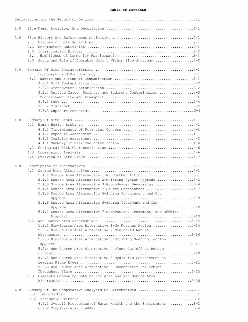
Table of Contents
Declaration for the Record of Decision ..............................................ix
1.0 Site Name, Location, And Description .........................................1-1
2.0 Site History And Enforcement Activities ......................................2-1 2.1 History of Site Activities ............................................. 2-1 2.2 Enforcement Activities ..................................................2-1 2.3 Investigation History ...................................................2-2
2.4 Highlights of Community Participation ..................................2-2 2.5 Scope and Role of Operable Unit 1 Within Site Strategy ..................2-3
3.0 Summary Of Site Characteristics ..............................................3-1 3.1 Topography and Hydrogeology .............................................3-1
3.2 Nature and Extent of Contamination .....................................3-2 3.2.1 Soil Contamination ................................................3-2 3.2.2 Groundwater Contamination .........................................3-2 3.2.3 Surface Water, Springs, and Sediment Contamination ................3-3
3.3 Contaminant Fate and Transport .........................................3-4 3.3.1 Fate ..............................................................3-4 3.3.2 Transport .........................................................3-5 3.3.3 Exposure Potential ...........................................3-6
4.0 Summary Of Site Risks ........................................................4-1 4.1 Human Health Risks ......................................................4-1 4.1.1 Contaminants of Potential Concern .................................4-1 4.1.2 Exposure Assessment ...............................................4-1 4.1.3 Toxicity Assessment ...............................................4-3 4.1.4 Summary of Risk Characterization ..................................4-4 4.2 Ecological Risk Characterization ........................................4-6 4.3 Uncertainty Analysis ....................................................4-6 4.4 Overview of Site Risks ..................................................4-7
5.0 Description Of Alternatives ..................................................5-1 5.1 Source Area Alternatives ................................................5-1 5.1.1 Source Area Alternative 1-No Further Action .......................5-1 5.1.2 Source Area Alternative 2-Existing System Upgrade .................5-2 5.1.3 Source Area Alternative 3-Groundwater Dewatering ..................5-4 5.1.4 Source Area Alternative 4-Source Containment ......................5-7 5.1.5 Source Area Alternative 5-Source Containment and Cap Upgrade ...........................................................5-9 5.1.6 Source Area Alternative 6-Source Treatment and Cap Upgrade ..........................................................5-10 5.1.7 Source Area Alternative 7-Excavation, Treatment, and Offsite Disposal .........................................................5-13 5.2 Non-Source Area Alternatives ...........................................5-14 5.2.1 Non-Source Area Alternative 1-No Further Action ..................5-14 5.2.2 Non-Source Area Alternative 2-Monitored Natural Attenuation ............................................................5-16 5.2.3 Non-Source Area Alternative 3-Existing Seep Collection
Upgrade ...............................................................5-18 5.2.4 Non-Source Area Alternative 4-Plume Cut-off at Bottom of Bluff ...............................................................5-19 5.2.5 Non-Source Area Alternative 5-Hydraulic Containment at Leading Plume Edges ....................................................5-21 5.2.6 Non-Source Area Alternative 6-Groundwater Collection Throughout Plume .......................................................5-23 5.3 Elements Common to Both Source Area and Non-Source Area Alternatives ...........................................................5-26
6.0 Summary Of The Comparative Analysis Of Alternatives ..........................6-16.1 Introduction ...........................................................6-1
6.2 Threshold Criteria .....................................................6-2 6.2.1 Overall Protection of Human Health and the Environment ............6-2 6.2.2 Compliance with ARARs .............................................6-4
6.3 Primary Balancing Criteria ..............................................6-5 6.3.1 Long-Term Effectiveness and Permanence ............................6-5 6.3.2 Reduction of Toxicity, Mobility, or Volume Through Treatment ......6-6 6.3.3 Short-Term Effectiveness ..........................................6-8 6.3.4 Implementability ..................................................6-9 6.3.5 Cost .............................................................6-10
6.4 Modifying Criteria ....................................................6-12 6.4.1 State Acceptance .................................................6-12 6.4.2 Community Acceptance .............................................6-127.0 The Selected Remedy ..........................................................7-1 7.1 Description of the Selected Remedy ......................................7-1 7.1.1 Remediation Goals and Performance Standards .......................7-4 7.1.2 Restoration Time Frame ............................................7-8 7.1.3 Costs .............................................................7-8 7.2 Statutory Determinations ................................................7-8 7.2.1 Protection of Human Health and the Environment ....................7-9 7.2.2 Compliance with Applicable or Relevant and Appropriate
Requirements ....................................................7-10 7.2.3 Cost-Effectiveness ................................................7-11 7.2.4 Utilization of Permanent Solutions and Alternative Treatment Technologies ......................................................7-12 7.2.5 Preference for Treatment as a Principal Element ...................7-13 7.3 Documentation of Significant Changes ....................................7-13
8.0 References ....................................................................8-1
9.0 Responsiveness Summary ........................................................9-1 9.1 Introduction .............................................................9-1 9.2 Overview .................................................................9-1 9.3 Background on Community Involvement ......................................9-2 9.4 Summary of Public Comments ...............................................9-2 9.4.1 Comments on the Proposed Plan ......................................9-2 9.4.2 Comments Made During the Public Meeting ............................9-4
APPENDIX A: Identification of ARARsAPPENDIX B: List of Attendees at the Hill Air Force Base Operable Unit 1 Open HouseAPPENDIX C: Proposed Plan Comments and Hill Air Force Base Responses to Comments
List of Tables
Table 3-1 Range of Analytical Results for Selected Compounds in Soil Sample from CDP's 1 & 2Table 3-2 Range of Analytical Results for Selected Compounds in Soil Samples from Landfill 3Table 3-3 Range of Analytical Results for Selected Compounds in Soil Samples from Landfill 4Table 3-4 Range of Analytical Results for Selected Compounds in Soil Samples from Fire Training Area 1Table 3-5 Range of Analytical Results for Selected Compounds in Soil Samples from Fire Training Area 2Table 3-6 Range of Analytical Results for Selected Compounds in Soil Samples from the Waste Phenol/Oil PitTable 3-7 Range of Analytical Results for Selected Compounds in Soil Samples from the Waste Oil Storage TanksTable 3-8 Summary of Analytical Results for LNAPL Samples Downgradient of the CDPsTable 3-9 Summary of Analytical Results for LNAPL Samples from Fire Training Area 1Table 3-10 Summary of Analytical Results for Groundwater Samples from On-Base AreasTable 3-11 Summary of Analytical Results for Groundwater Samples from the Weber River ValleyTable 3-12 Summary of Surface Water Data for Select CompoundsTable 3-13 Summary of Metals Detected in Sediment Samples from Seeps/Springs at OU1Table 4-1 Summary of Cancer Risks and Hazard IndicesTable 5-1 Assumed Quality of Extracted GroundwaterTable 5-2 Source Area Alternative 7 Excavation Volumes and Disposal MethodsTable 5-3 Northern Containment System Groundwater Contamination ConcentrationsTable 5-4 Western Containment System Groundwater Contamination ConcentrationsTable 5-5 Non-Source Area Alternative NSA6 Expected Maximum Contamination Levels (Off-Base)Table 5-6 Non-Source Area Alternative NSA6 Expected Maximum Contamination Levels (On-Base)Table 6-1 Source Area Alternatives Summary Cost TableTable 6-2 Non-Source Area Alternatives Summary Cost TableTable 7-1 Performance Standards for Soil Protective of GroundwaterTable 7-2 Performance Standards for Principal Contaminants of Concern in Groundwater and Surface Water at Operable Unit 1Table 7-3 Summary of Costs for the Selected Remedy at HAFB Operable Unit 1 List of Figures
Figure 1-1 Site LocationFigure 1-2 Site Topography of OU1Figure 3-1 Generalized Geologic Cross-SectionFigure 3-1 Generalized Geologic Cross-SectionFigure 3-2 Areas Exceeding Soil PRGs and/or Containing Free- and Residual-Phase LNAPLFigure 3-3 Areas Exceeding PRGs for Groundwater and Surface WaterFigure 3-4 Conceptual Model for Fate and Transport of Contaminants Associated with the Major OU1 Source AreasFigure 3-5 Conceptual Model for Fate and Transport of Contaminants Associated with the Minor OU1 Source AreasFigure 5-1 Source Area Alternative 2 Site PlanFigure 5-2 Source Area Alternative 3 Site PlanFigure 5-3 Source Area Alternative 4 Site PlanFigure 5-4 Source Area Alternative 5 Site PlanFigure 5-5 Source Area Alternative 6 Site PlanFigure 5-6 Source Area Alternative 7 Site PlanFigure 5-7 Non-Source Area Alternative 2 Site PlanFigure 5-8 Non-Source Area Alternative 3 Site PlanFigure 5-9 Non-Source Area Alternative 4 Site PlanFigure 5-10 Non-Source Area Alternative 5 Site PlanFigure 5-11 Non-Source Area Alternative 6 Site PlanFigure 5-12 Proposed CAMU BoundariesFigure 7-1 Preferred AlternativeFigure 7-2 Areas Exceeding PRGs for SoilFigure 7-3 Areas Exceeding PRGs for GroundwaterFigure 7-4 Areas Exceeding PRGs for Surface Water and Locations of Springs with Concentrations of Arsenic in Sediment Above Background ConcentrationsFigure 7-5 Areas Exceeding PRGs and/or Containing Free- and Residual-Phase LNAPLFigure 7-6 Landfill Boundaries
List of Acronyms
ARAR Applicable or Relevant and Appropriate RequirementASTP Air Stripper Treatment PlantBACT Best Available Control Technologybgs Below the Ground SurfaceCAMU Corrective Action Management UnitCDP Chemical Disposal PitCERCLA Comprehensive Environmental Response, Compensation, and Liability ActCOPC Contaminant of Potential ConcernCPF Cancer Potency FactorCWSID Central Weber Sewer Improvement Districtcy Cubic YardsDCE Cis 1,2-DichloroetheneDOQ Data Quality ObjectiveEPA U.S. Environmental Protection AgencyFS Feasibility StudyFTA Fire Training Areagpm Gallons Per MinuteHAFB Hill Air Force BaseHI Hazard IndexHQ Hazard QuotientIWTP Industrial Wastewater Treatment PlantLDR Land Disposal RegulationLNAPL Light Non-Aqueous Phase LiquidsMCL Maximum Contaminant LevelIg/l Micrograms Per Liter (parts per billion)Ig/g Micrograms Per Gram (parts per billion)mg/kg Milligrams Per Kilogram (parts per million)mg/l Milligrams Per Liter (parts per million)NCP National Oil and Hazardous Substances Pollution Contingency PlanNPL National Priorities ListNSA Non-Source Areapg/l Picograms Per LiterPAH Polynucleararomatic HydrocarbonPA/SI Preliminary Assessment/Site InvestigationPCB Polychlorinated BiphenylPOTW Publicly Owned Treatment WorksPRG Preliminary Remediation GoalPSVP Performance Standard Verification PlanO&M Operation and MaintenanceOU Operable UnitOU1 Operable Unit 1RAB Restoration Advisory BoardRCRA Resource, Conservation and Recovery ActRfC Reference ConcentrationRfD Reference DoseRI Remedial InvestigationRME Reasonable Maximum ExposureROD Record of DecisionSA Source AreaSARA Superfund Amendments and Reauthorization Actscfm Standard Cubic Feet per MinuteSF Slope FactorSVE Soil Vapor ExtractionSWLC South Weber Landfill CoalitionTAG Technical Assistance GrantTCE TrichloroetheneTMV Toxicity, Mobility, or VolumeTPH Total Petroleum HydrocarbonsUDAQ Utah Division of Air QualityUDEQ Utah Department of Environmental QualityVGAC Vapor-Phase Granular Activated CarbonVOC Volatile Organic Compound
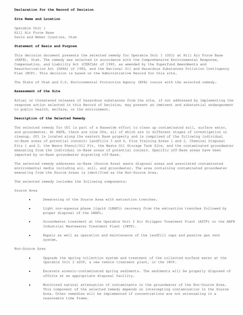
Declaration for the Record of Decision
Site Name and Location
Operable Unit 1Hill Air Force BaseDavis and Weber Counties, Utah
Statement of Basis and Purpose
This decision document presents the selected remedy for Operable Unit 1 (OU1) at Hill Air Force Base(HAFB), Utah. The remedy was selected in accordance with the Comprehensive Environmental Response,Compensation, and Liability Act (CERCLA) of 1980, as amended by the Superfund Amendments andReauthorization Act (SARA) of 1986, and the National Oil and Hazardous Substances Pollution ContingencyPlan (NCP). This decision is based on the Administrative Record for this site.
The State of Utah and U.S. Environmental Protection Agency (EPA) concur with the selected remedy.
Assessment of the Site
Actual or threatened releases of hazardous substances from the site, if not addressed by implementing theresponse action selected in this Record of Decision, may present an imminent and substantial endangermentto public health, welfare, or the environment.
Description of the Selected Remedy
The selected remedy for OU1 is part of a Basewide effort to clean up contaminated soil, surface water,and groundwater. At HAFB, there are nine OUs, all of which are in different stages of investigation orcleanup. OU1 is located along the eastern Base property and is comprised of the following individualon-Base areas of potential concern: Landfills 3 and 4, Fire Training Areas 1 and 2, Chemical DisposalPits 1 and 2, the Waste Phenol/Oil Pit, the Waste Oil Storage Tank Site, and the contaminated groundwateremanating from the individual on-Base areas of potential concern. Specific off-Base areas have beenimpacted by on-Base groundwater migrating off-Base.
The selected remedy addresses on-Base (Source Area) waste disposal areas and associated contaminatedenvironmental media including air, soil, and groundwater. The area containing contaminated groundwateremanating from the Source Areas is identified as the Non-Source Area.
The selected remedy includes the following components:
Source Area
• Dewatering of the Source Area with extraction trenches.
• Light non-aqueous phase liquid (LNAPL) recovery from the extraction trenches followed byproper disposal of the LNAPL.
• Groundwater treatment at the Operable Unit 2 Air Stripper Treatment Plant (ASTP) or the HAFBIndustrial Wastewater Treatment Plant (IWTP).
• Repair as well as operation and maintenance of the landfill caps and passive gas ventsystem.
Non-Source Area
• Upgrade the spring collection system and treatment of the collected surface water at the Operable Unit 2 ASTP, a new remote treatment plant, or the IWTP.
• Excavate arsenic-contaminated spring sediments. The sediments will be properly disposed ofoffsite at an appropriate disposal facility.
• Monitored natural attenuation of contaminants in the groundwater of the Non-Source Area.This component of the selected remedy depends on intercepting contamination in the SourceArea. Other remedies will be implemented if concentrations are not attenuating in areasonable time frame.
Both Source and Non-Source Areas
• Environmental monitoring.
• Institutional and engineering controls designed to prevent potential unacceptable risks tohuman health and the environment.
• Designation of a Corrective Action Management Unit (CAMU) to facilitate remedial actions.The CAMU will be designated as the contiguous area of contamination.
The selected remedy for OU1 addresses the principal threats posed by the site by minimizing or preventingdirect contact with contaminated soils and landfill contents, preventing ingestion of and direct contactwith contaminated groundwater, surface water, and sediments as well as preventing further offsitetransport of contaminants.
Statutory Determinations
The selected remedy is protective of human health and the environment, complies with federal and State ofUtah requirements that are legally applicable or relevant and appropriate to the remedial action, and iscost effective. The remedy addresses potentially unacceptable risks to human health and the environmentat both the onsite Source Area and the offsite Non-Source Area.
This remedy utilizes permanent solutions and alternative treatment technologies to the maximum extentpracticable for the on-Base area and satisfies the Statutory preference for remedies employing treatmentsthat reduce toxicity, mobility, or volume as a principal element. The toxicity and volume of contaminantsin the Non-Source Area is expected to be reduced by natural processes rather than through treatment as aprincipal remedial element. The onsite Source Area treatment activities will reduce the total mass ofcontaminants in the groundwater at OU1, which in turn will help the offsite natural remedial processesaddress Non-Source Area contamination. Since this remedy will result in hazardous substances remainingonsite above health-based levels, a review will be conducted within 5 years after commencement ofremedial actions to ensure that the remedy continues to protect human health and the environment.
Once the remedy is complete, Applicable or Relevant and Appropriate Requirements (ARAR) will be met or awaiver will be justified. An ARAR waiver may be invoked, accompanied by an Explanation of SignificantDifferences, if it is determined on the basis of criteria stated in this Record of Decision (ROD) thatMCLs or other chemical-specific ARARs cannot be achieved within all portions of the area of attainment inthe Source Area, or where it is anticipated that it may be technically impracticable to reach such levelstargeted in the ROD.
RECORD OF DECISION FOR OPERABLE UNIT 1UNITED STATESENVIRONMENTAL PROTECTION AGENCY
<IMG SRC 98107A>
RECORD OF DECISION FOR OPERABLE UNIT 1STATE OF UTAHDEPARTMENT OF ENVIRONMENTAL QUALITY
RECORD OF DECISION FOR OPERABLE UNIT 1AIR FORCE MATERIEL COMMANDWRIGHT-PATTERSON AIR FORCE BASE, OHIO
Stewart E. Cranston DATELieutenant General, USAFVice Commander
Decision Summary
1.0 Site Name, Location, and Description
1.0.0.1. Hill Air Force Base (HAFB) is located in northern Utah, approximately 25 miles north of SaltLake City and about 5 miles south of Ogden. HAFB occupies approximately 6,700 acres in Davis and Webercounties. The Base is bounded on the west by Interstate 15, on the south by State Route 193, and on thenortheast by the Weber River Valley (Figure 1-1). The Base is located on a prominent terrace known as theWeber Delta.
1.0.0.2. Operable Unit 1 (OU1), one of nine OUs at HAFB, is located within Davis County, near the easternBase property boundary. As shown in Figure 1-2, OU1 includes the former waste disposal areas: Landfills 3and 4, Fire Training Areas (FTA) 1 and 2, Chemical Disposal Pits (CDP) 1 and 2, the Waste Phenol/Oil Pit,and the Waste Oil Storage Tank Site.
1.0.0.3. The Source Area portion of OU1 includes Landfills 3 and 4, CDPs 1 and 2, FTAs 1 and 2, the WastePhenol/Oil Pit, the Waste Oil Storage Tank Site, and the light non-aqueous phase liquid (LNAPL) plumeemanating from CDPs 1 and 2. The Non-Source Areas consist of an on-Base groundwater plume west of theLNAPL plume, and the off-Base groundwater contamination in the Weber River Valley. The off-Base portionof the Non-Source Area is located on the steep, terraced, northeasterly-facing escarpment that forms thesouth wall of the Weber River Valley and in the valley. There is over 250 feet of relief between theSource Area and the off-Base Non-Source Area. The land surface in the on-Base portion of OU1 is generallylevel with a slight northeasterly grade.
1.0.0.4. The Davis-Weber Canal is located off-Base (Figure 1-2) and is situated about two-thirds of theway down the escarpment. It is a privately-owned irrigation canal that supplies water for irrigationdiverted from the Weber River from mid-April to mid-October. The canal is concrete-lined in the area ofOU1. Groundwater level measurements of monitoring wells adjacent to the canal have shown the shallowgroundwater level to be about 90 feet below the ground surface (bgs), or about 85 feet below the canalbottom.
1.0.0.5. Land use on-Base at OU1 is military / industrial and immediately off-Base is mixed agriculturaland residential use. There are no hospitals, retirement or nursing homes, schools, nurseries, or daycarecenters currently located within OU1. The nearest daycare or school is approximately 0.3 miles east ofthe contamination associated with OU1.
1.0.0.6. At present, the groundwater plume associated with the on-Base Source Area disposal sites hasmigrated approximately 2,200 feet north/northeast of the Base property boundary. The off-Base portion ofthe groundwater plume underlies a few residences in the City of South Weber. Historically, there havebeen seven off-Base surface water springs located within the downgradient areal extent of the groundwaterplume that have been observed with significant levels of contamination (above MCLs). Based on recentsampling results, four of these springs continue to exceed MCLs. Other springs have been observed in theoff-Base areas. Very low levels of groundwater contamination (below MCLs) or no groundwater contaminationhas been observed in these other springs.
1.0.0.7. Shallow groundwater is not currently used as a source of drinking water in the area. Municipalwater for the City of South Weber is supplied by the Weber Basin Water Conservancy District. The districtprovides water from wells that tap deep aquifers that are unaffected by contaminants associated with OU1.South Weber No. 2 is the only groundwater well located within the aerial extent of the OU1 off-Basegroundwater plume. The well is located approximately 1,500 feet from the OU1 Source Areas. This well hasbeen used sporadically over the years during peak demand periods. Oil was recently observed floating onthe surface of the water in the well, and the well is currently not in use due to the dissolvedcontamination in the well water from the oil. Recent investigations have shown HAFB is not the source ofthe oil or associated contamination in the well water. The investigation is described in the DraftMonitoring Well Installation and Impact Assessment of South Weber No. 2 Report (CH2M, HILL, 1998b).
1.0.0.8. Land within OU1 is not located within the 100-year floodplain. There are no jurisdictionalwetlands, as regulated by the U.S. Army Corps of Engineers, within OU1. Apart from deeper groundwater fordrinking water, there are no uses or known occurrences of commercially valuable natural resources withinthe OU1 area.
<IMG SRC 98107C><IMG SRC 98107D>
2.0 Site History and Enforcement Activities
2.1 History of Site Activities
2.1.0.1. The Base has housed numerous industrial facilities related to management and maintenance ofaircraft and missiles since the 1940s. These industrial operations have included the use of numerouschemicals, metals, degreasing solvents, and hydrocarbon fuel products. Historically, waste products weredisposed of in onsite pits and landfills. Additionally, fire training areas were established onsite, sofacility personnel could practice extinguishing and managing hydrocarbon fuel fires. The types of wastematerials disposed of at Source Areas, or use of the area, and the time periods the OU1 Source Areas werein use are listed below:
• Chemical Disposal Pits 1 and 2: an industrial liquid waste disposal site in operation from 1952 through 1973.
• Landfill 3: An industrial (dump and burn) liquid and solid waste disposal site in operationfrom 1940 through 1967.
• Landfill 4: A sanitary refuse landfill in operation from 1967 through 1973.
• Fire Training Area 1: A fire training practice area used by HAFB from the mid-1950s through1973 to extinguish simulated aircraft fires.
• Fire Training Area 2: A fire training practice area used by HAFB from 1973 until 1995 to extinguish simulated aircraft fires.
• Waste Phenol/Oil Pit: A brick-lined pit used periodically to dispose and burn waste oil and phenol from 1954 through 1965.
• Waste Oil Storage Tank Site: Site of four 20,000 to 25,000-gallon aboveground storage tanks used to store fuel oil, jet fuel, and hydraulic oil. The tanks were removed in 1985.
2.2 Enforcement Activities
2.2.0.1. In 1987, the U.S. Environmental Protection Agency (EPA) placed HAFB on the National PrioritiesList (NPL) under the Comprehensive Environmental Response, Compensation, and Liability Act (CERCLA). OnApril 10, 1991, HAFB entered into a Federal Facilities Agreement with the Utah Department ofEnvironmental Quality (UDEQ) and the EPA to establish a procedural framework and schedule for developing,implementing, and monitoring appropriate response actions at the site in accordance with existingregulations.
2.2.0.2. Prior to being placed on the NPL list, a Cease and Desist Order for leachate discharge belowLandfill 4 was issued by the Utah Water Pollution Control Board (currently the State of Utah Division ofWater Quality) on July 23, 1984. The leachate was observed at Springs Ul-303 and UI-304. HAFB implementedthe interim remedial measures to prevent exposure to contamination associated with the OU1 site and tolimit the mobility of contaminants at OU1. These actions were implemented prior to the SuperfundAmendments and Reauthorization Act (SARA) in November 1986. Some of the actions were taken without EPAand UDEQ oversight. HAFB implemented the following remedial measures:
• Installation of low-permeability caps over Source Areas in 1985 and 1986, designed to reduce infiltration of precipitation.
• Installation of a subsurface physical barrier in 1985 (soil/bentonite slurry cut-off wall) located upgradient of the Source Areas, designed to reduce groundwater recharge to the Source Areas.
• Collection and treatment of contaminated surface water in 1985 from off-Base springs located downgradient of the Source Areas.
• Extraction and treatment of contaminated groundwater in the on-Base Source Area in 1985.
• Implementation of groundwater and surface water monitoring program in 1990.
2.3 Investigation History
2.3.0.1. HAFB began investigative activities in the 1980s, in the northern portion of the Base, todetermine the source of suspected contamination in this area. Supplemental investigative activities wereperformed under a Preliminary Assessment/Site Investigation (PA/SI), and the findings suggested locationswithin HAFB were the source of the contamination found in the off-Base groundwater and surface water.Following the PA/SI, Remedial Investigation (RI) activities were conducted to further characterize theextent of contamination in the soil, as well as groundwater and springs. These RI activities were alsoconducted to evaluate potential downgradient receptors, water-bearing zone properties, and transportpathways. The RI was conducted in two phases. The Phase I RI investigation was completed in 1992. ThePhase II RI investigation was completed to fill data gaps in the Phase I RI investigation. The work forboth phases is documented in the Comprehensive Remedial Investigation Report for Operable Unit 1 (MW,1995).
2.3.0.2. The Comprehensive Remedial Investigation Report for Operable Unit 1, also included a baselinerisk assessment that evaluated the potential human health and environmental effects caused by chemicalsat the site. The Feasibility Study (FS) for Operable Unit 1 (CH2M HILL, 1998) identifies and evaluatesalternative remedial actions.
2.4 Highlights of Community Participation
2.4.0.1. The public participation requirements of CERCLA Sections 113(k)(2)(B)(i-iv) and 117 were met forthe remedy selection process. HAFB has an Environmental Restoration Community Relations Plan (HAFB,December 1997), which describes HAFB environmental programs and community involvement. Specific to OU1,meetings were held with the public to discuss the findings of the RI/FS, alternative and proposedremedial strategies, and the selected remedy. In particular, HAFB, meets with the South Weber CityCouncil as necessary to update the council on specific issues and the status of remedial efforts at OU1.Updates on OUl activities are made to the Restoration Advisory Board (RAB) on a quarterly basis. Inaddition, a public meeting was held on April 28, 1993, to explain and discuss risk assessment and riskmanagement issues for the communities located north of the Base that are affected by OU1, OU2, and OU4.Section 9.3 further describes community participation.
2.4.0.2. The EPA awarded a Technical Assistance Grant (TAG) to the South Weber Landfill Coalition (SWLC)in September 1992. The TAG funds citizen groups to obtain independent technical assistance, information,and explanation from qualified professionals. SWLC focused its review activities on OU1, has reviewed allRI/FS documents in the Administrative Record, and provided comments and identified issues to HAFB throughthe study process. SWLC comments to the Proposed Plan for OU1 (CH2M HILL, 1998a) and FS, with responses,may be found in Appendix C. The SWLC is also represented on the RAB.
2.4.0.3. The Proposed Plan was released to the public on January 15, 1998, for public comment. TheProposed Plan was also mailed to federal, State, and local agencies, Administrative Record repositories,and interested parties on the HAFB mailing list. The Proposed Plan was hand-delivered to residents in theSouth Weber Area. All documents related to the RI/FS, as they were finalized, were placed in theAdministrative Record located at the Directorate of Environmental Management at HAFB and at the CentralBranch of the Davis County Library in Layton, Utah.
2.4.0.4. The notice of availability of the Proposed Plan was published in the Salt Lake Tribune, OgdenStandard Examiner, Hilltop Times, and Deseret News. A public comment period was originally scheduled tobe held from January 15 to February 14, 1998. The SWLC requested a 1-month extension to March 16, 1998.
2.4.0.5. An open house format public meeting was held on February 5, 1998, at the South Weber ElementarySchool. Affected South Weber residents and all other interested parties on the HAFB mailing list werenotified about the open house. The purpose of the open house was to answer questions and accept commentsabout the remedial alternatives presented in the Proposed Plan, including the preferred remedialalternative for the site, and other topics relevant to OU1 in an informal setting.
2.5 Scope and Role of Operable Unit 1 within Site Strategy
2.5.0.1. Response actions at HAFB are structured into nine Operable Units (OU); most of them, includingOU1, are geographically defined and address all contaminated media within each unit. Remedial actions areaddressed separately for each OU, and each of the OUs are at different stages of investigation orremediation.
2.5.0.2. The selected remedy for OU1 incorporates or builds on prior response actions described inSection 2.2, which will continue as part of this remedy. Extraction and treatment of groundwater in theSource Areas will reduce concentrations of contaminants, and hydraulic controls will prevent further
transport of contaminants to Non-Source Areas. Subsurface soil contamination will be addressed by repairand maintenance of the existing Source Area cap, the maintenance of the landfill passive gas vent system,as well as institutional controls. Collection and treatment of contaminated surface water from springs,in concert with institutional controls and/or selective excavation and offsite disposal of surficialsoils at selected off-Base springs, will address exposure risks associated with each area of potentialconcern. Monitored natural attenuation of contaminated groundwater, collection and treatment ofgroundwater, and selective excavation of sediments from contaminated springs will reduce concentrationsof contamination in Non-Source Areas.
3.0 Summary of Site Characteristics
3.1 Topography and Hydrogeology
3.1.0.1. OU1 is located adjacent to the eastern property boundary of HAFB. The topography is relativelyflat in the on-Base portion of OU1, dropping steeply to the northeast in the off-Base portions of OU1toward the City of South Weber. The topography flattens in the vicinity of the City of South Weber.
3.1.0.2. The uppermost water-bearing zone beneath OU1 is typically encountered within the exposed ProvoFormation at an approximate depth of 25 to 30 feet bgs, immediately above the contact between the ProvoFormation and the underlying Upper Clay Unit of the Alpine Formation. Figure 3-1 presents a generalizedgeologic cross-section of a portion of OU1, highlighting subsurface geologic characteristics, includingthe depths and thicknesses of the Provo and Alpine Formations. At OU1, the Provo Formation is typicallycomprised of fine-to coarse-grained sand with interbedded gravel. The Provo Formation ranges in thicknessfrom 0 to 60 feet and averages approximately 30 feet in thickness. The Alpine Formation is comprisedtypically of fine-grained materials, such as silty clay with fine-grained sand interbeds and fine-grainedsand layers. Six water-bearing zones have been observed in the Alpine Formation. The Alpine Formationoverlies the groundwater aquifer and is approximately 500 feet thick at OU1.
3.1.0.3. Most of the shallow groundwater beneath OU1 flows laterally along the interface of the twoformations, with a relatively insignificant portion migrating vertically into thin sand layers within theAlpine Formation. Shallow groundwater flow within the Provo Formation is mainly to the east and westalong groundwater channels eroded into the Alpine Formation. Groundwater flow in the Alpine Formation isto the north.
3.1.0.4. Shallow groundwater beneath OU1 discharges primarily to weathered residual soils and terracedeposits, as well as sand stringers within the Alpine Formation. There are numerous springs located alongthe escarpment, where shallow groundwater discharges to the ground surface. The regional migration ofshallow groundwater located off-Base and immediately north of OU1 is generally north toward the WeberRiver.
3.1.0.5. Based on the State of Utah Groundwater Quality Classifications, shallow groundwater in the Provoand Alpine formations would likely be Class II Drinking Water Quality Groundwater. The classification isbased on ambient total dissolved solids (TDS) concentrations ranging between 500 and 3,000 milligrams perliter (mg/L). In reality, the low yield of the relatively impermeable Alpine Formation may be moreappropriately described as an "aquitard."
3.1.0.6. The OU1 site overlies a deep confined groundwater aquifer. The top of the deep confinedgroundwater, aquifer is located approximately 650 feet below the OU1 Source Areas and 400 feet below theoff-Base portion of OU1. The Alpine Formation at OU1 acts as a significant barrier to vertical migrationof shallow groundwater from the Provo and Upper Alpine Formations to the much deeper, deep confinedgroundwater aquifer.
3.1.0.7. Municipal groundwater supplies in the area are obtained from the deep confined groundwateraquifer systems. Natural regional flow directions for these aquifers, in the general vicinity of theBase, are generally toward the west. The aquifers are Class IIA aquifers under EPA's groundwater qualityclassification system. Under the UDEQ, Division of Water Quality's groundwater classification system, theaquifers are classified as Class IA-Pristine Groundwater aquifers or Class II-Drinking Water Qualityaquifers. The classifications were established in Section 5.4.5.7 of the Comprehensive RemedialInvestigation Report for Operable Unit 1 (MW, 1995).
3.2 Nature and Extent of Contamination
3.2.0.1. Environmental samples were taken from soil, sediment, groundwater, surface water, and air at thesite during the RI. The chemical contaminants detected in these media are primarily chlorinated volatileorganic compounds (VOC), with cis 1,1-Dichloroethene (DCE) being the most prevalent. Trichloroethene(TCE) has also been found at OU1. Some sediments associated with a few offsite springs contain arsenic
concentrations in excess of background concentrations. Additionally, shallow onsite groundwaterassociated with some onsite Source Areas contains LNAPLs, comprised typically of residual degreasingsolvent and hydrocarbon fuel constituents. LNAPLs typically float on top of the water table.
3.2.1 Soil Contamination
3.2.1.1. Residual chemical constituents detected in on-Base subsurface soil (soil at depths greater than2 feet) include VOCs, polynuclear aromatic hydrocarbons (PAH), petroleum hydrocarbons, dioxins, furans,pesticides, and PCBs. Residual chemical constituents detected in on-Base surface soil include VOCs, PAHs,petroleum hydrocarbons, dioxins, furans, pesticides, and polychlorinated biphenyls (PCB). Tables 3-1through 3-7 highlight contaminant constituents and corresponding ranges of concentrations detected insoils at the principal Source Areas of OU1. The most highly contaminated soils at OU1 occur within FTA 1and CDPs 1 and 2.
3.2.1.2. To date, the only off-Base subsurface soils found to have been impacted by OU1 contaminants arethose soils located at or below the water table within areas of the contaminated OU1 groundwater plume.In light of the site-specific hydrogeologic conditions at OU1, it is anticipated that off-Base subsurfacesoils will not pose any unacceptable risk to human health or the environment for the foreseeable future.
3.2.1.3. Off-Base surface soils have not been impacted by chemical constituents associated with OU1.Off-Base surface soils do not pose any unacceptable risks to human health or the environment.
3.2.2 Groundwater Contamination
3.2.2.1. Figure 3-2 presents the areal extent of free- and residual-phase LNAPL and areas exceeding soilPreliminary Remediation Goals (PRGs) at the Source Area. PRGs are the maximum contaminant constituentconcentrations that represent levels of contamination which, if left in place in the environment withoutany treatment, are not expected to pose
any unacceptable risk to human health or the environment. An LNAPL layer on the shallow groundwater tableextends northwest from FTA 1 and the chemical disposal pit areas. The LNAPL is composed primarily of jetfuel, based on modified EPA Method 8015 analysis using fuel standards for identification andquantification. However, other contaminants that have been detected in OUl soils have also solubilized inthe jet fuel. The highest concentrations of VOCs (base, neutral, and acid extractable compounds; dioxins;and furans) occur in the LNAPL associated with CDPs 1 and 2 and FTA 1. In addition, PCBs exist in LNAPLassociated with the CDPs. A summary of the compounds detected in the LNAPL samples is presented in Tables3-8 and 3-9.
3.2.2.2. Historically, the areal extent of the LNAPL has covered as much as 9 acres of OU1. However, asshown in Figure 3-2, the lateral extent of the LNAPL has diminished considerably during recent years. Itnow appears the free-phase LNAPL is limited to the area immediately surrounding FTA 1 and an areaextending primarily westward from CDPs 1 and 2. The free-phase LNAPL is heterogeneous in composition anddiscontinuous across the area. The apparent thickness of the LNAPL in OU1 monitoring wells has rangedfrom a few hundredths of a foot to nearly a foot in the LNAPL plume eliminating from the CDPs. Theestimated actual LNAPL thickness has ranged from 0.04 feet at the CDPs to 0.53 feet at FTA 1. The LNAPLoccurs at a depth range of approximately 25 feet to 35 feet bgs. The nature and extent of LNAPL isdescribed in detail in the Comprehensive Remedial Investigation Report for Operable Unit 1.
3.2.2.3. Figure 3-3 presents the extent of the on- and off-Base groundwater plumes comprised of dissolvedchemical constituents that exceed PRGs. Individual contaminant constituents include but are not limitedto DCE, TCE, and arsenic. DCE is a reliable indicator constituent in groundwater at HAFB because DCE isthe most mobile and widespread compound in the groundwater. DCE has been used to identify the extent ofoff-Base groundwater contamination. Table 3-10 summarizes the range of concentrations of contaminantsdetected in on-Base groundwater since 1992. The on-Base groundwater plumes are confined to the shallowProvo and Alpine Formation water-bearing zones. The off-Base plume is confined to surficial terracedeposits and the Alpine Formation water-bearing zones. There are no known users of the groundwater fromthese water-bearing zones for domestic purposes.
3.2.2.4. As may be seen in Figure 3-3, a comparison of the off-Base groundwater plume extent in 1994versus 1996 reveals that DCE concentrations in the plume appear to be declining, apparently due to theremedial measures previously enacted at the site, in concert with natural attenuation. Investigativeefforts to date have not identified any LNAPLs within the off-Base groundwater plume. Table 3-11summarizes the range of concentrations of contaminants detected in off-Base groundwater since monitoringbegan in 1992. The primary contaminants detected in the shallow off-Base groundwater are DCE and TCE.Contaminant concentrations decrease with depth in the shallow water-bearing zones. The nature and extentof groundwater contamination at OU1 are described in detail in the Comprehensive Remedial InvestigationReport for Operable Unit 1.
3.2.3 Surface Water, Springs, and Sediment Contamination
3.2.3.1. The Davis-Weber Canal is located approximately 225 to 300 feet north of the HAFB propertyboundary. Groundwater has been determined to be at least 90 feet below the Davis-Weber Canal; therefore,there is little potential for groundwater to contaminate the water in the canal. Hydrogeologic datasuggest that water from the canal leaks to the subsurface.
3.2.3.2. There are numerous offsite springs/seeps located along the escarpment that adjoins the northernBase property boundary at OU1 and the Weber River Valley farther to the north. Some of these springs arehydraulically connected with the on-Base plume of shallow groundwater that contains residualconcentrations of chemical constituents, and are therefore contaminated. Studies have shown that surfacewater and sediments associated with some springs have been impacted to varying degrees by contaminantconstituents, such as DCE and arsenic, associated with OU1. Due to the incongruous nature of hydraulicinterconnection, not all of the springs that are located within the areal extent of the off-Base plume ofgroundwater contamination actually contain contaminated surface water. Table 3-12 summarizes the range ofconcentrations of contaminants detected in off-Base surface water. In general, contaminants detected insurface water are a subset of and occur at lower concentrations than the contaminants found in the upperportion of the shallow on-Base water-bearing zone. The number of contaminants and contaminantconcentrations decrease with distance from the OU1 Source Area; i.e., fewer contaminants and lowerconcentrations of contaminants occur in surface water in the Weber River Valley as compared to hillsidesurface water.
3.2.3.3. Table 3-13 summarizes the range of concentrations of contaminants detected in sedimentscollected at off-Base seeps and springs. All reported concentrations for chromium, lead, cadmium, copper,and zinc are within the range of expected background concentrations for OU1. As shown in Table 3-13,arsenic was detected in sediment from all five sites. Arsenic most likely is precipitated (i.e., adsorbedto iron oxide surfaces) out of the spring and seep water into the sediment in response to changes in theredox potential of the water. Reducing conditions in the shallow groundwater at OU1 and their influenceon the distribution of redox-sensitive contaminants such as arsenic are discussed in greater detail inthe Comprehensive Remedial Investigation Report for Operable Unit 1.
3.3 Contaminant Fate and Transport
3.3.0.1. Populations and environmental receptors that could be affected, if exposed, include HAFBpersonnel and any construction contractors, off-Base residents, future on-Base residents, plants, andanimals in the vicinity. The OU1 conceptual model provided as Figures 3-4 and 3-5 are graphicalillustrations of the fate and transport of contaminants in the OU1 environment.
3.3.1 Fate
3.3.1.1. The persistence of chemical constituents in the subsurface is strongly influenced by thephysical and chemical characteristic properties of the respective chemicals (for example, vapor pressure,vapor density, Henry's Law Constant, water solubility, organic carbon/water partition coefficient-K oc,etc.), as well as the physical and chemical properties of the media in which the chemicals are located(soil, air, water, etc.). VOCs and most total petroleum hydrocarbon (TPH) constituents are likely topartition to air, followed by groundwater and soil. In surface water, chlorinated VOCs tend to readilyvolatilize to the air because of the large area for water-air contact. It is expected that any dissolvedVOC constituents in groundwater that discharges at the ground surface in the form of springs or seeps atOU1 will volatilize and dissipate into the atmosphere readily.
3.3.1.2. In general, dioxins, furans, TPHs, PCBs, and pesticides do not partition into the gaseous oraqueous phases as readily as VOCs; thus, these constituents tend to absorb to soil materials more readilythan VOCs and are therefore less mobile than VOCs.
3.3.2 Transport
3.3.2.1. The conceptual model represented by Figures 3-4 and 3-5 shows the principal contaminantsassociated with each disposal site, and how these contaminants have migrated through the soil/unsaturated zone to the LNAPL (if present) and to groundwater both on-Base and off-Base. The model alsorepresents transfer of contaminants from the liquid phase to the gaseous phase in soil gas and theatmosphere. Each pathway by which contaminants may migrate is represented by an arrow that indicates therelative importance of that pathway to the overall distribution and migration of contaminants at OU1.
3.3.2.2. The analysis of the fate and transport of the contaminants observed at OU1 suggests that animportant factor controlling the movement and persistence of both inorganic and organic groundwatercontaminants migrating from the Source Areas is the oxidation-reduction conditions that exist at the
site. Degradation of hydrocarbons has created reducing conditions that have led to the mobilization ofmetals, including iron, manganese, and arsenic.
3.3.2.3. The predominant pathway for the majority of the contamination at OU1 was from the wastematerials in the Source Areas to the unsaturated zone, and into the shallow on-Base groundwater. From theshallow on-Base groundwater, groundwater containing a limited number of contaminants (primarily 1,2-DCE)migrated toward and along the northern escarpment where it discharged either to springs and seeps or tothe shallow groundwater off-Base. Only the more mobile compounds, such as DCE, have migrated to theoff-Base groundwater. In addition, the LNAPL layer is a major secondary source of chemical constituentsto both soil and groundwater on-Base.
3.3.2.4. Typically, the highest concentrations of groundwater contaminants coincide with the occurrenceof LNAPL. The distribution and migration of LNAPL and contaminated groundwater across the on-Base portionof OU1 is controlled largely by the sand and gravel channels of the Provo Formation eroded into theunderlying Alpine Formation clay surface. Once groundwater reaches the northern escarpment, migrationappears to be controlled by vertical fractures, high-permeability landslide debris, and sand channels.
3.3.2.5. Off-Base contaminant migration generally is horizontal and is controlled by the hydraulicgradient in the shallow water-bearing zone. Groundwater advection has resulted in the transport ofcontaminants into off-Base groundwater, which in turn discharges, to varying degrees, to off-Base springsand/or shallow terrace and alluvial deposits within the Weber River Valley. Some shallow groundwaterwithin the Weber River Valley discharges to the Weber River. The OU1 off-Base groundwater plume does notdischarge to the Weber River based on analytical results from monitoring wells between the leading edgeof the plume and the Weber River. The off-Base groundwater plume is currently approximately 2,000 feetsouth of the Weber River. As groundwater discharges from the Alpine Formation at OU1 to the alluvialdeposits, the groundwater within the Alpine Formation is diluted by the existing groundwater. Thewater-bearing layers in the valley are comprised of deposits that typically have higher storativity,permeability, and transmissivity characteristics than those associated with the Alpine Formation at OU1.Thus, there is a reduction in dissolved contaminant concentrations as groundwater from the AlpineFormation discharges to the alluvial deposits, due to intrinsic processes including dilution, dispersion,and diffusion.
3.3.3 Exposure Potential
3.3.3.1. Current on-Base land use at OU1 is highly restricted. Shallow groundwater in the area is notused as a domestic water source, edible plants are not cultivated, and the area is not subject to cattlegrazing. Because of the on-Base institutional controls and the existing low permeability caps, there islittle potential for exposure to contaminated soil onsite. Therefore, current exposures to site-relatedcontamination within the OU1 on-Base Source Area are not anticipated.
3.3.3.2. Current land use in off-Base areas is mostly residential with some agricultural use. Off-Baseresidents rely on municipal water for their domestic supply. Shallow groundwater is not used as a sourceof drinking water in the area. Surface water from some of the springs in the area is seasonally present.These levels are generally near the MCLs for contamination in the area. With the exception of arseniccontaminated soils adjacent to Springs U1-301, U1-303, U1-304, U1-305, and U1-318, there are nocontaminated soils located off-Base that pose an unacceptable risk to human health and the environment.The most likely current exposure to contaminants would be via inhalation of VOCs migrating upward fromthe shallow water-bearing zone.
3.3.3.3. Effects of exposures to nearby ecosystems are expected to be minimal. Details regarding thepopulation and environmental receptors that could be affected are discussed in Section 4, whichsummarizes the findings of the human health and environmental assessments.
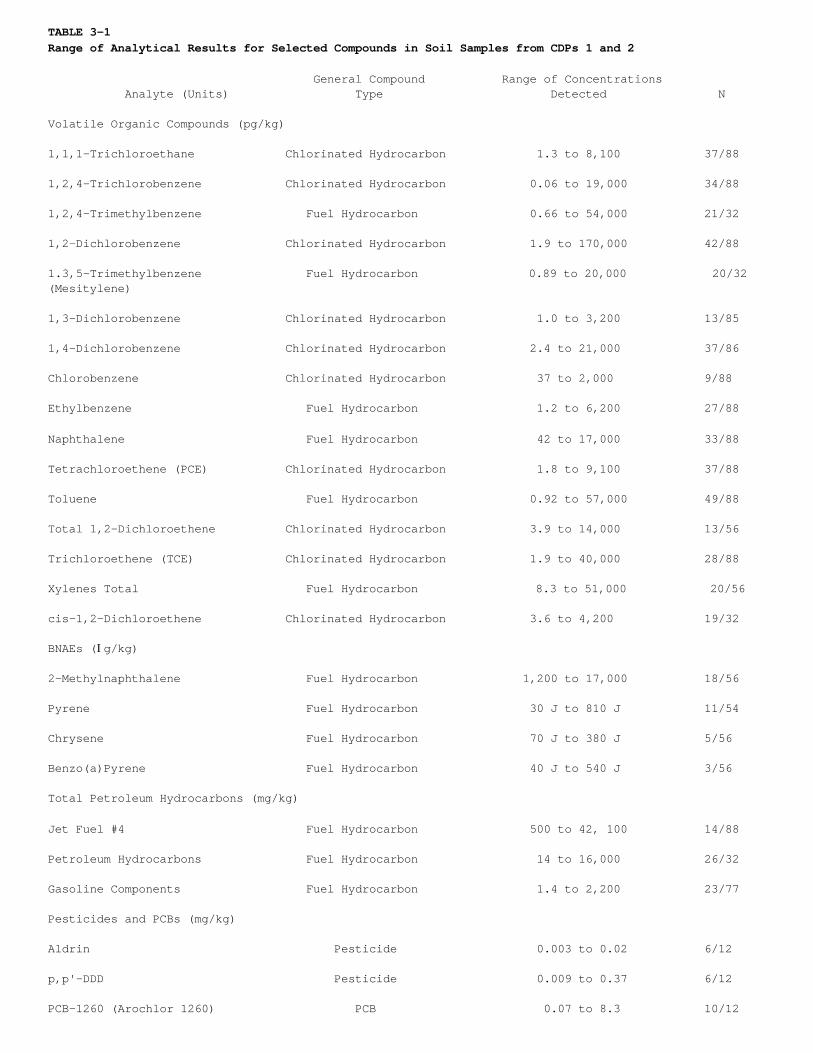
TABLE 3-1Range of Analytical Results for Selected Compounds in Soil Samples from CDPs 1 and 2
General Compound Range of Concentrations Analyte (Units) Type Detected N
Volatile Organic Compounds (pg/kg)
1,1,1-Trichloroethane Chlorinated Hydrocarbon 1.3 to 8,100 37/88
1,2,4-Trichlorobenzene Chlorinated Hydrocarbon 0.06 to 19,000 34/88
1,2,4-Trimethylbenzene Fuel Hydrocarbon 0.66 to 54,000 21/32
1,2-Dichlorobenzene Chlorinated Hydrocarbon 1.9 to 170,000 42/88
1.3,5-Trimethylbenzene Fuel Hydrocarbon 0.89 to 20,000 20/32(Mesitylene)
1,3-Dichlorobenzene Chlorinated Hydrocarbon 1.0 to 3,200 13/85
1,4-Dichlorobenzene Chlorinated Hydrocarbon 2.4 to 21,000 37/86
Chlorobenzene Chlorinated Hydrocarbon 37 to 2,000 9/88
Ethylbenzene Fuel Hydrocarbon 1.2 to 6,200 27/88
Naphthalene Fuel Hydrocarbon 42 to 17,000 33/88
Tetrachloroethene (PCE) Chlorinated Hydrocarbon 1.8 to 9,100 37/88
Toluene Fuel Hydrocarbon 0.92 to 57,000 49/88
Total 1,2-Dichloroethene Chlorinated Hydrocarbon 3.9 to 14,000 13/56
Trichloroethene (TCE) Chlorinated Hydrocarbon 1.9 to 40,000 28/88
Xylenes Total Fuel Hydrocarbon 8.3 to 51,000 20/56
cis-1,2-Dichloroethene Chlorinated Hydrocarbon 3.6 to 4,200 19/32
BNAEs (Ig/kg)
2-Methylnaphthalene Fuel Hydrocarbon 1,200 to 17,000 18/56
Pyrene Fuel Hydrocarbon 30 J to 810 J 11/54
Chrysene Fuel Hydrocarbon 70 J to 380 J 5/56
Benzo(a)Pyrene Fuel Hydrocarbon 40 J to 540 J 3/56
Total Petroleum Hydrocarbons (mg/kg)
Jet Fuel #4 Fuel Hydrocarbon 500 to 42, 100 14/88
Petroleum Hydrocarbons Fuel Hydrocarbon 14 to 16,000 26/32
Gasoline Components Fuel Hydrocarbon 1.4 to 2,200 23/77
Pesticides and PCBs (mg/kg)
Aldrin Pesticide 0.003 to 0.02 6/12
p,p'-DDD Pesticide 0.009 to 0.37 6/12
PCB-1260 (Arochlor 1260) PCB 0.07 to 8.3 10/12
TABLE 3-1Range of Analytical Results for Selected Compounds in Soil Samples from CDPs 1 and 2
General Compound Range of Concentrations Analyte (Units) Type Detected N
Volatile Organic Compounds (pg/kg)
Dioxin/Furans (pg/g)
Tetrachlorinated Dibenzofurans, Furan 1.5 to 190 5/5(Total)
Pentachlorinated Dibenzofurans, Furan 57 to 190 3/5(Total)
Hexachlorinated Dibenzofurans, Furan 26 to 210 4/5(Total)
Heptachlorinated Dibenzofurans, Furan 13 to 370 5/5(Total)
Hexachlorinated Dibenzo-p- Dioxin 14 to 150 4/5Dioxins, (Total)
Heptachlorinated Dibenzo-p- Dioxin 29 to 840 5/5Dioxins, (Total)
Octachlorodibenzo-p-Dioxin Dioxin 45 to 3,500 5/5
Metals (Ig/g)
Arsenic Metal 0.8 to 6.6 56/56
Selected compounds only; the Comprehensive RI contains summary tables of all compounds detected in soil.
J = indicates an estimated concentration.N = frequency of detection (number of detections/number of analyses).
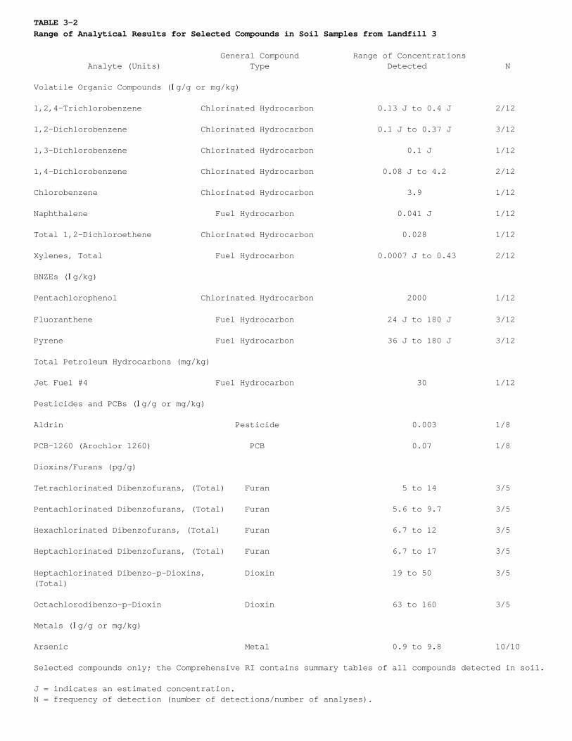
TABLE 3-2Range of Analytical Results for Selected Compounds in Soil Samples from Landfill 3
General Compound Range of Concentrations Analyte (Units) Type Detected N
Volatile Organic Compounds (Ig/g or mg/kg)
1,2,4-Trichlorobenzene Chlorinated Hydrocarbon 0.13 J to 0.4 J 2/12
1,2-Dichlorobenzene Chlorinated Hydrocarbon 0.1 J to 0.37 J 3/12
1,3-Dichlorobenzene Chlorinated Hydrocarbon 0.1 J 1/12
1,4-Dichlorobenzene Chlorinated Hydrocarbon 0.08 J to 4.2 2/12
Chlorobenzene Chlorinated Hydrocarbon 3.9 1/12
Naphthalene Fuel Hydrocarbon 0.041 J 1/12
Total 1,2-Dichloroethene Chlorinated Hydrocarbon 0.028 1/12
Xylenes, Total Fuel Hydrocarbon 0.0007 J to 0.43 2/12
BNZEs (Ig/kg)
Pentachlorophenol Chlorinated Hydrocarbon 2000 1/12
Fluoranthene Fuel Hydrocarbon 24 J to 180 J 3/12
Pyrene Fuel Hydrocarbon 36 J to 180 J 3/12
Total Petroleum Hydrocarbons (mg/kg)
Jet Fuel #4 Fuel Hydrocarbon 30 1/12
Pesticides and PCBs (Ig/g or mg/kg)
Aldrin Pesticide 0.003 1/8
PCB-1260 (Arochlor 1260) PCB 0.07 1/8
Dioxins/Furans (pg/g)
Tetrachlorinated Dibenzofurans, (Total) Furan 5 to 14 3/5
Pentachlorinated Dibenzofurans, (Total) Furan 5.6 to 9.7 3/5
Hexachlorinated Dibenzofurans, (Total) Furan 6.7 to 12 3/5
Heptachlorinated Dibenzofurans, (Total) Furan 6.7 to 17 3/5
Heptachlorinated Dibenzo-p-Dioxins, Dioxin 19 to 50 3/5(Total)
Octachlorodibenzo-p-Dioxin Dioxin 63 to 160 3/5
Metals (Ig/g or mg/kg)
Arsenic Metal 0.9 to 9.8 10/10
Selected compounds only; the Comprehensive RI contains summary tables of all compounds detected in soil.
J = indicates an estimated concentration.N = frequency of detection (number of detections/number of analyses).
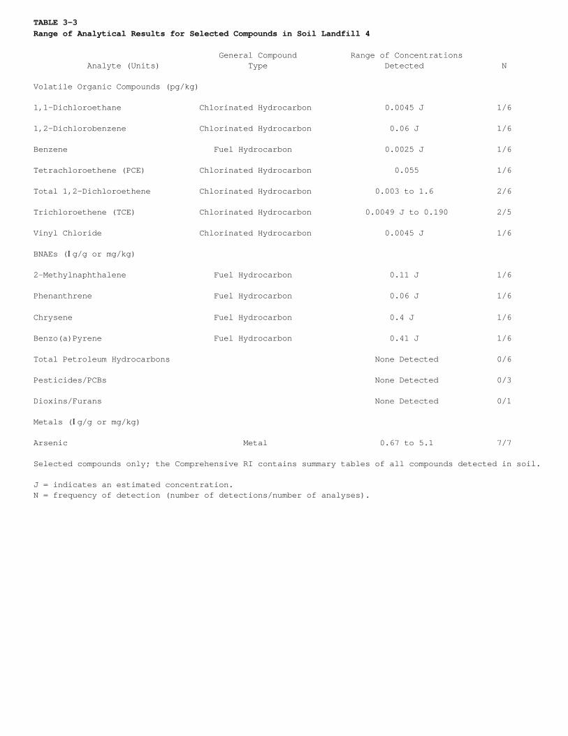
TABLE 3-3Range of Analytical Results for Selected Compounds in Soil Landfill 4
General Compound Range of Concentrations Analyte (Units) Type Detected N
Volatile Organic Compounds (pg/kg)
1,1-Dichloroethane Chlorinated Hydrocarbon 0.0045 J 1/6
1,2-Dichlorobenzene Chlorinated Hydrocarbon 0.06 J 1/6
Benzene Fuel Hydrocarbon 0.0025 J 1/6
Tetrachloroethene (PCE) Chlorinated Hydrocarbon 0.055 1/6
Total 1,2-Dichloroethene Chlorinated Hydrocarbon 0.003 to 1.6 2/6
Trichloroethene (TCE) Chlorinated Hydrocarbon 0.0049 J to 0.190 2/5
Vinyl Chloride Chlorinated Hydrocarbon 0.0045 J 1/6
BNAEs (Ig/g or mg/kg)
2-Methylnaphthalene Fuel Hydrocarbon 0.11 J 1/6
Phenanthrene Fuel Hydrocarbon 0.06 J 1/6
Chrysene Fuel Hydrocarbon 0.4 J 1/6
Benzo(a)Pyrene Fuel Hydrocarbon 0.41 J 1/6
Total Petroleum Hydrocarbons None Detected 0/6
Pesticides/PCBs None Detected 0/3
Dioxins/Furans None Detected 0/1
Metals (Ig/g or mg/kg)
Arsenic Metal 0.67 to 5.1 7/7
Selected compounds only; the Comprehensive RI contains summary tables of all compounds detected in soil.
J = indicates an estimated concentration.N = frequency of detection (number of detections/number of analyses).
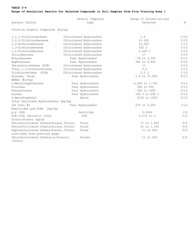
TABLE 3-4Range of Analytical Results for Selected Compounds in Soil Samples from Fire Training Area 1
General Compound Range of ConcentrationsAnalyte (Units) Type Detected N
Volatile Organic Compounds (Ig/kg)
1,1,1-Trichloroethane Chlorinated Hydrocarbon 1.4 1/131,2,4-Trichlorobenzene Chlorinated Hydrocarbon 41,000 1/131,2-Dichlorobenzene Chlorinated Hydrocarbon 15,000 1/131,3-Dichlorobenzene Chlorinated Hydrocarbon 520 J 1/131,4-Dichlorobenzene Chlorinated Hydrocarbon 2,600 J 1/13Chlorobenzene Chlorinated Hydrocarbon 17 1/13Ethylbenzene Fuel Hydrocarbon 59 to 3,500 6/13Naphthalene Fuel Hydrocarbon 340 to 9,900 5/12Tetrachloroethene (PCE) Chlorinated Hydrocarbon 11 1/13Total 1,2-Dichloroethene Chlorinated Hydrocarbon 2.2 1/13Trichloroethene (TCE) Chlorinated Hydrocarbon 2.2 J 1/13Xylenes, Total Fuel Hydrocarbon 1.9 to 37,000 8/13BNAEs (Ig/kg)2-Methylnaphthalene Fuel Hydrocarbon 4,200 to 7,700 3/13Fluorene Fuel Hydrocarbon 360 to 930 2/13Phenanthrene Fuel Hydrocarbon 450 to 1400 2/13Pyrene Fuel Hydrocarbon 100 J to 290 J 2/134-Aminobiphenyl Amine 210J to 1000 2/13Total Petroleum Hydrocarbons (mg/kg)Jet Fuel #4 Fuel Hydrocarbon 270 to 3,200 7/13Pesticides and PCBs (mg/kg)p,p'-DDD Pesticide 0.0042 1/5PCB-1260 (Arochlor 1260) PCB 0.072 to 5 2/5Dioxin/Furans (pg/g)Tetrachlorinated Dibenzofurans,(Total) Furan 17 to 1,600 5/5Pentachlorinated Dibenzofurans,(Total) Furan 21 to 1,100 5/5Heptachlorirated Dibenzofurans,(Total) Furan 11 to 850 5/5continued from previous page:Tetrachlorinated Dibenzo-p-Dioxins, Dioxin 11 to 250 4/5(Total)
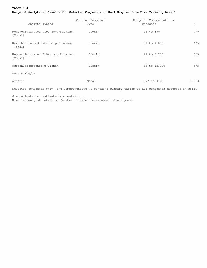
TABLE 3-4Range of Analytical Results for Selected Compounds in Soil Samples from Fire Training Area 1
General Compound Range of Concentrations Analyte (Units) Type Detected N
Pentachlorinated Dibenzo-p-Dioxins, Dioxin 11 to 390 4/5(Total)
Hexachlorinated Dibenzo-p-Dioxins, Dioxin 34 to 1,800 4/5(Total)
Heptachlorinated Dibenzo-p-Dioxins, Dioxin 21 to 5,700 5/5(Total)
Octachlorodibenzo-p-Dioxin Dioxin 83 to 15,000 5/5
Metals (Ig/g)
Arsenic Metal 0.7 to 4.6 13/13
Selected compounds only; the Comprehensive RI contains summary tables of all compounds detected in soil.
J = indicated an estimated concentration.N = frequency of detection (number of detections/number of analyses).
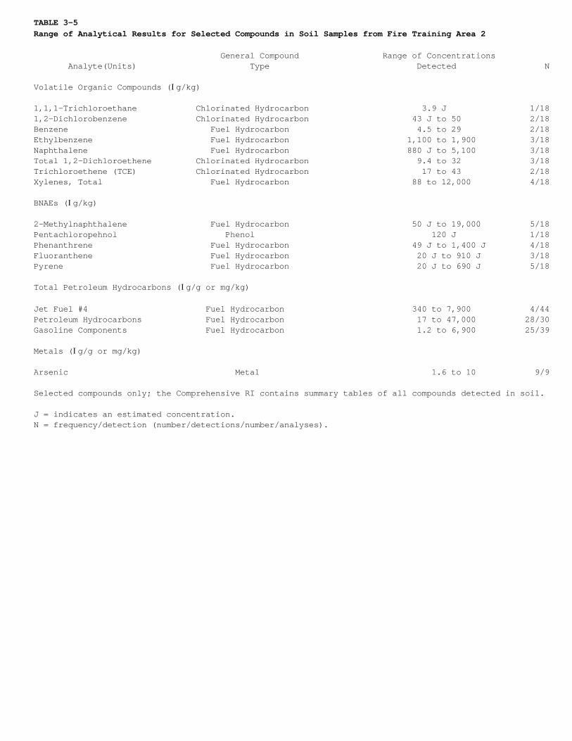
TABLE 3-5Range of Analytical Results for Selected Compounds in Soil Samples from Fire Training Area 2
General Compound Range of Concentrations Analyte(Units) Type Detected N
Volatile Organic Compounds (Ig/kg)
1,1,1-Trichloroethane Chlorinated Hydrocarbon 3.9 J 1/181,2-Dichlorobenzene Chlorinated Hydrocarbon 43 J to 50 2/18Benzene Fuel Hydrocarbon 4.5 to 29 2/18Ethylbenzene Fuel Hydrocarbon 1,100 to 1,900 3/18Naphthalene Fuel Hydrocarbon 880 J to 5,100 3/18Total 1,2-Dichloroethene Chlorinated Hydrocarbon 9.4 to 32 3/18Trichloroethene (TCE) Chlorinated Hydrocarbon 17 to 43 2/18Xylenes, Total Fuel Hydrocarbon 88 to 12,000 4/18
BNAEs (Ig/kg)
2-Methylnaphthalene Fuel Hydrocarbon 50 J to 19,000 5/18Pentachloropehnol Phenol 120 J 1/18Phenanthrene Fuel Hydrocarbon 49 J to 1,400 J 4/18Fluoranthene Fuel Hydrocarbon 20 J to 910 J 3/18Pyrene Fuel Hydrocarbon 20 J to 690 J 5/18
Total Petroleum Hydrocarbons (Ig/g or mg/kg)
Jet Fuel #4 Fuel Hydrocarbon 340 to 7,900 4/44Petroleum Hydrocarbons Fuel Hydrocarbon 17 to 47,000 28/30Gasoline Components Fuel Hydrocarbon 1.2 to 6,900 25/39
Metals (Ig/g or mg/kg)
Arsenic Metal 1.6 to 10 9/9
Selected compounds only; the Comprehensive RI contains summary tables of all compounds detected in soil.
J = indicates an estimated concentration.N = frequency/detection (number/detections/number/analyses).

TABLE 3-6Range of Analytical Results for Selected Compounds in Soil Samples from the Waste Phenol/Oil Pit
General Compound Range of Concentrations Analyte (Units) Type Detected N
Volatile Organic Compounds (Ig/kg)
1,2,4-Trichlorobenzene Chlorinated Hydrocarbon 3320 J to 4,400 2/31,2-Dichlorobenzene Chlorinated Hydrocarbon 220 J to 540 2/31,3-Dichlorobenzene Chlorinated Hydrocarbon 18 J 1/31,4-Dichlorobenzene Chlorinated Hydrocarbon 36 J to 120 J 2/3Total 1,2-Dichloroethene Chlorinated Hydrocarbon 92 1/3Trichloroethene (TCE) Chlorinated Hydrocarbon 560 to 1,400 2/3
BNAEs (Ig/kg)
2,4-Dimethylphenol Phenol 180 J 1/3Pentachlorophenol Phenol 240 J 1/3Pyrene Fuel Hydrocarbon 52 J 1/3
Total Petroleum Hydrocarbons (mg/kg)
Jet Fuel #4 Fuel Hydrocarbon 70 1/3
Pesticides and PCBs (Ig/kg)
p,p'-DDT Pesticide 7.1 1/3PCB-1260 (Arochlor 1260) PCB 80 1/3
Dioxin/Furans (pg/g)
Tetrachlorianted Dibenzofurans, Furan 26 ½(Total)Pentachlorinated Dibenzofurans, Furan 14 ½(Total)Hexachlorinated Dibenzofurans, Furan 9.2 ½(Total)Heptachlorinated Dibenzofurans, Furan 8.7 ½(Total)Tetrachlorinated Dibenzo-p- Dioxin 4.7 ½Dioxins, (Total)Pentachlorinated Dibenzo-p- Dioxin 6.8 ½Dioxins, (TotalHexachlorinated Dibenzo-p- Dioxin 20 ½Dioxins, (Total)Heptachlorinated Dibenzo-p- Dioxin 29 ½Dioxins, (Total)Octachlorodibenzo-p-Dioxin Dioxin 50 ½

TABLE 3-6Range of Analytical Results for Selected Compounds in Soil Samples from the Waste Phenol/Oil Pit
General Compound Range of Concentrations Analyte (Units) Type Detected N
Metals (Ig/g)
Arsenic Metal 2.6 to 3.4 3/3
Selected compounds only; the Comprehensive RI contains summary tables of all compounds detected in soil.
J = indicates an estimated concentration.N = frequency of Detection (number of detections/number of analyses).
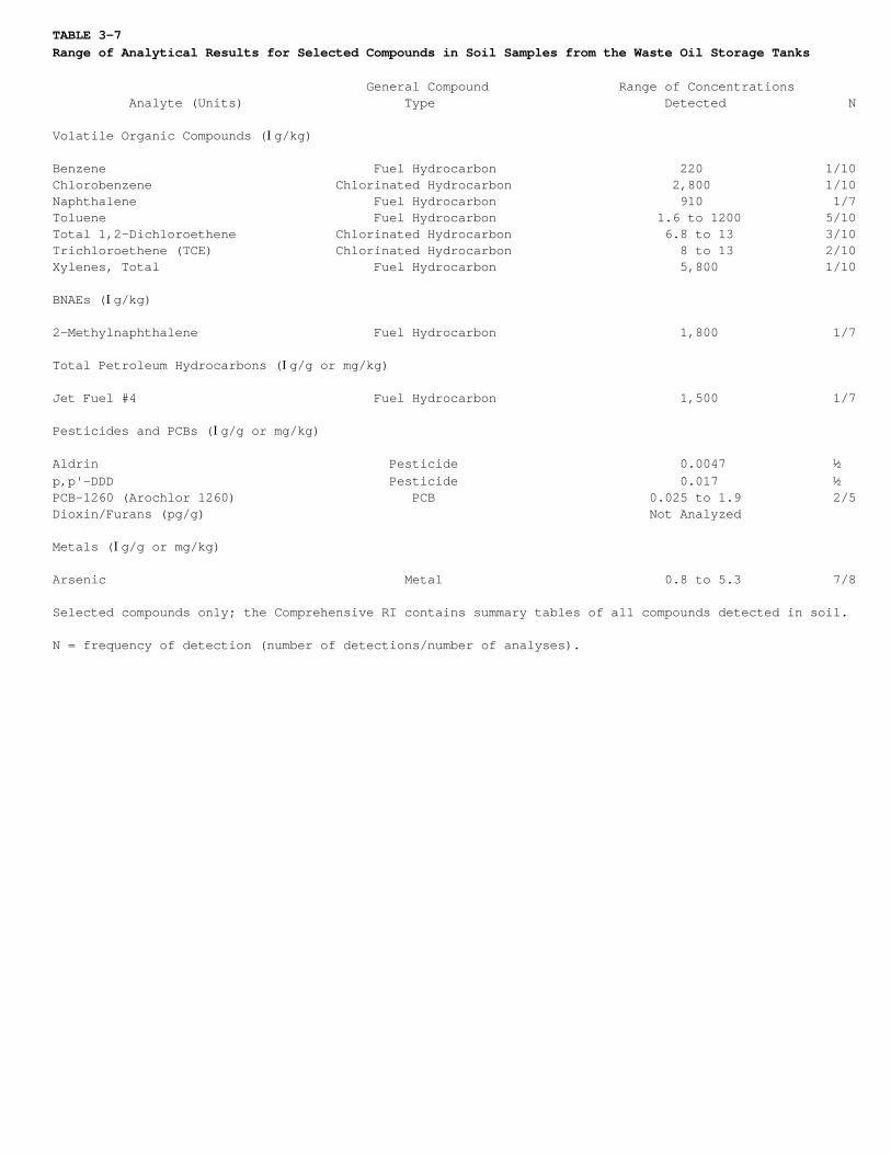
TABLE 3-7Range of Analytical Results for Selected Compounds in Soil Samples from the Waste Oil Storage Tanks
General Compound Range of Concentrations Analyte (Units) Type Detected N
Volatile Organic Compounds (Ig/kg)
Benzene Fuel Hydrocarbon 220 1/10Chlorobenzene Chlorinated Hydrocarbon 2,800 1/10Naphthalene Fuel Hydrocarbon 910 1/7Toluene Fuel Hydrocarbon 1.6 to 1200 5/10Total 1,2-Dichloroethene Chlorinated Hydrocarbon 6.8 to 13 3/10Trichloroethene (TCE) Chlorinated Hydrocarbon 8 to 13 2/10Xylenes, Total Fuel Hydrocarbon 5,800 1/10
BNAEs (Ig/kg)
2-Methylnaphthalene Fuel Hydrocarbon 1,800 1/7
Total Petroleum Hydrocarbons (Ig/g or mg/kg)
Jet Fuel #4 Fuel Hydrocarbon 1,500 1/7
Pesticides and PCBs (Ig/g or mg/kg)
Aldrin Pesticide 0.0047 ½p,p'-DDD Pesticide 0.017 ½PCB-1260 (Arochlor 1260) PCB 0.025 to 1.9 2/5Dioxin/Furans (pg/g) Not Analyzed
Metals (Ig/g or mg/kg)
Arsenic Metal 0.8 to 5.3 7/8
Selected compounds only; the Comprehensive RI contains summary tables of all compounds detected in soil.
N = frequency of detection (number of detections/number of analyses).
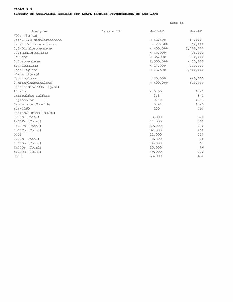
TABLE 3-8Summary of Analytical Results for LNAPL Samples Downgradient of the CDPs
Results
Analytes Sample ID M-27-LF W-4-LFVOCs (Ig/kg)Total 1,2-dichloroethene < 52,500 87,0001,1,1-Trichloroethane < 27,500 92,0001,2-Dichlorobenzene < 400,000 2,700,000Tetrachloroethene < 35,000 38,000Toluene < 35,000 770,000Chlorobenzene 2,300,000 < 13,000Ethylbenzene < 27,500 210,000Total Xylene < 23,500 1,400,000BNZEs (Ig/kg)Naphthalene 430,000 640,0002-Methylnaphthalene < 400,000 810,000Pesticides/PCBs (Ig/ml)Aldrin < 0.05 0.41Endosulfan Sulfate 3.5 5.3Heptachlor 0.12 0.13Heptachlor Epoxide 0.41 0.45PCB-1260 230 190Dioxin/Furans (pg/ml)TCDFs (Total) 3,800 320PeCDFs (Total) 44,000 350HxCDFs (Total) 50,000 370HpCDFs (Total) 32,000 290OCDF 11,000 220TCDDs (Total) 8,300 16PeCDDs (Total) 14,000 57HxCDDs (Total) 23,000 86HpCDDs (Total) 49,000 320OCDD 63,000 630
TABLE 3-8Summary of Analytical Results for LNAPL Samples Downgradient of the CDPs Results
Analytes Sample ID M-27-LF W-4-LF
TPH (mg/ml)
JP4 120 72
Selected compounds only; the Comprehensive RI contains summary tables of all compounds detected inLNAPL.
< = Not detected at or above the specified detection limit.J = Value is an estimated concentration below the practical quantitation limit.
TABLE 3-9Summary of Analytical Results for LNAPL Samples from Fire Training Area 1
Results U1-101 Analytes Sample Location U1-1-1 (Blind DuplicateSample)
VOCs (Ig/kg)
Ethylbenzene 210,000 200,000Total Xylene 540,000 < 23,250
BNAEs (Ig/kg)
Naphthalene 1,400,000 1,500,0002-Methylnaphthalene 520,000 J 540,000
Pesticides (Ig/ml)
Alpha-BHC 0.65 0.51Delta-BHC < 0.05 0.11Lindane < 0.05 0.39Dieldrin 0.08 0.08Endosulfan Sulfate < 0.25 0.37
Dioxins and Furans (pg/ml)
TCDFs (Total) 8,300 3,700HxCDFs (Total) 1,600 1,300HpCDFs (Total) 480 690OCDF < 220 210TCDDs (Total) 220 430PeCDDs (Total) 340 800HxCDDs (Total) 1,200 2,100OCDD 11,000 12,000
TPH (mg/ml)
JP4 240 250
Selected compounds only; the Comprehensive RI contains summary tables of all compounds detected inLNAPL.
< = not detected at or above the specified detection limit.J = value is an estimated concentration below the practical quantitation limit.
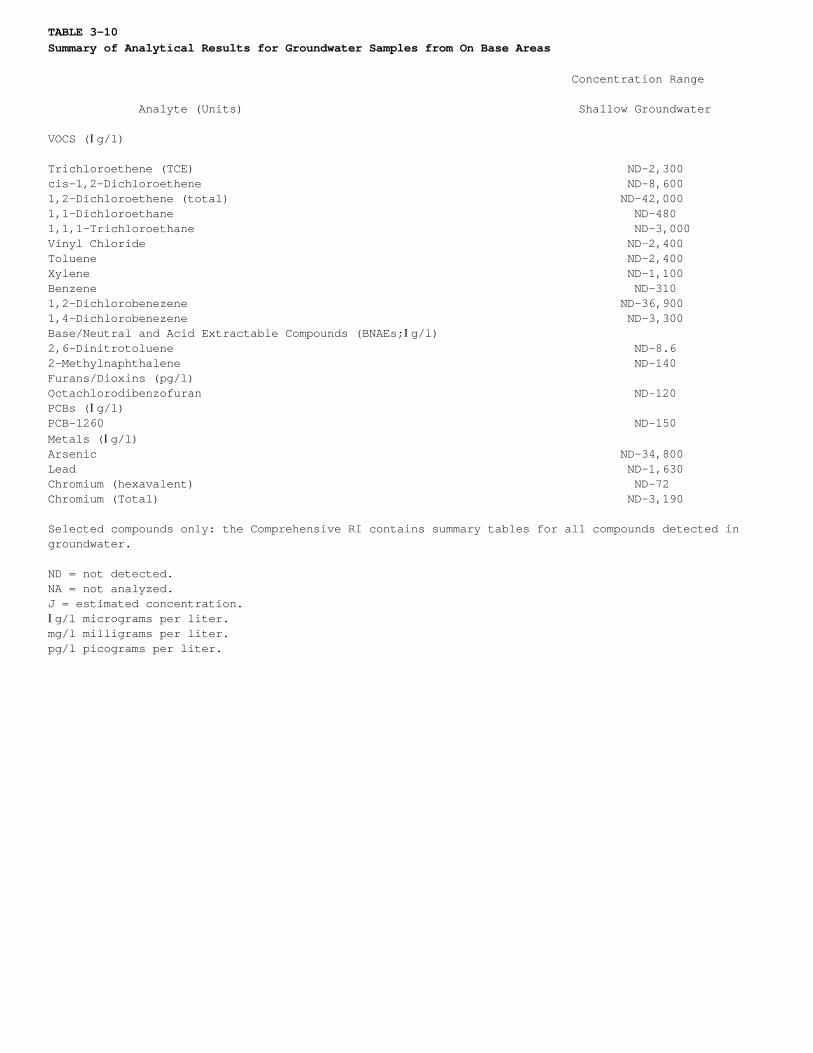
TABLE 3-10Summary of Analytical Results for Groundwater Samples from On Base Areas
Concentration Range
Analyte (Units) Shallow Groundwater
VOCS (Ig/l)
Trichloroethene (TCE) ND-2,300cis-1,2-Dichloroethene ND-8,6001,2-Dichloroethene (total) ND-42,0001,1-Dichloroethane ND-4801,1,1-Trichloroethane ND-3,000Vinyl Chloride ND-2,400Toluene ND-2,400Xylene ND-1,100Benzene ND-3101,2-Dichlorobenezene ND-36,9001,4-Dichlorobenezene ND-3,300Base/Neutral and Acid Extractable Compounds (BNAEs;Ig/l)2,6-Dinitrotoluene ND-8.62-Methylnaphthalene ND-140Furans/Dioxins (pg/l)Octachlorodibenzofuran ND-120PCBs (Ig/l)PCB-1260 ND-150Metals (Ig/l)Arsenic ND-34,800Lead ND-1,630Chromium (hexavalent) ND-72Chromium (Total) ND-3,190
Selected compounds only: the Comprehensive RI contains summary tables for all compounds detected ingroundwater.
ND = not detected.NA = not analyzed.J = estimated concentration.Ig/l micrograms per liter.mg/l milligrams per liter.pg/l picograms per liter.
TABLE 3-11Summary of Analytical Results for Groundwater Samples from the Weber River Valley
Concentration Range
Shallow Groundwater from theDeeper Analyte (Units) Groundwater Part of the Aquifer
VOCS (Ig/l)
Trichloroethene (TCE) ND-28 NDcis-1,2-Dichloroethene ND-970 ND1,2-Dichloroethene (Total) ND-1,500 ND1,1-Dichloroethane ND-28 ND1,1,1-Trichloroethane ND-14J NDToluene 1.6J NDXylene 0.53J NDBase/Neutral and Acid Extractable Compounds ND NA(BNAEs; Ig/l)Total Petroleum Hydrocarbons (mg/l) ND NAFurans (pg/l) NA NADioxins (pg/l) NA NAPCBs (Ig/l) NA NAMetals (Ig/l)Arsenic (filtered) ND-30 NDChromium (filtered) ND-300 30
Selected compounds only; the Comprehensive RI contains summary tables for all compounds detected ingroundwater.
ND = not detected.NA = not analyzed.J = estimated concentration.Ig/l micrograms per liter.mg/l milligrams per liter.pg/l picograms per liter.
TABLE 3-12Summary of Surface Water Data for Select Compounds
Hillside Downgradient of OU 1 Boundary the Eastern Portion Northeast of Downgradient of Hillside Downgradient Weber River Valley of OU1 (Seeps U1- LF 4 (Seeps U1- the Central of the Western Portion Downgradient of 301, U1-302, U1-311 303, U1-304, Portion of OU1 of OU1 (Seeps U1-306, the Western Analytes (Units) U1-312, and U1-319) and U1-318) (Seep U1-305) U1-307, and U1-308) Portion of OU1Metals-Unfiltered (Ig/l)Chromium, Hexavalent -- -- ND -- NDMetals-Filtered (Ig/l)Arsenic 6-26.3 31.4-1160 2.3-3.9 2.3-5.6 NDVOCS (Ig/l)Dichlorodifluoromethane ND 1.1-11 ND ND NDVinyl Chloride ND 0.72J-50 ND ND NDChloroethane ND 1.7-5.3 ND ND NDcis= 1,2-Dichloroethene ND 1.1-3.3 0.54T-1.1 450-490 85-1401,1-Dichloroethane ND 2.2-8.1 2.1-9.9 0.28J-6.7 1.4J-2.5Total 1,2-Dichloroethene ND 0.95J-3.4T 1.6T-1.6J 29-530 1.4-2401,2-Dichloroethane ND 0.82T-1.5 0.53T-0.64T ND ND1,1,1-Trichloroethane (TCA) ND ND ND ND 0.33J-3.3Trichloroethene (TCE) ND 0.19T-1.1 1.3-4.5T 0.20J-0.67J 1.6T-4.7Benzene ND 0.26J-7.3 ND ND NDToluene ND 0.21T-34 ND ND NDChlorobenzene ND 0.14T-2.2 ND ND NDEthylbenzene ND 0.28T-34 ND ND NDm,p-Xylene ND 0.79T-26 ND ND ND
TABLE 3-12Summary of Surface Water Data for Select Compounds
Hillside Downgradient of OU 1 Boundary the Eastern Portion Northeast of Downgradient of Hillside Downgradient Weber River Valley of OU1 (Seeps U1- LF 4 (Seeps U1- the Central of the Western Portion Downgradient of 301, U1-302, U1-311 303, U1-304, Portion of OU1 of OU1 (Seeps U1-306, the Western Analytes (Units) U1-312, and U1-319) and U1-318) (Seep U1-305) U1-307, and U1-308) Portion of OU1
o-Xylene (1,2-Dimethylbenzene) ND 0.80T-17 ND ND NDXylenes, Total ND 0.34J-2.8T ND ND NDIsopropylbenzene (Cumene) ND 0.22J-0.92J ND ND NDn-Propylbenzene ND 0.16J-0.58J ND ND ND1,3,5-Trimethylbenzene (Mesitylene) ND 0.12T-1.1 ND ND ND1,2,4-Trimethylbenzene ND 0.32T-5.1 0.13T ND NDsec-Butylbenzene ND 0.15T-0.29J ND ND NDp-Cymene (p-Isopropyltoluene) ND 0.12J ND ND ND1,3-Dichlorobenzene ND 0.13T-0.27J ND ND ND1,4-Dichlorobenzene ND 0.41J-14 ND ND ND1,2-Dichlorobenzene ND 0.22T-1.4 ND ND NDNaphthalene ND 0.98-1.4 ND ND NDTetrachloroethene (PCE) ND ND ND 4.1J 6.2
- = not analyzed.ND = not detectedJ = estimated concentration.T = detected above detection limit, but below standard reporting limit.

TABLE 3-13Summary of Metals Detected in Sediment Samples from Seeps/Springs at OU1
Sampling Location IDMetal mg/kg Soil Background* U1-301 U1-303 U1-304 U1-305 U1-318
Arsenic 1.2-11 49 310 370 204 573
*Background range for arsenic in soil at OU1.
<IMG SRC 98107E><IMG SRC 98107F><IMG SRC 98107G><IMG SRC 98107H><IMG SRC 98107I>
4.0 Summary of Site Risks
4.0.0.1. A Comprehensive Baseline Risk Assessment was prepared for OU1 as part of the ComprehensiveRemedial Investigation Report for Operable Unit 1 (MW, 1995) to evaluate potential health andenvironmental effects caused by actual or potential releases of and exposure to OU1-related chemicalsunder current and hypothetical future conditions. The risk assessment identifies the contaminants ofpotential concern (COPC), current and future exposure pathways for humans, environmental receptors, andthe probability of adverse effects resulting from exposure. The four basic components of the riskassessment are summarized in this section: identification of chemicals of potential concern, exposureassessment, toxicity assessment, and risk characterization. Detailed descriptions of the risk assessmentare available in Appendix A of the Comprehensive Remedial Investigation Report for Operable Unit 1.
4.1 Human Health Risks
4.1.1 Contaminants of Potential Concern
4.1.1.1. COPCs are defined by the EPA as "chemicals that are potentially site-related and whose data areof sufficient quality for use in the quantitative risk assessment" (EPA, 1988). All data of acceptablequality from the RI were used to identify COPCs. Detailed descriptions of the screening andidentification process and criteria are described in the Comprehensive Baseline Risk Assessment. Criteriaused to select COPCs followed EPA guidance. In addition, chemicals were screened against conservativerisk-based concentrations using calculated PRGs for a residential exposure scenario.
4.1.1.2. Although there are numerous contaminants present at OU1, only a few compounds account for mostof the potential human health and ecological risks. Chemicals dominating the potential human health risksinclude DCE, vinyl chloride, arsenic, and in some instances, TCE.
4.1.2 Exposure Assessment
4.1.2.1. Exposure assessment is the determination or estimation of the magnitude, frequency, duration,and route of human and environmental exposures to COPCs present at or migrating from a site. Humanexposure to COPCs from OU1 was evaluated by performing the following tasks: (1) characterizing thepotentially exposed population, (2) developing exposure scenarios, (3) identifying exposure pathways, and(4) quantifying exposures for each scenario.
4.1.2.2. Current Off-Base Residential Exposure Scenario. The current land use in the off-Base areasimmediately north of OU1 consists of mostly residential homes and some areas used for livestock grazing.
Pathways for both child and adult receptors include the following:
• Inhalation of volatile compounds from basement seepage. (Note: Significant quantities ofVOCs have not been observed in air samples of basement air obtained in residences overlyingthe OU1 off-Base plume).
• Ingestion of locally grown fruits and vegetables irrigated with contaminated groundwater.
• Ingestion of locally produced beef products from animals fed contaminated water or contaminated feed.
4.1.2.3. The Comprehensive Baseline Risk Assessment used standard equations and assumptions available inEPA guidance to quantify chemical intake. This report documents all the equations and assumptions used.
4.1.2.4. Future Off-Base Residential Exposure Scenario. According to State of Utah populationdemographics for Davis County for the years 1990 through 2020, the resident population is projected toincrease at an annual rate of 2.14 percent (State of Utah Governor's Office of Planning andBudget-Demographic and Economic Analysis Section, 1997).
4.1.2.5. The most likely future changes in land use in the area include increases in residential housingand decreasing agricultural activities. New residents will most likely be connected to the municipalwater supply but could use shallow wells and drains for lawn and garden irrigation. New residents mayelect to install shallow groundwater wells even though higher quality water is readily available fromother sources; i.e., municipal sources and deeper aquifers.
Pathways for both child and adult receptors include the following:
• Inhalation of volatile compounds from basement seepage.
• Inhalation of volatile compounds while showering.
• Dermal contact with contaminated water while showering.
• Ingestion of contaminated drinking water.
• Ingestion of locally grown fruits and vegetables irrigated with contaminated groundwater.
• Ingestion of locally produced beef products from animals fed contaminated water or contaminated feed.
• Dermal contact and/or ingestion of sediments associated with off-Base springs.
4.1.2.6. Future On-Base Residential Exposure Scenario. Residential development is not likely in theon-Base areas of OU1 However, to provide a conservative assessment of the potential risks associated withOU1 health risks based on a future on-Base residential development were evaluated. The future potentialexposure pathways associated with unrestricted, on-Base residential land use include the following:
• Inhalation of contaminated fugitive dust from the site.
• Inhalation of volatile compounds while showering.
• Dermal contact with contaminated water while showering.
• Dermal contact with and incidental ingestion of contaminated soils.
• Ingestion of contaminated drinking water.
• Ingestion of locally grown fruits and vegetables irrigated with contaminated groundwater.
• Ingestion of locally produced beef products from animals fed contaminated water or contaminated feed.
4.1.2.7. On-Base Worker Scenario. If development occurs at OU1, on-Base construction workers could beexposed to site-related chemicals. Exposure pathways affecting workers engaged in construction activitiesinclude the following:
• Inhalation of contaminated fugitive dust from the site.
• Inhalation of volatile compounds close to the source.
• Dermal contact with and incidental ingestion of contaminated soils.
4.1.3 Toxicity Assessment
4.1.3.1. Contaminants may have carcinogenic (cancer-causing) effects or noncarcinogenic/systemiceffects. Exposure to some of the chemicals detected at OU1 could potentially result in both types ofeffects. For carcinogens, it is assumed any amount of exposure to a carcinogenic chemical poses apotential for generating a carcinogenic response in the exposed organism.
4.1.3.2. Noncarcinogenic or systemic effects include a variety of toxicological end points and mayinclude effects on specific organs or systems, such as the kidney, liver, lungs, and others. Thresholdlevels generally exist for noncarcinogenic effects; i.e., a dose exceeding a certain level must bereached before health effects are observed. No adverse effects are assumed for doses below the threshold.
4.1.3.3. Cancer potency factors (CPF), or slope factors (SF), are used to provide conservative estimatesof excess lifetime cancer risks associated with exposure to potentially carcinogenic chemicals. SFs,which are expressed in units of milligrams per kilogram per day [(mg/kg-day) -1] are multiplied by theestimated intake of a potential carcinogen, in mg/kg-day, to provide an upper bound estimate of theexcess lifetime cancer risk associated with exposure at the intake level. The term "upper bound" reflectsthe conservative estimate of the risks calculated from the SF. Use of this approach makes underestimationof the actual cancer risk unlikely. SFs are derived from the results of human epidemiological studies orchronic animal bioassays to which animal-to-human extrapolation and uncertainty factors have been
applied; e.g., to account for the use of animal data to predict effects on humans.
4.1.3.4. Reference doses (RfD) are used to indicate the potential for adverse health effects fromexposure to chemicals causing noncarcinogenic effects. RfDs, which are expressed in units of mg/kg-day,are estimated threshold levels for daily exposure below which exposure is considered safe for humans,including sensitive individuals. Estimated intakes of COPCs from environmental media (e.g., the amount ofa COPC ingested from contaminated drinking water) can be compared with the RfD. RfDs are derived fromhuman epidemiological studies or animal studies to which uncertainty factors have been applied. SFs andRfDs are specific to the route of exposure; for example, oral SFs are used to evaluate risk throughingestion of a carcinogenic COPC.
4.1.4 Summary of Risk Characterization
4.1.4.1. Carcinogenic and noncarcinogenic risks were calculated for each of the exposure pathways forthe COPCs and compared with acceptable levels of risk. For each potentially carcinogenic COPC, theprobability that an individual will develop cancer over a lifetime was estimated from projected intakelevels and the cancer SF or the inhalation unit risk. Risks are probabilities generally expressed inexponential form. An individual excess lifetime cancer risk of 1 x 10 -6 indicates that an individual hasa 1-in-1 million additional chance of developing cancer as a result of site-related exposure to acarcinogen over a 70-year lifetime under specific exposure conditions at OU1.
4.1.4.2. To address the range of exposures that may occur now and in the future, both average andreasonable maximum exposures (RME) were considered. Inclusion of both average and RME values allows risksto be estimated for the upper bound exposure situation and the more typical or average exposure. Theresulting risk estimates then present a range of possible risks based on the range of possible exposureconditions.
4.1.4.3. The EPA Superfund site remediation goal set forth in the National Oil and Hazardous SubstancesPollution Contingency Plan (NCP) allows a cancer risk of 10 -4 (1 in 10,000) to 10 -6 (1 in 1 million).This range is designed to be protective of human health. The cancer risk of 10 -6, based on reasonablemaximum exposure, is the required point of departure for addressing risks. A cancer risk of 1 in 1million is considered a "de minimis level," or a level of negligible risk, for risk management decisions.
4.1.4.4. To characterize the potential systemic effects of chemicals, comparisons were made betweenprojected intakes of COPCs over specified time and toxicity values, primarily oral as well as dermal RfDsand inhalation reference concentrations. A hazard quotient (HQ), which is the ratio between exposure to achemical and that chemical's toxicity value, was calculated for each COPC and exposure pathway.Chemical-specific HQs were then summed for each COPC and each pathway of exposure to calculate the totalhazard index (HI) for each exposure scenario.
4.1.4.5. The HI is not a statistical probability of a systemic effect occurring. If the exposure levelexceeds the appropriate toxicity value (i.e., the HQ is greater than 1), there may be cause for concern.The Superfund site remediation goal for noncarcinogens is a total HI of less than 1.
4.1.4.6. Table 4-1 summarizes the cancer risk and hazard index estimates for each potential exposurescenario. Excess cancer risks and hazard indices for current and potential future pathways aresummarized. Exposure pathways that may be complete at OU1 under current conditions include inhalation ofvolatilized DCE (soil gas) in basements of houses that are situated over the DCE-contaminatedgroundwater, and exposure to chromium in springs used for watering livestock. Neither of these pathwaysposes a significant risk. (Note: significant quantities of VOCs have not been observed in air samples ofbasement air obtained in residences overlying the OU1 off-Base plume).
4.1.4.7. Neither of the two potentially complete current exposure pathways identified poses anunacceptable risk to human health or the environment. Air sampling within five homes situated overDCE-contaminated groundwater in the Weber River Valley has shown that excess cancer risks and risks ofchronic health effects associated with current exposure to soil gas in basements are both well below thetarget 1 x 10 -6 excess cancer risk level and hazard index of 1. The sampled homes are located off-Baseover areas where concentrations of 1,2-DCE are the highest, and one home has a basement that is partiallybelow the water table (the home has a sump to remove groundwater that enters the basement). Therefore,the calculated exposure based on the results of this air sampling represents a worst case scenario forthis exposure pathway off-Base. The risks were well below acceptable levels.
4.1.4.8. Chromium was detected in one round of surface water sampling at OU1, and has not been detectedduring subsequent rounds of quarterly monitoring. This suggests that the initial chromium detections maybe the result of false positives associated with matrix interference during analysis, and are notrepresentative of the environment. If it is assumed chromium was present in the detected concentrations,the calculated hazard indices due to exposure to the chromium are well below the benchmark of 1.
Consequently, there are no current significant risks to human health from exposure to chromium in surfacewater or to organic compounds in basement air at OU1.
4.1.4.9. Future potential exposure pathways that could become significant involve on- and off-Basedomestic use of groundwater from the shallow unconfined water-bearing zone, exposure of constructionworkers and future residents to on-Base soil contaminants, and exposure to contaminated soil gas if itmigrates into the basements of houses. When possible, quantitative exposure estimates resulting fromthese pathways were made. The scenarios were analyzed qualitatively when a large degree of uncertaintyexisted. When evaluating potential exposure, the existing response actions at OU1 were not assumed to bein place.
4.1.4.10. In the future, if the shallow groundwater beneath OU1 is used for drinking and for showering,the resulting cancer risks and non-cancer health threats both would be greater than permitted by the NCP.Although the health risks (1 x 10 -5) associated with future exposure to contaminants present in theshallow groundwater of the Weber River Valley fall within the NCP range of 10 -6 to 10 -4, the hazardindex is estimated to be between 1 and 10. For future exposure to shallow on-Base groundwater beneath theSource Areas, the excess cancer risks are estimated to be greater than 10 -3 and hazard indices rangefrom 20 to 90.
4.1.4.11. Based on a qualitative evaluation, risks from exposure to soil gas in basements of futureon-Base residences may become significant in the future. Health risks associated with the exposure ofconstruction workers to on-Base contaminated soil are expected to be of borderline significance (1 x 10⁻⁶) at most. Future excess cancer risks were estimated to be no greater than 1 x 10 -6 for any of theSource Areas, although these estimates did not include risks from compounds that do not have publishedtoxicity values. If these compounds were included, it may be reasonable to assume a potential cancer riskbetween 1 x 10 -6 and 1 x 10 -4 at the CDPs and the Waste Phenol/Oil Pit. All hazard indices for soil areestimated to be less than 1. The estimated cancer risk (1 x 10 -6) and the hazard index (0.01) fromingestion of soil (contaminated with pesticides and PCBs) by future residents is not significant.
4.2 Ecological Risk Characterization
4.2.0.1. Calculated doses of the main contaminant of environmental concern (arsenic) to alfalfa (orsimilar crops) and cattle were lower than doses reported to have no effect on these receptors. Whileother types of vegetation and domestic animals are found in the area, cattle and alfalfa were consideredrepresentative species for risk calculations that would provide a reasonable indication of potentialhazards to agriculture. The results of this investigation indicate that non-domestic plants and animalsare not expected to be adversely affected by the contaminants from OU1. As discussed in the ComprehensiveBaseline Risk Assessment, neither critical habitats nor threatened or endangered species are present.Pond No. 10 contains the area of the former Waste Phenol/Oil Pit. This pond holds surface water runofffrom nearby areas of the Base. Contaminants detected at the Waste Phenol/Oil Pit occur in subsurfacesoil, and are not expected to significantly impact the quality of water in Pond No. 10. Animals thatdrink from the escarpment springs/seeps could be exposed to arsenic contaminated sediments, but exposurewould be of short duration and is not expected to produce adverse effects.
4.3 Uncertainty Analysis
4.3.0.1. Uncertainty is inherent to the risk assessment process. Uncertainty associated with these riskestimates include uncertainties associated with the exposure estimates and uncertainties in the toxicityevaluation. Uncertainties associated with the risk characterization include data, indicator chemicalselection, exposure, and toxicity assumptions. The primary additional uncertainty is whether the futureexposure pathways (especially those involving residential exposure on-Base) will actually become completein the future. If not, the actual cancer risks and hazard indices are zero. Other uncertainties includeextrapolations from high to low dose, extrapolations from animals to human, model uncertainties,representativeness of samples, and intraspecies variation. Because of the arguments presented in thissection, it can be stated that for those exposure scenarios which have been quantitatively evaluated andfor which the most toxic and prevalent compounds at OU1 have reference doses and slope factors, the riskassessment is expected to be conservative, and the actual risks are expected to be less than thosecalculated. Certain exposure scenarios were not evaluated quantitatively due to a lack of information.
4.3.0.2. Risks from petroleum mixtures, including jet fuel, diesel, and gasoline, were not addressedquantitatively in the risk assessment because the potential for risk was clear from a qualitativeassessment. These mixtures would be associated with human health risks by all routes including oral,inhalation, and dermal exposures. However, the odor, taste, and appearance of any groundwater mixed withLNAPL would be objectionable, and actual direct contact with this medium is not anticipated under anyfuture scenario. For all evaluations, the risk assessment is expected to be conservative, and the actualrisks are probably less than those calculated in the Comprehensive Baseline Risk Assessment.

4.4 Overview of Site Risks
4.4.0.1. Actual or threatened releases of hazardous substances from this site, if not addressed byimplementing the response action selected in this ROD, may present an imminent and substantialendangerment to public health, welfare, or the environment.
4.4.0.2. Remedial action at OU1 is warranted on the basis of potential future risks to human health andthe environment (i.e., to prevent a significant risk to residents). Also, remedial action is generallywarranted when MCLs are exceeded in groundwater. Potential domestic groundwater use accounts for themajority of the risk by ingestion, inhalation, and dermal pathways.
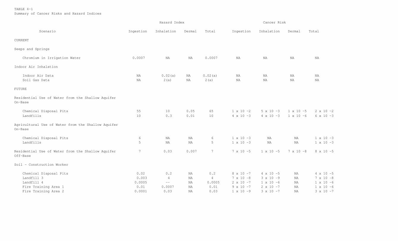
TABLE 4-1Summary of Cancer Risks and Hazard Indices
Hazard Index Cancer Risk
Scenario Ingestion Inhalation Dermal Total Ingestion Inhalation Dermal Total
CURRENT
Seeps and Springs
Chromium in Irrigation Water 0.0007 NA NA 0.0007 NA NA NA NA
Indoor Air Inhalation
Indoor Air Data NA 0.02(a) NA 0.02(a) NA NA NA NA Soil Gas Data NA 2(a) NA 2(a) NA NA NA NA
FUTURE
Residential Use of Water from the Shallow AquiferOn-Base
Chemical Disposal Pits 55 10 0.05 65 1 x 10 -2 5 x 10 -3 1 x 10 -5 2 x 10 -2 Landfills 10 0.3 0.01 10 4 x 10 -3 4 x 10 -3 1 x 10 -6 6 x 10 -3
Agricultural Use of Water from the Shallow AquiferOn-Base
Chemical Disposal Pits 6 NA NA 6 1 x 10 -3 NA NA 1 x 10 -3 Landfills 5 NA NA 5 1 x 10 -3 NA NA 1 x 10 -3
Residential Use of Water from the Shallow Aquifer 7 0.03 0.007 7 7 x 10 -5 1 x 10 -5 7 x 10 -8 8 x 10 -5Off-Base
Soil - Construction Worker
Chemical Disposal Pits 0.02 0.2 NA 0.2 8 x 10 -7 4 x 10 -5 NA 4 x 10 -5 Landfill 3 0.003 4 NA 4 7 x 10 -8 3 x 10 -9 NA 7 x 10 -8 Landfill 4 0.0005 -- NA 0.0005 2 x 10 -7 1 x 10 -6 NA 1 x 10 -6 Fire Training Area 1 0.01 0.0007 NA 0.01 9 x 10 -7 2 x 10 -7 NA 1 x 10 -6 Fire Training Area 2 0.0001 0.03 NA 0.03 1 x 10 -9 3 x 10 -7 NA 3 x 10 -7
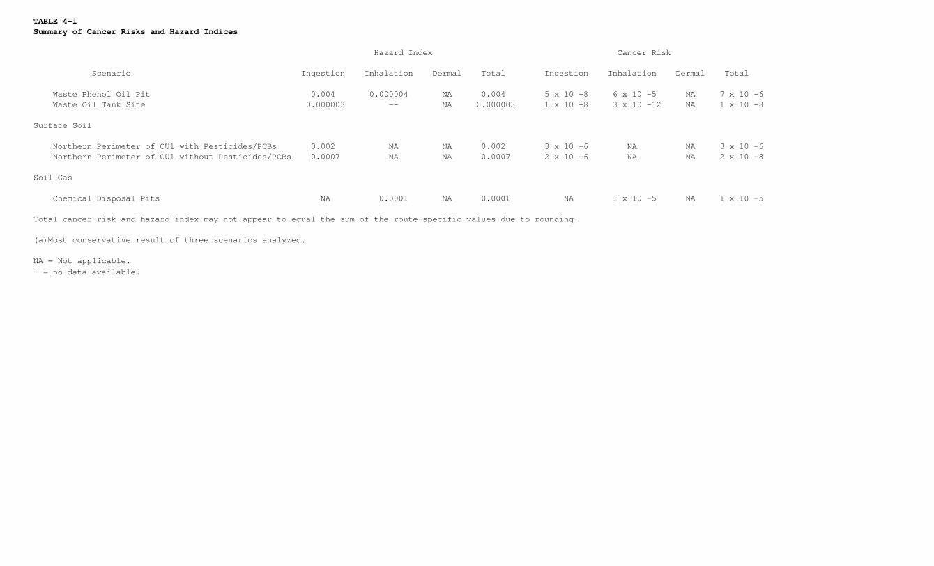
TABLE 4-1Summary of Cancer Risks and Hazard Indices
Hazard Index Cancer Risk
Scenario Ingestion Inhalation Dermal Total Ingestion Inhalation Dermal Total
Waste Phenol Oil Pit 0.004 0.000004 NA 0.004 5 x 10 -8 6 x 10 -5 NA 7 x 10 -6 Waste Oil Tank Site 0.000003 -- NA 0.000003 1 x 10 -8 3 x 10 -12 NA 1 x 10 -8
Surface Soil
Northern Perimeter of OU1 with Pesticides/PCBs 0.002 NA NA 0.002 3 x 10 -6 NA NA 3 x 10 -6 Northern Perimeter of OU1 without Pesticides/PCBs 0.0007 NA NA 0.0007 2 x 10 -6 NA NA 2 x 10 -8
Soil Gas
Chemical Disposal Pits NA 0.0001 NA 0.0001 NA 1 x 10 -5 NA 1 x 10 -5
Total cancer risk and hazard index may not appear to equal the sum of the route-specific values due to rounding.
(a)Most conservative result of three scenarios analyzed.
NA = Not applicable.- = no data available.
5.0 Description of Alternatives
5.0.0.1. The following subsections provide a detailed description of each of the developed alternatives.The descriptions are separated into Source Area (SA) alternative descriptions and Non-Source Area (NSA)alternative descriptions. Elements common to the SA and NSA alternative descriptions are summarized atthe end of this section. The specific details of the remedial components are intended only to serve asrepresentative examples to allow order-of-magnitude cost estimates. Other viable process options toachieve the same objectives may be evaluated during remedial design activities for OU1. The monitoringprograms developed for the alternatives represent preliminary monitoring designs that were developed inthe FS for the purpose of defining an initial scope and estimating costs. The final design of themonitoring program, including the number and exact locations of monitoring wells, will be defined duringremedial design.
5.1 Source Area Alternatives
5.1.1 Source Area Alternative 1 (SA1) - No Further Action
5.1.1.1. Major remedial components of SA1 are described below. A description of the component ispresented in the following paragraphs. Included in SA1 are the following components:
• Continued operation of the existing groundwater collection systems.
• Treatment of extracted groundwater at the HAFB OU2 ASTP or the IWTP.
• Maintenance of the existing landfill cap and passive gas vent system.
• Environmental monitoring, including the continued monitoring of the effectiveness of the existing upgradient soil/bentonite cut-off wall.
• Institutional controls as described in Section 5.3.0.16.
5.1.1.2. Existing Groundwater Collection System. The existing groundwater collection system is comprisedof a series of dewatering wells and a single infiltration collection gallery in the OU1 Source Area. SA1includes the continued operation of these systems for containment of contaminated groundwater.
5.1.1.3. Groundwater Treatment. Currently, groundwater from the existing collection system is treated atthe HAFB IWTP. The OU1 discharge will be redirected from the HAFB IWTP to the new ASTP at OU2 as part ofall alternatives, including SA1. These modifications were recommended and initiated prior to thedevelopment of the FS in the Three-mile Pipeline Design Options Report (Radian, 1995).
5.1.1.4. Landfill Cap and Passive Gas Vent System. A low-permeability soil/bentonite cap was constructedover Source Areas between 1983 and 1986. SA1 includes operation and maintenance of this cap. This willinclude walk-over surveys of the surface soils for identification of defects such as desiccation cracks,animal burrows, tire ruts, localized low areas resulting from settlement of the waste, erosionalfeatures, and any other features indicating the hydraulic integrity of the cap has been compromised. Inaddition, inspection of the landfill gas vents will be conducted. Landfill gas vents will be repaired inaccordance with the original vent design.
5.1.1.5. Environmental Monitoring. The objective of the SA1 environmental monitoring program is toassess the degree of protection provided by the existing environmental control systems and to determinewhether performance standards and remedial goals are being met. Further, the monitoring program for SA1establishes a baseline monitoring scenario to which monitoring programs for other Source Areaalternatives will be compared.
5.1.1.6. Groundwater monitoring for SA1 is designed to monitor changes in hydrogeologic conditions,contaminant concentrations, as well as lateral and vertical extent of contamination. Five well pairs (twoexisting, three new) will be used to address uncertainty associated with the effectiveness of theupgradient soil/bentonite cut-off wall. Monitoring of water levels and contaminant concentrations in thevicinity of the soil/bentonite cut-off wall will help identify the effectiveness of the cut-off wall.Additional Source Area monitoring will be accomplished by collecting groundwater samples from sixexisting Provo Formation (shallow) wells and four existing Alpine Formation (deep) wells. These 20 wellswill be monitored monthly for LNAPL thickness and water table elevation for the first year of remediationsystem operation and quarterly for the remaining years of operation. Analytical samples will be collectedsemiannually for the first 3 years of remediation system operation and annually for the remaining yearsof operation. It is assumed groundwater monitoring will continue for at least the 30-year period used inestimating present worth costs. Samples from all 20 wells will be analyzed for VOCs and arsenic.
Groundwater samples from four shallow monitoring wells located downgradient to Landfills 3 and 4 willalso be analyzed for chlorinated insecticides, chlorophenoxy herbicides, and explosives. The continuousdecline of groundwater elevations and subsequent gradual reduction of the LNAPL plume extent in theSource Area, due to the continuous operation of the existing extraction system, may limit the usefulnessof a number of existing monitoring wells. It is anticipated for cost estimating purposes that as many as20 existing monitoring wells would be abandoned as part of SA1.
5.1.1.7. Surface water sampling for SA1 will include the collection of one surface water sample fromPond No. 10 near the former WPOP location following each major storm event. The pond water samples willbe analyzed for VOCs and arsenic.
5.1.2. Source Area Alternative 2 (SA2) - Existing System Upgrade
5.1.2.1. Major remedial components of SA2 are shown in Figure 5-1 and further described below. Adescription of the component is presented in the following paragraphs. Included in SA2 are the followingcomponents:
• Upgrade of the existing groundwater collection system along primary groundwater flow paths.
• Groundwater treatment at the OU2 ASTP or the IWTP.
• Repair, operation, and maintenance of the existing landfill cap and passive gas vent system.
• Environmental monitoring, including the continued monitoring of the effectiveness of theexisting upgradient soil/bentonite cut-off wall.
• Institutional controls as described in Section 5.3.0.16.
5.1.2.2. The following paragraphs provide greater detail concerning each of these components.
5.1.2.3. Groundwater Collection System Upgrades. The objective of the upgraded groundwater collectionsystem for SA2 is to prevent further offsite migration of contaminated groundwater in the ProvoFormation. Flow in the saturated Provo Formation is primarily to the east and west; flow in the weatheredAlpine Formation is primarily toward the north, with some additional flow east and west. Under SA2, theexisting groundwater collection system will continue to be operated. Additionally, two gravel-filledtrenches will be constructed within the Base boundary across the east and west flow channels in the ProvoFormation to control the flow and migration of contaminants from the OU1 Source Area. The western trench,as shown in Figure 5-1, is designed to extend southwest beyond the existing soil/bentonite cut-off wallto capture contaminated groundwater attributable to residual LNAPL in this area. The existing and newextraction sumps will include an automated level detection system relative to downgradient piezometers toassure that effective capture is achieved.
5.1.2.4. The vertical extent of the collection trenches was established on the basis of the flow regimesin the Provo and Alpine Formations. It is possible that slope stability may limit the depth of theeastern trench. For this reason, the eastern trench is intended to capture only Provo Formation flow,while the western trench would be designed to capture flow in the Provo Formation and in the upper 15feet of the Alpine Formation. Total extraction rates are estimated to be approximately 50 gallons perminute (gpm) for the eastern trench and 45 gpm for the western trench. It is assumed for the purpose ofcost estimating that the collection and treatment system will be operated for the 30-year present worthperiod. It is possible that more time may be needed to fulfill remedial action objectives. However, it isalso possible that groundwater in the Provo Formation will be remediated to MCLs in a shorter timeperiod. Estimates of the time necessary for groundwater to be remediated are highly uncertain for the OU1Source Area and depend on the accuracy of many assumptions. Based on contaminant flushing calculations,groundwater VOC concentrations in the Provo Formation could decline to MCL concentrations in about 10years, assuming no further contaminant loading to the groundwater from either the unsaturated zone soilor the LNAPL residual. In reality, contamination loading will continue at reduced levels as the watertable drops below the elevation of the LNAPL residual. In the Alpine Formation, the low hydraulicconductivity reduces the amount of flushing achievable. Contaminant reductions in the Alpine Formationwill largely depend on the amount of degradation rather than the flushing of the water-bearing zone.
5.1.2.5. Groundwater Treatment. As discussed previously, groundwater collected from the extractionsystem may be redirected to the OU2 ASTP for treatment and discharged to the Central Weber SewerImprovement District plant (CWSID). The groundwater may also be treated at the IWTP.
5.1.2.6. Landfill Cap Repair and O&M. The existing landfill cap was recently inspected and found to havenumerous depressions over Landfill 4 where water could pond and increase infiltration through thelandfill cap. These depressions are likely a result of landfill settlement caused by decomposition of
wastes and the weight of the landfill cap. SA2 includes filling these depressions and revegetating thearea to promote runoff and prevent ponding of water. SA2 also includes the same O&M provisions for theexisting landfill cap discussed for SA1.
5.1.2.7. Environmental Monitoring. The following monitoring wells will be added to the groundwatermonitoring program specified for SA1 to assess the effectiveness of the east and west groundwatercollection systems and to verify offsite contaminant migration is mitigated:
• Monitoring of two existing shallow monitoring wells and installation/monitoring of one newshallow monitoring well.
• Monitoring of three existing deep monitoring wells and installation of one new deepmonitoring well.
5.1.2.8. Each of these monitoring wells will be included in the monitoring program for water levelmeasurement, LNAPL thickness measurement, as well as VOC and arsenic analysis. Continuous decrease ofgroundwater elevations and subsequent gradual reduction of the LNAPL plume extent in the Source Area, dueto the additional groundwater extraction along the primary flow paths and continuous operation of theexisting extraction system in the Source Area, may limit the usefulness of a number of existingmonitoring wells. Although the number of monitoring wells to be abandoned for the alternative will beestablished during the remedial design, it is anticipated for cost estimating purposes that as many as 30existing monitoring wells would be abandoned as part of SA2. In addition, eight new monitoring wells willbe installed (including the six new monitoring wells proposed for SA1). Monitoring of water levels andcontaminant concentrations in the vicinity of the existing upgradient soil/bentonite cut-off wall willhelp identify the effectiveness of the cut-off wall.
5.1.2.9. No surface water sampling is included for SA2 or subsequent Source Area alternatives; this isbecause the pump inlet at Pond No. 10 will be lowered so the pond can be completely drained. Stormwatercurrently managed in Pond No. 10 will be diverted to Pond No. 9 located approximately 2 miles west ofPond No. 10.
5.1.3 Source Area Alternative 3 (SA3) - Groundwater Dewatering
5.1.3.1. Major remedial components of SA3 are shown in Figure 5-2 and further described below. Thefollowing paragraphs describe the conceptual design of SA3, including the following specific components:
• Dewatering of the Source Area by a series of groundwater extraction trenches.
• LNAPL recovery from the extraction trenches followed by proper disposal of the LNAPL.
• Groundwater treatment at the OU2 ASTP or the IWTP.
• Repair and continued O&M of the landfill cap and passive gas vent system.
• Environmental monitoring, including the continued monitoring of the effectiveness of theexisting upgradient soil/bentonite cut-off wall.
• Institutional controls as described in Section 5.3.0.16.
5.1.3.2. The following paragraphs provide greater detail concerning each of these components.
5.1.3.3. Dewatering of the Source Area. As shown in Figure 5-2, six separate trenches will be used todewater the Source Area. These trenches are labeled Trenches A through F in Figure 5-2. The length andalignment of the dewatering trenches were based on the following factors:
• Current and historic extent of the LNAPL plume.• Preferential groundwater flow paths.• Groundwater "troughs" in the Provo Formation.• Saturated thickness of the Provo Formation.• Dissolved phase plume extent of total DCE exceeding 1,000 Ig/L.• Location of the individual Source Areas.
5.1.3.4. Conceptual design details were developed for cost estimating purposes. Trenches A, B, and C areassumed to be 30 feet deep and will only dewater the Provo Formation. Trenches D and E will dewater theProvo and Alpine Formations will be constructed to a total depth of approximately 45 feet such that thesetrenches will extend approximately 10 to 15 feet into the Alpine Formation. The objective of thesetrenches is primarily to expedite dewatering and ensure groundwater containment within the Base boundary.
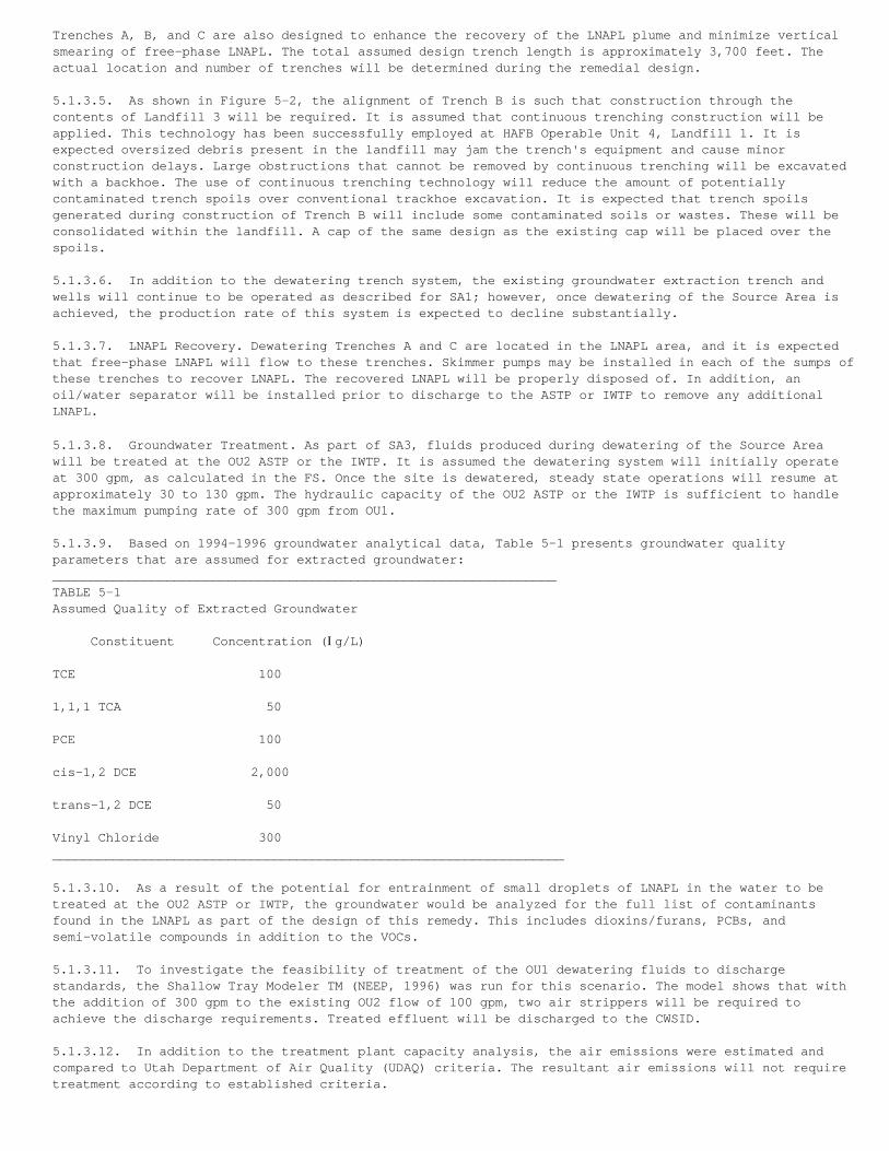
Trenches A, B, and C are also designed to enhance the recovery of the LNAPL plume and minimize verticalsmearing of free-phase LNAPL. The total assumed design trench length is approximately 3,700 feet. Theactual location and number of trenches will be determined during the remedial design.
5.1.3.5. As shown in Figure 5-2, the alignment of Trench B is such that construction through thecontents of Landfill 3 will be required. It is assumed that continuous trenching construction will beapplied. This technology has been successfully employed at HAFB Operable Unit 4, Landfill 1. It isexpected oversized debris present in the landfill may jam the trench's equipment and cause minorconstruction delays. Large obstructions that cannot be removed by continuous trenching will be excavatedwith a backhoe. The use of continuous trenching technology will reduce the amount of potentiallycontaminated trench spoils over conventional trackhoe excavation. It is expected that trench spoilsgenerated during construction of Trench B will include some contaminated soils or wastes. These will beconsolidated within the landfill. A cap of the same design as the existing cap will be placed over thespoils.
5.1.3.6. In addition to the dewatering trench system, the existing groundwater extraction trench andwells will continue to be operated as described for SA1; however, once dewatering of the Source Area isachieved, the production rate of this system is expected to decline substantially.
5.1.3.7. LNAPL Recovery. Dewatering Trenches A and C are located in the LNAPL area, and it is expectedthat free-phase LNAPL will flow to these trenches. Skimmer pumps may be installed in each of the sumps ofthese trenches to recover LNAPL. The recovered LNAPL will be properly disposed of. In addition, anoil/water separator will be installed prior to discharge to the ASTP or IWTP to remove any additionalLNAPL.
5.1.3.8. Groundwater Treatment. As part of SA3, fluids produced during dewatering of the Source Areawill be treated at the OU2 ASTP or the IWTP. It is assumed the dewatering system will initially operateat 300 gpm, as calculated in the FS. Once the site is dewatered, steady state operations will resume atapproximately 30 to 130 gpm. The hydraulic capacity of the OU2 ASTP or the IWTP is sufficient to handlethe maximum pumping rate of 300 gpm from OU1.
5.1.3.9. Based on 1994-1996 groundwater analytical data, Table 5-1 presents groundwater qualityparameters that are assumed for extracted groundwater:__________________________________________________________________TABLE 5-1Assumed Quality of Extracted Groundwater
Constituent Concentration (Ig/L)
TCE 100
1,1,1 TCA 50
PCE 100
cis-1,2 DCE 2,000
trans-1,2 DCE 50
Vinyl Chloride 300___________________________________________________________________
5.1.3.10. As a result of the potential for entrainment of small droplets of LNAPL in the water to betreated at the OU2 ASTP or IWTP, the groundwater would be analyzed for the full list of contaminantsfound in the LNAPL as part of the design of this remedy. This includes dioxins/furans, PCBs, andsemi-volatile compounds in addition to the VOCs.
5.1.3.11. To investigate the feasibility of treatment of the OU1 dewatering fluids to dischargestandards, the Shallow Tray Modeler TM (NEEP, 1996) was run for this scenario. The model shows that withthe addition of 300 gpm to the existing OU2 flow of 100 gpm, two air strippers will be required toachieve the discharge requirements. Treated effluent will be discharged to the CWSID.
5.1.3.12. In addition to the treatment plant capacity analysis, the air emissions were estimated andcompared to Utah Department of Air Quality (UDAQ) criteria. The resultant air emissions will not requiretreatment according to established criteria.
5.1.3.13. Landfill Cap Repair and O&M. Provisions for the repair and O&M of the existing landfill capsunder SA3 are the same as those presented for SA2.
5.1.3.14. Environmental Monitoring. The following wells will be added to the groundwater monitoringprogram specified for SA1 to assess the effectiveness of the dewatering system:
• Monitoring of four existing shallow wells and installation/monitoring of five new shallowmonitoring wells.
• Monitoring of six existing deep wells and installation/monitoring of one new deep monitoring well.
5.1.3.15. Each of these monitoring wells will be included in the monitoring program for water levelmeasurement, LNAPL thickness measurement, and VOC and arsenic analysis. Rapid decline of groundwaterelevations and subsequent gradual reduction of LNAPL plume extent in the Source Area, due to thegroundwater dewatering effort and continuous operation of the existing extraction system in the SourceArea, may limit the usefulness of a number of existing monitoring wells. Although the number ofmonitoring wells to be abandoned for the alternative will be established during the remedial design, itis anticipated for cost estimating purposes that as many as 40 existing monitoring wells would beabandoned as part of SA3. In addition, 12 new wells will be installed (including the six new monitoringwells proposed for SA1). Monitoring of water levels and contaminant concentrations in the vicinity of theexisting upgradient soil/bentonite cut-off wall will help identify the effectiveness of the cut-off wall.
5.1.4 Source Area Alternative 4 (SA4) - Source Containment
5.1.4.1. Major remedial components of SA4 are shown in Figure 5-3 and further described below. Thefollowing paragraphs describe the conceptual design of SA4, including the following specific components:
• Downgradient soil/bentonite cut-off wall.
• Dewatering of the Source Area by a series of groundwater collection trenches.
• LNAPL recovery from the extraction trenches using skimmer pumps.
• Groundwater treatment at the OU2 ASTP or the IWTP.
• Continued O&M of the landfill cap and passive gas vent system.
• Environmental monitoring, including the continued monitoring of the effectiveness of the existing upgradient soil/bentonite cut-off wall.
• Institutional controls as described in Section 5.3.0.16.
5.1.4.2. The following paragraphs provide greater detail concerning each of these components.
5.1.4.3. Downgradient Soil/Bentonite Cut-Off Wall. A downgradient hydraulic barrier would be installedas part of SA4 to provide an added degree of assurance that the migration of contaminated groundwater ismitigated. The hydraulic barrier system would be comprised of a soil/bentonite cut-off wall approximately30 to 45 feet deep such that the wall would extend approximately 15 feet into the Alpine Formation. Thedepth of the wall is intended to intercept groundwater flow through sand stringers in the AlpineFormation that may not be effectively contained by the dewatering trenches.
5.1.4.4. The alignment of the downgradient cut-off wall is shown in Figure 5-3. This alignment wasdeveloped to achieve the following criteria:
• Intercept the primary east and west groundwater flow paths.
• Avoid the OU1 slope area based on constructability and slope stability concerns.
• Avoid the containment and treatment of "clean' precipitation from Pond No. 10 by aligning the wall along the upgradient edge of Pond No. 10.
• Minimize groundwater contact with OU1 contaminants by aligning the wall in close proximity to contaminant sources.
5.1.4.5. Because operation of the dewatering trench system is expected to eliminate off-Base groundwaterflow, a separate extraction system is not included in the design of the downgradient cut-off wall. It is
anticipated construction of the wall would be phased such that dewatering of the Source Area would becompleted prior to wall construction. This would allow the exact depth and alignment of the wall to berefined to address long-term operations under dewatering conditions.
5.1.4.6. Dewatering of the Source Area. As with SA3, dewatering of the Source Area will be accomplishedby a series of dewatering trenches installed in the areas of the greatest saturated thickness of theProvo Formation. The existing groundwater extraction trench and wells will continue to be operated asdiscussed for SA1; however, once dewatering of the Source Area is achieved, the production rate of thissystem is expected to decline substantially.
5.1.4.7. LNAPL Recovery. Provisions for the recovery of LNAPL for SA4 are the same as those presentedfor SA3.
5.1.4.8. Groundwater Treatment. As with previous alternatives, groundwater collected by the dewateringsystem for SA4 would be treated at the OU2 ASTP or the IWTP and discharged to the local POTW. Thequantity and quality of extracted groundwater is expected to be the same as that discussed for SA3.
5.1.4.9. Landfill Cap Repair and O&M. Provisions for repair and O&M of the existing landfill cap underSA4 are the same as those presented for SA2.
5.1.4.10. Environmental Monitoring. The groundwater monitoring program for SA4 is the same as thatpresented for SA3, with the following additions:
• Installation of 10 new shallow piezometers along the downgradient cut-off wall.
• Installation of 10 new deep piezometers along the downgradient cut-off wall.
5.1.4.11. These piezometers would be situated as well pairs along the downgradient cut-off wall tomonitor hydraulic gradients created by the wall. Water level monitoring would be conducted at thesepiezometers on a monthly basis for the first year of operation and quarterly thereafter. Additionally,monitoring of water levels and contaminant concentrations in the vicinity of the existing upgradientsoil/bentonite cut-off wall will help identify the effectiveness of the upgradient cut-off wall.
5.1.5 Source Area Alternative 5 (SA5) - Source Containment and Cap Upgrade
5.1.5.1. Major remedial components of SA5 are shown in Figure 5-4 and further described below. Adescription of the component is presented in the following paragraphs. Included in SA5 are the followingcomponents:
• Upgrade the existing landfill cap.
• Downgradient soil/bentonite cut-off wall.
• Dewatering of the Source Area by a series of groundwater collection trenches.
• LNAPL recovery from the extraction trenches using skimmer pumps.
• Groundwater treatment at the OU2 ASTP or the IWTP.
• Continued O&M of the landfill cap and passive gas vent system.
• Environmental monitoring, including the continued monitoring of the effectiveness of theexisting upgradient soil/bentonite cut-off wall.
• Institutional controls as described in Section 5.3.0.16.
5.1.5.2. The following paragraphs provide greater detail concerning each of these components.
5.1.5.3. Upgrade of Existing Landfill Cap. SA5 includes upgrading the existing cap with an engineeredcap. Preliminary assessments from the Hydrologic Evaluation of Landfill Performance Model analysisindicate a potential reduction in percolation rates of approximately one order of magnitude may beachieved with an improved cap. This corresponds to approximately 70,000 cubic feet (500,000 gallons) peryear of reduced leachate generation.
5.1.5.4. The extent of the cap upgrade, as shown in Figure 5-4, was selected to reduce infiltration tothe entire OU1 Source Area. The design of the improved cap would consist of a protective vegetation layerover a hydraulic barrier layer of either compacted clay or a geosynthetic clay liner. From the surface
down, the cap components would be as follows:
• A 6-inch-thick layer of topsoil, planted with grasses suitable for the climate and selected to eliminate the need for irrigation.
• An 18-inch-thick layer of subsoil to provide mechanical protection of the underlying hydraulic barrier layer.
• A hydraulic barrier layer, consisting of one of the following (the selection would be madeduring remedial design):
- A 1- to 2-foot thick layer of compacted low-permeability clay. The permeability should be less than 1 x 10 -6 cm/sec, and preferably would be less than 1 x 10 -7 cm/sec if sufficient soil of this permeability can be obtained locally.
- A commercially manufactured geosynthetic clay layer. These materials consist of a synthetic material (either a geotextile or a geomembrane ) coated with, or otherwise holding, a uniform thickness of bentonite clay.
• Grading fill, as necessary, to properly slope the surface (at least 2 percent) to promote surface water runoff.
5.1.5.5. No drainage layer would be provided since the evapotranspiration of the site is relativelyhigh. As a result, the primary function of the hydraulic barrier layer would be to retard anyinfiltration that does occur, and keep it in the root zone where it is available for plant uptake andevapotranspiration. Also, no active gas venting system has been provided since the landfill has beeninactive for several years and the potential for gas generation is low. It is anticipated nothing morecomplex than a limited number of passive vents would be required. Evaluation of the need for additionalventing as well as use of the existing passive gas venting system with minor modifications would beconsidered during the remedial design.
5.1.5.6. It is assumed the cap upgrade would be constructed over the existing cap without excavation tominimize risk of exposure to the landfilled wastes during construction. The slope of the cap would alsobe improved to provide greater surface runoff. The drainage swale constructed in the landfill cap withinLandfill 4 would be filled, resulting in a continuous slope. An O&M routine similar to that described inAlternatives SA2 through SA4 would be employed to ensure long-term effectiveness of the upgraded cap.
5.1.5.7. It is assumed that the existing detention pond, Pond 10, has sufficient capacity to collectsurface runoff from the upgraded cap. An assessment would be conducted during the remedial design todetermine whether an upgrade of Pond 10 is required.
5.1.5.8. Downgradient Soil/Bentonite Cut-Off Wall. The conceptual design of the downgradient cut-offwall for SA5 is the same as that presented in SA4.
5.1.5.9. Dewatering of the Source Area. As with SA3 and SA4, dewatering of the Source Area would beaccomplished by a series of dewatering trenches installed in the areas of the greatest saturatedthickness of the Provo Formation. The existing groundwater extraction trench and wells would continue tobe operated as discussed for SA1 however, once dewatering of the Source Area was achieved, the productionrate of this system would be expected to decline substantially.
5.1.5.10. LNAPL Recovery. Provisions for the recovery of LNAPL for SA5 are the same as those presentedfor SA3 and SA4.
5.1.5.11. Groundwater Treatment. As with previous alternatives, groundwater collected by the dewateringsystem for SA5 will be treated at the OU2 ASTP or the IWTP and discharged to the local POTW. The qualityof extracted groundwater would be expected to be the same as that discussed for SA3 and SA4; however, thequantity of extracted groundwater would be reduced by the landfill cap upgrade.
5.1.5.12. Environmental Monitoring. The groundwater monitoring program for SA5 is the same as thatpresented for SA4.
5.1.6 Source Area Alternative 6 (SA6) - Source Treatment and Cap Upgrade
5.1.6.1. Major remedial components of SA6 are shown in Figure 5-5 and further described below. Thefollowing paragraphs describe the conceptual design of SA6, including the following specific components:
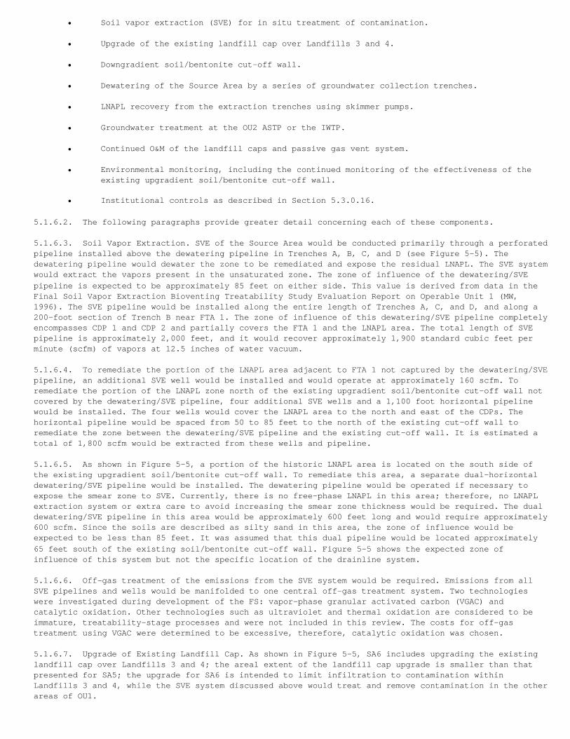
• Soil vapor extraction (SVE) for in situ treatment of contamination.
• Upgrade of the existing landfill cap over Landfills 3 and 4.
• Downgradient soil/bentonite cut-off wall.
• Dewatering of the Source Area by a series of groundwater collection trenches.
• LNAPL recovery from the extraction trenches using skimmer pumps.
• Groundwater treatment at the OU2 ASTP or the IWTP.
• Continued O&M of the landfill caps and passive gas vent system.
• Environmental monitoring, including the continued monitoring of the effectiveness of theexisting upgradient soil/bentonite cut-off wall.
• Institutional controls as described in Section 5.3.0.16.
5.1.6.2. The following paragraphs provide greater detail concerning each of these components.
5.1.6.3. Soil Vapor Extraction. SVE of the Source Area would be conducted primarily through a perforatedpipeline installed above the dewatering pipeline in Trenches A, B, C, and D (see Figure 5-5). Thedewatering pipeline would dewater the zone to be remediated and expose the residual LNAPL. The SVE systemwould extract the vapors present in the unsaturated zone. The zone of influence of the dewatering/SVEpipeline is expected to be approximately 85 feet on either side. This value is derived from data in theFinal Soil Vapor Extraction Bioventing Treatability Study Evaluation Report on Operable Unit 1 (MW,1996). The SVE pipeline would be installed along the entire length of Trenches A, C, and D, and along a200-foot section of Trench B near FTA 1. The zone of influence of this dewatering/SVE pipeline completelyencompasses CDP 1 and CDP 2 and partially covers the FTA 1 and the LNAPL area. The total length of SVEpipeline is approximately 2,000 feet, and it would recover approximately 1,900 standard cubic feet perminute (scfm) of vapors at 12.5 inches of water vacuum.
5.1.6.4. To remediate the portion of the LNAPL area adjacent to FTA 1 not captured by the dewatering/SVEpipeline, an additional SVE well would be installed and would operate at approximately 160 scfm. Toremediate the portion of the LNAPL zone north of the existing upgradient soil/bentonite cut-off wall notcovered by the dewatering/SVE pipeline, four additional SVE wells and a 1,100 foot horizontal pipelinewould be installed. The four wells would cover the LNAPL area to the north and east of the CDPs. Thehorizontal pipeline would be spaced from 50 to 85 feet to the north of the existing cut-off wall toremediate the zone between the dewatering/SVE pipeline and the existing cut-off wall. It is estimated atotal of 1,800 scfm would be extracted from these wells and pipeline.
5.1.6.5. As shown in Figure 5-5, a portion of the historic LNAPL area is located on the south side ofthe existing upgradient soil/bentonite cut-off wall. To remediate this area, a separate dual-horizontaldewatering/SVE pipeline would be installed. The dewatering pipeline would be operated if necessary toexpose the smear zone to SVE. Currently, there is no free-phase LNAPL in this area; therefore, no LNAPLextraction system or extra care to avoid increasing the smear zone thickness would be required. The dualdewatering/SVE pipeline in this area would be approximately 600 feet long and would require approximately600 scfm. Since the soils are described as silty sand in this area, the zone of influence would beexpected to be less than 85 feet. It was assumed that this dual pipeline would be located approximately65 feet south of the existing soil/bentonite cut-off wall. Figure 5-5 shows the expected zone ofinfluence of this system but not the specific location of the drainline system.
5.1.6.6. Off-gas treatment of the emissions from the SVE system would be required. Emissions from allSVE pipelines and wells would be manifolded to one central off-gas treatment system. Two technologieswere investigated during development of the FS: vapor-phase granular activated carbon (VGAC) andcatalytic oxidation. Other technologies such as ultraviolet and thermal oxidation are considered to beimmature, treatability-stage processes and were not included in this review. The costs for off-gastreatment using VGAC were determined to be excessive, therefore, catalytic oxidation was chosen.
5.1.6.7. Upgrade of Existing Landfill Cap. As shown in Figure 5-5, SA6 includes upgrading the existinglandfill cap over Landfills 3 and 4; the areal extent of the landfill cap upgrade is smaller than thatpresented for SA5; the upgrade for SA6 is intended to limit infiltration to contamination withinLandfills 3 and 4, while the SVE system discussed above would treat and remove contamination in the otherareas of OU1.
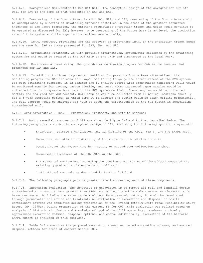
5.1.6.8. Downgradient Soil/Bentonite Cut-Off Wall. The conceptual design of the downgradient cut-offwall for SA6 is the same as that presented in SA4 and SA5.
5.1.6.9. Dewatering of the Source Area. As with SA3, SA4, and SA5, dewatering of the Source Area wouldbe accomplished by a series of dewatering trenches installed in the areas of the greatest saturatedthickness of the Provo Formation. The existing groundwater extraction trench and wells would continue tobe operated as discussed for SA1; however, once dewatering of the Source Area is achieved, the productionrate of this system would be expected to decline substantially,
5.1.6.10. LNAPL Recovery. Provisions for the recovery of free-phase LNAPL in the extraction trench sumpsare the same for SA6 as those presented for SA3, SA4, and SA5.
5.1.6.11. Groundwater Treatment. As with previous alternatives, groundwater collected by the dewateringsystem for SA6 would be treated at the OU2 ASTP or the IWTP and discharged to the local POTW.
5.1.6.12. Environmental Monitoring. The groundwater monitoring program for SA6 is the same as thatpresented for SA4 and SA5.
5.1.6.13. In addition to those components identified for previous Source Area alternatives, themonitoring program for SA6 includes soil vapor monitoring to gauge the effectiveness of the SVE system.For cost estimating purposes, it is assumed the 10 shallow Source Area groundwater monitoring wells wouldbe monitored monthly for oxygen, carbon dioxide, and total VOCs. Extracted vapor samples would becollected from four separate locations in the SVE system manifold. These samples would be collectedmonthly and analyzed for VOC content. Soil samples would be collected from 10 boring locations annuallyfor a 3-year operating period, at which time it is assumed the system would be taken offline permanently.The soil samples would be analyzed for VOCs to gauge the effectiveness of the SVE system in remediatingcontaminated soil.
5.1.7 Area Alternative 7 (SA7) - Excavation, Treatment, and Offsite Disposal
5.1.7.1. Major remedial components of SA7 are shown in Figure 5-6 and further described below. Thefollowing paragraphs describe the conceptual design of SA7, including the following specific components:
• Excavation, offsite incineration, and landfilling of the CDPs, FTA 1, and the LNAPL area.
• Excavation and offsite landfilling of the contents of Landfills 3 and 4.
• Dewatering of the Source Area by a series of groundwater collection trenches.
• Groundwater treatment at the OU2 ASTP or the IWTP.
• Environmental monitoring, including the continued monitoring of the effectiveness of theexisting upgradient soil/bentonite cut-off wall.
• Institutional controls as described in Section 5.3.0.16.
5.1.7.2. The following paragraphs provide greater detail concerning each of these components.
5.1.7.3. Excavation Evaluation. The objective of excavation is to remove all soil and landfill debriscontaminated at concentrations greater than PRGs, containing listed hazardous waste, or characteristichazardous waste. Soil below the water table would not be excavated; rather, it would be remediatedthrough groundwater collection and treatment. An evaluation of excavation and disposal of onsitecontaminant sources was conducted during preparation of the Revised Interim Draft Final Feasibility StudyReport (MW, 1995a). During preparation of the current FS for OU1, this evaluation was refined based onanalysis of historic air photos and knowledge of typical landfill operating procedures to developapproximate excavation volumes, disposal options, and costs. Additionally, excavation of the historicLNAPL extent is included in this analysis.
5.1.7.4. Table 5-2 summarizes the proposed excavation areas, estimated excavation volumes, and assumeddisposal methods for areas of concern within OU1.
TABLE 5-2Source Area Alternative SA7 Excavation Volumes and Disposal Methods
Area Excavation Volume (cubic yards) 1 DisposalFTA 1 42,000 Incinerate, Landfill Offsite
CDP 1 and 2 4,000 Incinerate, Landfill Offsite
LNAPL (clean overburden) 390,000 Stockpile, Backfill
LNAPL (contaminated) 65,000 Incinerate
Landfill 3 120,000 Sort, Landfill Offsite
Landfill 4 585,000 Sort, Landfill Offsite
1 These volumes do not include soil expansion factors used for cost estimating (see FS Appendix B).________________________________________________________________________________________________________
5.1.7.5. The excavation volumes presented in Table 5-2 are for the purpose of estimating remedial costs.Actual volumes to be excavated would be determined through a sampling and analysis program conductedprior to remedial design or during the remedial action.
5.1.7.6. It is anticipated that excavation of these areas would require approximately 2 years. Othercomponents of SA7, such as groundwater collection and treatment, will be initiated following completionof excavation activities.
5.1.7.7. Soil Disposal Issues. The most significant action-specific Applicable or Relevant andAppropriate Requirement (ARAR) affecting implementation of Alternative SA7 is the determination ofwhether the contaminated soils are considered to be hazardous waste. In summary, excavated soil at theCDPs, FTA 1, and the LNAPL area would be managed as listed hazardous waste (F001) and possibly also ascharacteristic waste. Incineration of half the soil from the CDPs and FTA 1 is assumed to be necessary tomeet the land disposal restrictions (LDR) for these waste codes. All the soil from the LNAPL area wouldbe incinerated because of higher concentrations of solvents, pesticides, and dioxin/furans found in thesesoils. Because of the high cost of incineration of soils, increases in the volume of soil requiringincineration would greatly increase the cost of this alternative.
5.1.7.8. The majority of soils and wastes from Landfills 3 and 4 are not expected to be characteristicwastes and are not expected to contain listed wastes. However, it is possible that some isolated areas ofwastes within the landfills would be sufficiently contaminated to either be characteristic or beconsidered to contain listed wastes. In this event, the wastes would be managed as hazardous, and theappropriate LDRs would be met or a treatability variance would be sought. It is assumed 1,000 cubic yardsof materials from Landfills 3 and 4 would be incinerated to meet LDRs.
5.1.7.9. Dewatering of the Source Area. As with previous alternatives, dewatering of the Source Areawould be accomplished by a series of dewatering trenches installed in the areas of the greatest saturatedthickness of the Provo Formation. These trenches would be installed following completion of excavationactivities.
5.1.7.10. Groundwater Treatment. As with previous alternatives, groundwater collected by the dewateringsystem for SA7 would be treated at the OU2 ASTP or the IWTP and discharged to the local POTW.
5.1.7.11. Environmental Monitoring. The groundwater monitoring program for SA7 is the same as thatpresented for SA3. However, it is anticipated that the four existing shallow monitoring wells and sixexisting deep monitoring wells identified in SA1 (subsequently used in SA3) would be destroyed duringexcavation activities and replaced.
5.2 Non-Source Area Alternatives
5.2.1 Non-Source Area Alternative 1 (NSA1) - No Further Action
5.2.1.1. The following paragraphs describe the conceptual design of NSA1, including the followingspecific components:
• Continued operation of the existing spring collection systems at Springs U1-303, U1-304, and U1-307.
• Water extracted from the springs to be treated at the OU2 ASTP, the IWTP, or discharged tothe surface after treatment at the remote treatment facility.
• Environmental monitoring.
• Institutional control is as described in Section 5.3.0.16.
5.2.1.2. Existing Spring Collection System. As previously discussed, spring collection systems wereinstalled as early response actions at Springs U1-303, U1-304, and U1-307. NSA1 would include thecontinued operation of these systems until remediation goals are attained.
5.2.1.3. Water Treatment. As discussed previously for the Source Area alternatives, water produced fromthe existing seep/spring collection systems would be treated at the IWTP or the OU2 ASTP upon completionof modifications recommended in the 3-Mile Pipeline Design Options Report. For cost estimating purposes,it is assumed treatment would occur in the IWTP for the first year of operation and then switch to theOU2 ASTP for the remaining years of operation.
5.2.1.4. Restoration Time. For comparative analysis of the Non-Source Area alternatives, restorationtime was estimated for the offsite contamination in groundwater under representative site conditions.Assuming the Source Area is not remediated further, releases would continue. Although recent offsitegroundwater contaminant data show a decline, it is expected PRGs would not be met for decades because ofcontinuing releases.
5.2.1.5. Environmental Monitoring. The objective of the NSA1 environmental monitoring program is tocollect sufficient information to track the lateral and vertical extent and chemical nature of thedissolved contaminant plumes in the offsite shallow (5 to 15 feet bgs) and deep (40 to 45 feet bgs)water-bearing zones. The program would allow assessment of continued releases from the Source Area. Themonitoring program for NSA1 establishes a baseline monitoring scenario onto which monitoring programs forthe remaining Non-Source Area alternatives would build.
5.2.1.6. Surface water would be sampled quarterly from all 20 springs for the first 3 years of themonitoring program and semiannually for the remaining years of operation. The spring samples would beanalyzed for VOCs. Spring flow rate would also be approximated during the monitoring events.
5.2.1.7. The groundwater monitoring network for NSA1 would include the following wells:
• Monitoring of seven existing shallow wells and installation/monitoring of 10 new shallowmonitoring wells.
• Monitoring of five existing deep wells and installation/monitoring of one new deep monitoring well located on the west flank of the existing Non-Source Area plume to monitorlateral and vertical contaminant migration.
5.2.1.8. Samples from the 13 existing monitoring wells would be analyzed for VOCs. Water levels in all23 wells listed above will be monitored. For the purposes of cost estimating, it is assumed 10 existingNon-Source Area monitoring wells would be abandoned.
5.2.1.9. The Weber Basin Water Conservancy District's potable water well, South Weber No. 2, is the onlygroundwater supply well located within the areal extent of the OU1 off-Base groundwater plume. The wellhas been used sporadically over the years during peak demand periods. Oil was recently observed floatingon the surface of the water in the well, and the well is currently not in use due to the dissolvedcontamination in the groundwater from the oil. Recent investigations have shown HAFB is not the source ofthe oil or associated groundwater contamination in the drinking water aquifer. The investigation isdescribed in the Draft Monitoring Well Installation and Impact Assessment of South Weber No. 2 (CH2MHILL, 1998b). The well will be monitored to provide assurance the water supply source is not beingadversely affected by contaminants of concern from OU1.
5.2.2 Non-Source Area Alternative 2 (NSA2) - Monitored Natural Attenuation
5.2.2.1. Major remedial components of NSA2 are shown in Figure 5-7 and further described below. Thefollowing paragraphs describe the conceptual design of NSA2, including the following specific components:
• Monitored natural attenuation.
• Operation of the existing spring collection systems.
• Treatment of collected water at the OU2 ASTP or the IWTP.
• Environmental monitoring.
• Control further contaminant migration from the Source Area through Source Area Alternatives SA3, SA4, SA5, SA6, or SA7.
• Institutional controls as described in Section 5.3.0.16.
5.2.2.2. The environmental monitoring described below would be used to assess the degree of naturalattenuation and allow estimates of the time necessary to reach remedial goals. If monitoring dataindicate further spreading of the plume above remedial goals, active restoration using one of theremaining alternatives (NSA3 through NSA6) would be implemented.
5.2.2.3. Monitored Natural Attenuation Assessment. Monitored natural attenuation is the process by whichcontaminant concentrations are reduced by various naturally occurring in situ mechanisms. The naturalprocesses may include:
• Biodegradation• Dilution• Adsorption
5.2.2.4. Based on the Comprehensive Remedial Investigation Report for Operable Unit 1 and investigationsrelating to monitored natural attenuation, Draft Work Plan for a Demonstration of Remediation by NaturalAttenuation (Parsons, 1996), the following observations of the processes as related to the site can bemade:
• Dilution produces the net effect of decreasing concentrations but does not represent areduction in mass. Dilution occurs through processes such as advection, diffusion, andhydrodynamic dispersion. In most cases, dilution by diffusion only is small. Advection-dispersion effects may be especially significant in areas of large concentration gradientsor low groundwater flow velocities. Because of the heterogeneous nature of the water-bearingzone sediments, hydrodynamic dispersion is considered significant.
• Biodegradation of "parent" compounds, such as tetrachloroethene (PCE) or TCE, appears to beoccurring within the Source Area. The primary contaminant of the offsite plume is DCE. Thedegree of biodegradation in the offsite plume is not known, but it is not likely the offsiteDCE plume in the alluvium undergoes significant biodegradation (Parsons, 1996). Vinylchloride, a more toxic contaminant than DCE, is a degradation product of DCE and has notbeen detected in the Weber River Valley plume. It is doubtful that vinyl chloride will bedetectable in the future because DCE is expected to decline as the Source Area is entirelycutoff. Because biodegradation rates are not known, biodegradation was not included inestimates of the time to achieve remedial goals. Therefore, the time estimates for monitorednatural attenuation may be conservative.
• Retardation caused by the sorption of contaminants on water-bearing zone materials willdelay the migration of contaminants but will not reduce the mass in the system. The fraction of organic carbon content representative of the site is estimated to be 0.005percent based on total organic content (TOC) measurements. The organic carbon fraction isutilized to estimate the retardation coefficient for the hydrogeologic unit.
5.2.2.5. Dilution (advection and dispersion) and adsorption are considered to be the most significantprocesses affecting contaminants in groundwater in the Non-Source Area of OU1.
5.2.2.6. A groundwater flow and transport analysis was conducted to assess the relative impacts of thenatural attenuation processes identified above. For model application, it was assumed upgradientgroundwater flow and contaminant migration is completely contained. The remaining mass within the offsiteplume is expected to naturally attenuate and migrate north within the area of the current plume.Simulations were performed to observe the effect of key parameters on the contaminant attenuation. Thesimulation results indicated that the estimated restoration time (i.e., time required for the naturalprocesses to reduce contaminant concentration below MCLs) varies from 5 years to more than 50 yearsdepending on the parameter values used.
5.2.2.7. Using the site-specific organic carbon coefficient and best estimates of the criticalparameters affecting transport, the time to attain MCLs is estimated to be 12 years. If the organiccarbon fraction in the subsurface formations exceeds 5 percent, restoration of the water-bearing zonesthrough natural processes within a reasonable time frame is unlikely. The Davis-Weber Cartal leakage ratemay also have a significant impact on the plume migration and attenuation. Modeling indicates thatrestoration time may increase without leakage through the canal bottom.
5.2.2.8. Existing Seep/Spring Collection System. Provisions for the operation of the existing collectionsystems at Springs U1-303, U1-304, and U1-307 are the same as those described for NSA1.
5.2.2.9. Water Treatment. Provisions for the treatment of water from the existing collection systems arethe same as those presented for NSA1.
5.2.2.10. Environmental Monitoring. The spring monitoring program for NSA2 includes all components ofthe NSA1 program, and the analytical program would be expanded to include monitoring for the followingmonitored natural attenuation indicator parameters:
• Dissolved Oxygen• pH, Temperature, and Specific Conductance• Oxidation/Reduction Potential• Alkalinity• Nitrate- and Nitrite-Nitrogen• Sulfate- and Sulfide-Sulfur• Total Iron, Ferrous Iron, and Ferric Iron• Manganese• Carbon Dioxide• Chloride
5.2.2.11. The groundwater monitoring program for NSA2 includes all components of NSA1, with thefollowing modifications:
• Two existing and six new shallow monitoring wells within the Non-Source Area plume would beadded to the monitoring program.
• The analytical program for the 13 wells presented in NSA1 plus the 8 additional wells described above, would be expanded to include monitoring for the monitored natural attenuation parameters for surface water listed above.
• The number of Non-Source Area wells requiring abandonment would be reduced from 10 to 8.
5.2.2.12. The alternative includes development of a groundwater flow and solute transport model to allowprediction of contaminant transport. The model would be updated annually based on these monitoringresults to reflect actual conditions.
5.2.3 Non-Source Area Alternative 3 (NSA3) - Existing Seep Collection Upgrade
5.2.3.1. Major remedial components of NSA3 are shown in Figure 5-8 and further described below. Thefollowing paragraphs describe the conceptual design of NSA3, including the following specific components:
• Upgraded seep collection and treatment.
• Excavation and offsite disposal of arsenic-contaminated sediment at Springs U1-301, U1-303, U1-304 U1-305, and U1-318.
• Monitored natural attenuation.
• Environmental monitoring.
• Control further contamination migration from the Source Area through Source Area Alternatives SA3, SA4, SA5, SA6, or SA7.
• Institutional controls as described in Section 5.3.0.16.
5.2.3.2. Upgraded Seep Collection and Treatment. NSA3 includes modification of the existing off-Basespring collection system to include collection and treatment of springs with contaminant concentrationsexceeding MCLs as well as upgrading the existing systems at U1-303 and U1-304. The following paragraphsprovide a summary of the existing systems, and an overview of the required additional collection and
treatment systems.
5.2.3.3. In 1985, a collection gallery with pumping stations at Springs U1-303 and U1-304 was installed,and an additional pumping station was installed at Spring U1-307 in 1995. These collection systemscurrently pump the surface water to the OU2 ASTP for treatment. The flow could be directed to the OU2ASTP or the IWTP for any future design. Figure 5-8 shows the planned modifications to the springcollection system. The spring collection system at U1-303 and U1-304 requires upgrade or replacement toeffectively collect all surface, water from the area. The extent of the modifications required will beevaluated during the remedial design and will probably consist of an extension of the existing extractiontrench at Springs U1-303 and U1-304 to Spring U1-318. Discharge from Springs U1-305 and U1-306 would bepiped to the OU2 ASTP, the IWTP, or discharged to the surface after treatment at a remote treatmentfacility. A remote treatment system may be installed at Spring U1-309. Groundwater from U1-309 would bedischarged to the local POTW or surface after treatment. A Best Available Control Technology (BACT)analysis would be conducted on the remote treatment system to ensure compliance with air qualitystandards.
5.2.3.4. Excavation of Arsenic-Contaminated Sediment. As part of NSA3, arsenic-contaminated sediment atseeps U1-301, U1-303, U1-304, U1-305, and U1-318 would be excavated and disposed of appropriately. Thevolume of arsenic contaminated sediment is estimated to vary from 20 to 100 cubic yards and, for thepurpose of cost estimating, it is assumed that it would be excavated to a depth of 1 to 3 feet. It isanticipated the arsenic contamination is limited to the upper foot because the arsenic is beingaccumulated as a result of the change to an aerobic environment as the groundwater discharges to thesurface. The actual depth of excavation will be based on sediment sampling during excavation.
5.2.3.5. Natural Attenuation Monitoring. NSA3 includes the monitoring of natural attenuation parametersdiscussed for NSA2. Estimated restoration time for NSA3 is the same as that presented for NSA2 (12years).
5.2.3.6. Environmental Monitoring. The spring monitoring program for NSA3 is the same as the program forNSA2 except the discharge from the springs would be included as an O&M issue rather than as a long-termmonitoring issue. The groundwater monitoring program for NSA3 is the same as the program for NSA2.
5.2.4 Non-Source Area Alternative 4 (NSA4) - Plume Cut-Off at Bottom of Bluff
5.2.4.1. Major remedial components of NSA4 are shown in Figure 5-9 and further described below. Thefollowing paragraphs describe the conceptual design of NSA4, including the following specific components:
• Plume cut-off at the bottom of the OU1 bluff.
• Upgraded seep collection and treatment.
• Excavation of arsenic-contaminated sediment at seeps U1-301, U1-303, U1-304, U1-305, andU1-318.
• Monitored natural attenuation.
• Control further contaminant migration from the Source Area through Source Area Alternatives SA3, SA4, SA5, SA6, or SA7.
• Environmental monitoring.
• Institutional controls as described in Section 5.3.0.16.
5.2.4.2. Two technologies were considered in the development of this alternative to achieve plumecut-off: (1) an "aeration curtain" for in situ treatment of the groundwater, and (2) collection ofgroundwater in a gravel-filled trench and treatment at the OU2 ASTP, the IWTP, or at a remote treatmentplant. A comparison was conducted between these technologies based on effectiveness, implementability,and cost. This comparison indicated that while both technologies were comparable in effectiveness andimplementability, the net present value of in situ aeration was lower than that of a pump and treatsystem by approximately $300,000. Therefore, this technology was selected for analysis.
5.2.4.3. Air Sparge System. The evaluation presented in the FS assumes an aeration curtain would beimplemented for in situ treatment of the plume. The physical system to be installed can be retrofittedfor use as a groundwater collection system, if necessary. The FS analysis discusses the location, depth,and facilities to be constructed for the in situ aeration system.
5.2.4.4. The cut-off system would consist of a gravel-filled trench approximately 1,600 feet long with aperforated pipeline at the bottom of the trench. Air would be injected into the air sparge pipeline usingpositive displacement blowers. The air would permeate the gravel pack and produce a "curtain" of diffusedair bubbles through which the contaminated groundwater plume must pass. The air and water contact wouldvolatilize the VOCs in the groundwater, and pass from the groundwater into the vapor phase. The VOCswould be emitted to the atmosphere through the ground surface. Preliminary analysis has indicated thataverage emissions from the aeration curtain will be below UDAQ "de minimis" health-based levels;therefore, it is assumed emissions control would not be necessary for this application. However, a BACTanalysis would be conducted prior to implementation of this alternative, in an effort to ensurecompliance with air quality standards.
5.2.4.5. The air sparge trench would be keyed into the clay formation that lies approximately 40 feetbgs. The saturated thickness of this area is approximately 30 feet, which is the practical limit of airsparging.
5.2.4.6. Calculations were performed during development of the FS to determine the required air flowrate for treatment of the groundwater. A mass balance was performed on the aeration curtain. The aerationcurtain pipeline would be divided into eight 200-foot segments. Each segment would require approximately750 scfm.
5.2.4.7. An aeration curtain performance evaluation was conducted at HAFB Operable Unit 5 prior toconstruction of the aeration curtain. The results of this evaluation, conducted primarily on TCE, werechecked against the mass balance. An exact correlation between the model and the test was not feasible.Generally, the model predicted greater air requirements than were actually needed to achieve removal ofTCE to MCLs.
5.2.4.8. Upgraded Spring Collection and Treatment. Provisions for the collection and treatment ofsprings for NSA4 are t1te same as these for NSA3.
5.2.4.9. Excavation of Arsenic-Contaminated Sediment. As with NSA3, NSA4 includes excavation and offsitedisposal of arsenic-contaminated sediment from Springs U1-301, U1-303, U1-304, U1-305, and U1-318.
5.2.4.10. Monitored Natural Attenuation. Monitored natural attenuation modeling was carried out for NSA4to simulate the impact of a groundwater control system located along the toe of the bluff. Forcomparative purposes, the cut-off system was considered to be 100 percent efficient so that no furthercontaminant loading to the Non-Source Area plume was occurring. The Method of Characteristics model wasapplied to evaluate natural attenuation for the plume downgradient of the air sparge curtain.
5.2.4.11. The estimated restoration time for this alternative varies from 5 years to greater than 50years depending on the parameter value used. Using the site-specific organic carbon coefficient and bestestimates for the remaining critical assumptions, the estimated restoration time to achieve remedialgoals is 11 years for the plume downgradient of the cutoff system. The plume upgradient of the wall wouldremediate more rapidly because of the cut-off of the Source Area and the greater hydraulic gradient onthe bluff. The Davis-Weber Channel recharge was found not to have significant effect on the plumemigration and attenuation for this alternative. Retardation due to the adsorption of contaminants to soilparticles will play a major role in estimating a reasonable restoration time for the natural attenuatingprocesses. Given the assumed site boundary conditions, the estimated restoration lime does not showsignificant sensitivity to variation of dispersivity.
5.2.4.12. Environmental Monitoring. The spring monitoring program for NSA4 is the same as that presentedfor NSA2. The groundwater monitoring program for NSA4 is the same as the program for NSA2, with thefollowing exceptions:
• Nine shallow sparge system monitoring wells, situated downgradient to the air sparge curtainin the dissolved Non-Source Area plume, would be added to the monitoring program for VOCsand monitored natural attenuation parameters. The wells will be used to monitor theeffectiveness of the air sparge system in reducing contaminant concentration.
• Two existing and one new deep monitoring wells, situated immediately upgradient to the airsparge curtain, would be added to the analytical program presented in NSA2.
• The number of Non-Source Area wells requiring abandonment would be reduced from eight tosix.
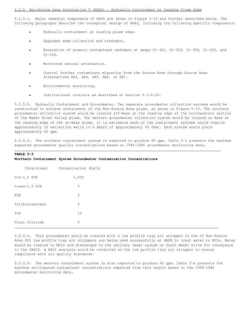
5.2.5 Non-Source Area Alternative 5 (NSA5) - Hydraulic Containment at Leading Plume Edge
5.2.5.1. Major remedial components of NSA5 are shown in Figure 5-10 and further described below. Thefollowing paragraphs describe the conceptual design of NSA5, including the following specific components:
• Hydraulic containment at leading plume edge.
• Upgraded seep collection and treatment.
• Excavation of arsenic contaminant sediment at seeps U1-301, U1-303, U1-304, U1-305, andU1-318.
• Monitored natural attenuation.
• Control further contaminant migration from the Source Area through Source Area Alternatives SA3, SA4, SA5, SA6, or SA7.
• Environmental monitoring.
• Institutional controls as described in Section 5.3.0.16.
5.2.5.2. Hydraulic Containment and Groundwater. Two separate groundwater collection systems would beconstructed to achieve containment of the Non-Source Area plume, as shown in Figure 5-10. The northerngroundwater collection system would be located off-Base at the leading edge of the northwestern sectionof the Weber River Valley plume. The western groundwater collection system would be located on-Base atthe leading edge of the on-Base plume. It is estimated each of the containment systems would requireapproximately 10 extraction wells to a depth of approximately 45 feet. Each system would yieldapproximately 60 gpm.
5.2.5.3. The northern containment system is expected to produce 60 gpm. Table 5-3 presents the maximumexpected groundwater quality concentrations based on 1994-1996 groundwater monitoring data.__________________________________________________________________________________________________TABLE 5-3Northern Containment System Groundwater Contamination Concentrations
Constituent Concentration (Ig/L)
cis-1,2 DCE 1,000
trans-1,2 DCE 5
PCE 5
Trichloroethane 5
TCE 10
Vinyl Chloride 5_________________________________________________________________________________________________
5.2.5.4. This groundwater would be treated with a low profile tray air stripper in the of Non-SourceArea OU1 Low profile tray air strippers are being used successfully at HAFB to treat water to MCLs. Waterwould be treated to MCLs and discharged to the sanitary sewer system on South Weber Drive for conveyanceto the CWSID. A BACT analysis would be conducted on the low profile tray air stripper to ensurecompliance with air quality standards.
5.2.5.5. The western containment system is also expected to produce 60 gpm. Table 5-4 presents themaximum anticipated contaminant concentrations expected from this region based on the 1994-1996groundwater monitoring data.
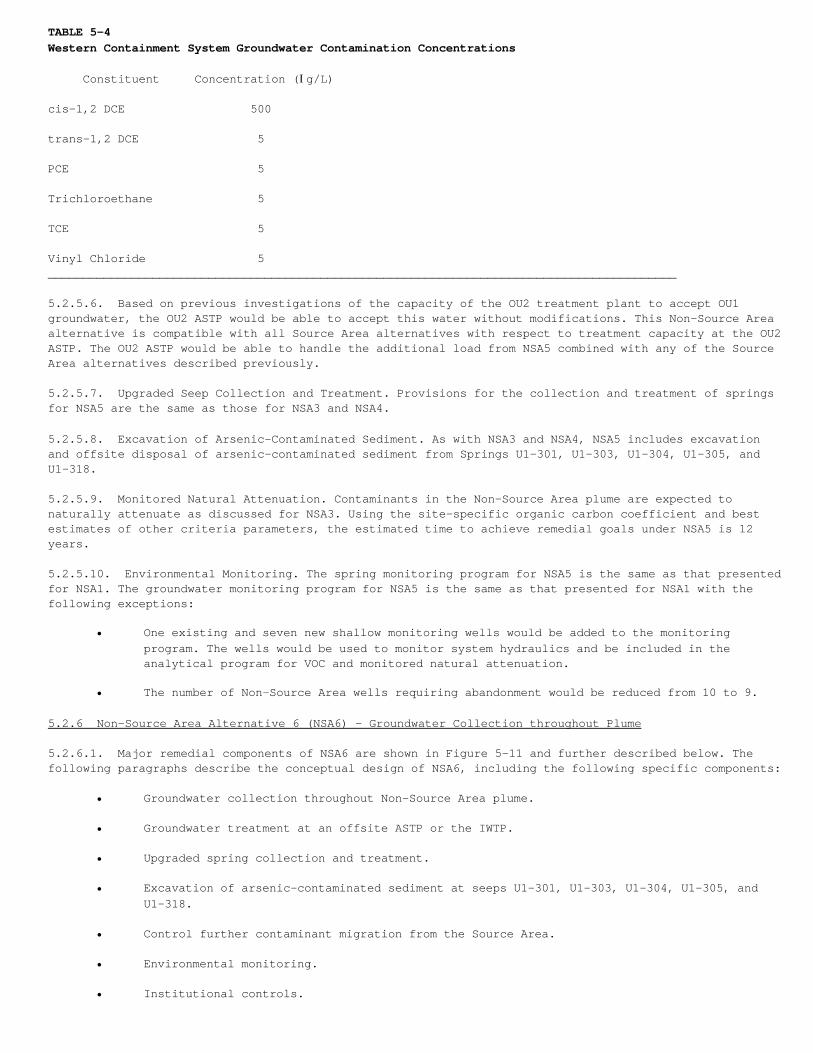
TABLE 5-4Western Containment System Groundwater Contamination Concentrations
Constituent Concentration (Ig/L)
cis-1,2 DCE 500
trans-1,2 DCE 5
PCE 5
Trichloroethane 5
TCE 5
Vinyl Chloride 5__________________________________________________________________________________________
5.2.5.6. Based on previous investigations of the capacity of the OU2 treatment plant to accept OU1groundwater, the OU2 ASTP would be able to accept this water without modifications. This Non-Source Areaalternative is compatible with all Source Area alternatives with respect to treatment capacity at the OU2ASTP. The OU2 ASTP would be able to handle the additional load from NSA5 combined with any of the SourceArea alternatives described previously.
5.2.5.7. Upgraded Seep Collection and Treatment. Provisions for the collection and treatment of springsfor NSA5 are the same as those for NSA3 and NSA4.
5.2.5.8. Excavation of Arsenic-Contaminated Sediment. As with NSA3 and NSA4, NSA5 includes excavationand offsite disposal of arsenic-contaminated sediment from Springs U1-301, U1-303, U1-304, U1-305, andU1-318.
5.2.5.9. Monitored Natural Attenuation. Contaminants in the Non-Source Area plume are expected tonaturally attenuate as discussed for NSA3. Using the site-specific organic carbon coefficient and bestestimates of other criteria parameters, the estimated time to achieve remedial goals under NSA5 is 12years.
5.2.5.10. Environmental Monitoring. The spring monitoring program for NSA5 is the same as that presentedfor NSA1. The groundwater monitoring program for NSA5 is the same as that presented for NSA1 with thefollowing exceptions:
• One existing and seven new shallow monitoring wells would be added to the monitoringprogram. The wells would be used to monitor system hydraulics and be included in theanalytical program for VOC and monitored natural attenuation.
• The number of Non-Source Area wells requiring abandonment would be reduced from 10 to 9.
5.2.6 Non-Source Area Alternative 6 (NSA6) - Groundwater Collection throughout Plume
5.2.6.1. Major remedial components of NSA6 are shown in Figure 5-11 and further described below. Thefollowing paragraphs describe the conceptual design of NSA6, including the following specific components:
• Groundwater collection throughout Non-Source Area plume.
• Groundwater treatment at an offsite ASTP or the IWTP.
• Upgraded spring collection and treatment.
• Excavation of arsenic-contaminated sediment at seeps U1-301, U1-303, U1-304, U1-305, andU1-318.
• Control further contaminant migration from the Source Area.
• Environmental monitoring.
• Institutional controls.
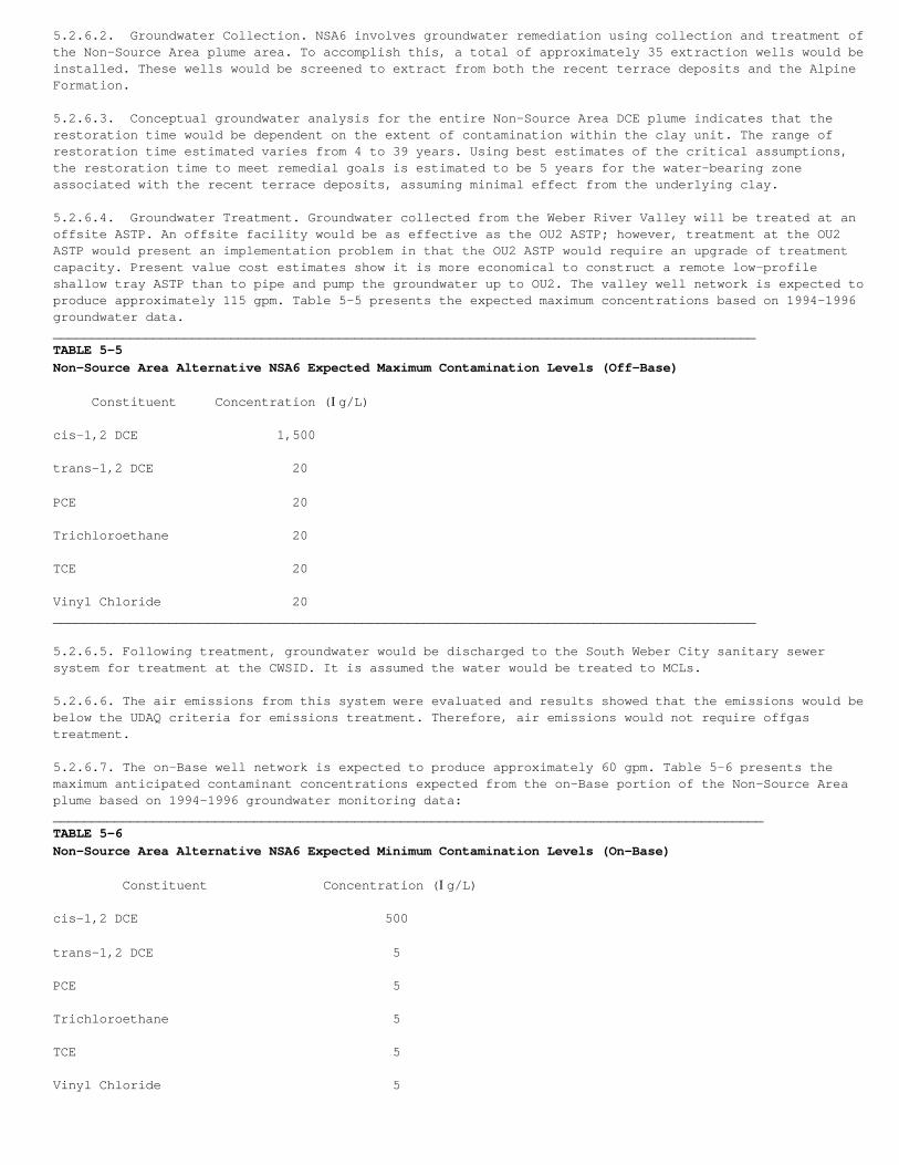
5.2.6.2. Groundwater Collection. NSA6 involves groundwater remediation using collection and treatment ofthe Non-Source Area plume area. To accomplish this, a total of approximately 35 extraction wells would beinstalled. These wells would be screened to extract from both the recent terrace deposits and the AlpineFormation.
5.2.6.3. Conceptual groundwater analysis for the entire Non-Source Area DCE plume indicates that therestoration time would be dependent on the extent of contamination within the clay unit. The range ofrestoration time estimated varies from 4 to 39 years. Using best estimates of the critical assumptions,the restoration time to meet remedial goals is estimated to be 5 years for the water-bearing zoneassociated with the recent terrace deposits, assuming minimal effect from the underlying clay.
5.2.6.4. Groundwater Treatment. Groundwater collected from the Weber River Valley will be treated at anoffsite ASTP. An offsite facility would be as effective as the OU2 ASTP; however, treatment at the OU2ASTP would present an implementation problem in that the OU2 ASTP would require an upgrade of treatmentcapacity. Present value cost estimates show it is more economical to construct a remote low-profileshallow tray ASTP than to pipe and pump the groundwater up to OU2. The valley well network is expected toproduce approximately 115 gpm. Table 5-5 presents the expected maximum concentrations based on 1994-1996groundwater data.___________________________________________________________________________________________TABLE 5-5Non-Source Area Alternative NSA6 Expected Maximum Contamination Levels (Off-Base)
Constituent Concentration (Ig/L)
cis-1,2 DCE 1,500
trans-1,2 DCE 20
PCE 20
Trichloroethane 20
TCE 20
Vinyl Chloride 20___________________________________________________________________________________________
5.2.6.5. Following treatment, groundwater would be discharged to the South Weber City sanitary sewersystem for treatment at the CWSID. It is assumed the water would be treated to MCLs.
5.2.6.6. The air emissions from this system were evaluated and results showed that the emissions would bebelow the UDAQ criteria for emissions treatment. Therefore, air emissions would not require offgastreatment.
5.2.6.7. The on-Base well network is expected to produce approximately 60 gpm. Table 5-6 presents themaximum anticipated contaminant concentrations expected from the on-Base portion of the Non-Source Areaplume based on 1994-1996 groundwater monitoring data:____________________________________________________________________________________________TABLE 5-6Non-Source Area Alternative NSA6 Expected Minimum Contamination Levels (On-Base)
Constituent Concentration (Ig/L)
cis-1,2 DCE 500 trans-1,2 DCE 5
PCE 5
Trichloroethane 5
TCE 5
Vinyl Chloride 5
5.2.6.8. Based on previous investigations of the ability of the OU2 ASTP to accept OU1 groundwater, theOU2 ASTP would be able to accept this water without modifications.
5.2.6.9. This Non-Source Area alternative is compatible with all Source Area alternatives with respect totreatment capacity at the OU2 ASTP. The OU2 ASTP would be able to handle the additional load from NSA6combined with any of the Source Area alternatives described previously.
5.2.6.10. Upgraded Seep Collection and Treatment. Provisions for the collection and treatment of springsfor NSA6 are the same as those for previous alternatives.
5.2.6.11. Excavation of Arsenic-Contaminated Sediment. As with previous alternatives, NSA6 includesexcavation and offsite disposal of arsenic-contaminated sediment from Springs U1-301, U1-303, U1-304,U1-305, and U1-318.
5.2.6.12. Environmental Monitoring. The spring monitoring program for NSA6 is the same as that presentedfor NSA1. The groundwater monitoring program for NSA6 is the same as that presented for NSA1, with thefollowing exceptions:
• Two existing and three new shallow wells would be added.
• Three existing and 22 new deep wells would be added.
• The number of Non-Source Area wells requiring abandonment would be reduced from 10 to 5.
5.3 Elements Common to Both Source Area and Non-Source Area Alternatives
5.3.0.1. Several specific remedial components are common to more than one of the Source Areaalternatives; these components are as follows:
• Pond No. 10 modifications.• Localized groundwater extraction at the northern Base boundary.• Waste Oil/Phenol Pit containment.• Upgradient soil/bentonite cut-off wall.• Groundwater treatment at OU2 ASTP or the IWTP.• Landfill gas monitoring.• Slope stability monitoring.• Institutional and engineering controls.• Operations, maintenance, and replacement of remedial components.• Designation of Corrective Action Management Unit (CAMU).
5.3.0.2. The following paragraphs provide greater detail concerning each of these common elements.
5.3.0.3. Pond No. 10 Modifications. As part of Source Area Alternative SA2 and all subsequentalternatives, the pump inlet at Pond No. 10 will be lowered so the pond can be completely drained afterstorm events to reduce potential infiltration, and thus reduce the gradient and flow of contamination inthe underlying Alpine Formation. Stormwater from Pond No. 10 will be diverted to Pond No. 9, locatedapproximately 2 miles west of Pond No. 10. An analysis of stormwater infiltration in Pond 10 is currentlybeing performed. The results of this investigation are documented in the Draft Operable Unit 1Groundwater Pre-Design Report (CH2M HILL, 1998c). The U.S. Army Corps of Engineers would also becontacted to determine whether they have jurisdiction over the pond/wetland area. If so, the substantiverequirements for obtaining a permit for the pond modifications would be performed and wetland mitigationwould be undertaken, if necessary.
5.3.0.4. Groundwater Extraction at Northern Base Boundary. As part of Source Area Alternative SA2, andall subsequent alternatives, the area of groundwater contamination downgradient of the Waste Phenol/OilPit will be contained. Based on existing data, it is estimated that a single extraction well will berequired to achieve containment of contaminants in this area. The total depth of this well is estimatedto be 40 feet and approximately 1.5 gpm will be extracted. The extracted groundwater will be treated atthe OU2 ASTP or IWTP and discharged to the local POTW.
5.3.0.5. Waste Phenol/Oil Pit Containment. As part of Source Area Alternative SA2 and all subsequentalternatives, a containment system specific to contaminant releases to groundwater from the WastePhenol/Oil Pit will be constructed. The system will consist of an extraction trench downgradient of theWaste Phenol/Oil Pit to collect contaminated groundwater. The extraction system is expected to collectapproximately 0.5 gpm, which will be treated at the OU2 ASTP or the IWTP.

5.3.0.6. Upgradient Soil/Bentonite Cut-Off Wall. As previously discussed, an upgradient soil/bentonitecut-off wall was installed as an early response action in 1985 to divert upgradient groundwater aroundthe OU1 Source Area. Uncertainty associated with the cut-off wall effectiveness make it difficult todevelop proposed remedial actions for upgradient hydraulic containment. This uncertainty stems from aninvestigation that indicated the actual depth of the wall is less than the design depth in severallocations (Dames and Moore, 1985). These conclusions were reached by examining water level data, whichdoes not indicate a consistent head differential across the wall. Two options were evaluated to addressthis uncertainty, as follows:
• Option 1: Utilize the existing wall without modification and collect leakage with the downgradient systems proposed for each alternative.
• Option 2: Test and upgrade or replace the wall to increase the effectiveness of upgradient flow diversion.
5.3.0.7. Evaluation of these options was based on effectiveness, implementability, and cost. While eachof the options will effectively mitigate offsite transport of contaminants, Option 2 is more difficult toimplement because of required investigations and construction. By comparing the costs associated withthese options, it was determined that the costs of further evaluation and enhancement of the wall willexceed the costs of treating water that may pass through or beneath the upgradient wall in the OU2 ASTP.A conservative estimate of cut-off wall effectiveness under current conditions is 50 percent; i.e., 50percent of upgradient water is diverted by the wall. The 30-year net present value of Option 1 (treating50 percent of upgradient flow) is estimated at $184,000; the 30-year net present value of Option 2(testing and upgrading the wall to 80 percent effectiveness) is estimated at $384,000.
5.3.0.8. Based on these evaluations, it is evident that a substantial expenditure to test and enhance theexisting wall is not cost effective. This is primarily due to the relatively low cost of treatingupgradient groundwater that is not diverted by the wall in the OU2 ASTP. A substantial expenditure totest and upgrade the wall is likely to result only in an incremental reduction in groundwater treatmentcost. Therefore, it is assumed for all Source Area alternatives that the existing wall will not bemodified. For the purpose of estimating groundwater collection system flow rates and sizing groundwatertreatment systems, it was conservatively estimated that the wall does not effect the groundwater flowsystem.
5.3.0.9. Groundwater Treatment. As part of all Source Area alternatives, groundwater collected in the OU1Source Area may be redirected from the HAFB IWTP to the OU2 ASTP. The Three-Mile Pipeline Design OptionReport recommends discontinuing discharge to the IWTP and redirecting flow from OU1 to ASTP located atthe OU2 Source Removal System Facility. This option was determined to comply with ARARs, to be flexibleat incorporating future flows, and to have a low implementation cost. The OU2 ASTP was completed in 1997.The following paragraphs describe the existing treatment facilities and the modifications required toimplement this alternative.
5.3.0.10. As previously discussed, groundwater is currently collected from the OU1 Source Area by aseries of dewatering wells and a single extraction trench. The system also includes pumping stations thatcollect water from hillside springs (see Non-Source Area Alternative NSA3). Water collected by thissystem is pumped to a pump transfer building at OU1 which pumps the water via the 3-mile pipeline to theHAFB IWTP where it is treated and disposed.
5.3.0.11. The following modifications will be implemented to discharge groundwater from OU1 to the OU2ASTP:
• Install oil/water separation pretreatment at OU1.
• Discontinue use of the three-mile pipeline until HAFB determines a future use.
• Modify the pumps, piping, and controls in the OU1 Pump Transfer Building to pump water inthe reverse direction to the OU2 ASTP.
5.3.0.12. Landfill Gas Monitoring. As part of Source Area Alternative SA2 and all subsequent alternativesexcept Source Area Alternative SA7, biannual sampling will be conducted to monitor constituents inlandfill gas. Sampling will be conducted from selected landfill gas vents. A BACT analysis will beperformed to ensure compliance with air quality standards.
5.3.0.13. Slope Stability Monitoring. The stability of the terrace north of OU1 may be compromised byfluctuations in the static groundwater table induced by groundwater extraction systems. Therefore, fourexisting inclinometers will be monitored annually for the remediation period to provide early warning ofpotential failure of the slope. This monitoring is included for all Source Area alternatives.
5.3.0.14. Institutional and Engineering Controls. Institutional and engineering controls for propertiesnot fee-owned by the Air Force will include: (1) water rights and well drilling restrictions andadvisories to prevent exposure to contaminated groundwater, and (2) fencing with warning signs torestrict access to exposure areas, construction areas, and treatment facilities. Leases or easements maybe needed to enact some of the institutional controls.
5.3.0.15. The Utah Department of Natural Resources, Division of Water Rights has developed a groundwatermanagement plan for the Weber Delta sub-area of the East Shore area, which includes HAFB. Areas ofgroundwater contamination surrounding HAFB are identified as restricted. No new wells will be permittedin the restricted areas nor will change applications that propose to transfer water into these areas begranted. When the contamination is successfully cleaned up and no longer poses a threat to groundwateraquifers, the State Engineer will consider allowing the construction of wells in these areas.
5.3.0.16. Institutional controls for Air Force fee-owned property will include:
1. Issuing a continuing order that remains in effect as long as the property is owned by the Air Force. These controls restrict access to or disturbance of contaminated soil, restrict construction activities, and restrict installing water supply wells in zones of contaminated groundwater.
2. Filing a notice to the deed detailing the restrictions of the continuing order.
3. A deed restriction or restrictive easement to the deed in the event of property transfer.
5.3.0.17. In the case of the sale or transfer of property within OU1 by the U.S. to any other person orentity, the Air Force will place a deed restriction or restrictive easement in the deed that willrestrict access and prohibit disturbance of contaminated soils or the remedial action without approval ofthe U.S. These deed restrictions or restrictive easements will be in effect until removed upon agreementof the State of Utah, the EPA, and the U.S. Air Force or their successors in interest. The Air Force willalso include in the deed a deed restriction or restrictive easement required by Section 120(h)(3) ofCERCLA, which includes (1) a warranty that the U.S. will conduct any remedial action found to benecessary after the date of the transfer; and (2) a right of access on behalf of the EPA and the AirForce or their successors in interest to the property to participate in any response or corrective actionthat might be required after, the date of transfer. The right of access referenced in the precedingsentence shall include the State of Utah for purposes of conducting or participating in any response orcorrective action that might be required after the date of transfer.
5.3.0.18. In the event the land use is changed or structures are removed, the Air Force will re-evaluatethe protectiveness of the remedy selected for OU1, and will take any appropriate remedial action.
5.3.0.19. Operations, Maintenance, and Replacement of Remedial Components. It is anticipated that routineO&M of remedial components will be conducted, and periodic replacement of specific components will berequired.
5.3.0.20. Designation of Corrective Action Management Unit. A CAMU will be designated under all SourceArea and Non-Source Area alternatives, other than the no further action alternatives (SA1 and NSA1), toinclude the contiguous area of contamination. The aerial extent of the CAMU is shown on Figure 5-12.Movement of soils or landfill materials to appropriate locations within the boundaries of the CAMU willcomply with Resource, Conservation and Recovery Act (RCRA) land disposal restrictions. It is anticipatedthis will be applied to cuttings from groundwater extraction and monitoring wells, trench spoils forgroundwater collection systems, and excess soils from slurry wall construction. In all cases, the soilswould be consolidated on the landfills, covered with a landfill cap comparable to that used by thealternative, and meet landfill closure ARARs.
<IMG SCR 98107J><IMG SCR 98107K><IMG SCR 98107L><IMG SCR 98107M><IMG SCR 98107N><IMG SCR 98107O><IMG SCR 98107P><IMG SCR 98107Q><IMG SCR 98107R><IMG SCR 98107S><IMG SCR 98107T><IMG SCR 98107U>

6.0 Summary of the Comparative Analysis of the Alternatives
6.1 Introduction
6.1.0.1. The comparative analysis evaluates relative performance of the alternatives within the nineevaluation criteria established in the NCP listed below. The first two evaluation criteria are thresholdcriteria that must be met by the selected remedial action. The five balancing criteria are balanced toachieve the best overall solution. The final two modifying criteria considered in the remedy selectionare State acceptance and community acceptance.
6.1.0.2. Threshold criteria include overall protection of human health and the environment as well ascompliance with ARARs. These threshold criteria must be met by an alternative before it can be evaluatedunder the five balancing criteria.
1. Overall Protection of Human Health and the Environment addresses whether a remedy provides adequate protection and describes how risks posed through each pathway are eliminated, reduced, or controlled.
2. Compliance with ARARs addresses whether a remedy will meet all substantive federal and State environmental laws and/or provide grounds for a waiver.
6.1.0.3. The five balancing criteria form the basis of the comparative analysis because they allowtradeoffs among the alternatives requiring different degrees of performance.
3. Long-Term Effectiveness and Permanence refers to the ability of a remedy to provide reliable protection of human health and the environment over time.
4. Reduction of Toxicity, Mobility, or Volume through Treatment refers to the preference for a remedy that reduces health hazards of contaminants, the movement of contaminants, or the quantity of contaminants at OU1 through treatment at the site.
5. Short-Term Effectiveness addresses the period of time needed until protection is achieved, and any adverse effects to human health and the environment that may be caused during the construction and implementation of the remedy.
6. Implementability refers to the technical and administrative feasibility of an alternative or a remedy, and the availability of goods and services needed to implement the alternative.
7. Cost evaluates the estimated capital, operation, and maintenance costs of each alternative.
6.1.0.4. The modifying criteria are generally addressed in response to comments from the State and thepublic, after issuance of the Proposed Plan.
8. State Acceptance indicates whether the State agrees with, opposes, or has no comment on the preferred alternative.
9. Community Acceptance indicates whether the community agrees with, opposes, or has no comment on the preferred alternative.
6.2 Threshold Criteria
6.2.1 Overall Protection of Human Health and the Environment
6.2.1.1. The NCP requires all alternatives be assessed to determine whether they can adequately protecthuman health and the environment, in both the short- and long-term, from unacceptable risks posed byhazardous substances, pollutants, or contaminants present at the site by eliminating, reducing, orcontrolling exposures to such substances, pollutants, or contaminants. Overall protection of human healthand the environment draws on the assessments of other evaluation criteria, especially long-termeffectiveness and permanence, short-term effectiveness, and compliance with ARARs.
6.2.1.2. Source Area Alternatives. All alternatives with the exception of SA1 are protective of publichealth and the environment. SA6 achieves protection because it uses protective measures included in SA2through SA5, as well as in situ treatment to remove the VOCs posing the greatest risk for offsitemigration in groundwater and direct contact risks for construction workers, while also minimizingpotential impacts related to construction.
6.2.1.3. SA7 achieves protection through the removal of the sources. Once the sources are removed, therewould be no need for on-Base institutional controls designed to address unacceptable risks associatedwith landfill contents and soils. However, institutional controls associated with potential groundwaterrisk scenarios would still be required. Although much of the waste and soil would be treated byincineration, the majority would be disposed untreated at an offsite landfill. There would be potentialrisks to on- and off-Base human health and the environment during the excavation and offsite transport ofcontaminated source materials. The potential risks would be associated with the excavation of anestimated 765,000 cubic yards of contaminated soil and landfill wastes, and the offsite transport thatwould require an estimated 38,000 truck round trips from the site to the offsite landfill andincinerator. Even though there are potential risks to human health and the environment duringimplementation of source removal activities, the short-term risks can be managed adequately soprotectiveness is maintained.
6.2.1.4. SA4 and SA5 achieve protectiveness through the use of the central dewatering trenches and slurrywall groundwater containment system to prevent further offsite contaminant migration. The slurry wall isprotective because it provides reliability that further releases offsite through the Alpine Formation areprevented. This is because it prevents the offsite discharge of contaminants in narrow (about 0.5 inch)sand stringers located near the Source Area perimeter that may connect to permeable zones on thehillside. Groundwater flow in these stringers may not be captured by the central dewatering trenchbecause of the large permeability difference between the sand stringers and clay of the Alpine Formation.The landfill cap upgrade of SA5 is also protective because it reduces infiltration and may reduceleaching of contaminants to groundwater.
6.2.1.5. The central dewatering trench of SA3 is protective of public health and the environment becauseit provides a high degree of assurance that offsite migration of groundwater contaminants in the Provoand Alpine Formations is prevented. This is because the trench is completed to a depth of 10 to 15 feetinto the Alpine Formation, thus allowing capture of contaminants nearer the most significant sources(CDPs and the LNAPL area) and contaminants in the upper depths of the Alpine Formation. Because thetrench dewaters the Provo Formation, and the Alpine Formation does not supply sufficient water forpotable use, future risks from ingestion of groundwater within the Source Areas are eliminated. SA2includes groundwater collection trenches to capture groundwater migrating offsite. It also relies ongroundwater monitoring to verify that further releases to offsite groundwater are not occurring. However,because the potential for offsite migration in the Alpine Formation at concentrations exceeding PRGs islimited, SA2 combined with groundwater monitoring and potential upgrades to the collection system, asnecessary, is also considered protective.
6.2.1.6. SA1 is not considered protective of public health and the environment because it allowscontinued releases of contaminants to groundwater and their migration offsite. However, the earlyresponse actions previously implemented have decreased infiltration and recharge into the OU1 SourceAreas, and removed large amounts of contaminated groundwater from the Source Area. They are most likelyresponsible for the recently observed decline in off site groundwater contaminant concentrations.Although the early response actions are not considered sufficiently protective, they have provided asubstantial increase to the protection of public health and the environment.
6.2.1.7. Non-Source Area Alternatives. For the purpose of establishing a true "no further action"alternative, the no further action alternative for the Source Area (SA1) is combined with the no furtheraction alternative of the Non-Source Area (NSA1). All alternatives except NSA1 are considered protectiveof public health and the environment. NSA2 through NSA6 are considered protective because institutionalcontrols are expected to continue preventing potable use of the springs and groundwater, while remedialactions reduce contaminant concentrations to levels protective of human health and the environment. Thetime during which reliance on institutional controls is necessary ranges from 5 years for NSA6 to 12years for NSA2 and NSA5. While there is substantial uncertainty associated with remediation timeestimates, and actual remediation times may be longer, groundwater monitoring data from the north plumeshows declines in many of the wells over the last few years, several of which are now below remedialgoals.
6.2.1.8. NSA2 through NSA6 are also considered protective because there is little potential for use ofthe groundwater during the relatively short times to achieve remedial goals. This is because thegroundwater plume is either on-Base, where access is controlled, or in the Weber River Valley, whereresidences are connected to the city water supply. The greatest potential for use would be for occasionaluse of spring water, particularly Spring U1-309 that has a substantial flow rate (30 gpm). NSA2 throughNSA6 prevent access through institutional and/or engineering controls such as acquisition of easementsand fencing of springs. NSA1 is not considered protective because it does not prevent use.
6.2.2 Compliance with ARARs
6.2.2.1. Applicable requirements are those cleanup standards, standards for control, and othersubstantive requirements, criteria, or limitations promulgated under federal or State law thatspecifically address a hazardous substance, pollutant, contaminant, remedial action, or location at aCERCLA site. Relevant and appropriate requirements are similar requirements, that while not applicable,clearly address problems or situations sufficiently similar to those encountered at a CERCLA site suchthat their use is well suited to the particular site. Compliance with ARARs for the Source and Non-SourceArea alternatives are discussed in the following subsections.
6.2.2.2. Each alternative is assessed to determine whether it would attain applicable or relevant andappropriate requirements under federal environmental laws and State environmental or facility sitinglaws, or provide grounds for invoking an ARARs waiver. ARARs for all alternatives at OU1 are presented inAppendix A. Compliance with some key ARARs is discussed in the description of alternatives and will notbe repeated here.
6.2.2.3. Source Area Alternatives. Except for SA1, all Source Area alternatives are expected to meet MCLsin groundwater in a reasonable time frame. However, there are some uncertainties. A waiver to meet MCLsin groundwater may be needed for parts of the Source Area in the future because it is technicallyimpracticable to achieve these levels. The overall uncertainty focuses on contaminated groundwater inthin sand layers in the otherwise clayey Alpine Formation. It may be impracticable to locate and collectgroundwater from all of the sand layers. This would be the case regardless of whether the wastes arecontained, treated in place, or removed. Also, upgrading the existing system in SA2 may not interceptsome contaminated groundwater from the lowermost parts of the Provo Formation, and MCLs may not beachieved in a reasonable time frame.
6.2.2.4. All alternatives involving treatment of groundwater and soils would be designed to meet theaction-specific ARARs. This includes meeting discharge pre-treatment limits, air emission requirementsfor air stripper or SVE system offgas, and RCRA land disposal restrictions for characteristic or listedwaste. Some of the alternatives include the designation of a CAMU. Treatability variances for CERCLA soiland debris may be sought under SA7 for soils or wastes where the "contained in" policy applies, and thecontaminant concentrations are relatively low.
6.2.2.5. Non-Source Area Alternatives. All alternatives except NSA1 would comply with ARARs. NSA1 wouldnot meet ARARs because continued releases from the Source Area would occur. With continued releases fromthe Source Area, it is unlikely groundwater would meet MCLs in a reasonable time frame, as required bythe NCP. The remaining alternatives will meet ARARs because the remedial goals are expected to beachieved in a reasonable time, possibly within 12 years for NSA2, Monitored Natural Attenuation.Groundwater monitoring is important for all alternatives to document declines in groundwater contaminantconcentrations. In the event that declining trends are not observed for any of the alternatives,additional actions to meet ARARs would be considered.
6.2.2.6. Action-specific ARARs would be met for all alternatives. Surface water and groundwater treatmentincluded in NSA3 through NSA6 would be designed to meet discharge standards, and air emissions from theair stripper would meet air quality standards. The air emissions from the NSA4 air sparge system are notexpected to require treatment to comply with ARARs.
6.2.2.7. All alternatives involving construction or monitoring activity would be designed to meet thefederal location-specific ARARs regarding impacts to threatened or endangered species or their habitat,including development in a floodplain. Adverse impacts to surface water or groundwater quality are notanticipated, and groundwater quality will be improved over the long term, for all alternatives except SA1and NSA1. No significant impacts on ecosystems are expected as a result of construction. Althoughendangered species may frequent the HAFB area, the OU1 Source Area does not provide critical or importanthabitats for any wildlife species, and no threatened or endangered species are known to inhabit the OU1Source Area. Construction in the Non-Source Area under NSA3 through NSA6 will primarily impactagricultural or residential land uses.
6.3 Primary Balancing Criteria
6.3.1 Long-Term Effectiveness and Permanence
6.3.1.1. The alternatives were assessed for the long-term effectiveness and permanence they afford, alongwith the degree of certainty that the alternative would prove successful. Factors considered include thefollowing:
• The magnitude of residual risk from untreated waste or treatment residuals remaining at theconclusion of the remedial activities.
• The adequacy and reliability of controls such as containment systems and institutional controls that are necessary to manage untreated waste and treatment residuals.
6.3.1.2. Source Area Alternatives. SA7 is the most effective and permanent because it removes anddisposes offsite the soil and landfill contents posing potential risk. SA7 does not require reliance oninstitutional controls to prevent exposure to the soil or landfill contents. However, it does requireinstitutional controls to prevent exposure to contaminated groundwater, and it requires the leastlong-term management.
6.3.1.3. SA6 is the next most effective and permanent because it removes and treats the mobilecontaminants, which pose the greatest risk to human health and the environment. SVE coupled withdewatering results in the least amount of risk from residuals of SA1 through SA6. The cap upgrade of SA6adds some improvement in long-term effectiveness and permanence but only reduces infiltration by anestimated 1 gpm. The landfill cap upgrade of SA6 appears to offer only a marginal decrease in thepotential for contaminant leaching to groundwater. It is estimated the landfill cap will decreaseinfiltration by only about 0.4 inches per year, equivalent to 0.6 gpm over the entire Landfills 3 and 4cap area. This small amount of infiltration may be adsorbed into the waste mass, and much of it may notreach the groundwater. If it does reach the groundwater, the infiltration would eventually be collectedin the dewatering trench.
6.3.1.4. SA2 through SA5 are the next most effective and permanent alternatives when compared to SA6 andSA7. They have similar effectiveness although there are incremental increases in the adequacy of theprevention of offsite migration as a result of the increasing number of remedial actions incorporatedinto each sequential alternative; e.g., SA4 adds supplemental remedial measures to those proposed in SA3,SA5 adds to SA4, etc.
6.3.1.5. SA1 is the least effective although the presence of the existing landfill cap and existinginstitutional controls at HAFB reduces the likelihood that exposure through construction within thelandfill would occur. Continued releases to offsite groundwater would continue although the decliningconcentrations in offsite groundwater suggest that the response actions taken to date are reducing thereleases.
6.3.1.6. Non-Source Area Alternatives. All alternatives except NSA1 are expected to be effective inpreventing future risks from exposure to groundwater or surface water through reliance on institutionalcontrols during the period until groundwater meets the remedial goals. The magnitude of residual risks(i.e., the risks remaining following completion of the remediation) are similar for NSA2 through NSA6because each alternative continues in operation until remedial goals are met. Residual risks related toexposure to arsenic in sediment, though currently below target levels, would be eliminated entirely underNSA3 through NSA6.
6.3.1.7. Cleanup of DCE to its remedial goal of 70 micrograms per liter (Ig/L), can be achieved based ongroundwater monitoring data for the Weber River Valley plume. The cleanup of groundwater to remedialgoals or to non-detection is often difficult because of the slow desorption of contaminants from thewater-bearing zone soil and heterogeneities in the water-bearing zone. In particular, the Weber RiverValley plume may not cleanup to non-detectable concentrations as a result of the presence ofcontamination in the clay below the alluvial water-bearing zone. This clay contamination may act as a lowconcentration continuous source to the alluvium, resulting in a decline in groundwater concentrations toan asymptote above detectable levels. The difficulty with achieving low Ig/L concentrations in thewater-bearing zones also applies to NSA1 through NSA5.
6.3.1.8. NSA6 is the most reliable alternative because it actively removes contaminants from thegroundwater. NSA5 is considered the next most effective alternative because it controls the potentialspread of the western and valley plumes with active groundwater collection. The control of the valleyplume, however, may not be necessary because the plume appears to be discharging at the springs along thenorthern perimeter of the plume. The western plume is expected to diminish in concentration once furtherreleases from the Source Area cease. Both plumes are currently stable or contracting based on historicalanalytical data. NSA3 and NSA4 are slightly more effective than NSA2 because they prevent use of thesprings by collecting and treating the water before it surfaces. Again the difference is not greatbetween alternatives because the concentrations at the springs may drop below levels of concern within 12years, and the institutional controls used in NSA2 are expected to be effective and reliable over thistime frame.
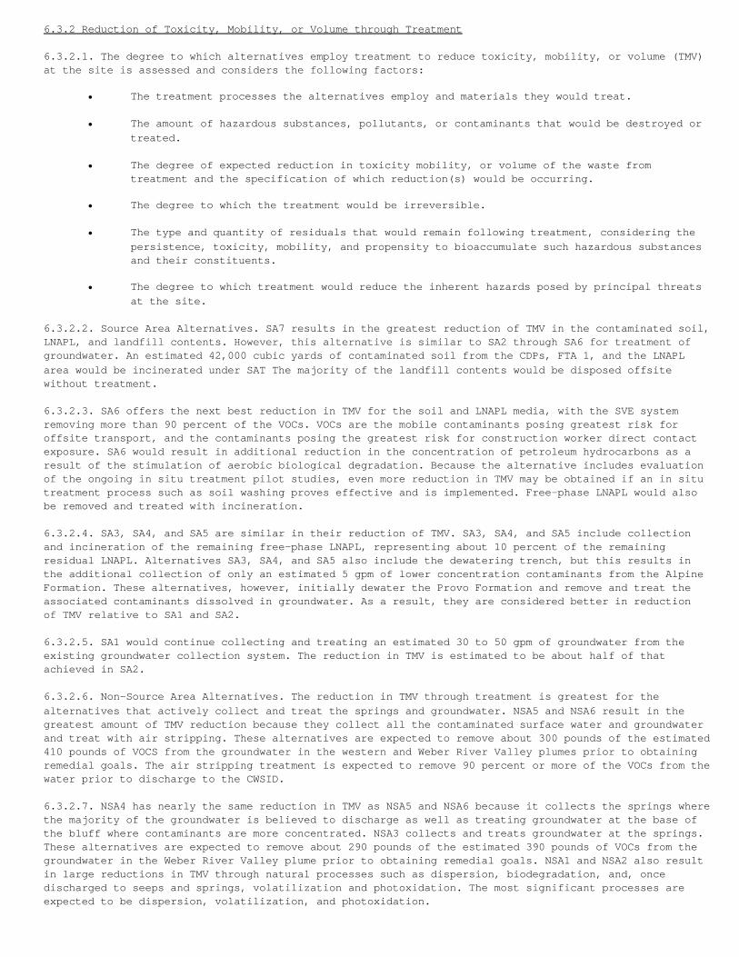
6.3.2 Reduction of Toxicity, Mobility, or Volume through Treatment
6.3.2.1. The degree to which alternatives employ treatment to reduce toxicity, mobility, or volume (TMV)at the site is assessed and considers the following factors:
• The treatment processes the alternatives employ and materials they would treat.
• The amount of hazardous substances, pollutants, or contaminants that would be destroyed ortreated.
• The degree of expected reduction in toxicity mobility, or volume of the waste from treatment and the specification of which reduction(s) would be occurring.
• The degree to which the treatment would be irreversible.
• The type and quantity of residuals that would remain following treatment, considering thepersistence, toxicity, mobility, and propensity to bioaccumulate such hazardous substancesand their constituents.
• The degree to which treatment would reduce the inherent hazards posed by principal threatsat the site.
6.3.2.2. Source Area Alternatives. SA7 results in the greatest reduction of TMV in the contaminated soil,LNAPL, and landfill contents. However, this alternative is similar to SA2 through SA6 for treatment ofgroundwater. An estimated 42,000 cubic yards of contaminated soil from the CDPs, FTA 1, and the LNAPLarea would be incinerated under SAT The majority of the landfill contents would be disposed offsitewithout treatment.
6.3.2.3. SA6 offers the next best reduction in TMV for the soil and LNAPL media, with the SVE systemremoving more than 90 percent of the VOCs. VOCs are the mobile contaminants posing greatest risk foroffsite transport, and the contaminants posing the greatest risk for construction worker direct contactexposure. SA6 would result in additional reduction in the concentration of petroleum hydrocarbons as aresult of the stimulation of aerobic biological degradation. Because the alternative includes evaluationof the ongoing in situ treatment pilot studies, even more reduction in TMV may be obtained if an in situtreatment process such as soil washing proves effective and is implemented. Free-phase LNAPL would alsobe removed and treated with incineration.
6.3.2.4. SA3, SA4, and SA5 are similar in their reduction of TMV. SA3, SA4, and SA5 include collectionand incineration of the remaining free-phase LNAPL, representing about 10 percent of the remainingresidual LNAPL. Alternatives SA3, SA4, and SA5 also include the dewatering trench, but this results inthe additional collection of only an estimated 5 gpm of lower concentration contaminants from the AlpineFormation. These alternatives, however, initially dewater the Provo Formation and remove and treat theassociated contaminants dissolved in groundwater. As a result, they are considered better in reductionof TMV relative to SA1 and SA2.
6.3.2.5. SA1 would continue collecting and treating an estimated 30 to 50 gpm of groundwater from theexisting groundwater collection system. The reduction in TMV is estimated to be about half of thatachieved in SA2.
6.3.2.6. Non-Source Area Alternatives. The reduction in TMV through treatment is greatest for thealternatives that actively collect and treat the springs and groundwater. NSA5 and NSA6 result in thegreatest amount of TMV reduction because they collect all the contaminated surface water and groundwaterand treat with air stripping. These alternatives are expected to remove about 300 pounds of the estimated410 pounds of VOCS from the groundwater in the western and Weber River Valley plumes prior to obtainingremedial goals. The air stripping treatment is expected to remove 90 percent or more of the VOCs from thewater prior to discharge to the CWSID.
6.3.2.7. NSA4 has nearly the same reduction in TMV as NSA5 and NSA6 because it collects the springs wherethe majority of the groundwater is believed to discharge as well as treating groundwater at the base ofthe bluff where contaminants are more concentrated. NSA3 collects and treats groundwater at the springs.These alternatives are expected to remove about 290 pounds of the estimated 390 pounds of VOCs from thegroundwater in the Weber River Valley plume prior to obtaining remedial goals. NSA1 and NSA2 also resultin large reductions in TMV through natural processes such as dispersion, biodegradation, and, oncedischarged to seeps and springs, volatilization and photoxidation. The most significant processes areexpected to be dispersion, volatilization, and photoxidation.

6.3.3 Short-Term Effectiveness
6.3.3.1. Factors that were considered include the following four features as components of short-termeffectiveness:
1. Short-term risks to the community during implementation.2. Potential impacts to worker during implementation.3. Potential environmental impacts during implementation.4. Time until protection is achieved.
6.3.3.2. Source Area Alternatives. Short-term risks to workers, the community, or environment are relatedto impacts from the construction and implementation of the remedial alternatives. SA1 and SA2 do not haveany significant impacts. SA1 has no impacts because there is no construction. SA2 has no significantimpacts because the construction of the collection trenches is largely outside the area of soilcontamination.
6.3.3.3. SA3 and SA4 include excavation through contaminated soil and landfill wastes to install thecentral dewatering trench, so adherence to a health and safety plan is important to prevent exposure ofworkers to contaminants. Impacts on the community and environment are not expected, but air emissionmonitoring, dust suppression, and implementation of an erosion control plan are necessary.
6.3.3.4. SA5 and SA6 include hauling large quantities of soil for upgrading of the cap. Impacts onworkers are expected to be limited to normal construction-related accidents. Risks related to exposure tocontaminants are not expected because excavation of contaminated soil or wastes is not necessary for thecap upgrade. The new cap will be constructed over the existing cap. Impacts on the community will berelated to nuisance noise, dust, and the potential for accidents related to truck traffic.
6.3.3.5. SA7 is the worst alternative relative to short-term impacts. It poses significant short-termrisks to workers, the community, and environment due to VOC emissions and fugitive dust from soil andlandfill contents excavation; potential for injuries from construction- or transportation-relatedaccidents; increased truck traffic in the surrounding community (an estimated 38,000 truck round trips);and transportation of a very large volume of potentially contaminated material (765,000 cubic yards) fromthe Base to an off-Base disposal location. The risks to the community and environment from the dust,increased truck traffic, and potential spills of contaminated material could be reduced, but noteliminated, through dust abatement procedures, careful traffic routing and traffic control during peakhours, and emergency spill mitigation procedures.
6.3.3.6. Non-Source Area Alternatives. None of the alternatives poses a significant risk to workers, thecommunity, or the environment as a result of construction or operation activities. The constructionactivities associated with the installation of the proposed 1,600-foot long air sparge curtain, which isrecommended as part of NSA4, would pose the greatest potential risk to human health and the environment.The installation of the 35 groundwater extraction wells recommended as part of NSA6, followed by theinstallation of the 10 extraction wells recommended as part of NSA5, pose the next greatest potentialrisks to human health and the environment, respectively. Construction or initiation activities associatedwith Alternatives NSA3, NSA2, and NSA1 pose the least potential risk and are listed herein in order ofdecreasing potential risk. Air emissions from the air stripper or air sparge curtain wall will be treatedif necessary to prevent risk. The time until remedial goals are achieved is the least for NSA6 (as few as5 years), followed by NSA4 (as few as 11 years), and NSA2, NSA3, and NSA5 (as few as 12 years). NSA1 maynot achieve remedial goals for decades because continued releases from the Source Area would occur (nofurther action is assumed for the Source Area). Estimates of the time to meet remedial goals are bestestimates and were made using many simplifying assumptions.
6.3.3.7 Time Until Protection is Achieved. The time to complete construction of the active Source Areaalternatives is estimated at 1 year for SA2; 2 years for SA3 through SA6; and more than 2 years for SA7.The time frames to reach Source Area alternative remedial goals are effectively equivalent to these timesto complete construction. The time to complete construction of the active Non-Source Area alternativesare estimated at less than 1 year for NSA2 and NSA3; 1 year for NSA4 and NSA5; and 2 years for NSA6. Thetime frames to reach Non-Source Area alternative remedial goals are 12 years for NSA2, NSA3, and NSA5;11 years for NSA4; and 5 years for NSA6.
6.3.4 Implementability
6.3.4.1. The ease or difficulty of implementing the alternatives was assessed by considering thefollowing factors:
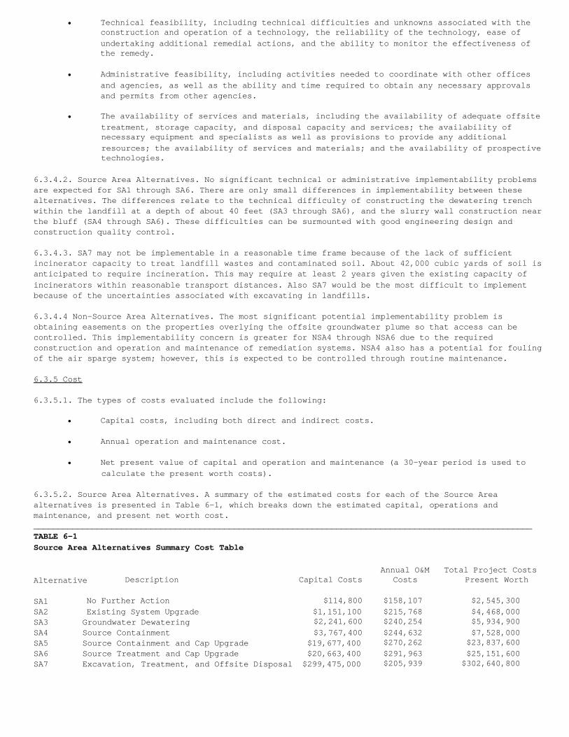
• Technical feasibility, including technical difficulties and unknowns associated with theconstruction and operation of a technology, the reliability of the technology, ease ofundertaking additional remedial actions, and the ability to monitor the effectiveness ofthe remedy.
• Administrative feasibility, including activities needed to coordinate with other offices and agencies, as well as the ability and time required to obtain any necessary approvals and permits from other agencies.
• The availability of services and materials, including the availability of adequate offsite treatment, storage capacity, and disposal capacity and services; the availability of necessary equipment and specialists as well as provisions to provide any additional resources; the availability of services and materials; and the availability of prospective technologies.
6.3.4.2. Source Area Alternatives. No significant technical or administrative implementability problemsare expected for SA1 through SA6. There are only small differences in implementability between thesealternatives. The differences relate to the technical difficulty of constructing the dewatering trenchwithin the landfill at a depth of about 40 feet (SA3 through SA6), and the slurry wall construction nearthe bluff (SA4 through SA6). These difficulties can be surmounted with good engineering design andconstruction quality control.
6.3.4.3. SA7 may not be implementable in a reasonable time frame because of the lack of sufficientincinerator capacity to treat landfill wastes and contaminated soil. About 42,000 cubic yards of soil isanticipated to require incineration. This may require at least 2 years given the existing capacity ofincinerators within reasonable transport distances. Also SA7 would be the most difficult to implementbecause of the uncertainties associated with excavating in landfills.
6.3.4.4 Non-Source Area Alternatives. The most significant potential implementability problem isobtaining easements on the properties overlying the offsite groundwater plume so that access can becontrolled. This implementability concern is greater for NSA4 through NSA6 due to the requiredconstruction and operation and maintenance of remediation systems. NSA4 also has a potential for foulingof the air sparge system; however, this is expected to be controlled through routine maintenance.
6.3.5 Cost
6.3.5.1. The types of costs evaluated include the following:
• Capital costs, including both direct and indirect costs.
• Annual operation and maintenance cost.
• Net present value of capital and operation and maintenance (a 30-year period is used to calculate the present worth costs).
6.3.5.2. Source Area Alternatives. A summary of the estimated costs for each of the Source Areaalternatives is presented in Table 6-1, which breaks down the estimated capital, operations andmaintenance, and present net worth cost.______________________________________________________________________________________________________TABLE 6-1Source Area Alternatives Summary Cost Table
Annual O&M Total Project CostsAlternative Description Capital Costs Costs Present Worth
SA1 No Further Action $114,800 $158,107 $2,545,300SA2 Existing System Upgrade $1,151,100 $215,768 $4,468,000SA3 Groundwater Dewatering $2,241,600 $240,254 $5,934,900SA4 Source Containment $3,767,400 $244,632 $7,528,000SA5 Source Containment and Cap Upgrade $19,677,400 $270,262 $23,837,600SA6 Source Treatment and Cap Upgrade $20,663,400 $291,963 $25,151,600SA7 Excavation, Treatment, and Offsite Disposal $299,475,000 $205,939 $302,640,800
6.3.5.3. As would be expected, SA1 has the lowest capital and operations maintenance costs. SA2 is thenext least expensive and adds approximately $1.9 million to present net worth over SA1 for upgrades tothe existing containment systems. SA3 is the next most expensive and adds approximately $1.5 million forthe dewatering systems within the Source Area. SA4 adds to SA3 the downgradient cut-off wall at anadditional cost of $1.6 million. SA5 adds to SA4 approximately $16.3 million for the upgrade of theexisting cap over the OU1 Source Area. SA6 adds an SVE system to SA5 and adds an additional $1.3 million.SA7 is the most expensive and is significantly higher than any of the other alternatives because of thecosts associated with the excavation, treatment, and disposal of the contaminated soils and landfillcontents.
6.3.5.4. Non-Source Area Alternatives. A summary of the estimated costs for each of the Non-Source Areaalternatives is presented in Table 6-2. A 30-year period is used to calculate present worth costs ratherthan the best estimate time frames for the NSA alternatives because of the overall range in the timeframe estimate. Table 6-2 breaks down the estimated capital, operations and maintenance, and present networth cost.________________________________________________________________________________________________________TABLE 6-2Non-Source Area Alternatives Summary Cost Table
Annual O&M Total Project CostsAlternative Description Capital Costs Costs Present Worth
NSA1 No Further Action $439,000 $60,420 $1,367,800NSA2 Monitored Natural Attenuation $455,200 $122,212 $1,538,400NSA3 Existing Seep Collection Upgrade $717,500 $176,266 $2,279,800NSA4 Plume Cut-Off at Bottom of Bluff $1,531,400 $271,742 $3,788,600NSA5 Hydraulic Containment at Leading Plume $1,289,300 $174,799 $2,838,600 Edges
NSA6 Groundwater Collection throughout Plume $2,258,300 $235,963 $3,279,900________________________________________________________________________________________________________
6.3.5.5. As would be expected, NSA1 has the lowest capital and operations and maintenance costs. NSA2adds the monitored natural attenuation and costs an additional $0.2 million in present net worth overNSA1. NSA3 adds a spring collection upgrade to NSA2 and costs an additional $0.7 million. NSA5 is thenext most expensive and adds $0.6 million to NSA3 for hydraulic containment and treatment at the leadingplume edges. NSA4 and NSA6 are similar in costs and are the most expensive of the alternatives.
6.4 Modifying Criteria
6.4.1 State Acceptance
6.4.1.1. The State of Utah agrees with the selected remedy. No change to the selected remedy isnecessary.
6.4.2 Community Acceptance
6.4.2.1. An Availability Session to answer questions concerning the Proposed Plan was held on February 5,1998. The names of members of the public present at the Availability Session are presented in Appendix B.Numerous comments were received regarding the Proposed Plan. The comments and HAFB's response to commentsare included as Appendix C. The main themes noted in the public comments included the possibility ofgroundwater contamination in South Weber No. 2, how institutional controls will be enacted, the presenceof buried drums in Landfills 3 and 4, and how the performance of remediation systems will be evaluated.
7.0 The Selected Remedy
7.1 Description of the Selected Remedy
7.1.0.1. The selected remedy at HAFB OU1 is the combination of Source Area Alternative SA3 and Non-SourceArea Alternative NSA3. The selected remedy is graphically illustrated in Figure 7-1.
7.1.0.2. Elements of the remedy common to both the Source Area and Non-Source Area include the following:
• Groundwater from the Source Area and spring collection systems at Springs U1-303, U1-304,U1-307, and U1-318 will be pumped to the OU2 ASTP or the IWTP for treatment and dischargedto it local POTW. Groundwater from Springs U1-305, U1-306, and U1-309 may be piped to theOU2 ASTP or the IWTP for treatment and discharge to a POTW or treated at a remote treatmentfacility and discharged at the spring. Only those springs with contamination levels aboveMCLs and that continue to flow after the Source Area groundwater extraction trenches areoperational will be treated.
• Long-term monitoring for contaminants and treatment system performance will be conducted. Aperformance and compliance sampling program will be implemented during the remedial actionto monitor performance and compliance with remediation goals. This program will include thelocations of performance monitoring points, monitoring frequency, analytical parameters,sampling and analytical methods, and statistical methods for evaluating data.
• Designation of a Corrective Action Management Unit (CAMU) to facilitate remedial actions.The CAMU will be designated as the contiguous area of contamination. Movement of soils orlandfill materials to appropriate locations within the boundaries of the CAMU complies withRCRA land disposal restrictions. It is anticipated that this will be applied to cuttingsfrom groundwater extraction and monitoring wells, and trench spoils from groundwatercollection systems.
• Institutional controls will be established to prevent completion of potential exposure pathways or to protect facilities installed as part of the remedy. The institutional controls are described in Section 5. Institutional controls have already been applied to the future use of groundwater.
• Because the selected remedy will result in hazardous substances remaining onsite above health-based levels, a review will be conducted within 5 years after commencement of theremedial action to ensure the remedy continues to provide adequate protection of humanhealth and the environment.
7.1.0.3. Elements specific to Source Area Alternative SA3 include:
• Installation of a series of dewatering trenches through the areas of greatest saturated thickness in the shallow water-bearing zone. Extraction wells may be used in some locations.This will prevent migration of contaminated groundwater and LNAPL from the Source Areathrough the Provo Formation. Some of the dewatering trenches will be completed in the AlpineFormation to reduce the potential for migration offsite in the Alpine Formation. The actuallocation and number of trenches will be determined during the remedial design.
• LNAPL recovery from the extraction trenches followed by proper disposal of the LNAPL .Theexisting cap and vent system over the Source Areas will be maintained to minimize infiltration and migration of contaminants.
• The landfill cap previously placed over Landfill 4 will be improved to prevent ponding ofwater.
• The pump inlet at Pond No. 10 will be lowered so that stormwater in the pond may be divertedto Pond No. 9 located approximately 2 miles west of Pond No. 10.
7.1.0.4. Changes in groundwater levels and spring flow may occur due to the continued operation of thegroundwater collection system, landfill cap repairs, or installation of the dewatering trenches.Additions, reductions, or relocations of groundwater level control points, or specific groundwater orspring extraction points may be needed.
7.1.0.5. The goals of this Source Area remedial action are to prevent migration of contaminatedgroundwater and LNAPL from the Source Area, and to restore Source Area groundwater to MCLs. The abilityto prevent migration will be evaluated in a performance monitoring system including measurements of waterlevels to determine adequate capture of groundwater and through monitoring well sampling to trackdeclines in contaminant concentrations over time. If the selected remedy cannot meet remediation goals,additional measures identified below will be considered.
7.1.0.6. The selected Source Area remedy will include groundwater extraction for an estimated period of50 or more years, during which time the system's performance will be carefully monitored on a regularbasis and adjusted as warranted by the performance data collected during operation. Modifications mayinclude any or all of the following:
• Discontinuing extraction and treatment where cleanup goals have been attained; however,monitoring will continue for 2 to 5 years to ensure cleanup goals have been attained.
• Alternating extraction rates to eliminate stagnation points, or to allow water-bearing layer equilibration and encourage adsorbed contaminants to partition into groundwater,
as long as containment is not compromised.
• Installing additional extraction points to facilitate or accelerate control of the contaminant plume.
7.1.0.7. If it is determined, on the basis of the preceding criteria and the system performance data,that restoration of certain portions of the water-bearing zones cannot be achieved, all of the followingmeasures involving long-term management may occur, for an indefinite period of time, as a modification ofthe existing system:
Engineering controls such as physical barriers or long-term gradient control provided by low-levelpumping will be maintained as containment measures.
• Chemical-specific ARARs will be waived for the restoration goals of those portions of thewater-bearing zones based on the technical impracticability of achieving further contaminantreduction-- a decision which would be made in the future based on all relevant informationand any new remedial technologies available at the time.
• Institutional controls will be provided and maintained to restrict access to those portionsof the aquifer that remain above remediation levels.
• Monitoring of specified wells will continue.
• Remedial technologies for groundwater restoration will be periodically re-evaluated.
7.1.0.8. The decision to invoke any or all of these measures may be made during a periodic review of theremedial action, which will occur at least every 5 years in accordance with CERCLA Section 121(c).
7.1.0.9. Element specific to Non-Source Area Alternative NSA3 include:
• The existing seep collection systems will be upgraded and new collection systems installedas necessary to prevent discharge of seeps and springs at concentrations exceeding MCLs. Ifthe seeps and springs cease to flow due to groundwater extraction systems in the SourceAreas, new collection systems will not be installed. Expansion and upgrade of the existingsystem will occur after the source control system has been implemented and the effects onthe seeps and springs have become evident.
• Arsenic contaminated sediment having concentrations exceeding background levels, as definedin the Baseline Risk Assessment portion of the RI, will be excavated at seeps U1-301,U1-303, U1-304, U1-305, and UI-318. The sediments will be properly disposed of offsite at anappropriate disposal facility. This sediment will be excavated once source control measuresand spring collection system upgrades have been made that prevent further discharges to thesurface at these locations, or, due to Source Area controls, the spring and seep areas ceaseto flow.
• Reliance on monitored natural attenuation for groundwater restoration.
7.1.0.10. The goal of this remedial action for the Non-Source Area is to minimize the potential for humanexposure to contaminated groundwater and surface water and restore the groundwater and surface water toMCLs, since groundwater and water from the springs are potential drinking water sources. However, thereis no current domestic use of the shallow groundwater in the vicinity of the OU1 Non-Source Area plumes.
7.1.0.11. The selected remedy for the Non-Source Area will include sediment removal, monitored naturalattenuation, and spring collection and treatment for an estimated period of 12 years, during which thesystems performance will be carefully monitored on a regular basis and adjusted as warranted by theperformance data collected during operation. Modifications may include any or all of the following:
• Discontinuing groundwater collection at individual springs where cleanup goals have beenattained; however, monitoring will continue for 2 to 5 years to ensure cleanup goals havebeen attained.
• Installing additional springs collection points if new springs occur that exceed MCLs.
7.1.0.12. It may become apparent, during implementation or operation of the Non-Source Area alternative,that contaminant levels have ceased to decline and are remaining constant at levels higher than theremediation goal over some portion of the contaminated plume. In such a case, the remedy will bere-evaluated.
7.1.1 Remediation Goals and Performance Standards
7.1.1.1. In an effort to protect human health and the environment, remedial action objectives andremediation goals were established to address potential future unacceptable risk scenarios. As noted inthe Feasibility Study (FS) and the Proposed Plan, remedial action objectives and remediation goals wereestablished for each medium that might pose such unacceptable risks, including soil and landfillcontents, air, groundwater, and surface water. Preliminary remediation goals were developed to establishmedia-specific concentrations of contaminants of concern that will pose no unacceptable risks to humanhealth or the environment. Preliminary remediation goals associated with each medium of concern at OU1are discussed below and presented in more detail in the FS. The considerations used in setting remedialaction goals for OU1 soil, groundwater, surface water, LNAPL, and landfill contents and gas are:
• PRGs representing concentration levels corresponding to an excess cancer risk between 1 x 10 -4 and 1 x 10 -6, a chronic health risk defined by a hazard quotient of 1, and/or a significant ecological risk. PRGs will be presented in this Record of Decision at the 1 x 10 -6 level because it is the PRG serving as "the point of departure" as required by the
NCP.
• Chemical-specific ARARs (including MCLs and non-zero maximum contaminant level goals forpotential sources of drinking water).
• Background concentrations of specific constituents in soils.
• Factors related to technical limitations, uncertainties, and other pertinent information.
7.1.1.2. Soil Remedial Action Objectives. The remedial action objectives for soils are to prevent humanexposure through contact, ingestion, or inhalation to contaminated soil that presents an unacceptablerisk and to prevent migration of contaminants that cause an unacceptable risk in groundwater.
7.1.1.3. Soil Performance Standards. The performance standards shown in Table 7-1 were used for definingthe soil areas requiring remediation. These performance standards are intended to prevent contaminationin soil from migrating to groundwater at concentrations that would result in exceedance of groundwaterperformance standards. A chemical equilibrium mass-balance model was used to establish these performancestandards. Areas exceeding these standards are shown in Figure 7-2 and shall be covered with alow-permeability soil cap to prevent exposure and minimize the infiltration of surface water through thecontaminated soils to the groundwater. The existing landfill cap currently covers these areas and shallbe maintained under the selected remedy. Monitoring and maintenance of the landfill cap will comply withthe performance standards (ARARs) identified in Appendix A. Details of the operation and maintenancemeasures for the landfill cap will be defined in the Performance Standard Verification Plan (PSVP).
7.1.1.4. Groundwater Remedial Action Objectives. The remedial action objectives for groundwater are toprevent human exposure through contact, ingestion, or inhalation to contaminated groundwater and restoregroundwater to beneficial use. Institutional and engineering controls will prevent use of the water andcontain contaminants in the Source Area. Contaminated groundwater from the Source Area will be treated aspart of the dewatering process. Monitored natural attenuation is expected to meet these goals in theNon-Source Area.
7.1.1.5. Groundwater Performance Standards. Chemical-specific ARARs (e.g., MCLs) exist for some of thecontaminants of concern at OU1. For those constituents, the performance standards are based on compliancewith ARARs. For contaminants that do not have chemical-specific ARARs, performance standards are based ona maximum excess cancer risk for ingestion, inhalation, and dermal contact with shallow groundwater orsurface water within the range of 1 x 10 -4 to 1 x 10 -6 with a target risk level of 1 x 10 -6. Finally,for chemicals without chemical-specific ARARs that can produce chronic health effects, the performancestandard is set at a concentration that will lead to a hazard index of 1. The area exceeding performancestandards is defined by the area over which concentrations of one or more contaminants in the shallowgroundwater exceed the performance standards for groundwater. Table 7-2 presents the list of performancestandards for the principal contaminants of concern in groundwater and surface water at OU1. As discussedin Section 6.2.2.3 of this ROD, a waiver to meet MCLs in the groundwater may be needed for parts of theSource Area in the future because it is technically impracticable to reach those levels.
7.1.1.6. At OU1, DCE is the most widespread groundwater contaminant exceeding performance standards. As aresult, DCE largely defines the area exceeding performance standards shown in Figure 7-3. Other
groundwater contaminants found sporadically in the Non-Source Area plume include TCE, 1,1-dichloroethane,and 1,1,1-trichloroethane. The area exceeding performance standards for groundwater encompassesapproximately 170 acres.
7.1.1.7. Thus, the performance standard for the groundwater component of the selected remedy is forcontaminant concentrations in groundwater to be reduced to below the performance standards (Table 7-2).Groundwater monitoring and evaluation shall be performed to determine if groundwater restoration isprogressing at an appropriate rate. The specifics of the monitoring and evaluation program will bedetermined during the remedial design.
7.1.1.8. Surface Water Remedial Action Objective. The remedial action objective for surface water is toprevent human exposure through contact, ingestion, or inhalation to contaminated seep or spring water bythe collection and treatment of the contaminated water.
7.1.1.9. Surface Water Performance Standards. Springs that have exceeded the performance standardsinclude U1-303, U1-304, U1-305, U1-306, U1-307, U1-309, and U1-318. Many of the springs are intermittentand have flow rates of less than 1 gpm, which vary seasonally in response to climatic changes, dependingon whether the area is in a drought or wet cycle. Surface water from all seeps and springs exceedingperformance standards in Table 7-2 will be collected, treated, and discharged, and shall comply with allperformance standards (ARARs) identified in Appendix A.
7.1.1.10. Sediment Remedial Action Objective. The potential for exposure to sediments at the springs wasconsidered minimal. Because arsenic is found above background values (11 mg/kg) at off-Base SpringsU1-301, U1-303, U1-304, U1-305, and U1-318, HAFB is including the sediment at these springs in the areasfor remediation. The remedial action objective for these sediments is to prevent human exposure throughcontact, ingestion, or inhalation to sediments that exceed 11 mg/kg of arsenic.
7.1.1.11. Sediment Performance Standards. The performance standard of 11 mg/kg for arsenic is consistentwith background concentrations measured in the area. Arsenic concentrations below background levelsnaturally pose low-level risks in the 1 x 10 -4 to 1 x 10 -6 risk range for the residential scenario.Because the naturally occurring concentrations are widespread throughout the area, there is no benefit topublic health in attempting to attain a lower concentration. Figure 7-4 shows those areas exceedingperformance standards for surface water, and locations of springs with concentrations of arsenic insediment above background concentrations. Sediments exceeding the performance standards of 11 mg/kg willbe excavated and disposed of according to performance standards (ARARs) identified in Appendix A.
7.1.1.12. Source Area Remedial Action Objectives. The Source Area of OU1 includes Landfills 3 and 4, CDPs1 and 2, FTAs 1 and 2, the Waste Phenol/ Oil Pit, the Waste Oil Storage Tank Site, and the lightnon-aqueous phase liquid (LNAPL) plume emanating from CDPs 1 and 2. The remedial action objectives forthe Source Area are to prevent contaminants in excess of MCLs from migrating away from the Source Area sothat the Non-Source Area can be effectively remediated and to restore Source Area groundwater to MCLs.
7.1.1.13. Source Area Performance Standards. Containment of the Source Area will be required in areaswhere contaminants migrate from the Source Area at levels exceeding the performance standards.Containment will be accomplished through the use of a series of dewatering trenches and/or extractionwells through the areas of greatest saturated thickness in the shallow water-bearing zone. Thecontainment trenches and/or extraction wells will be constructed and operated in accordance with theperformance standards (ARARs) identified in Appendix A. The monitoring points to be used to determinecompliance shall be identified during the remedial design. Hydraulic controls or other measuresacceptable to the EPA and UDEQ will be used to demonstrate that containment measures are complying withthe remedial action objective. The containment measures will continue until releases are no longeroccurring that impair water quality and/or represent a potential threat to human health and theenvironment.
7.1.1.14. LNAPL Plume Remedial Action Objectives. The remedial action objectives for the LNAPL plume isto remove the LNAPL that can be practicably removed and to prevent contaminant migration from the SourceArea to groundwater at levels that impair water quality and/or represent a potential threat to humanhealth and the environment. The LNAPL plume area requiring remediation is defined as the area wherefree-phase LNAPL, including observations of sheens, has been detected in groundwater monitoring wells.Also included is the area where observations were made while drilling soil borings that residual-phaseLNAPL, was observed in the smear zone near the groundwater. The LNAPL plume occurs over a 7-acre area.Recent 1996 monitoring data reveals that the area of free-phase LNAPL is considerably smaller than thehistorical maximum extent of LNAPL, as shown in Figure 7-5.
7.1.1.15. LNAPL Plume Performance Standards. LNAPL removal will need to be operated until it is no longerpracticable to remove. LNAPL removal and disposal will comply with the performance standards (ARARs)identified in Appendix A. Details of the operation and maintenance and monitoring points used to
determine compliance will be identified during the remedial design.
7.1.1.16. Landfill Remedial Action Objectives. The remedial action objectives for the landfill contentsand landfill gas are to: prevent human exposure to the contents and the gas; minimize infiltration, thusreducing additional groundwater contamination; and prevent landfill gas concentrations form reachingdangerous (i.e., explosive) levels.
7.1.1.17. Landfill Performance Standards. The landfill contents and landfill gas areas that need to beaddressed by the selected remedy are the boundaries of the landfills as shown in Figure 7-6 and coverapproximately 25 acres. Landfill contents are defined as landfill debris and unsaturated contaminatedsoil from the base of the existing landfill caps (which cover Landfills 3 and 4) to maximum depth of thecontaminated soil or the groundwater table, whichever is less. Because the areal extent of landfill gasis currently unknown, landfill gases are assumed to be present throughout the landfill contents. Landfillgas is defined as gas generated from wastes present in the landfill contents. A BACT analysis will beperformed to ensure compliance with air quality standards.
7.1.1.18. Monitoring and maintenance of the existing cap and vent system will be performed in accordancewith the performance standards (ARARs) identified in Appendix A. In addition, the cap over Landfill 4will be improved to prevent ponding of water. Compliance monitoring of the cap and vent system will beidentified in the remedial design.
7.1.1.19. Achievement of Remedial Action Objectives. As detailed in the FS and the Proposed Plan, theselected remedy is designed to address each of the remedial objectives, remediation goals, and PRGs asWell as ensure that these objectives and goals are met. To this end, the selected remedy will preventmigration of contaminants in soils, landfill contents, and air from the Source Area by maintaining thelandfill cap and gas vent system. The selected remedy will prevent migration of contaminated groundwaterand LNAPL from the Source Area by dewatering the Provo Formation and reducing the potential for migrationinto the Alpine Formation. The selected remedy will also prevent unacceptable exposure scenarios withregard to Source Area soils, landfill contents, air, and groundwater by providing institutional andengineering controls. The selected remedy will also provide additional control over potential exposure tocontaminants at seeps of potential concern by providing institutional and engineering controls, upgradeto the existing surface water collection system, and removal of sediments. The selected remedy willrestore groundwater through mass removal and natural attenuation in the Source Area and through naturalattenuation in the Non-Source Areas. The selected remedy also provides environmental monitoring andmonitored natural attenuation to help ensure that remediation objectives and goals are met in theNon-Source Area.
7.1.1.20. Compliance and Performance Monitoring. As part of the CERCLA process, there are monitoringrequirements to ensure that the selected remedy for OU1 is in compliance with regulatory requisites, isachieving appropriate protection of human health and the environment, and is continuing to pursueattainment of remediation goals. Media and remediation system monitoring programs have been implementedin the past and will be implemented in the future at OU1 in an effort to determine if, and to whatdegree, remedial measures implemented to date and individual components of the selected remedy arehelping to achieve these objectives. A PSVP will be prepared during remedial design and prior toimplementation of the selected remedy. The PSVP report will more fully describe the data qualityobjectives (DQO) and proposed monitoring programs that will monitor the progress toward achieving theremediation goals, and ultimate achievement or resolution of the goals.
7.1.2 Restoration Time Frame
7.1.2.1. The restoration time for groundwater is estimated to be greater than 50 years in the Source Areaand 12 years in the Non-Source Area. Complex hydrogeology precludes accurate modeling with theinformation available. Installation of the dewatering and performance monitoring systems will providemore hydrogeological and empirical information by which better estimates may be made.
7.1.3 Costs
7.1.3.1. The estimated capital costs for remediating OU1 using the selected remedy (Source AreaAlternative SA3 and Non-Source Area Alternative NSA3) is presented in Table 7-3. The total capital costsfor the selected remedy is estimated at $2,959,100. The selected remedy includes the following capitalcosts items: extraction trenches for dewatering in the Source Area; LNAPL recovery systems for thesetrenches; repair of the landfill cap and passive gas vent system; monitoring well installations; upgradedseep collection systems for the Non-Source Area; and groundwater treatment at the OU2 ASTP and dischargeto the CWSID.
7.1.3.2. Operation and maintenance costs have been calculated for a 30-year period and do not reflectcosts that may be incurred if the remediation period lasts longer than 30 years. Annual operation and
maintenance for the selected remedy is estimated to be $416,520.
7.1.3.3. The total 30-year present worth cost of the selected remedy, using an interest rate of 5percent, was estimated at $8,214,700. The present worth cost is estimated with a +50/-30 percent accuracyfor the 30-year period.
7.2 Statutory Determinations
7.2.0.1. The selected remedy for HAFB OU1 meets the statutory requirements of Section 121 of CERCLA asamended by SARA. These statutory requirements include protectiveness of human health and the environment,compliance with ARARs, cost effectiveness, utilization of permanent solutions and alternative treatmenttechnologies to the maximum extent practicable, and preference for treatment as a principal element. Themanner in which the selected remedy for OU1 meets each of the requirements is presented in the followingdiscussion.
7.2.1 Protection of Human Health and the Environment
7.2.1.1. The selected remedy for OU1 protects human health and the environment through the followingtreatments with institutional and engineering controls:
• Institutional and engineering controls in the Source Area would limit direct exposure to contaminated soils that pose a future health risk.
• Future health risks resulting from exposure to contaminants migrating outside the SourceArea in groundwater are unlikely since essentially all of the contaminant mass currentlymigrating offsite would be prevented from migrating by the dewatering trenches. Groundwaterwould no longer be available for use from the Provo Formation, and institutional controlswould limit direct exposure to contaminated groundwater.
• Future health risks resulting from exposure to contaminants leaching from LNAPL migratingoutside the Source Area in groundwater are unlikely since essentially all of the contaminantmass leaving the site would be prevented from migrating by the dewatering trenches.Groundwater in the LNAPL area would no longer be used because the Provo Formation isdewatered, and institutional controls would limit direct exposure to LNAPL.
• Regarding landfill contents and gas, the existing landfill cap should continue to minimizeinfiltration and leaching of contaminants to groundwater, if properly maintained. Futurehealth risks to construction workers are unlikely since institutional controls require useof proper health and safety equipment for excavation in landfills. Health or safety risksare unlikely from landfill gas because the existing gas vent system is maintained andmonitored.
• Institutional controls in place during the period until monitored natural attenuation reduces the groundwater contaminants to MCLs should prevent potable use of the groundwaterin the Non-Source Area. The time until MCLs are met may be as few as 12 years. The presenceof an existing water supply minimizes potential for potable use of the Non-Source Areagroundwater.
• Surface water from all springs exceeding MCLs will be collected and treated to MCLs.
• Institutional controls including well advisories, water rights, well drilling restrictions, easements, and leases, as necessary for monitoring and installation of equipment will beenacted.
• Ongoing monitoring of groundwater and water flowing from springs will provide the basis ofdetermining the effectiveness of the remedial action.
7.2.1.2. The selected remedy will not pose any unacceptable short-term risks. Institutional andengineering controls and proper health and safety procedures will be implemented during construction andmonitoring to minimize short-term risks to site workers and off-Base residents. The selected remedy willminimize cross-media impacts. For example, contamination of groundwater will be reduced by dewatering theSource Area, thus reducing impacts on springs fed by shallow groundwater.
7.2.1.3. Because this remedy will result in hazardous substances remaining onsite above health-basedlevels, a review will be conducted within 5 years after commencement of remedial action to ensure theremedy continues to provide adequate protection of human health and the environment.
7.2.2 Compliance with Applicable or Relevant and Appropriate Requirements
7.2.2.1. Section 121(d)(1) of CERCLA, as amended by SARA, requires that the remedial actions for OU1 mustattain a degree of cleanup that assures protection of human health and the environment. In addition,remedial actions that leave any hazardous substances, pollutants, or contaminants onsite must, uponcompletion, meet a level or standard that at least attains ARARs under the circumstances of the release.ARARs will be adhered to during implementation of the selected remedy. All ARARs will be met uponcompletion of the selected remedy or a waiver will be justified. Federal and State ARARs for the selectedremedy are presented in Appendix A.
7.2.2.2. Chemical-Specific ARARs. The selected remedy will comply with chemical-specific ARARs related togroundwater, springs, air quality, and discharge limits from water treatment.
7.2.2.3. MCLs based on the Safe Drinking Water Act (Utah Primary Drinking Water Regulations) are relevantand appropriate as cleanup standards for contaminated groundwater and springs at OU1. The UtahGroundwater Quality Protection Rule provides identical standards for the chemicals of concern. Also, theUtah Groundwater Quality Protection Rule is met because the existing landfill cap minimizes infiltrationthrough the landfill contents.
7.2.2.4. A waiver of MCLs as restoration goals is not being considered at this time. It may beestablished in the future that it is technically impracticable to remediate portions of the Source Areagroundwater to MCLs within a reasonable time frame. In this case, a waiver will be considered.
7.2.2.5. Location-Specific ARARs. Few location-specific ARARs were identified for this site. The locationstandards for hazardous wastes management units are applicable (40 CFR Part 264.18; UAC R315-8-2.9), butno remediation units will be located on a fault or in a 100-year floodplain.
7.2.2.6. Action-Specific ARARs. The selected remedy will comply with all action-specific ARARs, asidentified in Appendix A. Federal and State action-specific ARARs include those for air and waterdischarges as described under chemical-specific ARARs. Additional action-specific ARARs include the SolidWaste Disposal Act; RCRA requirements for treatment, storage, and disposal of wastes generated fromconstruction; and State ARARs which are more stringent or for which there are no federal counterparts.
7.2.2.7. A CAMU will be designated as the contiguous area of contamination. Movement of soils or landfillmaterials to appropriate locations within the boundaries of the CAMU will comply with RCRA land disposalrestrictions. It is anticipated that this will be applied to cuttings from groundwater extraction andmonitoring wells as well as trench spoils for groundwater collection systems.
7.2.3 Cost Effectiveness
7.2.3.1. The selected remedy is cost effective in addressing the principal risks posed by the LNAPL,soils, groundwater, landfill contents and gas, and springs within a reasonable period of time. Section300.430(f)(ii)(D) of the NCP requires evaluating cost effectiveness by comparing all of the alternativesthat meet the threshold criteria against three additional balancing criteria that describe thealternatives overall effectiveness: long-term effectiveness and permanence; reduction of toxicity,mobility, or volume through treatment; and short-term effectiveness. A remedy is cost effective if itscosts are proportionate to its overall effectiveness.
7.2.3.2. The selected remedy for the Source Area (SA3) provides the best overall effectiveness of allalternatives considered proportional to its cost. Except for the most expensive removal SA Alternatives(SA6 and SA7), SA2 through SA5 are the next most effective and permanent alternatives. They have similareffectiveness although there are small increases in reliability and permanence in the prevention ofoffsite migration as a result of the central dewatering trench (SA3, SA4, and SA5), the slurry wall (SA4and SA5), and the landfill cap upgrade (SA5). The increase in reliability is considered only slightbecause contamination in these stringers is much less concentrated than in the Provo Formation, and thegroundwater flow is only a small fraction of the flow in the Provo Formation. The landfill cap upgradeincluded in SA5 provides only a marginal increase in reliability relative to SA4, which is notproportionate to the 200% higher cost for SA5. SA3, SA4, and SA5 are similar in their reduction of TMV.SA3, SA4, and SA5 include the dewatering trench, but this results in the additional collection of only anestimated 5 gpm of lower concentration contaminants from the Alpine Formation. These alternatives,however, initially dewater the Provo Formation and remove and treat the associated contaminants dissolvedin the groundwater. As a result they are considered better in reduction of TMV relative to SA1 and SA2.Only the 30 percent higher cost of SA3 is proportionate to the increased reduction of TMV over SA2. SA1and SA2 have no significant short-term risks, and SA5, SA6, and SA7 have significant risks due toexcavation and hauling of large quantities of soil and/or landfill contents. The marginal increases inprotectiveness provided by these alternatives (under 20 percent) is not proportionate to thesignificantly higher costs (200-- 4,000 percent). SA3 and SA4 include excavation through contaminated
soil and landfill wastes to install the central dewatering trench, so adherence to a health and safetyplan is important to prevent exposure of workers to contaminants. Impacts on the community andenvironment are not expected; however, air emission monitoring, dust suppression, and implementation ofan erosion control plan are necessary.
7.2.3.3. The selected remedy for the Non-Source Area (NSA3) provides the best overall effectiveness ofall alternatives considered proportionate to its cost. All alternatives except NSA1 are expected to beeffective in preventing future risks from exposure to groundwater or surface water through reliance oninstitutional controls during the period until groundwater meets the remedial goals. The magnitude ofresidual risks, (i.e., the risks remaining following completion of the remediation) are similar for NSA2through NSA6 because each alternative continues operation until remedial goals are met. Residual risksrelated to exposure to arsenic in sediment, though currently below target levels, would be eliminatedentirely under NSA3 through NSA6. The reduction in TMV through treatment is greatest for the alternativesthat actively collect and treat the springs and groundwater. NSA3 (compared to NSA2) provides greaterlong-term effectiveness and reduction in TMV, at a level proportionate to its 50 percent higher cost, inthat more springs will be addressed as well as the removal of arsenic contaminated sediments. NSA5 andNSA6 result in the greatest amount of TMV reduction because they collect all the contaminated surfacewater and groundwater and treat with air stripping. NSA4 has nearly the same reduction in TMV. However,NSA4 is the most expensive (33 percent higher than NSA5). None of the alternatives pose significant risksto workers, the community, or the environment as a result of construction or operation activities,although the increased TMV reduction and risks due to construction of NSA4 through NSA6 are not balancedby the proportionately higher costs as compared to NSA3 (26 to 66 percent). The time until remedial goalsare achieved is the least for NSA6 (as few as 5 years), followed by NSA4 (as few as 11 years), and NSA2,NSA3, and NSA5 (as few as 12 years). In summary, the differences between alternatives in their overallprotectiveness are not considered great because they all rely on the same institutional controls toprevent exposure, and the time period for which the controls are necessary is not significantlydifferent. Each alternative provides some added degree of protection and reliability in achieving ARARs.However, the alternatives do not vary significantly in the degree to which they best balance the fivebalancing criteria.
7.2.4 Utilization of Permanent Solutions and Alternative Treatment Technologies
7.2.4.1. The selected remedy meets the statutory requirement to utilize permanent solutions and treatmenttechnologies to the maximum extent practicable. The selected remedy provides the best balance oftradeoffs among all of the alternatives with respect to the five balancing criteria which include:
• Long-Term Effectiveness• Reduction of Toxicity, Mobility, or Volume Reduction through Treatment• Short-Term Effectiveness• Implementability• Cost
7.2.4.2. Several aspects of the selected remedy use permanent solutions, which are statutorily preferredin the interests of public health and environmental protection. Operation of the existing Source Areagroundwater collection system will result in greater removal of dissolved constituents in the Provo andUpper Alpine Formations. The new dewatering trenches will also result in contaminant mass removal,including the improved opportunity for free-phase LNAPL removal as the water table is lowered. This massremoval in the Source Area will have a secondary benefit of permanently controlling and reducingcontainment mass loading to the Non-Source Area springs. Further, the remedy provides for removal ofarsenic contaminated sediment and disposal under the existing landfill cap or offsite at an appropriatedisposal facility from these springs where concentrations represent unacceptable risks to the publichealth or the environment.
7.2.4.3. The criteria most critical in the selection decision for the Source Area were long- andshort-term effectiveness, implementability, and cost. All alternatives that met the threshold criteriawould reduce toxicity, mobility, and volume. Potential risks to the community and site worker concerns ofshort-term effectiveness are significantly less for SA3 than SA5 through SA7. SA4 provides a similarbalance of the five criteria to SA3, since its greater cost is balanced by its slightly better long-termeffectiveness. SA5 through SA7 do not provide a good balance of the five criteria, since their costs aremuch greater than SA3 and SA4.
7.2.4.4. The criteria most critical in the selection decision for the Non-Source Area were long-termeffectiveness and cost. NSA3 provides a similar balance of the five criteria as does NSA2, even though itis slightly more costly. NSA4 through NSA6 provide slightly greater degrees of protectiveness and aregreater in cost than NSA3, but are slightly poorer in their balance of the five criteria than NSA3.
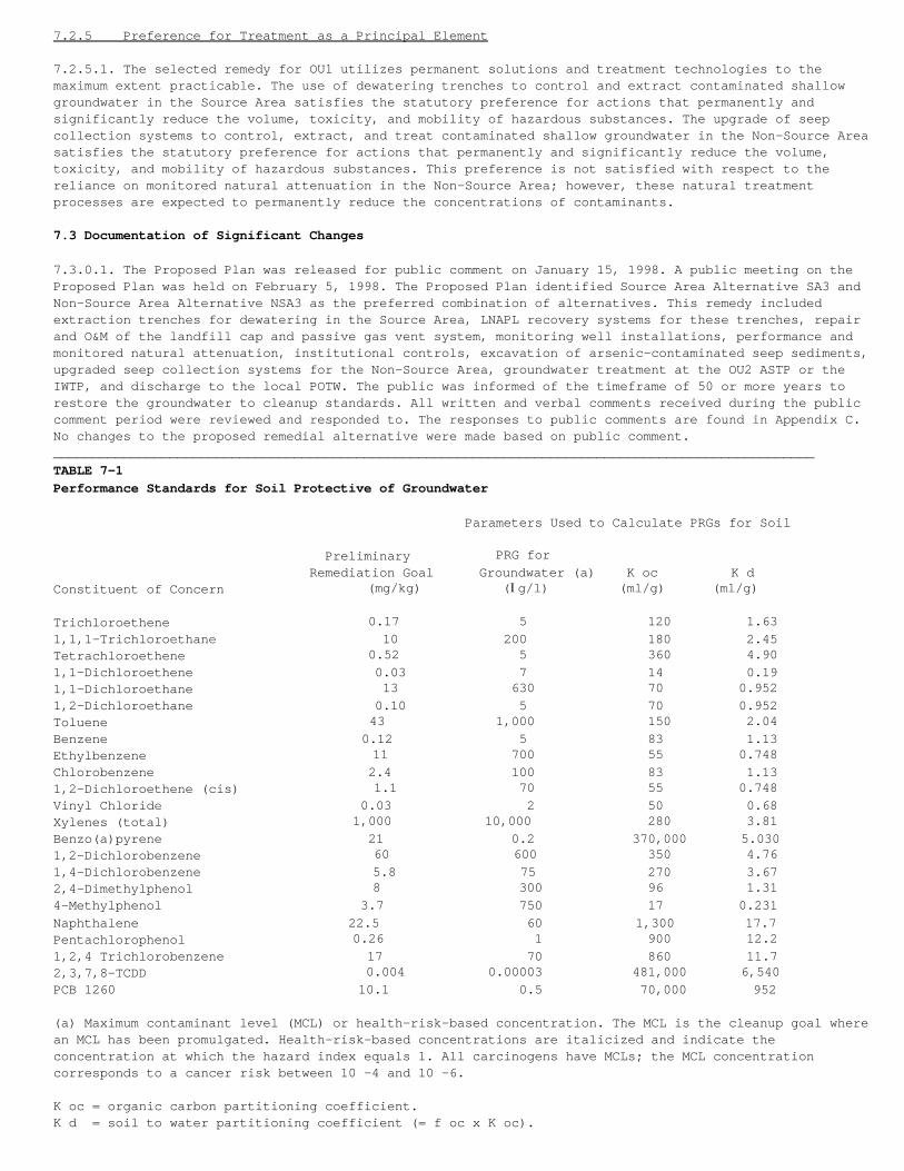
7.2.5 Preference for Treatment as a Principal Element
7.2.5.1. The selected remedy for OU1 utilizes permanent solutions and treatment technologies to themaximum extent practicable. The use of dewatering trenches to control and extract contaminated shallowgroundwater in the Source Area satisfies the statutory preference for actions that permanently andsignificantly reduce the volume, toxicity, and mobility of hazardous substances. The upgrade of seepcollection systems to control, extract, and treat contaminated shallow groundwater in the Non-Source Areasatisfies the statutory preference for actions that permanently and significantly reduce the volume,toxicity, and mobility of hazardous substances. This preference is not satisfied with respect to thereliance on monitored natural attenuation in the Non-Source Area; however, these natural treatmentprocesses are expected to permanently reduce the concentrations of contaminants.
7.3 Documentation of Significant Changes
7.3.0.1. The Proposed Plan was released for public comment on January 15, 1998. A public meeting on theProposed Plan was held on February 5, 1998. The Proposed Plan identified Source Area Alternative SA3 andNon-Source Area Alternative NSA3 as the preferred combination of alternatives. This remedy includedextraction trenches for dewatering in the Source Area, LNAPL recovery systems for these trenches, repairand O&M of the landfill cap and passive gas vent system, monitoring well installations, performance andmonitored natural attenuation, institutional controls, excavation of arsenic-contaminated seep sediments,upgraded seep collection systems for the Non-Source Area, groundwater treatment at the OU2 ASTP or theIWTP, and discharge to the local POTW. The public was informed of the timeframe of 50 or more years torestore the groundwater to cleanup standards. All written and verbal comments received during the publiccomment period were reviewed and responded to. The responses to public comments are found in Appendix C.No changes to the proposed remedial alternative were made based on public comment.__________________________________________________________________________________________________TABLE 7-1Performance Standards for Soil Protective of Groundwater
Parameters Used to Calculate PRGs for Soil
Preliminary PRG for Remediation Goal Groundwater (a) K oc K dConstituent of Concern (mg/kg) (Ig/l) (ml/g) (ml/g)
Trichloroethene 0.17 5 120 1.631,1,1-Trichloroethane 10 200 180 2.45Tetrachloroethene 0.52 5 360 4.901,1-Dichloroethene 0.03 7 14 0.191,1-Dichloroethane 13 630 70 0.9521,2-Dichloroethane 0.10 5 70 0.952Toluene 43 1,000 150 2.04Benzene 0.12 5 83 1.13Ethylbenzene 11 700 55 0.748Chlorobenzene 2.4 100 83 1.131,2-Dichloroethene (cis) 1.1 70 55 0.748Vinyl Chloride 0.03 2 50 0.68Xylenes (total) 1,000 10,000 280 3.81Benzo(a)pyrene 21 0.2 370,000 5.0301,2-Dichlorobenzene 60 600 350 4.761,4-Dichlorobenzene 5.8 75 270 3.672,4-Dimethylphenol 8 300 96 1.314-Methylphenol 3.7 750 17 0.231Naphthalene 22.5 60 1,300 17.7Pentachlorophenol 0.26 1 900 12.21,2,4 Trichlorobenzene 17 70 860 11.72,3,7,8-TCDD 0.004 0.00003 481,000 6,540PCB 1260 10.1 0.5 70,000 952
(a) Maximum contaminant level (MCL) or health-risk-based concentration. The MCL is the cleanup goal wherean MCL has been promulgated. Health-risk-based concentrations are italicized and indicate theconcentration at which the hazard index equals 1. All carcinogens have MCLs; the MCL concentrationcorresponds to a cancer risk between 10 -4 and 10 -6.
K oc = organic carbon partitioning coefficient.K d = soil to water partitioning coefficient (= f oc x K oc).
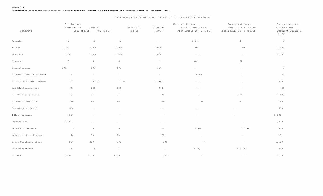
TABLE 7-2Performance Standards for Principal Contaminants of Concern in Groundwater and Surface Water at Operable Unit 1
Parameters Considered In Setting PRGs for Ground and Surface Water
Preliminary Concentration at Concentration at Concentration at Remediation Federal Utah MCL MCLG (a) which Excess Cancer which Excess Cancer which Hazard Compound Goal (Ig/l) MCL (Ig/l) (Ig/l) (Ig/l) Risk Equals 10 -6 (Ig/l) Risk Equals 10 -4 (Ig/l) Quotient Equals 1
(Ig/l)
Arsenic 50 50 50 -- 0.04 4 9
Barium 1,000 2,000 2,000 2,000 -- -- 2,100
Fluoride 2,400 2,400 2,400 4,000 -- -- 1,800
Benzene 5 5 5 -- 0.6 60 --
Chlorobenzene 100 100 100 100 -- -- 50
1,1-Dichloroethene (cis) 7 7 7 7 0.02 2 40
Total-1,2-Dichloroethene 70 70 (a) 70 (a) 70 (a) -- -- 300
1,2-Dichlorobenzene 600 600 600 600 -- -- 400
1,4-Dichlorobenzene 75 75 75 75 3 290 2,600
1,1-Dichloroethane 790 -- -- -- -- – 790
2,4-Dimethylphenol 600 -- -- -- -- -- 600
4-Methylphenol 1,500 -- -- -- -- -- 1,500
Naphthalene 1,200 -- -- -- -- -- 1,200
Tetrachloroethene 5 5 5 -- 1 (b) 120 (b) 300
1,2,4-Trichlorobenzene 70 70 70 70 -- -- 20
1,1,1-Trichloroethane 200 200 200 200 -- -- 1,500
Trichloroethene 5 5 5 -- 3 (b) 270 (b) 210
Toluene 1,000 1,000 1,000 1,000 -- -- 1,500
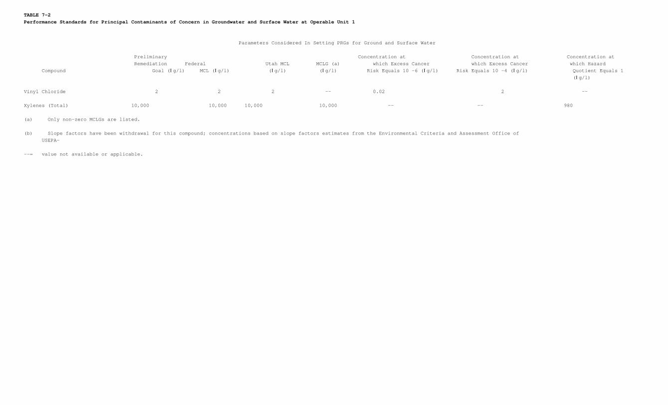
TABLE 7-2Performance Standards for Principal Contaminants of Concern in Groundwater and Surface Water at Operable Unit 1
Parameters Considered In Setting PRGs for Ground and Surface Water
Preliminary Concentration at Concentration at Concentration at Remediation Federal Utah MCL MCLG (a) which Excess Cancer which Excess Cancer which Hazard Compound Goal (Ig/l) MCL (Ig/l) (Ig/l) (Ig/l) Risk Equals 10 -6 (Ig/l) Risk Equals 10 -4 (Ig/l) Quotient Equals 1
(Ig/l)
Vinyl Chloride 2 2 2 -- 0.02 2 --
Xylenes (Total) 10,000 10,000 10,000 10,000 -- -- 980
(a) Only non-zero MCLGs are listed.
(b) Slope factors have been withdrawal for this compound; concentrations based on slope factors estimates from the Environmental Criteria and Assessment Office of USEPA-
--= value not available or applicable.
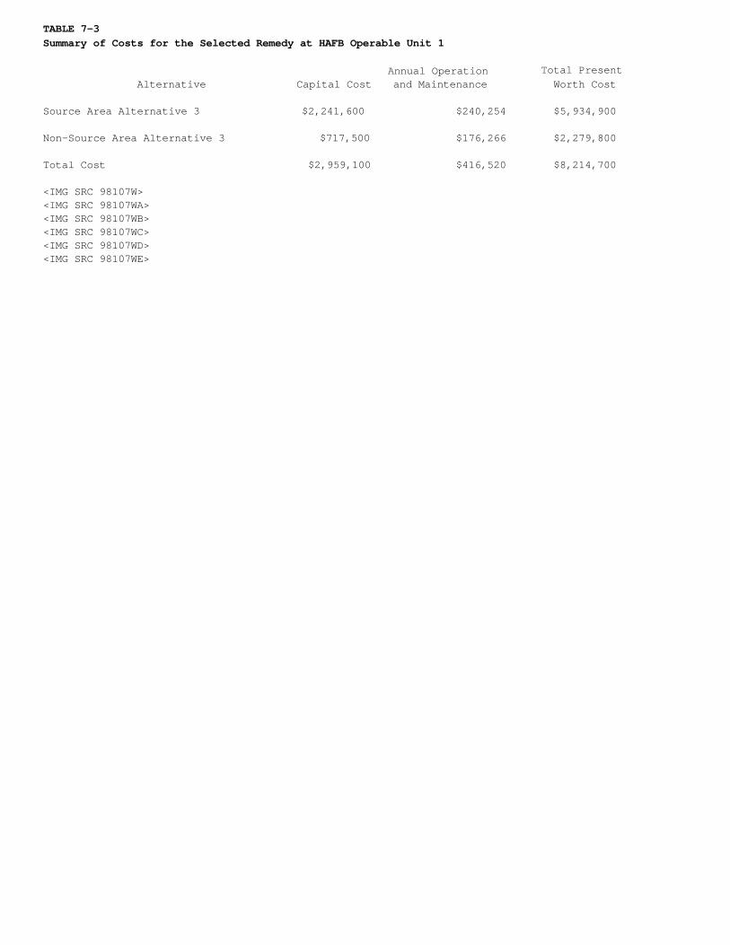
TABLE 7-3Summary of Costs for the Selected Remedy at HAFB Operable Unit 1
Annual Operation Total Present Alternative Capital Cost and Maintenance Worth Cost
Source Area Alternative 3 $2,241,600 $240,254 $5,934,900
Non-Source Area Alternative 3 $717,500 $176,266 $2,279,800
Total Cost $2,959,100 $416,520 $8,214,700
<IMG SRC 98107W><IMG SRC 98107WA><IMG SRC 98107WB><IMG SRC 98107WC><IMG SRC 98107WD><IMG SRC 98107WE>
8.0 References
CH2M HILL, 1998. Final Feasibility Study for Operable Unit 1, Hill Air Force Base, Utah, January 1998.
CH2M HILL, 1998a. Final Proposed Plan for Operable Unit 1, Hill Air Force Base, Utah, January 1998.
CH2M HILL, 1998b. Draft Monitoring Well Installation and Impact Assessment of South Weber No. 2 Report,Hill Air Force Base, Utah, June 1998.
CH2M HILL, 1998c. Draft Groundwater Pre-Design Report for Operable Unit 1, Hill Air Force Base, Utah, May1998.
Dames & Moore, Inc. 1985. Additional Geotechnical Services, Cutoff Wall Investigation, North of HAFB GolfCourse, Hill Air Force Base, Utah.
Hill Air Force Base, 1997. Final Environmental Restoration Community Relations Plan, Hill Air Force Base,Utah, December 1997.
Montgomery Watson (MW), 1995. Final Comprehensive Remedial Investigation Report for Operable Unit 1, HillAir Force Base, Utah, December 1995.
MW, 1995a. Revised Interim Draft Final Feasibility Study Report for Operable Unit 1, Hill Air Force Base,Utah, November 1995.
MW, 1996. Final Soil Vapor Extraction Bioventing Treatability Study Evaluation Report for Operable Unit1, Hill Air Force Base, Utah, January 1996.
Northeast Environmental Products (NEEP), 1996. Shallow Tray Modeler Air Stripping Calculation Software,Northeast Environmental Products.
Parsons Engineering Science, 1996. Draft Work Plan For a Demonstration of Remediation by NaturalAttenuation for Groundwater at Operable Unit 1, Hill Air Force Base, Utah, November 1996.
Radian Corporation, 1995. Three-Mile Pipeline Design Options Report, Hill Air Force Base, Utah.
State of Utah Governor's Office of Planning and Budget-Demographic and Economic Analysis Section, 1997.1997 Baseline Population Projections.
U.S. Environmental Protection Agency (EPA), 1988. Guidance for Conduction Remedial Investigations andFeasibility Studies under CERCLA, Interim Final, October 1988.
9.0 Responsiveness Summary
9.1 Introduction
9.1.0.1. This section presents the HAFB response to public comments to the Proposed Plan. These responsesare known as the Responsiveness Summary. The Responsiveness Summary is a requirement of the CERCLAprocess. CERCLA is the regulatory framework HAFB OU1 is governed by. The EPA and UDEQ regulate OU1. TheEPA and UDEQ have reviewed and concur with the responses to public comments.
9.1.0.2. The responsiveness summary consists of an introduction, an overview of HAFB communityinvolvement, and a summary of the main issues identified by the public. The actual public comments andresponses to the HAFB response to public are included as Appendix C-1. Copies of the actual publiccomments as received by HAFB and responses to South Weber Landfill Coalition comments to the Draft Finaland Revised Draft Feasibility Study are included as Appendices C-2 and C-3, respectively.
9.2 Overview
9.2.0.1. This Responsiveness Summary provides information about the views of the community with regard tothe proposed remedial action for HAFB OU1, documents how public comments have been considered during thedecision-making process, and provides responses to concerns.
The public was informed of the selected remedial action in the following ways:
• All items contained within the Administrative Record have been on file in the Davis CountyLibrary and at the Environmental Management Directorate at HAFB since the final version ofeach document was issued. The documents include the Final Comprehensive RemedialInvestigation Report, Feasibility Study, and the Proposed Plan.
• The notices of availability for the documents in the Administrative Record were published inthe Salt Lake Tribune, Ogden Standard Examiner, Hilltop Times, and Deseret News.
• A public comment period for the Proposed Plan was held from January 15, 1998, through March 16,1998.
• A notice about the public meeting was published in the Salt Lake Tribune, Ogden Standard Examiner, Hilltop Times, and Deseret News.
• A public meeting in open house format was held on February 5, 1998, at South Weber Elementary School in South Weber, Utah.
• Written comments by the public were encouraged.
9.3 Background on Community Involvement
9.3.0.1. The public participation requirements of CERCLA Sections 113(k)(2)(B)(i-v) and 117 were met.Hill Air Force Base has a Community Relations Plan, based on community interviews, that was drafted inApril 1997 (HAFB, 1997). The ongoing community relations activities include:
• A Restoration Advisory Board (RAB) that meets at least quarterly and includes communityrepresentatives from adjacent counties and towns.
• mailing list for interested parties in the community.• bi-monthly newsletter called EnviroNews.• Visits to nearby schools to discuss environmental issues.• Community involvement in a noise abatement program.• Periodic briefings to local City Councils.• Semiannual town council meetings.• Opportunities for public comment on remedial activities.• Support for the community for obtaining technical assistance grants.• Administrative record and information repository.
9.4 Summary of Public Comments
9.4.1 Comments on the Proposed Plan
9.4.1.1. The following section summarizes the main comments made by the public concerning the ProposedPlan. The HAFB response to the general comment follows the general comment.
9.4.1.2. Groundwater Contamination Associated with South Weber Number 2. Numerous comments were receivedconcerning the contamination found in South Weber No. 2, a domestic groundwater well operated by theWeber Basin Water Conservancy District. The public is concerned the contamination is from HAFB, and theyare concerned about the action HAFB is taking to remedy the problem.
9.4.1.3. Response to Comment. Hill Air Force Base has responded to this problem by installing a series ofmonitoring wells adjacent to South Weber No. 2 to evaluate the geology and contamination levels in thevarious water-bearing zones adjacent to South Weber No. 2. The results of the installation of monitoringwells adjacent to South Weber No. 2 are presented in the Monitoring Well Installation and ImpactAssessment of South Weber No. 2 Report (CH2M HILL, 1998b). The report is available to the public in theAdministrative Record or by requesting the report from HAFB. A summary of the investigation effort waspresented to the public at the RAB Meeting on June 18, 1998, at HAFB.
9.4.1.4. The purpose of the Monitoring Well Installation and Impact Assessment of South Weber No. 2Report investigation was to acquire groundwater samples from the water-bearing zones to evaluate thesource of the contamination, assess the lithology of the soil materials adjacent to South Weber No. 2,and estimate the potential for OU1 contamination to migrate to the depths of the production zones ofSouth Weber No. 2. The results of this report indicate that the drinking water aquifer has not beencontaminated by HAFB. Contamination, at concentrations similar to levels in adjacent monitoring wells,was observed in the shallow water-bearing layers well above the drinking water aquifer. The soils betweenthe surface and drinking water aquifer were mainly fine-grained. Due to the fine-grained layers, the areasurrounding South Weber No. 2 was not found to be a recharge area. Drinking water aquifer recharge areasare located at the base of the Wasatch Mountains, approximately 2 miles to the east.
9.4.1.5. Institutional Controls. The definition of institutional controls and how the institutionalcontrols would be enforced was an area of public concern.
9.4.1.6. Response to Comment. The institutional controls or land use restrictions for off-Base areas theAir Force has proposed include limiting the use of the property to the current land use and limitingaccess to the shallow groundwater below the affected property. The land use restrictions would be imposedby a deed restriction with the property owner. The property owner would be paid for the deed restriction.The restriction would be recorded on the property deed with the county. The land use restrictions arecurrently being reviewed by Air Force Headquarters for final approval and should be implemented inJanuary 1999. After the shallow groundwater contamination has attenuated to levels safe enough to drink,the deed restriction will be removed from the deed. The State Engineer is currently restricting the useof the shallow groundwater. The State Engineer will not issue a permit for a drinking water well drawingwater from the shallow water-bearing zone. In addition, a majority of the contaminated off-Base area isalready under a deed restriction imposed by the State of Utah. The deed restriction was implemented tolimit development in areas surrounding HAFB with aircraft noise levels above 70 decibels.
9.4.1.7. The on-Base portions of OU1 HAFB are limited from further development by a continuing order fromthe Base General. If HAFB were closed and transferred to private ownership, a deed restriction would beincluded in the deed for the property that would limit use of the area. Deed restrictions have been usedextensively for contaminated areas of military bases that have been closed and transferred to privateownership. In addition, if the remediation systems are still active once the Base is closed, the AirForce would probably be required to continue operating the remediation systems.
9.4.1.8. Buried Drums in Landfills 3 and 4. Comments were received concerning the presence of drumscontaining hazardous materials in the landfills that may rust out and leak causing further groundwatercontamination.
9.4.1.9. Response to Comment. An investigation of the Operable Unit 1 landfills has recently beenperformed. The landfill areas were investigated to evaluate the nature and extent of landfill debris andto determine whether drums were buried in the landfill area. This report is available to the public. Thisstudy included a magnetic anomaly study to determine the location of large concentrations of metals thatwould be the most likely location of buried drums. These areas were identified and mapped. Trenches wereexcavated in these areas to evaluate the type of debris that caused the anomalies. The anomalies werefound to be related to the presence of large concentrations of metal waste materials rather than burieddrums.
9.4.1.10. Remediation System Performance Reviews. Numerous comments were received concerning ways theperformance of the remediation systems would be evaluated and how the data would be reported.
9.4.1.11. Response to Comment. The monitoring will consist of groundwater, surface water, and possiblyair monitoring. Groundwater levels will also be measured on a routine basis to verify capture ofgroundwater. The monitoring schedule has not been defined at this time. As part of the remedial design, amonitoring schedule will be developed. A report will be prepared after each monitoring event, and it willinclude the results of monitoring events as well as an assessment of the progress of the remediationeffort. This report will be available for public inspection, and it is anticipated a summary will be sentto the affected property owners. The performance of the remediation systems will be evaluated on aBase-wide basis every 5 years. The most current evaluation is scheduled for 1998. The next evaluation isscheduled for 2003. The evaluation could be performed sooner if the dewatering trenches are notperforming as designed and are allowing contaminated groundwater to migrate off-Base. The design andconstruction of another alternative, such as a slurry wall, could be implemented to limit the migrationof off-Base groundwater contamination.
9.4.2 Comments Made during the Public Meeting
9.4.2.1. An open house public meeting for OU1 was held from 4:30 p.m. until 8:00 p.m. on Thursday,February 5, 1998, at the South Weber Elementary School in South Weber, Utah. Representatives from HAFB,EPA Region VIII, and UDEQ were available to explain and answer questions about the results of theinvestigations, health issues, and the proposed remedy for OU1 A list of all participants in the meetingare included in Appendix B. Public comments and written responses to public comments are presented inAppendix C.

Appendix A Tables
Table A-1 Summary of Federal Chemical-Specific ARARs
Table A-2 Summary of Federal Location-Specific ARARs
Table A-3 Summary of Federal Action-Specific ARARs
Table A-4 Summary of State Chemical-Specific ARARs
Table A-5 Summary of State Action-Specific ARARs
Table A-6 Summary of Preferred Alternative-Specific ARARs (see the Final Feasibility Study for OperableUnit 1 (CH2M HILL, 1998) for a complete summary of key ARARs for each of the evaluated alternatives)
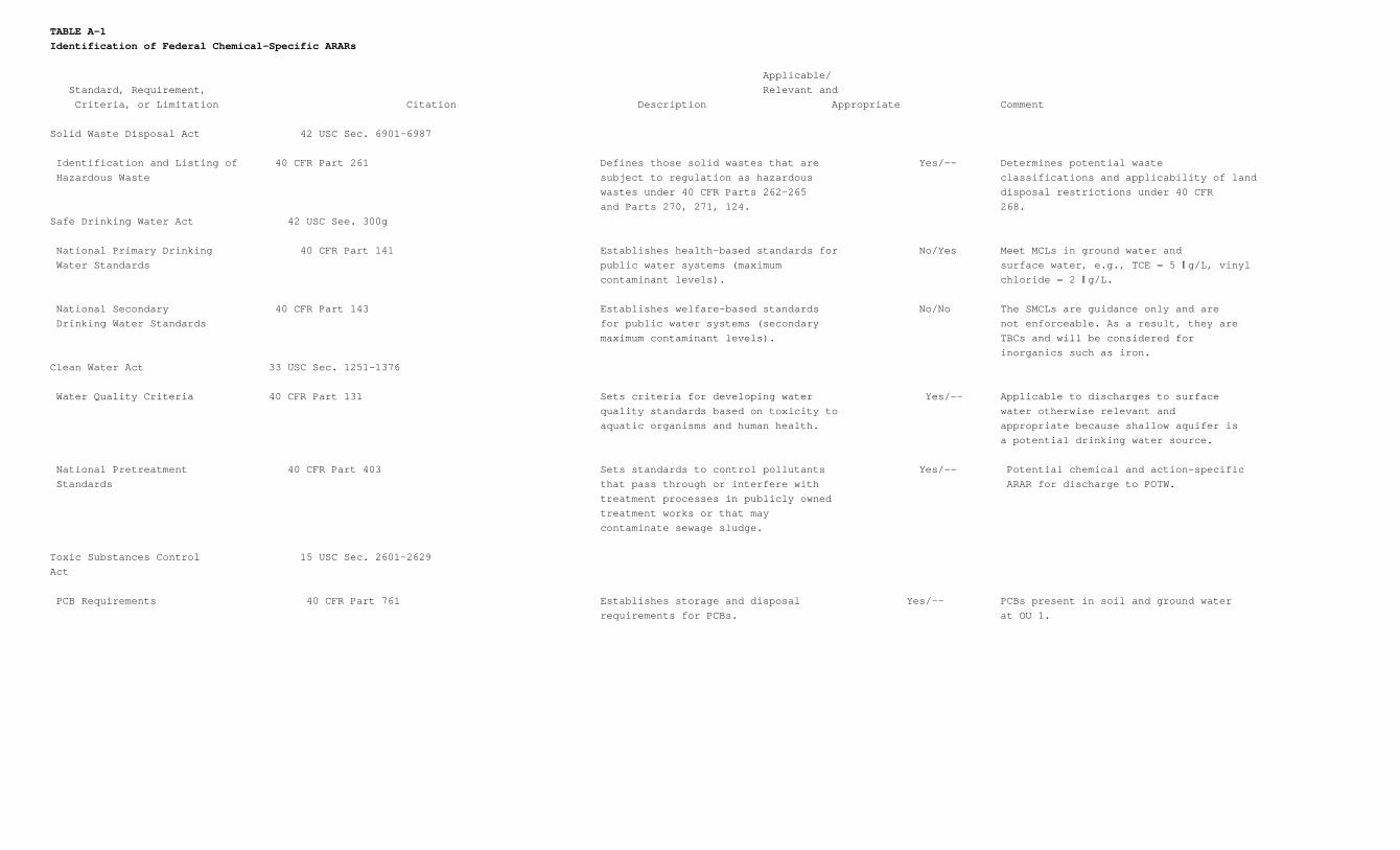
TABLE A-1Identification of Federal Chemical-Specific ARARs
Applicable/ Standard, Requirement, Relevant and Criteria, or Limitation Citation Description Appropriate Comment
Solid Waste Disposal Act 42 USC Sec. 6901-6987
Identification and Listing of 40 CFR Part 261 Defines those solid wastes that are Yes/-- Determines potential waste Hazardous Waste subject to regulation as hazardous classifications and applicability of land
wastes under 40 CFR Parts 262-265 disposal restrictions under 40 CFR and Parts 270, 271, 124. 268.
Safe Drinking Water Act 42 USC See. 300g
National Primary Drinking 40 CFR Part 141 Establishes health-based standards for No/Yes Meet MCLs in ground water and Water Standards public water systems (maximum surface water, e.g., TCE = 5 Ig/L, vinyl
contaminant levels). chloride = 2 Ig/L.
National Secondary 40 CFR Part 143 Establishes welfare-based standards No/No The SMCLs are guidance only and are Drinking Water Standards for public water systems (secondary not enforceable. As a result, they are
maximum contaminant levels). TBCs and will be considered for inorganics such as iron.
Clean Water Act 33 USC Sec. 1251-1376
Water Quality Criteria 40 CFR Part 131 Sets criteria for developing water Yes/-- Applicable to discharges to surface quality standards based on toxicity to water otherwise relevant and aquatic organisms and human health. appropriate because shallow aquifer is
a potential drinking water source.
National Pretreatment 40 CFR Part 403 Sets standards to control pollutants Yes/-- Potential chemical and action-specific Standards that pass through or interfere with ARAR for discharge to POTW.
treatment processes in publicly owned treatment works or that may contaminate sewage sludge.
Toxic Substances Control 15 USC Sec. 2601-2629Act
PCB Requirements 40 CFR Part 761 Establishes storage and disposal Yes/-- PCBs present in soil and ground water requirements for PCBs. at OU 1.
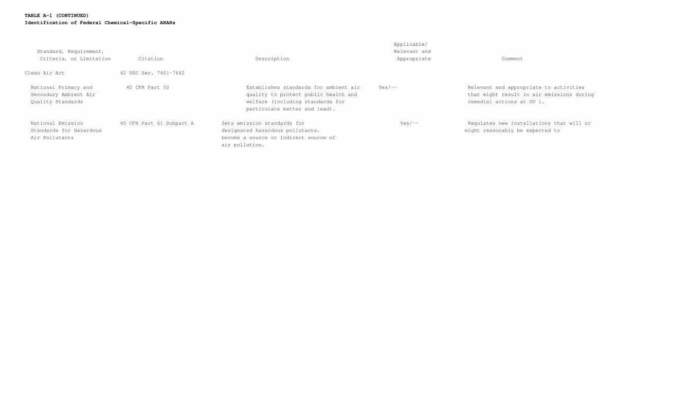
TABLE A-1 (CONTINUED)Identification of Federal Chemical-Specific ARARs
Applicable/ Standard, Requirement, Relevant and Criteria, or Limitation Citation Description Appropriate Comment
Clean Air Act 42 USC Sec. 7401-7642
National Primary and 40 CFR Part 50 Establishes standards for ambient air Yes/-- Relevant and appropriate to activities Secondary Ambient Air quality to protect public health and that might result in air emissions during Quality Standards welfare (including standards for remedial actions at OU 1.
particulate matter and lead).
National Emission 40 CFR Part 61 Subpart A Sets emission standards for Yes/-- Regulates new installations that will or Standards for Hazardous designated hazardous pollutants. might reasonably be expected to Air Pollutants become a source or indirect source of air pollution.
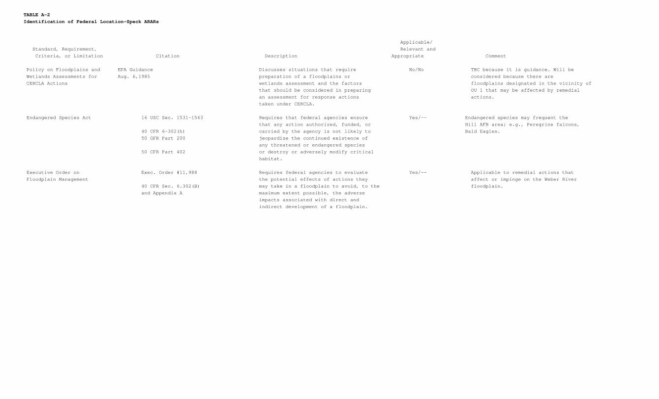
TABLE A-2Identification of Federal Location-Speck ARARs
Applicable/ Standard, Requirement, Relevant and Criteria, or Limitation Citation Description Appropriate Comment
Policy on Floodplains and EPA Guidance Discusses situations that require No/No TBC because it is guidance. Will be Wetlands Assessments for Aug. 6,1985 preparation of a floodplains or considered because there are CERCLA Actions wetlands assessment and the factors floodplains designated in the vicinity of
that should be considered in preparing OU 1 that may be affected by remedial an assessment for response actions actions. taken under CERCLA.
Endangered Species Act 16 USC Sec. 1531-1543 Requires that federal agencies ensure Yes/-- Endangered species may frequent the that any action authorized, funded, or Hill AFB area; e.g., Peregrine falcons,
40 CFR 6-302(h) carried by the agency is not likely to Bald Eagles. 50 GFR Part 200 jeopardize the continued existence of
any threatened or endangered species 50 CFR Part 402 or destroy or adversely modify critical
habitat.
Executive Order on Exec. Order #11,988 Requires federal agencies to evaluate Yes/-- Applicable to remedial actions that Floodplain Management the potential effects of actions they affect or impinge on the Weber River
40 CFR Sec. 6.302(B) may take in a floodplain to avoid, to the floodplain. and Appendix A maximum extent possible, the adverse
impacts associated with direct and indirect development of a floodplain.
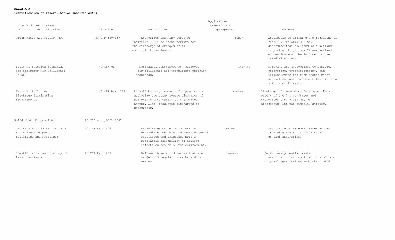
TABLE A-3Identification of Federal Action-Specific ARARs
Applicable/ Standard, Requirement, Relevant and Criteria, or Limitation Citation Description Appropriate Comment
Clean Water Act Section 404 33 CFR 320-330 Authorizes the Army Corps of Yes/- Applicable to draining and regrading of Engineers (COE) to issue permits for Pond 10. The Army COE may the discharge of dredged or fill determine that the pond is a wetland materials to wetlands. requiring mitigation. If so, wetlands
mitigation would be included in the remedial action.
National Emission Standards 40 CFR 61 Designates substances as hazardous Yes/Yes Relevant and appropriate to benzene, for Hazardous Air Pollutants air pollutants and establishes emission chloroform, trichloroethene, and (NESHAP) standards. toluene emissions from ground water
or surface water treatment facilities or soil/landfill vents.
National Pollution 40 CFR Part 122 Establishes requirements for permits to Yes/-- Discharge of treated surface water into Discharge Elimination authorize the point source discharge of waters of the United States and Requirements pollutants into waters of the United stormwater discharges may be
States. Also, regulates discharges of associated with the remedial strategy. stormwater.
Solid Waste Disposal Act 42 USC Sec,,6901-6987 Criteria for Classification of 40 CFR Part 257 Establishes criteria for use in Yes/-- Applicable to remedial alternatives Solid Waste Disposal determining which solid waste disposal involving onsite landfilling of Facilities and Practices facilities and practices pose a contaminated soils. reasonable probability of adverse
effects on health or the environment. Identification and Listing of 40 CFR Part 261 Defines those solid wastes that are Yes/-- Determines potential waste Hazardous Waste subject to regulation as hazardous classification and applicability of land
wastes. disposal restrictions and other solid
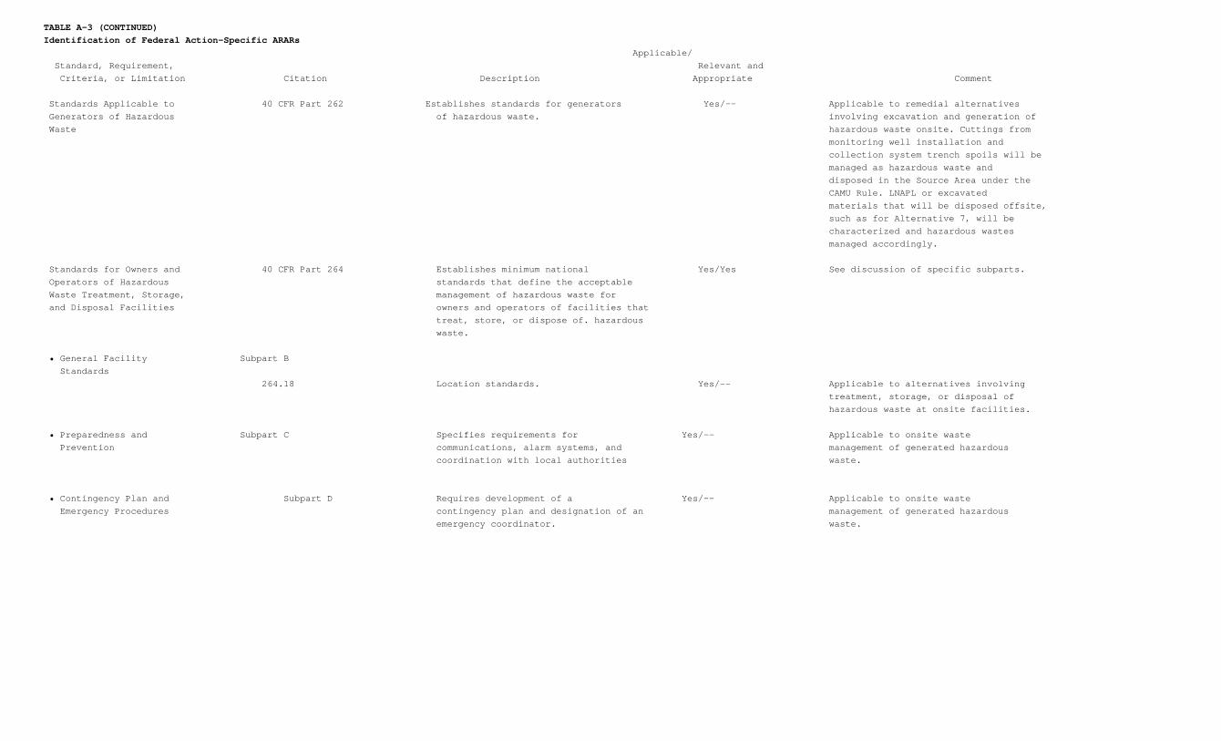
TABLE A-3 (CONTINUED)Identification of Federal Action-Specific ARARs
Applicable/ Standard, Requirement, Relevant and Criteria, or Limitation Citation Description Appropriate Comment
Standards Applicable to 40 CFR Part 262 Establishes standards for generators Yes/-- Applicable to remedial alternatives Generators of Hazardous of hazardous waste. involving excavation and generation of Waste hazardous waste onsite. Cuttings from
monitoring well installation and collection system trench spoils will be managed as hazardous waste and disposed in the Source Area under the CAMU Rule. LNAPL or excavated materials that will be disposed offsite, such as for Alternative 7, will be characterized and hazardous wastes managed accordingly.
Standards for Owners and 40 CFR Part 264 Establishes minimum national Yes/Yes See discussion of specific subparts. Operators of Hazardous standards that define the acceptable Waste Treatment, Storage, management of hazardous waste for and Disposal Facilities owners and operators of facilities that
treat, store, or dispose of. hazardous waste.
• General Facility Subpart B Standards
264.18 Location standards. Yes/-- Applicable to alternatives involving treatment, storage, or disposal of hazardous waste at onsite facilities.
• Preparedness and Subpart C Specifies requirements for Yes/-- Applicable to onsite waste Prevention communications, alarm systems, and management of generated hazardous
coordination with local authorities waste. • Contingency Plan and Subpart D Requires development of a Yes/-- Applicable to onsite waste Emergency Procedures contingency plan and designation of an management of generated hazardous
emergency coordinator. waste.
TABLE A-3 (CONTINUED)Identification of Federal Action-Specific ARARs
Applicable/ Standard, Requirement, Relevant and Criteria, or Limitation Citation Description Appropriate Comment
• Manifest System, Record Subpart E Yes/-- Applicable to onsite waste Keeping, and Reporting management of generated hazardous
waste.
264.71 Use of manifest system. Yes/-- Applicable to onsite waste management of generated hazardous waste.
264.73 Operating record. Yes/-- Applicable to onsite waste management of generated hazardous waste.
• Releases from Solid Subpart F Yes/Yes Requirements for detection of release Waste Management from SWMUs are applicable for units Units treating generated hazardous waste
and may be relevant and appropriate to the Source Areas where hazardous waste was disposed.
264.91 Required programs. Yes/Yes Applicable to alternatives involving treatment of generated hazardous waste and may be relevant and appropriate to the Source Areas where hazardous waste was disposed.
264.92 Ground water protection standard. Yes/Yes Applicable to alternatives involving treatment of generated hazardous waste and may be relevant and appropriate to the Source Areas where hazardous waste was disposed.
264.93 Hazardous constituents. Yes/Yes Applicable to alternatives involving treatment of generated hazardous waste and may be relevant and appropriate to the Source Areas where
TABLE A-3 (CONTINUED)Identification of Federal Action-Specific ARARs
Applicable/ Standard, Requirement, Relevant andCriteria, or Limitation Citation Description Appropriate Comment
• Releases from Solid 264.94 Concentration limits. Yes/Yes Applicable to alternatives involving Waste Management treatment of generated hazardous Units (continued) waste and may be relevant and appropriate to the Source Areas where hazardous waste was disposed.
264.95 Point of compliance. Yes/Yes Applicable to alternatives involving treatment of generated hazardous waste and may be relevant and appropriate to the Source Areas where hazardous waste was disposed.
264.96 Compliance period. Yes/Yes Applicable to alternatives involving treatment of generated hazardous waste and may be relevant and appropriate to the Source Areas where hazardous waste was disposed.
264.97 General ground water monitoring Yes/Yes Applicable to alternatives involving requirements. treatment of generated hazardous waste and may be relevant and appropriate to the Source Areas where hazardous waste was disposed.
264.98 Detection monitoring program. Yes/Yes Applicable to alternatives involving treatment of generated hazardous waste and may be relevant and appropriate to the Source Areas where hazardous waste was disposed.
264.99 Compliance monitoring program. Yes/Yes Applicable to alternatives involving treatment of generated hazardous waste and may be relevant and appropriate to the Source Areas where hazardous waste was disposed.
TABLE A-3 (CONTINUED)Identification of Federal Action-Specific ARARs
Applicable/ Standard, Requirement, Relevant andCriteria, or Limitation Citation Description Appropriate Comment
• Releases from Solid 264.100 Corrective action program. Yes/Yes Applicable to alternatives involving Waste Management treatment of generated hazardous Units (continued) waste and may be relevant and appropriate to the Source Areas where hazardous waste was disposed.
264.101 Corrective action for solid waste Yes/Yes Applicable to alternatives involving management units. treatment of generated hazardous waste and may be relevant and appropriate to the Source Areas where hazardous waste was disposed.
• Closure and Post- Subpart G Yes/Yes Applicable to alternatives involving Closure treatment of generated hazardous waste and may be relevant and appropriate to the Source Areas where hazardous waste was disposed.
264.111 Closure performance standard. Yes/Yes Applicable to alternatives involving treatment of generated hazardous waste and may be relevant and appropriate to the Source Areas where hazardous waste was disposed.
264.112 Closure plan; amendment of plan. Yes/Yes Applicable to alternatives involving treatment of generated hazardous waste and may be relevant and appropriate to the Source Areas where hazardous waste was disposed.
264.113 Closure; time allowed for closure. Yes/Yes Applicable to alternatives involving treatment of generated hazardous waste and may be relevant and appropriate to the Source Areas where hazardous waste was disposed.
TABLE A-3 (CONTINUED)Identification of Federal Action-Specific ARARs
Applicable/ Standard, Requirement, Relevant andCriteria, or Limitation Citation Description Appropriate Comment
• Closure and Post- 264.114 Disposal or decontamination of Yes/Yes Applicable to alternatives involving Closure (continued) equipment, structures, and soils. treatment of generated hazardous waste and may be relevant and appropriate to the Source Areas where hazardous waste was disposed.
264.115 Certification of closure. Yes/-- Applicable to alternatives involving treatment of generated hazardous waste and may be relevant and appropriate to the Source Areas where hazardous waste was disposed.
264.116 Survey plat. Yes/Yes Applicable to alternatives involving treatment of generated hazardous waste and may be relevant and appropriate to the Source Areas where hazardous waste was disposed.
264.117 Post-closure care and use of property. Yes/Yes Applicable to alternatives involving treatment of generated hazardous waste and may be relevant and appropriate to the Source Areas where hazardous waste was disposed.
264.118 Post-closure plan; amendment of plan. Yes/Yes Applicable to alternatives involving treatment of generated hazardous waste and may be relevant and appropriate to the Source Areas where hazardous waste was disposed.
264.119 Post-closure notices. Yes/Yes Applicable to alternatives involving treatment of generated hazardous waste and may be relevant and appropriate to the Source Areas where hazardous waste was disposed.
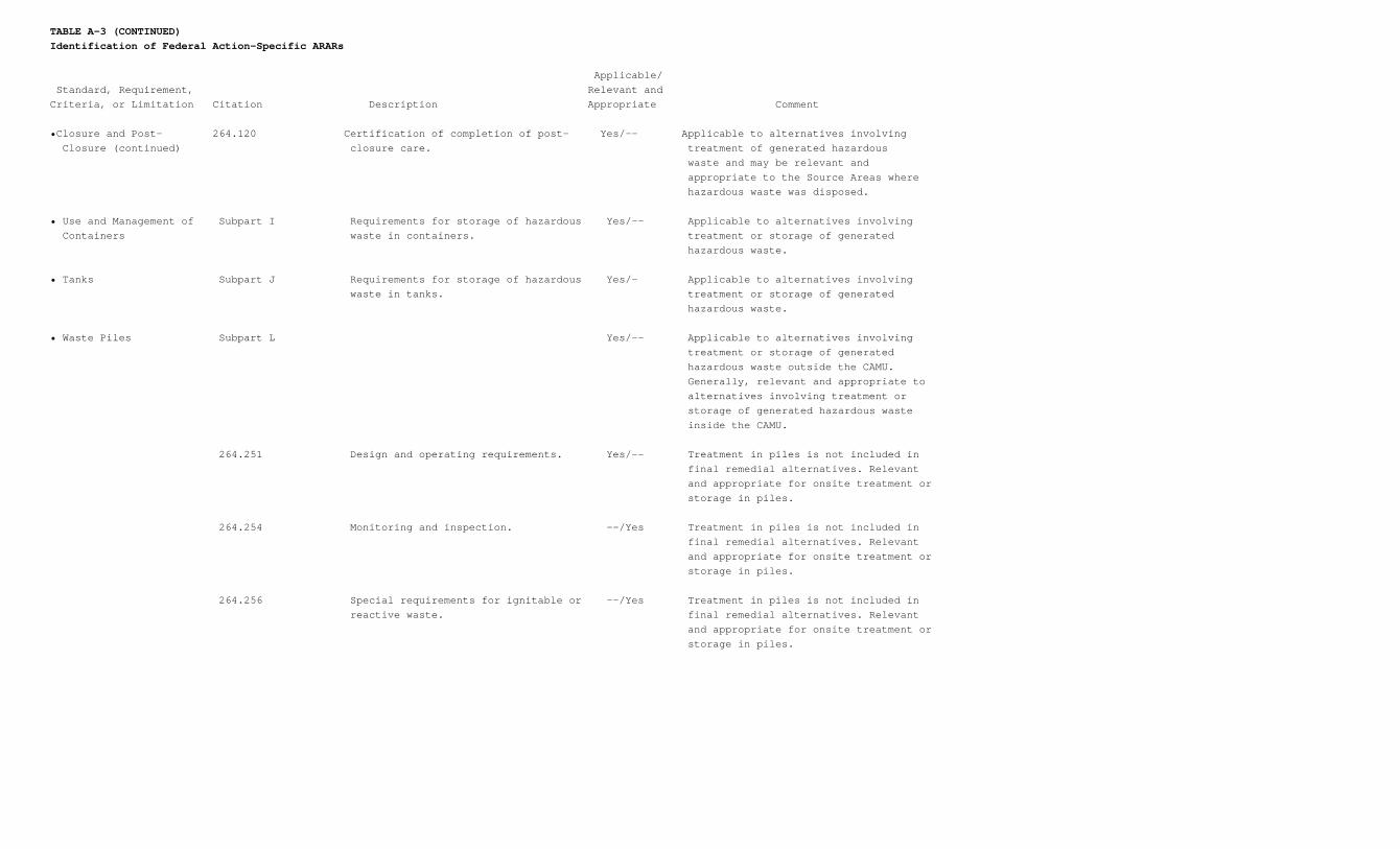
TABLE A-3 (CONTINUED)Identification of Federal Action-Specific ARARs
Applicable/ Standard, Requirement, Relevant andCriteria, or Limitation Citation Description Appropriate Comment
•Closure and Post- 264.120 Certification of completion of post- Yes/-- Applicable to alternatives involving Closure (continued) closure care. treatment of generated hazardous waste and may be relevant and appropriate to the Source Areas where hazardous waste was disposed.
• Use and Management of Subpart I Requirements for storage of hazardous Yes/-- Applicable to alternatives involving Containers waste in containers. treatment or storage of generated hazardous waste.
• Tanks Subpart J Requirements for storage of hazardous Yes/– Applicable to alternatives involving waste in tanks. treatment or storage of generated hazardous waste.
• Waste Piles Subpart L Yes/-- Applicable to alternatives involving treatment or storage of generated hazardous waste outside the CAMU. Generally, relevant and appropriate to alternatives involving treatment or storage of generated hazardous waste inside the CAMU.
264.251 Design and operating requirements. Yes/-- Treatment in piles is not included in final remedial alternatives. Relevant and appropriate for onsite treatment or storage in piles.
264.254 Monitoring and inspection. --/Yes Treatment in piles is not included in final remedial alternatives. Relevant and appropriate for onsite treatment or storage in piles.
264.256 Special requirements for ignitable or --/Yes Treatment in piles is not included in reactive waste. final remedial alternatives. Relevant and appropriate for onsite treatment or storage in piles.
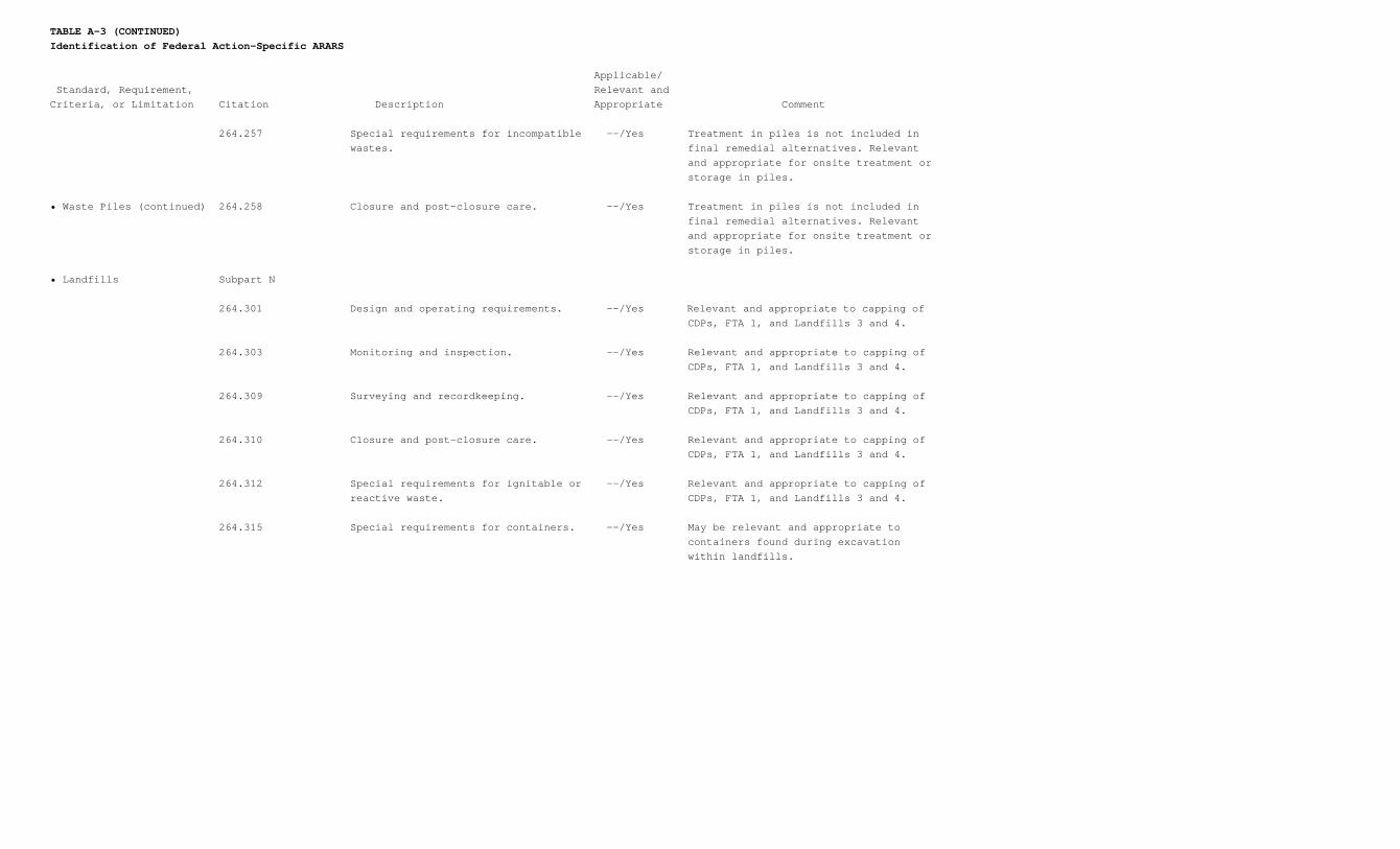
TABLE A-3 (CONTINUED)Identification of Federal Action-Specific ARARS
Applicable/ Standard, Requirement, Relevant andCriteria, or Limitation Citation Description Appropriate Comment
264.257 Special requirements for incompatible --/Yes Treatment in piles is not included in wastes. final remedial alternatives. Relevant and appropriate for onsite treatment or storage in piles.
• Waste Piles (continued) 264.258 Closure and post-closure care. --/Yes Treatment in piles is not included in final remedial alternatives. Relevant and appropriate for onsite treatment or storage in piles.
• Landfills Subpart N
264.301 Design and operating requirements. --/Yes Relevant and appropriate to capping of CDPs, FTA 1, and Landfills 3 and 4.
264.303 Monitoring and inspection. --/Yes Relevant and appropriate to capping of CDPs, FTA 1, and Landfills 3 and 4.
264.309 Surveying and recordkeeping. --/Yes Relevant and appropriate to capping of CDPs, FTA 1, and Landfills 3 and 4.
264.310 Closure and post-closure care. --/Yes Relevant and appropriate to capping of CDPs, FTA 1, and Landfills 3 and 4.
264.312 Special requirements for ignitable or --/Yes Relevant and appropriate to capping of reactive waste. CDPs, FTA 1, and Landfills 3 and 4.
264.315 Special requirements for containers. --/Yes May be relevant and appropriate to containers found during excavation within landfills.
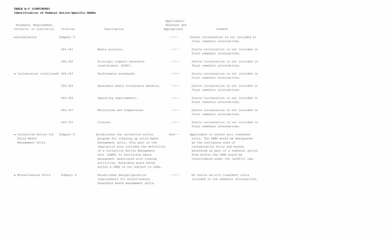
TABLE A-3 (CONTINUED)Identification of Federal Action-Specific ARARs
Applicable/ Standard, Requirement, Relevant andCriteria, or Limitation Citation Description Appropriate Comment
•Incinerators Subpart O --/-- Onsite incineration is not included in final remedial alternatives.
264.341 Waste analysis. --/-- Onsite incineration is not included in final remedial alternatives.
264.342 Principal organic hazardous --/-- Onsite incineration is not included in constituents (POHC). final remedial alternatives.
• Incinerators (continued) 264.343 Performance standards. --/-- Onsite incineration is not included in final remedial alternatives.
264.344 Hazardous waste incinerator permits. --/-- Onsite incineration is not included in final remedial alternatives.
264.345 Operating requirements. --/-- Onsite incineration is not included in final remedial alternatives.
264.347 Monitoring and inspections. --/-- Onsite incineration is not included in final remedial alternatives.
264.351 Closure. --/-- Onsite incineration is not included in final remedial alternatives.
• Corrective Action for Subpart S Establishes the corrective action Yes/-- Applicable to onsite soil treatment Solid Waste program for cleaning up solid waste units. The CAMU would be designated Management Units management units. This part of the as the contiguous area of regulation also includes the definition contamination Soils and wastes of a Corrective Action Management excavated as part of a remedial action Unit (CAMU) to facilitate waste from within the CAMU would be management associated with cleanup consolidated under the landfill cap. activities. Hazardous waste moved within a CAMU is not subject to LDRs.
• Miscellaneous Units Subpart X Establishes design/operation --/-- No onsite ex-situ treatment units requirements for miscellaneous included in the remedial alternatives. hazardous waste management units.
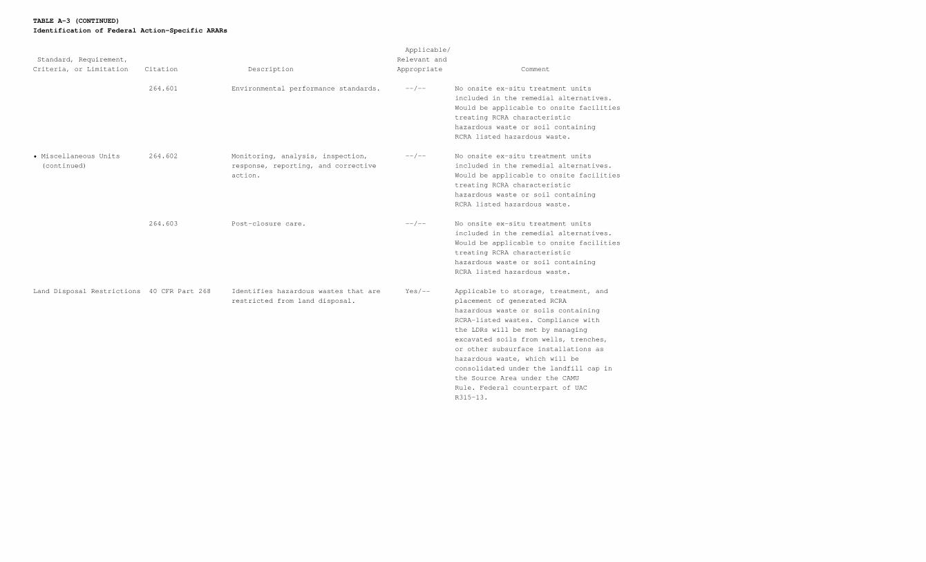
TABLE A-3 (CONTINUED)Identification of Federal Action-Specific ARARs
Applicable/ Standard, Requirement, Relevant andCriteria, or Limitation Citation Description Appropriate Comment
264.601 Environmental performance standards. --/-- No onsite ex-situ treatment units included in the remedial alternatives. Would be applicable to onsite facilities treating RCRA characteristic hazardous waste or soil containing RCRA listed hazardous waste.
• Miscellaneous Units 264.602 Monitoring, analysis, inspection, --/-- No onsite ex-situ treatment units (continued) response, reporting, and corrective included in the remedial alternatives. action. Would be applicable to onsite facilities treating RCRA characteristic hazardous waste or soil containing RCRA listed hazardous waste.
264.603 Post-closure care. --/-- No onsite ex-situ treatment units included in the remedial alternatives. Would be applicable to onsite facilities treating RCRA characteristic hazardous waste or soil containing RCRA listed hazardous waste.
Land Disposal Restrictions 40 CFR Part 268 Identifies hazardous wastes that are Yes/-- Applicable to storage, treatment, and restricted from land disposal. placement of generated RCRA hazardous waste or soils containing RCRA-listed wastes. Compliance with the LDRs will be met by managing excavated soils from wells, trenches, or other subsurface installations as hazardous waste, which will be consolidated under the landfill cap in the Source Area under the CAMU Rule. Federal counterpart of UAC R315-13.
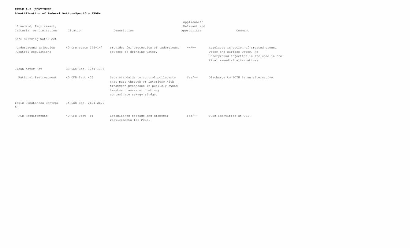
TABLE A-3 (CONTINUED)Identification of Federal Action-Specific ARARs
Applicable/ Standard, Requirement, Relevant andCriteria, or Limitation Citation Description Appropriate Comment
Safe Drinking Water Act
Underground Injection 40 CFR Parts 144-147 Provides for protection of underground --/-- Regulates injection of treated ground Control Regulations sources of drinking water. water and surface water. No underground injection is included in the final remedial alternatives.
Clean Water Act 33 USC Sec. 1251-1376
National Pretreatment 40 CFR Part 403 Sets standards to control pollutants Yes/-- Discharge to POTW is an alternative. that pass through or interfere with treatment processes in publicly owned treatment works or that may contaminate sewage sludge.
Toxic Substances Control 15 USC Sec. 2601-2629Act
PCB Requirements 40 CFR Part 761 Establishes storage and disposal Yes/-- PCBs identified at OU1. requirements for PCBs.
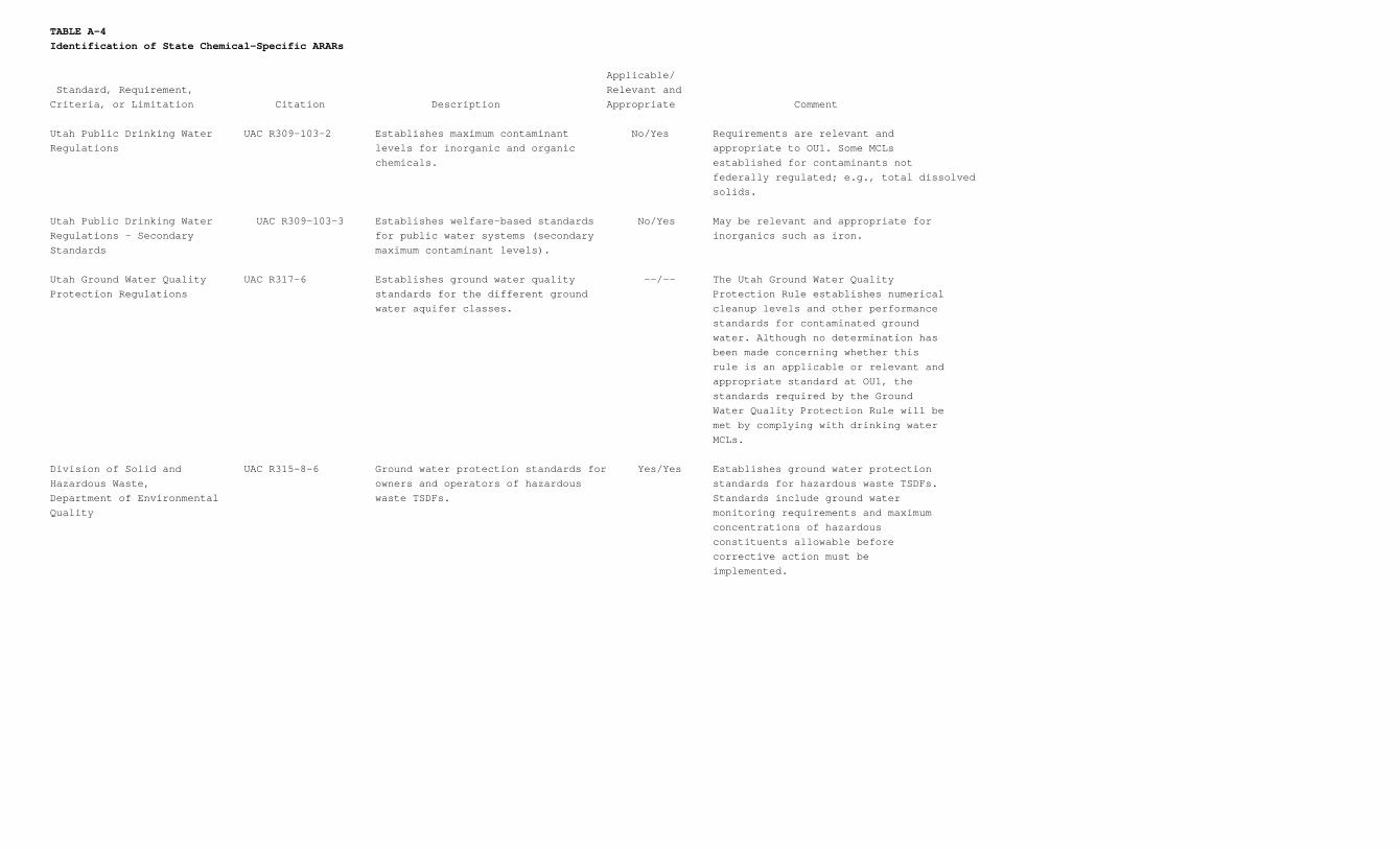
TABLE A-4Identification of State Chemical-Specific ARARs
Applicable/ Standard, Requirement, Relevant andCriteria, or Limitation Citation Description Appropriate Comment
Utah Public Drinking Water UAC R309-103-2 Establishes maximum contaminant No/Yes Requirements are relevant andRegulations levels for inorganic and organic appropriate to OU1. Some MCLs chemicals. established for contaminants not federally regulated; e.g., total dissolved solids.
Utah Public Drinking Water UAC R309-103-3 Establishes welfare-based standards No/Yes May be relevant and appropriate forRegulations - Secondary for public water systems (secondary inorganics such as iron.Standards maximum contaminant levels).
Utah Ground Water Quality UAC R317-6 Establishes ground water quality --/-- The Utah Ground Water QualityProtection Regulations standards for the different ground Protection Rule establishes numerical water aquifer classes. cleanup levels and other performance standards for contaminated ground water. Although no determination has been made concerning whether this rule is an applicable or relevant and appropriate standard at OU1, the standards required by the Ground Water Quality Protection Rule will be met by complying with drinking water MCLs.
Division of Solid and UAC R315-8-6 Ground water protection standards for Yes/Yes Establishes ground water protectionHazardous Waste, owners and operators of hazardous standards for hazardous waste TSDFs.Department of Environmental waste TSDFs. Standards include ground waterQuality monitoring requirements and maximum concentrations of hazardous constituents allowable before corrective action must be implemented.
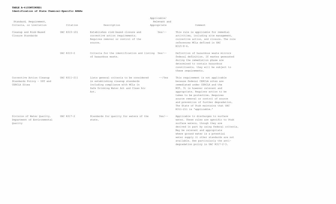
TABLE A-4(CONTINUED)Identification of State Chemical-Specific ARARs
Applicable/ Standard, Requirement, Relevant andCriteria, or Limitation Citation Description Appropriate Comment
Cleanup and Risk-Based UAC R315-101 Establishes risk-based closure and Yes/-- This rule is applicable for remedialClosure Standards corrective action requirements. activities, including site management, Requires removal or control of the corrective action, and closure. The rule source. references MCLs defined in UAC R315-8-6.
UAC R315-2 Criteria for the identification and listing Yes/-- Definition of hazardous waste mirrors of hazardous waste. federal definition. If wastes generated during the remediation phase are determined to contain hazardous constituents, they will be subject to these requirements.
Corrective Action Cleanup UAC R311-211 Lists general criteria to be considered --/Yes This requirement is not applicableStandards Policy - UST and in establishing cleanup standards because federal CERCLA sites areCERCLA Sites including compliance with MCLs in remediated under CERCLA and the Safe Drinking Water Act and Clean Air NCP. It is however relevant and Act. appropriate. Requires action to be taken to be protective. Requires source removal or control of source and prevention of further degradation. The State of Utah maintains that UAC R311-211 is "applicable."
Division of Water Quality, UAC R317-2 Standards for quality for waters of the Yes/-- Applicable to discharges to surfaceDepartment of Environmental state. water. These rules are specific to UtahQuality surface waters, though they are derived in part by using federal criteria. May be relevant and appropriate where ground water is a potential water supply it other standards are not available. See particularly the anti- degradation policy in UAC R317-2-3.
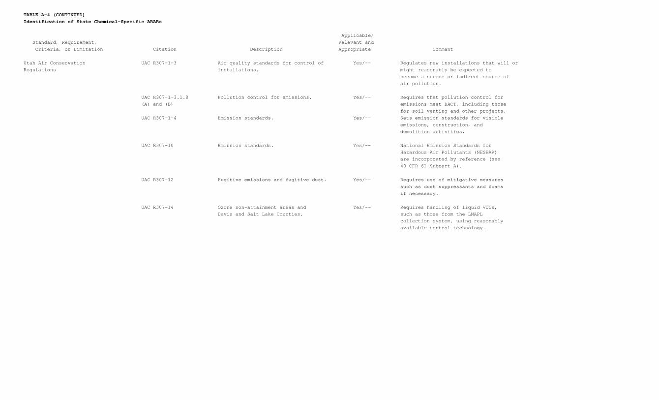
TABLE A-4 (CONTINUED)Identification of State Chemical-Specific ARARs
Applicable/ Standard, Requirement, Relevant and Criteria, or Limitation Citation Description Appropriate Comment
Utah Air Conservation UAC R307-1-3 Air quality standards for control of Yes/-- Regulates new installations that will orRegulations installations. might reasonably be expected to become a source or indirect source of air pollution.
UAC R307-1-3.1.8 Pollution control for emissions. Yes/-- Requires that pollution control for (A) and (B) emissions meet BACT, including those for soil venting and other projects. UAC R307-1-4 Emission standards. Yes/-- Sets emission standards for visible emissions, construction, and demolition activities.
UAC R307-10 Emission standards. Yes/-- National Emission Standards for Hazardous Air Pollutants (NESHAP) are incorporated by reference (see 40 CFR 61 Subpart A).
UAC R307-12 Fugitive emissions and fugitive dust. Yes/-- Requires use of mitigative measures such as dust suppressants and foams if necessary.
UAC R307-14 Ozone non-attainment areas and Yes/-- Requires handling of liquid VOCs, Davis and Salt Lake Counties. such as those from the LNAPL collection system, using reasonably available control technology.
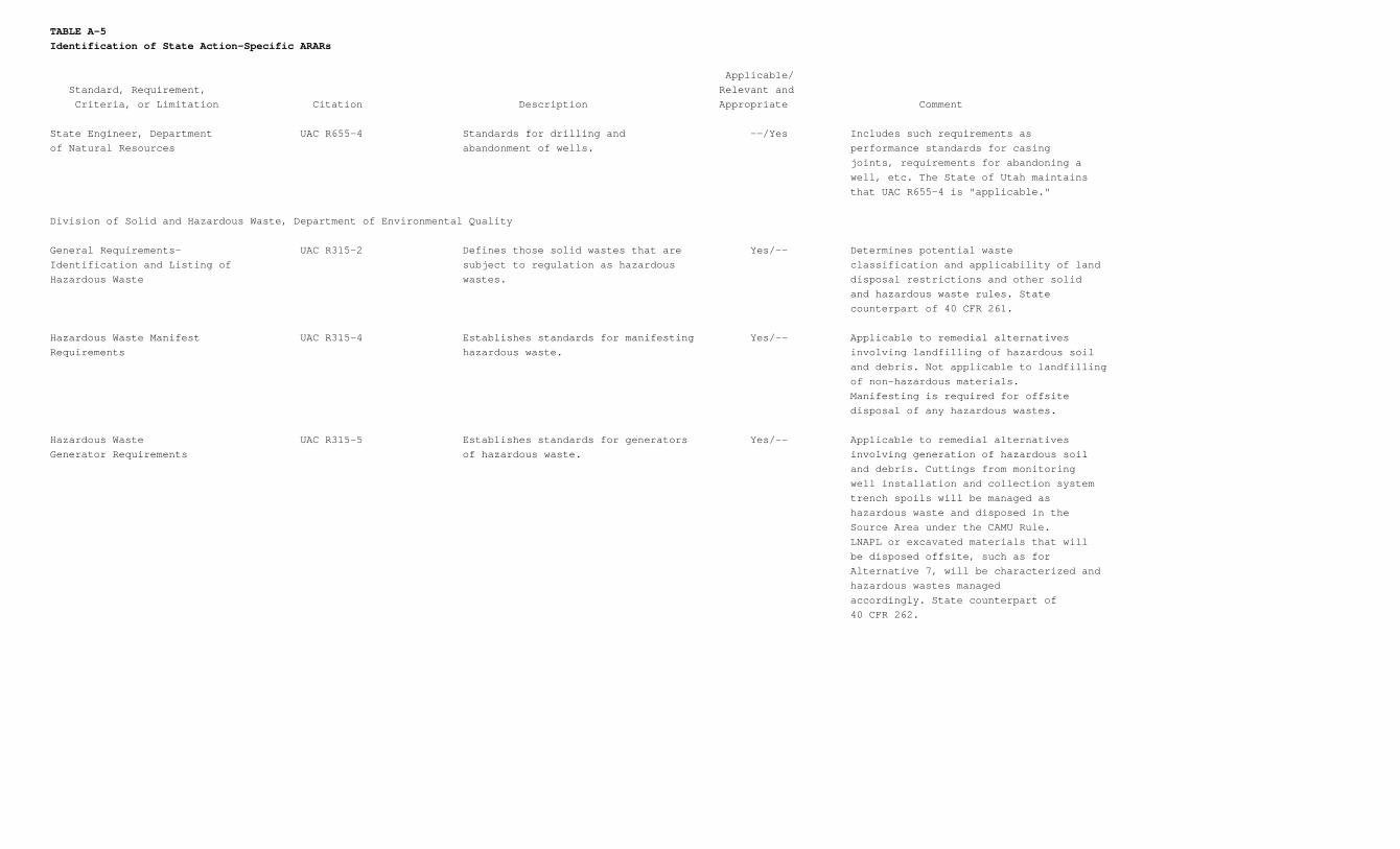
TABLE A-5Identification of State Action-Specific ARARs
Applicable/ Standard, Requirement, Relevant and Criteria, or Limitation Citation Description Appropriate Comment
State Engineer, Department UAC R655-4 Standards for drilling and --/Yes Includes such requirements asof Natural Resources abandonment of wells. performance standards for casing joints, requirements for abandoning a well, etc. The State of Utah maintains that UAC R655-4 is "applicable."
Division of Solid and Hazardous Waste, Department of Environmental Quality
General Requirements- UAC R315-2 Defines those solid wastes that are Yes/-- Determines potential wasteIdentification and Listing of subject to regulation as hazardous classification and applicability of landHazardous Waste wastes. disposal restrictions and other solid and hazardous waste rules. State counterpart of 40 CFR 261.
Hazardous Waste Manifest UAC R315-4 Establishes standards for manifesting Yes/-- Applicable to remedial alternativesRequirements hazardous waste. involving landfilling of hazardous soil and debris. Not applicable to landfilling of non-hazardous materials. Manifesting is required for offsite disposal of any hazardous wastes.
Hazardous Waste UAC R315-5 Establishes standards for generators Yes/-- Applicable to remedial alternativesGenerator Requirements of hazardous waste. involving generation of hazardous soil and debris. Cuttings from monitoring well installation and collection system trench spoils will be managed as hazardous waste and disposed in the Source Area under the CAMU Rule. LNAPL or excavated materials that will be disposed offsite, such as for Alternative 7, will be characterized and hazardous wastes managed accordingly. State counterpart of 40 CFR 262.
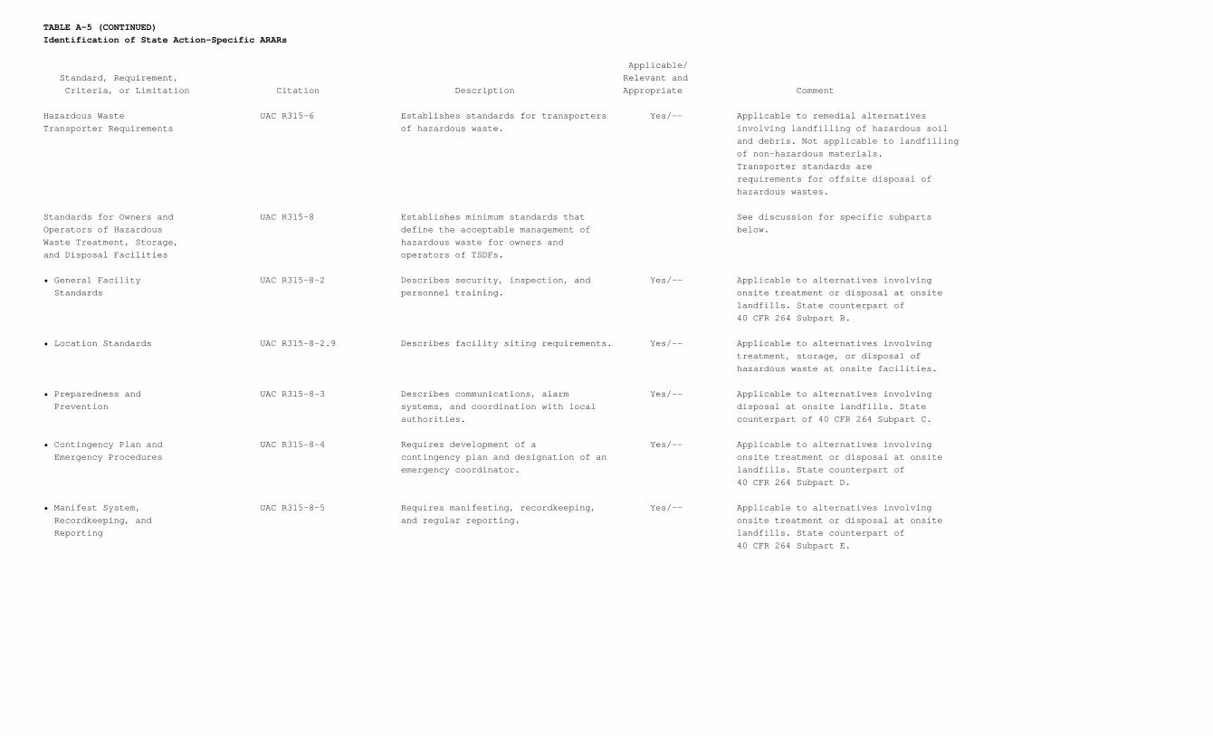
TABLE A-5 (CONTINUED)Identification of State Action-Specific ARARs
Applicable/ Standard, Requirement, Relevant and Criteria, or Limitation Citation Description Appropriate Comment
Hazardous Waste UAC R315-6 Establishes standards for transporters Yes/-- Applicable to remedial alternativesTransporter Requirements of hazardous waste. involving landfilling of hazardous soil and debris. Not applicable to landfilling of non-hazardous materials. Transporter standards are requirements for offsite disposal of hazardous wastes.
Standards for Owners and UAC R315-8 Establishes minimum standards that See discussion for specific subpartsOperators of Hazardous define the acceptable management of below.Waste Treatment, Storage, hazardous waste for owners andand Disposal Facilities operators of TSDFs.
• General Facility UAC R315-8-2 Describes security, inspection, and Yes/-- Applicable to alternatives involving Standards personnel training. onsite treatment or disposal at onsite landfills. State counterpart of 40 CFR 264 Subpart B.
• Location Standards UAC R315-8-2.9 Describes facility siting requirements. Yes/-- Applicable to alternatives involving treatment, storage, or disposal of hazardous waste at onsite facilities.
• Preparedness and UAC R315-8-3 Describes communications, alarm Yes/-- Applicable to alternatives involving Prevention systems, and coordination with local disposal at onsite landfills. State authorities. counterpart of 40 CFR 264 Subpart C.
• Contingency Plan and UAC R315-8-4 Requires development of a Yes/-- Applicable to alternatives involving Emergency Procedures contingency plan and designation of an onsite treatment or disposal at onsite emergency coordinator. landfills. State counterpart of 40 CFR 264 Subpart D.
• Manifest System, UAC R315-8-5 Requires manifesting, recordkeeping, Yes/-- Applicable to alternatives involving Recordkeeping, and and regular reporting. onsite treatment or disposal at onsite Reporting landfills. State counterpart of 40 CFR 264 Subpart E.
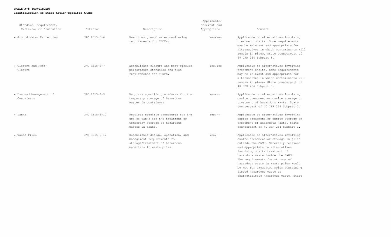
TABLE A-5 (CONTINUED)Identification of State Action-Specific ARARs
Applicable/ Standard, Requirement, Relevant and Criteria, or Limitation Citation Description Appropriate Comment
• Ground Water Protection UAC R315-8-6 Describes ground water monitoring Yes/Yes Applicable to alternatives involving requirements for TSDFs. treatment onsite. Some requirements may be relevant and appropriate for alternatives in which contaminants will remain in place. State counterpart of 40 CFR 264 Subpart F.
• Closure and Post- UAC R315-8-7 Establishes closure and post-closure Yes/Yes Applicable to alternatives involving Closure performance standards and plan treatment onsite. Some requirements requirements for TSDFs. may be relevant and appropriate for alternatives in which contaminants will remain in place. State counterpart of 40 CFR 264 Subpart G.
• Use and Management of UAC R315-8-9 Requires specific procedures for the Yes/-- Applicable to alternatives involving Containers temporary storage of hazardous onsite treatment or onsite storage or wastes in containers. treatment of hazardous waste. State counterpart of 40 CFR 264 Subpart I.
• Tanks UAC R315-8-10 Requires specific procedures for the Yes/-- Applicable to alternatives involving use of tanks for the treatment or onsite treatment or onsite storage or temporary storage of hazardous treatment of hazardous waste. State wastes in tanks. counterpart of 40 CFR 264 Subpart I.
• Waste Piles UAC R315-8-12 Establishes design, operation, and Yes/-- Applicable to alternatives involving management requirements for onsite treatment or storage in piles storage/treatment of hazardous outside the CAMU. Generally relevant materials in waste piles. and appropriate to alternatives involving onsite treatment of hazardous waste inside the CAMU. The requirements for storage of hazardous waste in waste piles would be met for excavated soils containing listed hazardous waste or characteristic hazardous waste. State
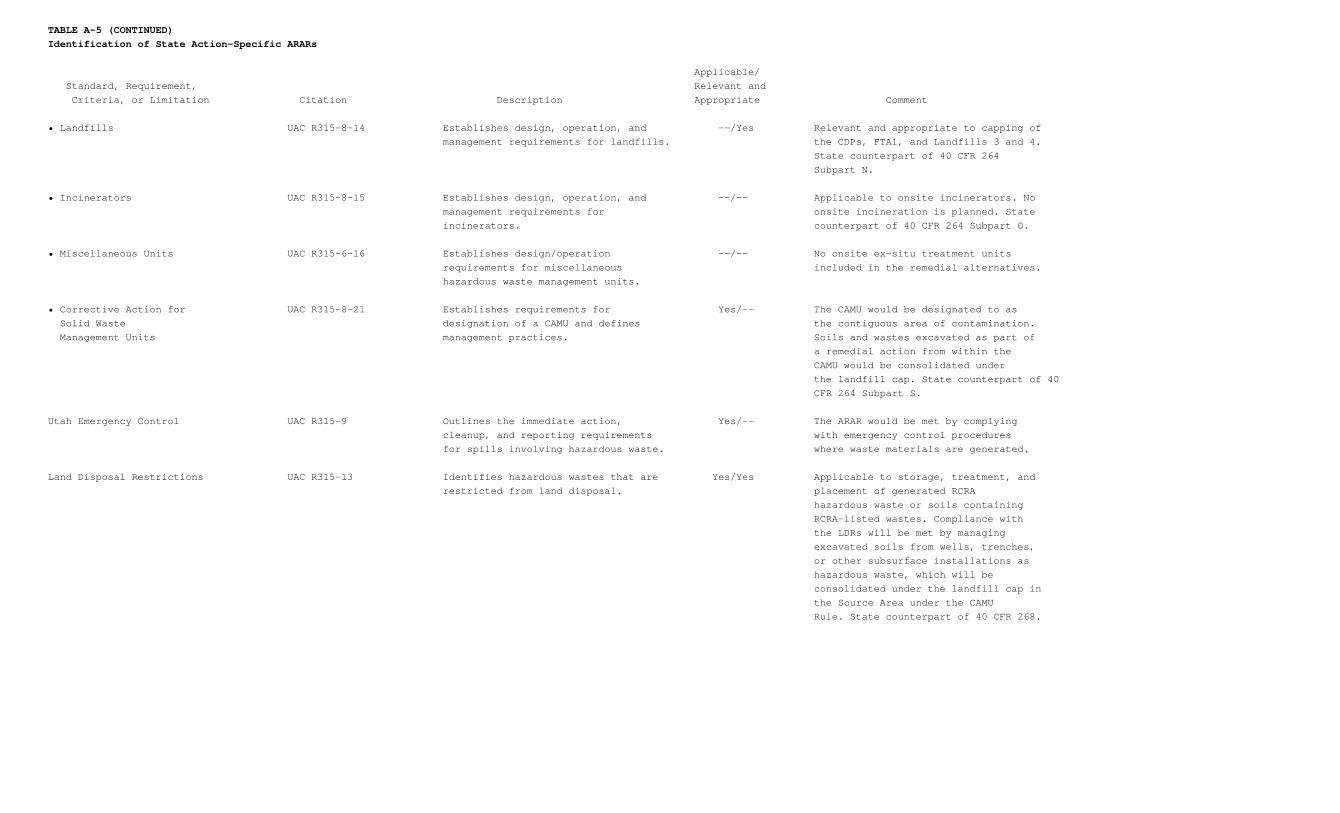
TABLE A-5 (CONTINUED)Identification of State Action-Specific ARARs
Applicable/ Standard, Requirement, Relevant and Criteria, or Limitation Citation Description Appropriate Comment
• Landfills UAC R315-8-14 Establishes design, operation, and --/Yes Relevant and appropriate to capping of management requirements for landfills. the CDPs, FTA1, and Landfills 3 and 4. State counterpart of 40 CFR 264 Subpart N.
• Incinerators UAC R315-8-15 Establishes design, operation, and --/-- Applicable to onsite incinerators. No management requirements for onsite incineration is planned. State incinerators. counterpart of 40 CFR 264 Subpart O.
• Miscellaneous Units UAC R315-6-16 Establishes design/operation --/-- No onsite ex-situ treatment units requirements for miscellaneous included in the remedial alternatives. hazardous waste management units.
• Corrective Action for UAC R315-8-21 Establishes requirements for Yes/-- The CAMU would be designated to as Solid Waste designation of a CAMU and defines the contiguous area of contamination. Management Units management practices. Soils and wastes excavated as part of a remedial action from within the CAMU would be consolidated under the landfill cap. State counterpart of 40 CFR 264 Subpart S.
Utah Emergency Control UAC R315-9 Outlines the immediate action, Yes/-- The ARAR would be met by complying cleanup, and reporting requirements with emergency control procedures for spills involving hazardous waste. where waste materials are generated.
Land Disposal Restrictions UAC R315-13 Identifies hazardous wastes that are Yes/Yes Applicable to storage, treatment, and restricted from land disposal. placement of generated RCRA hazardous waste or soils containing RCRA-listed wastes. Compliance with the LDRs will be met by managing excavated soils from wells, trenches, or other subsurface installations as hazardous waste, which will be consolidated under the landfill cap in the Source Area under the CAMU Rule. State counterpart of 40 CFR 268.
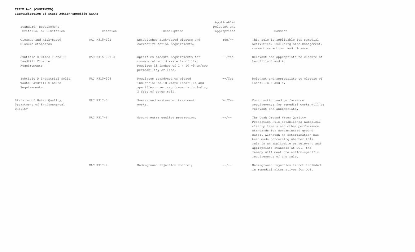
TABLE A-5 (CONTINUED)Identification of State Action-Specific ARARs
Applicable/ Standard, Requirement, Relevant and Criteria, or Limitation Citation Description Appropriate Comment
Cleanup and Risk-Based UAC R315-101 Establishes risk-based closure and Yes/-- This rule is applicable for remedial Closure Standards corrective action requirements. activities, including site management, corrective action, and closure.
Subtitle D Class I and II UAC R315-303-4 Specifies closure requirements for --/Yes Relevant and appropriate to closure of Landfill Closure commercial solid waste landfills. Landfills 3 and 4. Requirements Requires 18 inches of 1 x 10 -5 cm/sec permeability or less.
Subtitle D Industrial Solid UAC R315-308 Regulates abandoned or closed --/Yes Relevant and appropriate to closure of Waste Landfill Closure industrial solid waste landfills and Landfills 3 and 4. Requirements specifies cover requirements including 2 feet of cover soil.
Division of Water Quality, UAC R317-3 Sewers and wastewater treatment No/Yes Construction and performanceDepartment of Environmental works. requirements for remedial works will beQuality relevant and appropriate.
UAC R317-6 Ground water quality protection. --/-- The Utah Ground Water Quality Protection Rule establishes numerical cleanup levels and other performance standards for contaminated ground water. Although no determination has been made concerning whether this rule is an applicable or relevant and appropriate standard at OU1, the remedy will meet the action-specific requirements of the rule.
UAC R317-7 Underground injection control, --/-- Underground injection is not included in remedial alternatives for OU1.
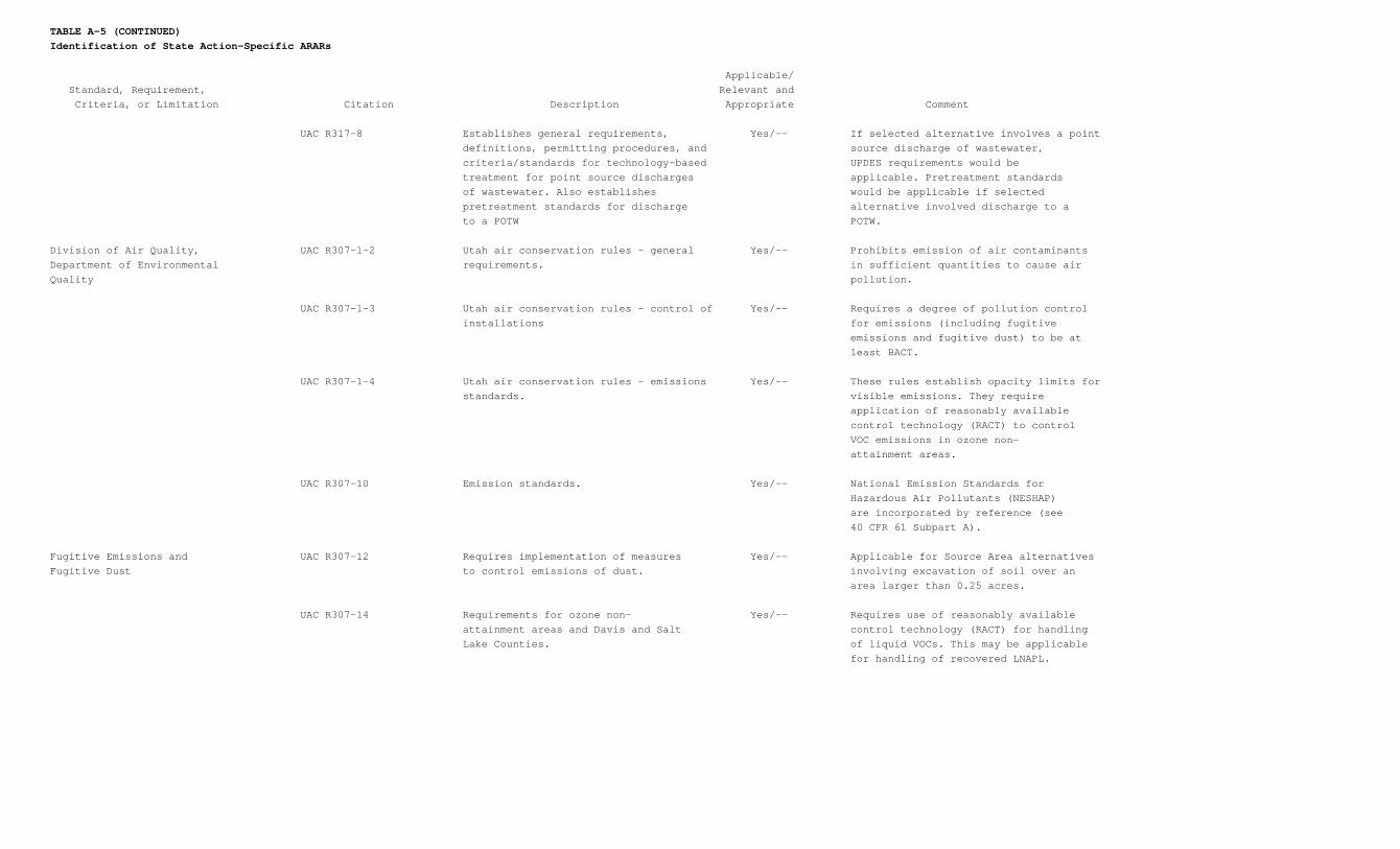
TABLE A-5 (CONTINUED)Identification of State Action-Specific ARARs
Applicable/ Standard, Requirement, Relevant and Criteria, or Limitation Citation Description Appropriate Comment
UAC R317-8 Establishes general requirements, Yes/-- If selected alternative involves a point definitions, permitting procedures, and source discharge of wastewater, criteria/standards for technology-based UPDES requirements would be treatment for point source discharges applicable. Pretreatment standards of wastewater. Also establishes would be applicable if selected pretreatment standards for discharge alternative involved discharge to a to a POTW POTW.
Division of Air Quality, UAC R307-1-2 Utah air conservation rules - general Yes/-- Prohibits emission of air contaminantsDepartment of Environmental requirements. in sufficient quantities to cause airQuality pollution.
UAC R307-1-3 Utah air conservation rules - control of Yes/-- Requires a degree of pollution control installations for emissions (including fugitive emissions and fugitive dust) to be at least BACT.
UAC R307-1-4 Utah air conservation rules - emissions Yes/-- These rules establish opacity limits for standards. visible emissions. They require application of reasonably available control technology (RACT) to control VOC emissions in ozone non- attainment areas.
UAC R307-10 Emission standards. Yes/-- National Emission Standards for Hazardous Air Pollutants (NESHAP) are incorporated by reference (see 40 CFR 61 Subpart A).
Fugitive Emissions and UAC R307-12 Requires implementation of measures Yes/-- Applicable for Source Area alternativesFugitive Dust to control emissions of dust. involving excavation of soil over an area larger than 0.25 acres.
UAC R307-14 Requirements for ozone non- Yes/-- Requires use of reasonably available attainment areas and Davis and Salt control technology (RACT) for handling Lake Counties. of liquid VOCs. This may be applicable for handling of recovered LNAPL.
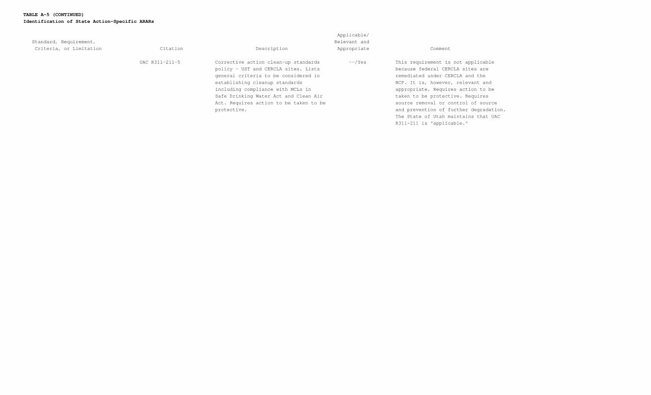
TABLE A-5 (CONTINUED)Identification of State Action-Specific ARARs
Applicable/ Standard, Requirement, Relevant and Criteria, or Limitation Citation Description Appropriate Comment
UAC R311-211-5 Corrective action clean-up standards --/Yes This requirement is not applicable policy - UST and CERCLA sites. Lists because federal CERCLA sites are general criteria to be considered in remediated under CERCLA and the establishing cleanup standards NCP. It is, however, relevant and including compliance with MCLs in appropriate. Requires action to be Safe Drinking Water Act and Clean Air taken to be protective. Requires Act. Requires action to be taken to be source removal or control of source protective. and prevention of further degradation. The State of Utah maintains that UAC R311-211 is "applicable."
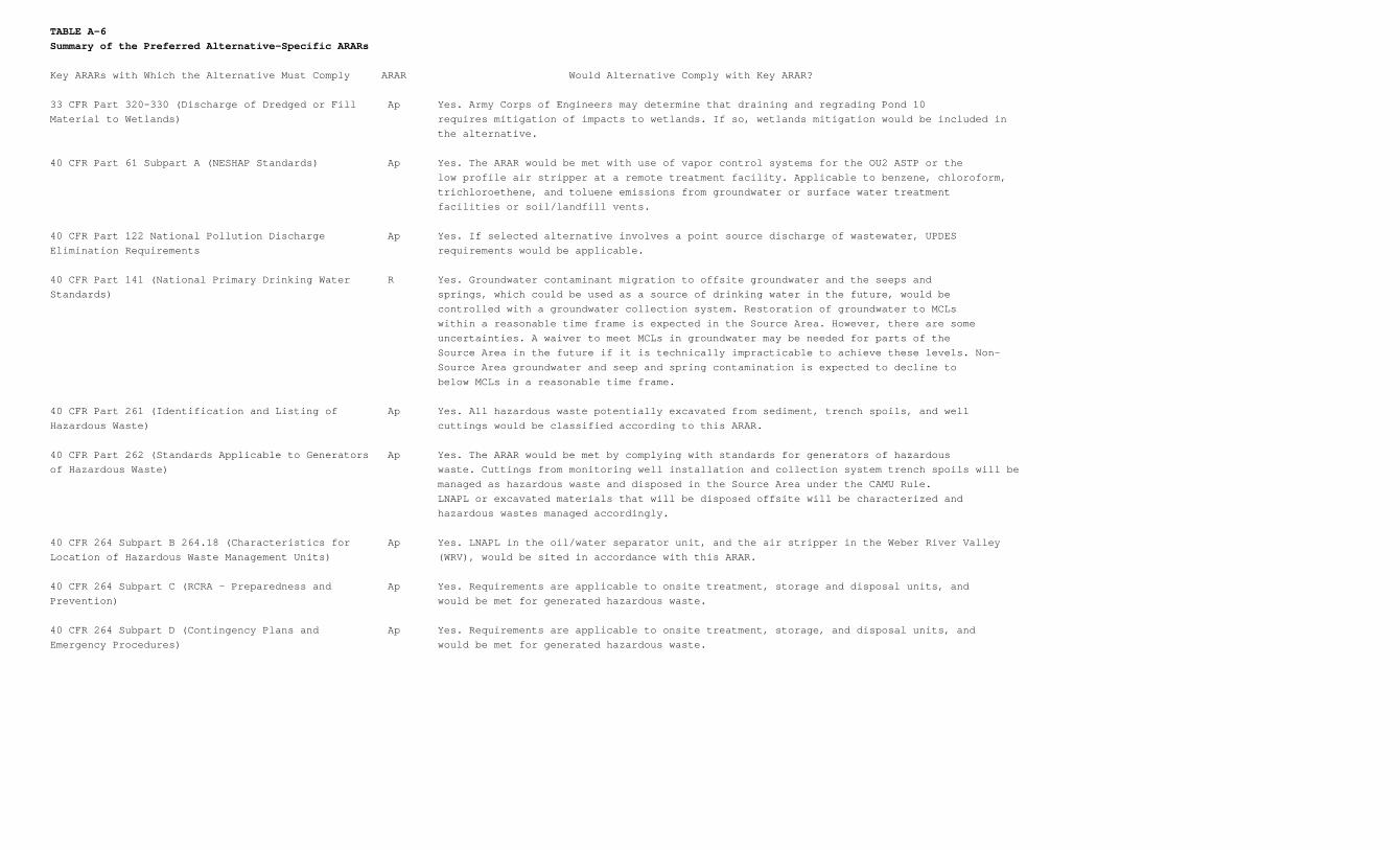
TABLE A-6Summary of the Preferred Alternative-Specific ARARs
Key ARARs with Which the Alternative Must Comply ARAR Would Alternative Comply with Key ARAR?
33 CFR Part 320-330 (Discharge of Dredged or Fill Ap Yes. Army Corps of Engineers may determine that draining and regrading Pond 10Material to Wetlands) requires mitigation of impacts to wetlands. If so, wetlands mitigation would be included in the alternative.
40 CFR Part 61 Subpart A (NESHAP Standards) Ap Yes. The ARAR would be met with use of vapor control systems for the OU2 ASTP or the low profile air stripper at a remote treatment facility. Applicable to benzene, chloroform, trichloroethene, and toluene emissions from groundwater or surface water treatment facilities or soil/landfill vents.
40 CFR Part 122 National Pollution Discharge Ap Yes. If selected alternative involves a point source discharge of wastewater, UPDESElimination Requirements requirements would be applicable.
40 CFR Part 141 (National Primary Drinking Water R Yes. Groundwater contaminant migration to offsite groundwater and the seeps andStandards) springs, which could be used as a source of drinking water in the future, would be controlled with a groundwater collection system. Restoration of groundwater to MCLs within a reasonable time frame is expected in the Source Area. However, there are some uncertainties. A waiver to meet MCLs in groundwater may be needed for parts of the Source Area in the future if it is technically impracticable to achieve these levels. Non- Source Area groundwater and seep and spring contamination is expected to decline to below MCLs in a reasonable time frame.
40 CFR Part 261 (Identification and Listing of Ap Yes. All hazardous waste potentially excavated from sediment, trench spoils, and wellHazardous Waste) cuttings would be classified according to this ARAR.
40 CFR Part 262 (Standards Applicable to Generators Ap Yes. The ARAR would be met by complying with standards for generators of hazardousof Hazardous Waste) waste. Cuttings from monitoring well installation and collection system trench spoils will be managed as hazardous waste and disposed in the Source Area under the CAMU Rule. LNAPL or excavated materials that will be disposed offsite will be characterized and hazardous wastes managed accordingly.
40 CFR 264 Subpart B 264.18 (Characteristics for Ap Yes. LNAPL in the oil/water separator unit, and the air stripper in the Weber River ValleyLocation of Hazardous Waste Management Units) (WRV), would be sited in accordance with this ARAR.
40 CFR 264 Subpart C (RCRA - Preparedness and Ap Yes. Requirements are applicable to onsite treatment, storage and disposal units, andPrevention) would be met for generated hazardous waste.
40 CFR 264 Subpart D (Contingency Plans and Ap Yes. Requirements are applicable to onsite treatment, storage, and disposal units, andEmergency Procedures) would be met for generated hazardous waste.
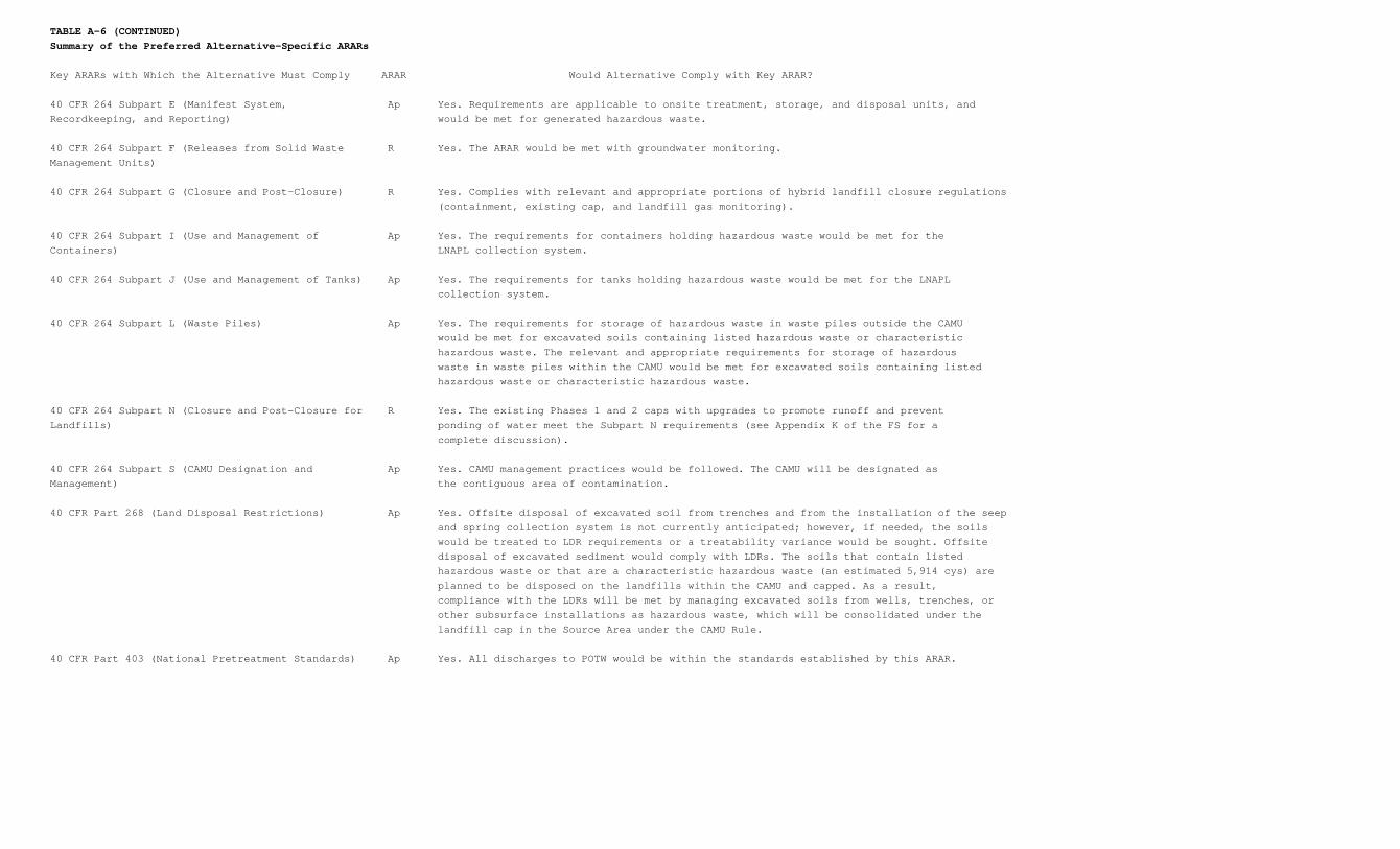
TABLE A-6 (CONTINUED)Summary of the Preferred Alternative-Specific ARARs
Key ARARs with Which the Alternative Must Comply ARAR Would Alternative Comply with Key ARAR?
40 CFR 264 Subpart E (Manifest System, Ap Yes. Requirements are applicable to onsite treatment, storage, and disposal units, andRecordkeeping, and Reporting) would be met for generated hazardous waste.
40 CFR 264 Subpart F (Releases from Solid Waste R Yes. The ARAR would be met with groundwater monitoring.Management Units)
40 CFR 264 Subpart G (Closure and Post-Closure) R Yes. Complies with relevant and appropriate portions of hybrid landfill closure regulations (containment, existing cap, and landfill gas monitoring).
40 CFR 264 Subpart I (Use and Management of Ap Yes. The requirements for containers holding hazardous waste would be met for theContainers) LNAPL collection system.
40 CFR 264 Subpart J (Use and Management of Tanks) Ap Yes. The requirements for tanks holding hazardous waste would be met for the LNAPL collection system.
40 CFR 264 Subpart L (Waste Piles) Ap Yes. The requirements for storage of hazardous waste in waste piles outside the CAMU would be met for excavated soils containing listed hazardous waste or characteristic hazardous waste. The relevant and appropriate requirements for storage of hazardous waste in waste piles within the CAMU would be met for excavated soils containing listed hazardous waste or characteristic hazardous waste.
40 CFR 264 Subpart N (Closure and Post-Closure for R Yes. The existing Phases 1 and 2 caps with upgrades to promote runoff and preventLandfills) ponding of water meet the Subpart N requirements (see Appendix K of the FS for a complete discussion).
40 CFR 264 Subpart S (CAMU Designation and Ap Yes. CAMU management practices would be followed. The CAMU will be designated asManagement) the contiguous area of contamination.
40 CFR Part 268 (Land Disposal Restrictions) Ap Yes. Offsite disposal of excavated soil from trenches and from the installation of the seep and spring collection system is not currently anticipated; however, if needed, the soils would be treated to LDR requirements or a treatability variance would be sought. Offsite disposal of excavated sediment would comply with LDRs. The soils that contain listed hazardous waste or that are a characteristic hazardous waste (an estimated 5,914 cys) are planned to be disposed on the landfills within the CAMU and capped. As a result, compliance with the LDRs will be met by managing excavated soils from wells, trenches, or other subsurface installations as hazardous waste, which will be consolidated under the landfill cap in the Source Area under the CAMU Rule.
40 CFR Part 403 (National Pretreatment Standards) Ap Yes. All discharges to POTW would be within the standards established by this ARAR.

TABLE A-6 (CONTINUED)Summary of the Preferred Alternative-Specific ARARs
Key ARARs with Which the Alternative Must Comply ARAR Would Alternative Comply with Key ARAR?
40 CFR Part 761 (PCB Requirements) Ap Yes. Any PCB contaminated soil would be managed in accordance with the ARAR.
UAC R307-1-2 (Division of Air Quality, Department of Ap Yes. Provisions would be made during remedial action to minimize discharge of airEnvironmental Quality) pollutants.
UAC R307-1-3 (Air Quality Standards for Control of Ap Yes. BACT would be used for control of vapor emissions.Installations)
UAC R307-1-4 (Emission Standards) Ap Yes. Air emissions would be controlled to comply with emissions standards.
UAC R307-10 (National Emission Standards for Ap Yes. The ARAR would be met with use of vapor control systems for the OU2 ASTP or theHazardous Air Pollutants) low profile air stripper at a remote treatment facility. Applicable to benzene, chloroform, trichloroethene, and toluene emissions from groundwater or surface water treatment facilities or soil/landfill vents.
UAC R307-12 (Fugitive Emissions and Fugitive Dust) Ap Yes. The ARAR would be met with use of mitigative measures such as dust suppressants and foams, and during construction of the air stripper in the WRV, if necessary.
UAC R307-14 (Non-Attainment Area Requirements for Ap Yes. The ARAR requires handling of liquid VOCs such as those from the LNAPL collectionOzone) system and the air stripper in the WRV, using reasonably available control technology.
UAC R309-103 (Utah Public Drinking Water R Yes. Groundwater contaminant migration to offsite groundwater and the seeps andRegulations) springs, which could be used as a source of drinking water in the future, would be controlled with a groundwater collection system. Restoration of groundwater to MCLs within a reasonable time frame is expected in the Source Area. However, there are some uncertainties. A waiver to meet MCLs in groundwater may be needed for parts of the Source Area in the future if it is technically impracticable to achieve these levels. Non- Source Area groundwater and seep and spring contamination is expected to decline to below MCLs in a reasonable time frame.
UAC R311-211 (Specified State of Utah Corrective R Yes. The sources would be controlled by the existing cap, and offsite groundwater wouldAction Cleanup Standards for UST and CERCLA Sites) be monitored. Seeps and springs exceeding MCLs would be collected and treated. The State of Utah maintains that UAC R311-211 is "applicable."
UAC R315-2 (Criteria for the Identification and Listing of Ap Yes. Hazardous waste generated during the remedial action would be defined according toHazardous Waste) the ARAR.
UAC R315-5 (State of Utah Standards for Generators of Ap Yes. The ARAR would be met by complying with standards for generators of hazardousHazardous Waste) waste. Cuttings from monitoring well installation, trench spoils, and recovered LNAPL may contain listed hazardous waste.
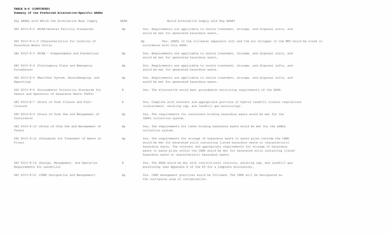
TABLE A-6 (CONTINUED)Summary of the Preferred Alternative-Specific ARARs
Key ARARs with Which the Alternative Must Comply ARAR Would Alternative Comply with Key ARAR?
UAC R315-8-2 (RCRA-General Facility Standards) Ap Yes. Requirements are applicable to onsite treatment, storage, and disposal units, and would be met for generated hazardous waste.
UAC R315-8-2.9 (Characteristics for Location of Ap Yes. LNAPL in the oil/water separator unit and the air stripper in the WRV would be sited inHazardous Waste Units) accordance with this ARAR.
UAC R315-8-3 (RCRA - Preparedness and Prevention) Ap Yes. Requirements are applicable to onsite treatment, storage, and disposal units, and would be met for generated hazardous waste.
UAC R315-8-4 (Contingency Plans and Emergency Ap Yes. Requirements are applicable to onsite treatment, storage, and disposal units, andProcedures) would be met for generated hazardous waste.
UAC R315-8-5 (Manifest System, Recordkeeping, and Ap Yes. Requirements are applicable to onsite treatment, storage, and disposal units, andReporting) would be met for generated hazardous waste.
UAC R315-8-6 (Groundwater Protection Standards for R Yes. The alternative would meet groundwater monitoring requirements of the ARAR.Owners and Operators of Hazardous Waste TSDFs)
UAC R315-8-7 (State of Utah Closure and Post- R Yes. Complies with relevant and appropriate portions of hybrid landfill closure regulationsClosure) (containment, existing cap, and landfill gas monitoring).
UAC R315-8-9 (State of Utah Use and Management of Ap Yes. The requirements for containers holding hazardous waste would be met for theContainers) LNAPL collection system.
UAC R315-8-10 (State of Utah Use and Management of Ap Yes. The requirements for tanks holding hazardous waste would be met for the LNAPLTanks) collection system.
UAC R315-8-12 (Standards for Treatment of Waste in Ap Yes. The requirements for storage of hazardous waste in waste piles outside the CAMUPiles) would be met for excavated soils containing listed hazardous waste or characteristic hazardous waste. The relevant and appropriate requirements for storage of hazardous waste in waste piles within the CAMU would be met for excavated soils containing listed hazardous waste or characteristic hazardous waste.
UAC R315-8-14 (Design, Management, and Operation R Yes. The ARAR would be met with institutional controls, existing cap, and landfill gasRequirements for Landfills) monitoring (see Appendix K of the FS for a complete discussion).
UAC R315-8-21 (CAMU Designation and Management) Ap Yes. CAMU management practices would be followed. The CAMU will be designated as the contiguous area of contamination.
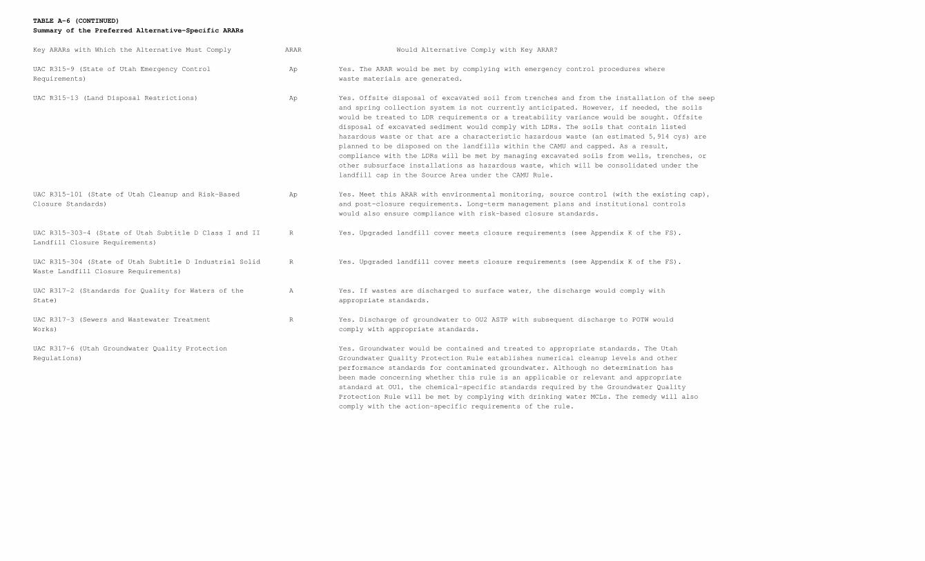
TABLE A-6 (CONTINUED)Summary of the Preferred Alternative-Specific ARARs
Key ARARs with Which the Alternative Must Comply ARAR Would Alternative Comply with Key ARAR?
UAC R315-9 (State of Utah Emergency Control Ap Yes. The ARAR would be met by complying with emergency control procedures whereRequirements) waste materials are generated.
UAC R315-13 (Land Disposal Restrictions) Ap Yes. Offsite disposal of excavated soil from trenches and from the installation of the seep and spring collection system is not currently anticipated. However, if needed, the soils would be treated to LDR requirements or a treatability variance would be sought. Offsite disposal of excavated sediment would comply with LDRs. The soils that contain listed hazardous waste or that are a characteristic hazardous waste (an estimated 5,914 cys) are planned to be disposed on the landfills within the CAMU and capped. As a result, compliance with the LDRs will be met by managing excavated soils from wells, trenches, or other subsurface installations as hazardous waste, which will be consolidated under the landfill cap in the Source Area under the CAMU Rule.
UAC R315-101 (State of Utah Cleanup and Risk-Based Ap Yes. Meet this ARAR with environmental monitoring, source control (with the existing cap),Closure Standards) and post-closure requirements. Long-term management plans and institutional controls would also ensure compliance with risk-based closure standards.
UAC R315-303-4 (State of Utah Subtitle D Class I and II R Yes. Upgraded landfill cover meets closure requirements (see Appendix K of the FS).Landfill Closure Requirements)
UAC R315-304 (State of Utah Subtitle D Industrial Solid R Yes. Upgraded landfill cover meets closure requirements (see Appendix K of the FS).Waste Landfill Closure Requirements)
UAC R317-2 (Standards for Quality for Waters of the A Yes. If wastes are discharged to surface water, the discharge would comply withState) appropriate standards.
UAC R317-3 (Sewers and Wastewater Treatment R Yes. Discharge of groundwater to OU2 ASTP with subsequent discharge to POTW wouldWorks) comply with appropriate standards.
UAC R317-6 (Utah Groundwater Quality Protection Yes. Groundwater would be contained and treated to appropriate standards. The UtahRegulations) Groundwater Quality Protection Rule establishes numerical cleanup levels and other performance standards for contaminated groundwater. Although no determination has been made concerning whether this rule is an applicable or relevant and appropriate standard at OU1, the chemical-specific standards required by the Groundwater Quality Protection Rule will be met by complying with drinking water MCLs. The remedy will also comply with the action-specific requirements of the rule.
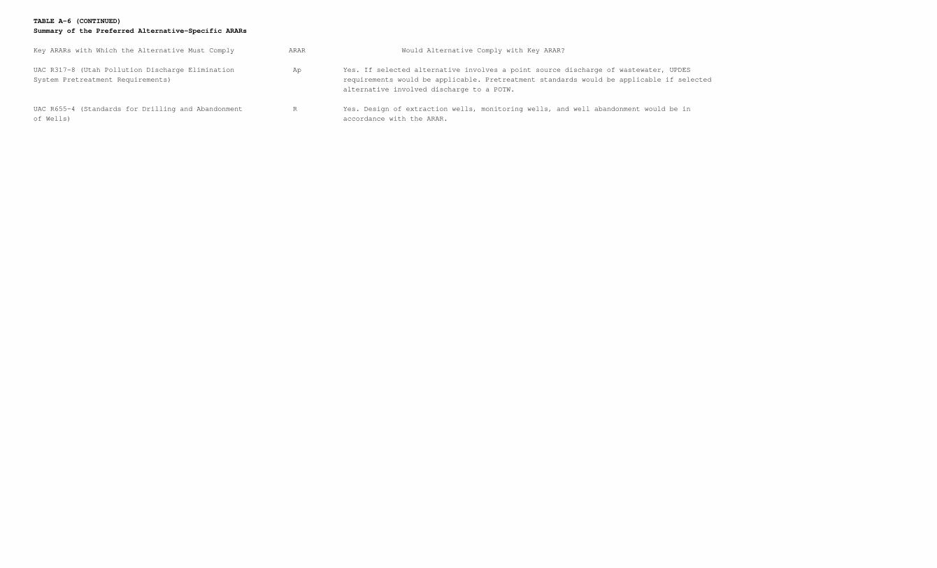
TABLE A-6 (CONTINUED)Summary of the Preferred Alternative-Specific ARARs
Key ARARs with Which the Alternative Must Comply ARAR Would Alternative Comply with Key ARAR?
UAC R317-8 (Utah Pollution Discharge Elimination Ap Yes. If selected alternative involves a point source discharge of wastewater, UPDESSystem Pretreatment Requirements) requirements would be applicable. Pretreatment standards would be applicable if selected alternative involved discharge to a POTW.
UAC R655-4 (Standards for Drilling and Abandonment R Yes. Design of extraction wells, monitoring wells, and well abandonment would be inof Wells) accordance with the ARAR.
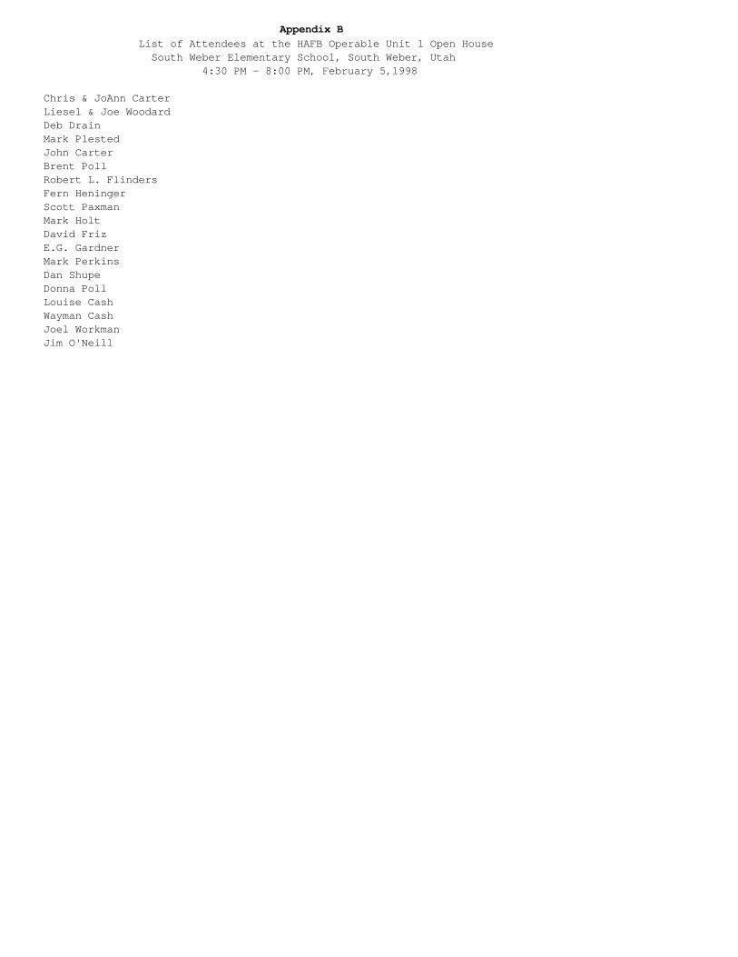
Appendix B List of Attendees at the HAFB Operable Unit 1 Open House South Weber Elementary School, South Weber, Utah 4:30 PM - 8:00 PM, February 5,1998
Chris & JoAnn CarterLiesel & Joe WoodardDeb DrainMark PlestedJohn CarterBrent PollRobert L. FlindersFern HeningerScott PaxmanMark HoltDavid FrizE.G. GardnerMark PerkinsDan ShupeDonna PollLouise CashWayman CashJoel WorkmanJim O'Neill
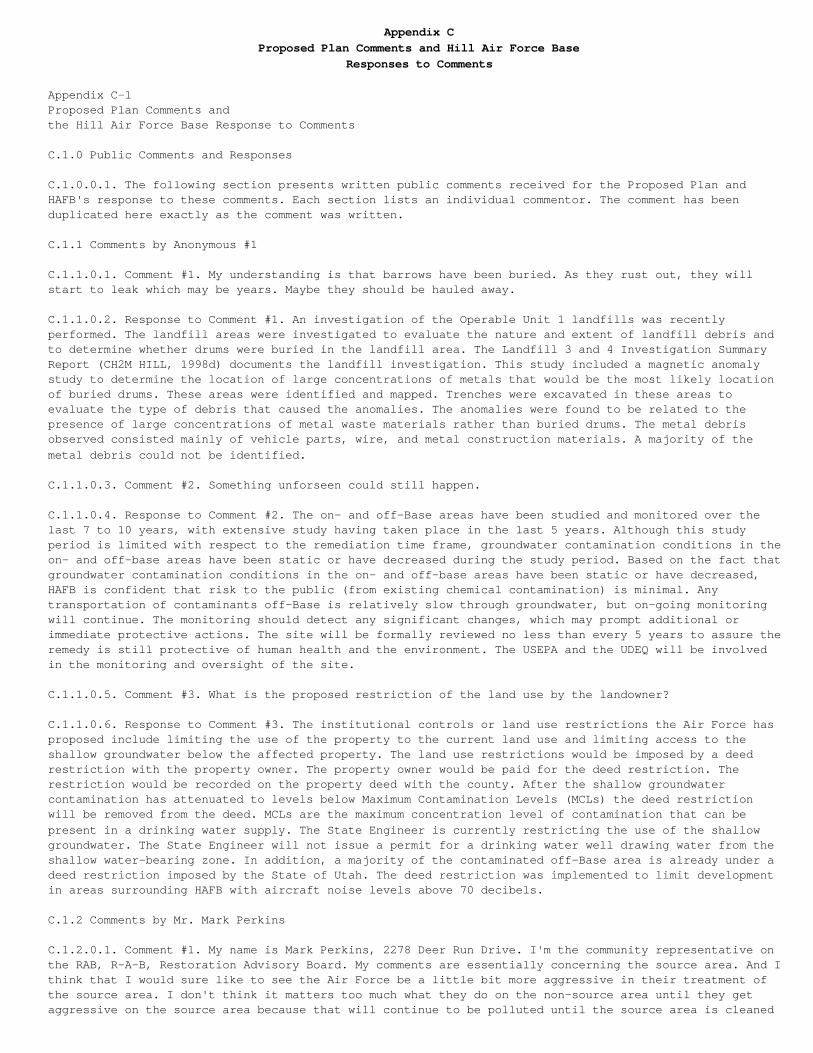
Appendix CProposed Plan Comments and Hill Air Force Base
Responses to Comments
Appendix C-1Proposed Plan Comments andthe Hill Air Force Base Response to Comments
C.1.0 Public Comments and Responses
C.1.0.0.1. The following section presents written public comments received for the Proposed Plan andHAFB's response to these comments. Each section lists an individual commentor. The comment has beenduplicated here exactly as the comment was written.
C.1.1 Comments by Anonymous #1
C.1.1.0.1. Comment #1. My understanding is that barrows have been buried. As they rust out, they willstart to leak which may be years. Maybe they should be hauled away.
C.1.1.0.2. Response to Comment #1. An investigation of the Operable Unit 1 landfills was recentlyperformed. The landfill areas were investigated to evaluate the nature and extent of landfill debris andto determine whether drums were buried in the landfill area. The Landfill 3 and 4 Investigation SummaryReport (CH2M HILL, 1998d) documents the landfill investigation. This study included a magnetic anomalystudy to determine the location of large concentrations of metals that would be the most likely locationof buried drums. These areas were identified and mapped. Trenches were excavated in these areas toevaluate the type of debris that caused the anomalies. The anomalies were found to be related to the presence of large concentrations of metal waste materials rather than buried drums. The metal debrisobserved consisted mainly of vehicle parts, wire, and metal construction materials. A majority of themetal debris could not be identified.
C.1.1.0.3. Comment #2. Something unforseen could still happen.
C.1.1.0.4. Response to Comment #2. The on- and off-Base areas have been studied and monitored over thelast 7 to 10 years, with extensive study having taken place in the last 5 years. Although this studyperiod is limited with respect to the remediation time frame, groundwater contamination conditions in theon- and off-base areas have been static or have decreased during the study period. Based on the fact thatgroundwater contamination conditions in the on- and off-base areas have been static or have decreased,HAFB is confident that risk to the public (from existing chemical contamination) is minimal. Anytransportation of contaminants off-Base is relatively slow through groundwater, but on-going monitoringwill continue. The monitoring should detect any significant changes, which may prompt additional orimmediate protective actions. The site will be formally reviewed no less than every 5 years to assure theremedy is still protective of human health and the environment. The USEPA and the UDEQ will be involvedin the monitoring and oversight of the site.
C.1.1.0.5. Comment #3. What is the proposed restriction of the land use by the landowner?
C.1.1.0.6. Response to Comment #3. The institutional controls or land use restrictions the Air Force hasproposed include limiting the use of the property to the current land use and limiting access to theshallow groundwater below the affected property. The land use restrictions would be imposed by a deedrestriction with the property owner. The property owner would be paid for the deed restriction. Therestriction would be recorded on the property deed with the county. After the shallow groundwatercontamination has attenuated to levels below Maximum Contamination Levels (MCLs) the deed restrictionwill be removed from the deed. MCLs are the maximum concentration level of contamination that can bepresent in a drinking water supply. The State Engineer is currently restricting the use of the shallowgroundwater. The State Engineer will not issue a permit for a drinking water well drawing water from theshallow water-bearing zone. In addition, a majority of the contaminated off-Base area is already under adeed restriction imposed by the State of Utah. The deed restriction was implemented to limit developmentin areas surrounding HAFB with aircraft noise levels above 70 decibels.
C.1.2 Comments by Mr. Mark Perkins
C.1.2.0.1. Comment #1. My name is Mark Perkins, 2278 Deer Run Drive. I'm the community representative onthe RAB, R-A-B, Restoration Advisory Board. My comments are essentially concerning the source area. And Ithink that I would sure like to see the Air Force be a little bit more aggressive in their treatment ofthe source area. I don't think it matters too much what they do on the non-source area until they getaggressive on the source area because that will continue to be polluted until the source area is cleaned
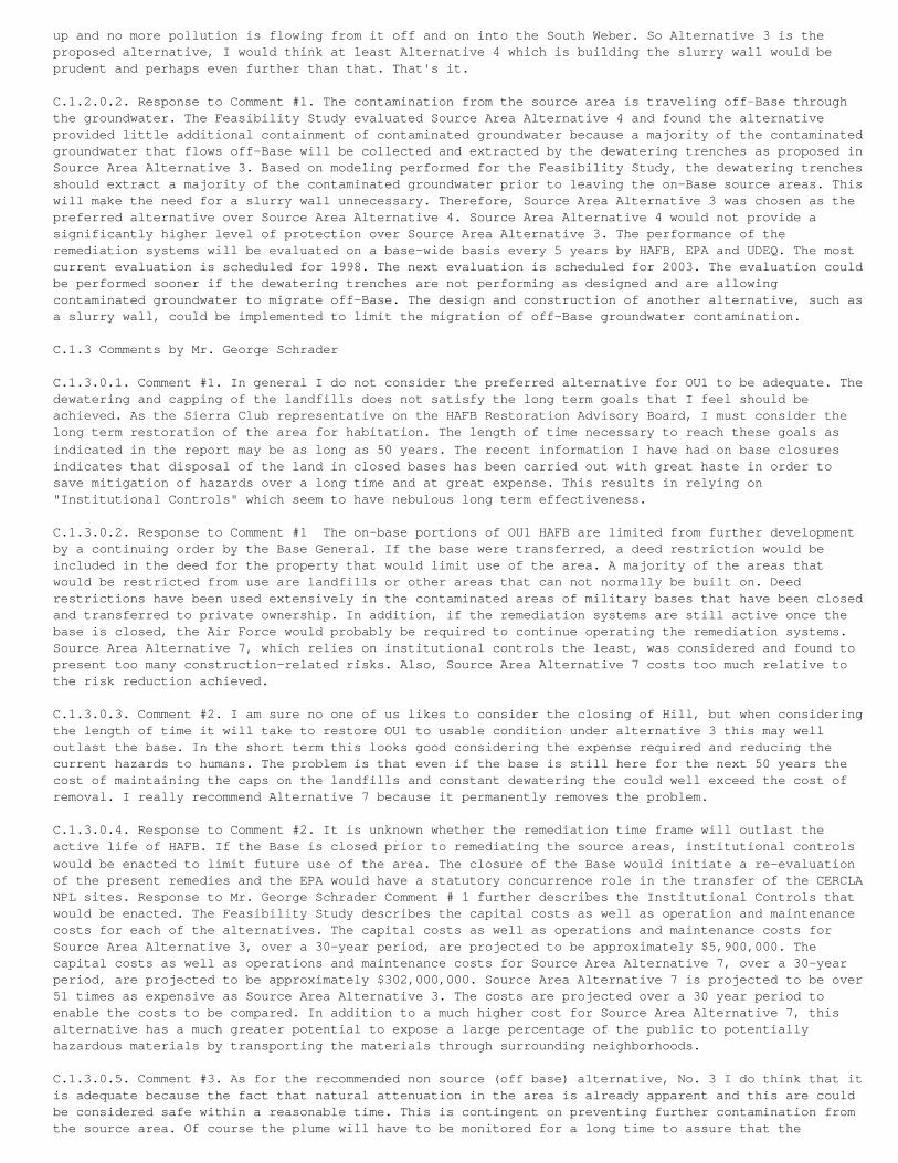
up and no more pollution is flowing from it off and on into the South Weber. So Alternative 3 is theproposed alternative, I would think at least Alternative 4 which is building the slurry wall would beprudent and perhaps even further than that. That's it.
C.1.2.0.2. Response to Comment #1. The contamination from the source area is traveling off-Base throughthe groundwater. The Feasibility Study evaluated Source Area Alternative 4 and found the alternativeprovided little additional containment of contaminated groundwater because a majority of the contaminatedgroundwater that flows off-Base will be collected and extracted by the dewatering trenches as proposed inSource Area Alternative 3. Based on modeling performed for the Feasibility Study, the dewatering trenchesshould extract a majority of the contaminated groundwater prior to leaving the on-Base source areas. Thiswill make the need for a slurry wall unnecessary. Therefore, Source Area Alternative 3 was chosen as thepreferred alternative over Source Area Alternative 4. Source Area Alternative 4 would not provide asignificantly higher level of protection over Source Area Alternative 3. The performance of theremediation systems will be evaluated on a base-wide basis every 5 years by HAFB, EPA and UDEQ. The mostcurrent evaluation is scheduled for 1998. The next evaluation is scheduled for 2003. The evaluation couldbe performed sooner if the dewatering trenches are not performing as designed and are allowingcontaminated groundwater to migrate off-Base. The design and construction of another alternative, such asa slurry wall, could be implemented to limit the migration of off-Base groundwater contamination.
C.1.3 Comments by Mr. George Schrader
C.1.3.0.1. Comment #1. In general I do not consider the preferred alternative for OU1 to be adequate. Thedewatering and capping of the landfills does not satisfy the long term goals that I feel should beachieved. As the Sierra Club representative on the HAFB Restoration Advisory Board, I must consider thelong term restoration of the area for habitation. The length of time necessary to reach these goals asindicated in the report may be as long as 50 years. The recent information I have had on base closuresindicates that disposal of the land in closed bases has been carried out with great haste in order tosave mitigation of hazards over a long time and at great expense. This results in relying on"Institutional Controls" which seem to have nebulous long term effectiveness.
C.1.3.0.2. Response to Comment #1 The on-base portions of OU1 HAFB are limited from further developmentby a continuing order by the Base General. If the base were transferred, a deed restriction would beincluded in the deed for the property that would limit use of the area. A majority of the areas thatwould be restricted from use are landfills or other areas that can not normally be built on. Deedrestrictions have been used extensively in the contaminated areas of military bases that have been closedand transferred to private ownership. In addition, if the remediation systems are still active once thebase is closed, the Air Force would probably be required to continue operating the remediation systems.Source Area Alternative 7, which relies on institutional controls the least, was considered and found topresent too many construction-related risks. Also, Source Area Alternative 7 costs too much relative tothe risk reduction achieved.
C.1.3.0.3. Comment #2. I am sure no one of us likes to consider the closing of Hill, but when consideringthe length of time it will take to restore OU1 to usable condition under alternative 3 this may welloutlast the base. In the short term this looks good considering the expense required and reducing thecurrent hazards to humans. The problem is that even if the base is still here for the next 50 years thecost of maintaining the caps on the landfills and constant dewatering the could well exceed the cost ofremoval. I really recommend Alternative 7 because it permanently removes the problem.
C.1.3.0.4. Response to Comment #2. It is unknown whether the remediation time frame will outlast theactive life of HAFB. If the Base is closed prior to remediating the source areas, institutional controlswould be enacted to limit future use of the area. The closure of the Base would initiate a re-evaluationof the present remedies and the EPA would have a statutory concurrence role in the transfer of the CERCLANPL sites. Response to Mr. George Schrader Comment # 1 further describes the Institutional Controls thatwould be enacted. The Feasibility Study describes the capital costs as well as operation and maintenancecosts for each of the alternatives. The capital costs as well as operations and maintenance costs forSource Area Alternative 3, over a 30-year period, are projected to be approximately $5,900,000. Thecapital costs as well as operations and maintenance costs for Source Area Alternative 7, over a 30-yearperiod, are projected to be approximately $302,000,000. Source Area Alternative 7 is projected to be over51 times as expensive as Source Area Alternative 3. The costs are projected over a 30 year period toenable the costs to be compared. In addition to a much higher cost for Source Area Alternative 7, thisalternative has a much greater potential to expose a large percentage of the public to potentiallyhazardous materials by transporting the materials through surrounding neighborhoods.
C.1.3.0.5. Comment #3. As for the recommended non source (off base) alternative, No. 3 I do think that itis adequate because the fact that natural attenuation in the area is already apparent and this are couldbe considered safe within a reasonable time. This is contingent on preventing further contamination fromthe source area. Of course the plume will have to be monitored for a long time to assure that the
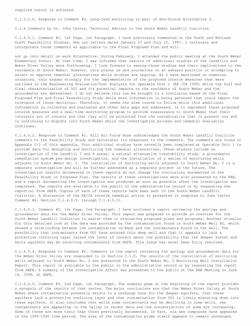
required result is achieved.
C.1.3.0.6. Response to Comment #3. Long-term monitoring is part of Non-Source Alternative 3.
C.1.4 Comments by Dr. John Carter, Technical Advisor to the South Weber Landfill Coalition
C.1.4.0.1. Comment #1, 1st Page, 1st Paragraph. I have previously commented on the Draft and RevisedDraft Feasibility Studies. See our letters dated January 27 and July 10, 1997. I reiterate andincorporate those comments as applicable to the Final Proposed Plan and will
not go into detail on each Alternative. During February, I attended the public meeting at the South WeberElementary School. At that time, I was informed that results of additional studies of the landfills andWeber River Valley were forthcoming. I look forward to seeing those studies and their implications to theresidents of South Weber. However, this places us and yourselves in an awkward position of attempting toselect or approve remedial alternatives while studies are ongoing. As I have mentioned on numerousoccasions, this argues strongly for the implementation of the proposed interim measures that wereoutlined in the Engineering Evaluation/Cost Analysis for Operable Unit 1 (EE /CA 1995) while the full andfinal characterization of OU1 and its potential impacts on the residents of South Weber and thegroundwater are determined. I do not believe this can be brought to a conclusion based on the FinalProposed Plan and Final Feasibility Study while more information is being gathered that could impact therelevance of those decisions. Therefore, it seems the wise course to follow while this additionalinformation is collected and evaluated and other data gaps are addressed, is to implement these proposedinterim measures and a real-time monitoring program to provide reassurance to South Weber that theirinterests are of concern and that they will be protected from the contamination that is present now andis continuing to migrate into South Weber while the investigative process and remedial evaluationcontinues.
C.1.4.0.2. Response to Comment #1. Hill Air Force Base acknowledges the South Weber Landfill Coalitioncomments to the Feasibility Study and reiterates its responses to the comments. The comments are found inAppendix C-3 of this appendix. Four additional studies have recently been completed at Operable Unit 1 toprovide data for designing and monitoring the remedial alternatives. These studies include aninvestigation of the Landfill 3 and 4 areas, a natural attenuation treatability study, a groundwaterremediation system pre-design investigation, and the installation of a series of monitoring wellsadjacent to South Weber No. 2. The installation of monitoring wells adjacent to South Weber No. 2 is aseparate investigation and will be further addressed as a separate project in the future. Theinvestigation results documented in these reports do not change the conclusions documented in theFeasibility Study or Proposed Plan. The results of these investigations were also presented to the RAB,and a report documenting the investigation was produced as soon as possible after the investigation wascompleted. The reports are available to the public in the administrative record or by requesting thereport(s) from HAFB. Copies of each of these reports have been sent to the South Weber LandfillCoalition. A discussion of the EE/CA interim remedial action is presented in response to John CarterComment #4, Section C.1.4.0.9. through C.1.4.0.11.
C.1.4.0.3. Comment #2, 1st Page, 2nd Paragraph. I have enclosed a report reviewing the geology andgroundwater data for the Weber River Valley. This report was prepared to provide an overview for theSouth Weber Landfill Coalition to assist them in evaluating proposed plans and programs. Another stimulusfor this detailed look at the data was provided by the contamination found in South Weber Well #2, whichshowed a relationship between the contamination on-Base and the contaminants found in the well. Thepossibility that contaminants from OU1 have entered this deep well and that it appears to lack aprotective confining layer raised the level of concern about the possibility that the deeper Sunset andDelta aquifers may be receiving contaminants from HAFB. This issue has never been fully resolved.
C.1.4.0.4. Response to Comment #2. Comments in the report reviewing the geology and groundwater data forthe Weber River Valley are responded to in Section C.1.5. The results of the installation of monitoringwells adjacent to South Weber No. 2 are presented in the South Weber No. 2 Monitoring Well InstallationReport. This report is available to the public in the administrative record or by requesting the reportfrom HAFB. A summary of the investigation effort was presented to the public at the RAB Meeting on June18, 1998, at HAFB.
C.1.4.0.5. Comment #3, 2nd Page, 1st Paragraph. The summary page at the beginning of the report providesa synopsis of the results of that review. The major conclusions are that the Weber River Valley at SouthWeber where contamination presently exists is a recharge zone for the deeper aquifers, that theseaquifers lack a protective confining layer and that contamination from OU1 is likely migrating down intothese aquifers. It also concludes that while some contaminants may be declining in some wells, newcontaminants are appearing in the Valley in recent data and the concentrations of some are increasing.Some of these are more toxic than those previously documented. In fact, six new compounds have appearedin the 1995-1996 time period. The area of the contamination plume itself appears to remain unchanged,
reaching to South Weber Drive. Based on this analysis, the Final Proposed Plan does not provide adequateprotection for the residents of South Weber or the deeper aquifers. Therefore, the use of extractiontrenches in Source Areas and natural attenuation in Source and Non-Source areas must be rejected as afinal solution. More specific comments and recommendations follow.
C.1.4.0.6. Response to Comment #3. The results of the installation of monitoring wells adjacent to SouthWeber No. 2 are presented in the South Weber No. 2 Monitoring Well Installation Report. The report isavailable to the public in the administrative record or by requesting the report from HAFB. Based on ourinterpretation of the drillers log from the South Weber No. 2, confining layers appear to exist betweenthe surface and the drinking water aquifer. The area does not appear to be a recharge area. The recentdrilling of a monitoring well adjacent to South Weber No. 2, to a depth of 453 feet below the groundsurface, showed numerous confining layers between the surface and the drinking water aquifer. Due to theconfining layers, the area surrounding South Weber No. 2 was not found to be a recharge area. Drinkingwater aquifer recharge areas are located at the base of the Wasatch Mountains, approximately 2-miles tothe east. Please see the Response to Comments in Sections C.1.5.4.8. through C.1.5.4.10. for anevaluation of the compounds identified by the South Weber Landfill Coalition. Considering all theinformation, HAFB has determined the selected remedy to be the proper final solution.
C.1.4.0.7. Comment #4, 2nd Page, 2nd and 3rd Paragraphs. Source Area Preferred Alternative-Dewatering byExtraction Trenches. This method was previously judged unsuitable for OU1 by HAFB in the EE/CA. To quotefrom page 3 of that document, "A physical barrier is preferred over a hydraulic barrier because it is amore positive means of containment and it is not as reliant on the operation of electromechanicalequipment (i.e. extraction pumps). If a pump in a gradient control well were to fail, there would beadequate time to detect and respond to the problem before any contamination escaped the containmentsystem. This may not be the case with failure of a pump in an extraction trench. Given that there is asteep slope immediately downgradient of the proposed trench location, ground water that migrates throughwhile the pumps are inoperative could not be recovered. ...The two alternatives using hydraulic barriersalso represented a risk that the resulting drawdown in the water table might allow the LNAPL to migrateinto the clay, potentially making future remediation efforts more difficult." Further, from page 4-10 ofthe EE/CA, it is stated that "Pump failure or poor pump performance could result in contaminantsmigrating beyond the trench system. This is a distinct disadvantage of a hydraulic barrier compared to aphysical barrier. Given the estimated life of the removal action (30 years), it is likely that the pumpswill fail at some point and they will need to be replaced. For this reason, frequent performancemonitoring is critical."
C.1.4.0.8. Comment #4 (cont.). Modeling results presented in the EE/CA indicated that only 30 to 40particles released would be captured. While the design of the system presented in the EE/CA is differentthan that in the Final Proposed Plan (1998), it appears that capture efficiency and reliability poses asignificant risk that the Preferred Alternative will not eliminate contaminant flow into the Weber RiverValley and South Weber Non Source Area. It is also of benefit to mention that the physical barrierproposed in the EE/CA was a slurry wall which is the physical containment method already used to limitgroundwater flow into OU1 from the South. However, as it stated in the EE/CA, "Since the existing slurrywall at the site is not performing as a effective barrier to ground waterflow, there is some concernabout the ability to construct a slurry wall that will meet the performance objectives. The reason forits limited effectiveness is believed to be related to poor construction quality control, such that thewall was not properly keyed into the clay." What was not mentioned in the EE/CA was the possibility ofdiscontinuities in the silty clay layer that might allow continued migration of groundwater into OU1through or beneath the slurry wall. Alternative 4 of the Proposed Plan, proposed a downgradient cutoff(slurry) wall to "... increase the reliability of preventing off-site migration by providing a physicalbarrier to groundwater movement." This alternative was not accepted as part of the Preferred Alternativeand South Weber is left without the physical containment that was considered necessary in the EE/CA.
C.1.4.0.9. Response to Comment #4. Source Area Alternative 4 consists of a dewatering system and slurrywall similar to the design of the EE/CA. The location of dewatering systems varied from the EE/CA.Because the Source Area Alternative 3 Dewatering Trenches are much more distant from the bluff area,compared to the EE/CA design, failure of a pump would not result in the loss of capture of contaminatedgroundwater. The groundwater modeling performed as part of the Feasibility Study evaluated Source AreaAlternative 4, and found that the alternative provided little additional containment of contaminatedgroundwater because a majority of the contaminated groundwater that flows off-Base will be collected andextracted by the dewatering trenches (as proposed in Source Area Alternative 3). Therefore, the slurrywall would be unnecessary because the groundwater would be mostly removed by the dewatering trenches andthere would be limited groundwater for the slurry wall to contain. Recent investigation also identifiedthe location of the groundwater channels considered to be the main flow path for groundwater andgroundwater contamination. The location of the trenches is based on the location of the groundwaterchannels.
C.1.4.0.10. Response to Comment #4 (cont.). A slurry wall was proposed as an EE/CA interim remedialaction for Operable Unit 1 in 1995. The design of the slurry wall was evaluated by a third party reviewerwho found that the slurry wall would provide limited protection to the off-Base migration of groundwatercontamination. During the public comment period, the public also identified problems with theeffectiveness of the slurry wall. Based on third party evaluation and comments made by the public, theAir Force decided not to construct the slurry wall. The Feasibility Study also evaluated the installationof a slurry wall (Source Area Alternative 4) and found the slurry wall would not provide a significantlevel of additional protection when compared to dewatering trenches without a slurry wall (Source AreaAlternative 3). The slurry wall would be unnecessary because the groundwater would be mostly removed bythe dewatering trenches, and there would be limited water for the slurry wall to contain. Therefore,Source Area Alternative 3 was chosen as the preferred alternative over Source Area Alternative 4. Inaddition, the effectiveness of the upgradient slurry wall constructed in the mid-1980's has been shown tobe limited at best.
C.1.4.0.11. Response to Comment #4 (cont.). The performance of the remediation systems will be evaluatedon a base-wide basis every 5 years. The most current evaluation is scheduled for 1998. The nextevaluation is scheduled for 2003. The evaluation could be performed sooner if the dewatering trenches arenot performing as designed and are allowing contaminated groundwater to migrate off-Base. The design andconstruction of another alternative, such as a slurry wall, could be implemented to limit the migrationof off-Base groundwater contamination. The dewatering system will be remotely monitored with alarms. Ifthe system shuts down, personnel will be immediately dispatched to resolve the problem. In addition, theflow of groundwater is relatively slow. Once the pumps are turned back on, the water on the downgradientside of the trench would be drawn back into the trench.
C.1.4.0.12. Comment #5, 3rd Page, 1st full Paragraph. Repair and O&M of Landfill Caps and Passive GasVent System. Monitoring data for landfill gases presented in the Final Comprehensive RemedialInvestigation (RI 1995) indicated that numerous volatile organic compounds were present within thelandfills including TCE (340 ppb), DCE (52,000 ppb) and Vinyl Chloride (30,000 ppb), among others. Theseare present in the landfill gas and are vented to the atmosphere. Lack of monitoring within the landfillshas precluded a definitive analysis of the source(s) of these compounds. It is not known whether LNAPL orDNAPL is present, or whether drummed or containerized wastes are present that cannot be remediated by thePreferred Alternative in the Final Proposed Plan. A consequence of the Preferred Alternative is that thelandfills will be dewatered to varying degrees depending upon the design and operation of the proposedextraction system and the integrity of the landfill cap. Much of the disposal activity in the landfillsresulted in disposed material being present in the upper region of the landfills above the water table.Lowering the water table will leave more of the landfill contents above the saturated zone. The loweredor absent infiltration rate obtained by repair of the landfill cap will preclude water movement throughthis upper zone where the disposed material resides. The result of this is that, depending upon the stateof the contaminants in the landfills, they may persist long beyond any proposed time estimate forremediation and reappear once OU1 is deemed closed and monitoring ceases or during failures of theextraction system.
C.1.4.0.13. Response to Comment #5. During original sampling of the landfill gas system, the samples wereobtained by inserting a tube inside the landfill vent. The samples were collected in a SUMMA canisterconnected to the end of the tube. Based on this question, HAFB recently scanned the air from the ventswith an Organic Vapor Meter (OVM). A reading was taken 3 to 6 feet inside the vent and at the ventoutlet. The depth of 3 to 6 feet was the depth at which the original samples were obtained. The OVM didnot detect any reading of Volatile Organic Compounds (VOCs) at the vent outlet. OVM readings as high as 1part per million were observed in some of the landfill vents in Landfill 4. VOCs were not detected insidethe other vents. The minor amount of gas that these vents produce is considered insignificant and quicklydilutes to non-detection upon venting to the atmosphere. The amount of Volatile Organic Compounds emittedby the landfills appears to be well below the amount required to be treated by the State of Utah undercurrent law. A Best Control Technology (BACT) analysis for landfill gas will be performed to assess theneed for controls prior to implementation of the selected remedy.
C.1.4.0.14. Response to Comment #5 (cont.). The Landfill 3 and 4 Summary Investigation (CH2M HILL, 1998d)provided information concerning the types of materials and debris contained within the landfills.Ninety-five exploration points were excavated within Landfills 3 and 4 to evaluate the nature and extentof landfill debris. DNAPL was not found in the landfill areas. LNAPL has been observed in Landfill 3, butis associated with Fire Training Area 1. The extent and nature of the LNAPL from Fire Training Area 1 hasbeen well documented in the Remedial Investigation. Additional study was also performed to evaluate thepresence of drums that may have been buried in the landfills. This investigation did not detectcontainerized hazardous waste. The results of this investigation are presented in the Landfill 3 and 4Summary Investigation (CH2M HILL, 1998d).
C.1.4.0.15. Response to Comment #5 (cont.). The shallow groundwater under the landfills will be collectedand treated with the goal of removing and treating the majority of the shallow groundwater. Groundwater
is the transport mechanism moving contamination off-Base. The dewatering trenches will mitigate the flowof groundwater off-Base. The improvements to the landfill caps will also inhibit surface waterinfiltration to the shallow groundwater table. These remedial efforts should lower or eliminate theshallow groundwater table, thereby removing the main contamination transport mechanism. If thecontamination does not have a mechanism for transport, it will not migrate to off-Base areas and will notbe a threat to the public. HAFB does not believe using surface water to flush the contamination throughthe landfill debris to the shallow groundwater table is in the best interest of the public. The intent ofthe dewatering system is to limit contaminated groundwater from flowing off-Base.
C.1.4.0.16. Comment #6, 3rd Page, 2nd Paragraph. Environmental Monitoring. No monitoring programdescription is provided. The type (groundwater, surface water, air, soil, soil gas, other), location andfrequency of monitoring as well as the contaminant list being analyzed is critically important to theimpacted populations. Depending upon these factors, the populace could be exposed to contaminants forlong periods of time corresponding to the interval between samples or monitoring events. Reliance uponmechanical pumping systems demands daily checks for performance, standby equipment to bring on-line whenproblems occur and contingency planning for any foreseeable problem. This has not been presented in theproposed plan. The people of South Weber cannot feel comfortable with monitoring and reporting as it hasbeen conducted in the past and may be conducted as part of any interim or final solution. The design andimplementation of any monitoring program must allow for detection of known and unknown contaminants bothin air, water and soils. The monitoring network must be designed to provide early warning and becomprehensive enough to address the monitoring gaps I have repeatedly pointed out. The monitoringschedule and reporting must be timely and disseminated in such a way that residents will be providedcurrent results. There must be a response mechanism that will activate a contingency plan to ensureprotection.
C.1.4.0.17. Response to Comment #6. Hill Air Force Base agrees the remedial monitoring plan is veryimportant, especially with respect to the natural attenuation alternative. Proposed plans and feasibilitystudies generally do not provide detailed monitoring plans. The monitoring plans are only defined ingeneral terms in the Feasibility Study and Proposed Plan. The monitoring will consist of groundwater,surface water, and possibly air monitoring. Groundwater levels will also be measured. The monitoringschedule has not been defined at this time. As part of the remedial design, a monitoring schedule will bedeveloped. Twenty-two additional monitoring wells were recently installed in an off-Base area for naturalattenuation monitoring, bringing the total number of monitoring wells in the off-Base area to 43. Thesenew monitoring wells include a deep well screened in the drinking water aquifer adjacent to South WeberNo. 2.
C.1.4.0.18. Response to Comment #6 (cont.). A continuous monitoring system, with alarms in the event offailure, will be designed into the on-Base dewatering system. Contingency and emergency plans will beincluded as part of operation and maintenance manuals for the remediation system. Numerous otherdewatering systems are currently operating at HAFB, at the various operable units, with remote alarmsthat notify base personnel in the event of system malfunction. This system has worked well to date. Amore sophisticated system, that will allow remote monitoring and operation of most Base remediationsystems, is currently being designed.
C.1.4.0.19. Response to Comment #6 (cont.). Hill Air Force Base does not agree that there are still datagaps and has performed numerous investigations and studies to evaluate the nature and extent ofcontamination at Operable Unit 1. The number and type of investigations and studies have met the EPA andUDEQ requirements for similar sites.
C.1.4.0.20. Response, to Comment #6 (cont.). The details of reporting monitoring results have not yetbeen defined. The details will be prepared as part of the remediation system design. A report will beprepared after each monitoring event, and it will include the results of monitoring events as well as anassessment of the progress of the remediation effort. The report will be available for public inspectionand possibly a condensed version will be sent to the affected property owners.
C.1.4.0.21. Comment #7, 4th, Page, 1st Paragraph. Institutional Controls. The scope (area, type andduration) of "institutional controls" is not described. Property owners should be informed about thelimitations on their use of their property in order to make informed judgements about the Proposed Planand Preferred Alternative. The description for Non Source Area Alternative 6 states: "...the use ofinstitutional controls to prevent changes in land use or use of the groundwater." This type of controlcould have long-term impacts to individual property owners as well as to the Town of South Weber ifenforced. How are institutional controls to be implemented and enforced? Decades down the road, how do weobtain assurance that innocent and unaware citizens might not inadvertently expose themselves to thecontaminants through, their activities?
C.1.4.0.22. Response to Comment #7. The land use restrictions the Air Force has proposed for off-Baseareas include limiting use of the property to current land use and limiting access to shallow groundwater
below the affected property. The land use restrictions would be imposed by a deed restriction with theproperty owner. The property owner would be paid for the deed restriction. The restriction would berecorded on the property deed with the county. After the shallow groundwater contamination has attenuatedto levels safe enough to drink, the deed restriction would be discontinued and removed from the deed. Useof the shallow groundwater is restricted by the State Engineer. The State Engineer will not issue apermit for a drinking water well drawing water from the shallow water-bearing zone. In addition, amajority of the contaminated off-Base area is already under a deed restriction imposed by the State ofUtah. The deed restriction was implemented to limit development in areas surrounding HAFB with aircraftnoise levels above 70 decibels.
C.1.4.0.23. Comment #8, 4th Page, 2nd Paragraph. Upgraded Seep Collection and Treatment. Under thePreferred Alternative in the Proposed Plan, it is expected that groundwater transport of contaminantsfrom the OU1 Source Areas will be stopped by the extraction trench system. In that case, why is aseparate collection and treatment system necessary for seeps? The proposed plan states in the descriptionof Non-Source Area Alternative 3, that "Restoration time is estimated at 5 to 50 years, with a bestestimate of 12 years." This implies that these seeps are expected to flow for long periods of time. Ifso, what is the source of contaminated water that allows this when all contaminated water flowing fromthe Source Areas is to be captured under the Preferred Alternative? An additional point here relates tothe statement in the Preferred Alternative "Alternative 3 provides an additional protection by collectingadditional seeps/springs that are contaminated above remedial goals...". An inspection of Figure 13 forthis Alternative shows these seep collection systems lie within and beyond the Area Exceeding PRGs ingroundwater. According to the logic regarding PRGs presented in the Proposed Plan, it seems strange thatseep collection system is proposed in an area that doesn't exceed PRGs unless there is a recognition thatnot all risks are accounted for, that concentrations could increase or that more active measures need tobe taken.
C.1.4.0.24. Response to Comment #8. Good point. The springs are one of the few risk pathways that arerelatively easily completed by drinking or coming in contact with the spring water. The source areadewatering system will be constructed in two phases. The dewatering trenches will be constructed first.After the dewatering trenches begin to extract groundwater, the springs will be monitored to determinewhether the dewatering trenches extract enough groundwater to cause the springs to cease to flow. Withthe exception of U1-309, located near South Weber Drive, the dewatering system is expected to dry up theseeps and springs in question. If the springs do not cease to flow and still contain contamination, aspring treatment system will be designed and constructed. The springs to be treated are those springscontaining contamination with a significant year-round flow and having historic contamination levels thatexceed the Maximum Contaminant Level (MCLs) for the compound. Most of the groundwater emanating from thesprings with contamination above MCLs is already being treated.
C.1.4.0.25. Comment #9, 5th Page, 1st Paragraph. Excavation of Arsenic-Contaminated Sediments. It isnoted from Figure 13 for the Preferred Alternative that four seeps located to the north and east of LF3and LF4 contain arsenic-contaminated sediments that are to be excavated. What is the source or thearsenic? Since seeps arise from groundwater sources, and there is a lack of soil or groundwater data inthis Non-Source Area, what assurance exists that this is not an indication of much more widespread soiland groundwater contamination that is being overlooked? The results of soil gas investigations in theNon-Source Area to the north and east of the landfills that showed significant soil gas concentrations ofBenzene, DCE and Toluene have been repeatedly pointed out to HAFB, yet the absence of data collection inthis area continues to be relied upon as proof of no contamination or threat to human health. This areaneeds to be addressed more fully in any final solution.
C.1.4.0.26. Response to Comment #9. Arsenic in the soil adjacent to the springs in question has beendeposited by groundwater from the landfill areas. The groundwater is in a reducing condition under thelandfills. Due to the reducing condition under the landfills, naturally occurring arsenic and irondissolve into the groundwater. The arsenic and iron precipitate upon contact with the atmosphere as thespring discharges. The final version of the Feasibility Study contains a technical memorandum thatidentifies the extent of the arsenic contaminated soils. The technical memorandum is part of Appendix Lof the Feasibility Study. Numerous soil samples were obtained during the field investigation and weretested for arsenic. The extent of arsenic soil contamination in the areas around the springs wasdetermined using these soil samples. Many of the samples contained arsenic levels within backgroundlevels. The soils contaminated by arsenic are located immediately adjacent to the springs.
C.1.4.0.27. Response to Comment #9 (cont.). A soil gas investigation, to evaluate the extent of soil andgroundwater contamination, was performed during the Phase I Remedial Investigation for Operable Unit 1 in1990. Benzene and toluene were detected in the soil gas contamination in an area well east of theexisting off-Base Operable Unit 1 DCE groundwater plume. DCE was not noted in this area. The areas thatshowed soil gas contamination were further investigated by drilling soil borings and installingmonitoring wells. Groundwater or soil contamination was not observed in this area east of the existingplume. Investigations since the soil gas investigation have been focused in areas of groundwater
contamination, although the monitoring wells installed in the area east of the existing plume continue tobe monitored.
C.1.4.0.28. Comment #10, 5th Page, 2nd Paragraph. Natural Attenuation Monitoring. In addition to theextraction trenches natural attenuation has been proposed for remediation of groundwater contamination.It is also proposed as the Preferred Alternative for Non-Source Areas (the Weber River Valley), wherecontamination has been documented in the groundwater. According to the description for Non-SourceAlternative 3, "Restoration time is estimated at 5 to 50 years, with a best estimate of 12 years." In theGlossary of the Proposed Plan, Natural Attenuation is " The process whereby contaminant concentrationsare reduced through natural physical, chemical and biological processes." In the Final Feasibility StudyReport for Operable Unit 1 (January 1998), natural attenuation processes are listed as biodegradation,dilution and adsorption. Processes that are not listed include evaporation up through the soil to theambient environment (air), horizontal movement of contaminants in groundwater at depths below the shallowmonitoring wells currently in place and downward movement into the deeper Delta and Sunset Aquifers whichserve as a water source for thousands of people. The attached report "Review of Off-Base (South Weber)Groundwater Data" provides sufficient documentation that what is presumed to be natural attenuation mayalso include downward migration into deeper zones that are not monitored. The recent appearance of new,previously undetected compounds in Valley monitoring wells, some of which are more toxic than thosepreviously found shows that reliance on this process is a risky strategy.
C.1.4.0.29. Response to Comment #10. The air in the basements of six residences overlying the off-Basegroundwater plume has been monitored, and vapors from groundwater contamination have not been observed.Hill Air Force Base does not believe the contamination mass is vaporizing and escaping to the atmosphere.The vapors may be degrading into inert compounds by natural attenuation. Air in basements will continueto be monitored in the future.
C.1.4.0.30. Response to Comment #10 (cont.). Deeper monitoring wells installed in water-bearing zonesbelow the shallowest groundwater water-bearing zone have been constructed in the past. The FeasibilityStudy identified and grouped the monitoring wells screened in the same water-bearing zone. Significantdifferences in contamination levels and groundwater elevations were noted in the water-bearing zones.Additional monitoring wells were recently installed in the deeper water-bearing zones in the off-Basearea for future monitoring. The results of the installation of monitoring wells adjacent to South WeberNo. 2 are presented in the South Weber No. 2 Monitoring Well Installation Report (CH2M HILL, 1998b). Thereport is available to the public in the administrative record or by requesting the report from HAFB.
C.1.4.0.31. Comment #11, 5th Page, 3rd Paragraph. Interim Measures and Removal of Source Material. Thesefacts should urge HAFB to proceed with protective interim measures to stop migration of contaminants bothoff-Base and within South Weber. These measures include extraction trenches and physical barriers in theSource Areas of OU1, plume cutoff at the bottom of the bluff and groundwater extraction and treatment inthe plume in South Weber.
C.1.4.0.32. Comment #11 (cont.) Implementation of these interim measures would provide time for HAFB tocomplete characterization of the site in sufficient detail to answer the unresolved questions thatpersist. To conclude that removal is not an acceptable alternative is premature. Since the EE/CA hasadmitted that physical containment is more certain of success than mechanical systems, a more carefulconsideration of the removal option and its costs and benefits should be made. This study should considerthat there are numerous Operable Units on Base and that a secure landfill constructed on-site could havevery positive benefits in terms of the effectiveness of cleanup actions and, with cost spread overseveral Operable Units would be more cost-effective. In addition, to arrive at a cost estimate and rejectthe removal alternative at OU1 without a refined volume estimate based on the latest landfill studies,consideration of the much less expensive transport cost of on-Base disposal, reduced monitoring andtreatment costs and other benefits that may accrue by combing this alternative with other Operable Unitsseems not to serve the long-term interests of HAFB or the surrounding communities and their environment.The installation of the previously proposed interim measures would provide the time necessary for themore careful consideration of this alternative.
C.1.4.0.33. Response to Comment #11. The other alternatives in the Source Area and Non-Source Area wereevaluated as part of the Feasibility Study and were found not to provide a significant level ofadditional protectiveness over the preferred alternatives. Characterization of the Operable Unit 1 areahas been ongoing for approximately 20 years. Hill Air Force Base believes the area has been studiedadequately, no unresolved issues that affect the remediation plans for the area exist, and a finalremedial action needs to be implemented. Hill Air Force Base has met all substantive USEPA and UDEQrequirements for a CERCLA site. After construction and start up of the preferred alternative, theperformance of the remediation system will be monitored. The performance of the remediation systems willbe evaluated on a base-wide basis every 5 years. The most current evaluation is scheduled for 1998. Thenext evaluation is scheduled for 2003. The evaluation could be performed sooner if the dewateringtrenches are not performing as designed and are allowing contaminated groundwater to migrate off-Base.
The design and construction of another alternative, such as a slurry wall, could be implemented to limitthe migration of off-Base groundwater contamination. The implementation of an interim remedial actioncould not be performed any faster than the remedial action proposed, as both actions have to follow thesame guidelines.
C.1.4.0.34. Response to Comment #11 (cont.). The removal alternative (Source Area Alternative 7) was notchosen as the preferred alternative due to the cost and the fact that the major risks are associated withthe groundwater. Recent landfill investigations confirmed the assumptions (for the most part) made in theFeasibility Study. The construction of a base-wide landfill is interesting, although a majority of thecontamination found at HAFB is groundwater related. In addition, a majority of the landfill debris wouldcome from OU1 which, would negate the advantage of spreading the costs between the OUs. The permittingand operation of such a landfill would be very difficult, if not impossible, at HAFB.
C.1.5 Comments by Environmental & Engineering Solutions, Inc. - Review of Off-Base (South Weber) Groundwater Data
C.1.5.1. Report Summary
C.1.5.1.1. Comment #1. A review of existing data and literature describing the geology and groundwatercontamination in the Weber River Valley in South Weber was undertaken in order to evaluate remedialalternatives proposed in the Final Proposed Plan for Operable Unit 1 (January, 1998). The review showedthat confining layers of impermeable materials (clays, bedrock) needed to isolate the deeper Sunset andDelta aquifers from contamination are lacking. Further, the literature indicates this area is a rechargezone for the deeper aquifers that provide groundwater to South Weber and communities further west.Hydrogeologic data from investigations at OU1 also show that a strong downward gradient exists in theValley. This further reinforces that the area is a recharge zone. Because HAFB has indicated that theplume of groundwater contamination is shrinking in the Valley and that concentration trends are downward,an analysis of groundwater monitoring data for the 21 Valley wells was also undertaken. This studyindicates that while some contaminants in some wells may be declining, other contaminants have appearedin 1995-1996 that were not detected in prior years. Two of these, benzene and vinyl chloride are knownhuman carcinogens. In addition, some compounds appear to be increasing in concentration. The most recentdata we have seen indicates that nearly all wells have had contamination detected in the most recentyears, therefore to conclude that the plume is shrinking may be in error. Finally, in evaluating trendsof contaminant concentration, plots were generated for the most recent and complete data. These show thattrends for many compounds appear to be weak or lacking and that many of them cycle over a range on ayearly basis. Our conclusion is that relying on natural attenuation and on-Base groundwater extractionlacks certainty, is not protective of the deeper aquifers and does not provide assurance to South Weberthat more toxic contaminants are not and will not migrate into South Weber now or in the future. In factthe recent discovery of contamination in South Weber Well #2, which is 1200' deep and contained numerouscontaminants found in OU1, an issue that has not been resolved, further raises concerns aboutcontamination in the deeper aquifers.
C.1.5.2. Review of Off-Base (South Weber) Groundwater Data
C.1.5.2.1. Comment #1 (cont.). In order to evaluate the Final Proposed Plan for Operable Unit 1, athorough understanding of the status of the groundwater monitoring system and data gathered since 1990 isneeded. This report is intended to provide an analysis of the geology and trends in groundwatercontamination in the Weber River Valley and South Weber based on HAFB data. The focus of this work iscontamination by Volatile Organic Compounds (VOCs).
C.1.5.2.2. Response to Comment #1. Report introduction; the comments responded to in subsequent sections.
C.1.5.3. Monitoring Wells and Valley Geology
C.1.5.3.1. Comment #2. During recent efforts to understand the contamination occurring in Weber BasinWater Conservancy District/South Weber Well #2, a review of well logs for South Weber Well #2 and HAFBmonitoring wells in the Valley indicated that there is no confining layer that will protect deeperaquifers from contamination. The well log provided by the Weber Basin Water Conservancy District for Well#2 (attached) showed a lack of confining layers over its total depth of 1200'. A review of Figure 5-20(attached) from the Final Comprehensive Remedial Investigation Report for the Operable Unit 1 (1995)shows that the best understanding of Valley geology is that it consists of mostly permeable formationsdominated by sand. Some thin layers of clay and silty clay are shown, but are discontinuous. A summary ofHAFB well logs taken from the Final RI, Appendix I is provided in Table 1. This table provide dates ofwell installation, depth and descriptions of layers of low permeability formations through which thewells were installed. As can be seen, the majority of the wells do not pass through confining layers.Some wells pass through silty clay layers. Figure 4-3 from the final RI is attached showing locations and
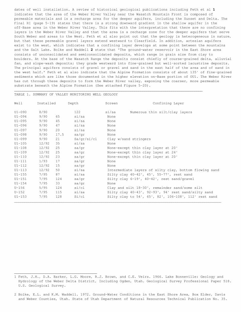
dates of well installation. A review of historical geological publications including Feth et al 1indicates that the area of the Weber River Valley near the Wasatch Mountain Front is composed ofpermeable materials and is a recharge area for the deeper aquifers, including the Sunset and Delta. TheFinal RI (page 5-19) states that there is a strong downward gradient in the shallow aquifer in theoff-Base area in the Weber River Valley. This fits with the interpretation that there are no confininglayers in the Weber River Valley and that the area is a recharge zone for the deeper aquifers that serveSouth Weber and areas to the West. Feth et al also point out that the geology is heterogeneous in nature,but that these permeable gravel layers extend westward to Clearfield. In addition, artesian aquifersexist to the west, which indicates that a confining layer develops at some point between the mountainsand the Salt Lake. Bolke and Waddell 2 state that "The ground-water reservoir in the East Shore areaconsists of unconsolidated and semiconsolidated deposits, which range in grain size from clay toboulders. At the base of the Wasatch Range the deposits consist chiefly of course-grained delta, alluvialfan, and slope-wash deposits; they grade westward into fine-grained but well-sorted lacustrine deposits.The principal aquifers consists of gravel or gravel and sand in the east half of the area and of sand inthe west half." Feth et al also indicate that the Alpine Formation consists of about 135' of fine-grainedsediments which are like those documented in the higher elevation on-Base portion of OU1. The Weber Riverhas cut through these deposits to form the Weber River valley, exposing the coarser, more permeablesubstrate beneath the Alpine Formation (See attached Figure 5-20).___________________________________________________________________________________________TABLE 1. SUMMARY OF VALLEY MONITORING WELL GEOLOGY
Well Installed Depth Screen Confining Layer
U1-090 8/90 122 si/sa Numerous thin silt/clay layersU1-094 9/90 65 si/sa NoneU1-095 9/90 45 si/sa NoneU1-096 9/90 47 si/sa NoneU1-097 9/90 20 si/sa NoneU1-098 9/90 17.5 sa/gr NoneU1-099 9/90 21 Sa/gr/si/cl Clay w/sand stringersU1-105 12/92 35 si/sa NoneU1-108 12/92 25 sa/gr None-except thin clay layer at 20'U1-109 12/92 25 sa/gr None-except thin clay layer at 24'U1-110 12/92 23 sa/gr None-except thin clay layer at 20'U1-111 1/93 17 sa/gr NoneU1-112 12/92 15 sa/gr NoneU1-113 12/92 50 si/sa Intermediate layers of silty clay, bottom flowing sandU1-155 7/95 87 si/sa Silty clay 40-42', 45', 55-77', rest sandU1-151 7/95 124 sa/gr Silty clay 6-19', 40-42', rest sand/gravelU1-154 7/95 33 sa/gr NoneU-156 5/95 124 si/cl Clay and silt 18-30', remainder sand/some siltU-152 7/95 115 si/sa Silty clay 40-43', 92-93', 94' rest sand/silty sandU1-153 7/95 128 Si/cl Silty clay to 54', 65', 82', 106-108', 112' rest sand____________________________________________________________________________________________________
________________________________________1 Feth, J.H., D.A. Barker, L.G. Moore, R.J. Brown, and C.E. Veirs. 1966. Lake Bonneville: Geology and Hydrology of the Weber Delta District, Including Ogden, Utah. Geological Survey Professional Paper 518. U.S. Geological Survey.
2 Bolke, E.L. and K.M. Waddell. 1972. Ground-Water Conditions in the East Shore Area, Box Elder, Davis and Weber Counties, Utah. State of Utah Department of Natural Resources Technical Publication No. 35.
C.1.5.3.2. Response to Comment #2. Twenty-three additional monitoring wells were recently installed inthe off-Base Weber Valley area to better understand the levels of contamination in the valley. Five ofthese wells were installed adjacent to South Weber No. 2. These five monitoring wells provide alithologic profile of the geology adjacent to South Weber No. 2 to the depths of the drinking waterproduction zone. Many of the shallower water-bearing zones can be correlated throughout the valley. Thedeepest well was drilled to a depth of 455 feet below the ground surface (bgs). The deep well penetratedthrough the Alpine Formation to the drinking water aquifer. The top of the drinking water aquifer waspenetrated at a depth of 404 feet bgs. The Alpine Formation consisted mainly of layers of unsaturatedsilty clays, silts, and silty sand. The lithology above the drinking water aquifer consists of thin,saturated, medium-grained sand layers interbedded with the finer-grained materials. The ratio of thefiner-grained, unsaturated materials to the coarser grained saturated materials is approximately 80 to 90percent finer-grained materials. The only exception was a 70 foot thick layer of coarse-grained sand andgravel located 263 to 334 feet bgs. Another layer of mainly unsaturated, silty sand was observed betweenthis gravel layer and the drinking water aquifer. The most significant silty clay layer was observed from200 to 263 feet bgs. Monitoring wells were screened in the following intervals: 46-66 feet bgs, 99 109feet bgs, 122-132 feet bgs, 175-195 feet bgs, and 433-453 feet bgs. The saturated layers tended to beconfined. With the exception of the shallowest water-bearing zone, the groundwater levels all rose abovethe screened interval. This data actually correlates reasonably wells with the drillers log from SouthWeber No. 2. The "shale" described in the drillers logs are clay layers.
C.1.5.3.3. Response to Comment #2 (cont.). The lithology was described using a continuous core. The coreis stored in core boxes for future analysis if necessary. The only areas where a continuous core was nottaken were in the coarse-grained sand and gravel zones where core could not be recovered. A wash samplewas taken in these zones. The lithology in South Weber No. 2 was described using strictly wash samples.This difference in logging methods is the probable reason for differences in the description oflithology.
C.1.5.3.4. Response to Comment #2 (cont.). Hill Air Force Base does not consider this area to be arecharge zone to the drinking water aquifer due to the numerous confining layers found and the fact thatmost of the shallow water-bearing zones are confined. The groundwater recharge areas are located furthereast toward the mouth of the Weber River. A downward gradient can be calculated in the area, but thisdoes not necessarily mean the area is a recharge zone. The drinking water aquifer does consist of sandand gravel as stated by Bolke and Waddell, but this zone is not encountered until approximately 400 feetbgs. Additional investigation in this area has shown that the lithology is not as sandy as is shown inRemedial Investigation (Figure 5-20) and numerous confining layers exist in the area.
C.1.5.3.5. Response to Comment #2 (cont.). The Final Feasibility Study provides an interpretation of thegeology that is slightly different than the Remedial Investigation. This new interpretation is based onadditional exploration points and is considered a refinement of the interpretation in the RemedialInvestigation. The Draft Groundwater Pre-Design Investigation (CH2M HILL, 1998c) and Monitoring WellInstallation and Impact Assessment of South Weber No. 2 Report (CH2M HILL, 1998b) also provided data tofurther refine geologic conditions.
C.1.5.4. Chemical Contamination Trends
C.1.5.4.1. Comment #3. In the Final Proposed Plan Operable Unit 1, HAFB states that in Non Source Areas,i.e. the Weber River Valley/South Weber downslope of the Bambrough Canal, Total 1,2-Dichloroethene (DCE)concentrations appear to be declining and that the area of the DCE plume has declined from 36 to 20acres. These observations are used to establish natural attenuation as a preferred mode of dealing withcontamination in the Valley. Natural attenuation is defined in the Final Proposed Plan as "The processwhereby contaminant concentrations are reduced through natural physical, chemical and biologicalprocesses." The Final Feasibility Study Report January 1998) defines natural attenuation to meanbiodegradation, dilution and adsorption. In any case, relying on natural attenuation precludes any activemeans of remediation of the Valley contamination plume. Because such weight has been placed on theapparent dynamics of DCE in the Valley as justification for eliminating active remediation measures, EEShas also studied the groundwater monitoring data provided by HAFB which includes data for DCE and othervolatile organic compounds (VOCs) from 1990 to 1996. In particular, we have focused on interpreting theoccurrence of VOCs in 21 monitoring wells in the Weber River Valley that were installed to monitorcontaminant migration off-Base from OU1.
C.1.5.4.2. Comment #3 (cont.). These monitoring wells were installed during three time periods. In 1990,7 wells were installed to depths varying from 17.5' to 122' with screened intervals reflecting thisoverall depth. Three of these wells are less than 20' in depth, while two penetrate to 42', 1 to 64' and1 to 119'. In 1992-1993, 7 additional wells were installed. Six of these were shallow, ranging in depthfrom 5' to 35'. A single well was installed to a depth of 50'. In 1995, 7 more wells were installed. Onewell was shallow, going to a depth of 33', while the remainder ranged in depth from 77' to 128'. Thedifferences in ages and depths of the wells introduce comparative problems into data interpretation. This
is due to different forces operating at the different depths and having only short-term results for themore recent wells. The following discussion looks at the volatile organic compounds found in these Valleywells as represented in the HAFB database.
C.1.5.4.3. Comment #3 (cont.). Table 2 provides a comparison of the VOCs found in the shallow and deepwells. Of the 18 compounds found, 10 have been found in the deep wells and 18 in the shallow wells. Thisshows that contamination from OU1 does occur in the deeper part of the off-Base aquifer. This could beoccurring due to (1) these wells being installed through the silty/clay layer and picking upcontamination that is moving down through this layer beneath OU1 of (2) due to the downward hydraulicgradient that is carrying contaminants down into the deeper aquifers from the shallow off-Base zone ofcontamination. This question has not been addressed to date.
C.1.5.4.4. Comment #3 (cont.). Table 3 shows the pattern of contamination by VOCs as a function oflocation north across the Valley from the Davis-Weber Canal to South Weber Drive. At the wells locatednearer OU1 (Davis Weber Canal), 10 VOCs were detected. At the Bambrough Canal well locations furthernorth, 16 VOCs have been detected and at mid-Valley and South Weber Drive locations still further north,13 compounds have been detected. The detection of fewer compounds nearer OU1 (the source) at firstappears to be illogical. However, this may be due to the fact that these are also the deep wells whichmay be subject to potential differences in migration pathways from OU1 (i.e. through the silty clay layerrather than along the landslide interface on the hillslope). The lower number of compounds detected inlocations further north (mid-Valley and South Weber Drive) as compared to locations. at the BambroughCanal could be indicative of less pollution reaching the locations further from OU1 or, it could be thatsufficient time has not elapsed for all the migrating compounds to reach these more distant locations.For example, ethylbenzene and vinyl chloride have been found in the wells adjacent to the BambroughCanal, but not at mid-Valley wells or those nearer South Weber Drive. There are anomalies in the data aswell, whereby some compounds such as acetone and xylene have appeared in wells further from the SourceAreas, but not in those at the closer locations. Some, such as benzene and 1,2-Dichloroethane appear tohave been missed in the mid-Valley locations while being present in wells at the Bambrough Canal and atSouth Weber Drive.______________________________________________________________________________________________TABLE 2. SUMMARY OF VALLEY MONITORING WELL GEOLOGY
Volatile, Organic Compounds Deep Shallow
1,1,1-Trichloroethane 1 71,1-Dichloroethane 3 81,2-Dichloroethane 21,1-Dichloroethene 2 1Acetone 4Benzene 2Bromodichloromethane 5Chloroform 7Dibromochloromethane 2Ethylbenzene 1Methylene Chloride 1 12Tetrachloroethylene 3 3Toluene 5 9Total 1,2-Dichlorothene 4 10Trichloroethylene 4 9Trichlorofluoromethane 2 6Vinyl Chloride 1 1Xylenes 1
Totals 10 18_________________________________________________________________________________________________
C.1.5.4.5. Comment #3 (cont.). A chronology of occurrence of the different VOCs found in these Valleywells is shown in Table 4. This is quite interesting in that it documents that an increasing number ofcompounds have been detected in more recent years. For example in 1990 only three compounds were detectedwhile in 1996, 13 compounds were detected. In fact, in the 1995-1996 monitoring period, six compoundswere detected that had not previously been found, including benzene and vinyl chloride, both known humancarcinogens.
C.1.5.4.6. Comment #3 (cont.). The HAFB database was used to generate plots of each VOC compound and itsconcentration over time in the Valley wells. Only Vocs with three or more data points and those found in1996 (the most recent data) were included. Tables showing the maximum annual VOC concentrations for eachwell and the plots are included in the Appendix. The following discussion does not address each well and
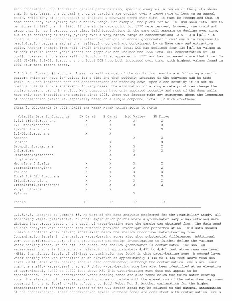
each contaminant, but focuses on general patterns using specific examples. A review of the plots showsthat in most cases, the contaminant concentrations are cycling over a range more or less on an annualbasis. While many of these appear to indicate a downward trend over time, it must be recognized that insome cases they are cycling over a narrow range. For example, the plots for Well U1-090 show Total DCE tobe higher in 1996 than in 1990. If the single data point for 1990 were removed, however, one could notargue that it has increased over time. Trichloroethylene in the same well appears to decline over time,but is it declining or merely cycling over a very narrow range of concentrations (2.6 - 3.8 Ig/1)? Itcould be that these concentrations reflect variations in annual groundwater flows/levels in response toprecipitation patterns rather than reflecting contaminant containment by on Base caps and extractionwells. Another example from well U1-097 indicates that Total DCE has declined from 130 Ig/1 to values ator near zero in recent years (note: the graph did not include the 1990 Total DCE concentration of 130ug/l). However, in the same well, chloroform first appeared in 1995 and has increased since that time. Inwell U1-099, 1,1-Dichloroethane and Total DCE have both increased over time, with highest values found in1996 (our most recent data).
C.1.5.4.7. Comment #3 (cont.). These, as well as most of the monitoring results are following a cyclicpattern which can have low values for a time and then suddenly increase or the converse can be true.While HAFB has indicated that the concentrations are trending down, upon close scrutiny it is not soobvious this is a true statement. In many cases, the elimination of a single data point can change theentire apparent trend in a plot. Many compounds have only appeared recently and most of the deep wellshave only been installed and sampled since 1995. These two factors make any statement about the lesseningof contamination premature, especially based on a single compound, Total 1,2-Dichloroethene.______________________________________________________________________________________________TABLE 3. OCCURRENCE OF VOCS ACROSS THE WEBER RIVER VALLEY SOUTH TO NORTH
Volatile Organic Compounds DW Canal B Canal Mid Valley SW Drive1,1,1-Trichloroethane X X X X1,1-Dichloroethane X X X X1,2-Dichloroethane X X1,1-Dichloroethane X XAcetone X XBenzene X XBromodichloromethane X X XChloroform X X XDibromochloromethane X XEthylbenzene XMethylene Chloride X X X XTetrachloroethylene X X X XToluene X X X XTotal 1,2-Dichlorothene X X X XTrichloroethylene X X X XTrichlorofluorornethane X X X XVinyl Chloride X XXylenes X
Totals 10 16 13 13______________________________________________________________________________________________
C.1.5.4.8. Response to Comment #3. As part of the data analysis performed for the Feasibility Study, allmonitoring wells, piezometers, or other exploration points where a groundwater sample was obtained weredivided into groups based on the depth of water-bearing zone the sample was obtained from. The data usedin this analysis were obtained from numerous previous investigations performed at OU1 This data showednumerous confined water bearing zones exist below the shallow unconfined water-bearing zone.Contamination levels in the various water-bearing zones also show substantial differences. Additionalwork was performed as part of the groundwater pre-design investigation to further define the variouswater-bearing zones. In the off-Base areas, the shallow groundwater is contaminated. The shallowwater-bearing zone is located at an elevation of approximately 4,475 to 4,465 feet above mean sea level(MSL). The highest levels of off-Base contamination are found in this water-bearing zone. A second layerwater bearing zone was identified at an elevation of approximately 4,445 to 4,430 feet above mean sealevel (MSL). This water-bearing zone is also contaminated, although the contamination levels are lowerthan the shallow water-bearing zone. A third water-bearing zone has also been identified at an elevationof approximately 4,420 to 4,400 feet above MSL This water-bearing zone does not appear to becontaminated. Other non-contaminated water-bearing zones are also found below the third water-bearingzone. The elevation of these water-bearing zones correlate with the elevations of the water-bearing zonesobserved in the monitoring wells adjacent to South Weber No. 2. Another explanation for the higherconcentrations of contamination closer to the OU1 source areas may be related to the natural attenuationof the contamination. These contamination levels in these zones are consistent with contamination levels
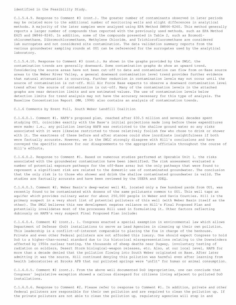
identified in the Feasibility Study.
C.1.5.4.9. Response to Comment #3 (cont.). The greater number of contaminants observed in later periodsmay be related more to the additional number of monitoring wells and slight differences in analyticalmethods. A majority of the later samples were analyzed using EPA Method SW846-8260. This method generallyreports a larger number of compounds than reported with the previously used methods, such as EPA MethodE625 and SW846-8240. In addition, some of the compounds presented in Table 2, such as Bromodi-chloromethane, Dibromochloromethane, Methylene Chloride, and Trichlorofluoromethane are consideredlab surrogates and not considered site contamination. The data validation summary reports from thevarious groundwater sampling rounds at OU1 can be referenced for the surrogates used by the analyticallaboratory.
C.1.5.4.10. Response to Comment #3 (cont.). As shown in the graphs provided by the SWLC, thecontamination trends are generally downward. Some contamination graphs do show an upward trend.Considering the source areas have not been cut-off to date and contamination can flow from on-Base sourceareas to the Weber River Valley, a general downward contamination level trend provides further evidencethat natural attenuation is occurring. Further reduction in contamination levels may not occur until thesource of contamination is cut-off. Hill Air Force Base expects to observe a downward contamination leveltrend after the source of contamination is cut-off. Many of the contamination levels in the attachedgraphs are near detection limits and are estimated values. The use of contamination levels belowdetection limits for trend analysis may not have the accuracy necessary for this type of analysis. TheBaseline Concentration Report (MW, 1998) also contains an analysis of contamination trends.
C.1.6 Comments by Brent Poll, South Weber Landfill Coalition
C.1.6.0.1. Comment #1. HAFB's proposed plan, reached after $30.5 million and several decades spentstudying OU1, coincides exactly with the Base's initial projections made long before these expenditureswere made; i.e., any pollution leaving HAFB was restricted to the shallow ground water so any risksassociated with it were likewise restricted to those relatively foolish few who chose to drink or showerwith it. The exactness of these before and after stances could show inordinate insightfulness if bothwere factually accurate. However, we in the SWLC strongly disagree with Hill's conclusions and haveconveyed the specific reasons for our disagreements to the appropriate officials throughout the course ofHill's efforts.
C.1.6.0.2. Response to Comment #1. Based on numerous studies performed at Operable Unit 1, the risksassociated with the groundwater contamination have been identified. The risk assessment evaluated anumber of potential exposure pathways for the off-Base area; but the only pathways that were found torepresent a significant risk are related to the domestic use of contaminated groundwater. The conclusionthat the only risk is to those who shower and drink the shallow contaminated groundwater is valid. Thestudies are factually accurate and have been reviewed by the USEPA and UDEQ.
C.1.6.0.3. Comment #2. Weber Basin's deep-water well #2, located only a few hundred yards from OU1, wasrecently found to be contaminated with dozens of the same pollutants common to OU1. This well taps anaquifer which provides culinary water for about 250,000 people in Weber and Davis Counties. Hill is theprimary suspect in a very short list of potential polluters of this well (with Weber Basin itself as theother). The SWLC believes this new development negates reliance on Hill's Final Proposed Plan andpotentially invalidates most of the processes Hill used in formulating it. Other factors reflectingdubiously on HAFB's very suspect Final Proposed Plan include:
C.1.6.0.4. Comment #2 (cont.). 1. Congress enacted a special exemption in environmental law which allowsDepartment of Defense (DoD) installations to serve as Lead Agencies in cleaning up their own pollution.This leadership is a conflict-of-interest comparable to placing the fox in charge of the henhouse.Private and even other Federal polluters are not afforded this luxury. One should expect Congress to holdDoD to a higher-than-normal standard due to its historical misrepresentations relating to the Downwindersaffected by 1950s nuclear testing, the thousands of sheep deaths near Dugway, involuntary testing ofradiation on soldiers, Desert Storm biological-weapon releases, etc. Also, at our local level, HAFB formore than a decade denied that the pollution flowing into South Weber originated on Base. After lateradmitting it was the source, Hill continued denying this pollution was harmful even after learning fromhealth laboratories at Brooks AFB that our polluted springs were "unfit" for human or animal consumption.
C.1.6.0.5. Comment #2 (cont.). From the above well documented DoD improprieties, one can conclude thatCongress' legislative exception showed a callous disregard for citizens living adjacent to polluted DoDinstallations.
C.1.6.0.6. Response to Comment #2. Please refer to response to Comment #1. In addition, private and otherfederal polluters are responsible for their own pollution and are required to clean the pollution up. Ifthe private polluters are not able to clean the pollution up, regulatory agencies will step in and
remediate the pollution using remediation funds set up for this purpose. The Air Force is the leadgovernment agency responsible for environmental clean up at HAFB and funds the environmental clean upefforts. The clean up process for all polluters is regulated by the EPA and the UDEQ. Again, the studiesperformed at Operable Unit 1 were reviewed and approved by the USEPA and UDEQ. With respect to thecontamination found in South Weber No. 2, HAFB responded quickly with an investigation to determine thesource of the problem.
C.1.6.0.7. Response to Comment #2 (cont.). The purpose of the Monitoring Well Installation and ImpactAssessment of South Weber No. 2 investigation was to acquire groundwater samples from the water-bearingzones to evaluate the source of the contamination, assess the lithology of the soil materials adjacent toSouth Weber No. 2, and estimate the potential for OU1 contamination to migrate to the depths of theproduction zones of South Weber No. 2. The results of this report indicate the drinking water aquifer hasnot been contaminated by HAFB. Contamination, at concentrations similar to levels in adjacent monitoringwells, was observed in the shallow water-bearing layers. The soils between the surface and drinking wateraquifer were mainly fine-grained. Due to the fine-grained layers, the area surrounding South Weber No. 2was not found to be a recharge area. Drinking water aquifer recharge areas are located at the base of theWasatch Mountains, approximately 2-miles to the east.
C.1.6.0.8. Comment #3. 2. HAFB could have risen above its conflicted situation and still deliveredanalytical studies. Such studies would be predicated on facts and applied logic which could withstandscrutiny and serve as a solid premise for future decisions. But Hill failed to provide this objectivity.Facts tended to contradict initial projections, so they were replaced by the Base's more abstractassumptions and theories. For example:
C.1.6.0.9. Comment #3 (cont.). a. HAFB, in the early 1980s, theorized there was a convenient impermeableclay layer underneath the entire mass of OU1 which allowed the Base to envelop (through addition ofsurrounding impermeable sides) its pollution on Base. After failure of its first attempt to envelop thesource by 1990, the Base admitted there were holes in the impermeable clay later, but continued tomaintain it was so low in permeability that it would take "more than a 1000 years" for any possibleleakage to reach deep water aquifers. Hill's theory of low permeability remains an essential component inits Final Proposed Plan.
C.1.6.0.10. Comment #3 (cont.) However, there is no factual justification for this premise, and thedeep-water well below OU1 is already being polluted with ingredients closely aligned to those at the OU1source. Furthermore, studies by Weber Basin (Weston Engineering) at the well site showed nothing toseriously retard downward migration of the pollution from the Base. The absence of viable retardationsuggests millions of gallons of shallow groundwater flushed through Hill's OU1 over the last halfcentury, carrying with it massive amounts of pollution, are still sinking towards the drinking watersupply for much of the Wasatch Front. Unfortunately, Hill's $30.5 million study provides no help inmeasuring this deep-water risk as the Base's low permeability theory inaccurately set study parameters atsurface or relatively near-surface levels.
C.1.6.0.1 1. Response to Comment #3. Again, the studies performed at Operable Unit 1 were reviewed andapproved by the USEPA and UDEQ. Based on numerous exploration points that have been drilled toinvestigate OU1, clay layers exist throughout the on-and off-Base areas. The Remedial Investigation,Feasibility Study, and numerous other investigation reports describe the nature and extent of the claylayers. The recent installation of a series of monitoring wells adjacent to South Weber No. 2 and thegroundwater pre-design report further described the nature and extent of the clay layers. The results ofthese reports show that the clay layers are continuous across the site, and numerous clay layers existbetween the shallow groundwater contamination and the deeper drinking water aquifers. These reportsprovide "factual justification" for the presence of the clay layer. In addition, HAFB is not aware of a"hole in the clay layer". The presence of the clay layers limits the downward migration of contaminatedgroundwater. Due to the presence of the clay layers, the conjecture that "millions of gallons" ofcontaminated shallow groundwater are flushing to the drinking water aquifer is inaccurate.
C.1.6.0.12. Comment #4. b. Facts collected by HAFB show absolutely no controls over the types or amountsof materials dumped at OU1 throughout the 40 year active life of the site. Witnesses interviewed (to helpcharacterize contents) exclusively by Base personnel mentioned an extremely wide range of chemicals,"hundreds of drums," a "sea of drums," tanks of various description, etc. For many years, the locationwas restricted for radiation danger. Questions remain whether the munitions from Ogden Arsenal wereincluded with other disposals from that installation; and if biological and chemical-warfare componentsfound their way into the dump during the years HAFB had Air-Force-wide responsibility for those weaponsystems.
C.1.6.0.13. Comment #4 (cont.). Rather than accept into its studies the many factual uncertainties aboutthe contents of OU1 or excavate it to find out (due to proclaimed risks to the searchers), HAFB chose toinject more theories and assumptions to downsize the risks OU1 could represent. It deemed the site
equivalent to any standard municipal landfill, stated "small" amounts of munitions (includingradioactive, biological and chemical materials) "may" be present, discounted the hundreds of drums as"alleged" drums, and even suggested the Base fire department burned the contents of those drums fortraining without analyzation of their respective contents. Hill further dismissed the potential threatof its pollution by claiming once burned or flushed to the surface on the bluff below the Base, that thepollution risks were greatly dissipated; hence of no further real concern for remediation.
C.1.6.0.14. Comment #4 (cont.) Hill also elected not to fully assess the effects of the massive off basemigration of pollution (down the steep and unstable northern bluff) during the 50 years the Base waseither denying accountability or conducting studies relating to this final proposal. Instead, HAFB againtheorized that the tremendous amount of polluted water flowing into the Weber and Davis canal was madeharmless by dilution. The remainder (also massive in quantity) was deemed restricted just to shallowground water or dissipated through contact with the open air. In fact, so much has migrated off-base overthe past 50 years, it raises yet another unanswered question; i.e., Has most of the OU1 pollution alreadyleft the Base and now exists somewhere beyond the self-limited range of Hill's proposed $25 millioncorrective action (closing the barn doors after the horses have already escaped)?
C.1.6.0.15. Response to Comment #4. Hill Air Force Base recently completed the Landfills 3 and 4 SummaryInvestigation. The investigation focused on evaluating the nature and extent of landfill debris andgroundwater contamination. As part of this investigation, a search for the drums identified above wasconducted. The investigation for the drums consisted of a geophysical survey and excavation of thelandfill debris. Drums containing any kind of liquid were not observed in the landfill debris.Groundwater samples from areas throughout the landfills were obtained and sampled for munitions, chemicalwarfare degradation products, and radionuclides. The results of this investigation did not provideinformation that would change the preferred alternative. The contents of the landfill were found tocontain less contamination than previously thought.
C.1.6.0.16. Response to Comment #4 (cont.). The amount of off-Base migration of contamination wasestimated in the Feasibility Study. Approximately 390 pounds of chlorinated volatile organic compoundswere found to have migrated off-Base.
C.1.6.0.17. Comment #5.c. Hill theorized that the "only exposure scenarios which might result inunacceptable risks to humans include possible human interaction with on-base soils or groundwater, andfuture use of shallow groundwater in the Weber River Valley for drinking or showering." This is an almostnegligible window of risk. One should logically reason such limited risk, if accurate, does not warrantthe $25 million corrective action proposed by the Base.
C.1.6.0.18. Comment #5 (cont.) However, again the Base has no factual basis for inferring that it has afinite grasp of the full range of risks its pollution may represent when every other reliable authorityfreely admits that science has only scratched the surface in this relatively new field of study. Anotherview was expressed by President Clinton, in a recent State of Union Address, where he voiced concern thatno child should live within four miles of a toxic site. Demographics show people (children especially)are at risk for skin disorders, immune system deficiencies, birth defects and a host of other maladieswhen they live near toxic sites.
C.1.6.0.19. Comment #5 (cont.) South Weber Elementary is about 400 yards from OU1. Wind has blown thesupposedly "dissipated" dust from polluted areas below OU1 all over this school and the surroundingneighborhood. Likewise, the smoke from open burns of gases, chemicals and other materials at OU1 and thefire training area has floated throughout South Weber for generations. Nevertheless, HAFB ignores theseas viable pathways from the source to our children through ingestion, inhalation or absorption.Therefore, to trust HAFB's assessment of risk is to disbelieve the concerns voiced by the President andthe vast majority of the professionals in the field who insist finite risk measurements for pollution aresimply beyond present scientific capabilities. Moreover, recent developments show a multiplier effectwherein chemicals in combination are many times more hazardous than the sum of their individual parts.This is particularly troublesome at OU1 where the possible combinations are almost infinite in view ofthe multitude of chemicals found there.
C.1.6.0.20. Comment #5 (cont.) For HAFB to claim it alone has somehow transcended modern science to graspthe "only" risks at its complex OU1 site is without factual foundation and must not be taken seriously.In fact, none of Hill's repeated self-serving assumptions upon assumptions can be validated through itsown data base.
C.1.6.0.21. Response to Comment #5. The only exposure scenarios which might result in unacceptable risksto humans include possible human interaction with on-base soils or groundwater, and future use of shallowgroundwater in the Weber River Valley for drinking or showering. The Comprehensive EnvironmentalResource, Compensation and Liability Act and National Contingency Plan regulations require thatgroundwater be restored to beneficial use. Restoration of groundwater is a substantial portion of the
cost to remediate contamination at OU1 The projected capital costs and 30-year operation and maintenancecosts and for the source area and non-source areas preferred alternatives are approximately $5,900,000and $2,300,000, respectively. This equals a total cost of approximately $8,200,000.
C.1.6.0.22. Response to Comment #5 (cont.). We agree, there is some uncertainty with the assessment ofrisk to humans from pollution just as there are uncertainties in all areas of science. Again, the studiesperformed at Operable Unit 1 were in accordance with the current state of practice and in accordance withguidance from EPA and UDEQ, including the risk assessment. The studies were also reviewed and approved bythe EPA and UDEQ. In addition, due to uncertainties associated with risk assessment, the risk-basedlevels calculated in this type of study tend to be very conservative. With respect the President'scomments, it is believed the comment was in reference to active hazardous waste disposal sites currentlyreceiving wastes for disposal, rather than sites such as OU1.
C.1.6.0.23. Response to Comment #5 (cont.). The pathway for dust has been evaluated in the riskassessment and was found to be an inconsequential pathway. The on-base burning of chemicals and refusestopped in 1967. South Weber Elementary School was built in 1976 well after the burning of chemicals hadstopped. The use of jet fuel for fire training exercises stopped in 1994. The comment: "the vast majorityof the professionals in the field who insist finite risk measurements for pollution are simply beyondpresent scientific capabilities" is unreferenced and is not believed to be representative of riskassessment professionals. As stated in the paragraph above, there are uncertainties associated with riskassessment, but risks can be calculated. Risk assessments are conservative by using large factors ofsafety for public health (such as assuming higher water or soil intake) in the calculations. Chemicalscan have a multiplier effect wherein chemicals in combination are many times more hazardous than the sumof their individual parts, However, chemicals can also have a neutralizing effect on each other. Very fewchemicals are found in the off-Base areas, and the risks are relatively easily defined. In addition,there is not a current exposure pathway for on-Base chemicals.
C.1.6.0.24. Response to Comment #5 (cont.). Hill Air Force Base is unclear about what is meant by: "theway we have transcended modern science". Again, the studies performed at Operable Unit 1 were inaccordance with current practice and EPA and UDEQ requirements including the risk assessment. The studieswere also reviewed and approved by the EPA and UDEQ.
C.1.6.0.25. Comment #6.3. Utah State's Environmental Health Office has been helpful in some ways tofurther the studies of pollution on Base. However, this office is well aware of the current deep-waterpollution at SW Well #2, but has not withdrawn its support of HAFB's plan which only addressesshallow-groundwater issues. State officials reasoned that the remedial process is on-going, so anydeep-water problems could be corrected after Hill's proposed plan is approved.
C.1.6.0.26. Comment #6 (cont.) We disagree. After almost 20 years of concentrated efforts, a $30.5million dollar study, and about $25 million more to implement Hill's proposed plan; it would be highlyimplausible that the relatively cursory oversight which follows could possibly be sufficient to reversethe direction of the huge but incorrect processes which proceeded it.
C.1.6.0.27. Response to Comment #6. We disagree the process is incorrect. Again, the studies performed atOperable Unit 1 were reviewed and approved by the USEPA and UDEQ who agreed with the findings. We assumethe reference to Utah State's Environmental Health Office is the UDEQ. The UDEQ is highly concerned aboutthe contamination in South Weber No. 2 and is currently reviewing the South Weber No. 2 Monitoring WellInstallation Report (CH2M HILL, 1998b). The UDEQ supports HAFBs's efforts to investigate the cause of thecontamination.
C.1.6.0.28. Response to Comment #6 (cont.). Oversight will be required after the remediation system isconstructed. This oversight will consist of a formal review by the regulatory agencies and would beperformed on a base-wide basis every 5 years. The most current evaluation is scheduled for 1998. The nextevaluation is scheduled for 2003. The evaluation could be performed sooner if the dewatering trenches arenot performing as designed and are allowing contaminated groundwater to migrate off-Base. The design andconstruction of another alternative, such as a slurry wall, could be implemented to limit the migrationof off-Base groundwater contamination. The public will also be informed of the monitoring results througha report prepared after each monitoring event. The report will include the results of monitoring eventsas well as an assessment of the progress of the remediation effort. The report will be available forpublic inspection and possibly a condensed version will be sent to the affected property owners.
C.1.6.0.29. Comment #7.4. Since South Weber Councilman Reid Stark's death in 1994, neither the Councilnor its Restoration Agency Board (RAB) representatives have regularly attended RAB meetings or otherwiseseriously studied developments concerning OU1. The SWLC feels Hill has taken advantage of this to spindoctor data and conclusions in its favor and against the interests of the city's citizens.
C.1.6.0.30. Response to Comment #7. Hill Air Force Base sponsors the RAB to keep members of public andlocal governmental agencies informed of remediation efforts of HAFB. Hill Air Force Base also meets withlocal city governments, including the city of South Weber, to keep the cities apprised of remediationefforts. Meetings with local governments occur on an as needed basis or every 6 to 12 months per the HAFBCommunity Relations Plan. Participation in the RAB is voluntary and HAFB cannot force participation.
C.1.6.0.31. Comment #8.5. The SWLC also has become more apathetic than issues warrant. Our only excuse isthat pursuit has been difficult and maintaining enthusiasm impossible when the remedial processes havemoved so slowly, and HAFB has remained so firmly entrenched in its self-serving predispositions. However,we should have done more to hopefully preclude this project from reaching this stage while still in sucha sorry state.
C.1.6.0.32. Response to Comment #8. Hill Air Force Base strongly disagrees that HAFB is "entrenched inits self-serving predispositions" and "in such a sorry state". Again, the studies performed at OperableUnit 1 were reviewed and approved by the USEPA and UDEQ who agreed with the findings. Decisions werebased on these studies, not a predisposition to what the data should be. The data was not modified toreach a conclusion.
C.1.6.0.33. Comment #9. In conclusion, Hill's final proposed plan must not be approved. Since HAFBcertainly cannot be excluded as a cause of the deep-water pollution in Weber Basin's Well #2, thesubstance of Hill's plan fails to address the major risks everyone now knows actually exist. Moreover,the SWLC now believes the Base has proven itself incapable of objective leadership over the effort toremediate OU1 If Congress must realign its environmental laws according, then such be instigated soon astoo much time has already been wasted trying to minimize Hill's culpability rather than genuinelyremediating the risks its pollution may pose to the general public.
C.1.6.0.34. Response to Comment #9. Hill Air Force Base has taken steps to investigate the contaminationfound in South Weber No. 2 and has met the investigation requirements of the EPA and UDEQ. The results ofthis investigation are documented in the Monitoring Well Installation and Impact Assessment of SouthWeber No 2 (CH2M HILL, 1998b). The results of this report indicate that HAFB has not contaminated thedrinking water aquifer. We strongly disagree that we are incapable. The selected remedy is stronglybelieved to be protective of human health and the environment as well as be effective in the long-term.Again, the studies performed at Operable Unit 1 were in accordance with the current state of practice andin accordance with guidance from EPA and UDEQ, including the risk assessment. The studies were alsoreviewed and approved by the EPA and UDEQ. The EPA and UDEQ provide oversight of the clean up effort inaccordance with a Federal Facility Agreement under CERCLA Section 120.
C.1.7 Comments by Anonymous #2
C.1.7.0.1. The following comments were received well after the end of the public comment period. Hill AirForce Base is not legally obligated to respond to the comments, but has chosen to do so.
C.1.7.0.2. Comment #1. Have people there to tell the truth when asked something not beat around what weask.
C.1.7.0.3. Response to Comment #1. Hill Air Force Base is telling the truth and has thoroughlyinvestigated the site. The studies performed at Operable Unit 1 were in accordance with EPA and UDEQrequirements, including the risk assessment. The studies were also reviewed and approved by the EPA andUDEQ. The reports can be found in the administrative record at the Davis County Library or at HAFB. RABmeetings are a way for members of the public to receive more information on the status of clean up ofBase projects or to become involved in the process of remediating Base contamination.
C.1.7.0.4. Comment #2. When I was told that Hill AFB was just not going to dump anymore and let this runits course and check the ground water every so often I became angry. It needs to be removed before itreaches the river and before it affects other generations of people. Our animals drink the water we drinkthe water. We need it cleaned up NOW! Not 6 months or four years. NOW! We bought our home not evenknowing we were in this area 3 years ago. Where's our value in our home now! Looks are deceiving itsbeautiful here in So. Weber and the deer can't even roam free instead of transferring them last year toanother area they were killed. Fix your fences so they can't get over there or transfer the deer. Pleasedon't kill them or us. Please clean up the contamination. Please, please, please for our health, andfuture generations.
C.1.7.0.5. Response to Comment #2. Groundwater is the mechanism that brings contamination from theon-Base source areas to the South Weber area. The remediation effort at HAFB will capture thecontaminated groundwater prior to leaving the base. This will allow the off Base contamination toattenuate naturally. Cleaning up groundwater is a very difficult process that takes a considerable lengthof time. Technologies other than natural attenuation, such as pumping and treating the groundwater, will
only slightly shorten the remediation period and substantially increase the cost of remediation.Providing the public does not drink or shower with the contaminated off-base groundwater, there is norisk to the public. The residents of South Weber only drink water that is from the deep, uncontaminateddrinking water aquifer. The drinking water is regularly tested for harmful contaminants. Drinking waterwells found to be contaminated are shut down, and the public is not allowed to drink from these wells.Numerous groundwater monitoring wells are located between the contaminated groundwater and the WeberRiver. Based on testing of these monitoring wells, the groundwater contamination has not migrated to theWeber River. The contamination plume is presently located approximately 2500 feet from the Weber River.Based on groundwater monitoring over the past 8 years, the plume appears to be shrinking and is nowfurther away and from the river than in the past. The Environmental Management Directorate at HAFB doesnot have any information concerning the deer.
C.1.7.0.6. Comment #3. If it were a spill at a gas station the Federal government makes them remove thecontamination Immediately I don't feel enough is being done Especially to property owners who are withinthe area.
C.1.7.0.7. Response to Comment #3. The investigations and clean up at Operable Unit 1 have been performedin accordance with the Comprehensive Environmental Resource, Compensation and Liability Act process.
C.1.7.0.8. Comment #4. I think they talk about cleaning up but they are going to let it go until its inthe river.
C.1.7.0.9. Response to Comment #4. Numerous groundwater monitoring wells are located between thecontaminated groundwater and the Weber River. Based on the testing of these monitoring wells, thegroundwater contamination has not migrated to the Weber River.
C.1.7.0.10. Comment #5. They just want us to let it go because it might go away. We are drinking wellwater from this area. We are not lab animals that 10 year from now you can say oh we made a mistake youhave cancer and other illnesses but we'll pay you. Money does improve property and health now. Remove thecontamination.
C.1.7.0.11. Response to Comment #5. Providing the public does not drink or shower with the contaminatedoff-base groundwater, there is no risk to the public. The residents of South Weber only drink water fromthe deep, uncontaminated drinking water aquifer. The drinking water is regularly tested for harmfulcontaminants. Drinking water wells that are found to be contaminated are shut down, and the public is notallowed to drink from these wells.
C.1.8 Comments by Ms. Fern Heninger
C.1.8.0.1. Comment #1. Disbelieve premise relating to supposed clay bottom. Also question how much stillat source vs. already migrated off-base.
C.1.8.0.2. Response to Comment #1. Based on approximately 925 exploration points drilled or sampled toinvestigate OU1, clay layers exist throughout the on-and off-Base areas. The Remedial Investigation,Feasibility Study, and numerous other investigation reports describe the nature and extent of the claylayers. The recent installation of a series of monitoring wells adjacent to South Weber No. 2 and thegroundwater pre-design report further described the nature and extent of the clay layers. The results ofthese reports have shown the clay layers are continuous across the site, and numerous clay layers existbetween the shallow groundwater contamination and the deeper drinking water aquifers. These reportsprovide "factual justification" for the presence of the clay layer.
C.1.8.0.3. Response to Comment #1 (cont.). There are still substantial amounts of contamination in theon-Base areas as evidenced by the on-Base LNAPL area and the contamination levels in the chemicaldisposal pit areas.
C.1.8.0.4. Comment #2. Hill AFB understates risks and understates equally need for cleanup.
C.1.8.0.5. Response to Comment #2. Based on numerous studies performed at Operable Unit 1, the risksassociated with the groundwater contamination have been identified using scientifically valid methods.The studies are factually accurate and have been reviewed and approved by the USEPA and UDEQ. Based onthe risks defined in these studies, the method to remediate OU1 was chosen.
C.1.8.0.6. Comment #3. Too much left to nature and chance. Too little attention to full range of riskspublic around 0U1 may face.
C.1.8.0.7. Response to Comment #3. Again, based on numerous studies performed at Operable Unit 1, therisks associated with the groundwater contamination have been identified using scientifically valid
methods. The studies are factually accurate and have been reviewed and approved by the USEPA and UDEQ.
C.1.8.0.8. Comment #4. Hill much too self-serving. Hence, not trustworthy.
C.1.8.0.9. Response to Comment #4. The comment is an opinion and requires no further response.
C.1.8.0.10. Comment #5. Base must acknowledge simple fact that it does not know as much as it claimsabout the (1) source, (2) the pathways to those impacted or (3) the risks those around OU1 face.
C.1.8.0.11. Response to Comment #5. Again, based on numerous studies performed at Operable Unit 1, therisks associated with the groundwater contamination have been identified using scientifically validmethods. The studies are factually accurate and have been reviewed and approved by the USEPA and UDEQ.There are uncertainties in all scientific studies, but risk assessments are conservative as a result ofusing large factors of safety for public health (such as assuming higher water or soil intake) in thecalculations.________________________________________________________________________________________________TABLE 3. OCCURRENCE OF VOCS ACROSS THE WEBER RIVER VALLEY SOUTH TO NORTH
Volatile Organic Compounds DW Canal B Canal Mid Valley SW Drive
1,1,1-Trichloroethane X X X X1,1-Dichloroethane X X X X1,2-Dichloroethane X X1,1-Dichloroethane X XAcetone X XBenzene X XBromodichloromethane X X XChloroform X X XDibromochloromethane X XEthylbenzene XMethylene Chloride X X X XTetrachloroethylene X X X XToluene X X X XTotal 1,2-Dichlorothene X X X XTrichloroethylene X X X XTrichlorofluoromethane X X X XVinyl Chloride X XXylenes XTotals 10 16 13 13_________________________________________________________________________________________________
C.1.5.4.8. Response to Comment #3. As part of the data analysis performed for the Feasibility Study, allmonitoring wells, piezometers, or other exploration points where a groundwater sample was obtained weredivided into groups based on the depth of water-bearing zone the sample was obtained from. The data usedin this analysis were obtained from numerous previous investigations performed at OU1. This data showednumerous confined water bearing zones exist below the shallow unconfined water-bearing zone.Contamination levels in the various water-bearing zones also show substantial differences. Additionalwork was performed as part of the groundwater pre-design investigation to further define the variouswater-bearing zones. In the off-Base areas, the shallow groundwater is contaminated. The highest levelsof off-Base contamination are found in this water-bearing zone. A second layer water bearing zone wasidentified approximately 35 to 50 feet below the ground surface (bgs), at an elevation of approximately4,445 to 4,430 feet above mean sea level (MSL). This water-bearing zone is also contaminated, althoughthe contamination levels are lower than the shallow water-bearing zone. A third water-bearing zone hasalso been identified 60 to 80 feet bgs, at an elevation of approximately 4,420 to 4,400 feet above MSL.This water-bearing zone does not appear to be contaminated. Other non-contaminated water-bearing zonesare also found below the water-bearing zone at 60 to 80 feet bgs. The elevation of these water-bearingzones correlate with the elevations of the water-bearing zones observed in the monitoring wells adjacentto South Weber No. 2.
Another explanation for the higher concentrations of contamination closer to the OU1 source areas may berelated to the natural attenuation of the contamination.
C.1.5.4.9. Response to Comment #3 (cont.). The greater number of contaminants observed in later periodsmay be related more to the additional number of monitoring wells and slight differences in analyticalmethods. A majority of the later samples were analyzed using EPA Method SW846-8260. This method generallyreports a larger number of compounds than reported with the previously used methods, such as EPA MethodE625 and SW846-8240. In addition, some of the compounds presented in Table 2, such as Bromodichloro-
methane, Dibromochloromethane, Methylene Chloride, and Trichlorofluoromethane are consideredlab surrogates and not considered site contamination. The data validation summary reports from thevarious groundwater sampling rounds at OU1 can be referenced for the surrogates used by the analyticallaboratory.
C.1.5.4.10. Response to Comment #3 (cont.). As shown in the graphs provided by the SWLC, thecontamination trends are generally downward. Some contamination graphs do show an upward trend.Considering the source areas have not been cut-off to date and contamination can flow from on-Base sourceareas to the Weber River Valley, a general downward contamination level trend provides further evidencethat natural attenuation is occurring. Further reduction in contamination levels may not occur until thesource of contamination is cut-off. Hill Air Force Base expects to observe a downward contamination leveltrend after the source of contamination is cut-off. Many of the contamination levels in the attachedgraphs are near detection limits and are estimated values. The use of contamination levels belowdetection limits for trend analysis may not have the accuracy necessary for this type of analysis. TheBaseline Concentration Report (MW, 1998) also contains an analysis of contamination trends.
C.1.6 Comments by Brent Poll, South Weber Landfill Coalition
C.1.6.0.1. Comment #1. HAFB's proposed plan, reached after $30.5 million and several decades spentstudying OU1, coincides exactly with the Base's initial projections made long before these expenditureswere made; i.e., any pollution leaving HAFB was restricted to the shallow ground water so any risksassociated with it were likewise restricted to those relatively foolish few who chose to drink or showerwith it. The exactness of these before and after stances could show inordinate insightfulness if bothwere factually accurate. However, we in the SWLC strongly disagree with Hill's conclusions and haveconveyed the specific reasons for our disagreements to the appropriate officials throughout the course ofHill's efforts.
C.1.6.0.2. Response to Comment #1. Based on numerous studies performed at Operable Unit 1, the risksassociated with the groundwater contamination have been identified. The risk assessment evaluated anumber of potential exposure pathways for the off-Base area; but the only pathways that were found torepresent a significant risk are related to the domestic use of contaminated groundwater. The conclusionthat the only risk is to those who shower and drink the shallow contaminated groundwater is valid. Thestudies are factually accurate and have been reviewed by the USEPA and UDEQ.
C.1.6.0.3. Comment #2. Weber Basin's deep-water well #2, located only a few hundred yards from OU1, wasrecently found to be contaminated with dozens of the same pollutants common to OU1. This well taps anaquifer which provides culinary water for about 250,000 people in Weber and Davis Counties. Hill is theprimary suspect in a very short list of potential polluters of this well (with Weber Basin itself as theother). The SWLC believes this new development negates reliance on Hill's Final Proposed Plan andpotentially invalidates most of the processes Hill used in formulating it. Other factors reflectingdubiously on HAFB's very suspect Final Proposed Plan include:
C.1.6.0.4. Comment #2 (cont.). 1. Congress enacted a special exemption in environmental law which allowsDepartment of Defense (DoD) installations to serve as Lead Agencies in cleaning up their own pollution.This leadership is a conflict-of-interest comparable to placing the fox in charge of the henhouse.Private and even other Federal polluters are not afforded this luxury. One should expect Congress to holdDoD to a higher-than-normal standard due to its historical misrepresentations relating to the Downwindersaffected by 1950s nuclear testing, the thousands of sheep deaths near Dugway, involuntary testing ofradiation on soldiers, Desert Storm biological-weapon releases, etc. Also, at our local level, HAFB formore than a decade denied that the pollution flowing into South Weber originated on Base. After lateradmitting it was the source, Hill continued denying this pollution was harmful even after learning fromhealth laboratories at Brooks AFB that our polluted springs were "unfit" for human or animal consumption.
C.1.6.0.5. Comment #2 (cont.). From the above well documented DoD improprieties, one can conclude thatCongress' legislative exception showed a callous disregard for citizens living adjacent to polluted DoDinstallations.
C.1.6.0.6. Response to Comment #2. Please refer to response to Comment #1. In addition, private and otherfederal polluters are responsible for their own pollution and are required to clean the pollution up. Ifthe private polluters are not able to clean the pollution up, regulatory agencies will step in andremediate the pollution using remediation funds set up for this purpose. The Air Force is the leadgovernment agency responsible for environmental clean up at HAFB and funds the environmental clean upefforts. The clean up process for all polluters is regulated by the EPA and the UDEQ. Again, the studiesperformed at Operable Unit 1 were reviewed and approved by the USEPA and UDEQ. With respect to thecontamination found in South Weber No. 2, HAFB responded quickly with an investigation to determine thesource of the problem.
C.1.6.0.7. Response to Comment #2 (cont.). The purpose of the Monitoring Well Installation and ImpactAssessment of South Weber No. 2 investigation was to acquire groundwater samples from the water-bearingzones to evaluate the source of the contamination, assess the lithology of the soil materials adjacent toSouth Weber No. 2, and estimate the potential for OU1 contamination to migrate to the depths of theproduction zones of South Weber No. 2. The results of this report indicate the drinking water aquifer hasnot been contaminated by HAFB. Contamination, at concentrations similar to levels in adjacent monitoringwells, was observed in the shallow water-bearing layers. The soils between the surface and drinking wateraquifer were mainly fine-grained. Due to the fine-grained layers, the area surrounding South Weber No. 2was not found to be a recharge area. Drinking water aquifer recharge areas are located at the base of theWasatch Mountains, approximately 2-miles to the east.
C.1.6.0.8. Comment #3. 2. HAFB could have risen above its conflicted situation and still deliveredanalytical studies. Such studies would be predicated on facts and applied logic which could withstandscrutiny and serve as a solid premise for future decisions. But Hill failed to provide this objectivity.Facts tended to contradict initial projections, so they were replaced by the Base's more abstractassumptions and theories. For example:
C.1.6.0.9. Comment #3 (cont.). a. HAFB, in the early 1980s, theorized there was a convenient impermeableclay layer underneath the entire mass of OU1 which allowed the Base to envelop (through addition ofsurrounding impermeable sides) its pollution on Base. After failure of its first attempt to envelop thesource by 1990, the Base admitted there were holes in the impermeable clay later, but continued tomaintain it was so low in permeability that it would take "more than a 1000 years" for any possibleleakage to reach deep water aquifers. Hill's theory of low permeability remains an essential component inits Final Proposed Plan.
C.1.6.0.10. Comment #3 (cont.) However, there is no factual justification for this premise, and thedeep-water well below OU1 is already being polluted with ingredients closely aligned to those at the OU1source. Furthermore, studies by Weber Basin (Weston Engineering) at the well site showed nothing toseriously retard downward migration of the pollution from the Base. The absence of viable retardationsuggests millions of gallons of shallow groundwater flushed through Hill's OU1 over the last halfcentury, carrying with it massive amounts of pollution, are still sinking towards the drinking watersupply for much of the Wasatch Front. Unfortunately, Hill's $30.5 million study provides no help inmeasuring this deep-water risk as the Base's low permeability theory inaccurately set study parameters atsurface or relatively near-surface levels.
C.1.6.0.11. Response to Comment #3. Again, the studies performed at Operable Unit 1 were reviewed andapproved by the USEPA and UDEQ. Based on numerous exploration points that have been drilled toinvestigate OU1 clay layers exist throughout the on-and off-Base areas. The Remedial Investigation,Feasibility Study, and numerous other investigation reports describe the nature and extent of the claylayers. The recent installation of a series of monitoring wells adjacent to South Weber No. 2 and thegroundwater pre-design report further described the nature and extent of the clay layers. The results ofthese reports show that the clay layers are continuous across the site, and numerous clay layers existbetween the shallow groundwater contamination and the deeper drinking water aquifers. These reportsprovide "factual justification" for the presence of the clay layer. In addition, HAFB is not aware of a"hole in the clay layer". The presence of the clay layers limits the downward migration of contaminatedgroundwater. Due to the presence of the clay layers, the conjecture that "millions of gallons" ofcontaminated shallow groundwater are flushing to the drinking water aquifer is inaccurate.
C.1.6.0.12. Comment #4. b. Facts collected by HAFB show absolutely no controls over the types or amountsof materials dumped at OU1 throughout the 40 year active life of the site. Witnesses interviewed (to helpcharacterize contents) exclusively by Base personnel mentioned an extremely wide range of chemicals,"hundreds of drums," a "sea of drums," tanks of various description, etc. For many years, the locationwas restricted for radiation danger. Questions remain whether the munitions from Ogden Arsenal wereincluded with other disposals from that installation; and if biological and chemical-warfare componentsfound their way into the dump during the years HAFB had Air-Force-wide responsibility for those weaponsystems.
C.1.6.0.13. Comment #4 (cont.). Rather than accept into its studies the many factual uncertainties aboutthe contents of OU1 or excavate it to find out (due to proclaimed risks to the searchers), HAFB chose toinject more theories and assumptions to downsize the risks OU1 could represent. It deemed the siteequivalent to any standard municipal landfill, stated "small" amounts of munitions (includingradioactive, biological and chemical materials) "may" be present, discounted the hundreds of drums as"alleged" drums, and even suggested the Base fire department burned the contents of those drums fortraining without analyzation of their respective contents. Hill further dismissed the potential threat ofits pollution by claiming once burned or flushed to the surface on the bluff below the Base, that thepollution risks were greatly dissipated; hence of no further real concern for remediation.
C.1.6.0.14. Comment #4 (cont.) Hill also elected not to fully assess the effects of the massive off-basemigration of pollution (down the steep and unstable northern bluff) during the 50 years the Base waseither denying accountability or conducting studies relating to this final proposal. Instead, HAFB againtheorized that the tremendous amount of polluted water flowing into the Weber and Davis canal was madeharmless by dilution. The remainder (also massive in quantity) was deemed restricted just to shallowground water or dissipated through contact with the open air. In fact, so much has migrated off-base overthe past 50 years, it raises yet another unanswered question; i.e., Has most of the OU1 pollution alreadyleft the Base and now exists somewhere beyond the self-limited range of Hill's proposed $25 millioncorrective action (closing the barn doors after the horses have already escaped)?
C.1.6.0.15. Response to Comment #4. Hill Air Force Base recently completed the Landfills 3 and 4 SummaryInvestigation. The investigation focused on evaluating the nature and extent of landfill debris andgroundwater contamination. As part of this investigation, a search for the drums identified above wasconducted. The investigation for the drums consisted of a geophysical survey and excavation of thelandfill debris. Drums containing any kind of liquid were not observed in the landfill debris.Groundwater samples from areas throughout the landfills were obtained and sampled for munitions, chemicalwarfare degradation products, and radionuclides. The results of this investigation did not provideinformation that would change the preferred alternative. The contents of the landfill were found tocontain less contamination than previously thought.
C.1.6.0.16. Response to Comment #4 (cont.). The amount of off-Base migration of contamination wasestimated in the Feasibility Study. Approximately 390 pounds of chlorinated volatile organic compoundswere found to have migrated off-Base.
C.1.6.0.17. Comment #5. c. Hill theorized that the "only exposure scenarios which might result inunacceptable risks to humans include possible human interaction with on-base soils or groundwater, andfuture use of shallow groundwater in the Weber River Valley for drinking or showering." This is an almostnegligible window of risk. One should logically reason such limited risk, if accurate, does not warrantthe $25 million corrective action proposed by the Base.
C.1.6.0.18. Comment #5 (Cont.) However, again the Base has no factual basis for inferring that it has afinite grasp of the full range of risks its pollution may represent when every other reliable authorityfreely admits that science has only scratched the surface in this relatively new field of study. Anotherview was expressed by President Clinton, in a recent State of Union Address, where he voiced concern thatno child should live within four miles of a toxic site. Demographics show people (children especially)are at risk for skin disorders, immune system deficiencies, birth defects and a host of other maladieswhen they live near toxic sites.
C.1.6.0.19. Comment #5 (cont.) South Weber Elementary is about 400 yards from OU1. Wind has blown thesupposedly "dissipated" dust from polluted areas below OU1 all over this school and the surroundingneighborhood. Likewise, the smoke from open burns of gases, chemicals and other materials at OU1 and thefire training area has floated throughout South Weber for generations. Nevertheless, HAFB ignores theseas viable pathways from the source to our children through ingestion, inhalation or absorption.Therefore, to trust HAFB's assessment of risk is to disbelieve the concerns voiced by the President andthe vast majority of the professionals in the field who insist finite risk measurements for pollution aresimply beyond present scientific capabilities. Moreover, recent developments show a multiplier effectwherein chemicals in combination are many times more hazardous than the sum of their individual parts.This is particularly troublesome at OU1 where the possible combinations are almost infinite in view ofthe multitude of chemicals found there.
C.1.6.0.20. Comment #5 (cont.) For HAFB to claim it alone has somehow transcended modern science to graspthe "only" risks at its complex OU1 site is without factual foundation and must not be taken seriously.In fact, none of Hill's repeated self-serving assumptions upon assumptions can be validated through itsown data base.
C.1.6.0.21. Response to Comment #5. The only exposure scenarios which might result in unacceptable risksto humans include possible human interaction with on-base soils or groundwater, and future use of shallowgroundwater in the Weber River Valley for drinking or showering. The Comprehensive EnvironmentalResource, Compensation and Liability Act and National Contingency Plan regulations require thatgroundwater be restored to beneficial use. Restoration of groundwater is a substantial portion of thecost to remediate contamination at OU1. The projected capital costs and 30-year operation and maintenancecosts and for the source area and non-source areas preferred alternatives are approximately $5,900,000and $2,300,000, respectively. This equals a total cost of approximately $8,200,000.
C.1.6.0.22. Response to Comment #5 (cont.). We agree, there is some uncertainty with the assessment ofrisk to humans from pollution just as there are uncertainties in all areas of science. Again, the studiesperformed at Operable Unit 1 were in accordance with the current state of practice and in accordance with
guidance from EPA and UDEQ, including the risk assessment. The studies were also reviewed and approved bythe EPA and UDEQ. In addition, due to uncertainties associated with risk assessment, the risk-basedlevels calculated in this type of study tend to be very conservative. With respect the President'scomments, it is believed the comment was in reference to active hazardous waste disposal sites currentlyreceiving wastes for disposal, rather than sites such as OU1.
C.1.6.0.23. Response to Comment #5 (cont.). The pathway for dust has been evaluated in the riskassessment and was found to be an inconsequential pathway. The on-base burning of chemicals and refusestopped in 1967. South Weber Elementary School was built in 1976 well after the burning of chemicals hadstopped. The use of jet fuel for fire training exercises stopped in 1994. The comment: "the vast majorityof the professionals in the field who insist finite risk measurements for pollution are simply beyondpresent scientific capabilities" is unreferenced and is not believed to be representative of riskassessment professionals. As stated in the paragraph above, there are uncertainties associated with riskassessment, but risks can be calculated. Risk assessments are conservative by using large factors ofsafety for public health (such as assuming higher water or soil intake) in the calculations. Chemicalscan have a multiplier effect wherein chemicals in combination are many times more hazardous than the sumof their individual parts. However, chemicals can also have a neutralizing effect on each other. Very fewchemicals are found in the off-Base areas, and the risks are relatively easily defined. In addition,there is not a current exposure pathway for on-Base chemicals.
C.1.6.0.24. Response to Comment #5 (cont.). Hill Air Force Base is unclear about what is meant by: "theway we have transcended modern science". Again, the studies performed at Operable Unit 1 were inaccordance with current practice and EPA and UDEQ requirements including the risk assessment. The studieswere also reviewed and approved by the EPA and UDEQ.
C.1.6.0.25. Comment #6.3. Utah State's Environmental Health Office has been helpful in some ways tofurther the studies of pollution on Base. However, this office is well aware of the current deep-waterpollution at SW Well #2, but has not withdrawn its support of HAFB's plan which only addressesshallow-groundwater issues. State officials reasoned that the remedial process is on-going, so anydeep-water problems could be corrected after Hill's proposed plan is approved.
C.1.6.0.26. Comment #6 (cont.) We disagree. After almost 20 years of concentrated efforts, a $30.5million dollar study, and about $25 million more to implement Hill's proposed plan; it would be highlyimplausible that the relatively cursory oversight which follows could possibly be sufficient to reversethe direction of the huge but incorrect processes which proceeded it.
C.1.6.0.27. Response to Comment #6. We disagree the process is incorrect. Again, the studies performed atOperable Unit 1 were reviewed and approved by the USEPA and UDEQ who agreed with the findings. We assumethe reference to Utah State's Environmental Health Office is the UDEQ. The UDEQ is highly concerned aboutthe contamination in South Weber No. 2 and is currently reviewing the South Weber No. 2 Monitoring WellInstallation Report (CH2M HILL, 1998b). The UDEQ supports HAFBs's efforts to investigate the cause of thecontamination.
C.1.6.0.28. Response to Comment #6 (cont.). Oversight will be required after the remediation system isconstructed. This oversight will consist of a formal review by the regulatory agencies and would beperformed on a base-wide basis every 5 years. The most current evaluation is scheduled for 1998. The nextevaluation is scheduled for 2003. The evaluation could be performed sooner if the dewatering trenches arenot performing as designed and are allowing contaminated groundwater to migrate off-Base. The design andconstruction of another alternative, such as a slurry wall, could be implemented to limit the migrationof off-Base groundwater contamination. The public will also be informed of the monitoring results througha report prepared after each monitoring event. The report will include the results of monitoring eventsas well as an assessment of the progress of the remediation effort. The report will be available forpublic inspection and possibly a condensed version will be sent to the affected property owners.
C.1.6.0.29. Comment #7.4. Since South Weber Councilman Reid Stark's death in 1994, neither the Councilnor its Restoration Agency Board (RAB) representatives have regularly attended RAB meetings or otherwiseseriously studied developments concerning OU1. The SWLC feels Hill has taken advantage of this to spindoctor data and conclusions in its favor and against the interests of the city's citizens.
C.1.6.0.30. Response to Comment #7. Hill Air Force Base sponsors the RAB to keep members of public andlocal governmental agencies informed of remediation efforts of HAFB. Hill Air Force Base also meets withlocal city governments, including the city of South Weber, to keep the cities apprised of remediationefforts. Meetings with local governments occur on an as needed basis or every 6 to 12 months per the HAFBCommunity Relations Plan. Participation in the RAB is voluntary and HAFB cannot force participation.
C.1.6.0.31. Comment #8.5. The SWLC also has become more apathetic than issues warrant. Our only excuse isthat pursuit has been difficult and maintaining enthusiasm impossible when the remedial processes have
moved so slowly, and HAFB has remained so firmly entrenched in its self-serving predispositions. However,we should have done more to hopefully preclude this project from reaching this stage while still in sucha sorry state.
C.1.6.0.32. Response to Comment #8. Hill Air Force Base strongly disagrees that HAFB is entrenched in itsself-serving predispositions" and "in such a sorry state". Again, the studies performed at Operable Unit1 were reviewed and approved by the USEPA and UDEQ who agreed with the findings. Decisions were based onthese studies, not a predisposition to what the data should be. The data was not modified to reach aconclusion.
C.1.6.0.33. Comment #9. In conclusion, Hill's final proposed plan must not be approved. Since HAFBcertainly cannot be excluded as a cause of the deep-water pollution in Weber Basin's Well #2, thesubstance of Hill's plan fails to address the major risks everyone now knows actually exist. Moreover,the SWLC now believes the Base has proven itself incapable of objective leadership over the effort toremediate OU1. If Congress must realign its environmental laws according, then such be instigated soon astoo much time has already been wasted trying to minimize Hill's culpability rather than genuinelyremediating the risks its pollution may pose to the general public.
C.1.6.0.34. Response to Comment #9. Hill Air Force Base has taken steps to investigate the contaminationfound in South Weber No. 2 and has met the investigation requirements of the EPA and UDEQ. The results ofthis investigation are documented in the Monitoring Well Installation and Impact Assessment of SouthWeber No 2 (CH2M HILL, 1998b). The results of this report indicate that HAFB has not contaminated thedrinking water aquifer. We strongly disagree that we are incapable. The selected remedy is stronglybelieved to be protective of human health and the environment as well as be effective in the long-term.Again, the studies performed at Operable Unit 1 were in accordance with the current state of practice andin accordance with guidance from EPA and UDEQ, including the risk assessment. The studies were alsoreviewed and approved by the EPA and UDEQ. The EPA and UDEQ provide oversight of the clean up efforts byan executive order signed by the President of the United States.
C.1.7 Comments by Anonymous #2
C.1.7.0.1. The following comments were received well after the end of the public comment period. Hill AirForce Base is not legally obligated to respond to the comments, but has chosen to do so.
C.1.7.0.2. Comment #1. Have people there to tell the truth when asked something not beat around what weask.
C.1.7.0.3. Response to Comment #1. Hill Air Force Base is telling the truth and has thoroughlyinvestigated the site. The studies performed at Operable Unit 1 were in accordance with EPA and UDEQrequirements, including the risk assessment. The studies were also reviewed and approved by the EPA andUDEQ. The reports can be found in the administrative record at the Davis County Library or at HAFB. RABmeetings are a way for members of the public who would like more information on the status of clean up ofBase projects or want to become involved in the process of remediating Base contamination.
C.1.7.0.4. Comment #2. When I was told that Hill AFB was just not going to dump anymore and let this runits course and check the ground water every so often I became angry. It needs to be removed before itreaches the river and before it affects other generations of people. Our animals drink the water we drinkthe water. We need it cleaned up NOW! Not 6 months or four years. NOW! We bought our home not evenknowing we were in this area 3 years ago. Where's our value in our home now! Looks are deceiving itsbeautiful here in So. Weber and the deer can't even roam free instead of transferring them last year toanother area they were killed. Fix your fences so they can't get over there or transfer the deer. Pleasedon't kill them or us. Please clean up the contamination. Please, please, please for our health, andfuture generations.
C.1.7.0.5. Response to Comment #2. Groundwater is the mechanism that brings contamination from theon-Base source areas to the South Weber area. The remediation effort at HAFB will capture thecontaminated groundwater prior to leaving the base. This will allow the off Base contamination toattenuate naturally. Cleaning up groundwater is a very difficult process that takes a considerable lengthof time. Technologies other than natural attenuation, such as pumping and treating the groundwater, willonly slightly shorten the remediation period and substantially increase the cost of remediation.Providing the public does not drink or shower with the contaminated off-base groundwater, there is norisk to the public. The residents of South Weber only drink water that is from the deep, uncontaminateddrinking water aquifer. The drinking water is regularly tested for harmful contaminants. Drinking waterwells found to be contaminated are shut down, and the public is not allowed to drink from these wells.Numerous groundwater monitoring wells are located between the contaminated groundwater and the WeberRiver. Based on testing of these monitoring wells, the groundwater contamination has not migrated to theWeber River. The contamination plume is presently located approximately 2500 feet from the Weber River.
Based on groundwater monitoring over the past 8 years, the plume appears to be shrinking and is nowfurther away and from the river than in the past. The Environmental Management Directorate at HAFB doesnot have any information concerning the deer.
C.1.7.0.6. Comment #3. If it were a spill at a gas station the Federal government makes them remove thecontamination Immediately I don't feel enough is being done Especially to property owners who are withinthe area.
C.1.7.0.7. Response to Comment #3. The investigations and clean up at Operable Unit 1 have been performedin accordance with the Comprehensive Environmental Resource, Compensation and Liability Act process.
C.1.7.0.8. Comment #4. I think they talk about cleaning up but they are going to let it go until its inthe river.
C.1.7.0.9. Response to Comment #4. Numerous groundwater monitoring wells are located between thecontaminated groundwater and the Weber River. Based on the testing of these monitoring wells, thegroundwater contamination has not migrated to the Weber River.
C.1.7.0.10. Comment #5. They just want us to let it go because it might go away. We are drinking wellwater from this area. We are not lab animals that 10 year from now you can say oh we made a mistake youhave cancer and other illnesses but we'll pay you. Money does improve property and health now. Remove thecontamination.
C.1.7.0.11. Response to Comment #5. Providing the public does not drink or shower with the contaminatedoff-base groundwater, there is no risk to the public. The residents of South Weber only drink water fromthe deep, uncontaminated drinking water aquifer. The drinking water is regularly tested for harmfulcontaminants. Drinking water wells that are found to be contaminated are shut down, and the public is notallowed to drink from these wells.
C.1.8 Comments by Ms. Fern Heninger
C.1.8.0.1. Comment #1. Disbelieve premise relating to supposed clay bottom. Also question how much stillat source vs. already migrated off-base.
C.1.8.0.2. Response to Comment #1. Based on approximately 925 exploration points drilled or sampled toinvestigate OU1, clay layers exist throughout the on-and off-Base areas. The Remedial Investigation,Feasibility Study, and numerous other investigation reports describe the nature and extent of the claylayers. The recent installation of a series of monitoring wells adjacent to South Weber No. 2 and thegroundwater pre-design report further described the nature and extent of the clay layers. The results ofthese reports have shown the clay layers are continuous across the site, and numerous clay layers existbetween the shallow groundwater contamination and the deeper drinking water aquifers. These reportsprovide "factual justification" for the presence of the clay layer.
C.1.8.0.3. Response to Comment #1 (cont.). There are still substantial amounts of contamination in theon-Base areas as evidenced by the on-Base LNAPL area and the contamination levels in the chemicaldisposal pit areas.
C.1.8.0.4. Comment #2. Hill AFB understates risks and understates equally need for cleanup.
C.1.8.0.5. Response to Comment #2. Based on numerous studies performed at Operable Unit 1, the risksassociated with the groundwater contamination have been identified using scientifically valid methods.The studies are factually accurate and have been reviewed and approved by the USEPA and UDEQ. Based onthe risks defined in these studies, the method to remediate OU1 was chosen.
C.1.8.0.6. Comment #3. Too much left to nature and chance. Too little attention to full range of riskspublic around OU1 may face.
C.1.8.0.7. Response to Comment #3. Again, based on numerous studies performed at Operable Unit 1, therisks associated with the groundwater contamination have been identified using scientifically validmethods. The studies are factually accurate and have been reviewed and approved by the USEPA and UDEQ.
C.1.8.0.8. Comment #4. Hill much too self-serving. Hence, not trustworthy.
C.1.8.0.9. Response to Comment #4. The comment is an opinion and requires no further response.
C.1.8.0.10. Comment #5. Base must acknowledge simple fact that it does not know as much as it claimsabout the (1) source, (2) the pathways to those impacted or (3) the risks those around OU1 face.

C.1.8.0.11. Response to Comment #5. Again, based on numerous studies performed at Operable Unit 1, therisks associated with the groundwater contamination have been identified using scientifically validmethods. The studies are factually accurate and have been reviewed and approved by the USEPA and UDEQ.There are uncertainties in all scientific studies, but risk assessments are conservative as a result ofusing large factors of safety for public health (such as assuming higher water or soil intake) in thecalculations.
Appendix C-2Copies of Public Comments to the Proposed Plan
<IMG SRC 98107WF><IMG SRC 98107WG>
ORIGINAL
PLAN 1 FOR PROPOSED OPERABLE UNIT ONE PLAN
MEETING MINUTES
Held at: South Weber Elementary School 1285 Lester Avenue
South Weber, UT February 5, 1998 4:30-8:00 p.m.
Reported by: Tracy A. Covington, RPR Associated Professional Reporters (801) 322-3441
<IMG SRC 98107WH>
1 February 5th, 1998 7:30 p.m.
2
3 P R O C E E D I N G S
4
5 MR. PERKINS: My name is Mark Perkins,
6 2278 Deer Run Drive. I'm the community
7 representative on the RAB, R-A-B, Restoration
8 Advisory Board. My comments are essentially
9 concerning the source area. And I think that I
10 would sure like to see the Air Force be a little bit
11 more aggressive in their treatment of the source
12 area. I don't think it matters too much what they
13 do on the non-source area until they get aggressive
14 on the source area because that will continue to be
15 polluted until the source area is cleaned up and no
16 more pollution is flowing from it off and on into
17 the South Weber.
18 So Alternative 3 is the proposed
19 alternative, I would think that at least Alternative
20 4 which is building the slurry wall would be prudent
21 and perhaps even further than that. That's it.
22 (The matter concluded at 8:00 p.m.)
23
24
25
C E R T I F I C A T E
STATE OF UTAH ) :COUNTY OF DAVIS )
I, Tracy A. Covington, Certified Shorthand
Reporter, Registered Professional Reporter, and
Notary Public within and for the County of Davis,
State of Utah do hereby certify:
That the foregoing proceedings were taken
by before me at the time and place set forth herein
and was taken down by me in stenotype and thereafter
transcribed into typewriting under my direction and
supervision;
That the foregoing pages contain a true
and correct transcription of my said stenotype notes
so taken.
In Witness Whereof, I have subscribed my
name this 6th day of February, 1998.
<IMG SRC 98107WI>
My Commission Expires:January 16, 2000
George F. Schrader 5473 South 850 East Ogden, Utah 85505-7001 February 13, 1998
Kevin BourneOO-ALC/EMR7274 Wardleigh Rd.Hill AFB, UT 84056-5137
Subject: Proposed plan For OU1, CommentsIn general I do not consider the preferred alternative for OU1 to be adequate. The dewatering and cappingof the landfills, does not satisfy the long term goals that I feel should be achieved. As the Sierra Clubrepresentative on the HAFB Restoration Advisory Board I must consider the long term restoration of thearea for habitation. The length of time necessary to reach these goals as indicated in the report may beas long as 50 years. The recent information I have had on base closures indicates that disposal of theland in closed bases has been carried out with great haste in order save mitigation of hazards over along time and at great expense. This results in relying on "Institutional Controls" which seem to havenebulous long term effectiveness.
I am sure no one of likes to consider the closing of Hill but when considering the length of timeit will take to restore OU1 to usable condition under alternative 3 this may wen outlast the base. In theshort term this looks good considering the expense required and reducing the current hazards to humans.The problem is that even if the base is still here for the next 50 years the cost of maintaining the capson the landfills and constant dewatering the could well exceed the cost of removal. I really recommendAlternative 7 because it permanently removes the problem.
As for the recommended non source (off base) alternative, No.3 I do think that it is adequatebecause the fact that natural attenuation in the area is already apparent and this are could beconsidered safe within a reasonable time. This is contingent on preventing further contamination from thesource area. Of course the plume will have to be monitored for a long time to assure that the requiredresult is achieved.
George F. Schrader Sierra Club Representative Hill Air Force Base Restoration Advisory Board
<IMG SRC 98107WJ>
<IMG SRC 98107WK>
March 13, 1998
Mr. Kevin Bourne, P.E.OO-ALC/EMR7274 Wardleigh Road, Building 5Hill Air Force Base, Utah 84056-5127
Re: Final Proposed Plan Operable Unit 1 dated January, 1998
Dear Kevin:
I have previously commented on the Draft and Revised Draft Feasibility Studies. See our lettersdated January 27 and July 10, 1997. I reiterate and incorporate those comments as applicable to the FinalProposed Plan and will not go into detail on each Alternative. During February, I attended the publicmeeting at the South Weber Elementary School. At that time, I was informed that results of additionalstudies of the landfills and Weber River Valley were forthcoming. I look forward to seeing those studiesand their implications to the residents of South Weber. However, this places us and yourselves in anawkward position of attempting to select or approve remedial alternatives while studies are ongoing. As Ihave mentioned on numerous occasions, this argues strongly for the implementation of the proposed interimmeasures that were outlined in the Engineering Evaluation/Cost Analysis for Operable Unit 1 (EE/CA 1995)while the full and final characterization of OU1 and its potential impacts on the residents of SouthWeber and the groundwater are determined. I do not believe this can be brought to a conclusion based onthe Final Proposed Plan and Final Feasibility Study while more information is being gathered that couldimpact the relevance of those decisions. Therefore, it seems the wise course to follow while thisadditional information is collected and evaluated and other data gaps are addressed, is to implementthese proposed interim measures and a real-time monitoring program to provide reassurance to South Weberthat their interests are of concern and that they will be protected from the contamination that ispresent now and is continuing to migrate into South Weber while the investigative process and remedialevaluation continues.
I have enclosed a report reviewing the geology and groundwater data for the Weber River Valley. Thisreport was prepared to provide an overview for the South Weber Landfill Coalition to assist them inevaluating proposed plans and programs. Another stimulus for this detailed look at the data was providedby the contamination found in South Weber Well #2, which showed a relationship between the contaminationon-Base and the contaminants found in the well. The possibility that contaminants from OU1 have enteredthis deep well and that it appears to lack a protective confining layer raised the level of concern aboutthe possibility that the deeper Sunset and Delta aquifers may be receiving contaminants from HAFB. Thisissue has never been fully resolved.
The summary page at the beginning of the report provides a synopsis of the results of that review.The major conclusions are that the Weber River Valley at South Weber where contamination presently existsis a recharge zone for the deeper aquifers, that these aquifers lack a protective confining layer andthat contamination from OU1 is likely migrating down into these aquifers. It also concludes that whilesome contaminants may be declining in some wells, new contaminants are appearing in the Valley in recentdata and the concentrations of some are increasing. Some of these are more toxic than those previouslydocumented. In fact, six new compounds have appeared in the 1995-1996 time period. The area of thecontamination plume itself appears to remain unchanged, reaching to South Weber Drive. Based on thisanalysis, the Final Proposed Plan does not provide adequate protection for the residents of South Weberor the deeper aquifers. Therefore, the use of extraction trenches in Source Areas and natural attenuationin Source and Non-Source areas must be rejected as a final solution. More specific comments andrecommendations follow.
Source Area Preferred Alternative - Dewatering by Extraction Trenches
This method was previously judged unsuitable for OU1 by HAFB in the EE/CA. To quote from page 3 ofthat document, "A physical barrier is preferred over a hydraulic barrier because it is a more positivemeans of containment and it is not as reliant on the operation of electromechanical equipment (i.e.extraction pumps). If a pump in a gradient control well were to fail, there would be adequate time todetect and respond to the problem before any contamination escaped the containment system. This may notbe the case with failure of a pump in an extraction french. Given that there is a steep slope immediatelydowngradient of the proposed trench location, ground water that migrates through while the pumps areinoperative could not be recovered. ... The two alternatives using hydraulic barriers also represented arisk that the resulting drawdown in the water table might allow the LNAPL to migrate into the clay,
<IMG SRC 98107WL>
potentially making future remediation efforts more difficult." Further, from page 4-10 of the EE/CA, itis stated that "Pump failure or poor pump performance could result in contaminants migrating beyond thetrench system. This is a distinct disadvantage of a hydraulic barrier compared to a physical barrier.Given the estimated life of the removal action (30 years), it is likely that the pumps will fail at somepoint and they will need to be replaced. For this reason, frequent performance monitoring is critical. "
Modeling results presented in the EE/CA indicated that only 30 of 40 particles released would becaptured. While the design of the system presented in the EE/CA is different than that in the FinalProposed Plan (1998), it appears that capture efficiency and reliability poses a significant risk thatthe Preferred Alternative will not eliminate contaminant flow into the Weber River Valley and South WeberNon Source Area. It is also of benefit to mention that the physical barrier proposed in the EE/CA was aslurry wall which is the physical containment method already used to limit groundwater flow into OU1 fromthe South. However, as is stated in the EE/CA, "Since the existing slurry wall at the site is notperforming as an effective barrier to ground water flow, there is some concern about the ability toconstrict a slurry wall that will meet the performance objectives. The reason for its limitedeffectiveness is believed to be related to poor construction quality control, such that the wall was notproperly keyed into the clay." What was not mentioned in the EE/CA was the possibility of discontinuitiesin the silty clay layer that might allow continued migration of groundwater into OU1 through or beneaththe slurry wall. Alternative 4 of the Proposed Plan, proposed a downgradient cutoff (slurry) wall to "...increase the reliability of preventing off-site migration by providing a physical barrier to groundwatermovement." This alternative was not accepted as part of the Preferred Alternative and South Weber is leftwithout the physical containment that was considered necessary in the EE/CA.
Repair and O&M of Landfill Caps and Passive Gas Vent System
Monitoring data for landfill gases presented in the Final Comprehensive Remedial Investigation (RI1995) indicated that numerous volatile organic compounds were present within the landfills including TCE(340 ppb), DCE (52,000 ppb) and Vinyl Chloride (30,000 ppb), among others. These are present in thelandfill gas and are vented to the atmosphere. Lack of monitoring within the landfills has precluded adefinitive analysis of the source(s) of these compounds. It is not known whether LNAPL or DNAPL ispresent, or whether drummed or containerized wastes are present that cannot be remediated by thePreferred Alternative in the Final Proposed Plan. A consequence of the Preferred Alternative is that thelandfills will be dewatered to varying degrees depending upon the design and operation of the proposedextraction system and the integrity of the landfill cap. Much of the disposal activity in the landfillsresulted in disposed material being present in the upper region of the landfills above the water table.Lowering the water table will leave more of the landfill contents above the saturated zone. The loweredor absent infiltration rate obtained by repair of the landfill cap will preclude water movement throughthis upper zone where the disposed material resides. The result of this is that, depending upon the stateof the contaminants in the landfills, they may persist long beyond any proposed time estimate forremediation and reappear once OU1 is deemed closed and monitoring ceases or during failures of theextraction system.
Environmental Monitoring
No monitoring program description is provided. The type (groundwater, surface water, air, soil, soilgas, other), location and frequency of monitoring as well as the contaminant list being analyzed iscritically important to the impacted populations. Depending upon these factors, the populace could beexposed to contaminants for long periods of time corresponding to the interval between samples ormonitoring events. Reliance upon mechanical pumping systems demands daily checks of performance, standbyequipment to bring on-line when problems occur and contingency planning for any foreseeable problem. Thishas not been presented in the proposed plan. The people of South Weber cannot feel comfortable withmonitoring and reporting as it has been conducted in the past and may be conducted as part of any interimor final solution. The design and implementation of any monitoring program must allow for detection ofknown and unknown contaminants both in air, water and soils. The monitoring network must be designed toprovide early warning and be comprehensive enough to address the monitoring gaps I have repeatedlypointed out. The monitoring schedule and reporting must be timely and disseminated in such a way thatresidents will be provided current results. There must be a response mechanism that will activate acontingency plan to ensure protection.
Institutional Controls
The scope (area, type and duration) of "institutional controls" is not described. Property ownersshould be informed about the limitations on their use of their property in order to make informedjudgements about the Proposed Plan and Preferred Alternative. The description for Non Source AreaAlternative 6 states. "... the use of institutional controls to prevent changes in land use or use of thegroundwater." This type of control could have long-term impacts to individual property owners as well asto the Town of South Weber if enforced. How are institutional controls to be implemented and enforced?
Decades down the road, how do we obtain assurance that innocent and unaware citizens might notinadvertently expose themselves to the contaminants through their activities?
Upgraded Seep Collection and Treatment
Under the Preferred Alternative in the Proposed Plan, it is expected that groundwater transport ofcontaminants from the OU1 Source Areas will be stopped by the extraction trench system. In that case, whyis a separate collection and treatment system necessary for seeps? The proposed plan states in thedescription of Non-Source Area Alternative 3, that "Restoration time is estimated at 5 to 50 years, witha best estimate of 12 years." This implies that these seeps are expected to flow for long periods oftime. If so, what is the source of contaminated water that allows this when all contaminated waterflowing from the Source Areas is to be captured under the Preferred Alternative? An additional point hererelates to the statement in the Preferred Alternative "Alternative 3 provides an additional protection bycollecting additional seeps/springs that are contaminated above remedial goals... ". An inspection ofFigure 13 for this Alternative shows these seep collection systems lie within and beyond the AreaExceeding PRGs in groundwater. According to the logic regarding PRGs presented in the Proposed Plan, itseems strange that a seep collection system is proposed in an area that doesn't exceed PRGs unless thereis a recognition that not all risks are accounted for, that concentrations could increase or that moreactive measures need to be taken.
Excavation of Arsenic-Contaminated Sediments
It is noted from Figure 13 for the Preferred Alternative that four seeps located to the north andeast of LF3 and LF4 contain arsenic-contaminated sediments that are to be excavated. What is the sourceof the arsenic? Since seeps arise from groundwater sources, and there is a lack of soil or groundwaterdata in this Non-Source Area, what assurance exists that this is not an indication of much morewidespread soil and groundwater contamination that is being overlooked? The results of soil gasinvestigations in the Non-Source Area to the north and east of the landfills that showed significant soilgas concentrations of Benzene, DCE and Toluene have been repeatedly pointed out to HAFB, yet the absenceof data collection in this area continues to be relied upon as proof of no contamination or threat tohuman health. This area needs to be addressed more fully in any final solution.
Natural Attenuation Monitoring
In addition to the extraction trenches natural attenuation has been proposed for remediation ofgroundwater contamination. It is also proposed as the Preferred Alternative for Non-Source Areas (theWeber River Valley), where contamination has been documented in the groundwater. According to thedescription for Non-Source Alternative 3, "Restoration time is estimated at 5 to 50 years, with a bestestimate of 12 years. " In the Glossary of the Proposed Plan, Natural Attenuation is "The process wherebycontaminant concentrations are reduced through natural physical, chemical and biological processes. " Inthe Final Feasibility Study Report for Operable Unit 1 (January 1998), natural attenuation processes arelisted as biodegradation, dilution and adsorption. Processes that are not listed include evaporation upthrough the soil to the ambient environment (air), horizontal movement of contaminants in groundwater atdepths below the shallow monitoring wells currently in place and downward movement into the deeper Deltaand Sunset Aquifers which serve as a water source for thousands of people. The attached report "Review ofOff-Base (South Weber) Groundwater Data" provides sufficient documentation that what is presumed to benatural attenuation may also include downward migration into deeper zones that are not monitored. Therecent appearance of new, previously undetected compounds in Valley monitoring wells, some of which aremore toxic than those previously found shows that reliance on this process is a risky strategy.
Interim Measures and Removal of Source Material
These facts should urge HAFB to proceed with protective interim measures to stop migration ofcontaminants both off-Base and within South Weber. These measures include extraction trenches andphysical barriers in the Source Areas of OU1, plume cutoff at the bottom of the bluff and groundwaterextraction and treatment in the plume in South Weber.
Implementation of these interim measures would provide time for HAFB to complete characterization of thesite in sufficient detail to answer the unresolved questions that persist. To conclude that removal isnot an acceptable alternative is premature. Since the EE/CA has admitted that physical containment ismore certain of success than mechanical systems, a more careful consideration of the removal option andits costs and benefits should be made. This study should consider that there are numerous Operable Unitson Base and that a secure landfill constructed on-site could have very positive benefits in terms of theeffectiveness of cleanup actions and, with cost spread over several Operable Units would be more cost-effective. In addition, to arrive at a cost estimate and reject the removal alternative at OU1 without arefined volume estimate based on the latest landfill studies, consideration of the much less expensivetransport cost of on-Base disposal, reduced monitoring and treatment costs and other benefits that may

accrue by combining this alternative with other Operable Units seems not to serve the long-term interestsof HAFB or the surrounding communities and their environment. The installation of the previously proposedinterim measures would provide the time necessary for the more careful consideration of this alternative.
<IMG SRC 98107WM>
John Carter
cc: Brent Poll (SWLC) Duane Mortensen (UDEQ) Rob Stites (EPA) Scott Paxman, Weber Basin Water Conservancy District
<IMG SRC 98107WN>
Summary Review of Off-Base (South Weber) Groundwater Data
A review of existing data and literature describing the geology and groundwater contamination in theWeber River Valley in South Weber was undertaken in order to evaluate remedial alternatives proposed inthe Final Proposed Plan for Operable Unit 1 (January, 1998). The review showed that confining layers ofimpermeable materials (clays, bedrock) needed to isolate the deeper Sunset and Delta aquifers fromcontamination are lacking. Further, the literature indicates this area is a recharge zone for the deeper aquifers that provide groundwater to South Weber and communities further west. Hydrogeologic data frominvestigations at OU1 also show that a strong downward gradient exists in the Valley. This furtherreinforces that the area is a recharge zone. Because HAFB has indicated that the plume of groundwatercontamination is shrinking in the Valley and that concentration trends are downward, an analysis ofgroundwater monitoring data for the 21 Valley wells was also undertaken. This study indicates that whilesome contaminants in some wells may be declining, other contaminants have appeared in 1995-1996 that werenot detected in prior years. Two of these, benzene and vinyl chloride are known human carcinogens. Inaddition, some compounds appear to be increasing in concentration. The most recent data we have seenindicates that nearly all wells have had contamination detected in the most recent years, therefore toconclude that the plume is shrinking may be in error. Finally, in evaluating trends of contaminantconcentration, plots were generated for the most recent and complete data. These show that trends formany compounds appear to be weak or lacking and that many of them cycle over a range on a yearly basis.Our conclusion is that relying on natural attenuation and on-Base groundwater extraction lacks certainty,is not protective of the deeper aquifers and does not provide assurance to South Weber that more toxiccontaminants are not and will not migrate into South Weber now or in the future. In fact the recentdiscovery of contamination in South Weber Well #2, which is 1200' deep and contained numerouscontaminants found in OU1, an issue that has not been resolved, further raises concerns aboutcontamination in the deeper aquifers.
<IMG SRC 98107WO>
In order to evaluate the Final Proposed Plan for Operable Unit 1, a thorough understanding of thestatus of the groundwater monitoring system and data gathered since 1990 is needed. This report isintended to provide an analysis of the geology and trends in groundwater contamination in the Weber RiverValley and South Weber based on HAFB data, The focus of this work is contamination by Volatile OrganicCompounds (VOCs).
Monitoring Wells and Valley Geology
During recent efforts to understand the contamination occurring in Weber Basin Water ConservancyDistrict/South Weber Well #2, a review of well logs for South Weber Well #2 and HAFB monitoring wells inthe Valley indicated that there is no confining layer that will protect deeper aquifers fromcontamination. The well log provided by the Weber Basin Water Conservancy District for Well #2 (attached)showed a lack of confining layers over its total depth of 1200'. A review of Figure 5-20 (attached) fromthe Final Comprehensive Remedial Investigation Report for Operable Unit 1 (1995) shows that the bestunderstanding of Valley geology is that it consists of mostly permeable formations dominated by sand.Some thin layers of clay and silty clay are shown, but are discontinuous. A summary of HAFB well logstaken from the Final RI, Appendix I is provided in Table 1. This table provide dates of wellinstallation, depth and descriptions of layers of low permeability formations through which the wellswere installed. As can be seen, the majority of the wells do not pass through confining layers. Somewells pass through silty clay layers Figure 4-3 from the Final RI is attached showing locations and datesof well installation.
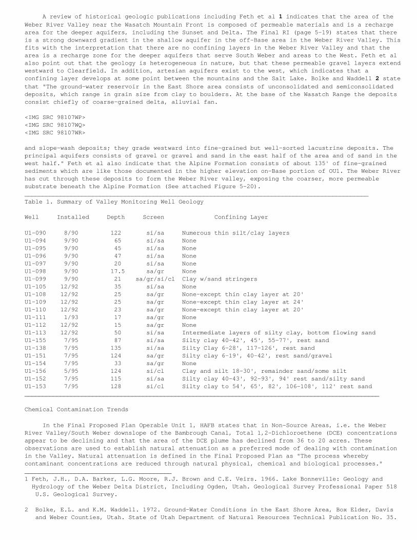
A review of historical geologic publications including Feth et al 1 indicates that the area of theWeber River Valley near the Wasatch Mountain Front is composed of permeable materials and is a rechargearea for the deeper aquifers, including the Sunset and Delta. The Final RI (page 5-19) states that thereis a strong downward gradient in the shallow aquifer in the off-Base area in the Weber River Valley. Thisfits with the interpretation that there are no confining layers in the Weber River Valley and that thearea is a recharge zone for the deeper aquifers that serve South Weber and areas to the West. Feth et alalso point out that the geology is heterogeneous in nature, but that these permeable gravel layers extendwestward to Clearfield. In addition, artesian aquifers exist to the west, which indicates that aconfining layer develops at some point between the mountains and the Salt Lake. Bolke and Waddell 2 statethat "The ground-water reservoir in the East Shore area consists of unconsolidated and semiconsolidateddeposits, which range in grain size from clay to boulders. At the base of the Wasatch Range the depositsconsist chiefly of coarse-grained delta, alluvial fan.
<IMG SRC 98107WP><IMG SRC 98107WQ><IMG SRC 98107WR>
and slope-wash deposits; they grade westward into fine-grained but well-sorted lacustrine deposits. Theprincipal aquifers consists of gravel or gravel and sand in the east half of the area and of sand in thewest half." Feth et al also indicate that the Alpine Formation consists of about 135' of fine-grainedsediments which are like those documented in the higher elevation on-Base portion of OU1. The Weber Riverhas cut through these deposits to form the Weber River valley, exposing the coarser, more permeablesubstrate beneath the Alpine Formation (See attached Figure 5-20).________________________________________________________________________________________________Table 1. Summary of Valley Monitoring Well Geology
Well Installed Depth Screen Confining Layer
U1-090 8/90 122 si/sa Numerous thin silt/clay layersU1-094 9/90 65 si/sa NoneU1-095 9/90 45 si/sa NoneU1-096 9/90 47 si/sa NoneU1-097 9/90 20 si/sa NoneU1-098 9/90 17.5 sa/gr NoneU1-099 9/90 21 sa/gr/si/cl Clay w/sand stringersU1-105 12/92 35 si/sa NoneU1-108 12/92 25 sa/gr None-except thin clay layer at 20'U1-109 12/92 25 sa/gr None-except thin clay layer at 24'U1-110 12/92 23 sa/gr None-except thin clay layer at 20'U1-111 1/93 17 sa/gr NoneU1-112 12/92 15 sa/gr NoneU1-113 12/92 50 si/sa Intermediate layers of silty clay, bottom flowing sandU1-155 7/95 87 si/sa Silty clay 40-42', 45', 55-77', rest sandU1-138 7/95 135 si/sa Silty Clay 6-28', 117-126', rest sandU1-151 7/95 124 sa/gr Silty clay 6-19', 40-42', rest sand/gravelU1-154 7/95 33 sa/gr NoneU1-156 5/95 124 si/cl Clay and silt 18-30', remainder sand/some siltU1-152 7/95 115 si/sa Silty clay 40-43', 92-93', 94' rest sand/silty sandU1-153 7/95 128 si/cl Silty clay to 54', 65', 82', 106-108', 112' rest sand___________________________________________________________________________________________________
Chemical Contamination Trends
In the Final Proposed Plan Operable Unit 1, HAFB states that in Non-Source Areas, i.e. the WeberRiver Valley/South Weber downslope of the Bambrough Canal, Total 1,2-Dichloroethene (DCE) concentrationsappear to be declining and that the area of the DCE plume has declined from 36 to 20 acres. Theseobservations are used to establish natural attenuation as a preferred mode of dealing with contaminationin the Valley. Natural attenuation is defined in the Final Proposed Plan as "The process wherebycontaminant concentrations are reduced through natural physical, chemical and biological processes."_________________________________________1 Feth, J.H., D.A. Barker, L.G. Moore, R.J. Brown and C.E. Veirs. 1966. Lake Bonneville: Geology and Hydrology of the Weber Delta District, Including Ogden, Utah. Geological Survey Professional Paper 518 U.S. Geological Survey.
2 Bolke, E.L. and K.M. Waddell. 1972. Ground-Water Conditions in the East Shore Area, Box Elder, Davis and Weber Counties, Utah. State of Utah Department of Natural Resources Technical Publication No. 35.
The Final Feasibility Study Report (January 1998) defines natural attenuation to mean biodegradation, dilution and adsorption. In any case, relying on natural attenuation precludes any active means ofremediation of the Valley contamination plume. Because dilution and adsorption. In any case, relying onnatural attenuation precludes any active means of remediation of the Valley contamination plume. Becausesuch weight has been placed on the apparent dynamics of DCE in the Valley as justification foreliminating active remediation measures, EES has also studied the groundwater monitoring data provided byHAFB which includes data for DCE and other volatile organic compounds (VOCs) from 1990 to 1996. Inparticular, we have focused on interpreting the occurrence of VOCs in 21 monitoring wells in the WeberRiver Valley that were installed to monitor contaminant migration off-Base from OU1.
These monitoring wells were installed during three time periods. In 1990, 7 wells were installed todepths varying from 17.5' to 122' with screened intervals reflecting this overall depth. Three of thesewells are less than 20' in depth, while two penetrate to 42', 1 to 64' and 1 to 119'. In 1992-1993, 7additional wells were installed. Six of these were shallow, ranging in depth from 5' to 35'. A singlewell was installed to a depth of 50'. In 1995, 7 more wells were installed. One well was shallow, goingto a depth of 33', while the remainder ranged in depth from 77' to 128'. The differences in ages anddepths of the wells introduce comparative problems into data interpretation. This is due to differentforces operating at the different depths and having only short-term results for the more recent wells.The following discussion looks at the volatile organic compounds found in these Valley wells asrepresented in the HAFB database.
Table 2 provides a comparison of the VOCs found in the shallow and deep wells. Of the 18 compoundsfound, 10 have been found in the deep wells and 18 in the shallow wells. This shows that contaminationfrom OU1 does occur in the deeper part of the off-Base aquifer. This could be occurring due to (1) thesewells being installed through the silty/clay layer and picking up contamination that is moving downthrough this layer beneath OU1 or (2) due to the downward hydraulic gradient that is carryingcontaminants down into the deeper aquifers from the shallow off-Base zone of contamination. This questionhas not been addressed to date.
Table 3 shows the pattern of contamination by VOCs as a function of location north across the Valleyfrom the Davis-Weber Canal to South Weber Drive. At the wells located nearer OU1 (Davis Weber Canal), 10VOCs were detected. At the Bambrough Canal well locations further north, 16 VOCs have been detected andat mid-Valley and South Weber Drive locations still further north, 13 compounds have been detected. Thedetection of fewer compounds nearer OU1 (the source) at first appears to be illogical. However, this maybe due to the fact that these are also the deep wells which may be subject to potential differences inmigration pathways from OU1(i.e. through the silty clay layer rather than along the landslide interfaceon the hillslope). The lower number of compounds detected in locations further north (mid-Valley andSouth Weber Drive) as compared to locations at the Bambrough Canal could be indicative of less pollutionreaching the locations further from OU1 or, it could be that sufficient time has not elapsed for all themigrating compounds to reach these more distant locations. For example, ethylbenzene and vinyl chloridehave been found in the wells adjacent to the Bambrough Canal, but not at mid-Valley wells or those nearerSouth Weber Drive. There are anomalies in the data as well, whereby some compounds such as acetone andxylene have appeared in wells further from the Source Areas, but not in those at the closer locations.Some, such as benzene and 1,2-Dichloroethane appear to have been missed in the mid-Valley locations whilebeing present in wells at the Bambrough Canal and at South Weber Drive.
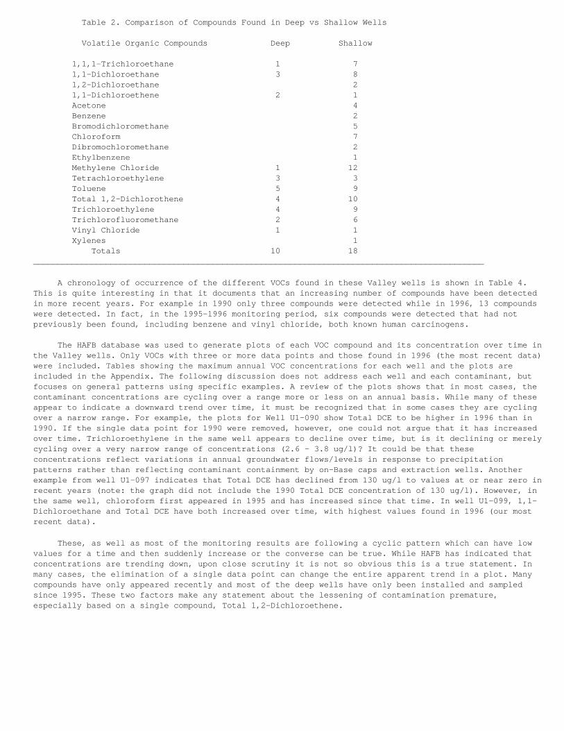
Table 2. Comparison of Compounds Found in Deep vs Shallow Wells
Volatile Organic Compounds Deep Shallow
1,1,1-Trichloroethane 1 7 1,1-Dichloroethane 3 8 1,2-Dichloroethane 2 1,1-Dichloroethene 2 1 Acetone 4 Benzene 2 Bromodichloromethane 5 Chloroform 7 Dibromochloromethane 2 Ethylbenzene 1 Methylene Chloride 1 12 Tetrachloroethylene 3 3 Toluene 5 9 Total 1,2-Dichlorothene 4 10 Trichloroethylene 4 9 Trichlorofluoromethane 2 6 Vinyl Chloride 1 1 Xylenes 1 Totals 10 18_____________________________________________________________________________________________
A chronology of occurrence of the different VOCs found in these Valley wells is shown in Table 4.This is quite interesting in that it documents that an increasing number of compounds have been detectedin more recent years. For example in 1990 only three compounds were detected while in 1996, 13 compoundswere detected. In fact, in the 1995-1996 monitoring period, six compounds were detected that had notpreviously been found, including benzene and vinyl chloride, both known human carcinogens.
The HAFB database was used to generate plots of each VOC compound and its concentration over time inthe Valley wells. Only VOCs with three or more data points and those found in 1996 (the most recent data)were included. Tables showing the maximum annual VOC concentrations for each well and the plots areincluded in the Appendix. The following discussion does not address each well and each contaminant, butfocuses on general patterns using specific examples. A review of the plots shows that in most cases, thecontaminant concentrations are cycling over a range more or less on an annual basis. While many of theseappear to indicate a downward trend over time, it must be recognized that in some cases they are cyclingover a narrow range. For example, the plots for Well U1-090 show Total DCE to be higher in 1996 than in1990. If the single data point for 1990 were removed, however, one could not argue that it has increasedover time. Trichloroethylene in the same well appears to decline over time, but is it declining or merelycycling over a very narrow range of concentrations (2.6 - 3.8 ug/l)? It could be that theseconcentrations reflect variations in annual groundwater flows/levels in response to precipitationpatterns rather than reflecting contaminant containment by on-Base caps and extraction wells. Anotherexample from well U1-097 indicates that Total DCE has declined from 130 ug/l to values at or near zero inrecent years (note: the graph did not include the 1990 Total DCE concentration of 130 ug/l). However, inthe same well, chloroform first appeared in 1995 and has increased since that time. In well U1-099, 1,1-Dichloroethane and Total DCE have both increased over time, with highest values found in 1996 (our mostrecent data).
These, as well as most of the monitoring results are following a cyclic pattern which can have lowvalues for a time and then suddenly increase or the converse can be true. While HAFB has indicated thatconcentrations are trending down, upon close scrutiny it is not so obvious this is a true statement. Inmany cases, the elimination of a single data point can change the entire apparent trend in a plot. Manycompounds have only appeared recently and most of the deep wells have only been installed and sampledsince 1995. These two factors make any statement about the lessening of contamination premature,especially based on a single compound, Total 1,2-Dichloroethene.
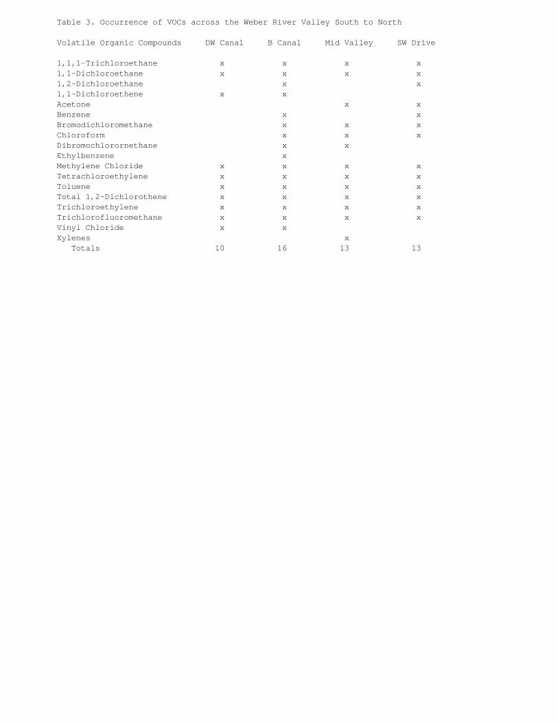
Table 3. Occurrence of VOCs across the Weber River Valley South to North
Volatile Organic Compounds DW Canal B Canal Mid Valley SW Drive
1,1,1-Trichloroethane x x x x 1,1-Dichloroethane x x x x 1,2-Dichloroethane x x 1,1-Dichloroethene x x Acetone x x Benzene x x Bromodichloromethane x x x Chloroform x x x Dibromochlorornethane x x Ethylbenzene x Methylene Chloride x x x x Tetrachloroethylene x x x x Toluene x x x x Total 1,2-Dichlorothene x x x x Trichloroethylene x x x x Trichlorofluoromethane x x x x Vinyl Chloride x x Xylenes x Totals 10 16 13 13
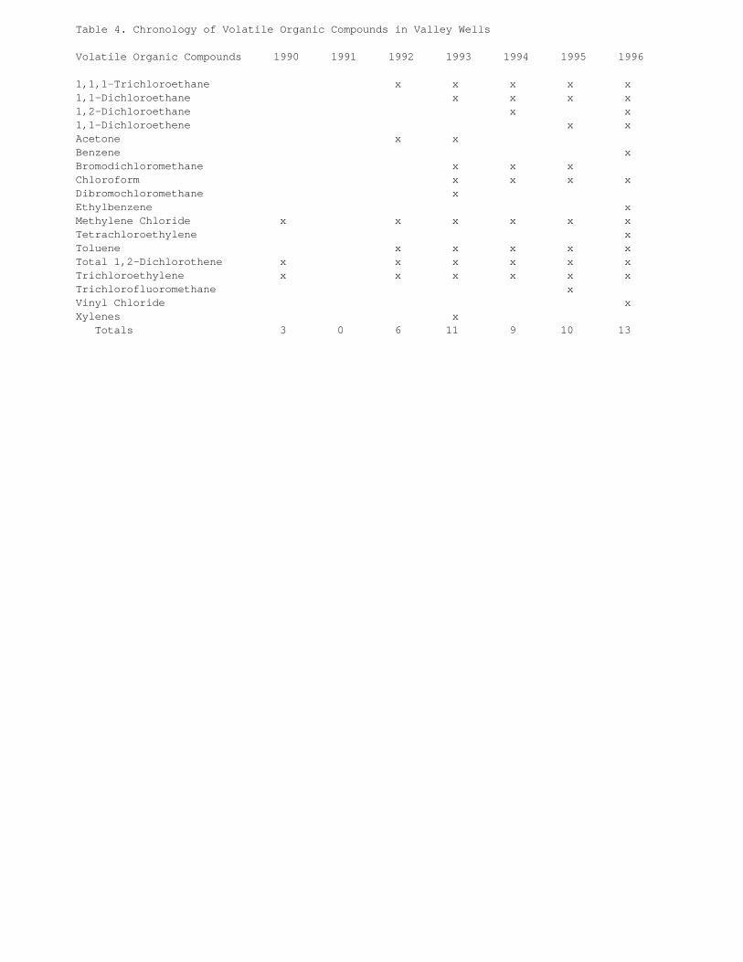
Table 4. Chronology of Volatile Organic Compounds in Valley Wells Volatile Organic Compounds 1990 1991 1992 1993 1994 1995 1996
1,1,1-Trichloroethane x x x x x 1,1-Dichloroethane x x x x 1,2-Dichloroethane x x 1,1-Dichloroethene x x Acetone x x Benzene x Bromodichloromethane x x x Chloroform x x x x Dibromochloromethane x Ethylbenzene x Methylene Chloride x x x x x x Tetrachloroethylene x Toluene x x x x x Total 1,2-Dichlorothene x x x x x x Trichloroethylene x x x x x x Trichlorofluoromethane x Vinyl Chloride x Xylenes x Totals 3 0 6 11 9 10 13
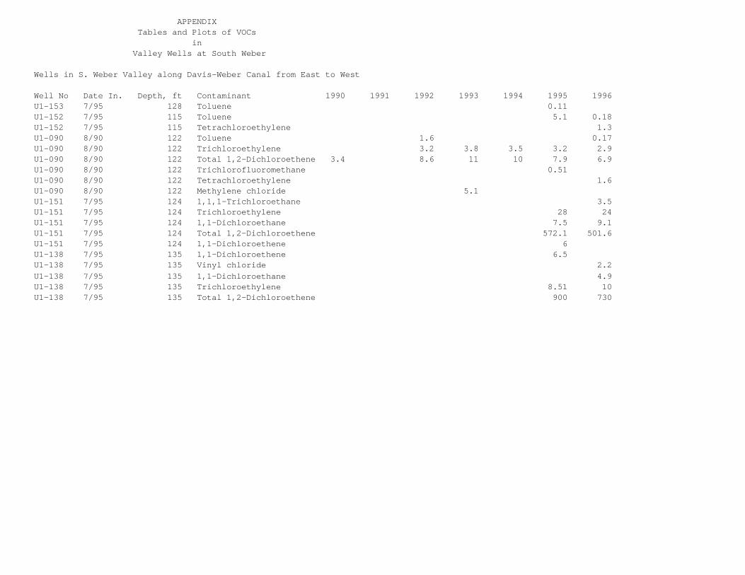
APPENDIX Tables and Plots of VOCs in Valley Wells at South Weber
Wells in S. Weber Valley along Davis-Weber Canal from East to West
Well No Date In. Depth, ft Contaminant 1990 1991 1992 1993 1994 1995 1996U1-153 7/95 128 Toluene 0.11U1-152 7/95 115 Toluene 5.1 0.18U1-152 7/95 115 Tetrachloroethylene 1.3U1-090 8/90 122 Toluene 1.6 0.17U1-090 8/90 122 Trichloroethylene 3.2 3.8 3.5 3.2 2.9U1-090 8/90 122 Total 1,2-Dichloroethene 3.4 8.6 11 10 7.9 6.9U1-090 8/90 122 Trichlorofluoromethane 0.51U1-090 8/90 122 Tetrachloroethylene 1.6U1-090 8/90 122 Methylene chloride 5.1U1-151 7/95 124 1,1,1-Trichloroethane 3.5U1-151 7/95 124 Trichloroethylene 28 24U1-151 7/95 124 1,1-Dichloroethane 7.5 9.1U1-151 7/95 124 Total 1,2-Dichloroethene 572.1 501.6U1-151 7/95 124 1,1-Dichloroethene 6U1-138 7/95 135 1,1-Dichloroethene 6.5U1-138 7/95 135 Vinyl chloride 2.2U1-138 7/95 135 1,1-Dichloroethane 4.9U1-138 7/95 135 Trichloroethylene 8.51 10U1-138 7/95 135 Total 1,2-Dichloroethene 900 730
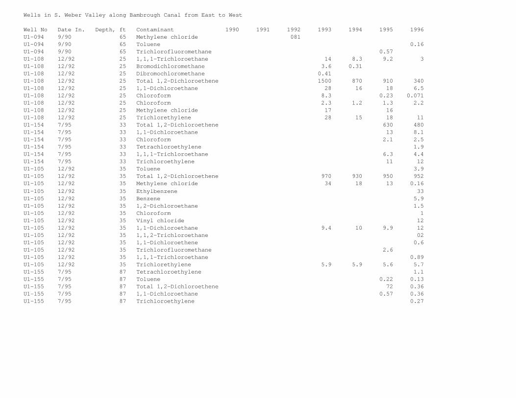
Wells in S. Weber Valley along Bambrough Canal from East to West
Well No Date In. Depth, ft Contaminant 1990 1991 1992 1993 1994 1995 1996U1-094 9/90 65 Methylene chloride 081U1-094 9/90 65 Toluene 0.16U1-094 9/90 65 Trichlorofluoromethane 0.57U1-108 12/92 25 1,1,1-Trichloroethane 14 8.3 9.2 3U1-108 12/92 25 Bromodichloromethane 3.6 0.31U1-108 12/92 25 Dibromochloromethane 0.41U1-108 12/92 25 Total 1,2-Dichloroethene 1500 870 910 340U1-108 12/92 25 1,1-Dichloroethane 28 16 18 6.5U1-108 12/92 25 Chloroform 8.3 0.23 0.071U1-108 12/92 25 Chloroform 2.3 1.2 1.3 2.2U1-108 12/92 25 Methylene chloride 17 16U1-108 12/92 25 Trichlorethylene 28 15 18 11U1-154 7/95 33 Total 1,2-Dichloroethene 630 480U1-154 7/95 33 1,1-Dichloroethane 13 8.1U1-154 7/95 33 Chloroform 2.1 2.5U1-154 7/95 33 Tetrachloroethylene 1.9U1-154 7/95 33 1,1,1-Trichloroethane 6.3 4.4U1-154 7/95 33 Trichloroethylene 11 12U1-105 12/92 35 Toluene 3.9U1-105 12/92 35 Total 1,2-Dichloroethene 970 930 950 952U1-105 12/92 35 Methylene chloride 34 18 13 0.16U1-105 12/92 35 Ethylbenzene 33U1-105 12/92 35 Benzene 5.9U1-105 12/92 35 1,2-Dichloroethane 1.5U1-105 12/92 35 Chloroform 1U1-105 12/92 35 Vinyl chloride 12U1-105 12/92 35 1,1-Dichloroethane 9.4 10 9.9 12U1-105 12/92 35 1,1,2-Trichloroethane 02U1-105 12/92 35 1,1-Dichloroethene 0.6U1-105 12/92 35 Trichlorofluoromethane 2.6U1-105 12/92 35 1,1,1-Trichloroethane 0.89U1-105 12/92 35 Trichlorethylene 5.9 5.9 5.6 5.7U1-155 7/95 87 Tetrachloroethylene 1.1U1-155 7/95 87 Toluene 0.22 0.13U1-155 7/95 87 Total 1,2-Dichloroethene 72 0.36 U1-155 7/95 87 1,1-Dichloroethane 0.57 0.36U1-155 7/95 87 Trichloroethylene 0.27
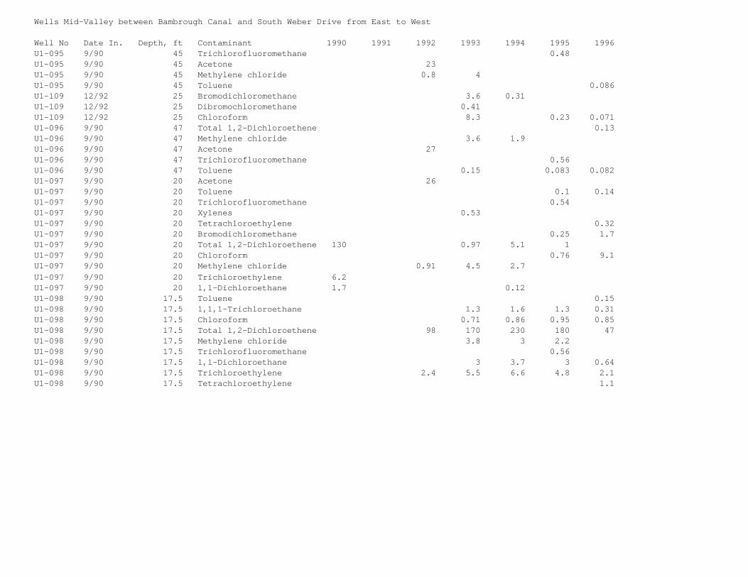
Wells Mid-Valley between Bambrough Canal and South Weber Drive from East to West
Well No Date In. Depth, ft Contaminant 1990 1991 1992 1993 1994 1995 1996U1-095 9/90 45 Trichlorofluoromethane 0.48U1-095 9/90 45 Acetone 23U1-095 9/90 45 Methylene chloride 0.8 4U1-095 9/90 45 Toluene 0.086U1-109 12/92 25 Bromodichloromethane 3.6 0.31U1-109 12/92 25 Dibromochloromethane 0.41U1-109 12/92 25 Chloroform 8.3 0.23 0.071U1-096 9/90 47 Total 1,2-Dichloroethene 0.13U1-096 9/90 47 Methylene chloride 3.6 1.9U1-096 9/90 47 Acetone 27U1-096 9/90 47 Trichlorofluoromethane 0.56U1-096 9/90 47 Toluene 0.15 0.083 0.082U1-097 9/90 20 Acetone 26U1-097 9/90 20 Toluene 0.1 0.14U1-097 9/90 20 Trichlorofluoromethane 0.54U1-097 9/90 20 Xylenes 0.53U1-097 9/90 20 Tetrachloroethylene 0.32U1-097 9/90 20 Bromodichloromethane 0.25 1.7U1-097 9/90 20 Total 1,2-Dichloroethene 130 0.97 5.1 1U1-097 9/90 20 Chloroform 0.76 9.1U1-097 9/90 20 Methylene chloride 0.91 4.5 2.7 U1-097 9/90 20 Trichloroethylene 6.2U1-097 9/90 20 1,1-Dichloroethane 1.7 0.12U1-098 9/90 17.5 Toluene 0.15U1-098 9/90 17.5 1,1,1-Trichloroethane 1.3 1.6 1.3 0.31U1-098 9/90 17.5 Chloroform 0.71 0.86 0.95 0.85U1-098 9/90 17.5 Total 1,2-Dichloroethene 98 170 230 180 47U1-098 9/90 17.5 Methylene chloride 3.8 3 2.2U1-098 9/90 17.5 Trichlorofluoromethane 0.56U1-098 9/90 17.5 1,1-Dichloroethane 3 3.7 3 0.64U1-098 9/90 17.5 Trichloroethylene 2.4 5.5 6.6 4.8 2.1U1-098 9/90 17.5 Tetrachloroethylene 1.1
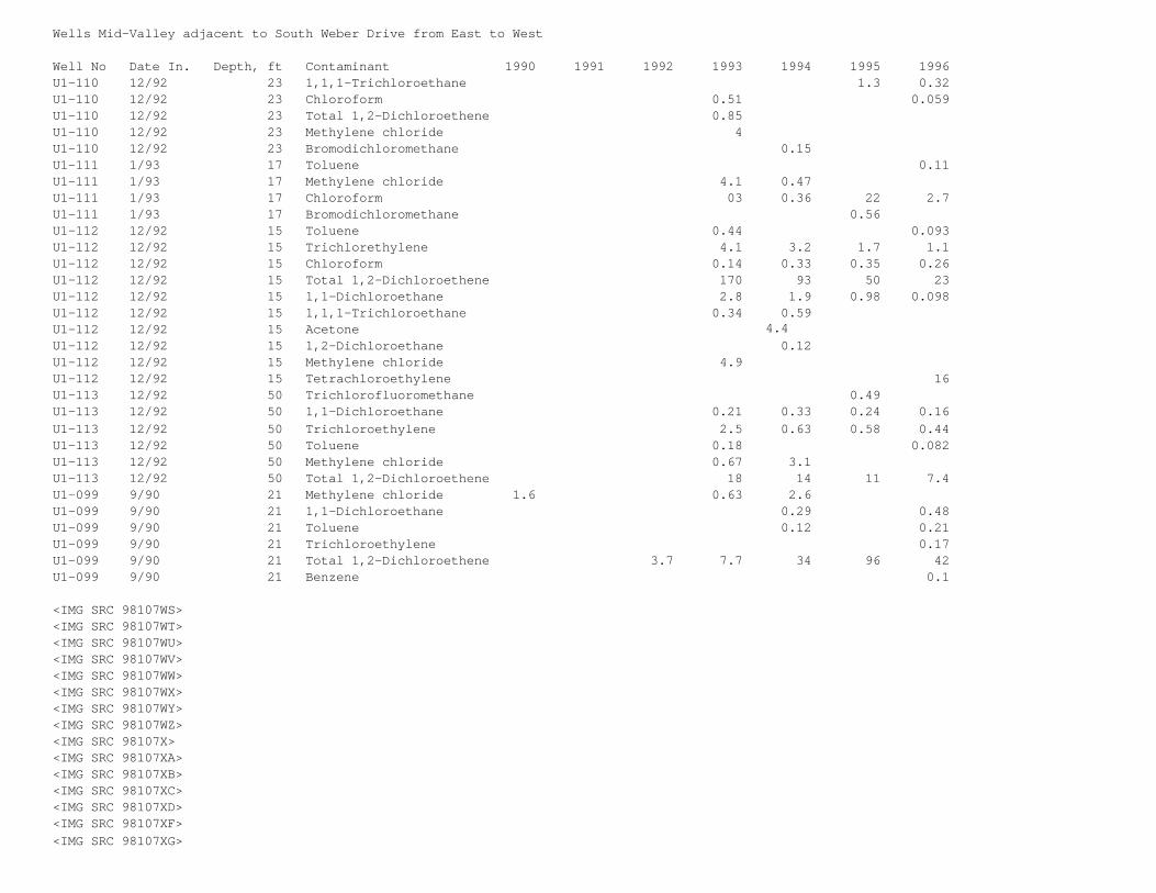
Wells Mid-Valley adjacent to South Weber Drive from East to West
Well No Date In. Depth, ft Contaminant 1990 1991 1992 1993 1994 1995 1996U1-110 12/92 23 1,1,1-Trichloroethane 1.3 0.32U1-110 12/92 23 Chloroform 0.51 0.059U1-110 12/92 23 Total 1,2-Dichloroethene 0.85U1-110 12/92 23 Methylene chloride 4U1-110 12/92 23 Bromodichloromethane 0.15U1-111 1/93 17 Toluene 0.11U1-111 1/93 17 Methylene chloride 4.1 0.47U1-111 1/93 17 Chloroform 03 0.36 22 2.7U1-111 1/93 17 Bromodichloromethane 0.56U1-112 12/92 15 Toluene 0.44 0.093U1-112 12/92 15 Trichlorethylene 4.1 3.2 1.7 1.1U1-112 12/92 15 Chloroform 0.14 0.33 0.35 0.26U1-112 12/92 15 Total 1,2-Dichloroethene 170 93 50 23U1-112 12/92 15 1,1-Dichloroethane 2.8 1.9 0.98 0.098U1-112 12/92 15 1,1,1-Trichloroethane 0.34 0.59 U1-112 12/92 15 Acetone 4.4U1-112 12/92 15 1,2-Dichloroethane 0.12U1-112 12/92 15 Methylene chloride 4.9U1-112 12/92 15 Tetrachloroethylene 16U1-113 12/92 50 Trichlorofluoromethane 0.49U1-113 12/92 50 1,1-Dichloroethane 0.21 0.33 0.24 0.16U1-113 12/92 50 Trichloroethylene 2.5 0.63 0.58 0.44U1-113 12/92 50 Toluene 0.18 0.082U1-113 12/92 50 Methylene chloride 0.67 3.1U1-113 12/92 50 Total 1,2-Dichloroethene 18 14 11 7.4U1-099 9/90 21 Methylene chloride 1.6 0.63 2.6 U1-099 9/90 21 1,1-Dichloroethane 0.29 0.48U1-099 9/90 21 Toluene 0.12 0.21U1-099 9/90 21 Trichloroethylene 0.17U1-099 9/90 21 Total 1,2-Dichloroethene 3.7 7.7 34 96 42U1-099 9/90 21 Benzene 0.1
<IMG SRC 98107WS><IMG SRC 98107WT><IMG SRC 98107WU><IMG SRC 98107WV><IMG SRC 98107WW><IMG SRC 98107WX><IMG SRC 98107WY><IMG SRC 98107WZ><IMG SRC 98107X><IMG SRC 98107XA><IMG SRC 98107XB><IMG SRC 98107XC><IMG SRC 98107XD><IMG SRC 98107XF><IMG SRC 98107XG>
<IMG SRC 98107XH>
Kevin BourneOO-ALC/EMR7274 Wardleigh RoadHill AFB, Utah 84056-5137
Re: Final Proposed Plan OU1
Dear Kevin,
This is the first of two responses from the South Weber Landfill Coalition (SWLC) regarding the subjectplan; and a request for a 30-day extension to your 14 Feb 98 deadline allowing our Technical Advisor (Dr.John Carter) sufficient time to fully compare it with your 14 Jan 98 release of the final OU1 FeasibilityStudy.
HAFB's proposed plan, reached after $30.5 million and several decades spent studying OU1, coincidesexactly with the Base's initial projections made long before these expenditures were made; i.e., anypollution leaving HAFB was restricted to the shallow ground water so any risks associated With it werelikewise restricted to those relatively foolish few who chose to drink or shower with it. The exactnessof these before and after stances could show inordinate insightfulness if both were factually accurate.However, we in the SWLC strongly disagree with Hill's conclusions and have conveyed the specific reasonsfor our disagreements to the appropriate officials throughout the course of Hill's efforts.
Weber Basin's deep-water well #2, located only a few hundred yards from OU1, was recently found to becontaminated with dozens of the same pollutants common to OU1. This well taps an aquifer which providesculinary water for about 250,000 people in Weber and Davis Counties. Hill is the primary suspect in avery short list of potential polluters of this well (with Weber Basin itself as the other). The SWLCbelieves this new development negates reliance on Hill's Final Proposed Plan and potentially invalidatesmost of the processes Hill used in formulating it. Other factors reflecting dubiously on HAFB's verysuspect final proposal include:
(1) Congress enacted a special exception in environmental law which allows Department of Defense (DoD) installations to serve as Lead Agencies in cleaning up their own pollution. This leadership is a conflict-of-interest comparable to placing the fox in charge of the henhouse. Private and even other Federal polluters are not afforded this luxury. One should expect Congress to hold DoD to a higher-than-normal standard due to its historical misrepresentations relating to the Downwinders affected by 1950s nuclear testing, the thousands of sheep deaths near Dugway, involuntary testing of radiation on soldiers, Desert Storm biological-weapon releases, etc. Also, at our local level , HAFB for more than a decade denied that the pollution flowing into South Weber originated on Base. After later admitting it was the source, Hill continued denying this pollution was harmful even after learning from health laboratories at Brooks AFB that our polluted springs were "unfit" for human or animal consumption.
From the above well documented DoD improprieties, one can conclude that Congress' legislative exceptionshowed a callous disregard for citizens living adjacent to polluted DoD installations.
(2) HAFB could have risen above its conflicted situation and still delivered analytical studies. Such studies would be predicated on facts and applied logic which could withstand scrutiny and serve as a solid premise for future decisions. But Hill failed to provide this objectivity. Facts tended to contradict initial projections, so they were replaced by the Base's more abstract assumptions and theories. For example:
(a) HAFB, in the early 1980s, theorized there was a convenient impermeable clay layer underneath the entire mass of OU1 which allowed the Base to envelop (through addition of surrounding impermeable sides) its pollution on Base. After failure of its first attempt to envelop the source by 1990, the Base admitted there were holes in the impermeable clay layer, but continued to maintain it was so low in permeability that it would take "more than a 1000 years" for any possible leakage to reach deep water aquifers. Hill's theory of low permeability remains an essential component in its final proposed plan.
However, there is no factual justification for this premise, and the deep-water well below OU1 is already being polluted with ingredients closely aligned to those at the OU1 source. Furthermore, studies by Weber Basin (Weston Engineering) at the well site showed nothing to seriously retard downward migration of the pollution from the Base. The absence of viable retardation suggests millions of gallons of shallow ground water flushed through Hill's OU1 over the last half century, carrying with it massive amounts of pollution, are still sinking towards the drinking water supply for much of the Wasatch Front. Unfortunately, Hill's $30.5 million study provides no help in measuring this deep-water risk as the Base's low-permeability theory inaccurately set study parameters at surface or relatively near-surface levels. (b) Facts collected by HAFB show absolutely no controls over the types or amounts of materials dumped at OU1 throughout the 40 year active life of the site. Witnesses interviewed (to help characterize contents) exclusively by Base personnel mentioned an extremely wide range of chemicals, "hundreds of drums," a "sea of drums," tanks of various description, etc. For many years, the location was restricted for radiation danger. Questions remain whether the munitions from Ogden Arsenal were included with other disposals from that installation; and if biological and chemical-warfare components found their way into the dump during the years HAFB had Air-Force-wide responsibility for those weapon systems.
Rather than accept into its studies the many factual uncertainties about the contents of OU1 or excavate it to find out (due to proclaimed risks to the searchers), HAFB chose to inject more theories and assumptions to downsize the risks OU1 could represent. It deemed the site equivalent to any standard municipal landfill, stated "small" amounts of munitions (including radioactive, biological and chemical materials) "may" be present, discounted the hundreds of drums as "alleged" drums, and even suggested the Base fire department burned the contents of those drums for training without analyzation of their respective contents. Hill further dismissed the potential threat of its pollution by claiming once burned or flushed to the surface on the bluff below the Base, that the pollution risks were greatly dissipated; hence of no further real concern for remediation.
Hill also elected not to fully assess the effects of the massive off-base migration of pollution (down the steep and unstable northern bluff) during the 50 years the Base was either denying accountability or conducting studies relating to this final proposal. Instead, HAFB again theorized that the tremendous amount of polluted water flowing into the Weber and Davis canal was made harmless by delution. The remainder (also massive in quantity) was deemed restricted just to shallow ground water or dissipated through contact with the open air. In fact, so much has migrated off-base over the past 50 years, it raises yet another unanswered question; i.e., Has most of the OU1 pollution already left the Base and now exists somewhere beyond the self-limited range of Hill's proposed $25 million corrective action (closing the barn doors after the horses have already escaped)?
(c) Hill theorized that the "only exposure scenarios which might result in unacceptable risks to humans include possible human interaction with on-base soils or ground-water, and future use of shallow groundwater in the Weber River Valley for drinking or showering." This is an almost negligible window of risk. One should logically reason such limited risk, if accurate, does not warrant the $25 million corrective action proposed by the Base.
However, again the Base has no factual basis for inferring that it has a finite grasp of the full range of risks its pollution may represent when every other reliable authority freely admits that science has only scratched the surface in this relatively new field of study. Another view was expressed by President Clinton, in a recent State of Union Address, where he voiced concern that no child should live within four miles of a toxic site. Demographics show people (children especially) are at risk for skin disorders, immune system deficiencies, birth defects and a host of other maladies when they live near toxic sites.
South Weber Elementary is about 400 yards from OU1. Wind has blown the supposedly "dissipated" dust from polluted areas below OU1 all over this school and the surrounding neighborhood. Likewise, the smoke from open burns of gases, chemicals and other materials at OU1 and the fire training area has floated throughout South Weber for generations. Nevertheless, HAFB ignores these as viable pathways from the source to our children through ingestion, inhalation or absorption. Therefore, to trust HAFB's assessment of risk is to disbelieve the concerns voiced by the President and the vast majority of the professionals in the field who insist finite risk measurements for pollution are simply beyond present scientific capabilities. Moreover, recent developments show a multiplier effect wherein chemicals in combination are many times more hazardous than the sum of their individual parts. This is particularly troublesome at OU1 where the possible combinations are almost infinite in view of the
multitude of chemicals found there.
For HAFB to claim it alone has somehow transcended modern science to grasp the "only" risks at its complex OU1 site is without factual foundation and must not be taken seriously. In fact, none of Hill's repeated self-serving assumptions upon assumptions can be validated through its own data base.
(3) Utah State's Environmental Health Office has been helpful in some ways to further the studies of pollution on Base. However, this office is well aware of current deep-water pollution at SW Well #2, but has not withdrawn its support of HAFB's plan which only addresses shallow-groundwater issues. State officials reasoned that the remedial process is on-going, so any deep-water problems could be corrected after Hill 's proposed plan is approved.
We disagree. After almost 20 Years of concentrated efforts, a $30.5 million dollar study, and about $25 million more to implement Hill's proposed plan; it would be highly implausible that the relatively cursory oversight which follows could possibly be sufficient to reverse the direction of the huge but incorrect processes which proceeded it.
(4) Since South Weber Councilman Reid Stark's death in 1994, neither the Council nor its Restoration Advisory Board (RAB) representatives have regularly attended RAB meetings or otherwise seriously studied developments concerning OU1. The SWLC feels Hill has taken advantage of this to spin doctor data and conclusions in its favor and against the interests of the city's citizens.
(5) The SWLC also has become more apathetic than issues warrant. Our only excuse is that pursuit has been difficult and maintaining enthusiasm impossible when the remedial processes have moved so slowly, and HAFB has remained so firmly entrenched in its self-serving predispositions. However, we should have done more to hopefully preclude this project from reaching this stage while still in such a sorry state.
In conclusion, Hill's final proposed plan must not be approved. Since HAFB certainly cannot be excludedas a cause of the deep-water pollution in Weber Basin's Well #2, the substance of Hill's plan fails toaddress the major risks everyone now knows actually exist. Moreover, the SWLC now believes the Base hasproven itself incapable of objective leadership over the effort to remediate OU1. If Congress mustrealign its environmental laws according, then such be instigated soon as too much time has already beenwasted trying to minimize Hill's culpability rather than genuinely remediating the risks its pollutionmay pose to the general public.
Please call if you have questions.
<IMG SRC 98107XI>
cc: Senator Bennett Senator Hatch Congressman Hansen Weber Basin Water South Weber City Utah State Environmental Health Davis County Environmental Health
<IMG SRC 98107XJ><IMG SRC 98107XK><IMG SRC 98107XL><IMG SRC 98107XM><IMG SRC 98107XN><IMG SRC 98107XO><IMG SRC 98107XP><IMG SRC 98107XQ><IMG SRC 98107XR><IMG SRC 98107XS>
Appendix C-3South Weber Landfill Coalition Comments to the
Draft and Draft Final Feasibility Study
Response to South Weber Landfill Coalition Comments on Revised Draft Final Feasibility Study Report for Operable Unit 1, Hill Air Force Base, Utah (IRP Sites LF01, LF03, WP02, FT09, OT14, FT81, and WP80)
November 1996
This section presents responses to comments on the Revised Draft Feasibility Study (FS) for Operable Unit1 (OU1) by the South Weber Landfill Coalition (SWLC). Comments by the SWLC are included as presented inthe comment letter by Dr. John G. Carter, dated January 27, 1997. Responses to comments follow thecomments.
South Weber Landfill Coalition Comments (Dr. John G. Carter):
During the past several years as Technical Advisor to the South Weber Landfill Coalition, I havemade numerous comments concerning hydrogeology investigations and characterizations, proposed interimremedial actions and risk assessments. These will not be repeated here, but many of the uncertaintiesstill remain. I have focused my comments on the Executive Summary, Introduction and Development of RAOsand Screening of Technologies presented in Sections 1 and 2 of the Revised Draft Feasibility Study.Comments (in italics) are referenced to page numbers in the FS.
The "Draft Field Manual for Site Activities at Operable Unit 1...", dated October, 1996 proposedadditional investigations in the landfill areas to: (1) estimate the volume of waste in the landfills,(2) assess contaminants in soils, leachate and groundwater below the landfill debris, (3) determine thevertical and horizontal gradients below the landfills, (4) evaluate the physical properties andcontinuity of the clay materials below the landfills, (5) evaluate the Landfill 3 magnetic anomaly area,(6) compare OU1 leachate and groundwater with other military and municipal landfills across the countryand (7) reevaluate the cost assumptions associated with the feasibility study alternative forlandfill removal.
The SWLC appreciates these planned studies which have the potential to further clarify the pictureat OU1. The same reasons that prompted these additional studies make it impossible to fully evaluate theFS until the result of those studies are available. Other factors such as the many assumptions made inthe FS coupled with the great degree of uncertainty expressed by HAFB about the ultimate effectiveness ofremedial measures also make it impossible to fully evaluate the FS at this time. However, the comments inthis document are provided to clarify the concerns of the SWLC and, hopefully suggest some alternativesthat can provide greater peace of mind to the citizens of South Weber. As Technical Advisor to the SWLC,I believe that it is imperative to implement several interim remedial actions immediately because theinvestigation and report at OU1 has extended for decades and shows no signs of being ended soon. Theinterim remedial measures that should be implemented in my view include (1) the containment alternativesproposed in the EE/CA (October 1995) to contain groundwater migrating off-site from the Source Areas, (2)plume cut-off at the bottom of the bluff (Alternative 4 for Non Source Areas), (3) hydraulic containmentat leading plume edges (Alternative 5 for Non Source Areas) and (4) groundwater collection throughout theplume (Alternative 6 for Non Source Areas.). These measures could begin the process of risk reduction andrestoration to the Non Source Areas while remedial investigations and design/development/implementationphases are taking place on Base, a process that will undoubtedly take years to complete. The cost ofthese measures is small, provides some assurance to South Weber that progress is being made and probablycost a fraction of what has been spent on investigation and reporting at OU1 to date.
Response to Comment. The OU1 area has been thoroughly investigated. Hill Air Force Base (HAFB) feels thatadequate investigation has been performed to develop a Feasibility Study (FS). The EnvironmentalProtection Agency (EPA), and State of Utah, Department of Environmental Quality (UDEQ) have approved theinvestigations and agree that enough data is available to develop an FS. Three additional investigationsare currently planned for OU1 to evaluate specific areas in the near future. If the results of theseinvestigations indicate that conditions are significantly different than identified in the FS, this datawill be incorporated into future versions of the FS, the Proposed Plan, and the Record of Decision. Thefield data from these investigations will be available prior to the final date of the documents.
Response to Comment (cont.): The author's comments suggest a need to implement interim remedial actionsimmediately. This is contrary to the views of the SWLC expressed by Brent Poll in a letter dated November14, 1995, which opposed an interim remedial action prior to the final remedy. Resources have beenrealigned to follow the conventional CERCLA process of the FS, Proposed Plan, and ROD to achieve the
remedial objectives.
PES-4 It is stated that the majority of groundwater flow leaves OU1 toward the west, with some flowmoving east, mostly emanating from springs and seeps and little migrating downhill through the landslidedebris formation. The Final Comprehensive RI, Figures 6-3 and 6-4 shows soil gas plumes along thehillside to both the north and east. The RI on page 5-23 states in paragraph 5.6.3.2 "Generalground-water flow paths at OU1 are to the north off the bench." Also, for it to emanate from springs andseeps, it has to arrive at the spring or seep in some manner. Statements like this are of great concernbecause they seem to be unrelated to the mass of data presented in the past, leading one to wonder whatelse has been missed.
Response to Comment. It appears the referenced statements are collectively presented somewhat out ofcontext. The FS also supports (Figures 1-4 and 1-5) the generalized northward flow suggested in 5.6.3.2of the RI. The FS also identifies eastward flow, as stated by the author, which is consistent with theseep and spring flow reported in the RI.
PES-5 It is stated that remedial action objectives include preventing human exposure that presents anunacceptable risk, with risk being defined as HI>1 or excess cancer risk greater than 1 x 10 -4 to 1 x 10⁻⁶. This is of great concern because the term "unacceptable" is a relative term and in this case turns onwhat is believed to be the current state of knowledge of chemical effects on humans. However, sinceknowledge of chemical effects on humans as well as ecosystems continues to grow, standards can change andbecome more strict over time. Synergistic effects and effects on sensitive individuals may be differentthan the "average" statistic or standard. It is also stated that an objective is to prevent migration ofcontaminants in excess of MCL's or the other cited risk levels beyond the Source Area perimeter. Again,this implies that continued, long-term migration of chemicals will be allowed subject to current-day"risk standards." This does not satisfy the concern of SWLC that the residents of South Weber will notcontinue to be at risk indefinitely. Other statements are made such as to "minimize the potential forhuman exposure to contaminated shallow groundwater" and "enable long-term attainment of ... remedialaction objectives". SWLC is not comfortable with vague, undefined terms or qualifiers such as this.Without firm commitments as to effectiveness and guarantees of success within a reasonable time frame,SWLC doubts the viability of the Feasibility Study and the studies upon which it is based. Ultimately,long-term could mean however long it takes for natural attenuation to eliminate the contamination. Thatcould take decades or longer.
Response to Comment. The concerns of the SWLC regarding the current state of knowledge of chemicaleffects on humans, the risk assessment process, and the uncertainties of how this science could change inthe future, were addressed in a special presentation by Gerry Henningsen/EPA, at the August 14,1996,Restoration Advisory Board (RAB) meeting. In addition, the Base remediations systems will be reviewedevery 5 years or when necessary. If the systems are not performing as expected or risk standards changein the future and make the remediation systems ineffective, other remediation systems will be considered.The general statements that the author qualifies as "vague, undefined terms or qualifiers" were presentedin the Executive Summary as general descriptions of remedial objectives. The FS provides additionaldetail regarding the remedial objectives later in the document (Section 5.0 Detailed Analysis ofAlternatives).
PES-6 It is stated that "All alternatives, with the exception of Alternative 1, are protective of publichealth and the environment, and should be able to meet... ARARs." With the use of terms such as"minimize", "long-term" and now, "should" throughout the description of remedial action objectives andalternatives, SWLC is left with a feeling of unease that the Air Force is unwilling to stand behind thework that has been done and has little confidence in the proposed measures. SWLC needs to see a definiteset of commitments.
Response to Comment. The Draft Final Version of FS will maximize use of more definitive language whereappropriate.
PES-6 Alternative 1 - No Further Action: It is stated that "The interim actions currently in place havereduced the extent of off-site migration. The magnitude of the current off-site migration is, however,not known. It is likely that some migration of contaminants offsite currently exists..." SWLC finds thisset of statements scary in their degree of non-commitment. If the site has been studied for this manyyears without being able to document or model the degree of migration, how on earth can the effectivenessof proposed remedies be evaluated. To use the term "likely", when it is known that groundwater migratesoff-site and that the, groundwater is contaminated, places doubt on the efficacy of everything thatfollows. This is why SWLC insists that the most aggressive measures be taken and that cost is a secondaryconsideration.
Response to Comment. The area has been studied extensively and some modeling has been performed. However,as with all modeling efforts, it is very difficult to model actual subsurface conditions and there is
some uncertainty associated with the modeling efforts. Hill Air Force Base is certain that groundwater isthe main transport mechanism off-Base. This is the reason that many of the Source Area RemedialAlternatives focus on extracting groundwater to mitigate contamination transport off-Base. Pastinvestigations have focused on evaluating the groundwater flow paths and mechanisms rather thancalculating the amount of contamination flowing off-Base. By identifying the location of groundwater flowpaths, remediation systems that will extract the maximum amount of groundwater can be designed. Modelingthe quantity of contamination flowing off-Base has not been a high priority of past investigations. Inaccordance with CERCLA guidance, cost is given consideration in the choice of remediation systems.Section 5 of the FS provides an analysis of the alternatives.
PES-6 Alternative 2 - Existing System Upgrade: "...would not prevent migration through the upper AlpineFormation." This is of concern because the upper Alpine Formation is the silty clay layer that SWLC issupposed to rely upon to protect their environment from downward migration from the LFs and other SourceAreas. Now we are told that these measures would not prevent migration through this silty-clay layer.This heightens the level of concern of the SWLC about this silty-clay layer and the reliance placed uponit by HAFB.
Response to Comment. The reason the existing system does not prevent migration though the upper AlpineFormation is that the existing system does not extend into the upper Alpine Formation. Therefore, thesystem does not extract groundwater from the upper Alpine Formation. As stated in Source AreaAlternatives 3, the proposed dewatering trenches will be extended into and extract groundwater from theupper Alpine Formation. In addition, contaminated groundwater has been found in the upper AlpineFormation, but has only been observed in limited concentrations in the lower Alpine Formation. Therefore,the Alpine Formation clays appear to be limiting the vertical migration of contamination. Geology,hydrogeology and contamination levels are further described in Section 1.
PES-9 Alternatives 3 and 4 - Groundwater Dewatering and Source Containment: Both alternatives indicatethe lack of knowledge of the extent of migration through the upper Alpine Formation, but it is indicatedto be insignificant or small. The point here is that the lack of characterization of this unit iscompromising the ability of HAFB and others to have confidence in the selected alternatives. It shouldalso be noted that groundwater dewatering and source containment will leave in-place contaminated soilsand other contents that may be sources when exposed to groundwater. Theoretically, this means thesealternatives would have to be operated and maintained forever which throws the economic comparisons basedon 30 years out the window.
Response to Comment. Contamination levels in the upper Alpine Formation have been investigated. Hill AirForce Base is confident that the available information is adequate and appropriate to meet the standardsrequired in the CERCLA process. Regarding the impact of uncertainties on timeframes and therefore cost,these same uncertainties impact all alternatives, resulting in a balanced comparison.
PES-9 Alternative 5 - Source Containment and Cap Upgrade: It is stated that the amount of waterinfiltrating through the cap is small and that the water infiltrating through the cap "should" becaptured by the dewatering system. In the RI, page 5-18, paragraph 5.6.1.3 it is stated "Recharge to theshallow aquifer on Base is through infiltration of precipitation with some unknown contribution from thegolf course to the south of OU1." With the data collected to date, it is difficult to understand whymodeling and water balance calculations have not been presented in order to better quantify the relativecontributions of each source of recharge. It is only in the context of data that an accurate evaluationof the feasibility of these options can be made. The use of the term "should" fortifies the doubt thatgrows as one reads the Executive Summary. Based on the statement above, one is left with the belief thatif irrigation of the Golf Course were stopped, the cap that exists now would eliminate any furtherexposure of the contaminated media in OU1 to groundwater. Is this a true statement?
Response to Comment. As stated in the Response to Comment PSE-6, past investigations have focused ongroundwater flow paths rather than the amount of groundwater in the subsurface as calculated by modeling.If irrigation to the golf course were stopped, groundwater elevations in the OU1 area would probably belowered. Groundwater migration would not be stopped because precipitation infiltrating to the groundwatertable would cause some migration of groundwater. The landfill caps only cover a portion of therecharge area to OU1.
PES-10 Alternative 6: Source Treatment and Cap Upgrade: States that SVE would not increase thereliability of preventing contaminant migration because the groundwater extraction system and containment"should" effectively prevent migration. There will be a significant volume of potentially contaminatedmedia in the unsaturated horizon. SVE was shown to be an effective technique in the experimental study atFTA1. Perhaps more consideration should be given to dewatering and SVE for OU1.
Response to Comment. The groundwater extraction system will prevent migration of contamination. The SVEsystem will remove source area contamination mass.
PES-10 Alternative 7 - Excavation, Treatment, and Offsite Disposal: "This alternative does not provide agood balance of the ... criteria since the cost is so much higher than the other alternatives, andshort-term effectiveness and implementability of this alternative are poor. The short-term risks to thecommunity and workers ... is very high." Onsite disposal was eliminated due to construction andpermitting. It appears that a set of assumptions is made as to how this alternative is implemented thatprovide a self-fulfilling prophesy. Since transport is expensive and HAFB believes poses risks to thecommunity, it is strange that given the number of Operable Units at HAFB, that you haven't consideredonsite remediation using a state of the art landfill and/or incineration facility. During the design andpermitting process, the alternatives suggested for containment of Source Areas and interim remediation ofNon-Source Areas could be implemented to provide the short-term containment and treatment that would beneeded until facilities were built. It appears that HAFB is missing an opportunity to perform remediationthat provides greater long-term reliability and has the potential to save money relative to the "removal"alternative (no. 7) by not taking an integrated look at all the operable units. Further, so manyassumptions and contingencies are included in cost estimates for the sake of being conservative, theestimated cost could be overinflated, especially if some reasonable balance of excavation and onsitedisposal were included. In addition, to leave the mass of the Source Areas in place at OU1 means that thesources will exist indefinitely (>> 30 years) and therefore, to compare the alternatives on a short-term(30 year) basis may be underestimating the cost of the other alternatives when compared to some level ofremoval or in-situ characterization and treatment.
Response to Comment. The construction of a base-wide landfill or incineration facility is interesting,although a majority of the contamination found at Hill Air Force Base is groundwater related. Inaddition, a majority of the landfill debris would come from OU1. The permitting and operation of such alandfill or incineration facility would be very difficult, if not impossible, at Hill Air Force Base andwould add substantial cost to Source Area Alternative 7.
Response to Comment (cont.). As a comparison, the capital costs as well as operations and maintenancecosts for Source Area Alternative 3, over a 30-year period, are projected to be approximately $5,900,000.The capital costs as well as operations and maintenance costs for Source Area Alternative 7, over a30-year period, are projected to be approximately $302,000,000. In addition to a much higher cost forSource Area Alternative 7, this alternative has a much greater potential to expose a large percentage ofthe public to potentially hazardous materials by transporting the materials through surroundingneighborhoods.
PES-10. "The differences between alternatives in their overall protectiveness are not considered greatbecause they all rely on the same institutional controls to prevent exposure and the time period forwhich the controls are necessary are not significantly different. The reliance on institutional controlsmay be necessary for some time while remedial actions return full use of the land and groundwater to thecitizens of South Weber. However, to rely on institutional controls rather than remediation and notconsider the economic and other values lost by the presence of contamination, the threat of exposure tocontamination and the institutional controls which deny property owners the full use and value of theirproperty creates an artificial basis for feasibility evaluation. SWLC is concerned that this rationale,if followed, will result in indefinite potential for exposure and loss of value. SWLC strongly disagreesthat the time periods for which controls are necessary are not significantly different. See the previouscomment regarding the indefinite retention of contamination in the Landfills and other Source Areas underthe "non-removal" alternatives.
Response to Comment. Overall protection is just one of the nine evaluation criteria. The factorssuggested in the comments (timeframe, cost, effectiveness, permanence, and implementability) are alsopart of the nine evaluation criteria, and have therefore been considered. The comment references asection from the Executive Summary which addresses a "Non-Source Area Alternatives Comparison", and as aresult the relationship of this comment to the previous comment regarding Source Areas is not clear.
PES-11 Alternative 1 - No Further Action: "... this alternative is not completely protective since thereis some potential for exposure ..." SWLC is concerned about past exposure, ongoing exposure and thepotential for greater exposure in the future. There is no guarantee that current migration rates andconcentrations will remain the same or decline in the absence of mitigation, therefore intensive measuresshould be employed to insure the return of full use of the land to the residents in as short-term periodas possible.
Response to Comment. Statement, no response necessary.
PES-11 Alternative 2 - Natural Attenuation: "This alternative, coupled with the Source Area alternativesthat prevent (emphasis added) off-site migration, provides greater reliability of meeting ARARs thanAlternative 1." The operative term here is "prevent". Since the ability of the Source Area alternativesto prevent off-site migration is cast in doubt in the discussion of those alternatives, there can be noestimate of time to achieve ARARs and no assurance that ARARs will not need change in the future as more
information becomes available. SWLC is concerned that ARARs are an artificial construct and are notadequate parameters of risk. Meanwhile, exposure and potential for exposure will continue indefinitely.
Response to Comment. The Source Area Alternatives with groundwater extraction systems identified in theFS should prevent groundwater from flowing to off-Base areas. This is based on the investigationperformed to date. Base remediation systems will also be reviewed on a 5-year basis to evaluateperformance. If performance is not as expected, other remedial alternatives may be attempted. HAFB isunsure what is meant by "....ARARs are all artificial construct and are not adequate parameters of risk"in the above comment. HAFB is unaware of any current exposure to off-Base contamination.
PES-11 Alternative 3 - Existing Seep Collection Upgrade: Collection of seeps and springs constitutes aloss to the ecosystem in that these water sources could be important to wildlife, habitat or otherenvironmental values. Of course, if Source Area remedial actions stopped migration of contaminated water,these springs and seeps may be lost as a consequence of this action. Removal of arsenic-contaminatedsoils, is of course appropriate. However, wet years coupled with uncertain success of measures in theSource Areas, could result in a re-occurrence of events that happened in the early 1980's where visiblecontamination occurred on the slope and resulted in the "cease and desist order" by the State of Utah.Therefore, it is important to have measures in place which provide positive assurance of containment. Theloss of these seeps and springs through dewatering and/or collection represents a loss in value to thepeople of South Weber and to the ecosystem. Of course, the current contaminated state of these seeps andsprings provides for loss at a similar level.
Response to Comment. Based on existing investigation, only a few seeps will be impacted by theremediation systems. Numerous other sources of water exist for the wildlife in the area. Loss of theecosystems will be off-set by limiting the exposure of wildlife to contaminated groundwater and soils.The springs are located on private property, hence, the loss to the people of the City of South Weberwill be minimal.
PES-12 Alternative 4 - Plume Cut-Off at Bottom of Bluff: "... provides a slightly increased degree ofprotectiveness (as compared to ?)... . This is especially true if the Source Area alternativeimplement(ed?) is not effective in stopping offsite migration." Again, doubt is introduced about theability of Source Area remedial actions to perform. This is, of course, understandable because systemsinstalled will begin to lose integrity from the first day and with no way to know how long they must bekept in place and operating, no evaluation of their feasibility is possible for the long term. SWLC isconcerned that cost and effectiveness evaluations are biased by use of too many assumption to arrive atcomparisons. SWLC believes that a system such as this that intercepts contaminated groundwater shouldhave been installed as an interim remedial measure to prevent further migration long ago.
Response to Comment. There are two recurring themes expressed in this and previous comments regardinguncertainties in the FS process, and the need to implement an interim measure. First, there are few ifany absolute certainties or guarantees when dealing with the subsurface and the CERCLA process bothallows and provides for that unavoidable fact. Second, the issue of interim measures has been addressedpreviously, this Response to Comment document, and in other correspondence.
PES-12 Alternative 5 - Hydraulic Containment at Leading Plume Edges: "However, minimal migration isexpected even without this alternative and, in the Weber River Valley, concentrations beyond the seepsand springs are less than remedial goals." The same could have been said in the past regarding areas inthe valley that are now contaminated. The plume continues to migrate (after all it got to where it is bymigration), there is no effective containment and unless there is data that shows migration has stoppedand will not continue, this is an invalid assumption. In addition, there is no assurance that thecontamination present will not change in nature (e.g. to vinyl chloride, or increase as additionalcontamination leaves the Source Areas. SWLC believes that the containment at leading plume edges shouldhave been implemented as an interim remedial action long before now and, in fact will be necessary toprovide some insurance against failure or ineffectiveness of the Source Area remediation. This optionshould be placed into operation as an interim action immediately.
Response to Comment. The geologic controls limiting migration of the off-Base plume are described inSection 1 of the FS. Existing data shows the vinyl chloride has been noted in very small concentrationsin the off-Base plume and only associated with higher levels of DCE. In addition, groundwater monitoringdata from the off-Base plume shows declines in many of the wells over the last several years. Again, theissue of interim measures has been addressed previously in this Response to Comment document and in othercorrespondence.
PES-12 Alternative 6 - Groundwater Collection throughout the plume: "This alternative is the onlyalternative that substantially decreases the time to achieve ARARs..." Reliance on institutional controlsdenies property owners access to the full value of their property and extends the length of time thatresidents are at risk of exposure. Implementation of this alternative would, as stated, decrease the
length of time of exposure and loss of value and would return the property to full use much sooner.Therefore, SWLC believes that groundwater collection throughout the plume should be implemented as aninterim action immediately to reduce risk and provide the residents of South Weber some assurance thatfull use of their property will be regained in a reasonable length of time.
Response to Comment. The sentence in question actually states, "This alternative is the only alternativethat substantially decreases the time to achieve ARARs compared to Alternative 2". Alternative 2 does notassume source control. With source control, Alternative 3, the time to achieve ARARs between Alternatives3, 4, 5, and 6 are not significantly different. Again, the issue of interim measures has been addressedpreviously in this document and in other correspondence.
PES-13 "... further investigations of natural attenuation are currently underway at OU1... ." SWLCbelieves that, while studies of this nature are useful, it is time to implement remedial actions thatwill give the residents of South Weber some peace of mind. Therefore, SWLC insists that the threeNon-source Area alternatives (4, 5, 6) should be implemented immediately. The cost is small, even on theorder of some groundwater data collection efforts, therefore, cost should not be a major factor in theevaluation.
Response to Comment. Again, the issue of interim measures has been addressed previously in this documentand in other correspondence.
P1-6 "... the golf course was removed from OU1 in 1991 because it is not a source of groundwatercontaminants at HAFB." While this may be the case, nevertheless, the Golf Course irrigation is a sourceof groundwater recharge at OU1. As such, it provides part of the motive force that moves contaminationthrough OU1 and into South Weber. The management or irrigation and infiltration at the Golf Course couldbe a low cost method of reducing the amount of water ultimately treated. There are a variety of soilmoisture and climatic monitors that could be used to control irrigation to minimize water use. UltimatelyHAFB could save a great deal through better water management and lowered water treatment costs.
Response to Comment. Good point, the opportunity to limit groundwater recharge will be evaluated as partof the groundwater pre-design investigation.
P1-52 "... current exposure to soil gas in basements are both well below the target 1 x 10 -6 excesscancer risk level and hazard index of 1 ..." Air samples at residences detected numerous compounds,which, individually, were below OSHA PEL", however, the number of compounds was large and one must assumethey come from the contamination beneath the house even though arguments were presented otherwise.Unfortunately, HAFB by way of having caused the plume of contaminated groundwater to migrate to theseresidences, is considered the cause. Until demonstrated otherwise, that will continue to be the case.Isn't it true that exposure to chemicals can, in some individuals, create sensitivities resulting inadverse reactions to further exposures? This investigation was not thorough enough in it's extent nor init's analysis and interpretation to offer comfort to the SWLC. It provides a basis for interim remedialmeasures to be implemented to correct any exposure that may be occurring as a result of activities atHAFB.
Response to Comment. Trace levels of compounds have been detected in basement air of tested residences.To date, the results have not indicated any detectable hazard to the residents that could reasonably beattributed to the OU1 off-Base contamination plume.
P2-4 "... there are no currently complete exposure pathways to any media that pose levels of riskconsidered unacceptable by the NCP." As has been pointed out in the past, demographic studies have shownthat mere proximity to Superfund sites poses risk. Also, the SWLC does not feel that acceptability underthe NCP constitutes acceptability by SWLC. The presence of a plume beneath South Weber damages propertyvalues, denies use of property and may pose danger to residents that are not accounted for in currentrisk assessments. HAFB must realize that the citizens of South Weber are being asked to live withcontamination beneath their houses for decades unless active measures are taken to shorten the exposuretime.
Response to Comment. Please identify the demographic studies. The remainder of the comments is astatement and no response is required.
P2-8 In this section, the Utah Regulations regarding groundwater contamination are referenced. It ispointed out that sources that may potentially degrade the quality of groundwater must be remediated orcontrolled. HAFB only proposes to "minimize" continuing contamination of groundwater. "Minimize" is anon-quantitative, general term that lacks dimensions. The intent of the regulations is anti-degradation.The groundwater has been degraded beyond it's natural state. It now needs to be returned to it's naturalstate irregardless of ARARs, etc. The same rationale applies to the RAOs for surface water, which also issubject to an anti-degradation policy in Utah.
Response to Comment. The sentence in Section 2.2.2.5 which uses the word "minimize" will be replaced withlanguage stating that "remedial actions must restore groundwater". True, the groundwater has beendegraded beyond its natural state. The point of the investigations, this FS, and future remedial effortsis to restore the groundwater to its natural state.
P2-10 In these sections, a commitment to long-term attainment of groundwater, surface water, and soilRAOs is expressed. Long-term is not defined. SWLC is concerned that conditions will be allowed to existfor decades or longer that may continue to pose a threat to South Weber and it's residents. Thepsychological impact of living with these conditions has never been addressed. It is for this reason thatSWLC believes indefinite time periods or vague commitments are not acceptable. Remediation should bepositive and take place in a finite time period to provide assurance to the residents that there will bean end to the process.
Response to Comment. Hill Air Force Base will take all input into consideration as we evaluate thespecific technologies that should be applied in the restoration efforts at OU1. Future drafts of thisdocument will provide as much definition in restoration timeframes and land use impacts as practicable.
2-11 "... PRGs establish media-specific concentrations of contaminants of concern that will pose nounacceptable risk to human health and the environment..." SWLC is glad to see that HAFB proposes toprotect the residents and environment of South Weber from any unacceptable risk. It is also noted thatbackground concentrations of specific constituents will be used as remedial goals. This is in line withUtah antidegradation policy and if used on both organic and inorganic constituents would reassure theSWLC that their environment would be restored to conditions that existed prior to the onset ofcontamination from HAFB. SWLC believes that remedial goals are not satisfied until the concentration ofall contaminants are at naturally-occurring levels.
Response to Comment. Statement, no response required.
P2-12 "... due to the high uncertainty associated with the risk calculations for this scenario..." SWLCis concerned that all risk calculations are attended by a high degree of uncertainty. In addition, modelsused to calculate mass-balances involve assumptions that could increase the degree of uncertainty. Addedto these uncertainties are the uncertainties involved in the estimates of time needed to accomplishremediation as well as the uncertainties in cost estimates. These are all factors involved in the processused to eliminate alternatives. This is why SWLC wants immediate attention to the interim remedialmeasures proposed with a permanent, long-term solution.
Response to Comment. The Risk Assessment for Operable Unit 1 was performed in accordance with EPA andUDEQ guidance and approved by both agencies. Again, the issue of interim measures has been addressedpreviously in this document and in other correspondence.
P2-14 We note that the PRG for soils for xylene (1000 mg/kg) exceeds the Tier 1 risk-based level (235mg/kg) used for LUST sites in Utah. Inconsistencies such as this cause concern about the PRGs in generaland make the SWLC wonder how any numerical value can provide reassurance of long-term safety. That is whyinterim remedial measures should be employed immediately to begin eliminating the contamination withinSouth Weber while the sources are being cleaned up.
Response to Comment. The referenced PRGs were developed with different models and assumptions than thoseused by DERR to establish the leaking underground storage tank Tier 1 RBCA program, which take intoaccount basic assumptions about typical distances to receptors in service station scenarios (e.g., 30'-100'). The calculation of PRGs for Operable Unit 1 was performed in accordance with EPA and UDEQ guidanceand approved by both agencies. Again, the issue of interim measures has been addressed previously in thisdocument and in other correspondence.
P2-16 We note that the PRG for naphthalene in groundwater is 1.2 mg/l while the Tier 1 risk-based levelfor Lust sites in Utah is 0.1 mg/l. Same comment as above.
Response to Comment. See response to the previous comment.
P2-21 It is stated that because of the steep terrain along the hillside north of OU1, no alternatives toremediate groundwater will be developed in the FS. SWLC believes this is another justification to placeinterim remedial measures at the bottom of the hill to intercept contamination coming off base.
Response to Comment. The basic premise of the source area remediation systems is to capture contaminationprior to flowing into the hillside. The issue of interim measures has been addressed previously in thisdocument and in other correspondence.
Response to South Weber Landfill Coalition Comments on Revised Draft Final Feasibility Study Report for Operable Unit 1, Hill Air Force Base, Utah (IRP Sites LF01, LF03, WP02, FT09, OT14, FT81, and WP80)
November 1996
This section presents responses to comments on the Revised Draft Feasibility Study (FS) for Operable Unit1 (OU1) by the South Weber Landfill Coalition (SWLC). Comments by the SWLC are included as presented inthe comment letter by Mr. Brent Poll, dated January 24, 1997. Responses to comments follow the comments.
South Weber Landfill Coalition Comments (Mr. Brent Poll):
This is the response of the SWLC to the revised draft Feasibility Study (FS) Report for Operable UnitOne. Our response supplements that submitted by Dr. John Carter who serves as Technical Advisor to ourcoalition. We have received his input and considered it in forming our own.
There are several historical facts which Dr. Carter mentioned, but did not give the full weight webelieve is necessary. These primarily evolve around HAFB" past failures to accurately identify the scopeof the problems at OU1, and its role in causing, defining and potentially resolving them. In short, HAFBhas a documented history of being less than candid with those impacted by OU1. We were told by the Baseabout 25 years ago, after we identified its pollution problem, that the substances leaking downhill fromthe site did not originate on HAFB. Much later the Base reluctantly acknowledged that it was the source,but insisted that the leakage was not harmful. The Base continued with this stance after learning thatits pollution made the springs below OU1 "harmful for human and animal consumption." During the early1980s, HAFB tried to put an end to its problem at OU1 by literally covering it up. The Base theninaccurately reported that there was an impervious clay layer below the entire mass at OU1, so itscoverup would "envelope" the pollution and protect everyone from all possible harm. Of course, mosteveryone but Hill (including State officials) accurately projected than an impervious clay layer did notexist, and the pollution continued to migrate off-base through hundreds of acres in South Weber. Noapologies ever came from Hill. In fact, it insists even today that it has never been negligent, andcontinues to profess a greater interest in the public's welfare than in minimizing its own culpabilityrelating to HAFB pollution.
One would have to be very naive to place blind faith in HAFB's current conclusions concerning itsremedial plans in view of its historical record of deceptions and failures in this regard. We havelearned from experience to discount Hill's self-serving assumptions and theories. Now we focus on inputfrom HAFB which can be measured objectively. With this premise, we made the following assessment ofHill's interpretation of evidence collected for its FS:
1. Do HAFB's conclusions reflect a definitive understanding of the full range of pollutants and thequantities of them placed in OU1?
ANSWER: No. There was TOTALLY UNCONTROLLED but copious dumping for about thirty years at OU1; sodefinitive records of what or how much of anything was dumped therein simply do not exist. This is theonly defensible conclusion that an objective person can reach from looking at the complete record(including personal interviews).
However, the Base twists this to conclude that since there are no records of munitions, biological,radioactive or other more hazardous contaminants being placed in OU1 (at least in large volumes); thenthey were not placed there. While acknowledging the absence of concrete evidence to support its stance,Hill's conclusions seemed to embrace any suggestions or theory which tends to minimize the potentialrecipients off-base. Such conclusions are not objective. They are self-serving. The SWLC insists thatunless HAFB can produce "cradle to grave" accounts (which it usually can for today's pollutants) for allpotentially harmful materials found anywhere on the Base between 1940-1976, one must conclude thatlarge amounts of these could well have been eventually discarded through uncontrolled dumping in unknownquantities at OU1.
Response to Comment 1. Unfortunately, complete disposal records do not exist for the period of 1940-1976.Numerous investigations have attempted to locate any records without significant success. This is not anunusual situation for a disposal site in use during the above referenced period. A landfill investigationis planned for the summer of 1997, which may provide additional information on the type of materialsdisposed of at Landfills 3 and 4. The remainder of the comment is a statement and no response isrequired.
2. Is there an impervious clay layer below OU1, and does HAFB claim it can stop the continuedmigration of pollution from the source?
ANSWER: No. This was a major concession for Hill to finally admit that no miraculous impermeable barrierconveniently existed below OU1. Now it acknowledges silty lenses or comparable gaps are present throughwhich the pollution from OU1 can escape the confines of the Base. The Base buffers this admission withthe unproven and self-serving theory that such discharges would be relatively small and the levels oftoxicity would not exceed "acceptable" standards. The Base further discounted its off-base discharges byunduly minimizing the means (e.g. drinking polluted ground water) whereby those near OU1 can ingest itspollution.
Response to Comment 2. Statement, no response required.
3. Since Federal cleanup laws require that "relevant and appropriate" standards be used to measurethe toxicity of pollutants which at a minimum "assure protection of human health and the environment;"has HAFB applied such standards in its analysis to protect South Weber residents from the full range ofOU1's pollutants and the full range of potential maladies which can be associated with them?
ANSWER: No. There are no "relevant and appropriate" standards to definitely measure the entire wide rangeof pollutants in OU1 against the almost equally expansive list of diseases, abnormalities, malfunctions,cancers, physical deformations, etc.; which such contamination "may reasonably be anticipated" to cause.The absence of such standards is not the fault of HAFB. The study of toxicology is in its infancy.Standards have not been developed which fully or accurately address all the causes of any of the maladiescited above. However, demographics show that people experienced more of these problems if they livewithin three miles of a toxic site than if they lived further away. This too creates a standard.President Clinton embraced such a standard in his State of the Union addresses wherein he said no childshould live within "four miles" of a toxic site. Note that the President made no reference to supposedlyvalid "relevant and appropriate" EPA standards in proposing his safeguard of children. Unlike HAFB, thePresident apparently is aware that such all-inclusive and reliable standards, while a very worthylong-term goal, are far from being a reality.
HAFB's FS relies heavily on its listing of a relative few EPA standards (mainly for carcinogens) and"indicator chemicals" as if they were totally "relevant and appropriate" and all inclusive. The SWLCbelieves this is the latest major falsehood which must be dissolved, and challenges the Base to publicizeits all inclusive list showing all the contaminants in OU1 with its "relevant and appropriate" standardsmeasuring each contaminant against the wide range of maladies potentially connected with it. Of course,the "multiplier" effect should also be incorporated into such a listing to show that, when contaminantsare combined, the resulting combinations often are many times more toxic than the sum of their individualcomponents. Of course, one should expect these "relevant and appropriate" standards to remain quiteconstant if worthy of such designation.
Hill will not produce such a complete listing because they don't have one, and science in this field isso new that the Base can't manufacture one in the predictable future. Moreover, Hill cannot attest withany reliability that it can even identify all the harmful ingredients within OU1.
Response to Comment 3. ARARs have been evaluated with respect to a wide range of alternatives, addressingboth the Source and Non-Source areas to a degree of detail and thoroughness required by the NCP. Thecommenter refers to both the existence and the absence of an "all inclusive list" of OU1 contaminants.OU1 contaminants which are known to pose potential risk to human health or the environment have beenaddressed in the FS. As previously stated in this Response to Comments, the concerns of the SWLCregarding the current state of knowledge of chemical effects on humans, the risk assessment process, andthe uncertainties of how this science could change in the future, were addressed in a specialpresentation by Gerry Henningsen/EPA, at the August 14, 1996, RAB meeting.
Our review of the data accumulated for this Feasibility Study shows (as suggested above) that (1) thereare no definitive records of exactly what or how much is buried in OU1; but tests show the presence of anextremely wide range of pollutants which have been reasonably linked to a great assortment of diseasesand abnormalities. (2) HAFB can retard but not stop the migration of pollution from OU1. (3) Relevant andappropriate standards have yet to be invented to effectively measure the complete range of risks that thenumerous contaminants from OU1 poses to the public. We also concluded:
A. HAFB should have embraced the measures shown in options 4, 5, and/or 6 (non-source alternatives) many years ago to alleviate the spread of pollution from OU1 to the valley below. The SWLC has always advocated doing this, but not at the expense of also accepting Hill's plan to simply leave the leaking source in place.
Response to Comment A. The author's comments suggest a need to implement interim remedial actionsimmediately. This is contrary to the views of the SWLC expressed by Brent Poll in a letter dated November14, 1995, which opposed an interim remedial action prior to the final remedy. Resources have beenrealigned to follow the conventional CERCLA process of the FS, Proposed Plan, and ROD to achieve theremedial objectives. In addition, the Base remediation systems will be reviewed every 5 years or whennecessary. If the systems are not performing as expected or risk standards change in the future and makethe remediation systems ineffective, other remediation systems will be considered.
B. Federal cleanup law states that "off-site treatment" of a source should be the "least favored alternative remedial action." Yet, the leaking nature of the source and the absence of acceptable means to measure the full adverse potential on the public, makes elimination of it now the only viable corrective alternative. This conclusion is irrefutable, we believe, and will remain so until application of genuinely complete "relevant and appropriate" standards hopefully show otherwise; or until HAFB can keep virtually every particle of its pollution onsite. Since the key distraction and expense presently making destruction of the source so unattractive is its envisioned off-site relocation, the Base should redirect its attention towards finding means to destroy it onsite. Our advisor believes this is practical, yet it is not addressed as an alternative in the FS.
Response to Comment B. Source removal is not the only alternative allowed under CERCLA. Onsitedestruction is technologically possible. The construction of a base-wide landfill or incinerationfacility as identified by John Carter in Comment PES-10 is interesting, although a majority of thecontamination found at Hill Air Force Base is groundwater related. In addition, a majority of thelandfill debris would come from OU1. The permitting and operation of such a landfill or incinerationfacility would be very difficult, if not impossible, at Hill Air Force Base and would add substantialcost to Source Area Alternative 7.
C. In comparing our conclusions against those of the Base, we felt HAFB far too often relied on what "should," "appears," or "may" happen. These nebulous modifiers were then frequently linked by Hill to unproven theories. Having so many weak and intangible components as influential parts of any study makes the recommendations from it very suspect. HAFB's interpretations fall in this category. Its conclusions are flawed by reliance on theories and variables which often are refuted by facts and constants within its own data base. We believe HAFB has thus skewed its interpretations to coincide with its long vocalized preferences (i.e., leaving its leaking source in place). This, of course, will leave a continuing problem for us to address again and again as we have already for a quarter of a century. We deserve better from the Base.
Response to Comment C. Statement, no response required.
Therefore, SWLC recommends that the Base move quickly on the non-source alternatives 4, 5, and/or 6; butfind an acceptable means to give some closure by eliminating the source as a perpetual threat to thecommunity.
Response to Comment. The author's comments suggest a need to implement interim remedial actionsimmediately. This is contrary to the views of the SWLC expressed by Brent Poll in a letter dated November14, 1995, which opposed an interim remedial action prior to the final remedy. Resources have beenrealigned to follow the conventional CERCLA process of the FS, Proposed Plan, and ROD to achieve theremedial objectives.
Draft Response to South Weber Landfill Coalition Comments on Draft Final Feasibility Study Report for Operable Unit 1, Hill Air Force Base, Utah (IRP Sites LF01, LF03, WP02, FT09, OT14, FT81, and WP80)
May 1997
This letter presents responses to comments on the Draft Final Feasibility Study (FS) for Operable Unit 1(OU1) by the South Weber Landfill Coalition (SWLC). Comments by the SWLC are included as presented in thecomment letter by the SWLC, dated July 10, 1997. Responses to comments follow the comments.
South Weber Landfill Coalition Comments:
The essentials of the Draft Final Feasibility Study (DFFS) appear to be largely unchanged from theRevised Draft Feasibility Study Report for Operable Unit 1 (November, 1996). Therefore, my comments,dated January 27, 1997, remain in effect and are hereby incorporated by reference.
The following comments are referenced to Section and Page Number of the Draft Final Feasibility Reportfor OU1 (May, 1997). Quotes from the text of the DFFS are enclosed in quotes. My comments on behalf ofSWLC are italicized.
Page ES-1. It is noted that the LNAPL plume has thinned out and is now measurable in only a few wells.Where has it gone?
Response to Comment: Recent monitoring data, gathered in 1996, has shown that the area of free phaseLNAPL has shrunk considerably in size. This is likely the result of the free phase becoming bound withinthe soil pore space because of water table fluctuations and the natural attenuation of contamination. Theresidual-phase LNAPL in the smear zone extends both above and below the present water table. It nowappears the free phase LNAPL is limited to the area immediately surrounding FTA 1 and an area extendingprimarily westward from CDPs 1 and 2. Contaminant transport paths also include transfer of contaminantsfrom the liquid phase to the gaseous phase. The predominant pathway for the majority of the contaminationat OU1 is believed to be from waste materials in the source areas to the shallow on-base groundwater andonto the unsaturated zone. Because LNAPL is in direct contact with soil and groundwater, contaminants inthe LNAPL will continue to dissolve in groundwater, adsorb to soil particles, and naturally attenuate.
Page ES-1. It is stated that "...wastes placed in LF4 were predominantly solid wastes, although someliquid wastes may (emphasis added) have been placed there." This statement is indicative of efforts toattempt to de-emphasize the importance of LF4. The Final RI (1995) on Page 3-8 notes that a variety ofliquid wastes such as acids, cyanide compounds, methyl ethyl ketone, phenols and IWTP sludge were placedin LF4. In fact, it is also noted that in spite of efforts to stop the dumping of liquid wastes in thislandfill, the practice continued until the mid-1970's even though banned years before. If it was aproblem after the ban, how can SWLC believe that only minimal liquid wastes were dumped there before. Itis misleading to imply that LF4 poses no problem because on a weight basis, perhaps more solid waste thanliquid waste was placed there. How do you compare pound for pound the importance of concrete and paperagainst vinyl chloride or cyanide?
Response to Comment: The statement referenced from the FS does not appear to compare the importance ofliquid wastes versus solid wastes. An investigation to evaluate the nature of the Landfills 3 and 4 iscurrently being performed. A report of this investigation will be available next year. In order toclarify the last sentence of the second paragraph of Page ES-1 of the FS, "may have also been" will bereplaced with "were reportedly."
Page ES-2. "Of the flow that does move east, it appears that most emanates in seeps and springs andlittle migrates downhill through the landslide debris formation. This may have limited contaminantmigration in an easterly direction off-base." The lack of monitoring wells between OU1 and Smith Weber inthe north and easterly directions makes it impossible to characterize whether there is contaminationpresent beneath the residences and school or to what extent any plume exists in the easterly or northerlydirection. Vinyl chloride and other compounds have been detected adjacent to OU1 to the north and east inmonitoring wells at the Base boundary and in soil gas monitoring along the hillside. This is an area thatmust be addressed in a more complete manner.
Response to Comment: Investigation has been performed north and east of the unit. The investigation hasbeen documented in the Remedial Investigation (RI) (Montgomery Watson, 1995). Of the areas off-Base, amajority of the investigation has been done in the western areas because nearly all of the contaminationhas been found in the western area. Only limited or no contamination has been found in northern andeastern areas. Additional investigation is currently planned for off-Base areas north and west of the on-Base portion of OU1. This investigation will be documented in an investigation report to be completed in
the spring of 1998.
Page ES-4. In the first paragraph the discussion centers on the conversion of TCE to DCE and thevolatilization of the contaminants from seeps, springs and groundwater - all implying a lowering ofexposure and toxicity. On the one hand, it appears the DF FS relies on lowered risk due to the isolationof residents of South Weber from the DCE plume because there are no users of the shallow groundwater, buton the other hand, the DF FS relies on evaporation and loss through seeps and springs which are potentialroutes of exposure to people and wildlife. In addition, the implication that the breakdown of TCE to DCEis a good thing doesn't take into account the transformation to DCE to Vinyl Chloride (Final FI, Figure12-1). Has vinyl chloride been found at OU2 which also has a plume of TCE? Is the presence of vinylchloride in LF4, along the hillside and in wells in portions of South Weber to the north and west aresult of transformation from TCE or are LF4 and other locations in OU1 the source of vinyl chloride thatwas placed there?
Response to Comment: Vinyl chloride has been detected in localized, off-base areas of OU2, atconcentrations marginally above method detection limits. A similar comment was provided by the EPA onthis issue (see EPA Comment No. 12, regarding the May 1997 Draft Final FS). As per the response to thatcomment, vinyl chloride has not been consistently detected in the OU1 DCE plume, likely indicating thatit degrades at a rate more rapid than DCE and does not accumulate in the groundwater. Vinyl chloridegenerally degrades to ethylene and carbon dioxide and does not persist in the environment for longperiods of time.
Page ES-4. Summary of Remedial Action Objectives.
• "Prevent ... excess cancer risk greater than 1 x 10 -4 tp 1 x 10 -6". This appears to be a ratherbroad range and it seems risk analysis should recognize demographic studies that indicate mereproximity to Superfund sites is related to increased incidence of disease as Brent Poll has
pointed out in several meetings. Further, the risk of cancer or disease to a single individual is either 1 or 0, not a fractional number.
Response to Comment: The risk analyses presented and referenced in the FS have followed agency guidelinesand industry standards. The approaches suggested in the comment would not increase the certainty of theseanalyses, even if they were accepted practice.
• "Minimize ... within a reasonable time frame". After 20 years of study and unknown exposures toresidents, HAFB is moving along through the recipe of the RI/FS process while the plume has spreadbeyond all existing monitoring points. What is a reasonable time frame for remediation given thetime expended to this point while many questions still remain unanswered? It appears that if wewait to answer all the questions before implementing any remediation, the residents of South Weberwill be subjected to continued risk for decades to come. There is no good reason for notimplementing interim actions now to stop the migration off-Base.
Response to Comment: Remedy selection is based on nine evaluation criteria required by the EPA. Whilethese criteria do not directly include "time expended to this point," community acceptance is animportant criteria. The comment regarding "interim measures" has been addressed previously in a letterfrom Hill Air Force Base, dated April 11, 1997, that was written in response to comments in the SWLCreview of the Draft Phase I Groundwater Pre-Design Data Collection Work Plan by CH2M HILL. In addition,please review the last paragraph of Mr. Brent Poll's letter to Hill Air Force Base, dated November 14,1995.
• "Remediate LNAPL and landfill contents ... to enable long-term attainment of ... objectives".Again, the use of "long-term" does not provide any assurance of improvement within a finite timeperiod. The residents of South Weber deserve a more definitive schedule. As pointed out in theprevious comment, 20 years is a long time to be subjected to the stress of knowing your home orschool is sitting atop contaminated groundwater or that the air and soil may contain compoundsthat can cause cancer, birth defects or other health problems. There has been no attempt toaddress the psychological burden to the residents of South Weber. How does the risk analysis takeinto account the stress of "long-term" cohabitation with the unknown consequences of OU1 and thepotential for increased susceptibility of individuals to health problems because of this stress?Use of adjectives such as "long-term" does not provide closure to the problems faced by theresidents of South Weber.
Response to Comment: The words "enable long-term attainment" in this remedial objective are meant toconvey the importance of remediating source areas sufficiently so that the remedial objectives for othermedia such as groundwater, surface water, and soil can be met and maintained. It appears that thisobjective has been mis-interpreted to imply that remedial objectives for other media only need to be metin the "long-term." This meaning was not intended, and the verbage will be revised to clarify the intent.
It is recognized that the intent of the comment is directed at the time necessary to remediategroundwater. This point has been made previously by the regulatory agencies also. There are uncertaintiesin making remedial projections, and to suggest otherwise is also unacceptable. The FS does containnumerous references to quantified estimates of remedial time frames. In response to this SWLC comment,and several received from the regulatory agencies, attempts will be made to present remedial time framesmore consistently and clearly in the FS and the Proposed Plan.
• "Prevent above ground landfills gas concentration and subsurface land gas concentrations fromreaching dangerous (i.e. explosive) levels at receptor locations beyond the landfill perimeter."It doesn't take explosive concentrations of chemical vapors to be dangerous. Certainly theconsideration of exposure to landfill gases such as vinyl chloride (present at 30,000 ppb in thelandfill vent system) shouldn't be limited to areas beyond the landfill perimeter because of therisk to Base personnel, or in the event of Base closure, to future occupants of the Base.
Response to Comment: A similar comment was provided by the UDEQ on this issue (see UDEQ Comment No. 3,regarding the May 1997 Draft Final FS). As per the response to that comment, an analysis will be included(and referenced) as Section 1-5 in Appendix I of the Final FS.
Additional General Comment
A further objective should be added to recognize that a "cleanup" should be just that. Source areas thatare feeding the contaminants into the environment should be remediated so that they can no longer besources. Mere containment as a long-term goal leaves the problem in place in perpetuity and, as is thecase here, the contamination is allowed to continue to migrate without controls indefinitely. Therecognition in the DFFS that natural attenuation can take up to 50 years (I assume this is discountingany further inputs from Source Areas) is an indication that "long-term" can mean several lifetimes. It isalso an indication that cost evaluations showing the removal option is not cost feasible may be flawed bynot taking into account the potential length of time (>> 30 years) other options may have to be continuedin operation.
Response to Comment: Life cycle costs, calculated on the basis of present worth, were estimated usingagency guidelines and industry standards, so the comparisons are not biased. In general, the presentworth of operation and maintenance or capital replacement costs beyond year 30 are small and do notgreatly affect the present worth costs.
Page ES-5. Source Area Alternatives Comparison.
It is admitted that Alternative 1 - No Further Action is not protective of human health and theenvironment. Therefore, it is imperative to ask why HAFB continues to delay implementing measures tocontrol the contaminant migration from these source areas when such measures were proposed two years ago?If HAFB knows these areas pose a risk, regardless of debate over the ultimate remediation of the sources,interim measures should be installed immediately. In Section 1.0, page 1-7 the implication that thesouthern portion of LF4 was a sanitary landfill seems weak when the data for landfill gas in this portionof the landfill indicates numerous chemical vapors including the above mentioned vinyl chloride (30,000ppb). it is also important to point out that in an analysis of hazards posed by areas on Base,Engineering Science (1982) gave Landfill 4 the highest risk.
Response to Comment: The comments regarding "interim measures" have been addressed previously in a letterfrom Hill Air Force Base, dated April 11, 1997, that was written in response to comments in the SWLCreview of the Draft Phase I Groundwater Pre-Design Data Collection Work Plan by CH2M HILL. In addition,please review the last paragraph of Mr. Brent Poll's letter to Hill Air Force Base, dated November 14,1995. As stated in the RI report, the existence of volatile organic compounds, such as vinyl chloride, inthe landfill gas collection system is consistent with volatilization of compounds found in thegroundwater underlying OU1. An investigation to further evaluate the nature of the Landfills 3 and 4 iscurrently being performed. A report of this investigation will be available next year.
Additional General Comment
Since investigations are still ongoing and data gaps continue to exist, I must reiterate my concern thatinterim measures be implemented as soon as possible. These should, at a minimum, consist of sourcecontainment by (1) a physical barrier and (2) groundwater extraction and for non-source areas (SouthWeber) consist of (1) plume cut-off at the bottom of the bluff, (2) hydraulic containment at leadingplume edges and (3) groundwater collection throughout the plume. Similar techniques have been proposedand are being implemented for OU2.
While investigations and debate over the source areas may continue for some time, it appears that furtherdelay in implementing measures to mitigate off-site migration and contamination is not in anyone's

interest and is affecting South Weber and its residents adversely. Therefore, I fail to understand thereluctance of HAFB to proceed with the measures proposed in the EE/CA in October 1995.
Response to Comment: The comments regarding "interim measures" have been addressed previously in a letterfrom Hill Air Force Base, dated April 11, 1997, that was written in response to comments in the SWLCreview of the Draft Phase I Groundwater Pre-Design Data Collection Work Plan by CH2M HILL. In addition,please review the last paragraph of Mr. Brent Poll's letter to Hill Air Force Base, dated November 14,1995.


