Embed Size (px)
Citation preview

ENVIRONMENTAL IMPACT ASSESSMENT
REPORT
LUIPAARDSVLEI EXT.9 RESIDENTIAL
DEVELOPMENT, MOGALE CITY LOCAL
MUNICIPALITY
GDARD Reference Number:
ECm1/C/LN2/M/16-2018
PUBLIC REVIEW: 2 NOVEMBER 2018 – 3 DECEMBER 2018
Proponent:
LUIPAARDSVLEI DEVELOPMENT PARTNERS (PTY) LTD
Report Compiled by:
Prism EMS
PO Box 1401 Wilgeheuwel Johannesburg 1736
Tel: 011 475 0210 Fax: 086 601 4800 E-Mail: [email protected]

EIA Report October 2018 21710 Luipaardsvlei X 9
PRISM EMS 1
DOCUMENT CONTROL
Project Name LUIPAARDSVLEI EXTENSION 9
Report Title ENVIRONMENTAL IMPACT ASSESSMENT REPORT LUIPAARDSVLEI EXT.9 RESIDENTIAL DEVELOPMENT, MOGALE CITY LOCAL MUNICIPALITY
Report Reference 21710_DEIR_1
Authority Reference
Number
GAUT 002/18-19/E2107
Report Status PUBLIC REVIEW: 2 NOVEMBER 2018 – 3 DECEMBER 2018
Applicant Name LUIPAARDSVLEI DEVELOPMENT PARTNERS (PTY) LTD
Name Signature Qualifications
and
Certifications
Date
Field
Assessment
Miss M Niehof
BSc. Hon. Env.
Man
January 2018
Mr D Botha
M.A. Env. Man.
(PHED)
Document
Compilation
Miss M Niehof
BSc. Hon. Env.
Man
October 2018
Document
Review
Ms. V. Stippel (MSc. Ecol & Env.
Cons)
(Pr. Sci. Nat.
Reg no 116221)
October 2018
Document
Approval
Mr D Botha
M.A. Env. Man.
(PHED)
October 2018

EIA Report October 2018 21710 Luipaardsvlei X 9
PRISM EMS 2
DOCUMENT PROGRESS
Distribution List
Date Report Reference Number Document Distribution Number of
Copies
November 2018 21710_DEIR_1 Luipaardsvlei Development Partners
(Pty) Ltd Electronic
Copy
November 2018 21710_DEIR_1 Interested and Affected Parties including
adjacent land owners Electronic
Copy
November 2018 21710_DEIR_1 Gauteng Department of Agriculture and
Rural Development (GDARD)
Hard Copy, CD and Online
Submission
November 2018 21710_DEIR_1 Mogale City Local Municipality
Hard Copy and CD
November 2018 21710_DEIR_1 Ward Councillor Ward 14
Electronic Copy
November 2018 21710_DEIR_1 West Rand District Municipality Hard Copy
November 2018 21710_DEIR_1 South African Heritage Resources Authority (SAHRA)
Online Submission
November 2018 21710_DEIR_1 Provincial Heritage Resources Authority Gauteng (PHRAG)
Online Submission
November 2018 21710_DEIR_1 Department of Mineral Resources CD
November 2018 21710_DEIR_1 Gauteng Department of Roads and Transport
CD
November 2018 21710_DEIR_1 National Nuclear Regulator CD
Amendments on Document
Date Report Reference Number Description of Amendment
October 2018 21710_DEIR_0 21710_DEIR_1 Minor Amendments

EIA Report October 2018 21710 Luipaardsvlei X 9
PRISM EMS 3
INDEMNITY AND CONDITIONS RELATING TO THIS REPORT
The findings, results, observations, conclusions and recommendations given in this report are based on
the author’s best scientific and professional knowledge as well as available information. The report is based
on survey and assessment techniques which are limited by time and budgetary constraints relevant to the
type and level of investigation undertaken and Prism Environmental Management Services and its staff
reserve the right to modify aspects of the report including the recommendations if and when new information
becomes available from ongoing research or further work in this field, or pertaining to this investigation.
Although Prism Environmental Management Services exercises due care and diligence in rendering
services and preparing documents, Prism Environmental Management Services accepts no liability, and
the client, by receiving this document, indemnifies Prism Environmental Management Services and its
directors, managers, agents and employees against all actions, claims, demands, losses, liabilities, costs,
damages and expenses arising from or in connection with services rendered, directly or indirectly by Prism
Environmental Management Services and by the use of the information contained in this document.
This report must not be altered or added to without the prior written consent of the author. This also refers
to electronic copies of this report which are supplied for the purposes of inclusion as part of other reports,
including main reports. Similarly, any recommendations, statements or conclusions drawn from or based
on this report must make reference to this report. If these form part of a main report relating to this
investigation or report, this report must be included in its entirety as an appendix or separate section to the
main report.

EIA Report October 2018 21710 Luipaardsvlei X 9
PRISM EMS 4
COPYRIGHT
Copyright on all documents, drawings and records, whether manually or electronically produced, which
form part of the submission and any subsequent report or project document, shall vest in Prism
Environmental Management Services.
The client, on acceptance of any submission by Prism Environmental Management Services and on
condition that the client pays to Prism Environmental Management Services the full price for the work as
agreed, shall be entitled to use for its own benefit:
The results of the project;
The technology described in any report; and
Recommendations delivered to the client.
Should the Proponent wish to utilise any part of, or the entire report, for a project other than the subject
project, permission must be obtained from Prism Environmental Management Services to do so. This will
ensure validation of the suitability and relevance of this report on an alternative project.

EIA Report October 2018 21710 Luipaardsvlei X 9
PRISM EMS 5
TABLE OF CONTENTS
1 INTRODUCTION ............................................................................................................................ 11
1.1 PROCESS TO DATE .................................................................................................................... 11
1.2 CURRENT REVIEW PROCESS ...................................................................................................... 12
1.3 EIA REPORT REQUIREMENTS AND OUTLINE ................................................................................. 13
1.4 AUTHORITIES ............................................................................................................................ 19
1.5 APPLICANT ................................................................................................................................ 22
2 ENVIRONMENTAL ASSESSMENT PRACTITIONER ..................................................................... 23
3 LEGISLATIVE FRAMEWORK ........................................................................................................ 24
3.1 CONSTITUTION OF THE REPUBLIC OF SOUTH AFRICA 1996 (ACT NO. 108 OF 1998) [AS AMENDED]
(CSA) 24
3.2 NATIONAL ENVIRONMENTAL MANAGEMENT ACT (NEMA), 1998 (ACT NO. 107 OF 1998) .................. 25
3.3 NATIONAL WATER ACT (NWA), 1998 (ACT NO. 36 OF 1998) ......................................................... 26
3.4 NATIONAL HERITAGE RESOURCE ACT (NHRA), 1999 (ACT NO. 25 OF 1999) .................................. 27
3.5 NATIONAL ENVIRONMENTAL MANAGEMENT: BIODIVERSITY ACT (NEM:BA), 2004 (ACT NO. 10 OF 2004)
27
3.6 NATIONAL ENVIRONMENTAL MANAGEMENT: AIR QUALITY ACT (NEMAQA), 2004 (ACT NO. 39 OF 2004)
AND THE NATIONAL DUST CONTROL REGULATIONS, 2013 ........................................................................ 28
3.7 NATIONAL VELD AND FOREST FIRE ACT, 101 (ACT NO. 101 OF 1998)............................................. 28
3.8 NATIONAL FORESTS ACT, 1998 (ACT NO. 84 OF 1998) ................................................................. 28
3.9 MINERAL AND PETROLEUM RESOURCES DEVELOPMENT ACT.......................................................... 29
3.10 OTHER LEGISLATION AND GUIDELINES ...................................................................................... 30
4 PROJECT DESCRIPTION .............................................................................................................. 33
4.1 ENVIRONMENTAL AUTHORISATION ............................................................................................... 33
4.2 LISTED ACTIVITIES ..................................................................................................................... 35
4.3 PROJECT LOCATION ................................................................................................................... 35
4.4 DESCRIPTION OF PROJECT ACTIVITIES ......................................................................................... 38
4.5 TIMEFRAMES ............................................................................................................................. 49
5 DESCRIPTION OF THE RECEIVING ENVIRONMENT .................................................................. 50
5.1 LOCAL CLIMATE ......................................................................................................................... 50
5.2 TOPOGRAPHY............................................................................................................................ 55
5.3 GEOLOGY ................................................................................................................................. 55
5.4 SOILS AND LAND USE .................................................................................................................. 55
5.5 BIODIVERSITY ............................................................................................................................ 58
5.6 SURFACE AND GROUND WATER .................................................................................................. 64
5.7 NOISE ...................................................................................................................................... 66

EIA Report October 2018 21710 Luipaardsvlei X 9
PRISM EMS 6
5.8 AIR QUALITY ............................................................................................................................. 66
5.9 ARCHAEOLOGY AND CULTURAL HERITAGE .................................................................................... 73
5.10 SOCIO-ECONOMIC ENVIRONMENT ................................................................................................ 76
6 NEED AND DESIRABILITY ............................................................................................................ 85
6.1 NEED FOR THE PROPOSED ACTIVITY ............................................................................................ 85
6.2 DESIRABILITY ............................................................................................................................ 86
7 ALTERNATIVES .......................................................................................................................... 100
7.1 SITE CONSTRAINTS .................................................................................................................. 100
8 PUBLIC PARTICIPATION ............................................................................................................ 111
8.1 OBJECTIVES AND PURPOSE OF PUBLIC PARTICIPATION ................................................................ 111
8.2 NOTIFICATION PHASE OF PUBLIC PARTICIPATION ........................................................................ 111
8.3 SCOPING PHASE PUBLIC PARTICIPATION .................................................................................... 113
8.4 EIA PHASE PUBLIC PARTICIPATION ........................................................................................... 113
8.5 FINAL EIA REPORT AND COMPETENT AUTHORITY DECISION ......................................................... 114
8.6 OUTCOME OF THE DECISION ..................................................................................................... 114
8.7 TIMEFRAMES ........................................................................................................................... 114
9 SUMMARY OF SPECIALIST STUDIES ........................................................................................ 116
9.1 ECOLOGICAL HABITAT IMPACT ASSESSMENT .............................................................................. 117
9.2 HERITAGE IMPACT ASSESSMENT ............................................................................................... 120
9.3 AIR QUALITY IMPACT ASSESSMENT ............................................................................................ 126
9.4 ASSUMPTIONS AND LIMITATIONS IDENTIFIED BY SPECIALISTS ........................................................ 138
10 IMPACT ASSESSMENT ........................................................................................................... 140
10.1 OVERALL IMPACT ASSESSMENT................................................................................................. 140
10.2 IMPACT ASSESSMENT METHODOLOGY ....................................................................................... 140
10.3 QUALITATIVE DISCUSSION OF IMPACTS ...................................................................................... 145
10.4 QUANTITATIVE IMPACT ASSESSMENT ......................................................................................... 147
10.5 DESCRIPTION OF IMPACTS ........................................................................................................ 161
10.6 MITIGATION ............................................................................................................................. 175
10.7 ASSESSMENT OF ALTERNATIVES ............................................................................................... 176
11 ENVIRONMENTAL IMPACT STATEMENT ............................................................................... 180
11.1 SENSITIVE ENVIRONMENTAL FEATURES ..................................................................................... 180
11.2 SUMMARY OF IMPACTS ............................................................................................................. 181
11.3 RECOMMENDATIONS FROM SPECIALIST REPORTS ....................................................................... 186
11.4 IMPACT MANAGEMENT OBJECTIVES AND OUTCOMES ................................................................... 196
11.5 ASSUMPTIONS, UNCERTAINTIES AND GAPS IN KNOWLEDGE .......................................................... 197
11.6 REASONED OPINION OF EAP .................................................................................................... 197

EIA Report October 2018 21710 Luipaardsvlei X 9
PRISM EMS 7
12 EAP UNDERTAKING ................................................................................................................ 203
13 REFERENCES ......................................................................................................................... 204
14 APPENDICES ........................................................................................................................... 205
14.1 CURRICULUM VITAE OF EAP ..................................................................................................... 205
14.2 A3 MAPS AND DRAWINGS ......................................................................................................... 205
14.3 PUBLIC PARTICIPATION............................................................................................................. 205
14.4 SPECIALIST STUDIES ................................................................................................................ 205
14.5 TECHNICAL REPORTS ............................................................................................................... 206
14.6 IMPACT ASSESSMENT ............................................................................................................... 206
14.7 ENVIRONMENTAL MANAGEMENT PROGRAMME ............................................................................ 206
14.8 OTHER INFORMATION ............................................................................................................... 206

EIA Report October 2018 21710 Luipaardsvlei X 9
PRISM EMS 8
LIST OF FIGURES
FIGURE 1: SOUTH AFRICAN ENVIRONMENTAL LEGISLATION HIERARCHY ........................................................ 24
FIGURE 2: PROPOSED ENVIRONMENTAL AUTHORISATION PROCESS ............................................................... 34
FIGURE 3: LOCALITY MAP OF THE SITE IN RELATION TO MAJOR ROADS AND TOWNS .......................................... 37
FIGURE 4: PROPOSED LAYOUT OF THE PHASED TOWNSHIP DEVELOPMENT FOR LUIPAARDSVLEI EXTENSION ...... 39
FIGURE 5: LUIPAARTSVLEI EXTENSION 9 PROPOSED BULK WATER LAYOUT ................................................... 43
FIGURE 6: LUIPAARTSVLEI EXTENSION 9 PROPOSED BULK SEWER LAYOUT ................................................... 44
FIGURE 7: PROPOSED ACCESS ARRANGEMENTS AND INTERNAL LAYOUT 1 .................................................... 47
FIGURE 8: PROPOSED ACCESS ARRANGEMENTS AND INTERNAL LAYOUT 2 .................................................... 48
FIGURE 9: AVERAGE TEMPERATURE DATA FOR KRUGERSDORP ..................................................................... 50
FIGURE 10: AVERAGE RAINFALL DATA FOR KRUGERSDORP .......................................................................... 51
FIGURE 11: PERIOD WIND ROSE – EXTRAPOLATED MM5 WEATHER DATA AT THE PROPOSED SITE (2015-2017) . 52
FIGURE 12: SEASONAL VARIATION OF WINDS IN SPRING SEASON (SEPTEMBER – NOVEMBER) (TOP LEFT), SUMMER
SEASON (DECEMBER - FEBRUARY) (TOP RIGHT), AUTUMN SEASON (MARCH – MAY) (BOTTOM LEFT) AND WINTER
SEASON (JUNE – AUGUST) (BOTTOM RIGHT) (EXTRAPOLATED MM5 MODELLED DATA 01 JANUARY 2015 – 31
DECEMBER 2017) CLOSE TO THE SITE ................................................................................................ 53
FIGURE 13: DIURNAL VARIATION OF WINDS BETWEEN NIGHT TIME 00:00 – 06:00 (TOP LEFT), MORNING 06:00 –
12:00 (TOP RIGHT), AFTERNOON 12:00 – 18:00 (BOTTOM LEFT) AND EVENING 18:00 – 24:00 (BOTTOM RIGHT)
(EXTRAPOLATED MM5 WEATHER DATA 01 JANUARY 2015 – 31 DECEMBER 2017) CLOSE TO THE SITE ...... 54
FIGURE 14: MAP INDICATING THE LAND USES FOR THE PROPOSED LUIPAARDSVLEI EXT 9 MIXED-USE DEVELOPMENT
...................................................................................................................................................... 57
FIGURE 15: SOWETO HIGHVELD GRASSLAND VEGETATION .......................................................................... 61
FIGURE 16: GAUTENG CONSERVATION PLAN (GDARD, 2017) ..................................................................... 62
FIGURE 17: NON-SENSITIVE LANDSCAPES OF THE PROPOSED DEVELOPMENT SITE .......................................... 63
FIGURE 18: PHOTOGRAPHIC RECORD OF THE ECOLOGICAL HABITAT ON THE STUDY AREA ................................ 64
FIGURE 19: AQUATIC RESOURCES OF THE STUDY AREA ............................................................................... 65
FIGURE 20: REGIONAL MAP SHOWING PROPOSED LUIPAARDSVLEI MIXED-USE DEVELOPMENT IN RELATION TO THE
SURROUNDING TSFS AND SAND DUMPS .............................................................................................. 67
FIGURE 21: SENSITIVE RECEPTORS SURROUNDING THE PROPOSED DEVELOPMENT AREA ................................ 69
FIGURE 22: IDENTIFIED STRUCTURES ON SITE ............................................................................................. 75
FIGURE 23: MOGALE CITY LOCAL MUNICIPALITY BUILT-UP AREAS AND SURROUNDING AREAS ......................... 77
FIGURE 24: WEST RAND DISTRICT MUNICIPALITIES POPULATION DISTRIBUTION ............................................. 78
FIGURE 25: MOGALE CITY POPULATION GROWTH RATE .............................................................................. 78
FIGURE 26: MOGALE CITY’S PROPORTIONAL DISTRIBUTION OF POPULATION GROUPS .................................... 79
FIGURE 27: MOGALE CITY’S POPULATION PYRAMID .................................................................................... 79
FIGURE 28: GINI CO-EFFICIENT, 2011-2015 ............................................................................................... 80
FIGURE 29: PERCENTAGE OF THE POPULATION BELOW THE FOOD POVERTY LINE, 2011-2015 ....................... 81
FIGURE 30: QUALIFICATIONS OF PEOPLE OLDER THAN 20 YEARS, 2011-2015 .............................................. 81
FIGURE 31: INCOME DISTRIBUTION OF MOGALE CITY IN 2015 ...................................................................... 82
FIGURE 32: TOTAL EMPLOYMENT AND GROWTH, 2011-2015 ....................................................................... 83

EIA Report October 2018 21710 Luipaardsvlei X 9
PRISM EMS 9
FIGURE 33: MOGALE CITY’S EMPLOYMENT BY SECTORS, 2011-2015 ........................................................... 83
FIGURE 34: MOGALE CITY UNEMPLOYMENT RATES, 2011-2015 .................................................................. 84
FIGURE 35: UNDERMINING MAP OF THE REMAINDER OF PORTION 212 OF LUIPAARTSVLEI 246 IQ .................. 102
FIGURE 36: GEOTECHNICAL MAP OF THE REMAINDER OF PORTION 212 OF LUIPAARTSVLEI 246..................... 103
FIGURE 37: ALTERNATIVE LAYOUT OF THE PROPOSED LUIPAARTSVLEI EXTENSION 9 DEVELOPMENT .............. 109
FIGURE 38: SIMULATED 99TH PERCENTILE DAILY PM10 CONCENTRATIONS (µG/M3) DUE TO TSFS AND SAND DUMPS
NEAR THE PROPOSED DEVELOPMENT (NAAQS IS 75 µG/M3) ................................................................ 132
FIGURE 39: SIMULATED 99TH PERCENTILE ANNUAL AVERAGE PM10 CONCENTRATIONS (µG/M3) DUE TO TSFS AND
SAND DUMPS NEAR THE PROPOSED DEVELOPMENT (NAAQS IS 40 µG/M3). ........................................... 133
FIGURE 40: SIMULATED 99TH PERCENTILE DAILY PM2.5 CONCENTRATIONS (µG/M3) DUE TO TSFS AND SAND DUMPS
NEAR THE PROPOSED DEVELOPMENT (NAAQS IS 40 µG/M3) ................................................................ 134
FIGURE 41: SIMULATED 99TH PERCENTILE ANNUAL AVERAGE PM2.5 CONCENTRATIONS (µG/M3) DUE TO TSFS AND
SAND DUMPS NEAR THE PROPOSED DEVELOPMENT (NAAQS IS 25 µG/M3) ............................................ 135
FIGURE 42: DUST FALLOUT (MG/M2/DAY) DUE TSFS AND SAND DUMPS NEAR THE PROPOSED DEVELOPMENT (NDCR
STANDARD IS 600 MG/M2/DAY AVERAGED OVER 30 DAYS IN RESIDENTIAL AREAS) .................................. 136
FIGURE 43: MITIGATION HIERARCHY ........................................................................................................ 175

EIA Report October 2018 21710 Luipaardsvlei X 9
PRISM EMS 10
LIST OF TABLES
TABLE 1: REQUIRED CONTENTS OF THE EIA REPORT .................................................................................. 13
TABLE 2: ALIGNMENT WITH PLAN OF STUDY ............................................................................................... 19
TABLE 3: GDARD REQUIREMENTS FOR THE EIA REPORT ............................................................................ 19
TABLE 4: DETAILS OF THE APPLICANT ........................................................................................................ 22
TABLE 5: DETAILS OF THE EAP ................................................................................................................. 23
TABLE 6: DESCRIPTION OF THE LISTED ACTIVITIES TRIGGERED UNDER NEMA ............................................... 35
TABLE 7: COORDINATES OF THE PROPOSED SITE ........................................................................................ 35
TABLE 8: OPERATIONAL HOURS FOR CONSTRUCTION PHASES ....................................................................... 49
TABLE 9: MONTHLY TEMPERATURE SUMMARY – MM5 MODELLED DATA (2015-2017) ...................................... 50
TABLE 10: BUILDING RESTRICTION GUIDELINE .......................................................................................... 101
TABLE 11: TIMEFRAMES FOR THE EIA PROCESS........................................................................................ 114
TABLE 12: ECOLOGICAL STATUS CATEGORIES ........................................................................................... 119
TABLE 13: PREDICTED PM10, PM2.5 AND TSP (DUSTFALL) GROUND LEVEL CONCENTRATIONS AT IDENTIFIED
SENSITIVE RECEPTORS .................................................................................................................... 129
TABLE 14: DISPERSION MODELLING SCENARIOS FOR THE DIFFERENT POLLUTANTS ........................................ 131
TABLE 15: NATURE AND TYPE OF IMPACT. ................................................................................................ 141
TABLE 16: CONSEQUENCE OF THE IMPACT OCCURRING ............................................................................. 142
TABLE 17: PROBABILITY AND CONFIDENCE OF IMPACT PREDICTION. ............................................................. 143
TABLE 18: SIGNIFICANCE RATING OF THE IMPACT. ..................................................................................... 143
TABLE 19: LEVEL OF CONFIDENCE OF THE IMPACT PREDICTION. .................................................................. 143
TABLE 20: MITIGATION EFFICIENCY .......................................................................................................... 144
TABLE 21: DEGREE OF REVERSIBILITY AND LOSS OF RESOURCES. .............................................................. 144
TABLE 22: POTENTIAL IMPACTS ASSOCIATED WITH LISTED ACTIVITIES ......................................................... 145
TABLE 23: PROJECT ACTIVITIES .............................................................................................................. 146
TABLE 24: ENVIRONMENTAL ASPECTS ..................................................................................................... 147
TABLE 25: SUMMARY OF QUANTITATIVE IMPACT ASSESSMENT ................................................................... 148
TABLE 26: COMPARATIVE ANALYSIS BETWEEN LAYOUT ALTERNATIVES ....................................................... 177
TABLE 27: SUMMARY OF IMPACTS ........................................................................................................... 181
TABLE 28: SPECIALIST RECOMMENDATIONS .............................................................................................. 186

EIA Report October 2018 21710 Luipaardsvlei X 9
PRISM EMS 11
1 INTRODUCTION
Luipaardsvlei Development Partners (Pty) Ltd (hereinafter referred to as Luipaardsvlei Development
Partners) intends to develop a mixed-use development on part of the remainder of Portion 212 of the Farm
Luipaardsvlei 246 IQ (hereinafter referred to as ‘the study area’). The study area is situated south of
Wentworth Park and Luipaardsvlei and specifically south and adjacent to Main Reef Road (Future K11)
and west and adjacent to Tudor Street (Future K76) and falls within the Mogale City Local Municipality and
the West Rand District Municipality.
The main objective of this proposed development is to establish a mixed land use and sustainable
development, consisting of:
A variety of tenure / housing options to cater for a variety of income groups including:
Bonded erven; and
High density development.
Land uses to provide employment opportunities and supportive community facilities:
Institutional;
Educational; and
Business.
Associated infrastructure for bulk and internal services including electricity provision, transportation
of water, sewage and stormwater.
Prism Environmental Management Services (hereinafter referred to as Prism EMS) as the independent
Environmental Assessment Practitioner (EAP) was appointed to undertake the required environmental
authorisation processes required by a host of environmental legislation. Such process referred to as an
Environmental Authorisation process and the details of which are discussed and described in the
contents of this report.
1.1 Process to Date
1.1.1 Application
An application for the Environmental Authorisation was lodged with the competent authority on 14 August
2018. The application was acknowledged by the Gauteng Department of Agriculture and Rural
Development (GDARD) on 16 August 2018.
1.1.2 Public Notification Period and Scoping Report Commenting Period
An Interested and Affected Party (I&AP) database was compiled and included adjacent landowners,
businesses and authorities. I&APs were provided with 30 days to register as an I&AP (from 23 March 2018
– 23 April 2018). An advert was also placed in the Krugersdorp News newspaper on 23 March 2018. In

EIA Report October 2018 21710 Luipaardsvlei X 9
PRISM EMS 12
addition, site notices were placed on site in four locations around the study area on 21 March 2018. All
comments received were added to the Comments and Response Report.
A Scoping Report was compiled in line with the requirements contained in Appendix 2 of the EIA
Regulations, 2014 promulgated under the National Environmental Management Act, 1998 (Act No. 107 of
1998), as amended. The Scoping Report was available for public review between 15 August 2018 and 14
September 2018. All comments received on the Scoping report were incorporated into the Comments and
Responses Report.
It should be noted that due to the Applicant Name Change from Onicatrim Property Projects Proprietary
Limited to Luipaardsvlei Development Partners Proprietary Limited and identification of additional
Interested and Affected Parties, additional notification took place as part of the review of the Scoping
Report. This included notification in writing of all surrounding landowners and/or occupiers and organs of
state, the placement of four site notices around the site and the publication of a notice in the Krugersdorp
News newspaper on 15 August 2018, reflecting the Scoping report commenting period and the new
Applicant Name. Proof of this additional notification was included in the Scoping Report which was
submitted to the Department on 18 September 2018.
1.1.3 Submission and Acceptance of the Scoping Report
The Scoping Report was compiled in line with the requirements contained in Appendix 2 of the EIA
Regulations, 2014 promulgated under the National Environmental Management Act, 1998 (Act No. 107 of
1998), as amended. The Scoping Report was submitted to GDARD on 18 September 2018 and the Scoping
Report (including the Plan of Study for the Environmental Impact Assessment (EIA) Report was
subsequently accepted by the Department on 15 October 2018.
1.2 Current Review Process
1.2.1 Public Notification and Public Review of the EIA Report
The EIA Report has been compiled in line with the approved Plan of Study for the EIA (approved on 23 July
2018) and the requirements of the EIA Regulations, 2014 [as amended in 2017].
In order to ensure that all I&APs will have an opportunity to review and comment on the EIA Report, all
registered I&APs (as identified as part of the process described in Section 1.1) are provided an opportunity
to review the documents between 02 November 2018 and 03 December 2018.
As part of this review, either a hard copy or electronic copy of the report have been made available to all
registered Interested and Affected Parties (I&APS) on request. All relevant Organs of State received either
a hard copy or electronic copy for review. All comments received during this period will be added to the
Comments and Responses Report and will be included in the EIA Report as part of the final submission.

EIA Report October 2018 21710 Luipaardsvlei X 9
PRISM EMS 13
1.3 EIA Report Requirements and Outline
According to Section 2 of Appendix 3 of the 2014 EIA Regulations [as amended in 2017], the objective of
the EIA process is to, through a consultative process-
(a) determine the policy and legislative context within which the activity is located and document
how the proposed activity complies with and responds to the policy and legislative context;
(b) describe the need and desirability of the proposed activity, including the need and desirability
of the activity in the context of the develo9pment footprint on the approved site as contemplated in
the accepted scoping report;
(c) identify the location of the development footprint within the approved site as contemplated in
the accepted scoping report based on an impact and risk assessment process inclusive of
cumulative impacts and a ranking process of all the identified development footprint alternatives
focusing on the geographical, physical, biological, social, economic, heritage and cultural aspects
of the environment;
(d) determine the--
(i) nature, significance, consequence, extent, duration and probability of the impacts
occurring to inform identified preferred alternatives; and
(ii) degree to which these impacts-
(aa) can be reversed;
(bb) may cause irreplaceable loss of resources, and
(cc) can be avoided, managed or mitigated;
(e) identify the most ideal location for the activity within the development footprint of the approved
site as contemplated in the accepted scoping report based on the lowest level of environmental
sensitivity identified during the assessment;
(f) identify, assess, and rank the impacts the activity will impose on the development footprint on
the approved site as contemplated in the accepted scoping report through the life of the activity;
(g) identify suitable measures to avoid, manage or mitigate identified impacts; and
(h) identify residual risks that need to be managed and monitored.
The EIA process for the proposed Luipaardsvlei Extension 9 development aims to ensure that the objectives
described above are met. In line with this, an outline of the EIA Report (and its relationship to the
requirements to Appendix 3 of 2014 EIA Regulations) is provided in Table 1.
Table 1: Required contents of the EIA Report
Chapter
Number
Chapter Name Requirements included in Appendix 3 of 2014 EIA
Regulations
1. Introduction 3(1)(u) an indication of any deviation from the approved scoping
report, including the plan of study, including-

EIA Report October 2018 21710 Luipaardsvlei X 9
PRISM EMS 14
Chapter
Number
Chapter Name Requirements included in Appendix 3 of 2014 EIA
Regulations
(i) any deviation from the methodology used in
determining the significance of potential environmental
impacts and risks; and
(ii) a motivation for the deviation.
2. Environmental
Assessment Practitioner
3(1)(a) details of-
(i) the EAP who prepared the report; and
(ii) the expertise of the EAP, including a curriculum vitae
3. Legislative Framework 3(1)(e) a description of the policy and legislative context within
which the development is located and an explanation of how the
proposed development complies with and responds to the
legislation and policy context
4. Project Description 3(1)(b) the location of the development footprint of the activity
on the approved site as contemplated in the accepted scoping
report, including:
(i) the 21-digit Surveyor General code of each cadastral
land parcel;
(ii) where available, the physical address and farm
name; and
(iii) where the required information in items (i) and (ii) is
not available, the coordinates of the boundary of the
property or properties;
3(1)(c) a plan which locates the proposed activity or activities
applied for as well as the associated structures and
infrastructure at an appropriate scale, or, if it is-
(i) a linear activity, a description and coordinates of the
corridor in which the proposed activity or activities is to
be undertaken;
(ii) on land where the property has not been defined, the
coordinates within which the
activity is to be undertaken;
3(1)(d) a description of the scope of the proposed activity,
including-
(i) all listed and specified activities triggered and being
applied for; and
(ii) a description of the associated structures and
infrastructure related to the development.

EIA Report October 2018 21710 Luipaardsvlei X 9
PRISM EMS 15
Chapter
Number
Chapter Name Requirements included in Appendix 3 of 2014 EIA
Regulations
5. Description of the
Receiving Environment
3(1)(h) a full description of the process followed to reach the
proposed development footprint within the approved site as
contemplated in the accepted scoping report including:
(iv) the environmental attributes associated with the
development footprint alternatives focusing on the
geographical, physical, biological, social, economic,
heritage and cultural aspects.
6. Need and Desirability 3(1)(f) a motivation for the need and desirability for the proposed
development, including the need and desirability of the activity
in the context of the preferred development footprint within the
approved site as contemplated in the accepted scoping report;
7. Alternatives 3(1)(h) a full description of the process followed to reach the
proposed development footprint within the approved site as
contemplated in the accepted scoping report, including:
(i) details of the development footprint alternatives
considered;
8. Public Participation 3(1)(h) a full description of the process followed to reach the
proposed development footprint within the approved site as
contemplated in the accepted scoping report, including:
(ii) details of the public participation process undertaken
in terms of regulation 41 of the Regulations, including
copies of the supporting documents and inputs;
(iii) a summary of the issues raised by interested and
affected parties, and an indication of the manner in
which the issues were incorporated, or the reasons for
not including them.
9. Summary of Specialist
Studies
3(1)(k) where applicable, a summary of the findings and
recommendations of any specialist report complying with
Appendix 6 to these Regulations and an indication as to how
these findings and recommendations have been included in the
final assessment report.
10. Impact Assessment 3(1)(h) a full description of the process followed to reach the
proposed development footprint within the approved site as
contemplated in the accepted scoping report, including:
(v) the impacts and risks identified including the nature,
significance, consequence, extent, duration and
probability of the impacts, including the degree to which
these impacts-

EIA Report October 2018 21710 Luipaardsvlei X 9
PRISM EMS 16
Chapter
Number
Chapter Name Requirements included in Appendix 3 of 2014 EIA
Regulations
(aa) can be reversed;
(bb) may cause irreplaceable loss of resources;
and
(cc) can be avoided, managed or mitigated;
(vi) the methodology used in determining and ranking
the nature, significance, consequences, extent,
duration and probability of potential environmental
impacts and risks;
(vii) positive and negative impacts that the proposed
activity and alternatives will have on the environment
and on the community that may be affected focusing on
the geographical, physical, biological, social, economic,
heritage and cultural aspects;
(viii) the possible mitigation measures that could be
applied and level of residual risk;
(ix) if no alternative development footprints for the
activity were investigated, the motivation for not
considering such;
3(1)(i) a full description of the process undertaken to identify,
assess and rank the impacts the activity and associated
structures and infrastructure will impose on the preferred
development footprint on the approved site as contemplated in
the accepted scoping report through the life of the activity,
including-
(i) a description of all environmental issues and
risks that were identified during the
environmental impact assessment process;
and
(ii) an assessment of the significance of each
issue and risk and an indication of the extent to
which the issue and risk could be avoided or
addressed by the adoption of mitigation
measures.
3(1)(j) an assessment of each identified potentially significant
impact and risk, including-
(i) cumulative impacts;
(ii) the nature, significance and consequences of the
impact and risk;

EIA Report October 2018 21710 Luipaardsvlei X 9
PRISM EMS 17
Chapter
Number
Chapter Name Requirements included in Appendix 3 of 2014 EIA
Regulations
(iii) the extent and duration of the impact and risk;
(iv) the probability of the impact and risk occurring;
(v) the degree to which the impact and risk can be
reversed;
(vi) the degree to which the impact and risk may cause
irreplaceable loss of resources; and
(vii) the degree to which the impact and risk can be
mitigated.
11. Environmental Impact
Statement
3(1)(h) a full description of the process followed to reach the
proposed development footprint within the approved site as
contemplated in the accepted scoping report, including:
(x) a concluding statement indicating the location of the
preferred alternative development footprint within the
approved site as contemplated within the accepted
scoping report;
3(1)(g) a motivation for the preferred development footprint
within the approved site as contemplated in the accepted
scoping report.
3(1)(I) an environmental impact statement which contains-
(i) a summary of the key findings of the environmental
impact assessment:
(ii) a map at an appropriate scale which superimposes
the proposed activity and its associated structures and
infrastructure on the environmental sensitivities of the
Preferred development footprint on the approved site as
contemplated in the accepted scoping report indicating
any areas that should be avoided, including buffers; and
(iii) a summary of the positive and negative impacts and
risks of the proposed activity and identified alternatives.
3(1)(m) based on the assessment, and where applicable,
recommendations from specialist reports, the recording of
proposed impact management outcomes for the development
for inclusion in the EMPr as well as for inclusion as conditions of
authorization.
3(1)(n) the final proposed alternatives which respond to the
impact management measures, avoidance, and mitigation
measures identified through the assessment;

EIA Report October 2018 21710 Luipaardsvlei X 9
PRISM EMS 18
Chapter
Number
Chapter Name Requirements included in Appendix 3 of 2014 EIA
Regulations
3(1)(o) any aspects which were conditional to the findings of the
assessment either by the EAP or specialist which are to be
included as conditions of authorisation.
3(1)(p) a description of any assumptions, uncertainties and gaps
in knowledge which relate to the assessment and mitigation
measures proposed;
3(1)(q) a reasoned opinion as to whether the proposed activity
should or should not be authorised, and if the opinion is that it
should be authorised, any conditions that should be made in
respect of that authorisation;
3(1)(r) where the proposed activity does not include operational
aspects, the period for which the environmental authorisation is
required and the date on which the activity will be concluded and
the post construction monitoring requirements finalised;
3(1)(t) where applicable, details of any financial provision for the
rehabilitation, closure, and ongoing post decommissioning
management of negative environmental impacts;
3(1)(v) any specific information that may be required by the
competent authority; and
3(1)(w) any other matters required in terms of section 24(4)(a)
and (b) of the Act.
12. EAP Undertaking 3(1)(s) an undertaking under oath or affirmation by the EAP in
relation to:
(i) the correctness of the information provided in the
reports;
(ii) the inclusion of comments and inputs from
stakeholders and l&APs;
(iii) the inclusion of inputs and recommendations from
the specialist reports where relevant; and
(iv) any information provided by the EAP to interested
and affected parties and any responses by the EAP to
comments or inputs made by interested or affected
parties.
13. References -
14. Appendices 3(1)(k) where applicable, a summary of the findings and
recommendations of any specialist report complying with
Appendix 6 to these Regulations and an indication as to how

EIA Report October 2018 21710 Luipaardsvlei X 9
PRISM EMS 19
Chapter
Number
Chapter Name Requirements included in Appendix 3 of 2014 EIA
Regulations
these findings and recommendations have been included in the
final assessment report.
In addition to the above, the Regulations also note that the EIA process must be undertaken in line with the
approved plan of study for environmental impact assessment. To this end, a summary of how the EIA
Process is in line with the Approved Plan of Study is provided in Table 2.
Table 2: Alignment with Plan of Study
Item Plan of Study Requirement Reference in Report
1. Specialist Studies –
Ecological Impact Assessment;
Air Quality Impact Assessment; and
Phase 1 Heritage Impact Assessment.
Chapter 9
Chapter 14.4
2. Impact Assessment Methodology Chapter 10
3. Public Participation Chapter 8
Section 3(u) of Appendix 3 of the 2014 EIA Regulations notes that the EIA Report should provide an
indication of any deviation from the approved scoping report. This confirms that there are no deviations
from the approved scoping report.
1.4 Authorities
The Gauteng Department of Agriculture and Rural Development (GDARD) is the Competent Authority with
reference to activities triggered in terms of the National Environmental Management Act, 1998 (Act No. 107
of 1998) [as amended] (NEMA).
1.4.1 GDARD Requirements for EIA Report
In addition to the above, the EIA Report aims to ensure that GDARD’s comments on the Scoping Report
(as part of the acceptance of the Scoping Report) are addressed. The table below provide a summary of
these comments, as well as where they have been addressed in the report. A copy of the GDARD
Acceptance letter is included in Chapter 14.8.3.
Table 3: GDARD requirements for the EIA Report
Item GDARD Comment – 15 October 2018 Reference in
the Report
Comment
a) The proposed specialist studies as outlined in
the final Scoping Report should thoroughly be
Chapter 5
Chapter 9
Noted. All specialist studies
identified in the Scoping

EIA Report October 2018 21710 Luipaardsvlei X 9
PRISM EMS 20
Item GDARD Comment – 15 October 2018 Reference in
the Report
Comment
conducted and included in the EIA report to
identify potential hazards that may arise from
the proposed operations as well as to provide
possible mitigation and rehabilitation measures
that may be required.
Chapter 14.4 Report have been
undertaken and are included
in the EIA Report and
recommended mitigation
measures are included in the
EMPr.
b) An air quality impact assessment and
community health impact assessment
specifically addressing concerns associated
with the mining areas and resultant mine
tailings should also form part of EIA report. The
buffer zones should be appropriately
delineated.
Chapter 5.8
Chapter 9.3
Chapter 14.3.6
The West Rand District
Municipality Health
Department will conduct an
environmental health impact
assessment and site visit and
provide comments during the
Draft EIA Report
Commenting period on
potential health impacts on
the proposed development.
c) Comments from all relevant stakeholders must
be adequately addressed and submitted to the
Department with the DEIAR. This includes but
not limited to comments from the council of
Geosciences, heritage resource agency,
Department of Mineral Resources, and any
other stakeholders.
Chapter 14.3.5
Chapter 14.3.6
Noted, these
Departments/Stakeholders
have been included in the
I&AP Database and provided
with a copy of the DEIR. All
comments received will be
included in the final
submission to GDARD.
d) Radiological risks assessment and comments
from the National Nuclear Regulator (NNR)
should also form part of the EIA report to
indicate hazards that may be associated with
the close proximity to the old mine tailings
facilities. The site needs to be declared safe
and suitable for human habitation.
Chapter 14.3.5
Chapter 14.3.6
The National Nuclear
Regulator (NNR) will provide
comments during the Draft
EIA Report commenting
period on potential
radiological risks on the
proposed development. All
comments received will be
included in the final
submission of the EIR to
GDARD.
e) Proof of correspondence with stakeholders
must be included in the DEIAR. Should you be
unable to submit comments, proof of attempts
Chapter 14.3.6
Chapter
14.8.2.
Noted. All proof and
comments will be included in
the final submission of the

EIA Report October 2018 21710 Luipaardsvlei X 9
PRISM EMS 21
Item GDARD Comment – 15 October 2018 Reference in
the Report
Comment
that were made to obtain comments must be
submitted to the Department. Proof of site
notices, legible newspaper advert and site
photos taken in all directions should also be
included in the DEIAR.
EIR to GDARD. Please note
however that initial
notification took place in April
2018 and then again in
August 2018 as part of the
review of the Scoping Report.
Therefore, only registered
I&APs will be notified of the
review of the EIR and no
further site notices or adverts
will be placed.
Site photos are included in
Appendix 14.8.2.
f) A detailed colour layout plan/map (Preferably
an A3) with a descriptive legend portraying the
proposed activities and indicating the total
footprint of the proposed development overlying
all the sensitivities of the site is required. The
existing servitudes for electrical, roads, water
and gas supply services with all the erven
should also be depicted. All sensitivities need to
be delineated in accordance with the GDARD
minimum requirements for Biodiversity
Assessments.
Figure 4
Figure 17
Chapter 14.2
A layout plan is included as
well as a sensitivity plan. It is
important to note that the
entire site is of a very low
sensitivity and no specific
ecological or aquatic/wetland
sensitivities occur.
g) Bulk services report must be included as part of
the EIA report. The capacity of the infrastructure
to cater for the proposed development must be
confirmed with the relevant service provider i.e.
(Electricity, Water and Sewer). Comments from
all relevant stakeholders must be adequately
addressed and attached with the EIA report.
Chapter 4.4
Chapter 14.5
A copy of Outline Scheme
Report and Roads and
Stormwater Report is
included in Chapter 5.
Information on these reports
is also summarised in
Chapter 4.4.
h) A comprehensive Environmental Management
Programme (EMPr) that includes measures to
manage stormwater runoff during both the
construction and operational phases should
also form part of the Environmental Impact
Assessment report. Any threats from the
Chapter 14.7 A detailed and site specific
EMPr is included in Chapter
14.7 and has been compiled
in line with the requirements
of Appendix 4 of the EIA
Regulations, 2014 (as

EIA Report October 2018 21710 Luipaardsvlei X 9
PRISM EMS 22
Item GDARD Comment – 15 October 2018 Reference in
the Report
Comment
surrounding environment need to be identified
and an emergency plan be drawn up to deal
with such threats. The EMPr must comply with
the content requirements as stipulated in
Appendix 4 of the Environmental Impact
Assessment (EIA) Regulations, 2014.
amended). An emergency
preparedness plan is
included as requested.
i) In all aspects of the planning and
implementation of the proposed development,
attention must be given to reducing its carbon
footprint. Thus, issues relating to water
efficiency, energy efficiency, waste reduction,
green building techniques and others that will
contribute to sustainable development need to
be incorporated into this proposed
development.
Chapter 14.7 Energy efficiency, water
saving, and waste reduction
measures have been
included in the EMPr.
1.4.2 GDARD Comments on EIA Report
As discussed in Section 1.1.3., the EIA Report has been made available for review and all comments
received during this period will be considered in the final EIA Report and will also be addressed in the final
Comments and Responses Report.
1.5 Applicant
The applicant is the entity that will assume responsibilities as the holder of the environmental authorisation
if granted. Details of the applicant and landowner are contained in Table 4.
Table 4: Details of the Applicant
Applicant: Luipaardsvlei Development Partners (Pty) Ltd
Contact Person: Mr M Hartman
Landowner: Onicatrim Property Projects (Pty) Ltd
Contact Person: Mr P Lapham

EIA Report October 2018 21710 Luipaardsvlei X 9
PRISM EMS 23
2 ENVIRONMENTAL ASSESSMENT PRACTITIONER
Prism EMS have been appointed to undertake the required Environmental Authorisation process in terms
of the required Environmental Impact Assessment (EIA) Regulations. Details and expertise of the
Environmental Assessment Practitioner (EAP) who prepared the EIA Report is provided in Table 5 and
Curriculum Vitae is appended in Section 14.1.
Table 5: Details of the EAP
EAP: Monica Niehof
Company: Prism Environmental Management Services
Qualifications: BSc. (Hons) Environmental Management
Experience: 11 Years
Address: PO Box 1401, Wilgeheuwel, 1736
Tel: 087 985 0951
Fax: 086 601 4800
Email: [email protected]
Prism EMS Team
Contact Details Post: PO Box 1401, Wilgeheuwel, Johannesburg, 1736
Tel: 087 985 0951 Fax: 086 601 4800 Email: [email protected] www.prismems.co.za
Designation Name Qualification Professional Registration
Experience:
Project Director De Wet Botha M.A. (Env.Man.) (PHED)
Founder Member of Environmental Assessment Practitioners Association of South Africa (EAPASA)
Member of the International Association for Impact Assessors (IAIAsa)(1653)
Member of the Gauteng Wetland Forum
Member of the South African Wetland Society
15 Years
Project Principle Vanessa Stippel MSc. Ecology, Environment and
Conservation
SACNASP– Pr. Sci. Nat.(116221).
7 Years

EIA Report October 2018 21710 Luipaardsvlei X 9
PRISM EMS 24
3 LEGISLATIVE FRAMEWORK
This section aims to provide an overview of key policy, legislation, plans, guidelines and municipal
development planning frameworks triggered by the proposed project. The requirements set out in these
Acts and Regulations will be adhered to through the scoping and impact assessment phases of the project.
Figure 1: South African Environmental Legislation Hierarchy
The following Acts, Regulations, By-Laws and Guidelines are applicable to the proposed Luipardsvlei
development.
3.1 Constitution of the Republic of South Africa 1996 (Act No. 108 of 1998) [as amended] (CSA)
Section 24 of the Constitution states that –
“Everyone has the right to -
a) an environment that is not harmful to their health or well-being; and
b) have the environment protected, for the benefit of present and future generations, through reasonable
legislative and other measures that –
(i) Prevent pollution and ecological degradation;
(ii) Promote conservation; and
(iii) Secure ecologically sustainable development and use of natural resources while promoting
justifiable economic and social development.”
Constitution of the Republic of South Africa
(Basic Rights of SA Citizens)
National Environmental Management Act (NEMA is the Framework Defining & Entrenches Sustainability Principles)
Sectoral Specific Legislation
(E.g. NEMWA, NEMAQA, NEMBA with associated
Regulations)
Provincial Legislation
(Norms and Standards)
Local Government
(By-laws)
Primary
Legislation
Secondary
Legislation

EIA Report October 2018 21710 Luipaardsvlei X 9
PRISM EMS 25
3.2 National Environmental Management Act (NEMA), 1998 (Act No. 107 of 1998)
NEMA is the umbrella framework for all environmental legislation, primarily to assist with implementing the
environmental rights of the Constitution (refer to Section 3.1). NEMA provides fundamental principles
required for environmental decision making and to achieve sustainable development. It also makes
provision for duty of care to prevent, control and rehabilitate the effects of significant pollution and
environmental degradation, and prosecute environmental crimes. These principles must be adhered to and
taken into consideration during the impact assessment phase.
NEMA defines “environment” as –
“the surroundings within which humans exist and that are made up of –
(i) the land, water and atmosphere of the earth;
(ii) micro-organisms, plants and animal life;
(iii) any part or combination of (i) or (ii) and the interrelationship among and between them; and
(iv) the physical, chemical, aesthetic and cultural, properties and conditions of the foregoing that
influence human health and well-being.”
Section 24D and 24(2) of the NEMA makes provision for the publication of lists and associated regulations
containing activities identified that may not commence without obtaining prior environmental authorisation
from the competent authority. These regulations are referred to as the Environmental Impact Assessment
Regulations and are interpreted hand in hand with the various listed activities discussed further below.
Section 28 imposes a duty to avoid pollution and environmental degradation on every person.
3.2.1 Environmental Impact Assessment Regulations, 2014 (GN R 982 of 4 December
2014) [as amended]
The EIA regulations were promulgated in terms of Section 24 of the NEMA, for providing methodologies
and specific requirements for the undertaking of an EIA. The Regulations stipulate that any proposed
activity listed in the associated notices must undertake either a Basic Assessment (BA) or Scoping &
Environmental Impact Report (S&EIR) to obtain an environmental authorisation (if granted by the
competent authority) before the commencement of the specified listed activity. The EIA Regulations provide
the minimum requirements for appointing an Environmental Assessment Practitioner (EAP) and for
undertaking the relevant Public Participation Process (PPP) as required. They also detail the contents of
the impact assessment reports and all other aspects associated with BA and/or EIAs.
Listed activities are identified in terms of the following Listing Notices that was promulgated in terms of the
EIA Regulations:
Listing Notice 1: GN R 983 of 4 December 2014 [as amended by GN R327 of 7 April 2017]
Activities listed under this process require a Basic Assessment process to be undertaken. No activities
under this Listing Notice are triggered by the proposed development.

EIA Report October 2018 21710 Luipaardsvlei X 9
PRISM EMS 26
Listing Notice 2: GN R 984 of 4 December 2014 [as amended by GN R325 of 7 April 2017]
Activities listed under this process require Scoping and EIA to be undertaken. Refer to Section 4.2 for a
description of the specific listed activities that pertain to this project. Since activities listed in this Listing
Notice are triggered by the proposed development, a Scoping and EIA process is undertaken to apply for
Environmental Authorisation.
Listing Notice 3: GN R 985 of 4 December 2014 [as amended by GN R324 of 7 April 2017]
Activities listed under this process require a Basic Assessment process to be undertaken but only in
specified geographic areas. No activities are triggered under this list pertaining to this project.
3.3 National Water Act (NWA), 1998 (Act No. 36 of 1998)
The NWA is the primary regulatory legislation; controlling and managing the use of water resources as well
as the pollution thereof and is implemented and enforced by the Department of Water and Sanitation
(DWS). Section 21 of the NWA lists water uses that must be licensed unless it is listed in the schedule
(existing lawful use) and/or is permissible under a general authorisation, or if a responsible authority waives
the need for a Water Use Licence. Section 21 water uses include:
Section 21(a): taking water from a water resource
Section 21(b): storing water
Section 21(c): impeding or diverting the flow of water in a watercourse
Section 21(d): engaging in a stream flow reduction activity contemplated in section 36
Section 21(e): engaging in a controlled activity as identified in Section 37 (1) or declared under
Section 38 (1).
Section 21(f): discharging waste or water containing waste into a water resource through a pipe,
canal, sewer, sea outfall, or other conduit.
Section 21(g): disposal of waste (i.e. effluent from sewage works) in a manner which may
detrimentally impact on a water resource;
Section 21 (h): disposing in any manner of water which contains waste from, or which has been
heated in, any industrial or power generation process.
Section 21 (i): altering the bed, banks, course or characteristics of a watercourse.
Section 21 (j): removing, discharging, or disposing of water found underground if it necessary for
the efficient continuation of an activity or for the safety of people.
Section 21(k): using water for recreational purposes.
From the investigations as part of this EIA process, it was concluded that no Water Use Licence is required
for the proposed development as no immediate watercourses or water resources are present onsite and
no other listed activities are triggered.

EIA Report October 2018 21710 Luipaardsvlei X 9
PRISM EMS 27
3.4 National Heritage Resource Act (NHRA), 1999 (Act No. 25 of 1999)
The NHRA provides for the protection and management of South Africa’s heritage resources. The South
African National Heritage Resources Agency (SAHRA) is the administering authority regarding all matters
relating to heritage resources. A heritage resource refers to any historically important feature such as
graves, trees, archaeology, culturally significant symbols, spaces, landscapes and fossil beds as protected
heritage resources. In terms of Section 38 of the NHRA, SAHRA can call for a Heritage Impact Assessment
(HIA) for certain categories of development. The NHRA also makes provision for the assessment of
heritage impacts as part of an EIA process and indicates that if such an assessment is deemed adequate,
a separate HIA is not required.
Section 38 (1) of the NHRA notes that the relevant heritage authority should be notified provided with details
such as location, nature and extent of the following developments:
(a) the construction of a road, wall, powerline, pipeline, canal or other similar form of linear
development or barrier exceeding 300m in length;
(b) the construction of a bridge or similar structure exceeding 50 m in length;
(c) any development or other activity which will change the character of a site—
(i) exceeding 5 000 m2 in extent; or
(ii) involving three or more existing erven or subdivisions thereof; or
(iii) involving three or more erven or divisions thereof which have been consolidated within
the past five years; or
(iv) the costs of which will exceed a sum set in terms of regulations by SAHRA or a
provincial heritage resources authority;
(d) the re-zoning of a site exceeding 10 000 m2 in extent; or
(e) any other category of development provided for in regulations by SAHRA or a provincial heritage
resources authority.
A Phase 1 Heritage Impact Assessment were undertaken to confirm the presence of any heritage resources
on the study area and this is discussed in Section 5.9 and Section 9.2 and the report is attached in Section
14.4.2
3.5 National Environmental Management: Biodiversity Act (NEM:BA), 2004 (Act No. 10 of 2004)
The NEM:BA aims to provide for the management and conservation of South Africa’s biodiversity within the
framework of the NEMA. The purpose of the NEM:BA is to protect ecosystems and the species within as
well as the promoting of sustainable use of indigenous biodiversity. During any environmental authorisation
process the following regulations are considered and researched if at any stage the following regulations
are applicable:
Alien and Invasive Species Regulations, 2014;
Alien and Invasive Species Lists, 2016;
Lists of Critically Endangered, Endangered, Vulnerable and Protected Species, 2007; and

EIA Report October 2018 21710 Luipaardsvlei X 9
PRISM EMS 28
Threatened or Protected Species Regulations, 2007.
An Ecological Impact Assessment were undertaken to confirm the presence of any sensitive and alien plant
species on the study area and this is discussed in Section 5.5 and Section 9.4.1 and the report is attached
in Section 14.4.1. No sensitive species were identified on site. Mitigation measures related to the
management and removal of alien species are included in the EMPr.
3.6 National Environmental Management: Air Quality Act (NEMAQA), 2004 (Act No. 39 of 2004)
and the National Dust Control Regulations, 2013
The aim of NEMAQA is to regulate air quality to protect the environment from pollution and ecological
degradation. The development itself will not impact on air quality, however, during the scoping report it was
identified that the surrounding land uses such as old mine tailings, quarrying and landfill sites may have an
impact on the proposed development.
Therefore, an air quality impact assessment was conducted to determine the baseline air quality of the
study area and whether any mitigation measures is required to mitigate any impact that air quality may
have on the proposed development. This is discussed in Section 5.8 and Section 9.3 and the report is
appended in Section 14.4.3.
3.7 National Veld and Forest Fire Act, 101 (Act No. 101 of 1998)
The purpose of this Act is to prevent and combat veld, forest and mountain fires throughout the Republic.
The Act provides for a variety of institutions, methods and practices for achieving the purpose.
Chapter 4 places a duty on owners to prepare and maintain firebreaks; and
Chapter 5 places a duty on all owners to acquire equipment and have available personnel to fight
fires.
3.8 National Forests Act, 1998 (Act No. 84 of 1998)
The purposes of this Act are to-
promote the sustainable management and development of forests for the benefit of all;
create the conditions necessary to restructure forestry in State forests;
provide special measures for the protection of certain forests and trees;
promote the sustainable use of forests for environmental, economic, educational, recreational,
cultural, health and spiritual purposes;
promote community forestry;
promote greater participation in all aspects of forestry and the forest products industry by persons
disadvantaged by unfair discrimination.
In terms of section 15(1) of the National Forests Act, 1998, no person may cut, disturb, damage or destroy
any protected tree or possess, collect, remove, transport, export, purchase, sell, donate or in any other

EIA Report October 2018 21710 Luipaardsvlei X 9
PRISM EMS 29
manner acquire or dispose of any protected tree or any product derived from a protected tree, except under
a licence or exemption granted by the Minister to an applicant and subject to such period and conditions
as may be stipulated. Protected trees are listed in the: List of Protected Tree Species under the National
Forests Act, 1998 (Act No. 84 of 1998) as published in Government Notice Number 690, September 2017.
An Ecological Habitat Assessment Section 14.4.1 was undertaken to confirm the presence of any protected
tree species on the study area. No protected tree species were observed during the site visit.
3.9 Mineral and Petroleum Resources Development Act
The purpose of the Act is:
‘To make provision for equitable access to and sustainable development of the nation's mineral and
petroleum resources; and to provide for matters connected therewith.
2. Objects of Act
The objects of this Act are to-
a) recognise the internationally accepted right of the State to exercise sovereignty over all the mineral
and petroleum resources within the Republic;
b) give effect to the principle of the State's custodianship of the nation's mineral and petroleum
resources;
c) promote equitable access to the nation's mineral and petroleum resources to all the people of South
Africa;
d) substantially and meaningfully expand opportunities for historically disadvantaged persons,
including women and communities, to enter into and actively participate in the mineral and
petroleum industries and to benefit from the exploitation of the nation's mineral and petroleum
resources; (Section 2(d) substituted by section 2 of Act 49 of 2008 with effect from 7 June 2013);
e) promote economic growth and mineral and petroleum resources development in the Republic,
particularly development of downstream industries through provision of feedstock, and
development of mining and petroleum inputs industries; (Section 2(e) substituted by section 2 of
Act 49 of 2008 with effect from 7 June 2013);
f) promote employment and advance the social and economic welfare of all South Africans;
g) provide for security of tenure in respect of prospecting, exploration, mining and production
operations;
h) give effect to section 24 of the Constitution by ensuring that the nation's mineral and petroleum
resources are developed in an orderly and ecologically sustainable manner while promoting
justifiable social and economic development; and
i) ensure that holders of mining and production rights contribute towards the socio-economic
development of the areas in which they are operating.

EIA Report October 2018 21710 Luipaardsvlei X 9
PRISM EMS 30
An old mine tailings dam and the Luipaartsvlei Landfill Site (Mogale City) is situated to the west of the site
while portions to the south of the study area have been subjected to open cast mining activities. A letter
from the DMR, indicating the mining right holders and a letter from the mining right holders (Mintails),
indicating that they consent to the proposed development, has been obtained and is included in Chapter
14.8.1. DMR is included in the list of Interested and Affected parties for this application.
3.10 Other Legislation and Guidelines
3.10.1 Guidelines
The following guidelines have been adopted by the applicant in the pursuit of best practice and sustainable
development and are considered in the management measures and mitigation of impacts identified.
DEA, 2014 – IEMS Guideline series
Integrated Environmental Management Guideline: Guideline on Need and Desirability;
Integrated Environmental Management Guideline Series (Guideline 7);
Public Participation in the Environmental Impact Assessment Process; and
Guidelines on Alternatives.
Compliance with Spatial Development Frameworks:
In terms of Section 52 of SPLUMA any development must be considered with regards to compliance with:
National Spatial Development Frameworks;
Provincial Spatial Development Frameworks; and
Municipal Spatial Development Frameworks.
o Mogale City Spatial Development Framework
The Spatial Development Framework for Mogale City Local Municipality represents the key spatial policy
position for the city, while reflecting on broader spatial policies and legislative initiatives, including inter alia:
o The National Development Plan;
The National Development Plan identifies five principles for spatial development: spatial justice, spatial
sustainability, spatial resilience, spatial quality and special efficiency. It confirms that South African cities
are highly fragmented, as little has been achieved in reversing apartheid geography. The Plan proposes
that the situation be addressed by establishing new norms and standards: among others by densifying
cities, improving transport and locating jobs where people live. The containment of urban sprawl is
particularly highlighted in the Plan, confirming that sprawl be contained and reversed (if possible), “…as
denser forms of development are more efficient in terms of land usage, infrastructure cost and
environmental protection.”

EIA Report October 2018 21710 Luipaardsvlei X 9
PRISM EMS 31
The proposed development aligns with the vision of the National Development Plan, as it will promote
compaction of the city and limiting urban sprawl (by means of infill development), as well as by establishing
a place of work near residential opportunities, which will result in reduced travel times. More housing
opportunities will be provided within the municipal area, which will include high density housing
opportunities.
The Spatial Planning and Land Use Management Act;
The Gauteng Transformation Modernisation and Reindustrialisation Strategy; and
The Gauteng Spatial Development Framework 2030.
o In terms of Map 41 of the SDF, the proposed development is located within the Mogale Urban
Development Boundary (UDB), in an area earmarked for residential development (medium density
development);
o The Kagiso complex is physically separated from the Krugersdorp urban areas by an extensive
mining belt that runs in a roughly east-west direction through the area. This makes future integration
of these areas very difficult, if not impossible;
o The greater Kagiso/Rietvallei/Azaadville area represents the largest concentration of
disadvantaged settlements in Mogale City. These settlements have mostly been developed as
dormitory towns and lack the full range of urban services and facilities.
o The physical barrier created by the mining land also means that these areas are physically and
functionally separated from the Krugersdorp urban area.
o The proposed development is therefore supported by Council and in line with the SDF.
The Gauteng Pollution Buffer Zones Guideline, March 2017
This guideline was developed to ensure that pollution buffer areas are created between the pollution
sources and the nearest human settlements. The purpose of the guideline is to ensure that the residents
of the Gauteng Province are protected from the emissions from pollution generators. This document aims
to spatially document and categorise industrially affiliated activities and establish buffers around them to
ensure that only the compatible land uses are allowed in the buffer areas. Care should be taken in the
placement of incompatible land uses with an emphasis on mitigation measures that will be implemented;
this should not be a norm but a consideration on a case by case basis. The primary concern is to ensure
that the people who live in Gauteng are protected from the negative health impacts of such activities.
Active, dormant and reclaimed tailings storage facilities (TSFs) within Gauteng have been identified as
potential significant sources of windblown dust, impacting on human health and the environment – City of
Johannesburg (CoJ) Air Quality Management Plan (AQMP) of 2013 (CoJ, 2003); Gauteng province AQMP
of 2009 (GDACE, 2009) and the Vaal Triangle Priority Area AQMP of 2009 (DEA, 2009). As a management
measure, the Gauteng Department of Agriculture, Conservation and the Environment (GDACE) developed
generic buffer zones around tailings dams. Two generic buffer zone distances were specified – best case
and worst case. A worst-case buffer zone distance of 1,000 m was specified for slimes dams and ash
dumps, with a best-case buffer zone of 500 m. The reasoning behind the best-case buffer zone is that at

EIA Report October 2018 21710 Luipaardsvlei X 9
PRISM EMS 32
500 m the dust can no longer be distinguished from ambient dust pollution (GDACE, 2002, amended 2006,
approved 24 March 2017). These buffer zones are merely guidelines and hence not legally enforceable.
These generic buffer zones are used by Metropolitan Municipalities within Gauteng as guidelines
specifically in the approval of new residential areas in close proximity to existing TSFs.

EIA Report October 2018 21710 Luipaardsvlei X 9
PRISM EMS 33
4 PROJECT DESCRIPTION
The Appendix 3 of the 2014 EIA Regulations requires that the following information is provided in the EIA
Report:
3 (b) the location of the development footprint of the activity on the approved site as contemplated
in the accepted scoping report, including:
(i) the 21-digit Surveyor General code of each cadastral land parcel;
(ii) where available, the physical address and farm name; and
(iii) where the required information in items (i) and (ii) is not available, the coordinates of
the boundary of the property or properties;
3 (c) a plan which locates the proposed activity or activities applied for as well as the associated
structures and infrastructure at an appropriate scale, or, if it is-
(i) a linear activity, a description and coordinates of the corridor in which the proposed
activity or activities is to be undertaken;
(ii) on land where the property has not been defined, the coordinates within which the
activity is to be undertaken;
3 (d) a description of the scope of the proposed activity, including-
(i) all listed and specified activities triggered and being applied for; and
(ii) a description of the associated structures and infrastructure related to the development.
In line with this, Section 4.2. provides information on the listed activities triggered, Section 4.3., provides
information on the project location and Section 4.4 provides information on the proposed development
(including associated infrastructure).
Please note that A3 copies of maps and drawings are appended in Section 14.2.
4.1 Environmental Authorisation
An “Environmental Authorisation” means an authorisation granted by the competent authority of a listed
activity in terms of Section 24 of the National Environmental Management Amendment Act, (Act No. 107 of
1998).
An application for Environmental Authorisation (EA) has been submitted to GDARD and the following
reference number has been issued: Gaut: 002/18-19/E02107.
As activities under Listing Notice 2 and 3 of the 2014 EIA Regulations are triggered, a Scoping and EIA
process is being conducted. The process being followed is detailed in Figure 2.
.

EIA Report October 2018 21710 Luipaardsvlei X 9
PRISM EMS 34
Figure 2: Proposed environmental authorisation process

EIA Report October 2018 21710 Luipaardsvlei X 9
PRISM EMS 35
4.2 Listed Activities
In terms of the EIA Regulations and Listed Activities 2014, the activities that are triggered under the Listing
Notices for this proposed development are provided in Table 6. Refer to Section 3 for a description and
overview of the applicable legislative framework.
Table 6: Description of the Listed Activities Triggered under NEMA
Listing Notice Activity Description of Listed Activity Interpretation
NEMA: Listing Notice 2 (require Scoping and EIR)
GN R 984
4 December 2014
[as amended in
2017]
15 The clearance of an area of 20
hectares or more of indigenous
vegetation, excluding where such
clearance of indigenous vegetation
is required for the undertaking of a
linear activity; or maintenance
purposes undertaken in accordance
with a maintenance management
plan.
The footprint of the proposed
development is approximately
47 Hectares and the site
consists of indigenous
vegetation, although disturbed
that needs to be cleared to
establish the development.
The above listed activity triggers a scoping and impact assessment reporting process.
4.3 Project Location
The proposed development is situated on part of the remaining extent of Portion 212 of the Farm
Luipaartsvlei 246 IQ (hereinafter referred to as ‘the study area’), within the jurisdiction of Mogale City Local
Municipality, Krugersdorp. The study area is situated south of Wentworth Park and Luipaardsvlei and
specifically south and adjacent to Main Reef Road (Future K11) and west and adjacent to Tudor Street
(Future K76).
The SG21 Digit Code of the property: T0IQ00000000024600212.
Table 7: Coordinates of the proposed site
South East
26.1201715278 27.78837851600001
26.1201865888 27.7882790973
26.1203921238 27.78824452390001
26.1219999141 27.7886933462
26.1233346051 27.7906843954
26.1235113 27.7913968
26.1205304297 27.7969801332
26.1224667272 27.7989000045

EIA Report October 2018 21710 Luipaardsvlei X 9
PRISM EMS 36
South East
26.1255996505 27.8013409117
26.1259196766 27.8016386512
26.1261839631 27.8019414917
26.126412 27.8022655
26.1252810219 27.8024726576
26.1244772594 27.8025420917
26.1238124332 27.8025418451
26.1227259874 27.8023941186
26.1221410957 27.8022044648
26.121952628 27.8020186869
26.1215708951 27.8014129062
26.1214693341 27.8011917164
26.121360441 27.8009532374
26.1210349664 27.8003454684
26.1207556867 27.7999080651
26.1207014433 27.7998395299
26.12035081020001 27.7993745174
26.1197253579 27.7986351443
26.119405759 27.7982364588
26.1188624901 27.7965032331
26.1183031554 27.7947583929
26.1183620619 27.7947340015
26.1189680724 27.794015099
26.1199101627 27.7938001542
26.1185131429 27.7915612965
26.1180294402 27.7918346772
26.1179387889 27.791633883
26.1179598689 27.7914997456
26.1177742511 27.7915888354
26.1178899377 27.7916573317
26.1179820684 27.7918613349
26.1174779135 27.7921471742
26.1172989814 27.7916229109
26.1177259642 27.7914495152
26.1183988167 27.7910491831
26.118578778 27.7909178849
26.1202254213 27.7897419586
26.1201715278 27.78837851600001
Refer to Figure 3 for a visual indication of the site’s location in relation to major roads and towns.

EIA Report October 2018 21710 Luipaardsvlei X 9
PRISM EMS 37
Figure 3: Locality map of the site in relation to major roads and towns

EIA Report October 2018 21710 Luipaardsvlei X 9
PRISM EMS 38
4.4 Description of Project Activities
The main objective of this proposed development is to establish a mixed land use and sustainable
development, consisting of the following:
4.4.1 Township development
In terms of Chapter 1 (Defined Townships) of the City of Johannesburg Municipal Planning By-Law, 2015,
a township is regarded as:
“An area of land divided into erven, which may be combined with public places and roads as indicated on
a general plan, which are used mainly for residential, business, commercial, industrial or other similar
purposes, or are intended to be so used”.
The Township will consist of the following land uses (refer to Figure 4):
A variety of tenure / housing options to cater for a variety of income groups including:
Bonded erven; and
High density development.
Land uses to provide employment opportunities and supportive community facilities:
Institutional;
Educational;
Business; and
Public Open Space.
The proposed configuration of the proposed development encompasses the following:
± 800 erven zoned Residential 1 (one dwelling per erf) = ±17, 3 Ha;
± 3 erven zoned Residential 4 = ± 4,1Ha;
± 1 erf zoned Business = 0, 8 Ha;
± 2 erven zoned Educational = 5,5 Ha;
± 2 erven zoned Institutional 1 Ha;
± 25 erven zoned Public Open Space = 3 Ha; and
Street = 17 Ha.

EIA Report October 2018 21710 Luipaardsvlei X 9
PRISM EMS 39
Figure 4: Proposed layout of the phased township development for Luipaardsvlei Extension

EIA Report October 2018 21710 Luipaardsvlei X 9
PRISM EMS 40
4.4.2 Water
4.4.2.1 Existing Water Network
The Mogale City Local Municipality is responsible for the water distribution in the area. The only water
network on the property where the study area is located, lies in the existing village, and a Rand Water
pipeline traverses the site along Main Reef Road which is generally not accessible unless a storage facility
is constructed and approved by Rand Water. The Lewisham Reservoir lies to the East of the proposed site.
It has a design capacity of 12Ml and is currently operating at a capacity of 2.592Ml leaving 9.408Ml of
available capacity.
4.4.2.2 Water Supply
There are two options available that may be considered for the development:
Connect to the Rand Water line, where Rand Water might require a new reservoir and water tower
to be built to service the stands;
Connect to the Lewisham Reservoir and use available capacity.
4.4.2.3 Residential Water Demand
The water demand is calculated according to the Guidelines for Human Settlement Planning and Design
(Red Book). The Annual Average Daily Demand (AADD) for residential zones is taken as 700l/day/unit.
The total AADD for the entire proposed development is approximately 1.43 Ml/day and the peak demand
is approximately 2.71 Ml/ day. The Lewisham reservoir has 9.408Ml of available capacity and will be able
to accommodate the proposed development.
4.4.2.4 Proposed Bulk Pipeline
A new proposed 200mm diameter bulk water line will be connected to the Lewisham Reservoir. The pipeline
will stretch from the Lewisham Reservoir, along Tudor Street for 500m, from where it will be connected to
a new proposed 200mm diameter link water line at the Eastern corner of the proposed development. The
200mm diameter link water line will run along the Chamdor Extension 6 boundary in the 16m road reserve,
from where it will turn South and follow the Luipaardsvlei Extension 9 boundary to the most Southern point,
in a 25m road reserve (refer to Figure 5).
4.4.3 Sewer
4.4.3.1 Existing Sewer Network
The proposed Luipaartsvlei Extension 9 development will drain to the Flip Human Waste Water Treatment
Works (WWTW) to the South of the study area. The Flip Human WWTW has a design capacity of 50Ml and
is currently operating at a capacity of 22Ml leaving 28Ml of available capacity (refer to Figure 6).

EIA Report October 2018 21710 Luipaardsvlei X 9
PRISM EMS 41
4.4.3.2 Sewer Reticulation
An internal reticulation network with connection points to each property is proposed with underground pipes
laid in the road reserve. Refer to Figure 6 for sewer connection point.
4.4.3.3 Proposed Sewer Reticulation
The internal sewer reticulation of the proposed Luipaartsvlei Extension 9 will connect into the existing sewer
network via a link sewer line. This link sewer will have a minimum diameter of 160mm and installed following
a route from the lowest point on the township boundary to the outfall sewer. The proposed Luipaartsvlei
Extension 9 sewer outflow will be drained into the Flip Human WWTW (Figure 6).
The total AADWF for the entire proposed development is approximately 1.16 Ml/day and the peak demand
is approximately 2.9 Ml/day. The Flip Human WWTW has 28Ml of available capacity and will be able to
accommodate the proposed development.
4.4.4 Stormwater
No natural drainage channels occur within the site and the stormwater runoff from the site has been affected
by prior mining activity on the property. Bulk stormwater systems may have to be designed to accommodate
the bulk stormwater. This will however be minimised with the correct internal stormwater reticulation design
and attenuation facilities.
4.4.4.1 Internal Stormwater Network
The internal stormwater network incorporates appropriately designed and sized catch pits and underground
pipes. Minimum pipe sizes of 450 mm Ø will apply including appropriately sized kerb inlets. As a result, pre-
development flows for both the 1:5 and 1:50 year storm events will not be exceeded. The total flow of
stormwater off the site must be collected using the road network. The stormwater is collected by kerb inlets,
flows through a piped system placed along the roads which then flows to attenuation ponds and discharged
into the flood line via a stormwater stilling chamber and erosion protection. No development will take place
within the 1:100-year floodline as there are no watercourses in the immediate vicinity of the township.
4.4.4.2 Bulk Stormwater
Trapezoidal channels may be required where sheet flow cannot be achieved from the discharge of the
internal system’s attenuation facilities.
4.4.5 Electricity
The required bulk load for the development has been estimated at 4,5 MVA. The preferred option to supply
the proposed development will be to upgrade the Factoria substation, which will entail adding a third 20
MVA transformer, transformer bay, busbar extension and MV switch room rectification / rebuilt. A dedicated

EIA Report October 2018 21710 Luipaardsvlei X 9
PRISM EMS 42
new link service will then be constructed from the substation to the proposed development to supply the
development.

EIA Report October 2018 21710 Luipaardsvlei X 9
PRISM EMS 43
Figure 5: Luipaartsvlei Extension 9 Proposed Bulk Water layout

EIA Report October 2018 21710 Luipaardsvlei X 9
PRISM EMS 44
Figure 6: Luipaartsvlei Extension 9 Proposed Bulk Sewer layout

EIA Report October 2018 21710 Luipaardsvlei X 9
PRISM EMS 45
4.4.6 Roads
The study area is surrounded by the following roads:
To the north the site abuts Main Reef Road;
To the east the site abuts Station Road;
To the south-east the site abuts Tudor Street; and
To the west the applicant site abuts an unnamed road (Road A in Figure 8).
Based on the proposed land uses, the expected additional development traffic is summarised as follows:
Weekday morning peak hour : 2 489 trips
Weekday afternoon peak hour : 1 448 trips
Saturday peak hour : 901 trips
4.4.6.1 Existing Road and Street Network
The existing surrounding road network is briefly discussed below and indicated on Figure 7 and Figure 8
respectively.
Main Reef Road is a single lane road running in an east-west direction. The road is a Class 2
road and falls under the jurisdiction of the Gauteng Provincial Government;
Road A is a single lane surfaced road running in a north-south direction. The road is located
along the western side of the property. Road A is classified either a Class 3 or 4 road and falls
under the jurisdiction of MCLM;
Station Road is a four-lane road, between Tudor Street and Main Reef Road. To the south of
the Station Road/Tudor Street intersection the road is a single lane road. The road is located
along the eastern side of the proposed development and will in future be replaced by the
provincial Road K76, planned along the alignment of the road. Station Street is a Class 3 road
and in future a Class once Road K76 is constructed. Station Road falls under the jurisdiction of
MCLM. The future Road K76 will falls under the jurisdiction of the Gauteng Provincial
Government.
Tudor Street is a four-lane dual carriageway. The road is located south-east of the applicant
site. Tudor Street falls under the jurisdiction of Mogale Local Municipality.
4.4.6.2 Access
The proposed township will be served by two main access roads. Access to the development is proposed
from new link roads (Road A and Road B), which intersect with Main Reef Road (future Road K11) (refer
to Figure 7 and Figure 8, showing the two access roads.
4.4.6.3 Gauteng Transport Infrastructure Act Evaluation
The application was also evaluated in terms of the Gauteng Transport Infrastructure Act of 2001. Based

EIA Report October 2018 21710 Luipaardsvlei X 9
PRISM EMS 46
on the Gauteng Strategic Road Network, the applicant site is affected by the following future provincial
roads:
Road K11, planned along the northern boundary of the applicant site; and
Road K76, planned along the eastern boundary of the applicant site.
The proposed township application was evaluated by Gauteng Department Roads and Transport (GDRT)
and comments were issued by the Department. The comments received from GDRT are summarised as
follows:
Acknowledge the future road reserve for the roads and that no development will be permitted
within the road reserves;
The line-of-no-access imposed along the road reserves;
The building line of 16m imposed along these roads; and
Road A and Road B to have a minimum road reserve width of 25m.
The proposed township layout (Figure 4) acknowledges these requirements imposed by GDRT.

EIA Report October 2018 21710 Luipaardsvlei X 9
PRISM EMS 47
Figure 7: Proposed Access Arrangements and Internal Layout 1

EIA Report October 2018 21710 Luipaardsvlei X 9
PRISM EMS 48
Figure 8: Proposed Access Arrangements and Internal Layout 2

EIA Report October 2018 21710 Luipaardsvlei X 9
PRISM EMS 49
4.5 Timeframes
The construction period is envisaged to stretch over a period of approximately 18 months. The follow
construction conditions in respect of time restrictions will apply. Refer to Table 8.
Table 8: Operational hours for construction phases
Period Open Close
Weekdays 07:00 18:00
Saturdays 07:00 15:00
Sunday Only when required
Public holidays Only when required
4.5.1 Ancillary Infrastructure Required for Construction
No major infrastructure is required on site for the construction of the development. The required ancillary
infrastructure for the purposes of supporting services is discussed below.
Security
A construction camp for housing equipment will be erected on site for the duration of the construction. This
camp will be fenced for security purposes. A security guard will also be posted on site during non-
operational times.
Sanitation
During the construction phase of the project, chemical toilets will be placed on site for the duration of the
construction phase. One chemical toilet per 10 workers is recommended. More detail will be provided in
the Environmental Management Programme for the construction phase.
Construction Camp and Laydown Areas
Designated areas will be established during the construction phase for construction equipment and
vehicles.

EIA Report October 2018 21710 Luipaardsvlei X 9
PRISM EMS 50
5 DESCRIPTION OF THE RECEIVING ENVIRONMENT
Section 3(h) of Appendix 3 of the 2014 EIA Regulations, requires that the EIA Report includes information
on the environmental attributes associated with the development footprint alternatives focusing on the
geographical, physical, biological, social, economic, heritage and cultural aspects. In line with this, and to
understand how the environment will be affected by the proposed Luipaardsvlei mixed-use development,
the following section provides an overview of the receiving environment. Where necessary, this section
includes information obtained from the specialist studies on the baseline conditions.
5.1 Local Climate
Temperature
Air temperature provides an indication of the extent of insolation, and therefore of the rate of development
and dissipation of mixing dispersion layers. Monthly maximum and minimum temperatures are given in
Table 9. Average monthly temperatures ranged between 8.2°C and 20.9°C.
Figure 9: Average temperature data for Krugersdorp (www.meteoblue.com) [Date accessed: 07
May 2018]
Table 9: Monthly temperature summary – MM5 modelled data (2015-2017)
Monthly Minimum, Maximum and Average Temperatures (°C)
Jan Feb Mar Apr May Jun Jul Aug Sep Oct Nov Dec
Minimum 20.3 19.9 19.0 15.6 11.1 8.6 8.2 10.8 15.3 16.8 18.6 20.1
Maximum 20.9 21.3 19.5 17.1 13.9 9.8 10.1 13.4 15.8
18.7 19.9 22.3
Average 20.5 20.7 19.2 16.2 12.4 20.7 9.1 12.0 15.6
17.9 19.1 21.0

EIA Report October 2018 21710 Luipaardsvlei X 9
PRISM EMS 51
Rainfall
The average annual rainfall in the area is 579 mm. The most common forms of precipitation include
thunderstorms, moderate rain, and light rain. The highest rainfall is recorded between December and
January (refer to Figure 10).
Figure 10: Average rainfall data for Krugersdorp (www.meteoblue.com) [Date accessed: 07 May
2018]
Wind
The wind roses show the frequency of occurrence of winds by direction and strength. The bars correspond
to the 36 compass points (north, north-north-east, north-east, etc). The bar at the top of each wind rose
diagram represents winds blowing from the north (i.e. northerly winds), and so on. The length of the bar
represents the frequency of occurrence of winds from that direction, and the colour and width of the bar
sections correspond to wind speed categories, as per the legend. Thus, it is possible to visualise how often
winds of a certain direction and strength occur over any period of time. The wind roses plotted from data
extracted from MM5 dataset are presented in Figure 11, Figure 12 and Figure 13. The data for the wind
roses has been extracted for the project site.
The colours used in the wind roses, reflect the different categories of wind speeds; the darkest purple shade
area, for example, representing wind speeds over 11.1 m/s. The frequency with which calms occurred, i.e.
periods during which the wind speed was below 0.5 m/s, is also indicated.

EIA Report October 2018 21710 Luipaardsvlei X 9
PRISM EMS 52
The wind field for the entire period was dominated by winds from the north-northeast and from the north.
The average wind speed for the MM5 data set at Luipaardsvlei was 3.82 m/s, with calms over the entire
period occurring 3.33% of the time.
PERIOD
Average Wind Speed (m/s) Calm Winds Frequency (%)
3.82 3.33
Location: Project Site
Data Period: 01/01/2015-31/12/2017
Data Type: MM5 modelled
Plot: Vladimir Jovic
Figure 11: Period wind rose – extrapolated MM5 weather data at the proposed site (2015-2017)

EIA Report October 2018 21710 Luipaardsvlei X 9
PRISM EMS 53
SPRING SUMMER
AUTUMN WINTER
Season Average Wind Speed (m/s)
Calm Winds Frequency (%)
Spring 4.51 1.56
Summer 3.78 3.67
Autumn 3.14 4.63
Winter 3.84 3.44
Location:
Project Site
Data Period:
01/01/2015-31/12/2017
Data Type:
MM5 modelled
Plot:
Vladimir Jovic
Figure 12: Seasonal variation of winds in spring season (September – November) (top left), summer season (December - February) (top right), autumn season (March – May) (bottom left) and winter season (June – August) (bottom right) (extrapolated MM5 modelled data 01 January 2015 – 31 December 2017) close to the site

EIA Report October 2018 21710 Luipaardsvlei X 9
PRISM EMS 54
12 AM to 6 AM 6 AM to 12 PM
12 PM to 6 PM 6 PM to 12 AM
Time of Day Average Wind Speed (m/s) Calm Winds
Frequency (%)
12 AM to 6 AM 4.02 1.95
6 AM to 12 PM 4.41 2.68
12 PM to 6 PM 3.52 6.07
6 PM to 12 AM 3.32 2.63
Location: Project Site
Data Period: 01/01/2015-31/12/2017
Data Type: MM5 modelled
Plot: Vladimir Jovic
Figure 13: Diurnal variation of winds between Night time 00:00 – 06:00 (top left), Morning 06:00 –
12:00 (top right), Afternoon 12:00 – 18:00 (bottom left) and Evening 18:00 – 24:00 (bottom right)
(extrapolated MM5 weather data 01 January 2015 – 31 December 2017) close to the site
It is not expected that the proposed development will impact on the existing local climate in the area.

EIA Report October 2018 21710 Luipaardsvlei X 9
PRISM EMS 55
5.2 Topography
The site is currently partially developed and was previously part of the Luipaardsvlei Estate Gold Mine with
large portions of the site been used for mine surface infrastructure, the demolished remains of which exist
over the site.
The property is located north and south of the Main Reef Road in Krugersdorp and some portions of the
proposed development area are located west of the R28 Road. The land slopes down towards the south at
a gradient of between 4 and 5%.
An old mine tailings dam and the Luipaartsvlei Landfill Site (Mogale City) is situated to the west of the site
while portions to the south of the study area have been subjected to open cast mining activities. A letter
from the DMR, indicating the mining right holders and a letter from the mining right holders (Mintails),
indicating that they consent to the proposed development, has been obtained and is included in Section
14.8.1.
The proposed development will result in minor changes to the topography of the site. Mitigation measures
to ensure management of erosion will be included in the EMPr.
5.3 Geology
The geology data was sourced from the Geological Investigation Report for Luipaardsvlei Mixed-Use
Development (Ext. 9) (Africa Exposed, 2015).
The entire area is largely underlain by Luipaardsvlei quartzite formation belonging to the Johannesburg
sub-group of the Central Rand Group, Witwatersrand Supergroup. A narrow portion of shale, known as the
Booysens Shale Formation occurs to the south of the site.
The regional dip of these lithologies is some 30 degrees to 45 degrees to the south and many small localised
faults area known to occur in the quartzites of the area. The Witpoortjie fault, which has a significant
influence on the geology in the area is localised to the southeast of the site, however it has no impact on
the geotechnical characteristics of the proposed property. No igneous intrusions are known to occur in the
area and no evidence of the presence of dykes or sill was observed in the field mapping.
5.4 Soils and land use
The soil data was sourced from the Geological Investigation Report for Luipaardsvlei Mixed-Use
Development (Ext. 9) (Africa Exposed, 2015).
5.4.1 Soils
A summarised description of the soils which blanket the site are presented below.

EIA Report October 2018 21710 Luipaardsvlei X 9
PRISM EMS 56
5.4.1.1 Transported Soils
Colluvium and Hillwash
A horizon of soil that is up to 2.6m thick occurs beneath the entire site and consists of reddish brown, loose
to medium dense silty sand and is identified as hillwash in origin.
Pedogenic Soils
In many places the soils have been subjected to pedogenesis and the degree of cementation of the
pedogenic material varies from nodular ferricrete to honeycomb ferricrete. The consistency of the horizon
is dependent on the degree of pedogenisis and varies from dense to very dense, and ranges in thickness
from 0.2 to 0.4m.
5.4.1.2 Residual Soils
Residual soils are derived from the in-situ weathering of the host rock, and the properties of these soils are
dependent on the parent lithology, and as such the geotechnical characteristics are generally easier to
predict.
The residual quartzite derived from this formation consist of silty and gravelly sand that typically
shows relic jointing and bedding as seen in the parent rock. The residual soil horizon is generally
of a suitable thickness and consistency to provide an adequate founding medium for structures.
The soils are generally of medium dense to dense consistency within the upper 1.0 to 1.5m,
becoming blocky silty gravel with a consistency of dense to very dense beyond this depth. Very
soft to soft rock consistency highly weathered shale and quartzite bedrock will be exposed
throughout the site. Medium weathered, medium hard to hard rock quartzite is exposed in the
central portions of the site. The soils derived from these formations are generally considered to be
suitable for the construction of pavement layers, and with careful selection may be used in the sub-
base and base coarse layers of roads. In many places the soils have been subjected to
pedogenesis and the degree of cementation of the pedogenic material varies from nodular
ferricrete to honeycomb ferricrete. The consistency of the horizon is dependent on the degree of
pedogenisis and varies from dense to very dense, and ranges in thickness from 0.2 to 0.4 m.
5.4.2 Land Use
The study area falls on urban / built-up land mainly for residential purposes and is also surrounded by this
land use. Further north-west of the study area is an area zoned as urban / built-up land mainly for
commercial purposes. To the south of the study area is a section zoned as unimproved grasslands (Figure
14).
The proposed development will require a change in the zoning of the proposed site to the required zoning
as per the local council requirements. A town planning process is currently being undertaken.

EIA Report October 2018 21710 Luipaardsvlei X 9
PRISM EMS 57
Figure 14: Map indicating the land uses for the proposed Luipaardsvlei Ext 9 Mixed-Use Development

EIA Report October 2018 21710 Luipaardsvlei X 9
PRISM EMS 58
5.5 Biodiversity
The information below has been sourced from the Ecological Habitat Assessment for Luipaardsvlei
Mixed-Use Development (Ext. 9) (Prism EMS, 2018).
According to Mucina and Rutherford (2006) the site falls within the Soweto Highveld Grassland
vegetation type (Figure 15). This vegetation type is characterised with gently to moderately undulating
landscape on the Highveld plateau supporting short to medium-high, dense, tufted grassland dominated
almost entirely by Themeda triandra and accompanied by a variety of other grasses such as Elionurus
muticus, Eragrostis racemose, Heteropogon contortus and Tristachya leucothrix. In places not
disturbed, only scattered small wetlands, narrow stream alluvia, pans and occasional ridges or rocky
outcrops interrupt the continuous grassland cover.
This grassland type is formally classified as an Endangered vegetation type of which very little of the
provincial conservation target of 24% is conserved (Waldrift, Krugersdorp, Leeuwkuil, Suikerbosrand,
Rolfe’s Pan Nature Reserves). Almost 50% of this vegetation unit has already undergone
transformation, mostly by urbanisation, cultivation, mines or road construction, and some areas have
been flooded by dams. Erosion is generally low (Mucina & Rutherford 2006).
Less than 1% of the grasslands occurring in Gauteng are conserved, with more than 70% being
transformed (GDACE, 2005). Factors such as veld mismanagement in the form of incorrect burning
regimes, over grazing and trampling by livestock, ploughing, landscaping and other forms of
transformation all lead to a generally transformed veld. These factors can lead to a situation where
there is no representation of the natural veld left within an area.
5.5.1 Ecological status
Ecological status can be defined as the present state of vegetation and soil protection of a site in relation
to the potential natural community for the site. Vegetation status is the expression of the relative degree
to which the kind, proportions, and amounts of plants in a community resemble that of the potential
natural community.
To determine the ecological status of the site, the following was considered:
The species diversity:
The proportion of species typical of the natural vegetation type. These species increase
the ecological status of the site and the proportion of these species is therefore
multiplied by 1 to get a species rating.
The proportion of exotic and invader species. These species reduce the ecological
status of the site and the proportion of these species is multiplied by 0.1 to get a species
rating.

EIA Report October 2018 21710 Luipaardsvlei X 9
PRISM EMS 59
The proportion of indigenous species (excluding species typical of the natural
vegetation type). These species increase the ecological status of the site, though it
carries less weight than the species typical of the natural vegetation type. The
proportion of these species is therefore multiplied by 0.5 to get a species rating.
The majority of the study area is highly transformed by roads and urban developments. Some fragments
of natural vegetation remain, but these are disturbed and does not represent pristine conditions of the
Soweto Highveld Grassland. All trees and almost 60% of the flowers and shrubs that were recorded
were alien species.
The ecological status score of the remaining grasslands on the study area was determined to be
between 30 and 40% and therefore were rated as Moderately Poor. The transformed areas were not
evaluated, because no natural vegetation remained to be assessed.
The overall ecological status of the site is classified as: PES = VERY POOR.
5.5.2 Plant species
Red data plant species with a potential distribution in the proposed development site, their habitats,
times of flowering and possibility of occurrence was determined by the specialist. It is possible that
some species could have been overlooked, either because they were not along the transects that were
surveyed, or because the time of flowering did not coincide with the survey. Plant species indicated in
the ecological habitat assessment to have a possible occurrence, was not observed during the survey,
but have a possible occurrence based on their habitat requirements. Information on habitat and
flowering times were obtained from GDARD (2017).
Four red data list plant species of have a possibility of occurring on the study area due to habitat
requirements. Two of the four species have a threatened status, these include Brachycorythis conica
subsp. transvaalensis with a threatened status of Critically Endangered and Melolobium subspicatum
with a threatened status of Vulnerable. The other two species are not of conservation concern as they
are catergorised as of Least Concern.
None of the four red data list species have been observed during the site visit.
5.5.1 Mammal species
The ecological habitat assessment indicates red data list mammal species with a potential distribution
on the proposed development site, as well as their possibility of occurrence based on habitat
requirements.
Only one of the three red data list mammal species with a potential distribution may possibly occur on
the study area due to habitat requirements. The national conservation status of the Atelerix frontalis

EIA Report October 2018 21710 Luipaardsvlei X 9
PRISM EMS 60
(Southern African Hedgehog) is Near Threatened, which is classified as a species of conservation
concern, but not a threatened species, in the Mammal Red Data List, 2016.
No red data list faunal species have been observed during the site visit.
5.5.1 Bird species
The ecological habitat assessment indicates red data bird species with a potential distribution on the
proposed development site, as well as their possibility of occurrence based on habitat requirements.
Habitat information was taken from the field guide ‘Birds of Southern Africa’ (Newman, 1966). Even bird
species that typically occur in grasslands are not expected to be found on the proposed development
site, due to the fragmented condition of the remaining grasslands. Only one of the species may possibly
occur on the study area.
Only one species, the Falco biarmicus (Lanner Falcon), of the red data list bird species with a potential
distribution could possibly occur on the study area due to habitat requirements.
No sightings were recorded by the specialists.
5.5.1 Herpetofauna
The only red data list herpetofaunal species with a potential distribution on the proposed development
site, is the Pyxicephalus adspersus (Giant bullfrog). The possibility of occurrence of this species is not
considered high, based on the lack in wetland vegetation within the grassland and because of the
fragmentation of the grasslands the number of people that regularly cross the site and the intensive
land-uses in the surrounding environment.
5.5.2 Site Sensitivity
According to the Gauteng C-plan there are no areas of ecological importance within the proposed
development site (Figure 16Figure 17). The proposed development site is composed of highly
transformed landscapes and fragmented grassland and contains no sensitive features (Figure 17). The
transformed landscapes are not considered to be sensitive, because natural vegetation is either highly
transformed or absent. The sensitivity of the remaining grasslands is considered low, because although
it occurs in an endangered veld type and could possibly support 4 red data list plant species, 1 red data
list mammal species and 1 red data list bird species, the ecological status of the remaining grasslands
is ‘moderately poor’ and no red data species have been observed. Furthermore, the fragmented
condition of these grasslands results in poor ecological functioning, limited possibilities for species
migration and cross pollination. The overall ecological status of the site is classified as: PES = VERY
POOR. Land use activities on site and in the surroundings, have likely reduced the number of faunal
species that previously inhabited the area.

EIA Report October 2018 21710 Luipaardsvlei X 9
PRISM EMS 61
Figure 15: Soweto Highveld Grassland Vegetation

EIA Report October 2018 21710 Luipaardsvlei X 9
PRISM EMS 62
Figure 16: Gauteng Conservation Plan (GDARD, 2017)

EIA Report October 2018 21710 Luipaardsvlei X 9
PRISM EMS 63
Figure 17: Overall sensitivity of the proposed development site

EIA Report October 2018 21710 Luipaardsvlei X 9
PRISM EMS 64
5.5.3 Photographic Record
Figure 18: Photographic record of the ecological habitat on the study area
5.6 Surface and Ground Water
The study area is located within the Upper Vaal Water Management Area and Quaternary Catchment C23D
(DWS, 2018) (Figure 19).
No natural drainage channels occur within the area investigated and the runoff from the site has been
affected by the previous mining activity on the property.

EIA Report October 2018 21710 Luipaardsvlei X 9
PRISM EMS 65
Figure 19: Aquatic Resources of the study area

EIA Report October 2018 21710 Luipaardsvlei X 9
PRISM EMS 66
5.7 Noise
Existing noise in the area that may impact on the proposed development are from the main railway line
linking Cape Town, Windhoek and the north of South Africa that is located to the north of the study area.
The existing Main Reef Road and potentially the Payloads Plant Hire (Pty) Ltd operations to the north-east
of the study area, may also contribute to vehicular noise and remnants of old mining activities and quarries
in the area may all contribute to noise levels within the study area.
5.8 Air Quality
An air quality impact assessment was conducted by VJ Air Modelling Services (Pty) Ltd (2018) to assess
the baseline air quality of the area and assess the impact of existing pollution sources in the environment
on the proposed development.
5.8.1 Windblown Dust Sources in the Region
A total of 380 Mine Residue Areas (MRAs) are present within the Gauteng Province, ranging from gold
TSFs, waste rock dumps, coal dumps, and quarries (GDARD, 2009). These facilities are also in various
operational and rehabilitation stages, with some still operational, a number of these facilities being dormant,
and a few in the process of being reclaimed. There are a number of abandoned gold tailings dumps in
Gauteng and specifically in the CoJ and Mogale City, with typically poor vegetation cover and large open
areas prone to wind erosion. The active dumps have the same problems, but the surface areas are usually
wet thereby reducing the potential for windblown dust.
Windblown dust from mine waste facilities can be significant sources of dust emissions with high dust
concentrations reported near mining sites, affecting both the environment and human health. A number of
studies have been conducted on the impact from mine tailings – specifically gold mine tailings – on
residential areas around and close to the base of these tailings facilities (Ojelede et al., 2012; Phakedi,
2011; Annegarn, 2006; Annegarn et al., 2000; 2010). These studies indicated that slimes dams in close
proximity to human settlements pose a health risk, with measured PM10 concentrations during storm
events reported to be between 171 µg/m³ and 462 µg/m³ (Ojelede et al., 2012).
A regional map showing proposed Luipaardsvlei Mixed-Use development in relation to the surrounding
TSFs and sand dumps are indicated in Figure 20.

EIA Report October 2018 21710 Luipaardsvlei X 9
PRISM EMS 67
Figure 20: Regional map showing proposed Luipaardsvlei Mixed-Use development in relation to the surrounding TSFs and sand dumps

EIA Report October 2018 21710 Luipaardsvlei X 9
PRISM EMS 68
5.8.2 Sensitive Receptors in terms of Air Quality
Sensitive receptors (SRs) primarily refer to places where humans reside, schools and hospitals. Ambient
air quality guidelines and standards have been developed by government to protect human health. Ambient
air quality, in contrast to occupational exposure, pertains to areas outside of an industrial site boundary
where the public has access to and according to the National Environmental Management: Air Quality Act,
2004 (Act No. 39 of 2004) [as amended] excludes areas regulated under the Occupational Health and
Safety Act (Act No 85 of 1993).
The proposed development itself, i.e. Luipaardsvlei X9 is the primary sensitive receptor (SR). Suburbs
located around the proposed residential development include Kagiso, Sinqobile and Chamdor industrial
area to the south, Soul City and Tudor Shaft to the south-east, Lewisham, Silverfields and Factoria industrial
area to the east, Krugersdorp, Olivanna and Monument to the north-west and north and West Village to the
west, Mindalore and Witpoortjie to the south-west of the proposed development and Leratong Hospital
(Provincial Hospital with Casualty) is further to the south. These SRs are illustrated in Figure 21.

EIA Report October 2018 21710 Luipaardsvlei X 9
PRISM EMS 69
Figure 21: Sensitive receptors surrounding the proposed development area

EIA Report October 2018 21710 Luipaardsvlei X 9
PRISM EMS 70
5.8.3 Ambient Air Quality within the region
5.8.3.1 Sources of Air Pollution within the Region
Mining and industrial activities, farming and residential land-uses occur in the vicinity of the proposed
development area. These land-use activities contribute to baseline pollutant concentrations via vehicle
tailpipe emissions, household fuel combustion, biomass burning and various fugitive dust sources.
Sources of atmospheric emissions include:
Gaseous and particulate emissions from household fuel burning;
Gaseous and particulate emissions from mining and tailings recovery operations;
Gaseous and particulate emissions from industrial operations;
Miscellaneous fugitive dust sources including vehicle entrainment on roads and windblown dust
from open areas;
Gaseous and particulate emissions from landfill operations;
Gaseous and particulate emissions from vehicles; and
Gaseous and particulate emissions from biomass burning/veld fires (e.g. wild fires).
Vehicle Entrainment of Dust from Paved and Unpaved Roads and Tailpipe Emissions
The force of wheels of vehicles travelling on unpaved roadways causes the pulverisation of the surface
material. Particles are lifted and dropped from the rotating wheels and the road surface is exposed to
strong air currents in turbulent shear with the surface. The turbulent wake behind the vehicle continues to
act on the road surface after the vehicle has passed. The quantity of dust emissions from unpaved roads
varies linearly with the volume of traffic as well as the speed of the vehicles. The site that is proposed for
development is in the vicinity of R24 (Main Reef Road), R28 (Randfontein Road) and suburban streets,
as well as numerous unpaved roads, especially to the south of the proposed developments.
Household Fuel Combustion (Domestic Fuel Burning)
Despite the intensive national electrification programme a large number of households continue to burn
fuel to meet all or a portion of their energy requirements. The main fuels with air pollution potentials used
by households within the study region are coal, wood and paraffin. The distribution patterns of fuel use
are linked with the former townships and informal residential areas.
Pollutants released from these fuels include CO, NO2, SO2, inhalable particulates and polycyclic aromatic
hydrocarbons. Particulates are the dominant pollutant emitted from the burning of wood. Smoke from
wood burning contains respirable particles that are small enough in diameter to enter and deposit in the
lungs. These particles comprise a mixture of inorganic and organic substances including aromatic
hydrocarbon compounds, trace metals, nitrates and sulphates. Polycyclic aromatic hydrocarbons are
produced as a result of incomplete combustion and are potentially carcinogenic in wood smoke (Maroni

EIA Report October 2018 21710 Luipaardsvlei X 9
PRISM EMS 71
et al., 1995). The main pollutants emitted from the combustion of paraffin are NO2, particulates, carbon
monoxide and polycyclic aromatic hydrocarbons.
Domestic fuel burning shows a characteristic diurnal and seasonal signature. Periods of elevated domestic
fuel burning, and hence emissions, occurs in the early morning and evening for space heating and cooking
purposes. During the winter months, an increase in domestic fuel burning is recorded as the demand for
space heating and cooking increases with the declining temperature.
Municipal Solid Waste Landfill site
The Luipaardsvlei landfill site started operating more than forty years ago as the Krugersdorp Municipal
Landfill site. In the late 1990’s, Department of Water Affairs and Forestry became concerned with the
impacts of the landfill and started the procedure for its closure. Due to lack of suitable alternative sites, it
commissioned a commercial landfill operator, Enviro-Fill (Pty) Ltd to assist with site operation. Enviro-Fill
took control of on-site operations, and overall condition of the site notably improved. DWAF decided to
close the existing site and concurrently expand the site to the south. This request was granted under
condition that site expansion must not exceed ten years, and that priority must be given to the development
of new regional waste disposal site that would cater for waste generated in the West Rand District
Municipality area. The Mogale City manages the Luipaardsvlei site.
Atmospheric emissions from waste disposal activities have the potential for impacts on the receiving
environment. Landfill fugitive dust emissions represent the main atmospheric releases related to such
operations, together with gaseous emissions. Sources of fugitive dust emissions include: vehicle
entrainment from paved and unpaved roads, materials handling operations (e.g. waste movement,
compaction and tipping operations), wind erosion of open areas and earthmoving activities. Particulate
emissions from landfill sites present a health hazard since they may have adsorbed molecules of toxic
substances.
Mining Activities
Mining operations result in the formation of discard or slimes dams to accommodate the waste material.
Wind erosion can be a major cause of the loss and dispersion of tailings material from a tailings dam into
the surrounding environment. Dust from tailings dams can be a serious nuisance, as well as a health
hazard to inhabitants in nearby residential areas and can also damage the health of animals, degrade
crops and cause soil and water pollution. The problem of wind erosion can affect tailings dams in all types
of climate but becomes worse as climatic aridity increases.
Studies of wind erosion from the surfaces of gold tailings dams in the Germiston-Johannesburg-
Roodepoort area (Blight, 1989) found that:
Wind and water are the major agents in eroding the slopes of gold-tailings dams;
The horizontal top surfaces of gold-tailings dams are relatively little affected by erosion whereas
the slopes of the tailings dams are the true major dust source;

EIA Report October 2018 21710 Luipaardsvlei X 9
PRISM EMS 72
There is a weak negative correlation between the shear strength of the surface of a gold-tailings-
dam slope and the rate of erosion of the slope;
There is a weak positive correlation between the length of a slope and the rate of erosion;
A two-branched correlation exists between the slope angles of gold-tailings dams and the rate of
erosion;
Very flat slopes and very steep slopes erode less than slopes of intermediate angle. At the limits
of slope, the horizontal and vertical surfaces erode very little;
The grassing of slopes appears to be very effective as a means of reducing the rate of erosion.
The immediate vicinity of the site is characterised by past and present mining activities, with shafts, tailings
and slimes dams, as well as sand and rock dumps dominating the landscape. The area is located in an
impaired environment, primarily as a result of mining activities by Randfontein Estates Gold Mine, West
Rand Consolidated Gold Mine, Luipaardsvlei Estate and Gold Mine and East Champ D’Or Gold Mine.
Dust emissions from the surrounding mining operations will contribute to ambient particulate
concentrations, particularly during windy conditions.
Biomass Burning (Veld Fires)
A veld fire is a large-scale natural combustion process that consumes various ages, sizes, and types of
plants growing outdoors in a geographical area. Consequently, veld fires are potential sources of large
amounts of air pollutants that should be considered when attempting to relate emissions to air quality. The
size and intensity, even the occurrence, of a veld fire depends directly on such variables as meteorological
conditions, the species of vegetation involved and their moisture content, and the weight of consumable
fuel per hectare (available fuel loading).
Veld fires are not easily quantified due to the irregular and seasonal nature of this source, but also
considered to be an important contributor to ambient particulate concentrations, particularly during the
fire-burning season.
5.8.3.2 Measured Ambient Air Quality
The identification of existing sources of emissions and the characterisation of ambient pollutant
concentrations is fundamental to the assessment of the potential for cumulative impacts in the region.
Ambient measurement data in the region from the Mogale City monitoring station operated by the West
Rand District Municipality was obtained for the period April 2012 to present. The station is located fairly
near the site (~5 km to the south of the site). Data availability was poor with huge gaps in data captured.
From these figures, it can be deduced that ambient concentrations of PM10 exceeded the NAAQS.
It should also be noted that the Mogale City monitoring station is expected to reflect higher pollutant
concentrations - compared to the project site - due to domestic fuel burning activities in the township,
especially during winter months. The Mogale City site is considered to be most representative of ambient

EIA Report October 2018 21710 Luipaardsvlei X 9
PRISM EMS 73
air quality in the proposed development area with respect to background air pollution sources and ambient
air quality.
5.8.3.3 Modelled Regional Ambient Air Quality
The proposed development is situated in an area within Gauteng Province that has been identified as
characterised with poor air quality. Windblown dust from mine waste facilities can be significant sources of
dust emissions with high dust concentrations reported near mining sites, affecting both the environment
and human health.
A comprehensive emissions inventory was completed for the region as part of the baseline study for the
City of Johannesburg (CoJ) Air Quality Management Plan (AQMP) ((CSIR Climate Studies, 2016)). These
results of the inventory were used to carry out a comprehensive dispersion modelling study over the area
using the CALPUFF model. Based on these dispersion modelling results, the AQMP identified Baseline
Hotspots for PM10 where the proposed development area is already elevated with respect to PM10
concentrations. The ambient monitoring data available for the area, as discussed in the previous section,
confirms the potential for high PM10 background concentrations.
The construction of the proposed development should therefore also ensure minimal contribution to PM10
concentrations.
5.9 Archaeology and Cultural Heritage
5.9.1 Overview
The presence and distribution of heritage resources define a ‘heritage landscape’. In this landscape, every
undisturbed site is relevant and in addition, because heritage resources are non-renewable, heritage
surveys need to investigate an entire project area, or a representative sample, depending on the nature of
the project.
Since the mid-1800s up until the present, South Africa has been divided and re-divided into various districts.
Since 1857, the farm under investigation formed part of the Pretoria district. As of 1894 the farm formed
part of the Krugersdorp district. This remained the case up until 1977, when South Africa was divided into
various smaller magisterial districts. The farm area became known as the Krugersdorp magisterial district
within the Witwatersrand district. Today, the property falls within the Mogale City Local Municipality in the
West Rand District Municipality, Gauteng Province (Bergh 1999: 17; 20-27). Note that, by the early 1900s
the property under investigation was known as Luipaardsvlei 8, and after 1950 it was renamed Luipaardsvlei
468 IQ.
A large animal shelter is situated on the south-western corner of the proposed site. A sandblasting business
is situated on the southern side of the proposed site. An old hostel complex is situated on the north-western
corner of the proposed site with several industrial sites further to the west. A few existing businesses are
situated along the northern boundary of the proposed site, but these will be excluded from the proposed

EIA Report October 2018 21710 Luipaardsvlei X 9
PRISM EMS 74
development. Wentworth Park residential area is situated to the north of the proposed site and the
Lewisham residential area is situated to the east of the study area. A disused and removed railway line also
traverses other parts of the proposed site as do several power lines. A gas line crosses the proposed site
from east to west.
Several clusters of trees are situated across the study area. These trees include clumps of Blue Gum and
Black Wattle which were planted throughout the years. Most of the site is not fenced off and is open which
leads to easy access. This resulted in several mounds of illegally dumped material across the study area
and allows artisanal miners access to illegal mining activities.
5.9.2 Description of Identified Heritage Resources (NHRA Section 34 - 36)
Built Environment (Section 34 of the NHRA)
Part of Portion 212 (not part of the footprint of the proposed development) was disturbed during the previous
(legal) mining developments and activities. Several dumps and open excavations are scattered across the
proposed site. These old mining activities were never rehabilitated. Numerous demolished structures
assumed to be associated with the old mining developments and activities are also scattered across the
study area. These structures area demolished to the extent that their purpose could not be identified.
The study area was exposed to and is still subject to several activities and developments which disturbed
and destroyed most of the original state of the site during the last century and more. Except for the remains
of the demolished mining infrastructure, very little signs of anything of heritage value or significance were
identified across most of the proposed site due to these previous disturbances.
Three structures were identified in the study area namely two residential structures (Feature 1 & 2) and
Feature 3 comprising demolished mining infrastructure (indicated on Figure 22 as LPV1 to LPV3). The age
of these structures is unknown, but it is highly likely that Feature 1 & 2 is older than 60 years. According to
archival maps mining infrastructure was constructed from 1913 and structures in the study area could be
older than 60 years and would then be protected by the NHRA. The age of standing structures in the study
area should be confirmed and if older than 60 years a destruction permit will be required from the PHRAG.

EIA Report October 2018 21710 Luipaardsvlei X 9
PRISM EMS 75
Figure 22: Identified structures on site
Archaeological and paleontological resources (Section 35 of the NHRA)
No archaeological sites or material was recorded during the survey and based on the SAHRIS
Paleontological Sensitivity Map provided in the HIA, the area is of low paleontological significance.
Therefore, no further mitigation prior to construction was recommended by the specialist in terms of Section
35 for the proposed development to proceed.
Burial Grounds and Graves (Section 36 of the NHRA)
In terms of Section 36 of the Act no known grave sites are on record close to the study area and no burial
sites were recorded. However, graves may be discovered in future. If any graves are located in future they
should ideally be preserved in-situ or alternatively relocated according to existing legislation.
Cultural Landscapes, Intangible and Living Heritage
Long term impact on the cultural landscape is considered to be negligible as the surrounding area consists
of a densely-developed zone that was developed from 1913 onwards. Visual impacts to scenic routes and
sense of place are also considered to be low due to the extensive developments in the area.

EIA Report October 2018 21710 Luipaardsvlei X 9
PRISM EMS 76
Battlefields and Concentration Camps
There are no battlefields or related concentration camp sites located in the study area.
Public Monuments
No public monuments are located within or close to the study area and no other archaeological sites or
material have been observed.
5.10 Socio-economic Environment
Information in this Section have been obtained from the Mogale City Local Municipality’s Integrated
Development Plan (2017-2018).
Mogale City Local Municipality (MCLM), Randwest City Local Municipality (RCLM) and Merafong City Local
Municipality all form part of the West Rand District Municipality. Mogale City covers an area of
approximately 110 000 ha, with Krugersdorp being the major Central Business District (CBD). Krugersdorp
is accessible from all major centres of Gauteng Province and the North-West Province, e.g. Johannesburg,
Pretoria, Midrand, Hartbeespoort, Randfontein and Soweto (refer to Figure 23). The Muldersdrift Region is
experiencing exponential growth which can partly be attributed to the ease of access the Region has in
terms of other precincts in and around Mogale City, the City of Johannesburg, as well as, the City of
Tshwane. The development trend of properties in the precinct further confirms the notion.
MCLM consists of the following built-up areas:
Kagiso and Rietvallei (including Azaadville);
Krugersdorp and surrounding area;
Munsieville;
Muldersdrift;
Tarlton;
Magaliesburg;
Kromdraai; and
Hekpoort.

EIA Report October 2018 21710 Luipaardsvlei X 9
PRISM EMS 77
Figure 23: Mogale City Local Municipality Built-up Areas and Surrounding Areas
Population
Approximately 45.5 percent (estimated at 383 864 people) of the total population of the West Rand District
(estimated at 820 995 people), resided in MCLM in 2016, making it the most populated region in the district
(refer to Figure 24). Randfontein and Westonaria City municipalities have merged in August 2016 and
became one municipality which is now named Randwest City, which has a total population of 261 053
people. also shows the population distribution of the West Rand District Local Municipalities from 2011 to
2016. There has been a growth of 21 442 persons in the past 5 years, from 362 422 persons in 2011 to
383 864 persons in 2016 in MCLM.

EIA Report October 2018 21710 Luipaardsvlei X 9
PRISM EMS 78
Figure 24: West Rand District Municipalities Population Distribution
Figure 25 indicates Mogale City’s average population fluctuation from year to year. The population average
growth increased at a decreasing rate.
Figure 25: Mogale City Population Growth Rate
Figure 26 illustrates the proportional population groups of MCLM. The population has increased across all
race groups from 2001 to 2016, except for the Indian / Asian population group that has decreased slightly
between 2011 and 2016.

EIA Report October 2018 21710 Luipaardsvlei X 9
PRISM EMS 79
Figure 26: Mogale City’s Proportional Distribution of Population Groups
Figure 27 shows how the population structure has changed between 2011 and 2016. Mogale City Local
Municipality (MCLM) has a youth population bulge which is similar to that of the Gauteng province and the
country. A major proportion of the region’s population are people of working age. A youth age population
bulge indicates a population group decline between the ages of 25-29 as well as age group 30-34 when
comparing census results from 2011 and 2016. There were less people in 2016 of these age groups than
in 2011. These age groups are in transition into adulthood, which consist mainly of child bearing people
and newly established families. Overall, a decline can also be detected in age groups from 35-39 to 75+
when comparing 2011 and 2016 census results. These ages are the essential economically active
population.
Figure 27: Mogale City’s Population Pyramid

EIA Report October 2018 21710 Luipaardsvlei X 9
PRISM EMS 80
Economic Development Indicators
Development indicators can help to gauge progress on developmental goals and objectives. These
indicators include:
- Unemployment rate;
- Poverty; and
- Inequality.
In measuring inequality, the Gini co-efficient is often used and measures the extent to which the distribution
of income (or, in some cases, consumption expenditure) amongst individuals or households within an
economy deviates from a perfectly equal distribution. Thus, a Gini co-efficient of 0 represents perfect
equality, while an index of 1 implies perfect inequality. Figure 28 indicates the Gini-co-efficient as a measure
of income inequality for MCLM and the West Rand from 2011 to 2015. The Gini co-efficient has remained
constant in MCLM across the years. There are some instances where the figure declined (such as between
2013 and 2015), however, the declines were very minimal. The Gini decline for MCLM, indicates that the
poverty gap has widened, which implies more residents are becoming increasingly poor. With a coefficient
of 0.62 in 2015, it means that approximately 36% of the population holds most of the income or all the
income, whilst the remaining 64% share very little or no income at all.
Figure 28: Gini co-efficient, 2011-2015 (Source: HIS Markit, 2017)
The proportion of people that lives below the food poverty line for Mogale City and the West Rand from
2011 to 2015 are shown in Figure 29. Both regions have a rising trend of persons living below the food

EIA Report October 2018 21710 Luipaardsvlei X 9
PRISM EMS 81
poverty line, with Mogale recording higher proportions. In 2015, approximately 15% of the population lived
below the food poverty line for both regions respectively.
Figure 29: Percentage of the Population Below the Food Poverty Line, 2011-2015 (Source: HIS
Markit, 2017)
Education
67.9% of people older than 20 years in Mogale City in 2015, had a secondary education, which is an
increase of 8.5 percent compared to 2011. There was a decline in persons with primary schooling and no
schooling in 2015 when compared to the results for 2011. The percentage of persons with a tertiary
education increased slightly from 2011 to 2015 (refer to Figure 30). The above results show that
improvements in education have been made in the region.
Figure 30: Qualifications of People Older Than 20 Years, 2011-2015 (Source: Quantic Research,
2017)

EIA Report October 2018 21710 Luipaardsvlei X 9
PRISM EMS 82
Income Distribution
In 2015, the annual income per household that constituted the largest number of households, was the R42
001 to R96 000 range, which accounted for 29.1% of total households in Mogale City. This was followed
by the R96 001 to R 360 000 range, which accounted for 27.7 % of all households within the City. The
lowest percentage of households was in the highest income range of more than R2.4 million per annum
and it comprised 0.3% of households (refer to Figure 31).
Figure 31: Income Distribution of Mogale City in 2015 (Source: HIS Markit, 2017)
The total employment levels and growth in Mogale City from 2011 to 2015 are shown in Figure 32.
Employment levels in the City showed a declining trend over the review period. Formal employment
declined from 91 210 in 2011 to 87 575 in 2015, whilst informal employment decreased from 15 477 in
2011 to 15 114 in 2015. The employment growth rate in 2014 and 2015 was negative. The City experienced
its lowest level of employment growth in 2015 for the review period, with a growth rate of 2.3%. During the
same period, GDP-R also had a negative growth rate of 1.8%.

EIA Report October 2018 21710 Luipaardsvlei X 9
PRISM EMS 83
Figure 32: Total Employment and Growth, 2011-2015 (Source: HIS Markit, 2016)
Employment figures by sector are shown in Figure 33. During the review period, there was a decline in
employment levels in five sectors. The construction, transport, community services and the finance sectors
showed an increase. The wholesale and retail trade and finance sectors are the largest employment sectors
in MCLM. The electricity and mining employment sectors had the lowest level of employment within the
City.
Figure 33: Mogale City’s Employment by Sectors, 2011-2015 (Source: IHS Markit, 2017)

EIA Report October 2018 21710 Luipaardsvlei X 9
PRISM EMS 84
The unemployment rate for Mogale City reached 39.6% in 2015, up from 27.5% in 2011, indicating that
most of the youth in the region is unable to find work (Figure 34).
Figure 34: Mogale City Unemployment Rates, 2011-2015 (Source: HIS Global Insight, 2017)
The proposed development will result in approximately R995 Million in capital investment in the area. This
will have a multiplier effect in the region. In addition, the proposed development will create approximately
70 employment opportunities during the construction phase and approximately 450 during the operational
phase and will provide housing and associated services as well as other mixed uses.

EIA Report October 2018 21710 Luipaardsvlei X 9
PRISM EMS 85
6 NEED AND DESIRABILITY
6.1 Need for the Proposed Activity
6.1.1 Market research report
A market research report was conducted by Urban Studies, in order to highlight the dynamics of the area
to get a good understanding of the nature of the Main Reef Road corridor development and to indicate the
potential for different land uses as part of the land and to identify the market potential for different land uses.
6.1.1.1 Residential Market Analysis: The main objectives of the research study were the following
To get a full understanding of the dynamics and profile of the current housing market;
To link the proposed development to specific sector growth within the urban environment;
Calculate the residential development potential;
To indicate specific market segments that would be available as potential buyers/tenants in the
proposed development;
To indicate all new developments proposed for a particular area, and;
To link a timeframe to the tempo of residential development.
6.1.1.2 Retail market analysis:
The main objectives with a retail study are the following:
To focus on the residential growth, the socio-economic profile and the current shopping behaviour;
To indicate the level of competition;
To conduct a detailed site evaluation; and
To calculate the retail development potential for the area currently as well as for the medium term.
6.1.1.3 Findings:
Start with the residential development;
Focus on multiple units;
Focus on price range R400 000 – R600 000 (2018 prices);
Size bracket 37 – 50m²;
Rental levels of R3 000 – R4 000 per unit;
To reach the threshold number of houses before any community facilities are provided;
Retail only to be considered once the threshold number of new houses has been reached;
To build a small local centre;
To follow a ‘follow the roofs’ strategy;
Potential exist for a private school in future focusing on existing residential areas as well the
expected increase in residential units.

EIA Report October 2018 21710 Luipaardsvlei X 9
PRISM EMS 86
With road upgrades this becomes a very good location, although it will remain secluded from the rest of
Kagiso and Krugersdorp. It is very important that the Luipaardsvlei development coincides with existing
facilities and improve the image of the area.
6.2 Desirability
The application can be evaluated on the following:
6.2.1 Surrounding Land Uses and Compatibility
The mining belt area from Randfontein up to the East Rand is being targeted for integrated infill
residential development
The proposed residential development is in line with such use and per definition compatible.
6.2.2 Vehicular Movement, Parking and Access
Access to the township would be taken from Main Reef Road Future K11
Onsite parking at the requirements from Council for the specific uses to be developed would be
provided.
6.2.3 Visual/Physical Impact;
The proposed residential development is in line with the surrounding developments and would have
no adverse visual or physical impact on the area.
The proposed development will contribute to the rehabilitation of the area, which was previously
used for mining related activities.
6.2.4 Environmental Impact:
A detailed impact assessment has been undertaken as part of the EIA process (refer to Section 10 for a
description of potential environmental impacts that may occur as a result of the proposed development).
These impacts can be satisfactorily mitigated. Further, there are numerous socio-economic benefits related
to the proposed development.
The following questions have also been addressed in line with the Guideline for Need and Desirability
(Notice 891 of 2014).
Table 10: Need and Desirability Assessment
Question from the Need and Desirability
Guideline
Response
Securing ecological sustainable development and use of natural resources
How will this development (and its separate
elements / aspects) impact on the ecological
integrity of the area?
The Ecological habitat assessment was
undertaken, and no sensitivities were identified.

EIA Report October 2018 21710 Luipaardsvlei X 9
PRISM EMS 87
Question from the Need and Desirability
Guideline
Response
Based on this, the proposed development will
not significantly impact on the ecological
integrity of the area.
How were the following ecological integrity
considerations taken into account?
Threatened Ecosystems;
Sensitive, vulnerable, highly dynamic or
stressed ecosystems, such as coastal
shores, estuaries, wetlands, and similar
systems require specific attention in
management and planning procedures,
especially where they are subject to
significant human resource usage and
development pressure;
Critical Biodiversity Areas (“CBAs”) and
Ecological Support Areas (“ESAs”)
Conservation targets;
Environmental Management Framework;
Spatial Development Framework; and
Global and international responsibilities
relating to the environment (e.g. RAMSAR
sites, Climate Change, etc.)
This EIA Report has taken into account the
ecological integrity of the area in the following way:
An initial sensitivity map was compiled to
identify potential ecological sensitivities.
This map took into account CBAs, ESAs,
watercourses, Important Bird Areas
(IBAs); GPEMF; SDF etc.;
Based on this, it was determined that an
Ecological Assessment was required.
An Ecological Assessment was therefore
undertaken and took into account aspects
such as threatened and sensitive
ecosystems etc. A detailed final sensitivity
map was compiled based on the findings
of the study.
The findings of the Ecological Assessment
were used to determine and assess
impacts related to the development. A
detailed impact assessment which
assessed the proposal, alternative and no-
go option was compiled.
How will this development disturb or enhance
ecosystems and / or result in the loss or protection
of biological impacts that could not be avoided
altogether, what measures were explored to
minimise and remedy (including offsetting) the
impacts? What measures were explored to
enhance positive impacts?
Please refer to Section 10 for the impact
assessment as which identified the main impacts
as well as the pertinent mitigation measures that
reduce negative impacts and enhance positive
benefits. Further, please see the detailed and site
specific EMPr for all proposed mitigation
measures. Including those suggested to enhance
positive benefits (i.e. such as the use of local labour
where possible).
How will this development pollute and/or degrade
the biophysical environment? What measures
were explored to firstly avoid these impacts, and
where impacts could not be avoided altogether,
what measures were explored to minimise and
Please refer to Section 10 for the impact
assessment as which identified the main impacts
as well as the pertinent mitigation measures that
reduce negative impacts and enhance positive
benefits. Further, please see the detailed and site

EIA Report October 2018 21710 Luipaardsvlei X 9
PRISM EMS 88
Question from the Need and Desirability
Guideline
Response
remedy (including offsetting) the impacts? What
measures were explored to enhance positive
impacts?
specific EMPr for all proposed mitigation
measures. Including those suggested to enhance
positive benefits (i.e. such as the use of local labour
where possible).
What waste will be generated by this
development? What measures were explored to
firstly avoid waste, and where waste could not be
avoided altogether, what measures were explored
to minimize, reuse and/or recycle the waste? What
measures have been explored to safely treat
and/or dispose of unavoidable waste?
Please refer to Section 10 for the impact
assessment as which identified the main impacts
as well as the pertinent mitigation measures that
reduce negative impacts and enhance positive
benefits. Further, please see the detailed and site
specific EMPr for all proposed mitigation
measures. Including those suggested to enhance
positive benefits (i.e. such as the use of local labour
where possible).
Further, a waste management plan is included in
the EMPr which includes measures to reduce and
recycle waste.
How will this development use and/or impact on
non-renewable natural resources? What measures
were explored to ensure responsible and equitable
use of the resources? How have the consequences
of the depletion of the non-renewable natural
resources been considered? What measures were
explored to firstly avoid these impacts, and where
impacts could not be avoided altogether, what
measures were explored to minimise and remedy
(including offsetting) the impacts? What measures
were explored to enhance positive impacts?
Please refer to Section 10 for the impact
assessment as which identified the main impacts
as well as the pertinent mitigation measures that
reduce negative impacts and enhance positive
benefits. Further, please see the detailed and site
specific EMPr for all proposed mitigation
measures. Including those suggested to enhance
positive benefits.
How will this development use and/or impact on
renewable natural resources and the ecosystem of
which they are part? Will the use of the resources
and/or impact on the ecosystem jeopardise the
integrity of the resource and/or system taking into
account carrying capacity restrictions, limits of
acceptable change, and thresholds? What
measures were explored to firstly avoid the use of
resources, or if avoidance is not possible, to
minimise the use of resources? What measures
Please refer to Section 10 for the impact
assessment as which identified the main impacts
as well as the pertinent mitigation measures that
reduce negative impacts and enhance positive
benefits. This includes an assessment of resources
required for the development.
As mentioned, an ecological habitat assessment
was conducted which did not identify any
ecological sensitivities.

EIA Report October 2018 21710 Luipaardsvlei X 9
PRISM EMS 89
Question from the Need and Desirability
Guideline
Response
were taken to ensure responsible and equitable
use of the resources? What measures were
explored to enhance positive impacts?
Does the proposed development
exacerbate the increased dependency on
increased use of resources to maintain
economic growth or does it reduce
resource dependency (i.e. de-materialized
growth)? (note: sustainability requires that
settlements reduce their ecological
footprint by using less material and energy
demands and reduce the amount of waste
they generate, without compromising their
quest to improve their quality of life)
Does the proposed use of natural
resources constitute the best use thereof?
Is the use justifiable when considering
intra- and intergenerational equity and are
there more important priorities for which
the resources should be used (i.e. what
are the opportunity costs of using these
resources this the proposed development
alternative?).
Do the proposed location, type and scale
of development promote a reduced
dependency on resources?
Further, as the site is impacted by previous use, it
is a good site for infill development to provide
residential opportunities which are required in the
area. The site occurs in the Gauteng
Environmental Management Framework Zone 1,
which is an urban development zone.
How were a risk-averse and cautious approach
applied in terms of ecological impacts?
What are the limits of current knowledge
(note: the gaps, uncertainties and
assumptions must be clearly stated)?
What is the level of risk associated with the
limits of current knowledge?
Based on the limits of knowledge and the
level of risk, how and to what extent was a
risk-averse and cautious approach applied
to the development?
A risk-averse and cautious approach was
undertaken throughout the process including the
compilation of specialist studies, the impact
assessment and the EMPr. In particular, it was
incorporated in the following ways:
The specialist identified gaps which were
noted in both the specialist report and EIA
Report.
The impact assessment specifically deals
with gaps identified by specialists and/or

EIA Report October 2018 21710 Luipaardsvlei X 9
PRISM EMS 90
Question from the Need and Desirability
Guideline
Response
lack of information through the
assessment of ‘Level of Confidence’.
The EMPr provided numerous mitigation
measures to ensure that even impacts that
were identified to be a ‘low’ risk would be
further mitigated.
In all cases, the level of risk associated with the
current knowledge was deemed sufficient for
undertaking the impact assessment for providing a
recommendation. It is therefore the EAP’s opinion
that a risk averse and cautious approach has been
applied to the development.
How will the ecological impacts resulting from this
development impact on people’s environmental
right in terms following:
Negative impacts e.g. access to
resources, opportunity costs, loss of
amenity (e.g. open space), air and water
quality impacts, nuisance (noise, odour,
etc.), health impacts, visual impacts, etc.
What measures were taken to firstly avoid
negative impacts, but if avoidance is not
possible, to minimise, manage and remedy
negative impacts?
Positive impacts: e.g. improved access to
resources, improved amenity, improved air
or water quality, etc. What measures were
taken to enhance positive impacts?
Please refer to Section 10 for the detailed impact
assessment as well as the detailed and site
specific EMPr which is contained in Section 14.7
for all proposed mitigation measures.
However, in summary, it is felt that the negative
impacts related to the development will not have a
significantly negative impact on people’s
environmental right through the dedicated
implementation of the EMPr. The site is not
sensitive and therefore the positive benefits of
providing residential development outweigh any
negative impacts.
Describe the linkages and dependencies between
human wellbeing, livelihoods and ecosystem
services applicable to the area in question and how
the development’s ecological impacts will result in
socio-economic impacts (e.g. on livelihoods, loss
of heritage site, opportunity costs, etc.)?
Due to the fact that the site is not sensitive, it is not
expected that there will be opportunity costs
related to the development.
Based on all of the above, how will this
development positively or negatively impact on
As the site is not sensitive, it is not expected that
the proposed development will negatively impact
on the ecological targets of the area.

EIA Report October 2018 21710 Luipaardsvlei X 9
PRISM EMS 91
Question from the Need and Desirability
Guideline
Response
ecological integrity
objectives/targets/considerations of the area?
Considering the need to secure ecological integrity
and a healthy biophysical environment, describe
how the alternatives identified (in terms of all the
different elements of the development and all the
different impacts being proposed), resulted in the
selection of the “best practicable environmental
option” in terms of ecological considerations?
Two layouts were assessed, namely:
The Proposal; and
Alternative 1.
When assessing these alternatives, the following
was assessed:
The findings of the specialist studies
undertaken;
The results of the impact assessment; and
The need for the project.
Based on the findings of the specialist study
and impact assessment and taking into
account the successful implementation of the
EMPr, it is felt that Proposal should be
authorised and is the BPEO. Please see Section
10.7 for the detailed assessment of
alternatives.
Promoting justifiable economic and social development
What is the socio-economic context of the area,
based on, amongst other considerations, the
following considerations?
The IDP (and its sector plans’ vision,
objectives, strategies, indicators and
targets) and any strategic plans,
frameworks of policies applicable to the
area,
Spatial priorities and desired spatial
patterns (e.g. need for integrated of
segregated communities, need to upgrade
informal settlements, need for
densification, etc.).
Spatial characteristics (e.g. existing land
uses, planned land uses, cultural
landscapes, etc.), and
Please see Section 5.10 of the EIA Report which
provides an overview of the socio-economic
context of the area.
In summary, the proposed development is in line
with the planning of the area. In particular, the
mining belt area from Randfontein up to the East
Rand is being targeted for integrated infill
residential development and therefore the
proposed residential development is in line with
such use and per definition compatible.

EIA Report October 2018 21710 Luipaardsvlei X 9
PRISM EMS 92
Question from the Need and Desirability
Guideline
Response
Municipal Economic Development
Strategy (“LED Strategy”).
Considering the socio-economic context, what will
the socio-economic impacts be of the development
(and its separate elements/aspects), and
specifically also on the socio-economic objectives
of the area?
Will the development complement the local
socio-economic initiatives (such as local
economic development (LED) initiatives),
or skills development programs?
Please refer to Section 10 for the detailed impact
assessment as well as the detailed and site
specific EMPr which is contained in Appendix 14.7
for all proposed mitigation measures. In summary,
the social and economic main impacts that were
assessed included:
Social
o Visual impact;
o Safety and security;
o Traffic disruptions; and
o Loss of cultural heritage.
Economic
o Decline/increase in economy; and
o Employment.
In terms of social impacts, during construction and
operation, the main social impacts will be visual
impacts, safety and security, traffic disruptions,
loss of cultural heritage. All these impacts can be
successfully mitigated to a low/low-medium
significance.
In terms of economic impacts, during construction
and operation, a number of positive economic
impacts will occur relating to an increase in
economy and increased employment. Both these
have a medium to high significance after mitigation.
How will this development address the specific
physical, psychological, developmental, cultural
and social needs and interests of the relevant
communities?
The proposed development will provide much
needed residential development in line with the IDP
for the area.
Will the development result in equitable (intra- and
inter-generational) impact distribution, in the short-
and long-term? Will the impact be socially and
The proposed development will provide much
needed residential development in line with the IDP
for the area.

EIA Report October 2018 21710 Luipaardsvlei X 9
PRISM EMS 93
Question from the Need and Desirability
Guideline
Response
economically sustainable in the short- and long-
term?
In terms of location, describe how the placement of
the proposed development will:
Result in the creation of residential and
employment opportunities in close
proximity to or integrated with each other;
Reduce the need for transport of people
and goods;
Result in access to public transport or
enable non-motorised and pedestrian
transport (e.g. will the development result
in densification and the achievement of
thresholds in terms public transport);
Compliment other uses in the area;
Be in line with the planning for the area for
urban related development;
Make use of underutilised land available
with the urban edge;
Optimise the use of existing resources and
infrastructure opportunity costs in terms of
bulk infrastructure expansions in non-
priority areas (e.g. not aligned with the bulk
infrastructure planning for the settlement
that reflects the spatial reconstruction
priorities of the settlement);
Discourage “urban sprawl” and contribute
to compaction/densification;
Contribute to the correction of the
historically distorted spatial patterns of
settlements and to the optimum use of
existing infrastructure in excess of current
needs;
Encourage environmentally sustainable
land development practices and
processes;
Take into account special locational
factors that might favour the specific
The proposed location of the proposed
development considered a number of aspects
including:
The need for infill development;
The ecological sensitivity (or lack thereof)
of the site;
Services required for the development;
and
Access roads required for the
development.
The following can also be noted:
The proposed development will create
employment during construction and
operation;
It will provide a much-needed residential
development;
It is in line with the IDP in terms of
providing infill development;
It will positively contribute to
compaction/densification; and
Letters from DMR and Mintails show that
the development will not result in loss of
strategic mineral resource development.

EIA Report October 2018 21710 Luipaardsvlei X 9
PRISM EMS 94
Question from the Need and Desirability
Guideline
Response
location (e.g. the location of a strategic
mineral resource, access to the port,
access to rail, etc.);
The investment in the settlement or area in
question will generate the highest
socio=economic returns (i.e an area with
high economic potential);
Impact on the sense of history, sense of
place and heritage of the area and the
socio-cultural and cultural-historic
characteristics and sensitivities of the
area; and
In terms of the nature, scale and location
of the development promote or act as a
catalyst to create a more integrated
settlement?
How were a risk-averse and cautious approach
applied in terms of socio-economic impacts?
What are the limits of current knowledge
(note: the gaps, uncertainties and
assumptions must be clearly stated)?
What is the level of risk (note: related to
inequality, social fabric, livelihoods,
vulnerable communities, critical resources,
economic vulnerability and sustainability)
associated with the limits of current
knowledge?
Based on the limits of knowledge and the
level of risk, how and to what extent was a
risk-averse and cautious approach applied
to the development?
A risk-averse and cautious approach was
undertaken throughout the process including the
compilation of the impact assessment and the
EMPr. In particular, it was incorporated in the
following ways:
The impact assessment specifically deals
with gaps and/or lack of information
through the assessment of ‘Level of
Confidence’.
The EMPr provided numerous mitigation
measures to ensure that even impacts that
were identified to be a ‘low’ risk would be
further mitigated.
In all cases, the level of risk associated with the
current knowledge was deemed sufficient for
undertaking the impact assessment for providing a
recommendation. It is therefore the EAP’s opinion
that a risk averse and cautious approach has been
applied to the development.

EIA Report October 2018 21710 Luipaardsvlei X 9
PRISM EMS 95
Question from the Need and Desirability
Guideline
Response
How will the socio-economic impacts resulting from
this development impact on people’s
environmental right in terms following:
Negative impacts: e.g. health (e.g. HIV-
Aids), safety, social ills, etc. What
measures were taken to firstly avoid
negative impacts, but if avoidance is not
possible, to minimize, manage and remedy
negative impacts?
Positive impacts. What measures were
taken to enhance positive impacts?
Please refer to Section 10 for the detailed impact
assessment as well as the detailed and site
specific EMPr which is contained in Section 14.7
for all proposed mitigation measures. In summary,
the social and economic main impacts that were
assessed included:
Social
o Visual impact;
o Safety and security;
o Traffic disruptions;
o Loss of equestrian centre; and
o Loss of cultural heritage.
Economic
o Decline/increase in economy; and
o Employment.
In summary, most social and economic impacts are
positive in nature. Those that are negative can be
satisfactorily mitigated and thus the development
does not impact on people’s environmental rights.
Considering the linkages and dependencies
between human wellbeing, livelihoods and
ecosystem services, describe the linkages and
dependencies applicable to the area in question
and how the development’s socio-economic
impacts will result in ecological impacts (e.g. over
utilisation of natural resources, etc.)?
The proposed development’s socio-economic
benefits will not result in ecological impacts as the
site is not ecologically sensitive.
What measures were taken to pursue the selection
of the “best practicable environmental option” in
terms of socio-economic considerations?
Two layouts were assessed, namely:
The Proposal; and
Alternative 1.
When assessing these alternatives, the following
was assessed:
The findings of the specialist studies
undertaken;
The results of the impact assessment; and

EIA Report October 2018 21710 Luipaardsvlei X 9
PRISM EMS 96
Question from the Need and Desirability
Guideline
Response
The need for the project.
Please see Section 10.7 for the discussion of
alternatives. However, in summary, based on the
findings of the specialist study and impact
assessment and taking into account the
successful implementation of the EMPr, it is felt
that Proposal should be authorised and is the
BPEO.
What measures were taken to pursue
environmental justice so that adverse
environmental impacts shall not be distributed in
such a manner as to unfairly discriminate against
any person, particularly vulnerable and
disadvantaged persons (who are the beneficiaries
and is the development located appropriately)?
Considering the need for social equity and justice,
do the alternatives identified, allow the “best
practicable environmental option” to be selected, or
is there a need for other alternatives to be
considered?
A detailed impact assessment process has been
undertaken including the development of
alternatives which were assessed. In addition, in
line with the requirements of the EIA Regulations,
2014, the EIA Report is being made available for
review and I&APS will be able to comment on the
impact assessment. It is the opinion of the EAP,
that no impacts assessed will distributed in such a
way to discriminate against any disadvantaged
person.
The alternatives assessed do allow for the best
practicable environmental option to be determined
and the EAP is of the opinion that no further
alternatives need to be assessed.
What measures were taken to pursue equitable
access to environmental resources, benefits and
services to meet basic human needs and ensure
human wellbeing and what special measures were
taken to ensure access thereto by categories of
persons disadvantaged by unfair discrimination?
The proposed development will provide residential
opportunities to numerous individuals and it is not
expected that any categories of people will be
disadvantaged by the development.
What measures were taken to ensure that the
responsibility for the environmental health and
safety consequences of the development has been
addressed throughout the development’s life
cycle?
In identifying the impacts associated with the
development as well as the development of the
EMPr, the full lifecycle was assessed.
Further, the full EMPr includes the roles and
responsibilities for the development and ensures
that the responsibility of the implementation of the
EMPr falls to the developer.

EIA Report October 2018 21710 Luipaardsvlei X 9
PRISM EMS 97
Question from the Need and Desirability
Guideline
Response
What measures were taken to:
ensure the participation of all interested
and affected parties;
provide all people with an opportunity to
develop the understanding, skills and
capacity necessary for achieving equitable
and effective participation;
ensure participation by vulnerable and
disadvantaged persons;
promote community wellbeing and
empowerment through environmental
education, the raising of environmental
awareness, the sharing of knowledge and
experience and other appropriate means;
ensure openness and transparency, and
access to information in terms of the
process;
ensure that the interests, needs and
values of all interested and affected parties
were taken into account, and that
adequate recognition were given to all
forms of knowledge, including traditional
and ordinary knowledge; and
ensure that the vital role of women and
youth in environmental management and
development were recognised and their
full participation therein were promoted?
A detailed public participation process is being
undertaken as part of the EIA process. Please see
Section 8 for more information on this process.
Considering the interests, needs and values of all
the interested and affected parties, describe how
the development will allow for opportunities for all
the segments of the community (e.g. a mixture of
low- middle-, and high-income housing
opportunities) that is consistent with the priority
needs of the local area (or that is proportional to
the needs of an area).
The proposed development will provide residential
opportunities to numerous individuals and it is not
expected that any categories of people will be
disadvantaged by the development. As mentioned,
the development is also in line with the IDP for the
area.
What measures have been taken to ensure that
current and / or future workers will be informed of
work that potentially might be harmful to human
Please refer to Section 14.7: EMPr which includes
an Environmental Awareness Plan. As part of this,
workers will be informed of their rights to refuse

EIA Report October 2018 21710 Luipaardsvlei X 9
PRISM EMS 98
Question from the Need and Desirability
Guideline
Response
health or the or the environment or of dangers
associated with the work, and what measures have
been taken to ensure that the right of workers to
refuse such work will be respected and protected?
work that might be harmful to human health or the
environment.
Describe how the development will impact on job
creation in terms of, amongst other aspects:
the number of temporary versus
permanent jobs that will be created;
whether the labour available in the area
will be able to take up the job opportunities
(i.e. do the required skills match the skills
available in the area);
the distance from where labourers will
have to travel;
the location of jobs opportunities versus
the location of impacts (i.e. equitable
distribution of costs and benefits); and
the opportunity costs in terms of job
creation (e.g. a mine might create 100
jobs, but impact on 1000 agricultural jobs,
etc.).
The following can be noted in regard to this:
Approximately 120 jobs will be created
during the construction phase and
approximately 450 during the operational
phase;
Prism EMS have indicated in the EMPr,
contained under Section 14.7, that local
employment should be encouraged to
promote skills transfer and development.
This will enhance the general area and
provide job opportunities to potential job
seekers and manage it in the best suitable
way;
An assessment of the social environment
of the area suggests that there is labour
available in the area;
The proposed development will not result
in any losses of any jobs and job-related
opportunity costs are not expected.
What measures were taken to ensure:
That there were intergovernmental
coordination and harmonisation of policies,
legislation and actions relating to the
environment; and
That actual or potential conflicts of interest
between organs of state were resolved
through conflict resolution procedures?
National Legislation i.e. NEMA, NWA, NHRA,
NEM:BA were consulted in the preparation of this
EIA Report. Provincial guidelines also formed part
of the literature review. Spatial development tools
also aided the EAP to assess and provide
information pertaining to the proposed
development.
Any comments received from I&APs or organs of
state are included in the comments and response
register.
Are the mitigation measures proposed realistic and
what long-term environmental legacy and
managed burden will be left?
The EMPr which has been compiled is site specific
and includes realistic and achievable mitigation
measures which aim to reduce any negative

EIA Report October 2018 21710 Luipaardsvlei X 9
PRISM EMS 99
Question from the Need and Desirability
Guideline
Response
impacts as well as to enhance any positive benefits
associated with the project.
What measures were taken to ensure that the
costs of remedying pollution, environmental
degradation and consequent adverse health
effects and of preventing, controlling or minimising
further pollution, environmental damage or adverse
health effects will be paid for by those responsible
for harming the environment?
A detailed EMPr has been compiled and includes
detailed roles and responsibilities. In addition, a
penalty system for contractors is included.
Considering the need to secure ecological integrity
and a healthy bio-physical environment, describe
how the alternatives identified (in terms of all the
different impacts being proposed), resulted in the
selection of the best practicable environmental
option in terms of socio-economic considerations?
Two layouts were assessed, namely:
The Proposal; and
Alternative 1.
When assessing these alternatives, the following
was assessed:
The findings of the specialist studies
undertaken;
The results of the impact assessment; and
The need for the project.
Based on the findings of the specialist studies
and impact assessment and taking into
account the successful implementation of the
EMPr, it is felt that Proposal should be
authorised and is the BPEO.
.

EIA Report October 2018 21710 Luipaardsvlei X 9
PRISM EMS 100
7 ALTERNATIVES
According to the 2014 EIA Regulations, alternatives are defined as:
“Different means of meeting the general purpose and requirements of the activity, which may include
alternatives to the-
(a) property on which or location where the activity is proposed to be undertaken;
(b) type of activity to be undertaken;
(c) design or layout of the activity;
(d) technology to be used in the activity; or
(e) operational aspects of the activity;
and includes the option of not implementing the activity”
In line with the Regulations, the following alternatives have been assessed for the proposed development:
Layout alternatives; and
The No -Go Option.
Two layout alternatives have been developed and are described in detail in Section 7. However, in order to
understand the development of these alternatives, a summary of the site constraints identified by the
professional team (and then taken into account in the layouts) is provided.
7.1 Site constraints
The town planners that were appointed to apply for the rezoning of the property for the proposed
development evaluated the various land uses and layouts that will be in line with the planning policies and
documents for the area. A preliminary layout based on the evaluation was designed and completed. The
township layout takes into consideration the natural and manmade constraints, to provide a safe and secure
mixed-use development, in line with the client’s development vision (refer to Figure 4).
The design of the township was influenced by the following conditions that affected the development
potential of the site:
Geotechnical conditions: Geotechnical Zones and undermining depths;
Natural conditions: Existing Developments on site;
Surrounding developments; and
Road proposals.
7.1.1.1 Geotechnical conditions
Part of the study area has been undermined and falls within the original boundaries of the Luipaardsvlei
Estate Gold Mine. Although part of the study area is underlain by the mined-out gold bearing Main Reefs,

EIA Report October 2018 21710 Luipaardsvlei X 9
PRISM EMS 101
the depth to the reef vary from surface outcrop along the northern side of the site, extending to depths in
excess of 700 m below the study area along the southern side. The study area will be affected by the
building restriction zones as enforced by the Department of Mineral Resources (Refer to Table 11 and
Figure 35).
Table 11: Building Restriction Guideline (African Exposed, 2015)
The areas where no development is permitted has therefore, been excluded from the township layout.
In terms of the National Home Builders Registration Council (NHBRC) of 1999 site classification system for
geology and soils, the site has been classified as shown in Figure 36.
S Less than 10mm consolidation settlement anticipated;
S1 10 to 20mm total consolidation settlement anticipated.
Area classified S: (Less than 10mm consolidation settlement anticipated).
This area is characterised by a thin horizon of transported soils that overlie residual quartzite that grade
rapidly into very soft and soft rock consistency material within 0.6 to 1.6m of the surface. Negligible
consolidation settlement is anticipated under applied pressures of less than 120kPa and total settlements
of less than 10mm are anticipated. The site is therefore classified S.
It is recommended that structures built on this site should be founded using normal strip footings placed on
dense residual quartzite or on very soft quartzite at a depth of 600mm below current ground level. The
maximum allowable bearing pressure should not exceed 120kPa.
Site Classification S1: (10 to 20mm total consolidation settlement anticipated).
A portion of the site has been classified an S1 and is characterised by a thin surface horizon of transported
soils which is underlain by ferruginised reworked residual quartzite within 1.5m of the surface. Total
consolidation settlement in the order of 10 to 20mm is anticipated under assumed applied pressures of less
than 100kPa. The maximum allowable bearing pressures must not exceed 100kPa.

EIA Report October 2018 21710 Luipaardsvlei X 9
PRISM EMS 102
Figure 35: Undermining Map of the Remainder of Portion 212 of Luipaartsvlei 246 IQ (Africa Exposed, 2015)

EIA Report October 2018 21710 Luipaardsvlei X 9
PRISM EMS 103
Figure 36: Geotechnical Map of the Remainder of Portion 212 of Luipaartsvlei 246 (African Exposed, 2015)

EIA Report October 2018 21710 Luipaardsvlei X 9
PRISM EMS 104
7.1.1.2 Natural conditions: existing developments on the property
Existing developments on the property (Remainder of Portion 212 of the Farm Luipaartsvlei 246 IQ),
excluded some areas for development, particularly in the north-western part of the property, particularly the
West Waste operations.
7.1.1.3 Surrounding developments
Surrounding existing developments that may have an impact on the proposed development influences the
study area where the development is proposed within the property to some degree. E.g. the Luipaardsvlei
Landfill Site and existing and historic mining activities (tailings and quarries) to the south of the study area,
which may have impacts on the proposed development.
7.1.1.4 Road proposals
Various options in terms of access to the proposed development were assessed and influenced the
preferred locality on the property and the layout.
Conceptual access arrangements were proposed by the traffic engineer. The following access
arrangements were proposed:
Residential 1 (Erven 1 to 763)
o One access per erf from adjacent road abutting the site. No direct access permitted from Main
Reef Road (future Road K11), Station Road (future Road K76), Road A, Road B or Road D.
Residential 4 (Erf 764)
o Access from Road F.
o Assume some form of security control at the entrance to the development.
o Two inbound lanes each 3.0m wide unless the lanes are separated by a raised median island,
then one lane should be 4.5m.
o One outbound lane 3.0m wide unless the inbound and outbound lanes are separated by a
raised median island, then the inbound lanes should be 4.5m wide.
o A minimum throat length of 10.0m to be provided between the road reserve and the centre of
the security gate/boom.
o Any vertical structural clearance should be a minimum of 5.2m.
o All bellmouths on public roads to have a minimum radius of 10.0m.
Residential 4 (Erf 765)
o Access from Road K.
o Assume some form of security control at the entrance to the development.

EIA Report October 2018 21710 Luipaardsvlei X 9
PRISM EMS 105
o Two inbound lanes each 3.0m wide unless the lanes are separated by a raised median island,
then one lane should be 4.5m.
o One outbound lane 3.0m wide unless the inbound and outbound lanes are separated by a
raised median island, then the inbound lanes should be 4.5m wide.
o A minimum throat length of 5.0m to be provided between the road reserve and the centre of
the security gate/boom.
o Any vertical structural clearance should be a minimum of 5.2m.
o All bellmouths on public roads to have a minimum radius of 10.0m.
Residential 4 (Erf 766)
o Access from Road E.
o Assume some form of security control at the entrance to the development.
o Two inbound lanes each 3.0m wide unless the lanes are separated by a raised median island,
then one lane should be 4.5m.
o One outbound lane 3.0m wide unless the inbound and outbound lanes are separated by a
raised median island, then the inbound lanes should be 4.5m wide.
o A minimum throat length of 5.0m to be provided between the road reserve and the centre of
the security gate/boom.
o Any vertical structural clearance should be a minimum of 5.2m.
o All bellmouths on public roads to have a minimum radius of 10.0m.
Educational (Erf 768)
o Access to the school site is proposed from Road F, a potential Class 4 or 5 road, directly
opposite the intersection with Road G. The proposed access point will be located
approximately 520m from the future Road K11 & Road B intersection. This is in line with
Gautrans' "Policy document entitled "Location of schools near major roads in Gauteng".
o One outbound lane and one outbound lane. Assume any security gate will allow for free flow
of traffic during peak hours of development.
o Minimum lane widths to be 3.5m.
o A minimum throat length of 10.0m to be provided between the road reserve and the centre of
the security gate/boom. It is also recommended the security gate/boom to remain in an upright
position during peak traffic flow periods to allow for uninterrupted flows to and from the site.
o Any vertical structural clearance should be a minimum of 5.2m.
o All bellmouths on public roads to have a minimum radius of 10.0m.
Educational (Erf 769)
o Access to the site is proposed from Road H, a Class 5 road, and should be provided on the
southern property boundary of the site. The proposed access point will be located
approximately 700m from the future Road K11 & Road B intersection. The access position is

EIA Report October 2018 21710 Luipaardsvlei X 9
PRISM EMS 106
in line with Gautrans' "Policy document entitled "Location of schools near major roads in
Gauteng";
o One outbound lane and one outbound lane.
o Minimum lane widths to be 3.5m.
o A minimum throat length of 10.0m to be provided between the road reserve and the centre of
the security gate/boom. It is also recommended the security gate/boom to remain in an upright
position during peak traffic flow periods to allow for uninterrupted flows to and from the site.
o Any vertical structural clearance should be a minimum of 5.2m.
o All bellmouths on public roads to have a minimum radius of 10.0m.
Business 1 (Erf 767)
o Access to the site is proposed from Road C.
o The design also allows for an exclusive right-turn lane on Road C.
o Any access control to be setback a minimum distance of 70m from the centre link of Road C.
Final access details to be determined during the site development plan phase.
o One outbound lane and one outbound lane.
o Minimum lane widths to be 3.5m.
o Any vertical structural clearance should be a minimum of 5.2m.
o All bellmouths on public roads to have a minimum radius of 15.0m.
Institution (Erf 770)
o Access to the site is proposed from Road F and should be provided on the southern property
boundary of the site.
o Assume some form of security control at the entrance to the development.
o One outbound lane and one outbound lane.
o Minimum lane widths to be 3.5m.
o A minimum throat length of 10.0m to be provided between the road reserve and the centre of
the security gate/boom. It is also recommended the security gate/boom to remain in an upright
position during peak traffic flow periods to allow for uninterrupted flows to and from the site.
o Any vertical structural clearance should be a minimum of 5.2m.
o All bellmouths on public roads to have a minimum radius of 10.0m.
Institution (Erf 771)
o Access to the site is proposed from Road J, 60m north of the centre line of Road C/Road J
intersection.
o Assume some form of security control at the entrance to the development.
o One outbound lane and one outbound lane.
o Minimum lane widths to be 3.5m.

EIA Report October 2018 21710 Luipaardsvlei X 9
PRISM EMS 107
o A minimum throat length of 10.0m to be provided between the road reserve and the centre of
the security gate/boom. It is also recommended the security gate/boom to remain in an upright
position during peak traffic flow periods to allow for uninterrupted flows to and from the site.
o Any vertical structural clearance should be a minimum of 5.2m.
o All bellmouths on public roads to have a minimum radius of 10.0m.
7.1.1.5 Environmental Attributes
A sensitivity assessment was undertaken using the C-Plan and rivers, wetlands and vegetation data
sources as well as onsite observations. No sensitive features were observed on the study area, other than
built structures that may potentially be older than 60 years.
Ecological sensitive areas including potential sensitive fauna and flora: No sensitive areas occur
on the study area (Figure 17);
Rivers and Wetlands: No surface waterbody or wetland was observed on the study area (Figure
19)
Heritage and Cultural aspects (Figure 22).
There are therefore, no site constraints in terms of the environment within the study area.
7.1.2 Layout Alternatives
After careful consideration of the above site conditions and planning documents, the following two layout
alternatives have been developed. The two alternatives will be assessed and discussed, and a comparative
assessment will be conducted during the EIA phase of the application.
7.1.2.1 Proposal
The proposed configuration of the proposed development encompasses the following:
±800 erven zoned Residential 1 (one dwelling per erf) = ±17 Ha;
± 3 erven zoned Residential 4 = ± 4 Ha;
± 1 erf zoned Business = ± 1 Ha;
± 2 erven zoned Educational = ± 5 Ha;
± 2 erven zoned Institution ± 1 Ha;
± 25 erven zoned Public Open Space = ± 3 Ha; Street = ± 17 Ha.
Refer to Figure 4.
7.1.2.2 Layout Alternative 1
The alternative configuration of the proposed development encompasses the following:

EIA Report October 2018 21710 Luipaardsvlei X 9
PRISM EMS 108
±800 erven zoned Residential 1 (one dwelling per erf) = ±17 Ha;
± 3 erven zoned Social Housing = ± 4 Ha;
± 1 erf zoned Business = ± 1 Ha;
± 2 erven zoned Educational = ± 5 Ha;
± 2 erven zoned Special ± 1 Ha;
± 25 erven zoned Public Open Space = ± 3 Ha; and
Street = ± 17 Ha.
The main alteration of the alternative layout from the proposed layout, is the provision of Social Housing,
instead of Residential 4 (High density housing) and the Business land use has been moved from the
northern, middle part of the proposed township to the far west of the township.
.
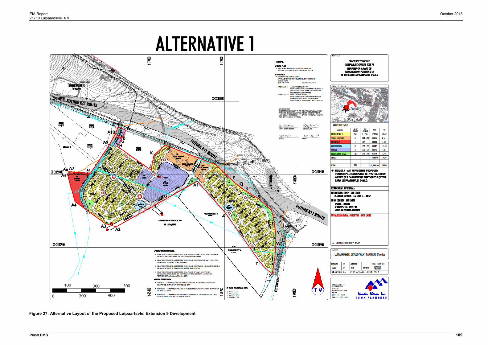
EIA Report October 2018 21710 Luipaardsvlei X 9
PRISM EMS 109
Figure 37: Alternative Layout of the Proposed Luipaartsvlei Extension 9 Development

EIA Report October 2018 21710 Luipaardsvlei X 9
PRISM EMS 110
7.1.3 No-go Option
As standard practice and to satisfy regulatory requirements, the option of not proceeding with the project is
included in the evaluation of the alternatives.
The No-go Alternative assumes that the property will retain its General Zoning. This implies that the site be
left as is and that no development or alteration be done. If this alternative is pursued, the study area’s
existing habitat will be retained. Under this scenario, the following benefits and disadvantages are expected
to occur:
The No-go option will sterilise a prime development area where there is a need for residential and
mixed land uses. In terms of Map 41 of the SDF, the proposed development is located within the
Mogale Urban Development Boundary (UDB), in an area earmarked for residential development
(medium density development);
The potential to provide additional housing, community facilities and employment opportunities to
the population, will be lost;
The demand for housing and supplying new and approved developments will not be possible or
feasible and financial losses could occur;
A viable opportunity to exploit the limited opportunities in the area and creating jobs and income
for the local market will be negated;
By not approving the proposed development, the general area may not be economically uplifted
neither will job opportunities and skills development be encouraged and the decision will not comply
with the planning policies of the area;
Illegal squatters or vagrants could inhabit the site as the local area is currently impacted;
Given the fact that the site will eventually degenerate if left unmanaged, and the fact that it is most
likely unsuitable to be utilised for grazing or agricultural purposes due to the size of the study area
and the high cost thereof, it is reasonable to state that the No-go option is less favourable than the
Proposal; and
The approval will ensure that an EMPr be implemented and that the environmental concerns on
the site will be managed.
The No-go alternative is therefore not preferred.

EIA Report October 2018 21710 Luipaardsvlei X 9
PRISM EMS 111
8 PUBLIC PARTICIPATION
8.1 Objectives and Purpose of Public Participation
The purpose of the public participation process is to provide information regarding the proposed project to
any potentially interested and/or affected person for use and consideration throughout the environmental
assessment process. The information usually involves a combination of the technical project scope,
environmental attributes and sensitives, cultural and heritage aspects as well as socio-economic factors
that may be potentially beneficial or problematic to various role players.
The dissemination of such information is intended to assist the public with understanding how the proposed
project and/or development may impact them and the environment in either a positive and/or negative
manner, and especially where impacts are determined or perceived as significantly high, how such impacts
may be influenced by project changes (layout or design aspects) or management measures may be
implemented to reduce or minimise the significance of any identified impacts.
As a registered I&AP, members of the public of any affiliation are awarded the opportunity to remain
informed of the steps, actions and decisions made within the environmental impact assessment process
and are able to actively participate by reviewing all information provided by the EAP to the I&AP’s in a
reasonable period in order to provide comments, objections, suggestions or any other information that will
assist the project to develop in a favourable for all manner or contribute to the competent authority’s
knowledge in order to make an informed decision on the application for environmental authorisation.
8.2 Notification Phase of Public Participation
The public participation process commenced with identifying and notifying all potential Interested and
Affected Parties (I&AP’s). Background information documents and comment forms were provided as a
basic source of information or notices were viewed and potential interested and/or affected members of the
public were invited to register as I&AP’s for the remainder of the Scoping and Environmental Impact
Reporting phases of the process.
8.2.1 Identified I&AP’s
The following potential I&AP’s were identified:
Department of Water and Sanitation;
Sasol;
Mogale City Local Municipality;
Ward Councillor (Ward 14);
South African Heritage Resources Agency (SAHRA);

EIA Report October 2018 21710 Luipaardsvlei X 9
PRISM EMS 112
Provincial Heritage Resources Agency Gauteng (PHRAG);
Surrounding Landowners / Occupiers; and
DMR.
Refer to for a detailed list of the interested and/or affected members of the public and Organs of State that
is registered as an I&AP.
Please also note that the National Nuclear Regular and West Rand District Municipality have also been
contacted to provide comments on the EIA Report based on the comments from GDARD contained in the
Acceptance of the Scoping Report.
8.2.2 Newspaper Notice
A notice was published in the following newspaper on the specified dates:
Local: The Krugersdorp News newspaper published on the 23rd of March 2018.
Local: The Krugersdorp News newspaper published on the 15th of August 2018, due to the
Applicant name change from Onicatrim Property Projects Proprietary Limited to Luipaardsvlei
Development Partners Proprietary Limited.
Refer to 14.3.2.1 and 14.3.3.1 for proof of the newspaper notices published on 23 March 2018 and 15
August 2018.
8.2.3 Site Notice
Four site notices were placed on the boundary of the study area on 23 March 2018:
Off Main Reef Road at the existing access road to Rand Sandblasting Projects on the northern
boundary of the study area;
Off Main Reef Road at the existing access road to the Luipaardsvlei Landfill Site, FORA and the
Mogale City Hostel at the north-western corner of the study area; and
On Main Reef Road on the barrier to the old removed train tracks on the northern boundary of the
study area; and
Off Tudor Street on the eastern boundary of the study area.
Due to the applicant name change from Onicatrim Property Projects Proprietary Limited to Luipaardsvlei
Development Partners Proprietary Limited, four new site notices were placed at the same locations as
above on 15 August 2018.
Refer to Section 14.3.2.2 and Section 14.3.3.2 for proof of the notices placed on site on 23 March 2018
and 15 August 2018.

EIA Report October 2018 21710 Luipaardsvlei X 9
PRISM EMS 113
8.2.4 Written Notifications
The surrounding landowners and/or occupiers and organs of state were notified of the proposed
development and environmental application in writing via email on 23 March 2018.
Due to the applicant name change from Onicatrim Property Projects Proprietary Limited to Luipaardsvlei
Development Partners Proprietary Limited and identification of additional Interested and Affected Parties,
all surrounding landowners and/or occupiers and organs of state were again notified in writing via email on
15 August 2018.
Refer to 14.3.2.3 and 14.3.3.3 for proof of the Written Notifications on 23 March 2018 and 15 August 2018.
8.2.5 Comments Raised by Interested and Affected Parties
Comments received during the notification period are summarised in the Comments and Response table
attached in Section 14.3.5.
8.3 Scoping Phase Public Participation
8.3.1 Proof of Notification
All registered I&APs were notified via email of the review period (15 August 2018 to 14 September 2018)
of the Draft Scoping Report. The Draft Scoping Reports were made available to all registered Interested
and Affected Parties for a period of 30 days.
The following authorities were provided with a copy of the Scoping Report:
South African National Roads Agency Limited (SANRAL);
South African Heritage Resources Agency (SAHRA);
The Department of Mineral Resources (DMR);
Gauteng Department of Roads and Transport (GDRT); and
Mogale City Local Municipality.
Proof of notification and submission of the draft scoping report is provided in Section 14.3.3.3.
8.3.2 Comments Raised by I&AP’s during the Review of the Scoping Report
No comments were received during the scoping report review period.
8.4 EIA Phase Public Participation
Upon acceptance of the scoping report by GDARD, the applicant/EAP proceeded with the tasks contained
in the plan of study.

EIA Report October 2018 21710 Luipaardsvlei X 9
PRISM EMS 114
The Draft EIA Report has been made available to all registered interested and affected parties and relevant
organs of state for a period of 30 days between 02 November 2018 to 03 December 2018. Comments
raised during this review period will be included in the Comments and Responses Report attached in
Appendix of the Final EIA Report to be submitted to GDARD.
The following authorities were provided with a copy of the Environmental Impact Assessment Report:
South African National Roads Agency Limited (SANRAL);
South African Heritage Resources Agency (SAHRA) and the Provincial Heritage Resources
Authority Gauteng (PHRAG);
The Department of Mineral Resources (DMR);
Gauteng Department of Roads and Transport (GDRT);
National Nuclear Regulator;
Council or Geoscience;
West Rand District Municipality Environmental Management;
West Rand District Municipality Environmental Health; and
Mogale City Local Municipality.
8.5 Final EIA Report and Competent Authority Decision
All comments received during the comment period, as discussed above will be considered and incorporated
into the Final EIA Report and documented in the Comments and Response Report. The Final EIA Report
will then be submitted to GDARD for decision.
8.6 Outcome of the Decision
Registered I&AP’s will be notified in writing of the outcome of the Department’s decision within 14 days of
the decision. The notification will include details of the process and timeframes in which to appeal the
outcome of the decision made by the competent authority, GDARD.
8.7 Timeframes
An overview of the Scoping and EIA process undertaken to date is provided in Table 12.
Table 12: Timeframes for the EIA process
Responsible
Role Player
Milestone Tasks Required
Time
Period
Proposed
Timeframes
Status
Application Phase
PPP Written, Newspaper, Site Notices &
BID’s
30 days 21 March 2018 – 21
April 2018 ����

EIA Report October 2018 21710 Luipaardsvlei X 9
PRISM EMS 115
Responsible
Role Player
Milestone Tasks Required
Time
Period
Proposed
Timeframes
Status
EAP Submit Application for
Environmental Authorisation (EA)
N/A 14 August 2018 ����
GDARD Accept/Acknowledge Application
for EA
10 days 24 August 2018 ����
Scoping Phase
EAP Compile Scoping Report (SR) N/A April 2018 – May
2018 ����
PPP I&AP Comment Period on SR 30 days 15 August 2018 – 14
September 2014 ����
EAP Review / Incorporate Comments 1 Week 15 September 2018 –
19 September 2018 ����
GDARD Review SR 43 days 20 September 2018 –
5 November 2018 ����
Impact Assessment Phase
Specialists Ecological Habitat Assessment N/A Mar – Apr 2018 ����
Specialists Heritage Impact Assessment N/A Mar – Apr 2018 ����
Specialists Air Quality Impact Assessment N/A August 2018 –
September 2018 ����
EAP Compile EIA Report N/A August 2018 –
November 2018 ����
PPP I&AP Comment on EIA Report 30 days 2 November 2018 – 3
December 2018
Current
EAP Review / Incorporate Comments 2 weeks 3 December 2018 – 8
December 2018
To Follow
GDARD Review EIA Report and Provide
Decision
106 days 9 December 2018 –
April 2019
To Follow
PPP Notification of Decision / Appeal March 2019 / April
2019
To Follow

EIA Report October 2018 21710 Luipaardsvlei X 9
PRISM EMS 116
9 SUMMARY OF SPECIALIST STUDIES
One of the most important aspects of the Scoping Phase was the identification of specialist studies required
for the EIA Phase.
The Specialist Studies triggered (a trigger is “a particular characteristic of either the receiving environment
or the proposed project which indicates that there is likely to be an issue and/or potentially significant impact
associated with that proposed development that may require specialist input”) included the following:
Ecological Habitat Assessment;
Heritage Impact Assessment; and
Air Quality Impact Assessment.
In addition, the following technical studies were also undertaken and have also been used to inform the EIA
Report:
Traffic Impact Assessment;
Geotechnical Assessment;
Outline Scheme Report (services report);
Roads and Stormwater Report.
The Guideline for the review of specialist input in EIA processes (Keatimilwe & Ashton, 2005) was used to
ensure that specialist input was incorporated into the EIA Report comprehensively. This included the
incorporation of the following information:
The assumptions and limitations identified in each study are included in Section 9.4;
A summary of each specialist study is/will be provided below and includes information on the key
findings and conclusions drawn;
The Specialists’ impacts assessment, and the identified mitigation measures, were/will be included
in the overall project impact assessment contained in Section 10;
Specialist information was / will be used to assess alternatives and identify the BPEO (Section
10.7);
Specialist input was/will be obtained to address comments made by I&APs that related to specific
environmental features; and
Recommendations made by the specialists were/will be taken forward to the EIA Conclusions and
Recommendations and associated EMPr (Section 11 and Section 14.7).

EIA Report October 2018 21710 Luipaardsvlei X 9
PRISM EMS 117
9.1 Ecological Habitat Impact Assessment
The key issues and triggers identified during Scoping for the Ecological Assessment include:
Disturbance of natural ecosystems, making them vulnerable to invasion of alien species;
Negative impact due to dust;
Disturbance of fauna in the area.
The details of the Ecological Specialist are as follows:
Prism EMS – Team of specialists
The full Ecological Impact Assessment is appended in 14.4.1.
9.1.1 Scope and Objectives
The scope of the study includes:
Desktop study of the development area on broad scale to determine areas, habitats and species
of concern;
A field survey to investigate key elements of vegetation communities, habitats and species on the
site;
An evaluation of the conservation importance and significance of the site with special emphasis on
the status of threatened species, habitats and communities as stipulated by Gauteng Department
of Agriculture and Rural Development (GDARD);
Identify potential ecological impacts that could occur because of the development; and
Make recommendations to reduce or minimise impacts, should the development be approved.
The objectives of the ecological habitat assessment are the following:
Determine the occurrence, or possibility of occurrence, of threatened species (both floristic and
faunal taxa);
Determine the sensitivity and conservation importance of the existing habitat in terms of local,
regional or national biodiversity objectives;
Evaluate the study area for the presence of species and characteristics associated with the
endangered Soweto Highveld Grassland vegetation type; and
Determine the ecological condition of the site with respect to function, connectivity and status.
9.1.2 Methods of Investigation
Desktop Assessment

EIA Report October 2018 21710 Luipaardsvlei X 9
PRISM EMS 118
The Gauteng Department of Agriculture and Rural Development (GDARD) was contacted to provide the
Gauteng Conservation plan (C-plan) and information on red data species for the proposed development
site.
The flow of genes and consequently the conservation of biodiversity is dependent on migratory corridors.
Habitat fragmentation can impair the essential genetic movement in a community. It is therefore important
to identify potential migratory corridors and the extent of the impact on the migratory corridors. Aerial
photographs were also used to determine whether the proposed development site may fall within a
migratory corridor.
Literature Review
The current literature was utilised to gain an understanding of the environmental influences presently
affecting the proposed development site. General information on the veld type, climate, geology and soils
and current activity on the site was acquired prior to the field assessment of the property.
A literature review on the habitat of red data listed plant, bird, mammal and butterfly species with a potential
distribution on site was conducted prior to the field assessment to gain a thorough understanding of the
habitat type occupied by these species.
Site Investigation
Date: April 2017 / January 2018
Season: Late summer - Early Autumn / Summer
o Plant Communities and Floral Species Composition: The vegetation of the proposed
development site was stratified during a reconnaissance ‘walkabout’ and by means of an
aerial photograph.
o Exotic and Invader Species: Any exotic and invasive species identified during the field
assessment were noted. Plants were identified to species level wherever possible. Faunal
species were recorded as per observation.
o Ecological Status of Site: Ecological status can be defined as the present state of
vegetation and soil protection of a site in relation to the potential natural community for the
site. Vegetation status is the expression of the relative degree to which the kind,
proportions, and amounts of plants in a community resemble that of the potential natural
community.
To determine the ecological status of the site, the following was considered:
The species diversity:
The proportion of species typical of the natural vegetation type. These species increase
the ecological status of the site and the proportion of these species is therefore multiplied
by 1 to get a species rating.

EIA Report October 2018 21710 Luipaardsvlei X 9
PRISM EMS 119
The proportion of exotic and invader species. These species reduce the ecological status
of the site and the proportion of these species is multiplied by 0.1 to get a species rating.
The proportion of indigenous species (excluding species typical of the natural vegetation
type). These species increase the ecological status of the site, though it carries less weight
than the species typical of the natural vegetation type. The proportion of these species is
therefore multiplied by 0.5 to get a species rating.
The categories given in Table 13 were used to determine the Ecological Status of each community in the
site:
Table 13: Ecological status categories
Ecological status Score
TOTALLY DEGRADED 0-10%
VERY POOR 10-20%
POOR 20-30%
MODERATELY POOR 30-40%
AVERAGE 40-50%
FAIR 50-60%
GOOD 60-70%
VERY GOOD 70-80%
EXCELLENT 80-90%
NEAR PRISTINE 90-100%
Faunal habitat assessment
A desktop study was undertaken to gather background information on the property and the faunal
species with a potential distribution within the proposed development site. This information and further
literature reviews were used to determine the possibility of occurrence for the species of concern for
the proposed development site and surrounding areas. This information incorporated (amongst others)
data on vegetation types, habitat suitability, biodiversity potential and species-specific information.
Faunal species were recorded as per observation during site visit. No long-term trapping or monitoring
was conducted for this survey.
Impact assessment methodology
The impact assessment methodology used for the EIA was also used for the Ecological Habitat
Assessment.
9.1.3 Key findings
According to the Gauteng C-plan there are no areas of ecological importance within the proposed
development site (Figure 16Figure 17). The proposed development site is composed of highly transformed

EIA Report October 2018 21710 Luipaardsvlei X 9
PRISM EMS 120
landscapes and fragmented grassland and contains no sensitive features (Figure 17). The transformed
landscapes are not considered to be sensitive, because natural vegetation is either highly transformed or
absent. The sensitivity of the remaining grasslands is considered low, because although it occurs in an
endangered veld type and could possibly support 4 red data list plant species, 1 red data list mammal
species and 1 red data list bird species, the ecological status of the remaining grasslands is ‘moderately
poor’ and no red data species have been observed. Furthermore, the fragmented condition of these
grasslands results in poor ecological functioning, limited possibilities for species migration and cross
pollination. The overall ecological status of the site is classified as: PES = VERY POOR. Land use activities
on site and in the surroundings, have likely reduced the number of faunal species that previously inhabited
the area.
9.2 Heritage Impact Assessment
The key issues and triggers identified during Scoping for the Heritage Impact Assessment include:
Potential impacts to heritage resources.
The details of the Heritage Specialist are as follows:
Jaco van der Walt: Archaeologist
- Qualifications: MA (Archaeology)
- Experience: 18 Years
- Accreditation:
o Field Director: Iron Age Archaeology;
o Field Supervisor: Colonial Period Archaeology, Stone Age Archaeology and
Grave Relocation;
o Accredited CRM Archaeologist with SAHRA
o Accredited CRM Archaeologist with AMAFA
o Co-opted council member for the CRM Section of the Association of Southern
African Association Professional Archaeologists (2011 – 2012).
The full Heritage Impact Assessment is appended in Section 14.4.2.
9.2.1 Terms of Reference
Field study
Conduct a field study to: (a) locate, identify, record, photograph and describe sites of archaeological,
historical or cultural interest; b) record GPS points of sites/areas identified as significant areas; c) determine
the levels of significance of the various types of heritage resources affected by the proposed development.

EIA Report October 2018 21710 Luipaardsvlei X 9
PRISM EMS 121
Reporting
Report on the identification of anticipated and cumulative impacts the operational units of the proposed
project activity may have on the identified heritage resources for all 3 phases of the project; i.e.,
construction, operation and decommissioning phases. Consider alternatives, should any significant sites
be impacted adversely by the proposed project. Ensure that all studies and results comply with the relevant
legislation, SAHRA minimum standards and the code of ethics and guidelines of ASAPA.
To assist the developer in managing the discovered heritage resources in a responsible manner, and to
protect, preserve, and develop them within the framework provided by the National Heritage Resources Act
of 1999 (Act No 25 of 1999).
9.2.2 Methods of Investigations
Literature Review
A brief survey of available literature was conducted to extract data and information on the area in question
to provide general heritage context into which the development would be set. This literature search included
published material, unpublished commercial reports and online material, including reports sourced from the
South African Heritage Resources Information System (SAHRIS).
Genealogical Society and Google Earth Monuments
Google Earth and 1:50 000 maps of the area were utilised to identify possible places where sites of heritage
significance might be located; these locations were marked and visited during the field work phase. The
database of the Genealogical Society was consulted to collect data on any known graves in the area.
Public Consultation and Stakeholder Engagement
Stakeholder engagement is a key component of any EIA process, it involves stakeholders interested in, or
affected by the proposed development. Stakeholders are provided with an opportunity to raise issues of
concern (for the purposes of this report only heritage related issues will be included). The aim of the public
consultation process was to capture and address any issues raised by community members and other
stakeholders during key stakeholder and public meetings. The process involved:
o Placement of advertisements and site notices;
o Stakeholder notification (through the dissemination of information and meeting invitations);
o Stakeholder meetings undertaken with I&APs;
o Authority Consultation;
o The compilation of a Scoping report and Environmental Impact Report and opportunity for
I&Aps to comment on the draft reports.
o The compilation of a Comments and Response Report (CRR).

EIA Report October 2018 21710 Luipaardsvlei X 9
PRISM EMS 122
Site Investigation
Conduct a field study to: a) systematically survey the proposed project area to locate, identify, record,
photograph and describe sites of archaeological, historical or cultural interest; b) record GPS points of
sites/areas identified as significant areas; c) determine the levels of significance of the various types of
heritage resources recorded in the project area.
The site investigation was conducted on 13 June 2017 in early winter – vegetation in the study area is low
and archaeological visibility is high. The impact area was sufficiently covered to adequately record the
presence of heritage resources.
Site Significance and Field Rating
Section 3 of the NHRA distinguishes nine criteria for places and objects to qualify as ‘part of the national
estate’ if they have cultural significance or other special value. These criteria are:
o Its importance in/to the community, or pattern of South Africa’s history;
o Its possession of uncommon, rare or endangered aspects of South Africa’s natural or
cultural heritage;
o Its potential to yield information that will contribute to an understanding of South Africa’s
natural or cultural heritage;
o Its importance in demonstrating the principal characteristics of a particular class of South
Africa’s natural or cultural places or objects;
o Its importance in exhibiting particular aesthetic characteristics valued by a community or
cultural group;
o Its importance in demonstrating a high degree of creative or technical achievement at a
particular period;
o Its strong or special association with a particular community or cultural group for social,
cultural or spiritual reasons;
o Its strong or special association with the life or work of a person, group or organisation of
importance in the history of South Africa;
o Sites of significance relating to the history of slavery in South Africa.
The presence and distribution of heritage resources define a ‘heritage landscape’. In this landscape, every
site is relevant. In addition, because heritage resources are non-renewable, heritage surveys need to
investigate an entire project area, or a representative sample, depending on the nature of the project. In
the case of the proposed project the local extent of its impact necessitates a representative sample and
only the footprint of the areas demarcated for development were surveyed. In all initial investigations,
however, the specialists are responsible only for the identification of resources visible on the surface. This
section describes the evaluation criteria used for determining the significance of archaeological and
heritage sites. The following criteria were used to establish site significance with cognisance of Section 3
of the NHRA:

EIA Report October 2018 21710 Luipaardsvlei X 9
PRISM EMS 123
o The unique nature of a site;
o The integrity of the archaeological/cultural heritage deposits;
o The wider historic, archaeological and geographic context of the site;
o The location of the site in relation to other similar sites or features;
o The depth of the archaeological deposit (when it can be determined/is known);
o The preservation condition of the sites; and
o Potential to answer present research questions.
In addition to this criteria field ratings prescribed by SAHRA (2006), and acknowledged by ASAPA for the
SADC region, were used for the purpose of this report.
Field Rating Grade Significance Recommended Mitigation
National Significance (NS) Grade 1 - Conservation; national site
nomination
Provincial Significance (PS) Grade 2 - Conservation; provincial site
nomination
Local Significance (LS) Grade 3A High significance Conservation; mitigation not
advised
Local Significance (LS) Grade 3B High significance Mitigation (part of site should
be retained)
Generally Protected A (GP.
A)
- High/medium
significance
Mitigation before destruction
Generally Protected B (GP.
B)
- Medium significance Recording before destruction
Generally Protected C (GP.C) - Low significance Destruction
9.2.3 Key findings
In terms of the built environment, three structures were identified in the study area namely two residential
structures and a third feature comprising demolished mining infrastructure (indicated on Figure 22 as LPV1
to LPV3). The age of these structures is unknown, but it is highly likely that the residential structures are
older than 60 years. According to archival maps mining infrastructure was constructed from 1913 and
structures in the study area could be older than 60 years and would then be protected by the NHRA. The
age of standing structures in the study area should be confirmed and if older than 60 years a destruction
permit will be required from the PHRAG.
No archaeological sites or material was recorded during the survey and based on the SAHRIS
Paleontological Sensitivity Map provided in the HIA, the area is of low paleontological significance.
Therefore, no further mitigation prior to construction was recommended by the specialist in terms of Section
35 for the proposed development to proceed.

EIA Report October 2018 21710 Luipaardsvlei X 9
PRISM EMS 124
In terms of Section 36 of the Act no known grave sites are on record close to the study area and no burial
sites were recorded. However, graves may be discovered in future. If any graves are located in future, they
should ideally be preserved in-situ or alternatively relocated according to existing legislation.
Long term impact on the cultural landscape is considered to be negligible as the surrounding area consists
of a densely-developed zone that was developed from 1913 onwards. Visual impacts to scenic routes and
sense of place are also considered to be low due to the extensive developments in the area. There are no
battlefields or related concentration camp sites, or any public monuments located in the study area.
Potential Impacts
The chances of impacting unknown archaeological sites in the study area is considered to be negligible.
Any direct impacts that did occur would be during the construction phase only and would be of very low
significance. Cumulative impacts occur from the combination of effects of various impacts on heritage
resources. The importance of identifying and assessing cumulative impacts is that the whole is greater than
the sum of its parts. In the case of the development, it will, with the recommended mitigation measures and
management actions, not impact any heritage resources directly. However, this and other projects in the
area could have an indirect impact on the heritage landscape. The lack of any heritage resources in the
immediate area minimises additional impact on the landscape.
9.2.4 Conclusion
The general area was exposed to several mining activities and developments since the discovery of gold
in the 1980’s and changed the face of this region. The study area is characterised by several businesses
and an old hostel complex. A disused and removed railway line also traverses other parts of the proposed
site as do several power lines. A gas line also crosses the proposed site from east to west. The study area
is not fenced off which leads to easy access. This resulted in several mounds of illegally dumped material
across the site. The study area is open, and this allows artisanal miners access to illegal mining activities.
All of these activities would have impacted on surface indicators of heritage features and no archaeological
sites or material was recorded during the survey and based on the SAHRIS Paleontological Sensitivity Map
the area is of low paleontological significance. Therefore, no further mitigation prior to construction is
recommended in terms of Section 35 for the proposed development to proceed.
In terms of the built environment, two residential dwellings (Feature 1 & 2) and partially demolished mining
related structures (Feature 3) occur in the study area. According to archival maps mining infrastructure was
constructed from 1913 and structures in the study area could be older than 60 years and would then be
protected by the NHRA. The age of standing structures in the study area should be confirmed and if older
than 60 years a destruction permit will be required from the PHRAG.
In terms of Section 36 of the Act no burial sites were recorded. However, if any graves are located in future
they should ideally be preserved in-situ or alternatively relocated according to existing legislation. No public
monuments are located within or close to the study area. The study area is surrounded by industrial and

EIA Report October 2018 21710 Luipaardsvlei X 9
PRISM EMS 125
residential developments and road infrastructure developments and the proposed residential development
will not impact negatively on significant cultural landscapes or viewscapes. During the public participation
process conducted for the project no heritage concerns was raised.
From a heritage perspective, the proposed project is acceptable. If the above recommendations are
adhered to and based on approval from SAHRA, HCAC is of the opinion that the development can continue
as the development will not impact negatively on the heritage record of the area.

EIA Report October 2018 21710 Luipaardsvlei X 9
PRISM EMS 126
9.3 Air Quality Impact Assessment
The key issues and triggers identified during Scoping for the Ecological Assessment include:
Dust and vehicle and equipment emissions during construction;
Impact of surrounding land uses (e.g. landfill site, mine tailings storage facilities and waste rock
dumps on the proposed development;
Vehicle emissions.
The details of the Air Quality Specialist are as follows:
Vladimir Jovic: VJ Air Modelling Services (Pty) Ltd
- Qualifications: B.A. Hons. Town and Regional Planning (University of Belgrade, Republic
of Serbia) and several air dispersion modelling courses.
- Experience: 14 Years
- Accreditation: Pr.Sci.Nat. (400054/17)
The full Air Quality Impact Assessment is appended in Section 14.4.3.
9.3.1 Scope of Work
The purpose of this investigation is to determine baseline air quality conditions, identify sensitive receptors
and quantify and assess the potential impact that the receiving environment may have on the proposed
development area.
The following tasks, typical of an air quality impact assessment, are included in the scope of work:
A review of surrounding activities in order to identify sources of emissions and associated
pollutants;
A study of regulatory requirements and inhalation thresholds for identified key pollutants against
which compliance need to be assessed and health risks screened;
A study of the environment in the vicinity of the proposed development; including:
o The identification of potential sensitive receptors (SRs);
o A study of the atmospheric dispersion potential of the area taking into consideration
local meteorology, land-use and topography; and
o The analysis of all available ambient air quality information/data to determine pre-
development ambient pollutant levels and dustfall rates.
The compilation of a comprehensive emissions inventory:
o Pollutants quantified will include particulate matter (TSP, PM10 and PM2.5).
Atmospheric dispersion modelling to simulate ambient air pollutant concentrations and dustfall
rates as a result of the TSFs.
A screening assessment to determine:

EIA Report October 2018 21710 Luipaardsvlei X 9
PRISM EMS 127
o Compliance of simulated criteria pollutant concentrations with ambient air quality
standards; and
o Nuisance dustfall.
The compilation of a comprehensive air quality specialist report detailing the study approach, limitations,
assumptions, results and recommendations.
9.3.2 Methods of Investigation
The approach and methodology followed in the completion of tasks included in the scope of work are
discussed below:
Project Information and Activity Review
All project related information referred to in this study was provided by Prism EMS.
The Identification of Regulatory Requirements and Screening Criteria
In the evaluation of ambient air quality impacts and dustfall rates reference was made to:
o South African National Ambient Air Quality Standards (NAAQS); and
o National Dust Control Regulations (NDCR) as set out in the National Environmental
Management Air Quality Act (Act No. 39 of 2004) (NEM: AQA).
Study of the Receiving Environment
An understanding of the atmospheric dispersion potential of the area is essential to an air quality impact
assessment.
Site specific MM5 modelled meteorological data set for full three calendar years (2015 – 2017) was obtained
from the Lakes Environmental Consultants in Canada to determine local prevailing weather conditions. This
dataset consists of surface data, as well as upper air meteorological data that is required to run the
dispersion model. It is required if site specific surface and upper air meteorological data is not available.
The Pennsylvania State University / National Centre for Atmospheric Research (PSU/NCAR) meso-scale
model (known as MM5) is a limited-area, non-hydrostatic, terrain-following sigma-coordinate model
designed to simulate or predict meso-scale atmospheric circulation. This data has been tested extensively
and has been found to be extremely accurate.
Modelled meteorological data for the period January 2015 to December 2017 was obtained for a point close
to the proposed site (26.116667 S, 27.794444 E). Data availability was 100%. Generally, a data set of
greater than 90% (taken to be the same as that stipulated for pollutant data availability (SANS, 2005)) is
required in order for that month/year to be considered representative of the assessed area.
According to the dispersion modelling guidelines (Government Gazette, 2014) mesoscale models offer an
alternative to meteorological measurements as input for Gaussian- plume models and advanced dispersion

EIA Report October 2018 21710 Luipaardsvlei X 9
PRISM EMS 128
models. Mesoscale models use gridded meteorological data and sophisticated physics algorithms to
produce meteorological fields at defined horizontal grid resolutions and in multiple vertical levels over a
large domain. A number of meteorological model datasets covering South Africa are available from a
number of vendors. The Code of Practice refrains from recommending specific datasets but encourages
modellers to use data from the United Kingdom Meteorological Office Unified Model (MetUM), Weather
Research and Forecasting (WRF), The Air Pollution Model (TAPM) and the 5th-generation Mesoscale
Model (MM5).
Determining the Impact of the Project on the Receiving Environment
The establishment of a comprehensive emission inventory formed the basis for the assessment of the air
quality impacts from the TSFs on the receiving environment. Emission quantification to determine the
possible emissions from surrounding TSF’s was done using the emission factors published by the US-EPA
and Australian NPI.
Compliance Assessment
Compliance was assessed by comparing simulated ambient criteria pollutant concentrations (PM2.5 and
PM10) and dustfall rates to selected ambient air quality and dustfall criteria.
Impact Significance
The significance of impacts was determined in line with the requirements for impact assessment as
outlined in the NEMA.
The Development of an Air Quality Management Plan
The findings of the above components informed recommendations of air quality management measures,
including mitigation and reporting.
9.3.3 Results
Dispersion modelling was undertaken to determine the highest daily and annual average ground level
concentrations, as well as deposition (dustfall) rates for each of the pollutants considered in the study.
Averaging periods were selected to facilitate the comparison of predicted pollutant concentrations to
relevant ambient air quality and inhalation health criteria, as well as National Dust Control Regulations.
Results are primarily provided in form of isopleths to present areas of exceedance of assessment criteria.
Ground level concentration or dustfall isopleths presented in this section depict interpolated values from
the deposition/dustfall rates simulated by AERMOD for each of the receptor grid points specified. Isopleth
plots reflect the incremental ground level concentrations (GLCs) for PM2.5 and PM10, as well as dustfall
rates for Total Suspended Particulates (TSP).

EIA Report October 2018 21710 Luipaardsvlei X 9
PRISM EMS 129
Dispersion Simulation Results and Nuisance Screening (Incremental)
Pollutants with the potential to result in human health impacts and assessed in this study include PM2.5 and
PM10. TSP (as dustfall) is assessed for its nuisance effects.
The impacts due to the TSFs and sand dumps are regarded as incremental baseline impacts, because they
fall under baseline conditions, but should not be considered as the overall baseline level for the area. The
maximum simulated annual average and highest daily PM2.5, PM10 and TSP impacts (over the entire
modelling grid of 10 km), are presented in Figure 38 to Figure 42. Results are shown for all TSFs and sand
dumps. Table 14 gives a summary of compliance with the NAAQS and the National Dust Control
Regulations (NDCR).
Table 14: Predicted PM10, PM2.5 and TSP (dustfall) Ground Level Concentrations at identified
sensitive receptors
Incremental concentrations
Pollutant PM10 PM2.5 TSP
Averaging period 24-Hours Year 24-Hours Year Monthly
Standard 75 40 40 20 600
Unit µg/m3 µg/m3 µg/m3 µg/m3 mg/m2/day
Atlhogang Primary School 6.14 0.91 0.93 0.14 1873
Boipelo Intermediary Primary School 4.04 0.55 0.61 0.08 1170
Bosele Intermediate Primary School 3.74 0.41 0.56 0.06 1096
Diphalane Primary School 2.74 0.16 0.41 0.02 324
Khaselihle Primary School 1.52 0.16 0.23 0.02 612
Krugersdorp Town Primary School 3.09 0.19 0.47 0.03 482
Laerskool Culembeeck Primary School 1.02 0.08 0.15 0.01 180
Laerskool Dr. HAVINGA 0.82 0.05 0.12 0.01 142
Laerskool Kenmare 0.57 0.05 0.09 0.01 186
Laerskool Paardekraal Primary School 2.54 0.20 0.38 0.03 566
Laerskool Roodebeeck 0.68 0.07 0.10 0.01 147
Lengau Primary School 6.09 0.81 0.92 0.12 1894
Lewisham Primary School 4.66 0.39 0.70 0.06 716
Matlhasedi Primary School 5.63 0.64 0.85 0.10 1834
Mofundi/John Martin Primary School 0.62 0.11 0.09 0.02 314
Monument Primary School 0.64 0.06 0.10 0.01 238
Phatudi Primary School 2.77 0.16 0.42 0.02 320
Princess Primary School 0.80 0.07 0.12 0.01 151
Sandile Primary School 2.48 0.25 0.37 0.04 921
Setlolamathe Primary School 4.72 0.69 0.71 0.10 1463
Silverfields Primary School 2.33 0.16 0.35 0.02 343
Thembile Primary School 2.26 0.25 0.33 0.04 1026

EIA Report October 2018 21710 Luipaardsvlei X 9
PRISM EMS 130
Incremental concentrations
Pollutant PM10 PM2.5 TSP
Averaging period 24-Hours Year 24-Hours Year Monthly
Standard 75 40 40 20 600
Unit µg/m3 µg/m3 µg/m3 µg/m3 mg/m2/day
Thusong Primary School 0.72 0.11 0.11 0.02 303
Tsholetsega Public Primary School 0.71 0.10 0.11 0.02 331
WD Oliphant Primary School 3.41 0.50 0.52 0.08 1016
West Rand Primary Mine School 1.96 0.22 0.28 0.03 1010
Curro High School 1.04 0.07 0.16 0.01 120
Hoërskool Adelaar 0.45 0.03 0.07 0.00 113
Hoërskool Jan De Klerk 3.26 0.22 0.49 0.03 590
Hoërskool Noordheuwel 0.59 0.05 0.09 0.01 147
HTS Nic Diederichs THS 2.76 0.17 0.42 0.03 401
Kagiso Senior Secondary School 1.55 0.15 0.22 0.02 532
Krugersdorp High School 0.47 0.05 0.07 0.01 199
Mosupatsela Secondary School 6.11 0.87 0.92 0.13 1925
Princess High School 0.35 0.03 0.05 0.00 96
S.G Mafaesa Senior Secondary School 3.85 0.60 0.58 0.09 1202
St Ursula's Convent School Krugersdorp 3.05 0.20 0.46 0.03 490
Townview High School 2.60 0.18 0.39 0.03 430
Vine Christian Secondary School 2.62 0.13 0.39 0.02 276
Central Clinic 3.44 0.23 0.52 0.03 645
Execu Med Sub Acute Clinic 3.54 0.25 0.53 0.04 700
Netcare Bell Street Hospital 0.82 0.06 0.12 0.01 160
Netcare Krugersdorp Hospital 4.59 0.29 0.69 0.04 773
P L G Herbberg 0.84 0.06 0.13 0.01 112
Luipaardsvlei Tehuis Vir Bejaardes 3.43 0.33 0.52 0.05 702
Krugersdorp Council for the Care of the
Aged 4.77 0.29 0.72 0.04 804
Moria Sentrum Old Age Home 2.80 0.18 0.42 0.03 365
S A V F Moreglans Ouetehuis Vir
Bejaardes 2.71 0.18 0.41 0.03 435
Curro School Krugersdorp 0.78 0.05 0.12 0.01 102
ProPracticum Special Needs School 3.74 0.22 0.56 0.03 450
Rant en Dal Special Needs School 3.00 0.16 0.45 0.02 385
St Ursula's School 3.15 0.19 0.48 0.03 422
Westcol College 2.37 0.15 0.36 0.02 1873

EIA Report October 2018 21710 Luipaardsvlei X 9
PRISM EMS 131
The Regulations for Air Dispersion Modelling (DEA, 2014), recommend the use of the 99th percentile
concentrations for short-term assessment with the NAAQS, since the highest predicted ground-level
concentrations can be considered outliers due to complex variability of meteorological processes. This
might cause exceptionally high concentrations that the facility may never actually exceed in its lifetime.
Isopleth plots of daily and annual average PM10 and PM2.5 concentrations and daily average dry dust
deposition (over a 30-day period) for proposed development are presented in the section below. Isopleth
plots of daily and annual average PM10 and PM2.5 concentrations for proposed development are given in
the section below. For daily averaging periods, the predicted 99th percentile concentrations are provided
as per Modelling Regulations Comparison of the predicted PM10 and PM2.5 concentrations have been made
with the NAAQS (where applicable) to determine compliance. Comparison of the predicted TSP (as dust
fallout deposition) values is made with the NDCR to determine compliance. Ambient air standards are
applied to areas considered residential.
The 99th percentile results (24 hours) are graphically presented as concentration isopleths, indicating the
short-term concentrations at each grid point. The modelling scenarios considered in the modelling
assessment for the proposed development are summarised in Table 15.
Table 15: Dispersion modelling scenarios for the different pollutants
POLLUTANT MODELLED AS
SHORT TERM LONG TERM
PM10 99th percentile 24-hour mean Annual mean
PM2.5 99th percentile 1-hour mean Annual mean
Dust Deposition daily average (over a 30-day
period)

EIA Report October 2018 21710 Luipaardsvlei X 9
PRISM EMS 132
Figure 38: Simulated 99th percentile daily PM10 concentrations (µg/m3) due to TSFs and sand dumps near the proposed development (NAAQS is 75 µg/m3)

EIA Report October 2018 21710 Luipaardsvlei X 9
PRISM EMS 133
Figure 39: Simulated 99th percentile annual average PM10 concentrations (µg/m3) due to TSFs and sand dumps near the proposed development (NAAQS is 40 µg/m3).

EIA Report October 2018 21710 Luipaardsvlei X 9
PRISM EMS 134
Figure 40: Simulated 99th percentile daily PM2.5 concentrations (µg/m3) due to TSFs and sand dumps near the proposed development (NAAQS is 40 µg/m3)

EIA Report October 2018 21710 Luipaardsvlei X 9
PRISM EMS 135
Figure 41: Simulated 99th percentile annual average PM2.5 concentrations (µg/m3) due to TSFs and sand dumps near the proposed development (NAAQS is 25 µg/m3)

EIA Report October 2018 21710 Luipaardsvlei X 9
PRISM EMS 136
Figure 42: Dust fallout (mg/m2/day) due TSFs and sand dumps near the proposed development (NDCR Standard is 600 mg/m2/day averaged over 30 days in residential areas)

EIA Report October 2018 21710 Luipaardsvlei X 9
PRISM EMS 137
9.3.4 Key findings
The main findings of the assessment are summarised below:
The receiving environment:
o The proposed development area is dominated by winds from the northerly sector. An average
wind speed of 3.82 m/s was extracted for the site from the MM5 data set with wind speeds
exceeding 6.7 m/s (the threshold wind speed likely to result in dust emissions from gold TSFs)
6.39% of the time.
o Surrounding areas where ambient air quality data is available show PM10 concentrations
exceeding the NAAQS.
Impact of the TSFs and sand dumps:
o Sources of emissions quantified included windblown dust from the TSFs and sand dumps
surrounding the proposed development.
o PM emissions (PM2.5, PM10 and TSP) were quantified using verified methods and utilised in
dispersion simulations.
o For wind erosion to occur, the wind speed needs to exceed a certain threshold, called the friction
velocity. Literature indicates a wind speed of around 6.7 m/s to result in windblown emissions
from gold TSFs. The threshold wind speed for this study is 5.4 m/s (conservative approach).
o Simulated highest daily and annual average PM2.5 and PM10 concentrations, as a result of
windblown dust from the TSFs and sand dumps, are low and below the respective ambient air
quality standards.
o The worst-case unmitigated scenario shows the same conclusion regarding compliance,
however, in reality the TSFs and sand dumps have vegetative cover to a certain extent, which
means that simulated concentrations of the pollutant of interest can only be lower than modelled
in this study:
o A significance rating of ‘low’ was assigned to potential inhalation health impacts and dustfall
effects for the proposed development site. With mitigation measures in place, such as vegetation
or rock cladding, the significance could be reduced further for the proposed development site.
9.3.5 Conclusion
In conclusion, existing TSFs and sand dumps are likely to result in the highest impacts if no mitigation
measures, such as water sprays, are applied, but this impact will not likely extend to the proposed
development site. However, rehabilitation or re-mining of TSFs and sand dumps, would be required to
ensure long-term compliance for the immediate areas surrounding the TSFs and sand dumps.

EIA Report October 2018 21710 Luipaardsvlei X 9
PRISM EMS 138
9.4 Assumptions and Limitations Identified by Specialists
The impacts identified as part of the various specialist studies have heavily influenced the impact
assessment included in the EIA. As such, it is important to note the assumptions and limitations identified
by the various specialists:
9.4.1 Ecological Habitat Assessment Limitations
The following limitations apply to the study:
The assessment of red data listed species was limited to a habitat assessment to determine the
possibility of occurrence;
The adjacent areas were not surveyed during the site investigation but was considered during the
desktop assessment;
Species lists were compiled along transects that represented all plant communities but is not an
exhaustive list of plant species occurring on site;
Sampling, by nature, implies that not all species in a study area will be recorded due to factors such
as plant phenology as affected by seasonality, seasonal climatic conditions, microhabitats and both
historical and current management practices;
Field assessment notes are supplemented by making use of literature sources and existing data
bases (SANBI/GDARD, Reference books, Articles etc.); and
The main ecological and floristic observations, forming the basis for recommendations and / or any
delineation, are, however, based on the field assessment observations.
9.4.2 Heritage Impact Assessment Limitations
The following limitations with respect to the NEMA Risk Assessment are applicable to the report:
The authors acknowledge that the brief literature review is not exhaustive on the literature of the area. Due
to the subsurface nature of archaeological artefacts, the possibility exists that some features or artefacts
may not have been discovered/recorded during the survey and the possible occurrence of unmarked graves
and other cultural material cannot be excluded. Similarly, the depth of the deposit of heritage sites cannot
be accurately determined due its subsurface nature. This report only deals with the footprint area of the
proposed development and consisted of non-intrusive surface surveys. This study did not assess the impact
on medicinal plants and intangible heritage as it is assumed that these components would have been
highlighted through the public consultation process if relevant. It is possible that new information could
come to light in future, which might change the results of this Impact Assessment.
9.4.3 Air Quality Impact Assessment Limitations
The following limitations with respect to the Air Quality Impact Assessment are applicable to the report:

EIA Report October 2018 21710 Luipaardsvlei X 9
PRISM EMS 139
Assumptions, Exclusions and Uncertainties
The following important assumptions, exclusions and uncertainties to the specialist study should be noted:
o Meteorological data from a data point for the project site for the period 2015-2017 was
extracted from the MM5 data set.
o The impact assessment was limited to criteria particulates (including TSP, PM10 and PM2.5).
o Constructional phase impacts of the proposed development were not quantified. These
impacts are expected to be of short duration.
o There will always be some degree of uncertainty in any geophysical model, but it is
desirable to structure the model in such a way to minimize the total error. A model
represents the most likely outcome of an ensemble of experimental results. The total
uncertainty can be thought of as the sum of three components: the uncertainty due to
errors in the model physics; the uncertainty due to data errors; and the uncertainty due to
stochastic processes (turbulence) in the atmosphere. Nevertheless, dispersion modelling
is generally accepted as a scientific and valuable tool in air quality management.
Gaps in Knowledge
The following was identified as gaps in knowledge during the specialist study and should be noted:
The quantification of sources of emission was restricted to the TSFs identified in the study scope.
Hence, only incremental impacts due to PM10 and PM2.5, as well as incremental dustfall effects
were simulated from the TSFs. Other sources in the area (e.g. domestic fuel combustion,
smelters, mining activities, landfilling), could also be contributing to the ambient air.

EIA Report October 2018 21710 Luipaardsvlei X 9
PRISM EMS 140
10 IMPACT ASSESSMENT
10.1 Overall Impact Assessment
This section focuses on the potential environmental impacts that could be caused by the proposed
Luipaardsvlei Ext 9 development.
An ‘impact’ refers to the change to the environment resulting from an environmental aspect (or activity),
whether desirable or undesirable. An impact may be the direct or indirect consequence of an activity. From
a qualitative perspective, impacts were identified as follows:
Impacts associated with listed activities contained in GN 983-985 of 4 December 2014 (Listing
Notice, 1, 2 and 3) [as amended in 2017], for which authorisation has been applied for;
An assessment of the project activities and components; and
Issues highlighted by I&APs (both the general public and authorities).
In addition to the above more qualitative descriptions of impacts, a more detailed quantitative assessment
of impacts is also provided and specifically considers impacts to the receiving environment (Section 5) and
the findings from Specialist Studies (Section 9). This quantitative impact assessment uses the impact
assessment methodology discussed in the approved Scoping Report and Plan of Study for the EIA. A
summary of the methodology is provided below.
10.2 Impact Assessment Methodology
The standard methodology used in the environmental impact assessment to determine the significance
rating of the potential impacts are outlined in this section.
10.2.1 Significance
The significance of an impact is defined as the combination of the consequence of the impact occurring
and the probability that the impact will occur. The nature and type of impact may be direct or indirect and
may also be positive or negative, refer to Table 16 for the specific definitions.

EIA Report October 2018 21710 Luipaardsvlei X 9
PRISM EMS 141
Table 16: Nature and type of impact.
IMP
AC
T
Nature and Type of Impact:
Direct Impacts that are caused directly by the activity and generally occur at the same time and place as the activity
����/
Indirect Indirect or induced changes that may occur because of the activity. These include all impacts that do not manifest immediately when the activity is undertaken, or which occur at a different place as a result of the activity
����/
Cumulative Those impacts associated with the activity which add to, or interact synergistically with existing impacts of past or existing activities, and include direct or indirect impacts which accumulate over time and space
����/
Positive Impacts affect the environment in such a way that natural, cultural and / or social functions and processes will benefit significantly, and includes neutral impacts (those that are not considered to be negative
����
Negative Impacts affect the environment in such a way that natural, cultural and/or social functions and processes will be comprised
Table 17 presents the defined criteria used to determine the consequence of the impact occurring which
incorporates the extent, duration and intensity (severity) of the impact.

EIA Report October 2018 21710 Luipaardsvlei X 9
PRISM EMS 142
Table 17: Consequence of the Impact occurring
CO
NS
EQ
UE
NC
E
Extent of Impact:
Site Impact is limited to the site and immediate surroundings, within the study site boundary or property (immobile impacts)
Neighbouring Impact extends across the site boundary to adjacent properties (mobile impacts)
Local Impact occurs within a 5km radius of the site
Regional Impact occurs within a provincial boundary
National Impact occurs across one or more provincial boundaries
Duration of Impact:
Incidental The impact will cease almost immediately (within weeks) if the activity is stopped, or may occur during isolated or sporadic incidences
Short-term The impact is limited to the construction phase, or the impact will cease within 1 - 2 years if the activity is stopped
Medium-term The impact will cease within 5 years if the activity is stopped
Long-term The impact will cease after the operational life of the activity, either by natural processes or by human intervention
Permanent Where mitigation either by natural process or by human intervention will not occur in such a way or in such a time span that the impact can be considered
transient
Intensity or Severity of Impact:
Low Impacts affect the environment in such a way that natural, cultural and/or social functions and processes are not affected
Low-Medium Impacts affect the environment in such a way that natural, cultural and/or social functions and processes are modified insignificantly
Medium Impacts affect the environment in such a way that natural, cultural and/or social functions and processes are altered
Medium-High Impacts affect the environment in such a way that natural, cultural and / or social functions and processes are severely altered
High Impacts affect the environment in such a way that natural, cultural and / or social functions and processes will permanently cease
The probability of the impact occurring is the likelihood of the impacts actually occurring and is determined
based on the classification provided in Table 18.

EIA Report October 2018 21710 Luipaardsvlei X 9
PRISM EMS 143
Table 18: Probability and confidence of impact prediction.
PR
OB
AB
ILIT
Y
Probability of Potential Impact Occurrence:
Improbable The possibility of the impact materialising is very low either because of design or historic experience
Possible The possibility of the impact materialising is low either because of design or historic experience
Likely There is a possibility that the impact will occur
Highly Likely There is a distinct possibility that the impact will occur
Definite The impact will occur regardless of any prevention measures
The significance of the impact is determined by considering the consequence and probability without
taking into account any mitigation or management measures and is then ranked according to the ratings
listed in Table 19. The level of confidence associated with the impact prediction is also considered as low,
medium or high and is described in Table 20.
Table 19: Significance rating of the impact.
SIG
NIF
ICA
NC
E
Significance Ratings:
Low Neither environmental nor social and cultural receptors will be adversely affected by the impact. Management measures are usually not provided for low impacts
Low-Medium
Management measures are usually encouraged to ensure that the impacts remain of Low-Medium significance. Management measures may be proposed to ensure
that the significance ranking remains low-medium
Medium Natural, cultural and/or social functions and processes are altered by the activities, and management measures must be provided to reduce the significance rating
Medium-High
Natural, cultural and/or social functions and processes are altered significantly by the activities, although management measures may still be feasible
High Natural, cultural, and/or social functions and processes are adversely affected by the activities. The precautionary approach will be adopted for all high significant
impacts and all possible measures must be taken to reduce the impact
Table 20: Level of confidence of the impact prediction.
CO
NF
IDE
NC
E Level of Confidence in the Impact Prediction:
Low Less than 40% sure of impact prediction due to gaps in specialist knowledge and/or availability of information
Medium Between 40 and 70% sure of impact prediction due to limited specialist knowledge and/or availability of information
High Greater than 70% sure of impact prediction due to outcome of specialist knowledge and/or availability of information
Once significance rating has been determined for each impact, management and mitigation measures must
be determined for all impacts that have a significance ranking of Medium and higher in order to attempt to
reduce the level of significance that the impact may reflect.
The EIA Regulations, 2014 specifically require a description is provided of the degree to which these
impacts:
can be reversed;
may cause irreplaceable loss of resources; and
can be avoided, managed or mitigated.

EIA Report October 2018 21710 Luipaardsvlei X 9
PRISM EMS 144
Based on the proposed mitigation measures the EAP will determined a mitigation efficiency (Table 21)
whereby the initial significance is re-evaluated and ranked again to effect a significance that incorporates
the mitigation based on its effectiveness. The overall significance is then re-ranked, and a final significance
rating is determined.
Table 21: Mitigation efficiency
MIT
IGA
TIO
N E
FF
ICIE
NC
Y
Mitigation Efficiency
None Not applicable
Very Low Where the significance rating stays the same, but where mitigation will reduce the intensity of the impact. Positive impacts will remain the same
Low Where the significance rating reduces by one level, after mitigation
Medium Where the significance rating reduces by two levels, after mitigation
High Where the significance rating reduces by three levels, after mitigation
Very High Where the significance rating reduces by more than three levels, after mitigation
The reversibility is directly proportional the “Loss of Resource” where no loss of resource is experienced,
the impact is completely reversible; where a substantial “Loss of resource” is experienced there is a medium
degree of reversibility; and an irreversible impact relates to a complete loss of resources, i.e. irreplaceable
(Table 22).
Table 22: Degree of reversibility and loss of resources.
DE
GR
EE
RE
VE
RS
AB
ILIT
Y &
LO
SS
OF
RE
SO
UR
CE
S
Loss of Resources:
No Loss No loss of social, cultural and/or ecological resource(s) are experienced. Positive impacts will not experience resource loss
Partial The activity results in an insignificant or partial loss of social, cultural and/or ecological resource(s)
Substantial The activity results in a significant loss of social, cultural and/or ecological resource(s)
Irreplaceable The activity results in the complete and irreplaceable social, cultural and/or ecological loss of resource(s)
Reversibility:
Irreversible Impacts on natural, cultural and/or social functions and processes are irreversible to the pre-impacted state in such a way that the application of resources will not
cause any degree of reversibility
Medium Degree
Impacts on natural, cultural and/or social functions and processes are partially reversible to the pre-impacted state if less than 50% resources are applied
High Degree Impacts on natural, cultural and/or social functions and processes are partially reversible to the pre-impacted state if more than 50% resources are applied
Reversible Impacts on natural, cultural and/or social functions and processes are fully reversible to the pre-impacted state if adequate resources are applied

EIA Report October 2018 21710 Luipaardsvlei X 9
PRISM EMS 145
10.2.2 Cumulative Impacts
It is important to assess the natural environment using a systems approach that will consider the cumulative
impact of various actions. Cumulative impact refers to the impact on the environment, which results from
the incremental impact of the actions when added to other past, present and reasonably foreseeable future
actions regardless of what agencies or persons undertake such actions. Cumulative impacts can result
from individually minor, but collectively significant actions or activities taking place over a period.
Cumulative effects can take place frequently and over a period that the effects cannot be assimilated by
the environment.
10.3 Qualitative Discussion of Impacts
10.3.1 Impacts Associated with Listed Activities
As mentioned, the project requires authorisation for certain activities listed in the 2014 EIA Regulations [as
amended in 2017], which serve as triggers for the environmental assessment process. The potential
impacts associated with the key listed activities are broadly stated in Table 23.
Table 23: Potential impacts associated with Listed Activities
Listing
Notice Activity Description of Listed Activity Potential Impact Overview
NEMA: Listing Notice 2 (require Scoping and EIR)
GN R 984
4 December
2014 [as
amended in
2017]
15
The clearance of an area of 20 hectares
or more of indigenous vegetation,
excluding where such clearance of
indigenous vegetation is required for the
undertaking of a linear activity; or
maintenance purposes undertaken in
accordance with a maintenance
management plan.
Loss of flora
Spreading of alien invasive
plants
Loss of fauna
Disturbance of ecological
systems
Impact on biodiversity
Dust pollution
Air pollution
Vehicle emissions
Noise
Safety and security
Visual impact
10.3.2 Environmental Activities
In order to understand the impacts related to the project it is necessary to unpack the activities associated
with the project life-cycle. The main project activities as well as high-level environmental activities
undertaken in the various project phases are listed in Table 24.

EIA Report October 2018 21710 Luipaardsvlei X 9
PRISM EMS 146
Table 24: Project Activities P
re-
Co
nstr
ucti
on
Project Activities
Detailed layouts and services designs
Procurement process for Contractors
Procurement of other necessary construction materials
Environmental Activities
Appointment of Environmental Control Officer (ECO)
Permits if heritage resources are to be impacted on.
Co
nstr
ucti
on
Project Activities
Appointments and site camp set up:
Set up site camp with temporary offices and administrative facilities;
Set up ablutions;
Set up access control, security; signage and lighting;
General materials storage and laydown areas;
Construction employment;
Change-houses, chemical toilets and showering facilities (linked to conservancy tanks – removal of contents by exhauster vehicle and disposal at permitted facility);
Temporary waste storage areas; these shall be established and managed in accordance with EMPr requirements.
Sourcing of construction materials and equipment:
All bulk materials (aggregate, cement, steel etc.) will be sourced from existing lawful commercial sources; there will be no direct mining, harvesting or extraction of natural resources.
Excavation and earthworks
Removal of existing surfacing material where necessary (concrete, asphalt etc.) which could involve excavation below ground level;
Levelling and compaction using heavy machinery / earthmoving equipment;
Potential for excavations and trenching in order to lay of below ground level equipment (cables, pipes, sumps, drainage etc.);
Potential for excavation dewatering in the event of water-table interception;
Use of general mechanical equipment within construction areas (generators, cutting and welding equipment, compressors etc.).
Environmental Activities
Diligent compliance monitoring of the EMPr, environmental authorisation and other relevant environmental legislation.
Continued consultation with I&APS (as required).
Environmental awareness creation.
Op
era
tio
n Project Activities
Operation of facilities;
Maintenance of infrastructure;
Environmental Activities
Monitoring
10.3.3 Environmental Aspects
Environmental aspects are regarded as those components of an organisation’s activities, products and
services that are likely to interact with the environment and cause an impact. The following environmental
aspects have been identified for the proposed township which are linked to the project activities (note that
only high-level aspects are provided):

EIA Report October 2018 21710 Luipaardsvlei X 9
PRISM EMS 147
Table 25: Environmental Aspects P
re-
Co
nstr
ucti
on
Aspects
Inadequate consultation with landowners/occupiers of land and I&APs
Inadequate environmental and compliance monitoring
Poor construction site planning and layout
Absence of relevant permits (e.g. heritage resources) – if required
Poor waste management
Absence of ablution facilities
Co
nstr
ucti
on
Aspects
Inadequate consultation with I&APs
Inadequate environmental and compliance monitoring
Lack of environmental awareness creation
Indiscriminate site clearing
Poor site establishment
Op
era
tio
n Aspects
Inadequate consultation with I&APs
Inadequate environmental and compliance monitoring
Lack of environmental awareness creation
Lack of maintenance
10.3.4 Issues raised by Environmental Authorities and IAPs
The issues raised by authorities (both regulatory and commenting) and I&APs received to date during the
execution of the Scoping and EIA process are captured and addressed in the Comments and Responses
Report (Section 14.3.5). The following potential impacts were identified:
Noise pollution;
Air pollution;
Traffic;
Resource consumption
Waste management;
Stormwater management;
Open space management; and
Alien and invasive species.
These issues helped identify specialist and technical studies required and thus contributed to the
assessment of impacts in Section 10.4.
10.4 Quantitative Impact Assessment
Table 26 provides a summary of the identified impacts and significance ranking (WOM = Without Mitigation)
for the construction and operational phases of development. Impacts for each alternative (both layout and
treatment alternatives) are also provided. Brief management measures have been provided for the
purposes of assessing whether the implementation of recommended management measures may be
sufficient to decrease the significance ranking (WM = With Mitigation).

EIA Report October 2018 21710 Luipaardsvlei X 9
PRISM EMS 148
Table 26: Summary of Quantitative Impact Assessment
ASPECTS
IMPACTS SIGNIFICANCE
(WOM)
CONFIDENCE
MANAGEMENT & MITIGATION MEASURES
MITIGATION EFFICIENCY
SIGNIFICANCE (WM)
DEGREE
TYPE
DESCRIPTION
ALTERNATIVE
CUMULATIVE
NATURE
LOSS RESOURCE
REVERSABILITY
Significance (A + B + C) X P
CONSTRUCTION PHASE
Atmospheric Emissions
Direct Dust emissions altering air quality and visibility
on nearby roads.
Layout 1
Yes Negative
Low High • A speed limit of 20km/h must be maintained on all dirt roads; • Dust suppression measures by means of either water or biodegradable chemical agent will be implemented during the construction phase to minimise dust generated by construction activities. Recycled water to be used, instead of potable water, to save water.
Medium Low No Loss Reversible
Layout 2 Low High Low Low No Loss Reversible
Direct
Emissions from vehicles and machinery
(CO2, NOx, SOx, VOC's etc.)
Layout 1
Yes Negative
Low High
• All construction vehicles and machinery will be maintained such as to operate efficiently. Idling times of vehicles and machinery to be minimised; • In terms of transportation of workers and materials, collective transportation arrangements should be made to reduce individual car journeys where possible; • All vehicles used during the project should be properly maintained and in good working order; • All vehicles and other machinery should comply with road worthy requirements and comply with legislation in terms of allowable emissions.
Low Low No Loss Reversible
Layout 2 Low High Low Low No Loss Reversible
Noise Direct Noise nuisance to surrounding land
owners and animals.
Layout 1
Yes Negative
Medium High
• The provisions of SANS 10103:2008 will apply to all areas within audible distance of residents or adjacent landowners; • Equipment and/or machinery which will be used must comply with the manufacturer’s specifications on acceptable noise levels; • Construction activities should be limited to daytime only; • Noise monitoring should be undertaken as spot checks; • When required noise mufflers should be utilised to reduced noise; • It is important to keep an open channel of communication between all stakeholders and keep record of any concerns raised.
Medium Low No Loss Reversible
Layout 2 Medium High Medium Low No Loss Reversible
Water Impacts
(Surface and Groundwater)
Direct
Liquid waste including sewage may cause
stormwater and groundwater pollution if
not managed and disposed of correctly.
Layout 1
Yes Negative
Low-Medium Medium • Management of Ablution Facilities:o Chemical toilets will be placed on site for the duration of the construction phase;o Ablution facilities (chemical toilets) are to be provided by the Contractor, at a ratio of 1:10;o Ablution facilities (chemical toilets) must be erected within 100m from all workplaces but within the development footprint;o Toilets are to be secured to the ground and must have a closing mechanism;o Toilet paper must be provided at these facilities and must be serviced once per week;o Certified contractors to maintain and empty chemical toilets regularly;o Safe disposal certificates to be kept in the site file;o The contractor must ensure that spillage does not occur when toilets are cleaned/serviced, and contents must be properly stored and disposed of properly;o Discharge of waste into the environment and/or burial of waste are strictly prohibited;o Sanitary arrangements must be to the satisfaction of the , ECO, the local authorities and the applicable legal requirements.• Management of waste water:o The contractor is to ensure that clean run-off water is diverted away from potentially contaminated areas of the construction site;o Contaminated liquids and soil from the site must be disposed of at a permitted disposal site;o Safe disposal certificates to be kept in the site file.
High Low No Loss Reversible
Layout 2 Low-Medium Medium High Low No Loss Reversible

EIA Report October 2018 21710 Luipaardsvlei X 9
PRISM EMS 149
ASPECTS
IMPACTS SIGNIFICANCE
(WOM)
CONFIDENCE
MANAGEMENT & MITIGATION MEASURES
MITIGATION EFFICIENCY
SIGNIFICANCE (WM)
DEGREE
TYPE
DESCRIPTION
ALTERNATIVE
CUMULATIVE
NATURE
LOSS RESOURCE
REVERSABILITY
Significance (A + B + C) X P
Indirect
Impact of changes to water quality through construction materials
such as sediments, diesel, oils and cement may pose a threat to
the instream and adjacent vegetated
areas, if by chance it is dispersed via surface run-off or allowed to
permeate groundwater.
Layout 1 Yes Negative Low-Medium Medium
• The following best practise measures in terms of erosion apply: o Instability and erosion of steep slopes must be stabilised immediately. Re-vegetation in consultation with landscape architect and ECO should be done if required; o To reduce the loss of material by erosion, causing sedimentation, disturbance must be kept to a minimum; o If clearing of slopes occur within the rainy season, earth berms must be created along the up-slope side of the construction area; o Where possible, natural vegetation should be retained to reduce the risk of erosion; o Should erosion occur due to negligence on the part of the Contractor to apply the above measures, the Contractor will be responsible for reinstatement of the eroded area to its former state at his own expense. Any surface water pollution occurring as a result of this negligence will be cleaned up by the Contractor or a nominated clean up organisation at the expenses of the Contractor; o Proper Stormwater management must be implemented; o Run-off containing high sedimentation loads must not be released into natural or municipal drainage systems; o Silt fences must be used to stabilise the site, reduce erosion and silt entering the natural environment. No unchecked silt may enter the natural environment.; o Silt fences must be fit for purpose, effective and regularly maintained. • Management of workshop and equipment: o Maintenance of equipment and vehicles is not allowed at the construction site. Faulty equipment must be removed from site and repaired at a workshop. o A designated vehicle wash bay must be put in place and must meet the following requirements: § Must have an impermeable surface. § Must have drainage measures in place to direct contaminated water towards the oil separator. § Quality of water to be tested prior to release. If not safe then contaminated water must be disposed of as hazardous waste at a licensed waste disposal facility. Safe disposal certificates to be obtained from the final disposal facility. § Emergency spill kit o No washing of plant outside of designated wash bay. o Drip trays will be provided for the stationary plant and for the "parked" plant. o All vehicles and equipment will be kept in good working order and serviced regularly. Leaking equipment will be repaired immediately or removed from the site. • Management of concrete mixing: o Cement mixing to take place on an impervious surface (e.g. plastic or cement mixing pit). o Unused cement bags will be stored in an area not exposed to the weather and packed neatly to prevent hardening or leakage of cement. • Prevention of spillages and spill management; o Drip trays must be placed under all vehicles when immobile for longer than 24 hours. Vehicles suspected of leaking must be monitored and conduct a pre start-up inspection checklist. o Drip trays must be checked and replaced for vehicles standing (parked) for prolonged periods. o Drip trays must be of a sufficient size and volume to collect any hydrocarbon leakages from a stationary vehicle. o Spill kits (absorbent material) must be available on site and in all vehicles that transport hydrocarbons for dispensing to other vehicles on the construction site. o Spilled substances must be contained in impermeable containers for removal to a licensed hazardous waste site. o Significant spills should be reported to the Project Manager or Contractors Manager and ECO who should report this to the relevant authority. • Stormwater management: Storm water management during construction will be implemented however, as the proposed development does not cross any
High Low No Loss Reversible

EIA Report October 2018 21710 Luipaardsvlei X 9
PRISM EMS 150
ASPECTS
IMPACTS SIGNIFICANCE
(WOM)
CONFIDENCE
MANAGEMENT & MITIGATION MEASURES
MITIGATION EFFICIENCY
SIGNIFICANCE (WM)
DEGREE
TYPE
DESCRIPTION
ALTERNATIVE
CUMULATIVE
NATURE
LOSS RESOURCE
REVERSABILITY
Significance (A + B + C) X P
Layout 2 Low-Medium Medium
watercourses and is not in close proximity to any wetlands, minimal impacts are expected. Further, as a precaution, the following measures should be implemented: o Compile and implement proper stormwater management plan; o Increased run-off during construction should be managed using berms, temporary cut-off drains, attenuation ponds or other suitable structures, in consultation with the ECO and resident Engineer; o Cut off drains may not cause additional harm to environment. Care must be taken to consider their position and the receiving environment; o Stormwater management system is to be installed as soon as possible following site establishment, to attenuate stormwater during the construction phase, as well as during the operational phase; • Surface-water run-off and stormwater must be directed away from trenches and areas of excavation. Management of Hazardous Substances: • The proposed development does not cross any watercourses and is not in close proximity to any wetlands as such minimal impacts apply. Further, the following measures must be implemented: • Proper storage of hazardous material o Hazardous materials to be suitably stored to prevent environmental contamination and visual impacts. Storage requirements to be determined based on chemical qualities of material and Material Safety Data Sheets (MSDS). At a minimum, hazardous chemical substances (HCS) must be stored at a designated area that meets the following requirements: § Earthed; § Fire extinguisher must be present; § Relevant signage to be displayed including No Smoking/ No open flames; Hazardous Chemical Substance Store; Type of HCS (e.g. Diesel); Maximum contents volume and Fire extinguisher o Storage areas should be located 100m from the edge of wetlands or drainage lines; o Hazardous substances must be stored and handled in accordance with the appropriate legislation and standards, which include the Hazardous Substances Act (Act No. 15 of 1973), the Occupational Health and Safety Act (No. 85 of 1993), relevant associated Regulations, and applicable SANS and international standards. o Any hazardous materials (apart from fuel) must be stored within a lockable store with a sealed floor. Suitable ventilation to be provided. o All storage tanks containing hazardous materials must be placed in bunded containment areas with impermeable surfaces. The bunded area must be able to contain 110% of the total volume of the stored hazardous material. • Spillages o In the event of spillages of hazardous substances, the appropriate clean up and disposal measures are to be implemented. o The contractor must ensure that necessary materials and equipment are available on site to deal with spills of any hazardous materials present o The ECO and Project Manager must be notified of all significant spillages. • Training o Staff that will be handling hazardous materials must be trained to do so. • General o Drip trays must be placed under all vehicles when immobile for longer than 24 hours. Vehicles suspected of leaking must be monitored and conduct a pre-start-up inspection checklist. o Drip trays must be checked and replaced for vehicles standing (parked) for prolonged periods. o Drip trays must be of a sufficient size and volume to collect any hydrocarbon leakages from a stationary vehicle. o Spill kits (absorbent material) must be available on site and in all vehicles that transport hydrocarbons for dispensing to other vehicles on the construction site. o Spilled substances must be contained in impermeable containers for removal to a licensed hazardous waste site. • Contaminated wastewater to be contained, and removed to a registered site, to ensure water bodies on site are not contaminated.
High Low No Loss Reversible

EIA Report October 2018 21710 Luipaardsvlei X 9
PRISM EMS 151
ASPECTS
IMPACTS SIGNIFICANCE
(WOM)
CONFIDENCE
MANAGEMENT & MITIGATION MEASURES
MITIGATION EFFICIENCY
SIGNIFICANCE (WM)
DEGREE
TYPE
DESCRIPTION
ALTERNATIVE
CUMULATIVE
NATURE
LOSS RESOURCE
REVERSABILITY
Significance (A + B + C) X P
Waste Generation
Indirect Domestic waste
Layout 1
Yes Negative
Low-Medium High
• Waste recycling to be put in place. • Domestic waste must be stored in containers labelled or colour coded for general waste. • Vermin / weatherproof bins will be provided in sufficient numbers and capacity to store domestic waste. • Containers must be emptied frequently before reaching capacity• Solid waste shall only be stored in the designated general waste storage area which must be enclosed and impermeable.• No waste shall be buried or burned anywhere on the construction site.• All solid waste shall be disposed of by a certified contractor, off-site, at an approved landfill site if no municipal services is available. The Contractor shall supply the ECO with a certificate of disposal for auditing purposes.• Avoidance, reduction and reuse should be practiced wherever possible – see waste management plan. • Waste may not cause any nuisance (e.g. odour)• Records of waste manifest documents must be retained at the administration office.
Low Low No Loss Reversible
Layout 2 Low-Medium High Low Low No Loss Reversible
Direct Construction waste
Layout 1
Yes Negative
Low-Medium High
• Construction waste must be collected and put into suitable closed bins on a daily basis. • Provide waste skips on site. These skips should be sufficient in number, the skip storage area should be kept clean, skips should be emptied and replaced before overflowing or spillage occurs. Skips should be covered to prevent waste blowing away. • Construction rubble must be disposed of at a registered landfill site. • Avoidance, reduction, and reuse should be practiced wherever possible – see waste management plan. • Records of waste manifest documents must be retained at the administration office.
Low Low No Loss Reversible
Layout 2 Low-Medium High Low Low No Loss Reversible
Direct Hazardous waste
Layout 1
Yes Negative
Low-Medium High
• The classification of waste determines the handling methods and the ultimate disposal of the material. The contractor shall manage hazardous waste that are anticipated to be generated by his operations as follows: o Characterise the waste to determine if it is general or hazardous (Use the Appendix 1 of the Norms and Standards for the Classification of Waste for landfill to determine whether additional classification is required). o Obtain and provide an acceptable container with a label. o Place hazardous waste material in the container. o Inspect the container on a regular basis o Haul the full container to the licenced and correct disposal site. o Provide documentary evidence of proper disposal of the waste. • Only temporary storage of waste is allowed (once of storage of waste for a period less than 90 days). The volume of material should be limited to less than 80m3 of hazardous waste. Should this be exceeded the Norms and Standards for the Storage of Waste will need to be complied with. • Containers must be emptied frequently before reaching capacity • All hazardous waste must be disposed of at the nearest hazardous landfill • Waste may not cause any nuisance (e.g. contamination) • Records of waste manifest documents must be retained at the administration office • Certificates of registration must be retained for transporters of hazardous waste and retained in record at the administration office.
Low Low No Loss Reversible
Layout 2 Low-Medium High Low Low No Loss Reversible
Soil Alteration
Direct Loss of topsoil
Layout 1
No Negative
Medium-High High • During site preparation, topsoil and subsoil must be stripped separately from each other and must be stored separately from spoil material for use in the rehabilitation phase. • Topsoil should be protected from wind and rain, as well as contamination from diesel, concrete or wastewater. Topsoil stockpiles should be checked on a monthly basis to ensure that this is the case. • Topsoil should be used in landscaping and rehabilitation where possible.
Medium Low-Medium Minimal High Degree
Layout 2 Medium-High High Medium Low-Medium Minimal High Degree

EIA Report October 2018 21710 Luipaardsvlei X 9
PRISM EMS 152
ASPECTS
IMPACTS SIGNIFICANCE
(WOM)
CONFIDENCE
MANAGEMENT & MITIGATION MEASURES
MITIGATION EFFICIENCY
SIGNIFICANCE (WM)
DEGREE
TYPE
DESCRIPTION
ALTERNATIVE
CUMULATIVE
NATURE
LOSS RESOURCE
REVERSABILITY
Significance (A + B + C) X P
Direct Loss of land capability
Layout 1
Yes Negative
Low-Medium High • The proposed site does not have a high agricultural potential nor is currently used for agriculture. No mitigation measures are therefore recommended or required.
None Low-Medium Minimal High Degree
Layout 2 Low-Medium High None Low-Medium Minimal High Degree
Direct Alteration of topography
Layout 1
No Negative
Low-Medium High • Changes to topography must be properly designed and landscaped. • Stormwater management measures must be implemented to ensure these changes to not impact on stormwater.
Medium Low Minimal High Degree
Layout 2 Low-Medium High Medium Low Minimal High Degree
Direct Soil erosion
Layout 1
No Negative
Low-Medium High
• Instability and erosion of steep slopes must be stabilised immediately. Re-vegetation in consultation with landscape architect and ECO should be done if required. • To reduce the loss of material by erosion, disturbance must be kept to a minimum. • If clearing of slopes occur within the rainy season, earth berms must be created along the up-slope side of the construction area. • Where possible, natural vegetation should be retained to reduce the risk of erosion. • Should erosion occur due to negligence on the part of the Contractor, the Contractor will be responsible for reinstatement of the eroded area to its former state at his own expense. Any surface water pollution occurring as a result of this negligence will be cleaned up by the Contractor or a nominated clean up organisation at the expenses of the Contractor.
High Low No Loss Reversible
Layout 2 Low-Medium High High Low No Loss Reversible
Soil Alteration
Direct Soil pollution Layout 1 No Negative Low-Medium High
Construction waste must be collected and put into suitable closed bins on a daily basis. • Provide waste skips on site. These skips should be sufficient in number, the skip storage area should be kept clean, skips should be emptied and replaced before overflowing or spillage occurs. Skips should be covered to prevent waste blowing away. • Construction rubble must be disposed of at a registered landfill site. • Avoidance, reduction, and reuse should be practiced wherever possible – see waste management plan. • Records of waste manifest documents must be retained at the administration office. • Management of Ablution Facilities: o Chemical toilets will be placed on site for the duration of the construction phase; o Ablution facilities (chemical toilets) are to be provided by the Contractor, at a ratio of 1:10; o Ablution facilities (chemical toilets) must be erected within 100m from all
High Low No Loss Reversible

EIA Report October 2018 21710 Luipaardsvlei X 9
PRISM EMS 153
ASPECTS
IMPACTS SIGNIFICANCE
(WOM)
CONFIDENCE
MANAGEMENT & MITIGATION MEASURES
MITIGATION EFFICIENCY
SIGNIFICANCE (WM)
DEGREE
TYPE
DESCRIPTION
ALTERNATIVE
CUMULATIVE
NATURE
LOSS RESOURCE
REVERSABILITY
Significance (A + B + C) X P
Layout 2 Low-Medium High
workplaces but within the development footprint; o Toilets are to be secured to the ground and must have a closing mechanism; o Toilet paper must be provided at these facilities and must be serviced once per week; o Certified contractors to maintain and empty chemical toilets regularly; o Safe disposal certificates to be kept in the site file; o The contractor must ensure that spillage does not occur when toilets are cleaned/serviced, and contents must be properly stored and disposed of properly; o Discharge of waste into the environment and/or burial of waste are strictly prohibited; o Sanitary arrangements must be to the satisfaction of the PM, ECO, the local authorities and the applicable legal requirements. • Management of waste water: o The contractor is to ensure that clean run-off water is diverted away from potentially contaminated areas of the construction site; o Contaminated liquids and soil from the site must be disposed of at a permitted disposal site; o Safe disposal certificates to be kept in the site file.
High Low No Loss Reversible
Resource Consumption
Direct Electricity consumption
Layout 1
Yes Negative
Low-Medium Medium • Enforce electricity reduction strategies • Environmental awareness training
Medium Low Minimal High Degree
Layout 2 Low-Medium Medium Medium Low Minimal High Degree
Direct Water consumption
Layout 1
Yes Negative
Low-Medium Medium • Enforce water saving strategies including design of recycling and reuse, rainwater harvesting etc.; • Environmental awareness training.
Medium Low Minimal High Degree
Layout 2 Low-Medium Medium Medium Low Minimal High Degree
Direct Fuel consumption
Layout 1
Yes Negative
Low-Medium Medium
• Record and monitor fuel consumption regularly • Reduce theft of fuel (increase security)
Low Low Minimal High Degree
Layout 2 Low-Medium Medium Low Low Minimal High Degree
Direct Raw materials consumption
Layout 1
Yes Negative
Medium Medium
• Promote effective use of raw materials; • Recycling will be implemented on applicable waste streams.
Low Low-Medium Minimal High Degree
Layout 2 Medium Medium Low Low-Medium Minimal High Degree

EIA Report October 2018 21710 Luipaardsvlei X 9
PRISM EMS 154
ASPECTS
IMPACTS SIGNIFICANCE
(WOM)
CONFIDENCE
MANAGEMENT & MITIGATION MEASURES
MITIGATION EFFICIENCY
SIGNIFICANCE (WM)
DEGREE
TYPE
DESCRIPTION
ALTERNATIVE
CUMULATIVE
NATURE
LOSS RESOURCE
REVERSABILITY
Significance (A + B + C) X P
Effects on Biodiversity
Direct Loss of habitat
Layout 1
No Negative
Low-Medium High
• Proper management of site establishment:o The location of the construction camp should be approved by the ECO, Project Manager and EO.o Construction camp should be fenced, and access control should be exercised.o The extent of the site should by all means be limited, to avoid any additional clearance of vegetation.• Proper management of site clearing:o Restrict site clearing activities to construction area /domain.o Clearing of vegetation to be conducted in a phased manner (where possible).• All laydown, storage areas etc should be restricted to within the Project area and all access roads must be kept within this area or from existing access roads.• A qualified environmental control officer must be on site when construction begins to identify species that will be directly disturbed and to relocate fauna/flora that is found during construction (including all reptiles and amphibians).• Areas that are denuded during construction need to be re-vegetated with indigenous vegetation to prevent erosion during flood events. This will also reduce the likelihood of encroachment by alien invasive plant species.• Compilation of and implementation of an alien vegetation management plan for the entire site.
Low Low Minimal High Degree
Layout 2 Low-Medium High Low Low Minimal High Degree
Direct Loss of fauna
Layout 1
No Negative
Low High
• Comply with the requirements of the National Environmental Management: Biodiversity Act (No. 10 of 2004), and Animal Protection Act (No. 71 of 1962); • All domesticated animals are forbidden within the entire Project area (especially feral cats) during construction; • The use of “migratory friendly” property borders, such as palisade fencing or wire fencing with large gaps, should be considered, as this will allow for the ongoing survival of most species presently inhabiting the property. This will allow for the free movement of small mobile organisms (such as rodents). • If the development is approved, construction contractors, sub-contractors and operators must ensure that no fauna taxa are unduly disturbed, trapped, hunted or killed. • Environmental awareness training should be provided to contractors regarding disturbance to animals. Particular emphasis should be placed on talks regarding snakes. • All workers will undergo environmental awareness training to address potential human and wildlife interaction and the permissible reactions to this interaction. • If any faunal species are recorded during construction, activities should temporarily cease, and an appropriate specialist should be consulted to identify the correct course of action. • No poaching or killing of animals to be allowed whatsoever; • No wilful harm to any animals, unless a direct threat is posed to a worker’s health or safety; • Animals residing within the designated area shall not be unnecessarily disturbed; • Before construction starts, construction workers must be educated with regards to littering and poaching; • No trapping or snaring of wild animals if any. Nesting sites should not be disturbed. • If the development is approved, construction contractors, sub-contractors and operators must ensure that no fauna taxa are unduly disturbed, trapped, hunted or killed.
High Low Minimal High Degree
Layout 2 Low High High Low Minimal High Degree
Direct Loss of flora
Layout 1
No Negative
Low-Medium High
See mitigation measures for loss of habitat.
Low Low Minimal High Degree
Layout 2 Low-Medium High Low Low Minimal High Degree
Indirect Degradation of
ecological systems
Layout 1
No Negative
Low High See mitigation measures for loss of habitat, stormwater management measures and loss of fauna.
High Low Minimal High Degree
Layout 2 Low High High Low Minimal High Degree

EIA Report October 2018 21710 Luipaardsvlei X 9
PRISM EMS 155
ASPECTS
IMPACTS SIGNIFICANCE
(WOM)
CONFIDENCE
MANAGEMENT & MITIGATION MEASURES
MITIGATION EFFICIENCY
SIGNIFICANCE (WM)
DEGREE
TYPE
DESCRIPTION
ALTERNATIVE
CUMULATIVE
NATURE
LOSS RESOURCE
REVERSABILITY
Significance (A + B + C) X P
Indirect Disruption of natural
corridors
Layout 1
No Negative
Low High • The use of “migratory friendly” property borders, such as palisade fencing or wire fencing with large gaps, should be considered, as this will allow for the ongoing survival of most species presently inhabiting the property. This will allow for the free movement of small mobile organisms (such as rodents).
Medium Low Minimal High Degree
Layout 2 Low High Medium Low Minimal High Degree
Incidents, accidents and
potential emergency situations
Direct Pollution incidents
Layout 1
No Negative
Low Medium • Proper emergency response procedure to be in place for dealing with spill or leaks at the construction site;• Ensure that the necessary materials and equipment for dealing with spills and leaks are available on site, where practicable;• Remediation of the spill areas will be undertaken to the satisfaction of the Project Manager;• In the event of a hydrocarbon spill, the source of the spillage will be isolated and contained. The area will be cordoned off and secured;• The Contractor will ensure that there is always a supply of an appropriate absorbent material readily available to absorb, breakdown and where possible, encapsulate a minor hydrocarbon spillage;• All staff on site will be made aware of actions to be taken in case of a spillage;• Provide contact details of person to be notified in a case of spillages – signage to be displayed at strategic points within the construction domain (e.g. workshop, fuel storage area, hazardous material containers).
Medium Low No Loss Reversible
Layout 2 Low Medium Medium Low No Loss Reversible
Direct Health and safety
Layout 1
No Negative
Medium Medium
• Appoint Safety Agent. • Contractor to submit a Health and Safety Plan, prepared in accordance with the Health and Safety Specification, for approval prior to the commencement of work. • All construction personal must be clearly identifiable. All employees must also be issued with employee cards for identification purposes. • All workers will be supplied with the required Personal Protective Equipment as per the Occupational Health and Safety Act (Act No. 85 of 1993). • Fencing and barriers will be in place in accordance with the Occupational Health and Safety Act (Act No. 85 of 1993). • Applicable notice boards and hazard warning notices will be put in place and secured. Night hazards will be indicated suitably (e.g. reflectors, lighting, traffic signage). • Maintain access control to prevent access of the public to the construction areas, as far as practicable. • 24-hour security and access control. • Health and Safety awareness training. • A Dedicated Occupational Health and Safety system to be implemented by Contractor’s Safety Officer. To be monitored and audited by the Client’s Safety Agent, in terms of the Construction Regulations (2003).
High Low No Loss Reversible
Layout 2 Medium Medium High Low No Loss Reversible

EIA Report October 2018 21710 Luipaardsvlei X 9
PRISM EMS 156
ASPECTS
IMPACTS SIGNIFICANCE
(WOM)
CONFIDENCE
MANAGEMENT & MITIGATION MEASURES
MITIGATION EFFICIENCY
SIGNIFICANCE (WM)
DEGREE
TYPE
DESCRIPTION
ALTERNATIVE
CUMULATIVE
NATURE
LOSS RESOURCE
REVERSABILITY
Significance (A + B + C) X P
Direct Storage of
hydrocarbons
Layout 1
No Negative
Low-Medium High
• Proper storage of hydrocarbons o Storage requirements to be determined based on chemical qualities of material and Safety Data Sheets (SDS). As a minimum, hazardous chemical substances (HCS) must be stored at a designated area that meets the following requirements: § Earthed; § Fire extinguisher must be present; § Relevant signage to be displayed including No Smoking/ No open flames; Hazardous Chemical Substance Store; Type of HCS (e.g. Diesel); Maximum contents volume and Fire extinguisher; • Storage areas should be located 100m from the edge of wetlands; • Hazardous substances must be stored and handled in accordance with the appropriate legislation and standards, which include the Hazardous Substances Act (Act No. 15 of 1973), the Occupational Health and Safety Act (No. 85 of 1993), relevant associated Regulations, and applicable SANS and international standards; • Any hazardous materials (apart from fuel) must be stored within a lockable store with a sealed floor. Suitable ventilation to be provided; • All storage tanks containing hazardous materials must be placed in bunded containment areas with impermeable surfaces. The bunded area must be able to contain 110% of the total volume of the stored hazardous material. • Spillages: o In the event of spillages of hazardous substances, the appropriate clean up and disposal measures are to be implemented; o The contractor must ensure that necessary materials and equipment are available on site to deal with spills of any hazardous materials present; o The ECO and Project Manager must be notified of all significant spillages.
High Low No Loss Reversible
Layout 2 Low-Medium High High Low No Loss Reversible
Incidents, accidents and
potential emergency situations
Direct Fire
Layout 1
No Negative
Low-Medium Medium • Adhere to the appropriate emergency procedures.• Firefighting equipment must be accessible on site at all times.• Display of emergency numbers. • The area is prone to veld fires. It is therefore recommended that discussions take place with fire association in the area to discuss emergency protocols in the event of a fire. Environmental awareness training should include a section of fire fighting and should highlight the seriousness of fire in the area.• All staff on site will be made aware of general fire prevention and control methods, and the name of the responsible person to alert to the presence of a fire. Cooking over open flames is not allowed.'• Appropriate emergency response to be in place for dealing with fire at the construction site.• All fire control mechanisms (firefighting equipment) will be routinely inspected by a qualified investigator for efficacy thereof and be approved by local fire services.• Burning of waste is not permitted.• Suitable precautions will be taken (e.g. suitable fire extinguishers, water bowsers, welding curtains) when working with welding or grinding equipment.• Designated smoking areas should be provided, with special bins for discarding of cigarette butts. There should be zero tolerance to smoking outside these areas.
High Low No Loss Reversible
Layout 2 Low-Medium Medium High Low No Loss Reversible

EIA Report October 2018 21710 Luipaardsvlei X 9
PRISM EMS 157
ASPECTS
IMPACTS SIGNIFICANCE
(WOM)
CONFIDENCE
MANAGEMENT & MITIGATION MEASURES
MITIGATION EFFICIENCY
SIGNIFICANCE (WM)
DEGREE
TYPE
DESCRIPTION
ALTERNATIVE
CUMULATIVE
NATURE
LOSS RESOURCE
REVERSABILITY
Significance (A + B + C) X P
Social
Direct Visual impact
Layout 1
Yes Negative
Low-Medium High • Suitable screening to be put in place during construction to minimise visual impacts. • No littering to be allowed. • Good housekeeping practices to be followed.
Low Low No Loss Reversible
Layout 2 Low-Medium High Low Low No Loss Reversible
Direct Safety and security
Layout 1
Yes Negative
Low-Medium Medium • 24-hour access control to the site and 24-hour security. • Workers found to be engaging in activities such as excessive consumption of alcohol, drug use or selling of any such items on site must be disciplined.
Medium Low Minimal High Degree
Layout 2 Low-Medium Medium Medium Low Minimal High Degree
Direct Traffic disruptions
impacts on road safety
Layout 1
Yes Negative
Medium High
• Road upgrades must be done in accordance to requirements in the Traffic Impact Assessment; • The roads must be upgraded one lane at a time and traffic must be controlled with flags men and the necessary signage. • Traffic warning and calming measures will be put in place when construction activities may impact on traffic flow; • A speed limits to be clearly marked and adhered to on and around the study area. Environmental awareness training to all workers and visitors to the site, especially drivers to include this aspect.
Low Low-Medium No Loss Reversible
Layout 2 Medium High Low Low-Medium No Loss Reversible
Direct Loss of cultural
heritage
Layout 1
No Negative
Low High
• No heritage resources were identified on site. o Chance find procedure: § If during the construction phase of this project, any person employed by the developer, one of its subsidiaries, contractors and subcontractors, or service provider, finds any artefact of cultural significance or heritage site, this person must cease work at the site of the find and report this find to their immediate supervisor, and through their supervisor to the senior on-site manager; § It is the responsibility of the senior on-site Manager to make an initial assessment of the extent of the find and confirm the extent of the work stoppage in that area. § The senior on-site Manager will inform the ECO of the chance find and its immediate impact on operations. The ECO will then contact a professional archaeologist for an assessment of the finds who will notify the SAHRA and PHRAG. Two buildings and potential mining infrastructure may be older than 60 years old. A conservation architect must be consulted to ensure that any changes to these buildings are permitted by the PHRA-G.
Medium Low Minimal High Degree
Layout 2 Low High Medium Low Minimal High Degree
Economic
Direct Increase in economy
Layout 1
Yes Positive
Medium High • Local contractors and suppliers to be used during the construction phase as far as possible.
Low Medium-High No Loss Reversible
Layout 2 Medium High Low Medium-High No Loss Reversible
Direct Employment
Layout 1
Yes Positive
Medium High • Mogale' City Local Municipality's requirements for employment equity and BBBEEE requirements to be met. • Foreign skilled workers to be limited and preference to local skilled workers. • Approximately 120 jobs to be created (including building contractors and service delivery contractors during the construction phase).
Medium High No Loss Reversible
Layout 2 Medium High Medium High No Loss Reversible

EIA Report October 2018 21710 Luipaardsvlei X 9
PRISM EMS 158
ASPECTS
IMPACTS SIGNIFICANCE
(WOM)
CONFIDENCE
MANAGEMENT & MITIGATION MEASURES
MITIGATION EFFICIENCY
SIGNIFICANCE (WM)
DEGREE
TYPE
DESCRIPTION
ALTERNATIVE
CUMULATIVE
NATURE
LOSS RESOURCE
REVERSABILITY
Significance (A + B + C) X P
OPERATIONAL PHASE
Atmospheric Emissions
Direct Windblown dust -
Health impacts due to daily PM2.5 emissions.
Layout 1
Yes Negative
Low High
No mitigation required by the Applicant as there is only a low possibility of the proposed development being affected by the Tailings Storage Facilities and sand dumps, as demonstrated in the results of the air dispersion modelling. Monitoring of dust fallout is however recommended to confirm the modelling results for dustfall on the proposed development site and determine baseline results for the proposed development site. This monitoring can be carried out for three months prior to construction.
None Low Minimal High Degree
Layout 2 Low High None Low Minimal High Degree
Direct Windblown dust -
Health impacts due to daily PM10 emissions.
Layout 1
Yes Negative
Low High None Low Minimal High Degree
Layout 2 Low High None Low Minimal High Degree
Direct Windblown dust
Nuisance effects due to dustfall deposition.
Layout 1
Yes Negative
Low High None Low Minimal High Degree
Layout 2 Low High None Low Minimal High Degree
Direct
Emissions from vehicles and equipment
(CO2, NOx, SOx, VOC's etc.)
Layout 1
Yes Negative
Medium Medium • Mitigation is possible through regulation on a government level, through regulation by enforcing vehicle emissions standards and through public awareness programmes.
Low Low-Medium Minimal High Degree
Layout 2 Medium Medium Low Low-Medium Minimal High Degree
Noise Direct Noise due to increased
traffic.
Layout 1
Yes Negative
Medium High
• All road upgrades to be implemented as per recommendations of the Traffic Impact Assessment.
Low Low-Medium Minimal High Degree
Layout 2 Medium High Low Low-Medium Minimal High Degree
Water Impacts
(Surface and Groundwater)
Direct
Liquid waste including sewage may cause
stormwater and groundwater pollution if
not managed and disposed of correctly.
Layout 1
No Negative
Low-Medium High • Ensure that clean run-off water is diverted away from potentially contaminated areas of the study area. • Approved stormwater management plan and recommended upgrades to the stormwater system to be implemented. • Sewage pipeline to be installed and maintained as per recommendations of the ECSA registered engineer and engineering designs.
High Low No Loss Reversible
Layout 2 Low-Medium High High Low No Loss Reversible
Direct
Diversion and increased velocity of surface water flows –
Changes to the hydrological regime
and increased potential for erosion, reduction in
permeable surfaces.
Layout 1
Yes Negative
Medium High
Approved stormwater management plan to be implemented; • Stormwater and any runoff generated by the hard surfaces should be discharged into energy dissipation structures, where required. These could be used to enhance the sense of place, if they are planted with indigenous vegetation. These energy dissipation structures should be placed in a manner that flows are managed prior to being discharged back into the environment, thus also supporting the maintenance of natural base flows within these systems, i.e. hydrological regime (water quantity and quality) is maintained; • The stormwater structures and infrastructure should be maintained on a regular basis.
High Low No Loss Reversible
Layout 2 Medium High High Low No Loss Reversible

EIA Report October 2018 21710 Luipaardsvlei X 9
PRISM EMS 159
ASPECTS
IMPACTS SIGNIFICANCE
(WOM)
CONFIDENCE
MANAGEMENT & MITIGATION MEASURES
MITIGATION EFFICIENCY
SIGNIFICANCE (WM)
DEGREE
TYPE
DESCRIPTION
ALTERNATIVE
CUMULATIVE
NATURE
LOSS RESOURCE
REVERSABILITY
Significance (A + B + C) X P
Waste generation
Direct Domestic waste
Layout 1
Yes Negative
Medium High
• Safe disposal of waste; • Valid contract with external contractor for removal of waste in place and maintained; • Approved external contractor method statement implemented; • Approved Standard Operating Procedure for waste management implemented; • Waste and waste water management plan as per this EMPr (Section 14.7) to be implemented; • Waste recycling to be put in place. • Domestic waste must be stored in containers labelled or colour coded for general waste; • Vermin / weatherproof bins will be provided in sufficient numbers and capacity to store domestic waste; • Containers must be emptied frequently before reaching capacity; • Solid waste shall only be stored in the designated general waste storage area which must be enclosed and impermeable; • No waste shall be buried or burned anywhere on the site; • All solid waste shall be disposed of by a certified contractor, off-site, at an approved landfill site if no municipal services is available; • Avoidance, reduction and reuse should be practiced wherever possible – see Section 10; • Waste may not cause any nuisance (e.g. odour) • Records of waste manifest documents must be retained at the administration office.
Low Low-Medium No Loss Reversible
Layout 2 Medium High Low Low-Medium No Loss Reversible
Soil Alteration
Direct Soil Erosion
Layout 1
Yes Negative
Low-Medium High • Topsoil conservation practices as per the Environmental Management Programme to be strictly implemented. Topsoil to be stored separately and protected for rehabilitation purposes and for use in the landscaping.
Low No Loss Reversible
Layout 2 Low-Medium High Low No Loss Reversible
Indirect Soil pollution
Layout 1
No Negative
Low-Medium High
• Sewage infrastructure must be inspected and maintained on a regular basis.
Low No Loss Reversible
Layout 2 Low-Medium High Low No Loss Reversible
Resource consumption
Direct Electricity consumption
Layout 1
Yes Negative
Medium-High High
• Promote effective electricity consumption and sustainable alternatives.
Medium Low-Medium Minimal High Degree
Layout 2 Medium-High High Medium Low-Medium Minimal High Degree
Direct Water consumption
Layout 1
Yes Negative
Medium-High High • Promote effective water conservation measures. • Rainwater harvesting, treatment and reuse of grey water and effluent for irrigation purposes, combination of municipal water and borehole water will be used.
Medium Low-Medium Minimal High Degree
Layout 2 Medium-High High Medium Low-Medium Minimal High Degree
Effects on Biodiversity
Indirect Loss of fauna
Layout 1
Yes Negative
Low High
• No hunting trapping and killing of animals are allowed. This aspect should be dealt with as part of Environmental Awareness Training. • Comply with the requirements of the National Environmental Management: Biodiversity Act (No. 10 of 2004), Natal Nature Conservation Ordinance 15 of 1974 and Animal Protection Act (No. 71 of 1962). • The use of “migratory friendly” property borders, such as palisade fencing or wire fencing with large gaps, should be considered along the pipeline, as this will allow for the ongoing survival of most species presently inhabiting the property. This will allow for the free movement of small mobile organisms (such as rodents).
Very High Low No Loss Reversible
Layout 2 Low High Very High Low No Loss Reversible

EIA Report October 2018 21710 Luipaardsvlei X 9
PRISM EMS 160
ASPECTS
IMPACTS SIGNIFICANCE
(WOM)
CONFIDENCE
MANAGEMENT & MITIGATION MEASURES
MITIGATION EFFICIENCY
SIGNIFICANCE (WM)
DEGREE
TYPE
DESCRIPTION
ALTERNATIVE
CUMULATIVE
NATURE
LOSS RESOURCE
REVERSABILITY
Significance (A + B + C) X P
Indirect Degradation of
ecological systems
Layout 1
Yes Negative
Low High
Impact related to construction - no management measures required. Very High
Low No Loss Reversible
Layout 2 Low High Very High
Low No Loss Reversible
Social
Direct
Community Health Impacts as a result of
the landfill site and TSFs and sand dumps
in the area.
Layout 1
Yes Negative
Low High No mitigation required by the Applicant as there is only a low possibility of the proposed development being affected by the Tailings Storage Facilities and sand dumps, as demonstrated in the results of the air dispersion modelling.Monitoring of dust fallout is however recommended to confirm the modelling results for dustfall on the proposed development site and determine baseline results for the proposed development site. This monitoring can be carried out for three months prior to construction.
None Low Minimal High Degree
Layout 2 Low High None Low Minimal High Degree
Direct Visual impact
Layout 1
Yes Negative
Low-Medium High • Dustbins to be provided throughout the proposed development, especially within the open space areas; • Architectural guidelines should be provided to ensure buildings are uniform and fit in with the surrounding environment. The proposed development have the potential to improve the aesthetic quality of the surrounding environment. •The proposed development should incorporate the existing indigenous trees where possible and plant new indigenous trees to enhance the aesthetic quality of the proposed development.
Medium Low Minimal High Degree
Layout 2 Low-Medium High Medium Low Minimal High Degree
Direct Safety and security
Layout 1
Yes Negative
Low-Medium High
• 24 hour access control and security is recommended.
High Low Minimal High Degree
Layout 2 Low-Medium High High Low Minimal High Degree
Direct Road safety
Layout 1
No Negative
Low-Medium High
It is recommended that Layout 1 be approved.
Medium Low Minimal High Degree
Layout 2 Medium-High High None Medium-High Partial Medium Degree
Direct Impact on Access
Layout 1
No Negative
Low-Medium High
It is recommended that Layout 1 be approved.
Medium Low Minimal High Degree
Layout 2 Medium-High High None Medium-High Partial Medium Degree
Direct Increased traffic
Layout 1
Yes Negative
Medium-High High • Road upgrades as recommended by the Traffic Engineer to be implemented prior to the operational phase of the development. '• Traffic control signage to be correct and visible throughout the development and adjusted on the surrounding roads where needed. '• Public transport to be provided, as recommended by the Traffic Engineer.
High Low No Loss Reversible
Layout 2 Medium-High High High Low No Loss Reversible
Economic
Direct Increase in economy
Layout 1
No Positive
High High • No mitigation measures are recommended. The implementation of the development will automatically increase the economy in the area, by providing job opportunities and will have multiplier effects on the local economy. It is recommended however that local labour be utilised as far as possible.
Medium High No Loss Reversible
Layout 2 High High Medium High No Loss Reversible
Indirect Increase in property
value
Layout 1
No Positive
Medium Medium
No mitigation measures required.
None Medium No Loss Reversible
Layout 2 Medium Medium None Medium No Loss Reversible
Direct Employment
Layout 1
No Positive
Medium-High High • Mogale' City Local Municipality's requirements for employment equity and BBBEEE requirements to be met. • Approximately 450 jobs to be created.
Medium High No Loss Reversible
Layout 2 Medium-High High Medium High No Loss Reversible

EIA Report October 2018 21710 Luipaardsvlei X 9
PRISM EMS 161
10.5 Description of Impacts
A discussion of impacts to various aspects is provided below. Impacts that have been identified as having
a low-medium impact significance rating and higher (before mitigation) are discussed in more detail within
the subsection in terms of their risks or concerns affecting the environment. A discussion on how mitigation
measures are expected to decrease/increase the significance rating is also provided as well as input from
specialists where this input was used to assess impacts.
In addition, it is important to assess the natural environment using a systems approach that will consider
the cumulative impact of various actions. A cumulative impact refers to “the impact on the environment,
which results from the incremental impact of the actions when added to other past, present and reasonably
foreseeable future actions regardless of what agencies or persons undertake such actions”. Cumulative
impacts can result from individually minor, but collectively significant actions or activities taking place over
a period of time. Cumulative effects can take place frequently and over a period of time that the effects
cannot be assimilated by the environment. Cumulative impacts are also discussed in the subsections that
follow.
10.5.1 Atmospheric Emissions
10.5.1.1 Overview
In terms of atmospheric emissions, two potential impacts were identified during construction, namely, dust
emissions and emissions from vehicles and equipment. Construction operations are potentially significant
sources of dust emissions that may have a substantial temporary impact on local air quality. Atmospheric
emissions due to construction activities are linked to general site preparation for the developments.
Construction activities that contribute to air pollution typically include: land clearing and demolition activities,
excavation, material handling activities, wheel entrainment, operation of diesel or petrol engines etc. If not
properly mitigated, construction sites could generate high levels of dust (typically from concrete, cement,
wood, stone, silica) and this has the potential to travel for large distances. Construction dust may be
classified as Total Suspended Particulates (TSP), with impacts generally close to the construction activities
and pollution that is more responsible for soiling than health issues. Health impacts are more associated
with the finer PM10 and PM2.5 fractions, both of which are invisible to the naked eye. Research has shown
that PM10, and even more significantly PM2.5, penetrate deeply into the lungs and therefore has the potential
to cause a wide range of health problems including respiratory illness, asthma, bronchitis and even cancer.
Combustion engines also emit emissions of CO, HC, NOx and CO2. A potential source of PM2.5 on
construction sites comes from the diesel engine exhausts of on- and off-road utility vehicles and heavy
equipment, as well as stationary combustion sources. These particles are known as diesel particulate
matter (DPM), and consist of soot (unburnt organic material), sulphates and silicates, all of which may
readily combine with other compounds in the atmosphere, increasing the health risks of particle inhalation.

EIA Report October 2018 21710 Luipaardsvlei X 9
PRISM EMS 162
Other noxious vapours may also originate from oils, glues, thinners, paints, treated woods, plastics,
cleaners and other hazardous chemicals that may be used on construction sites.
A significant amount of the dust emissions is generated from construction vehicle traffic over temporary
roads at construction sites. Usually, dust emissions vary substantially from day to day, depending on the
level of activity, the specific operations, and the prevailing meteorological conditions.
Air quality impacts will be associated with the construction phase of the proposed development; however,
this will be of a short duration. It is difficult to quantify emissions from construction activities, as these vary
substantially over time, and the only emission factor that is available is known to overestimate emissions
to air due to construction activities.
Both impacts were identified as having a ‘low’ significance before mitigation. Mitigation measures include
ensuring that speed limits on dirt roads are maintained and that dust suppression measures are utilised. In
terms of the emissions from construction vehicles, these will be mitigated by ensuring that all vehicles and
other machinery comply with road worthy requirements and legislation in terms of allowable emissions.
During operation, three potential impacts were identified, namely: Windblown dust - health impacts due to
daily PM2.5 emissions; windblown dust - health impacts due to daily PM10 emissions; and windblown dust -
nuisance effects due to dustfall deposition.
Tailings storage facilities (TSFs) and sand dumps
Emissions generated from TSFs and sand dumps are associated mainly with fugitive dust sources.
Wind erosion is a complex process, including three different phases of particle entrainment, transport and
deposition. It is primarily influenced by atmospheric conditions (e.g. wind, precipitation and temperature),
soil properties (e.g. soil texture, composition and aggregation), land-surface characteristics (e.g.
topography, moisture, aerodynamic roughness length, vegetation and non-erodible elements) and land-use
practice (e.g. farming, grazing and mining) (Shao, 2008).
Windblown dust originates from natural and anthropogenic sources. For wind erosion to occur, the wind
speed needs to exceed a certain threshold, called the friction velocity. This relates to gravity and the inter-
particle cohesion that resists removal. Surface properties such as soil texture, soil moisture and vegetation
cover influence the removal potential. Conversely, the friction velocity or wind shear at the surface is related
to atmospheric flow conditions and surface aerodynamic properties. Thus, for particles to become airborne
the wind shear at the surface must exceed the gravitational and cohesive forces acting upon them, called
the threshold friction velocity (Shao, 2008). Thus, the likelihood exists for wind erosion to occur from open
and exposed surfaces, with loose fine material, when the wind speed exceeds the friction velocity threshold.
Literature indicates a friction velocity of 9 m/s to initiate erosion from two gold tailings storage facilities in
New Brunswick and Ontario, Canada (Mian & Yanful, 2003). A case study conducted for a gold tailings
facility in South Africa, indicated dust mobilisation for wind speeds above 3 m/s (dust flux), with most dust
emissions when winds were above 6.7 m/s (Liebenberg- Enslin, 2014). Thus, the likelihood exists for wind

EIA Report October 2018 21710 Luipaardsvlei X 9
PRISM EMS 163
erosion to occur from open and exposed surfaces, with loose fine material, when the wind speed exceeds
at least 6.7 m/s. Wind speed data used in this study indicate exceedances of 6.7 m/s for 6.39% of the time
and emissions resulted from wind speeds exceeding 6.7 m/s. The majority of the emissions (90%) occur
with wind speeds over 7.7 m/s.
Twelve gold TSFs and three sand dumps have been identified in the vicinity of the proposed development
and are included in this study to determine their contribution to ambient concentration levels. These
operations are depicted in Figure 20. The tailings dam east of Luipaardsvlei Landfill Site is currently being
re-mined and the site will most likely be converted to a different land use category by the time the proposed
development is established.
Wind Erosion from Exposed Areas
Dust emissions due to the erosion of open storage piles and exposed areas occur when the threshold wind
speed is exceeded (Cowherd et al., 1988; US EPA, 1995). The threshold wind speed is dependent on the
erosion potential of the exposed surface, which is expressed in terms of the availability of erodible material
per unit area (mass/area). Any factor which binds the erodible material or otherwise reduces the availability
of erodible material on the surface, thus decreases the erosion potential of the surface. Studies have shown
that when the threshold wind speeds are exceeded, particulate emission rates tend to decay rapidly due to
the reduced availability of erodible material (Cowherd et al., 1988).
All potential impacts (health impacts due to PM2.5, PM10; nuisance effects due to dustfall) during the
operational phase were assigned impact rating scores equivalent to “low” impact significance. It is possible
that the TSFs and sand dumps will have an impact. The duration will last for the lifespan of the TSFs and
sand dumps. Mitigation would reduce the extent of the impact slightly (within site boundaries of the TSFs
and sand dumps). If the mitigation of the TSFs and sand dumps was implemented and the TSFs and sand
dumps were removed, the significance rating could be reduced, but without mitigation the impact
significance is still rated as low as the impact is not likely to extend to the proposed development site,
although possible.
10.5.1.2 Cumulative Impacts:
Both dust emissions and emissions from vehicles and equipment are cumulative in nature as they are
compounded by existing activities in the environment. In general, these impacts are medium intensity.
Mitigation measures to reduce these impacts are vital and must be implemented to reduce the significance
of these impacts to low.
10.5.2 Noise
10.5.2.1 Overview
During the construction period, the cumulative noise level at the abutting area during the construction phase
of the project will be approximately 50 dBA when all the construction machinery will be operational.
However, it is not expected that all equipment will be operational at one time and thus expected noise is

EIA Report October 2018 21710 Luipaardsvlei X 9
PRISM EMS 164
estimated to be at a lower level. Based on the expected noise levels and the baseline environment, the
expected significance of the impact was assessed as ‘medium’, mainly because there are some residential
areas to the north and east of the study area. It is expected that small to medium animals who may be
affected by construction noise will temporarily move further away from the study area. However, several
mitigation measures are recommended. Based on the expected mitigation outcome, the significance with
mitigation is expected to decrease to ‘low’.
Noise is expected to decrease during the operational phase with the only major source of noise being
increased traffic on the roads. The significance of the impact was rated as medium without mitigation, based
mainly on the increased extent and duration of the impact. Although mitigation efficiency is rated as low,
based on the expected mitigation outcome the significance is still expected to decrease to be ‘low-medium’
after mitigation with minimal loss of resources and a high degree of reversibility. Mitigation include that all
road upgrades to be implemented as per recommendations of the Traffic Impact Assessment.
10.5.2.2 Cumulative Impacts
Noise impact associated with an increase in traffic are cumulative in nature as it is compounded by existing
activities in the environment. The impact was still rated as having a ‘medium’ significance’ before mitigation.
Mitigation measures to reduce these impacts are vital and must be implemented to reduce the significance
of these impacts.
10.5.3 Impacts to surface and groundwater
10.5.3.1 Overview
During construction, liquid waste, including sewage from chemical toilets may pollute clean stormwater and
infiltrate into the ground and pollute groundwater. Spills/leaks of sewage may result from inappropriate
installation, management, use and maintenance of chemical toilets. During the operational phase sewage
may leak or spill as a result from the poor design and installation of sewage pipelines or not using the
correct materials to construct the pipeline and also poor maintenance and monitoring of the pipeline after
installation. The sewage may then infiltrate into the ground and pollute groundwater and enter clean
stormwater drainage pathways which will pollute stormwater run-off. The intensity of this impact is high
however, the impact will only extent to neighbouring areas and therefore, the significance of the impact was
rated as ‘low-medium’ before mitigation.
During construction, the impact of changes to water quality through construction materials such as
sediments, diesel, oils, paints and cement may pollute clean stormwater run-off and /or infiltrate into the
ground when polluted stormwater is pooling and pollute groundwater may impact adjacent vegetated areas
and the clean stormwater system of the municipality. This impact may have a local extent, but is predicted
to only have a low-medium intensity and was therefore rated as having a ‘low-medium’ significance before
mitigation.

EIA Report October 2018 21710 Luipaardsvlei X 9
PRISM EMS 165
The construction of the proposed development will divert and increase the velocity of stormwater run-off
and this may in turn cause changes to the hydrological regime of the study and adjacent areas. There will
also be an increased potential for erosion through the reduction in permeable surfaces. This impact may
extent locally and be permanent, however, the intensity will be low and was therefore rated with a ‘medium’
significance before mitigation. After mitigation, the extent will only be site specific and the intensity even
lower, therefore, the impact was rated with a ‘low’ significance after mitigation.
Mitigation measures however will be implemented and include inter alia:
During the construction phase of the project, chemical toilets will also be placed on site for the
duration of the construction phase in the correct quantities;
Toilets are to be secured to the ground and must have a closing mechanism;
Certified contractors to maintain and empty/remove/replace chemical toilets regularly;
The contractor must ensure that spillage does not occur when toilets are cleaned/serviced, and
contents must be properly stored and disposed of;
Contaminated liquids and soil from the site must be disposed of at a permitted disposal site;
Safe disposal certificates to be kept in the site file;
Ensure that clean run-off water is diverted away from potentially contaminated areas of the study
area.
Approved stormwater management plan and recommended upgrades to the stormwater system to
be implemented.
Sewage pipeline to be installed and maintained as per recommendations of the ECSA registered
engineer and engineering designs.
Erosion control measures as specified within the EMPr;
Spill response procedures and measures e.g. drip trays to be used, as specified within the EMPr.
Based on the implementation of the above-mentioned mitigation measures, the significance of the potential
impacts on surface and groundwater after mitigation was assessed as being ‘low’.
10.5.3.2 Cumulative Impacts:
The spill of liquid waste and sewage as well as other construction related impacts on water quality in the
immediate area is not seen as cumulative as a result of the lack of this impact currently on the study area
or within the immediate vicinity of the study area. Changes to the hydrological regime and increased
potential for erosion as a result of the reduction in permeable surfaces are cumulative in nature due to
similar impacts on the study area and in the immediate vicinity of the study area. However, with the
implementation of mitigation measures, the significance of this cumulative impact is expected to be ‘low.

EIA Report October 2018 21710 Luipaardsvlei X 9
PRISM EMS 166
10.5.4 Waste Generation
10.5.4.1 Overview
The proposed development will produce waste during both the construction and operational phases. During
construction, impacts are expected to be ‘low-medium’ (before mitigation) and ‘low’ (after mitigation).
Mitigation measures related to the construction phase include:
Waste recycling to be put in place;
Solid waste shall only be stored in the designated general waste storage area which must be
enclosed and impermeable;
All solid waste shall be disposed of by a certified contractor, off-site, at an approved landfill site if
no municipal services is available. The Contractor shall supply the ECO with a certificate of disposal
for auditing purposes;
Litter (from outside the camp included) and concrete bags etc. must be collected and put into
suitable closed bins on a daily basis;
Construction rubble must be disposed of at a registered landfill site;
General wastewater on site to be collected and disposed of at a registered communal facility;
The classification of waste determines the handling methods and the ultimate disposal of the
material. The contractor shall manage hazardous waste that are anticipated to be generated by his
operations as follows: Characterise the waste to determine if it is general or hazardous (Use the
Appendix 1 of the Norms and Standards for the Classification of Waste for landfill to determine
whether additional classification is required). Obtain and provide an acceptable container with a
label. Place hazardous waste material in the container. Inspect the container on a regular basis
Haul the full container to the licensed and correct disposal site. Provide documentary evidence of
proper disposal of the waste.
Only temporary storage of waste is allowed (once of storage of waste for a period less than 90
days). The volume of material should be limited to less than 80m3 of hazardous waste. Should this
be exceeded the Norms and Standards for the Storage of Waste will need to be complied with.
During operation, the volume of domestic waste will increase and without mitigation would result in a
‘medium’ significant impact. Some hazardous waste will be produced (but in low volumes – for example,
empty containers) and is expected to have a ‘low-medium’ impact. Mitigation measures related to the
operation phase include:
Recyclable waste streams must be separated from other waste streams. Waste to be separated
into recyclable and non-recyclable waste. Waste separation needs to occur before waste is
collected;
Solid waste shall only be stored in the designated general waste storage area which must be
enclosed and impermeable;
All solid waste shall be disposed of by a certified contractor, off-site, at an approved landfill site if
no municipal services is available;

EIA Report October 2018 21710 Luipaardsvlei X 9
PRISM EMS 167
Avoidance, reduction, re-use and recycling should be practiced wherever possible.
These mitigation measures will decrease the impacts by one level (i.e. to ‘low-medium’).
10.5.4.2 Cumulative Impacts:
All waste generated will add to the waste generated by existing and future developments as such waste
generation is cumulative in nature. Minimisation and recycling of waste must be undertaken to reduce this
impact.
10.5.5 Soil Alteration
10.5.5.1 Overview
In terms of soil alteration, impacts related to loss of topsoil, loss of land capability, alteration of topography,
soil erosion and soil pollution were assessed.
10.5.5.2 Loss of Topsoil
In terms of topsoil, much of the site will be cleared for development. Existing indigenous trees and
vegetation on the study area will be utilised as part of the landscaping where possible. This impact is
permanent with a high intensity and will definitely occur without mitigation but is limited to the site only.
Therefore, it was rated with a ‘medium-high’ significance before mitigation. Mitigation measures include
separating and stockpiling topsoil separately so that it can be used for landscaping and rehabilitation of the
site. Based on this, the impact was assessed as ‘low’ after mitigation as there will be minimal loss of topsoil
if conserved appropriately to be used in the landscaping of the development.
10.5.5.3 Loss of Land Capability
Land capability is defined as the inherent capacity of land to be productive under sustained use and specific
management methods. By developing the area will result in a loss of land capability in terms of the natural
area and soil. The site is however altered and thus the capability of the area was already degraded. Based
on this, the impact is seen to be of a ‘low-medium’ significance.
10.5.5.4 Alteration of Topography
During construction, landscaping of the site will take place which will result in changes in the topography.
The topography of the site is overall relatively flat in nature, however, in some areas, levelling out will be
required for the development. This will change the topography of the site. However, as the site does not
occur on a ridge, this change is not expected to be highly significant. Changes to topography must be
properly designed and landscaped and include proper stormwater management. With the implementation
of these mitigation measures, the expected impact is ‘low’ in significance.

EIA Report October 2018 21710 Luipaardsvlei X 9
PRISM EMS 168
10.5.5.5 Soil Erosion
Soil erosion is another potential impact, however with proper mitigation, this impact can be sufficiently
mitigated. Much of these mitigation measures will be implemented as part of the landscaping of the site
which will stabilise any disturbed areas and prevent soil erosion.
10.5.5.6 Soil Pollution
Lastly, in terms of soil pollution, impacts may occur but would will last only in the short term and if cleaned
properly, will result in a low significance impact. Mitigation measures include:
All vehicle/equipment maintenance and washing must be done in the workshop area, equipped
with a bund wall and grease trap oil separator;
Workshop area must be monitored for fuel and oil spills;
Chemical toilets on site during construction, must be installed, managed, used, maintained and
serviced appropriately;
Spills must be cleaned up immediately and remediated to the satisfaction of the ECO; and
Spill kits must be comprehensive and available on site at all times. An adequate supply of absorbent
material must be available to accommodate emergency spills.
10.5.5.7 Cumulative Impacts:
Loss of land capability can be seen to be cumulative as developments in the Gauteng area have reduced
the available land that can be productive. No mitigation measures are possible for this impact however it
should be noted that the site is already impacted and thus this impact is not seen to be highly significant.
10.5.6 Resource Consumption
10.5.6.1 Overview
Four types of resource consumption were assessed, namely, water, electricity, raw materials and fuel.
During construction, all resource consumption was assessed to be at a ‘low-medium’ level except raw
materials which was assessed as a ‘medium’ significance without mitigation. Mitigation measures during
construction include the following:
Enforce electricity reduction strategies;
Environmental awareness training;
Enforce water saving strategies;
Environmental awareness training;
Record and monitor fuel consumption regularly;
Reduce theft of fuel (increase security); and
Promote effective use of raw material.

EIA Report October 2018 21710 Luipaardsvlei X 9
PRISM EMS 169
Based on these mitigation measures, the impacts are expected to decrease to a ‘low’ or ‘low-medium’ level.
However, during operation, more excessive resource consumption is expected. In terms of water
consumption, the Annual Average Daily Demand (AADD) for the entire proposed development is
approximately 1.43 Ml/day and the peak demand is approximately 2.71 Ml/ day. The engineer confirmed
that there is capacity available close to the study area. Mitigation measures include:
The municipality must confirm in writing that water is available for the proposed development;
Promote effective water conservation measures including, but not limited to the following:
o Rainwater harvesting;
o Backwash water recycling;
o Treatment and reuse of grey water and effluent for irrigation purposes.
Based on this, the impact was assessed to be ‘low-medium’ after mitigation for the operational phase.
Electricity will also be used during operation however effective electricity consumption will be promoted.
Based on this, the impact was assessed to be ‘low-medium’. The electrical engineer however has confirmed
that electricity is available for the development, which must still be confirmed by the municipality.
10.5.6.2 Cumulative Impacts:
All four types of resource consumption (water, electricity, raw materials and fuel) have a cumulative impact
as they add to the existing and future use of resources. In particular, water consumption may place
additional burden on resources. However, the municipality confirmed the availability of services for the
proposed development.
10.5.7 Effects on Biodiversity
10.5.7.1 Overview
In order to assess the various potential impacts on biodiversity, an Ecological Habitat Assessment was
undertaken and found that the study area occurs within the footprint of the Endangered but heavily impacted
Soweto Highveld Grassland. However, only fragments of natural vegetation remain on the study area and
these are disturbed and does not represent pristine conditions of the Soweto Highveld Grassland. All trees
and almost 60% of the flowers and shrubs that were recorded were alien species. The ecological status
score of the remaining grasslands on the study area was determined to be between 30 and 40% and
therefore were rated as Moderately Poor. The transformed areas were not evaluated, because no natural
vegetation remained to be assessed. No other sensitive areas have been identified on or adjacent to the
study area either during the desktop assessments or the site investigation. The overall ecological status of
the site is classified as: PES = VERY POOR. The significance of impacts on biodiversity was therefore,
rated as ‘low’ to ‘low-medium’.
Based on the above, the impacts to the following aspects were assessed as follows:

EIA Report October 2018 21710 Luipaardsvlei X 9
PRISM EMS 170
Loss of habitat – ‘low-medium’ (without mitigation);
Loss of Fauna – ‘low’ (without mitigation);
Loss of Flora ‘low-medium’ (without mitigation);
Degradation of ecological systems – ‘low’ (without mitigation); and
Disruption of natural corridors ‘low’ (without mitigation).
With mitigation measures such as the eradication of alien plants and using indigenous vegetation in the
landscaping of the proposed development, these impacts will decrease and thus after mitigation, all these
impacts were assessed to be of ‘low’ significance.
Most of these impacts will occur during construction phase.
10.5.7.2 Cumulative Impacts:
Impacts to biodiversity can be seen to be cumulative in nature as development is prolific in Gauteng.
However, based on the Gauteng Environmental Management Framework, the site occurs in the urban
development area and thus is in line with development priorities in the province.
10.5.8 Incidents, accidents and potential emergency situations
10.5.8.1 Overview
Four main impacts were assessed linked to incidents, accidents and potential emergency situations. These
included:
Pollution incidents;
Health and safety;
Storage of hydrocarbons; and
Fire.
During construction, it was found that whilst these impacts could potentially have a ‘medium’ to ‘high’
intensity, range from short-term to permanent in duration and are possible, likely, highly likely to occur or
definitely occur, they will be confined to the study area. The significance was therefore rated as ‘low’ to
‘medium’ in significance without mitigation. The implementation of mitigation measures will reduce the
significance of all these impacts to ‘low’. These include ensuring that a Safety Agent is appointed and that
all staff undergo health and safety awareness training. In addition, pollution incidents and impacts
associated with the storage of hydrocarbons will be mitigated through the proper storage of materials and
by ensuring that spill kits are available to deal with any spills.
During construction fires are possible but would be limited to the neighbouring areas. Whist the intensity
would be high, the overall significance would be ‘low-medium’ without mitigation. A number of mitigation
measures will be implemented. These include:

EIA Report October 2018 21710 Luipaardsvlei X 9
PRISM EMS 171
Discussions to take place with the fire association in the area to discuss emergency protocols in
the event of a fire;
Display of emergency numbers;
Environmental awareness training should include a section of firefighting and should highlight the
seriousness of fire in the area;
In addition, designated smoking areas should be provided and there should be zero tolerance to
smoking outside these areas. Cooking over open flames is not allowed; and
Firefighting equipment must be accessible on site at all times.
After mitigation this impact may not occur, or if it does, will only have a low significance with minimal loss
of resources and a high degree of reversibility.
10.5.8.2 Cumulative Impacts
Impacts relating to incidents, accidents and potential emergency situations are not seen to be cumulative
as they are limited to the specific site in question.
10.5.9 Social
10.5.9.1 Overview
From a social perspective, impacts to the following attributes were assessed:
Community health impact;
Visual impact;
Safety and security;
Traffic disruptions and an increase in traffic and impacts on road safety and access; and
Loss of cultural heritage.
These are discussed below.
10.5.9.1.1 Community Health Impacts
During the operational phase there may be a health impact resulting from the surrounding land uses on the
proposed development. No mitigation is required by the Applicant as there is only a low possibility of the
proposed development being affected by the Tailings Storage Facilities and sand dumps, as demonstrated
in the results of the air dispersion modelling.
Monitoring of dust fallout is however recommended to confirm the modelling results for dustfall on the
proposed development site and determine baseline results for the proposed development site. This impact
was assessed as low before and after mitigation. Please refer to the air quality impact assessment.

EIA Report October 2018 21710 Luipaardsvlei X 9
PRISM EMS 172
10.5.9.1.2 Visual Impact
During construction, the visual impact will be limited and can be effectively mitigated through screening with
construction netting, if required. In addition, proper housekeeping will ensure that litter is kept to a minimum.
During operation, the visual impact is more long term in nature however, the design of the proposed
development should be in accordance with the architectural guidelines of the local municipality for the area.
If there are no architectural guidelines, the developer could develop guidelines to ensure that visual impact
is limited or that the aesthetic quality may be enhanced when these guidelines are followed. Guidelines
such as buildings painted in earthy colours that will fit in with the surrounding environment and aesthetically
pleasing building designs may be included. In addition, landscaping should be conducted throughout the
development to soften the hard surfaces and built environment into an aesthetically pleasing environment.
Existing indigenous and non-invasive trees will be incorporated into the layout as far as possible and new
indigenous plants and trees to be incorporated in the open spaces and throughout the development.
Based on this, the pre-mitigation impact which is ‘low-medium’ in significance will be decreased to ‘low’
after mitigation. The proposed development has the potential to enhance the aesthetic quality of the study
area and surroundings due to existing impacts on visual quality such as mine dumps and the landfill site in
the adjacent areas.
10.5.9.1.3 Safety and Security
During construction, crime may increase due to the influx of workers into the area. This impact would be
short-term in nature (i.e. limited to construction) and would potentially impact neighbouring properties.
Without mitigation, the potential impact would be ‘medium’. However, a number of mitigation measures will
be implemented. These include:
Discussions with local community organisations to increase patrols in the area during construction;
24-hour access control to the site and 24-hour security; and
Workers found to be engaging in activities such as excessive consumption of alcohol, drug use or
selling of any such items on site must be disciplined.
Based on the above, and the fact that the construction employment will be managed by the relevant
contractor (i.e. there will not be an employment desk on site), the impact is seen to be ‘low’.
The safety and security of the study area will likely increase during the operational phase if mitigation
measures such as access control are implemented.
10.5.9.1.4 Traffic Impacts
In terms of traffic, during the operational phase, the proposed development would potentially have a
significant impact however, a Traffic Impact Assessment was undertaken and determined that some
upgrades would be required. In line with this, the proposed development includes the upgrades of
surrounding roads and the impact on traffic will be mitigated to ‘low’ during operation. However, in order to

EIA Report October 2018 21710 Luipaardsvlei X 9
PRISM EMS 173
undertake these upgrades, there will be traffic disruptions and impacts on road safety during the
construction phase. These however will be short-term (limited to construction). Mitigation measures include
upgrading one lane at a time as well as ensuring the presence of flag men and signage. Based on this, the
impact will be ‘low-medium’ with mitigation during construction.
During the operational phase alternative layout 1 will have a lower impact on road safety and access than
alternative 2, mainly due to the probability of incidents occurring increasing with alternative layout 2.
Alternative layout 1 received a ‘low-medium’ significance rating and Alternative layout 2 a ‘medium-high’
significance rating without mitigation. Mitigation will include that alternative layout 1 be approved which will
decrease the significance rating of these impacts to ‘low’ with mitigation.
10.5.9.1.5 Loss of Cultural Heritage
In terms of heritage, the Heritage Impact Assessment (HIA) for the proposed development noted that in
terms of the built environment of the area (Section 34), Three structures were identified in the study area
namely two residential structures (Feature 1 & 2) and Feature 3 comprising demolished mining
infrastructure (indicated on Figure 22 as LPV1 to LPV3). The age of these structures is unknown, but it is
highly likely that Feature 1 & 2 is older than 60 years. According to archival maps mining infrastructure was
constructed from 1913 and structures in the study area could be older than 60 years and would then be
protected by the NHRA. The age of standing structures in the study area should be confirmed and if older
than 60 years a destruction permit will be required from the PHRAG.
In terms of Section 36 of the Act no burial sites were recorded. However, if any graves are located in the
future they should ideally be preserved in-situ or alternatively relocated according to existing legislation. it
is recommended that a chance find procedure is implemented for the project as part of the EMPr.
No archaeological sites or material was recorded during the survey and based on the SAHRIS
Paleontological Sensitivity Map provided in the HIA, the area is of low paleontological significance.
Long term impact on the cultural landscape is considered to be negligible as the surrounding area consists
of a densely-developed zone that was developed from 1913 onwards. Visual impacts to scenic routes and
sense of place are also considered to be low due to the extensive developments in the area. There are no
battlefields or related concentration camp sites located in the study area. No public monuments are located
within or close to the study area and no other archaeological sites or material have been observed.
Based on the findings of the HIA, no significant loss of heritage resources is envisioned. The impact was
rated with a ‘low’ significance without mitigation. With the implementation of the chance find procedure and
the use of a conservation architect, the impact during construction will be mitigated and decrease, but the
significance rating will still be ‘low’. During operation, no impacts are envisioned.
10.5.9.2 Cumulative Impacts:
Visual impacts, safety and security, traffic disruptions and an increase in traffic are all cumulative in nature.

EIA Report October 2018 21710 Luipaardsvlei X 9
PRISM EMS 174
In terms of aesthetic quality, the area is already impacted on through the existing land uses and the
development will not contribute significantly to the visual impact, if mitigation measures are implemented,
the aesthetic quality of the area can be enhanced.
From a safety and security perspective, the area already has a high crime rate. However, a number of
mitigation measures have been suggested. The impact is also short-term in duration and should not have
a significant impact.
In terms of traffic disruption and increases, current traffic as well as traffic increases due to the proposed
development were considered by the Traffic Impact Assessment and mitigation measures provided.
Cumulative impacts have therefore been catered for.
10.5.10 Economic
10.5.10.1 Overview
Two major positive benefits related to both the construction and operation of the proposed Luipaardsvlei
development is the increase in the local economy and increase in temporary and permanent employment.
In addition, in terms of employment, approximately 120 new temporary jobs will be created during
construction and 450 permanent jobs during operation. This will have positive impact in the area due to the
existing low employment.
In order to ensure that these benefits are increased as much as possible, the following mitigation measures
have been put in place:
Local contractors and suppliers to be used during the construction phase as far as possible;
Mogale' City Local Municipality's requirements for employment equity and BBBEEE requirements
to be met; and
Maintenance and operation of the proposed development must make use of local companies and
contractors as far as possible.
With the implementation of these mitigation measures, the significance of these benefits will be increased
to ‘medium-high’ and ‘high’.
10.5.10.2 Cumulative Impacts:
Increases in economy and increase in the economy are both cumulative in nature and will thus have a
compounded positive impact. In light of the fact that there is a high unemployment rate in the area, this is
very important.

EIA Report October 2018 21710 Luipaardsvlei X 9
PRISM EMS 175
10.6 Mitigation
According to the EIA Regulations, 2014, “mitigation" means to “anticipate and prevent negative impacts
and risks, then to minimise them, rehabilitate or repair impacts to the extent feasible”. Based on this
definition, it possible to see that a mitigation hierarchy exists.
At the bottom of this hierarchy is the most preferred option which includes prevention (1). These mitigation
measures aim to avoid impacts completely.
The second level of mitigation is reduction (2) which involves mitigation measures that minimise impacts.
Most of the mitigation measures suggested for the proposed development fall into this level.
Mitigation measures for the proposed Luipaardsvlei development also include remediation measures (3)
for environmental impacts. These measures focus on remediating or rehabilitating areas after they have
been impacted.
Compensation (4) involves compensating the loss of an entire feature. In the case for the environment,
this usually means consideration of an off-set associated with rehabilitation and mitigation. No offsets or
compensation measures are included in the mitigation measures for the proposed development.
Figure 43: Mitigation Hierarchy
An EMPr will be developed based on the findings of the impact assessment of the EIA and in line with the
requirements of Appendix 4 of GN 982 of 4 December 2014 [as amended in 2017]. The EMPr represents
a detailed plan of action and includes site-specific mitigation measures for all medium to high (significant)
impacts. The mitigation and management measures will include a combination of the following:
4. Compensation
3. Remediation
2. Reduction
1. Prevention

EIA Report October 2018 21710 Luipaardsvlei X 9
PRISM EMS 176
Physical environmental management structures.
Monitoring and compliance of pollution and regulatory requirements.
All liability for the implementation of the EMPr (as well as the EIA findings and environmental authorisation)
lies with the project applicant which in this case is the Luipaardsvlei Development Partners (Pty) Ltd.
10.7 Assessment of Alternatives
According to the EIA Regulations, 2014, alternatives can be defined as:
“Different means of meeting the general purpose and requirements of the activity, which may include
alternatives to the-
(a) property on which or location where the activity is proposed to be undertaken;
(b) type of activity to be undertaken;
(c) design or layout of the activity;
(d) technology to be used in the activity; or
(e) operational aspects of the activity;
and includes the option of not implementing the activity;
The EIA Regulations, 2014 also require that the EIA Report undertake “a ranking process of all the identified
development footprint alternatives focusing on the geographical, physical, biological, social, economic,
heritage and cultural aspects of the environment”. The aim of this process is to identify the most ideal
location for the activity within the preferred site based on the “lowest level of environmental sensitivity”
identified during the assessment.
10.7.1 Comparative Assessment and Motivation based on Receiving Environment and
Impact Assessment
In line with the above, this section aims to provide a comparative analysis of the alternatives based on the
receiving environment and impact assessment (Section 5 and Section 10.4. respectively). The aim of this
comparative assessment is to identify the Best Practicable Environmental Option (BPEO). Münster (2005)
defines BPEO as the alternative that “provides the most benefit or causes the least damage to the
environment as a whole, at a cost acceptable to society, in the long term as well as in the short term”.
Table 27 provides the comparative analysis of layout alternatives and shows that the preferred (Alternative
layout 1) is preferred for one main reason namely:
Road safety and access.

EIA Report October 2018 21710 Luipaardsvlei X 9
PRISM EMS 177
Table 27: Comparative Analysis Between Layout Alternatives
Aspects Layout
Alternative 1
Layout
Alternative 2
Motivation for the Best Practicable Environmental
Option (BPEO)
Atmospheric
Emissions
No preference
In terms of dust and vehicle and equipment
emissions, there is no difference between the two
layout alternatives.
In terms of air quality impacts from the surrounding
land uses, there is no difference between the two
layout alternatives.
Noise No preference
In terms of noise, there is no difference between the
two layout alternatives.
Surface and
groundwater No preference
In terms of surface and groundwater impacts, there
is no difference between the two layout alternatives.
Waste
Generation No preference
Both alternatives will result in waste being
generated and the volumes and type of waste
created will be more or less the same. As such,
there is no difference between alternatives.
Soil
Alteration No preference
In terms of soil impacts, there is no difference
between the two layout alternatives
Resource
Consumption No preference
Both alternatives require resources in more or less
the same quantities. There is therefore no
preference.
Effects on
Biodiversity
No preference
In terms of effects on biodiversity, there is no
difference between the two layout alternatives as
both requires the clearing of the site. Further, the
site contains no specific sensitivities and therefore
from an ecological perspective, there is no
preference.
Incidents and
Accidents No preference
In terms of potential incidents and accidents, there
is no difference between the two layouts as both
requires the clearing of the site.
Social
���� X
The proposed layout is preferred from a traffic safety
and impact on access point of view based on the
following:
Although the erf size for the "Bus 1"
development on "Alternative 1" is more than
double the erf size as per the initial layout, the
bulk area will remain the same;

EIA Report October 2018 21710 Luipaardsvlei X 9
PRISM EMS 178
Aspects Layout
Alternative 1
Layout
Alternative 2
Motivation for the Best Practicable Environmental
Option (BPEO)
The two alternatives will generate the same
number of peak hour trips;
Alternative layout 1’s design allows for the
"Bus" and "Institutional" erven to be located
within the core residential area with easy
access and no need to cross major external
roads to interact with the respective land uses;
With the alternative 1 layout the "Bus 1" site
(retail) is located outside the core residential
area. Further to this, a taxi rank is proposed on
the "Bus 1" site;
With this alternative the majority of residents and
some pupils will have longer walking distance
(between the taxi rank and residential/school site).
This includes crossing a major external road,
located to the east of Erf 767 and could increases
the risk of poor road safety for the study area.
Economic
No preference
From an economic perspective, there is no
preference between alternatives. Both alternatives
will create employment opportunities and result in
an increase in the economy more or less equally.
10.7.2 “No-Go” Option
As standard practice and to satisfy regulatory requirements, the option of not proceeding with the project is
included in the evaluation of the alternatives.
The No-go Alternative assumes that the property will retain its General Zoning. This implies that the site be
left as is and that no development or alteration be done. If this alternative is pursued, the study area’s
existing habitat will be retained. Under this scenario, the following benefits and disadvantages are expected
to occur:
The No-go option will sterilise a prime development area where there is a need for residential and
mixed land uses. In terms of Map 41 of the SDF, the proposed development is located within the
Mogale Urban Development Boundary (UDB), in an area earmarked for residential development
(medium density development);
The potential to provide additional housing, community facilities and employment opportunities to
the population, will be lost;

EIA Report October 2018 21710 Luipaardsvlei X 9
PRISM EMS 179
The demand for housing and supplying new and approved developments will not be possible or
feasible and financial losses could occur;
A viable opportunity to exploit the limited opportunities in the area and creating jobs and income
for the local market will be negated;
By not approving the proposed development, the general area may not be economically uplifted
neither will job opportunities and skills development be encouraged and the decision will not comply
with the planning policies of the area;
Illegal squatters or vagrants could inhabit the site as the local area is currently impacted;
Given the fact that the site will eventually degenerate if left unmanaged, and the fact that it is most
likely unsuitable to be utilised for grazing or agricultural purposes due to the size of the study area
and the high cost thereof, it is reasonable to state that the No-go option is less favourable than the
Proposal; and
The approval will ensure that an EMPr be implemented and that the environmental concerns on
the site will be managed.
The No-go alternative is therefore not preferred.

EIA Report October 2018 21710 Luipaardsvlei X 9
PRISM EMS 180
11 ENVIRONMENTAL IMPACT STATEMENT
The EIA Regulations 2014 require that the EIA Report include an Environmental Impact Statement that
includes the following:
A map at an appropriate scale which superimposes the proposed activity and its associated
structures and infrastructure on the environmental sensitivities of the preferred site indicating
any areas that should be avoided, including buffers;
A summary of the key findings of the environmental impact assessment; and
A summary of the positive and negative impacts and risks of the proposed activity and identified
alternatives.
In addition, the EIA Report must include the following:
Based on the assessment, and where applicable, recommendations from specialist reports, the
recording of proposed impact management objectives, and the impact management outcomes
for the development for inclusion in the EMPr as well as for inclusion as conditions of
authorisation.
The final proposed alternatives which respond to the impact management measures,
avoidance, and mitigation measures identified through the assessment;
Any aspects which were conditional to the findings of the assessment either by the EAP or
specialist which are to be included as conditions of authorisation.
A description of any assumptions, uncertainties and gaps in knowledge which relate to the
assessment and mitigation measures proposed;
A reasoned opinion as to whether the proposed activity should or should not be authorised, and
if the opinion is that it should be authorised, any conditions that should be made in respect of
that authorisation;
Where the proposed activity does not include operational aspects, the period for which the
environmental authorisation is required and the date on which the activity will be concluded,
and the post construction monitoring requirements finalised;
Where applicable, details of any financial provisions for the rehabilitation, closure, and ongoing
post decommissioning management of negative environmental impacts;
Any specific information that may be required by the competent authority; and
Any other matters required in terms of section 24(4)(a) and (b) of the Act.
In order to ensure that the Impact Statement is comprehensive and includes all the requirements of the
Regulations, this section aims to meet the abovementioned requirements.
11.1 Sensitive Environmental Features
According to the Gauteng C-plan there are no areas of ecological importance within the proposed
development site (Figure 16). The proposed development site is composed of highly transformed

EIA Report October 2018 21710 Luipaardsvlei X 9
PRISM EMS 181
landscapes and fragmented grassland and contains no sensitive features (Figure 17). The transformed
landscapes are not considered to be sensitive, because natural vegetation is either highly transformed
or absent. The sensitivity of the remaining grasslands is considered low, because although it occurs in
an endangered veld type and could possibly support 4 red data list plant species, 1 red data list mammal
species and 1 red data list bird species, the ecological status of the remaining grasslands is ‘moderately
poor’ and no red data species have been observed. Furthermore, the fragmented condition of these
grasslands results in poor ecological functioning, limited possibilities for species migration and cross
pollination. The overall ecological status of the site is classified as: PES = VERY POOR. Land use
activities on site and in the surroundings, have likely reduced the number of faunal species that
previously inhabited the area. Furthermore, there are no known water courses or surface water features
on the study area and the study area is not located within any other sensitive aquatic C-Plan areas.
The only potential sensitive environmental features include on the study area include features that may
be of cultural heritage importance, the three structures that were identified in the study area namely two
residential structures (Feature 1 & 2) and Feature 3 comprising demolished mining infrastructure
(indicated on Figure 22 as LPV1 to LPV3). The age of these structures is unknown, but it is highly likely
that Feature 1 & 2 is older than 60 years. According to archival maps mining infrastructure was
constructed from 1913 and structures in the study area could be older than 60 years and would then be
protected by the NHRA. The age of standing structures in the study area should be confirmed and if
older than 60 years a destruction permit will be required from the PHRAG.
11.2 Summary of Impacts
A detailed discussion on impacts is provided in Section 10.4 and 10.5 however in summary, all impacts
can be satisfactorily mitigated to low or low-medium significance. A summary of impacts is provided in
Table 28.
Table 28: Summary of Impacts
Potential Impacts
Atmospheric
Emissions
In terms of atmospheric emissions, three potential impacts were identified
during construction namely, dust emissions, emissions from vehicles and
equipment. Windblown dust may cause health impacts due to PM2.5 and PM10
emission and dustfall may cause nuisance effects.
The significance of the impacts during the construction phase could be
reduced to ‘low’ through the implementation of mitigation measures.
The significance of impacts during the operational phase was rated as low as
the likelihood of it extending to the proposed development is not high.
Mitigation can however, lower the significance of the impact further.
Noise During construction, noise impacts will be associated with construction
equipment and vehicles. Activities will be limited to the day and all equipment

EIA Report October 2018 21710 Luipaardsvlei X 9
PRISM EMS 182
Potential Impacts
must comply with manufacturers specifications. Based on this, the
significance of the impact would be low.
During operation, noise impacts will be associated with an increase in traffic.
With mitigation, which includes road upgrades and appropriate speed limits
and signage, the significance of the impact will be ‘low-medium’, mainly due
to its cumulative effects.
Surface water
and
groundwater
During the construction phase liquid waste and sewage spills and leaks
from chemical toilets may pollute surface water run-off and if allowed to
pool, infiltrate the ground to pollute groundwater.
Impact of changes to water quality through construction materials such as
sediments, diesel, oils and cement may pose a threat to the instream and
adjacent vegetated areas, if by chance it is dispersed via surface run-off
or allowed to permeate groundwater;
The significance rating of construction related impacts was assessed as
‘low-medium’ without mitigation and ‘low’ with mitigation;
Liquid waste including sewage leaking from pipelines may cause
stormwater and groundwater pollution in the local area if not installed, and
maintained appropriately;
Diversion and increased velocity of surface water flows – Changes to the
hydrological regime and increased potential for erosion, reduction in
permeable surfaces;
With the implementation of mitigation measures impacts that may result
from the operational phase may be decreased to having a ‘low’
significance.
Waste
Generation
The proposed development will produce waste during both the construction
and operational phases. During construction, impacts are expected to be of
‘low-medium’ significance (before mitigation) and ‘low’ significance (after
mitigation). Mitigation measures include waste recycling and proper storage
and disposal of waste.
During operation, the volume of domestic waste will increase and without
mitigation would result in a ‘medium’ significant impact. Some hazardous
waste will be produced (but in low volumes – for example, empty containers)
and is expected to have a ‘low-medium’ significant impact. Mitigation
measures related to the operation phase also include recycling and proper
management and disposal of waste.

EIA Report October 2018 21710 Luipaardsvlei X 9
PRISM EMS 183
Potential Impacts
Soil Alteration In terms of soil alteration, impacts related to loss of topsoil, loss of land
capability, alteration of topography, soil erosion and soil pollution were
assessed.
In terms of topsoil, much of the site will be cleared for development. Existing
indigenous trees and vegetation on the study area will be utilised as part of
the landscaping where possible. This impact is permanent with a high intensity
and will definitely occur without mitigation but is limited to the site only.
Therefore, it was rated with a ‘medium-high’ significance before mitigation.
The impact was assessed as ‘low’ after mitigation as there will be minimal loss
of topsoil if conserved appropriately to be used in the landscaping of the
development.
Developing the study area will result in a loss of land capability. The site is
however altered and thus the capability of the area was already degraded.
Based on this, the impact is seen to be of a ‘low-medium’ significance;
During construction, landscaping of the site will take place which will result in
changes in the topography. The topography of the site is overall relatively flat
in nature, however, in some areas, levelling out will be required for the
development. However, as the site does not occur on a ridge, this change is
not expected to be highly significant. The expected impact is ‘low’ in
significance with mitigation measures implemented;
With proper mitigation measures implemented, soil erosion can be sufficiently
mitigated, and this impact was rated as low after mitigation;
Lastly, in terms of soil pollution, impacts may occur but would will last only in
the short term and if cleaned properly, will result in a low significance impact.
With mitigation this impact can also be prevented.
Resource
Consumption
Four types of resource consumption were assessed, namely, water,
electricity, raw materials and fuel. During construction, the impacts are
expected to decrease to a ‘low’ or ‘low-medium’ level with mitigation.
However, during operation, more excessive resource consumption is
expected. The civil engineer confirmed that there is capacity available for
water and sewage close to the study area. Based on this, the impact was
assessed to be ‘low-medium’ after mitigation for the operational phase.
Electricity will also be used during operation however effective electricity
consumption will be promoted. Based on this, the impact was assessed to be
‘low-medium’. The electrical engineer however has confirmed that electricity
is available for the development, which must still be confirmed by the
municipality.

EIA Report October 2018 21710 Luipaardsvlei X 9
PRISM EMS 184
Potential Impacts
All four types of resource consumption (water, electricity, raw materials and
fuel) have a cumulative impact as they add to the existing and future use of
resources. In particular, water consumption may place additional burden on
resources. However, the engineer showed that capacity is available for
services for the development.
Effects on
Biodiversity
In terms of biodiversity, the following impacts were assessed:
o Loss of habitat – ‘low-medium’ (without mitigation);
o Loss of Fauna – ‘low’ (without mitigation);
o Loss of Flora ‘low-medium’ (without mitigation);
o Degradation of ecological systems – ‘low’ (without mitigation); and
o Disruption of natural corridors ‘low’ (without mitigation).
With mitigation measures such as the eradication of alien plants and using
indigenous vegetation in the landscaping of the proposed development, these
impacts will decrease and thus after mitigation, all these impacts were
assessed to be of ‘low’ significance.
Most of these impacts will occur during construction phase.
Incidents and
Accidents
During construction, it was found that whilst impacts associated with pollution
incidents, health and safety and the storage of hydrocarbons could potentially
have a ‘medium’ to ‘high’ intensity, range from short-term to permanent in
duration and are possible, likely, highly likely to occur or may definitely occur,
they will be confined to the study area. The significance was therefore rated
as ‘low’ to ‘medium’ in significance without mitigation. The implementation of
mitigation measures will reduce the significance of all these impacts to ‘low’.
During construction fires are possible but would be limited to the neighbouring
areas. Whist the intensity would be high, the overall significance would be
‘low-medium’ without mitigation. After mitigation this impact may not occur, or
if it does, will only have a low significance with minimal loss of resources and
a high degree of reversibility.
Social From a social perspective, impacts to the following attributes were assessed:
o Community health impacts;
o Visual impact;
o Safety and security;
o Traffic disruptions and an increase in traffic and impacts on road safety
and access; and
o Loss of cultural heritage.
During the operational phase there may be a health impact resulting from the
surrounding land uses on the proposed development. No mitigation is required
by the Applicant as there is only a low possibility of the proposed development

EIA Report October 2018 21710 Luipaardsvlei X 9
PRISM EMS 185
Potential Impacts
being affected by the Tailings Storage Facilities and sand dumps, as
demonstrated in the results of the air dispersion modelling. Monitoring of dust
fallout is however recommended. This impact was assessed as low before
and after mitigation;
During construction, the visual impact will be limited and can be effectively
mitigated and during operation, the visual impact is more long term in nature
however, with implementation of mitigation measures the aesthetic quality of
the area may be enhanced due to the existing visual impacts of existing land
uses in the area;
During construction, crime may increase due to the influx of workers into the
area. The significance of this impact with mitigation was rated as ‘low’;
In terms of traffic, during the operational phase, the proposed development
would potentially have a significant impact however, a Traffic Impact
Assessment was undertaken and determined that some upgrades would be
required. Impact on traffic will be mitigated to ‘low’ during operation. However,
in order to undertake these upgrades, there will be traffic disruptions and
impacts on road safety during the construction phase. These however will be
short-term (limited to construction). With mitigation the significance of the
impact will be ‘low-medium’ during construction;
During the operational phase the proposed layout will have a lower impact on
road safety and access than Alternative 1 layout. Mitigation will include that
alternative layout 1 be approved which will decrease the significance rating of
these impacts to ‘low’ with mitigation;
In terms of heritage, the Heritage Impact Assessment (HIA) for the proposed
development noted that some structures could be over 60 years old. No burial
sites were however recorded. Based on the findings of the HIA, the impact
during construction will be mitigated to ‘low’. During operation, no impacts are
envisioned.
The West Rand District Municipality will provide more information on potential
community health issues during the review of the EIA Report however based
on information from the air quality assessment, no specific community health
impacts are expected.
Economic Two major positive benefits related to both the construction and operation of
the proposed Luipaardsvlei development is the increase in the local economy
and increase in temporary and permanent employment.
In addition, in terms of employment, approximately 120 new temporary jobs
will be created during construction and 450 permanent jobs during operation.
This will have positive impact in the area due to the existing low employment;

EIA Report October 2018 21710 Luipaardsvlei X 9
PRISM EMS 186
Potential Impacts
With the implementation of these mitigation measures, the significance of
these benefits will be increased to ‘medium-high’ and ‘high’.
11.3 Recommendations from Specialist Reports
An overview of the recommendations of the various environmental and technical specialists are
provided in Table 29. Please note that only the main mitigation measures are provided. All mitigation
measures are however included in the EMPr.
Table 29: Specialist recommendations
Recommendations Development
to proceed
Ecological
Habitat
Assessment
Alien species as identified in the study, must be removed
to improve the ecological integrity of the study area;
During the construction phase of the development,
building or waste material should be discarded in an
authorised location; and
During construction the area of disturbance must be
minimised.
����
Heritage Impact
Assessment
It is recommended that the proposed project can commence on
the condition that the following recommendations are
implemented as part of the EMPr and based on approval from
SAHRA:
Implementation of a chance find procedure as detailed
under Section 10.1 of the HIA;
The age of standing structures should be confirmed and
if greater than 60 years of age a destruction permit will
be required from the PHRAG;
A paleontological protocol for finds should be included in
the EMPr; and
if any graves are located in future they should ideally be
preserved in-situ or alternatively relocated according to
existing legislation.
����
Air Quality
Impact
Assessment
Based on the dispersion modelling results, the following is
recommended to ensure compliance with NAAQS and NDCR
within the residential development.
If in future the re-mining of TSFs and sand dumps in the
surrounding areas is proposed, it is recommended that the
����

EIA Report October 2018 21710 Luipaardsvlei X 9
PRISM EMS 187
Recommendations Development
to proceed
respective mining company would need to apply mitigation
measures to the re-mining of these dumps to ensure acceptable
exposure to the proposed development community.
It is the specialist opinion that the proposed development may
be authorised. With regards to the Gauteng Pollution Buffer
Zone Guideline (March 2017), no TSFs or sand dumps will be
closer than 500 m to the proposed development. The dust
generated by mine slime dams and ash dumps is
indistinguishable from ambient dust pollution at 1000 m,
however, dust levels are generally acceptable at a distance of
500 m, provided that adequate mitigation is applied. No TSFs
are closer than 1000 m to the proposed development site and
only one sand dump is closer than 1000 m to the proposed
development site.
It is recommended that a short-term ambient monitoring
campaign be carried out to verify the ambient levels at the site
and also to determine if additional vegetation is sufficient to
meet ambient NAAQS and NDCR at the proposed development.
Recommendations for Monitoring
It is recommended that a dustfall monitoring programme be
undertaken to establish and confirm results of the modelling
simulations, in specific the mitigation against the exceedances
of dustfall.
A dustfall monitoring programme should be implemented at the
proposed development to monitor dust fallout levels and to
ensure dust fallout levels are in compliance with the NDCR dust
fallout standards. The dustfall monitoring programme should
include the establishment of a network of dust monitoring points
using method ASTM D1739: 1970 (or equivalent), sufficient in
number to establish the contribution of the person to dustfall in
residential areas in the vicinity of the premises, to monitor
identified or likely sensitive receptor locations, and to establish
the baseline dustfall for the area. This monitoring can be carried
out for three months prior to construction.
Geotechnical
Assessment
It is recommended that the development may continue, with the
implementation of: ����

EIA Report October 2018 21710 Luipaardsvlei X 9
PRISM EMS 188
Recommendations Development
to proceed
Design solutions as per Section 3.3 of the Geotechnical
report including solutions for structures, roads and
terraces, excavations and stormwater management.
This investigation was completed for the purposes of
township proclamation, and whilst the site has been
zoned and generalised foundation recommendations
have been presented for typical residential structures, the
results contained in this report should not be used for site
specific foundation design purposes. Additional detailed
geotechnical investigations would be required for
structures other than single and double storey residential
units.
Traffic Impact
Assessment
Based on the Traffic Impact Assessment and subsequent
assessment of the alternative layout, the traffic engineer
recommended that layout option 1 be approved, with subject to
the following:
i. Mogale City and Gautrans supporting the road
upgrade proposed for the study area.
ii. Mogale City to support the internal road layout and
design concepts applied for the road network.
iii. The following road upgrades is required:
a) Intersection 1 – Main Reef Road & Windsor
Road
Provide a 2nd through lane (storage length = 90m)
on the eastbound and westbound approaches of
Main Reef Road.
Provide an exit lane (storage length = 60) on the
downstream side of the intersection.
Optimise traffic signal settings.
b) Intersection 2 – Main Reef Road & Road A
Provide a 2nd through lane (storage length = 90m)
on the eastbound and westbound approaches of
Main Reef Road.
Provide an exit lane (storage length = 60m) on the
downstream side of the intersection.
Provide an exclusive right-turn lane (storage
length = 60m) on the northbound and southbound
approaches of Road A.
����

EIA Report October 2018 21710 Luipaardsvlei X 9
PRISM EMS 189
Recommendations Development
to proceed
Optimise traffic signal settings.
c) Intersection 3 – Main Reef Road & Station
Road
Convert the exclusive left-turn lane on the
northbound approach of Station Road into an
exclusive slip lane.
Convert the continuous slip lane on the westbound
approach of Main Reef Road to an exclusive slip
lane.
Provide a 2nd right-turn lane (storage length = 90m)
on the eastbound approach of Main Reef Road.
Convert the exclusive slip lane on the northbound
approach of Station Road to a continuous slip
lane, with a downstream storage length of 60m.
Provide a 2nd through lane on the westbound
approaches of Main Reef Road. Provide an exit
lane (storage length = 120m) on the downstream
side of the intersection.
Construct and exclusive slip lane (storage length =
120m) on the westbound approach of Main Reef
Road.
Convert the 2nd exclusive right-turn lane on the
eastbound approach of Main Reef Road to a
shared through and right-turn lane.
Optimise traffic signal settings.
d) Intersection 4 – Main Reef Road & Albertina
Sisulu Road
Provide an additional through lane (storage length
= 60m) on the westbound approach of Albertina
Sisulu Road. Provide an exit lane (storage length
= 90m) on the downstream side of the intersection.
NOTE: The design will have to cognisance of the
existing access road from Albertina Sisulu Road,
serving five (5) dwellings.
Provide a 2nd right-turn lane on the northbound
approach of Main Reef Road.
Optimise traffic signal settings.

EIA Report October 2018 21710 Luipaardsvlei X 9
PRISM EMS 190
Recommendations Development
to proceed
f) Intersection 5 – Station Road & Tudor
No road upgrade proposed.
iv. The external road upgrades will serve the area as a
whole and not only the proposed development.
Mogale City is therefore requested to support the
offset of any bulk services contributions payable
towards road and stormwater, against the
construction of the external upgrades, as well as all
the internal roads.
v. At present no site development plan is available and
in the absence of such details, conceptual access
arrangements are proposed and will have to be
investigated in detail at SDP stage, by means of a
"Traffic Site Assessment" study. As part of this
application the following access arrangements are
proposed (also refer to Mariteng Plan No.: 186-24-01
& 186-24-02):
a) Residential 1 (Erven 1 to 763)
One access per erf from adjacent road abutting
the site. No direct access permitted from Main
Reef Road (future Road K11), Station Road
(future Road K76), Road A, Road B or Road D.
b) Residential 4 (Erf 764)
Access from Road F.
Assume some form of security control at the
entrance to the development.
Two inbound lanes each 3.0m wide unless the
lanes are separated by a raised median island,
then one lane should be 4.5m.
One outbound lane 3.0m wide unless the
inbound and outbound lanes are separated by a
raised median island, then the inbound lanes
should be 4.5m wide.
A minimum throat length of 10.0m to be provided
between the road reserve and the centre of the
security gate/boom.
Any vertical structural clearance should be a
minimum of 5.2m.

EIA Report October 2018 21710 Luipaardsvlei X 9
PRISM EMS 191
Recommendations Development
to proceed
All bellmouths on public roads to have a
minimum radius of 10.0m.
c) Residential 4 (Erf 765)
Access from Road K.
Assume some form of security control at the
entrance to the development.
Two inbound lanes each 3.0m wide unless the
lanes are separated by a raised median island,
then one lane should be 4.5m.
One outbound lane 3.0m wide unless the
inbound and outbound lanes are separated by a
raised median island, then the inbound lanes
should be 4.5m wide.
A minimum throat length of 5.0m to be provided
between the road reserve and the centre of the
security gate/boom.
Any vertical structural clearance should be a
minimum of 5.2m.
All bellmouths on public roads to have a
minimum radius of 10.0m.
d) Residential 4 (Erf 766)
Access from Road E.
Assume some form of security control at the
entrance to the development.
Two inbound lanes each 3.0m wide unless the
lanes are separated by a raised median island,
then one lane should be 4.5m.
One outbound lane 3.0m wide unless the
inbound and outbound lanes are separated by a
raised median island, then the inbound lanes
should be 4.5m wide.
A minimum throat length of 5.0m to be provided
between the road reserve and the centre of the
security gate/boom.
Any vertical structural clearance should be a
minimum of 5.2m.
All bellmouths on public roads to have a
minimum radius of 10.0m.

EIA Report October 2018 21710 Luipaardsvlei X 9
PRISM EMS 192
Recommendations Development
to proceed
e) Educational (Erf 768)
Access to the school site is proposed from Road
F, a potential Class 4 or 5 road, directly opposite
the intersection with Road G. The proposed
access point will be located approximately 520m
from the future Road K11 & Road B intersection.
This is in line with Gautrans' "Policy document
entitled "Location of schools near major roads
in Gauteng".
One outbound lane and one outbound lane.
Assume any security gate will allow for free flow
of traffic during peak hours of development.
Minimum lane widths to be 3.5m.
A minimum throat length of 10.0m to be provided
between the road reserve and the centre of the
security gate/boom. It is also recommended the
security gate/boom to remain in an upright
position during peak traffic flow periods to allow
for uninterrupted flows to and from the site.
Any vertical structural clearance should be a
minimum of 5.2m.
All bellmouths on public roads to have a
minimum radius of 10.0m.
f) Educational (Erf 769)
Access to the site is proposed from Road H, a
Class 5 road, and should be provided on the
southern property boundary of the site. The
proposed access point will be located
approximately 700m from the future Road K11 &
Road B intersection. The access position is in
line with Gautrans' "Policy document entitled
"Location of schools near major roads in
Gauteng".
One outbound lane and one outbound lane.
Minimum lane widths to be 3.5m.
A minimum throat length of 10.0m to be provided
between the road reserve and the centre of the
security gate/boom. It is also recommended the

EIA Report October 2018 21710 Luipaardsvlei X 9
PRISM EMS 193
Recommendations Development
to proceed
security gate/boom to remain in an upright
position during peak traffic flow periods to allow
for uninterrupted flows to and from the site.
Any vertical structural clearance should be a
minimum of 5.2m.
All bellmouths on public roads to have a
minimum radius of 10.0m.
g) Business 1 (Erf 767)
Access to the site is proposed from Road C.
The design also allows for an exclusive right-turn
lane on Road C.
Any access control to be setback a minimum
distance of 70m from the centre link of Road C.
Final access details to be determined during the
site development plan phase.
One outbound lane and one outbound lane.
Minimum lane widths to be 3.5m.
Any vertical structural clearance should be a
minimum of 5.2m.
All bellmouths on public roads to have a
minimum radius of 15.0m.
e) Institution (Erf 770)
Access to the site is proposed from Road F, and
should be provided on the southern property
boundary of the site.
Assume some form of security control at the
entrance to the development.
One outbound lane and one outbound lane.
Minimum lane widths to be 3.5m.
A minimum throat length of 10.0m to be provided
between the road reserve and the centre of the
security gate/boom. It is also recommended the
security gate/boom to remain in an upright
position during peak traffic flow periods to allow
for uninterrupted flows to and from the site.
Any vertical structural clearance should be a
minimum of 5.2m.
All bellmouths on public roads to have a

EIA Report October 2018 21710 Luipaardsvlei X 9
PRISM EMS 194
Recommendations Development
to proceed
minimum radius of 10.0m.
f) Institution (Erf 771)
Access to the site is proposed from Road J, 60m
north of the centre line of Road C/Road J
intersection.
Assume some form of security control at the
entrance to the development.
One outbound lane and one outbound lane.
Minimum lane widths to be 3.5m.
A minimum throat length of 10.0m to be provided
between the road reserve and the centre of the
security gate/boom. It is also recommended the
security gate/boom to remain in an upright
position during peak traffic flow periods to allow
for uninterrupted flows to and from the site.
Any vertical structural clearance should be a
minimum of 5.2m.
All bellmouths on public roads to have a
minimum radius of 10.0m.
vi. Implementation of the following non-motorized
transport facilities (refer to Mariteng Plan No.'s: 186-
24-01 and 186-24-02):
Provide 2.0m paved walkway along both sides of
Road A, between Main Reef Road and Road E.
Provide 2.0m paved walkway along both sides of
Road B for the full length of the road.
Provide 2.0m paved walkway along both sides of
Road C for the full length of the road.
Provide 2.0m paved walkway along both sides of
Road D for the full length of the road.
Provide 2.0m paved walkway along both sides of
Road E for the full length of the road.
Provide 2.0m paved walkway along both sides of
Road F, for the full length of the road.
Provide 2.0m paved walkway along both sides of
Road G, for the full length of the road.
Provide 2.0m paved walkway along both sides of
Road H, for the full length of the road.

EIA Report October 2018 21710 Luipaardsvlei X 9
PRISM EMS 195
Recommendations Development
to proceed
Provide 2.0m paved walkway along both sides of
Road J, for the full length of the road.
Provide 2.0m paved walkway along one side of
Road K, for the full length of the road.
Provide 2.0m paved walkway along one side of
Road L, between Road C and Road K.
Provide 2.0m paved walkway along both sides of
Road M, for the full length of the road.
vii. Provide the following public transport facilities at the
site access.
Taxi stops along both sides of Main Reef Road,
downstream of Road A.
Taxi stops along both sides of Main Reef Road,
downstream of Road B.
Taxi stops along both sides of Road A,
downstream of Road D.
Taxi stops along both sides of Road A,
downstream of Road E.
Taxi stops along both sides of Road B,
downstream of Road C.
Taxi stops along both sides of Road B,
downstream of Road D.
Provide a possible taxi rank within the parking
area of the proposed business site on Erf 767.
The extent of the rank to be determined at SDP
stage.
viii. Provide access to Land Parcel A via Road F - refer to
Mariteng Plan No.: 186-24-01.
ix. Provide a new access to Chamdor Extension 6 from
Tudor Street. Mogale to assist with the relocation of
the existing access from Main Reef Road. Refer to
Mariteng Plan No.: 186-24-03.
x. Prepare a Traffic Site Assessment report at site
development stage for the "Res 4", retail, institutional
and educational erven, to address all on-site
circulation and parking layout.
xi. The location of the access for Erf 769 ("Educational"
land use) from Road F, directly opposite Road G

EIA Report October 2018 21710 Luipaardsvlei X 9
PRISM EMS 196
Recommendations Development
to proceed
intersection to be supported by both Mogale and
Gautrans.
xii. Amend township layout to comply with Mariteng Plan
No.: 186-24-01 and 186-24-02.
11.4 Impact Management Objectives and Outcomes
Impact management objectives and outcomes will be provided in the EMPr to ensure that the proposed
development is sustainable and has no significantly negative impacts. A summary of these
management objectives is provided below:
Planning and layout of construction site is undertaken responsibly to ensure protection of
potential sensitive environmental features;
Environmental awareness creation and training is undertaken throughout the construction
phase to minimise environmental impacts and ensure compliance to relevant legislation and
authorisations;
Minimise environmental impacts associated with emergency procedures;
A safe working environment for contractors/construction workers and the public is provided;
Proper management of site clearing is undertaken to ensure minimal environmental
disturbance;
Minimise environmental impacts associated with site establishment;
Minimal disturbances to traffic due to delivery of construction material;
Proper management of labour force is undertaken to ensure that:
o There are no security-related issues or disturbance to tenants or landowners outside
the construction footprint;
o There is optimal use of local labourer.
Minimise environmental impacts associated with ablution facilities;
Reduce the generation of waste by changing behaviours of contractors throughout the
development
Re-use waste generated by the construction where possible thereby resulting in decreased
waste disposal volumes;
Waste separation and recycling must be undertaken as part of construction;
Waste generated during the construction of the proposed development, to be disposed of at
licenced landfill sites;
Minimal environmental impacts associated with waste;
Effective and safe management of hazardous and non-hazardous materials on site, in order to
minimise the impact of materials on the environment;
Minimal environmental impacts associated with the management of workshops and equipment;

EIA Report October 2018 21710 Luipaardsvlei X 9
PRISM EMS 197
Ensure that all possible causes of pollution are mitigated as far as possible to minimise impacts
to the surrounding environment;
Prevent polluted water from entering the clean stormwater drainage paths;
Minimise noise disturbance to surrounding areas;
Protect flora species outside of construction areas;
Control alien plants and noxious weeds;
Minimal impact to fauna species;
To have no adverse impact on the historical inheritance of the area;
The preservation and appropriate management of new findings should these be discovered
during construction;
Adequate reinstatement and rehabilitation of construction areas;
Water conservation mechanisms to be implemented;
Electricity reduction mechanisms to be implemented; and
Carbon footprint of the proposed development is minimised by the implementation of
sustainable construction and operational practices.
11.5 Assumptions, Uncertainties and Gaps in Knowledge
The Environmental Impact Assessment (EIA) was based on the conceptual designs of the bulk services
infrastructure. Furthermore, EIAs are intended to suggest mitigation which may alter the design and
layout of the project. Detail designs would be required post EIA and Environmental Authorisation (EA)
to complete the project for construction.
Prism EMS used the information provided and made available by Luipaardsvlei Development Partners
(Pty) Ltd and their professional team as well as the input from the relevant specialists as described in
the document. The accuracy of the document would be limited to the available documents presented
at this phase of the development process.
11.6 Reasoned Opinion of EAP
11.6.1 Summary of EIA Report Findings
The proposed Luipaardsvlei development triggered a listed activity from Listing Notice 2 of the EIA
Regulations, 2014 [as amended]. As such a Scoping and EIA process was undertaken to assess the
impacts of the proposed development and to ensure that the development was in line with the concept
of sustainable development captured in NEMA.
The proposed development involves the development of a mixed-use development including
residential, educational, institutional, business (retail), public open space and other land uses and
associated services (including upgrades of access roads, bulk services and parking). Two layout
alternatives were assessed.

EIA Report October 2018 21710 Luipaardsvlei X 9
PRISM EMS 198
Public Participation was undertaken throughout the process and several concerns were raised by
registered I&APs. Concerns regarding the following were noted:
Noise pollution;
Air pollution;
Traffic;
Resource consumption
Waste management;
Stormwater management;
Open space management;
Alien and invasive species.
Based on the concerns raised, listed activities and potential impacts associated with the development,
a number of specialist studies were undertaken to assess the impacts associated with the development.
Several technical studies were also undertaken and informed the EIA process. Specialist and technical
studies included:
Ecological Habitat Assessment;
Heritage Impact Assessment;
Air Quality Impact Assessment;
Outline Scheme Report (including Stormwater Management Plan);
Traffic Impact Assessment; and
Geotechnical Assessment.
The Ecological Habitat Assessment found that the whilst the study area occurs within the footprint of
the highly endangered Soweto Highveld Grassland and some fragments of natural vegetation remain,
these are disturbed and does not represent pristine conditions of the Soweto Highveld Grassland. All
trees and almost 60% of the flowers and shrubs that were recorded were alien species. The sensitivity
of the remaining grasslands is considered low, because although they occur in an endangered veld
type and could potentially support some red data species, the ecological status of the remaining
grasslands is ‘moderately poor’ and no red data species have been observed during the site visit. The
overall ecological status of the site is classified as: Present Ecological State (PES) = VERY POOR.
Land use activities on site and in the surroundings, have likely reduced the number of faunal species
that previously inhabited the area. The proposed development is not expected to have any significant
impact on the ecological integrity of the site.
In terms of heritage, the Heritage Impact Assessment (HIA) for the proposed development found that
in terms of the built environment of the area (Section 34), three structures were identified in the study
area namely two residential structures (Feature 1 & 2) and Feature 3 comprising demolished mining
infrastructure (indicated on Figure 22 as LPV1 to LPV3). The age of these structures is unknown, but it
is highly likely that Feature 1 & 2 is older than 60 years. According to archival maps mining infrastructure

EIA Report October 2018 21710 Luipaardsvlei X 9
PRISM EMS 199
was constructed from 1913 and structures in the study area could be older than 60 years and would
then be protected by the NHRA. The age of standing structures in the study area should be confirmed
and if older than 60 years a destruction permit will be required from the PHRAG. In terms of Section 36
of the Act no burial sites were recorded. However, if any graves are located in the future they should
ideally be preserved in-situ or alternatively relocated according to existing legislation. it is recommended
that a chance find procedure is implemented for the project as part of the EMPr.
It is the air quality specialist’s opinion that from an air quality perspective the proposed development
may be authorised. With regards to the Gauteng Pollution Buffer Zone Guideline (March 2017), no TSFs
or sand dumps will be closer than 500 m to the proposed development. The dust generated by mine
slime dams and ash dumps is indistinguishable from ambient dust pollution at 1000 m, however, dust
levels are generally acceptable at a distance of 500 m, provided that adequate mitigation is applied. No
TSFs are closer than 1000 m to the proposed development site and only one sand dump is closer than
1000 m to the proposed development site. The West Rand District Municipality Health Department will
conduct an environmental health impact assessment and site visit and provide comments during the
Draft EIA Report commenting period on potential health impacts on the proposed development. The
National Nuclear Regulator (NNR) will provide comments during the Draft EIA Report commenting
period on potential radiological risks on the proposed development. All comments received will be
included in the final submission of the EIR to GDARD.
In terms of services, the Outline Scheme Report and Stormwater Management Plan found that the
services required for the proposed development are available and can be put in place.
A Traffic Impact Assessment was also undertaken and found that the proposed development is
expected to generate approximately 2 489 trips during the weekday morning peak hour and 1 448 trips
weekday afternoon peak hour; as well as 901 trips during the Saturday peak hour on the external road
network. The study recommended several road upgrades to mitigate the traffic related impacts. Based
on the above, from a traffic engineering perspective, the proposed development is thus regarded as
feasible and sustainable and is therefore supported.
In terms of alternatives, the proposed layout would be the preferred option. The proposed layout is
preferred from a traffic safety and impact on access point of view based on the following: The majority
of residents and some pupils will have a shorter walking distance (between the taxi rank and
residential/school site). This includes avoiding having to cross a major external road, as is the case with
the alternative layout, located to the east of Erf 767 and could therefore, decrease the risk of poor road
safety for the study area.
In terms of the impact assessment undertaken as part of the EIA Report, a qualitative and quantitative
approach was followed. From a qualitative perspective, impacts related to listed activities and raised by
I&APs were assessed. This was then followed by a more detailed quantitative assessment which
incorporated the findings of the specialists where possible. Overall all impacts could be mitigated
satisfactorily. Alternatives were then compared and assessed based on their impact to environmental

EIA Report October 2018 21710 Luipaardsvlei X 9
PRISM EMS 200
attributes as well as how well they incorporated the requirements of the various specialists. Based on
this assessment, the recommended alternative is the proposed layout.
The no-go option/alternative was not supported for a number of reasons, the most of important of which
being that should the development not proceed, there will be a loss of the economic benefits of the
investment of capital in the area. There will also be a loss of the 120 construction related employment
opportunities and 450 operation related employment opportunities. This would be a significant negative
impact as the unemployment rate for MCLM reached 39.6% in 2015, up from 27.5% in 2011, indicating
that most of the youth in the region is unable to find work. The proposed development will result in
approximately R995 Million in capital investment in the area. This will have a multiplier effect in the
region. In addition, the proposed development will provide housing and associated services as well as
other mixed uses. The no-go alternative would result in a loss of these positive economic benefits.
Thus, with the implementation of the EMPr which includes all necessary mitigation measures, it is felt
that impacts can be satisfactorily mitigated, and the benefits will be maximised and thus the
development may proceed.
11.6.2 Reasons for Decision
Based on the findings of the specialist studies and impact assessment and taking into account the
successful implementation of the EMPr, it is felt that the Proposed Luipaardsvlei mixed-use
development should proceed. In summary, the following reasons form the basis of this opinion.
The proposed development is in line with the Spatial Development Frameworks applicable to
the area, as well as other guidelines and frameworks for the area as demonstrated within this
report;
The location of the site has been considered as suitable as it is line with the Mogale City Spatial
Development Framework. In terms of Map 41 of the SDF, the proposed development is located
within the Mogale Urban Development Boundary (UDB), in an area earmarked for residential
development (medium density development);
The proposed footprint falls within the urban development zone of the GPEMF which favours
infill and densification development;
The location of the site ensures that it can be considered accessible presently and, in the future,
as demonstrated in this report and within the TIA report;
The site is currently impacted upon by existing land uses. Using this site therefore reduces the
need for greenfields development elsewhere;
Services required for the development are available or will be developed during the construction
phase;
No environmental or technical specialist study identified any fatal flaws related to the site
selection for the proposed development;

EIA Report October 2018 21710 Luipaardsvlei X 9
PRISM EMS 201
In addition, all impacts identified as part of specialist studies and the impact assessment could
be satisfactorily mitigated to ‘low’ or ‘low-medium’. As such no significantly negative impacts
are expected;
The economic benefits of the proposed development include the investment of approximately
R995 million in the area. This will have a positive economic impact in the area;
Approximately 120 construction related employment opportunities and 370 operation related
employment opportunities will be created through the development. This results in a
significantly positive impact as the unemployment rate for MCLM reached 39.6% in 2015, up
from 27.5% in 2011, indicating that most of the youth in the region is unable to find work and
any employment opportunities are therefore of vital importance;
The assumptions, uncertainties and gaps are such that the impact assessment is expected to
be accurate;
The mitigation measures included in the EMPr are thought to adequately mitigate impacts so
that the impact management objectives can be met; and
The comparison of alternatives resulted in the selection of the BPEO for the site: the proposed
layout.
11.6.3 Proposed Conditions
A number of critical mitigation measures accompany this recommendation and should be included as
conditions of the environmental authorisation (should it be granted). These include:
The proposed layout should be implemented;
An Environmental Control Officer (ECO) should be appointed to ensure compliance to the
authorisation and EMPr. Monthly monitoring together with six-monthly full environmental audits
is recommended;
Construction contractors, sub-contractors and operators must ensure that no fauna taxa are
unduly disturbed, trapped, hunted or killed;
If the heritage features (structures older than 60 years) to be impacted on, then a Conservation
architect should be appointed. Permits from PHRA-G to be in place should this be the case;
Equipment and/or machinery which will be used must comply with the manufacturer’s
specifications on acceptable noise levels;
Preparation of the foot print, civil construction activities and the construction of the roads should
be limited to daytime only.
The stormwater management system included in the Stormwater Management Plan must be
implemented and maintained;
The National Nuclear Regulator’s (NNR) requirements in terms of risk assessments, if required
must be complied with;
The West Rand District Municipality’s requirements in terms of community health, if any, must
be complied with;

EIA Report October 2018 21710 Luipaardsvlei X 9
PRISM EMS 202
Water recycling and rainwater harvesting mechanisms included in the EMPr must be
implemented; and
The requirements of the Traffic Impact Assessment must be implemented.
11.6.4 Authorisation Validity
The proposed development includes operational activities and thus once construction has commenced,
the authorisation will be viewed to be permanently valid. The proposed period for which the
environmental authorisation should be valid prior to operation is 10 years with an option to extend if
necessary. Should construction not commence within this period, the authorisation will lapse and new
authorisation process would be required.
11.6.5 Management of Rehabilitation/Decommissioning
Decommissioning of the proposed Luipaardsvlei mixed-use development and associated services is
not envisioned. However, should decommissioning be required the activity will need to comply with the
appropriate environmental legislation and best practices at that time.
Remediation and rehabilitation of the construction footprint will be undertaken prior to operation.
Mitigation measures to ensure proper rehabilitation are included in the EMPr.

EIA Report October 2018 21710 Luipaardsvlei X 9
PRISM EMS 203
12 EAP UNDERTAKING
I, , as the Environmental Assessment Practitioner
managing this application provide the following affirmation in relation to -
the correctness of the information provided in the reports;
the inclusion of comments and inputs from stakeholders and l&APs;
the inclusion of inputs and recommendations from the specialist reports where relevant; and
any information provided by the EAP to interested and affected parties and any responses by
the EAP to comments or inputs made by interested or affected parties;
Designation: Senior Environmental Assessment Practitioner
Prism Environmental Management Services
Company
2018-11-01
Date
Monica Niehof

EIA Report October 2018 21710 Luipaardsvlei X 9
PRISM EMS 204
13 REFERENCES
DIT 500. (2013). Mogale City Local Municipality Tourism Strategy Development. Krugersdorp.
DWAF. (1996d). South African Water Quality Guidelines Volume 2: Recreational Use. Pretoria:
Department of Water Affairs and Forestry (DWAF).
DWAF. (2005). A practical field procedure for the identification and delineation of wetlands and
riparian areas. Pretoria: Department of Water Affairs and Forestry.
DWAF. (2007). Manual for the assessment of a Wetland Index of Habitat Integrity for South Africa
floodplain and channelled valley bottom wetland types. Department of Water Affairs and
Forestry. Pretoria: Resource Quality Services: Department of water Affairs and Forestry.
Kleynhans, C. J., Thirion, C., & Moolman, J. (2005). A Level I River Ecoregion classification System
for South Africa, Lesotho and Swaziland. Pretoria: Department of Water Affaris and Forestry.
Kleynhans, C. J., Thirion, C., & Moolman, J. (2005). Level I River Ecoregional Classification System
for South Africa, Lesotho and Swaziland. Pretoria: Department of Water Affairs and Forestry
Resource Quality Services.
Kotze, D. C., Breen, C. M., & Klug, J. R. (1994). Wetland-use: A wetland management decision
support system for the KwaZulu Natal Midlands. Water Research Commision: WRC Report
No 501/2/94.
Mogale City Local Municipality. (2011). State of the Environment Report. Krugersdorp: Mogale City
Local Municipality.
Mogale City Local Municipality. (2013). Mogale City Local Municipality Draft Baseline Assessment
Report. Krugersdorp.
SANBI. (2009). Further development of a proposed national wetland classification system for South
Africa. Pretoria: South African National Biodiversty Institute.
SANS. (2015). South African National Standard (SANS). Drinking Water Part 1: Microbiological,
physical, aesthetic and chemical determinands. Pretoria: SABS Standards Division.
Statistics South Africa. (2011). Census 2011 Data - Mogale City Local Municipality. Johannesburg:
Statistics South Africa.

EIA Report October 2018 21710 Luipaardsvlei X 9
PRISM EMS 205
14 APPENDICES
14.1 Curriculum Vitae of EAP
14.2 A3 Maps and Drawings
14.3 Public Participation
14.3.1 Interested and Affected Party Database and Register
14.3.2 Proof of Initial Notification
14.3.2.1 Newspaper Notices
14.3.2.2 Site Notices
14.3.2.3 Written Notices
14.3.3 Proof of 2nd Notification and notification of Review of Scoping Report
14.3.3.1 Newspaper Notice
14.3.3.2 Proof of Site Notices
14.3.3.3 Proof of Delivery of Scoping Report
14.3.4 Proof of Notification of Review of the EIA Report
14.3.4.1 Proof of written notification of registered interested and affected parties
14.3.4.2 Proof of delivery of EIA reports
14.3.5 Comments and Responses Report
14.3.6 Comments Received
14.3.6.1 Comments during Initial Notification
14.3.6.2 Comments during Review of Scoping Report
14.3.6.3 Comments received during the EIA Report review
14.4 Specialist Studies
14.4.1 Ecological Habitat Assessment

EIA Report October 2018 21710 Luipaardsvlei X 9
PRISM EMS 206
14.4.2 Heritage Impact Assessment
14.4.3 Air Quality Impact Assessment
14.5 Technical Reports
14.5.1 Geotechnical Assessment
14.5.2 Traffic Impact Assessment
14.5.3 Outline Scheme Report Water and Sewer
14.5.4 Roads and Stormwater Report
14.6 Impact Assessment
14.7 Environmental Management Programme
14.8 Other Information
14.8.1 Letter from the Department of Mineral Resources and Letter from Mintails
14.8.2 Site Photos
14.8.3 GDARD Scoping Report Acceptance Letter


