Embed Size (px)
Citation preview
Journal of Indian Ocean World Studies, 5, 2 (2021), pp. 270-313. © Andrew MacDonald CC BY-NC-SA 4.0 | 270
© Andrew MacDonald. This is an Open Access article distributed under the terms of the Creative Commons License CC
BY NC SA, which permits users to share, use, and remix the material provided they give proper attribution, the use is non-
commercial, and any remixes/transformations of the work are shared under the same license as the original.
TO AN ALIEN MECCA: DURBAN PORT AND ITS
WATERFRONTS BEFORE 1914
Andrew MacDonald
University of the Witwatersrand
ABSTRACT
Between 1860 and 1914, three to four million people passed along Durban’s
waterfronts, most travelling to or from an industrialising hinterland that a colonial
gatekeeper called a ‘Mecca for aliens.’ This article explores mass migration through
Durban and the changes the phenomenon brought to the social world and built
environments around the lagoon that forms today’s large container port. Using
Immigration, Harbour Department and Water Police archives, it shows how the
lagoon, until the mid-nineteenth century an obscure outlier in the Indian Ocean
World, became deeply integrated with processes simultaneously underway across
much of maritime Asia. After an introduction that places colonial Durban alongside
the wider changes common to many Indian-Ocean ports, we set the scene with an
overview of the lagoon’s deep precolonial past. The core argument then moves
through several phases. First, economic and technological developments from the
1850s, designed to inflate cargo capacity, also intensified transoceanic migrant
traffic. This generated a rich cultural heterogeneity on the lagoon’s fringes. Second,
mass migration fueled a backlash among colonial authorities, who built an elaborate
architecture of detention and surveillance around the inner shore. Third, some
migrants subverted the new order by ‘jumping ship’ in creative ways, ensuring the
waterfronts remained, for a time, unruly heterotopia. In these ways, Durban became
a characteristic Indian Ocean port city. But Durban authorities introduced an
unusual element: to the north they created a recreational beachfront for settler elites.
This ultimately reorientated the city’s waterfront away from the lagoon to the open
ocean, casting the former’s social history into the shadows.
271 | To an Alien Mecca
In 2003, on a finger of land close to the entrance to Durban lagoon, an archaeologist
uncovered a skeleton of a young adult, about twenty.1 The burial took place between 1880
and 1920 at the Point, in a cluster of rough dwellings separated from ocean spray by
warehouses (see appended maps). Wrapped in a black hessian shawl and feet pointing
east, the skeleton wore a skirt embroidered with oyster buttons, a brass buckle and the
cuffs of a British soldier’s jacket. Around the skull fell seashell earrings, on the chest a
mother-of-pearl brooch. Nearby lay the detritus of a busy thoroughfare: amid bottles,
shoes and sardine tins, there lay imported dice, tobacco pipes and a crude gold ring. In
addition, there was a stray Portuguese coin, a lice-comb, and cattle bones. Much else
reminds us that the Point was a gateway into (and out of) an industrialising hinterland,
which a turn of the century gatekeeper called ‘a Mecca for Aliens.’2 We can say little more
about the deceased’s biography or cause of death; the remains are in museum storage, and
property developers have tarred the excavation site with an aquarium car park.
The skeleton in the black shawl draws our attention to Durban port and its global
entanglements, the subject of this article. Although Durban’s docklands received only
partial attention in a recent special issue on South Africa’s maritime edges, the city is
well-researched.3 Scholars have richly charted the city’s role in creating a sub-continental
racial order, and resistance to it.4 The harbour itself has an old tradition of economic and
technical histories,5 and a well-established labour historiography that explains internal
peasant migrations to the port and their gradual, uneven transformation into well-
organised industrial dockworkers; two important interventions consider dockside labour
1 Gavin Anderson, uShaka Island Marine Park, Point, Durban: Survey of the development area and excavations of Bamboo
Square (Pietermaritzburg: Natal Museum, 2004), 17-18. 2 Natal Archives Bureau, Pietermaritzburg (hereafter NAB), Annual Report of the Immigration Restriction Department
(hereafter ARIRD) for 1902 (Pietermaritzburg: Government Printer, 1903), 8. 3 See: Isabel Hofmeyr, Uma Dhupelia-Mesthrie and PrebenKaarsholm (eds.), “Durban and Cape Town as Port Cities:
Reconsidering southern African studies from the Indian Ocean,” Journal of Southern African Studies (Special Issue), 42, 3,
(2016). 4 Milestones are: Maynard W. Swanson, “’The Asiatic menace’: Creating segregation in Durban, 1870-1900,” International
Journal of African Historical Studies 16, 3 (1983), 401-21, Paul Maylam and Iain Edwards (eds.), The People's City:
African life in twentieth century Durban (Pietermaritzburg: University of Natal Press, 1996); Vivian Bickford-Smith, The
Emergence of the South African Metropolis: Cities and identities in the twentieth century (Cambridge: Cambridge
University Press, 2016). 5 J. Forsyth Ingram, The Story of an African Seaport (Durban: G. Coester, 1899); Bill Guest and John Sellers (eds.),
Enterprise and Exploitation in a Victorian Colony: Aspects of the economic and social history of colonial Natal
(Pietermaritzburg: University of Natal Press, 1985); A.B. Lumby, “The South African economy and the development of the
port of Durban during the inter-war years,” The Great Circle, 13, 1 (1991), 21-34; A.B. Lumby, “The development of the
port of Durban during the ‘long Capitalist boom’,” The Great Circle, 14, 2 (1992), 105-13; Colin Bender, Who Saved
Natal? The Victorian harbour engineers of colonial Port Natal (Durban: C.C. Bender, 1988); Tony Pearson, African
Keyport: Story of the port of Durban (Durban: Accucut Books, 1995); Brian Kearney, Alas Poor Little Colony: An
illustrated history of Port Natal. Vols 1-3 (Durban: Durban Heritage Trust, 2013).
Andrew MacDonald | 272
politics from the perspective of maritime labourers.6 For most migration histories, the
harbour naturally forms a backdrop, though it is rarely central.7 The most recent work,
meanwhile, has turned toward the charged passage of counter-colonial ideas and illicit
things.8 This article builds on this work but turns the focus, like Hofmeyr, explicitly to the
city’s terraqueous zones – those liminal, littoral spaces, neither sea nor soil, where water
and land make incessant claims upon one another.9 Taking space – in this case a lagoon
and the built environments that developed on and immediately around it – rather than race,
class or capital as the organising frame opens the possibility for a history of the port that
is at once more diachronic, less bound by ethnic particularism, and more outwardly
orientated.
This article explores how Durban lagoon became part of the Indian Ocean World.
The lagoon was a far outlier in preindustrial times, as we explore in the first section.
Although populated through unusually deep spans of time, until the nineteenth century it
had no significant hinterland polities nor littoral exporters or consumers for which it might
become a conduit, as at proximate Chibuene, Kilwa or, further afield, classical Berenice,
Dilmun or Barygaza, or later Canton, Quanzhou or Ayutthaya (to pick a few cardinal
entrepots of the premodern Indian Ocean).10 Nor did the lagoon’s oceanic location give it
any strategic advantage. Despite evidence of transoceanic exchange commodities around
Durban’s Iron Age/ ‘medieval’ lagoon, it was neither a hinge between oceanic trading
segments, nor between climatic or hydrological zones, and it did not enjoy any hintersea
– say an archipelago or enclosed gulf – as in old Cochin, Hormuz, Socotra or Malacca.
6 David Hemson, “Class consciousness and migrant workers : Dock workers of Durban” (Unpublished PhD diss.: University
of Warwick, 1979); Bernard Dubbeld, “Breaking the buffalo: The transformation of stevedoring work in Durban between
1970 and 1990,” International Review of Social History, 48, 11 (2003), 97-122; Jonathan Hyslop, “Oceanic mobility and
settler-colonial power: Policing the global maritime labour force in Durban harbour c.1890–1910,” Journal of Transport
History, 36, 2 (2015), 248-67; Jonathan Hyslop, “The politics of disembarkation: Empire, shipping and labor in the port of
Durban, 1897–1947,” International Labor and Working-Class History, 93 (2018), 176-200; Ralph Callebert, On Durban’s
Docks: Zulu workers, rural households, global labour (Rochester, NY: University of Rochester Press, 2018); Peter Cole,
Dockworker Power: Race and activism in Durban and San Francisco (Chicago: University of Illinois Press, 2018). 7 Best developed with respect to South Asians, most recently in: Ashwin Desai and Goolam Vahed, Inside Indenture: A
South African story, 1860-1914 (Durban: Madiba, 2008); Goolam Vahed and Surendra Bhana, Crossing Space and Time
across the Indian Ocean: Early Indian traders in Natal, a biographical study (Pretoria: Unisa, 2012). 8 Shamil Jeppie, Language, Identity, Modernity: The Arabic study circle of Durban (Pretoria; Human Sciences Research
Council, 2007); Mark R. Frost, “In search of cosmopolitan discourse: A historical journey across the Indian Ocean from
Singapore to South Africa, 1870-1920,” in Eyes Across the Water: Navigating the Indian Ocean, eds. Pamila Gupta, Isabel
Hofmeyr, and Michael Pearson (Pretoria: Unisa, 2010), 75-95; Isabel Hofmeyr, Dockside Reading: Hydrocolonialism and
the customs house (Durham, NC: Duke University Press, 2021). 9 For a productive resurrection of this seventeenth-century term, see: Alison Bashford, “Terraqueous Histories,” Historical
Journal, 60, 2 (2017), 253-72. 10 For the widest comparative treatment, see: David Abulafia, The Boundless Sea: A human history of the oceans (Oxford:
Oxford Univ. Press, 2019), 85-272.
273 | To an Alien Mecca
Between the sixteenth and early nineteenth centuries, Europeans encountered the lagoon
in only the smallest numbers and lived in threadbare, creolised encampments, not the
bridgehead forts and factories that characterised Sofala, Mozambique Island, Goa,
Madras, Batavia, Penang and many others.11 Even when large, centralised and aristocratic
interior sates appeared in Southeast Africa between the 1790s and 1820s – a change driven
largely by ecological pressures and culminating with the establishment of the Zulu, Pedi,
Gazan and Swazi and Tonga polities – long-distance exchange (primarily African ivory,
cattle and some slaves for European and Asian beads, brass and textiles) was limited,
orientated largely toward Delagoa Bay and Inhambane, several hundred kilometres
north.12 Where the lagoon presented something like a waterfront, it was open, contingent
and uncertain.
As we will see in the second section, from the mid-nineteenth century, an alliance
of merchants and administrators stimulated an import-export market. While southern
Africa turned inward, Durban evolved affinities with, and in many instances came to
resemble, costal nodes elsewhere in maritime Asia. Sometimes this occurred through
parallel developments and sometimes through more direct integration and
interconnection, the ‘interconnected synchronicity’ that Hazareesingh’s has productively
explored of Bombay.13 This reminds us, as Sugata Bose, Thomas Metcalf and others have
argued (without a close focus on Durban), that horizontal relationships between ‘sub-
imperial’ regions were as significant as those between colonial peripheries and
metropolitan cores.14
Studying newly uncovered Immigration, Water Police and Harbour Board records,
this article traces how Durban paralleled, if not converged with, Indian Ocean ports in
several ways. As shipping traffic, driven by both new steamships and still flourishing
sailing vessels, intensified across the Indian Ocean after the opening of the Suez Canal in
1869, both the volume of vessels and the diversity of ports of origin visiting Durban
increased exponentially. Over the same decades, Durban’s lagoon mirrored many diverse
Indian Ocean ports, both in its environmental challenges and in a mania for marine
11 Ibid., 594-610. 12 For the most recent treatment, see: Linell Chewins, “Trading societies and their networks in Southeast Africa: Social and
political change on the coasts and interiors of Inhambane and Delagoa Bay, 1729-1823” (Unpublished PhD diss., University
of the Witwatersrand, 2020). 13 Sandip Hazareesingh, “Interconnected synchronicities: The production of Bombay and Glasgow as modern
global ports c.1850–1880,” Journal of Global History, 4, 1 (2009), 7–31. 14 Sugata Bose, A Hundred Horizons: The Indian Ocean in the Age of Global Empire (Cambridge, MA: Harvard Univerity
Press, 2006); Thomas Metcalf, Imperial Networks: India in the Indian Ocean arena (Berkeley: University of California
Press, 2008).

Andrew MacDonald | 274
excavation. As will we see, Durban engineers developed breakwaters, wharves, piers, and
dredging systems, and they reclaimed swampy land for wharfs and esplanades in stages
between 1855 and 1910. This developed in step, and often in dialogue, with closely related
hydro-projects in diverse parts of the Indian Ocean (and its Red Sea and South China Sea
extensions), as port developers rivalled one another to attract the cargo trade.15 Besides
Suez itself and southern African ports of Cape Town and Algoa, in the Anglophone world
the most conspicuous and earliest were in the Hong Kong-Kowloon marine amphitheatre
(initially a haphazard quayside development made systematic between 1855-69, and again
from 1884), the great breakwaters at exposed Madras (works in 1859-60, 1877-95 and
from 1906), and the Manora breakwater at Karachi, whose near-enclosed lagoon and
sandbars bore striking parallels to Durban (1867-74). Even in different port environments,
being either older or riverine, reconstruction proceeded in ways colonial Durbanites
recognised.16 In almost all the ports, autonomous public associations – usually called
Trusts, Boards or Commissions – formed to raise finance, centralise complex planning,
and enclose watersides for capital investment and colonial property ownership regimes.
Durban’s Harbour Board, established 1880, was a prime example of these new institutions
that structured so much of the ocean’s exchanges.
Parallels between Durban and other Indian Ocean ports went beyond the
technocratic and legal, as becomes clear in sections 3 and 4. Recent migration scholarship
points to the Indian Ocean as a dynamic arena of transoceanic voyaging. McKeown
estimated over forty million voyagers, free and unfree, between the 1840s and 1940s,
which matched and, in some respects, eclipsed migration in the Atlantic world.17 Indian
Ocean migration ensured Durban’s population boomed approximately thirteen-fold –
from about five thousand to sixty-five thousand – between 1860 and 1910. But even this
15 For an overview, see: Frank Broeze, Peter Reeves, and Kenneth McPherson, “Imperial ports and the modern world
economy: The case of the Indian Ocean,” in Port and Harbour Engineering, 2nd ed., ed. Adrian Jarvis (London: Routledge,
2016), unpaginated. The South China Sea and the Red Sea, not considered in the above, can be followed in, respectively:
Collette Dubois, “The Red Sea ports during the revolution in transportation,1800–1914,” in Modernity and Culture: From
the Mediterranean to the Indian Ocean, eds. Leila Tawazi Faraz and C.A Bayly (New York: Columbia University Press,
2002), 58-74; Stephen Davies, “Terminal dilemma: Hong Kong’s waterfront, 1841-1891,” Australian Journal of Victorian
Studies, 20, 1 (2015), 5-23. 16 Consider harbour work in Bombay/Mazgaon (1870-1904), Singapore (1878-1917), Calcutta/Kidderpore (commenced
1889), Freemantle (1893-1903) and Sheikh Barhut/Port Sudan (1899-1909). Elsewhere, similar developments occurred in
Egyptian Massawa and Berber on the Red Sea (1875-82), Dutch Batavia/Tanjung Priok (from 1877, expanded 1910-16),
Belawan and Sabang (both from the mid-1890s), as well as in Francophone Saigon/Khánh Hội (1881, extended 1903-1912)
and Djibouti (from 1892), and further still in Lusophone Delagoa Bay/Lourenço Marques (1900-1905). Even this list is not
comprehensive, leaving off several ports that were the subject of pre-War study but for which construction did not fully
begin until after 1918: Cochin, Zanzibar, Basra, Port Louis, Tamatave, Beira and Mombasa, among others. 17
Adam McKeown, “Global migration, 1846-1940,” Journal of World History, 15, 2 (2004), 155-89.
275 | To an Alien Mecca
does not account for the perhaps 3-4 million transient visitors, a figure we unpack below,
who passed through the port in the same period. This enormous number, the totality
invisible in extant accounts of the city, allows us to place Durban alongside much more
conspicuous migration and demographic growth nodes around the Indian Ocean rim (with
Durban’s high proportion of inward migration setting it apart from some).
Further, new scholarship holds that Indian Ocean mobility, free and unfree, led to
the growth of urban environments characterised by distinctive concentrations of ethnic,
linguistic heterogeneity and ‘simultaneity.’18 We will examine how the same process
evolved along Durban’s polyglot waterfronts. Here, Tamil, Gujarati, Zulu, Tsonga,
Makua, Portuguese, Dutch and Chinese-speaking communities made up the ‘foreign
tongues’ our gatekeeper, mentioned above, also disparaged during daily walks around the
Point.19 But in a settler context like Durban, in which British migrants were numerically
significant and controlled the levers of formal power, this produced tensions, if not ironies.
Against this backdrop, Durban became an important crucible for the creation of an
aggressive architecture of constraint and surveillance, another – and not necessarily
contradictory – feature of Indian Ocean port cities. Patrick Joyce famously showed us how
nineteenth-century liberal reformers – drawing from older Cartesian philosophy and the
‘Grand Modell’ that had earlier made the linear street grid the common form of Atlantic
port cities – worked creatively to compel urbanites to be free.20 To create cities of self-
regulating free circulation, they sought to replace putrid fluids, obstructive flesh and
stenches with fresh, transparent, predictable space, waging wars on abattoirs, markets,
charnel grounds, traffic, loiterers, jostlers and indeed darkness itself. Metropolitan
reformers mapped urban towns incessantly, turning the harsh ‘light of publicity’ onto
them, putting police on the beat, and generating a new moral architecture. Restraint or
removal of obstructive humans became imperative. This played out especially vividly in
Indian Ocean port cities after about 1850, including Durban.
For our purposes, we consider three aspects. First, everywhere waterfronts – not
just port machinery – transformed. Besides the establishment of wide, straight roads,
wharfs, promenades and macadamized spaces to impose a linear edge over the mud,
18
Monographs on discrete port cities invariably highlight multiple, overlapping communities in each, but for a start on
comparative approaches, see: Pepyn Brandin, Nilkas Frykan and Pernille Røge (eds.), “Free and Unfree Labor in Atlantic
and Indian Ocean Port Cities (Seventeenth–Nineteenth Centuries)” International Review of Social History (Special Issue),
64 (2019); John Darwin, Unlocking the World: Port cities and globalization in the age of steam (London: Penguin, 2020),
Ch, 6-7. 19
ARIRD 1902, 8. 20 Patrick Joyce, The Rule of Freedom: Liberalism and the modern City (London: Verso, 2003).
Andrew MacDonald | 276
swamps and siltation of the ever-elusive shorelines, a sea-facing architecture of emphatic
lines, incisions and rich ornamentation emerged.21 Durban port’s now vanished
neoclassical and baroque-revival style with occasional ‘oriental’ motifs, interspersed with
vernacular verandas and utilitarian warehouses, synchronised with tropical seafronts
elsewhere (even if, with Durban lacking the Indo-Saracenic hybridity of Madras or the
neo-Gothic extravagance of Bombay, one needs to look at more eclectic waterfronts of
Calcutta, Hong Kong or even Rangoon). As we shall see in the conclusion, Durban’s
striking innovation was to continue the seaside civilising mission by reorientating its
‘seafront’ away from wharves toward open, but ethnically exclusive, recreational beaches.
It inverted the common notion across much of colonial Asia that hill stations, rather than
muggy coasts, provided healthy leisure, sociability and economic opportunity for
respectable (white) colonials. 22
Second, if Durban port’s commercial and administrative architecture was ‘Maritime
Raj’ writ small, many carceral structures around Durban’s lagoon meant that an ocean-
wide ‘confinement culture’ was writ especially large here.23 At the broadest level,
Durban’s developing racial zones echoed, and formalised early on, the ethnic separations
manifest in colonial Calcutta, the kampongs of Raffles’ Singapore and elsewhere in
British Malaya, to highlight obvious examples.24 Lazarettos, barracks, gaols,
concentration camps, detention hulks and Water Police stations around the lagoon
reflected continued diffusion of an Indian Ocean penal regime. As elsewhere, it entailed
an idiosyncratic, often archaic, mix of convict labour, racial differentiation and fiscal
disincentives, a regime in which incarceration was pervasive and metropolitan reformism
rare, and in which police put greatest effort into mobility and labour infractions.25 In the
21 There is not yet, so far as I am aware, a volume on comparative seafront architecture in the Indian Ocean World, but the
general trends may be easily followed in the relevant regional sections of: G.A Bremmer (ed.), Architecture and Urbanism
in the British Empire (Oxford: Oxford University Press, 2016). For a still valuable introduction to Durban, see: Brian
Kearney, The Architecture of Natal from 1824 to 1893 (Cape Town: A.A Balkerma, 1973). 22 An innovative and recent treatment of hill stations is: Nandini Bhattacharya, “Leisure, economy and colonial urbanism:
Darjeeling, 1835–1930,” Urban History, 40, 3, (2013), 442-61. 23 For a synthesis by the leading scholars of penal and convict labour regimes in the tropical world, see: Frank Dikötter and
Ian Brown (eds.), Cultures of Confinement: A history of the prison in Africa, Asia and Latin America (Ithaca, NY: Cornell
University Press, 2007). For a rich example of a single port study, see: Anoma Pieres, Hidden Hands and Divided
Landscapes: A penal history of Singapore’s plural society (Honolulu: University of Hawai’i Press, 2009). ‘Maritime Raj’ is
Darwin’s coinage (Darwin, Unlocking the World). 24 On the latter, see: David Baillargeon, “Spaces of occupation: Colonial enclosure and confinement in British
Malaya,” Journal of Historical Geography, 73 (2021), 24-35. 25 Dikotter and Brown, Confinement; David M. Anderson and David Killingray, “Consent, coercion and colonial control:
Policing the empire, 1830-1940,’ in Policing the Empire: Government, authority and control, 1830-1940, eds. David M.
Anderson and David Killingray (Manchester: Manchester Univ. Press, 1991), 1-17. For examples of local studies elsewhere,
see: Prashant Kidambi, “‘The ultimate masters of the city’: Police, public order and the poor in colonial Bombay, c.1893-

277 | To an Alien Mecca
wider Indian Ocean, incarceration entwined with prophylactic and public health measures;
Durban was among the first ports in the Indian Ocean to set up modern quarantine.26
Third, within and between the shadows of these modern institutions, Durban
became a prominent site for ‘disorderly’ practices that another strand of recent scholarship
has identified as a constituent part of the imperial Indian Ocean.27 Whereas historians have
pointed to Durban’s place in the circulation of anti-colonial texts in the civic sphere, this
piece draws attention to evolving heterotopias along the waterfront.28 We consider,
briefly, those isolated yet protean, motley spaces and practices of deviation and
subversion, incompatible with both colonial power and formalised resistance: alienated
ship-jumpers and deserters, escapologists and stowaways, bribers and counterfeiters,
pettifoggers and touts operating (to us) anonymously across the lagoon. If conventional
resistance scholarship traces the evolution of coloniser/colonised dialogue, this article
highlights a dockside antilogue. But before we get there, let us first set the scene by taking
inspiration from the capacious macro-histories of human-ocean interactions by Gillis,
Beaujard and Abulafia to get beyond the clichés that societies needed a trading port to be
littoral, and that mobility only began in the age of colonial capital.29
A DEEP HISTORY OF A LAGOON
The southeast African coast, the Indian Ocean’s oldest, is the scar of a Mesozoic mantle
plume. 180 million years ago, chimneys of rising rock just north of today’s Durban
initiated the fracture of the Gondwanaland supercontinent, opening the first isolated basins
that, over great time, ocean water filled and submerged.30 Recurrent episodes of magmatic
swell in the hinterland between about 80 and 2 million years ago produced southern
Africa’s great interior plateau, over five thousand feet high. The resulting eastward tilt
eroded river gorges and incised lagoons, of which Durban’s is today among the largest of
1914,” Crime, History & Societies, 8, 1 (2004), 1-21; Aniruddha Bose, Class Conflict and Modernisation in India: The Raj
and the Calcutta waterfront, 1860-1910 (London: Routledge, 2018). 26 See contributions in: Alison Bashford and Carolyn Strange (eds.), Isolation: Places and practices of exclusion (London:
Routledge, 2003). 27 Ashwini Tambe and Harald Fischer-Tiné (eds.), The Limits of British Colonial Control in South Asia: Spaces of disorder
in the Indian Ocean region (London: Routledge, 2009); Marcus Rediker, “Afterword: Reflections on the Motley Crew as
port city proletariat,” International Review of Social History, 64 (2019), 255-62. 28 See fn. 8. 29 John Gillis, The Human Shore (Chicago: Chicago University Press, 2012); Abulafia, Boundless Sea; Phillipe Beaujard,
The Worlds of the Indian Ocean: A Global History, 2 Vols. (Cambridge: Cambridge University Press, 2019). 30 Willem de Wet, “Bathymetry of the South African continental shelf” (Unpublished MSc diss., University of Cape Town,
2013), 28-32.

Andrew MacDonald | 278
several hundred on this coast.31 Here, a complex interplay between high amplitude sea-
level changes and a local northward retroflection of the strong southbound current
offshore sculpted the distinctive dunes, swampland and marshes that almost enclose the
lagoon.32 These same forces have left old, high dunes, which today appear as the forested
hills or ridges of the suburbs, younger ones as submerged banks and reefs, occasionally
visible as flat estuarine islets. All erode and reform continuously, such that moderns
glimpse only a moment in a slow dance of mud, sand and current. To the west, the Berea
and Isipingo ridges developed between four and three hundred thousand years ago; to the
south the Bluff, a 60m high, kilometre-long promontory, pointing like an accusing finger
northeast into open ocean, grew from around 100,000 years ago, but took on today’s
recognisable form only after the Last Glacial Maximum, around 16,000 years before
present.33
The warm equatorial waters that the southbound current brought to the estuaries
were nutritionally rich. The environment attracted some of the earliest humans to an
abundance of oysters and mussel shells, whose long-chain fatty acids helped drive a
cognitive revolution in our species. Archaeological work around modern Durban finds
evidence of consumption and symbolic decoration of shells perhaps as early as 300,000
years before present, but certainly by 90,000 years before and in regular pulses
thereafter.34 Between 10,000 years ago and the start of the common era, shells from this
coastline were being traded (for ostrich shell) with the Lesotho highlands and Tugela
uplands, two-three hundred kilometres away.35
31 Ander M. de Lecea, Andrew N. Green, and J. Andrew G. Cooper, “Environmental change during the Pleistocene and
Holocene: Estuaries and lagoons of Southern Africa,” in Quaternary Environmental Change in Southern Africa: Physical
and Human Dimensions, eds. Jasper Knight and Stefan W. Grab (Cambridge: Cambridge University Press, 2016), 219-33. 32 Johann Lutjeharms, The Agulhas Current (Berlin: Springer-Verlag, 2006), 107-20; Andrew N. Green, Nonkululeko
Dladla, and G. Luke Garlick, “Spatial and temporal variations in incised valley systems from the Durban Continental Shelf,
KwaZulu-Natal, South Africa,” Marine Geology, 335 (2013), 148-61. 33 H.C. Cawthra, R. Uken, and M.N. Ovechkina, “New insights into the geological evolution of the Durban Bluff and
adjacent blood reef, South Africa,” South African Journal of Geology, 115, 3 (2012), 291-308. 34 There are formidable methodological challenges with the earliest dates. Seemingly Acheulian tools, recovered from
beneath the oldest dunes, were excavated before the development of modern dating methods. Oliver Davies, “Pleistocene
beaches of Natal,” Annals of the Natal Museum, 20, 2 (1970), 403-42. For more certainty, see: Ina Plug, “Aquatic animals
and their associates from the Middle Stone Age levels at Sibudu,” Southern African Humanities, 18, 1 (2006), 289-99;
Marian Vanhaeren, Lyn Wadley, and Francesco d’Errico, “Variability in Middle Stone Age symbolic traditions: The marine
shell beads from Sibudu Cave, South Africa,” Journal of Archaeological Science, 27 (2019). For the Later Stone Age, see:
C. A. Schoute-Vanneck and R. C. Walsh, “The Tongaat Variant of the Wilton Culture,” South African Archaeological
Bulletin (herafter: SAAB), 15, 58 (1960), 29-35; C. A. Schoute-Vanneck and R. C. Walsh, “The Umlaas Variant of the
Smithfield C Culture,” SAAB, 16, 64 (1961), 137-43; J. Kaplan, “The Umhlatuzana Rock Shelter Sequence: 100,000 years
of Stone Age history,” Southern African Humanities (hereafter: SAH), 2 (1990), 1-94. 35 Peter J. Mitchell, “Prehistoric exchange and interaction in southeastern Africa: Marine shells and ostrich eggshell,”
African Archaeological Review, 13, 1 (1996), 35-76.
279 | To an Alien Mecca
Eastern African farmers migrated south, many along coastal pathways in
Mozambique, in several waves between the third and thirteenth centuries of the common
era.36 Around ‘Durban,’ they continued to supplement their livestock and sorghum diet
with lagoonal seafood, mined the iron in estuarine marshes and coastal shale outcrops,
and built small but semi-permanent homesteads nearby.37 By the thirteenth century, the
last of the Iron Age arrivals – Nguni-speakers – had probably bequeathed the toponyms
still familiar today: isiBubulungu (eminence, promontory), iFenya (marshlands),
uThungula (plum bush that grew atop the beach dunes of the Point) and eThekwini
(lagoon).38 But despite fragmentary signs of transoceanic exchange in the environs of 7th-
14th century eThekwini – Iraqi glazed glassware, South Asian beads (likely via Cambay
or Negapatam), Indian chicken and rat bones, ivory and copper from the far north – there
was seemingly no maritime traffic further south than Chibuene, from where imports were
likely relayed overland.39 Medieval Arab geographers called the waters off southeast
Africa Bahr-al-Zulma, the Sea of Obscurity.40 They knew the shores below Madagascar
as al-Wāḳwāḳ, a dimly perceived maritime frontier, a zone of heat, darkness and erratic
winds and eddies, inhabited by fabulous beings (human trees, sacral maidens, mythical
birds and djinns) and enclosed by a land bridge curving east to Sumatra.41
36
On coastal pathways see, most recently: Armando Semo, Magdalena Gayà-Vidal, Cesar Fortes-Lima, Bérénice Alard,
Sandra Oliveira, João Almeida, António Prista, Albertino Damasceno, Anne-Maria Fehn, Carina Schlebusch, and Jorge
Rocha, “Along the Indian Ocean coast: Genomic variation in Mozambique provides new insights into the Bantu expansion,”
Molecular Biology and Evolution, 37, 2 (2020), 406-16. 37 For the Early Iron Age, see: “Tim Maggs, Mzonjani and the beginning of the Iron Age in Natal,” SAH, 24, 1 (1980), 71-
96; Gavin Whitelaw and Michael Moon, “The ceramics and distribution of pioneer agriculturists in KwaZulu-Natal,” SAH,
8 (1996), 53-79. For the later Iron Age, see: J.F Schofield, “Natal coastal pottery from the Durban district: A preliminary
survey,” South African Journal of Science, 32, 7 (1935), 508-227; C.A. Schoute-Vanneck, “The shell middens on the
Durban Bluff,” SAAB, 13, 50 (1958), 43-54; L. Horwitz, T. Maggs, and V. Ward, “Two shell middens as indicators of
shellfish exploitation patterns during the first millennium AD on the Natal North Coast,” SAH, 3 (1991), 1-28; Gavin
Whitelaw, “Precolonial iron production around Durban and in southern Natal,” SAH, 3 (1991), 29-39. Scholarship published
prior to 1980 should be read in conjunction with the dating revision in: Maggs, “Mzonjani,” 87-91. 38 Suggestions that eThekwini derives from ‘testicle,’ to describe the shape of the bay, are highly speculative. See: Adriaan
Koopman, “The names and naming of Durban,” Natalia, 34 (2004), 70-87. 39 Evidence of watercraft this far south is entirely lacking. Our current picture for exchange networks is reviewed in Ashley
N. Coutu, Gavin Whitelaw, Petrus le Roux, and Judith Sealy, “Earliest evidence for the ivory trade in southern Africa:
Isotopic and ZooMS analysis of seventh–tenth century AD ivory from KwaZulu-Natal,” African Archaeological Review, 33,
4 (2016), 411-35. See also: Marilee Wood, Laure Dussubieux, and Lyn Wadley, “A cache of ~5,000 glass beads from the
Sibudu Iron Age occupation,” SAH, 21 (2009), 239-61; Paul Sinclair, Anneli Ekblom, and Marilee Wood, “Trade and
society on the South-East African coast in the later first millennium AD: The case of Chibuene,” Antiquity, 86, 333 (2012),
723-37. 40 G.R. Tibbets, Shawkat M. Toorawa, G. Ferrand, G.S.P. Freeman-Grenville, and F. Viré, “Wāḳwāḳ,” in, eds.
Encyclopaedia of Islam. Vol. XI, 2nd ed., eds. Peri J. Bearman, Th Bianquis, C.E. Bosworth, E. van Donzel, and W.P.
Heinrichs (Leiden: Brill, 2002), 104. 41 Ibid. The orthodox view in medieval Baghdad that ‘southeast Africa’ conjoined with ‘southeast Asia’ survived an
important theoretical challenge by the Persian mathematician al-Bīrūnī (fl. 1035 CE). For this debate, see: G.R Tibbets,
“The Balkhī School of geographers,” in The History of Cartography, Volume 2, Book 1: Cartography in the Traditional

Andrew MacDonald | 280
The earliest Portuguese expeditions to Asia aimed for the Swahili and Malabari
coasts, tracking far offshore. They leave us little about the lagoon except for the first
hydrographic surveys and names for coastal features, seen from afar.42 But shipwreck
survivors from overladen, late-departing vessels from Cochin and Goa came ashore all
along the coast south of eThekwini.43 As heterodox parties of a few hundred tramped north
in hope of rescue at Delagoa, several assimilated with the small Nguni chiefdoms
encountered en route. Near eThekwini between c. 1550 and 1650 were a Malabari, two
(west?) African former captives, two Portuguese sailors, a Malay woman, and a Catholic
friar. A couple of days sail in either direction lived an Iberian mariner, a young Gujarati,
a Bengali, a Javanese lascar, a Portuguese rainmaker, and two Muslims.44 In the 1680s
stranded traders, including aspirant slavers, from England, Holland and France were part
of multi-ethnic, if fleeting, settlement at eThekwini, large enough to support a market of
a hundred people.45 After 1690, seaborne visitors to the lagoon were again few. Later
English settler traditions refer to a putative second sailor’s encampment in 1699, a
polygamous Englishman who refused to leave in 1705, and a sequestered pirate in 1718,
in each case assimilating to Nguni lifeways.46
Toward the end of the 18th century, the detail becomes clearer. A palimpsest of
clans lived around the lagoon: initially Mpofana and Thembu, subjected by the 1770s to
the Thuli paramountcy, itself subordinate in an asymmetrical alliance with the Cele people
from the 1790s, the latter having taken leave of ecologically-driven violence between the
iMfolozi and uPhongolo rivers to the north. 47 By the 1810s and 20s, impoverished Zelumu
or Nkumbi (wanderers) joined them from the same theatre of conflict.48 To various
degrees, each depended on the lagoon as a source of food and deployed novel basket or
Islamic and South Asian Societies, eds. J. B. Harley and D. Woodward (Chicago: University of Chicago Press, 1992), 108-
36. 42 Portuguese mariners may have known eThekwini as Ponta Pescaria, but there is unsurprising imprecision in the sources.
Careful rereading of roteiros and charts suggests Da Gama had named the coast between Pondoland and St Lucia ‘Natal’
(after a Christmas-time survey) while anchored off modern Hibberdene, not Durban as per popular mythology. See: Gavin
Whitelaw, “What Da Gama missed on his way to Sofala,” Natalia, 27 (1997), 30-41. 43 C.R Boxer, “Introduction,” in The Tragic History of the Sea 1589-1622, ed. C.R Boxer (Cambridge: Cambridge
University Press, 1959), 8, 17-18. 44 See original accounts in translation in: G.M Theal, Records of South-Eastern Africa (London: Wm. Clowes & Sons,
1898-1902), Vol. I, 236-8, 251, 283 and Vol VIII, 102-10, 309, 320, 331-5, 349. For a recent modern analysis of shipwreck
accounts, see: Elizabeth A. Eldredge, Kingdoms and Chiefdoms of Southeastern Africa: Oral traditions and history, 1400–
1830 (Woodbridge: Boydell & Brewer, 2015), 54-88. 45
.John Bird, The Annals of Natal, 1495 to 1845. Vol. I (Pietermaritzburg: P. Davis & Sons, 1888), 25-58. 46 T. V Bulpin, Natal and the Zulu Country (Cape Town: Books of Africa, 1966), 47-8. 47 This can be followed in more detail than is possible here in: John Wright, “The Thuli and Cele Paramountcies in the
coastlands of Natal, c. 1770-c. 1820,” SAH, 21, 1 (2009), 177–94. 48 Keletso Atkins, The Moon Is Dead! Give Us Our Money! The cultural origins of an African work ethic in Natal, 1843-
1900 (London: Heinemann, 1994), 10.
281 | To an Alien Mecca
‘kraal’ fishing techniques, while likely also using it, or nearby beaches, for
fertility/renewal rituals and emetic therapy.49
By now, a community of European merchants and smugglers, a radical extension
of the Bombay ‘country trade,’ had brought a small commercial revolution to Delagoa
Bay.50 This brought other lagoons along the southeast African coast to merchant attention.
In 1824, merchants plying between Mauritius, Delagoa and Algoa ventured to ‘Port
Natal,’ the English name for eThekwini that started appearing on charts in the 1780s.
Nominally ‘English,’ the companies were led by an Irish veteran of the East India
Company’s Moluccas ventures, a coastal trader recently out of Bengal, a Canadian sailor
and the heir of an Anglo-Dutch Jewish family raised on St Helena.51 Leading highly
creolised parties and winning a grant or cession from the Zulu court – for whom the lagoon
was a distant southern periphery – they set up a camp from which to buy ivory with beads,
textiles and guns, and dabbled in boatbuilding (claims in the 1980s they were slavers have
not survived archival scrutiny).52 They took vernacular names, became chiefs and created
large polygamous families.53 Law and order were oral, personalised and charismatic.
When the houses fell out with one another, they segmented into isolated homesteads, built
from wattle and daub, and arranged them in circular patterns. Their dress and food
mirrored Nguni custom. But a lightly populated lagoon of creolizing migrants could not
last.
THE MAKING OF A COLONIAL PORT FROM 1830
The lagoon changed in the 1830s.54 Port Natal’s economy, never flourishing, stagnated
for lack of capital and insurance against wreck. The early traders fought over the scraps,
and several died before the new decade begun. The families almost abandoned their
49 Gavin Whitelaw, “An Iron Age fishing tale,” SAH, 21 (2009), 195–212. It is uncertain whether a disinclination among
certain sections of coastland society to consume marine foods, which is apparent in early ethnological sources, reflected
class distinctions (in which reliance on estuarine foods indicated social inferiority) or powerful religious taboo, or some
combination. 50 Chewins, “Trading Societies,” 47-73. 51 The best primary sources are: James Stuart and D. McK Malcolm, (eds.), The Diary of Henry Francis Fynn
(Pietermaritzburg: Shuter & Shooter, 1986); Nathaniel Isaacs, Travels and Adventures in Eastern Africa, descriptive of the
Zoolus, their manners, customs, etc. etc. with a sketch of Natal (London: E. Churton, 1836). 52 Carolyn Hamilton, “‘The character and objects of Chaka’: A reconsideration of the making of Shaka as “Mfecane”
motor,” Journal of African History, 33, 1 (1992), 37-63. 53
Besides the memoirs above, see also: Julie Pridmore, “The wives of Henry Fynn: ‘Unwritten but potentially transfiguring
texts’? The untold biographies of Vundhlazi of the Zelemu and Christina Brown,” Alternation 4, 1 (1997), 73-83. 54 For the key archive of these well-known political developments, see: Bird, Annals. Vol I and II. For social and cultural
aspects, see: Allen Francis Gardiner, Narrative of a Journey to the Zoolu Country in South Africa (London : W. Crofts,
1836); William Clifford Holden, History of the Colony of Natal, South Africa (London, A. Heylin, 1855).
Andrew MacDonald | 282
homesteads after Shaka’s successor, the more inwardly orientated King Dingane,
launched an attack in 1831 (and threatened to again in 1835 and in 1838). But further
immigrants arrived that decade. First were thirty English farmer-merchants and their
families disappointed with aided immigration schemes to the Cape. Later came a few
hundred Dutch-speaking trekkers with their African captives, seeking an ocean outlet for
a flimsy republic locked into conflict with the Zulu state. From Zululand, another wave of
“wanderers” (or “runaways” as Dingane called them) sought sanctuary in the 1830s; soon
2,000 Zulu-speakers lived around the lagoon.55 Then came British administrators from
Cape Town and London, drawn in to quell simmering tensions inland and obstruct Trekker
claims to a port on the sea-lanes to Asia. Between 1842 and 1845, after long-rumbling
tensions and suffering a Trekker-led siege, British forces seized the seaport and
proclaimed the Colony of Natal.56 During this time, racial hierarchies developed. The
Europeans bore with them a mix of Methodist or Calvinist piety, commercial aspirations
and hunger for extensive cattle pasture and maize farms inland. Influenced by the early
manifestations of race-science then taking shape across the Empire, they disdained inter-
marriage, organised in racially exclusive civic committees, and started putting in place the
pillars of racial segregation that would subsequently transform the lagoon in elaborate
ways.
The new colonial government set about a wholesale development project in the
Colony. From the mid-1850s through later decades, authorities sold lands and licences
from which to raise revenue. They capitalised hinterland agriculture.57 Government and
private investors experimented with temperate and tropical crops with a view to export.
Sugar in the coastlands, and maize and cotton in the grasslands, dominated from the 1860s.
By the 1870s and 1880s, huge new urban markets emerged in the northern and eastern
boomtowns of Kimberley, Barberton and, largest of all, Johannesburg.58 These
developments created hinterland dependency on imported materials, foods and consumer
goods from which Durban, much nearer than the Cape Ports, sought to profit. As part of
these changes, the Natal state developed the lagoon into a port. They designed the new
infrastructure primarily to exploit, and increase, the cargo trade. Though the port
55 Atkins, Moon, 22-5. 56 To appease the Trekkers and provide a more central locus for a dispersed population, the British retained the capital at
Pietermartizburg, a hundred kilometres inland, for the new colony. 57 See contributions by Collenbrander, Ballard and Lenta, Sellers, and Richardson in: Guest and Sellers (eds.), Enterprise,
99-198. 58 These developments cannot be considered here, but for a recent attempt to integrate diamond, gold and other mining
ventures in the late nineteenth-century interior, and the towns that grew around each, see: Jade Davenport, Digging Deep: A
History of Mining in South Africa (Cape Town: Jonathan Ball, 2013).
283 | To an Alien Mecca
developers could not yet see it, this soon attracted large numbers of migrants of all myriad
kinds, both from the hinterland and the sea: they saw the port either as destination or
steppingstone. Let us first consider how this infrastructural development evolved.
The earliest commercial stores at the seaward entrance to the lagoon, which coastal
inhabitants called ‘Sandy Point,’ appeared in the 1830s, forming the nucleus of a
warehouse node along the landing beach. Among the developers’ first significant acts was
the fortification of the Point to defend British shipping from naval and landward threats.
In 1838, soldiers had cleared mangroves and established a fort upon the Point dunes. By
1845, ‘Fort Victoria’ was the centre of a modest complex of barracks, stores, and a
magazine and Customs House, which guns overlooked from the promontory.59 The Point
fort hung on until the late 1870s, despite few naval alarms. Later, in response to French
activity in Madagascar and the Comoros, and Russian designs on sea-lanes to India in the
1880s, engineers emplaced modern batteries around the Bluff, to be augmented at the
outbreak of the South African war in 1898.60 By then there was much to protect, notably
the Point railway line (opened in 1860 and extended in 1879), a submarine telegraph
linking Durban to Port Louis, Aden and Suez (laid in 1879), and a forest of cranes and
warehouses.61
Charting the lagoon for the safety of cargo ships was also key during the half-
century after 1850. Early Victorian modernisers had only approximations and sketches of
Durban lagoon, mostly concerned with the timber and grazing potential of the hills.62
Between 1845 and 1895, a local hydrocracy – to use Hofmeyr’s turn of phrase - produced
ninety-seven surveys of the lagoon, studying all aspects of its hydrography.63 This marine
archive formed the basis of detailed, widely disseminated editions of the Admiralty Charts
(from 1854) and the African Pilot (from 1861) that radically reduced risk to ship masters.
Durban remained dangerous: 101 vessels wrecked around the harbour entrance
between 1845 and 1915.64 Besides the immediate loss of life and cargo, wrecks presented
fresh hazards and produced unseemly scavenging on the beaches. To mitigate, local pilots
59 For a rare collection of visual material relating to the early Point fort, see: Graham McCallum, “Fort Victoria, Point,
Durban”: https://grahamlesliemccallum.wordpress.com/2014/12/14/fort-victoria-point-durban/ [Accessed: 19 Mar. 2021]. 60 Ingram, Seaport, 70; Johan Wassermann and Brian Kearney, A Warrior’s Gateway: Durban and the Anglo-Boer War,
1899-1902 (Pretoria: Protea, 2002), 24-9. 61 Pearson, Keyport, 40, 69-72. 62 For example, see King’s chart produced in: Isaacs, Travels, 1. 63 “Annual report of the Engineer in Chief, Natal Harbour Department (hereafter: AREC-NHD), 1894,” Natal Blue Book
(hereafter: NBB), 1894 (Pietermaritzburg: Wm. Watson, 1895), C-48. See also: Hofmeyr, Dockside, 14. 64 ‘Natal Harbour Board: Chairman’s Minute (hereafter: NHB-CM), 1886’ in NBB, 1886, C-47; Vanessa Maitland,
Underwater Heritage Impact Assessment for the Proposed Offshore Sandwinning for Developments within the Port Of
Durban, Kwazulu-Natal, South Africa (Cape Town: African Centre for Heritage Activities, 2016), 12-24.
Andrew MacDonald | 284
assisted vessels crossing the bar, installed beacons in the late 1840s, a signal and
observation station in the 1850s and by 1869 a lighthouse, for a period the only one
between Algoa and the Red Sea. In the 1870s-80s, port captains added lifeboats and a
‘Rocket House,’ a peculiar mechanism that fired rescue cables toward craft in distress.65
The most intractable obstacle to shipping was the submarine dune at the lagoon’s
entrance, which prevented large ships from docking. Suggestions to combine dredging
and training walls or piers to amplify tidal scour had first emerged in the 1850s.66 But it
was only in the 1870s-80s when Durban’s colonial engineers – themselves elite migrants
with professional connections to myriad ports elsewhere in the colonial oceans67- studied
similarly situated Karachi, and devised plans at once practical and cost-effective.68
Port modernisation at Durban had opened a market for international shipping firms
and with it, migrants of all class and ethnic backgrounds. The numbers are striking.
Between 1845 and 1860, only 400 vessels of an average 250 tonnes had called.69 These
were part of a minor, irregular coasting trade from the Cape or as an occasional stop for
boats plying further east. But an English mail service in 1857 (expanded in 1863) put
Durban into regular communication with Cape Town, London and Port Louis and, in the
1870s, Zanzibar, Mozambique and Madagascar. More steamship companies entered in the
1880s-90s. Although dominated by Union-Castle, there were over twenty major lines
serving South African ports by 1920, while myriad windjammers, tramps-ships and
sailboats, operated by innumerable small agencies, remained a significant (and under-
appreciated) part of port traffic until well into the new century.70 Between 1860 and 1900,
over 12,000 ships had visited, averaging 2,800 tonnes toward the end of this period.71
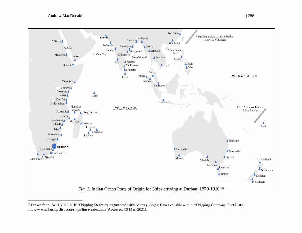
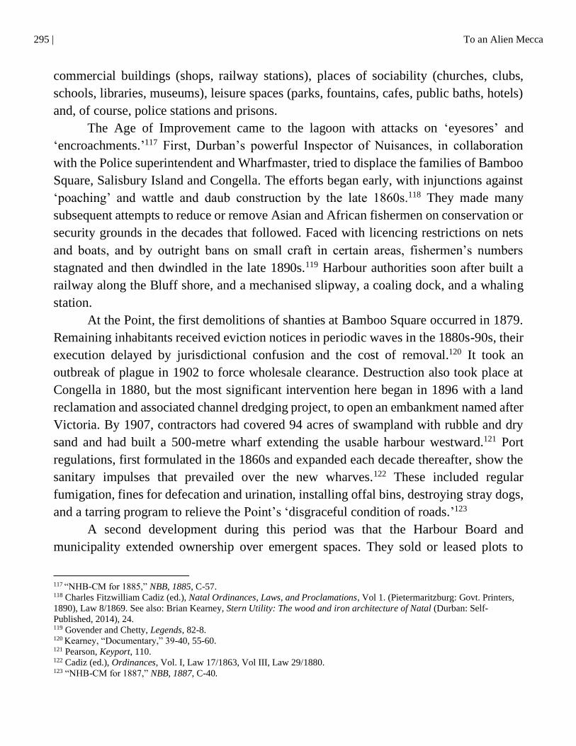
Durban’s connections with the world, and the Indian Ocean in particular, proliferated, as
Fig. 1 demonstrates. As we will see in the next section, the development of the port and
65 Ingram, Seaport, 62-4. 66 Lucille Heydenrich, “Port Natal Harbour,” in Enterprise, eds. Guest and Sellers, 17-46. 67 The precise professional journeys of even the most senior engineers need to be adequately researched, but a preliminary
review suggests training predominantly in Scottish, Irish and Caribbean ports, as well as an interest in Colombo and Venice.
Working through professional institutions with global reach, the engineers could draw off multiple case-studies and
expertise elsewhere. 68 NHB-CM, NBB for 1885, C-53; Pearson, Keyport, 48. 69Yearbook, 1917, 626 70 Lines that operated at Durban (not always simultaneously) before 1920 were: Bank’s India-Africa Line, Blue Funnel,
Clan Lines, Commonwealth & Dominion, Companhia Colonial de Navigação, Deutsche Ost-Afrika Linie, Elder-Dempster,
Ellerman-Bucknall, Federal & Shire, Hansa, Holland-Afrika Lijn, Koninklijke Paket Vaart Maatschappij, Lloyd Triestino,
Messagaries Maritimes, Nippon Yusen Kaisha, Osaka Shoshen Kaisha, Peninsula & Orient, Prince, Robin, Scandinavian-
South Africa Line, Union-Castle and White Star. See: Marischal Murray, Ships and South Africa: A maritime chronicle of
the Cape, with particular reference to mail and passenger liners from the early days of steam down to the present (Oxford:
Oxford University Press, 1933). 71Yearbook, 1917, 626.
285 | To an Alien Mecca
increases in shipping traffic revolutionised migration to and through the port, changing
Durban from premodern outlier to central node in Indian Ocean networks, and producing
an ironic backlash.
‘MOTHS TO A CANDLE’: MIGRATION 1850S-1910S
While engineers concentrated on modernising the port, the number of seaborne voyagers
increased exponentially. The extent of migration is complicated to quantify until the later
1890s. The most numerous but least understood of the lagoon’s visitors before 1895 were
the approximately 380,000 crew who operated on ships there since 1860; by the end of
this period a third were Asian lascars.72 Passengers are harder to track. If one estimates a
conservative average of fifty per vessel, whether immigrating, emigrating or in transit,
over half a million anchored at Durban in the same period. Of those that landed, the best
studied are the 65,000 Indian indentured labourers, from the hinterlands of Madras and
Calcutta, who disembarked between 1860-95.73 5,000 settler-farmers passed through the
Point for the hinterland in organised schemes between 1849 and 1860. The majority came
from England, but others were from Mauritius, Holland and the Dutch East Indies,
Bremen, Osnabruck and Glasgow.74 A further 8,000 arrived on government aided
programs between 1876 and 1896, now including Irish and Norwegian parties.75 During
the Anglo-Zulu War (1879-81), several thousand British soldiers entered through Durban,
many of whom remained. African migrants crossed the bar in smaller but not insignificant
numbers. About 3,000 recruited men, some from Delagoa Bay, and other libertos (freed
slaves) from Inhambane and Quelimane, sailed into Durban to work on sugar farms
between 1867-76, and another thousand from Inhambane docked in 1890.76 In 1873, a
thousand St Helenians landed in a scheme to import servants, farm and railway
labourers.77 Between 1873 and 1877, 500 liberated ‘Zanzibaris’ – they were Mukua-
72 Tallied from annual shipping returns in: NBB 1860-1895. For the second figure, nationalities are tallied from AR-IRD
1897-1916 (see below). 73 Surendra Bhana, Indentured Indians in Natal, 1860-1902: A study based on ship’s lists (New Delhi: Promilla & Co.,
1987), 3. 74
Shelagh O’ Spencer, British Settlers in Natal, 1824-1857. Vols. 1-8 (Pietermaritzburg: University of Natal Press, 1981-
2016). 75 Tallied from annual “Report of the Land & Immigration Board,” NBB, 1876-1896. 76 Ibid., 1891-92: A61; Patrick Harries, Work, Culture, and Identity: Migrant laborers in Mozambique and South Africa, c.
1860-1910 (Portsmouth, N.H.: Heinemann, 1997), 19-21. 77 Rebecca Swartz and Johan Wassermann, “‘Britishness’, colonial governance and education: St Helenian children in
colonial Natal in the 1870s,” Journal of Imperial and Commonwealth History, 44, 6 (2016), 881-9.
Andrew MacDonald | 286
Fig. 1. Indian Ocean Ports of Origin for Ships arriving at Durban, 1870-1910.78
78 Drawn from: NBB, 1870-1910. Shipping Statistics, augmented with: Murray, Ships; Data available within: “Shipping Company Fleet Lists,”
https://www.theshipslist.com/ships/lines/index.htm [Accessed: 19 Mar. 2021].

287 | To an Alien Mecca
speakers from Northern Mozambique whom British patrols had rescued from Arab and
Comorian slavers en route to Madagascar – walked across Durban’s wharves.79
Natal Magistrates’ annual population returns indicate significant ‘independent’
migration beyond the organised schemes. The number of Europeans/Whites in Natal,
allowing for births, deaths and emigrants, grew by at least 500-600 settlers a year between
1870 and 1890.80 But at the end of 1890, when the Wharfmaster published the first figures
on independent European passengers, he found 4,000 ‘Europeans’ had landed during the
prior twelve months; by 1896 he had recorded a further 33,000.81 Natal authorities
believed that between 1870 and 1896, Gujarati family firms totalling about 4,000
individuals had moved through Durban’s port.82 Using birthplace – rather than more
conventional ethnicity or nationality – data from censuses conducted at either end of the
1890s show an even greater heterogeneity in Durban (Fig. 1).
The surge of independent journeys from the 1890s prompted detailed record
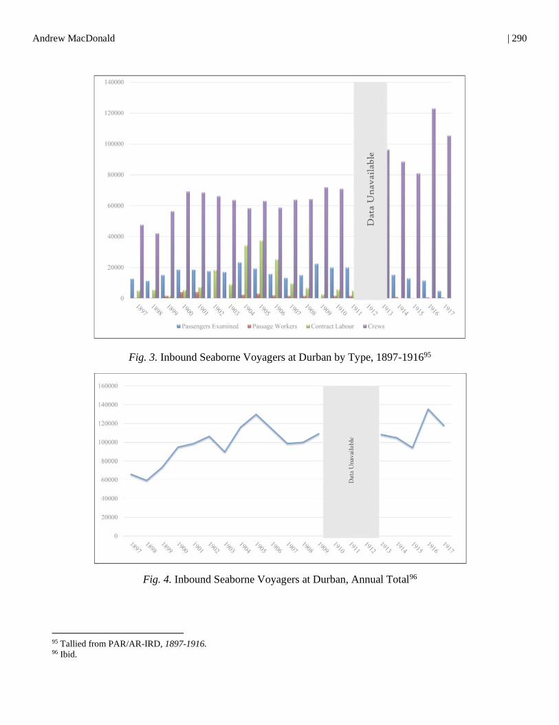
keeping at the Point. Figs. 2-4 merge all the seaborne voyagers examined while arriving
at or transiting through the port from 1897 to 1914. Crews and passage workers remained
the most frequent visitors; indenture initiatives expanded to incorporate Chinese ‘Transit
Immigrants’ for the gold mines. We cannot unpack every motivation here. But each stream
of ‘free’ migrants had merchants and peasants, priests and political activists, fugitives and
adventurers, those seeking a family and those escaping one. Not included here were the
34,000 officers, servicemen and other ‘followers’ that entered from Britain and India
during Britain’s war against the South African Republic (1899-1902), for which Natal was
a key staging ground.83 All told, the port saw close to two million inward voyagers. As
we shall see, this did not please many in authority: Durban’s chief constable disparaged
the migrants thronging the Point as like ‘moths to a candle.’84
If Durban was a point of entry to the hinterland from 1850-1914, it was also a point
of exit. Surveying emigration is even more difficult than immigration. Between 1865 and
1914, approximately 10,000 indentured workers returned to India at the end of their
contracts (an additional 35,000 were repatriated between the 1920s to the 1940s).85
79 Zubeda K. Seedat, “The Zanzibaris in Durban: A social anthropological study of the Muslim descendants of African freed
slaves living in the Indian area of Chatsworth” (Unpublished MA diss., University of Natal, 1973), 1-12. 80 Tallied from annual “Population” returns in NBB, 1870-1890. 81 Tallied from annual “Report of the Collector of Customs,” NBB, 1891-1897. 82 Goolam H. Vahed and Surendra Bhana, Crossing Space and Time in the Indian Ocean: Early Indian traders in Natal, a
biographical study (Pretoria: Unisa Press, 2015), 31. 83 Wasserman and Kearney, Gateway, 59-60. 84 Durban Archives Repository, Durban (hereafter TBD), Durban Borough Police (DBP), Monthly Report for Jan. 1899, 1. 85
Ashwin Desai and Goolam Vahed, Inside Indian Indenture: A South African story, 1860-1914 (Cape Town: HSRC Press,
2010), 119, 358.
Andrew MacDonald | 288
Europeans emigrated in significant numbers, too. Magistrates kept registers of resident
Europeans ‘born outside the colony.’ Between 1870 and 1890 this number remained quite
stable despite other sources showing incessant immigration; this suggests 5-6,000
emigrants over the two decades, albeit the returns are incomplete.86 Between 1890 and
1896, wharf master records show 29,000 Europeans embarked to leave the colony
(whether temporarily or permanently).87 No tallies of emigrants appeared again until 1910,
when the volume of emigrants equalled that of immigrants.88 African emigrants were not
uncommon, too. Recruiters returned 12,000 Mozambicans via ship to Lourenço Marques
in the 1870s-80s.89 Up to 400 black South Africans, mostly young Christians and many
Zulu-speaking, left for American and British Universities between 1880 and the 1910s.90
Recent work indicates some ‘Zulu’ shipmen worked on international liners, but the
number is not clear.91
Hinterland turmoil brought to Durban displaced peoples not always reflected in the
immigration lists. Zulu-speaking peasants in the colony’s interior migrated to Durban
from the earliest days, a result of overlapping political, land and subsistence crises at home
and bare security and consumer goods available at the coast. ‘Refugees,’ as colonial
authorities called them, arrived regularly, but notable flights occurred during violent
succession struggles in the Zulu state in the late 1850s, and in the aftermath of the Anglo-
Zulu War (1879-1881).92 By the twentieth century, when rinderpest and a suppressed
Rebellion intensified the exodus, ‘internal migrants’ in Durban numbered 12,000 from
colony districts, 6,000 from Zululand.93 Here they acted as loosely formalised
craftworkers, labourers and servants. Meanwhile, ‘Free Indians’ – that is, contract-expired
Indians – had insufficient capital to acquire agrarian property. By 1885, 2,000 small-scale
Indian market gardeners had made homes around the port city; by 1900 their numbers had
doubled, and their occupations reflected diverse artisans, municipal employees,
86 Tallied from annual “Population” returns in NBB, 1870-1890. 87 Tallied from annual “Report of Collector of Customs” in NBB, 1891-1897. 88 Yearbook, 1917, 630. 89 Harries, Work, 33. 90 Robert Vinson and Robert Edgar, “Zulus, African-Americans and the African Diaspora,” in Zulu Identities: Being Zulu,
Past and Present, eds. Benedict Carton, John Laband, and Jabulani Sithole (New York: Columbia University Press, 2009),
242. 91 John Hyslop, “Zulu sailors in the steamship era: The African modern in the world voyage narratives of Fulunge Mpofu
and George Magodini, 1916–1924,” Critical Perspectives on Colonialism: Writing the empire from below, eds. Fiona
Paisley and Kirsty Reid (London: Routledge, 2013): 124-40. 92 Atkins, Moon, esp. 18-25. 93 By 1900, ‘Internal’ migrants came from all the colony’s districts; most came from Vryheid and Maphumulo. For a full
breakdown, see: Hemson, “Class consciousness,” 53-54.
289 | To an Alien Mecca
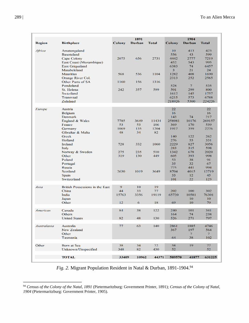
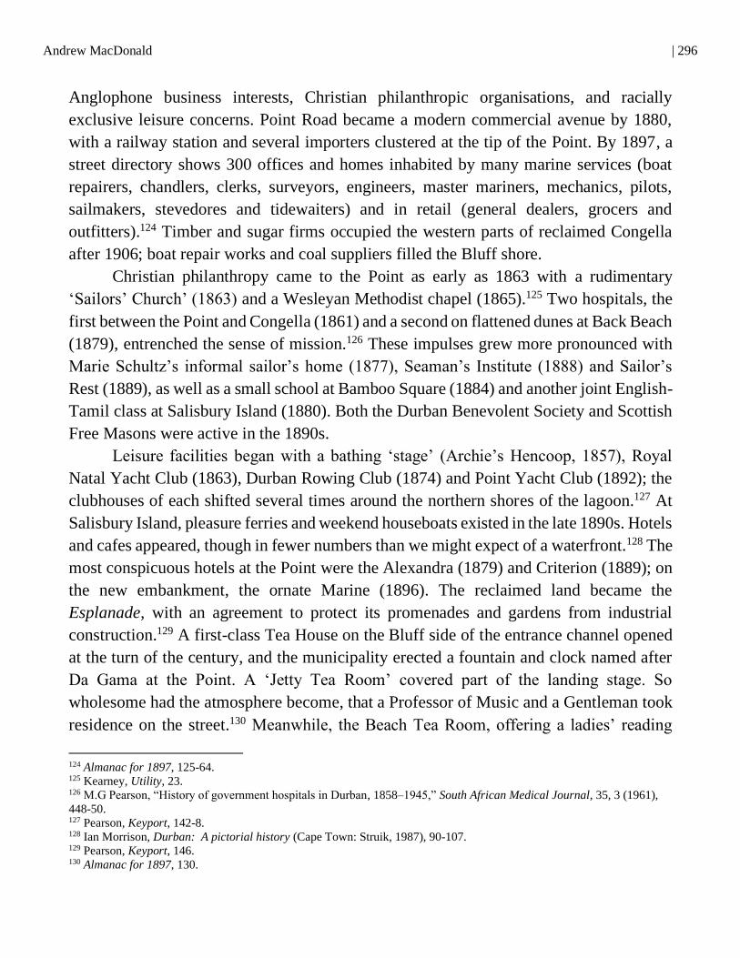
Fig. 2. Migrant Population Resident in Natal & Durban, 1891-1904.94
94 Census of the Colony of the Natal, 1891 (Pietermaritzburg: Government Printer, 1891); Census of the Colony of Natal,
1904 (Pietermaritzburg: Government Printer, 1905).
Andrew MacDonald | 290
Fig. 3. Inbound Seaborne Voyagers at Durban by Type, 1897-191695
Fig. 4. Inbound Seaborne Voyagers at Durban, Annual Total96
95 Tallied from PAR/AR-IRD, 1897-1916. 96 Ibid.
291 | To an Alien Mecca
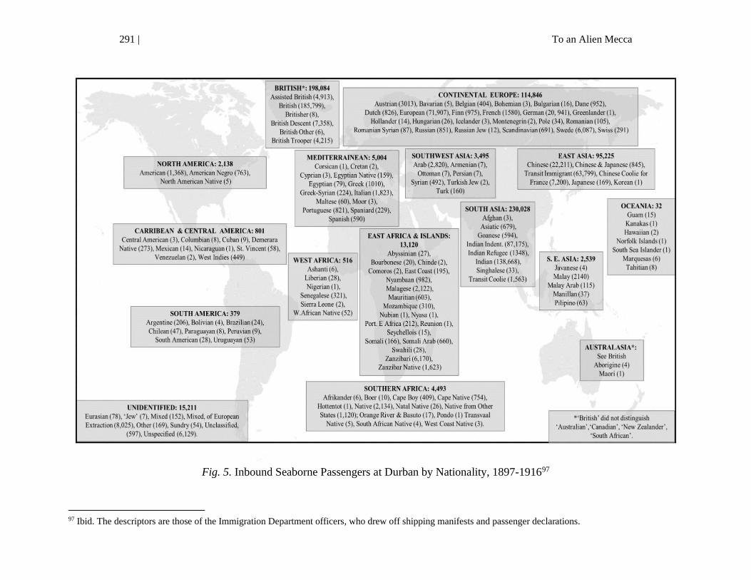
Fig. 5. Inbound Seaborne Passengers at Durban by Nationality, 1897-191697
97 Ibid. The descriptors are those of the Immigration Department officers, who drew off shipping manifests and passenger declarations.
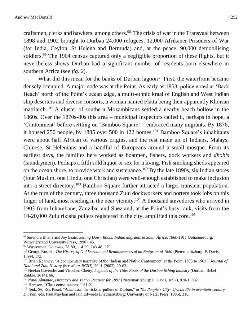
Andrew MacDonald | 292
craftsmen, clerks and hawkers, among others.98 The crisis of war in the Transvaal between
1898 and 1902 brought to Durban 24,000 refugees, 12,000 Afrikaner Prisoners of War
(for India, Ceylon, St Helena and Bermuda) and, at the peace, 90,000 demobilising
soldiers.99 The 1904 census captured only a negligible proportion of these flights, but it
nevertheless shows Durban had a significant number of residents born elsewhere in
southern Africa (see fig. 2).
What did this mean for the banks of Durban lagoon? First, the waterfront became
densely occupied. A major node was at the Point. As early as 1853, police noted at ‘Back
Beach’ north of the Point’s ocean edge, a multi-ethnic kraal of English and West Indian
ship deserters and diverse consorts, a woman named Flatta being their apparently Khoisan
matriarch.100 A cluster of southern Mozambicans settled a nearby beach hollow in the
1860s. Over the 1870s-80s this area – municipal inspectors called it, perhaps in hope, a
‘Cantonment’ before settling on ‘Bamboo Square’ – embraced many migrants. By 1876,
it housed 250 people, by 1885 over 500 in 122 homes.101 Bamboo Square’s inhabitants
were about half African of various origins, and the rest made up of Indians, Malays,
Chinese, St Helenians and a handful of Europeans around a small mosque. From its
earliest days, the families here worked as boatmen, fishers, dock workers and dhobis
(laundrymen). Perhaps a fifth sold liquor or sex for a living. Fish smoking sheds appeared
on the ocean shore, to provide work and sustenance.102 By the late 1890s, six Indian stores
(four Muslim, one Hindu, one Christian) were well-enough established to make inclusion
into a street directory.103 Bamboo Square further attracted a larger transient population.
At the turn of the century, three thousand Zulu dockworkers and porters took jobs on this
finger of land, most residing in the near vicinity.104 A thousand stevedores who arrived in
1903 from Inhambane, Zanzibar and Suez and, at the Point’s busy rank, visits from the
10-20,000 Zulu rikisha pullers registered in the city, amplified this core.105
98
Surendra Bhana and Joy Brain, Setting Down Roots: Indian migrants in South Africa, 1860-1911 (Johannesburg:
Witwatersrand University Press, 1990), 45. 99 Wasserman, Gateway, 78-80, 114-20, 243-48, 279. 100
George Russell, The History of Old Durban and Reminiscences of an Emigrant of 1850 (Pietermaritzburg: P. Davis,
1899), 173. 101 Brian Kearney, “A documentary narrative of the ‘Indian and Native Cantonment’ at the Point, 1873 to 1903,” Journal of
Natal and Zulu History (hereafter: JNZH), 20, 1 (2002), 29-63. 102
Neelan Govender and Viroshen Chetty, Legends of the Tide: Roots of the Durban fishing industry (Durban: Rebel
Rabble, 2014), 66. 103
Natal Almanac, Directory and Yearly Register for 1897 (Pietermaritzburg: P. Davis, 1897), 870-1, 882 104 Hemson, “Class consciousness,” 61-2. 105 Ibid., 86; Ros Posel, “Amahashi: the ricksha-pullers of Durban,” in The People’s City: African life in twentieth-century
Durban, eds. Paul Maylam and Iain Edwards (Pietmaritzburg: University of Natal Press, 1996), 216.
293 | To an Alien Mecca
A second node of settlement was to the lagoon’s southwest, on Salisbury Island and
the Bluff’s inward shore.106 The waters here had been ideal for fishing since antiquity;
lagoon descriptions through the 1820s-50s noted Nguni fish kraals (a submerged a wicker
cage or trap). The commercial development of this stretch, too shallow to admit ships, had
been slower after a failed 1856 experiment to establish saltworks there. Off-duty
indentured labourers and dockhands were wading into the lagoon and harpooning fish at
night by 1860. By 1875, resident ‘Free Indians’ had established a seafood market, based
on South Indian ‘seine’ nets, so-called because of their earlier transfer from Paris to
French Pondicherry, and a fleet of flat-bottomed masulah boats. They supplied cheap
smoked shad, dried sardine (a local variant of Bombay Duck) and shrimp to plantations
and working-class markets, as well as medicine to Zulu healers. In years of good haul,
they exported to Mauritius. Several master draggers (three from the Pular river south of
Madras, a Malabari and a Mauritian) led fishing companies of 15-30 hands each and
owned the properties there. They were the area’s chief authorities through the 1890s, when
the community numbered about three hundred Indians and Africans.
By now, the rescued ‘Zanzibaris’ (see above) had formed an enclave west of
Salisbury Island. A Muslim section lived under the leadership of a Comorian khalifah,
Catholics under an Inhambane preacher.107 They engaged in market gardening and rented
out rowboats across the lagoon; liquor trafficking seems to have been an important income
generator too. By the 1900s, previously indentured Francophone Mauritians, as well as
other ‘East Coast natives’ from inland, joined.108 Europeans settled here late and only in
limited numbers. A lighthouse keeper lived on the Bluff’s crest from 1867. Perhaps ten
English families, a mingling of mercurial speculators in fish, labour recruitment and wreck
salvage, came to make up the bulk below in later years, to be followed by a few
independent boatmen.109
Separating the Point wharves from the Bluff lay the long arc of malarial swampland
of Congella, corrupted from uKhangelaamaNkengane (‘Watchers of the Vagabonds’),
after a Zulu regiment that putatively encamped there in the 1820s.110 Because of
Congella’s unsuitability for construction, nineteenth-century planners situated the centre
106 See: Govender and Chetty, Legends; Brian Kearney, “Salisbury Island: The early years,” JNZH, 31, 1 (2013), 1-21. 107
Seedat, “Zanzibaris,” 26-34. 108 Ibid., 32. 109 For example: Kearney, “Salisbury,” 7-10. 110 There is no evidence that such a regimental outpost ever existed. Koopman resolves the riddle by suggesting Trekker
leader Andries Pretorius had appropriated the name of an important Zulu palace and transplanted the toponym to his own
small camp at Port Natal in the 1840s. Koopman, “Durban,” 82-3.
Andrew MacDonald | 294
of the town on firmer soils a few hundred metres northeast, leaving the waterfront here a
muddy backwater and public defecation ground.111 The few visitors to this stretch came
to cut mangroves for termite-resistant building poles, and to strip their bark for its
medicinal qualities. Over the 1880s, a straggle of shad curing sheds and lime kilns
belonging to a mix of English and Indian owners appeared, but it retained a reputation for
marine detritus.112 On Congella’s western fringe, where the uMbilo river enters the
lagoon, Indian market gardeners congregated from the late 1860s. They, probably with
Hindus on Salisbury Island, maintained a Shiva Temple – it enshrined the Goddess of Fish
and of Smallpox – from 1869 until its destruction by flood at the turn of the century.113
THE REIGN OF THE WATER RATS AND THE FASCINATION FRANTIC
Late nineteenth-century English watercolourists typically omitted any depiction of the
unromantic, heterodox world of the waterfront, and instead highlighted the technological
progress and natural landscapes around the lagoon.114 The artistic erasure was echoed by
municipal attempts to scrub the peoples from the lagoon, be they residents or passing
migrants. Historians of southeast Africa have long studied the corps of social and public
health reformers, employers, intellectuals, and legislators who circulated Eugenic and
segregationist ideas from mid-19th century onwards, winning support from both middle-
and working-class settler audiences.115 Across Natal, this manifested in denunciations of,
and ultimately restrictions on, free African and Asian mobility, residence patterns,
political rights, consumption choices and domestic/sexual practices. Segregationists
encouraged respectable northern European settlement and the upliftment of ‘poor whites.’
As part of these campaigns, reformers tried to transform Durban into an exemplar of
Victorian civic urbanity.116 Beginning as early as the 1850s but in full swing by the 1890s,
Durban’s municipal elites waged war on the town’s smells, dust, and air. Architects
decorated the English-named streets with monumental architecture, splendorous
111
Brian Kearney, “‘Keep your town sweet and wholesome.’ The inspector of nuisances: A narrative of culture and
sanitation in nineteenth-century Durban,” Historia, 57 (2012), 42-65. 112 Ibid., 55. See also: “Report of the Resident Magistrate, Durban Borough, for 1881,” in NBB, 1881, JJ-94. 113 Alleyn Diesel, “The worship and iconography of the Hindu folk goddesses in Natal,” Journal for the Study of Religion,
5, 2 (1992), 3-30. 114 For an anthology, see: Nigel Hughes, The Paintings of the Bay of Natal: A selection of works dating from 1845 to 1982
(Johannesburg: Mertrade, 2001). 115 For the widest perspective, see: Jeremy C. Martens, “‘So destructive of domestic security and comfort’: Settler
domesticity, race and the regulation of African behaviour in the colony of Natal, 1843-1893” (Unpublished PhD diss.,
Queens University, 2001). 116
W.P.M. Henderson, Durban: Fifty years’ municipal history (Durban: Robinson, 1904), 225-330.
295 | To an Alien Mecca
commercial buildings (shops, railway stations), places of sociability (churches, clubs,
schools, libraries, museums), leisure spaces (parks, fountains, cafes, public baths, hotels)
and, of course, police stations and prisons.
The Age of Improvement came to the lagoon with attacks on ‘eyesores’ and
‘encroachments.’117 First, Durban’s powerful Inspector of Nuisances, in collaboration
with the Police superintendent and Wharfmaster, tried to displace the families of Bamboo
Square, Salisbury Island and Congella. The efforts began early, with injunctions against
‘poaching’ and wattle and daub construction by the late 1860s.118 They made many
subsequent attempts to reduce or remove Asian and African fishermen on conservation or
security grounds in the decades that followed. Faced with licencing restrictions on nets
and boats, and by outright bans on small craft in certain areas, fishermen’s numbers
stagnated and then dwindled in the late 1890s.119 Harbour authorities soon after built a
railway along the Bluff shore, and a mechanised slipway, a coaling dock, and a whaling
station.
At the Point, the first demolitions of shanties at Bamboo Square occurred in 1879.
Remaining inhabitants received eviction notices in periodic waves in the 1880s-90s, their
execution delayed by jurisdictional confusion and the cost of removal.120 It took an
outbreak of plague in 1902 to force wholesale clearance. Destruction also took place at
Congella in 1880, but the most significant intervention here began in 1896 with a land
reclamation and associated channel dredging project, to open an embankment named after
Victoria. By 1907, contractors had covered 94 acres of swampland with rubble and dry
sand and had built a 500-metre wharf extending the usable harbour westward.121 Port
regulations, first formulated in the 1860s and expanded each decade thereafter, show the
sanitary impulses that prevailed over the new wharves.122 These included regular
fumigation, fines for defecation and urination, installing offal bins, destroying stray dogs,
and a tarring program to relieve the Point’s ‘disgraceful condition of roads.’123
A second development during this period was that the Harbour Board and
municipality extended ownership over emergent spaces. They sold or leased plots to
117
“NHB-CM for 1885,” NBB, 1885, C-57. 118 Charles Fitzwilliam Cadiz (ed.), Natal Ordinances, Laws, and Proclamations, Vol 1. (Pietermaritzburg: Govt. Printers,
1890), Law 8/1869. See also: Brian Kearney, Stern Utility: The wood and iron architecture of Natal (Durban: Self-
Published, 2014), 24. 119 Govender and Chetty, Legends, 82-8. 120
Kearney, “Documentary,” 39-40, 55-60. 121 Pearson, Keyport, 110. 122 Cadiz (ed.), Ordinances, Vol. I, Law 17/1863, Vol III, Law 29/1880. 123 “NHB-CM for 1887,” NBB, 1887, C-40.
Andrew MacDonald | 296
Anglophone business interests, Christian philanthropic organisations, and racially
exclusive leisure concerns. Point Road became a modern commercial avenue by 1880,
with a railway station and several importers clustered at the tip of the Point. By 1897, a
street directory shows 300 offices and homes inhabited by many marine services (boat
repairers, chandlers, clerks, surveyors, engineers, master mariners, mechanics, pilots,
sailmakers, stevedores and tidewaiters) and in retail (general dealers, grocers and
outfitters).124 Timber and sugar firms occupied the western parts of reclaimed Congella
after 1906; boat repair works and coal suppliers filled the Bluff shore.
Christian philanthropy came to the Point as early as 1863 with a rudimentary
‘Sailors’ Church’ (1863) and a Wesleyan Methodist chapel (1865).125 Two hospitals, the
first between the Point and Congella (1861) and a second on flattened dunes at Back Beach
(1879), entrenched the sense of mission.126 These impulses grew more pronounced with
Marie Schultz’s informal sailor’s home (1877), Seaman’s Institute (1888) and Sailor’s
Rest (1889), as well as a small school at Bamboo Square (1884) and another joint English-
Tamil class at Salisbury Island (1880). Both the Durban Benevolent Society and Scottish
Free Masons were active in the 1890s.
Leisure facilities began with a bathing ‘stage’ (Archie’s Hencoop, 1857), Royal
Natal Yacht Club (1863), Durban Rowing Club (1874) and Point Yacht Club (1892); the
clubhouses of each shifted several times around the northern shores of the lagoon.127 At
Salisbury Island, pleasure ferries and weekend houseboats existed in the late 1890s. Hotels
and cafes appeared, though in fewer numbers than we might expect of a waterfront.128 The
most conspicuous hotels at the Point were the Alexandra (1879) and Criterion (1889); on
the new embankment, the ornate Marine (1896). The reclaimed land became the
Esplanade, with an agreement to protect its promenades and gardens from industrial
construction.129 A first-class Tea House on the Bluff side of the entrance channel opened
at the turn of the century, and the municipality erected a fountain and clock named after
Da Gama at the Point. A ‘Jetty Tea Room’ covered part of the landing stage. So
wholesome had the atmosphere become, that a Professor of Music and a Gentleman took
residence on the street.130 Meanwhile, the Beach Tea Room, offering a ladies’ reading
124 Almanac for 1897, 125-64. 125 Kearney, Utility, 23. 126 M.G Pearson, “History of government hospitals in Durban, 1858–1945,” South African Medical Journal, 35, 3 (1961),
448-50. 127 Pearson, Keyport, 142-8. 128 Ian Morrison, Durban: A pictorial history (Cape Town: Struik, 1987), 90-107. 129 Pearson, Keyport, 146. 130 Almanac for 1897, 130.
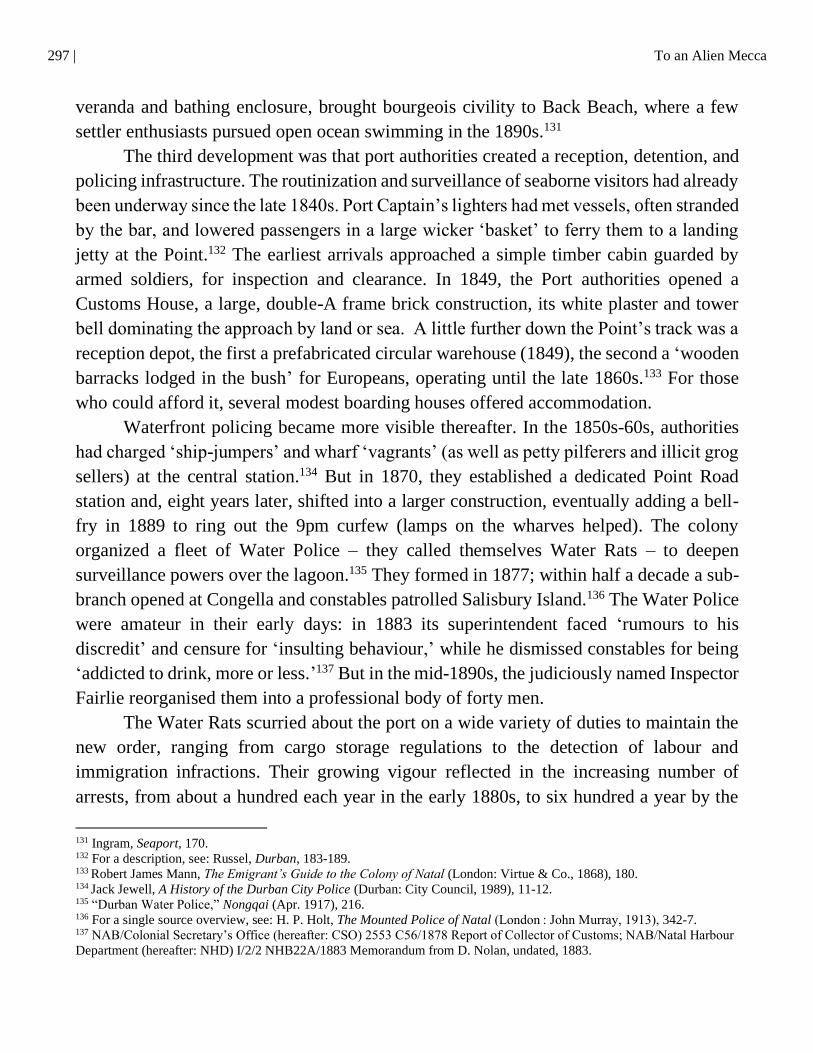
297 | To an Alien Mecca
veranda and bathing enclosure, brought bourgeois civility to Back Beach, where a few
settler enthusiasts pursued open ocean swimming in the 1890s.131
The third development was that port authorities created a reception, detention, and
policing infrastructure. The routinization and surveillance of seaborne visitors had already
been underway since the late 1840s. Port Captain’s lighters had met vessels, often stranded
by the bar, and lowered passengers in a large wicker ‘basket’ to ferry them to a landing
jetty at the Point.132 The earliest arrivals approached a simple timber cabin guarded by
armed soldiers, for inspection and clearance. In 1849, the Port authorities opened a
Customs House, a large, double-A frame brick construction, its white plaster and tower
bell dominating the approach by land or sea. A little further down the Point’s track was a
reception depot, the first a prefabricated circular warehouse (1849), the second a ‘wooden
barracks lodged in the bush’ for Europeans, operating until the late 1860s.133 For those
who could afford it, several modest boarding houses offered accommodation.
Waterfront policing became more visible thereafter. In the 1850s-60s, authorities
had charged ‘ship-jumpers’ and wharf ‘vagrants’ (as well as petty pilferers and illicit grog
sellers) at the central station.134 But in 1870, they established a dedicated Point Road
station and, eight years later, shifted into a larger construction, eventually adding a bell-
fry in 1889 to ring out the 9pm curfew (lamps on the wharves helped). The colony
organized a fleet of Water Police – they called themselves Water Rats – to deepen
surveillance powers over the lagoon.135 They formed in 1877; within half a decade a sub-
branch opened at Congella and constables patrolled Salisbury Island.136 The Water Police
were amateur in their early days: in 1883 its superintendent faced ‘rumours to his
discredit’ and censure for ‘insulting behaviour,’ while he dismissed constables for being
‘addicted to drink, more or less.’137 But in the mid-1890s, the judiciously named Inspector
Fairlie reorganised them into a professional body of forty men.
The Water Rats scurried about the port on a wide variety of duties to maintain the
new order, ranging from cargo storage regulations to the detection of labour and
immigration infractions. Their growing vigour reflected in the increasing number of
arrests, from about a hundred each year in the early 1880s, to six hundred a year by the
131 Ingram, Seaport, 170. 132 For a description, see: Russel, Durban, 183-189. 133
Robert James Mann, The Emigrant’s Guide to the Colony of Natal (London: Virtue & Co., 1868), 180. 134
Jack Jewell, A History of the Durban City Police (Durban: City Council, 1989), 11-12. 135 “Durban Water Police,” Nongqai (Apr. 1917), 216. 136 For a single source overview, see: H. P. Holt, The Mounted Police of Natal (London : John Murray, 1913), 342-7. 137 NAB/Colonial Secretary’s Office (hereafter: CSO) 2553 C56/1878 Report of Collector of Customs; NAB/Natal Harbour
Department (hereafter: NHD) I/2/2 NHB22A/1883 Memorandum from D. Nolan, undated, 1883.
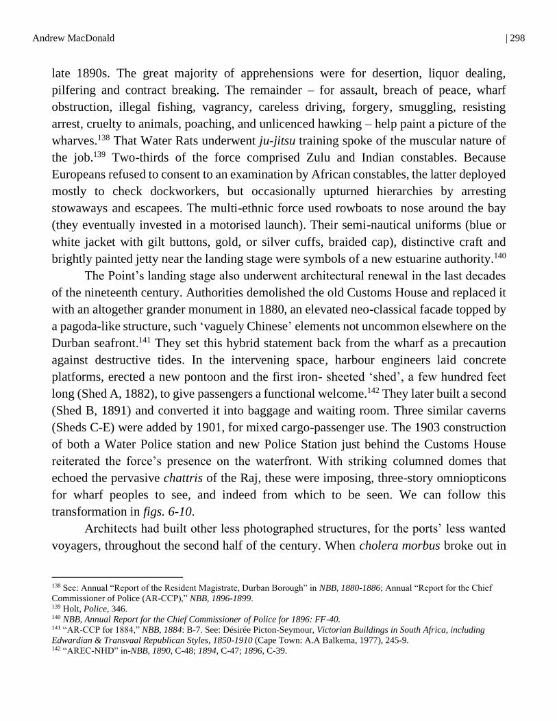
Andrew MacDonald | 298
late 1890s. The great majority of apprehensions were for desertion, liquor dealing,
pilfering and contract breaking. The remainder – for assault, breach of peace, wharf
obstruction, illegal fishing, vagrancy, careless driving, forgery, smuggling, resisting
arrest, cruelty to animals, poaching, and unlicenced hawking – help paint a picture of the
wharves.138 That Water Rats underwent ju-jitsu training spoke of the muscular nature of
the job.139 Two-thirds of the force comprised Zulu and Indian constables. Because
Europeans refused to consent to an examination by African constables, the latter deployed
mostly to check dockworkers, but occasionally upturned hierarchies by arresting
stowaways and escapees. The multi-ethnic force used rowboats to nose around the bay
(they eventually invested in a motorised launch). Their semi-nautical uniforms (blue or
white jacket with gilt buttons, gold, or silver cuffs, braided cap), distinctive craft and
brightly painted jetty near the landing stage were symbols of a new estuarine authority.140
The Point’s landing stage also underwent architectural renewal in the last decades
of the nineteenth century. Authorities demolished the old Customs House and replaced it
with an altogether grander monument in 1880, an elevated neo-classical facade topped by
a pagoda-like structure, such ‘vaguely Chinese’ elements not uncommon elsewhere on the
Durban seafront.141 They set this hybrid statement back from the wharf as a precaution
against destructive tides. In the intervening space, harbour engineers laid concrete
platforms, erected a new pontoon and the first iron- sheeted ‘shed’, a few hundred feet
long (Shed A, 1882), to give passengers a functional welcome.142 They later built a second
(Shed B, 1891) and converted it into baggage and waiting room. Three similar caverns
(Sheds C-E) were added by 1901, for mixed cargo-passenger use. The 1903 construction
of both a Water Police station and new Police Station just behind the Customs House
reiterated the force’s presence on the waterfront. With striking columned domes that
echoed the pervasive chattris of the Raj, these were imposing, three-story omniopticons
for wharf peoples to see, and indeed from which to be seen. We can follow this
transformation in figs. 6-10.
Architects had built other less photographed structures, for the ports’ less wanted
voyagers, throughout the second half of the century. When cholera morbus broke out in
138 See: Annual “Report of the Resident Magistrate, Durban Borough” in NBB, 1880-1886; Annual “Report for the Chief
Commissioner of Police (AR-CCP),” NBB, 1896-1899. 139 Holt, Police, 346. 140 NBB, Annual Report for the Chief Commissioner of Police for 1896: FF-40. 141 “AR-CCP for 1884,” NBB, 1884: B-7. See: Désirée Picton-Seymour, Victorian Buildings in South Africa, including
Edwardian & Transvaal Republican Styles, 1850-1910 (Cape Town: A.A Balkema, 1977), 245-9. 142 “AREC-NHD” in-NBB, 1890, C-48; 1894, C-47; 1896, C-39.
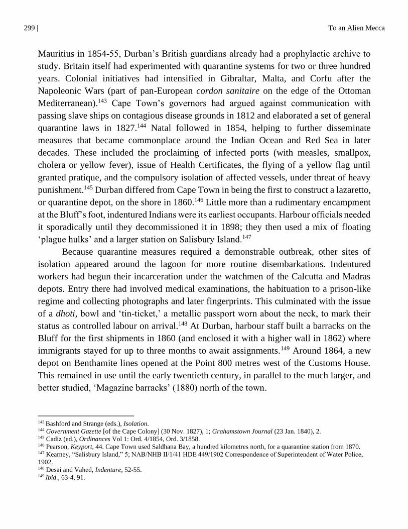
299 | To an Alien Mecca
Mauritius in 1854-55, Durban’s British guardians already had a prophylactic archive to
study. Britain itself had experimented with quarantine systems for two or three hundred
years. Colonial initiatives had intensified in Gibraltar, Malta, and Corfu after the
Napoleonic Wars (part of pan-European cordon sanitaire on the edge of the Ottoman
Mediterranean).143 Cape Town’s governors had argued against communication with
passing slave ships on contagious disease grounds in 1812 and elaborated a set of general
quarantine laws in 1827.144 Natal followed in 1854, helping to further disseminate
measures that became commonplace around the Indian Ocean and Red Sea in later
decades. These included the proclaiming of infected ports (with measles, smallpox,
cholera or yellow fever), issue of Health Certificates, the flying of a yellow flag until
granted pratique, and the compulsory isolation of affected vessels, under threat of heavy
punishment.145 Durban differed from Cape Town in being the first to construct a lazaretto,
or quarantine depot, on the shore in 1860.146 Little more than a rudimentary encampment
at the Bluff’s foot, indentured Indians were its earliest occupants. Harbour officials needed
it sporadically until they decommissioned it in 1898; they then used a mix of floating
‘plague hulks’ and a larger station on Salisbury Island.147
Because quarantine measures required a demonstrable outbreak, other sites of
isolation appeared around the lagoon for more routine disembarkations. Indentured
workers had begun their incarceration under the watchmen of the Calcutta and Madras
depots. Entry there had involved medical examinations, the habituation to a prison-like
regime and collecting photographs and later fingerprints. This culminated with the issue
of a dhoti, bowl and ‘tin-ticket,’ a metallic passport worn about the neck, to mark their
status as controlled labour on arrival.148 At Durban, harbour staff built a barracks on the
Bluff for the first shipments in 1860 (and enclosed it with a higher wall in 1862) where
immigrants stayed for up to three months to await assignments.149 Around 1864, a new
depot on Benthamite lines opened at the Point 800 metres west of the Customs House.
This remained in use until the early twentieth century, in parallel to the much larger, and
better studied, ‘Magazine barracks’ (1880) north of the town.
143
Bashford and Strange (eds.), Isolation. 144 Government Gazette [of the Cape Colony] (30 Nov. 1827), 1; Grahamstown Journal (23 Jan. 1840), 2. 145 Cadiz (ed.), Ordinances Vol 1: Ord. 4/1854, Ord. 3/1858. 146 Pearson, Keyport, 44. Cape Town used Saldhana Bay, a hundred kilometres north, for a quarantine station from 1870. 147 Kearney, “Salisbury Island,” 5; NAB/NHB II/1/41 HDE 449/1902 Correspondence of Superintendent of Water Police,
1902. 148 Desai and Vahed, Indenture, 52-55. 149
Ibid., 63-4, 91.
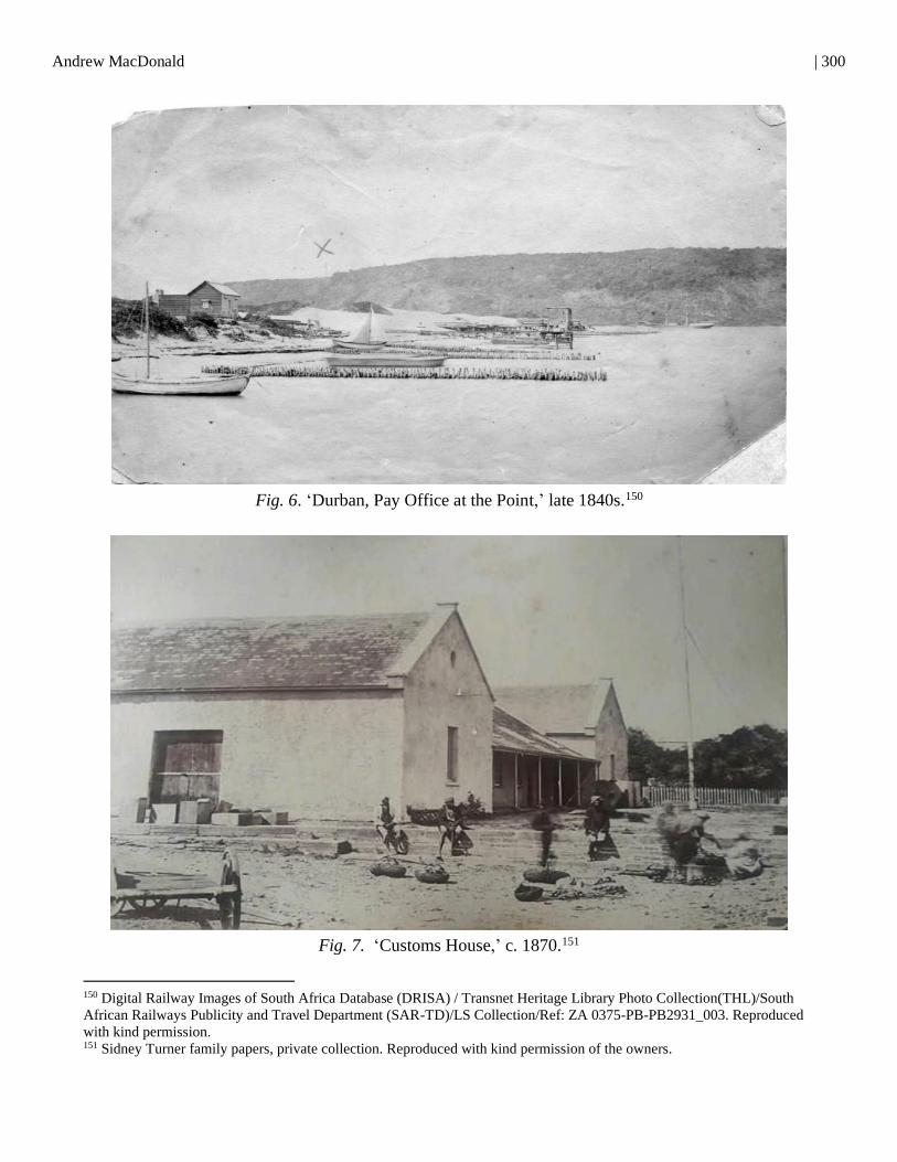
Andrew MacDonald | 300
Fig. 6. ‘Durban, Pay Office at the Point,’ late 1840s.150
Fig. 7. ‘Customs House,’ c. 1870.151
150 Digital Railway Images of South Africa Database (DRISA) / Transnet Heritage Library Photo Collection(THL)/South
African Railways Publicity and Travel Department (SAR-TD)/LS Collection/Ref: ZA 0375-PB-PB2931_003. Reproduced
with kind permission. 151 Sidney Turner family papers, private collection. Reproduced with kind permission of the owners.
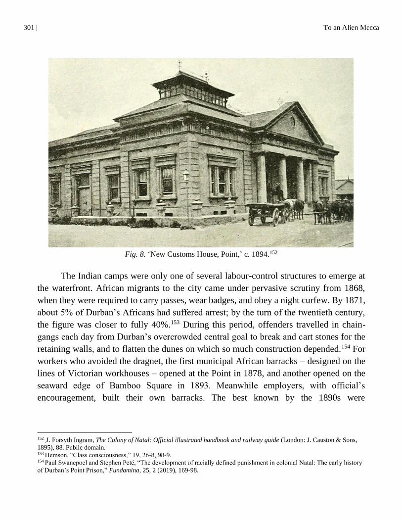
301 | To an Alien Mecca
Fig. 8. ‘New Customs House, Point,’ c. 1894.152
The Indian camps were only one of several labour-control structures to emerge at
the waterfront. African migrants to the city came under pervasive scrutiny from 1868,
when they were required to carry passes, wear badges, and obey a night curfew. By 1871,
about 5% of Durban’s Africans had suffered arrest; by the turn of the twentieth century,
the figure was closer to fully 40%.153 During this period, offenders travelled in chain-
gangs each day from Durban’s overcrowded central goal to break and cart stones for the
retaining walls, and to flatten the dunes on which so much construction depended.154 For
workers who avoided the dragnet, the first municipal African barracks – designed on the
lines of Victorian workhouses – opened at the Point in 1878, and another opened on the
seaward edge of Bamboo Square in 1893. Meanwhile employers, with official’s
encouragement, built their own barracks. The best known by the 1890s were
152
.J. Forsyth Ingram, The Colony of Natal: Official illustrated handbook and railway guide (London: J. Causton & Sons,
1895), 88. Public domain. 153
Hemson, “Class consciousness,” 19, 26-8, 98-9. 154
Paul Swanepoel and Stephen Peté, “The development of racially defined punishment in colonial Natal: The early history
of Durban’s Point Prison,” Fundamina, 25, 2 (2019), 169-98.
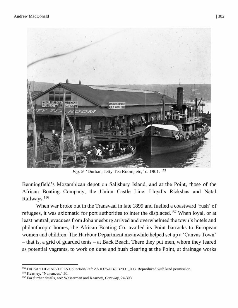
Andrew MacDonald | 302
Fig. 9. ‘Durban, Jetty Tea Room, etc,’ c. 1901. 155
Benningfield’s Mozambican depot on Salisbury Island, and at the Point, those of the
African Boating Company, the Union Castle Line, Lloyd’s Rickshas and Natal
Railways.156
When war broke out in the Transvaal in late 1899 and fuelled a coastward ‘rush’ of
refugees, it was axiomatic for port authorities to inter the displaced.157 When loyal, or at
least neutral, evacuees from Johannesburg arrived and overwhelmed the town’s hotels and
philanthropic homes, the African Boating Co. availed its Point barracks to European
women and children. The Harbour Department meanwhile helped set up a ‘Canvas Town’
– that is, a grid of guarded tents – at Back Beach. There they put men, whom they feared
as potential vagrants, to work on dune and bush clearing at the Point, at drainage works
155 DRISA/THL/SAR-TD/LS Collection/Ref: ZA 0375-PB-PB2931_003. Reproduced with kind permission. 156 Kearney, “Nuisances,” 50. 157 For further details, see: Wasserman and Kearney, Gateway, 24-303.
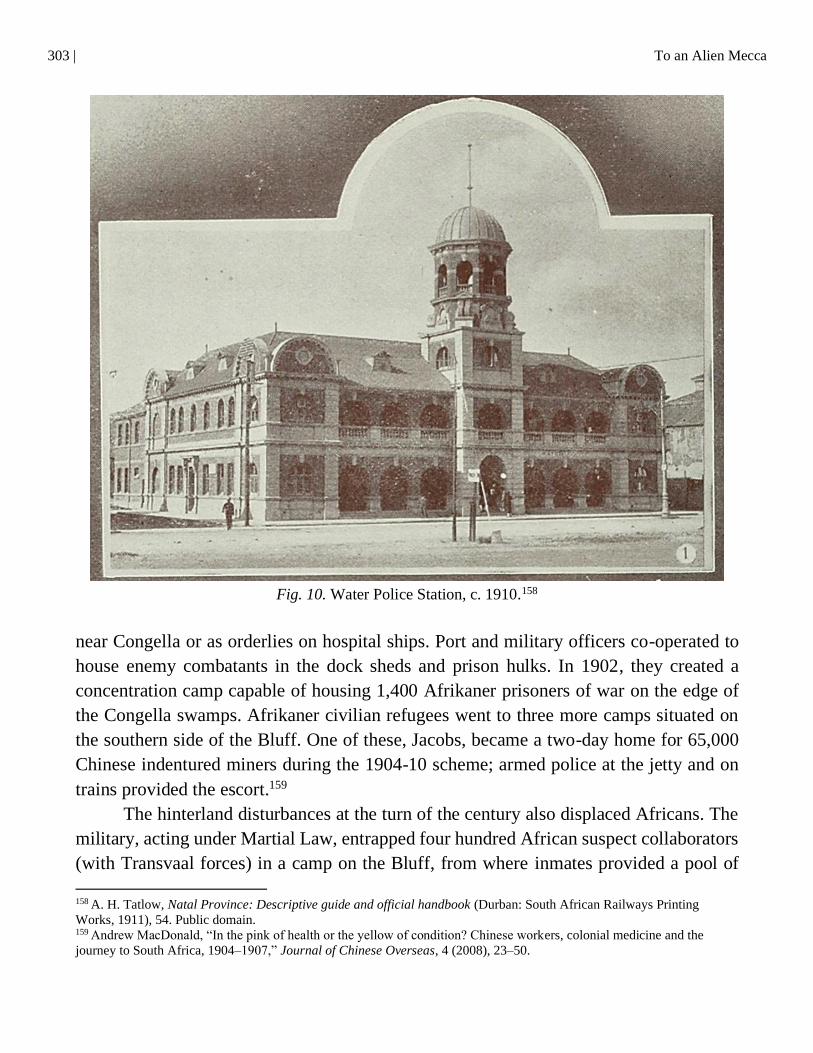
303 | To an Alien Mecca
Fig. 10. Water Police Station, c. 1910.158
near Congella or as orderlies on hospital ships. Port and military officers co-operated to
house enemy combatants in the dock sheds and prison hulks. In 1902, they created a
concentration camp capable of housing 1,400 Afrikaner prisoners of war on the edge of
the Congella swamps. Afrikaner civilian refugees went to three more camps situated on
the southern side of the Bluff. One of these, Jacobs, became a two-day home for 65,000
Chinese indentured miners during the 1904-10 scheme; armed police at the jetty and on
trains provided the escort.159
The hinterland disturbances at the turn of the century also displaced Africans. The
military, acting under Martial Law, entrapped four hundred African suspect collaborators
(with Transvaal forces) in a camp on the Bluff, from where inmates provided a pool of
158
A. H. Tatlow, Natal Province: Descriptive guide and official handbook (Durban: South African Railways Printing
Works, 1911), 54. Public domain. 159
Andrew MacDonald, “In the pink of health or the yellow of condition? Chinese workers, colonial medicine and the
journey to South Africa, 1904–1907,” Journal of Chinese Overseas, 4 (2008), 23–50.

Andrew MacDonald | 304
forced labour for the waterfront.160 Four years after the peace, the Bambatha Rebellion –
driven by Zulu peasants long disenchanted with colonial taxes and the broken promises
of liberation during the recent War – produced several thousand insurgents in the Mpanza
valley. Magistrates sent two thousand to the Point to serve sentences in Jacobs Camp,
Bamboo Square’s barracks (deemed a prison), and the Point Convict station nearby.161
Designed like the ‘portable prisons’ in use elsewhere on the colony’s roads, the rebels
themselves built this extensive building from wood, iron and recycled harbour material.
From here, convicts dispersed daily to build the embankments then swallowing up the
Congella swamps, between 1906-8.
The upswing in migration in the 1890s had alerted settler authorities to the reality
that the colony lacked mechanisms to regulate seaborne migrants who were neither
contract labourers nor convicts. Until then independent migrants faced no legal obstacle
to landing, even if naturalisation and full property rights required an expensive application
and the Lieutenant Governor’s personal approval.162 In 1896, protest by white working-
class artisans against free Indian immigration led to the Immigration Restriction Act
(IRA); indeed the Point itself became a major epicentre for demonstrations.163 The final
text of the 1897 Act targeted those ‘unable to write in a European language,’ a
constitutional subterfuge to bypass Imperial restrictions on racial laws. It further denied
landing to ‘all idiots, insane persons, paupers, or persons likely to become a public charge,
persons suffering from a loathsome or dangerous contagious disease, persons who have
been convicted of a felony or other infamous crime or misdemeanour involving moral
turpitude.’ To this, law makers added a few exemptions, for prior residents, relatives, and
compassionate cases. To enforce the new act, the government created an Immigration
Restriction Department (IRD), with offices close to the main wharf at the Point. Harry
Smith and Godfrey Dick, two English-born segregationists with the Harbour Department,
took the helm and dealt with all aspects of immigration at the Point. Within a decade, they
had created a tower of correspondence fourteen metres high. Asian travellers endured the
thrust of this offensive, but Smith and Dick did not stop there.
160
Swanepoel and Peté, “Punishment,” 170-1. 161 Ibid., 190-3. 162 Cadiz (ed.), Ordinances, Ord. 6/1849, Law 4/1874. 163 I cover this in more detail in my MA dissertation: Andrew MacDonald, “Strangers in a strange land: Undesirable and
border-controls in colonial Durban, 1897-1910” (MA Diss., University of KwaZulu-Natal, 2007), 52-66, 165-8.
305 | To an Alien Mecca
Immigrant processing at the wharf became key. A team of officials and interpreters
boarded steamers on arrival and set up an examination desk at the gangway.164 The officers
served the IRA and Port Regulations on the Master, who raised an ‘I flag’ to signal
examinations had commenced. Boarding teams then set a twenty-four-hour watch on the
ship. The guards varied their positions, allowed nobody to board, and paid special
attention to the ships’ blindside. They required everybody, apart from ‘Prominent
Colonists’ and ‘Persons of Note,’ to present themselves for identification and approval to
disembark. The gangway officer laid out papers for signing: Educational Test Certificates,
Prohibition Orders, Visiting Passes (for temporary landing permission) and Inward Passes
(for black South Africans). As the investigations proceeded, the officer drew up a
Borgesian assortment of lists. These detailed the number and nationalities of: Passengers
Examined, Prohibited Persons, Crew, Extra-hands, Passage Workers, Natal Passengers,
In-Transit Passengers, Natives, Holders of Domicile Certificates, and Holders of
Mozambique Outward Passes. At the end of the survey, he prepared further lists for
Deserters, Stowaways, and Holders of Confiscated (i.e., fraudulent) Certificates. He then
summarised the information for the shipping index, wrote up accounts for guard
payments, filled in charge sheets for lawbreakers, prepared telegraphic advice for Cape or
Mozambican ports, and concluded the task by explaining anomalies in an office diary.
Only then were IRD staff in a position to prepare the vessels’ clearance papers and to
stand down the watch carefully a few moments before it raised anchor for departure.
What of those not approved for disembarkation? The IRA ensured ships in the
lagoon were the first line of defence. The steamships were liable for confining ‘Prohibited
Immigrants.’165 This meant relegating a passenger or crewman to a locked space aboard
so that the great symbols of global mobility became, in fact, floating prisons. Masters
either arranged their own guard or paid the wages of Water Rats to do so. When crewmen
met the minimum requirements of the Act and wished to stay in the colony, the Master
had to find a substitute. When escapes occurred, masters became vulnerable to a £100 fine
per deserter. The department could withhold a ship’s clearance until the fine’s settlement.
The IRD compelled shipping companies to take responsibility for guarding, and to deport
prohibited immigrants from their ships, if discovered. Protests from the lines at the
164 NAB/Immigration Restriction Department (IRD) 46/1286 Notes and Standing Orders for the Guidance of Water Police,
1905 165 Section 8 of the IRA lays out the obligations. See also NAB/IRD 1/1/1897 Suggestions re: carrying out the Act, 22 May
1897.
Andrew MacDonald | 306
severity of these impositions, and shippers’ doubts of their legality, led the IRD to explore
several further measures.166
The IRD lobbied the Water Police to recruit more ship guards; their roll call went
from 30-odd to over 60 in 1905.167 It then reorganised the arrangements further by
employing permanent, professionalised ‘Boarding Officers’ under the direct authority of
Smith and Dick.168 In 1906, Smith purchased the Liitto, a sugar baron’s houseboat (a 150-
foot Finnish-built coaster damaged in a collision in Port Elizabeth in 1901), for use as a
‘Detention Hulk.’ Close to a thousand guests stayed on it during its first three years of
operation.169 But it was an old craft under an unreliable caretaker. By 1910, even the port
officials regarded its rotting woods, worm infestations, and malodorous leakages an
embarrassment (the Port Health office called it ‘altogether filthy, and sadly out of repair…
unfit for the accommodation of human beings.’)170 Press coverage and official censure
were expensive to the IRD’s repute. Thereafter, the IRD searched for more suitable places
of confinement. Sometimes they adapted the Health Department’s quarantine building on
Salisbury Island. At other times, the IRD used general cells in town, and at Water Police
‘sub-stations’ erected at Congella and the foot of Bluff; its airy design lightened the
oppressive summer heat but invited the stench of decomposing carcasses from the whalers
next door.171
During the 1910s, once unfamiliar words turned into common currency: Prohibited,
Undesirable, Stowaway, Detention, Restriction. New kinds of action (and inaction)
emerged: waiting, queuing, interviewing, dictating, writing, stamping, filing, and
reporting. But we should not take the IRD’s instructions at face value. For migrants, there
were always options: posing, dissimulating, hoodwinking, hiding, climbing, jumping,
swimming, scurrying. Confidential correspondence by Smith and Dick between 1898 and
1912 offers a shadow commentary on the published procedures. Smith complained soon
after his appointment – one can sense the stiff lip – of ‘no little difficulty’ with arriving
ships.172 It had taken only a few weeks after the IRD opened its doors in 1897 to record a
deserter: an ‘Arab’ whom police subsequently found on Point Road. He was one of 120
166 NAB/IRD 12/522/1902 Shipping Agents to Colonial Secretary, 29 July 1902; NAB/IRD 18/587/1903 Shipping Agents
to Colonial Secretary, 15 June 1903. 167 NAB/IRD 50/417/1904 Smith to Colonial Secretary, 6 Apr. 1905-19, Apr. 1906 168
Ibid. 169 NAB/IRD 62/345/1905 Correspondence relating to the purchase of a Detention Hulk, 1905-11. 170 NAB/IRD 68/624/1907 Report of the Port Health Officer, undated, 1907. 171
South African Archives Bureau, Pretoria (SAB)/Public Works Department (PWD) 2083/7367 Memorandum on Durban
Immigration Detention Station, 1915-1924. 172 NAB/AR-IRD 1900, 3.
307 | To an Alien Mecca
arrested that year under the IRA.173 By 1901 Smith reported that his duties at the dock
were ‘at once anxious, harassing, and exacting to the highest degree and arising from the
dark ways [of people] … the work is full of incident.’174 By 1905 he felt ‘we might as well
be without an Act,’ so multifarious were the difficulties associated with policing the
boats.175 In 1911, he took long leave, admitting ‘the strain of an almost unbroken decade’
as gatekeeper.176
Busy he had been. Between 1898 and 1910 Smith had investigated nearly a
thousand cases of escape, many involving several individuals.177 There were probably
more. Impatient masters did not always press charges for the delay it entailed; the Water
Police tried to warn and deescalate rather than arrest.178 Officers were sometimes
collaborators, and even the honest filed careless reports. In some seasons, vessels lost
multiple travellers. The worst case was the SS Somali. Having arrived from the East
African coast, the Water Police saw – or did not see – thirteen escapes on a single summer
night in 1906.179
There were many ways ashore.180 Officers accepted bribes or capitulated before
pettifoggers. Smith told of a ‘spirit of quiet hostility’ between his Immigration Department
and Water Rats; he fumed over the ‘gross negligence,’ ‘grave carelessness,’ and ‘serious
dereliction’ of ‘men employed by the hour [and] who owe allegiance elsewhere.’181 Smith
wrote of the ‘confusing traffic’ of the wharves, what some passengers at Durban called
‘the fascination frantic,’ that disguised clandestine activity (see fig. 11).182 Smith pointed
out what he called ‘poachers on the bay’ among the seventy ferry craft for hire, whom he
accused of abetting escapes by hovering on the blindside of becalmed ships.183 In 1917 a
retired Water Rat looked backed on the opening decade of the century and described ‘all
sorts of tricks… [immigrants] jumped overboard, climbed down ropes and swam to the
173 NAB/IRD 1/48/1897 Smith to Colonial Secretary, 14 Sep. 1897. 174
NAB/ARIRD, 1902, 1. 175 NAB/IRD 42/857/1905 Correspondence relating to the SS Somali, 19 Aug. – 3 Oct. 1905. 176 NAB/IRD 92/1904/1911 Smith to Secretary of the Interior, 16 Oct. 1911. 177 NAB/IRD 10/558/1902 Returns of escapes, 1898-1906. 178 “AR-CCP,” NBB 1897, F-57. Borough police, a “zealous [and] formidable competitor” to the Water Police, also made
arrests on the wharves but surviving statistics do not distinguish how many nor for what offence. 179 NAB/IRD 42/857/1905 Correspondence relating to the SS Somali, 19 Aug. – 3 Oct. 1905. 180 Many examples are detailed and fully cited in: MacDonald, “Strangers,” 172-86. 181 Ibid. 182 NAB/IRD 22/975/1903 Dick [quoting Smith] to Colonial Secretary, 22 Oct. 1903. 183 For an example, see: NAB/IRD 12/870/1902 Smith to Water-Police, Oct. 1902. For poachers in general, see: NAB/IRD
391/1903 Harry Smith to Colonial Secretary and Attorney-General, 27 May 1903. For hire craft, see: “AR-CCP for 1897”
NBB, 1897, F-59.
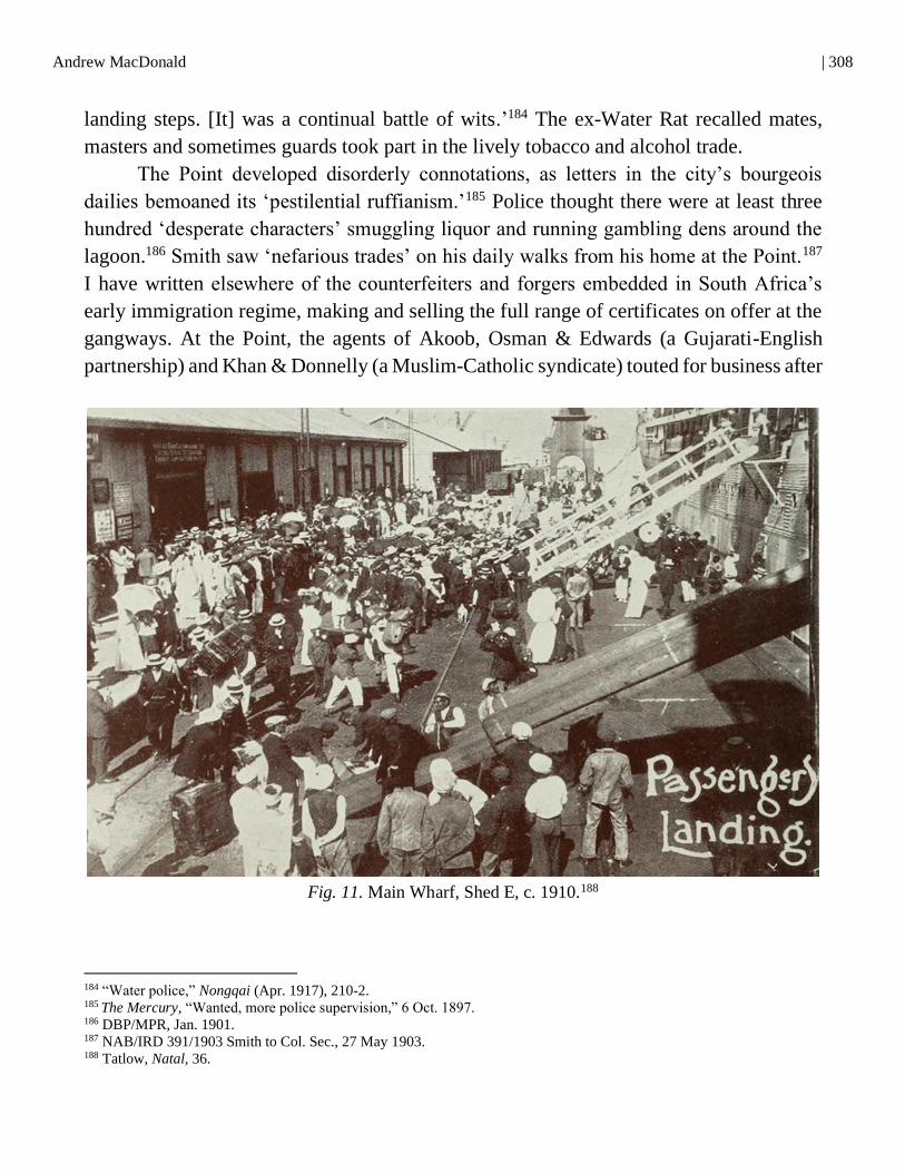
Andrew MacDonald | 308
landing steps. [It] was a continual battle of wits.’184 The ex-Water Rat recalled mates,
masters and sometimes guards took part in the lively tobacco and alcohol trade.
The Point developed disorderly connotations, as letters in the city’s bourgeois
dailies bemoaned its ‘pestilential ruffianism.’185 Police thought there were at least three
hundred ‘desperate characters’ smuggling liquor and running gambling dens around the
lagoon.186 Smith saw ‘nefarious trades’ on his daily walks from his home at the Point.187
I have written elsewhere of the counterfeiters and forgers embedded in South Africa’s
early immigration regime, making and selling the full range of certificates on offer at the
gangways. At the Point, the agents of Akoob, Osman & Edwards (a Gujarati-English
partnership) and Khan & Donnelly (a Muslim-Catholic syndicate) touted for business after
Fig. 11. Main Wharf, Shed E, c. 1910.188
184 “Water police,” Nongqai (Apr. 1917), 210-2. 185
The Mercury, “Wanted, more police supervision,” 6 Oct. 1897. 186 DBP/MPR, Jan. 1901. 187 NAB/IRD 391/1903 Smith to Col. Sec., 27 May 1903. 188 Tatlow, Natal, 36.
309 | To an Alien Mecca
1900.189 Ricksha-pullers, meanwhile, kept an illicit sex economy alive by touting at the
Point for brothels closer to the Berea.190 At the same time, the docks developed into a
space of revolt. Crews and soldiers sometimes led violent micro-mutinies against the
brutal discipline of the ship or confinement on it.191 The image of incarceration and of
travellers sent ‘pillar to post’ grew frequent in the pages of Gandhi’s Indian Opinion.192
African dockworkers protested wages and arrests, the maritime variants of the South
Africa’s ‘total institutions,’ and struck or deserted.193 The fishermen of Bamboo Square
and Salisbury Island partly re-established their communities soon after demolition,
frustrating inspectors.194 They organised an informal fisherman’s union, to fight ongoing
struggles against authorities through multiple attempts at forced removal over the
twentieth century. Smuggling and pilferage echoed in both African and settler memories
of the port’s informal economy well into the twentieth century.195
The official view of the harbour as an unruly space fuelled authorities’ activism
after 1910. Immigration scholars have shown how the Union immigration regime
redoubled their efforts, but the fundamental trajectories, the path dependencies, were well
in place.196 Port officials tinkered with the most efficient ways to isolate passengers and
crew from the shore. They simplified and standardised the gangway examinations with a
new Landing Declaration in 1913 and tallied these with more sophisticated manifests.
Union immigration officers made educational and means tests harder to pass, and more
openly discriminated on racial grounds. Reforms within the Water Police made it more
difficult for unauthorised migrants to evade inspection at the waterfront. In 1922, the IRD
converted the Indian immigration barracks into the ‘Durban Detention Depot,’ capable of
holding several hundred Prohibited Immigrants at a time.197
189 NAB/IRD 7/58/1902 Anonymous to Smith. 29 Jan. 1902; The Mercury, “Alleged Forgeries,” 31 Aug. 1910. 190 Ros Posel, “‘Continental women’ and Durban’s ‘social evil,’ 1899–1905,” JNZH, 12, 1 (1989), 1-13. 191 Jonathan Hyslop, “Oceanic mobility and settler-colonial power: Policing the global maritime labour force in Durban
harbour c. 1890–1910,” Journal of Transport History, 36, 2 (2015), 248-67. 192 For example: Indian Opinion, “Death of another passive resister,” 22 Oct. 1910. 193
Hemson,“Class consciousness,” 32, 66-71. 194 Govender and Chetty, Legends, 106-12. 195 Lawrence Green, Harbours of Memory (Cape Town: Timmins, 1982); Ralph Callebert, “Cleaning the wharves:
Pilferage, bribery, and social connections on the Durban docks in the 1950s,” Canadian Journal of African Studies, 46, 1
(2012), 23-38. 196 Jonathan Klaaren. “Migrating to citizenship: Mobility, law and nationality in South Africa, 1897-1937” (Unpublished
Ph.D. diss., Yale University, 2004), esp. Ch. 4. 197 SAB/PWD 2083/7367 Papers re: Durban Immigration Detention Station, 1915-1924.

Andrew MacDonald | 310
CONCLUSION
The processes described above were effectively complete by about 1910 (see appended
maps). But city planners had one last move to play. Scholars of industrialisation have
shown how nineteenth-century romantics, their towns enclosed and despoiled, turned
away from mountains to the oceans – in their sublime, wild immensity – for refuge,
redemption and stimulation.198 As the salty brine took on therapeutic, even cultic,
meanings, so the sea and its beaches offered opportunities for the reconstitution of body
and family. By the later nineteenth century, the seaside came to be associated with
masculine heroism and virility, with feminine fertility (soon sexuality) and childhood
innocence. As Gillis shows, the esteem in which large parts of Atlantic society held the
ocean explains the striking pervasion of nautical artefacts in nineteenth-century
metropolitan (and colonial) culture: fascinations with toy boats, sailor suits, aquariums,
shell collections, seascape painting and voyage-books (matched by morbid ruminations
on shark attacks and shipwrecks). New practices such as bathing, contemplative water-
gazing and beach-strolling or picnicking – unthinkable in prior centuries – came into
being. Around the Atlantic especially, new kinds of waterfronts emerged, with bathing
enclosures (sometimes ‘machines’), piers, promenades, cabins and decorous hotels, that
simultaneously brought the sea closer while eradicating its less salubrious smells, sights
and sensations. Urban developers emptied motley urban shores and replaced them with
open horizons, recreation phantasia and vacationers.
Durban became a striking Indian Ocean exemplar of this shift. As authorities erased
the long history of the lagoon, Edwardian beautifiers – a symphony of municipal
architects, railways publicists and hoteliers – reorientated the ‘front’ of the town to Back
Beach. After five years of planning, a settler playground, renamed ‘Ocean Beach,’ took
shape in the 1910s.199 Inspired in part by the City Beautiful movements in Chicago, its
designers transformed the dunes over which Flatta had once reigned with a manicured
promenade, a ‘shark-proof’ bathing ring and paddling ponds. To these, developers added
a Beach Pavilion and a ‘fairyland’ that included a water slide, a ‘switchback’ rollercoaster,
a model dairy, and a snake park, all topped by medieval turrets.
Despite frequent damage to Ocean Beach by high seas, reformers pressed ahead in
the 1920s and 30s. They extended roads to create the modern Marine Parade from
198 Seminal is: Alain Corbin, The Lure of the Sea: The discovery of the seaside in the western world, trans. Jocelyn Phelps
(Berkeley: University of California Press, 1994). See also: Gillis, Human Shore, Ch. 5. 199 Michelle Jacobs and Brian Kearney, The Berea Style: The architecture of William Murray-Jones and Arthur Ritchie
McKinley (Durban: Durban Heritage Trust, 2018).
311 | To an Alien Mecca
Addington to the Umgeni mouth (renamed ‘Blue Lagoon’) and decorated them with
public swimming pools, colonnaded changing rooms, bowling greens and a civic
amphitheatre, each for Europeans. These were the preludes to Apartheid’s ‘Whites Only’
beaches from the 1960s and then post-Apartheid’s multi-racial Golden Mile, ‘where the
fun never sets’ in the phrasing of tourist paraphernalia. The transformation of Back Beach
now embraces the Point itself, the site of luxury apartments, themed water parks and cruise
ship facilities, even if underworlds and scandal continue to mock, and even constitute,
urban development here in the twenty-first century.200
Over the long twentieth century, the ancient lagoon itself became ever denser with
breakwaters, piers, and concrete wharfs, today stretching twenty kilometres and able to
accommodate over fifty modern ships.201 Landward are coal bunkers, automated cranes
and container terminals, linked to marshalling yards and 300 kilometres of shoreline
railways. Ironically, construction in the 1960s destroyed the complex of neo-classical
waterfront buildings that had earlier secured the lagoon for colonial capital. On the water
are floating repair docks, dredger plants and a fleet of tugs, survey vessels and rescue
craft. The port embraces too the air above, with helicopters (ferrying local pilots to and
from the offshore anchorage) and arcs of light from navigational towers. The works now
cover 2,000 hectares and employ fifty thousand people. A mix of state and private
enterprise annually handles 120 million tonnes of cargo (or 2.8 million containers), under
watchful security.202 This has made it southern and eastern Africa’s largest port, and a
major transhipment point for the south-west Indian Ocean.203 But the skeleton enrobed in
a black shawl had a more interesting story to tell, if we care to listen.
200
Ashwin Desai and Patrick Bond, “Speculators and scoundrels in South Africa’s secondary circuit of capital: A turbulent
investment climate at Durban’s Point Waterfront,” Socialism and Democracy, 33, 2 (2019), 108-41. 201 The later twentieth-century history of the port may be traced through: Lumby, “The South African economy,” 21-34;
Lumby, “The development of the port,” 105-13. 202 2019 statistics. See: https://africaports.co.za/durban/ [Accessed: 27 Jan. 2021].

Andrew MacDonald | 312
APPENDIX #1: MAP OF DURBAN’S LAGOON, DRAWN BY THE AUTHOR
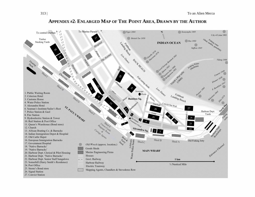
313 | To an Alien Mecca
APPENDIX #2: ENLARGED MAP OF THE POINT AREA, DRAWN BY THE AUTHOR


