Embed Size (px)
Citation preview
117
Abstract
This paper reports on the fifth season of fieldwork for the
Palaeoanthropology part of the Desert Migrations Proj-
ect. Previous seasons established an extensive archaeo-
logical map based on a wide survey of the rich record
along the edges of the Ubari Sand Sea, a small area of
the Messak Settafet, the Wadi al-Ajal, the Wadi ash-Shati
and the Wadi Barjuj. These surveys, complemented
with small excavations, demonstrated a deep prehistory
to the Fazzan, with Mode 1 technologies, Acheulean,
Mode 3 (classic Levallois, large blade technologies, and
Aterian), and Late Stone Age and Neolithic assemblages,
some with pottery and grinding stones. The focus of the
2011 season was the Wadi Barjuj. This is an extensive
wadi system to the South of the Messak, running along
the northern edge of the Murzuq Sand Sea, and drain-
ing towards the east. Geomorphologically, it comprises
old channel cut and fill gravels, usually finely graded,
with areas of ancient lacustrine duricrusts, some of which
are elevated significantly above the landscape. Surveys,
complementing those of 2008, revealed a particularly rich
and extensive Holocene series of sites, with microliths,
pottery and grinding stones. These sites indicate a dense
early Holocene occupation which seems associated with
both hunter-gatherers and pastoralists. In addition, there
was a low frequency of MSA lithics (compared to other
survey areas), although one extremely rich site (BJJ4)
had a very large number of water-worn, highly diagnos-
tic small bifaces, characteristics of some Africa MSA tra-
ditions. Acheulean was relatively rare. One restricted
locality (BJJ6) provided further evidence for a Mode 1
presence in the region, similar to that reported earlier
from the Messak and Wadi ash-Shati (Mirazón Lahr et al.
2009, 2010). The context for the finds suggests that at
various points during the Pleistocene the Wadi Barjuj was
a low lying, swampy and/or lacustrine region, possibly
riverine at times, and attractive to hominin populations
because of its relatively rich resource base. This paper
describes the localities and finds underpinning these
conclusions.
IntroductionThe palaeoanthropology and prehistory sub-proj-ect of the Desert Migrations Project (DMP) aims at investigating the Pleistocene and Holocene record of hominin occupation of Fazzan (see Mattingly et al. 2007; Mirazón Lahr et al. 2008). The four previ-ous seasons of work (2007, 2008, 2009 and 2010) focused on mapping and recording the type and extent of archaeological remains along the margins of the Ubari Sand Sea, including a portion of the Messak Settafet mountains that mark its southern boundary. In 2008, a small area in the Wadi Barjuj, to the south of the Messak, was visited as part of a study on the impact of oil exploration on the prehistory of the region. That brief visit revealed a rich archaeological record in the context of an important palaeolake, as well as along a major pal-aeoriver channel. Furthermore, aspects of the more recent archaeology found at these sites suggested a slightly different pattern of use of raw materials than observed on the northern side of the Messak mountains, consistent with previous observations by Cremaschi and di Lernia (1999). With a view to contrasting the nature of the archaeological record of the Wadi Barjuj with that of the Wadi al-Ajal and Edeyen Ubari, one of the main aims of the fifth season of fieldwork was to re-visit the Wadi Barjuj and increase the information from the group of sites around the main palaeolake. This paper repre-sents a report on all the localities in the Wadi Barjuj visited in 2008 and 2011. As during previous years, the fieldwork included a large portion of off-site archaeological surveys (Foley 1981), implemented through the recording of archaeological remains on the surface of particular geomorphological forma-tions, using both hand-held GPS and total stations. Some collection of diagnostic lithic material, as well as of geological samples for dating purposes and raw material analyses were made. All material col-lected was deposited at the Museum of Jarma.
DMP XIV: Prehistoric sites in the Wadi Barjuj, Fazzan,
Libyan Sahara
By Marta Mirazón Lahr,1 Robert Foley,1 Federica Crivellaro,1 José Maillo Fernandez,2 Alex Wilshaw,1 Ben Copsey,1
Frances Rivera1 and David Mattingly3
Libyan Studies 42 (2011)
1 Leverhulme Centre for Human Evolutionary Studies, University of Cambridge, UK2 Departamento de Prehistoria y Arqueologia, UNED, Spain3 School of Archaeology and Ancient History, University of Leicester, UK
LSJ42-117-138-DMPXIV.indd 117 02/09/2011 00:59
M. MIRAZÓN LAHR et al.
118
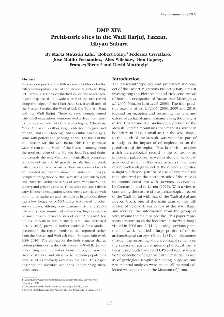
(I) Brief survey of the archaeological localities surrounding one of the palaeolake exposures of Wadi Barjuj (Figure 1)A small area of the Wadi Barjuj was briefly surveyed in 2008, revealing prehistoric surface scatters of very different ages − from a possible Oldowan site (BJJ6), to a site rich in bifaces at the edge of palaeolake sediments, to dense Holocene localities. The overall objective of the present survey was to enhance these observations and collect more samples where necessary to char-acterise the industries in question. In particular, we aimed at making a more extensive survey and arte-fact collection at the possible Old-owan site of BJJ6 and assessing the extent of the Holocene occupation area to the East and West of the site BJJ4.
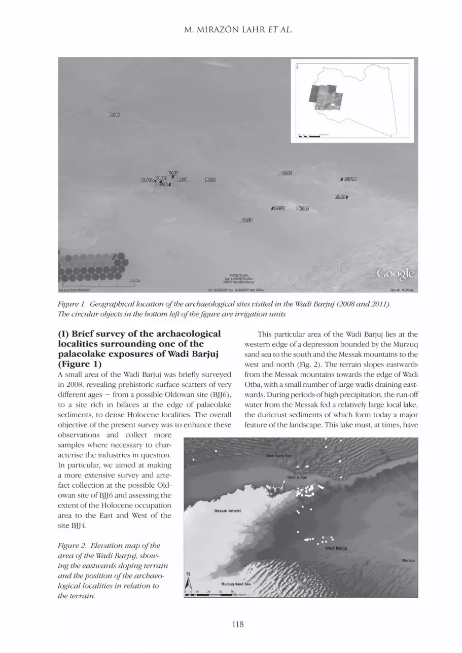
This particular area of the Wadi Barjuj lies at the western edge of a depression bounded by the Murzuq sand sea to the south and the Messak mountains to the west and north (Fig. 2). The terrain slopes eastwards from the Messak mountains towards the edge of Wadi Otba, with a small number of large wadis draining east-wards. During periods of high precipitation, the run-off water from the Messak fed a relatively large local lake, the duricrust sediments of which form today a major feature of the landscape. This lake must, at times, have
Figure 2. Elevation map of the area of the Wadi Barjuj, show-ing the eastwards sloping terrain and the position of the archaeo-logical localities in relation to the terrain.
Figure 1. Geographical location of the archaeological sites visited in the Wadi Barjuj (2008 and 2011). The circular objects in the bottom left of the figure are irrigation units
LSJ42-117-138-DMPXIV.indd 118 02/09/2011 00:59
DMP XIV: HUMAN PREHISTORY IN THE LIBYAN SAHARA
119
been the north-western end of a much larger body of water extending to the edge of Sharrabah and the present-day town of Murzuq. The landscape consists of geomorphological features of different ages associ-ated with periods of greater precipitation and lake for-mation, explaining the great disparity in the nature of the archaeological remains found.
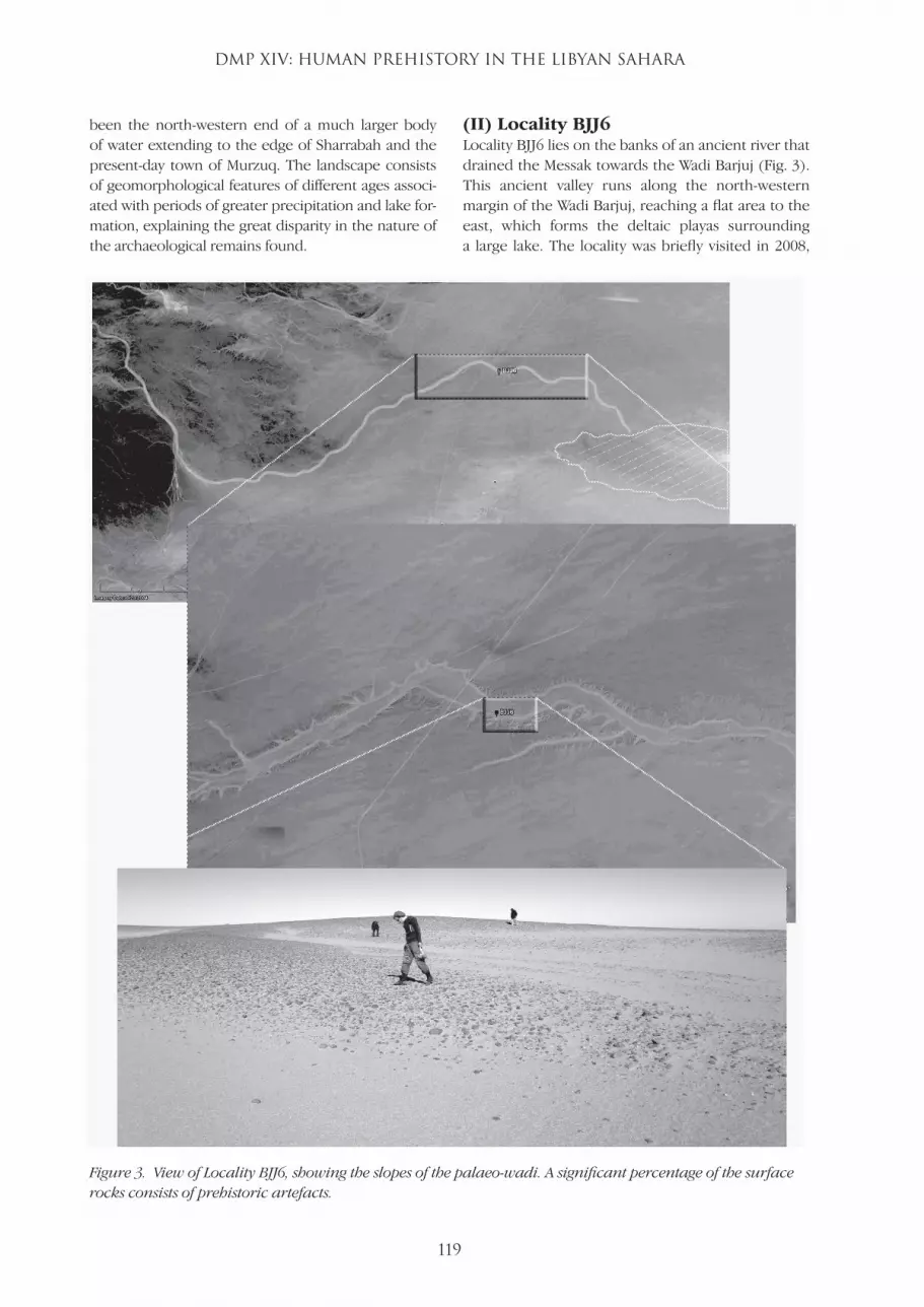
(II) Locality BJJ6Locality BJJ6 lies on the banks of an ancient river that drained the Messak towards the Wadi Barjuj (Fig. 3). This ancient valley runs along the north-western margin of the Wadi Barjuj, reaching a flat area to the east, which forms the deltaic playas surrounding a large lake. The locality was briefly visited in 2008,
Figure 3. View of Locality BJJ6, showing the slopes of the palaeo-wadi. A significant percentage of the surface rocks consists of prehistoric artefacts.
LSJ42-117-138-DMPXIV.indd 119 02/09/2011 00:59
M. MIRAZÓN LAHR et al.
120
when a surface scatter of very worn artefacts was found. These are mainly crude, large simple lithics, of Mode 1 character, but a more substantial survey and collection was necessary to confirm the assess-ment. The survey of the locality this year was carried out through seven parallel transects running north−south for approximately 100 m (Fig. 3).
Artefact density was not very high − stone tools were found amongst a loose pavement of pebbles and cobbles which represent the relics of the ancient river bank. A collection of representa-tive lithic artefacts was made, consisting mainly of very wind-worn cores and flakes, and a crude bifa-cial tool. The survey also identified a small area of approximately 10 x 10 m where more recent arte-facts were found. Two artefacts of Middle Stone Age (MSA) affinities, as well as a probably Holocene deflated stone hearth with an associated polished stone adze, were observed at the edge of the rocky scatter with the sandy plain.
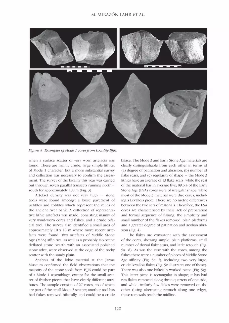
Analysis of the lithic material at the Jarma Museum confirmed the field observations that the majority of the stone tools from BJJ6 could be part of a Mode 1 assemblage, except for the small scat-ter of fresher pieces that have clearly different attri-butes. The sample consists of 27 cores, six of which are part of the small Mode 3 scatter; another tool has had flakes removed bifacially, and could be a crude
biface. The Mode 3 and Early Stone Age materials are clearly distinguishable from each other in terms of (a) degree of patination and abrasion, (b) number of flake scars, and (c) regularity of shape − the Mode 3 lithics have an average of 13 flake scars, while the rest of the material has in average five; 89.5% of the Early Stone Age (ESA) cores were of irregular shape, while most of the Mode 3 material were disc cores, includ-ing a Levallois piece. There are no metric differences between the two sets of materials. Therefore, the ESA cores are characterised by their lack of preparation and formal sequence of flaking, the simplicity and small number of the flakes removed, plain platforms and a greater degree of patination and aeolian abra-sion (Fig. 4).
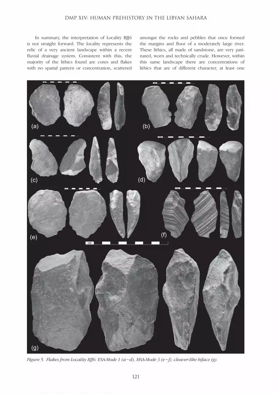
The flakes are consistent with the assessment of the cores, showing simple, plain platforms, small number of dorsal flake scars, and little retouch (Fig. 5a−d). As was the case with the cores, among the flakes there were a number of pieces of Middle Stone Age affinity (Fig. 5e−f), including two very large, crude Levallois flakes (Fig. 5e illustrates one of these). There was also one bifacially-worked piece (Fig. 5g). This latter piece is rectangular in shape; it has had rim-flakes removed along three-quarters of one side, and while similarly few flakes were removed on the other (using alternating retouch along one edge), these removals reach the midline.
Figure 4. Examples of Mode 1 cores from Locality BJJ6.
LSJ42-117-138-DMPXIV.indd 120 02/09/2011 00:59
DMP XIV: HUMAN PREHISTORY IN THE LIBYAN SAHARA
121
In summary, the interpretation of Locality BJJ6 is not straight forward. The locality represents the relic of a very ancient landscape within a recent fluvial drainage system. Consistent with this, the majority of the lithics found are cores and flakes with no spatial pattern or concentration, scattered
amongst the rocks and pebbles that once formed the margins and floor of a moderately large river. These lithics, all made of sandstone, are very pati-nated, worn and technically crude. However, within this same landscape there are concentrations of lithics that are of different character, at least one
Figure 5. Flakes from Locality BJJ6: ESA-Mode 1 (a−d), MSA-Mode 3 (e−f), cleaver-like biface (g).
LSJ42-117-138-DMPXIV.indd 121 02/09/2011 00:59

M. MIRAZÓN LAHR et al.
122
of which was found around a small deflated stone hearth-like feature as seen elsewhere in the Sahara. These stand out for being less patinated and worn, for having smaller platforms and greater number of flake scars, more retouch, and, occasionally, evidence of use of the Levallois technique. Their metric dimensions, however, are not distinguish-able, except that the Mode 3 sample includes some pieces of very large size (the two heaviest flakes weigh 628 gr [Fig. 5e] and 421 gr). The presence of a bifacially worked piece, similar to a very crude cleaver, could indicate that all the ESA lithics found are actually part of a crude Mode 2 assemblage. If that is the case, such an assemblage would stand out from the frequent Acheulean localities in the Messak Settafet by the absence of handaxes and general simplicity of the industry. However, the bifacial artefact is also not inconsistent with similar pieces at the BK site at Olduvai, part of the “Developed Old-owan B” assemblage (Leakey 1971). Therefore, the lithic material from the BJJ6 locality, together with its relict geomorphological context, strongly sug-gests the presence of a very ancient occupation, probably late Oldowan or perhaps early Acheulean.
The area was also used sporadically by later popu-lations, most notably by makers of rather crude MSA lithics.
(III) Localities in the area surrounding the Barjuj palaeolake The palaeoriver at the margins of which locality BJJ6 was found drains towards the lower-lying plain to the east-south-east, which slopes gently towards Murzuq (Fig. 2). The patchy and complex mosaic of lake playas, delta fans and lake sediments of differ-ent ages punctuate the local landscape, which can vary from stretches of uninterrupted sandy plains to rugged and terraced carbonated sediments, of dif-ferent consistency and colour, which can extend for kilometres. The area is extremely rich in archaeo-logical remains, most of which are concentrated on the deltaic fan-playa formed where the Messak river reaches the plain (at 510−515 m asl; localities BJJ1, BJJ2, BJJ3, BJJ7, BJJ10, BJJ11, BJJ12), or along the north-north-east margins of the area surveyed, at the edge of exposed lake sediments, indicating the presence of a very large lake (BJJ5, BJJ9, BJJ14; Fig. 6). The vast majority of the archaeology at all
Figure 6. Palaeoecological reconstruction of the hydrological features in the area of the Wadi Barjuj surveyed, and associated archaeological sites. Broken parallel lines represent the encroaching sands over the Barjuj plain.
LSJ42-117-138-DMPXIV.indd 122 02/09/2011 00:59
DMP XIV: HUMAN PREHISTORY IN THE LIBYAN SAHARA
123
these sites is of Holocene age; however, MSA arte-facts are also found as well as rare bifaces (BJJ5, BJJ12). Finally, an extremely rich site was found at the edge of a large expanse of continuous palaeo-lake sediments (BJJ4), where hundreds of artefacts suggest a local MSA industry rich in bifaces, includ-ing at least one tanged point.
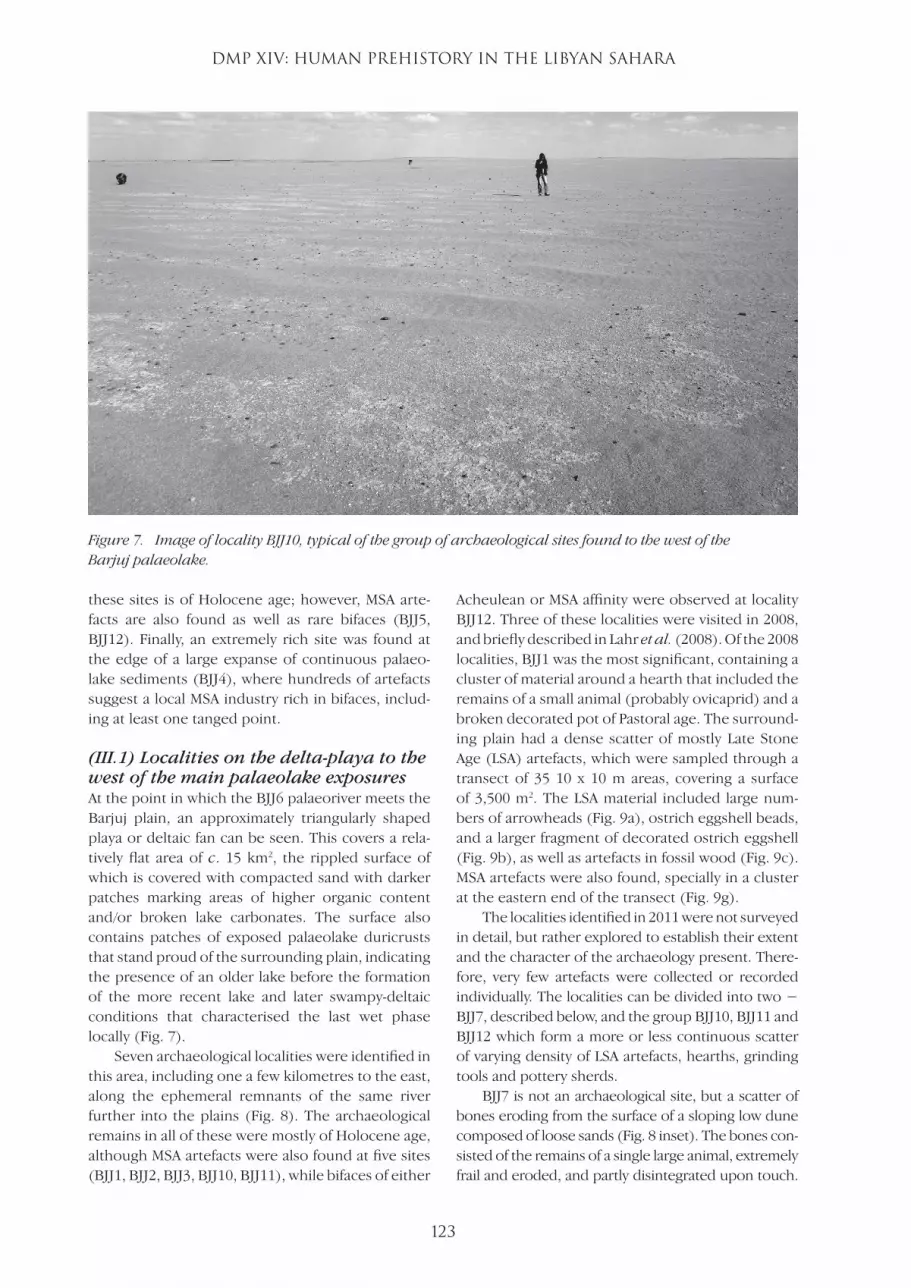
(III.1) Localities on the delta-playa to the west of the main palaeolake exposuresAt the point in which the BJJ6 palaeoriver meets the Barjuj plain, an approximately triangularly shaped playa or deltaic fan can be seen. This covers a rela-tively flat area of c. 15 km2, the rippled surface of which is covered with compacted sand with darker patches marking areas of higher organic content and/or broken lake carbonates. The surface also contains patches of exposed palaeolake duricrusts that stand proud of the surrounding plain, indicating the presence of an older lake before the formation of the more recent lake and later swampy-deltaic conditions that characterised the last wet phase locally (Fig. 7).
Seven archaeological localities were identified in this area, including one a few kilometres to the east, along the ephemeral remnants of the same river further into the plains (Fig. 8). The archaeological remains in all of these were mostly of Holocene age, although MSA artefacts were also found at five sites (BJJ1, BJJ2, BJJ3, BJJ10, BJJ11), while bifaces of either
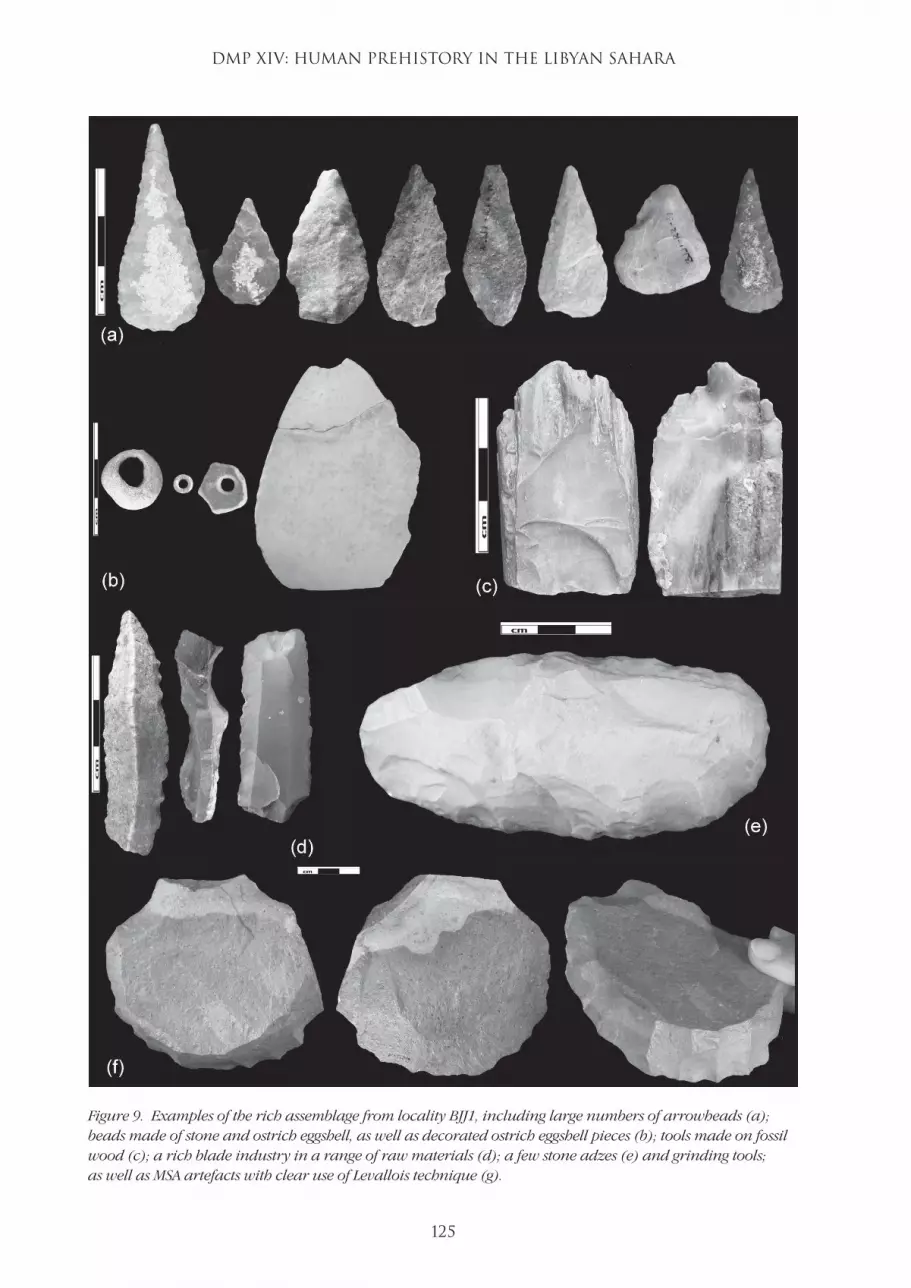
Acheulean or MSA affinity were observed at locality BJJ12. Three of these localities were visited in 2008, and briefly described in Lahr et al. (2008). Of the 2008 localities, BJJ1 was the most significant, containing a cluster of material around a hearth that included the remains of a small animal (probably ovicaprid) and a broken decorated pot of Pastoral age. The surround-ing plain had a dense scatter of mostly Late Stone Age (LSA) artefacts, which were sampled through a transect of 35 10 x 10 m areas, covering a surface of 3,500 m2. The LSA material included large num-bers of arrowheads (Fig. 9a), ostrich eggshell beads, and a larger fragment of decorated ostrich eggshell (Fig. 9b), as well as artefacts in fossil wood (Fig. 9c). MSA artefacts were also found, specially in a cluster at the eastern end of the transect (Fig. 9g).
The localities identified in 2011 were not surveyed in detail, but rather explored to establish their extent and the character of the archaeology present. There-fore, very few artefacts were collected or recorded individually. The localities can be divided into two − BJJ7, described below, and the group BJJ10, BJJ11 and BJJ12 which form a more or less continuous scatter of varying density of LSA artefacts, hearths, grinding tools and pottery sherds.
BJJ7 is not an archaeological site, but a scatter of bones eroding from the surface of a sloping low dune composed of loose sands (Fig. 8 inset). The bones con-sisted of the remains of a single large animal, extremely frail and eroded, and partly disintegrated upon touch.
Figure 7. Image of locality BJJ10, typical of the group of archaeological sites found to the west of the Barjuj palaeolake.
LSJ42-117-138-DMPXIV.indd 123 02/09/2011 00:59

M. MIRAZÓN LAHR et al.
124
Just below the surface, the sand surrounding the bones was grey and coarse, indicating the presence of a lake or swamp in the past. Samples, including fragments of dental enamel, as well as of a large (femoral?) articular surface were taken for laboratory analysis. The brief visual inspection of the remains at the site suggests that the remains may be those of a hippopotamus (Fig. 10). The discovery of the remains of a large, locally extinct animal is important not only in terms of provid-ing palaeoecological information, but also as evidence that some organic materials may be retrieved from the area of Barjuj. Samples from the skeleton have been sent for radiocarbon dating.
As mentioned above, localities BJJ10, BJJ11 and BJJ12 are part of a more or less continuous archaeo-logical landscape that extends for at least 2 km (and probably more) within the same geomorphological formation. The sites recorded represent points of greater density of what is mainly the remains of an intense early Holocene occupation. The character of the archaeological assemblages, similar to that from the site of BJJ1, and which, at the rich locality BJJ12 also included large numbers of decorated pottery sherds, suggests that the main occupation of the area was during Pastoral Neolithic times. As was the case in BJJ1, MSA artefacts were also observed, and at least at BJJ12, also a biface (which, given the artefacts from
locality BJJ4 described below, could be either from a MSA or Acheulean context).
At localities BJJ10 and BJJ11, besides the scatter of stone tools, very large grinding stones made of quartzitic sandstone were found. These, very much like those found at BJJ9 (described below), were of a shape, size and raw material not observed before else-where in Fazzan. In the case of the ones from BJJ10 and BJJ11, they had also been extensively knapped in situ in antiquity, being found surrounded by large quantities of debitage (Fig. 11a). The type of these unusual grinding tools, together with the fact that they were reutilised by (most probably) Neolithic Pastoral groups suggests that the area had an earlier Holocene occupation, possibly, early Holocene hunter-gather-ers. Two samples of the knapped grinding stones and associated debitage were collected for further analysis (Fig. 11b). These were refitted at the Jarma Museum by Ben Copsey, demonstrating that indeed, the large grinding tools had been used as a source of immedi-ately available raw material by other populations who occupied the same area later in the Holocene. Fur-thermore, the refitting analysis showed that most of the flakes resulting from the knapping event recorded in BJJ10 were used expediently at the site, with a very small number of flakes missing from the completely refitted piece.
Figure 8. Geomorphological context of the archaeological sites on the delta fan/playa west of the main Barjuj palaeolake.
LSJ42-117-138-DMPXIV.indd 124 02/09/2011 00:59
DMP XIV: HUMAN PREHISTORY IN THE LIBYAN SAHARA
125
Figure 9. Examples of the rich assemblage from locality BJJ1, including large numbers of arrowheads (a); beads made of stone and ostrich eggshell, as well as decorated ostrich eggshell pieces (b); tools made on fossil wood (c); a rich blade industry in a range of raw materials (d); a few stone adzes (e) and grinding tools; as well as MSA artefacts with clear use of Levallois technique (g).
LSJ42-117-138-DMPXIV.indd 125 02/09/2011 00:59

M. MIRAZÓN LAHR et al.
126
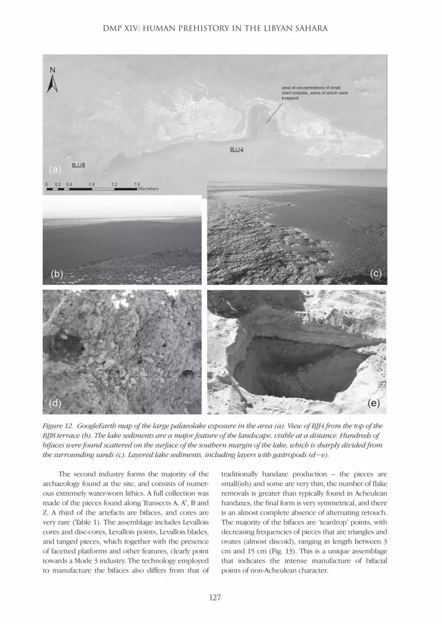
(III.2) Localities at the edge of the main palaeolake exposure in the Wadi BarjujThe palaeolake sediments at the centre of the area surveyed (Fig. 6) extend for approximately 4 km east−west and 1 km north−south (Fig. 12). They consist of a flat white surface of duricrust, forming a carbonated-capped landscape partly overlain by a thin layer of sand and partly exposed as ridges up to 1 m in height as the carbonates and gypsum pre-vented the weathering and erosion of the surface. The sediments are layered, changing in colour and geochemical properties, including layers rich in gas-tropods (Fig. 12d−e).
The full extent of locality BJJ4 is not known. Three areas were surveyed − c. 500 m along the southern margin of the lake sediments, running east−west, c. 400 m along a higher sandy gravel ridge running north−south (and separating the palaeolake
sediments into a western and an eastern exposure), and the south-western edge of the eastern part (Fig. 12a). All these surfaces were extremely rich in archaeologi-cal material, which was concen-trated in the 10−15 m adjacent to the lake sediments. All archaeo-logical remains were stone tools, mostly made on Messak quartz-itic sandstone with a few pieces in chert. Almost all the artefacts are extremely water-worn, to the point that many have the edges and flake scars semi-obliterated by wear.
The area was surveyed through a number of transects running along the edges of the lake and the mid-ridge (Transects A, A”, B, Z), as well as on a sandy surface running north−south parallel to the mid-
ridge but within the lake sediments (Transect R). A brief survey of the south-west margin of the eastern lake was carried out, but with no formal transect, and only a partial, minor collection of artefacts made. The archaeological material is concentrated on the edge of the lake sediments, with no pieces over the surface of the latter.
Two industries were clearly identified. First, a Holocene LSA assemblage made on fresh chert and sandstones of different colours, and which included a number of microliths and a stone adze. More than two-thirds of all LSA artefacts found were part of a single small scatter in the sandy area in the middle of the lake duricrust, pointing to an ephemeral recent occupation when the lake was dry. As mentioned, all the LSA material is fresh and consistent with the Pas-toral Neolithic archaeology found elsewhere in the Wadi Barjuj.
Figure 11. Knapped large grinding stones from BJJ10 with debitage in situ (a), and re-fitted piece (b).
Figure 10. Close-up view of some of the large mammal skeletal remains found at BJJ7.
LSJ42-117-138-DMPXIV.indd 126 02/09/2011 00:59
DMP XIV: HUMAN PREHISTORY IN THE LIBYAN SAHARA
127
The second industry forms the majority of the archaeology found at the site, and consists of numer-ous extremely water-worn lithics. A full collection was made of the pieces found along Transects A, A”, B and Z. A third of the artefacts are bifaces, and cores are very rare (Table 1). The assemblage includes Levallois cores and disc-cores, Levallois points, Levallois blades, and tanged pieces, which together with the presence of facetted platforms and other features, clearly point towards a Mode 3 industry. The technology employed to manufacture the bifaces also differs from that of
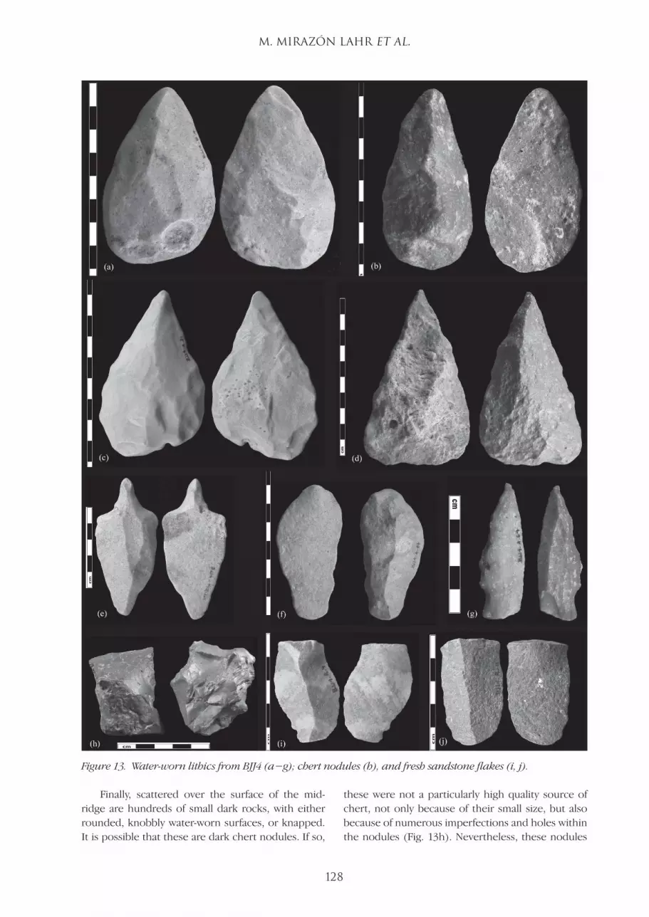
traditionally handaxe production – the pieces are small(ish) and some are very thin, the number of flake removals is greater than typically found in Acheulean handaxes, the final form is very symmetrical, and there is an almost complete absence of alternating retouch. The majority of the bifaces are ‘teardrop’ points, with decreasing frequencies of pieces that are triangles and ovates (almost discoid), ranging in length between 3 cm and 15 cm (Fig. 13). This is a unique assemblage that indicates the intense manufacture of bifacial points of non-Acheulean character.
Figure 12. GoogleEarth map of the large palaeolake exposure in the area (a). View of BJJ4 from the top of the BJJ8 terrace (b). The lake sediments are a major feature of the landscape, visible at a distance. Hundreds of bifaces were found scattered on the surface of the southern margin of the lake, which is sharply divided from the surrounding sands (c). Layered lake sediments, including layers with gastropods (d−e).
LSJ42-117-138-DMPXIV.indd 127 02/09/2011 00:59
M. MIRAZÓN LAHR et al.
128
Finally, scattered over the surface of the mid-ridge are hundreds of small dark rocks, with either rounded, knobbly water-worn surfaces, or knapped. It is possible that these are dark chert nodules. If so,
these were not a particularly high quality source of chert, not only because of their small size, but also because of numerous imperfections and holes within the nodules (Fig. 13h). Nevertheless, these nodules
Figure 13. Water-worn lithics from BJJ4 (a−g); chert nodules (h), and fresh sandstone flakes (i, j).
LSJ42-117-138-DMPXIV.indd 128 02/09/2011 01:00

DMP XIV: HUMAN PREHISTORY IN THE LIBYAN SAHARA
129
Tabl
e 1
- Com
posi
tion
of t
he w
ate
r-w
orn
an
d fr
esh
ass
embl
age
s fr
om lo
cali
ty B
JJ4.
BJJ4
Wat
er-w
orn
Art
efac
tsFr
esh
Art
efac
tsCo
res
Bifa
ces
Flak
es/B
lade
sO
ther
Tran
sect
A −
500
m a
long
the
S m
argi
n of
the
W la
ke se
dim
ents
7In
clud
ing
2 di
sc
core
s11
Rang
e of
bifa
ces
of d
iffer
ent s
izes
25Fl
akes
, bla
des o
f va
rious
size
s18
7 tr
imm
ing
flake
s, 11
bro
ken
flake
s or
with
out b
ulb
4Al
l fre
sh sm
all
LSA
flake
s
Tran
sect
A” −
par
alle
l to
Tr. A
, im
med
iate
ly to
the
S3
1 Le
vallo
is an
d
2 di
sc c
ores
7M
ostly
smal
l, bu
t a la
rger
one
w
ith la
ter fl
akes
re
mov
ed
6In
clud
ing
2 ta
nged
po
ints
and
a
Leva
llois
flake
15Ch
unks
of d
ark
cher
t (?)
nod
ules
, al
l kna
pped
Tran
sect
B –
400
m a
long
the
W
mar
gin
of th
e m
id-r
idge
9In
clud
ing
1
Leva
llois
tort
oise
-she
ll co
re
and
1 kn
appe
d da
rk c
hert
nod
ule
30In
clud
ing
4
brok
en24
Rang
ing
from
ver
y la
rge
to sm
all
17Sm
all t
rimm
ing
flake
s, sm
all
chun
ks, m
ostly
w
ithou
t bul
b
6LS
A fla
kes,
incl
udin
g
1 m
icro
lith
Tran
sect
Z −
bet
wee
n Tr
anse
ct A
an
d B,
and
alo
ng th
e m
id-r
idge
5In
clud
ing
1
Leva
llois
core
30In
clud
ing
4 m
iss-
ing
the
tip a
nd
5 tip
s
29In
clud
ing
1
Leva
llois
poin
t,
3 ta
nged
, 7 b
roke
n
10Tr
imm
ing
or
thin
ning
smal
l fla
kes
Tran
sect
L −
c.10
0 m
alo
ng th
e SW
mar
gin
of th
e E
lake
sedi
-m
ents
(min
or c
olle
ctio
n)
16In
clud
ing
1 bu
rnt,
3 m
issin
g th
e tip
4A
few
flak
es
Tran
sect
R −
in sa
ndy
patc
h w
ithin
the
lake
sedi
men
ts1
Reto
uche
d fla
ke26
2 co
res a
nd
24 sm
all fl
akes
an
d bl
ades
, in
clud
ing
5 m
icro
liths
(som
e in
fres
h ch
ert)
and
a po
lishe
d ad
ze
Tota
l wat
er-w
orn
arte
fact
s
= 26
724
8.99
%94
35.2
1%89
33.3
3%60
22.4
7%
Tota
l fre
sh a
rtef
acts
= 3
636
LSJ42-117-138-DMPXIV.indd 129 02/09/2011 01:00
M. MIRAZÓN LAHR et al.
130
had clearly been used as a source of raw material in prehistory, although the resulting flakes/blades are not easily identified in the assemblages examined so far (although at least one such was found amongst the LSA remains in Transect R).
The material from locality BJJ4 is a particularly interesting assemblage for several reasons. Firstly, although it contains the remains of at least two peri-ods of occupation, the degree of wear of the lithics is so starkly different that these are clearly differen-tiated, allowing us to contrast the use of space and raw material between the two; Secondly, despite the high frequency of bifaces, the older industry is clearly a Mode 3 tradition, containing numerous Levallois pieces (both cores and flakes) and facetted platforms; and thirdly, because of the composition of the MSA assemblage, with almost no cores and bifaces form-ing one-third of the artefacts, suggesting the use of the lake edge for foraging or hunting. Lastly, the small LSA assemblage is also extremely interesting for its spatial location in a small sandy patch within the thick lake duricrust along the side of which the lake sedi-ments form a ridge that acts as a natural wind-break, thus reflecting the use of the area for ephemeral camps during the Holocene at a time when presum-ably the lake was dry.
Elsewhere around the main palaeolake the den-sity of archaeological remains decreases drastically. Indeed, even 50 m south of the lake the surface scat-ter of artefacts disappears. Together with the almost complete absence of Holocene archaeology (with the exception of the one cluster in the middle of the lake sediments), this suggests that the whole area was probably under water during most of the wet phase of the early Holocene, when Acacus hunter-gather-ers and later Neolithic pastoralists lived in the Wadi Barjuj. During the survey, a geomorphological feature to the south-west of the main lake sediments was investigated. This locality, BJJ8, marks the southern extent of the palaeolake exposures with an ancient lake terrace, some 10−20 m above the level of the lake recorded at BJJ4. The terrace forms an inselberg in the otherwise relatively flat plain of the wadi, the surface of which is covered by a broken-up grey slate rock. A handful of unworn flakes were seen on the surface, which was otherwise barren.
(III.3) Localities along the north-north-eastern margins of the area surveyed Three localities were identified at the northeast and northern margins of the area surveyed in the Barjuj plain. These are each extremely different in both their geomorphological context and the nature of the archaeology.
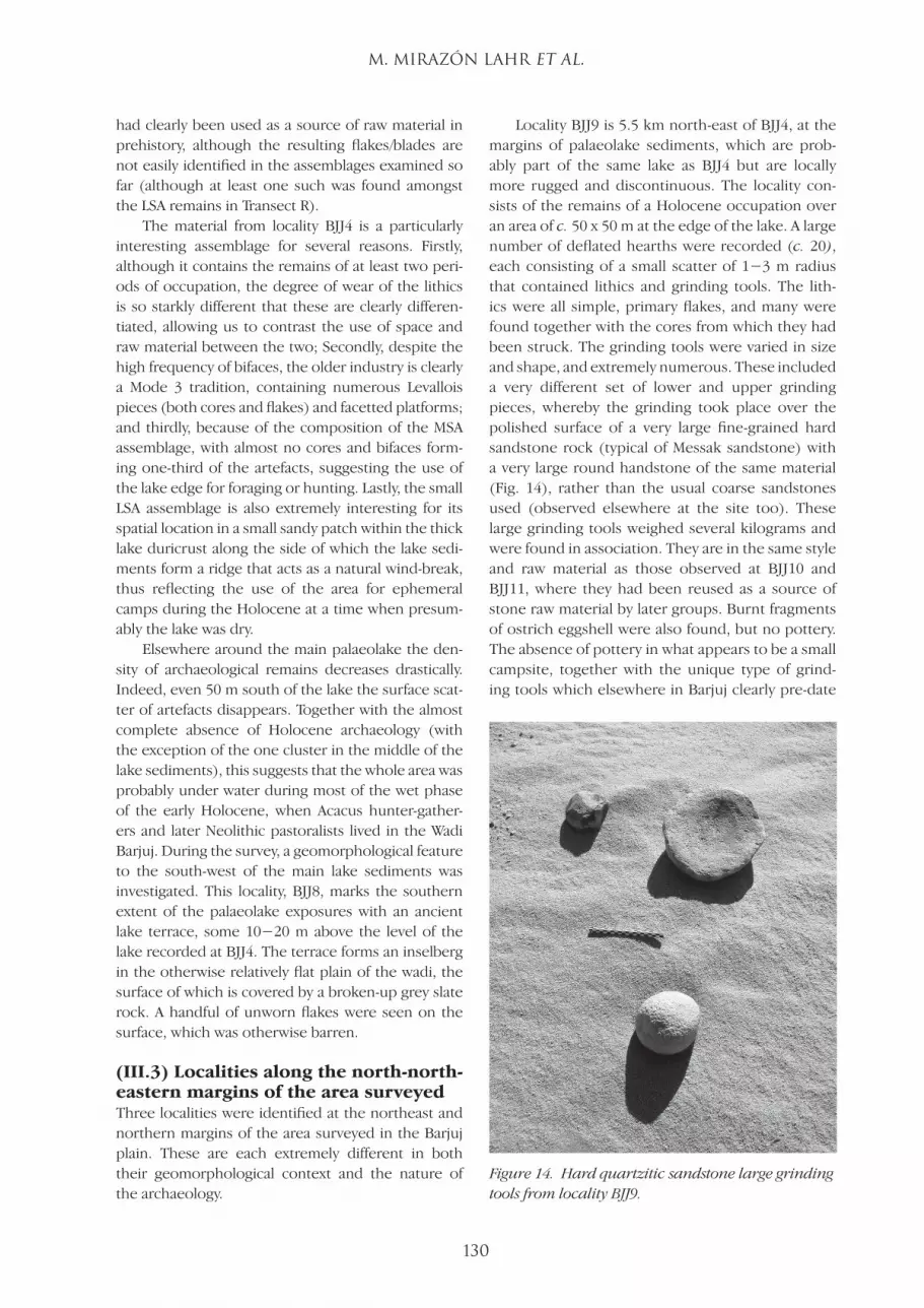
Locality BJJ9 is 5.5 km north-east of BJJ4, at the margins of palaeolake sediments, which are prob-ably part of the same lake as BJJ4 but are locally more rugged and discontinuous. The locality con-sists of the remains of a Holocene occupation over an area of c. 50 x 50 m at the edge of the lake. A large number of deflated hearths were recorded (c. 20), each consisting of a small scatter of 1−3 m radius that contained lithics and grinding tools. The lith-ics were all simple, primary flakes, and many were found together with the cores from which they had been struck. The grinding tools were varied in size and shape, and extremely numerous. These included a very different set of lower and upper grinding pieces, whereby the grinding took place over the polished surface of a very large fine-grained hard sandstone rock (typical of Messak sandstone) with a very large round handstone of the same material (Fig. 14), rather than the usual coarse sandstones used (observed elsewhere at the site too). These large grinding tools weighed several kilograms and were found in association. They are in the same style and raw material as those observed at BJJ10 and BJJ11, where they had been reused as a source of stone raw material by later groups. Burnt fragments of ostrich eggshell were also found, but no pottery. The absence of pottery in what appears to be a small campsite, together with the unique type of grind-ing tools which elsewhere in Barjuj clearly pre-date
Figure 14. Hard quartzitic sandstone large grinding tools from locality BJJ9.
LSJ42-117-138-DMPXIV.indd 130 02/09/2011 01:00
DMP XIV: HUMAN PREHISTORY IN THE LIBYAN SAHARA
131
the Pastoral Neolithic, would sug-gest that this may have been an occupation by Late Acacus hunter-gatherers.
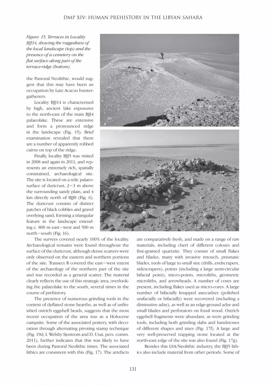
Locality BJJ14 is characterised by high, ancient lake exposures to the north-east of the main BJJ4 palaeolake. These are extensive and form a pronounced ridge in the landscape (Fig. 15). Brief examination revealed that there are a number of apparently robbed cairns on top of the ridge.
Finally, locality BJJ5 was visited in 2008 and again in 2011, and rep-resents an extremely rich, spatially constrained, archaeological site. The site is located on a relic palaeo-surface of duricrust, 2−3 m above the surrounding sandy plain, and 4 km directly north of BJJ8 (Fig. 6). The duricrust consists of distinct patches of black cobbles and gravel overlying sand, forming a triangular feature in the landscape extend-ing c. 800 m east−west and 500 m north−south (Fig. 16).
The surveys covered nearly 100% of the locality. Archaeological remains were found throughout the surface of the duricrust, although dense scatters were only observed on the eastern and northern portions of the site. Transect R covered the east−west extent of the archaeology of the northern part of the site and was recorded as a general scatter. The material clearly reflects the use of this strategic area, overlook-ing the palaeolake to the south, several times in the course of prehistory.
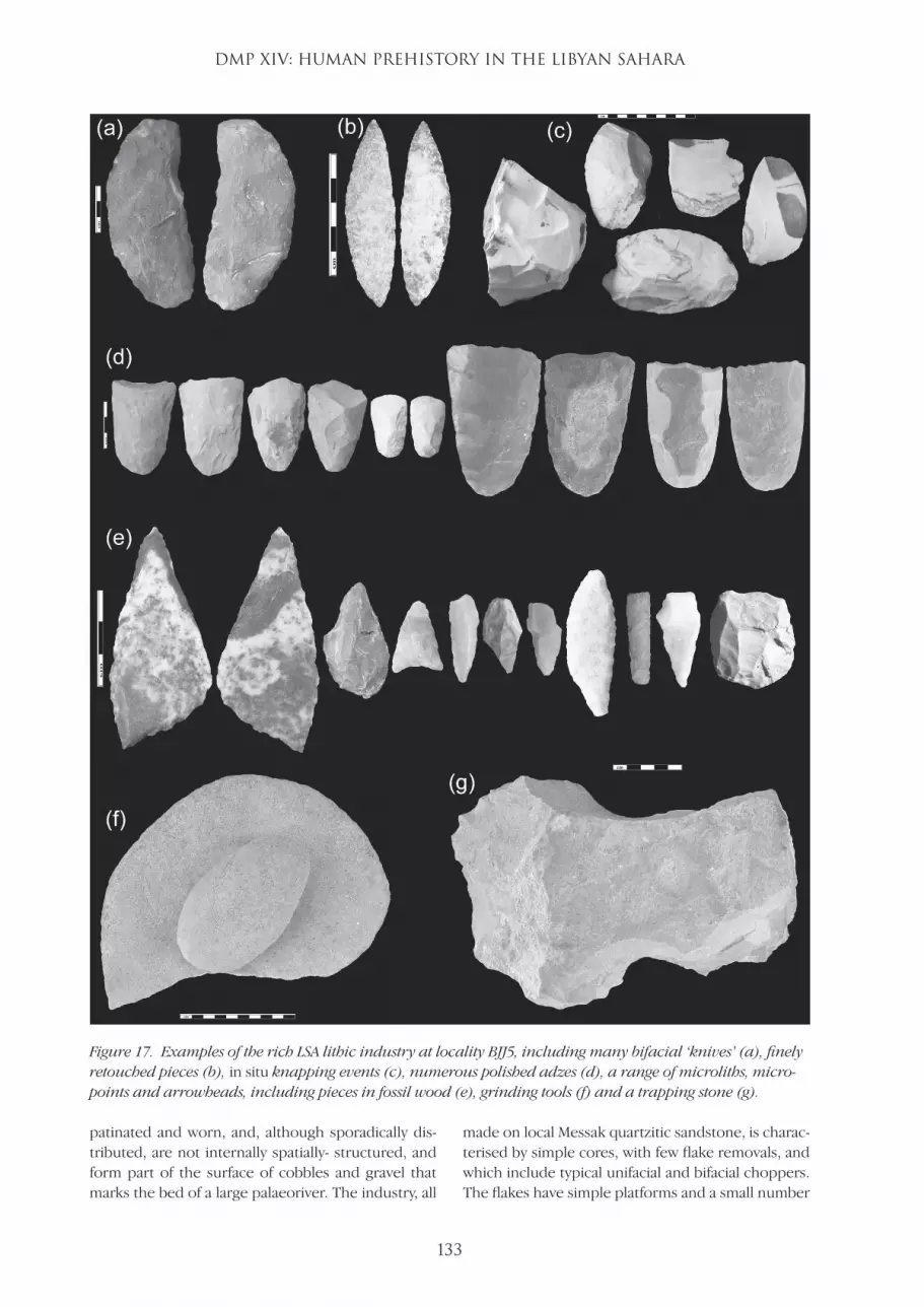
The presence of numerous grinding tools in the context of deflated stone hearths, as well as of unfin-ished ostrich eggshell beads, suggests that the most recent occupation of the area was as a Holocene campsite. Some of the associated pottery, with deco-ration through alternating pivoting stamp technique (Fig. 19d; I. Welsby Sjostrom and D. Usai, pers. comm. 2011), further indicates that this was likely to have been during Pastoral Neolithic times. The associated lithics are consistent with this (Fig. 17). The artefacts
are comparatively fresh, and made on a range of raw materials, including chert of different colours and fine-grained quartzite. They consist of small flakes and blades, many with invasive retouch, prismatic blades, tools of large to small size (drills, endscrapers, sidescrapers), points (including a large semi-circular bifacial point), micro-points, microliths, geometric microliths, and arrowheads. A number of cores are present, including flakes used as micro-cores. A large number of bifacially knapped axes/adzes (polished unifacially or bifacially) were recovered (including a diminutive adze), as well as an edge-ground adze and small blades and perforators on fossil wood. Ostrich eggshell fragments were abundant, as were grinding tools, including both grinding slabs and handstones of different shapes and sizes (Fig. 17f). A large and very well-preserved trapping stone located at the north-east edge of the site was also found (Fig. 17g).
Besides this LSA/Neolithic industry, the BJJ5 lith-ics also include material from other periods. Some of
Figure 15. Terraces in Locality BJJ14, showing the ruggedness of the local landscape (top) and the presence of a cemetery on the flat surface along part of the terrace-ridge (bottom).
LSJ42-117-138-DMPXIV.indd 131 02/09/2011 01:00
M. MIRAZÓN LAHR et al.
132
these are MSA artefacts, including a number of weath-ered, large cores and flakes, some of which are rela-tively crude in manufacture. Levallois cores and flakes are also present, as well as two water-worn, possibly tanged, flakes. The character of the Mode 3 artefacts is similar to those found at BJJ4 (Fig. 18a). At the SW end of the site, a few much more weathered artefacts were found, including a chopper (Fig. 18b) and two very worn and patinated handaxes, suggesting that further survey of relict geomorphological surfaces, such as this one and that of BJJ6, may provide more comprehensive evidence of the use of the Wadi Barjuj by ESA hominins in the earlier Pleistocene.
Finally, many of the pottery sherds had rocker packed zig-zag decoration (Fig. 19a−c) (J. Dore, I. Welsby Sjöström and D. Usai, pers. comm.), further supporting the conclusion that there was a pre-Neolithic occupation of the area by early Holocene hunter-gatherers based on the reuse of earlier (and different) grinding tools at other sites.
(IV) Discussion and ConclusionsThe Wadi Barjuj occupies a key position in the local Saharan landscape, marking a small strip of land separating the Murzuq sand sea from the plain and Messak Mountains to the north, where lakes, ponds and swamps formed recurrently as a result of the
unique local drainage between two upland areas. During wet episodes, the area must have supported lush vegetation surrounding local lakes of varying extent. This intermittently rich landscape was clearly a focus of human occupation and foraging in the past. The distribution of the archaeological sites, as well as the density of material found at these, suggests that prehistoric populations camped and hunted at the margins of lakes and ponds, leaving a signature of landscape use intimately linked to the distribution of palaeohydrological features.
There is considerable discussion in the archaeo-logical literature about the importance of ecotones, the boundaries between two habitats, and the value of these as they provide access to a wider range of resources. At first sight, it may appear that the Wadi Barjuj is an ecotone, but it is not; rather, it is a habitat in its own right, and its significance lies in it represent-ing a narrow resource-rich strip lying between two very different (rocky mountain to the north, sand sea to the south) resource-poor regions (Mirazón Lahr and Foley, in press). Its rich and recurrent archaeo-logical record is a reflection of this.
The area contains evidence of hominin and human presence at very different periods. The earliest evidence consists of a surface scatter of Early Stone Age artefacts of Mode 1 character; the lithics are very
Figure 16. Schematic map of the duricrust palaeosurface of locality BJJ5. Areas within the dotted circles were archaeologically extremely rich; the rest of the locality was almost devoid of archaeological remains.
LSJ42-117-138-DMPXIV.indd 132 02/09/2011 01:00
DMP XIV: HUMAN PREHISTORY IN THE LIBYAN SAHARA
133
patinated and worn, and, although sporadically dis-tributed, are not internally spatially- structured, and form part of the surface of cobbles and gravel that marks the bed of a large palaeoriver. The industry, all
made on local Messak quartzitic sandstone, is charac-terised by simple cores, with few flake removals, and which include typical unifacial and bifacial choppers. The flakes have simple platforms and a small number
Figure 17. Examples of the rich LSA lithic industry at locality BJJ5, including many bifacial ‘knives’ (a), finely retouched pieces (b), in situ knapping events (c), numerous polished adzes (d), a range of microliths, micro-points and arrowheads, including pieces in fossil wood (e), grinding tools (f) and a trapping stone (g).
LSJ42-117-138-DMPXIV.indd 133 02/09/2011 01:00

M. MIRAZÓN LAHR et al.
134
Figure 18. Examples of the small number of Pleistocene lithics at locality BJJ5, including large water-worn bifacial pieces reminiscent of the MSA material from BJJ4 (a), and a crude, wind-worn chopper (b).
Figure 19. Examples of decorated pottery from locality BJJ5: (a−c) rocker packed zig-zag; (d) alternatively pivoting stamp technique. Photographs by John Dore, identification by J. Dore, I. Welsby Sjöström and D. Usai.
LSJ42-117-138-DMPXIV.indd 134 02/09/2011 01:00
DMP XIV: HUMAN PREHISTORY IN THE LIBYAN SAHARA
135
of flake scars; retouch is rare and non-invasive. The presence of a crude, and also patinated, biface at the site may question the interpretation of the assemblage as a genuine Mode 1 industry, rather than Mode 2. However, the simplicity of the cleaver-like flake, with cortex over much of one side of the piece, does not rule out it being part of a more derived Oldowan industry, where bifaces and proto-bifaces are known to make up to 6% of the artefacts (Semaw et al. 2009). We have reported on the presence of Mode 1 assemblages in Fazzan before − in the Wadi ash-Shati (Mattingly et al. 2007, Mirazón Lahr et al. 2010), in a wadi draining the Messak Settafet towards the Wadi Barjuj (Mirazón Lahr et al. 2009), and in the Hamada Zaqher (Mirazón Lahr et al. 2010). Locality BJJ6 adds to the mounting evidence of a Mode 1 bearing hom-inin in Fazzan.
Contrasting with the rich classical Acheu-lean record elsewhere in Fazzan, including on the Messak Settafet escarpment not far to the north, no clearly Acheulean artefacts were found in the Wadi Barjuj. A biface of Acheulean affinity was observed at locality BJJ12; however, only a preliminary survey with no collection was carried out at the site, so the observation needs confirming by further field and museum study. Given that Acheulean tool-making hominins were certainly present in the region, the absence of sites in this area is extremely interesting. It is possible that the lake and ponds in the early Middle Pleistocene formed to the south and/or east of where our survey was carried out, and that we consequently missed the evidence of lake-edge occupation of the time. Alternatively, it could be that the geomorphology of the area was different in the early part of the Middle Pleistocene, and that there was no palaeolake at the time, just the plain drained by moderately large rivers from the Messak (such as the BJJ6 palaeoriver), and that the course of these (and any associated archaeology) has since been buried by lake sediments and sand. Clearly, confir-mation of the presence or absence of Acheulean in the area merits further study.
Mode 3 lithics are ubiquitous throughout the region, albeit at very low density in all except one locality. These do not appear to be particularly homo-geneous, however, ranging from comparatively crude artefacts (some of very large size) at locality BJJ6, to tanged points of Aterian character at others (BJJ4, BJJ5). This may indicate that the area was used by MSA-making groups at different times, consistent with the evidence elsewhere in Fazzan that indicates an early, large MSA tradition which includes the pro-duction of large blades, and a later one character-ised by the presence of tanged artefacts, thin bifaces
and finer retouched pieces. Four episodes of lake formation in Fazzan during the Middle Pleistocene have been dated (Geyh and Thiedig 2008). These have been interpreted as resulting from periods of increased precipitation during interglacials, namely during MIS11 (beginning c. 420,000 years ago), MIS9 (320,000 years ago), MIS7 (250,000 years ago), and MIS5 (beginning c. 130,000 years ago). Each of these represented an opportunity for hominin re-colonisa-tion of the area. If so, given the age range of the Afri-can Middle Stone Age (Barham and Mitchell 2008), Mode 3 hominins could have occupied Fazzan at least three times, bringing with them lithic traditions of somewhat different character.
Contrasting with the modest density of MSA artefacts in the overall area, locality BJJ4 represents one of the richest MSA sites we have seen in Fazzan. Hundreds of artefacts were scattered over a narrow strip of land at the very edge of an extensive and thick palaeolake duricrust. All these lithics were extremely water-worn, indicating a long period underwater, although their restricted spatial distribution, neither extending to the sandy plain to the south beyond 50 m, nor to the surface of the duricrust to the north, suggests little movement from their original posi-tion of discard. Just over one third of the artefacts are bifaces, ranging in size from very small triangular bifacial points 3 cm long, to relatively large, 15 cm long teardrop or pick-like tools, to small ovates and discoid pieces. The industry also contains a number of medium to large blades, while the presence of a tanged point suggests Aterian affinities. If the latter association is correct, the occupation of BJJ4 would date to the last interglacial, MIS5. Nevertheless, in none of the large number of Aterian sites surveyed as part of the DMP have we observed such a pre-dominance of bifaces and bifacial points, making the industry from BJJ4 unique in the context of the Middle Stone Age of the Central Sahara.
Most of the rich archaeology of the Wadi Barjuj reflects an intense occupation of the area by Neo-lithic pastoralists who occupied the edge of a larger lake that submerged most of the plains. These Pastoral Neolithic sites show clear signs of settle-ment, including numerous grinding tools, pottery with typical decoration, the in situ manufacture of ostrich eggshell beads, and the decoration of the rim of ostrich eggs most probably used as containers. Sites contain deflated hearths, animal bones, and an extremely rich lithic industry which includes geo-metric microliths, arrowheads, and extensive use of bifacial flaking for the production of thin knives, foli-ates and polished stone axes and adzes. The number of such adzes at sites like BJJ5 is an indication of
LSJ42-117-138-DMPXIV.indd 135 02/09/2011 01:00
M. MIRAZÓN LAHR et al.
136
the lushness of the local environment at the time. The type and range of thin bifacial knives, similar to those found around Rohlfs’ cave in the western desert of Egypt and in the Beshendi industries of Dakhla Oasis (Kuper 1996; McDonald 1991) suggest an early to middle Pastoral Neolithic age for these assemblages.
However, the re-utilisation of earlier tools and the presence of certain types of decorated pottery (such as rocker packed zig-zag patterns) indicate that Neolithic pastoralists were not the first group to occupy this area in the Holocene. A pre-Neolithic Holocene occupation in the area has been recorded previously in the Acacus (di Lernia 1999), although we have found it to be rare to the north of the Messak Settafet escarpment. On the basis of the sequence from the Acacus, Cremaschi and di Lernia have pro-posed that sub-Saharan African hunter-gatherers were the first to re-colonise the Central Sahara in the early Holocene (Cremaschi and di Lernia 1999, di Lernia 1999). These authors describe this phase in Fazzan as Early and Late Acacus Mesolithic, with rocker packed zig-zag decorated pottery character-istic of the Late Acacus period, dated in Fazzan from 8,900 − 8,000 years BP. The presence of a phase of occupation of the area prior to the Pastoral Neolithic is further supported by hitherto unseen types of grinding tools, some of which were used as isolated opportunities of immediately available raw material by later groups. These grinding tools were made of very large, hard quartzitic sandstone cobbles, which would have had to be carried to the area from the Messak. They had deep grinding grooves on the base stones, and polished handstones, suggesting long-term use and curation, and presumably recur-rent carrying from campsite to campsite. Of the four such sets of grinding tools observed, all but one (the intact pieces at BJJ9) had been subsequently knapped by later populations who reused them as the only local source of stone.
Finally, it is worth noting the absence of mate-rial as much as presence. The Holocene archaeol-ogy of the Wadi Barjuj would seem to relate solely to the earlier parts, and we found very little evi-dence for either Gramantian or later occupation, although important Garamantian settlements are known to have developed to the east in both Sharra-bah and around the present-day town of Murzuq. Nevertheless, this scarcity of Garamantian material in the Wadi Barjuj area contrasts markedly with the evidence from the equivalent system to the north of the Messak, the Wadi al-Ajal and to the east of Murzuq, where at the same time the Wadi Barjuj was abandoned, urbanised settlements flourished. This
perhaps underlines the importance of the unique foggara irrigation system that the Garamantes devel-oped and its association with valleys at the edge of escarpments and highlands.
These preliminary observations on the archaeol-ogy of the Wadi Barjuj, an area of c. 10 x 40 km at the northern edge of the Murzuq Sand Sea, reflect both the predictability and complexity of the prehis-toric occupation of the Fazzan. The Central Sahara was hyper-arid desert during much of the Pleisto-cene, and could only support a local biomass during punctuated wet episodes, mostly associated with the orbitally-induced interglacial phases contempora-neous with northern latitude glacial cycles. During these times, small to very large lakes formed in vari-ous depressions across the Sahara (Geyh and Thiedig 2008), as well as a myriad of ponds and small lakes within interdunal and plateaux depressions. Evi-dence from elsewhere in North Africa (Lahr 2010), and locally from the caves of the Acacus (di Lernia 1999; Garcea 2001), suggests that sub-Saharan African faunas repeatedly re-colonised the Sahara at these times. As expected, hominins and later humans, were part of these re-colonisation events, leaving behind the punctuated stone tool record of each wet inter-glacial phase. Despite this predictable biogeographic pattern, the local expression of these recurrent phases of occupation, together with the temporal and spatial trends that shaped local traditions, or per-haps the nature of the lush short-lived environments these groups faced, create a level of complexity in the archaeological industries of the Sahara. The material from the Wadi Barjuj typifies both of these aspects of the prehistory of Fazzan − the range of archaeo-logical industries suggests the area was occupied repeatedly by different hominin and human popula-tions in association with the formation of a local lake, while the character of the different MSA assemblages found, as well as the complex, multi-period Holocene sequence, invoke more complex interpretations.
Acknowledgements
We are grateful to our colleagues in the Department of
Antiquities in Tripoli, Sabha and Jarma for all their help.
Special thanks are due to Dr Salah Aghab, President of
the Department of Antiquities, who has continued to be
strongly supportive of our project; we would like to extend
our thanks to the new Controller of Fazzan, Hasen Mokhtar,
to Mustapha Turjman from the Tripoli office, as well as to
Dr Muftah Ahmed for his generous help in various matters.
Dr Mustafa Salam, al-Fatah University, Tripoli, as always pro-
vided invaluable advice on planning the fieldwork. Fund-
ing for the project was provided by the Society for Libyan
Studies from its annual grant from the British Academy
LSJ42-117-138-DMPXIV.indd 136 02/09/2011 01:00
DMP XIV: HUMAN PREHISTORY IN THE LIBYAN SAHARA
137
(BASIS) research allocation under the Learned Societies
Programme, the Leverhulme Trust and the University of
Cambridge. We are particularly grateful to the members of
the Society for Libyan Studies fieldwork committee and to
the officers of the Society for Libyan Studies and its trea-
surer, Philip Kenrick. Special thanks to J. Dore, I. Welsby
Sjöström and D. Usai for assistance in the identification of
pottery decoration. The 2011 Palaeo Team of the DMP was
composed of Ben Copsey, Federica Crivellaro, Robert Foley,
Marta Mirazón Lahr, Frances Rivera and Alex Wilshaw from
the University of Cambridge, and José Manuel Maillo Fer-
nandez from UNED, Spain.
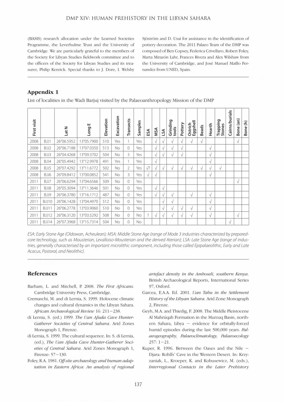
Appendix 1
List of localities in the Wadi Barjuj visited by the Palaeoanthropology Mission of the DMP
Firs
t vis
it
Lat N
Long
E
Elev
atio
n
Exca
vatio
n
Tran
sect
s
Sam
ples
ESA
MSA
LSA
Gri
ndin
g to
ols
Pott
ery
Ost
rich
Eg
gshe
ll
Bead
s
Hea
rth
Trap
ping
St
ones
Cair
ns/b
uria
ls
Bone
(an)
Bone
(h)
2008 BJJ1 26°06.5952 13°05.7900 510 Yes 1 Yes √ √ √ √ √ √ √
2008 BJJ2 26°06.7188 13°07.0350 513 No 0 Yes √ √ √ √ √
2008 BJJ3 26°04.4268 13°09.3702 504 No 3 Yes √ √ √ √ √
2008 BJJ4 26°05.4942 13°12.9978 491 Yes 1 Yes √ √
2008 BJJ5 26°07.4292 13°11.6772 502 No 2 Yes √? √ √ √ √ √ √ √ √
2008 BJJ6 26°09.8412 13°00.0852 541 No 3 Yes √ √ √
2011 BJJ7 26°06.6294 13°04.6566 509 No 0 Yes √
2011 BJJ8 26°05.3094 13°11.3646 501 No 0 Yes √ √
2011 BJJ9 26°06.3780 13°16.1712 487 No 0 Yes √ √ √ √ √
2011 BJJ10 26°06.1428 13°04.4970 512 No 0 Yes √ √ √
2011 BJJ11 26°06.2778 13°03.9060 510 No 0 Yes √ √ √ √ √
2011 BJJ12 26°06.3120 13°03.5292 508 No 0 No ? √ √ √ √ √ √ √
2011 BJJ14 26°07.3968 13°15.7314 504 No 0 No √
ESA: Early Stone Age (Oldowan, Acheulean); MSA: Middle Stone Age (range of Mode 3 industries characterized by prepared-core technology, such as Mousterian, Levalloiso-Mousterian and the derived Aterian); LSA: Late Stone Age (range of indus-tries, generally characterised by an important microlithic component, including those called Epipalaeolithic, Early and Late Acacus, Pastoral, and Neolithic).
References
Barham, L. and Mitchell, P. 2008. The First Africans. Cambridge University Press, Cambridge.
Cremaschi, M. and di Lernia, S. 1999. Holocene climatic changes and cultural dynamics in the Libyan Sahara. African Archaeological Review 16: 211−238.
di Lernia, S. (ed.) 1999. The Uan Afuda Cave Hunter-Gatherer Societies of Central Sahara. Arid Zones Monograph 1, Firenze.
di Lernia, S. 1999. The cultural sequence. In: S. di Lernia, (ed.), The Uan Afuda Cave Hunter-Gatherer Soci-eties of Central Sahara. Arid Zones Monograph 1, Firenze: 57−130.
Foley, R.A. 1981. Off-site archaeology and human adap-tation in Eastern Africa: An analysis of regional
artefact density in the Amboseli, southern Kenya. British Archaeological Reports, International Series 97, Oxford.
Garcea, E.A.A. Ed. 2001. Uan Tabu in the Settlement History of the Libyan Sahara. Arid Zone Monograph 2, Firenze.
Geyh, M.A. and Thiedig, F. 2008. The Middle Pleistocene Al Mahrúqah Formation in the Murzuq Basin, north-ern Sahara, Libya − evidence for orbitally-forced humid episodes during the last 500,000 years. Pal-aeogeography, Palaeoclimatology, Palaeoecology 257: 1−21.
Kuper, R. 1996. Between the Oases and the Nile − Djara: Rohlfs’ Cave in the Western Desert. In: Krzy-zaniak, L., Kroeper, K. and Kobusewicz, M. (eds.), Interregional Contacts in the Later Prehistory
LSJ42-117-138-DMPXIV.indd 137 02/09/2011 01:00
M. MIRAZÓN LAHR et al.
138
of Northeastern Africa. Poznan Archaeological Museum, Poznan: 81−91.
Leakey, M.D. 1971. Olduvai Gorge, Vol. III. Excavations in Beds I and II, 1960−1963. Cambridge University Press, Cambridge.
Mattingly, D., Lahr, M., Armitage, S., Barton, H., Dore, J., Drake, N., Foley, R., Merlo, S., Salem, M., Stock, J. and White, K. 2007. Desert migrations: people, envi-ronment and culture in the Libyan Sahara. Libyan Studies 38: 1−42.
McDonald, M. 1991. Origins of the Neolithic in the Nile Valley as seen from Dakhleh Oasis in the Egyptian Western Desert. Sahara 4: 41−52.
Mirazón Lahr, M. 2010. Saharan Corridors and Their Role in the Evolutionary Geography of ‘Out of Africa I’. In Fleagle, J.J., Shea, F.E. Grine, A.L. Baden and Leakey, R.E. (eds), Out of Africa I: The First Hominin Colo-nization of Eurasia. Springer, New York: 27−46.
Mirazón Lahr, M. and Foley, R.A. in press. Extreme evo-lution: the role of the Sahara in human evolution and prehistory. In: Ruebens, K., Romanowska, I. and Byno, R. (eds), Title to be confirmed, Southampton Archaeology Monograph Series. Archaeopress.
Mirazón Lahr, M., Foley, R., Armitage, S., Barton, H., Crivellaro, F., Drake, N., Hounslow, M., Maher, L., Mattingly, D., Salem, M., Stock, J. and White, K. 2008. DMP III: Pleistocene and Holocene palaeoenviron-ments and prehistoric occupation of Fazzan, Libyan Sahara. Libyan Studies 39: 263−294.
Mirazón Lahr, M., Foley, R., Crivellaro, F.; Okumura, M., Maher, L., Davies, T., Veldhuis, D., Wilshaw, A. and Mattingly, D. 2009. DMP VI: Preliminary results from 2009 fieldwork on the human prehistory of the Libyan Sahara. Libyan Studies 40: 143−162.
Mirazón Lahr, M., Foley, R., Crivellaro, F., Maillo Fernan-dez, J., Wilshaw, A., Purdon, A., Halladay-Garrett, C., Veldhuis, D. and Mattingly, D. 2010. DMP XI: Pre-liminary results from 2010 fieldwork on the human prehistory of the Libyan Sahara. Libyan Studies 41: 133−154.
Semaw, S., Rogers, M. and Stout, D. 2009. The Old-owan-Acheulian Transition: Is there a “Developed Oldowan” Artifact Tradition? In Camps, M. and Chauhan, P. (eds), Source Book of Paleolithic Transi-tions. Springer, New York: 173−193.
LSJ42-117-138-DMPXIV.indd 138 02/09/2011 01:00


