Embed Size (px)
Citation preview
1
DISTRICT SURVEY REPORT SATARA 2018-19 Prepared by
2
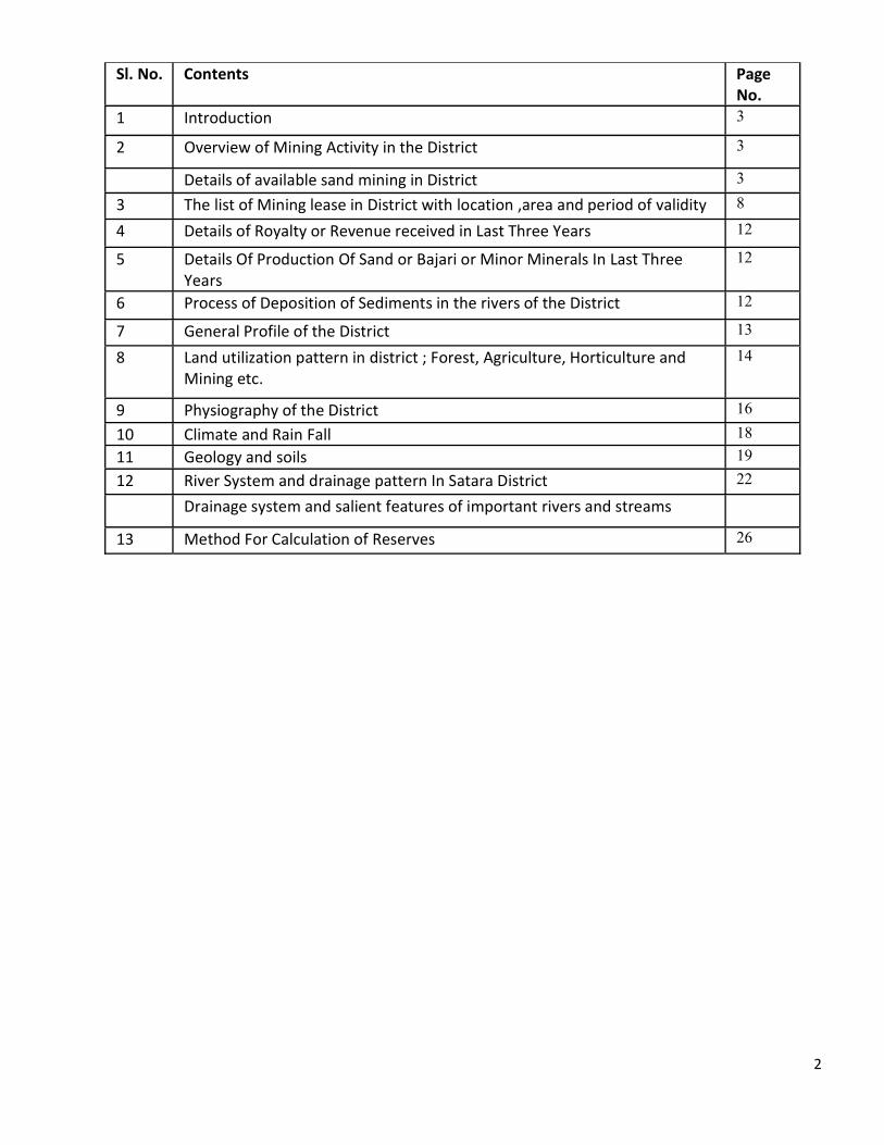
Sl. No. Contents Page No.
1 Introduction 3
2 Overview of Mining Activity in the District 3
Details of available sand mining in District 3
3 The list of Mining lease in District with location ,area and period of validity 8
4 Details of Royalty or Revenue received in Last Three Years 12
5 Details Of Production Of Sand or Bajari or Minor Minerals In Last Three Years
12
6 Process of Deposition of Sediments in the rivers of the District 12
7 General Profile of the District 13
8 Land utilization pattern in district ; Forest, Agriculture, Horticulture and Mining etc.
14
9 Physiography of the District 16
10 Climate and Rain Fall 18
11 Geology and soils 19
12 River System and drainage pattern In Satara District 22
Drainage system and salient features of important rivers and streams
13 Method For Calculation of Reserves 26
3
1. INTRODUCTION
Ordinary sand other than sand use for prescribed purposes and some other minerals have been specified as minor mineral in Sec 3(E) of The Mines and Minerals (Development and Regulation) Act, 1957. The Central Government in addition to some other minor minerals has also declared the ordinary earth (used for filling or leveling purposes in construction or embankments, roads, railways and buildings) and brick earth as the minor minerals. The Government of Uttar Pradesh vide Under Rule (s) 34 of U.P. Minor Mineral Concession Rule 1963 and MoEF&CC’s Gazette Notification dated 15/01/2016 have acquired the rights of ordinary clay, ordinary sand other than in construction or embankments, roads, railways and buildings) in addition to some sand use for prescribed purposes, brick earth and ordinary earth (used for filling or leveling purposes other minor minerals.
District Survey Report (DSR) is required to identify the areas of aggradations or depositions where mining can be allowed and identification of areas of erosion and proximity to infrastructural structures and installations where mining should be prohibited and calculation of annual rate of replenishment and allowing time for replenishment after mining in that area. Every effort have been made to cover sand mining locations, areas and overview of Mining activity in the district with all its relevant features pertaining to geology and mineral wealth in replenishable and non-replenishable areas of rivers, stream and other sand sources. This report will be a model and guiding document which is a compendium of available mineral resources, geographical set up, environmental and ecological set up of the District and is based on data of various departments, published reports, and websites. The data may vary due to flood, heavy rains and other natural calamities. Therefore, it is recommended that Sub Divisional Level Committee may take into consideration all its relevant aspects / data while scrutinizing and recommending the application for EC to the concerned Authority.
The District Survey Report (DSR) shall form the basis for application for environmental clearance, preparation of reports and appraisal of projects. The report shall be updated once every five years.
2. OVERVIEW OF MINING ACTIVITY IN DISTRICT:
Mainly two types of minor minerals constituents such as sand and stone are required for any type of construction apart from other material like cement and steel. In earlier times, the houses / buildings were constructed in form of small dwellings with walls made up of mud plaster, stone and interlocking provided with wooden frames and there were negligible commercial as well as developmental activities resulting in less demand of building material. However with the passage of time, new vistas of developmental activities were started. The quantity of minor minerals consumption in a particular area is a thermometer to assess the development of the area. Thus with the pace of development activities, the consumption of minor minerals also increased. As such the demand of minor minerals in the district has started an increasing trend. In order to meet the requirement of raw material for construction, the extraction of sand is being carried our exclusively from the river beds.
4
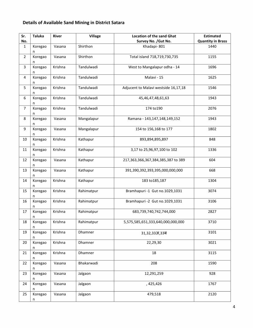
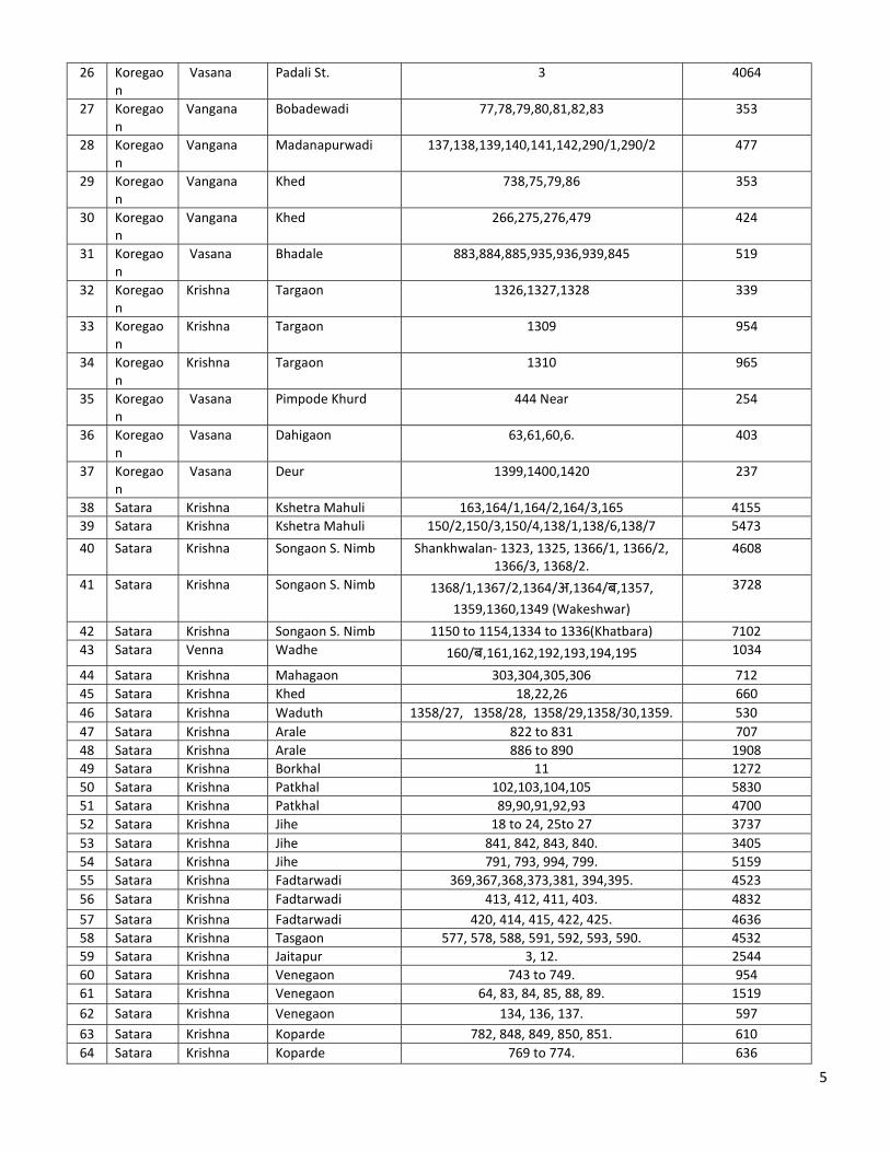
Details of Available Sand Mining in District Satara
Sr. No.
Taluka
River
Village Location of the sand Ghat Survey No. /Gut No.
Estimated Quantity in Brass
1 Koregaon
Vasana Shirthon Khadapi- 801 1440
2 Koregaon
Vasana Shirthon Total island 718,719,730,735 1155
3 Koregaon
Krishna Tandulwadi West to Mangalapur odha - 14 1696
4 Koregaon
Krishna Tandulwadi Malavi - 15 1625
5 Koregaon
Krishna Tandulwadi Adjucent to Malavi westside 16,17,18 1546
6 Koregaon
Krishna Tandulwadi 45,46,47,48,61,63 1943
7 Koregaon
Krishna Tandulwadi 174 to190 2076
8 Koregaon
Vasana Mangalapur Ramana - 143,147,148,149,152 1943
9 Koregaon
Vasana Mangalapur 154 to 156,168 to 177 1802
10 Koregaon
Krishna Kathapur 893,894,895,897 848
11 Koregaon
Krishna Kathapur 3,17 to 25,96,97,100 to 102 1336
12 Koregaon
Vasana Kathapur 217,363,366,367,384,385,387 to 389 604
13 Koregaon
Vasana Kathapur 391,390,392,393,395,000,000,000 668
14 Koregaon
Krishna Kathapur 183 to185,187 1304
15 Koregaon
Krishna Rahimatpur Bramhapuri -1 Gut no.1029,1031 3074
16 Koregaon
Krishna Rahimatpur Bramhapuri -2 Gut no.1029,1031 3106
17 Koregaon
Krishna Rahimatpur 683,739,740,742,744,000 2827
18 Koregaon
Krishna Rahimatpur 5,575,585,651,333,640,000,000,000 3710
19 Koregaon
Krishna Dhamner 31,32,33अ,33ब 3101
20 Koregaon
Krishna Dhamner 22,29,30 3021
21 Koregaon
Krishna Dhamner 18 3115
22 Koregaon
Vasana Bhakarwadi 208 1590
23 Koregaon
Vasana Jalgaon 12,291,259 928
24 Koregaon
Vasana Jalgaon , 425,426 1767
25 Koregaon
Vasana Jalgaon 479,518 2120
5
26 Koregaon
Vasana Padali St. 3 4064
27 Koregaon
Vangana Bobadewadi 77,78,79,80,81,82,83 353
28 Koregaon
Vangana Madanapurwadi 137,138,139,140,141,142,290/1,290/2 477
29 Koregaon
Vangana Khed 738,75,79,86 353
30 Koregaon
Vangana Khed 266,275,276,479 424
31 Koregaon
Vasana Bhadale 883,884,885,935,936,939,845 519
32 Koregaon
Krishna Targaon 1326,1327,1328 339
33 Koregaon
Krishna Targaon 1309 954
34 Koregaon
Krishna Targaon 1310 965
35 Koregaon
Vasana Pimpode Khurd 444 Near 254
36 Koregaon
Vasana Dahigaon 63,61,60,6. 403
37 Koregaon
Vasana Deur 1399,1400,1420 237
38 Satara Krishna Kshetra Mahuli 163,164/1,164/2,164/3,165 4155 39 Satara Krishna Kshetra Mahuli 150/2,150/3,150/4,138/1,138/6,138/7 5473
40 Satara Krishna Songaon S. Nimb Shankhwalan- 1323, 1325, 1366/1, 1366/2, 1366/3, 1368/2.
4608
41 Satara Krishna Songaon S. Nimb 1368/1,1367/2,1364/अ,1364/ब,1357, 1359,1360,1349 (Wakeshwar)
3728
42 Satara Krishna Songaon S. Nimb 1150 to 1154,1334 to 1336(Khatbara) 7102 43 Satara Venna Wadhe 160/ब,161,162,192,193,194,195 1034
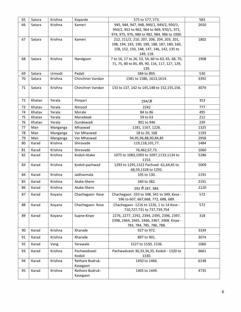
44 Satara Krishna Mahagaon 303,304,305,306 712 45 Satara Krishna Khed 18,22,26 660 46 Satara Krishna Waduth 1358/27, 1358/28, 1358/29,1358/30,1359. 530 47 Satara Krishna Arale 822 to 831 707 48 Satara Krishna Arale 886 to 890 1908 49 Satara Krishna Borkhal 11 1272 50 Satara Krishna Patkhal 102,103,104,105 5830 51 Satara Krishna Patkhal 89,90,91,92,93 4700 52 Satara Krishna Jihe 18 to 24, 25to 27 3737 53 Satara Krishna Jihe 841, 842, 843, 840. 3405 54 Satara Krishna Jihe 791, 793, 994, 799. 5159 55 Satara Krishna Fadtarwadi 369,367,368,373,381, 394,395. 4523 56 Satara Krishna Fadtarwadi 413, 412, 411, 403. 4832 57 Satara Krishna Fadtarwadi 420, 414, 415, 422, 425. 4636 58 Satara Krishna Tasgaon 577, 578, 588, 591, 592, 593, 590. 4532 59 Satara Krishna Jaitapur 3, 12. 2544 60 Satara Krishna Venegaon 743 to 749. 954 61 Satara Krishna Venegaon 64, 83, 84, 85, 88, 89. 1519 62 Satara Krishna Venegaon 134, 136, 137. 597 63 Satara Krishna Koparde 782, 848, 849, 850, 851. 610 64 Satara Krishna Koparde 769 to 774. 636
6
65 Satara Krishna Koparde 575 to 577, 573. 583 66 Satara Krishna Kameri 945, 944, 947, 948, 949/1, 949/2, 950/1,
950/2, 952 to 962, 964 to 969, 970/1, 971, 974, 975, 976, 980 to 982, 984, 986 to 1000.
2650
67 Satara Krishna Kameri 212, 211/2, 210, 207, 206, 204, 203, 201, 198, 194, 193, 190, 189, 188, 187, 180, 160,
158, 152, 150, 148, 147, 146, 142, 135 to 149, 118.
1802
68 Satara Krishna Nandgaon 7 to 16, 17 to 26, 53, 54, 60 to 63, 65, 68, 70, 71, 75, 80 to 85, 89, 90, 116, 117, 127, 129,
130.
1908
69 Satara Urmodi Padali 584 to 893. 530 70 Satara Krishna Chinchner Vandan 1581 to 1586, 1613,1614. 3392
71 Satara Krishna Chinchner Vandan 133 to 137, 142 to 145,148 to 152,155,156. 3074
72 Khatav Yerala Pimpari 294/अ 353
73 Khatav Yerala Nimsod 2242 777 74 Khatav Yerala Morale 84 to 86 495 75 Khatav Yerala Maradwak 59 to 63 212 76 Khatav Yerala Gundewadi 901 to 946 239 77 Man Manganga Mhaswad 1181, 1167, 1226. 1325 78 Man Manganga Var Mhaswad 18 to 20, 168 1193 79 Man Manganga Var Mhaswad 94,95,96,88,90,84,85 2958 80 Karad Krishna Shiravade 119,118,101,77. 1484
81 Karad Krishna Shiravade 76,462,67,73. 1060 82 Karad Krishna Kodoli-Atake 1075 to 1083,1093 to 1097,1133,1134 to
1153. 5286
83 Karad Krishna Kodoli-pachwad 1293 to 1295,1322 Pachvad -61,64,65 to 68,59,1328 to 1292.
5009
84 Karad Krishna Jadhavmala 105 to 130. 2191
85 Karad Krishna Atake-Shere 340 to 382. 2191
86 Karad Krishna Atake-Shere 292 त े287, 384. 2120
87 Karad Koyana Chachegaon- Kese Chachegaon -333 to 348, 341 to 349, Kese -596 to 607, 667,668, 772, 688, 689.
572
88 Karad Koyana Chachegaon- Kese Chachegaon -1216 to 1226, 1 to 14 Kese -710,727,731 to 737,739,754
572
89 Karad Koyana Supne-Kirpe 2276, 2277, 2292, 2394, 2395, 2396, 2397, 2398, 2464, 2465, 2466, 2467, 2468. Kirpe -
783, 784, 785, 786, 788.
318
90 Karad Krishna Kharade 927 to 972. 3339
91 Karad Krishna Kharade 897 to 901. 3074
92 Karad Vang Yerawale 1527 to 1530, 1536. 1060
93 Karad Krishna Pachwadvasti Kodoli
Pachwadvasti 30,33,34,35, Kodoli - 1320 to 1330.
6661
94 Karad Krishna Rethare Budruk- Kasegaon
1450 to 1466. 6148
95 Karad Krishna Rethare Budruk- Kasegaon
1405 to 1449. 4735
7
96 Karad Krishna Rethare Budruk- Kasegaon
1385 to 1403 4028
97 Karad Krishna Rethare Budruk- Kasegaon
1312 to 1357.. 3392
98 Karad Krishna Rethare Budruk- Kasegaon
1241to 1226. 5159
99 Karad Krishna Rethare Budruk- Dhotrewadi
1225 to 1182. 4212
100 Karad Krishna Rethare Budruk- Tambve
1116 to 1143. 5936
101 Karad Krishna Tasawade-Konegaon
465, 466, 484 to 188, 529 to 534. 4452
102 Karad Krishna Belawade H. Shiravade
40,41, 42, 803 to 805, 808 to 810, 924 to 931, 937, 938, 940 to 943, 944 to 946, 949 to
960, 961 to 967.
4770
103 Karad Krishna Belawade H. - Nadashi
64 to 68, 57 to 59,68 2968
104 Karad Krishna Belawade H. - Nadashi
106 to 112, 117, 70,79,81 2862
105 Karad Krishna Belawade H. - Nadashi
129, 130, 135, 146, 83 to 85 2756
106 Karad Krishna Khubi 2 to 22, 413, 424. 6740
107 Karad Krishna Khubi 294 to 300, 376. 4452 108 Karad Koyana Pashchim Supane-
Kirape Pashchim Supane - 362 to 368, 371 to 385
Kirape -706 to 710,713 त े720. 296
109 Karad Koyana Chachegaon- Kese Chachegaon -333 to 340, 341 त े349. 572
110 Karad Koyana Mhopre- Uttar Tambve
Mhopre - 652 to 662, Uttar Tambve -2076, (1+2) 2077 to 2080.
265
111 Karad Koyana Yerawale- Kese Yerawale-1, Kese 754 to 805. 509 112 Karad Krishna Rethare Bu. 1848to1802. 7618 113 Karad Krishna Rethare Bu. 1801to1777. 5318 114 Karad Krishna Rethare Bu. 1756to2007. 5936 115 Karad Krishna Rethare Bu. 1733to1737. 5565 116 Karad Krishna Rethare Bu. 1726to1734. 4205
117 Karad Krishna Rethare Bu. 1665to1725. 7495
118 Karad Krishna Rethare Bu. 1542to1664. 7940
119 Karad Krishna Rethare Bu. 1493to1541. 7693 120 Karad Krishna Varade- Konegaon 110to117. 4717
121 Karad Krishna Umbraj -Hnumanwadi
104to114, 120to124, 149to151, 216to220, 222to229.
9011
122 Karad Krishna Koparde H. -Ghonashi
New G.N. 1965 to1954. 2756
123 Karad Krishna Koparde H. -Ghonashi
New G.N. 493to614. 2438
124 Karad Krishna Vahagaon-Ghonashi -Koparde H.
678, 682, 683, 686, 689, 690, 747, 743, 744. 2120
125 Karad Krishna Vahagaon- Nadashi 1303to1202 Nadashi- 93 to 94. 3401
8
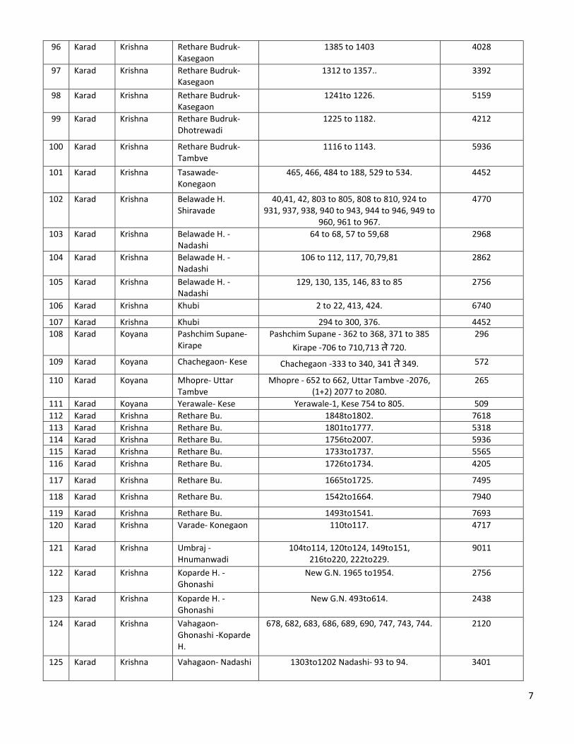
126 Karad Krishna Perale- Kalgaon 970, 972, 975, 983, 971. 1767 127 Karad Krishna Perale- Kalgaon 1025, 1026, 1037, 1039, 1058, 1059, 1038. 1767 128 Karad Krishna Bhuyachiwadi
Navin Kavathe 2to5 1413
129 Karad Tarali Umbraj -Bhosalewadi
Umbraj -204/2, 205/1to205/3, 206/1 अto206/6ब,207/1to209/6ब. Bhosalewadi -
312, 313, 314, 315, 317.
1237
130 Karad Krishna Vadoli- Korti Vadoli -3,4,5 Korti -86to90, 92to107 3313
131 Karad Krishna Korti-Navin Kavathe
274, 294to303,338, 339. 3754
132 Karad Krishna June Kavathe- Korti
Kavathe 2to5, 7to18, 79to83 8481
133 Karad Krishna Dhankawadi- Korti 108to111,113, 114, 116, 117, 119to121, 128,129.
3534
134 Karad Krishna Tasawade 680to699, 700to755. 1894 135 Wai Kudali Udatare 619, 620, 621, 622, 623, 624,625. 133 136 Wai Kudali Udatare 1461, 1462, 1463, 1427, 1428,1473. 143
137 Wai Kudali Kalambhe 1058. 98
138 Wai Krishna Pachwad 53, 82. 707 139 Wai Krishna Pasarani 1109,1110, 1111,1112. 5009 140 Wai Krishna Eksar 729, 730, 737, 738, 739. 883
141 Wai Krishna Menavali 550, 529,634. 1590
142 Wai Krishna Ozarde 1328, 1327, 1326, 1325, 1323. 2014 143 Wai Krishna Ozarde 1195, 1193, 1161, 1160. 2827
144 Wai Krishna Ozarde 952/1, 945,879,878. 2120
145 Phaltan Nira Sangvi 1157, 1158, 1383. 530
146 Phaltan Nira Sangvi 1168, 1170, 1171. 636
147 Phaltan Nira Sangvi 1173 610
148 Phaltan Nira Sangvi 156, 158. 610
149 Phaltan Odha Sarade 282, 283, 284, 285, 286. 353
150 Phaltan Odha Sarade 69 353
151 Phaltan Nira Gokhali 29to41, व 43. 1352
152 Phaltan Nira Gokhali 11to26. 795
153 Phaltan Nira Asu 848, 851, 68. 2473
154 Phaltan Talav Salape 380 159
155 Phaltan Nira Padegaon 173 610
156 Phaltan Nira Padegaon 97.99.100. 557
157 Phaltan Odha Taradgaon 81,82, 72, 73, 74, 90. 3180
158 Phaltan Nira Rawadi Bu. 3,4. 212
159 Phaltan Nira Rawadi Bu. 4 212
160 Phaltan Nira Murum 68 212
161 Phaltan Nira Jinti 1092, 1093. 265
162 Phaltan Nira Somthali 572/ब. 663
9
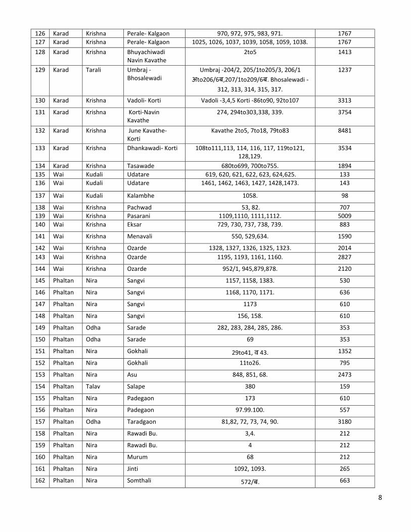
163 Phaltan Nira Somthali 1to4. 583
164 Phaltan Nira Somthali 5to8 716
165 Phaltan Odha Nikwadi 278, 277, 330, 331, 329. 106
166 Phaltan Odha Dudhebavi 822, 916. 88
167 Phaltan Odha Sayakal 302to306 117
168 Phaltan Odha Nirgudi 192, 193, 154, 155, 157, 158. 71
169 Phaltan Banganga Dalwadi 54 to 59, 62, 86. 148
170 Phaltan Nira Wathar (Ni) 169/2 (Kavalban) 247
171 Phaltan Odha Wathar (Ni) 501, 502,500,489,499. 194
172 Phaltan Talav Dhaval 380, 397, 379, 396. 318
173 Phaltan Talav Tathavada 25 to 36. 265
174 Man Manganga Mhaswad 534,501,500 1554
175 Man Manganga Mhaswad 486,488,570,571 1625
176 Man Manganga Mhaswad 468,467,564,577 1201
177 Man Manganga Mhaswad 1205,1203 and 1195 1978
178 Man Manganga Vaki (var Mhaswad) 36 to 38 4500
179 Man Manganga Vaki (var Mhaswad) 8,9,15 to 20 3500
180 Karad Krushna Perle 33,34,42,43,48,49,50,53 1555
181 Karad Koyana Tambave 495 to 499, 501 574
182 Karad Tarali Indoli 1695 to 1691 2544
183 Karad Tarali Hingnole- Bhosalewadi
531,534,283/1,284,286 1237
184 Patan Koyana Chopadi-1 985,951,950 1590
185 Patan Koyana Chopadi-2 944,948,949 1590
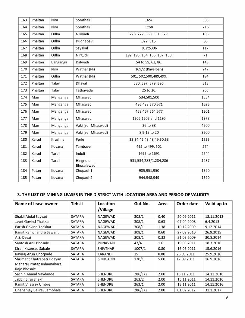
3. THE LIST OF MINING LEASES IN THE DISTRICT WITH LOCATION AREA AND PERIOD OF VALIDITY
Name of lease owner Tehsil Location /Village
Gut No. Area Order date Valid up to
Shakil Abdal Sayyad SATARA NAGEWADI 308/1 0.40 20.09.2011 18.11.2013 Jayet Govind Thakkar SATARA NAGEWADI 308/1 0.63 07.04.2008 6.4.2013 Parish Govind Thakkar SATARA NAGEWADI 308/1 1.38 10.12.2009 9.12.2014 Ranjit Ramchandra Sawant SATARA NAGEWADI 308/1 0.60 27.09.2010 26.9.2015 A.S. Desai SATARA NAGEWADI 308/1 0.32 31.08.2009 30.8.2014 Santosh Anil Bhosale SATARA PUNAVADI 47/4 1.6 19.03.2011 18.3.2016 Kiran Kisanrao Sabale SATARA SHIVTHAR 1007/1 0.80 16.06.2011 15.6.2016 Raviraj Arun Ghorpade SATARA KARANDI 15 0.80 26.09.2011 25.9.2016 Shrimant Chatrapati Udayan Maharaj Pratapsinhamaharaj Raje Bhosale
SATARA SONGAON 170/1 5.00 17.09.2011 16.9.2016
Sachin Anand Vaydande SATARA SHENDRE 286/1/2 2.00 15.11.2011 14.11.2016 Jabbir Siraj Shekh SATARA SHENDRE 263/2 2.00 15.11.2011 14.11.2016 Ranjit Vilasrav Umbre SATARA SHENDRE 263/1 2.00 15.11.2011 14.11.2016 Dhananjay Bajirav Jambhale SATARA SHENDRE 286/1/2 2.00 01.02.2012 31.1.2017
10
Mrs. Anita Hanmant Kanase SATARA SASPADE 1460 0.60 25.3.2012 25.3.2017 Mahesh Shivaji Chaugule SATARA SASPADE 1611/2 0.80 25.3.2012 25.3.2017
Ranjit Bhanudas Savant SATARA SASPADE 1460 0.80 25.3.2012 25.3.2017 Dhananjay Bajirav Jambhale SATARA KARANDI 15 0.40 25.3.2012 25.3.2012 Janardan Keshav Mane KARAD PADALI KESE 351/अ 0.50 20.7.2009 19.7.2014
Anil Balkrushna Patil KARAD PADALI KESE 351/अ 0.50 5.8.2009 4.8.2014
Mrs. Lalita Balaso Shinde KARAD PADALI KESE 351/4अ 0.50 7.9.2009 7.9.2009
Pravin Pralhad Pawar KARAD SANJAYNAGAR SHERE
26/1,26/2 2.00 19.9.2011 18.9.2016
Vilas Vishwanath Mane KARAD KALGAON 484 0.80 19.9.2011 28.9.2018
Mrs. Shubhangi Umakant Khabale
KARAD SHINDEWADI 19/2 0.80 17.9.2011 16.9.2016
Vaishali Ramesh Khabale KARAD POTARLE 462 0.20 21.9.2011 20.9.2016
Vinayak(Lalaso) Shankar Yadav KARAD POTARLE 462 0.20 21.9.2011 20.9.2016
Dilip Ramchandra Chavan KARAD SANJAYNAGAR SHERE
26/2 0.80 29.9.2011 28.9.2016
Dilip Ramchandra Chavan KARAD SANJAYNAGAR SHERE
26/5 0.80 29.9.2011 28.9.2017
Rajaram Uttamrav Kadam KARAD NANDLAPUR 409 0.100 07.12.2011 06.12.2016 Manojkumar Sarjerav Jadhav KARAD NANDLAPUR 409 0.42 04.1.2012 3.1.2017 Dhondiram Shankarrav Jadhav KARAD NANDLAPUR 409 0.50 19.12.2011 18.12.2016 Sachin Annaso Shirke KARAD NANDLAPUR 409 0.40 19.12.2011 18.12.2016 Vilas Mahadev Shirke KARAD NANDLAPUR 409 0.40 04.01.2012 3.1.2017 Devraj Babaso Patil KARAD MARALI 35 0.80 28.11.2011 27.11.2011
Dattatray Hanumant Desai KARAD NANDLAPUR 409 0.25 07.12.2011 06.12.2016 Pandurang Ganpati Deshmukh KARAD NANDLAPUR 409 0.20 7.12.2011 6.12.2015 Vasant Tanaji Deshmukh KARAD NANDLAPUR 409 0.20 7.12.2011 06.12.2015 Jagannath Dnyandev More KARAD NANDLAPUR 409 0.20 25.3.2012 25.3.2017 Ramdas Bhanudas Jadhav WAI AMRUTWADI 222/1 0.40 29.7.2007 15.9.2013
Nitin Vinayak Chavan WAI ASLE 506/अ 0.60 2.8.2008 1.8.2013
Anil Vinayak Chavan WAI ASLE 506/अ 0.40 2.8.2008 12.11.2013
Nitin Lakshaman Wagh WAI ASLE 506/अ 0.40 19.11.2008 18.11.2013
Rahul Krushnarav Jagtap WAI KALAMBHE 871 0.80 20.6.2009 19.6.2014 Nitin Atmaram Shinde WAI VELE 246 0.50 1.12.2009 1.12.2009 ITD Cementation India WAI MOHADEKARWADI 31/2 1.00 2.11.2011 1.11.2014 Anil Buvasaheb Jagtap KHANDALA PARGAON 151 1.00 10.12.2009 10.12.2009 Shekh Latif Noor Mohammad KHANDALA PALASHI 1504 1.60 24.4.2008 24.4.2013 Somnath Suresh Dhadekar for M/s Rajlaxmi Infrastructure
KHANDALA YELEWADI 234 1.94 28.11.2011 27.11.2016
Pravin Dattatray Dhamal KHANDALA ASAWALI 661 0.80 28.11.2011 27.11.2016 Pradipkumar Rajaram Pawar M/s Bawada Construction
KHANDALA KESURDI 616 2.00 1.2.2012 31.1.2017
Sachin Gade M/s Yash Enterprises
KHANDALA DHAVADWADI 201 2.00 1.2.2012 31.1.2017
Hemant Vasantrav More JAVALI KARANDOSHI 517 ब 1.20 12.9.2008 11.9.2013
Arun Shivajirav Desai JAVALI MAHIGAON 169 0.80 15.11.2011 14.11.2016 Vijay Shivajirav Desai JAVALI MAHIGAON 169 0.80 15.11.2011 14.11.2016
11
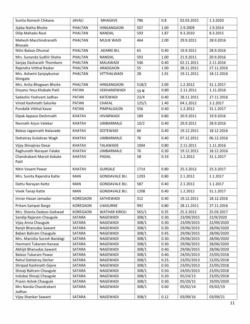
Sunita Ramesh Chikane JAVALI MHASAVE 786 0.8 02.03.2015 1.3.2020
Jijaba Natha Bhoite PHALTAN HINGANGAON 507 1.00 2.9.2009 1.9.2014 Dilip Mahadu Raut PHALTAN NANDAL 593 1.87 9.3.2010 8.3.2015
Mahesh Macchindranath Bhosale
PHALTAN MULIK WADI 464 2.00 29.9.2011 28.9.2016
Nitin Balaso Dhumal PHALTAN ADARKI BU. 65 0.40 19.9.2011 28.9.2016
Mrs. Sunanda Sudhir Shaha PHALTAN NANDAL 593 1.00 21.9.2011 20.9.2016 Sanjay Dasharath Thombare PHALTAN MALAWADI 546 0.40 02.11.2011 2.11.2016 Rajendra Vitthal Raskar PHALTAN ARADGAON 55 1.00 28.11.2011 27.11.2016 Mrs. Ashwini Sanjaykumar Shingate
PHALTAN VITTHALWADI 28 1.91 19.11.2011 18.11.2016
Mrs. Anita Bhagwan Bhoite PHALTAN HINGANGAON 518/2 2.00 1.2.2012 31.1.2017 Dnyanu Yesu Khabale Patil PATAN VEKHANDWADI 59 ब 0.80 2.11.2011 1.11.2016
Sadashiv Yashvant Jadhav PATAN KATEWADI 22/4 0.40 28.11.2011 27.11.2016 Vinod Kashinath Salunke PATAN CHAFAL 125/1 1.40 04.1.2012 3.1.2017 Pundalik Vitthal Kavar PATAN PIMPALGAON 556 0.40 1.2.2012 31.1.2017
Dipak Appaso Deshmukh KHATAV HIVARWADI 189 0.80 20.9.2011 19.9.2016
Navnath Arjun Valekar KHATAV UMBARMALE 10/2 0.40 29.9.2011 28.9.2016
Balaso Jagannath Nalavade KHATAV DOTEWADI 66 0.40 19.12.2011 18.12.2016
Dattatray Gulabrao Wagh KHATAV UMBARMALE 76 0.40 07.12.2011 06.12.2016
Vijay Shivajirav Desai KHATAV TALAWADE 1004 0.80 2.11.2011 1.11.2016 Raghunath Narayan Falake KHATAV UMBARMALE 76 0.30 19.12.2011 18.12.2016 Chandrakant Maroti Kokate Patil
KHATAV PADAL 58 0.33 1.2.2012 31.1.2017
Nitin Vasant Pawar KHATAV GURSALE 1714 0.80 25.3.2012 25.3.2017
Mrs. Sunita Rajendra Katte MAN GONDAVALE BU. 1203 0.80 2.1.2012 1.1.2017
Dattu Narayan Katte MAN GONDAVALE BU. 587 0.40 2.1.2012 1.1.2017
Vivek Tanaji Katte MAN GONDAVALE BU. 1208 0.40 1.2.2012 31.1.2017
Imran Hasan Jamadar KOREGAON SATHEWADI 312 0.40 19.12.2011 18.12.2016
Pritam Sampat Barge KOREGAON LHASURNE 992 0.80 28.11.2011 27.11.2016
Mrs. Shanta Dadaso Gaikwad KOREGAON WATHAR KIROLI 565/1 0.35 25.3.2012 25.03.2017 Sandip Rajaram Chaugule SATARA NAGEWADI 308/1 0.30. 23/09/2015 22/9/2020 Vijay Anna Chaugule SATARA NAGEWADI 308/1 0.30. 23/09/2015 22/09/2020 Ranjit Bhanudas Sawant SATARA NAGEWADI 308/1 0.30. 29/06/2015 28/06/2020 Baban Baliram Chaugule SATARA NAGEWADI 308/1 0.45. 29/06/2015 28/06/2020 Mrs. Manisha Suresh Bandagi SATARA NAGEWADI 308/1 0.30. 29/06/2015 28/06/2020 Hanmant Tukaram Kanase SATARA NAGEWADI 308/1 0.30. 29/06/2015 28/06/2020 Abhijit Bhanudas Sawant SATARA NAGEWADI 308/1 0.40. 29/06/2015 28/06/2020 Balaso Tukaram Pawar SATARA NAGEWADI 308/1 0.40. 24/05/2013 23/05/2018 Rahul Dattatray Derkar SATARA NAGEWADI 308/1 0.25. 23/05/2013 22/05/2018 Shripad Kashinath Gijare SATARA NAGEWADI 308/1 0.50. 23/05/2013 22/05/2018 Shivaji Baliram Chaugule SATARA NAGEWADI 308/1 0.50. 24/05/2013 23/05/2018 Indubai Shivaji Chaugule SATARA NAGEWADI 308/1 0.20. 05/24/13 23/05/2018 Pravin Ashok Chaugule SATARA NAGEWADI 308/1 0.30. 05/20/15 19/05/2020 Mrs Nanda Chandrakant Jadhav
SATARA NAGEWADI 308/1 0.60 05/02/14 05/02/19
Vijay Shankar Sawant SATARA NAGEWADI 308/1 0.12 03/09/16 03/09/21
12
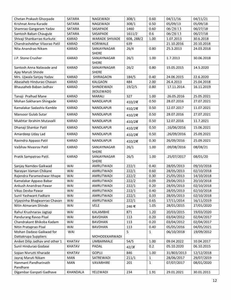
Chetan Prakash Ghorpade SATARA NAGEWADI 308/1 0.60 04/11/16 04/11/21 Krishnat Anna Kurade SATARA NAGEWADI 308/1 0.50 05/09/13 05/09/18 Shamrao Gangaram Yadav SATARA SASAPADE 1460 0.60 06/28/13 06/27/18 Santosh Baban Chaugule SATARA SASAPADE 1611/2 0.6 06/28/13 06/27/18 Shivaji Shankarrao Kurkute KARAD WARADE SHIVADE 608, 288/2 1.00 1.07.2013 30.6.2018 Chandrashekhar Vilasrao Patil KARAD KORIWALE 639 21.10.2016 20.10.2018 Nita Anandrao Nikam KARAD SANJAYNAGAR
SHERE 26/4 0.80 25.3.2013 24.03.2018
J.P. Stone Crusher KARAD SANJAYNAGAR SHERE
26/1 1.00 1.7.2013 30.06.2018
Santosh Anna Nalavade and Ajay Maruti Shinde
KARAD SANJAYNAGAR SHERE
26/2 0.80 15.05.2015 14.5.2020
Mrs. Ujwala Sanjay Yadav KARAD SHIRAGAON 184/5 0.40 24.06.2015 22.6.2020 Abasaheb Hindurao Chavan KARAD KALGAON 484 2.00 26.4.2013 25.04.2018 Bhausaheb Baban Jadhav KARAD SHINDEWADI
(KOLEWADI) 19/2/5 0.80 17.11.2014 16.11.2019
Tanaji Pralhad Mane KARAD MARALI 327 1.00 26.05.2016 25.05.2021 Mohan Sakharam Shingade KARAD NANDLAPUR 410/2ब 0.50 28.07.2016 27.07.2021
Kamalakar Sadashiv Kamble KARAD NANDLAPUR 410/2ब 0.50 12.07.2017 11.07.2021
Mansoor Gulab Sutar KARAD NANDLAPUR 410/2ब 0.50 28.07.2016 27.07.2021
Mukhtar Ibrahim Mutavalli KARAD NANDLAPUR 410/2ब 0.50 12.07.2016 11.7.2021
Dhanaji Shankar Patil KARAD NANDLAPUR 410/2ब 0.50 .16/06/2016 15.06.2021
Amardeep Uday Lad KARAD NANDLAPUR 410/2ब 0.50 .26/09/2016 25.09.2021
Ravindra Appaso Patil KARAD NANDLAPUR 410/2ब 0.30 26/09/2016 25.09.2021
Vaibhav Nivasrav Patil KARAD SANJAYNAGAR SHERE
26/1 1.00 .09/08/2016 08/08/21
Pratik Sampatrao Patil. KARAD SANJAYNAGAR SHERE
26/5 1.00 .25/07/2017 08/01/20
Sanjay Namdev Gaikwad WAI AMRUTWADI 222/1 0.40 28/05/2013 09/10/2018 Narayan Vaman Chikane WAI AMRUTWADI 222/1 0.60 28/05/2013 02/10/2018 Rajendra Parameshwar Ithape WAI AMRUTWADI 222/2 0.30 25/05/2013 14/10/2018 Kamalakar Appaso Babar WAI AMRUTWADI 222/2 0.09 29/06/2013 20/10/2018 Ankush Anandrao Pawar WAI AMRUTWADI 222/1 0.20 28/05/2013 02/10/2018 Vikas Devba Pawar WAI AMRUTWADI 222/1 0.40 28/05/2013 02/10/2018 Sunil Yashwant Fadtare WAI AMRUTWADI 222/1 0.33 28/05/2013 02/10/2018 Vijaysinha Bhagwanrao Chavan WAI AMRUTWADI 222/1 0.65 17/11/2014 16/11/2019 Nitin Atmaram Shinde WAI VELE 246 ब 1.05 28/01/2015 27/01/2020
Rahul Krushnarav Jagtap WAI KALAMBHE 871 1.20 20/03/2015 19/03/2020 Pandurang Ravso Pisal WAI BAVDHAN 113 0.20 03/04/2012 02/04/2017 Chandrakant Bhikoba Kadam WAI BAVDHAN 113 0.20 03/04/2012 02/04/2017 Nitin Prataprao Pisal WAI BAVDHAN 113 0.40 05/05/2016 04/05/2021 Mohan Dadaso Gaikwad for Dattakrupa Suppliers
WAI MOHODEKARWADI
5 1 06/10/2018 19/09/2012
Aniket Dilip Jadhav and other 1 KHATAV UMBARMALE 54/5 1.00 09.04.2022 10.04.2017 Sunil Hindurao Godase KHATAV PADAL 42/अ 0.2 05.10.2020 06.10.2015
Sopan Nivrutti Kharade KHATAV GOPUJ 846 1.00 31/803/2013 12/12/2018 Jayraj Maruti Nikam MAN SATREWADI 211/1 1 28/06/2017 29/07/2019 Hanmant Pandharinath Pandhare
MAN VAVARHIRE 201 1 07/07/2017 08/01/2020
Digambar Ganpati Gadhave KHANDALA YELEWADI 234 1.91 29.01.2021 30.01.2011
13
Dipak Sampat Suryavanshi KHANDALA AMBARWADI 3 4.00 26.05.2021 27.05.2016 Dnyaneshwar Vitthal Maragaje KHANDALA KANHARWADI 150 1.20 03/28/21 15.10.2018 Yogesh Gangadharrao Ohol Patil
PHALTAN Ghadagewadi 129 0.22
Yogesh Ohol Patil for Sagunamata Construction
PHALTAN Dalwadi 190 1.5
Dada Parbati Gadhave PHALTAN Kalaj 313 0.4
4. DETAILS OF ROYALTY OR REVENUE RECEIVED IN LAST THREE YEARS
Sr.No. Financial Year Amount In (lakh) 1 2014-15 1740.14 2 2015-16 2151.70 3 2016-17 3468.60
5. DETAILS OF PRODUCTION OF SAND OR BAJARI IN LAST THREE YEARS:
Sr.No. Year Production (Appro.)(cum) Production (Appro.)(Brass) 1 2014-15 71992 25439 2 2015-16 52491 18548 3 2016-17 91248 32243
6. PROCESS OF DEPOSITION OF SEDIMENTS IN THE RIVERS OF THE DISTRICT
The loose boundary (consisting of movable material) of an alluvial channel deforms under the action of flowing water and the deformed bed with its changing roughness (bed forms) interacts with the flow. The resulting movement of the bed material (sediment) in the direction of flow is called sediment transport and a critical bed shear stress must be exceeded to start the particle movement.
Such a critical shear stress is referred as incipient (threshold) motion condition, below which the particles will be at rest and the flow is similar to that on a rigid boundary. Some sediment particles roll or slide along the bed intermittently and some others saltate (hopping or bouncing along the bed). The material transported in one or both of these modes is called ‘bed load’.
Finer particles (with low fall velocities) are entrained in suspension by the fluid turbulence and transported along the channel in suspension. This mode of transport is called ‘suspended load’. Sometimes finer particles from upland catchment (sizes which are not present in the bed material), called ‘wash load’, are also transported in suspension. The combined bed material and wash load is called ‘total load’.
Bed load ranges from a few percent of total load in lowland rivers to perhaps 15% in Mountain Rivers to over 60% in some arid catchments. Although a relatively small part of the total sediment load, the arrangement of bed load sediment constitutes the architecture of sand, and gravel-bed channels.
14
Deposition occurs when a river loses energy. This can be when a river enters a shallow area (this could be when it floods and comes into contact with the flood plain) sand deposited in the river near to the sand Ghats.
7. GENERAL PROFILE OF THE DISTRICT
Satara district is one of the oldest districts and located in western part of Maharashtra State. In 1960 Northern Satara district was named as Satara and Southern Satara district named as Sangli district. It is bounded by Pune district in the north, Solapur district in the east, Sangli district in the south and Ratnagiri district in the west. Raigad district lies to its north-west. Satara district is located in the western part of Deccan plateau and lies between 17°05’ and 18°11’ north latitudes and 73°33’ and 74°54’ east longitudes. The entire area of the district falls in parts of Survey of India degree sheet No’s 47-G, 47-K, 47-J and 47-F. The district has an area of 10480 sq.km, which constitutes about 3% of the total area of Maharashtra. Prior to 1971, district had 9 talukas but presently there are 11 talukas. These talukas consist of 1721 villages including 20 unhabited villages besides 10 towns.
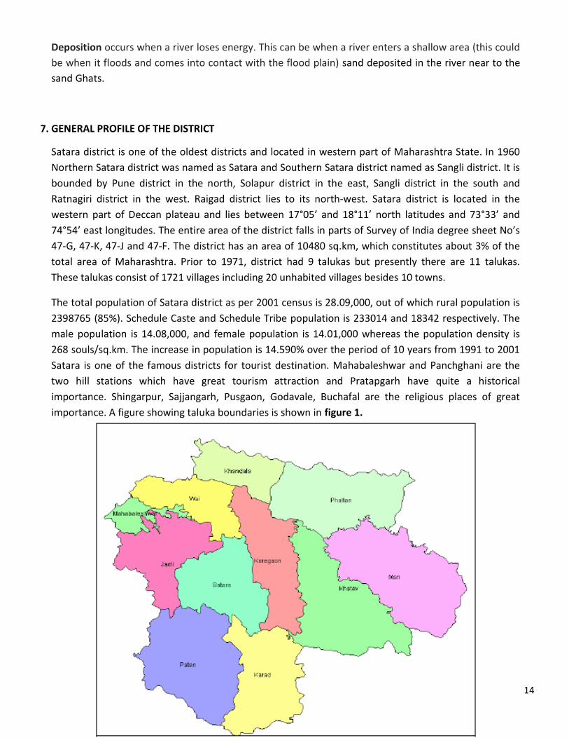
The total population of Satara district as per 2001 census is 28.09,000, out of which rural population is 2398765 (85%). Schedule Caste and Schedule Tribe population is 233014 and 18342 respectively. The male population is 14.08,000, and female population is 14.01,000 whereas the population density is 268 souls/sq.km. The increase in population is 14.590% over the period of 10 years from 1991 to 2001 Satara is one of the famous districts for tourist destination. Mahabaleshwar and Panchghani are the two hill stations which have great tourism attraction and Pratapgarh have quite a historical importance. Shingarpur, Sajjangarh, Pusgaon, Godavale, Buchafal are the religious places of great importance. A figure showing taluka boundaries is shown in figure 1.
15
Figure 1. : Satara District taluka boundaries
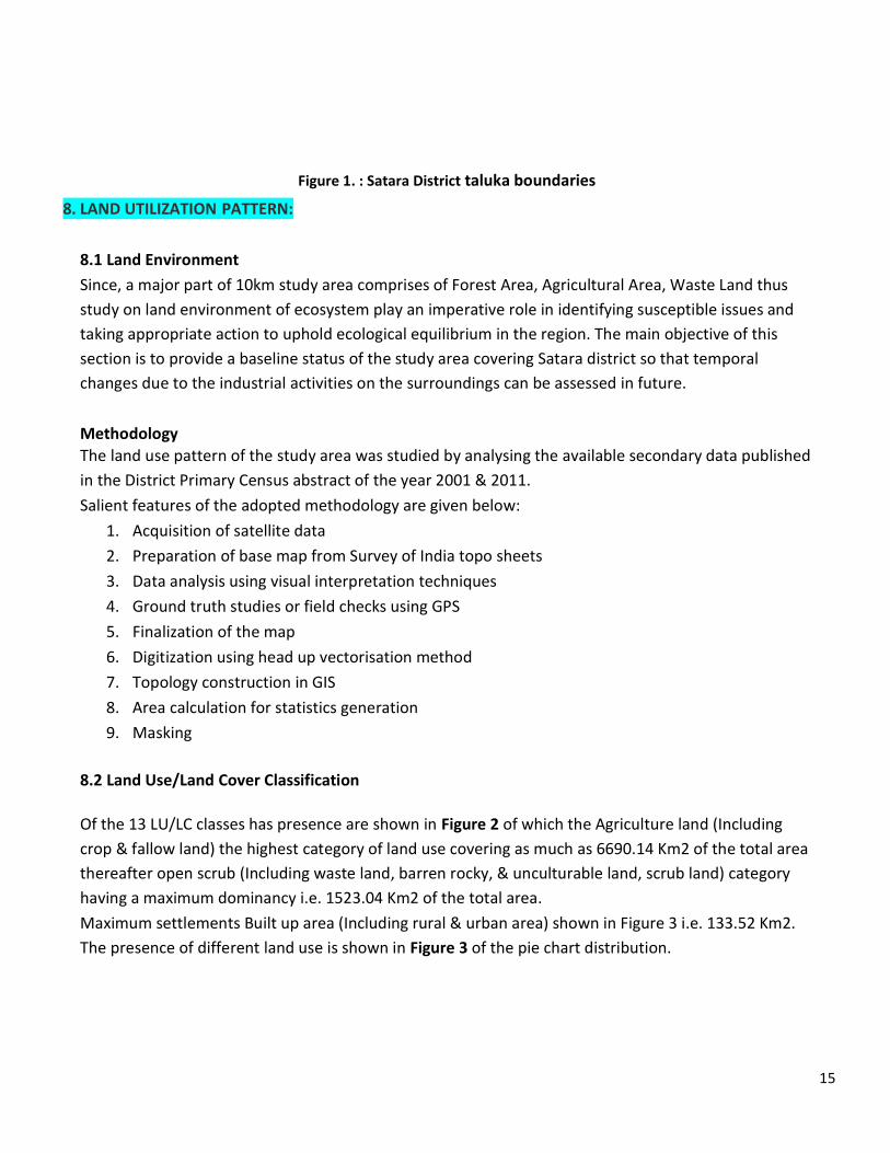
8. LAND UTILIZATION PATTERN:
8.1 Land Environment Since, a major part of 10km study area comprises of Forest Area, Agricultural Area, Waste Land thus study on land environment of ecosystem play an imperative role in identifying susceptible issues and taking appropriate action to uphold ecological equilibrium in the region. The main objective of this section is to provide a baseline status of the study area covering Satara district so that temporal changes due to the industrial activities on the surroundings can be assessed in future. Methodology The land use pattern of the study area was studied by analysing the available secondary data published in the District Primary Census abstract of the year 2001 & 2011. Salient features of the adopted methodology are given below:
1. Acquisition of satellite data 2. Preparation of base map from Survey of India topo sheets 3. Data analysis using visual interpretation techniques 4. Ground truth studies or field checks using GPS 5. Finalization of the map 6. Digitization using head up vectorisation method 7. Topology construction in GIS 8. Area calculation for statistics generation 9. Masking
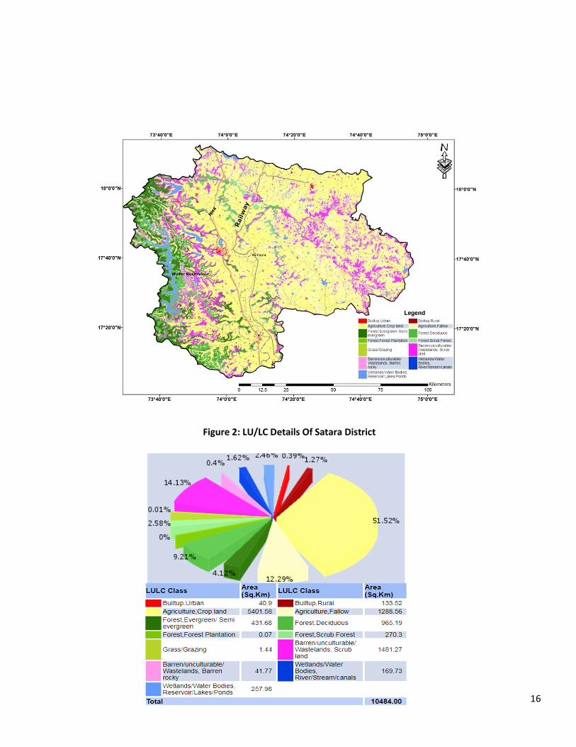
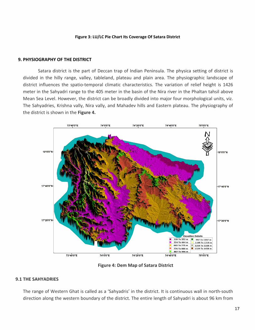
8.2 Land Use/Land Cover Classification Of the 13 LU/LC classes has presence are shown in Figure 2 of which the Agriculture land (Including crop & fallow land) the highest category of land use covering as much as 6690.14 Km2 of the total area thereafter open scrub (Including waste land, barren rocky, & unculturable land, scrub land) category having a maximum dominancy i.e. 1523.04 Km2 of the total area. Maximum settlements Built up area (Including rural & urban area) shown in Figure 3 i.e. 133.52 Km2. The presence of different land use is shown in Figure 3 of the pie chart distribution.
16
Figure 2: LU/LC Details Of Satara District
17
Figure 3: LU/LC Pie Chart Its Coverage Of Satara District
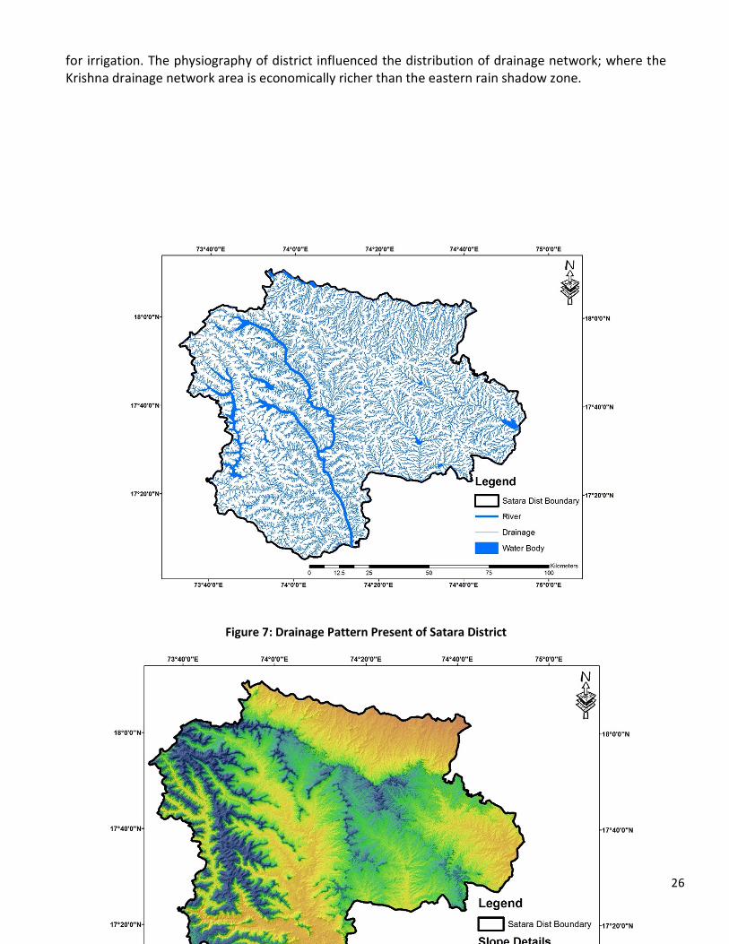
9. PHYSIOGRAPHY OF THE DISTRICT
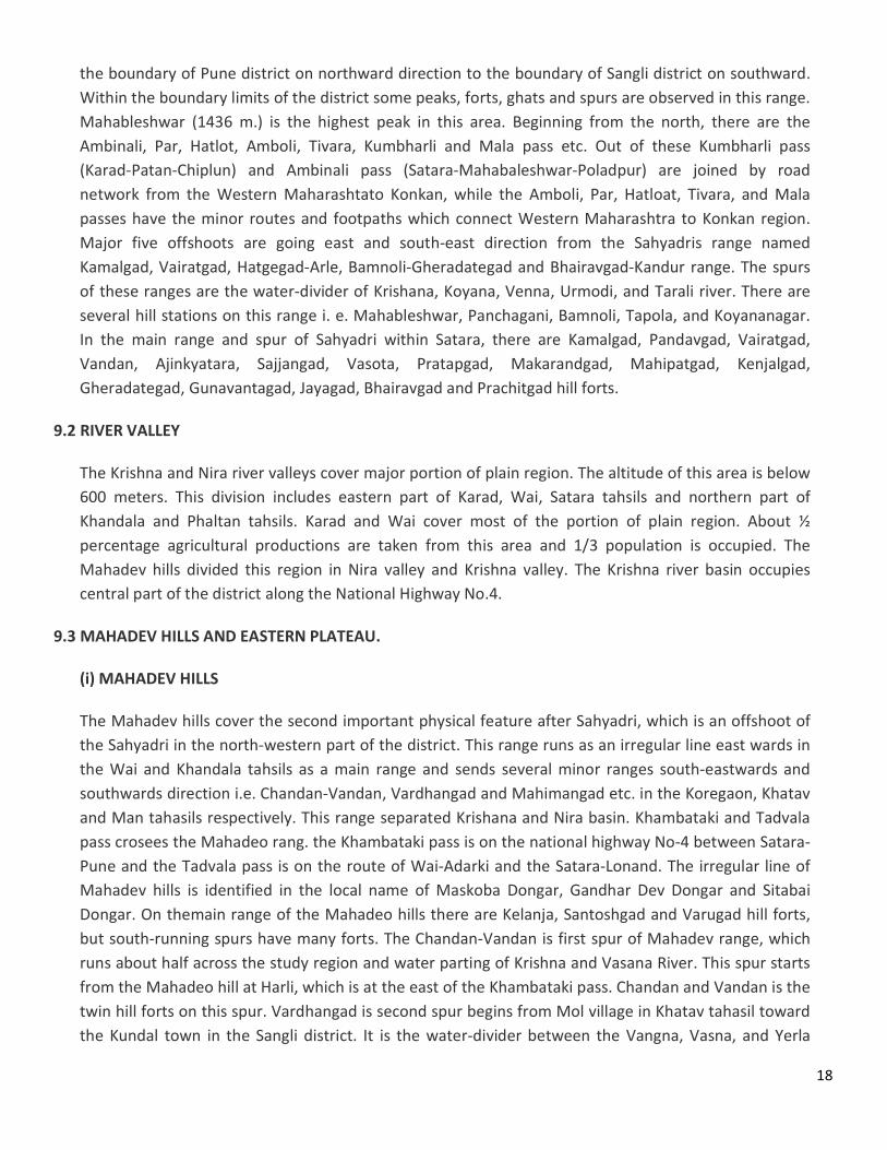
Satara district is the part of Deccan trap of Indian Peninsula. The physica setting of district is divided in the hilly range, valley, tableland, plateau and plain area. The physiographic landscape of district influences the spatio-temporal climatic characteristics. The variation of relief height is 1426 meter in the Sahyadri range to the 405 meter in the basin of the Nira river in the Phaltan tahsil above Mean Sea Level. However, the district can be broadly divided into major four morphological units, viz. The Sahyadries, Krishna vally, Nira vally, and Mahadev hills and Eastern plateau. The physiography of the district is shown in the Figure 4.
Figure 4: Dem Map of Satara District
9.1 THE SAHYADRIES
The range of Western Ghat is called as a ‘Sahyadris’ in the district. It is continuous wall in north-south direction along the western boundary of the district. The entire length of Sahyadri is about 96 km from
18
the boundary of Pune district on northward direction to the boundary of Sangli district on southward. Within the boundary limits of the district some peaks, forts, ghats and spurs are observed in this range. Mahableshwar (1436 m.) is the highest peak in this area. Beginning from the north, there are the Ambinali, Par, Hatlot, Amboli, Tivara, Kumbharli and Mala pass etc. Out of these Kumbharli pass (Karad-Patan-Chiplun) and Ambinali pass (Satara-Mahabaleshwar-Poladpur) are joined by road network from the Western Maharashtato Konkan, while the Amboli, Par, Hatloat, Tivara, and Mala passes have the minor routes and footpaths which connect Western Maharashtra to Konkan region. Major five offshoots are going east and south-east direction from the Sahyadris range named Kamalgad, Vairatgad, Hatgegad-Arle, Bamnoli-Gheradategad and Bhairavgad-Kandur range. The spurs of these ranges are the water-divider of Krishana, Koyana, Venna, Urmodi, and Tarali river. There are several hill stations on this range i. e. Mahableshwar, Panchagani, Bamnoli, Tapola, and Koyananagar. In the main range and spur of Sahyadri within Satara, there are Kamalgad, Pandavgad, Vairatgad, Vandan, Ajinkyatara, Sajjangad, Vasota, Pratapgad, Makarandgad, Mahipatgad, Kenjalgad, Gheradategad, Gunavantagad, Jayagad, Bhairavgad and Prachitgad hill forts.
9.2 RIVER VALLEY
The Krishna and Nira river valleys cover major portion of plain region. The altitude of this area is below 600 meters. This division includes eastern part of Karad, Wai, Satara tahsils and northern part of Khandala and Phaltan tahsils. Karad and Wai cover most of the portion of plain region. About ½ percentage agricultural productions are taken from this area and 1/3 population is occupied. The Mahadev hills divided this region in Nira valley and Krishna valley. The Krishna river basin occupies central part of the district along the National Highway No.4.
9.3 MAHADEV HILLS AND EASTERN PLATEAU.
(i) MAHADEV HILLS
The Mahadev hills cover the second important physical feature after Sahyadri, which is an offshoot of the Sahyadri in the north-western part of the district. This range runs as an irregular line east wards in the Wai and Khandala tahsils as a main range and sends several minor ranges south-eastwards and southwards direction i.e. Chandan-Vandan, Vardhangad and Mahimangad etc. in the Koregaon, Khatav and Man tahasils respectively. This range separated Krishana and Nira basin. Khambataki and Tadvala pass crosees the Mahadeo rang. the Khambataki pass is on the national highway No-4 between Satara- Pune and the Tadvala pass is on the route of Wai-Adarki and the Satara-Lonand. The irregular line of Mahadev hills is identified in the local name of Maskoba Dongar, Gandhar Dev Dongar and Sitabai Dongar. On themain range of the Mahadeo hills there are Kelanja, Santoshgad and Varugad hill forts, but south-running spurs have many forts. The Chandan-Vandan is first spur of Mahadev range, which runs about half across the study region and water parting of Krishna and Vasana River. This spur starts from the Mahadeo hill at Harli, which is at the east of the Khambataki pass. Chandan and Vandan is the twin hill forts on this spur. Vardhangad is second spur begins from Mol village in Khatav tahasil toward the Kundal town in the Sangli district. It is the water-divider between the Vangna, Vasna, and Yerla
19
rivers. Vardhangad and Sadashivgad are two important hill forts on this spur. Mahimangad is the third spur begins from the 14 Km east of the Vardhangad hill range and extended to the south-east direction toward Khanapur tahsil in the Sangli district. It is the water-parting between Yerla and Man River. Mahimangad is the major hill fort on this range.
(ii) EASTERN PLATEAU
The land between main Mahadev range and its spur has an elevated plateau feature. It has been showing typical semi-arid topography of bare tops covered with debris and stone. The eastern plateau covered the northern parts of Koregaon, central part of Khatav and Man tahsils. The average height of Mahadev hills is about 1200 to 1300 meters above the Mean Sea Level. The slope of plateau is gentle and mainly in the south-east part of the district. This region consist valleys of Vasana, Vangana, Yerala and Man rivers. Animal raring and dry farming are notable activities in this division.
10. CLIMATE AND RAINFALL The Indian Meteorology Department, Pune divided Satara district into four seasons.1 (i) Cold season -December to February (ii) Hot season- March to May (iii)Southwest monsoon season -June to September (iv)Post monsoon or the retreating monsoon season - October and November Temperature, rainfall, humidity, evaporation and wind speed are important elements of the climate. The climatic condition of Satara district depends on geographical factor. Generally, the climatic conditions of India change latitude wise but in the district, it changes longitudinal. Rainfall: The rainfall ranges from the rainiest in the Mahabaleshwar region, which has an average annual all of over 5805 mm to the driest in Man tahsil where the average annual rainfall is about 557 mm (Figure 2.3). Average annual rainfall of Satara district is 1033 mm. The rainfall is received in the three seasons. June to September is the south west monsoon season whereas October to December constitutes the post-monsoon season or the retreating monsoon season. The pre monsoon or hot season is from March to the end of May. The normal rainfall trend in the district increases towards the east to west and reaches maximum around Mahabaleshwar.
SATARA DISTRICT DISTRIBUTION OF MEAN ANNUAL RAINFALL
Sr. No Tahsil Rainfall (mm)
1 Man 557 2 Khatav 542
20
3 Phaltan 546 4 Khandala 563 5 Karad 759 6 Koregaon 798 7 Satara 878 8 Wai 966 9 Patan 1683 10 Jaoli 1805 11 Mahabaleshwar 5805
Source - Computed by researcher .
Humidity: In the rainy season, the air is highly humid (more than 75 percent) while during the winter and the summer season, the air is dry particularly in the afternoon. The eastern part of district is drier as compare to western high range.
Wind: Winds arestrong particularly on the Sahyadri Mountain in the monsoon season. They are weak to moderate during rest of the year but local wind is also creating dust storm. In the rainy season, the direction of wind is southwest or south and during summer, it is north and northeast. Thunderstorms
hails occur in the post monsoon months of summer season (April and May). The Sahyadri hilltops are generally covered with clouds and fog during the monsoon month Fog also occurs occasionally in the Koyana valley and Mahabaleshwar tahsil in the winter season. Occurrence of haze and frost is recorded in some part of Mahabaleshwar and Tapola area. Temperature: The mean minimum temperature is 11.6o C whereas the mean maximum is 37.5o C.
11. GEOLOGY AND SOILS:
11.1 GEOLOGY The entire district is underlying by Deccan trap basaltic lava flow of Upper Cretaceous to Lower Eocene age. The shallow alluvial formation of recent age also occurs as narrow stretch along the major rivers flowing in the district however, they have limited areal extension. Bauxite also found at some spaces alongwith this type of rocks. Geology of the district is shown in Figure 5. 11.1.1 Hard rock (Deccan Trap Basalt) Deccan trap occupies about 95% of the area of the district. It occurs as basaltic lava flows which are normally horizontal and deposited over wide stretch and give rise to tabular type of topography also known as plateau. These flows occur in layered sequence ranging in thickness from 4 to 66 m. Flows are represented by massive portion at bottom and vesicular portion at top and are separated from each other by marker bole bed. Thickness of weathering varies widely in the district from 5 m to 20 m bgl. The weathered and fractured flows occurring in topographic lows form the main aquifer in the district. The ground water occurs under phreatic, semi –confined and confined conditions. Generally, the shallower zones down to depth of 20 m bgl form phreatic aquifer. The water bearing zones occurring between the depth of 20 m and 40 m are weathered interflow of shear zones and have water under semi-confined condition. Deep confined aquifers occur below the depth of 40m. The vesicular
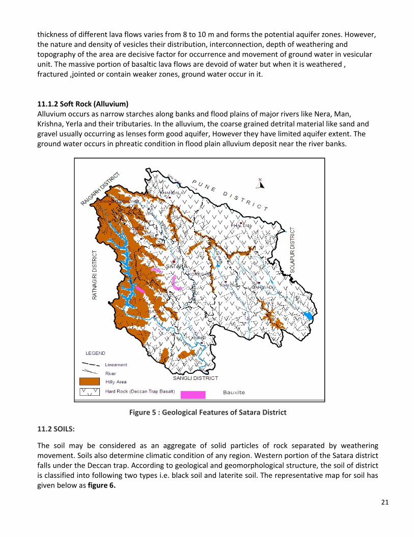
21
thickness of different lava flows varies from 8 to 10 m and forms the potential aquifer zones. However, the nature and density of vesicles their distribution, interconnection, depth of weathering and topography of the area are decisive factor for occurrence and movement of ground water in vesicular unit. The massive portion of basaltic lava flows are devoid of water but when it is weathered , fractured ,jointed or contain weaker zones, ground water occur in it. 11.1.2 Soft Rock (Alluvium) Alluvium occurs as narrow starches along banks and flood plains of major rivers like Nera, Man, Krishna, Yerla and their tributaries. In the alluvium, the coarse grained detrital material like sand and gravel usually occurring as lenses form good aquifer, However they have limited aquifer extent. The ground water occurs in phreatic condition in flood plain alluvium deposit near the river banks.
Figure 5 : Geological Features of Satara District
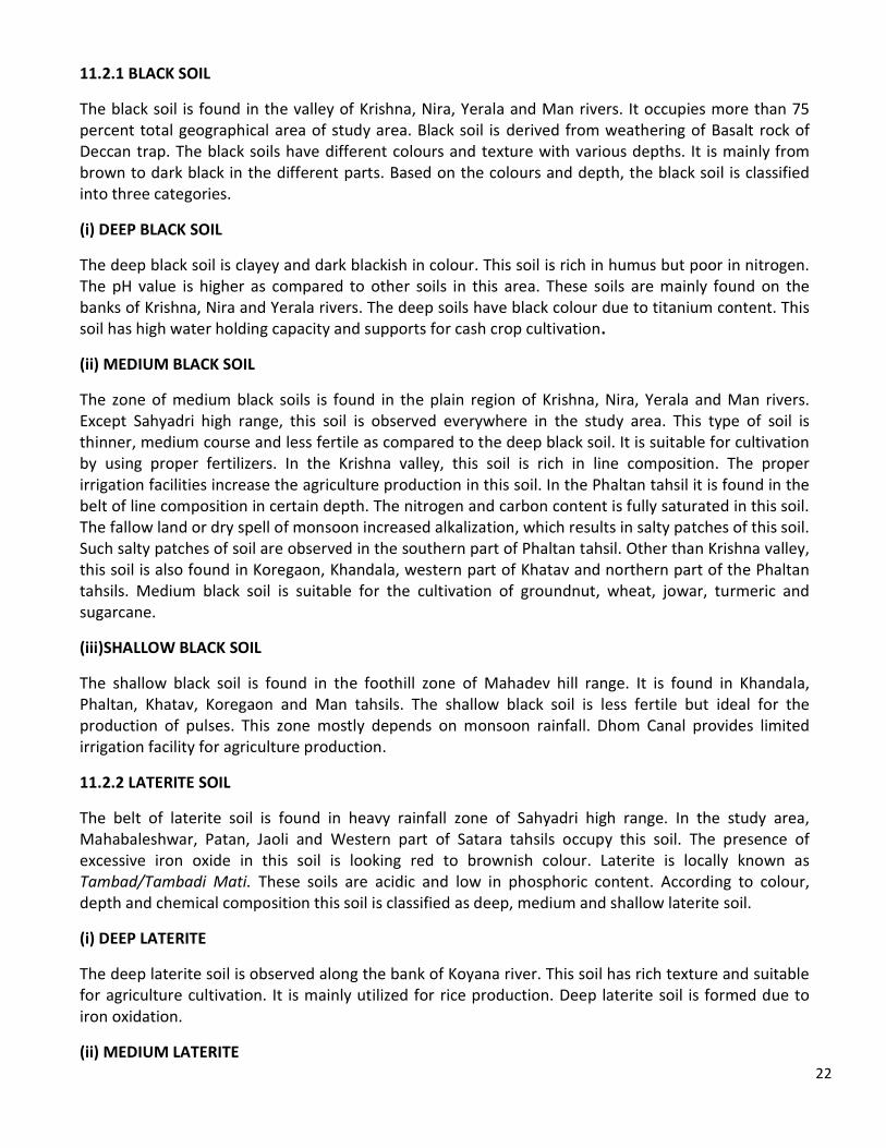
11.2 SOILS:
The soil may be considered as an aggregate of solid particles of rock separated by weathering movement. Soils also determine climatic condition of any region. Western portion of the Satara district falls under the Deccan trap. According to geological and geomorphological structure, the soil of district is classified into following two types i.e. black soil and laterite soil. The representative map for soil has given below as figure 6.
22
11.2.1 BLACK SOIL
The black soil is found in the valley of Krishna, Nira, Yerala and Man rivers. It occupies more than 75 percent total geographical area of study area. Black soil is derived from weathering of Basalt rock of Deccan trap. The black soils have different colours and texture with various depths. It is mainly from brown to dark black in the different parts. Based on the colours and depth, the black soil is classified into three categories.
(i) DEEP BLACK SOIL
The deep black soil is clayey and dark blackish in colour. This soil is rich in humus but poor in nitrogen. The pH value is higher as compared to other soils in this area. These soils are mainly found on the banks of Krishna, Nira and Yerala rivers. The deep soils have black colour due to titanium content. This soil has high water holding capacity and supports for cash crop cultivation.
(ii) MEDIUM BLACK SOIL
The zone of medium black soils is found in the plain region of Krishna, Nira, Yerala and Man rivers. Except Sahyadri high range, this soil is observed everywhere in the study area. This type of soil is thinner, medium course and less fertile as compared to the deep black soil. It is suitable for cultivation by using proper fertilizers. In the Krishna valley, this soil is rich in line composition. The proper irrigation facilities increase the agriculture production in this soil. In the Phaltan tahsil it is found in the belt of line composition in certain depth. The nitrogen and carbon content is fully saturated in this soil. The fallow land or dry spell of monsoon increased alkalization, which results in salty patches of this soil. Such salty patches of soil are observed in the southern part of Phaltan tahsil. Other than Krishna valley, this soil is also found in Koregaon, Khandala, western part of Khatav and northern part of the Phaltan tahsils. Medium black soil is suitable for the cultivation of groundnut, wheat, jowar, turmeric and sugarcane.
(iii)SHALLOW BLACK SOIL
The shallow black soil is found in the foothill zone of Mahadev hill range. It is found in Khandala, Phaltan, Khatav, Koregaon and Man tahsils. The shallow black soil is less fertile but ideal for the production of pulses. This zone mostly depends on monsoon rainfall. Dhom Canal provides limited irrigation facility for agriculture production.
11.2.2 LATERITE SOIL
The belt of laterite soil is found in heavy rainfall zone of Sahyadri high range. In the study area, Mahabaleshwar, Patan, Jaoli and Western part of Satara tahsils occupy this soil. The presence of excessive iron oxide in this soil is looking red to brownish colour. Laterite is locally known as Tambad/Tambadi Mati. These soils are acidic and low in phosphoric content. According to colour, depth and chemical composition this soil is classified as deep, medium and shallow laterite soil.
(i) DEEP LATERITE
The deep laterite soil is observed along the bank of Koyana river. This soil has rich texture and suitable for agriculture cultivation. It is mainly utilized for rice production. Deep laterite soil is formed due to iron oxidation.
(ii) MEDIUM LATERITE
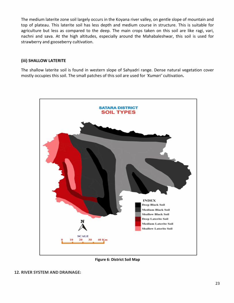
23
The medium laterite zone soil largely occurs in the Koyana river valley, on gentle slope of mountain and top of plateau. This laterite soil has less depth and medium course in structure. This is suitable for agriculture but less as compared to the deep. The main crops taken on this soil are like ragi, vari, nachni and sava. At the high altitudes, especially around the Mahabaleshwar, this soil is used for strawberry and gooseberry cultivation.
(iii) SHALLOW LATERITE
The shallow laterite soil is found in western slope of Sahyadri range. Dense natural vegetation cover mostly occupies this soil. The small patches of this soil are used for ‘Kumari’ cultivation.
Figure 6: District Soil Map
12. RIVER SYSTEM AND DRAINAGE:
24
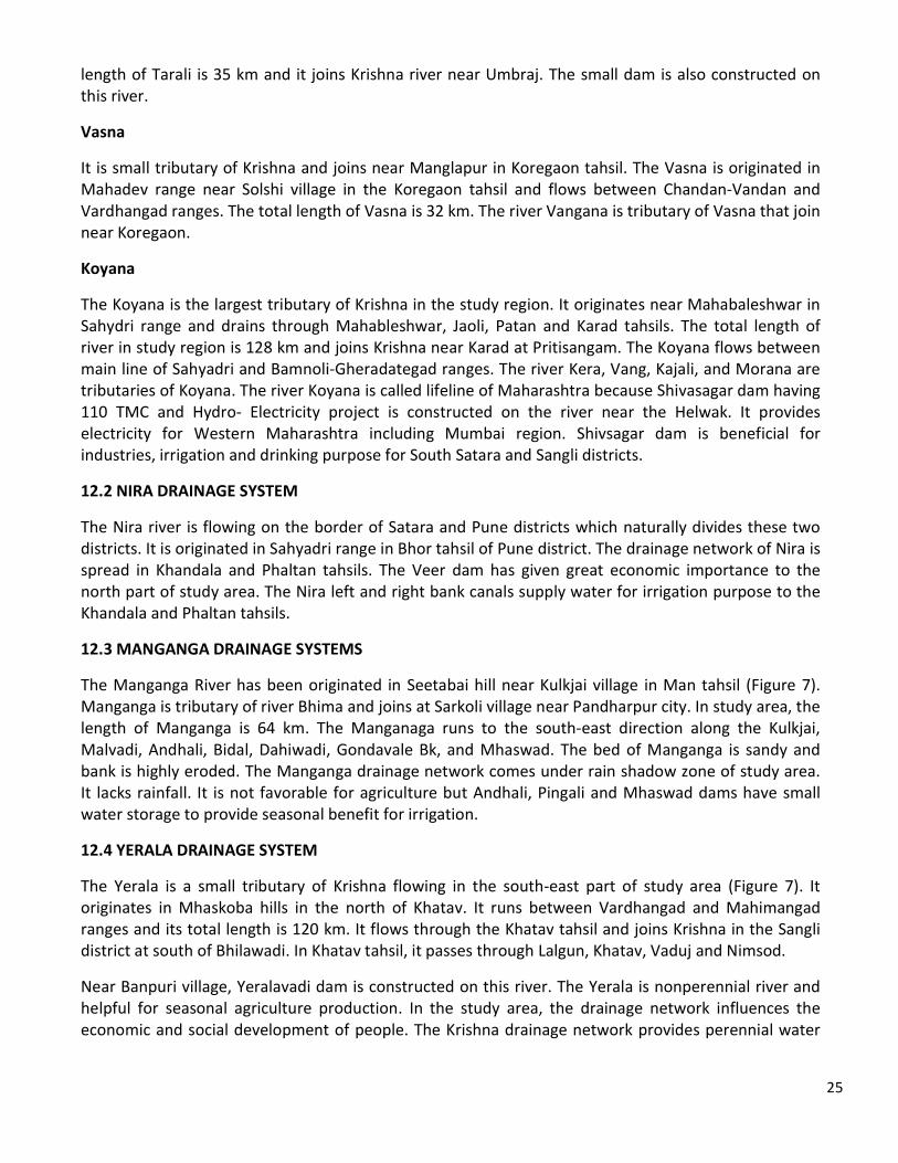
In the district, the Sahyadri hill range and its subdivision divided the drainage network into four areas; the Nira in the northern zone, the Krishna in the west and south zone, the Manganga and Yerala in east and south-east zone respectively (Figure 7). The major part of district is covered by Krishna river drainage system.
12.1 KRISHNA DRAINAGE SYSTEM
The Krishna is the second largest east flowing river of Indian Peninsula. Its length is about 1280 km and total drainage area is 243,610 km2. It rises on the 1364 meter above the Mean Sea Level in the Sahyadri range just north of Mahabaleshwar hill station of the district (Figure 7). Krishna is a main river in the district and drains 176km in the middle of the district. After origin, Krishna runs in Mahabaleshwar, Wai, Satara, Koregaon and Karad Tahsils. Kudali, Urmodi, Venna, Vasana, Koyana and
Tarali tributaries meet the Krishna in study region. The Dhom and Balkavadi dams are constructed on the Krishna near Wai. The annual water supply and fertile soil of Krishna drainage networks are providing the favorable situation for agricultural and economic development of study region. Satara, Wai, Karad are situated on the bank of Krishna.
Kudali
The Kudali is small tributary of Krishna originated near Kedamb in Jaoli tahsil and meets Krishna on right bank about 3 km south of Panchawad town. The length of Kudali river is 26 km and drains into Jaoli and Wai tahsils.
Venna
The Venna is one of the major tributaries of Krishna, which rises on the Mahableshwar plateau in Sahyadri. It flows between Hatgegad -Arle range on the left and Satara range on right side, and after meets Krishna near Sangam Mahuli about 5 km east of Satara city. The length of Venna is 64 km and it drains through Mahabaleshwar, Jaoli, and Satara tahsils. Near Kanher village one dam is also constructed on the Venna river. This reservoir is also beneficial for Jaoli, Satara and Koregaon tahsils for agriculture and drinking purpose.
Urmodi
The Urmodi is small tributary of Krishna that originates on the Kas plateau and joins near Venegaon. The Urmodi drains between Satara-Yavteshwar and Kalvali-Sonapur hill ranges. The total length of Urmodi is 32 km and flows into Jaoli and Satara tahsils. One small and one large dams are constructed on Urmaodi near Kas village and Parali town respectively. The water of Kas is supplied to the Satara city for drinking purpose. The Urmodi dam is beneficial for agriculture purpose of drought prone area of Satara and Sangli districts.
Tarali
The Tarali river rises on the east of Thoseghar-Chalkewadi village. It flows in Patan, Satara and Karad tahsils from the south east direction of Kelavali-Sonapur and north-east of Jalu-Vasantgad hills. The
25
length of Tarali is 35 km and it joins Krishna river near Umbraj. The small dam is also constructed on this river.
Vasna
It is small tributary of Krishna and joins near Manglapur in Koregaon tahsil. The Vasna is originated in Mahadev range near Solshi village in the Koregaon tahsil and flows between Chandan-Vandan and Vardhangad ranges. The total length of Vasna is 32 km. The river Vangana is tributary of Vasna that join near Koregaon.
Koyana
The Koyana is the largest tributary of Krishna in the study region. It originates near Mahabaleshwar in Sahydri range and drains through Mahableshwar, Jaoli, Patan and Karad tahsils. The total length of river in study region is 128 km and joins Krishna near Karad at Pritisangam. The Koyana flows between main line of Sahyadri and Bamnoli-Gheradategad ranges. The river Kera, Vang, Kajali, and Morana are tributaries of Koyana. The river Koyana is called lifeline of Maharashtra because Shivasagar dam having 110 TMC and Hydro- Electricity project is constructed on the river near the Helwak. It provides electricity for Western Maharashtra including Mumbai region. Shivsagar dam is beneficial for industries, irrigation and drinking purpose for South Satara and Sangli districts.
12.2 NIRA DRAINAGE SYSTEM
The Nira river is flowing on the border of Satara and Pune districts which naturally divides these two districts. It is originated in Sahyadri range in Bhor tahsil of Pune district. The drainage network of Nira is spread in Khandala and Phaltan tahsils. The Veer dam has given great economic importance to the north part of study area. The Nira left and right bank canals supply water for irrigation purpose to the Khandala and Phaltan tahsils.
12.3 MANGANGA DRAINAGE SYSTEMS
The Manganga River has been originated in Seetabai hill near Kulkjai village in Man tahsil (Figure 7). Manganga is tributary of river Bhima and joins at Sarkoli village near Pandharpur city. In study area, the length of Manganga is 64 km. The Manganaga runs to the south-east direction along the Kulkjai, Malvadi, Andhali, Bidal, Dahiwadi, Gondavale Bk, and Mhaswad. The bed of Manganga is sandy and bank is highly eroded. The Manganga drainage network comes under rain shadow zone of study area. It lacks rainfall. It is not favorable for agriculture but Andhali, Pingali and Mhaswad dams have small water storage to provide seasonal benefit for irrigation.
12.4 YERALA DRAINAGE SYSTEM
The Yerala is a small tributary of Krishna flowing in the south-east part of study area (Figure 7). It originates in Mhaskoba hills in the north of Khatav. It runs between Vardhangad and Mahimangad ranges and its total length is 120 km. It flows through the Khatav tahsil and joins Krishna in the Sangli district at south of Bhilawadi. In Khatav tahsil, it passes through Lalgun, Khatav, Vaduj and Nimsod.
Near Banpuri village, Yeralavadi dam is constructed on this river. The Yerala is nonperennial river and helpful for seasonal agriculture production. In the study area, the drainage network influences the economic and social development of people. The Krishna drainage network provides perennial water
26
for irrigation. The physiography of district influenced the distribution of drainage network; where the Krishna drainage network area is economically richer than the eastern rain shadow zone.
Figure 7: Drainage Pattern Present of Satara District
27
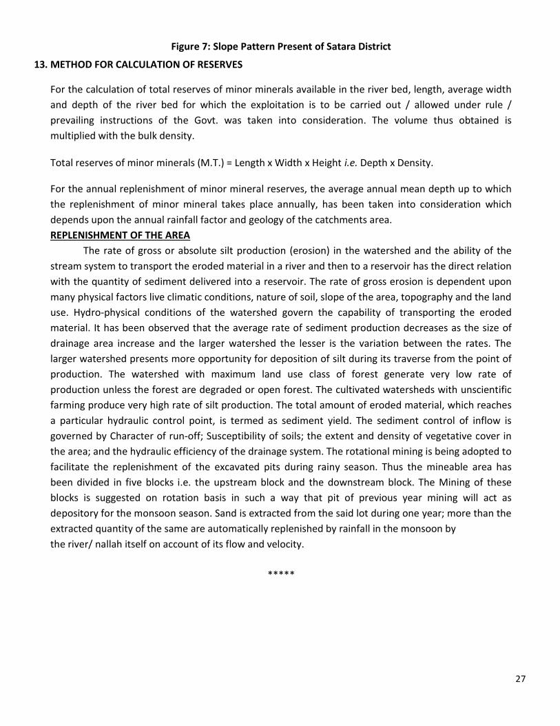
Figure 7: Slope Pattern Present of Satara District
13. METHOD FOR CALCULATION OF RESERVES
For the calculation of total reserves of minor minerals available in the river bed, length, average width and depth of the river bed for which the exploitation is to be carried out / allowed under rule / prevailing instructions of the Govt. was taken into consideration. The volume thus obtained is multiplied with the bulk density. Total reserves of minor minerals (M.T.) = Length x Width x Height i.e. Depth x Density. For the annual replenishment of minor mineral reserves, the average annual mean depth up to which the replenishment of minor mineral takes place annually, has been taken into consideration which depends upon the annual rainfall factor and geology of the catchments area. REPLENISHMENT OF THE AREA
The rate of gross or absolute silt production (erosion) in the watershed and the ability of the stream system to transport the eroded material in a river and then to a reservoir has the direct relation with the quantity of sediment delivered into a reservoir. The rate of gross erosion is dependent upon many physical factors live climatic conditions, nature of soil, slope of the area, topography and the land use. Hydro-physical conditions of the watershed govern the capability of transporting the eroded material. It has been observed that the average rate of sediment production decreases as the size of drainage area increase and the larger watershed the lesser is the variation between the rates. The larger watershed presents more opportunity for deposition of silt during its traverse from the point of production. The watershed with maximum land use class of forest generate very low rate of production unless the forest are degraded or open forest. The cultivated watersheds with unscientific farming produce very high rate of silt production. The total amount of eroded material, which reaches a particular hydraulic control point, is termed as sediment yield. The sediment control of inflow is governed by Character of run-off; Susceptibility of soils; the extent and density of vegetative cover in the area; and the hydraulic efficiency of the drainage system. The rotational mining is being adopted to facilitate the replenishment of the excavated pits during rainy season. Thus the mineable area has been divided in five blocks i.e. the upstream block and the downstream block. The Mining of these blocks is suggested on rotation basis in such a way that pit of previous year mining will act as depository for the monsoon season. Sand is extracted from the said lot during one year; more than the extracted quantity of the same are automatically replenished by rainfall in the monsoon by the river/ nallah itself on account of its flow and velocity.
*****


