Embed Size (px)
Citation preview
Construction Parking and Access Strategy
Western Harbour Tunnel and Warringah Freeway Upgrade
Stage 1A Early and Enabling Works - Critical utility installation, relocation and protection works
Transport for NSW

THIS PAGE LEFT BLANK INTENTIONALLY
1 | Western Harbour Tunnel and Warringah Freeway Upgrade – Critical Utilities Installation, Relocation and Protection Works | June 2021 Version 2 | UNCONTROLLED WHEN PRINTED
Construction Parking and Access Strategy
Western Harbour Tunnel and Warringah Freeway Upgrade
Stage 1A Early and Enabling Works - Critical utility installation, relocation and protection works
June 2021
3 | Western Harbour Tunnel and Warringah Freeway Upgrade – Critical Utilities Installation, Relocation and Protection Works | June 2021 Version 2 | UNCONTROLLED WHEN PRINTED
Contents
1 Introduction ............................................................................................................................. 9
1.1 Background ...................................................................................................................... 9
1.2 Project description .......................................................................................................... 11
1.3 Purpose and scope of this CPAS .................................................................................... 15
2 Consultation, endorsement and approval ........................................................................... 19
3 Existing conditions ............................................................................................................... 20
3.1 Parking surveys .............................................................................................................. 20
3.1.1 Parking survey times and locations ..................................................................... 20
3.1.2 Parking survey methodology ............................................................................... 25
3.1.3 Calculation of parking occupancy ........................................................................ 25
3.2 Bells Avenue / Warringa Road, Cammeray ..................................................................... 25
3.2.1 Parking supply ..................................................................................................... 25
3.2.2 Parking occupancy .............................................................................................. 26
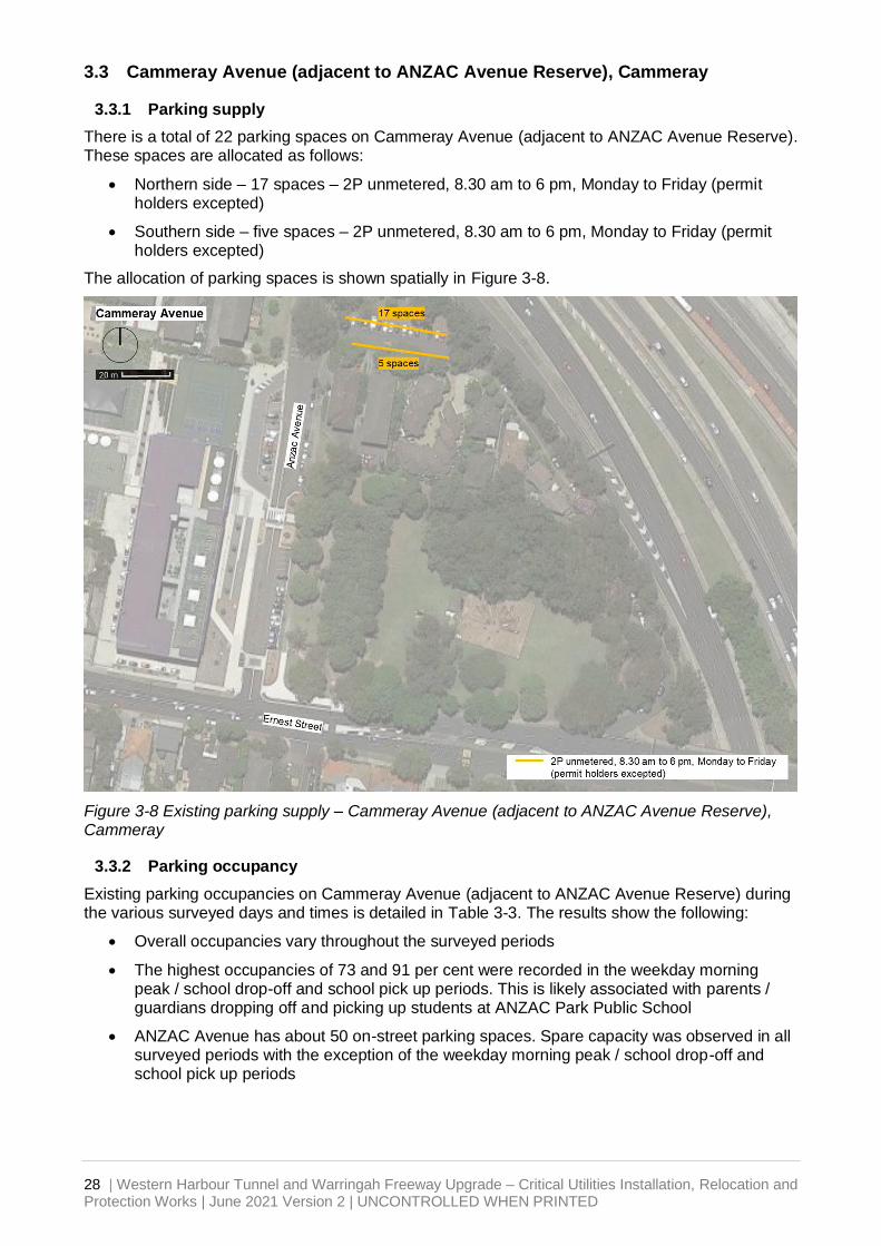
3.3 Cammeray Avenue (adjacent to ANZAC Avenue Reserve), Cammeray ......................... 27
3.3.1 Parking supply ..................................................................................................... 27
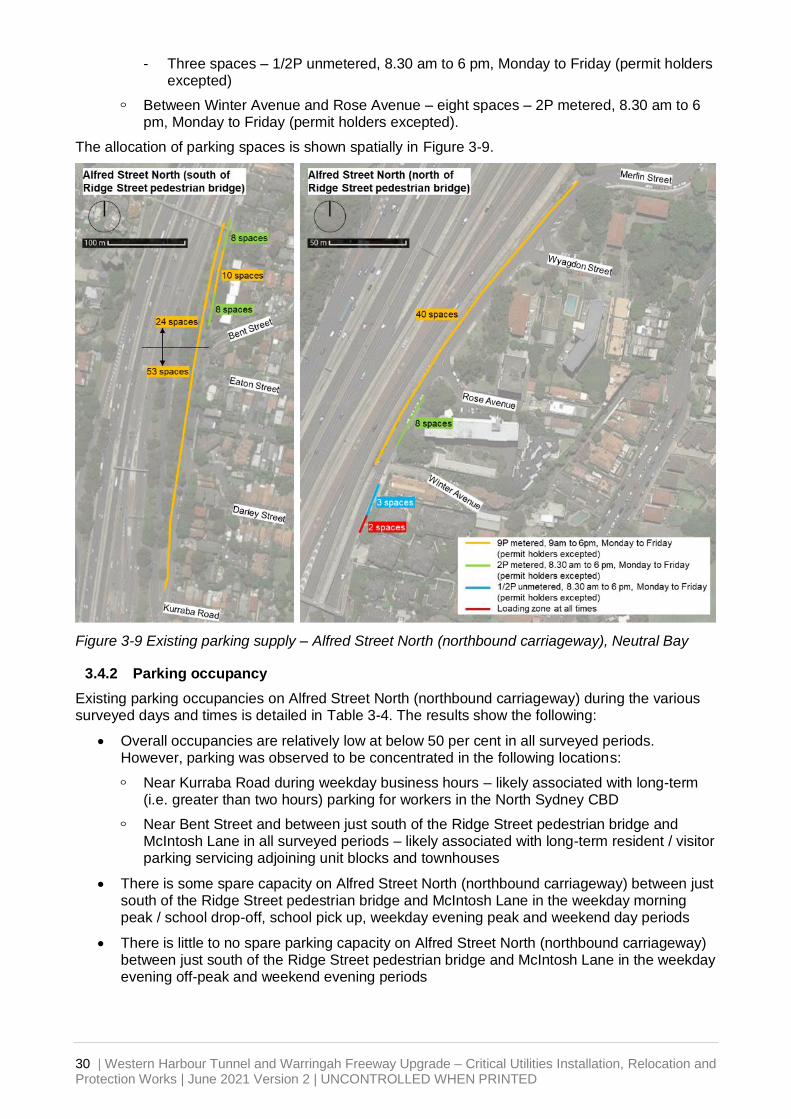
3.3.2 Parking occupancy .............................................................................................. 27
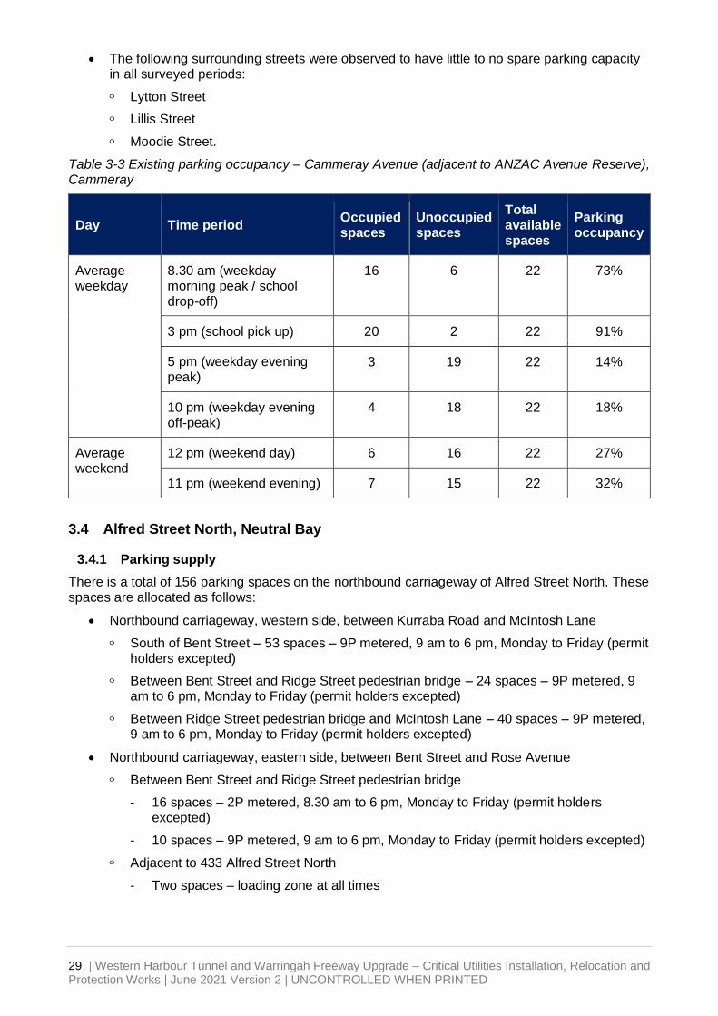
3.4 Alfred Street North, Neutral Bay ...................................................................................... 28
3.4.1 Parking supply ..................................................................................................... 28
3.4.2 Parking occupancy .............................................................................................. 29
3.5 Cammeray Avenue (south of ANZAC Avenue Reserve), Cammeray .............................. 30
3.5.1 Parking supply ..................................................................................................... 30
3.5.2 Parking occupancy .............................................................................................. 31
3.6 Ridge Street, North Sydney ............................................................................................ 32
3.6.1 Parking supply ..................................................................................................... 32
3.6.2 Parking occupancy .............................................................................................. 33
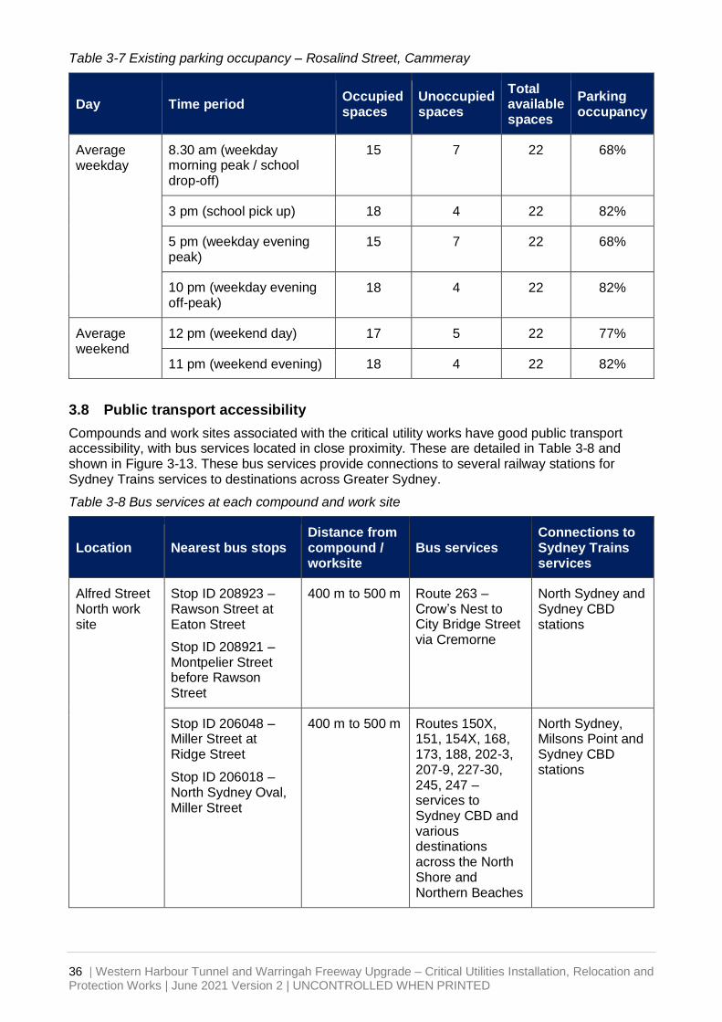
3.7 Rosalind Street, Cammeray ............................................................................................ 34
3.7.1 Parking supply ..................................................................................................... 34
3.7.2 Parking occupancy .............................................................................................. 34
3.8 Public transport accessibility ........................................................................................... 35
4 Proposed parking and access changes and impacts ......................................................... 38
4.1 Construction workforce parking ....................................................................................... 38
4.2 Locations outside the approved CSSI footprint ............................................................... 38
4.2.1 Bells Avenue / Warringa Road, Cammeray.......................................................... 38
4.2.2 Cammeray Avenue (adjacent to ANZAC Avenue Reserve), Cammeray .............. 39
4.3 Locations within the approved CSSI footprint .................................................................. 41
4 | Western Harbour Tunnel and Warringah Freeway Upgrade – Critical Utilities Installation, Relocation and Protection Works | June 2021 Version 2 | UNCONTROLLED WHEN PRINTED
4.3.1 Alfred Street North, Neutral Bay .......................................................................... 41
4.3.2 Cammeray Avenue (south of ANZAC Avenue Reserve), Cammeray ................... 42
4.3.3 Ridge Street, North Sydney ................................................................................. 44
4.3.4 Rosalind Street, Cammeray ................................................................................. 44
5 Mitigation measures .............................................................................................................. 46
5.1 Potential mitigation measures ......................................................................................... 46
5.2 Construction workforce parking ....................................................................................... 46
5.3 Bells Avenue / Warringa Road, Cammeray ..................................................................... 47
5.4 Cammeray Avenue (adjacent to ANZAC Avenue Reserve), Cammeray ......................... 48
6 Monitoring and reporting ...................................................................................................... 51
6.1 Monitoring of mitigation measures .................................................................................. 51
6.2 Corrective actions ........................................................................................................... 51
6.3 Reporting ........................................................................................................................ 51
6.4 Contingency measures ................................................................................................... 51
6.5 Update and amendment of this CPAS ............................................................................ 52
Tables
Table 1-1 Critical utilities works ..................................................................................................... 11
Table 1-2 Description of activities for the critical utility works scope .............................................. 12
Table 1-3 CoA E139 and E140 compliance................................................................................... 15
Table 1-4 Rapid assessment of parking spaces to be removed .................................................... 17
Table 3-1 Parking survey locations ............................................................................................... 20
Table 3-2 Existing parking occupancy – Bells Avenue / Warringa Road, Cammeray .................... 26
Table 3-3 Existing parking occupancy – Cammeray Avenue (adjacent to ANZAC Avenue Reserve), Cammeray .............................................................................................................................. 28
Table 3-4 Existing parking occupancy – Alfred Street North (northbound carriageway), Neutral Bay 30
Table 3-5 Existing parking occupancy – Cammeray Avenue (south of ANZAC Avenue Reserve), Cammeray .............................................................................................................................. 32
Table 3-6 Existing parking occupancy – Ridge Street, North Sydney ............................................ 33
Table 3-7 Existing parking occupancy – Rosalind Street, Cammeray............................................ 35
Table 3-8 Bus services at each compound and work site .............................................................. 35
Table 5-1 Consideration of potential mitigation measures – Bells Avenue / Warringa Road, Cammeray .............................................................................................................................. 47
Table 5-2 Consideration of potential mitigation measures – Cammeray Avenue (adjacent to ANZAC Avenue Reserve), Cammeray .................................................................................... 49
Table A-6-5 CoA and REMM relevant to the development of this CPAS…………………………….54
5 | Western Harbour Tunnel and Warringah Freeway Upgrade – Critical Utilities Installation, Relocation and Protection Works | June 2021 Version 2 | UNCONTROLLED WHEN PRINTED
Figures
Figure 1-1 Key features of the Warringah Freeway Upgrade component of the project ................. 10
Figure 1-2 Location of critical utility works scope.......................................................................... 14
Figure 3-1 Parking survey locations – Bells Avenue / Warringa Road, Cammeray ........................ 21
Figure 3-2 Parking survey locations – Cammeray Avenue (adjacent to ANZAC Avenue Reserve), Cammeray .............................................................................................................................. 22
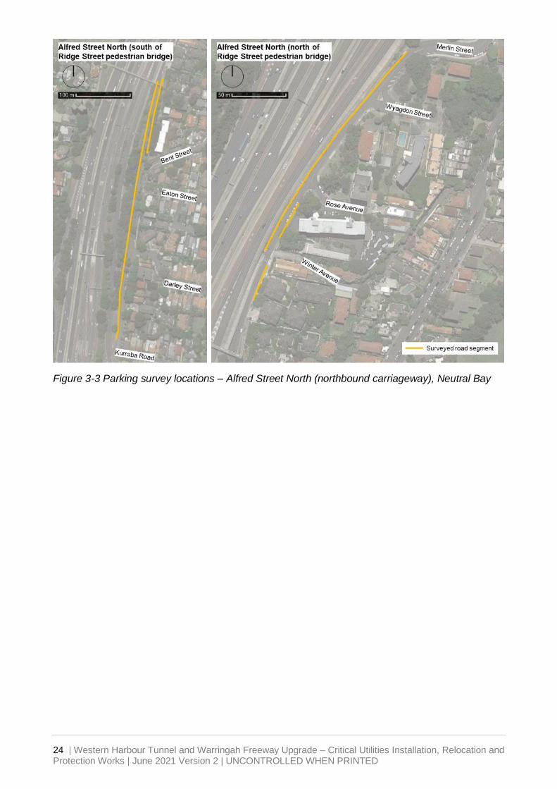
Figure 3-3 Parking survey locations – Alfred Street North (northbound carriageway), Neutral Bay 23
Figure 3-4 Parking survey locations – Cammeray Avenue (south of ANZAC Avenue Reserve), Cammeray .............................................................................................................................. 24
Figure 3-5 Parking survey locations – Ridge Street, North Sydney ............................................... 24
Figure 3-6 Parking survey locations – Rosalind Street, Cammeray ............................................... 25
Figure 3-7 Existing parking supply – Bells Avenue / Warringa Road, Cammeray .......................... 26
Figure 3-8 Existing parking supply – Cammeray Avenue (adjacent to ANZAC Avenue Reserve), Cammeray .............................................................................................................................. 27
Figure 3-9 Existing parking supply – Alfred Street North (northbound carriageway), Neutral Bay .. 29
Figure 3-10 Existing parking supply – Cammeray Avenue (south of ANZAC Avenue Reserve), Cammeray .............................................................................................................................. 31
Figure 3-6 Existing parking supply – Ridge Street, North Sydney ................................................. 33
Figure 3-7 Existing parking supply – Rosalind Street, Cammeray ................................................. 34
Figure 3-13 Bus network in Neutral Bay, North Sydney and Cammeray ....................................... 37
Figure 4-2 Long-term temporary removal of on-street parking – Bells Avenue / Warringa Road, Cammeray (indicative only – exact location subject to change) ............................................... 39
Figure 4-2 Long-term temporary removal of on-street parking – Cammeray Avenue (adjacent to ANZAC Avenue Reserve), Cammeray (indicative only – exact location subject to change) ..... 40
Figure 4-3 Long-term temporary removal of on-street parking – Alfred Street North, Neutral Bay (indicative only – exact location subject to change) ................................................................. 41
Figure 4-4 Long-term temporary removal of on-street parking – Cammeray Avenue (south of ANZAC Avenue Reserve), Cammeray (indicative only – exact location subject to change) ..... 43
Figure 4-4 Long-term temporary removal of on-street parking – Ridge Street, North Sydney (indicative only – exact location subject to change) ................................................................. 44
Figure 4-5 Long-term temporary removal of on-street parking – Rosalind Street, Cammeray (indicative only – exact location subject to change) ................................................................. 45
Appendices
Appendix A1 Parking survey data
Appendix A2 Additional CoA and REMM compliance table
7 | Western Harbour Tunnel and Warringah Freeway Upgrade – Critical Utilities Installation, Relocation and Protection Works | June 2021 Version 2 | UNCONTROLLED WHEN PRINTED
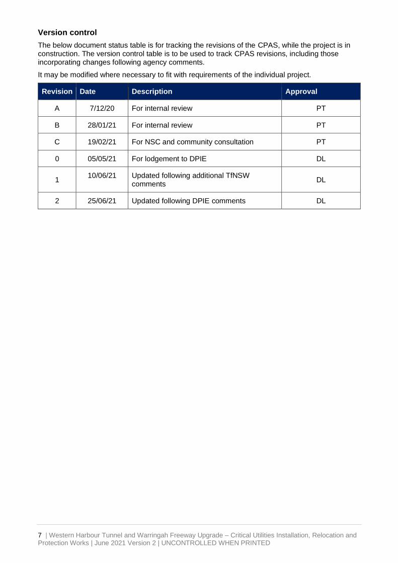
Version control
The below document status table is for tracking the revisions of the CPAS, while the project is in construction. The version control table is to be used to track CPAS revisions, including those incorporating changes following agency comments.
It may be modified where necessary to fit with requirements of the individual project.
Revision Date Description Approval
A 7/12/20 For internal review PT
B 28/01/21 For internal review PT
C 19/02/21 For NSC and community consultation PT
0 05/05/21 For lodgement to DPIE DL
1 10/06/21 Updated following additional TfNSW
comments DL
2 25/06/21 Updated following DPIE comments DL
8 | Western Harbour Tunnel and Warringah Freeway Upgrade – Critical Utilities Installation, Relocation and Protection Works | June 2021 Version 2 | UNCONTROLLED WHEN PRINTED
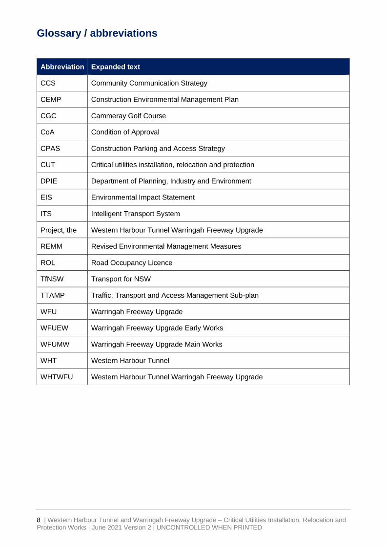
Glossary / abbreviations
Abbreviation Expanded text
CCS Community Communication Strategy
CEMP Construction Environmental Management Plan
CGC Cammeray Golf Course
CoA Condition of Approval
CPAS Construction Parking and Access Strategy
CUT Critical utilities installation, relocation and protection
DPIE Department of Planning, Industry and Environment
EIS Environmental Impact Statement
ITS Intelligent Transport System
Project, the Western Harbour Tunnel Warringah Freeway Upgrade
REMM Revised Environmental Management Measures
ROL Road Occupancy Licence
TfNSW Transport for NSW
TTAMP Traffic, Transport and Access Management Sub-plan
WFU Warringah Freeway Upgrade
WFUEW Warringah Freeway Upgrade Early Works
WFUMW Warringah Freeway Upgrade Main Works
WHT Western Harbour Tunnel
WHTWFU Western Harbour Tunnel Warringah Freeway Upgrade
9 | Western Harbour Tunnel and Warringah Freeway Upgrade – Critical Utilities Installation, Relocation and Protection Works | June 2021 Version 2 | UNCONTROLLED WHEN PRINTED
1 Introduction
1.1 Background
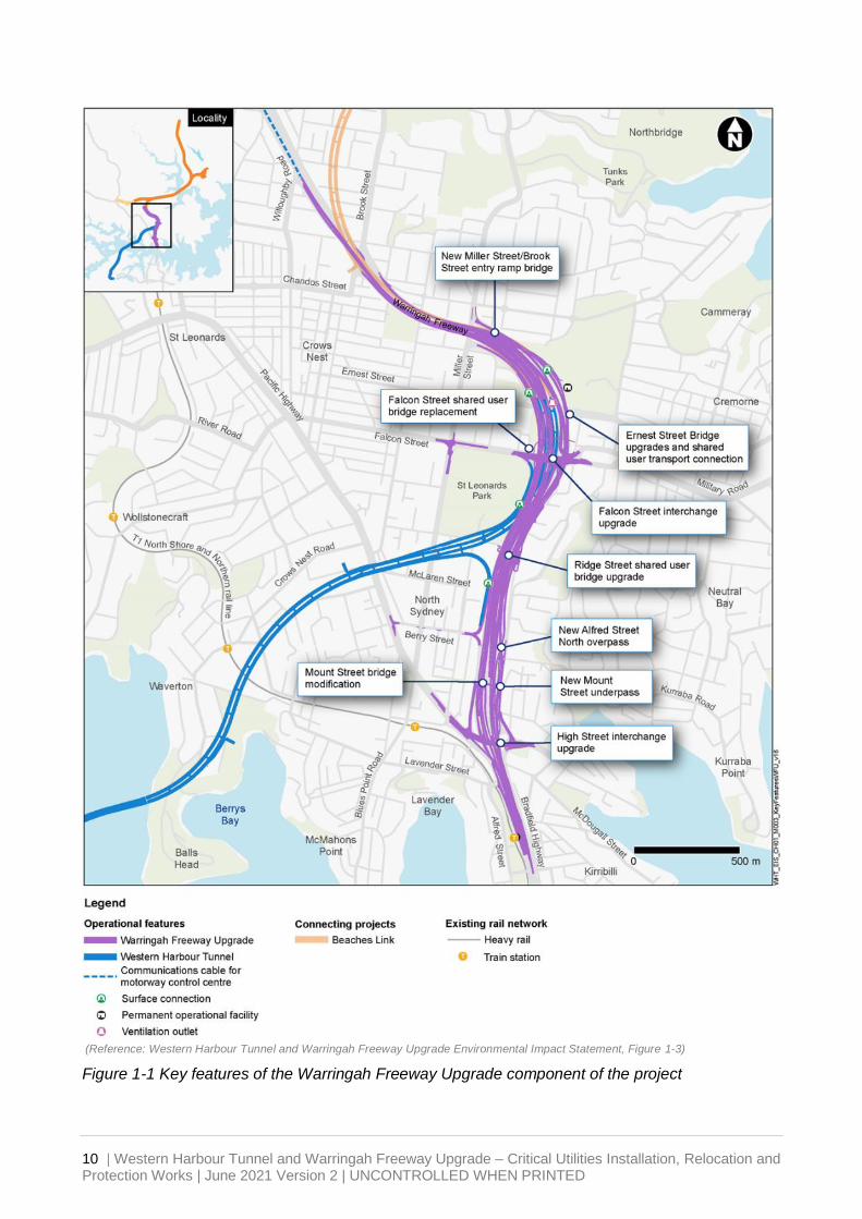
The Western Harbour Tunnel and Warringah Freeway Upgrade (WHTWFU) is shown in Figure 1-1. The project comprises two main components:
• A new crossing of Sydney Harbour involving twin tolled motorway tunnels connecting the M4-M5 Link at Rozelle and the Warringah Freeway at North Sydney (the Western Harbour Tunnel)
• Upgrade and integration work along the existing Warringah Freeway, including infrastructure required for connections to the Beaches Link and Gore Hill Freeway Connection project. Reconfiguration works as part of the Warringah Freeway Upgrade would optimise the road corridor and improve the performance of the Sydney Harbour Tunnel, the Sydney Harbour Bridge and the Western Harbour Tunnel.
Due to its importance, the WHTWFU project was declared to be Critical State Significant Infrastructure (CSSI) by the Minister for Planning and Public Space on 9 November 2020.
On 21 January 2021, the Department of Planning, Industry and Environment (DPIE) approved the construction and operation of the WHTWFU project (SSI 8863).
A detailed description of the project is provided in Chapter 5 of the Western Harbour Tunnel and Warringah Freeway Upgrade Environmental Impact Statement (EIS).
The WHTWFU project will be delivered in numerous stages:
• Stage 1 - Early and enabling works:
Stage 1A - Critical utility installation, relocation and protection (CUT) (the subject of this CPAS)
Stage 1B - Cammeray Golf Course adjustment works (CGC)
• Stage 2 - Warringah Freeway Upgrade project:
Stage 2A - Warringah Freeway Upgrade early works (WFUEW)
Stage 2B - Warringah Freeway Upgrade main works (WFUMW)
• Stage 3 - Western Harbour Tunnel project (WHT).
Further detail on each stage is provided in the WHTWFU project Staging Report.
This Construction Parking and Access Strategy (CPAS) applies only to Stage 1A Early and Enabling Works - Critical utility installation, relocation and protection stage of the project (referred to herein as “the critical utility works’ or ‘CUT’. The critical utility works will support the delivery of the wider WHTWFU program of works by undertaking these works prior to the commencement of the Stage 2 and Stage 3.
10 | Western Harbour Tunnel and Warringah Freeway Upgrade – Critical Utilities Installation, Relocation and Protection Works | June 2021 Version 2 | UNCONTROLLED WHEN PRINTED
(Reference: Western Harbour Tunnel and Warringah Freeway Upgrade Environmental Impact Statement, Figure 1-3)
Figure 1-1 Key features of the Warringah Freeway Upgrade component of the project
11 | Western Harbour Tunnel and Warringah Freeway Upgrade – Critical Utilities Installation, Relocation and Protection Works | June 2021 Version 2 | UNCONTROLLED WHEN PRINTED
1.2 Project description
The early and enabling works will support the delivery program of the Main Works of the project by undertaking these works prior to the commencement of the Main Works.
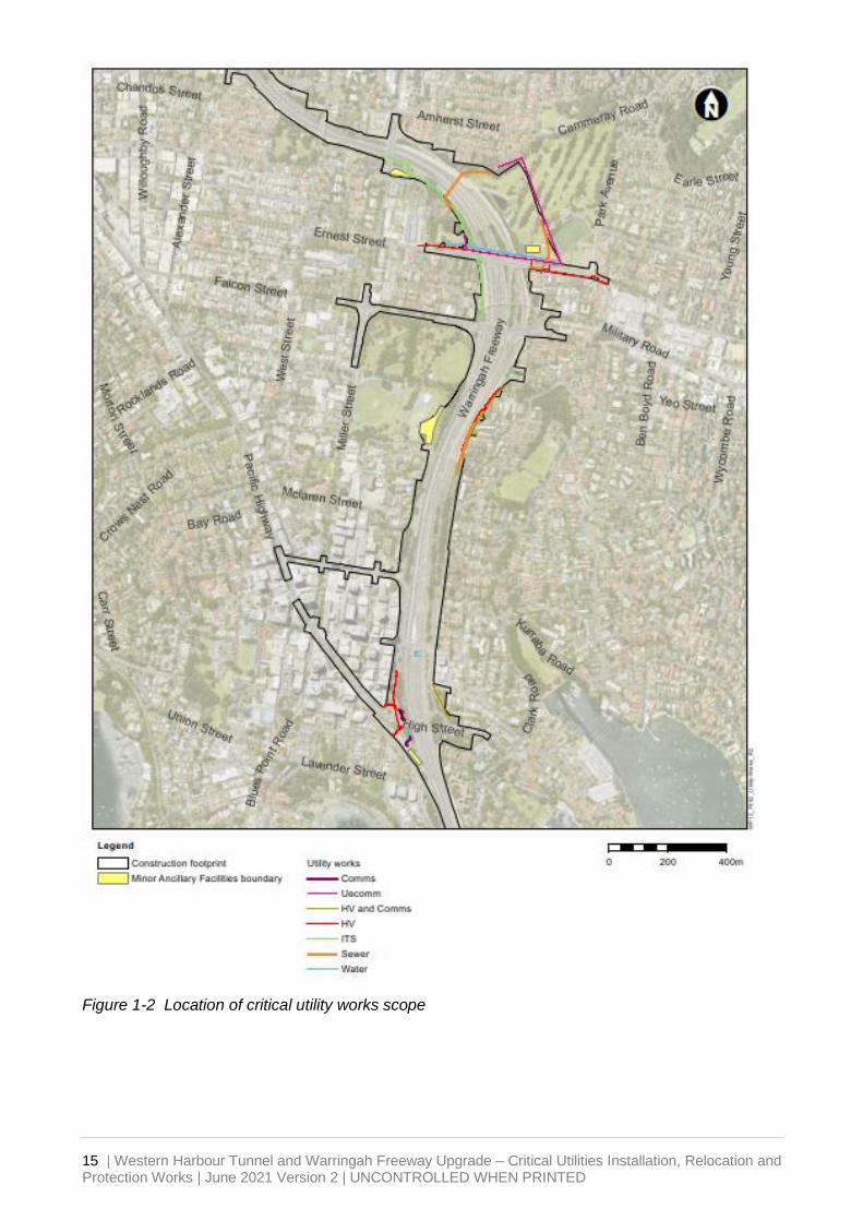
This CPAS applies only to the critical utility installation, relocation and protection early works package of the project (Stage 1A). These critical utilities work is critical to an earlier start on site and will be undertaken as part of early and enabling works of the project as outlined in Table 1-1 and Figure 1-2.
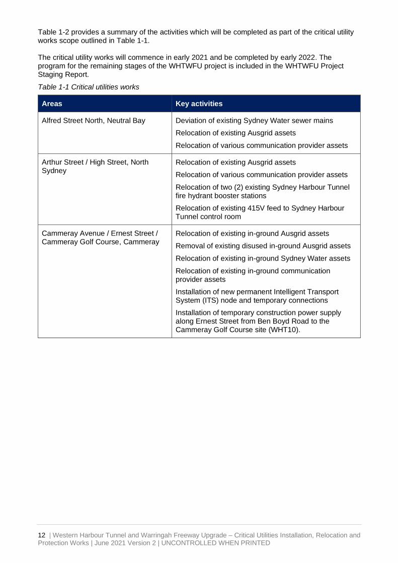
12 | Western Harbour Tunnel and Warringah Freeway Upgrade – Critical Utilities Installation, Relocation and Protection Works | June 2021 Version 2 | UNCONTROLLED WHEN PRINTED
Table 1-2 provides a summary of the activities which will be completed as part of the critical utility works scope outlined in Table 1-1. The critical utility works will commence in early 2021 and be completed by early 2022. The program for the remaining stages of the WHTWFU project is included in the WHTWFU Project Staging Report.
Table 1-1 Critical utilities works
Areas Key activities
Alfred Street North, Neutral Bay Deviation of existing Sydney Water sewer mains
Relocation of existing Ausgrid assets
Relocation of various communication provider assets
Arthur Street / High Street, North Sydney
Relocation of existing Ausgrid assets
Relocation of various communication provider assets
Relocation of two (2) existing Sydney Harbour Tunnel fire hydrant booster stations
Relocation of existing 415V feed to Sydney Harbour Tunnel control room
Cammeray Avenue / Ernest Street / Cammeray Golf Course, Cammeray
Relocation of existing in-ground Ausgrid assets
Removal of existing disused in-ground Ausgrid assets
Relocation of existing in-ground Sydney Water assets
Relocation of existing in-ground communication provider assets
Installation of new permanent Intelligent Transport System (ITS) node and temporary connections
Installation of temporary construction power supply along Ernest Street from Ben Boyd Road to the Cammeray Golf Course site (WHT10).
13 | Western Harbour Tunnel and Warringah Freeway Upgrade – Critical Utilities Installation, Relocation and Protection Works | June 2021 Version 2 | UNCONTROLLED WHEN PRINTED
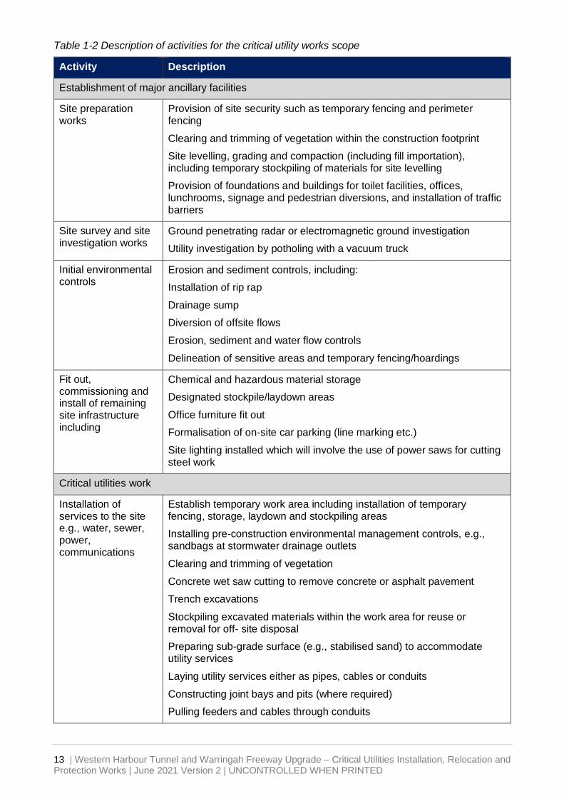
Table 1-2 Description of activities for the critical utility works scope
Activity Description
Establishment of major ancillary facilities
Site preparation works
Provision of site security such as temporary fencing and perimeter fencing
Clearing and trimming of vegetation within the construction footprint
Site levelling, grading and compaction (including fill importation), including temporary stockpiling of materials for site levelling
Provision of foundations and buildings for toilet facilities, offices, lunchrooms, signage and pedestrian diversions, and installation of traffic barriers
Site survey and site investigation works
Ground penetrating radar or electromagnetic ground investigation
Utility investigation by potholing with a vacuum truck
Initial environmental controls
Erosion and sediment controls, including:
Installation of rip rap
Drainage sump
Diversion of offsite flows
Erosion, sediment and water flow controls
Delineation of sensitive areas and temporary fencing/hoardings
Fit out, commissioning and install of remaining site infrastructure including
Chemical and hazardous material storage
Designated stockpile/laydown areas
Office furniture fit out
Formalisation of on-site car parking (line marking etc.)
Site lighting installed which will involve the use of power saws for cutting steel work
Critical utilities work
Installation of services to the site e.g., water, sewer, power, communications
Establish temporary work area including installation of temporary fencing, storage, laydown and stockpiling areas
Installing pre-construction environmental management controls, e.g., sandbags at stormwater drainage outlets
Clearing and trimming of vegetation
Concrete wet saw cutting to remove concrete or asphalt pavement
Trench excavations
Stockpiling excavated materials within the work area for reuse or removal for off- site disposal
Preparing sub-grade surface (e.g., stabilised sand) to accommodate utility services
Laying utility services either as pipes, cables or conduits
Constructing joint bays and pits (where required)
Pulling feeders and cables through conduits
14 | Western Harbour Tunnel and Warringah Freeway Upgrade – Critical Utilities Installation, Relocation and Protection Works | June 2021 Version 2 | UNCONTROLLED WHEN PRINTED
Activity Description
Connecting utility services to existing networks
Testing and commissioning of utility services
Backfilling trenches and re-instating ground surface to an appropriate condition
Rehabilitate areas disturbed by works
Site clean-up and decommissioning of temporary work areas and environmental management controls
Installation of relocated utilities e.g., water, sewer, power, communications
Establish temporary work area including installation of temporary fencing, storage, laydown and stockpiling areas
Installing pre-construction environmental management controls, e.g., sandbags at stormwater drainage outlets
Clearing and trimming of vegetation
Concrete wet saw cutting to remove concrete or asphalt pavement
Trench excavations
Installation of directional drilling launch/receiving sites
Stockpiling excavated materials within the work area for reuse or removal for off- site disposal
Preparing sub-grade surface (e.g., stabilised sand) to accommodate utility services
Laying utility services either as pipes, cables or conduits
Constructing joint bays and pits (where required)
Pulling feeders and cables through conduits
Connecting utility services to existing networks
Testing and commissioning of utility services
Backfilling trenches and re-instating ground surface to an appropriate condition
Removal of redundant utilities
Rehabilitate areas disturbed by works
Site clean-up and decommissioning of temporary work areas and environmental management controls
15 | Western Harbour Tunnel and Warringah Freeway Upgrade – Critical Utilities Installation, Relocation and Protection Works | June 2021 Version 2 | UNCONTROLLED WHEN PRINTED
Figure 1-2 Location of critical utility works scope
16 | Western Harbour Tunnel and Warringah Freeway Upgrade – Critical Utilities Installation, Relocation and Protection Works | June 2021 Version 2 | UNCONTROLLED WHEN PRINTED
1.3 Purpose and scope of this CPAS
This CPAS has been prepared to describe how the Contractor, during the critical utilities work, will comply with the requirements of the NSW Minister for Planning and Public Space’s Conditions of Approval (CoA) E139 and E140. The scope of the CPAS includes on- and off-street parking changes during the critical utilities work that are located outside the approved CSSI footprint. Car parking requiring removal inside the approved CSSI footprint has been considered in the EIS and has already been approved under the Infrastructure Approval (SSI-8863). Notwithstanding, car parking spaces that will be removed during the critical utilities work that are located within the approved CSSI footprint have been assessed and identified.
The CPAS will be lodged to DPIE at least one month prior to the commencement of any work that will impact on parking. These works will not commence until the CPAS has been approved by DPIE.
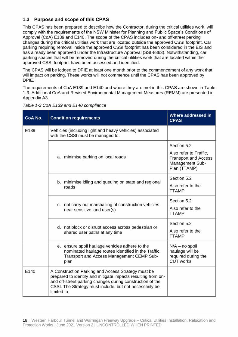
The requirements of CoA E139 and E140 and where they are met in this CPAS are shown in Table 1-3. Additional CoA and Revised Environmental Management Measures (REMM) are presented in Appendix A3.
Table 1-3 CoA E139 and E140 compliance
CoA No. Condition requirements Where addressed in CPAS
E139 Vehicles (including light and heavy vehicles) associated with the CSSI must be managed to:
a. minimise parking on local roads
Section 5.2
Also refer to Traffic, Transport and Access Management Sub-Plan (TTAMP)
b. minimise idling and queuing on state and regional roads
Section 5.2
Also refer to the TTAMP
c. not carry out marshalling of construction vehicles near sensitive land user(s)
Section 5.2
Also refer to the TTAMP
d. not block or disrupt access across pedestrian or shared user paths at any time
Section 5.2
Also refer to the TTAMP
e. ensure spoil haulage vehicles adhere to the nominated haulage routes identified in the Traffic, Transport and Access Management CEMP Sub-plan
N/A – no spoil haulage will be required during the CUT works.
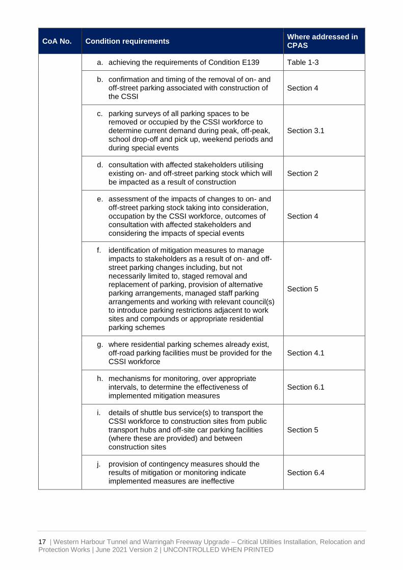
E140
A Construction Parking and Access Strategy must be prepared to identify and mitigate impacts resulting from on- and off-street parking changes during construction of the CSSI. The Strategy must include, but not necessarily be limited to:
17 | Western Harbour Tunnel and Warringah Freeway Upgrade – Critical Utilities Installation, Relocation and Protection Works | June 2021 Version 2 | UNCONTROLLED WHEN PRINTED
CoA No. Condition requirements Where addressed in CPAS
a. achieving the requirements of Condition E139 Table 1-3
b. confirmation and timing of the removal of on- and off-street parking associated with construction of the CSSI
Section 4
c. parking surveys of all parking spaces to be removed or occupied by the CSSI workforce to determine current demand during peak, off-peak, school drop-off and pick up, weekend periods and during special events
Section 3.1
d. consultation with affected stakeholders utilising existing on- and off-street parking stock which will be impacted as a result of construction
Section 2
e. assessment of the impacts of changes to on- and off-street parking stock taking into consideration, occupation by the CSSI workforce, outcomes of consultation with affected stakeholders and considering the impacts of special events
Section 4
f. identification of mitigation measures to manage impacts to stakeholders as a result of on- and off-street parking changes including, but not necessarily limited to, staged removal and replacement of parking, provision of alternative parking arrangements, managed staff parking arrangements and working with relevant council(s) to introduce parking restrictions adjacent to work sites and compounds or appropriate residential parking schemes
Section 5
g. where residential parking schemes already exist, off-road parking facilities must be provided for the CSSI workforce
Section 4.1
h. mechanisms for monitoring, over appropriate intervals, to determine the effectiveness of implemented mitigation measures
Section 6.1
i. details of shuttle bus service(s) to transport the CSSI workforce to construction sites from public transport hubs and off-site car parking facilities (where these are provided) and between construction sites
Section 5
j. provision of contingency measures should the results of mitigation or monitoring indicate implemented measures are ineffective
Section 6.4
18 | Western Harbour Tunnel and Warringah Freeway Upgrade – Critical Utilities Installation, Relocation and Protection Works | June 2021 Version 2 | UNCONTROLLED WHEN PRINTED
CoA No. Condition requirements Where addressed in CPAS
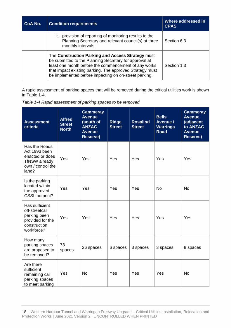
k. provision of reporting of monitoring results to the Planning Secretary and relevant council(s) at three monthly intervals
Section 6.3
The Construction Parking and Access Strategy must be submitted to the Planning Secretary for approval at least one month before the commencement of any works that impact existing parking. The approved Strategy must be implemented before impacting on on-street parking.
Section 1.3
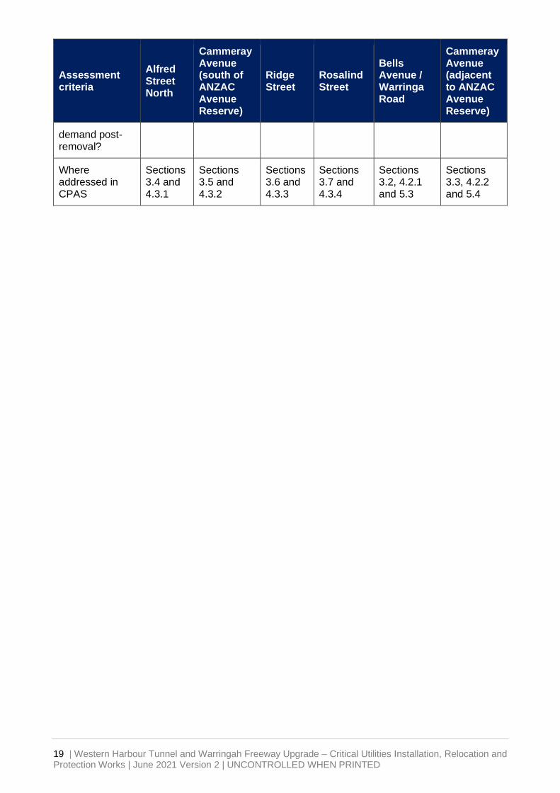
A rapid assessment of parking spaces that will be removed during the critical utilities work is shown in Table 1-4.
Table 1-4 Rapid assessment of parking spaces to be removed
Assessment criteria
Alfred Street North
Cammeray Avenue (south of ANZAC Avenue Reserve)
Ridge Street
Rosalind Street
Bells Avenue / Warringa Road
Cammeray Avenue (adjacent to ANZAC Avenue Reserve)
Has the Roads Act 1993 been enacted or does TfNSW already own / control the land?
Yes Yes Yes Yes Yes Yes
Is the parking located within the approved CSSI footprint?
Yes Yes Yes Yes No No
Has sufficient off-streetcar parking been provided for the construction workforce?
Yes Yes Yes Yes Yes Yes
How many parking spaces are proposed to be removed?
73 spaces
26 spaces 6 spaces 3 spaces 3 spaces 8 spaces
Are there sufficient remaining car parking spaces to meet parking
Yes No Yes Yes Yes No
19 | Western Harbour Tunnel and Warringah Freeway Upgrade – Critical Utilities Installation, Relocation and Protection Works | June 2021 Version 2 | UNCONTROLLED WHEN PRINTED
Assessment criteria
Alfred Street North
Cammeray Avenue (south of ANZAC Avenue Reserve)
Ridge Street
Rosalind Street
Bells Avenue / Warringa Road
Cammeray Avenue (adjacent to ANZAC Avenue Reserve)
demand post-removal?
Where addressed in CPAS
Sections 3.4 and 4.3.1
Sections 3.5 and 4.3.2
Sections 3.6 and 4.3.3
Sections 3.7 and 4.3.4
Sections 3.2, 4.2.1 and 5.3
Sections 3.3, 4.2.2 and 5.4
20 | Western Harbour Tunnel and Warringah Freeway Upgrade – Critical Utilities Installation, Relocation and Protection Works | June 2021 Version 2 | UNCONTROLLED WHEN PRINTED
2 Consultation, endorsement and approval
This CPAS will be accepted by the Contractor Project Manager, Contractor Environmental Manager and Transport for NSW (TfNSW) prior to lodgement to DPIE for approval. The CPAS will be prepared with consideration of consultation undertaken with North Sydney Council and stakeholders who will be affected by impacts to on and off-street parking.
Consultation was undertaken with affected stakeholders associated with on-street car parking removal proposed on Bells Avenue and Cammeray Avenue, in accordance with CoA E140(d),(e) and (f). The intent of this consultation was to inform affected stakeholders, to assess impacts to affected stakeholders and to develop specific mitigation measures to manage the impacts to affected stakeholder. This consultation included the following:
• Letter box drops
• Door knocks
• Emails
• Phone calls
• Online Survey.
No specific mitigation measures were identified following the outcomes of stakeholder consultation associated with the removal of on-street car parking along Bells Avenue and Cammeray Avenue. Therefore, no additional mitigation measures were developed beyond those presented in Section 5.3 of this CPAS.
In accordance with CoA A5 a Consultation Summary report has been prepared to document the consultation undertaken in the development as required by CoA E140(d),(e) and (f). This Consultation Summary will be lodged to DPIE along with this CPAS.
Ongoing consultation with stakeholders, including the surrounding community, will be conducted throughout works in accordance with the Community Communication Strategy (CCS).
21 | Western Harbour Tunnel and Warringah Freeway Upgrade – Critical Utilities Installation, Relocation and Protection Works | June 2021 Version 2 | UNCONTROLLED WHEN PRINTED
3 Existing conditions
3.1 Parking surveys
3.1.1 Parking survey times and locations
In accordance with CoA E140(c), parking surveys have been undertaken at all locations where on-street parking spaces are proposed to be removed to determine existing parking demand during peak, off-peak, school drop-off and pick up, weekend periods and during special events.
The parking surveys were undertaken on the following days and times:
• Weekdays1
8.30 am (weekday morning peak / school drop-off)
3 pm (school pick up)
5 pm (weekday evening peak)
10 pm (weekday evening off-peak)
• Weekends2
12 pm (weekend day)
11 pm (weekend evening)
These days do not coincide with public holidays or school holidays. The parking survey results can therefore be considered an accurate representation of a typical weekday and weekend.
The parking surveys were undertaken at the locations listed in Table 3-1.
Table 3-1 Parking survey locations
Location Road segment
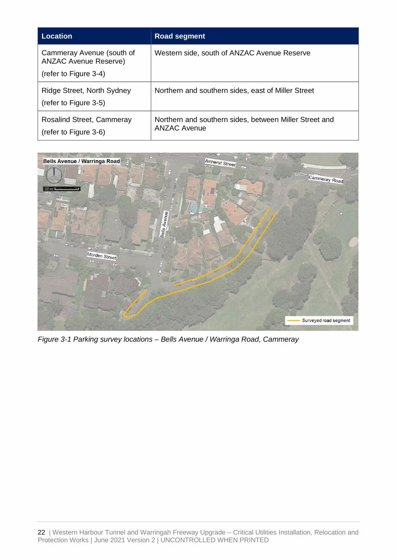
Bells Avenue / Warringa Road, Cammeray
(refer to Figure 3-1)
Northern and southern sides, south of Amherst Street / Cammeray Road
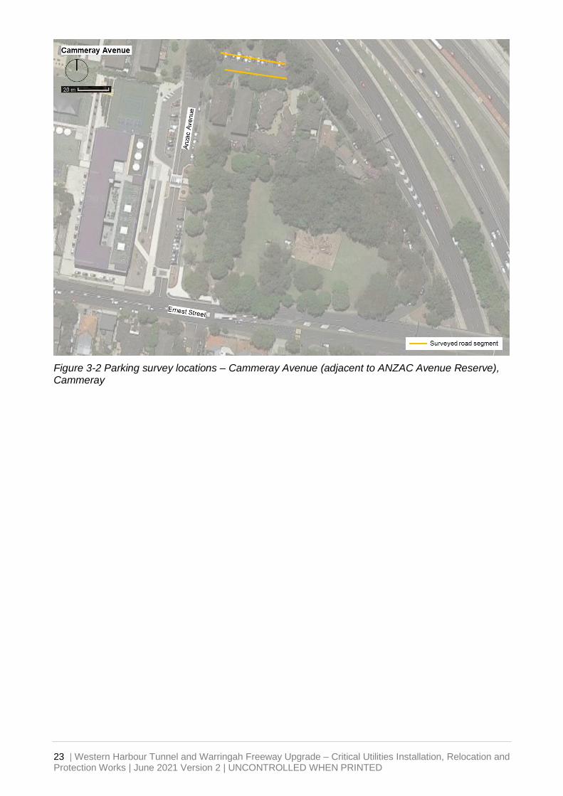
Cammeray Avenue (adjacent to ANZAC Avenue Reserve), Cammeray
(refer to Figure 3-2)
Northern and southern sides, adjacent to ANZAC Avenue Reserve
Alfred Street North, Neutral Bay
(refer to Figure 3-3)
Northbound carriageway, western side, between Kurraba Road and McIntosh Lane
Northbound carriageway, eastern side, between Bent Street and Rose Avenue
1 Weekday surveys were undertaken on Thursday 26 November 2020, Monday 14 December 2020, Tuesday 15 December 2020, Wednesday 16 December 2020 and Friday 18 December 2020 2 Weekend surveys were undertaken on Saturday 28 November 2020 and Sunday 13 December 2020
22 | Western Harbour Tunnel and Warringah Freeway Upgrade – Critical Utilities Installation, Relocation and Protection Works | June 2021 Version 2 | UNCONTROLLED WHEN PRINTED
Location Road segment
Cammeray Avenue (south of ANZAC Avenue Reserve)
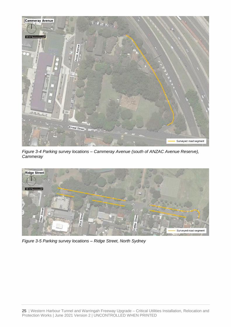
(refer to Figure 3-4)
Western side, south of ANZAC Avenue Reserve
Ridge Street, North Sydney
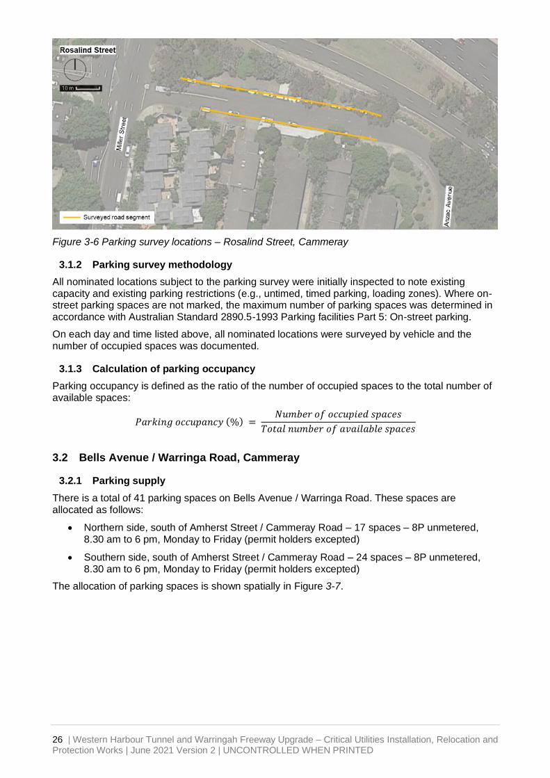
(refer to Figure 3-5)
Northern and southern sides, east of Miller Street
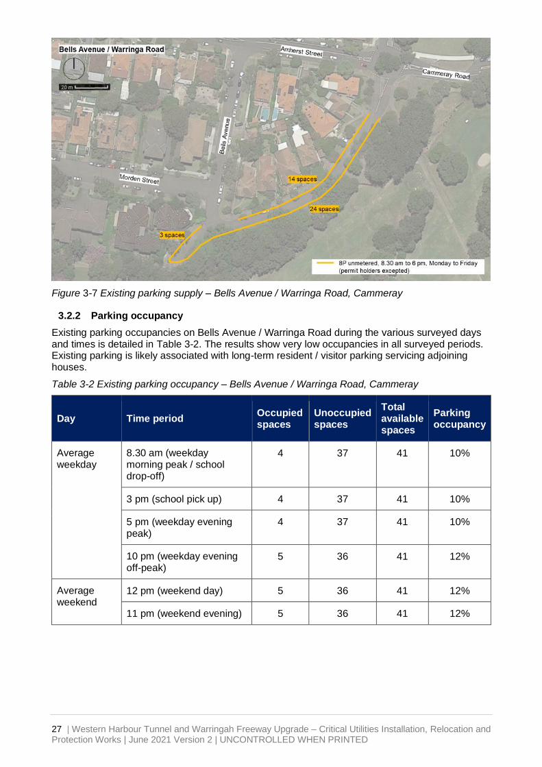
Rosalind Street, Cammeray
(refer to Figure 3-6)
Northern and southern sides, between Miller Street and ANZAC Avenue
Figure 3-1 Parking survey locations – Bells Avenue / Warringa Road, Cammeray
23 | Western Harbour Tunnel and Warringah Freeway Upgrade – Critical Utilities Installation, Relocation and Protection Works | June 2021 Version 2 | UNCONTROLLED WHEN PRINTED
Figure 3-2 Parking survey locations – Cammeray Avenue (adjacent to ANZAC Avenue Reserve), Cammeray
24 | Western Harbour Tunnel and Warringah Freeway Upgrade – Critical Utilities Installation, Relocation and Protection Works | June 2021 Version 2 | UNCONTROLLED WHEN PRINTED
Figure 3-3 Parking survey locations – Alfred Street North (northbound carriageway), Neutral Bay
25 | Western Harbour Tunnel and Warringah Freeway Upgrade – Critical Utilities Installation, Relocation and Protection Works | June 2021 Version 2 | UNCONTROLLED WHEN PRINTED
Figure 3-4 Parking survey locations – Cammeray Avenue (south of ANZAC Avenue Reserve), Cammeray
Figure 3-5 Parking survey locations – Ridge Street, North Sydney
26 | Western Harbour Tunnel and Warringah Freeway Upgrade – Critical Utilities Installation, Relocation and Protection Works | June 2021 Version 2 | UNCONTROLLED WHEN PRINTED
Figure 3-6 Parking survey locations – Rosalind Street, Cammeray
3.1.2 Parking survey methodology
All nominated locations subject to the parking survey were initially inspected to note existing capacity and existing parking restrictions (e.g., untimed, timed parking, loading zones). Where on-street parking spaces are not marked, the maximum number of parking spaces was determined in accordance with Australian Standard 2890.5-1993 Parking facilities Part 5: On-street parking.
On each day and time listed above, all nominated locations were surveyed by vehicle and the number of occupied spaces was documented.
3.1.3 Calculation of parking occupancy
Parking occupancy is defined as the ratio of the number of occupied spaces to the total number of available spaces:
𝑃𝑎𝑟𝑘𝑖𝑛𝑔 𝑜𝑐𝑐𝑢𝑝𝑎𝑛𝑐𝑦 (%) = 𝑁𝑢𝑚𝑏𝑒𝑟 𝑜𝑓 𝑜𝑐𝑐𝑢𝑝𝑖𝑒𝑑 𝑠𝑝𝑎𝑐𝑒𝑠
𝑇𝑜𝑡𝑎𝑙 𝑛𝑢𝑚𝑏𝑒𝑟 𝑜𝑓 𝑎𝑣𝑎𝑖𝑙𝑎𝑏𝑙𝑒 𝑠𝑝𝑎𝑐𝑒𝑠
3.2 Bells Avenue / Warringa Road, Cammeray
3.2.1 Parking supply
There is a total of 41 parking spaces on Bells Avenue / Warringa Road. These spaces are allocated as follows:
• Northern side, south of Amherst Street / Cammeray Road – 17 spaces – 8P unmetered, 8.30 am to 6 pm, Monday to Friday (permit holders excepted)
• Southern side, south of Amherst Street / Cammeray Road – 24 spaces – 8P unmetered, 8.30 am to 6 pm, Monday to Friday (permit holders excepted)
The allocation of parking spaces is shown spatially in Figure 3-7.
27 | Western Harbour Tunnel and Warringah Freeway Upgrade – Critical Utilities Installation, Relocation and Protection Works | June 2021 Version 2 | UNCONTROLLED WHEN PRINTED
Figure 3-7 Existing parking supply – Bells Avenue / Warringa Road, Cammeray
3.2.2 Parking occupancy
Existing parking occupancies on Bells Avenue / Warringa Road during the various surveyed days and times is detailed in Table 3-2. The results show very low occupancies in all surveyed periods. Existing parking is likely associated with long-term resident / visitor parking servicing adjoining houses.
Table 3-2 Existing parking occupancy – Bells Avenue / Warringa Road, Cammeray
Day Time period Occupied spaces
Unoccupied spaces
Total available spaces
Parking occupancy
Average weekday
8.30 am (weekday morning peak / school drop-off)
4 37 41 10%
3 pm (school pick up) 4 37 41 10%
5 pm (weekday evening peak)
4 37 41 10%
10 pm (weekday evening off-peak)
5 36 41 12%
Average weekend
12 pm (weekend day) 5 36 41 12%
11 pm (weekend evening) 5 36 41 12%
28 | Western Harbour Tunnel and Warringah Freeway Upgrade – Critical Utilities Installation, Relocation and Protection Works | June 2021 Version 2 | UNCONTROLLED WHEN PRINTED
3.3 Cammeray Avenue (adjacent to ANZAC Avenue Reserve), Cammeray
3.3.1 Parking supply
There is a total of 22 parking spaces on Cammeray Avenue (adjacent to ANZAC Avenue Reserve). These spaces are allocated as follows:
• Northern side – 17 spaces – 2P unmetered, 8.30 am to 6 pm, Monday to Friday (permit holders excepted)
• Southern side – five spaces – 2P unmetered, 8.30 am to 6 pm, Monday to Friday (permit holders excepted)
The allocation of parking spaces is shown spatially in Figure 3-8.
Figure 3-8 Existing parking supply – Cammeray Avenue (adjacent to ANZAC Avenue Reserve), Cammeray
3.3.2 Parking occupancy
Existing parking occupancies on Cammeray Avenue (adjacent to ANZAC Avenue Reserve) during the various surveyed days and times is detailed in Table 3-3. The results show the following:
• Overall occupancies vary throughout the surveyed periods
• The highest occupancies of 73 and 91 per cent were recorded in the weekday morning peak / school drop-off and school pick up periods. This is likely associated with parents / guardians dropping off and picking up students at ANZAC Park Public School
• ANZAC Avenue has about 50 on-street parking spaces. Spare capacity was observed in all surveyed periods with the exception of the weekday morning peak / school drop-off and school pick up periods
29 | Western Harbour Tunnel and Warringah Freeway Upgrade – Critical Utilities Installation, Relocation and Protection Works | June 2021 Version 2 | UNCONTROLLED WHEN PRINTED
• The following surrounding streets were observed to have little to no spare parking capacity in all surveyed periods:
Lytton Street
Lillis Street
Moodie Street.
Table 3-3 Existing parking occupancy – Cammeray Avenue (adjacent to ANZAC Avenue Reserve), Cammeray
Day Time period Occupied spaces
Unoccupied spaces
Total available spaces
Parking occupancy
Average weekday
8.30 am (weekday morning peak / school drop-off)
16 6 22 73%
3 pm (school pick up) 20 2 22 91%
5 pm (weekday evening peak)
3 19 22 14%
10 pm (weekday evening off-peak)
4 18 22 18%
Average weekend
12 pm (weekend day) 6 16 22 27%
11 pm (weekend evening) 7 15 22 32%
3.4 Alfred Street North, Neutral Bay
3.4.1 Parking supply
There is a total of 156 parking spaces on the northbound carriageway of Alfred Street North. These spaces are allocated as follows:
• Northbound carriageway, western side, between Kurraba Road and McIntosh Lane
South of Bent Street – 53 spaces – 9P metered, 9 am to 6 pm, Monday to Friday (permit holders excepted)
Between Bent Street and Ridge Street pedestrian bridge – 24 spaces – 9P metered, 9 am to 6 pm, Monday to Friday (permit holders excepted)
Between Ridge Street pedestrian bridge and McIntosh Lane – 40 spaces – 9P metered, 9 am to 6 pm, Monday to Friday (permit holders excepted)
• Northbound carriageway, eastern side, between Bent Street and Rose Avenue
Between Bent Street and Ridge Street pedestrian bridge
- 16 spaces – 2P metered, 8.30 am to 6 pm, Monday to Friday (permit holders excepted)
- 10 spaces – 9P metered, 9 am to 6 pm, Monday to Friday (permit holders excepted)
Adjacent to 433 Alfred Street North
- Two spaces – loading zone at all times
30 | Western Harbour Tunnel and Warringah Freeway Upgrade – Critical Utilities Installation, Relocation and Protection Works | June 2021 Version 2 | UNCONTROLLED WHEN PRINTED
- Three spaces – 1/2P unmetered, 8.30 am to 6 pm, Monday to Friday (permit holders excepted)
Between Winter Avenue and Rose Avenue – eight spaces – 2P metered, 8.30 am to 6 pm, Monday to Friday (permit holders excepted).
The allocation of parking spaces is shown spatially in Figure 3-9.
Figure 3-9 Existing parking supply – Alfred Street North (northbound carriageway), Neutral Bay
3.4.2 Parking occupancy
Existing parking occupancies on Alfred Street North (northbound carriageway) during the various surveyed days and times is detailed in Table 3-4. The results show the following:
• Overall occupancies are relatively low at below 50 per cent in all surveyed periods. However, parking was observed to be concentrated in the following locations:
Near Kurraba Road during weekday business hours – likely associated with long-term (i.e. greater than two hours) parking for workers in the North Sydney CBD
Near Bent Street and between just south of the Ridge Street pedestrian bridge and McIntosh Lane in all surveyed periods – likely associated with long-term resident / visitor parking servicing adjoining unit blocks and townhouses
• There is some spare capacity on Alfred Street North (northbound carriageway) between just south of the Ridge Street pedestrian bridge and McIntosh Lane in the weekday morning peak / school drop-off, school pick up, weekday evening peak and weekend day periods
• There is little to no spare parking capacity on Alfred Street North (northbound carriageway) between just south of the Ridge Street pedestrian bridge and McIntosh Lane in the weekday evening off-peak and weekend evening periods
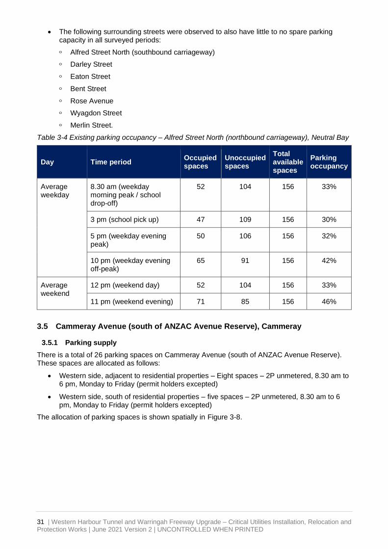
31 | Western Harbour Tunnel and Warringah Freeway Upgrade – Critical Utilities Installation, Relocation and Protection Works | June 2021 Version 2 | UNCONTROLLED WHEN PRINTED
• The following surrounding streets were observed to also have little to no spare parking capacity in all surveyed periods:
Alfred Street North (southbound carriageway)
Darley Street
Eaton Street
Bent Street
Rose Avenue
Wyagdon Street
Merlin Street.
Table 3-4 Existing parking occupancy – Alfred Street North (northbound carriageway), Neutral Bay
Day Time period Occupied spaces
Unoccupied spaces
Total available spaces
Parking occupancy
Average weekday
8.30 am (weekday morning peak / school drop-off)
52 104 156 33%
3 pm (school pick up) 47 109 156 30%
5 pm (weekday evening peak)
50 106 156 32%
10 pm (weekday evening off-peak)
65 91 156 42%
Average weekend
12 pm (weekend day) 52 104 156 33%
11 pm (weekend evening) 71 85 156 46%
3.5 Cammeray Avenue (south of ANZAC Avenue Reserve), Cammeray
3.5.1 Parking supply
There is a total of 26 parking spaces on Cammeray Avenue (south of ANZAC Avenue Reserve). These spaces are allocated as follows:
• Western side, adjacent to residential properties – Eight spaces – 2P unmetered, 8.30 am to 6 pm, Monday to Friday (permit holders excepted)
• Western side, south of residential properties – five spaces – 2P unmetered, 8.30 am to 6 pm, Monday to Friday (permit holders excepted)
The allocation of parking spaces is shown spatially in Figure 3-8.
32 | Western Harbour Tunnel and Warringah Freeway Upgrade – Critical Utilities Installation, Relocation and Protection Works | June 2021 Version 2 | UNCONTROLLED WHEN PRINTED
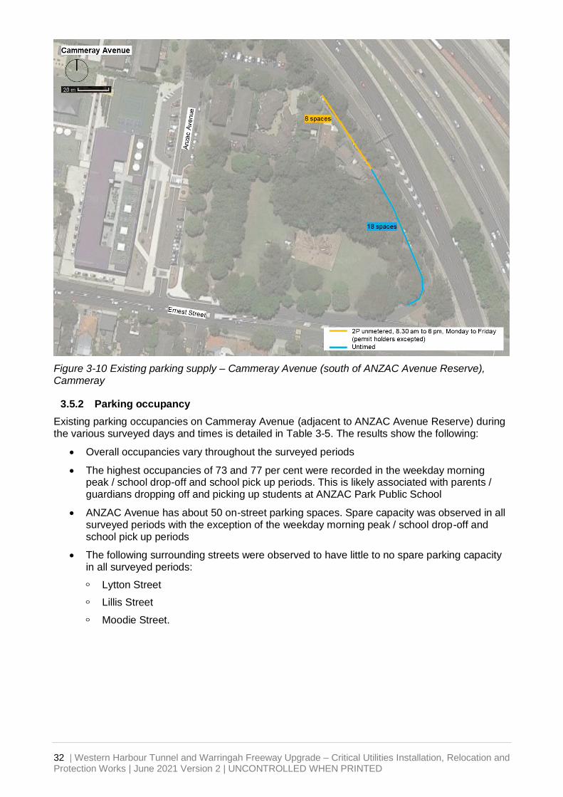
Figure 3-10 Existing parking supply – Cammeray Avenue (south of ANZAC Avenue Reserve), Cammeray
3.5.2 Parking occupancy
Existing parking occupancies on Cammeray Avenue (adjacent to ANZAC Avenue Reserve) during the various surveyed days and times is detailed in Table 3-5. The results show the following:
• Overall occupancies vary throughout the surveyed periods
• The highest occupancies of 73 and 77 per cent were recorded in the weekday morning peak / school drop-off and school pick up periods. This is likely associated with parents / guardians dropping off and picking up students at ANZAC Park Public School
• ANZAC Avenue has about 50 on-street parking spaces. Spare capacity was observed in all surveyed periods with the exception of the weekday morning peak / school drop-off and school pick up periods
• The following surrounding streets were observed to have little to no spare parking capacity in all surveyed periods:
Lytton Street
Lillis Street
Moodie Street.
33 | Western Harbour Tunnel and Warringah Freeway Upgrade – Critical Utilities Installation, Relocation and Protection Works | June 2021 Version 2 | UNCONTROLLED WHEN PRINTED
Table 3-5 Existing parking occupancy – Cammeray Avenue (south of ANZAC Avenue Reserve), Cammeray
Day Time period Occupied spaces
Unoccupied spaces
Total available spaces
Parking occupancy
Average weekday
8.30 am (weekday morning peak / school drop-off)
19 7 26 73%
3 pm (school pick up) 20 6 26 77%
5 pm (weekday evening peak)
15 11 26 58%
10 pm (weekday evening off-peak)
17 9 26 65%
Average weekend
12 pm (weekend day) 8 18 26 31%
11 pm (weekend evening) 13 13 26 50%
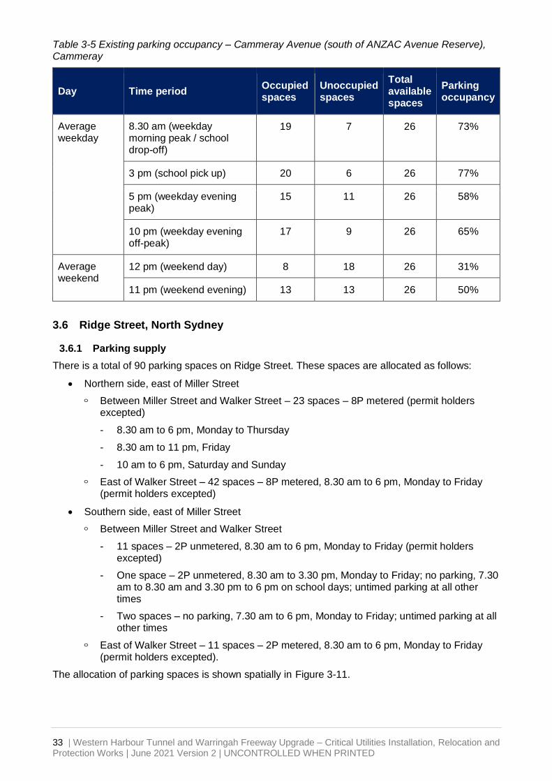
3.6 Ridge Street, North Sydney
3.6.1 Parking supply
There is a total of 90 parking spaces on Ridge Street. These spaces are allocated as follows:
• Northern side, east of Miller Street
Between Miller Street and Walker Street – 23 spaces – 8P metered (permit holders excepted)
- 8.30 am to 6 pm, Monday to Thursday
- 8.30 am to 11 pm, Friday
- 10 am to 6 pm, Saturday and Sunday
East of Walker Street – 42 spaces – 8P metered, 8.30 am to 6 pm, Monday to Friday (permit holders excepted)
• Southern side, east of Miller Street
Between Miller Street and Walker Street
- 11 spaces – 2P unmetered, 8.30 am to 6 pm, Monday to Friday (permit holders excepted)
- One space – 2P unmetered, 8.30 am to 3.30 pm, Monday to Friday; no parking, 7.30 am to 8.30 am and 3.30 pm to 6 pm on school days; untimed parking at all other times
- Two spaces – no parking, 7.30 am to 6 pm, Monday to Friday; untimed parking at all other times
East of Walker Street – 11 spaces – 2P metered, 8.30 am to 6 pm, Monday to Friday (permit holders excepted).
The allocation of parking spaces is shown spatially in Figure 3-11.
34 | Western Harbour Tunnel and Warringah Freeway Upgrade – Critical Utilities Installation, Relocation and Protection Works | June 2021 Version 2 | UNCONTROLLED WHEN PRINTED
Figure 3-11 Existing parking supply – Ridge Street, North Sydney
3.6.2 Parking occupancy
Existing parking occupancies on Ridge Street during the various surveyed days and times is detailed in Table 3-6. The results show the following:
• Overall occupancies vary throughout the surveyed periods
• The highest occupancy of 90 per cent was recorded in the school pick up period
• At all times, parking was observed to be concentrated east of Walker Street. This is likely associated with long-term resident / visitor parking servicing adjoining unit blocks, townhouses and houses, and also short-term (i.e. less than two hours) parking associated with the North Sydney Bowling Club
• Some spare capacity was observed during a special event held at North Sydney Oval.
Table 3-6 Existing parking occupancy – Ridge Street, North Sydney
Day Time period Occupied spaces
Unoccupied spaces
Total available spaces
Parking occupancy
Average weekday
8.30 am (weekday morning peak / school drop-off)
49 39 88 56%
3 pm (school pick up) 79 9 88 90%
5 pm (weekday evening peak)
69 18 87 79%
10 pm (weekday evening off-peak)
31 59 90 34%
Average weekend
12 pm (weekend day) 44 46 90 49%
8 pm (special event)3 71 19 90 79%
3 The parking survey on Saturday 28 November 2020 at 8 pm coincided with the Women’s Big Bash League final between Sydney Thunder and Melbourne Stars that was held at North Sydney Oval.
35 | Western Harbour Tunnel and Warringah Freeway Upgrade – Critical Utilities Installation, Relocation and Protection Works | June 2021 Version 2 | UNCONTROLLED WHEN PRINTED
Day Time period Occupied spaces
Unoccupied spaces
Total available spaces
Parking occupancy
11 pm (weekend evening) 28 62 90 31%
3.7 Rosalind Street, Cammeray
3.7.1 Parking supply
There is a total of 22 parking spaces on Rosalind Street. These spaces are allocated as follows:
• Northern side, between Miller Street and ANZAC Avenue
Seven spaces – 2P unmetered, 8.30 am to 6 pm, Monday to Friday (permit holders excepted)
One space – untimed
• Northern side, between Miller Street and ANZAC Avenue – 14 spaces – 2P unmetered, 8.30 am to 6 pm, Monday to Friday (permit holders excepted)
The allocation of parking spaces is shown spatially in Figure 3-12.
Figure 3-12 Existing parking supply – Rosalind Street, Cammeray
3.7.2 Parking occupancy
Existing parking occupancies on Rosalind Street during the various surveyed days and times is detailed in Table 3-7. The results show the following:
• Overall occupancies range between 68 per cent and 86 per cent
• The highest occupancy of 82 per cent was recorded in the school pick up, weekday evening off-peak and weekend evening periods. This is likely associated with school pick ups and long-term resident / visitor parking servicing adjoining unit blocks and townhouses.
36 | Western Harbour Tunnel and Warringah Freeway Upgrade – Critical Utilities Installation, Relocation and Protection Works | June 2021 Version 2 | UNCONTROLLED WHEN PRINTED
Table 3-7 Existing parking occupancy – Rosalind Street, Cammeray
Day Time period Occupied spaces
Unoccupied spaces
Total available spaces
Parking occupancy
Average weekday
8.30 am (weekday morning peak / school drop-off)
15 7 22 68%
3 pm (school pick up) 18 4 22 82%
5 pm (weekday evening peak)
15 7 22 68%
10 pm (weekday evening off-peak)
18 4 22 82%
Average weekend
12 pm (weekend day) 17 5 22 77%
11 pm (weekend evening) 18 4 22 82%
3.8 Public transport accessibility
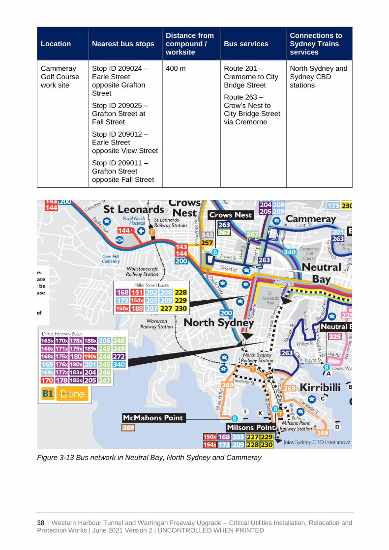
Compounds and work sites associated with the critical utility works have good public transport accessibility, with bus services located in close proximity. These are detailed in Table 3-8 and shown in Figure 3-13. These bus services provide connections to several railway stations for Sydney Trains services to destinations across Greater Sydney.
Table 3-8 Bus services at each compound and work site
Location Nearest bus stops Distance from compound / worksite
Bus services Connections to Sydney Trains services
Alfred Street North work site
Stop ID 208923 – Rawson Street at Eaton Street
Stop ID 208921 – Montpelier Street before Rawson Street
400 m to 500 m Route 263 – Crow’s Nest to City Bridge Street via Cremorne
North Sydney and Sydney CBD stations
Stop ID 206048 – Miller Street at Ridge Street
Stop ID 206018 – North Sydney Oval, Miller Street
400 m to 500 m Routes 150X, 151, 154X, 168, 173, 188, 202-3, 207-9, 227-30, 245, 247 – services to Sydney CBD and various destinations across the North Shore and Northern Beaches
North Sydney, Milsons Point and Sydney CBD stations
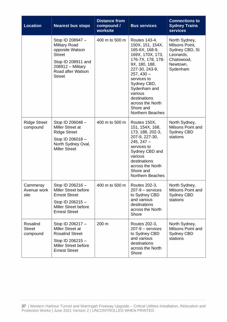
37 | Western Harbour Tunnel and Warringah Freeway Upgrade – Critical Utilities Installation, Relocation and Protection Works | June 2021 Version 2 | UNCONTROLLED WHEN PRINTED
Location Nearest bus stops Distance from compound / worksite
Bus services Connections to Sydney Trains services
Stop ID 208947 – Military Road opposite Watson Street
Stop ID 208911 and 208912 – Military Road after Watson Street
400 m to 500 m Routes 143-4, 150X, 151, 154X, 165-6X, 168-9, 169X, 170X, 173, 176-7X, 178, 178-9X, 180, 188, 227-30, 243-9, 257, 430 – services to Sydney CBD, Sydenham and various destinations across the North Shore and Northern Beaches
North Sydney, Milsons Point, Sydney CBD, St Leonards, Chatswood, Newtown, Sydenham
Ridge Street compound
Stop ID 206048 – Miller Street at Ridge Street
Stop ID 206018 – North Sydney Oval, Miller Street
400 m to 500 m Routes 150X, 151, 154X, 168, 173, 188, 202-3, 207-9, 227-30, 245, 247 – services to Sydney CBD and various destinations across the North Shore and Northern Beaches
North Sydney, Milsons Point and Sydney CBD stations
Cammeray Avenue work site
Stop ID 206216 – Miller Street before Ernest Street
Stop ID 206215 – Miller Street before Ernest Street
400 m to 500 m Routes 202-3, 207-9 – services to Sydney CBD and various destinations across the North Shore
North Sydney, Milsons Point and Sydney CBD stations
Rosalind Street compound
Stop ID 206217 – Miller Street at Rosalind Street
Stop ID 206215 – Miller Street before Ernest Street
200 m Routes 202-3, 207-9 – services to Sydney CBD and various destinations across the North Shore
North Sydney, Milsons Point and Sydney CBD stations
38 | Western Harbour Tunnel and Warringah Freeway Upgrade – Critical Utilities Installation, Relocation and Protection Works | June 2021 Version 2 | UNCONTROLLED WHEN PRINTED
Location Nearest bus stops Distance from compound / worksite
Bus services Connections to Sydney Trains services
Cammeray Golf Course work site
Stop ID 209024 – Earle Street opposite Grafton Street
Stop ID 209025 – Grafton Street at Fall Street
Stop ID 209012 – Earle Street opposite View Street
Stop ID 209011 – Grafton Street opposite Fall Street
400 m Route 201 – Cremorne to City Bridge Street
Route 263 – Crow’s Nest to City Bridge Street via Cremorne
North Sydney and Sydney CBD stations
Figure 3-13 Bus network in Neutral Bay, North Sydney and Cammeray
39 | Western Harbour Tunnel and Warringah Freeway Upgrade – Critical Utilities Installation, Relocation and Protection Works | June 2021 Version 2 | UNCONTROLLED WHEN PRINTED
4 Proposed parking and access changes and impacts
The temporary removal of on-street parking spaces during the critical utilities work in locations that are outside the approved CSSI footprint is addressed in Section 4.2. Car parking requiring removal inside the approved CSSI footprint has been considered in the EIS and has already been approved under the Infrastructure Approval (SSI-8863). Notwithstanding, car parking spaces that will be removed during the critical utilities work in locations that are within the approved CSSI footprint have been assessed and identified and are detailed in Section 4.3. Throughout construction there may be occasional times when short term on-street car parking removal (i.e. for the period of one shift) will be required under a Road Occupancy Licence (ROL). In these cases any short term on-street car parking removed will be reinstated at the end of each shift following expiration of the ROL. There may also be other occasional times when short term car parking removal (i.e. for the period of one shift) will be required due to progression of a utilities trench. In these cases any short term car parking removal will be reinstated at the end of each shift. Any such short term car parking removal will be managed in accordance with the TTAMP.
4.1 Construction workforce parking
The construction workforce will comprise of trades and construction personnel, and engineering, functional and administration staff. The size of the workforce will vary throughout the duration of the critical utility works program, with a reduction in personnel for evening and night shifts. The maximum size of the construction workforce is expected to be 90 people.
A total of 110 off-street parking spaces will be provided at the following locations:
• The Ridge Street compound will include about 60 off-street parking spaces. This will serve most of the construction workforce
• The Cammeray Golf Course work site will include about 50 off-street parking spaces. This will serve as construction workforce parking.
Assuming a worst-case scenario where 100 per cent of the construction workforce travels to work by car and there is no carpooling, there would be demand for 90 parking spaces. Given there will be a total of 110 off-street parking spaces, construction workforce parking is expected to have a minimal impact on on-street parking.
Where practical, essential vehicles (i.e., vehicles carrying tools, plant and other equipment to facilitate works) will be contained within the footprint of each work site with no impact on adjacent on-street parking.
4.2 Locations outside the approved CSSI footprint
4.2.1 Bells Avenue / Warringa Road, Cammeray
Impact of parking changes
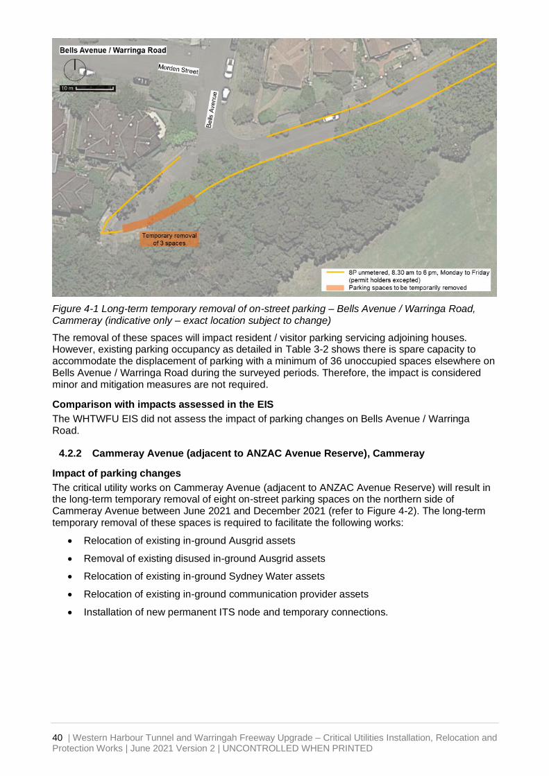
The critical utility works on Bells Avenue will result in the long-term temporary removal of three on-street parking spaces at the western end of Bells Avenue between June 2021 and December 2021 (refer to Figure 4-1). The long-term temporary removal of these spaces is required to facilitate the following works:
• Sewer adjustments
• Hauling of communications cables
• Underbore installation.
40 | Western Harbour Tunnel and Warringah Freeway Upgrade – Critical Utilities Installation, Relocation and Protection Works | June 2021 Version 2 | UNCONTROLLED WHEN PRINTED
Figure 4-1 Long-term temporary removal of on-street parking – Bells Avenue / Warringa Road, Cammeray (indicative only – exact location subject to change)
The removal of these spaces will impact resident / visitor parking servicing adjoining houses. However, existing parking occupancy as detailed in Table 3-2 shows there is spare capacity to accommodate the displacement of parking with a minimum of 36 unoccupied spaces elsewhere on Bells Avenue / Warringa Road during the surveyed periods. Therefore, the impact is considered minor and mitigation measures are not required.
Comparison with impacts assessed in the EIS
The WHTWFU EIS did not assess the impact of parking changes on Bells Avenue / Warringa Road.
4.2.2 Cammeray Avenue (adjacent to ANZAC Avenue Reserve), Cammeray
Impact of parking changes
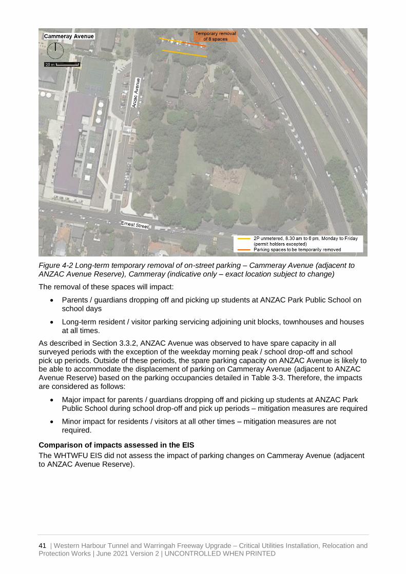
The critical utility works on Cammeray Avenue (adjacent to ANZAC Avenue Reserve) will result in the long-term temporary removal of eight on-street parking spaces on the northern side of Cammeray Avenue between June 2021 and December 2021 (refer to Figure 4-2). The long-term temporary removal of these spaces is required to facilitate the following works:
• Relocation of existing in-ground Ausgrid assets
• Removal of existing disused in-ground Ausgrid assets
• Relocation of existing in-ground Sydney Water assets
• Relocation of existing in-ground communication provider assets
• Installation of new permanent ITS node and temporary connections.
41 | Western Harbour Tunnel and Warringah Freeway Upgrade – Critical Utilities Installation, Relocation and Protection Works | June 2021 Version 2 | UNCONTROLLED WHEN PRINTED
Figure 4-2 Long-term temporary removal of on-street parking – Cammeray Avenue (adjacent to ANZAC Avenue Reserve), Cammeray (indicative only – exact location subject to change)
The removal of these spaces will impact:
• Parents / guardians dropping off and picking up students at ANZAC Park Public School on school days
• Long-term resident / visitor parking servicing adjoining unit blocks, townhouses and houses at all times.
As described in Section 3.3.2, ANZAC Avenue was observed to have spare capacity in all surveyed periods with the exception of the weekday morning peak / school drop-off and school pick up periods. Outside of these periods, the spare parking capacity on ANZAC Avenue is likely to be able to accommodate the displacement of parking on Cammeray Avenue (adjacent to ANZAC Avenue Reserve) based on the parking occupancies detailed in Table 3-3. Therefore, the impacts are considered as follows:
• Major impact for parents / guardians dropping off and picking up students at ANZAC Park Public School during school drop-off and pick up periods – mitigation measures are required
• Minor impact for residents / visitors at all other times – mitigation measures are not required.
Comparison of impacts assessed in the EIS
The WHTWFU EIS did not assess the impact of parking changes on Cammeray Avenue (adjacent to ANZAC Avenue Reserve).
42 | Western Harbour Tunnel and Warringah Freeway Upgrade – Critical Utilities Installation, Relocation and Protection Works | June 2021 Version 2 | UNCONTROLLED WHEN PRINTED
4.3 Locations within the approved CSSI footprint
4.3.1 Alfred Street North, Neutral Bay
Impact of parking changes
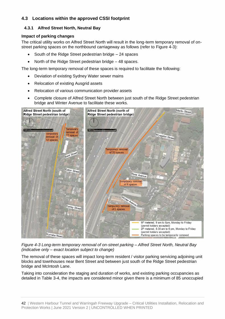
The critical utility works on Alfred Street North will result in the long-term temporary removal of on-street parking spaces on the northbound carriageway as follows (refer to Figure 4-3):
• South of the Ridge Street pedestrian bridge – 24 spaces
• North of the Ridge Street pedestrian bridge – 48 spaces.
The long-term temporary removal of these spaces is required to facilitate the following:
• Deviation of existing Sydney Water sewer mains
• Relocation of existing Ausgrid assets
• Relocation of various communication provider assets
• Complete closure of Alfred Street North between just south of the Ridge Street pedestrian bridge and Winter Avenue to facilitate these works.
Figure 4-3 Long-term temporary removal of on-street parking – Alfred Street North, Neutral Bay (indicative only – exact location subject to change)
The removal of these spaces will impact long-term resident / visitor parking servicing adjoining unit blocks and townhouses near Bent Street and between just south of the Ridge Street pedestrian bridge and McIntosh Lane.
Taking into consideration the staging and duration of works, and existing parking occupancies as detailed in Table 3-4, the impacts are considered minor given there is a minimum of 85 unoccupied
43 | Western Harbour Tunnel and Warringah Freeway Upgrade – Critical Utilities Installation, Relocation and Protection Works | June 2021 Version 2 | UNCONTROLLED WHEN PRINTED
spaces elsewhere on Alfred Street North in all surveyed periods. Therefore, mitigation measures are not required.
Comparison with impacts assessed in the EIS
Section 5.3.4 of Appendix F (Traffic and Transport) of the WHTWFU EIS states that construction works on Alfred Street North would result in the permanent removal of a total of 96 on-street parking spaces, distributed as follows:
• 49 parking spaces between Whaling Road and the Ridge Street pedestrian bridge
• 47 spaces between the Ridge Street pedestrian bridge and Wyagdon Street.
This compares to the proposed temporary removal of 72 on-street parking spaces on Alfred Street North as part of the critical utility works that are the subject of this CPAS, distributed as follows:
• South of the Ridge Street pedestrian bridge – 24 spaces
• North of the Ridge Street pedestrian bridge – 48 spaces.
4.3.2 Cammeray Avenue (south of ANZAC Avenue Reserve), Cammeray
Impact of parking changes
The critical utility works on Cammeray Avenue (south of ANZAC Avenue Reserve) will result in the long-term temporary removal of 26 on-street parking spaces on the western side of Cammeray Avenue between June 2021 and December 2021 (refer to Figure 4-4). The long-term temporary removal of these spaces is required to facilitate the following works:
• Relocation of existing in-ground Ausgrid assets
• Removal of existing disused in-ground Ausgrid assets
• Relocation of existing in-ground Sydney Water assets
• Relocation of existing in-ground communication provider assets
• Installation of new permanent ITS node and temporary connections.
44 | Western Harbour Tunnel and Warringah Freeway Upgrade – Critical Utilities Installation, Relocation and Protection Works | June 2021 Version 2 | UNCONTROLLED WHEN PRINTED
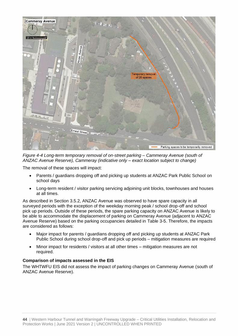
Figure 4-4 Long-term temporary removal of on-street parking – Cammeray Avenue (south of ANZAC Avenue Reserve), Cammeray (indicative only – exact location subject to change)
The removal of these spaces will impact:
• Parents / guardians dropping off and picking up students at ANZAC Park Public School on school days
• Long-term resident / visitor parking servicing adjoining unit blocks, townhouses and houses at all times.
As described in Section 3.5.2, ANZAC Avenue was observed to have spare capacity in all surveyed periods with the exception of the weekday morning peak / school drop-off and school pick up periods. Outside of these periods, the spare parking capacity on ANZAC Avenue is likely to be able to accommodate the displacement of parking on Cammeray Avenue (adjacent to ANZAC Avenue Reserve) based on the parking occupancies detailed in Table 3-5. Therefore, the impacts are considered as follows:
• Major impact for parents / guardians dropping off and picking up students at ANZAC Park Public School during school drop-off and pick up periods – mitigation measures are required
• Minor impact for residents / visitors at all other times – mitigation measures are not required.
Comparison of impacts assessed in the EIS
The WHTWFU EIS did not assess the impact of parking changes on Cammeray Avenue (south of ANZAC Avenue Reserve).
45 | Western Harbour Tunnel and Warringah Freeway Upgrade – Critical Utilities Installation, Relocation and Protection Works | June 2021 Version 2 | UNCONTROLLED WHEN PRINTED
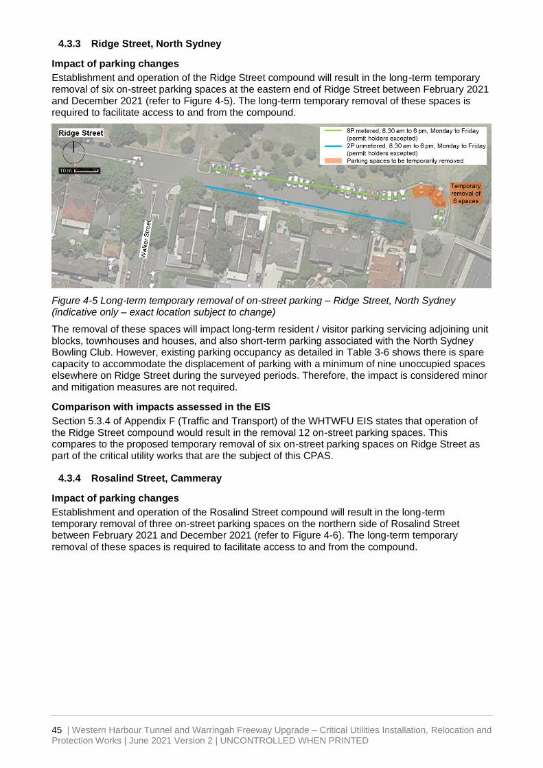
4.3.3 Ridge Street, North Sydney
Impact of parking changes
Establishment and operation of the Ridge Street compound will result in the long-term temporary removal of six on-street parking spaces at the eastern end of Ridge Street between February 2021 and December 2021 (refer to Figure 4-5). The long-term temporary removal of these spaces is required to facilitate access to and from the compound.
Figure 4-5 Long-term temporary removal of on-street parking – Ridge Street, North Sydney (indicative only – exact location subject to change)
The removal of these spaces will impact long-term resident / visitor parking servicing adjoining unit blocks, townhouses and houses, and also short-term parking associated with the North Sydney Bowling Club. However, existing parking occupancy as detailed in Table 3-6 shows there is spare capacity to accommodate the displacement of parking with a minimum of nine unoccupied spaces elsewhere on Ridge Street during the surveyed periods. Therefore, the impact is considered minor and mitigation measures are not required.
Comparison with impacts assessed in the EIS
Section 5.3.4 of Appendix F (Traffic and Transport) of the WHTWFU EIS states that operation of the Ridge Street compound would result in the removal 12 on-street parking spaces. This compares to the proposed temporary removal of six on-street parking spaces on Ridge Street as part of the critical utility works that are the subject of this CPAS.
4.3.4 Rosalind Street, Cammeray
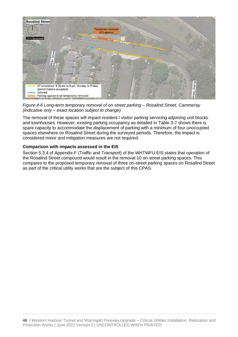
Impact of parking changes
Establishment and operation of the Rosalind Street compound will result in the long-term temporary removal of three on-street parking spaces on the northern side of Rosalind Street between February 2021 and December 2021 (refer to Figure 4-6). The long-term temporary removal of these spaces is required to facilitate access to and from the compound.
46 | Western Harbour Tunnel and Warringah Freeway Upgrade – Critical Utilities Installation, Relocation and Protection Works | June 2021 Version 2 | UNCONTROLLED WHEN PRINTED
Figure 4-6 Long-term temporary removal of on-street parking – Rosalind Street, Cammeray (indicative only – exact location subject to change)
The removal of these spaces will impact resident / visitor parking servicing adjoining unit blocks and townhouses. However, existing parking occupancy as detailed in Table 3-7 shows there is spare capacity to accommodate the displacement of parking with a minimum of four unoccupied spaces elsewhere on Rosalind Street during the surveyed periods. Therefore, the impact is considered minor and mitigation measures are not required.
Comparison with impacts assessed in the EIS
Section 5.3.4 of Appendix F (Traffic and Transport) of the WHTWFU EIS states that operation of the Rosalind Street compound would result in the removal 10 on-street parking spaces. This compares to the proposed temporary removal of three on-street parking spaces on Rosalind Street as part of the critical utility works that are the subject of this CPAS.
47 | Western Harbour Tunnel and Warringah Freeway Upgrade – Critical Utilities Installation, Relocation and Protection Works | June 2021 Version 2 | UNCONTROLLED WHEN PRINTED
5 Mitigation measures
5.1 Potential mitigation measures
Potential measures that were considered to mitigate the identified impacts of the long-term temporary removal of on-street parking include the following:
• Consultation with affected stakeholders of parking proposed to be removed
• Staging the removal of on-street parking
• Consideration of alternative parking locations and / or arrangements
• Provision of a shuttle bus service for the construction workforce
• Introduction of parking restrictions near compounds and work sites where they currently do not exist, or alteration of existing parking restrictions
• Daily workforce parking to be contained within the footprint of individual work sites
• Provision of parking at ancillary facilities
• Ancillary facility design to considered impacts to pedestrian and shared user paths
• Encouraging use of public transport
• Encouraging carpooling
• Ongoing communication with workforce on measures to reduce impacts to parking and access
• Parking demand reduction (through the use of other transport modes).
5.2 Construction workforce parking
As described in Section 4.1, construction workforce parking is expected to have a minimal impact on on-street parking given the provision of off-street parking at the Ridge Street, Cammeray Golf Course and Rosalind Street compounds. In addition:
• Where practical, essential vehicles (i.e., vehicles carrying tools, plant and other equipment to facilitate works) will be contained within the footprint of each work site with no impact on adjacent on-street parking
• The provision of parking at ancillary facilities means there will be no requirement to idle and queue on state and regional roads
• The provision of parking at ancillary facilities, and the limited number of deliveries required at work sites, means there will be no requirement to marshal construction vehicles
• The ancillary facilities have been designed so that construction vehicles will not block access across pedestrian or shared user paths at any time.
However, the following measures will be in place for the construction workforce to reduce the potential for an unexpected impact to occur:
• Encouragement of the use of public transport – through the recruitment and onboarding process and site toolbox talks to reduce the number of private vehicles travelling to and from the compounds
• Encouragement of carpooling – site toolbox talks will be utilised to encourage the construction workforce on the same shifts to coordinate with others to carpool to / from similar locations
• Communication of parking restrictions to the construction workforce – parking restrictions around the compounds and work sites will be communicated to the construction workforce
48 | Western Harbour Tunnel and Warringah Freeway Upgrade – Critical Utilities Installation, Relocation and Protection Works | June 2021 Version 2 | UNCONTROLLED WHEN PRINTED
through site inductions where they will be supplied with a Project Worker Code of Conduct, site toolbox talks, and pre-start meetings as required. Where workers are impacting the amenity of adjacent residents, are not complying with the Project Worker Code of Conduct, or are repeatedly parking inappropriately, they may be required re-attend the site inductions. Stronger sanctions, up to and including dismissal, may be implemented for repeat offenders at the discretion of the Project Manager.
5.3 Bells Avenue / Warringa Road, Cammeray
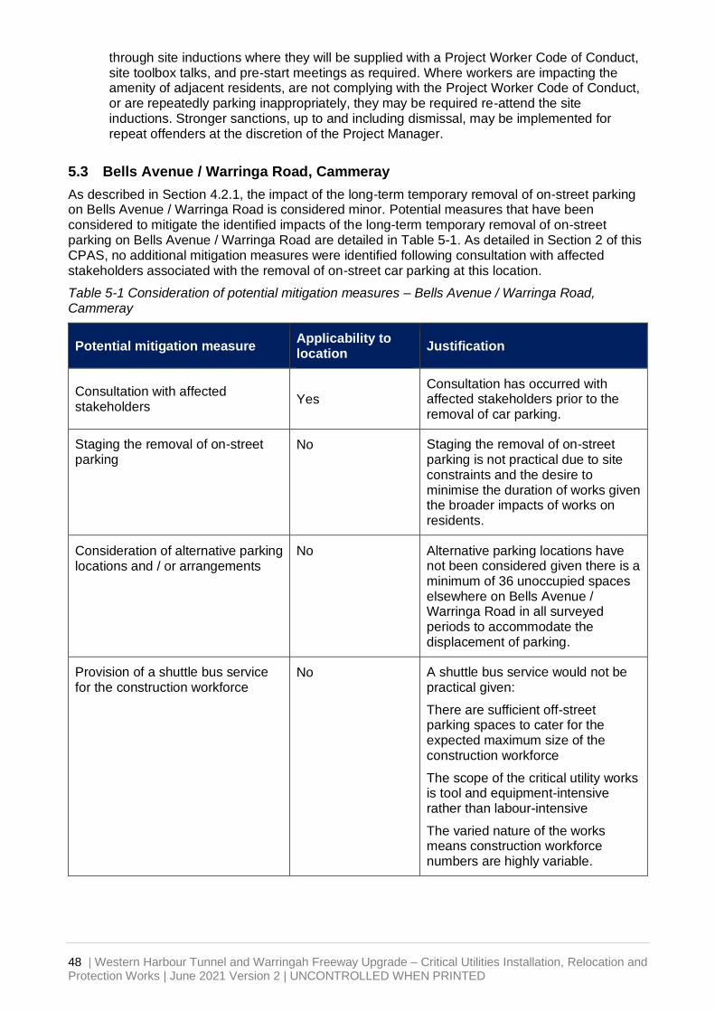
As described in Section 4.2.1, the impact of the long-term temporary removal of on-street parking on Bells Avenue / Warringa Road is considered minor. Potential measures that have been considered to mitigate the identified impacts of the long-term temporary removal of on-street parking on Bells Avenue / Warringa Road are detailed in Table 5-1. As detailed in Section 2 of this CPAS, no additional mitigation measures were identified following consultation with affected stakeholders associated with the removal of on-street car parking at this location.
Table 5-1 Consideration of potential mitigation measures – Bells Avenue / Warringa Road, Cammeray
Potential mitigation measure Applicability to location
Justification
Consultation with affected stakeholders
Yes Consultation has occurred with affected stakeholders prior to the removal of car parking.
Staging the removal of on-street parking
No Staging the removal of on-street parking is not practical due to site constraints and the desire to minimise the duration of works given the broader impacts of works on residents.
Consideration of alternative parking locations and / or arrangements
No Alternative parking locations have not been considered given there is a minimum of 36 unoccupied spaces elsewhere on Bells Avenue / Warringa Road in all surveyed periods to accommodate the displacement of parking.
Provision of a shuttle bus service for the construction workforce
No A shuttle bus service would not be practical given:
There are sufficient off-street parking spaces to cater for the expected maximum size of the construction workforce
The scope of the critical utility works is tool and equipment-intensive rather than labour-intensive
The varied nature of the works means construction workforce numbers are highly variable.
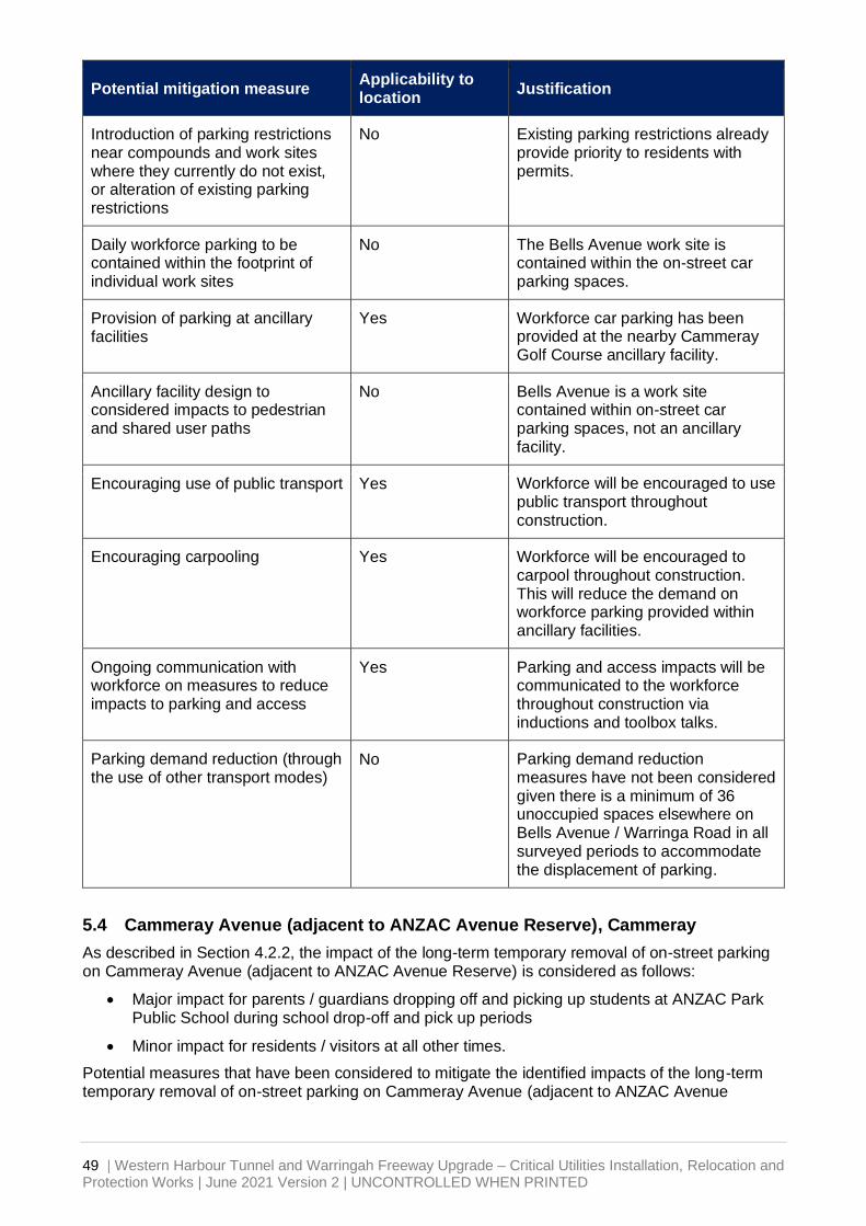
49 | Western Harbour Tunnel and Warringah Freeway Upgrade – Critical Utilities Installation, Relocation and Protection Works | June 2021 Version 2 | UNCONTROLLED WHEN PRINTED
Potential mitigation measure Applicability to location
Justification
Introduction of parking restrictions near compounds and work sites where they currently do not exist, or alteration of existing parking restrictions
No Existing parking restrictions already provide priority to residents with permits.
Daily workforce parking to be contained within the footprint of individual work sites
No The Bells Avenue work site is contained within the on-street car parking spaces.
Provision of parking at ancillary facilities
Yes Workforce car parking has been provided at the nearby Cammeray Golf Course ancillary facility.
Ancillary facility design to considered impacts to pedestrian and shared user paths
No Bells Avenue is a work site contained within on-street car parking spaces, not an ancillary facility.
Encouraging use of public transport Yes Workforce will be encouraged to use public transport throughout construction.
Encouraging carpooling Yes Workforce will be encouraged to carpool throughout construction. This will reduce the demand on workforce parking provided within ancillary facilities.
Ongoing communication with workforce on measures to reduce impacts to parking and access
Yes Parking and access impacts will be communicated to the workforce throughout construction via inductions and toolbox talks.
Parking demand reduction (through the use of other transport modes)
No Parking demand reduction measures have not been considered given there is a minimum of 36 unoccupied spaces elsewhere on Bells Avenue / Warringa Road in all surveyed periods to accommodate the displacement of parking.
5.4 Cammeray Avenue (adjacent to ANZAC Avenue Reserve), Cammeray
As described in Section 4.2.2, the impact of the long-term temporary removal of on-street parking on Cammeray Avenue (adjacent to ANZAC Avenue Reserve) is considered as follows:
• Major impact for parents / guardians dropping off and picking up students at ANZAC Park Public School during school drop-off and pick up periods
• Minor impact for residents / visitors at all other times.
Potential measures that have been considered to mitigate the identified impacts of the long-term temporary removal of on-street parking on Cammeray Avenue (adjacent to ANZAC Avenue
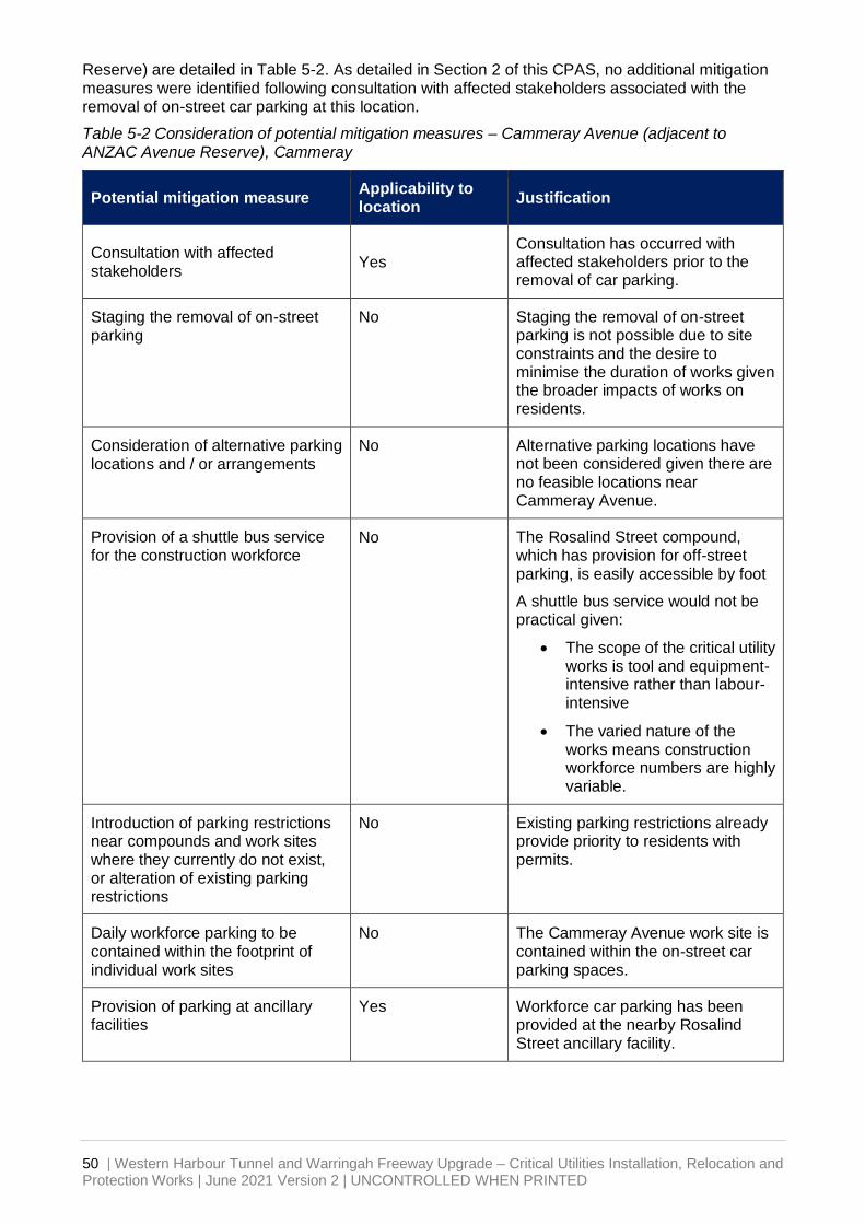
50 | Western Harbour Tunnel and Warringah Freeway Upgrade – Critical Utilities Installation, Relocation and Protection Works | June 2021 Version 2 | UNCONTROLLED WHEN PRINTED
Reserve) are detailed in Table 5-2. As detailed in Section 2 of this CPAS, no additional mitigation measures were identified following consultation with affected stakeholders associated with the removal of on-street car parking at this location.
Table 5-2 Consideration of potential mitigation measures – Cammeray Avenue (adjacent to ANZAC Avenue Reserve), Cammeray
Potential mitigation measure Applicability to location
Justification
Consultation with affected stakeholders
Yes Consultation has occurred with affected stakeholders prior to the removal of car parking.
Staging the removal of on-street parking
No Staging the removal of on-street parking is not possible due to site constraints and the desire to minimise the duration of works given the broader impacts of works on residents.
Consideration of alternative parking locations and / or arrangements
No Alternative parking locations have not been considered given there are no feasible locations near Cammeray Avenue.
Provision of a shuttle bus service for the construction workforce
No The Rosalind Street compound, which has provision for off-street parking, is easily accessible by foot
A shuttle bus service would not be practical given:
• The scope of the critical utility works is tool and equipment-intensive rather than labour-intensive
• The varied nature of the works means construction workforce numbers are highly variable.
Introduction of parking restrictions near compounds and work sites where they currently do not exist, or alteration of existing parking restrictions
No Existing parking restrictions already provide priority to residents with permits.
Daily workforce parking to be contained within the footprint of individual work sites
No The Cammeray Avenue work site is contained within the on-street car parking spaces.
Provision of parking at ancillary facilities
Yes Workforce car parking has been provided at the nearby Rosalind Street ancillary facility.
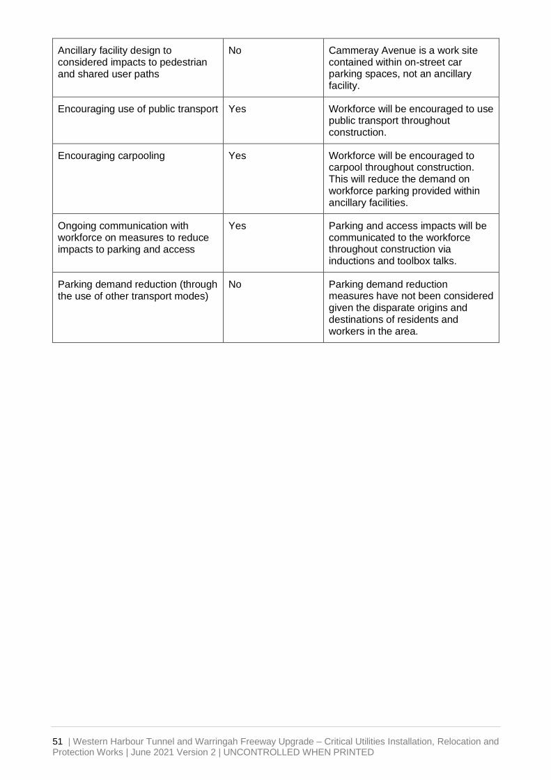
51 | Western Harbour Tunnel and Warringah Freeway Upgrade – Critical Utilities Installation, Relocation and Protection Works | June 2021 Version 2 | UNCONTROLLED WHEN PRINTED
Ancillary facility design to considered impacts to pedestrian and shared user paths
No Cammeray Avenue is a work site contained within on-street car parking spaces, not an ancillary facility.
Encouraging use of public transport Yes Workforce will be encouraged to use public transport throughout construction.
Encouraging carpooling Yes Workforce will be encouraged to carpool throughout construction. This will reduce the demand on workforce parking provided within ancillary facilities.
Ongoing communication with workforce on measures to reduce impacts to parking and access
Yes Parking and access impacts will be communicated to the workforce throughout construction via inductions and toolbox talks.
Parking demand reduction (through the use of other transport modes)
No Parking demand reduction measures have not been considered given the disparate origins and destinations of residents and workers in the area.
52 | Western Harbour Tunnel and Warringah Freeway Upgrade – Critical Utilities Installation, Relocation and Protection Works | June 2021 Version 2 | UNCONTROLLED WHEN PRINTED
6 Monitoring and reporting
6.1 Monitoring of mitigation measures
Monitoring to assess the effectiveness of this CPAS will be undertaken on roads that have been impacted by the long-term temporary removal of on-street parking, i.e., Alfred Street North, Neutral Bay; Ridge Street, North Sydney; Cammeray Avenue, Cammeray; Rosalind Street, Cammeray; and Bells Avenue / Warringa Road, Cammeray.
Inspections will be undertaken at fortnightly intervals and will involve the following:
• Confirmation that where alternative parking arrangements have been provided, these are being implemented
• Monitoring the impacts of the removal of on-street parking on surrounding roads
• Inspections for the presence of construction workforce parking on local roads.
Inspections will be undertaken by project engineers. The Project Manager will be responsible for implementing the mitigation measures contained in this CPAS with support from the Traffic Manager.
6.2 Corrective actions
Where monitoring or community complaints identify non-conformances with this CPAS, corrective actions will be undertaken through the project’s non-conformance works procedure. Corrective actions will be documented as per the procedure. Where practicable, non-conformances and corresponding corrective actions will be communicated to the construction workforce and reinforced through various communications including but not limited to:
• Site toolbox talks
• Pre-start meetings
• Project alerts
• Investigation and implementation of alternative methods to reinforce this CPAS
• Investigation and implementation of other viable options for the construction workforce to use public transport
• Issue warning notices where the owner of an offending vehicle can be identified
• Documenting actions in weekly and monthly internal reports.
Refer to Section 3.8 of the Construction Environmental Management Plan (CEMP) for further detail on environmental non-conformances.
6.3 Reporting
A quarterly summary report will be provided to North Sydney Council, DPIE and TfNSW regarding the outcomes of the monitoring that has been undertaken in the preceding quarter. Details of non-conformances and corrective actions will be summarised.
6.4 Contingency measures
Contingency measures will depend on the issues / non-conformances identified during monitoring and the effectiveness of corrective actions that have been implemented as described in Sections 6.1 and 6.2, respectively.
Contingency measures will be investigated if it is determined that the corrective actions implemented are ineffective, and may include:
53 | Western Harbour Tunnel and Warringah Freeway Upgrade – Critical Utilities Installation, Relocation and Protection Works | June 2021 Version 2 | UNCONTROLLED WHEN PRINTED
• Investigating the potential to provide additional off-street parking for the construction workforce
• Revising site induction and site toolbox talk content to better encourage the use of public transport and communicate designated and prohibited locations for construction workforce parking
• Amending carpooling communications to encourage an increase in participation rates
• Implementing disciplinary processes for repeated non-conformances.
6.5 Update and amendment of this CPAS
Any revisions to this CPAS will be in accordance with the process outlined in Section 3.12 of the CEMP and will be provided to TfNSW for review and comment and forwarded to the Secretary of DPIE for approval.
A copy of the updated CPAS and record of changes will be distributed to all relevant stakeholders in accordance with the approved document control procedure.
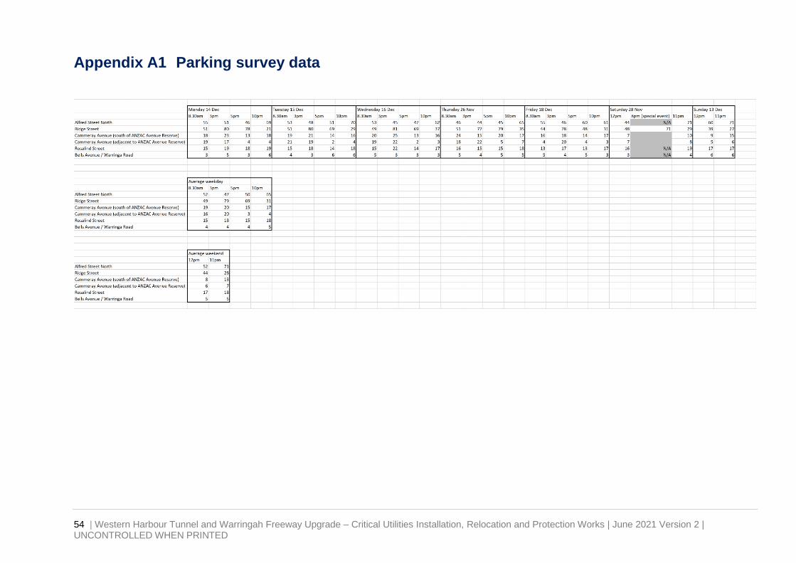
54 | Western Harbour Tunnel and Warringah Freeway Upgrade – Critical Utilities Installation, Relocation and Protection Works | June 2021 Version 2 | UNCONTROLLED WHEN PRINTED
Appendix A1 Parking survey data
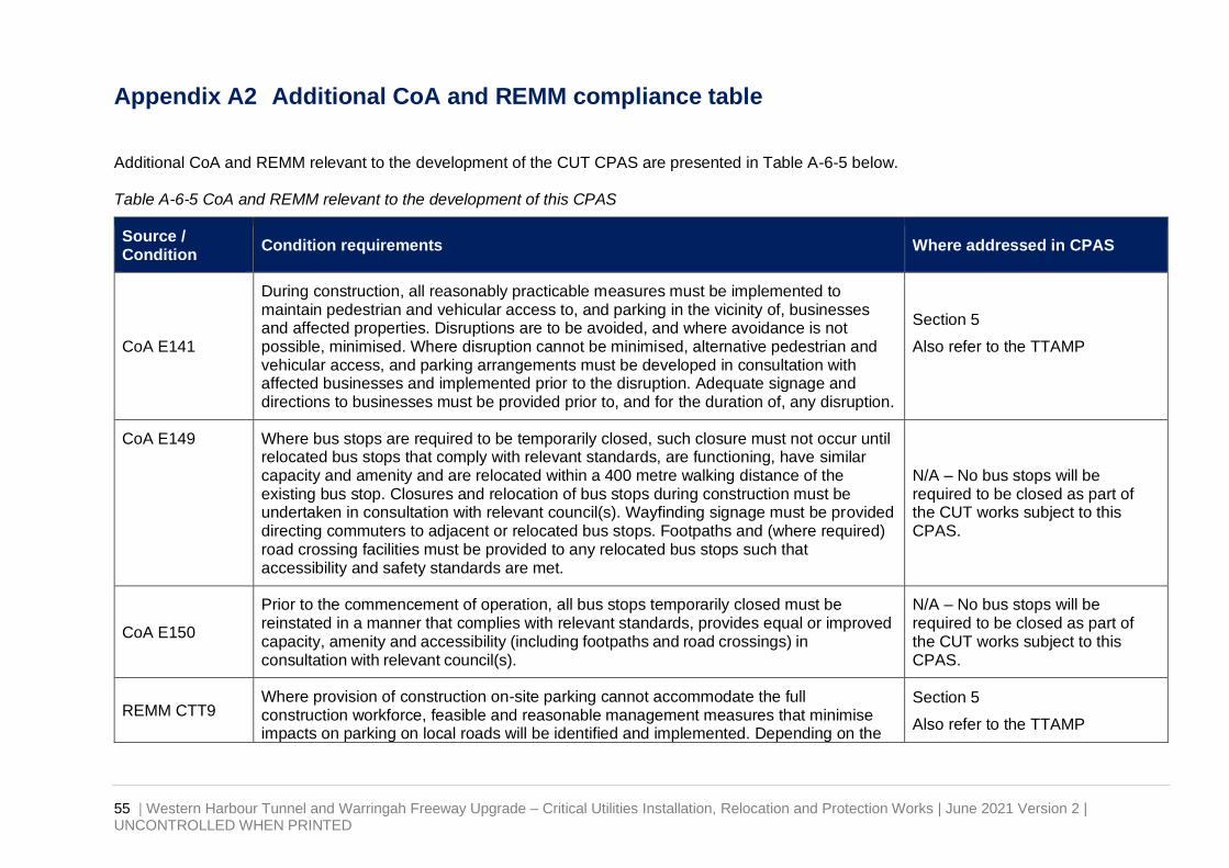
55 | Western Harbour Tunnel and Warringah Freeway Upgrade – Critical Utilities Installation, Relocation and Protection Works | June 2021 Version 2 | UNCONTROLLED WHEN PRINTED
Appendix A2 Additional CoA and REMM compliance table
Additional CoA and REMM relevant to the development of the CUT CPAS are presented in Table A-6-5 below. Table A-6-5 CoA and REMM relevant to the development of this CPAS
Source / Condition
Condition requirements Where addressed in CPAS
CoA E141
During construction, all reasonably practicable measures must be implemented to maintain pedestrian and vehicular access to, and parking in the vicinity of, businesses and affected properties. Disruptions are to be avoided, and where avoidance is not possible, minimised. Where disruption cannot be minimised, alternative pedestrian and vehicular access, and parking arrangements must be developed in consultation with affected businesses and implemented prior to the disruption. Adequate signage and directions to businesses must be provided prior to, and for the duration of, any disruption.
Section 5
Also refer to the TTAMP
CoA E149 Where bus stops are required to be temporarily closed, such closure must not occur until relocated bus stops that comply with relevant standards, are functioning, have similar capacity and amenity and are relocated within a 400 metre walking distance of the existing bus stop. Closures and relocation of bus stops during construction must be undertaken in consultation with relevant council(s). Wayfinding signage must be provided directing commuters to adjacent or relocated bus stops. Footpaths and (where required) road crossing facilities must be provided to any relocated bus stops such that accessibility and safety standards are met.
N/A – No bus stops will be required to be closed as part of the CUT works subject to this CPAS.
CoA E150
Prior to the commencement of operation, all bus stops temporarily closed must be reinstated in a manner that complies with relevant standards, provides equal or improved capacity, amenity and accessibility (including footpaths and road crossings) in consultation with relevant council(s).
N/A – No bus stops will be required to be closed as part of the CUT works subject to this CPAS.
REMM CTT9 Where provision of construction on-site parking cannot accommodate the full construction workforce, feasible and reasonable management measures that minimise impacts on parking on local roads will be identified and implemented. Depending on the
Section 5
Also refer to the TTAMP

56 | Western Harbour Tunnel and Warringah Freeway Upgrade – Critical Utilities Installation, Relocation and Protection Works | June 2021 Version 2 | UNCONTROLLED WHEN PRINTED
Source / Condition
Condition requirements Where addressed in CPAS
location, management measures may include workforce shuttle buses and the use of public transport.
REMM CTT10
Any adjustments to existing bus stops will be determined in consultation with relevant stakeholders including other divisions of Transport for NSW and advanced notification will be provided to affected bus customers.
Relocations will be as close as feasible and reasonable to their existing position.
N/A – No bus stops will be required to be closed as part of the CUT works subject to this CPAS.


