Embed Size (px)
Citation preview
CONFLICT AND COOPERATION WITHIN INTERNATIONAL RIVER BASINS: THE IMPORTANCE OF INSTITUTIONAL CAPACITY
Aaron T. Wolf, Kerstin Stahl, and Marcia F. Macomber Department of Geosciences, Oregon State University, Corvallis, Oregon
INTRODUCTION There are 263 watersheds that cross the political boundaries of two or more countries. These international basins cover 45.3 percent of the land surface of the earth, affect about 40 percent of the world’s population, and account for approximately 60 percent of global river flow (Wolf et. al 1999). Recent studies that focus on the conflict potential of international water stress the dangers of violence over water resources (see, for example, Gleick, 1993; Homer-Dixon, 1994; Remans, 1995; and Samson and Charrier, 1997), while others call attention to the possibilities and historic evidence of cooperation between co-riparians (see Libiszewski, 1995; Wolf, 1998; and Salman and de Chazournes, 1998). The fortunate corollary of water as an inducement to conflict is that water provides an incentive for hostile co-riparians to cooperate, even as disputes are waged over other issues. Conflicts between riparian nations regarding economic development, infrastructural capacity, or political orientation complicate water resources development, institutions, and management. As a result, development, treaties, and institutions are regularly seen as inefficient or ineffective, and, occasionally, as a new source of tensions themselves. Despite the tensions inherent in the international setting, riparians have shown tremendous creativity in approaching regional development, often through preventive diplomacy, and the creation of positive-sum, integrative allocations of joint gains. Just in the last 50 years, 157 treaties have been negotiated and signed, marking the initiation of institutional agreements between riparian nations to cooperate and to mitigate future conflicts over their shared water sources. Supporting and nurturing the development of both existing and future international river basin institutions will be a key ingredient to meeting the goals of human security and sustainable development around the world. This paper outlines the initial findings of a study conducted by the Basins at Risk (BAR) team at Oregon State University that quantitatively examines the
history of international water relations and the geographical and political setting in which that spectrum of interactions has evolved. With both physical and social variables in one database, linked by basin, hypotheses of indicators of conflict are explored, suggesting the centrality of institutions in ameliorating water disputes. On the climate side, analyses demonstrate that historically, extreme events of conflict were more frequent in marginal climates with highly variable hydrologic conditions, while the riparians of rivers with less extreme natural conditions have been more moderate in their conflict/cooperation relationship. These findings are then followed by recommendations regarding the role that universities can play to aid the international community and riparian nations in building effective institutions to manage shared water resources. THE BASINS AT RISK PROJECT & THE TRANSBOUNDARY FRESHWATER DISPUTE DATABASE1
Over the past nine years, a research group at the Oregon State University Department of Geosciences, in collaboration with the Northwest Alliance for Computational Science and Engineering, has been developing the Transboundary Freshwater Dispute Database (TFDD)2 to aid in the assessment of the process of water conflict resolution. The TFDD is a collection of searchable and linked international waters databases (text and digital) including: • An events database containing a comprehensive
news file of 1,831 reported cases of international water related disputes and dispute resolution (1950-2000);
• A treaties database containing over 400 water-related treaties, along with the full text of each;
• An annotated bibliography of the state of the art of water conflict resolution, including approximately 1,000 entries;
1 UCOWR
• A collection of negotiating notes (primary or secondary) from fourteen detailed case-studies of water conflict resolution;
• Descriptions of indigenous/traditional methods of water dispute resolution; and
• An international waters Geographic Information System containing digital thematic maps of the world’s 263 international watersheds including climate type, population density, population living with water stress, etc.
As critical data are collected within a unified format, analysis that assesses both physical and social variables within the same context becomes possible. The Basins at Risk (BAR)3 project is an ongoing and evolving multi-investigator research initiative that draws from the resources of TFDD, and that aims to systematically assess the process of international water conflict resolution, in order to:
1. Collect and analyze biophysical, socio-economic, and geopolitical data in a Geographic Information System, and use these factors to determine historically based indicators for future tensions within international basins;
2. Identify basins that are at risk of conflict for the coming decade using indicators determined in the initial investigation; and
3. Identify and assess the potential for mitigating factors and new technologies that may allow for a future different than that predicted by historically based indicators.
Using the TFDD, Wolf, Yoffe, and Giordano (2003) attempted to identify the indicators of settings with a high potential for water disputes. By examining the biophysical, geopolitical, and socioeconomic setting of each historical incident of water conflict and cooperation, they assessed factors contributing to water conflict. Then, based on the correlation of each event to its setting, they made a preliminary identification of international basins that are at the greatest risk for conflicts of interest and, possibly, tensions in the near future. The working hypothesis of the study was as follows:
The likelihood and intensity of conflict rises as the rate of change within the basin exceeds the institutional capacity to absorb that change.
This points to two critical components of the dispute setting – the rate of change in the system, and the institutional capacity. Internationalization (the break-up of a basin into more than one country) or large development projects such as the building of a major dam are examples of incidents that represent high rates of change in a basin. The likelihood of dispute over such changes rises with low institutional capacity – for example, when there is no treaty or other regional agreement, or when relations are tenuous over other issues. It is hoped that with the results of this BAR study, the appropriate international agencies might be able to focus preventive diplomacy efforts in basins that appear to be at risk of future conflict, so that conflict might be averted. SPECTRUM OF RELATIONS BETWEEN COUNTRIES OVER WATER4
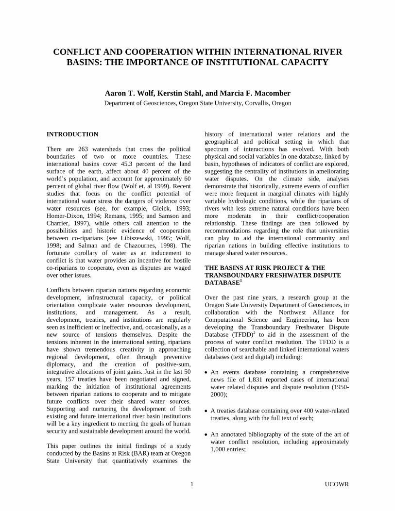
Studies on the history of international water conflict have taken a largely anecdotal approach. In order to contribute a more systematic approach to the literature, the BAR project attempted to compile a dataset of every reported interaction between two or more nations, whether conflictive or cooperative, which involved water as a scarce and/or consumable resource or as a quantity to be managed5 from 1950-2000. In order to evaluate the intensity of interactions, either cooperative or conflictive, a scoring system6 was developed, which assigned BAR intensity values from -7 (indicating the highest level of conflict, i.e. war) to +7 (indicating the highest level of cooperation, i.e. voluntary merging of countries) to each event. The study documents a total of 1,831 interactions, both conflictive and cooperative, between two or more nations over water during those 50 years, and found several interesting results. First, the number of historical incidents of cooperation over international water resources outnumbers those of conflict in a greater than two to one ratio (Figure 1). Of all 1,831 events delineated, 1,228 were found to be cooperative, while only 507 were conflictive. Additionally, the BAR study found that most events are mild; 42.8 percent of events fell between mild verbal support (+1) and mild verbal hostility (-1) on the BAR scale. Only 37 cases of acute conflict, in which violence takes place (-5 to -6 on BAR scale), were identified, and these events were not recent or widespread. In the same time period, 157 treaties were negotiated and signed.7 Second, water plays a role as both an irritant and a unifier of riparian nations. Despite markedly little violence over water resources, water can act to degrade relations between countries. This has been seen in
2 UCOWR
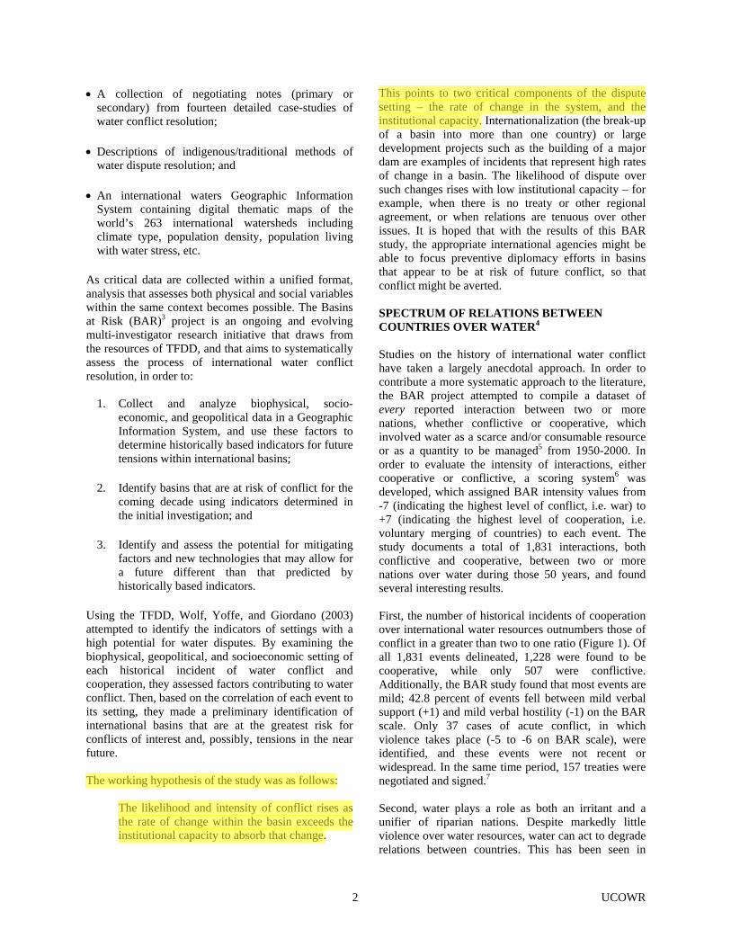
relations between India and Pakistan, Israel and Jordan, and Canada and the United States. However, history shows that disputes over water between riparians can be resolved, even as conflict over other issues ensues. The Mekong Committee has existed since 1957, providing a flow of information regarding water resources even throughout the Vietnam War. Furthermore, even in areas where water has acted as an irritant, unifying efforts have sustained through periods of particularly difficult relations between countries. Third, nations cooperate over a broad spectrum of issues, as shown in Figure 2. Joint management, water quantity, water quality, infrastructure, hydropower, and economic development are all issues that have induced cooperation in a significant number of events. However, examination of conflictive events reveals that 86% of all conflictive events have to do with only two issues – water quantity or infrastructure. Moreover, of the most extreme cases of conflict, those ranking -6 or -7 on the BAR scale, nearly 100% fall into one of these two issue categories. Institutions play a key role in preventing and mitigating conflict. Changes within basins can lead to conflict if institutions are not in place. To avoid the political
intricacies of shared water resources, for example, a riparian, generally the regional power,8 may implement a project that impacts at least one of its neighbors. This might be to continue to meet existing uses in the face of decreasing relative water availability – as for example Egypt's plans for a high dam on the Nile or Indian diversions of the Ganges to protect the port of Calcutta – or to meet new needs and associated policies such as Turkey's GAP project on the Euphrates. When projects such as these proceed without regional collaboration, they can become a flashpoint, heightening tensions and regional instability, and requiring years or, more commonly, decades to resolve. Evidence of how institutions can diffuse tensions is seen in basins with large numbers of water infrastructure projects. Co-riparian relations have shown to be significantly more cooperative in basins with treaties and high dam density than in similarly developed basins without treaties. Thus, institutional capacity together with shared interests and human creativity seem to diffuse water's conflict-inducing characteristics, suggesting that an important lesson of international water is that as a resource it tends to induce cooperation, and incite violence only in the exception.
Figure 1. Number of events by BAR scale.
3 UCOWR
Figure 2. Spectrum of issue types in events database. INDICATORS OF CONFLICT The BAR study (Wolf, Yoffe, and Giordano, 2003; Yoffe et al., forthcoming) found that most of the parameters commonly identified as indicators of conflict (i.e., climate, water stress, dependence on hydropower, dams or development per se, or level of development) are actually only weakly linked to dispute. Instead, the study suggests that institutional capacity within a basin, whether defined as water management bodies or treaties, or generally positive international relations are as important, if not more so, than the physical aspects of a system. In accordance with the working hypothesis of the study, it was found that when the rate of change within a basin exceeds the institutional capacity to absorb change, we are likely to find tensions.
The most rapid changes institutionally are associated with internationalized basins – basins whose management institution was developed under a single jurisdiction, but which was made obsolete as that jurisdiction suddenly became divided among two or more nations. The most rapid physical change is typically the development of a large-scale dam or diversion project, but in this case, too, the institutional capacity makes a difference. In other words, high levels of animosity and/or the absence of a transboundary institution can exacerbate the setting, while positive international relations and/or the presence of transboundary institutions can mitigate the negative effects of such projects. By using the parameters of rapid change and institutional capacity, the BAR study identified basins that may be at risk for conflicts over water in the near
4 UCOWR

future. Basins that are becoming internationalized or have major planned development projects and/or do not have an institution in place to handle such changes were deemed at risk. These basins include the Ganges-Brahmaputra, Han, Incomati, Kunene, Kura-Araks, Lake Chad, La Plata, Lempa, Limpopo, Mekong, Ob (Ertis), Okavango, Orange, Salween, Senegal, Tumen, and Zambezi. It should be noted that “basins at risk” is a fluid concept, with the actual basins changing constantly. Many of the basins originally named in the study currently have processes of conflict mitigation in progress, reducing the “risk” substantially. Nevertheless, these indicators allow us to monitor for “red flags,” or markers that may suggest new basins at risk as they arise, among them tenders for future projects and nations with active nationalist movements. Subsequent Research on the Role of Climate that Highlights the Importance of Scale:9
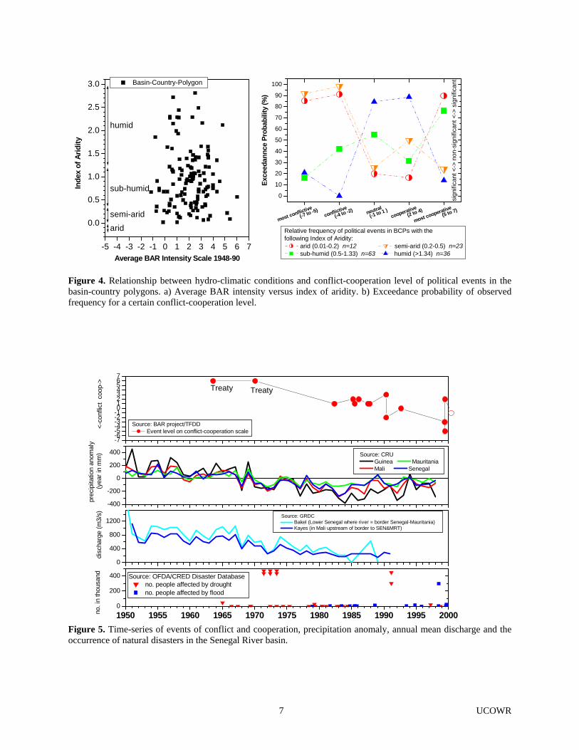
Ongoing research is being carried out to look more closely at the role that climate might play in conflict over international waters. The initial findings of the BAR study found no significant difference between most climate types and the likelihood of disputes. However, the BAR analysis utilized the international river basin as the primary spatial unit of analysis, and conflict levels for the basins were defined by averaging BAR intensity values of all events (cooperative or conflictive) within the period of the study. Different climatic regimes within the boundaries of basins and temporal changes in water availability may play an important role, which can only be identified in an examination of the systems at a finer scale than that utilized in the Wolf, Yoffe, and Giordano (2003) study. This subsequent research looks at the role of scale, both temporal and spatial, in international water relations, using climate as a variable. As with BAR, the geographic unit defined in this subsequent study is the basin-country-polygon (BCP). The BCP is a portion of an individual country within an international river basin that experiences a self-similar climate. The Climate Research Unit (CRU) 0.5 degree monthly mean precipitation (New et al., 2000), the Tateishi Potential Evapotranspiration and Water Balance (Ahn & Tateishi, 1994) and at-station discharge data from the Global Runoff Data Center (GRDC) were used to derive four hydro-climatic parameters including 1) aridity, 2) inter-annual variability of precipitation, 3) inter-annual variability of discharge, and 4) river type within each BCP. Aridity indices (I) (mean annual precipitation divided by the mean annual potential evapotranspiration) described BCP conditions falling within one of three
classes – I<0.2 (arid), I<0.5 (semi-arid), 0.5<I<1.33 (sub-humid) and I>1.33 (humid). New indices and the relative frequency distributions of events (cooperative/conflictive) are being used to test the following hypothesis:
The intensity of conflict or cooperation (indicated by BAR scale values) for BCP’s characterized by particular hydro-climatic conditions (classes of aridity, inter-annual variability of precipitation, inter-annual variability of discharge, and river type) is no different from any randomly chosen subset of BCP’s of the same size.
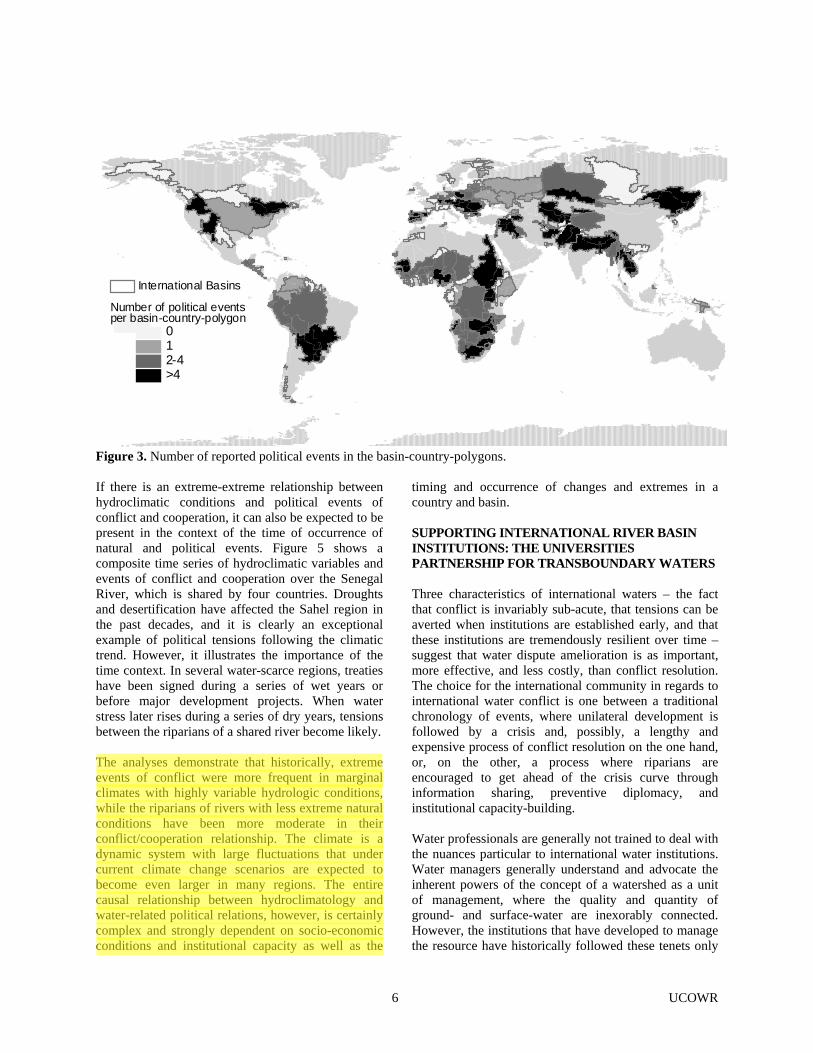
The test was carried out for the134 BCP’s that had five and more political events of conflict and cooperation (Figure 3). Preliminary Results: As shown in Figure 4, the average BAR intensity scale per BCP shows no relationship between conflict/cooperation level and hydro-climatic conditions, confirming the BAR project results of Wolf, Yoffe, and Giordano (2003). A new approach, which concentrates on the frequency of the political events of a particular intensity (both positive and negative), however, shows that there are differences between the four aridity index subsets. The observed relative frequency for a certain BAR scale level is expressed as an exceedance probability compared to the 10,000 random sample replications. The graph shows that in arid, and even more pronounced in semi-arid regions, the relative frequencies of the most conflictive events are significantly higher compared to what one can expect from random samples, while they are low for neutral to slightly cooperative events. In arid regions, however, there is also a high probability for the most cooperative events. In sub-humid and humid regions, the relative frequencies of the most conflictive events are comparatively low. The other three hydroclimatic parameters show similar results. These preliminary results suggest that extreme conflicts, but also extreme cooperation, are relatively frequent in regions with extreme conditions characterized by high inter-annual hydrologic variability. The high frequency of events on both sides of the conflict-cooperation intensity scale, however, makes the basin appear moderate when averaging the scale of all events (as done in the BAR study described earlier), thus concealing a more complex relationship with geographic indicators.
5 UCOWR
International Basins
Number of political eventsper basin-country-polygon
12-4>4
0
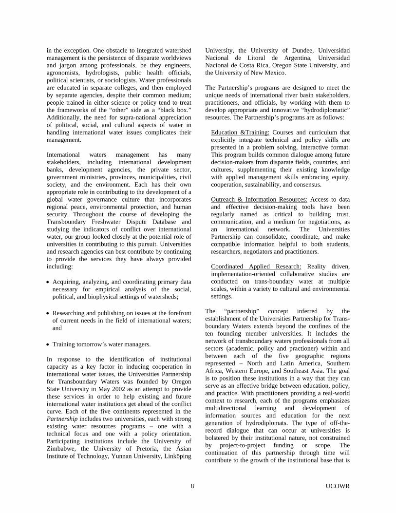
Figure 3. Number of reported political events in the basin-country-polygons. If there is an extreme-extreme relationship between hydroclimatic conditions and political events of conflict and cooperation, it can also be expected to be present in the context of the time of occurrence of natural and political events. Figure 5 shows a composite time series of hydroclimatic variables and events of conflict and cooperation over the Senegal River, which is shared by four countries. Droughts and desertification have affected the Sahel region in the past decades, and it is clearly an exceptional example of political tensions following the climatic trend. However, it illustrates the importance of the time context. In several water-scarce regions, treaties have been signed during a series of wet years or before major development projects. When water stress later rises during a series of dry years, tensions between the riparians of a shared river become likely. The analyses demonstrate that historically, extreme events of conflict were more frequent in marginal climates with highly variable hydrologic conditions, while the riparians of rivers with less extreme natural conditions have been more moderate in their conflict/cooperation relationship. The climate is a dynamic system with large fluctuations that under current climate change scenarios are expected to become even larger in many regions. The entire causal relationship between hydroclimatology and water-related political relations, however, is certainly complex and strongly dependent on socio-economic conditions and institutional capacity as well as the
timing and occurrence of changes and extremes in a country and basin. SUPPORTING INTERNATIONAL RIVER BASIN INSTITUTIONS: THE UNIVERSITIES PARTNERSHIP FOR TRANSBOUNDARY WATERS Three characteristics of international waters – the fact that conflict is invariably sub-acute, that tensions can be averted when institutions are established early, and that these institutions are tremendously resilient over time – suggest that water dispute amelioration is as important, more effective, and less costly, than conflict resolution. The choice for the international community in regards to international water conflict is one between a traditional chronology of events, where unilateral development is followed by a crisis and, possibly, a lengthy and expensive process of conflict resolution on the one hand, or, on the other, a process where riparians are encouraged to get ahead of the crisis curve through information sharing, preventive diplomacy, and institutional capacity-building. Water professionals are generally not trained to deal with the nuances particular to international water institutions. Water managers generally understand and advocate the inherent powers of the concept of a watershed as a unit of management, where the quality and quantity of ground- and surface-water are inexorably connected. However, the institutions that have developed to manage the resource have historically followed these tenets only
6 UCOWR
-5 -4 -3 -2 -1 0 1 2 3 4 5 6 7
0.0
0.5
1.0
1.5
2.0
2.5
3.0 Basin-Country-Polygon
humid
sub-humid
semi-aridarid
In
dex
of A
ridity
Average BAR Intensity Scale 1948-90
0
10
20
30
40
50
60
70
80
90
100
most conflictiveconflictive
neutral
cooperative
most cooperative(-7 to -5)
(-4 to -2)(-1 to 1 )
(2 to 4)(5 to 7)
sign
ifica
nt <
-> n
on-s
igni
fican
t <->
sig
nific
ant
Exce
edan
nce
Prob
abili
ty (%
)
Relative frequency of political events in BCPs with the following Index of Aridity:
arid (0.01-0.2) n=12 semi-arid (0.2-0.5) n=23 sub-humid (0.5-1.33) n=63 humid (>1.34) n=36
Figure 4. Relationship between hydro-climatic conditions and conflict-cooperation level of political events in the basin-country polygons. a) Average BAR intensity versus index of aridity. b) Exceedance probability of observed frequency for a certain conflict-cooperation level.
-7-6-5-4-3-2-101234567
0
400
800
1200
-400
-200
0
200
400
1950 1955 1960 1965 1970 1975 1980 1985 1990 1995 20000
200
400
no. i
n th
ousa
nd
Source: OFDA/CRED Disaster Database no. people affected by drought no. people affected by flood
TreatyTreaty
<-c
onfli
ct c
oop-
>
Source: BAR project/TFDD Event level on conflict-cooperation scale
dis
char
ge (m
3/s) Source: GRDC
Bakel (Lower Senegal where river = border Senegal-Mauritania) Kayes (in Mali upstream of border to SEN&MRT)
Source: CRU Guinea Mauritania Mali Senegal
prec
ipita
tion
anom
aly
(yea
r in
mm
)
Figure 5. Time-series of events of conflict and cooperation, precipitation anomaly, annual mean discharge and the occurrence of natural disasters in the Senegal River basin.
7 UCOWR
in the exception. One obstacle to integrated watershed management is the persistence of disparate worldviews and jargon among professionals, be they engineers, agronomists, hydrologists, public health officials, political scientists, or sociologists. Water professionals are educated in separate colleges, and then employed by separate agencies, despite their common medium; people trained in either science or policy tend to treat the frameworks of the “other” side as a “black box.” Additionally, the need for supra-national appreciation of political, social, and cultural aspects of water in handling international water issues complicates their management. International waters management has many stakeholders, including international development banks, development agencies, the private sector, government ministries, provinces, municipalities, civil society, and the environment. Each has their own appropriate role in contributing to the development of a global water governance culture that incorporates regional peace, environmental protection, and human security. Throughout the course of developing the Transboundary Freshwater Dispute Database and studying the indicators of conflict over international water, our group looked closely at the potential role of universities in contributing to this pursuit. Universities and research agencies can best contribute by continuing to provide the services they have always provided including:
• Acquiring, analyzing, and coordinating primary data
necessary for empirical analysis of the social, political, and biophysical settings of watersheds;
• Researching and publishing on issues at the forefront of current needs in the field of international waters; and
• Training tomorrow’s water managers.
In response to the identification of institutional capacity as a key factor in inducing cooperation in international water issues, the Universities Partnership for Transboundary Waters was founded by Oregon State University in May 2002 as an attempt to provide these services in order to help existing and future international water institutions get ahead of the conflict curve. Each of the five continents represented in the Partnership includes two universities, each with strong existing water resources programs – one with a technical focus and one with a policy orientation. Participating institutions include the University of Zimbabwe, the University of Pretoria, the Asian Institute of Technology, Yunnan University, Linköping
University, the University of Dundee, Universidad Nacional de Litoral de Argentina, Universidad Nacional de Costa Rica, Oregon State University, and the University of New Mexico. The Partnership’s programs are designed to meet the unique needs of international river basin stakeholders, practitioners, and officials, by working with them to develop appropriate and innovative “hydrodiplomatic” resources. The Partnership’s programs are as follows:
Education &Training: Courses and curriculum that explicitly integrate technical and policy skills are presented in a problem solving, interactive format. This program builds common dialogue among future decision-makers from disparate fields, countries, and cultures, supplementing their existing knowledge with applied management skills embracing equity, cooperation, sustainability, and consensus.
Outreach & Information Resources: Access to data and effective decision-making tools have been regularly named as critical to building trust, communication, and a medium for negotiations, as an international network. The Universities Partnership can consolidate, coordinate, and make compatible information helpful to both students, researchers, negotiators and practitioners.
Coordinated Applied Research: Reality driven, implementation-oriented collaborative studies are conducted on trans-boundary water at multiple scales, within a variety to cultural and environmental settings.
The “partnership” concept inferred by the establishment of the Universities Partnership for Trans-boundary Waters extends beyond the confines of the ten founding member universities. It includes the network of transboundary waters professionals from all sectors (academic, policy and practioner) within and between each of the five geographic regions represented – North and Latin America, Southern Africa, Western Europe, and Southeast Asia. The goal is to position these institutions in a way that they can serve as an effective bridge between education, policy, and practice. With practitioners providing a real-world context to research, each of the programs emphasizes multidirectional learning and development of information sources and education for the next generation of hydrodiplomats. The type of off-the-record dialogue that can occur at universities is bolstered by their institutional nature, not constrained by project-to-project funding or scope. The continuation of this partnership through time will contribute to the growth of the institutional base that is
8 UCOWR
necessary to 1) chart the development of new methods and paradigms for formulating water agreements, 2) develop technologies to aid in decision-making, and 3) tackle issues of contention such as globalization and climate change. This type of institutional base could effectively change the theater of traditional negotiations, but will only be useful to the needs of the future if they can be made amenable to the needs of their constituents. ACKNOWLEDGEMENTS A draft of this paper was presented to the annual meeting of the International Studies Association, Portland, Oregon, 25 February – 2 March 2003. The authors are indebted to Kristin Anderson for her editing expertise. ENDNOTES 1 This section is drawn from (1) Wolf, A.T. (2002)
International Water Conflict and Cooperation: A Survey of the Past; Reflections on the Future prepared for the UNESCO/Green Cross International program: From Potential Conflict to Cooperation Potential: Water for Peace, in collaboration with the Organization for Security and Cooperation in Europe and from (2) Wolf et al. (2003) International Waters: Identifying Basins At Risk. Water Policy. 2003.
2 Online at: www.transboundarywaters.orst.edu. 3 See Yoffe (2002) for complete details of the
methodology and initial findings of BAR. 4 This section draws from Wolf, A.T. (2002)
International Water Conflict and Cooperation: A Survey of the Past; Reflections on the Future prepared for the UNESCO/Green Cross International program: From Potential Conflict to Cooperation Potential: Water for Peace, in collaboration with the Organization for Security and Cooperation in Europe and from (2) Wolf et al. (2003) International Waters: Identifying Basins At Risk. Water Policy. 2003. See also Yoffe et al. (forthcoming) for more detailed results.
5 Excluded are events where water is incidental to the
dispute, such as those concerning fishing rights, access to ports, transportation, or river boundaries. Also excluded are events where water is not the driver, such as those where water is a tool, target, or victim of armed conflict.
6 For more details of how the event data were compiled, structured, and assessed, see Shira Yoffe and Kelli Larson’s, “Basins at Risk: Event Data Methodology and Findings,”
<www.transboundarywaters.orst.edu>. 7 The only “water war” between nations on record
occurred over 4,500 years ago, between the city-states of Lagash and Umma in the Tigris-Euphrates basin (Wolf 1998).
8 “Power” in regional hydropolitics can include
riparian position, with an upstream riparian having more relative strength vis a vis the water resources than its downstream riparian, in addition to the more-conventional measures of military, political, and economic strength. Nevertheless, when a project is implemented that impacts one's neighbors, it is generally undertaken by the regional power, as defined by traditional terms, regardless of its riparian position.
9 This section is drawn from research currently being
conducted by Kerstin Stahl at Oregon State University.
AUTHOR INFORMATION Aaron T. Wolf is an associate professor of geography in the Department of Geosciences at Oregon State University. His research focus is on the interaction between water science and water policy, particularly as related to conflict prevention and resolution. He is author of Hydropolitics Along the Jordan River: The Impact of Scarce Water Resources on the Arab-Israeli Conflict, (United Nations University Press, 1995), a co-author of Core and Periphery: A Comprehensive Approach to Middle Eastern Water, (Oxford University Press, 1997), and editor of Conflict Prevention and Resolution in Water Systems, (Cheltenham, UK: Elgar, 2002). Wolf coordinates the Transboundary Freshwater Dispute Database, an electronic compendium of case studies of water conflicts and conflict resolution, international treaties, national compacts, and indigenous methods of water dispute resolution (www.transboundarywaters.orst.edu), and is a co-director of the Universities Partnership on Transboundary Waters. Kerstin Stahl is a postdoctoral research fellow (German Research Foundation, DFG) at the Department of Geosciences at Oregon State University. Her research focuses on the influence of hydrologic conditions and hydroclimatic variability on water-related political conflict and cooperation in international river basins.
9 UCOWR
She has also worked on different aspects of hydrologic drought and has a PhD in Hydrology from the University of Freiburg in Germany.
New, M. G., M. Hulme, and P.D. Jones, 2000. Representing Twentieth-Century Space-Time Climate Variability. Part II: Development of 1901-1996 Monthly Grids of Terrestrial Surface Climate, Journal of Climate, 13: 2217-2238.
Marcia Fraser Macomber is the Director of Program Development for the Universities Partnership for Transboundary Waters. She served as an International Development Associate with the University of Michigan Population, Environmental Change, and Security (PECS) Initiative, and worked on international transboundary environmental issues with the U.S. Embassy’s Regional Environmental Hub in Amman, Jordan as well as in Tijuana, Mexico on a 2001 binational workshop entitled The Future of the U.S. Mexico Border: Population, Development and Water. She holds a B.S. in Biology from San Francisco State University, San Francisco, California and a MS in Resource Geography with a minor in Fisheries Science from Oregon State University.
Remans, W., 1995. Water and War, Humantäres Völkerrecht, 8(1). Salman, S.M.A. and L. B. de Chazournes, eds. 1998. International Watercourses: Enhancing Cooperation and Managing Conflict. The World Bank, Washington, D.C. (Technical Paper No. 414). Samson, P. and B. Charrier, 1997. International Freshwater Conflict: Issues and Prevention Strategies. Green Cross Report. Wolf, A., 1998. Conflict and Cooperation Along International Waterways, Water Policy, 1(2): 251-265.
REFERENCES Wolf, A., J. Natharius, J. Danielson, B. Ward, and J.
Pender, 1999. International River Basins of the World, International Journal of Water Resources Development, 15(4) 387-427.
Ahn, C.H. and R. Tateishi, 1994. Development of a Global 30-Minute Grid Potential Evapotranspiration Data Set, Journal of the Japan Soc. Photogrammetry and Remote Sensing, 33(2): 12-21.
Wolf, A., S. Yoffe, and M. Giordano, 2003. International Waters: Identifying Basins at Risk, Water Policy, 5: 31-62.
Amery, Hussein, 2002. Water Wars in the Middle East: A Looming Threat, The Geographical Journal, 168(4): 313-323.
Yoffe, Shira, 2002. Basins at Risk: Conflict and Cooperation over International Freshwater Resources. Unpublished Ph.D. dissertation, Oregon State University.
Gleick, P.H., 1993. Water and Conflict: Fresh Water Resources and International Security, International Security, 18(1): 79-112.
Yoffe, S., A. Wolf, and M. Giordano, forthcoming, Conflict and Cooperation Over International Freshwater Resources: Indicators of Basins at Risk, Journal of the American Water Resources Association.
Homer-Dixon, T., 1994. Environmental Scarcities and Violent Conflict, International Security. Libiszewski, S., 1995. Water Disputes in the Jordan Basin Region and their Role in the Resolution of the Arab-Israeli Conflict. Zurich: Center for Security Studies and Conflict Research, Occasional Paper 13.
10 UCOWR


![LU70 Sedimentary basins abstracts[1]](https://img.dokumen.tips/doc/110x75/634c76497f5a138881007e91/lu70-sedimentary-basins-abstracts1.jpg)