Embed Size (px)
Citation preview

PHOTONIRVACHAK Journal of the Indian Society of Femote Sensing, Vol. 17, No. 1, 1989
COASTAL LANDFORM MAPPING AROUND THE GULF OF KHAMBHAT USING LANDSAT TM DATA
M.G. Shaikh*, Shailesh Nayak*, P.N. Shah** and B.B. Jambusaria** *Space Application Centre, Ahmedabad 380053
**Gujarat Engineering Research Institute, Vadodara 390007
A B S T R A C T Landsat TM data was utJlised for coastal geomorphic mapping around me Gulf of Khambhat. Various land- forms like shoreline, estuaries, mudflats, islands, mangroves, relict aluvium, cliffs, dunes, flood plains, paJeo- channel, paleomeanders, oxbow lake, etc. were delineated. The estuaries were divided into salt-wedge es- tuary, fully mixed estuary and partially mixed estuary based on amount of freshwater discharge and nature of tidal currents. The mudflats were classified into high tide flats, intertidal slopes and subtidal zones. These classes were further classified based on their composition. It was concluded that TM data has brought out many new features and improved the classification of coastal landforms. The presence of coastal features like drowned river valleys, paleomudflats, relict alluvium, dunes, paleomeanders, oxbow lake and terraces clearly indicate the sea-level changes of the Quarternary period.
INTRODUCTION The study of coastal landforms is one of the
most interesting areas of geomorphological research. The study is important as the tides, waves and currents provide energy which is constantly working to change the landforms.
Many important complexes are located in the coastal zone around the Gulf of Khambhat, viz, Dhuwaran Thermal Power Station on the bank of the Mahi estuary, Gujarat Narmada Val- ley Fertilizer Company on the bank of the Nar- mada estuary, Hajira Industrial Complex on the bank of the Tapi estuary, etc. The mapping and study of coastal landforms, one of the major component of the coastal environment, provide us a proper understanding of coastal processes operating in an area and thus help towards better management of the coastal zone.
Landsat MSS data with synoptic and repeti- tive coverage has helped in identifying deposi- tional as well as erosional landforms around the Gulf of Khambhat which are sometimes difficult to identify on ground, thus gave clue to studying geomorphology of the area (Nayak and Sahai, 1984; 1985).
The main objective of the present study is to map coastal landforms using Landsat TM data
and to understand the coastal processes.
METHODOLOGY Landsat TM FCC (Band 2, 3 and 4) on
1:250,000 scale was visually interpreted by using light table and a hand lense. The major geomor- phic features like shoreline, estuaries, mudflats, islands, dunes, floodplains, cliffs etc. were de- marcated. The secondary data was based on ground truth data which include field visits, aerial photographs (wherever available) and topo- graphic maps. This map was compared with the geomorphic map prepared using Landsat MSS (Nayak and Sahai, 1984:1985) to detect changes as well as to understand the utility of the better resolution data in landform mapping.
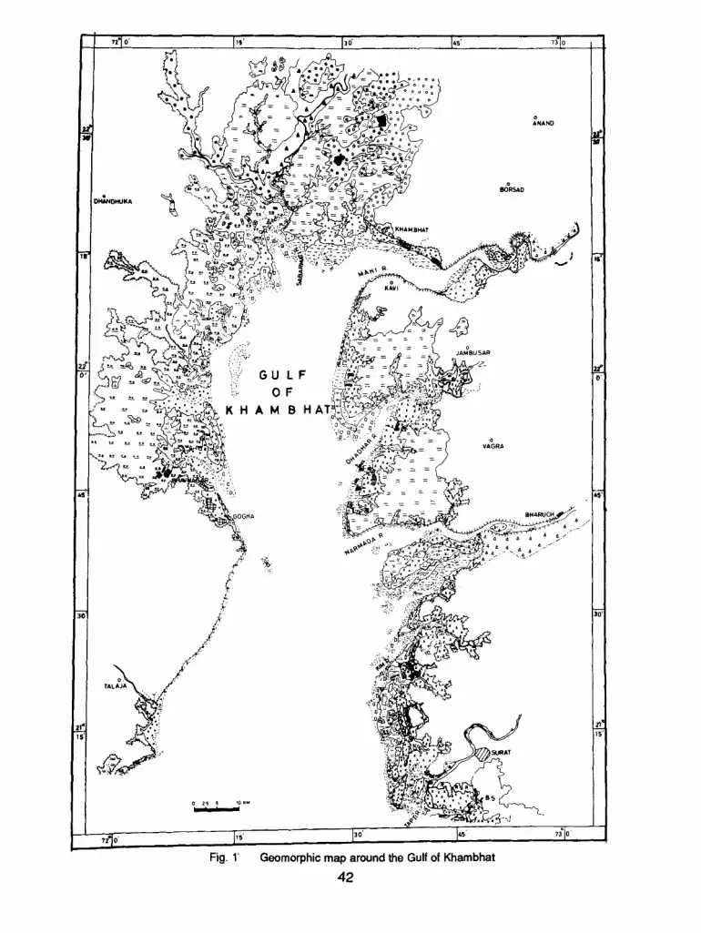
RESULTS AND DISCUSSIONS The shoreline around the Gulf of Khambhat is
indented by estuaries and creeks which are char- acterised by islands and extensive mudflats. The mudflats are either vegetated or non-vegetated. All these landforms are manifestation of high tidal range in the Gulf of Khambhat. The salient features of geomorphic units are discussed be- low (Fig. 1 ).
Shoreline The shoreline around the Gulf of Khambhat is
highly indented as well as moderately wavy. The
(Received 10th Feb. 1989). 41
, "1 ~ I'" I ,o' I,~' 7~']o I
' �9 : ooo .
D / ANAND
I
JAMBUSAR
_ , , ,,:. ~ ~- o. , "": G U L F r'~ ~ ,~ f i::/ ' ~ ,
. . . . ~ ,~ ~ VAGRA
,% ~ ~:. ' :2'
~ARUCH
,,1 o I'" I '~ k ';1 ~ , Fig. 1' Geomorphic map around the Gulf of Khambhat
4 2
L E G E N D
I X X X ]
1 "-"-'q
f: . . . --1
[ . �9 . !
[ ' - -- 1
I - v - . !
[ = = l t �9 t e e
i 1 I-v-v-i
[ 1 e �9 �9 e
l . - v = !
I~:D i i * * ~ ' I . § §
HIGH TIDE FLATS
Mudflat I
Mudflat I with vegetation
Mudflat I with salt encrustation
Mudflat II
Mudlfat II with vegetation
Mudflat III
Mudflat IV
Mudlfat IV with vegetation
Mudfiat V
Mudflat VI with salt encrustation
INTERTIDAL SLOPE
Mudflat I
Mudflat I with vegetation
Mudflat II
Mudflat II with vegetation
Relict alluvium
Mangroves
Mudflat III
I �9 o . �9 �9 J
[ - - _ ' ]
1* " " " 5 t 1
I - - - I 10 oo l e o G I
l^ ^ , , I [R'~ I
1 - ' - i
( . . . . . I
l ~ s I
43
SUBTIDAL ZONE
Submerged shoal
Mudflat
OTHER LANDFORMS
Low water line
High water line
Paleomudflat
Transitional zone I
Transitional zone II
Cliff
Dune with vegetation
Reclaimed mudflat
Salt pan
Flood plain
Older flood plain
Paleochannel
O• lake
Badland saline area
Water body
Town/Village

shoreline of the mainland is highly indented due to the presence of major estuaries and narrow creeks. The shoreline of the Saurashtra coast is less indented and appears moderately straight. The shoreline is marked by the presence of wide mudflats, estuaries, islands, submerged shoals, dunes and the absence of sandy beaches. The change in the shoreline, especially in the Mahi and the Narmada estuary are significant (Nayak and Sahai, 1983, 1984, 1985; Shaikh et al. 1987 a and b). The erosional processes are predominant in the Mahi estuary while depositional activities are dominating in the Narmada estuary.
Estauries The Gulf of Khambhat is characterised by a
number of large and small estuaries appearing as if enclosed within a large one (The Gulf itself). Estuaries are largest and most complex of all landforms. All major estauries like the Tapi, the Narmada, the Mahi, the Sabarmati, the Kim and the Dhadhar are marked by funnelshaped outline and tidal meanders, excep~he Narmada estuary, as evident from satellite imagery which char- acterises high tidal range. The estuaries are clas- sified into salt-wedge estuary, fully mixed estu- ary and partially mixed estuary (Pethick, 1984).
The Narmada estuary is classified as salt- wedge estuary where fresh water flow predomi- nates. However, due to the high tidal range sig- nificant mixing also takes place because of strong tidal currents during high tide period. The maximum deposition occurs in the mouth and this is evidenced by the presence of the Aliabet island and its gradual expansion as reported eadier (Nayak et al. 1985; 1986, Shaikh etal. 1987 a and b). This has blocked the channel south of the island resulting in filling up of the channel.
The Mahi, theTapi and the Sabarmati estuar- ies are fully mixed estuaries as they experience strong tidal currents and weak discharges of fresh water. The sediments on left and right banks are of different nature probably because of horizontal variation'in salinity. The Dhadhar and the Kalubhar estuaries are partially mixed estuar- Ies.
All these estuaries are drowned river valleys
as per classification of Fritchard (1952). The rising sea level after last glaciation was respon- sible for the formation of these estuaries. They can be termed as coasial plain estuaries (Pritchard, 1952).
The Tapi, the Narmada, the Mahi and the Sabarmati estuaries bifurcate around islands and their appreciable infilling and are called estuarine delta (Nayak and Sahai, 1984; 1985).
All the estuaries are funnel-shaped and are macro-tidal estuaries, in the funnel-shaped or trumpet-shaped estuaires width decrease dras- tically upstream. Such a decrease in width pro- duces a concentration of the energy of the tidal wave (Langbein, 1963). This concentration of energy might dissipate on the banks and river bed. Thus deposition occurs mainly at the mouth. All estuaries except the Narmada have wide mudflats. This is because all estuaries have mean- ders which allow dampening of more land by tidal water as compared to the straight bank estuaries like the Narmada estuary. This has given rise to wide mudflats along all the major estuaries.
The sedimentation in the Tapi and the Kalubhar estuaries is a serious problem as it affects navigations and port operations.
Mu~lflats Extensive mudflats, 6-8 km wide have devel-
oped all along the coast of the Gulf of Khambhat except along the Narmada estuary. These mudflats are classed on the basis of their relation with tidal condition into subtidal, intertidal and the high tide flats (Davies, 1972). The subtidal zone is exposed only during very low tide. The intertidal slopes lie between highwater and mean low water mark. While the high tide flats lie above mean high water mark. Subtidal zone includes submerged shoals and mudflats. Submerged shoals are occuring in the Dhadhar, the Narmada, the Kim estuaries and on the Saurashtra coast. The shoal on the Saurashtra coast were not visible during 1975 (Nayak and Sahai, 1984; 1985). It indicates recent heavy deposition in the Gulf. The mudflats of this zone are barren and are present in the Dhadhar, the Kim and in the Kalubhar estuary.
44

Intertidal slopes include three types of mudflats. Type I mudflats run along the coast between the Sabarrnati and the Tapi estuaries, type II are found between the Narmada and the Tapi and type III are found on the Saurashtra coast. The difference in these mudflats is mainly because of different nature of the source mate- rial. The type I mudflat sometimes have either marsh or grass on it, viz, between the Mahi and the Dhadhar estuaries. Mangroves are found mainly on the Aliabet island in the Narmada estuary. Grass is found around the Kim estuary and on Kadiabet island in the Tapi estuary. At many places, between the Narmada and Tapi estuaries, patches of alluvium are found, within mudflats.
High tide flats are divided into six different types of mudflats. Type I mudflat is mainly found between the Mahi and the Tapi estuaris. It covers the largest area. This mudflats are sometimes covered with either salt viz, south of Dhadhar or vegetation, viz, south of the Kim river and on the Aliabet island in the Narmada estuary. South of Tapi estuary, part of mudflat is reclaimed and crops are grown. Type I1 mudflats are found around the Mahi estuary only. These mudflats near Dabka are reclaimed and being used to grow crops. Sometimes they sustain thick babul growth also and are classified as mudflat II with vegetation.
constitution or size of the sediments. The fine- grained silt and clay form the mudflats. The source material is mainly fluvial in nature, that is, sediments brought down by rivers. Other sources are sediments derived from cliff erosion and in situ reworking of sediments within estuary. These sediments are deposited by flocculation process. Tidal currents play an important role in formation of these mudflats. Most of the sedi- ments have been deposited during slack period (Nayak and Sahai, (1985).
These mudflat exhibit marked break in slope at the high tide mark and in between high and low tide mark. Possibly because of these reasons, two distinct boundaries are visible on the satel- lite imagery. These mudfalts can also be classed as vegetated or non-vegetated on the basis of presence or absence of vegetation on them.
The mudflats, north of Gulf as well as be- tween the Mahi and the Narmada estuaries, lying above the high tide flats are termed as pale- omudflats (Fig. 2) (Nayak and Sahai, 1984; 1985). These mudflats are related to phenomena of regression of sea. They represent the sites of older mudflats when the sea level was several metres higher than the present. These mudflats are utilised for growing crops and shows transi- tion from these flats to good agricultural land.
Type III mudflats are found along the creeks of the Saurashtra side. Their composition is dis- tinctly different and their origin is mainly marine in nature.
Type IV mudflats are found within type V mudflats, along the Saurashtra coast (north of the Kal u bhar estuary). They are slightly on higher ground and escape submergence during normal high tide. They are often covered by babul.
Type V mudflats cover a large area on the Saurashtra coast. Type Vl mudflats are found around the Shetrunji estuary. They are covered by thin veneer of salt.
The above-mentioned mudflats are differen- tiated on the basis of the difference in tone and texture which may be due to variation in the
Islands There are many islands in the Gulf. The islands
at the mouth of estuaries are designated as mouth bars (Nayak and Sahai, 1984; t 985). The Narmada, the Tapi, the Mahi and the Sabramati have mouthbars. They have smooth outline and normally above the high-water line, and are com- posed of either sand or silt and clay and free from rocks. The islands at the mouth of the Narmada and the Tal?i are wide in thei'r areal extent. These islands are mainly composed of silt and clay. The islands in the Mahi and the Sabarmati are mainly sandy in nature. This probably indicates pre- dominanc of fluvial deposition in the Sabarmati and the Mahi and marine deposition in the Tapi river.
The Piram island is composed of hard con- glomerates, with cliffyshore. It is5 km across and
45

aligned in NW-SE direction.
Apart from these islands, there are many shoals present in the Gulf, especially at the mouth of estuaries. Shoals are generally composed of sand and remain submerged under water. Many new shoals are seen especially near the Saurash- tra coast and in the Narmada estuary, west of Bharuch. This indicates high rate of sedimenta- tion in the area.
Mangroves/Marsh The mangroves refer to the community of
plants which colonise in soft muddy shores. The plants with their roots help in consolidating the loose muddy soil and build up a barrier between the tidal action from the sea and floods from the river. They are present on the Aliabat island in the Narmada estuary (Fig. 3) and near Ghogha on the Saurashtra coast. They are mainly Avicennia spp.
Relict Alluvium Relict alluvium occurs within the mudflat II on
intertidal slope. It is present between the Nar- mada and the Kim estuaries (Fig. 3). The relict alluvium patches are few metres above the high water line. They reveal the sequence of trans- gression and regression of sea. They were the part of mainland when the shoreline was much lower than today. With the subsequent trans- gression the river valleys were drowned and the higher level patches were separated from the mainland which are engulfed in the present mudflat.
Salt Pans Salt pans are distributed all along the coast
in the Gulf. Their number is more on the Saurash- tra coast near Bhavnagar.
almost entire course of the Mahi and the Nar- mada estuaries are marked by the presence of high alluvial cliffs. The cliffs present along the bank of Mahi have more altitude (10-20 m) as compared to the Narmadawhere the height is 3- 5 m (Patel et al. 1982). The cliffs are an erosional feature.
Dunes Dunes are present south of the Dhadhar
river, near Dahej, and between the Tapi and the Narmada estuaries (Fig. 3). They border the high tide mark and extend inland upto 2-3 km. They run parallel to shoreline separated from each other by marked trough or valleys. They range in height from 2-3 m usually having steep windward slope. Their crests are flat. They are stabilised by the vegetation giving them different tone and tex- ture than surroundings. These dunes may have formed due to exposure of vast expanse of sand which dries up at low tide on a low near-shore slope with strong onshore winds. Such a condi- tion existed during the glacial period when the sea level was lower than today. Thus they repre- sent former levels of sea and point to the regre- sion of the sea. The dunes lying north of the Tapi estuary are surrounded by mud and are thus ca~led cheniers.
FloodPlains Flood plain is a geomorphic feature repre-
senting the surface being constructed by the river. They usually run parallel to the river. They are subject to periodic overflow of river water. They are subject to periodic overflow of river water. They are present along the river Tapi and the Sabarmati and are differentiated due to their elongated shape and the presence of the dense vegetation they support.
Transitional Zones Transitional zones are those lying between
the paleomudflats and the plains between the Mahi and the Sabarmati rivers (Fig. 2). They are classed into two zones based on vegetation density. These are usually reclaimed to grow crops.
Cliffs Cliffs in this area are high, almost vertical. The
Paleochannel A paleochannel is an abandoned course of
the river. The paleochannels identified along the Mahi and the Narmada rivers, are actually edge of terraces as identified in aerial photos (Mahi area) (Fig. 2). The oldest terrace (T1) is an un- paired terrace and is formed due to slow and continuous rejuvenation with lateral erosion. These terrances can be attributed to the Flan- drian transgression (early Holocene) or the
46
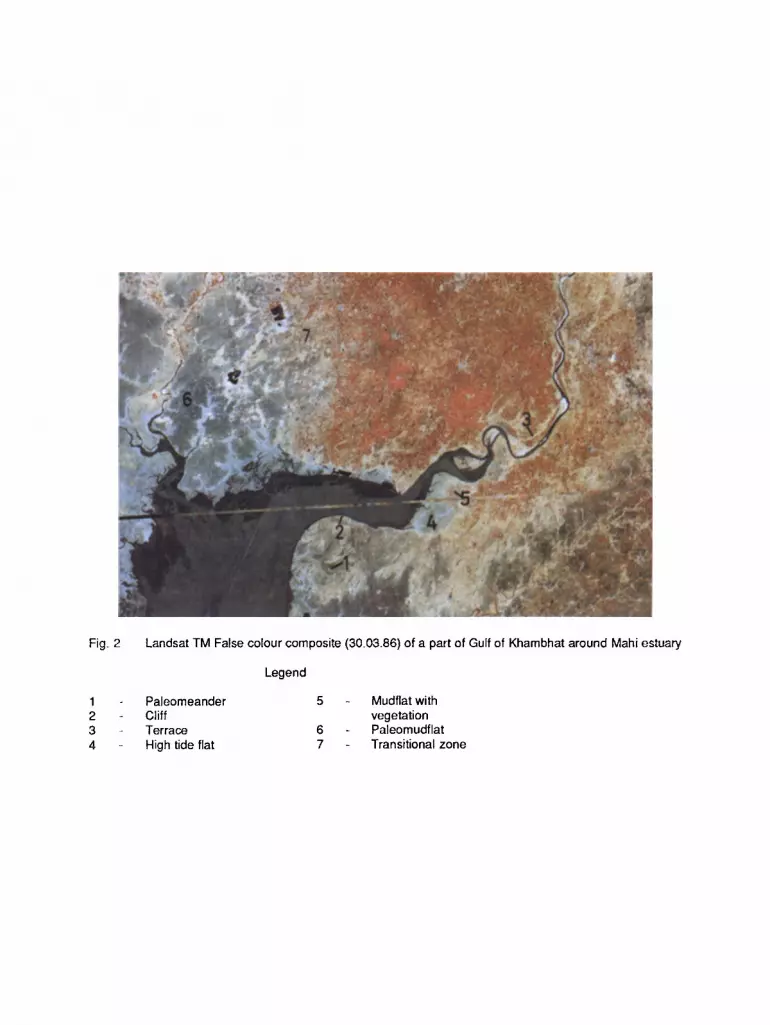
Fig. 2 Landsat TM False colour composite (30.03.86) of a part of Gulf of Khambhat around Mahi estuary
Legend
Paleomeander 5 Mudflat with Cliff vegetation Terrace 6 Paleomudflat High tide flat 7 Transitional zone

Fig. 3 Landsat TI~I False colour composite (30.03.86) of a part of Gulf of Khambhat around Narmada estuary
Legend
Subtidal zone 5 Relict alluvium Intertidal slope 8 Dune High tide flat 7 Reclaimed mudflat Mangroves
upliftment or both (Nayak et al. 1988). The ter- races of the Mahi and the Narmada estuary are clearly recognised on the satellite imagery.
Paleomeanders Paleomeanders are the old scars of the
channel. They are present south of the Mahi estuary (Fig. 2). They were initially delineated using IRS LISS-II data and later on TM data. The presence of paleomeanders indicates presence of older terrace than T1.
Oxbow lake Oxbow lake is a cut-off portion of the mean-
der of river. Oxbow lake is seen on the southern bank of the Mahi river. This indicates change in the course of the Mahi river, probably because of tectonic activity.
Saline areas Saline area is present south of Surat. It
houses the Udhna industrial complex.
CONCLUSIONS Landsat TM data with its better spatial and
radiometric resolutions is very useful in the study of coastal landforms. TM data has brought out many features and has improved furtherthe clas- sification of mudfalts which was not possible with Landsat MSS data. The scattered vegetation on mudflat is not visible in MSS but can be mapped in TM data.
The study of cliff and terrances requires stereo images which will be possible by SPOT data.
The presence of drowned river valleys, pale- omudf!ats, paleomeanders, relict alluvium, dunes, oxbow lake and terraces clearly indicates the sea-level changes in the recent past.
ACKNOWLEDGEMENTS The authors are extremely grateful to Dr.
Baldev Sahai, Associate Director, IRS-UP and Group Director, Remote Sensing Applications Group, SAC for his valuable advice and guidance in carrying out these studies. We express our sincere thanks to Shri N.B. Desai, Director,
Gujarat Engineering Research Institute, Va- dodara for his keen interest and useful discus- sions. We are thankful to Dr. A. Narain, Head, Marine and Water Resources Division, SAC for critically going through manuscript and offer his comments. Thanks are due to Shri K.M Bhavsar for photographic support and Shri Rajkotwala for cartographic work.
REFERENCES Davies, J.L. (1972). Geographical variation in coastal development, Oliver and Boyd, Ed- inburgh, 204 p.
Langbein, W.B. (1963). The hydraulic geometry of a small tidal estuary. Bull. Int. Asso. Scien. Hydrol., 8:84-94.
Nayak, S.R., and Shahi, B. (1983). Morphological changes in the Mahi estuary. In the Proc. of the National conf. on Application of Remote Snesing, Centre of studies in Resources Engi- neering, liT, Bombay, pp. 152-154.
Nayak, S.R., and Sahai, B. (1984). Coastal mor- phology of the Gulf of Khambhat, In the Proc. of the symp. on Quarternay Episodes in India: Neotectonism, Eustasy and Paleoclimates. Dept. of Geology, M.S. University, Baroda, pp. 87-96.
Nayak, S.R., and Sahai, B. (1985). Coastal mor- phology a case study of the Gulf of Khambhat (Cambay), Int. J. of Remote Sensing, 6(3 & 4): pp. 559-567.
Nayak, S.R. Gupta, M.C. and Chauhan, H.B. (1985). Monitoring of wetland and shoreline on the part of Gujarat coast using Landsat data. In the Proc. of the 6th Asian Conf. on Remote Sensing, NRSA, Hyderbad, pp. 348-353.
Nayak, S.R., Gupta, M.C. and Chauhan, H.B. (1986). Wetland and shoreline mapping of the part of Gujarat coast using Landsat data. Scien- tific Note. Sapce Applications Centre, Ahme- dabad. IRS-UP/SAC/MCE/SN/06/86. 24p.
Nayak, S.R., Shaikh, MG., Shah, P.N., Patel, V.B. and Jambusaria, B.B. (1988). Application of aerial
47

photographs in the Geomorphic mapping of the Mahi estuarine areas. Scientific Note. Space Applications Centre, Ahemdabad. I RS-U P/SAC/ MCE/SN/15/88 13p.
Patel, M.P., Patel, S.G. and Merh, S.S. (1985). Geomorphic evidences of Quarternary sea level changes in Mahi-Tapi coastal segment of Gujarat. In the Proc. of the Symp. on Quaternary Episodes in India (S.S. Merh and N.M. Vashi, Editors), Dept. of Geology, M.S. University, Baroda, pp. 49-62.
Pethick, J. (1984). An introduction to coastal geomorphology, Arnold-Heinemann, New Delhi 260p.
Pritchard, D. (1952). Estuarine hydrology. Ad- vances in Geophysics, Vol. 1, pp. 243-280 Shaikh, M.G., Nayak, S., Jambusaria, B.B. and Thatte, C.D. (1987a). Monitoring of shoreline in the Mahi estuary. In Remote Sensing Applica- tions in Coastal Studies. Scientific report. Space Applications Centre, Ahemadbad, IRS-UP/SAC/ MCE/SN/08/87. pp. 34-38.
Shaikh, M.G., Nayak. S., Shah, P.N. and Jam- busaira, B.B. (1987b). Monitoring of shoreline changes in the Narmada estuary using Landsat data. In Remote Sensing Applications in Coastal Studies. Scientific report. Space Applications Centre, Ahmedabad. IRS-UP/SAC/MCE/SN/ 08/87. pp. 39-42.
48


