Embed Size (px)
Citation preview

Cities 37 (2014) 1–26
Contents lists available at ScienceDirect
Cities
journal homepage: www.elsevier .com/locate /c i t ies
City profile
City profile: Berlin
0264-2751/$ - see front matter � 2013 Elsevier Ltd. All rights reserved.http://dx.doi.org/10.1016/j.cities.2013.10.007
⇑ Corresponding author. Tel.: +381 691279692.E-mail address: [email protected] (B. Arandjelovic).
Biljana Arandjelovic a,⇑, Dushko Bogunovich b
a University of Nis, Faculty of Civil Engineering and Architecture, Aleksandra Medvedeva 14, 18000 Nis, Serbiab Unitec Institute of Technology, Departments of Architecture and Landscape Architecture, 1 Carrington Rd, Mt Albert, 102 Auckland, New Zealand
a r t i c l e i n f o
Article history:Received 27 February 2013Received in revised form 5 October 2013Accepted 26 October 2013Available online 6 December 2013
Keywords:Post-Wall BerlinBerlinReichstagPotsdamer PlatzMemorialsCreative CityEast BerlinWest BerlinUrban history
a b s t r a c t
Berlin is a German city and federal state, situated in the heart of Europe. It has been the capital city since1991, and is the largest city in the country with around 3.4 million inhabitants. This profile explains Ber-lin’s historical development and emphasizes changes which took place during the 20th century (the Wei-mar period in the 1920s, followed by the Nazi takeover in 1933 and the city’s destruction during WorldWar II, then the division of the city into West Berlin and East Berlin, until its final reunification in 1990after the Wall fell down). After reunification, Berlin experienced a new period of urban redevelopment inwhich many new buildings were constructed. This profile also outlines some recent positive changes interms of Berlin’s economic growth and its transformation into the capital of innovative new companies inthe digital, culture and media industries.
� 2013 Elsevier Ltd. All rights reserved.
Introduction
Berlin is the city that best portrays the unification of the twoGermanies, both visually and physically. It has always been a placeof political power and a legendary symbol of survival. A politicaldivision of more than 40 years during the Cold War period and aphysical division of more than 30 years imposed differences be-tween the Western and Eastern parts of the city. Berlin is a combi-nation of new with the old, where abandoned factories in unusedareas along the former Wall are still to be found. Berlin is a citywhere ‘every corner is telling a story, a city that narrates its multi-ple histories, the only place in the world where the center is empty’(Till, 2005). The 20th century was full of dramatic changes, startingfrom the revolution of 1918, followed by the Nazis taking power in1933, then the post-war city division from 1945, the erection of theWall in 1961, followed by life in the divided city and then reunifi-cation in 1990. All these events are turning points in the city’spolitical life and have shaped its built environment. The city’s pres-ent borders were assigned in 1920 with the inclusion of adjacentsmall towns, agricultural land and lakes and forests, not by the in-ner city enlargement process.
It is a dynamic city of culture and one of the UNESCO Cities ofDesign. As a capital city, Berlin is rich in cultural institutions. Most
of them are financed through public subsidies, though it is impor-tant to emphasize that Berlin is equally famous for its non-subsi-dized arts scene and creative industries. One of the results ofBerlin’s division is its duplication of cultural institutions. As the ci-ty’s cultural center was in the Boulevard Unter den Linden, whichfell on East Berlin’s side, the West German government compen-sated for this by creating new institutions. The Deutsche Oper Ber-lin in West Berlin was equivalent to the State Opera. Mies van derRohe’s New National Gallery (part of the Kultur Forum complex)served as counterpart to the old national museums, and Hans Scha-roun’s State Library was West Berlin’s answer to the old Berlin Li-brary. All of these institutions stayed after the unification andtoday Berlin has three opera houses, four opera ensembles, eightlarge orchestras, including Berlin Philharmonic Hall, and ten cham-ber orchestras (OECD, 2003). During the Weimar Republic, Berlingained ‘entertainment metropolis’ reputation, which holds to thisday. The unified German capital also embraces a great number ofcorporate buildings, a new federal government district, a recon-structed regional transportation system and gentrified neighbor-hoods. Its historical district has also been renovated, whilesuburban settlements are still growing. Berlin is rich in large publicspaces, particularly at the waterfront and in its green urban parks(which cover more than 40 % of the city area). It is the Europeancity with the highest density of green space (Berlin Senat Depart-ment for Urban Development) (see Figs. 1–4).
2 B. Arandjelovic, D. Bogunovich / Cities 37 (2014) 1–26
The history of Berlin’s urban development
Berlin’s early history
A dense network of villages appeared on the territory betweenthe rivers Elbe and Oder during the 12th cenutry. These villageshad similar structure, and were all concentrated along a road witha green area at its center. Even today, the outline of the green areacan still be seen in some Berlin districts. At the end of the 12th cen-tury, two separate settlements sprang up from these villages, Cöllnand Berlin. These two settlements kept separate identities until the18th century, though they even shared a town hall for one periodand were often communally referred to as Berlin. In 1709, thesetwo settlements finally officially unified. During the Middle Agesthese settlements spread minimally but with no significant archi-tectural shapes. Indeed, in the area of urban development Berlindefinitely stayed far behind other grandiose capitals in Europe likeVienna or Paris. Berlin started developing during the Baroque per-iod under Friedrich Wilhelm the Great Elector (Cobbers, 2011).
Berlin before the 20th century
A new chapter in the architectural history of Berlin started atthe beginning of the 1700s when a line of new districts was setout on the west side from the remains of the previous medievalcity, under the rule of Prussian King Friedrich I. This developmentcontinued under Friedrich Wilhelm I, when Berlin’s intense grid
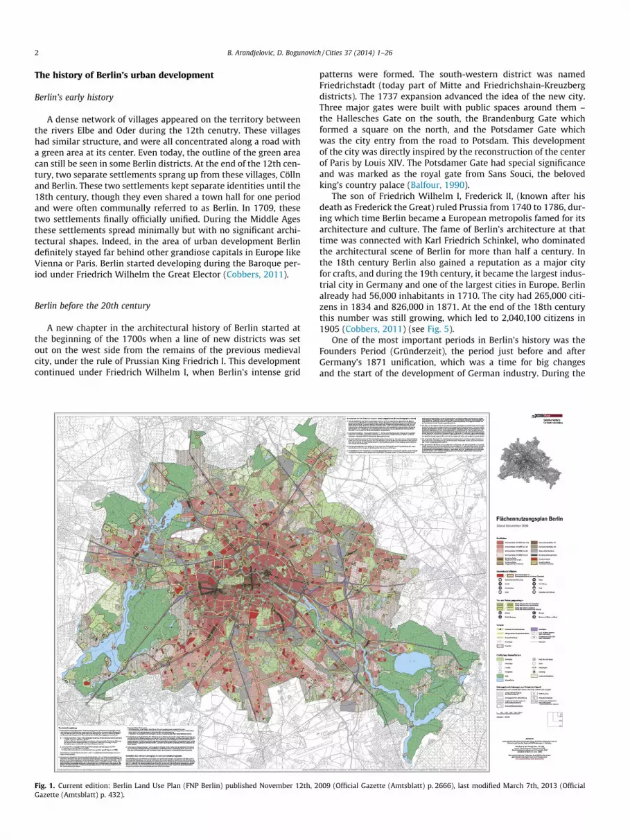
Fig. 1. Current edition: Berlin Land Use Plan (FNP Berlin) published November 12th, 2Gazette (Amtsblatt) p. 432).
patterns were formed. The south-western district was namedFriedrichstadt (today part of Mitte and Friedrichshain-Kreuzbergdistricts). The 1737 expansion advanced the idea of the new city.Three major gates were built with public spaces around them –the Hallesches Gate on the south, the Brandenburg Gate whichformed a square on the north, and the Potsdamer Gate whichwas the city entry from the road to Potsdam. This developmentof the city was directly inspired by the reconstruction of the centerof Paris by Louis XIV. The Potsdamer Gate had special significanceand was marked as the royal gate from Sans Souci, the belovedking’s country palace (Balfour, 1990).
The son of Friedrich Wilhelm I, Frederick II, (known after hisdeath as Frederick the Great) ruled Prussia from 1740 to 1786, dur-ing which time Berlin became a European metropolis famed for itsarchitecture and culture. The fame of Berlin’s architecture at thattime was connected with Karl Friedrich Schinkel, who dominatedthe architectural scene of Berlin for more than half a century. Inthe 18th century Berlin also gained a reputation as a major cityfor crafts, and during the 19th century, it became the largest indus-trial city in Germany and one of the largest cities in Europe. Berlinalready had 56,000 inhabitants in 1710. The city had 265,000 citi-zens in 1834 and 826,000 in 1871. At the end of the 18th centurythis number was still growing, which led to 2,040,100 citizens in1905 (Cobbers, 2011) (see Fig. 5).
One of the most important periods in Berlin’s history was theFounders Period (Gründerzeit), the period just before and afterGermany’s 1871 unification, which was a time for big changesand the start of the development of German industry. During the
009 (Official Gazette (Amtsblatt) p. 2666), last modified March 7th, 2013 (Official

Fig. 2. Map of Berlin’s districts (Bezirke). Source: d-maps.com.
Fig. 3. Mies van der Rohe’s New National Gallery and Alexander Calder’s sculpture Têtes et Queue. Source: Arandjelovic (2012).
B. Arandjelovic, D. Bogunovich / Cities 37 (2014) 1–26 3
period from 1860 to 1890, Berlin, together with the greater metro-politan area, increased its population more than threefold. Withthe aim of handling this population growth better, the Prussiangovernment organized the annexation of the closest suburbs toBerlin in 1861, many of which were already sites of industrialexpansion. With this, the city’s area was enlarged by two-thirds.Parallel population growth continued and in the 1890s the govern-ment tried to annex additional suburban areas to Berlin, but with-out success. The wealthier suburbs rejected the annexation and thelarger suburbs became independent cities. The state invited Berlinand its neighboring municipalities to form a regional administra-tive body, but the wealthier suburbs were persistent in rejectingfurther consolidation.
Berlin at the beginning of the 20th century
The Weimar Republic was declared in 1918, and the integrationof all settlements into Greater Berlin started. The merging of eightcities, fifty nine towns, and twenty seven agricultural regions intoGreater Berlin happened in 1920, which then became the biggestcity in Europe at that time, with over four million inhabitants livingin an area of 880 square kilometers. The core of integrated settle-ments stayed intact and became part of the Greater Berlin urbanfabric. Even today, some of Berlin’s current administrative districtsdate from this municipal division (Strom, p. 40). In 1925 Berlin wasthe center of the entire German securities market and in 1929 wasthe largest industrial city in Germany. The branches of 37 banks

Fig. 4. Hans Scharoun’s Berlin Philharmonic Hall. Source: Arandjelovic (2012).
Fig. 5. The oldest map of Berlin by Johann Gregor Memhardt from 1659 (North is on the left). Source: Bodenschatz (2010).
4 B. Arandjelovic, D. Bogunovich / Cities 37 (2014) 1–26
could be found there. According to Lethen, a twelfth of all Germanindustrial concerns had settled in the city, bringing with them a to-tal of 297,771 offices and 1,770,140 employees (Lethen, 1978).
The Prussian government appointed engineer James Hobrechtin 1862 to draw up a plan for the recently annexed city areas. Insome aspects, his work was compared with Haussmann’s plan ofParis as Hobrecht laid out a new street grid. Previously, Berlinhad been known for its industrial areas with their characteristicallylarge blocks, but one of the results of Hobrecht’s general zoningplan was building large residential districts for the workers. Thismade Berlin the world’s largest barrack style rented city. Hobr-echt’s plan (Fig. 6) was created for a city of four million, and thepopulation of greater Berlin at the beginning of the 20th century,including all suburbs, amounted to almost 3.8 million (Kleihues,1993).
The land was bought by real estate firms, who built housingunits there as densely as possible. These housing units (built dur-ing the industrialization period of the early 20th century), knownas Mietskaserne, are still one of the main characteristics of theseneighborhoods in Berlin. Mietskaserne are street facing buildings,usually housing middle or lower middle class families. These unitswere followed by a sequence of rear buildings where factories werelocated or even cheaper apartments. In many city areas, Kreuzberg
for example, the density of Mietskaserne was reduced during the1970s. After the years of progress, hyperinflation came, ‘with oneAmerican dollar worth 14 billion marks at its peak in November1923’ (Webber, 2008). The years after brought the Great Depres-sion and world economic crash, which influenced the situation inGermany and led to the next and the darkest period in the historyof Berlin (see Fig. 7).
Hitler’s fantasy of Berlin
When Hitler gained power in 1933, there were around 170,000Jews in Berlin. By the end of World War II the number was about5000. Today, there are around 9000 Jews in Berlin, mostly newimmigrants coming from Eastern Europe (Goldberger, 1995).
With the inauguration of Adolf Hitler as chancellor of Germanyin January 1933, a 12 year regime of National Socialism started,along with the megalomanic planning of the new capital city,guided by Albert Speer as Hitler’s main architect (Whyte, 2007).Hitler was inspired by Rome and dreamed of a monumental cityfor future centuries. The court architect, Albert Speer, translatedhis desire into architectural models for ‘Germania’, the new capitalof the Thousand Year Reich. Monumental triumphal arches andgovernment halls took a central position in the plan (Fig. 8). To
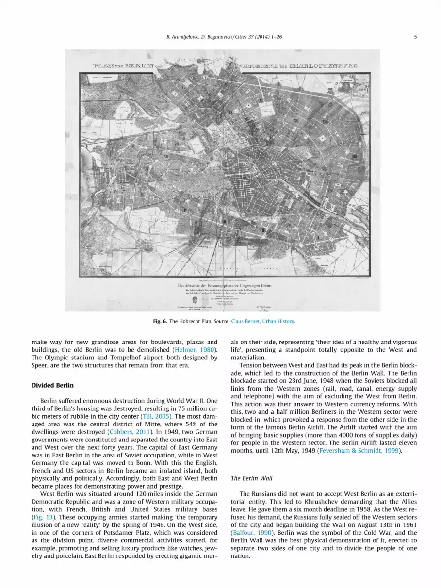
Fig. 6. The Hobrecht Plan. Source: Claus Bernet, Urban History.
B. Arandjelovic, D. Bogunovich / Cities 37 (2014) 1–26 5
make way for new grandiose areas for boulevards, plazas andbuildings, the old Berlin was to be demolished (Helmer, 1980).The Olympic stadium and Tempelhof airport, both designed bySpeer, are the two structures that remain from that era.
Divided Berlin
Berlin suffered enormous destruction during World War II. Onethird of Berlin’s housing was destroyed, resulting in 75 million cu-bic meters of rubble in the city center (Till, 2005). The most dam-aged area was the central district of Mitte, where 54% of thedwellings were destroyed (Cobbers, 2011). In 1949, two Germangovernments were constituted and separated the country into Eastand West over the next forty years. The capital of East Germanywas in East Berlin in the area of Soviet occupation, while in WestGermany the capital was moved to Bonn. With this the English,French and US sectors in Berlin became an isolated island, bothphysically and politically. Accordingly, both East and West Berlinbecame places for demonstrating power and prestige.
West Berlin was situated around 120 miles inside the GermanDemocratic Republic and was a zone of Western military occupa-tion, with French, British and United States military bases(Fig. 13). These occupying armies started making ‘the temporaryillusion of a new reality’ by the spring of 1946. On the West side,in one of the corners of Potsdamer Platz, which was consideredas the division point, diverse commercial activities started, forexample, promoting and selling luxury products like watches, jew-elry and porcelain. East Berlin responded by erecting gigantic mur-
als on their side, representing ‘their idea of a healthy and vigorouslife’, presenting a standpoint totally opposite to the West andmaterialism.
Tension between West and East had its peak in the Berlin block-ade, which led to the construction of the Berlin Wall. The Berlinblockade started on 23rd June, 1948 when the Soviets blocked alllinks from the Western zones (rail, road, canal, energy supplyand telephone) with the aim of excluding the West from Berlin.This action was their answer to Western currency reforms. Withthis, two and a half million Berliners in the Western sector wereblocked in, which provoked a response from the other side in theform of the famous Berlin Airlift. The Airlift started with the aimof bringing basic supplies (more than 4000 tons of supplies daily)for people in the Western sector. The Berlin Airlift lasted elevenmonths, until 12th May, 1949 (Feversham & Schmidt, 1999).
The Berlin Wall
The Russians did not want to accept West Berlin as an exterri-torial entity. This led to Khrushchev demanding that the Alliesleave. He gave them a six month deadline in 1958. As the West re-fused his demand, the Russians fully sealed off the Western sectorsof the city and began building the Wall on August 13th in 1961(Balfour, 1990). Berlin was the symbol of the Cold War, and theBerlin Wall was the best physical demonstration of it, erected toseparate two sides of one city and to divide the people of onenation.

Fig. 7. The Greater-Berlin area around 1914. The plan shows the dense inner-city ring around the city center and the expanding neighboring areas. Between are green areas.Source: Hofmeister (1985): Berlin. Beiträge zur Geographie eines Großstadtraums.
Fig. 8. Central part of the Speer Plan, view towards the north, model made ca. 1940.Source: Helmer, Stephen (1980): Plans for Reshaping the Central City Developed byAlbert Speer.
6 B. Arandjelovic, D. Bogunovich / Cities 37 (2014) 1–26
In the period between 1949 and 1961 the GDR lost almost 10%of its population, reducing it from over 19 million in 1949 to 17million in 1961. An enormous exodus happened between Januaryand June 1961 when over 100,000 left (Schmidt & von Preuschen,2005). The situation was even worse in July and August when over1000 people left every day. The problem was bigger than just aneconomic crash. It was about the political system and was furthernegative propaganda for the GDR. The Soviets saw the physicalbarricade and sealing the border as the only possible solution forthe situation. The Berlin Wall was actually the guarantee of stabil-ity during the Cold War, both sides were aware of that. The Westaccepted the Berlin Wall. Interfering would present a major risk(Loeb, 2006).
There were extreme differences in how people experienced theWall because West Berliners were allowed to interact freely withit, while East Berliners were not permitted to approach it. Eventhe name of the Wall had different versions, simply Die Mauer(Wall) in the West, while it was known as Antifaschistischer Schutz-wall (the ‘antifascist protection rampart’) in the East. West Berlin-ers could touch it and write or paint graffiti on it while on the otherside, anyone showing interest in approaching the Wall was consid-ered suspicious (Feversham & Schmidt, 1999) (see Figs. 9, 10 and12).
With this, ‘the city was cut in half, both physically and politi-cally’ (Biswas & Kumar, 2000). On the tourist map of East Berlin,the West was marked with just traces of lines showing major roadsand the city rail system (Fig. 15). The official Senate map of WestBerlin could be described as total fantasy, with no acknowledg-ment of the Wall, and trolley cars running empty through Potsd-amer Platz. The Wall, the symbol of the Cold War, was guardedby 260 watchtowers along the border ring. The ring around WestBerlin was 102.5 miles in length and divided East and West Berlinfor 28 years, from 1961 until 1989. Concrete slabs topped with
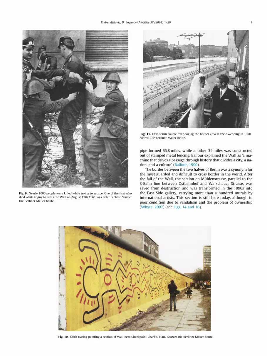
Fig. 9. Nearly 1000 people were killed while trying to escape. One of the first whodied while trying to cross the Wall on August 17th 1961 was Peter Fechter. Source:Die Berliner Mauer heute.
Fig. 10. Keith Haring painting a section of Wall near Check
Fig. 11. East Berlin couple overlooking the border area at their wedding in 1970.Source: Die Berliner Mauer heute.
B. Arandjelovic, D. Bogunovich / Cities 37 (2014) 1–26 7
pipe formed 65.8 miles, while another 34 miles was constructedout of stamped metal fencing. Balfour explained the Wall as ‘a ma-chine that drives a passage through history that divides a city, a na-tion, and a culture’ (Balfour, 1990).
The border between the two halves of Berlin was a synonym forthe most guarded and difficult to cross border in the world. Afterthe fall of the Wall, the section on Mühlenstrasse, parallel to theS-Bahn line between Ostbahnhof and Warschauer Strasse, wassaved from destruction and was transformed in the 1990s intothe East Side gallery, carrying more than a hundred murals byinternational artists. This section is still here today, although inpoor condition due to vandalism and the problem of ownership(Whyte, 2007) (see Figs. 14 and 16).
point Charlie, 1986. Source: Die Berliner Mauer heute.
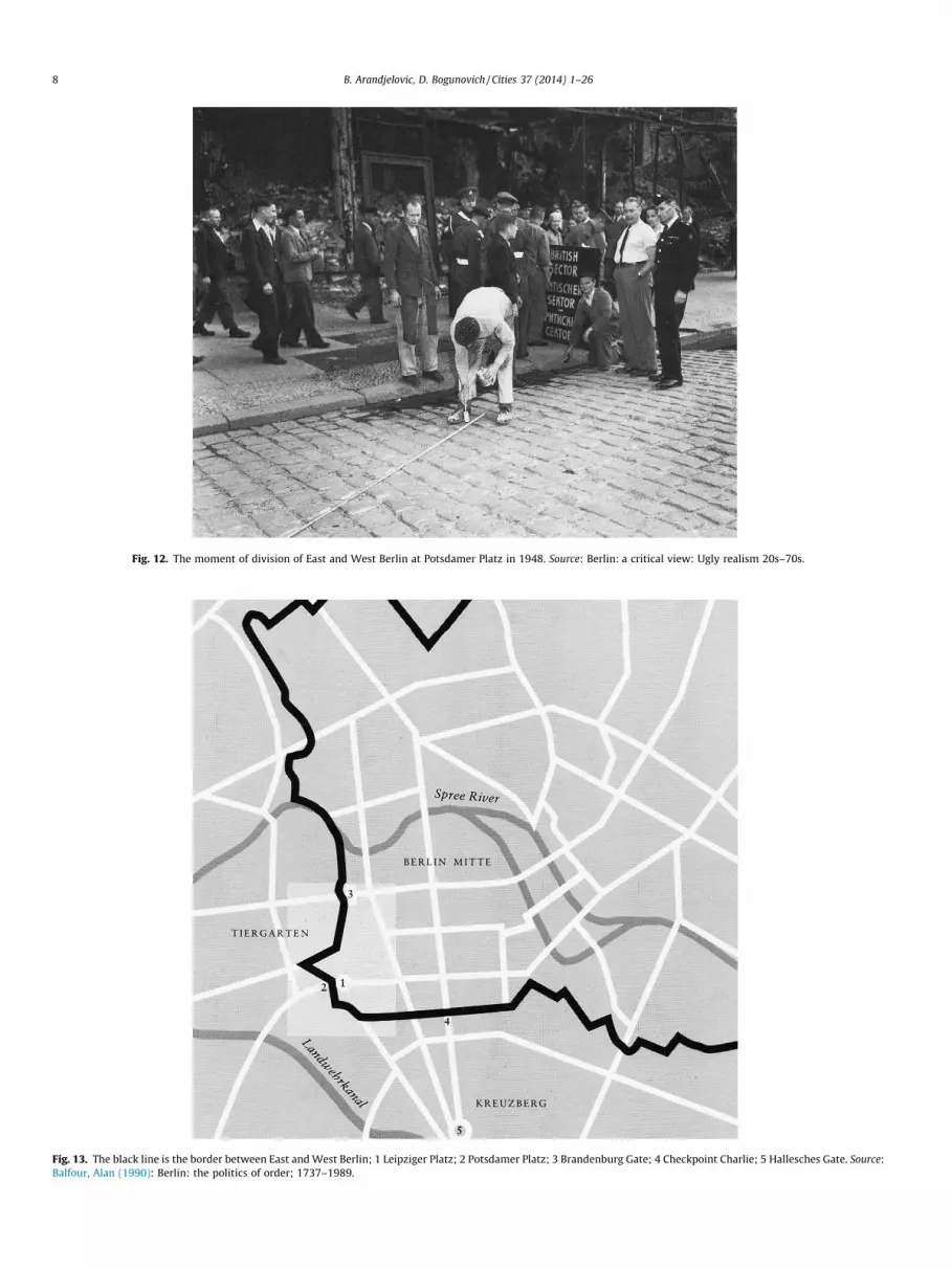
Fig. 12. The moment of division of East and West Berlin at Potsdamer Platz in 1948. Source: Berlin: a critical view: Ugly realism 20s–70s.
Fig. 13. The black line is the border between East and West Berlin; 1 Leipziger Platz; 2 Potsdamer Platz; 3 Brandenburg Gate; 4 Checkpoint Charlie; 5 Hallesches Gate. Source:Balfour, Alan (1990): Berlin: the politics of order; 1737–1989.
8 B. Arandjelovic, D. Bogunovich / Cities 37 (2014) 1–26
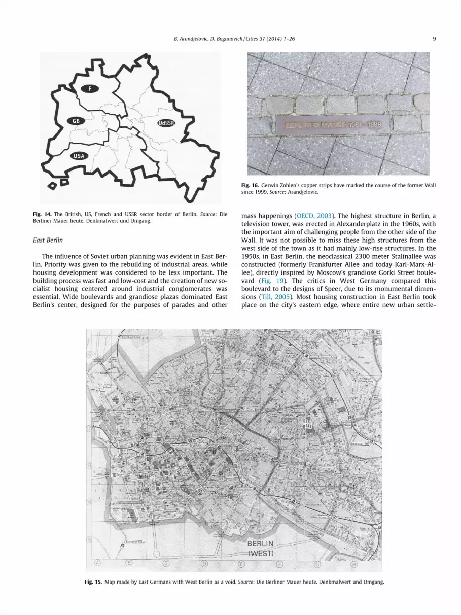
Fig. 14. The British, US, French and USSR sector border of Berlin. Source: DieBerliner Mauer heute. Denkmalwert und Umgang.
Fig. 16. Gerwin Zohlen’s copper strips have marked the course of the former Wallsince 1999. Source: Arandjelovic.
B. Arandjelovic, D. Bogunovich / Cities 37 (2014) 1–26 9
East Berlin
The influence of Soviet urban planning was evident in East Ber-lin. Priority was given to the rebuilding of industrial areas, whilehousing development was considered to be less important. Thebuilding process was fast and low-cost and the creation of new so-cialist housing centered around industrial conglomerates wasessential. Wide boulevards and grandiose plazas dominated EastBerlin’s center, designed for the purposes of parades and other
Fig. 15. Map made by East Germans with West Berlin as a void. S
mass happenings (OECD, 2003). The highest structure in Berlin, atelevision tower, was erected in Alexanderplatz in the 1960s, withthe important aim of challenging people from the other side of theWall. It was not possible to miss these high structures from thewest side of the town as it had mainly low-rise structures. In the1950s, in East Berlin, the neoclassical 2300 meter Stalinallee wasconstructed (formerly Frankfurter Allee and today Karl-Marx-Al-lee), directly inspired by Moscow’s grandiose Gorki Street boule-vard (Fig. 19). The critics in West Germany compared thisboulevard to the designs of Speer, due to its monumental dimen-sions (Till, 2005). Most housing construction in East Berlin tookplace on the city’s eastern edge, where entire new urban settle-
ource: Die Berliner Mauer heute. Denkmalwert und Umgang.

Fig. 17. The symbolic Alexanderplatz Television Tower (Fernsehturm) in the background. Source: Arandjelovic.
Fig. 18. Alexanderplatz. Source: Arandjelovic.
10 B. Arandjelovic, D. Bogunovich / Cities 37 (2014) 1–26
ments were constructed, some of them in the districts of Marzahnor Hellersdorf (see Figs. 17 and 18).
West Berlin
The commercial city center, before World War II, stretched fromPotsdamer Platz in the west to Alexanderplatz in the east. AfterWorld War II, this area was soon intersected by the border. Withthis, a big part of the traditional city center, together with numer-ous historical buildings, found themselves in East Berlin. For this
reason, it was necessary to make some kind of compensation fortheir absence, but to do it carefully because West Berlin did notwant to suggest that they saw the division as permanent. Berlin’scenturies old development trajectory had been a continual move-ment westward. Kurfürstendamm was developed into a represen-tative Boulevard during the 1920s after becoming a leading tradeand entertainment center. This area was built at the beginning ofthe 20th century as an upper class residential district with someof the highest land prices in Berlin. After the division of Berlin,and even more so after 1970, Zoologischer Garten train station

Fig. 19. Today Karl-Marx-Alle, previously Stalinallee in East Berlin (left).
Fig. 20. Hansaviertel (Hansa District) in West Berlin (right). Source: Bodenschatz(2010).
Fig. 21. Walter Gropius Haus in Händelallee in Hansaviertel (Hansa District).Source: Arandjelovic.
B. Arandjelovic, D. Bogunovich / Cities 37 (2014) 1–26 11
and the Kurfürstendamm area, became the center of West Berlin,with numerous businesses and entertainment services. Also, thisarea had great public transport connections (Balfour, 1990).
Hansaviertel (Hansa District), an area in the northwest part ofTiergarten, was the showcase of German design in West Berlin atthe Interbau 1957 International Building Exhibition (in deliberatecontrast to Stalinallee). Oscar Niemeyer, Arne Jacobson, Alvar Alto,Walter Gropius and Willy Kreuer are just some of the famousnames of modernist architects whose buildings can be found inHansaviertel (Fig. 20). The Hansaviertel residential complex is animportant testimony to the modern architecture and urban plan-ning of the 1950s. The designs for 45 different architectural struc-tures were proposed then, of which 35 were implemented in theend. Most of the buildings stand as solitary blocks (Cobbers, 2011).
Also, there was a need for creating new cultural institutions toreplace the old ones that had stayed on the east side. The Westgovernment wanted to fill the empty space near the border andto make it visible from the east side. Architect Hans Scharounwas appointed in 1956 to design the Kulturforum (Cultural Forum),consisting of a major music hall, library, and arts museum (Web-ber, 2008). The most important project that represented West Ger-many’s Berlin was Hans Scharoun’s Philharmonic Hall from 1963, amodern building with symmetrical surfaces and curved roofs. Theother buildings forming the Kulturforum complex are the State Li-brary (Staatsbibliothek), the Chamber Music Concert Hall and Miesvan der Rohe’s New National Gallery (see Fig. 21).
Berlin after the fall of the Wall
The fall of the Berlin Wall started on November 9th, 1989, andin 1991 the German government voted to move the capital fromBonn to Berlin. Since then, Berlin has witnessed radical and monu-mental changes. In the years after unification it appeared possibleto reach the position of Paris or London.
It also happened that social housing urban development grants,in both parts of the former divided city, were withdrawn and thecompanies responsible for social housing construction lost theirinfluence. Onto the stage came private investors whose priority
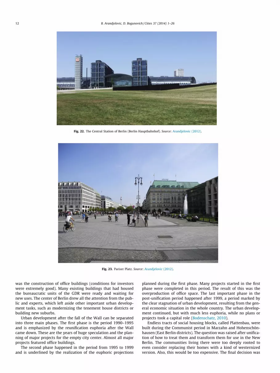
Fig. 22. The Central Station of Berlin (Berlin Hauptbahnhof). Source: Arandjelovic (2012).
Fig. 23. Pariser Platz. Source: Arandjelovic (2012).
12 B. Arandjelovic, D. Bogunovich / Cities 37 (2014) 1–26
was the construction of office buildings (conditions for investorswere extremely good). Many existing buildings that had housedthe bureaucratic units of the GDR were ready and waiting fornew uses. The center of Berlin drew all the attention from the pub-lic and experts, which left aside other important urban develop-ment tasks, such as modernizing the tenement house districts orbuilding new suburbs.
Urban development after the fall of the Wall can be separatedinto three main phases. The first phase is the period 1990–1995and is emphasized by the reunification euphoria after the Wallcame down. These are the years of huge speculation and the plan-ning of major projects for the empty city center. Almost all majorprojects featured office buildings.
The second phase happened in the period from 1995 to 1999and is underlined by the realization of the euphoric projections
planned during the first phase. Many projects started in the firstphase were completed in this period. The result of this was theoverproduction of office space. The last important phase in thepost-unification period happened after 1999, a period marked bythe clear stagnation of urban development, resulting from the gen-eral economic situation in the whole country. The urban develop-ment continued, but with much less euphoria, while no plans orprojects took a capital role (Bodenschatz, 2010).
Endless tracts of social housing blocks, called Plattenbau, werebuilt during the Communist period in Marzahn and Hohenschön-hausen (East Berlin districts). The question was raised after unifica-tion of how to treat them and transform them for use in the NewBerlin. The communities living there were too deeply rooted toeven consider replacing their homes with a kind of westernizedversion. Also, this would be too expensive. The final decision was
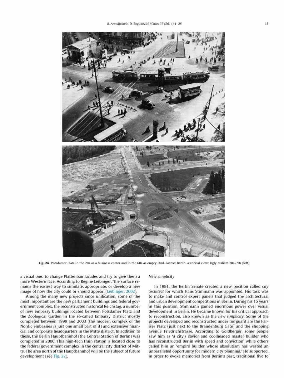
Fig. 24. Potsdamer Platz in the 20s as a business center and in the 60s as empty land. Source: Berlin: a critical view: Ugly realism 20s–70s (left).
B. Arandjelovic, D. Bogunovich / Cities 37 (2014) 1–26 13
a visual one: to change Plattenbau facades and try to give them amore Western face. According to Regine Leibinger, ‘the surface re-mains the easiest way to simulate, appropriate, or develop a newimage of how the city could or should appear’ (Leibinger, 2002).
Among the many new projects since unification, some of themost important are the new parliament buildings and federal gov-ernment complex, the reconstructed historical Reichstag, a numberof new embassy buildings located between Potsdamer Platz andthe Zoological Garden in the so-called Embassy District mostlycompleted between 1999 and 2003 (the modern complex of theNordic embassies is just one small part of it) and extensive finan-cial and corporate headquarters in the Mitte district. In addition tothese, the Berlin Hauptbahnhof (the Central Station of Berlin) wascompleted in 2006. This high-tech train station is located close tothe federal government complex in the central city district of Mit-te. The area north of the Hauptbahnhof will be the subject of futuredevelopment (see Fig. 22).
New simplicity
In 1991, the Berlin Senate created a new position called cityarchitect for which Hans Stimmann was appointed. His task wasto make and control expert panels that judged the architecturaland urban development competitions in Berlin. During his 15 yearsin this position, Stimmann gained enormous power over visualdevelopment in Berlin. He became known for his critical approachto reconstruction, also known as the new simplicity. Some of theprojects developed and reconstructed under his guard are the Par-iser Platz (just next to the Brandenburg Gate) and the shoppingavenue Friedrichstrasse. According to Goldberger, some peoplesaw him as ‘a city’s savior and coolheaded master builder whohas reconstructed Berlin with speed and conviction’ while otherscalled him an ‘empire builder whose absolutism has wasted anunparalleled opportunity for modern city planning.’ He supported,in order to evoke memories from Berlin’s past, traditional five to

Fig. 25. Business and entertainment center Potsdamer Platz today. Source:Arandjelovic.
14 B. Arandjelovic, D. Bogunovich / Cities 37 (2014) 1–26
six storey buildings made of stone, while high-rise constructionswith glass and metal facades were rejected. For Stimmann andall others who shared his views, the aim of central city redevelop-ment must be a critical reconstruction of the existing urban fabric
Fig. 26. Potsdamer Platz tod
rather than the kind of radical restructuring that has been favoredby modernist architects. He directed projects covering more than1830 ha and was known for being afraid that ‘uncontrolled devel-opment would produce a forest of skyscrapers’ (Goldberger, 1995)(see Fig. 23).
Potsdamer Platz
The area of Potsdamer Platz has always had importance throughhistory, and even more so after unification, not just as urban spacebut also as a stage for political activities. Potsdamer Gate was thecity entry from the road to Potsdam and one of three major gates.The next important function of this area was in the 19th centurywhen two of the main railway termini were built – the PotsdamerBahnhof and the Anhalter Bahnhof. During the Weimar Republicthe cosmopolitan Potsdamer Platz was an economic center ofpower, but also a bohemian center (Fig. 24) which was sometimescompared with New York. Later, Potsdamer Platz was the NationalSocialist’s center of power. In World War II the area was heavilydevastated, and soon after it became a black market area. Postd-amer Platz was constantly used as a stage for political confronta-tion, an example of which is the Berlin workers’ demonstrationswhich took place in 1953, and were crushed by Soviet tanks. After1961 the area of Potsdamer Platz became a deserted strip in themiddle of the Berlin Wall, often called no man’s land (Fig. 24)(Caygill, 1992).
Potsdamer Platz was, in 1993, an empty space before emergingas Europe’s biggest construction site in 1994. Just after the Wallcame down, Daimler Benz decided to locate its new service divi-sion, Debis, in Berlin. This was the first major international com-pany to choose Berlin for its headquarters since before WorldWar II. Soon after, Sony bought land just next to Debis to buildits new European headquarters (the complex was finished in thesummer of 2000).
The main aim of the government was to attract powerful inter-national firms, even if it meant lowering the price of the land. Theexpectations were that these wealthy firms would start bringingthousands of highly skilled jobs to Berlin. The Debis complex, fea-
ay. Source: Arandjelovic.

Fig. 27. Potsdamer Platz today. Source: Arandjelovic.
Fig. 28. The memorial to the murdered Jews of Europe. Source: Arandjelovic (2012).
B. Arandjelovic, D. Bogunovich / Cities 37 (2014) 1–26 15
turing 19 buildings, was the first to be realized in October 1998. Itincluded 50% office space, 20% housing, and 30% retail and enter-tainment facilities (Huyssen, 2003) (see Figs. 25–27).
Memorials
According to Andreas Huyssen, Germany has engaged in amemory mania of truly monumental proportions. Since the1980s there have been several hundred plans for Holocaust memo-rial sites all over Germany (Huyssen, 2003), the most famous ofthem being Berlin’s Holocaust Memorial (Fig. 11). Its constructionbegan in 2002 in a large empty space on the western edge of thehistorical district and the east side of the large city park, Tiergarten.The location is in the residential district of Berlin Mitte in the for-mer East, between the Reichstag and Potsdamer Platz, south of thenew American Embassy and just next to Brandenburg gate. Berlin’sHolocaust Memorial construction was finished in 2005. Designedby American architect Peter Eisenman, this field of 2700 concretestelae of different heights (from about one and one-half feet to
about ten feet tall) is set up in a grid pattern on a 19,000 squaremeter plot. The memorial is open to the public day and nightand consists of two parts, an underground informational centerand grid patterned concrete stelae (Glazer & Mark, 1987). It at-tracts around 10,000 visitors per day and has thus turned into animportant tourist sight in Berlin (Richter, 2010). ‘If it had been lo-cated on a less sensitive site the effect would have been softened.By being located so close to the Reichstag, it became a silent remin-der of the past and events better not forgotten’ (Jodidio, 2005). Theinformation center was designed by Dagmar von Wilcken. Thespace contains a Room of Names with Yad Vashem’s database ofall known names of Jews murdered in the Holocaust, a Room ofFates with photographic stories and a Room of Sites. Being at thislocation with no formal place of entrance or exit, visitors are in-vited to find their own way in and out of the field, which mayevoke rethinking of the past.
Another example of Berlin memorials is the Jewish Museumdesigned by Daniel Libeskind, a museum dedicated to the historyof Berlin Jews located in the vicinity of Potsdamer Platz. The mod-

Fig. 29. The commemorative site is located at Bernauer Straße. The steel installation is raised in a body of 7-m tall walls which spread to a length of 70 m and follow the pathwhere the Wall used to be. Source: Arandjelovic (2012).
16 B. Arandjelovic, D. Bogunovich / Cities 37 (2014) 1–26
ern silver building of the museum, organized around three inter-secting axes and five spatial voids, was opened to the public in1999, and at that time was merely a building without exhibitions.The unusual building with angular walls and an irregular shapeimmediately gained the attention of visitors. ‘In spite of its defi-nition as a museum, the architect’s intention is that, in its sym-bolic centre, the building remains empty. The buildingrepresents in architectural form the architect’s message aboutthe irreparable absence of murdered human beings and their cul-ture’ (Sewing, 2004). In order to enter, visitors must first gothrough the old Berlin museum, located in a yellow 18th centurybaroque building, the last standing structure of its time. The three
intersecting axes symbolize the axis of exile, the Holocaust axisand the axis of continuity. According to Karen Till ‘the JewishMuseum is created of voids and voided voids, empty spaces thatcan be seen but not physically accessed’ (Till, 2005) (see Fig. 28and 29).
Federal government complex
After unification, the land north of the Reichstag was plannedfor a new government complex. A whole series of plans was madefor this location through the first part of the 20th century, such as agovernment complex plan similar to the Federal Triangle in Wash-

Fig. 30. Wrapped Reichstag by Christo and Jeanne-Claude in Berlin 1995. Source: Wolfgang Volz; Fig. 22.
Fig. 31. The Reichstag today. Source: Arandjelovic.
B. Arandjelovic, D. Bogunovich / Cities 37 (2014) 1–26 17
ington. The Reichstag building is now the epicenter for a new gov-ernment complex, designed by the architects Axel Schultes andCharlotte Frank from 1997 to 2000 (Whyte, 2007). Their task wasto reconstruct the whole area around the meander of the Spree,previously destroyed during WWII. This complex includes the Fed-eral Chancellery, a monumental Federal building that contains theChancellor and state Ministers’ offices as well as conference andcabinet rooms. The Paul Löbe building and Marie Elisabeth Lüdersbuilding (right across the river) host the offices for parliamentari-
ans. Two pedestrian bridges over the river Spree connect these twobuildings, both situated alongside the river.
The symbol of German reunification, the Reichstag, left dome-less after the fire in 1933, was renovated in 1971 by architectWeingarten after being heavily damaged in World War II. The mostrecent renovation was by Norman Foster and Partners after theywon the second stage of a competition for the Reichstag recon-struction in 1992 (Fig. 31). The main attraction of the recon-structed Reichstag is a glass cupola, a physical source of daylight

Fig. 32. Paul Löbe building. Source: Arandjelovic.
Fig. 33. The Reichstag cupola, inside view. Source: Arandjelovic.
18 B. Arandjelovic, D. Bogunovich / Cities 37 (2014) 1–26
to the building interior. With the opening of the glass dome, peoplecould look down at their elected representatives. The aim was toshow a modern and transparent Germany. Tourists are allowedand welcome to enter the building and to take a lift up to the roofterrace and glass dome. The Reichstag building is, with three mil-lion visitors per year, one of the most popular tourist sites in Berlinwith about 30% of its area available to tourists (Richter, 2010).
The veiling of the Reichstag by artists Christo and Jeanne-Claude happened in 1995 (Fig. 30). They covered the entire Reich-stag with 100,000 square meters of silver polypropylene fabric forfourteen days. Being temporarily invisible, this event ‘raised a cityabove usual cares and had transported it to another plane’ (Biswas& Kumar, 2000). Andreas Huyssen described it as ‘serenely and attimes uncannily beautiful’ and noticed that the public discussionsabout the history and meaning of the Reichstag were never moreintense than during the debates in parliament and in the publicabout the quality of Christo’s project (Huyssen, 2003). At that mo-ment, the Reichstag was more visible than ever (see Figs. 32–37).
Demography
Today, Berlin is the capital city of Germany, and with approxi-mately 3.4 million inhabitants (40% of Berlin’s population is youn-ger than 35 years, many of whom are newcomers) and 892 km2, itis the largest city in Germany. Berlin is a very dynamic city. Figuresfrom the Berlin-Brandenburg Statistical Office show us that147,769 people moved to Berlin in 2010 while at the same time130,951 moved away. Young people make the majority of new-comers and in 2010 as many as 68% of all the new arrivals in thatyear were people younger than 33.
The 23 former districts of Berlin merged into 12 in the year2000. According to the Senate Department for Urban Developmentand the Environment statistical base from 2012, Berlin’s entire ur-ban area population density is 37 p/ha, while in the city center,within the Inner Rapid-Railway Circle (S-Bahn), the density is111.5 p/ha (the inner city districts Tiergarten, Wedding, Mitte,Prenzlauer Berg and Kreuzberg/Friedrichshain had their greatest
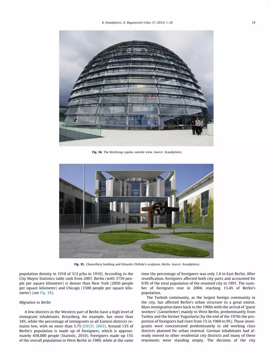
Fig. 34. The Reichstag cupola, outside view. Source: Arandjelovic.
Fig. 35. Chancellery building and Eduardo Chillida’s sculpture, Berlin. Source: Arandjelovic.
B. Arandjelovic, D. Bogunovich / Cities 37 (2014) 1–26 19
population density in 1910 of 312 p/ha in 1910). According to theCity Mayor Statistics table rank from 2007, Berlin (with 3759 peo-ple per square kilometer) is denser than New York (2050 peopleper square kilometer) and Chicago (1500 people per square kilo-meter) (see Fig. 38).
Migration to Berlin
A few districts in the Western part of Berlin have a high level ofimmigrant inhabitants. Kreuzberg, for example, has more than34%, while the percentage of immigrants in all Eastern districts re-mains low, with no more than 5.7% (OECD, 2003). Around 13% ofBerlin’s population is made up of foreigners, which is approxi-mately 458,000 people (Statistic, 2010). Foreigners made up 15%of the overall population in West Berlin in 1989, while at the same
time the percentage of foreigners was only 1.6 in East Berlin. Afterreunification, foreigners affected both city parts and accounted for9.9% of the total population of the reunited city in 1991. The num-ber of foreigners rose in 2004, reaching 13.4% of Berlin’spopulation.
The Turkish community, as the largest foreign community inthe city, has affected Berlin’s urban structure to a great extent.Mass immigration dates back to the 1960s with the arrival of ‘guestworkers’ (Gastarbeiter) mainly to West Berlin, predominantly fromTurkey and the former Yugoslavia (by the end of the 1970s the pro-portion of foreigners had risen from 1% in 1960 to 9%). Those immi-grants were concentrated predominately in old working classdistricts planned for urban renewal. German inhabitants had al-ready moved to other residential city districts and many of thesetenements were standing empty. The decision of the city

Fig. 36. View from Norman Foster’s glass dome at the Reichstag towards the Berlin Mitte district. Source: Arandjelovic.
Fig. 37. The new Parliamentary and Government Quarter development areas integrated into the historical city. Source: Photo Falcon Crest GmbH, DSK Deutsche Stadt- undGrundstücksentwicklungsgesellschaft 2006 (Senat for Urban Develpment).
20 B. Arandjelovic, D. Bogunovich / Cities 37 (2014) 1–26
government was to house new immigrants in those districts. Thus,the city districts of Kreuzberg and Wedding were the first to be-come predominantly inhabited by foreigners. These ethnic districtshave remained their home and are home also to the second gener-ations and to new immigrants as a result of good ethnic networks.Also, a change in urban renewal policy planned for these districtscontributed this process. Plans for demolition were predominantlystopped, and the process of renewing and maintaining existing oldtenements began without relocating their sitting inhabitants or‘guest workers’ (Gastarbeiter). Also, after reunification and changesin the housing market in Berlin, non-German inhabitants had achance to move into areas with increasing numbers of vacantand cheap apartments. The consequence of this process is thecreation of new foreign neighborhoods in Berlin with 35–55% offoreign inhabitants (for example in Reuterkiez, Britz orRudow neighborhoods in the Neukölln district) (Neill & Schwedler,2006).
Tourism
Berlin is the most visited tourist destination in Germany andhas reached the top three most visited places in Europe, after Parisand London. Berlin has the international reputation of being a con-ference and trade fair center, and now, the east part of the town isexperiencing a boom regarding its newly built hotel capacities. In2008, for the first time, 8 million arrivals and 18 million overnightstays were registered, meaning that the number of tourists arrivingin Berlin has more than doubled in the last 10 years (Richter, 2010).With approximately 20.8 million overnight stays as well as 9.1 mil-lion guests, the city has broken its own record. Statistics show 9.5%more arrivals of guests and 10.2 % more overnights than in 2009(Statistic, 2010). Even more recently, the Berlin-Brandenburg Sta-tistics Office reported that tourists spent 2,432,428 nights in Berlinduring October 2012, which is an increase of 8.5% for the samemonth in 2011 (www.visit.berlin.de).
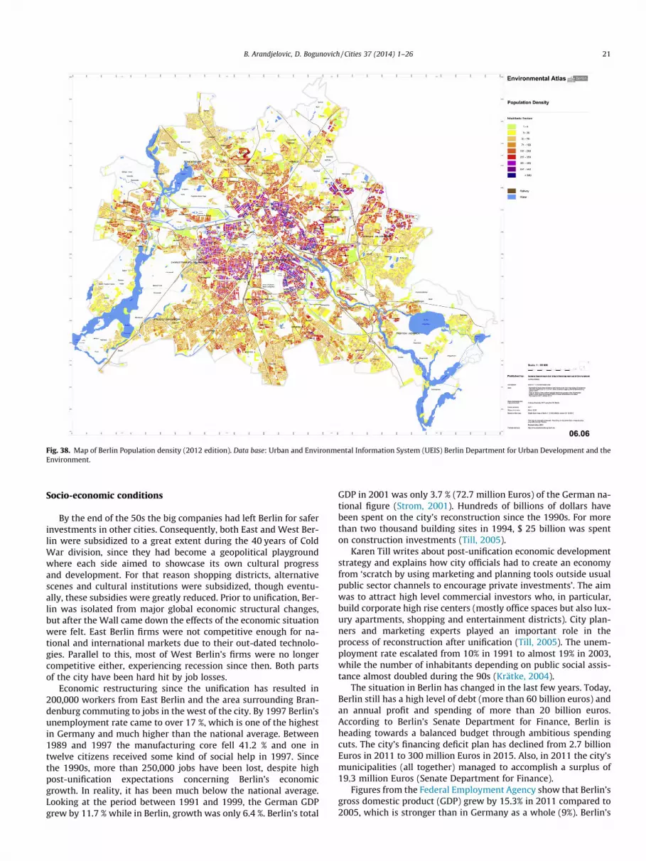
Fig. 38. Map of Berlin Population density (2012 edition). Data base: Urban and Environmental Information System (UEIS) Berlin Department for Urban Development and theEnvironment.
B. Arandjelovic, D. Bogunovich / Cities 37 (2014) 1–26 21
Socio-economic conditions
By the end of the 50s the big companies had left Berlin for saferinvestments in other cities. Consequently, both East and West Ber-lin were subsidized to a great extent during the 40 years of ColdWar division, since they had become a geopolitical playgroundwhere each side aimed to showcase its own cultural progressand development. For that reason shopping districts, alternativescenes and cultural institutions were subsidized, though eventu-ally, these subsidies were greatly reduced. Prior to unification, Ber-lin was isolated from major global economic structural changes,but after the Wall came down the effects of the economic situationwere felt. East Berlin firms were not competitive enough for na-tional and international markets due to their out-dated technolo-gies. Parallel to this, most of West Berlin’s firms were no longercompetitive either, experiencing recession since then. Both partsof the city have been hard hit by job losses.
Economic restructuring since the unification has resulted in200,000 workers from East Berlin and the area surrounding Bran-denburg commuting to jobs in the west of the city. By 1997 Berlin’sunemployment rate came to over 17 %, which is one of the highestin Germany and much higher than the national average. Between1989 and 1997 the manufacturing core fell 41.2 % and one intwelve citizens received some kind of social help in 1997. Sincethe 1990s, more than 250,000 jobs have been lost, despite highpost-unification expectations concerning Berlin’s economicgrowth. In reality, it has been much below the national average.Looking at the period between 1991 and 1999, the German GDPgrew by 11.7 % while in Berlin, growth was only 6.4 %. Berlin’s total
GDP in 2001 was only 3.7 % (72.7 million Euros) of the German na-tional figure (Strom, 2001). Hundreds of billions of dollars havebeen spent on the city’s reconstruction since the 1990s. For morethan two thousand building sites in 1994, $ 25 billion was spenton construction investments (Till, 2005).
Karen Till writes about post-unification economic developmentstrategy and explains how city officials had to create an economyfrom ‘scratch by using marketing and planning tools outside usualpublic sector channels to encourage private investments’. The aimwas to attract high level commercial investors who, in particular,build corporate high rise centers (mostly office spaces but also lux-ury apartments, shopping and entertainment districts). City plan-ners and marketing experts played an important role in theprocess of reconstruction after unification (Till, 2005). The unem-ployment rate escalated from 10% in 1991 to almost 19% in 2003,while the number of inhabitants depending on public social assis-tance almost doubled during the 90s (Krätke, 2004).
The situation in Berlin has changed in the last few years. Today,Berlin still has a high level of debt (more than 60 billion euros) andan annual profit and spending of more than 20 billion euros.According to Berlin’s Senate Department for Finance, Berlin isheading towards a balanced budget through ambitious spendingcuts. The city’s financing deficit plan has declined from 2.7 billionEuros in 2011 to 300 million Euros in 2015. Also, in 2011 the city’smunicipalities (all together) managed to accomplish a surplus of19.3 million Euros (Senate Department for Finance).
Figures from the Federal Employment Agency show that Berlin’sgross domestic product (GDP) grew by 15.3% in 2011 compared to2005, which is stronger than in Germany as a whole (9%). Berlin’s

Fig. 39. An example of old-new fusion in Mitte is a five-storey building of KochOberhuber Wolff Gallery in Brunnenstraße, built in 2009 (this area of Bru-nnenstraße was the first area to be reconstructed after the Wall came down).Source: Arandjelovic.
Fig. 40. Ohne Titel art work at Checkpoint Charlie by Frank Thiel. Checkpoint Charliewas the best known border-crossing in the divided city and it served as the mainentrance as well as the departure point to East Berlin for non-Germans, diplomatsand journalists who were allowed to enter the Eastern part on a day visa. On oneside of the box is an American soldier and on the other a Russian, symbolizing theborderline and historical place of separation. Source: Arandjelovic.
22 B. Arandjelovic, D. Bogunovich / Cities 37 (2014) 1–26
GDP was long down after the fall of the Wall but in the last fewyears Berlin has constantly been among the regions with the high-est growth rates in the country. There was also a 13.5% increase innew jobs in Berlin for the period from 2005 to 2011, higher againthan in Germany as a whole (8.55%). According to the Berlin-Bran-denburg Statistics Office, Berlin export grew in 2011 by 5.8% com-pared with previous years. Berlin’s industrial sector is goingthrough a period of big structural changes which have brought ITand creative industries into a leading position. Thanks to thebeBerlin city marketing campaign which has the aim of promotingthe city as an investment location, Berlin has had more new busi-ness start-ups than any other German state in the last few years.Also, the unemployment rate in Berlin is correspondingly falling(Berlin-Brandenburg Statistic Office, 2012).
Creative City Berlin
UNESCO awarded Berlin with the title City of Design in 2006.With this Berlin was the first and until 2011, when Graz joinedthe network, the only European city with this status. One of thebenefits of being a UNESCO City of Design is the creation of anidentifiable visual identity in the world (Arandjelovic, 2012). Theconcept of a city of talents and a Creative City is related to RichardFlorida’s work on The Rise of the Creative Class (Florida, 2002).
Recent economic restructuring in Western Europe and NorthAmerica shows the tendency that creative industries have the po-tential to become an important basis for a prosperous urban
economy. The notion of creative industries applies to people en-gaged in science and research, design, visual arts, media, engineer-ing, various cultural productions or the music industry, thusmaking a force with great potential, especially in cities sufferingfrom a fall of their traditional industrial base, such as Berlin(Krätke, 2004).
The creative industries sector plays a significant role in Berlintoday with around 30,000 companies and a staff of over 220,000people, making 10% of Berlin’s working population and bringingan annual profit of around 20 billion Euros. Figures from BusinessLocation Berlin show that Media and IT clusters have around17,000 companies with over 170,000 staff (Rosenthaler Platz inBerlin Mitte district has become the center of IT start-ups overthe past years). One-fifth of the existing 3400 advertising and PRagencies were founded after 2000 and more than 8000 companiesthat are practicing in the domain of design, architecture and adver-tising create an annual profit of 1.6 billion Euros. Berlin has becomean important center of the music scene in recent years and home toUniversal Music Germany, Sony Classics and Sony Music Entertain-ment, EMI and others. Around 2100 companies with more than16,000 staff bring an annual profit of almost 700 million Euros.In 2007, the Berlin State Investment Bank established a capitalfund for the creative industries, VC Fonds Kreativwirtschaft Berlin.Recent developments of start-ups in the web and social media haveplaced Berlin in some of the leading positions in Germany. Since2004 Berlin has become attractive to the young IT creative sceneand in 2005 an initial master plan for an IT Location Strategy inBerlin was made. Today it has about 12 technology parks and 29start-up centers (according to Location Strategy Berlin the softwareindustry estimates around 3600 companies with approximately27,000 employees). Google, eBay and the Wikimedia Foundation
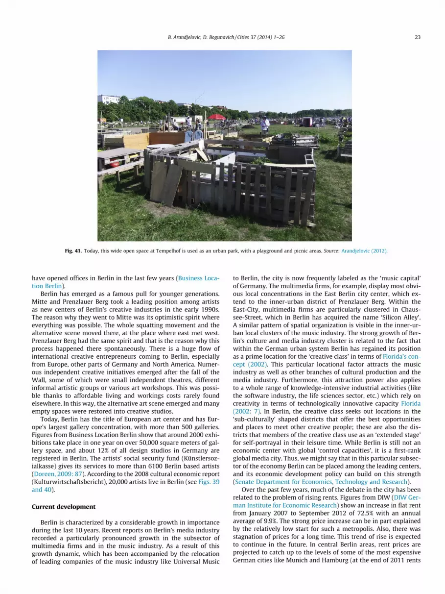
Fig. 41. Today, this wide open space at Tempelhof is used as an urban park, with a playground and picnic areas. Source: Arandjelovic (2012).
B. Arandjelovic, D. Bogunovich / Cities 37 (2014) 1–26 23
have opened offices in Berlin in the last few years (Business Loca-tion Berlin).
Berlin has emerged as a famous pull for younger generations.Mitte and Prenzlauer Berg took a leading position among artistsas new centers of Berlin’s creative industries in the early 1990s.The reason why they went to Mitte was its optimistic spirit whereeverything was possible. The whole squatting movement and thealternative scene moved there, at the place where east met west.Prenzlauer Berg had the same spirit and that is the reason why thisprocess happened there spontaneously. There is a huge flow ofinternational creative entrepreneurs coming to Berlin, especiallyfrom Europe, other parts of Germany and North America. Numer-ous independent creative initiatives emerged after the fall of theWall, some of which were small independent theatres, differentinformal artistic groups or various art workshops. This was possi-ble thanks to affordable living and workings costs rarely foundelsewhere. In this way, the alternative art scene emerged and manyempty spaces were restored into creative studios.
Today, Berlin has the title of European art center and has Eur-ope’s largest gallery concentration, with more than 500 galleries.Figures from Business Location Berlin show that around 2000 exhi-bitions take place in one year on over 50,000 square meters of gal-lery space, and about 12% of all design studios in Germany areregistered in Berlin. The artists’ social security fund (Künstlersoz-ialkasse) gives its services to more than 6100 Berlin based artists(Doreen, 2009: 87). According to the 2008 cultural economic report(Kulturwirtschaftsbericht), 20,000 artists live in Berlin (see Figs. 39and 40).
Current development
Berlin is characterized by a considerable growth in importanceduring the last 10 years. Recent reports on Berlin’s media industryrecorded a particularly pronounced growth in the subsector ofmultimedia firms and in the music industry. As a result of thisgrowth dynamic, which has been accompanied by the relocationof leading companies of the music industry like Universal Music
to Berlin, the city is now frequently labeled as the ‘music capital’of Germany. The multimedia firms, for example, display most obvi-ous local concentrations in the East Berlin city center, which ex-tend to the inner-urban district of Prenzlauer Berg. Within theEast-City, multimedia firms are particularly clustered in Chaus-see-Street, which in Berlin has acquired the name ‘Silicon Alley’.A similar pattern of spatial organization is visible in the inner-ur-ban local clusters of the music industry. The strong growth of Ber-lin’s culture and media industry cluster is related to the fact thatwithin the German urban system Berlin has regained its positionas a prime location for the ‘creative class’ in terms of Florida’s con-cept (2002). This particular locational factor attracts the musicindustry as well as other branches of cultural production and themedia industry. Furthermore, this attraction power also appliesto a whole range of knowledge-intensive industrial activities (likethe software industry, the life sciences sector, etc.) which rely oncreativity in terms of technologically innovative capacity Florida(2002: 7). In Berlin, the creative class seeks out locations in the‘sub-culturally’ shaped districts that offer the best opportunitiesand places to meet other creative people; these are also the dis-tricts that members of the creative class use as an ‘extended stage’for self-portrayal in their leisure time. While Berlin is still not aneconomic center with global ‘control capacities’, it is a first-rankglobal media city. Thus, we might say that in this particular subsec-tor of the economy Berlin can be placed among the leading centers,and its economic development policy can build on this strength(Senate Department for Economics, Technology and Research).
Over the past few years, much of the debate in the city has beenrelated to the problem of rising rents. Figures from DIW (DIW Ger-man Institute for Economic Research) show an increase in flat rentfrom January 2007 to September 2012 of 72.5% with an annualaverage of 9.9%. The strong price increase can be in part explainedby the relatively low start for such a metropolis. Also, there wasstagnation of prices for a long time. This trend of rise is expectedto continue in the future. In central Berlin areas, rent prices areprojected to catch up to the levels of some of the most expensiveGerman cities like Munich and Hamburg (at the end of 2011 rents

Fig. 42. Mediaspree-Panorama. View for the bridge Oberbaumbrücke. From left Universal Music Germany, NH Hotel, MTV Central Europe, Labels buildings and Molecule Mansculpture. Source: Arandjelovic (2012).
Fig. 43. Molecule man with Oberbaumbrücke and Television Tower (Fernsehturm) in the background. Source: Arandjelovic (2012).
24 B. Arandjelovic, D. Bogunovich / Cities 37 (2014) 1–26
in Berlin reached an average of around 7.00 euros per square me-ter, while in Munich they were 12.30, and 10.90 euros in Hamburg)Kholodilin and Mense (2012).
Tempelhof airfield
The city center reconstruction has not been completed yet. Thedesign of the large complex on the waterfront of the river Spree inthe east part of the city is still the subject of controversy. Today,there are new urban challenges in the city. One of them is the
former airport, the open space at Berlin’s Tempelhof airport(Fig. 41). Tempelhof airport was built during the National Socialistperiod and was where Western flights landed during the Berlin Air-lift in 1948–49. It was closed a few years ago, leaving an openspace of over 300 ha, which has been open to the public sincespring 2008 and used as an urban park and picnic area. The Cityof Berlin bought this land in 2009 with a plan to integrate it intothe city structure as an inner city district. Currently, the GrünBerlin organization is responsible for handling events there (OpenSpace for the City of Future www.tempelhoferfreiheit.de).

Fig. 44. Badeschiff. Source: Arandjelovic (left); Hettlage (2004) (right).
B. Arandjelovic, D. Bogunovich / Cities 37 (2014) 1–26 25
Berlin Brandenburg airport
The discussion about a convenient airport for the new capital ofBerlin started just after reunification. The accepted conclusion wasthat Berlin needed a modern airport and as a result, planning forthe new Berlin-Brandenburg airport started in 1996 and construc-tion in 2006. The opening was planned for 2011 (it was originallymeant to open much earlier), but due to frequent delays has beenpostponed as it is still not functional. Berlin had three small air-ports: the Tempelhof (which is now closed), Tegel, which is usedtoday as the main city airport until the new Berlin-Brandenburgopens and which served as the airport for the three western Alliesin West Berlin and Schönefeld in the eastern part of the city whichserved as the airport for East Berlin. The location of the new Berlin-Brandenburg airport is in the Schönefeld district, just south ofSchönefeld airport. The new Berlin-Brandenburg airport has beenbuilt for a capacity of around 27 million passengers per year.
Media Spree (Berlin Harbor City)
Starting as a private sector marketing company in 2002, MediaSpree, located in the industrial areas of Friedrichshain, was trans-formed in 2005 into the non-profit company Media Spree Region-almanagement. Media Spree now represents 19 large estatecompanies and property owners, including local and federal gov-ernment owned companies. The old industrial areas of Friedrichsh-ain were handed to a large investor who renovated them and thenlet them to high-profit creative and service companies. An exampleof this is the Osthafen warehouse on the east harbor on the Spreeriver front in southern Friedrichshain that today hosts the Univer-sal Music German headquarters, and has done so since 2002. Both
Universal Music and MTV Networks Germany are largely subsi-dized by the Berlin government. Another example is OberbaumCity, also a part of Media Spree, a former large light bulb factorybuilt during the Industrial Revolution in the 1920s. This complexnow features five individual buildings, rented mainly to servicecompanies, with a total of 83,000 square meters of reconstructedusable space. The BASF Shared Service Center set up office therein August 2005 (Shaw & Porter, 2009).
The Media Spree development project includes all the buildingsmentioned here. This project is an area 3.7 km long, covering180 ha, reaching both sides of the Spree River from Jannowitzbrücketo Elsenbrücke. This area stretches along Friedrichshain/Kreuzbergand Mitte city districts. Indeed, the waterfront development projectis eight times larger than Potsdamer Platz and is considered to be thelargest urban development project since reunification. With this, thecity center is going even more eastwards. Also part of the MediaSpree complex are the O2 World multifunctional arena opened in2008, the Panorama bar/Berghain, Watergate, Fritzclub im Post-bahnhof and the Radialsystem (Doreen, 2009). There are big devel-opment plans for the future of this area.
However, the Media Spree development has created big pro-tests among the public, not only because of the dislocation ofnon-profit usage in favor of extremely commercial businesses,but also due to the privatization of public space at the riverfront.The citizens’ initiative Media Spree Versenken, was founded andstarted collecting signatures in 2007 in order to stop further com-mercial businesses development. They demand a wider public riv-er front of 50 m with no new skyscrapers and a car ban for theplanned new bridge.
Time will reveal what the future decisions of the city govern-ment will bring into this historic area (see Figs. 42 and 43).
26 B. Arandjelovic, D. Bogunovich / Cities 37 (2014) 1–26
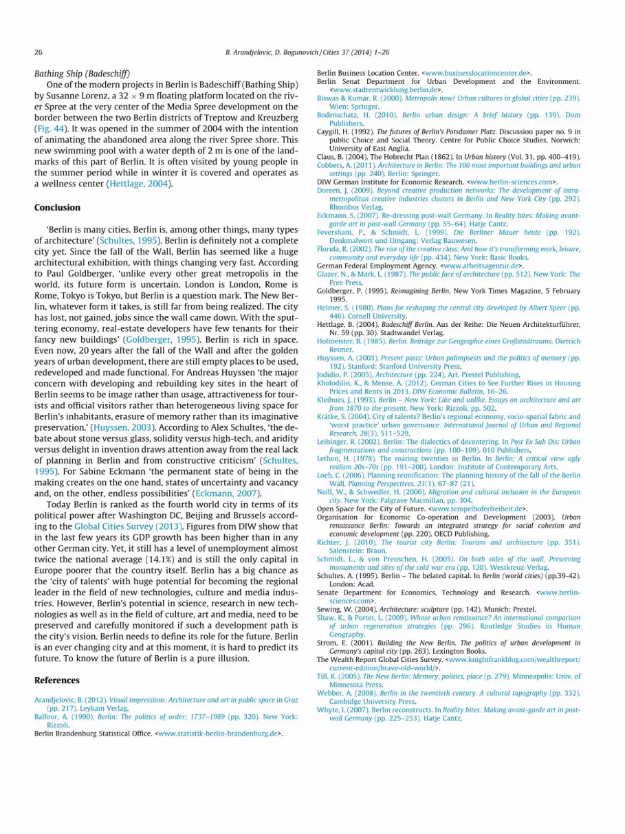
Bathing Ship (Badeschiff)One of the modern projects in Berlin is Badeschiff (Bathing Ship)
by Susanne Lorenz, a 32 � 9 m floating platform located on the riv-er Spree at the very center of the Media Spree development on theborder between the two Berlin districts of Treptow and Kreuzberg(Fig. 44). It was opened in the summer of 2004 with the intentionof animating the abandoned area along the river Spree shore. Thisnew swimming pool with a water depth of 2 m is one of the land-marks of this part of Berlin. It is often visited by young people inthe summer period while in winter it is covered and operates asa wellness center (Hettlage, 2004).
Conclusion
‘Berlin is many cities. Berlin is, among other things, many typesof architecture’ (Schultes, 1995). Berlin is definitely not a completecity yet. Since the fall of the Wall, Berlin has seemed like a hugearchitectural exhibition, with things changing very fast. Accordingto Paul Goldberger, ‘unlike every other great metropolis in theworld, its future form is uncertain. London is London, Rome isRome, Tokyo is Tokyo, but Berlin is a question mark. The New Ber-lin, whatever form it takes, is still far from being realized. The cityhas lost, not gained, jobs since the wall came down. With the sput-tering economy, real-estate developers have few tenants for theirfancy new buildings’ (Goldberger, 1995). Berlin is rich in space.Even now, 20 years after the fall of the Wall and after the goldenyears of urban development, there are still empty places to be used,redeveloped and made functional. For Andreas Huyssen ‘the majorconcern with developing and rebuilding key sites in the heart ofBerlin seems to be image rather than usage, attractiveness for tour-ists and official visitors rather than heterogeneous living space forBerlin’s inhabitants, erasure of memory rather than its imaginativepreservation.’ (Huyssen, 2003). According to Alex Schultes, ‘the de-bate about stone versus glass, solidity versus high-tech, and aridityversus delight in invention draws attention away from the real lackof planning in Berlin and from constructive criticism’ (Schultes,1995). For Sabine Eckmann ‘the permanent state of being in themaking creates on the one hand, states of uncertainty and vacancyand, on the other, endless possibilities’ (Eckmann, 2007).
Today Berlin is ranked as the fourth world city in terms of itspolitical power after Washington DC, Beijing and Brussels accord-ing to the Global Cities Survey (2013). Figures from DIW show thatin the last few years its GDP growth has been higher than in anyother German city. Yet, it still has a level of unemployment almosttwice the national average (14.1%) and is still the only capital inEurope poorer that the country itself. Berlin has a big chance asthe ‘city of talents’ with huge potential for becoming the regionalleader in the field of new technologies, culture and media indus-tries. However, Berlin’s potential in science, research in new tech-nologies as well as in the field of culture, art and media, need to bepreserved and carefully monitored if such a development path isthe city’s vision. Berlin needs to define its role for the future. Berlinis an ever changing city and at this moment, it is hard to predict itsfuture. To know the future of Berlin is a pure illusion.
References
Arandjelovic, B. (2012). Visual impressions: Architecture and art in public space in Graz(pp. 217). Leykam Verlag.
Balfour, A. (1990). Berlin: The politics of order; 1737–1989 (pp. 320). New York:Rizzoli.
Berlin Brandenburg Statistical Office. <www.statistik-berlin-brandenburg.de>.
Berlin Business Location Center. <www.businesslocationcenter.de>.Berlin Senat Department for Urban Development and the Environment.
<www.stadtentwicklung.berlin.de>.Biswas & Kumar, R. (2000). Metropolis now! Urban cultures in global cities (pp. 239).
Wien: Springer.Bodenschatz, H. (2010). Berlin urban design: A brief history (pp. 139). Dom
Publishers.Caygill, H. (1992). The futures of Berlin’s Potsdamer Platz. Discussion paper no. 9 in
public Choice and Social Theory. Centre for Public Choice Studies, Norwich:University of East Anglia.
Claus, B. (2004). The Hobrecht Plan (1862). In Urban history (Vol. 31, pp. 400–419).Cobbers, A. (2011). Architecture in Berlin: The 100 most important buildings and urban
settings (pp. 240). Berlin: Springer.DIW German Institute for Economic Research. <www.berlin-sciences.com>.Doreen, J. (2009). Beyond creative production networks: The development of intra-
metropolitan creative industries clusters in Berlin and New York City (pp. 292).Rhombos Verlag.
Eckmann, S. (2007). Re-dressing post-wall Germany. In Reality bites: Making avant-garde art in post-wall Germany (pp. 55–64). Hatje Cantz.
Feversham, P., & Schmidt, L. (1999). Die Berliner Mauer heute (pp. 192).Denkmalwert und Umgang: Verlag Bauwesen.
Florida, R. (2002). The rise of the creative class: And how it’s transforming work, leisure,community and everyday life (pp. 434). New York: Basic Books.
German Federal Employment Agency. <www.arbeitsagentur.de>.Glazer, N., & Mark, L. (1987). The public face of architecture (pp. 512). New York: The
Free Press.Goldberger, P. (1995). Reimagining Berlin. New York Times Magazine, 5 February
1995.Helmer, S. (1980). Plans for reshaping the central city developed by Albert Speer (pp.
446). Cornell University.Hettlage, B. (2004). Badeschiff Berlin. Aus der Reihe: Die Neuen Architekturführer,
Nr. 59 (pp. 30). Stadtwandel Verlag.Hofmeister, B. (1985). Berlin. Beiträge zur Geographie eines Großstadtraums. Dietrich
Reimer.Huyssen, A. (2003). Present pasts: Urban palimpsests and the politics of memory (pp.
192). Stanford: Stanford University Press.Jodidio, P. (2005). Architecture (pp. 224). Art. Prestel Publishing.Kholodilin, K., & Mense, A. (2012). German Cities to See Further Rises in Housing
Prices and Rents in 2013. DIW Economic Bulletin, 16–26.Kleihues, J. (1993). Berlin – New York: Like and unlike. Essays on architecture and art
from 1870 to the present. New York: Rizzoli, pp. 502.Krätke, S. (2004). City of talents? Berlin’s regional economy, socio-spatial fabric and
‘worst practice’ urban governance. International Journal of Urban and RegionalResearch, 28(3), 511–529.
Leibinger, R. (2002). Berlin: The dialectics of decentering. In Post Ex Sub Dis: Urbanfragmentations and constructions (pp. 100–109). 010 Publishers.
Lethen, H. (1978). The roaring twenties in Berlin. In Berlin: A critical view uglyrealism 20s–70s (pp. 191–200). London: Institute of Contemporary Arts.
Loeb, C. (2006). Planning reunification: The planning history of the fall of the BerlinWall. Planning Perspectives, 21(1), 67–87 (21).
Neill, W., & Schwedler, H. (2006). Migration and cultural inclusion in the Europeancity. New York: Palgrave Macmillan, pp. 304.
Open Space for the City of Future. <www.tempelhoferfreiheit.de>.Organisation for Economic Co-operation and Development (2003). Urban
renaissance Berlin: Towards an integrated strategy for social cohesion andeconomic development (pp. 220). OECD Publishing.
Richter, J. (2010). The tourist city Berlin: Tourism and architecture (pp. 351).Salenstein: Braun.
Schmidt, L., & von Preuschen, H. (2005). On both sides of the wall. Preservingmonuments and sites of the cold war era (pp. 120). Westkreuz-Verlag.
Schultes, A. (1995). Berlin – The belated capital. In Berlin (world cities) (pp.39-42).London: Acad.
Senate Department for Economics, Technology and Research. <www.berlin-sciences.com>.
Sewing, W. (2004). Architecture: sculpture (pp. 142). Munich: Prestel.Shaw, K., & Porter, L. (2009). Whose urban renaissance? An international comparison
of urban regeneration strategies (pp. 296). Routledge Studies in HumanGeography.
Strom, E. (2001). Building the New Berlin. The politics of urban development inGermany’s capital city (pp. 263). Lexington Books.
The Wealth Report Global Cities Survey. <www.knightfrankblog.com/wealthreport/current-edition/brave-old-world/>.
Till, K. (2005). The New Berlin: Memory, politics, place (p. 279). Minneapolis: Univ. ofMinnesota Press.
Webber, A. (2008). Berlin in the twentieth century. A cultural topography (pp. 332).Cambidge University Press.
Whyte, I. (2007). Berlin reconstructs. In Reality bites: Making avant-garde art in post-wall Germany (pp. 225–253). Hatje Cantz.


