Embed Size (px)
Citation preview

Overview
Citizen science for hydrological riskreduction and resilience buildingJonathan D. Paul,1* Wouter Buytaert,1 Simon Allen,2 Juan A. Ballesteros-Cánovas,2
Jagat Bhusal,3 Katarzyna Cieslik,4 Julian Clark,5 Sumit Dugar,6 David M. Hannah,5
Markus Stoffel,2 Art Dewulf,4 Megh R. Dhital,7 Wei Liu,8 Janak Lal Nayaval,3
Bhanu Neupane,9 Arnulf Schiller,10 Paul J. Smith11 and Robert Supper10
In disaster risk management (DRM), an emerging shift has been noted from broad-scale, top-down assessments toward more participatory, community-based, bottom-up approaches. Arguably, nonscientist local stakeholders have always played animportant role in knowledge risk management and resilience building within ahydrological context, such as flood response and drought alleviation. However, rap-idly developing information and communication technologies such as the Internet,smartphones, and social media have already demonstrated their sizeable potential tomake knowledge creation more multidirectional, decentralized, diverse, and inclusive.Combined with technologies for robust and low-cost sensor networks, a ‘citizen sci-ence’ approach has recently emerged as a promising direction in the provision ofextensive, real-time information for risk management. Such projects work best whenthere is community buy-in, when their purpose(s) are clearly defined at the outset,and when the motivations and skillsets of all participants and stakeholders are wellunderstood. They have great potential to enhance knowledge creation, not only fordata collection, but also for analysis or interpretation. In addition, they can serve as ameans of educating and empowering communities and stakeholders that arebypassed by more traditional knowledge generation processes. Here, we review thestate-of-the-art of citizen science within the context of hydrological risk reduction andresilience building. Particularly when embedded within a polycentric approachtoward risk governance, we argue that citizen science could complement more tradi-tional knowledge generation practices, and also enhance innovation, adaptation, mul-tidirectional information provision, risk management, and local resilience building. ©2017 The Authors. WIREs Water published by Wiley Periodicals, Inc.
How to cite this article:WIREs Water 2018, 5:e1262. doi: 10.1002/wat2.1262
*Correspondence to: [email protected]; [email protected] of Civil and Environmental Engineering, ImperialCollege London, London, UK2Climatic Change and Climate Impacts Research Group, Univer-sity of Geneva, Geneva, Switzerland3Society of Hydrologists and Meteorologists (SoHAM Nepal),Kathmandu, Nepal4Public Administration and Policy Group, Wageningen University,Wageningen, The Netherlands5School of Geography, Earth and Environmental Sciences, Univer-sity of Birmingham, Birmingham, UK6Practical Action Nepal, Kathmandu, Nepal
7Central Department of Geology, Tribhuvan University, Kath-mandu, Nepal8International Institute for Applied Systems Analysis (IIASA),Vienna, Austria9United Nations Educational, Scientific, and Cultural Organization(UNESCO), Paris, France10Geological Survey of Austria (GBA), Vienna, Austria11Waternumbers Consultancy, Lancaster, UK
Conflict of interest: The authors have declared no conflicts of inter-est for this article.
Volume 5, January/February 2018 1 of 15© 2017 The Authors. WIREs Water published by Wiley Periodicals, Inc.This is an open access article under the terms of the Creative Commons Attribution License, which permits use, distribution and reproduction in anymedium, provided the original work is properly cited.
INTRODUCTION
Within the emerging trend of democratizing sci-ence, the participation of nonprofessional sci-
entists in research projects that involve datacollection, interpretation, and analysis is oftentermed ‘citizen science.’1–5 The constant demand forresearch to be societally relevant has helped involvemore citizens in research projects.4,5 As a practice,citizen science is receiving increasing attention inmany disciplines. However, traditional citizen scienceapplications are already well established in, forinstance, aspects of biology like medical trials,6–8 andthe development of geographic information system(GIS) networks.9–11
Water science is not an obvious discipline for theuse of citizen science because many measurements aretechnologically demanding. On the other hand, thereare also several good examples, such as the citizen-ledmeasurement of precipitation, river water, and soilmoisture levels.1 This process has been greatly aided byrapid technological development over the past10–15 years, with small, cheap sensors now widelyavailable in smartphones, which themselves are gener-ally fully Internet connected and come with sophisti-cated cameras as standard.9,10,12–15 Moreover, themanagement of flood risk through interaction withsocial media9,14 and simple smartphone-based flowestimation,10,13,15,16 is another common hydrologicalcitizen science application.
At the same time, there is much interest and aneed to explore new ways to create relevant knowl-edge. Hydrology remains a highly data-scarce sci-ence; in many regions, if data exist, the lengths of thetime series are insufficient.17 From a policy perspec-tive, there is increasing interest in improving the riskperception by engaging all actors involved in DisasterRisk Management (DRM).1,18 The 2015 UN SendaiFramework for Disaster Risk Reduction, for instance,states that ‘[d]isaster risk reduction requires an all-of-society engagement and partnership [in which] spe-cial attention should be paid to the improvement oforganized voluntary work of citizens.’19
These points are highly relevant in the contextof risk reduction and resilience building. These areareas where a major need for data persists, and theyare of high societal relevance (as they have a directimpact upon livelihoods). Also, ‘traditional’ methodsstruggle to create locally relevant, ‘actionable’ knowl-edge. For instance, ‘traditional’ water level and dis-charge monitoring is usually based on a sparsenetwork of gauges that require extensive and techno-logically complex maintenance, while legal issuesover data ownership can frustrate community-level
access.1 Hence, this paper explores the challengesand opportunities of citizen science within a broadercontext of DRM and resilience.
THE CONCEPT OF CITIZEN SCIENCE
While the concept of citizen science is well estab-lished, several different definitions, both formal andinformal, exist.1 Citizen science is most commonlydefined as science by nonscientists: it is ‘… a form ofscience enacted and developed by citizens them-selves’20,21 or ‘[t]he participation of the general pub-lic in the research design, data collection andinterpretation process together with scientists.’1
Other related terminology includes the ‘public under-standing of science and technology’ (PUST) tradition,which focuses on outreach and enhances publicknowledge and acceptance of science; and ‘publicengagement in science’ (PES), which stems from com-munity science approaches and focuses on participa-tory research, practice and policy.22–25 True citizenscience projects can be differentiated from more gen-eral stakeholder engagement by the active involve-ment of citizen volunteers throughout the project,which is underpinned by one or more motivationalaspects.1 Citizen science is thus distinct from partici-patory approaches in general, which have beendefined as ‘activities that engage the public and/orstakeholders.’26 Such approaches have been encoun-tered in river basin management since at least the1970s, when a bottom-up approach was recognizedas key in the sustainable management of waterresources.26,27 Elsewhere, in river quality restoration,a citizen science approach has been sought as an aug-mentation to participation alone, as citizen scientistsbecame recognized as increasingly important actorsin actively defining local monitoring practices.27
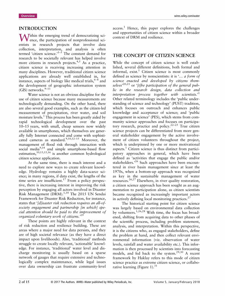
The historical starting point for citizen sciencewas largely based on environmental data collectionby volunteers.1,26,28 With time, the focus has broad-ened, shifting from acquiring data to other phases ofthe scientific process, including problem statement,analysis, and interpretation. Within this perspective,it is the citizens who, as engaged stakeholders, definethe problem at hand, and then collect relevant envi-ronmental information (viz. observation of waterlevels, rainfall and water availability etc.). This infor-mation is then processed by scientists into forecastingmodels, and fed back to the system.29,30 A recentframework by Haklay refers to this mode of citizenscience practice as extreme citizen science, or collabo-rative learning (Figure 1).31
Overview wires.wiley.com/water
2 of 15 © 2017 The Authors. WIREs Water published by Wiley Periodicals, Inc. Volume 5, January/February 2018
‘Extreme citizen science’ (the fourth and highestlevel of Haklay’s framework31) embraces collabora-tive science in its broadest sense: citizens are involvedfrom problem definition to the dissemination ofresults. In this interpretation, the emphasis is not onthe citizen as a scientist, but on the scientist as a citi-zen.23,32 This method of practicing science is cur-rently not widely accepted in the academiccommunity: taking into account local needs, prac-tices, and culture, it requires scientists to engage at aprofound level with the social and ethical aspects oftheir work.32
Extreme citizen science is gaining popularitywithin environmental and conservation sciences inparticular.33–35 There are a number of informationgaps that hamper effective environmental monitoringfor evidence-based decision-making, including insuffi-cient data, inconsistent metrics, weaknesses in predic-tive models, and a lack of real-time monitoringsystems.36 While increasing numbers ofstakeholders—governments and large developmentorganizations, research centers and private compa-nies, and local and national NGOs—engage in datacollection, their activities are mostly uncoordinated,and the resulting data often remain underutilized.Most worryingly, very rarely do those metrics trans-late into usable, actionable knowledge for the com-munities directly affected by the environmentalchange.37
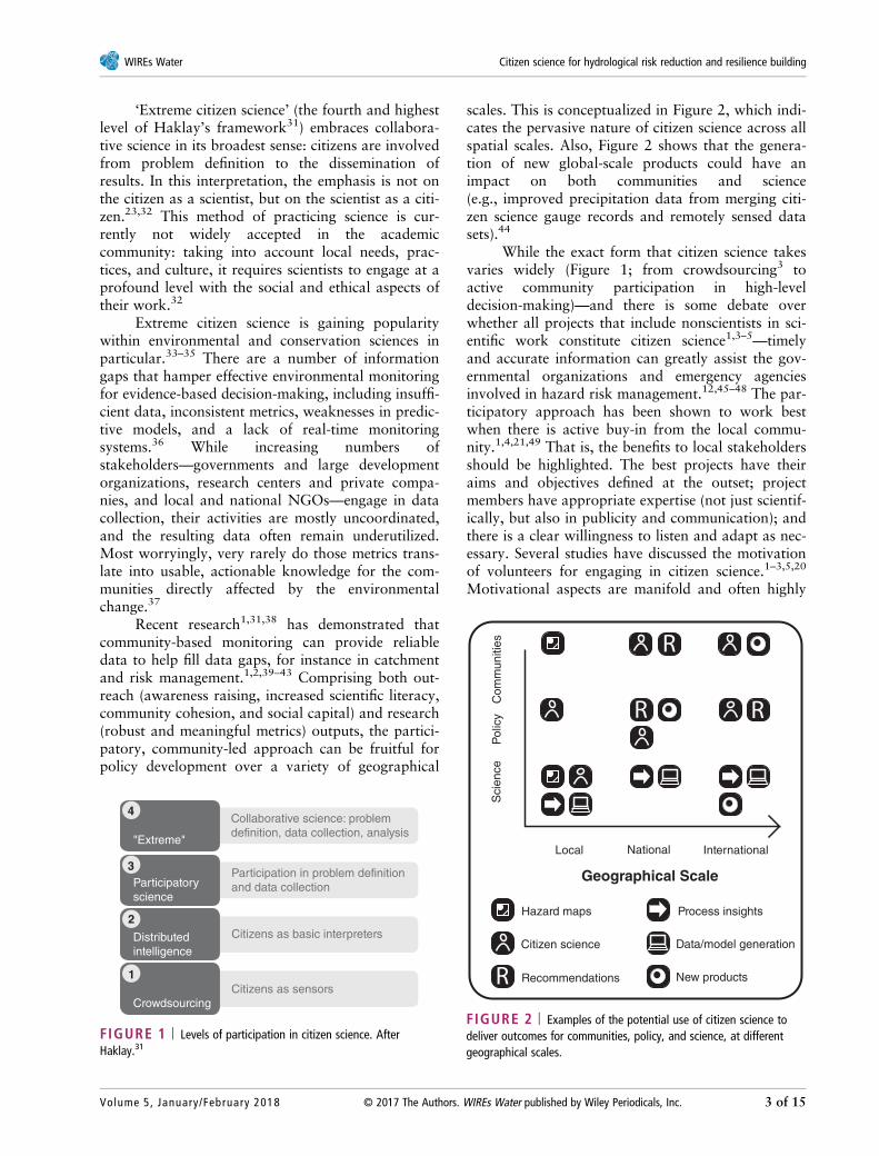
Recent research1,31,38 has demonstrated thatcommunity-based monitoring can provide reliabledata to help fill data gaps, for instance in catchmentand risk management.1,2,39–43 Comprising both out-reach (awareness raising, increased scientific literacy,community cohesion, and social capital) and research(robust and meaningful metrics) outputs, the partici-patory, community-led approach can be fruitful forpolicy development over a variety of geographical
scales. This is conceptualized in Figure 2, which indi-cates the pervasive nature of citizen science across allspatial scales. Also, Figure 2 shows that the genera-tion of new global-scale products could have animpact on both communities and science(e.g., improved precipitation data from merging citi-zen science gauge records and remotely sensed datasets).44
While the exact form that citizen science takesvaries widely (Figure 1; from crowdsourcing3 toactive community participation in high-leveldecision-making)—and there is some debate overwhether all projects that include nonscientists in sci-entific work constitute citizen science1,3–5—timelyand accurate information can greatly assist the gov-ernmental organizations and emergency agenciesinvolved in hazard risk management.12,45–48 The par-ticipatory approach has been shown to work bestwhen there is active buy-in from the local commu-nity.1,4,21,49 That is, the benefits to local stakeholdersshould be highlighted. The best projects have theiraims and objectives defined at the outset; projectmembers have appropriate expertise (not just scientif-ically, but also in publicity and communication); andthere is a clear willingness to listen and adapt as nec-essary. Several studies have discussed the motivationof volunteers for engaging in citizen science.1–3,5,20
Motivational aspects are manifold and often highly
Crowdsourcing
Distributedintelligence
Participatoryscience
"Extreme"
Collaborative science: problemdefinition, data collection, analysis
Participation in problem definitionand data collection
Citizens as basic interpreters
Citizens as sensors
4
3
2
1
FIGURE 1 | Levels of participation in citizen science. AfterHaklay.31
Hazard maps
Local
Sci
ence
Pol
icy
Com
mun
ities
National International
Geographical Scale
Process insights
Data/model generation
New products
Citizen science
Recommendations
FIGURE 2 | Examples of the potential use of citizen science todeliver outcomes for communities, policy, and science, at differentgeographical scales.
WIREs Water Citizen science for hydrological risk reduction and resilience building
Volume 5, January/February 2018 © 2017 The Authors. WIREs Water published by Wiley Periodicals, Inc. 3 of 15
complex, ranging from scientific curiosity to environ-mental concern and a desire for political empower-ment.1 A participant is only a citizen scientist whenthey actively volunteer (i.e., they are motivated byone or more factors) and maintain their activity (andcontact with the professional scientists) throughoutthe duration of the project. In some citizen scienceprojects, participants have lost interest and/or fallenout of contact with scientists,9,11 or, as ‘citizensensors,’ collect data passively without any obviousmotivation.10 However, the recent tendency is toinvolve volunteers in all intellectual aspects of the sci-ence, rather than capitalizing on them as a low-costworkforce.1,2
CITIZEN SCIENCE IN HYDROLOGY
OverviewThe implications of the Internet, smartphones, andnew developments in sensing technology on citizenscience in a hydrological context have recently beendiscussed.1 The increased availability of Informationand Communications Technology (ICT)—in particu-lar, mobile phone saturation across societalsegments—opens up new ways of both gathering bigdata and accessing environmentally relevant informa-tion, having a profound impact upon the work of sci-entists and policy makers.50,51 Today’s mobilephones may be equipped with sensors that can be uti-lized for scientific observation, including transceivers,FM and GPS receivers, cameras, accelerometers, digi-tal compasses and microphones.52,53 Even in theabsence of the sensors, mobile networks can still beused to transmit physical observations and measure-ments from users to the predesigned scientificdomain.52,54 Beyond smartphones, citizen science canalso benefit from other newly emerging technolo-gies53: examples include crowdsourcing rainfall datafrom personal weather stations,55 or inferring precip-itation by exploiting sensors attached to car wind-screen wipers.56
The uptake of citizen science has, so far, beenrather limited in terms of hydrological risk and resil-ience building, even though participatory projectshave been noted in water resources management forsome time.1,27 Hydrological data are often difficultto interpret intuitively, while measurements tend tobe expensive (e.g., using proprietorial software),complex, spatially sparse and temporally dense (forinstance, long time series of discharge and precipita-tion). For these reasons, intensive scientific trainingand specialization is normally a prerequisite for dataanalysis and manipulation.57 However, new
technological developments can, to some extent, cir-cumvent these limitations, paving the way for themore rapid uptake of citizen science1,5 (Table 1).
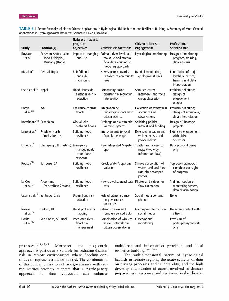
Quantification of Hydrological RiskTable 2 summarizes documented citizen science pro-jects that involve risk reduction and/or resiliencebuilding against hydrologically induced natural haz-ards, such as flooding and landslides (‘hydroha-zards’). Many projects involve community-basedresponses to river flooding, either taking a preventa-tive approach,14,15,61 or offering the opportunity forreal-time observation and mitigation.9,10,13,16,60 Inthe majority of these studies, we note that the role ofcitizen scientists is strictly limited to information anddata gathering, rather than leveraging the full poten-tial of actionable knowledge co-generation.2 Com-pared to citizen science applications in waterresources science (e.g., measuring water qualityparameters and biodiversity), there is less emphasison training the project participants.1 This could be adirect result of recent technological development,which allows data to be shared easily via socialmedia.9,10,12,13
In building resilience, utilization of multipledata sources is particularly desirable. The installationof networks of robust and low-cost sensors(e.g., automatic rain gauges and river level distancesensors) has recently emerged as a useful approachthat has the potential to provide real-time informa-tion for risk management.1,10,16,58,62,63 However,considerable effort is required to ensure the effectiveoperation of these sensors. Participatory monitoringcan involve supervision and/or installation of suchsensor networks; in high-risk, low-data availabilityareas, citizens can provide additional, often qualita-tive, information via various devices such as smart-phones (Volunteered Geographical Information:VGI).9–16,48,60,61
The combination of a sensor network with VGIcan act as a mutual support system to achieve hydro-logically induced risk management, and significantlyimprove the coverage of monitored areas.1,5,16,58,60
This can take the form of time-stamped and geo-located photographs,9,10,12–15 social mediaupdates,12,14,15 or interviews and feedback to ad hochazard mitigation websites.12,60,61 Smartphone appshave also been developed to this end.9–11 On theother hand, a few projects have worked closely withlocal communities in order to explain to and trainparticipants in the use of more complex monitoringprinciples, e.g., water level and flow1,10,16 and raingauges.58
Overview wires.wiley.com/water
4 of 15 © 2017 The Authors. WIREs Water published by Wiley Periodicals, Inc. Volume 5, January/February 2018
The organization and degree of involvementof the citizen scientists varies widely. On one endof the spectrum (Haklay’s31 Level 1), so-called‘community-led’ projects may in practice involvevery limited direct community engagement, and asa result of this collect very little data, or utilize itsparingly or poorly. For instance, drainage andearly warning systems to reduce the risk from gla-cial outburst floods in Nepal were constructed andmonitored following a remote crowdsourcingapproach, but little action was then taken, owingto funding concerns and lack of continuing interestfrom participants.48 Moreover, the initial results ofthe Creek Watch program in the western USA didnot greatly progress, perhaps because specific roleswere not yet fully defined for the relevant actors inthis flood resilience-building project.10 Sometimes,governmental bodies or scientists do not recognizelocal actors as being able to produce high-quality,official information; furthermore, community inter-est or deliberation over possible solutions may belacking.1,14,48
On the other end of the spectrum (Haklay’s31
Level 4: ‘extreme’ citizen science), extensivecommunity-led engagement exercises have generatedfruitful results for knowledge co-generation, fromrural areas with multiple hazards as in westernNepal,1,42,45 to urban areas at risk from repeatedflooding.14,15,59,61,64 The most effective projects(from the point of view that both scientific and citi-zen engagement objectives are satisfied) involve two-
way information flow over the entire project life-cycle, which has been shown to improve citizen par-ticipation significantly, as well as their sense of situa-tional awareness.2,9,62 For instance, Liu et al.9
describe how, using their flood resilience app, userscan simultaneously upload geo-referenced tweets,and also instantly explore heterogeneous data setsand maps that have been processed by professionalscientists. This process, in turn, can inform futureparticipatory observation, ensuring that the citizenscience project grows organically and sustainably.
However, it must be remembered that most citi-zen science projects in this context only involve moni-toring and data submission (‘citizens as sensors’: a‘one-way street’9), with roll-out of citizen-to-citizen orcitizen-to-scientist feedback (and more sophisticatedinformation provision systems) generally lacking or atan early stage.10,11,13–16 This makes it pertinent to ana-lyze how citizen science concepts may be leveraged toturn collected data into actionable knowledge relatedto risk reduction, governance, and wider resiliencebuilding.
Hydrological Risk Management andGovernanceThe polycentric risk governance approach hasrecently gained traction in the context of climatechange policy65 and the generation of knowledge onecosystem service processes of remote river basins,linking them into local and regional governance
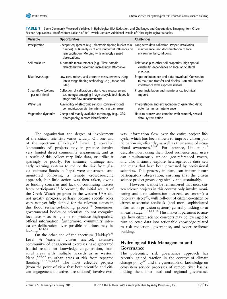
TABLE 1 | Some Commonly Measured Variables in Hydrological Risk Reduction, and Challenges and Opportunities Emerging from CitizenScience Applications. Modified from Table 2 of Ref 1 which Contains Additional Details of Other Hydrological Variables
Variable Opportunities Challenges
Precipitation Cheaper equipment (e.g., electronic tipping bucket raingauges). Bulk analysis of environmental influences onrain capitation. Merging with remotely sensedobservations.
Long-term data collection. Proper installation,maintenance, and documentation of localenvironmental conditions.
Soil moisture Automatic measurements (e.g., Time domainreflectometry) becoming increasingly affordable.
Relationship to other soil properties; high spatialvariability; dependence on local agriculturalpractices.
River level/stage Low-cost, robust, and accurate measurements usinglatest range-finding technology (e.g., radar andlidar).
Proper maintenance and data download. Conversionto real-time transfer and display. Potential humaninterference with exposed sensors.
Streamflow (volumeper unit time)
Collection of calibration data; cheap measurementtechnology; emerging image analysis techniques forstage and flow measurements
Proper installation and maintenance; technicalsupport
Water use Availability of electronic sensors; convenient datacommunication via the Internet in urban areas
Interpretation and extrapolation of generated data;potential human interference
Vegetation dynamics Cheap and readily available technology (e.g., GPS,photography; remote identification
Hard to process and combine with remotely senseddata; systemization
WIREs Water Citizen science for hydrological risk reduction and resilience building
Volume 5, January/February 2018 © 2017 The Authors. WIREs Water published by Wiley Periodicals, Inc. 5 of 15
processes.1,18,62,63 Moreover, the polycentricapproach is particularly suitable for reducing disasterrisk in remote environments where flooding con-tinues to represent a major hazard. The combinationof this conceptualization of risk governance with citi-zen science strongly suggests that a participatoryapproach to data collection can enhance
multidirectional information provision and localresilience building.1,2,18,62
The multidimensional nature of hydrologicalhazards in remote regions, the acute scarcity of dataon driving processes and vulnerability, and the highdiversity and number of actors involved in disasterpreparedness, response and recovery, make disaster
TABLE 2 | Recent Examples of citizen Science Applications in Hydrological Risk Reduction and Resilience Building. A Summary of More GeneralApplications in Hydrology/Water Resources Science is Given Elsewhere1
Study Location(s)
Nature of hazard/programobjectives Activities/innovations
Citizen scientistengagement
Professionalscientist role
Buytaertet al.1
Peruvian Andes, LakeTana (Ethiopia),Mustang (Nepal)
Impact of changingland use
Rainfall, river level, soilmoisture and streamflow data coupled tomodeling approach
Hydrological monitoring Design of monitoringprogram, training,data analysis
Malakar58 Central Nepal Rainfall andlandslidemonitoring
New sensor networksinstalled at communitylevel
Rainfall monitoring;geological studies
Enunciation of majorlandslide causes;training and datainterpretation
Oven et al.59 Nepal Flood, landslide,earthquake riskreduction
Community-baseddisaster risk reductionintervention
Semi-structuredinterviews and focusgroup discussion
Problem definition;design ofengagementprogram
Borgaet al.60
n/a Resilience to flashfloods
Integration ofhydrological data withcitizen science
Collection of eyewitnessaccounts andobservations
Problem definition;design of interviews;data interpretation
Kattelmann48 East Nepal Glacial lakeoutburst floods
Drainage and automaticwarning systems
Soliciting politicalinterest and funding
Design of drainageprojects
Lane et al.61 Ryedale, NorthYorkshire, UK
Building floodresilience
Improvements to localflood knowledge
Extensive engagementwith scientists andpolicy makers
Extensive engagementwith citizenscientists
Liu et al.9 Champaign, IL (testing) Emergencymanagement;urban floodresponse
New integrated Mapsterapp
Twitter and access tomaps (two-wayinformation flow)
Data protocol designonly
Robson10 San Jose, CA Building floodresilience
‘Creek Watch’: app andwebsite
Simple observation ofwater level and flowrate; time-stampedphotos
Top-down approach:complete oversightof program
Le Cozet al.13
Argentina/France/New Zealand
Building floodresilience
New crowd-sourced datasets
Photos and videos forflow estimation
Training, design ofmonitoring system,data dissemination
Uson et al.14 Santiago, Chile Urban flood riskreduction
Role of citizen scienceon governancestructures
Social media content,photos
None
Rosseret al.15
Oxford, UK Flood probabilitymapping
Citizen science andremotely sensed data
Geotagged photos fromsocial media
No active contact withcitizens
Horitaet al.16
Sao Carlos, SE Brazil Integrated riverflood riskmanagement
Combination of wirelesssensor network andcitizen observatories
Observationalmonitoring
Provision ofparticipatory websiteonly
Overview wires.wiley.com/water
6 of 15 © 2017 The Authors. WIREs Water published by Wiley Periodicals, Inc. Volume 5, January/February 2018
risk reduction in this environment a formidable chal-lenge.66 Lack of scientific evidence is a major obstacleto improving local policy-making to deal with man-aging hydrological-based risk,17 which is further hin-dered by the frequently observed combination ofacute poverty and often poorly developed linksbetween formal and informal institutions.67 There istherefore real potential for the involvement of localactors and communities (i.e., citizen science), whomay also be incentivized by a desire to improve livingconditions and livelihoods, provide protectionagainst hydrological-related hazards, or foster a senseof civic or national pride.1
The coupling of insights on risk management,disaster risk reduction, resilience building, and citizenscience, is challenging. Multiple risks need to be con-sidered at the same time; responsibilities cut acrossmultiple governance scales and sectors of society;and the risks that need to be addressed are character-ized by complexity, uncertainty, and ambiguity.Effective risk governance involves stakeholders atvarious levels; this includes the use of citizen scienceacross all three phases of the disaster risk cycle:
1. Pre-disaster preparedness: since vulnerability iswhat turns hazards into disasters,68 disasterresilience requires ex ante socioeconomic andphysical vulnerability assessment to promotevulnerability reduction.69 Governance capacityin preparedness and early warning is enhancedby involving and drawing on communities andtheir local knowledge, practices, and riskculture,70 involving them in citizen scienceefforts that support early warnings.
2. In-disaster response: most efforts in riskresearch focus on the first phase. Yet in manycases, crisis management is the major factor inshaping how catastrophic disasters will turnout to be.71 Individual citizens and their net-works play an important role in in-disasterresponse: most people are saved by their kin,friends, or neighbors.72 While real-time disastermonitoring by trained scientists will always beimportant, citizen science can be an indispens-able tool to provide rapid initial assessments ofdamage, as well as areas and communities thatare most at risk.69,72 Such real-time, multidirec-tional risk communication between citizen sci-entists and disaster relief agencies can greatlyimprove the speed and effectiveness of theresponse.72
3. Post-disaster recovery and adaptation: thisstage involves working at the community level
to ensure that a return to the status quo ante(with the same vulnerabilities) does not happen(this is often physically impossible anyway).The efficacy and longevity of disaster resiliencebuilding projects is greatest when there is activecommunity buy-in, e.g., through citizen scienceprojects.4,21,49
It is therefore clear that the principles of hydrologicalrisk governance and citizen science are very stronglyaligned.
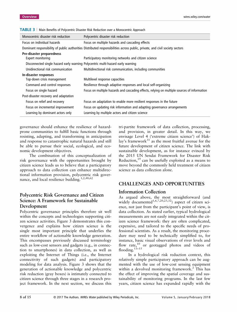
Building ResilienceThe seminal work of Ostrom on polycentric gover-nance42,73 has triggered an increasing scientificawareness that managing natural resources and riskscan benefit from a polycentric approach.2,74,75 Thisacknowledges that social-ecological systems are oftencharacterized by multiple centers of decision-makingacross different scales, thereby relying on a distribu-tion of responsibilities, multiple sources of informa-tion, and cogeneration of knowledge. Even if theyare less streamlined than tightly integrated central-ized systems, polycentric systems tend to ‘enhanceinnovation, learning, adaptation, trustworthiness,levels of cooperation of participants, and the achieve-ment of more effective, equitable, and sustainableoutcomes at multiple scales.’73 Table 3 details themain advantages of a polycentric citizen scienceapproach over a top-down, monocentric one. Theformer approach has become prominent in the con-text of climate change policy65 and the generation ofknowledge on ecosystem service processes of remotemountainous basins, linking them into local andregional governance processes.1,18,62,63
Polycentric approaches to hydrological moni-toring and management could provide an extensionor even possibly an alternative to Integrated WaterResources Management (IWRM).74 The current dis-course on IWRM is concerned with identifyingpotential entry points to scale up the local watermanagement approaches toward the development ofnested institutional setups.74,76 Despite manyachievements in DRM, problems with building resil-ience persist across many hydrological risk manage-ment projects.69,71,77,78 Governing risks is concernednot just with minimizing the risks, but also enhancingresilience, in order to be able to withstand or eventolerate surprises and respond better.43,45,79 Resil-ience is the capability of a system to (1) resist shocks,(2) adapt flexibly to constantly changing conditions,and (3) to transform, in order to keep fulfilling basicfunctions and services.75,80 Polycentric disaster risk
WIREs Water Citizen science for hydrological risk reduction and resilience building
Volume 5, January/February 2018 © 2017 The Authors. WIREs Water published by Wiley Periodicals, Inc. 7 of 15
governance should enhance the resilience of hazard-prone communities to fulfill basic functions throughresisting, adapting, and transforming in anticipationand response to catastrophic natural hazards and stillbe able to pursue their social, ecological, and eco-nomic development objectives.
The combination of this conceptualization ofrisk governance with the opportunities brought bycitizen science leads us to believe that a participatoryapproach to data collection can enhance multidirec-tional information provision, polycentric risk gover-nance, and local resilience building.1,2,48,62
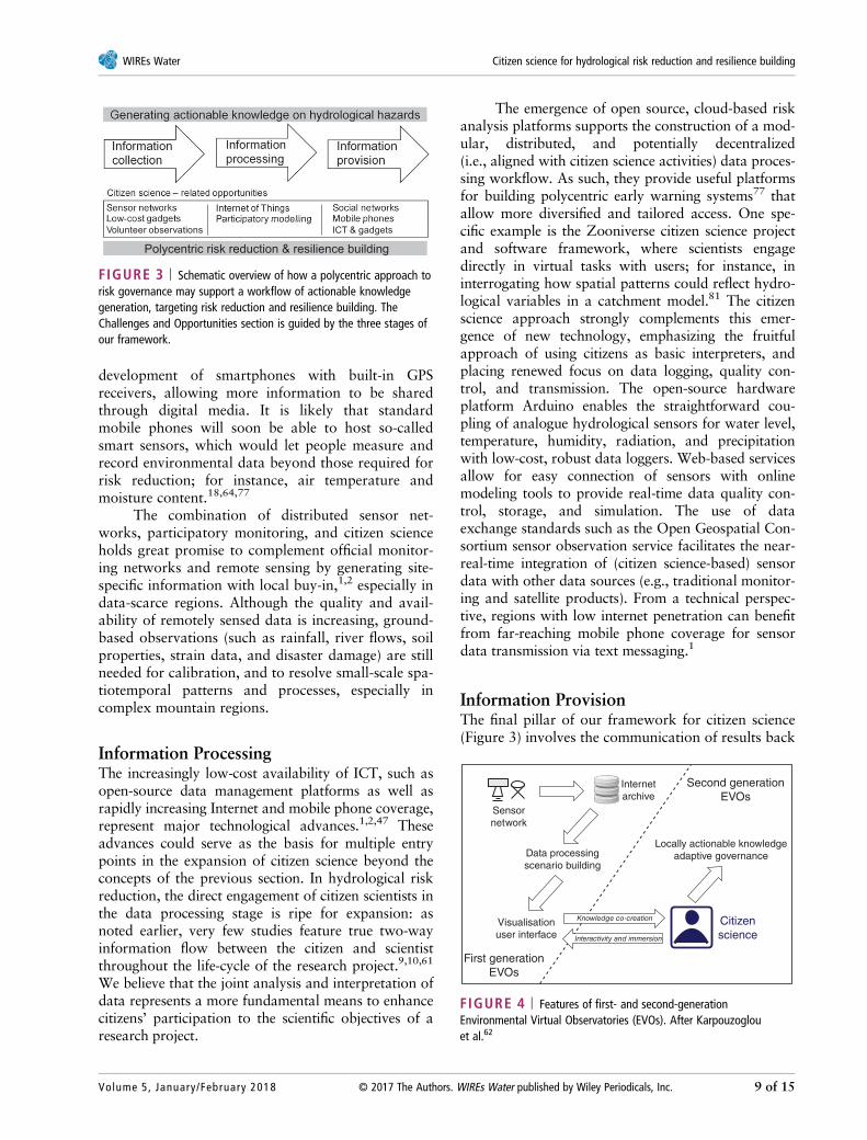
Polycentric Risk Governance and CitizenScience: A Framework for SustainableDevelopmentPolycentric governance principles therefore sit wellwithin the concepts and technologies supporting citi-zen science activities. Figure 3 demonstrates this con-vergence and explains how citizen science is thesingle most important principle that underlies theentire workflow of actionable knowledge generation.This encompasses previously discussed terminologysuch as low-cost sensors and gadgets (e.g., in connec-tion to smartphones) in data collection, as well asexploiting the Internet of Things (i.e., the Internetconnectivity of such gadgets) and participatorymodeling for data analysis. Figure 3 shows that thegeneration of actionable knowledge and polycentricrisk reduction (gray boxes) is intimately connected tocitizen science through three stages in a research pro-ject framework. In the next section, we discuss this
tri-partite framework of data collection, processing,and provision, in greater detail. In this way, weenvisage Level 4 (‘extreme citizen science’) of Hak-lay’s framework31 as the most fruitful avenue for thefuture development of citizen science. The link withsustainable development, as for instance evinced bythe 2015 UN Sendai Framework for Disaster RiskReduction,19 can be usefully exploited as a means tomove beyond the commonly held treatment of citizenscience as data collection alone.
CHALLENGES AND OPPORTUNITIES
Information CollectionAs argued above, the most straightforward (andwidely documented1,6,7,20,23,32) aspect of citizen sci-ence, not just from the participant’s point of view, isdata collection. As stated earlier, typical hydrologicalmeasurements are not easily integrated within the cit-izen science framework: they are often complicated,expensive, and tailored to the specific needs of pro-fessional scientists. As a result, the monitoring proce-dure may need to be technically simplified to, forinstance, basic visual observations of river levels andflow rate,10 or geotagged photos and videos offlooding.13–15
In a hydrological risk reduction context, thisrelatively simple participatory approach can be aug-mented with the use of low-cost sensing equipmentwithin a devolved monitoring framework.2 This hasthe effect of improving the spatial coverage and sus-tainability of monitoring programs. In the last fewyears, citizen science has expanded rapidly with the
TABLE 3 | Main Benefits of Polycentric Disaster Risk Reduction over a Monocentric Approach
Monocentric disaster risk reduction Polycentric disaster risk reduction
Focus on individual hazards Focus on multiple hazards and cascading effects
Dominant responsibility of public authorities Distributed responsibilities across public, private, and civil society sectors
Pre-disaster preparednessExpert monitoring Participatory monitoring networks and citizen science
Disconnected single hazard early warning Polycentric multi-hazard early warning
Unidirectional risk communication Multidirectional risk communication, including communities
In-disaster responsesTop-down crisis management Multilevel response capacities
Command and control responses Resilience through adaptive responses and local self-organizing
Focus on single hazard Focus on multiple hazards and cascading effects, relying on multiple sources of information
Post-disaster recovery and adaptation
Focus on relief and recovery Focus on adaptation to enable more resilient responses in the future
Focus on incremental improvement Focus on updating risk information and adapting governance arrangements
Learning by dominant actors only Learning by multiple actors and citizen science
Overview wires.wiley.com/water
8 of 15 © 2017 The Authors. WIREs Water published by Wiley Periodicals, Inc. Volume 5, January/February 2018
development of smartphones with built-in GPSreceivers, allowing more information to be sharedthrough digital media. It is likely that standardmobile phones will soon be able to host so-calledsmart sensors, which would let people measure andrecord environmental data beyond those required forrisk reduction; for instance, air temperature andmoisture content.18,64,77
The combination of distributed sensor net-works, participatory monitoring, and citizen scienceholds great promise to complement official monitor-ing networks and remote sensing by generating site-specific information with local buy-in,1,2 especially indata-scarce regions. Although the quality and avail-ability of remotely sensed data is increasing, ground-based observations (such as rainfall, river flows, soilproperties, strain data, and disaster damage) are stillneeded for calibration, and to resolve small-scale spa-tiotemporal patterns and processes, especially incomplex mountain regions.
Information ProcessingThe increasingly low-cost availability of ICT, such asopen-source data management platforms as well asrapidly increasing Internet and mobile phone coverage,represent major technological advances.1,2,47 Theseadvances could serve as the basis for multiple entrypoints in the expansion of citizen science beyond theconcepts of the previous section. In hydrological riskreduction, the direct engagement of citizen scientists inthe data processing stage is ripe for expansion: asnoted earlier, very few studies feature true two-wayinformation flow between the citizen and scientistthroughout the life-cycle of the research project.9,10,61
We believe that the joint analysis and interpretation ofdata represents a more fundamental means to enhancecitizens’ participation to the scientific objectives of aresearch project.
The emergence of open source, cloud-based riskanalysis platforms supports the construction of a mod-ular, distributed, and potentially decentralized(i.e., aligned with citizen science activities) data proces-sing workflow. As such, they provide useful platformsfor building polycentric early warning systems77 thatallow more diversified and tailored access. One spe-cific example is the Zooniverse citizen science projectand software framework, where scientists engagedirectly in virtual tasks with users; for instance, ininterrogating how spatial patterns could reflect hydro-logical variables in a catchment model.81 The citizenscience approach strongly complements this emer-gence of new technology, emphasizing the fruitfulapproach of using citizens as basic interpreters, andplacing renewed focus on data logging, quality con-trol, and transmission. The open-source hardwareplatform Arduino enables the straightforward cou-pling of analogue hydrological sensors for water level,temperature, humidity, radiation, and precipitationwith low-cost, robust data loggers. Web-based servicesallow for easy connection of sensors with onlinemodeling tools to provide real-time data quality con-trol, storage, and simulation. The use of dataexchange standards such as the Open Geospatial Con-sortium sensor observation service facilitates the near-real-time integration of (citizen science-based) sensordata with other data sources (e.g., traditional monitor-ing and satellite products). From a technical perspec-tive, regions with low internet penetration can benefitfrom far-reaching mobile phone coverage for sensordata transmission via text messaging.1
Information ProvisionThe final pillar of our framework for citizen science(Figure 3) involves the communication of results back
FIGURE 3 | Schematic overview of how a polycentric approach torisk governance may support a workflow of actionable knowledgegeneration, targeting risk reduction and resilience building. TheChallenges and Opportunities section is guided by the three stages ofour framework.
Sensornetwork
Internetarchive
Second generationEVOs
First generationEVOs
Visualisationuser interface
Data processingscenario building
Locally actionable knowledgeadaptive governance
Knowledge co-creation
Interactivity and immersion
Citizenscience
FIGURE 4 | Features of first- and second-generationEnvironmental Virtual Observatories (EVOs). After Karpouzoglouet al.62
WIREs Water Citizen science for hydrological risk reduction and resilience building
Volume 5, January/February 2018 © 2017 The Authors. WIREs Water published by Wiley Periodicals, Inc. 9 of 15

to the participants. This provision of information, ina manner that is comprehensible for a nonscientificaudience, serves as an incentive for further citizen
participation. Although this important aspect of citi-zen science is lightly developed3,23,32 (especially in ahydrological context1,14–16), we believe that the
FIGURE 5 | Example of a prototype dashboard-style knowledge dissemination interface, co-designed with local stakeholders, using themethodology developed by Zulkafli et al.18
Overview wires.wiley.com/water
10 of 15 © 2017 The Authors. WIREs Water published by Wiley Periodicals, Inc. Volume 5, January/February 2018
recent growth of Internet technologies could createexcellent opportunities for user feedback and com-munication beyond the scientific project itself. In thesmall number of cases where information provisionand citizen feedback are integral to project develop-ment, the situational awareness and participationrates of participants, as well as levels of communitybuy-in, are high.2,9,62
As strongly advocated by the Sendai Frame-work on Disaster Risk Reduction,19 linking dataanalysis platforms to social computer networks andICT (such as mobile phones and tablets) allows tai-lored interfaces and people-centered decision- andpolicy-support systems to be constructed, which caneffectively support a citizen science approach toinformation generation, visualization, and communi-cation. Such technologies have been termed Environ-mental Virtual Observatories (EVOs),1,62 which areopen and decentralized, allowing information to flowfreely between multiple actors. This is one of thesalient points of citizen science. Given the potentiallyvery different quality and nature of citizen science-collected data, a major outstanding challenge is thecommunication of inherent assumptions and newuncertainties that are difficult to quantify.1,82
Figure 4 shows the development of EVOsthrough time: while the first generation was con-structed around scientists, the second generation isspecifically designed in a participatory manner,i.e., around the principles of citizen science. It is alsoconcerned with how co-generation/co-design poten-tially leads to political empowerment of marginalizedindividuals and communities. In this way, these morerecent EVOs have broader implications for resiliencebuilding and knowledge co-creation.62 Figure 5shows an example of an interface that is built aroundthe activities of the citizen participant in a recentresearch project.1,18
Future challenges in the realm of data provisioninclude ensuring a user-centered approach, leveragingnew technology, and recognizing the polycentricnature of systems. While it is sometimes difficult toquantify visual data, many EVOs now include a com-ponent of graphical support for participatory sce-nario building; for instance, 3D visualization andmodeling of raw photographic and geospatial datausing a gaming engine.83 Zulkafli et al.18 describe afour-stage citizen science approach to designing aninformation provision system. This approachinvolves: (1) discovery of user motivations and goals;(2) conceptual design of the system, based on userinterviews and testing; (3) detailed design; and (4) sys-tem launch and feedback sessions with the local com-munity. Clearly, the involvement of participants over
the entire-life cycle of a research project (Figure 3) isthe best way of creating locally relevant actionableknowledge (Box 1).
CONCLUSION
The growth of citizen science in a hydrological riskcontext can be explained by the prior inaccessibilityand sparseness of water-related datasets, as well asthe development of new technology such as Internet-
BOX 1
THE HISTORY BETWEEN CITIZENSCIENCE AND WATER SCIENCE
The application of citizen science in hydrologyand water resource science arrived rather latein the former’s history, mainly because of theadvanced technology required for monitoringmany aspects of the water cycle, which pre-cluded the active involvement of nonprofes-sional scientists.1 Yet the rapid and widespreadeffects of inexorable global population growthand environmental change have stimulated sci-entific interest in the collection of hydrologicaldata that are both spatially and temporally rich.Though citizen science is a relatively new term,people have been contributing to scientific pro-jects for many years. The Christmas Bird Count,conducted by the US National Audubon Societyin the late 19th century,3 is sometimes noted asthe first true citizen science project; though it islikely that meteorologists had been collatingvolunteer data for a long time hitherto. Interms of water, the earliest projects exploitedeconomic gain as an incentive for communityparticipation: for instance, in employing a vil-lage network to monitor annual springdischarge,84 or mill workers to measure riverflow.85 As technology has progressed, citizensare now able to take part in sophisticated andextensive water quality monitoring networks,reporting data in real time.26 In the realm ofacademia, there is extensive evidence that aformer, rather dismissive, attitude among waterscientists of citizen science has profoundlyshifted in recent years.4,49 There are now manypublications that use citizen science data as pri-mary core information, in fields as disparate asbotany and ecology,28,38,86 medical research,6–8
and hazard risk mitigation and resiliencebuilding.1,2,39,64,77
WIREs Water Citizen science for hydrological risk reduction and resilience building
Volume 5, January/February 2018 © 2017 The Authors. WIREs Water published by Wiley Periodicals, Inc. 11 of 15
connected smartphones. The active involvement ofcitizen scientists across the entire project lifecycle(rather than participatory monitoring alone) canenhance local uptake, support local diagnostics, andincrease decision capacity. Beyond the technical andcommunication challenges, this is an efficient way toenhance the culture of hazard risk and make commu-nities more collectively engaged. In other words, theprinciples of polycentric hydrological risk governanceand citizen science are very strongly aligned; and thisalignment is expressed well in the form of polycentricmonitoring approaches. Citizen science effectivelybridges gaps between contextual science and adop-tive knowledge.
One exciting future perspective would be tocombine such ‘measurement-oriented’ and ‘citizen
hydrologist’ approaches with the powerful toolsdeveloped in other projects for data mining the socialmedia contents and conducting a spatial analysis ofVGI. A participatory citizen science approach to datacollection can enhance decentralized multidirectionalinformation provision, polycentric risk governance,and local resilience building. However, we believethat the future of citizen science lies not in mere datacollection, but rather in its integration with informa-tion processing and feedback (i.e., the completeresearch project life-cycle). Potential links to sustain-able development in a hydrological risk reductioncontext offer the unique opportunity to shift the par-adigm decisively away from ‘citizen sensors’ towardthe much broader concept of ‘extreme citizenscience.’
ACKNOWLEDGMENTS
The research consortium to which the authors belong is funded by the UK Natural Environment ResearchCouncil (NERC) and Department for International Development (DFID) as project NE/P000452/1 (LandslideEVO) under the Science for Humanitarian Emergencies and Resilience (SHEAR) program. WB, DMH, JC,JAB-C, MS, and AD acknowledge funding from NERC project NE-K010239–1 (Mountain-EVO).
FURTHER READINGDickinson JL, Bonney R. Citizen Science: Public Participation in Environmental Research. Ithaca, NY: Comstock PublishingAssociates; 2012.
Grey D., Garrick D., Blackmore D., Kelman J., Muller M., Sadoff C., 2013. Water security in one blue planet: twenty-firstcentury policy challenges for science. Philos Trans R Soc A 37120120406
Lowry CS, Fienen MN. CrowdHydrology: crowdsourcing hydrologic data and engaging citizen scientists. Groundwater2012, 51:151–156.
Pocock MJO, Chapman DS, Sheppard LJ, Roy HE. Choosing and Using Citizen Science: A Guide to when and how to UseCitizen Science to Monitor Biodiversity and the Environment. Wallingford, UK: Centre for Ecology and Hydrology; 2014.
REFERENCES1. Buytaert W, Zulkafli Z, Grainger S, Acosta L,
Alemie TC, Bastiaensen J, De Bièvre B, Bhusal J,Clark J, Dewulf A, et al. Citizen science in hydrologyand water resources: opportunities for knowledge gen-eration, ecosystem service management, and sustain-able development. Front Earth Sci 2014, 2, 26 pp.
2. Buytaert W, Dewulf A, De Bièvre B, Clark J,Hannah DM. Citizen science for water resources man-agement: toward polycentric monitoring and gover-nance? J Water Resour Plan Manage 2016,142:01816002.
3. Mueller M, Tippins D, Bryan L. The future of citizenscience. Democr Edu 2012, 20:1–12.
4. Droege S. Just because you paid them, doesn’t meantheir data are any better. In: Proceedings of the CitizenScience Toolkit Conference, Cornell Lab of Ornithol-ogy, Ithaca, NY, 2007.
5. Cohn JP. Citizen science: can volunteers do realresearch? Bioscience 2008, 58:192.
6. Entwhistle VA, Renfrew MJ, Yearley S, Forrester J,Lamont T. Lay perspectives: advantages for healthresearch. Br Med J 1998, 316:463–466.
7. Angrist M. Eyes wide open: the personal genome pro-ject, citizen science and veracity in informed consent.Pers Med 2009, 6:691–699.
Overview wires.wiley.com/water
12 of 15 © 2017 The Authors. WIREs Water published by Wiley Periodicals, Inc. Volume 5, January/February 2018
8. Swan M. Crowdsourced health research studies: animportant emerging component to clinical trials in thepublic health research ecosystem. J Med Internet Res2012, 14:e46.
9. Liu Y, Piyawongwaisal P, Handa S, Yu L, Xu Y,Samuel A. Going beyond citizen data collection withMapster: a mobile+cloud real-time citizen scienceexperiment. In: 2011 I.E. Seventh International Con-ference on e-Science Workshops (eScienceW), 2011
10. Robson C. Using mobile technology and social net-working to crowdsource citizen science. PhD Disserta-tion, University of California, Berkeley, CA, 2012.
11. Mee K, Duncan MJ. Increasing resilience to naturalhazards through crowd-sourcing in St. Vincent and theGrenadines. British Geological Survey Open ReportNo. OR/15/32, 2015; 54 pp.
12. Baum RL, Highland LM, Lyttle PT, Fee JM,Martinez EM, Wald LA. “Report-a-landslide”: a web-site to engage the public in identifying geologic haz-ards. In: Sassa K, Canuti P, Yin Y, eds. LandslideScience for a Safer Geoenvironment, vol. 2. Cham,Switzerland: Springer; 2014.
13. Le Coz J, Patalano A, Collins D, Guillen NF,Garcia CM, Smart GM, Bind J, Chiaverini A, LeBoursicaud R. Crowdsourced data for flood hydrol-ogy: feedback from recent citizen science projects inArgentina, France and New Zealand. J Hydrol 2016,541(B):766–777.
14. Uson TJ, Klonner C, Höfle B. Using participatory geo-graphic approaches for urban flood risk in Santiago deChile: insights from a governance analysis. Environ SciPolicy 2016, 66:62–72.
15. Rosser JF, Leibovici DG, Jackson MJ. Rapid flood inun-dation mapping using social media, remote sensing, andtopographic data. Nat Hazards 2017, 87:103–120;https://doi.org/10.1007/s11069-017-2755-0.
16. Horita FEA, Porto de Albuquerque J, Degrossi LC,Mendiondo EM, Ueyama J. Development of a spatialdecision support system for flood risk management inBrazil that combines volunteered geographic informa-tion with wireless sensor networks. Comput Geosci2015, 80:84–94.
17. Ballesteros-Cánovas JA, Stoffel M, St George S,Hirschboeck K. A review of flood records from treerings. Progr Phys Geogr 2015, 39:794–816.
18. Zulkafli Z, Perez K, Vitolo C, Buytaert W,Karpouzoglou T, Dewulf A, De Bièvre B, Clark J,Hannah DM, Shaheed S. User-driven design of deci-sion support systems for polycentric environmentalresources management. Environ Model Softw 2017,88:58–73.
19. UN. Sendai framework for disaster risk reduction2015–2030. In: Third UN World Conference, Sendai,Japan, 2015.
20. Irwin A. Citizen Science: A Study of People, Expertiseand Sustainable Development. Abingdon, UK: Psychol-ogy Press; 1995.
21. Kruger LE, Shannon MA. Getting to know ourselvesand our places through participation in civic socialassessment. Soc Nat Resour 2000, 13:461–478.
22. Carr A. Why do we all need community science? SocNat Resour 2004, 17:841–849.
23. Stilgoe J. Citizen Scientists Reconnecting Science withCivil Society. London, UK: Demos; 2009.
24. Miller-Rushing A, Primack R, Bonney R. The historyof public participation in ecological research. FrontEcol Environ 2012, 10:285–290.
25. Lakeman-Fraser P, Gosling L, Moffat AJ, West SE,Fradera R, Davies L, van der Wal R. To have your citi-zen science cake and eat it? Delivering research andoutreach through Open Air Laboratories (OPAL).BMC Ecol 2016, 16:16.
26. Huddart JEA, Thompson MSA, Woodward G,Brooks SJ. Citizen science: from detecting pollution toevaluating ecological restoration. WIREs Water 2016,3:287–300.
27. Carr G. Stakeholder and public participation in riverbasin management – an introduction. WIREs Water2015, 2:393–405.
28. Goeau H, Joly A, Selmi S, Bonnet P, Mouysset E,Joyeux L, Molino J-F, Birnbaum P, Bathelemy D,Boujemaa N. Visual-based plant species identificationfrom crowdsourced data. In: Proceedings of the 19thACM International Conference on Multimedia, 2011;813–814
29. Loss SR, Loss SS, Will T, Marra PP. Linking place-based citizen science with large-scale conservationresearch: a case study of bird-building collisions andthe role of professional scientists. Biol Conserv 2015,184:439–445.
30. Pratihast A, DeVries B, Avitabile V, de Bruin S,Kooistra L, Tekle M, Herold M. Combining satellitedata and community-based observations for forestmonitoring. Forests 2014, 5:2464–2489.
31. Haklay M. Citizen science and volunteered geographicinformation – overview and typology of participation.In: Sui DZ, Elwood S, Goodchild MF, eds. Volun-teered Geographic Information, Public Participation,and Crowdsourced Production of Geographic Knowl-edge. Berlin, Germany: Springer; 2012.
32. Wilsdon J, Wynne B, Stilgoe J. The Public Value ofScience (or to Ensure that Science Really Matters).London, UK: Demos; 2005.
33. Cavalier D, Kennedy E. The Rightful Place of Science:Citizen Science. Tempe, AZ: Consortium for Science,Policy & Outcomes; 2016 54 pp.
34. Jalbert K, Kinchy AJ. Sense and influence: environmen-tal monitoring tools and the power of citizen science.J Environ Policy Plan 2015, 18:1–19.
WIREs Water Citizen science for hydrological risk reduction and resilience building
Volume 5, January/February 2018 © 2017 The Authors. WIREs Water published by Wiley Periodicals, Inc. 13 of 15
35. Stevens MLL, Vitos M, Lewis J, Haklay M. Participa-tory monitoring of poaching in the Congo basin. In:Proceedings of the 21st GIS Research UK Conference2013, 2013.
36. Bates S, Scarlett L. Agricultural Conservation andEnvironmental Programs: The Challenge of MeasuringPerformance. Washington, DC: AGree; 2013 Availableat: http://www.foodandagpolicy.org.
37. Harris RW. How ICT4D research fails the poor. InfTechnol Dev 2015, 1102:1–16.
38. Arnstein SR. A ladder of citizen participation. J AmInst Plann 1969, 35:216–224.
39. Walker D, Forsythe N, Parkin G, Gowing J. Filling theobservational void: scientific value and quantitativevalidation of hydrometeorological data from acommunity-based monitoring programme. J Hydrol2016, 538:713–725.
40. Starkey E, Parkin G, Birkinshaw S, Large A, Quinn P,Gibson C. Demonstrating the value of community-based(‘citizen science’) observations for catchment modellingand characterisation. J Hydrol 2017, 548:801–817;https://doi.org/j.jhydrol.2017.03.019.
41. Hart JK, Martinez K. Environmental sensor networks:a revolution in the earth system science? Earth Sci Rev2006, 78:177–191.
42. Ostrom E. Governing the Commons: The Evolution ofInstitutions for Collective Action. Cambridge, UK:Cambridge University Press; 1990.
43. Renn O. Risk Governance: Coping with Uncertaintyin a Complex World. Sterling, VA: Earthscan; 2008.
44. Manz B, Buytaert W, Zulkafli Z, Lavado W,Willems B, Alberto Robles L, Rodriguez-Sanchez J-P.High-resolution satellite-gauge merged precipitationclimatologies of the Tropical Andes. J Geophys ResAtmos 2016, 121:1190–1207.
45. Van Asselt MBA, Renn O. Risk governance. J RiskRes 2011, 14:431–439.
46. Renn O, Schweizer P-JE. Inclusive risk governance:concepts and application to environmental policy mak-ing. Environ Policy Govern 2009, 19:174–185.
47. Hand E. People power. Nature 2010, 466:685–687.
48. Kattelmann R. Glacial lake outburst floods in theNepal Himalaya: a manageable hazard? Nat Hazards2003, 28:145–154.
49. Little KE, Hayashi M, Liang S. Community-basedgroundwater monitoring network using a citizen-science approach. Groundwater 2016, 54:317–324.
50. Dey B, Sorour K, Filieri R. ICTs in Developing Coun-tries: Research, Practices and Policy Implications. ICTsin Developing Countries: Research, Practices and Pol-icy Implications. New York: Palgrave Macmil-lan; 2016.
51. Qureshi S. Are we making a Better World with Infor-mation and Communication Technology for Develop-ment (ICT4D) Research? Findings from the field and
theory building. Inf Technol Dev 2015, 1102:511–522.
52. van Vliet AJH, Bron WA, Mulder S. The how andwhy of societal publications for citizen science projectsand scientists. Int J Biometeorol 2014, 58:565–577.
53. McCabe MF et al. The future of Earth observation inhydrology. Hydrol Earth Syst Sci 2017, 21:3879–3914https://doi.org/10.5194/hess-21-3879-2017.
54. Cooper CB, Dickinson J, Phillips T, Bonney R. Citizenscience as a tool for conservation in residential ecosys-tems. Ecol Soc 2007, 12:11.
55. de Vos L, Leijnse H, Overeem A, Uijlenhoet R. Thepotential of urban rainfall monitoring with crowd-sourced automatic weather stations in Amsterdam.Hydrol Earth Syst Sci 2017, 21:765–777.
56. Rabiei E, Haberlandt U, Sester M, Fitzner D,Wallner M. Areal rainfall estimation using moving cars– computer experiments including hydrological model-ling. Hydrol Earth Syst Sci 2016, 20:3907–3922.
57. Herschy R. Streamflow Measurements. 3rd ed. London,UK: Taylor & Francis; 2009.
58. Malakar Y. Community-based rainfall observation forlandslide monitoring in western Nepal. In: Sassa K,Canuti P, Yin Y, eds. Landslide Science for a SaferGeoenvironment, vol. 2. Cham, Switzerland: Springer;2014, 757–763.
59. Oven KJ, Sigdel S, Rana S, Wisner B, Datta A, Jones S,Densmore A. Review of the nine minimum characteris-tics of a disaster-resilient community in Nepal. Researchreport, Durham University, Durham, UK, 2016.Available at: http://flagship4.nrrc.org.np/sites/default/files/documents/NRRC%20-%20Flagship%204%20Handbook_26%20Aug%2013.pdf. (Accessed Sep-tember 15, 2017).
60. Borga M, Gauma E, Creutin JD, Marchi L. Surveyingflash floods: gauging the ungauged extremes. HydrolProcess 2008, 22:3883–3885.
61. Lane SN, Odoni N, Landström C, Whatmore SJ,Ward N, Bradley S. Doing flood risk science differ-ently: an experiment in radical scientific method. TransInst Br Geogr 2011, 36:15–36.
62. Karpouzoglou T, Zulkafli Z, Grainger S, Dewulf A,Buytaert W, Hannah DM. Environmental virtualobservatories (EVOs): prospects for knowledge co-creation and resilience in the Information Age. CurrOpin Environ Sustain 2016, 18:40–48.
63. Karpouzoglou T, Dewulf A, Clark J. Advancing adap-tive governance of social-ecological systems throughtheoretical multiplicity. Environ Sci Policy 2016,57:1–9.
64. McEwen L, Jones O. Building local/lay flood knowl-edges into community flood resilience planning afterthe July 2007 floods, Gloucestershire, UK. Hydrol Res2012, 43:675–688.
Overview wires.wiley.com/water
14 of 15 © 2017 The Authors. WIREs Water published by Wiley Periodicals, Inc. Volume 5, January/February 2018
65. Cole DH. Advantages of a polycentric approach to cli-mate change policy. Nat Clim Change 2015,5:114–118.
66. Kappes MS, Keiler M, von Elverfeldt K, Glade T.Challenges of analyzing multi-hazard risk: a review.Nat Hazards 2012, 64:1925–1958.
67. Aven T. On risk governance deficits. Saf Sci 2011,49:912–919.
68. Blaikie PM, Davis I, Wisner B, Cannon T. At Risk:Natural Hazards, People’s Vulnerability, and Disas-ters. New York: Routledge; 1994.
69. Birkmann J. Measuring Vulnerability to Natural Haz-ards: Towards Disaster-Resilient Societies. New York:United Nations University Press; 2006.
70. Gaillard JC. Vulnerability, capacity, and resilience.Perspectives from climate and development. J Int Dev2010, 22:218–232.
71. Quarantelli EL. Disaster crisis management: a sum-mary of research findings. J Manage Stud 1988,25:373–385.
72. Kirschenbaum A. Chaos Organization and DisasterManagement. New York: Marcel Dekker; 2004.
73. Ostrom E. Polycentric systems for coping with collec-tive action and global environmental change. GlobEnviron Change 2010, 20:550–557.
74. Lankford B, Hepworth N. The cathedral and thebazaar: monocentric and polycentric river basin man-agement. Water Altern 2010, 3:81–101.
75. Folke C, Carpenter SR, Walker B, Scheffer M,Chapin T, Rockström J. Resilience thinking: integrat-ing resilience, adaptability, and transformability. EcolSoc 2010, 15:20.
76. Suhardiman D, Clement F, Bharati L. Integrated waterresources management in Nepal: key stakeholders’ per-ceptions and lessons learned. Int J Water Resour Dev2015, 31:284–300.
77. Bouriel S, Trink R. NPL951 – VISTAR II – strengthen-ing resilience of communities and institutions from theimpacts of natural disasters in far- and mid-western
region of Nepal. CARE-AT Consortium IntermediateReport, 2016.
78. Lewis J. Development in Disaster-Prone Places: Studiesof Vulnerability. London, UK: Practical Action; 1999.
79. Collingridge D. Resilience, flexibility, and diversity inmanaging the risks of technologies. In: Hood C,Jones DKC, eds. Accident and Design: ContemporaryDebates in Risk Management. London, UK: UCLPress; 1996, 40–45.
80. Mao F, Clark J, Karpouzoglou T, Dewulf A,Buytaert W, Hannah D. A conceptual framework forassessing socio-hydrological resilience under change.Hydrol Earth Syst Sci 2017, 21:1–16.
81. Koch J, Stisen S. Citizen science: a new perspective toadvance spatial pattern evaluation in hydrology. PLoSOne 2017, 12:e0178165. https://doi.org/10.1371/journal.pone.0178165.
82. Olsson JA, Andersson L. Possibilities and problemswith the use of models as a communication tool inwater resource management. In: Craswell E,Bonnell M, Bossio D, Demuth S, van de Giesen N,Bonn, eds. Integrated Assessment of Water Resourcesand Global Change: A North-South Analysis. Dor-drecht, The Netherlands: Springer; 2007.
83. O’Connor A, Bishop I, Stock C. 3D visualisation ofspatial information and environmental process modeloutputs for collaborative data exploration. In: Pro-ceedings of the Ninth International Conference onInformation Visualisation, London, IEEE, 2005.
84. Richardson L. Wells and Springs of Gloucestershire.Memoirs of the Geological Survey. London, UK:HMSO; 1930.
85. Strangeways I. Measuring the Natural Environment.Cambridge, UK: Cambridge University Press; 2003.
86. Crall AW, Newman GJ, Stohlgren TJ, Holfelder KA,Graham J, Waller DM. Assessing citizen science dataquality: an invasive species case study. Conserv Lett2011, 4:433–442.
WIREs Water Citizen science for hydrological risk reduction and resilience building
Volume 5, January/February 2018 © 2017 The Authors. WIREs Water published by Wiley Periodicals, Inc. 15 of 15


