Embed Size (px)
Citation preview

Quaternary International 89 (2002) 31–44
Chronostratigraphy of aeolianites from theSharon Coastal Plain of Israel
Manfred Frechena,*, Alexander Neberb, Birgit Dermannb, Alexander Tsatskinc,Wolfgang Boenigkb, Avraham Ronenc
a Institut f .ur Geowissenschaftliche Gemeinschaftsaufgaben (GGA), S3FGeochronologie und Isotopenhydrologie, Stilleweg 2,
D-30631 Hannover, GermanybGeologisches Institut, Universit .at zu K .oln, Z .ulpicher Str. 49a, D-50674 K .oln, GermanycThe Zinman Institute of Archaeology, The University of Haifa, Haifa 31905, Israel
Abstract
The Sharon Coastal Plain in Israel is composed mainly of sand dune fields and aeolianite ridges. Three major sand accumulationperiods are documented in the terrestrial record along the cliffs of the Sharon Coastal Plain, between 65 to 50 ka, from 7 to 5 ka and
from 5 to 0.2 ka. These seem to correlate with the periods of sapropel formation in the Mediterranean Sea and so with periods ofstrongly increased African monsoon activity. The accumulation of the stratigraphically oldest aeolianite (Kurkar, Unit 5) appears tocorrelate with sapropel S2, formed about 55 kaBP. The uppermost aeolianite (calcareous sandstone, Unit 2) seems to correlate with
sapropel S1, formed at about 7.874.0 kaBP. Major soil formations occurred between 35 and 25 ka resulting in a Rhodoxeralf soil/Grumusolic Dark Brown soil, and between 15 and 12 ka resulting in a Rhodoxeralf (hamra) soil. At least seven weak weatheringhorizons (regosol-type soils) are intercalated in the aeolianite of Unit V and two regosols are present in the Holocene aeolian sand of
Unit I. r 2002 Elsevier Science Ltd and INQUA. All rights reserved.
1. Introduction
In Israel, the central coastal plain is characterized bysand dune fields and ridges formed from carbonaceousaeolianite sandstone. The latter, locally termed ‘‘kur-kar’’, run parallel to the modern coastline (e.g. Issar,1968). Yaalon and Laronne (1971) proposed that thecross-bedding present in kurkar beds is dominated bysteep avalanche slipfaces, which is characteristic forbarchan and barchan-like dune types. They indicate thata westerly and southwesterly wind regime prevailed inthe past, as it does today. The mineral spectra of theaeolianites are dominated by quartz with a littlefeldspar. Emery and Neev (1960) postulated that long-shore currents carry most of the sand material from theNile Delta to the Israeli beaches. Goldsmith and Golik(1980) developed a sediment transport model for long-shore currents along the Mediterranean coast, whichindicate that net sand transport in the ‘‘Nile littoral cell’’is northward in southern Israel and southward in
northern Israel. The sand migrates inland formingdifferent types of dunes.Kurkar ridges were formed owing to several sedimen-
tary cycles (Ronen, 1975a, b, 1983; Brunnacker et al.,1982; Gvirtzman et al., 1984; Boenigk et al., 1985;Neber, in press). The carbonaceous sandstone units areintercalated by red, sandy, loam-rich soils, locallytermed ‘‘hamra’’ (Yaalon and Dan, 1967). The aeolia-nites and the intercalated palaeosols (the latter oftenincluding archaeological horizons) are an importantarchive of climatic and environmental change in thestudy area. Yaalon and Dan (1967) correlated hamraformation with periods of high precipitation, whichresulted in the complete dissolution and removal ofcarbonates from the palaeosols. Periods of moderateprecipitation resulted in a partial dissolution of carbo-nate, as shown by carbonate nodules in the soil (Wiederand Yaalon, 1974), and hence in the stabilization ofsand dunes and the formation of a thin crust of sandyregosol (‘‘caf!e-au-lait’’ soil-type of Avnimelech, 1952).Typical examples are the upper Nahsholim sands andwithin the Ta‘arukha sands (Gvirtzman et al., 1998,2000; Neber, 1999).
*Corresponding author.
E-mail address: [email protected] (M. Frechen).
1040-6182/02/$ - see front matter r 2002 Elsevier Science Ltd and INQUA. All rights reserved.
PII: S 1 0 4 0 - 6 1 8 2 ( 0 1 ) 0 0 0 7 9 - 9

A 15m thick sequence of aeolian Quaternary sedi-ments is exposed in the coastal cliff near the town ofGivat Olga in the northern part of the Sharon CoastalPlain. South of the city of Netanya, a similar sequenceup to 35m thick is exposed along the coastal cliff(Fig. 1).To obtain a more reliable chronological framework, a
multidisciplinary approach combining sedimentology,pedology and luminescence chronology was carried outfor the Upper Pleistocene and Holocene sequences at theGivat Olga and Netanya South sections. Sedimentolo-gical and pedological results and the chronostrati-graphic correlation of the aeolianites and palaeosolsare presented in this study. These results are comparedwith those by Ritte et al. (1997) from Ga‘ash. The
chronostratigraphy of Middle and Upper Pleistocenekey sites of the Carmel Coastal Plain (Fig. 1) will bepresented in a further study (Frechen et al., in prep.).
2. Lithology and site geology
The Quaternary sediments from the sections at GivatOlga and Netanya South were each studied in a profilealong the coastal cliff. Palaeosols were describedaccording to the Soil Survey Staff (1975) and TheClassification of Israel Soils (1979). Particle-size dis-tribution for all the beds was determined on dry samplesafter homogenization and removal of carbonates byetching with hydrochloric acid. Sieve sizes were chosenaccording to the Udden/Wentworth Phi grade scale(Lewis and McConchie, 1994). A reduction in the siltand clay fraction owing to the pretreatment withhydrochloric acid was taken into account. Thin sectionsof all beds were analysed by polarizing transmissionlight microscopy after impregnation with polyester resin(Hillquist, Scotland). Thin sections from palaeosolswere described according to Bullock et al. (1985).Infrared spectra were obtained by a Fourier TransformInfrared Spectrometer (Midac. Corp., Mesa, California)using KBr pellets at 4 cm�1 collection resolution.
2.1. Givat Olga
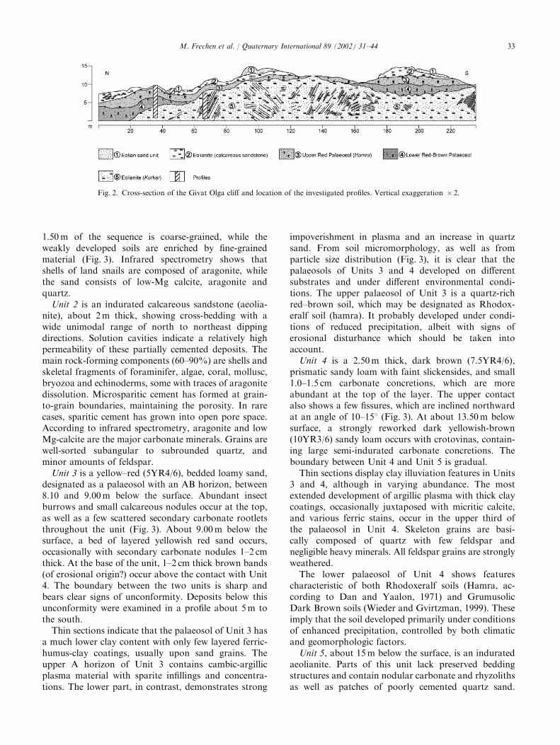
In order to reconstruct changes in sedimentaryenvironments during the geological past, we investigatedthe major stratigraphic units from the key sectionlocated in the northern part of the Givat Olga outcrop(Fig. 2). The coastal cliff at Givat Olga is composed ofseveral lithological units. The base of the exposedQuaternary sediments is formed by an aeolianite (Unit5). On top of this aeolianite, two welded palaeosols,Unit 4 and Unit 3, occur in a morphologic depression.The palaeosols are covered by calcareous sandstone(Unit 2) indicating a phase of re-activated sandmigration. The youngest deposits (Unit 1) are aeoliansands intercalated by weakly developed soils defined asregosols. These palaeosols occur sporadically on top ofthe sequence.The uppermost Unit 1, about 5m thick, is composed
of loose aeolian sand interstratified by weakly developedpalaeosols. These youngest deposits are now partlystabilized by vegetation. Unit 1 includes two majorhorizons. The upper horizon is a brownish-yellow dunesand (Munsell colour on dry material: 10YR6/6) and iscomposed of quartz and calcareous fragments, mainlysnail shells. The lower horizon of Unit 1 contains twoweakly developed palaeosols. The two A horizons havea dark yellow–brown (10YR5/6-4/6) colour, very similarto the surface regosol on top of the modern dune.Particle-size analysis indicates that the uppermost
Fig. 1. Map showing kurkar ridges between Netanya and Haifa and
the location of the sections at Givat Olga, Netanya South and Ga‘ash
in the Sharon Coastal Plain of Israel.
M. Frechen et al. / Quaternary International 89 (2002) 31–4432
1.50m of the sequence is coarse-grained, while theweakly developed soils are enriched by fine-grainedmaterial (Fig. 3). Infrared spectrometry shows thatshells of land snails are composed of aragonite, whilethe sand consists of low-Mg calcite, aragonite andquartz.
Unit 2 is an indurated calcareous sandstone (aeolia-nite), about 2m thick, showing cross-bedding with awide unimodal range of north to northeast dippingdirections. Solution cavities indicate a relatively highpermeability of these partially cemented deposits. Themain rock-forming components (60–90%) are shells andskeletal fragments of foraminifer, algae, coral, mollusc,bryozoa and echinoderms, some with traces of aragonitedissolution. Microsparitic cement has formed at grain-to-grain boundaries, maintaining the porosity. In rarecases, sparitic cement has grown into open pore space.According to infrared spectrometry, aragonite and lowMg-calcite are the major carbonate minerals. Grains arewell-sorted subangular to subrounded quartz, andminor amounts of feldspar.
Unit 3 is a yellow–red (5YR4/6), bedded loamy sand,designated as a palaeosol with an AB horizon, between8.10 and 9.00m below the surface. Abundant insectburrows and small calcareous nodules occur at the top,as well as a few scattered secondary carbonate rootletsthroughout the unit (Fig. 3). About 9.00m below thesurface, a bed of layered yellowish red sand occurs,occasionally with secondary carbonate nodules 1–2 cmthick. At the base of the unit, 1–2 cm thick brown bands(of erosional origin?) occur above the contact with Unit4. The boundary between the two units is sharp andbears clear signs of unconformity. Deposits below thisunconformity were examined in a profile about 5m tothe south.Thin sections indicate that the palaeosol of Unit 3 has
a much lower clay content with only few layered ferric-humus-clay coatings, usually upon sand grains. Theupper A horizon of Unit 3 contains cambic-argillicplasma material with sparite infillings and concentra-tions. The lower part, in contrast, demonstrates strong
impoverishment in plasma and an increase in quartzsand. From soil micromorphology, as well as fromparticle size distribution (Fig. 3), it is clear that thepalaeosols of Units 3 and 4 developed on differentsubstrates and under different environmental condi-tions. The upper palaeosol of Unit 3 is a quartz-richred–brown soil, which may be designated as Rhodox-eralf soil (hamra). It probably developed under condi-tions of reduced precipitation, albeit with signs oferosional disturbance which should be taken intoaccount.
Unit 4 is a 2.50m thick, dark brown (7.5YR4/6),prismatic sandy loam with faint slickensides, and small1.0–1.5 cm carbonate concretions, which are moreabundant at the top of the layer. The upper contactalso shows a few fissures, which are inclined northwardat an angle of 10–151 (Fig. 3). At about 13.50m belowsurface, a strongly reworked dark yellowish-brown(10YR3/6) sandy loam occurs with crotovinas, contain-ing large semi-indurated carbonate concretions. Theboundary between Unit 4 and Unit 5 is gradual.Thin sections display clay illuviation features in Units
3 and 4, although in varying abundance. The mostextended development of argillic plasma with thick claycoatings, occasionally juxtaposed with micritic calcite,and various ferric stains, occur in the upper third ofthe palaeosol in Unit 4. Skeleton grains are basi-cally composed of quartz with few feldspar andnegligible heavy minerals. All feldspar grains are stronglyweathered.The lower palaeosol of Unit 4 shows features
characteristic of both Rhodoxeralf soils (Hamra, ac-cording to Dan and Yaalon, 1971) and GrumusolicDark Brown soils (Wieder and Gvirtzman, 1999). Theseimply that the soil developed primarily under conditionsof enhanced precipitation, controlled by both climaticand geomorphologic factors.
Unit 5, about 15m below the surface, is an induratedaeolianite. Parts of this unit lack preserved beddingstructures and contain nodular carbonate and rhyzolithsas well as patches of poorly cemented quartz sand.
Fig. 2. Cross-section of the Givat Olga cliff and location of the investigated profiles. Vertical exaggeration � 2.
M. Frechen et al. / Quaternary International 89 (2002) 31–44 33
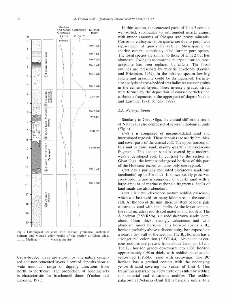
Cross-bedded areas are shown by alternating cemen-ted and non-cemented layers. Leeward deposits show awide unimodal range of dipping directions fromnorth to northeast. The proportion of bedding setsis characteristic for barchanoid dunes (Yaalon andLaronne, 1971).
In thin section, the cemented parts of Unit 5 containwell-sorted, subangular to subrounded quartz grains,with minor amounts of feldspar and heavy minerals.Corrosion embayments on quartz are due to peripheralreplacement of quartz by calcite. Microsparitic tosparitic cement completely filled former pore spaces.The fossil species are similar to those of Unit 2 but lessabundant. Owing to neomorphic re-crystallization, mostaragonite has been replaced by calcite. The fossiloutlines are preserved by micritic envelopes (Gavishand Friedman, 1969). In the infrared spectra low-Mgcalcite and aragonite could be distinguished. Particle-size analysis of cross-bedded sets indicates coarser grainsin the cemented layers. These inversely graded stratawere formed by the deposition of coarser particles andcarbonate fragments in the upper part of slopes (Yaalonand Laronne, 1971; Schenk, 1992).
2.2. Netanya South
Similarly to Givat Olga, the coastal cliff in the southof Netanya is also composed of several lithological units(Fig. 4).
Unit 1 is composed of unconsolidated sand andintercalated regosols. These deposits are nearly 2m thickand cover parts of the coastal cliff. The upper horizon ofthis unit is dune sand, mainly quartz and calcareousfragments. This aeolian sand is covered by a modern,weakly developed soil. In contrast to the section atGivat Olga, the lower sand/regosol horizon of this partof the Holocene record contains only one regosol.
Unit 2 is a partially indurated calcareous sandstone(aeolianite) up to 3m thick. It shows weakly preservedcross-bedding and is composed of quartz sand with alarge amount of marine carbonate fragments. Shells ofland snails are also abundant.
Unit 3 is a well-developed mature reddish palaeosol,which can be traced for many kilometres in the coastalcliff. At the top of the unit, there is 10 cm of loose palecalcareous sand with snail shells. At the lower contact,the sand includes reddish soil material and rootlets. TheA horizon (7.5YR5/6) is a reddish-brown sandy loam,about 15 cm thick, strongly calcareous and withabundant insect burrows. This horizon covers a Bcahorizon probably above a discontinuity, best exposed ona nearby dry wall of the section. The Bca horizon has astronger red coloration (2.5YR4/4). Abundant calcar-eous nodules are present from about 2mm to 1.5 cm.The Bca horizon grades downward into a BC horizonapproximately 0.60m thick, with reddish patches andyellow–red (5YR4/6) sand with crotovinas. The BChorizon has a gradual contact with the underlyingyellowish sand covering the kurkar of Unit 4. Thistransition is marked by a few crotovinas filled by reddishsoil material and calcareous nodules. The reddishpalaeosol at Netanya (Unit III) is basically similar to a
Fig. 3. Lithological sequence with median grain-size, carbonate
content and Munsell color results of the section at Givat Olga.
Median; - - - - - - - - Mean grain size.
M. Frechen et al. / Quaternary International 89 (2002) 31–4434
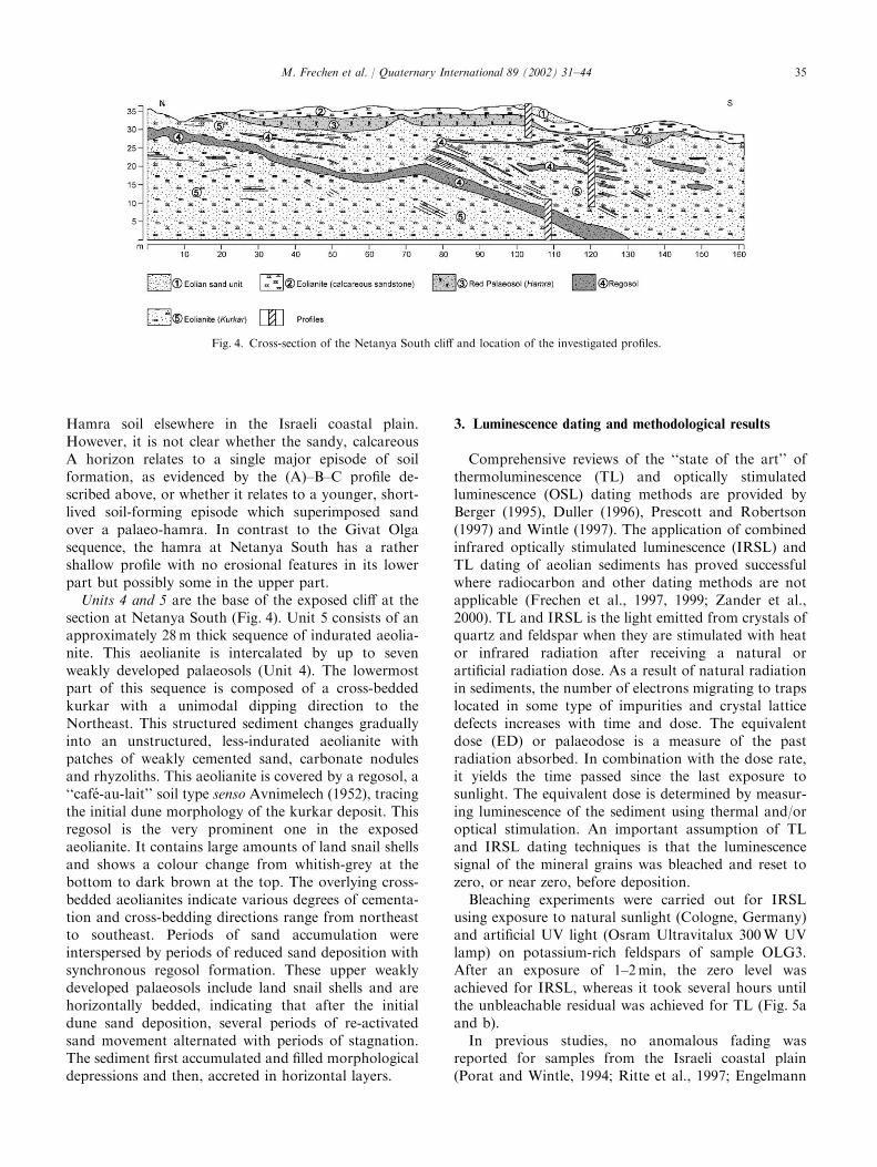
Hamra soil elsewhere in the Israeli coastal plain.However, it is not clear whether the sandy, calcareousA horizon relates to a single major episode of soilformation, as evidenced by the (A)–B–C profile de-scribed above, or whether it relates to a younger, short-lived soil-forming episode which superimposed sandover a palaeo-hamra. In contrast to the Givat Olgasequence, the hamra at Netanya South has a rathershallow profile with no erosional features in its lowerpart but possibly some in the upper part.
Units 4 and 5 are the base of the exposed cliff at thesection at Netanya South (Fig. 4). Unit 5 consists of anapproximately 28m thick sequence of indurated aeolia-nite. This aeolianite is intercalated by up to sevenweakly developed palaeosols (Unit 4). The lowermostpart of this sequence is composed of a cross-beddedkurkar with a unimodal dipping direction to theNortheast. This structured sediment changes graduallyinto an unstructured, less-indurated aeolianite withpatches of weakly cemented sand, carbonate nodulesand rhyzoliths. This aeolianite is covered by a regosol, a‘‘caf!e-au-lait’’ soil type senso Avnimelech (1952), tracingthe initial dune morphology of the kurkar deposit. Thisregosol is the very prominent one in the exposedaeolianite. It contains large amounts of land snail shellsand shows a colour change from whitish-grey at thebottom to dark brown at the top. The overlying cross-bedded aeolianites indicate various degrees of cementa-tion and cross-bedding directions range from northeastto southeast. Periods of sand accumulation wereinterspersed by periods of reduced sand deposition withsynchronous regosol formation. These upper weaklydeveloped palaeosols include land snail shells and arehorizontally bedded, indicating that after the initialdune sand deposition, several periods of re-activatedsand movement alternated with periods of stagnation.The sediment first accumulated and filled morphologicaldepressions and then, accreted in horizontal layers.
3. Luminescence dating and methodological results
Comprehensive reviews of the ‘‘state of the art’’ ofthermoluminescence (TL) and optically stimulatedluminescence (OSL) dating methods are provided byBerger (1995), Duller (1996), Prescott and Robertson(1997) and Wintle (1997). The application of combinedinfrared optically stimulated luminescence (IRSL) andTL dating of aeolian sediments has proved successfulwhere radiocarbon and other dating methods are notapplicable (Frechen et al., 1997, 1999; Zander et al.,2000). TL and IRSL is the light emitted from crystals ofquartz and feldspar when they are stimulated with heator infrared radiation after receiving a natural orartificial radiation dose. As a result of natural radiationin sediments, the number of electrons migrating to trapslocated in some type of impurities and crystal latticedefects increases with time and dose. The equivalentdose (ED) or palaeodose is a measure of the pastradiation absorbed. In combination with the dose rate,it yields the time passed since the last exposure tosunlight. The equivalent dose is determined by measur-ing luminescence of the sediment using thermal and/oroptical stimulation. An important assumption of TLand IRSL dating techniques is that the luminescencesignal of the mineral grains was bleached and reset tozero, or near zero, before deposition.Bleaching experiments were carried out for IRSL
using exposure to natural sunlight (Cologne, Germany)and artificial UV light (Osram Ultravitalux 300W UVlamp) on potassium-rich feldspars of sample OLG3.After an exposure of 1–2min, the zero level wasachieved for IRSL, whereas it took several hours untilthe unbleachable residual was achieved for TL (Fig. 5aand b).In previous studies, no anomalous fading was
reported for samples from the Israeli coastal plain(Porat and Wintle, 1994; Ritte et al., 1997; Engelmann
Fig. 4. Cross-section of the Netanya South cliff and location of the investigated profiles.
M. Frechen et al. / Quaternary International 89 (2002) 31–44 35

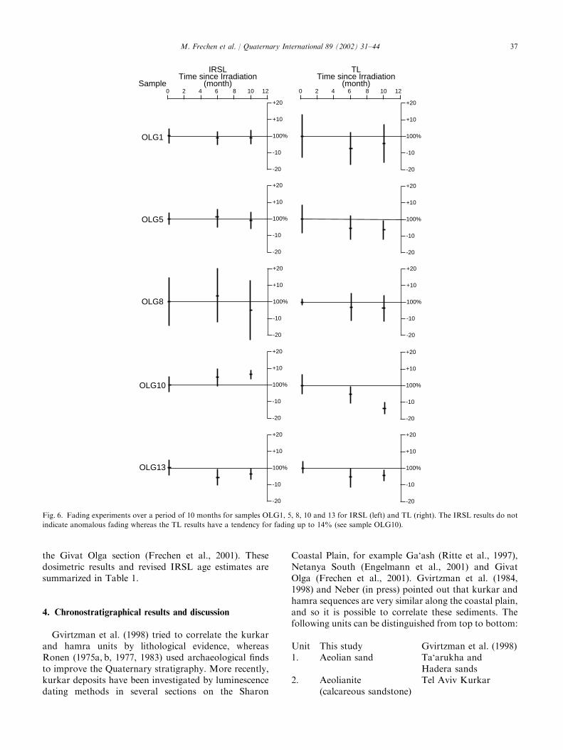
et al., 2001; Frechen et al., 2001). In this study, extensivefading experiments over a period of ten months havebeen carried out for a suite of samples from the GivatOlga section covering most of the stratigraphic layers(Fig. 6). No anomalous fading was determined for theIRSL method, as suggested by the previous studies.However, a tendency of signal decrease is obvious forthe mean values of the TL method ranging from about5–14% (Fig. 6). The highest value of anomalous fading(TL) was determined for sample OLG10, which wastaken from the Red Palaeosol (Hamra) at section GivatOlga.The suitability of quartz using green light stimula-
tion (GLSL) was investigated in a multiple aliquotapproach. The different steps of quartz preparation
are described by Frechen (1995). The luminescencemeasurements were applied using the stimulation of agreen halogen lamp (420–550 nm) of the Ris� Reader inCheltenham with a detection filter pack of three HoyaU-340. The luminescence results indicate that quartz isalready in saturation for samples OLG5 and OLG4,asindicated by no or little signal increase with dose(Fig. 7).Examples of IR decay and TL glow curvesand the resulting growth curves are presented in Figs. 8aand b.A re-calculation of the total dose rate concerning the
attenuation of the cosmic dose (cf. Aitken, 1998) for theNetanya South section was necessary following furtherfield-inspection. The IRSL age estimates of this lattersection were re-calculated with the same approach as for
Fig. 5. Bleaching experiments for sample OLG3. The results indicate a zero level for the IRSL method after 1–2min or 5–6min exposure to natural
sunlight and artificial UV light, respectively: (a) bleaching with artificial UV light (Osram Ultravitalux 300W UV lamp); (b) bleaching with natural
sunlight in Cologne, Germany.
M. Frechen et al. / Quaternary International 89 (2002) 31–4436
the Givat Olga section (Frechen et al., 2001). Thesedosimetric results and revised IRSL age estimates aresummarized in Table 1.
4. Chronostratigraphical results and discussion
Gvirtzman et al. (1998) tried to correlate the kurkarand hamra units by lithological evidence, whereasRonen (1975a, b, 1977, 1983) used archaeological findsto improve the Quaternary stratigraphy. More recently,kurkar deposits have been investigated by luminescencedating methods in several sections on the Sharon
Coastal Plain, for example Ga‘ash (Ritte et al., 1997),Netanya South (Engelmann et al., 2001) and GivatOlga (Frechen et al., 2001). Gvirtzman et al. (1984,1998) and Neber (in press) pointed out that kurkar andhamra sequences are very similar along the coastal plain,and so it is possible to correlate these sediments. Thefollowing units can be distinguished from top to bottom:
Unit This study Gvirtzman et al. (1998)1. Aeolian sand Ta‘arukha and
Hadera sands2. Aeolianite
(calcareous sandstone)Tel Aviv Kurkar
0 2 4 6 8 10 12 0 2 4 6 8 10 12
+20
+10
100%
-10
-20
+20
+10
100%
-10
-20
+20
+10
100%
-10
-20
+20
+10
100%
-10
-20
+20
+10
100%
-10
-20
+20
+10
100%
-10
-20
+20
+10
100%
-10
-20
+20
+10
100%
-10
-20
+20
+10
100%
-10
-20
+20
+10
100%
-10
-20
IRSLTime since Irradiation
(month)
TLTime since Irradiation
(month)Sample
OLG1
OLG5
OLG8
OLG10
OLG13
Fig. 6. Fading experiments over a period of 10 months for samples OLG1, 5, 8, 10 and 13 for IRSL (left) and TL (right). The IRSL results do not
indicate anomalous fading whereas the TL results have a tendency for fading up to 14% (see sample OLG10).
M. Frechen et al. / Quaternary International 89 (2002) 31–44 37

3. Red palaeosol (Hamra) Netanya Hamra4. Red-brown palaeosol Not defined5. Aeolianite (Kurkar)
intercalated by severalregosols
Dor Kurkar
The stratigraphically oldest units at the sectionsat Givat Olga, Netanya South and Ga‘ash consist ofcalcareous sandstone aeolianite. A mean IRSL ageof 53.979.1 ka was determined for this aeolianitefrom Givat Olga (including samples OLG1+3 and
0 10 20 30 40 50 60Dose (a.u.)
10
20
30G
LSL
inte
nsity
(co
unts
)OLG5, normalized
0 10 20 30 40 50 60Dose (a.u.)
10
20
30
40
50
60
70
80
90
TL
inte
nsity
(co
unts
)
OLG4, normalized
Fig. 7. Regression analysis for samples OLG5 and OLG4. Samples were normalized and stimulated with OSL (green light) using quartz grains.
Besides the significant sample-to-sample scattering, both samples do not indicate an increase of signal intensity with dose. These quartz samples are
most likely in saturation.
Fig. 8. IRSL decay curves and TL glow curves and regression analysis for monomineralic potassium-rich feldspars from sample OLG13 (a) and
sample OLG1 (b), respectively.
M. Frechen et al. / Quaternary International 89 (2002) 31–4438
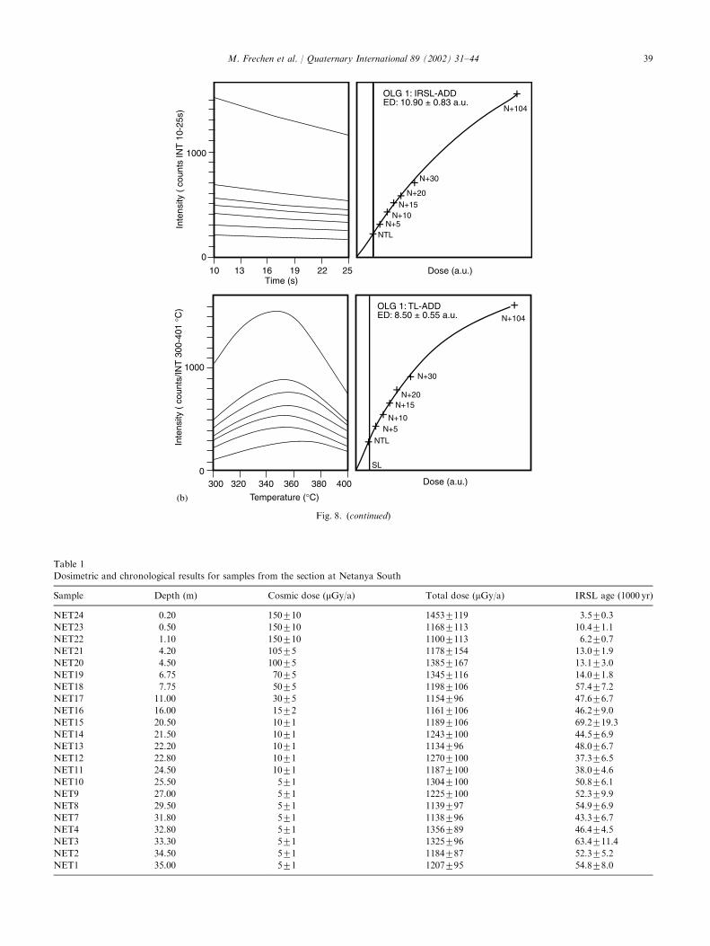
Fig. 8. (continued)
Table 1
Dosimetric and chronological results for samples from the section at Netanya South
Sample Depth (m) Cosmic dose (mGy/a) Total dose (mGy/a) IRSL age (1000 yr)
NET24 0.20 150710 14537119 3.570.3NET23 0.50 150710 11687113 10.471.1NET22 1.10 150710 11007113 6.270.7NET21 4.20 10575 11787154 13.071.9NET20 4.50 10075 13857167 13.173.0NET19 6.75 7075 13457116 14.071.8NET18 7.75 5075 11987106 57.477.2NET17 11.00 3075 1154796 47.676.7NET16 16.00 1572 11617106 46.279.0NET15 20.50 1071 11897106 69.2719.3NET14 21.50 1071 12437100 44.576.9NET13 22.20 1071 1134796 48.076.7NET12 22.80 1071 12707100 37.376.5NET11 24.50 1071 11877100 38.074.6NET10 25.50 571 13047100 50.876.1NET9 27.00 571 12257100 52.379.9NET8 29.50 571 1139797 54.976.9NET7 31.80 571 1138796 43.376.7NET4 32.80 571 1356789 46.474.5NET3 33.30 571 1325796 63.4711.4NET2 34.50 571 1184787 52.375.2NET1 35.00 571 1207795 54.878.0
M. Frechen et al. / Quaternary International 89 (2002) 31–44 39
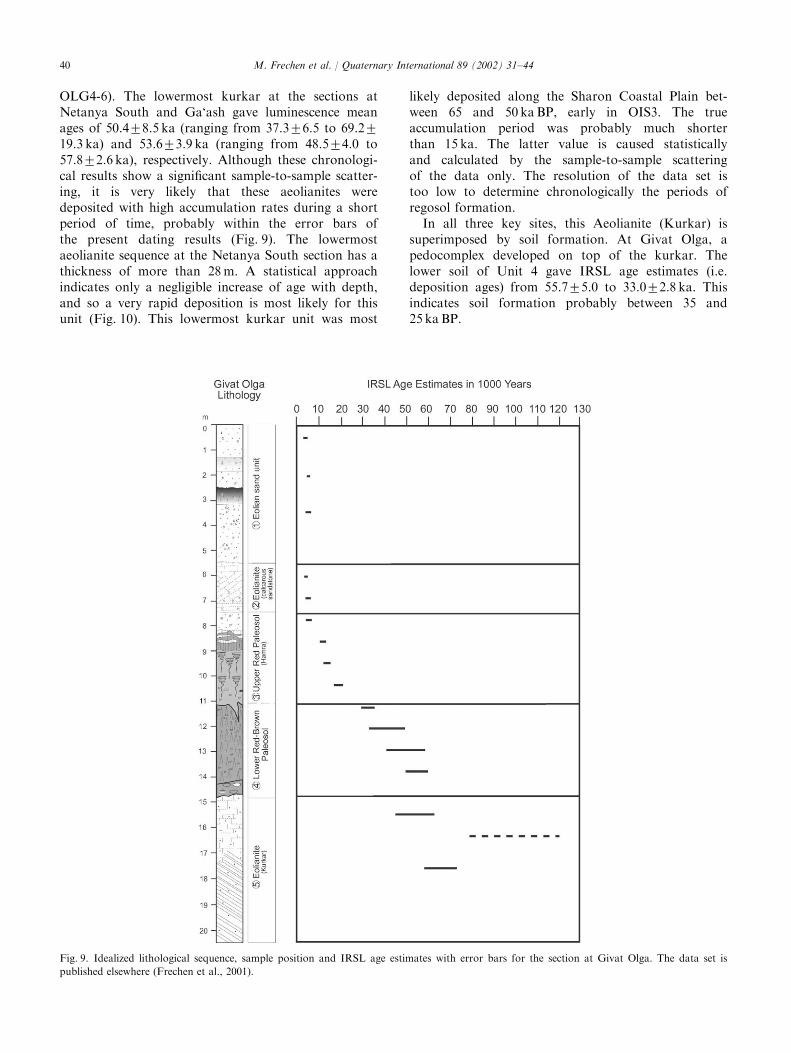
OLG4-6). The lowermost kurkar at the sections atNetanya South and Ga‘ash gave luminescence meanages of 50.478.5 ka (ranging from 37.376.5 to 69.2719.3 ka) and 53.673.9 ka (ranging from 48.574.0 to57.872.6 ka), respectively. Although these chronologi-cal results show a significant sample-to-sample scatter-ing, it is very likely that these aeolianites weredeposited with high accumulation rates during a shortperiod of time, probably within the error bars ofthe present dating results (Fig. 9). The lowermostaeolianite sequence at the Netanya South section has athickness of more than 28m. A statistical approachindicates only a negligible increase of age with depth,and so a very rapid deposition is most likely for thisunit (Fig. 10). This lowermost kurkar unit was most
likely deposited along the Sharon Coastal Plain bet-ween 65 and 50 kaBP, early in OIS3. The trueaccumulation period was probably much shorterthan 15 ka. The latter value is caused statisticallyand calculated by the sample-to-sample scatteringof the data only. The resolution of the data set istoo low to determine chronologically the periods ofregosol formation.In all three key sites, this Aeolianite (Kurkar) is
superimposed by soil formation. At Givat Olga, apedocomplex developed on top of the kurkar. Thelower soil of Unit 4 gave IRSL age estimates (i.e.deposition ages) from 55.775.0 to 33.072.8 ka. Thisindicates soil formation probably between 35 and25 kaBP.
Fig. 9. Idealized lithological sequence, sample position and IRSL age estimates with error bars for the section at Givat Olga. The data set is
published elsewhere (Frechen et al., 2001).
M. Frechen et al. / Quaternary International 89 (2002) 31–4440
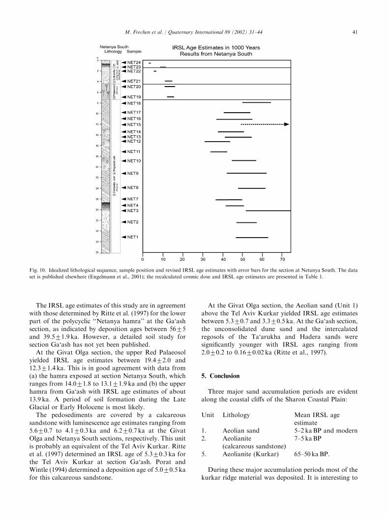
The IRSL age estimates of this study are in agreementwith those determined by Ritte et al. (1997) for the lowerpart of the polycyclic ‘‘Netanya hamra’’ at the Ga‘ashsection, as indicated by deposition ages between 5675and 39.571.9 ka. However, a detailed soil study forsection Ga‘ash has not yet been published.At the Givat Olga section, the upper Red Palaeosol
yielded IRSL age estimates between 19.472.0 and12.371.4 ka. This is in good agreement with data from(a) the hamra exposed at section Netanya South, whichranges from 14.071.8 to 13.171.9 ka and (b) the upperhamra from Ga‘ash with IRSL age estimates of about13.9 ka. A period of soil formation during the LateGlacial or Early Holocene is most likely.The pedosediments are covered by a calcareous
sandstone with luminescence age estimates ranging from5.670.7 to 4.170.3 ka and 6.270.7 ka at the GivatOlga and Netanya South sections, respectively. This unitis probably an equivalent of the Tel Aviv Kurkar. Ritteet al. (1997) determined an IRSL age of 5.370.3 ka forthe Tel Aviv Kurkar at section Ga‘ash. Porat andWintle (1994) determined a deposition age of 5.070.5 kafor this calcareous sandstone.
At the Givat Olga section, the Aeolian sand (Unit 1)above the Tel Aviv Kurkar yielded IRSL age estimatesbetween 5.370.7 and 3.370.5 ka. At the Ga‘ash section,the unconsolidated dune sand and the intercalatedregosols of the Ta‘arukha and Hadera sands weresignificantly younger with IRSL ages ranging from2.070.2 to 0.1670.02 ka (Ritte et al., 1997).
5. Conclusion
Three major sand accumulation periods are evidentalong the coastal cliffs of the Sharon Coastal Plain:
Unit Lithology Mean IRSL ageestimate
1. Aeolian sand 5–2 kaBP and modern2. Aeolianite
(calcareous sandstone)7–5 kaBP
5. Aeolianite (Kurkar) 65–50 kaBP.
During these major accumulation periods most of thekurkar ridge material was deposited. It is interesting to
Fig. 10. Idealized lithological sequence, sample position and revised IRSL age estimates with error bars for the section at Netanya South. The data
set is published elsewhere (Engelmann et al., 2001); the recalculated cosmic dose and IRSL age estimates are presented in Table 1.
M. Frechen et al. / Quaternary International 89 (2002) 31–44 41
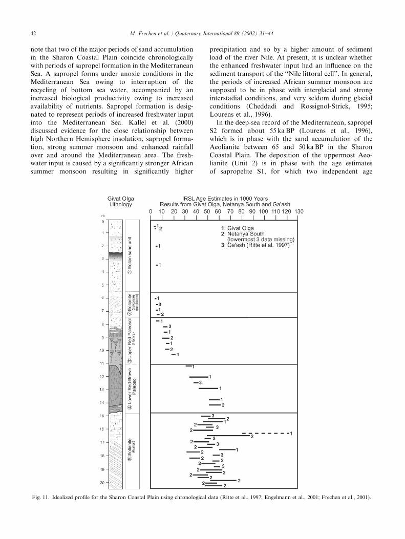
note that two of the major periods of sand accumulationin the Sharon Coastal Plain coincide chronologicallywith periods of sapropel formation in the MediterraneanSea. A sapropel forms under anoxic conditions in theMediterranean Sea owing to interruption of therecycling of bottom sea water, accompanied by anincreased biological productivity owing to increasedavailability of nutrients. Sapropel formation is desig-nated to represent periods of increased freshwater inputinto the Mediterranean Sea. Kallel et al. (2000)discussed evidence for the close relationship betweenhigh Northern Hemisphere insolation, sapropel forma-tion, strong summer monsoon and enhanced rainfallover and around the Mediterranean area. The fresh-water input is caused by a significantly stronger Africansummer monsoon resulting in significantly higher
precipitation and so by a higher amount of sedimentload of the river Nile. At present, it is unclear whetherthe enhanced freshwater input had an influence on thesediment transport of the ‘‘Nile littoral cell’’. In general,the periods of increased African summer monsoon aresupposed to be in phase with interglacial and stronginterstadial conditions, and very seldom during glacialconditions (Cheddadi and Rossignol-Strick, 1995;Lourens et al., 1996).In the deep-sea record of the Mediterranean, sapropel
S2 formed about 55 kaBP (Lourens et al., 1996),which is in phase with the sand accumulation of theAeolianite between 65 and 50 kaBP in the SharonCoastal Plain. The deposition of the uppermost Aeo-lianite (Unit 2) is in phase with the age estimatesof sapropelite S1, for which two independent age
Fig. 11. Idealized profile for the Sharon Coastal Plain using chronological data (Ritte et al., 1997; Engelmann et al., 2001; Frechen et al., 2001).
M. Frechen et al. / Quaternary International 89 (2002) 31–4442

estimates are available: 7.874.0 kaBP (Cheddadi andRossignol-Strick, 1995) and about 8.5 kaBP (Lourenset al., 1996).The periods of sand accumulation and desertification
are followed by soil formation. Two main periods of soilformation are obvious. The Brown Palaeosol and theRed Palaeosol (Hamra), both in Unit 4, formed mostlikely between 35 and 25 kaBP and between 15 and12 kaBP, respectively. The Brown Palaeosol developedprimarily under conditions of enhanced precipitationand wetness, as indicated by thick clay coatings,strongly weathered feldspar grains, the prismatic struc-ture and the presence of crotovinas. The Red Palaeosol(Hamra) has a much lower clay content than the BrownPalaeosol and most likely formed under conditions ofreduced precipitation (Fig. 11).Several weak weathering horizons resulting in rego-
sol-type soils were formed during the accumulation ofUnit 5 and Unit 1. These periods of soil formations areobviously not in phase with periods of high freshwatersupply and so increased precipitation in the easternMediterranean area. This multidisciplinary study hasprovided a better understanding of climate and envir-onment change in the Sharon Coastal Plain of Israel,although additional data are needed to resolve temporaldetails fully.
Acknowledgements
We thank the German-Israeli Foundation for fund-ing [Project-No. I132-301.02/95], Frank Chambers,Anette Engelmann and Terry Hill, all of Cheltenham,for valuable comments on an earlier version of themanuscript.
References
Aitken, M.J., 1998. Introduction to Optical Dating. Academic Press,
Oxford.
Avnimelech, M., 1952. Late Quaternary sediments of the coastal plain
of Israel. Israel Research Council Bulletin 2, 51–57.
Berger, G.W., 1995. Progress in luminescence dating methods for
Quaternary sediments. In: Rutter, N.W., Catto, N.R. (Eds.),
Dating Methods for Quaternary Deposits, Geoscience Canada.
Geotext 2, 81–104.
Boenigk, W., Brunnacker, K., Tillmanns, W., Ronen, A., 1985. Die.Aolianite in der n .ordlichen K .ustenebene von Israel. Genese,
Stratigraphie und Klimageschichte. Quart.ar 35/36, 113–140.
Brunnacker, K., Ronen, A., Tillmanns, W., 1982. Die jungpleistoz.anen.Aolianite in der s .udlichen K .ustenzone von Israel. Ein Beitrag zur
zeitlich-r.aumlichen Klimaentwicklung. Eiszeitalter und Gegenwart
32, 23–48.
Bullock, P., Fedoroff, N., Jongerius, A., Stoops, G., Tursina, T., 1985.
Handbook for Soil Thin Section Description. Waine Research,
Wolverhampton.
Cheddadi, R., Rossignol-Strick, M., 1995. Improved preservation of
organic matter in Eastern Mediterranean sapropels. Palaeoceano-
graphy 10 (2), 301–309.
Dan, J., Yaalon, D.H., 1971. On the origin and nature of
paleopedological formations in the coastal desert fringe areas of
Israel. In: Yaalon, D.H. (Ed.), PaleopedologyFOrigin, Natureand Dating of Paleosols. Israel University Press, Jerusalem,
pp. 245–260.
Duller, G.A.T., 1996. Recent developments in luminescence dating
of Quaternary sediments. Progress in Physical Geography 20 (2),
127–145.
Emery, K.O., Neev, 1960. Mediterranean beaches of Israel. Bulletin of
the Geological Society of Israel, 26, 1–22.
Engelmann, A., Neber, A., Frechen, M., Boenigk, W., Ronen, A.,
2001. Luminescence chronology of upper Pleistocene and Holocene
aeolianites from Netanya South–Sharon Coastal Plain, Israel.
Quaternary Science Reviews 20, 799–804.
Frechen, M., 1995. Chronostratigraphie des ‘‘Eiszeitlichen L .o�profils’’in Koblenz-Metternich. Mainzer geowissenschaftliche Mitteilungen
24, 155–180.
Frechen, M., Horv!ath, E., G!abris, G., 1997. Geochronology of middle
and upper Pleistocene loess sections in Hungary. Quaternary
Research 48, 291–312.
Frechen, M., Neber, A., Engelmann, A., Tsatskin, A., Boenigk, W.,
Ronen, A., in preparation. Pleistocene Sedimentary Cycles in the
Carmel Coastal Plain of Israel (to be submitted to Quaternary
International).
Frechen, M., Zander, A., Cilek, V., Lozek, V., 1999. Loess chronology
of the last interglacial/glacial cycle in Bohemia and Moravia/Czech
Republic. Quaternary Science Reviews 18, 1467–1493.
Frechen, M., Dermann, B., Boenigk, W., Ronen, A., 2001. Lumines-
cence chronology of aeolianites from the section at Givat
OlgaFcoastal plain of Israel. Quaternary Science Reviews 20,805–809.
Gavish, E., Friedman, G.M., 1969. Progressive diagenesis in
Quaternary to later Tertiary carbonate sediments: sequence and
time scale. Journal of Sediment Petrology 55, 109–119.
Goldsmith, V., Golik, A., 1980. Sediment transport model of the
southeastern Mediterranean coast. Marine Geology 37, 147–175.
Gvirtzman, G., Shachnai, E., Bakler, N., Ilani, S., 1984. Stratigraphy
of the kurkar group (Quaternary) of the coastal plain of Israel.
Geological Survey Israel, Current Research, 1983–84, 70–82.
Gvirtzman, G., Netser, M., Katsav, E., 1998. Last-Glacial to Holocene
kurkar ridges, hamra soils and dune fields in the coastal belt of
Israel. Israeli Journal of Earth Science 47, 29–46.
Gvirtzman, G., Wieder, M., Carmi, I., 2000. Climate change during
the Late Holocene of the coastal plain of Israel according to
Carbon-14 dating of land snails. International Radiocarbon
Conference, Judean Hills, Israel, p. 82 (abstracts).
Issar, A., 1968. Geology of the central coastal plain of Israel. Israel
Journal of Earth Sciences 17, 16–29.
Kallel, N., Duplessy, J.C., Labeyrie, L., Fontugne, M., Paterne, M.,
Montacer, M., 2000. Mediterranean pluvial periods and sapropel
formation over the last 200,000 yr. Palaeogeography, Palaeoclima-
tology, Palaeoecology 157, 45–58.
Lewis, D.W., McConchie, D., 1994. Practical Sedimentology. Chap-
man and Hall, New York, London, 213pp.
Lourens, L.J., Antonarakon, A., Hilgen, F.J., Van Hoof, A.A.M.,
Vergnaud-Grazzini, C., Zachariasse, W.J., 1996. Evaluation of the
Plio-Pleistocene astronomical timescale. Palaeoceanography 11 (4),
391–413.
Neber, A., 1999. Stratigraphy of Holocene deposits of the Hadera
dunefield in the Sharon Coastal Plain, Israel. INQUA 15th
International Congress, Durban, South Africa, p. 131 (abstract).
Neber, A., in press. Pleistocene sandstone on the Carmel coastal plain
of Israel: an overview. INQUA Subcommittee on Palaeolithic
Geoarchaeology, Newsletter, Vol. 2.
Porat, N., Wintle, A.G., 1994. IRSL dating of kurkar and hamra from
the Givat Olga Member in the Sharon Coastal Cliff, Israel.
M. Frechen et al. / Quaternary International 89 (2002) 31–44 43
Proceedings of the Annual Meeting, Israel Geological Society,
p. 85.
Prescott, J.R., Robertson, G.B., 1997. Sediment dating by lumines-
cence: a review. Radiation Measurements 27, 893–922.
Ritte, M., Porat, N., Gvirtzman, G., 1997. Stratigraphy of the coastal
cliff of the Sharon environments of deposition and luminescence
dating. Proceedings of the Annual Meeting, Israel Geological
Society, pp. 92–93.
Ronen, A., 1975a. The Palaeolithic archaeology and chronology of
Israel. In: Wendorf, F. and Marks, A.E. (Eds.), Problems
in Prehistory: North Africa and the Levant, Dallas, pp. 229–248.
Ronen, A., 1975b. R!eflexions sur l’origine, la gen!ese et la chronologie
des gr"es dunaires calcifi!es dits premi"ere et deuxi"eme cha#ınes c #oti"eres
sur le littoral isra!elien. Bulletin de la Soci!et!e Pr!ehistorique
Fran-caise 72, 72–77.
Ronen, A., 1977. Mousterian sites in the red loam of Mount Carmel.
Eretz-Israel 13, 183–190.
Ronen, A., 1983. Late Quaternary sea levels inferred from coastal
stratigraphy and archaeology in Israel. In: Masters, P.M.,
Flemings, N.C. (Eds.), Quaternary Coastlines and Marine Archae-
ology Towards the Prehistory of Landbridges and Continental
Shelves, London, pp. 293–304.
Schenk, C.J., 1992. Processes of eolian sand transport and depo-
sition. In: Fryberger, S.G., Krystinik, L.F., Schenk, C.J.
(Eds.), Modern and Ancient Eolian Deposits: Petroleum Explora-
tion and Production, 2.1-9, Rocky Mountain Section, Denver,
Colorado.
Soil Survey Staff, 1975. Soil taxonomy. A basic system of soil
classification for making and interpreting soil surveys, USDA
Agriculture Handbook, Vol. 436. US Government Printing Office,
Washington, DC.
The Classification of Israel Soils, 1979. Special Publication, 137.
Division of Scientific Publications. The Volcano Center, Bet
Dagan, Israel.
Wieder, M., Gvirtzman, G., 1999. Micromorphological indications on
the nature of the Late Quaternary Paleosols in the southern coastal
plain of Israel. Catena 35, 219–237.
Wieder, M., Yaalon, D.H., 1974. Effect of matrix composition on
carbonate nodule crystallisation. Geoderma 11, 95–121.
Wintle, A.G., 1997. Luminescence dating: laboratory procedures and
protocols. Radiation Measurements 27, 769–817.
Yaalon, D.H., Dan, J., 1967. Factors controlling soil formation and
distribution in the Mediterranean coastal plain of Israel during
the Quaternary. Quaternary Soils, Seventh NQUA Congress 1965,
pp. 321–338.
Yaalon, D.H., Laronne, J., 1971. Internal structures in eolianites and
paleowinds, Mediterranean Coast, Israel. Journal of Sedimentary
Petrology 41, 1059–1064.
Zander, A.M., Duller, G.A.T., Wintle, A.G., 2000. Multiple and
single aliquot luminescence dating techniques applied to
quartz extracted from Middle and Upper Weichselian loess,
Zemechy, Czech Republic. Journal of Quaternary Science 15,
51–60.
M. Frechen et al. / Quaternary International 89 (2002) 31–4444


