Embed Size (px)
Citation preview
CITY OF LYNDEN
CHAPTER 16.16
CRITICAL AREAS ORDINANCE 2018 Update
CAO Originally Adopted December 15, 2003 by City Council Ordinance Number 1188
Updated: August 7, 2018 by City Council
Ordinance Number 1560
Table of Contents
Page Number
SECTION 1 – INTRODUCTION
16.16.010 Purpose and Intent 16.16.020 Authority 16.16.030 Interpretation 16.16.040 Relationship to other regulations
1
1 1 2 2
SECTION 2 – GENERAL PROVISIONS
16.16.050 Applicability and Jurisdiction 16.16.060 Authorizations Required 16.16.070 Exemption from Critical Area Review Requirements 16.16.080 Critical Area Permits 16.16.090 Waiver for Subsequent Approvals 16.16.100 Existing Non-Conforming Uses 16.16.110 Fees 16.16.120 Site Inspections 16.16.130 Enforcement 16.16.140 Offense and Penalty
3
3 3 3 5 5 6 6 7 7 7
SECTION 3 – CRITICAL AREA REVIEW PROCEDURES
16.16.150 Critical Area Review Requirements 16.16.160 Pre-application Meeting 16.16.170 Application 16.16.180 Initial Critical Areas Determination 16.16.190 Best Available Science 16.16.200 Critical Area Detailed Studies 16.16.210 Signage and Fencing 16.16.220 Mitigation Requirements 16.16.230 Mitigation Sequencing 16.16.240 Mitigation Plan Requirements 16.16.250 Bonding
9
9 9
10 10 10 11 13 13 14 14 15

SECTION 4 – WETLANDS
16.16.260 Wetland Designation 16.16.270 Wetland Identification 16.16.280 Wetland Detailed Study Requirements 16.16.290 Regulated Activities in Wetland Buffers 16.16.300 Stormwater Facilities and Wetland Buffers 16.16.310 Wetland Buffers 16.16.320 Wetland Mitigation Requirements
17
17 18 18 20 20 20 25
SECTION 5 - FISH AND WILDLIFE HABITAT CONSERVATION AREAS (FWHCA)
16.16.330 FWHCA Designation 16.16.340 FWHCA Classification 16.16.350 FWHCA Indicators 16.16.360 FWHCA Detailed Study Requirements 16.16.370 FWHCA Performance Requirements 16.16.380 Performance Standards – Specific Habitats 16.16.390 FWHCA Mitigation Requirements
28
28 29 29 30 31 32 37
SECTION 6 – GEOLOGICALLY HAZARDOUS AREAS
16.16.400 Geologically Hazardous Areas Designation 16.16.410 Geologically Hazardous Areas Classification 16.16.420 Geologically Hazardous Areas Indicators 16.16.430 Geologically Hazardous Areas Detailed Study Requirements 16.16.440 Geologically Hazardous Areas Performance Requirements
39
39 39 39 39 40
SECTION 7 – AQUIFER RECHARGE AREAS
16.16.450 Aquifer Recharge Area Designation 16.16.460 Aquifer Recharge Area Detailed Study Requirements 16.16.470 Aquifer Recharge Area Performance Requirements
41
41 41 41
SECTION 8 – DEFINITIONS
16.16.480 Definitions
42
42
1
Chapter 16.16
Critical Areas
SECTION ONE: INTRODUCTION
16.16.010 Purpose and Intent
A. The intent of this Chapter is to identify and define the types and qualities of various critical
areas within the Lynden community which contribute to or affect public health, safety and
general welfare; and to protect those critical areas deemed important by the citizens of
Lynden, the State of Washington, and the federal government; all consistent with the best
available science. Critical areas addressed in this Chapter include:
1. Wetlands;
2. Fish and wildlife habitat conservation areas;
3. Geologically hazardous areas; and
4. Aquifer recharge areas.
Frequently flooded areas are addressed in Chapter 16.12.
B. The purpose of this Chapter is to provide understandable and reasonable requirements for
the use and development of land in proximity to critical areas. The requirements set forth
herein are adopted in order to:
1. Minimize development impacts and protect the beneficial uses, natural functions and
values of critical areas;
2. Protect the quality and quantity of water resources and the species inhabiting local
waterways, wetlands and habitats;
3. Prevent erosion and loss of slope and soil stability caused by grading or alteration of
earth surfaces and removal of trees, shrubs and root systems of vegetative cover;
4. Protect the public against potentially avoidable losses from landslide, subsidence,
erosion and flooding; and
5. Meet the requirements of the Washington Growth Management Act (RCW 36.70A) with
respect to the protection of critical areas.
C. This chapter is to be administered with flexibility and attention to site-specific characteristics
in the context of the watershed or other relevant ecosystem unit. It is not the intent of this
chapter to make a parcel of property unusable by denying its owner all reasonable economic
use of the property. It is not intended to prevent the provision of public facilities and services
necessary to support existing and planned development for/by the community.
16.16.020 Authority
This Chapter is adopted under the authority of Chapters 35A.63 and 36.70A RCW and Article
11 of the Washington State Constitution.
2
A. As provided herein, the Director of Planning and Community Development (“director”) and/or
their duly designated Critical Areas Administrator (“administrator”) is given the authority to
interpret and apply, and the responsibility to enforce this chapter to accomplish the stated
purpose. Subsequent reference to the “administrator” in this Chapter refers to either the
director or their duly authorized agent.
B. The city may withhold, condition, or deny development permits or activity approvals to
ensure that they proposed action is consistent with this chapter.
16.16.030 Interpretation
In the interpretation and application of this Chapter, all provisions shall be considered to be the
minimum necessary and shall be liberally construed to serve the purpose and intent of this
Chapter.
16.16.040 Relationship to Other Regulations
A. The regulations contained in this Chapter shall apply as an overlay to other regulations
established by the City. In the event of any conflict between these regulations and any other
regulations, the more restrictive shall apply.
B. Regulation of frequently flooded areas as required by RCW 36.70A and WAC 365-190 is
provided through the Floodplain Management Ordinance of the City of Lynden, Chapter
16.12 of the Lynden Municipal Code.
C. Compliance with the provisions of this Chapter shall not be construed as constituting
compliance with any other federal, state, and local regulations and permits that may be
required (for example Shoreline Substantial Development Permit, Hydraulic Permit Act,
National Pollution Discharge Elimination System, US Army Corps of Engineers Section 404
or 401 permits). The applicant is responsible for complying with these separate
requirements.
D. These critical area regulations shall apply concurrently with review conducted under the
State Environmental Policy Act (SEPA).
3
SECTION TWO: GENERAL PROVISIONS
16.16.050 Applicability and Jurisdiction
A. This Chapter shall apply to all land, all land uses and development, and all structures and
facilities within the City of Lynden except as specifically exempted under Section 16.16.070
of this Chapter.
16.16.060 Authorizations Required
A. No development activity or alteration of land, water or vegetation within a critical area or its standard buffer, except as specifically allowed under Section 16.16.070, shall be allowed without prior authorization from the administrator. Said authorization shall document compliance with the procedural and substantive requirements of this Chapter.
B. The City of Lynden shall insure that the provisions of this Chapter are met in conjunction with review of applications for the following permits and approvals:
1. Building permit; 2. Conditional Use Permit; 3. Fill and Grade Permit; 4. SEPA Determination; 5. Shoreline Conditional Use Permit; 6. Shoreline Substantial Development Permit; 7. Shoreline Variance; 8. Short Subdivision; 9. Subdivision; 10. Zoning Variance; 11. Zoning Code Amendment 12. Planned Residential Development 13. Planned Unit Development; or 14. Any other development permit or approval required by the Lynden Municipal Code, as
amended, not expressly exempted by this Chapter.
16.16.070 Exemption from Critical Area Review Requirements
A. Subject to the limitations established in subsections (B), (C), (D) and (E) of this Section, the
following developments, associated uses and activities shall be exempt from the critical area
review procedures established in this Chapter:
1. Emergency activities necessary to reduce or prevent an immediate threat to public
health, safety and welfare. An emergency is an unanticipated and imminent threat to the
public health or safety or to the environment which requires immediate action within a
period of time too short to allow full compliance with this Chapter. The person or agency
undertaking such emergency action shall notify the administrator within one (1) working
day or as soon as practical following commencement of the emergency activity.
Following such notification, the administrator shall determine if the action taken was
within the scope of the emergency actions allowed in this subsection. If the administrator
determines that the action taken or any part of the action taken was beyond the scope of
allowed emergency actions, then the enforcement provisions of Section 16.16.140 shall
apply.
4
2. Existing activities defined as ongoing agriculture, including development and activities
related to ongoing agriculture, which do not result in expansion into a critical area or its
standard buffer.
3. Normal and routine maintenance or repair of existing structures, utilities, sewage
disposal systems, potable water systems, drainage facilities, ponds, or public and private
roads and driveways associated with existing residential or commercial development.
4. Normal maintenance, repair, or operation of existing structures, facilities, and existing
improved areas that are accessory to a single-family residential use.
5. Modification or replacement of any existing structure that does not add to or expand the
building footprint or increase septic effluent.
6. Change in the use of an existing structure that does not add to or expand the building
footprint, require additional parking or structures, or adversely impact critical areas or
their buffers.
7. Activities involving artificially created wetlands or artificial watercourses intentionally
created from non-wetland sites, including, but not limited to, grass-lined swales, irrigation
and drainage ditches, stormwater detention facilities, and landscape features, except
those features that provide critical habitat for anadromous fish, or were designed as a
dual purpose stormwater facility, and those features which were created as mitigation
pursuant to the provisions of this Chapter.
8. Outdoor recreational activities which do not adversely impact critical areas or their
buffers.
9. The harvesting of wild crops in a manner that is not injurious to natural reproduction of
such crops and provided the harvesting does not require tilling soil, planting crops, or
changing existing topography, water conditions or water sources.
10. The lawful operation and maintenance of public and private diking and drainage systems
which protect life and property.
11. Education and scientific research activities which do not adversely impact critical areas
or their buffers.
12. Site investigation work necessary for land use applications such as surveys, soil logs,
percolation tests and other related activities which do not adversely impact critical areas
or their buffers. In every case, critical area impacts shall be minimized and disturbed
areas shall be immediately restored.
13. Maintenance activities such as mowing and normal pruning, provided that such
maintenance activities are limited to existing landscaping improvements and do not
expand into critical areas or associated buffers, do not expose soils, do not alter
topography, do not destroy or clear native vegetation, and do not diminish water quality
or quantity.
14. Fish, wildlife, wetland and/or riparian enhancement activities not required as mitigation
provided that the project is approved by the U.S. Department of Fish and Wildlife, the
National Oceanic and Atmospheric Administration, the U.S. Army Corps of Engineers,
5
the U.S. Department of Agriculture, the Washington State Department of Fish and
Wildlife or the Washington State Department of Ecology.
15. Hazard tree removal within critical areas and their buffers if such tree is determined to be
a hazard through a site visit by the administrator. The administrator may require
documentation of the subject tree’s health from a certified arborist.
B. Exemption from Critical Areas Review shall not constitute exemption from any other
applicable provision of the Lynden Municipal Code.
C. Exempt activities shall use reasonable methods or accepted best management practices to
reduce potential impacts to critical areas and/or to restore impacted critical areas following
completion of exempt activities. To be exempt does not give permission to destroy or
damage a critical area or critical area buffer or to ignore risk from a natural hazard.
D. If a non-development activity (not otherwise requiring a development permit or approval)
meets any of the exemption criteria listed under subsection (A) and adheres to the
requirements established under subsection (C), then critical area review shall not be
required and the activity may proceed without action by the administrator.
E. If a proposed development activity meets any of the listed exemption criteria, then
exemption from Critical Areas Review shall be established through the following procedure:
1. The applicant shall submit an exemption request to the administrator. The request shall
be in writing and describe the proposed project, list why there will be no adverse impact
on the critical area and its buffer and list the criteria listed in this Section which apply.
2. The administrator shall review the exemption request for compliance with this Chapter
and make a determination, in writing, either certifying or denying the exemption.
3. A copy of the exemption request and subsequent determination shall be included in the
file for the proposed development activity.
16.16.080 Critical Area Permits
A. The City does not require a Critical Area permit for approved work within a designated
critical area or its buffer. Written documentation, by the administrator, of the Detailed Study
approval or exemption determination is required prior to associated development activity
being completed. For development activity requiring a building permit, Critical Area review
and approval is required prior to the building permit being issued.
16.16.090 Waiver for Subsequent Approvals
A. Critical area review requirements may be waived in conjunction with review of a
development permit application when all of the following conditions are met:
1. The provisions of this Chapter have been addressed fully through previous Critical Areas
Review of a development approval within the previous five years (such as a subdivision,
conditional use or other permit identified under Section 16.16.060(B));
2. The subsequent construction activity complies fully with the conditions established as
part of the initial land use approval; and
6
3. No substantial changes in the nature or extent of the approved activity have been made.
B. Requests for such waivers shall be submitted in writing to the administrator and shall include
the following:
1. Description of the proposed activity and citation of the previous approval;
2. Submission of a scaled site plan that presents all proposed actions and the location of
the critical areas.
3. Identification of any changes in the nature or extent of the proposed activity subsequent
to the previous approval; and
4. Documentation of compliance or substantiation of plans for compliance with all critical
areas conditions imposed as part of the previous approval.
C. The administrator shall review the waiver request and shall certify or deny the request based
on demonstration of compliance with this Chapter.
D. A copy of the waiver request and subsequent determination shall be included in the file for
the proposed construction activity.
16.16.100 Existing Non-Conforming Uses
The following provisions shall apply to existing uses and/or buildings and/or structures that do
not meet the specific standards of this chapter:
A. The lawful use of any building, structure, land, or premises existing on the effective date of
the adoption or amendment of this chapter or authorized under a permit or approval issued,
or otherwise vested, prior to the effective date of the adoption or amendment of this chapter
may be continued, subject to the provisions for a nonconforming use in LMC 19.35.
B. Expansion, alteration, and/or intensification of a nonconforming use, building or structure,
excluding normal maintenance, is prohibited if such use will produce impacts that degrade
the critical area, including but not limited to vegetation clearing; additional impervious
surfaces; generation of surface water runoff; discharge, or risk of discharge of pollutants;
increased noise, light or glare.
C. Nonconforming structures that are destroyed by fire, explosion, flood, or other casualty may
be restored or replaced in kind if there is no alternative that allows for compliance with the
standards of this chapter; provided, that the following are met:
1. The reconstruction process is commenced within 18 months of the date of such
damage; and
2. The reconstruction does not expand, enlarge, or otherwise increase the
nonconformity, except as provided for in subsection B of this section
16.16.110 Fees
A. The City Council by resolution shall establish fees for processing of Critical Areas Review
and other services provided pursuant to this Chapter. These fees shall be established based
on the anticipated direct costs to the City for review of any given development and shall
7
include any cost to the City for services provided by a qualified consultant retained by the
City to perform Critical Areas Review.
16.16.120 Site Inspections
A. The administrator is authorized to make site inspections and take such actions as necessary
to administer and enforce this Chapter. City representatives shall make a reasonable effort
to contact the property owner before entering onto private property.
16.16.130 Enforcement
A. Activities found to be not in compliance with this Chapter or any applicable performance
requirements or any conditions established through the Critical Areas Review and approval
process, such as required mitigation, shall be subject to enforcement actions necessary to
bring the activity into compliance. The City shall have the authority to require restoration,
rehabilitation or replacement measures to compensate for violations of this Chapter which
result in destruction, degradation, or reduction in function of critical areas or required buffer
areas. The City shall have the further authority to initiate a civil lawsuit seeking abatement,
injunctive and/or declaratory relief, damages, and restoration/replacement costs, for any
violation of this Chapter.
16.16.140 Offense and Penalty
A. Any person, firm, partnership, limited liability company, corporation, or other legal entity that
fails to comply or causes the failure to comply with any provision of this Chapter shall be
guilty of a misdemeanor. Each day or portion of a day during which such a violation is found
to have occurred shall constitute a separate offense.
B. The City may levy civil penalties against any person, firm, partnership, limited liability
company, corporation, or other legal entity for failure to comply or causing a failure to
comply with of any of the provisions of this Chapter. The civil penalty shall be assessed as a
one-time penalty of five hundred dollars ($500) and/or a maximum rate of five hundred
dollars ($500) per day per violation.
C. A failure to comply with a provision of this Chapter occurs when a party: (1) develops within
or disturbs a critical area or its buffer without fully complying the requirements of this
Chapter; or (2) fails to comply with mitigation requirements imposed pursuant to this
Chapter.
D. The penalty provided in subsection (B) above shall be imposed by serving the responsible
party with a notice in writing, either by certified mail with return receipt requested, or by
personal service. The notice shall include the amount of the penalty imposed and shall
describe the violation with reasonable particularity in ordering the act or acts constituting the
violation or violations to cease and desist or, in appropriate cases, requiring necessary
corrective action to be taken within a specific and reasonable time.
E. Within 30 days after the notice is received, the party incurring the penalty may apply in
writing to the Planning Director for remission or mitigation of such penalty. Upon receipt of
the application, the Planning Director may remit or mitigate the penalty upon whatever terms
the department in its discretion deems proper. The Planning Director’s final decision on
8
mitigation or revision shall be reviewed by the City Council if the aggrieved party files a
written appeal therewith of said decision within 10 days of its issuance.

9
SECTION THREE: CRITICAL AREA REVIEW PROCEDURES
16.16.150 Critical Area Review Requirements
A. Unless otherwise provided in this Chapter, the City of Lynden shall complete a Critical Areas
Review prior to granting any permit or approval for a development activity or other alteration
which is found likely to include, be adjacent to, or likely to affect the function of one or more
critical areas. As part of this review, the administrator shall be authorized to retain such
qualified consultants necessary to advise the City as to whether a proposal meets the
requirements of this chapter.
B. As part of this review, the administrator shall:
1. Verify the information provided by the applicant;
2. Confirm the nature, extent and type of any critical area identified through the
requirement of a Detailed Study or other habitat assessment;
3. Evaluate any required Detailed Studies;
4. Assess the impacts to critical areas likely to result from the proposed activity;
5. Determine whether the proposed activity is consistent with the purposes of this Chapter;
6. Determine whether the proposed activity conforms to the applicable performance
requirements included in this Chapter; and
7. Determine whether the mitigation proposed by the applicant is sufficient to protect critical
areas or adequately mitigate for potential impacts to critical areas functions, and address
public health, safety and welfare concerns consistent with the purpose and intent of this
Chapter.
C. Unless otherwise indicated, the applicant shall be responsible for the preparation,
submission and expense of any required assessments, reconnaissance, studies, plans and
all other work in support of the application.
D. Any proposed activity requiring Critical Area Review shall be conditioned as necessary to
mitigate impacts to critical areas or their buffers and conform to the applicable performance
requirements.
E. Any project that cannot adequately mitigate its impacts to critical areas or its buffers shall be
denied.
F. In circumstances where the protective provisions for more than one critical area apply to a
specific location, such as where a wetland is adjacent to fish-bearing stream, the most
restrictive regulations shall apply.
16.16.160 Pre-application Meeting
A. Any person preparing for the permitting of an activity that may be regulated by the
provisions of this Chapter is required to attend a pre-application meeting with the Planning
Director and the Technical Review Committee (TRC) prior to initiating Critical Areas Review.
At this meeting, the TRC shall outline the review process, discuss the requirements of the
10
Chapter, and identify, on a preliminary basis, any potential concerns that may arise during
the review process.
16.16.170 Application
A. For any proposed activity not found to be exempt pursuant to Section 16.16.070, the
applicant shall provide critical areas information in conjunction with application for any of the
permits or approvals identified under Section 16.16.060(B). Such information shall be
submitted on forms provided by the City. The applicant is encouraged to review the Lynden
Critical Area Maps when completing portions of applications pertaining to critical areas
information.
16.16.180 Initial Critical Areas Determination
A. Upon receipt and review of a properly completed application, the administrator shall make
the Initial Critical Areas Determination. This determination shall be made based on the
known existence of critical area(s), according to related biological assessments and/or a site
visit.
B. If the administrator determines either that the project site includes or is adjacent to a known
or potential critical area, or that the project could affect a critical area or critical area buffer,
then the administrator shall notify the applicant that a critical area Detailed Study is required
for each of the critical areas indicated.
C. The Planning Director may waive the requirement for preparation of a critical area Detailed
Study if there is substantial evidence that:
1. There will be no alteration of a critical area or its standard buffer; and
2. The development proposal and its likely impacts are consistent with the purpose, intent
and requirements of this Chapter; and
3. The performance requirements established by this Chapter will be met.
4. Notice of the findings substantiating such a determination shall be included in the project
file. Such a determination shall fulfill the critical review requirements of this Chapter and
the Critical Areas Review process shall be considered complete.
16.16.190 Best Available Science
A. Critical area reports and decisions to alter critical areas shall rely on the best available
science to protect the functions and values of critical areas and must give special
consideration to conservation or protection measures necessary to preserve or enhance
anadromous fish, such as salmon, steelhead, cutthroat trout and their habitat.
B. The best available science is that scientific information applicable to the critical area
prepared by local, state, or federal natural resource agencies, a qualified scientific
professional, or team of qualified scientific professionals that is consistent with criteria
established in WAC 365-195-900 through 365-195-925.
C. In the context of critical areas protection, a valid scientific process is one that produces
reliable information useful in understanding the consequences of a local government’s
11
regulatory decisions, and in developing critical areas policies and development regulations
that will be effective in protecting the functions and values of critical areas. To determine
whether information received during the permit review process is reliable scientific
information, the director shall determine whether the source of the information displays the
characteristics of a valid scientific process. Such characteristics are as follows:
1. Methods. The methods used to obtain the information are clearly stated and reproducible.
The methods are standardized in the pertinent scientific discipline or, if not, the methods
have been appropriately reviewed to ensure their reliability and validity;
2. Logical Conclusions and Reasonable Inferences. The conclusions presented are based
on reasonable assumptions supported by other studies and consistent with the general
theory underlying the assumptions. The conclusions are logically and reasonably derived
from the assumptions and supported by the data presented. Any gaps in information and
inconsistencies with other pertinent scientific information are adequately explained;
3. Quantitative Analysis. The data have been analyzed using appropriate statistical or
quantitative methods. Data collection locations are accurately mapped or surveyed;
4. Context. The information is placed in proper context. The assumptions, analytical
techniques, data, and conclusions are appropriately framed with respect to the prevailing
body of pertinent scientific knowledge; and
5. References. The assumptions, analytical techniques, and conclusions are well
referenced with citations to relevant, credible literature and other pertinent existing
information.
D. Where there is an absence of valid scientific information or incomplete scientific information
relating to a critical area leading to uncertainty about the risk to critical area function of
permitting an alteration of or impact to the critical area, the director shall take a
“precautionary approach,” that strictly limits development and land use activities until the
uncertainty is sufficiently resolved.
16.16.200 Critical Area Detailed Studies
A. The applicant shall submit a critical area report prepared by a qualified professional as
defined in LMC 16.16.450, unless determined to be a minor or exempt activity.
B. The critical area report shall use scientifically valid methods and studies in the analysis of
critical area data and field reconnaissance and reference the source of science used. The
critical area report shall evaluate the proposal and all probable impacts to critical areas in
accordance with the provisions of this chapter.
C. At a minimum, the report shall contain the following:
1. The name and contact information of the applicant, a description of the proposal, and
identification of the permit requested;
2. A copy of the site plan for the development proposal including:
12
a. A map to scale depicting critical areas and required buffers;
b. A map to scale of the development proposal and limits of construction overlaid
on the critical areas map; and
c. A description of the proposed stormwater management plan for the
development and consideration of impacts to drainage alterations;
3. The dates, names, and qualifications of the persons preparing the report and
documentation of any fieldwork performed on the site;
4. Identification and characterization of all critical areas including their buffers, adjacent to
the subject site and characterization of the ecological relationship of the critical area and
buffers with any adjacent noncritical areas such as upland forest patches;
5. A statement specifying the accuracy of the report, and all assumptions made and relied
upon;
6. An assessment of the probable cumulative impacts to critical areas resulting from
development of the site and the proposed development;
7. The following are required only if there will be an impact to a critical area and/or its
buffer, resulting in the requirement for mitigation:
a. An analysis of site development alternatives derived from mitigation sequencing;
b. A description of reasonable efforts made to apply mitigation sequencing pursuant
to mitigation sequencing (LMC 16.16.230) to avoid, minimize, and mitigate
impacts to critical areas;
c. Plans for adequate mitigation, as needed, to offset any impacts, in accordance
with mitigation plan requirements and additional requirements specified for each
critical area (LMC 16.16.260), including, but not limited to:
i. The impacts of any proposed development within or adjacent to a critical
area or buffer on the critical area; and
ii. The impacts of any proposed alteration of a critical area or buffer on the
development proposal, other properties and the environment;
iii. A discussion of the performance standards applicable to the critical area
and proposed activity;
iv. A detailed, line-item estimate of the total costs to complete the proposed
mitigation in accordance with mitigation requirements.
D. Unless otherwise provided, a critical area report may be supplemented by or composed, in
whole or in part, of any reports or studies required by other laws and regulations or
previously prepared for and applicable to the development proposal site, as approved by the
administrator.
E. The administrator may require the report by the qualified professional and other documents
to be reviewed by other agencies with jurisdiction. The administrator may also require peer
13
review of any reports or documents at the expense of the applicant for the assurance that
the materials are accurate and consistent with federal, state, and local regulations and
guidelines.
16.16.210 Signage and Fencing
A. As a condition of any approval or determined authorization pursuant to this chapter, the
administrator may require the applicant to install permanent signs along the boundary of a
critical area.
B. Permanent signs shall be made of a durable material and vandal-resistant, and shall be
attached to a metal post, or other material of equal durability. Signs must be posted at an
interval of 100 feet, or as the administrator deems necessary, and must be maintained and
replaced by the property owner if the sign language is no longer visible. Any modification of
the location or materials required for permanent signs shall be approved by the
administrator. The sign shall be worded as follows, or as approved by the administrator:
“Protected Critical Area”
Do Not Disturb
Contact City of Lynden
Regarding Uses and Restriction
C. Fencing.
1. The administrator may require the installation of a temporary construction fence along
the construction limits adjacent to the critical area to prevent encroachment into the
critical area during construction. The fencing shall be designed and installed to
effectively prevent construction and related impacts. The fencing shall be installed and
inspected prior to commencement of construction activities.
2. The administrator may condition any approval or determined authorization pursuant to
this chapter to require the applicant to install a permanent fence at the edge of the
critical area when fencing will prevent future impacts to these features. Fencing shall be
designed to not interfere with the migration of wildlife species and to keep out domestic
grazing animals. Fencing materials shall not be made or treated with toxic materials.
16.16.220 Mitigation Requirements
A. The applicant shall avoid all impacts that increase risk to the general public and/or degrade
the functions and values of a critical area or areas and their buffers. Unless otherwise
provided in this chapter, and after mitigation sequencing in LMC 16.16.230 has been
applied, if alteration to the critical area is unavoidable, all adverse impacts to critical areas
and buffers resulting from a development proposal or alteration shall be mitigated using the
best available science in accordance with an approved critical area report and SEPA
documents, so as to result in no net loss of critical area functions and values.
B. Mitigation site selection shall be focused on the site’s ability to sustain a critical area over
the long term. Mitigation design shall be based on replacing functions and values in the
14
context of the watershed in order to compensate for loss. In some case, on-site mitigation
may not be the best location.
C. Mitigation shall not be implemented until after city approval of a critical area report that
includes a mitigation plan, and mitigation shall be in accordance with the provisions of the
approved critical area report.
D. The applicant shall be required to submit a financial guarantee (“surety” or “assignment of
funds”) for 150 percent of the total costs of mitigation to ensure the mitigation requirements
are met and the mitigation plan is fully implemented, including, but not limited to, the
required monitoring and maintenance periods.
16.16.230 Mitigation Sequencing
Applicants shall demonstrate that all reasonable efforts have been examined with the intent to
avoid and minimize impacts to critical areas and buffers. When an alteration to a critical area is
proposed, applicants shall follow the mitigation sequential order of preference below:
A. Avoiding the impact altogether by not taking a certain action or parts of an action;
B. Minimizing impacts by limiting the degree or magnitude of the action and its implementation,
by using appropriate technology, or by taking affirmative steps, such as project redesign,
relocation, or timing, to avoid or reduce impacts;
C. Rectifying the impact to wetlands, critical aquifer recharge areas, frequently flooded areas,
and habitat conservation areas by repairing, rehabilitating, or restoring the affected
environment to the historical conditions or the conditions existing at the time of the initiation
of the project;
D. Minimizing or eliminating the hazard by restoring or stabilizing the hazard area through
engineered or other methods;
E. Reducing or eliminating the impact or hazard over time by preservation and maintenance
operations during the life of the action;
F. Compensating for the impact to wetlands, critical aquifer recharge areas, frequently flooded
areas, and habitat conservation areas by replacing, enhancing, or providing substitute
resources or environments; and
G. Monitoring the hazard or other required mitigation and taking remedial action when
necessary.
Mitigation for individual actions may include a combination of the above measures.
16.16.240 Mitigation Plan Requirements
A. When mitigation is required, the applicant shall submit a mitigation plan as part of the critical
area report. The mitigation plan shall be prepared by a qualified professional specializing in
the type of critical area – as defined in LMC 16.16.450.
B. Report Requirements. The mitigation plan shall include:
15
1. Detailed summary of the project, including the impacts to the critical area, and the
proposed mitigation to compensate for lost functions and values.
2. Rationale for selecting the mitigation site.
3. Complete site characterization of the proposed mitigation site to include parcel size,
ownership, soils, vegetation, hydrology, topography, and wildlife.
4. Goals, objectives, performance standards and dates of commencement and completion
of the mitigation proposal.
5. Report and maps of the critical area to be impacted. If it is a wetland, the report must
include a functional assessment – see LMC 16.16.290(F).
6. Monitoring, Maintenance, Contingency Plan and As-Built Report. The mitigation plan
shall include the dates, frequencies, protocols, and submittal deadlines for the
monitoring, maintenance, contingency and as-built report requirements. Monitoring and
maintenance shall be required for at least five consecutive years unless otherwise
stipulated by another government agency or the administrator.
7. Map of development, with scale, shown in relation to critical area.
8. A detailed, line-item estimate of the total cost to complete the approved mitigation plan,
including a minimum of five years of maintenance and monitoring, shall be submitted for
approval for the required financial surety for the project. The total estimate shall be
multiplied by 150 percent.
16.16.250 Bonding
A. The applicant shall be required to submit a financial guarantee (“surety” or “assignment of
funds”) for 150 percent of the total costs of mitigation to ensure the mitigation requirements
are met and the mitigation plan is fully implemented, including, but not limited to, the
required monitoring and maintenance periods.
B. The bond shall be in the form of a surety bond, performance bond, assignment of savings
account, or an irrevocable letter of credit guaranteed by an acceptable financial institution
with terms and conditions acceptable to the City Attorney.
C. The surety/bond shall be released as the mitigation project meets specific bench marks
1. Funds associated with the construction and as-built reporting shall be released to the
applicant upon the City’s acceptance of the as-built report as submitted by the qualified
professional.
2. Funds associated with project monitoring and maintenance shall be released for a given
monitoring year upon documentation that the project is meeting is approved
performance standards as presented in the approved mitigation report.
3. Remaining funds at the end of the monitoring period will be released (with any accrued
interest) to the applicant upon a final monitoring report by a qualified professional
documenting all performance standards have been met/
16
D. The period of the bond shall be five (5) years, or until the additional activity or construction
has been completed and passed the necessary inspections, whichever is longer.
17
SECTION FOUR: WETLANDS
16.16.260 Wetland Designation
A. Wetland boundaries shall be designated in accordance with the approved federal and/or
state wetland delineation manual and applicable regional supplements. All areas within
the City meeting the wetland designation criteria in that procedure are hereby
designated critical areas and are subject to the provisions of this Chapter. 16.16.270
Wetland Rating (Classification) and Functional Assessment.
B. Wetlands shall be rated (classified) as Category I, Category II, Category III, or Category
IV based upon Washington State Department of Ecology's Washington State Wetland
Rating System for Western Washington—2014 Update (October 2014) or most recent
update (“Rating System”). For purposes of this ordinance, this Rating System is deemed
to be the best available science for rating wetlands. Generally, the classification of
wetlands is based on the following criteria:
A. Category I. Category I wetlands are:
1. Wetlands of high conservation value that are identified by scientists of the Washington
Natural Heritage Program/DNR;
2. Bogs;
3. Mature and old-growth forested wetlands larger than 1 acre;
4. Wetlands that perform many functions well (scoring 23 points or more).
These wetlands represent unique or rare wetland types; are more sensitive to disturbance
than most wetlands; are relatively undisturbed and contain ecological attributes that are
impossible to replace within a human lifetime; or provide a high level of functions. There are
no known Category 1 wetlands in the Lynden city limits.
B. Category II. Category II wetlands are:
1. Wetlands with a moderately high level of functions (scoring between 20 and 22 points).
C. Category III. Category III wetlands are:
1. Wetlands with a moderate level of functions (scoring between 16 and 19 points);
2. Can often be adequately replaced with a well-planned mitigation project; and
Wetlands scoring between 16 and 19 points generally have been disturbed in some ways
and are often less diverse or more isolated from other natural resources in the landscape
than Category II wetlands.
D. Category IV. Category IV wetlands are:
1. Wetlands with the lowest levels of functions (scoring fewer than 16 points) and are often
heavily disturbed.

18
These are wetlands that we should be able to replace, or in some cases to improve.
However, experience has shown that replacement cannot be guaranteed in any specific
case. These wetlands may provide some important functions, and should be protected to
some degree.
E. Date of Wetland Rating. The wetland rating categories in this section shall be applied to
wetland studies including but not limited to delineations, on or after the date of adoption of
the ordinance codified in this chapter. The wetland rating shall be valid for five years unless
the state rating system changes or the wetland and/or the wetland buffer have been altered
since the rating.
16.16.270 Wetland Identification
The administrator shall use the following as indicators of the need for a Wetland Detailed Study:
A. The site is within a distance of 300 feet from an area identified as a wetland in the City
Critical Areas Inventory and Critical Area Maps;
B. Documentation through any public resource information source that a wetland exists on or
adjacent to the site;
C. A finding by a qualified professional based on site-specific soils, vegetation and hydrology
that the presence of a wetland is likely;
D. A reasonable belief by the administrator, based on local information that a wetland may exist
on or within 300 feet of the site. Such a belief shall be supported through consultation with a
qualified professional.
16.16.280 Wetland Detailed Study Requirements
A Wetland Detailed Study, if required, shall be completed by a qualified wetland biologist,
include and incorporate best available science, and shall include the following:
A. The name and contact information of the applicant; the name, qualifications, and contact
information for the primary author(s) of the wetland critical area report; a description of the
proposal; identification of all the local, state, and/or federal wetland-related permit(s)
required for the project; and a vicinity map for the project.
B. A statement specifying the accuracy of the report and all assumptions made and relied
upon.
C. Documentation of any fieldwork performed on the site, including field data sheets for
delineations, rating system forms, baseline hydrologic data, etc.
D. A description of the methodologies used to conduct the wetland delineations, wetland
ratings, or impact analyses, including references.
E. Identification and characterization of all critical areas, wetlands, water bodies, shorelines,
floodplains, and buffers on or adjacent to the proposed project area. For areas off site of the
project site, estimate conditions within 300 feet of the project boundaries using the best
available information.
19
F. For each wetland identified on site and within 300 feet of the project boundary, provide: the
wetland rating, per Wetland Ratings (Section 16.16.260.A) of this Chapter; the habitat score
from the rating: the proposed land use intensity; required buffers; wetland acreage based on
a professional survey from the field delineation (acreages for on-site portion or estimate
entire wetland area including off-site portions); Cowardin classification of vegetation
communities; habitat elements; soil conditions based on site assessment and/or soil survey
information; and to the extent possible, hydrologic information such as location and
condition of inlets/outlets (if they can be legally accessed), estimated water depths within the
wetland, and estimated hydroperiod patterns based on visual cues (e.g., algal mats, drift
lines, flood debris, etc.). Provide acreage estimates, classifications, and ratings based on
entire wetland complexes, not only the portion present on the proposed project site.
G. A description of the proposed actions, including an estimation of acreages of impacts to
wetlands and buffers based on the field delineation and survey and an analysis of site
development alternatives, including a no-development alternative.
H. An assessment of the probable cumulative impacts to the wetlands and buffers resulting
from the proposed development.
1. A description of reasonable efforts made to apply mitigation sequencing pursuant to
Mitigation Sequencing (Chapter 16.16.230.A) to avoid, minimize, and mitigate impacts to
critical areas.
I. A discussion of measures, including avoidance, minimization, and compensation, proposed
to preserve existing wetlands and restore any wetlands that were degraded prior to the
current proposed land-use activity.
J. A conservation strategy for habitat and native vegetation that addresses methods to protect
and enhance on-site habitat and wetland functions.
K. An evaluation of the functions of the wetland and its buffer. Include references for the
method used and data sheets.
L. A copy of the site plan sheet(s) for the project must be included with the written report and
must include, at a minimum:
1. Maps (to scale) depicting delineated wetland and required buffers on site, including
buffers for off-site critical areas that extend onto the project site; the development
proposal; other critical areas; grading and clearing limits; and areas of proposed impacts
to wetlands and/or buffers (include square footage estimates).
2. A depiction of the proposed stormwater management facilities and outlets (to scale) for
the development, including estimated areas of intrusion into the buffers of any critical
areas. The written report shall contain a discussion of the potential impacts to the
wetland(s) associated with anticipated hydroperiod alterations from the project.
20
16.16.290 Regulated Activities in Wetland Buffers
A. Regulated activities, such as trail construction and utility installation, are not outright
prohibited in wetland buffers. Mitigation shall be provided in accordance with the provisions
of this chapter.
B. Approval of the activity shall be obtained in the appropriate administrative approval process,
or exception, depending on the activity. Mitigation shall be provided in accordance with the
provisions in this chapter.
16.16.300 Stormwater Facilities and Wetland Buffers
A. Stormwater management facilities shall not be located within wetland buffers, with the
following exceptions:
1. Conveyance systems may be located in wetland buffers on a case-by-case basis if
deemed necessary and approved by the public works and planning and community
development departments.
2. Full dispersion of flow, as defined in Chapter 13.24 LMC, may be allowed in a wetland
buffer if approved by the public works and planning and community development
departments.
3. The facilities or methods specified in subsections (A)(1) and (2) of this section are
allowed only if impacts to the buffer, resulting from their installation, are avoided or
mitigated.
B. Stormwater management design and facilities shall be consistent with Chapter13.24 LMC,
as amended, to protect wetland hydrology and wetland functions. Native vegetation
enhancement in wetland buffers may be approved for both buffer enhancement and as part
of a best management practice to meet low impact development stormwater standards
required by the Washington State Department of Ecology. Any stormwater management
facility or method associated with wetlands shall meet the state requirements adopted in
Chapter 13.24 LMC, as amended.
16.16.310 Wetland Buffers
Wetland buffers shall be established to protect the integrity, functions and values of the wetland.
A. Measurement of Wetland Buffers. All buffers shall be measured horizontally from edge of
the wetland boundary as surveyed in the field. The width of the wetland buffer shall be
determined according to Tables 16.16.310(A), (B) and (C).
1. Buffer Standards. The buffer standards required by this chapter presume the existence
of a dense vegetation community in the buffer adequate to protect the wetland functions
and values. When a buffer lacks adequate vegetation, the administrator may increase
the standard buffer, require buffer planting or other enhancements, and/or deny a
proposal for buffer reduction or buffer averaging. Buffers may not include areas that are
functionally and effectively disconnected from the wetland by an existing public or private
road as determined by the administrator. Functionally and effectively disconnected
21
means that the road blocks the protective measures provided by a buffer or it disrupts
the life cycle of wildlife documented to be using the area.
B. The standard buffer shall be based on the wetland category, the adjacent land use, and the
functions provided by the wetland. There are three sets of buffer standards, based on these
parameters:
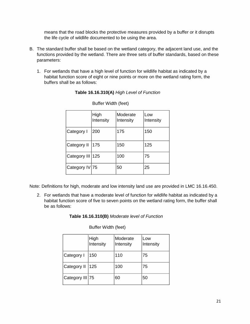
1. For wetlands that have a high level of function for wildlife habitat as indicated by a
habitat function score of eight or nine points or more on the wetland rating form, the
buffers shall be as follows:
Table 16.16.310(A) High Level of Function
Buffer Width (feet)
High
Intensity
Moderate
Intensity
Low
Intensity
Category I 200 175 150
Category II 175 150 125
Category III 125 100 75
Category IV 75 50 25
Note: Definitions for high, moderate and low intensity land use are provided in LMC 16.16.450.
2. For wetlands that have a moderate level of function for wildlife habitat as indicated by a
habitat function score of five to seven points on the wetland rating form, the buffer shall
be as follows:
Table 16.16.310(B) Moderate level of Function
Buffer Width (feet)
High
Intensity
Moderate
Intensity
Low
Intensity
Category I 150 110 75
Category II 125 100 75
Category III 75 60 50

22
Table 16.16.310(B) Moderate level of Function
Buffer Width (feet)
High
Intensity
Moderate
Intensity
Low
Intensity
Category
IV
40 30 25
Note: Definitions for high, moderate and low intensity land use are provided in LMC 16.16.450
3. For wetlands that have a low level of function for wildlife habitat as indicated by a habitat
function score four points or less on the wetland rating form, the buffers shall be as
follows:
Table 16.16.310(C) Low level of Function
Buffer Width (feet)
High
Intensity
Moderate
Intensity
Low
Intensity
Category I 125 100 75
Category II 100 75 50
Category III 60 50 35
Category IV 40 30 25
Note: Definitions for high, moderate and low intensity land use are provided in LMC 16.16.450.
C. Modifications to Buffer Widths. Any modifications to the buffer width are to be based on the
specific wetland functions, site and/or watershed characteristics, location of the wetland
within the watershed or sub-basin, and the proposed land use.
1. Increasing Buffer Widths. The administrator shall have the authority to increase the
standard buffer width on a case-by-case basis when a larger buffer is required by an
approved habitat assessment as outlined in LMC 16.16.310(A); or such increase is
necessary to:
a. Protect the function and value of that wetland, including but not limited to
compensating for a poorly vegetated buffer that has a steep slope (greater than 30
percent); or
23
b. Prevent wind-throw damage; or
c. Maintain viable populations of species such as herons and other priority wildlife
species; or
d. Protect wetlands or other critical areas from landslides, erosion or other hazards.
3. Reducing Wetland Buffer Widths. The administrator shall have the authority to reduce
the standard buffer widths; provided, that all of the following apply:
a. The buffer of a Category I wetland shall not be reduced;
b. The buffer reduction shall not adversely affect the functions and values of adjacent
wetlands;
c. The buffer of a Category II or III wetland shall not be reduced to less than 75 percent
of the required buffer or 50 feet, whichever is greater;
d. The buffer of a Category IV wetland shall not be reduced to less than 50 percent of
the required buffer, or 25 feet, whichever is greater, provided the buffer reduction
does not result in reducing the functions and values of the wetland; and
f. The applicant implements all reasonable measures to reduce the adverse effects of
adjacent land uses and ensure no new loss of buffer functions and values. The
specific measures that shall be implemented include, but are not limited to, the
following:
1. Direct lights away from the wetland and buffer;
2. Locate facilities that generate substantial noise (such as some manufacturing,
industrial and recreational facilities) away from the wetland and buffer;
3. Implement integrated pest management programs;
4. Infiltrate or treat, detain and disperse runoff into buffer;
5. Construct a wildlife permeable fence around buffer and post signs at the outer
edge of the critical area or buffer to clearly indicate the location of the critical area
according to the direction of the city;
6. Plant buffer with “impenetrable” native vegetation appropriate for the location;
7. Use low impact development techniques to the greatest extent possible;
8. Establish and record a permanent conservation easement to protect the wetland
and the associated buffer and restrict the use of pesticides and herbicides in the
easement.
4. Averaging Buffer Widths. The administrator has the authority to average wetland
buffer widths on a case-by-case basis when all the following criteria are met:
a. The buffer averaging does not reduce the functions or values of the wetland;
24
b. The total area contained in the buffer area after averaging is no less than that
which would be contained within the standard buffer, and all increases in buffer
dimension for averaging must be parallel to the wetland boundary;
c. The wetland contains variations in sensitivity due to existing physical
characteristics or the character of the buffer varies in slope, soils, or vegetation;
d. The buffer width is not reduced in any location to less than 50 percent of the
standard width or 35 feet, whichever is greater, except for buffers for Category IV
wetlands, and low intensity land uses in which case the narrowest buffer width can
be determined on a case-by-case basis, using the best available science;
e. The buffer has not been reduced in accordance with this section. Buffer averaging
is not allowed if the buffer has been reduced; and
f. There were no feasible alternatives to the site design without buffer averaging.
5. Buffer Maintenance. Final buffer conditions shall be maintained and undisturbed from
future impacts.
6. Wetland Buffer Impacts. When buffer impacts occur, compensatory mitigation shall be
provided at a square footage ratio of 1:1. The mitigation shall occur on the same site
when feasible or within the same wetland system preferably. The mitigation shall ensure
that the wetland functions and values are not diminished due to the buffer impacts.
7. Buffers on Mitigated Sites. Buffer widths shall be applied to mitigation sites consistent
with the wetland ratings and buffer requirements of this chapter for subsequent
development proposals and based on expected category of the wetland once the
mitigation actions are taken.
8. Building Setbacks from Buffers. Buildings, structures, paving, and other hard surfacing
shall be set back a distance of 10 feet from the edge of the wetland buffer, or edge of the
wetland if no buffer is required, unless otherwise determined by the administrator to be a
shorter distance. This setback is to avoid conflicts with tree branches and/or critical root
zones of trees that are in the buffer or will be planted in the buffer. The following may be
allowed in the building setback from the buffer if they do not cause damage to the critical
root zone of trees in the buffer:
a. Landscaping;
b. Uncovered decks, roof eaves and overhangs, unroofed stairways and steps;
c. Pervious ground surfaces, such as driveways, patios, and parking may be allowed;
provided, that it is engineered as a pervious system. Such improvements may be subject
to the requirements in Chapter 13.24 LMC, Stormwater Management;
d. Above and below ground water conservation cisterns and associated infrastructure,
used for residential rainwater catchment but not to exceed 300 square feet total;
25
provided, that if above ground, the necessary foundation is engineered as a pervious
system.
16.16.320 Wetland Mitigation Requirements
A. All projects that will result in permanent or temporary loss or degradation of wetland functions and values or infringe upon wetland standard buffers shall provide compensatory mitigation based on best available science sufficient to offset the impacts that will result from the proposed actions. It is preferred that compensatory mitigation takes place on the subject site, however the City may consider off-site mitigation where based on information presented in the Detailed Study, the administrator determines that on-site mitigation is infeasible or undesirable. Off-site mitigation shall be consistent with the ratios for wetland enhancement listed in 16.16.310(C) below.
B. A Wetland Mitigation Plan shall be prepared by a qualified wetland biologist and shall fully compensate for the impacts to the wetland or buffers by the proposed action/project. The Wetland Mitigation plan shall be written as per the criteria set forth within the Wetland Mitigation in Washington State, Part 2: Developing Mitigation Plans (Version 1, Ecology Publication #06-06-011b, March 2006) or as revised. These Guidelines shall be considered the best available science for developing a freshwater wetland mitigation plan. The Wetland Mitigation Plan shall at minimum include the following:
1. The name and contact information of the applicant, a description of the proposal, and
identification of the permit requested;
2. A copy of the site plan for the development proposal including:
a. A map to scale depicting critical areas and required buffers;
b. A map to scale of the development proposal and limits of construction overlaid on the
critical areas map; and
c. A description of the proposed stormwater management plan for the development and
consideration of impacts to drainage alterations;
3. The dates, names, and qualifications of the persons preparing the report and
documentation of any fieldwork performed on the site;
4. Identification and characterization of all critical areas including their buffers, adjacent to
the subject site and characterization of the ecological relationship of the critical area and
buffers with any adjacent noncritical areas such as upland forest patches;
5. A statement specifying the accuracy of the report, and all assumptions made and relied
upon;
6. An assessment of the probable cumulative impacts to critical areas resulting from
development of the site and the proposed development;
7. The following are required only if there will be an impact to a critical area and/or its
buffer, resulting in the requirement for mitigation:
a. An analysis of site development alternatives derived from mitigation sequencing;
26
b. A description of reasonable efforts made to apply mitigation sequencing pursuant to
mitigation sequencing (LMC 16.16.230) to avoid, minimize, and mitigate impacts to
critical areas;
c. Plans for adequate mitigation, as needed, to offset any impacts, in accordance with
mitigation plan requirements and additional requirements specified for each critical area
(LMC 16.16.240), including, but not limited to:
i. The impacts of any proposed development within or adjacent to a critical area
or buffer on the critical area; and
ii. The impacts of any proposed alteration of a critical area or buffer on the
development proposal, other properties and the environment;
iii. A discussion of the performance standards applicable to the critical area and
proposed activity;
iv. A detailed, line-item estimate of the total costs to complete the proposed
mitigation in accordance with mitigation requirements.
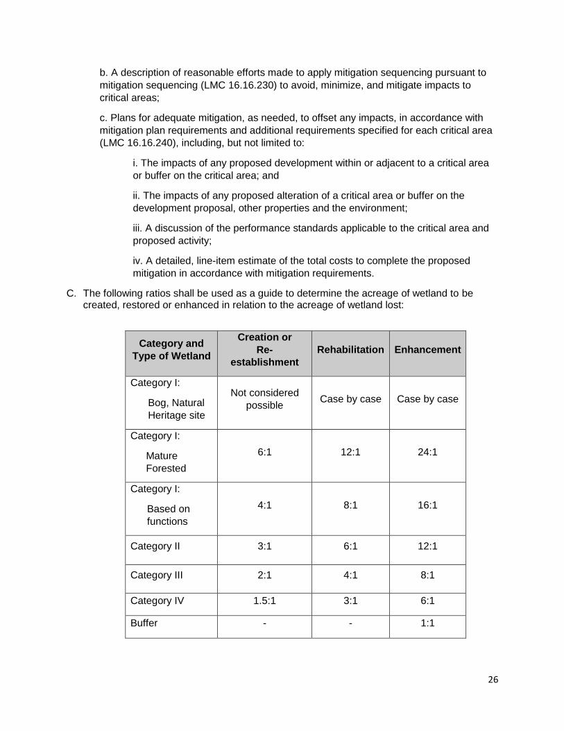
C. The following ratios shall be used as a guide to determine the acreage of wetland to be created, restored or enhanced in relation to the acreage of wetland lost:
Category and
Type of Wetland
Creation or
Re-
establishment
Rehabilitation Enhancement
Category I:
Bog, Natural
Heritage site
Not considered
possible Case by case Case by case
Category I:
Mature
Forested
6:1 12:1 24:1
Category I:
Based on
functions
4:1 8:1 16:1
Category II 3:1 6:1 12:1
Category III 2:1 4:1 8:1
Category IV 1.5:1 3:1 6:1
Buffer - - 1:1
27
D. Mitigation Banking:
1. Credits from a wetland mitigation bank may be approved for use as compensation for
unavoidable impacts to wetlands when:
a. The bank is certified under state rules;
b. The administrator determines that the bank provides appropriate compensation for the
authorized impacts; and
c. The proposed use of credits is consistent with the terms and conditions of the certified
bank instrument.
2. Replacement ratios for projects using bank credits shall be consistent with replacement
ratios specified in the certified bank instrument.
3. Credits from a certified wetland mitigation bank may be used to compensate for impacts
located within the service area specified in the certified bank instrument.
E. In-Lieu Fee Mitigation: To aid in the implementation of off-site mitigation, the City may develop
an in-lieu fee program. This program shall be developed and be consistent with federal rules,
state policy on in-lieu fee mitigation, and state water quality regulations. An approved in-lieu fee
program sells compensatory mitigation credits to permittees whose obligation to provide
compensatory mitigation is then transferred to the in-lieu program sponsor, a governmental or
non-profit natural resource management entity.
28
SECTION FIVE: FISH AND WILDLIFE HABITAT CONSERVATION AREAS
16.16.330 Fish and Wildlife Habitat Conservation Areas Designation
Fish & Wildlife Habitat Conservation Areas (HCA) shall be designated based on meeting any
one of the following criteria:
A. Areas with Which State or Federally Designated Endangered, Threatened, and Sensitive
Species Have a Primary Association.
1. Federally designated endangered and threatened species are those fish and wildlife
species identified by the U.S. Fish and Wildlife Service and the National Marine
Fisheries Service that are in danger of extinction or threatened to become
endangered. The U.S. Fish and Wildlife Service and the National Marine Fisheries
Service should be consulted for current listing status.
2. State designated endangered, threatened, and sensitive species are those fish and
wildlife species native to the state of Washington identified by the Washington
Department of Fish and Wildlife, that are in danger of extinction, threatened to
become endangered, vulnerable, or declining and are likely to become endangered
or threatened in a significant portion of their range within the state without
cooperative management or removal of threats. State designated endangered,
threatened, and sensitive species are periodically recorded in WAC 232-12-
014 (state endangered species) and WAC 232-12-011 (state threatened and
sensitive species). The State Department of Fish and Wildlife maintains the most
current listing and should be consulted for current listing status.
3. State priority habitats and areas associated with state priority species are considered
to be priorities for conservation and management. Priority species require protective
measures for their perpetuation due to their population status, sensitivity to habitat
alteration, and/or recreational, commercial, or tribal importance. Priority habitats are
those habitat types or elements with unique or significant value to a diverse
assemblage of species. A priority habitat may consist of a unique vegetation type or
dominant plant species, a described successional stage, or a specific structural
element. Priority habitats and species (PHS) are identified and listed by the State
Department of Fish and Wildlife.
B. Habitats and species of local importance that have been designated by the City at the
time of application;
C. Naturally occurring ponds under 20 acres and their submerged aquatic beds that provide
fish or wildlife habitat;
D. Waters of the State as defined by WAC 173-226-030(26)(27), including Fishtrap Creek,
Duffner Ditch, Double Ditch, Kamm Creek and their tributaries;
E. Areas with which anadromous fish species have a primary association;
29
F. Lakes, ponds, streams and rivers planted with game fish by a governmental or tribal
entity;
G. State Natural Area Preserves and Natural Resource Conservation Areas.
H. Areas of Rare Plant Species and High Quality Ecosystems. Areas of rare plant species
and high quality ecosystems are identified by the Washington State Department of
Natural Resources through the Natural Heritage Program.
I. Land useful or essential for preserving connections between habitat blocks and open
spaces.
16.16.340 Fish and Wildlife Habitat Conservation Areas Classification
A. All areas within the city meeting one or more of the criteria listed in section 16.16.320 of this
Chapter, regardless of any formal identification, are hereby designated critical areas and are
subject to the provisions of this chapter and shall be managed consistent with the best
available science.
B. The approximate location and extent of habitat conservation areas are shown on the
following maps adopted by the city, as revised:
1. Washington Department of Fish and Wildlife Priority Habitat and Species maps;
2. Washington State Department of Natural Resources, Official Water Type Reference
maps;
3. Washington State Department of Natural Resources Puget Sound Intertidal Habitat
Inventory maps;
4. Washington State Department of Natural Resources Shore Zone inventory;
5. Washington State Department of Natural Resources Natural Heritage Program mapping
data;
6. Washington State Department of Health Annual Inventory of Shellfish Harvest Areas;
7. Anadromous and resident fish distribution maps contained in the habitat limiting factors
reports published by the Washington Conservation Commission and others;
8. Washington State Department of Natural Resources State Natural Area Preserves and
Natural Resource Conservation Area maps; and
9. City official habitat maps.
These maps are to be used as a guide for the city, project applicants, and/or property
owners and should be continuously updated as new critical areas are identified. They are a
reference and do not provide a final critical area designation.
16.16.350 Fish and Wildlife Habitat Conservation Areas Indicators
The administrator shall use the following as indicators of the need for a Fish and Wildlife HCA
Detailed Study:
30
A. The site is located within an area listed as a Fish and Wildlife HCA in the City Critical
Areas Inventory and Critical Area Maps;
B. Documentation of habitat or species on the Washington State Priority Habitat and
Species Data Base.
C. Documentation through any public resource information source that a Fish and Wildlife
HCA exists on or adjacent to the site;
D. A finding by a qualified fisheries or wildlife biologist or botanist that the presence of a
Fish and Wildlife HCA is likely;
E. A reasonable belief by the administrator based on local information that a Fish and
Wildlife HCA may exist on or adjacent to the site. Such a belief shall be supported
through consultation with a qualified consultant.
16.16.360 Fish and Wildlife Habitat Conservation Areas Detailed Study Requirements
A. A Fish and Wildlife HCA Detailed Study, if required, shall be prepared by a qualified fish
and/or wildlife biologist and shall include the following:
B. Detailed description of vegetation on and adjacent to the project area and its associated
buffer;
1. Identification of any species of local importance, priority species, or endangered,
threatened, sensitive, or candidate species that have a primary association with habitat
on or adjacent to the project area, and assessment of potential project impacts to the use
of the site by the species;
2. A discussion of any federal, state, or local special management recommendations,
including Washington Department of Fish and Wildlife habitat management
recommendations, that have been developed for species or habitats located on or
adjacent to the project area;
3. A detailed discussion of the direct and indirect potential impacts on habitat by the project,
including potential impacts to water quality;
4. A discussion of measures, including avoidance, minimization, and mitigation, proposed to
preserve existing habitats and restore any habitat that was degraded prior to the current
proposed land use activity and to be conducted in accordance with mitigation
sequencing; and
5. A discussion of ongoing management practices that will protect habitat after the project
site has been developed, including proposed monitoring and maintenance programs.
C. When appropriate due to the type of habitat or species present or the project area
conditions, the director may also require the habitat management plan to include:
1. An evaluation by an independent qualified professional regarding the applicant’s analysis
and the effectiveness of any proposed mitigating measures or programs, to include any
recommendations as appropriate;
2. A request for consultation with the Washington Department of Fish and Wildlife or other
appropriate agency; and
3. Detailed hydrologic features both on and adjacent to the site.
31
16.16.370 Fish and Wildlife Habitat Conservation Areas Performance Requirements
A. Nonindigenous Species. No plant, wildlife, or fish species not indigenous to the region shall
be introduced into a habitat conservation area unless authorized by a state or federal permit
or approval.
B. Mitigation and Contiguous Corridors. Mitigation sites shall be located to preserve or achieve
contiguous wildlife habitat corridors in accordance with a mitigation plan that is part of an
approved critical area report to minimize the isolating effects of development on habitat
areas, so long as mitigation of aquatic habitat is located within the same aquatic ecosystem
as the area disturbed.
C. Approval of Activities. The administrator shall condition approvals of activities allowed within
or adjacent to a habitat conservation area and its buffers, as necessary to minimize or
mitigate any potential adverse impacts. Conditions shall be based on the best available
science and may include, but are not limited to, the following:
1. Establishment of buffer zones;
2. Preservation of critically important vegetation and/or habitat features such as snags and
downed wood;
3. Limitation of access to the habitat area, including fencing to deter unauthorized access;
4. Seasonal restriction of construction activities;
5. Establishment of a duration and timetable for periodic review of mitigation activities; and
6. Requirement of a performance bond, when necessary, to ensure completion and
success of proposed mitigation.
D. Mitigation and Equivalent or Greater Biological Functions. Mitigation for alterations to habitat
conservation areas shall achieve equivalent or greater biologic and hydrologic functions and
shall include mitigation for adverse impacts upstream or downstream of the development
proposal site. Mitigation shall address each function affected by the alteration to achieve
functional equivalency or improvement on a per function basis.
E. Approvals and the Best Available Science. Any approval of alterations or impacts to a
habitat conservation area shall be supported by the best available science.
F. Buffers.
1. Establishment of Buffers. The administrator shall require the establishment of buffer
areas for activities adjacent to habitat conservation areas when needed to protect habitat
conservation areas. Buffers shall consist of an undisturbed area of native vegetation or
areas identified for restoration established to protect the integrity, functions, and values of
the affected habitat. Required buffer widths shall reflect the sensitivity of the habitat and
the type and intensity of human activity proposed to be conducted nearby.
2. Seasonal Restrictions. When a species is more susceptible to adverse impacts during
specific periods of the year, seasonal restrictions may apply. Larger buffers may be
required and activities may be further restricted during the specified season.
32
3. Habitat Buffer Averaging. The administrator may allow the recommended habitat area
buffer width to be reduced in accordance with a critical area report and the best available
science only if:
a. It will not reduce stream or habitat functions;
b. It will not adversely affect salmonid habitat;
c. It will provide additional natural resource protection, such as buffer enhancement; and
d. The total area contained in the buffer area after averaging is no less than that which
would be contained within the standard buffer.
4. All land and shoreline uses, development, occupancy, and critical area resource
management of any kind shall comply with the provisions of the city of Lynden shoreline
master program (SMP). The SMP shall establish all permitted uses adjacent to, and
critical area buffers and setbacks from, the ordinary high water mark of the Nooksack
River and Fishtrap Creek.
16.16.380 Performance standards – Specific habitats
A. Endangered, Threatened, and Sensitive Species.
1. No development shall be allowed within a habitat conservation area or buffer with which
state or federally endangered, threatened, or sensitive species have a primary
association, unless a management plan consistent with applicable state or federal
agency regulations or guidance is provided. Appropriate management measures shall be
included in a critical areas report prepared by a qualified professional for review by the
city. The city may require a consultation with the respective agency prior to approval.
2. Nesting bald eagles and bald eagle habitat shall be protected consistent with the U.S.
Fish and Wildlife Service Bald Eagle Management Guidelines, or the state or federal
regulations in place at the time of application. Whenever activities are proposed adjacent
to a verified nest territory or communal roost, a bald eagle habitat management plan shall
be developed by a qualified professional. Activities are adjacent to managed bald eagle
sites when they are within 660 feet of a nest or within one-half mile (2,640 feet) of a
shoreline foraging area. Approval of the activity shall not occur prior to consultation with
the state or federal agency with authority on bald eagle pairs and their nest.
B. Anadromous and Resident Fish.
1. All activities, uses, and alterations proposed to be located in water bodies used by
anadromous fish or in areas that affect such water bodies shall give special consideration
to the preservation and enhancement of anadromous fish habitat, including, but not
limited to, adhering to the following standards:
a. Activities shall be timed to occur only during the allowable work window as designated
by the Washington Department of Fish and Wildlife for the applicable species;
b. An alternative alignment or location for the activity is not feasible;
c. The activity is designed so that it will not degrade the functions or values of the fish
habitat or other critical areas;
33
d. Shoreline erosion control measures shall be designed to use bioengineering methods
or soft armoring techniques, according to an approved critical area report; and
e. Any impacts to the functions or values of the habitat conservation area are mitigated in
accordance with an approved critical area report.
2. Structures that prevent the migration of fish shall not be allowed in the portion of water
bodies currently, historically, or potentially used by fish. Fish bypass facilities shall be
provided that allow the upstream migration of adult fish and shall prevent fry and
juveniles migrating downstream from being trapped or harmed.
3. Fills, when authorized by the shoreline master program, shall not adversely impact fish or
their habitat or shall mitigate any unavoidable impacts and shall only be allowed for a
water-dependent use.
C. Wetland Habitats. All proposed activities within or adjacent to habitat conservation areas
containing wetlands shall conform to the wetland development performance standards set
forth in this chapter. If non-wetland habitat and wetlands are present at the same location,
the provisions of this chapter which provide the greater protection to the habitat apply.
D. Stream Buffers (Riparian Habitat Areas). Unless otherwise allowed in this chapter, all
clearing, grading, structures, storage of materials and activities shall be located outside of
the stream buffer.
E. Buffer Standards. The buffer standards required by this chapter presume the existence of a
dense vegetation community in the buffer adequate to protect the stream functions and
values. When a buffer lacks adequate vegetation, the administrator may increase the
standard buffer, requiring buffer planting or enhancement, and/or deny a proposal for buffer
reduction or buffer averaging. Buffers may not include areas that are functionally and
effectively disconnected from the stream or buffer areas by a public or private road.
F. Stream Buffers Widths (Riparian Habitat Area Widths). Stream buffer widths are shown in
Table 16.16.380 (F). Stream buffer widths shall be measured outward in each direction, on
the horizontal plane, from the “Ordinary High Water Mark”, or from the top of bank, if the
ordinary high water mark cannot be identified. Riparian areas should be sufficiently wide to
achieve the full range of riparian and aquatic ecosystem functions, which include but are not
limited to protection of instream fish habitat through control of temperature and
sedimentation in streams; preservation of fish and wildlife habitat; and connection of riparian
wildlife habitat to other habitats.
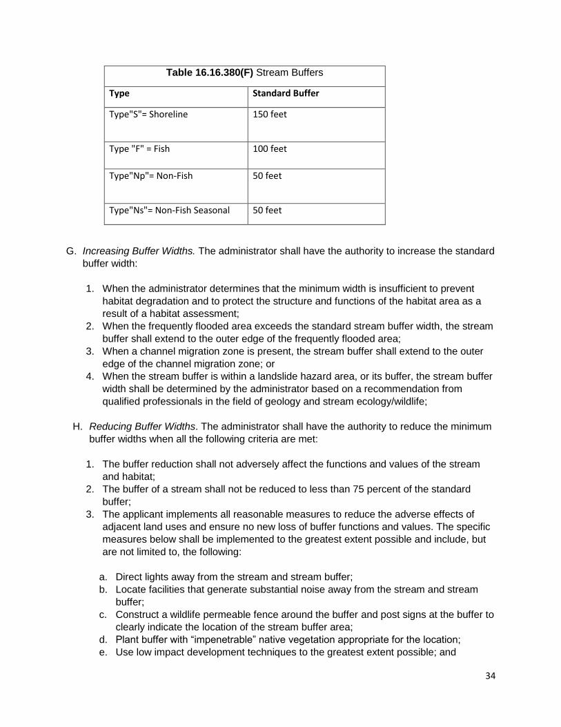
34
Table 16.16.380(F) Stream Buffers
Type Standard Buffer
Type"S"= Shoreline
150 feet
Type "F" = Fish 100 feet
Type"Np"= Non-Fish 50 feet
Type"Ns"= Non-Fish Seasonal 50 feet
G. Increasing Buffer Widths. The administrator shall have the authority to increase the standard
buffer width:
1. When the administrator determines that the minimum width is insufficient to prevent
habitat degradation and to protect the structure and functions of the habitat area as a
result of a habitat assessment;
2. When the frequently flooded area exceeds the standard stream buffer width, the stream
buffer shall extend to the outer edge of the frequently flooded area;
3. When a channel migration zone is present, the stream buffer shall extend to the outer
edge of the channel migration zone; or
4. When the stream buffer is within a landslide hazard area, or its buffer, the stream buffer
width shall be determined by the administrator based on a recommendation from
qualified professionals in the field of geology and stream ecology/wildlife;
H. Reducing Buffer Widths. The administrator shall have the authority to reduce the minimum
buffer widths when all the following criteria are met:
1. The buffer reduction shall not adversely affect the functions and values of the stream
and habitat;
2. The buffer of a stream shall not be reduced to less than 75 percent of the standard
buffer;
3. The applicant implements all reasonable measures to reduce the adverse effects of
adjacent land uses and ensure no new loss of buffer functions and values. The specific
measures below shall be implemented to the greatest extent possible and include, but
are not limited to, the following:
a. Direct lights away from the stream and stream buffer;
b. Locate facilities that generate substantial noise away from the stream and stream
buffer;
c. Construct a wildlife permeable fence around the buffer and post signs at the buffer to
clearly indicate the location of the stream buffer area;
d. Plant buffer with “impenetrable” native vegetation appropriate for the location;
e. Use low impact development techniques to the greatest extent possible; and
35
f. Establish and record a permanent conservation easement to protect the stream and
stream buffer and restrict the use of pesticides and herbicides in the easement.
I. Averaging Buffer Widths. The administrator has the authority to average stream buffer
widths on a case-by-case basis when all the following criteria are met:
1. The buffer averaging does not reduce the functions or values of the stream or stream
buffer; and
2. The total area contained in the buffer area after averaging is no less than that which
would be contained within the standard buffer, and all increases in buffer dimension for
averaging must be parallel to the stream; and
3. The stream or stream buffer contains variations in sensitivity due to existing physical
characteristics or the character of the buffer varies in slope, soils, or vegetation; and
4. The buffer width is not reduced in any location to less than 50 percent of the standard
width or 35 feet, whichever is greater, on a case-by-case basis as a result of a habitat
assessment; and
5. The buffer has not been reduced in accordance with this section. Buffer averaging is not
allowed if the buffer has been reduced; and
6. There were no feasible alternatives to the site design without buffer averaging.
J. Stream Buffer Impacts. When buffer width adjustments through buffer averaging or
reduction do not remove the proposed activity from the buffer, then the activity is considered
a buffer impact. When unavoidable buffer impacts occur, compensatory mitigation shall be
provided at a ratio of 1:1. The mitigation shall occur on the same site when feasible or within
the same stream system preferably. The mitigation shall ensure that the stream and stream
buffer functions and values are not diminished due to the impacts.
K. Stream Buffers on Mitigation Sites. Stream buffer widths at mitigation sites shall comply with
the buffer requirements of this chapter.
L. Aquatic Habitat. The activities listed below are allowed in stream buffers, and waters of the
state with the exception of wetlands. Approval of the activity shall be obtained in the
appropriate critical area review, or exception, depending on the activity. Mitigation shall be
provided in accordance with the provisions of this chapter.
1. Clearing and Grading. When clearing and grading is permitted as part of an authorized
activity or as otherwise allowed in these standards, the following shall apply:
a. Grading is allowed only during the dry season, which is typically regarded as
beginning on May 1st and ending on October 1st of each year; provided, that the city
may extend or shorten the dry season on a case-by-case basis, determined on
actual weather conditions.
b. The soil duff layer shall remain undisturbed to the maximum extent possible. Where
feasible, any soil disturbed shall be redistributed to other areas of the project area.
c. The moisture-holding capacity of the topsoil layer shall be maintained by minimizing
soil compaction or reestablishing natural soil structure and infiltrative capacity on all
areas of the project area not covered by impervious surfaces.
36
d. Erosion and sediment control that meets or exceeds the standards set forth in
Chapter 13.24 LMC shall be provided.
2. Shoreline Erosion Control Measures. New, replacement, or substantially improved
shoreline erosion control measures may be permitted in accordance with an approved
critical area report that demonstrates the following:
a. Natural shoreline processes will be maintained. The project will not result in
increased beach erosion or alterations to, or loss of, shoreline substrate within one-
quarter mile of the project area.
b. The shoreline erosion control measures will not degrade fish or wildlife habitat
conservation areas or associated wetlands.
c. Adequate mitigation measures ensure that there is no net loss of the functions or
values of intertidal habitat or riparian habitat as a result of the proposed shoreline
erosion control measures.
d. The proposed shoreline erosion control measures do not result in alteration of
intertidal migration corridors.
3. Stream Bank Stabilization. Stream bank stabilization to protect new structures from
future channel migration is not permitted except when such stabilization is achieved
through bioengineering or soft armoring techniques in accordance with an approved
critical area report.
4. Roads, Trails, Bridges, and Rights-of-Way. Construction of trails, roadways, and bridges
may be permitted in accordance with an approved critical area report subject to the
following standards:
a. There is no other feasible alternative route with less impact on the fish populations,
stream, or stream buffer, and mitigation sequencing has been applied;
b. The crossing minimizes interruption of downstream movement of wood and gravel;
c. Roads in riparian habitat areas or their buffers shall not run parallel to the water
body;
d. Trails shall be located on the outer edge of the riparian area or buffer except for
limited viewing platforms and crossings unless there is a location that has a lesser
impact on the water body. Trails shall not be located in the channel migration zone
and shall be the minimum width necessary for safe travel;
e. Crossings, where necessary, shall only occur as near to perpendicular with the water
body as possible;
f. Mitigation for impacts is provided pursuant to a mitigation plan of an approved critical
area report;
g. Road bridges are designed to be consistent with Washington State’s Department of
Fish and Wildlife “Water Crossing Design Guidelines” (2013) and the National Marine
Fisheries Service “Anadromous Salmonid Passage Facility Design” (2011).
5. Utility Facilities. New utility lines and facilities may be permitted in accordance with an
approved critical area report, if they comply with the following criteria:
a. There is no alternative location;
37
b. Fish and wildlife habitat areas shall be avoided to the maximum extent possible;
c. Installation shall be accomplished by boring beneath the scour depth and hyporheic
zone of the water body and channel migration zone, where feasible;
d. If a utility is proposed to cross or span a stream, the utility shall cross at an angle
greater than 60 degrees to the centerline of the channel in streams or perpendicular
to the channel centerline whenever boring under the channel is not feasible;
e. Crossings shall be contained within the footprint of an existing road or utility crossing
where possible;
f. The utility route shall avoid paralleling the stream or following a down-valley course
near the channel; and
g. The utility installation shall not increase or decrease the natural rate of shore
migration or channel migration.
6. Public Flood Protection Measures. New public flood protection measures and expansion
of existing ones may be permitted, subject to the city’s review and approval of a critical
area report and the approval of a federal biological assessment by the federal agency
responsible for reviewing actions related to a federally listed species.
7. Instream Structures. Instream structures, such as, but not limited to, high flow bypasses,
sediment ponds, instream ponds, retention and detention facilities, tide gates, dams, and
weirs, shall be allowed only as part of an approved watershed basin restoration project
approved by the city and upon acquisition of any required state or federal permits. The
structure shall be designed to avoid modifying flows and water quality in ways that may
adversely affect habitat conservation areas.
8. Stormwater Management in Stream Buffers.
a. Stormwater management facilities, including dual purpose facilities, shall only be
located within stream buffers if approved through the Critical Area Detailed Study
process in LMC 16.16.200 and 16.16.360.
b. Stormwater management design and facilities shall be consistent with
Chapter 13.24 LMC, as amended, to protect stream conditions and functions.
9. Restoration. Restoration, relocation, alteration and/or realignment of a stream channel to
improve ecological functions provided such action is concurrently reviewed and
approved by the Washington State Department of Fish and Wildlife, the United States
Army Corps of Engineers and if required, the Department of Ecology.
16.16.390 Fish and Wildlife Habitat Conservation Areas Mitigation Requirements
A. All projects that will result in permanent or temporary loss or degradation of the functions
and values of a Fish and Wildlife Habitat Conservation Area or the standard buffer thereof
shall provide compensatory mitigation based on best available science sufficient to
completely offset the impacts that will result from the proposed actions. It is preferred that
compensatory mitigation takes place on the subject site, however the City may consider off-
38
site mitigation where based on information presented in the Detailed Study, the Planning
Director determines that on-site mitigation is infeasible or undesirable.
B. A Fish and Wildlife Habitat Conservation Area Mitigation Plan shall be prepared by a
qualified biologist and shall fully compensate for the impacts to the Fish and Wildlife Habitat
Conservation Area or standard buffer. Said mitigation plan shall also give special
consideration to the preservation or enhancement of any anadromous species likely to be
affected. The Fish and Wildlife Habitat Conservation Area Mitigation Plan shall at minimum
include the following:
1. A description of the existing conditions;
2. A description of the proposed conditions and the extent to which the proposed action will
impact the Fish and Wildlife Habitat Conservation Area and its and standard buffers,
including a quantification of the impacts (square footage of Fish and Wildlife Habitat
Conservation Area and buffer and decreased functions/values);
3. Proposed compensation with a description of how the proposed compensation will fully
mitigate for impacts to the functions and values of the Fish and Wildlife Habitat
Conservation Area and its standard buffer.
39
SECTION SIX: GEOLOGICALLY HAZARDOUS AREAS
16.16.400 Geologically Hazardous Areas Designation
Areas that meet any of the classification criteria established below shall be designated as
geologic hazard areas and shall be subject to the provisions of this Chapter.
16.16.410 Geologically Hazardous Areas Classification
Geologic hazard areas shall be classified as steep slopes, earthquake-sensitive areas and
volcanic debris flow areas based on the following criteria.
A. Steep slopes. Steep slopes shall include all areas with a slope inclination greater than or
equal to thirty-five percent (35%) with a vertical relief of ten (10) or more feet.
B. Earthquake-sensitive areas. Earthquake-sensitive areas shall include:
1. Areas where manmade fill or partially decomposed organic material average at least five
feet in depth;
2. Filled wetlands;
3. Alluvial deposits subject to liquefaction during severe shaking.
C. Volcanic debris flow areas. Volcanic debris flow areas shall include all areas within the 100-
year floodplain as designated in the Lynden Floodplain Management Ordinance, Chapter
16.12 LMC. Due to the relatively low frequency of catastrophic volcanic debris flow events,
the protective measures contained in the Lynden Floodplain Management Ordinance are
deemed sufficient to reduce potential risks from such events to acceptable levels.
16.16.420 Geologically Hazardous Areas Indicators
The Planning Director shall use the following as indicators of the need for a Geologically
Hazardous Area Detailed Study:
A. The site is located within fifty (50) feet of an area listed as steep slope or earthquake
sensitive area in the City Critical Areas Inventory and Critical Area Maps;
B. Documentation through any public resource information source that a steep slope or
earthquake-sensitive area exists on or within fifty (50) feet of the site;
C. A finding by a qualified geologist or geotechnical engineer that the presence of a steep
slope or earthquake-sensitive area is likely;
D. A reasonable belief by the Planning Director based on local information that a steep slope or
earthquake-sensitive area may exist on or within fifty (50) feet of the site. Such a belief shall
be supported through consultation with a qualified consultant.
16.16.430 Geologically Hazardous Areas Detailed Study Requirements
A Geologically Hazardous Area Detailed Study shall be prepared by a qualified geologist or
geotechnical engineer and shall include the following:
A. Site plan and description of existing conditions showing property boundaries, north arrow,
scale and topography.
40
B. Identification of the type, location and extent of the hazard area on the project site plan.
C. An assessment of the geologic and engineering characteristics of the proposed sites.
D. Site plan and description of the proposed conditions showing property boundaries, north
arrow, scale and topography along with identification of any hazard area or hazard area
buffers that will be impacted by the proposal.
E. A geotechnical analysis of the project in relation to the proposed site prepared by a qualified
engineer, including discussion of potential impacts on the hazard area, the project site and
adjacent properties.
F. A mitigation plan based on the best available science, including documentation of
preparation or concurrence by a professional engineer, discussing how the project has been
designed to avoid or minimize risks associated with the identified hazard area.
G. Qualifications of the consultant(s) who prepared the study along with a description of the
methods used.
16.16.440 Geologically Hazardous Areas Performance Requirements
Alteration of a steep slope or earthquake-sensitive area or a site within fifty (50) feet of such
area shall only be permitted if the Detailed Study indicates that the project has been designed
such that the risks associated with the hazard area have been reduced to within acceptable
levels. Such mitigation of risks shall be certified by a geotechnical engineer.
41
SECTION SEVEN: AQUIFER RECHARGE AREAS
16.16.450 Aquifer Recharge Area Designation
Aquifer recharge areas shall be designated based on meeting any one of the following criteria:
A. Wellhead Protection Areas designated per WAC 246-290;
B. Sole Source Aquifers designated by the U.S. EPA per the Federal Safe Drinking Water Act;
C. Areas designated for special protection as part of a groundwater management program per
RCW 90.44, 90.48, or 90.58 or WAC 173-100 or 173-200; or
D. Areas overlying unprotected aquifers used as a source of potable water.
16.16.460 Aquifer Recharge Area Detailed Study Requirements
A. All proposals within a designated aquifer recharge area that require SEPA review shall be
reviewed by the Planning Director to determine the potential for adverse impacts to
groundwater resources.
B. If the potential for significant adverse impacts is present, then the Planning Director shall
require preparation of an aquifer recharge area Detailed Study.
C. An aquifer recharge area Detailed Study shall be prepared by a qualified consultant with
experience in preparing hydrogeologic site assessments
D. The Detailed Study shall identify the existing hydrogeologic conditions of the project site and
the proposed activity’s potential to result in contamination of groundwater resources.
E. The Detailed Study shall also, based on the best available science, identify proposed
mitigation measures necessary to reduce potential impacts to groundwater resources.
F. The qualifications of the consultant(s) who prepared the Detailed Study along with the
methods used shall also be provided.
16.16.470 Aquifer Recharge Area Performance Requirements
Activities requiring preparation of an aquifer recharge area Detailed Study shall only be
permitted if the Detailed Study indicates that the activity does not pose a significant threat to the
underlying aquifer system. The Planning Director shall establish mitigating conditions necessary
to insure protection of groundwater resources.
42
SECTION EIGHT: DEFINITIONS
16.16.480 Definitions
“Adjacent” or “adjacent to” generally means within a distance of 300 feet from a critical area
or, in some circumstances, within a greater distance within which the project is likely to impact
the critical area.
“Agriculture” or “Agricultural activities” means those activities directly pertaining to the
production of crops or livestock including but not limited to cultivation, harvest, grazing, animal
waste storage and disposal, fertilization, the operation and maintenance of farm and stock
ponds, drainage ditches, irrigation systems, and canals, and normal maintenance, operation
and repair of existing serviceable structures, facilities, or improved areas.
"Anadromous fish" means fish species that ascend rivers from the sea to spawn.
"Aquifer" means any geologic formation capable of yielding a significant amount of ground
water to a well, spring or other withdrawal works in sufficient quantity for beneficial use.
"Aquifer recharge areas" means areas where the prevailing geologic conditions allow
infiltration rates which contribute significantly to the replacement of groundwater and which
create a high potential for contamination of groundwater resources that serve as a source of
potable water supplies.
"Artificial watercourse" means ditches and other water conveyance systems, not constructed
from natural watercourses, which are artificially constructed and actively maintained for irrigation
and drainage. Artificial watercourses include lateral field ditches used to drain farmland where
the ditch did not replace a natural watercourse.
“Best available science” means the best available information gathered, analyzed and
presented based on substantial and well-qualified professional experience, expertise and
judgment, and established scientific principles and practices. Such principles and practices
include peer review, use of scientific methodology, logical analysis and reasonable inference,
statistical analysis, rigorous referencing within the scientific literature, and conclusions drawn
from within an accepted scientific framework and placed in an appropriate scientific context.
“Best management practices (BMP)” means physical or structural tools and/or management
practices which, when used singularly or in combination, prevent or reduce adverse impacts to
critical areas or their buffers.
"Biologist" means a person having specific relevant expertise who has a minimum of a
Bachelor of Science degree in biological sciences or a related field from an accredited college
or university OR equivalent relevant training in fish and wildlife biology and a minimum of 5
years of professional experience as a practicing biologist.
"Buffer" or “Buffer area” means a naturally vegetated, undisturbed or revegetated zone
immediately adjacent to a critical area that helps protect the critical area from adverse impacts
to its functions and values OR that helps provide the margin of safety necessary to minimize risk
to the public.
"Planning Director" means the Lynden Planning Director.
43
"Compensatory mitigation" means replacing project-induced losses or adverse impacts to
critical areas and includes, but is not limited to, restoration, creation, or enhancement.
“Contiguous” means lands adjoining and touching the subject property regardless of whether
or not portions of the land have separate Assessor’s tax numbers, are purchased at different
times, lie in different sections, are in different government lots, lie within different governmental
jurisdictions, or are separated from the subject property by a private road or private right of way.
“Creation” means actions intentionally performed to establish a critical area, or a portion of a
critical area, where one did not formerly exist.
“Critical area administrator” means the Lynden Planning Director, or their duly authorized
agent, responsible for the administration of the Critical Area Ordinance.
"Critical area designation" means legal identification and specification of critical areas for
regulatory purposes.
“Critical Area Detailed Study” means a Detailed Study that includes a thorough investigation
of a proposed activity and the critical area(s) it may impact as required by this Chapter.
“Critical area indicators” means site-specific features such as vegetation, soils, hydrology,
topography or other environmental features established through a site visit or other means that
indicate that critical areas are or may be present at a particular location. For critical areas such
as aquifer recharge areas, where indicators cannot be identified through a site visit, indicators
may be identified through use of critical area maps or other resources.
“Critical Area Review” means the administrative and investigative process for decision making
by the City on authorizations required by this Chapter. The process begins with the filing of an
application for an activity within the jurisdiction of this Chapter and concludes with the Final
Critical Areas Determination.
“Critical areas” means the following areas as required by RCW 36.70A and WAC 365-190-
080, and as defined and regulated in this Chapter: wetlands, geologically hazardous areas,
frequently flooded areas, fish & wildlife habitat conservation areas, and aquifer recharge areas.
"Delineation" means the precise determination of wetland boundaries in the field according to
the application of specific methodology in accordance with the approved federal wetland
delineation manual and applicable regional supplements
“Detailed Study” means a report prepared by a qualified consultant that at a minimum
describes the existing and proposed conditions pertaining to a proposed use or development on
a parcel of land, along with any proposed mitigation. The report shall include and incorporate
best available science and provide information in sufficient detail to allow the City to determine
the impacts to critical areas likely to result from the proposed development.
“Dual purpose stormwater facility” means a stormwater facility that has been designed to
provide beneficial habitat and stormwater detention. Long-term maintenance activities shall be
designated within the design of the facility so that both detention and habitat function can be
balanced. These are only to be considered where appropriate and not in place of impact
mitigation.
44
“Drainage” means the collection, conveyance, containment, and/or discharge of surface and
storm water runoff.
“Drainage ditch” means an artificial watercourse constructed to drain surface or ground water.
"Endangered species" means a species, native to the state of Washington that is designated
by the responsible State or Federal fish or wildlife agency as endangered.
“Enhancement” means an action that improves a critical area’s functions or values.
“Final Critical Areas Determination” means the determination by the Planning Director that a
development activity, as proposed or conditioned, is or is not adequate to mitigate potential
impacts to affected critical areas and comply with applicable performance requirements. The
determination will be either favorable or unfavorable, indicating that the proposed activity is or is
not authorized.
"Fish and wildlife habitat conservation areas" (HCA) means:
a. Areas with which endangered, threatened, and sensitive species have a primary
association;
b. Habitats and species of local importance that have been designated by the City at the
time of application;
c. Waters of the State as defined by WAC 222-16;
d. Areas with which anadromous fish species have a primary association; and
e. Streams and rivers planted with game fish by a governmental or tribal entity;
“Frequently flooded areas” means areas of special flood hazard as designated and regulated
pursuant to Chapter 16.12 of the Lynden Municipal Code.
"Functions" means those natural processes performed by a critical area and its components.
"Geologically hazardous areas" means areas that because of their susceptibility to erosion,
sliding, earthquake, or other geologic events, are not suited to the siting of commercial,
residential, or industrial development consistent with public health or safety concerns.
"Geologist" means a person who has received a degree in geology from an accredited college
or university, OR a person who has equivalent education and training and substantial
demonstrated experience as a practicing geologist.
“Geotechnical engineer” means a person who is licensed as a civil engineer with the State of
Washington and who has recent, related experience as a professional geotechnical engineer.
“Groundwater” means all waters that exist beneath the land surface or beneath the bed of any
body of surface water, whatever may be the geological formation or structure in which such
water stands or flows, percolates or otherwise moves.
"Habitats of Local Importance" means a seasonal range or habitat element with which a
designated species of local importance has a primary association, and which, if altered, may
reduce the likelihood that the species will maintain and reproduce over the long-term.
45
“High intensity land use” means land use that includes the following uses or activities:
commercial, urban, industrial, institutional, retail sales, residential (more than one unit/acre),
high-intensity new agriculture (dairies, nurseries, greenhouses, raising and harvesting crops
requiring annual tilling, raising and maintaining animals), high-intensity recreation (golf courses,
ball fields), hobby farms.
“Initial critical areas determination” means the determination by the Planning Director that a
development activity as proposed potentially includes or does not include a critical area, OR is
or is not adjacent to a critical area, OR would or would not have probable significant adverse
impacts on a critical area.
“Low intensity land use” means land use that includes the following uses or activities: forestry
(cutting of trees only), low-intensity open space (such as passive recreation and natural
resources preservation), unpaved trails.
“Mitigation” means avoiding, minimizing, reducing, rectifying, eliminating or compensating for
project-induced, adverse impacts to critical areas.
“Mitigation bank” means a properly developed collection of existing, created, restored or
enhanced wetlands, HCA, and their protective buffers that are created or established using the
best available science to provide mitigation credits to offset future adverse to wetlands from
approved projects elsewhere.
"Mitigation plan" means a detailed plan indicating actions necessary to mitigate adverse
impacts to critical areas.
“Moderate intensity land use” means land use that includes the following uses or activities:
residential (one unit/acre or less), moderate-intensity open space (parks), moderate-intensity
new agriculture (orchards and hay fields), trails, and logging roads
"Modified natural watercourse" means that segment of a natural watercourse that has been
modified and is maintained by diking and drainage districts, and where such modification was
not the result of an illegal action.
"National Wetland Inventory" means an inventory that was developed by the U.S. Fish and
Wildlife Service, which used aerial photography to map wetlands across the United States.
"Native vegetation" means plant species that are indigenous to the area.
"Natural watercourse" means any stream in existence prior to settlement that originated from
a natural source. An example of a natural watercourse is a stream that originates in a wetland or
upland area, flows through agricultural, rural and/or urban land, and ultimately empties into a
saltwater bay or another watercourse.
"Off-site" means action away from the site at which a critical area has been or may likely be
adversely impacted by a regulated activity.
“On-site” means action on or immediately adjacent to the site at which a critical area has been
or will likely be adversely impacted by a regulated activity.
"Ongoing agriculture" means the continuation of any existing agricultural activity as defined in
this Section including crop rotations.
46
"Ordinary high water mark (OHWM)" means the mark on the shores of all water which will be
found by examining the bed and banks and ascertaining where the presence and action of
waters are so common and usual, and so long continued in all ordinary years, as to mark upon
the soil a character distinct from that of the abutting upland, in respect to vegetation; provided
that, in any area where the ordinary high-water mark cannot be found, the ordinary high-water
mark adjoining freshwater shall be the line of mean high-water. (WAC 173-22--030.)
"Performance requirements" means specific, measurable criteria that a proposed
development activity must conform to and that may be used to determine the degree to which
said activity complies with the provisions of this Chapter.
“Potable water” means water which meets the quality standards for drinking purposes as
established by the State of Washington.
“Primary association” means habitat used by a plant or animal species that is necessary for
survival, but does not include incidental use areas.
“Qualified professional” means a person with expertise in the pertinent scientific discipline
directly related to the critical area in question. The qualified professional shall have a minimum
of a B.S. or B.A., or equivalent certification, and a minimum of five years of directly related work
experience.
"Restoration" means the return of a critical area or buffer to a state in which its functions and
values approach its unaltered state as closely as possible.
"Riparian area" means the portion of habitat extending from the ordinary high-water mark
(OHWM) of a stream (i.e., a flowing body of water) to that part of the upland influenced by
elevated water tables or flooding. It includes the area that directly influences the aquatic
ecosystem (e.g., providing coarse woody debris to the stream, or filtering sediments); provided,
riparian areas associated with an existing system of dikes and levees shall not extend beyond
the toe of the slope on the landward side of the dike or levee structure.
"Sensitive species" means a species native to the State of Washington, that is vulnerable or
declining and is likely to become endangered or threatened in a significant portion of its range
within the State without cooperative management or the removal of threats as designated by
WAC 232-12-011.
“Shoreline Master Program” means the Shoreline Master Program of the City of Lynden as
codified in Chapter 16.08 of the Lynden Municipal Code.
“Site assessment” means a site-specific analysis that identifies the presence of critical areas,
classifies and designates each critical area, documents site conditions, analyzes project-
generated impacts, and identifies appropriate mitigative measures. Site assessments include
wetland reports, hydrogeologic reports, and habitat management plans.
“Slope” means an inclined earth surface, the inclination of which is expressed as the ratio of
horizontal distance to vertical distance from the toe to the top of the surface. The slope may also
be expressed as a percent based on the quotient of the vertical distance divided by the
horizontal distance.
"Species of Local Importance" means those species that may not be endangered, threatened
or sensitive from a statewide perspective, but are of local concern due to their population status,
47
sensitivity to habitat manipulation, or other educational, cultural or historic attributes. A species
shall only be considered as being of local importance upon official designation as such by the
City.
"Threatened species" means a species, native to the State of Washington, that is likely to
become endangered in the foreseeable future throughout a significant portion of its range within
the state without cooperative management or the removal of threats as designated by WAC
232-12-011. Both Federally and State listed Threatened species are protected.
“Values” means the desirable attributes associated with a critical area and its components
which contribute to public health, safety and welfare.
“Wetland” or “wetlands” means areas that are inundated or saturated by surface water or
groundwater at a frequency and duration sufficient to support, and that under normal
circumstances do support, a prevalence of vegetation typically adapted for life in saturated soft
conditions. Wetlands generally include swamps, marshes, bogs, and similar areas. For the
purposes of this Chapter, those portions of a lake that meet the definitional criteria for “wetland”
shall be regulated under the wetland section of this Chapter. Wetlands do not include those
artificial wetlands intentionally created from non-wetland sites, including, but not limited to,
irrigation and drainage ditches, grass-lined swales, canals, detention facilities, wastewater
treatment facilities, farm ponds, and landscape amenities, or those wetlands created after July
1, 1990, that were unintentionally created as a result of the construction of a road, street, or
highway. Wetlands may include those artificial wetlands intentionally created from non-wetland
areas created to mitigate conversion of wetlands.
"Wetland delineation" means mapping wetlands and establishing a wetland edge or boundary
in accordance with the approved federal wetland delineation manual and applicable regional
supplements.
"Wetland reconnaissance" means a site assessment of wetlands in accordance with the
methodologies stipulated in the manual adopted under RCW36.70.A.175 pursuant to RCW
90.58.380.


