Embed Size (px)
Citation preview

CERTIFICATE OF AUTHENTICITY
THIS IS TO CERTIFY THAT THE FOLLOWING ELECTRONIC RECORDS ARE
TRUE AND ACCURATE REPRODUCTIONS OF THE ORIGINAL RECORDS OF
JAMES CITY COUNTY GENERAL SERVICES DEPARTMENT- STORMW ATER
DIVISION; WERE SCANNED IN THE REGULAR COURSE OF BUSINESS
PURSUANT TO GUIDELINES ESTABLISHED BY THE LIBRARY OF VIRGINIA AND
ARCHIVES; AND HAVE BEEN VERIFIED IN THE CUSTODY OF THE INDIVIDUAL
LISTED BELOW.
BMP NUMBER: MC008
DATE VERIFIED: May 29, 2020
QUALITY ASSURANCE TECHNICIAN: Charles E. Lovett II
LOCATION: WILLIAMSBURG, VIRGINIA
NOTES: CERTIFY BOX 1
mJamesCity
CountyVlHC I N I A
Juncfltuwn1607
~JT

MC008_VILLAGE_SQ_FIVE_FORKS - 001
MbTamesCity
CountyVl RBI N I A
Jamestown1607
CERTIFICATE OF AUTHENTICITY
THIS IS TO CERTIFY THAT THE FOLLOWING ELECTRONIC RECORDS ARE
TRUE AND ACCURATE REPRODUCTIONS OF THE ORIGINAL RECORDS OF
JAMES CITY COUNTY GENERAL SERVICES DEPARTMENT- STORMWATER
DIVISION; WERE SCANNED IN THE REGULAR COURSE OF BUSINESS
PURSUANT TO GUIDELINES ESTABLISHED BY THE LIBRARY OF VIRGINIA AND
ARCHIVES; AND HAVE BEEN VERIFIED IN THE CUSTODY OF THE INDIVIDUAL
LISTED BELOW.
MC008BMP NUMBER:
DATE VERIFIED: November 20, 2012
Leah HardenberghQUALITY ASSURANCE TECHNICIAN:
LOCATION: WILLIAMSBURG, VIRGINIA
MC008_VILLAGE_SQ_FIVE_FORKS - 002
mTamesCity
CountyVirginia
Jamestown Stormwater Division1607
Memorandum
March 28, 2012Date:
Michael J. Gillis, Virginia Correctional Enterprises Document Management Services
To:
Leah HardenberghFrom:
PO: 110426
Files Approved for ScanningRe:
General File ID or BMP ID: MC008
PIN: 4711500001B
Owner Name (if known):
Legal Property Description:
VILLAGE SQUARE
CONSERVATION AREA P-1 VILLAGE
SQUARE
ADJACENT TO 4588 VILLAGE PARK DRIVE
EASTSite Address:
(For internal use only):
Box# 2
Agreements (in file as of scan date): Y Book or Doc #:

1. Maintenance
Agreement

2.
Deeds/Easements/Ag
reements/Property
Records
MC008_VILLAGE_SQ_FIVE_FORKS - 004
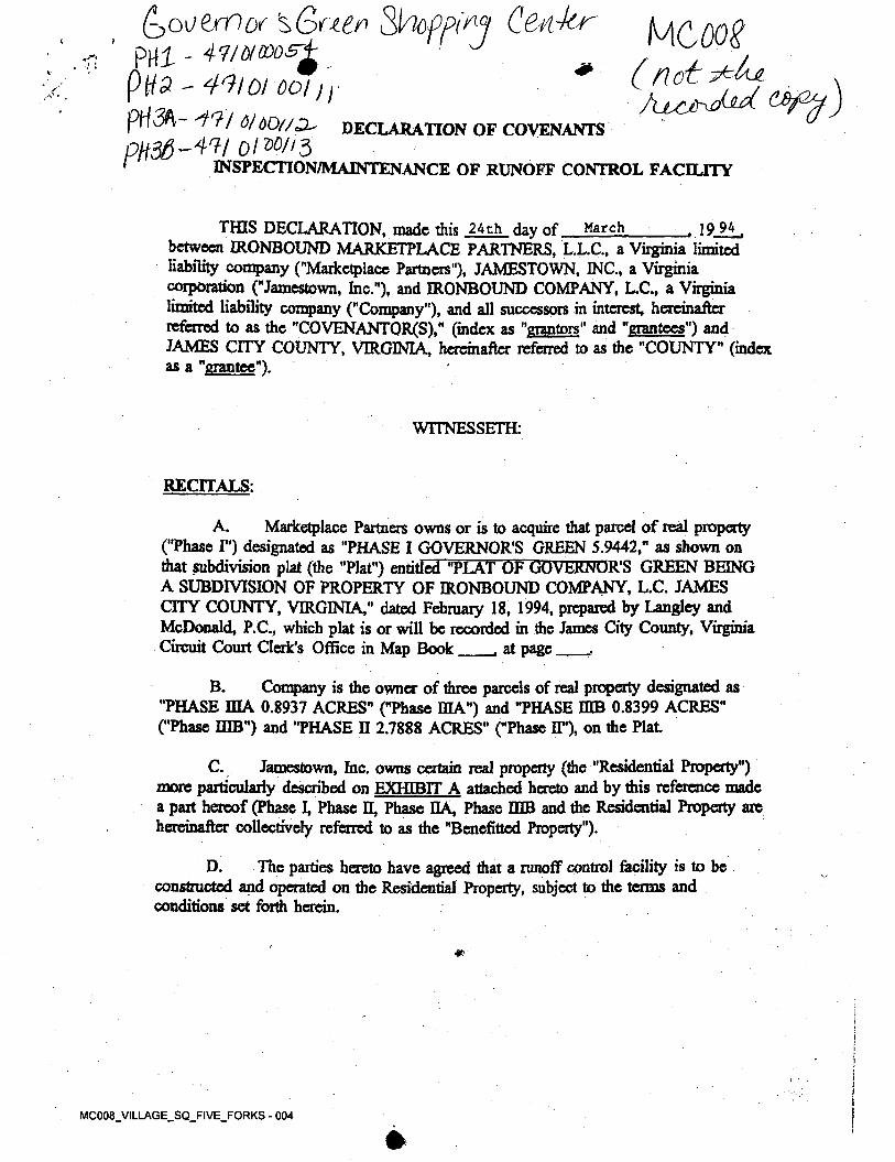
DECLARATION OF COVENANTS
INSPECTION/MAINTENANCE OF RUNOFF CONTROL FACILITY
, 19 94.THIS DECLARATION, made this 24th day of between IRONBOUND MARKETPLACE PARTNERS, L.L.C., a Virginia limited liability company ("Marketplace Partners"), JAMESTOWN, INC., a Virginia corporation ("Jamestown, Inc."), and IRONBOUND COMPANY, L.C., a Virginia limited liability company ("Company”), and all successors in interest, hereinafter referred to as the "COVENANTOR(S)," (index as "grantors" and "grantees") and JAMES CITY COUNTY, VIRGINIA, hereinafter referred to as the "COUNTY" (index as a "grantee").
March
WITNESSETH:
RECITALS:
Marketplace Partners owns or is to acquire that parcel of real property ("Phase I") designated as "PHASE I GOVERNOR'S GREEN 5.9442," as shown on that subdivision plat (the "Plat") entitled "PLAT OF GOVERNOR'S GREEN BEING A SUBDIVISION OF PROPERTY OF IRONBOUND COMPANY, L.C. JAMES CITY COUNTY, VIRGINIA," dated February 18, 1994, prepared by Langley and McDonald, P.C., which plat is or will be recorded in the James City County, Virginia Circuit Court Clerk's Office in Map Book
Company is the owner of three parcels of real property designated as "PHASE mA 0.8937 ACRES" ("Phase IDA") and "PHASE DIB 0.8399 ACRES" ("Phase IHB") and "PHASE D 2.7888 ACRES" ("Phase II"), on the Plat.
Jamestown, Inc. owns certain real property (the "Residential Property") more particularly described on EXHIBIT A attached hereto and by this reference made a part hereof (Phase I, Phase II, Phase HA, Phase DIB and the Residential Property are hereinafter collectively referred to as the "Benefitted Property").
The parties hereto have agreed that a runoff control facility is to be constructed and operated on die Residential Property, subject to the terms and conditions set forth herein.
A.
J at page
B.
C.
D.
MC008_VILLAGE_SQ_FIVE_FORKS - 005
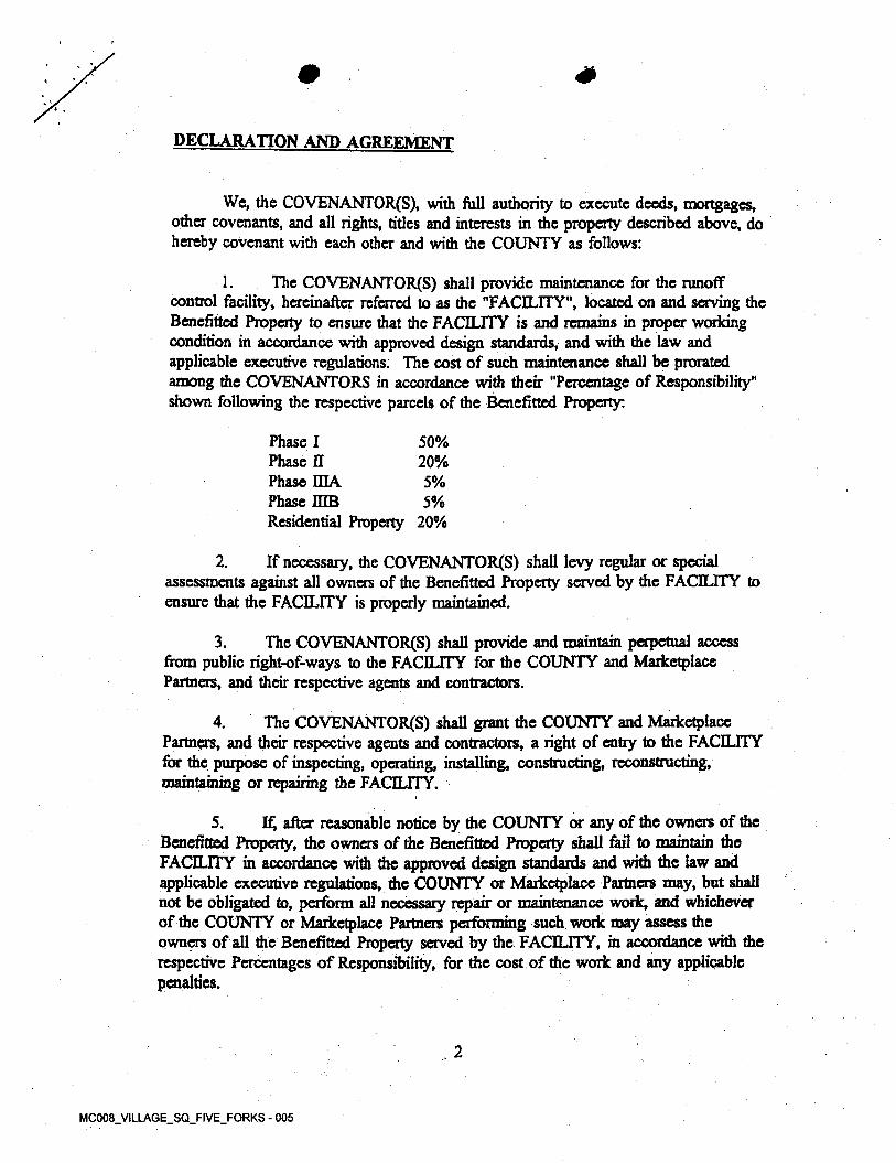
DECLARATION AND AGREEMENT
We, the COVENANTOR(S), with full authority to execute deeds, mortgages, other covenants, and all rights, titles and interests in the property described above, do hereby covenant with each other and with the COUNTY as follows:
1. The COVENANTOR(S) shall provide maintenance for the runoff control facility, hereinafter referred to as the "FACILITY", located on and serving the Benefifted Property to ensure that the FACILITY is and remains in proper working condition in accordance with approved design standards, and with the law and applicable executive regulations. The cost of such maintenance shall be prorated among the COVENANTORS in accordance with their "Percentage of Responsibility" shown following the respective parcels of the Benefitted Property:
Phase I Phase II Phase ELLA Phase MB Residential Property 20%
50%20%5%5%
If necessary, the COVENANTOR(S) shall levy regular or special assessments against all owners of the Benefitted Property served by the FACILITY to ensure that the FACILITY is properly maintained.
2.
The COVENANTOR(S) shall provide and maintain perpetual access from public right-of-ways to the FACILITY for the COUNTY and Marketplace Partners, and their respective agents and contractors.
3.
The COVENANTOR(S) shall grant the COUNTY and Marketplace Partners, and their respective agents and contractors, a right of entry to the FACILITY for the purpose of inspecting, operating, installing, constructing, reconstructing, maintaining or repairing the FACILITY.
4.
If, after reasonable notice by the COUNTY or any of the owners of the Benefitted Property, the owners of the Benefitted Property shall fail to maintain the FACILITY in accordance with the approved design standards and with the law and applicable executive regulations, the COUNTY or Marketplace Partners may, but shall not be obligated to, perform all necessary repair or maintenance work, and whichever of the COUNTY or Marketplace Partners performing such work may assess the owners of all the Benefitted Property served by the FACILITY, in accordance v/ith the respective Percentages of Responsibility, for the cost of the work and any applicable penalties.
5.
2
MC008_VILLAGE_SQ_FIVE_FORKS - 006
*
' /
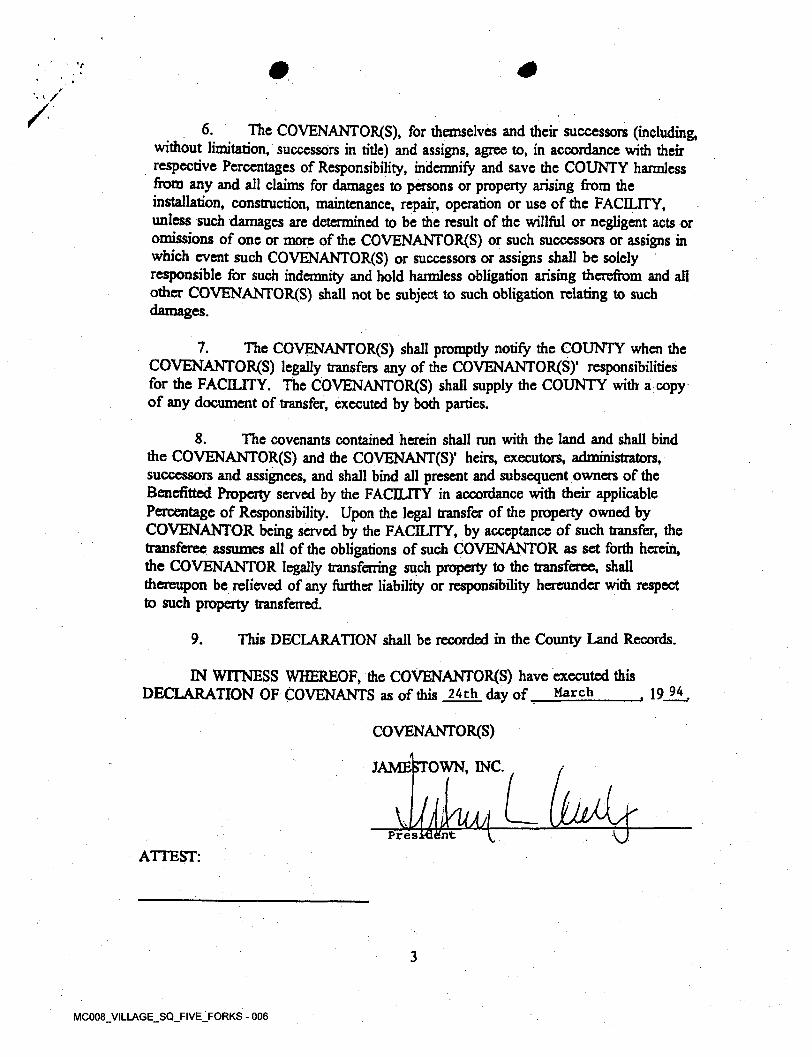
/ 6. The COVENANTOR(S), for themselves and their successors (including, without limitation, successors in title) and assigns, agree to, in accordance with their respective Percentages of Responsibility, indemnify and save the COUNTY harmless from any and all claims for damages to persons or property arising from the installation, construction, maintenance, repair, operation or use of the FAGLITY, unless such damages are determined to be the result of the willful or negligent acts or omissions of one or more of the COVENANTOR(S) or such successors or assigns in which event such COVENANTOR(S) or successors or assigns shall be solely responsible for such indemnity and hold harmless obligation arising therefrom and all other COVENANTOR(S) shall not be subject to such obligation relating to such damages.
The COVENANTOR(S) shall promptly notify the COUNTY when the COVENANTOR^) legally transfers any of the COVENANTOR^)1 responsibilities for the FACILITY. The COVENANTOR(S) shall supply the COUNTY with a copy of any document of transfer, executed by both parties.
7.
The covenants contained herein shall run with the land and shall bind the COVENANTOR(S) and the COVENANT(S)’ heirs, executors, administrators, successors and assignees, and shall bind all present and subsequent owners of the Benefitted Property served by the FACILITY in accordance with their applicable Percentage of Responsibility. Upon the legal transfer of the property owned by COVENANTOR being served by the FACILITY, by acceptance of such transfer, the transferee assumes all of the obligations of such COVENANTOR as set forth herein, the COVENANTOR legally transferring such property to the transferee, shall thereupon be relieved of any further liability or responsibility hereunder with respect to such property transferred.
8.
This DECLARATION shall be recorded in the County Land Records.9.
IN WITNESS WHEREOF, the COVENANTOR(S) have executed this DECLARATION OF COVENANTS as of this 24th day of , 19 94,March
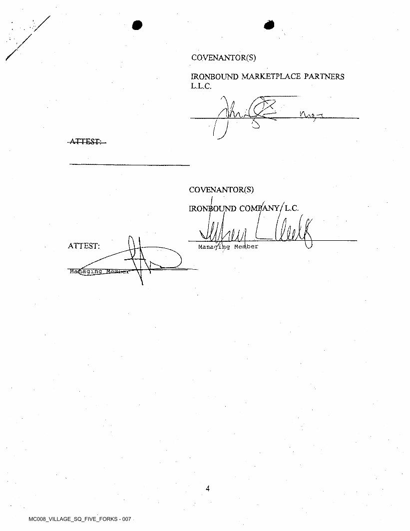
COVENANTOR^)
JAMESTOWN, INC.
Mud^ V uPres
ATTEST:
3
MC008_VILLAGE_SQ_FIVE_FORKS - 007
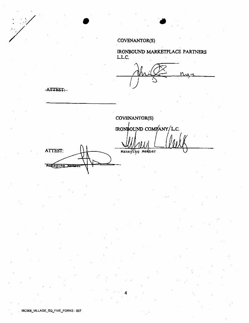
m/ COVENANTOR(S)
ERONBOUND MARKETPLACE PARTNERS L.L.C.
'A5/
ATTEST;
COVENANTOR(S)
ERONBOUND COMI^Ny/l.C.
kUAMernManagingATTEST: ber
Managing
4
MC008_VILLAGE_SQ_FIVE_FORKS - 008
#• ?
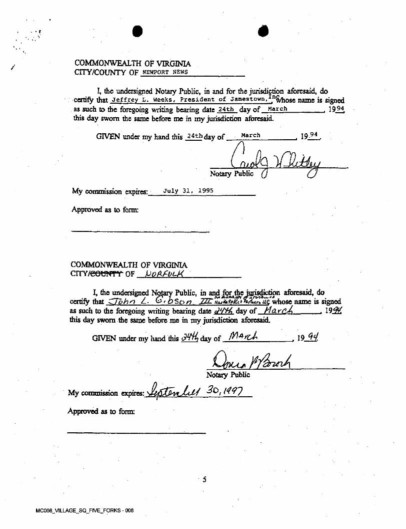
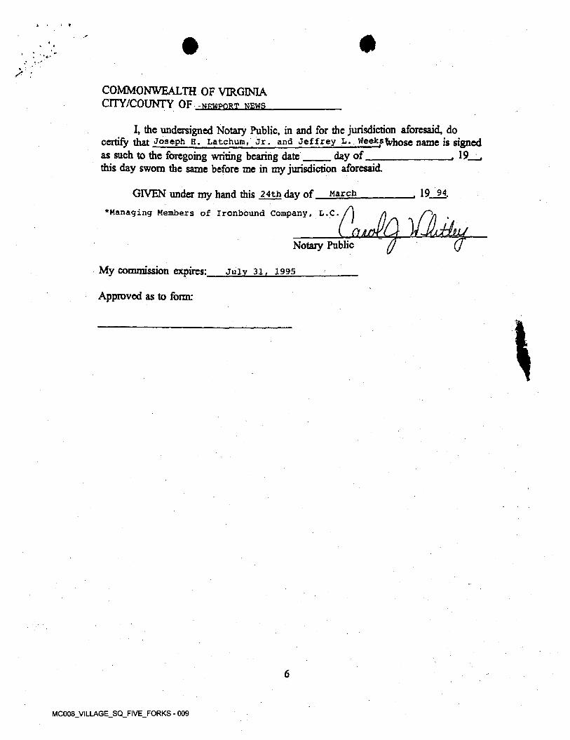
COMMONWEALTH OF VIRGINIA CITY/COUNTY OF NEWPORT NEWS
I, the undersigned Notary Public, in and for the jurisdiction aforesaid, do certify that Jeffrey L, Weeks, President of Jamestown,^whose name is signedas such to the foregoing writing bearing date 24th day of March this day sworn the same before me in my jurisdiction aforesaid.
, 1994
94MarchGIVEN under my hand this 24th day of , 19
nCtANotary Public (j
My commission expires: July 31, 1995
Approved as to form:
COMMONWEALTH OF VIRGINIA CITY/GOtfNTY" OF Po(K£bU<
Public, in and for the jurisdiction aforesaid, do__________________So /?, JZL HuXitoZci fo/Wa d£ whose name is signed
such to the foregoing writing bearing date oW'tt, day of Hd r cM____________ , 19j2Zthis day sworn the same before me in my jurisdiction aforesaid.
GIVEN under my hand this day of
I, the undersigned Notary certify that ZTbhn Z -as
, 19j^
Notary Public
./ 3o,t<vr)My commission expires:
Approved as to form:
5
MC008_VILLAGE_SQ_FIVE_FORKS - 009
X .
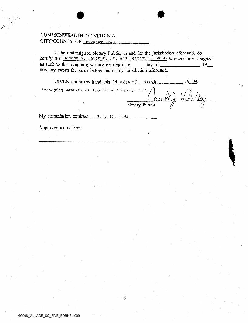
COMMONWEALTH OF VIRGINIA CITY/COUNTY OF NEWPORT NEWS
I, the undersigned Notary Public, in and for the jurisdiction aforesaid, do certify that Joseph H. Latchum, Jr. and Jeffrey L. Weeksfyhose name is signed
, 19__ ,as such to the foregoing writing bearing date this day sworn the same before me in my jurisdiction aforesaid.
day of
19 94.GIVEN under my hand this 24th day of *Managing Members of Ironbound Company, L.C.
March
aNotary Public
My commission expires: July 31, 1995
Approved as to form:
6
£>oi)tvOo{ %G>fi&rsPHI ' 47/0/
- 4^101 OOI j i
pH3fl- 6/60//D-'PH36-WI 0IW131 INSPECTION/MAINTENANCE OF RUNOFF CONTROL FACILITY
( notitduL
'0
DECLARATION OF COVENANTS
THIS DECLARATION, made this 24th day of between IRONBOUND MARKETPLACE PARTNERS, L.L.C., a Virginia limited liability company ("Marketplace Partners”), JAMESTOWN, INC., a Virginia corporation ("Jamestown, Inc.”), and IRONBOUND COMPANY, L.C., a Virginia limited liability company ("Company”), and all successors in interest, hereinafter referred to as the "COVENANTOR^)," (index as "grantors" and "grantees”) and JAMES CITY COUNTY, VIRGINIA, hereinafter referred to as the "COUNTY" (index as a "grantee").
, 19 94March
WITNESSETH;
RECITALS:
A. Marketplace Partners owns or is to acquire that parcel of real property("Phase I") designated as "PHASE I GOVERNOR'S GREEN 5.9442," as shown on that subdivision plat (the "Plat") entitled "PLAT OF GOVERNOR'S GREEN BEING A SUBDIVISION OF PROPERTY OF IRONBOUND COMPANY, L.C. JAMES CITY COUNTY, VIRGINIA," dated February 18, 1994, prepared by Langley and McDonald, P.C., which plat is or will be recorded in the James City County, Virginia Circuit Court Clerk's Office in Map Book_____, at page____..
B. Company is the owner of three parcels of real property designated as "PHASE IDA 0.8937 ACRES" ("Phase HIA") and "PHASE DIB 0.8399 ACRES" ("Phase mB") and "PHASE D 2.7888 ACRES" ("Phase IT'), on the Plat
C. Jamestown, Inc. owns certain real property (the "Residential Property") more particularly described on EXHIBIT A attached hereto and by this reference made a part hereof (Phase L Phase H, Phase HA, Phase DIB and die Residential Property are hereinafter collectively referred to as the "Benefitted Property").
D. The parties hereto have agreed that a runoff control facility is to be constructed and operated on die Residential Property, subject to the terms and conditions set forth herein.
0
MC008_VILLAGE_SQ_FIVE_FORKS - 004
declaration and agreement
We, the COVENANTOR'S), with full authority to execute deeds, mortgages, other covenants, and all rights, titles and interests in the property described above, do hereby covenant with each other and with the COUNTY as follows:
The COVENANTOR^) shall provide maintenance for the runoff control facility, hereinafter referred to as die "FACILITY", located on and serving die Benefited Property to ensure that the FACILITY is and remains in proper working condition in accordance with approved design standards, and with die law and applicable executive regulations. The cost of such maintenance shall be prorated among the COVENANTORS in accordance with their "Percentage of Responsibility" shown following the respective parcels of the Benefitted Property:
1.
Phase I Phase II Phase DIA Phase DIB Residential Property 20%
50%20%5%5%
If necessary, the COVENANTOR^) shall levy regular or special assessments against all owners of the Benefitted Property served by the FACILITY to ensure that the FACILITY is properly maintained.
2.
The COVENANTOR(S) shall provide and maintain perpetual access from public right-of-ways to the FACILITY for the COUNTY and Marketplace Partners, and their respective agents and contractors.
The COVENANTOR^) shall grant die COUNTY and Marketplace Partners, and their respective agents and contractors, a right of entry to the FACILITY for die purpose of inspecting, operating, installing, constructing, reconstructing, maintaining or repairing the FACILITY.
3.
4.
If, after reasonable notice by the COUNTY or any of the owners of the Benefitted Property, die owners of the Benefitted Property shall fail to maintain the FACILITY in accordance with the approved design standards and with the law and applicable executive regulations, the COUNTY or Marketplace Partners may, but shall not be obligated to, perform all necessary repair or maintenance work, and whichever of the COUNTY or Marketplace Partners performing such work may assess die owners of all die Benefitted Property served by die FACILITY, in accordance with die respective Percentages of Responsibility, for die cost of die work and any applicable penalties.
5.
2
MC008_VILLAGE_SQ_FIVE_FORKS - 005
•- > /
/ 6. The COVENANTORS), for themselves and their successors (including, without limitation, successors in tide) and assigns, agree to, in accordance with them respective Percentages of Responsibility, indemnify and save the COUNTY harmless from any and all claims for damages to persons or property arising from the installation, construction, maintenance, repair, operation or use of the FACILITY, unless such damages are determined to be the result of die willful or negligent acts or omissions of one or more of the COVENANTOR^) or such successors or assigns in which event such COVENANTOR(S) or successors or assigns shall be solely responsible for such indemnity and hold harmless obligation arising therefrom and all other COVENANTOR^) shall not be subject to such obligation relating to suchdamages.
7. The COVENANTOR(S) shall prompdy notify the COUNTY when the COVENANTOR(S) legally transfers any of the COVENANTORfS)' responsibilities for the FACILITY. The COVENANTOR^) shall supply the COUNTY with a copy of any document of transfer, executed by both parties.
The covenants contained herein shall run with the land and shall bind the COVENANTOR^) and the COVENANT(S)’ heirs, executors, administrators, successors and assignees, and shall bind all present and subsequent owners of the Benefittcd Property served by the FACILITY in accordance with their applicable Percentage of Responsibility. Upon the legal transfer of the property owned by COVENANTOR being served by the FACILITY, by acceptance of such transfer, the transferee assumes all of the obligations of such COVENANTOR as set forth herein, die COVENANTOR legally transferring such property to the transferee, shall thereupon be relieved of any further liability or responsibility hereunder with respect to such property transferred.
8.
This DECLARATION shall be recorded in the County Land Records.9.
IN WITNESS WHEREOF, the COVENANTOR^) have executed thisMarch , 19 94.DECLARATION OF COVENANTS as of this 24th day of
COVENANTOR^)
JAMESTOWN, INC.
LPresident
ATTEST:
3
MC008 VILLAGE SQ_FIVE_FORKS - 006
4
COVENANTOR^)
ERONBOUND MARKETPLACE PARTNERS L.L.C.
/IBW7
/
ATTEST:
COVENANTOR(S)
comb^ny/l.c.IRONBOl
kManaging MemberATTEST:
Managing wamS3
4
MC008_VILLAGE_SQ_FIVE_FORKS - 007
COMMONWEALTH OF VIRGINIA CITY/COUNTY OF Newport news
/
L the undersigned Notary Public, in and for the jurisdiction aforesaid, do certify that Jeffrey L. Weeks, President of Jamestown,^whose nams is signedas such to the foregoing writing bearing date 24th day of this day swom the same before me in my jurisdiction aforesaid.
1994March
, 1921MarchGIVEN under my hand this 24th day of
HiNotary Public
My commission expires: July 31, 1995
Approved as to form:
COMMONWEALTH OF VIRGINIA CITY/COI5NTY OF
I, die undersigned Notary Public, in and for die jurisdiction aforesaid, do certify that -^tohn L. ^ > bSo n. JLlL'HuMt&onAu*ilc whose name is signed as such to the foregoing writing bearing date o/¥'^A day of HdruM this day swom die same before me in my jurisdiction aforesaid.
GIVEN under my hand this day of
. \93H
, 19M
Notary Public
■JLf&njLtJ 30,t4<nMy commission expires:
Approved as to form:
5
MC008 VILLAGE SQ FIVE_FORKS - 008
#
/ ;
COMMONWEALTH OF VIRGINIA CITY/COUNTY OF -Newport news
I, the undersigned Notary Public, in and for the jurisdiction aforesaid, do certify that Joseph H. Latchum, Jr. and Jeffrey L. Weeks fafrose name is signed
- 19__,as such to the foregoing writing bearing date this day sworn the same before me in my jurisdiction aforesaid.
day of
„ 19 94.GIVEN under my hand this 24th day of March
‘Managing Members of Ironbound Company, L.C.
Notary Public
My commission expires: July 31, 1995
Approved as to form:
6
MC008_VILLAGE_SQ_FIVE_FORKS - 009

3. Construction
Certificate

4. Record Drawing (as-
built plan)
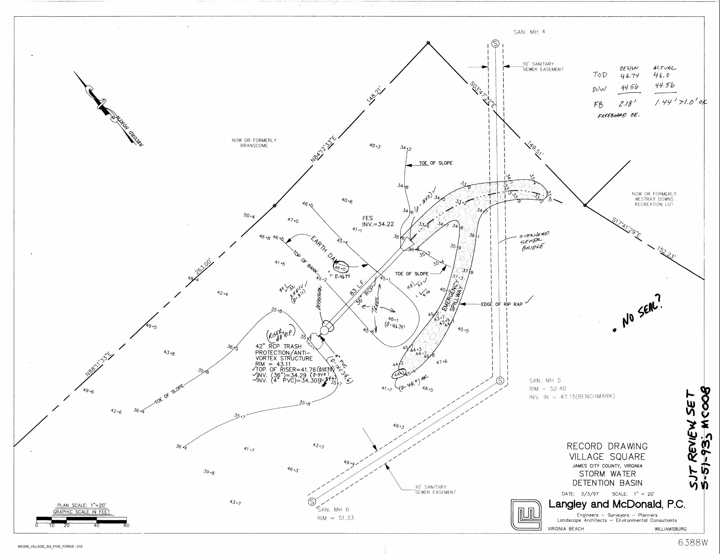
MC008_VILLAGE_SQ_FIVE_FORKS - 010
SAN. MH 4
10’ SANITARY SEWER EASEMENTr*
Hi, o
H55~bLj £.77
i)l). 5b
T\dP
%
NR, ppW'v/$■\x /, yy ' >t.o'ottV /rg> /■/#
Fttef&oAM?e
To.
s£o^ ,'<VNOW OR FORMERLY BRANSCOME 5
<Y 4 0*3 34•N>■&.py \
TOE OF SLOPE
LY3?
A 5734 \6 J IJ) NOW OR FORMERLY
WESTRAY DOWNS RECREATION LOT
'-r A -n&34V y40+6 305^ o\0to46 /
34\6^ 3450 +4 FES47
33.^ 34+o INV.=34.22 34 ?7’841
Js9*+7
5363646+8 46 1%%4, +4
35 fg y>& 57>/ Qo 35<0
<0.0 3^4i +59>X <$>.4) 46 +0nS 4 377pTOE OF SLOPE\ ^ y<HWH 374§A 45+2 45+1 +3,J X4;J / £>xi’£g,
'&&T
.1V4V .yJ+' \*Rivv;
X0"A)42 <b/+4 1o J dP'/ EDGE OF RIP RAP§35 *8 45,
aS'LsL i *R
46 + 7^"W.7y;49+5 45+545 +1 0yV
42” RCP TRASH ^ PROTECTION/ANTIVORTEX STRUCTURE RIM = 43.11 ,
AOP OF RISER=41.76 (OMIZw ANV. (36”)=34.29 CP-nO MNV. (4” PVC)=34.30(C^
35
/ 3eO 45/ 44+3 -744+i43$y
+8 *+,C*> 47+6; * 44/A\ u
% 385 j44SAN. MH 5
RIM = 52.40sl+£-0)p^
35 7 yA /4S +54U?4>V°49 I-+6 /
O* 47.1 5(BENCHM ARK)/ INV. IN
0^ 4)35A //■+8 // /
36^42+6 /35+7 // /
>49 +3 // ///
£/ RECORD DRAWING
VILLAGE SQUARE36 0 41 +7
//
/ I/49 +4/ JAMES CITY COUNTY, VIRGINIA w/46+3- /39 STORM WATER
DETENTION BASIN+8 //
/ I// // 'O/ 10’ SANITARY SEWER EASEMENT
//
DATE: 3/3/97 SCALE: 1” = 20’///s / Langley and McDonald. P.C.43+7 /PLAN SCALE: 1”=20’ 1SAN. MH 6
RIM = 51.33GRAPHIC SCALE IN FEET
Engineers - Surveyors - Planners Landscape Architects — Environmental Consultants
VIRGINIA BEACH0 10 20 4' 60
WILLIAMSBURG
6388W
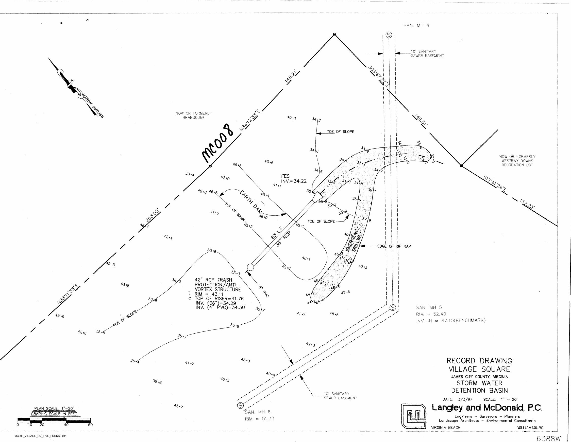
MC008_VILLAGE_SQ_FIVE_FORKS - 011
£ft
SAN. MH 4
I
1 10’ SANITARY SEWER EASEMENTr*
% ! Win>/
<b-V <y
I1
a iO:<£*70 ''4yNOW OR FORMERLY
BRANSCOMEa. 4)
<*9<A 4q+j 44 +2 I.<V I
iTOE OF SLOPE
& LI p- u»
S> jp-
$
3416 jVt-—■ i ^
" r >4 ■NOW UR FORMERLY
WE STRAY DOWNS Rf CREATION LOT
J34*0 >6 o; {<6
4434 lg s50 *4 FES&>.47
33.^'.. 44.+0 INV. = 34.22 2 34 ?7'\a41 89**1
£-361*4646 46+8 4,1. +4/ 'P 35 jg L. ;2)
O' \/Q/ J5<0
.0 41 +5O' <94): 46 +g%<o ' 47Jo4: TOE OF SLOPE -\ 47 +4<45+24S + i*§A Xov; x
& 40M.4 m
4>4^ <6/ *4
O'/ EDGE OF RIP RAP
45 i*8
AS/£S*?^6+; *9
45+545
4^+3
42” RCP TRASH \ PROTECTION/ANTIVORTEX STRUCTURE
T RIM = 43.11 c TOP OF RISER=41.76
(36”}= 34.29 (4” PVC)=34.30
/ 4<5>5 4/44 + 3 4*3+8 44sy jr* !
47 +6/O r2A 44\•\<b 45 ■>Ka4VH<5V. JINV.SAN. MH 5
52.40SN V. ,N = 47.1 5( BENCH MARK)
sINV. 45 7& x
*8+541 RIM* . F>V°' *749+6 xyX
/ xxO^ 35+gA /X/ XX
36 r/42+6 yy30 *7 yy
y49+3 y
yy
yyy RECORD DRAWING
VILLAGE SQUAREx36 y^ *341+7
xXX
XX49 +4X JAMES CITY COUNTY, VIRGINIAxx46+3 x39.8 STORM WATER
DETENTION BASINX Jr
XXXX
X 10’ SANITARY SEWER EASEMENT
xXX DATE: 3/3/97 SCALE: 1” - 20’
xs A Langley and McDonald, P.C.X43+7
UUPLAN SCALE: r=20’ XSAN. MH 6
RIM = 51.33GRAPHIC SCALE IN FEET
Engineers - Surveyors - Planners Landscape Architects - Environmental Consultants
WILLIAMSBURGJ0 T 00 4'VIRGINIA BEACH
6388W

5. Construction
Drawings
MC008_VILLAGE_SQ_FIVE_FORKS - 012
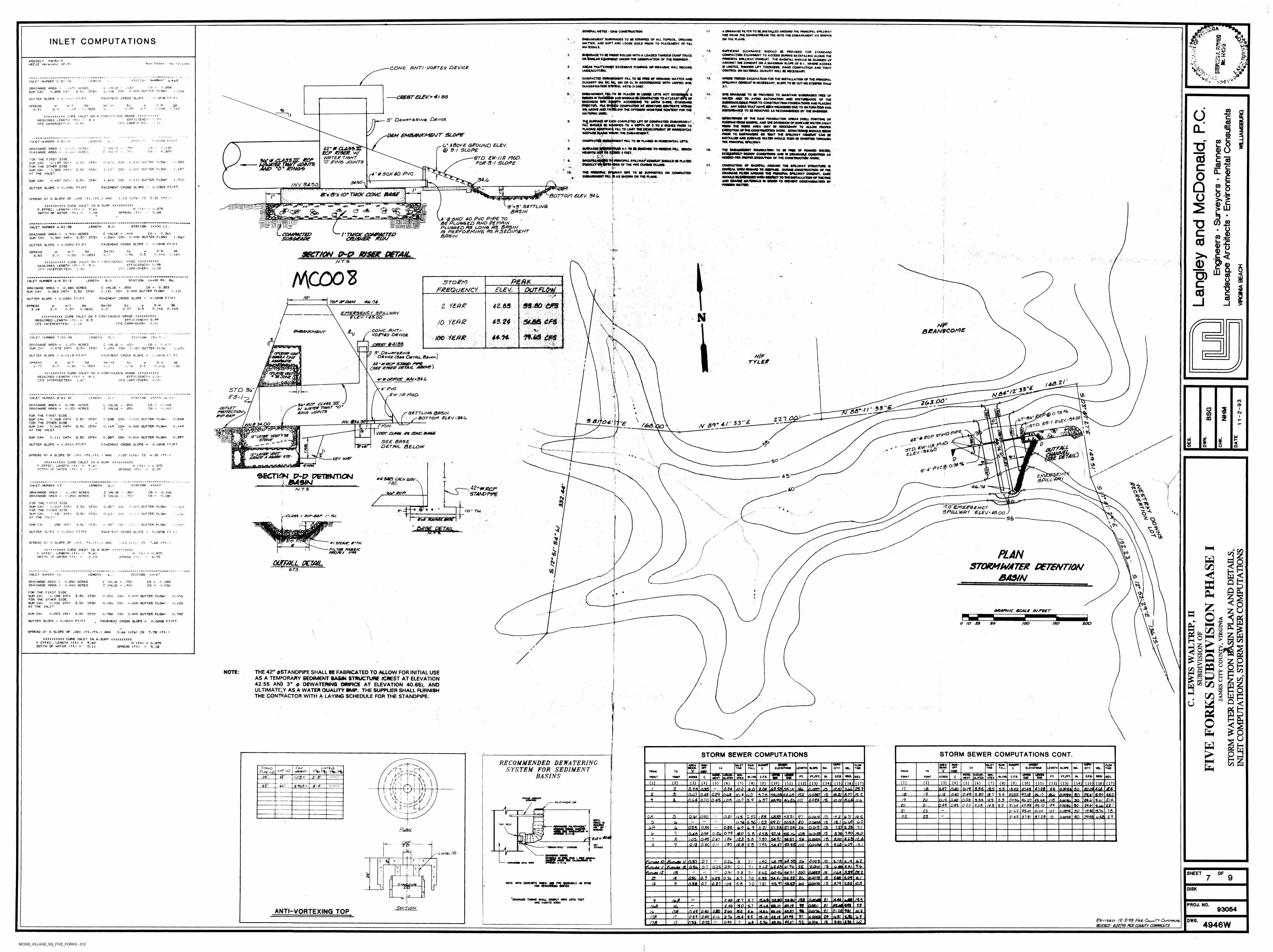
\
SCNCKAL NOTE! - DAM CONSTRUCTION A OMMAOi FILTER TO K WSTAU.EO AAOUNO THE, FWNCIPAL SPKLWAY «ft FROM THE OOWNSTRlAM TOE INTO THE EMBANKMENT AS SHOWN ON THE PLANS.
11 f.
fi ft.§EMBANKMENT SUOORAOES TO BE STRlWEO OF ALL TORSOtl. ORGANIC MATTER. Alto SOFT AND LOOSE SOILS PRIOR TO PLACEMENT OF PILL MATERIALS
INLET COMPUTATIONS 1.
II. SUFFieiCNT CLEARANCE SHOULO SE PROVOEO FOR STANDARD COMPACTION EQUIPMENT TO ACCESS OURWO BACKFILLING ALONG THE
At SPILLWAY CONDUIT. THE BACKFILL SHOULD SC RAMMED UP AGAMST THE CONDUIT ON A MAXIMUM SLOPE Of 5 1. WHERE ACCESS IS LIMITED, THINNER UFT THICKNESS. NANO COMPACTION A NO TIGHT CONTROL ON MATERIAL QUALITY WILL IE NECESSARY.
WHERE TRENCH EXCAVATION FOR THE INSTALLATION OF THE PRINCIPAL SPU.WAY COMMIT « NECESSARY. SLOPE TO SC CUT NO STEEPER THAN
g.BU80RA0E TO m PROOF ROLLED WITH A LOADED TANOEM DUMP TRUCKor Similar equipment under the observation of the enobkcr.
2. rs* "r»
£<$93054PROJECT HEC\B Version: Run Date: 06-i?-i9Q3ve.9i
AREAS THATEXHWT EXCESSIVE PUMPING OR WEAVWO WILL REQUIRE unoercuttSw.
3. K*CONC. Ft NT I ■ VORTEX DEVICE
% V*coV4. . compacted embankmsnt fill to be pres of organic matter and
CLASSIFY SM. BC.ML. MN OR Cl M ACCORDANCE WITH UNIFIED SOU CLASSEICATION CTS1EM. ASTM D-MS7.
13. irRT U3 tat I oriCN6THINLET NUMBER 'D! - yf‘ V
»1;0.288 0.000 BUTTER FLOW**
C A -. 30C VALUE t . <X»8
.6*70 ACRES 3.50
DRAINAGE AREA « SUM CA~
EMBANKMENT fiU,TO SC PLACED » LOOSE LOTS NOT EXCEEBNM • •NDtoS W THldOmS AND SHOULD SC COMPACTCD TO AT LEAST SBH OF
co= I . 008CFS*0,288 INT: s, , •DEORASiAQE to be pro who to maintain SUBGRABES FREE ofWMfR AMO TO A VO© SATURATION AMO DISTURBANCE OF THESUBGAABCIBSS prior to construct*© foundations and placing J*L Rtillto THAfT HAVE MEN WEAKENED DUE TO BAWMAflON ANOCHSTUPGANCE TO SC REMOVED AS RECOMMENDED BY THE
14,CflESTELEK” 4/88■:<. f>aoa ft-ftPAVFHGNT CROSS SLOPF iFT/FTGUTTER SLOF'E * O.'T
MAXIMUM NRV OI totoCTQR.. nu.»R SIS ABOVE AND MATERIAL
WAY* ACCORPBto TO ABTM CMBNL trANOARB Sfo COMPACTED AT MOISTURE CONTENTS WfTtm •slow the on**** MOM TIME OONTERT for the
X€i ' w'.146 o. 165
Eo5W SU s>.4 . *
W t T v. 69
WSPREAD a.91 3.50.990.08332.0 *> COoiiXXXXXXXXXX CURB INLET ON A CONI I'JVOUS GRADE
REQUIRED LENGTHces interceft-:d-
X X X . ...TXT
§DEWATER RIB OF THE OAM FOUNDATION AREAS (WELL POWTING ORIS,3" D&wftTt.8iN6 DeviceEFFICIENCY - > . 9*>3.4f t ) - 0.90
SURFACE OF i/CH COMPLETED UFT OF COMPACTED EMBANKMENT SHOUft EC S4UMF*0 TO A DEPTH OP" 1 TO S MCMCS PfUOR TO ‘
PLACWa AOOmONt FXL TO LIMIT IMI OEVCLOPMtolT OF MOMZONTAl SEEPAGE ItAMB WtHIN THE EMBANKMENT. '
3e. PUMPING FROM SUMPS). ANO THf DIVERSION OF SURFACE WATER AWAY mm THE WORK AREA MAV BE NlCESBART TO AUCWf PROPER EXECUTION Of THE CONSTRUCTION WORK. OCWATEMNO SHOULD SEOW PRBN TO EARTHWORK BO THAT THE SPEAWAV COMMIT CAN EC INSTALLED AMO SURFACE WATER WOULD THEN BE tXVERTTO THROUGH THE FMMOFM. BPXXWAV.
CFS CAPRrOOGf*-
Q. D■PAM EMBANKMENT SLOPE
OM5PAClE» n«A^KMCNT PAL TO RE PLACED M HORIZONTAL UPTS.
EMRM.atojjwip.ptfi HEIGHTS Rdf TO CfKO i FEET.
EACKFtAtoWte EGUAUVOillto
wt
EMBANKMENT PAL M AE SHOWN OH THE PLANS..... - I-. : "
- V' ,L................
7.us poirn COST A Il.L'MGTHINLET NUMBER 3-D I-3*1 6 .
"O6" above qeouno elev.@ 3 ■■/ SLOPEr42* 0 CLAeeiF' ecp ztsEJz w/
\NFITER T/GHT "O" E/N<S JO/NTS
CA O . 1 35 0.322 oIN. 4:1 TO K ESNChCO TO RECEIVE PEJ- BENCHMAI 1 ;t
UAtACRES
• o ACRESADRAINAGE AREA ^
DRAINAGE AREA ==« FOUNDATION TO BE15.
CXQEBSfcCtNEEPEDFOP
OF RONOED WATER.CAC If.
Y MUDDY CONDITIONS ANO M DRAINABLE CONDEMN AS cdSTD. EW-lift MOD. FOP 3 V SLOPE
PROPER EXECUTION OF THE CONSTRUCTION WORK. C 00CurECAS3JIT ECP wmTmrdOMrs/O - O * E/NOrS
FOR THE FIRST SIDE0.135 INI - ITMPMNC3PAL SPALWAY COHOLXT SHOULD BE PLACED
P» PCS Of THE PIPE OUHnW'FAUHO.t *.c>. S830.110 GUTTER FLOW-co-CFS- O . !<3SUM CA<=
FOP THE OTHER SIDE 17. COMPACmON OF BACKFAL AROUND THE SPALWAY STRUCTURE IS cCRfrtCAA wrw RMARp TOO.OuO GUTTER FLOW” 1 . 1ST1 . IF•’ C0«CFS-3.50 CONSTRUCTION OF THE„ ----------------- SPALWAY CONDUIT. CAREWRM RESPECT TO THE BMTALLAtMN OF THE FINE
AMD eOAMB.«M1WSAlto M ORDER TO MSVCNT CONTAMINATION BY
0.32B INT=SUM CA=AT THE INLET Q.TO. AY MPE TO BE SUPFORTEO ON COMPACTED4" PS CM- 40 PVC Oc SHOULOA -34.01.600 C0= 0.110 GUTTER FLOW- 1 .710CFS*3.50O.457 INT-SUM CA* 3490 QAINV 3430. CO0.0333 FT/FTPAVEMENT CROSS SLOPE
BOTTOM ELEV. 34.0
BUTTER SLOPE « 0.0050 FT/FT to•;rp. K \ l' ."J! •>I1 tA * *
e x B'x tOm TUCK CEWC O^3'*3' SETTLING
BASIN"0 SHD. 40 PVC P/PE TOe Plugged and pemmn
Plugged As long As 8ASIS PEPFOPM/N& AS A SEDIMENT BAS/N
5.31 (ft.)1 .13 (cfs) ISSPREAD AT A SLOPE OF .005 (ft./ft.! AND 1
4>.SXXXXXXXXXX CURB INLET IN A SUMP XXXXXXXXXX 9.60 0.18 ka* UJi"*Vi9 «g0.375
5.63H (ft)
SPREAD (ft!P EFFEC. LENGTH (ft) = DEPTH OF WATER (ft) = <3a ax .4JUBL K
CO w<9S*3:SUCKAXKIIB)
STATION 14+00 Lt.LENGTH B.O /NINLET NUMBER 6-DI-3B .1cLeom/hetepSV0&B40E
i0.360 0.000 GUTTER FLOW* ' TH/CK EOMPJETED
CO/SME& KUNC VALUE = .LOO 1.260 C0=
CA /DRAINAGE AREA * 0.900 ACRESSUM CA= 0.360 INT* 3.50 CFS= 1.260
C0PAVEMENT CROSS SLOPE 0.0208 FT/FT0.0350 FT/FTGUTTER SLOPE
S 1 W O. 146
SEEoSW/SX4 . n
SW «?W/TW seertoN wse* detailSPREAD3.83 3.5 <:>. i 600.960.0833
<0.522.0 l
;tl-
<DNTS.XXXXXXXXXX CURB INLET ON A lONTINL'OUS GRADE XXXXXXXXXX 9.0 •vEFFICIENCY^ 0.98 5REQUIRED LENGTH (ft) *
CFS INTERCEPTED* 0.02CFS CARRYOVER*1 .24
MC003 LUO)isssBsesssaa : m st a =:
pernSTATION 1 A.00 Rt. Rd.LENGTH 8.0INLET NUMBER 6-A DI-3 ■3 TO EM)FREQUENCY
ICA * 0.3230.000 GUTTER FLOW*
C VALUE = .950 1.131 CQ=
DRAINAGE AREA * 0.380 ACRESSUM CA* 0.323 INT* 3.50 CFS*
m.&Q cm
s&m cm v1
ff.4d cm
ecev. (01.131 f
/O'0.0208 FT/FTPAVEMENT CROSS SLOPEGUTTER SLOPE * 0.0350 FT/FT 1 ror gr&AM toto.74 -J2 tetfyEsw SEEoSW/SX A .0
SWW/T0.57
SPREAD 3.LB
W0.1L6 0.1630.97 3.50.08332.0
wlEMERGENCY SP/LLWRV Ei.£\/. '4-S OO
i
NI'XXXXXXXXXX CURB INLET ON a CONTINUOUS GRADE XXXXXXXXXX 8.5 fEFFICIENCY* 0.99 4-3.24REQUIRED LENGTH (ft)
CFS INTERCEPTED* JO 1EPR mFCFS CARRYOVER- 0.011.12 l BEAN3COMECONC. ANT/- VO Ft EX OEV/CE
cxEsr 44/86
*J) 3“ Dt^/trefi/NG .Iy Device (Gee Dmtgjl Be4**>j
4ZnEr/ecF anam» fvw .(SEEP/SEP Pem/L ABOVE}
3EMB4A/KN/ENT c 44-.Hx too i£0& cLENGTH 8. Fi STATIONINLET NUMBER 7-DI-3B 15 + l r. 3»n1.050 ACRES 3.50
DRAINAGE AREA * SUM CA*
C VALUE * .450 1 . *54
CA 4 V p ki‘«
van* vo* amp* fjne
1 m ft0.020 GUTTER FLOWO.L7£ INT* CFS* CO* i .674
lN/FFAVEMENT CROSS SLOPE *GUTTER SLOPE 0.0113 FT/FT 0.0208 F' FT
TYL£fi JtW/T 0.30
SWSPREAD SW 'SX Ed S * W 0.14 6
W 3EI0.0833 3.5-7 3 2.0 0.76 1 . 1 324 .6 .
'wswXXXXXXXXXX CURB INLET ON A CONTINUOUS GRADE XXXXXXXXXX REQUIRED LENGTH <ft)CFS INTERCEPTED^
\EFFICIENCY^ 1,00
CFS CARRYOVER*B. 1
1.67
46*£.o. 00
/L*jS& rsL 4" PVCSTD. 30" F3-/—5 /
i‘ n*£!±.Ew/IA MOD- \S\LENGTH station 15INLET NUMBER 8-DI-3C v6 R t .6.0'2U3-O01 CO\
3£»* ECF EZ43S JlL ■» A/ MM7ETS 7?GMT uO EJNOr JO/NTS
O). 850 CA -• 0.060 <.i .04 3
DRAINAGE AREA * DRAINAGE AREA *
0.080 ACRES 0.050 ACRES
C VALUE C VALUE * .850
04t , 33 "G<OUTLET rxcTECT/aw-
E/E’EU/r ^ %CA « Ii ,O AS Ao
1 EL£S-
CMyr SETTLING BASINBOTTOM ELEV -34.C,
*lAFOP THE FIRST SIDE
SUM CA*FOR THE OTHER SIDE SUM CA*AT THE INLET
I2.21-00^. -.3400 CDSBtT04.'\ \'■',238 CO* 0.010 GUTTER flow* O. 2L80.069 INT* 3.50 CFS*
/AM G14 /S& ’ (O'1!* 4.)’ 33”£• > «f
3td. £s~ N£iIAN.fi 34.00 NT£h3.r FUN.S ~XvP0T CLA43L
\ "H0.1L9 CO* 0.000 GUTTER FLOW* 0.1 L 90.063 INT* 3.50 CFS* «*0sptf0
ffhtP- \T~~Ljgta!
Ft ODMC.B4GEV£VT»73tviArm stmvE
- g\U- / fA.m pSUM CA* 0.111 INT* 3.50 CFS* 0.307 CO* 0.010 GUTTER FLOW* 0.397 vi i4* tSEE BASE
OETA/L BELOW*■ <%> 8 <D0.0200 FT/FTGUTTER SLOPE * 0.0010 FT/FT PAVEMENT CROSS SLOFE %•« bF2 a u Q-3
' Web \ \ ^/Z”L4YJtXr vpor_._oaaoe * fasee- 4te-SPREAD AT A SLOPE OF .001 (ft./ft.' AND A.32 (ft.)0.25 (cfs) IS ‘ • , toll\KEY A/FT V6O tollXXXXXXXXXX CURB INLET IN A SUMP XXXXXXXXXX
P EFFEC. LENGTH (ft)DEPTH OF WATER <ft'
* I VJ»4‘Afl9.60 0.07
H (ft) * 0.375 3.29 pvt®I 0-4‘SPREAD (ft) I /
SECTION P-£? PETKMTIOJ _____ k /MSIN__________
EN45 £M LV*4 DOES EACH UUAV-roc. Sp/LL
o ^STATION 10*L7INLET NUMBER 13 LENGTH 6 . i.i 40.14-A2*T0R£JP
STAHDPfPg I \S\^40AY. 7. 3CADRAINAGE AREA *
DRAINAGE AREA =0. 102 0.1 80
0.120 ACRES 0.2A0 ACRES
C VA1 tJE = . 35" C VALUE * .750
■&G*/&?/*>CA N X*s«a "3a TOFOR THE FIRST SIDE
SUM CA*FOR THE O1HER SIDE
•. I 6'
\TO' EMEPQENCi
SPILL WA i ELEV- 45.00»i GUTTER FLOW0.102 I NT * 3.50 CFS* 0.357 CO* -\T7‘ • - 3j7
]€• (§J • • % 9fo " TU * x oi■. ■ m gutter flow*sum CA*
AT THE INLETINT* 3.50 CFS* 0.63 C
1CC4S4 / */E’4S*r /• TO.8x£-9QtfA4£049i If ~ZL55
SUM CA* .882 INT* 3. So >;■ ' GUTTER FLOW*CFS* 0.98" l'-CO" \ &07 II \
t^ Vi
GUTTER SLOPE 0.0010 PT/FT PAVEMENT CROSS SLOF’E - 0.0208 FI F fX
Y) vVj\SF’READ AT A SLOPE OF .001 'ft. /ft. ) AND IS 7.62 < f t. < »! S7ZM/e; S"TU.
—r/LTm tabfuc neofex //***
' .63 (c' =SL HH%
XXty.<<XXXX CURB INLET IN A SUMP /yyzYxXXXX P EFFEC. LENGTH (ft)DEPTH OP WATER <ft>
r C/5\s ALANSTORMWATER DETENTION
BASIN
W*V)9.600.13
H ft) SPREAD (ft)
0.375 6.05 z\ vV»)/% otft /N / FxA/.rji V)rztzi
<INLET NUMBER 14 LENGTH STATION 10+4"6 . ■. c SB/i i nDRAINAGE AREA * 0.250 ACRES
0.040 ACRESCA = O.j08
O . 036C VALUE * .750 C VALUEDRAINAGE AREA . 900 CA
PmFOR’ THE FIRST SIDE SUM CA*FOR THE OTHER SIDE SUM CA*AT THE INLET
Vjv,0.188 INT* 3.50 CFS* 0.000 GUTTER FLOW*0.656 CO* 0.656
I o0.036 INT* 3.50 CFS= 0,126 CO* 0.000 GUTTER FLOW* 0. 1 26 z\* uGRAPHIC SCALE IN FEET Pti\0.223 INT* 3.50 CFS* oSUM CA* 0.782 CO* 0.000 GUTTER FLOW* 0.782
GUTTER SLOPE = 0.0010 FT/FT toPAVEMENT CROSS SLOPE = 0.0208 FT/FT o fo is so /sotoo zoo
%oSPREAD AT A SLOPE OF .001 (ft./ft.) AND 0.66 (cfs) IS 7.78 (ft.) 65O-A\ >XXXXXXXXXX CURB INLET IN A SUMP XXXXXXXXXX
P EFFEC. LENGTH (ft) *DEPTH OF WATER (ft) =
COV*9.600.11
H (ft) = 0.375 5.18 3SPREAD (ft) /sc
o Ms
o& ua s >*NOTE: THE 42" 0STANDPIPE SHALL BE FABRICATED TO ALLOW FOR INITIAL USE
AS A TEMPORARY SEDIMENT BASJft STRUCTURE (CREST AT ELEVATION 42.55 AN5 3" 0 DEWATERING ORIFICE AT ELEVATION 40.65), AND ULTIMATELY AS A WATER QUALITY BMP. THE SUPPLIER SHALL FURNISH THE CONTRACTOR WITH A LAYING SCHEDULE FOR THE STANDPIPE.
vH to\HHu
“ IDwfH^L in pI uI
5O <
^ Ofo ui
STORM SEWER COMPUTATIONS CONT.STORM SEWER COMPUTATIONSRECOMMENDED DEWATERING
SYSTEM FOR SEDIMENT BASINS
«RFsasg TOT-J- IMI Ml AM.
MW- ML IT RAW RUNOFFRUNOFF fotollMIAMNUN,
RAM FUM ru»OFF5m ho
Pipe. t.D.Cpp
VjtttHTLintils CA TNfC fall IlfVATtONS LI NATH ILOFCCUCYATWM LI NATH tmk MA. VtL. THMTime OTT VtL. OTTCA FALL 0
Y\ Ii '\ I
oLbP 1.0. V5 %> ?% r FROM TO S9SL7%>7% FROM S9ELTO
l556immrasearmint ulatip
UFFIRwent.MINT
ACCUM-ULATIOCSX KM.rryrt rtyrt ntiFT. CM.Ml. M7ML C.F.I.24’ M./ML C.F.I. tie. FOINT FOMT ACRII c SEC.FOtMT FOMT ACRII cNIST
/EBB I NOUTCt CNDIffU
\\ \ \l '
/(1) illill ill ill illill ill ill ill illill ill ii°l iiilill ill ill ill m mi iiii ini illl iiil iiil iiil iiil iiU
zo.cn 4Uiiil iiil iiil Iiil4Z- 4-4‘Z9(,3r
l+H// /
Aia 2111 a 01 1222. J2JLMLl 6&3&SBUL
MBS.
Mla,canJtt-MSSlm,.. mil
IUl 1£l 2U1 11/ML J2JS1 ABL CM IMS. 12122ML 21 mu la.flgstfe-ao.0.OO3L 30
DBS. ML 11 /£OLl 0.43 16. Ml2 123,.041 CmH. II A2? 12. smJZ2L .LLL 132, J2J. IL M2OLD. Mlmil. ZOSL £3012£l SM
\V I V/ / FMMMJBMUMt I±OIL1 Mil nm.121 A4f MJl. ML m.n 22 an DJ22 012.241 11 Ml MSI 111 2MLUL£l 20. Sfe4% JO
LkL10.02K s FOLYDHnlNt CAPL41 ggj22. 2L 0 2 0 Its 24.410.43 HA S3 4S.55g/02 lo£323k.
2SS2LMek
\ SL 2Lklg/.t g
4S.OO 2121 JSMlSlk.C/.oo SSL1221 1UL 21 23IfL 1LLQ31 Ml MU MSI 32-Q&ULasm
n. ML 21 SUL0.2/ Ml SO.SI 21U1 122, II pm*-ocfth {.(A klMLMil sail5 SlSS.Sl 11MJLMA««aws-sroRWC
X IV-40M
TACK WEU)
121 ILSR 11 7.37k QSA Ml0.M QH1 112t2L SLSh §lL%LS3dL, SSulk
GO 21Plan.Q7<?n 3.74. 7.gQ(p Q.S4 11 IS.O1QLSS.
omsamt
22k. LUMR 1AUS igs.ti\ LkhMLSill2l MIL Ml0.45 123.0.41 A22.i sfl 230 sm SL1 / Q D
CfiPxzr (m.Q53S£3t&1 mq J2J3 12l 211 IMS.DJI Ml Ml S112 Ml LSIO-ll>■ 2l*n* FBMOA-WIU * COiMUNC STtXWGf
Ajrt -L >mu (z)*£&&<SliXTr1' T
jt&Jl JsUZi Mkkite k£L 32.
« MLF.ucvAi ilfuamJL.
QMS01 L2£l AJ±it m is.031Pun am /QfuiuU. Ufhrult ll
22k 213.»t«-A)
Ik.kJ&LLLfftfflSL 11Ski.0.703k 221 ML 11 7 I'a • 1
ASS232.MSL 222- om*322 kUk MM.13 QSI S 34 ■ 21 /g SHEET OF3 7 9JT i LSI jlLSLiLSLO. SM.SU 24.22222 ii£22 S.7l£11 i£o.?/. £32231JOAsin Ml im4B STUB SSI14 1 SSSL21 Ml 222.00022033. mS3 211123.Sr,11 J
FORDISK*!
*DRAHUOC TUBIIM SHALL COMFIT wm ASTM FMT MO AASMTO MltA ILtL1121 111133 02043 Ml OJA.IkJL sunsssmMl SI232.1
PROJ. NO.M6t 333E-om. 21OPAL SLSI132. £300.ISMIkd. 2JDIkSection 93064ANTI-VORTEXING TOP 2121 SSL26. ZL JSJLIkSL JS2 MSIm. O/BlOk.Ail OJO. li£kLk MOLIk■SSEL(LQ&S& 3±iklLm. ii 22 kl0,39 32k SJL illl
4SJ> 7222. Hit0/0 MIS.
Eev/sea -. 12-2-93 Per, CounT* <2arttv*\jvs rnnsEU- alizfa fee couuty commemts
DW6.6-^0 miMLis3k QJ2Lil 0.40 kt 23km. mi ms mi 4946W
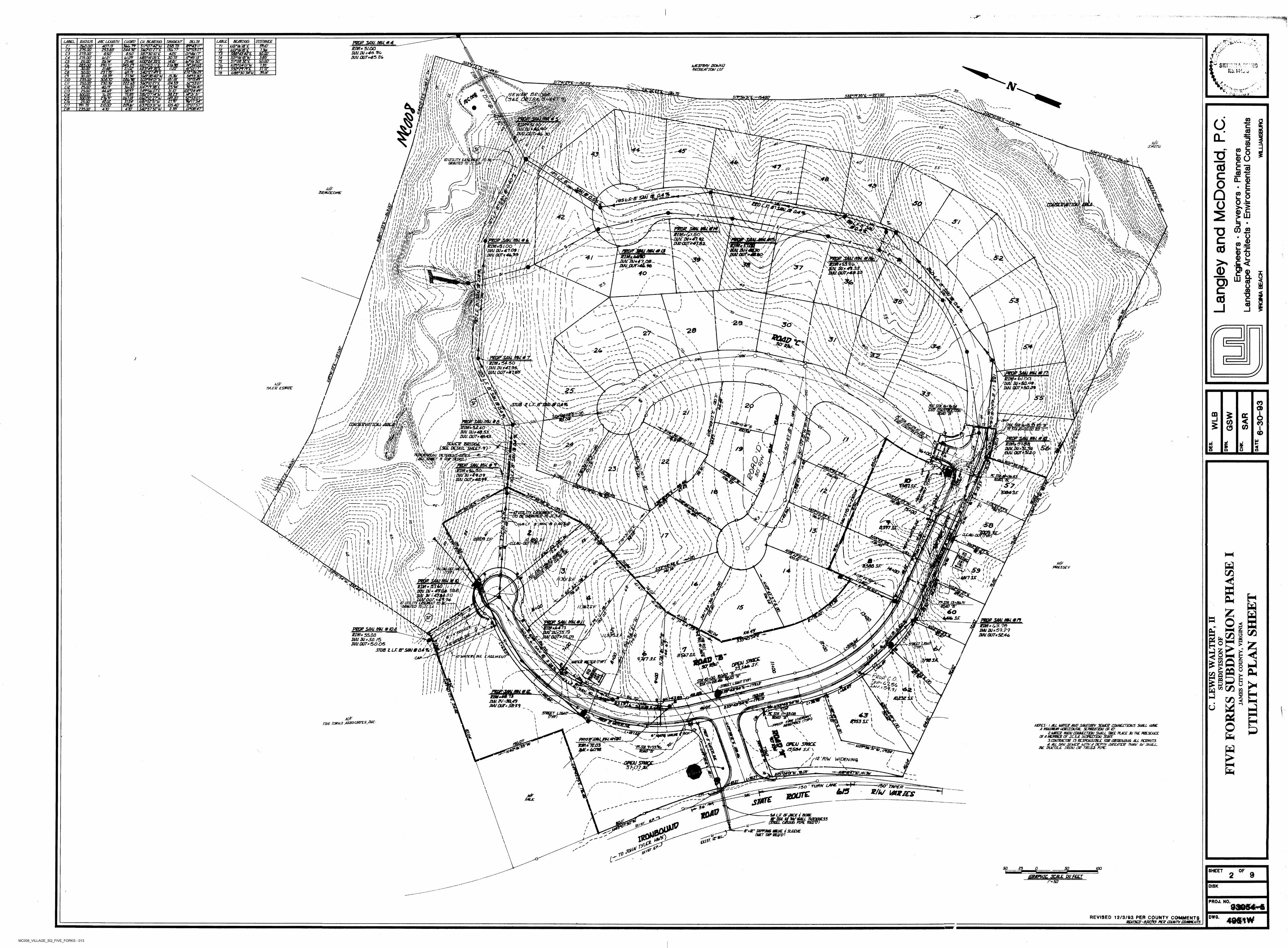
MC008_VILLAGE_SQ_FIVE_FORKS - 013
*:
TUfcO''*BEARING DISTANCELABILDLLTA&r4S'/>uSFESDT
LABEL RADIUS ARC LENGTH CU BEARING TANGENTT&.W
CHORD PROP 5dAJ.MU*4KIM* 51.012 IlIU IN *4*30 INU.OUTM5 2G
~W/o7smarms2GO.OO' sszm IuSnk-fB"Ea 77Jj JiiwM/erl753.53- SiPmTE /3G.17-Zl imxr 24412' 7T2
73SBT3Q7QE 01*40(17" "£aso' 6.50' 425275.00'C3lit'A4 m3.85'"saw0*4673“NS5*/4'0S"E 30.73' T4 SO/*/C$'fBkJ01.07'Z75.00' (at.ZfC4 t!3IW3FENQQ*Z4'35i“E 75 srcr:'r!A
% Ikl-Mw*
V0D/G-50-14.61'263* 25ML25.00'£2. 11111 '! I / / /T>7•Mu !/JJ,IftiKl . / > I I / l
rA3\ *0 ■MESn&Y POUNS PCCREAFlGN LOT
34527' NQT03'// 210.76' 74*3403" 735'390.7/' N25*04'OT1aJCU TO*49' 3T7T----C7 SWFfTTE2/46' 11.22' 4/*0/7 7"z/.ot 77
\ ^
T24072237.75'ca mm:..30.00
39.14'N6B*3Q'34?UTB54*/3'30"75V5WT mu!
i1 w i i 1 >1
m ii'wli» ; W\
21.34’ SG6*38'40"UJS03*54'D/"U1
/5.3V26.39'C 9 It i/BITS7350025000'
3SET07 2BU.9B'T/O l i / l
W$$kr?i\' //11 '70//''til'll >Xi11 ! y111 1\A/ t/i i h !! y7 ,, /
Ar17433 s227.05' 3&mrn S2*S3'0T'92*06>'4f"
230.70/ •sCll
jt.m' i -v .rN47*/9'33"L 7534'4fl/r 30.00'2500'ctz1 ,rs*»*
■A4l :<i
X>
» \ \1
• ‘ ' l 1 J -M>sl—
///
i ///"-—Mil WW
' CX w./31/0' t02*Z4'4V33.23' WWW'
3B.9T S4T5&07 T4409'25.00'C/3 % -75'/SEW C3&4
i.Li I 0ft; e75M jBsznww30000' X "■ "<ST00'\ m1UQ5‘04 surrraarSi*N N[ yti S/9*5U'3/''£r/S400‘
' * ' >V /•____ \ N \ \ N
\ \ \ V 1^ \ii
\ \AjurmjTid wrm' im 'M& i r» %i \ V\\vi V, >i '^yJitylr
-ON /Z///,///^///hi r~"‘yZy'/ >// ///
i27Wzs.
o\Ww
v\ \/I)V* /AN nX^\ ^ - s
-VX\\- \ \ \' \ - % v a ’
. W v
/Z*07'S7“ ✓ummrw /ds.40'z/omr99/75’ \2cn.tr \C/7 Ii'
I'lll
,U s s
\\/y
/\ yS40*5T3tU zW -.V \OMJ6'4r \\ ' ✓ /" Z ^ ^
470'470'C/6 73500' I ‘\ t \ \S s 40\I11 i'll1
Ill'll iiilUil\k1
'\W\
''Xv \*4«L X X \X \\N\ \ \ \Mi \\‘ ^*55L«'
V\\Va\V
s\\\ I //i xI / GOi I • ! WA°\ v;\ N. o/* / \\ \\\ I :.'XVi l \ ^5-f / t; / / 1\\
\ \iI \•i / xl\ }! A
\' \*v. < \\lI /f II / f \\I I _/ /1 1 X COfhf Hi
» '/rw> '//ii i •, 1! /
U__ *\/i .y\ \i s xV\ >I \ \ \ CL<< ' ^ \
" \ \ \i l XI I
\W ■ •\ U s A/1I I Di i /III,'1/)i i't, /
1 / //////>
\____/ / / / / // / //'// ////// w ^
1 ' ' ‘1^77/'7 *111 'ii/ /! ! V/V
i/pli ii
\ \ \Vx /ii / // /i/A✓\
i in1'!//// Ktaum Ej^kemimimH/Jtyi > / Ii}/!/// granted tz/jcJ/ai j ij / / / //>/ 1'v0! mmn
m//{(r"\\/ \ <> l,\'//fl'il 1,11
ill i n
i \M \ i / \ \■ VI CO1\1/1 I1 !l» i /
SS/'/ZUr - oVVAX-xV. x\\N
nSVv
N'yxyyyXX X X'x''^
\ SMITH/\ ' CO cV S x '
''x>\ 'So\ \ /, x/ /I l1 X/ Y./ h
/ X1 pl 1 1 j1,'
1 1 \
/ To, o\Z” —
-//r/i:! ^\ \ N \X\ V X "O
■Sy\vA\\\\\ \ ,xxxvX\'\ \Vx\\\\\ \ X wx\\\X\ \V\\xv\ ‘
\ XX x\x\\\y\x\ x\\\\^.V \N \Y\x\V \\\V\Vx'
;
I w
X1 /1 \ J/ \ SX \X
-Ayyy-V \\\\ \ \ _
\ \t
I I \ \^/ s N 0) Oc__c co/•t 11 i i \/ wwI N\ l I/
<\/ I 'ill11 :S/
— X \ \N\\ \ x \ x ' \ x
\\ VX XXN N
X \
XX VX/X^'■ WVvA \ 1\\ \,Y\ Nj
x \ WXvl N
XX/ V\ X x\>11 XX/• / \I/ x^./ 1/ XX/ / I IXI cd// xl NSxx1/ I xyy
x> nxn s
Milt,X/ I NX1 > \
M \ \ vV I 1 I ~ 5S~
( ~ ~' \
XI V s. y\in!I
/ /xiJI/i, \ \ N x'N\y^\ V\s 111/I* c// wIvi liilil'i/d'///' / /'- m,iSKtfr/tf/ ni / /v/Wlr/ " ii r /
4«7/v//// 'sif]/'' */ f / f 1r/N'h / / 11 i / /
'//i nh/ !. Ii ///// t / / ,I'PMPjSAMjmtA /\ klM*5i.OO ' if! / XhlUIN*4.1.09 / II, ■ \im 0UTf4t.93,1' 1 1 hi'Mly iTi\h~PT\
\ii x/i \v>V. »l I iXx \N\\/ x I\ X\ \/ i N\ \ VC.ItN CL 0)/ u ^^xx/yNr —i }\ ;»/.\\ x\^\y\\\ i» \\a /\ .
x'v" v%\y\\\\/X' . X’Xir' X \ X \
\ \\j\\\\X X X/h \/ o\ ' \ \\ \ X \
'// / '■'//r-
\ X X X^ ' ' X • eN x1f.l \I \ NX X\ xn X N\ s \N/f x \ \XXX \ X/ Q%\ N\ \ X
/ .^NXI I \ \BEAM5CC&1E \ £ o
o -b >% > 0) .P.
\
i‘ i!X\ \/ xI / \ X\ X//1 / X\ \ \!/! \i> i f li \\X X\/ >I \ \ \Y\\
\ W \ \\\ oI Njf I i'll/.',„
W11!"'! ''Ill /Vii h i:/ /! ))) ////^Ml nlhUh/.^IJ /////'/, 'V / . / / A /
III' '
\***>£/ i \\\ X X\/ > XxX <iCi\ \V \ \ v'x \ v \\ '
"j' ss ' *!**/.x X/ / \X \\ X X N \/ \ /. X\\x
x-Ll._____ ^ ^
—IW^yUxN
rs'
///1Mi / \
//// / -
*////// / V /
/ \\ \\X LU/■ X \ \ i\\/ \N \ \ X1\\ XV \ L.\/ / XX \- 5 I\ Sv, A\ \ \ i i l 55 ■•J
CO £X \/_ y' X\x: ii X\/ X \1Xs. Ni t ' 1
\ \ X\I\/ / 7/ T5/ \X \7 VX x \ \\ N \\/IX / \/ \
N\\\\yA \ n x x\y y v \ xV'"VNS!
^Vxvn^v^
A" S\WN\\,\\v. v, i \vi:• i i I l I I M
11 I I Iji 1 ! i /
; i ; I 1 l/l
11 h r '//1 j /1 \ I If 111 J.!////A f-■■'/ // Ms
' / X/s X.N'// \SNX x// N \ I’///, X X\\\ -s N .
X N
/ \ ' \\NNX' \ xmy//if nmM/i(fe^\ \ a\ux\v " '
11 \ \\' >1 t V' ' \ ''
. i \\ \ /
\/ / / \/ / /\\\ \
\\W\\x.\ ..\X NX
/ \\V x/ \ \Z /t //
L/ \LxX \ \/ / / X\7 / \/ \( / / L \ V\N Xf \x XI V x.\ VX \/ <srV X/ /1P^A V
\1?/ I / \ \ cd\ \Ny /7 i x1/I / V11 I \I \ \x \ \\\ s \
U,I x \ \XX1-/ x
!/th *'A//umhu/aanaK
''n^2\X\ s s'.
1r/ MU #13 \ \ nn\
lkI I i \ XI'M\X f J/ X x xI X X\ ' I
\\
NX/ V\ \ X sI XI A/i xI I ''59 IX '\ I X ! I£3^r-x \ Xf \ XII / ( I
inihXX' s '
\ \ y \ XXI 11 X/ x\ XI X\ I I \ ' x\A^\ X x X '
\ N\ X
/ X k\x
y s"\\ \\ y\Sx \ x
i IUU W*4\QB^ ^ WU.jPUrs4£,. 96
y
40
w I \ \I s/ ! X/ ✓ v i xx
^V\\V/\n^NxI\ X/ ; XI xi rl \ \\ \\ s\v y N1 \l I X Xx X\ . 37 _ \ \/ X\\.s I 1 CD\:AKl \ \i/ 'V \1 X \Ix /Xxx\~~xxO Xx VsNX^ 1- \ \I \ Xi IS \ I I>xl \ 5i yX Xy \ X \WA
X X\^ \ '\ X \V \ vs\A A
x xy-i XA\ xX X/ \I ■J Iw y n u XX7 XXVrvX X y x \ \'V \ I \\ X LU\
)3ft> \ \ X\ \7 y O)WlR \ 1 \
§s A sI \ 1N. X I I \\/ IiN \ A r \ \\Ul"\'
\M!I Vi \N»// I \\ i ro vi/ \ \\ ^
\\. 7>I I IX\
'///I II \x\ N x.N X - x x I II I X\ I/ XI x X \ \\ /\ \ \ i\1\ II h' sX I \!I I! XI / \✓\ I /1 I \ Iw \ IvMA \ \ \
%\\wwI/7!• M',
s/
#(!'Wi
'Ail'/>'> /him I ! / ,'j'f'•Av.'.W’i'uftlilL
i ■/ wVivVi'A v\vJl1 «w*sfs° /; Iy '' llWtx'
X
X --'Aiife®yvy : 'yyMi'x'
N —V ✓ s 1\I I I I I I
/ im<\i ii i /\ \ i\\\ \ \y,-v \\ J.i f% \X SXN
' >s\;// i \ zl \ COi \h \ \i ^y ,\ \ 15$\ \ 1 (J I I' \l . 1 1
ii , \, u M l'''1
i \ xi i X/ II \X LI \\ I/ \ \/1 X\ I IjX z 11 III/ X/ ) \il I\ Vl » 1 \ ✓i l Z/ y lI \
/ /\ \ \i / / \)/r
, ' y/'-'UIA / / 1II X
//'
\ z\\ \ i ! ii iyj\ i ii iX. / \ \\ \ji V I/ / / I
s ///i' "il 1\ 1 i\ \iz h h'/
i //; >!!i ni/
. ///A///i n’ ///' /// I ' I
/ •//1, >;\</j/ i /1 /'//,vYj/ii/m
7>//34(W/ ' 1 / O ''I' s ' s sy\'\ /U'/r/' " xliijiw/
I II i 11 'll /1/ //^
1 II\ \ III/ A / \ v /\ \ \/M1 ' l \> I
' ' Ol yJ l' / \X — II\ t I\
/\\' /;\ Wnn /I n i\ ,ln nv
ti X XV /Iz i s i»' 1
/ )
i"-f/X \ /II ■-f/ I / *yi \ \\11i i i\ /|Z \ \/ 30" XIw /»' i■ / / /l i \A / / Z1 / \ /I l/l I » " "A ^ /X'W •V,ill I V /'ll
\"llI I// \II / I /11 /xV.' *2 8 ysx
i' \ u \ „Vx\
x—"v>Voy:—>V>C3» — / y \ —/ n -----------------------------
\i i 2V i / /y • /'/
X /II // \ / II / / /X / // 11\
yi i l V/ I'"ZV <YI • V
11\\\ t\\ \O&D' So-
\' l\ I I
>(
/1I \ z/ / / /\ \i ii li X //I I \ \ \ / // V " ~/* \I x // /x I //I I / I I I 1 t I . tII i 11 i V 1'1 i11 i 11 X \''ii ;l In h\
:,,l l/l A' " IH ///;, ill/'1,!//""l/l //////,'<i*
////>'/ if /f!// 7 //// f / ! / !/ / / /
I \ \IT*NI I\ I I lZ /\ (✓ // / ✓X' l \ '//
I m\ y
x\> I/ t / / I t/ Vl / /I 1 I li \/ \ i\\ IX x NXX IN , 26 -- 'x X I I/ I x IW\ NX \N XI IX✓ /I i I!&
\ x \ I1x \ Is \ XX y i
\y> LL-i M' X /I I\111 \ \S A x. i c/ //i x /I\X X i\ III I I /xl \ yI \ I y/ ,1' u// / / i'll
i iXs X IXy SI I xsyl( II// i.. _____SM/.Mu*nNI ' fe n nil iiij-tbI i . | i11
£ 4?/y^- 1rl /wu.W‘Soy/9
\ i x/ X/ y-' N xs
y/x"\\\ 7'! i \ \
§ \\4N X \/ NX XC \/s'o<y>/ yj/!//<./V 7,7 y
\ \ iy yX XX \ X / X x \
XI \x V x\^ s~-—~y
\ \ X\ I\/ \N I t Il I IIN Xv / //i X N lx. \ /X
&■ I
IX / S ' 'NlF / A7, «
H ‘M1 // 7
X// X\ x s lX y \ \ 1y\ l ^ /x X\ *50.391X \\ 2A/KN N XXI Xx ix
N STXf 7Z £S»7F X/ // XX y I IZ I\ >1X
A )3x\ X
' TOCSnl/UyTU'N ag>
\s /X \ IX I\ XX I / \Xsy ^ N N/ // Z //
Ix \ \i Ul /x z\ i; l ' W,x \X
n't X X IXz X XXX I / SB) 1N s/ XI
f\v ,\ \\^\\-
I \XX x/ \ xX\ V^ 'I / \\ I Xz X N'x._y-- s \X x X7U&^LKsBX.\ \
J! / 1I x 1 /\I NN II I XIx <0X Z /< IX/1 ,. A'v-1 //
nj/ au&Ib/iI f/imwvi.
\ i/ z 1 l\ N1 / 20/// i \ N ■Ny'/ 0/7% ^yy"SN,_ X
\ /Ax
4/8I Zffj/i/jih
y t \/ S
N l
/\>/ X // Q)i zV \ zIx X> x / /I N/ /X S/ ). I\ S\ X x / / yx sIj ' 2i ! I c N iX I /I / ✓ GQ $
y \s xI ) \/ ' / /i/i
V sI I XV s cc// X1-X \x x/ /— S Vy-y "'v S
y y y \ x_______________________ \\ ,n : N//Z', \ I SJSmmm
t/A''' Zy y&s''/ 'W'f / t w/f / ■'
a ^ /1 fS/k ''It- ////iMryti ‘ i 1^W// / /4J ill i
\ X&/ / \ i// /I i \ \ •i/\✓ \\ixx / / -J\' ^ /\ X Is
// <\\
’*8 (/>/i \Vx
i/ V. y , CDUsppmupu,
,-'//// //hr' r/r.
I\/ \X COV7 ;f/' /? /
' / NX’ I 5\ X I II /y s’so/ \ __________ W i Ipn/jAp+oodo W. rr' . \
' ! S ." \M:\'
f'i
/ JXV Wf4S.53^ o r v / iM/. aur*4B.43, V'U
SEiuce BPIOOE-h^S/_
COI> N\ ow:/N \ \\ O' ) / l\ /
\ ''''A/' \ I} A\ l/'/■/ IXIj \ IX \ N \AXN
S\N N\ sb O N \VRVT\^\
/ \Vf.7/ ,W/I
X / ‘rA ‘iff/\ / z z CD7 / \ \\ \X/ I I\l «v V I
fuu.aar*3Uo
/ w\',\ X r i / aV JV /
/ I \Z>,
N // I I I '• V) Vr Joz> I/ Itz t'X/ I // IS'*1 NII mvVV '
/ / <*/ I/&€!i / i’ V L.
■\A/ X// CO\o ./ ^ / l y
.5^1 1
i i //
s' I' / /'// / 7
iy iI Z / I.0 ' ✓ smwy/ /f yy
\ !»•;/✓ 20//) 8/ ✓JSEE DCJAIL SA/EErj) ^
!f/'?*xxrmum#*I, i I \Bim*5/a/$0-----------AX
I MUM*1.9,09^I l i tiJU 0CJ7s40.f9~
" '///'-'’ / / y
/ i/ A x x\x x I /g x Vy* 0 ✓/ Iy a/ ; / /
/ :
/ // /\\V ii i IS/ I’M/u// ' I /
/ / fX, 11✓X //^ / /
V.'-
■ v y //x:APll''AAxNx \ k
I / a7/ ^ *'linys''
- 46 ~z/ / Is I' /
V iQi to /• /X ✓f \✓I // / /✓flr / /
A:/ yf \I 7 / //I z y ////X I I IXX (70l /\z y y z
fe^'y'iY.Ky r_ _ _ /> / I'A /
/ N lII\Xy / /'JTA"n i / y
f/i^' / Itl'i ,jnJI ry / /;
K-^/-//7?%'S?/ t.'/m
--Os\\
j I <f»i // xX I I V i/ &i x ///'
\\ / i& t ii /i ii / /iI x iI —i*- Ky " '"V
'Thsth ■'
/a zi / 7I II‘n:<x|
X. xf>7-
\I /X x zv\ y' z/i y\ fi’ i*! l i[I \i Z / t / /
z z / t s ' />>/ //
7/ / ^ ' •
\\ I l ' \
I /\ I) " y"S Il /X \ / / v *7/\ s_____. ( yI \ \I I\ ins I \ /tX\ \ \ \\\'\'>\\' Vx^ ^
-S M 'll'1
-xN M Ml V—. N I l.li.i V-
II!!! i \\ j! s'/ y y - - z / // z /
///■ ZZ/y
I s.I /\^ Aw 'v ) >);/ /
nA/;aa( hr./TOe^Sjr's —SS \ 'OaLzA; ( (Jy:\ \x y“~“~.. \\ \ \ /
f/i;' \ul V M \ \\
M\ \ \ \ \ \ J.) J
rv' /
07/ y.
I I I r\ // / Z y/ z /
v \ x L \ \^|
J&\ ' \ C \ \ \
^ \ /N IX \ \ \ 1III f >//' \/ I // //* I Ilf 'll1*
S \\ \ \I I\ \/ /\ Zy/ z I L X A\ A I/ / \X /I /\\/ Z y y Z y y. xz z /
Z /'A/ // /'/ //y/V/zz.
Z y z // / y //////zz1’// /*
X /// / / ✓ y^>//i'/////A'//'
///''//////./ / / z//// / Z ' / / S / / s / / / // Z z /
\ I O*.* z lOxfoii
/i /\ \ //'/I i!l(rf?y
ii' ^\ l\ y y
<jfc> ■' \\ s'"I\\ /N IZ
f)\ \ 1 ^ Al-+s- I\ ' /.z / /H /\ \ sS \
x \ I
/\\\
N\X
I \yz
\ l / S/I i\ \ /i Hi y •yA \1 I /X1 I /I I I s'
f's
\'s''
s V s s
X X \ NN X. \ N
X \
/ / y1 /
\ \V\A. / /\ \ 4l 7Z/ '1 /\\\
V / 1 ' \ // ) '
\/ I 11 \ y/ 's Z L
fL> j1111 '-/7Z7
Vv1 Xs\
/\ \/ y/ / z/ I Is 34V/// l! !! '' i
t mI I \ \ /fs/t
f?my>/ i / i 7\\ \x_ s A As I / I I l /\/ \y•s I\I 1// NI / yZ I\ lGSLFS' / /\ \♦C'-zA ' /\ lA IUi|Ml1
/ / /i i i\ m 0,597l I i'--r i i i I'Hiiii//, "!f:h ‘
. oSL/‘ 11 / /
Unm.ii A/"mi i''
i i /3/\ i/ \A \ \ \!u \ ii• s\ s' y
s y., 5/
i i\y\ \\\\rnNv.W'
/ J i / / //
/ / Z/,
I I/I \ I1 I >/ /*!zyj l /I Z'"*\I / I V7Y i i\
,\ N/ «*»
\ \ I N) / // ft 1 I I ‘ I y.i! l \ (to \
s; i myI \11 I
n \Vp* Rl\ / I // //y-x 1 / /y \X ,ylI I I I I T l I \
/ A/ « s \\ y// ^ ( //>!
I I I I ) /\I i I ! / /z \l V \ I ✓ *I / I/ f f ' s\
'///f\ / ///
\\i // LK yZl I i i A Aj / IA yI i I 1 \A'\
■>!
/> S)
\ ) Ii y/ I I —, -Z\ z yI -hiY) ,
< I 1‘l y.I to y / s
//
i z1 y y y y
y z l / z I" \ I I fs\\
* / Zz yzI I //
/VI I y SlSsJ. I I! 111 s/ / / I//X / i \ v sw / I/ /I II I I IZ S' ; z i \TJ5
n\Avv\y / L I
/4 '
/ i s1 ’ / / St ' z
I t //A y z '//s'/
Ilj/f I \ V-z ijUl \ \
{/I \ \ \\\ v \ \\ n A
\VAsA\\A1 \ s \ \ 1 ....' fO'uriLmij&
I 'GRANTED 7D/JC.SA. I I""" w>W.’
4*z \ I sI yZ/llll // ' / / z
/
/ f 7z / Z
/ i1
I X / II I I // I lI/ // l#lI \I > I //
z/ / z / _/ /./ vy'**7 / /<Jl i / /
/ l *
J' \\y\\v \y\ Viitt
«x,\a^AI'll \u ' 1
\ ^///7 y’ s
/1 I I / I Sr /C^'\»
ox'o4fl/7jyr /
/ ! V x AIi i v/ N/FI I w/ /I ///I / I \ \\ y II / II / / " /\ > l/y\/ I / PREsscyr% iiniii/ /ITnfffi/'Tisz / h ij n / y / /
11'/i. ' // /11 i 7 Zi/ // Il Az
I / I / C/5t/y y ' ^ j-'=-
'/ /' y / z'
u 1/ L I Ix // Vz 1-7 \/ l^^y.> IZ ttI / ItI \ I>s-. )\f/ft1 "st/fr
/ I Ix/I I / ' \/y!^r0ff'.ini MM(l 49.04-00 ,
3i ir \ii i / »
/u> 1l» / I/ . y / /
Z /®Z /7 /)I 1\ ' J4z.\ >1 iX.YZ/ Z /
' ! ( /»i\ \./\
#i i \ s'9* / /r, \ i XI *3^ ryZ Z
/ Zl l y.) X/ \I A/\ v/ yl I/ I ;oz y
^41I ' / /i \ yI I y\l I // y\ ' z7z I H^\vilyI yI \l Z\/ / 1/1 t Z y *
' ZI /
\&H' f I NI / I1 /z J A/ y\ II \ 1 yir. / / l>7^ \z ,z Z /
oO / /y \ 7I I/ yy\ 7,/ NTs' \\ \\ /S)F J/ J, i yjfc 1
/ -ri i / z I\ 'Ij\ IX /i i /5 y/ y \/ \I I I1 iJZCsl
\ X
/ / /»/ : i
\ Vy. /y \ I £y-\1 /i / X-//l/.-'V N x H/A}l \ x X X
i /I / // /#';
\
f/s
iti i / //i \\ «y./I I s%
\\ P/ X I\ /> /I I Z#-A A i i O7 —tfmmswm**
$ ZIM*/*3.78 ‘ 1miUsS9.29
MU OUT* 5044,
l
\\k// s/ //\/ / II/ X /// «?. N/
P72QR SAMMU.#/0/3 1 \Na^/ zt I x / \z 1z \ \A/ i\5 \ 1 i2k
) I»UUfTtk AAETERiTypY % 1
Yi_ // C/5/ i s \Z t \ \/ImZk I o tr1
z 1>O«»?* 5S/JZJ
WU. Ms SO. 75 m. OUT* 50.05
Irs I X' v/ > I li \ \/ S I &
\/ I/
\ \ , \ \ N
.X \o/ X 1
v \ ' >x - Xs.
»*mz/ /ri'iv / / / jjfO'MTCR^JBVC
iX >I l/ VxA
^"'xs W5\/ I 1 SSTUB Z L.F. 8“SONS0.49// SII \
&
\X/ "Wo/ L ANX.,
8 m"A s s \ lFALL MB \ \ yy \i \
/\i \CAP Z / X jf/r/ \ ' i?/wx\ \I II/ l \.!l\ \ Ai X/ \Xf \ 1 \1I ol 3^X N XI i \ \ \Ni \i \ i\ eui X UI V \VNII I 'llI \\ \ \I
x \ Is \
I \I "II I \ \y VI \\I I "A\ \y \II o.\ \/ x7ii x\ I t iA N\ ZPP--C \ \ZaSS . -r\\
I \ 1/ \I \I uI tS<S l/l .f-»/ «a • \'I 1 l ^ ss\ / x_
\ \ ■’ v- *1 ^
l ^\ v
\ \i i \i TflI \•X\ :■v \i i \ W/ s \
H\v/ ' \. \ii
^ c«I
X \ \ \ \jBMf A fv\ \A\JIN. ZV-JjiA/our*
<9 v #
d1^*\
9 \ 9# u36, /\ i\
; ' ' 1vn m \"uri \L.\ \
A
r-t \ 5z/A i i X4953 sj:\r/wz rae^sS associatesInc. \ \ o» \V A/OTES URL INNER AND SANITARY SEINER CONNECTIONS SHALL NINEa mimm horizontal semeatjon of uj.
2 INNER MAW CONNECTION SHALL TAKE PLACE JU THE PRESENCE OF A MEMBER OF JC.SA. INSPECTION STAFF
3.CONTRACTOR IS RESPONSIBLE FOR OBTAINING ALL PERMITS. 4 ALL SAN SCh/CP Uim/A DEPTH GREATER THAN TU' SHALE
BE DUCTILE IRON OR TRUSS PIPE.
IN
\ tT \XI A A'x
*
/ \ X& s004 fa\I •“/Q*tq URN*%
I X\PRQ7ysMJKjnu.#f#i -
umiitoi' 'Z~= £016
<*( 1t y y \ V/I yI ,X X\wyi OKU smc£ /s/sa* sj;\\\V \" 'P7STA. ?/53.W
✓35 NiX
'PST.7jS3?* Xr \'7*Ss'
J%s /y /^/z 'R/W WIDENING
■^—NRRRFfZlC'. /4tSV
A
$
/'"'--ZOTEX/5WCE.-""
5/07 2//
,jg^Vwn /X'\\x /z x
fay/ XJ'-yjujr/ lb SS/
rvoo’mPER/ 750 TUftNy// U5 RUN IMZSCS/\ / ROUTE/ ■3#n/f /
SlRTEFALK
U>At7 MLR OF JACK f BLUE #0U NlV*’
A
PIPE REQ/^0)/ tf*Kzr avm #u/E $
(WET TAWEEQVlSLEEVEt *Z<s'/ \W(f\
txl5f\ t' s£?S
A roi
SO 25 O SO too SHEET _ OF2 9tseemic. gas wrctr
r* SOWS*;
PR0J, NO.
DWG.REVISED 12/3/93 PER COUNTY COMMENTS___________________ REVISED > B/l2/f3 PER COUNTY COMM. NTSX
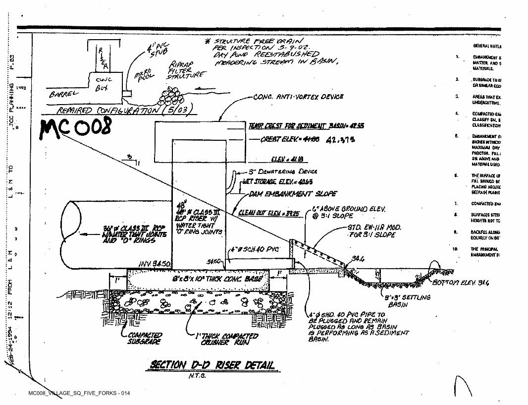
MC008_VILLAGE_SQ_FIVE_FORKS - 014
f
W jZ7ZiAr>^£ f7Z,s£P&S. ffiJ3PecT?0/V J5~ 9-Q’Z- /?/t.y> /?££S>7?to&t/StfG£>
rf£i90e&Jr/& J5>T&Ei9m i*/ /$&&/,
r 4%%sene tut «ans£
k EwaANOeirs MATTER AND S MATBWIS.
n I.Q £, fttflZAgftSL
I 2- -SUMRABtrOB! CflEtWlARtQU
CWC□ $rtz 1W3
COM. ftNTl-VO/nex OEVK& 1 areas mate*. uwEftamwo,
5/03)XeM/RpD Cortn&QgiQVOCL 4. COltfACTEfrEM. CLAtWFV SH. S CUWflCATia**\GO03V mrnacsr mscowEisr mm-4is&
CRESTELBV.m 4M36 4t,V\±
T;b6. EUBAHOCW Ei
WOiiSMTROCT MAXIUUU ORV fiHtCTOfi. FUi 3* ABOVtAMO MATEfllttUSEO
% j tm**i.t&— 3" D£*#TtLetbj6 Device
■mSWBML ELB/.*4DM
-s-PAM EMBANKMENT SLOPE
ot-
1Vi£ SURFACE Of Fill SHOULD U
■ pucwa AOtunc SEEPAGE CUWS
6.r
«*»*-
tm COMPACIEOEMI7.^ABOVE QPOUNQ £LEV.@ 3:/ SLOPE
.—S70. EW'/Jfi MOD. x E0K3-J SLOPE
CLELULMJT £££H*M& f A SURFACES STKf HEIGHTS NOT TLw/: mrcs? TieftT
'0V/M3 JOJN7Sf of BLASS M JBCP3*. BACKFltAL0H3 EQUAUV OR 60'7
rrscdw pvc TOC nNCVAL lUBAKKMENTFt
to.
C• 03460JNV 3450,
■f'j 1“*-s
JTW2.7r*r*7 r? <■/■■ mTTrr .■ j;11! ., j. :va'tmto'Tmcwnc bas£‘ sr ■80TTO/} EL£V- BK1.
S'*3' SETTUN& 0PSJNcP<& &, •0 «* § Sgns SadSMtSai l JStBL shd. 40 five Pipe to
&iPLUGGED PND PEWM PLUGGED ftS LONG PS 8BSIN /$ PERFORMING PS ft SEDIMENT QftSlN.
IMFL COMPACTED
SU86WAE
hmm*
/' TWCK COMPACTEDaemae run
»»J
SECTION 0-0 OSEE DETAILMTA r\
MC008_VILLAGE_SQ_FIVE_FORKS - 015
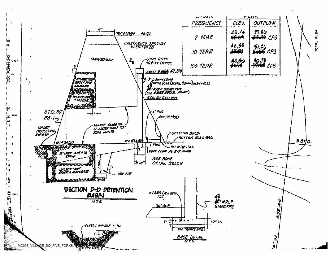
r<~nr<<-• i O'* 17
FREQUENCY £lE\f> OUTFLOW." I/<?*1 Z7,£kI tf>F4r
yCn?J
Jj’l-fff
§«a.74nr or mmZ iERg OL3 jgmRQEtit y SPILLWAY
eZI7. '4 s.<oo amua. \—p./o &h$$ CfS
\9 QONC. ANTh YOfiex Device
eMeuwcMeur *» M44>«6»ZT►-* 1703*
Aft? SA r*A T*l i r CFSier
b! n carer fi&M 42 s $74ho J) 3* DtwstregjM .Amu (S,a
°*mLW'*/?cr sm& rw . (see*&tx PSTAiL Amove)
\ crntmtsuiui
fatmem\moeAFmAMxmaeI*
\i(\
mAmcim*Tssm&
P f 1*—STD. 3&TFS-l-i j
4'Pvc'w-UfitfoD£
oa■s&earr a*ss szrJV Mtm TMT *0* jam iwjnt&
curter ntojezn riPMr, serrum gRSIN
BOTTOM £LEY-*34.0Cs F setm §n*Q W'me 34-00 hi/rtw*VPOT rune At CCVJC B4LS
SEE BASE DETAIL BELOW
« j1$st'urtr vpot*ts
STONE ____7
3 fK5H%&%&»*■
-'F■KEY (VAT
Ifltu.
SECTION P-0 PETSNTION MSNn *4&mcAunm-rl a“» sTEC.
N.ft'WZCPSTANPPifE Irl AJ.T.&
WACPM$n—r
& * » » iO"TUif * ciAst / e/p-ear r m8WSQWS 6ASt\
BABE DETAILw. iH li
J**KMvWF:f-:
K>t J
rjjumF ■■V*
LjtiL.Pi -1mreserunr 4»tu■-. i’ .'
MC008_VILLAGE_SQ_FIVE_FORKS - 016
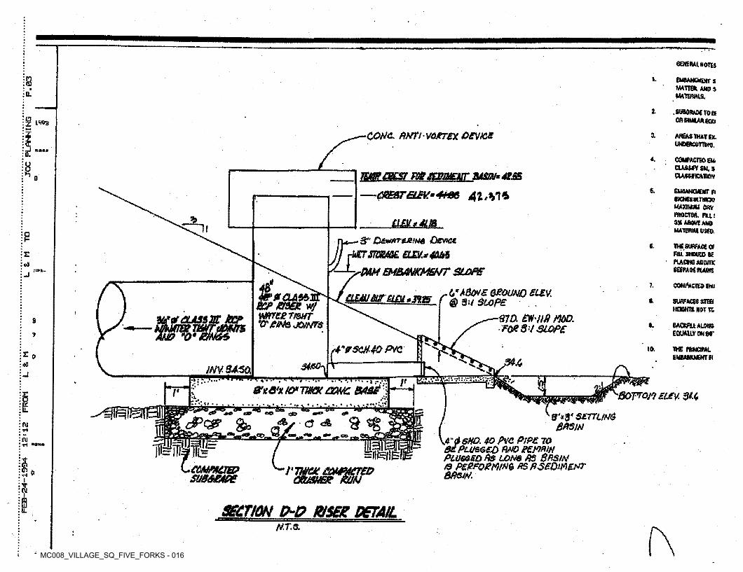
GENERAL AOTU
1. EMBANKMENTSMATTER, AMO $ MATERIALS,
n<aEL
3- .SUMfUMTOa OR SIMILAR £auz LW3
COMj. AHTl VOJtrex OEMS a AREAS THAT EX UNDERCUTTING.
£L 4. COMPACTED EU. CUSSTYSM.S OASSHCATtON8 wmaicsr m sssmur smj* ass
—CHEATGLEV.'+HAB 41,hi*
a8. EMSAMCICMrn
INCHESWTHICW MAXIUUU OSY PROCTOR. Pit! 3% ABOVE AMO MATERIAL USEO
% USUAAiP rw_- 3" D£w*T&e/H4 Device
JjrmmmE. om*4MS-l-s-MM EMBANKMENT SLOPE
TVS SURFACE Of FILL SHD«D SE PUCtMAOCUTK SEEPAGE HARK
6.ra
i COMPACTED EMi7.tSA&WZ OPOUAJD EUV.@ 3 U SLOPE
^—STD. EW'/Jfi MOD. S FOK S'L SLOPE
0CLASS3ST BCPBSEZ w/ mrczTtwT ‘Cr&NQ JO/NTS
CLEM OUT £L&i *3125 r t SURFACES STHI HEtOHIS NOT TC:
CLASS IE JBCP3BACKFILL ALONG EQUALLY ON GO*
I.7
hK$W4QPVCt io. me ntiotm EMBANKMENT fl= 0
'■6<& -3*«0-i: ■■ ■lt .v i'.. "■
JNV 3450,-i 1IT ft ~E m*rrrrrr*Tr*r~.&tQlXia*TWX &NC BASE
;V
1r ■BOTTOM ELFV. 3*4\A-I
LL9'*3' S£TTUA& &A$M■CJ $ «gw
m 8/Ci .*» ,4“d StfO. 40 /VO |CVP£ TO MPlugged RPO eEMfUH Plugged Rs long as Sasm to pEpFomm AspseomEPT BAsN.
JStEL.
fulfillsLcommcjb?
SU86KME
m=J!teflEI'TWOC COMPACTED
OCU3UEZ RUN»
SECTION (£D WSEZ DETAIL«"«i»"i mpu^gijiii —[_f ^ii "Iju’IJj"*™111111
1
MT.S. f\
MC008_VILLAGE_SQ_FIVE_FORKS - 017
i
t /jjjpoqr^TT -H 1ftf.l? . 4
>4■U.• \ IK*- To o IA\ i+i
\M t *»sloasj>
O' I I :JtOUND. I * s4*LsJ gfrn
* ■i%B84 7<6 76.74 686 4563 r •> jO'f rM siFMlV
r •'r£ ■v-T
rr(638 js'V
//
/ 4*#
BlLLBOA •-.[
il S=f ^ lI AO 14' Io. a l.ja*?a ' /WAL l L4: *^ ^RANSCOME
-CONSTRUCTI
$I ,457 /
\>
<. ,1 . / <t f // 46437 //^ V.\1V0: IUpt >- Y'K > \ \i >
\\). o \ sse5/. <9 \J\\
/u\ IVE lR 4
t i* .’ / Ai >v;.-I
4V,! 5*/• l*
• 4-7-V Afi,. T^p&O^.^- *
/ ,
|//■
i f t\ * v V.,\1 /
(< 72.5ft,v )\ Il Af ,•
At \:
/t
5A ;MSrS'<\ /■* \ *ji/ / o
",x?!S P'1 i\/ '\!iU6
A,ms//76.0// I7
/ //;y<//
! /y' uy\ , 74.3/ /// ItS) Q/// ✓ vv\ s// 73.6/ m74: tV-
-p-p./
/s
)‘ J660 /// / *v
% %/:Sj /■73rP// S “mYr2.ffSr\*/ < +Tw,■ 7J i—t rn #4f V
>•/
•$.63 t[/j
= ^\i^;
TTS . J // ( /9AKEN school
r,S9 4/T9/30;
/V
r nr\
X. a^4
/ 3008-i V ■tttc*'■\ \ IT✓ *±LT O O
MC008_VILLAGE_SQ_FIVE_FORKS - 018
n V*. ^ -'C?*v t *a ;r\t. r '\ ■ V -7 'Vv.‘“V rvVi5?i-
•>r,'r 'fi S
O*’ <>
). >VV.9-n* ir.■*f
t- ft>-S<| -----_ c.<r >*v*'V>-**& K£ o4' 22=r^,N 3619879.6345
E 11988345.9868I M.•' •r r , «r '■V
Vfcfc . S.4 U.I_ N —-/ Y>
f-A<X
’^.A.V-.A
#*10l. m- I Y~v _
egiatet**5 3r» j A3</)
rrf8°
JOE TYLD.B. 765. PG. 529 ^ I ZONE B1
PARCEL ID: 471010004 \ A§EA = 1.19 ACRE5
i tr^ o.12"I IlU I T »i ,
-1.’jW -.• 1 f •-*I
■t-
: - -•. • ■v S it C.
r, ^ /I V)C ? * ^// c» O
a, •Oty” - * -m?
Si I So„*f IX I
a0 IdOd Y/i/
EXISTING OVERHEAO UTILITY WIRE TO BE REMOVED BY UTILITY COMPANY
■ ■
—s: 7 °ft* t•f I
5?\\ \
Y \/ TIE INTO EXISTING CHAINUNK FENCE. MATERIALS TO MATCH EXISTING.
// I\/LIMITS OF
CLEARINGI - \o/ :■ .V r/ oI) X 3-/ r-
/ —sr-■
. . *Y‘ =:=L- V A*-". .../ §I n I t . I
6/ M..../ i/
/7.T-/ / /d mt m / /f3j ftir toiflur^ i
/ -- ,<c/ o /LD L/ * 5 H
r-fe*7 / D
- PROPOSED GRAVEL —
cv«/ vn
/ ■'fai N ^
I /£ /<4Y .*/I
\ $'.I
•S:v - /Y fc */C<? ■*f50' BUILDING
SETBACK —Vv -*4/
I0.3‘ OVERHEAD DOOR} I
IPROPOSED CHAIN LINK FENCE ------- PROPOSED'
BUILDING SPECIALTIES
WAREHOUSE EXPANSIONI >
s> .9,680 GSF (STORAGE ONLY)w
<dfi
ft
MAX HEIGHT= 30 FT.st
I
~3(Si 12LOB
>! 2 t3I.OVERHEAD
DOORi
§M I4.
3 /r>. ? < : i; •• II/•-
i I / I>'■ //
/?/ — PROPOSED ) 6' GRAVEL-
'Slj//VEXISDNG TRAILER
TO SE REMOVED»
1
':
/\/i
\ /I
V
X Ir\ IU>j_UGHT POLE
TO BE REMOVED\ <f-------------—o. )\ 1 Pi
\ \ai
\ \ ►5fP -INSTALL FENCE <\vi i M
■ >m\'■ \ Yvx Am , .'(■
••MilUMITS OF DISTURBED AREA
a:I •>LUV 5Cl TIE INTO EXISTING
CHAINUNK FENCE. MATERIALS TO MATCH. EXISTING.
i . IM-o\\ / oe
/ | I ^
\ CLPARlc-L I \ '•s
\■ 1 /o ^ i\'3/
I\.I\
J/)nt- rw ' .\ l /N.I \
Vv % /I
Yr-ffr- —.
*<S\
o-544.2V i.:
A -f
1 &'"S.
I
MC008_VILLAGE_SQ_FIVE_FORKS - 019
; / ! r v- '
/ 0/ ,rmrv W1
\ >7 **/&>V f 1C
/r i/9 t '% —> . v'Jsr# /^ -tJO T(
#* r M etr>. J*'
^ / :"i
rOf N xC£> )/■ *> ^ Or■n in* \. ’cj *0
6x VN ..n
/■«.% X*r7' <c
v oo 'w- NK \<ot
Xf V* V /* / s- dcAiy ^I VI f *A- V
'J 4.f^fV^ /=tag^S V£Z£jpA4£7dT<yi < tffi!'
6©*£V?CO •'*
/ /» J1u v
W\ll \l\' TABLE 3sX*> X ; r7 / N
\\\ RiWORKSHEET FOR BMP POINT SYSTEM uPljtonu'j Di ASIHLKT
/IVt Si A. STRUCTURAL BMP POINT ALLOCATION\\ y
l Htrr&' Ao&r/t&i/K AA€4 , >vr» omr p** Mvr&r/3*Ansco**tf ***** 4<S*S»*i
v V / *
Ip7i reaction o£
Site Served by BMP
■ .
f VT Weighted BMP Pointsv v4’It BMP' BHPr Pointsi it »n\
p{\J& pem/ts p&>f£>&nt>~rr*C.
27.BAc
tO,tu *\ l>\ ATT- p»7 esr#t.±£ ttd tof-JT/sc.<r> 6 4.3xt i
ij u> to- 3X 5XT •« - 27
<7MX 30./ •* .V>
u w& t't eo*,~«ru/*ctPrtttwmf*
A*** * 1AC\ »'* v v HH f/V *lZat1
'v
C X
J *•*«o -' Im V \? fc»« 7.6iO iT TOTAL VTEianro STRUCTURAL BMP POINTS:
|V \—1r . nI \e oX- (7.3 AC t B. NATURAL OPEN SPACE CREDITfiV-.
I • Points for Natural Open Space
NaturalOpen Space Crediti /:IMM O
j* 11§J> i / Fraction of Site/* %
v:*'\ CJ> z. it. t. 1#./
'•nC3 - : M/, t 2?% xM o. /
TO'pefll")2.7ri \
,r>* v €ki ( ,. /*—'j C. TOTAL WEI SITED POINTS
7. CCTO
to. S'/ 2. ?vv *4-;'V>II TOTALNatural Open Space PointsStructural bhf Points\. »
I
o
//.//
■'‘B 5L • ic m Sf
t* \W\V
'2 ^ Kfore■ Z 4 2£MStJy Z&oy/1 o&
/)o/r£fvA-T£/)*-£-* T&
Res, opft*/ Sfitce Res '&COM- Ofe*S Sfoer /eeQ'o «
i[Ftm/0»JAC
ZB % flnojfoos svwee , ^ ,Trysts /a/ Tfr€
w •tr.A /u \SV
/ 'vXV ;VX
/Qnr/^#wr/*c}=D i / Saa- ,
ex3 L? %s&&\\ s.s > \s
uX
ts ^ ^ e>.4 ®
/<3.J X
7.S~AC * 4./ AC.
«. \ i.A p /fcy U)i V / 1 >«c Pes &pp*s Sfi^cf R*ov/oet> =o!of. &pe*f Sp#cf Pm><ovi473 i
//. 2f 0.6 x O. t$y(/-7* £>.4)* S.fAC
t4-jAC.~
\vV $jy
\\/ u
V >CAa;A ,Jcs v<v
* 1 <y*
•< - i \v'* , A?r
7-1-^3/511^-31-93❖ C: 1X V *> '■aMVi %•Vi 1 ^ 1 I
*I\ ’ J7>.^ V\
\r* \
■ I *. %> ✓ fejv -*• iW\i%4-
, iv%
rK hcf\s r&A * \h- V S$IIIr m1 I t 1it AA. ^ xrn's. / 4 -■ -4

6. Design Calculations
MC008_VILLAGE_SQ_FIVE_FORKS - 020
FIVE FORKS SUBDIVISION
CHESAPEAKE BAY COMPLIANCE
November 3, 1993
Langley and McDonald 5544 Greenwich Road, Virginia Beach, VA 23462 (804) 473-2000
ENGINEERS • PLANNERS • SURVEYORS 201 Packets Court, Williamsburg, VA 23185 (804) 253-2975
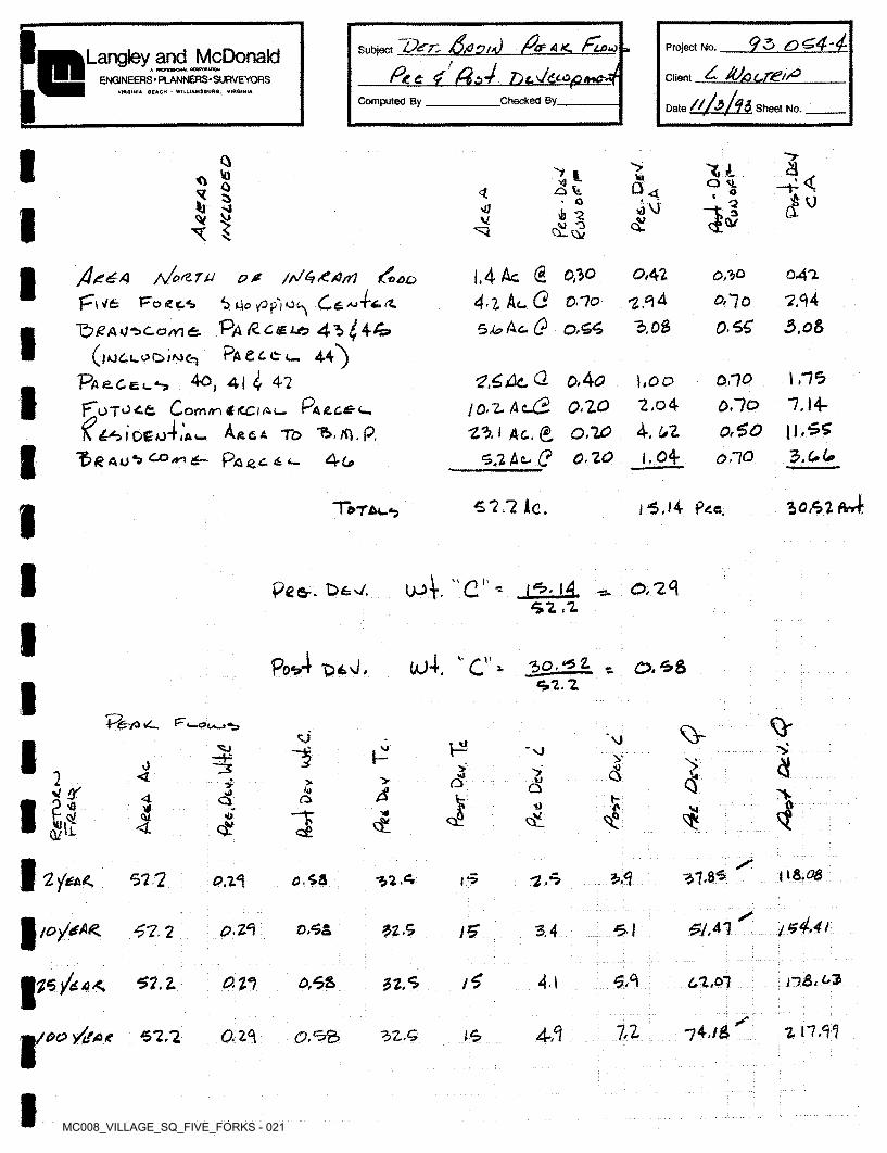
MC008_VILLAGE_SQ_FIVE_FORKS - 021
Per. S/Ccn/d /Zfak. fto*} ,
P<.& <? fl$473
4 AJ/ac.re//°
ah/n
Project No.SubjectLangley and McDonaldA mCTOMMM- COWOftAHOW
ClientENGINEERS • PLANNERS-SURVEYORSVIRGINIA BEACH - WILLIAMSBURG, VIRGINIA
Computed By Checked By.Date Sheet No.
> aXI'yto \ ld , Ci U
tu•O -h<Q M.
<v□4< o
<!u■ Q v)VJ>0 tb *2V £'U o Cl. cv
/Le^A /s/oft TJJ P0 /P^^/OrT} ffeco
p-\Vfc 'FrotZc*>
|,4 Ac @ 0,10
4-2 At- (2 O "7o5,4? Ac. 0,55
0,42 041.
7,44
0,50
5l4oy0p'|O^ C&^
T^i<?a u^co/nt Pa Rc&us 45 ^44»
Pacccc-, 44^
P’fie.CEu^ 40 4| ^ 42
•2.^4 A *70
O-SS13, OS 3.08
?,£Alc <2 &4<o
I0-2.AcJ3 o.zo
25,1 Ac. e, 0,20 0-20
\ ,-7*30,10<0.700>$O0.10
\ ,00 2,o4
4. 6Z
1.04
F"oTO<.& Comn 4iCC/A(— Pacc£-c.
N <^3IOCo4jGu.
7,14- |l.$5
3.C.6*AfttA To 1!»./0.p.
ft A U ^ ^ 4— Pa ^ c. C l- 4c.
50,52 a457.7 Ac.Total.*? 1*5,14 Pee.
u4. "c"' 0,24L2JAsi ,2
Peer. t>£7.
Po*4 vOtJ, uj4. v,c”- ^bQJ±k - O. ^8 <52.2
PfevavC. F,sj NJ s■SJ p? *Vj
8>,0 x>>2 < od1>4 Q> av or u■J4 kooeV) -jMl4 VI**
totfQ/'L
Qlc£
/08.3837 8*5'Z'jl£A<. 52 7 -Z.50,24 0.58 •%2.5 f>
i*4.a&A1£?. Z3 0,5857 2 •52.5 5 I3.4/S'
^5)44< 5,34.1 n&. c3(2 27 0,6&52. Z 22,5 62,01
/oo y^4< 57,7 7,24,1 74,/S 2 11,3?az3 32.C 15
MC008_VILLAGE_SQ_FIVE_FORKS - 022
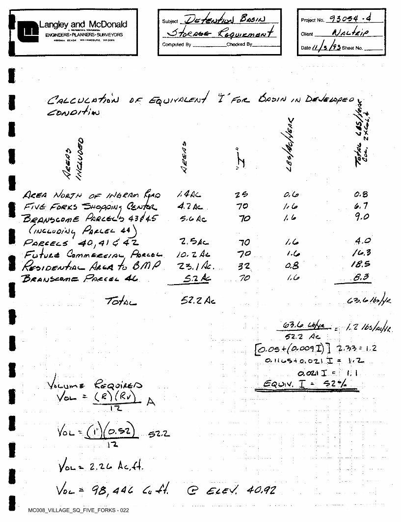
s-$~/o*LA4t6r- $Cer4 Ql KLsn t£AJ ~f
lZo*4 -4Project No.SubjectLangley and McDonald* rmna&GHH. COWormich
ENGtf'lEERS • PLANNERS ■ SURVEYORS ClientVIRGINIA BEACH - WtLUAMaSUHG. VIRGINIA UMiComputed By Checked By. Date It Sheet No.
2" So/Z- f$£Z>t/0<Z?#t-C04.A'//b+J D/C
<£TD/\J&/P) +J/AJ I
V $34v.vyM*
N
§ 4iMT*
4! hSj |e*^3\l
/Jon.JrM 0fo /fJ/Sj/SA/n XfFl\t6r £b<e<5 C&
~3/eA/Ut>c*04)£. Paec&d*} 41J4-G
P/tjccuoAOc. Pa
/.4A<-
4.2Ac. . 4c
O.Co 0.8bf> AO
TZK. 6,110 // G*AJ
1.0/, (*IO
“JP/G&CSC.4 *40^)$ 4 z.
34- . .
/^OtD£A>'ti&<— /J/L&4 To P
4,0•2.^40
Jo. z /U.
*ZSi Ac.
/,c>10PoAU.&U. /OS/ •(**7o
/#.*o,&52lfr/*AK)S>c*snC. ffaACdU. 44* .6.370 /,(*
~7c>4&t~. 67. Z /3c c^.
(al.Lfi u>b*.62 2, Ac.
^C),0'o±(0'00<\ I)] 'Itt = 1.2
0-lluS4o,01l I * \‘!~O. OLi\ X =
£qo\4. X - *62*/.
z /, 2 /di/ficJ/A
I, Ivi 'kcF <3 £}££0
- (eyg^tl-unAt
Ot- Aiz
you - (iV»»z) ^2/2-\“2.
Ac.4.Z.'li.ot- ■»-
Vot- — Zu VVf C? 40,42
MC008_VILLAGE_SQ_FIVE_FORKS - 023
[« Computed By
4*>oZ4-4S. CUal.T/Z4‘<>
!c. Project No.SubjectLangley and McDonald* enQrsajoOHju cop*orahon
ClientENGINEERS • PLANNERS- SURVEYORSVlflQlNtA BEACH - WilUAMSBiiaa. VIROtNiA
Checked By,Date Sheet No.
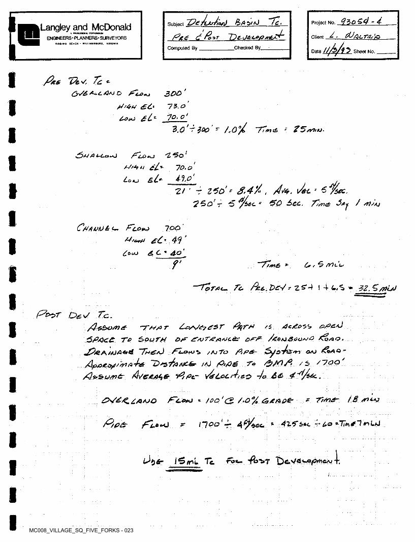
/%££ >/ /2 ^X}AJ O
H'<rU £6*
0OtU si*
300 ' IS. o' 7o. o'
3.0 'r$oo' - 70°/ 77*,* -*
I^>J~/ A C-Ua^J fTuotu a//*t u e£-
Lo o £ L*
'l*5o7o.o Ho'
r £ $*re.r £,4*/° , \J&lS * &O See. 7/sn* Sfiy / /rtSAj
2/ ' r Z60' ?So'r
CHAVK)is<— F'l.OvU lOO'
£o<aj £ C. ■* 4^
~77/t,£s * , £ /T7cL
7Z 4 l 4 * ZZS/nijJo
Oe.7 /.c./}*So/n£ -r/*/or /fyrn /s e/e*<4
SP4c£ To South OH HajT^^ajc<^ /coaj&ao+jO ac,
^?/SA//JA«rt£ 7m£aJ STLouj** /ajTo oaj &AO -
Ap/o*.o/'/r>aVW lO+e'/ftNChr /aJ fO,fig To /6 /loo'
X?S*su/n&- Ave£At,& y^/fitr vtfLocih&o -jo S<£> 4^/uc..
Z0V4^£/3AJO f~4-o+J *- /oo'C? /.O^/a &4/3Q€r TtmAT 18 /ru-o
HOO'S. ~-<»•<) 42.5* 5*c 4*4o *-77#v 4? "7 **» LaJ
l$trl Tc. 4^>7 4
MC008_VILLAGE_SQ_FIVE_FORKS - 024
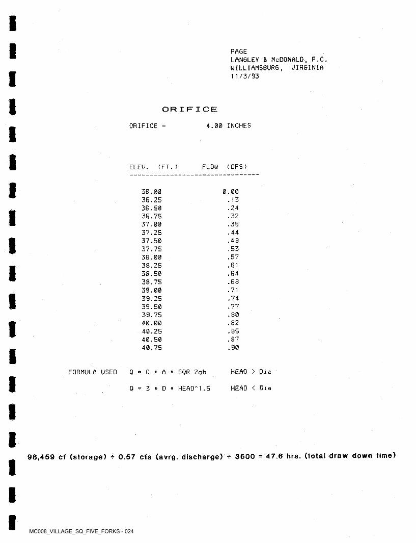
PAGELANGLEY & McDONALD, P.C. WILLIAMSBURG, UIRGINIA 11/3/93
ORIFICE
ORIFICE 4.00 INCHES
FLOW (CFS)ELEU. < FT. )
3B.003G.2536.5036.75 37.0037.2537.5037.75 38.0038.2538.5038.75 39.0039.2539.5039.75 40.0040.2540.5040.75
0.00.13.24.32.38.44.49.53.57.61.64.68.71.74.77.80.82,85.87.90
FORMULA USED 0 = C * A * SQR 2gh HEAD > Dia
0 = 3 * D * HEAD'' 1 .5 HEAD < Dia
98,459 cf (storage) * 0.57 cfs (avrg. discharge) * 3600 = 47.6 hrs. (total draw down time)
MC008_VILLAGE_SQ_FIVE_FORKS - 025
POND-2 Version; 5.17 S/N: 1295130250
F1VE FORKS DETENTION POND
CALCULATED DISK FILE: b;FF
14:38:4811-22-1993 .VOL
Planimeter scale; 1 inch 50 ft .
*Elevation
( ft )Volume Sum < cubic-ft)
P1 animeter (sq.in.)
Area(sq.ft)
Al+A2-*-sqr ( A 1 *A2 ) (sq.ft)
Vo 1ume (cubic-ft)
034.60 35.00 40.00 45.00 46.00 47.00
0.00 0.25
13.40 31.60 36.00 38.00
0 0083 83625 625
64,585 337,825 422,265 514,754
64,501 273,240 84,440 92,489
33,500 79,000 90,000 95,000
38,701163,944253,321277,466
Elevations With Areas Interpolated From The Closest Two Planimeter Readings
87,911 96,931 98,542
175,471
40.6540.8840.9242.55
23,327 32,347 33,957
110,886
38,328 40,114 40,429 54,303
107,661110,272110,731130,455
2(sq.rt(Areal) + <(Ei-E1)/(E2-E1))*<sq.rt<Area2)-sq.rt(Area1)))IA
= Closest two elevations with planimeter data = Elevation at which to interpolate area
Areal,AreaH = Areas computed for El, E2, respectively = Interpolated area for Ei
where: El, E2E i
IA
Incremental volume computed by the Conic Method for Reservoir Volumes.*
Volume = (1/3) * (EL2-EL1) * (Areal + Area2 +■ sq.rt.(Area1*Area2))
where: ELI, EL2Areal,Area2 Vo 1ume
= Lower and upper elevations of the increment = Areas computed for ELI, EL2, respectively = Incremental volume between ELI and ELS
MC008_VILLAGE_SQ_FIVE_FORKS - 026
Outlet Structure File: FF .STR
POND-2 Version: Date Executed:
S/N: 1295130250 Time Executed:
5.17
********** ***************
FIVE FORKS DETENTION POND
*************************
***** COMPOSITE OUTFLOW SUMMARY ****
E1evation (ft) Struc turesQ (cfs) Contributing
3A .6035.1035.6036.1036.6037.1037.6038.1038.6039.1039.60 AO. 10 AO. 60 A1 . 10 A1 .60 AE. 10 A2.60 A3.10 A3.60 AA . 10 AA . 60 A5. 1 0 A5.60 A6.10 A6.60 A6.90
0.00.2 10. A 10.5 10.6 10.6 10.7 10.8 10.8 10.9 10.9 11.0 11.0 11 . 1 11 . 1 1A.8 2 +1
2 +1 2 +1 2 +1 2 +1 2 +1 2 +1 2 +1 2 +1 2 +1 2 +1
22.2 A7.A 62.1 70. A77.8 8A.590.8 96.6
102.1105.3
1I
MC008_VILLAGE_SQ_FIVE_FORKS - 027
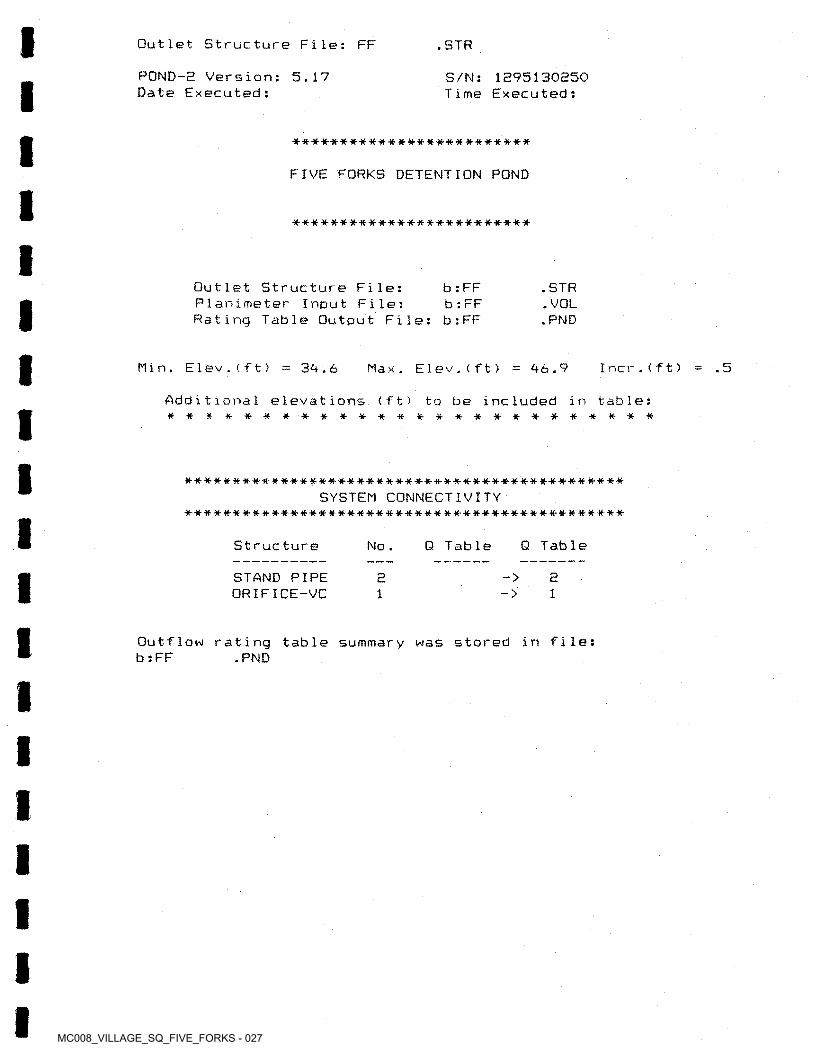
Outlet Structure File: FF .STR
POND-E Version: 5.17 Date Executed:
S/N: 1E95130S50 Time Executed:
-a--****-****#*****'**'##*****-*
FIVE FORKS DETENTION POND
****-*****-*-**-x-******-*-«-*-*-**
Outlet Structure File: Planimeter Input File; Rating Table Output File:
b : FF b : FF b : FF
• STR• VOL .PND
Min. E1ev.(ft) Incr.(ft)34.6 .5Elev.(ft) 46.9Max .
Additional elevations (ft) to be included in table: ■**-***#***#******■*#•*•#■****■**
SYSTEM CONNECTIVITY•a-*****-**-#**-**-******#********#***-*--*-*****-*#*****-
Q TableStructure Q TableNo .
STAND PIPE ORIFICE-VC
-> 221->1
summary was stored in file:Outflow b : FF
rating table .PND
MC008_VILLAGE_SQ_FIVE_FORKS - 028
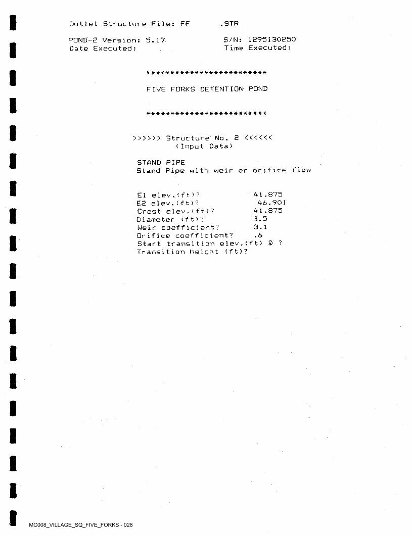
I Outlet Structure File: FF • STR
POND-2 Version: 5.17 Date Executed:
S/N: 1275130250 Time Executed:
a***********-**********#-**
FIVE FORKS DETENTION POND
•*-**•******#*-***-**•*■-*■#**■****
>>>>>> Structure No. 2 <<<<<< (Input Data)
STAND PIPEStand Pipe with weir or orifice flow
El elev.(ft)?E2 elev.< ft ) ?Crest elev.(ft ) ?Diameter (f t ) ?Weir coefficient?Orifice coefficient?Start transition elev.(ft) S ? Transition height (ft)?
71 .875 76.901
71.8753.53.1.6
MC008_VILLAGE_SQ_FIVE_FORKS - 029
Outlet Structure File: FF .STR
POND-2 Version: Date Executed:
5.17 S/N: 1295130250 Time Executed:
**-**•#•*****•*■#■***■**•**■*#■*■***
FIVE FORKS DETENTION POND
*•*************•*-#-**#•**•*•#-*-*
>>>>>> Structure No. 1 <<<<<< (Input Data)
OR IFICE-VC Orifice - Vertical Circular
3-4.7667-46.901
El e1ev.(ft)?E2 e1ev.(f t ) ? Orifice coeff . ? Invert elev.(ft)? Datum Diameter
. 603-4.63-4.7667.3333
elev.(ft)? (ft)?
MC008_VILLAGE_SQ_FIVE_FORKS - 030
I Outlet Structure File: FF .STR
POND-2 Version: 5.17 Date Executed:
S/N: 1295130250 Time Executed:I
*************************
FIVE FORKS DETENTION POND
**************************
Outflow Rating Table for Structure #2 STAND PIPE Stand Pipe with weir or orifice flow
***** INLET control assumed *****
E1evation (ft) Computat ionQ (cfs) Messages
E < Inv.El.=41.875 E < El=41.875 E < El=41.875 E < E1=41.875 E < El=41.875 E < E1=41.875 E < El=41.875 E < El=41.875 E < E1=41.875 E < El=41.875 E < E1=41.875 E < E1=41.875 E < E1=41.875 E < El=41.875 E < El=41.875 We i r :Weir:Weir:Orifice:Orifice:Or if ice:Or ifice;Or if ice;Orifice:Orifice:Or i fice:
34.6035.1035.6036.1036.6037.1037.6038.1038.6039.1039.6040.1040.6041.1041.6042.1042.6043.1043.6044.1044.6045.1045.6046.1046.60 46.90
0.0 0.0 0.0 0.00.00.00.00.00.00.00.00.00.00.00.0
H —.225 H =.725
3.621.0 46.2 60.869.1 76,583.2 89.495.2
100.7103.8
H =1.725
H =2.725 H =3.225 H =3.725 H =4.225 H =4.725 H =5.025
10.99557 ft 9.621123 sq.ft.
(Co * A * sqr(2*g*H)) 0.0
WeirOrifice Co = .6 Q (cfs)No transition used, transition height Weir equation = Orifice equation <D elev.= 43.23407 ft
Cw 3.1 Weir 1 eng thOrifice area
(Cw * L * H**1.5) or
MC008_VILLAGE_SQ_FIVE_FORKS - 031
Outlet Structure File: FF .STR
POND-2 Version: 5.17 Date Executed:
S/N; 1295130250 Time Executed:
*- *•#-■***•**-*•■#-**■**# #■#**■* *-**-* *
FIVE FORKS DETENTION POND
**-*-****-**-*#***■#•**#**•-#■■***■*•
Outflow Rating Table for Structure ttl ORIFICE-VC Orifice Vertical Circular
Elevation < f t) MessagesQ < c f s ) Computation
34 . 60 35. 1035.6036.1036.6037.1037.6038.1038.6039. 1039.6040. 1040.6041.1041.6042.1042.60 43. 1043.6044.1044.60 45. 1045.6046.1046.60 46.90
E < El=34.7667 H =.333 H =.833 H =1.333 H =1.833 H =2.333 H =2.833 H =3.333 H =3.833 H =4.333 H =4.833 H =5.333 H =5.833 H =6.333 H =6.833 H =7.333 H =7.833 H =8.333 H =8.833
— Q 'D'D'D“ T ■ 23 iIj CD
H =9.833 H =10.333 H =10.833 H =11.333 H =11.833 H =12.133
0.00.20.40.50.60.60.70.80.80.90.91 .01.01 . 11 . 11 . 11.21.21.21.31.31.41.41.41 .41 .5
C = .6 A = 8.724902E-02 sq.ft.H (ft) = Table elev. - Datum elev. ( 34.7667 ft ) Q (cfs) = C * A * sqr(2g * H)
MC008_VILLAGE_SQ_FIVE_FORKS - 032
Quick TR-55 Ver .5.96 Executed; 16:96:51
S/N:1315930271 11-23-1993
************************************************************************************************************************************************* ** *
MODIFIED RATIONAL METHOD Grand Summary For All Storm Frequencies
* ** ** ** *************************************************************************************************************************************************
First peak outflow point assumed to occur at inflow recession leg.
FIVE FORKS
15.00 minutesTcArea 52.20 acres
VOLUMESStor age (cu.ft.)
Inflow (cu.ft.)
Frequency < years)
Ad justed Duration Inters. Qpeak minutes
A11owab1e I cf s !‘C’ in/hr cf s— (
122,576 169,253 203,720 399,089
239,990 325,207 326,618 589,927
2 0.580 0.580 0.638 0.725
37.85 51.97 62.07 79. IB
96,63 63.02
106.79109.79
B9 1.590 2.082 3.205 2.767
10 8625 I51
100 i93
II
MC008_VILLAGE_SQ_FIVE_FORKS - 033
Quick TR-55 Ver.5.46 Executed: 16:46:51
S/N:1315430271 11-22-1993
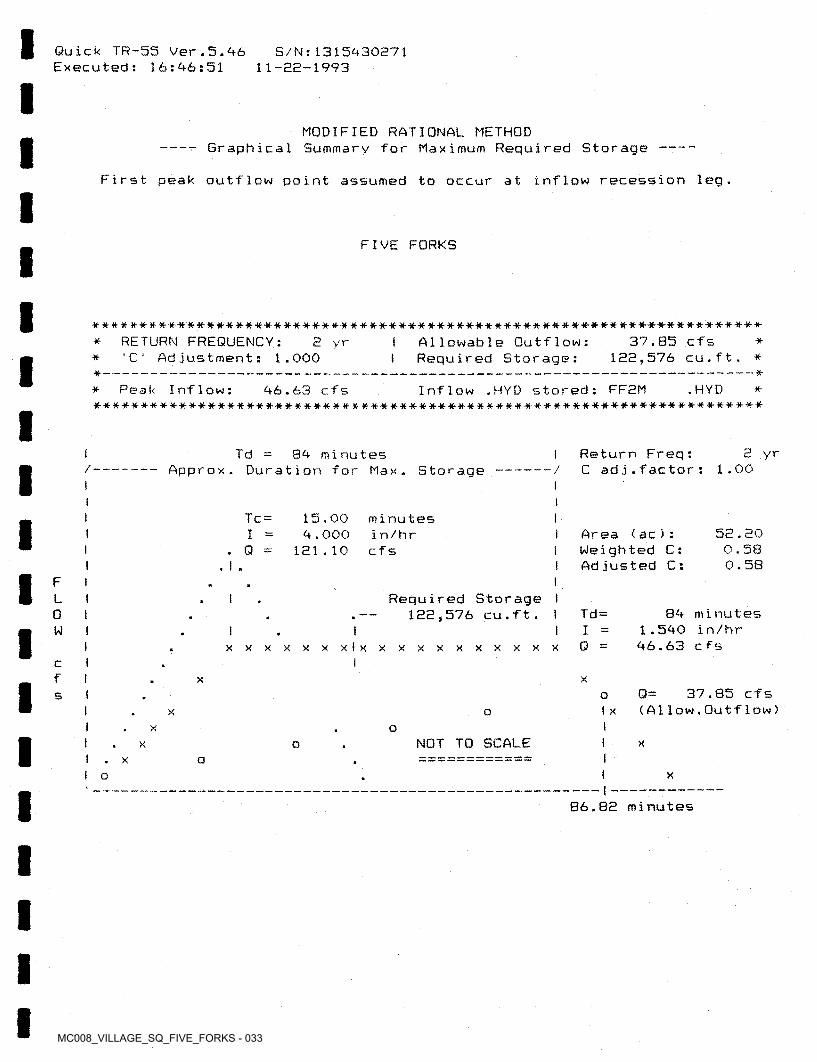
MODIFIED RATIONAL METHOD----- Graphical Summary for Maximum Required Storage ------------------------------
First peak outflow point assumed to occur at inflow recession leg.
FIVE FORKS
***W»****##*****W1H-**t#**#*#m*****HHHHHf**»**<HH«*»*»****«****1t-Allowable Outflow:Required Storage:
37.85 cfs 122,576 cu.ft. *
RETURN FREQUENCY: Ad justment:
2 yr I **•C ‘ 1.000 I*
— *** Peak Inflow:
#■•**-#■■***■*■■*■**•**•****■*■*****#**#******■#■****#*#-*■****-*********•*-****•■*■******■**•*
Inflow .HYD stored: FF2M .HYD46.63 cfs *
2 yrReturn Freq:C ad j■f ac tor :
Td 84 minutes Approx. Duration for Max. Storage — 1.00/ — — /
I iI Tc = 15.00
4.000121.10
minutesin/hrcfs
52.20 0.58 0.58
Area < ac): Weighted C: Adjusted C:
I. Q = I
1 I. I .F I
Required Storage I 122,576 cu.ft. I
L84 minutes
1.540 in/hr 46.63 cfs
Td =0 iIW0 =I xxxxxxxlxxxxxxxxxxx
Icf XX
37.85 cfs (A1low.Outflow)Q=I os
I XX ox o
NOT TO SCALEI xX oo
1I o X
86.82 minutes
MC008_VILLAGE_SQ_FIVE_FORKS - 034
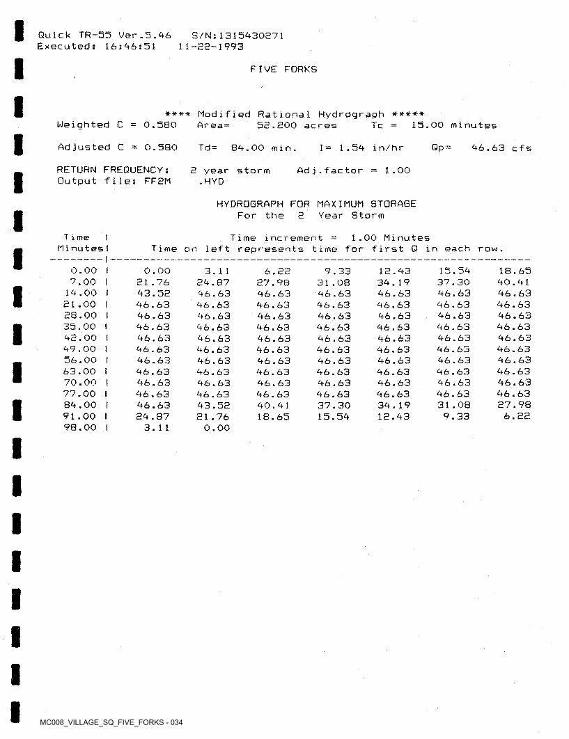
Quick TR-55 Ver.5.46 Executed: 16:46:51
S/M:1315430271 11-22-1993
FIVE FORKS
**** Modified Rational Hydrograph ***** 52.200 acresWeighted C 0.580 15.00 minutesAr ea = Tc
Adjusted C 0.5B0 Td= 84.00 min. Qp =I= 1.54 in/hr 46.63 cfs
RETURN FREQUENCY: Output file: FF2M
1.002 year storm .HYD
Ad j.factor
HYDROGRAPH FOR MAXIMUM STORAGE For the 2 Year Storm
T i me Minutes!
I Time increment Time on left represents time for first Q in each row.
1.00 Minutes
0.00 I 7.00 I
14.00 I 21.00 I 28.00 I 35.00 I 42.00 I 49.00 I 56.00 I 63.00 i 70.00 I 77.00 I 84.00 I 91.00 I 98.00 !
15.54 37.30 46.63 46.63 46.63 46.63 46.63 46.63 46.63 46.63 46.63 46.63 31.08 9.33
0.00 21 .76 43.52 46.63 46.63 46.63 46.63 46.63 46.63 46.63 46.63 46.63 46.63 24.87
3.11
18.65 40.41 46.63 46.63 46.63 46.63 46.63 46.63 46.63 46.63 46.63 46.63 27.98
6.22
3.11 24.87 46.63 46.63 46.63 46.63 46.63 46.63 46.63 46.63 46.63 46.63 43.52 21.76
0.00
12.43 34.19 46.63 46.63 46.63 46.63 46.63 46.63 46.63 46.63 46.63 46.63 34.19 12.43
6.22 27.98 46.63 46.63 46.63 46.63 46.63 46.63 46.63 46.63 46.63 46.63 40.41 18.65
9.33 31.08 46.63 46.63 46.63 46.63 46.63 46.63 46.63 46.63 46.63 46.63 37.30 15.54

MC008_VILLAGE_SQ_FIVE_FORKS - 035
Quick TR-55 Ver.5.46 Executed: 16:96:51
S/N: 131 5*43027 1 11-22-1993
FIVE FORKS
****** SUMMARY OF RATIONAL METHOD PEAK DISCHARGES ******
adj * C * I *AWhere: Q=cfs, C=Weighted Runoff Coefficient, I=in/hour, A=acres
C’ adjustment factor for each return frequency
Q
ad j
RETURN FREQUENCY 'C' ad justment, k
Adj. *C'
2 years1
Wtd.’C‘ x 1
Subarea Descr .
Runoff Area acres I (min)
Totalacres
I Peak Q I < cfs)
Tc Wtd . Adj . IC ' 'C' C ' in/hr
I I —FIVE FORKS 0.580 52.20
t 15.00 0.580 II 0.580 9.000 52.20 I 121.10
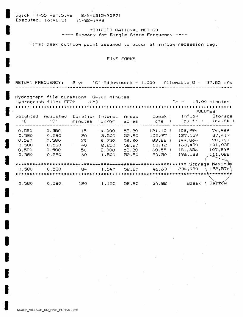
MC008_VILLAGE_SQ_FIVE_FORKS - 036
Quick TR-55 Ver.5.46 Executed: 16:46:51
S/N:1315430271 11-S2-1993
MODIFIED RATIONAL METHOD ----- Summary for Single Storm Frequency --
First peak outflow point assumed to occur at inflow recession leg.
FIVE FORKS
RETURN FREQUENCY: A11owab1e Q2 yr 1 .000 37.85 cfs' C Ad justment
Hydrograpb file duration^ Hydrograph file: FFEM
84.00 minutes .HYD 15.00 minutesTc
VOLUMESInflow ( cu.ft. )
Storage (cu . f t . )
Weighted Adjusted Qpeak I cfs I
Duration Intens. minutes
Areasacres' C •c in/hr
74, 9E9 87,417 78,769
101,038 107,B49
ill,026
0.580 0.580 0.580 0.580 0.580 0.580
0.580 0.580 0.580 0.580 0.580 0.580
108,994 1E7,159 149,866 163,490 181,656 196,188
5E.E0 52. EO 52. EO 52.20 52.20 52.20
121.10 I 105.97 I 83.26 I 68.12 I 60.55 I 54.50 I
15 4.000 3.500 2.750 2.250 2.000 1.800
2030405060
;************************************************************ Storage Max imut
122,576************* ****** *********************************************** *}********■
46.63 I 234,9900.580 0.580 84 1.540 52.20
Qpeak < Qa34.82 I0.580 0.580 120 1.150 52.20 w
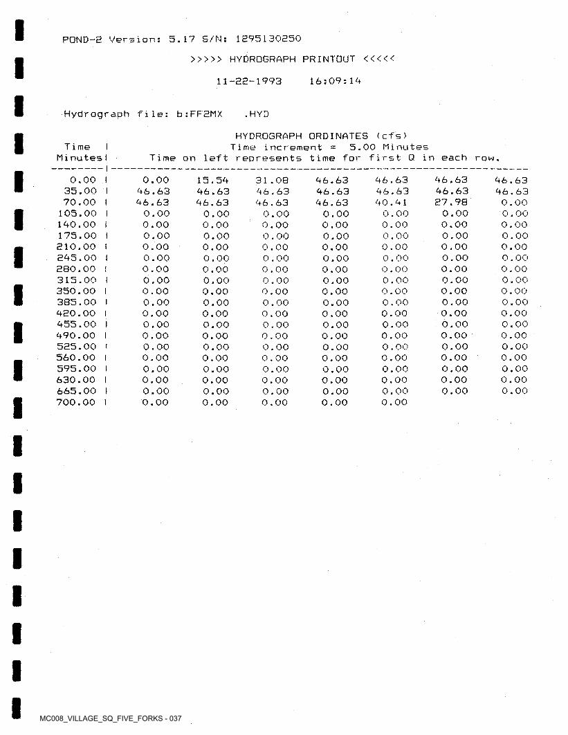
MC008_VILLAGE_SQ_FIVE_FORKS - 037
5.17 S/N: 1295130250POND-E Version;
>>>>> HYDROGRAPH PRINTOUT <<<<<
16:09:1411-23-1993
Hydrograph file: b:FFEMX • HYD
HYDROGRAPH ORDINATES (cfs)5.00 MinutesT i me I
MinutesITime increment
Time on left represents time for first Q in each row.
46.63 46.63 E7.98
0.00 0.00 0.00 0.00 0.00 0.00 0.00 0.00 0.00 0.00 0.00 0.00 0.00 0.00 0.00 0.00 0.00
46.6346.6340.41
0.000.000.000.000.000.000.000.000.000.000.000.000.000.000.000.000.000.00
46.63 46.63
0.00 0.00 0.00 0.00 0.00 0.00 0.00 0.00 0.00 0.00 0.00 0.00 0.00 0.00 0.00 0.00 0.00 0.00
46.63 46.63 46.63
0.00 0.00 0.00 0.00 0.00 0.00 0.00 0.00 0.00 0.00 0.00 0.00 0.00 0.00 0.00 0.00 0.00 0.00
31.08 46.63 46.63
0.00 0.00 0.00 0.00 0.00 0.00 0.00 0.00 0.00 0.00 0.00 0.00 0.00 0.00 0.00 0.00 0.00 0.00
0.00 46.63 46.63
0.00 0.00 0.00 0.00 0.00 0.00 0.00 0.00 0.00 0.00 0.00 0.00 0.00 0.00 0.00 0.00 0.00 0.00
15.5446.6346.63
0.000.000.000.000.000.000.000.000.000.000.000.000.000.000.000.000.000.00
0.00 I 35.00 I 70.00 I
105.00 I 140.00 i 175.00 I E10.00 I E45.00 I 380.00 I 315.00 I 350.00 I 385.00 I 420.00 I 455.00 I 490.00 I 525.00 I 560.00 I 595.00 I 630.00 I 665.00 I 700.00 I
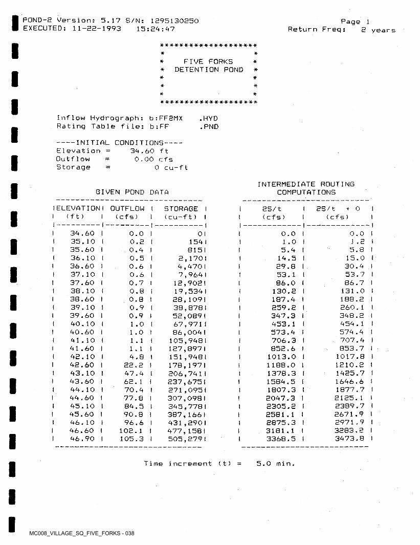
MC008_VILLAGE_SQ_FIVE_FORKS - 038
POND-2 Version: 5.17 S/N: 1295130250 EXECUTED: 11-22-1993
Page 115:24:47 Return Freq: 2 years
*-**■•#•*****••#•*•#■-#-*****-**
* *FIVE FORKS
* DETENTION POND ** *
* ** *# *a-*-*****-#*****#*-*#***
Inflow Hydrograph: b:FF2MX Rating Table file: b:FF
.HYD.PND
-------INITIAL CONDITIONS--E levation Outflow Storage
34.60 ft 0.00 cfs
0 cu-ft
INTERMEDIATE ROUTING COMPUTATIONSGIVEN POND DATA
i ELEVATION I OUTFLOW 1 (ft)
2S/t + 0 I (cfs)
STORAGE 1 < cu-ft) 1
SS/t (cfs)(cf s) I
-1 — I34.60 I35.10 I35.60 136.10 I36.60 I37.10 I37.60 I38.10 i38.60 I39.10 t39.60 I40.10 !40.60 i41.10 I41.60 I42.10 !42.60 I43.10 I43.60 !44.10 I44.60 I45.10 145.60 I46.10 I46.60 I 46.90 I
0.0 I 0.2 I 0.4 I 0.5 I 0.6 I 0.6 I 0.7 I 0.8 I 0.8 I 0.9 I 0.9 I 1.0 I 1.0 I 1.1 i 1.1 f 4.8 1
no o iCC * C I47.4 I62. 1 t70.4 I77.8 I84.5 I90.8 I96.6 I
102.1 I 105.3 I
0.0 i 1.0 I 5.4 I
14.5 I 29.8 I 53.1 I 86.0 I
130.2 I 187.4 I259.2 I347.3 I 453.1 I573.4 I 706.3 I 852.6 I
1013.0 I 1188.0 I1378.3 I1584.5 I1807.3 I2047.3 I2305.2 I2581.1 I2875.3 I3181.1 I3368.5 I
0.0 1 1.2 i 5.8 t
15.0 ! 30.4 I
53.7 I86.7 I
131.0 i 188.2 I260.1 I348.2 I 454.1 I574.4 I707.4 ! 853.7 I
1017.8 I 1210.2 1 1425.7 I1646.6 I1877.7 I2125.1 I2389.7 (2671.9 I2971.9 I3283.2 I3473.8 I
0 I I154 I 8151
2,1701 4,4701 7,964 I
12,9021 19,534 I 28,1091 38,8781 52,089 I 67,9711 86,004 I
105.9481 127,8971151.9481 178,1971 206,741 I 237,6751 271,0951 307,0981 345,778 I 387,166 I 431,2901 477,158 I 505,2791
I
I
1
I 1
Time increment (t) 5.0 min.
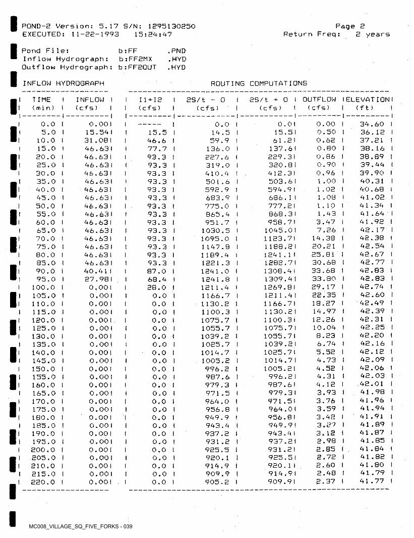
MC008_VILLAGE_SQ_FIVE_FORKS - 039
I POND-e Version: 5.17 S/N: 1295130250 EXECUTED: 11-22-1993
Page 2Return Freq: 2 years15:29:97
I Pond File:Inflow Hydrograph: Outflow Hydrograph:
b : FF b:FF2MX b;FF20UT
.PND.HYD.HYD
I INFLOW HYDROGRAPH ROUTING CONFUTATIONS
2S/t + 0 I OUTFLOW IELEVATION I (cfs) i (ft) I
TIME(min)
INFLOW I ( cfs) I
11+12 I 2S/t (cfs) I
0I (cfs)(cf s)I I
0.00 0.50 0.62 0.80 0.86 0.90 0.96 1.00 1.02 1.08 1.101.933.977.26
19.38 20.21 25.8130.6833.68 33.80 29.17 22.35 18.27 19.97 12.26 10.098.236.795.52 9.739.52 9.31 9.123.93 3.763.59 3.923.27 3. 122.98 2.85 2.722.60 2.98 2.37
0.00 1 15.591 31.081 96.631 96.631 96.63 I 96.631 96.63 I 96.63! 96.63 I 96.63 I 96.63!
96.631 96.631 96.63! 96.631 96.631 96.631 90.911 27.981 0.00 1 0.00 1 0.00 1 0.00 1 0.001 0.001 0.001 0.00 1 0.001 0.001
0.00 1 0.00 1 0.001 0.00 1 0.00 1 0.00 1 0.00 1 0.00 I 0.00!
0.00 1 0.001 0.00 1 0.001 0.00 1 0.00!
39.60 136.12 I 37.21 I38.16 !38.89 !39.99 I39.90 I90.31 I90.68 I 91.02 I 91.39 I91.69 I 91.92 !92.17 I92.38 I92.59 I 92.67 I92.77 I 92.83 I 92.83 !92.79 I92.60 I92.99 I92.39 I92.31 I 92.25 I 92.20 I 92.16 I92.12 I 92.09 I 92.06 1 92.03 I 92.01 I91.98 1 91.96 !91.99 I91.91 I 91.89 I 91.87 1 91.85 I 91.89 1 91.82 I91.80 I 91.79 I91.77 I
0.0 0.0115.5161.2!
137.61 229.3! 320.8!912.31503.61599.91686.1 I777.21868.31 958.7!
1095.011123.71 1188.2! 1291.1 I 1282.7! 1308.9! 1309.91 1269.81 1211.9! 1166.7!1130.21 1100.311075.711055.711039.21 1025.7!1019.71 1005.2!
996.2 I 9B7.61 979.3! 971.5! 969.01 956.81 999.9!993.91937.21931.21 925.5! 920.1 I 919.9!909.91
0.0 I 19.5 I 59.9 !
136.0 I227.6 I 319.0 !910.9 I501.6 I592.9 I683.9 I 775.0 I865.9 I951.7 t
1030.5 l 1095.0 I1197.8 I1189.9 i 1221.3 ! 1291.0 I1291.8 11211.9 !1166.7 I1130.2 (1100.3 I1075.7 I1055.7 I1039.2 I1025.7 I1019.7 I1005.2 I996.2 I 987.6 !979.3 I971.5 I 969.0 I956.8 I999.9 !993.9 !937.2 I931.2 I925.5 I920.1 I919.9 I909.9 I905.2 I
I 5.0 15.5 I96.6 I77.7 I 93.3 I 93.3 I 93.3 I 93.3 I 93.3 I 93.3 I 93.3 ! 93.3 f 93.3 I 93.3 I 93.3 I 93.3 I 93.3 I 93.3 I 87.0 I 68.9 I 28.0 I
0.0 I 0.0 I 0.0 I 0.0 ! 0.0 I 0.0 I 0,0 I 0.0 I 0.0 I 0.0 i 0.0 I 0.0 I 0.0 I 0.0 I 0.0 I 0.0 I 0.0 I 0.0 I 0.0 I 0,0 ! 0.0 I 0.0 I 0.0 I 0.0 I
I10.0 I 15.0 I 20.0 t 25.0 I 30.0 I 35.0 I 90.0 I 95.0 I 50.0 I 55.0 I 60.0 I 65.0 I 70.0 I 75.0 I 80.0 I 85.0 I 90.0 I 95.0 I
100.0 I 105.0 I 110.0 I 115.0 I 120.0 I 125.0 I 130.0 I 135.0 I 190.0 I 195.0 I 150.0 ! 155.0 I 160.0 I 165.0 I 170.0 I 175.0 I 180.0 I 185.0 I 190.0 I 195.0 I 200.0 ! 205.0 I 210.0 I 215.0 ! 220.0 I
I
I I
III I
I II
II !I
II I
I I
III I
II
I IIII
II1II II
I IIII
III
I
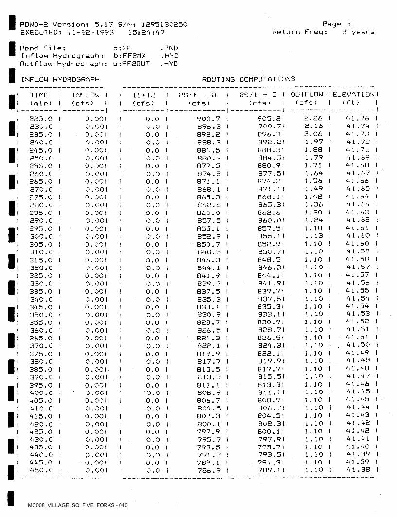
MC008_VILLAGE_SQ_FIVE_FORKS - 040
Page 3POND-2 Version: 5.17 S/N: 1295130250 EXECUTED; 11-22-1993 15:24:47 Return Freq: 2 years
Pond File:Inflow Hydrograph:Outflow Hydrograph: b;FF2QUT
.PND.HYD.HYD
b: FF b:FF2MX
ROUTING COMPUTATIONSINFLOW HYDROGRAPH
2S/t - 0 I 2S/t + 0 I OUTFLOW I ELEVATION 1(cf s )
TIME I INFLOW I I (min) I < cf 5) I t
11 + 12 ( c f s ) (ft)(cf s) (cfs)
2.26 I 2.16 I 2.06 I 1.97 I 1.88 I 1.79 I 1.71 I 1.64 I 1.56 I 1.49 I 1.42 I 1.36 I 1.30 I 1.24 I 1.18 I 1.13 I 1.10 I 1.10 I 1.10 I 1.10 I 1.10 i 1.10 I 1.10 I 1.10 I 1.10 I 1.10 I 1.10 I 1.10 t 1.10 I 1.10 I 1.10 I 1.10 I 1.10 I 1.10 I 1.10 I 1.10 I 1.10 ! 1.10 I 1.10 I 1.10 1 1.10 I 1.10 I 1.10 I 1.10 1 1.10 I 1.10 f
I — -141.76 I 41.74 I 41.73 I 41.72 I 41.71 I 41.69 I 41.68 I 41.67 i 41.66 I 41.65 i 41.64 I 41.64 I 41.63 t 41.62 I 41.61 141.60 I 41.60 141.59 I 41.58 I 41.57 I 41.57 I 41.56 I 41.55 I 41.54 I 41.54 I 41.53 I 41.52 1 41.51 I 41.51 I 41.50 I 41.49 I 41.48 I 41.48 I 41.47 t 41.46 1 41.45 ! 41.45 I 41.44 I 41.43 I 41.42 I 41.42 I 41.41 141.40 1 41.39 I 41.39 I 41.38 I
905.2) 900.7 I896.31892.21838.31884.51 880.91877.51874.21871.11868.11865.31 862.61 860.0 I857.51
225.0 I 230.0 I 235.0 I 240.0 t 245.0 I 250.0 I 255.0 I 260.0 1 265.0 I 270.0 I 275.0 I 280.0 I 285.0 I 290.0 I 295.0 I 300.0 I 305.0 I 310.0 I 315.0 I 320.0 I 325.0 I 330.0 I 335.0 I 340.0 I 345.0 I 350.0 ! 355.0 I 360.0 I 365.0 I 370.0 I 375.0 ! 380.0 I 385.0 I 390.0 I 395.0 I 400.0 I 405.0 I 410.0 I 415.0 I 420.0 I 425.0 I 430.0 I 435.0 I 440.0 I 445.0 I 450.0 I
0.001 0.001 0.00 1 0.001 0.001 0.00) 0.00 I 0.00 1 0.001 0.001 0.001 0.001 0.00 1 0.001 0.00 1 0.001 0.001 0.00 1 0.001 0.001 0.001 0.00 1 0.00 1 0.001 0.001 0.001 0.001 0.00 1 0.001 0.001 0.00 1 0.00! 0.00 1 0.00 1 0.001 0.001 0.00 1 0.001 0.00! 0.00 t 0.001 0.00! 0.001 0.00! 0.00 1 0.00 1
900.7 1 896.3 I892.2 I888.3 !884.5 i880.9 I877.5 I874.2 I871.1 I868.1 !865.3 I862.6 I 860.0 I857.5 I855.1 !852.9 I850.7 I848.5 t846.3 I844.1 !841.9 I839.7 t837.5 I835.3 I833.1 I830.9 I828.7 I826.5 I824.3 I822.1 I819.9 I817.7 !815.5 I813.3 I811.1 I808.9 I806.7 t804.5 I802.3 !800.1 !797.9 I795.7 I793.5 I791.3 I 789.1 I786.9 I
0.0 I 0.0 1 0.0 I 0.0 I 0.0 I 0.0 I 0.0 ! 0.0 I 0.0 I 0.0 I 0.0 I 0.0 I 0.0 I 0.0 I 0.0 ! 0.0 I 0.0 I 0.0 I 0.0 I 0.0 I 0.0 I 0.0 I 0.0 I 0.0 I 0.0 ! 0.0 I 0.0 ! 0.0 ! 0.0 I 0.0 I 0.0 I 0.0 I 0.0 I 0.0 I 0.0 ! 0.0 I 0.0 I 0.0 I 0.0 I 0.0 I 0.0 I 0.0 t 0.0 I 0.0 I 0.0 I 0.0 I
II
I
I
I
I!I
I
I852.91 850.7 I848.51846.31844.1 I841.91 839.7!837.51835.31833.1 I B30.9I828.71826.51824.31822.1 I819.91817.71815.51813.31 811.11 808.9!806.71804.51802.31800.1 I797.91795.71793.51791.31 789.1!
I
I
II
I I
I
II
I
II
III
II IIII
III
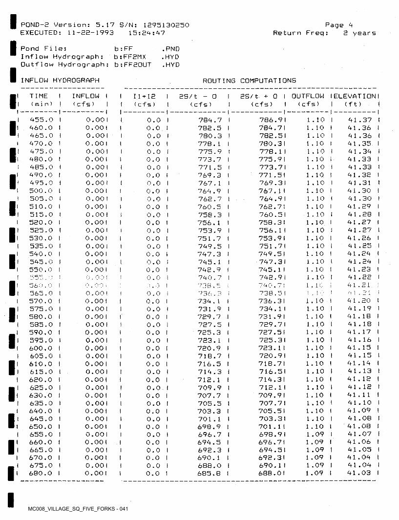
MC008_VILLAGE_SQ_FIVE_FORKS - 041
PGND-2 Version: 5.17 S/N: 1295130250 EXECUTED: 11-22-1993
Page <4Return Freq:15:24:47 2 years
Pond File:Inflow Hydrograph; Outflow Hydrograph:
b : FF b;FF2MX b;FF20UT
.PND , HYD .HYD
INFLOW HYDROGRAPH ROUTING COMPUTATIONS
TIME I (min) I
INFLOW I < cfs) I
25/1 + 0 I OUTFLOW I ELEVATION I <cfs> 1 <cfs> I (ft) I
11 + 12( c f s )
as/t - o(cf s )
I — -1 — II -1455.0 1 460.0 I 465.0 I 470.0 I 475.0 ! 480.0 I 485.0 I 490.0 I 495.0 I 500.0 I 505.0 I 510.0 I 515.0 t 520.0 I 525.0 I 530.0 I 535.0 I 540.0 I 545.0 I 550.0 I
0.00 1 0.00 1 0.001 0.00 1 0.00 1 0.001 0.00 1 0.00 1 0.00 f 0.00! 0.00 I 0.00 1 0.00! 0.001 0.00 1 0.00 1 0.00 1 0.001 0.00! 0.00!
786.91784.71782.51780.31778.1 I775.91773.71 771.5!769.31767.1 I764.91762.71 760.5(758.31 756.1!753.91751.71749.51747.31745.1 I742.91
1.10 I 1.10 I 1.10 ! 1.10 ! 1.10 f 1.10 t 1.10 I 1.10 I 1.10 I 1.10 I 1.10 I 1.10 I 1.10 I 1.10 I 1 . 10 1.10 I 1.10 i 1.10 1 1.10 I 1.10 ! 1.10 i
41.37 I 41.36 I 41.36 I 41.35 I 41.34 I 41.33 I 41.33 I 41.32 I 41.31 I 41.30 I 41.30 I 41.29 !41.28 I 41.27 I 41.27 I 41.26 ! 41.25 I 41.24 I 41.24 I 41.23 I 41.22 I 41.21 !'! 1 , 41.20 I 41.19 1 41.18 I 41.18 I 41.17 I 41.16 ! 41.15 I 41.15 ! 41.14 I 41.13 I 41.12 I 41.12 I 41.11 I 41.10 I 41.09 I 41.08 ! 41.08 I 41.07 i 41.06 I 41.05 ! 41.04 I 41.04 I 41.03 I
0.0 I 0.0 I 0.0 I 0.0 ! 0.0 I 0.0 I 0.0 I 0.0 I 0.0 I 0.0 I 0.0 ! 0.0 I 0.0 I 0.0 I 0.0 I 0.0 ! 0.0 I 0.0 i 0.0 ! 0.0 I 0.0 !
784.7 I782.5 I780.3 1778.1 I775.9 I773.7 I771.5 1769.3 I767.1 i764.9 I762.7 I760.5 I758.3 I756.1 !753.9 I751.7 I749.5 I747.3 I745.1 !742.9 I740.7 ! 7 38,5736.3 i734.1 I731.9 I729.7 I727.5 I725.3 I723.1 I720.9 I718.7 1716.5 I714.3 i712.1 I709.9 1707.7 I705.5 I703.3 I701.1 I698.9 !696.7 I694.5 I692.3 I690.1 i 688.0 I/, CJ L-i (1 I C5 O w » w I
I(
I
!
Ii
!
I■ err;
i. i o560.0 !565.0 I 570.0 I 575.0 I 580,0 I 585.0 I 590.0 I 595.0 ! 600.0 I 605.0 I 610.0 I 615.0 I 620.0 I 625.0 I 630.0 ! 635,0 i 640.0 ! 645.0 I 650.0 I 655.0 I 660.0 I 665.0 I 670.0 I 675.0 I 680.0 I
740.7i•; i iL_ L!738.5 I
736.3!734.1 I731.91729.71727.51725.31723.1 I720.91718.71716.51714.31712.1 I709.91707.71 705.5!703.31701.1 I698.91696.71694.51692.31 690.1i 688.01
0.00! 0.00! 0.001 0.00 1 0.00 1 0.00 1 0.00 1 0.00! 0.00 1 0.00 1 0.001 0.00 1 0.00 1 0.001 0.00! 0.001 0.00 1 0.00 ! 0.001 0.00! 0.001 0.001 0.001 0.00 1
0.0 ! 0.0 I 0.0 f0.0 I 0.0 I 0.0 I 0.0 I 0.0 I 0.0 I 0.0 I 0.0 ! 0.0 ! 0.0 i 0.0 I 0.0 I 0.0 I 0.0 I 0.0 I 0.0 I 0.0 I 0.0 I 0.0 I 0.0 ! 0.0 !
I ■
1.10 ! 1.10 I 1.10 I 1.10 I 1.10 I 1.10 1 1.10 I 1.10 I 1.10 ! 1.10 I 1.10 I 1.10 I 1.10 I 1.10 ( 1.10 ! 1.10 I 1.10 1 1.09 I 1.09 I 1.09 I 1.09 I 1 .09 I 1.09 I
II
1I I
II I
I
1IIII
II
II
II
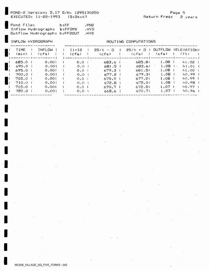
MC008_VILLAGE_SQ_FIVE_FORKS - 042
POND-2 Version: 5.17 S/N: 1295130250 EXECUTED: 11-22-1993
Page 5Return Freq:15:29:97 2 years
Pond File:Inflow Hydrograph:Outflow Hydrograph: b;FF20UT
b : FF b:FF2MX
.PND.HYD.HYD
ROUTING COMPUTATIONSINFLOW HYDROGRAPH
2S/t + 0 t OUTFLOW I ELEVATION I (cfs) ! ( f t) I
TIME(min)
I INFLOW I I ( cf s ) I
I 11+12 I I (cfs) I
as/t - o(cf s) (cf s)
— II —1.08 I 1.08 1 1.08 I 1.08 I 1.08 1 1.08 I 1.07 I 1.07 I
685.0 I 690.0 I 695.0 I 700.0 I 705.0 I 710.0 I 715.0 I 720.0 i
685.8 I 683.61 681.51 679.31 677.21 675.01 672.81 670.71
0.001 0.00 1 0.00 1 0.00 1 0.001 0.001 o.oot 0.00 1
683.6 I681.5 I 679.3 I 677.2 I 675.0 I 672.8 1670.7 1668.6 I
91.02 I 91.01 I 91.00 1 90.99 I 90.99 I 90.98 1 90.97 I 90.96 1
0.0 1 0.0 I 0.0 I 0.0 I 0.0 I 0.0 I 0.0 1 0.0 1
1
I
I
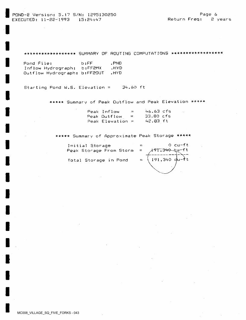
MC008_VILLAGE_SQ_FIVE_FORKS - 043
POND-8 Version: 5.17 S/N: 1295130250 EXECUTED: 11-22-1993
Page 6Return Freq:15:24: 47 2 years
****************** SUMMARY OF ROUTING COMPUTATIONS ******************
Pond File:Inflow Hydrograph: Outflow Hydrograph:
b : FF b:FF2MX b:FF20UT
.PND.HYD.HYD
Starting Pond W.S. Elevation 34.60 ft
***** Summary of Peak Outflow and Peak Elevation *****
46.63 cfs 33.80 cfs 42.83 ft
Peak Inflow Peak Outflow Peak Elevation
***** Summary of Approximate Peak Storage *****
0 cu-ft. O—cu-f t
Initial StoragePeak Storage From Storm *
191 ,340 b-T tTotal Storage in Pond
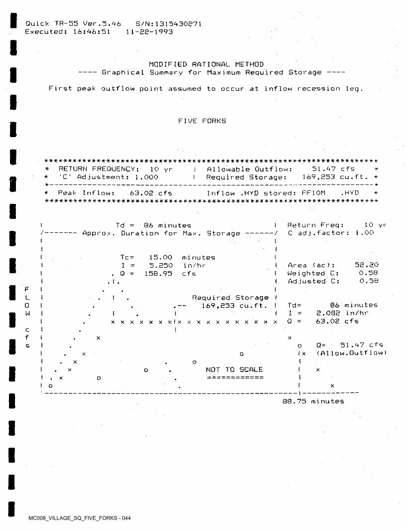
MC008_VILLAGE_SQ_FIVE_FORKS - 044
Quick TR-55 Ver.5.46 Executed: 16:46:51
S/N:1315430271 11-22-1993
MODIFIED RATIONAL METHODGraphical Summary for Maximum Required Storage -----------------------------
First peak outflow point assumed to occur at inflow recession leg.
FIVE FORKS
*-**-* ********•*-**-#■■*■*•* •***•#-#*#*■**•**•##-*•#••***-***-*--* *#•***■*#*• **#-*-*#■*-#-* *#***■**-*•* *
Allowable Outflow:Required Storage:
RETURN FREQUENCY:'C' Adjustment; 1.000
51.47 cfs 169,353 cu.ft.
10 yr* ** **- — ** Peak Inflow; Inflow .HYD stored: FF10M ♦ •a-***-**-*#***# -it-***##*****#****##****#*****#* «■*•»■**#***** ****************
.HYD63.03 cfs if
10 yrReturn Freq:C ad j . f ac tor :
t Td 86 minutes Approx. Duration for Max. Storage 1 .00/ /
I
I Tc = 15.00 5.350
158.95
Iminutesin/hrcfs
53.300.580.58
Area (ac >: Weighted C: Adjusted C:
I. Q
IF i iL I Required Storage
169,353 cu.ft. 86 minutes 3.083 in/hr 63.03 cfs
Td =0IW 1Qxxxxxxxlxxxxxxxxxx X
tcf I XX
Q= 51.47 cfs < A11ow.Outf1ow)
Is oI XoX
I X oI NOT TO SCALE I xX o
oXI o X
I88.75 minutes
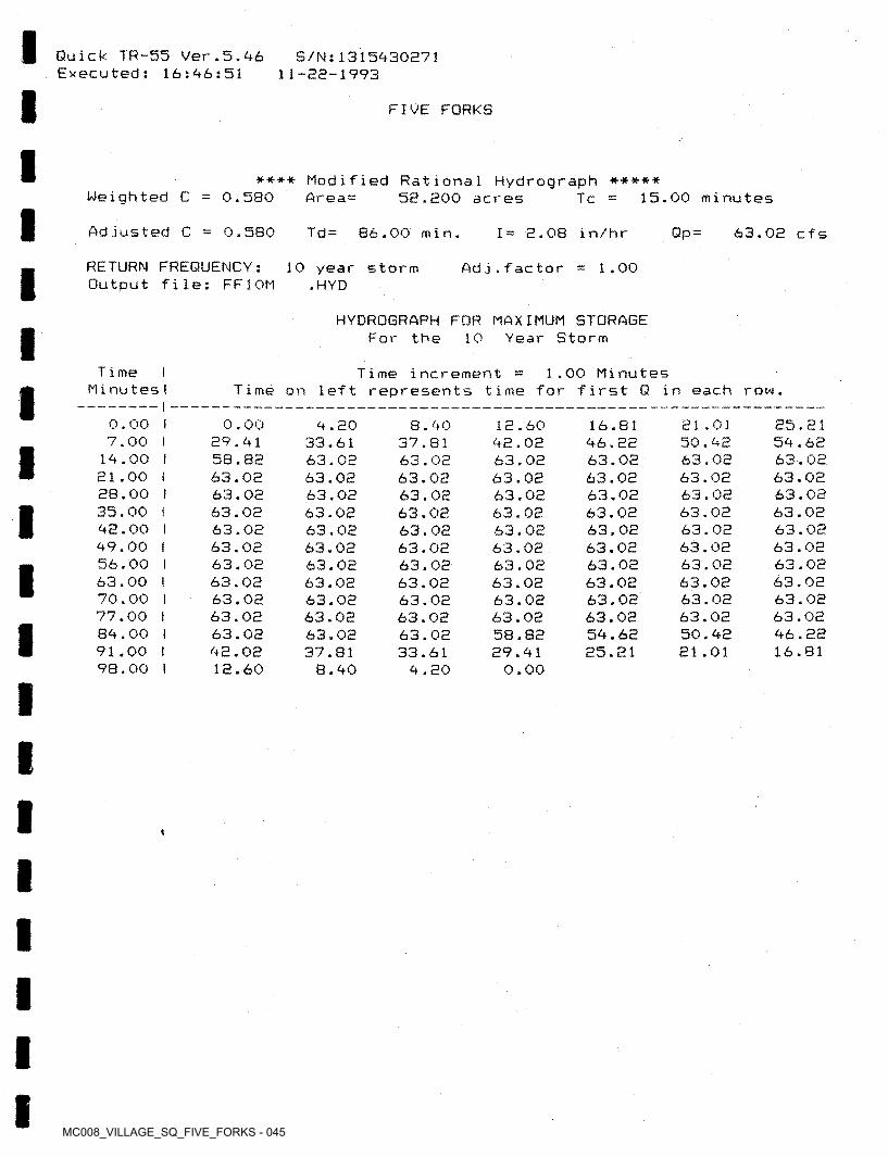
MC008_VILLAGE_SQ_FIVE_FORKS - 045
Quick TR-55 7er.5.46 Executed: 16:46:51
S/Ns1315430271 11-22-1993
FIVE FORKS
**** Modified Rational Hydrograph ***** 52.200 acresWeighted C 0.580 Area= 15.00 minutesTc
Adjusted C 0.580 Td= 86.00 min. Qp = 63.02 cfsI = 2.08 in/hr
RETURN FREQUENCY: Output file: FF10M
10 year storm .HYD
Ad j.fac tor 1.00
HYDROGRAPH FOR MAXIMUM STORAGE For the 10 Year Storm
Time I Minu tesI
1.00 MinutesTime increment Time on left represents time far first Q in each row.
0.007.00
14.0021.0028.0035.0042.0049.0056.0063.0070.0077.0084.0091.0098.00
I 0.00 29.41 58.82 63.02 63.02 63.02 63.02 63.02 63.02 63.02 63.02 63.02 63.02 42.02 12.60
25.21 54.62 63.02 63.02 63.02 63.02 63.02 63.02 63.02 63.02 63.02 63.0246.22 16.81
21.01 50.42 63.02 63.02 63.02 63.02 63.02 63.02 63.02 63.02 63.02 63.02 50.42 21.01
4.20 33.61 63.02 63.02 63.02 63.02 63.02 63.02 63.02 63.02 63.02 63.02 63.02 37.81
8.40
8.4037.8163.0263.0263.0263.0263.0263.0263.0263.0263.0263.0263.0233.61
4.20
16.8146.2263.0263.0263.0263.0263.0263.0263.0263.0263.0263.0254.6225.21
12.60 42.02 63.02
3.0 2 63.02 63.02 63.02 63.02 63.02 63.02 63.02 63.02 58.82 29.41
0.00
I!I
III
*
II
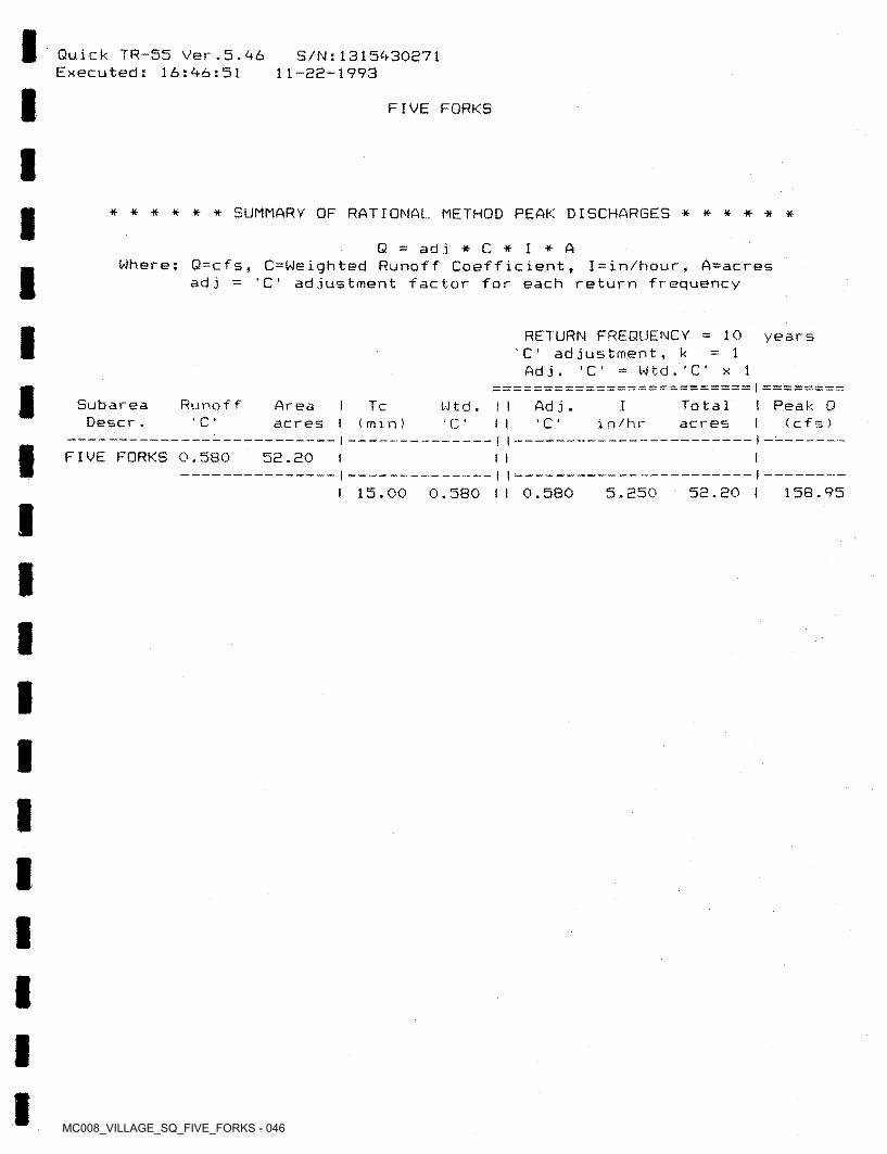
MC008_VILLAGE_SQ_FIVE_FORKS - 046
Quick TR-55 Ver .5.-46 Executed: 16:46:51
S/N:1315430271 11-32-1993
FIVE FORKS
****** SUMMARY OF RATIONAL METHOD PEAK DISCHARGES ******
Q — ad j *C* I *AWhere: Q=cfs, C=Weighted Runoff Coefficient, I=in/hour, A=acres
adj = 'C‘ adjustment factor for each return frequency
RETURN FREQUENCY ='C' adjustment, k
W t d . ’ C ' x 1
10 years1
Adj. 'C
Subarea Descr,
Runof f t Peak Q I ( c f s )
Areaacres
Totalacres
I Tc I (mm)
IAd j .Wtd .C * ’ C in/hr' C ' I I
FIVE FORKS 0.580 52.20— II-
I 15.00 0.580 II 0.580 5.250 52.20 I 158.95
I
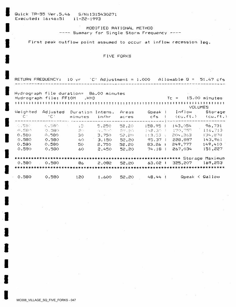
MC008_VILLAGE_SQ_FIVE_FORKS - 047
Quick TR—55 Ver.5.46 Executed: 16:46:51
S/N:1315430271 11-22-1993
MODIFIED RATIONAL METHOD -- Summary for Single Storm Frequency
First peak outflow point assumed to occur at inflow recession leg.
FIVE FORKS
RETURN FREQUENCY: A1 1owab1e Q' C 1.000 51.47 cfs10 yr Ad justment
Hydrograph file duration= Hydrograph file: FF10M
86.00 minutes. HYD 3 5.00 minu tesTc
VOLUMESWeighted Adjusted Inflow
< cu.f t. )Storage ( cu . ft. )
Qpeakcfs
Duration Inters, minu tes
A r e a s ac resC *C ’ in/hr
143,054 1 70 , ‘ 204,363 288,887 849,777 867,034
96,731 116,713 1 34,371 143,961 149,410 151,887
Q 1 e;n nci. wJ O a / -~J5.850 58l57O 580E 0
0.580 0.5S0 0.580 0.580
0.580 0,580 0.580 0.580
30 3.750 3.1508.750 8.450
58.80 58.2058.80 58.20
395.37 I 83.26 i 74.18 !
405060
********** ********************** ******************* ********* Storage Max i mum58.80
****************************************************************************169,2530.580 0.580 63.08 I 385,80786 2.082
Qpeak < Gallow0.580 0.580 180 1.600 58.80 48.44 I
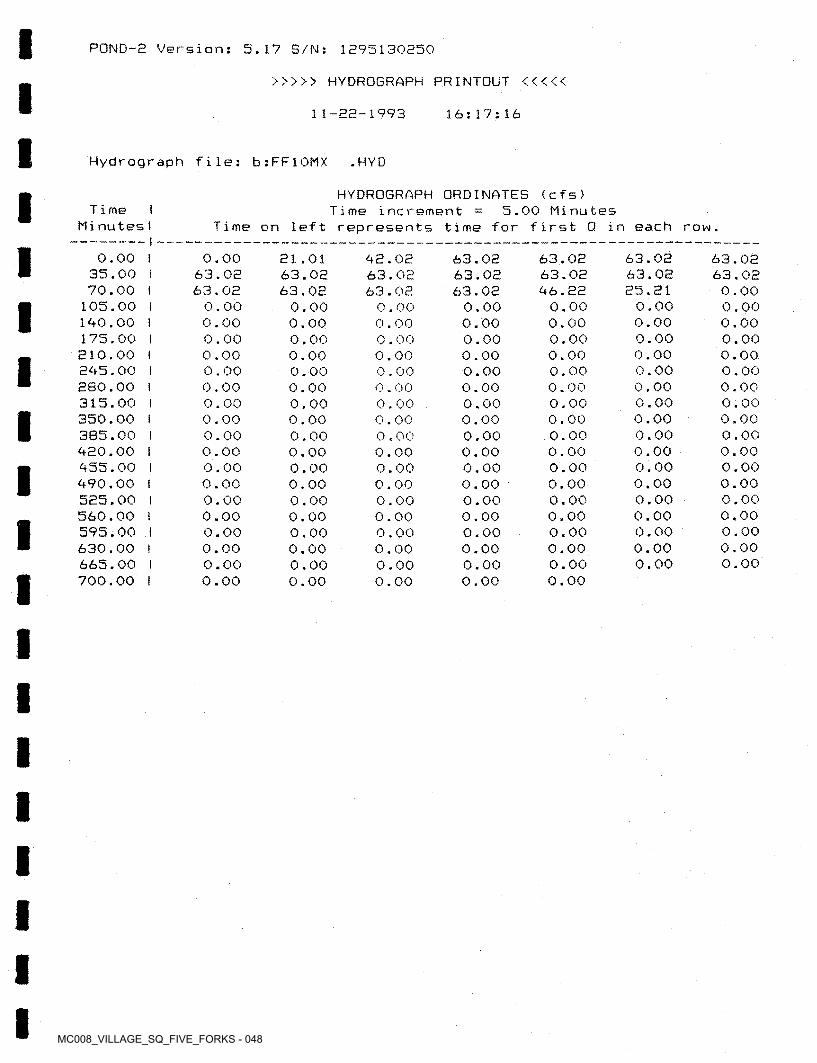
MC008_VILLAGE_SQ_FIVE_FORKS - 048
POND-2 Version: 5.17 S/N: 1295130250
>>>>> HYDROGRAPH PRINTOUT <<<<<
11-22-1993 16:17:16
Hydrograph file: b:FF10MX .HYD
HYDROGRAPH ORDINATES (cfs)5.00 MinutesTime I
MinutesITime increment =
Time on left represents time for first Q in each row.i
0.00 I 35.00 I 70.00 l
105.00 I 190.00 I 175.00 I 210.00 I 295.00 I 280.00 I 315.00 I 350.00 I 385.00 I 920.00 I 955.00 I 990,00 I 525.00 I 560.00 t 595.00 I 630.00 I 665.00 I 700.00 I
0.0063.0263.02
0.000.000.000.000.000.000.000.000.000.000.000.000.000.000.000.000.000.00
21.01 63.02 63.02
0.00 0.00 0.00 0.00 0.00 0.00 0.00 0.00 0.00 0.00 0.00 0.00 0,00 0.00 0.00 0.00 0.00 0.00
63.02 63.02 96.22
0.00 0.00 0.00 0.00 0.00 0.00 0.00 0.00 0.00 0.00 0.00 0.00 0.00 0.00 0.00 0.00 0.00 0.00
63.0263.0225.21
0.000.000.000.000.000.000.000.000.000.000.000.000.000.000.000.000.00
92.02 63.02 63.02
0.00 0.00 0.00 0.00 0.00 0.00 0.00 0.00 0.00 0.00 0.00 0.00 0.00 0.00 0.00 0.00 0.00 0.00
63.02 63.02 63.02
0.00 0.00 0.00 0.00 0.00 0.00 0.00 0.00 0.00 0.00 0.00 0.00 0.00 0.00 0.00 0.00 0.00 0.00
63.0263.02
0.000.000.000.000.000.000.000.000.000.000.000.000.000.000.000.000.000.00
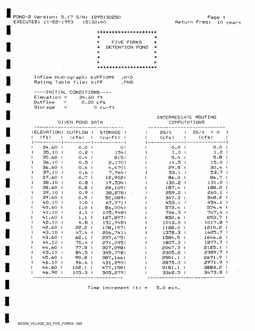
MC008_VILLAGE_SQ_FIVE_FORKS - 049
I POND-2 Version: 5.17 S/N: 1295130250 EXECUTED: 11-22-1993
Page 1Return Freq:15:32:90 10 years
I ********** ************
FIVE FORKS * DETENTION POND ** *I * ** *
I * ******** *************
Inflow Hydrograph; b:FF10MX Rating Table file: b:FF
. HYD . PND
------- INITIAL CONDITIONS—Eleva tion Outflow Storage
I 39.60 ft 0.00 cfs
0 cu-ft-
I INTERMEDIATE ROUTING COMPUTATIONSGIVEN POND DATA
I I ELEVATION I OUTFLOW I 1 (ft)
2S/t + 0 (cfs)
STORAGE 1 (cfs) I (cu-ft) I
2S/t(cfs)
— II —
I 39.60 I35.10 I35.60 I36.10 t36.60 t37.10 I37.60 I38.10 t38.60 i39.10 t39.60 I90.10 I90.60 I91.10 I91.60 I92.10 I92.60 I93.10 I93.60 I99.10 199.60 I95.10 t95.60 I96.10 I96.60 i 96.90 I
0.0 1 1.2 I
5.8 1 15.0 I 30.9 l
53.7 I86.7 I
131.0 1 188.2 I260.1 I398.2 i 959.1 I579.9 I707.9 i 853.7 I
1017.8 1 1210.2 f 1925.7 t1696.6 I1877.7 t2125.1 t2389.7 !2671.9 12971.9 I3283.2 i3973.8 I
0.0 I 1.0 i 5.9 I
19.5 I 29.8 I 53.1 I 86.0 I
130.2 I187.9 I259.2 I397.3 I 953.1 I573.9 I706.3 I 852.6 I
1013.0 I 1188.0 I1378.3 11589.5 I1807.3 i2097.3 12305.2 I2581.1 I2875.3 I3181.1 I3368.5 t
0.0 I 0.2 1 0.9 1 0.5 I 0.6 I 0.6 I 0.7 I 0.8 I 0.8 I 0.9 I 0.9 I 1 .0 I 1.0 I 1.1 1 1.1 ) 9.8 I
22.2 197.9 I62.1 I70.9 I77.8 I89.5 I90.8 I96.6 I
102.1 I 105.3 I
0 I1 1 59 I
8151 2,170 t 9,970 I 7,969 I
12,9021 19,539 I 28,1091 38,8781 52,089 I 67,9711 86,009 I
105,9981 127,8971 151,998 I 178,1971 206,7911 237,6751 271,0951 307,0981 395,778 I 387,166 I 931,290 I 977,158 I 505,279 I
I III i
I III
I I
1
I t
I1iII
I Time increment (t) 5.0 min.
II
MC008_VILLAGE_SQ_FIVE_FORKS - 050
Page 2Return Freq: 10 years
POND-2 Version: 5.17 S/N: 1295130250 EXECUTED: 11-22-1993 15:32:40
Pond File:Inflow Hydrograph: Outflow Hydrograph:
b: FFb:FF10MX b:FF1OOUT
.PND.HYD.HYD
ROUTING COMPUTATIONSINFLOW HYDROGRAPH
2S/t + 0 I OUTFLOW I ELEVATION! (cfs) I < cfs) I ( ft ) I
TIME I (min) !
INFLOW I < cf s ) I
I 11+12 I (cfs)
2S/t - 0 (cfs)
I I34.60 I 36.30 !37.54 I 38.59 I 39.39 I 40.01 I40.54 I41.01 I 41.44 I 41.84 I 42.19 I 42.47 !42.70 I42.86 I42.99 I 43.09 I43.16 I43.23 I43.24 !43.17 I 43.00 I42.80 I 42.65 I 42.53 I 42.43 I 42.34 I 42.27 I 42.22 I42.17 I 42.13 I 42.10 I 42.07 I 42.05 I 42.02 I41.99 I 41.97 I 41.95 I 41.92 t 41.90 I 41.88 I41.86 I 41.84 I 41.83 I41.81 f 41.79 1
0.00 1 21.011 42.021 63.021 63.021 63.021 63.021 63.021 63.021 63.021 63.021 63.021 63.021 63.02 I 63.021 63.021 63.02 I 63.021 46.221 25.21! 0.00 i 0.00 1 0.001 0.00 1 0.00 1 0.00 1 0.00 1 0.00 1 0.00 I 0.001
0.00 1 0.00 1 0.00 1 0.001 0.00! 0.00!
0.001 0.001 0.00! 0.00! 0.00! 0.00 ! 0.00! 0.00!
0.00 1
0.00 I 0.54 ! 0.69 I 0.80 I 0.90 I 0.98 I 1.00 ! 1.08 ! 1.10 I2.85 I7.85 I
17.83 ! 27.12 I 35.51 I 41.95 I 46.88 I49.25 I 51.08 ! 51.55 ! 49.45 I 42.38 I 32.47 ! 24.87 I 19.77 I 16.19 i13.26 I 10.86 i
8.90 I 7.29 I 5.97 I4.89 I 4.60 I 4.39 I 4.20 ! 4.01 I 3.83 I 3.65 1 3.49 I 3.33 I 3.18 I 3.04 t2.90 I 2.77 I 2.64 I 2.53 I
0.01 21.01
83.0 1 186.61 311.11 435.31
559.41683.41 807.3 I 931.1!
1051.5!1161.811252.21 1324.01 1379.011421.21 1453.51 1481.0! 1488.1 I 1456.4 I1382.71 1298.01 1233.01 1183.311143.81 1111.411084.81 1063.1! 1045.3!1030.711018.81 1009.01999.81 991.0!982.61974.61 967.0 I959.71952.71 946.01939.71933.61927.81 922.2! 916.91
0.0 I 5.0 !
10.0 I 15.0 I 20.0 I 25.0 I 30.0 I 35.0 I 40.0 I 45.0 I 50.0 I 55.0 I 60.0 I 65.0 I 70.0 I 75.0 I 80.0 I 85.0 ! 90.0 I 95.0 I
100.0 I 105.0 I 110.0 I 115.0 ! 120.0 I 125.0 I 130.0 I 135.0 I 140.0 ! 145.0 ! 150.0 I 155.0 I 160.0 ! 165.0 I 170.0 I 175.0 I 180.0 I 185.0 I 190.0 I 195.0 I 200.0 I 205.0 I 210.0 I 215.0 I 220.0 I
0.021.0 I 63.0 I
105.0 ! 126.0 I 126.0 I 126.0 1 126.0 I 126.0 ! 126.0 t 126.0 I 126.0 I 126.0 I 126.0 ! 126.0 I 126.0 I 126.0 I 126.0 I 109.2 I
71 .4 I 25,2 I
19.9 81.6
185.0309.3433.3557.4681.3 805. 1925.4
1035.8 1126.2 1198.0 1253.01295.11327.4 1355.01378.9 1385.01357.5 1298.0 1233.01183.31143.81111.41084.81063.1 1045.31030.71018.8 1009.0
999.8991.0982.6974.6 967.0959.7952.7 946.0939.7 933.6927.8 922.2916.9911.9
0.00.00.00.00.00.00.00.00.00.00.00.00.00.00.00.00.00.00.00.00.00.00.00.0
MC008_VILLAGE_SQ_FIVE_FORKS - 051
POND-e Version: 5.17 S/N: 1295130250 EXECUTED: 11-22-1993
Page 3Return Freq: 10 years15:32:90
Pond File:Inflow Hydrograph: Outflow Hydrograph:
b : FFb:FF1OMX b:FF1OOUT
.PND.HYD.HYD
ROUTING COMPUTATIONSINFLOW HYDROGRAPH
ES/t + 0 I OUTFLOW I ELEVATION I (cfs) I (cfs)
I TIME t INFLOW ! (min) I (cfs) I
11+12 I ( cfs) I
ES/t - 0 (cfs) (f t >
0.0 I 0.0 I 0.0 I 0.0 ! 0.0 I 0.0 I 0.0 I 0.0 I 0.0 1 0.0 I 0.0 I 0.0 I 0.0 I 0.0 I 0.0 I 0.0 I 0.0 1 0.0 I 0.0 I 0.0 I 0.0 I 0.0 I 0.0 I 0.0 I 0.0 I 0.0 I 0.0 I 0.0 I 0.0 I 0.0 I 0.0 I 0.0 I 0.0 I 0.0 I 0.0 I 0.0 i 0.0 I 0.0 I 0.0 I 0.0 I 0.0 1 0.0 ! 0.0 I 0.0 I 0.0 I 0.0 I
2.91 i 2.30 12.20 I2.10 I 2.00 I1.91 t 1 .83 1 1.75 I 1.67 I 1 .59 i 1.52 I 1.95 I 1.39 I 1.32 I 1.26 I1.21 I 1.15 I1.10 I 1.10 I 1.10 I 1.10 I 1.10 I 1.10 I 1.10 I 1.10 I 1.10 1 1.10 I 1.10 I 1.10 I 1.10 I 1.10 I 1.10 I 1.10 I 1.10 I 1.10 I 1.10 t 1.10 I 1.10 I 1.10 ! 1.10 ! 1.10 I 1.10 I 1.10 I 1.10 i 1.10 I 1.10 I
91.78 I 91.76 I 91.75 I91.79 I 91.72 I 91.71 I 91.70 I 91.69 I91.68 I91.67 191.66 I 91.65 I91.69 I 91.63 I 91.62 I 91.61 I 91.61 I 91.60 I 91.59 I 91.59 I91.58 I 91.57 I 91.56 ! 91.55 I 91.55 I91.59 I 91.53 I 91.52 I 91.52 I 91.51 I 91.50 I 91.99 i 91.99 I91.98 I 91.97 I 91.96 I 91.96 I 91.95 I91.99 I 91.93 I 91.93 I 91.92 S 91.91 I 91.90 I 91.90 I 91.39 I
225.0 I 230.0 I 235.0 I 290.0 I 295.0 t 250.0 I 255.0 I 260.0 ! 265.0 I 270.0 I 275.0 I 280.0 I 285.0 I 290.0 I 295.0 I 300.0 I 305.0 I 310.0 ! 315.0 I 320.0 i
0.00 1 0.00 i 0.00 1 0.00 I 0.00 I 0.00! 0.00 ! 0.00 I 0.00 1 0.00 I 0.00 1 0.001 0.00 1 0.00 1 0.00! 0.001 0.00 1 0.00 1 0.00 1 0.00 1 0.00 I 0.001 0.00 1 0.00! 0.00! 0.001 0.00 1 0.00 1 0.00 1 0.00! 0.00 1 0.00 i 0.00 1 0.00 1 0.00 1 0.00! 0.00 1 0.00! 0.00! 0.00! 0.00! 0.001 0.00 i 0.001 0.001 0.001
911.91907.1 I902.51898.1 I893.91889.91 886.01882.91878.91875.51 872.9! 869.31 866.9! 863.71 861.01858.51856.1 I853.81851.61 899.9 I897.21 895.0! 892.8! 890.6!838.91836.2 I 839.01 831.8!829.61827.91825.21 823.01820.81818.61816.91819.21 812.01809.81 807.6!805.91803.21 801.01798.81 796.6!799.91792.21
907.1 I902.5 I898.1 I893.9 i889.9 I 886.0 I882.9 I878.9 !875.5 I872.9 I 869.3 1866.9 I863.7 ! 861.0 !858.5 I856.1 I853.8 I851.6 I899.9 I897.2 I 895.0 I892.8 I890.6 I838.9 I836.2 I 839.0 I831.8 I829.6 I827.9 I825.2 I 823.0 I820.8 I818.6 I816.9 I819.2 I 812.0 I809.8 I807.6 I805.9 I803.2 I 801.0 1798.8 !796.6 I799.9 I792.2 I 790.0 I
I
!!IIIIIII
I330.0 I 335.0 I 390.0 I 395.0 I 350.0 I 355.0 I 360.0 I 365.0 I 370.0 I 375.0 I 380.0 I 385.0 I 390.0 I 395.0 I 900.0 I 905.0 I 910.0 I 915.0 I 920.0 I 925.0 I 930.0 I 935.0 I 990.0 I 995.0 I 950.0 I
II
I1
I
I
I
I
III
MC008_VILLAGE_SQ_FIVE_FORKS - 052
Page 4Return Freq: 10 years
POND-2 Version: 5.17 S/N: 1295130250 EXECUTED: 11-22-1993 15:32:90
Pond File:Inflow Hydrograph: Outflow Hydrograph:
b ; FFb:FF1OMX b:FF100UT
.PND . HVD .HYD
ROUTING COMPUTATIONSINFLOW HYDROGRAPH
as/t + o I OUTFLOW I ELEVATION I (cf s )
TIME(min)
INFLOW I < cfs) I
i ii+ia i as/t - oI ( c f s ) < f t )(cfs )( c f s )
787.8 I785.6 I783.9 I781.2 I 779.0 I776.8 i779.6 I772.9 !770.2 I 768.0 I765.8 1763.6 I761.9 I759.2 t 757.0 I759.8 I752.6 I750.9 I798.2 I
91.38 1 41.37 I 41.37 I 41.36 I 41.35 I 41.34 I 41.34 I 41.33 I 41.32 ! 41.31 I 41.31 I 41.30 I 41.29 I 41.28 I 41.28 I 41.27 I 41.26 I 41.25 I 41.25 I
24 I
1.10 1.10 1 . 10 1 . 101 . 10 1.10 1 . 10 1 . 101.10 1 . 101.10 1 . 101 . 10 1 . 101 . 10 1.10 1.10 1 . 101.10
790.01787.81785.61783.41781.21 779.01776.81774.61 772.4 I770.21 768.01765.81763.61761.41759.21 757.01754.81 752.6 t750.41
I455.0 460.0 465.0 470.0 475.0 480.0 485.0 490.0 495.0 500.0 505.0 510.0 515.0 520.0 525.0 530.0 535.0 540.0
0.00 1 0.00 1 0.001 0.001 0.00 I 0.00 1 0.00 1 0.001 0.001 0.001 0.00 1 0.001 0.001 0.00 1 0.001 0.001 0.00 I 0.001
0.0 I 0.0 I 0.0 I 0.0 I 0.0 I 0.0 I 0.0 I 0.0 I 0.0 I 0.0 I 0.0 I 0.0 I 0.0 I 0.0 I 0.0 I 0.0 1 0.0 I 0.0 I 0.0 1
I1
I1I
II
II
1I
II
II
I545 00 1;1.10 4 1550.0 4 6 .■ -~tii {
!•7/ 0 l555.0 560.0 565.0 570.0 575.0 580.0 585.0 590.0 595.0 600.0 605.0 610.0 615.0 620.0 625.0 630.0 635.0 640.0 645.0 650.0 655.0 660.0 665.0 670.0 675.0 680.0
0.00 10.00 1 0.00 I 0.00 1 0.00 1 0.001 0.001 0.001 0.001 0.001 0.001 0.001 0.001 0.00 1 0.00 1 0.00 1 0.001 0.00 1 0.00 1 0.001 0.001 0.00 1 0.00 1 0.00 1 0.00 1 0.001
743.8 1741.6 I739.4 I737.2 I 735.0 I732.8 I730.6 I728.4 I726.2 1 724.0 1721.8 I719.6 I717.4 1715.2 1 713.0 I710.8 1708.6 1706.4 t704.2 I 702.0 1699.8 I697.6 I695.4 I693.2 I 691.0 1688.9 i
0.0 !0.0 I 0.0 I 0.0 I 0.0 I 0.0 I 0.0 I 0.0 I 0.0 I 0.0 1 0.0 I 0.0 I 0.0 I 0.0 1 0.0 I 0.0 1 0.0 i 0.0 I 0.0 I 0.0 ! 0.0 I 0.0 I 0.0 I 0.0 I 0.0 1 0.0 I
41.22 I■f
1.101.101.10 1 . 10 1 . 10 1.10 1 . 10 1 . 10 1 . 10 1 . 10 1 . 10 1 . 10 1 . 10 1 . 10 1 . 10 1.10 1 . 10 1 . 10 1 . 10 1 . 10 1.09 1.09 1.09 1 .09 1.09
743.81741.61739.41737.21 735.01732.81730.61728.41726.21 724.01 721.8!719.61717.41715.21 713.01710.81 708.6 I 706.4 I704.21 702.01 699.8 I697.61695.41693.21 691.01
I41.22 I 41.21 I 41.20 i 41.19 I 41.19 1 41.18 I 41.17 I 41.16 ( 41.16 I 41.15 I 41.14 I 41.13 I 41.13 I 41.12 I 41.11 I 41.10 I 41.10 I 41.09 I 41.08 I 41.07 I 41.06 I 41.05 I 41.05 I 41.04 I
II
III
IIII
II
III
IIIIIIIi
I I
iII
III
MC008_VILLAGE_SQ_FIVE_FORKS - 053
I POND-2 Version: 5.17 S/N: 1295130250 EXECUTED: 11-22-1993
Page 5Return Freq:15:32:90 10 years
I Pond File:Inflow Hydrograph:Outflow Hydrograph; b:FF100UT
b : FFb:FF10MX
.PND.HYD.HYDI ROUTING COMPUTATIONSINFLOW HYDROGRAPH
I 25/1 + 0 i OUTFLOW I ELEVATION I (cfs)
TIME (min)
685,0 I 690.0 I 695.0 I 700.0 I 705.0 I 710.0 I 715.0 I 720.0 I
INFLOW t (cfs) f
I 11+12 I (cfs)
2S/t - 0 (cf s) (ft )(cfs)
1.09 I 1.08 I 1 .OB I 1.08 I 1.08 I 1.08 I 1.08 I 1.07 I
0.001 0.00 1 0.001 0.00 ! 0.00 1 0.00 1 0.00 1 0.001
688.91686.71 689.51682.91 680.21 678.01675.91673.71
91.03 I 91.02 I 91.01 I 91.01 I 91.00 I 90,99 I 90.98 I 90.97 I
686.7 I689.5 I682.9 I 680.2 I 678.0 I675.9 I673.7 I671.6 I
0.0 I 0.0 I 0.0 I 0.0 I 0.0 I 0.0 I 0.0 I 0.0 I
I I
I III
IIIII
I
IIIII
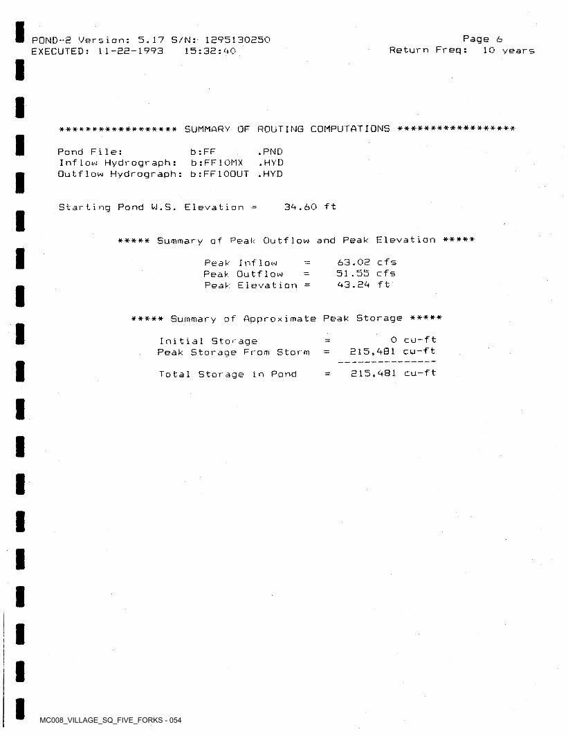
MC008_VILLAGE_SQ_FIVE_FORKS - 054
Page 6POND-2 Version: 5.17 S/N: 1295130250 EXECUTED: 11-22-1993 Return Freq: 10 years15:32:40
****************** SUMMARY OF ROUTING COMPUTATIONS ******************
Pond File:Inflow Hydrograph: Outflow Hydrograph:
b : FFb:FF1OMX b:FF1OOUT
.PND.HYD.HYD
Starting Pond W.S. Elevation = 34.60 ft
***** Summary of Peak Outflow and Peak Elevation *****
63.02 cfs 51.55 cfs 43.24 ft
Peak Inflow Peak Outflow Peak Elevation
Summary of Approximate Peak Storage **********
0 cu-ft 215,481 cu-ft
Initial Storage Peak Storage From Storm
215,481 cu-ftTotal Storage in Pond
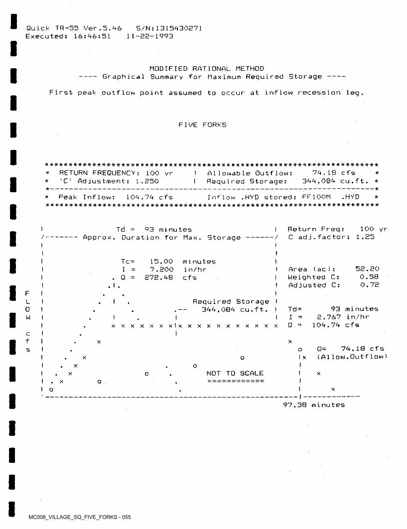
MC008_VILLAGE_SQ_FIVE_FORKS - 055
Quick TR-55 Ver.5.46 Executed: 16:46:51
S/N:1315430571 11-55-1993
MODIFIED RATIONAL METHOD----- Graphical Summary for Maximum Required Storage
First peak outflow point assumed to occur at inflow recession leg.
FIVE FORKS
**********************************************************************Allowable Outflow:Required Storage:
RETURN FREQUENCY: 100 yr 'C Adjustment: 1.550
79.18 cfs 399,084 cu.ft. *
* ***—
Inflow .HYD stored: FF100M **********************************************************************
Peak Inflow: .HYD104.74 cfs* *
100 yr1.55
Return Freq:C ad j.fac tor :
I Td 93 minutes — Approx. Duration for Max. Storage /
I Tc = 15.00 7.500
575.48
Iminutesin/hrcfs
55. SO 0.58 0.75
Area (ac): Weighted C: Adjusted C:
I. Q =I
IF
Required Storage I 344,084 cu.ft. I
IL93 minutes
5.767 in/hr 104.74 cfs
Td =0IWQxxxxxxxlxxxxxxxxxxx
cf I XX
74.18 cfs (A1low.Outflow >Q=os
I XX oII X o
NOT TO SCALE I xX oX o
II o X
97.38 minutes
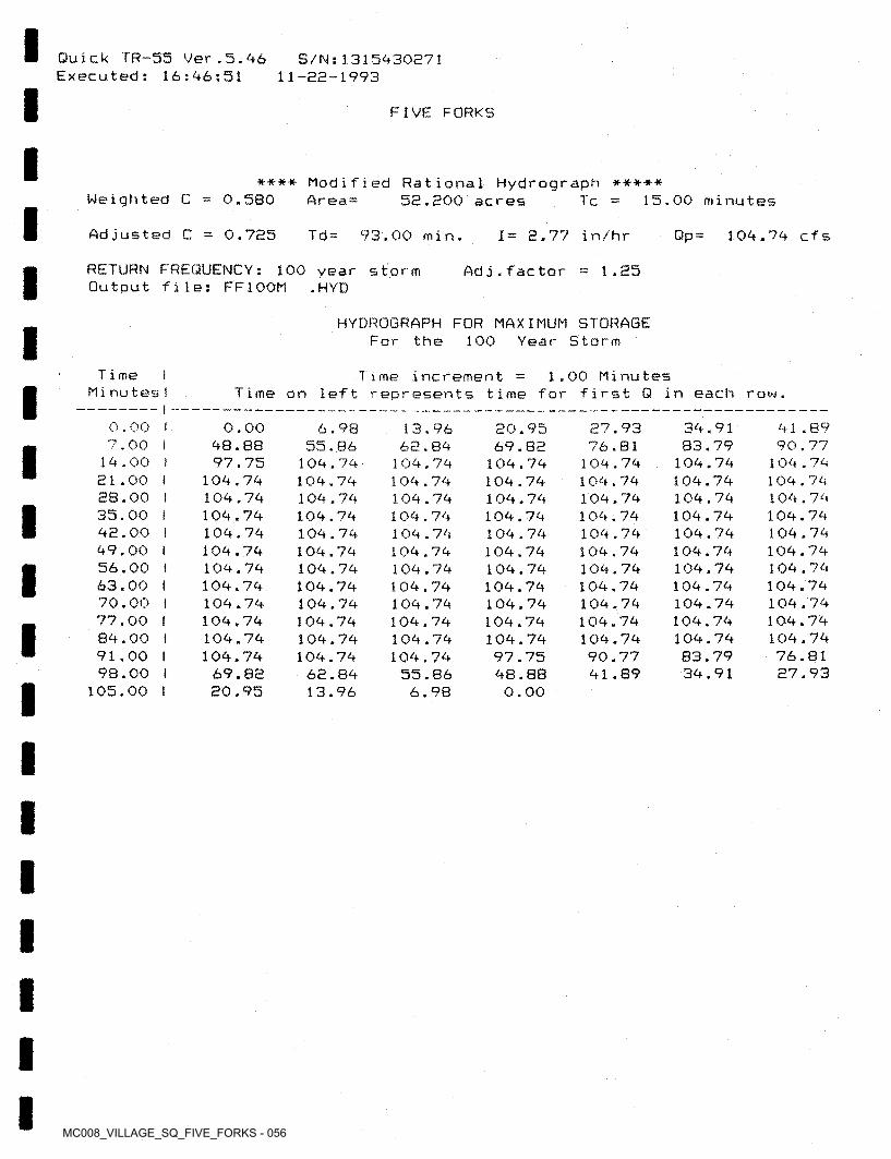
MC008_VILLAGE_SQ_FIVE_FORKS - 056
Quick TR-55 Ver.5.46 Executed: 16:46:51
S/N:1315430271 11-22-1993
FIVE FORKS
***••* Modified Rational Hydrograph ***** 55.200 acresWeighted C 0.580 Ar ea = 15.00 minutesT c
Adjusted C 0.755 Td= 93.00 min. 1= 5.77 in/hr Qp= 104.74 cfs
RETURN FREQUENCY: Output file: FF100M
100 year storm .HYD
1.55Ad j.fac tor
HYDROGRAPH FOR MAXIMUM STORAGE For the 100 Year Storm
Time MinutesI
I Time increment Time on left represents time for first Q in each row.
1.00 Minutes
0.00 I 7.00 I
1A.00 I 51.00 f 28.00 ! 35.00 I AS.00 I <49.00 I 56.00 I 63.00 I 70.00 I 77.00 ! 84.00 I 91.00 I 98.00 i
105.00 I
0.00 <48.88
97.75 104.74 104.74 104.74 104.74 104.74 104.74 104.74 104.74 104.74 104.74 104.74
69.85 20.95
34.9183.79
104.74104.74104.74104.74104.74104.74104.74104.74104.74104.74104.7483.7934.91
41 .89 90.77
104.74 104.74 104.74 104.74 104.74 104.74 104.74 104.74 104.74 104.74 104.74 76.81 27.93
27.9376.81
104.74104.74104.74104.74104.74104.74104.74104.74104.74104.74104.7490.7741.89
6.9855.86
104.74104.74104.74104.74104.74104.7^104.74104.74104.74104.74104.74104.74
62.8413.96
13.96 62.84
104.74 104.74 104.74 104.74 10^.74 104.74 104.74 104.74 104.7A 104.74 104.74 104.74
55.86 6.98
20.95 69.82
104.74 104.74 104.74 104.74 104.74 104.74 104.74 104.74 104.74 104.74 104.74 97.75 48.88 0.00
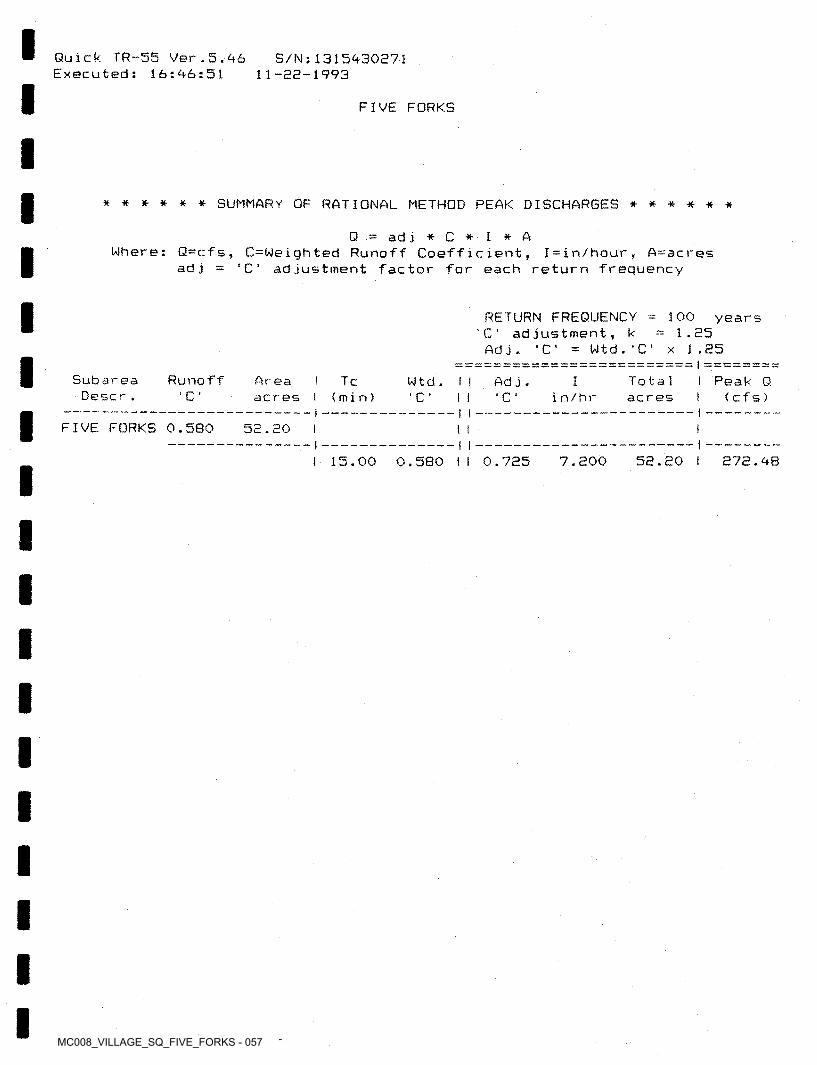
MC008_VILLAGE_SQ_FIVE_FORKS - 057
Quick TR-55 Ver.5.46 Executed: 16:46:51
S/Ns 1315430271 11-22-1993
FIVE FORKS
****** SUMMARY OF RATIONAL METHOD PEAK DISCHARGES ******
ad j * C * I * AWhere: Q=cfs, C=Weighted Runoff Coefficient, I=in/hour, A=acres
C' adjustment factor for each return frequency
Q
ad j
RETURN FREQUENCY = 100 years 'C' adjustment, k =1.25
Adj. 'C' = Wtd.'C' x 1.25I
Subarea Descr .
Runof f Area ac r es
Tc Totalacres
I Peak Q I ( c f s )
IWtd . Ad j .C 1 (min) C C in/hrI I
FIVE FORKS 0.580 52.20 I II
15.00 0.580 t I 0.725 7.200 52.20 1 272.48
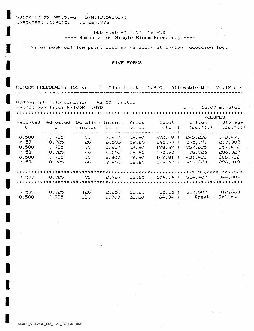
MC008_VILLAGE_SQ_FIVE_FORKS - 058
Quick TR-55 Ver.5.46 Executed: 16:46:51
S/N:1315430271 11-82-1993
MODIFIED RATIONAL METHOD Summary for Single Storm Frequency ------------------------
First peak outflow point assumed to occur at inflow recession leg.
FIVE FORKS
RETURN FREQUENCY: 100 yr A1lowable Q 74.18 cfs' C ' 1.250Ad justment
Hydrograph file duration= Hydrograph file: FF100M
93.00 minutes .HYD 15.00 minutesT c
VOLUMESWeig h t ed Ad justed Inflow
< cu.ft.)Storage ( cu.f t.)
Duration Intens. minutes
Qpeak I cfs I
Areasacres‘ C ’ C in/hr
0.580 0.580 0.580 0.580 0.580 0.580
0.725 0.725 0.725 0.725 0.725 0.725
245,236 295,191 357,635 408,726 431,433 463,223
178,473 217,302 257,492 286,329 286,782 296,318
7.2006.500 5.2504.500 3.800 3.400
15 52.2052.2052.2052.2052.2052.20
272.4B I 245.99 I 198.69 I 170.30 I 143.81 I 128.67 I
2030405060
************************************************************ Storage Maximum344,084
****** ************************* ********* ************************************0.580 0.725 104.74 I 584,42793 2.767 52.20
0.5800.580
613,089 312,660 Qpeak < Qa11ow
0.7250.725
85.15 I 64.34 I
120 2.250 1.700
52.2052.20180
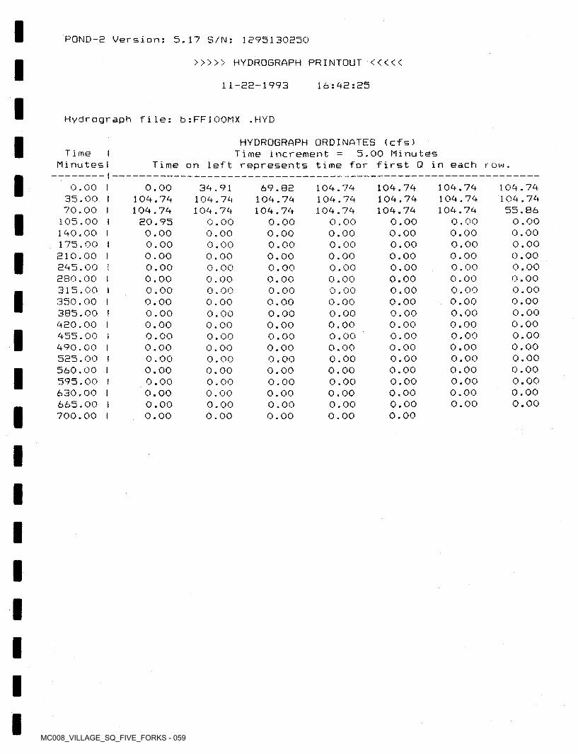
MC008_VILLAGE_SQ_FIVE_FORKS - 059
POND-2 Version; 5.17 S/N: 1295130B50
>>>>> HYDROGRAPH PRINTOUT <<<<<
16:42:2511-22-1993
Hydrograph file: b:FF100MX .HYD
HYDROGRAPH ORDINATES (cfs)5.00 MinutesT i me I
MinutesITime increment
Time on left represents time for first 0 in each row.
104.74 104.74 55.86
0.00 0.00 0.00 0.00 0.00 0.00 0.00 0.00 0.00 0.00 0.00 0.00 0.00 0.00 0.00 0.00 0.00
104.74104.74104.74
0.000.000.000.000.000.000.000.000.000.000.000.000.000.000.000.000.00
0.00 I 35.00 I 70.00 I
105,00 I 140.00 I 175.00 I 210.00 I 245.00 I 280.00 I 315.00 I 350.00 t 385.00 ! 420.00 I 455.00 I 490.00 I 525.00 I 560.00 I 595.00 I 630.00 I 665.00 I 700.00 I
0.00104.74104.74
20.950.000.000.000.000.000.000.000.000.000.000.000.000.000.000.000.000.00
104.74104.74104.74
0.000.000.000.000.000.000.000.000.000.000.000.000.000.000.000.000.000.00
69.82 104.74 104.74
0.00 0.00 0.00 0.00 0.00 0.00 0.00 0.00 0.00 0.00 0.00 0.00 0.00 0.00 0.00 0.00 0.00 0.00
104.74 104.74 104.74
0.00 0.00 0.00 0.00 0.00 0.00 0.00 0.00 0.00 O ■ 00 0.00 0.00 0.00 0.00 0.00 0.00 0.00 0.00
34.91 104.74 104.74
0.000.000.000.000.000.000.000.000.000.000.000.000.000.000.000.000.000.00
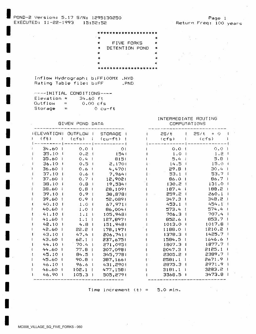
MC008_VILLAGE_SQ_FIVE_FORKS - 060
PDND-8 Version: 5.17 S/N: 1895130850 EXECUTED: 11-28-1993
Page 1Return Freq: 100 years15:58:58
■*••**•*--** #••**#•*** **#••****
* *FIVE FORKS
* DETENTION POND ** *
* ** ** #-tut*#*#-*****-*******#*
Inflow Hydrograph: b:FF100MX Rating Table file: b:FF
• HYD .PND
------- INITIAL CONDITIONS-Elevation Outf1ow Storage
39.60 ft 0.00 cfs
0 cu-ft
INTERMEDIATE ROUTING COMPUTATIONSGIVEN POND DATA
I ELEVATION I OUTFLOW I I (ft )
I 8S/t + O I I (cfs) I
STORAGE I (cu-ft) I
8S/t (cf s)(cf s)
39.60 I35.10 I35.60 136.10 I36.60 I37.10 I37.60 I38.10 I38.60 t39.10 I39.60 I90.10 I90.60 I91.10 I91.60 I98.10 I98.60 I93.10 i93.60 I99.10 I99.60 I95.10 I95.60 f96.10 196.60 I 96.90 I
0.0 I1.8 I5.8 I
1 5.0 I 30.9 I53.7 I86.7 I
131.0 I 188.8 1860.1 I398.8 I959.1 I579.9 I707.9 1 853.7 I
1017.8 I1810.8 1 1985.7 I1696.6 I1877.7 I 8185.1 t8389.7 I8671.9 I8971.9 I3883.8 I3973.8 1
0.0 I 0.8 I 0.9 1 0.5 I 0.6 I 0.6 I 0.7 I 0.8 I 0.8 ( 0.9 I 0.9 I 1.0 I 1.0 I
0.0 I 1.0 I 5.9 I
19.5 I 89.8 I
53.1 186.0 1
130.8 I187.9 I859.8 I397.3 I 953.1 I573.9 I706.3 I 858.6 I
1013.0 I 1188.0 I1378.3 I1589.5 I1807.3 I8097.3 i 8305.8 I8581.1 I8875.3 t3181.1 I3368.5 I
01l 159 1
8151 8,1701 9,9701 7,9691
18,9081 19,539 I 88,109! 38,8781 58,0891 67,9711 86,0091
105.998 I 187,897 I151.998 I 178,197 I 806,791f 837,6751 871,0951 307,0981 395,7781 387,1661 931,890 I 977,1581 505,879 I
II
I
II
I1 . 11 . 1 I
9.8 I88.8 I97.9 I 68.1 I70.9 I77.8 i89.5 I90.8 I96.6 I
108.1 I 105.3 1
I
II
III
I
Time increment 5.0 min.< t)
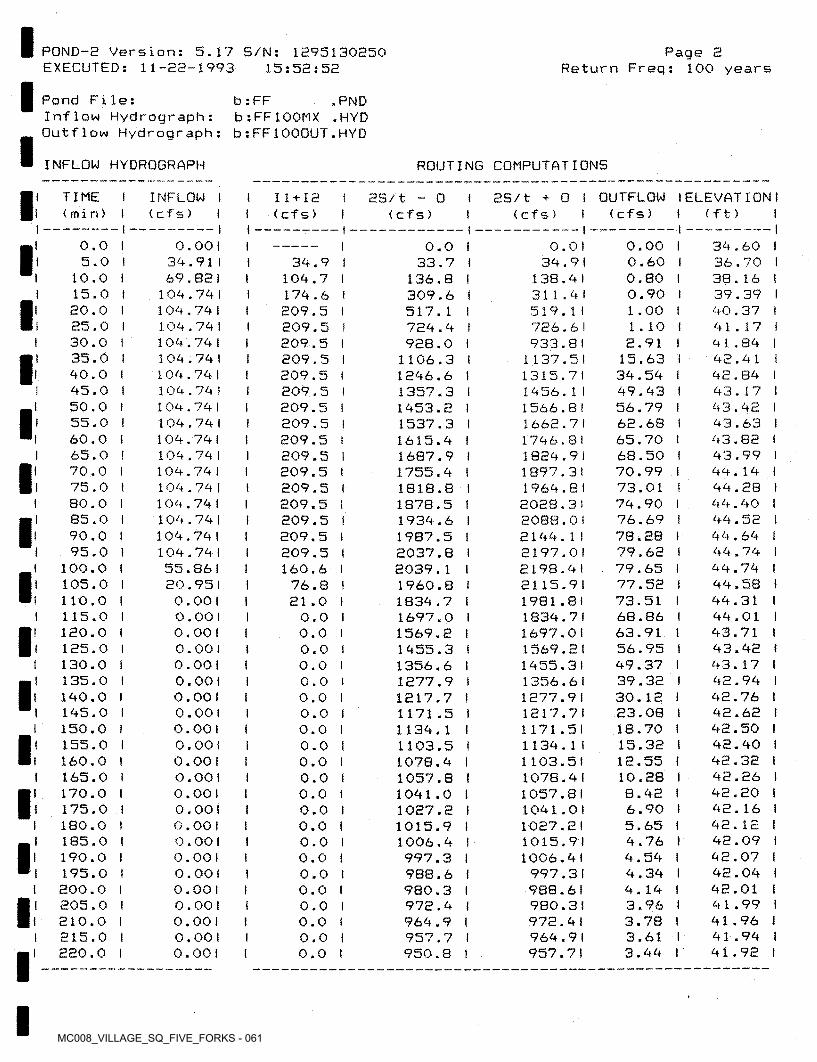
MC008_VILLAGE_SQ_FIVE_FORKS - 061
Page 2Return Freq: 100 years
POND-2 Version: 5.17 S/N: 1295130250 EXECUTED: 11-22-1993 15:52:52
Pond File:Inflow Hydrograph: Outflow Hydrograph:
b : FFb:FF100MX
.PND
.HYD b:FF1000UT.HYD
ROUTING COMPUTATIONSINFLOW HYDROGRAPH
2S/t + 0 I OUTFLOW I ELEVATION!(ft ) t
I TIME I (min)
INFLOW I (cfs) I
2S/t - 0 (cfs)
11 + 12 (cfs) (cfs)(cfs)
II39.60 I36.70 I38.16 ! 39.39 I 90.37 I91.17 I91.89 I92.91 I92.89 I93.17 I93.92 I 93.63 I 93.82 193.99 I99.19 I 99.28 I99.90 I 99.52 t 99.69 I 99.79 I 99.79 I 99.58 I99.31 I 99.01 I93.71 I93.92 I 93.17 I92.99 I 92.76 ! 92.62 i 92.50 I92.90 I92.32 I 92.26 I92.20 I 92.16 I 92.12 I 92.09 I 92.07 I 92.09 I 92.01 I91.99 I 91.96 I 91.99 I91.92 I
0.00 0.60 0.80 0.90 1.00 1 . 102.91
15.63 39.59 99.93 56.79 62.68 65.7068.50 70.99 73.0179.9076.6978.28 79.62 79.65 77.5273.51 68.8663.91 56.95 99.3739.32 30. 12 23.0818.7015.32 12.5510.288.92 6.90 5.65 9.76 9.59 9.39 9.19 3.96 3.78 3.61 3.99
0.01 39.9 1
138.91311.91 519.11726.61 933.8 I
1137.511315.71 1956. 1 I 1566.8! 1668.7 I1796.811829.911897.311969.812028.31 2088.01 2199.1 I 2197.012198.912115.911981.811839.71 1697.01 1569.211955.31 1356.611277.911217.71 1171.5! 1139.11 1103.5!1078.911057.81 1091.0! 1027.2! 1015.9!1006.91
997.3!988.61 980.3 I972.91969.91 957.71
0.0 0.001 39.911 69.821
109.79 I 109.79! 109.791 109.791 109.791 109.79 I 109.79 t 109.79 I 109.791 109.79! 109.79 I 109.791 109.79 I 109.791 109.79 I 109.791 109.791 55.861 20.951 0.00 1 0.00 1 0.00 1 0.00 1 0.00 1 0.001 0.001 0.00!
0.00 I 0.00 1 0.00! 0.001 0.001 0.00!
0.001 0.001 0.00!
0.00 1 0.00 1
0.00! 0.001 0.00!
0.001
0.0I5.0 I
10.0 I 15.0 I 20.0 I 25.0 I 30.0 I 35.0 I 90.0 I 95.0 i 50.0 I 55.0 ! 60.0 I 65.0 I 70.0 I 75.0 i 80.0 ! 85.0 I 90.0 I 95.0 I
100.0 I 105.0 I 110.0 I 115.0 I 120.0 I 125.0 I 130.0 I 135.0 I
190.0 1 195.0 I 150.0 I 155.0 I 160.0 I 165.0 I 170.0 I 175.0 I 180.0 I 185.0 I 190.0 I 195.0 I 200.0 I 205.0 I 210.0 I 215.0 I 220.0 I
39.9 I 109.7 I 179.6 I 209.5 ! 209.5 t 209.5 I 209.5 I 209.5 I 209.5 I 209.5 I 209.5 I 209.5 I 209.5 I 209.5 ! 209.5 I 209.5 I 209.5 I 209.5 I209.5 (160.6 I
76.8 I 21.0 I
33.7136.8309.6 517.1729.9 928.0
1106.3 1296.61357.31953.21537.31615.91687.91755.9 1818.81878.51939.61987.52037.82039.11960.81839.7 1697.0 1569«21955.31356.61277.91217.7 1171 .51139.1 1103.51078.91057.8 1091.01027.21015.91006.9997.3988.6980.3972.9969.9957.7950.8
II1
II!
II
!III
I!
1II
1I
0.00.00.0
II 0.00.0I0.00.0I
I0.00.00.00.0I
!0.0!t0.0I0.0!0.0I0.0I
0.0I0.00.00.00.0I
!0.0
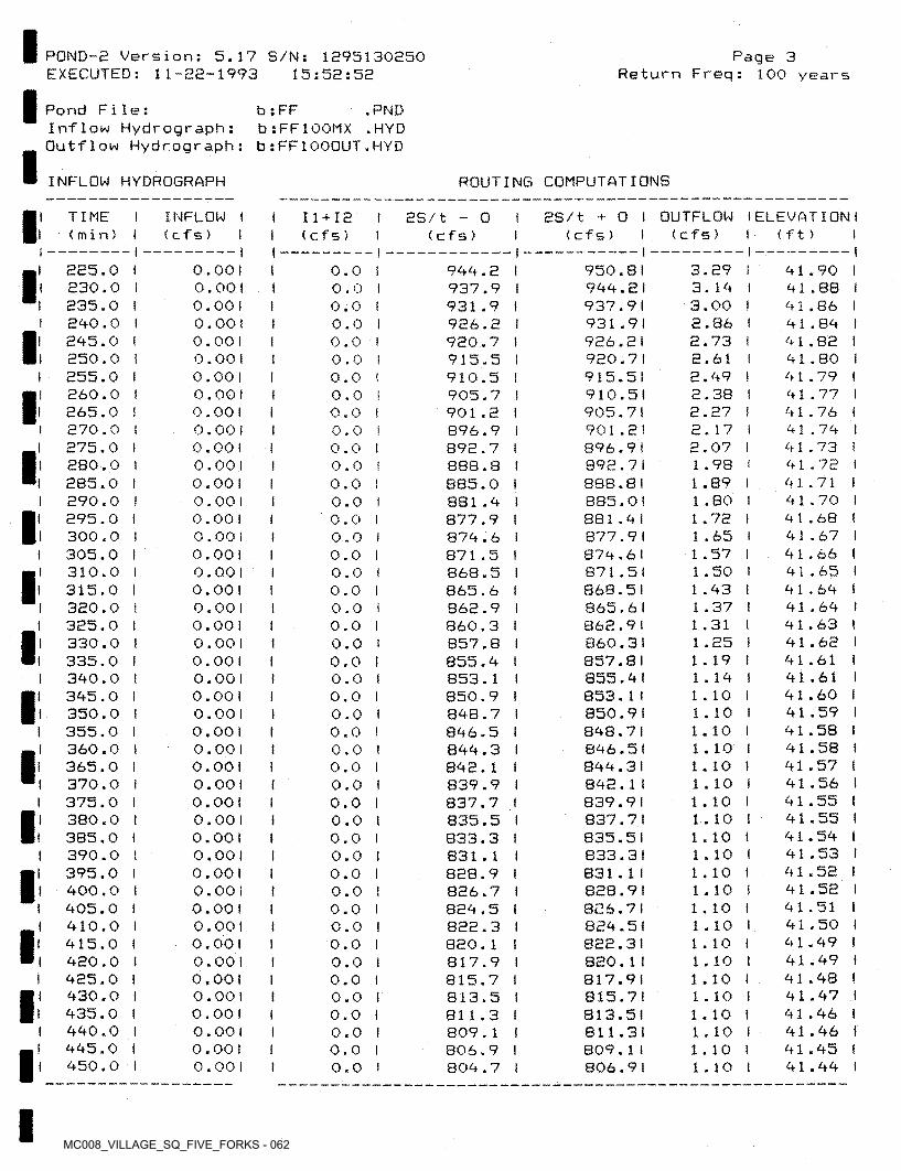
MC008_VILLAGE_SQ_FIVE_FORKS - 062
Page 3Return Freq: 100 years
POND-2 Version: 5.17 S/N: 1295130250 EXECUTED: 11-22-1993 15:52:52
Pond File:Inflow Hydrograph: Outflow Hydrograph:
b: FF .PND b:FF100MX .HYD b:FF1000UT.HYD
ROUTING COMPUTATIONSINFLOW HYDROGRAPH
2S/t + O I OUTFLOW IELEVATION I < c f s ) I ( c f s )
I TIME I (min)
INFLOW I (cfs) I
11+12 I 2S/t - O (cfs) < f t ) I(cfs)
i3.293.14 3.00 2.86 2.73 2.612.49 2.38 2.27 2.17 2.07 1.98 1.89 1.80 1.72 1.65 1 .571.50 1 .43 1.37 1.31 1.25 1 . 191.14 1 . 10 1 . 10 1.10 1 . 10 1 . 10 1 . 10 1 . 10 1.10 1 . 10 1 . 10 1 . 10 1 . 10 1 . 10 1 . 10 1 . 10 1 . 10 1 . 10 1 . 10 1 . 10 1 . 10 1.10 1 . 10
950.81944.21937.91931.91926.21920.71915.51 910.5! 905.7! 901.2!896.91892.71 888.8 I 885.0!881.41877.91874.61871.51868.51865.61862.91860.31857.81855.41 853.1t850.91848.71 846.5!844.31842.1 I839.91837.71835.51 e33.3l831.1 I 828.9!826.71824.51822.31820.1 I817.91815.71813.51811.31809.1 I806.91
41.90 I 41.88 I 41.86 I 41.84 I 41.82 I 41.80 I 41.79 I 41.77 I 41.76 ! 41.74 t 41.73 I 41.72 I 41.71 I 41.70 I 41.68 !41.67 I 41.66 1 41.65 I 41.64 I 41.64 I 41.63 ! 41.62 I 41.61 !41.61 I 41.60 I 41.59 I 41.58 I 41.58 I 41.57 I 41.56 l 41.55 I 41.55 ! 41.54 I 41.53 I 41.52 I 41.52 I 41.51 I 41.50 I 41.49 i 41.49 I 41.48 I 41.47 I 41.46 I 41.46 I 41.45 I 41.44 I
225.0 230.0 235.0 240.0 245.0 250.0 255.0 260.0 265.0 270.0 275.0 280.0 285.0 290.0 295.0 300.0 305.0 310.0 315.0 320.0 325.0 330.0 335.0 340.0 345.0 350.0 355.0 360.0 365.0 370.0 375.0 380.0 385.0 390.0 395.0 400.0 405.0 410.0 415.0 420.0 425.0 430.0 435.0 440.0 445.0 450.0
0.001 0.00 1 0.001 0.00 1 0.001 0.00! 0.00 1 0.001 0.001 0.00! 0.001 0.00 1 0.001 0.00 1 0.00 ! 0.00 1 0.00 1 0.001 0.00 1 0.00 1 0.00 1 0.00 1 0.00 1 0.00 1 0.001 0.00 1 0.00 1 0.00 1 0.001 0.00 1 0.00! 0.00 1 0.00 1 0.001 0.00 1 0.00 1 0.00 1 0.00! 0.001 0.00! 0.00! 0.001 0.00 1 0.00! 0.00! 0.00 1
944.2 I937.9 I931.9 I926.2 I920.7 I915.5 I910.5 I905.7 I901.2 I896.9 I892.7 I 8B8.8 I 885.0 I881.4 I877.9 I874.6 I871.5 I868.5 I865.6 I862.9 I860.3 I857.8 I855.4 I853.1 I850.9 I 84B.7 I846.5 I844.3 I842.1 I839.9 I837.7 I835.5 I833.3 I831.1 I828.9 I826.7 I824.5 I822.3 I820.1 I817.9 I815.7 I813.5 I811.3 I809.1 I806.9 I804.7 I
0.0 ! 0.0 I 0.0 I 0.0 I 0.0 I 0.0 ! 0.0 I 0.0 I 0.0 I 0.0 I 0.0 t 0.0 ! 0.0 I 0.0 I 0.0 I 0.0 I 0.0 I 0.0 I 0.0 I 0.0 I 0.0 ! 0.0 1 0.0 I 0.0 ! 0.0 I 0.0 I 0.0 I 0.0 ! 0.0 I 0.0 I 0.0 I 0.0 I 0.0 I 0.0 I 0.0 I 0.0 I 0.0 I 0.0 I 0.0 I 0.0 I 0.0 I 0.0 I 0.0 I 0.0 I 0.0 I 0.0 !
I
I
II
I
I(
I
III
!
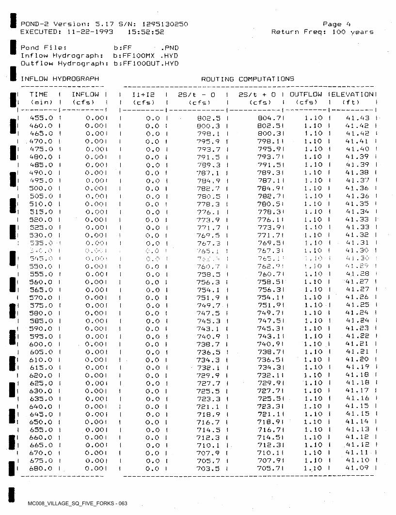
MC008_VILLAGE_SQ_FIVE_FORKS - 063
POND-2 Version: 5.17 S/N: 1295130250 EXECUTED: 11-22-1993 15:52:52
Page <4Return Freq: 100 years
Pond File:Inflow Hydrograph: Outflow Hydrograph:
b : FFb : FF100MX .HYD b :FF1000UT.HYD
.PND
INFLOW HYDROGRAPH ROUTING COMPUTATIONS
as/t + 0 I OUTFLOW I ELEVATION I (cfs) I (cfs) I (ft) I
I TIME I (min)
INFLOW I (cf s) t
I 11+12 I I (cfs) I
as/t - o(cfs)
455.0 I 460.0 I 465.0 I 470.0 I 475.0 1 480.0 i 485.0 I 490.0 I 495.0 I 500.0 I 505.0 I 510.0 I 515.0 I 520.0 I 525.0 I 530.0 I 535.0 I
1.10 I 1.10 ) 1.10 I 1.10 i 1.10 I 1.10 I 1.10 I 1.10 I 1.10 I 1.10 I 1.10 I 1.10 i 1.10 I 1.10 I 1.10 I 1.10 I 1.10 I 1.10 I
0.00 1 0.001 0.00 1 0.00 1 0.001 0.00 1 0.00 1 0.00 1 0.00 1 0.001 0.00 I 0.00 I 0.00 I 0.00 1 0.001 0.001 0.00 I
804.71802.51800.31798.1 I 795.91 793.7 I791.51789.31787.1 I784.9 I782.71780.51778.31776.1 I773.9 I771.71769.51
41.43 i 41.42 I 41.42 141.41 I 41.40 141.39 I 41.39 I 41.38 I 41.37 I 41.36 I 41.36 I 41.35 ! 41.34 I 41.33 I 41.33 I 41.32 i 41.31 i 41.30 I
0.0 I 0.0 1 0.0 I 0.0 I 0.0 I 0.0 1 0.0 I 0.0 t 0.0 I 0.0 I 0.0 I 0.0 I 0.0 1 0.0 I 0.0 I 0.0 I 0.0 I 0.0 ■ 0.0 1 0.0 I 0.0 t 0.0 I 0.0 I 0.0 I 0.0 I 0.0 I 0.0 I 0.0 I 0.0 I 0.0 I 0.0 I 0.0 I 0.0 I 0.0 I 0.0 1 0.0 I 0.0 I 0.0 I 0.0 I 0.0 I 0.0 I 0.0 I 0.0 1 0.0 I 0.0 I 0.0 I
802.5 I800.3 I798.1 I795.9 I793.7 I791.5 I789.3 i787.1 I784.9 I782.7 i780.5 1778.3 I776.1 I773.9 I771.7 t769.5 I767.3 I
II I
II
II 1
lI
II
I
767.3! 765.1:
765 . i; i3 -f V4i.30 !
p o ii . 1 0545.0
I 550.000 I ;I o
! . 10 I1.10 I 1.10 I 1.10 I 1.10 I 1.10 I 1.10 I 1.10 I 1.10 1 1.10 1 1.10 1 1.10 I 1.10 I 1.10 i 1.10 1 1.10 I 1.10 I 1.10 I 1.10 ! 1.10 I 1.10 i 1.10 I 1.10 I 1.10 1 1.10 I 1.10 i 1.10 I
4 1 .0.00 I 0.001 0.00 1 0.001 0.001 0.00 I 0.00 I 0.00 ! 0.001 0.00 1 0.00 1 0.00 I 0.00 1 0.001 0.00 1 0.001 0.001 0.00 1 0.00 1 0.00 1 0.001 0.001 0.001 0.00 1 0.001 0.00 1 0.001
762.9 I 760.7 I758.51756.31754.1 I751.91749.71747.51745.31743.1 I740.91738.71736.51734.31732.1 I729.91727.71725.51723.31 721.11718.91716.71714.51 712.3)710.1 I707.91705.71
760.7 I758.5 1756.3 i754.1 I751.9 I749.7 I747.5 I745.3 I743.1 1740.9 1738.7 1736.5 I734.3 I732.1 1729.9 I727.7 I725.5 1723.3 I721.1 I718.9 I716.7 1714.5 1712.3 I710.1 I707.9 I705.7 1703.5 I
41.28 I 41.27 I 41.27 I 41.26 I 41.25 1 41.24 I 41.24 I 41.23 I 41.22 ! 41.21 I 41.21 I 41.20 1 41.19 I 41.18 I 41.18 I 41.17 1 41.16 1 41.15 I 41.15 I 41.14 I 41.13 I 41.12 I 41.12 I 41.11 l 41.10 ! 41.09 I
I560.0 565.0 570.0 575.0 580.0 585.0 590.0 595.0 600.0 605.0 610.0 615.0 620.0 625.0 630.0 635.0 640.0 645.0 650.0 655.0 660.0 665.0 670.0 675.0 680.0
I
I
I
I
I
I
IIIII
I I
I
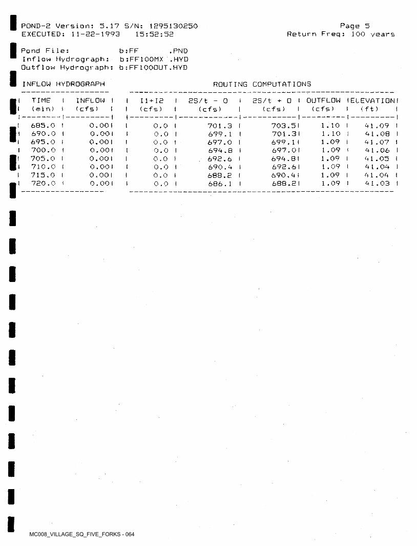
MC008_VILLAGE_SQ_FIVE_FORKS - 064
Page 5Return Freq: 100 years
5.17 S/N: 1095130250 15:52:52
POND-2 Version: EXECUTED: 11-22-1993
Pond File:Inflow Hydrograph:Outflow Hydrograph: b:FF1000UT.HYD
b : FFb:FF1OOMX
.PND.HYD
INFLOW HYDROGRAPH ROUTING COMPUTATIONS
2S/t + 0 I OUTFLOW I ELEVATION I (cf s)
TIME(min)
INFLOW I I Il+ia < cfs) I I (cf s)
2S/t - 0( Cf 5 ) (cfs) (ft) I
I---- --- I0.0 I 0.0 I 0.0 I 0.0 I 0.0 I 0.0 I 0.0 I 0.0 I
685.0 I 690.0 I 695.0 I 700.0 I 705.0 I 710.0 I 715.0 I 720.0 I
0.001 0.001 0.00 1 0.00 ! 0.00 1 0.00 1 0.00 1 0.00)
1.10 I1.10 I 1.09 I 1.09 I 1.09 I 1 .09 I 1 .09 I 1.09 I
703.51 701.31 699.1 I 697.0! 694.8) 692.6 I 690.41 688.21
I 41.09 i 41.08 I 41.07 t 41.06 I 41.05 t 41.04 I 41.04 I 41.03 I
701.3 I699.1 I 697.0 1 694.8 I 692.6 I690.4 i688.2 I 686.1 I
I
III
I
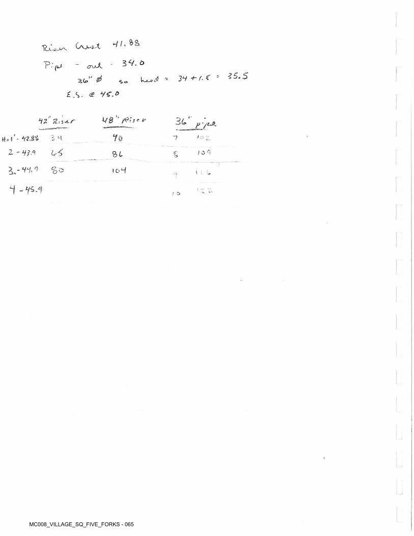
MC008_VILLAGE_SQ_FIVE_FORKS - 065
*//,0
5 9. oP‘pj ci'xaA
*5.5- 31 f- Z 'z<&" $£.S. <£> Vf."
<»»
V8 ’“ fits* &i2'' %• i*r 3l1' F '/*-*-Yohh'- ^?.g%
z - y?.<*
/ - ,- -.“74
0-5 / o r?2>l t?'o
a^-VY,^
9
<? -, o ° ic-4 \ ‘ u
J z>
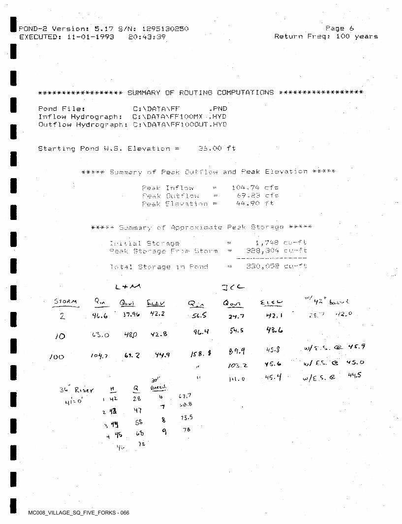
MC008_VILLAGE_SQ_FIVE_FORKS - 066
POND-e Versions 5.17 5/Ns 1H95130250 EXECUTED; 11-01-1993 20;93s39
Page 6Return Freq; 100 years
****************** SUMMARY OF ROUTING COMPUTATIONS ******************
Pond File;Inflow Hydrograph; Outflow Hydrograph;
C s\DATA\FF C:\DATA\FF100MX C s\DATA\FF1OOOUT.HYD
. PND .HYD
Starting Pond W.5. Elevation = 00 ft
js and Peak Elf Peal ! t 'if*- Vjp -H.'¥? ¥r ¥: -ft' •¥? ? V 3 T,: 1 Oy
? £». - f69.23 cfif £4. n ^
k I nf 1 1 n /- ■!W
k?~£0 Lft0 El
eak. Sty of Appr & * # *-ft n 0(fi- e
ito T H-:\qb •5
328,i” n dU4 !.rSQ€? r ;7> r ;
1 Pf C LI1 O witage o
L+Muv/ t?
Q,*Sto/^av Qo 1 Zt£. ✓ (3 £-1 «Q,ySiSV2.217.60. 92.0z HI.<* *92 , I29.7
56. S<?C'WY2-St'l.o HWJOyt?95-?
74-8.YV.94.7- 2/0Y.?/ooPC. <2 V5. oYC-fe/0Z.1f*
H*f,S3°’’
11 |U . 0
3^
Ml'- o'
C?vtLZP1922>1 mt.
7X *f& M"?
75-5%c°bo76
H ^76
if'
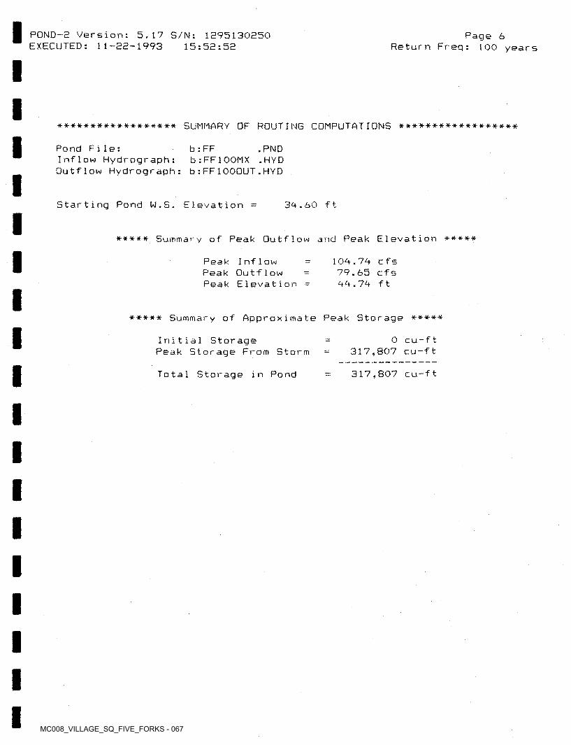
MC008_VILLAGE_SQ_FIVE_FORKS - 067
POND-2 Version: 5,17 S/N: 1295130250 EXECUTED: 11-22-1993 15:52:52
Page 6Return Freq: 100 years
****************** SUMMARY OF ROUTING COMPUTATIONS ******************
Pond File:Inflow Hydrograph:Outflow Hydrograph: b:FF1OOOUT.HYD
b : FFb:FF1OOMX
• PND .HYD
Starting Pond W.S. Elevation 39.60 ft
***** Summary of Peak Outflow and Peak Elevation *****
109.79 c fs 79.65 cfs 99.79 ft
Peak Inflow Peak Outflow Peak Elevation
Summary of Approximate Peak Storage **********
0 cu-ft 317,807 cu-ft
Initial StoragePeak Storage From Storm
317,807 cu-ftTotal Storage in Pond
MC008_VILLAGE_SQ_FIVE_FORKS - 068
.1
V / f>tS* O /XI2-.<£T~
/
/
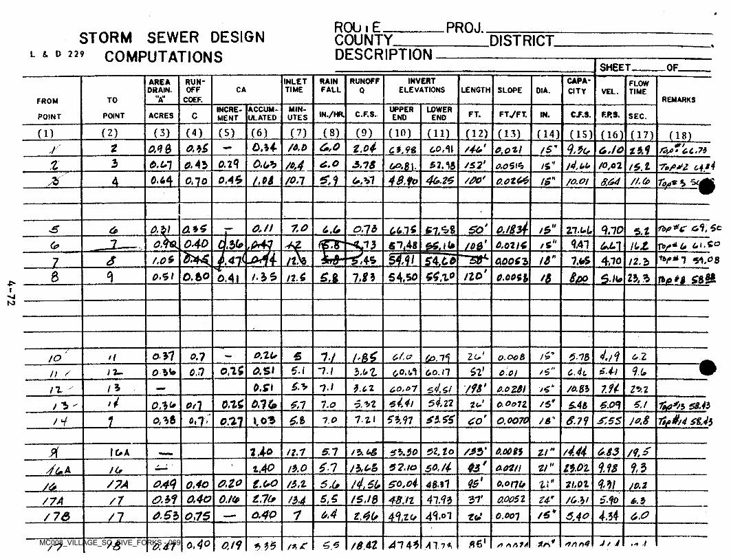
MC008_VILLAGE_SQ_FIVE_FORKS - 069
ROU.E______COUNTY____DESCRIPTION
PROJ.STORM SEWER DESIGN
COMPUTATIONSDISTRICT
L 5. D 2 29SHEET OF.
INVERTELEVATIONS
capacity
RUNOFFINLETTIME
RAINRUN-AREADRAIN.
FLOWTIMEOFF CA FALL LENGTH SLOPE DIA.Q VEL.
H.llA REMARKSCOEF.TOFROMUPPERACCUM
ULATEDMINUTES
INCREMENT
LOWER FT7FT.IN./HR. C.F.S. FT. C.F.S. F.P.S.IN.CPOINT ACRES SEC.POINT ENO ENO
(8)(2) (3) (4) (5) (6) (7) (9) (10)CD (ID (12) (13) (14) (15) (16) (17) ant.oi6,0oM fd.O /4*' q.it.2 0.4 6 /S" o.lo60,11 e.ozlr an g * £0 £ *7$
3 0,l4 O.UhO,43 /o,4 o.o /S2' l4,t,y% e>.u] 3,78 T.fiJi g*4St Ah A"O,0$lS /0,02 !S. 20,45 *L19.44 40. to 46.25/M /00'X o.otte/onA f£” 8.640,10 //.(PfO.Of
Ibp*c ol, ScSO* ItO./l 7.0ox\ onb0,(0 Zl.t+L 9.10 S.t3 5l.4>% /56>0.40 usL 4.4161M0. .13
%
J* TV* U Ui.So
si,os6 0.07 A /S OJL1 IUZ
s4Ji /3”f.O*6 A5 7>S 4,700,006Z1 !2.bno*6 54, SO/.3S 7J3 M.O.bO ££0,SI nA IL n>p*t ggj&oAi 6.006$ g.fto
r-jN>
1/4/o' oYI O.ZL. l&£. 2 (*' + •*5 11on C-Z.o 6.20180.00 8>/ I*
on 5 0. si 5./ 52* 6.4-1 4A1.1on c.dul.oZ 60.1-1O /S60. nn~ cotn 45X 71 6,4,6! /W 7.94o.s\1* 3.67 /4"0.0281 /6.8160,07 l*. 2!T
>4 sin5 4,4/oni /S¥on/0 y.si tc1l.o O.Oo7Z 6./Otl sn 0.01£45 Th>*/1 58,43
t*p4//4 sUioni»/ 3
53.11 to'Si ASon s 10.86A l.ti 6.711.03 0.0070 /a"1 on, oni A.SSno
/4.44Pi 1A0 /**>' /</.*st, to 8.0083 0.835.7lG> A /S.6& M!1,7 $3.30 ZiSO.fi 9.98$n 9.3/*>A& 52.10 2/" M.OZ^JaJl 7.40 aoznn.o/<*
95'l£6U SO, oi0.44 O.ZO 4 n Mlt.oo 48.310,40S7A /S,t S ,(* O.onu 11,07li miI4l zm* 6 AOA f 0,40 0,/(p /g,/g 41.13 37' aoo$t Z4"/7 48,it S4o/M /Mi/7A 6.50.4 /6¥6.53 ons o.4P 1 4.3444,07t.4(* 6.041,70/ 73 3.40n. 0.001rot
trS0,40 *6 J f J78At 4143 Al.niO.tt .1*>35f& 5,56.4-1 /*, £7
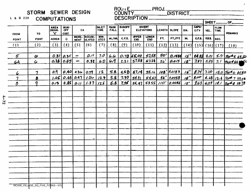
MC008_VILLAGE_SQ_FIVE_FORKS - 070
RObiE________COUNTY___DESCRIPTION
PROJ.STORM SEWER DESIGN
COMPUTATIONSDISTRICT
L & D 229SHEET OF.
CAPA-INVERTELEVATIONS
RUNOFFINLETTIME
RAINFALL
RUN-AREADRAIN.
FLOWLENGTH SLOPEOFF CA DIA.Q CITY TIMEVEL.
M.llA REMARKSCOEF.TOFROMUPPERMIN- LOWERACCUM
ULATEDINCREMENT FT7FT.FT.IN./HR. C.F.S. F.P.S.IN. C.F.S.CACRESPOINT SEC.POINT END ENDUTES
(8) (9)(5) (6) (7) (10)(2) (3) (4) (H) (12) (13)rn 05) (16) (17) LULL.So*O.n tAn 4,011.0 OMti /£ i/o.si C£oo
to fittest-5* 6>.(,OA<&
(PA £7,24c,\b I0S5 0,52 0,0 C.oi} 5,26tn\ 1.12Uo
jet* 0.O/&5S7./4oA 0A° S.& Tofi^c. O/SQ
To/>± 7 Sf,o8r^s st is.
5S.il 1,100.14O.lu /g,01u.$6' 4.l$l,o£ o, 45 5.g 1.10 sA.1i /6*J.tu B,ooOA1 6.0O5&111t n.j7
otf UL O.ooH1 ?.ti//o‘6.$ sl£LA 37 0,0?OA S3SS5 o.ft iton /s
p->4KJ
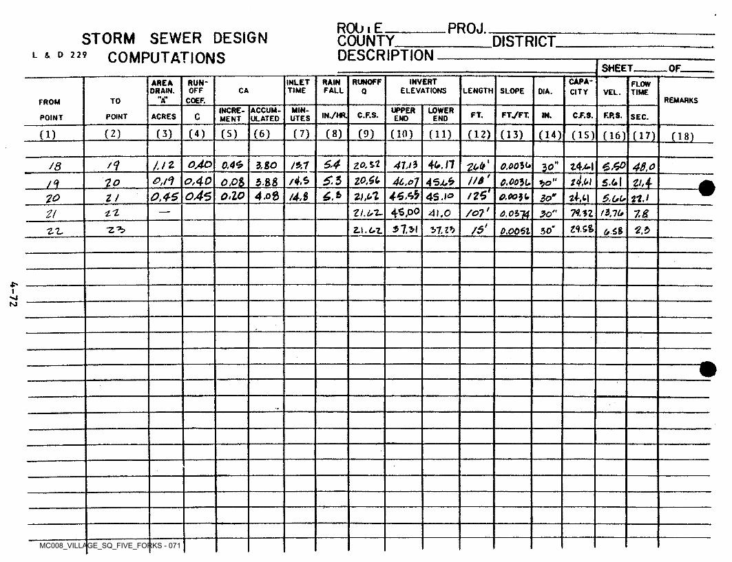
MC008_VILLAGE_SQ_FIVE_FORKS - 071
RObiE______COUNTY____DESCRIPTION
PROJ.STORM SEWER DESIGN
COMPUTATIONSDISTRICT
L i D 229
SHEET OF.INVERT
ELEVATIONSCAPACITY
RUNOFFINLETTIME
RAINRUN-AREAORAIN.
FLOWTIMEOFF CA FALL LENGTH SLOPEQ OIA. VEL.
II .11A REMARKSCOEF.TOFROM
MIN- UPPERINCREMENT
ACCUMULATED
LOWER FT./FT,IN./HR. C.F.S. FT. IN. C.F.S. F.P.S.CACRESPOINT SEC.POINT UTES END END
(2) (3) (4) (5) (6) (7) (8) (9) (in) (11) (12)(1) (13) (14) (15) (16) (17) Oil
oAo 64 too'4u.n//2 0.46 41/5\13.80 £.6® 48,oZ4M0,0030/8 1£//*' z4mzo^uS.6o,40 /4>50,!°! 4c.t> 7 5.4.1oM Zh4"Mi 0.003070Zi 30
T46.6b045 /264.08 6. 6o.io 4.8046 4S .\o O.0030 3om 6.00 n.t70 Z!
/o?(45,00'L'l mi 13,10Zt.UT- 41.07! 7.83,0314 ft80
/$' l<\. Sfe0.0061 50‘61.1*) 2.i>■z**> z\.oz (0.6%2.x,
S'
N)
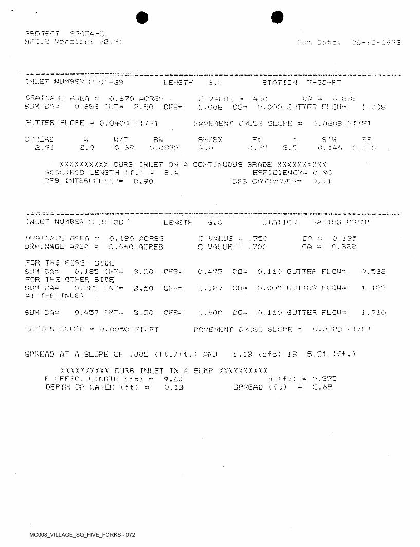
MC008_VILLAGE_SQ_FIVE_FORKS - 072
PROJECT H E C12 ! ■/ e r s i o n 5 V 2,91
03054-55
— rr. su: rr rr
INLET NUMBER 2-DI-3B LENGTH STAT ION 7-i-2b-RT6 , 0
DRAINAGE AREA = SUM CA*
0.670 ACRES 3.50
C VALUE •= , 430 1.008 C0--
0.283 0,000 GLITTER FLOW*
CA0,288 INT-- CFS* 008\
SUTTER SLOPE = 0.0400 FT/FT PAVEMENT CROSS SLOPE = 0.0208 FT/FT
SPREAD 2.91
W W/T SW S ' w0,146
sw/sx 4,0
Ec SEa2.0 0.69 3.50.0833 0.99 0,1 63
XXXXXXXXXX CURB INLET ON A CONTINUOUS GRADE XXXXXXXXXX REQUIRED LENGTH (ft) =CFS INTERCEPTED*
EFFICIENCY* 0,90 CFS CARRYOVER*
S - 40,90 0.. 1 1
zz zz zz ns: :r: sr = zz zz ss ::7 -- 32 zz se zs nr 2c sr == zz :nr ss szzz zz zz nsz‘.z 7a: zz zzzzzz
INLET NUMBER 3-DI-3C RADIUS POINTSTATIONLENGTH 6.0
DRAINAGE AREA = DRAINAGE AREA *
0 „ 135 0«328
0,180 ACRES 0,960 ACRES
, 750 „ 700
CA = CA *
C VALUE * C VALUE *
FOR THE FIRST SIDE SUM CA*FOR THE OTHER SIDE SUM CA*AT THE INLET
0,473 CO* 0.110 GUTTER FLOW* 7,5880.135 INT* 3.50 CFS*
1.127 CO* 0.000 BUTTER FLOW*0.322 INT= 3.50 CFS* 1 . 127
0.457 INT* 1.600 CO* 0.110 GUTTER FLOW*SUM CA* 1.7103.50 CFS*
GUTTER SLOPE 0,0323 FT/FT0,0050 FT/FT PAVEMENT CROSS SLOPE *
SPREAD AT A SLOPE OF ,005 (ft./ft.) AND 1.13 <cfs> IS 5.31 (ft.)
XXXXXXXX.XX CURB INLET IN A SUMP XXXXXXXXXX P EFFEC. LENGTH (ft) =DEPTH OF WATER (ft) *
H (ft) 0.375 SPREAD (ft)
9.60 0. 13 5«62
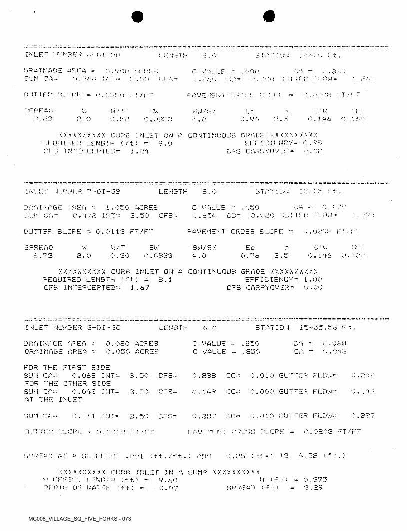
MC008_VILLAGE_SQ_FIVE_FORKS - 073
rr zz zz zz zr zr zz zz zz zz zz: :zz zr is: zz zr zr zz rz zz zz: zz zz zz:zz zz rz nr "" zr zz zz zz
INLET HUMBER 6-DI-SB LENGTH STATION 14-!-00 Lt.S, 0
DRAINAGE AREA =SUM CA*
0.90O ftCRES 3»SO
CA0.000 GUTTER FLOW*
C VALUE ■= 1. „ £60
.400 . 3600.360 INT= TO M i ;CFS* 1co*
GUTTER SLOPE * 0.0350 FT/FT PAVEMENT CROSS SLOPE * 0.0£08 FT/FT
SPREAD3.83
W W/T O .32
S ' W 0.146
3ESW0.0833
sw/sx4,0
Ed 4.2.0 3 0 « 1600.96
XXXXXXXXXX CURB INLET ON A CONTINUOUS GRADE XXXXXXXXXXEFFICIENCY- 0.93
CFS CARRYOVER:-REQUIRED LENGTH (ft) CFS INTERCEPTED*
9.0zr.
0 „ 021.24
zz zr rz zr: nr, ::r zz nr zz zz n: zz r.z zr. n:r. nr zz nr zz
15405 Lt.:z zz zr zz zz zz nr it. zr: zz zr. zr rz rz zz zz zz zz zz zr zz zrz zz zz zz m zz zz zz m zz: :z: zr zz nr zz m1
INLET NUMBER 7--DI-3B STATIONLENGTH 3,0
0.472CADRAINAGE AREA * 1.050 ACRES 3.50
, 450C value1.654 CO* 0.020 GUTTER FLOW* 1 , c'?/0.472 INT*SUM CA* CFS*
V , 0808 FT •' F FGUTTER SLOPE PAVEMENT CROSS SLOPE *0,0113 FT/FT
S 1 W SESPREAD 6.73
W to0.76
SWW/T 0,30
SW/SX 4.0
3.0.1322.0 3.5 0.1460.0333
XXXXXXXXXX CURB INLET ON A CONTINUOUS GRADE XXXXXXXXXXEFFICIENCY* 1.00
CFS CARRYOVER*REQUIRED LENGTH (ft) * CFS INTERCEPTED*
8.10.001.67
zr zz zr zz zz zr zr zz zr. zr zz zz zz zr. zz: zz zzzz zr zz: rz z:nz::r: zz zr. zz: zr. zz zr zr zz: zr zz zz: :zz zr zr zr z:: zz zr zr. zz zz zz zr zz zr zr rz zr zr zr zr:
15+55,56 Rt,INLET NUMBER 8-DI-3C STATIONLENGTH 6.0
0,068 0.043
DRAINAGE AREA * DRAINAGE AREA *
CA * CA *
C VALUE = .850 . 850
0.080 ACRES 0.050 ACRES C VALUE
FOR THE FIRST SIDE SUM CA*FOR THE OTHER SIDE SUM CA*AT THE INLET
.010 GUTTER FLOW* 0.2480.063 INT* 50 CFS* 0.238 CO*CD
0,149 CO* 0.000 GUTTER FLOW* 0.1490.043 INT* 3.50 CFS*
0,3970,387 CO* 0,010 GUTTER FLOW*SUM CA* 0.111 INT* 3.50 CFS*
0,0208 FT/FTGUTTER SLOPE = 0-0010 FT/FT PAVEMENT CROSS SLOPE =
(f +0.25 <cfs> IS )READ AT SLOPE OF ,A (ft./ft.) AND01 4H
XXXXXXXXXX CURB INLET IN A SUMP XXXXXXXXXX P EFFEC. LENGTH (ft) *DEPTH OF WATER (ft) =
= 0.375 : 3.29
H (ft) SPREAD (ft)
9.60 0.07
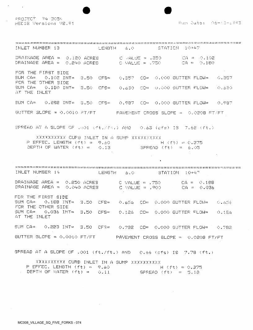
MC008_VILLAGE_SQ_FIVE_FORKS - 074
94 3054 Versions V2,?1
PROJECT HEC1E
™ irr.rr:INLET NUMBER 13 STATION 10+47LENGTH 6.0
DRAINAGE AREA = DRAINAGE AREA *
C A * CA
0.102 o. i so
0.1EO ACRES 0.240 ACRES
. 850C VALUE = C VALUE * . 750
FOR THE FIRST SIDE SUM CA*FOR THE OTHER SIDE SUM CA*AT THE INLET
0.102 INT* 0,000 GUTTER FLOW3* 0.3573.50 CFS= 0.357 CO*
0.180 I NT* 0.000 GUTTER FLOW*3.50 CFS* 0630O . 66U co=
SUM CA= 0.2S2 INT* 3 . 50 CFS* 0.987 CO* 0.000 GUTTER FLOW* 0.987
GUTTER SLOPE 0.0010 FT/FT 0 0208 FT/FTPAVEMENT CROSS SLOPE *
SPREAD AT A SLOPE OF .001 (ft./ft.> AND 7.62 Oft.)0.63 (cfs) IS
XXXXXXXXXX CURB INLET IN A SUMP XXXXXXXXXX P EFFEC. LENGTH (ft) =DEPTH OR WATER (ft) =
H (ft) SPREAD Oft)
0.375 6.. 05
9.60 0.13
™ i":
INLET NUMBER 1.4 LENGTH STATION 1 0 + 476.0
DRAINAGE AREA = DRAINAGE AREA =
0.250 ACRES O«040 ACRES
0.188 0.036
CA * CA *
C VALUE C VALUE
. 750 . 900
FOR THE FIRST SIDE SUM CA*FOR THE OTHER SIDE SUM CA*AT THE INLET
0.1SB INT* 3.50 CFS* 0.000 GUTTER FLOW*O . b 5< 6 CO* L FT
0.036 INT* 3.50 CFS* 0.126 CO* 0.000 GUTTER FLOW* 0.126
SUM CA* 0.223 I NT* 3.50 CFS* 0.000 GUTTER FLOW*0.782 CO* 0.782
GUTTER SLOPE = 0.0010 FT/FT PAVEMENT CROSS SLOPE = 0.0208 FT/FT
SPREAD AT A SLOPE OF .001 (ft./ft.) AND 0.66 (cfs) IS 7.73 (ft.)
XXXXXXXXXX CURB INLET IN A SUMP XXXXXXXXXX P EFFEC. LENGTH (ft) *DEPTH OF WATER (ft) =
9.60 0.11
H (ft) * 0.375 SPREAD (ft) 5 „ 18
MC008_VILLAGE_SQ_FIVE_FORKS - 075
zz :::r:s:!=;=:^ zz sr ism: ~; m: zz zz zz zz z:: zz zz~z zt. rr: ~ zz zz: zz :zz zz.zzrzz.zzzzz.zzzz
INLET NUMBER 15 LENGTH 6 . 0 STATION
DRAINAGE AREA SUM CA®
0,490 ACRES 3 - 50
, 400C VALUE ®0,686 CO®
0,196 0,000 GUTTER FLOW®
CA0.196 INT= CFS® O „ c
GUTTER SLOPE 0.0208 FT/FT0.0E33 FT/FT PAVEMENT CROSS SLOPE
SPREAD W 3 ' W SE14/ T SW 3W/SX4 „ 0
Eo a0.166E. 55 2.0 3.5 0,1460.78 0.0833 1,00
XXXXXXXXXX CURB INLET ON A CONTINUOUS GRADE XXXXXXXXXXEFFICIENCY® 1.00
CFS CARRYOVER®REQUIRED LENGTH (ft) = CFS INTERCEPTED®
6.00.000«69
5S3S 5r.sz a: =s ss =s ss ss s; “ zz\ zz: zzzzzz: zz zz zz zz zz zz zz r:z zz zz, zz zzzzzzzz zzzzv.zz zz zz zz '.zr. zz zzzzzzzz : '.zz zz zz zz ss:zz zz zz.
INLET NUMBER 1,6 STATIONLENGTH 8,0
DRAINAGE AREA = DRAINAGE AREA ®
0, 165 0« 045
CA ®0,220 ACRES o.060 ACRES
C VALUE ?50C VALUE - ,750 CA
FOR THE FIRST SIDE SUM Cft®FOR THE OTHER SIDE SUM CA®AT THE INLET
0.165 INT® 3.50 CFS® 0.000 GUTTER FLOW® 0,577CO®0,577
0.1570.157 CO® 0.000 GUTTER FLOW®0,045 I NT® 3.50 CFS®
SUM CA 0.7350.210 INT® 3.50 CFS® 0,735 CO® 0.000 GUTTER FLOW®
GUTTER SLOPE = 0,0010 FT/FT 0.0203 FT/FTPAVEMENT CROSS SLOPE
SPREAD AT A SLOPE OF .001 (ft./ft.) AND .2? < f t. )0.58 f cf5) IS
XXXXXXXXXX CURB INLET IN A SUMP XXXXXXXXXX P EFFEC. LENGTH (ft)DEPTH OF WATER (ft) ®
H (ft) ® 0.385 4,33
1 1.60 0.09 SPREAD (ft)
zzzz zzzzzzzz•zz zz zz: ss zz: zz zz zz ss zz. zz sr zz zz: zz sr zz zz. zz zz zz: rrzz zz zz ■INLET NUMBER 17a STATIONLENGTH 4.0
0.156 0.000 GUTTER FLOW®
DRAINAGE AREA ® SUM CA®
CA0,390 ACRES 0.156 INT® 3.50 CFS®
C VALUE = .400 0.546 C0= 0,546
0,0208 FT/FTGUTTER SLOPE = 0.0100 FT/FT PAVEMENT CROSS SLOPE ®
SPREAD3.16
W S' W SEW/T EoSW sw/sx4.0
a0,146 0.1642.0 0.63 0.98 3.5O.OS33
XXXXXXXXXX CURB INLET ON A CONTINUOUS GRADE XXXXXXXXXX REQUIRED LENGTH (ft) ®CFS INTERCEPTED®
EFFICIENCY® 0.99 CFS CARRYOVER®
4.30.000,54
MC008_VILLAGE_SQ_FIVE_FORKS - 076
r k i i DUMBER 1.71 I i._b.NG 1 H -r y\ -«■ ;•S - 0
DRAINAGE AREA O j 2OO ACRES 0 . 0E3O 0. 108
VAU , 4 0 i f-DRAINAGE AREA ACRES CAALUE
FOR THE FIRST SIDE SUM CA” 0.080 I NT® FOR THE OTHER
3.50 CFS® 0.000 GUTTER FLOW®0 . 280 CO® 3 £•)
IDE 0.108 I NT®SUM CA® CFS= 0,000 GUTTER FLOW®0,378 n —L/ w —3.50
AT THE INLET
SUM CA® 0.138 INT® 0.000 GUTTER FLOW®3.50 CO®CFS® 0.658 0,6 O
UTTER SLOPE 0 » 0010 C*T/CT PAVEMENT CROSS SLOPE = 08 FT/FT0. ' E— . '
SPREAD AT A SLOPE OF .001 (ft./ft.5 AND IS 7 sr0.33 (cfs) (ft. ;
XXXXXXXXXX CURB INLET t )
X X X X X X X X XINLENGTH
DEPTH OF WATER (ft)EFr r 11.60
0.08(f t > 0, i *•**» rrM / „J
SPREAD (f t) 7
INLET NUMBER 18 STATIONLENGTH oW u
DRAINAGE AREA = 0.448
i") u ^4-AS1.120 ACRES 3.50
CA. 400C VALUESUM - H ~ I NT- 0-000 GUTTER FLOW®CFS® rQ-aiiaw Qui.
GUTTER c* j 0.0208 FT/FTOPE ® 0.019E FT/FT PAVEMENT CROSS SLOPEu) l
SPREAD cc-~J u~
0.144W W/T
0.3 6Eo
0 - 85s ' wsw / S X
4,0SW B.
=, —Jjt, 2.0 . 146cr0»0833 -V -4
XXXXXXXXXX CURB INLET ON A CONTINUOUS GRADE XXXXXXXXXXEFFICIENCY® 0.99
CFS CARRYOVER®REQUIRED LENGTH (ft) 8.8
INTERCEPTED® 0, 021. cr cr JJ
INLET NUMBER 19 STATIONLENGTH 4.0
DRAINAGE AREA SUM CA®
0.0760.190 ACRES CA0.000 GUTTER FLOW®
. 400C VALUEfl O ,L L.'•J « 1— W w0.076 INT® m 50 CFS® O. H66■J3 «
0.0208 FT/FTGUTTER SLOPE PAVEMENT CROSS SLOPE0.0192 FT/FT
SPREAD “ crw Eo ’ WSW SW/SX 4.0
w/ r2.0 c»l . 56 1.28 0. 1460.0833 1 .00 W a 5
XXXXXXXXXX CURB INLET ON A CONTINUOUS GRADE XXXXXXXXXXEFFICIENCY® 1.00
o«00REQUIRED LENGTH (ft) CFS INTERCEPTED®
3.30»27 CFS CARRYOVER®
MC008_VILLAGE_SQ_FIVE_FORKS - 077
zxznsznzrr rzzz.zz.zz~z zz: zzzzzzzzzzzzzzz:zzzzz'.zzzzzz rz: :zz:zz zzrz tz: rs zz zz :zz rr rzzn rz z= rz zr rzINLET NUMBER SO STATIONLENGTH 6,0
DRAINAGE AREA »DRAINAGE AREA =
0.1200.090
CA0.3 0O ACRES 0.150 ACRES
, LOO 600
C VALUE = C VALUE ■= CA
FOR THE FIRST SIDE SUM CA=FOR THE OTHER SIDE SUM CA=AT THE INLET
0.420 C0= 0.000 GUTTER FLOW* 0. Ago0.1E0 INT= 3.50 CFS"
0 . 3150.090 I NT - 0,315 C0= 0.000 GUTTER. FLOW*3.50 CFS"
0.735SUM CA= 0.735 CO* 0.000 GUTTER FLOW-0.210 INT* CFS--O et.AW o w1 'J
0.0203 FT/FTGUTTER SLOPE ~ 0.0050 FT/'FT PAVEMENT CROSS SLOPE =
SPREAD AT A SLOPE OF .005 (ft,/ft,; AND 3,03 (ft.)0.42 (cfs) IS
XXXXXXXXXX CURB INLET IN A SUMP XXXXXXXXXX EFFEC. LENGTH 'ft) ;
SPIN CF HATER (ft? =H (ft) ~ 0.3V
4,779.60 ■ J
SPREAD (ft)0,10
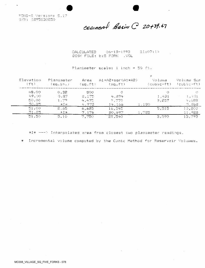
MC008_VILLAGE_SQ_FIVE_FORKS - 078
-nr-JD-r; S/N;
version 3 1295130250
5,17
2.1 3 07 3 1 4CALCULATED DISK FILES b;5 FORK
06-i3-i993. VOL
P1 animeter scale; 1 inch =: 50 f t„
*Elevation
(ft)Planimstsr < s q , i n . )
Vo 1ume Sum (cubic-ft)
A1 + A 2+s a r 1A1 * A 2 ) ( sq . ft )
Vo 1uma <cub ic-ft)
Area (sq.f t)
48.00 49.00 SO, 00
0.32 0,87 1,79 * I *
800 H * 175 4 . 475 4,973
0 o oi43 i 3,257
4,294 1 , v 31 V r, 3825„ £363
9,77050. a? 14,166
16,545 20,697
1 , 180-51,00 2.65
j*I*6,625 1z12£l
5,515 10,202 11,92S51,25 1 ’•?»es
■ •151,50 3,10 7,750 21,540 3,590 13,793
* I ■* > Interpolated area from closest two planimeter readings.
Incremental volume computed by the Conic Method for Reservoir Volumes.
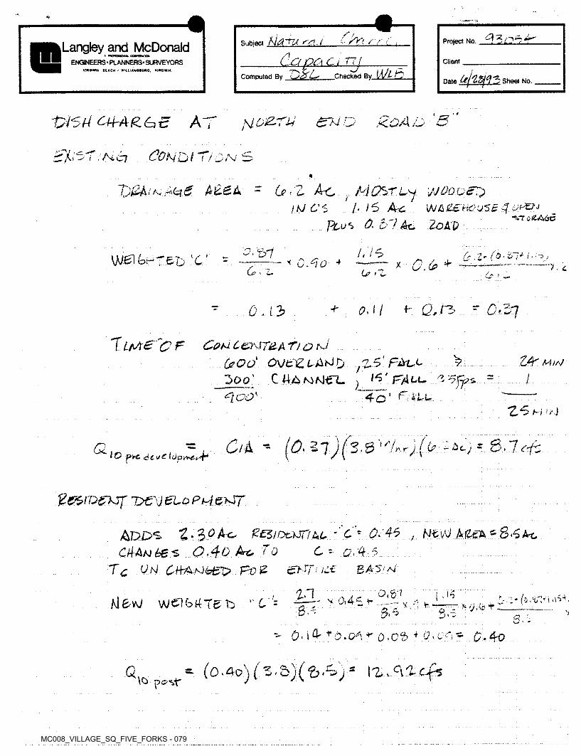
MC008_VILLAGE_SQ_FIVE_FORKS - 079
/' ; ~l3ci±±'..Subject rs[ _ l
do PCs C i 77;7> c>/ OComputed By L—■ Checked
6 ✓ >? Project No.Langley and McDonaldENGINEERS • PLANNERS- SURVEYORS Client
YlftatWA BEACH - W»LLIAM1*U«Q, VIHISIWIA
i'MZZ Sheet No.Date
t 4
'Vi'Sti C\JrAg.^E AT UOZ-TU eru o
CONOi T/OrV SA< i Ai C7
G5 - Z Ac ; MCfcCL'j ]AIQQ&ST}ItJ C5> /■ 15 Ac WAZEHO'JSB JoPZN
Plus 0,0'/Ac. 2oA0
~Ty£h ■' A, A5, c? AiZBA
"VT <5 (&A6C
/,/6 & ,Zr (O' 0!+ Iti'ij\}J&\ (pHT&Tj 'C r x + 7.66. i. U> >0
OM Q,r$ - Q'270 .13
T LrA£ ~C F Coh± C&\17£A Ty £> m
(eOd OVtlZLA^O ^5'FAll
5oo' Cma^/yJ ec*[coK
ZA ww15' FALL 15ft os il
4o' FiLLH ?aJ
Cik - £.27 8.7^-i2.0 '-■(2 ■-At,A r / /io p*e dd sri (op^vA.4*
Pe&iv&kjf loev eto p^i exj7
Adds 'Z^oAc, ZESioctsnul c* 0.45
CAAubes 0.40 Arc To C - 0,4-5Tc Ut4 CHAsJb£7? Foe £hFUc£ BA'S'A
0,51
, NF4 MUA-85Ac
zn 1 ;k (o.'iflrUi*.- v 0i4~ i* ,/J&W W^b^T&b ''D = * *,i ► r > y. it? t80 3 So V
' 0- lG rD.c^ +■ q.o5 4 CM £•^0
- (o.4o)(z. &)(&.%>)* ^.q-icfsQpC’Sf'
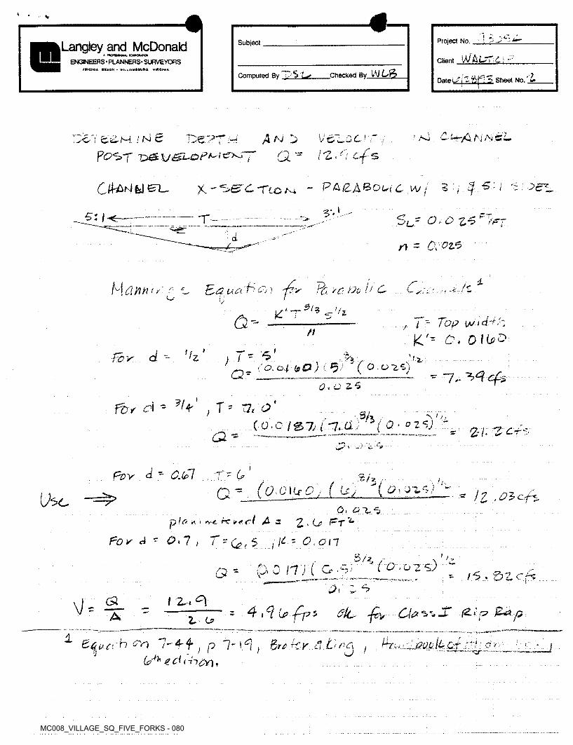
MC008_VILLAGE_SQ_FIVE_FORKS - 080
■ s
!Project No.SubjectLangley and McDonaldW’A LTT.L-,ClientENGINEERS • PLANNERS' SURVEYORS
VtfUlINtA BEACH - WIL l IAMMURQ. VIRGINIA
Checked Bv WComputed By -■■'i'LsOatSheet No. 'Z
’ AJ /Ci NA,’v67 ctiH INS 4^ !>i>ePTAp£>Sf
\JoLQCrr .rl/j - f 4. •L-X
3 7 $ £ - i 3 ;P&IZ&BOUC WjCO Ad
Si) -----r-.. SC' a? / £> 'T
n - O.ozed
dM t'JO /1 C
•5 fz
TOO. Pd7 5 /<■C/ ■f i -■£ «
o-- f i - Top Ia/id-r 'i K> O, 0 l(j>^
/t nI Ir
-/d’X c/ - !'Z T~^>a*'
,94; ( O. Od to£3 j ( ' C O.o25)0. O ZS ^ ~1, 4*
fbr ci - ?(p T ' T2< O'> - % ... *\' //( 0- 0 2<5j -(O.c /S7, (-7.a.
2■/• -£2^£ **
IpZJV" d “ 0.(el r ~ (j> tJ-1. .
^ g
(q_Q\UO) ( Ley (6>t oz.1?y 2G * * /£ <£’2c'ps0, 015
trf A zp'o 2.0- ^t'**/ * i .VC. l"C * <•
pov - on \i~ O. oilt 'Or 5/ I3/*
(0.02 s) “p.0 IT) ( G ■Q * /6.5ZCr7 ,<2. 7
= 4 \Ci (j? -f-p 5 •£, £0t Z t °\\]-- 4- /2-t‘p £0pS'-_dA 2.- O
1 mo (tot7-4-f6?'^’ 1 c( (h&n,
Shoo'd on P 1~ 1 ^ +€,K cl Lf no! lJ
0r;->/
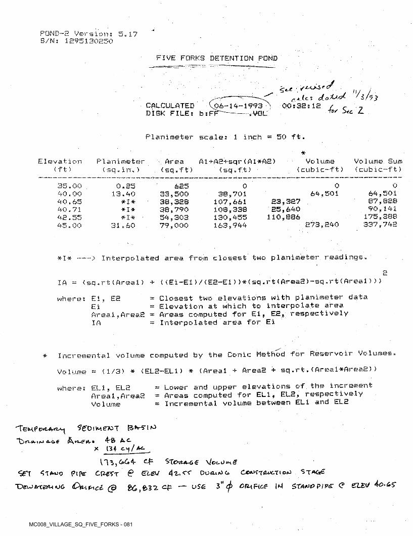
MC008_VILLAGE_SQ_FIVE_FORKS - 081
POND-S Versions 5.17 S/Ns 1895130850
FIVE FORKS DETENTION POND
„/ y(tv 'iHy
00 s 3E 5IE / r «TSV Sec Z.
■7~’ c*CALCULATED V DISK FILE: bsF
06-14-1993 ' r~— rVQL
Planirneter scales 1 inch 50 ft.
*Elevation
(ft)P1 an i me t er
(sq«in.)Area
(sq.ft)A1+AE+sqr(A1* A£)
(sq.ft)Vo 1ume
< cubic-ft)Volume Sum (cubic-ft)
35.00 40.00 40.65 40.71 42.55 45.00
0.85 13.40
# I # *1*
*1*31.60
685 33,500 38,3EB 38,790 54,303 79,000
0 0 038,701
107,661100,338130,455163,944
64,501 64,501 87,82.8 90,141
175,388 337,748
S3,3E7 85,640
110,886E73,E40
Interpolated area from closest two planirneter readings.# I •**- — '
c(sq .rt (Areal) + < (Ei-El) / (EE-E1) >*(sq .rt (AreaE) -sq . rt (Areal > > )IA
= Closest two elevations with planirneter data = Elevation at which to interpolate area = Areas computed for El, EE, respectively = Interpolated area for Ei
wheres El, EEEi iAreal,AreaEIA
Reservoir Volumes.* Incremental volume computed by the Conic: Method for
Volume - (1/3) * (EL2-EL1) * (Areal + AreaE + sq,rt.(Areal*AreaE))
elevations of the increment respectivelyELE = Lower and upper
= Areas computed for ELI, ELE,= Incremental volume between ELI and ELE
ELI,Area1,AreaE Vo 1ume
where s
'Te<4f>0rc4-rt»-j 3’6'OiMe'toT
4-ft ArC- X (34
V/ccUtH#
<S£'T Pipe Cfrerr @ El&J 4z. cf DuoaiOg Cjo^'xiwctio^ Stac*€
T>ei*>*teru*j& Oyl\P\cI (3 &C>,e>32. c-fc — uS£ 3" on-iHce |M $TA*w PIP£ <? 6LEt/
/O
&-c*e n-tFKV *
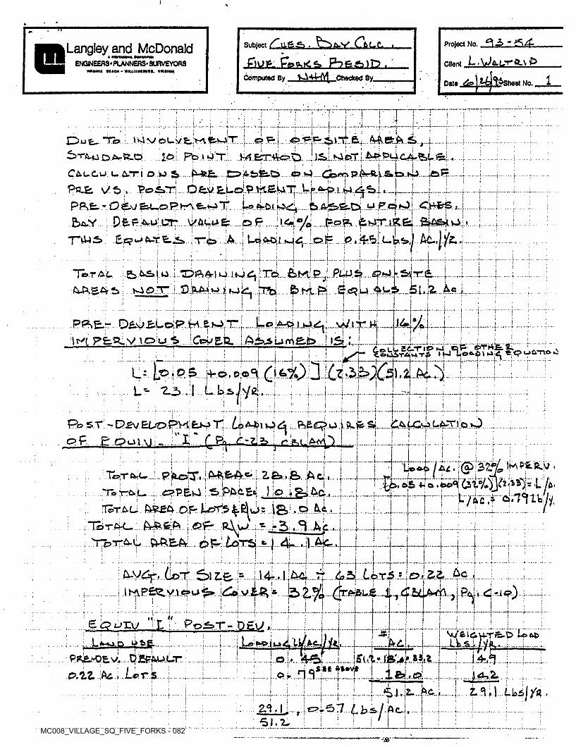
MC008_VILLAGE_SQ_FIVE_FORKS - 082
i s
' J
Subject (?bL.£.
^hi£Jttzl^ JhEJSlLLComputed By SA44-A^ Checked By_
Project No. <3l3 - .5 A.
t.W&.L.Tft.v£>
j£s
Langley and McDonald ♦
ENGINEERS«PLANNERS’ SURVEYORS ClientXVtMHNA MACH - WMUIAMItttM. VM4HIIA
1beet No.Date
7*TtIi1 !i
I
:.Lx. f ----- 4 '*•I*-"■! i
•IIIOmmmvm
u ”Tc>
....ID. PotUT.CllCu. L. 6.TI o..w. s......&-*£►••• OMsfe-Ci.«.*g....Com p.M*4.£».b.*»b..loP?
: : : ; i t * : i l ! t i i • I i I • i I
PojE s/t>P*fc.b^V...., ArU CTF VACU&
“ITU3>
T"/':
;.!£»;...Kierr.i.4^P*goifeLySi;...i.
4!-4*i !
i ,u.. A...■ *.................. » -f "’V............T
U- ■i'
• .1
j,!y^.ATT
■ 1i !4 ...<•-ii —. •i •*
4.) 414 <n ..... &m|.pJ..JStkjLSife 4*4.1O-Mg vJ.J Mklj. !Tb..&hi. S..... S.<S?.U....iA.lk5?-—5.t.iZ.....4e
;Total. . gAAEA gOTl,
. ,t. ti
;! Ii : ..|j -T
ji4 *Jt• i
WlXJ4■P.&&JT.
\tv(; pfcg>V7D;uS
I>» I I1—f i'!. i.Cojj E.U.. i Ai?3 u m B,b......I.JSl .L I|
..2C.o*AVT< >ij
—f f--
4: Ipiok !i i
£>% zp.e j % t :!< ;*2.3.1 L L £»L t ..4...
1 !ii .4. .. !.|
i1 .vU*Sl.fc ........
:I %* H
pf, go o A3Li i!£Li ’T.
1 11 i +!
t0 Ijr tx\i.;1
ipprtsSafBesqplwj! I
cpP.&vJ i’SPAc.Es ) ;o J. T5» TLL........ ; 4 RJ... ...£ 0.iI •lg>.o Ail.vj. •f
R^W r5i£>5r. I.4*-!• ..
:C. ;. I A. rIi Ii ii t
...i-....j.... 4«,,t..... .4,... ..EE451
■1tSS-*. I{ :1I 1r
.1■T
%1
i !L..1.j .L. 4. !i■! I£g>urv^ ‘^Li
Po5»T- OSU J-.1.1.......... - IWfci<iU,TS.D loot)Lib.Al.jlyi,.
..i.I1
‘..Lsm*.. y4fcji
oLM...i1- -...
■r1 * ; UA.I..UI 4—7» VV'4 , .
Ac O K.t!'ii
.1... ■It....... 1 ;■2,^-L51. ^
0.57 »■•f];
j i
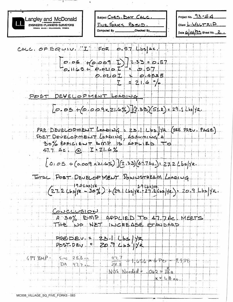
MC008_VILLAGE_SQ_FIVE_FORKS - 083
I K
Project No.
L.\»A-LTg.i P
Sheet No. 2-
Subject Cl-HkSt bft-T CM-G ,
£\U£r-fe^,.K S, gfe 61D^.Checked By_
Langley and McDonaldClientENGINEERS • PLANNERS* SURVEYORS
VIMlNIA MAON - WtlUAMMWM, ¥IMINtA
Computed ByDate »
T■ jj
ii i
JLj .. o» {5 ~1. {(2>F Ci^u.va/ . AC .1. I f ...4
.b.i.5.1.O . o£a
n d? 6. -hi
p.oz.1 C3 X. is?.4*. .j..
4*
:2.1.; .4 O S1 f.j.... .4-. •—r
i sI !+... ' i*•<. r■••p.s
pfc? f?T~ D£V £. L. c?j: I |i j'j *.i-
Oj 7,hZ>XS.Ll}\o5 2..|i
;.i| I■;:•i
i
'kk..PRtvPRE. DEU^CDPfAE44X.;tof>-t>i»J^I
*I 1 p*2.3 tai..1.
fbST DeP Euo^ffSEtul*... A !
IS»4.A-£.F.UV.E*b,.iJ i
t »; or •j* ■r
<o.... :I*ZI.^%. Ij47,11..A-a 44 •f i;
i ii"TL |
0 i <p.S 4- (o.oo^ Z.’b 3/4-7 £ VR,1... .»..rIi
Deoeu^p yteur.....j&juj ..tbkrftkAJmn.od.fe5|/ft
iTc>r^L- .;. Post*
:• i-l tts /zer ~ TA......... ....... 7.........1 I .<*
(Zl.ZU^R .2.e? 3: «9 24 e»,>*». A...'0 ....r......i j
...1. 44* tj ;i i !
.........»■ f*i ‘' i i i+- »
$oj0 ..;.. £? tA V.].fVPPU zip1
Xi4fci...po.... j V4£lf 1 J ‘ 1
■
A AX :
I i;t •f !
'Rl■ i i: ri
Zo L bs> R.M,it ji! ».. .. f
4h.;t5fj
4 FT ^HP 284s l'{. I'M'tr;DA in. i
i jA;1
XIjQkl .2.S.--S.A..;... ..j. .. .4......
i\* 5i x
i • ■
i: j'' !
~PC

MC008_VILLAGE_SQ_FIVE_FORKS - 084
i
°i -sL .U? fl-LTftl P
Data
Subject D&Ti, E> 43,1b* P&6-X Project No.Langley and McDonaldA moruiO<% MRMMOI
s 4 pg bj. ■ENGINEERS • PLANNERS* SURVEYORS ClientVmOtNM MACH • WILLIAM MUR*. VIMINIA
Computed By lA4"lAA Checked By,Sheet No. «3
i0 0- IVI <s> M (D’ j ir
*i
01 oi c\J..I *iAl Ol•Q: * 0. Jii ;l_ 0.
!M j*F?&3 4i o1 w
I iIiJ-^P-TW .of- .12,0 .. ©, 2>o
:p >lo
p .55 . i>.7o„
e>:.AZ,.&
[Oi'l.o.I a/Pu^e. Ffc>.*££».,,dT.&. .j... Jr. ;• -jv
■
P~iRPha£)Coy^N€. P^ftC-S-L. 4-2> £45 :.5.o3.i i
1,00a i J5.5d,...4&..
j j£\2<b
*,03:Jh 5. >
i
7,1.4-PW.C.B.L ,£a .... 4c? ^4-/ 74^4
Hjtu RE. <C<5»><V.ml. , R^CtC. • ; ..
id, A-4 £. A...... iffe..; £>,M. P.Plrt. ...:.. £>;{=-
i
j |\o, 21 Ac., .(D i ;:o no
A. 50
V.,1
; .£pu.2h i/EA-..t4* -5T
1.1,55 iiIi' .... I.....710
>< ?£>7i .o,..2<d c?.l4*o, *P..j. ..
ii H14-, 2*0.3j • .ft....... j*
ii i jj !i i—.
•«14-.7^> . P,%0 4-7 n i
rj
1HO3'{■ , 12j O
.n QcZL■■
1K:*2.71,0 2- iiL dpi- -f: » I
pp&r-D£U &hP. £i o. .1... r.t'4-7.T 1i
iI t.... :• &1 ri L-tW11
;PFS£> D£y..i T, 1iW :e. ■+•f: |Itf?V6.^L.Artu»3J,. PLcajO........... ;...3ocs...........
.... . ..-Wtftrt tL,.. ?.. .li ,.o.!
.............. ....... 1. Ls».Vt £,L..,...- ~]e> , CO
.j. i....... j....;: ii !!4•f • •i. •i- — »-*
fj;
t!• f* -i-+ ■4*iI ij n\ t2>,o:
Tf^AE. ai. 2.5...Kn4
3oO.'■*•"■'
ii {i i ?
.. • • j
I 1Don c.«...pLow? ..“fcS.O.
.Oi«tW EL.
5VH^VLaiiJ.,i.. 4- 4IIm;.». ... 1.i* •+ •
iI iA1..#.. ...j. .■r
i1 i t:»
Qa.Q&A..7.1 2.6.^J '
iv..feC,
iI :S ..j.F • *I:I lf5/6EC ,..1...I.
t SAY..t S. 5o .sSfejE^ CL«. ..rn.Ji.f4{•*• ■i:Plow?...........Hpq'
! rHiO-H..JEA
Low? E-l.
CtkVt4 M EL. ••f.»;4-<? !A
4-a‘ ii■....».. t «:
i1 it I i
■3. 1.. i. •t -r -1 i
.4... I.01 .i..o1 //v>fe 1...,..iT,To'r'L U 2 .£>it=.:...L-lrAa-iS 3Z a.^ >rrf FbJc “ iL
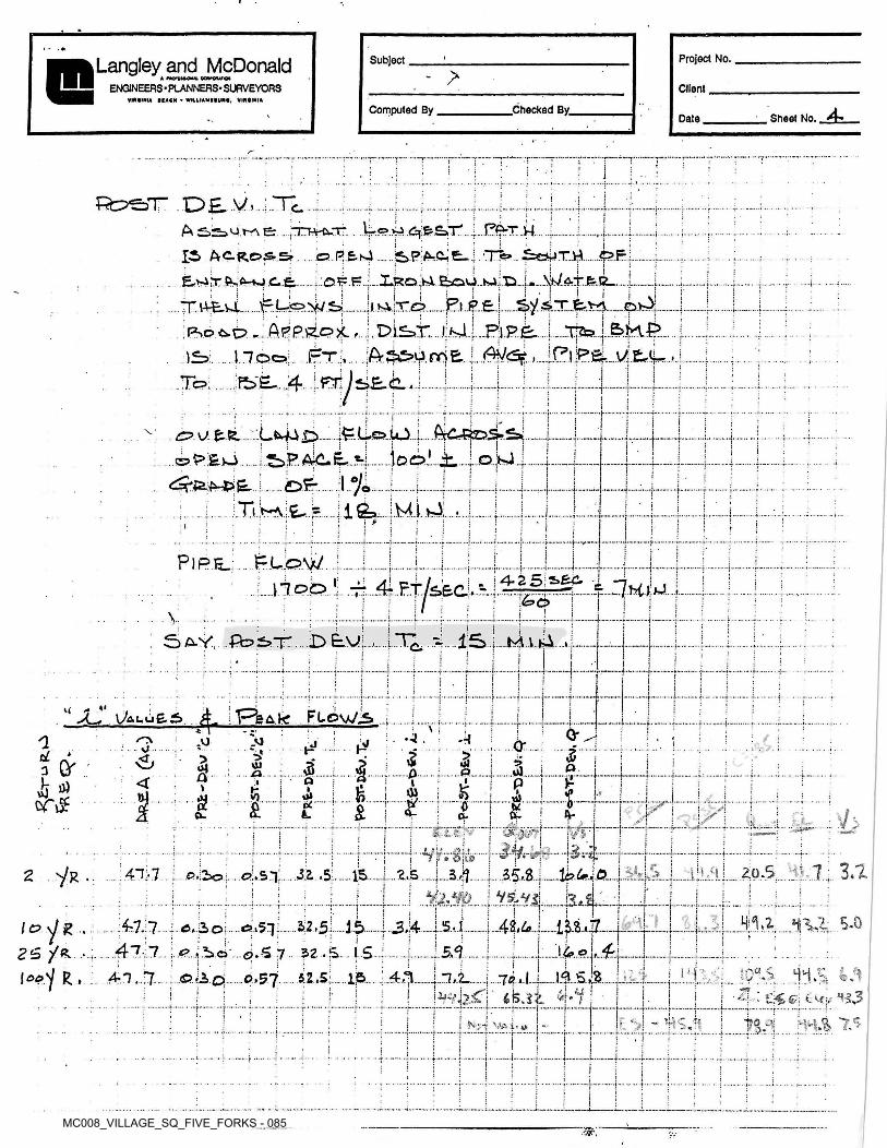
MC008_VILLAGE_SQ_FIVE_FORKS - 085
»
Project No.Subject >Langley and McDonaldENGINEERS • PLANNERS- SURVEYORS Client
VIMINU MACH - WH.IIAMMUM, VIMINIA
Computed By .Checked By.Sheet No. 4-Date
1T t :
i.» ■1*■t'•■y
path.S.PA-C. £_ i. •~T%>.. £ojT,W..£?.E;
Wd.ffec_
Ae: nrprCu-r
IS AC.ROS& o.Rfcsl
E,>4hc:^«trM.c.&.... ::opp!I |JM]Bl i
l ; 'I! r ;. i i!jisV;Xc> FI !
PSOCS.C? -. Appstox. -TjZte.,r.. ri»|
fe'E- .4 ;Tr/si£-C..iTo i f :..1 :
i■ i ;•t — ! ti
<0 u fcfc.;:LWJk 4-ea<.iO.jiooLii........jjD.fej
:i..t
i
:t© .
il i i
!( i
■j’ .j.
iP)P£_ PLOW • -*•■?
4-2 5 s»£A.i •:
7KW] IV i
"Vii
i
lf5> Ml. si«S £-Y fb>5>T........ £> E.\4 '■c. ■ •• !Ij
•i-•| fi i i
t t-4- ! !M' ^. I /Pkafe Fle>WiS>lA lu£6 l!
i • ■ 4-\ j o-■c Aja .VJ.VJ J O' I-J 5>* 5i 5f<r 5 cJo Qr iNO 5*U4 Oi ido0 | +a .»•*■■■ •
h' iJ) < o PtIi
&h i i03 v»I1»<0 i£acTv£ v o• •j-£* -r£ c8. CV- j-.L <VU-<x /■a- j / . .*4» ..f-
■,L
\mj w>i»"7 7VT5Wt j 1
A- •t-r r^-r i
7 ; 3.11!.).,5M.........40-5.r2 35,8.!.._4eA,04T7 ©.sn;..3z .& is ,JLS.©•IS©.:. .. . ■fi ; ::
4 •••• ...ii j j H^U..8-0ts-Sfi.....S2.5i...15 42.A 188.7ye .S.t.1./o d.iO:
7...:.<p ,^o <p.-S 7■■ .32. -S..... IS:.........j...
ArJ . 1 ©*4 o...... 0.57 . . 52,S:.....15.... j 4T
Tl
4Iss26 /(k loo 'j R.
i.ff-T1i
Pi 8... -t’4 6 0 v-c-y
14A 7r>
15.5,8. ■i.1,2.... 10,
lis.il *-1C!t . .’C
4/.!■ I «£j.i
•i.1" ;i If 07.
“:Vi -- .»•-T T •j-t
!i !!i i
1 i i
ii
~w;
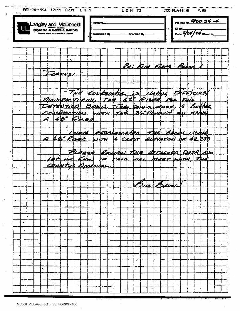
MC008_VILLAGE_SQ_FIVE_FORKS - 086
FEB-24-1994 12:11 FROM L 8. M L 8= M TO JCC PLANNING P.02Il
s4 -4Subject. Project Me.,.Langley and McDonaldCUMH.©JCbEEftS ■PLANNBK-SUSVETORS
mnii KHM'iumtHig. wim Downed By. .Checked ay. .Sheet No.Date.
■ ner TI )I£ I )
ti hiu •«.*7
IDcLAt/30. 'i'stfLJL 1—!I
i X•4 I)
Z'mt^Zfe'2Cj23ifctfl_jS<JseiAl^:^C^^;Saj44.eL.(^S«Juw!^sL-^!5«»K. --4QA^4tolSgsjag4AJ[ i^JarW._4-?L_ik!_>S&icfe4
"T
“
i.. >e*f
1
JLi&J&Q'-jfZ.kl*^ijtrik & \Cjtapr
'ZaStJ&r &4&r,UL iI
Ali-
................ jE<fe*££5M3!_<d3eVrtfflsc«J
. &A„X MC _J^ lieu rtf _^i ££
.^^^^siLyw^cUEAM^U^i______________
tf.<8aL_£ tf« ttLjdSfei . kaL«4->4& tfeCC^bJ fapWh- JZ&4-
t3C^ :
I
«■ ■
I!f;!i
I
I
I%
i
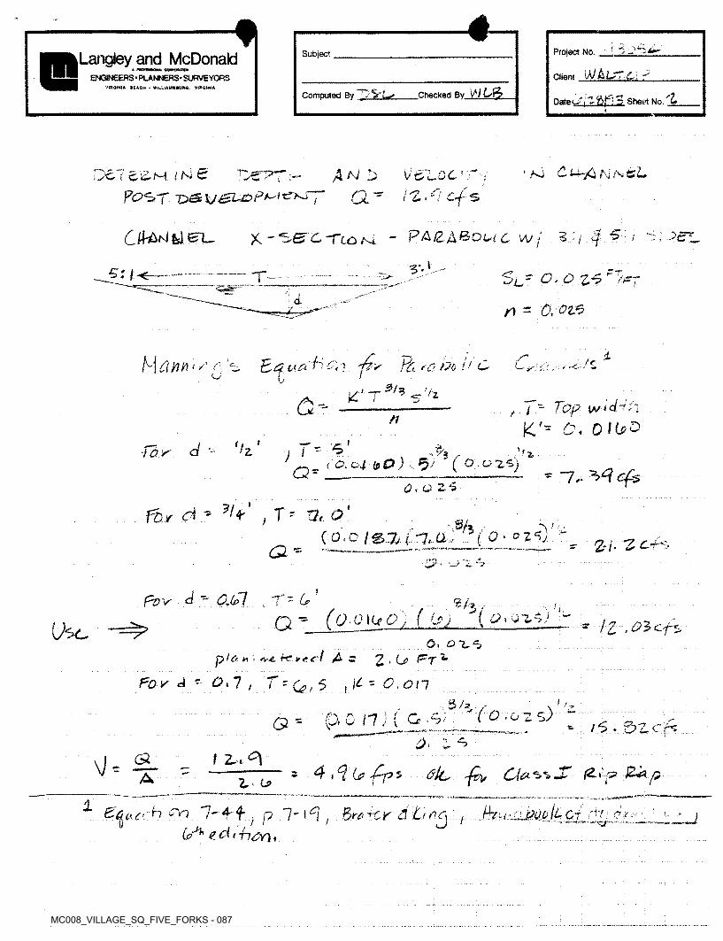
MC008_VILLAGE_SQ_FIVE_FORKS - 087
f! j < jar—Project No. _SubjectLangley and McDonalda MioranQNM. eawattKw
‘\)JkU7-Ci
Date O i Z ftp 3 Sheet No. Z
ClientENGINEERS ■ PLANNERS- SURVEYORSVinaiNU BEACH - WILUAM8IUHC, VlROttilA
Computed By S' L«» Checked Bv M
*.ao Cu-jCi Hi>C- I !£■&•-N't (Nt
P(9ST tfKiJ4 AO VCr'W / i 6'
l 2 i 7 S
~ PA£A®OWc w I* ' -Tto Av4 .-'C ^
S*1-"l<-------- T-- Sc- 0. £ £-5
/) = a ^dX
. 47^HAM'*' c--. 't. M ^ bo hei>ah /£
*<■-
O U
S'- i - Top. w l drift0 I(j>&
ft K'*If77? k d •-- (/z I ' ^ a‘ , ...... .,
: Q.o4 Ip0) L l?'f
; . rj.
a* * ~7.‘ ^>4 cfso*oz$\
fbr d - ?h tT' ~7t Q)
■S/j f O • 0 2 ‘0 ~(o.c/stu -7.a. 27- Pf"L ......
>pZ?V d ' <2-<jc7 6-'T
*'3/(g£ICr g / f Gry ( CPi 0~Z.riJ - ■» /£ .^cfsUse 0.
p la * \ *,-*. t-c *<• cl As
TtQ,^2>U Prl
d - 0.7 K = O. on/ i
3/*, / i
Zs) ’(0,02> 0 /7 ;) ( G;9/5. i <=>
<5 - v” - /^.0zcp;
t Z< ^cs\b 5 4,4 6? -^-ps ^ 06* /27p jZ^?pA Z 0>
b 7' 4 f 67^ € 7 * 774^/) ,
p 7' i7 ; 3whr 3 C ho 1 ■f-r / <7 y.>
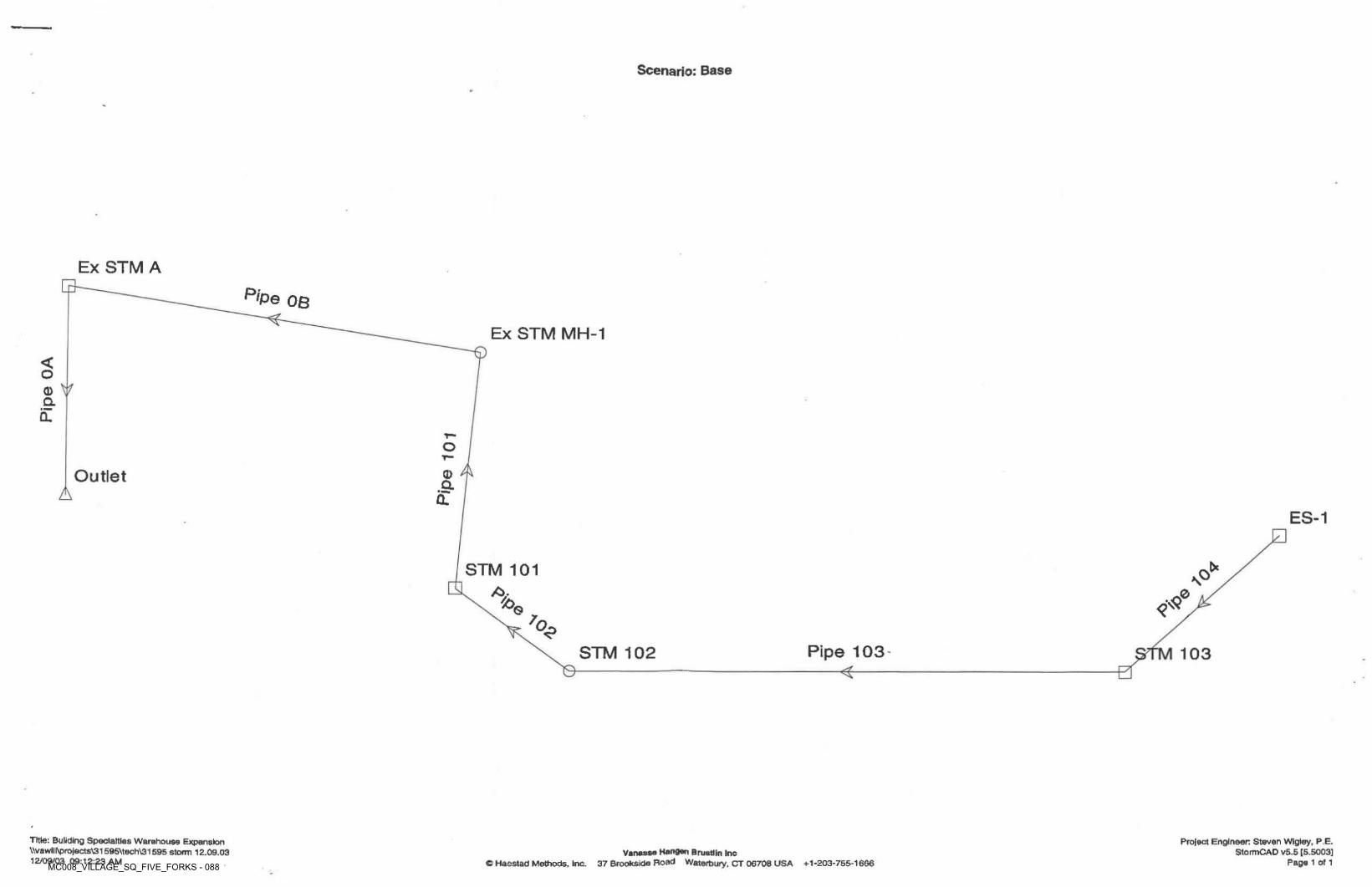
MC008_VILLAGE_SQ_FIVE_FORKS - 088
Scenario; Base
Ex STM Ap'Pe OB
Ex STM MH-1
<o0)Q.CL
O
0Outlet aA CLES-1
C*STM 101 O\o
%/ O<?
Pipe 103 103STM 102
Protect Engineer Steven Wlgley, P E.StormCAD v5.5 {5.5003]
Page 1 of 1
Title: Building Specialties Warehouse Expansion \\vakvllf\projects\31595Vtech\3l 595 storm 12.09.03 12109/03 09:12:23 AM
Vanessa Hengen Brustlln Inc® Haestad Methods. Inc. 37 Brookside Road Waterbury, CT 06708 USA +1-203-755-16G6
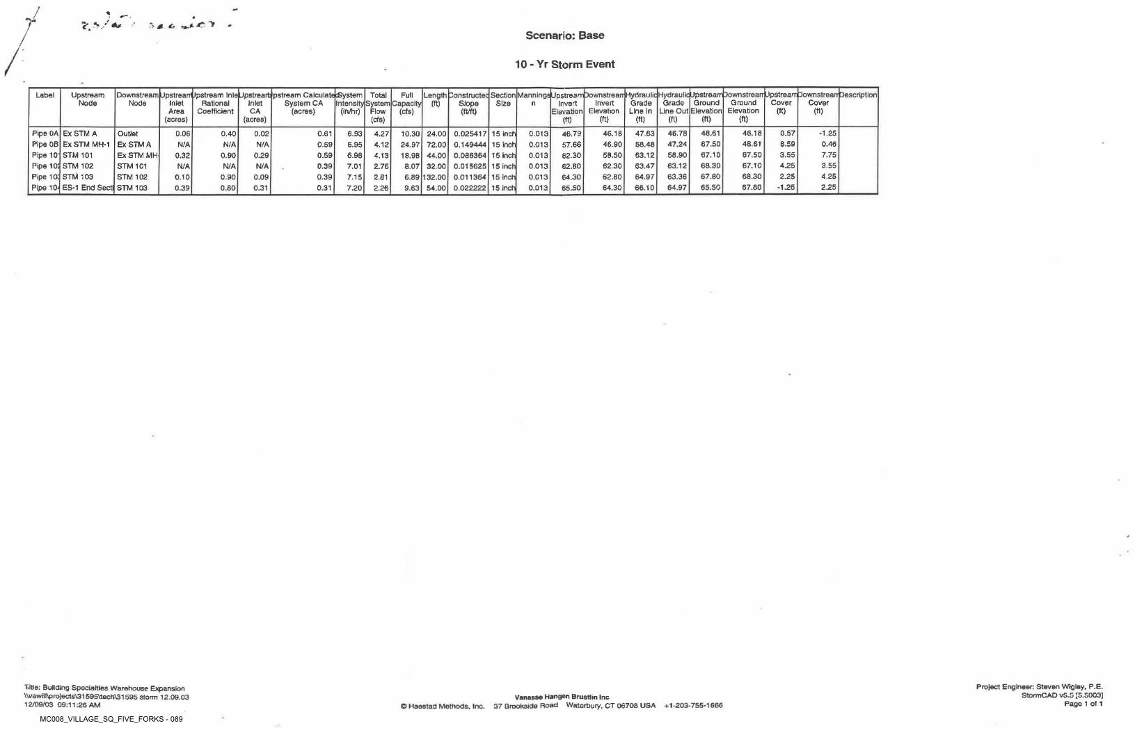
MC008_VILLAGE_SQ_FIVE_FORKS - 089
/ *4^ >:*> 0
Scenario: Base
10 - Yr Storm Event
Hydraulic Upstream Downstrearr Jpstrearr Downstrearr Description Grade Ground Ground Cover Cover
Line Out Elevation Elevation (ft)
UpstreanVpstream InlafJpstreart pstream Calculate System Inlet System CA Intensity
(acres) (In/hr)
DonstructeqSection Manningsppstream Downstrearr HydraulicInvert Invert Grade
Elevation Elevation Line In
Label UpstreamNode
DownstreamNode
TotalSystem
Flow
Full Length Capacity (ft)Inlet Rational
CoefficientSlope Size n
(ft)CA (ft/ft)Area(acres)
(cfs)(ft) (ft)(acres) (ft) (ft) (ft)(cfs) (ft)
Pipe OA Pipe OB Pipe 10' Pipe 10; Pipe 10; Pipe 10-
Ex STM A Ex STM MH-1 STM 101 STM 102 STM 103 ES-1 End Sect
46.7847.2458.9063.1263.3664.97
48.6167.50 67.10 68.30 67.6065.50
46.1848.6167.5067.1068.3067.80
0.57 -1.25Outlet Ex STM A Ex STM MH- STM 101 STM 102 STM 103
0.06 0.40 0.02 0.61 6.93 0.0254170.1494440.0863640.0156250.0113640.022222
15 inch 15 inch 15 inch 15 inch 15 Inch 15 inch
0.0130.0130.0130.0130.0130.013
46.79 57.6662.3062.8064.30 65.50
46.1646.9058.5062.30 62.8064.30
47.6358.46 63.1263.47 64.97 66.10
4.27 10.3024.9718.98
24.0072.0044.0032.00
132.0054.00
8.59N/A N/A N/A 0.59 0.466.95 4.120.90 3.55 7.750.32 0.29 0.59 6.98 4.13N/A 4.25 3.55N/A N/A 0.39 7.01 2.76 8.07
2.25 4.250.10 0.90 0.09 0.39 7.15 2.81 6.89-1.25 2.250.80 0.31 0.31 7.200.39 2.26 9.63
Project Engineer: Steven Wigley. P.E.StormCAD vS.5 [5.5003]
Page 1 of 1
Utle: Building Specialties Warehouse Expansion \\vawill\proJects\31595\tech\31595 storm 12.09.03 12/09/03 09:11:26 AM
Vanasse Hangen BrusUin Inc© Haestad Methods. Inc. 37 Brookside Road Waterbury, CT 06708 USA +1-203-755-1666

7. Reports

8. Correspondence
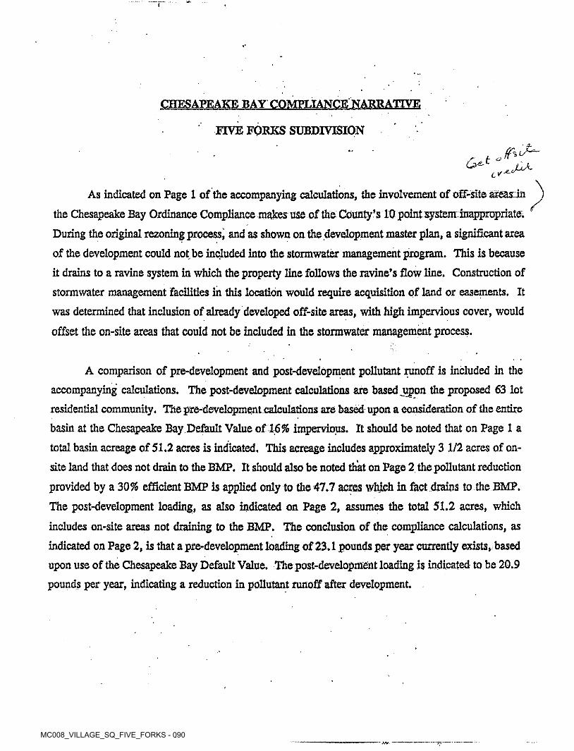
MC008_VILLAGE_SQ_FIVE_FORKS - 090
CHESAPEAKE BAY COMPLIANCE NARRATIVE
FIVE FORKS SUBDIVISION
t ^ .6^CV
As Indicated on Page 1 of the accompanying calculations, the involvement of off-site areas in
the Chesapeake Bay Ordinance Compliance makes use of the County’s 10 point system inappropriate. During the original rezoning process) and as shown on the development master plan, a significant area
of the development could not be included into the stormwater management program. This is because
it drains to a ravine system in which the property line follows the ravine’s flow line. Construction of
stormwater management facilities in this location would require acquisition of land or easements. It was determined that inclusion of already developed off-site areas, with high impervious cover, would
offset the on-site areas that could not be included in the stormwater management process.
A comparison of pre-development and post-development pollutant runoff is included in the
accompanying calculations. The post-development calculations are based .upon the proposed 63 lot residential community. The pre-development calculations are based upon a consideration of the entire
basin at the Chesapeake Bay Default Value of 16% impervious. It should be noted that on Page 1 a
total basin acreage of 51.2 acres is indicated. This acreage includes approximately 3 1/2 acres of onsite land that does not drain to the BMP. It should also be noted that on Page 2 the pollutant reduction
provided by a 30% efficient BMP is applied only to the 47.7 acres which in fact drains to the BMP. The post-development loading, as also indicated on Page 2, assumes the total 51.2 acres, which
includes on-site areas not draining to the BMP. The conclusion of the compliance calculations, as
indicated on Page 2, is that a pre-development loading of 23.1 pounds per year currently exists, based
upon use of the Chesapeake Bay Default Value. The post-development loading is indicated to be 20.9
pounds per year, indicating a reduction in pollutant runoff after development.
MC008_VILLAGE_SQ_FIVE_FORKS - 091
The calculations on Page 3 and 4 provide the stormwater runoff review , for routing through the
detention basin. Page 4 indicates the peak pre-development flows from the 2,10 and 100 year storms. These are 35.8 cfs, 48.6 cfs and 70.1 cfs respectively. The stormwater routing calculations on Page
38, 48 and 58 o'f the accompanying calculations indicate that the peak flows of all three storms are
attenuated by the detention basin. The post-development peak outflows from the detention bask are
34.7, 45.4, and 65.3 cfs for the 2, 10, and 100 year storms.
MC008_VILLAGE_SQ_FIVE_FORKS - 095
C. LEWIS WALTRIP II, INC.P.O. BOX 3522 WILLIAMSBURG, VIRGINIA 23187 (804) 253-1883 FAX (804) 253-0706
*P8 n//Vtx
'b "'\S]
VoMarch 7,1997
Mr. Darryl CookJames City County Codes Compliance 101 E Mounts Bay Road Williamsburg, Virginia 23185
Re: Village Sguare
Dear Mr Cook,With the receipt of the detention pond as built drawings today we would like to request the release of all E&S bonds that are still held by James City County. If you have any questions please let me know.
'<7 -* 4 ■K-)j
\cr> v, V'7i5b)C’x--c
V-Sincerj f
'TaJt -Lynn D. Evans Av-e
cL -a- Xu-oei*^
^ CA~c <-^e_
-JovJJk.
W\
f-
MC008_VILLAGE_SQ_FIVE_FORKS - 092
£*A Development Management%e<v
101-E Mounts Bay Road, P.O, Box 8784, Williamsburg, Virginia 23187-8784 (757) 253-6671 Environmental Division ([email protected]
E-mail: [email protected] Fax: (757) 259-4032
County Engineer (757) 253-6678
Planning (757) [email protected]
Mosquito Control (757S259-4116
March 28,2007
Mr. Adam Herman Village Square HOA 4516 Misty Court Williamsburg, Va. 23185
nrefTTH■ in
Village SquareStormwater Management Facility County Plan No.County BMP ID Code: MC 008
Re:
Dear Mr. Herman:
It was a pleasure to talk with you recently about the stormwater management facility at Village Square. As discussed, I am providing you with some of our “first contact' information for your community association to use relative to maintenance of the BMP. The subject stormwater management facility (MC 008) is a dry pond stormwater management facility situated at the north end of the subdivision.
Information as attached includes: a watershed education brochure from our PRIDE program (www.protectedwithpride.org): landscaping tips for stormwater management BMP’s; watershed awareness tips, a sample maintenance plan for a dry pond stormwater management facility; and three brochures related to liability and maintenance. One of these brochures is a good informational handout entitled A Guide for Maintaining and Operating BMP‘s. This publication is distributed through our office in response to a cooperative effort from the Hampton Roads Regional Stormwater Management Committee and HR STORM, a regional stormwater education program offered by the Hampton Roads Planning District Commission.
Our Division is always readily available to assist owners and HOA representatives with guidance related to stormwater management facilities and drainage and we sincerely look forward working with you in the future. If you have any additional questions or comments, call me at 757-253-6639.
Sincerely,
las, P.E.Scott J. Tl Chief Engineer - Stormwater Environmental Division
AttachmentsSJT/sjt
SWMProg\Educatian\Subdivisions\VilIageSquare.fc
MC008_VILLAGE_SQ_FIVE_FORKS - 093
'/l Development Management%4'fO gff< 101-E Mounts Bay Road, P.O. Box 8784, Williamsburg, Virginia 23187-8784 (757) 253-6671 E-MAIL: [email protected]: (757) 253-6850
EE County Engineer (757) 253-6678 Integrated Pest Management (757) 259-4116
Code Compliance (757) 253-6626 [email protected]
Planning (757) [email protected]. us
November 13, 2001
Environmental Division (757) 253-6670 [email protected]
//rn-Br/fosre/i
c/e & rovtot/1/!fer/
Se?/ <*/r * tty*
C. Lewis Waltrip II, Inc. P.O. Box 3522 Williamsburg, Va. 23187
Stan DykstraAttn: 6
V.Re: Village Square Phase I (formerly Five Forks Subdivision)
County Plan S-51-93Stormwater Management Facility - Dry Pond County BMP ID Code: MC 008
4**'”rnU^//f on-/{^njr/!Zf,
Dear Mr. Dykstra:
In response to your request on October 31st, 2001 to release surety on the above referenced project, the Environmental Division has reviewed record file information and performed a field inspection of the stormwater management facility for the project. The subject extended dry detention stormwater management facility for the site is located in the north comer near the end of Village Park Drive West (behind 4588 Village Park Drive East).
Based on our review of a previous submitted record drawing and a field observation as performed on November 9th 2001, the following items must be addressed prior to release of the developer’s surety instrument for the stormwater management/BMP facility at the site:
Record Drawing:
y The record drawing dated March 3rd 1997 is satisfactory.1.
Construction Certification:
A Based on previous plans and Environmental Division comments for the project, a construction certification is not required for the facility. Previous notes only required a certified as-built plan, which was previously provided.
Construction-Related Items:
The entire fill embankment for the pond is covered with large trees and thick woody vegetation. Trees, shrubs and woody vegetation are not permitted to grow on any part of pond embankments constructed using engineered (compacted) fills. Saturated roots mats combined with high wind can cause trees to overtop and accelerate soil erosion and embankment failure conditions. For older facilities which may have established tree growth, we recommend that trees be cut flush to or below ground level and be maintained in that fashion as to not disturb root systems that may already be extensive. Efforts should then be made to reduce tree re-stablishment and maintain a low-maintenance grass covering. Clear and remove all trees from the downstream fill embankment, top of dam and in the upper portions of the upstream fill embankment. Seed and mulch disturbed areas associated with subsequent tree clearing operations
lp‘°*7c rr*
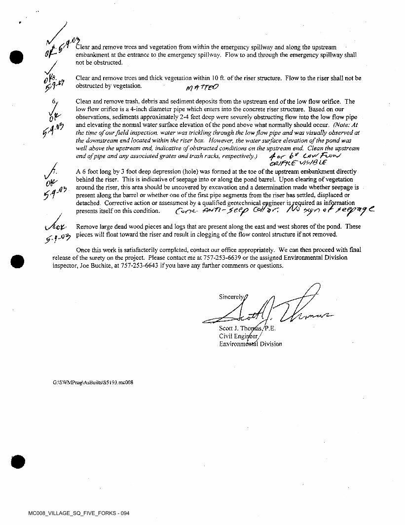
MC008_VILLAGE_SQ_FIVE_FORKS - 094
Clear and remove trees and vegetation from within the emergency spillway and along the upstream embankment at the entrance to the emergency spillway. Flow to and through the emergency spillway shall not be obstructed.
Clear and remove trees and thick vegetation within 10 ft. of the riser structure. Flow to the riser shall not be obstructed by vegetation.
1 Clean and remove trash, debris and sediment deposits from the upstream end of the low flow orifice. The low flow orifice is a 4-inch diameter pipe which enters into the concrete riser structure. Based on our observations, sediments approximately 2-4 feet deep were severely obstructing flow into the low flow pipe and elevating the normal water surface elevation of the pond above what normally should occur. (Note: At the time of our field inspection, water wot trickling through the low flow pipe and was visually observed at the downstream end located within the riser box. However, the water surface elevation of the pond was well above the upstream end, indicative of obstructed conditions on the upstream end. Clean the upstream end of pipe and any associated grates and trash racks, respectively.) 4- or b ^ fifoixy
&Z/fsfc€' v)t>/8L€
Wf)0
J, A 6 foot long by 3 foot deep depression (hole) was formed at the toe of the upstream embankment directly behind the riser. This is indicative of seepage into or along the pond barrel. Upon clearing of vegetation around the riser, this area should be uncovered by excavation and a determination made whether seepage is present along the barrel or whether one of the first pipe segments from the riser has settled, displaced or detached. Corrective action or assessment by a qualified geotechnical engineer is required as information presents itself on this condition. e€^> C&lf'dSZ /Vo or
Remove large dead wood pieces and logs that are present along the east and west shores of the pond. These pieces will float toward the riser and result in clogging of the flow control structure if not removed.
Once this work is satisfactorily completed, contact our office appropriately. We can then proceed with final release of the surety on the project. Please contact me at 757-253-6639 or the assigned Environmental Division inspector, Joe Buchite, at 757-253-6643 if you have any further comments or questions.
Sincerely,
Scott J. Thomas,'T\E. Civil Engineer/ Environmi tl Division
G:\SWMProg\AsBuilts\S5193.mc008
MC008_VILLAGE_SQ_FIVE_FORKS - 096
Page 1 of 1
Scott Thomas
Scott ThomasFrom:Sent: Friday, March 02, 2007 12:30 PM
'[email protected]'Village Square BMP
To:Subject:Attachments: VillageSquare.map.pdf; MC008-1s.jpg; MC008-2s.jpg; MC008-3s.jpg; MC008-4s.jpg; MC008-
5s.jpg; MC008-6s.jpg; MC008-7s.jpg; MC008-8s.jpg; MC008-9s.jpg; MC008-10s.jpg; MC008- 11s.jpg; MC008-12s.jpg; MC008-13s.jpg
Here’s some information on the BMP including an aerial map of the area and photographs from when 1 did the final inspection in May 2003, The pond should be a dry pond, meaning it stays dry then fills up when it rains then it draws back down in about 24-36 hours. So if there is a permanent pool there, it’s a sure sign that the low flow orifice is clogged.
The County BMP ID Code for this stormwater management facility is MC 008. The pond was approved as part of County Plan No. S-51-93. It serves 52.2 acres.
Scott J. Thomas, P.E.Chief Engineer - Stormwater James City County Environmental Division
Visit:http://www.iames-citv.va.us/resources/devmgmt/div devmgmt environ.htmlandwww.protectedwithpride.org
3/2/2007

9. Inspection Records
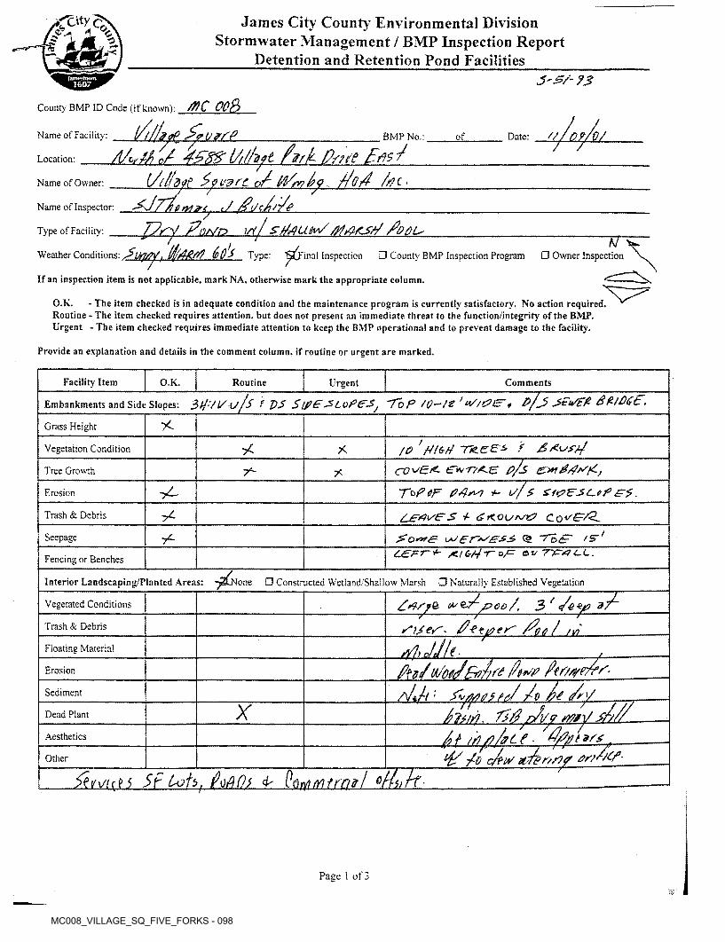
MC008_VILLAGE_SQ_FIVE_FORKS - 098
ep*>^ James City County Environmental Division Stormwater Management / BMP Inspection Report
Detention and Retention Pond Facilitiesn *2
m
?SSD
County BMP ID Code (if known): /%€_ OOB
A/wtf J 4f$*rU//fyt fvrk ppe pP{Afyt jjLMLL P (rVry?/?<? Po4 /rfC'
J ,PtJcpr/epry Po/vo \rt/EfMujzLMrn&L Aol,
UfirtV, (fyrf-AiV? 60S Type: ^Final Inspection □ County BMP Inspection Program □ Owner Inspection
olqi/su.Name of Facility: BMP No.: of Date:
Location:
Name of Owner:
Name of Inspector:
Type of Facility:77
Weather Conditions:
If an inspection item is not applicable, mark NA, otherwise mark the appropriate column.
O.K.Routine - The item checked requires attention, but does not present an immediate threat to the function/integrity of the BMP. Urgent - The item checked requires immediate attention to keep the BMP operational and to prevent damage to the facility.
- The item checked is in adequate condition and the maintenance program is currently satisfactory. No action required.
Provide an explanation and details in the comment column, if routine or urgent are marked.
Facility Item O.K. Routine CommentsUrgent
Embankments and Side Slopes: 3^/i/ u/S f VS Stfi£'Tb P /g-/g ’ P/j jFiSft Bt/DCE,
AGrass Height
/O ' tft<* 4 TTcee-S / jZAvfpAVegetation Condition *
£?/s ~tPuP>Pjco^Er. £*77A.e:Tree Growth 7"- 7<
+- IS/$ SftZFSC-e? Ft.yL-Erosion
7^Trash & Debris
c& "TBS' /s*'Seepage 7^L£zFT-+- /a Cr/4-r oF e-vncrtfi-L.Fencing or Benches
Interior Landscaping/Planted Areas: -^None □ Constructed Wetiand/Shailow Marsh □ Naturally Established Vegetation
£-7^poo/, 3 ' </-e *jp
Pos / u£------rises'*p) jjU ■
Vegetated Conditions
Trash & Debris erFloating Material
Erosion
PP; St/ A Ji. PyfatuL W-dj
<p t4 c/tiT arPcS-
Sediment
77Dead Plant /
Aesthetics t 9S4
Other
Sf IoAOl £ PotriMtmff/ mUE-L
Page 1 of 3
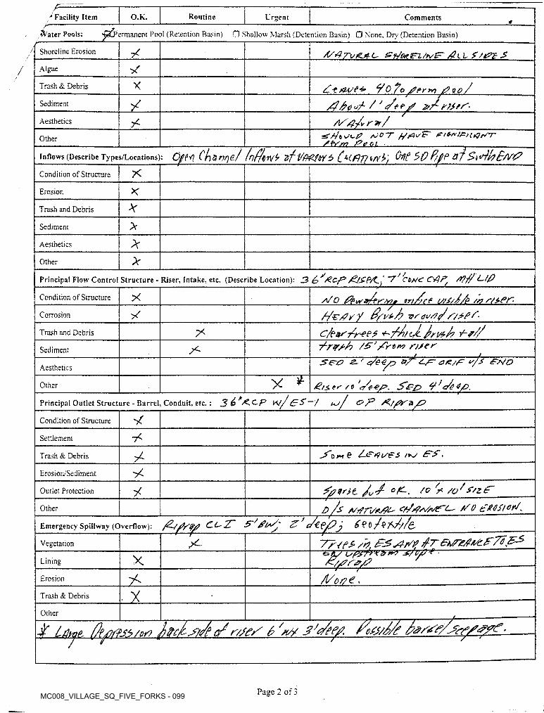
MC008_VILLAGE_SQ_FIVE_FORKS - 099
p—Routine* Facility Item O.K. Urgent Comments
■permanent Pool (Retention Basin) □ Shallow Marsh (Detention Basin) □ None. Dry (Detention Basin)•&'ater Pools:
Shoreline Erosion 7 A/4Tv£h/e*sn./h/!FjgiL Ss&zSAlgae/
X y0 To iPio/
A/4-/v r*/
Trash & Debris
Sediment
Aesthetics:SV/« e/c/? /OCT ///4VF’ rtto'iFniQrST
Z-bdaz jfeju. •CjfM Chznr)?/ inf/viv9 nf Vfi£M5 $0P/f/P of $t<4bB/V&
Other
Inflows (Describe Types/Locations):
*Condition of Structure
Erosion
Trash and Debris
>Sediment
*Aesthetics
*Other
Principal Flow Control Structure - Riser, Intake, etc, (Describe Location): 3 ~7’/ CMC Ct^F/ /??$ L./P
fee ufelA. {f2J2±£HA/ O ^wir/pCondition of Structure
/^€/?y y vfdvrf/
trt
Corrosion
c/eiv'/r-eP# ±S^UJrt*A V-f///*Trash and Debris7*7?*/? /£' /'r'Drv n/eT5iro z-f c/ee/y o/ ax/T "/s ~e*7o
Sediment
Aesthetics
y* £ii> e r /■ p 't/e-ep. S'ezP 7 /<g^ e/Q.
>/ &P 7g//Ka/7
Other
Principal Outlet Structure - Barrel, Conduit, etc.: J^Xc./P \*j/ £P>~f uJ
Condition of Structure
Settlement
& fe^tpt/tFS t+J ££.Trash & Debris
Erosion/Sediment
Sflfit // °£-. 7C? ^ /Q;
d /s /vrfri/K/pt' f/ o tXGfiorf*Ci^TT is'S’py <7 ^€(^7j /$?>///(/
xOutlet Protection
Other
Emergency Spillway (Overflow):
7?<e* /h.oA/ LsPSrytZ'*? "S7V7?'*"~---------------- -ts//7r<p/7
/l/c r? €,
X-Vegetation
XLining
Erosion
XTrash & Debris
Other
■f Lfhjt ^ii/^
Page 2 of 3
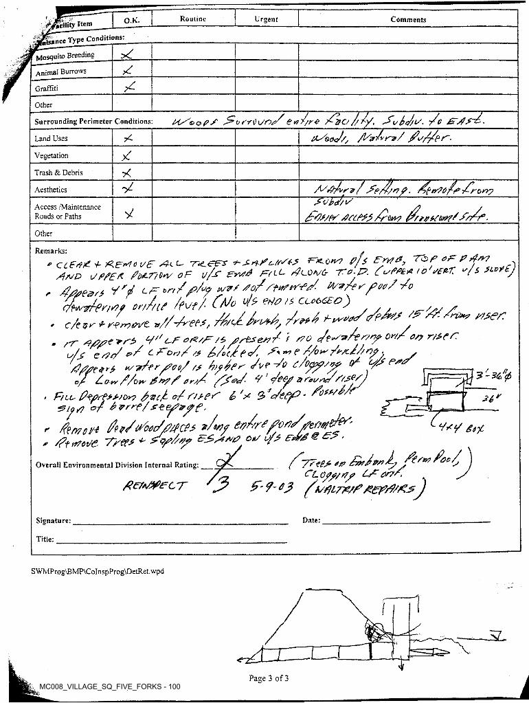
MC008_VILLAGE_SQ_FIVE_FORKS - 100
■facility Item_______
agL^eType Conditions:
Mosquito Breeding
Routine Urgent CommentsO.K.
••-’j
Animai Burrows
Graffiti
Other
//re pG/o ////, J'vSJl/. /o
O-T&sJ/, /1/zJvrv/ /o//p ~~Surrounding Perimeter Conditions: e<t
7CLand Uses n.
/Vegetation
7<Trash & Debris
A/P)/vr<>/ ^trPo/p,/rony
/y?s?pr df/P*5/row //rr/nstw?*
Aesthetics
Access /Maintenance Roads or Paths yOther
Remarks: ^^ CtfPd p Puerto t/£ dt-t <- TtZ.e&s *-d o/fds-f F~K-Qna 0/S Fry?*, Top ad p drr?
/}ASD x/PPSP Pot-77G*Z OF y/-F PYi/d p^ftt- F?C0w6- 7~0-T?. Co'PPE# to i/££77 u/£ SLD yy tpr on/ /p/y do/FtitfiFPj/. tt/v/td00/ /o
Alt W CPo A W/i CCOCEC)df*4 ^
- rr ■4/V’tf''* V'' t-F /i FstJes?/ i s70 Jt^-zAr/n? 0»/,v/j; end' */ c P'ov/& /,/(/?</. //o^/rx/Z/ny - /Pj?/?e$rp l/fry?oo/?P Zy/pn /vr -So P/Dypp/vp (/ t/S* P*op P. 0 y* //ov* ?£ d? /* 0 r7/ ^h?</ F /pSy S 0eUyte/F/S^Py
v P-eprPsP/or? /%(/ o/ F/PpP £>' F Q ^c/pPjP' /pfPP^’ **
r /emoy-e {/n/^coZ/PpcPs */*9f ev/sr*fvrt/tferwt&‘', /?f »70t/e Tree* * <y>/s»/ ^ e '
'PsrS0
00/.F 7,
» c/e Z/r P pprr/cn/tas? r/SPF
*6'p 7,
ypy **%
/^yy-eep 0# /Zt/pdA, ftrwfoo/, j/ CL o/f/Pf Lr* or?A y
tfe/tWecT Jy ^ <? 03 ^k/piltf/P/zep/PPPZ^JOverall Environmental Division Internal Rating:
Signature: Date:
Title:
SWMProg\BMP\CoInspProg\DetRet.wpd
3LI t Jr"
jPage 3 of 3

10. Misc. (ex. photos)
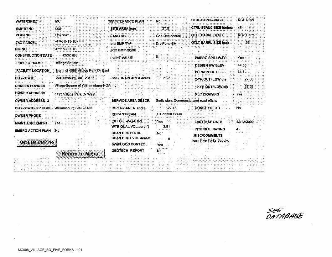
MC008_VILLAGE_SQ_FIVE_FORKS - 101
RCP RiserCTRL STRUC DESCMC NoMAINTENANCE PLANWATERSHED
CTRL STRUC SIZE inches 4827.8SITE AREA acre008BMP ID NO
OTLT BARRL DESC RCP BarrelUnknownPLAN NO Gen ResidentialLAND USE(47-01 )(15-1B) 36TAX PARCEL OTLT BARRL SIZE inchDry Pond SMold BMP TYP4711500001BPIN NO JCC BMP CODE
12/3/1993CONSTRUCTION DATE 6POINT VALUE EMERG SPILLWAY YesVillage SquarePROJECT NAME
DESIGN HW ELEV 44.56North of 4588 Village Park Dr East
Williamsburg. Va. 23185
FACILITY LOCATION 34.3PERM POOL ELE
52.2CITY-STATE SVC DRAIN AREA acres 2-YR OUTFLOW cfs 27.86
Village Square of Williamsburg HOA IncCURRENT OWNER 51.2610-YR OUTFLOW cfs
OWNER ADDRESS 4493 Village Park Dr West REC DRAWING
Sudivision, Commercial and road offsite
Yes
OWNER ADDRESS 2 SERVICE AREA DESCRI
27.48CITY-STATE-ZIP CODE Williamsburg, Va. 23185 IMPERVAREA acres CONSTR CERTI No
UT of Mill CreekRECVSTREAMOWNER PHONEEXT DET-WQ-CTRL WTR QUAL VOL acre-fl
Yes LAST INSP DATE 12/12/2000MAINT AGREEMENT Yes2.81
INTERNAL RATING 4NoEMERG ACTION PLANCHAN PROT CTRL CHAN PROT VOL acre-ft
SW/FLOOD CONTROL GEOTECH REPORT
NoMISC/COMMENTS
form Five Forks Subdiv.0No
Yes,
Menu | NoReturn to. ;|
_ _____ _• r v:..
_______ ML i:'i • a.
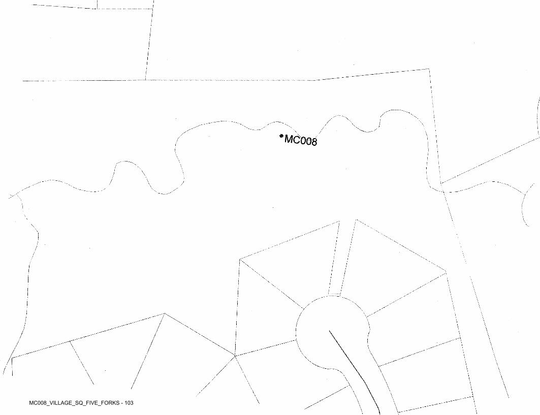
MC008_VILLAGE_SQ_FIVE_FORKS - 103
i!!
f
/i
i .i! ;\J 1\/ i
*MC0O8'f
i{
■
\ »!\ \ :.
/) \\ s\yX, Ns. X \> J\ l\ !\
\ \\V\
i/ 'I;! :
;'■
,-
/ \ \\//
\\
\!
\ \:
\\ \ \\\\
\ \\I
\\\ \\/ \ \
\

MC008_VILLAGE_SQ_FIVE_FORKS - 104
James City County Environmental Division Building Specialties Warehouse Expansion
County Plan Number SP-144-03January 15, 2004
General:
/l) A Land-Disturbing Permit and Siltation Agreement, with surety, are required for this project.
Water and sewer inspection fees, as applicable, must be paid in full prior to issuance of a Land- Disturbing Permit.
^2)
Plan Number. Please reference the assigned County plan number (SP-144-03) on all subsequent submissions.
Site Tabulation. Provide total proposed impervious cover and disturbed area estimates in the site tabulation for the project and show the limits of disturbed area.
Watershed. Provide a note on the cover sheet of the plans indicating that the project is situated in the Mill Creek watershed.
Professional seal and signature is required on final and complete approved stormwater management plans, drawings, technical reports and specifications.
^1) VPDES. It appears that the calculated area of disturbance is incorrectly noted as 0.98 acres, and that the actual area of land disturbance for the project exceeds one (1) acre. If that is the case, it is the owner’s responsibility to register for a General Virginia Pollutant Discharge Elimination System (VPDES) Permit for Discharges of Stormwater from Construction Activities, in accordance with current requirements of the Virginia Department of Environmental Quality and 9 VAC 25-180-10 et seq. Contact the Tidewater Regional Office of the DEQ at (757) 518-2000 or the Central Office at (804) 698-4000 for further information. Failure to obtain the required permit will likely result in enforcement action from the DEQ.
Chesapeake Bay Preservation:
8) Environmental Inventory. Although a tabular environmental inventory was provided on the plan set, there is no indication on the plan sheets where the components are located. The required components are listed under Section 23-10(2) of the Chesapeake Bay Preservation Ordinance.An inventory needs to list the components, state whether there are impacts or not, and quantify impacts (acres, square feet, linear feet, etc.), as applicable. The inventory should also show the limits of work for site clearing and grading, including that associated with utilities and installation of erosion and sediment controls, clearly transposed onto the sheet to properly evaluate impacts of the development plan to environmentally sensitive areas.
^9) Steep Slope Areas. Section 23-5 of the Chesapeake Bay Preservation Ordinance does not allow land-disturbing activities to be performed on slopes 25 percent or greater without an exception being granted. It appears that steep slope areas are being disturbed in locations where proposed contours are shown tying into existing ground on the eastern and western sides of the site. Therefore, a written request for an exception is required.
0?.
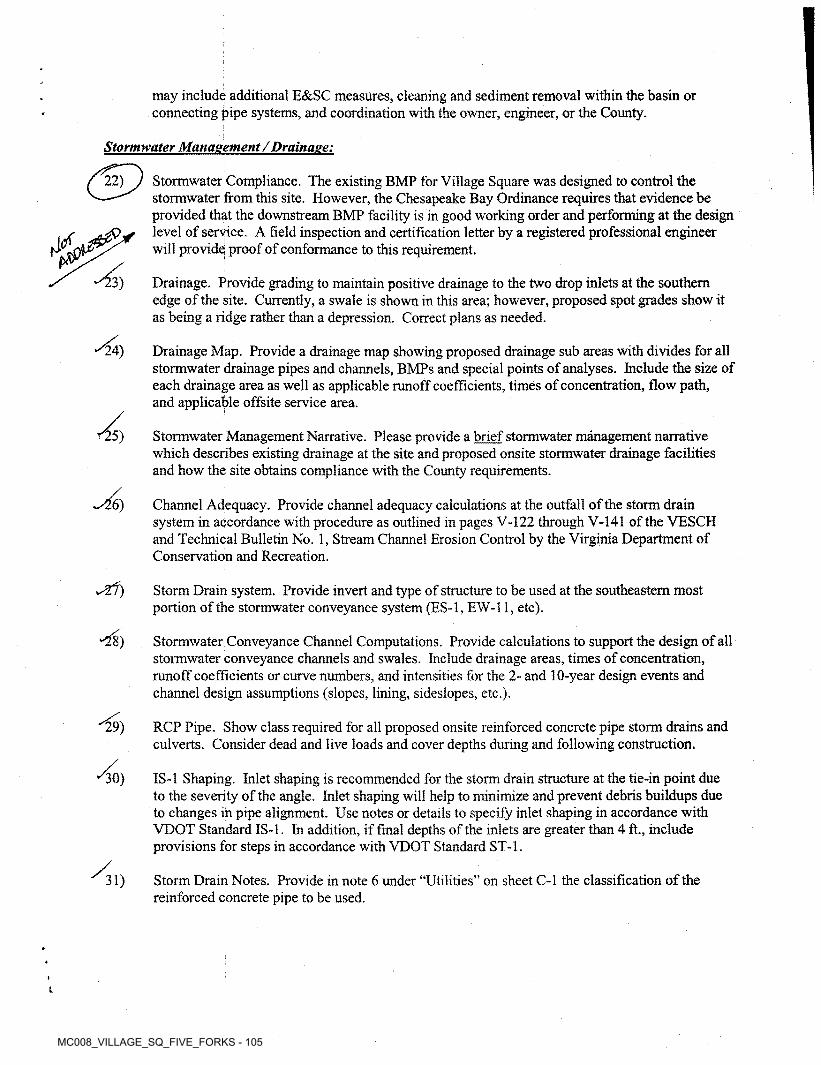
MC008_VILLAGE_SQ_FIVE_FORKS - 105
may include additional E&SC measures, cleaning and sediment removal within the basin or connecting pipe systems, and coordination with the owner, engineer, or the County.
Stormwater Management /Drainage:
22) Stormwater Compliance. The existing BMP for Village Square was designed to control the stormwater from this site. However, the Chesapeake Bay Ordinance requires that evidence be provided that the downstream BMP facility is in good working order and performing at the design level of service. A field inspection and certification letter by a registered professional engineer will provide proof of conformance to this requirement.
Drainage. Provide grading to maintain positive drainage to the two drop inlets at the southern edge of the site. Currently, a swale is shown in this area; however, proposed spot grades show it as being a ridge rather than a depression. Correct plans as needed.
£>A>^3)
Drainage Map. Provide a drainage map showing proposed drainage sub areas with divides for all stormwater drainage pipes and channels, BMPs and special points of analyses. Include the size of each drainage area as well as applicable runoff coefficients, times of concentration, flow path, and applicable offsite service area.
Stormwater Management Narrative. Please provide a brief stormwater management narrative which describes existing drainage at the site and proposed onsite stormwater drainage facilities and how the site obtains compliance with the County requirements.
24)
^5)
w^6) Channel Adequacy. Provide channel adequacy calculations at the outfall of the storm drain system in accordance with procedure as outlined in pages V-122 through V-141 of the VESCH and Technical Bulletin No. 1, Stream Channel Erosion Control by the Virginia Department of Conservation and Recreation.
Storm Drain system. Provide invert and type of structure to be used at the southeastern most portion of the stormwater conveyance system (ES-1, EW-11, etc).
-28) Stormwater Conveyance Channel Computations. Provide calculations to support the design of all stormwater conveyance channels and swales. Include drainage areas, times of concentration, runoff coefficients or curve numbers, and intensities for the 2- and 10-year design events and channel design assumptions (slopes, lining, sideslopes, etc.).
RCP Pipe. Show class required for all proposed onsite reinforced concrete pipe storm drains and culverts. Consider dead and live loads and cover depths during and following construction.
29)
18-1 Shaping. Inlet shaping is recommended for the storm drain structure at the tie-in point due to the severity of the angle. Inlet shaping will help to minimize and prevent debris buildups due to changes in pipe alignment. Use notes or details to specify inlet shaping in accordance with VDOT Standard IS-1, In addition, if final depths of the inlets are greater than 4 ft., include provisions for steps in accordance with VDOT Standard ST-1.
30)
Storm Drain Notes. Provide in note 6 under “Utilities” on sheet C-l the classification of the reinforced concrete pipe to be used.
31)
inJaniesCity
CountyVlRQINlA
Jamestown1607
Stormwater Conveyance and Stormwater Management / BMP Facilities Record Drawing and Construction Certification Forms
Standard Forms and Instructions
Contents Page
Record Drawing and Construction Certification Forms
Section 1 - Site InformationSection 2 - Construction InformationSection 3 - Owner/Designer/Contractor InformationSection 4 - Professional CertificationsSection 4 - Standard Certification FormSection 5 - Certification Requirements and Instructions
122344
-6<0
%ODcr
o JUN 0 1 2021 oo'in
"^CEi M*?
Issue Date: February 1,2001 Revised: April 2019
Stormwater and Resource Protection Division P: [email protected]
101-E Mounts Bay Road, P.O. Box 8784 F: 757-259-4032
Williamsburg, VA 23187-8784 jamescitycountyva.gov Revised: April 2019
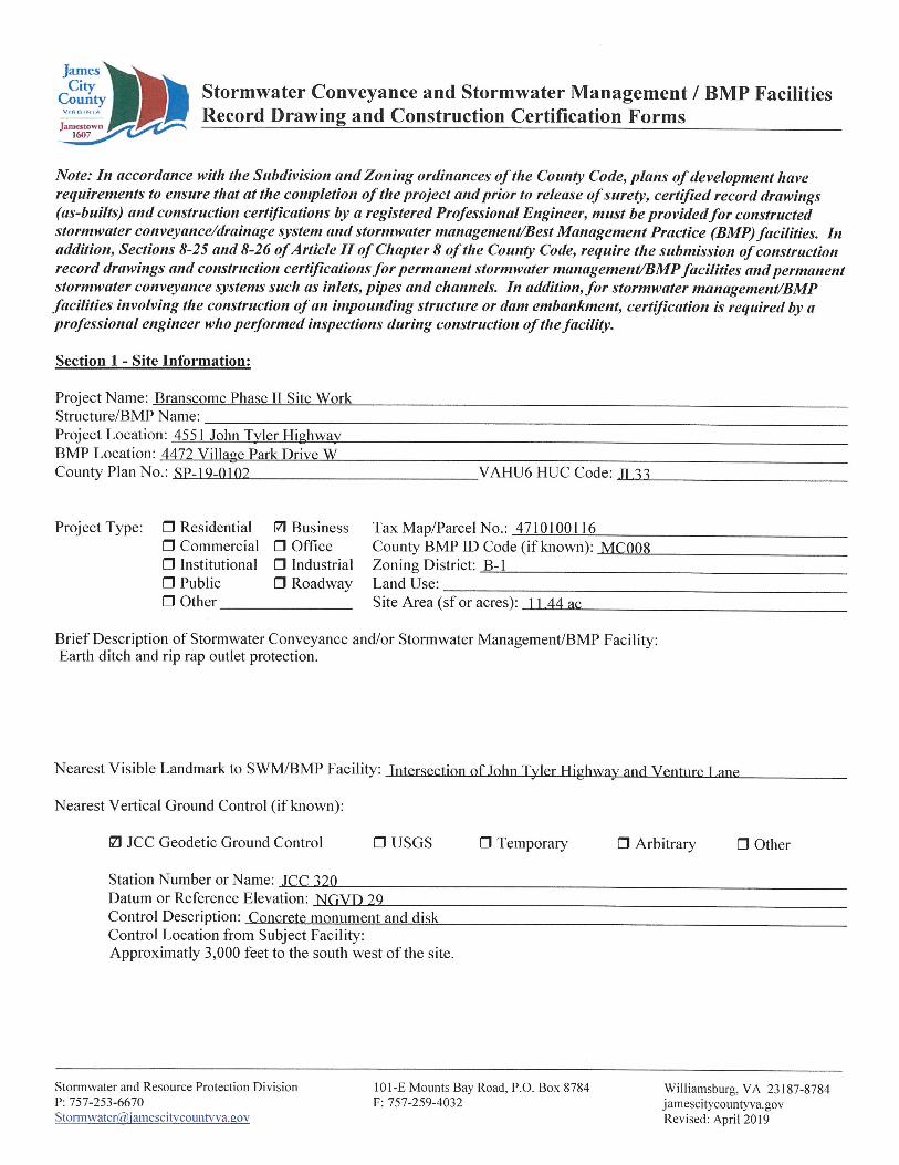
toJamesCity
County Stormwater Conveyance and Stormwater Management / BMP Facilities Record Drawing and Construction Certification FormsVirginia
Jamestown1607
Note: In accordance with the Subdivision and Zoning ordinances of the County Code, plans of development have requirements to ensure that at the completion of the project and prior to release of surety, certified record drawings (as-builts) and construction certifications by a registered Professional Engineer, must be provided for constructed stormwater conveyance/drainage system and stormwater management/Best Management Practice (BMP) facilities. In addition, Sections 8-25 and 8-26 of Article II of Chapter 8 of the County Code, require the submission of construction record drawings and construction certifications for permanent stormwater management/BMP facilities and permanent stormwater conveyance systems such as inlets, pipes and channels. In addition, for stormwater nuinagement/BMP facilities involving the construction of an impounding structure or dam embankment, certification is required by a professional engineer who performed inspections during construction of the facility.
Section 1 - Site Information:
Project Name: Branscome Phase II Site WorkStructure/BMP Name:__________________Project Location: 4551 John Tyler HighwayBMP Location: 4472 Village Park Drive W__County Plan No.: SP-19-0102_____________ VAHU6 HUC Code: 11.17
Project Type: □ Residential 7) Business□ Commercial □ Office□ Institutional □ Industrial□ Public□ Other
Tax Map/Parcel No.: 4710100116_______County BMP ID Code (if known): MC008Zoning District: B-l__________________Land Use:__________________________Site Area (sf or acres): 1 1.44 ac________
□ Roadway
Brief Description of Stormwater Conveyance and/or Stormwater Management/BMP Facility: Earth ditch and rip rap outlet protection.
Nearest Visible Landmark to SWM/BMP Facility: Intersection of John Tyler Flighwav and Venture Lane
Nearest Vertical Ground Control (if known):
n usgs □ Temporary □ Arbitrary0 JCC Geodetic Ground Control □ Other
Station Number or Name: .ICC 120______________Datum or Reference Elevation: NGVD 29_________Control Description: Concrete monument and disk Control Location from Subject Facility:Approximatly 3,000 feet to the south west of the site.
Stormwater and Resource Protection Division P: [email protected]
101-E Mounts Bay Road, P.O. Box 8784 F: 757-259-4032
Williamsburg, VA 23187-8784 j amesc ity countyva. gov Revised: April 2019
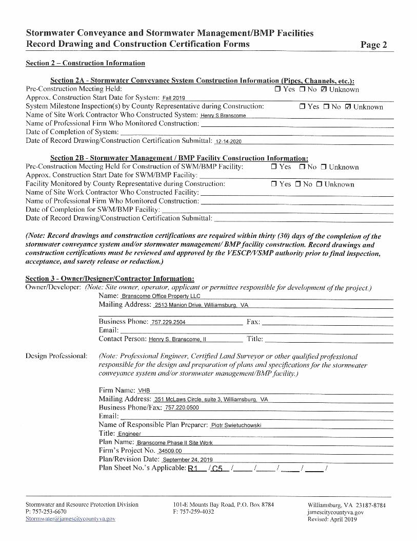
Stormwater Conveyance and Stormwater Management/BMP Facilities Record Drawing and Construction Certification Forms Page 2
Section 2 - Construction Information
Section 2A - Stormwater Conveyance System Construction Information (Pipes, Channels, etc.):□ Yes □ No □ UnknownPre-Construction Meeting Held:
Approx. Construction Start Date for System: Fall 2019____________________System Milestone Inspection(s) by County Representative during Construction:Name of Site Work Contractor Who Constructed System: Henry s Branscome_Name of Professional Firm Who Monitored Construction:_________________
□ Yes □ No □ Unknown
Date of Completion of System:________________________________Date of Record Drawing/Construction Certification Submittal: 12-14-2020
Section 2B - Stormwater Management / BMP Facility Construction Information:Pre-Construction Meeting Held for Construction of SWM/BMP Facility:Approx. Construction Start Date for SWM/BMP Facility:____________Facility Monitored by County Representative during Construction:Name of Site Work Contractor Who Constructed Facility:____________Name of Professional Firm Who Monitored Construction:___________Date of Completion for SWM/BMP Facility:______________________Date of Record Drawing/Construction Certification Submittal:________
□ Yes □ No □ Unknown
□ Yes □ No □ Unknown
(Note: Record drawings and construction certifications are required within thirty (30) days of the completion of the stormwater conveyance system and/or stormwater management/ BMP facility construction. Record drawings and construction certifications must he reviewed and approved by the VESCP/VSMP authority prior to final inspection, acceptance, and surety release or reduction.)
Section 3 - Owner/Designer/Contractor Information:Owner/Developer: (Note: Site owner, operator, applicant or permittee responsible for development of the project.)
Name: Branscome Office Property LLC_________________________________________________Mailing Address: 2513 Manion Drive. Williamsburg. VA____________________________________
Business Phone: 757.229.2504____Email:_______________________Contact Person: Henry S. Branscome. II
Fax:
Title:
(Note: Professional Engineer, Certified Land Surveyor or other qualified professional responsible for the design and preparation ofplans and specifications for the stormwater conveyance system and/or stormwater management/BMP facility.)
Design Professional:
Firm Name: VHB______________________________Mailing Address: 351 McLaws Circle, suite 3, Williamsburg. VABusiness Phone/Fax: 757.220.0500_________________Email:_______________________________________Name of Responsible Plan Preparer: Piotr SwietuchowskiTitle: Engineer____________________________Plan Name: Branscome Phase II Site Work_____Firm’s Project No. 34509.00_____________Plan/Revision Date: September 24, 2019______Plan Sheet No.’s Applicable: R1 / C.F> / / / /
101-E Mounts Bay Road, P.O. Box 8784 F: 757-259-4032 ’
Stormwater and Resource Protection Division P: [email protected]
Williamsburg, VA 23187-8784 j amescitycounty va. gov Revised: April 2019
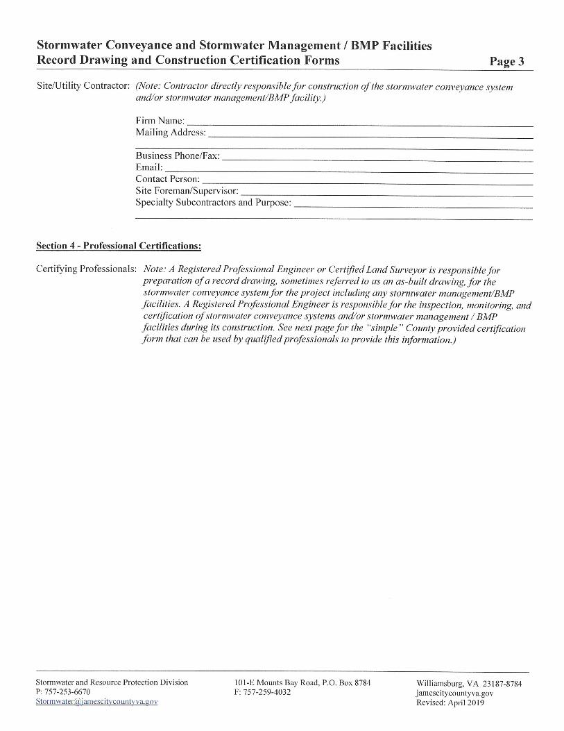
Stormwater Conveyance and Stormwater Management / BMP Facilities Record Drawing and Construction Certification Forms Page 3
Site/Utility Contractor: (Note: Contractor directly responsible for construction of the stormwater conveyance system and/or stormwater management/BMP facility.)
Firm Name:____Mailing Address:
Business Phone/Fax:______________Email:_________________________Contact Person:__________________Site Foreman/Supervisor:__________Specialty Subcontractors and Purpose:
Section 4 - Professional Certifications:
Certifying Professionals: Note: A Registered Professional Engineer or Certified Land Surveyor is responsible forpreparation of a record drawing, sometimes referred to as an as-built drawing, for the stormwater conveyance system for the project including any stormwater management/BMP facilities. A Registered Professional Engineer is responsible for the inspection, monitoring, and certification of stormwater conveyance systems and/or stormwater management/BMP facilities during its construction. See next page for the “simple ” County provided certification form that can be used by qualified professionals to provide this information.)
Stormwater and Resource Protection Division P: [email protected]
101-E Mounts Bay Road, P.0. Box 8784 F: 757-259-4032
Williamsburg, VA 23187-8784 jamescitycountyva.gov Revised: April 2019
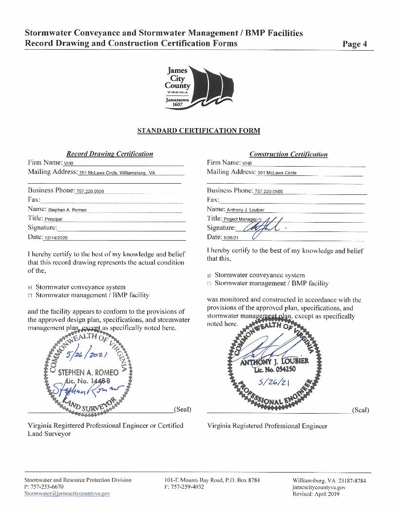
Stormwater Conveyance and Stormwater Management / BMP Facilities Record Drawing and Construction Certification Forms Page 4
RkJamesCity
CountyVirginia
Jamestown1607
STANDARD CERTIFICATION FORM
Record Drawing Certification Construction CertificationFirm Name: vhb___________Mailing Address: 351 McLaws Circle
Firm Name: vhbMailing Address: 351 McLaws Circle, Williamsburg, VA
Business Phone: 757.220 0500Fax:_________________Name: Anthony J. Loubier_____
Business Phone: 757.220.0500 Fax:_________________Name: Stephen A. Romeo_____
Title: Principal_______________
Signature:_____________Date: 12/14/2020____________
Title: ProiectManage.ro d / / Signature:Date: 5/26/21 (/
I hereby certify to the best of my knowledge and belief that this,I hereby certify to the best of my knowledge and belief
that this record drawing represents the actual condition of the, 0 Stormwater conveyance system
□ Stormwater management / BMP facility0 Stormwater conveyance system □ Stormwater management / BMP facility was monitored and constructed in accordance with the
provisions of the approved plan, specifications, and2, except as specifically
and the facility appears to conform to the provisions of the approved design plan, specifications, and stormwater management plai
stormwater manage, noted here. *gj*ALTHo*
.cr ^ /ttas specifically noted here.
ggjWT Ho7£
J'/u./zolto
£ %0 *c>% IB1ERJ-
u STEPHEN A. ROMEO ^ tk. No. 054250S/ZG/z I *ic. No
suw&S? (Seal) (Seal)
Virginia Registered Professional Engineer or Certified Land Surveyor
Virginia Registered Professional Engineer
101-E Mounts Bay Road, P.O. Box 8784 F: 757-259-4032
Stormwater and Resource Protection Division P: 757-253-6670Stormwater@iamescitvcountv va.gov
Williamsburg, VA 23187-8784 jamescitycountyva.gov Revised: April 2019

Stormwater Conveyance and Stormwater Management / BMP Facilities Record Drawing and Construction Certification Forms Page 5
Section 5 - Record Drawing and Construction Certification Requirements and Instructions:
Pre-Construction Meeting - Provides an opportunity to review SWM/BMP facility construction, maintenance and operation plans and addresses any questions regarding construction and/or monitoring of the structure. The design engineer, certifying professionals (if different), Owner/Applicant, Contractor and County representative(s) are encouraged to attend the preconstruction meeting. Advanced notice to the Engineering and Resource Protection Division is requested. Usually, this requirement can be met simultaneously with Erosion and Sediment Control preconstruction meetings held for the project.
□
□ The Record Drawing shall be prepared by a Registered Professional Engineer or Certified Land Surveyor for the drainage system of the project including any Best Management Practices.
□ Construction Certification - Construction of stormwater management / BMP facilities which contain impoundments, embankments and related engineered appurtenances including subgrade preparation, compacted soils, structural fills, liners, geotextiles, filters, seepage controls, cutoffs, toe drains, hydraulic flow control structures, etc. shall be visually observed and monitored by a Registered Professional Engineer or his/her authorized representative. The Engineer must certify that the structure, embankment and associated appurtenances were built in accordance with the approved design plan, specifications and stormwater management plan and standard accepted construction practice and shall submit a written certification and/or drawings to the VESCP/VSMP authority as required. Soil and compaction test reports, concrete test reports, inspection reports, logs and other required construction material or installation documentation may be required by the VESCP/VSMP authority to substantiate the certification, if specifically requested. The Engineer shall have the authority and responsibility to make minor changes to the approved plan, in coordination with the assigned County inspector, in order to compensate for unsafe or unusual conditions encountered during construction such as those related to bedrock, soils, groundwater, topography, etc. as long as changes do not adversely affect the integrity of the structure(s). Major changes to the approved design plan or structure must be reviewed and approved by the original design professional and the VESCP/VSMP authority.
□ Record Drawing and Construction Certifications are required within thirty (30) days of the completion of Stormwater Management / BMP facility construction. Submittals must be reviewed and accepted by James City County Engineering and Resource Protection Division prior to final inspection, acceptance and bond/surety release.
Dual Purpose Facilities (Temporary Sediment Basin & BMP) - Completion of construction also includes an interim stage for stormwater management / BMP facilities which serve dual purpose as temporary sediment basins during construction and as permanent stormwater management / BMP facilities following construction, once development and stabilization are substantially complete. For these dual purpose facilities, construction certification is required once the temporary sediment basin phase of construction is complete. Final record drawing and construction certification of additional permanent components is required once permanent facility construction is complete.
101 -E Mounts Bay Road, P.O. Box 8784 F: 757-259-4032
Stormwater and Resource Protection Division P: [email protected]
Williamsburg, VA 23187-8784 jamescitycountyva.gov Revised: April 2019
Stormwater Conveyance and Stormwater Management / BMP Facilities Record Drawing and Construction Certification Forms Page 6
Interim Construction Certification is required for those dual purpose embankment-type facilities that are generally ten (10) feet or greater in dam height (*) and may not be converted, modified or begin function as a permanent SWM / BMP structure for a period generally ranging from six (6) to eighteen (18) months or more from issuance of a Land Disturbance permit for construction.
Interim or final record drawing and construction certifications are not required for temporary sediment basins which are designed and constructed in accordance with current minimum standards and specifications for temporary sediment basins per the Virginia Erosion and Sediment Control Handbook (VESCH); have a temporary service life of less than eighteen (18) months; and will be removed completely once associated disturbed areas are stabilized, unless a distinct hazard to the public’s health, safety and welfare is determined by the Engineering and Resource Protection Division due to the size or presence of the structure or due to evidence of improper construction.
(*Note: Dam Height as referenced above is generally defined as the vertical distance from the natural bed of the stream or waterway at the downstream toe of the embankment to the top of the embankment structure in accordance with 4VAC50-20-30, Virginia Impoundment Structure Regulations and the Virginia Dam Safety Program.)
In accordance with Sections 8-25 and 8-27 of the Chapter 8 of the County Code, an internal closed- circuit television (CCTV) post installation inspection, performed by the operator, is required as part of the as-built and construction certification process. CCTV inspections shall follow standards and specifications developed by the VSMP authority administrator.
□
Record Drawings shall provide, at a minimum, all information as shown within these requirements, in accordance with standard industry practice, and in accordance with applicable RECORD DRAWING CHECKLISTS specific to the type of SWM/BMP facility being constructed. Other additional record data may be formally requested by the V ESC P/VS MP authority. (Note: Refer to the Virginia BMP Clearinghouse website and the current edition of the Virginia Stormwater Management Handbook for representative record drawing and construction certification checklists for the specific type of stormwater management/BMP facility being used. If none are available, the VSMP authority can provide this information if specifically requested.)
□
□ Record Drawings shall consist of blue/black line prints and a reproducible (mylar, sepia, diazo, etc.) set of the approved stormwater management plan including applicable plan views, profiles, sections, details, maintenance plans, etc. as related to the subject SWM / BMP facility. The set shall indicate “RECORD DRAWING ” in large text in the lower right hand corner of each sheet with record elevations, dimensions and data drawn in a clearly annotated format and/or boxed beside design values. Approved design plan values, dimensions and data shall not be removed or erased. Drawing sheet revision blocks shall be modified as required to indicate record drawing status. Elevations to the nearest 0.1' are sufficiently accurate except where higher accuracy is needed to show positive drainage. Certification statements as shown in Section 4 of the Record Drawing and Construction Certification Form, or similar forms thereof and professional signatures and seals, with dates matching that of the record drawing status in the revision or title block, are also required on all associated record drawing plans, prints or reproducibles.
Stormwater and Resource Protection Division P: 757-253-6670Stormwater@,iamescitvcountvva.gov
101 -E Mounts Bay Road, P.O. Box 8784 F: 757-259-4032
Williamsburg, VA 23187-8784 jamescitycountyva.gov Revised: April 2019
Stormwater Conveyance and Stormwater Management / BMP Facility Record Drawing and Construction Certification Forms Page 7
□ Submission Requirements - Initial and subsequent submissions for review shall consist of a minimum of one (1) blue/black line set for record drawings and one copy of the construction certification documents with appropriate transmittal. Under certain circumstances, it is understood that the record drawing and construction certification submissions may be performed by different professional firms. Therefore, record drawing submission may be in advance of construction certification or vice versa.Upon approval and prior to release of bond/surety, final submission shall include one (1) reproducible set of the record drawings, one (1) blue/black line set of the record drawings and one (1) copy of the construction certification. Also for current and/or future incorporation into the County’s BMP database and G1S system, it is requested that the record drawings also be submitted to the VESCP/VSMP authority on a CD-ROM in an acceptable electronic file format such as *.pdf, *.dxf, *.dwg, etc. or in a standard scanned and readable format. The electronic file requirement can be discussed and coordinated with Engineering and Resource Protection Division staff at the time of final submission.
101-E Mounts Bay Road, P.O. Box 8784 F: 757-259-4032 ’
Stormwater and Resource Protection Division P: [email protected]
Williamsburg, VA 23187-8784 jamescitycountyva.gov Revised: April 2019
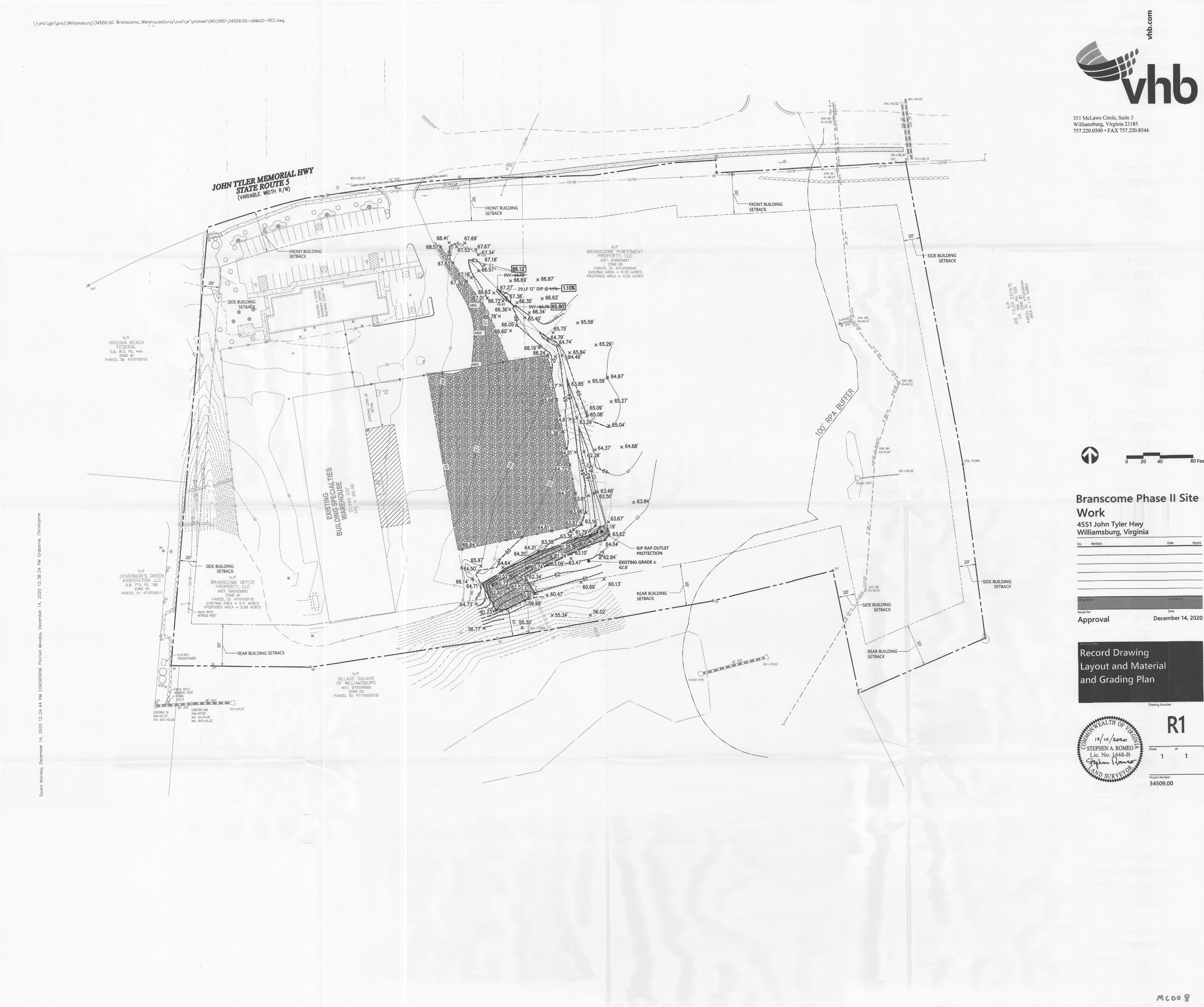
o\\vhb\gbl\proj\Williamsburg\34509.00 Branscome_WarehouseSurvy\cad\sr\planset\RECORD\34509.00 LM&GD REC.dwg0
JQ/;
A*
vhbi
I NV,=40.59’i
* rIN¥ft4G<62'\X,
ft
— i 351 McLaws Circle, Suite 3 Williamsburg, Virginia 23185 757.220.0500 • FAX 757.220.8544
SAN MH\ IR»47(B!i
\ fti
itjt
*
il-4®. -------O/ Aft 11ay
Ti I0**
rf ia CMF.
R-48.22' »I . _
«..-Iway m
OHW :Bsr fty\r^~iHV.~6a.7S' R" RCS oc*OHW»** »C' *OHW----- f ir^OHW-/wviniw* O
—TO °\\tti
i
\j ui io\ 1O FRONT BUILDING SETBACK
\c IFRONT BUILDING j SETBACK
u 1i&br\ \ \
i i
V\\^fT \.
\ \ i\\ \
QoBC>' *\/r> \\<r£> \
tft-
G \A I, \ \ \
\■.fi 20's£*<\ \ 68.41' 67.69'
X 1<°& ,67.53
< 03
Hft O) o\w\ xV ft\r \
“O, x67.er
,V7,8'
68.57' N/F7BRANSCOME INVESTMENT
PROPERTY, LLCINST. 010010887
ZONE 81PARCEL ID; 4710100048
EXISTING AREA = 6.33 ACRES PROPOSED AREA = 5.55 ACRES
FRONT BUILDING SETBACK
v I t%r ft / t-SIDE BUILDING SETBACK/
I{ !\
\Q $,y' /\
\\ \67. \-u~ 67JJ-q ■ - g m i56.57'G^,\
<T?1
G \ \
I1KV\
\ |-J GYPSS \ \ \ \ft r INVft&Pft
x 66.69'i I; ...A ( I\ \ x'X x 66.87'
- 29 LF 12" DIP @^tI%-|1.10%1
x 66.62'
iNV=&fc»[65l x 66.34' ^65.40'
t<5- u i67 \ Xc\...
rrrrr>^X^hr^rmr- !20' :U1 *' t-4
jV^.. \ PR V.'v. (/)1
\LJrra ft27'
66Ji^7^i35'66.36'x
1J. <cft\57 IG —ilsr p*(rr777777777777777y
3 x66.e: .01V
ft' i-4 b o ft / r'" tf)\t &:«II l\
\ \
ul/ r \/rf- SIDE BUILDING SETBACK 1104
r.s 41\r in \t MEG~\
II9 S*®
/\ ft: \ I
\\ fil / \ft /I \\ OJJM /’8'xy1 p U\ ^Ui7P¥r SAN MH
it R=48,23'*4.92# \ «<c! \ / \ t*x 65.59' o: .to a-tau77*1 J; 66.05X 6.60'x \*f 5ft OI
H
I 65.75'iijG 1i. \/-/ xMEGft.- -A \I : / 4.79'/*N/F G~ Ik J\ \l I \O 64.74'1 IVIRGINIA BEACH FEDERAL
0,8. 813, PG, 444 ZONE Bt
PARCEL ID: 47101001
x 65.29Vi \\ S
\ 66.19'fy t \y' \
! x 65.84' ,64.49'
\/ 66.2' \x««h #\i // \
A // ^J 70«6I) \ ft- \.,49' IEGft M-» \Z\ \/ \/ | I
\i/ \t \/ IA / \ I
\/— 69-------- l 64.974? \ \ \x 65.59's 1s. SAN MH R-49,10’
t \ -"“1 6^85'/\/ 7'X|J\
V <az// 3r ACONt. LV/ /:/\ f\ x m^ Nr
\ j,a x 65.27'\ I \/
T \ LI
G\\’\ \ \ \ \\\
ft. \65.09'4:65.08'
V11 f 0 /: / 1/
/oc/
, #
1lt /y1I i-V 1 :V:/ / 4 / 4,61'x i/i
";WFft^B5.o4Wy\ \ :i t t // //
$/
I ! / 7 F ft , i ■,/ '7/ i / zK \ \ ftA w 11/ «y / I u\\H 1/I 1T / a\a \ i \ \ Tv/ 1/1/ / ft ft ft \ xv
//GuftfH
' XX
/\
// T/
\1 \1 \i
x 64.68'64.37'T NI
«
SAN MH R-49.561/ iv U3II I I
ih i / •/ // I /
>1' »
Il\ \ 2,26'/ \ S -ill\i
A 80 Feet ii \ NAIL FOUND 0 20 40i\mvSI:/s \/ /
. ’ - v v.F. i.. ft<o .I !\ \ fi tof i
;Is I1$
\!:TI H ! INV.«3S.2ff 1Vii i \ ii in i s % i
II
i 1/ii \!
:1um \ *««j in
S #3^ uj Oco S 3 #
vsmm %, k MssKis? -ft 1 *— !J**S "3r <L CM H*"is
» I/ STAID PIPEl Lm$K y i1 ly~\ ft
!U,, 0> ft Jx 63.48' n\>62.50'
1f I Ilift \ cs>ft )ft' 10\
Branscome Phase II Site
Work4551 John Tyler Hwy
Williamsburg, Virginia
©MU LAr:
Iin! 3.81V, nb x 63.84'c »i ii / i
L\
■ \i V l »*>*v - •!* •»V\U
i\ %\W 1 II i5 .% \iii i y4 \ i \\ 161 1i! .i (A\ \V
63.16' \ \x63,67 t * X62.19'
iyii 1 \ S \1 i r’'V,>\'ltvVi** lUAM ft IF111 ■">%
<3>ii YA! iJZ i ' ICL y:.A iTL,o\
s.<M74s
yy-yy \V) !II S 3:1 I r^SrejLTai \ Isz.yyy 63,62'i .o(ft >
.ft'63-*8*mm
\ Ii /IWK»Ss!;«f5i!2aSi
\1 /<u 1 \ Appvd.1 Patec ft 64.04' Revision\ No.\\ t 1 / / 64.21' \o lRIP RAP OUTLET PROTECTION
I i\ I\ I£>
* * ) / »/P63.10' \!4w / 64.20'it :4\io 62.84'201 .\ X1 ^5r* rt* /\
f\ \ 20'EXISTING GRADE ±3.09'-63.47Q- 1/ rv\ TiSIDE BUILDING SETBACK \ 62.8\ iGV f IPfxi S /N/l / /
^2:3^-.-^^''"✓
//C'l \ / i*1 \GOVERNOR’S GREEN
ASSOCIATION LLC D.B, 773, PG. 180
ZONE 81PARCEL ID: 471010011!
yy - 60.69' /
00 I tN/F i o,"5lIto 1II 66.14' 'FT
64.71i. i /*»
BRANSCOME OFFICE \ PROPERTY, LLC
; .080025880 ZONE 01
PARCEL ID: 4710100116 EXISTING AREA * 5.11 ACRES \
PROPOSED AREA = 5.89 ACRES \
///
SIDE BUILDING SETBACK
/x ■il ' 60.13'txl \Ul Io _/ :O; 57'« 1 SAH MH R=48.05'\s/o /9#*
_x 60.47' -a<v r'
INST 20’ep; ///
ft* iCM REAR BUILDING SETBACK
'4o / >3U-rCM ■ 'ViI '■ y ft .ft /■ ft/■ y y /f /■ Tpfrl i—f Pffti59.98'-"'ft
' 55.34: r::55.30:1"^::—
(64.73"^.ft'
*• y y s'
//ftl" SIDE BUILDING SETBACK
/ ft^ /A
i /;\* ■* / 56.02" DateIssued forft timber optic
WITNESS POST■■■ ■ (mft1X Ift ft December 14, 2020ApprovalE \ft 7CD ft \.ft' ftftO ft ✓
56.77' \<0■(Cl 77\
\ft ftf-Vft
!i>t ft' i
Il
ftO ft UHS
ft.ft"'’ /"O
HI .ftc V orfto Drawing Title^ftft''^ ao _ ft "a
ft-'/Lift / I^ -T“O'"" y ft/ , ,ftft Record Drawing
Layout and Material and/jrading Plan
REAR BUILDING SETBACK
/ /X3 //REAR BUILDING SETBACK ft/ /ftCD / / ftftft"-^^aectwcTRAHSF0RMEH // /ft // « A// / ft"/o / / i
i\/ / // ftft"'/I uCL IHVP-33J2"/ // // // / /,ftIPF
/Lu /
HIiH (
/ /IRF / / //N/F / io; /ft /. / /o ftVILLAGE SQUARE OF WILLIAMSBURC
INST. 970006990 ZONE R2
PARCEL ID: 471150000"
ftftbCO STAND PIPE/
/ft ft\ft"
ftCT! ftIPED ft' ft'BO /ft'mm cftc wmm post JR.O \/
\
\ \
ftCL pULT
«3TStrcp
t;v /-x|- Drawing NumberN. |■Mi ff V
\iNV,=44.01' ft’EXiSHHD MH
RW*57.00’ iNV, 1N«44,48' INV. 007-44.27
ft*sr ftEMST1NG D) RiM*»65,75‘(NV. OUT-45421
/CMft'"' R1CM ft \
\ \ OjC#)
ftCM& ;ft
\\ ftCM
■ft O.„ft-■4^ iZ( ^
° STEPHEN A. ROMEO > Lie. No. U48-B
\\a^Aert
\\ft"
ftft" ofSheet\E
11<DO \ft
ft:
>;D
jc Project Numbero
34509.00'ft
>O
MCOO £


