Embed Size (px)
Citation preview

Surveys
Can Reliable Sage-Grouse Lek Counts Be Obtained UsingAerial Infrared Technology?Gifford L. Gillette,* Peter S. Coates, Steven Petersen, John P. Romero
G.L. GilletteDepartment of Fish and Wildlife Sciences, University of Idaho, 875 Perimeter Drive, MS 1136, Moscow,Idaho 83844-1136
P.S. CoatesUnited States Geological Survey, Western Ecological Research Center, Dixon, California 95620
S. PetersenDepartment of Plant and Wildlife Sciences, Brigham Young University, 487 WIDB, Provo, Utah 84602
J.P. RomeroOwyhee Air Research, 17000 ZX Ranch Road, Murphy, Idaho 83650
Abstract
More effective methods for counting greater sage-grouse (Centrocercus urophasianus) are needed to better assesspopulation trends through enumeration or location of new leks. We describe an aerial infrared technique for conductingsage-grouse lek counts and compare this method with conventional ground-based lek count methods. During the breedingperiod in 2010 and 2011, we surveyed leks from fixed-winged aircraft using cryogenically cooled mid-wave infrared camerasand surveyed the same leks on the same day from the ground following a standard lek count protocol. We did not detectsignificant differences in lek counts between surveying techniques. These findings suggest that using a cryogenically cooledmid-wave infrared camera from an aerial platform to conduct lek surveys is an effective alternative technique toconventional ground-based methods, but further research is needed. We discuss multiple advantages to aerial infraredsurveys, including counting in remote areas, representing greater spatial variation, and increasing the number of countedleks per season. Aerial infrared lek counts may be a valuable wildlife management tool that releases time and resources forother conservation efforts. Opportunities exist for wildlife professionals to refine and apply aerial infrared techniques towildlife monitoring programs because of the increasing reliability and affordability of this technology.
Keywords: aerial infrared; lek count; aerial survey; Centrocercus urophasianus; infrared; sage-grouse; populationmonitoring
Received: March 11, 2013; Accepted: September 16, 2013; Published Online Early: September 2013; Published:December 2013
Citation: Gillette GL, Coates PS, Petersen S, Romero JP. Journal of Fish and Wildlife Management 4(2):386-394; e1944-687X. doi: 10.3996/032013-JFWM-025
Copyright: All material appearing in the Journal of Fish and Wildlife Management is in the public domain and may bereproduced or copied without permission unless specifically noted with the copyright symbol �. Citation of thesource, as given above, is requested.
The findings and conclusions in this article are those of the author(s) and do not necessarily represent the views of theU.S. Fish and Wildlife Service.
* Corresponding author: [email protected]
Introduction
The status of greater sage-grouse (Centrocercusurophasianus; hereafter sage-grouse) as a species war-ranted for listing but precluded under the U.S. Endan-gered Species Act (ESA 1973, as amended) has increasedthe need for larger, more accurate data sets that inform
management decisions. Novel technology that increasesefficiency and decreases cost is increasingly valuable foraddressing contemporary conservation needs and con-straints (Witmer 2005; Hristov et al. 2008).
Much of sage-grouse conservation efforts are guidedby population monitoring using lek-based survey meth-ods. Leks are traditional breeding grounds where males
Journal of Fish and Wildlife Management | www.fwspubs.org December 2013 | Volume 4 | Issue 2 | 386

congregate during the spring to perform ritualizeddisplays and mate with visiting females. Sage-grousefidelity to leks and the conspicuous behavior of malesmake it possible to estimate population trends. In anattempt to compare trends among populations, recentlek monitoring protocols have been published (Connellyet al. 2003; Connelly and Schroeder 2007; Fedy et al.2012). During a lek count, attending males are directlycounted from a distance to prevent disturbance ofbreeding behavior but still maintain high visibility andcount accuracy (Patterson 1952; Jenni and Hartzler 1978;Connelly et al. 2003).
The validity of using lek counts as an index ofpopulation size is widely debated (Beck and Braun1980; Walsh et al. 2004; Johnson and Rowland 2007) asshortcomings such as a disregard of accepted techniques(Connelly et al. 2003), convenience sampling (Gartonet al. 2007), and violation of lek count assumptions(Sedinger 2007) are emphasized. Despite these criticisms,lek counts remain widely applicable, with few alterationsover the past 60 y. For example, Johnson and Rowland(2007) described a surprising similarity between currentapproaches for conducting lek counts (Connelly et al.2003) and the seminal work conducted mid-century byPatterson (1952).
Aerial surveys are a common method for monitoringwildlife populations, including using airplanes andhelicopters to conduct sage-grouse lek surveys fordetermining lek status (active or inactive), counting leks,and identifying new leks (Connelly et al. 2003; Connellyand Schroeder 2007). Infrared (IR) imagery enumerates agreater proportion of the population for some speciescompared with visual aerial surveys and other methods(Gill 1997; Havens and Sharp 1998; Edwards et al. 2004).Hence, the use of IR technology addresses some of thebasic problems in wildlife population monitoring asso-ciated with declining, exploited, and overly abundantpopulations (Caughley 1974; Blackwell et al. 2006).
Infrared technology has provided wildlife professionalsincreased efficiency while reducing the impact of observerson roosting or displaying birds during population counts(Blackwell et al. 2006). Aerial infrared (AIR) technology hasbeen applied successfully in monitoring programs for bothaquatic and terrestrial vertebrates: Pacific walrus (Odobenusrosmarus divergens; Burn et al. 2006; Udevitz et al. 2008;Speckman et al. 2011), harbor seals (Phoca vitulina vitulina;Cronin et al. 2007), sandhill crane (Grus canadensis; Kinzelet al. 2006), and white-tailed deer (Odocoileus virginianus;Naugle et al. 1996).
To the best of our knowledge no studies have beenpublished that evaluate the capability of AIR cameras fordetecting sage-grouse. Our study objective is to deter-mine if cryogenic IR technology can be used to reliablycount sage-grouse near lek sites from fixed-wing aircraft.We compare lek count data obtained using AIR withconventional ground-based count data to evaluatethe reliability of using AIR-based methods. From ourknowledge of AIR-based techniques, we hypothesizethat the resulting counts of AIR and ground methods willbe consistent.
Study Site
This study was conducted over a period of 2 y (2010–2011) at two locations. At the first location, during May2010, we conducted ground and AIR lek counts at fiveleks in White Pine County, Nevada (Figure 1), approxi-mately 30 km northwest of Ely, Nevada, both east andwest of the Egan Range (39u38927.380N, 114u56959.700E).The range of distances between leks is 14.2–26.4 km.Dominant vegetation near leks consists of Wyoming bigsagebrush (Artemisia tridentata wyomingensis), rabbit-brush (Chrysothamnus spp.), and less common highdesert vegetation including mountain sagebrush (A.tridentata vaseyana), basin big sagebrush (A. tridentatatridentata), black sagebrush (A. nova), fringed sagebrush(A. frigida), greasewood (Sarcobatus vermiculatus), andspiny hopsage (Grayia spinosa). Grasses and forbs arepresent in the shrub-steppe understory. Leks range inelevation between 1,850 and 1,930 m and receive 20–30 cm in annual precipitation. Leks and adjacent landsoccupied by sage-grouse in White Pine County arepredominantly owned and managed by the U.S. Bureauof Land Management.
At the second location, during April 2011, weconducted ground and AIR lek counts at seven leks inSublette County, Wyoming, approximately 15 km west ofBig Piney (Figure 1). The dominant vegetation consistsof Wyoming big sagebrush and basin big sagebrush(Ingelfinger and Anderson 2004). Less common specieswithin the study area include low (A. arbuscula), black,and fringed sagebrush, greasewood, shadscale saltbush(Atriplex confertifolia), and rubber rabbitbrush (Ericamerianauseosa; Lyon and Anderson 2003). A mix of grassesand forbs exists in the shrub-steppe understory. Lekelevations range between 2,100 and 2,600 m and theaverage precipitation is 27 cm annually. Sage-grouse-occupied lands occurred primarily on lands administeredby the U.S. Bureauof Land Management located withinthe Pinedale Regional Management Area. These areashave experienced significant energy development withinthe last decade.
Methods
Lek counts from the airTwo basic types of mid-wave infrared (MWIR) systems
(cooled and uncooled) have been developed fordetecting thermal landscape features. Quantum detec-tors utilize a more advanced technology that requiresinternal cooling to cryogenic temperatures for fast,sensitive thermal detection. Alternatively, thermal detec-tors consist of uncooled semiconductor material thatreacts more slowly, is less sensitive, and is typically lessexpensive than cameras with quantum detector tech-nology. Both MWIR cameras used during this study wereequipped with cooled quantum detector technology fortracking and recording targets at long distances. Mid-wave infrared cameras used in this project detect shortto medium wavelengths in the spectral range of 3.0–5.0 mm. In our experience, biologists who have experi-mented with uncooled MWIR cameras have beenunsatisfied with the technology, and they seem to be
AIR Greater Sage-Grouse Lek Counts G.L. Gillette et al.
Journal of Fish and Wildlife Management | www.fwspubs.org December 2013 | Volume 4 | Issue 2 | 387

unaware of cooled MWIR cameras with more thermallysensitive components.
To count sage-grouse near leks in Nevada we used aCessna 185 (Cessna Aircraft Company, Wichita, Kansas)airplane with a SC6700 camera (Flir Systems Inc.,Wilsonville, OR) equipped with a 100-mm (5.5u 6 4.4ufield of view ) lens. We counted four leks using AIR andfrom the ground during the morning of May 1, 2010.Samples were collected at the same four leks and anadditional lek on May 2, 2010, totaling nine samplingoccasions from the air and the ground. Before conduct-ing counts, we determined that recording leks with aside oblique camera angle while circling the lek multipletimes was an effective technique. The timing of lekcounts was in accord with accepted techniques (i.e.,conducting lek counts 0.5 h before and within 1.5 h aftersunrise; Jenni and Hartzler 1978; Emmons and Braun
1984; Connelly et al. 2003). The aircraft departed fromthe Wells, Nevada airport 1 h before sunrise. Each lek wasalso counted by ground observers during those same 2 dby experienced surveyors.
A circular pattern was flown over each lek between100 and 305 m above ground level (AGL), although ourgoal was to be at least 150 m AGL when recording IRimagery. This was done to test the ability of the sensor todetect birds. Altitude was estimated by the pilot usingthe base altitude in the field altimeter set before theflight and then climbing to 300 m for a visual reference.The pilot oriented the plane with the targeted lek using atablet personal computer displaying real-time trackingand a topographical map.
The camera operator used landmarks and groundobservers’ vehicles when available as a visual reference,panning with the camera resting on the shoulder while
Figure 1. Counties where greater sage-grouse (Centrocercus urophasianus) lek counts were conducted using mid-wave infraredcameras and ground-based methods during May 2010 and April 2011. Black hexagons represent the area within counties where lekswere located.
AIR Greater Sage-Grouse Lek Counts G.L. Gillette et al.
Journal of Fish and Wildlife Management | www.fwspubs.org December 2013 | Volume 4 | Issue 2 | 388

pointing it out the passenger window of the plane.Recording of IR imagery for each lek began within 1 kmof the lek and continued for one to three revolutionsaround the lek at a line of sight between 290 and 410 m(Figure 2). The pilot notified the camera operator of thelek position during the flight. A circular flight path wasmade over the lek area, with the number of revolutionscorresponding with the ability of the camera operator todetect sage-grouse IR signatures within the center of thefield of view. The camera operator centered the lek in thefield of view using real-time feedback from a liquid-crystal display monitor displaying IR imagery. The goalwas to keep the lek in the center of the field of view for360u (Figure 2).
A laptop computer with ExaminIR software was usedto start and stop recording. IR imagery was analyzedpostflight using four ExaminIR software tools to deter-mine counts for each lek: 1) the main image window:plays the IR imagery as a movie at the speed of interestand also allowed the observer to manually set the frameand view video in forward or reverse; 2) the imageenhancement tool: allowed operator to set the temper-ature scale limits; 3) the manual segmentation tool:allowed operator to further specify the temperature ofinterest by dragging a shaded box on a histogram; and 4)zoom. The main image window was the most importanttool for obtaining counts of leks with AIR. Some lekscould be counted by viewing a single frame, some leksby viewing from multiple angles (frames), and some leksrequired viewing IR imagery (in the form of a movie) inslow motion to obtain a count.
We counted leks with AIR in Wyoming during 2011using a RS6700 (Flir Systems) camera mounted on a LSG2gyro stabilization unit (Aerial Exposures International,Kinnelon, NJ). The RS6700 camera was equipped withboth 50 mm (11u68.8u field of view) and 250 mm (2.2u6 1.8u field of view) lens optical configuration. Lenses
were both interchangeable and had autofocus capabil-ities. The RS6700 camera has a sealed enclosure designfor operation in inclement weather. This IR system wasmounted within a Maule 7-235 (Maule Air, Moultrie,Georgia) aerial platform. The camera was oriented toview out the rear passenger door (which was removedfor this study; Figure 3).
We departed the Pinedale airport 20 min beforesunrise (0646 hours) and returned at 0930 hours aftervisiting 25 leks on April 11, 2011. However, our analysiswas restricted to 7 of the 25 leks that were visited byground personnel on the same day. Lek coordinateswere provided by Wyoming Department of Game and
Figure 2. The red lines indicate the revolution of the plane around the lek during aerial infrared (AIR) lek counts of greater sage-grouse (Centrocercus urophasianus). The location of the lek was usually in the center of the circular flight path depending on theaccuracy of lek coordinates provided by wildlife agencies. This figure demonstrates six AIR lek counts conducted in Wyoming onApril 11, 2011.
Figure 3. Maule 7-235 aerial platform with door removed andmid-wave infrared RS6700 camera mounted to a LSG-2 gyrostabilization unit used for aerial infrared lek counts in SubletteCounty Wyoming 2011. Camera record and lens magnificationis controlled with a laptop computer that displays real-timeIR imagery.
AIR Greater Sage-Grouse Lek Counts G.L. Gillette et al.
Journal of Fish and Wildlife Management | www.fwspubs.org December 2013 | Volume 4 | Issue 2 | 389
Fish and Northwind Inc. (Idaho Falls, Idaho). Topographicmaps were used to navigate to leks. The 250-mm cameralens allowed AIR lek counts to be conducted atapproximately 240–365 m AGL at a line of sight of365–460 m.
Similar to data obtained in Nevada, a laptop computerwith ExaminIR software (Flir Systems) was used to startand stop recording and switch lens magnification of thecamera while in flight, as well as to analyze the IRimagery data postflight to determine lek counts. Thecamera was set to 6 Hz, which allowed the viewing of IRimagery in real time on the laptop computer controllingthe camera.
Lek counts from the groundLek counts by ground in Nevada were conducted on
the same day as AIR counts in Nevada using a standardlek-counting protocol (Connelly et al. 2003). In Nevada,ground-based lek counts were conducted by U.S.Geological Survey, Western Ecological Research Centeremployees at four leks on both survey days; oneadditional lek was only counted the second day. Twoobservers were on the ground at assigned leks 1 h beforedaylight and at sunrise using binoculars and spottingscopes to conduct a count before, during, and after theIR count was conducted. Observers on the groundarrived at their second lek of the morning approximately15–30 min after sunrise and before the AIR lek count.Observers repeated lek count procedures at their secondlek of the morning.
In Wyoming, lek counts on the ground were conduct-ed by a Wyoming Game and Fish and a U.S. Bureau ofLand Management employee (hereafter agency person-nel) on the same day as AIR counts. Ground counts byagency personnel were conducted before AIR countsusing standard lek-counting protocol (Connelly et al.2003) with the aid of binoculars and spotting scopes.
Statistical analysisWe compared ground-based count data to AIR count
data only for leks that were counted on the samemorning by both procedures. We used 16 paired lekcount surveys (ground and AIR) for this analysis (Nevada= 9, Wyoming = 7). The purpose of this analysis wasto identify a difference between current methods ofcounting sage-grouse and those conducted using IRtechnology. Therefore, we pooled data across Wyomingand Nevada on the basis of limitations in sample sizeand lack of reasoning to suspect differences betweensampling techniques among areas.
We used generalized linear modeling (specifiedbinomial distribution with logit link function) to estimatethe difference between ground and AIR count data.Specifically, technique was coded as a binary response(0 = ground; 1 = AIR) and the explanatory measure wascount (continuous variable). In the model structure, wespecified a matched (case-control) design, meaning thesurveys for each sampling occasion were paired. Becauseour sample size was limited and asymptotic methods inthese scenarios can be misleading, we used an exactestimation technique (Hirji et al. 1987), which uses
efficient algorithms to generate the required conditionaldistributions. For the exact conditional algorithm, weinvoked a hybrid technique between network and MonteCarlo (Mehta et al. 2000), which is the robust exactoption to estimate model parameters for these types ofdata. We specified 10,000 Markov chain Monte Carlosimulations in this analysis to derive estimates and 95%confidence intervals. This Markov chain Monte Carloanalysis was appropriate because it allowed for arelatively robust comparison between the two surveytechniques with limited sampling occasions. We reportedthe mean (6SE) counts for each technique and estimatedmodel parameters. We tested the null hypothesis (e.g., nodifference detected) by evaluating the 95% confidenceintervals of the coefficient (b1) for count. If 95% confidenceinterval did not overlap zero, then the null hypothesis wasrejected.
Results
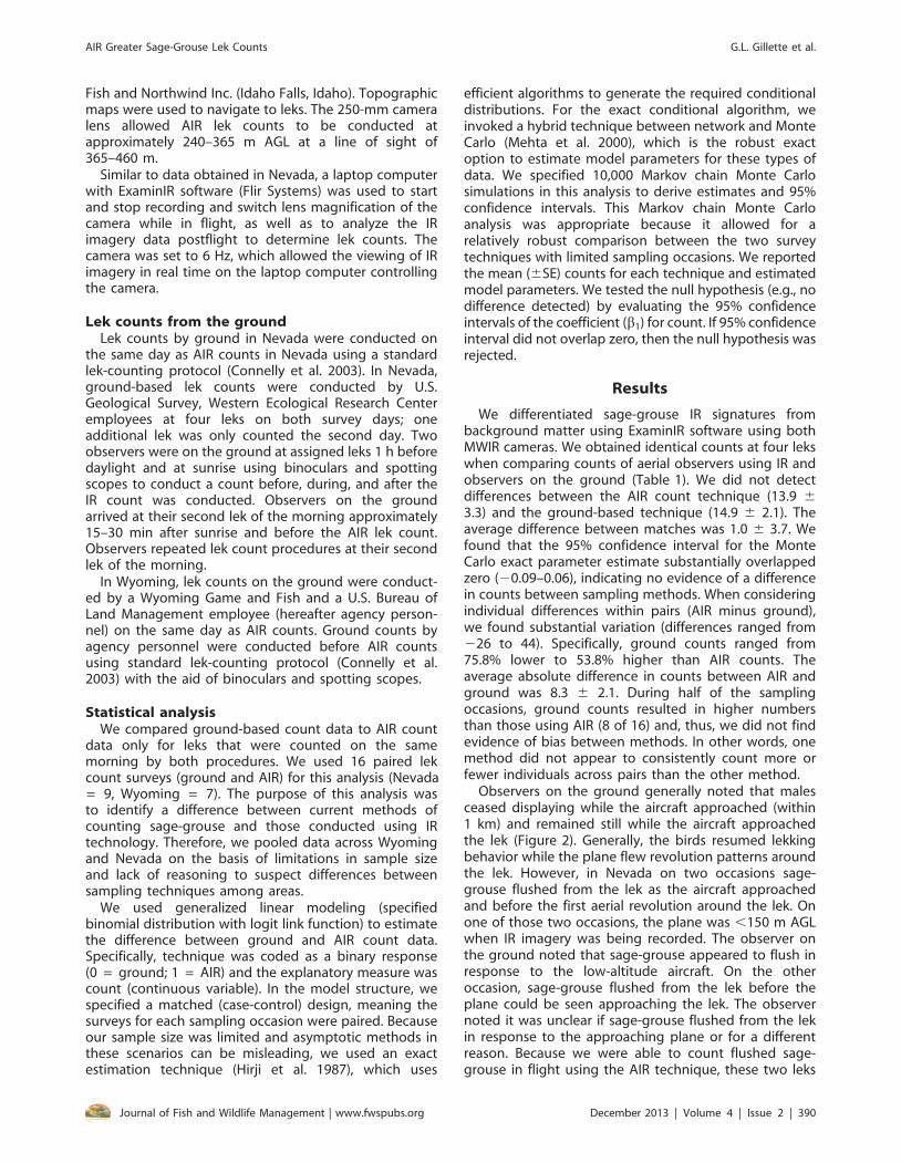
We differentiated sage-grouse IR signatures frombackground matter using ExaminIR software using bothMWIR cameras. We obtained identical counts at four lekswhen comparing counts of aerial observers using IR andobservers on the ground (Table 1). We did not detectdifferences between the AIR count technique (13.9 63.3) and the ground-based technique (14.9 6 2.1). Theaverage difference between matches was 1.0 6 3.7. Wefound that the 95% confidence interval for the MonteCarlo exact parameter estimate substantially overlappedzero (20.09–0.06), indicating no evidence of a differencein counts between sampling methods. When consideringindividual differences within pairs (AIR minus ground),we found substantial variation (differences ranged from226 to 44). Specifically, ground counts ranged from75.8% lower to 53.8% higher than AIR counts. Theaverage absolute difference in counts between AIR andground was 8.3 6 2.1. During half of the samplingoccasions, ground counts resulted in higher numbersthan those using AIR (8 of 16) and, thus, we did not findevidence of bias between methods. In other words, onemethod did not appear to consistently count more orfewer individuals across pairs than the other method.
Observers on the ground generally noted that malesceased displaying while the aircraft approached (within1 km) and remained still while the aircraft approachedthe lek (Figure 2). Generally, the birds resumed lekkingbehavior while the plane flew revolution patterns aroundthe lek. However, in Nevada on two occasions sage-grouse flushed from the lek as the aircraft approachedand before the first aerial revolution around the lek. Onone of those two occasions, the plane was ,150 m AGLwhen IR imagery was being recorded. The observer onthe ground noted that sage-grouse appeared to flush inresponse to the low-altitude aircraft. On the otheroccasion, sage-grouse flushed from the lek before theplane could be seen approaching the lek. The observernoted it was unclear if sage-grouse flushed from the lekin response to the approaching plane or for a differentreason. Because we were able to count flushed sage-grouse in flight using the AIR technique, these two leks
AIR Greater Sage-Grouse Lek Counts G.L. Gillette et al.
Journal of Fish and Wildlife Management | www.fwspubs.org December 2013 | Volume 4 | Issue 2 | 390

were retained in the analysis. On a separate occasion, acoyote (Canis latrans) was observed on the lek via IRimagery but the observer on the ground was unaware ofits presence because of obstructed view from vegetation.In Wyoming, we did not observe any evidence of sage-grouse flushing from leks in response to the aircraft.
On average, we recorded IR imagery for 2 min and 31 sat lek sites (range, 0:58–4:28). The camera operator spentan average of 15 min postflight reviewing IR imagery foreach lek to determine AIR counts (range, 3–68 min).Three of the coordinates for leks counted in Wyomingwere inaccurate; the locations of sage-grouse were 200–600 m away from the coordinates provided for the lek.On one occasion sage-grouse IR signature acquisitionappeared to be influenced by the topography since acomplete 360u turn was required to verify the presenceof sage-grouse.
Discussion
To date, ground-observer counts remain the mostpractical method for counting sage-grouse leks (Connellyand Braun 1997; Naugle and Walker 2007). As analternative to ground-observer counts, Booth et al.(2009) tested the efficacy of aerially photographingactive leks to obtain lek counts but concluded it wasnot effective. In general, aerial surveys can producemisleading results largely on the basis of the speed ofthe aircraft, time limitations, and an observer’s capabilityto locate animals, and remember and maintain concen-tration among other biases (Caughley 1974; Fleming andTracey 2008). Detection of animals using IR technologyhas become a valuable tool for image-based datacollection. Infrared technology allows for discernmentbetween IR signatures of target animals and a back-ground of vegetation or abiotic matter (Blackwell et al.2006). Infrared technology decreases bias that resultsfrom observation fatigue (Burn et al. 2006). With IR
technology, observers can review digital IR imagespostflight in more suitable conditions (i.e., lab, office).
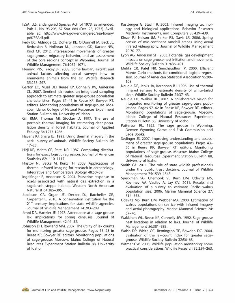
In our study, the contrast between sage-grouse IRsignatures and a background consisting of vegetationand abiotic material viewed with AIR was sufficient fordistinguishing and counting sage-grouse located on ornear leks (Figure 4). Identical counts obtained fromground and AIR methods conducted on the same daydemonstrate that a reliable sage-grouse lek count can beobtained using an IR camera from a fixed-wing airplane.We did not evaluate differences in lek counts that mayhave occurred because of females or males near the lek
Table 1. Greater sage-grouse (Centrocercus urophasianus; GSG) lek counts conducted using aerial infrared (AIR) imagery andconducted from the ground at the same leks on the same day in Nevada (NV) and Wyoming (WY).
Lek ID AIR count Ground count Date Comments
NV 1 12 12 May 1, 2010
NV 2 10 16 May 1, 2010
NV 3 19 23 May 1, 2010
NV 4 12 30 May 1, 2010 GSG flushed from the lek during the AIR count
NV 1 9 12 May 2, 2010
NV 2 16 16 May 2, 2010
NV 3 5 31 May 2, 2010 GSG flushed from lek before AIR count was conducted
NV 4 13 10 May 2, 2010
NV 5 17 18 May 2, 2010
WY 1 13 20 April 11, 2011
WY 2 19 12 April 11, 2011
WY 3 58 14 April 11, 2011 141 GSG were counted from the ground 3 d later
WY 4 5 0 April 11, 2011
WY 5 12 12 April 11, 2011
WY 6 2 12 April 11, 2011
WY 7 0 0 April 11, 2011
Figure 4. Infrared (IR) image using ExaminIR software from anaerial IR lek count conducted in Nevada. There are sevengreater sage-grouse (Centrocercus urophasianus) IR signaturesin the image. Background vegetation consists of sagebrush,bunchgrass, and abiotic material.
AIR Greater Sage-Grouse Lek Counts G.L. Gillette et al.
Journal of Fish and Wildlife Management | www.fwspubs.org December 2013 | Volume 4 | Issue 2 | 391

but missed by ground observers and may have beendetected by AIR.
Aerial IR cameras have the potential to aid in reliablecounts even when aerial observers are unfamiliar with leklocations, have imprecise lek coordinates, and lack avisual reference from ground observers or their vehicleswhen locating leks. For example, most of the leks in thisstudy had not been visited on the ground by aerialobservers and many of the leks located aerially with IRwere 100–200 m away from coordinates in wildlifeagency databases. We strongly suggest that both cameraoperators and reviewers of IR imagery be knowledgeableabout sage-grouse behavior and the types of habitatsage-grouse occupy when lekking.
If AIR counts are reliable, AIR has the potential toincrease the precision of lek counts as an index to thepopulation by decreasing convenience sampling andincreasing confidence in lek count assumptions (Sedin-ger 2007). For example, biologists will have no need tochoose a subset of leks associated with roads, trails, oreasily accessible areas (Anderson 2001) because leks inremote areas are easily counted with AIR. Counting ahigher proportion of leks in a given morning decreasesthe likelihood of violating the assumption that males donot change leks or lek complexes (Dalke et al. 1963;Sedinger 2007) and minimizes the limitation that all leksare not counted (Johnson and Rowland 2007). As AIR lek-count techniques are refined, depending on flying timebetween leks, we estimate that 20 leks could be countedduring a 1.5-h lek-counting period, which doubles themaximum counts obtained by lek routes conducted onthe ground in areas with good road access (Garton et al.2007). Furthermore, using AIR to find new leks couldalleviate some of the problems of unknown leks to obtaina more representative sample when making inferences.Similar to ground-based counts, AIR counts may not bepractical during inclement weather or for monitoringprograms with temporal and financial constraints.
We did not observe a difference in the overallcapability of MWIR cameras and conclude that both IRsystems equipped with quantum detectors are appro-priate for AIR lek counts. However, well-designed studiesthat focus on differences between camera types withlarger sample sizes than our study would be beneficial.Cameras shared similar if not identical adjustability andspeed of frame rates, time stamping, analog/digital datastreaming capability, and video outputs. We did notexperiment with advanced image processing capabilitiesof MWIR cameras like filtering, windowing, or advancedsync modes. Preparation before using the equipment isnecessary to produce consistent results with groundcounts. For example, calibrating the MWIR camera tosearch for the range of electromagnetic radiationemitted by sage-grouse is necessary.
We found several key aspects to successfully conduct-ing AIR lek counts. First, communication between thecamera operator and the pilot about the precise locationof the lek is important to obtaining sage-grouse withinthe camera field of view, which helps reduce flightrevolutions. Second, IR imagery reviewers were trained inhow to use ExaminIR software for species identification.
Software tools are important for species identification,especially for imagery recorded late in the morning whendirect sunlight increases the emissivity of vegetation androcks. If aerial observers are unsure of the species of IRsignatures observed during flight, then a low-altitude passcould help verify the species. If observers are unsure afterreviewing the imagery, then the zoom feature in ExaminIRmakes species identification more reliable. We found thatIR imagery reviewers were capable of distinguishingbetween sage-grouse and similar-sized mammals (coyote,Sylvilagus spp., and Lepus spp.) using the zoom feature inthe software. Animal behavior and morphology helped tomake this distinction. For example, a coyote that was notdetected by a ground observer was identified at a lek withAIR on the basis of distinguishing characteristics, whichincluded ears and legs that were identifiable using thesoftware. Last, although we did not find it necessary, leksites could be visited on the ground if reviewers ofimagery were unsure of IR signatures after using softwaretools or a low-altitude flight.
Using AIR surveys to monitor sage-grouse populationsis not without limitations. Sage-grouse lek counts areimportant for monitoring long-term sage-grouse popu-lation trends. Those population trends are based on thenumber of males attending leks. For AIR lek counts ofsage-grouse to be compatible with existing trend datasets, the probability of correct detection of males vs.females needs to be quantified for both AIR and groundlek counts. We did not test the ability of AIR todifferentiate between male and female sage-grouse. IfAIR methods are not capable of distinguishing betweenmale and female sage-grouse, at the very least, AIR lekcounts will need to be conducted during a time thatavoids periods of peak hen attendance. Further researchis necessary for both ground and AIR lek counts todetermine if they are compatible for monitoring long-term sage-grouse population trends.
Estimating differences in lek counts between AIR andground methods is likely a function of multiple factors,including atmospheric turbulence, wind velocity, topog-raphy, vegetation near the lek, ambient air temperature,observer and pilot experience, and sage-grouse behav-ior. Future research regarding AIR lek counts shouldfocus on at least one of the three classes of variablesinfluencing probability of detection: observers, environ-ment, and species characteristics (Anderson 2001). Forexample, despite leks being typically located in sparsevegetation (Wakkinen et al. 1992), vegetation still oftenobstructs ground counts and may obstruct sage-grouseIR signatures, especially where vegetation or abiotic materiallike rocks is irradiated early in the day. Furthermore, ambienttemperature may influence the ability to detect sage-grousethermally. The purpose of our study was not to investigatethe influence of these factors but instead describe thismethod as a viable and perhaps advantageous alternativeto conventional ground techniques.
Management implicationsUsing cryogenically cooled MWIR cameras from an
aerial platform for sage-grouse population monitoringprograms may be an effective method used by wildlife
AIR Greater Sage-Grouse Lek Counts G.L. Gillette et al.
Journal of Fish and Wildlife Management | www.fwspubs.org December 2013 | Volume 4 | Issue 2 | 392

professionals to meet the demands of public andpolitical entities. Wildlife professionals using appropriatenew technology can attain credibility with the publicand increase public trust in government regulation ofwildlife populations (Jacobson et al. 2010; Smith 2011).Perhaps more important, IR technology may increase theprecision and efficiency of sage-grouse monitoringprograms while releasing time and resources for otherconservation efforts. The application of IR technology forwildlife management has been limited by access,reliability, and cost (Kinzel et al. 2006). On the basis ofour initial assessment of the IR technology mentioned,we recommend considering AIR surveys as an alternativeto ground-based lek survey techniques in lek monitoringprograms. Perhaps the greatest advantage to includingAIR surveys is the ability to represent more spatialvariation by including more leks, especially those that arenot easily accessible by ground. We recommend using atleast a 100-mm lens for the purposes of AIR sage-grouselek counts. On the basis of our experience, a lens withless magnification will require flying #150 m AGL toobserve sage-grouse IR signatures and likely disturbsage-grouse, which is consistent with a previous studythat described no disturbance to leks at .150 m AGLwhen using digital photography (Booth et al. 2009).
The limited availability of cryogenic IR cameras for usein airplanes and the cost of accessing the technologymay prohibit wildlife professionals from using thetechnology. Recent innovations have reduced cost andincreased reliability (Naugle et al. 1996; Kastberger andStachl 2003; Udevitz et al. 2008); hence, IR technology ismore readily available for application by wildlifeprofessionals in wildlife monitoring programs. Aerial IRcan cost as low as $800/h but expenses will vary bycontractor, aerial platform, MWIR camera, and thetechnology interfaced with MWIR cameras (i.e., softwareinterfaces such as laser-guided global positioningsystem). Comparing the financial cost of ground vs.AIR lek counts was beyond the scope of this study;hence, we provide a rough comparison by estimatingthat 20 leks could be counted during the first 1.5 h ofvisible light using AIR at an estimated cost of $100/lek(total flight time: 2.5 h). We estimate that the averagelek route conducted on the ground during the first 1.5 hof visible light consists of four leks counted with anestimated cost of $45/lek (man hours: four; wage: $29/h;distance vehicle travels: 84 miles; mileage rate: $0.55/mile; vehicle rental rate: $20.16/d). Research thatcompares the costs and benefits of AIR lek counts withground count methods is needed.
Acknowledgments
We thank T. Draney, T. Gettelman, S. Espinosa, K.Huebner, M. Casazza, T. Lingle, and Wyoming Gameand Fish personnel for aid with field logistics, T. Maybeand G. Jones for accurate depiction of vegetation in theNevada study area, and M. Boccella for training in IRtechnology. Reviews by P. Deibert, M. Boccella, K. Reese,J. Severson, G. Wylie, and two anonymous reviewersimproved the manuscript.
Funding was provided by Owyhee Air Research andBrigham Young University.
Any use of trade, product, or firm names is fordescriptive purposes only and does not imply endorse-ment by the U.S. Government.
References
Anderson DR. 2001. The need to get the basics right inwildlife field studies. Wildlife Society Bulletin 29:1294–1297.
Beck TDI, Braun CE. 1980. The strutting ground count:variation, traditionalism, management needs. Proceed-ings of the Annual Conference of the Western Associa-tion of State Game and Fish Commissioners 60:558–566.
Blackwell BF, Seamans TW, Washburn BR. 2006. Use ofinfrared technology in wildlife surveys. Pages 467–472in Timm RM, O’Brien JM, editors. Proceedings ofthe 22nd Vertebrate Pest Conference, University ofNebraska-Lincoln, Lincoln, Nebraska.
Booth DT, Cox SE, Simonds GE, Elmore B. 2009. Efficacy oftwo variations on an aerial lek-count method forgreater sage-grouse. Western North American Natu-ralist 69:413–416.
Burn DM, Webber MA, Udevitz MS. 2006. Application ofairborne thermal imagery to surveys of Pacific walrus.Wildlife Society Bulletin 34:51–58.
Caughley G. 1974. Bias in aerial survey. Journal of WildlifeManagement 38:921–933.
Connelly JW, Braun CE. 1997. Long-term changes in sage-grouse Centrocercus urophasianus populations inwestern North America. Wildlife Biology 3:229–234.
Connelly JW, Reese KP, Schroeder MA. 2003. Monitoring ofgreater sage-grouse habitats and populations. StationBulletin 80. College of Natural Resources ExperimentStation, University of Idaho, Moscow, Idaho.
Connelly JW, Schroeder MA. 2007. Historical and currentapproaches to monitoring greater sage-grouse. Pages3–9 in Reese KP, Bowyer RT, editors. Monitoringpopulations of sage-grouse. Moscow, Idaho: Collegeof Natural Resources Experiment Station Bulletin 88,University of Idaho.
Cronin M, Duck C, Cadhla OO, Nairn R, Strong D, O’KeefeC. 2007. An assessment of population size anddistribution of harbor seals in the Republic of Irelandduring the moult season in August 2003. Journal ofZoology 273:131–139.
Dalke PD, Pyrah DB, Stanton DC, Crawford JE, SchlattererEF. 1963. Ecology, productivity, and management ofsage grouse in Idaho. Journal of Wildlife Management.27:811–841.
Edwards GP, Pople AR, Saalfield K, Caley P. 2004.Introduced mammals in Australian rangelands: futurethreats and the role of monitoring programmes inmanagement strategies. Austral Ecology 29:40–50.
Emmons SR, Braun CE. 1984. Lek attendance of malesage grouse. Journal of Wildlife Management 48:1023–1028.
AIR Greater Sage-Grouse Lek Counts G.L. Gillette et al.
Journal of Fish and Wildlife Management | www.fwspubs.org December 2013 | Volume 4 | Issue 2 | 393
[ESA] U.S. Endangered Species Act of 1973, as amended,Pub. L. No. 93-205, 87 Stat. 884 (Dec. 28, 1973). Avail-able at: http://www.fws.gov/endangered/esa-library/pdf/ESAall.pdf.
Fedy BC, Aldridge CL, Doherty KE, O’Donnell M, Beck JL,Bedrosian B, Holloran MJ, Johnson GD, Kaczor NW,Kirol CP. 2012. Interseasonal movements of greatersage-grouse, migratory behavior, and an assessmentof the core regions concept in Wyoming. Journal ofWildlife Management 76:1062–1071.
Fleming PJS, Tracey JP. 2008. Some human, aircraft andanimal factors affecting aerial surveys: how toenumerate animals from the air. Wildlife Research35:258–267.
Garton EO, Musil DD, Reese KP, Connelly JW, AndersonCL. 2007. Sentinel lek routes: an integrated samplingapproach to estimate greater sage-grouse populationcharacteristics. Pages 31–41 in Reese KP, Bowyer RT,editors. Monitoring populations of sage-grouse. Mos-cow, Idaho: College of Natural Resources ExperimentStation Bulletin 88, University of Idaho.
Gill RMA, Thomas MI, Stocker D. 1997. The use ofportable thermal imaging for estimating deer popu-lation density in forest habitats. Journal of AppliedEcology 34:1273-1286.
Havens KJ, Sharp EJ. 1998. Using thermal imagery in theaerial survey of animals. Wildlife Society Bulletin 26:17–23.
Hirji KF, Mehta CR, Patel NR. 1987. Computing distribu-tions for exact logistic regression. Journal of AmericanStatistics 82:1110–1117.
Hristov NI, Betke M, Kunz TH. 2008. Applications ofthermal infrared imaging for research in aeroecology.Integrative and Comparative Biology 48:50–59.
Ingelfinger F, Anderson S. 2004. Passerine response toroads associated with natural gas extraction in asagebrush steppe habitat. Western North AmericanNaturalist 64:385–395.
Jacobson CA, Organ JF, Decker DJ, Batcheller GR,Carpenter L. 2010. A conservation institution for the21st century: implications for state wildlife agencies.Journal of Wildlife Management 74:203–209.
Jenni DA, Hartzler JE. 1978. Attendance at a sage grouselek: implications for spring censuses. Journal ofWildlife Management 42:46–52.
Johnson DH, Rowland MM. 2007. The utility of lek countsfor monitoring greater sage-grouse. Pages 15–23 inReese KP, Bowyer RT, editors. Monitoring populationsof sage-grouse. Moscow, Idaho: College of NaturalResources Experiment Station Bulletin 88, Universityof Idaho.
Kastberger G, Stachl R. 2003. Infrared imaging technol-ogy and biological applications. Behavior ResearchMethods, Instruments, and Computers 35:429–439.
Kinzel PJ, Nelson JM, Parker RS, Davis LR. 2006. Springcensus of mid-continent sandhill cranes using aerialinfared videography. Journal of Wildlife Managament70:70–77.
Lyon AG, Anderson SH. 2003. Potential gas developmentimpacts on sage grouse nest initiation and movement.Wildlife Society Bulletin 31:486–491.
Mehta CR, Patel NR, Senchaudhuri P. 2000. EfficientMonte Carlo methods for conditional logistic regres-sion. Journal of American Statistical Association 95:99–108.
Naugle DE, Jenks JA, Kernohan BJ. 1996. Use of thermalinfrared sensing to estimate density of white-taileddeer. Wildlife Society Bulletin 24:37–43.
Naugle DE, Walker BL. 2007. A collaborative vision forintegrated monitoring of greater sage-grouse popu-lations. Pages 57–62 in Reese KP, Bowyer RT, editors.Monitoring populations of sage-grouse. Moscow,Idaho: College of Natural Resources ExperimentStation Bulletin 88, University of Idaho.
Patterson RL. 1952. The sage grouse in Wyoming.Denver: Wyoming Game and Fish Commission andSage Books.
Sedinger JS. 2007. Improving understanding and assess-ment of greater sage-grouse populations. Pages 43–56 in Reese KP, Bowyer RT, editors. Monitoringpopulations of sage-grouse. Moscow, Idaho: Collegeof Natural Resources Experiment Station Bulletin 88,University of Idaho.
Smith CA. 2011. The role of state wildlife professionalsunder the public trust doctrine. Journal of WildlifeManagement 75:1539–1543.
Speckman SG, Chernook VI, Burn DM, Udevitz MS,Kochnev AA, Vasilev A, Jay CV. 2011. Results andevaluation of a survey to estimate Pacifc walruspopulation size, 2006. Marine Mammal Science 27:514–553.
Udevitz MS, Burn DM, Webber MA. 2008. Estimation ofwalrus populations on sea ice with infrared imageryand aerial photography. Marine Mammal Science 24:57–70.
Wakkinen WL, Reese KP, Connelly JW. 1992. Sage grousenest locations in relation to leks. Journal of WildlifeManagement 56:381–383.
Walsh DP, White GC, Remington TE, Bowden DC. 2004.Evaluation of the lek-count index for greater sage-grouse. Wildlife Society Bulletin 32:56–68.
Witmer GW. 2005. Wildlife population monitoring: somepractical considerations. Wildlife Research 32:259–263.
AIR Greater Sage-Grouse Lek Counts G.L. Gillette et al.
Journal of Fish and Wildlife Management | www.fwspubs.org December 2013 | Volume 4 | Issue 2 | 394


