Embed Size (px)
Citation preview
SITE PLAN REVIEW
CAMP PEMBROKE YURT VILLAGE
306 Oldham Street Pembroke, Massachusetts
Prepared for:
Eli & Bessie Cohen Camps of Massachusetts, Inc. 888 Worcester Street, Suite 350 Wellesley, MA 02482
Prepared by:
B E A L S + T H O M A S BEALS AND THOMAS, INC. 32 Court Street Plymouth, MA 02360-3866
Submitted in Compliance with the Town of Pembroke
Zoning Bylaws and the Planning Board Rules and
Regulations Governing the Issuance of Site Plan
Approval
November 1, 2019
176211PT001

144 Turnpike Road
Boston, MA Southborough, MA 01772 Plymouth, MA
T 508.366.0560 | www.bealsandthomas.com | F 508.366.4391
November 1, 2019
Rebecca Coletta, Chairperson
Pembroke Planning Board
c/o Matthew Heins
100 Center Street
Pembroke, Massachusetts
Via: FedEx and Email to [email protected]
Reference: Site Plan Review Application
Camp Pembroke Yurt Village
306 Oldham Street
Pembroke, Massachusetts
B+T Project No. 1762.11
Dear Chairperson Coletta and Members of the Commission:
On behalf of the Applicant, Eli & Bessie Cohen Camps of Massachusetts, Inc., Beals and
Thomas, Inc. (B+T) respectfully submits this Site Plan Review Application for the development
of a common house and four (4) yurts as an addition to the existing Camp Pembroke. The
proposed development includes the installation of a ±2,600 square-foot common house, four (4)
yurts, and gathering area and firepit at 306 Oldham Street in Pembroke, Massachusetts (also
identified as 290 Oldham Street by the Pembroke Assessors). This filing is submitted in
accordance with Massachusetts General Law (MGL) Chapter 40A, Section 3, referred to as the
Dover Amendment, the Town of Pembroke Zoning Bylaws (the Bylaws) and the Planning Board
Rules and Regulations Governing Issuance of Site Plan Approval (the Regulations). A Notice of
Intent was filed with the Pembroke Conservation Commission for work within the 100-foot
buffer zone, with an associated Order of Conditions approving the project forthcoming.
Please see Section 2.5 herein for Waiver Request Information.
As required, enclosed are three (3) copies of the Site Plan Review Application submission
package, six (6) full sized plan sets, and four (4) 11x17 plan sets. The following information is
included for your review:
Section 1: Site Plan Review Application Form;
Section 2: Project Narrative;
Section 3: Abutter Information;
Section 4: Stormwater Management Information;
Section 5: Plans.
Rebecca Coletta, Chairperson
Pembroke Planning Board
November 1, 2019
Page 2
Pursuant to requirements of the Bylaw, we understand that the Planning Board will notify
abutters within 300 feet of the subject property and appropriate mailing materials (envelopes,
certified mail forms, and return receipt forms with the return address addressed to the Office of
the Planning Board) are included with this submission. Enclosed is a check payable to the Town
of Pembroke in the amount of $1,000.00 for the appropriate filing fee as required by the
Regulations and a check for $500.00 for the administrative review fee. A third check for $6,000
is enclosed as a deposit for the engineering review fee. It is our understanding that the legal ad
will be published in the Pembroke Mariner Express by the Planning Board and the related fee
will be deducted from the engineering review deposit.
Should you have any questions regarding this matter or require additional information, please
contact us at (508) 366-0560. We thank you for your consideration of this Site Plan Review
Application and look forward to meeting with the Board at the next available public hearing.
Very truly yours,
BEALS AND THOMAS, INC.
Stacy H. Minihane PWS Jeffrey R. Murphy PE
Senior Associate Civil Engineer
Enclosures
cc: Eli & Bessie Cohen Camps of Massachusetts, Inc. (1 copy via U.S. Mail)
CEB/shm/cmv/176211PT001
Site Plan Review Application
Camp Pembroke Yurt Village
Pembroke, Massachusetts
TABLE OF CONTENTS
1.0 FORMS ........................................................................................................................................................... 1-1
2.0 PROJECT NARRATIVE .............................................................................................................................. 2-1
2.1 INTRODUCTION ............................................................................................................................................ 2-1 2.2 EXISTING CONDITIONS ................................................................................................................................. 2-1 2.3 PROPOSED CONDITIONS ............................................................................................................................... 2-1 2.4 CONFORMANCE WITH APPLICABLE REQUIREMENTS .................................................................................... 2-2
2.4.1 Regulations Section V – Site Plan Requirements ............................................................................... 2-2 2.5 WAIVERS: .................................................................................................................................................... 2-9
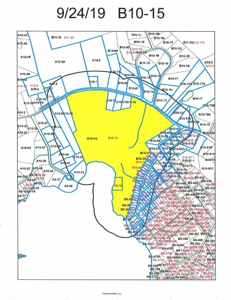
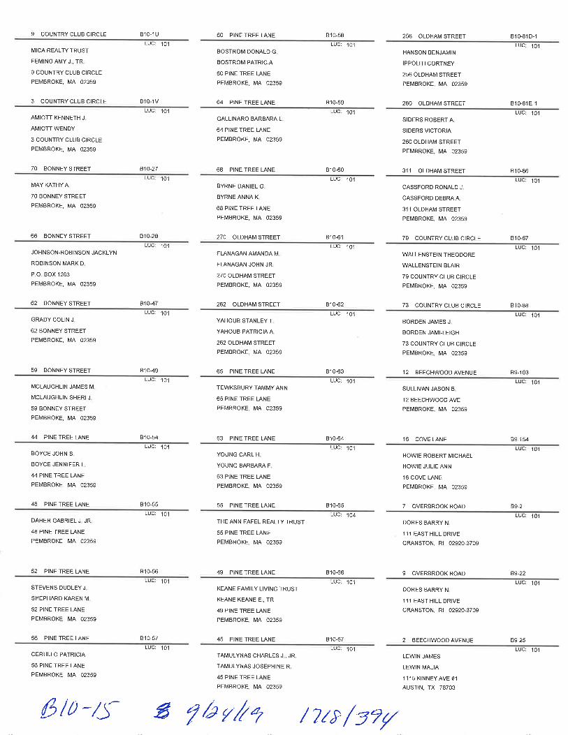
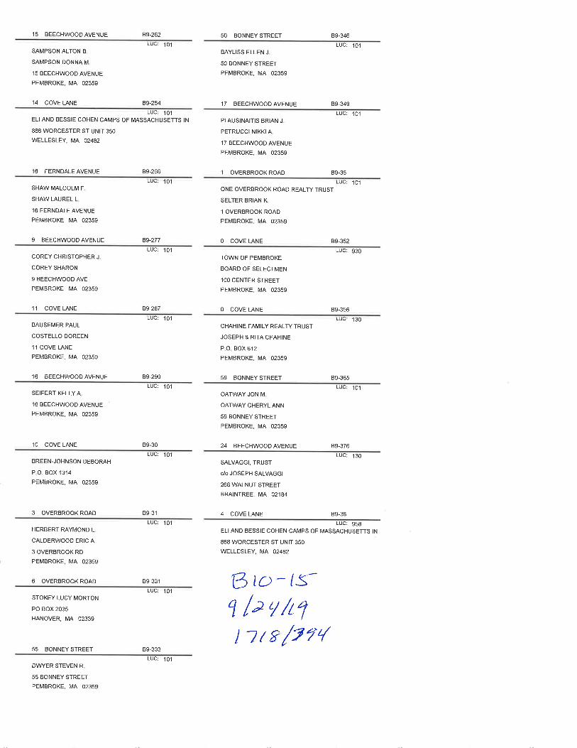
3.0 ABUTTER INFORMATION ........................................................................................................................ 3-1
4.0 STORMWATER MANAGEMENT INFORMATION .............................................................................. 4-1
5.0 PLANS ............................................................................................................................................................ 5-1
Section 1.0 Site Plan Review Application Form
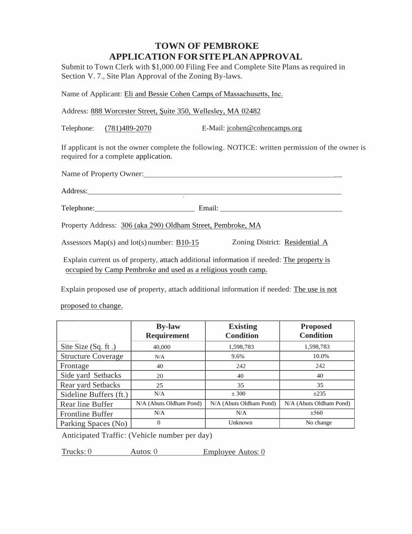
TOWN OF PEMBROKE
APPLICATION FOR SITE PLAN APPROVAL Submit to Town Clerk with $1,000.00 Filing Fee and Complete Site Plans as required in
Section V. 7., Site Plan Approval of the Zoning By-laws.
Name of Applicant: Eli and Bessie Cohen Camps of Massachusetts, Inc.
Address: 888 Worcester Street, Suite 350, Wellesley, MA 02482
Telephone: (781)489-2070 E-Mail: [email protected]
If applicant is not the owner complete the following. NOTICE: written permission of the owner is
required for a complete application.
_ Name of Property Owner:
Address:
Telephone: Email:
Property Address: 306 (aka 290) Oldham Street, Pembroke, MA
Assessors Map(s) and lot(s) number: B10-15 Zoning District: Residential A
Explain current us of property, attach additional information if needed: The property is
occupied by Camp Pembroke and used as a religious youth camp.
Explain proposed use of property, attach additional information if needed: The use is not
proposed to change.
By-law
Requirement
Existing
Condition
Proposed
Condition
Site Size (Sq. ft .) 40,000 1,598,783 1,598,783
Structure Coverage N/A 9.6% 10.0%
Frontage 40 242 242
Side yard Setbacks 20 40 40
Rear yard Setbacks 25 35 35
Sideline Buffers (ft.) N/A ± 300 ±235
Rear line Buffer N/A (Abuts Oldham Pond) N/A (Abuts Oldham Pond) N/A (Abuts Oldham Pond)
Frontline Buffer N/A N/A ±560
Parking Spaces (No) 0 Unknown No change
Anticipated Traffic: (Vehicle number per day)
Trucks: 0 Autos: 0 Employee Autos: 0
Section 2.0 Project Narrative
Site Plan Review Application
Camp Pembroke Yurt Village
Pembroke, Massachusetts
Project Narrative 2-1
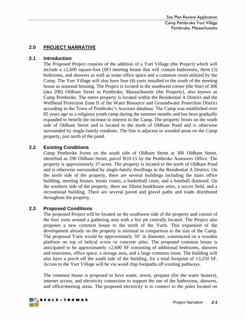
2.0 PROJECT NARRATIVE
2.1 Introduction The Proposed Project consists of the addition of a Yurt Village (the Project) which will
include a ±2,600 square-foot (SF) meeting house that will contain bathrooms, three (3)
bedrooms, and showers as well as some office space and a common room utilized by the
Camp. The Yurt Village will also have four (4) yurts installed to the south of the meeting
house as seasonal housing. The Project is located in the southwest corner (the Site) of 306
(aka 290) Oldham Street in Pembroke, Massachusetts (the Property), also known as
Camp Pembroke. The entire property is located within the Residential A District and the
Wellhead Protection Zone II of the Water Resource and Groundwater Protection District
according to the Town of Pembroke’s Assessor database. The Camp was established over
85 years ago as a religious youth camp during the summer months and has been gradually
expanded to benefit the increase in interest in the Camp. The property fronts on the south
side of Oldham Street and is located to the north of Oldham Pond and is otherwise
surrounded by single-family residents. The Site is adjacent to wooded areas on the Camp
property, just north of the pond.
2.2 Existing Conditions Camp Pembroke fronts on the south side of Oldham Street at 306 Oldham Street,
identified as 290 Oldham Street, parcel B10-15 by the Pembroke Assessors Office. The
property is approximately 37-acres. The property is located to the north of Oldham Pond
and is otherwise surrounded by single-family dwellings in the Residential A District. On
the north side of the property, there are several buildings including the main office
building, meeting houses, tennis courts, a basketball court, and a baseball diamond. On
the southern side of the property, there are fifteen bunkhouse units, a soccer field, and a
recreational building. There are several paved and gravel paths and roads distributed
throughout the property.
2.3 Proposed Conditions The proposed Project will be located on the southwest side of the property and consist of
the four yurts around a gathering area with a fire pit centrally located. The Project also
proposes a new common house to the north of the Yurts. This expansion of the
development already on the property is minimal in comparison to the size of the Camp.
The proposed Yurts would be approximately 30’ in diameter, constructed on a wooden
platform on top of helical screw or concrete piles. The proposed common house is
anticipated to be approximately ±2,600 SF consisting of additional bedrooms, showers
and restrooms, office space, a storage area, and a large common room. The building will
also have a porch off the south side of the building, for a total footprint of ±3,250 SF.
Access to the Yurt Village will be via wood chip footpaths off existing pathways.
The common house is proposed to have water, sewer, propane (for the water heaters),
internet access, and electricity connection to support the use of the bathrooms, showers,
and office/meeting areas. The proposed electricity is to connect to the poles located on
Site Plan Review Application
Camp Pembroke Yurt Village
Pembroke, Massachusetts
Project Narrative 2-2
the east side of the site and to continue aboveground to coincide with the existing state of
the Camp’s electrical connections. The Yurts will include electricity sourced from the
common house. The septic system for the proposed common house will be designed and
permitted by others. Stormwater management facilities are proposed to be implemented
on the Site to address the additional impervious surface created by the Project. Tree and
shrub trimming will also be undertaken in the vicinity of the Yurt Village, to provide
maximum safety, while leaving as much natural vegetation as possible. Some of the trees
in the area will need to be cleared or trimmed to prevent potential hazard to campers and
staff. The property has suffered much wind damage in the past few years so the Camp is
very cognizant of the potential hazards.
2.4 Conformance with Applicable Requirements The Applicant proposes this Project in accordance with MGL c.40A, s. 3: Massachusetts
Zoning Law stating that no zoning ordinance or by-law shall prohibit, regulate or restrict
the use of land or structures for religious purposes or for educational purposes on land
owned or leased by the commonwealth or any of its agencies, subdivisions or bodies
politic or by a religious sect or denomination, or by a nonprofit educational corporation;
provided, however, that such land or structures may be subject to reasonable regulations
concerning the bulk and height of structures and determining yard sizes, lot area,
setbacks, open space, parking and building coverage requirements. Additionally, the
Project has been designed to meet the requirements of the Pembroke Bylaw and
Regulations as outlined below.
2.4.1 Regulations Section V – Site Plan Requirements 5.1.1 Every effort shall be made to retain and protect existing (6" trunk diameter
or greater measured 4 feet above grade) trees, shrubs and other landscape
features on a site.
The Project has been sited to avoid tree clearing to the extent practicable,
considering existing constraints including buildings, an abandoned soil absorption
system to the east, and a soccer field to the north. That said, tree clearing has been
minimized by siting the Project partially within the southern portion of the
existing soccer field. Additionally, the limit of clearing has been maintained
immediately adjacent to the yurts and common house in order to further minimize
clearing. Brush and stumps will be disposed of in accordance with applicable
requirements.
5.1.2 Regarding foundation landscaping, refer to the Waiver request in Section
2.5.
5.1.3 A undisturbed natural buffer area shall be maintained from any wetland
resource area defined under the Massachusetts Wetland Protection Act and
recognized by the Pembroke Conservation Commission. Stairways, decks, fences
Site Plan Review Application
Camp Pembroke Yurt Village
Pembroke, Massachusetts
Project Narrative 2-3
and water dependent structures (and the grading for such) internal to parking lots
and around buildings are not exempted from the minimum setback requirements.
At a minimum, a 20-foot setback will be maintained between the Bordering
Vegetated Wetland (BVW) and the yurts, and a 60-foot setback has been
maintained from the common house. At the October 7, 2019 hearing, the
Pembroke Conservation Commission voted to approve the Project.
5.1.4 It is the purpose of these Rules and Regulations to preserve and/or maintain
open space for new sites. Therefore, any lot or group of contiguous lots totaling
less than three (3) acres shall provide twenty-five (25) percent open space. Any
lot or group of contiguous lots totaling more than three (3) acres shall provide
thirty-five (35) percent open space.
The Property is not a new lot and consists of a total of 37-acres. The existing
conditions provide 90.4% open space. The proposed conditions will result in
90.0% open space onsite.
All open space areas on a site shall be adequately landscaped with trees, shrubs,
flowers, grass, and/or mulch, wherever feasible, open space shall be contiguous
with other open space of abutting land and must be continuously maintained by
the owner.
The majority of the existing property is not to be altered by the work described in
this application and therefore the existing landscaping will not be altered. The
project is located adjacent to other developed areas of the Camp and such
remaining open space will be contiguous with other open space onsite and of
abutting land. Native shrubs and trees are proposed within the project area. Refer
to the enclosed Plans for further landscaping information.
5.1.5 Parking lots containing ten (10) or more parking spaces shall have at least
one tree per six (or fractions of six) parking spaces ... Such trees to be located
within the paved parking area. Such trees shall be at least four (4)" trunk
diameter measured twelve (12)' to eighteen (18)' above the ground with a
minimum of sixty (60) square feet of seeded or landscaped permeable surface
area per tree. When parking areas contain twenty-five (25) or more spaces, at
least five (5) percent of the parking area shall be maintained with landscaping
(within the interior of the parking area), including trees as above, in plots of at
least ten (10) feet in width. Trees and landscaped plots shall be so designed and
located as to provide visual relief and sun and wind screening within the parking
area, and to assure safe patterns of internal circulation. Planting areas are
required along parking area perimeters to prevent off-site glare onto the public or
private way(s). Parking lot plantings shall not block motorists’ line of sight upon
Site Plan Review Application
Camp Pembroke Yurt Village
Pembroke, Massachusetts
Project Narrative 2-4
entering and exiting a site. Any landscaped area described above can be used to
meet the open space requirement of this section for new sites.
The Project does not propose any additional parking and the existing conditions of
the onsite parking are not proposed to be altered with this Application.
5.1.6 All residential properties shall be protected by a landscaped buffer strip
with a minimum width of 50 feet, with such berms, fences, sound walls, and
plantings deemed necessary by the Planning Board to protect neighboring
residences.
The limit of work is approximately 235-feet from the closest abutting property
line. This buffer is fully wooded.
5.2 Site Lighting
Access ways, parking areas, and pedestrian walkways shall have adequate
lighting for security and safety reasons. Lighting shall meet the following
standards: Standards 5.2.1 through 5.2.5
The exterior of the common house is proposed to have lights at all building
entrances for the safety of the occupants entering and exiting at night and low
path lights between the building and the yurts. The proposed lighting will be
aimed downward to prevent light pollution and designed to appear decorative in
nature.
The lighting proposed to be located at the entrances and exits of the proposed
buildings will not exceed the height of the building’s roofline and the light
fixtures along the pathways will not exceed 12 feet in height.
Proposed lighting will meet the requirements of 5.2.1 through 5.2.5.
5.3 Drainage
Refer to the enclosed Plans in Section 5.0 and the Stormwater Management
Report in Section 4.0 herein for additional drainage system and stormwater
management information. Note that the Project meets the stormwater standards to
the maximum extent practicable.
The drainage system shall be designed so that there is no net increase in the pre
v. post peak rates of storm water discharge for the 2, 10- and 100-year storm
events and rates. The applicant shall demonstrate to the satisfaction of the
Planning Board that the project is designed to have no measurable or significant
impact as to existing vegetation, topography, wetlands, and other natural or man-
made features.
Site Plan Review Application
Camp Pembroke Yurt Village
Pembroke, Massachusetts
Project Narrative 2-5
Peak rates of runoff are maintained to the maximum extent practicable in
accordance with the Stormwater Management Handbook, and the design meets
the intent of this provision given the character of the Project. Refer to the
Stormwater Management Report in Section 4.0 for additional information.
The system shall be designed to treat storm water to all applicable standards of
town state and federal agencies. The system design shall promote on-site
infiltration and minimize the discharge of pollutants to the ground and surface
water.
The proposed infiltration trenches are designed to recharge the required volume of
clean roof runoff in accordance with MassDEP stormwater standards.
Drainage systems shall have an emergency overflow for the one hundred (100)
year storm event.
The proposed infiltration trenches are sized to infiltrate the required volume of
runoff based on the proposed impervious area and the soil type onsite. Due to the
highly permeable onsite soils, as documented by the NRCS mapping of Hinckley
loamy sand (HSG A) and prior test pits done in the area, an overflow for the
trenches and chambers is not anticipated to be necessary.
Additionally, the drainage system will be designed in accordance with
Stormwater Management Volume I and II prepared by: MA Department of
Environmental Protection and MA Office of Coastal Zone Management as most
recently revised.
The proposed stormwater system has been designed to comply with the MassDEP
stormwater standards.
In special cases, the site drainage can utilize the Town's drainage system with the
approval of the Highway Department. The Planning Board requires that proper
calculations be submitted. A minimum of one foot of freeboard shall be provided
for all detention/retention structures.
The proposed project will not create discharge to the Town’s drainage system.
The freeboard requirement does not apply to the type of infiltration that is
proposed.
5.3.1 Design Criteria: The applicant shall use the best available drainage
systems. The suitability of the drainage design shall be based on the natural
features, such as soil types, slope, vegetative cover, water table etc., of the site.
Drainage plans shall be developed in consultation with the Planning Board office
and the Board's consultants with the following objectives in mind:
Site Plan Review Application
Camp Pembroke Yurt Village
Pembroke, Massachusetts
Project Narrative 2-6
5.3.1.1 Protection of surface and groundwater quality;
Additional runoff from the proposed work will only result in clean roof runoff
that is planned to be infiltrated onsite.
5.3.1.2 Public safety;
Stormwater BMPs will be built into flush with existing grades or below grade
which will provide protection of the BMPs and public safety.
5.3.1.3 Protection of existing abutting properties and septic systems;
The proposed drainage system will be self-contained on the property and
sufficiently off-set from existing septic systems.
5.3.1.4 Enhancement of and connection to natural drainage systems, including
streams, floodplains, and associated wetlands;
The infiltration from the additional runoff is designed to imitate the natural flow
of stormwater onsite and allow for natural groundwater recharge.
5.3.1.5 Attractiveness of the plan, minimizing disruption to existing features, and
successful imitation of natural systems;
The infiltration from the additional runoff is designed to imitate the natural flow
of stormwater onsite and allow for natural groundwater recharge.
5.3.1.6 Minimizing of long-term maintenance and/or reconstruction obligations.
The infiltration trenches are designed to be low maintenance for short and long-
term use. Further requirements regarding operation and maintenance of the
Stormwater BMPs are outlined in the Site Owner’s Manual in the Stormwater
Management Report in Section 4.0.
5.3.2 Performance Standards:
On site drainage systems, including detention/retention areas, shall meet the
following:
5.3.2.1 A twenty-five (25) foot buffer screen that is aesthetically pleasing of
existing vegetation shall be retained between all detention or siltation structures
and adjacent off-site uses (roadways and/or structures).
Site Plan Review Application
Camp Pembroke Yurt Village
Pembroke, Massachusetts
Project Narrative 2-7
There is a vegetated buffer of at least 235-feet between the closest adjacent
property line, and the proposed limit of work. BMPs are designed to be
implemented underground and therefore will not have an esthetic impact to the
surrounding properties.
5.3.2.2 A thirty (30) foot buffer zone of existing vegetation shall be retained
between all point source discharges of stormwater and surface waters and
wetlands;
There are no point source discharges proposed with this Project.
5.3.2.3 All piping within the drainage system shall be sized for the twenty-five
(25) year storm event.
There is no proposed drainage that will involve piping.
5.3.2.4 Detention facilities shall be designed to function as natural wetlands,
having characteristics of side slopes, gradients, vegetation and topographic
location which follow naturally occurring wetland.
There are no detention basins proposed.
5.3.2.5 Side slopes of detention/retention facilities should be no steeper than 3: 1
horizontal to vertical relationship unless steeper slopes can be shown to be
typical for conditions on the site;
There are no detention/retention basins proposed.
5.3.2.6 A maximum of 2% slope shall be permitted for the bottom of the basin;
There are no detention/retention basins proposed.
5.3.2.7 Where clearing and/or regrading is unavoidable, vegetation shall be
reestablished in conformance with the landscaping plan.
The proposed Project has been designed to avoid vegetation removal as much as
practicable. Tree and shrub plantings are proposed to maintain the environmental
character of the area.
5.3.2.8 Retention basins shall provide one-hundred and fifty (150) of the required
storage volume for the one hundred (100)-year storm event. At least one
permeability test shall be conducted within each retention basin to estimate the
infiltration rate. (one test per 10,000 square feet of overall detention/retention
basin area is required).
Site Plan Review Application
Camp Pembroke Yurt Village
Pembroke, Massachusetts
Project Narrative 2-8
There are no retention basins proposed.
5.3.2.9 Ground infiltration by means of leaching pits, leaching catch basins or
similar facilities are not allowed as a means to calculate or mitigate storm water
disposal;
There are no leaching pits or leaching catch basins (or similar) proposed. Clean
roof runoff is being directed to infiltration trenches and chambers.
5.3.2.10 No drainage outfall shall be discharged at an elevation below the high-
water line of a wetland, stream or water body;
There are no drainage outfalls proposed.
5.3.2.11 A headwall with wing walls protected by rip-rapped aprons shall be
provided at the outfall of all drainage pipes.
There are no drainage pipes/outfalls proposed.
5.3.2.12 Test holes shall be conducted by a licensed soil evaluator in each
detention/retention basin in accordance with the 310 CMR: Department of
Environmental Protection (Title V) methods. A minimum of one test per 10,000
square feet of overall detention/retention basin area is required. Monitoring wells
may be required by the Planning Board.
There are no retention/detention basins proposed. However, existing test pit
information in the vicinity of the project site was utilized to inform the design of
the infiltration trenches.
5.3.2.13 All retention/detention basins within ten (10) feet of parking lots,
driveways, or areas of public access shall be protected by a guardrail. All
retention/detention basins within forty (40) feet of public ways shall be protected
by a guardrail. The Planning Board may require additional guardrails.
There are no retention/detention basins proposed.
5.4 Parking and Loading
There are no proposed parking lots or access drives associated with the project.
Existing access to the Property comes from Oldham Street and is not proposed to
be altered.
5.5 Service Facilities
Site Plan Review Application
Camp Pembroke Yurt Village
Pembroke, Massachusetts
Project Narrative 2-9
Service facilities such as: garbage collection, recycling containers, refrigeration
units, utility areas and other facilities not specifically identified shall be screened
around their perimeters. Screening may consist of fencing and/or natural
vegetation. Screening shall have an effective height and width to screen from
public view said service facility.
There are no new service facilities proposed.
5.6 Construction
5.6.1 All access drives and parking areas shall be graded, paved, and drained in
accordance with standards enumerated above.
There are no new access drives or parking areas proposed.
5.6.2 Curbing shall be placed at the edges· of all paved surfaces. Wheelstops shall
be placed where parking spaces abut sidewalks and/or walkways for pedestrians.
Guardrails shall be placed along parking spaces and drive aisles where slopes
exceed 3:1. Curbing shall not be bituminous concrete.
There are no paved surfaces proposed, including parking spaces that abut
sidewalks or drive aisles.
5.6.3 Regarding utility connections, refer to the Waiver requests in Section 2.5.
5.6.4 Bollards shall be placed along the sides of the building exposed to vehicle
traffic.
The proposed common house and yurts will not be exposed to vehicle traffic.
Note that Section 5.7 (Access Connections) and 5.8 (Drive through Facilities) of
the Regulations are not applicable to the Project.
2.5 Waivers: The Applicant respectfully requests the following waivers:
Town of Pembroke Zoning Bylaws Site Plan Approval D.13: Relevant zoning information
is provided on Plan Sheet C1.1, on the application form in Section 1 and within the
narrative herein. Certain components are not addressed in table format or on the plans
due to the nature of the project (specifically lot perimeter ratio, lot width, building
heights, building floor area, landscaping, use of all buildings, number of people
anticipated on the site) and the Applicant respectfully requests a waiver from these
requirements.
Site Plan Review Application
Camp Pembroke Yurt Village
Pembroke, Massachusetts
Project Narrative 2-10
Planning Board Rules & Regulations Governing the Issuance of Site Plan Approval
Section 4.22: The proposed project will not result in increased traffic beyond the Camp’s
existing operations, and The Applicant therefore requests a waiver from the requirement
to prepare a traffic impact study.
Planning Board Rules and Regulations Governing the Issuance of Site Plan Approval
Section 5.1.2: A three (3) foot wide landscaping strip shall be provided along the
foundation walls to soften their appearance for all non-residential building(s). The
landscape strip may be staggered in order to vary the landscape design for a Site. The
landscaping strip shall provide screening to the portion of the foundation above grade:
The proposed common house and yurts are designed to have stone infiltration trenches
surrounding the exterior walls and therefore will not be able to provide a three-foot wide
landscaping strip along the foundation walls. The proposed structures are set well within
the boundaries of the property (minimum ±235-feet from the nearest property line to the
limit of work). Additionally, appropriate landscaping with native plants is proposed as
depicted on the Plans. The landscaping around the proposed common house and yurts
will mimic the appearance of the existing landscaping conditions of the rest of the Camp.
Therefore, the Applicant respectfully requests a waiver from the requirement stated
above.
Planning Board Rules and Regulations Governing the Issuance of Site Plan Approval
Section 5.6.3: All utility connections shall be underground and constructed in
accordance with the requirements of the town and other utility companies. Utilities are
designed to be located underground with the exception of the electricity connections. The
existing state of the site includes aboveground electric lines. Due to this, the proposed
electric extension is anticipated to be located aboveground to coincide with the existing
electric infrastructure and allow for connection to the existing poles on the east side of
the property. Therefore, the Applicant respectfully requests a waiver from the
requirement that utilities be located underground.
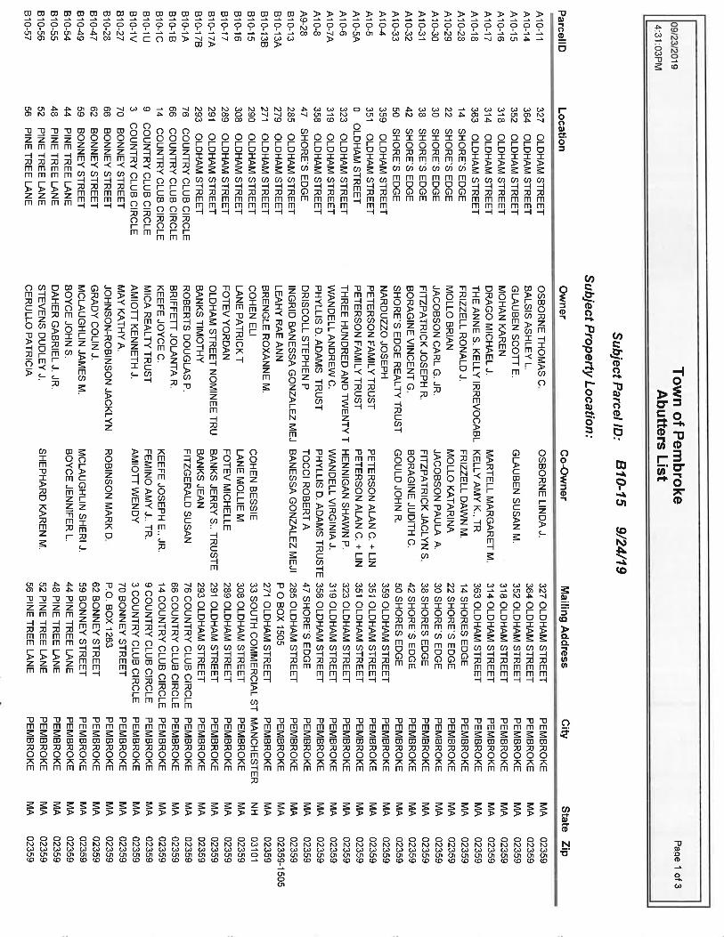
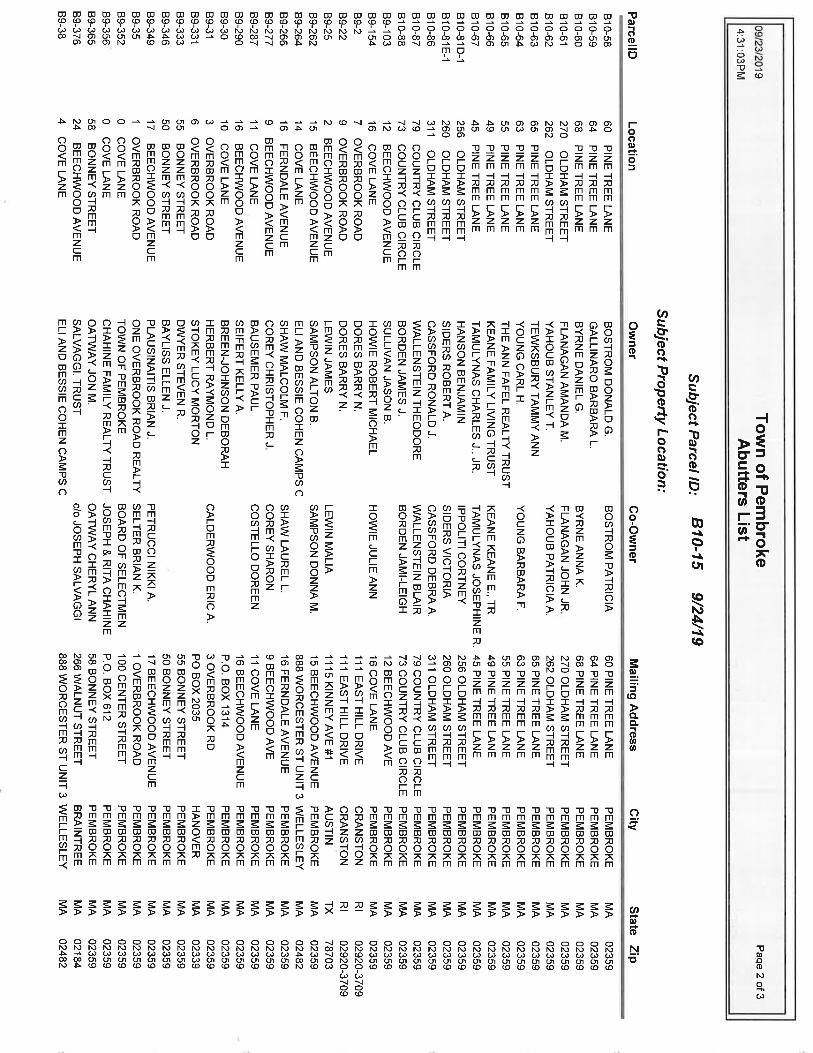
Section 3.0
Abutter Information Certified List of Abutters

Section 4.0 Stormwater Management Information Stormwater Management Report
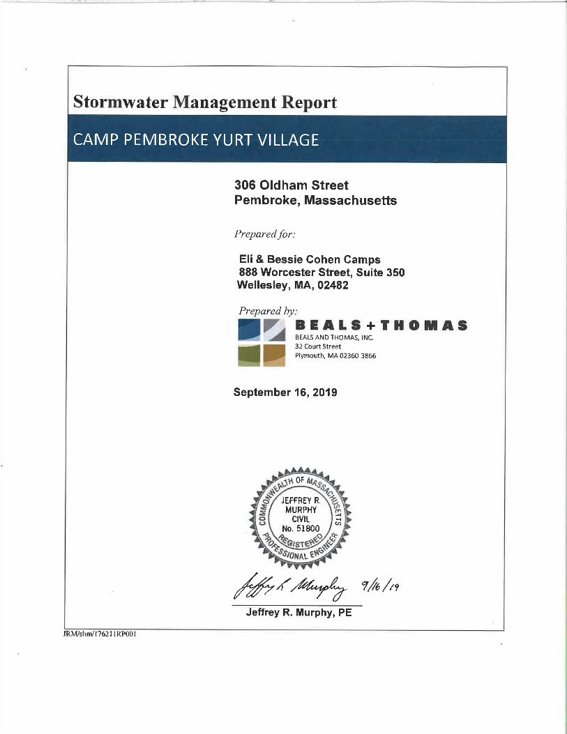
Camp Pembroke Yurt Village Stormwater Management Report
Pembroke, Massachusetts 176211RP001
Table of Contents i
TABLE OF CONTENTS 1.0 INTRODUCTION .......................................................................................................................................... 1-1
2.0 EXISTING CONDITIONS ........................................................................................................................... 2-1 2.1 SITE CONDITIONS ........................................................................................................................................ 2-1
2.1.1 Critical Areas ..................................................................................................................................... 2-1 2.1.2 Total Maximum Daily Loads (TMDL) ............................................................................................... 2-2
3.0 PROPOSED CONDITIONS ......................................................................................................................... 3-1
3.1 PROPOSED CONDITIONS ............................................................................................................................... 3-1 3.2 COMPLIANCE WITH DEP STORMWATER MANAGEMENT STANDARDS .......................................................... 3-1 3.3 ILLICIT DISCHARGE COMPLIANCE STATEMENT ............................................................................................ 3-5 3.4 DEP’S CHECKLIST FOR A STORMWATER REPORT ........................................................................................ 3-6
LIST OF ATTACHMENTS ATTACHMENT 1: SOIL DATA ATTACHMENT 2: STORMWATER RECHARGE CALCULATIONS ATTACHMENT 3: SITE OWNER’S MANUAL ATTACHMENT 4: CONSTRUCTION PERIOD SEDIMENT, EROSION & POLLUTION
PREVENTION PLAN
Camp Pembroke Yurt Village Stormwater Management Report
Pembroke, Massachusetts 176211RP001
Introduction 1-1
1.0 INTRODUCTION The proposed project includes the construction of a Yurt Village which is comprised of a ±2,615 SF common house building that will contain bathrooms with showers, staff accommodations, and office space to be utilized by the camp. The Yurt Village will also have four (4) yurts (round tents on elevated wooden platforms) which will be installed to the south of the common house as seasonal housing. The project will also include the construction of wood chip pathways, a campfire gathering area and the installation of landscaping comprised of native species. Roof runoff from the proposed common house will be infiltrated via a crushed stone perimeter trench as well as subsurface infiltrators. Similarly, the proposed yurts will have a crushed stone drip edge trench for infiltration of roof runoff. This type of project is not contemplated by the Massachusetts Department of Environmental Protection (MassDEP) Stormwater Handbook. The Handbook provides exemptions and exceptions for full project compliance with the 10 Stormwater Standards, as noted within Volume 1, Chapter 1 of the Handbook. The proposed project is comparable to, but less impactful than Items (1) and (3) under the list of projects to which the Standards apply to the maximum extent practicable. Item (1) identifies “Housing development and redevelopment projects comprised of detached single-family dwellings on four or fewer lots that have a stormwater discharge the may potentially affect a critical area” and Item (3) which identifies “Housing developments and redevelopment projects comprised of detached single family dwellings on five to nine lots, provided there is no stormwater discharge that may potentially affect a critical area.” As such, the project has been designed to the extent practicable to comply with the MassDEP 10 Stormwater Standards. The proposed common house building is no larger than a typical single family home, and the yurts are built on elevated platforms above the ground, thus lessening their overall impact in terms of stormwater. Additionally, the design of the Yurt Village pathways and gathering space is intended to minimize the change in ground cover type and therefore the runoff for the project area. The proposed recharge measures for the common house and yurts will provide infiltration volumes as required by the MassDEP Stormwater Handbook for new impervious areas. There are no other paved or impervious surfaces proposed aside from the common house and yurts. As such, water quality treatment for TSS and pollutants is not necessary. Calculations for the sizing of the perimeter and drip edge trenches, and subsurface chambers are included in Attachment 2.
Camp Pembroke Yurt Village Stormwater Management Report
Pembroke, Massachusetts 176211RP001
Existing Conditions 2-1
2.0 EXISTING CONDITIONS
2.1 Site Conditions Camp Pembroke is located on an approximately 30-acre parcel of land adjacent to Oldham Pond on Oldham Street, in Pembroke, Massachusetts. The property lies within Plymouth County and the South Shore Drainage Area. Topography on-site generally slopes to the southwest from a high elevation of 95’ along the northeast property line to elevation 60’ along the shore of Lake Oldham. Surface water flow is consistent with the topography. Existing soils in the vicinity of the Project are mapped by the Natural Resources Conservation Service (NRCS) soil survey for Plymouth County as Hinckley loamy sand with 3 to 8 percent slopes. Hinckley soils are very deep, nearly level, excessively drained soils formed in gravelly fluvial deposits. Hinckley loamy sand is identified as a Hydrologic Soil Group A soil, which is favorable for infiltration of stormwater.
Runoff from the project area drains to the south and west towards Oldham Pond and the wetlands to the west. Existing grades within the project area are gently sloping with grades generally between 2 and 5%. The project will be located in existing wooded areas as well as existing grass lawn.
2.1.1 Critical Areas
Critical Areas as defined by Standard 6 of the 2008 MassDEP Stormwater Management Handbook are areas where high levels of stormwater treatment are required; typically the first inch of runoff is treated using specific best management practices (BMPs) and pre-treatment methods. Specific source control and pollution prevention measures are also required. As noted in the introduction, the proposed project does not include any paved parking lots or impervious areas that would generate pollutants for stormwater. The site is tributary to Oldham Pond, which is a Class A public water supply tributary to Furnace Pond. As such, it is mapped with a Zone A protection zone and is considered a Critical Area per DEP Stormwater Policy. Only infiltration of clean rooftop runoff is proposed for the common house and yurts. There is no proposed pavement or parking lots that would generate pollutants that would impact the pond. Therefore, the project will not impact a critical area.
Camp Pembroke Yurt Village Stormwater Management Report
Pembroke, Massachusetts 176211RP001
Existing Conditions 2-2
2.1.2 Total Maximum Daily Loads (TMDL) A TMDL is the greatest amount of a pollutant that a waterbody can accept and still meet water quality standards for protecting public health and maintaining the designated beneficial uses of those waters for drinking, swimming, recreation, and fishing. A TMDL is implemented by specifying how much of that pollutant can come from point, nonpoint, and natural sources. Oldham Pond is part of the South Coastal Watershed. A Final Pathogen TMDL has been issued for the overall watershed. The proposed project will not negatively impact Oldham Pond in terms of pollutants. Sanitary sewer flows from the common house will be addressed by a Title 5 compliant septic system (to be designed and permitted by others).

Camp Pembroke Yurt Village Stormwater Management Report
Pembroke, Massachusetts 176211RP001
Proposed Conditions 3-1
3.0 PROPOSED CONDITIONS
3.1 Proposed Conditions The proposed common house will be located at the south end of the existing grass soccer field along the western side of the camp. The front porch of the common house will face towards the center of the yurt village, which will include a fire pit and gathering area. Pathways will connect between the common house, gathering space and yurts. Selective clearing of existing trees and brush will occur within the yurt village area. Where possible, large diameter mature trees will be saved to provide shade and maintain the natural character of the area. Proposed pathways will be surfaced with wood chips to reduce stormwater runoff and puddling within the yurt village common spaces. The common house and porch roof, stairs and ramps occupy a footprint of approximately 3,250 sf. Since this is new impervious area, a perimeter trench along with two subsurface infiltrators are proposed to infiltrate the required recharge volume per MassDEP Stormwater Policy. Perforated piping in the perimeter trench will collect and convey excess flows in the perimeter trench to the infiltrators. Floor plans and building elevations for the common house have been provided for reference in the Site Plans. The proposed yurts consist of circular tent structures that sit atop elevated wooden platforms with support posts. The individual support posts will be anchored to the ground with concrete footings. Each yurt will be designed with a crushed stone drip edge that will encircle each platform and provide the required stormwater recharge volume for the footprint of the tent platform and decks. A generic schematic detail of the yurts is provided on the Site Plans for reference. The yurts will also have electric service fed from the common house building. As previously noted, the project will not include paved driveways or parking areas that would require treatment of stormwater. Accordingly, the requirements of Standard 4 of the Stormwater Handbook pertaining to water quality will be upheld.
3.2 Compliance with DEP Stormwater Management Standards The project has been designed to the extent practicable, in accordance with the ten (10) MassDEP Stormwater Management Standards to minimize impacts in terms of stormwater and protect adjacent wetland resource areas and Oldham Pond.
Camp Pembroke Yurt Village Stormwater Management Report
Pembroke, Massachusetts 176211RP001
Proposed Conditions 3-2
STANDARD 1: No new stormwater conveyance (e.g. outfalls) may discharge
untreated stormwater directly to or cause erosion in wetlands or waters of the Commonwealth.
The proposed Project will not create any new outfalls of untreated stormwater. Clean roof runoff from the common house and yurts will be infiltrated using crushed stone perimeter trenches, drip edges, and subsurface infiltrators. STANDARD 2: Stormwater management systems shall be designed so that post-
development peak discharge rates do not exceed pre-development peak discharge rates.
The proposed design of the yurt village area is designed to minimize alteration of ground surface cover types from existing conditions, although some vegetation clearing will be needed to install the yurts. The proposed pathways and gathering area will be surfaced with wood chips to allow rainfall to infiltrate into the underlying soils and minimize runoff from the project area. Native Plants will be planted in the areas around the pathways to keep the area as natural and vegetated as possible. This will translate to a minimal change in runoff from the yurt village area. The proposed rooftop recharge measures will infiltrate a significant amount of the rooftop runoff from the proposed structures. STANDARD 3: Loss of annual recharge to groundwater shall be eliminated or
minimized through the use of environmentally sensitive site design, low impact development techniques, stormwater management practices and good operation and maintenance. At a minimum, the annual recharge from the post-development site shall approximate the annual recharge from pre-development conditions based on soil types. This Standard is met when the stormwater management system is designed to infiltrate the required recharge volume as determined in accordance with the Massachusetts Stormwater Handbook.
The rooftop runoff recharge measures for the common house and yurts will meet the recharge volumes required by the MassDEP Stormwater Handbook. Based upon test pits and percolation tests performed for a septic system nearby to the proposed project, a Rawls Rate of 8.27 in/hr was used for the drawdown calculations. Calculations are included in Attachment 2.
Camp Pembroke Yurt Village Stormwater Management Report
Pembroke, Massachusetts 176211RP001
Proposed Conditions 3-3
STANDARD 4: Stormwater management systems shall be designed to remove 80% of
the average annual post-construction load of Total Suspended Solids (TSS).
The project will not include paved driveways or parking areas that would require treatment of stormwater. Accordingly, the requirements of Standard 4 of the Stormwater Handbook pertaining to water quality will be upheld. A Site Owner’s Manual provided in Attachment 3 has been developed that complies with the Long-Term Pollution Prevention Plan (Standard 4) and the Long-Term Operation and Maintenance Plan (Standard 9) requirements of the MassDEP Stormwater Management Standards. The Manual outlines source control and pollution prevention measures and maintenance requirements of the proposed stormwater best management practices (BMPs) for the project. STANDARD 5: For land uses with higher potential pollutant loads (LUHPPLs), source
control and pollution prevention shall be implemented in accordance with the Massachusetts Stormwater Handbook to eliminate or reduce the discharge of stormwater runoff from such land uses to the maximum extent practicable.
The proposed project is not associated with stormwater discharges from land uses with higher potential pollutant loads. STANDARD 6: Stormwater discharges to critical areas must utilize certain
stormwater management BMPs approved for critical areas. Critical areas are Outstanding Resource Waters, shellfish beds, swimming beaches, coldwater fisheries and recharge areas for public water supplies.
The project is tributary to Oldham Pond which is a Class A Public Water Supply with Zone A protection area. However, the project proposes no impervious surfaces that would impact water quality or generate pollutants. Therefore, the interests of Standard 6 will be upheld.
Camp Pembroke Yurt Village Stormwater Management Report
Pembroke, Massachusetts 176211RP001
Proposed Conditions 3-4
STANDARD 7: Redevelopment of previously developed sites must meet the
Stormwater Management Standards to the maximum extent practicable. However, if it is not practicable to meet all the Standards, new (retrofitted or expanded) stormwater management systems must be designed to improve existing conditions.
This standard does not apply because the proposed project includes an increase in impervious rooftop area. STANDARD 8: A plan to control construction-related impacts during erosion,
sedimentation and other pollutant sources during construction and land disturbance activities (construction period erosion, sedimentation, and pollution prevention plan) shall be developed and implemented.
A Construction Period Erosion, Sedimentation, and Pollution Prevention Plan has been developed for implementation by the Contractor during construction to comply with the requirements of Standard 8. A copy is provided in Attachment 4. The project will disturb less than 1-acre, so a Stormwater Pollution Prevention Plan (SWPPP) under the NPDES Construction General Permit is not required. STANDARD 9: A Long-Term Operation and Maintenance (O&M) Plan shall be
developed and implemented to ensure that stormwater management systems function as designed.
The Site Owner’s Manual provided in Attachment 3 complies with the Long-Term Pollution Prevention Plan (Standard 4) and the Long-Term Operation and Maintenance Plan (Standard 9) requirements of the MassDEP Stormwater Management Standards. The Manual outlines source control and pollution prevention measures and maintenance requirements of the proposed stormwater best management practices (BMPs) for the project. STANDARD 10: All illicit discharges to the stormwater management system are
prohibited. There will be no illicit discharges to the proposed stormwater management system associated with the proposed project. An Illicit Discharge Compliance Statement is provided on the following page.
Camp Pembroke Yurt Village Stormwater Management Report
Pembroke, Massachusetts 176211RP001
Proposed Conditions 3-5
3.3 Illicit Discharge Compliance Statement An illicit discharge is any discharge to a stormwater management system that is not comprised entirely of stormwater, discharges from fire-fighting activities, and certain non-designated non-stormwater discharges. To the best of my knowledge, no detectable illicit discharge exists on site. The Site Plans included with this report detail the storm sewers that convey stormwater on the site and demonstrate that these systems do not include the entry of an illicit discharge. A Site Owner’s Manual is also included, which contains the Long Term Pollution Plan that outlines measures to prevent future illicit discharges. As the Site Owner, I will ultimately be responsible for implementing the Long Term Pollution Prevention Plan.
Signature: _______________________________________ Owner’s Name
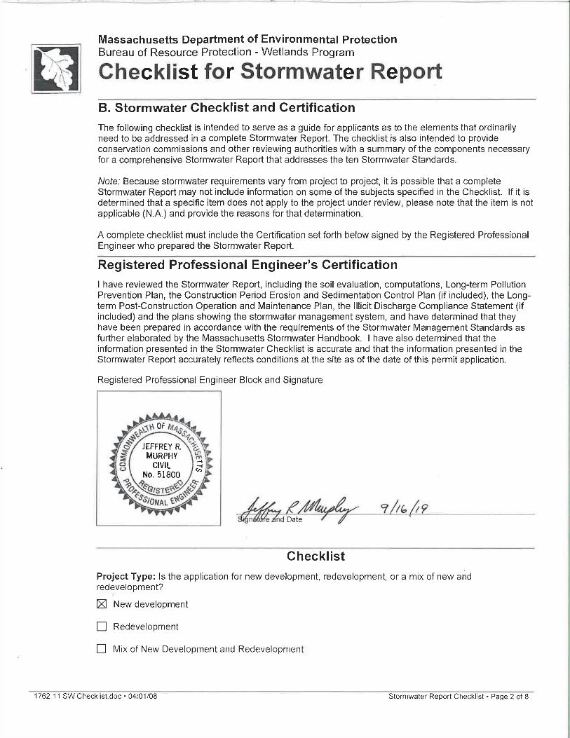
1762.11 SW Checklist.doc • 04/01/08 Stormwater Report Checklist • Page 1 of 8
Massachusetts Department of Environmental Protection Bureau of Resource Protection - Wetlands Program
Checklist for Stormwater Report
A. Introduction Important: When filling out forms on the computer, use only the tab key to move your cursor - do not use the return key.
A Stormwater Report must be submitted with the Notice of Intent permit application to document compliance with the Stormwater Management Standards. The following checklist is NOT a substitute for the Stormwater Report (which should provide more substantive and detailed information) but is offered here as a tool to help the applicant organize their Stormwater Management documentation for their Report and for the reviewer to assess this information in a consistent format. As noted in the Checklist, the Stormwater Report must contain the engineering computations and supporting information set forth in Volume 3 of the Massachusetts Stormwater Handbook. The Stormwater Report must be prepared and certified by a Registered Professional Engineer (RPE) licensed in the Commonwealth. The Stormwater Report must include:
The Stormwater Checklist completed and stamped by a Registered Professional Engineer (see page 2) that certifies that the Stormwater Report contains all required submittals.1 This Checklist is to be used as the cover for the completed Stormwater Report.
Applicant/Project Name Project Address Name of Firm and Registered Professional Engineer that prepared the Report Long-Term Pollution Prevention Plan required by Standards 4-6 Construction Period Pollution Prevention and Erosion and Sedimentation Control Plan required
by Standard 82 Operation and Maintenance Plan required by Standard 9
In addition to all plans and supporting information, the Stormwater Report must include a brief narrative describing stormwater management practices, including environmentally sensitive site design and LID techniques, along with a diagram depicting runoff through the proposed BMP treatment train. Plans are required to show existing and proposed conditions, identify all wetland resource areas, NRCS soil types, critical areas, Land Uses with Higher Potential Pollutant Loads (LUHPPL), and any areas on the site where infiltration rate is greater than 2.4 inches per hour. The Plans shall identify the drainage areas for both existing and proposed conditions at a scale that enables verification of supporting calculations.
As noted in the Checklist, the Stormwater Management Report shall document compliance with each of the Stormwater Management Standards as provided in the Massachusetts Stormwater Handbook. The soils evaluation and calculations shall be done using the methodologies set forth in Volume 3 of the Massachusetts Stormwater Handbook. To ensure that the Stormwater Report is complete, applicants are required to fill in the Stormwater Report Checklist by checking the box to indicate that the specified information has been included in the Stormwater Report. If any of the information specified in the checklist has not been submitted, the applicant must provide an explanation. The completed Stormwater Report Checklist and Certification must be submitted with the Stormwater Report.
1 The Stormwater Report may also include the Illicit Discharge Compliance Statement required by Standard 10. If not included in the Stormwater Report, the Illicit Discharge Compliance Statement must be submitted prior to the discharge of stormwater runoff to the post-construction best management practices. 2 For some complex projects, it may not be possible to include the Construction Period Erosion and Sedimentation Control Plan in the Stormwater Report. In that event, the issuing authority has the discretion to issue an Order of Conditions that approves the project and includes a condition requiring the proponent to submit the Construction Period Erosion and Sedimentation Control Plan before commencing any land disturbance activity on the site.
1762.11 SW Checklist.doc • 04/01/08 Stormwater Report Checklist • Page 3 of 8
Massachusetts Department of Environmental Protection Bureau of Resource Protection - Wetlands Program
Checklist for Stormwater Report
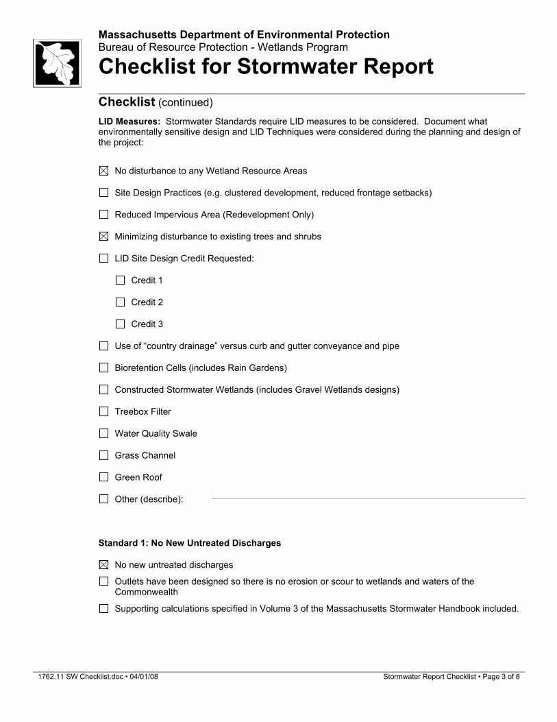
Checklist (continued) LID Measures: Stormwater Standards require LID measures to be considered. Document what
environmentally sensitive design and LID Techniques were considered during the planning and design of the project:
No disturbance to any Wetland Resource Areas
Site Design Practices (e.g. clustered development, reduced frontage setbacks)
Reduced Impervious Area (Redevelopment Only)
Minimizing disturbance to existing trees and shrubs
LID Site Design Credit Requested:
Credit 1
Credit 2
Credit 3
Use of “country drainage” versus curb and gutter conveyance and pipe
Bioretention Cells (includes Rain Gardens)
Constructed Stormwater Wetlands (includes Gravel Wetlands designs)
Treebox Filter
Water Quality Swale
Grass Channel
Green Roof
Other (describe):
Standard 1: No New Untreated Discharges
No new untreated discharges
Outlets have been designed so there is no erosion or scour to wetlands and waters of the Commonwealth
Supporting calculations specified in Volume 3 of the Massachusetts Stormwater Handbook included.
1762.11 SW Checklist.doc • 04/01/08 Stormwater Report Checklist • Page 4 of 8
Massachusetts Department of Environmental Protection Bureau of Resource Protection - Wetlands Program
Checklist for Stormwater Report
Checklist (continued)
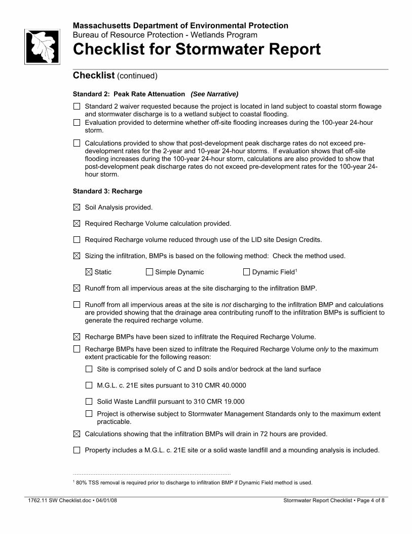
Standard 2: Peak Rate Attenuation (See Narrative)
Standard 2 waiver requested because the project is located in land subject to coastal storm flowage and stormwater discharge is to a wetland subject to coastal flooding.
Evaluation provided to determine whether off-site flooding increases during the 100-year 24-hour storm.
Calculations provided to show that post-development peak discharge rates do not exceed pre-
development rates for the 2-year and 10-year 24-hour storms. If evaluation shows that off-site flooding increases during the 100-year 24-hour storm, calculations are also provided to show that post-development peak discharge rates do not exceed pre-development rates for the 100-year 24-hour storm.
Standard 3: Recharge
Soil Analysis provided.
Required Recharge Volume calculation provided.
Required Recharge volume reduced through use of the LID site Design Credits.
Sizing the infiltration, BMPs is based on the following method: Check the method used.
Static Simple Dynamic Dynamic Field1
Runoff from all impervious areas at the site discharging to the infiltration BMP.
Runoff from all impervious areas at the site is not discharging to the infiltration BMP and calculations
are provided showing that the drainage area contributing runoff to the infiltration BMPs is sufficient to generate the required recharge volume.
Recharge BMPs have been sized to infiltrate the Required Recharge Volume.
Recharge BMPs have been sized to infiltrate the Required Recharge Volume only to the maximum extent practicable for the following reason:
Site is comprised solely of C and D soils and/or bedrock at the land surface
M.G.L. c. 21E sites pursuant to 310 CMR 40.0000
Solid Waste Landfill pursuant to 310 CMR 19.000
Project is otherwise subject to Stormwater Management Standards only to the maximum extent practicable.
Calculations showing that the infiltration BMPs will drain in 72 hours are provided.
Property includes a M.G.L. c. 21E site or a solid waste landfill and a mounding analysis is included.
1 80% TSS removal is required prior to discharge to infiltration BMP if Dynamic Field method is used.
1762.11 SW Checklist.doc • 04/01/08 Stormwater Report Checklist • Page 5 of 8
Massachusetts Department of Environmental Protection Bureau of Resource Protection - Wetlands Program
Checklist for Stormwater Report
Checklist (continued)
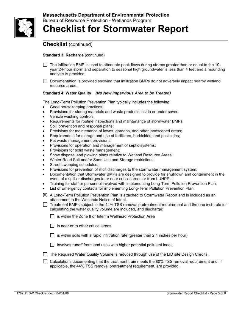
Standard 3: Recharge (continued)
The infiltration BMP is used to attenuate peak flows during storms greater than or equal to the 10-
year 24-hour storm and separation to seasonal high groundwater is less than 4 feet and a mounding analysis is provided.
Documentation is provided showing that infiltration BMPs do not adversely impact nearby wetland resource areas.
Standard 4: Water Quality (No New Impervious Area to be Treated)
The Long-Term Pollution Prevention Plan typically includes the following: Good housekeeping practices; Provisions for storing materials and waste products inside or under cover; Vehicle washing controls; Requirements for routine inspections and maintenance of stormwater BMPs; Spill prevention and response plans; Provisions for maintenance of lawns, gardens, and other landscaped areas; Requirements for storage and use of fertilizers, herbicides, and pesticides; Pet waste management provisions; Provisions for operation and management of septic systems; Provisions for solid waste management; Snow disposal and plowing plans relative to Wetland Resource Areas; Winter Road Salt and/or Sand Use and Storage restrictions; Street sweeping schedules; Provisions for prevention of illicit discharges to the stormwater management system; Documentation that Stormwater BMPs are designed to provide for shutdown and containment in the
event of a spill or discharges to or near critical areas or from LUHPPL; Training for staff or personnel involved with implementing Long-Term Pollution Prevention Plan; List of Emergency contacts for implementing Long-Term Pollution Prevention Plan.
A Long-Term Pollution Prevention Plan is attached to Stormwater Report and is included as an attachment to the Wetlands Notice of Intent.
Treatment BMPs subject to the 44% TSS removal pretreatment requirement and the one inch rule for calculating the water quality volume are included, and discharge:
is within the Zone II or Interim Wellhead Protection Area
is near or to other critical areas
is within soils with a rapid infiltration rate (greater than 2.4 inches per hour)
involves runoff from land uses with higher potential pollutant loads.
The Required Water Quality Volume is reduced through use of the LID site Design Credits.
Calculations documenting that the treatment train meets the 80% TSS removal requirement and, if applicable, the 44% TSS removal pretreatment requirement, are provided.
1762.11 SW Checklist.doc • 04/01/08 Stormwater Report Checklist • Page 6 of 8
Massachusetts Department of Environmental Protection Bureau of Resource Protection - Wetlands Program
Checklist for Stormwater Report
Checklist (continued)
Standard 4: Water Quality (continued)
The BMP is sized (and calculations provided) based on:
The ½” or 1” Water Quality Volume or
The equivalent flow rate associated with the Water Quality Volume and documentation is provided showing that the BMP treats the required water quality volume.
The applicant proposes to use proprietary BMPs, and documentation supporting use of proprietary
BMP and proposed TSS removal rate is provided. This documentation may be in the form of the propriety BMP checklist found in Volume 2, Chapter 4 of the Massachusetts Stormwater Handbook and submitting copies of the TARP Report, STEP Report, and/or other third party studies verifying performance of the proprietary BMPs.
A TMDL exists that indicates a need to reduce pollutants other than TSS and documentation showing
that the BMPs selected are consistent with the TMDL is provided.
Standard 5: Land Uses With Higher Potential Pollutant Loads (LUHPPLs) (Not Applicable)
The NPDES Multi-Sector General Permit covers the land use and the Stormwater Pollution
Prevention Plan (SWPPP) has been included with the Stormwater Report.
The NPDES Multi-Sector General Permit covers the land use and the SWPPP will be submitted prior
to the discharge of stormwater to the post-construction stormwater BMPs.
The NPDES Multi-Sector General Permit does not cover the land use.
LUHPPLs are located at the site and industry specific source control and pollution prevention measures have been proposed to reduce or eliminate the exposure of LUHPPLs to rain, snow, snow melt and runoff, and been included in the long term Pollution Prevention Plan.
All exposure has been eliminated.
All exposure has not been eliminated and all BMPs selected are on MassDEP LUHPPL list.
The LUHPPL has the potential to generate runoff with moderate to higher concentrations of oil and grease (e.g. all parking lots with >1000 vehicle trips per day) and the treatment train includes an oil grit separator, a filtering bioretention area, a sand filter or equivalent.
Standard 6: Critical Areas (Site Discharges to Zone A, only clean roof runoff to be infiltrated)
The discharge is near or to a critical area and the treatment train includes only BMPs that MassDEP
has approved for stormwater discharges to or near that particular class of critical area.
Critical areas and BMPs are identified in the Stormwater Report.
1762.11 SW Checklist.doc • 04/01/08 Stormwater Report Checklist • Page 7 of 8
Massachusetts Department of Environmental Protection Bureau of Resource Protection - Wetlands Program
Checklist for Stormwater Report
Checklist (continued)
Standard 7: Redevelopments and Other Projects Subject to the Standards only to the maximum extent practicable (Not Applicable)
The project is subject to the Stormwater Management Standards only to the maximum Extent
Practicable as a:
Limited Project
Small Residential Projects: 5-9 single family houses or 5-9 units in a multi-family development
provided there is no discharge that may potentially affect a critical area.
Small Residential Projects: 2-4 single family houses or 2-4 units in a multi-family development with a discharge to a critical area
Marina and/or boatyard provided the hull painting, service and maintenance areas are protected
from exposure to rain, snow, snow melt and runoff
Bike Path and/or Foot Path
Redevelopment Project
Redevelopment portion of mix of new and redevelopment.
Certain standards are not fully met (Standard No. 1, 8, 9, and 10 must always be fully met) and an
explanation of why these standards are not met is contained in the Stormwater Report.
The project involves redevelopment and a description of all measures that have been taken to
improve existing conditions is provided in the Stormwater Report. The redevelopment checklist found in Volume 2 Chapter 3 of the Massachusetts Stormwater Handbook may be used to document that the proposed stormwater management system (a) complies with Standards 2, 3 and the pretreatment and structural BMP requirements of Standards 4-6 to the maximum extent practicable and (b) improves existing conditions.
Standard 8: Construction Period Pollution Prevention and Erosion and Sedimentation Control
A Construction Period Pollution Prevention and Erosion and Sedimentation Control Plan must include the following information:
Narrative; Construction Period Operation and Maintenance Plan; Names of Persons or Entity Responsible for Plan Compliance; Construction Period Pollution Prevention Measures; Erosion and Sedimentation Control Plan Drawings; Detail drawings and specifications for erosion control BMPs, including sizing calculations; Vegetation Planning; Site Development Plan; Construction Sequencing Plan; Sequencing of Erosion and Sedimentation Controls; Operation and Maintenance of Erosion and Sedimentation Controls; Inspection Schedule; Maintenance Schedule; Inspection and Maintenance Log Form.
A Construction Period Pollution Prevention and Erosion and Sedimentation Control Plan containing
the information set forth above has been included in the Stormwater Report.
1762.11 SW Checklist.doc • 04/01/08 Stormwater Report Checklist • Page 8 of 8
Massachusetts Department of Environmental Protection Bureau of Resource Protection - Wetlands Program
Checklist for Stormwater Report
Checklist (continued)
Standard 8: Construction Period Pollution Prevention and Erosion and Sedimentation Control (continued)
The project is highly complex and information is included in the Stormwater Report that explains why it is not possible to submit the Construction Period Pollution Prevention and Erosion and Sedimentation Control Plan with the application. A Construction Period Pollution Prevention and Erosion and Sedimentation Control has not been included in the Stormwater Report but will be submitted before land disturbance begins.
The project is not covered by a NPDES Construction General Permit. (Disturbs less than 1 acre)
The project is covered by a NPDES Construction General Permit and a copy of the SWPPP is in the
Stormwater Report.
The project is covered by a NPDES Construction General Permit but no SWPPP been submitted.
The SWPPP will be submitted BEFORE land disturbance begins.
Standard 9: Operation and Maintenance Plan
The Post Construction Operation and Maintenance Plan is included in the Stormwater Report and
includes the following information:
Name of the stormwater management system owners;
Party responsible for operation and maintenance;
Schedule for implementation of routine and non-routine maintenance tasks;
Plan showing the location of all stormwater BMPs maintenance access areas;
Description and delineation of public safety features;
Estimated operation and maintenance budget; and
Operation and Maintenance Log Form.
The responsible party is not the owner of the parcel where the BMP is located and the Stormwater
Report includes the following submissions:
A copy of the legal instrument (deed, homeowner’s association, utility trust or other legal entity) that establishes the terms of and legal responsibility for the operation and maintenance of the project site stormwater BMPs;
A plan and easement deed that allows site access for the legal entity to operate and maintain
BMP functions.
Standard 10: Prohibition of Illicit Discharges
The Long-Term Pollution Prevention Plan includes measures to prevent illicit discharges;
An Illicit Discharge Compliance Statement is attached;
NO Illicit Discharge Compliance Statement is attached but will be submitted prior to the discharge of
any stormwater to post-construction BMPs.
Attachment 1 Soil Data
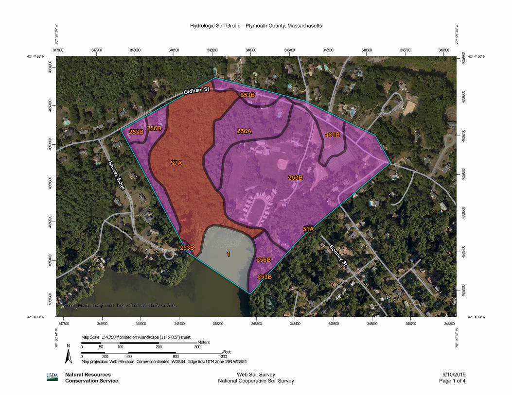
Hydrologic Soil Group—Plymouth County, Massachusetts
Natural ResourcesConservation Service
Web Soil SurveyNational Cooperative Soil Survey
9/10/2019Page 1 of 4
4659
300
4659
400
4659
500
4659
600
4659
700
4659
800
4659
900
4659
300
4659
400
4659
500
4659
600
4659
700
4659
800
4659
900
347800 347900 348000 348100 348200 348300 348400 348500 348600 348700 348800
347800 347900 348000 348100 348200 348300 348400 348500 348600 348700 348800
42° 4' 36'' N70
° 5
0' 2
4'' W
42° 4' 36'' N
70° 4
9' 3
8'' W
42° 4' 14'' N
70° 5
0' 2
4'' W
42° 4' 14'' N
70° 4
9' 3
8'' W
N
Map projection: Web Mercator Corner coordinates: WGS84 Edge tics: UTM Zone 19N WGS840 200 400 800 1200
Feet0 50 100 200 300
MetersMap Scale: 1:4,750 if printed on A landscape (11" x 8.5") sheet.
Soil Map may not be valid at this scale.
MAP LEGEND MAP INFORMATION
Area of Interest (AOI)Area of Interest (AOI)
SoilsSoil Rating Polygons
A
A/D
B
B/D
C
C/D
D
Not rated or not available
Soil Rating LinesA
A/D
B
B/D
C
C/D
D
Not rated or not available
Soil Rating PointsA
A/D
B
B/D
C
C/D
D
Not rated or not available
Water FeaturesStreams and Canals
TransportationRails
Interstate Highways
US Routes
Major Roads
Local Roads
BackgroundAerial Photography
The soil surveys that comprise your AOI were mapped at 1:12,000.
Warning: Soil Map may not be valid at this scale.
Enlargement of maps beyond the scale of mapping can cause misunderstanding of the detail of mapping and accuracy of soil line placement. The maps do not show the small areas of contrasting soils that could have been shown at a more detailed scale.
Please rely on the bar scale on each map sheet for map measurements.
Source of Map: Natural Resources Conservation ServiceWeb Soil Survey URL: Coordinate System: Web Mercator (EPSG:3857)
Maps from the Web Soil Survey are based on the Web Mercator projection, which preserves direction and shape but distorts distance and area. A projection that preserves area, such as the Albers equal-area conic projection, should be used if more accurate calculations of distance or area are required.
This product is generated from the USDA-NRCS certified data as of the version date(s) listed below.
Soil Survey Area: Plymouth County, MassachusettsSurvey Area Data: Version 11, Sep 7, 2018
Soil map units are labeled (as space allows) for map scales 1:50,000 or larger.
Date(s) aerial images were photographed: Aug 26, 2014—Sep 4, 2014
The orthophoto or other base map on which the soil lines were compiled and digitized probably differs from the background imagery displayed on these maps. As a result, some minor shifting of map unit boundaries may be evident.
Hydrologic Soil Group—Plymouth County, Massachusetts
Natural ResourcesConservation Service
Web Soil SurveyNational Cooperative Soil Survey
9/10/2019Page 2 of 4
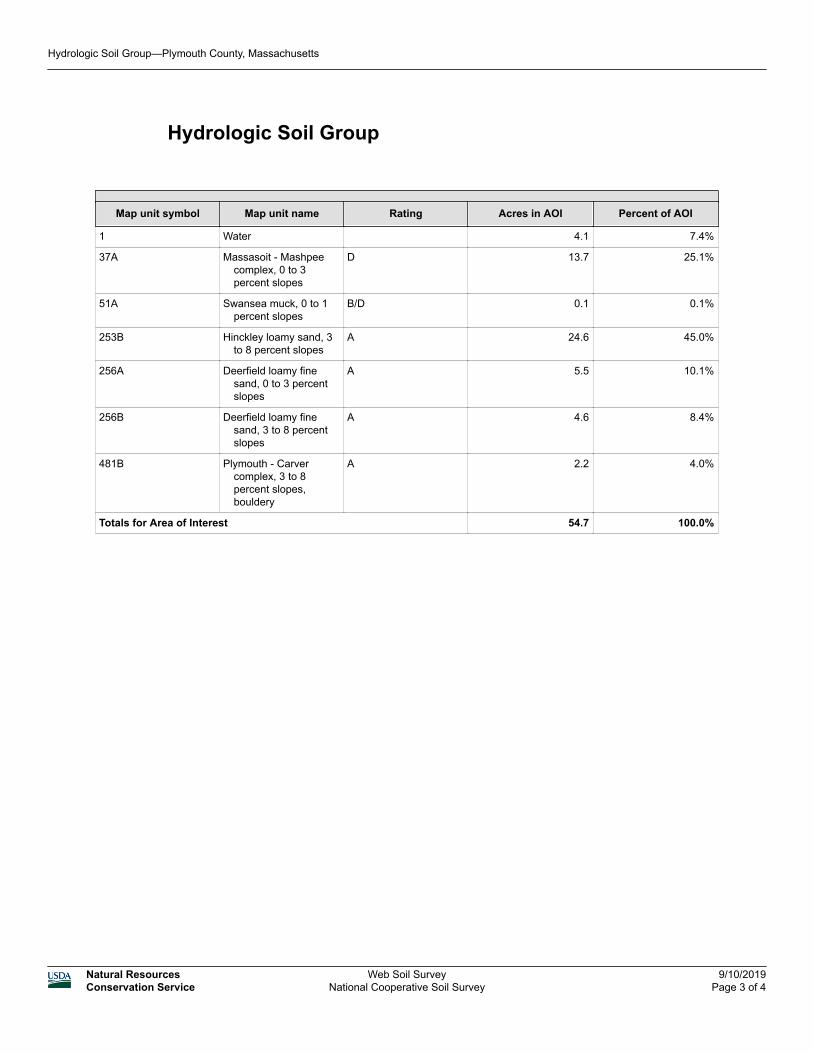
Hydrologic Soil Group
Map unit symbol Map unit name Rating Acres in AOI Percent of AOI
1 Water 4.1 7.4%
37A Massasoit - Mashpee complex, 0 to 3 percent slopes
D 13.7 25.1%
51A Swansea muck, 0 to 1 percent slopes
B/D 0.1 0.1%
253B Hinckley loamy sand, 3 to 8 percent slopes
A 24.6 45.0%
256A Deerfield loamy fine sand, 0 to 3 percent slopes
A 5.5 10.1%
256B Deerfield loamy fine sand, 3 to 8 percent slopes
A 4.6 8.4%
481B Plymouth - Carver complex, 3 to 8 percent slopes, bouldery
A 2.2 4.0%
Totals for Area of Interest 54.7 100.0%
Hydrologic Soil Group—Plymouth County, Massachusetts
Natural ResourcesConservation Service
Web Soil SurveyNational Cooperative Soil Survey
9/10/2019Page 3 of 4
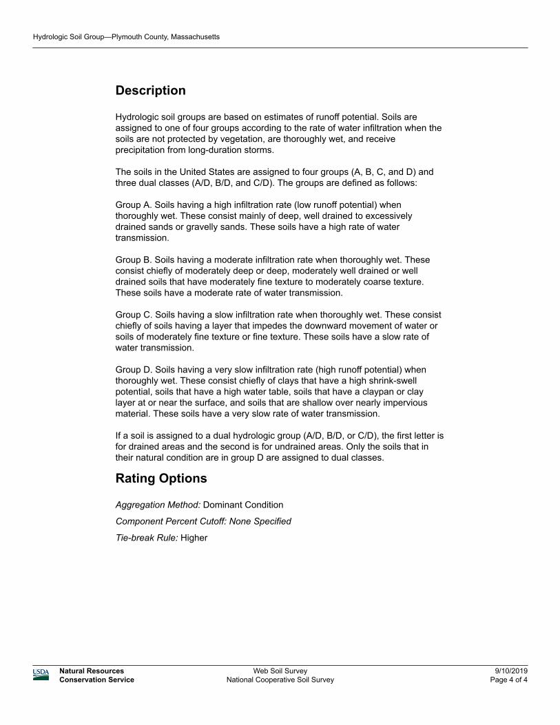
Description
Hydrologic soil groups are based on estimates of runoff potential. Soils are assigned to one of four groups according to the rate of water infiltration when the soils are not protected by vegetation, are thoroughly wet, and receive precipitation from long-duration storms.
The soils in the United States are assigned to four groups (A, B, C, and D) and three dual classes (A/D, B/D, and C/D). The groups are defined as follows:
Group A. Soils having a high infiltration rate (low runoff potential) when thoroughly wet. These consist mainly of deep, well drained to excessively drained sands or gravelly sands. These soils have a high rate of water transmission.
Group B. Soils having a moderate infiltration rate when thoroughly wet. These consist chiefly of moderately deep or deep, moderately well drained or well drained soils that have moderately fine texture to moderately coarse texture. These soils have a moderate rate of water transmission.
Group C. Soils having a slow infiltration rate when thoroughly wet. These consist chiefly of soils having a layer that impedes the downward movement of water or soils of moderately fine texture or fine texture. These soils have a slow rate of water transmission.
Group D. Soils having a very slow infiltration rate (high runoff potential) when thoroughly wet. These consist chiefly of clays that have a high shrink-swell potential, soils that have a high water table, soils that have a claypan or clay layer at or near the surface, and soils that are shallow over nearly impervious material. These soils have a very slow rate of water transmission.
If a soil is assigned to a dual hydrologic group (A/D, B/D, or C/D), the first letter is for drained areas and the second is for undrained areas. Only the soils that in their natural condition are in group D are assigned to dual classes.
Rating Options
Aggregation Method: Dominant Condition
Component Percent Cutoff: None Specified
Tie-break Rule: Higher
Hydrologic Soil Group—Plymouth County, Massachusetts
Natural ResourcesConservation Service
Web Soil SurveyNational Cooperative Soil Survey
9/10/2019Page 4 of 4
Plymouth County, Massachusetts
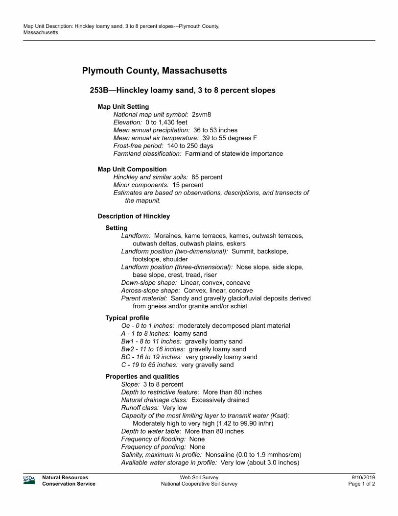
253B—Hinckley loamy sand, 3 to 8 percent slopes
Map Unit SettingNational map unit symbol: 2svm8Elevation: 0 to 1,430 feetMean annual precipitation: 36 to 53 inchesMean annual air temperature: 39 to 55 degrees FFrost-free period: 140 to 250 daysFarmland classification: Farmland of statewide importance
Map Unit CompositionHinckley and similar soils: 85 percentMinor components: 15 percentEstimates are based on observations, descriptions, and transects of
the mapunit.
Description of Hinckley
SettingLandform: Moraines, kame terraces, kames, outwash terraces,
outwash deltas, outwash plains, eskersLandform position (two-dimensional): Summit, backslope,
footslope, shoulderLandform position (three-dimensional): Nose slope, side slope,
base slope, crest, tread, riserDown-slope shape: Linear, convex, concaveAcross-slope shape: Convex, linear, concaveParent material: Sandy and gravelly glaciofluvial deposits derived
from gneiss and/or granite and/or schist
Typical profileOe - 0 to 1 inches: moderately decomposed plant materialA - 1 to 8 inches: loamy sandBw1 - 8 to 11 inches: gravelly loamy sandBw2 - 11 to 16 inches: gravelly loamy sandBC - 16 to 19 inches: very gravelly loamy sandC - 19 to 65 inches: very gravelly sand
Properties and qualitiesSlope: 3 to 8 percentDepth to restrictive feature: More than 80 inchesNatural drainage class: Excessively drainedRunoff class: Very lowCapacity of the most limiting layer to transmit water (Ksat):
Moderately high to very high (1.42 to 99.90 in/hr)Depth to water table: More than 80 inchesFrequency of flooding: NoneFrequency of ponding: NoneSalinity, maximum in profile: Nonsaline (0.0 to 1.9 mmhos/cm)Available water storage in profile: Very low (about 3.0 inches)
Map Unit Description: Hinckley loamy sand, 3 to 8 percent slopes---Plymouth County, Massachusetts
Natural ResourcesConservation Service
Web Soil SurveyNational Cooperative Soil Survey
9/10/2019Page 1 of 2
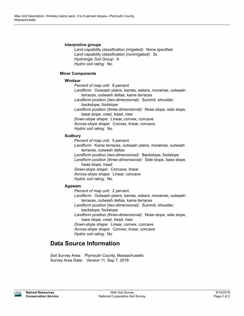
Interpretive groupsLand capability classification (irrigated): None specifiedLand capability classification (nonirrigated): 3sHydrologic Soil Group: AHydric soil rating: No
Minor Components
WindsorPercent of map unit: 8 percentLandform: Outwash plains, kames, eskers, moraines, outwash
terraces, outwash deltas, kame terracesLandform position (two-dimensional): Summit, shoulder,
backslope, footslopeLandform position (three-dimensional): Nose slope, side slope,
base slope, crest, tread, riserDown-slope shape: Linear, convex, concaveAcross-slope shape: Convex, linear, concaveHydric soil rating: No
SudburyPercent of map unit: 5 percentLandform: Kame terraces, outwash plains, moraines, outwash
terraces, outwash deltasLandform position (two-dimensional): Backslope, footslopeLandform position (three-dimensional): Side slope, base slope,
head slope, treadDown-slope shape: Concave, linearAcross-slope shape: Linear, concaveHydric soil rating: No
AgawamPercent of map unit: 2 percentLandform: Outwash plains, kames, eskers, moraines, outwash
terraces, outwash deltas, kame terracesLandform position (two-dimensional): Summit, shoulder,
backslope, footslopeLandform position (three-dimensional): Nose slope, side slope,
base slope, crest, tread, riserDown-slope shape: Linear, convex, concaveAcross-slope shape: Convex, linear, concaveHydric soil rating: No
Data Source Information
Soil Survey Area: Plymouth County, MassachusettsSurvey Area Data: Version 11, Sep 7, 2018
Map Unit Description: Hinckley loamy sand, 3 to 8 percent slopes---Plymouth County, Massachusetts
Natural ResourcesConservation Service
Web Soil SurveyNational Cooperative Soil Survey
9/10/2019Page 2 of 2
Attachment 2 Stormwater Recharge Calculations
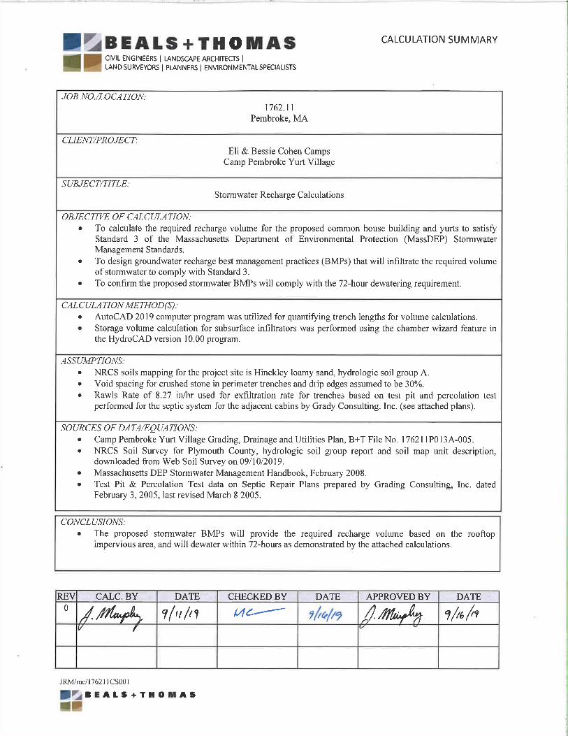
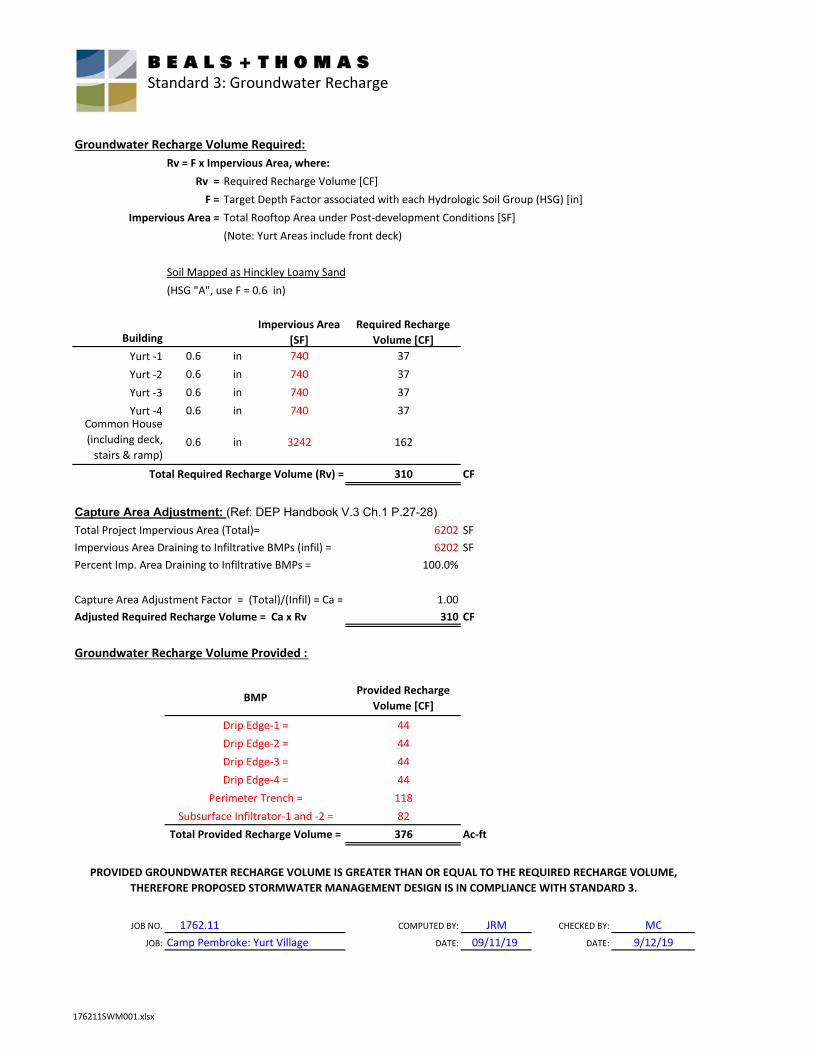
Groundwater Recharge Volume Required:
Rv = F x Impervious Area, where:
Rv = Required Recharge Volume [CF]F = Target Depth Factor associated with each Hydrologic Soil Group (HSG) [in]
Impervious Area = Total Rooftop Area under Post‐development Conditions [SF](Note: Yurt Areas include front deck)
Soil Mapped as Hinckley Loamy Sand
BuildingImpervious Area
[SF]
Required Recharge
Volume [CF]
Yurt ‐1 0.6 in 740 37Yurt ‐2 0.6 in 740 37Yurt ‐3 0.6 in 740 37Yurt ‐4 0.6 in 740 37
Common House (including deck, stairs & ramp)
0.6 in 3242 162
Total Required Recharge Volume (Rv) = 310 CF
Capture Area Adjustment: (Ref: DEP Handbook V.3 Ch.1 P.27-28)
Total Project Impervious Area (Total)= 6202 SFImpervious Area Draining to Infiltrative BMPs (infil) = 6202 SFPercent Imp. Area Draining to Infiltrative BMPs = 100.0%
Capture Area Adjustment Factor = (Total)/(Infil) = Ca = 1.00Adjusted Required Recharge Volume = Ca x Rv 310 CF
Groundwater Recharge Volume Provided :
Provided Recharge
Volume [CF]
4444444411882
Total Provided Recharge Volume = 376 Ac‐ft
JOB NO. 1762.11 COMPUTED BY: JRM CHECKED BY: MCJOB: Camp Pembroke: Yurt Village DATE: 09/11/19 DATE: 9/12/19
PROVIDED GROUNDWATER RECHARGE VOLUME IS GREATER THAN OR EQUAL TO THE REQUIRED RECHARGE VOLUME,
THEREFORE PROPOSED STORMWATER MANAGEMENT DESIGN IS IN COMPLIANCE WITH STANDARD 3.
Drip Edge‐1 =Drip Edge‐2 =Drip Edge‐3 =
Perimeter Trench =
BMP
Drip Edge‐4 =
Subsurface Infiltrator‐1 and ‐2 =
(HSG "A", use F = 0.6 in)
B E A L S + T H O M A S Standard 3: Groundwater Recharge
176211SWM001.xlsx
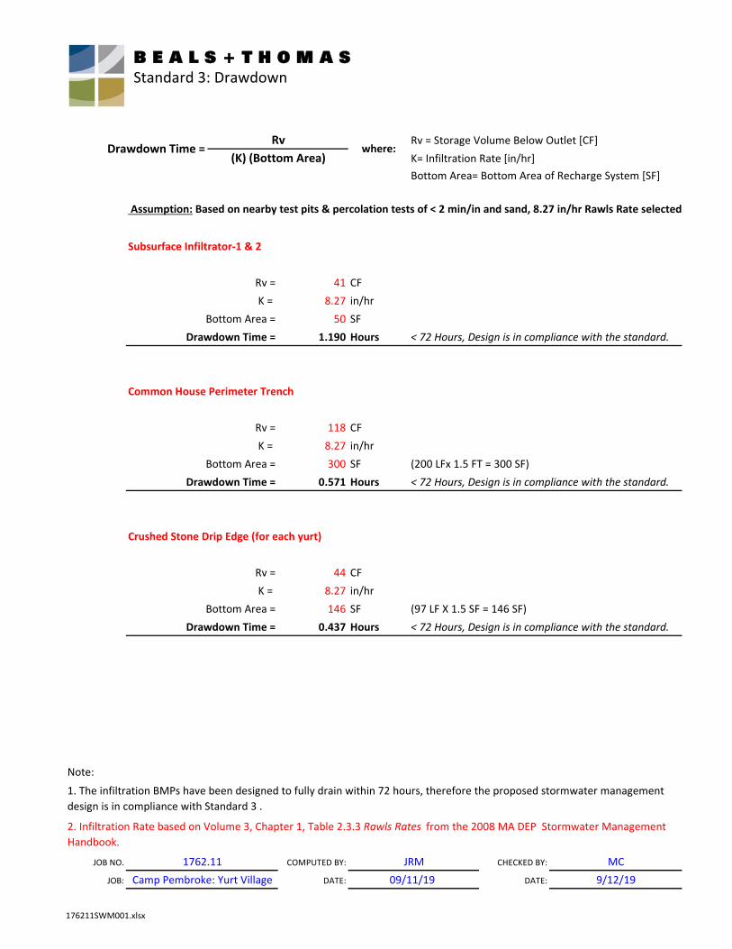
Rv = Storage Volume Below Outlet [CF]
Assumption: Based on nearby test pits & percolation tests of < 2 min/in and sand, 8.27 in/hr Rawls Rate selected
Subsurface Infiltrator‐1 & 2
41 CF8.27 in/hr50 SF
1.190 Hours
Common House Perimeter Trench
118 CF8.27 in/hr300 SF (200 LFx 1.5 FT = 300 SF)
0.571 Hours
Crushed Stone Drip Edge (for each yurt)
44 CF8.27 in/hr146 SF (97 LF X 1.5 SF = 146 SF)
0.437 Hours
Note:
JOB NO. COMPUTED BY: CHECKED BY: MCJOB: DATE: DATE: 9/12/19
(K) (Bottom Area)
K =
1. The infiltration BMPs have been designed to fully drain within 72 hours, therefore the proposed stormwater management design is in compliance with Standard 3 .
2. Infiltration Rate based on Volume 3, Chapter 1, Table 2.3.3 Rawls Rates from the 2008 MA DEP Stormwater Management Handbook.
Rv =K =
Bottom Area =Drawdown Time =
K = Rv =
Bottom Area =Drawdown Time =
JRM09/11/19
1762.11Camp Pembroke: Yurt Village
Bottom Area =Drawdown Time = < 72 Hours, Design is in compliance with the standard.
< 72 Hours, Design is in compliance with the standard.
< 72 Hours, Design is in compliance with the standard.
Rv =
Drawdown Time = where:
Bottom Area= Bottom Area of Recharge System [SF]K= Infiltration Rate [in/hr]
Rv
B E A L S + T H O M A S Standard 3: Drawdown
176211SWM001.xlsx
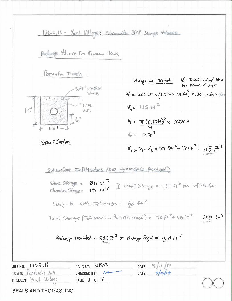
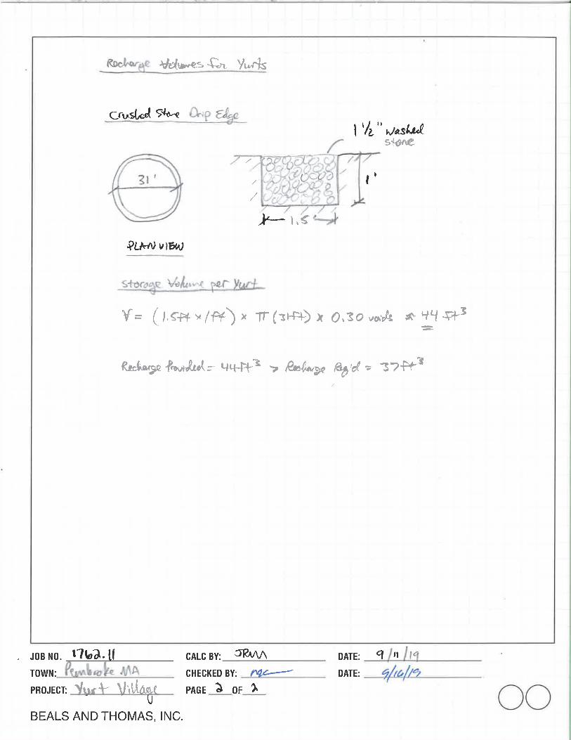
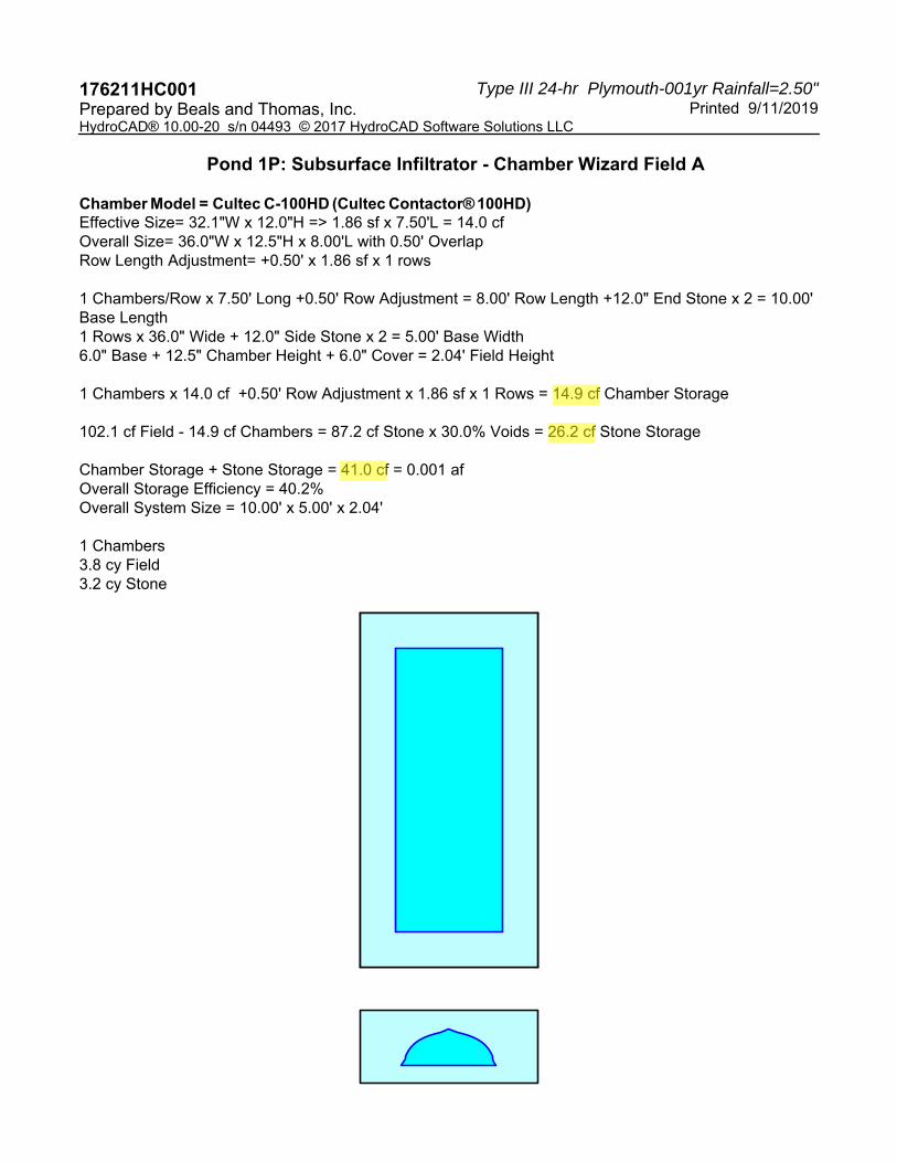
Type III 24-hr Plymouth-001yr Rainfall=2.50"176211HC001 Printed 9/11/2019Prepared by Beals and Thomas, Inc.
HydroCAD® 10.00-20 s/n 04493 © 2017 HydroCAD Software Solutions LLC
Pond 1P: Subsurface Infiltrator - Chamber Wizard Field A
Chamber Model = Cultec C-100HD (Cultec Contactor® 100HD)Effective Size= 32.1"W x 12.0"H => 1.86 sf x 7.50'L = 14.0 cfOverall Size= 36.0"W x 12.5"H x 8.00'L with 0.50' OverlapRow Length Adjustment= +0.50' x 1.86 sf x 1 rows
1 Chambers/Row x 7.50' Long +0.50' Row Adjustment = 8.00' Row Length +12.0" End Stone x 2 = 10.00' Base Length1 Rows x 36.0" Wide + 12.0" Side Stone x 2 = 5.00' Base Width6.0" Base + 12.5" Chamber Height + 6.0" Cover = 2.04' Field Height
1 Chambers x 14.0 cf +0.50' Row Adjustment x 1.86 sf x 1 Rows = 14.9 cf Chamber Storage
102.1 cf Field - 14.9 cf Chambers = 87.2 cf Stone x 30.0% Voids = 26.2 cf Stone Storage
Chamber Storage + Stone Storage = 41.0 cf = 0.001 afOverall Storage Efficiency = 40.2%Overall System Size = 10.00' x 5.00' x 2.04'
1 Chambers3.8 cy Field3.2 cy Stone
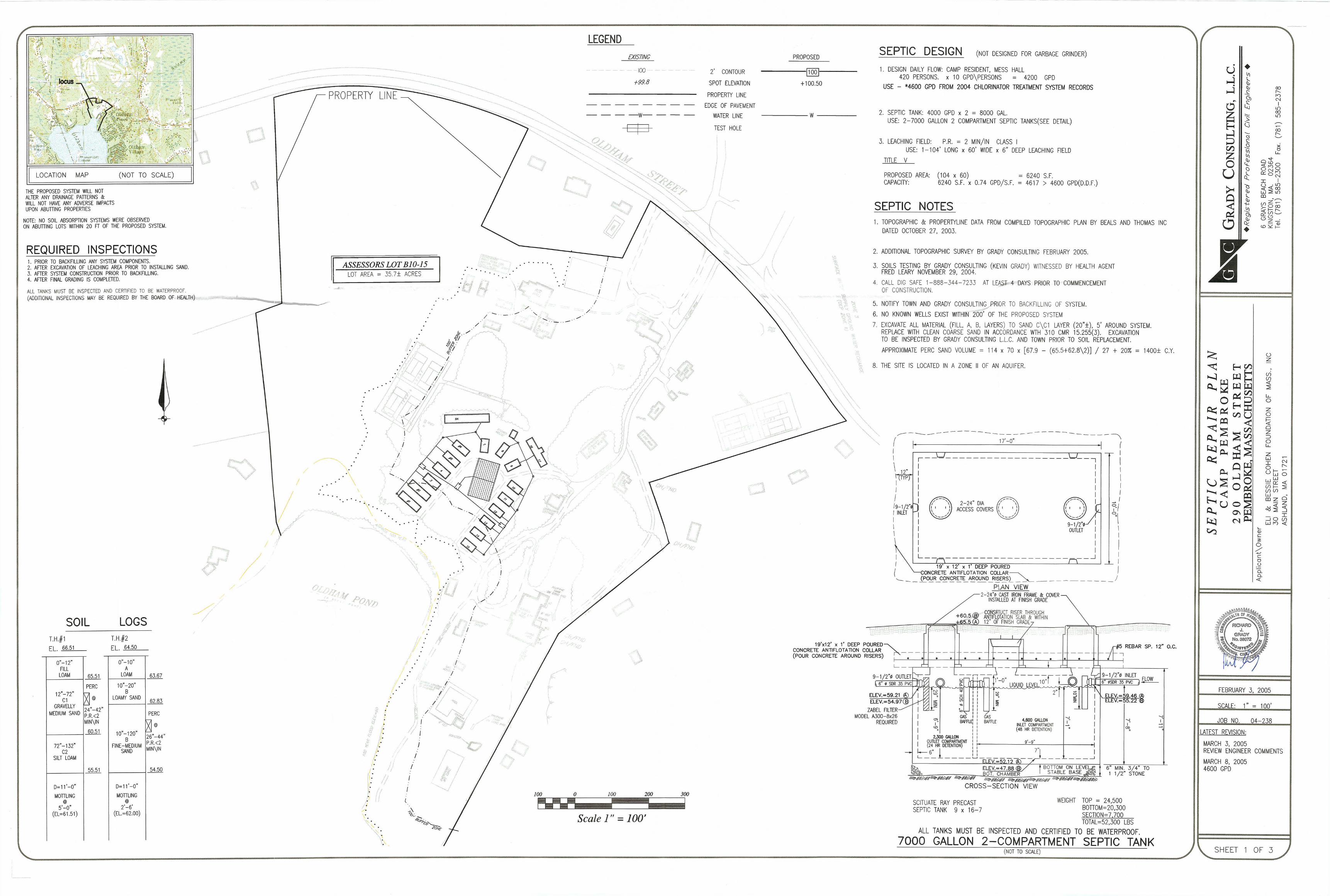
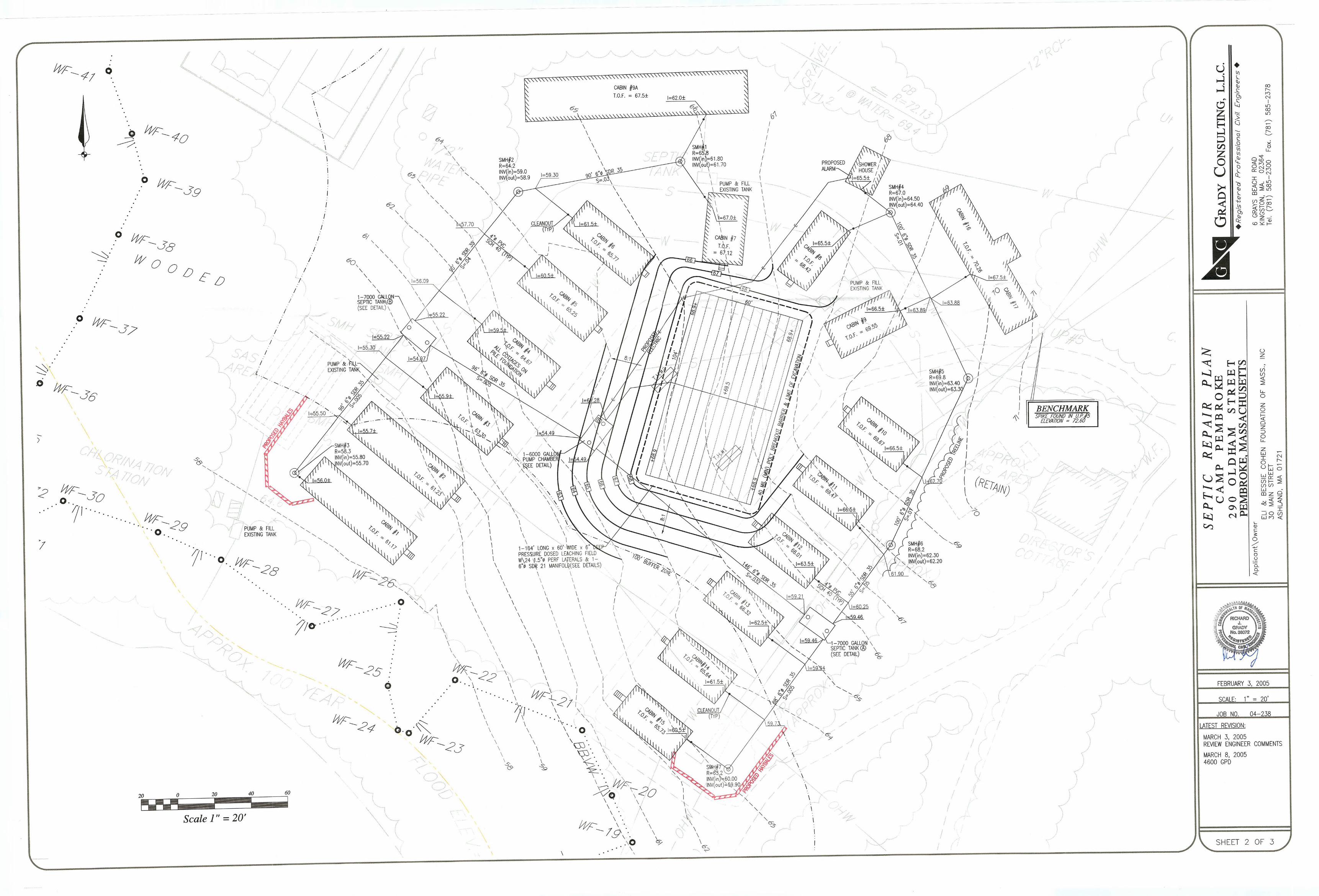
Attachment 3 Site Owner’s Manual
Site Owner’s Manual
CAMP PEMBROKE YURT VILLAGE
306 Oldham Street Pembroke, Massachusetts
Prepared for: Eli & Bessie Cohen Camps 888 Worcester Street, Suite 350 Wellesley, MA, 02482
Prepared by: B E A L S + T H O M A S BEALS AND THOMAS, INC. 32 Court Street Plymouth, MA 02360‐3866
September 16, 2019
JRM/shm/176211RP002
Camp Pembroke Yurt Village Site Owner’s Manual
Pembroke, Massachusetts 176211RP002
Table of Contents i
TABLE OF CONTENTS
1.0 INTRODUCTION .......................................................................................................................................... 1-1
2.0 SITE OWNER’S AGREEMENT ................................................................................................................. 2-0 2.1 OPERATION AND MAINTENANCE COMPLIANCE STATEMENT ........................................................................ 2-0 2.2 STORMWATER MAINTENANCE EASEMENTS ................................................................................................. 2-0 2.3 RECORD KEEPING ........................................................................................................................................ 2-0 2.4 TRAINING ..................................................................................................................................................... 2-1
3.0 LONG-TERM POLLUTION PREVENTION PLAN ................................................................................ 3-1 3.1 STORAGE OF MATERIALS AND WASTE ......................................................................................................... 3-1 3.2 VEHICLE WASHING ...................................................................................................................................... 3-1 3.3 ROUTINE INSPECTIONS AND MAINTENANCE OF STORMWATER BMPS ......................................................... 3-1 3.4 SPILL PREVENTION AND RESPONSE .............................................................................................................. 3-1 3.5 MAINTENANCE OF LAWNS AND OTHER LANDSCAPED AREAS ...................................................................... 3-1 3.6 STORAGE AND USE OF FERTILIZERS, HERBICIDES, AND PESTICIDES ............................................................ 3-2 3.7 OPERATION AND MANAGEMENT OF SEPTIC SYSTEMS .................................................................................. 3-2
4.0 LONG-TERM OPERATION AND MAINTENANCE PLAN ................................................................... 4-1 4.1 STORMWATER MANAGEMENT SYSTEM COMPONENTS ................................................................................. 4-1 4.2 INSPECTION AND MAINTENANCE SCHEDULES .............................................................................................. 4-1
4.2.1 Perimeter Trench & Drip Edges ........................................................................................................ 4-1 4.2.2 Subsurface Infiltrators ....................................................................................................................... 4-2
4.3 ESTIMATED OPERATION AND MAINTENANCE BUDGET ................................................................................ 4-2 4.4 PUBLIC SAFETY FEATURES .......................................................................................................................... 4-2
FIGURES
FIGURE 1: SITE PLANS APPENDICES
APPENDIX A: OPERATION AND MAINTENANCE LOG APPENDIX B: LIST OF EMERGENCY CONTACTS
Camp Pembroke Yurt Village Site Owner’s Manual
Pembroke, Massachusetts 176211RP002
Site Owner’s Agreement 1-1
1.0 INTRODUCTION The Site Owner’s Manual complies with the Long-Term Pollution Prevention Plan (Standard 4) and the Long-Term Operation and Maintenance Plan (Standard 9) requirements of the 2008 Massachusetts Department of Environmental Protection (MassDEP) Stormwater Handbook. The Manual outlines source control and pollution prevention measures and maintenance requirements of stormwater best management practices (BMPs) associated with the proposed project.
Camp Pembroke Yurt Village Site Owner’s Manual
Pembroke, Massachusetts 176211RP002
Site Owner’s Agreement 2-0
2.0 SITE OWNER’S AGREEMENT
2.1 Operation and Maintenance Compliance Statement Site Owner: Eli & Bessie Cohen Camps
888 Worcester Street, Suite 350 Wellesley, MA, 02482
Responsible Party: Eli & Bessie Cohen Camps
Eli & Bessie Cohen Camps or their successors shall maintain ownership of the on-site stormwater management BMPs as well as the responsibility for operation and maintenance during the post-development stages of the project. The site has been inspected for erosion and appropriate measures have been taken to permanently stabilize any eroded areas. All aspects of stormwater best management practices (BMPs) have been inspected for damage, wear and malfunction, and appropriate steps have been taken to repair or replace the system or portions of the system so that the stormwater at the site may be managed in accordance with the Stormwater Management Standards. Future responsible parties shall be notified of their continuing legal responsibility to operate and maintain the BMPs. The operation and maintenance plan for the stormwater BMPs is being implemented.
___________________________ ___________ Responsible Party Signature Date 2.2 Stormwater Maintenance Easements
The Site Owner has obtained access to all off-site areas utilized for stormwater control.
2.3 Record Keeping The Site Owner shall maintain a rolling log in which all inspections and maintenance activities for the past three years shall be recorded. The Operation and Maintenance Log includes information pertaining to inspections, repairs, and disposal relevant to the project’s stormwater management system. The Log is located in Appendix A. The Operation and Maintenance Log shall be made available to the Conservation Commission and MassDEP upon request. The Conservation Commission and MassDEP shall be allowed to enter and inspect the premises to evaluate and ensure that the responsible party complies with the maintenance requirements for each BMP.
Camp Pembroke Yurt Village Site Owner’s Manual
Pembroke, Massachusetts 176211RP002
Site Owner’s Agreement 2-1
2.4 Training Employees involved in grounds maintenance and emergency response will be educated on the general concepts of stormwater management and groundwater protection. The Site Owner’s Manual will be reviewed with the maintenance staff. The staff will be trained on the proper course of action for specific events expected to be incurred during routine maintenance or emergency situations.
Camp Pembroke Yurt Village Site Owner’s Manual
Pembroke, Massachusetts 176211RP002
Long-Term Pollution Prevention Plan 3-1
3.0 LONG-TERM POLLUTION PREVENTION PLAN In compliance with Standard 4 of the 2008 MassDEP Stormwater Management Handbook, this section outlines source control and pollution prevention measures to be employed on-site after construction.
3.1 Storage of Materials and Waste
The site shall be kept clear of trash and debris at all times. Certain materials and waste products shall be stored inside or outside upon an impervious surface and covered, as required by local and state regulations.
3.2 Vehicle Washing No commercial vehicle washing shall take place on site.
3.3 Routine Inspections and Maintenance of Stormwater BMPs See Section 4.0 Long-Term Operation and Maintenance Plan, for routine inspection and maintenance requirements for all proposed stormwater BMPs.
3.4 Spill Prevention and Response A contingency plan shall be implemented to address the spill or release of petroleum
products and hazardous materials and will include the following measures:
1. Equipment necessary to quickly attend to inadvertent spills or leaks shall be stored on-site in a secure but accessible location. Such equipment shall include but not be limited to the following: safety goggles, chemically resistant gloves and overshoe boots, water and chemical fire extinguishers, sand and shovels, suitable absorbent materials, storage containers and first aid equipment (i.e. Indian Valley Industries, Inc. 55-gallon Spill Containment kit or approved equivalent).
2. Spills or leaks shall be treated properly according to material type, volume of spillage
and location of spill. Mitigation shall include preventing further spillage, containing the spilled material in the smallest practical area, removing spilled material in a safe and environmentally-friendly manner, and remediation of any damage to the environment.
3. For large spills, Massachusetts DEP Hazardous Waste Incident Response Group shall
be notified immediately at 888-304-1133 and an emergency response contractor shall be consulted.
3.5 Maintenance of Lawns and other Landscaped Areas
Lawns and other landscaped areas shall be maintained regularly by the site owner. Stormwater BMPs will be maintained as outlined in Section 4.0.
Camp Pembroke Yurt Village Site Owner’s Manual
Pembroke, Massachusetts 176211RP002
Long-Term Pollution Prevention Plan 3-2
3.6 Storage and Use of Fertilizers, Herbicides, and Pesticides All fertilizers, herbicides, and pesticides shall be stored in accordance with local, state, and federal regulations. The application rate and use of fertilizers, herbicides, and pesticides on the site shall at no time exceed local, state, or federal specifications. Fertilizers containing phosphorus shall not be used.
3.7 Operation and Management of Septic Systems
The proposed project will include a septic system to treat wastewater (to be designed and permitted by others). The septic system shall be operated and maintained in accordance with local and state regulations.
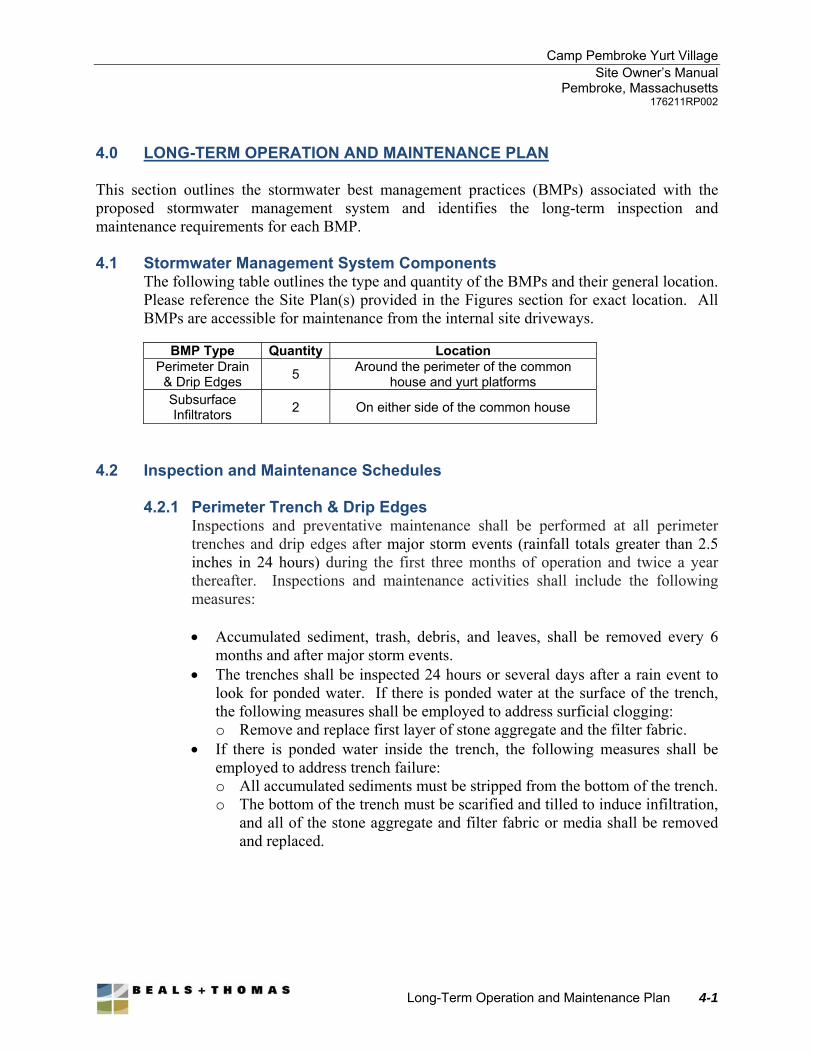
Camp Pembroke Yurt Village Site Owner’s Manual
Pembroke, Massachusetts 176211RP002
Long-Term Operation and Maintenance Plan 4-1
4.0 LONG-TERM OPERATION AND MAINTENANCE PLAN This section outlines the stormwater best management practices (BMPs) associated with the proposed stormwater management system and identifies the long-term inspection and maintenance requirements for each BMP. 4.1 Stormwater Management System Components
The following table outlines the type and quantity of the BMPs and their general location. Please reference the Site Plan(s) provided in the Figures section for exact location. All BMPs are accessible for maintenance from the internal site driveways.
BMP Type Quantity Location Perimeter Drain
& Drip Edges 5
Around the perimeter of the common house and yurt platforms
Subsurface Infiltrators
2 On either side of the common house
4.2 Inspection and Maintenance Schedules
4.2.1 Perimeter Trench & Drip Edges
Inspections and preventative maintenance shall be performed at all perimeter trenches and drip edges after major storm events (rainfall totals greater than 2.5 inches in 24 hours) during the first three months of operation and twice a year thereafter. Inspections and maintenance activities shall include the following measures:
Accumulated sediment, trash, debris, and leaves, shall be removed every 6
months and after major storm events. The trenches shall be inspected 24 hours or several days after a rain event to
look for ponded water. If there is ponded water at the surface of the trench, the following measures shall be employed to address surficial clogging: o Remove and replace first layer of stone aggregate and the filter fabric.
If there is ponded water inside the trench, the following measures shall be employed to address trench failure: o All accumulated sediments must be stripped from the bottom of the trench. o The bottom of the trench must be scarified and tilled to induce infiltration,
and all of the stone aggregate and filter fabric or media shall be removed and replaced.
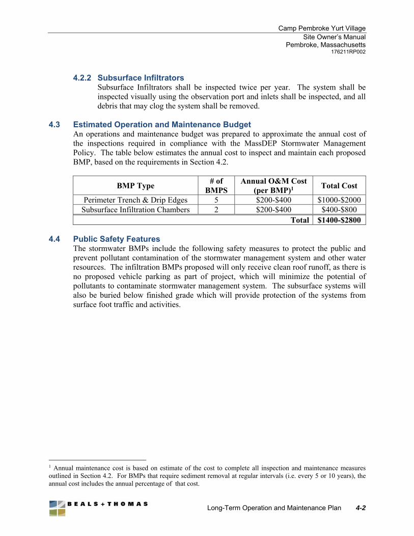
Camp Pembroke Yurt Village Site Owner’s Manual
Pembroke, Massachusetts 176211RP002
Long-Term Operation and Maintenance Plan 4-2
4.2.2 Subsurface Infiltrators Subsurface Infiltrators shall be inspected twice per year. The system shall be inspected visually using the observation port and inlets shall be inspected, and all debris that may clog the system shall be removed.
4.3 Estimated Operation and Maintenance Budget
An operations and maintenance budget was prepared to approximate the annual cost of the inspections required in compliance with the MassDEP Stormwater Management Policy. The table below estimates the annual cost to inspect and maintain each proposed BMP, based on the requirements in Section 4.2.
BMP Type # of
BMPS Annual O&M Cost
(per BMP)1 Total Cost
Perimeter Trench & Drip Edges 5 $200-$400 $1000-$2000 Subsurface Infiltration Chambers 2 $200-$400 $400-$800
Total $1400-$2800
4.4 Public Safety Features The stormwater BMPs include the following safety measures to protect the public and prevent pollutant contamination of the stormwater management system and other water resources. The infiltration BMPs proposed will only receive clean roof runoff, as there is no proposed vehicle parking as part of project, which will minimize the potential of pollutants to contaminate stormwater management system. The subsurface systems will also be buried below finished grade which will provide protection of the systems from surface foot traffic and activities.
1 Annual maintenance cost is based on estimate of the cost to complete all inspection and maintenance measures outlined in Section 4.2. For BMPs that require sediment removal at regular intervals (i.e. every 5 or 10 years), the annual cost includes the annual percentage of that cost.

Figures
Figure 1: Site Plans (Grading, Drainage & Utility Plan and Detail Sheets)

Appendices
Appendix A
Operation and Maintenance Log
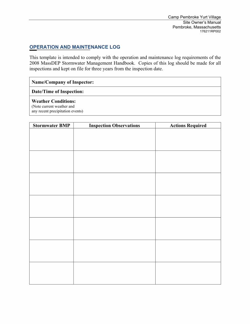
Camp Pembroke Yurt Village Site Owner’s Manual
Pembroke, Massachusetts 176211RP002
OPERATION AND MAINTENANCE LOG
This template is intended to comply with the operation and maintenance log requirements of the 2008 MassDEP Stormwater Management Handbook. Copies of this log should be made for all inspections and kept on file for three years from the inspection date. Name/Company of Inspector:
Date/Time of Inspection:
Weather Conditions: (Note current weather and any recent precipitation events)
Stormwater BMP Inspection Observations Actions Required
Appendix B
List of Emergency Contacts
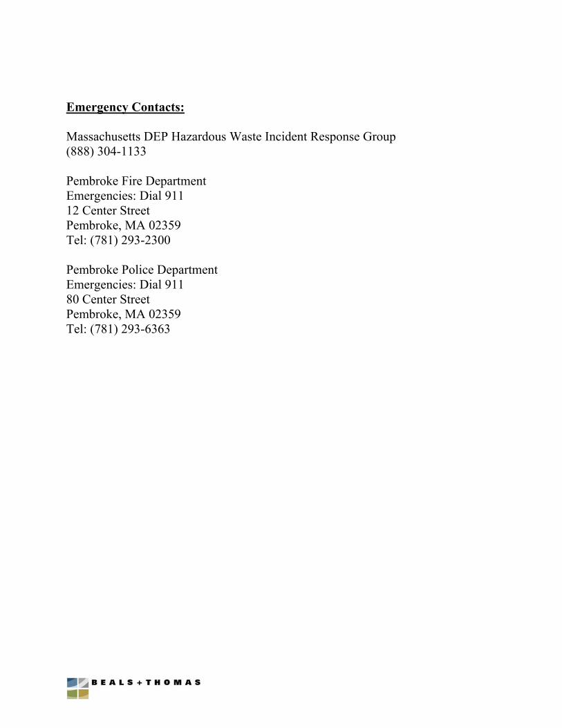
Emergency Contacts: Massachusetts DEP Hazardous Waste Incident Response Group (888) 304-1133 Pembroke Fire Department Emergencies: Dial 911 12 Center Street Pembroke, MA 02359 Tel: (781) 293-2300 Pembroke Police Department Emergencies: Dial 911 80 Center Street Pembroke, MA 02359 Tel: (781) 293-6363

Attachment 4 Construction Period Erosion, Sedimentation &
Pollution Prevention Plan
Construction Period Sediment, Erosion & Pollution Prevention Plan
Camp Pembroke Yurt Village
306 Oldham Street Pembroke, Massachusetts
Prepared for: Eli & Bessie Cohen Camps 888 Worcester Street, Suite 350 Wellesley, MA 02482
Presented by:
B E A L S + T H O M A S Beals and Thomas, Inc. 32 Court Street Plymouth, MA 02360‐3866
September 16, 2019
JRM/shm/176211RP003
Camp Pembroke Yurt Village Construction Pollution Prevention Plan
Pembroke, Massachusetts 176211RP003
Table of Contents i
Table of Contents
1.0 SITE EVALUATION, ASSESSMENT, AND PLANNING ........................................................................ 1-1
1.1 RESPONSIBLE PARTY ................................................................................................................................... 1-1 1.2 CONSTRUCTION SEQUENCING PLAN ............................................................................................................. 1-1
2.0 EROSION AND SEDIMENT CONTROL BMPS ...................................................................................... 2-1
2.1 MINIMIZE DISTURBED AREA AND PROTECT NATURAL FEATURES AND SOIL ............................................... 2-1 2.1.1 Preserve Existing Vegetation ............................................................................................................. 2-1
2.2 PHASED CONSTRUCTION ACTIVITY .............................................................................................................. 2-1 2.3 CONTROL STORMWATER FLOWING ONTO AND THROUGH THE PROJECT ...................................................... 2-1 2.4 STABILIZE SOIL ............................................................................................................................................ 2-2
2.4.1 Temporary Stabilization .................................................................................................................... 2-2 2.4.2 Permanent Stabilization ..................................................................................................................... 2-2
2.5 ESTABLISH PERIMETER CONTROLS AND SEDIMENT BARRIERS .................................................................... 2-3 2.5.1 Erosion Control Barrier .................................................................................................................... 2-3
3.0 INSPECTION SCHEDULE AND PROCEDURES .................................................................................... 3-1
4.0 FINAL STABILIZATION ............................................................................................................................ 4-1
4.1 PERMANENT SEEDING .................................................................................................................................. 4-1 LIST OF APPENDICES APPENDIX A: SITE PLANS SHOWING EROSION & SEDIMENT CONTROL MEASURES APPENDIX B: INSPECTION AND MAINTENANCE LOG
Camp Pembroke Yurt Village Construction Pollution Prevention Plan
Pembroke, Massachusetts 176211RP003
Site Evaluation, Assessment, and Planning 1-1
1.0 SITE EVALUATION, ASSESSMENT, AND PLANNING The Construction Period Erosion, Sediment & Pollution Prevention Plan complies with the requirements of Standard 8 of the 2008 Massachusetts Department of Environmental Protection (MassDEP) Stormwater Handbook. The Plan outlines source control and pollution prevention measures, and maintenance requirements for the erosion and sediment control measures associated with the construction of the proposed project.
1.1 Responsible Party
Name of persons or entity responsible for Plan compliance, to be determined prior to construction.
Company:
Name:
Address:
City: State: ZIP Code:
Telephone: Fax:
1.2 Construction Sequencing Plan Before any site grading activities begin: 1. Stake Limit of Construction. Workers shall be informed that no construction activity
is to occur beyond this limit at any time. 2. Clear vegetation as necessary to complete construction of the yurt village and common
house. 3. The existing ground surface shall be disturbed as little as possible prior to the start of
construction. 4. Install erosion and sediment control barriers as shown on the plans. An adequate
stockpile of erosion control materials shall be on site at all times for emergency or routine replacement and shall include materials to repair erosion controls, or any other devices planned for use during construction.
5. Construct a staging and materials storage area within the existing soccer field, and as far from resource areas as practicable.
6. Install temporary sanitary facilities and dumpsters.
Site grading: 1. Establish small material stockpiles as necessary and implement perimeter controls to
ensure sediment does not leave the limit of work 2. Complete grading, seed and stabilize disturbed soils as soon as practicable upon
completion of building, yurts, and pathways
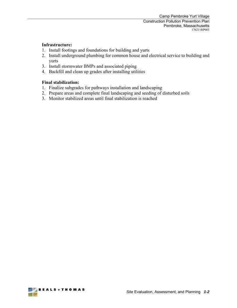
Camp Pembroke Yurt Village Construction Pollution Prevention Plan
Pembroke, Massachusetts 176211RP003
Site Evaluation, Assessment, and Planning 1-2
Infrastructure: 1. Install footings and foundations for building and yurts 2. Install underground plumbing for common house and electrical service to building and
yurts 3. Install stormwater BMPs and associated piping 4. Backfill and clean up grades after installing utilities
Final stabilization: 1. Finalize subgrades for pathways installation and landscaping 2. Prepare areas and complete final landscaping and seeding of disturbed soils 3. Monitor stabilized areas until final stabilization is reached
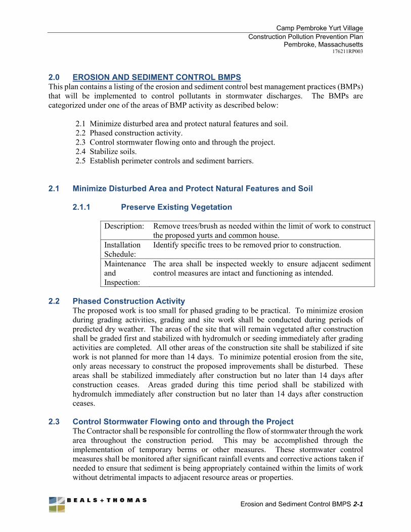
Camp Pembroke Yurt Village Construction Pollution Prevention Plan
Pembroke, Massachusetts 176211RP003
Erosion and Sediment Control BMPS 2-1
2.0 EROSION AND SEDIMENT CONTROL BMPS This plan contains a listing of the erosion and sediment control best management practices (BMPs) that will be implemented to control pollutants in stormwater discharges. The BMPs are categorized under one of the areas of BMP activity as described below:
2.1 Minimize disturbed area and protect natural features and soil. 2.2 Phased construction activity. 2.3 Control stormwater flowing onto and through the project. 2.4 Stabilize soils. 2.5 Establish perimeter controls and sediment barriers.
2.1 Minimize Disturbed Area and Protect Natural Features and Soil
2.1.1 Preserve Existing Vegetation
Description: Remove trees/brush as needed within the limit of work to construct the proposed yurts and common house.
Installation Schedule:
Identify specific trees to be removed prior to construction.
Maintenance and Inspection:
The area shall be inspected weekly to ensure adjacent sediment control measures are intact and functioning as intended.
2.2 Phased Construction Activity
The proposed work is too small for phased grading to be practical. To minimize erosion during grading activities, grading and site work shall be conducted during periods of predicted dry weather. The areas of the site that will remain vegetated after construction shall be graded first and stabilized with hydromulch or seeding immediately after grading activities are completed. All other areas of the construction site shall be stabilized if site work is not planned for more than 14 days. To minimize potential erosion from the site, only areas necessary to construct the proposed improvements shall be disturbed. These areas shall be stabilized immediately after construction but no later than 14 days after construction ceases. Areas graded during this time period shall be stabilized with hydromulch immediately after construction but no later than 14 days after construction ceases.
2.3 Control Stormwater Flowing onto and through the Project
The Contractor shall be responsible for controlling the flow of stormwater through the work area throughout the construction period. This may be accomplished through the implementation of temporary berms or other measures. These stormwater control measures shall be monitored after significant rainfall events and corrective actions taken if needed to ensure that sediment is being appropriately contained within the limits of work without detrimental impacts to adjacent resource areas or properties.
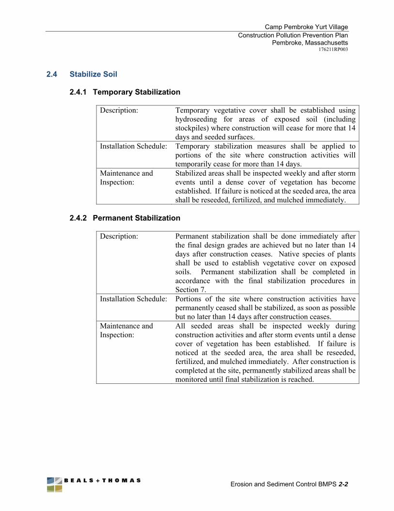
Camp Pembroke Yurt Village Construction Pollution Prevention Plan
Pembroke, Massachusetts 176211RP003
Erosion and Sediment Control BMPS 2-2
2.4 Stabilize Soil 2.4.1 Temporary Stabilization
Description: Temporary vegetative cover shall be established using hydroseeding for areas of exposed soil (including stockpiles) where construction will cease for more that 14 days and seeded surfaces.
Installation Schedule: Temporary stabilization measures shall be applied to portions of the site where construction activities will temporarily cease for more than 14 days.
Maintenance and Inspection:
Stabilized areas shall be inspected weekly and after storm events until a dense cover of vegetation has become established. If failure is noticed at the seeded area, the area shall be reseeded, fertilized, and mulched immediately.
2.4.2 Permanent Stabilization
Description: Permanent stabilization shall be done immediately after the final design grades are achieved but no later than 14 days after construction ceases. Native species of plants shall be used to establish vegetative cover on exposed soils. Permanent stabilization shall be completed in accordance with the final stabilization procedures in Section 7.
Installation Schedule: Portions of the site where construction activities have permanently ceased shall be stabilized, as soon as possible but no later than 14 days after construction ceases.
Maintenance and Inspection:
All seeded areas shall be inspected weekly during construction activities and after storm events until a dense cover of vegetation has been established. If failure is noticed at the seeded area, the area shall be reseeded, fertilized, and mulched immediately. After construction is completed at the site, permanently stabilized areas shall be monitored until final stabilization is reached.
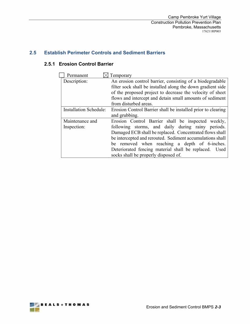
Camp Pembroke Yurt Village Construction Pollution Prevention Plan
Pembroke, Massachusetts 176211RP003
Erosion and Sediment Control BMPS 2-3
2.5 Establish Perimeter Controls and Sediment Barriers
2.5.1 Erosion Control Barrier
Permanent Temporary Description: An erosion control barrier, consisting of a biodegradable
filter sock shall be installed along the down gradient side of the proposed project to decrease the velocity of sheet flows and intercept and detain small amounts of sediment from disturbed areas.
Installation Schedule: Erosion Control Barrier shall be installed prior to clearing and grubbing.
Maintenance and Inspection:
Erosion Control Barrier shall be inspected weekly, following storms, and daily during rainy periods. Damaged ECB shall be replaced. Concentrated flows shall be intercepted and rerouted. Sediment accumulations shall be removed when reaching a depth of 6-inches. Deteriorated fencing material shall be replaced. Used socks shall be properly disposed of.
Camp Pembroke Yurt Village Construction Pollution Prevention Plan
Pembroke, Massachusetts 176211RP003
Inspection Schedule and Procedures 3-1
3.0 INSPECTION SCHEDULE AND PROCEDURES Inspections of the site will be performed once every 7 days and within 24 hours of the end of a storm event of one-half inch or greater unless otherwise specified. The inspections will verify that all BMPs are implemented, maintained and effectively minimizing erosion and preventing stormwater contamination from construction materials. Inspections shall include all areas of the site disturbed by construction activity and areas used for storage of materials that are exposed to precipitation. Inspectors shall look for evidence of, or the potential for, pollutants entering the storm water conveyance system. Sedimentation and erosion control measures identified in the plan shall be observed to ensure proper operation. Discharge locations shall be inspected to ascertain whether erosion control measures are effective in preventing significant impacts to resource areas, where accessible. Where discharge locations are inaccessible, nearby downstream locations shall be inspected to the extent that such inspections are practicable. Locations where vehicles enter or exit the site shall be inspected for evidence of off-site sediment tracking. If corrective actions are identified during the inspection, the inspector shall notify and submit a copy of the inspection report to the project managers. For corrective actions identified, the project managers shall be responsible for initiating the corrective action within 24 hours of the report and completing maintenance as soon as possible or before the next storm event.
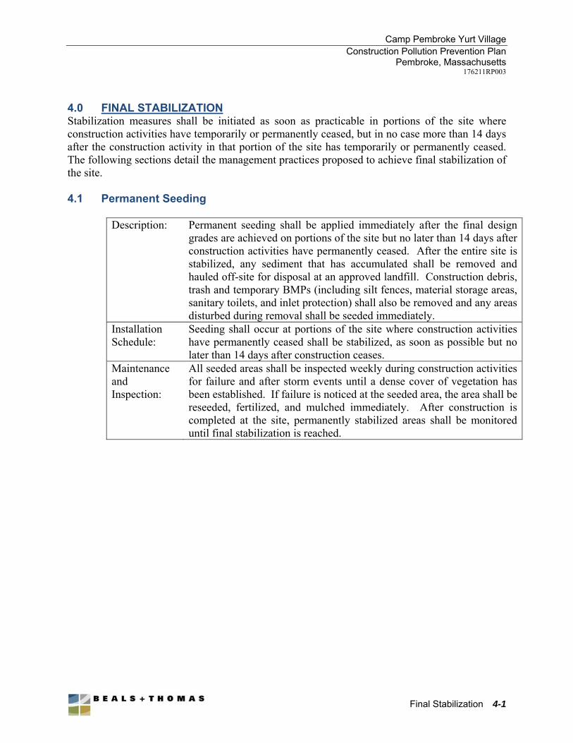
Camp Pembroke Yurt Village Construction Pollution Prevention Plan
Pembroke, Massachusetts 176211RP003
Final Stabilization 4-1
4.0 FINAL STABILIZATION Stabilization measures shall be initiated as soon as practicable in portions of the site where construction activities have temporarily or permanently ceased, but in no case more than 14 days after the construction activity in that portion of the site has temporarily or permanently ceased. The following sections detail the management practices proposed to achieve final stabilization of the site. 4.1 Permanent Seeding
Description: Permanent seeding shall be applied immediately after the final design
grades are achieved on portions of the site but no later than 14 days after construction activities have permanently ceased. After the entire site is stabilized, any sediment that has accumulated shall be removed and hauled off-site for disposal at an approved landfill. Construction debris, trash and temporary BMPs (including silt fences, material storage areas, sanitary toilets, and inlet protection) shall also be removed and any areas disturbed during removal shall be seeded immediately.
Installation Schedule:
Seeding shall occur at portions of the site where construction activities have permanently ceased shall be stabilized, as soon as possible but no later than 14 days after construction ceases.
Maintenance and Inspection:
All seeded areas shall be inspected weekly during construction activities for failure and after storm events until a dense cover of vegetation has been established. If failure is noticed at the seeded area, the area shall be reseeded, fertilized, and mulched immediately. After construction is completed at the site, permanently stabilized areas shall be monitored until final stabilization is reached.
Camp Pembroke Yurt Village Construction Pollution Prevention Plan
Pembroke, Massachusetts 176211RP003
Appendix A
Site Plans Showing Erosion and Sediment Control Measures (Site Plans Attached Separately)
Appendix B
Inspection and Maintenance Log
Inspections under this Plan shall be conducted in accordance with each installed BMP’s recommended maintenance requirements. This inspection frequency may be reduced to at least once every month if: a) the entire site is temporarily stabilized, b) runoff is unlikely due to winter conditions (e.g. site is covered with snow, ice, or the ground is frozen), or c) construction is occurring during seasonal arid periods in arid areas and semi-arid areas. If an inspection report is filed according to this modified schedule it shall be noted at the end of the report under the “NOTES” section. The following four pages should be copied and completed for each inspection. All inspection forms should be compiled in a binder to prove compliance with this Pla
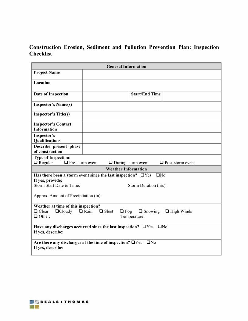
Construction Erosion, Sediment and Pollution Prevention Plan: Inspection Checklist
General Information Project Name
Location
Date of Inspection Start/End Time
Inspector’s Name(s)
Inspector’s Title(s)
Inspector’s Contact Information
Inspector’s Qualifications
Describe present phase of construction
Type of Inspection: Regular Pre-storm event During storm event Post-storm event
Weather Information Has there been a storm event since the last inspection? Yes No If yes, provide: Storm Start Date & Time: Storm Duration (hrs): Approx. Amount of Precipitation (in): Weather at time of this inspection? Clear Cloudy Rain Sleet Fog Snowing High Winds Other: Temperature: Have any discharges occurred since the last inspection? Yes No If yes, describe: Are there any discharges at the time of inspection? Yes No If yes, describe:
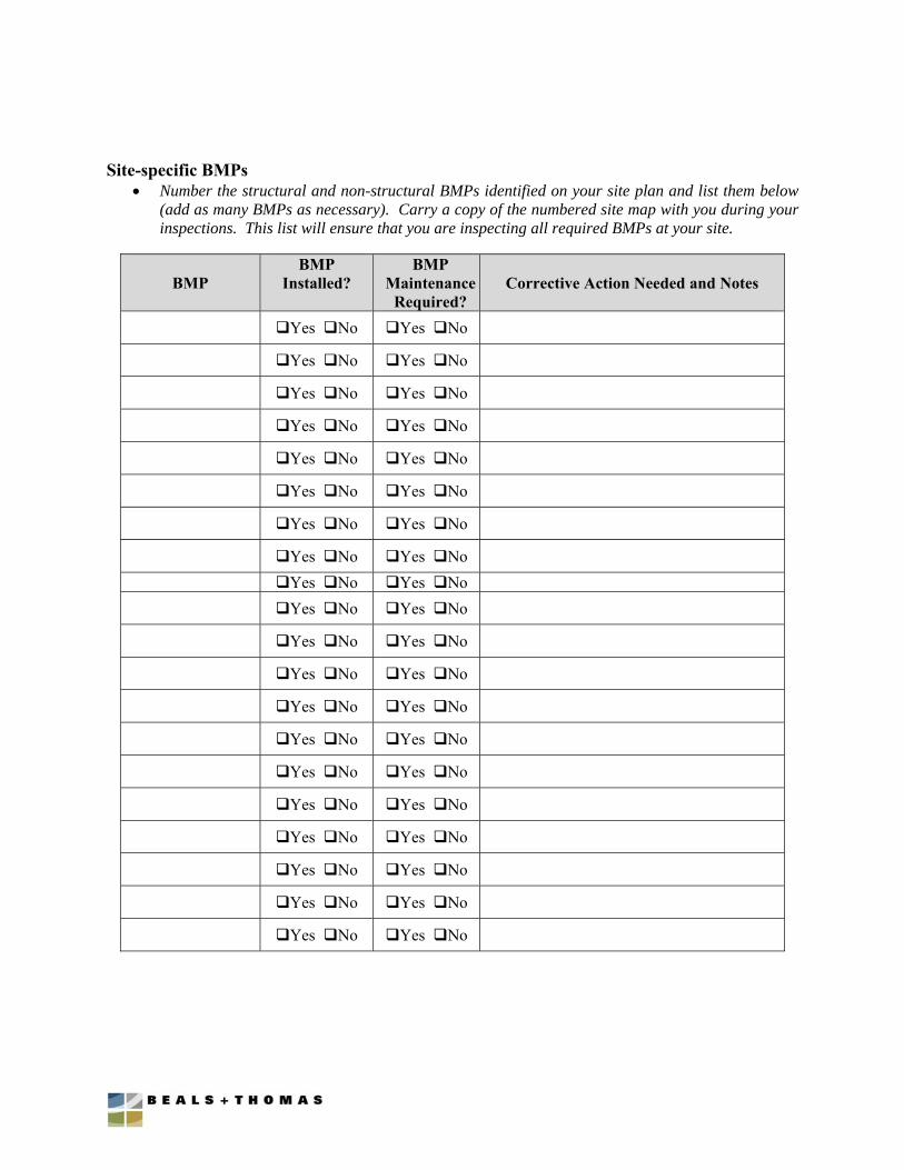
Site-specific BMPs Number the structural and non-structural BMPs identified on your site plan and list them below
(add as many BMPs as necessary). Carry a copy of the numbered site map with you during your inspections. This list will ensure that you are inspecting all required BMPs at your site.
BMP
BMP Installed?
BMP Maintenance
Required?
Corrective Action Needed and Notes
Yes No Yes No
Yes No Yes No
Yes No Yes No
Yes No Yes No
Yes No Yes No
Yes No Yes No
Yes No Yes No
Yes No Yes No
Yes No Yes No Yes No Yes No
Yes No Yes No
Yes No Yes No
Yes No Yes No
Yes No Yes No
Yes No Yes No
Yes No Yes No
Yes No Yes No
Yes No Yes No
Yes No Yes No
Yes No Yes No
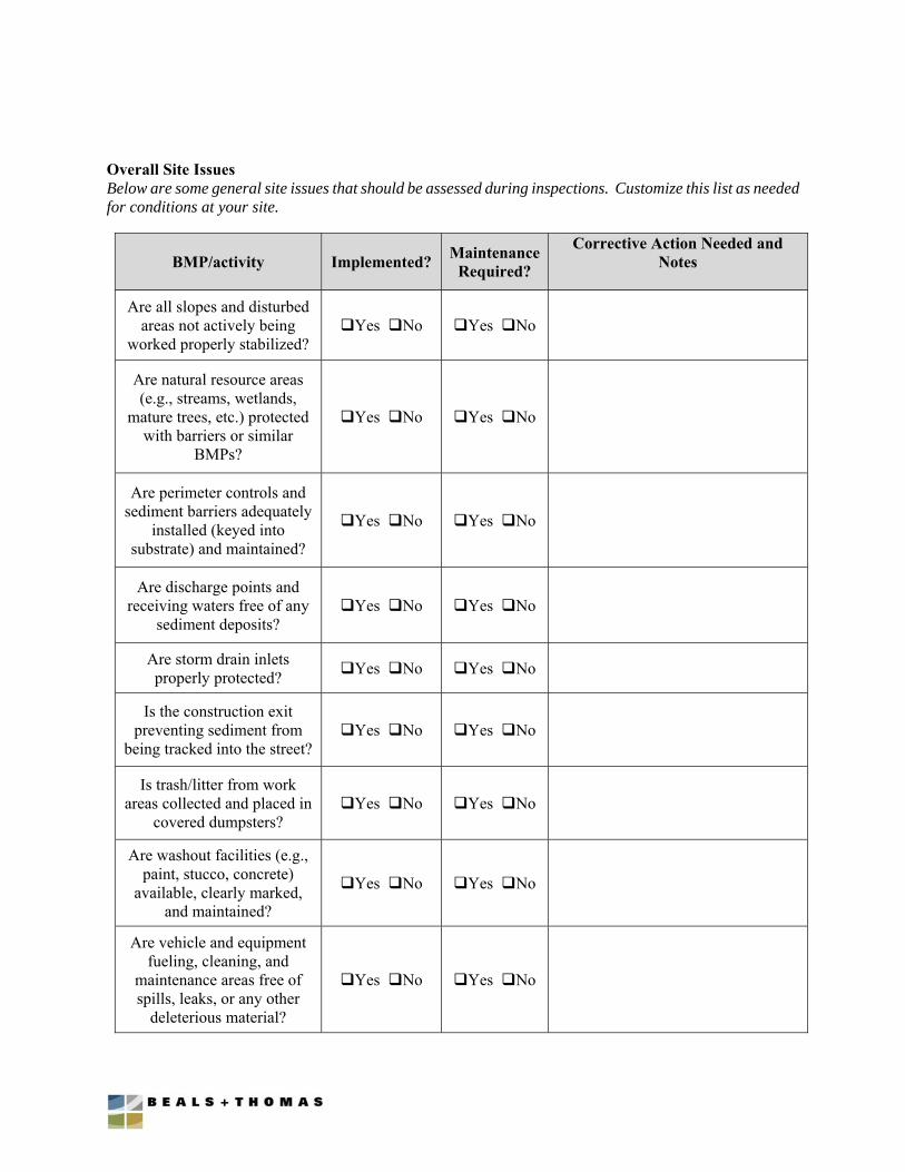
Overall Site Issues Below are some general site issues that should be assessed during inspections. Customize this list as needed for conditions at your site.
BMP/activity Implemented? Maintenance
Required?
Corrective Action Needed and Notes
Are all slopes and disturbed areas not actively being
worked properly stabilized? Yes No Yes No
Are natural resource areas (e.g., streams, wetlands,
mature trees, etc.) protected with barriers or similar
BMPs?
Yes No Yes No
Are perimeter controls and sediment barriers adequately
installed (keyed into substrate) and maintained?
Yes No Yes No
Are discharge points and receiving waters free of any
sediment deposits? Yes No Yes No
Are storm drain inlets properly protected? Yes No Yes No
Is the construction exit preventing sediment from
being tracked into the street? Yes No Yes No
Is trash/litter from work areas collected and placed in
covered dumpsters? Yes No Yes No
Are washout facilities (e.g., paint, stucco, concrete)
available, clearly marked, and maintained?
Yes No Yes No
Are vehicle and equipment fueling, cleaning, and
maintenance areas free of spills, leaks, or any other
deleterious material?
Yes No Yes No
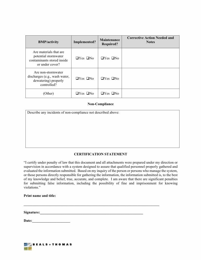
BMP/activity Implemented? Maintenance
Required?
Corrective Action Needed and Notes
Are materials that are potential stormwater
contaminants stored inside or under cover?
Yes No Yes No
Are non-stormwater discharges (e.g., wash water,
dewatering) properly controlled?
Yes No Yes No
(Other) Yes No Yes No
Non-Compliance
Describe any incidents of non-compliance not described above:
CERTIFICATION STATEMENT
“I certify under penalty of law that this document and all attachments were prepared under my direction or supervision in accordance with a system designed to assure that qualified personnel properly gathered and evaluated the information submitted. Based on my inquiry of the person or persons who manage the system, or those persons directly responsible for gathering the information, the information submitted is, to the best of my knowledge and belief, true, accurate, and complete. I am aware that there are significant penalties for submitting false information, including the possibility of fine and imprisonment for knowing violations.” Print name and title: ___________________________________________________________________________ Signature:_________________________________________________________ Date:_____________________
Section 5.0 Plans
Entitled Camp Pembroke Yurt Village
Prepared by Beals and Thomas, Inc.
In 10 Sheets
Dated September 18, 2019