Embed Size (px)
Citation preview
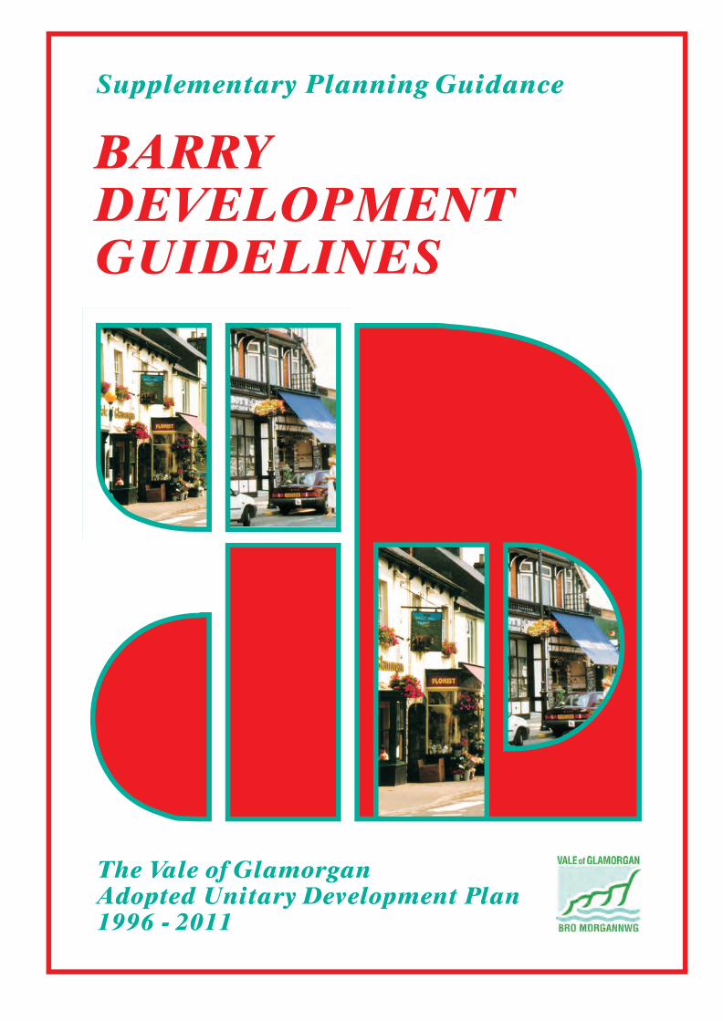
BARRYDEVELOPMENTGUIDELINES
Supplementary Planning Guidance
The Vale of GlamorganAdopted Unitary Development Plan1996 - 2011
BARRY DEVELOPMENT GUIDELINES
The Vale of Glamorgan UDP Supplementary Planning Guidance
Rob Quick, B.A. (Hons), Dip. TP, MRTPI. Director of Environmental & Economic Regeneration Rob Thomas, B.Sc. (Hons), M.Sc., MRTPI. Head of Planning & Transportation The Vale of Glamorgan Council. © 2006

The Vale of Glamorgan UDP Supplementary Planning Guidance Barry Development Guidelines 2.
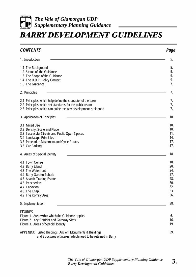
CONTENTS 1. Introduction 1.1 The Background 1.2 Status of the Guidance 1.3 The Scope of the Guidance 1.4 The U.D.P. Policy Context 1.5 The Guidance 2. Principles 2.1 Principles which help define the character of the town 2.2 Principles which set standards for the public realm 2.3 Principles which can guide the way development is planned 3. Application of Principles 3.1 Mixed Use 3.2 Density, Scale and Place 3.3 Successful Streets and Public Open Spaces 3.4 Landscape Principles 3.5 Pedestrian Movement and Cycle Routes 3.6 Car Parking 4. Areas of Special Identity 4.1 Town Centre 4.2 Barry Island 4.3 The Waterfront 4.4 Barry Garden Suburb 4.5 Atlantic Trading Estate 4.6 Pencoedtre 4.7 Cadoxton 4.8 The Knap 4.9 The Romilly Area 5. Implementation FIGURES Figure 1. Area within which the Guidance applies Figure 2. Key Corridor and Gateway Sites Figure 3. Areas of Special Identity APPENDIX Listed Buidings, Ancient Monuments & Buildings
and Structures of Interest which need to be retained in Barry
BARRY DEVELOPMENT GUIDELINES
The Vale of Glamorgan UDP Supplementary Planning Guidance
3. The Vale of Glamorgan UDP Supplementary Planning Guidance Barry Development Guidelines
Page
5.
5. 5. 5. 5. 7.
7.
7. 7. 7.
10.
10. 10. 11. 14. 17. 17.
18.
18. 20. 24. 27. 28. 30. 32. 33. 36.
38.
6. 16. 19.
39.

4. The Vale of Glamorgan UDP Supplementary Planning Guidance Barry Development Guidelines
5. The Vale of Glamorgan UDP Supplementary Planning Guidance Barry Development Guidelines
BARRY DEVELOPMENT GUIDELINES
The Vale of Glamorgan UDP Supplementary Planning Guidance
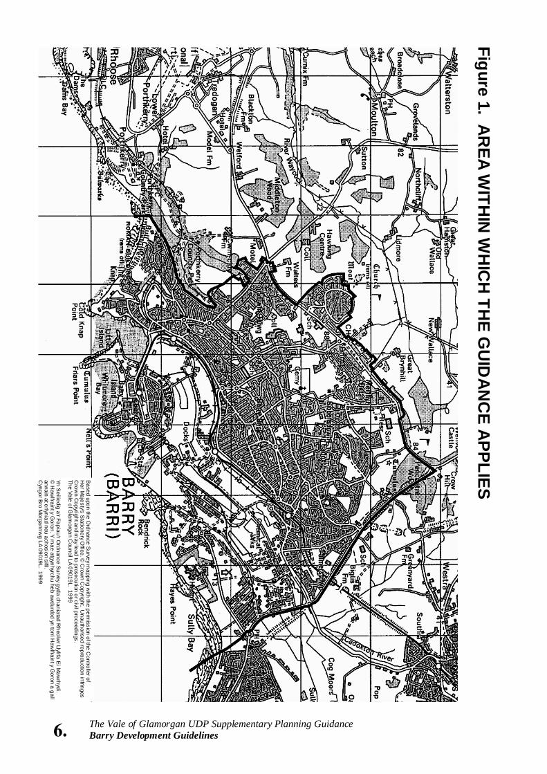
1. INTRODUCTION 1.1 The Background The Barry Development Guidelines have been prepared to assist the Council, private landowners and developers in formulating and reviewing proposals for the built environment. The Guidelines have been prepared following the publication of a study commissioned by the Vale of Glamorgan Council and the Welsh Development Agency -“Barry: A Vision for A Sense of Place”. The Study sought to identify how the built and natural environment contributes towards people's perception of the town, and secondly, how Barry's identity and “sense of place” can be enhanced as change and development takes place. The findings of the Study have informed the preparation of this “Supplementary Planning Guidance”. 1.2 Status of Guidance This guidance was approved for Development Control purposes by the Council on 6th January 1999, (Council Minute No: 995 refers). This document has subsequently been updated in light of Planning Policy Wales (2002). This Guidance will be used as a material consideration in determining planning applications and appeals. 1.3 The Scope of the Guidance The Unitary Development Plan sets out policies for the protection and enhancement of urban townscapes, (ENV 17) as well as policies for new development. (Policies ENV 25 and ENV 27). This guidance note explains how the policies can guide the way we protect existing townscapes and co-ordinate new development within Barry. Figure 1 indicates the area to which these guidelines apply. The guidance follows advice within Technical Advice
Note (Wales) 12, “Design” which explains that development plan policies should be based on a proper assessment of the character of the surrounding built and natural environment, and should take account of the defining characteristics of each local area. 1.4 The UDP Policy Context The guidance should be read in conjunction with policies set out in the Environment chapter of the UDP and in particular Policies ENV25 and ENV27. Policy ENV 25 seeks to guide the regeneration of urban areas and states that “measures to improve the environmental quality of the urban fabric will be favoured with priority being given to older urban areas and housing estates. Particular attention will be given to the regeneration of derelict or degraded land especially within the former dockland of Barry and Penarth”. The explanatory paragraph for ENV 27 explains that the policy establishes a framework to achieve appropriate sensitive development that promotes creative and imaginative design within the Vale of Glamorgan: “In view of the wide variety of architectural styles and contrasting identities for the Vale's towns, villages and open countryside, it would be inappropriate to introduce rigid over prescriptive design controls for new development within the Plan. However, to further promote good design principles and provide better advice to architects and their clients, the Council will prepare supplementary guidance and design briefs for detailed topics and issues.” At the same time, the Unitary Development Plan stresses the importance of the local natural and built environment in providing a context for new development (Policy ENV 17). The Guidance should be read in conjunction with other Supplementary Planning Guidance prepared for Barry Garden Suburb Conservation Area and the following topics “Trees and Development” and “Amenity Standards”. The Unitary Development Plan also identifies three further areas of study which will inform future supplementary planning guidance. These are a
6. The Vale of Glamorgan UDP Supplementary Planning Guidance Barry Development Guidelines
Figure 1. AR
EA WITH
IN W
HIC
H TH
E GU
IDA
NC
E APPLIES
Based upon the O
rdnance Survey m
apping with the perm
ission of the Controller of
Her M
ajesty's Stationery O
ffice. © C
rown C
opyright. Unauthorised reproduction infringes
Crow
n Copyright and m
ay lead to prosecution or civil proceedings. The Vale of G
lamorgan C
ouncil LA 09019L. 1999 Yn S
eiliedig a'r Fapiau'r Ordnance S
urvey gyda chaniatad R
heolwr Llyfrfa E
i Maw
rhydi. ©
Haw
lfraint y Goron. Y
mae atgynhyrchu heb aw
durdod yn torri Haw
lfraint y Goron a gall
arwain at erlyniad neu achosion sifil.
Cyngor B
ro Morgannw
g LA 09019L. 1999
Landscape Study for the Vale of Glamorgan, a Note on "Advertisements in Conservation Areas" and a Note on "Shop front Design in Conservation Areas". 1.5 The Guidance The Guidelines are set out in four parts. The first sets out the principles, identified in the Sense of Place Study and provides a clear indication of the Council's expectations for the design and quality of new development in Barry. The second section explains how the principles can be applied in a number of key locations and situations. The third section sets out areas that have a special identity and proposes design objectives for new development within each area. An appraisal of each area provides the basis for guidelines to be followed in considering new development. The final section sets out ways in which the Guidance can be implemented and identifies how these guidelines are to be addressed by other bodies with a role in managing and influencing the built environment within Barry. 2. PRINCIPLES These principles develop the findings of the Sense of Place study and seek to provide a clear indication of the Council's expectations for the design and quality of new development within Barry. Three groups of principles are identified to provide a basis for evaluating the built environment at different geographic scales. These are: • Principles which help define the character of the
town • Principles which set standards and expectations
for the public realm • Principles which can guide the way development
is planned. 2.1 Principles which help define the character of the town Barry's Maritime Identity The coastline is one of the most important factors in
defining the character of Barry. New development should seek to promote and reflect this character, recognising the importance of the sea and coastline in the design and orientation of new development. The Integration of the Town Centre with the Waterfront The redevelopment of the Barry Waterfront provides the opportunity to create a more cohesive and vibrant urban form that can link The Waterfront with the established town. The Topography of the Town The development of Barry around the coast provides extensive views and vistas across the town, making new development on exposed slopes prominent. New development should seek to reflect and work with the contours of a site, maximising the opportunities for landscaping and the integration of built form with the existing topography.
The Special Character of Districts and Neighbourhoods in the Town Barry possesses many distinct and contrasting areas. These areas reflect the physical layout of the town and the way it has developed in response to its social and economic history. There are opportunities to reflect these differences, and to enhance the unique character of areas that have a special identity. These are described in Section 4 of these Guidelines. The Re-use, Rehabilitation and Restoration of Important Buildings There are a number of buildings and structures that provide landmarks and contribute to the character and historic significance of the Barry area. These include a number of listed buildings and structures
7. The Vale of Glamorgan UDP Supplementary Planning Guidance Barry Development Guidelines
8. The Vale of Glamorgan UDP Supplementary Planning Guidance Barry Development Guidelines
that are statutorily protected from demolition or alteration. Others are not recognised, but remain sensitive to development pressures. These are identified in an Appendix to this Guidance. The Vitality of the Town Centre, and other
Commercial Sub-centres Barry town centre has traditionally been the commercial and cultural focus of the wider Barry community. Its vitality is dependent, in part, on the overall physical attractiveness of the built form, which in turn can foster investment in local services and retail uses. Built form within the town centre should be consciously urban in character and seek to combine and mix uses at sustainable densities. Gateways and Routes Town approaches need to be carefully designed providing clear and attractive arrival routes. Corridors and routes through the town that are recognised for their distinctive qualities can unify the town and provide a framework within which development may evolve. These are described in Section 3 of the Guidelines. 2.2 Principles which set standards and expectations for the Public Realm A Cohesive and Legible Urban Form There is a need for clarity in design in order to promote the legibility of an area, and to enable people to understand where they are, and how to orient themselves within the town. This can be achieved by providing landmarks at key points, by locating important buildings in prominent places and spaces and by clarifying the role of a building and its importance.
New Development which is Responsive to its Context Design for new development should reflect a clear understanding of townscape quality and context. New development should recognise the following contextual elements: density, street pattern, architectural scale, street character, detailing and use of materials. Building design should also consider the natural and historical landscape that gives Barry its special character. Reinforce and Enhance the Pedestrian Network Pedestrian routes through large urban blocks or development parcels should be encouraged to provide choice and variety in routes. The design of roads for new development should aim principally to reduce vehicular speed, and to provide easy access and movement for pedestrians. The choice and design of routes that link new development with established areas, should be clear and reflect a recognised hierarchy of routes and spaces. This can be achieved through the suitable design and landscaping of routes to ensure an appropriate design and scale for buildings that front the highway. Security in the Public Realm New development should seek to minimise the risk and fear of crime, through design that engenders a sense of ownership and “belonging”.
The design of spaces and buildings should ensure that people are able to overlook public spaces, and that they are able to have a degree of responsibility and stewardship for the places which help define their local neighbourhood or street.
9. The Vale of Glamorgan UDP Supplementary Planning Guidance Barry Development Guidelines
Mix, Density and Visual Impact The appropriate density or mix of uses will vary from place to place according to the ability of the local economy to sustain certain levels of development. However, where possible, new development should be designed to create a visual impact and to establish a mix of uses that are mutually supportive. Sustainable densities will permit a mix of dwellings, shops and public facilities, within close proximity to one another. This can lessen the reliance on private cars and encourage the use of alternative forms of transport. 2.3 Design Principles which can guide the way development is planned Promote a High Quality Environment New development should seek to embody the following design principles: Order and unity: The design of build ings and the spaces between them should demonstrate a coherent and balanced approach to scale, massing and design; Integrity: The design and appearance of new development should reflect the use of the building or spaces created; Detail: New development should demonstrate attention to detail in materials, and construction; Local Distinctiveness: New Development should acknowledge the potential for public art to contribute to the identity of an area; Flexibility: New development should consider the opportunities for adaptation and change to suit the needs of future uses and users. Consider and Enhance Views and Vistas The siting and design of new buildings should respect and, where possible, enhance views to and from public spaces and other buildings or landmarks of interest. Establish a Successful Transition between Buildings and Public Spaces New development which addresses public spaces
should contribute to their enhancement either through enclosing or framing the space or by marking the space's relative importance through building design and scale.
Design with regard for a Hierarchy of Routes and Spaces Building design should respond to each site's context to ensure that a hierarchy of built form is established which responds to the specific conditions of the surrounding built form and open space. Street corners and intersections should be appropriately marked and other open spaces should offer the opportunity to establish suitable urban landmarks. Provide a Clear Definition between the Private and Public Domain New development should establish a clear delineation between private and public space to ensure the suitable use of public and private open space, safety for pedestrians, and an unambiguous layout for future management. Promote Flexibility and Sustainability in Design
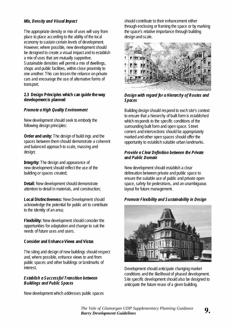
Development should anticipate changing market conditions and the likelihood of phased development. Site specific development should also be designed to anticipate the future reuse of a given building.
10. The Vale of Glamorgan UDP Supplementary Planning Guidance Barry Development Guidelines
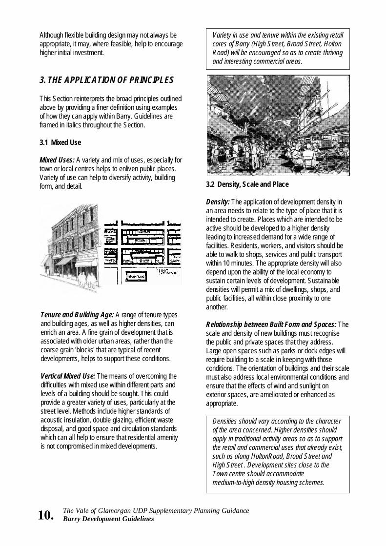
Although flexible building design may not always be appropriate, it may, where feasible, help to encourage higher initial investment. 3. THE APPLICATION OF PRINCIPLES This Section reinterprets the broad principles outlined above by providing a finer definition using examples of how they can apply within Barry. Guidelines are framed in italics throughout the Section. 3.1 Mixed Use Mixed Uses: A variety and mix of uses, especially for town or local centres helps to enliven public places. Variety of use can help to diversify activity, building form, and detail.
Variety in use and tenure within the existing retail cores of Barry (High Street, Broad Street, Holton Road) will be encouraged so as to create thriving and interesting commercial areas.
3.2 Density, Scale and Place Density: The application of development density in an area needs to relate to the type of place that it is intended to create. Places which are intended to be active should be developed to a higher density leading to increased demand for a wide range of facilities. Residents, workers, and visitors should be able to walk to shops, services and public transport within 10 minutes. The appropriate density will also depend upon the ability of the local economy to sustain certain levels of development. Sustainable densities will permit a mix of dwellings, shops, and public facilities, all within close proximity to one another. Relationship between Built Form and Spaces: The scale and density of new buildings must recognise the public and private spaces that they address. Large open spaces such as parks or dock edges will require building to a scale in keeping with those conditions. The orientation of buildings and their scale must also address local environmental conditions and ensure that the effects of wind and sunlight on exterior spaces, are ameliorated or enhanced as appropriate.
Densities should vary according to the character of the area concerned. Higher densities should apply in traditional activity areas so as to support the retail and commercial uses that already exist, such as along HoltonRoad, Broad Street and High Street . Development sites close to the Town centre should accommodate medium-to-high density housing schemes.
Tenure and Building Age: A range of tenure types and building ages, as well as higher densities, can enrich an area. A fine grain of development that is associated with older urban areas, rather than the coarse grain 'blocks' that are typical of recent developments, helps to support these conditions. Vertical Mixed Use: The means of overcoming the difficulties with mixed use within different parts and levels of a building should be sought. This could provide a greater variety of uses, particularly at the street level. Methods include higher standards of acoustic insulation, double glazing, efficient waste disposal, and good space and circulation standards which can all help to ensure that residential amenity is not compromised in mixed developments.
11. The Vale of Glamorgan UDP Supplementary Planning Guidance Barry Development Guidelines
The Waterfront area should also be developed to relatively higher densities along the waterfront and distributor routes. Taller buildings should be used as focal points to complete view corridors, establish strong intersections, define public open spaces and establish urban streets.
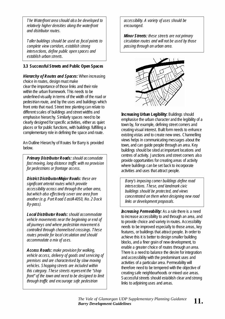
3.3 Successful Streets and Public Open Spaces Hierarchy of Routes and Spaces: When increasing choice in routes, design must make clear the importance of those links and their role within the urban framework. This needs to be underlined visually in terms of the width of the road or pedestrian route, and by the uses and buildings which front onto that road. Street tree planting can relate to different scales of buildings and street widths and emphasise hierarchy. Similarly spaces need to be clearly designed for specific activities, either as quiet places or for public functions, with buildings fulfilling a complementary role in defining the space and route. An Outline Hierarchy of Routes for Barry is provided below.
Primary Distributor Roads: should accomodate fast moving, long distance trafflc with no provision for pedestrians or frontage access. District Distributor/Major Roads: these are significant arterial routes which provide accessibility across and through the urban area, but which also effectively sever one area from another (e.g. Port Road East/A4050, No. 2 Dock By-pass). Local Distributor Roads: should accommodate vehicle movements near the beginning or end of all journeys and where pedestrian movement is controlled through channelised crossings. These routes provide for local circulation and should accommodate a mix of uses. Access Roads: make provision for walking, vehicle access, delivery of goods and servicing of premises and are characterised by slow moving vehicles. Shopping streets are included within this category. These streets represent the "shop front" of the town and need to be designed to limit through traffic and encourage safe pedestrian
accessibility. A variety of uses should be encouraged. Minor Streets: these streets are not primary circulation routes and will not be used by those passing through an urban area.
Increasing Urban Legibility: Buildings should emphasise the urban character and the legibility of a town by, for example, defining street corners and creating visual interest. Built form needs to enhance existing vistas and to create new ones. Channelling views helps in communicating messages about the town, and can guide people through an area. Key buildings should be sited at important locations and centres of activity. Junctions and street corners also provide opportunities for creating areas of activity where buildings can be set back to incorporate activities and uses that attract people.
Barry’s imposing corner buildings define road intersections. These, and landmark civic buildings should be protected, and views concentrated on them when designing new road links or development proposals.
Increasing Permeability: As a rule there is a need to increase accessibility to and through an area, and to provide choice and variety in routes. Accessibility needs to be improved especially to those areas, key features, or buildings that attract people. In order to achieve this it is better to design smaller building blocks, and a finer grain of new development, to enable a greater choice of routes through an area. There is a need to balance the desire for integration and accessibility with the predominant uses and activities of a particular area. Permeability will therefore need to be tempered with the objective of creating safe neighbourhoods or mixed use areas. Successful streets should establish clear and strong links to adjoining uses and areas.
12. The Vale of Glamorgan UDP Supplementary Planning Guidance Barry Development Guidelines
New development should encourage the controlled but through movement, of pedestrians and vehicles within neighbourhoods. Illegible street patterns should be avoided where possible.
Ensuring Rhythm in Design: Whilst there should be variety in building and townscape design, there also needs to be a thematic order that links elements together along a particular street, square or park and which provides a distinctive character. This could be applied through the use of building materials, a vertical emphasis in elevational treatment, or with a common theme in the detailing of entrances. Segments of High Street and parts of Holton Road embody these principles. However, along other parts of Holton Road, such as west of the former Town Hall, this rhythm has been damaged by a horizontal and less detailed form of development.
New development should be designed to re-establish the predominant street wall rhythm where it has been damaged, or a new one created where new streets or squares are proposed.
Street Marker Sequences: Streets should possess landmarks or a sequence of markers that help to orient and guide people as they travel along it.
New development should seek to incorporate new landmarks or enhance those existing.
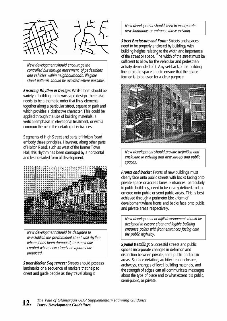
Street Enclosure and Form: Streets and spaces need to be properly enclosed by buildings with building heights relating to the width and importance of the street or space. The width of the street must be sufficient to allow for the vehicular and pedestrian activity demanded of it. Any set-back of the building line to create space should ensure that the space formed is to be used for a clear purpose.
New development should provide definition and enclosure to existing and new streets and public spaces.
Fronts and Backs: Fronts of new buildings must clearly face onto public streets with backs facing onto private space or access lanes. Entrances, particularly to public buildings, need to be clearly defined and to emerge onto public or semi-public areas. This is best achieved through a perimeter block form of development where fronts and backs face onto public and private areas respectively.
New development or infill development should be designed to ensure clear and legible building entrance points with front entrances facing onto the public highway.
Spatial Detailing: Successful streets and public spaces incorporate changes in definition and distinction between private, semi-public and public areas. Surface detailing, architectural enclosure, archways, changes of level, building materials, and the strength of edges can all communicate messages about the type of place and to what extent it is public, semi-public, or private.
13. The Vale of Glamorgan UDP Supplementary Planning Guidance Barry Development Guidelines
When considering new development, its contribution to the definition of public and private space should be carefully reviewed. Opportunities for enhancing the public realm should be considered.
Promoting Detail and Richness in Design: Buildings and features need to incorporate a hierarchy of visible detail that is recognisable from different distances. Thus, certain elements of built form, such as a tower, can be seen from a distance, whilst more intricate detail (such as ironwork, fenestration or facade detailing) can emerge as one approaches a building. All this adds to richness in urban form and contributes towards the character of a place. Listed Buildings, Ancient Monuments and buildings and structures of interest are identified in an appendix to this report.
Where feasible, Barry’s Victorian detailing should be retained and new development should respect the Town's traditional built form, character and detailing.
Respecting the Building Line: Buildings which face onto streets or border squares and parks should respect the building line created by the building facade. Projections and setbacks from this line, such as bays, foyers and entrance halls, can be used to create a visual emphasis. Those buildings which are set back from the building line should contribute to the street scene. They should be in scale with the surrounding townscape and relate to the space that they are enclosing. This will help to reinforce identity and a ‘sense of place’ for parts of the town.
New development should respect traditional building lines. Where departures are proposed the result should contribute to the overall quality of the street or public open space.
Building Design, Mixed Use and Flexibility: New buildings need to be designed to accommodate a mix of uses and be able to accommodate flexibility in internal layout to accommodate new uses. Designing for flexibility can range from ensuring that a building's structural grid is capable of accommodating more than one use to the installation of flexible cladding systems which can permit future change. Flexibility in design with a clear understanding of the need for accommodating people and change will help to promote the long term success of a street environment. Street furniture and art can also be used to define a specific character.
Mixed use buildings and buildings which provide for flexibility of use will be encouraged.
Management and Maintenance: The long-term maintenance of streets and public and private spaces is essential for encouraging their use and success. This needs to incorporate street cleanliness, the maintenance and upkeep of buildings, highways and street furniture, as well as security and surveillance. Both within the public and private realm, but particularly within the public realm, sufficient resources should be made available to ensure proper day-to-day maintenance and long term renewal. The use of high quality materials at the outset can often result in lower overall maintenance and capital replacement costs in the future.
New development areas, such as the Docks, should incorporate clear management and maintenance regimes. Proposals for new development will be expected to address issues of management, maintenance and additional contributions, where appropriate, to ensure the suitable maintenance of adjacent public open spaces.
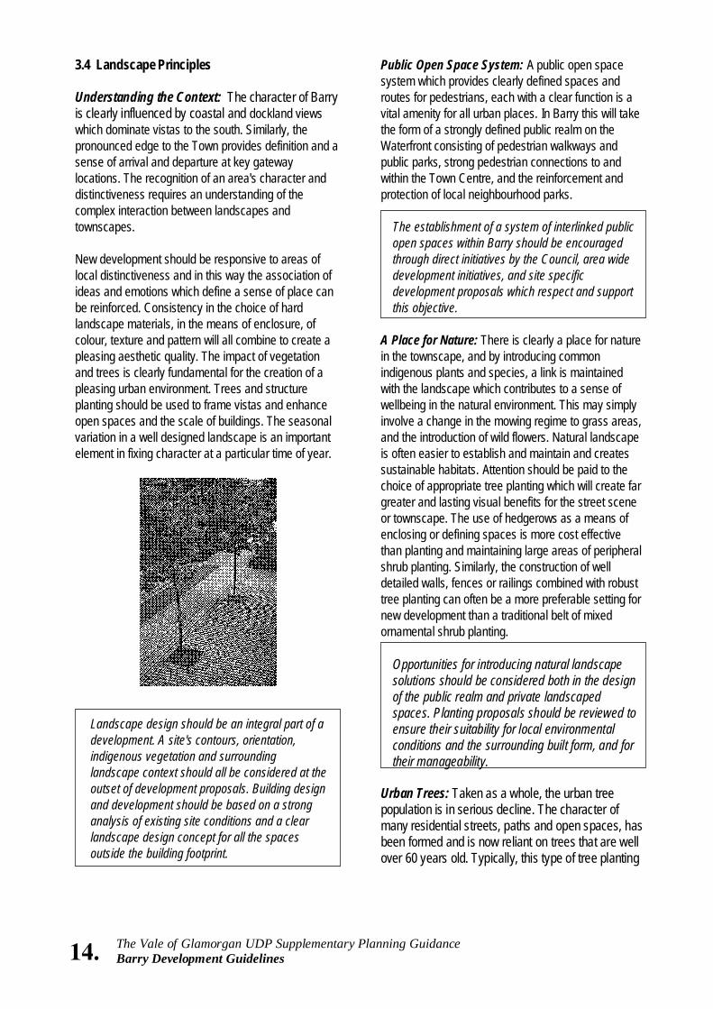
3.4 Landscape Principles Understanding the Context: The character of Barry is clearly influenced by coastal and dockland views which dominate vistas to the south. Similarly, the pronounced edge to the Town provides definition and a sense of arrival and departure at key gateway locations. The recognition of an area's character and distinctiveness requires an understanding of the complex interaction between landscapes and townscapes. New development should be responsive to areas of local distinctiveness and in this way the association of ideas and emotions which define a sense of place can be reinforced. Consistency in the choice of hard landscape materials, in the means of enclosure, of colour, texture and pattern will all combine to create a pleasing aesthetic quality. The impact of vegetation and trees is clearly fundamental for the creation of a pleasing urban environment. Trees and structure planting should be used to frame vistas and enhance open spaces and the scale of buildings. The seasonal variation in a well designed landscape is an important element in fixing character at a particular time of year.
Public Open Space System: A public open space system which provides clearly defined spaces and routes for pedestrians, each with a clear function is a vital amenity for all urban places. In Barry this will take the form of a strongly defined public realm on the Waterfront consisting of pedestrian walkways and public parks, strong pedestrian connections to and within the Town Centre, and the reinforcement and protection of local neighbourhood parks.
The establishment of a system of interlinked public open spaces within Barry should be encouraged through direct initiatives by the Council, area wide development initiatives, and site specific development proposals which respect and support this objective.
A Place for Nature: There is clearly a place for nature in the townscape, and by introducing common indigenous plants and species, a link is maintained with the landscape which contributes to a sense of wellbeing in the natural environment. This may simply involve a change in the mowing regime to grass areas, and the introduction of wild flowers. Natural landscape is often easier to establish and maintain and creates sustainable habitats. Attention should be paid to the choice of appropriate tree planting which will create far greater and lasting visual benefits for the street scene or townscape. The use of hedgerows as a means of enclosing or defining spaces is more cost effective than planting and maintaining large areas of peripheral shrub planting. Similarly, the construction of well detailed walls, fences or railings combined with robust tree planting can often be a more preferable setting for new development than a traditional belt of mixed ornamental shrub planting.
Opportunities for introducing natural landscape solutions should be considered both in the design of the public realm and private landscaped spaces. Planting proposals should be reviewed to ensure their suitability for local environmental conditions and the surrounding built form, and for their manageability.
Urban Trees: Taken as a whole, the urban tree population is in serious decline. The character of many residential streets, paths and open spaces, has been formed and is now reliant on trees that are well over 60 years old. Typically, this type of tree planting
14. The Vale of Glamorgan UDP Supplementary Planning Guidance Barry Development Guidelines
Landscape design should be an integral part of a development. A site's contours, orientation, indigenous vegetation and surrounding landscape context should all be considered at the outset of development proposals. Building design and development should be based on a strong analysis of existing site conditions and a clear landscape design concept for all the spaces outside the building footprint.

15. The Vale of Glamorgan UDP Supplementary Planning Guidance Barry Development Guidelines
used large species which were considered appropriate in scale and form for the streets, civic buildings and open spaces which they still frame. The pressures and stresses that trees have to withstand in an urban environment are many and varied. These mature specimens compete with contemporary urban pressures which their original selection may not have addressed. New planting must take full consideration of the requirements of pollution and drought resistance. Trees are often perceived as a threat within the built environment. and there is a lack of imaginative and meaningful tree planting associated with much new development. The important contribution that trees can make to townscape should be recognised across all disciplines within the public and private sectors. The opportunity to replenish the stock of amenity trees needs to be addressed through the sensitive and informed use of a range of tree species. The ultimate scale and form of the tree needs to be considered within its particular location. The retention of existing trees on sites undergoing redevelopment should generally be required. As a general rule, a tree survey should be undertaken for any large site containing existing trees whose health and vigour may be affected by development proposals.
Wherever possible, the Council will seek to introduce or renew street trees along new and existing public highways.
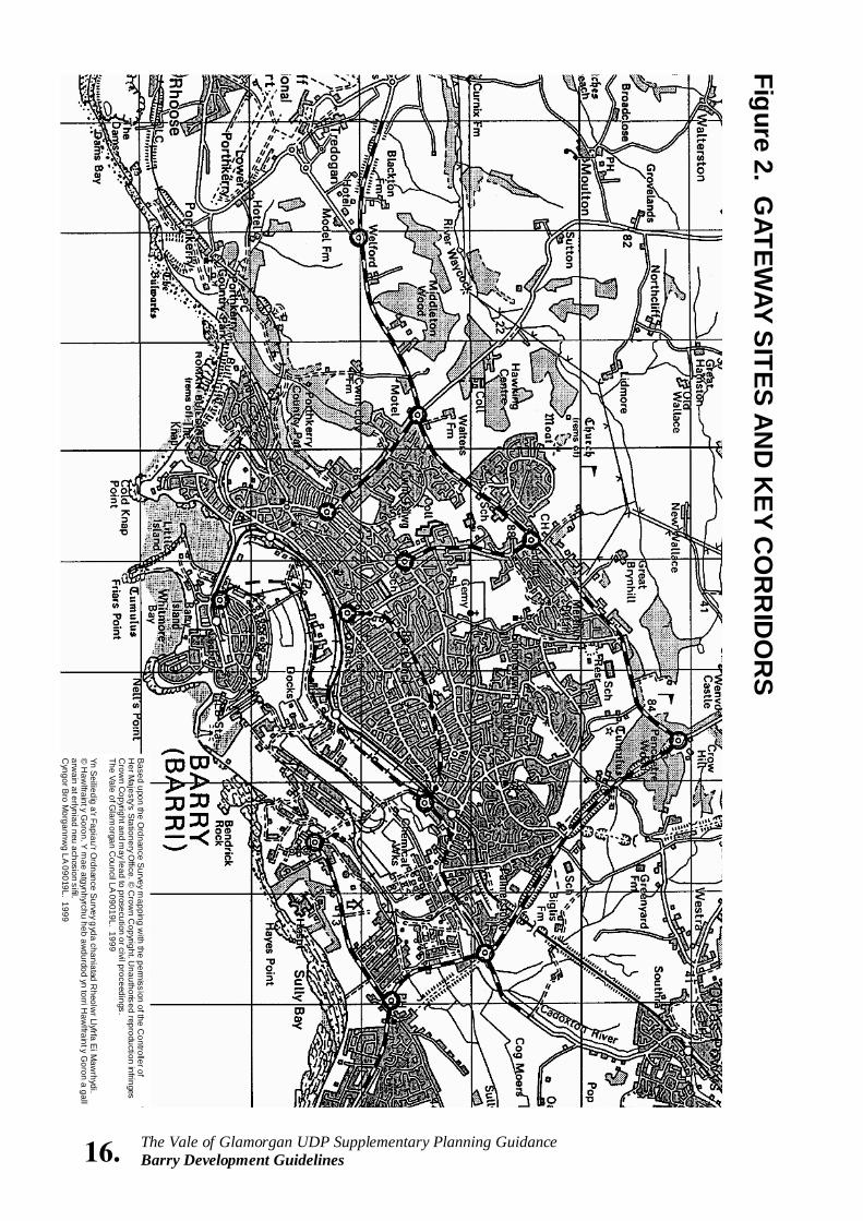
Illustrative section showing street trees Gateways and Corridors: Landscape design is able to contribute to the definition of key gateways and corridors. Existing gateways and corridors can be improved through appropriate scale planting establishing clear and consistent corridors or dramatic gateways.
Figure 2 illustrates the key corridor and gateway sites in Barry.
Development should recognise the importance of landscape design in defining key gateways and corridors and promote landscape design solutions to enhance these routes and entry points.
Town - Countryside Definition: The distinction between built urban areas and countryside is often blurred by urban sprawl which becomes poorly defined toward the edge of urban settlements. A strong clear distinction between town and countryside can significantly strengthen visual and recreational amenity
The edge of Barry's built-up area should, where possible, define the Town from its surrounding countryside. New development should form a strong edge where it abuts open areas.
Landscape Quality and Maintenance: Landscape design should, within the constraints of local economic conditions, seek to achieve the highest quality of materials and planting. Planting design should produce a dynamic seasonal variation in colour and vegetation, which over time matures in a planned and manageable way. The additional capital cost of hard and soft landscape materials should be carefully weighed against the anticipated savings from lower maintenance and replacement costs.
Landscape design proposals for both the public and private realm should be evaluated on the grounds of quality, durability and overall aesthetic effect within the context of local economic conditions, and particularly having regard to future management.
The Guidelines set out above should be read in conjunction with advice to developers published by the Council.
16. The Vale of Glamorgan UDP Supplementary Planning Guidance Barry Development Guidelines
Based upon the O
rdnance Survey m
apping with the perm
ission of the Controller of
Her M
ajesty's Stationery O
ffice. © C
rown C
opyright. Unauthorised reproduction infringes
Crow
n Copyright and m
ay lead to prosecution or civil proceedings. The Vale of G
lamorgan C
ouncil LA 09019L. 1999 Yn S
eiliedig a'r Fapiau'r Ordnance S
urvey gyda chaniatad R
heolwr Llyfrfa E
i Maw
rhydi. ©
Haw
lfraint y Goron. Y
mae atgynhyrchu heb aw
durdod yn torri Haw
lfraint y Goron a gall
arwain at erlyniad neu achosion sifil.
Cyngor B
ro Morgannw
g LA 09019L. 1999
Figure 2. GATEW
AY SITES A
ND
KE
Y CO
RR
IDO
RS
17. The Vale of Glamorgan UDP Supplementary Planning Guidance Barry Development Guidelines
3.5 Pedestrian Movement and Cycle Routes Accommodating the Pedestrian: The level of traffic, and its speed, should help to determine the degree to which the pedestrian should be protected from it. The design of the street should reflect the role of the route. Signalised intersections will help to ease pedestrian crossing and accessibility. Streets should enable pedestrians to walk alongside road carriageways in comfort and not be intimidated by the flow of traffic. In some cases pavements could be widened to accommodate sitting areas, as well as small informal spaces where people can meet, and be wide enough for ease of pedestrian flow and movement. Holton Road could be pedestrianised in certain sections where pedestrian and shopping activity is greatest, such as west of the former Town Hall as an extension of the existing pedestrianised area.
Major through routes should allow for pedestrian and cycling access alongside, either in a landscaped setting or at least separated from the carriageway.
Incorporating Cycling Routes: Cycling should be encouraged and incorporated within attractively designed pedestrian routes, which cross urban areas and improve accessibility. Safe routes should be provided for cyclists.
The Council will encourage a network of cycling routes along the main distributor routes. The layout of new roads or redesign of existing roads should incorporate cycle routes where possible, to encourage cycling within the Town.
3.6 Car Parking On street Car Parking: Parking requirements should be accommodated so that they do not affect the established building line. On-site car parking in the front of buildings frequently creates an undesirable setback to the building line. In commercial centres successful streets should be able to accommodate parked cars. On-street car parking can also help to reduce car speeds and increase street activity. However, on-street car parking should not compromise pedestrian safety and sufficient space for emergency vehicles needs to be provided.
Where highway capacity permits, the Council will consider favourably the provision of on-street car parking to provide convenience for visitors and shoppers and help animate the street. This is subject to road safety, maintenance and access to emergency equipment.
Multi-storey Car Parking: Multi-storey car parks should incorporate active land uses at the street level in order to enliven the public realm. Multi-storey car parks if appropriately designed need not act as an obtrusive and unsympathetic form of development. The facade treatment of the Multi-storey structures should respect the predominant vertical or horizontal facade treatment on the street.
Careful consideration should be given to the siting and design of Multi-storey car parks. Suitable facade treatment, which reflects the predominant street rhythm, should be encouraged and in particular the nature of uses at street level should be designed to animate and enliven the street.
Surface Car Parking: The location, design, and treatment of car parking areas will have a significant impact on the street scene and needs to be carefully considered. The impact of large surface car parking areas should be minimised through careful siting and suitable screening and landscaping. Where possible, smaller pocket-type car parks should be encouraged. These could provide interim uses prior to in-fill development and enhance convenience for local resident shoppers. The design and location of car parking areas should provide easy and convenient access to those activities they are designed to serve.
New development should make adequate provision for well designed and integrated surface parking where structured parking is not required. The establishment of local surface car parks that are suitably sited so as to improve shopping convenience and not detract from the overall urban quality of the Town Centre should be encouraged.
These Guidelines should be read in conjunction with the “Parking Guidelines” published by the Standing Conference on Regional Policy in Wales.
18. The Vale of Glamorgan UDP Supplementary Planning Guidance Barry Development Guidelines
Development and Design Objectives • Ensure that new development in the Town
Centre contributes to the revitalisation of the Town's commercial and service core;
• Encourage new uses and activities in the
Town Centre which are able to improve and adapt existing buildings;
• Encourage the development of convenient
small scale off-street parking; • Improve the overall quality of the public realm
within the Town Centre to make it more pleasant and useful for shoppers and visitors.
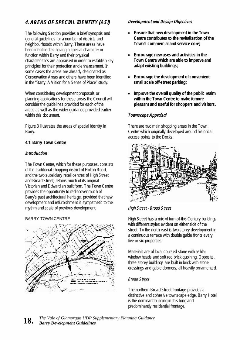
Townscape Appraisal There are two main shopping areas in the Town Centre which originally developed around historical access points to the Docks.
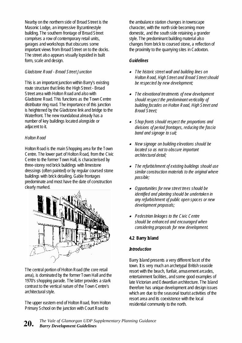
High Street - Broad Street High Street has a mix of turn-of-the-Century buildings with different styles evident on either side of the street. To the north-east is two storey development in a continuous terrace with double gable fronts every five or six properties. Materials are of local coursed stone with ashlar window heads and soft red brick quoining. Opposite, three storey buildings are built in brick with stone dressings and gable dormers, all heavily ornamented. Broad Street The northern Broad Street frontage provides a distinctive and cohesive townscape edge. Barry Hotel is the dominant building in this long and predominantly residential frontage.
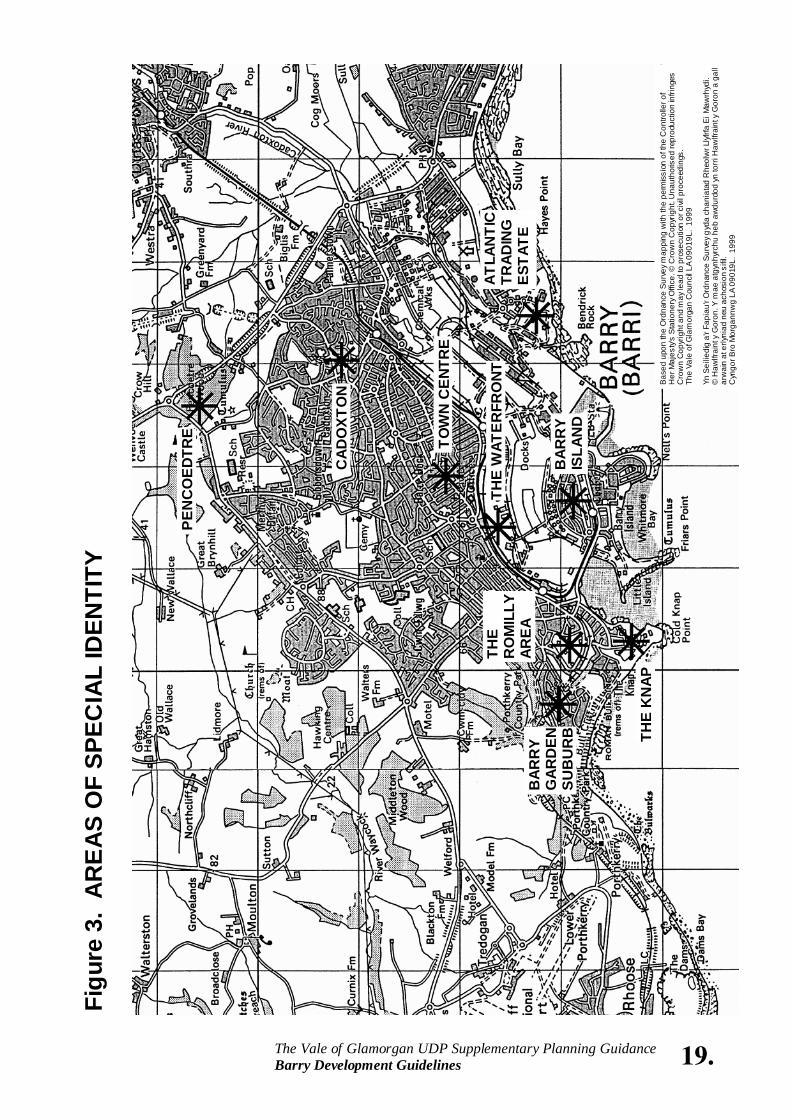
4. AREAS OF SPECIAL IDENTITY (ASI) The following Section provides a brief synopsis and general guidelines for a number of districts and neighbourhoods within Barry. These areas have been identified as having a special character or function within Barry and their physical characteristics are appraised in order to establish key principles for their protection and enhancement. In some cases the areas are already designated as Conservation Areas and others have been identified in the “Barry: A Vision for a Sense of Place” study. When considering development proposals or planning applications for these areas the Council will consider the guidelines provided for each of the areas as well as the wider guidance provided earlier within this document. Figure 3 illustrates the areas of special identity in Barry. 4.1 Barry Town Centre Introduction The Town Centre, which for these purposes, consists of the traditional shopping district of Holton Road, and the two subsidiary retail centres of High Street and Broad Street, retains much of its original Victorian and Edwardian built form. The Town Centre provides the opportunity to rediscover much of Barry’s past architectural heritage, provided that new development and refurbishment is sympathetic to the rhythm and scale of previous development. BARRY TOWN CENTRE
19. The Vale of Glamorgan UDP Supplementary Planning Guidance Barry Development Guidelines
Bas
ed u
pon
the
Ord
nanc
e S
urve
y m
appi
ng w
ith th
e pe
rmis
sion
of t
he C
ontro
ller o
f H
er M
ajes
ty's
Sta
tione
ry O
ffice
. © C
row
n C
opyr
ight
. Una
utho
rised
repr
oduc
tion
infri
nges
C
row
n C
opyr
ight
and
may
lead
to p
rose
cutio
n or
civ
il pr
ocee
ding
s.
The
Vale
of G
lam
orga
n C
ounc
il LA
090
19L.
199
9 Yn
Sei
liedi
g a'
r Fap
iau'
r Ord
nanc
e S
urve
y g
yda
chan
iata
d R
heol
wr L
lyfrf
a E
i Maw
rhyd
i.
© H
awlfr
aint
y G
oron
. Y m
ae a
tgyn
hyrc
hu h
eb a
wdu
rdod
yn
torr
i Haw
lfrai
nt y
Gor
on a
gal
l ar
wai
n at
erly
niad
neu
ach
osio
n si
fil.
Cyn
gor B
ro M
orga
nnw
g LA
090
19L.
199
9
Figu
re 3
. A
RE
AS
OF
SPEC
IAL
IDEN
TITY
PEN
CO
EDTR
E
CAD
OXT
ON
THE
KN
AP
TOW
N C
ENTR
E
ATLA
NTI
C
TRAD
ING
ES
TATE
B
ARR
Y G
ARD
EN
SUB
UR
B
BAR
RY
ISLA
ND
THE
RO
MIL
LY
AREA
THE
WAT
ERFR
ONT
20. The Vale of Glamorgan UDP Supplementary Planning Guidance Barry Development Guidelines
the ambulance station changes in townscape character, with the north side becoming more domestic, and the south side retaining a grander style. The predominant building material also changes from brick to coursed stone, a reflection of the proximity to the quarrying sites in Cadoxton. Guidelines • The historic street wall and building lines on
Holton Road, High Street and Broad Street should be respected by new development;
• The elevational treatments of new development
should respect the predominant verticality of building facades on Holton Road, High Street and Broad Street;
• Shop fronts should respect the proportions and
divisions of period frontages, reducing the fascia band and signage to suit;
• New signage on building elevations should be
located so as not to obscure important architectural detail;
• The refurbishment of existing buildings should use
similar construction materials to the original where possible;
• Opportunities for new street trees should be
identified and planting should be undertaken in any refurbishment of public open spaces or new development proposals;
• Pedestrian linkages to the Civic Centre
should be enhanced and encouraged when considering proposals for new development.
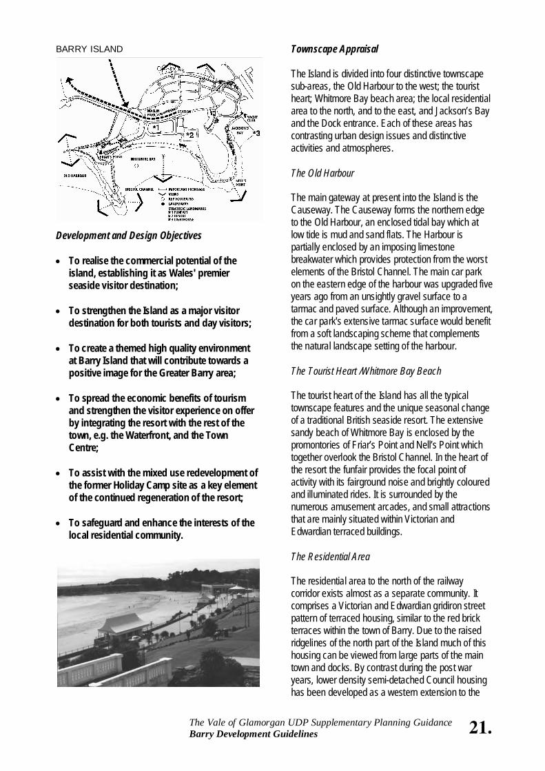
4.2 Barry Island Introduction Barry Island presents a very different facet of the town. It is very much an archetypal British seaside resort with the beach, funfair, amusement arcades, entertainment facilities, and some good examples of late Victorian and Edwardian architecture. The Island therefore has unique development and design issues which are due to the seasonal tourist activities of the resort area and its coexistence with the local residential community to the north.
Nearby on the northern side of Broad Street is the Masonic Lodge, an impressive Byzantinestyle building. The southern frontage of Broad Street comprises a row of contemporary retail units, garages and workshops that obscures some important views from Broad Street on to the docks. The street also appears visually lopsided in built form, scale and design. Gladstone Road - Broad Street Junction This is an important junction within Barry's existing route structure that links the High Street - Broad Street area with Holton Road and also with Gladstone Road. This functions as the Town Centre distributor ring road. The importance of this junction is heightened by the Gladstone link and bridge to the Waterfront. The new roundabout already has a number of key buildings located alongside or adjacent to it. Holton Road Holton Road is the main Shopping area for the Town Centre. The lower part of Holton Road, from the Civic Centre to the former Town Hall, is characterised by three-storey red brick buildings with limestone dressings (often painted) or by regular coursed stone buildings with brick detailing. Gable frontages predominate and most have the date of construction clearly marked.
The central portion of Holton Road (the core retail area), is dominated by the former Town Hall and the 1970's shopping parade. The latter provides a stark contrast to the vertical nature of the Town Centre's architectural style. The upper eastern end of Holton Road, from Holton Primary School on the junction with Court Road to
21. The Vale of Glamorgan UDP Supplementary Planning Guidance Barry Development Guidelines
BARRY ISLAND
Development and Design Objectives • To realise the commercial potential of the
island, establishing it as Wales' premier seaside visitor destination;
• To strengthen the Island as a major visitor
destination for both tourists and day visitors; • To create a themed high quality environment
at Barry Island that will contribute towards a positive image for the Greater Barry area;
• To spread the economic benefits of tourism
and strengthen the visitor experience on offer by integrating the resort with the rest of the town, e.g. the Waterfront, and the Town Centre;
• To assist with the mixed use redevelopment of
the former Holiday Camp site as a key element of the continued regeneration of the resort;
• To safeguard and enhance the interests of the
local residential community.
Townscape Appraisal The Island is divided into four distinctive townscape sub-areas, the Old Harbour to the west; the tourist heart; Whitmore Bay beach area; the local residential area to the north, and to the east, and Jackson’s Bay and the Dock entrance. Each of these areas has contrasting urban design issues and distinctive activities and atmospheres. The Old Harbour The main gateway at present into the Island is the Causeway. The Causeway forms the northern edge to the Old Harbour, an enclosed tidal bay which at low tide is mud and sand flats. The Harbour is partially enclosed by an imposing limestone breakwater which provides protection from the worst elements of the Bristol Channel. The main car park on the eastern edge of the harbour was upgraded five years ago from an unsightly gravel surface to a tarmac and paved surface. Although an improvement, the car park's extensive tarmac surface would benefit from a soft landscaping scheme that complements the natural landscape setting of the harbour. The Tourist Heart /Whitmore Bay Beach The tourist heart of the Island has all the typical townscape features and the unique seasonal change of a traditional British seaside resort. The extensive sandy beach of Whitmore Bay is enclosed by the promontories of Friar’s Point and Nell’s Point which together overlook the Bristol Channel. In the heart of the resort the funfair provides the focal point of activity with its fairground noise and brightly coloured and illuminated rides. It is surrounded by the numerous amusement arcades, and small attractions that are mainly situated within Victorian and Edwardian terraced buildings. The Residential Area The residential area to the north of the railway corridor exists almost as a separate community. It comprises a Victorian and Edwardian gridiron street pattern of terraced housing, similar to the red brick terraces within the town of Barry. Due to the raised ridgelines of the north part of the Island much of this housing can be viewed from large parts of the main town and docks. By contrast during the post war years, lower density semi-detached Council housing has been developed as a western extension to the
22. The Vale of Glamorgan UDP Supplementary Planning Guidance Barry Development Guidelines
Bristol Channel to the south together with long distance views of the No. 1 Dock and Town to the north can also be experienced from the breakwater in the Old Harbour. Guidelines The scale, massing and resultant density of any new development should complement the townscape setting of the particular location. The application of development density should therefore vary between the Island's four townscape sub-areas: i ) The Old Harbour / Barry Marine
Conservation Area Development will be strictly limited within this area, thereby respecting its status as a Conservation Area, and protecting its natural, largely undeveloped landscape. ii) The Tourist Heart / Whitmore Bay Beach Paget Road Terrace Encouragement should be given to unifying the appearance of this 3 storey key frontage. Developments that respect the scale and massing of this terrace will be encouraged. Barry Island Station Strict control of new development should be maintained within this area to safeguard the scale and local heritage importance of the Station and ensure it remains the dominant gateway building. Barry Island Pleasure Park Encouragement should be given to rides and buildings / structures that contribute towards a vibrant and exciting landmark. To strengthen the importance of the funfair as a strategic landmark the introduction of appropriate vertical feature / ride(s) should be welcomed. The Former Holiday Camp Site Priority should be given to returning part of the exposed headland to a natural open space / landscape buffer, and a brief has been adopted to fulfil this objective.
residential area adjacent to Maslin Park. Jackson's Bay Situated almost in relative isolation on the east of the Island is Jackson's Bay. The Bay comprises a small sandy beach which sits below the cliff side overlooked by Redbrink Crescent, and is adjacent to the Docks’ entrance and Barry Yacht Club. The built area, situated at the Dock's entrance, is dominated by Barry Yacht Club's Clubhouse, the former RNLI building and slip way, and on the dockside rows of yachts. The latter area is presently operational dock land owned by Associated British Ports. Landmarks Strategic landmarks include the funfair, Nell's Point, and the lighthouse situated on the west breakwater at the entrance to the docks. There are also a number of key frontages buildings and structures that provide reference points within the Island itself. These are the colonnaded structures of the Western and Eastern Shelters on the Promenade, the grade II Listed Friars Point House, the recently refurbished Station Buildings and canopies, the Old Harbour Breakwater, and the three storey Friars Road and Paget Road terraces. Open Spaces The Island has a number of important formal and informal open spaces. These comprise: Maslin Park, the natural exposed headland of Friars Point; the sandy beaches of Whitmore Bay and Jackson’s Bay. The formal semi-private green space of the cricket pitch; the tidal Old Harbour with its sand and mud flats; and the allotment gardens between the residential areas and the cliff edge. The proposed redevelopment of the Holiday Camp provides the opportunity to return some of the Nell’s Headland to open space as an accessible promontary and as part of a coastal walkway. Views The most important views at the Island are those of the Bristol Channel and the coastline of the West Country to the south. Exceptional panoramic views of the Channel can be experienced from Friars Point, Nell’s Point and the Promenade / seafront gardens overlooking Whitmore Bay. Extensive views of the
23. The Vale of Glamorgan UDP Supplementary Planning Guidance Barry Development Guidelines
iii) The Residential Area Developments that complement the densities of the Victorian and post war housing will be encouraged. In particular, the scale of built form within this area should clearly define public and private spaces. iv) Jackson’s Bay Any new development in this area will need to respect the operational dock entrance, the cliff and waterside uses, including the yacht club and its open storage areas. Materials Construction, Detail of Design As with scale and massing new development within any of the four sub-areas should complement the materials, construction and detail of design of the location. Both traditional and contemporary styles of detailing will be considered within this context. This will ensure the Island's sub-areas offer a variety and richness in design, which collectively provide for an interesting and attractive environment. In particular, within the resort and Whitmore Bay Beach sub-area a traditional British seaside image should be strengthened with the reinstatement of some of the late Victorian detailing, for example along the Paget Road and Friars Road terraces. The extension of the traditional boundary walls and contemporary new entrances to the funfair should also be encouraged. Key Landscape Features The following key landscape features should be reinforced and protected: The Tourist Heart/Whitmore Beach - a formal style of landscaping, such as the traditional terraced seafront gardens overlooking the promenade; Old Harbour and Friar’s Point - naturalistic seafront vegetation; Residential area - Maslin Park which provides an important “green lung” for the local community; Jackson's Bay - natural landscape of the cliffs edge overlooking the beach and yacht club.
Access The main highway access to the Island is presently confined to the Harbour Road that crosses the Causeway from the west. This limited access provides problems during the peak summer season when on sunny days traffic jams can occur. The construction of the new Docks Link Road through The Waterfront redevelopment area will greatly improve access and will become the main route to the Island. Within the resort area a new traffic management scheme is now at an advanced stage of implementation and through traffic calming and improved landscaping is creating a safer high quality streetscape. The new promenade has greatly enhanced the seafront overlooking Whitmore Bay. Potential also exists for improved pedestrian linkages: between the residential area and Jackson's Bay, the promenade from the Eastern shelter around Nell’s Point to Jackson’s Bay, the Friars Point footpath network to the Main Visitor Car Park adjacent the Old Harbour. The following guidelines shall apply: • Pedestrian links between the Barry Island
Pleasure Park seafront and Barry Island Station should be given priority over vehicular traffic;
• Parking should be located so as to minimise the
movement of vehicular traffic on Barry Island; • Pedestrian access to the Old Harbour; Whitmore
Bay, Friar’s Point and Jackson Bay and Nell’s Point should be maintained and strengthened where appropriate;
• Pedestrian and cycle access along the new Dock
Links Road between the Barry Waterfront and Barry Island should be provided;
• Dedicated cycle routes on Barry Island should be
identified and encouraged.
24. The Vale of Glamorgan UDP Supplementary Planning Guidance Barry Development Guidelines
• To establish The Waterfront as a social and leisure focal point for the Town;
• To provide complementary uses which
support the regeneration of Barry Island and the Town Centre;
• To provide a high quality environment which
will contribute toward improving Barry's image;
• To provide a link between Barry's heritage and
a vision for the future in development form and design;
• To use the extensive waterside edge as a focal
point for an attractive open space network. Townscape Appraisal Severance of Docks from Town Centre The alignment of the main railway line creates a clear physical severance of The Waterfront from the rest of the town. This is emphasised by a steep ridgeline that defines the northern edge of the former Barry Sound. The railway, which follows the base of the ridgeline, has traditionally split the employment and residential parts of Barry and both the railway line and the ridge restrict access to The Waterfront from the Town Centre. Strong Links to the Docks Strong links are being set in place from The Waterfront to the Town Centre. The Gladstone Link Road and Thompson Street present the best opportunities for such key links reflecting the traditional importance of Thompson Street in linking the Town Centre to The Waterfront. Docks Area Landmarks The principal landmark building in Barry is the former Docks Office building with its distinctive clock tower. This building is one of the largest in the Town and can be seen from many parts of Barry. The dockside cranes around No. 2 Docks, as well as the Rank Hovis Mill building, are also distinctive landmark structures.
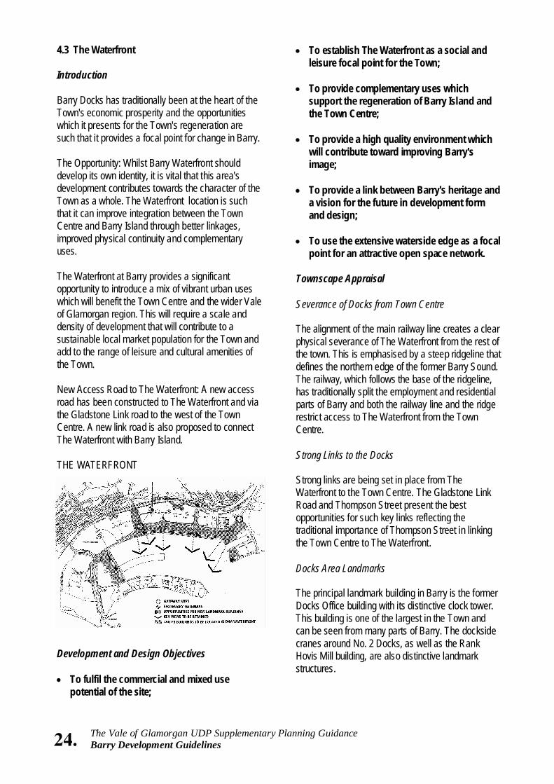
4.3 The Waterfront Introduction Barry Docks has traditionally been at the heart of the Town's economic prosperity and the opportunities which it presents for the Town's regeneration are such that it provides a focal point for change in Barry. The Opportunity: Whilst Barry Waterfront should develop its own identity, it is vital that this area's development contributes towards the character of the Town as a whole. The Waterfront location is such that it can improve integration between the Town Centre and Barry Island through better linkages, improved physical continuity and complementary uses. The Waterfront at Barry provides a significant opportunity to introduce a mix of vibrant urban uses which will benefit the Town Centre and the wider Vale of Glamorgan region. This will require a scale and density of development that will contribute to a sustainable local market population for the Town and add to the range of leisure and cultural amenities of the Town. New Access Road to The Waterfront: A new access road has been constructed to The Waterfront and via the Gladstone Link road to the west of the Town Centre. A new link road is also proposed to connect The Waterfront with Barry Island. THE WATERFRONT
Development and Design Objectives • To fulfil the commercial and mixed use
potential of the site;
25. The Vale of Glamorgan UDP Supplementary Planning Guidance Barry Development Guidelines
Docks Area Heritage Much of the dock-related machinery and artefacts were demolished during the 1980's. However, some remain and these features should be retained in future redevelopment proposals as reminders of Barry's economic heritage. Guidelines • The No. 2 Dock By-pass route has been designed
as a major Gateway to the Town and The Waterfront. New buildings that address this Boulevard should be set back to enable generous tree planting and separate pedestrian access. This new route presents opportunities for civic spaces or centres of activity that could extend into The Waterfront and other new development areas as part of a clear open space network.
• Strong links are needed from The Waterfront to
the Town Centre. These links must be direct, broad, and should accommodate generous pedestrian and cycle access. These routes present an early opportunity to display a co-ordinated approach to street furniture and tree planting.
Thompson Street and the Gladstone Link road present the best opportunities. The Gladstone Link has been designed as a strong tree-lined boulevard that can accommodate pedestrian, cyclist and vehicular use. An extension of Thompson Street will be crucial in linking the Town Centre with The Waterfront. This particular route should have a pedestrian emphasis and could incorporate a retail link between The Waterfront and the Town Centre. The mix of uses and the location of key activity areas should relate to and support existing areas in Barry. The Waterfront area closest to the Town Centre, should accommodate the focus for mixed uses. These need to be supported by strong pedestrian routes to the Town Centre.
• Views from Barry Island and the Town Centre and
along approach roads need to focus on key elements of The Waterfront area. The former Docks Office building must remain a dominant landmark and be protected from new
development by the identification of "key view corridors". These corridors should, where possible, align with the major routes that focus views onto the building and The Waterfront.
• Accessibility to and through an area should be
increased through providing a choice and variety in routes. These routes should be defined through a legible built form and open space system that enables ease of orientation and identification.
Permeability can be attained with the design of smaller building blocks, and a finer grain of new development. The Waterfront provides good opportunities for a clear perimeter block form of development. The perimeter block enables fronts and backs to clearly face onto public and private areas respectively. Entrances, especially for public buildings, need to be clearly defined, visible, and to emerge onto public or semi-public areas. Buildings need to front onto the Waterfront and promenades.
• Built form should optimise existing vistas and
channel views, and help to communicate messages about the dockside area and what it represents. Key buildings are important for orienting people through areas and providing visual links with the Town Centre and Barry Island. The former Docks’ Office building is a prime example where new routes and develop ment can help to focus views. New development should not obscure strategic views of this important building. New buildings in The Waterfront need to promote the character and legibility of the area by defining street corners and creating visual interest. The design of new and important landmark buildings needs to reflect their location and function.
• Many structures and artefacts representing
dockside heritage could be retained within new development. These can help maintain links to the past and add to the interest of the area.
Some dock structures and buidings may be worthy of incorporation within new schemes, even though they may not be listed by CADW Welsh Historic Monuments. These might include bollards, mooring rings and hand rails along the quays, dock bridges, rail tracks and cobble
26. The Vale of Glamorgan UDP Supplementary Planning Guidance Barry Development Guidelines
fulfilling a complementary role. This is especially important in The Waterfront area where there are few opportunities for existing networks to be incorporated.
• Streets should incorporate changes in definition
and distinction between private, semi-public and public areas.
• New development should incorporate a varied and
rich design through building form, siting, use of materials and site landscaping.
• Safe and convenient pedestrian movement and
cycling should be promoted within The Waterfront. • The new No. 2 Dock By-pass road and the
Gladstone Link road allows for dedicated pedestrian and cycling access alongside, in a landscaped setting. Elsewhere traffic calming measures would help to provide added security for pedestrians, for example within residential neighbourhoods and along the waterfront areas and promenades. Safe cycle paths need to be integrated into the road system, especially along those routes to the Town Centre, Barry Island and to the eastern part of Barry from The Waterfront. Specially segregated cycling routes should be accommodated within the distributor routes.
• Large and extensive car parking areas should be
avoided or suitably landscaped and smaller car parking areas should be encouraged.
• Private car parking areas should be
accommodated to the rear of development within private courtyards. Perimeter development is ideally suited for this. Areas of public car parking should be landscaped and screened by planting. Public open spaces and squares should also incorporate some limited parking areas. There should be provision for onstreet car parking on local access roads in commercial areas. Opportunities for car parking exist along the waterfront edge and promenade area.
stones, railway signs and signal posts. Signs of former dockside occupants could also be used as local landmarks along The Waterfront, promenades and within parks. A final list of items worthy of retention will be drafted in agreement with owners, providing guidance to developers about the opportunities to reuse these important links with the past.
• New development in The Waterfront should
incorporate a mix of uses and tenures.
The Waterfront area provides opportunities for mixing uses either within new development or as part of the refurbishment of existing buildings. The prospects for creating a rich and diverse mix of uses and activities, supported by higher density residential areas, is greater in The Waterfront than elsewhere in Barry. This principle should also apply to the area around Subway Road where former dock-related buildings could be used to accommodate a variety of uses as part of the link from Thompson Street and the Town Centre.
• The application of development density needs to
relate to the type of place that it is intended to create. The scale and density of built form must recognise the public and private spaces that it addresses.
The orientation of buildings and their scale needs to address local environmental conditions. Large open spaces such as dock edges will require a response that establishes a building scale in keeping with those conditions. Taller buildings should serve as focal points.
• The design of new routes should reflect the
importance of these routes and their role within the urban framework.
• This needs to be underlined visually in terms of
the width of the route, as well as through the appropriateness of the uses and buildings that front onto the road. Street tree planting can be used to relate to different scales of buildings and street widths, and to emphasise hierarchical importance. Similarly, spaces need to be clearly designed for specific activities, either as quiet places or for public functions, with buildings
27. The Vale of Glamorgan UDP Supplementary Planning Guidance Barry Development Guidelines
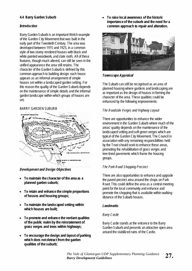
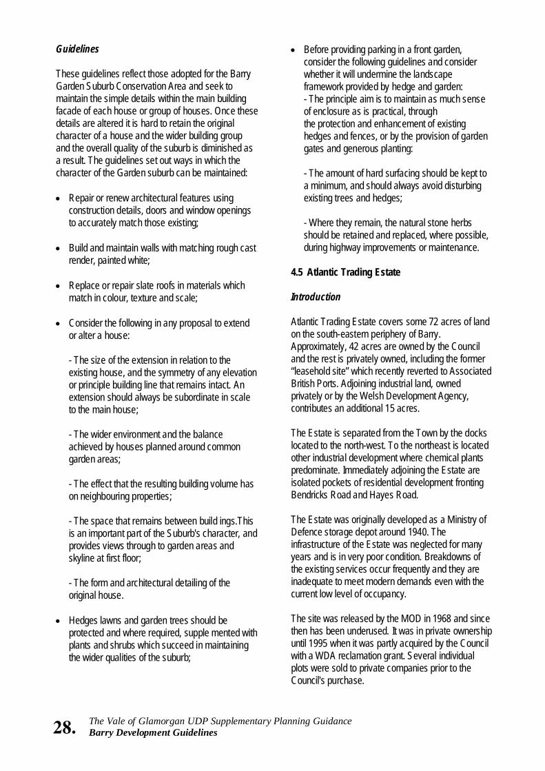
4.4 Barry Garden Suburb Introduction Barry Garden Suburb is an important Welsh example of the Garden City Movement that was built in the early part of the Twentieth Century. The area was developed between 1915 and 1925, in a common style of two storey rendered houses with black and white painted woodwork, and slate roofs. All of these features, though much altered, can still be seen in the unified appearance the area still retains. The character of the Garden Suburb is defined by this common approach to building design: each house appears as an informal arrangement of simple houses set within a landscaped garden setting. For this reason the quality of the Garden Suburb depends on the maintenance of simple details and the informal garden landscape within which groups of houses are set. BARRY GARDEN SUBURB
Development and Design Objectives • To maintain the character of the area as a
planned garden suburb; • To retain and enhance the simple proportions
of houses and housing groups; • To maintain the landscaped setting within
which houses are built; • To promote and enhance the verdant qualities
of the public realm by the reinstatement of grass verges and trees within highways;
• To encourage the design and layout of parking
which does not detract from the garden qualities of the suburb;
• To raise local awareness of the historic importance of the suburb and the need for a common approach to repair and alteration.
Townscape Appraisal The Suburb can still be recognised as an area of planned housing where gardens and landscaping are as important as the design of houses in forming the character of the area. These qualities could be enhanced by the following improvements: The Roadside Verges and Highway Layout There are opportunities to enhance the wider environment in the Garden Suburb where much of the areas' quality depends on the maintenance of the landscaped setting and soft green verges which are typical of the Garden City Movement. The Council in association with any remaining responsibilities held by the Trust should seek to enhance these areas, promoting the rehabilitation of grass verges and tree-lined pavements which frame the housing groups. The Park Road Shopping Precinct There are also opportunities to enhance and upgrade the paved precinct area around the shops on Park Road. This could define the area as a central meeting point for the local community and enhance and promote the shopping that is available within walking distance of the Suburb houses. Landmarks Barry Castle Barry Castle stands at the entrance to the Barry Garden Suburb and presents an attractive open area around the stabilized ruins of the Castle.
28. The Vale of Glamorgan UDP Supplementary Planning Guidance Barry Development Guidelines
• Before providing parking in a front garden, consider the following guidelines and consider whether it will undermine the landscape framework provided by hedge and garden: - The principle aim is to maintain as much sense of enclosure as is practical, through the protection and enhancement of existing hedges and fences, or by the provision of garden gates and generous planting: - The amount of hard surfacing should be kept to a minimum, and should always avoid disturbing existing trees and hedges; - Where they remain, the natural stone herbs should be retained and replaced, where possible, during highway improvements or maintenance.
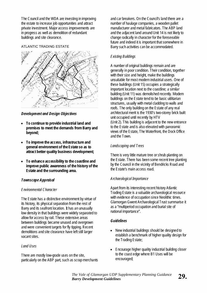
4.5 Atlantic Trading Estate Introduction Atlantic Trading Estate covers some 72 acres of land on the south-eastern periphery of Barry. Approximately, 42 acres are owned by the Council and the rest is privately owned, including the former “leasehold site” which recently reverted to Associated British Ports. Adjoining industrial land, owned privately or by the Welsh Development Agency, contributes an additional 15 acres. The Estate is separated from the Town by the docks located to the north-west. To the northeast is located other industrial development where chemical plants predominate. Immediately adjoining the Estate are isolated pockets of residential development fronting Bendricks Road and Hayes Road. The Estate was originally developed as a Ministry of Defence storage depot around 1940. The infrastructure of the Estate was neglected for many years and is in very poor condition. Breakdowns of the existing services occur frequently and they are inadequate to meet modern demands even with the current low level of occupancy. The site was released by the MOD in 1968 and since then has been underused. It was in private ownership until 1995 when it was partly acquired by the Council with a WDA reclamation grant. Several individual plots were sold to private companies prior to the Council's purchase.
Guidelines These guidelines reflect those adopted for the Barry Garden Suburb Conservation Area and seek to maintain the simple details within the main building facade of each house or group of houses. Once these details are altered it is hard to retain the original character of a house and the wider building group and the overall quality of the suburb is diminished as a result. The guidelines set out ways in which the character of the Garden suburb can be maintained: • Repair or renew architectural features using
construction details, doors and window openings to accurately match those existing;
• Build and maintain walls with matching rough cast
render, painted white; • Replace or repair slate roofs in materials which
match in colour, texture and scale; • Consider the following in any proposal to extend
or alter a house:
- The size of the extension in relation to the existing house, and the symmetry of any elevation or principle building line that remains intact. An extension should always be subordinate in scale to the main house; - The wider environment and the balance achieved by houses planned around common garden areas; - The effect that the resulting building volume has on neighbouring properties; - The space that remains between build ings.This is an important part of the Suburb's character, and provides views through to garden areas and skyline at first floor; - The form and architectural detailing of the original house.
• Hedges lawns and garden trees should be
protected and where required, supple mented with plants and shrubs which succeed in maintaining the wider qualities of the suburb;
29. The Vale of Glamorgan UDP Supplementary Planning Guidance Barry Development Guidelines
The Council and the WDA are investing in improving the estate to increase job opportunities and attract private investment. Major access improvements are in progress as well as demolition of redundant buildings and site clearance. ATLANTIC TRADING ESTATE
Development and Design Objectives • To continue to provide industrial land and
premises to meet the demands from Barry and beyond;
• To improve the access, infrastructure and
general environment of the Estate so as to attract better quality business development;
• To enhance accessibility to the coastline and
improve public awareness of the history of the Estate and the surrounding area.
Townscape Appraisal Environmental Character The Estate has a distinctive environment by virtue of its history, its physical separation from the rest of Barry and its seafront location. It has an unusually low density in that buildings were widely separated to allow for access by rail. These extensive areas between buildings became unused and overgrown and were convenient targets for fly tipping. Recent demolitions and site clearance have left still larger vacant sites. Land Uses There are mostly low-grade uses on the site, particularly on the ABP part, such as scrap merchants
and car breakers. On the Council's land there are a number of haulage companies, a wooden pallet manufacturer and metal fabricators. The ABP land and the adjacent land around Unit 14 is not likely to change radically in character for the foreseeable future and indeed it is important that somewhere in Barry such activities can be accommodated. Existing Buildings A number of original buildings remain and are generally in poor condition. Their condition, together with their size and height, make the buildings unsuitable for most modern industrial users. One of these buildings (Unit 15) occupies a strategically important location next to the coastline; a similar building (Unit 11) was demolished recently. Modem buildings on the Estate tend to be basic utilitarian structures, usually with metal cladding to walls and roofs. The only building on the Estate of any real architectural merit is the 1930’s two-storey brick built unit occupied until recently by HTV (Unit 2). This building is adjacent to the new entrance to the Estate and is also elevated with panoramic views of the Estate, The Waterfront, the Dock Office and the Town. Landscaping and Trees There is very little mature tree or shrub planting on the Estate. There has been some recent tree planting by the Council in the vicinity of Bendricks Road and the Estate's main access road. Archaeological Importance Apart from its interesting recent history Atlantic Trading Estate is a valuable archaeological resource with evidence of occupation since Neolithic times. Glamorgan Gwent Archaeological Trust summarise it as a “multiperiod occupation and burial site of national importance”. Guidelines • New industrial buildings should be designed to
establish a benchmark of higher quality design for the Trading Estate;
• Encourage higher quality industrial building closer
to the coast edge where B1 Uses will be encouraged;
30. The Vale of Glamorgan UDP Supplementary Planning Guidance Barry Development Guidelines
• Provision should be made for a coastal path along the adjacent coastline together with seating and interpretative material on the history of the area.
4.6 Pencoedtre Introduction Pencoedtre is located at the extreme north-east corner of Barry, bounded by the Dock link road to the east, Port Road East to the north and Pencoedtre Lane to the west. The site is allocated for a major mixed-use development in the Draft Vale of Glamorgan Unitary Development Plan, comprising housing, a special employment area extending to 17 hectares together with a business park of 3.5 hectares. Outline planning permission was granted by the Vale of Glamorgan Council in June 1997 for a predominantly residential development on the southern two thirds of the Plan allocation. The outline consent provides for the creation of three new access points to serve the development, an allocated school site, and three new areas of open space: • A central village green area laid out for informal
recreation • Two equipped play areas • Naturalised areas of native tree and shrub
planting. Development and Design Objectives • The creation of an informal townscape which
is appropriate to the semi-rural nature of the site;
• The enhancement of the existing indigenous
landscape by the provision of substantial new planting and the consolidation of existing hedgerows;
• The provision of a logical and legible road
hierarchy which generates opportunities for different forms of access and movement through the site;
• A co-ordinated approach to detail in highway
and landscape design through out the site;
• Intensify the Estate's land use by redeveloping existing plots to a higher density of use in keeping with the functional requirements of a modern industrial estate;
• New development should be orientated such that
office areas and car parking are located at the front of plots with manufacturing and service areas to the rear;
• Open storage should be discouraged but where it
is unavoidable it should be adequately screened; • A landscape plan for the Estate will be prepared
to guide future development proposals. New development proposals will be expected to include landscape design proposals as part of any redevelopment proposal;
• Development close to the housing at Bendricks
Road and Hayes Road will be required to provide particularly generous landscaping and earth bunding to minimise its impact. The area between Unit 14 and the coastal strip is also especially important in this respect in so far as it will be the interface between low-grade land use and better quality future development;
• Recent road works have opened up the Estate
and this places greater onus in future on individual plot holders to be responsible for site security. Fencing should be robust and painted to an agreed colour to improve its appearance and be supplemented with a generous screen of shrubbery;
• Further extensive building demolitions are unlikely
with the important exception of Unit 15 which should be removed as early as possible subject to suitable arrangements being made with the tenants. Unit 2 should be retained and its structural condition and setting improved;
• Vacant Sites should be bunded to discourage fly
tipping; • Areas of particular archaeological importance
should be preserved in situ where this would not unreasonably inhibit development, otherwise they must be fully documented by an appropriately qualified archaeologist;
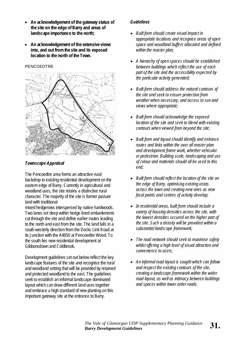
• An acknowledgement of the gateway status of the site on the edge of Barry and areas of landscape importance to the north;
• An acknowledgement of the extensive views
into, and out from the site and its exposed location to the north of the Town.
PENCOEDTRE
Townscape Appraisal The Pencoedtre area forms an attractive rural backdrop to existing residential development on the eastern edge of Barry. Currently in agricultural and woodland uses, the site retains a distinctive rural character. The majority of the site is former pasture land with traditional mixed hedgerows interspersed by native hardwoods. Two lanes set deep within hedge lined embankments cut through the site and define earlier routes leading to the north and east from the site. The land falls in a south westerly direction from the Docks Link Road at its Junction with the A4050 at Pencoedtre Wood. To the south lies new residential development at Gibbonsdown and Coldbrook. Development guidelines set out below reflect the key landscape features of the site and recognise the rural and woodland setting that will be provided by retained and protected woodland to the east. The guidelines seek to establish an informal landscape dominated layout which can draw different land uses together and embrace a high standard of new planting on this important gateway site at the entrance to Barry.
Guidelines • Built form should create visual impact in
appropriate locations and recognise areas of open space and woodland buffers allocated and defined within the master plan;
• A hierarchy of open spaces should be established
between buildings which reflect the use of each part of the site and the accessibility expected by the particular activity generated;
• Built form should address the natural contours of
the site and seek to ensure protection from weather when necessary, and access to sun and views where appropriate;
• Built form should acknowledge the exposed
location of the site and seek to blend with existing contours when viewed from beyond the site;
• Built form and layout should identify and enhance
routes and links within the over all master plan and development frame work, whether vehicular or pedestrian. Building scale, landscaping and use of colour and materials should all be used to this end;
• Built form should reflect the location of the site on
the edge of Barry, optimising existing vistas across the town and creating new ones as new focal points and centres of activity develop;
• In residential areas, built form should include a
variety of housing densities across the site, with the lowest densities secured on the higher part of the site. Such a density will be provided within a substantial landscape framework;
• The road network should seek to maximise safety
whilst offering a high level of visual attraction and convenience to users;
• An informal road layout is sought which can follow
and respect the existing contours of the site, creating a landscape framework within the wider road layout, as well as intimacy between buildings and spaces within lower order roads.
31. The Vale of Glamorgan UDP Supplementary Planning Guidance Barry Development Guidelines
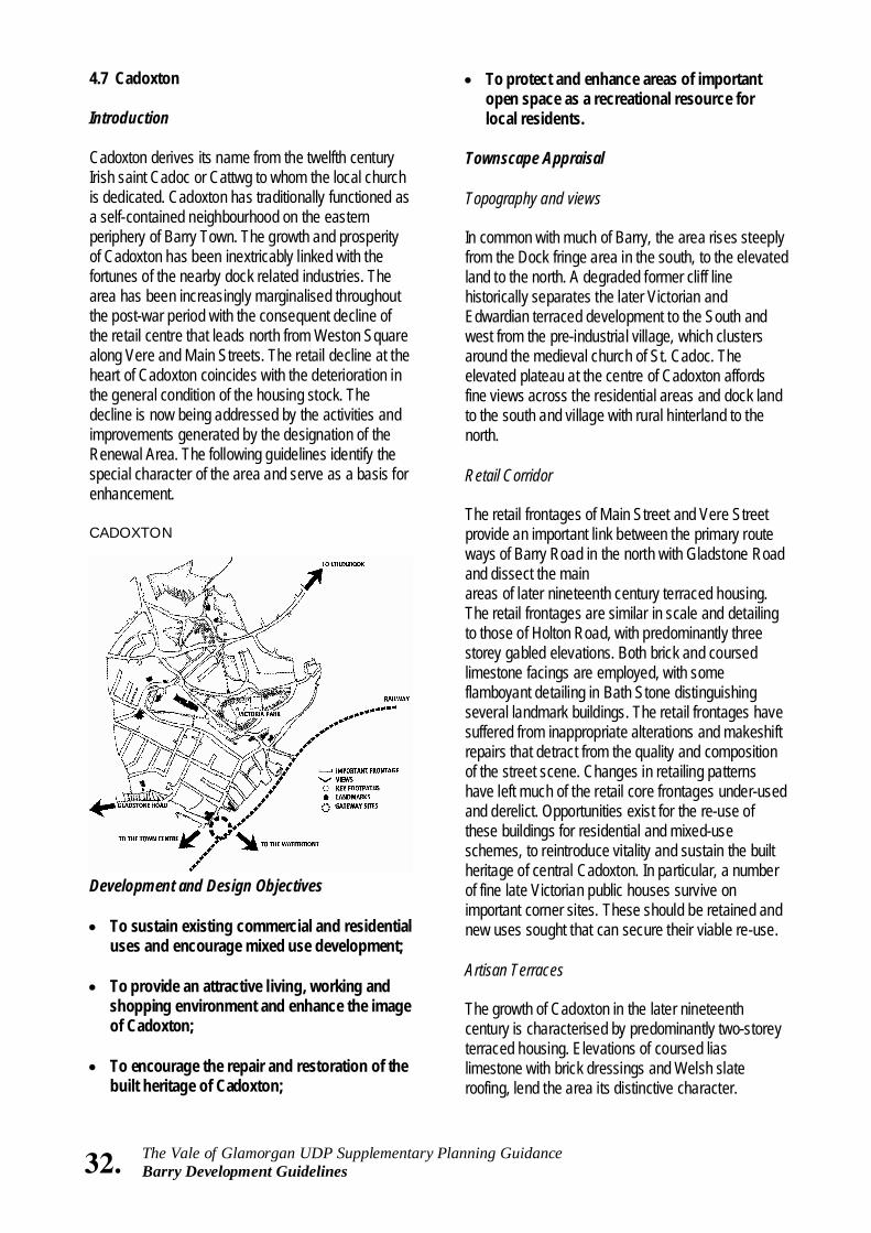
32. The Vale of Glamorgan UDP Supplementary Planning Guidance Barry Development Guidelines
4.7 Cadoxton Introduction Cadoxton derives its name from the twelfth century Irish saint Cadoc or Cattwg to whom the local church is dedicated. Cadoxton has traditionally functioned as a self-contained neighbourhood on the eastern periphery of Barry Town. The growth and prosperity of Cadoxton has been inextricably linked with the fortunes of the nearby dock related industries. The area has been increasingly marginalised throughout the post-war period with the consequent decline of the retail centre that leads north from Weston Square along Vere and Main Streets. The retail decline at the heart of Cadoxton coincides with the deterioration in the general condition of the housing stock. The decline is now being addressed by the activities and improvements generated by the designation of the Renewal Area. The following guidelines identify the special character of the area and serve as a basis for enhancement. CADOXTON
Development and Design Objectives • To sustain existing commercial and residential
uses and encourage mixed use development; • To provide an attractive living, working and
shopping environment and enhance the image of Cadoxton;
• To encourage the repair and restoration of the
built heritage of Cadoxton;
• To protect and enhance areas of important open space as a recreational resource for local residents.
Townscape Appraisal Topography and views In common with much of Barry, the area rises steeply from the Dock fringe area in the south, to the elevated land to the north. A degraded former cliff line historically separates the later Victorian and Edwardian terraced development to the South and west from the pre-industrial village, which clusters around the medieval church of St. Cadoc. The elevated plateau at the centre of Cadoxton affords fine views across the residential areas and dock land to the south and village with rural hinterland to the north. Retail Corridor The retail frontages of Main Street and Vere Street provide an important link between the primary route ways of Barry Road in the north with Gladstone Road and dissect the main areas of later nineteenth century terraced housing. The retail frontages are similar in scale and detailing to those of Holton Road, with predominantly three storey gabled elevations. Both brick and coursed limestone facings are employed, with some flamboyant detailing in Bath Stone distinguishing several landmark buildings. The retail frontages have suffered from inappropriate alterations and makeshift repairs that detract from the quality and composition of the street scene. Changes in retailing patterns have left much of the retail core frontages under-used and derelict. Opportunities exist for the re-use of these buildings for residential and mixed-use schemes, to reintroduce vitality and sustain the built heritage of central Cadoxton. In particular, a number of fine late Victorian public houses survive on important corner sites. These should be retained and new uses sought that can secure their viable re-use. Artisan Terraces The growth of Cadoxton in the later nineteenth century is characterised by predominantly two-storey terraced housing. Elevations of coursed lias limestone with brick dressings and Welsh slate roofing, lend the area its distinctive character.
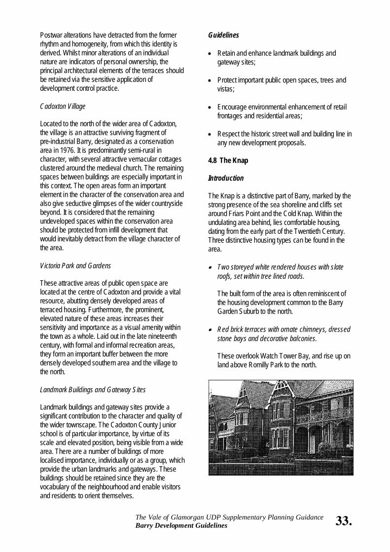
Postwar alterations have detracted from the former rhythm and homogeneity, from which this identity is derived. Whilst minor alterations of an individual nature are indicators of personal ownership, the principal architectural elements of the terraces should be retained via the sensitive application of development control practice. Cadoxton Village Located to the north of the wider area of Cadoxton, the village is an attractive surviving fragment of pre-industrial Barry, designated as a conservation area in 1976. It is predominantly semi-rural in character, with several attractive vernacular cottages clustered around the medieval church. The remaining spaces between buildings are especially important in this context. The open areas form an important element in the character of the conservation area and also give seductive glimpses of the wider countryside beyond. It is considered that the remaining undeveloped spaces within the conservation area should be protected from infill development that would inevitably detract from the village character of the area. Victoria Park and Gardens These attractive areas of public open space are located at the centre of Cadoxton and provide a vital resource, abutting densely developed areas of terraced housing. Furthermore, the prominent, elevated nature of these areas increases their sensitivity and importance as a visual amenity within the town as a whole. Laid out in the late nineteenth century, with formal and informal recreation areas, they form an important buffer between the more densely developed southern area and the village to the north. Landmark Buildings and Gateway Sites Landmark buildings and gateway sites provide a significant contribution to the character and quality of the wider townscape. The Cadoxton County Junior school is of particular importance, by virtue of its scale and elevated position, being visible from a wide area. There are a number of buildings of more localised importance, individually or as a group, which provide the urban landmarks and gateways. These buildings should be retained since they are the vocabulary of the neighbourhood and enable visitors and residents to orient themselves.
Guidelines • Retain and enhance landmark buildings and
gateway sites; • Protect important public open spaces, trees and
vistas; • Encourage environmental enhancement of retail
frontages and residential areas; • Respect the historic street wall and building line in
any new development proposals. 4.8 The Knap Introduction The Knap is a distinctive part of Barry, marked by the strong presence of the sea shoreline and cliffs set around Friars Point and the Cold Knap. Within the undulating area behind, lies comfortable housing, dating from the early part of the Twentieth Century. Three distinctive housing types can be found in the area. • Two storeyed white rendered houses with slate
roofs, set within tree lined roads.
The built form of the area is often reminiscent of the housing development common to the Barry Garden Suburb to the north.
• Red brick terraces with ornate chimneys, dressed stone bays and decorative balconies.
These overlook Watch Tower Bay, and rise up on land above Romilly Park to the north.
33. The Vale of Glamorgan UDP Supplementary Planning Guidance Barry Development Guidelines
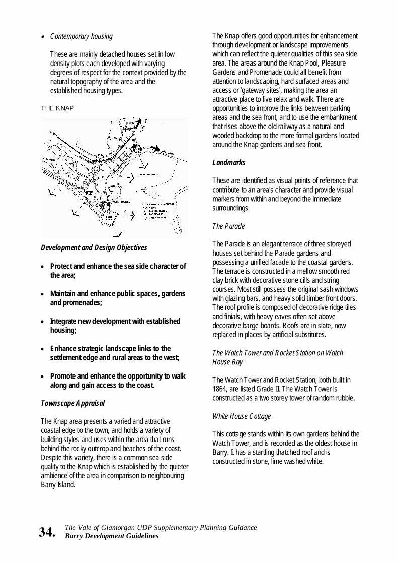
34. The Vale of Glamorgan UDP Supplementary Planning Guidance Barry Development Guidelines
• Contemporary housing
These are mainly detached houses set in low density plots each developed with varying degrees of respect for the context provided by the natural topography of the area and the established housing types.
THE KNAP
Development and Design Objectives • Protect and enhance the sea side character of
the area; • Maintain and enhance public spaces, gardens
and promenades; • Integrate new development with established
housing; • Enhance strategic landscape links to the
settlement edge and rural areas to the west; • Promote and enhance the opportunity to walk
along and gain access to the coast. Townscape Appraisal The Knap area presents a varied and attractive coastal edge to the town, and holds a variety of building styles and uses within the area that runs behind the rocky outcrop and beaches of the coast. Despite this variety, there is a common sea side quality to the Knap which is established by the quieter ambience of the area in comparison to neighbouring Barry Island.
The Knap offers good opportunities for enhancement through development or landscape improvements which can reflect the quieter qualities of this sea side area. The areas around the Knap Pool, Pleasure Gardens and Promenade could all benefit from attention to landscaping, hard surfaced areas and access or 'gateway sites', making the area an attractive place to live relax and walk. There are opportunities to improve the links between parking areas and the sea front, and to use the embankment that rises above the old railway as a natural and wooded backdrop to the more formal gardens located around the Knap gardens and sea front. Landmarks These are identified as visual points of reference that contribute to an area's character and provide visual markers from within and beyond the immediate surroundings. The Parade The Parade is an elegant terrace of three storeyed houses set behind the Parade gardens and possessing a unified facade to the coastal gardens. The terrace is constructed in a mellow smooth red clay brick with decorative stone cills and string courses. Most still possess the original sash windows with glazing bars, and heavy solid timber front doors. The roof profile is composed of decorative ridge tiles and finials, with heavy eaves often set above decorative barge boards. Roofs are in slate, now replaced in places by artificial substitutes. The Watch Tower and Rocket Station on Watch House Bay The Watch Tower and Rocket Station, both built in 1864, are listed Grade II. The Watch Tower is constructed as a two storey tower of random rubble. White House Cottage This cottage stands within its own gardens behind the Watch Tower, and is recorded as the oldest house in Barry. It has a startling thatched roof and is constructed in stone, lime washed white.
The Knap Pool The Knap Pool was constructed in the 1920’s by unemployed workmen. It is a good example of an early Lido, using reinforced concrete in the construction of the pool and the elegant crescent shaped changing rooms that lie adjacent. The Watch House Bay Promenade The Watch House Bay promenade lies behind the sandy shore and slipway and uses the same reinforced concrete in the construction of steps and footpaths. The area is in need of improvement and should be considered in association with wider plans for the area. Enhancement Opportunities The Knap and Pebble Beach Promenade This area is laid out as a promenade but offers few opportunities to sit and enjoy the beach. The windswept appearance of the area could be improved by the enhancement of paved areas and the introduction of more sheltered seating areas and a considered approach to seasonal planting and lighting to promote year round and night time interest for a larger section of residents and visitors. Access for the disabled should be assured within all enhancement work. The Bindles Car Park This area lies behind the Bindles Public House above an unkempt embankment. At present it looks like an unsightly and poorly maintained backland site. Opportunities for improved screening and landscaping exist. The Knap Public Car Park and road side cafe on Lakeside West The area provides informal parking for the Knap and is bound by the railway embankment and wooded areas beyond. The area has good links to the Knap Lake and shopping promenade adjacent. Guidelines The following guidelines should be considered in association with the formal designation of the area as part of the wider Barry Marine Conservation Area.
• New development should be designed to respect the prevailing topography of site; respect and enhance views across and out of the area; use materials which are sympathetic to the established building patterns described above;
• The scale and roof pitch of new development
should reflect the established building patterns; • New development should seek to follow and
repeat established boundaries, using either hedges, or stone or brick walls to enclose landscaped garden areas;
• Open or exposed areas of hard surface parking
should be avoided, with parking set where possible within the front gardens;
Proposed extensions or alterations to houses should consider and respect the following: • The size of the extension in relation to the existing
house, and the symmetry of any elevation or principle building line that remains in tact. An extension should always be subordinate in scale to the main house or terrace.
• The wider environment and the balance achieved
by houses planned around common garden areas;
• The effect that the resulting building volume has
on neighbouring properties; • The space that remains between buildings. This is
an important part of the areas’ character and provides views through to garden areas and the sea and hillside behind;
• The symmetry achieved by semi detached
houses. Extra accommodation, particularly at first floor level, should always be subordinate to the principal building frontage and roof pitch;
• The form and architectural detailing of the original
house. • Hedges lawns and garden trees should be
maintained and where required, supplemented with plants and shrubs which succeed in maintaining the wider qualities of the suburb. Hardy wind and salt resistant species are recommended.
35. The Vale of Glamorgan UDP Supplementary Planning Guidance Barry Development Guidelines
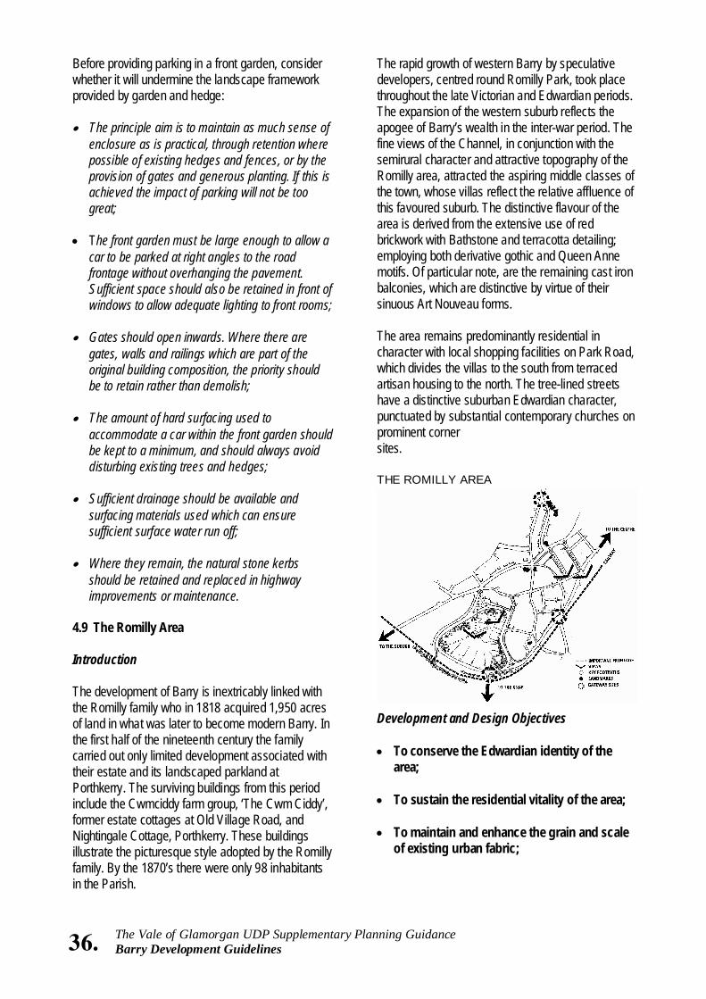
The rapid growth of western Barry by speculative developers, centred round Romilly Park, took place throughout the late Victorian and Edwardian periods. The expansion of the western suburb reflects the apogee of Barry’s wealth in the inter-war period. The fine views of the Channel, in conjunction with the semirural character and attractive topography of the Romilly area, attracted the aspiring middle classes of the town, whose villas reflect the relative affluence of this favoured suburb. The distinctive flavour of the area is derived from the extensive use of red brickwork with Bathstone and terracotta detailing; employing both derivative gothic and Queen Anne motifs. Of particular note, are the remaining cast iron balconies, which are distinctive by virtue of their sinuous Art Nouveau forms. The area remains predominantly residential in character with local shopping facilities on Park Road, which divides the villas to the south from terraced artisan housing to the north. The tree-lined streets have a distinctive suburban Edwardian character, punctuated by substantial contemporary churches on prominent corner sites. THE ROMILLY AREA
Development and Design Objectives • To conserve the Edwardian identity of the
area; • To sustain the residential vitality of the area; • To maintain and enhance the grain and scale
of existing urban fabric;
36. The Vale of Glamorgan UDP Supplementary Planning Guidance Barry Development Guidelines
Before providing parking in a front garden, consider whether it will undermine the landscape framework provided by garden and hedge: • The principle aim is to maintain as much sense of
enclosure as is practical, through retention where possible of existing hedges and fences, or by the provision of gates and generous planting. If this is achieved the impact of parking will not be too great;
• The front garden must be large enough to allow a
car to be parked at right angles to the road frontage without overhanging the pavement. Sufficient space should also be retained in front of windows to allow adequate lighting to front rooms;
• Gates should open inwards. Where there are
gates, walls and railings which are part of the original building composition, the priority should be to retain rather than demolish;
• The amount of hard surfacing used to
accommodate a car within the front garden should be kept to a minimum, and should always avoid disturbing existing trees and hedges;
• Sufficient drainage should be available and
surfacing materials used which can ensure sufficient surface water run off;
• Where they remain, the natural stone kerbs
should be retained and replaced in highway improvements or maintenance.
4.9 The Romilly Area Introduction The development of Barry is inextricably linked with the Romilly family who in 1818 acquired 1,950 acres of land in what was later to become modern Barry. In the first half of the nineteenth century the family carried out only limited development associated with their estate and its landscaped parkland at Porthkerry. The surviving buildings from this period include the Cwmciddy farm group, ‘The Cwm Ciddy’, former estate cottages at Old Village Road, and Nightingale Cottage, Porthkerry. These buildings illustrate the picturesque style adopted by the Romilly family. By the 1870’s there were only 98 inhabitants in the Parish.
• To protect public open spaces and spaces between buildings which make a positive contribution to the character and amenity of the locality;
• To protect important views within the public
realm; • To maintain and enhance the amenity
provided by street trees, traditional street furniture and public open spaces.
Townscape Appraisal Romilly Park Separated from the Knap to the south by the embankment of the railway line, the Park forms an essential recreational and visual amenity for local residents. The mature planting within the grounds is visible for a considerable distance, and forms an attractive foil to surrounding dwellings along Romilly Park Road, which circumscribe the Park boundaries. The Park has been the subject of survey and appraisal as part of an “Urban Parks Study”. Residential Core Areas Romilly Road, Windsor Road, Park Road and St. Nicholas Road comprise the key residential streets that define the distinctive typology within the character area. Whilst the scale and date of villas varies from the substantial threestorey semi-detached villas of Park Road set within substantial curtilages, to the lesser terraced properties of Romilly Road, the exclusive use of smooth red brickwork and Bath stone dressings provides a unifying element. The character of development within the area is also derived from the dramatic changes in level within the locality and the resultant distinctive relationships between dwellings and adjacent street frontages. The elevated nature of many properties in relation to street level serves to enhance the presence and scale of properties in the street scene. Furthermore, exceptional uninterrupted views are afforded of the Bristol Channel and Docks to the south and east. All new development should respect the vertical relationships between dwellings and respond to the sensitivity of the site in terms of its prominence within the wider townscape.
Landmarks and Gateways The Romilly area is contained by Park Road and Park Crescent to the north and the Railway embankment, lying south of Romilly Park Road/Avenue. Within this area are landmark buildings that not only provide important elements of the identity of the locality, but also provide important landmarks, enabling orientation within the wider Barry townscape. Of particular note are the churches of St. Nicholas, Porthkerry Methodist Church and All Saints which are all Grade II listed buildings. In addition, Romilly School (1896) prominently located on the corner of Park Crescent and Romilly Road, is an important feature of the northern gateway into the area. The retail frontages along Park Crescent have been degraded by inappropriate alterations and low quality shop fronts and signage, that considerably detract from the appearance of this prominent frontage. Guidelines • Enhance the Gateway sites on the periphery of
the area. The existing character of the access points into the area has been weakened by inappropriate alterations. These include the loss of street trees and an ad hoc approach to street furniture. Opportunities should be taken to reinforce local character through the development control process and via environmental enhancement schemes.
• Encourage the repair of buildings and
reinstatement of architectural features. Many existing buildings have suffered varying degrees of alteration, which also extends to the loss of traditional boundary treatments and planting. Whilst some of these alterations fall within the control of the planning authority, many do not and the continued loss of distinctive detail continues to erode local identity. This can only be arrested by property owners’ appreciation of the quality of their environment.
• Protect and enhance the Landmark Buildings
within the area. Whilst many of these buildings enjoy statutory protection via listed status, those which are unprotected require careful handling to ensure that their townscape value is not affected.
• Ensure that the amenity provided by public open
spaces, trees, important spaces between
37. The Vale of Glamorgan UDP Supplementary Planning Guidance Barry Development Guidelines
38. The Vale of Glamorgan UDP Supplementary Planning Guidance Barry Development Guidelines
buildings and views are unaffected by development proposals. The suburban Edwardian character of the area is derived only in part from its architectural heritage. An equal contribution is made by the wider setting of the buildings themselves. Every effort should be made to ensure that this is not prejudiced by development proposals.
5.0 IMPLEMENTATION The Guidance has been prepared by a Working Group of Officers within the Vale of Glamorgan Council, with assistance from Robert Maguire Consulting and the Welsh Development Agency. The Guidelines provide Supplementary Planning Guidance in support of the Unitary Development Plan and have been prepared to assist in the preparation and assessment of development proposals. The Guidance should be read alongside supporting information provided in the document “Barry: A Vision for a Sense of Place”, prepared for the Vale of Glamorgan Council and Welsh Development Agency in November, 1996. The study identified in more detail the particular elements these Guidelines seek to enhance and protect, as part of the wider regeneration strategy for Barry. The successful implementation of Guidance can be strengthened and consolidated by a wider understanding of Barry's character and potential. Within this wider framework the Guidance and background study can also inform the corporate activities of the Council and guide the work of the Barry Joint Venture. Further promotional work to follow this Supplementary Planning Guidance will secure this common understanding and maintain a co-ordinated and corporate approach to the implementation of policy following the public consultation demanded by the U.D.P. programme.
39. The Vale of Glamorgan UDP Supplementary Planning Guidance Barry Development Guidelines
APPENDIX
Listed Buildings, Ancient Monuments, and Buildings and Structures of Interest

40. The Vale of Glamorgan UDP Supplementary Planning Guidance Barry Development Guidelines
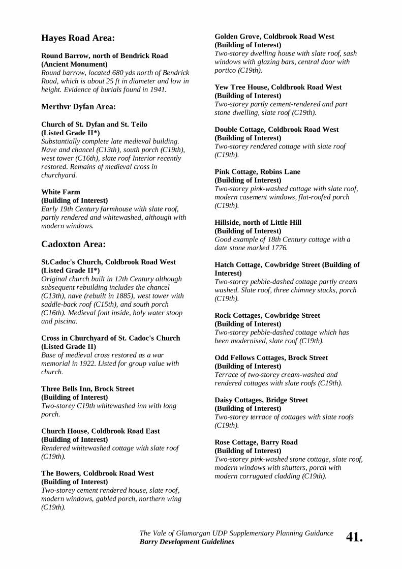
Hayes Road Area: Round Barrow, north of Bendrick Road (Ancient Monument) Round barrow, located 680 yds north of Bendrick Road, which is about 25 ft in diameter and low in height. Evidence of burials found in 1941. Merthvr Dyfan Area: Church of St. Dyfan and St. Teilo (Listed Grade II*) Substantially complete late medieval building. Nave and chancel (C13th), south porch (C19th), west tower (C16th), slate roof Interior recently restored. Remains of medieval cross in churchyard. White Farm (Building of Interest) Early 19th Century farmhouse with slate roof, partly rendered and whitewashed, although with modern windows. Cadoxton Area: St.Cadoc's Church, Coldbrook Road West (Listed Grade II*) Original church built in 12th Century although subsequent rebuilding includes the chancel (C13th), nave (rebuilt in 1885), west tower with saddle-back roof (C15th), and south porch (C16th). Medieval font inside, holy water stoop and piscina. Cross in Churchyard of St. Cadoc's Church (Listed Grade II) Base of medieval cross restored as a war memorial in 1922. Listed for group value with church. Three Bells Inn, Brock Street (Building of Interest) Two-storey C19th whitewashed inn with long porch. Church House, Coldbrook Road East (Building of Interest) Rendered whitewashed cottage with slate roof (C19th). The Bowers, Coldbrook Road West (Building of Interest) Two-storey cement rendered house, slate roof, modern windows, gabled porch, northern wing (C19th).
Golden Grove, Coldbrook Road West (Building of Interest) Two-storey dwelling house with slate roof, sash windows with glazing bars, central door with portico (C19th). Yew Tree House, Coldbrook Road West (Building of Interest) Two-storey partly cement-rendered and part stone dwelling, slate roof (C19th). Double Cottage, Coldbrook Road West (Building of Interest) Two-storey rendered cottage with slate roof (C19th). Pink Cottage, Robins Lane (Building of Interest) Two-storey pink-washed cottage with slate roof, modern casement windows, flat-roofed porch (C19th). Hillside, north of Little Hill (Building of Interest) Good example of 18th Century cottage with a date stone marked 1776. Hatch Cottage, Cowbridge Street (Building of Interest) Two-storey pebble-dashed cottage partly cream washed. Slate roof, three chimney stacks, porch (C19th). Rock Cottages, Cowbridge Street (Building of Interest) Two-storey pebble-dashed cottage which has been modernised, slate roof (C19th). Odd Fellows Cottages, Brock Street (Building of Interest) Terrace of two-storey cream-washed and rendered cottages with slate roofs (C19th). Daisy Cottages, Bridge Street (Building of Interest) Two-storey terrace of cottages with slate roofs (C19th). Rose Cottage, Barry Road (Building of Interest) Two-storey pink-washed stone cottage, slate roof, modern windows with shutters, porch with modern corrugated cladding (C19th).
41. The Vale of Glamorgan UDP Supplementary Planning Guidance Barry Development Guidelines
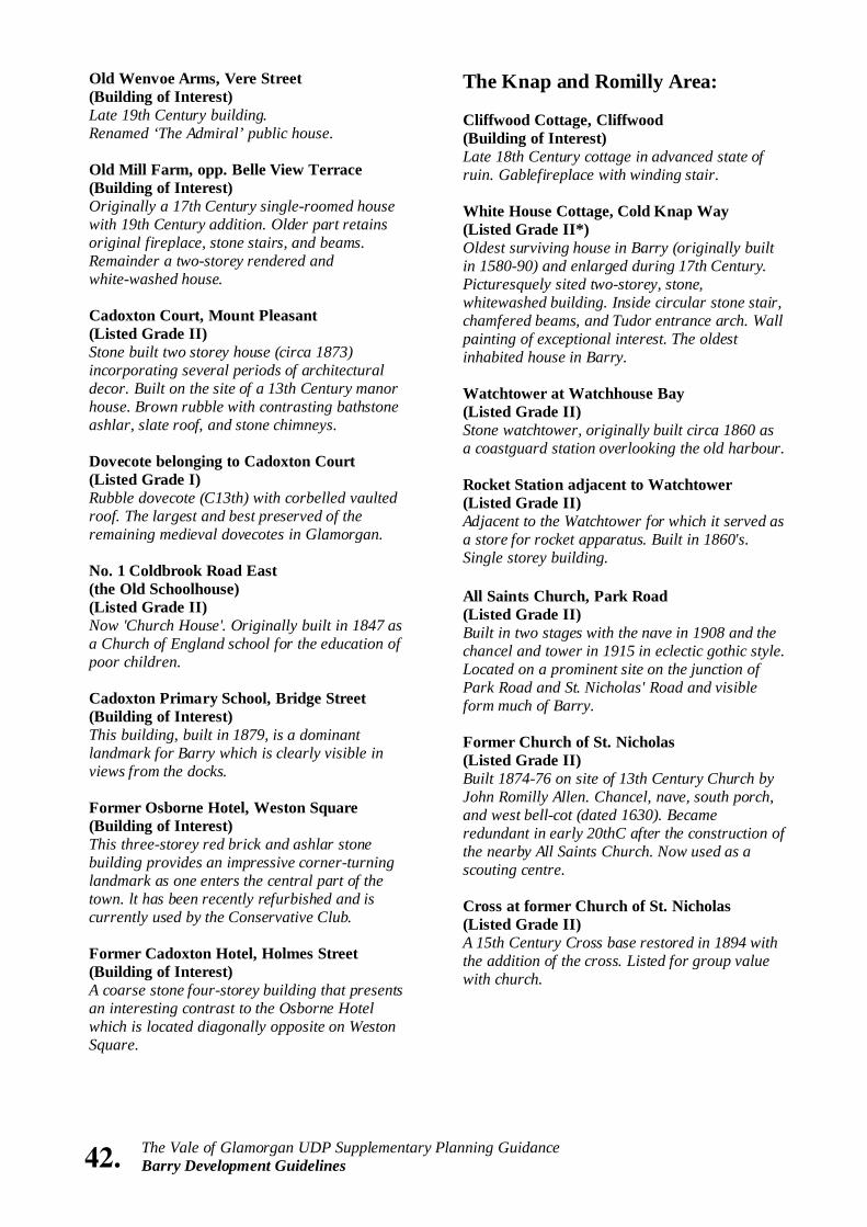
42. The Vale of Glamorgan UDP Supplementary Planning Guidance Barry Development Guidelines
Old Wenvoe Arms, Vere Street (Building of Interest) Late 19th Century building. Renamed ‘The Admiral’ public house. Old Mill Farm, opp. Belle View Terrace (Building of Interest) Originally a 17th Century single-roomed house with 19th Century addition. Older part retains original fireplace, stone stairs, and beams. Remainder a two-storey rendered and white-washed house. Cadoxton Court, Mount Pleasant (Listed Grade II) Stone built two storey house (circa 1873) incorporating several periods of architectural decor. Built on the site of a 13th Century manor house. Brown rubble with contrasting bathstone ashlar, slate roof, and stone chimneys. Dovecote belonging to Cadoxton Court (Listed Grade I) Rubble dovecote (C13th) with corbelled vaulted roof. The largest and best preserved of the remaining medieval dovecotes in Glamorgan. No. 1 Coldbrook Road East (the Old Schoolhouse) (Listed Grade II) Now 'Church House'. Originally built in 1847 as a Church of England school for the education of poor children. Cadoxton Primary School, Bridge Street (Building of Interest) This building, built in 1879, is a dominant landmark for Barry which is clearly visible in views from the docks. Former Osborne Hotel, Weston Square (Building of Interest) This three-storey red brick and ashlar stone building provides an impressive corner-turning landmark as one enters the central part of the town. lt has been recently refurbished and is currently used by the Conservative Club. Former Cadoxton Hotel, Holmes Street (Building of Interest) A coarse stone four-storey building that presents an interesting contrast to the Osborne Hotel which is located diagonally opposite on Weston Square.
The Knap and Romilly Area: Cliffwood Cottage, Cliffwood (Building of Interest) Late 18th Century cottage in advanced state of ruin. Gablefireplace with winding stair. White House Cottage, Cold Knap Way (Listed Grade II*) Oldest surviving house in Barry (originally built in 1580-90) and enlarged during 17th Century. Picturesquely sited two-storey, stone, whitewashed building. Inside circular stone stair, chamfered beams, and Tudor entrance arch. Wall painting of exceptional interest. The oldest inhabited house in Barry. Watchtower at Watchhouse Bay (Listed Grade II) Stone watchtower, originally built circa 1860 as a coastguard station overlooking the old harbour. Rocket Station adjacent to Watchtower (Listed Grade II) Adjacent to the Watchtower for which it served as a store for rocket apparatus. Built in 1860's. Single storey building. All Saints Church, Park Road (Listed Grade II) Built in two stages with the nave in 1908 and the chancel and tower in 1915 in eclectic gothic style. Located on a prominent site on the junction of Park Road and St. Nicholas' Road and visible form much of Barry. Former Church of St. Nicholas (Listed Grade II) Built 1874-76 on site of 13th Century Church by John Romilly Allen. Chancel, nave, south porch, and west bell-cot (dated 1630). Became redundant in early 20thC after the construction of the nearby All Saints Church. Now used as a scouting centre. Cross at former Church of St. Nicholas (Listed Grade II) A 15th Century Cross base restored in 1894 with the addition of the cross. Listed for group value with church.
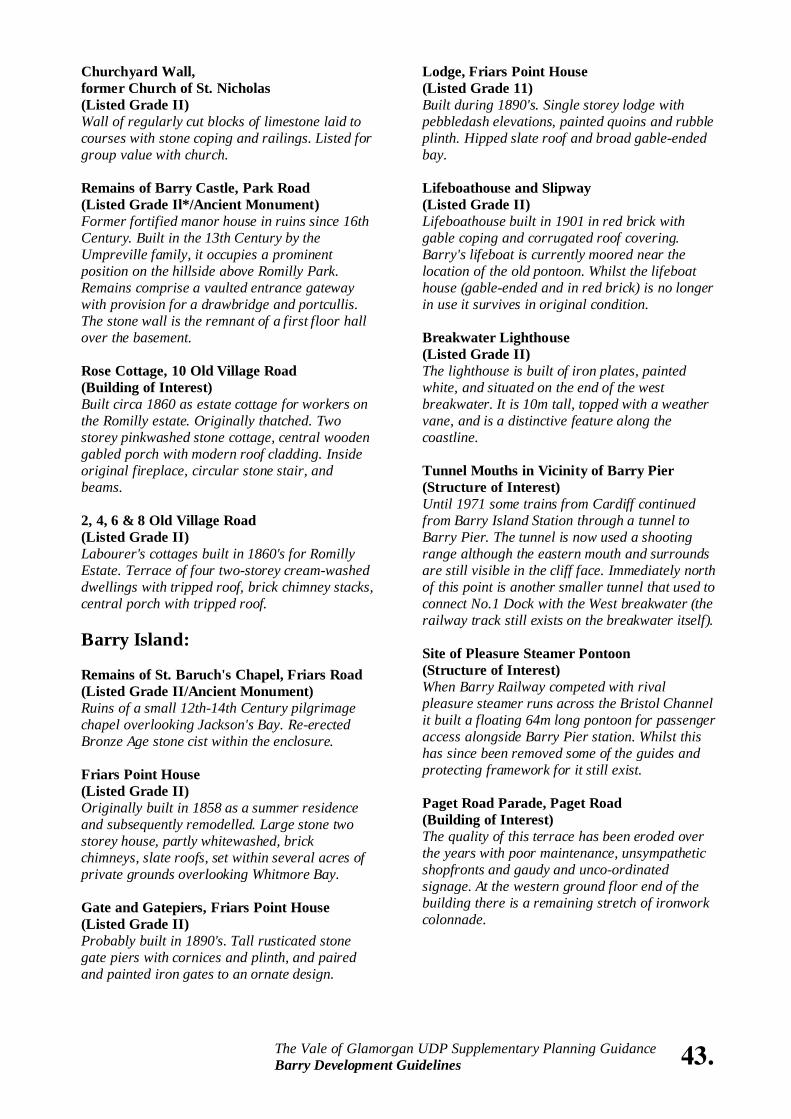
Churchyard Wall, former Church of St. Nicholas (Listed Grade II) Wall of regularly cut blocks of limestone laid to courses with stone coping and railings. Listed for group value with church. Remains of Barry Castle, Park Road (Listed Grade Il*/Ancient Monument) Former fortified manor house in ruins since 16th Century. Built in the 13th Century by the Umpreville family, it occupies a prominent position on the hillside above Romilly Park. Remains comprise a vaulted entrance gateway with provision for a drawbridge and portcullis. The stone wall is the remnant of a first floor hall over the basement. Rose Cottage, 10 Old Village Road (Building of Interest) Built circa 1860 as estate cottage for workers on the Romilly estate. Originally thatched. Two storey pinkwashed stone cottage, central wooden gabled porch with modern roof cladding. Inside original fireplace, circular stone stair, and beams. 2, 4, 6 & 8 Old Village Road (Listed Grade II) Labourer's cottages built in 1860's for Romilly Estate. Terrace of four two-storey cream-washed dwellings with tripped roof, brick chimney stacks, central porch with tripped roof. Barry Island: Remains of St. Baruch's Chapel, Friars Road (Listed Grade II/Ancient Monument) Ruins of a small 12th-14th Century pilgrimage chapel overlooking Jackson's Bay. Re-erected Bronze Age stone cist within the enclosure. Friars Point House (Listed Grade II) Originally built in 1858 as a summer residence and subsequently remodelled. Large stone two storey house, partly whitewashed, brick chimneys, slate roofs, set within several acres of private grounds overlooking Whitmore Bay. Gate and Gatepiers, Friars Point House (Listed Grade II) Probably built in 1890's. Tall rusticated stone gate piers with cornices and plinth, and paired and painted iron gates to an ornate design.
Lodge, Friars Point House (Listed Grade 11) Built during 1890's. Single storey lodge with pebbledash elevations, painted quoins and rubble plinth. Hipped slate roof and broad gable-ended bay. Lifeboathouse and Slipway (Listed Grade II) Lifeboathouse built in 1901 in red brick with gable coping and corrugated roof covering. Barry's lifeboat is currently moored near the location of the old pontoon. Whilst the lifeboat house (gable-ended and in red brick) is no longer in use it survives in original condition. Breakwater Lighthouse (Listed Grade II) The lighthouse is built of iron plates, painted white, and situated on the end of the west breakwater. It is 10m tall, topped with a weather vane, and is a distinctive feature along the coastline. Tunnel Mouths in Vicinity of Barry Pier (Structure of Interest) Until 1971 some trains from Cardiff continued from Barry Island Station through a tunnel to Barry Pier. The tunnel is now used a shooting range although the eastern mouth and surrounds are still visible in the cliff face. Immediately north of this point is another smaller tunnel that used to connect No.1 Dock with the West breakwater (the railway track still exists on the breakwater itself). Site of Pleasure Steamer Pontoon (Structure of Interest) When Barry Railway competed with rival pleasure steamer runs across the Bristol Channel it built a floating 64m long pontoon for passenger access alongside Barry Pier station. Whilst this has since been removed some of the guides and protecting framework for it still exist. Paget Road Parade, Paget Road (Building of Interest) The quality of this terrace has been eroded over the years with poor maintenance, unsympathetic shopfronts and gaudy and unco-ordinated signage. At the western ground floor end of the building there is a remaining stretch of ironwork colonnade.
43. The Vale of Glamorgan UDP Supplementary Planning Guidance Barry Development Guidelines
44. The Vale of Glamorgan UDP Supplementary Planning Guidance Barry Development Guidelines
Friars Road Parade, Friars Road (Building of Interest) This terrace provides a strong and distinctive townscape edge in this part of Barry Island and partly shield the Pleasure Park area. It has recently been refurbished. Barry Island Railway Station, Station Approach (Building of Interest) The station building is being refurbished in conjunction with a heritage museum and steam engine storage shed. Western and Eastern Parades, Whitmore Bay (Buildings of Interest) Represent good traditional examples of seaside architecture that provide a builds form symmetry for the beach. Both buildings are colonnaded with the Western Parade accommodating shops. Docks Area: Former Barry Dock Offices (Listed Grade II*) Built in 1898 and damaged by a fire in 1984, it has since been rebuilt to the original design with symmetrical elevations and central clock tower. It is four storeys in height and built in red brick with facings and other dressing in Portland stone. Hipped slate roof with brick chimney stacks and central dome. Neo-Baroque style with main features being its tall stone clock tower and impressive main staircase. Regarded as one of the most monumental commercial buildings in South Wales. Six Lamp Standards outside former Barry Docks Offices (Listed Grade II) Cast iron lamp standards with art nouveau leaf like detail. Included for group value with former dock offices. Statue of David Davies of Llandinam on plinth (Listed Grade II*) Standing figure of David Davies studying plans of his dock and railway developments. Designed by Alfred Gilbert who was regarded as one of the most important sculptors of the time.
North Hydraulic Pumping House, No. 1 Dock (Listed Grade II) A landmark building in the No.1 Dock area as a result of its 140ft. high square section chimney. The building was formerly used as one of the pumping stations for the hydraulic power network that operated most of the dock machinery. It is constructed mostly in red brick with some blue brick detailing and in the same style as the nearby railway goods shed and the buildings of the commercial graving dock. The main building, once an engineering shop, consists of two gabled ends facing south, broken up visually by recessed bays. A travelling crane built in 1912 runs on rails in the roof area between wrought iron trusses. The accumulator tower, which was located to the rear of the building has now been demolished. Pumping Station, north of Bendrick Road (Building of Interest) Built in 1898 to provide hydraulic power for the No.2 Dock's lock gates. More compact than the pumping station for the No.1 Dock. The uniformity of the building is broken at the south west end by a pyramid-roofed tower that used to accommodate the accumulators. (A third hydraulic pumping station, located below the Dock Road off Barry Island, has been demolished. This provided power for the coal tippers on No.1 Dock's south quay) Lock Gates (Structures of Interest) There are four sets of lock gates in operation, two are found at each end of Lady Windsor Lock and two more at the sea and dock end of No.3 Basin. A fifth set was once located in the main lock splitting it into two sections. They were operated by the hydraulic power stations. The original pistons and rams were removed in 1992 and the remains could be seen until recently alongside No.3 Basin. The gates were coupled directly to the hydraulic rams and this represented the first example of this arrangement. Walls of No. 3 Basin (Listed Grade II) Enclosing stone walls to the basin constructed in large stone blocks with granite copings includes slipway, steps and lock entrances. Part of the original construction of Barry Docks begun in 1884.
Memorial Hall, Gladstone Road (Building of Interest) A solid-looking building located close to the Junction with Broad Street and Holton Road. Built in 1932 in memory of Barry's war dead. It was originally designed as a conference and entertainment centre which could seat 1,000. Included an orchestra pit and organ chamber. Palace Cinema, Broad Street (Building of Interest) Former Fire Station, Court Road (Listed Grade II) Built in 1901 of yellow brick with red brick string courses and stone dressings. Three storeys with a very unusual tower which has been partly screened by the recent multi-storey car park in views from Holton Road. Vale Resource Centre (former Polytechnic of Wales), Buttrills Road (Listed Grade II) Built during 1913-14 as a women's training college. Listed as a fine example of early C20th educational architecture. Two storey red brick block with bathstone frontispiece and dressings forms a wide symmetrical composition on a spacious elevated site to the north of the town centre. College Fields Nursing Home (former Polytechnic of Wales), Buttrills Road (Listed Grade II) Built during 1913-14 as the eastern hostel of a women's training college. Three storey red brick and bathstone block with outer wings and panelled brick pilasters. Springbank Nursing Home (former Polytechnic of Wales), Buttrills Road (Listed Grade II) Built during 1913-14 as a residential block of a women's training college. Three storey red brick and bathstone block with outer wings and panelled brick pilasters. Former Caretaker's Cottage (former Polytechnic of Wales), Buttrills Road (Listed Grade II) Built during 1913-14 as the lodge of a women's training college. Two storey three-bay red brick house.
Dock Walls (Structures of Interest) The dock walls around the lock and No.1 Dock are largely unaltered since construction and are complete with original bollards, mooring rings, handrails, and also a hand crane. The walls are constructed from large red sandstone and limestone blocks. However, most of the walls are constructed of rubble and are sloping rather than vertical. This is because there was riffle need for vertical walls to moor against as boats were loaded by the coal tip piers. The dock walls were also indented to enable the mooring of 'overlapping ' strips for efficiency. Dock Bridges and Cabin (Listed Grade II) The sliding roadway bridge moves forward on tracks winched along by a horizontal wheel underneath the structure. A second similar structure once bridged the Lady Windsor Lock. Both of these bridges accommodated rail tracks. The operator's cabin alongside the bridge is of a standard Barry Railway wood built signal box design and the last of its type in existence (a brick built Barry Railway box still survives at Barry Main Station). The cabin includes the original lever frame structure consisting of seven levers, the original cast iron brackets, the wooden staircase, and decorative wood barge boards. Dry Docks (Structures of Interest) There are three dry docks, two in the north-east corner of No.1 Dock (one filled) and another alongside Lady Windsor Lock. The northern pair were the Barry Graving Docks and ceased operation in the late 1960's. They are now flooded although the caissons (floating tanks which fit into the dry dock recesses) remain for sealing them off. There are some original engineering buildings along Subway Road associated with the graving docks which still remain, although they have been reclad. A hydraulic capstan once used. Central Barry: Cenotaph, Gladstone Road (Listed Grade II) Built in 1932 to commemorate WW1 dead. Listing includes area walls and steps.
45. The Vale of Glamorgan UDP Supplementary Planning Guidance Barry Development Guidelines
46. The Vale of Glamorgan UDP Supplementary Planning Guidance Barry Development Guidelines
Former Chapel (former Polytechnic of Wales), Buttrills Road (Listed Grade II) Built in 1930 with art deco detailing. Single storey three-window red brick former chapel. Located north west of former college building. Municipal Buildings, King Square (Listed Grade II) Prize-winning design of 1902-03. Library completed in 1906. Proposed north east wing to rear not built. Two storeys and attic, basement and area railings to public offices. Building of red brick, bathstone dressings, channelled bathstone ground floor, and a plinth of local stone. Classic piece of Edwardian baroque civic architecture complete with clock tower which has a copper dome. Holton Primary School, Holton Road (Building of Interest) Built in 1892 it is a typical example of the Victorian approach at the time to school design. Windsor Hotel, Holton Road (Building of Interest) Impressive stone and red brick building. Masons Lodge, Broad Street (Building of Interest) Unusual and distinctive byzantine-style corner-turning building. Barry Station Signal Box, Broad Street (Building of Interest) The last remaining signal box of the Barry Railway Company. Barry Hotel, Broad Street (Listed Grade II) A dominant corner-turning building opposite the main railway station comprising three storeys plus attic. Built circa 1890. Nos. 69-72 High Street (Listed Grade II) Three storey brick terrace of four shops built circa 1891 with stone dressings and gabled dormers all heavily ornamented. This terrace of buildings represents a well-balanced group typical of the turn of the Century.
Former Customs House and Mercantile Marine Office, Dock View Road (Listed Grade II) Built between 1901-10. Neo baroque red brick building with Portland stone dressings. Two storeys with an attic and basement facing Dock View Road. Porthkerry Road Methodist Church (Listed Grade II) Fine example of gothic inspired chapel constructed in 1897. Highly detailed entrance front and spacious, simple interior with full height void to roof and balcony.

The Vale of Glamorgan Council Directorate of Environmental & Economic Regeneration,
Dock Office, Barry Dock, Barry. CF63 4RT.
www.valeofglamorgan.gov.uk


