Embed Size (px)
Citation preview
Australian Archaeology
Archived at Flinders University: dspace.flinders.edu.au Full Citation Details: Lampert, R.J. & Hughes, P.J. 1980. Pleistocene Archaeology in the Flinders Range: Research Prospects. 'Australian Archaeology', no.10, 11-20.
PLEISTOCENE ARCHAEOLOGY IN THE FLINDERS RANGE: RESEARCH PROSPECTS
R.J. Lampert and P.J. Hughes
INTRODUCTION
Our research in the Flinders Range is aimed at extending northward the earlier work by Lampert (1977, 1979, forthcoming), that was directed mainly towards the prehistory of Kangaroo Island and adjacent parts of the South Australian mainland. In that region the early stone industry is known as the Kartan. Presumably Pleis~ocene in origin, it is characterised by a predominance of heavy core tools, while steep-edged scrapers made on flakes constitute a relatively minor element compared with early industries found elsewhere in Australia. Because of this difference, the Kartan is seen by Lampert as a regional variant of the Australian core tool and scraper tradition. Claims by Cooper (1943) for the presence of the Kartan industry at widespread sites in the Flinders Range prompted our investigation of the region.
Found on Kangaroo Island and the adjacent mainland only on surface sites, the Kartan has not been directly dated. It must at the very least pre-date the separation of Kangaroo Island from the mainland some 9500 years ago; it seems almost as certainly older than the upper level of Seton Cave (ca. 11,000BP) and is possibly older than the lower level at that site (ca. 16,000~~). Hints of greater antiquity are g!-ven by the presence on Kangaroo Island of waisted tools that are similar in some respects to waisted blades found at early sites in New Guinea and as far afield as mainland Southeast Asia; also by the predominance of heavy core tools in the industry when Australian core tool and scraper industries generally show an evolutionary trend towards lighter and more varied tool forms. (The above arguments are developed more fully elsewhere - Lampert 1979 and forthcoming. )
More accurate dating has so far eluded investigation because the industry has never been found in a stratified context. This may be due partly to the nature of the soils on Kangaroo Island, where earlier research was concentrated. Soils on the Kangaroo Island plateau are shallow and have hardly deepened at all during the time that Australia has been occupied by people (cf. Northcote 1946:296). Soils in lower-lying areas, though often deeper and more recent, are rarely dissected to reveal earlier, deeper strata.
In the arid northern Flinders Range however, the Quaternary was a time of much more marked cyclic erosion and deposition. In late Pleistocene times, massive alluvial fans and valley fills, often several metres thick, accumulated at the foot of the range. Between phases of deposition, periods of stability allowed soils to develop on the fans. In some places these early soil horizons have been exposed by downcutting of streams. Some have been dated to within the known time-span of human occupation of Australia. Sand dunes,
Archived at Flinders University: dspace.flinders.edu.au
built up on the fans at a later stage, also developed palaeosols that have since been exposed by erosion. Phases of alluvial and aeolian deposition, soil formation and dissection have been linked over a wide area of the Flinders Range between Lake Torrens to the west and Lake Frome to the east. The phases of erosion and deposition have been explained as resulting from climatic changes although the mechanisms involved are a matter of debate. The consistency of radiocarbon dates for several morphologically and stratigraphically distinctive deposits and palaeosols supports the view that widespread regional phenomena were involved, whether or not they were due to climatic factors.
Because there are numerous exposures of deposits and palaeosols of the right age, the northern Flinders Range has excellent potential for research into early prehistory. Moreover, the discovery at several sites of large core tools accompanied by, at most, only a few flake tools raises the possibility of the Kartan industry being present here as well as further south (cf. Cooper 1943). The situation thus looks to be a promising one to answer not only questions of Pleistocene occupation of arid environments but those still outstanding about the Kartan, notably its dating and associations.
However, caution is urged in using the preliminary field results described below for two reasons. The stratigraphic, dating and palaeoenvironmental interpretations of the various sediments, palaeosols and landforms have arisen out of geological and geomorphological research aimed primarily at elucidating regional events. Because of this, detailed descriptions of type sections are usually not wholly applicable to the interpretation of specific localities of archaeological interest. The tentative correlations we make below with regional stratigraphy and chronology are put forward as working hypotheses to be tested by future research, in which dating of the sediments and palaeosols within the site areas themselves is seen as essential. Secondly, those industries in which core tools seem to predominate should not be accepted unquestionably as Kartan at this stage. Again we are putting forward a working hypothesis to be tested by better sampling and typological comparisons.
RECONNAISSANCES IN 1979
In conjunction with fieldwork elsewhere, three short reconnaissances were made of the region, the first in July by Lampert, the second in October by Lampert and Hughes and the third in December by Hughes and M.E. Sullivan. Several sites of archaeological potential at which future research is planned were discovered g 1 These, and other sites of interest, are described below.
Archived at Flinders University: dspace.flinders.edu.au
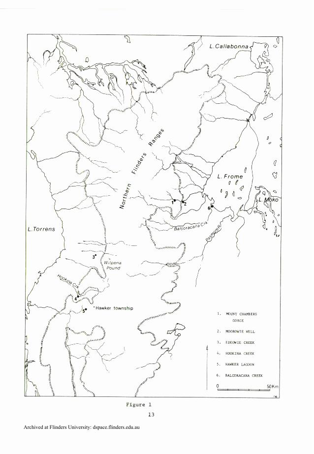
Figure 1
13
Archived at Flinders University: dspace.flinders.edu.au
SURFACE SITES WITH POSSIBLE KARTAN AFFILIATIONS
Mount Chambers Gorge
This su r f ace s i t e i s on s l o p e s above Mount Chambers Creek n o t f a r from t h e we l l known rock engravings . In two l o c a t i o n s about 200111 a p a r t a t o t a l of 25 co re t o o l s , made on b locks of r e d d i s h brown q u a r t z i t e , one trimming f l a k e and s i x was te f l a k e s were s een . Because t h i s a r e a i s s ac red t o Abor ig ines f u r t h e r r e s e a r c h w i l l involve in spec t ion of t h e i n d u s t r y i n s i t u , wi th no c o l l e c t i n g o r any o the r d i s tu rbance of t h e s i t e .
Moorowie Well
This su r f ace s i t e i s on a h i l l s l o p e above t h e downstream end o f Mount Chambers Gorge. Stone t o o l s were found among l imes tone rocks on the t a l u e s lope bu t not on t h e s u r f a c e o f t h e a l l u v i a l f a n extending downstream of t h e gorge , which i s young. Nine c o r e t o o l s and two waste f l a k e s were found, a l l made on b locks o f r e d d i s h brown q u a r t z i t e . In s i z e and shape they range from heavy horsehoof s e r i e s t o o l s t o smal ler and more i r r e g u l a r l y shaped b locks .
OTHER SURFACE SITES
Edeowie Creek
To the south and west o f Edeowie Creek on t h e wes t e rn foo t s lopes of t h e range below Wilpena Pound t h e r e a r e numerous l a r g e r ed dunes. The c r e s t s of t he se dunes have been s e v e r e l y eroded t o expose ca lcareous pa l aeoso l s . We examined a number o f t h e s e exposures and i n every ca se found e x t e n s i v e s c a t t e r s o f a r t e f a c t s l y i n g on the eroded s u r f a c e s . Although we examined many hundreds of t h e s e a r t e f a c t s none were found i n o r below t h e p a l a e o s o l , no r were any of those on t h e su r f ace coa t ed with ca rbona te . We t h e r e f o r e conclude t h a t a l l t h i s m a t e r i a l i s a l a g d e p o s i t de r ived o r i g i n a l l y from the ove r ly ing loose red sand.
The l o c a l s t r a t i g r a p h y can t e n t a t i v e l y be l i n k e d t o t h e r eg iona l sequence proposed by Will iams (1973). The d u n e f i e l d r e s t s on an ex t ens ive fan of t h e Pooraka Formation ( s e e below) and t h e dunes themselves probably belong t o t he widespread dune b u i l d i n g phase of t he Lake Torrens Formation (ca . 20,000-16,000BP). The pa l aeoso l on which t h e a r t e f a c t s l i e is t aken t o be e q u i v a l e n t t o t h e Motpena pa laeosol ( ca . 12,000BP). By t h i s r ea son ing we t a k e t h e maximum age of t he a r t e f a c t s t o be c a . 20,000-16,000BP.
The indus t ry a t t h e s e dune s i t e s c o n s i s t s o f c o r e and f l a k e t o o l s , with t h e co re t o o l s being a t l e a s t e q u a l l e d i n number both by f l a k e t o o l s and by m u l t i d i r e c t i o n a l c o r e s , and g r e a t l y exceeded by unmodified f l a k e s . Core t o o l e a r e o f a f a i r l y c o a r s e g ra ined w h i t e q u a r t z i t e while f l a k e t o o l s , m u l t i d i r e c t i o n a l c o r e s and unmodified f l a k e s a r e of f i n e g ra ined s i l i c e o u s rock such a s s i l c r e t e , q u a r t z i t e and c h e r t , a l l o f which a r e l o c a l l y a v a i l a b l e . One b u r r e n adze and s e v e r a l o t h e r p o s s i b l e non-tula adzes ( c f . Lampert 1977) were seen, but such c h a r a c t e r i r t i c sma l l t o o l e a s t h e p i r r i , t h e
Archived at Flinders University: dspace.flinders.edu.au
tula and backed blades are notably absent, as are fragments of grindstone.
In combination, the site stratigraphy and tool typology are consistent with a terminal Pleistocene or early Holocene age.
STRATIFIED SITES
Hookina Creek
Hookina Creek rises in the Flinders Range to the north of Hawker township. After flowing about 25km southwest it turns northwest to cross the footslopes of the range and to flood out in the sand plain to the east of Lake Torrens. Where it crosses the footslopes, the creek is entrenched up to 10m into a Pleistocene alluvial valley fill. This fill is included by Williams (1973) in the Pooraka Formation, an extensive and thick complex of fans and valley fills that occurs along the entire western margin of the Flinders and Mount Lofty Ranges. Radiocarbon dates indicate that sedimentation began before 38,000BP and continued up to about 30,000BP. A calcareous palaeosol, called the Wilkatana palaeosol and which is commonly up to 2m thick, developed on the Pooraka Formation sometime between 30,000 and 24,000BP.
The remains of extinct marsupials have been recovered from the Pooraka Formation in Hookina Creek and this sedimentary sequence and its contained fauna are currently being studied by D. Williams of Flinders University. The banks of the entrenched 25km section of the creek and its tributaries have been extensively eroded and there is excellent exposure of both the palaeosol and of the underlying sediments .
During our examination of a very small area of the exposed sediments at Hookina Creek a fractured quartzite pebble was seen in the Wilkatana palaeosol about lm below the present surface of the Pooraka Formation. At least three-quarters embedded and coated all over with flecks of carbonate, the pebble was unquestionably in situ. The quartzite is too coarse to permit easy interpretation of the fracture, but an edge appears to have been formed by removal of two adjacent large flakes. In an undoubted archaeological context it would probably be accepted without question as either a core or a core tool, but given as yet the absence of associated archaeological material and the high antiquity of the deposit (greater than ~O,OOOBP), we feel that further investigation is needed to test its authenticity.
Hawker Lagoon
The site extends around the margins of a seasonal swamp at the head of a narrow, steep-sided north-south trending valley to the south of Hawker township. Colluvial, alluvial and aeolian deposits surrounding the swamp (which is roughly lkm across and 3km long) have eroded in many places to expose as surface scatters many thousands of stone artefacts.
Archived at Flinders University: dspace.flinders.edu.au
The stratigraphy and surface morphology of these deposits is complex. Along the western margin of the swamp three main strata are exposed. Unit 1, the uppermost unit, is an irregular sheet of loose pale brown to red sand that is probably very young. Below this is Unit 2, up to lm thick, which consists of moderately to well indurated red sand with massive tabular sheets of carbonate in the upper 50cm. This red aeolian sand is tentatively correlated with William's (1973) Lake Torrens Formation (20,000 to 16,000BP) and the tabular carbonate palaeosol with the Motpena palaeosol (12,000BP).
The lowest unit, Unit 3, is a weathered clayey sand with some fine gravel and is taken to be colluvium at the toe of one of the many fans that mantle the lower footslopes of the valley. This unit has a well developed palaeosol with abundant carbonate nodules and carbonate encrusted root channels. In all respects Unit 3 and its palaeosol closely resembles the Pooraka Formation (greater than 38,000-ca. 30,000BP) and its associated Wilkatana palaeosol (30,000-24,000~P) as exposed to the west along Hookina Creek and is accordingly tentatively correlated with that sequence.
Along the eastern margin of the swamp the dominant landscape feature is a number of large red dunes with poorly developed tabular carbonate palaeosols exposed near their crests. These dunes, which are equated with Unit 2 on the western side of the valley, also overlie fan deposits but the latter are poorly exposed. The greater development of dunes on the eastern margin of the swamp is consistent with their downward location.
In the main, the stone industry is like that already described for Edeowie Creek with core tools of the horsehoof series, flake tools (scrapers), multidirectional cores and abundant flakes. Only two burren adzes and one geometric microlith were seen among many thousands of pieces of flaked stone, while grindstone fragments appear to be completely absent. As at Edeowie Creek, core tools are on fairly coarse grained quartzite and most flake tools, multidirectional cores and flakes on fine grained siliceous stone.
Unit 1 is not thought to be a reliable provenance because its sands appear to be frequently mobile. In Unit 2, four flakes protruding from a vertical section seemed to be in situ. In Unit 3, a large core tool was found about two-thirds embedded in a horizontal surface. Because it was firmly embedded in hard, carbonate-flecked clayey sand, and because carbonate encrusted its buried surface, the tool- was, as far as we could judge, in situ. We had questioned this at first because of the absence of carbonate on the exposed part of the tool. However, during the later examination of several vertical sections through carbonate soil horizons elsewhere, we noted that carbonate was commonly absent from the exposed parts of naturally deposited pebbles even though their buried surfaces were carbonate encrusted. Presumably the exposed surfaces had been coated too but the carbonate was removed by weathering.
The assemblage at Hawker Lagoon appears to be a mixed one derived from the deposition of artefacts during varying ages, as is shown by the in situ examples within soil units 2 and 3. Because of the deeply weathered strata, the core tool in Unit 3 must have reasonable antiquity whether or not the palaeosol in which it lay is the Wilkatana, while the presence of a geometric microlith suggests that the site was occupied also within the past 5000 years. However the bulk of the flaked stone is of the same core tool/flake scraper combination noted at Edeowie Creek, for which a terminal Pleistocene
Archived at Flinders University: dspace.flinders.edu.au
t o e a r l y Holocene age was sugges ted .
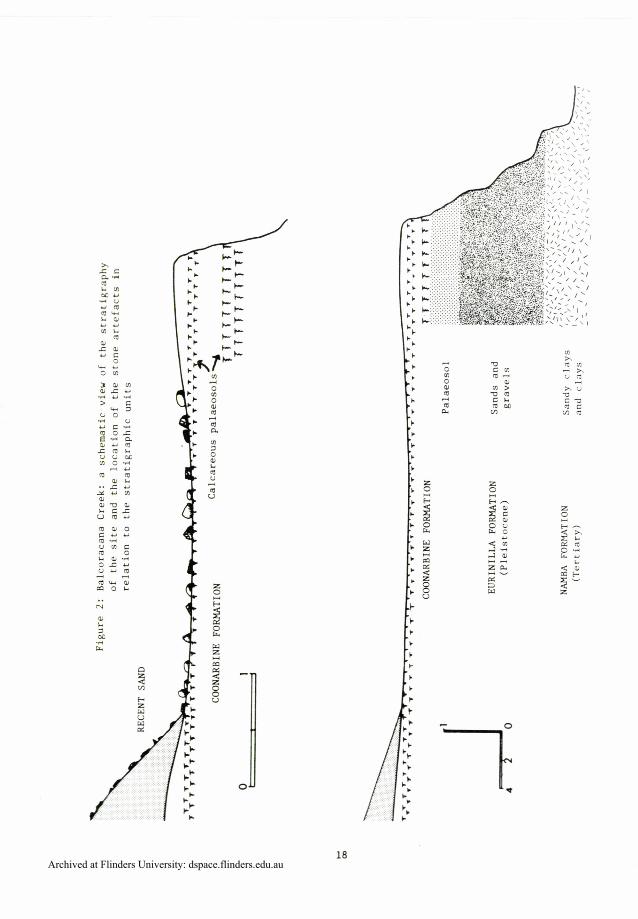
Balcoracana Creek
The sou theas t bank of t h i s c r eek nea r i t s mouth has been deep ly eroded t o expose a complex sequence o f P l e i s t o c e n e and T e r t i a r y sediments. A t one poin t a long t h e bank a r t e f a c t s l i e s c a t t e r e d on an exposed carbonate pa l aeoso l , whi le a few o t h e r s r e s t on l o o s e sand ove r ly ing t h e pa l aeoso l . By comparison o f t h e s t r a t i g r a p h y o f t h e sediments a t t h i s s i t e wi th t hose a t t y p e s e c t i o n s we v i s i t e d a t Lake Moko and Passmore River t o t he west a s desc r ibed by C a l l e n ( ~ a l l e n and Tedford 1976; Ca l l en , Wasson and G i l l e s p i e 1980) we deduce t h e s t r a t i g r a p h i c sequence t o be a s shown schema t i ca l ly i n F igure 2.
The s u r f a c e on which most of t h e a r t e f a c t s l i e has formed by e ros ion of t he upper pa r t of t h e Coonarbine Formation down t o a w e l l developed pa l aeoso l which probably formed more than 20,000 y e a r s ago. Because many of t he a r t e f a c t s a t t h i s s i t e a r e t h i c k l y coa t ed with ca rbona te , but very l i t t l e ca rbona te appea r s i n t h e sand ove r ly ing the pa l aeoso l , t h e s e a r t e f a c t s must almost c e r t a i n l y have eroded from t h e pa laeosol . However, o t h e r t o o l s a r e e n t i r e l y w i thou t carbonate and some l i e on loose sand cove r ing t h e p a l a e o s o l , i n d i c a t i n g t h a t l a t e r a r t e f a c t s a r e a l s o p r e s e n t .
I n t r y i n g t o deduce the o r i g i n a l s t r a t i g r a p h i c p o s i t i o n of each p i ece of s tone we have cons idered two l i n e s o f ev idence: ( a ) whether t h e a r t e f a c t l i e s d i r e c t l y on t h e p a l a e o s o l , and (b) whether o r n o t t h e a r t e f a c t i s coated with ca rbona te . Counts were made of the p r i n c i p a l a r t e f a c t types wi thout a c t u a l l y c o l l e c t i n g t h e m a t e r i a l . This i s not a wholly a c c u r a t e method bu t i s s u i t a b l e f o r making an i n i t i a l a p p r a i s a l of t he s i t e . For each type of a r t e f a c t t h e number of examples f a l l i n g i n t o t h e four c a t e g o r i e s i s l i s t e d i n Table 1. Those a r t e f a c t s l i s t e d i n column A we b e l i e v e o r i g i n a t e d from t h e pa l aeoso l ; t hose i n B a r e e i t h e r from t h e p a l a e o s o l o r from t h e more r ecen t sand above; those under C a r e from t h e more r e c e n t s and ; those i n D must have been moved up o n t o t h e l oose sand, perhaps v e r y r e c e n t l y .
Archived at Flinders University: dspace.flinders.edu.au
X r c PI*
l4 m M U 6 U U m 4 w * c U U
m * 0
m c al U C
w U o m 3 u m c c u d u d
> k 5 U 0 d U U c * 4 o r 6 4 P O I L 1 4
r m * U U M m o d
4 U m 4
c * .. U - Y U ~
t - 2 2 u m ~ m u 0 C U U 9 6 U m c m 0 * U d O S U Z U 2 ? m w c m 0 *
Archived at Flinders University: dspace.flinders.edu.au
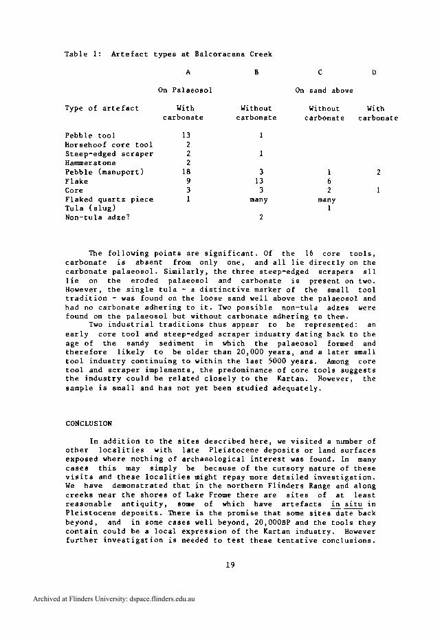
T a b l e 1: A r t e f a c t t y p e s a t Ba lcoracana Creek
On P a l a e o s o l
Type o f a r t e f a c t With c a r b o n a t e
P e b b l e t o o l 13 Horsehoof c o r e t o o l 2 Steep-edged s c r a p e r 2 Hammerstone 2 P e b b l e (manuport ) 18 F l a k e 9 Core 3 F laked q u a r t z p i e c e 1 T u l a ( s l u g ) Non-tula a d z e ?
On sand above
Without Without With c a r b o n a t e c a r b o n a t e c a r b o n a t e
3 13 3
many
1 6 2
many 1
The f o l l o w i n g p o i n t s a r e s i g n i f i c a n t . Of t h e 16 c o r e t o o l s , c a r b o n a t e i s a b s e n t from o n l y one, and a l l l i e d i r e c t l y on t h e c a r b o n a t e p a l a e o s o l . S i m i l a r l y , t h e t h r e e s teep-edged s c r a p e r s a l l l i e on t h e e r o d e d p a l a e o s o l and c a r b o n a t e i s p r e s e n t on two. However, t h e s i n g l e t u l a - a d i s t i n c t i v e marker o f t h e smal l t o o l t r a d i t i o n - was found on t h e l o o s e sand w e l l above t h e p a l a e o s o l and had no c a r b o n a t e a d h e r i n g t o i t . Two p o s s i b l e non- tu la adzes were found on t h e p a l a e o s o l b u t wi thout c a r b o n a t e a d h e r i n g t o them.
Two i n d u s t r i a l t r a d i t i o n s t h u s appear t o be r e p r e s e n t e d : an e a r l y c o r e t o o l and s teep-edged s c r a p e r i n d u s t r y d a t i n g back t o t h e age of the sandy sediment i n which t h e p a l a e o s o l formed and t h e r e f o r e l i k e l y t o be o l d e r t h a n 20,000 y e a r s , and a l a t e r smal l t o o l i n d u s t r y c o n t i n u i n g t o w i t h i n t h e l a s t 5000 y e a r s . Among c o r e t o o l and s c r a p e r implements , t h e predominance o f c o r e t o o l s s u g g e s t s t h e i n d u s t r y c o u l d be r e l a t e d c l o s e l y t o t h e Kar tan . However, t h e sample i s s m a l l and h a s no t y e t been s t u d i e d a d e q u a t e l y .
CONCLUSION
I n a d d i t i o n t o t h e s i t e s d e s c r i b e d h e r e , we v i s i t e d a number o f o t h e r l o c a l i t i e s w i t h l a t e P l e i s t o c e n e d e p o s i t s o r l and s u r f a c e s exposed where n o t h i n g o f a r c h a e o l o g i c a l i n t e r e s t was found. I n many c a s e s t h i s may s imply be because of t h e c u r s o r y n a t u r e o f t h e s e v i s i t s and t h e s e l o c a l i t i e s might repay more d e t a i l e d i n v e s t i g a t i o n . W e h a v e d e m o n s t r a t e d t h a t i n t h e n o r t h e r n F l i n d e r s Range and a l o n g c r e e k s n e a r t h e s h o r e s o f Lake Frome t h e r e a r e s i t e s o f a t l e a s t r e a s o n a b l e a n t i q u i t y , some o f which have a r t e f a c t s i n s i t u i n P l e i s t o c e n e d e p o s i t s . There i s t h e promise t h a t some s i t e s d a t e back beyond, and i n some c a s e s w e l l beyond, 20,000BP and t h e t o o l s t h e y c o n t a i n c o u l d be a l o c a l e x p r e s s i o n o f t h e Kartan i n d u s t r y . However f u r t h e r i n v e s t i g a t i o n i s needed t o t e s t t h e s e t e n t a t i v e c o n c l u s i o n s .
Archived at Flinders University: dspace.flinders.edu.au
The Australian Museum Sydney
Department of Prehistory ANU
BIBLIOGRAPHY
Callen, R.A. and R.H. Tedford 1976 New late Cainozoic rock units and depositional environments, Lake Frome area, South Australia. Transactions of the Royal Society of South Australia 100:125-67
Callen, R.A., R.J. Wasson and R. Gillespie 1980 The stratigraphy of the dunes and related sediments of the southern Strzelecki Desert. Australian Quaternary Newsletter 14:12-15
Cooper, H.M. 1943 Large stone implements from South Australia. Records of the South Australian Museum 7:343-69
Lampert, R. J. 1977 Kangaroo Island and the antiquity of . - Australians. 2 R.V. S. Wright (ed. ) Stone tools as cultural markers: change, evolution complexity, pp. 21F8. Canberra: Australian Institute of Aboriginal Studies
Lampert, R.J. 1979 Aborigines. 2 M.J. Tyler, C.R. Twidale and J.K. Ling (eds) Natural History of Kangaroo Island, pp.81-89. Adelaide: Royal Society of South Australia
Lampert, R.J. forthcoming The great Kartan mystery. To be published in Terra Australis series, but currently unpublished PhD thesis, ANU
Northcote, K.H. 1946 A fossil soil from Kangaroo Island, South Australia. Transactions of the Royal Society of South Australia 70:294-6
Williams, G.E. 1973 Late Quaternary piedmont sedimentation, soil formation and palaeoclimates in arid South Australia. Zeitschrift fur Geomorphologie 17:102-25
Archived at Flinders University: dspace.flinders.edu.au


