Embed Size (px)
Citation preview

Indicative Substation Connection Route[ Fence Line
Potential Service RoadSolar Panel AreaHard Stand AreaInverter/Transformer AreaLot BoundaryWatercourses
Vegetation TypesCoastal Foothill Spotted Gum- Ironbark ForestExotic/RehabilitatedPlanted Native VegetationAcacia Regeneration
Land uses Environmental LivingChildcareResidentialSubstation
1:5000
www.nghenvironmental.com.au
Notes:- Data collected by nghenvironmental ( 2017)- Client data courtesy of NCC, received 2017- Base map Copyright © Esri and its data suppliers.
0 50 10025 Meters
A3 @Ref: Site Analysis PlanAuthor: C.Jones
Site Analysis Plan
Summerhill Solar Farm DevelopmentApplication
°
Lot 2 DP 1208481NB: Entire site is capped landfill. Fenced area is approximately 7 ha.
170m
450m
85 m
160m
D001
Amended:28/11/2017

Indicative Substation Connection Route[ Fence Line
Potential Service RoadSolar Panel AreaHard Stand AreaInverter/Transformer AreaLot BoundaryWatercourses
Vegetation TypesCoastal Foothill Spotted Gum- Ironbark ForestExotic/RehabilitatedPlanted Native VegetationAcacia Regeneration
Land uses Environmental Living
1:2000
www.nghenvironmental.com.au
Notes:- Data collected by nghenvironmental ( 2017)- Client data courtesy of NCC, received 2017- Base map Copyright © Esri and its data suppliers.
0 50 10025 Meters
A3 @Ref: Site Analysis PlanAuthor: C.Jones
Site Analysis Plan
Summerhill Solar Farm DevelopmentApplication
°
Lot 2 DP 1208481NB: Entire site is capped landfill. Fenced area is approximately 7 ha.
D002
Amended:28/11/2017
1629 DRAFT 1
STATEMENT OF ENVIRONMENTAL EFFECTS PROPOSED SOLAR FARM 141 MINMI ROAD, WALLSEND
OCTOBER 2017

Statement of Environmental Effects Proposed Solar Farm - Minmi Road, Wallsend
www.nghenvironmental.com.au e: [email protected]
Newcastle - Hunter and North Coast 7/11 union st
newcastle west nsw 2302 (t 02 4929 2301)
Sydney Region 18/21 mary st
surry hills nsw 2010 (t 02 8202 8333)
Canberra - NSW SE & ACT 8/27 yallourn st (po box 62)
fyshwick act 2609 (t 02 6280 5053)
Brisbane level 7, 320 adelaide st
brisbane qld 4000 (t 07 3511 0238)
Bega - ACT and South East NSW suite 1, 216 carp st (po box 470)
bega nsw 2550 (t 02 6492 8333)
Wagga Wagga - Riverina and Western NSW suite 1, 39 fitzmaurice st (po box 5464)
wagga wagga nsw 2650 (t 02 6971 9696)
Bathurst - Central West and Orana 35 morrisset st (po box 434)
bathurst nsw 2795 (t 02 6331 4541)
Document Verification
Project Title: Proposed Solar Farm 141 Minmi Road, Wallsend
Project Number: 17-408 Project File Name: 17-408 Summerhill Solar Farm SEE Final 1.0 Revision Date Prepared by (name) Reviewed by (name) Approved by (name) Draft 1.0 23/10/17 Calia Jones
Steph Anderson Fiona McKay Fiona McKay
Final 1.0 24/10/17 Calia Jones Steph Anderson
Fiona McKay Fiona McKay
NGH Environmental prints all documents on environmentally sustainable paper including paper made from bagasse (a by-product of sugar production) or recycled paper.
NGH Environmental Pty Ltd (ACN: 124 444 622. ABN: 31 124 444 622) and NGH Environmental (Heritage) Pty Ltd (ACN: 603 938 549. ABN: 62 603 938 549) are part of the NGH Environmental Group of Companies.

Statement of Environmental Effects Proposed Solar Farm - Minmi Road, Wallsend
17-408 Final 1.0 i
CONTENTS 1 INTRODUCTION ........................................................................................................................ 5
1.1 BACKGROUND ......................................................................................................................................5
1.2 SUPPORTING DOCUMENTATION .........................................................................................................6
1.3 APPLICANT AND LAND OWNERHIP ......................................................................................................6
1.4 SUBJECT LAND AND LOCALITY .............................................................................................................6
2 THE DEVELOPMENT PROPOSAL ................................................................................................. 8
2.1 GENERAL OVERVIEW ............................................................................................................................8
2.2 THE DEVELOPMENT PROPOSAL ...........................................................................................................8
2.2.1 Solar farm infrastructure ....................................................................................................................... 8
2.2.2 Ancillary development ......................................................................................................................... 13
2.3 STAFF AND VISITORS ......................................................................................................................... 13
2.4 HOURS OF OPERATION ..................................................................................................................... 13
2.5 VEHICLE ACCESS AND MOVEMENTS ................................................................................................. 13
2.6 PROJECT CONSTRUCTION AND OPERATION ..................................................................................... 14
2.6.1 Construction ........................................................................................................................................ 14
2.6.2 Operation ............................................................................................................................................. 15
2.7 PROJECT DECOMMISSIONING ........................................................................................................... 15
3 ENVIRONMENTAL ANALYSIS ................................................................................................... 16
3.1 SITE ANALYSIS ................................................................................................................................... 16
3.2 LANDFORM, CHARACTER AND AMENITY .......................................................................................... 17
3.3 LANDUSE ........................................................................................................................................... 19
3.4 SITE HEALTH ...................................................................................................................................... 19
3.4.1 Current status of site health ................................................................................................................ 19
3.4.2 Proposal compatibility with site health ............................................................................................... 20
3.5 NOISE ................................................................................................................................................. 21
3.5.1 Construction noise impacts ................................................................................................................. 21
3.5.2 Operational noise impacts ................................................................................................................... 23
3.6 AIR QUALITY AND ODOUR................................................................................................................. 23
3.7 VISUAL AMENITY AND REFLECTIVITY ................................................................................................ 23
3.8 STORMWATER MANAGEMENT ......................................................................................................... 24
3.9 FLORA AND FAUNA ........................................................................................................................... 26
3.10 LAND HAZARDS AND RISKS ............................................................................................................... 28

Statement of Environmental Effects Proposed Solar Farm - Minmi Road, Wallsend
17-408 Final 1.0 ii
3.10.1 Flood prone land .................................................................................................................................. 28
3.10.2 Land slip ............................................................................................................................................... 28
3.10.3 Bush fire prone land ............................................................................................................................ 29
3.11 POST EUROPEAN AND ABORIGINAL HERITAGE ................................................................................ 31
3.11.1 Post-European Heritage ....................................................................................................................... 31
3.11.2 Aboriginal Heritage .............................................................................................................................. 31
4 INFRASTRUCTURE AND SERVICE PROVISIONS .......................................................................... 34
4.1 ROAD ACCESS .................................................................................................................................... 34
4.2 ELECTRICITY ....................................................................................................................................... 34
4.3 TELECOMMUNICATIONS ................................................................................................................... 34
4.4 WATER SUPPLY .................................................................................................................................. 34
4.5 STORMWATER ................................................................................................................................... 34
5 STATUTORY FRAMEWORK ...................................................................................................... 35
5.1 ENVIRONMENTAL PLANNING AND ASSESSMENT ACT 1979 ............................................................. 35
5.2 ENVIRONMENTAL PLANNING AND ASSESSMENT REGULATION 2000 .............................................. 35
5.3 BIODIVERSITY CONSERVATION (SAVINGS AND TRANSITIONAL) REGULATION 2017 ........................ 35
5.4 STATE ENVIRONMENTAL PLANNING POLICY (STATE AND REGIONAL DEVELOPMENT) 2011 .......... 35
5.5 STATE ENVIRONMENTAL PLANNING POLICY (INFRASTRUCTURE) 2007 ........................................... 36
5.6 STATE ENVIRONMENTAL PLANNING POLICY NO. 33 – HAZARDOUS AND OFFENSIVE DEVELOPMENT 36
5.7 STATE ENVIRONMENTAL PLANNING POLICY NO. 55 – REMEDIATION OF LAND .............................. 40
5.8 STATE ENVIRONMENTAL PLANNING POLICY NO. 44 – KOALA HABITAT PROTECTION ..................... 42
5.9 STATE ENVIRONMENTAL PLANNING POLICY (VEGETATION IN NON-RURAL AREAS) 2017 .............. 42
5.10 NEWCASTLE LOCAL ENVIRONMENTAL PLAN 2012 ........................................................................... 42
5.10.1 Land Zoning.......................................................................................................................................... 42
5.10.2 Defined Land Use ................................................................................................................................. 43
5.10.3 Permissibility of the proposed land use .............................................................................................. 43
5.10.4 Clause 5.10 - Heritage Conservation .................................................................................................... 43
5.10.5 Clause 5.11 - Bush Fire Hazard Reduction ........................................................................................... 44
5.10.6 Clause 5.12 Infrastructure development and use of existing buildings of the Crown ......................... 44
5.10.7 Clause 6.1 – Acid Sulfate Soils.............................................................................................................. 44
5.10.8 Clause 6.2 – Earthworks....................................................................................................................... 45
5.11 NEWCASTLE DEVELOPMENT CONTROL PLAN 2010 .......................................................................... 45
5.13 OTHER RELEVANT 79C MATTERS FOR CONSIDERATION ................................................................... 48

Statement of Environmental Effects Proposed Solar Farm - Minmi Road, Wallsend
17-408 Final 1.0 iii
6 ENVIRONMENTAL ASSESSMENT .............................................................................................. 50
7 CONCLUSION ......................................................................................................................... 55
9 REFERENCES ........................................................................................................................... 56
ATTACHMENT 1 DEVELOPMENT PLANS ............................................................................................. 57
ATTACHMENT 2 BIODIVERSITY ASSESSMENT ..................................................................................... 58
ATTACHMENT 3 APPROVAL FROM SUBSIDENCE ADVISORY NSW (TO COME) ...................................... 59
ATTACHMENT 4 APPROVAL FROM HUNTER WATER ........................................................................... 60
ATTACHMENT 5 AHIMS SEARCH RESULT ............................................................................................ 61
ATTACHMENT 5 GEOTECHNICAL REPORT, GHD .................................................................................. 62
TABLES
Table 1-1 Accompanying Plans and Documentation ...................................................................................... 6
Table 2-1 Details of solar farm infrastructure ...............................................................................................10
Table 3-1 Background levels and Noise Management Levels for Representative Noise Environment R1 ...22
Table 3-2 RMS Construction Noise Calculator inputs ...................................................................................22
Table 3-3 RMS Construction Noise Calculator outputs.................................................................................22
Table 3-4 Assessment against the objectives of Planning for Bushfire Protection 2006..............................30
Table 5-1 Suitability considerations for the proposal site ............................................................................40
Table 5-2 Relevant NDCP 2012 provisions ....................................................................................................45
Table 5-3 Relevant 79C matters ....................................................................................................................48
Table 6-1 Statement of Environmental Effects .............................................................................................50

Statement of Environmental Effects Proposed Solar Farm - Minmi Road, Wallsend
17-408 Final 1.0 iv
FIGURES
Figure 1-1 Subject land (Source: NSW Planning Portal mapping) ................................................................... 6
Figure 1-2 Subject land locality (Source: Google maps, 2017) ....................................................................... 7
Figure 2-1 Proposed solar farm plan (NGH Environmental, 2017) ................................................................. 9
Figure 2-2 Indicative photomontage of solar farm layout (Source: City of Newcastle, 2017) .....................11
Figure 2-3 Example of solar panel pile driven footing system for landfill sites (Source: Schletter, 2015) ...12
Figure 2-4 Example of solar panel footing system (Source: Schletter, 2015) ...............................................12
Figure 2-5 Ground-mounted array PV system components (Source: City of Newcastle, 2016) ...................12
Figure 2-6 Example of a central inverter with inbuilt transformer (Source: SMA) .......................................12
Figure 3-1 Subject land locality (Source: Google maps, 2017) .....................................................................16
Figure 3-2 Subject land topography (Source: Google maps, 2017) ..............................................................17
Figure 3-3 View east across the proposal site towards perimeter vegetation along Summerhill Road (Source: NGH Environmental, 2017) ...........................................................................................................................18
Figure 3-4 Vegetation on north-eastern extent of site and screening vegetation planted along southern side (Source: NGH Environmental, 2017) .............................................................................................................18
Figure 3-5 Expected capping depths of site (City of Newcastle, 2016) .........................................................20
Figure 3-6 Sensitive receivers in relation to the proposal site (Source: NGH Environmental) .....................21
Figure 3-7 View south looking toward the proposed solar farm from Summerhill Road .............................24
Figure 3-8 Surface water flows on current inert landfill (HLA Envirosciences, 2000)...................................25
Figure 3-9 Surface water drainage cross-section (HLA Envirosciences, 2000) .............................................26
Figure 3-10 Proximity to flood prone area (NSW Planning Portal mapping) ................................................28
Figure 3-11 Area of mine subsidence district (Source: NSW Planning Portal) ..............................................29
Figure 3-12 Bushfire prone land (Source: NSW Planning Portal) ..................................................................29
Figure 3-13 Subject land and its proximity to listed Items of Environmental Heritage (Source: NSW Planning Portal) ...........................................................................................................................................................31
Figure 5-1 Locality map of dangerous goods storage and neighbouring development (SEPP 33) (Source: NGH Environmental, 2017) ...................................................................................................................................39
Figure 5-2 Land zoning (Source: WWCC Online Mapping) ...........................................................................43
Figure 5-3 Acid Sulfate Soils (Source: Newcastle Local Environmental Plan 2012) ......................................44

Statement of Environmental Effects Proposed Solar Farm - Minmi Road, Wallsend
17-408 Final 1.0 5
1 INTRODUCTION In 2013, the NSW Government released the NSW Renewable Energy Action Plan to guide NSW’s renewable energy development (NSW Government 2013). The Government’s vision is for a secure, affordable and clean energy future for NSW. The Plan positions the state to increase energy from renewable sources by attracting investment, build community support, and grow expertise in renewable energy, at least cost to the energy customer and with maximum benefits to NSW. Furthermore, the Plan recognises that energy storage can increase the value of renewable energy to individuals, network operators and investors.
Newcastle City Council (NCC) are proposing to establish a solar farm located in the Summerhill Waste Management Centre (SWMC) at Wallsend in the Newcastle LGA. The SWMC is owned and operated by NCC. The SWMC facility already generates 2 MW of electricity through a landfill gas power generating system. The proposed solar farm would generate approximately 5 MW of renewable electricity. The bulk of the power would be fed into the grid and would offset energy consumption at other Council-owned facilities, through a virtual net metering arrangement.
The proposed solar farm would supply over 120,000 MWh over its operational life. This would assist in meeting NCC’s 2020 target of 30% generation from low-carbon sources. The solar farm would also be consistent with the aims of the NSW Government’s Renewable Energy Action Plan.
Local social and economic benefits that would be associated with the construction and operation of the proposed solar farm would include:
• A reduction in NCC-generated Carbon dioxide equivalent emissions (CO2e) by over 185,000 tonnes over the project life span, generating not only environmental benefits but also public health benefits;
• Beneficial re-use of contaminated land within the SWMC;
• Direct and indirect employment opportunities during construction and operation of the solar farm.
1.1 BACKGROUND
This Statement of Environmental Effects (SEE) has been prepared by NGH Environmental Pty Ltd (NGH) on behalf of Newcastle City Council, to support a development application (DA) seeking Council’s consideration of a proposed solar farm.
Development consent is sought under Part 4 of the Environmental Planning and Assessment Act 1979 (EP&A Act).
The proposed development is funded by the proponent and the estimated development cost is $8 million.
The purpose of this SEE is to describe the proposal and the likely impacts of the development on the environment and to detail the mitigation measures that would be implemented to minimise the potential impacts of the proposed activity.
The proposed development is not deemed to be a designated development (pursuant to Schedule 3 of the Environmental Planning and Assessment Regulation 2000), given the proposed power output would not exceed the requirements set out under Clause 18(1)(c) of Schedule 3 of the Regulation.
The proposed development is considered to be regional development pursuant to s20 of the State Environmental Planning Policy (State and Regional Development) 2011, given that the capital value of the project exceeds $5 million. The determining authority is therefore a Joint Regional Planning Panel (JRPP).

Statement of Environmental Effects Proposed Solar Farm - Minmi Road, Wallsend
17-408 Final 1.0 6
1.2 SUPPORTING DOCUMENTATION
This report shall be read in conjunction with accompanying plans and documentation listed in Table 1-1 below.
Table 1-1 Accompanying Plans and Documentation
Reference Description Prepared by
Attachment 1 Development Plans NCC/NGH Environmental
Attachment 2 Biodiversity Assessment NGH Environmental
Attachment 3 Approval Subsidence Advisory (to come) Subsidence Advisory NSW
Attachment 4 Approval Hunter Water Hunter Water
Attachment 5 AHIMS Search results NSW OEH
Attachment 6 Geotechnical Report GHD
1.3 APPLICANT AND LAND OWNERHIP
The applicant is Newcastle City Council. The subject land is operational land, owned by NCC.
1.4 SUBJECT LAND AND LOCALITY
The subject land is 141 Minmi Road, Wallsend. An image of the land is provided in Figure 1-1 below.
Figure 1-1 Subject land (Source: NSW Planning Portal mapping)
The subject land is sited on the western side of Minmi Road in the locality of Wallsend. Wallsend is characterised predominantly by residential development and is located approximately 10km north-west of the Newcastle CBD.
The location of the site with respect to the CBD is shown in Figure 1-2 below.

Statement of Environmental Effects Proposed Solar Farm - Minmi Road, Wallsend
17-408 Final 1.0 7
Figure 1-2 Subject land locality (Source: Google maps, 2017)

Statement of Environmental Effects Proposed Solar Farm - Minmi Road, Wallsend
17-408 Final 1.0 8
2 THE DEVELOPMENT PROPOSAL
2.1 GENERAL OVERVIEW
The proposed solar farm would be located within the Summerhill Waste Management Centre (SWMC) at Wallsend in the Newcastle LGA. SWMC is a solid waste landfill owned and operated by Newcastle City Council, which commenced operation in 1995. It is a modern, engineered landfill and resource recovery facility and is licensed by NSW Environment Protection Authority (EPA) to receive ‘General Solid Waste (Putrescible and Non-putrescible) and Special Waste’ under EPL 5897. Previously the site was used for open cut and underground mining activities. The SWMC Landfill Closure Plan manages remediation of the site as each waste cell is completed. Ongoing reshaping of the site occurs as part of the Landfill Closure Plan.
The proposal site is within an ‘inactive’ area of the facility that has been remediated. The proposed solar farm would be built on a capped zone with underlying non-putrescible (inert) waste cell. Two (2) MW of electricity are already generated from a separate landfill cell at the facility through a landfill gas power generating system. The proposed solar farm would generate an additional 5 MW of renewable electricity. The bulk of the power would be fed into the grid and would offset energy consumption at other Council-owned facilities through a virtual net metering arrangement.
The proposed solar farm has the potential to add a significant amount of distributed generation to the area, contribute to Newcastle’s renewable energy targets, offset energy costs through providing long-term budget certainty for electricity pricing, hedge against future price rises and create additional revenue for the City of Newcastle.
Under the Council adopted 'Newcastle 2020 Carbon and Water and Management Action Plan', Council has a target of achieving 30 percent of Council's electricity supplied from low carbon sources by 2020. In the 2015-2016 financial year, Council used approximately 14 million kilowatt hours (14 GWh) of grid electricity and approximately 500,000 kilowatt hours (0.5 GWh) of behind-the-meter renewable energy generation. Currently, low carbon electricity generation accounts for just under 5 percent of total Council electricity use.
2.2 THE DEVELOPMENT PROPOSAL
The proposed development relates to the establishment of a solar farm at the SWMC facility. The proposal site would comprise an area of approximately 7 hectares within the wider 260-hectare facility, with around 5 hectares of solar panels, as shown in Figure 2-1.
The proposed solar farm would generate approximately 5 MW of renewable electricity. The bulk of the power from the solar farm would be fed into the grid via a direct connection into the nearby Maryland Ausgrid substation.
2.2.1 Solar farm infrastructure
The proposed solar farm would consist of a commercial scale solar photovoltaic (PV) array with ground-mounted panels.
The proposed infrastructure would include the components as detailed in Table 2-1 on the following page and shown in Figure 2-2 to Figure 2-6.

Statement of Environmental Effects Proposed Solar Farm - Minmi Road, Wallsend
17-408 Final 1.0 9
Figure 2-1 Proposed solar farm plan (NGH Environmental, 2017)

Statement of Environmental Effects Proposed Solar Farm - Minmi Road, Wallsend
17-408 Final 1.0 10
Table 2-1 Details of solar farm infrastructure
Component Details Construction activities
Solar panels Solar PV panels (fixed tilt) and associated infrastructure (supports, cabling, inverters, transformers, assemblies etc).
The modules would be in rows which allow access between them for maintenance and minimisation of row to row shading. The PV panels would occupy approximately 5 hectares.
Foundations would be either concrete pad or shallow screw footings, extending approximately 600mm into the soil profile and specific for use in landfill sites, with low anchoring depths to protect subsoils.
Excavate and form footings (concrete) or install posts (shallow screw) (Figure 2-3 and Figure 2-4).
Attach support structures to footings or posts.
Mount panels on support structure.
Electrical connections/inverters
Infrastructure required to connect to the substation (e.g. switchgear; transformers, circuit breakers; cable supports, ring main unit, subject to detailed electricity design and certification). Indicative layout provided for location of connection to substation; most likely to be underbored beneath Summerhill Road to the fenceline of the Ausgrid substation.
Install/connect electrical conduit and wiring
Footings/padmounts installed for inverters and transformers, mount inverters and transformers on footings/padmounts.
Connect inverters, transformers and medium voltage (MV) switchgear.
Lithium battery storage on site
Storage of batteries on hardstand area and near point of connection (for future installation).
Shed or shipping container for storage of batteries.
Collection circuits Powerline connection to the adjacent existing substation located approximately 230 metres north-east of the solar farm site.
Underbore or trenching (under Summerhill Road), cable laying and backfill. Pole erection and line stringing for optional overhead section.
Access works Internal access driveway (up to 8m wide) along the southern side of the proposal site.
Indicative layout shown in Figure 2-1. Drainage works, approximately 240m.
Earthworks and rehabilitation.
Facility monitoring system
Performance and Remote Monitoring System such as a Supervisory control and data acquisition system (SCADA)
Construction of monitoring system and data connection points.
Hard stand area Viewing platform may be installed for educational purposes in the hardstand area to the west of the site.
Earthworks.
Fencing Chain wire fence surrounding solar farm Minor earthworks.

Statement of Environmental Effects Proposed Solar Farm - Minmi Road, Wallsend
17-408 Final 1.0 11
As part of future works, installation of battery storage systems to provide electric fleet charging and demand response capabilities is included; this may be close to the point of connection, or at the hard stand/car park area to the west, to be integrated with electric fleet charging infrastructure.
The development would also be supported by a real-time monitoring system integrated with the SCADA using a web-based facility. The Contractor and the Principal would jointly determine the number and type of data and signals in the facility monitoring system, a mimic-based representation of the facility, which would monitor the status and outputs of the facility.
The facility monitoring system would include the following:
a. A general plant overview summarising primary plant and meteorological quantities; b. Display key electrical quantities for inverters, combiner boxes, array boxes and any
other major collector systems • Inverters • Transformers • Meteorological stations • Solar Farm Switching and Control Station • Grid connection
c. Actual power export of the Facility.
Figure 2-2 Indicative photomontage of solar farm layout (Source: City of Newcastle, 2017)

Statement of Environmental Effects Proposed Solar Farm - Minmi Road, Wallsend
17-408 Final 1.0 12
An example of the type of footings and ground mounted solar panel system is shown below in Figure 2-3 to Figure 2-6.
Figure 2-3 Example of solar panel pile driven footing system for landfill sites (Source: Schletter, 2015)
Figure 2-4 Example of solar panel footing system (Source: Schletter, 2015)
Figure 2-5 Ground-mounted array PV system components (Source: City of Newcastle, 2016)
Figure 2-6 Example of a central inverter with inbuilt transformer (Source: SMA)
Statement of Environmental Effects Proposed Solar Farm - Minmi Road, Wallsend
17-408 Final 1.0 13
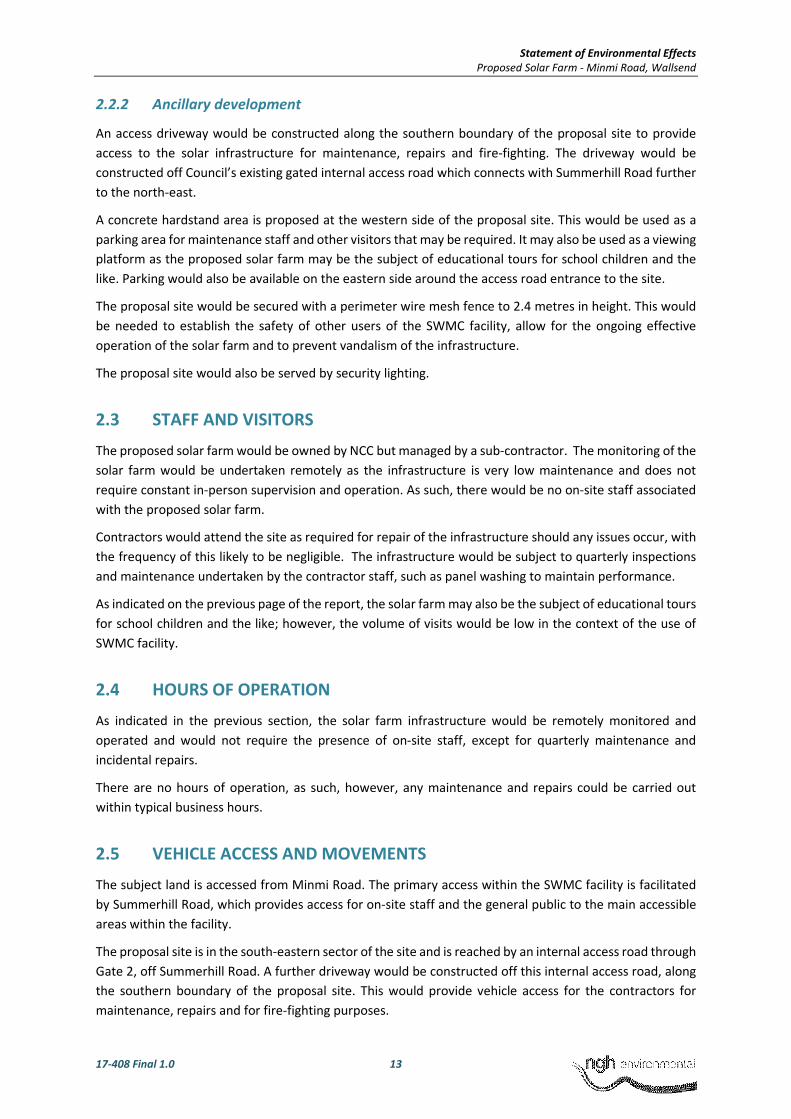
2.2.2 Ancillary development
An access driveway would be constructed along the southern boundary of the proposal site to provide access to the solar infrastructure for maintenance, repairs and fire-fighting. The driveway would be constructed off Council’s existing gated internal access road which connects with Summerhill Road further to the north-east.
A concrete hardstand area is proposed at the western side of the proposal site. This would be used as a parking area for maintenance staff and other visitors that may be required. It may also be used as a viewing platform as the proposed solar farm may be the subject of educational tours for school children and the like. Parking would also be available on the eastern side around the access road entrance to the site.
The proposal site would be secured with a perimeter wire mesh fence to 2.4 metres in height. This would be needed to establish the safety of other users of the SWMC facility, allow for the ongoing effective operation of the solar farm and to prevent vandalism of the infrastructure.
The proposal site would also be served by security lighting.
2.3 STAFF AND VISITORS
The proposed solar farm would be owned by NCC but managed by a sub-contractor. The monitoring of the solar farm would be undertaken remotely as the infrastructure is very low maintenance and does not require constant in-person supervision and operation. As such, there would be no on-site staff associated with the proposed solar farm.
Contractors would attend the site as required for repair of the infrastructure should any issues occur, with the frequency of this likely to be negligible. The infrastructure would be subject to quarterly inspections and maintenance undertaken by the contractor staff, such as panel washing to maintain performance.
As indicated on the previous page of the report, the solar farm may also be the subject of educational tours for school children and the like; however, the volume of visits would be low in the context of the use of SWMC facility.
2.4 HOURS OF OPERATION
As indicated in the previous section, the solar farm infrastructure would be remotely monitored and operated and would not require the presence of on-site staff, except for quarterly maintenance and incidental repairs.
There are no hours of operation, as such, however, any maintenance and repairs could be carried out within typical business hours.
2.5 VEHICLE ACCESS AND MOVEMENTS
The subject land is accessed from Minmi Road. The primary access within the SWMC facility is facilitated by Summerhill Road, which provides access for on-site staff and the general public to the main accessible areas within the facility.
The proposal site is in the south-eastern sector of the site and is reached by an internal access road through Gate 2, off Summerhill Road. A further driveway would be constructed off this internal access road, along the southern boundary of the proposal site. This would provide vehicle access for the contractors for maintenance, repairs and for fire-fighting purposes.

Statement of Environmental Effects Proposed Solar Farm - Minmi Road, Wallsend
17-408 Final 1.0 14
2.6 PROJECT CONSTRUCTION AND OPERATION
2.6.1 Construction
Establishment and construction of the proposed solar farm would broadly involve the following steps: • Site establishment including establishment of sediment and erosion controls, stripping of
grass cover, additive filling and land shaping • Delivery of materials and equipment • Installation of concrete pad or shallow-screw footings • Installation of cabling network, either trenched conduit or above-ground cable trays • Assembly of panel frames and mounts and fixing of the PV panels • Installation of the inverter units and transformers, including pouring of underlying
concrete pads • Substation works to connect the solar farm to the existing substation • Testing and commissioning of the solar farm • Removal of temporary construction facilities and completion of restoration works.
Proposed construction equipment Proposed construction equipment would include:
• Cable trenching equipment • Cable laying equipment • Earthmoving equipment such as excavators, bulldozers, pile drivers, backhoes, compactors,
rollers and graders • Materials handling equipment such as small cranes and forklifts • Water truck
Source and quantity of materials Materials would include:
• Gravel and road base for forming the gravel roads, imported from local quarries • Concrete • Panels, steelwork & inverters • Water for dust suppression and cleaning of panels would be commercially sourced from
offsite (water truck) or from within the SWMC primarily for dust control
Timing of work Construction would be undertaken during standard construction hours:
• Monday to Friday: 7am to 6pm
• Saturday: 8am to 1pm
• Sunday and Public Holidays: No work
No night works are proposed. It is unlikely that any works or deliveries will be required outside standard construction hours. It is expected that the construction program for the Project would be six months.

Statement of Environmental Effects Proposed Solar Farm - Minmi Road, Wallsend
17-408 Final 1.0 15
2.6.2 Operation
The project’s operational life is anticipated to be 30 years. After this time, components may be either decommissioned and removed from the site or upgraded for continued operation.
Operational activities would include monitoring and facility maintenance, such as panel cleaning and landscaping works, and the management of breakdowns and repairs. These requirements are likely to be met by external staff visiting the site as required.
2.7 PROJECT DECOMMISSIONING
Key elements of Project’s decommissioning stage would include:
• The PV power plant would be disconnected from the electrical grid • PV modules and all equipment would be disconnected • PV modules would be collected and recycled at a dedicated recycling facility • All buildings and equipment would be removed and materials recycled, wherever possible • Posts, frames and above ground cabling would be removed and recycled • Site rehabilitation
All aboveground infrastructure would be removed from the site at the decommissioning phase. Infrastructure and materials removed from the site would be recycled or otherwise disposed of at approved facilities. All areas of soil disturbed during decommissioning would be rehabilitated, appropriate to the existing species composition.
The development is highly reversible. After operation, the land could be returned to open grass or alternate uses, as per the Landfill Closure Plan (HLA Envirosciences, 2000). Formalised access and internal tracks, if elected to be retained, may benefit future development options.

Statement of Environmental Effects Proposed Solar Farm - Minmi Road, Wallsend
17-408 Final 1.0 16
3 ENVIRONMENTAL ANALYSIS
3.1 SITE ANALYSIS
The subject land is located within Summerhill Waste Management Centre (SWMC), 141 Minmi Road Wallsend NSW 2287. The land is legally identified as Lot 2 DP1208481. The allotment is irregular in shape and has an area of approximately 261 hectares. The approved area of the SWMC comprises approximately 70 hectares of this, with the remainder used a buffer to neighbouring land uses.
The subject land is sited on the western side of Minmi Road in the locality of Wallsend. Wallsend is characterised predominantly by residential development and is located approximately 10km north-west of the Newcastle CBD.
The area designated for the proposed solar farm is in the south-eastern sector of the site and comprises approximately 7 hectares of land, as indicated in Figure 3-1 below. The proposal site is within an ‘inactive’ area of the facility that has been remediated. The proposed solar farm would be built on a capped zone with underlying non-putrescible (inert) waste cell.
An internal access road leads from Minmi Road around the southern fringe of the proposal site. The main internal access road for the general public does not lead past the proposal site, but rather, is located further to the north.
Figure 3-1 Subject land locality (Source: Google maps, 2017)

Statement of Environmental Effects Proposed Solar Farm - Minmi Road, Wallsend
17-408 Final 1.0 17
3.2 LANDFORM, CHARACTER AND AMENITY
Site topography is gently undulating, with the highest elevation at approximately 60m ADH along the southern boundary of the subject land, as shown below in Figure 3-2.
Figure 3-2 Subject land topography (Source: Google maps, 2017)
Land proposed for the siting of the development falls in a north-westerly direction toward the vegetated area (Figure 3-3). The site drains to the north-east via Wentworth Creek and Flaggy Creek; however, no watercourses are present within the proposal site.
The image below (Figure 3-4) shows the northern view of the land that would contain the proposed development.

Statement of Environmental Effects Proposed Solar Farm - Minmi Road, Wallsend
17-408 Final 1.0 18
Figure 3-3 View east across the proposal site towards perimeter vegetation along Summerhill Road (Source: NGH Environmental, 2017)
Vegetation across the subject land is mostly rehabilitated landfill consisting of exotic flora; surrounding the site are stands of previous revegetation as well as remnant patches of native species, particularly on the northern and southern sides of the solar farm. Vegetation has been planted as a visual screen around the boundaries including along the northern, north-eastern and southern extents.
Figure 3-4 Vegetation on north-eastern extent of site and screening vegetation planted along southern side (Source: NGH Environmental, 2017)
The immediate local amenity is contained within the bounds of the SWMC, which is a waste management facility described as industrial in character. The surrounding local amenity could be described as peri-urban and the land uses present are predominantly residential. The proposed development does not depart from the character of the immediate environs and would be unlikely to have an impact on surrounding local amenity.
Statement of Environmental Effects Proposed Solar Farm - Minmi Road, Wallsend
17-408 Final 1.0 19
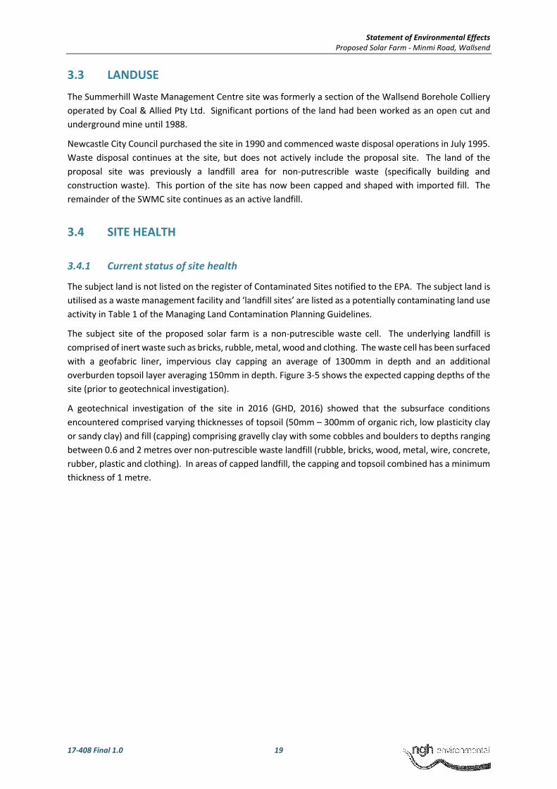
3.3 LANDUSE
The Summerhill Waste Management Centre site was formerly a section of the Wallsend Borehole Colliery operated by Coal & Allied Pty Ltd. Significant portions of the land had been worked as an open cut and underground mine until 1988.
Newcastle City Council purchased the site in 1990 and commenced waste disposal operations in July 1995. Waste disposal continues at the site, but does not actively include the proposal site. The land of the proposal site was previously a landfill area for non-putrescrible waste (specifically building and construction waste). This portion of the site has now been capped and shaped with imported fill. The remainder of the SWMC site continues as an active landfill.
3.4 SITE HEALTH
3.4.1 Current status of site health
The subject land is not listed on the register of Contaminated Sites notified to the EPA. The subject land is utilised as a waste management facility and ‘landfill sites’ are listed as a potentially contaminating land use activity in Table 1 of the Managing Land Contamination Planning Guidelines.
The subject site of the proposed solar farm is a non-putrescible waste cell. The underlying landfill is comprised of inert waste such as bricks, rubble, metal, wood and clothing. The waste cell has been surfaced with a geofabric liner, impervious clay capping an average of 1300mm in depth and an additional overburden topsoil layer averaging 150mm in depth. Figure 3-5 shows the expected capping depths of the site (prior to geotechnical investigation).
A geotechnical investigation of the site in 2016 (GHD, 2016) showed that the subsurface conditions encountered comprised varying thicknesses of topsoil (50mm – 300mm of organic rich, low plasticity clay or sandy clay) and fill (capping) comprising gravelly clay with some cobbles and boulders to depths ranging between 0.6 and 2 metres over non-putrescible waste landfill (rubble, bricks, wood, metal, wire, concrete, rubber, plastic and clothing). In areas of capped landfill, the capping and topsoil combined has a minimum thickness of 1 metre.

Statement of Environmental Effects Proposed Solar Farm - Minmi Road, Wallsend
17-408 Final 1.0 20
Figure 3-5 Expected capping depths of site (City of Newcastle, 2016)
3.4.2 Proposal compatibility with site health
Discussions between NCC and EPA revealed that guidance should be sought from the Best Practices for Siting Solar Photovoltaics on Municipal Solid Waste Landfills prepared by the US EPA (US EPA, 2013). The Best Practice document considers many landfill sites to be well-suited to the establishment of PV solar farms, provided that the relevant considerations are addressed in the design of the development.
It is proposed to install the PV panels on shallow concrete pad footings or shallow-screw footings that would require excavation to a depth of approximately 600mm. It is anticipated that a layer of additive fill would be provided where required once the existing site vegetation was stripped. There would be no ongoing excavation or disturbance of the site capping once the solar farm infrastructure was established.
As assessment of the proposal against SEPP 55 is included at 5.7 of this report.
The proposal site has been remediated in accordance with the Landfill Closure Plan (HLA Envirosciences, 2000) for the SWMC. Currently, there are no risks posed to the public. The integrity of the capping would be maintained and therefore the proposed development is viewed as being compatible with the contamination hazard and providing a viable redevelopment option for the site.

Statement of Environmental Effects Proposed Solar Farm - Minmi Road, Wallsend
17-408 Final 1.0 21
3.5 NOISE
The proposed solar farm would be located approximately 270 metres from the nearest dwelling (to the north) and 470 metres to the east, as shown in Figure 3-6.
Figure 3-6 Sensitive receivers in relation to the proposal site (Source: NGH Environmental)
3.5.1 Construction noise impacts
The proposed construction works can be divided into six stages based on the proposed works and required equipment. The stages include:
1. Site preparation, clearing and demolition 2. Establish site compound, access roads and delivery of materials 3. Installation of foundations 4. Installation of cabling 5. Assembly of panel frame mounts and transformer units 6. Site rehabilitation/removal of temporary construction facilities
The NSW Interim Construction Noise Guideline was developed by the NSW Department of Environment & Climate Change (DECC) and contains detailed procedures for the assessment and management of construction noise impacts. A qualitative desktop assessment of construction noise was undertaken.
The Roads and Maritime Services’ (RMS) Construction Noise Estimator Tool was used to predict the potential construction noise impact from the development on sensitive receivers. Estimated background noise is based on a representative noise environment - R1 (peri-urban area with residences within 500 metres of the works, with topography and vegetation providing a barrier to noise for residents), as shown in Table 3-1.

Statement of Environmental Effects Proposed Solar Farm - Minmi Road, Wallsend
17-408 Final 1.0 22
Table 3-1 Background levels and Noise Management Levels for Representative Noise Environment R1
Noise Category Representative Noise Environment
R1
RBL or LA90 Background level (dB(A)) Day 40
Evening 35
Night 30
LAeq(15minute) Noise Management level Day 50
Day (OOHW) 45
Evening 40
Night 35
During construction of the development, some additional noise sources would be present during clearing/preparation works and construction (drilling and road works). Typical plant used in construction of the solar farm is expected to include trucks, excavators, water cart, piling rig – driven (although this is a worst-case scenario, as it is more likely an auger would be used instead) and light vehicles. The typical plant were used to calculate estimated noise levels at the closest sensitive receivers (270 metres from the most northern point of the works), as shown in Table 3-2 below.
Table 3-2 RMS Construction Noise Calculator inputs
Noise area category R1
Line of sight to receiver No
Distance to nearest receiver (with line of sight) 270m
Noise level at nearest receiver (LAeq(15min)) 47dB
Are works required outside of standard hours? No
Table 3-3 RMS Construction Noise Calculator outputs
Catchment distances (refer also to Figure 3-6) Predicted noise levels (dB(A))
Nearest residence 270m (day) 47dB(A)
Nearest residence 270m (OOHW1) 40dB(A) (5 to 10dB(A) above background)
Nearest residence 270m (OOHW2) 35 dB (10-20db above background)
* OOHW1 = Out of hours works up to 10pm weekdays ** OOHW2 = Out of hours works 10pm-7am weekdays
The predicted noise level is below the recommended noise management levels, as shown in Table 3-3. The subject site is within the SWMC, which generates constant construction noise during daytime hours. In the context of the existing noise levels, and the short period of noise-generating construction activities during normal construction hours, construction noise from the development is not expected to be audibly increased to nearby sensitive receivers, and is therefore within the requirements of the Interim Construction Noise Guideline (ICNG).

Statement of Environmental Effects Proposed Solar Farm - Minmi Road, Wallsend
17-408 Final 1.0 23
3.5.2 Operational noise impacts
The NSW EPA Industrial Noise Policy (INP) set limits on the noise that may be generated by the development during operation. These limits are dependent upon the existing noise levels at the site and are designed to ensure changes to the existing noise environment are minimised and deal with the intrusiveness of the noise and the amenity of the environment. A review of potential noise sources and the background noise sources was undertaken.
Solar panels would be most likely fixed, however, there is a possibility of tracked solar panels which would move throughout the day to maximise solar exposure. Tracked solar panels would emanate noise from moving panels, during the daytime only, however, this is expected to be minimal during operation. Noise from the solar farm would be inaudible above the ambient background noise environment for nearby receivers, in the context of the existing background daytime noise levels from the SWMC and nearby traffic noise.
3.6 AIR QUALITY AND ODOUR
Given the established use of the subject land as a waste management facility, the existing ambient air quality is impacted by dust and odours generated during daily operations.
During construction there is the potential for dust generation from cleared and exposed areas. The implementation of the proposed mitigation measures would minimise any impacts on nearby sensitive receivers to the north of the subject land.
There are no identified operational impacts to the ambient air as result of the proposed development. There would be no ongoing ground disturbance associated with proposed solar farm and therefore no potential for ongoing dust impacts. Further, the proposed solar farm does not include any elements that would be likely to generate odour impacts on nearby sensitive receivers.
3.7 VISUAL AMENITY AND REFLECTIVITY
The visual environment of the local area is largely defined by the undulating ridges and slopes formed as part of the SWMC development. The SWMC is located within a valley that is screened from nearby receptors by vegetation and the surrounding topography. Surrounding land uses are predominantly residential, with some agricultural pasture to the south-east.
As a result of the land uses and topography, the visual catchment of the site is relatively contained. Views from elevated vantage points are limited by topography and vegetation along the perimeter of the site. The closest residence is 270m north of the proposal site, however, views of the development would be screened by vegetation and topography. It appears unlikely that significant impacts would be experienced from any sensitive receiver viewpoint.
Within the SWMC, brief glimpses of the solar farm would be visible from the Summerhill Road, visible for a few seconds to vehicles entering the SWMC, refer Figure 3-7. Opportunities for sun glint and glare from solar panels would be limited due to the properties and characteristics of the solar panels, which are designed to absorb light rather than reflect it. Sun glint and glare would also be limited due to the lack of direct visibility and line of sight from surrounding sensitive receiver locations to the development. The potential for sun glint impacting motorists travelling along Summerhill Road would be limited and would largely be mitigated by vegetation along the road corridor. Where visible, sun glint would tend to be indirect, relative to the direction of travel and very short term in duration.

Statement of Environmental Effects Proposed Solar Farm - Minmi Road, Wallsend
17-408 Final 1.0 24
Figure 3-7 View south looking toward the proposed solar farm from Summerhill Road
3.8 STORMWATER MANAGEMENT
Surface water from the subject site currently flows downslope (northwards) and is directed towards drainage channels and leachate collection points, as shown in Figure 3-8 and Figure 3-9 below.
The solar farm would require the installation of hardstand areas (to the east and west), concrete footings or shallow screw footings for each of the solar panels and an access road on the southern extent of the development. The existing stormwater arrangements would continue to operate and allow collection of all stormwater, as per the current arrangements.
Further details of the particulars of the site arrangements would be provided to Council’s satisfaction by the Contractor, who would be required to submit a construction and operational design including stormwater management.

Statement of Environmental Effects Proposed Solar Farm - Minmi Road, Wallsend
17-408 Final 1.0 25
Figure 3-8 Surface water flows on current inert landfill (HLA Envirosciences, 2000)

Statement of Environmental Effects Proposed Solar Farm - Minmi Road, Wallsend
17-408 Final 1.0 26
Figure 3-9 Surface water drainage cross-section (HLA Envirosciences, 2000)
3.9 FLORA AND FAUNA
A Biodiversity Assessment has been completed by NGH Environmental and is included in Attachment 2. The assessment concluded that with effective implementation of mitigation measures, risk of impacts to biodiversity are considered negligible. A summary for potential flora and fauna impacts can be found below.
Loss of vegetation
The vegetation within the proposal site has been previously highly disturbed. The amount of vegetation to be impacted for the proposed works is approximately 7.3 ha; some of this may be cleared, and other areas would be highly disturbed by construction vehicles. Three trees would be removed including Eucalyptus and Allocasuarina species.
The vast majority of vegetation to be impacted is previously rehabilitated landfill capping containing a mix of exotic and native species, however dominated by exotic flora such as Pennisetum clandestinum (Kikuyu), Chloris gayana (Rhodes grass) and environmental weeds including Senna pendula var. glabrata (Easter cassia), Cortaderia selloana (Pampas grass) and Lantana camara (Lantana).
Native vegetation within the impact areas is limited but a small area (0.08 ha) on the western fringe of the impact area does contain natural regeneration of Acacia irrorata (Green Wattle) and Acacia parramattensis (Sydney Wattle). No aquatic vegetation or habitat would be impacted.
Threatened Ecological Communities

Statement of Environmental Effects Proposed Solar Farm - Minmi Road, Wallsend
17-408 Final 1.0 27
There are no TECs within the study area. Mitigation measures would ensure no indirect impacts should occur on any TECs within the study locality or broader region.
Threatened Flora Species
Twelve threatened flora species under the TSC Act were recorded previously within the study locality however none were recorded within the study area during the site inspection. Vegetation impacted is considered non-optimal for threatened flora due to the highly disturbed historical land use. These species were detectable at the time of season that the inspection was undertaken and as none were observed within the proposed work area, impacts to threatened flora are considered unlikely.
Habitat Loss
The proposed works would result in the impact of 7.3 ha of non-optimal foraging habitat for birds, small mammals and reptiles. Vegetation with the study area surrounding the proposal site does contain more optimal habitat with increased native diversity and structure, however, this vegetation would not be impacted. The vast majority of vegetation to be impacted/removed has been previously disturbed and rehabilitated utilising exotic flora species as well as the incursion of environmental weeds. This habitat may be used for movement and foraging on occasion by protected and threatened fauna moving through the area however is considered non-optimal.
A threatened species evaluation determined a list of potential threatened species that may utilise the study area on occasion for foraging or as a corridor for movement. The loss of non-optimal habitat is unlikely to cause a significant impact to any threatened fauna species occurring within or near the study area due to the disturbance history, lack of structural diversity in the impact areas and better-quality habitat within vegetation within the study locality that would not be impacted.
Hollow Bearing Tress and Logs
No hollow bearing trees would be removed from the proposed works area. A small amount of woody debris would be disturbed, however, safeguards implemented, such as relocating logs into areas that would not be disturbed, would ensure impacts would be negligible.
Threatened Fauna Species
Of the 43 threatened fauna species previously recorded within the study locality, none are recorded within the proposal site or were observed during the site inspection.
Historical records of threatened species such as Powerful owl, Squirrel glider and various microbat species occur adjacent to the study area within areas of remnant vegetation, however, if they were to utilise the proposal site, it would be on a transitory basis only. As the proposed works would not impact on this vegetation and have minor impacts on non-optimal habitat only and with no roosting sites impacted, significant impacts are unlikely.
Habitat Fragmentation and Wildlife Connectivity
The proposed works would not significantly result in further fragmentation or isolate any areas or habitat. Vegetation to the north of the proposal site contains a mapped fauna corridor (Minmi) and additionally is mapped as key habitat under the OEH key habitats and corridor mapping, however this vegetation will not be impacted. The loss of approximately 7.3 ha of highly disturbed exotic dominated vegetation would not significantly alter the existing environment or significantly decrease connectivity.

Statement of Environmental Effects Proposed Solar Farm - Minmi Road, Wallsend
17-408 Final 1.0 28
3.10 LAND HAZARDS AND RISKS
3.10.1 Flood prone land
The subject land is not located on a floodplain or a flood management zone, shown on Council’s online mapping, as indicated in Figure 3-10 below.
Figure 3-10 Proximity to flood prone area (NSW Planning Portal mapping)
3.10.2 Land slip
The subject land is mapped within a mine subsidence district and susceptible to landslip, as indicated in Figure 3-11 below. The Summerhill Waste Management Centre site was formerly a section of the Wallsend Borehole Colliery operated by Coal & Allied Pty Ltd. Significant portions of the land had been worked as an open cut and underground mine until 1988.
The potential for mine subsidence is considered to be low given that the proposal site is a former building and construction waste cell that has been lined and capped with a further 1.2 metres of imported clay material. The capping was compacted to a level exceeding the required compaction density ratio in AS1289. Some differential settlement of capping has occurred over time.
The proposed development has been submitted for approval to Subsidence Advisory NSW, to be included in Attachment 3 to this report. The development would be undertaken in accordance with the conditions of the Subsidence Advisory approval in order to reduce the risk of potential mine subsidence damage.

Statement of Environmental Effects Proposed Solar Farm - Minmi Road, Wallsend
17-408 Final 1.0 29
Figure 3-11 Area of mine subsidence district (Source: NSW Planning Portal)
3.10.3 Bush fire prone land
The subject land is classified as bushfire prone land, as indicated in Figure 3-12 below. The proposal site is within the buffer for Category 1 vegetation.
Figure 3-12 Bushfire prone land (Source: NSW Planning Portal)

Statement of Environmental Effects Proposed Solar Farm - Minmi Road, Wallsend
17-408 Final 1.0 30
In Planning for Bushfire Protection 2006 (PBP), the proposed development is classified as ‘other’ development, for which there are no performance criteria. The development is required to address the aims and objectives of PBP.
The aim of PBP is to use the NSW development assessment system to provide for the protection of human life (including firefighters) and to minimise impacts on property from the threat of bush fire, while having due regard to development potential, on-site amenity and protection of the environment. The objectives of PBP are addressed in Table 3-4 below.
Table 3-4 Assessment against the objectives of Planning for Bushfire Protection 2006
Objective Response
(i) afford occupants of any building adequate protection from exposure to a bush fire;
There are no buildings proposed as part of the development
(ii) provide for a defendable space to be located around buildings;
There are no buildings proposed as part of the development; however, the proposal site would be surfaced and maintained as ‘managed land’ as defined by PBP, in order to reduce the bushfire risk. The proposal site would be cleared of vegetation where required (approximately 3 trees) and any hard surfaces covered with concrete or gravel; the remaining area would be retained with a managed grass cover.
(iii) provide appropriate separation between a hazard and buildings which, in combination with other measures, prevent direct flame contact and material ignition;
As mentioned, there are no buildings proposed with the development. NCC has a Bushfire Risk Management Plan that applies to SWMC, which would manage the risk of bushfire to the proposed solar farm.
Conversely, the risk of ignition from the solar farm substation or other electrical fault is considered to be low. The network would be electronically monitored and would be able to identify any faults or fatigued equipment.
(iv) ensure that safe operational access and egress for emergency service personnel and residents is available;
The proposal site is easily accessible from internal access roads within SWMC and this link back onto Summerhill Road at both ends. The internal access roads also link with nearby fire trails. It is viewed that operational access and egress are available for emergency services personnel and residents.
(v) provide for ongoing management and maintenance of bush fire protection measures, including fuel loads in the asset protection zone (APZ); and
The proposal site would be cleared of vegetation where required (approximately 3 trees) and any hard surfaces covered with concrete or gravel; the remaining area would be retained with a managed grass cover. This would constitute ’managed land’, reducing the fuel loads within the proposal site and managing the bushfire risk NCC also has a Bushfire Risk Management Plan that applies to SWMC, which would manage the risk of bushfire to the proposed solar farm.
(vi) ensure that utility services are adequate to meet the needs of firefighters (and others assisting in bush fire fighting).
The proposal site would not have an available water connection. Any potential risk of ignition from the solar farm would be an electrical fire and water should not be used to treat a fire of this nature. The solar farm would be supported by fire protection equipment such as extinguishers at the SWMC.

Statement of Environmental Effects Proposed Solar Farm - Minmi Road, Wallsend
17-408 Final 1.0 31
3.11 POST EUROPEAN AND ABORIGINAL HERITAGE
3.11.1 Post-European Heritage
The subject land does not contain items of Environmental Heritage pursuant to the Newcastle Local Environmental Plan 2012. The Minmi cemetery is located to the west of the subject land, as indicated (in brown solid hatch) in Figure 3-13 below. The cemetery is listed as Item I334 in Schedule 5 of the NLEP 2012.
The proposed development is located towards the eastern end of the subject land and well separated from the cemetery by topography and significant vegetation.
The proposed development relates to the establishment of a solar farm and is compatible with the existing industrial character of the subject land. It is considered that the physical separation of almost 3km and the buffer provided by the intermediate topography and vegetation would ensure that the proposal would not have a negative impact on the heritage significance or setting of the cemetery.
Therefore, the proposal is acceptable and accordingly, no further post-European heritage assessment or reporting is considered necessary.
Figure 3-13 Subject land and its proximity to listed Items of Environmental Heritage (Source: NSW Planning Portal)
3.11.2 Aboriginal Heritage
Introduction
Newcastle City Council propose to construct a solar farm on a 7 hectare portion of the Summerhill waste management facility. The Summerhill Waste Management Centre site was formerly a section of the Wallsend Borehole Colliery operated by Coal & Allied Pty Ltd. Significant portions of the land had been worked as an open cut and underground mine until 1988.

Statement of Environmental Effects Proposed Solar Farm - Minmi Road, Wallsend
17-408 Final 1.0 32
Newcastle City Council purchased the site in 1990 and commenced waste disposal operations in July 1995. Waste disposal continues at the site, but does not actively include the proposal site. The land of the subject site was previously used as a landfill for non-putrescible waste (specifically building and construction waste); this portion of the site has now been capped and shaped with imported fil approximately 1-2 metres in depth. The remainder of the site continues as an active landfill.
A site visit was undertaken on 7 September 2017 by Fiona McKay and Mitch Palmer of NGH Environmental. The desktop Due Diligence assessment was carried out by qualified archaeologist Matthew Barber of NGH Environmental.
This report has been drafted in keeping with the sequence of steps identified in the NSW Office of Environment and Heritage’s (OEH 2011) Due Diligence Code of Practice for the Protection of Aboriginal Objects in NSW. The Code of Practice provides a five step approach to determine if an activity is likely to cause harm to an Aboriginal object, as defined by the NSW National Parks and Wildlife Act (1974). The steps follow a logical sequence of questions, the answer to each question determines the need for the next step in the process.
Background Assessment
Ground Disturbance
The proposal would require earthworks for the construction of the solar farm infrastructure. This would have the potential to impact any subsurface heritage items. However, due to the heavily disturbed nature of the proposal site, the potential for encountering Aboriginal heritage objects is viewed as negligible.
A site visit undertaken on 7 September 2017 by Fiona McKay and Mitch Palmer confirmed that the site was heavily disturbed.
Register search and landscape assessment
A search of the Aboriginal Heritage Information Management System (AHIMS) was undertaken on the 5 September 2017. There were no registered Aboriginal heritage sites located within 50 metres of the proposal site. The AHIMS search result is provided as Attachment 5 to this report. No Native Title claims cover the proposal site.
The area is within the boundaries of the Awabakal Local Aboriginal Land Council. The Due Diligence process does not formally require consultation with Aboriginal community groups. No Aboriginal groups were contacted for this due diligence level assessment.
Local Studies
An archaeological survey and study was conducted by Pam Dean-Jones, Archaeological Consultant, in December 1989, as part of the Summerhill Waste Management Centre’s original Environmental Impact Statement (EIS) (Camp Scott Furphy, 1992). As part of this study, a detailed site inspection was undertaken with a local Awabakal Aboriginal Co-operative member to identify and record any Aboriginal heritage evidence or cultural values within the study area. The investigated study area included the area that is now identified as the Proposal study area. The site survey concentrated on areas identified as relatively undisturbed by previous mining activities.
Whilst the study area has several characteristics indicative of high archaeological potential in the local environmental context, the study did not identify any Aboriginal heritage sites within the study area. The archaeological survey did not identify any evidence of prehistoric occupation in either the landfill area or the buffer area. Consultation with Aboriginal stakeholders was undertaken for the SWMC Stage II EIS (GHD, 2010).

Statement of Environmental Effects Proposed Solar Farm - Minmi Road, Wallsend
17-408 Final 1.0 33
Assessment
Given the previous land use history of the site, both as a colliery and more recently as a waste management facility, it is highly unlikely that any Aboriginal heritage items would remain intact within the study area.
Impact Assessment Conclusion
The Due diligence assessment has been designed to establish the likelihood of Aboriginal objects being harmed by the proposed activity. The answer to this question, based on the evidence presented would be that such harm is unlikely.
Recommendations
If, during construction works, objects or skeletal remains are found that are suspected of being Aboriginal in origin, work in the immediate area shall cease and OEH notified.
All relevant contractors and staff engaged on the Proposal would be inducted as to their responsibilities and appropriate reporting process of discovered Aboriginal artefacts and would receive heritage awareness training prior to commencing work on-site.

Statement of Environmental Effects Proposed Solar Farm - Minmi Road, Wallsend
17-408 Final 1.0 34
4 INFRASTRUCTURE AND SERVICE PROVISIONS
4.1 ROAD ACCESS
The proposal site is in the south-eastern sector of the site and is reached by an internal access road off Summerhill Road, prior to the entrance to the Waste Facility gate. A further driveway would be constructed off this internal access road, along the southern boundary of the proposal site. This would provide vehicle access for the contractors for maintenance, repairs and for fire-fighting purposes.
4.2 ELECTRICITY
The proposed solar farm would generate approximately 5 MW of renewable electricity. The bulk of the power from the solar farm would be fed into the grid to offset energy consumption at other Council-owned facilities through a virtual net metering arrangement.
The proposal site would be directly connected to the nearby Maryland Ausgrid substation busbar via an 11kV powerline.
4.3 TELECOMMUNICATIONS
A telecommunications line would need to be extended to the proposal site to provide for the ability to remotely monitor and manage the proposed solar farm.
4.4 WATER SUPPLY
The proposal site would not require a water connection to serve the proposed solar farm. It is intended that a water truck would import water to the site for periodical panel washing.
4.5 STORMWATER
Surface water runoff would be directed to drainage channels, as per the current arrangements. Water is directed through the drainage lines northwards. During detailed design further details of the proposed drainage layout would be available.

Statement of Environmental Effects Proposed Solar Farm - Minmi Road, Wallsend
17-408 Final 1.0 35
5 STATUTORY FRAMEWORK
5.1 ENVIRONMENTAL PLANNING AND ASSESSMENT ACT 1979
Application is being made for proposed electricity generating works (solar farm) in accordance with Part 4 section 78A of the Environmental Planning and Assessment Act 1979.
The proposed development is also defined in Schedule 4A of the Act, as Council related development with a capital investment value exceeding $5 million. This is further discussed in Section 5.3 below in relation to the State Environmental Planning Policy (State and Regional Development) 2011.
5.2 ENVIRONMENTAL PLANNING AND ASSESSMENT REGULATION 2000
The proposed development has been assessed against the provisions Schedule 3 of the Environmental Planning and Assessment Regulation 2000 to determine whether the proposal is deemed a designated development.
The proposed development is not deemed to be a designated development (pursuant to Schedule 3 of the Environmental Planning and Assessment Regulation 2000), given the proposed power output would not exceed the requirements set out under Clause 18(1)(c) of Schedule 3 of the Regulation.
5.3 BIODIVERSITY CONSERVATION (SAVINGS AND TRANSITIONAL) REGULATION 2017
The NSW government introduced a new framework for the consideration and assessment of biodiversity impacts for developments. The new legislation, Biodiversity Conservation Act 2016 (BC Act), was gazetted on 25th August 2017. The BC Act replaced some of the existing legislation including the Threatened Species Conservation Act 1997. Development Applications submitted after the 25th August 2017 may need to consider the new framework.
However, the NSW Government has established transitional arrangements related to biodiversity assessment for the various categories of development consent or approval that are underway or have been made already. These are set out in the Biodiversity Conservation (Savings and Transitional) Regulation 2017. All development applications which were submitted before commencement will be considered under previous legislation. Importantly, outside of areas of Western Sydney, local developments in all other areas will have three months from 25 August 2017 to submit a development application under the previous legislation. As the Development Application will be submitted within the transition period, this assessment has been undertaken in accordance with the NSW Threatened Species Conservation Act 1995 (TSC Act).
5.4 STATE ENVIRONMENTAL PLANNING POLICY (STATE AND REGIONAL DEVELOPMENT) 2011
The proposed development is considered to be regional development pursuant to clause 20 of the State Environmental Planning Policy (State and Regional Development) 2011, given the capital investment value of the project exceeds $5 million, as defined by Schedule 4A of the Environmental Planning and Assessment Act 1979. The determining authority is therefore a Joint Regional Planning Panel.

Statement of Environmental Effects Proposed Solar Farm - Minmi Road, Wallsend
17-408 Final 1.0 36
5.5 STATE ENVIRONMENTAL PLANNING POLICY (INFRASTRUCTURE) 2007
The State Environmental Planning Policy (Infrastructure) 2007, referred to as ISEPP, contains provisions that facilitate the development and redevelopment of land for the purposes of infrastructure and service delivery.
Part 3 Division 4 contains the provisions that are relevant to electricity generating works or solar energy systems. Clause 34 provides for the following types of infrastructure development permitted with consent;
34 Development permitted with consent
(1) Development for the purpose of electricity generating works may be carried out by any person with consent on any land in a prescribed rural, industrial or special use zone.
(2) Development for the purpose of a back-up electricity generating plant that operates for not more than 200 hours in any year may be carried out by any person with consent on any land.
(2A) Development for the purpose of the expansion of existing electricity generating works may be carried out by or on behalf of a public authority with consent on any land that is adjacent to the existing works.
(2B) Consent is not required to carry out any such development on land if the development could, but for subclause (2A), be carried out on that land without consent.
(3) Development for the purpose of, or resulting in, a change of fuel source of an existing coal or gas fired generating works by a proportion of more than 5 per cent in any 12 month period may only be carried out with consent.
(4) If, under any environmental planning instrument (including this Policy), development for the purpose of:
(a) industry, or
(b) a waste or resource management facility,
may be carried out on land with consent, development for the purpose of electricity generating works that generate energy from waste, or from gas generated by waste, may also be carried out by any person with consent on that land.
(5) Without limiting subclause (1), development for the purpose of a small wind turbine system may be carried out by any person with consent on any land.
(6) However, subclause (5) only applies in relation to land in a prescribed residential zone if:
(a) the small wind turbine system has the capacity to generate no more than 10kW, and
(b) the height of any ground-mounted small wind turbine in the system from ground level (existing) to the topmost point of the wind turbine is no more than 18m.
The proposed development would be consistent with subclauses (1) and (4) and is therefore permitted with the consent of the authority.
5.6 STATE ENVIRONMENTAL PLANNING POLICY NO. 33 – HAZARDOUS AND OFFENSIVE DEVELOPMENT
State Environmental Planning Policy No 33 – Hazardous and Offensive Development requires that consideration be given to the current circulars or guidelines relating to such development as published by the Department of Planning, when determining if the proposal is so classified.

Statement of Environmental Effects Proposed Solar Farm - Minmi Road, Wallsend
17-408 Final 1.0 37
The relevant guidelines contained within Applying SEPP 33: Hazardous and Offensive Development Application Guidelines include two tests, one for hazard potential and one for pollution potential (offensiveness).
Electricity generating works are not identified as a potentially offensive or potentially hazardous industry in Appendix 3 of the Guidelines. However, this is not conclusive within itself and further assessment is included below.
Appendix 2 Checklist of Information Required to Identify SEPP 33 Development
(a) Information required in relation to the risk screening method of Applying SEPP 33
• The storage of lithium batteries is required. • The relevant Dangerous Goods classification is ADG code Class 9, Specialist provisions – 188,
230, 310, 376, 377, 384. Packing instructions: P903, P908, P909, P910, LP903, LP904. • There would be no ongoing delivery of dangerous goods or hazardous materials as the
lithium batteries would be delivered and established on-site during the construction phase and would remain in-situ.
• A locality map indicating the proximity of the dangerous goods storage and surrounding land use activities is included at Figure 5-1.
• The nearest sensitive receiver is 270 metres to the north, as indicated in Figure 3-6. • The dangerous goods storage would be located approximately 130 metres south of the
nearest property boundary.
(b) Information required to identify other risk factors
• It is considered that the lithium battery storage is not incompatible with any other materials to be placed on site.
• The only hazardous waste to be generated would be expired lithium batteries, which would be replaced and disposed of at a licenced facility.
• The lithium battery storage is associated with the operation of the solar farm. • There are no identified reactive or unstable materials or conditions that could lead to an
uncontrolled reaction. • The lithium batteries may be subjected to high and low temperatures with the local climate;
however, the design of the batteries would be able to withstand such conditions.
(c) Information required to identify potential offensive industry
• Construction activities such as site stripping, placement of additive fill and cover, have the potential to generate localised dust emissions and noise. There are no identified pollution impacts associated with the operation of the solar farm.
• EPL 5897 applies to the SWMC waste management operations. • The proposed solar farm does not require any licences or operating approvals to manage
environmental impacts from any agencies.
Potentially hazardous industry
For the purposes of SEPP 33, hazardous materials are defined by the Guidelines as “substances falling within the classification of the Australian Code for the Transportation of Dangerous Goods by Road and Rail”. The storage of lithium batteries is required, with the relevant Dangerous Goods classification being ADG Code Class 9.

Statement of Environmental Effects Proposed Solar Farm - Minmi Road, Wallsend
17-408 Final 1.0 38
The storage of ADG Code Class 9 goods is not included in the Screening Threshold in Table 1 of the Guidelines, as these “are miscellaneous dangerous goods, which pose little threat to people or property”1. In accordance with the Guidelines, it can therefore be assumed that there is unlikely to be a significant off-site risk associated with the storage of the lithium batteries. The transportation frequency for the lithium batteries is also well below the Transportation Screening Thresholds contained in Table 2 of the Guidelines.
Consequently, the proposed development is not considered to be potentially hazardous and a Preliminary Hazard Analysis (PHA) is not required to be prepared for the proposal.
Potentially offensive industry
In deciding if a proposal is a ‘potentially offensive industry’, consent authorities need to determine whether, in the absence of safeguards, the proposal would emit a polluting discharge which would cause a significant level of offence. As discussed in Sections 2 and 3 of this report, there are no identified polluting discharges that would be likely to result from the proposed development.
In accordance with the Guidelines, a proposal can generally be considered as not offensive industry as it does not require a licence from the EPA and in some cases, does not require a licence from any other licensing authorities. The proposed solar farm does not require any licences or operating approvals to manage environmental impacts from any agencies. It is concluded that the proposed development is not ‘offensive development’ as defined by the SEPP.
1 NSW Government Department of Planning, Applying SEPP 33: Hazardous and Offensive Development Application Guidelines, 2011, p.33

Statement of Environmental Effects Proposed Solar Farm - Minmi Road, Wallsend
17-408 Final 1.0 39
Figure 5-1 Locality map of dangerous goods storage and neighbouring development (SEPP 33) (Source: NGH Environmental, 2017)

Statement of Environmental Effects Proposed Solar Farm - Minmi Road, Wallsend
17-408 Final 1.0 40
5.7 STATE ENVIRONMENTAL PLANNING POLICY NO. 55 – REMEDIATION OF LAND
State Environmental Planning Policy No 55 – Remediation of Land requires the consent authority to take into account whether or not land is contaminated, whether the land is in a suitable state for the proposed development and whether land requires remediation to reach a state that is suitable for that development.
The subject land is not listed on the register of Contaminated Sites notified to the EPA. The subject land is utilised as a waste management facility and ‘landfill sites’ are listed as a potentially contaminating land use activity in Table 1 of the Managing Land Contamination Planning Guidelines.
The area of the proposed solar farm is a non-putrescible waste cell. The underlying landfill is comprised of inert waste such as bricks, rubble, metal, wood and clothing. The waste cell has been surfaced with a geofabric liner, impervious clay capping at an average of 1300mm in depth and an additional overburden topsoil layer averaging 150mm in depth.
It is proposed to install the PV panels on shallow concrete pad footings or using shallow screw footings that would only require excavation to a depth of up to approximately 600mm. Additive fill may also be placed dependant on the detailed structural design for the footing and mounting structures. There would be no ongoing excavation or disturbance of the site capping once the solar farm infrastructure was established.
Discussions between NCC and EPA revealed that guidance should be sought from the Best Practices for Siting Solar Photovoltaics on Municipal Solid Waste Landfills prepared by the US EPA (US EPA, 2013). The Best Practice document considers many landfill sites to be well-suited to the establishment of PV solar farms, provided that the relevant considerations are addressed. Refer to Table 5-1 below.
Table 5-1 Suitability considerations for the proposal site
Consideration Response
Slope and stability Fixed-axis systems generally produce a higher annual yield the closer they are oriented towards a 0 degree Azimuth (north). In the case of the subject proposal, this would increase mounting cost; however, north-west is also a suitable angle that has certain advantages in output over the summer months
The land slopes reasonably gently and is well-suited to the proposal. Council’s consultant recommended that if fixed panels are used, that the panels be mounted at a 20 degree angle.
The land is considered to be sufficiently stable for the intended purposes because of the highly-compacted capping, with dry fill material. This is supported by the geotechnical assessment conducted by GHD.
The nature of the underlying landfill is also of importance, as landfill with a high organic waste component would decay at a much higher rate. The landfill underlying the proposal site comprises building and construction waste consistently across the waste cell, which reduces the potential for differential movement as a result of differing decay rates. The landfill includes some timbers, but the vast majority is concrete, rubble, metal and the like. The latter materials would provide for low rates of decay and limited differential movement. The site was capped in 2003 and has therefore had sufficient time to account for the majority of any settling that may occur.
Footing penetrations Driven pile footings are not suitable for landfill applications as they would have too greater impact on the capping. In line with the US EPA Best Practice guide

Statement of Environmental Effects Proposed Solar Farm - Minmi Road, Wallsend
17-408 Final 1.0 41
Consideration Response (US EPA, 2013), pad footings and shallow screw footings are considered suitable for such applications.
The proposed development would not include driven pile footings. Detailed structural design details for concrete pad or shallow-screw footings would be provided to the satisfaction of the consent authority prior to the commencement of works.
Potential gas and explosion risks
The potential for gas seepage is considered to be low. The proposed footings of the solar infrastructure would extend to a depth of approximately 600mm and would not penetrate the underlying waste cell. The integrity of the existing impervious capping would be maintained.
Further, the nature of the underlying waste is such that methane gas production is low. A detection system is in place to monitor this.
Lightning protection Electrical grounding is a standard design consideration for all PV systems and protects the PV system from electrical surges and lightning strikes. The PV system would be grounded into the landfill cap material (provided the electrical engineer determines that the material and thickness of the cap is sufficient to dissipate the electrical charge). Grounding rods, as with the footings, would only penetrate the additive fill and capping material and must not extend into the waste cell.
Provided the system is adequately grounded, there is a low fire risk associated with the proposed development.
Stormwater Surface water from the subject site currently flows downslope (northwards) and is directed towards drainage channels and leachate collection points, as shown in Figure 3-8 and Figure 3-9 in this report.
The existing stormwater arrangements would continue to operate and allow collection of all stormwater, as per the current arrangements.
Further design details of the stormwater management arrangements would be provided to Council’s satisfaction by the Contractor, who would be required to submit a construction and operational design including stormwater management.
Compatibility with post-closure plans and management requirements
Existing management measures such as leachate management and monitoring and stormwater management, for the proposal site as a former waste cell could be continued with the proposed development.
All aboveground infrastructure would be removed from the site at the decommissioning phase. All areas of soil disturbed during decommissioning would be rehabilitated, appropriate to the existing species composition.
The solar farm development is highly reversible. After operation, the land could be returned to open grass or alternate uses, as per the Landfill Closure Plan (HLA Envirosciences, 2000).
Impacts to public health Provided that the integrity of the cell capping is maintained, there is no increase in the risk to public health as a result of the proposed development.
The proposal site has been remediated in accordance with the Landfill Closure Plan (HLA Envirosciences, 2000) for the SWMC. Currently, there are no risks posed to the public. The design of the solar farm infrastructure would be compatible with the state of the proposal site and the integrity of the capping

Statement of Environmental Effects Proposed Solar Farm - Minmi Road, Wallsend
17-408 Final 1.0 42
would be maintained. In consideration of these factors, the proposed development is viewed as being compatible with the contamination hazard and providing a viable redevelopment option for the site.
5.8 STATE ENVIRONMENTAL PLANNING POLICY NO. 44 – KOALA HABITAT PROTECTION
The proposed work area is located within the Newcastle LGA, which is listed on Schedule 1 of SEPP 44.
There were no primary, secondary or supplementary feed tree species present within the proposal area, however, Eucalyptus puncata (Grey gum) is present within the broader study area and study locality. According to SEPP 44, the vegetation within the proposal area cannot be considered "potential Koala habitat".
"Core koala habitat" is defined as an area of land with a resident population of koalas, evidenced by attributes such as breeding females and recent sightings, and historical records of a population. There are two (2) listed Koala sightings within the study locality, however, as the sightings are older than 10 years and the site is highly disturbed, the proposed works area is not considered core koala habitat according to SEPP 44.
5.9 STATE ENVIRONMENTAL PLANNING POLICY (VEGETATION IN NON-RURAL AREAS) 2017
As the proposal is being assessed under the transitional arrangements of the Biodiversity Conservation (Savings and Transitional) Regulation 2017, this SEPP does not apply.
5.10 NEWCASTLE LOCAL ENVIRONMENTAL PLAN 2012
5.10.1 Land Zoning
The subject land is zoned SP2 Infrastructure (Waste or Resource Management Facility) and E4 Environmental Living under the provisions of the Newcastle Local Environmental Plan (NLEP) 2012, as indicated in Figure 5-2 below.
The proposed solar farm would be located within the area of the property that is zoned SP2 Infrastructure.

Statement of Environmental Effects Proposed Solar Farm - Minmi Road, Wallsend
17-408 Final 1.0 43
Figure 5-2 Land zoning (Source: WWCC Online Mapping)
5.10.2 Defined Land Use
The proposed solar farm falls within the land use definition of electricity generating works, which is defined in the LEP 2012 as follows:
electricity generating works means a building or place used for the purpose of making or generating electricity.
5.10.3 Permissibility of the proposed land use
The proposed development is defined as electricity generating works. However, the proposed area of development is zoned SP2 Infrastructure, for the stated purpose of a waste or resource management facility. This would also extend to include any development that is ordinarily incidental or ancillary to development for that purpose.
Whether the proposed electricity generation is considered to be ordinarily incidental or ancillary is not a relevant matter, as the provisions of the ISEPP override the NLEP 2012.
5.10.4 Clause 5.10 - Heritage Conservation
Consent for any aspect of the proposed development is not required under clause 5.10 of the NLEP 2012.
It is considered that the potential to impact Aboriginal cultural heritage items is low given the significant land disturbance that has occurred in the proposed area of development. As discussed in section 3.11 of the report, the subject land does not contain Items of Environmental Heritage subject to listing in Schedule 5 of the Local Environmental Plan.

Statement of Environmental Effects Proposed Solar Farm - Minmi Road, Wallsend
17-408 Final 1.0 44
5.10.5 Clause 5.11 - Bush Fire Hazard Reduction
As discussed previously in section 3.10.3 of this report, the subject land is partly mapped as being bushfire prone land. The proposal site would be surfaced and maintained as ‘managed land’ to reduce the fuel loads and the bushfire risk.
5.10.6 Clause 5.12 Infrastructure development and use of existing buildings of the Crown
The provisions of this clause note that the NLEP 2012 “does not restrict or prohibit, or enable the restriction or prohibition of, the carrying out of any development, by or on behalf of a public authority, that is permitted to be carried out with or without development consent, or that is exempt development, under State Environmental Planning Policy (Infrastructure) 2007”.
The proposed development would be consistent with clause 34(1) and 34(4) of the ISEPP and is therefore permitted with the consent of the authority.
5.10.7 Clause 6.1 – Acid Sulfate Soils
The subject land is mapped as Class 5 land on the Acid Sulfate Soils Map, as indicated in Figure 5-3 below.
Under the provisions of this clause, development consent is required for works within 500 metres of adjacent Class 1, 2, 3 or 4 land that is below 5 metres Australian Height Datum and by which the watertable is likely to be lowered below 1 metre Australian Height Datum on adjacent Class 1, 2, 3 or 4 land.
The boundary of the subject land is approximately 620 metres from adjacent Class 3 land and therefore the provisions of this clause are not relevant to the proposed development.
Figure 5-3 Acid Sulfate Soils (Source: Newcastle Local Environmental Plan 2012)

Statement of Environmental Effects Proposed Solar Farm - Minmi Road, Wallsend
17-408 Final 1.0 45
5.10.8 Clause 6.2 – Earthworks
The proposed development will involve earthworks during construction of the solar infrastructure. These earthworks should be considered as an ancillary aspect of the proposed development and not as a separate matter under the provisions of this clause.
5.11 NEWCASTLE DEVELOPMENT CONTROL PLAN 2010
The Newcastle Development Control Plan applies to the subject land. The provisions relevant to the proposed development are discussed in Table 5-2 below.
Table 5-2 Relevant NDCP 2012 provisions
Development Control Plan – Consideration of Relevant Clauses
Section 4 – Risk minimisation provisions
4.02 Bushfire protection The subject land is mapped as bushfire prone land as discussed in Section 3.10.2 of this report.
An assessment of the development against the aims and objectives of Planning for Bushfire Protection 2006 is required for the proposal, which is classified as ‘other’ development under the PBP. Refer to Table 3-4 of this report.
4.03 Mine subsidence The subject land is located within the MSD. An application to Subsidence Advisory NSW has been made for approval of the development; the approval will be provided by SA to accompany the development application.
Section 5 – Environmental protection provisions
5.01 Soil management The subject site has previously been cleared and disturbed as part of previous mining and landfill activity; however, soil disturbance for the purpose of establishing solar infrastructure and ancillary development is minimised as much as possible.
Construction works can be managed so as to implement erosion and sediment control principles. An erosion and sediment control plan would be provided to Council for approval prior to the commencement of any work on site.
5.02 Land contamination An assessment of the development against the provisions of SEPP 55 and, more generally, NCC’s contaminated land policy is included in Section 5.6 of this report and is summarised below.
The subject land is utilised as a waste management facility and ‘landfill sites’ are listed as a potentially contaminating land use activity in Table 1 of the Managing Land Contamination Planning Guidelines.
The area of the proposed solar farm is a non-putrescible waste cell. The underlying landfill is comprised of inert waste such as bricks, rubble, metal, wood and clothing. The waste cell has been surfaced with a geofabric liner, impervious clay capping an average of 1300mm in depth and an additional overburden topsoil layer averaging 150mm in depth.
The design and operation would be generally consistent with the Best Practice Guide for Siting Solar Photovoltaics on Municipal Solid Waste Landfills (US EPA, 2013). It is proposed to install the PV panels on shallow concrete pad footings or use shallow screw footings that would only require excavation to a depth of up to 600mm. There would be no ongoing excavation or disturbance of the site capping once the solar farm infrastructure was established.

Statement of Environmental Effects Proposed Solar Farm - Minmi Road, Wallsend
17-408 Final 1.0 46
The proposed solar farm is considered to be an appropriate form of redevelopment of this area of the SWMC, with no further remediation works required to enable the development. There are no identified public health risks associated with the proposal.
5.04 Aboriginal heritage A desktop Due Diligence assessment is included in Section 3.11.2 of this report and summarised below.
The proposal site is highly disturbed as it forms part of a waste management facility. The proposed site of the solar farm is a non-putrescible waste cell that is capped with 1-2 metres of clay.
A search of the Aboriginal Heritage Information Management System (AHIMS) found that there are no registered Aboriginal heritage sites located within 200 metres of the subject land. An extract of the AHIMS search result is provided at Attachment 5.
The proposal would require earthworks for the construction of the solar farm infrastructure. This would have the potential to impact any subsurface heritage items. However, due to the disturbed nature of the proposal site, the potential presence of Aboriginal heritage objects is considered to be negligible.
Section 7 – Development Provisions
7.02 Landscape, open space and visual amenity
The visual environment of the local area is largely defined by the undulating ridges and slopes formed as part of the SWMC development.
The proposed solar farm would have a substantial impact on the visual amenity of the immediate area of the proposal site. However, due to the localised view catchment, the potential to affect nearby receptors is low.
Within the SWMC, brief glimpses of the solar farm would be visible from the Summerhill Road for a few seconds to vehicles entering the SWMC; however, the proposed development is not inconsistent with the disturbed visual character of the subject land as a former mine and now waste management centre.
Pre-DA advice received from NCC revealed that landscaping in support of the proposed development is not a significant concern; however it is proposed that a landscape plan would be provided to Council’s satisfaction prior to the commencement of any works.
7.03 Traffic, parking and access
Access to the site is provided from Summerhill Road via a gated established access road. Construction and operational traffic would access the site from this access road.
Parking would be provided within the hardstand area at the western end of the proposal site. As the solar farm would be remotely monitored, there is limited demand for parking associated with proposal. As indicated in Section 2 of this report, the solar farm would be visited by contractors for quarterly maintenance and on occasion for repairs. It may also be visited by school groups or other groups for educational purposes. It is viewed that the hardstand area is sufficiently sized to provide for the anticipated parking demand.
Given the nature of the proposed development, public transport services would not be a relevant concern.
7.05 Energy efficiency This section contains no controls that are relevant to the proposal.

Statement of Environmental Effects Proposed Solar Farm - Minmi Road, Wallsend
17-408 Final 1.0 47
The proposed development relates to the generation of renewable energy and would reduce the Council’s reliance on non-renewable energy sources. The development would be consistent with objectives of the NSW Renewable Energy Action Plan.
7.06 Stormwater Surface water from the subject site currently flows downslope (northwards) and is directed towards drainage channels and leachate collection points, as shown in Figure 3-6 and Figure 3-7.
The solar farm would require the installation of hardstand areas (to the east and west), concrete footings or shallow screw footings for each of the solar panels and an access road on the southern extent of the development. The existing stormwater arrangements would continue to operate and allow collection of all stormwater, as per the current arrangements.
Further details of the particulars of the site arrangements would be provided to Council’s satisfaction by the Contractor, who would be required to submit a construction and operational design including stormwater management.
Section 8 – Public Participation
8.00 Public Participation The project has been the subject of a Public Expression of Interest Process in November 2016 and has been discussed at various Council meetings. It has been identified as a specific project in both the Draft and Final Newcastle City Council Smart City Strategy which underwent an extensive public consultation process. A media release about the project was also sent out in September 2017 which was featured in the Newcastle Herald, NBN News and other media outlets as well as communication by Council via social media channels.
In response to this extensive communication about the project, NCC have only received positive feedback about the proposal and have not had any concerns raised as yet.
Given the location within Summerhill Landfill and the minimal impact (if any) it would have on adjacent landowners, no specific consultation has been undertaken.
Statement of Environmental Effects Proposed Solar Farm - Minmi Road, Wallsend
17-408 Final 1.0 48
5.13 OTHER RELEVANT 79C MATTERS FOR CONSIDERATION
Section 79C of the Environmental Planning and Assessment Act 1979 states that in determining a development application, a consent authority is to take into consideration other relevant matters. These matters are listed in Table 5-3 below.
Table 5-3 Relevant 79C matters
Other relevant 79C matters for consideration
• any proposed instrument that is or has been the subject of public consultation under this Act and that has been notified to the consent authority……:
There are no known proposed instruments applicable to the development proposal.
• any planning agreement……: There are no known planning agreements applicable to the development proposal.
• the suitability of the site for the development…:
Based on the evidence provided and discussions in this report, the site is considered suitable for the development.
The solar farm would be located atop an old waste cell; the cell contains inert waste and has been satisfactorily capped with an impervious layer. The construction and ongoing impacts of the solar farm are considered to be consistent with the contamination risk of the subject area.
It is considered that the proposal positively contributes to the public interest by addressing reliance on non-renewable energy sources and facilitating renewable energy production in line with the aims of the NSW Renewable Energy Action Plan.
• any submissions…..: The project has been the subject of a Public Expression of Interest Process in November 2016 and has been discussed at various Council meetings. It has been identified as a specific project in both the Draft and Final Newcastle City Council Smart City Strategy which underwent an extensive public consultation process. A media release about the project was also sent out in September 2017 which was featured in the Newcastle Herald, NBN News and other media outlets as well as communication by Council via social media channels.
In response to this extensive communication about the project, NCC have only received positive feedback about the proposal and have not had any concerns raised as yet.
Given the location within Summerhill Landfill and the minimal impact (if any) it would have on adjacent landowners, no specific consultation has been undertaken.
As part of the development assessment process, the consent authority would undertake appropriate public consultation and consider any submissions as a result of public notification.

Statement of Environmental Effects Proposed Solar Farm - Minmi Road, Wallsend
17-408 Final 1.0 49
Other relevant 79C matters for consideration
• the public interest…..: The public interest is supported with this application as the proposal is in accordance with the publicly endorsed planning policies and guidelines.
The proposed solar farm would enable redevelopment of the subject site that is compatible with the current use of the wider facility and would not adversely impact on the amenity of the locality.
The proposed development is compatible and in accordance with Local Environmental Plan objectives for the land.
The proposal will create positive economic impacts through the demand for goods, services and trades during the construction phase and provide employment during operation.

Statement of Environmental Effects Proposed Solar Farm - Minmi Road, Wallsend
17-408 Final 1.0 50
6 ENVIRONMENTAL ASSESSMENT Table 6-1 Statement of Environmental Effects
Primary Matters Likely Impacts Safeguards and Mitigation Measures
Context and Setting Nil. The subject land is within the locality of Wallsend and is described as a peri-urban setting.
The proposal site is located within the Summerhill Waste Management Centre (SWMC) and comprises approximately 7 hectares within the wider 260-hectare property. The development proposal is compatible with the existing industrial nature of the subject land and is sufficiently separated from nearby receptors that impacts in excess of the existing SWMC operations would be avoided.
Construction Mitigation measures during the construction period should consider: • Minimisation of tree removal where possible • Protection of mature trees within the proposed solar
farm site where retained. • Avoidance of temporary light spill beyond the
construction site where temporary lighting is required • Rehabilitation of disturbed areas A landscape plan shall be provided as part of detailed design Operation Mitigation measures during the operational period should consider: • Ongoing maintenance and repair of constructed
elements • Replacement of damaged or missing constructed
elements • Long term maintenance (and replacement as necessary)
of tree planting within the solar farm site to maintain visual filtering and screening of external views where appropriate.
Access and Traffic Minimal. The proposed solar farm would only increase traffic during construction. During operation there would be infrequent visits to site by contractors, so no increase in traffic volumes would occur.
The existing internal road would not need to be upgraded as it is at a standard for the use of large vehicles. There are no proposed changes to existing, external traffic arrangements.
Parking would be provided within the hardstand area at the western end of the proposal site with some parking on the eastern end inside
An all-weather internal road will be constructed to a standard suitable for the use of construction vehicles. The proposed hardstand will provide off-street parking for contractors and authorised visitors and be constructed in accordance with Engineering Guidelines.
A construction traffic plan for the site will be prepared by the Contractor prior to the commencement of any work.

Statement of Environmental Effects Proposed Solar Farm - Minmi Road, Wallsend
17-408 Final 1.0 51
Primary Matters Likely Impacts Safeguards and Mitigation Measures
the access area. As the solar farm would be remotely monitored, there is limited demand for parking associated with proposal. It is viewed that the hardstand area is sufficiently sized to provide for the anticipated parking demand.
Infrastructure Positive. The proposed development would provide for the generation of 5MW of renewable electricity. The bulk of the power from the solar farm would be fed into the grid to offset energy consumption at other Council-owned facilities through a virtual net metering arrangement. It would be directly connected to the nearby Maryland Ausgrid substation busbar via an 11kV powerline.
The proposal would not place an unreasonable demand on other public utilities, with only a telecommunications line needing to be extended to the proposal site.
Surface water runoff would be directed to drainage channels, as per the current arrangements. Water is directed through the drainage lines northwards.
Ensure stormwater is adequately managed with the proposed development. The contractor would provide design details of the proposed drainage layout to Council’s satisfaction prior to the commencement of any works.
Heritage Nil. The proposal is unlikely to have impacts on Aboriginal Heritage as the site is highly disturbed and no AHIMS sites were returned from the search.
The proposal site is also well-separated from any items of environmental heritage.
Not applicable.
Construction Construction works would be undertaken within a period of 2-6 months. Construction traffic would be located away from the publicly accessible areas of the site and would not interrupt existing SWMC operations.
Construction noise would also be below the relevant noise criteria and would not affect surrounding receivers.
Not applicable.
Land Resources The proposed development is a permissible and appropriate use of the land. The development is highly-reversible and would not
Not applicable.

Statement of Environmental Effects Proposed Solar Farm - Minmi Road, Wallsend
17-408 Final 1.0 52
Primary Matters Likely Impacts Safeguards and Mitigation Measures
compromise future redevelopment of the proposal site for other activities.
Soil and Water Minimal. The proposed development would involve earthworks during construction. Erosion and sedimentation control details would be submitted to Council’s satisfaction prior to the commencement of any works onsite.
Mitigation measures, such as sediment fencing, will ensure the environment is protected against soil erosion and loss of soil from the construction site.
Stormwater management and sedimentation and erosion control shall be in accordance with the Development Approval, Landfill Closure plan and Environmental Management Plan, to be submitted to Council.
Air and Microclimate Minimal. Emissions from machinery would occur during construction mostly consisting of dust during excavation. This is consistent with the surrounding waste management centre. These impacts would be short term and no emissions to air would occur during operation. The proposal would not cause odour.
Dust control measures during construction shall include: • A water cart (or other means) to be utilised to manage
dust on all access roads and exposed dusty surfaces in response to visual cues and complaints.
• Stockpiled topsoil and other materials that exhibit significant dust lift off would be wet down, stabilised or covered to manage dust.
• Protocols to guide vehicle and construction equipment use, to minimise emissions.
• Development of a complaints procedure to promptly identify and respond to complaints.
Noise Minimal. Construction works would generate short-term noise. The construction period is 3-6 months. Sensitive receivers occur over 270m away and are shielded by topography and vegetation.
The only noise emitted from an operational solar farm is minimal mechanical noise from the inverter and transformers with cooling fans for temperature regulation. Any noise is generated during daylight hours only and is generally below ambient levels.
Noise generated during construction works shall comply with the NSW Interim Construction Noise Guideline and operation works shall comply with the NSW Industrial Noise Policy.
Flora and Fauna Minimal. The vast majority of vegetation to be impacted is previously rehabilitated landfill capping containing a mix of exotic and native
• Vegetation clearing to minimum extent necessary

Statement of Environmental Effects Proposed Solar Farm - Minmi Road, Wallsend
17-408 Final 1.0 53
Primary Matters Likely Impacts Safeguards and Mitigation Measures
species, however dominated by exotic flora such as Pennisetum clandestinum (Kikuyu), Chloris gayana (Rhodes grass) and environmental weeds including Senna pendula var. glabrata (Easter cassia) and Lantana camara (Lantana).
Native vegetation within the impact areas is limited but a small area (0.08 ha) on the western fringe of the impact area does contain natural regeneration of Acacia irrorata (Green Wattle) and Acacia parramattensis (Sydney Wattle). No aquatic vegetation or habitat would be impacted.
The flora and fauna assessment concluded that with effective implementation of mitigation measures, risk of impacts to biodiversity are considered negligible.
• Prior to the commencement of any works, a physical clearing boundary is to be demarcated and implemented. Clearing would not occur outside of the identified area
• Where trees are to be retained, an adequate (minimum 5 m) protection zone (TPZ) will be provided around each tree for the duration of construction.
• If unexpected threatened fauna species are discovered, stop works immediately and contact the project manager
• Erosion and Sediment controls should be designed and implemented to prevent sediment entering areas of native vegetation or waterways
• A Weed Management Plan will be developed for the site to prevent/minimise the spread of weeds during construction
• Construction machinery will be cleaned using a high-pressure washer (or other suitable device) prior to entering work site
• All coarse woody debris is to be retained on site where possible or relocated to any area outside of the proposed work area for future habitat
Waste Minimal. The disposal of waste will be undertaken in accordance with the relevant standards and guidelines. A waste management plan shall be provided by the contractor prior to construction.
Land Hazards The subject land is not located on a floodplain.
The land is classed as bushfire prone and an assessment against Planning for Bushfire Protection is included at Section 3.10 of this report.
Not applicable.
Contaminated Land The land has been remediated as part of the waste facility remediation works. Non-putrescible waste underneath the proposed solar farm. Works would be undertaken within the capped zone, above the capped layer, which is imported compacted fill.
Not applicable.
Statement of Environmental Effects Proposed Solar Farm - Minmi Road, Wallsend
17-408 Final 1.0 54
Primary Matters Likely Impacts Safeguards and Mitigation Measures
Social and Economic Impacts
Positive. The proposed development would create positive social and economic impacts via the generation of renewable energy, reduction in carbon dioxide emissions, improved use of public funds, demand for goods, services and trades during the construction phase.
Not applicable.
Cumulative Impacts The cumulative impact of additional renewable energy generator in the region would have positive impacts for NSW in terms of provision of electricity to meet increasing demand as well as the reduction of coal fired electricity generation with the associated environmental benefits. This is a key benefit of the Project.
Not applicable.

Statement of Environmental Effects Proposed Solar Farm - Minmi Road, Wallsend
17-408 Final 1.0 55
7 CONCLUSION The proposed development meets the requirements, aims, and objectives of the Newcastle City Council Local Environmental Plan 2012. Further consideration has been given to the environmental and amenity impacts that are relevant to the proposal and mitigation measures have been incorporated into the overall design to prevent or minimise any potential adverse impacts on the environment.
The public interest is supported by the development, which will provide substantial economic benefits, and further strengthen the image and prosperity of the City of Newcastle.

Statement of Environmental Effects Proposed Solar Farm - Minmi Road, Wallsend
17-408 Final 1.0 56
9 REFERENCES Camp Scott Furphy (1992) Environmental Impact Statement for Proposed Summerhill Waste Management Facility, for City of Newcastle Council.
City of Newcastle (2016) Summerhill Waste Management Centre 5MW Solar PV Feasibility Study. Prepared by the Energy and Resource Management Team.
Epho Pty Ltd (2016) Conceptual Design for Newcastle Solar Farm Work Packages 1, 2
GHD (2010) The City of Newcastle Summerhill Waste Management Centre Stage II Development Environmental Impact Statement, for City of Newcastle Council.
HLA Envirosciences (2000) Landfill Closure Plan Current Inert Waste Landfill Summerhill Waste Management Centre. Prepared for City of Newcastle.
NSW Government Department of Planning (2011) Applying SEPP 33: Hazardous and Offensive Development Application Guidelines.
Schletter GmbH (2015) Schletter TerraGrid Steel – Product Sheet.
US EPA (2013) Best Practices for Siting Solar Photovoltaics on Municipal Solid Waste Landfills. National Renewable Energy Laboratory, operated by the Alliance for Sustainable Energy, LLC.

Statement of Environmental Effects Proposed Solar Farm - Minmi Road, Wallsend
17-408 Final 1.0 57
ATTACHMENT 1 DEVELOPMENT PLANS

0
Indicative Substation Connection Route[ Fence Line
Potential Service RoadSolar Panel AreaHard Stand AreaInverter/Transformer Area
1:2500
www.nghenvironmental.com.au
Notes:- Data collected by nghenvironmental ( 2017)- Client data courtesy of NCC, received 2017- Base map Copyright © Esri and its data suppliers.
0 50 10025 Meters
A3 @Ref: Site Analysis PlanAuthor: C.Jones
Notification Plan
Summerhill Solar Farm DevelopmentApplication
°
Lot 2 DP 1208481NB: Entire site is capped landfill.

Statement of Environmental Effects Proposed Solar Farm - Minmi Road, Wallsend
17-408 Final 1.0 58
ATTACHMENT 2 BIODIVERSITY ASSESSMENT

www.nghenvironmental.com.au e: [email protected] Newcastle - Hunter and North Coast
7/11 union st newcastle west nsw 2302 (t 02 4929 2301)
Sydney Region 18/21 mary st
surry hills nsw 2010 (t 02 8202 8333)
Canberra - NSW SE & ACT 8/27 yallourn st (po box 62)
fyshwick act 2609 (t 02 6280 5053)
Brisbane 8 trawalla st
the gap qld 4061 (t 07 3511 0238)
Bega - ACT and South East NSW suite 1, 216 carp st (po box 470)
bega nsw 2550 (t 02 6492 8333)
Wagga Wagga - Riverina and Western NSW suite 1, 39 fitzmaurice st (po box 5464)
wagga wagga nsw 2650 (t 02 6971 9696)
Bathurst - Central West and Orana 35 morrisset st (po box 434)
bathurst nsw 2795 (t 02 6331 4541)
Biodiversity Assessment SUMMERHILL SOLAR FARM, WALLSEND
OCTOBER 2017
www.nghenvironmental.com.au e: [email protected] Newcastle - Hunter and North Coast
7/11 union st newcastle west nsw 2302 (t 02 4929 2301)
Sydney Region 18/21 mary st
surry hills nsw 2010 (t 02 8202 8333)
Canberra - NSW SE & ACT 8/27 yallourn st (po box 62)
fyshwick act 2609 (t 02 6280 5053)
Brisbane 8 trawalla st
the gap qld 4061 (t 07 3511 0238)
Bega - ACT and South East NSW suite 1, 216 carp st (po box 470)
bega nsw 2550 (t 02 6492 8333)
Wagga Wagga - Riverina and Western NSW suite 1, 39 fitzmaurice st (po box 5464)
wagga wagga nsw 2650 (t 02 6971 9696)
Bathurst - Central West and Orana 35 morrisset st (po box 434)
bathurst nsw 2795 (t 02 6331 4541)
Document Verification
Project Title: Summerhill Solar Farm, Wallsend
Project Number: 17-408 Project File Name: 17-408 Summerhill Solar Farm BA Final 1.0 Revision Date Prepared by (name) Reviewed by (name) Approved by (name) Draft 1.0 24/10/17 Mitch Palmer Erwin Budde Erwin Budde Final 1.0 25/10/17 Mitch Palmer Fiona McKay Fiona McKay
NGH Environmental prints all documents on environmentally sustainable paper including paper made from bagasse (a by-product of sugar production) or recycled paper.
NGH Environmental Pty Ltd (ACN: 124 444 622. ABN: 31 124 444 622) and NGH Environmental (Heritage) Pty Ltd (ACN: 603 938 549. ABN: 62 603 938 549) are part of the NGH Environmental Group of Companies.

Biodiversity Assessment Summerhill Solar Farm, Wallsend
17-408 Final 1.0 i
CONTENTS 1 INTRODUCTION AND BACKGROUND ......................................................................................... 1
1.1 PROJECT DESCRIPTION .........................................................................................................................1
2 STATUTORY CONSIDERATIONS.................................................................................................. 4
2.1 NSW ENVIRONMENTAL PLANNING AND ASSESSMENT ACT 1979 .......................................................4
2.2 NSW BIODIVERSITY CONSERVATION ACT 2016 AND THREATENED SPECIES CONSERVATION ACT 1995 4
2.3 SEPP 14 – COASTAL WETLANDS ...........................................................................................................5
2.4 SEPP 19 – URBAN BUSHLAND ..............................................................................................................5
2.5 SEPP 44 – KOALA HABITAT PROTECTION .............................................................................................5
2.6 SEPP 71 – COASTAL PROTECTION ........................................................................................................5
2.7 BIOSECURITY ACT 2015 ........................................................................................................................6
2.8 ENVIRONMENT PROTECTION AND BIODIVERSITY CONSERVATION ACT 1999 (CWTH) .......................6
3 METHODOLOGY ....................................................................................................................... 7
3.1 BACKGROUND REVIEW ........................................................................................................................7
3.1.1 Database searches and literature review .............................................................................................. 7
3.2 FIELD SURVEY .......................................................................................................................................7
3.2.1 Field Survey ............................................................................................................................................ 7
3.2.2 Weather conditions ............................................................................................................................... 8
3.2.3 Flora ....................................................................................................................................................... 8
3.2.4 Fauna ..................................................................................................................................................... 9
3.3 LIMITATIONS ........................................................................................................................................9
4 RESULTS ................................................................................................................................. 11
4.1 LANDUSE ........................................................................................................................................... 11
4.2 VEGETATION ..................................................................................................................................... 11
4.2.1 Threatened Flora Species .................................................................................................................... 17
4.2.2 Threatened Ecological Communities (TECs) ........................................................................................ 17
4.3 FAUNA ............................................................................................................................................... 17
4.3.1 Fauna habitat ....................................................................................................................................... 17
4.3.2 Threatened fauna species .................................................................................................................... 18
4.4 EPBC MATTERS OF NATIONAL SIGNIFICANCE ................................................................................... 18
5 ASSESSMENT OF IMPACTS ...................................................................................................... 19
5.1 FLORA IMPACTS ................................................................................................................................ 19

Biodiversity Assessment Summerhill Solar Farm, Wallsend
17-408 Final 1.0 ii
5.1.1 Loss of Vegetation ............................................................................................................................... 19
5.1.2 Threatened Ecological Communities ................................................................................................... 20
5.1.3 Threatened Flora Species .................................................................................................................... 20
5.2 FAUNA IMPACTS ............................................................................................................................... 21
5.2.1 Habitat Loss ......................................................................................................................................... 21
5.2.2 Threatened Fauna Species ................................................................................................................... 21
5.2.3 Wildlife Connectivity and Habitat Fragmentation ............................................................................... 21
5.3 IMPACTS ON RELEVANT KEY THREATENING PROCESSES .................................................................. 22
6 MITIGATION MEASURES ......................................................................................................... 23
6.1 AVOID AND MINIMISE ....................................................................................................................... 23
6.2 SAFEGUARDS AND MITIGATION MEASURES ..................................................................................... 23
7 CONCLUSION ......................................................................................................................... A-I
8 REFERENCES .......................................................................................................................... A-II
APPENDIX A SEARCHES ............................................................................................................... A-I
APPENDIX B BIODIVERSITY FIELD RESULTS ................................................................................... B-I
APPENDIX C THREATENED SPECIES EVALUATIONS ........................................................................ C-I
TABLES
Table 1-1 Details of proposed solar farm infrastructure ............................................................................... 1
Table 3-1 Database searches for threatened species and communities, groundwater dependent ecosystems and weeds ................................................................................................................................... 7
Table 3-3 Targeted threatened flora species ................................................................................................. 8
Table 4-1 Description of proposed work area .............................................................................................11
Table 4-2 Identified vegetation communities ..............................................................................................12
Table 6-1 Safeguards and management measures to minimise impacts on flora and fauna from the proposal ........................................................................................................................................................23
FIGURES
Figure 1-1 Location of the proposed solar farm ............................................................................................ 3
Figure 4-1 Indicative vegetation map ..........................................................................................................13
Figure 4-2 Coastal Foothills Spotted Gum- Ironbark Forest ........................................................................14
Figure 4-3 Planted native vegetation ...........................................................................................................15

Biodiversity Assessment Summerhill Solar Farm, Wallsend
17-408 Final 1.0 iii
Figure 4-4 Rehabilitated landfill containing acacia regeneration ................................................................16
Figure 4-5 Rehabilitated landfill containing predominantly exotic flora .....................................................17
Figure 5-1 One (1) Allocasuarina littoralis located within the proposed work area ....................................19
Figure 5-1 Two (2) naturally regenerating Eucalypt species located within the proposed work area ........20

Biodiversity Assessment Summerhill Solar Farm, Wallsend
17-408 Final 1.0 iv
ACRONYMS AND ABBREVIATIONS
AoS Assessment of Significance
BC Act Biodiversity Conservation Act
Cwth Commonwealth
DA Development Application
DECC Refer to OEH
EEC Endangered ecological community – as defined under relevant law applying to the proposed work area
EPBC Act Environment Protection and Biodiversity Conservation Act 1999 (Cwth)
EP&A Act Environmental Planning and Assessment Act 1979 (NSW)
Ha Hectares
ISEPP State Environmental Planning Policy (Infrastructure) 2007
Km kilometres
LGA Local Government Area
m Metres
M2 Metres squared
NSW New South Wales
OEH (NSW) Office of Environment and Heritage, formerly Department of Environment, Climate Change
PCT Plant community type
PMST Protected Matters Search Tool
SEE Statement of Environmental Effects
SEPP 44 State Environmental Planning Policy No 44 – Koala Habitat Protection
SIS Species Impact Statement
sp/spp Species/multiple species
TEC Threatened Ecological Community
TSC Act Threatened Species Conservation Act 1995 (NSW)

Biodiversity Assessment Summerhill Solar Farm, Wallsend
17-408 Final 1.0 1
1 INTRODUCTION AND BACKGROUND
1.1 PROJECT DESCRIPTION
A solar farm is proposed to be constructed and operated within the Summerhill Waste Management Centre (SWMC) at Wallsend in the Newcastle LGA. SWMC is a solid waste landfill owned and operated by Newcastle City Council, which commenced operation in 1995. It is a modern, engineered landfill and resource recovery facility and is licensed by the NSW Environment Protection Authority (EPA) to receive ‘General Solid Waste (Putrescible and Non-putrescible) and Special Waste’ under EPL 5897. Previously the site was used for open cut and underground mining activities. The mining activities ceased in 1990 and involved rehabilitation work. The SWMC is characterised by hills and undulating footslopes situated within two valleys comprising the Wentworth Creek and Flaggy Creek catchments and is located approximately 10km east of the of the Sugarloaf Range. The Blue Gum Hills Regional Park borders the SWMC to the north west.
The proposed solar farm would be within an ‘inactive’ area of the facility, that has been remediated. The proposed solar farm would be built on a capped non-putrescible (inert) waste cell. The proposed solar farm would comprise an area of approximately 5 hectares within the wider 260 hectare facility (Figure 1-1). The proposed infrastructure would include the components as detailed in Table 1-1.
Table 1-1 Details of proposed solar farm infrastructure
Component Details Construction activities
Solar panels Solar PV panels (fixed tilt) and associated infrastructure (supports, cabling, inverter assemblies etc).
The modules would be in rows which allows access between them for maintenance and minimisation of row to row shading. PV panels would occupy approximately 5 hectares.
Foundations would be either concrete pad or pile driven footings extending approximately 600mm into the soil profile specific for use in landfill sites, with low anchoring depths to protect subsoils.
Excavate and form footings (concrete) or install posts (pile driven).
Attach support structures to footings or posts.
Mount panels on support structure.
Electrical connections/inverters
Infrastructure required to connect to the substation (e.g. switchgear; transformers, circuit breakers; cable supports subject to detailed electricity design and certification). Indicative layout provided for location of connection to substation; most likely to be underbored beneath Summerhill Road to the fenceline of the Ausgrid substation.
Install/connect electrical conduit and wiring
Footings/padmounts installed for inverters and transformers, mount inverters and transformers on footings/padmounts.
Connect inverters, transformers and medium voltage (MV) switchgear.
Lithium battery storage on site
Storage of batteries on hardstand closest to connection (for future installation).
Shed or shipping container for storage of batteries.

Biodiversity Assessment Summerhill Solar Farm, Wallsend
17-408 Final 1.0 2
Component Details Construction activities
Collection circuits Powerline connection to the adjacent existing substation located approximately 230 metres north-east of the solar farm site
Underbore or trenching (under Summerhill Road), cable laying and backfill. Pole erection and line stringing for optional overhead section.
Access works Internal access driveway (up to 8m wide) along the southern side of the proposal site.
Indicative layout shown in Figure 2-4. Drainage works would be approximately 240m.
Earthworks. Rehabilitation.
Facility monitoring system
Performance Monitoring System integrated into the Supervisory control and data acquisition system (SCADA).
Construction of monitoring system and data connection points.
Hard stand area Viewing platform may be installed for educational purposes in the hardstand area to the west of the site.
Earthworks.
Fencing Chain wire fence surrounding solar farm Minor earthworks.
For the purposes of this report, the following definitions apply:
• Proposed work area: the area directly impacted by the proposed works including ancillary facilities.
• Study area: is the area surveyed for the purposes of this assessment and includes the proposed work area and immediate surrounds.
• The study locality is defined as the area within a 10km radius of the proposed work area

Biodiversity Assessment Summerhill Solar Farm, Wallsend
17-408 Final 1.0 3
Figure 1-1 Location of the proposed solar farm

Biodiversity Assessment Summerhill Solar Farm, Wallsend
17-408 Final 1.0 4
2 STATUTORY CONSIDERATIONS
2.1 NSW ENVIRONMENTAL PLANNING AND ASSESSMENT ACT 1979
The Environmental Planning and Assessment Act 1979 (EP&A Act) provides the framework for the assessment of projects that require a development application (DA) under Part 4 of the EP&A Act. Part 4 applies to projects that require development consent from a consent authority (usually a local council) and must be accompanied by a Statement of Environmental Effects (SEE) or Environmental Impact Statement (for designated development) to assess environmental impacts from a proposed development.
Clause 5A and 5C of the EP&A Act requires that the significance of the impact of the proposal on terrestrial and aquatic threatened species, populations and endangered ecological communities is assessed by way of a seven-part test.
The application is being made for the proposed development in accordance with Part 4 of the EP&A Act.
2.2 NSW BIODIVERSITY CONSERVATION ACT 2016 AND THREATENED SPECIES CONSERVATION ACT 1995
The NSW government introduced a new framework for the consideration and assessment of biodiversity impacts for developments. The new legislation, Biodiversity Conservation Act 2016 (BC Act), was gazetted on 25th August 2017. The BC Act replaced some of the existing legislation including the Threatened Species Conservation Act 1995. Development Applications submitted after the 25th August 2017 may need to consider the new framework.
However, the NSW Government has established transitional arrangements for various categories of development consent or approval that are underway or have been made already. These are set out in the Biodiversity Conservation (Savings and Transitional) Regulation 2017. All development applications which were submitted before commencement will be considered under previous legislation. Outside of areas of Western Sydney, local developments will have three months from 25 August 2017 to submit a development application under the previous legislation. As this Development Application will be submitted within the transition period, this assessment has been undertaken in accordance with the NSW Threatened Species Conservation Act 1995 (TSC Act).
Significance of impact
If work is likely to impact on a listed (threatened) species, population or ecological community, Clause 5A(2) of the EP&A Act contains seven factors that can be used to determine whether the impact on the entity will be significant or not. Where a significant impact is likely to occur a Species Impact Statement (SIS) must be prepared for projects assessed under Part 4 of the EP&A Act.
Clause 50 requires public authorities to have regard to critical habitat when exercising their functions on land to which a critical habitat declaration applies.
Section 5 of this report discusses the potential impacts of the proposed solar farm on threatened species, populations or EECs in the vicinity of the proposed work areas.

Biodiversity Assessment Summerhill Solar Farm, Wallsend
17-408 Final 1.0 5
2.3 SEPP 14 – COASTAL WETLANDS
State Environmental Planning Policy No. 14 – Coastal Wetlands (SEPP 14) aims to protect coastal wetlands in NSW. According to clause 7(1) of SEPP 14, a person shall not:
(a) clear that land,
(b) construct a levee on that land,
(c) drain that land, or
(d) fill that land,
except with the consent of the council and the concurrence of the Director.
There are no areas of SEPP 14 Wetlands mapped within the study area. The nearest mapped SEPP 14 wetland occurs 2km north east of the study area. This would not be impacted by the proposed solar farm.
2.4 SEPP 19 – URBAN BUSHLAND
The objectives of SEPP 19 – Urban Bushland is to protect and preserve bushland within urban areas due to natural and biodiversity values to the community, aesthetic values and their use as a recreational, educational and scientific resource. Where a proposed development adjoins land zoned ‘Public Open Space’ than potential biodiversity impacts resulting from a proposed development should be addressed. The proposed work area is situated on land zoned SP2, however, a large portion of the surrounding vegetation to the west and southeast of the proposed work area is zoned E1 and E4 respectively and considered as a ‘public open space’. Therefore, potential impacts to this vegetation have been considered in this report.
2.5 SEPP 44 – KOALA HABITAT PROTECTION
The proposed work area is located within the Newcastle LGA, which is listed on Schedule 1 of SEPP 44.
There are no primary, secondary or supplementary feed tree species present within the proposed work area, however Eucalyptus puncata (Grey gum), a listed feed tree species, is present within the study area and study locality. According to SEPP 44, the vegetation within the proposed work area cannot be considered "potential Koala habitat".
"Core koala habitat" is defined as an area of land with a resident population of koalas, evidenced by attributes such as breeding females and recent sightings, and historical records of a population. There are two (2) listed Koala sightings within the study locality. However, both are older than 10 years. Therefore, the proposed work area is not considered core koala habitat according to SEPP 44.
2.6 SEPP 71 – COASTAL PROTECTION
SEPP 71 seeks to protect the unique features of the NSW coastal environment by ensuring that development is appropriate and suitably located, there is a consistent and strategic approach to coastal planning and management and there is a clear assessment framework for proposed development. The proposed work area is not within the coastal zone to which SEPP 71 applies and therefore the requirements of SEPP 71 do not apply.

Biodiversity Assessment Summerhill Solar Farm, Wallsend
17-408 Final 1.0 6
2.7 BIOSECURITY ACT 2015
The Biosecurity Act 2015 and its subordinate legislation commenced on the 1st July 2017. The Biosecurity Strategy 2013-2021 and Biosecurity Act 2015 (which repealed the Noxious Weeds Act 1993) provide a streamlined framework for safeguarding primary industries, natural environments and communities from a range of pests, diseases and weeds. The broad objectives for of this Act and for biosecurity in NSW are to manage biosecurity risks from animal and plant pests and diseases, weeds and contaminants by:
• Preventing their entry into NSW.
• Quickly finding, containing and eradicating any new entries.
• Effectively minimising the impacts of those pests, diseases, weeds and contaminants that cannot be eradicated through robust management arrangements.
The Biosecurity Act 2015 provides a flexible and responsive statutory framework to help achieve these objectives for the benefit of the NSW economy, environment and community. Priory weeds identified within the study area and associated impacts are assessed in Section 5.
2.8 ENVIRONMENT PROTECTION AND BIODIVERSITY CONSERVATION ACT 1999 (CWTH)
The Commonwealth Environment Protection and Biodiversity Conservation Act 1999 (EPBC Act) establishes a requirement for Commonwealth environmental assessment and approval for actions that are likely to have a significant impact on matters of national environmental significance, the environment on Commonwealth land or actions taken by Commonwealth agencies.
Matters of national environmental significance are:
• World heritage properties.
• National heritage places.
• Wetlands of international significance.
• Listed threatened species and ecological communities.
• Listed migratory species.
• Commonwealth marine areas.
• The Great Barrier Reef Marine Park.
• Nuclear actions (including uranium mining).
The proposed solar farm has the potential to affect listed threatened species, threatened ecological communities and listed migratory species, which are matters of national environmental significance. An assessment of the impacts of the proposed work on threatened species, ecological communities and migratory species is provided in Section 5.

Biodiversity Assessment Summerhill Solar Farm, Wallsend
17-408 Final 1.0 7
3 METHODOLOGY
3.1 BACKGROUND REVIEW
3.1.1 Database searches and literature review
Background searches undertaken for this biodiversity assessment included Commonwealth and State databases to determine whether any threatened flora and fauna species, populations, ecological communities, migratory species or critical habitats occur or are likely to occur within the proposed work area (Table 3-1). In addition to this, searches of the groundwater dependent ecosystems database and DPI weed wise database (Table 3-1) were also undertaken. The results of the database searches are provided in Appendix A.
Table 3-1 Database searches for threatened species and communities, groundwater dependent ecosystems and weeds
Resource Target Search date Search area
OEH Wildlife Atlas Data (Bionet)
Threatened flora and fauna species, populations and ecological communities listed under the TSC Act
6/9/2017 Study locality
EPBC Act Protected Matters Search
Threatened flora and fauna, endangered populations and ecological communities and migratory species
6/9/2017 Study locality
DPI WeedWise database Priority weeds declared in the relevant LGA
6/9/2017 Newcastle LGA
Bureau of Meteorology National Atlas of Groundwater Dependant Ecosystems
Vegetation communities that are likely to rely on groundwater.
6/9/2017 5 km radius of the proposed work area.
3.2 FIELD SURVEY
3.2.1 Field Survey
A site assessment of the study area was undertaken on the 7th September 2017 by one (1) NGH Senior Ecologist and one (1) NGH Senior Environmental Planner along with representatives from Newcastle City Council. A random meander search (Cropper, 1993) was used for the site investigation, to allow inspection of all available habitat types within the study area. Criteria recorded during the site inspection included:
• Native flora species and vegetation communities present.
• Abundance and cover of species via Braun-Blanquet 6-point scale.
• Targeted threatened species identified during background searches.
• Opportunistic fauna sightings where suitable habitat was present.
• Weed species present and their abundance.
Biodiversity Assessment Summerhill Solar Farm, Wallsend
17-408 Final 1.0 8
A complete flora inventory of species was not undertaken within the study area, however observations of dominant species in each stratum were recorded to determine vegetation community classification. Targeted threatened flora searches were also undertaken.
3.2.2 Weather conditions
Weather conditions during the field surveys were clear with a light north-west wind and cool to mild temperatures. Weather conditions prior to the surveys were dry, with only 46mm rainfall falling in the three months from July 1st to Sept 7th 2017 at Tocal (BOM, 2017).
3.2.3 Flora
The objectives of the flora surveys were to:
• Identify whether threatened species are present within the proposed work area, or have the potential to occur within the proposed work area.
• Determine vegetation communities present within the study area, their condition and extent.
• Identify potential Endangered Ecological Communities (EECs) within the study area and determine their extent and condition.
• Assess the distribution and abundance of priority weeds in the proposed work area.
An assessment and description of the vegetation communities present within the study area was undertaken with reference to the structure and condition of vegetation within the broader study area and previous vegetation mapping undertaken (LHCCREMS 2013). Plant community types (PCTs) were than identified.
Within areas of suitable habitat, and concentrated on potential areas of impact, targeted searches for those threatened flora species, populations or ecological communities of state or national significance were undertaken. Targeted searches were undertaken for the species shown in Table 3-2.
Table 3-2 Targeted threatened flora species
Family Species Common name Listing Records within study locality
Asteraceae Rutidosis heterogama Heath Wrinklewort
TSC Act – V EPBC Act - V
1
Elaeocarpaceae Tetratheca glandulosa
TSC Act – V
1
Elaeocarpaceae Tetratheca juncea Black-eyed Susan TSC Act – V EPBC Act - V
2056
Juncaginaceae Maundia triglochinoides
TSC Act – V
34
Myrtaceae Angophora inopina Charmhaven Apple
TSC Act – V EPBC Act - V
59
Myrtaceae Callistemon linearifolius
Netted Bottle Brush
TSC Act – V EPBC Act - V
6

Biodiversity Assessment Summerhill Solar Farm, Wallsend
17-408 Final 1.0 9
Family Species Common name Listing Records within study locality
Myrtaceae Eucalyptus nicholli Narrow leafed Black Peppermint
TSC Act – V EPBC Act - V
1
Myrtaceae Eucalyptus parramattensis subsp. parramattensis
TSC Act – E
1
Myrtaceae Melaleuca biconvexa
Biconvex Paperbark
TSC Act – V EPBC Act - V
1
Myrtaceae Syzygium paniculatum
Magenta Lilly-pilly
TSC Act – V EPBC Act - V
2
Proteaceae Grevillea parviflora subsp. parviflora
Small-flower Grevillea
TSC Act – V EPBC Act - V
35
Zannichelliacea Zannichellia palustris
TSC Act – E
8
A list of the flora species recorded within the study area is provided in Appendix B.
3.2.4 Fauna
The objectives of the fauna survey were to assess the habitat present (particularly for threatened species) within the study area in relation to the presence or absence of the following attributes:
• Habitat value (leaf litter, fallen timber, ground cover extent and type).
• Condition of vegetation.
• Floristic diversity of vegetation.
• Presence of hollow-bearing trees.
• Presence of species-specific foraging or breeding habitat.
Opportunistic fauna surveys were conducted between 9am and 11am across the study area. Weather conditions limited the ability to detect a variety of fauna species. However, opportunistic sightings of fauna and their traces (e.g. scats, tracks, scratches) were recorded (Appendix B).
3.3 LIMITATIONS
The study area is relatively small and easily accessible therefore allowed for a thorough search of most of the proposed work area. As the field surveys were undertaken in September, the flora species lists reflect plant species usually detectable during early spring only. Therefore, there is the potential for some flora species that were not detectable at the time of the survey to be present. Additionally, at the time of inspection, the proposed work area had been recently slashed so it may be possible some species were missed. However, the survey results are considered sufficient to identify vegetation communities present within the study area and therefore to evaluate the probability of threatened flora species to occur.
Many fauna species are nocturnal or active at dawn/dusk and therefore are not able to be located during daytime surveys, Detailed habitat assessments were made in the study area, so local occurrence of fauna

Biodiversity Assessment Summerhill Solar Farm, Wallsend
17-408 Final 1.0 10
can be predicted. A precautionary approach has been taken as to the likelihood of the presence of threatened species so fauna species unlikely to be detected during the time of the survey are assessed.

Biodiversity Assessment Summerhill Solar Farm, Wallsend
17-408 Final 1.0 11
4 RESULTS
4.1 LANDUSE
The proposed work area is within the SWMC solid waste landfill. The vast majority of the proposed work area has been remediated utilising fast growing exotic flora species. Adjacent areas have been rehabilitated with predominantly exotic flora, however they also contain some natural regeneration and planted native species. Much of the intact vegetation in the study area is a result of rehabilitation works undertaken at the closure of the mine. Photos of the proposed work area are shown in Table 4-1.
Table 4-1 Description of proposed work area
Site Easting Northing Description Image
Impact area 373569 6359879 Rehabilitated landfill site
Intact vegetation
373617 6359954 Intact vegetation to north of proposed work area
4.2 VEGETATION
NSW Wildlife Atlas database searches for threatened species listed on the TSC Act identified 12 threatened flora species and 25 Threatened Ecological Communities (TECs) that are known or have the potential to occur within the study locality. The EPBC Act protected matters search tool (PMST) revealed 17 threatened flora species and three (3) TECs with the potential to occur within the study locality.
In total, 40 plant species were recorded during the site inspection (Appendix B). One (1) vegetation community (Coastal Foothills Spotted Gum- Ironbark Forest) and four (4) vegetation zones of varying condition were observed within the study area (Figure 4-1 and

Biodiversity Assessment Summerhill Solar Farm, Wallsend
17-408 Final 1.0 12
Table 4-2). The field surveys did not identify any TECs within the study area. No threatened species were observed within the proposed work area.
Table 4-2 Identified vegetation communities
Vegetation zone Condition class Threatened ecological community?
Area (ha) in study area
Area (ha) in proposed work area
Coastal Foothills Spotted Gum- ironbark Forest MU15 (PCT 1589)
Moderate/ Good No 15.03 -
Planted native vegetation
Moderate/Poor No 2.97 -
Acacia regeneration Moderate/Poor No 2.14 0.08
Exotic/Rehabilitated Vegetation
Poor No 13.61 7.23
TOTAL - - 33.75 7.3

Biodiversity Assessment Summerhill Solar Farm, Wallsend
17-408 Final 1.0 13
Figure 4-1 Indicative vegetation map

Biodiversity Assessment Summerhill Solar Farm, Wallsend
17-408 Final 1.0 14
1) Coastal Foothills Spotted Gum- Ironbark Forest MU15 (PCT 1589)
This vegetation community (Figure 4-1) is characterised by canopy species that includes Corymbia maculata (Spotted Gum), Eucalyptus paniculata (Grey Ironbark), Eucalyptus puncata (Grey Gum), Angophora costata (Smooth-barked Apple), Eucalyptus umbra (Broad-leaved Mahogany) and the occasional Eucalyptus saligna (Sydney Blue Gum). A diverse understorey of midstorey shrubs and groundcover species is present including Allocasuarina torulosa (Forest Oak), Breynia oblongifolia (Coffee Bush), Daviesia ulicifolia (Gorse Bitter-pea), Persoonia linearis (Geebung), Imperata cylindrica (Blady grass), Billardiera scandens (Apple Berry) and Hardenbergia violacea (False Sarsaparilla).
This vegetation community is in moderate to good condition with exotic species sparse and limited to edge effects. Exotic flora species recorded include Chloris gayana (Rhodes grass) and Pennisetum clandestinum (Kikuyu).
Figure 4-2 Coastal Foothills Spotted Gum- Ironbark Forest
2) Planted Native Vegetation
Consists of native vegetation plantings as part of previous revegetation and rehabilitation works (Figure 4-3). Plantings predominately consist of native canopy species including Eucalyptus puncata (Grey Gum), Corymbia maculata (Spotted Gum), Eucalyptus fibrosa (Red Ironbark) and Eucalyptus umbra (Broad-leaved Mahogany). Over the 70% of groundcover within the planted vegetation consist of exotic flora and environmental weeds.

Biodiversity Assessment Summerhill Solar Farm, Wallsend
17-408 Final 1.0 15
Figure 4-3 Planted native vegetation
3) Acacia Regeneration
A small rehabilitated area adjoining the exiting hardstand that is dominated by the natural regeneration of acacia species including Acacia irrorata (Green Wattle) and Acacia parramattensis (Sydney Wattle) with over 70% of groundcover species consisting of exotic flora and environmental weeds (Figure 4-4)

Biodiversity Assessment Summerhill Solar Farm, Wallsend
17-408 Final 1.0 16
Figure 4-4 Rehabilitated landfill containing acacia regeneration
4) Exotic/Rehabilitated
The majority of proposed work area consists of rehabilitated landfill capping dominated by exotic grasses including Chloris gayana (Rhodes grass) and Pennisetum clandestinum (Kikuyu) with over 90% of groundcover consisting of exotic flora (Figure 4-5). Other exotic flora present includes Cortaderia selloana (Pampas grass) and Lantana camara (Lantana).

Biodiversity Assessment Summerhill Solar Farm, Wallsend
17-408 Final 1.0 17
Figure 4-5 Rehabilitated landfill containing predominantly exotic flora
4.2.1 Threatened Flora Species
No threatened flora species were observed during the field survey. Threatened flora species that are known or have the potential to occur within the study locality are listed in Table 3-2 and Appendix A. The proposed work area is considered non-optimal for threatened flora due to the highly disturbed land and past land uses.
4.2.2 Threatened Ecological Communities (TECs)
No TECs would be directly or indirectly impacted by the proposed works.
4.3 FAUNA
During the site inspection, six (6) species of fauna were recorded opportunistically all of which were avifauna (Appendix B). Considering the time of day the fauna surveys were undertaken, it is likely that some fauna species were not detected. None of the fauna observed are threatened under the TSC Act or EPBC Act.
4.3.1 Fauna habitat
Generally, vegetation within the study area has been highly disturbed and although it may be used on occasion for foraging and movement, is generally considered non -optimal. Fauna habitat within the

Biodiversity Assessment Summerhill Solar Farm, Wallsend
17-408 Final 1.0 18
proposed work area is considered minimal with a lack of structurally diverse native vegetation. There are no low-lying areas or aquatic habitat observed within the proposed work area. Nests, dens or other significant roosting features were observed with the broader study area but would not be impacted. The remnant vegetation to the north and south of the proposed work area have a high-quality habitat value for fauna (i.e. complex structure), however the proposed work would not impact on this vegetation. Woody debris and litter is abundant in vegetation within the study area but is largely absent from the proposed work area due to existing land use and disturbance history.
4.3.2 Threatened fauna species
NSW Wildlife Atlas database searches identified 43 threatened fauna species that are known or have potential to occur within the study locality. The EPBC Act protected matters search tool revealed 43 threatened and 34 migratory fauna species with the potential to occur within the study locality. No threatened fauna species, or evidence of, were observed during the site inspection.
A number of threatened fauna species have been previously recorded within or in close proximity to the study area (Appendix A). The closest historical observations within the study locality are of Ninox strenua (Powerful Owl) and various microchiropteran bat species 1.2 km southwest and 1.3 km north respectively from the proposed work area. These species are listed as vulnerable under the TSC Act and assessed further in Section 5 and Appendix C.
4.4 EPBC MATTERS OF NATIONAL SIGNIFICANCE
No threatened flora or fauna species were identified during the site inspection. Some threatened and/or migratory species may utilise habitat within the proposed work area on occasion, however abundant and similar habitat is located within the surrounding local area.

Biodiversity Assessment Summerhill Solar Farm, Wallsend
17-408 Final 1.0 19
5 ASSESSMENT OF IMPACTS
5.1 FLORA IMPACTS
5.1.1 Loss of Vegetation
The vegetation within the proposed work area has been previously highly disturbed. The amount of vegetation which would be impacted is approximately 7.3 ha. Some of this may be cleared, and other areas would be highly disturbed by construction. Three (3) trees would be removed including Eucalyptus and Allocasuarina species. The vast majority of vegetation to be impacted is previously rehabilitated landfill capping dominated by exotic flora such as Pennisetum clandestinum (Kikuyu), Chloris gayana (Rhodes grass) and environmental weeds including Senna pendula var. glabrata (Easter cassia), Cortaderia selloana (Pampas grass) and Lantana camara (Lantana). Native vegetation within the proposed work area is limited but a small area (0.08 ha) on the western fringe does contain natural regeneration of Acacia irrorata (Green Wattle) and Acacia parramattensis (Sydney Wattle). No aquatic vegetation or habitat would be impacted.
Figure 5-1 One (1) Allocasuarina littoralis located within the proposed work area

Biodiversity Assessment Summerhill Solar Farm, Wallsend
17-408 Final 1.0 20
Figure 5-2 Two (2) naturally regenerating Eucalypt species located within the proposed work area
5.1.2 Threatened Ecological Communities
There are no TECs within the study area. There would be no direct or indirect impact on any TEC.
5.1.3 Threatened Flora Species
No threatened flora species were observed during the site inspection. Additionally, due to the high disturbance history and regular slashing of the proposed work area, it is unlikely that threatened flora would occur and therefore be impacted.

Biodiversity Assessment Summerhill Solar Farm, Wallsend
17-408 Final 1.0 21
5.2 FAUNA IMPACTS
5.2.1 Habitat Loss
The proposed work would result in the impact of 7.3 ha of non-optimal foraging habitat for birds, small mammals and reptiles. Better quality habitat within the study area and study locality would not be directly or indirectly impacted. The vast majority of habitat to be impacted/removed has been previously disturbed and rehabilitated utilising exotic flora species and has incursions of environmental weeds. This habitat may be used for movement and foraging on occasion by protected and threatened fauna, particularly ground dwelling reptiles and mammals moving through the area, however as the habitat is consider non-optimal and with better quality and diverse habitat in the surrounding study locality, impacts are considered negligible.
No hollow bearing trees would be removed from the proposed work area. A small amount of woody debris would be disturbed, however, safeguards implemented, such as relocating logs into areas that would not be disturbed, would ensure impacts would be negligible.
5.2.2 Threatened Fauna Species
Of the 6 threatened fauna species previously recorded within the study locality, none were recorded within the proposal site or were observed during the site inspection. A threatened species evaluation determined a list of potential threatened species that may utilise the study area on occasion for foraging or as a corridor for movement. The loss of non-optimal habitat is unlikely to cause a significant impact to any threatened fauna species occurring within or near the study area due to the disturbance history, lack of structural diversity in the proposed work area and better-quality habitat within the study locality that would not be impacted
Historical records of threatened species such as Powerful owl, Squirrel glider and various microbat species occur adjacent to the study area within areas of remnant vegetation, however, if they were to utilise the proposal site, it would be on a transitory basis only. As the proposed works would not impact on this vegetation and have minor impacts on non-optimal habitat only and with no roosting sites impacted, significant impacts are unlikely.
5.2.3 Wildlife Connectivity and Habitat Fragmentation
The proposed works would not significantly result in further fragmentation or isolate any areas or habitat. Vegetation to the north of the study area contains a fauna corridor (Minmi) and is mapped as key habitat under the OEH key habitats and corridor mapping. However this vegetation would not be impacted. The loss of approximately 7.3ha of highly disturbed exotic dominated vegetation would not significantly alter the existing environment and or significantly decrease connectivity.

Biodiversity Assessment Summerhill Solar Farm, Wallsend
17-408 Final 1.0 22
5.3 IMPACTS ON RELEVANT KEY THREATENING PROCESSES
Key Threatening Processes
TSC Act EPBC Act Relevance
Clearing of native vegetation
Land clearance Minimal native vegetation would be removed as part of the proposed work (0.08 ha). Vegetation to be removed consists of exotic flora and environmental weed species.
Removal of dead wood and dead trees
N/A Due to disturbance history, minimal coarse woody debris and litter within the proposed work area would be impacted during construction.
Invasion of native plant communities by exotic perennial grasses
N/A Exotic perennial grasses were recorded within the study area, and dominate areas within the proposed work area. These species can benefit from disturbance to natural vegetation. Weed management at the site would help prevent these species from spreading within or between sites.
Invasion, establishment and spread of Lantana camara and Solanum mauritianum
N/A Weed management in the proposed work area would prevent contributing to this process.
Biodiversity Assessment Summerhill Solar Farm, Wallsend
17-408 Final 1.0 23
6 MITIGATION MEASURES
6.1 AVOID AND MINIMISE
The proposal has been designed to minimise vegetation clearing, where possible, and minimise potential impacts to specific threatened species that may be present in the proposed work area. This is achieved by limiting infrastructure to areas of past clearing and disturbance. There may be further opportunity within the final design to minimise impacts on biodiversity.
6.2 SAFEGUARDS AND MITIGATION MEASURES
The proposed works would use these safeguards (Table 6-1) to assist with minimising the impacts on biodiversity during construction and maintenance works.
Table 6-1 Safeguards and management measures to minimise impacts on flora and fauna from the proposal
Impact Environmental safeguards Responsibility Timing
Clearing and prevention of over-clearing
• Vegetation clearing to minimum extent necessary
• Prior to the commencement of any works, a physical clearing boundary is to be demarcated and implemented. Clearing would not occur outside of the identified area
• Where trees are to be retained, an adequate (minimum 5 m) protection zone (TPZ) will be provided around each tree for the duration of construction.
Proponent and contractor
Pre-construction Construction
Direct impact to threatened fauna/flora
• If unexpected threatened fauna species are discovered, stop works immediately and contact the project manager
Proponent and contractor
Pre-construction and construction
Erosion and sedimentation
• Erosion and Sediment controls should be designed and implemented to prevent sediment entering areas of native vegetation or waterways
Proponent and contractor
Pre-construction and construction
Light spill during operation
• Avoid nightworks • If night work is unavoidable, ensure any
floodlights are directed away from vegetation.
Proponent and contractor
Construction
Introduction and spread of noxious weeds and pathogens
• A Weed Management Plan will be developed for the site to prevent/minimise the spread of weeds during construction
• Construction machinery will be cleaned using a high-pressure washer (or other suitable device) prior to entering work site
Proponent and contractor
Pre-construction, construction and operation
Disturbance to woody debris and litter
• All coarse woody debris is to be retained on site where possible or relocated to any area
Proponent and contractor
Pre-construction

Biodiversity Assessment Summerhill Solar Farm, Wallsend
17-408 Final 1.0 24
Impact Environmental safeguards Responsibility Timing
outside of the proposed work area for future habitat
and construction

Biodiversity Assessment Summerhill Solar Farm, Wallsend
17-408 Final 1.0 A-I
7 CONCLUSION The proposed works would result in the loss of approximately 7.3ha of vegetation of which 7.23ha is exotic dominated vegetation on the rehabilitated landfill. Minimal native vegetation, 0.08ha, including acacia regeneration and three (3) immature canopy species would be removed. No threatened flora or fauna species were observed during the site inspection and following the biodiversity assessment, impacts are considered unlikely. No TECs were observed and therefore would be impacted.
With the effective implementation of mitigation measures identified in this biodiversity assessment, risk of impacts to biodiversity is considered negligible.

Biodiversity Assessment Summerhill Solar Farm, Wallsend
17-408 Final 1.0 A-II
8 REFERENCES Australian Bureau of Meteorology – Daily weather observations for Lake Macquarie NSW. http://www.bom.gov.au/climate/dwo/IDCJDW2159.latest.shtml.
Bell, S.A.J. (2016) Volume 2: Vegetation Community Profiles, Lake Macquarie Local Government Area. Working Draft v2. Unpublished Report to Lake Macquarie City Council. March 2016. Eastcoast Flora Survey.
Benson, J.S. (2006). New South Wales Vegetation Classification and Assessment: Introduction – the classification, database, assessment of protected areas and threat status of plant communities. Cunninghamia 9(3): 331-382.
Brooker, M.I.H. & Kleinig, D.A. (2006). Field guide to Eucalypts vol. 1: south-eastern Australia. Bloomings Books Pty Ltd.
Cropper, S.C. (1993) Management of Endangered Plants. CSIRO Australia, Melbourne
DPI (2011). Noxious and environmental weed control handbook: a guide to weed control in non-crop, aquatic and bushland situations. Department of Primary Industries.
Fairley, A. & Moore, P. (2010) Native plants of the Sydney Region, Revised 3rd Edition. Jacana Books, Crows Nest, NSW.
Garnett, S. & Crowley, G. - The Action Plan for Australian Birds 2000. Queensland Parks and Wildlife Service- Birds Australia Environment Australia, 2000
Lower Hunter and Central Coast Regional Environmental Management Strategy 2003a, Lower Hunter and Central Coast Regional Biodiversity Conservation Strategy Technical Report 2003, Callaghan, NSW
NSW Scientific Committee (2007) Loss of Hollow-bearing Trees – key threatening process determination.
OEH (2016a) BioNet – Atlas of NSW Wildlife.
OEH (2016b) VIS Plant Community Identification Tool. http://www.environment.nsw.gov.au/research/Visclassification.htm
PlantNET (The NSW Plant Information Network System). Royal Botanic Gardens and Domain Trust, Sydney. http://plantnet.rbgsyd.nsw.gov.au [20/12/2016]
Richardson, F. J.; Richardson, R. G.; Shepherd, R. C. H. (2011) Weeds of the south-east: an identification guide for Australia 2nd Ed. R.G. and F.J. Richardson, Meredith, Victoria.

Biodiversity Assessment Summerhill Solar Farm, Wallsend
17-408 Final 1.0 A-I
APPENDIX A SEARCHES

Report generated on 6/09/2017 1:39 PM
Kingdom Class FamilySpecies
CodeScientific Name Exotic Common Name
NSW
status
Comm.
statusRecords Info
Animalia Amphibia Hylidae 3166 Litoria aurea Green and Golden Bell Frog E1,P V 6
Animalia Aves Anseranatidae 0199 Anseranas semipalmata Magpie Goose V,P 45
Animalia Aves Anatidae 0216 Oxyura australis Blue-billed Duck V,P 4
Animalia Aves Anatidae 0214 Stictonetta naevosa Freckled Duck V,P 11
Animalia Aves Columbidae 0025 Ptilinopus magnificus Wompoo Fruit-Dove V,P 2
Animalia Aves Columbidae 0021 Ptilinopus regina Rose-crowned Fruit-Dove V,P 3
Animalia Aves Columbidae 0023 Ptilinopus superbus Superb Fruit-Dove V,P 2
Animalia Aves Ciconiidae 0183 Ephippiorhynchus
asiaticus
Black-necked Stork E1,P 61
Animalia Aves Ardeidae 0197 Botaurus poiciloptilus Australasian Bittern E1,P E 5
Animalia Aves Ardeidae 0196 Ixobrychus flavicollis Black Bittern V,P 1
Animalia Aves Accipitridae 0226 Haliaeetus leucogaster White-bellied Sea-Eagle V,P C 29
Animalia Aves Accipitridae 0225 Hieraaetus morphnoides Little Eagle V,P 7
Animalia Aves Accipitridae 8739 Pandion cristatus Eastern Osprey V,P,3 3
Animalia Aves Jacanidae 0171 Irediparra gallinacea Comb-crested Jacana V,P 5
Animalia Aves Rostratulidae 0170 Rostratula australis Australian Painted Snipe E1,P E 8
Animalia Aves Scolopacidae 0161 Calidris ferruginea Curlew Sandpiper E1,P CE,C,J,K 2
Animalia Aves Cacatuidae 0268 Callocephalon
fimbriatum
Gang-gang Cockatoo V,P,3 2
Animalia Aves Cacatuidae 0265 ^^Calyptorhynchus
lathami
Glossy Black-Cockatoo V,P,2 1
Animalia Aves Psittacidae 0260 Glossopsitta pusilla Little Lorikeet V,P 3
Animalia Aves Psittacidae 0309 Lathamus discolor Swift Parrot E1,P,3 CE 2
Animalia Aves Strigidae 0246 Ninox connivens Barking Owl V,P,3 1
Animalia Aves Strigidae 0248 Ninox strenua Powerful Owl V,P,3 46
Animalia Aves Tytonidae 0250 Tyto novaehollandiae Masked Owl V,P,3 7
Animalia Aves Climacteridae 8127 Climacteris picumnus
victoriae
Brown Treecreeper (eastern
subspecies)
V,P 1
Animalia Aves Meliphagidae 0603 Anthochaera phrygia Regent Honeyeater E4A,P CE 1
Animalia Aves Meliphagidae 0448 Epthianura albifrons White-fronted Chat V,P 23
Animalia Aves Pomatostomida
e
8388 Pomatostomus
temporalis temporalis
Grey-crowned Babbler
(eastern subspecies)
V,P 1
Animalia Aves Neosittidae 0549 Daphoenositta
chrysoptera
Varied Sittella V,P 8
Animalia Aves Artamidae 8519 Artamus cyanopterus
cyanopterus
Dusky Woodswallow V,P 2
Animalia Aves Petroicidae 8367 Melanodryas cucullata
cucullata
Hooded Robin (south-eastern
form)
V,P 1
Animalia Aves Petroicidae 0380 Petroica boodang Scarlet Robin V,P 3
Animalia Mammalia Phascolarctidae 1162 Phascolarctos cinereus Koala V,P V 2
Animalia Mammalia Petauridae 1137 Petaurus norfolcensis Squirrel Glider V,P 46
Animalia Mammalia Pteropodidae 1280 Pteropus poliocephalus Grey-headed Flying-fox V,P V 56
Animalia Mammalia Emballonuridae 1321 Saccolaimus flaviventris Yellow-bellied Sheathtail-bat V,P 1
Animalia Mammalia Molossidae 1329 Mormopterus
norfolkensis
Eastern Freetail-bat V,P 18
Animalia Mammalia Vespertilionida
e
1353 Chalinolobus dwyeri Large-eared Pied Bat V,P V 4
Animalia Mammalia Vespertilionida
e
1372 Falsistrellus tasmaniensis Eastern False Pipistrelle V,P 3
Animalia Mammalia Vespertilionida
e
1346 Miniopterus australis Little Bentwing-bat V,P 54
Animalia Mammalia Vespertilionida
e
1834 Miniopterus schreibersii
oceanensis
Eastern Bentwing-bat V,P 39
Animalia Mammalia Vespertilionida
e
1357 Myotis macropus Southern Myotis V,P 5
Animalia Mammalia Vespertilionida
e
1361 Scoteanax rueppellii Greater Broad-nosed Bat V,P 11
Data from the BioNet BioNet Atlas website, which holds records from a number of custodians. The data are only indicative and cannot be considered a
comprehensive inventory, and may contain errors and omissions. Species listed under the Sensitive Species Data Policy may have their locations denatured (^
rounded to 0.1°; ^^ rounded to 0.01°). Copyright the State of NSW through the Office of Environment and Heritage. Search criteria : Licensed Report of all
Records of Threatened (listed on TSC Act 1995) or Commonwealth listed Entities in selected area [North: -32.84 West: 151.60 East: 151.70 South: -32.94]
returned a total of 2,743 records of 55 species.

Animalia Mammalia Vespertilionida
e
1025 Vespadelus troughtoni Eastern Cave Bat V,P 3
Plantae Flora Asteraceae 1643 Rutidosis heterogama Heath Wrinklewort V,P V 1
Plantae Flora Elaeocarpaceae 6205 Tetratheca glandulosa V,P 1
Plantae Flora Elaeocarpaceae 6206 Tetratheca juncea Black-eyed Susan V,P V 2056
Plantae Flora Juncaginaceae 3363 Maundia triglochinoides V,P 34
Plantae Flora Myrtaceae 9619 Angophora inopina Charmhaven Apple V,P V 59
Plantae Flora Myrtaceae 4007 Callistemon linearifolius Netted Bottle Brush V,P,3 6
Plantae Flora Myrtaceae 4134 Eucalyptus nicholii Narrow-leaved Black
Peppermint
V,P V 1
Plantae Flora Myrtaceae 8959 Eucalyptus
parramattensis subsp.
parramattensis
Eucalyptus parramattensis C.
Hall. subsp. parramattensis in
Wyong and Lake Macquarie
local government areas
E2 1
Plantae Flora Myrtaceae 6809 Melaleuca biconvexa Biconvex Paperbark V,P V 1
Plantae Flora Myrtaceae 4293 Syzygium paniculatum Magenta Lilly Pilly E1,P V 2
Plantae Flora Proteaceae 10009 Grevillea parviflora
subsp. parviflora
Small-flower Grevillea V,P V 35
Plantae Flora Zannichelliacea
e
6339 Zannichellia palustris E1,P 8

NSW WeedWise http://weeds.dpi.nsw.gov.au/WeedBiosecurities?AreaId=100
1 of 2 6/09/2017, 1:22 pm

NSW WeedWise http://weeds.dpi.nsw.gov.au/WeedBiosecurities?AreaId=100
2 of 2 6/09/2017, 1:22 pm

EPBC Act Protected Matters Report
This report provides general guidance on matters of national environmental significance and other mattersprotected by the EPBC Act in the area you have selected.
Information on the coverage of this report and qualifications on data supporting this report are contained in thecaveat at the end of the report.
Information is available about Environment Assessments and the EPBC Act including significance guidelines,forms and application process details.
Other Matters Protected by the EPBC Act
Acknowledgements
Buffer: 10.0Km
Matters of NES
Report created: 06/09/17 14:56:08
Coordinates
This map may contain data which are©Commonwealth of Australia(Geoscience Australia), ©PSMA 2010
CaveatExtra Information
DetailsSummary

Summary
This part of the report summarises the matters of national environmental significance that may occur in, or mayrelate to, the area you nominated. Further information is available in the detail part of the report, which can beaccessed by scrolling or following the links below. If you are proposing to undertake an activity that may have asignificant impact on one or more matters of national environmental significance then you should consider theAdministrative Guidelines on Significance.
Matters of National Environmental Significance
Listed Threatened Ecological Communities:
Listed Migratory Species:
3
Great Barrier Reef Marine Park:
Wetlands of International Importance:
Listed Threatened Species:
None
66
None
None
National Heritage Places:
Commonwealth Marine Area:
World Heritage Properties:
1
None
56
The EPBC Act protects the environment on Commonwealth land, the environment from the actions taken onCommonwealth land, and the environment from actions taken by Commonwealth agencies. As heritage values of aplace are part of the 'environment', these aspects of the EPBC Act protect the Commonwealth Heritage values of aCommonwealth Heritage place. Information on the new heritage laws can be found athttp://www.environment.gov.au/heritage
This part of the report summarises other matters protected under the Act that may relate to the area you nominated.Approval may be required for a proposed activity that significantly affects the environment on Commonwealth land,when the action is outside the Commonwealth land, or the environment anywhere when the action is taken onCommonwealth land. Approval may also be required for the Commonwealth or Commonwealth agencies proposing totake an action that is likely to have a significant impact on the environment anywhere.
A permit may be required for activities in or on a Commonwealth area that may affect a member of a listed threatenedspecies or ecological community, a member of a listed migratory species, whales and other cetaceans, or a member ofa listed marine species.
Other Matters Protected by the EPBC Act
None
None
1
Listed Marine Species:
Whales and Other Cetaceans:
70
Commonwealth Heritage Places:
10
None
Critical Habitats:
Commonwealth Land:
Commonwealth Reserves Terrestrial:
NoneCommonwealth Reserves Marine:
Extra Information
This part of the report provides information that may also be relevant to the area you have nominated.
3
4State and Territory Reserves:
Nationally Important Wetlands:
1Regional Forest Agreements:
Invasive Species: 47
NoneKey Ecological Features (Marine)

Details
Wetlands of International Importance (Ramsar) [ Resource Information ]Name ProximityHunter estuary wetlands Within Ramsar site
Listed Threatened Species [ Resource Information ]Name Status Type of PresenceBirds
Regent Honeyeater [82338] Critically Endangered Foraging, feeding or relatedbehaviour likely to occurwithin area
Anthochaera phrygia
Australasian Bittern [1001] Endangered Species or species habitatknown to occur within area
Botaurus poiciloptilus
Red Knot, Knot [855] Endangered Species or species habitatknown to occur within area
Calidris canutus
Curlew Sandpiper [856] Critically Endangered Species or species habitatknown to occur within area
Calidris ferruginea
Great Knot [862] Critically Endangered Roosting known to occurwithin area
Calidris tenuirostris
Greater Sand Plover, Large Sand Plover [877] Vulnerable Roosting known to occurwithin area
Charadrius leschenaultii
Lesser Sand Plover, Mongolian Plover [879] Endangered Roosting known to occurwithin area
Charadrius mongolus
Eastern Bristlebird [533] Endangered Species or species habitatlikely to occur within area
Dasyornis brachypterus
Antipodean Albatross [64458] Vulnerable Foraging, feeding or relatedbehaviour likely to occurwithin area
Diomedea antipodensis
Gibson's Albatross [82270] Vulnerable Foraging, feeding or relatedbehaviour likely
Diomedea antipodensis gibsoni
For threatened ecological communities where the distribution is well known, maps are derived from recoveryplans, State vegetation maps, remote sensing imagery and other sources. Where threatened ecologicalcommunity distributions are less well known, existing vegetation maps and point location data are used toproduce indicative distribution maps.
Listed Threatened Ecological Communities [ Resource Information ]
Name Status Type of PresenceCentral Hunter Valley eucalypt forest and woodland Critically Endangered Community may occur
within areaLowland Rainforest of Subtropical Australia Critically Endangered Community may occur
within areaSubtropical and Temperate Coastal Saltmarsh Vulnerable Community likely to occur
within area
Matters of National Environmental Significance

Name Status Type of Presenceto occur within area
Southern Royal Albatross [89221] Vulnerable Foraging, feeding or relatedbehaviour likely to occurwithin area
Diomedea epomophora
Wandering Albatross [89223] Vulnerable Foraging, feeding or relatedbehaviour likely to occurwithin area
Diomedea exulans
Northern Royal Albatross [64456] Endangered Foraging, feeding or relatedbehaviour likely to occurwithin area
Diomedea sanfordi
Red Goshawk [942] Vulnerable Species or species habitatlikely to occur within area
Erythrotriorchis radiatus
Painted Honeyeater [470] Vulnerable Species or species habitatmay occur within area
Grantiella picta
Swift Parrot [744] Critically Endangered Species or species habitatknown to occur within area
Lathamus discolor
Bar-tailed Godwit (baueri), Western Alaskan Bar-tailedGodwit [86380]
Vulnerable Species or species habitatknown to occur within area
Limosa lapponica baueri
Northern Siberian Bar-tailed Godwit, Bar-tailed Godwit(menzbieri) [86432]
Critically Endangered Species or species habitatmay occur within area
Limosa lapponica menzbieri
Southern Giant-Petrel, Southern Giant Petrel [1060] Endangered Species or species habitatmay occur within area
Macronectes giganteus
Northern Giant Petrel [1061] Vulnerable Species or species habitatmay occur within area
Macronectes halli
Eastern Curlew, Far Eastern Curlew [847] Critically Endangered Species or species habitatknown to occur within area
Numenius madagascariensis
Fairy Prion (southern) [64445] Vulnerable Species or species habitatknown to occur within area
Pachyptila turtur subantarctica
Australian Painted Snipe [77037] Endangered Species or species habitatlikely to occur within area
Rostratula australis
Buller's Albatross, Pacific Albatross [64460] Vulnerable Species or species habitatmay occur within area
Thalassarche bulleri
Northern Buller's Albatross, Pacific Albatross [82273] Vulnerable Species or species habitatmay occur within area
Thalassarche bulleri platei
Shy Albatross, Tasmanian Shy Albatross [82345] Vulnerable Foraging, feeding or relatedbehaviour likely to occurwithin area
Thalassarche cauta cauta
White-capped Albatross [82344] Vulnerable Foraging, feeding or relatedbehaviour likely to occurwithin area
Thalassarche cauta steadi
Chatham Albatross [64457] Endangered Foraging, feeding or relatedbehaviour likely to occurwithin area
Thalassarche eremita

Name Status Type of Presence
Campbell Albatross, Campbell Black-browed Albatross[64459]
Vulnerable Species or species habitatmay occur within area
Thalassarche impavida
Black-browed Albatross [66472] Vulnerable Species or species habitatmay occur within area
Thalassarche melanophris
Salvin's Albatross [64463] Vulnerable Foraging, feeding or relatedbehaviour likely to occurwithin area
Thalassarche salvini
Fish
Black Rockcod, Black Cod, Saddled Rockcod [68449] Vulnerable Species or species habitatlikely to occur within area
Epinephelus daemelii
Frogs
Giant Burrowing Frog [1973] Vulnerable Species or species habitatmay occur within area
Heleioporus australiacus
Green and Golden Bell Frog [1870] Vulnerable Species or species habitatknown to occur within area
Litoria aurea
Littlejohn's Tree Frog, Heath Frog [64733] Vulnerable Species or species habitatmay occur within area
Litoria littlejohni
Stuttering Frog, Southern Barred Frog (in Victoria)[1942]
Vulnerable Species or species habitatlikely to occur within area
Mixophyes balbus
Mammals
Large-eared Pied Bat, Large Pied Bat [183] Vulnerable Species or species habitatknown to occur within area
Chalinolobus dwyeri
Spot-tailed Quoll, Spotted-tail Quoll, Tiger Quoll(southeastern mainland population) [75184]
Endangered Species or species habitatknown to occur within area
Dasyurus maculatus maculatus (SE mainland population)
Greater Glider [254] Vulnerable Species or species habitatknown to occur within area
Petauroides volans
Brush-tailed Rock-wallaby [225] Vulnerable Species or species habitatlikely to occur within area
Petrogale penicillata
Koala (combined populations of Queensland, NewSouth Wales and the Australian Capital Territory)[85104]
Vulnerable Species or species habitatknown to occur within area
Phascolarctos cinereus (combined populations of Qld, NSW and the ACT)
Long-nosed Potoroo (SE mainland) [66645] Vulnerable Species or species habitatlikely to occur within area
Potorous tridactylus tridactylus
New Holland Mouse, Pookila [96] Vulnerable Species or species habitatknown to occur within area
Pseudomys novaehollandiae
Grey-headed Flying-fox [186] Vulnerable Roosting known to occurwithin area
Pteropus poliocephalus
Plants
Bynoe's Wattle, Tiny Wattle [8575] Vulnerable Species or species habitatmay occur within area
Acacia bynoeana

Name Status Type of Presence
Charmhaven Apple [64832] Vulnerable Species or species habitatlikely to occur within area
Angophora inopina
[56780] Endangered Species or species habitatlikely to occur within area
Asterolasia elegans
Leafless Tongue-orchid [19533] Vulnerable Species or species habitatlikely to occur within area
Cryptostylis hunteriana
Newcastle Doubletail [55086] Vulnerable Species or species habitatlikely to occur within area
Diuris praecox
Camfield's Stringybark [15460] Vulnerable Species or species habitatlikely to occur within area
Eucalyptus camfieldii
Earp's Gum, Earp's Dirty Gum [56148] Vulnerable Species or species habitatlikely to occur within area
Eucalyptus parramattensis subsp. decadens
Small-flower Grevillea [64910] Vulnerable Species or species habitatknown to occur within area
Grevillea parviflora subsp. parviflora
Biconvex Paperbark [5583] Vulnerable Species or species habitatknown to occur within area
Melaleuca biconvexa
Omeo Stork's-bill [84065] Endangered Species or species habitatlikely to occur within area
Pelargonium sp. Striatellum (G.W.Carr 10345)
Lesser Swamp-orchid [5872] Endangered Species or species habitatmay occur within area
Phaius australis
a leek-orchid [81964] Critically Endangered Species or species habitatmay occur within area
Prasophyllum sp. Wybong (C.Phelps ORG 5269)
Illawarra Greenhood, Rufa Greenhood, PouchedGreenhood [4562]
Endangered Species or species habitatmay occur within area
Pterostylis gibbosa
Eastern Underground Orchid [11768] Endangered Species or species habitatmay occur within area
Rhizanthella slateri
Heath Wrinklewort [13132] Vulnerable Species or species habitatlikely to occur within area
Rutidosis heterogama
Magenta Lilly Pilly, Magenta Cherry, Daguba, ScrubCherry, Creek Lilly Pilly, Brush Cherry [20307]
Vulnerable Species or species habitatknown to occur within area
Syzygium paniculatum
Black-eyed Susan [21407] Vulnerable Species or species habitatknown to occur within area
Tetratheca juncea
Reptiles
Loggerhead Turtle [1763] Endangered Species or species habitatknown to occur within area
Caretta caretta
Green Turtle [1765] Vulnerable Foraging, feeding or relatedbehaviour known to occurwithin area
Chelonia mydas

Name Status Type of Presence
Leatherback Turtle, Leathery Turtle, Luth [1768] Endangered Species or species habitatknown to occur within area
Dermochelys coriacea
Hawksbill Turtle [1766] Vulnerable Foraging, feeding or relatedbehaviour known to occurwithin area
Eretmochelys imbricata
Flatback Turtle [59257] Vulnerable Foraging, feeding or relatedbehaviour known to occurwithin area
Natator depressus
Listed Migratory Species [ Resource Information ]* Species is listed under a different scientific name on the EPBC Act - Threatened Species list.Name Threatened Type of PresenceMigratory Marine Birds
Common Noddy [825] Species or species habitatlikely to occur within area
Anous stolidus
Fork-tailed Swift [678] Species or species habitatlikely to occur within area
Apus pacificus
Streaked Shearwater [1077] Species or species habitatknown to occur within area
Calonectris leucomelas
Southern Royal Albatross [89221] Vulnerable Foraging, feeding or relatedbehaviour likely to occurwithin area
Diomedea epomophora
Wandering Albatross [89223] Vulnerable Foraging, feeding or relatedbehaviour likely to occurwithin area
Diomedea exulans
Lesser Frigatebird, Least Frigatebird [1012] Species or species habitatlikely to occur within area
Fregata ariel
Great Frigatebird, Greater Frigatebird [1013] Species or species habitatlikely to occur within area
Fregata minor
Southern Giant-Petrel, Southern Giant Petrel [1060] Endangered Species or species habitatmay occur within area
Macronectes giganteus
Northern Giant Petrel [1061] Vulnerable Species or species habitatmay occur within area
Macronectes halli
Buller's Albatross, Pacific Albatross [64460] Vulnerable Species or species habitatmay occur within area
Thalassarche bulleri
Tasmanian Shy Albatross [89224] Vulnerable* Foraging, feeding or relatedbehaviour likely to occurwithin area
Thalassarche cauta
Black-browed Albatross [66472] Vulnerable Species or species habitatmay occur within area
Thalassarche melanophris
Migratory Marine Species
Loggerhead Turtle [1763] Endangered Species or species habitatknown to occur within area
Caretta caretta
Green Turtle [1765] Vulnerable Foraging, feeding or relatedbehaviour known
Chelonia mydas

Name Threatened Type of Presenceto occur within area
Leatherback Turtle, Leathery Turtle, Luth [1768] Endangered Species or species habitatknown to occur within area
Dermochelys coriacea
Hawksbill Turtle [1766] Vulnerable Foraging, feeding or relatedbehaviour known to occurwithin area
Eretmochelys imbricata
Porbeagle, Mackerel Shark [83288] Species or species habitatlikely to occur within area
Lamna nasus
Reef Manta Ray, Coastal Manta Ray, Inshore MantaRay, Prince Alfred's Ray, Resident Manta Ray [84994]
Species or species habitatmay occur within area
Manta alfredi
Giant Manta Ray, Chevron Manta Ray, Pacific MantaRay, Pelagic Manta Ray, Oceanic Manta Ray [84995]
Species or species habitatmay occur within area
Manta birostris
Flatback Turtle [59257] Vulnerable Foraging, feeding or relatedbehaviour known to occurwithin area
Natator depressus
Indo-Pacific Humpback Dolphin [50] Species or species habitatlikely to occur within area
Sousa chinensis
Migratory Terrestrial Species
Oriental Cuckoo, Horsfield's Cuckoo [86651] Species or species habitatmay occur within area
Cuculus optatus
White-throated Needletail [682] Species or species habitatknown to occur within area
Hirundapus caudacutus
Black-faced Monarch [609] Species or species habitatknown to occur within area
Monarcha melanopsis
Spectacled Monarch [610] Species or species habitatknown to occur within area
Monarcha trivirgatus
Yellow Wagtail [644] Species or species habitatknown to occur within area
Motacilla flava
Satin Flycatcher [612] Species or species habitatknown to occur within area
Myiagra cyanoleuca
Rufous Fantail [592] Species or species habitatknown to occur within area
Rhipidura rufifrons
Migratory Wetlands Species
Common Sandpiper [59309] Species or species habitatknown to occur within area
Actitis hypoleucos
Ruddy Turnstone [872] Roosting known to occurwithin area
Arenaria interpres
Sharp-tailed Sandpiper [874] Roosting known to occurwithin area
Calidris acuminata
Red Knot, Knot [855] Endangered Species or species habitatknown to occur within area
Calidris canutus

Name Threatened Type of Presence
Curlew Sandpiper [856] Critically Endangered Species or species habitatknown to occur within area
Calidris ferruginea
Pectoral Sandpiper [858] Species or species habitatknown to occur within area
Calidris melanotos
Red-necked Stint [860] Roosting known to occurwithin area
Calidris ruficollis
Great Knot [862] Critically Endangered Roosting known to occurwithin area
Calidris tenuirostris
Double-banded Plover [895] Roosting known to occurwithin area
Charadrius bicinctus
Greater Sand Plover, Large Sand Plover [877] Vulnerable Roosting known to occurwithin area
Charadrius leschenaultii
Lesser Sand Plover, Mongolian Plover [879] Endangered Roosting known to occurwithin area
Charadrius mongolus
Latham's Snipe, Japanese Snipe [863] Roosting known to occurwithin area
Gallinago hardwickii
Swinhoe's Snipe [864] Roosting likely to occurwithin area
Gallinago megala
Pin-tailed Snipe [841] Roosting likely to occurwithin area
Gallinago stenura
Broad-billed Sandpiper [842] Roosting known to occurwithin area
Limicola falcinellus
Bar-tailed Godwit [844] Species or species habitatknown to occur within area
Limosa lapponica
Black-tailed Godwit [845] Roosting known to occurwithin area
Limosa limosa
Eastern Curlew, Far Eastern Curlew [847] Critically Endangered Species or species habitatknown to occur within area
Numenius madagascariensis
Little Curlew, Little Whimbrel [848] Roosting likely to occurwithin area
Numenius minutus
Whimbrel [849] Roosting known to occurwithin area
Numenius phaeopus
Osprey [952] Species or species habitatknown to occur within area
Pandion haliaetus
Ruff (Reeve) [850] Roosting known to occurwithin area
Philomachus pugnax
Pacific Golden Plover [25545] Roosting known to occurwithin area
Pluvialis fulva
Grey Plover [865] Roosting known to occurwithin area
Pluvialis squatarola
Grey-tailed Tattler [851] Roosting known to occurwithin area
Tringa brevipes
Common Greenshank, Greenshank [832] Species or species habitatknown to occur within area
Tringa nebularia

Name Threatened Type of Presence
Marsh Sandpiper, Little Greenshank [833] Roosting known to occurwithin area
Tringa stagnatilis
Terek Sandpiper [59300] Roosting known to occurwithin area
Xenus cinereus
Listed Marine Species [ Resource Information ]* Species is listed under a different scientific name on the EPBC Act - Threatened Species list.Name Threatened Type of PresenceBirds
Common Sandpiper [59309] Species or species habitatknown to occur within area
Actitis hypoleucos
Common Noddy [825] Species or species habitatlikely to occur within area
Anous stolidus
Fork-tailed Swift [678] Species or species habitatlikely to occur within area
Apus pacificus
Great Egret, White Egret [59541] Breeding known to occurwithin area
Ardea alba
Cattle Egret [59542] Breeding likely to occurwithin area
Ardea ibis
Ruddy Turnstone [872] Roosting known to occurwithin area
Arenaria interpres
Sharp-tailed Sandpiper [874] Roosting known to occurwithin area
Calidris acuminata
Commonwealth Land [ Resource Information ]The Commonwealth area listed below may indicate the presence of Commonwealth land in this vicinity. Due tothe unreliability of the data source, all proposals should be checked as to whether it impacts on aCommonwealth area, before making a definitive decision. Contact the State or Territory government landdepartment for further information.
NameCommonwealth Land -Commonwealth Land - Australian Postal CommissionCommonwealth Land - Australian Postal CorporationCommonwealth Land - Australian Telecommunications CommissionCommonwealth Land - Commonwealth Trading Bank of AustraliaCommonwealth Land - Defence Housing AuthorityCommonwealth Land - Defence Service Homes CorporationCommonwealth Land - Director of Defence Service HomesCommonwealth Land - Director of War Service HomesCommonwealth Land - Telstra Corporation Limited
Other Matters Protected by the EPBC Act

Name Threatened Type of Presence
Red Knot, Knot [855] Endangered Species or species habitatknown to occur within area
Calidris canutus
Curlew Sandpiper [856] Critically Endangered Species or species habitatknown to occur within area
Calidris ferruginea
Pectoral Sandpiper [858] Species or species habitatknown to occur within area
Calidris melanotos
Red-necked Stint [860] Roosting known to occurwithin area
Calidris ruficollis
Great Knot [862] Critically Endangered Roosting known to occurwithin area
Calidris tenuirostris
Streaked Shearwater [1077] Species or species habitatknown to occur within area
Calonectris leucomelas
Double-banded Plover [895] Roosting known to occurwithin area
Charadrius bicinctus
Greater Sand Plover, Large Sand Plover [877] Vulnerable Roosting known to occurwithin area
Charadrius leschenaultii
Lesser Sand Plover, Mongolian Plover [879] Endangered Roosting known to occurwithin area
Charadrius mongolus
Red-capped Plover [881] Roosting known to occurwithin area
Charadrius ruficapillus
Oriental Cuckoo, Himalayan Cuckoo [710] Species or species habitatmay occur within area
Cuculus saturatus
Antipodean Albatross [64458] Vulnerable Foraging, feeding or relatedbehaviour likely to occurwithin area
Diomedea antipodensis
Southern Royal Albatross [89221] Vulnerable Foraging, feeding or relatedbehaviour likely to occurwithin area
Diomedea epomophora
Wandering Albatross [89223] Vulnerable Foraging, feeding or relatedbehaviour likely to occurwithin area
Diomedea exulans
Gibson's Albatross [64466] Vulnerable* Foraging, feeding or relatedbehaviour likely to occurwithin area
Diomedea gibsoni
Northern Royal Albatross [64456] Endangered Foraging, feeding or relatedbehaviour likely to occurwithin area
Diomedea sanfordi
Lesser Frigatebird, Least Frigatebird [1012] Species or species habitatlikely to occur within area
Fregata ariel
Great Frigatebird, Greater Frigatebird [1013] Species or species habitatlikely to occur within area
Fregata minor
Latham's Snipe, Japanese Snipe [863] Roosting known to occurwithin area
Gallinago hardwickii
Swinhoe's Snipe [864] Roosting likely to occurwithin area
Gallinago megala

Name Threatened Type of Presence
Pin-tailed Snipe [841] Roosting likely to occurwithin area
Gallinago stenura
White-bellied Sea-Eagle [943] Species or species habitatknown to occur within area
Haliaeetus leucogaster
Grey-tailed Tattler [59311] Roosting known to occurwithin area
Heteroscelus brevipes
Black-winged Stilt [870] Roosting known to occurwithin area
Himantopus himantopus
White-throated Needletail [682] Species or species habitatknown to occur within area
Hirundapus caudacutus
Swift Parrot [744] Critically Endangered Species or species habitatknown to occur within area
Lathamus discolor
Broad-billed Sandpiper [842] Roosting known to occurwithin area
Limicola falcinellus
Bar-tailed Godwit [844] Species or species habitatknown to occur within area
Limosa lapponica
Black-tailed Godwit [845] Roosting known to occurwithin area
Limosa limosa
Southern Giant-Petrel, Southern Giant Petrel [1060] Endangered Species or species habitatmay occur within area
Macronectes giganteus
Northern Giant Petrel [1061] Vulnerable Species or species habitatmay occur within area
Macronectes halli
Rainbow Bee-eater [670] Species or species habitatmay occur within area
Merops ornatus
Black-faced Monarch [609] Species or species habitatknown to occur within area
Monarcha melanopsis
Spectacled Monarch [610] Species or species habitatknown to occur within area
Monarcha trivirgatus
Yellow Wagtail [644] Species or species habitatknown to occur within area
Motacilla flava
Satin Flycatcher [612] Species or species habitatknown to occur within area
Myiagra cyanoleuca
Eastern Curlew, Far Eastern Curlew [847] Critically Endangered Species or species habitatknown to occur within area
Numenius madagascariensis
Little Curlew, Little Whimbrel [848] Roosting likely to occurwithin area
Numenius minutus
Whimbrel [849] Roosting known to occurwithin area
Numenius phaeopus
Fairy Prion [1066] Species or species habitatknown to occur within area
Pachyptila turtur

Name Threatened Type of Presence
Osprey [952] Species or species habitatknown to occur within area
Pandion haliaetus
Ruff (Reeve) [850] Roosting known to occurwithin area
Philomachus pugnax
Pacific Golden Plover [25545] Roosting known to occurwithin area
Pluvialis fulva
Grey Plover [865] Roosting known to occurwithin area
Pluvialis squatarola
Red-necked Avocet [871] Roosting known to occurwithin area
Recurvirostra novaehollandiae
Rufous Fantail [592] Species or species habitatknown to occur within area
Rhipidura rufifrons
Painted Snipe [889] Endangered* Species or species habitatlikely to occur within area
Rostratula benghalensis (sensu lato)
Buller's Albatross, Pacific Albatross [64460] Vulnerable Species or species habitatmay occur within area
Thalassarche bulleri
Tasmanian Shy Albatross [89224] Vulnerable* Foraging, feeding or relatedbehaviour likely to occurwithin area
Thalassarche cauta
Chatham Albatross [64457] Endangered Foraging, feeding or relatedbehaviour likely to occurwithin area
Thalassarche eremita
Campbell Albatross, Campbell Black-browed Albatross[64459]
Vulnerable Species or species habitatmay occur within area
Thalassarche impavida
Black-browed Albatross [66472] Vulnerable Species or species habitatmay occur within area
Thalassarche melanophris
Salvin's Albatross [64463] Vulnerable Foraging, feeding or relatedbehaviour likely to occurwithin area
Thalassarche salvini
Pacific Albatross [66511] Vulnerable* Species or species habitatmay occur within area
Thalassarche sp. nov.
White-capped Albatross [64462] Vulnerable* Foraging, feeding or relatedbehaviour likely to occurwithin area
Thalassarche steadi
Common Greenshank, Greenshank [832] Species or species habitatknown to occur within area
Tringa nebularia
Marsh Sandpiper, Little Greenshank [833] Roosting known to occurwithin area
Tringa stagnatilis
Terek Sandpiper [59300] Roosting known to occurwithin area
Xenus cinereus
Reptiles
Loggerhead Turtle [1763] Endangered Species or species habitatknown to occur within area
Caretta caretta
Green Turtle [1765] Vulnerable Foraging, feeding orChelonia mydas
Name Threatened Type of Presencerelated behaviour known tooccur within area
Leatherback Turtle, Leathery Turtle, Luth [1768] Endangered Species or species habitatknown to occur within area
Dermochelys coriacea
Hawksbill Turtle [1766] Vulnerable Foraging, feeding or relatedbehaviour known to occurwithin area
Eretmochelys imbricata
Flatback Turtle [59257] Vulnerable Foraging, feeding or relatedbehaviour known to occurwithin area
Natator depressus
Whales and other Cetaceans [ Resource Information ]Name Status Type of PresenceMammals
Indo-Pacific Humpback Dolphin [50] Species or species habitatlikely to occur within area
Sousa chinensis
State and Territory Reserves [ Resource Information ]Name StateBlue Gum Hills NSWHexham Swamp NSWHunter Wetlands NSWPambalong NSW
Regional Forest Agreements [ Resource Information ]
Note that all areas with completed RFAs have been included.
Name StateNorth East NSW RFA New South Wales
Extra Information
Invasive Species [ Resource Information ]Weeds reported here are the 20 species of national significance (WoNS), along with other introduced plantsthat are considered by the States and Territories to pose a particularly significant threat to biodiversity. Thefollowing feral animals are reported: Goat, Red Fox, Cat, Rabbit, Pig, Water Buffalo and Cane Toad. Maps fromLandscape Health Project, National Land and Water Resouces Audit, 2001.
Name Status Type of PresenceBirds
Common Myna, Indian Myna [387] Species or species habitatlikely to occur within area
Acridotheres tristis
Skylark [656] Species or species habitatlikely to occur within area
Alauda arvensis
Mallard [974] Species or species habitatlikely to occur within area
Anas platyrhynchos
European Goldfinch [403] Species or species habitatlikely to occur within area
Carduelis carduelis
Rock Pigeon, Rock Dove, Domestic Pigeon [803] Species or species habitatlikely to occur
Columba livia

Name Status Type of Presencewithin area
Nutmeg Mannikin [399] Species or species habitatlikely to occur within area
Lonchura punctulata
House Sparrow [405] Species or species habitatlikely to occur within area
Passer domesticus
Eurasian Tree Sparrow [406] Species or species habitatlikely to occur within area
Passer montanus
Red-whiskered Bulbul [631] Species or species habitatlikely to occur within area
Pycnonotus jocosus
Spotted Turtle-Dove [780] Species or species habitatlikely to occur within area
Streptopelia chinensis
Common Starling [389] Species or species habitatlikely to occur within area
Sturnus vulgaris
Common Blackbird, Eurasian Blackbird [596] Species or species habitatlikely to occur within area
Turdus merula
Frogs
Cane Toad [83218] Species or species habitatlikely to occur within area
Rhinella marina
Mammals
Domestic Cattle [16] Species or species habitatlikely to occur within area
Bos taurus
Domestic Dog [82654] Species or species habitatlikely to occur within area
Canis lupus familiaris
Cat, House Cat, Domestic Cat [19] Species or species habitatlikely to occur within area
Felis catus
Feral deer species in Australia [85733] Species or species habitatlikely to occur within area
Feral deer
Brown Hare [127] Species or species habitatlikely to occur within area
Lepus capensis
House Mouse [120] Species or species habitatlikely to occur within area
Mus musculus
Rabbit, European Rabbit [128] Species or species habitatlikely to occur within area
Oryctolagus cuniculus
Brown Rat, Norway Rat [83] Species or species habitatlikely to occur within area
Rattus norvegicus
Black Rat, Ship Rat [84] Species or species habitatlikely to occur within area
Rattus rattus
Red Fox, Fox [18] Species or speciesVulpes vulpes

Name Status Type of Presencehabitat likely to occur withinarea
Plants
Alligator Weed [11620] Species or species habitatlikely to occur within area
Alternanthera philoxeroides
Madeira Vine, Jalap, Lamb's-tail, Mignonette Vine,Anredera, Gulf Madeiravine, Heartleaf Madeiravine,Potato Vine [2643]
Species or species habitatlikely to occur within area
Anredera cordifolia
Asparagus Fern, Ground Asparagus, Basket Fern,Sprengi's Fern, Bushy Asparagus, Emerald Asparagus[62425]
Species or species habitatlikely to occur within area
Asparagus aethiopicus
Bridal Creeper, Bridal Veil Creeper, Smilax, Florist'sSmilax, Smilax Asparagus [22473]
Species or species habitatlikely to occur within area
Asparagus asparagoides
Climbing Asparagus-fern [48993] Species or species habitatlikely to occur within area
Asparagus plumosus
Cabomba, Fanwort, Carolina Watershield, Fish Grass,Washington Grass, Watershield, Carolina Fanwort,Common Cabomba [5171]
Species or species habitatlikely to occur within area
Cabomba caroliniana
Bitou Bush, Boneseed [18983] Species or species habitatmay occur within area
Chrysanthemoides monilifera
Bitou Bush [16332] Species or species habitatlikely to occur within area
Chrysanthemoides monilifera subsp. rotundata
Broom, English Broom, Scotch Broom, CommonBroom, Scottish Broom, Spanish Broom [5934]
Species or species habitatlikely to occur within area
Cytisus scoparius
Cat's Claw Vine, Yellow Trumpet Vine, Cat's ClawCreeper, Funnel Creeper [85119]
Species or species habitatlikely to occur within area
Dolichandra unguis-cati
Water Hyacinth, Water Orchid, Nile Lily [13466] Species or species habitatlikely to occur within area
Eichhornia crassipes
Montpellier Broom, Cape Broom, Canary Broom,Common Broom, French Broom, Soft Broom [20126]
Species or species habitatlikely to occur within area
Genista monspessulana
Broom [67538] Species or species habitatmay occur within area
Genista sp. X Genista monspessulana
Lantana, Common Lantana, Kamara Lantana, Large-leaf Lantana, Pink Flowered Lantana, Red FloweredLantana, Red-Flowered Sage, White Sage, Wild Sage[10892]
Species or species habitatlikely to occur within area
Lantana camara
Prickly Pears [82753] Species or species habitatlikely to occur within area
Opuntia spp.
Radiata Pine Monterey Pine, Insignis Pine, WildingPine [20780]
Species or species habitatmay occur within area
Pinus radiata
Asparagus Fern, Plume Asparagus [5015] Species or species habitatlikely to occur within area
Protasparagus densiflorus

Nationally Important Wetlands [ Resource Information ]Name StateHexham Swamp NSWKooragang Nature Reserve NSWShortland Wetlands Centre NSW
Name Status Type of Presence
Climbing Asparagus-fern, Ferny Asparagus [11747] Species or species habitatlikely to occur within area
Protasparagus plumosus
Blackberry, European Blackberry [68406] Species or species habitatlikely to occur within area
Rubus fruticosus aggregate
Delta Arrowhead, Arrowhead, Slender Arrowhead[68483]
Species or species habitatlikely to occur within area
Sagittaria platyphylla
Willows except Weeping Willow, Pussy Willow andSterile Pussy Willow [68497]
Species or species habitatlikely to occur within area
Salix spp. except S.babylonica, S.x calodendron & S.x reichardtii
Salvinia, Giant Salvinia, Aquarium Watermoss, KaribaWeed [13665]
Species or species habitatlikely to occur within area
Salvinia molesta
Fireweed, Madagascar Ragwort, MadagascarGroundsel [2624]
Species or species habitatlikely to occur within area
Senecio madagascariensis
Silver Nightshade, Silver-leaved Nightshade, WhiteHorse Nettle, Silver-leaf Nightshade, Tomato Weed,White Nightshade, Bull-nettle, Prairie-berry,Satansbos, Silver-leaf Bitter-apple, Silverleaf-nettle,Trompillo [12323]
Species or species habitatlikely to occur within area
Solanum elaeagnifolium

- non-threatened seabirds which have only been mapped for recorded breeding sites
- migratory species that are very widespread, vagrant, or only occur in small numbers
- some species and ecological communities that have only recently been listed
Not all species listed under the EPBC Act have been mapped (see below) and therefore a report is a general guide only. Where available datasupports mapping, the type of presence that can be determined from the data is indicated in general terms. People using this information in makinga referral may need to consider the qualifications below and may need to seek and consider other information sources.
For threatened ecological communities where the distribution is well known, maps are derived from recovery plans, State vegetation maps, remotesensing imagery and other sources. Where threatened ecological community distributions are less well known, existing vegetation maps and pointlocation data are used to produce indicative distribution maps.
- seals which have only been mapped for breeding sites near the Australian continent
Such breeding sites may be important for the protection of the Commonwealth Marine environment.
Threatened, migratory and marine species distributions have been derived through a variety of methods. Where distributions are well known and iftime permits, maps are derived using either thematic spatial data (i.e. vegetation, soils, geology, elevation, aspect, terrain, etc) together with pointlocations and described habitat; or environmental modelling (MAXENT or BIOCLIM habitat modelling) using point locations and environmental datalayers.
The information presented in this report has been provided by a range of data sources as acknowledged at the end of the report.Caveat
- migratory and
The following species and ecological communities have not been mapped and do not appear in reports produced from this database:
- marine
This report is designed to assist in identifying the locations of places which may be relevant in determining obligations under the EnvironmentProtection and Biodiversity Conservation Act 1999. It holds mapped locations of World and National Heritage properties, Wetlands of Internationaland National Importance, Commonwealth and State/Territory reserves, listed threatened, migratory and marine species and listed threatenedecological communities. Mapping of Commonwealth land is not complete at this stage. Maps have been collated from a range of sources at variousresolutions.
- threatened species listed as extinct or considered as vagrants
- some terrestrial species that overfly the Commonwealth marine area
The following groups have been mapped, but may not cover the complete distribution of the species:
Only selected species covered by the following provisions of the EPBC Act have been mapped:
Where very little information is available for species or large number of maps are required in a short time-frame, maps are derived either from 0.04or 0.02 decimal degree cells; by an automated process using polygon capture techniques (static two kilometre grid cells, alpha-hull and convex hull);or captured manually or by using topographic features (national park boundaries, islands, etc). In the early stages of the distribution mappingprocess (1999-early 2000s) distributions were defined by degree blocks, 100K or 250K map sheets to rapidly create distribution maps. More reliabledistribution mapping methods are used to update these distributions as time permits.
-32.88667 151.64755
Coordinates

-Environment and Planning Directorate, ACT-Birdlife Australia-Australian Bird and Bat Banding Scheme
-Department of Parks and Wildlife, Western Australia
Acknowledgements
-Office of Environment and Heritage, New South Wales
-Department of Primary Industries, Parks, Water and Environment, Tasmania
-Department of Land and Resource Management, Northern Territory-Department of Environmental and Heritage Protection, Queensland
-Department of Environment and Primary Industries, Victoria
-Australian National Wildlife Collection
-Department of Environment, Water and Natural Resources, South Australia
This database has been compiled from a range of data sources. The department acknowledges the followingcustodians who have contributed valuable data and advice:
-Australian Museum
-National Herbarium of NSW
Forestry Corporation, NSW-Australian Government, Department of Defence
-State Herbarium of South Australia
The Department is extremely grateful to the many organisations and individuals who provided expert adviceand information on numerous draft distributions.
-Natural history museums of Australia
-Queensland Museum
-Australian National Herbarium, Canberra
-Royal Botanic Gardens and National Herbarium of Victoria
-Geoscience Australia
-Ocean Biogeographic Information System
-Online Zoological Collections of Australian Museums-Queensland Herbarium
-Western Australian Herbarium
-Tasmanian Herbarium
-Northern Territory Herbarium
-South Australian Museum
-Museum Victoria
-University of New England
-CSIRO
-Other groups and individuals-Tasmanian Museum and Art Gallery, Hobart, Tasmania
-Museum and Art Gallery of the Northern Territory
-Reef Life Survey Australia-Australian Institute of Marine Science-Australian Government National Environmental Science Program
-Australian Tropical Herbarium, Cairns
-Australian Government – Australian Antarctic Data Centre
-Queen Victoria Museum and Art Gallery, Inveresk, Tasmania
-eBird Australia
-American Museum of Natural History
© Commonwealth of Australia
+61 2 6274 1111
Canberra ACT 2601 Australia
GPO Box 787
Department of the Environment
Please feel free to provide feedback via the Contact Us page.

Kingdom Scientific Name Exotic Common NameNSW
status
Comm.
statusRecords
Community Central Hunter Grey Box‐
Ironbark Woodland in
the New South Wales
North Coast and Sydney
Basin Bioregions
Central Hunter Grey Box‐Ironbark Woodland in the New South Wales North Coast and Sydney Basin Bioregions
E3 CE K
Community Central Hunter Ironbark‐
Spotted Gum‐Grey Box
Forest in the New South
Wales North Coast and
Sydney Basin Bioregions
Central Hunter Ironbark‐Spotted Gum‐Grey Box Forest in the New South Wales North Coast and Sydney Basin Bioregions
E3 CE K
Community Coastal Saltmarsh in the
New South Wales North
Coast, Sydney Basin and
South East Corner
Bioregions
Coastal Saltmarsh in the New South Wales North Coast, Sydney Basin and South East Corner Bioregions
E3 V P
Community Coastal Upland Swamp
in the Sydney Basin
Bioregion
Coastal Upland Swamp in the Sydney Basin Bioregion
E3 E K
Community Freshwater Wetlands on
Coastal Floodplains of
the New South Wales
North Coast, Sydney
Basin and South East
Corner Bioregions
Freshwater Wetlands on Coastal Floodplains of the New South Wales North Coast, Sydney Basin and South East Corner Bioregions
E3 K
Community Hunter Floodplain Red
Gum Woodland in the
NSW North Coast and
Sydney Basin Bioregions
Hunter Floodplain Red Gum Woodland in the NSW North Coast and Sydney Basin Bioregions
E3 K
Community Hunter Lowland Redgum
Forest in the Sydney
Basin and New South
Wales North Coast
Bioregions
Hunter Lowland Redgum Forest in the Sydney Basin and New South Wales North Coast Bioregions
E3 K
Community Hunter Valley Footslopes
Slaty Gum Woodland in
the Sydney Basin
Bioregion
Hunter Valley Footslopes Slaty Gum Woodland in the Sydney Basin Bioregion
V2 CE K
Community Hunter Valley Vine
Thicket in the NSW North
Coast and Sydney Basin
Bioregions
Hunter Valley Vine Thicket in the NSW North Coast and Sydney Basin Bioregions
E3 K

Community Hunter Valley Weeping
Myall Woodland in the
Sydney Basin Bioregion
Hunter Valley Weeping Myall Woodland in the Sydney Basin Bioregion
E4B CE K
Community Kincumber Scribbly Gum
Forest in the Sydney
Basin Bioregion
Kincumber Scribbly Gum Forest in the Sydney Basin Bioregion
E4B K
Community Kurri Sand Swamp
Woodland in the Sydney
Basin Bioregion
Kurri Sand Swamp Woodland in the Sydney Basin Bioregion
E3 K
Community Littoral Rainforest in the
New South Wales North
Coast, Sydney Basin and
South East Corner
Bioregions
Littoral Rainforest in the New South Wales North Coast, Sydney Basin and South East Corner Bioregions
E3 CE P
Community Lower Hunter Spotted
Gum‐Ironbark Forest in
the Sydney Basin
Bioregion
Lower Hunter Spotted Gum‐Ironbark Forest in the Sydney Basin Bioregion
E3 K
Community Lower Hunter Valley Dry
Rainforest in the Sydney
Basin and NSW North
Coast Bioregions
Lower Hunter Valley Dry Rainforest in the Sydney Basin and NSW North Coast Bioregions
V2 K
Community Lowland Rainforest in
the NSW North Coast
and Sydney Basin
Bioregions
Lowland Rainforest in the NSW North Coast and Sydney Basin Bioregions
E3 CE K
Community Quorrobolong Scribbly
Gum Woodland in the
Sydney Basin Bioregion
Quorrobolong Scribbly Gum Woodland in the Sydney Basin Bioregion
E3 K
Community River‐Flat Eucalypt
Forest on Coastal
Floodplains of the New
South Wales North
Coast, Sydney Basin and
South East Corner
Bioregions
River‐Flat Eucalypt Forest on Coastal Floodplains of the New South Wales North Coast, Sydney Basin and South East Corner Bioregions
E3 K
Community Swamp Oak Floodplain
Forest of the New South
Wales North Coast,
Sydney Basin and South
East Corner Bioregions
Swamp Oak Floodplain Forest of the New South Wales North Coast, Sydney Basin and South East Corner Bioregions
E3 K

Community Swamp Sclerophyll
Forest on Coastal
Floodplains of the New
South Wales North
Coast, Sydney Basin and
South East Corner
Bioregions
Swamp Sclerophyll Forest on Coastal Floodplains of the New South Wales North Coast, Sydney Basin and South East Corner Bioregions
E3 K
Community Sydney Freshwater
Wetlands in the Sydney
Basin Bioregion
Sydney Freshwater Wetlands in the Sydney Basin Bioregion
E3 K
Community Themeda grassland on
seacliffs and coastal
headlands in the NSW
North Coast, Sydney
Basin and South East
Corner Bioregions
Themeda grassland on seacliffs and coastal headlands in the NSW North Coast, Sydney Basin and South East Corner Bioregions
E3 K
Community Umina Coastal Sandplain
Woodland in the Sydney
Basin Bioregion
Umina Coastal Sandplain Woodland in the Sydney Basin Bioregion
E3 K
Community Warkworth Sands
Woodland in the Sydney
Basin Bioregion
Warkworth Sands Woodland in the Sydney Basin Bioregion
E3 CE K
Community White Box Yellow Box
Blakely’s Red Gum
Woodland
White Box Yellow Box Blakely’s Red Gum Woodland
E3 CE K

Biodiversity Assessment Summerhill Solar Farm, Wallsend
17-408 Final 1.0 B-I
APPENDIX B BIODIVERSITY FIELD RESULTS
B.1 FLORA
All native and introduced vascular plant species encountered within the proposed work area, and their relative abundances, were recorded (where identifiable). Cover/abundance assessments are based on visual estimates of foliage cover (after Carnahan 1997), scored using a modified Braun-Blanquet 6-point scale:
1 1 to a few individuals present, less than 5% cover
2 many individuals present, but still less than 5% cover
3 5 - <20% cover
4 20 - <50% cover
5 50 - <75% cover
6 75 – 100% cover
*Denotes exotic species
Family Exotic Scientific Name Common Name Cover Apiaceae Hydrocotyle tripartita Pennywort 2 Asteraceae * Senecio madagascariensis Fireweed 2 Asteraceae * Cirsium vulgare Spear Thistle 1 Asteraceae * Bidens pilosa Cobbler's Pegs 2 Asteraceae * Sonchus oleraceus Common Sowthistle 2 Casuarinaceae Allocasuarina littoralis Black She-Oak 1 Fabaceae (Caesalpinioideae) * Senna pendula var.
glabrata 2
Fabaceae (Faboideae) * Trifolium repens White Clover 3 Fabaceae (Faboideae) * Vicia sativa Common vetch 2 Fabaceae (Faboideae) Daviesia ulicifolia Gorse Bitter Pea 2 Fabaceae (Faboideae) Hardenbergia violacea False Sarsaparilla 1 Fabaceae (Mimosoideae) Acacia falcata 2 Fabaceae (Mimosoideae) Acacia irrorata Green Wattle 3 Fabaceae (Mimosoideae) Acacia parramattensis Parramatta Wattle 2 Fabaceae (Mimosoideae) Acacia longifolia 1 Myrsinaceae * Lysimachia arvensis Scarlet Pimpernel 2 Myrtaceae Angophora costata Sydney Red Gum 2 Myrtaceae Eucalyptus umbra Broad-leaved White Mahogany 2 Myrtaceae Eucalyptus punctata Grey Gum 1 Myrtaceae Corymbia maculata Spotted Gum 2 Myrtaceae Eucalyptus paniculata Grey Ironbark 1 Myrtaceae Eucalyptus saligna Sydney Blue Gum 1 Myrtaceae Eucalyptus fibrosa Red Ironbark 1 Phyllanthaceae Breynia oblongifolia Coffee Bush 1 Pittosporaceae Billardiera scandens Hairy Apple Berry 1 Plantaginaceae * Plantago lanceolata Lamb's Tongues 3

Biodiversity Assessment Summerhill Solar Farm, Wallsend
17-408 Final 1.0 B-II
Family Exotic Scientific Name Common Name Cover Poaceae * Pennisetum clandestinum Kikuyu Grass 5 Poaceae * Chloris gayana Rhodes Grass 4 Poaceae * Hyparrhenia hirta Coolatai Grass 2 Poaceae * Melinis repens Red Natal Grass 2 Poaceae * Setaria parviflora 1 Poaceae * Setaria pumila Pale Pigeon Grass 2 Poaceae * Cortaderia selloana Pampas Grass 2 Poaceae * Paspalum dilatatum Paspalum 2 Poaceae Imperata cylindrica Blady Grass 2 Poaceae * Eragrostis curvula African Lovegrass 2 Proteaceae Persoonia linearis Narrow-leaved Geebung 1 Ranunculaceae Clematis glycinoides Headache Vine 1 Verbenaceae * Verbena bonariensis Purpletop 2 Verbenaceae * Lantana camara Lantana 2

Biodiversity Assessment Summerhill Solar Farm, Wallsend
17-408 Final 1.0 B-I
B.2 FAUNA
Scientific name Common name Observation Platycercus eximius Eastern Rosella Ob Anthochaera chrysoptera Little Wattlebird Ob + call Meliphaga lewinii Lewin’s Honeyeater Ob + call Manorina melanocephala Noisy Miner Ob + call Trichoglossus moluccanus Rainbow Lorikeet Ob + call Cracticus tibicen Australian Magpie Ob + call

Biodiversity Assessment Summerhill Solar Farm, Wallsend
17-408 Final 1.0 C-I
APPENDIX C THREATENED SPECIES EVALUATIONS The tables in this appendix present the habitat evaluation for threatened species, ecological communities and endangered populations listed within the from the Atlas of NSW Wildlife1 and those identified as according to the Commonwealth EPBC Protected Matters Search Tool2.
The likelihood of occurrence is based on presence of habitat, proximity of nearest records and mobility of the species (where relevant). The assessment of potential impact is based on the nature of the proposed work area, the ecology of the species and its likelihood of occurrence. The following classifications are used:
Presence of habitat:
Present: Potential or known habitat is present within the study area
Marginal: Potential habitat with limiting environmental conditions
Absent: No potential or known habitat is present within the study area
Likelihood of occurrence
Unlikely: Species known or predicted within the locality but unlikely to occur in the study area
Possible: Species could occur in the study area
Present: Species was recorded during the field investigations
Possible to be impacted
No: The proposed work area would not impact this species or its habitats. No Assessment of Significance (AoS) is necessary for this species
Yes: The proposed work area could impact this species or its habitats. An AOS has been applied to these entities
1 The Atlas of NSW Wildlife is administered by the NSW Office of Environment and Heritage (OEH) and is an online database of fauna and flora records that contains over four million recorded sightings.
2 This online tool is designed for the public to search for matters protected under the Environment Protection and Biodiversity Conservation Act 1999 (EPBC Act). It is managed by the Commonwealth Department of the Environment, Water, Heritage and the Arts.

Biodiversity Assessment Summerhill Solar Farm, Wallsend
17-408 Final 1.0 C-II
Species Description of habitat3 Presence of habitat
Likelihood of occurrence
Possible impact?
Trees
Angophora inopina
Charmhaven Apple
BC-V, EPBC-V
A small to large tree, up to 8 m high, often multi-stemmed, and with persistent shortly fibrous bark throughout. Endemic to the Central Coast region of NSW. The known northern limit is near Karuah where a disjunct population occurs; to the south populations extend from Toronto to Charmhaven with the main population occurring between Charmhaven and Morisset. There is an unconfirmed record of the species near Bulahdelah. Approximately 1250 ha of occupied habitat has been mapped in the Wyong–southern Lake Macquarie area. This species is a member of the A. bakeri complex, which also includes A. crassifolia, A. paludosa and A. exul. It is most similar to A. crassifolia from which it is distinguished by the broader leaves with shorter petioles. None of these related species are known from the same area as A. inopina, although A. bakeri does occur sporadically in the ranges to the west, and near Kurri Kurri. Occurs most frequently in four main vegetation communities: (i) Eucalyptus haemastoma–Corymbia gummifera–Angophora inopina woodland/forest; (ii) Hakea teretifolia–Banksia oblongifolia wet heath; (iii) Eucalyptus resinifera–Melaleuca sieberi–Angophora inopina sedge woodland; (iv) Eucalyptus capitellata–Corymbia gummifera–Angophora inopina woodland/forest. The woodland occurs on deep white sandy soils over sandstone, often with some gravelly laterite. Ecological knowledge about this species is limited. Is lignotuberous, allowing vegetative growth to occur following disturbance. However, such vegetative reproduction may suppress the production of fruits/seeds, necessary for the recruitment of new individuals to a population, and the time between such disturbance and the onset of sexual reproduction is not known. Flowering appears to take place principally between mid-December and mid-January, but is generally poor and sporadic. Preliminary experiments indicate that neither pollination or seed viability are limiting factors in the life cycle.
Absent Unlikely No
3 Information sourced from species profiles on NSW OEH’s threatened species database or the Australian Government’s Species Profiles and Threats database (SPRAT) unless otherwise stated.
OEH threatened species database: http://www.threatenedspecies.environment.nsw.gov.au/index.aspx SPRAT: http://www.environment.gov.au/cgi-bin/sprat/public/sprat.pl

Biodiversity Assessment Summerhill Solar Farm, Wallsend
17-408 Final 1.0 C-III
Species Description of habitat3 Presence of habitat
Likelihood of occurrence
Possible impact?
Eucalyptus camfieldii
Camfield's Stringybark
BC-V, EPBC-V
Mostly mallee to 4 m tall though can grow to a straggly tree to 9 m high. Bark is rough, fibrous and stringy, red or dark grey-brown. Restricted distribution in a narrow band with the most northerly records in the Raymond Terrace Area south to Waterfall. Localised and scattered distribution includes sites at Norah Head (Tuggerah Lakes), Peats Ridge, Mt Colah, Elvina Bay Trail (West Head), Terrey Hills, Killara, North Head, Menai, Wattamolla and a few other sites in Royal National Park. Occurs in poor coastal country in shallow sandy soils overlying Hawkesbury sandstone. Grows in coastal heath mostly on exposed sandy ridges. Occurs mostly in small scattered stands near the boundary of tall coastal heaths and low open woodland of the slightly more fertile inland areas. Associated species frequently include stunted species of E. oblonga Narrow-leaved Stringybark, E. capitellata Brown Stringybark and E. haemastoma Scribbly Gum. Population sizes are difficult to estimate because its extensive lignotubers may be 20 m across. A number of stems arise from these lignotubers giving the impression of individual plants. Flowering period is irregular, flowers recorded throughout the year. Poor response to too frequent fires.
Absent Unlikely No
Melaleuca biconvex
Biconvex Paperbark
BC-V, EPBC-V
A shrub or small tree, usually up to 10 m tall, though occasionally as high as 20 m. Found in NSW, with scattered and dispersed populations found in the Jervis Bay area in the south and the Gosford-Wyong area in the north. Within the Gosford and Wyong area most populations occur on private land or on road reserves. Generally grows in damp places, often near streams or low-lying areas on alluvial soils of low slopes or sheltered aspects. May occur in dense stands forming a narrow strip adjacent to watercourses, in association with other Melaleuca species or as an understorey species in wet forest types.Flowering occurs over just 3-4 weeks in September and October. Resprouts following fire.
Absent Unlikely No
Eucalyptus nicholii
Narrow-leaved Black Peppermint
BC -V EPBC- V
A submerged aquatic plant. In NSW, this species is known only from the lower Hunter. Recent collections in NSW are from Ironbark Creek and tributaries at Shortland and Wallsend, in Black Creek at Cessnock and in ponds on Kooragang Island. It has also been recorded from near Belmont. Grows in fresh or slightly saline stationary or slowly flowing water. Flowers during warmer months. NSW populations behave as annuals, dying back completely every summer.
Absent Unlikely No

Biodiversity Assessment Summerhill Solar Farm, Wallsend
17-408 Final 1.0 C-IV
Species Description of habitat3 Presence of habitat
Likelihood of occurrence
Possible impact?
Eucalyptus parramattensis subsp. parramattensis population in the Wyong and Lake Macquarie LGAs
BC-E
This species is a small to medium-sized woodland tree with bark which sheds in large plates to leave a smooth or matt mottled grey and white surface. The species usually occurs from the Goulburn Valley on the Central West slopes to Hill Top on the Central Coast. The endangered population in the Lake Macquarie and Wyong local government areas is at the north-eastern limit of the species range and is quite separate from other known populations. The majority of the population occurs within Wyong in the Porter's Creek and the Wallarah Creek catchments. This species is associated with low moist areas alongside drainage lines and adjacent to wetlands. It is often found in woodland on sandy soils. The endangered population occurs on sandy alluvium within a floodplain community which also supports Eucalyptus robusta (Swamp mahogany), E. tereticornis (Forest Red Gum), E. gummifera (Sydney Bloodwood) as well as Melaleuca (Paperbark) species. The current population of the subspecies is estimated to be about 1300 trees in Wyong local government area and about 10 trees in Lake Macquarie local government area.
Absent Unlikely No
Eucalyptus parramattensis subsp. decadens
Eucalyptus parramattensis subsp. decadens
TSC-V, EPBC-V
A woodland tree, up to 15 m, but usually to about 8 – 10m in height. There are two separate meta-populations. The Kurri Kurri meta-population is bordered by Cessnock—Kurri Kurri in the north and Mulbring—Abedare in the south. Large aggregations of the sub-species are located in the Tomalpin area. The Tomago Sandbeds meta-population is bounded by Salt Ash and Tanilba Bay in the north and Williamtown and Tomago in the south. Generally occupies deep, low-nutrient sands, often those subject to periodic inundation or where water tables are relatively high. It occurs in dry sclerophyll woodland with dry heath understorey. It also occurs as an emergent in dry or wet heathland. Associated species may include Eucalyptus racemosa, E. globoidea and Angophora bakeri. Often where this species occurs, it is a community dominant. In the Kurri Kurri area, E. parramattensis subsp. decadens is a characteristic species of ‘Kurri Sand Swamp Woodland in the Sydney Basin Bioregion’, an endangered ecological community under the TSC Act. In the Tomago Sandbeds area, the species is usually associated with the ‘Tomago Swamp Woodland’ as defined by NSW NPWS (2000). Flowers from November to January.
Absent Unlikely No

Biodiversity Assessment Summerhill Solar Farm, Wallsend
17-408 Final 1.0 C-V
Species Description of habitat3 Presence of habitat
Likelihood of occurrence
Possible impact?
Syzygium paniculatum
Magenta Lily Pilly
BC-E, EPBC-V
A tree to 15 m tall, but is generally 3–8 m high and shrubby in form. Found only in NSW, in a narrow, linear coastal strip from Bulahdelah to Conjola State Forest. Has been recorded in widely scattered small populations along the NSW coast from Booti Booti (near Forster) in the north to Conjola State Forest (near Jervis Bay) in the south. Found in rainforest on sandy soils or stabilised Quaternary sand dunes at low altitudes in coastal areas. Rainforests are often remnant stands of littoral or gallery rainforest. Associated species include Alphitonia excelsa, Acmena smithii, Cryptocarya glaucescens, Toona ciliata, Eucalyptus saligna, Ficus fraseri, Syzygium oleosum, Acmena smithii, Cassine australe, F. obliqua, Glochidion ferdinandi, Endiandra sieberi, Synoum glandulosum, Podocarpus elatus, Notelaea longifolia, Guioa semiglauca and Pittosporum undulatum. Is thought to tolerate wet and dry conditions on sands. On the south coast the Magenta Lilly Pilly occurs on grey soils over sandstone, restricted mainly to remnant stands of littoral (coastal) rainforest. On the central coast Magenta Lilly Pilly occurs on gravels, sands, silts and clays in riverside gallery rainforests and remnant littoral rainforest communities. Flowers December to March, with fruit ripe from March to May, occasionally to September.
Absent Unlikely No
Shrubs
Acacia bynoeana
Bynoe’s Wattle
TSC-E, EPBC-V
Bynoe's Wattle is a semi-prostrate shrub to a metre high. This species is confined to the northern portion of the Sydney Basin Bioregion and the southern portion of the north coast Bioregion. Occurs in heath or dry sclerophyll forest on sandy clay soils, often containing ironstone gravels. Seems to prefer open, sometimes slightly disturbed sites such as trail margins, edges of roadside spoil mounds and in recently burnt patches. Bynoe's Wattle is a semi-prostrate shrub to a metre high. The single flower heads, on short hairy stems, appear anytime from September to March. Its seedpods are mature from September to January. The hairy branchlets distinguish the species from the similar and more common Three-veined Wattle Acacia trinervata. It is more likely to occur in sclerophyllous heath or woodland on Sandstone based substrates in association with Corymbia gummifera, Eucalyptus sclerophylla, Banksia serrata & Angophora bakeri, none of which occur in Cumberland Plain Woodland. It has been recorded in Castlereagh Nature Reserve.
Marginal Unlikely – Not recorded in surveys.
No

Biodiversity Assessment Summerhill Solar Farm, Wallsend
17-408 Final 1.0 C-VI
Species Description of habitat3 Presence of habitat
Likelihood of occurrence
Possible impact?
Asterolasia elegans
Asterolasia elegans
BC-E, EPBC-E
A tall, thin shrub to 3 m high. Occurs north of Sydney, in the Baulkham Hills, Hawkesbury and Hornsby local government areas. Also likely to occur in the western part of Gosford local government area. Known from only seven populations, only one of which is wholly within a conservation reserve. Occurs on Hawkesbury sandstone. Found in sheltered forests on mid- to lower slopes and valleys, e.g. in or adjacent to gullies which support sheltered forest. The canopy at known sites includes Turpentine (Syncarpia glomulifera subsp. glomulifera), Smooth-barked Apple (Angophora costata), Sydney Peppermint (Eucalyptus piperita), Forest Oak (Allocasuarina torulosa) and Christmas Bush (Ceratopetalum gummiferum). Ecological knowledge about this species is very limited. The species is considered to be fire sensitive and reliant on seed germination after disturbance to maintain populations. A soil seedbank appears to be established by this species, so for a number of years following fire or other disturbance the species may not be apparent, but be present only as seed in the soil. The size of the seedbank depends not only on the amount of seed contributed by mature plants each season, but on the level of dormancy of the seed which can vary from year to year.
Absent Unlikely No
Callistemon linearifolius
Netted Bottle Brush
BC-V
A shrub up to 3-4m tall. Recorded from the Georges River to Hawkesbury River in the Sydney area, and north to the Nelson Bay area of NSW. Recorded in 2000 at Coal Cliffs in the Southern Rivers CMA. For the Sydney area, recent records are limited to the Hornsby Plateau area near the Hawkesbury River. Was more widespread across its distribution in the past. There are currently only 5-6 populations in the Sydney area, of the 22 populations recorded in the past. Three of these are reserved in Ku-ring-gai Chase National Park, Lion Island Nature Reserve, and Spectacle Island Nature Reserve. Further north it has been recorded from Yengo National Park. Grows in dry sclerophyll forest on the coast and adjacent ranges. Flowers spring to summer.
Present Unlikely – Not recorded in surveys.
No
Grevilla parviflora subsp. Parviflora
Small-flower Grevillea
BC – V EPBC - V
A low spreading to erect shrub, usually less than a metre high. Sporadically distributed throughout the Sydney Basin with the main occurrence centred around Picton, Appin and Bargo (and possibly further south to the Moss Vale area). Separate populations are also known further north from Putty to Wyong and Lake Macquarie on the Central Coast and Cessnock and Kurri Kurri in the Lower Hunter. Grows in sandy or light clay soils usually over thin shales. Occurs in a range of vegetation types from heath and shrubby woodland to open forest. Canopy species vary greatly with community type but generally are species that favour soils with a strong lateritic influence including Eucalyptus fibrosa, E. parramattensis, Angophora bakeri and Eucalyptus sclerophylla. Found over a range of altitudes from flat, low-lying areas to upper slopes and ridge crests. Often occurs in open, slightly disturbed sites such as along tracks. Flowering has been recorded between July to December as well as April to May.
Present Unlikely – Not recorded in surveys.
No

Biodiversity Assessment Summerhill Solar Farm, Wallsend
17-408 Final 1.0 C-VII
Species Description of habitat3 Presence of habitat
Likelihood of occurrence
Possible impact?
Tetratheca glandulosa
Tetratheca glandulosa
BC-V, EPBC-V
A small, spreading shrub which grows 20–50 cm in height. Restricted to the following Local Government Areas: Baulkham Hills, Gosford, Hawkesbury, Hornsby, Ku-ring-gai, Pittwater, Ryde, Warringah, and Wyong. There are approximately 150 populations of this plant ranging from Sampons Pass (Yengo NP) in the north to West Pymble (Lane Cove NP) in the south. The eastern limit is at Ingleside (Pittwater LGA) and the western limit is at East Kurrajong (Wollemi NP). The current north-south range is approximately 65km. Associated with shale-sandstone transition habitat where shale-cappings occur over sandstone, with associated soil landscapes such as Lucas Heights, Gymea, Lambert and Faulconbridge. Topographically, the plant occupies ridgetops, upper-slopes and to a lesser extent mid-slope sandstone benches. Soils are generally shallow, consisting of a yellow, clayey/sandy loam. Stony lateritic fragments are also common in the soil profile on many of these ridgetops. Vegetation structure varies from heaths and scrub to woodlands/open woodlands, and open forest. Vegetation communities correspond broadly to Benson & Howell’s Sydney Sandstone Ridgetop Woodland. Common woodland tree species include: Corymbia gummifera, C. eximia, Eucalyptus haemastoma, E. punctata, E. racemosa, and/or E. sparsifolia, with an understorey dominated by species from the families Proteaceae, Fabaceae, and Epacridaceae. Can also be found with the endangered species Darwinia biflora, usually as part of the Shale/Sandstone Transition Forest community. Flowers July-November however residual flowers may persist until late December. Flowering is influenced by seasonal weather conditions and/or the microclimate effects (eg. exposure) of each particular site. Resprouts from a woody root following fire.
Present Unlikely – Not recorded in surveys.
No
Tetratheca juncea
Black-eyed Susan
BC-V, EPBC-V
A low shrub that grows in clumps of single or multiple stems up to 1 m long. Confined to the northern portion of the Sydney Basin bioregion and the southern portion of the North Coast bioregion in the local government areas of Wyong, Lake Macquarie, Newcastle, Port Stephens, Great Lakes and Cessnock. It is usually found in low open forest/woodland with a mixed shrub understorey and grassy groundcover. However, it has also been recorded in heathland and moist forest. Grows in forests with an overstorey of Angophora costata, Eucalyptus haemastoma, E. globoidea, Corymbia gummifera, and E. capitellata. Only T. thymifolia is known to grow in association with this species. The majority of populations occur on low nutrient soils associated with the Awaba Soil Landscape. While the species has a preference for cooler southerly aspects, it has been found on slopes with a variety of aspects. It generally prefers well-drained sites and occurs on ridges, although it has also been found on upper slopes, mid-slopes and occasionally in gullies. Flowering occurs between July and December with the peak flowering period occurring between the start of September to the end of October. Seeds are produced in late spring and mature from November to February. Very cryptic.
Present Unlikely – Not recorded in surveys.
No
Herbs & Forbs

Biodiversity Assessment Summerhill Solar Farm, Wallsend
17-408 Final 1.0 C-VIII
Species Description of habitat3 Presence of habitat
Likelihood of occurrence
Possible impact?
Diuris praecox
Rough Double Tail
BC-V, EPBC-V
A terrestrial herb with two or three linear leaves, 15 - 35 cm long. Occurs between Ourimbah and Nelson Bay. There are records of the species in Munmorah State Conservation Area and Wyrrabalong National Park. Grows on hills and slopes of near-coastal districts in open sclerophyll forests which have a grassy to fairly dense understorey. Exists as subterranean tubers most of the year. It produces leaves and flowering stems in winter. Flowers from July to early September.
Present Unlikely – Not recorded in surveys.
No
Maundia triglochinoides
Maundia triglochinoides
BC-V
A perennial with rhizomes about 5mm thick and emergent tufts of leaves arising along their length. Restricted to coastal NSW and extending into southern Queensland. The current southern limit is Wyong; former sites around Sydney are now extinct. Grows in swamps, creeks or shallow freshwater 30 - 60 cm deep on heavy clay, with low nutrients. Flowering occurs during warmer months. Associated with wetland species e.g. Triglochin procerum. Spreads vegetatively, with tufts of leaves arising along the rhizomes. Flowers November-January.
Absent Unlikely No
Rutidosis heterogama
Heath Wrinklewort
BC-V, EPBC-V
A perennial herb with decumbent (reclining to lying down) to erect stems, growing to 30 cm high. Scattered coastal locations between Wyong and Evans Head, and on the New England Tablelands from Torrington and Ashford south to Wandsworth south-west of Glen Innes. Grows in heath on sandy soils and moist areas in open forest, and has been recorded along disturbed roadsides. Occurs on moist sites in open forest and in sedgeland/heathland within shrubby open forest and woodland, at 860–1040 m above sea level, on granitic substrates in podsolic and lithosolic soils. Flowers are borne March to April, chiefly in Autumn or November to January.
Present Unlikely – Not recorded in surveys.
No
Pelargonium sp. (G.W.Carr 10345)
Omeo Storksbill
BC- E EPBC - E
P. striatellum, is a tufted perennial forb with leaves in basal rosettes arising from fleshy, often extensively branched rhizomes. Plants occur in clonal colonies that may be up to several metres wide. Known from only 4 locations in NSW, with three on lake-beds on the basalt plains of the Monaro and one at Lake Bathurst.A population at a fifth known site on the Monaro has not been seen in recent years. The only other known population is at Lake Omeo, Victoria.
Absent Unlikely No
Zannichellia palustris
BC - E
A submerged aquatic plant. In NSW, this species is known only from the lower Hunter. Recent collections in NSW are from Ironbark Creek and tributaries at Shortland and Wallsend, in Black Creek at Cessnock and in ponds on Kooragang Island. It has also been recorded from near Belmont. Grows in fresh or slightly saline stationary or slowly flowing water. Flowers during warmer months. NSW populations behave as annuals, dying back completely every summer.
Absent Unlikely No

Biodiversity Assessment Summerhill Solar Farm, Wallsend
17-408 Final 1.0 C-IX
Species Description of habitat3 Presence of habitat
Likelihood of occurrence
Possible impact?
Orchids
Cryptostylis hunteriana
Leafless Tongue Orchid
BC-V, EPBC-V
The Leafless Tongue Orchid has no leaf. It produces an upright flower-stem to 45 cm tall, bearing five to 10 flowers between November and February. This species has inconsistent flowering, with individuals not always flowering each season It has been recorded from as far north as Gibraltar Range National Park south into Victoria around the coast as far as Orbost. It is known historically from a number of localities on the NSW south coast and has been observed in recent years at many sites between Batemans Bay and Nowra (although it is uncommon at all sites). In NSW there are Leafless Tongue-orchid populations of unknown size in Washpool, Gibraltar Range, Ku-ring-gai Chase, Ben Boyd, Meroo, Morton, Murramarang, Jervis Bay and Lake Conjola National Parks as well as Cambewarra Range and Triplarina Nature Reserves. Brown (2007) indicates that this species is also present in Red Rocks (Yuraygri) National Park and is located on the Red Rocks Plateau in Cambewarra Range Nature Reserve. Also recorded at Nelson Bay, Wyee, Nowendoc State Forest, and two large populations near Bulahdelah. The species occurs mostly in coastal heathlands, margins of coastal swamps and sedgelands, coastal forest, dry woodland, and lowland forest. It prefers open areas in the understorey of forested communities. The soils include moist sands, moist to dry clay loam and occasionally in accumulated eucalypt leaves. The larger populations typically occur in woodland dominated by Scribbly Gum (Eucalyptus sclerophylla), Silvertop Ash (E. sieberi), Red Bloodwood (Corymbia gummifera) and Black Sheoak (Allocasuarina littoralis); appears to prefer open areas in the understorey of this community and is often found in association with the Large Tongue Orchid (C. subulata) and the Tartan Tongue Orchid (C. erecta). Little is known about the ecology of the species; being leafless it is expected to have limited photosynthetic capability and probably depends upon a fungal associate to meet its nutritional requirements from either living or dead organic material. In addition to reproducing from seed, it is also capable of vegetative reproduction and thus forms colonies which can become more or less permanent at a site.
Absent Unlikely No
Phaius australis
Southern Swamp Orchid
BC-E, EPBC-E
This orchid has flower stems up to 2 m tall, large broad leaves and produces the largest flowers of any Australian orchid. Occurs in Queensland and north-east NSW as far south as Coffs Harbour. Historically, it extended farther south, to Port Macquarie. Commonly associated with coastal wet heath/sedgeland wetlands, swampy grassland or swampy forest and often where Broad-leaved Paperbark or Swamp Mahogany are found. Typically, this species is restricted to the swamp-forest margins, where it occurs in swamp sclerophyll forest (Broad-leaved Paperbark/Swamp Mahogany/Swamp Box (Lophostemon suaveolens)), swampy rainforest (often with sclerophyll emergents), or fringing open forest. It is often associated with rainforest elements such as Bangalow Palm (Archontophoenix cunninghamiana) or Cabbage Tree Palm (Livistona australis). Flowers from September to October.
Absent Unlikely No

Biodiversity Assessment Summerhill Solar Farm, Wallsend
17-408 Final 1.0 C-X
Species Description of habitat3 Presence of habitat
Likelihood of occurrence
Possible impact?
Prasophyllum sp.Wybong
a leek-orchid
EPBC - CE
Prasophyllum sp. Wybong (C. Phelps ORG 5269) is a terrestrial orchid that grows to approximately 30 cm high. It has a single dull-green basal leaf that is tubular and fleshy. The single flower spike has numerous fragrant flowers. Endemic to NSW, it is known from near Ilford, Premer, Muswellbrook, Wybong, Yeoval, Inverell, Tenterfield, Currabubula and the Pilliga area. Most populations are small, although the Wybong population contains by far the largest number of individuals. A perennial orchid, appearing as a single leaf over winter and spring. Flowers in spring and dies back to a dormant tuber over summer and autumn. Known to occur in open eucalypt woodland and grassland.
Absent Unlikely No
Pterostylis gibbosa Illawarra Greenhood TSC-E, EPBC-E
A ground-dwelling orchid with a flower stem up to 45cm high. Known from a small number of populations in the Hunter region (Milbrodale), the Illawarra region (Albion Park and Yallah) and the Shoalhaven region (near Nowra). It is apparently extinct in western Sydney which is the area where it was first collected (1803). All known populations grow in open forest or woodland, on flat or gently sloping land with poor drainage. In the Illawarra region, the species grows in woodland dominated by Forest Red Gum Eucalyptus tereticornis, Woolybutt E. longifolia and White Feather Honey-myrtle Melaleuca decora. Near Nowra, the species grows in an open forest of Spotted Gum Corymbia maculata, Forest Red Gum and Grey Ironbark E. paniculata. In the Hunter region, the species grows in open woodland dominated by Narrow-leaved Ironbark E. crebra, Forest Red Gum and Black Cypress Pine Callitris endlicheri. The Illawarra Greenhood is a deciduous orchid that is only visible above the ground between late summer and spring, and only when soil moisture levels can sustain its growth. The leaf rosette grows from an underground tuber in late summer, followed by the flower stem in winter. After a spring flowering, the plant begins to die back and seed capsules form (if pollination has taken place).
Absent Unlikely No
Rhizanthella slateri Eastern Australian Underground Orchid TSC-V, EPBC-E
An endemic Australian orchid with a fleshy underground stem to 15 cm long. Flowers below the surface, or up to 2cm above the ground from October to November. Occurs from south-east Queensland to south-east NSW. In NSW, currently known from fewer than 10 locations including Bulahdelah (Alum Mountain), the Watagan Mountains, the Blue Mountains, Wiseman's Ferry area, Agnes Banks and near Nowra. Grows in eucalypt forest in shallow to deep loams. No particular vegetation type is associated with the species. The cryptic nature of the species makes it difficult to detect and it is usually located only when the soil is disturbed.
Absent Unlikely No
EECs

Biodiversity Assessment Summerhill Solar Farm, Wallsend
17-408 Final 1.0 C-XI
Species Description of habitat3 Presence of habitat
Likelihood of occurrence
Possible impact?
Central Hunter Valley eucalypt forest and woodland
Typically occurs on lower hillslopes and low ridges, or valley floors in undulating country; on soils derived from finer grained sedimentary rocks. The Central Hunter Valley eucalypt forest and woodland ecological community is an open forest or woodland—typically with a tree canopy dominated by eucalypt species; an open to sparse mid-layer of shrubs; and a ground layer of native grasses, forbs and small shrubs. The composition of a particular area (patch) of the ecological community is influenced by its size, recent rainfall, drought conditions and by its disturbance history (e.g. clearing, grazing and fire). The woodland or forest canopy is dominated1 by one or more of the following four eucalypt species, narrow-leaved ironbark (Eucalyptus crebra), spotted gum (Corymbia maculata (syn. Eucalyptus maculata)), slaty gum (Eucalyptus dawsonii) and grey box (Eucalyptus moluccana).Under certain circumstances a fifth species, Allocasuarina luehmannii (bulloak or buloke), may be part of the mix of dominants—i.e. in sites previously dominated by one or more of the four eucalypt species2.
Absent Unlikely No
Lowland Rainforest of Subtropical Australia
The ecological community primarily occurs from Maryborough in Queensland to the Clarence River (near Grafton) in New South Wales (NSW). The ecological community also includes isolated areas between the Clarence River and Hunter River such as the Bellinger and Hastings valleys. The ecological community occurs on basalt and alluvial soils, including sand and old or elevated alluvial soils as well as floodplain alluvia. It also occurs occasionally on enriched rhyolitic soils and basaltically enriched metasediments. The ecological community is generally a moderately tall (≥20 m) to tall (≥30 m) closed forest (canopy cover ≥70%). Tree species with compound leaves are common and leaves are relatively large (notophyll to mesophyll). Typically there is a relatively low abundance of species from the genera Eucalyptus, Melaleuca and Casuarina. Buttresses are common as is an abundance and diversity of vines.
Absent Unlikely No
Subtropical and Temperate Coastal Saltmarsh EPBC - V
The Subtropical and Temperate Coastal Saltmarsh ecological community occurs (generally) within a relatively narrow margin of the Australian coastline, within the subtropical and temperate climatic zones south of 23° latitude. The Coastal Saltmarsh ecological community consists mainly of salt-tolerant vegetation (halophytes) including: grasses, herbs, reeds, sedges and shrubs. Succulent herbs and grasses generally dominate and vegetation is generally less than half of a metre tall (with the exception of some reeds and sedges. Many species of non-vascular plants are also found in saltmarsh, including epiphytic algae, diatoms and cyanobacterial mats.
Absent Unlikely No

Biodiversity Assessment Summerhill Solar Farm, Wallsend
17-408 Final 1.0 C-XII
Species Description of habitat3 Presence of habitat
Likelihood of occurrence
Possible impact?
Central Hunter Grey Box-Ironbark Woodland in the New South Wales North Coast and Sydney Basin Bioregions
Central Hunter Grey Box–Ironbark Woodland typically forms a woodland dominated by Narrow-leaved Ironbark (Eucalyptus crebra), Kurrajong (Brachychiton populneus subsp. populneus) and Grey Box (Eucalyptus moluccana). Other tree species such as Rough-barked Apple (Angophora floribunda) and Black Cypress Pine (Callitris endlicheri) may be present and occasionally dominate or co-dominate. A shrub layer is often present and common shrub species include Velvet Mock Olive (Notelaea microcarpa var. microcarpa), Coffee Bush (Breynia oblongifolia), Blackthorn (Bursaria spinosa subsp. spinosa), Cassinia quinquefaria and Sticky Hop-bush (Dodonaea viscosa). Subshrubs may also be common and include Narrawa Burr (Solanum cinereum), Phyllanthus virgatus and Small-leaf Bluebush (Maireana microphylla). Ground cover can be moderately dense to dense, and consist of numerous forbs and grass species as well as a small number of ferns, sedges and twiners. The more common species include Barbed Wire Grass (Cymbopogon refractus), Purple Wiregrass (Aristida ramosa), Kidney Weed (Dichondra repens), Poison Rock Fern (Cheilanthes sieberi subsp. sieberi), Bristly Cloak Fern (Cheilanthes distans), Tall Chloris (Chloris ventricosa), Slender Tick-trefoil (Desmodium varians), Yellow Burr-daisy (Calotis lappulacea), Many-flowered Mat-rush (Lomandra multiflora subsp. multiflora), Blue Trumpet (Brunoniella australis) and Glycine tabacina. Central Hunter Grey Box-Ironbark Woodland occurs in the Central Hunter Valley between about Singleton and Muswellbrook. It is known to occur in the Cessnock, Singleton and Muswellbrook LGAs but may occur elsewhere within the Sydney Basin Bioregion.
Absent Unlikely No

Biodiversity Assessment Summerhill Solar Farm, Wallsend
17-408 Final 1.0 C-XIII
Species Description of habitat3 Presence of habitat
Likelihood of occurrence
Possible impact?
Central Hunter Ironbark-Spotted Gum-Grey Box Forest in the New South Wales North Coast and Sydney Basin Bioregions
Central Hunter Ironbark-Spotted Gum-Grey Box Forest typically forms an open forest or woodland dominated by Narrow-leaved Ironbark (Eucalyptus crebra), Spotted Gum (Corymbia maculata) and Grey Box (Eucalyptus moluccana). Other tree species such as Red Ironbark (Eucalyptus fibrosa) and Forest Red Gum (Eucalyptus tereticornis) may be present, and occasionally dominate or co-dominate. A sparse layer of small trees including Bulloak (Allocasuarina luehmannii) or Silver-stemmed Wattle (Acacia parvipinnula) may be present in some areas. The shrub layer varies from sparse to moderately dense. Common shrub species include Gorse Bitter Pea (Daviesia ulicifolia subsp. ulicifolia), Grey Bush-pea (Pultenaea spinosa), Coffee Bush (Breynia oblongifolia), Needlebush (Hakea sericea) and Blackthorn (Bursaria spinosa subsp. spinosa). Ground cover can be sparse to moderately dense and consists of numerous forbs, a few grass species and occasional ferns and sedges. Common species include Poison Rock Fern (Cheilanthes sieberi subsp. sieberi), Barbed Wire Grass (Cymbopogon refractus), Whiteroot (Pratia purpurascens), Many-flowered Mat-rush (Lomandra multiflora subsp. multiflora), Pomax umbellata, Glycine tabacina, Blue Flax-lily (Dianella revoluta), Slender Wire Lily (Laxmannia gracilis), Vernonia cinerea var. cinerea, Slender Tick-trefoil (Desmodium varians) and Kidney Weed (Dichondra repens). Central Hunter Ironbark-Spotted Gum-Grey Box Forest occurs in the central Hunter Valley mainly between Maitland and Muswellbrook. It has been recorded from Singleton, Cessnock and Muswellbrook LGAs but may occur elsewhere within the North Coast and Sydney Basin Bioregions.
Absent Unlikely No
Coastal Saltmarsh in the New South Wales North Coast, Sydney Basin and South East Corner Bioregions
Coastal Saltmarsh occurs in the intertidal zone on the shores of estuaries and lagoons that are permanently or intermittently open to the sea. It is frequently found as a zone on the landward side of mangrove stands. Characteristic plants include Baumea juncea, Sea Rush (Juncus krausii subsp. australiensis), Samphire (Sarcocornia quinqueflora subsp. quinqueflora), Marine Couch (Sporobolus virginicus), Streaked Arrowgrass (Triglochin striata), Knobby Club-rush (Ficinia nodosa), Creeping Brookweed (Samolus repens), Swamp Weed (Selliera radicans), Seablite (Suaeda australis) and Prickly Couch (Zoysia macrantha). Occasionally mangroves are scattered through the saltmarsh. Tall reeds may also occur, as well as salt pans.
Absent Unlikely No

Biodiversity Assessment Summerhill Solar Farm, Wallsend
17-408 Final 1.0 C-XIV
Species Description of habitat3 Presence of habitat
Likelihood of occurrence
Possible impact?
Coastal Upland Swamp in the Sydney Basin Bioregion
The Coastal Upland Swamp in the Sydney Basin Bioregion includes open graminiod heath, sedgeland and tall scrub associated with periodically waterlogged soils on the Hawkesbury sandstone plateaux. The Coastal Upland Swamp is generally associated with soils that are acidic and vary from yellow or grey mineral sandy loams with a shallow organic horizon to highly organic spongy black peat soils with pallid subsoils. The vegetation of the Coastal Upland Swamp may include tall open scrubs, tall closed scrubs, closed heaths, open graminoid heaths, sedgelands and fernlands. Larger examples may include a complex of these structural forms. The flora comprising the upland swamp is diverse there are 73 plant species listed as characterising the ecological community. The total species list is much greater and is likely to exceed 200 species of vascular plants. The Coastal Upland Swamp is endemic to NSW and confined to the Sydney Basin Bioregion. It occurs in the eastern Sydney Basin from the Somersby district in the north to the Robertson district in the south. In the north it occurs on the Somersby-Hornsby plateaux, in the the south it occurs on the Woronora plateau. It occurs in elevations from 20 metres to over 600 metres above sea level, with the majority of swamps occurring within 200 and 450 metres elevation.
Absent Unlikely No

Biodiversity Assessment Summerhill Solar Farm, Wallsend
17-408 Final 1.0 C-XV
Species Description of habitat3 Presence of habitat
Likelihood of occurrence
Possible impact?
Freshwater Wetlands on Coastal Floodplains of the New South Wales North Coast, Sydney Basin and South East Corner Bioregions
Associated with coastal areas subject to periodic flooding and in which standing fresh water persists for at least part of the year in most years. Typically occurs on silts, muds or humic loams in low-lying parts of floodplains, alluvial flats, depressions, drainage lines, backswamps, lagoons and lakes but may also occur in backbarrier landforms where floodplains adjoin coastal sandplains.Generally occur below 20 m elevation on level areas. They are dominated by herbaceous plants and have very few woody species. The structure and composition of the community varies both spatially and temporally depending on the water regime:Those that lack standing water most of the time are usually dominated by dense grassland or sedgeland vegetation, often forming a turf less than 0.5 metre tall and dominated by amphibious plants including Paspalum distichum (water couch), Leersia hexandra (swamp rice-grass), Pseudoraphis spinescens (mud grass) and Carex appressa (tussock sedge).Where they are subject to regular inundation and drying the vegetation may include large emergent sedges over 1 metre tall, such as Baumea articulata, Eleocharis equisetina and Lepironia articulata, as well as emergent or floating herbs such as Hydrocharis dubia (frogbit), Philydrum lanuginosum (frogsmouth), Ludwigia peploides subsp. montevidensis (water primrose), Marsilea mutica (nardoo) and Myriophyllum spp. (milfoils). As standing water becomes deeper or more permanent, amphibious and emergent plants become less abundant, while floating and submerged aquatic herbs become more abundant. These latter species include Azolla filiculoides var. rubra, Ceratophyllum demersum (hornwort), Hydrilla verticillata (water thyme), Lemna spp. (duckweeds), Nymphaea gigantea (giant waterlily), Nymphoides indica (water snowflake), Ottelia ovalifolia (swamp lily) and Potamageton spp. (pondweeds). The threatened aquatic plants, Aldrovanda vesiculosa and Najas marina, also occur within this community.For a comprehensive list of species that characterize the community open the Scientific Determination link in the top right box. Known from along the majority of the NSW coast. However, it is distinct from Sydney Freshwater Wetlands which are associated with sandplains in the Sydney Basin bioregion.
Absent Unlikely No

Biodiversity Assessment Summerhill Solar Farm, Wallsend
17-408 Final 1.0 C-XVI
Species Description of habitat3 Presence of habitat
Likelihood of occurrence
Possible impact?
Hunter Floodplain Red Gum Woodland in the NSW North Coast and Sydney Basin Bioregions
Hunter Floodplain Red Gum Woodland generally forms a tall to very tall (18-35 m) woodland on floodplains and associated rises along the Hunter River and tributaries within the NSW North Coast and Sydney Basin Bioregions. Stands on major floodplains are generally dominated by Eucalyptus camaldulensis (River Red Gum) in combinations with Eucalyptus tereticornis (Forest Red Gum), Eucalyptus melliodora (Yellow Box) and Angophora floribunda (Rough-barked Apple). Within the community stands of Casuarina cunninghamiana subsp. cunninghamiana (River Oak) and Casuarina glauca (Swamp Oak) can form a part of this community. Dominant groundcovers include Cynodon dactylon (Couch), Alternanthera denticulata (Lesser Joyweed), Austrostipa verticillata (Slender Bamboo Grass), Dichondra repens (Kidney Weed), Lepidium pseudohyssopifolium (Peppercress), Pratia concolor (Poison Pratia), Urtica incisa (Stinging Nettle), Einadia hastata (Berry Saltbush), Amaranthus macrocarpus var. macrocarpus (Dwarf Amaranth), Cyperus fulvus (Sticky Sedge), Cynoglossum australe (Australian Hound’s Tongue), Cyperus gracilis (Slender Flat-sedge), Glycine tabacina (Variable Glycine), Geranium solanderi (Native Geranium) and Microlaena stipoides var. stipoides (Weeping Rice Grass). The species assemblage that characterises the community is listed in the NSW Scientific Committee final determination.
Absent Unlikely No
Hunter Lowland Redgum Forest in the Sydney Basin and New South Wales North Coast Bioregions
An open forest where the most common canopy tree species are Eucalyptus tereticornis (Forest Red Gum) and E. punctata (Grey Gum). Other frequently occurring canopy species are Angophora floribunda (Rough-barked Apple), E. crebra (Narrow-leaved Ironbark), E. moluccana (Grey Box) and Corymbia maculata (Spotted Gum). The shrub layer is open and common shrub species include Breynia oblongifolia (Coffee Bush), Leucopogon juniperinus (Prickly Beard-heath), Daviesia ulicifolia (Gorse Bitter Pea) and Jacksonia scoparia (Dogwood). The ground cover typically comprises grasses and herbs with common species being Microlaena stipoides var. stipoides Forest Weeping Grass, Pratia purpurascens (Whiteroot), Lomandra multiflora (Many-flowered Mat-rush), Cymbopogon refractus (Barbed Wire Grass), Cheilanthes sieberi (Poison Rock Fern) and Dichondra repens (Kidney Weed). Occurs between Muswellbrook, Beresfield, Mulbring and Cessnock in the Lower Hunter in the Sydney Basin and North Coast bioregions. It has been recorded from the Maitland, Cessnock, Port Stephens, Muswellbrook and Singleton LGAs, but may occur elsewhere in these bioregions. Probably less than 500 hectares of this community remains. Occurs on gentle slopes of depressions and drainage flats on Permian sediments of the Hunter Valley floor. Hunter Floodplain Red Gum Woodland has been recorded from the local government areas of Maitland, Mid-Western, Muswellbrook, Singleton, and Upper Hunter but may occur elsewhere within the NSW North Coast and Sydney Basin Bioregions. Mapped occurrences include few remnants greater than 10 hectares and many small remnants less than 10 hectares, indicating severe fragmentation. Within the Central Hunter Valley geographic distribution is estimated to have been reduced by more than 90% of its pre-European extent.
Absent Unlikely No

Biodiversity Assessment Summerhill Solar Farm, Wallsend
17-408 Final 1.0 C-XVII
Species Description of habitat3 Presence of habitat
Likelihood of occurrence
Possible impact?
Hunter Valley Footslopes Slaty Gum Woodland in the Sydney Basin Bioregion
Hunter Valley Footslopes Slaty Gum Woodland is a woodland, or occasionally an open forest, with a sparse to moderately dense tree layer with occasional small trees and a moderately dense to dense shrub layer. The tree canopy is typically dominated by Eucalyptus dawsonii (Slaty Gum) and/or Eucalyptus moluccana (Grey Box). Acacia salicina (Cooba) and Allocasuarina luehmannii (Bulloak) may form a small tree layer or be part of the upper-most canopy. Other trees which may be present include Brachychiton populneus subsp. populneus (Kurrajong), Callitris endlicheri (Black Cypress Pine), Eucalyptus crebra (Narrow-leaved Ironbark) and Eucalyptus punctata (Grey Gum).The shrub layer includes species such as Olearia elliptica (Sticky Daisy Bush), Acacia cultriformis (Knife-leaved Wattle), Canthium odoratum (Shiny-leaved Canthium), Notelaea microcarpa var. microcarpa (Native Olive), Dodonaea viscosa subsp. cuneata (Wedge-leaf Hopbush), Acacia decora (Western Golden Wattle) and Solanum brownii (Violet Nightshade).The groundcover is typically sparse to very sparse and is relatively species poor. The most frequently occurring species include Dichondra repens (Kidney Weed), Lomandra multiflora subsp. multiflora (Many-flowered Mat-rush), Aristida ramosa (Wire Grass), Brunoniella australis (Blue Trumpet), Cymbopogon refractus (Barbed Wire Grass), Desmodium brachypodum (Large Tick-trefoil), Fimbristylis dichotoma (Common Fringe-rush) and Sida corrugata (Corrugated Sida).
Absent Unlikely No
Hunter Valley Vine Thicket in the NSW North Coast and Sydney Basin Bioregions
Hunter Valley Vine Thicket typically forms a low forest, usually less than 10 m tall, with a closed canopy dominated by small trees. The canopy may include Elaeodendron australe (Red Olive Plum), Geijera parviflora (Wilga), Notelaea microcarpa var. microcarpa (Native Olive), Alectryon oleifolius subsp. elongatus (Western Rosewood), Melia azedarach (White Cedar) and Brachychiton populneus subsp. populneus (Kurrajong). Emergent eucalypts are common and include Eucalyptus albens (White Box), E. dawsonii (Slaty Box) and E. crebra (Narrow-leaved Ironbark). A shrub stratum is usually present and includes Olearia elliptica subsp. elliptica (Sticky Daisy Bush) and Rhagodia parabolica (Mealy Saltbush). Vines are common and include Cissus opaca (Small-leaved Water Vine), Marsdenia flavescens (Hairy Milk Vine), Parsonsia eucalyptophylla (Gargaloo) and Pandorea pandorana subsp. pandorana (Wonga Vine). Ground cover is generally sparse and includes Urtica incisa (Stinging Nettle) and Austrostipa verticillata (Slender Bamboo Grass). Hunter Valley Vine Thicket has a highly restricted geographic distribution in the central Hunter Valley.
Absent Unlikely No

Biodiversity Assessment Summerhill Solar Farm, Wallsend
17-408 Final 1.0 C-XVIII
Species Description of habitat3 Presence of habitat
Likelihood of occurrence
Possible impact?
Hunter Valley Weeping Myall Woodland in the Sydney Basin Bioregion
Hunter Valley Weeping Myall Woodland of the Sydney Basin bioregion typically has a dense to open tree canopy up to about 15 m tall, depending on disturbance and regrowth history. The most common tree is Acacia pendula (Weeping Myall), which may occur with Eucalyptus crebra (Narrow-leaved Ironbark), A. salicina (Cooba) and/or trees within the A. homalophylla - A. melvillei complex. Understorey shrubs may include Canthium buxifolium (Stiff Canthium), Dodonaea viscosa (Sticky Hopbush), Geijera parviflora (Wilga), Notelaea microphylla var. microphylla (Native Olive) and Senna zygophylla (Silver Cassia). However, these shrubs are absent from some stands. The groundcover varies from dense to sparse, and is comprised of grasses such as Austrodanthonia fulva (a wallaby grass) and Themeda australis (Kangaroo Grass), and low shrubs and herbs such as Chrysocephalum apiculatum (Common Everlasting), Einadia nutans subsp. nutans (Climbing Saltbush), Enchylaena tomentosa (Ruby Saltbush), Maireana microphylla (Eastern Cotton Bush) and Ptilotus semilanatus. Hunter Valley Weeping Myall Woodland of the Sydney Basin bioregion is currently known from parts of the Muswellbrook and Singleton Local Government Areas, but may occur elsewhere in the bioregion. It may also occur in the Upper Hunter Local Government Area within the Brigalow Belt South bioregion, although its presence has not yet been confirmed there.
Absent Unlikely No
Kincumber Scribbly Gum Forest in the Sydney Basin Bioregion
An open forest with a tree canopy dominated by some combination of Eucalyptus racemosa (Scribbly Gum), Angophora costata (Smooth-barked Apple), Corymbia gummifera (Red Bloodwood), Syncarpia glomulifera (Turpentine) and Eucalyptus piperita (Sydney Peppermint). Kincumber Scribbly Gum Forest is restricted to a small area on the Bouddi Peninsula on the NSW Central Coast south of Kincumber. It occurs in the Gosford LGA. The total remaining area of Kincumber Scribbly Gum Forest is thought to be less than 100 ha within an area of about 4 km2. Occurs on gently undulating areas on sandy soils of the Erina soil landscape, derived from sandstones of the Triassic Narrabeen group. A number of fauna species listed as threatened in NSW occur, or are likely to occur in Kincumber Scribbly Gum Forest: the Yellow-bellied Glider (Petaurus australis, Vulnerable), the Regent Honeyeater (Xanthomyza phrygia, Endangered), the Little Bent-wing Bat (Miniopterus australis, Vulnerable), the Common Bent-wing Bat (Miniopterus schreibersii, Vulnerable) and the Yellow-bellied Sheath-tail Bat (Saccolaimus flaviventris, Vulnerable).
Absent Unlikely No

Biodiversity Assessment Summerhill Solar Farm, Wallsend
17-408 Final 1.0 C-XIX
Species Description of habitat3 Presence of habitat
Likelihood of occurrence
Possible impact?
Kurri Sand Swamp Woodland in the Sydney Basin Bioregion
Kurri Sand Swamp Woodland is a low woodland or heathland, generally with a low open canopy rarely exceeding 15 m in height and a shrubby understorey. The overstorey is usually dominated by Eucalyptus parramattensis subsp. decadens (Parramatta Red Gum) and Angophora bakeri (Narrow-leaved Apple) while other tree species that occur less frequently include E. racemosa (Narrow-leaved Scribbly Gum), E. fibrosa (Red Ironbark), E. sp. aff. agglomerata and Corymbia gummifera (Red Bloodwood). The shrub layer is typified by Banksia spinulosa (Hairpin Banksia), Dillwynia retorta, Jacksonia scoparia (Dogwood), Hakea dactyloides (Finger Hakea), Acacia ulicifolia (Prickly Moses), Grevillea parviflora subsp. parviflora, Melaleuca nodosa (Prickly-leaved Paperbark), A. elongata (Swamp Wattle) and Lambertia formosa (Mountain Devil). The common ground species include Entolasia stricta (Wiry Panic), Ptilothris deusta, Pimelea linifolia (Slender Rice Flower), Aristida warburgii, Lomandra cylindrica (Needle Mat-rush), Lomandra glauca (Pale Mat-rush) and Anisopogon avenaceus (Oat Speargrass).
Absent Unlikely No
Littoral Rainforest in the New South Wales North Coast, Sydney Basin and South East Corner Bioregions
Generally a closed forest, the structure and composition of which is strongly influenced by its proximity to the ocean. The plant species of this community are predominantly rainforest species. Several species have compound leaves, and vines may be a major component of the canopy. These features differentiate littoral rainforest from forest or scrub, but while the canopy is dominated by rainforest species, scattered emergent individuals of sclerophyll species, such as Angophora costata, Banksia integrifolia, Eucalyptus botryoides and Eucalyptus tereticornis occur in many stands. Littoral Rainforest occurs only on the coast and is found at locations in the NSW North Coast Bioregion, Sydney Basin Bioregion and South East Corner Bioregion. Littoral Rainforest is very rare and occurs in many small stands. In total, it comprises less than one percent of the total area of rainforest in NSW. The largest known stand occurs in Iluka Nature Reserve, which is about 136 hectares in size. Occurs on sand dunes and on soil derived from underlying rocks. Stands on headlands exposed to strong wind-action may take the form of dense, wind-pruned thickets. Stands are generally taller in sheltered sites such as hind dunes, although wind-pruning may still occur on their windward sides. Most stands occur within two kilometres of the sea, though are occasionally found further inland within reach of the maritime influence. A number of species characteristic of Littoral Rainforest in NSW reach their southern limits at various places along the coast; a number of temperate species are restricted to the south coast; the total Littoral Rainforest flora declines from north to south. The species composition (flora and fauna) of a site will be influenced by its geographic location, the size of the site, its degree of exposure and rainfall, its disturbance history (including fire) and, if previously disturbed, the stage of regeneration.
Absent Unlikely No

Biodiversity Assessment Summerhill Solar Farm, Wallsend
17-408 Final 1.0 C-XX
Species Description of habitat3 Presence of habitat
Likelihood of occurrence
Possible impact?
Lower Hunter Spotted Gum-Ironbark Forest in the Sydney Basin Bioregion
Dominated by Spotted Gum Corymbia maculata and Broad-leaved Ironbark Eucalyptus fibrosa, while Grey Gum E. punctata and Grey Ironbark E. crebra occur occasionally. A number of other eucalypt species occur at low frequency, but may be locally common in the community. One of these species, E. canaliculata, intergrades extensively in the area with E. punctata. In an undisturbed condition the structure of the community is typically open forest. If thinning has occurred, it may take the form of woodland or a dense thicket of saplings, depending on post-disturbance regeneration. Restricted to a range of approximately 65 km by 35 km centred on the Cessnock - Beresfield area in the Central and Lower Hunter Valley. A fragmented core of the community still occurs between Cessnock and Beresfield. Remnants occur within the Local Government Areas of Cessnock, Maitland, Singleton, Lake Macquarie, Newcastle and Port Stephens but may also occur elsewhere within the bioregion. Outliers are also present on the eastern escarpment of Pokolbin and Corrabare State Forests on Narrabeen Sandstone. Four large patches of Lower Hunter Spotted-Gum - Ironbark Forest are estimated to have covered nearly 50,000 ha prior to European settlement, representing 75% of the total distribution. The community is currently mapped as occurring in more than 4,800 fragments, of which more than 4,500 are less than 10 ha in area. The four largest patches now cover about 7,000 ha, representing less than one-quarter of the current distribution. Approximately 1,600 hectares of Lower Hunter Spotted Gum - Ironbark Forest occurs within Werakata National Park. Occurs principally on Permian geology in the central to lower Hunter Valley. The Permian substrates most commonly supporting the community belong to the Dalwood Group, the Maitland Group and the Greta and Tomago Coal Measures, although smaller areas of the community may also occur on the Permian Singleton and Newcastle Coal Measures and the Triassic Narrabeen Group. The community is strongly associated with, though not restricted to, the yellow podsolic and solodic soils of the Lower Hunter soil landscapes of Aberdare, Branxton and Neath. These substrates are said to produce 'moderately fertile' soils.
Absent Unlikely No

Biodiversity Assessment Summerhill Solar Farm, Wallsend
17-408 Final 1.0 C-XXI
Species Description of habitat3 Presence of habitat
Likelihood of occurrence
Possible impact?
Lower Hunter Valley Dry Rainforest in the Sydney Basin and NSW North Coast Bioregions
Lower Hunter Valley Dry Rainforest in the Sydney Basin and NSW North Coast Bioregions is the name given to the ecological community typically occurring on Carboniferous sediments of the Barrington footslopes in the Hunter Valley. The community usually forms a closed forest 15-20m high with emergent trees 20-30m high. Vines are abundant and there is a dense shrub and ground layer. All sites are within the Sydney Basin Bioregion and NSW North Coast Bioregion. Those sites within the NSW North Coast Bioregion are in the southern part of the bioregion. Lower Hunter Valley Dry Rainforest typically has a canopy of 15-25m high with 40-80% cover. The most common trees include Elaeocarpus obovatus (Hard Quandong), Alectryon subcinereus (Wild Quince), Baloghia inophylla (Brush Bloodwood), Melia azedarach (White Cedar), Melicope micrococca (Hairy-leaved Doughwood), Scolopia braunii (Flintwood), Streblus brunonianus (Whalebone Tree), Mallotus philippensis (Red Kamala), Capparis arborea (Brush Caper Berry), Olea paniculata (Native Olive), Guioa semiglauca (Guioa), Alectryon tomentosus, Claoxylon australe (Brittlewood), Elaeodendron australe var. australis (Red Olive Plum), Diospyros australis (Black Plum), and Pararchidendron pruinosum var. pruinosum (Snow Wood). The shrub layer is dense with common species including Notelaea longifolia (Large Mock Olive), Breynia oblongifolia (Coffee Bush), Clerodendrum tomentosum (Hairy Clerodendrum), and Pittosporum revolutum (Hairy Pittosporum). Vines are very abundant and include Pandorea pandorana subsp. pandorana (Wonga Vine), Geitonoplesium cymosum (Scrambling Lily), Cayratia clematidea (Native Grape), Jasminum volubile (Stiff Jasmine), and Maclura cochinchinensis (Cockspur Thorn). The ground cover is dense and comprises of forbs, grasses and ferns. The common species include, Commelina cyanea (Scurvy weed), Dichondra repens (Kidney Weed), Oplismenus aemulus (Basket Grass), and Adiantum aethiopicum (Common Maidenhair). Lower Hunter Valley Dry Rainforest typically occurs on Carboniferous sediments of the Barrington footslopes along the northern rim of the Hunter Valley Floor, where it occupies gullies and steep hillslopes with south facing aspects.
Absent Unlikely No

Biodiversity Assessment Summerhill Solar Farm, Wallsend
17-408 Final 1.0 C-XXII
Species Description of habitat3 Presence of habitat
Likelihood of occurrence
Possible impact?
Lowland Rainforest in the NSW North Coast and Sydney Basin Bioregions
An ecological community of subtropical rainforest and some related, structurally complex forms of dry rainforest. Lowland Rainforest, in a relatively undisturbed state, has a closed canopy, characterised by a high diversity of trees whose leaves may be mesophyllous and encompass a wide variety of shapes and sizes. A range of plant growth forms are present in Lowland Rainforest, including palms, vines and vascular epiphytes. In disturbed stands of this community the canopy cover may be broken, or the canopy may be smothered by exotic vines. The Hawkesbury River notionally marks the southern limit of Lowland Rainforest in the NSW North Coast and Sydney Basin bioregions. South of the Sydney metropolitan area, Lowland Rainforest is replaced by Illawarra Subtropical Rainforest of the Sydney Basin Bioregion, which is listed as an endangered ecological community. Milton Ulladulla Subtropical Rainforest is also a related rainforest endangered ecological community that occurs still further south in the South East Corner Bioregion. Typically occurs on relatively nutrient-rich, such as basic volcanic or fine-grained sedimentary substrates, but may also occur on substrates of intermediate fertility, including acid volcanics.
Absent Unlikely No
Quorrobolong Scribbly Gum Woodland in the Sydney Basin Bioregion
A low shrubby woodland with the overstorey dominated by Eucalyptus racemosa (Scribbly Gum). Other tree species present include E. piperita (Sydney Peppermint), E. resinifera (Red Mahogany), Angphora costata (Smooth-barked Apple) and E. punctata (Grey Gum). There is usually a well developed shrublayer with common species being Leptospermum trinervium (Slender Tea-tree), Acacia parvipinnula (Silver-stemmed Wattle), Persoonia linearis (Narrow-leaved Geebung) and Leptospermum polygalifolium (Tantoon). The ground layer is often sparse and frequently occurring species are Imperata cylindrica var. major (Blady Grass), Panicum simile (Two-colour Panic), Pratia purpuracens (Whiteroot), Lomandra cylindrica (Needle Mat-rush) and Dianella revoluta. Currently known from only a small area between Quorrobolong and Mulbring (on either side of Sandy Creek Rd) in the Cessnock local government area, but may also occur elsewhere within the Hunter Valley. The current known extent is about 70 hectares; the pre-European extent is estimated to have been only 160 hectares, reflecting the limited area of the sand deposit on which it occurs. Not known to occur within any conservation reserves. Occupies gentle slopes and rises on a residual sand deposit overlying the Permian clay sediments of the Hunter Valley floor.
Absent Unlikely No

Biodiversity Assessment Summerhill Solar Farm, Wallsend
17-408 Final 1.0 C-XXIII
Species Description of habitat3 Presence of habitat
Likelihood of occurrence
Possible impact?
River-Flat Eucalypt Forest on Coastal Floodplains of the New South Wales North Coast, Sydney Basin and South East Corner Bioregions
This EEC is found on the river flats of the coastal floodplains. It has a tall open tree layer of eucalypts, which may exceed 40 m in height. While the composition of the tree stratum varies considerably, the most widespread and abundant dominant trees include Eucalyptus tereticornis (forest red gum), E. amplifolia (cabbage gum), Angophora floribunda (rough-barked apple) and A. subvelutina (broad-leaved apple). Eucalyptus baueriana (blue box), E. botryoides (bangalay) and E. elata (river peppermint) south from Sydney. A layer of small trees may be present, including Melaleuca decora, M. styphelioides (prickly-leaved teatree), Backhousia myrtifolia (grey myrtle), Melia azaderach (white cedar), Casuarina cunninghamiana (river oak) and C. glauca (swamp oak). Scattered shrubs include Bursaria spinosa, Solanum prinophyllum, Rubus parvifolius, Breynia oblongifolia, Ozothamnus diosmifolius, Hymenanthera dentata, Acacia floribunda and Phyllanthus gunnii .The groundcover is composed of abundant forbs, scramblers and grasses including Microlaena stipoides, Dichondra repens, Glycine clandestina, Oplismenus aemulus, Desmodium gunnii, Pratia purpurascens, Entolasia marginata, Oxalis perennans and Veronica plebeia. The composition and structure of the understorey is influenced by grazing and fire history, changes to hydrology and soil salinity and other disturbance, and may have a substantial component of exotic shrubs, grasses, vines and forbs. Associated with silts, clay-loams and sandy loams, on periodically inundated alluvial flats, drainage lines and river terraces associated with coastal floodplains. Generally occurs below 50 m elevation, but may occur on localised river flats up to 250 m above sea level. The structure of the community may vary from tall open forests to woodlands, although partial clearing may have reduced the canopy to scattered trees. Typically form mosaics with other floodplain forest communities and treeless wetlands, and often fringe treeless floodplain lagoons or wetlands with semi-permanent standing water. Given its habitat, the community has an important role in maintaining river ecosystems and riverbank stability.
Absent Unlikely No
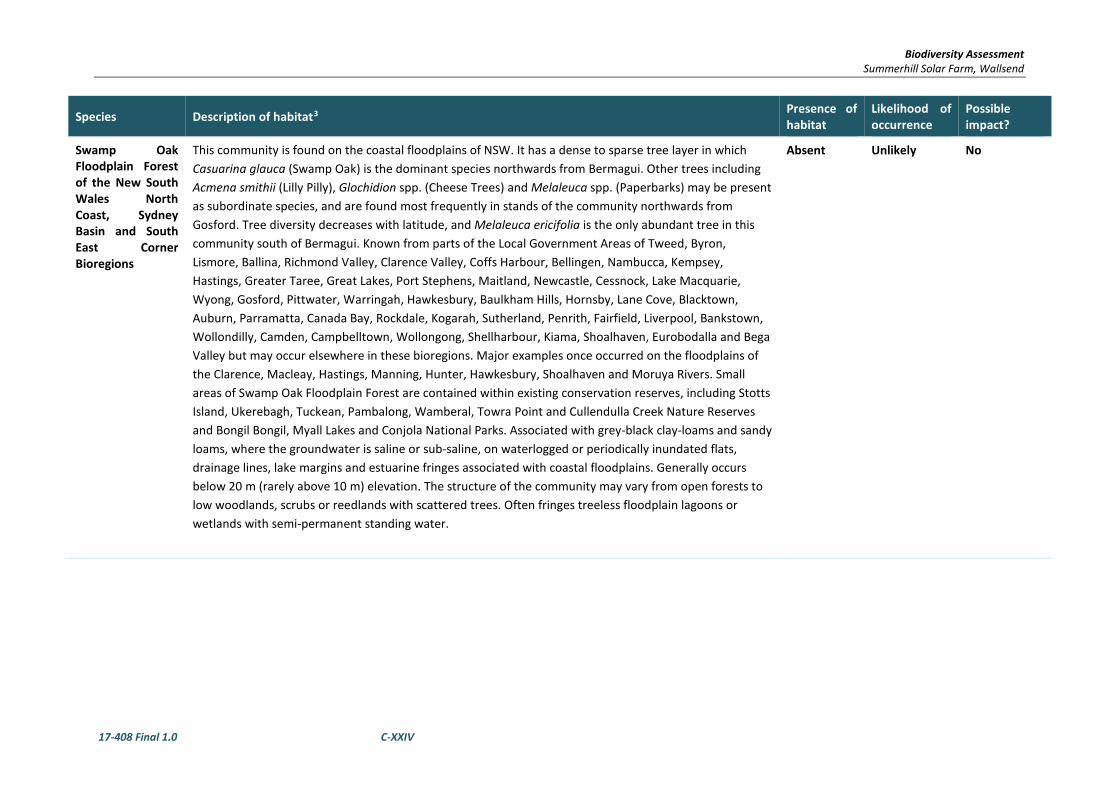
Biodiversity Assessment Summerhill Solar Farm, Wallsend
17-408 Final 1.0 C-XXIV
Species Description of habitat3 Presence of habitat
Likelihood of occurrence
Possible impact?
Swamp Oak Floodplain Forest of the New South Wales North Coast, Sydney Basin and South East Corner Bioregions
This community is found on the coastal floodplains of NSW. It has a dense to sparse tree layer in which Casuarina glauca (Swamp Oak) is the dominant species northwards from Bermagui. Other trees including Acmena smithii (Lilly Pilly), Glochidion spp. (Cheese Trees) and Melaleuca spp. (Paperbarks) may be present as subordinate species, and are found most frequently in stands of the community northwards from Gosford. Tree diversity decreases with latitude, and Melaleuca ericifolia is the only abundant tree in this community south of Bermagui. Known from parts of the Local Government Areas of Tweed, Byron, Lismore, Ballina, Richmond Valley, Clarence Valley, Coffs Harbour, Bellingen, Nambucca, Kempsey, Hastings, Greater Taree, Great Lakes, Port Stephens, Maitland, Newcastle, Cessnock, Lake Macquarie, Wyong, Gosford, Pittwater, Warringah, Hawkesbury, Baulkham Hills, Hornsby, Lane Cove, Blacktown, Auburn, Parramatta, Canada Bay, Rockdale, Kogarah, Sutherland, Penrith, Fairfield, Liverpool, Bankstown, Wollondilly, Camden, Campbelltown, Wollongong, Shellharbour, Kiama, Shoalhaven, Eurobodalla and Bega Valley but may occur elsewhere in these bioregions. Major examples once occurred on the floodplains of the Clarence, Macleay, Hastings, Manning, Hunter, Hawkesbury, Shoalhaven and Moruya Rivers. Small areas of Swamp Oak Floodplain Forest are contained within existing conservation reserves, including Stotts Island, Ukerebagh, Tuckean, Pambalong, Wamberal, Towra Point and Cullendulla Creek Nature Reserves and Bongil Bongil, Myall Lakes and Conjola National Parks. Associated with grey-black clay-loams and sandy loams, where the groundwater is saline or sub-saline, on waterlogged or periodically inundated flats, drainage lines, lake margins and estuarine fringes associated with coastal floodplains. Generally occurs below 20 m (rarely above 10 m) elevation. The structure of the community may vary from open forests to low woodlands, scrubs or reedlands with scattered trees. Often fringes treeless floodplain lagoons or wetlands with semi-permanent standing water.
Absent Unlikely No

Biodiversity Assessment Summerhill Solar Farm, Wallsend
17-408 Final 1.0 C-XXV
Species Description of habitat3 Presence of habitat
Likelihood of occurrence
Possible impact?
Swamp Sclerophyll Forest on Coastal Floodplains of the New South Wales North Coast, Sydney Basin and South East Corner Bioregions
This swamp community has an open to dense tree layer of eucalypts and paperbarks although some remnants now only have scattered trees as a result of partial clearing. The trees may exceed 25 m in height, but can be considerably shorter in regrowth stands or under conditions of lower site quality where the tree stratum is low and dense. For example, stands dominated by Melaleuca ericifolia typically do not exceed 8 m in height. The community also includes some areas of fernland and tall reedland or sedgeland, where trees are very sparse or absent.
The most widespread and abundant dominant trees include Eucalyptus robusta (swamp mahogany), Melaleuca quinquenervia (paperbark) and, south from Sydney, Eucalyptus botryoides (bangalay) and Eucalyptus longifolia (woollybutt). Other trees may be scattered throughout at low abundance or may be locally common at few sites, including Callistemon salignus (sweet willow bottlebrush), Casuarina glauca (swamp oak) and Eucalyptus resinifera subsp. hemilampra (red mahogany), Livistona australis (cabbage palm) and Lophostemon suaveolens (swamp turpentine).A layer of small trees may be present, including Acacia irrorata (green wattle), Acmena smithii (lilly pilly), Elaeocarpus reticulatus (blueberry ash), Glochidion ferdinandi (cheese tree), Melaleuca linariifolia and M. styphelioides (paperbarks).Shrubs include Acacia longifolia, Dodonaea triquetra, Ficus coronata, Leptospermum polygalifolium subsp. polygalifolium and Melaleuca spp. Occasional vines include Parsonsia straminea, Morinda jasminoides and Stephania japonica var. discolor.The groundcover is composed of abundant sedges, ferns, forbs, and grasses including Gahnia clarkei, Pteridium esculentum, Hypolepis muelleri, Calochlaena dubia, Dianella caerulea, Viola hederacea, Lomandra longifolia, Entolasia marginata and Imperata cylindrica.On sites downslope of lithic substrates or with soils of clay-loam texture, species such as Allocasuarina littoralis, Banksia oblongifolia, B. spinulosa, Ptilothrix deusta and Themeda australis, may also be present in the understorey.
Absent Unlikely No

Biodiversity Assessment Summerhill Solar Farm, Wallsend
17-408 Final 1.0 C-XXVI
Species Description of habitat3 Presence of habitat
Likelihood of occurrence
Possible impact?
Sydney Freshwater Wetlands in the Sydney Basin Bioregion
A complex of vegetation types largely restricted to freshwater swamps in coastal areas. These also vary considerably due to fluctuating water levels and seasonal conditions. Characteristic species include sedges and aquatic plants such as Baumea species, Eleocharis sphacelata, Gahnia species, Ludwigia peploides ssp. montevidensis and Persicaria species. Areas of open water may occur where drainage conditions have been altered and there may also be patches of emergent trees and shrubs. Occurs on sand dunes and low-nutrient sandplains along coastal areas in the Sydney Basin bioregion. Typically occur on silts, muds or humic loams in depressions, flats, drainage lines, backswamps, lagoons and lakes associated with coastal floodplains. It is known from the Lake Macquarie, Wyong, Gosford, Pittwater, Warringah, Woollahra, Waverley, Botany, Rockdale, Randwick, Sutherland and Wollongong local government areas, but is likely to occur elsewhere within the bioregion. Small areas of Sydney Freshwater Wetlands have been reported to occur in Wyrrabalong, Royal and Botany Bay National Parks.Has been extensively cleared and filled and remnants are often small and disturbed. Largely restricted to freshwater swamps in swales and depressions on sand dunes and low nutrient sandplains such as those of the Warriewood and Tuggerah soil landscapes. Swampy areas on alluvium with a saline influence do not fall within this community.
Absent Unlikely No
Themeda grassland on seacliffs and coastal headlands in the NSW North Coast, Sydney Basin and South East Corner Bioregions
The structure of the community is typically closed tussock grassland, but may be open shrubland or open heath with a grassy matrix between the shrubs. Themeda australis is the dominant species in this ecological commmunity. Themeda australis is an extremely widespread species, but in this community it may have a distinctive appearance, being prostrate and having glaucous leaves. These features are retained in cultivation and the form is believed to be genetically distinct. Scattered shrubs occur in many stands, most frequently Pimelea linifolia, Banksia integrifolia and Westringia fruticosa. These and other woody species often have dwarf growth forms. A number of threatened species occur in some stands of the community, including Diuris sp. aff. chrysantha, Pultenaea maritima, Rutidosus heterogama, Thesium australe and Zieria prostrata. Themeda Grassland on seacliffs and coastal headlands is found on a range of substrates in the NSW North Coast, Sydney Basin and South East Corner bioregions. Stands on sandstone are infrequent and small. Larger stands are found on old sand dunes above cliffs, as for example at Cape Banks and Henry Head in Botany Bay National Park, and on basalt headlands, as for example at Damerals Head in Moonee Beach National Park. Individual stands of the community are often very small, a few square metres, but at some sites larger stands of up to several hectares or tens of hectares occur. Overall, the community has a highly restricted geographic distribution comprising small, but widely scattered patches.
Absent Unlikely No

Biodiversity Assessment Summerhill Solar Farm, Wallsend
17-408 Final 1.0 C-XXVII
Species Description of habitat3 Presence of habitat
Likelihood of occurrence
Possible impact?
Umina Coastal Sandplain Woodland in the Sydney Basin Bioregion
A low woodland dominated by trees of Eucalyptus botryoides and Angophora floribunda with a diverse understorey of sclerophyllous shrubs species including Banksia integrifolia, Banksia serrata, Monotoca elliptica, Macrozamia communis, Acacia ulicifolia, Platysace lanceolata, Acacia suaveolens and Allocasuarina littoralis. Eucalyptus botryoides is the dominant tree in the zone immediately behind the beach, while Angophora floribunda is dominant in the zone beyond up to 2 km from the beach. Largely restricted to coastal sands on the Umina, Woy Woy and Ettalong Sandplain, a beach ridge system within the Gosford local government area. Including ecotonal areas, less than 10% (being less than 10 hectares) of the community's estimated original cover of about 80 hectares remains. This comprises four main remnants at Umina (Umina Oval, McEvoy Oval and Umina High School and a tiny remnant at Little Patonga Beach), while a few smaller remnant patches and scattered trees around Pearl Beach and Patonga and elsewhere on the 'Peninsula' indicate its former distribution. Occurs on sandy soils (iron podzols) of the Woy Woy Soil Landscape which are distinguished from the humus podsols generally associated with foothill talus slopes further away from the coast on which Angophora costata predominates.
Absent Unlikely No
Warkworth Sands Woodland in the Sydney Basin Bioregion
Warkworth Sands Woodland is a low woodland dominated by Angophora floribunda (Rough-barked Apple) and Banksia integrifolia subsp. integrifolia (Coast Banksia). Other tree species may be present such as Eucalyptus tereticornis (Forest Red Gum)and E. glaucina (Slaty Red Gum). Shrub and ground layer species commonly present include Acacia filicifolia (Fern-leaved Wattle), Melaleuca thymifolia (Thyme Honey-myrtle), Brachyloma daphnoides (Daphne Heath), Pteridium esculentum (Bracken), Pimelea linifolia (Slender Rice Flower), Imperata cylindrica var. major (Blady Grass), Chrysocephalum apiculatum (Common Everlasting) and Glycine clandestina. Small drainage lines within the area occuied by this community may support the presence or higher abundance of certain species (such as Melaleuca thymifolia) and the absence or lower abundance of others (such as Banksia integrifolia subsp. integrifolia). Such areas are included as part of this community.
Absent Unlikely No
White Box Yellow Box Blakely’s Red Gum Woodland
White Box Yellow Box Blakely’s Red Gum Woodland (commonly referred to as Box-Gum Woodland) is an open woodland community (sometimes occurring as a forest formation), in which the most obvious species are one or more of the following: White Box Eucalyptus albens, Yellow Box E. melliodora and Blakely's Red Gum E. blakelyi. Intact sites contain a high diversity of plant species, including the main tree species, additional tree species, some shrub species, several climbing plant species, many grasses and a very high diversity of herbs. The community also includes a range of mammal, bird, reptile, frog and invertebrate fauna species. Intact stands that contain diverse upper and mid-storeys and ground layers are rare.
Absent Unlikely No

Biodiversity Assessment Summerhill Solar Farm, Wallsend
17-408 Final 1.0 C-XXVIII
Species Description of habitat3 Presence of habitat
Likelihood of occurrence
Possible impact?
E TSC = listed as Endangered under Schedule 1 of the NSW Threatened Species Conservation Act 1995 E EPBC = listed as Endangered under the Commonwealth Environment Protection & Biodiversity Conservation Act 1999. V TSC = listed as Vulnerable under Schedule 2 of the NSW Threatened Species Conservation Act 1995. V EPBC = listed as Vulnerable under the Commonwealth Environment Protection & Biodiversity Conservation Act 1999.
EEC TSC = Endangered Ecological Community listed under Schedule 1 of the NSW TSC Act 1995 CE EPBC = listed as Critically Endangered under the Commonwealth Environment Protection & Biodiversity Conservation Act 1999.

Biodiversity Assessment Summerhill Solar Farm, Wallsend
17-408 Final 1.0 C-XXIX
Species Description of habitat3 Presence of habitat
Likelihood of occurrence
Possible impact?
Species and Status Description of habitat4 Presence of habitat
Likelihood of occurrence
Potential for impact?
Aves
Actitis hypoleucos
Common Sandpiper
EPBC – Migratory
Found along all coastlines of Australia and in many areas inland, the Common Sandpiper is widespread in small numbers. The population when in Australia is concentrated in northern and western Australia. The species utilises a wide range of coastal wetlands and some inland wetlands, with varying levels of salinity, and is mostly found around muddy margins or rocky shores and rarely on mudflats. The Common Sandpiper has been recorded in estuaries and deltas of streams, as well as on banks farther upstream; around lakes, pools, billabongs, reservoirs, dams and claypans, and occasionally piers and jetties. The muddy margins utilised by the species are often narrow, and may be steep. The species is often associated with mangroves, and sometimes found in areas of mud littered with rocks or snags. Generally the species forages in shallow water and on bare soft mud at the edges of wetlands; often where obstacles project from substrate, e.g. rocks or mangrove roots. Birds sometimes venture into grassy areas adjoining wetlands.
Absent Unlikely No
Anseranas semipalmata
Magpie Goose
BC-V
The Magpie Goose is still relatively common in the Australian northern tropics, but had disappeared from south-east Australia by 1920 due to drainage and overgrazing of reed swamps used for breeding. Since the 1980s there have been an increasing number of records in central and northern NSW. Vagrants can follow food sources to south-eastern NSW. Mainly found in shallow wetlands (less than 1 m deep) with dense growth of rushes or sedges. Equally at home in aquatic or terrestrial habitats; often seen walking and grazing on land; feeds on grasses, bulbs and rhizomes. Activities are centred on wetlands, mainly those on floodplains of rivers and large shallow wetlands formed by run-off; breeding can occur in both summer and winter dominated rainfall areas and is strongly influenced by water level; most breeding now occurs in monsoonal areas; nests are formed in trees over deep water; breeding is unlikely in south-eastern NSW. Often seen in trios or flocks on shallow wetlands, dry ephemeral swamps, wet grasslands and floodplains; roosts in tall vegetation.
Absent Unlikely No
4 Information sourced from species profiles on NSW OEH’s threatened species database or the Australian Government’s Species Profiles and Threats database (SPRAT) unless otherwise stated.
OEH threatened species database: http://www.threatenedspecies.environment.nsw.gov.au/index.aspx SPRAT: http://www.environment.gov.au/cgi-bin/sprat/public/sprat.pl

Biodiversity Assessment Summerhill Solar Farm, Wallsend
17-408 Final 1.0 C-XXX
Species Description of habitat3 Presence of habitat
Likelihood of occurrence
Possible impact?
Anthochaera phrygia
Regent Honeyeater
BC-E, EPBC-CE, Migratory
The Regent Honeyeater mainly inhabits temperate woodlands and open forests of the inland slopes of south-east Australia. Birds are also found in drier coastal woodlands and forests in some years. There are only three known key breeding regions remaining: north-east Victoria (Chiltern-Albury), and in NSW at Capertee Valley and the Bundarra-Barraba region. In NSW the distribution is very patchy and mainly confined to the two main breeding areas and surrounding fragmented woodlands. In some years non-breeding flocks converge on flowering coastal woodlands and forests. The species inhabits dry open forest and woodland, particularly Box-Ironbark woodland, and riparian forests of River She-oak. Regent Honeyeaters inhabit woodlands that support a significantly high abundance and species richness of bird species. These woodlands have significantly large numbers of mature trees, high canopy cover and abundance of mistletoes. Every few years non-breeding flocks are seen foraging in flowering coastal Swamp Mahogany and Spotted Gum forests, particularly on the central coast and occasionally on the upper north coast. Birds are occasionally seen on the south coast. The Regent Honeyeater is a generalist forager, which mainly feeds on the nectar from a wide range of eucalypts and mistletoes. Key eucalypt species include Mugga Ironbark, Yellow Box, Blakely's Red Gum, White Box and Swamp Mahogany. Also utilises E. microcarpa, E. punctata, E. polyanthemos, E. mollucana, Corymbia robusta, E. crebra, E. caleyi, Corymbia maculata, E. mckieana, E. macrorhyncha, E. laevopinea, and Angophora floribunda. Nectar and fruit from the mistletoes A. miquelii, A. pendula and A. cambagei are also eaten during the breeding season. When nectar is scarce lerp and honeydew comprise a large proportion of the diet. A shrubby understorey is an important source of insects and nesting material. The species breeds between July and January in Box-Ironbark and other temperate woodlands and riparian gallery forest dominated by River Sheoak. Regent Honeyeaters usually nest in horizontal branches or forks in tall mature eucalypts and Sheoaks. Also nest in mistletoe haustoria.
Marginal Unlikely No
Arenaria interpres
Ruddy Turnstone
EPBC-Marine, Migratory
Present on Australia’s coastal regions from September to April from its breeding grounds in eastern Siberia and Alaska. It frequent rocky shores, shingly beaches, estuaries and coral cays.
Absent Unlikely No

Biodiversity Assessment Summerhill Solar Farm, Wallsend
17-408 Final 1.0 C-XXXI
Species Description of habitat3 Presence of habitat
Likelihood of occurrence
Possible impact?
Artamus cyanopterus cyanopterus Dusky Woodswallow BC – V
The dusky woodswallow is a medium-sized bird (16-19.5 cm, 35 g), with a longish tail. Mostly dark grey-brown, merging to blackish on the tail, with a small black-brown mask. Bluish bill with a black tip. Upper-wings are a dark blue-grey with a white leading edge. Conspicuous white corners on the tail. In flight the dark grey-brown under-body contrasts with the whitish under-wing. Dusky woodswallows are widespread in eastern, southern and south western Australia. The species occurs throughout most of New South Wales, but is sparsely scattered in, or largely absent from, much of the upper western region. Most breeding activity occurs on the western slopes of the Great Dividing RangePrimarily inhabit dry, open eucalypt forests and woodlands, including mallee associations, with an open or sparse understorey of eucalypt saplings, acacias and other shrubs, and ground-cover of grasses or sedges and fallen woody debris. It has also been recorded in shrublands, heathlands and very occasionally in moist forest or rainforest. Also found in farmland, usually at the edges of forest or woodland.
Marginal Possible No – Given the small area of the works and the disturbance within the area.
Botaurus poiciloptilus
Australasian Bittern
BC-E
EPBC-E
In NSW, this species occurs along the coast and is frequently recorded in the Murray-Darling Basin, notably in floodplain wetlands of the Murrumbidgee, Lachlan, Macquarie and Gwydir Rivers. Occurs in permanent freshwater wetlands with tall, dense vegetation. Favours permanent and seasonal freshwater habitats, particularly those dominated by sedges, rushes and/or reeds (e.g. Phragmites, Cyperus, Eleocharis, Juncus, Typha, Baumea, , Bolboschoenus) or cutting grass (Gahnia) growing over muddy or peaty substrate. Hides during the day amongst dense reeds or rushes and feed mainly at night on frogs, fish, yabbies, spiders, insects and snails. Feeding platforms may be constructed over deeper water from reeds trampled by the bird; platforms are often littered with prey remains. Breeding occurs in summer from October to January; nests are built in secluded places in densely-vegetated wetlands on a platform of reeds; there are usually six olive-brown eggs to a clutch. In Australia, the Bittern occurs with the Australian Painted Snipe Rostratula benghalensis australis.
Absent Unlikely No

Biodiversity Assessment Summerhill Solar Farm, Wallsend
17-408 Final 1.0 C-XXXII
Species Description of habitat3 Presence of habitat
Likelihood of occurrence
Possible impact?
Calidris acuminata
Sharp-tailed Sandpiper
EPBC - Migratory
The Sharp-tailed Sandpiper spends the non-breeding season in Australia with small numbers occurring regularly in New Zealand. Most of the population migrates to Australia, mostly to the south-east and are widespread in both inland and coastal locations and in both freshwater and saline habitats. Many inland records are of birds on passage. In Australasia, the Sharp-tailed Sandpiper prefers muddy edges of shallow fresh or brackish wetlands, with inundated or emergent sedges, grass, saltmarsh or other low vegetation. This includes lagoons, swamps, lakes and pools near the coast, and dams, waterholes, soaks, bore drains and bore swamps, saltpans and hypersaline saltlakes inland. They also occur in saltworks and sewage farms. They use flooded paddocks, sedgelands and other ephemeral wetlands, but leave when they dry. They use intertidal mudflats in sheltered bays, inlets, estuaries or seashores, and also swamps and creeks lined with mangroves. They tend to occupy coastal mudflats mainly after ephemeral terrestrial wetlands have dried out, moving back during the wet season. They may be attracted to mats of algae and water weed either floating or washed up around terrestrial wetlands, and coastal areas with much beachcast seaweed. Sometimes they occur on rocky shores and rarely on exposed reefs
Absent Unlikely No
Calidris canutus
Red Knot, Knot
EPBC-Marine, Migratory
Breeding in the Arctic Circle between August and April, it visits Australian shores in large numbers and frequents coastal sand flats and the margins of estuaries and rivers. It feeds in close-packed flocks that move in unison.
Absent Unlikely No
Calidris ferruginea
Curlew Sandpiper
EPBC-Marine, Migratory
Curlew Sandpipers mainly occur on intertidal mudflats in sheltered coastal areas, such as estuaries, bays, inlets and lagoons, and also around non-tidal swamps, lakes and lagoons near the coast, and ponds in saltworks and sewage farms. They are also recorded inland, though less often, including around ephemeral and permanent lakes, dams, waterholes and bore drains, usually with bare edges of mud or sand. They occur in both fresh and brackish waters. Curlew Sandpipers generally roost on bare dry shingle, shell or sand beaches, sandspits and islets in or around coastal or near-coastal lagoons and other wetlands, occasionally roosting in dunes during very high tides and sometimes in saltmarsh. This species does not breed in Australia. This species forages mainly on invertebrates, including worms, molluscs, crustaceans, and insects, as well as seeds.
Absent Unlikely No

Biodiversity Assessment Summerhill Solar Farm, Wallsend
17-408 Final 1.0 C-XXXIII
Species Description of habitat3 Presence of habitat
Likelihood of occurrence
Possible impact?
Calidris melantos
Pectoral Sandpiper
EPBC – Migratory
In Queensland, most records for the Pectoral Sandpiper occur around Cairns. There are scattered records elsewhere, mainly from east of the Great Divide between Townsville and Yeppoon. Records also exist in the south-east of the state as well as a few inland records at Mount Isa, Longreach and Oakley. In New South Wales (NSW), the Pectoral Sandpiper is widespread, but scattered. Records exist east of the Great Divide, from Casino and Ballina, south to Ulladulla. West of the Great Divide, the species is widespread in the Riverina and Lower Western regions. In Victoria the Pectoral Sandpiper is mainly found from Port Phillip Bay and the valley of the Murray River between Kerang and Piangil. It has also been recorded at Coronet Bay (in Westernport Bay), Wimmera and Mallee. In Australasia, the Pectoral Sandpiper prefers shallow fresh to saline wetlands. The species is found at coastal lagoons, estuaries, bays, swamps, lakes, inundated grasslands, saltmarshes, river pools, creeks, floodplains and artificial wetlands.
Absent Unlikely No
Calidris ruficollis
Red-necked Stint
EPBC-Marine, Migratory
One of the smallest and most-commonly seen of the waders regularly to visit Australia, migrating from north eastern Siberia or Alaska. Flying in tightly packed wheeling flocks over a large part of the continent, it visits beaches, mudflats, estuaries and swamp margins.
Absent Unlikely No
Calidris tenuirostris
Great Knot
BC-V, EPBC-Marine, Migratory
Occurs within sheltered, coastal habitats containing large, intertidal mudflats or sandflats, including inlets, bays, harbours, estuaries and lagoons. Often recorded on sandy beaches with mudflats nearby, sandy spits and islets and sometimes on exposed reefs or rock platforms. Migrates to Australia from late August to early September, although juveniles may not arrive until October-November. Most birds return north in March and April, however some individuals may stay over winter in Australia. Forages for food by methodically thrusting its bill deep into the mud to search for invertebrates, such as bivalve molluscs, gastropods, polychaete worms and crustaceans.
Absent Unlikely No

Biodiversity Assessment Summerhill Solar Farm, Wallsend
17-408 Final 1.0 C-XXXIV
Species Description of habitat3 Presence of habitat
Likelihood of occurrence
Possible impact?
Callocephalon fimbriatum
Gang-gang Cockatoo
TSC-V
The Gang-gang Cockatoo is distributed from southern Victoria through south- and central-eastern New South Wales. In New South Wales, the Gang-gang Cockatoo is distributed from the south-east coast to the Hunter region, and inland to the Central Tablelands and south-west slopes. It occurs regularly in the Australian Capital Territory. It is rare at the extremities of its range, with isolated records known from as far north as Coffs Harbour and as far west as Mudgee. In summer, generally found in tall mountain forests and woodlands, particularly in heavily timbered and mature wet sclerophyll forests. In winter, may occur at lower altitudes in drier more open eucalypt forests and woodlands, and often found in urban areas. May also occur in sub-alpine Snow Gum Eucalyptus pauciflora woodland and occasionally in temperate rainforests. Move to lower altitudes in winter, preferring more open eucalypt forests and woodlands, particularly in box-ironbark assemblages, or in dry forest in coastal areas. Favours old growth attributes for nesting and roosting.
Marginal Unlikely No
Calyptorhynchus lathami
Glossy Black-cockatoo
BC-V
The species is uncommon although widespread throughout suitable forest and woodland habitats, from the central Queensland coast to East Gippsland in Victoria, and inland to the southern tablelands and central western plains of NSW, with a small population in the Riverina. An isolated population exists on Kangaroo Island, South Australia. Dependent on large hollow-bearing eucalypts for nest sites. One or two eggs are laid between March and August. Inhabits open forest and woodlands of the coast and the Great Dividing Range up to 1000 m in which stands of she-oak species, particularly Black She-oak (Allocasuarina littoralis), Forest She-oak (A. torulosa) or Drooping She-oak (A. verticillata) occur. In the Riverina area, inhabits open woodlands dominated by Belah (Casuarina cristata). Feeds almost exclusively on the seeds of several species of she-oak (Casuarina and Allocasuarina species), shredding the cones with the massive bill.
Present – Very limited.
Unlikely No
Charadrius bicinctus
Double-banded Plover
EPBC-Marine, Migratory
The Double-banded Plover is found on littoral, estuarine and fresh or saline terrestrial wetlands and also saltmarsh, grasslands and pasture. It occurs on muddy, sandy, shingled or sometimes rocky beaches, bays and inlets, harbours and margins of fresh or saline terrestrial wetlands such as lakes, lagoons and swamps, shallow estuaries and rivers. The species is sometimes associated with coastal lagoons, inland saltlakes and saltworks. It is also found on seagrass beds, especially Zostera, which, when exposed at low tide, remain heavily saturated or have numerous water-filled depressions. This species sometimes utilises kelp beds. The Double-banded Plover eats molluscs, insects, worms, crustaceans and spiders and sometimes seeds and fruits. The Double-banded Plover roosts on bare open areas or among vegetation and also on offshore islets.
Marginal Unlikely No

Biodiversity Assessment Summerhill Solar Farm, Wallsend
17-408 Final 1.0 C-XXXV
Species Description of habitat3 Presence of habitat
Likelihood of occurrence
Possible impact?
Charadrius leschenaultii
Greater Sand-plover
BC-V, EPBC-Marine, Migratory
Almost entirely restricted to coastal areas in NSW, occurring mainly on sheltered sandy, shelly or muddy beaches or estuaries with large intertidal mudflats or sandbanks. Roosts during high tide on sandy beaches and rocky shores; begin foraging activity on wet ground at low tide, usually away from the edge of the water; individuals may forage and roost with other waders. Diet includes insects, crustaceans, polychaete worms and molluscs. Prey is detected visually by running a short distance, stopping to look, then running to collect the prey.
Absent Unlikely No
Charadrius mongolus
Lesser Sand-plover
BC-V, EPBC- Migratory
In non-breeding grounds in Australia, this species usually occurs in coastal littoral and estuarine environments. It inhabits large intertidal sandflats or mudflats in sheltered bays, harbours and estuaries, and occasionally sandy ocean beaches, coral reefs, wave-cut rock platforms and rocky outcrops. It also sometime occurs in short saltmarsh or among mangroves. The species also inhabits saltworks and near-coastal saltpans, brackish swamps and sandy or silt islands in river beds. The species feeds mostly on extensive, freshly-exposed areas of intertidal sandflats and mudflats in estuaries or beaches, or in shallow ponds in saltworks. They roost near foraging areas, on beaches, banks, spits and banks of sand or shells, and occasionally on rocky spits, islets or reefs. They rarely roost in mangroves. The species does not breed in Australia.
Absent Unlikely No
Cuculus optatus
Oriental Cuckoo
EPBC – Migratory
The exact extent of its wintering range is uncertain due to its secretive habits and the difficulty of separating it from the Himalayan cuckoo and other similar species. It is believed to include the Malay Peninsula, Indonesia, the Philippines, New Guinea, western Micronesia, the Solomon Islands and northern and eastern Australia with occasional birds reaching New Zealand. It has occurred as a vagrant in Ukraine, Israel and Alaska. It mainly inhabits forests, occurring in coniferous, deciduous and mixed forest.
Absent Unlikely No

Biodiversity Assessment Summerhill Solar Farm, Wallsend
17-408 Final 1.0 C-XXXVI
Species Description of habitat3 Presence of habitat
Likelihood of occurrence
Possible impact?
Climacteris picumnus victoriae
Brown Treecreeper (eastern subspecies)
BC-V
The Brown Treecreeper is endemic to eastern Australia and occurs in eucalypt forests and woodlands of inland plains and slopes of the Great Dividing Range. It is less commonly found on coastal plains and ranges. The western boundary of the range of Climacteris picumnus victoriae runs approximately through Corowa, Wagga Wagga, Temora, Forbes, Dubbo and Inverell and along this line the subspecies intergrades with the arid zone subspecies of Brown Treecreeper Climacteris picumnus picumnus which then occupies the remaining parts of the state. The eastern subspecies lives in eastern NSW in eucalypt woodlands through central NSW and in coastal areas with drier open woodlands such as the Snowy River Valley, Cumberland Plains, Hunter Valley and parts of the Richmond and Clarence Valleys. The population density of this subspecies has been greatly reduced over much of its range, with major declines recorded in central NSW and the northern and southern tablelands. Declines have occurred in remnant vegetation fragments smaller than 300 hectares that have been isolated or fragmented for more than 50 years. Found in eucalypt woodlands (including Box-Gum Woodland) and dry open forest of the inland slopes and plains inland of the Great Dividing Range; mainly inhabits woodlands dominated by stringybarks or other rough-barked eucalypts, usually with an open grassy understorey, sometimes with one or more shrub species; also found in mallee and River Red Gum (Eucalyptus camaldulensis) Forest bordering wetlands with an open understorey of acacias, saltbush, lignum, cumbungi and grasses; usually not found in woodlands with a dense shrub layer; fallen timber is an important habitat component for foraging; also recorded, though less commonly, in similar woodland habitats on the coastal ranges and plains.
Present Possible No – Given the small area of the works and the disturbance within the area.
Daphoenositta chrysoptera
Varied Sittella
BC-V
The Varied Sittella is sedentary and inhabits most of mainland Australia except the treeless deserts and open grasslands, with a nearly continuous distribution in NSW from the coast to the far west. It inhabits eucalypt forests and woodlands, especially rough-barked species and mature smooth-barked gums with dead branches, mallee and Acacia woodland. The Varied Sittella feeds on arthropods gleaned from crevices in rough or decorticating bark, dead branches, standing dead trees, and from small branches and twigs in the tree canopy. It builds a cup-shaped nest of plant fibres and cobweb in an upright tree fork high in the living tree canopy, and often re-uses the same fork or tree in successive years.
Marginal Unlikely No

Biodiversity Assessment Summerhill Solar Farm, Wallsend
17-408 Final 1.0 C-XXXVII
Species Description of habitat3 Presence of habitat
Likelihood of occurrence
Possible impact?
Dasyornis brachypterus
Eastern Bristlebird
TSC-E, EPBC-E
The distribution of the Eastern Bristlebird has contracted to three disjunct areas of south-eastern Australia: southern Queensland/northern NSW, the Illawarra Region and in the vicinity of the NSW/Victorian border. The estimated population size is less than 2000 individuals occupying a total area of about 120 sq km. There are now only four populations in the southern Queensland/northern NSW area with a total of 35 birds, compared to 15 years ago when 14 populations and 154 birds were recorded. This population once extended as far south as at least Dorrigo and has recently been identified as a separate ultrataxon (monoides) but further research is being undertaken to determine the validity of this. The remaining populations are the nominate ultrataxon (brachypterus) and once extended at least to what is now the Sydney urban area. The Illawarra population comprises an estimated 1600 birds, mainly from Barren Grounds Nature Reserve, Budderoo National Park and the Jervis Bay area. The southern population in Nadgee Nature Reserve and Howe's Flat is around 200 birds. Further surveys are required in parts of Ben Boyd National Park and Sydney Catchment Authority lands to determine whether further populations of the Eastern Bristlebird occur in these areas. Habitat is characterised by dense, low vegetation including heath and open woodland with a heathy understorey; in northern NSW occurs in open forest with tussocky grass understorey; all of these vegetation types are fire prone. Age of habitat since fires (fire-age) is of paramount importance to this species; Illawarra and southern populations reach maximum densities in habitat that has not been burnt for at least 15 years; however, in the northern NSW population a lack of fire in grassy forest may be detrimental as grassy tussock nesting habitat becomes unsuitable after long periods without fire; northern NSW birds are usually found in habitats burnt five to 10 years previously. Shy and cryptic and rarely flies, although can be seen scampering over the ground; when approached, may move to a lookout perch 1 m or more above the ground, then retreat into dense vegetation. Feeds on a variety of insects, particularly ants. Nests are elliptical domes constructed on or near the ground amongst dense vegetation. Two eggs are laid during August to February; producing more than one clutch a year is rare, and recruitment into the population is low.
Absent Unlikely No
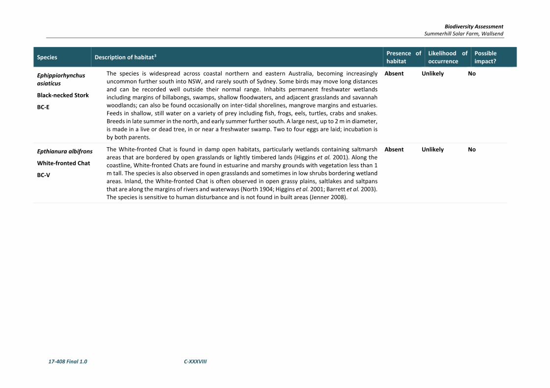
Biodiversity Assessment Summerhill Solar Farm, Wallsend
17-408 Final 1.0 C-XXXVIII
Species Description of habitat3 Presence of habitat
Likelihood of occurrence
Possible impact?
Ephippiorhynchus asiaticus
Black-necked Stork
BC-E
The species is widespread across coastal northern and eastern Australia, becoming increasingly uncommon further south into NSW, and rarely south of Sydney. Some birds may move long distances and can be recorded well outside their normal range. Inhabits permanent freshwater wetlands including margins of billabongs, swamps, shallow floodwaters, and adjacent grasslands and savannah woodlands; can also be found occasionally on inter-tidal shorelines, mangrove margins and estuaries. Feeds in shallow, still water on a variety of prey including fish, frogs, eels, turtles, crabs and snakes. Breeds in late summer in the north, and early summer further south. A large nest, up to 2 m in diameter, is made in a live or dead tree, in or near a freshwater swamp. Two to four eggs are laid; incubation is by both parents.
Absent Unlikely No
Epthianura albifrons
White-fronted Chat
BC-V
The White-fronted Chat is found in damp open habitats, particularly wetlands containing saltmarsh areas that are bordered by open grasslands or lightly timbered lands (Higgins et al. 2001). Along the coastline, White-fronted Chats are found in estuarine and marshy grounds with vegetation less than 1 m tall. The species is also observed in open grasslands and sometimes in low shrubs bordering wetland areas. Inland, the White-fronted Chat is often observed in open grassy plains, saltlakes and saltpans that are along the margins of rivers and waterways (North 1904; Higgins et al. 2001; Barrett et al. 2003). The species is sensitive to human disturbance and is not found in built areas (Jenner 2008).
Absent Unlikely No

Biodiversity Assessment Summerhill Solar Farm, Wallsend
17-408 Final 1.0 C-XXXIX
Species Description of habitat3 Presence of habitat
Likelihood of occurrence
Possible impact?
Erythrotriorchis radiates
Red Goshawk
BC-CE, EPBC-V
This unique Australian endemic raptor is distributed sparsely through northern and eastern Australia, from the western Kimberley Division of northern Western Australia to north-eastern Queensland and south to far north-eastern NSW, and with scattered records in central Australia. The species is very rare in NSW, extending south to about 30°S, with most records north of this, in the Clarence River Catchment, and a few around the lower Richmond and Tweed Rivers. Formerly, it was at least occasionally reported as far south as Port Stephens. Red Goshawks inhabit open woodland and forest, preferring a mosaic of vegetation types, a large population of birds as a source of food, and permanent water, and are often found in riparian habitats along or near watercourses or wetlands. In NSW, preferred habitats include mixed subtropical rainforest, Melaleuca swamp forest and riparian Eucalyptus forest of coastal rivers. Adults appear to occupy territories throughout the year and breeding territories are traditionally used from year to year. Adults have large home-ranges, estimated in the Northern Territory to be as great as about 120 km2 for females and 200 km2 for males. Red Goshawks mainly eat medium to large birds, including species as large as Australian Brush-turkeys Alectura lathami, but they also take mammals, reptiles and insects. Red Goshawks usually hunt from concealed or, less often, exposed perches, but also fly close above or through forest or woodland searching for prey. They often hunt from perches early in the morning and late in the day and tend to hunt more on the wing at other times of the day. Breeding is likely to be in spring and summer in southern Queensland and NSW (if they breed in the state at all). The birds lay clutches of 1-2 eggs, in a stick nest in a tall tree (>20 m tall) within 1 km of a watercourse or wetland. In winter in eastern Australia, the birds appear to move from nesting sites in the ranges to coastal plains, where they are associated with permanent wetlands. The age at which Red Goshawks first breed is not known, nor is the life expectancy. Young remain with their parents for at least 70-80 days after they leave the nest and may remain with their parents for 4-5 months.
Absent Unlikely No
Gallinago hardwickii
Latham’s Snipe
EPBC – Migratory
In Australia, Latham's Snipe occurs in permanent and ephemeral wetlands up to 2000 m above sea-level. They usually inhabit open, freshwater wetlands with low, dense vegetation (e.g. swamps, flooded grasslands or heathlands, around bogs and other water bodies). However, they can also occur in habitats with saline or brackish water, in modified or artificial habitats, and in habitats located close to humans or human activity. Latham's Snipe occurs in temperate and tropical regions of Australia. Its altitudinal range extends from sea-level (i.e. the coast) or possibly below. For example, there are records from near Lake Eyre to approximately 2000 m above sea-level.
Absent Unlikely No

Biodiversity Assessment Summerhill Solar Farm, Wallsend
17-408 Final 1.0 C-XL
Species Description of habitat3 Presence of habitat
Likelihood of occurrence
Possible impact?
Gallinago megala
Swinhoe's Snipe
EPBC-Marine, Migratory
This species is known to occur from the Kimberley in north-western Australia to Mount Isa and Cape york in the north-east. They are found in any vegetation around wetlands, in sedges, grasses, lignum, reeds and rushes and also in saltmarsh and creek edges on migration. They also use crops and pasture. This species is a migratory wader; it breeds in central Siberia and Mongolia and migrates through China.
Absent Unlikely No
Gallinago stenura
Pin-tailed Snipe
EPBC-Marine, Migratory
This species is known to occur regularly in the Pilbara region of north Western Australia. It breeds in south-eastern Siberia and Mongolia, migrating to Burma, southern Thailand, Malaysia and Western Borneo. Pin-tailed Snipes prefer dry habitats.
Absent Unlikely No
Glossopsitta pusilla
Little Lorikeet
BC- V
The Little Lorikeet is distributed widely across the coastal and Great Divide regions of eastern Australia from Cape York to South Australia. NSW provides a large portion of the species' core habitat, with lorikeets found westward as far as Dubbo and Albury. Nomadic movements are common, influenced by season and food availability. Forages primarily in the canopy of open Eucalyptus forest and woodland, yet also finds food in Angophoras, Melaleucas and other tree species. Riparian habitats are particularly used, due to higher soil fertility and hence greater productivity. Isolated flowering trees in open country, e.g. paddocks, roadside remnants and urban trees also help sustain viable populations of the species. Feeds mostly on nectar and pollen, occasionally on native fruits such as mistletoe, and only rarely in orchards. Roosts in treetops, often distant from feeding areas. Nests in proximity to feeding areas if possible, most typically selecting hollows in the limb or trunk of smooth-barked Eucalypts. Entrance is small (3 cm) and usually high above the ground (2–15 m). These nest sites are often used repeatedly for decades, suggesting that preferred sites are limited. Riparian trees often chosen, including species like Allocasuarina. Nesting season extends from May to September.
Absent Unlikely No

Biodiversity Assessment Summerhill Solar Farm, Wallsend
17-408 Final 1.0 C-XLI
Species Description of habitat3 Presence of habitat
Likelihood of occurrence
Possible impact?
Grantiella picta
Painted Honeyeater
BC-V, EPBC - V
The Painted Honeyeater is nomadic and occurs at low densities throughout its range. The greatest concentrations of the bird and almost all breeding occurs on the inland slopes of the Great Dividing Range in NSW, Victoria and southern Queensland. During the winter it is more likely to be found in the north of its distribution. Inhabits Boree, Brigalow and Box-Gum Woodlands and Box-Ironbark Forests. A specialist feeder on the fruits of mistletoes growing on woodland eucalypts and acacias. Prefers mistletoes of the genus Amyema. Insects and nectar from mistletoe or eucalypts are occasionally eaten. Nest from spring to autumn in a small, delicate nest hanging within the outer canopy of drooping eucalypts, she-oak, paperbark or mistletoe branches.
Present Possible No – Given the small area of the works and the disturbance within the area.
Haliaetus leucogaster
White-bellied sea eagle
EPBC – Migratory BC - V
White-bellied Sea-Eagles are a common sight in coastal and near coastal areas of Australia. Birds form permanent pairs that inhabit territories throughout the year. Their loud "goose-like" honking call is a familiar sound, particularly during the breeding season. Birds are normally seen, perched high in a tree, or soaring over waterways and adjacent land. In addition to Australia, the species is found in New Guinea, Indonesia, China, south-east Asia and India. The White-bellied Sea-Eagle feeds mainly off aquatic animals, such as fish, turtles and sea snakes, but it takes birds and mammals as well. It is a skilled hunter, and will attack prey up to the size of a swan. Sea-Eagles also feed on carrion (dead prey) such as sheep and fish along the waterline. They harass smaller birds, forcing them to drop any food that they are carrying. Sea-Eagles feed alone, in pairs or in family groups. White-bellied Sea-Eagles build a large stick nest, which is used for many seasons in succession. The nest can be located in a tree up to 30m above the ground, but may be also be placed on the ground or on rocks, where there are no suitable trees. At the start of the breeding season (May to October), the nest is lined with fresh green leaves and twigs. The female carries out most of the incubation of the two white eggs, but the male performs this duty from time to time.
Marginal Unlikley No
Hieraaetus morphnoides
Little Eagle
BC-V
The Little Eagle is a medium-sized bird of prey that is found throughout the Australian mainland excepting the most densely forested parts of the Dividing Range escarpment. It occurs as a single population throughout NSW. Occupies open eucalypt forest, woodland or open woodland. Sheoak or acacia woodlands and riparian woodlands of interior NSW are also used. Nests in tall living trees within a remnant patch, where pairs build a large stick nest in winter. Lays two or three eggs during spring, and young fledge in early summer. Preys on birds, reptiles and mammals, occasionally adding large insects and carrion.
Marginal Unlikely No

Biodiversity Assessment Summerhill Solar Farm, Wallsend
17-408 Final 1.0 C-XLII
Species Description of habitat3 Presence of habitat
Likelihood of occurrence
Possible impact?
Hirundapus caudactus
White- throated Needletail
EPBC – M
White-throated Needletails often occur in large numbers over eastern and northern Australia. White-throated Needletails are aerial birds and for a time it was commonly believed that they did not land while in Australia. It has now been observed that birds will roost in trees, and radio-tracking has since confirmed that this is a regular activity.
Absent Unlikely No
Irediparra gallinacea
Comb-crested Jacana
BC-V
In Australia the Comb-crested Jacana occurs on freshwater wetlands in northern and eastern Australia, mainly in coastal and subcoastal regions, from the north-eastern Kimberley Division of Western Australia to Cape York Peninsula then south along the east coast to the Hunter region of NSW, with stragglers recorded in south-eastern NSW (possibly in response to unfavourable conditions further north). Inhabit permanent freshwater wetlands, either still or slow-flowing, with a good surface cover of floating vegetation, especially water-lilies, or fringing and aquatic vegetation. Forage on floating vegetation. They feed primarily on insects and other invertebrates, as well as some seeds and other vegetation. Breed mainly in spring and summer in NSW, with clutches recorded from September to April. The nest is a platform or shallow cup of vegetable material, though eggs sometimes laid directly onto a large leaf with no nest built. The male builds the nest, incubates the eggs and broods the young. Eggs that roll into the water from a nest are usually retrieved. Comb-crested Jacanas are dispersive, moving about in response to the condition of wetlands, and occasionally turn up well beyond normal range.
Absent Unlikely No
Ixobrychus flavicollis
Black Bittern
BC-V
Inhabits both terrestrial and estuarine wetlands, generally in areas of permanent water and dense vegetation. Where permanent water is present, the species may occur in flooded grassland, forest, woodland, rainforest and mangroves. Feeds on frogs, reptiles, fish and invertebrates, including snails, dragonflies, shrimps and crayfish, with most feeding done at dusk and at night. During the day, roosts in trees or on the ground amongst dense reeds. When disturbed, freezes in a characteristic bittern posture (stretched tall, bill pointing up, so that shape and streaked pattern blend with upright stems of reeds), or will fly up to a branch or flush for cover where it will freeze again. Generally solitary, but occurs in pairs during the breeding season, from December to March. Like other bitterns, but unlike most herons, nesting is solitary. Nests, built in spring are located on a branch overhanging water and consist of a bed of sticks and reeds on a base of larger sticks. Between three and five eggs are laid and both parents incubate and rear the young
Absent Unlikely No

Biodiversity Assessment Summerhill Solar Farm, Wallsend
17-408 Final 1.0 C-XLIII
Species Description of habitat3 Presence of habitat
Likelihood of occurrence
Possible impact?
Lathamus discolor
Swift Parrot
BC-E, EPBC-CE
Breeds in Tasmania during spring and summer, migrating in the autumn and winter months to south-eastern Australia from Victoria and the eastern parts of South Australia to south-east Queensland. In NSW mostly occurs on the coast and south west slopes. On the mainland they occur in areas where eucalypts are flowering profusely or where there are abundant lerp (from sap-sucking bugs) infestations. Favoured feed trees include winter flowering species such as Swamp Mahogany Eucalyptus robusta, Spotted Gum Corymbia maculata, Red Bloodwood C. gummifera, Mugga Ironbark E. sideroxylon, and White Box E. albens. Commonly used lerp infested trees include babbler Babbler Box E. microcarpa, Grey Box E. moluccana and Blackbutt E. pilularis. Return to home foraging sites on a cyclic basis depending on food availability.
Present Possible No
Limicola falcinellus
Broad-billed Sandpiper
TSC-V
Broad-billed Sandpipers favour sheltered parts of the coast such as estuarine sandflats and mudflats, harbours, embayments, lagoons, saltmarshes and reefs as feeding and roosting habitat. Occasionally, individuals may be recorded in sewage farms or within shallow freshwater lagoons. Broad-billed Sandpipers roost on banks on sheltered sand, shell or shingle beaches. The species is an active forager, typically feeding by rapidly and repeatedly jabbing its bill into soft wet mud. Feeding also occurs while wading, often in water so deep that they have to submerge their heads and necks in order to probe the underlying mud. Their diet includes insects, crustaceans, molluscs, worms and seeds. Individuals are strongly migratory and only mildly gregarious when not breeding. Large flocks are seldom recorded and birds are often either encountered alone or feeding with other waders such as Red-necked Stints or Curlew Sandpipers.
Absent Unlikely No
Limosa lapponica
Bar-tailed Godwit
EPBC-V
This migratory species arrives in great numbers in August/September from its breeding grounds in north-east Siberia and spreads right around the coast for its summer visit until take-off time for breeding in April/May. Concentrations of tens of thousands have been recorded on Eight Mile Beach between Broom and Port Headland in WA. It is seen on coastal sandy shores, mud-flats and marches, probing, sweeping and jabbing into mud or sand between the tides for small crustaceans and worms.
Absent Unlikely No

Biodiversity Assessment Summerhill Solar Farm, Wallsend
17-408 Final 1.0 C-XLIV
Species Description of habitat3 Presence of habitat
Likelihood of occurrence
Possible impact?
Limosa lapponica menzbieri
Bar
-tailed godwit (northern Siberian)
EPBC - CE
The bar-tailed godwit (northern Siberian) is a large migratory shorebird. It has a length around 37-39 cm, a wingspan of 62-75 cm and body mass between 250 - 450 g. It has a long neck with a very long upturned bill which is characterized by a dark tip and pinkish base. The bar-tailed godwit (both subspecies combined) has been recorded in the coastal areas of all Australian states. It is widespread in the Torres Strait and along the east and south-east coasts of Queensland, NSW and Victoria. The bar-tailed godwit (northern Siberian) occurs mainly in coastal habitats such as large intertidal sandflats, banks, mudflats, estuaries, inlets, harbours, coastal lagoons and bays. It has also been recorded in coastal sewage farms and saltworks, saltlakes and brackish wetlands near coasts, sandy ocean beaches, rock platforms, and coral reef-flats.
Absent Unlikely No
Limosa limosa
Black-tailed Godwit
BC-V, EPBC-Marine, Migratory
Primarily a coastal species. Usually found in sheltered bays, estuaries and lagoons with large intertidal mudflats and/or sandflats. Further inland, it can also be found on mudflats and in water less than 10 cm deep, around muddy lakes and swamps. Individuals have been recorded in wet fields and sewerage treatment works. Forages for insects, crustaceans, molluscs, worms, larvae, spiders, fish eggs, frog eggs and tadpoles in soft mud or shallow water. Roosts and loafs on low banks of mud, sand and shell bars. Frequently recorded in mixed flocks with Bar-tailed Godwits.
Absent Unlikely No
Melanodryas cucullata cucullata
Hooded Robin (south-eastern form)
BC-V
The Hooded Robin is common in few places, and rarely found on the coast. It is considered a sedentary species, but local seasonal movements are possible. The south-eastern form is found from Brisbane to Adelaide throughout much of inland NSW, with the exception of the north-west. The species is widespread, found across Australia, except for the driest deserts and the wetter coastal areas - northern and eastern coastal Queensland and Tasmania. Prefers lightly wooded country, usually open eucalypt woodland, acacia scrub and mallee, often in or near clearings or open areas. Requires structurally diverse habitats featuring mature eucalypts, saplings, some small shrubs and a ground layer of moderately tall native grasses. Often perches on low dead stumps and fallen timber or on low-hanging branches, using a perch-and-pounce method of hunting insect prey. Territories range from around 10 ha during the breeding season, to 30 ha in the non-breeding season. May breed any time between July and November, often rearing several broods. The nest is a small, neat cup of bark and grasses bound with webs, in a tree fork or crevice, from less than 1 m to 5 m above the ground. The nest is defended by both sexes with displays of injury-feigning, tumbling across the ground. A clutch of two to three is laid and incubated for fourteen days by the female. Two females often cooperate in brooding.
Marginal Unlikely No

Biodiversity Assessment Summerhill Solar Farm, Wallsend
17-408 Final 1.0 C-XLV
Species Description of habitat3 Presence of habitat
Likelihood of occurrence
Possible impact?
Monarcha melanopis
Black-faced Monarch
EPBC - Migratory
The Black-faced Monarch is widespread in eastern Australia. It is vagrant to Western Australia; a single bird was detected 16 km east-north-east of Mt Brookes, June 1987 (Johnstone 1991). In Queensland, it is widespread from the islands of the Torres Strait and on Cape York Peninsula, south along the coasts (occasionally including offshore islands) and the eastern slopes of the Great Divide, to the New South Wales border. The species also occasionally occurs further inland, for example, at Forty Mile Scrub in April 1976, and Eight Mile Plain in October 1991; a single vagrant was recorded at Windorah, south-western Queensland in March 1989. In New South Wales and the Australian Capital Territory, the species occurs around the eastern slopes and tablelands of the Great Divide, inland to Coutts Crossing, Armidale, Widden Valley, Wollemi National Park, Wombeyan Caves and Canberra. It is rarely recorded farther inland (e.g. Munghorn Gap Nature Reserve, January 1995, and Maules Creek, 50 km south-east of Narrabri, December 1994). The Black-faced Monarch mainly occurs in rainforest ecosystems, including semi-deciduous vine-thickets, complex notophyll vine-forest, tropical (mesophyll) rainforest, subtropical (notophyll) rainforest, mesophyll (broadleaf) thicket/shrubland, warm temperate rainforest, dry (monsoon) rainforest and (occasionally) cool temperate rainforest.
Absent Unlikely No
Monarcha trivirgatus
Spectacled Monarch
EPBC – Migratory
The Spectacled Monarch is found in coastal north-eastern and eastern Australia, including coastal islands, from Cape York, Queensland to Port Stephens, New South Wales. It is much less common in the south. It is also found in Papua New Guinea, the Moluccas and Timor. The Spectacled Monarch prefers thick understorey in rainforests, wet gullies and waterside vegetation, as well as mangroves
Absent Unlikely No
Motacilla Flava
Yellow Wagtail
EPBC – M
The Yellow Wagtail is a regular wet season visitor to northern Australia. Increasing records in NSW suggest this species is an occasional but regular summer visitor to the Hunter River region. Habitat requirements for the Yellow Wagtail are highly variable but typically include open grassy flats near water. Habitats include open areas with low vegetation such as grasslands, airstrips, pastures, sports fields; damp open areas such as muddy or grassy edges of wetlands, rivers, irrigated farmland, dams, waterholes; sewage farms, sometimes utilise tidal mudflats and edges of mangroves.
Absent Unlikely No

Biodiversity Assessment Summerhill Solar Farm, Wallsend
17-408 Final 1.0 C-XLVI
Species Description of habitat3 Presence of habitat
Likelihood of occurrence
Possible impact?
Myiagra cyanoleuca
Satin Flycatcher
EPBC – M
The Satin Flycatcher is found along the east coast of Australia from far northern Queensland to Tasmania, including south-eastern South Australia. It is also found in New Guinea. The Satin Flycatcher is found in tall forests, preferring wetter habitats such as heavily forested gullies, but not rainforests.
Absent Unlikely No
Ninox connivens
Barking Owl
BC-V
Inhabits eucalypt woodland, open forest, swamp woodlands and, especially in inland areas, timber along watercourses. Denser vegetation is used occasionally for roosting. During the day they roost along creek lines, usually in tall understorey trees with dense foliage such as Acacia and Casuarina species, or the dense clumps of canopy leaves in large Eucalypts. Feeds on a variety of prey, with invertebrates predominant for most of the year, and birds and mammals such as smaller gliders, possums, rodents and rabbits becoming important during breeding. Live alone or in pairs. Territories range from 30 to 200 hectares and birds are present all year. Three eggs are laid in nests in hollows of large, old eucalypts including River Red Gum (Eucalyptus camaldulensis), White Box (Eucalyptus albens), (Red Box) Eucalyptus polyanthemos and Blakely’s Red Gum (Eucalyptus blakelyi). Breeding occurs during late winter and early spring.
Absent Unlikely No
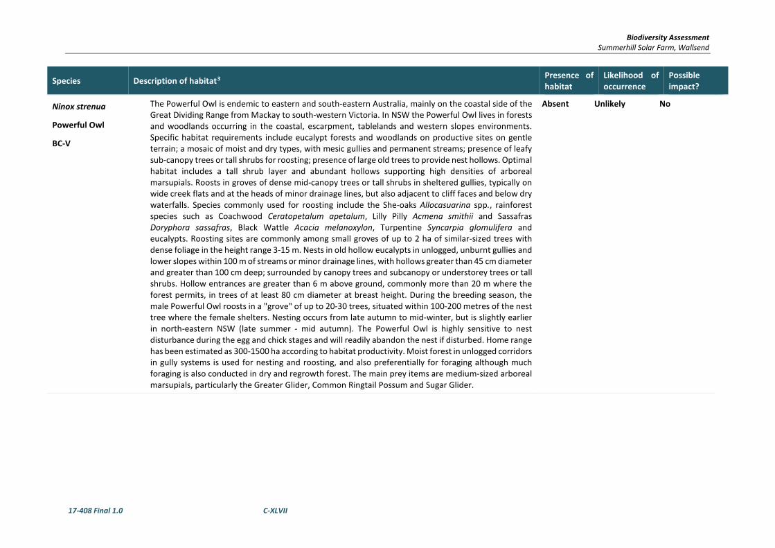
Biodiversity Assessment Summerhill Solar Farm, Wallsend
17-408 Final 1.0 C-XLVII
Species Description of habitat3 Presence of habitat
Likelihood of occurrence
Possible impact?
Ninox strenua
Powerful Owl
BC-V
The Powerful Owl is endemic to eastern and south-eastern Australia, mainly on the coastal side of the Great Dividing Range from Mackay to south-western Victoria. In NSW the Powerful Owl lives in forests and woodlands occurring in the coastal, escarpment, tablelands and western slopes environments. Specific habitat requirements include eucalypt forests and woodlands on productive sites on gentle terrain; a mosaic of moist and dry types, with mesic gullies and permanent streams; presence of leafy sub-canopy trees or tall shrubs for roosting; presence of large old trees to provide nest hollows. Optimal habitat includes a tall shrub layer and abundant hollows supporting high densities of arboreal marsupials. Roosts in groves of dense mid-canopy trees or tall shrubs in sheltered gullies, typically on wide creek flats and at the heads of minor drainage lines, but also adjacent to cliff faces and below dry waterfalls. Species commonly used for roosting include the She-oaks Allocasuarina spp., rainforest species such as Coachwood Ceratopetalum apetalum, Lilly Pilly Acmena smithii and Sassafras Doryphora sassafras, Black Wattle Acacia melanoxylon, Turpentine Syncarpia glomulifera and eucalypts. Roosting sites are commonly among small groves of up to 2 ha of similar-sized trees with dense foliage in the height range 3-15 m. Nests in old hollow eucalypts in unlogged, unburnt gullies and lower slopes within 100 m of streams or minor drainage lines, with hollows greater than 45 cm diameter and greater than 100 cm deep; surrounded by canopy trees and subcanopy or understorey trees or tall shrubs. Hollow entrances are greater than 6 m above ground, commonly more than 20 m where the forest permits, in trees of at least 80 cm diameter at breast height. During the breeding season, the male Powerful Owl roosts in a "grove" of up to 20-30 trees, situated within 100-200 metres of the nest tree where the female shelters. Nesting occurs from late autumn to mid-winter, but is slightly earlier in north-eastern NSW (late summer - mid autumn). The Powerful Owl is highly sensitive to nest disturbance during the egg and chick stages and will readily abandon the nest if disturbed. Home range has been estimated as 300-1500 ha according to habitat productivity. Moist forest in unlogged corridors in gully systems is used for nesting and roosting, and also preferentially for foraging although much foraging is also conducted in dry and regrowth forest. The main prey items are medium-sized arboreal marsupials, particularly the Greater Glider, Common Ringtail Possum and Sugar Glider.
Absent Unlikely No

Biodiversity Assessment Summerhill Solar Farm, Wallsend
17-408 Final 1.0 C-XLVIII
Species Description of habitat3 Presence of habitat
Likelihood of occurrence
Possible impact?
Numenius madagascariensis
Eastern Curlew
EPBC- CE Marine, Migratory
The Eastern Curlew is most commonly associated with sheltered coasts, especially estuaries, bays, harbours, inlets and coastal lagoons, with large intertidal mudflats or sandflats, often with beds of seagrass. The Eastern Curlew mainly forages on soft sheltered intertidal sandflats or mudflats, open and without vegetation or covered with seagrass, often near mangroves, on saltflats and in saltmarsh, rockpools and among rubble on coral reefs, and on ocean beaches near the tideline. The Eastern Curlew roosts on sandy spits and islets, especially on dry beach sand near the high-water mark, and among coastal vegetation including low saltmarsh or mangroves. It occasionally roosts on reef-flats, in the shallow water of lagoons and other near-coastal wetlands.
Absent Unlikely No
Numenius minutus
Little Curlew
EPBC-Marine, Migratory
Usually in small groups, it frequents paddocks, playing fields, airfields and floodplains, and feeds on insects, their larvae, and possibly seeds
Absent Unlikely No
Numenius phaeopus
Whimbrel
EPBC-Marine, Migratory
Breeds all around the high Arctic latitudes and overwinters in Australia from September to March/April. It is seen more often along the northern and eastern coasts than in the south and west. It frequents muddy estuaries, sandflats, salt marshes and coral cays, alone or in flocks, often with other waders.
Absent Unlikely No

Biodiversity Assessment Summerhill Solar Farm, Wallsend
17-408 Final 1.0 C-XLIX
Species Description of habitat3 Presence of habitat
Likelihood of occurrence
Possible impact?
Oxyura australis
Blue-billed Duck
BC-V
The Blue-billed Duck is endemic to south-eastern and south-western Australia. It is widespread in NSW, but most common in the southern Murray-Darling Basin area. Birds disperse during the breeding season to deep swamps up to 300 km away. It is generally only during summer or in drier years that they are seen in coastal areas. The Blue-billed Duck prefers deep water in large permanent wetlands and swamps with dense aquatic vegetation. The species is completely aquatic, swimming low in the water along the edge of dense cover. It will fly if disturbed, but prefers to dive if approached. Blue-billed Ducks will feed by day far from the shore, particularly if dense cover is available in the central parts of the wetland. They feed on the bottom of swamps eating seeds, buds, stems, leaves, fruit and small aquatic insects such as the larvae of midges, caddisflies and dragonflies Blue-billed Ducks are partly migratory, with short-distance movements between breeding swamps and overwintering lakes with some long-distance dispersal to breed during spring and early summer. Blue-billed Ducks usually nest solitarily in Cumbungi over deep water between September and February. They will also nest in trampled vegetation in Lignum, sedges or Spike-rushes, where a bowl-shaped nest is constructed. Young birds disperse in April-May from their breeding swamps in inland NSW to non-breeding areas on the Murray River system and coastal lakes.
Absent Unlikely No
Pachyptila tutur subantarctica
fairy prion (southern)
The burrows of fairy prions (southern) are usually in crevices, in hollows beneath cushions of Colobanthus muscoides (a perennial herb that can form dense mats or cushions up to 250 mm thick and sometimes up to several metres across) or in burrows in peaty soil held together by a thick cover of Cotula plumose (a short, feathery perennial herb). The species as a whole has a circumpolar distribution, and probably frequents subtropical waters during the non-breeding period. It has been recorded breeding on subantarctic and cool temperate islands in the Southern Hemisphere (New Zealand offshore islands, Iles Crozet, Bird Island, South Georgia, the Falkland Islands and Ile St Paul). It is the most abundant prion in New Zealand.
Absent Unlikely No
Pandion cristatus
Eastern Osprey
BC-V
The Eastern Osprey is a large, water-dependent bird of prey, distinctive in flight and when perched. Despite its wing-span of up to 1.7 m, it is noticeably smaller than the White-bellied Sea-eagle. Eastern Osprey (P. cristatus) occurrs between Sulawesi (in Indonesia), Australia and New Caledonia. Eastern Ospreys are found right around the Australian coast line, except for Victoria and Tasmania. They are common around the northern coast, especially on rocky shorelines, islands and reefs. The species is uncommon to rare or absent from closely settled parts of south-eastern Australia. There are a handful of records from inland areas.
Absent Unlikely No

Biodiversity Assessment Summerhill Solar Farm, Wallsend
17-408 Final 1.0 C-L
Species Description of habitat3 Presence of habitat
Likelihood of occurrence
Possible impact?
Pandion haliaetus
Osprey
EPBC - Migratory
It inhabits the areas around shallow waters, being sufficiently tolerant of human settlement to persist in suburban and sometimes urban environments (del Hoyo et al. 1994).
Absent Unlikely No
Petroica boodang
Scarlet Robin
BC-V
The Scarlet Robin is found from SE Queensland to SE South Australia and also in Tasmania and SW Western Australia. In NSW, it occurs from the coast to the inland slopes. After breeding, some Scarlet Robins disperse to the lower valleys and plains of the tablelands and slopes. Some birds may appear as far west as the eastern edges of the inland plains in autumn and winter. The Scarlet Robin lives in dry eucalypt forests and woodlands. The understorey is usually open and grassy with few scattered shrubs. This species lives in both mature and regrowth vegetation. It occasionally occurs in mallee or wet forest communities, or in wetlands and tea-tree swamps. Scarlet Robin habitat usually contains abundant logs and fallen timber: these are important components of its habitat. The Scarlet Robin breeds on ridges, hills and foothills of the western slopes, the Great Dividing Range and eastern coastal regions; this species is occasionally found up to 1000 metres in altitude. The Scarlet Robin is primarily a resident in forests and woodlands, but some adults and young birds disperse to more open habitats after breeding. In autumn and winter many Scarlet Robins live in open grassy woodlands, and grasslands or grazed paddocks with scattered trees. The Scarlet Robin is a quiet and unobtrusive species which is often quite tame and easily approached. Birds forage from low perches, fence-posts or on the ground, from where they pounce on small insects and other invertebrates which are taken from the ground, or off tree trunks and logs; they sometimes forage in the shrub or canopy layer. Scarlet Robin pairs defend a breeding territory and mainly breed between the months of July and January; they may raise two or three broods in each season. This species’ nest is an open cup made of plant fibres and cobwebs and is built in the fork of tree usually more than 2 metres above the ground; nests are often found in a dead branch in a live tree, or in a dead tree or shrub. Eggs are pale greenish-, bluish- or brownish-white, spotted with brown; clutch size ranges from one to four. Birds usually occur singly or in pairs, occasionally in small family parties; pairs stay together year-round. In autumn and winter, the Scarlet Robin joins mixed flocks of other small insectivorous birds which forage through dry forests and woodlands.
Marginal Unlikely No

Biodiversity Assessment Summerhill Solar Farm, Wallsend
17-408 Final 1.0 C-LI
Species Description of habitat3 Presence of habitat
Likelihood of occurrence
Possible impact?
Philomachus pugnax
Ruff (f. Reeve)
EPBC – Migratory, Marine
This species travels to Australia in non-breeding times. It is usually found in small groups and in most parts of Australia. The common names are different for males and females, the male is called ruff and the female called reeve. This species breeds throughout most of the arctic and temperate Eurasia. This species is known to inhabit fresh, brackish or saline wetlands with exposed mudflats at the edges. It is found in terrestrial wetlands including lakes, swamps, pools, lagoons, tidal rivers, swampy fields and floodlands. They are occasionally seen on sheltered coasts, in harbours, estuaries, seashores and are known to visit sewage farms and saltworks. They are sometimes found on wetlands surrounded by dense vegetation including grass, sedges, saltmarsh and reeds. They have been observed on sand spits and other sandy habitats including shingles. This species forages on exposed mudflats, in shallow water and occasionally on dry mud. They have been observed foraging in dry waterside plants and in swampy areas next to aeration tanks in sewage farms. They prefer to roost amongst shorter vegetation. In NSW the species has been recorded at Kurnell, Tomki, Casino, Ballina, Kooragang Island, Broadwater Lagoon and Little Cattai Creek. The species has also found around the Riverina, including Windouran Swamp, Wanganella, Fivebough Swamo abd the Tullakool Saltworks. Most NSW records come from the Sydney region.
Absent Unlikely No
Pluvialis fulva
Pacific Golden Plover
EPBC-Marine, Migratory
In non-breeding grounds in Australia this species usually inhabits coastal habitats, though it occasionally occurs around inland wetlands. Pacific Golden Plovers usually occur on beaches, mudflats and sandflats (sometimes in vegetation such as mangroves, low saltmarsh such as Sarcocornia, or beds of seagrass) in sheltered areas including harbours, estuaries and lagoons, and also in evaporation ponds in saltworks. This species usually forages on sandy or muddy shores (including mudflats and sandflats) or margins of sheltered areas such as estuaries and lagoons, though it also feeds on rocky shores, islands or reefs. In addition, Pacific Golden Plovers occasionally forage among vegetation, such as saltmarsh, mangroves or in pasture or crops. They usually roost near foraging areas. The species does not breed in Australia.
Absent Unlikely No
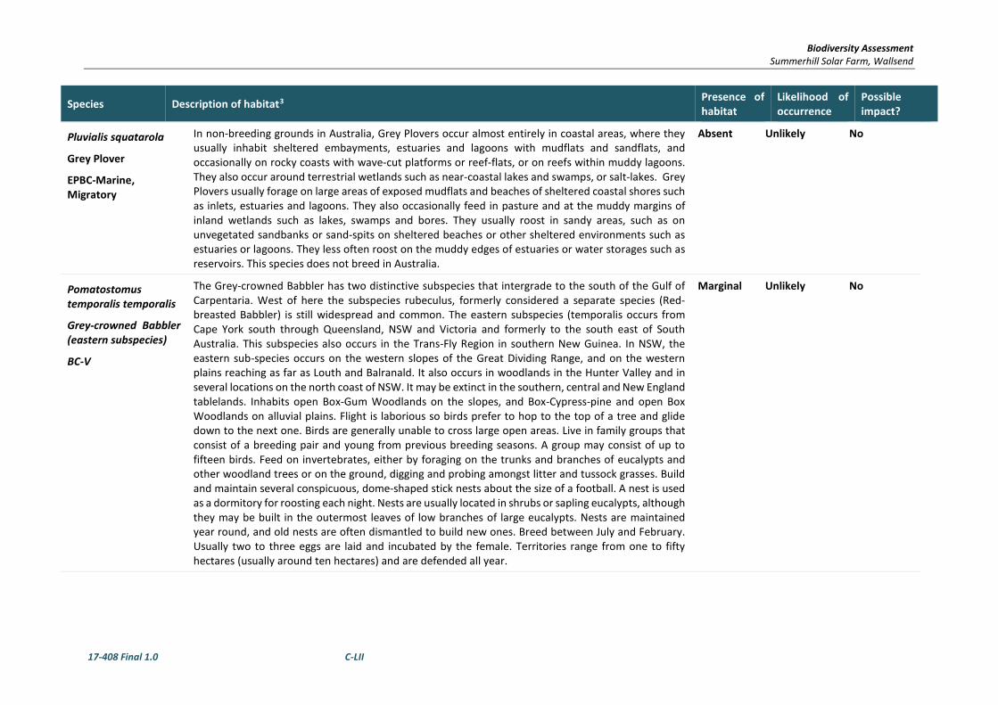
Biodiversity Assessment Summerhill Solar Farm, Wallsend
17-408 Final 1.0 C-LII
Species Description of habitat3 Presence of habitat
Likelihood of occurrence
Possible impact?
Pluvialis squatarola
Grey Plover
EPBC-Marine, Migratory
In non-breeding grounds in Australia, Grey Plovers occur almost entirely in coastal areas, where they usually inhabit sheltered embayments, estuaries and lagoons with mudflats and sandflats, and occasionally on rocky coasts with wave-cut platforms or reef-flats, or on reefs within muddy lagoons. They also occur around terrestrial wetlands such as near-coastal lakes and swamps, or salt-lakes. Grey Plovers usually forage on large areas of exposed mudflats and beaches of sheltered coastal shores such as inlets, estuaries and lagoons. They also occasionally feed in pasture and at the muddy margins of inland wetlands such as lakes, swamps and bores. They usually roost in sandy areas, such as on unvegetated sandbanks or sand-spits on sheltered beaches or other sheltered environments such as estuaries or lagoons. They less often roost on the muddy edges of estuaries or water storages such as reservoirs. This species does not breed in Australia.
Absent Unlikely No
Pomatostomus temporalis temporalis
Grey-crowned Babbler (eastern subspecies)
BC-V
The Grey-crowned Babbler has two distinctive subspecies that intergrade to the south of the Gulf of Carpentaria. West of here the subspecies rubeculus, formerly considered a separate species (Red-breasted Babbler) is still widespread and common. The eastern subspecies (temporalis occurs from Cape York south through Queensland, NSW and Victoria and formerly to the south east of South Australia. This subspecies also occurs in the Trans-Fly Region in southern New Guinea. In NSW, the eastern sub-species occurs on the western slopes of the Great Dividing Range, and on the western plains reaching as far as Louth and Balranald. It also occurs in woodlands in the Hunter Valley and in several locations on the north coast of NSW. It may be extinct in the southern, central and New England tablelands. Inhabits open Box-Gum Woodlands on the slopes, and Box-Cypress-pine and open Box Woodlands on alluvial plains. Flight is laborious so birds prefer to hop to the top of a tree and glide down to the next one. Birds are generally unable to cross large open areas. Live in family groups that consist of a breeding pair and young from previous breeding seasons. A group may consist of up to fifteen birds. Feed on invertebrates, either by foraging on the trunks and branches of eucalypts and other woodland trees or on the ground, digging and probing amongst litter and tussock grasses. Build and maintain several conspicuous, dome-shaped stick nests about the size of a football. A nest is used as a dormitory for roosting each night. Nests are usually located in shrubs or sapling eucalypts, although they may be built in the outermost leaves of low branches of large eucalypts. Nests are maintained year round, and old nests are often dismantled to build new ones. Breed between July and February. Usually two to three eggs are laid and incubated by the female. Territories range from one to fifty hectares (usually around ten hectares) and are defended all year.
Marginal Unlikely No

Biodiversity Assessment Summerhill Solar Farm, Wallsend
17-408 Final 1.0 C-LIII
Species Description of habitat3 Presence of habitat
Likelihood of occurrence
Possible impact?
Ptilinopus magnificus
Wompoo Fruit-dove
BC-V
Occurs along the coast and coastal ranges from the Hunter River in NSW to Cape York Peninsula. It is rare south of Coffs Harbour. Three subspecies are recognised, with the most southerly in NSW and south-eastern Queensland. It used to occur in the Illawarra, though there are no recent records. Occurs in, or near rainforest, low elevation moist eucalypt forest and brush box forests. Feeds on a diverse range of tree and vine fruits and is locally nomadic - following ripening fruit; some of its feed trees rely on species such as the this to distribute their seeds. Feeds alone, or in loose flocks at any height in the canopy. Despite its plumage, can be remarkably cryptic as it feeds, with the call and falling fruit being an indication of its presence. The nest is a typical pigeon nest - a flimsy platform of sticks on a thin branch or a palm frond, often over water, usually 3 - 10 m above the ground. Breeds in spring and early summer; a single white egg is laid. Most often seen in mature forests, but also found in remnant and regenerating rainforest. Aspects of its behaviour such as social behaviour and structure, movements and breeding biology have not been well-studied.
Absent Unlikely No
Ptilinopus superbus
Superb Fruit-dove
BC-V
Inhabits rainforest and similar closed forests where it forages high in the canopy, eating the fruits of many tree species such as figs and palms. It may also forage in eucalypt or acacia woodland where there are fruit-bearing trees. Part of the population is migratory or nomadic. There are records of single birds flying into lighted windows and lighthouses, indicating that birds travel at night. At least some of the population, particularly young birds, moves south through Sydney, especially in autumn. Breeding takes place from September to January. The nest is a structure of fine interlocked forked twigs, giving a stronger structure than its flimsy appearance would suggest, and is usually 5-30 metres up in rainforest and rainforest edge tree and shrub species. The male incubates the single egg by day, the female incubates at night.
Marginal Unlikely No
Ptilinopus regina
Rose-crowned Fruit-dove
BC-V
Coast and ranges of eastern NSW and Queensland, from Newcastle to Cape York. Vagrants are occasionally found further south to Victoria. Rose-crowned Fruit-doves occur mainly in sub-tropical and dry rainforest and occasionally in moist eucalypt forest and swamp forest, where fruit is plentiful. They are shy pigeons, not easy to see amongst the foliage, and are more often heard than seen. They feed entirely on fruit from vines, shrubs, large trees and palms, and are thought to be locally nomadic as they follow the ripening of fruits. Some populations are migratory in response to food availability - numbers in north-east NSW increase during spring and summer then decline in April or May.
Marginal Unlikely No

Biodiversity Assessment Summerhill Solar Farm, Wallsend
17-408 Final 1.0 C-LIV
Species Description of habitat3 Presence of habitat
Likelihood of occurrence
Possible impact?
Rhipidura rufifrons
Rufous Fantail
EPBC – M
The Rufous Fantail is found in northern and eastern coastal Australia, being more common in the north. It is also found in New Guinea, the Solomon Islands, Sulawesi and Guam. The Rufous Fantail is found in rainforest, dense wet forests, swamp woodlands and mangroves, preferring deep shade, and is often seen close to the ground. During migration, it may be found in more open habitats or urban areas.
Absent Unlikely No
Rostratula australis
Australian Painted Snipe
TSC- E, EPBC-V, Marine, Migratory
Little is known of the ecology, habitat requirements and reproductive biology of Australian Painted Snipe. They feed in shallow water or at the waters' edge and on mudflats, taking seeds and invertebrates such as insects, worms, molluscs and crustaceans. Females, which are larger and more brightly coloured than males, are thought to sometimes be polyandrous, mating with several males and leaving each one to incubate and raise chicks. They lay 3-4 eggs per clutch and incubation lasts about 15-16 days. Most records of Australian Painted Snipe are from temporary or infrequently filled freshwater wetlands and although they have occurred at many sites, no site can be identified in which they are resident or regular in occurrence. This may suggest the species is nomadic but the extent to which its cryptic behaviour may contribute to this belief is uncertain. The birds are able to remain hidden in rank vegetation, but many reports are of birds not being secretive, but rather still and unobtrusive. Primarily occurs along the east coast from north Queensland (excluding Cape York) to the Eyre Peninsula in South Australia, including the majority of Victoria and NSW. In NSW, this species has been recorded at the Paroo wetlands, Lake Cowell, Macquarie Marshes and Hexham Swamp. Most common in the Murray-Darling Basin. Inhabits inland and coastal shallow freshwater wetlands. The species occurs in both ephemeral and permanent wetlands, particularly where there is a cover of vegetation, including grasses, Lignum and Samphire. Individuals have also been known to use artificial habitats, such as sewage ponds, dams and waterlogged grassland. Nests on the ground amongst tall vegetation, such as grass tussocks or reeds. Forages nocturnally on mud flats and in shallow water. Breeding is often in response to local conditions; generally occurs from September to December.
Absent Unlikely No

Biodiversity Assessment Summerhill Solar Farm, Wallsend
17-408 Final 1.0 C-LV
Species Description of habitat3 Presence of habitat
Likelihood of occurrence
Possible impact?
Sterna albifrons
Little Tern
BC-E
Almost exclusively coastal, preferring sheltered environments; however may occur several kilometres from the sea in harbours, inlets and rivers (with occasional offshore islands or coral cay records). Nests in small, scattered colonies in low dunes or on sandy beaches just above high tide mark near estuary mouths or adjacent to coastal lakes and islands. The nest is a scrape in the sand, which may be lined with shell grit, seaweed or small pebbles. Both parents incubate up to three well-camouflaged eggs for up to 22 days, aggressively defending the nest against intruders until the young fledge at 17 - 19 days. Often seen feeding in flocks, foraging for small fish, crustaceans, insects, annelids and molluscs by plunging in the shallow water of channels and estuaries, and in the surf on beaches, or skipping over the water surface with a swallow-like flight.
Absent Unlikely No
Stictonetta naevosa
Freckled Duck
TSC-V
The Freckled Duck is found primarily in south-eastern and south-western Australia, occurring as a vagrant elsewhere. It breeds in large temporary swamps created by floods in the Bulloo and Lake Eyre basins and the Murray-Darling system, particularly along the Paroo and Lachlan Rivers, and other rivers within the Riverina. The duck is forced to disperse during extensive inland droughts when wetlands in the Murray River basin provide important habitat. The species may also occur as far as coastal NSW and Victoria during such times. Prefer permanent freshwater swamps and creeks with heavy growth of Cumbungi, Lignum or Tea-tree. The largest numbers of Freckled Ducks occur in brackish to hyposaline wetlands that are densely vegetated with Lignum. During drier times they move from ephemeral breeding swamps to more permanent waters such as lakes, reservoirs, farm dams and sewage ponds. Generally rest in dense cover during the day, usually in deep water. Feed at dawn and dusk and at night on algae, seeds and vegetative parts of aquatic grasses and sedges and small invertebrates. Nesting usually occurs between October and December but can take place at other times when conditions are favourable. Nests are usually located in dense vegetation at or near water level.
Marginal Unlikely No
Tringa brevipes
Grey-tailed Tattler
EPBC - Migratory
Grey-tailed Tattlers breed in Siberia and on passage are seen along the East Asian-Australasian Flyway (the migration route to Australia). When non-breeding they are found in China, Philipines, Taiwan, Vietnam, Malay Peninsula, Indonesia, New Guinea, Micronesia, Fiji, New Zealand and Australia. They are more commonly seen in the north of Australia. Grey-tailed Tattlers are usually seen in small flocks on sheltered coasts with reefs and rock platforms or with intertidal mudflats. They are also found in intertidal rocky, coral or stony reefs, platforms and islets that are exposed at high tide, also shores of rock, shingle, gravel and shells and on intertidal mudflats in embayments, estuaries and coastal lagoons, especially those fringed with mangroves.
Absent Unlikely No

Biodiversity Assessment Summerhill Solar Farm, Wallsend
17-408 Final 1.0 C-LVI
Species Description of habitat3 Presence of habitat
Likelihood of occurrence
Possible impact?
Tringa nebularia
Common Greenshank
EPBC – Migratory
The species has been recorded in most coastal regions. It is widespread west of the Great Dividing Range, especially between the Lachlan and Murray Rivers and the Darling River drainage basin, including the Macquarie Marshes, and north-west regions (Higgins & Davies 1996). The Common Greenshank is found in a wide variety of inland wetlands and sheltered coastal habitats of varying salinity. It occurs in sheltered coastal habitats, typically with large mudflats and saltmarsh, mangroves or seagrass. Habitats include embayments, harbours, river estuaries, deltas and lagoons and are recorded less often in round tidal pools, rock-flats and rock platforms. The species uses both permanent and ephemeral terrestrial wetlands, including swamps, lakes, dams, rivers, creeks, billabongs, waterholes and inundated floodplains, claypans and saltflats. It will also use artificial wetlands, including sewage farms and saltworks dams, inundated rice crops and bores. The edges of the wetlands used are generally of mud or clay, occasionally of sand, and may be bare or with emergent or fringing vegetation, including short sedges and saltmarsh, mangroves, thickets of rushes, and dead or live trees. It was once recorded with Black-winged Stilts (Himantopus himantopus) in pasture, but are generally not found in dry grassland (Higgins & Davies 1996).
Marginal Unlikely No
Tringa stagnatilis
Marsh Sandpiper
EPBC- Migratory
The Marsh Sandpiper is common across the far north of Australia though more scattered on other coastal areas and sparse inland. Breeding occurs from east Europe to east Siberia. In the non-breeding period they also occur throughout southern Africa, the Indian subcontinent, southern Indochina, Borneo and Sumatra and New Guinea. Marsh Sandpipers are commonly seen singly, or in small to large flocks in fresh or brackish (slightly salty) wetlands such as rivers, water meadows, sewage farms, drains, lagoons and swamps.
Absent Unlikely No
Tyto novaehollandiae
Masked Owl
BC-V
Extends from the coast where it is most abundant to the western plains. Lives in dry eucalypt forests and woodlands from sea level to 1100 m. Habitat for this species is also widespread throughout the dry eucalypt forests of the tablelands, western slopes and the undulating wet-dry forests of the coast. Optimal habitat includes an open understorey and a mosaic of sparse (grassy) and dense (shrubby) ground cover on gentle terrain. Roosts in hollows in live or occasionally dead eucalypts; dense foliage in gullies; and caves. Nest in old hollow eucalypts, live or dead, in a variety of topographic positions, with hollows greater than 40 cm wide and greater than 100 cm deep. Hollow entrances are at least 3 m above ground, in trees of at least 90 cm diameter at breast height. A specialist predator of terrestrial mammals, particularly native rodents. Home range has been estimated as 400-1000 ha according to habitat productivity.
Present Possible No – Given the small area of the works and the disturbance within the area.

Biodiversity Assessment Summerhill Solar Farm, Wallsend
17-408 Final 1.0 C-LVII
Species Description of habitat3 Presence of habitat
Likelihood of occurrence
Possible impact?
Xenus cinereus
Terek Sandpiper
BC- V, EPBC-Marine, Migratory
A rare migrant to the eastern and southern Australian coasts, being most common in northern Australia, and extending its distribution south to the NSW coast in the east. The two main sites for the species in NSW are the Richmond River estuary and the Hunter River estuary. The latter has been identified as nationally and internationally important for the species. In Australia, has been recorded on coastal mudflats, lagoons, creeks and estuaries. Favours mudbanks and sandbanks located near mangroves, but may also be observed on rocky pools and reefs, and occasionally up to 10 km inland around brackish pools. Generally roosts communally amongst mangroves of dead trees, often with related wader species. Breaks up into smaller flocks or even solitary birds when feeding in open intertidal mudflats. The diet includes worms, crabs and other crustaceans, small shellfish and the adults and larvae of various flies, beetles and water-bugs. Feeding is undertaken by moving rapidly and erratically over soft, wet mud, pecking or probing at the surface.
Absent Unlikely No
Fish
Epinephelus daemelii
Black Cod
FM-V
Adult black cod can grow to 2 m in length and at least 80 kg in weight, but it is more common to see smaller fish (up to 1m/30kg). A large, reef-dwelling, carnivorous grouper species. They are found in warm temperate and subtropical parts of the south-western Pacific, and naturally occurred along the entire NSW coast including Lord Howe Island. Adult black cod are usually found in caves, gutters and beneath bomboras on rocky reefs. They are territorial and often occupy a particular cave for life. Small juveniles are often found in coastal rock pools, and larger juveniles around rocky shores in estuaries. Black cod are opportunistic carnivores, eating mainly other fish and crustaceans. They can change from one colour pattern to another in just a few seconds. They are usually black in estuaries and banded around clear water reefs.
Absent Unlikely No
Mammals
Chalinolobus dwyeri
Large-eared Pied Bat, Large Pied Bat
TSC-V, EPBC-V
Found mainly in areas with extensive cliffs and caves, from Rockhampton in Queensland south to Bungonia in the NSW Southern Highlands. It is generally rare with a very patchy distribution in NSW. Roosts in caves (near their entrances), crevices in cliffs, old mine workings and in the disused, bottle-shaped mud nests of the Fairy Martin (Hirundo ariel), frequenting low to mid-elevation dry open forest and woodland close to these features. Females have been recorded raising young in maternity roosts (c. 20-40 females) from November through to January in roof domes in sandstone caves. Found in well-timbered areas containing gullies. This species probably forages for small, flying insects below the forest canopy. Likely to hibernate through the coolest months. It is uncertain whether mating occurs early in winter or in spring.
Present Unlikely – Foraging only.
No – Given the small area of the works and the disturbance within the area.

Biodiversity Assessment Summerhill Solar Farm, Wallsend
17-408 Final 1.0 C-LVIII
Species Description of habitat3 Presence of habitat
Likelihood of occurrence
Possible impact?
Dasyurus maculatus
Spot-tailed Quoll /Tiger Quoll
Dasyurus maculatus maculatus (SE mainland population)
BC-V, EPBC-E
Found on the east coast of NSW, Tasmania, eastern Victoria and north-eastern Queensland. Recorded across a range of habitat types, including rainforest, open forest, woodland, coastal heath and inland riparian forest, from the sub-alpine zone to the coastline. Individual animals use hollow-bearing trees, fallen logs, small caves, rock crevices, boulder fields and rocky-cliff faces as den sites. Mostly nocturnal, although will hunt during the day; spends most of the time on the ground. The home-range of this species is unknown, but estimates are between 800ha and 20km2. Usually traverse their ranges along densely vegetated creeklines. They need suitable den sites and abundant food, requiring large areas of intact vegetation for foraging. Use ‘latrine sites’, often on flat rocks among boulder fields and rocky cliff-faces; latrine sites can be recognised by the accumulation of the sometimes characteristic ‘twisty-shaped’ faeces deposited by animals. Consumes a variety of prey, including gliders, possums, small wallabies, rats, birds, bandicoots, rabbits and insects; also eats carrion and takes domestic fowl.
Absent Unlikely – Foraging only.
No
Falsistrellus tasmaniensis
Eastern False Pipistrelle
BC-V
The Eastern False Pipistrelle is found on the south-east coast and ranges of Australia, from southern Queensland to Victoria and Tasmania. Prefers moist habitats, with trees taller than 20 m. Generally roosts in eucalypt hollows, but has also been found under loose bark on trees or in buildings. Hunts beetles, moths, weevils and other flying insects above or just below the tree canopy. Hibernates in winter. Females are pregnant in late spring to early summer.
Present Unlikely – Foraging only.
No – Given the small area of the works and the disturbance within the area.
Miniopterus australis
Little Bentwing-bat
BC-V
Moist eucalypt forest, rainforest or dense coastal banksia scrub. Little Bentwing-bats roost in caves, tunnels and sometimes tree hollows during the day, and at night forage for small insects beneath the canopy of densely vegetated habitats. They often share roosting sites with the Common Bentwing-bat and, in winter, the two species may form mixed clusters. In NSW the largest maternity colony is in close association with a large maternity colony of Common Bentwing-bats (M. schreibersii) and appears to depend on the large colony to provide the high temperatures needed to rear its young.
Present Unlikely – Foraging only.
No – Given the small area of the works and the disturbance within the area.

Biodiversity Assessment Summerhill Solar Farm, Wallsend
17-408 Final 1.0 C-LIX
Species Description of habitat3 Presence of habitat
Likelihood of occurrence
Possible impact?
Miniopterus schreibersii oceanensis
Eastern Bentwing-bat
BC-V
Eastern Bent-wing Bats occur along the east and north-west coasts of Australia. Caves are the primary roosting habitat, but also use derelict mines, storm-water tunnels, buildings and other man-made structures. Form discrete populations centred on a maternity cave that is used annually in spring and summer for the birth and rearing of young. Maternity caves have very specific temperature and humidity regimes. At other times of the year, populations disperse within about 300 km range of maternity caves. Cold caves are used for hibernation in southern Australia. Breeding or roosting colonies can number from 100 to 150,000 individuals. Hunt in forested areas, catching moths and other flying insects above the tree tops.
Present Unlikely – Foraging only.
No – Given the small area of the works and the disturbance within the area.
Mormopterus norfolkensis
Eastern Freetail bat
BC-V
The East Coast Freetail bat is found along the east coast from south Queensland to southern NSW. Occur in dry sclerophyll forest and woodland east of the Great Dividing Range. Roost mainly in tree hollows but will also roost under bark or in man-made structures. Usually solitary but also recorded roosting communally, probably insectivorous.
Present Unlikely – Foraging only.
No – Given the small area of the works and the disturbance within the area.
Myotis macropus
Southern Myotis
BC-V
The Large-footed Myotis is found in the coastal band from the north-west of Australia, across the top-end and south to western Victoria. It is rarely found more than 100 km inland, except along major rivers. Generally roost in groups of 10 - 15 close to water in caves, mine shafts, hollow-bearing trees, storm water channels, buildings, under bridges and in dense foliage. Forage over streams and pools catching insects and small fish by raking their feet across the water surface. In NSW females have one young each year usually in November or December.
Absent Unlikely No
Petaurus norfolcensis
Squirrel Glider
BC-V
The Squirrel Glider is sparsely distributed along the east coast and immediate inland districts from western Victoria to north Queensland. The species is found inland as far as the Grampians in Victoria and the Pilliga and the Coonabarabran areas of NSW. Inhabits dry sclerophyll forest and woodland and is generally absent from rainforest and closed forest. In NSW, potential habitat includes Box-Ironbark forests and woodlands in the west, the River Red Gum forests of the Murray Valley and the eucalypt forests of the northeast. Requires abundant hollow-bearing trees and a mix of eucalypts, acacias and banksias. Nightly movements are estimated at between 300 and 500m. Home-ranges have been estimated at between 0.65 and 8.55ha. Smooth-barked eucalypts are preferred as these eucalypts form hollows more readily than rough-barked and support a greater diversity of invertebrates. Squirrel Glider’s forage in the upper and lower forest canopies and in the shrub understorey.
Present Unlikely – Foraging only.
No – Given the small area of the works and the disturbance within the area.

Biodiversity Assessment Summerhill Solar Farm, Wallsend
17-408 Final 1.0 C-LX
Species Description of habitat3 Presence of habitat
Likelihood of occurrence
Possible impact?
Petaurus Volans
Greater Glider
EPBC – V
Greater Gliders have highly varied colouration ranging from a light grey almost white colour to a very a dark sooty grey. The northern greater glider is uniform brown above with a pale belly. Wide range of habitats including tall open woodland, eucalypt forests and low woodlands. They do not occur in rainforests. They prefer habitats that are in older forests and have large number of hollows. The greater glider occurs down the east coast of Australia in Queensland, New South Wales and Victoria. It does not occur in the far north region of Queensland.
Present Unlikely No – Given the small area of the works and the disturbance within the area.
Petrogale penicillata
Brush-tailed Rock-wallaby
TSC-E, EPBC-V
The range of the Brush-tailed Rock-wallaby extends from south-east Queensland to the Grampians in western Victoria, roughly following the line of the Great Dividing Range. The species’ range is now fragmented, particularly in the south where they are now mostly found as small isolated populations dotted across their former range. In NSW they occur from the Queensland border in the north to the Shoalhaven in the south, with the population in the Warrumbungle Ranges being the western limit. Occupy rocky escarpments, outcrops and cliffs with a preference for complex structures with fissures, caves and ledges facing north. Throughout their range, Brush-tailed Rock-wallabies feed on a wide variety of grasses and shrubs, and have flexible dietary requirements. Shelter or bask during the day in rock crevices, caves and overhangs and are most active at night. Highly territorial and have strong site fidelity with an average home range size of about 15 ha. Live in family groups of 2 – 5 adults and usually one or two juvenile and sub-adult individuals. Dominant males associate and breed with up to four females. Breeding is likely to be continuous, at least in the southern populations, with no apparent seasonal trends in births.
Absent Unlikely No

Biodiversity Assessment Summerhill Solar Farm, Wallsend
17-408 Final 1.0 C-LXI
Species Description of habitat3 Presence of habitat
Likelihood of occurrence
Possible impact?
Phascolarctos cinereus
Koala
BC-V EPBC - V
Occurs in eastern Australia, from north-eastern Queensland to south-eastern South Australia and to the west of the Great Dividing Range. In NSW it mainly occurs on the central and north coasts with some populations in the western region. It was historically abundant on the south coast of NSW, but now occurs in sparse and possibly disjunct populations. The koala inhabits a range of eucalypt forest and woodland communities, including coastal forests, the woodlands of the tablelands and western slopes, and the riparian communities of the western plains. Examples of important shelter trees are cypress pine and brush box. The quality of forest and woodland communities as habitat for koalas is influenced by a range of factors, such as; species and size of trees present; structural diversity of the vegetation; soil nutrients; climate and rainfall; size and disturbance history of the habitat patch.Feed on the foliage of more than 70 eucalypt species and 30 non-eucalypt species, but in any one area will select preferred browse species. Home range size varies with quality of habitat, ranging from less than two ha to several hundred hectares in size. Breeding season for the koala peaks between September and February.
Absent Unlikely No
Potorous tridactylus tridactylus
Long-nosed Potoroo (SE mainland)
BC-V, EPBC-V
In NSW it is generally restricted to the east of the Great Dividing Range, with an annual rainfall exceeding 760 mm. Inhabits coastal heaths and dry and wet sclerophyll forests. Dense understorey with occasional open areas is an essential part of habitat, and may consist of grass-trees, sedges, ferns or heath, or of low shrubs of tea-trees or melaleucas. A sandy loam soil is also a common feature. The main habitat requirements would appear to be access to some form of dense vegetation for shelter and the presence of an abundant supply of fungi for food. The fruit-bodies of hypogeous (underground-fruiting) fungi are a large component of the diet of the Long-nosed Potoroo. They also eat roots, tubers, insects and their larvae and other soft-bodied animals in the soil. Individuals are mainly solitary, non-territorial and have home range sizes ranging between 2-5 ha. Breeding peaks typically occur in late winter to early summer.
Absent Unlikely No
Pseudomys novaehollandiae
New Holland Mouse
EPBC-V
The New Holland Mouse has a fragmented distribution across Tasmania, Victoria, New South Wales and Queensland. Known to inhabit open heathlands, open woodlands with a heathland understorey and vegetated sand dunes. Lives predominantly in burrows shared with other individuals. The home range of the New Holland Mouse ranges from 0.44 ha to 1.4 ha. Breeding typically occurs between August and January, but can extend into autumn. The species peaks in abundance during early to mid stages of vegetation succession typically induced by fire. Nocturnal and omnivorous, feeding on seeds, insects, leaves, flowers and fungi, and is therefore likely to play an important role in seed dispersal and fungal spore dispersal.
Absent Unlikely No

Biodiversity Assessment Summerhill Solar Farm, Wallsend
17-408 Final 1.0 C-LXII
Species Description of habitat3 Presence of habitat
Likelihood of occurrence
Possible impact?
Pteropus poliocephalus
Grey-headed Flying-fox
BC-V, EPBC-V
Grey-headed Flying-foxes are found within 200 km of the eastern coast of Australia, from Bundaberg in Queensland to Melbourne in Victoria. Occur in subtropical and temperate rainforests, tall sclerophyll forests and woodlands, heaths and swamps as well as urban gardens and cultivated fruit crops. Roosting camps are generally located within 20 km of a regular food source, often in stands of riparian rainforest, Paperbark or Casuarina forest, and are commonly found in gullies, close to water, or in vegetation with a dense canopy. Forage on the nectar and pollen of native trees, in particular Eucalyptus, Melaleuca and Banksia, and fruits of rainforest trees and vines. Travel up to 50 km to forage. Annual mating commences in January and a single young is born each October or November. Site fidelity to camps is high with some camps being used for over a century.
Present Unlikely – Foraging only.
No – Given the small area of the works and the disturbance within the area.
Saccolaimus flaviventris
Yellow-bellied Sheathtail-bat
BC-V
The Yellow-bellied Sheathtail-bat is a wide-ranging species found across northern and eastern Australia. In the most southerly part of its range - most of Victoria, south-western NSW and adjacent South Australia - it is a rare visitor in late summer and autumn. There are scattered records of this species across the New England Tablelands and North West Slopes. Roosts singly or in groups of up to six, in tree hollows and buildings; in treeless areas they are known to utilise mammal burrows. When foraging for insects, flies high and fast over the forest canopy, but lower in more open country. Forages in most habitats across its very wide range, with and without trees; appears to defend an aerial territory. Breeding has been recorded from December to mid-March, when a single young is born. Seasonal movements are unknown; there is speculation about a migration to southern Australia in late summer and autumn.
Present Unlikely – Foraging only.
No – Given the small area of the works and the disturbance within the area.
Scoteanax rueppellii
Greater Broad-nosed Bat
BC-V
The Greater Broad-nosed Bat is found mainly in the gullies and river systems that drain the Great Dividing Range, from north-eastern Victoria to the Atherton Tableland. It extends to the coast over much of its range. In NSW it is widespread on the New England Tablelands, however does not occur at altitudes above 500 m. Utilises a variety of habitats from woodland through to moist and dry eucalypt forest and rainforest, though it is most commonly found in tall wet forest. Although this species usually roosts in tree hollows, it has also been found in buildings. Forages after sunset, flying slowly and directly along creek and river corridors at an altitude of 3 - 6 m. Open woodland habitat and dry open forest suits the direct flight of this species as it searches for beetles and other large, slow-flying insects; this species has been known to eat other bat species. Little is known of its reproductive cycle, however a single young is born in January; prior to birth, females congregate at maternity sites located in suitable trees, where they appear to exclude males during the birth and raising of the single young.
Present Unlikely – Foraging only.
No – Given the small area of the works and the disturbance within the area.

Biodiversity Assessment Summerhill Solar Farm, Wallsend
17-408 Final 1.0 C-LXIII
Species Description of habitat3 Presence of habitat
Likelihood of occurrence
Possible impact?
Vespadelus troughtoni
Eastern Cave Bat
BC – V
The Eastern Cave Bat is found in a broad band on both sides of the Great Dividing Range from Cape York to Kempsey, with records from the New England Tablelands and the upper north coast of NSW. The western limit appears to be the Warrumbungle Range, and there is a single record from southern NSW, east of the ACT. Very little is known about the biology of this uncommon species. A cave-roosting species that is usually found in dry open forest and woodland, near cliffs or rocky overhangs; has been recorded roosting in disused mine workings or Fairy martin nests, occasionally in colonies of up to 500 individuals. Occasionally found along cliff-lines in wet eucalypt forest and rainforest. Little is understood of its feeding or breeding requirements or behaviour. Forages within 5km of breeding habitat. Most active October to March.
Marginal Unlikely No
Amphibians
Heleioporus australiacus
Giant Burrowing Frog
TSC-V, EPBC-V
The Giant Burrowing Frog occurs from the NSW Central Coast to eastern Victoria, but is most common on the Sydney sandstone. It has been found from the coast to the Great Dividing Range. Found in heath, woodland and open forest with sandy soils. Generally lives in the heath or forest and will travel several hundred metres to creeks to breed. Burrows into deep litter or loose soil, emerging to feed or breed after rain. Diet includes ground-dwelling invertebrates such as ants, beetles and spiders. Breeds from August to March and the eggs are laid in a white foam-mass under vegetation in creeks or in yabby holes.
Absent Unlikely No
Litoria aurea
Green and Golden Bellfrog
TSC-E, EPBC-V
Its former distribution was predominantly coastal but extended inland to the central and southern tablelands, including Bathurst in the west. It was known from the northern coastal part of NSW from around Brunswick Heads south along the entire NSW coast extending into the north-eastern portion of Victoria. There are presently 43 identified remaining key populations, most of which have a small fragmented distribution of mainly near coastal locations. Large populations in NSW are located around the metropolitan areas of Sydney, Shoalhaven and mid north coast. There is only one known population on the NSW Southern Tablelands. Inhabits marshes, dams and stream-sides, particularly those containing bullrushes (Typha spp.) or spikerushes (Eleocharis spp.). Optimum habitat includes water-bodies that are unshaded, free of predatory fish such as Plague Minnow (Gambusia holbrooki), have a grassy area nearby and diurnal sheltering sites available. Some sites, particularly in the Greater Sydney region occur in highly disturbed areas. The species is active by day and usually breeds in summer when conditions are warm and wet. Tadpoles feed on algae and other plant-matter; adults eat mainly insects, but also other frogs. Preyed upon by various wading birds and snakes.
Absent Unlikely No

Biodiversity Assessment Summerhill Solar Farm, Wallsend
17-408 Final 1.0 C-LXIV
Species Description of habitat3 Presence of habitat
Likelihood of occurrence
Possible impact?
Litoria littlejohni
Littlejohn's Tree Frog
TSC-E, EPBC-V
Occurs in scattered locations between the Watagan Mountains in eastern New South Wales and Buchan in north-east Victoria. It occurs within the Hunter-Central Rivers, Southern Rivers (NSW) and East Gippsland (Victoria) Natural Resource Management Regions. Inhabits forest, coastal woodland and heath from 100 to 950 m above sea level, but is not associated with any specific vegetation types. This species breeds in the upper reaches of permanent streams and in perched swamps. Non-breeding habitat is heath based forests and woodlands where it shelters under leaf litter and low vegetation, and hunts for invertebrate prey either in shrubs or on the ground. Breeding is triggered by heavy rain and can potentially occur all year, but is usually from late summer to early spring. Eggs and tadpoles are mostly found in still or slow flowing pools that receive extended exposure to sunlight, but will also use temporary isolated pools.
Absent Unlikely No
Mixophyes balbus
Stuttering Frog
TSC-E, EPBC-V
Stuttering Barred Frogs occur along the east coast of Australia from southern Queensland to the north-eastern Victoria. The species has suffered a marked decline in distribution and abundance, particularly in south-east NSW. It is the only Mixophyes species that occurs in south-east NSW and in recent surveys it has only been recorded at three locations south of Sydney. Found in rainforest and wet, tall open forest in the foothills and escarpment on the eastern side of the Great Dividing Range. Outside the breeding season adults live in deep leaf litter and thick understorey vegetation on the forest floor. Feed on insects and smaller frogs. Breed in streams during summer after heavy rain. Eggs are laid on rock shelves or shallow riffles in small, flowing streams. As the tadpoles grow they move to deep permanent pools and take approximately 12 months to metamorphose.
Absent Unlikely No
E TSC = listed as Endangered under Schedule 1 of the NSW Threatened Species Conservation Act 1995 E EPBC = listed as Endangered under the Commonwealth Environment Protection & Biodiversity Conservation Act 1999. V TSC = listed as Vulnerable under Schedule 2 of the NSW Threatened Species Conservation Act 1995. V EPBC = listed as Vulnerable under the Commonwealth Environment Protection & Biodiversity Conservation Act 1999. M EPBC = listed as Migratory under the Commonwealth Environment Protection & Biodiversity Conservation Act 1999.
CE EPBC = listed as Critically Endangered under the Commonwealth Environment Protection & Biodiversity Conservation Act 1999. CAMBA = Chinese-Australia Migratory Bird Agreement JAMBA = Japan-Australia Migratory Bird Agreement

Biodiversity Assessment Summerhill Solar Farm, Wallsend
17-408 Draft 1.0 C-I

Statement of Environmental Effects Proposed Solar Farm - Minmi Road, Wallsend
17-408 Final 1.0 59
ATTACHMENT 3 APPROVAL FROM SUBSIDENCE ADVISORY NSW (TO COME)
Statement of Environmental Effects Proposed Solar Farm - Minmi Road, Wallsend
17-408 Final 1.0 60
ATTACHMENT 4 APPROVAL FROM HUNTER WATER


Statement of Environmental Effects Proposed Solar Farm - Minmi Road, Wallsend
17-408 Final 1.0 61
ATTACHMENT 5 AHIMS SEARCH RESULT

AHIMS Web Services (AWS)Search Result Purchase Order/Reference : 17408 Summerhill SF
Client Service ID : 300063
Date: 06 September 2017Nghenvironmental-Bega
PO 470
Bega New South Wales 2550
Dear Sir or Madam:
AHIMS Web Service search for the following area at Lot : 2, DP:DP1208481 with a Buffer of 50 meters,
conducted by Calia Jones on 06 September 2017.
Email: [email protected]
Attention: Calia Jones
The context area of your search is shown in the map below. Please note that the map does not accurately
display the exact boundaries of the search as defined in the paragraph above. The map is to be used for
general reference purposes only.
A search of the Office of the Environment and Heritage AHIMS Web Services (Aboriginal Heritage Information
Management System) has shown that:
0
0
Aboriginal sites are recorded in or near the above location.
Aboriginal places have been declared in or near the above location. *

If your search shows Aboriginal sites or places what should you do?
Important information about your AHIMS search
You can get further information about Aboriginal places by looking at the gazettal notice that declared it.
Aboriginal places gazetted after 2001 are available on the NSW Government Gazette
(http://www.nsw.gov.au/gazette) website. Gazettal notices published prior to 2001 can be obtained from
Office of Environment and Heritage's Aboriginal Heritage Information Unit upon request
Aboriginal objects are protected under the National Parks and Wildlife Act 1974 even if they are not recorded
as a site on AHIMS.
You must do an extensive search if AHIMS has shown that there are Aboriginal sites or places recorded in the
search area.
If you are checking AHIMS as a part of your due diligence, refer to the next steps of the Due Diligence Code of
practice.
AHIMS records information about Aboriginal sites that have been provided to Office of Environment and
Heritage and Aboriginal places that have been declared by the Minister;
Information recorded on AHIMS may vary in its accuracy and may not be up to date .Location details are
recorded as grid references and it is important to note that there may be errors or omissions in these
recordings,
Some parts of New South Wales have not been investigated in detail and there may be fewer records of
Aboriginal sites in those areas. These areas may contain Aboriginal sites which are not recorded on AHIMS.
This search can form part of your due diligence and remains valid for 12 months.
The information derived from the AHIMS search is only to be used for the purpose for which it was requested.
It is not be made available to the public.
3 Marist Place, Parramatta NSW 2150
Locked Bag 5020 Parramatta NSW 2220
Tel: (02) 9585 6380 Fax: (02) 9873 8599
ABN 30 841 387 271
Email: [email protected]
Web: www.environment.nsw.gov.au

Newcastle City Council
Summerhill Waste Management Centre - Solar Farm
Geotechnical Investigation Report
October 2016

GHD | Report for Newcastle City Council - Summerhill Waste Management Centre - Solar Farm, 2218578
Table of contents
1. Introduction..................................................................................................................................... 1
1.1 Assumptions and limitations ................................................................................................ 1
2. Methodology ................................................................................................................................... 2
2.1 Test pit investigation ............................................................................................................ 2
2.2 Laboratory testing ................................................................................................................ 3
3. Investigation findings ...................................................................................................................... 4
3.1 Subsurface conditions.......................................................................................................... 4
3.2 Laboratory test results ......................................................................................................... 5
4. Discussion and recommendations ................................................................................................. 7
4.1 Geotechnical model ............................................................................................................. 7
4.2 Footing options .................................................................................................................... 7
4.3 Geotechnical design considerations .................................................................................... 7
4.4 Pavement recommendations for laydown area and access trail ......................................... 8
Table index
Table 2-1 Test pit coordinates and approximate surface levels .......................................................... 2
Table 3-1 Summary of subsurface conditions encountered at test locations ...................................... 4
Table 3-2 Moisture content and Atterberg limits test results ................................................................ 5
Table 3-3 Standard Compaction and California Bearing Ratio test results ......................................... 5
Table 3-4 Soil aggressivity test results ................................................................................................ 6
Table 4-1 Preliminary flexible pavement thickness design .................................................................. 9
Appendices
Appendix A – Figures
Appendix B – General Notes and Standard Sheets
Appendix C – Engineering Logs
Appendix D – DCP Report Sheets
Appendix E – Laboratory Test Results

GHD | Report for Newcastle City Council - Summerhill Waste Management Centre - Solar Farm, 2218578 | 1
1. Introduction
This report presents the results of a geotechnical investigation by GHD for Newcastle City
Council (NCC) for the proposed solar farm at Summerhill Waste Management Centre.
It is understood the proposed photovoltaic (PV) cells are to be supported by helical steel screw
piles within a capped section of the landfill. A temporary laydown area for use during
construction and a fire access trail around the perimeter of the solar farm are also proposed.
The purpose of the investigation was to provide geotechnical information on the existing landfill
capping to enable the preparation of geotechnical models for use in design of the solar farm.
This report presents the factual results of the subsurface investigation and interpretation of
geotechnical conditions together with discussion and recommendations on the following:
Thickness and nature of the capping.
Founding conditions.
Recommendations for pavement design for the laydown area and fire access trail.
This report should be read in conjunction with the attached General Notes in Appendix B.
1.1 Assumptions and limitations
This report has been prepared by GHD for Newcastle City Council (NCC) and may only be used
and relied on by NCC for the purpose agreed between GHD and the NCC as set out in
Section 1 of this report. GHD otherwise disclaims responsibility to any person other than NCC
arising in connection with this report. GHD also excludes implied warranties and conditions, to
the extent legally permissible.
The services undertaken by GHD in connection with preparing this report were limited to those
specifically detailed in the report and are subject to the scope limitations set out in the report.
The opinions, conclusions and any recommendations in this report are based on:
Conditions encountered and information reviewed at the date of preparation of the report.
GHD has no responsibility or obligation to update this report to account for events or
changes occurring subsequent to the date that the report was prepared.
Assumptions made by GHD described in this report. GHD disclaims liability arising from
any of the assumptions being incorrect. Information obtained from, and testing undertaken
at or in connection with, specific sample points. Site conditions at other parts of the site
may be different from the site conditions found at the specific sample points.
Site conditions (including the presence of hazardous substances and/or site contamination) may
change after the date of this Report. GHD does not accept responsibility arising from, or in
connection with, any change to the site conditions. GHD is also not responsible for updating this
report if the site conditions change.

GHD | Report for Newcastle City Council - Summerhill Waste Management Centre - Solar Farm, 2218578 | 2
2. Methodology
2.1 Test pit investigation
The test pit investigation was undertaken on 30 September 2016 and comprised the excavation
of ten (10) test pits (TP1 to TP10) to a maximum depth of 2 m using a 5 tonne excavator.
The fieldwork was supervised on a full time basis by an experienced GHD engineering geologist
who was responsible for locating the test pits, logging the encountered strata, conducting in-situ
testing and collecting representative samples for laboratory sampling. The logging was
generally carried out in accordance with Australian Standard, AS 1726-1993.
Upon completion, the excavated spoil was returned to the excavation and compacted using the
weight of the excavator.
Test pit locations were determined with reference to site features. Hand held GPS coordinates
(typically accurate to ±10 m) were also recorded at each test location. Existing ground surface
levels were estimated by interpolating test locations (from the recorded GPS coordinates) on the
site survey contours provided by NCC. Vertical accuracy of the quoted surface levels is
therefore expected to be ± 1 m. The test location coordinates are presented on the logs
provided in Appendix C.
The logs should be read in conjunction with the attached Standard Sheets included in
Appendix B, which explain the terms, abbreviations and symbols used together with the
interpretations and limitations of the logging procedure.
The test pit locations are shown on the Geotechnical Test Location Plan presented as Figure 1
in Appendix A.
Dynamic cone penetration tests (DCPs) were undertaken adjacent to all test pits to a maximum
depth of 1.7 m. The DCP report sheets are provided in Appendix D.
Table 2-1 Test pit coordinates and approximate surface levels
Test pit Approximate
surface level (m
AHD)
Easting (m) Northing (m)
TP1 59 373510 6359802
TP2 56 373510 6359862
TP3 56 373621 6359897
TP4 57 373730 6359981
TP5 57 373798 6360029
TP6 56 373866 6360073
TP7 59 373807 6359978
TP8 59 373711 6359895
TP9 45 373714 6360043
TP10 45 373507 6359927

GHD | Report for Newcastle City Council - Summerhill Waste Management Centre - Solar Farm, 2218578 | 3
2.2 Laboratory testing
Samples recovered during the test pit investigation were transported to GHD’s NATA accredited
laboratory in Artarmon for testing. The following laboratory testing was undertaken:
Three (3) moisture content and Atterberg limit (plasticity) tests.
Two (2) Standard Compaction tests.
Two (2) California bearing ratio (CBR) tests (4 day soak).
Two (2) soil aggression test suites (pH, SO4 and CI).
Laboratory test reports are included in Appendix E.

GHD | Report for Newcastle City Council - Summerhill Waste Management Centre - Solar Farm, 2218578 | 4
3. Investigation findings
3.1 Subsurface conditions
Reference to the individual test pit logs in Appendix C should be made for a full description of
the subsurface conditions encountered at each test location. Test procedures, classification
methods and descriptive terms are discussed in the Standard Sheets in Appendix B.
The subsurface conditions encountered comprised varying thicknesses of topsoil and capping
over non-putrescible landfill or residual clay. The more pertinent aspects of these units are
discussed below:
Topsoil: encountered in all test pits with the exception of TP3 and TP10, comprising 50 mm to
300 mm thickness of organic rich, low plasticity clay or sandy clay.
Fill (capping): encountered in all test pits comprising gravelly clay with some cobbles and
boulders to depths ranging between 0.6 and 2 m. The gravel and cobbles comprised sandstone,
siltstone, ironstone and coal. Capping was generally dry to moist and appeared moderately to
well compacted.
In areas of capped landfill, the capping and topsoil combined had a minimum thickness of 1 m.
A woven geofabric or hessian layer was observed within TP1 and TP5 at a depth of 1.3 m,
separating the capping and landfill.
Landfill: encountered underlying the capping in TP3 to TP5 and TP7 to TP9, comprised
building rubble and non-putrescible waste including bricks, wood, metal, wire, concrete, rubber,
plastic and clothing. Landfill material was described as dry to moist and appeared to be
moderately compacted.
Residual: encountered underlying capping within TP6 and TP10 comprised moist, high
plasticity, stiff to very stiff clay with traces of sand and gravel.
A summary of the subsurface conditions encountered at each test pit location is provided in
Table 3-1 below.
Table 3-1 Summary of subsurface conditions encountered at test locations
Location Topsoil Capping Landfill Residual Soil
TP1 0 to 0.05 0.05 to 1.3 - -
TP2 0 to 0.3 0.3 to 1.3 1.3 to 2.0 -
TP3 - 0 to 1.3 1.3 to 1.4 -
TP4 0 to 0.2 0.2 to 1.0 1.0 to 1.5 -
TP5 0 to 0.1 0.1 to 1.1 1.1 to 1.4 -
TP6 0 to 0.3 0.3 to 1.3 - 1.3 to 1.6
TP7 0 to 0.2 0.2 to 1.2 1.2 to 1.3 -
TP8 0 to 0.15 0.15 to 1.0 1.0 to 1.1 -
TP9 0 to 0.1 0.1 to 1.3 1.3 to 1.4 -
TP10 - 0 to 0.6 - 0.6 to 1.2
All depths are metres below ground surface

GHD | Report for Newcastle City Council - Summerhill Waste Management Centre - Solar Farm, 2218578 | 5
Minor groundwater seepage was observed within TP10 at a depth of 0.3 m below ground
surface. No monitoring of groundwater was undertaken and the test pits were backfilled upon
completion.
3.2 Laboratory test results
The laboratory test results are summarised in the following tables.
Table 3-2 Moisture content and Atterberg limits test results
Where: FMC = Field Moisture Content; LL = Liquid Limit; PL = Plastic Limit; PI = Plasticity Index
The Atterberg Limit results identified the tested capping as being of medium plasticity. Field
moisture contents in the tested samples were below the plastic limit.
Table 3-3 Standard Compaction and California Bearing Ratio test results
Sample
location
Sample
depth (m)
Material
description
FMC (%) OMC (%) MDD
(t/m3)
CBR (%)
TP1 0.2 – 0.5 Gravelly
CLAY
(capping)
18.9 16.2 1.78 6
TP7 0.3 -0.6 Gravelly
CLAY
(capping)
20.7 19.2 1.60 4.0
Where: FMC = Field Moisture Content; OMC = optimum moisture content; MDD = maximum dry density
California Bearing Ratio (CBR) testing was undertaken with samples remoulded and compacted
to nominally 98% of Standard maximum dry density at standard optimum moisture content and
soaked for 4 days with a 4.5 kg surcharge.
The results of standard compaction tests indicated the capping possessed field moisture
contents 1.5% and 2.7 % above that of the standard optimum moisture content at the time of
investigation.
Sample
location
Sample
depth (m)
Material
description
FMC (%) Atterberg limits
LL (%) PL (%) PI (%)
TP2 0.4 – 0.5 Gravelly
CLAY
(capping)
20.9 50 23 27
TP5 0.5 – 0.6 Gravelly
CLAY
(capping)
15.5 43 22 21
TP8 0.5 – 0.7 Gravelly
CLAY
(capping)
14.1 47 22 25

GHD | Report for Newcastle City Council - Summerhill Waste Management Centre - Solar Farm, 2218578 | 6
Table 3-4 Soil aggressivity test results
Sample location
Sample depth (m)
Material description
Chemical analysis
pH EC (S/cm) Cl (ppm)
SO4 (ppm)
TP2 0.4 -0.5 Gravelly CLAY (capping)
5.0 310 320 170
TP9 0.3 -0.4 Gravelly
CLAY
(capping)
6.1 48 <10 26
The results of soil aggressivity tests have been assessed with reference to Tables 6.4.2(C) and
6.5.2(C) of Australian Standard AS2159-2009 ‘Piling – Design and Installation’. Based on the
exposure conditions and soil types encountered, the capping is considered low permeability and
presents a ‘mild’ exposure classification for concrete and ‘non-aggressive’ exposure
classification for steel. However, landfill materials frequently pose special durability risks. In the
absence of site specific chemical information, we recommend the expose classification be
assessed as ‘severe’ for both concrete and steel within landfill material. Further chemical and
microbiological analysis could be undertaken to refine the exposure classification.

GHD | Report for Newcastle City Council - Summerhill Waste Management Centre - Solar Farm, 2218578 | 7
4. Discussion and recommendations
4.1 Geotechnical model
Where capping overlies landfill, a 0.1 to 0.3 m thick layer of topsoil was encountered at most
locations. This overlaid capping to between 1.0 and 1.3 m depth below the existing surface
level. The capping was 0.8 to 1.3 m thick, appeared to be moderately to well compacted and
generally comprised gravelly clay with varying portions of sand, gravel, cobbles and boulders of
sandstone, siltstone and/or rock of carbonaceous origin.
The capping was underlain soil similar in appearance to the capping (although generally
appearing to be moderately compacted) and landfill waste primarily made up of building
materials.
4.2 Footing options
It is understood helical steel screw piles have been investigated as a possible footing option that
would provide a light weight and potentially adjustable footing system.
The presence of boulders and cobbles within the capping may present a challenge to the
installation of screw piles at some locations. Depending on the strength of the screw piles and
the size and quantity of cobbles or boulders encountered, several installation attempts may be
required. It is understood that relocation of piles may not be feasible and as such pre-drilling or
over-excavation and replacement with engineered fill may be required where extensive cobbles
and boulders are encountered.
Given the above constraints, helical steel screw piles are may not be appropriate.
Alternative footing systems might include shallow pad footings founded no deeper than about
0.5 m and being proportioned to provide overturning and uplift resistance through gravity; or
bored piers founded no deeper than about 1 m and proportioned to provide overturning and
uplift resistance through a combination of gravity, shaft friction and short-pile lateral bearing.
4.3 Geotechnical design considerations
No attempt has been made to assess the thickness of the landfill material or the potential
settlement as part of this geotechnical investigation. While the proposed solar cells are unlikely
to be sensitive to minor differential settlements between panels, some degree of adjustability
should be incorporated into the footing system/support structure to account for differential
settlements within the landfill and thus avoid overstressing or damaging the solar panels or the
interconnecting cables and associated connections.
The footing designs should take into account the bearing capacity of the two-layer system (i.e.
capping over landfill), by considering both the bearing capacities of each layer and the potential
for ‘punching’ failure through the capping layer into the more variable and generally less
compacted landfill material. Consideration will also need to be given to lateral capacities and
uplift resistance e.g. either through footing mass for a shallow pad footing system or via cone
pull out and shaft pull out for piles.
Based on the identified subsurface conditions, it is recommended that capping material be
considered as similar in nature to ‘stiff’ clay, with corresponding material properties including an
undrained shear strength of 50 kPa and a bulk unit weight of 18 kN/m3. Footing design
parameters such as bearing capacity and shaft adhesion should be assessed on the basis of
these materials properties adopting conventional geotechnical design procedures dependant on
the type of footing selected.

GHD | Report for Newcastle City Council - Summerhill Waste Management Centre - Solar Farm, 2218578 | 8
The upper most layer of the underlying landfill comprised a mixture of the capping (or similar
‘daily cover’) material to an identified depth. Given the high proportion of building rubble in this
landfill layer, it is anticipated that the material will generally behave in a ‘non-cohesive’ manner
(although isolated pockets of material with cohesive characteristics may also be encountered).
Materials properties have been broadly assessed to include a bulk unit weight of between
15 kN/m3 and 18 kN/m3; and a drained friction angle of between 25° and 35°. However, given
these broad ranges of potential properties within the landfill material, a sensitivity analysis
(and/or possible back analysis of the landfill slopes) should be undertaken to further refine these
material properties if the lower bound values are deemed too conservative for use in the design.
Again, footing design parameters such as bearing capacity and shaft adhesion should be
assessed on the basis of these materials properties adopting conventional geotechnical design
procedures dependant on the type of footing selected.
We recommend that footing excavations be inspected by an experienced geotechnical engineer
or engineering geologist to ascertain that the recommended foundation material has been
reached and to check initial assumptions regarding foundation conditions, material properties
and possible variations that may occur across the site. Some footing excavations may need to
be locally modified if poorer than assumed quality material is encountered in the footing
excavations.
4.4 Pavement recommendations for laydown area and access
trail
4.4.1 Design traffic
The design traffic load has been assessed in terms of Austroads APRG No. 21 ‘A Guide to the
Design of New Pavements for Light Traffic’ for the equivalent of a ”local access road with buses”
(i.e. 20-year design life, an AADT of 500 vehicles, 6% commercial vehicles, a 1% growth rate
and an average ESA per commercial vehicle of 0.4). The corresponding design traffic load is 5 x
104 Equivalent Standard Axles (ESA).
4.4.2 Design subgrade CBR
The results of the CBR testing indicated values between 4% to 6% for the capping fill material.
A design subgrade CBR of the capping of 4% is considered appropriate. This assumes the new
pavement subgrade is at the top of existing capping.
4.4.3 Preliminary pavement thickness design
Flexible pavement thickness designs have been prepared in accordance with Austroads AP-
T36/06 ‘Pavement Design for Light Traffic: A Supplement to Austroads Pavement Design
Guide’. The minimum recommended flexible granular pavement thickness is presented in Table
4-1 below.

GHD | Report for Newcastle City Council - Summerhill Waste Management Centre - Solar Farm, 2218578 | 9
Table 4-1 Preliminary flexible pavement thickness design
Layer Description Material Compaction Thickness
Wearing course Assume not required for fire trail or hardstand
Base DGB20 (RMS 3051), but
with PI 4 % to 15%
98% Modified 100 mm
Subbase DGS20 (RMS 3051), but
with PI 4 % to 15%
95% Modified 210 mm
Design subgrade
CBR
4% 100% Standard -
Alternatively, modified granular materials, cemented materials, asphalt or recycled concrete
may be used for the flexible pavement base and subbase. Compared to unbound granular
materials, these alternatives will provide a lower permeability, all weather, lower maintenance
surface with low dust and weed control needs. However, larger supply costs are expected.
4.4.4 Pavement drainage
Pavement designs typically assume that adequate surface and subsurface drainage is provided.
Subsoil drains are recommended on the high side of paved areas where they cross a slope and
on both sides of roads through cuts.
If groundwater seepage is observed when pavement areas are boxed out, geotechnical advice
should be sought as additional subsoil drains may be required.
Further guidance on subsurface drainage design is provided in Austroads 2009, Guide to
Pavement Technology – Part 10: Subsurface Drainage.
4.4.5 Subgrade preparation and earthworks
Site preparation for pavements should comprise stripping to remove all vegetation, topsoil and
root affected or other potentially deleterious material from the laydown and access trail area.
Topsoil was recorded to be between 0.05 and 0.3 m thick. Stripped material should be
stockpiled for landscaping or other approved purposes.
Prior to pavement construction, the top of subgrade should be assessed by the geotechnical
testing authority. Assessment should include proof rolling using a minimum 8 tonne static drum
roller or approved equivalent. If over-wet subgrades exist, deleterious materials, or
compressible zones are encountered, these areas should be over-excavated and replaced with
granular select material with CBR of 10% or greater, and compacted to 100% Standard
Compaction (AS 1289 5.1.1-2003).
Earthworks and compaction testing should be carried out in accordance with Australian
Standard AS 3798-2007 ‘Guidelines for Earthworks for Commercial and Residential
Developments’ under a ‘Level 1’ or ‘Level 2’ supervision and testing service provided by a NATA
registered geotechnical testing authority.
Approved general fill should be placed in horizontal layers not exceeding 300 mm loose
thickness and be compacted to a minimum density ratio of 98% Standard Compaction, in
accordance with AS1289 5.1.1 or equivalent. Clay fill should be placed and maintained at -3%
to +1% of Standard optimum moisture content (SOMC). The top 300 mm of placed subgrade
(approved select fill) should be compacted to a minimum dry density ratio of 100% Standard
Compaction at a moisture content in the range of -3% to +1% of the SOMC.

GHD | Report for Newcastle City Council - Summerhill Waste Management Centre - Solar Farm, 2218578
Appendices

GHD | Report for Newcastle City Council - Summerhill Waste Management Centre - Solar Farm, 2218578 | 11
Appendix A – Figures
Figure 1 - Geotechnical Test Location Plan

ED
ED
ED
ED
ED
ED
ED
ED
ED
ED
TP1
TP2
TP3
TP4
TP5
TP6
TP7
TP8
TP9
TP10
60
59
58
57
46
44
41
39
38
37
36
35
34
33
32
31
81
79 78 77 76
73
72
71
69 6
8
66
62
56
54
45
43
42
41
40
38
37
29
27
26
25
30
29
28
25
52
47
51
49
5655
54
53
46
44
43
2423
83
82
61
60
6160
51
50
50
49
46
45
4039
30
29
61
60
25
24
23
22
75
70
61
48
47
45
42
40
30
30
2827
48
59
57
57
60
55
70
656564
60
60
60
57
55
55
55
55
55
55
55
55
55
53 50
50
50
50
50
50
50
50
5050
45
45
45
45
45
45
45
40
40
40
40
40
40
404
0
40
40
40
40
35
35
35
35
35
35
35
35
35
30
30
30
30
30
30
30
25
25
60
59
60
60
60
60
59
57
55
54
53
51
50
50
50
50
45
45
35
30
WALLSEND
Figure 1
G:\22\18223\GIS\Maps\Deliverables\Geotech\2218223_G001_TestPitLocations_A.mxd
0 25 50 75 100
Metres
LEGEND
© 2016. Whilst every care has been taken to prepare this map, GHD and LPI make no representations or warranties about its accuracy, reliability, completeness or suitability for any particular purpose and cannot accept liability and responsibility
of any kind (whether in contract, tort or otherwise) for any expenses, losses, damages and/or costs (including indirect or consequential damage) which are or may be incurred by any party as a result of the map being inaccurate, incomplete or unsuitable in any way and for any reason.
Job Number
Revision A
22-18223
Date 10 Oct 2016oNewcastle City Council
Summerhill Waste Management Centre Proposed Solar Farm
Geotechnical test location plan
Data source: LPI: DTDB / DCDB, 2012, Aerial 2016. Created by: fmackay
Level 3, GHD Tower, 24 Honeysuckle Drive, Newcastle NSW 2300 T 61 2 4979 9999 F 61 2 4979 9988 E [email protected] W www.ghd.com.au
Map Projection: Transverse Mercator
Horizontal Datum: GDA 1994
Grid: GDA 1994 MGA Zone 56
© Land and Property Information 2015
Paper Size A4
ED Test pit locations
Capped area
Contours
Cadastre

GHD | Report for Newcastle City Council - Summerhill Waste Management Centre - Solar Farm, 2218578
Appendix B – General Notes and Standard Sheets

GENERAL NOTES
The report contains the results of a geotechnical investigation or study conducted for a specific purpose and client. Theresults may not be used or relied on by other parties, or used for other purposes, as they may contain neither adequate norappropriate information. In particular, the investigation does not cover contamination issues unless specifically required to doso by the client.
To the maximum extent permitted by law, all implied warranties and conditions in relation to the services provided by GHDand the report are excluded unless they are expressly stated to apply in the report.
TEST HOLE LOGGING
The information on the test hole logs (boreholes, test pits, exposures etc.) is based on a visual and tactile assessment,except at the discrete locations where test information is available (field and/or laboratory results). The test hole logs includeboth factual data and inferred information. Moreover, the location of test holes should be considered approximate, unlessnoted otherwise (refer report). Reference should also be made to the relevant standard sheets for the explanation of loggingprocedures (Soil and Rock Descriptions, Core Log Sheet Notes etc.).
GROUNDWATER
Unless otherwise indicated, the water levels presented on the test hole logs are the levels of free water or seepage in thetest hole recorded at t he given time of measuring. The act ual groundwater level may differ from this recorded l eveldepending on material permeabilities (i.e. depending on response time of the measuring instrument). Further, variations ofthis level could occur with time due t o such effects as seasonal, environmental and t idal fluctuations or constructionactivities. Confirmation of groundwater levels, phreatic surfaces or piezometric pressures can only be made by appropriateinstrumentation techniques and monitoring programmes.
INTERPRETATION OF RESULTS
The discussion or recommendations contained within this report normally are based on a site evaluation from discrete testhole data, often with only approximate locations (e.g. G PS). Generalised, idealised or inferred subsurface conditions(including any geotechnical cross-sections) have been assumed or prepared by interpolation and/or extrapolation of thesedata. As such these conditions are an interpretation and must be considered as a guide only.
CHANGE IN CONDITIONS
Local variations or anomalies in the generalised ground conditions do occur in the natural environment, particularly betweendiscrete test hole locations. Additionally, certain design or construction procedures may have been assumed in assessingthe soil-structure interaction behaviour of the site. Furthermore, conditions may change at the site from those encountered atthe time of the geotechnical investigation through construction activities and constantly changing natural forces.
Any change in design, in construction methods, or in ground conditions as noted during construction, from those assumed orreported should be referred to this firm for appropriate assessment and comment.
GEOTECHNICAL VERIFICATION
Verification of the geotechnical assumptions and/or model is an integral part of the design process - i nvestigation,construction verification, and performance monitoring. Variability is a feature of the natural environment and, in manyinstances, verification of soil or rock quality, or foundation levels, is required. There may be a r equirement to ex tendfoundation depths, to modify a f oundation system and/or to conduct monitoring as a result of this natural variability.Allowance for verification by appropriate geotechnical personnel must be recognised and programmed for construction.
FOUNDATIONS
Where referred to in the report, the soil or rock quality, or the recommended depth of any foundation (piles, caissons,footings etc.) is an engineering estimate. The estimate is influenced, and perhaps limited, by the fi eldwork method andtesting carried out in connection with the site investigation, and other pertinent information as has been made available. Thematerial quality and/or foundation depth remains, however, an estim ate and t herefore liable to variation. Foundationdrawings, designs and specifications should provide for variations in the final depth, depending upon the ground conditionsat each point of support, and allow for geotechnical verification.
REPRODUCTION OF REPORTS
Where it is desired to reproduce the information contained in our geotechnical report, or other technical information, for theinclusion in contract documents or engineering specification of the subject development, such reproductions must include atleast all of the relevant test hole and test data, together with the appropriate Standard Description sheets and remarks madein the written report of a factual or descriptive nature.
Reports are the subject of copyright and shall not be reproduced either totally or in part without the prior written consent ofGHD. GHD expressly disclaims responsibility to any person other than the client arising from or in connection with thisreport.
Ref
: D
S5.
5.1
Iss
ue 1
.7
Dat
e: 2
5/06
/201
2
GHD GEOTECHNICSSpecialist Services in Geotechnical Engineering,Geology, Field/Laboratory Testing and Hydrogeologywww.ghd.com

SOIL DESCRIPTION
This procedure involves the description of a soil in terms of its visual and tactile properties, and relates to both laboratory samples and field exposures as applicable. A d etailed soil profile descripti on, in association with local geology and experience, will facilitate the in itial (and often complete) site assessment for engineering purposes. The method involves an evaluation of each of the items listed below and is in gene ral agreement with both Australian Standard AS 1726 (the Site Investigation Code) and ASTM D2487 and D2488. MOISTURE
The moisture condition of the soil is most applicable for cohesive soils as a precursor to the assessment of consistency and workability. The moisture condition is described as:-
Dry (dusty, dry to the touch) Slightly Moist Moist (damp, no visible water) Very Moist or Wet (visible free water, saturated condition)
In addition, the presence of any seepage or free water is noted on the testhole logs. COLOUR
Colour is important for correlation of data between testholes and during subsequent excavation operations. The prominent colour is noted, followed by (spotted, mottled, streaked etc.) then secondary colours as applicable. Colour is usually described at as-received moisture condition, though both wet and dry colours may also be appropriate. CONSISTENCY / DENSITY INDEX This assessment is based on the effort required to penetrate and/or mould the soil, and is an indicator of shear strength. Granular soils are generally described in terms of density index as listed in AS 1726. These soils a re inherently difficult to assess and normall y a penetration test procedure (SPT, DCP or CPT) is used in conjunction with published correlations. Alternatively, in-situ density tests can be conducted in association with minimum and maximum densities performed in the laboratory.
Term Symbol Density Index (%)
Very Loose VL < 15 Loose L 15 - 35 Medium Dense MD 35 - 65 Dense D 65 - 85 Very Dense VD >85
Cohesive soils can be assessed by direct measurement (shear vane, CPT etc), or estimated approximately by tactile means and/or the aid of a geological pick as given on the following table. It is emphasised that a “design shear strength” must take cognisance of the mode of testing and the in-situ moisture content with the possible variations of moisture with time.
Term Symbol Tactile Properties Undrained Strength Su (kPa)
Very Soft VS Extrudes between fingers when squeezed in hand <12
Soft S Easily penetrated by thumb about 30-40 mm. Pick head can be pushed in up to shaft. 12-25 Firm F Penetrated by thumb 20-30mm with moderate effort. Sharp end of pick pushed in 30-
40mm. 25-50
Stiff St Indented by thumb about 5mm with moderate effort. Pick pushed in up to 10mm. 50-100 Very Stiff VSt Readily indented by thumb nail. Slight indentation produced by pushing pick into soil. 100-200 Hard H Difficult to indent with thumb nail. Requires power tools for excavation. >200
STRUCTURE/OTHER FEATURES The soil structure is generally applicable to cohesive soils and mainly refers to the presence or absence of joints and layering. Typical terms use are intact (no joints), fissured (closed joints), shattere d (open joints), slickensided (polished joints indicative of moveme nt), and stratified/laminated. In addition, the presence of other features (ferricrete nodules, timber inclusions) should also be noted as applicable. For granular soils, an assessment of grading (well, uniform or poor), particle size (fine, medium etc.) and angularity and shape may also be given. SOIL TYPE
The soil is described in terms of its estimated grain size composition and the tactile behaviour (plasticity of any fines (less than *0.06 mm)). This system does not differentiate on grading below 0.06 mm, in accordance with the Unified Soil Classification (USC) procedure. However, in some situations a soil can exhibit different characteristics between the undisturbed and disturbed/remolded condition (eg. ‘sand’ sized particles which break down a clay). The Soil Type generally relates to the latter state but the former condition should be noted where applicable. Furthermore, as most natural soils frequently are combinations of various constituents, the primary soil is described and modified by minor components. In brief, the system is as follows:-
Coarse Grained Soils Fine Grained Soils
% Fines Modifier % Coarse Modifier
<5 omit, or use “trace” <15 omit, or use “trace” 5-12 describe as “with clay/silt” as applicable 15-30 described as “with sand/gravel” as applicable >12 prefix soil as “silty/clayey” as applicable >30 prefix soil as “sandy/gravelly” as applicable (*The 200# sieve (0.075 mm) is commonly used in practice to differentiate between fine and coarse grained soils).
Note: For soils containing both sand and gravel the minor coarse fraction is omitted if less than 15%, or described as “with sand/gravel” as applicable when greater than 15%.
The appropriate USC symbol may also be given after the soil type description in accordance with ASTM D2487 and D2488. ORIGIN
An attempt is m ade, where possible, to assess origin (transpo rted, residual, pedogenic, or fill etc.) since this assists in the judgement of probable engineering behaviour. This assessment is generally restricted to field logging activities. An interpretation of landform is a useful guide to the origin of transported soils (e.g. colluvium, talus, slide debris, slope wash, alluvium, lacustrine, estuarine, aeolian and littoral deposits) while local geology and remnant fabric will assist identification of residual soils.
Ref
: DS
6.5.
1.1
Iss
ue 1
.6
Dat
e: 1
9/11
/200
8
GHD GEOTECHNICS Specialist Services in Geotechnical Engineering, Geology, Field/Laboratory Testing and Hydrogeology www.ghd.com

ROCK DESCRIPTION
This method is based on Australian Standard AS 1726 and is orientated to the field logging of diamond drill core, but may be used for the profiling of natural exposures and cuttings, as applicable. The procedure involves a visual and tactile assessment of the rock mass and the nature of defects within it in order to facilitate a prediction of engineering behaviour. DESCRIPTION: Rock Type is described on the basis of origin (sedimentary, metamorphic and igneous) with the common types listed below:-
Sedimentary Metamorphic Igneous
Clastic Non clastic (chemical)
Non clastic (organic)
Pyroclastic Acid Intermediate Basic
Coal Some
Limestone
Extrusive Rhyolite Trachyte Andesite Basalt
Intrusive (medium
grained) Quartz
Porphyry Porphyry Porphyrite Dolerite
(coarse
grained) Granite Syenite Diorite Gabbro
Conglomerate Sandstone Siltstone
Shale Claystone
Limestone Chert
Gypsum Salt
Tuff Agglomerate
Volcanic Breccia
Slate Phyllite Schist
Quartzite Gneiss
Colour is given to assist in rock identification and the interpolation of field data. Colour is usually described at as-received moisture condition, though both wet and dry colours may also be appropriate. Texture refers to the degree of crystallinity and granularity (grain size) and the fabric relationship between the constituents of a rock. Often only grain size is given for simplified descriptions of certain sedimentary rocks. Structure and texture are commonly used synonymously in describing rocks since the re is no clear delineation between terms. In general, structure refers to large-scale features recognisable in the field (banding, lineation, massive, porphyritic, schistose etc.). For sedimentary rocks in particular, the thickness of sedimentary layering (bedding) is described as:-
Thinly laminated <6mm very thinly bedded 20-60mm medium bedded 0.2-0.6m very thickly bedded >2m Laminated 6-20mm thinly bedded 60-200mm thickly bedded 0.6-2m
In addition, mineral composition, hardness, alteration, cementation is given as applicable. WEATHERING: The assignment of weathering is some what subjective. Weathering assists identification and does not imply engineering behaviour. No distinction is drawn between chemical weathering and alteration for most engineering purposes. These procedures are collectively described as “weathering” using the following terms which do not describe the related strength change. This system is general, and in this format may not apply to all rock types. Carbonate rocks generally do not conform to this classification.
Term Symbol Definition
Completely Weathered CW Residual soil with rock fabric not visible. Extremely Weathered EW The rock exhibits soil-like properties though the texture of the original rock is still evident. Highly Weathered HW Limonite staining or col our change affects the whole of the rock mass and oth er signs of
chemical or physical decomposition are evident. Moderately Weathered MW Staining extends throughout the whole of the rock mass and the original colour is no longer
recognisable. Slightly Weathered SW Partial staining or discolouration of the rock mass, usually by limonite, has taken place. Fresh Fr Rock mass unaffected by weathering.
ESTIMATED STRENGTH: This refers to the strength of the rock substance and not that of the rock mass. The strength of the rock substance is estimated by the Point Load Strength Index IS(50) and refers to the strengt h measured in the direction normal to the bedding for sedimentary rocks. A field guide is given below:-
Term Symbol IS(50) MPa
Field Guide (The core refers to a 150mm long x 50mm dia. sample)
Extremely Low EL <0.03 Remoulded by hand to a material with soil properties. Very Low VL 0.03-0.1 May be crumbled in the hand. Sandstone is “sugary” and friable. Low L 0.1-0.3 The core may be broken by hand and easily scored with a knife. Sharp edges of core may
be friable and break during handling. Medium M 0.3-1.0 The core may be broken by hand with considerable difficulty. Readily scored with knife. High H 1-3 The core cannot be broken by unaided hands, can be slightly scratched or scored with knife.Very High VH 3-10 The core may be broken readily with hand held hammer. Cannot be scratched with knife. Extremely High
EH >10 The core is difficult to break with hand held hammer. Rings when struck with a hammer.
DEFECTS: This important feature can control the overall engineering behaviour of a rock mass. All types of natural fractures across which the core is discontinuous are noted. These fractures include bedding plane partings, joints and other defects but exclude artificial fractures such as drilling breaks. The nature of the defects (joints, bedding partings, seams, zones and veins) is also noted with description, orientation, infilling or coating, shape, roughness, thickness, etc. given generally in accordance with AS 1726. The spacing of natural fractures excludes bedding partings unless there is evidence that they were separated prior to drilling. This notwithstanding, bedding partings maybe considered as planes of weakness in an engineering assessment.
Ref
: DS
6.5.
2.1
Iss
ue 1
.6 D
ate:
04/
06/2
008
GHD GEOTECHNICS Specialist Services in Geotechnical Engineering, Geology, Field/Laboratory Testing and Hydrogeology www.ghd.com

GLOSSARY OF SYMBOLS
This standard sheet should be read in conjunction with all test hole log sheets and any idealised geological sectionsprepared for the investigation report.GENERAL
Symbol Description Symbol DescriptionD Disturbed Sample PZ Piezometer InstallationU Undisturbed Sampled (suffixed by sample size or R Rising Head Permeability Test
tube diameter in mm if applicable) F Falling Head Permeability TestC Core Sample (suffixed by diameter in mm) PBT Plate Bearing TestSV Shear Vane Test (suffixed by value in kPa) Water Inflow (make)
SPT Standard Penetration Test (with blows per 0.15m) Water Outflow (loss)N SPT Value Temporary Water Level
HB SPT hammer bouncing Final Water LevelPM Pressuremeter Test Point Load Test (axial)PP Pocket Penetrometer (suffixed by value in kPa) Point Load Test (diametric)PK Packer Test IMP Impression Device Test
SOIL SYMBOLS
Main Components
SAND CLAY SILT
GRAVEL FILL TOPSOIL
Minor Components
sandy clayey silty
gravelly vegetation, roots
Note: Natural soils are generally a combination of constituents, e.g. sandy CLAYROCK SYMBOLS
Sedimentary Igneous
SANDSTONE SHALE GRANITIC ROCK
CLAYSTONE CONGLOMERATE IGNEOUS DYKE
SILTSTONE COAL BASALTIC ROCK
Note: Additional rock symbols may be allocated for a particular project.
NATURAL FRACTURES (Coding)
Fracture Type Orientation
JT Joint For vertical non-oriented core ... “Dip” angle (eg. 5°) measured relative to horizontalBP Bedding Plane For inclined non-oriented core ... “Angle” measured relative to core axis.Cb Cross Bed For inclined oriented core ... “Dip” angle and “Dip Direction” angle (eg. 45°/225° mag.)SS Sheared SurfaceSM Seam VT VerticalCS Crushed Seam HZ or 0° HorizontalFZ Fragmented Zone d degreesSZ Shear ZoneVN VeinInfilling or Coating Shape Roughness OthersCN Clean PLN Planar POL Polished DIS DiscontinuousX Carbonaceous CU Curved SLK Slickensided OP OpenCLAY Clay UN Undulating SO Smooth CL ClosedKT Chlorite ST Stepped RF Rough TI TightCA Calcite IR Irregular VR Very RoughFE Iron OxideMI MicaceousMn ManganesePy PyriteQZ QuartzVE Veneer
GHD GEOTECHNICSSpecialist Services in Geotechnical Engineering,Geology, Field/Laboratory Testing and Hydrogeologywww.ghd.com
Ref
: DS
6.5.
1 I
ssue
1.7
D
ate:
20/
09/2
010

CORE LOG SHEET NOTES
GHD GEOTECHNICS Specialist Services in Geotechnical Engineering, Geology, Field/Laboratory Testing and Hydrogeology www.ghd.com
The intention of Core log Sheets is to present factual information measured from the core or as recorded in the field. Some interpretative information is inevitable in the location of core loss, description of weathering and identification of drilling induced fractures. This should be noted in the use of Core Log Sheets and remembered in their utilisation. DRILLING AND CASING
The types of drilling used to advance the drill hole are recorded for relevant intervals. The types of drilling may include: NMLC coring, NQTT (NQ triple tube wire line), HW, HX, NW and NX casing, wash boring (tri-cone roller bit, TC drag bit, TC blade bit), or auger drilling (V-bit, TC drag bit).
The relevant progress is shown by abbreviated dates in the column.
WATER
Water lost or water made during drilling is recorded and subsequent readings of water levels in the borehole or piezometers are recorded here with dates of observation.
DRILL DEPTH AND CORE LOSS
Drilling intervals are shown by depth increments and horizontal marker lines. Core loss is measured as a percentage of the drill run. If the location of the core loss is known or strongly suspected, it is shown in a region of the column bounded by dashed horizontal lines. If unknown, core loss is assigned to the bottom of a coring run.
SAMPLES AND FIELD TESTS
Ref
: DS
6.2.
1 I
ssue
1.5
D
ate:
04/
06/2
008 The location of samples taken for testing or the location of field tests are indicated by the appropriate symbol from the GLOSSARY OF
SYMBOLS Standard Sheet (or as applicable for the project) and are shown at the relevant location or over the relevant depth interval.
DEPTH (RL)
Changes in rock types or the locations of piezometer tips, samples, test intervals or other depths are shown as appropriate in terms of depth from the hole collar or in terms of RL.
For inclined holes the depths shown on the log refer to the drilled length along the borehole. The RL, where used, is the only transformed reference to true vertical depth.
STRATA
Rock types are presented graphically using the symbols shown on the GLOSSARY OF SYMBOLS Standard Sheet or as assigned for the project.
DESCRIPTION
The rock type is described in accordance with the ROCK DESCRIPTION Standard Sheet.
WEATHERING
Weathering is described, by code letters, in accordance with the ROCK DESCRIPTION Standard Sheet. A weathering term or range of terms is usually assigned to various strata.
It is noted, however, that the assignment of a term of weathering is subjective and is normally used for identification and does not imply engineering behaviour (such behaviour being controlled principally by rock substances strength and defect frequency - collectively, rock mass strength). Consequently, boundaries are often not shown and weathering may even not be reported where potentially misleading.
ESTIMATED STRENGTH
The strength of the rock substance is estimated by a combination of Point Load testing and tactile appraisal in accordance with the ROCK DESCRIPTION Standard Sheet. The estimated strength is presented in a histogram form. Both axial and diametric point load test results can be presented using the symbols on the GLOSSARY OF SYMBOLS Standard Sheet and the variation between axial and diametric values is indicative of anisotropy or fissility of the rock unit.
NATURAL FRACTURES
The identification of natural fractures requires an endeavour to exc lude drilling induced breaks in the core and, as such, can be somewhat subjective. Natural fractures exist prior to coring the rock, whereas artificial fractures occur either during coring, during placing core in the core boxes, or during examination or transportation, or core after being boxed.
The log of Natural Fractures is presented as a combination of Fracture Spacing, Visual and Description columns. Coding is presented on the GLOSSARY OF SYMBOLS Standard Sheet.
ROCK QUALITY DESIGNATION (RQD) INDEX OPTION The Core Log Sheet has an optional field column to record the RQD index. For certain projects, such as tunnelling or underground mining investigations, rock mass ratings or classifications can be required as part of the design process. The Rock Quality Designation (RQD) Index forms a component of these rock mass ratings and provides a quantitative estimate of rock mass quality from rock core logs. The core must be a minimum of 54.7mm diameter (although NMLC-sized core is probably OK) for derivation of an RQD index. The RQD index is expressed as a percentage of intact rock core (excludes extremely weathered rock/residual soil) greater than 100 mm in length over the total selected core length. The total selected core length should be based on identifiable engineering geological domain characteristics. Should this not be practicable, RQD can be measured on a per run basis.

LABORATORY TESTING
GENERAL
Samples extracted during the fieldwork stage of a site investigation may be “disturbed” or “undisturbed” (as generally indicated on the trial hole logs) depending upon the nature and purpose of the sample as well as the method of extraction, transportation, extrusion and testing. This aspect should be taken into account when assessing test results, which must of necessity reflect the effects of such disturbance.
All soil properties (as measured by laboratory testing) exhibit inherent variability and thus a certain statistical number of tests is required in order to predict an average property with any degree of confidence. The site variability of soil strata, future changes in moisture and other conditions and the discrete sampling positions must also be considered when assessing the representative nature of the laboratory programme.
Certain laboratory test results provide interpreted soil properties as derived by conventional mathematical procedures. The applicability of such properties to engineering design must be assessed with due regard to the site, sample condition, procedure and project in hand.
TESTING
Laboratory testing is normally carried out in accordance with Australian Standard AS 1289 as amended, or RTA Standards when specified. The routine Australian Standard tests are as follows:-
Moisture Content AS1289 2.1.1 Liquid Limit AS1289 3.1.1 ) Plastic Limit AS1289 3.2.1 ) collectively known as Atterberg Limits Plasticity Index AS1289 3.3.1 ) Linear Shrinkage AS1289 3.4.1 Particle Density AS1289 3.5.1 Particle Size Distribution AS1289 3.6.1, 3.6.2 and 3.6.3 Emerson Class Number AS1289 3.8.1 ) Percent Dispersion AS1289 3.8.2 ) collectively, Dispersive Classification Pinhole Dispersion Classification AS1289 3.8.3 ) Hole Erosion (HE) GHD Method No Erosion Filter (NEF) GHD Method Organic Matter AS1289 4.1.1 Sulphate Content AS1289 4.2.1 pH Value AS1289 4.3.1 Resistivity AS1289 4.4.1 Standard Compaction AS1289 5.1.1 Modified Compaction AS1289 5.2.1 Dry Density Ratio AS1289 5.4.1 Minimum Density AS1289 5.5.1 Density Index AS1289 5.6.1 California Bearing Ratio AS1289 6.1.1 and 6.1.2 Shear Box AS1289 6.2.2 Undrained Triaxial Shear AS1289 6.4.1 and 6.4.2 One Dimensional Consolidation AS1289 6.6.1 Permeability Testing AS1289 6.7.1, 6.7.2 and 6.7.3
Where tests are used which are not covered by appropriate standard procedures, details are given in the report.
LABORATORY
Our laboratory is NATA accredited to AS ISO / IEC17025 for the listed tests.
The oedometer, triaxial and shear box equipment are fully automated for continuous operation using computer controlled data acquisition, processing and plotting systems.
Re
f: D
S5.5
.2
Issu
e 1
.6
Da
te: 0
4/0
6/2
008
GHD GEOTECHNICS Specialist Services in Geotechnical Engineering, Geology, Field/Laboratory Testing and Hydrogeology www.ghd.com

DYNAMIC CONE PENETROMETER (DCP) TESTING
SCOPE
The Dynamic Cone Penetrometer (DCP) test comprises the measurement of the soil resistance to a steel rod driven into the ground by a dropped weight.
The DCP test is a simple manual test used in both sandy and clayey soils. The test is a measure of the shear strength of the soil at relatively shallow depth.
EQUIPMENT AND METHOD
A general description of the dynamic penetrometer apparatus used by our firm is presented in Australian Standard AS 1289.6.3.2. The equipment utilises a 9kg sliding weight with a drop height of 510mm. It is fitted with a conical tip. The equipment can be adjusted for a fall of 600mm and use of a blunt tip in accordance with AS 1289.6.3.3.
The test data are generally recorded as the number of blows (n) per 50mm of penetration. The test data are processed by our in-house computer software. For specific applications (such as pavement investigations), the data may be collected in the reverse form, i.e. as mm per blow. The results are presented either in tabular or graphic form for reporting purposes.
INTERPRETATION
The interpretation of the DCP results is generally based on the assumption that the measured resistance is a function of soil strength. A profile of soil strength (cohesive soils) or density index (cohesionless soils) can thus be established. The test often can be used to qualitatively indicate the presence of soft or loose zones within a soil profile.
The energy of the system per unit area is similar to that of an SPT approach. Thus, the common relationships of SPT and other parameters (say Dutch cone) can be utilised as a means of estimating soil properties, after appropriate site specific correlation. The interpretations from the test are approximate only, and this is particularly pertinent to sand profiles where the magnitude of confinement stress is important in the assessment of the results.
Interpretation of the DCP penetration rate at depth (up to 5m) must be conducted with due regard to side friction effects. In particular, care must be exercised with soft clay profiles where shaft resistance may have a significant unconservative impact upon the results.
In-situ California Bearing Ratio (CBR) values of clay soil subgrades are sometimes interpreted directly from DCP test results for use in road pavement design. In this case, the correlation between DCP and CBR based on that published in AUSTROADS Pavement Design Manual (1992) may be applied. This correlation should be verified by site specific laboratory testing, where appropriate. In addition, the effects of moisture content variations (in-situ verses design conditions) must be considered, as clearly the DCP test only reflects the shear strength of the soil at the time of testing.
Re
f: D
S5.4
.3
Is
su
e 1
.3
D
ate
: 0
4/0
6/2
00
8
GHD GEOTECHNICS Specialist Services in Geotechnical Engineering, Geology, Field/Laboratory Testing and Hydrogeology www.ghd.com

GHD | Report for Newcastle City Council - Summerhill Waste Management Centre - Solar Farm, 2218578 | 13
Appendix C – Engineering Logs

Appears moderatelycompacted.
0.4m, PP=50-70kPa
Appears moderate towell compacted.
1.3m, Base of cappingfill
CICH
CH
M
M
SM
(58.95)
(58.40)
(57.70)
0.05
0.60
1.30
-
-
-
B
CLAY, dark brown, low plasticity, come fine to coarseangular gravel, trace roots (tosoil/fill).Gravelly CLAY, pale grey mottled pale brown, highplasticity, fine to coarse grained angular gravel ofsiltstone and sandstone, some cobbles, trace roots(capping fill).
Gravelly CLAY, grey to dark grey, high plasticity, fine tocoarse grained angular gravel of siltstone, somecobbles, (capping fill).
1.3m, Geofabric layerEnd of Test pit at 1.3 metres..
SHEET OF1
2218223
Method of Exploration:
Client:
Project:
Location:
Position:
Moi
stur
eC
ondi
tion
US
CS
ymbo
l
Gra
phic
Log
Dep
th /
(RL)
met
res
1
SOIL TYPE, colour, structure, minor components (origin),and
ROCK TYPE, colour, grain size, structure,weathering, strength
TEST PIT LOG SHEET
5 T Excavator
Job No.
Con
sist
ency
/D
ensi
ty I
ndex
AWJ
30/09/16
HOLE No. TP1
MGA94
Sca
le (
m)
Wat
er
Sam
ples
& T
ests
See standard sheets fordetails of abbreviations& basis of descriptions
Date:
Surface RL:
Hole Size:
Logged by:
Material Description
Newcastle City Council
Summerhill Waste Management Centre, Proposed Solar Farm
See Figure 1, location plan, Wallsend, NSW
1
2
3
4
5
Processed:
Checked: SA
Date: 17/10/16
CommentsObservations
Note: * indicates signatures on originalissue of log or last revision of log
GE
O_T
ES
T P
IT 2
2182
23 L
OG
S.G
PJ
GH
D_G
EO
_TE
MP
LAT
E.G
DT
20/
10/
16
GHD GEOTECHNICS10/6 Reliance Drive, Tuggerah Business Park, Tuggerah NSW 2259 AustraliaT: 61 2 4350 4100 F: 61 2 4350 4101 E: [email protected] GEOTECHNICAL ENGINEERS AND GEOLOGISTS
373510 E 6359802 N AHD (approx)59m
2.1m x 0.45m
AWJ

0.3-0.5m, very slowprogressAppears wellcompacted.Appears moderately towell compacted.0.7m, PP=200-300kPa
1.3m, Possible landfill
Appears moderatelycompacted.
CH
CH
CH
D
D
SM
(55.70)
(54.70)
(54.00)
0.30
1.30
2.00
-
-
-
D
Sandy CLAY, brown, medium to high plasticity, fine tomedium grained sand, some fine to coarse angualrgravel, trace roots (topsoil/fill).
Gravelly CLAY, pale brown mottled pale grey, black andred, fine to coarse angular gravel of siltstone, somecobbles, trace boulders (capping fill).
Gravelly CLAY, dark grey, high plasticity, fine gravel,trace coarse gravel and cobbles of siltstone and coal,trace wood fragements (landfill).
End of Test pit at 2 metres..
SHEET OF1
2218223
Method of Exploration:
Client:
Project:
Location:
Position:
Moi
stur
eC
ondi
tion
US
CS
ymbo
l
Gra
phic
Log
Dep
th /
(RL)
met
res
1
SOIL TYPE, colour, structure, minor components (origin),and
ROCK TYPE, colour, grain size, structure,weathering, strength
TEST PIT LOG SHEET
5 T Excavator
Job No.
Con
sist
ency
/D
ensi
ty I
ndex
AWJ
30/09/16
HOLE No. TP2
MGA94
Sca
le (
m)
Wat
er
Sam
ples
& T
ests
See standard sheets fordetails of abbreviations& basis of descriptions
Date:
Surface RL:
Hole Size:
Logged by:
Material Description
Newcastle City Council
Summerhill Waste Management Centre, Proposed Solar Farm
See Figure 1, location plan, Wallsend, NSW
1
2
3
4
5
Processed:
Checked: SA
Date: 17/10/16
CommentsObservations
Note: * indicates signatures on originalissue of log or last revision of log
GE
O_T
ES
T P
IT 2
2182
23 L
OG
S.G
PJ
GH
D_G
EO
_TE
MP
LAT
E.G
DT
20/
10/
16
GHD GEOTECHNICS10/6 Reliance Drive, Tuggerah Business Park, Tuggerah NSW 2259 AustraliaT: 61 2 4350 4100 F: 61 2 4350 4101 E: [email protected] GEOTECHNICAL ENGINEERS AND GEOLOGISTS
373510 E 6359862 N AHD (approx)56m
2m x 0.3m
AWJ

Appears moderately towell compacted.
1.3m, LandfillAppears moderatelycompacted.
CH
CH
M
M(54.70)
(54.60)
1.30
1.40
-
-
Gravelly CLAY, brown, grey and orange brown, highplasticity, fine to coarse angular gravel of siltstone, tracecobbles (capping fill).
Gravelly CLAY, brown, grey and orange brown, highplasticity, with some buidling rubble including wood,bricks, metal and material (landfill).End of Test pit at 1.4 metres..
SHEET OF1
2218223
Method of Exploration:
Client:
Project:
Location:
Position:
Moi
stur
eC
ondi
tion
US
CS
ymbo
l
Gra
phic
Log
Dep
th /
(RL)
met
res
1
SOIL TYPE, colour, structure, minor components (origin),and
ROCK TYPE, colour, grain size, structure,weathering, strength
TEST PIT LOG SHEET
5 T Excavator
Job No.
Con
sist
ency
/D
ensi
ty I
ndex
AWJ
30/09/16
HOLE No. TP3
MGA94
Sca
le (
m)
Wat
er
Sam
ples
& T
ests
See standard sheets fordetails of abbreviations& basis of descriptions
Date:
Surface RL:
Hole Size:
Logged by:
Material Description
Newcastle City Council
Summerhill Waste Management Centre, Proposed Solar Farm
See Figure 1, location plan, Wallsend, NSW
1
2
3
4
5
Processed:
Checked: SA
Date: 17/10/16
CommentsObservations
Note: * indicates signatures on originalissue of log or last revision of log
GE
O_T
ES
T P
IT 2
2182
23 L
OG
S.G
PJ
GH
D_G
EO
_TE
MP
LAT
E.G
DT
20/
10/
16
GHD GEOTECHNICS10/6 Reliance Drive, Tuggerah Business Park, Tuggerah NSW 2259 AustraliaT: 61 2 4350 4100 F: 61 2 4350 4101 E: [email protected] GEOTECHNICAL ENGINEERS AND GEOLOGISTS
373621 E 6359897 N 56m
2.1m x 0.3m
AWJ
AHD (approx)
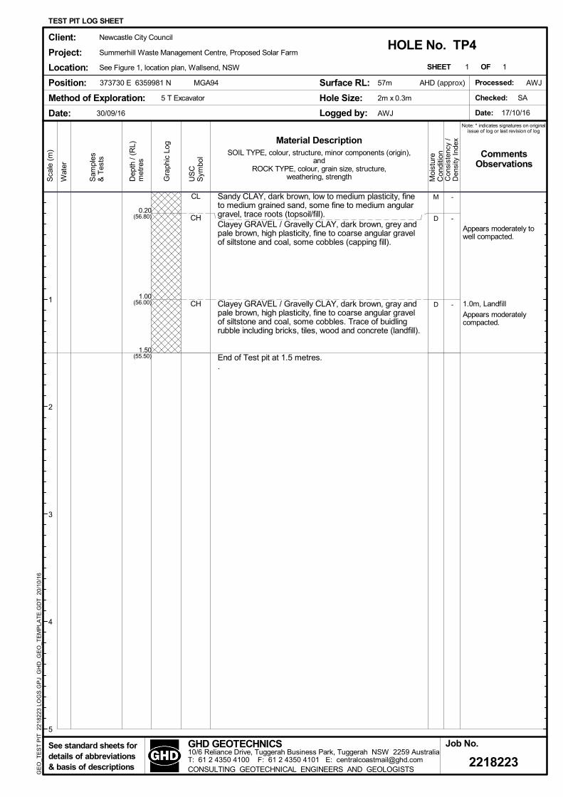
Appears moderately towell compacted.
1.0m, Landfill
Appears moderatelycompacted.
CL
CH
CH
M
D
D
(56.80)
(56.00)
(55.50)
0.20
1.00
1.50
-
-
-
Sandy CLAY, dark brown, low to medium plasticity, fineto medium grained sand, some fine to medium angulargravel, trace roots (topsoil/fill).Clayey GRAVEL / Gravelly CLAY, dark brown, grey andpale brown, high plasticity, fine to coarse angular gravelof siltstone and coal, some cobbles (capping fill).
Clayey GRAVEL / Gravelly CLAY, dark brown, gray andpale brown, high plasticity, fine to coarse angular gravelof siltstone and coal, some cobbles. Trace of buidlingrubble including bricks, tiles, wood and concrete (landfill).
End of Test pit at 1.5 metres..
SHEET OF1
2218223
Method of Exploration:
Client:
Project:
Location:
Position:
Moi
stur
eC
ondi
tion
US
CS
ymbo
l
Gra
phic
Log
Dep
th /
(RL)
met
res
1
SOIL TYPE, colour, structure, minor components (origin),and
ROCK TYPE, colour, grain size, structure,weathering, strength
TEST PIT LOG SHEET
5 T Excavator
Job No.
Con
sist
ency
/D
ensi
ty I
ndex
AWJ
30/09/16
HOLE No. TP4
MGA94
Sca
le (
m)
Wat
er
Sam
ples
& T
ests
See standard sheets fordetails of abbreviations& basis of descriptions
Date:
Surface RL:
Hole Size:
Logged by:
Material Description
Newcastle City Council
Summerhill Waste Management Centre, Proposed Solar Farm
See Figure 1, location plan, Wallsend, NSW
1
2
3
4
5
Processed:
Checked: SA
Date: 17/10/16
CommentsObservations
Note: * indicates signatures on originalissue of log or last revision of log
GE
O_T
ES
T P
IT 2
2182
23 L
OG
S.G
PJ
GH
D_G
EO
_TE
MP
LAT
E.G
DT
20/
10/
16
GHD GEOTECHNICS10/6 Reliance Drive, Tuggerah Business Park, Tuggerah NSW 2259 AustraliaT: 61 2 4350 4100 F: 61 2 4350 4101 E: [email protected] GEOTECHNICAL ENGINEERS AND GEOLOGISTS
373730 E 6359981 N 57m
2m x 0.3m
AWJ
AHD (approx)

Appears moderately towell compacted.
1.1m, Landfill
Appears moderatelycompacted.
CL
CH
CH
M
D
D
(56.90)
(55.90)
(55.60)
0.10
1.10
1.40
-
-
-
D
Sandy CLAY, brown, low to medium plasticity, finegrained sand, fine to coarse angular gravel, trace roots(topsoil/fill).Gravelly CLAY, grey, pale brown and dark grey, highplasticity, fine to coarse angular gravel and cobbles ofsiltstone and coal, trace roots (capping fill).
Gravelly CLAY, grey, pale brown and dark grey, highplasticity, fine to coarse angular gravel and cobbles ofsiltstone and coal. Some rubber, wire, metal and shoes(landfill).1.3m, possible hessian layerEnd of Test pit at 1.4 metres..
SHEET OF1
2218223
Method of Exploration:
Client:
Project:
Location:
Position:
Moi
stur
eC
ondi
tion
US
CS
ymbo
l
Gra
phic
Log
Dep
th /
(RL)
met
res
1
SOIL TYPE, colour, structure, minor components (origin),and
ROCK TYPE, colour, grain size, structure,weathering, strength
TEST PIT LOG SHEET
5 T Excavator
Job No.
Con
sist
ency
/D
ensi
ty I
ndex
AWJ
30/09/16
HOLE No. TP5
MGA94
Sca
le (
m)
Wat
er
Sam
ples
& T
ests
See standard sheets fordetails of abbreviations& basis of descriptions
Date:
Surface RL:
Hole Size:
Logged by:
Material Description
Newcastle City Council
Summerhill Waste Management Centre, Proposed Solar Farm
See Figure 1, location plan, Wallsend, NSW
1
2
3
4
5
Processed:
Checked: SA
Date: 17/10/16
CommentsObservations
Note: * indicates signatures on originalissue of log or last revision of log
GE
O_T
ES
T P
IT 2
2182
23 L
OG
S.G
PJ
GH
D_G
EO
_TE
MP
LAT
E.G
DT
20/
10/
16
GHD GEOTECHNICS10/6 Reliance Drive, Tuggerah Business Park, Tuggerah NSW 2259 AustraliaT: 61 2 4350 4100 F: 61 2 4350 4101 E: [email protected] GEOTECHNICAL ENGINEERS AND GEOLOGISTS
373798 E 6360029 N 57m
2m x 0.3m
AWJ
AHD (approx)

Appears moderately towell compacted.
1.4m, PP=200-250kPa
CL
CH
CH
M
M
M
(55.70)
(54.70)
(54.40)
0.30
1.30
1.60
-
-
VSt
D
CLAY, dark brown, low plasticity, trace fine grained sand,some roots (topsoil/fill).
Gravelly CLAY, dark brown, dark grey and pale brown,high plasticity, fine to coarse angular gravel of siltstone,coal and ironstone, trace cobbles, trace roots (cappingfill).
CLAY, pale grey mottled orange and red, high plasticity,trace sand and fine to coarse sub-angular gravel ofsandstone (residual)
End of Test pit at 1.6 metres..
SHEET OF1
2218223
Method of Exploration:
Client:
Project:
Location:
Position:
Moi
stur
eC
ondi
tion
US
CS
ymbo
l
Gra
phic
Log
Dep
th /
(RL)
met
res
1
SOIL TYPE, colour, structure, minor components (origin),and
ROCK TYPE, colour, grain size, structure,weathering, strength
TEST PIT LOG SHEET
5 T Excavator
Job No.
Con
sist
ency
/D
ensi
ty I
ndex
AWJ
30/09/16
HOLE No. TP6
MGA94
Sca
le (
m)
Wat
er
Sam
ples
& T
ests
See standard sheets fordetails of abbreviations& basis of descriptions
Date:
Surface RL:
Hole Size:
Logged by:
Material Description
Newcastle City Council
Summerhill Waste Management Centre, Proposed Solar Farm
See Figure 1, location plan, Wallsend, NSW
1
2
3
4
5
Processed:
Checked: SA
Date: 17/10/16
CommentsObservations
Note: * indicates signatures on originalissue of log or last revision of log
GE
O_T
ES
T P
IT 2
2182
23 L
OG
S.G
PJ
GH
D_G
EO
_TE
MP
LAT
E.G
DT
20/
10/
16
GHD GEOTECHNICS10/6 Reliance Drive, Tuggerah Business Park, Tuggerah NSW 2259 AustraliaT: 61 2 4350 4100 F: 61 2 4350 4101 E: [email protected] GEOTECHNICAL ENGINEERS AND GEOLOGISTS
373866 E 6360073 N 56m
2.2m x 0.3m
AWJ
AHD (approx)

Appears moderately towell compacted.
1.2m, LandfillAppears moderatelycompacted.
CL
CH
CH
M
D
D
(58.80)
(57.80)
(57.70)
0.20
1.20
1.30
-
-
-
B
CLAY, dark brown, low plasticity, some sand and finegrained gravel, trace roots (topsoil/fill).
Gravelly CLAY, dark grey, brown, and orange brown,high plasticity, fine to coarse angular gravel of siltstone,sandstone and coal, trace cobbles and boulders, traceroots (capping fill).
Gravelly CLAY, dark grey, brown, and orange brown,high plasticity, fine to coarse angular gravel of siltstone,sandstone and coal, trace cobbles and boulders. Somefabric, clothes, shoes and wood (landfill).End of Test pit at 1.3 metres..
SHEET OF1
2218223
Method of Exploration:
Client:
Project:
Location:
Position:
Moi
stur
eC
ondi
tion
US
CS
ymbo
l
Gra
phic
Log
Dep
th /
(RL)
met
res
1
SOIL TYPE, colour, structure, minor components (origin),and
ROCK TYPE, colour, grain size, structure,weathering, strength
TEST PIT LOG SHEET
5 T Excavator
Job No.
Con
sist
ency
/D
ensi
ty I
ndex
AWJ
30/09/16
HOLE No. TP7
MGA94
Sca
le (
m)
Wat
er
Sam
ples
& T
ests
See standard sheets fordetails of abbreviations& basis of descriptions
Date:
Surface RL:
Hole Size:
Logged by:
Material Description
Newcastle City Council
Summerhill Waste Management Centre, Proposed Solar Farm
See Figure 1, location plan, Wallsend, NSW
1
2
3
4
5
Processed:
Checked: SA
Date: 17/10/16
CommentsObservations
Note: * indicates signatures on originalissue of log or last revision of log
GE
O_T
ES
T P
IT 2
2182
23 L
OG
S.G
PJ
GH
D_G
EO
_TE
MP
LAT
E.G
DT
20/
10/
16
GHD GEOTECHNICS10/6 Reliance Drive, Tuggerah Business Park, Tuggerah NSW 2259 AustraliaT: 61 2 4350 4100 F: 61 2 4350 4101 E: [email protected] GEOTECHNICAL ENGINEERS AND GEOLOGISTS
373807 E 6359978 N 59m
2m x 0.3m
AWJ
AHD (approx)

Appears moderately towell compacted.
1.0m, LandfillAppears moderatelycompacted.
CL
CH
CH
M
D
D
(58.85)
(58.00)
(57.90)
0.15
1.00
1.10
-
-
-
B
CLAY, dark brown, low plasticity, some sand and fine tomedium gravel, trace roots (topsoil/fill).Gravelly CLAY, dark grey and dark brown, high plasticity,fine to coarse angular gravel of coal silstone andsandstone, trace cobbles and boulders (capping fill).
Gravelly CLAY, dark grey and dark brown, high plasticity,fine to coarse angular gravel of coal silstone andsandstone, trace cobbles and boulders. Some metalwiring/fencing (landfill).End of Test pit at 1.1 metres..
SHEET OF1
2218223
Method of Exploration:
Client:
Project:
Location:
Position:
Moi
stur
eC
ondi
tion
US
CS
ymbo
l
Gra
phic
Log
Dep
th /
(RL)
met
res
1
SOIL TYPE, colour, structure, minor components (origin),and
ROCK TYPE, colour, grain size, structure,weathering, strength
TEST PIT LOG SHEET
5 T Excavator
Job No.
Con
sist
ency
/D
ensi
ty I
ndex
AWJ
30/09/16
HOLE No. TP8
MGA94
Sca
le (
m)
Wat
er
Sam
ples
& T
ests
See standard sheets fordetails of abbreviations& basis of descriptions
Date:
Surface RL:
Hole Size:
Logged by:
Material Description
Newcastle City Council
Summerhill Waste Management Centre, Proposed Solar Farm
See Figure 1, location plan, Wallsend, NSW
1
2
3
4
5
Processed:
Checked: SA
Date: 17/10/16
CommentsObservations
Note: * indicates signatures on originalissue of log or last revision of log
GE
O_T
ES
T P
IT 2
2182
23 L
OG
S.G
PJ
GH
D_G
EO
_TE
MP
LAT
E.G
DT
20/
10/
16
GHD GEOTECHNICS10/6 Reliance Drive, Tuggerah Business Park, Tuggerah NSW 2259 AustraliaT: 61 2 4350 4100 F: 61 2 4350 4101 E: [email protected] GEOTECHNICAL ENGINEERS AND GEOLOGISTS
373711 E 6359895 N 59m
1.6m x 0.3m
AWJ
AHD (approx)

Appears moderatelycompacted.
1.3m, LandfillAppears moderatelycompacted.
CL
CH
CH
M
M
M
(44.90)
(43.70)
(43.60)
0.10
1.30
1.40
-
-
-
D
CLAY, dark brown, low plasticity, trace fine grained sand,trace roots (topsoil/fill).Gravelly CLAY, dark grey, black and brown, fine tocoarse angular gravel of siltstone and coal, tracecobbles, trace roots (capping fill).
Gravelly CLAY, dark grey, black and brown, fine tocoarse angular gravel of siltstone and coal, tracecobbles. Some building material including wire andplastic (landfill).End of Test pit at 1.4 metres..
SHEET OF1
2218223
Method of Exploration:
Client:
Project:
Location:
Position:
Moi
stur
eC
ondi
tion
US
CS
ymbo
l
Gra
phic
Log
Dep
th /
(RL)
met
res
1
SOIL TYPE, colour, structure, minor components (origin),and
ROCK TYPE, colour, grain size, structure,weathering, strength
TEST PIT LOG SHEET
5 T Excavator
Job No.
Con
sist
ency
/D
ensi
ty I
ndex
AWJ
30/09/16
HOLE No. TP9
MGA94
Sca
le (
m)
Wat
er
Sam
ples
& T
ests
See standard sheets fordetails of abbreviations& basis of descriptions
Date:
Surface RL:
Hole Size:
Logged by:
Material Description
Newcastle City Council
Summerhill Waste Management Centre, Proposed Solar Farm
See Figure 1, location plan, Wallsend, NSW
1
2
3
4
5
Processed:
Checked: SA
Date: 17/10/16
CommentsObservations
Note: * indicates signatures on originalissue of log or last revision of log
GE
O_T
ES
T P
IT 2
2182
23 L
OG
S.G
PJ
GH
D_G
EO
_TE
MP
LAT
E.G
DT
20/
10/
16
GHD GEOTECHNICS10/6 Reliance Drive, Tuggerah Business Park, Tuggerah NSW 2259 AustraliaT: 61 2 4350 4100 F: 61 2 4350 4101 E: [email protected] GEOTECHNICAL ENGINEERS AND GEOLOGISTS
373714 E 6360043 N AHD (approx)45m
2.1m x 0.3m
AWJ

Appears moderatelycompacted.0.3m, Groundwaterinflow.
1.0m, PP=180-200kPa
CH
CH
M
M(44.40)
(43.80)
0.60
1.20
-
St
B
Gravelly CLAY, brown, grey and orange, high plasticity,fine to coarse sub-angular gravel of siltstone andsandstone, trace cobbles (fill).
CLAY, grey mottled brown and red, high plasticity, tracefine sub-angular gravel, trace roots (residual).
End of Test pit at 1.2 metres..
SHEET OF1
2218223
Method of Exploration:
Client:
Project:
Location:
Position:
Moi
stur
eC
ondi
tion
US
CS
ymbo
l
Gra
phic
Log
Dep
th /
(RL)
met
res
1
SOIL TYPE, colour, structure, minor components (origin),and
ROCK TYPE, colour, grain size, structure,weathering, strength
TEST PIT LOG SHEET
5 T Excavator
Job No.
Con
sist
ency
/D
ensi
ty I
ndex
AWJ
30/09/16
HOLE No. TP10
MGA94
Sca
le (
m)
Wat
er
Sam
ples
& T
ests
See standard sheets fordetails of abbreviations& basis of descriptions
Date:
Surface RL:
Hole Size:
Logged by:
Material Description
Newcastle City Council
Summerhill Waste Management Centre, Proposed Solar Farm
See Figure 1, location plan, Wallsend, NSW
1
2
3
4
5
Processed:
Checked: SA
Date: 17/10/16
CommentsObservations
Note: * indicates signatures on originalissue of log or last revision of log
GE
O_T
ES
T P
IT 2
2182
23 L
OG
S.G
PJ
GH
D_G
EO
_TE
MP
LAT
E.G
DT
20/
10/
16
GHD GEOTECHNICS10/6 Reliance Drive, Tuggerah Business Park, Tuggerah NSW 2259 AustraliaT: 61 2 4350 4100 F: 61 2 4350 4101 E: [email protected] GEOTECHNICAL ENGINEERS AND GEOLOGISTS
AHD (approx)373507 E 6359927 N 45m
1.5m x 0.3m
AWJ

Newcastle City Council job no 22/18223
Summerhill Waste Management Centre Solar Farm
file ref
Geotechnical Investigation scale N/A
Test Pit Photos date September 2016
TP1

Newcastle City Council job no 22/18223
Summerhill Waste Management Centre Solar Farm
file ref
Geotechnical Investigation scale N/A
Test Pit Photos date September 2016
TP2

Newcastle City Council job no 22/18223
Summerhill Waste Management Centre Solar Farm
file ref
Geotechnical Investigation scale N/A
Test Pit Photos date September 2016
TP3
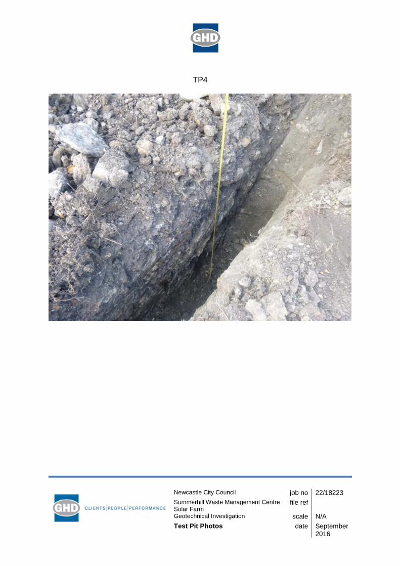
Newcastle City Council job no 22/18223
Summerhill Waste Management Centre Solar Farm
file ref
Geotechnical Investigation scale N/A
Test Pit Photos date September 2016
TP4

Newcastle City Council job no 22/18223
Summerhill Waste Management Centre Solar Farm
file ref
Geotechnical Investigation scale N/A
Test Pit Photos date September 2016
TP5

Newcastle City Council job no 22/18223
Summerhill Waste Management Centre Solar Farm
file ref
Geotechnical Investigation scale N/A
Test Pit Photos date September 2016
TP6

Newcastle City Council job no 22/18223
Summerhill Waste Management Centre Solar Farm
file ref
Geotechnical Investigation scale N/A
Test Pit Photos date September 2016
TP7

Newcastle City Council job no 22/18223
Summerhill Waste Management Centre Solar Farm
file ref
Geotechnical Investigation scale N/A
Test Pit Photos date September 2016
TP8

Newcastle City Council job no 22/18223
Summerhill Waste Management Centre Solar Farm
file ref
Geotechnical Investigation scale N/A
Test Pit Photos date September 2016
TP9

Newcastle City Council job no 22/18223
Summerhill Waste Management Centre Solar Farm
file ref
Geotechnical Investigation scale N/A
Test Pit Photos date September 2016
TP10

GHD | Report for Newcastle City Council - Summerhill Waste Management Centre - Solar Farm, 2218578
Appendix D – DCP Report Sheets

\\ghdnet\ghd\AU\Tuggerah\Projects\22\18223\Technical\Geotechnical\DCP_Template 5/10/2016
Refusal at 0.8m
0.0
0.5
1.0
1.5
2.0
2.5
3.0
0 5 10 15 20 25 30
Client:
Project:
Location:
Newcastle City Council
Summerhill Waste Solar Farm
Summerhill Waste Management Centre
PROBE: DCP1
Job No.
2218223
Comments:
NUMBER OF BLOWS TO PENETRATE 100mm (n100)
DE
PT
H (
m)
mm drop height.510AS 1289.6.3.2-1997 (Cone Tip)
Position:
Date:
Refer to test location plan
30/9/16
Chainage:Elevation: -
Operator: AWJ‐Offset: -
Adjacent Test Hole / Pit: TP1
Position Relative to Test Hole / Pit: -
DYNAMIC CONE PENETROMETER LOG SHEET
Checked:
Date:
CONSULTING GEOTECHNICAL ENGINEERS AND GEOLOGISTSLevel 2, GHD Tower, Honeysuckle Drive, Newcastle, NSW, 2300 AustraliaTelephone: 61 2 4979 9999 Fax: 61 2 4979 9988 Email: [email protected]
GHD GEOTECHNICS

\\ghdnet\ghd\AU\Tuggerah\Projects\22\18223\Technical\Geotechnical\DCP_Template 5/10/2016
Refusal at 0.3m
0.0
0.5
1.0
1.5
2.0
2.5
3.0
0 5 10 15 20 25 30
Client:
Project:
Location:
Newcastle City Council
Summerhill Waste Solar Farm
Summerhill Waste Management Centre
PROBE: DCP2
Job No.
2218223
Comments:
NUMBER OF BLOWS TO PENETRATE 100mm (n100)
DE
PT
H (
m)
mm drop height.510AS 1289.6.3.2-1997 (Cone Tip)
Position:
Date:
Refer to test location plan
30/9/16
Chainage:Elevation: -
Operator: AWJ‐Offset: -
Adjacent Test Hole / Pit: TP2
Position Relative to Test Hole / Pit: -
DYNAMIC CONE PENETROMETER LOG SHEET
Checked:
Date:
CONSULTING GEOTECHNICAL ENGINEERS AND GEOLOGISTSLevel 2, GHD Tower, Honeysuckle Drive, Newcastle, NSW, 2300 AustraliaTelephone: 61 2 4979 9999 Fax: 61 2 4979 9988 Email: [email protected]
GHD GEOTECHNICS

\\ghdnet\ghd\AU\Tuggerah\Projects\22\18223\Technical\Geotechnical\DCP_Template 5/10/2016
Refusal at 0.3m
0.0
0.5
1.0
1.5
2.0
2.5
3.0
0 5 10 15 20 25 30
Client:
Project:
Location:
Newcastle City Council
Summerhill Waste Solar Farm
Summerhill Waste Management Centre
PROBE: DCP3
Job No.
2218223
Comments:
NUMBER OF BLOWS TO PENETRATE 100mm (n100)
DE
PT
H (
m)
mm drop height.510AS 1289.6.3.2-1997 (Cone Tip)
Position:
Date:
Refer to test location plan
30/9/16
Chainage:Elevation: -
Operator: AWJ‐Offset: -
Adjacent Test Hole / Pit: TP3
Position Relative to Test Hole / Pit: -
DYNAMIC CONE PENETROMETER LOG SHEET
Checked:
Date:
CONSULTING GEOTECHNICAL ENGINEERS AND GEOLOGISTSLevel 2, GHD Tower, Honeysuckle Drive, Newcastle, NSW, 2300 AustraliaTelephone: 61 2 4979 9999 Fax: 61 2 4979 9988 Email: [email protected]
GHD GEOTECHNICS
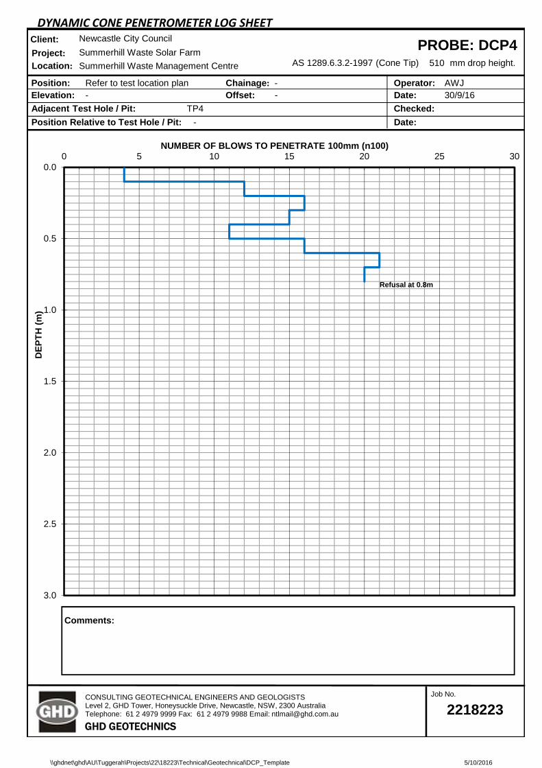
\\ghdnet\ghd\AU\Tuggerah\Projects\22\18223\Technical\Geotechnical\DCP_Template 5/10/2016
Refusal at 0.8m
0.0
0.5
1.0
1.5
2.0
2.5
3.0
0 5 10 15 20 25 30
Client:
Project:
Location:
Newcastle City Council
Summerhill Waste Solar Farm
Summerhill Waste Management Centre
PROBE: DCP4
Job No.
2218223
Comments:
NUMBER OF BLOWS TO PENETRATE 100mm (n100)
DE
PT
H (
m)
mm drop height.510AS 1289.6.3.2-1997 (Cone Tip)
Position:
Date:
Refer to test location plan
30/9/16
Chainage:Elevation: -
Operator: AWJ‐Offset: -
Adjacent Test Hole / Pit: TP4
Position Relative to Test Hole / Pit: -
DYNAMIC CONE PENETROMETER LOG SHEET
Checked:
Date:
CONSULTING GEOTECHNICAL ENGINEERS AND GEOLOGISTSLevel 2, GHD Tower, Honeysuckle Drive, Newcastle, NSW, 2300 AustraliaTelephone: 61 2 4979 9999 Fax: 61 2 4979 9988 Email: [email protected]
GHD GEOTECHNICS

\\ghdnet\ghd\AU\Tuggerah\Projects\22\18223\Technical\Geotechnical\DCP_Template 5/10/2016
Hammer Bouncing. Refusal at 0.8m
0.0
0.5
1.0
1.5
2.0
2.5
3.0
0 5 10 15 20 25 30
Client:
Project:
Location:
Newcastle City Council
Summerhill Waste Solar Farm
Summerhill Waste Management Centre
PROBE: DCP5
Job No.
2218223
Comments:
NUMBER OF BLOWS TO PENETRATE 100mm (n100)
DE
PT
H (
m)
mm drop height.510AS 1289.6.3.2-1997 (Cone Tip)
Position:
Date:
Refer to test location plan
30/9/16
Chainage:Elevation: -
Operator: AWJ‐Offset: -
Adjacent Test Hole / Pit: TP5
Position Relative to Test Hole / Pit: -
DYNAMIC CONE PENETROMETER LOG SHEET
Checked:
Date:
CONSULTING GEOTECHNICAL ENGINEERS AND GEOLOGISTSLevel 2, GHD Tower, Honeysuckle Drive, Newcastle, NSW, 2300 AustraliaTelephone: 61 2 4979 9999 Fax: 61 2 4979 9988 Email: [email protected]
GHD GEOTECHNICS

\\ghdnet\ghd\AU\Tuggerah\Projects\22\18223\Technical\Geotechnical\DCP_Template 5/10/2016
Limit of Test. End of probe at 1.7m
0.0
0.5
1.0
1.5
2.0
2.5
3.0
0 5 10 15 20 25 30
Client:
Project:
Location:
Newcastle City Council
Summerhill Waste Solar Farm
Summerhill Waste Management Centre
PROBE: DCP6
Job No.
2218223
Comments:
NUMBER OF BLOWS TO PENETRATE 100mm (n100)
DE
PT
H (
m)
mm drop height.510AS 1289.6.3.2-1997 (Cone Tip)
Position:
Date:
Refer to test location plan
30/9/16
Chainage:Elevation: -
Operator: AWJ‐Offset: -
Adjacent Test Hole / Pit: TP6
Position Relative to Test Hole / Pit: -
DYNAMIC CONE PENETROMETER LOG SHEET
Checked:
Date:
CONSULTING GEOTECHNICAL ENGINEERS AND GEOLOGISTSLevel 2, GHD Tower, Honeysuckle Drive, Newcastle, NSW, 2300 AustraliaTelephone: 61 2 4979 9999 Fax: 61 2 4979 9988 Email: [email protected]
GHD GEOTECHNICS

\\ghdnet\ghd\AU\Tuggerah\Projects\22\18223\Technical\Geotechnical\DCP_Template 5/10/2016
Refusal at 1.1m
0.0
0.5
1.0
1.5
2.0
2.5
3.0
0 5 10 15 20 25 30
Client:
Project:
Location:
Newcastle City Council
Summerhill Waste Solar Farm
Summerhill Waste Management Centre
PROBE: DCP7
Job No.
2218223
Comments:
NUMBER OF BLOWS TO PENETRATE 100mm (n100)
DE
PT
H (
m)
mm drop height.510AS 1289.6.3.2-1997 (Cone Tip)
Position:
Date:
Refer to test location plan
30/9/16
Chainage:Elevation: -
Operator: AWJ‐Offset: -
Adjacent Test Hole / Pit: TP7
Position Relative to Test Hole / Pit: -
DYNAMIC CONE PENETROMETER LOG SHEET
Checked:
Date:
CONSULTING GEOTECHNICAL ENGINEERS AND GEOLOGISTSLevel 2, GHD Tower, Honeysuckle Drive, Newcastle, NSW, 2300 AustraliaTelephone: 61 2 4979 9999 Fax: 61 2 4979 9988 Email: [email protected]
GHD GEOTECHNICS

\\ghdnet\ghd\AU\Tuggerah\Projects\22\18223\Technical\Geotechnical\DCP_Template 5/10/2016
Practical. Refusal at 1.1m
0.0
0.5
1.0
1.5
2.0
2.5
3.0
0 5 10 15 20 25 30
Client:
Project:
Location:
Newcastle City Council
Summerhill Waste Solar Farm
Summerhill Waste Management Centre
PROBE: DCP8
Job No.
2218223
Comments:
NUMBER OF BLOWS TO PENETRATE 100mm (n100)
DE
PT
H (
m)
mm drop height.510AS 1289.6.3.2-1997 (Cone Tip)
Position:
Date:
Refer to test location plan
30/9/16
Chainage:Elevation: -
Operator: AWJ‐Offset: -
Adjacent Test Hole / Pit: TP8
Position Relative to Test Hole / Pit: -
DYNAMIC CONE PENETROMETER LOG SHEET
Checked:
Date:
CONSULTING GEOTECHNICAL ENGINEERS AND GEOLOGISTSLevel 2, GHD Tower, Honeysuckle Drive, Newcastle, NSW, 2300 AustraliaTelephone: 61 2 4979 9999 Fax: 61 2 4979 9988 Email: [email protected]
GHD GEOTECHNICS

\\ghdnet\ghd\AU\Tuggerah\Projects\22\18223\Technical\Geotechnical\DCP_Template 5/10/2016
Hammer Bouncing. Refusal at 1.4m
0.0
0.5
1.0
1.5
2.0
2.5
3.0
0 5 10 15 20 25 30
Client:
Project:
Location:
Newcastle City Council
Summerhill Waste Solar Farm
Summerhill Waste Management Centre
PROBE: DCP9
Job No.
2218223
Comments:
NUMBER OF BLOWS TO PENETRATE 100mm (n100)
DE
PT
H (
m)
mm drop height.510AS 1289.6.3.2-1997 (Cone Tip)
Position:
Date:
Refer to test location plan
30/9/16
Chainage:Elevation: -
Operator: AWJ‐Offset: -
Adjacent Test Hole / Pit: TP9
Position Relative to Test Hole / Pit: -
DYNAMIC CONE PENETROMETER LOG SHEET
Checked:
Date:
CONSULTING GEOTECHNICAL ENGINEERS AND GEOLOGISTSLevel 2, GHD Tower, Honeysuckle Drive, Newcastle, NSW, 2300 AustraliaTelephone: 61 2 4979 9999 Fax: 61 2 4979 9988 Email: [email protected]
GHD GEOTECHNICS

\\ghdnet\ghd\AU\Tuggerah\Projects\22\18223\Technical\Geotechnical\DCP_Template 5/10/2016
Limit of Test. End of probe at 0.9m
0.0
0.5
1.0
1.5
2.0
2.5
3.0
0 5 10 15 20 25 30
Client:
Project:
Location:
Newcastle City Council
Summerhill Waste Solar Farm
Summerhill Waste Management Centre
PROBE: DCP10
Job No.
2218223
Comments:
NUMBER OF BLOWS TO PENETRATE 100mm (n100)
DE
PT
H (
m)
mm drop height.510AS 1289.6.3.2-1997 (Cone Tip)
Position:
Date:
Refer to test location plan
30/9/16
Chainage:Elevation: -
Operator: AWJ‐Offset: -
Adjacent Test Hole / Pit: TP10
Position Relative to Test Hole / Pit: -
DYNAMIC CONE PENETROMETER LOG SHEET
Checked:
Date:
CONSULTING GEOTECHNICAL ENGINEERS AND GEOLOGISTSLevel 2, GHD Tower, Honeysuckle Drive, Newcastle, NSW, 2300 AustraliaTelephone: 61 2 4979 9999 Fax: 61 2 4979 9988 Email: [email protected]
GHD GEOTECHNICS

GHD | Report for Newcastle City Council - Summerhill Waste Management Centre - Solar Farm, 2218578 | 15
Appendix E – Laboratory Test Results

TP2_0.4BH / TP No.0.4 - 0.5Depth (m)
Sample DetailsSYD16-0364-03GHD Sample NoSampled by GHDSampled By
CLAY: mottled grey, red and orangeSoil Description
30/09/2016Date Sampled
Test Results
Four Point50NoNoNo
0N/A
Dry SievedOven-dried7/10/2016
20.9Result
Moisture Content (%) AS 1289.2.1.1MethodDescription Limits
Date TestedSample History AS 1289.1.1Preparation AS 1289.1.1 Linear Shrinkage (%) AS 1289.3.4.1Mould Length (mm)CrumblingCurlingCrackingLiquid Limit (%) AS 1289.3.1.1Method
23Plastic Limit (%) AS 1289.3.2.127Plasticity Index (%) AS 1289.3.3.1
13/10/2016Date Tested
Sydney Laboratory 57 Herbert StArtarmon NSW 2064email: [email protected]: www.ghd.com.au/ghdgeotechnicsTel: (02) 9462 4860Fax:(02) 9462 4710
Aggregate/Soil Test Report Report No: SYD1601662Issue No: 1
This report replaces all previous issues of report no 'SYD1601662'.Accredited for compliance with ISO / IEC 17025
19/10/2016NATA Accredited
Laboratory Number:679 Date of Issue:
THIS DOCUMENT SHALL NOT BE REPRODUCED EXCEPT IN FULL
Client:
Project: 2218223
Newcastle City CouncilSummerhill Waste Management Centre Wallsend NSW Summerhill Waste Solar Farm
Approved Signatory: D.P Brooke (Sydney Laboratory Manager)
Page 1 of 1© 2000-2013 QESTLab by SpectraQEST.comForm No: 18909, Report No: SYD1601662
N/AComments

TP5_0.5BH / TP No.0.5 - 0.6Depth (m)
Sample DetailsSYD16-0364-04GHD Sample NoSampled by GHDSampled By
Gravelly CLAY: dark brown, with SiltSoil Description
30/09/2016Date Sampled
Test Results
Four Point43NoNoNo
0N/A
Dry SievedOven-dried7/10/2016
15.5Result
Moisture Content (%) AS 1289.2.1.1MethodDescription Limits
Date TestedSample History AS 1289.1.1Preparation AS 1289.1.1 Linear Shrinkage (%) AS 1289.3.4.1Mould Length (mm)CrumblingCurlingCrackingLiquid Limit (%) AS 1289.3.1.1Method
22Plastic Limit (%) AS 1289.3.2.121Plasticity Index (%) AS 1289.3.3.1
13/10/2016Date Tested
Sydney Laboratory 57 Herbert StArtarmon NSW 2064email: [email protected]: www.ghd.com.au/ghdgeotechnicsTel: (02) 9462 4860Fax:(02) 9462 4710
Aggregate/Soil Test Report Report No: SYD1601663Issue No: 1
This report replaces all previous issues of report no 'SYD1601663'.Accredited for compliance with ISO / IEC 17025
19/10/2016NATA Accredited
Laboratory Number:679 Date of Issue:
THIS DOCUMENT SHALL NOT BE REPRODUCED EXCEPT IN FULL
Client:
Project: 2218223
Newcastle City CouncilSummerhill Waste Management Centre Wallsend NSW Summerhill Waste Solar Farm
Approved Signatory: D.P Brooke (Sydney Laboratory Manager)
Page 1 of 1© 2000-2013 QESTLab by SpectraQEST.comForm No: 18909, Report No: SYD1601663
N/AComments

TP8_0.5BH / TP No.0.5 - 0.7Depth (m)
Sample DetailsSYD16-0364-05GHD Sample NoSampled by GHDSampled By
Gravelly CLAY: dark brownSoil Description
30/09/2016Date Sampled
Test Results
Four Point47NoNoNo
0N/A
Dry SievedAir
7/10/201614.1
ResultMoisture Content (%) AS 1289.2.1.1
MethodDescription LimitsDate TestedSample History AS 1289.1.1Preparation AS 1289.1.1 Linear Shrinkage (%) AS 1289.3.4.1Mould Length (mm)CrumblingCurlingCrackingLiquid Limit (%) AS 1289.3.1.1Method
22Plastic Limit (%) AS 1289.3.2.125Plasticity Index (%) AS 1289.3.3.1
13/10/2016Date Tested
Sydney Laboratory 57 Herbert StArtarmon NSW 2064email: [email protected]: www.ghd.com.au/ghdgeotechnicsTel: (02) 9462 4860Fax:(02) 9462 4710
Aggregate/Soil Test Report Report No: SYD1601664Issue No: 1
This report replaces all previous issues of report no 'SYD1601664'.Accredited for compliance with ISO / IEC 17025
19/10/2016NATA Accredited
Laboratory Number:679 Date of Issue:
THIS DOCUMENT SHALL NOT BE REPRODUCED EXCEPT IN FULL
Client:
Project: 2218223
Newcastle City CouncilSummerhill Waste Management Centre Wallsend NSW Summerhill Waste Solar Farm
Approved Signatory: D.P Brooke (Sydney Laboratory Manager)
Page 1 of 1© 2000-2013 QESTLab by SpectraQEST.comForm No: 18909, Report No: SYD1601664
N/AComments

Sample DetailsGHD Sample No: SYD16-0364-01 Client Sample ID:Date Sampled: 30/09/2016 Sampled By: Sampled by GHDLocation: BH /TP No: TP1_0.2Date Tested: 17/10/2016 Depth (m): 0.2 - 0.5Sample Description: Clayey GRAVEL: grey, with Sand
Test ResultsAS 1289.6.1.1
CBR At 5.0mm (%): 6Maximum Dry Density (t/m³): 1.78Optimum Moisture Content (%): 16.2Dry Density before Soaking (t/m³): 1.74Density Ratio before Soaking (%): 98Moisture Content before Soaking (%): 16.2Moisture Ratio before Soaking (%): 100Dry Density after Soaking (t/m³): 1.72Density Ratio after Soaking (%): 97Swell (%): 1.5Moisture Content of Top 30mm (%): 19.3Moisture Content of Remaining Depth (%): 18.5Compactive Effort: StandardSurcharge Mass (kg): 4.50Period of Soaking (Days): 4Oversize Material: ExcludedOversize Material (%): 30.6
———— AS 1289.2.1.1 ————Field Moisture Content (%): 18.9
Load vs Penetration
Sydney Laboratory 57 Herbert StArtarmon NSW 2064email: [email protected]: www.ghd.com.au/ghdgeotechnicsTel: (02) 9462 4860Fax:(02) 9462 4710
California Bearing Ratio Test Report Report No: CBR:SYD16-0364-01Issue No: 1
This report replaces all previous issues of report no 'CBR:SYD16-0364-01'.Accredited for compliance with ISO / IEC 17025
19/10/2016NATA Accredited
Laboratory Number:679 Date of Issue:
THIS DOCUMENT SHALL NOT BE REPRODUCED EXCEPT IN FULL
Client:
Project: 2218223
Newcastle City CouncilSummerhill Waste Management Centre Wallsend NSW Summerhill Waste Solar Farm
Approved Signatory: D.P Brooke (Sydney Laboratory Manager)
Page 1 of 1Form No: 18986, Report No: CBR:SYD16-0364-01 © 2000-2013 QESTLab by SpectraQEST.com
Comments
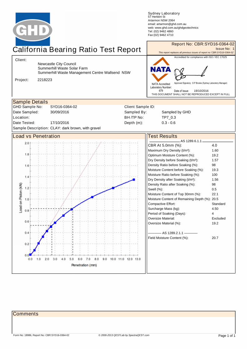
Sample DetailsGHD Sample No: SYD16-0364-02 Client Sample ID:Date Sampled: 30/09/2016 Sampled By: Sampled by GHDLocation: BH /TP No: TP7_0.3Date Tested: 17/10/2016 Depth (m): 0.3 - 0.6Sample Description: CLAY: dark brown, with gravel
Test ResultsAS 1289.6.1.1
CBR At 5.0mm (%): 4.0Maximum Dry Density (t/m³): 1.60Optimum Moisture Content (%): 19.2Dry Density before Soaking (t/m³): 1.57Density Ratio before Soaking (%): 98Moisture Content before Soaking (%): 19.3Moisture Ratio before Soaking (%): 100Dry Density after Soaking (t/m³): 1.56Density Ratio after Soaking (%): 98Swell (%): 0.5Moisture Content of Top 30mm (%): 22.1Moisture Content of Remaining Depth (%): 20.5Compactive Effort: StandardSurcharge Mass (kg): 4.50Period of Soaking (Days): 4Oversize Material: ExcludedOversize Material (%): 19.2
———— AS 1289.2.1.1 ————Field Moisture Content (%): 20.7
Load vs Penetration
Sydney Laboratory 57 Herbert StArtarmon NSW 2064email: [email protected]: www.ghd.com.au/ghdgeotechnicsTel: (02) 9462 4860Fax:(02) 9462 4710
California Bearing Ratio Test Report Report No: CBR:SYD16-0364-02Issue No: 1
This report replaces all previous issues of report no 'CBR:SYD16-0364-02'.Accredited for compliance with ISO / IEC 17025
19/10/2016NATA Accredited
Laboratory Number:679 Date of Issue:
THIS DOCUMENT SHALL NOT BE REPRODUCED EXCEPT IN FULL
Client:
Project: 2218223
Newcastle City CouncilSummerhill Waste Management Centre Wallsend NSW Summerhill Waste Solar Farm
Approved Signatory: D.P Brooke (Sydney Laboratory Manager)
Page 1 of 1Form No: 18986, Report No: CBR:SYD16-0364-02 © 2000-2013 QESTLab by SpectraQEST.com
Comments

CERTIFICATE OF ANALYSIS 155108
Client:
GHD Pty Ltd
57-63 Herbert StreetArtarmonNSW 2064
Attention: David Brooke
Sample log in details:
Your Reference: 2218223, Newcastle City Council, Summerhill
No. of samples: 2 SoilsDate samples received / completed instructions received 12/10/16 / 12/10/16
Analysis Details:
Please refer to the following pages for results, methodology summary and quality control data.Samples were analysed as received from the client. Results relate specifically to the samples as received.Results are reported on a dry weight basis for solids and on an as received basis for other matrices.Please refer to the last page of this report for any comments relating to the results.
Report Details:
Date results requested by: / Issue Date: 19/10/16 / 17/10/16Date of Preliminary Report: Not IssuedNATA accreditation number 2901. This document shall not be reproduced except in full.Accredited for compliance with ISO/IEC 17025 - Testing Tests not covered by NATA are denoted with *.
Results Approved By:
Page 1 of 6Envirolab Reference: 155108Revision No: R 00

Client Reference: 2218223, Newcastle City Council, Summerhill
Misc Inorg - Soil Our Reference: UNITS 155108-1 155108-2Your Reference ------------
-TP2 TP9
Depth ------------ 0.4-0.5 0.3-0.4Type of sample Soil SoilDate prepared - 13/10/2016 13/10/2016 Date analysed - 13/10/2016 13/10/2016
pH 1:5 soil:water pH Units 5.0 6.1 Electrical Conductivity 1:5
soil:waterµS/cm 310 48
Chloride, Cl 1:5 soil:water mg/kg 320 <10 Sulphate, SO4 1:5 soil:water mg/kg 170 26
Page 2 of 6Envirolab Reference: 155108Revision No: R 00

Client Reference: 2218223, Newcastle City Council, Summerhill
Method ID Methodology Summary Inorg-001 pH - Measured using pH meter and electrode in accordance with APHA latest edition, 4500-H+. Please note
that the results for water analyses are indicative only, as analysis outside of the APHA storage times.
Inorg-002 Conductivity and Salinity - measured using a conductivity cell at 25oC in accordance with APHA latest edition 2510 and Rayment & Lyons.
Inorg-081 Anions - a range of Anions are determined by Ion Chromatography, in accordance with APHA latest edition, 4110-B. Alternatively determined by colourimetry/turbidity using Discrete Analyer.
Page 3 of 6Envirolab Reference: 155108Revision No: R 00

Client Reference: 2218223, Newcastle City Council, Summerhill
QUALITY CONTROL UNITS PQL METHOD Blank Duplicate Sm#
Duplicate results Spike Sm# Spike % Recovery
Misc Inorg - Soil Base ll Duplicate ll %RPDDate prepared - 13/10/2
016[NT] [NT] LCS-1 13/10/2016
Date analysed - 13/10/2016
[NT] [NT] LCS-1 13/10/2016
pH 1:5 soil:water pH Units Inorg-001 [NT] [NT] [NT] LCS-1 100%Electrical Conductivity
1:5 soil:waterµS/cm 1 Inorg-002 <1 [NT] [NT] LCS-1 100%
Chloride, Cl 1:5 soil:water
mg/kg 10 Inorg-081 <10 [NT] [NT] LCS-1 88%
Sulphate, SO4 1:5 soil:water
mg/kg 10 Inorg-081 <10 [NT] [NT] LCS-1 94%
Page 4 of 6Envirolab Reference: 155108Revision No: R 00

Client Reference: 2218223, Newcastle City Council, Summerhill
Report Comments:
Asbestos ID was analysed by Approved Identifier: Not applicable for this jobAsbestos ID was authorised by Approved Signatory: Not applicable for this job
INS: Insufficient sample for this test PQL: Practical Quantitation Limit NT: Not testedNR: Test not required RPD: Relative Percent Difference NA: Test not required<: Less than >: Greater than LCS: Laboratory Control Sample
Page 5 of 6Envirolab Reference: 155108Revision No: R 00

Client Reference: 2218223, Newcastle City Council, Summerhill
Quality Control Definitions
Blank: This is the component of the analytical signal which is not derived from the sample but from reagents, glassware etc, can be determined by processing solvents and reagents in exactly the same manner as for samples. Duplicate : This is the complete duplicate analysis of a sample from the process batch. If possible, the sampleselected should be one where the analyte concentration is easily measurable. Matrix Spike : A portion of the sample is spiked with a known concentration of target analyte. The purpose of the matrix spike is to monitor the performance of the analytical method used and to determine whether matrix interferences exist. LCS (Laboratory Control Sample) : This comprises either a standard reference material or a control matrix (such as a blanksand or water) fortified with analytes representative of the analyte class. It is simply a check sample. Surrogate Spike: Surrogates are known additions to each sample, blank, matrix spike and LCS in a batch, of compoundswhich are similar to the analyte of interest, however are not expected to be found in real samples.
Laboratory Acceptance Criteria
Duplicate sample and matrix spike recoveries may not be reported on smaller jobs, however, were analysed at a frequencyto meet or exceed NEPM requirements. All samples are tested in batches of 20. The duplicate sample RPD and matrixspike recoveries for the batch were within the laboratory acceptance criteria.Filters, swabs, wipes, tubes and badges will not have duplicate data as the whole sample is generally extracted during sample extraction.Spikes for Physical and Aggregate Tests are not applicable.For VOCs in water samples, three vials are required for duplicate or spike analysis.
Duplicates: <5xPQL - any RPD is acceptable; >5xPQL - 0-50% RPD is acceptable.Matrix Spikes, LCS and Surrogate recoveries: Generally 70-130% for inorganics/metals; 60-140%for organics (+/-50% surrogates) and 10-140% for labile SVOCs (including labile surrogates), ultra trace organics and speciated phenols is acceptable.
In circumstances where no duplicate and/or sample spike has been reported at 1 in 10 and/or 1 in 20 samples respectively, the sample volume submitted was insufficient in order to satisfy laboratory QA/QC protocols.
When samples are received where certain analytes are outside of recommended technical holding times (THTs), the analysis has proceeded. Where analytes are on the verge of breaching THTs, every effort will be made to analyse within the THT or as soon as practicable.
Where sampling dates are not provided, Envirolab are not in a position to comment on the validityof the analysis where recommended technical holding times may have been breached.
Measurement Uncertainty estimates are available for most tests upon request.
Page 6 of 6Envirolab Reference: 155108Revision No: R 00

GHD
57-63 Herbert Street T: 61 2 9462 4700 F: 61 2 9462 4710 E: [email protected]
© GHD 2016
This document is and shall remain the property of GHD. The document may only be used for the purpose for which it was commissioned and in accordance with the Terms of Engagement for the commission. Unauthorised use of this document in any form whatsoever is prohibited.
GHDDocId/\\tug-svr-001\projects\22\18223\Technical\Geotechnical\2218233_REP-Geotechnical Investigation Report.docx
Document Status
Rev No.
Author Reviewer Approved for Issue
Name Signature Name Signature Date
0 A Wynne Jones
S Amoroso D.Barrett 21/10/2016

www.ghd.com


