Embed Size (px)
Citation preview
Alaska FISHERIES SCIENCE CENTER
Research to Determine the Distributions of Deep-Sea Corals and Sponges Throughout Alaska
Quarterly ReportOctober November
December
2013
U.S. Department of Commerce | National Oceanic and Atmospheric Administration | National Marine Fisheries Service
AFSC DIRECTORATE . . Science and Research Director: Douglas DeMasterDeputy Director: Steve Ignell
AUKE BAY LABORATORIES . . . . . . . . . . . . . . . . . . . . . . Director: Phillip Mundy
Deputy Director: Pete HagenFISHERIES MONITORING & ANALYSIS DIVISION . . . . . . . . . . . . . . . . . .Director: Martin Loefflad
Deputy Director: Chris RillingHABITAT & ECOLOGICAL PROCESSES RESEARCH . . . . . . . . . . . . . . . . Director: Michael SiglerNATIONAL MARINE MAMMAL LABORATORY . . . . . . . . . . . . . . . . Director: John Bengtson
Deputy Director: Robyn AnglissOPERATIONS MANAGEMENT & INFORMATION . . . . . . . . . . . . . . . . . . . . . . . . Director: Lori BudbillOFFICE OF FISHERIES INFORMATION SYSTEMS . . . . . . . . . . . . . . . Director: Ajith AbrahamRESOURCE ASSESSMENT & CONSERVATION ENGINEERING DIVISION . . . . Director: Russell Nelson Jr .
Deputy Director: Guy FleischerRESOURCE ECOLOGY & FISHERIES MANAGEMENT DIVISION . . . . . . . Director: Patricia Livingston
Deputy Director: Dan Ito
The Alaska Fisheries Science Center (AFSC) Quarterly Report is produced by the Center’s Communications Program.
PUBLICATION LIMITATION. Publication in whole or in part of the Quarterly Report should indicate the provisional nature of the findings and show credit to the appropriate research division of the AFSC. Advance copy should be submitted to the AFSC.
References to trade names do not imply endorsement by the National Marine Fisheries Service.
www.afsc.noaa.gov
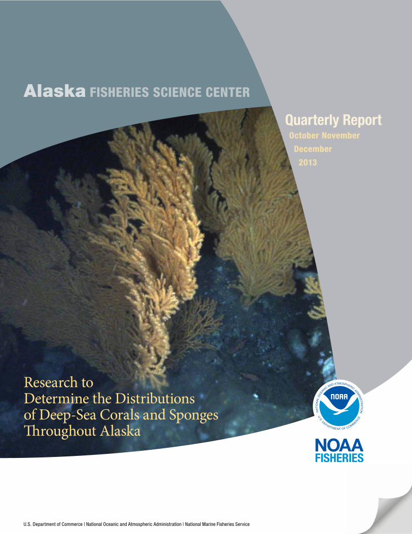
Cover image . Rockfish (Sebastes spp.) in a red tree coral (Primnoa pacifica) thicket at the Fairweather Grounds in southeast Alaska . The image was taken using a stereo drop camera developed by AFSC researchers (K. Williams, R. Towler, C. Rooper)
in August 2013 aboard the Alaska Department of Fish and Game research vessel Mediea.
Alaska FISHERIES SCIENCE CENTER
AFSC Quarterly Report
iii
CONTENTS
Feature . . . . . . . . . . . . . . . . . . . . . . . . . . . . . . . . 1• Research to Determine the
Distributions of Deep-Sea Corals and Sponges Throughout Alaska
Fisheries Monitoring and Analysis (FMA) Division . . . . . 5• FMA Observer Program Activities in 2013
National Marine Mammal Laboratory (NMML) . . . . . . . . . 6Alaska Ecosystems Program
• Re-examining Habitat Segregation and Foraging Effort of Northern Fur Seals after 15 Years of Decline
Cetacean Assessment & Ecology Program
• Gray Whale Calf Occurrence in the Alaskan Arctic, Summer and Fall 2013, with Comparisons to Previous Years
• Investigating the Foraging and Diving Behavior of “Transient”-type Killer Whales in the Central and Western Aleutians
Resource Assessment and Conservation Engineering (RACE) Division . . . . . . . . . . . . 13
Groundfish Assessment Program
• Yes, Virginia, Walleye Pollock is Gadus chalcogrammus
Resource Ecology and Fisheries Management (REFM) Division . . . . . . . . . . . . . . . 14
Resource Ecology & Ecosystem Modeling Program
• Fish Stomach Collection and Lab Analysis
• Ecosystem Modeling
• Seabird Bycatch Estimates for Alaskan Groundfish Fisheries, 1993-2012
Economics & Social Sciences Research Program
• Bering Sea Tanner Crab Bioeconomic Model to Forecast Effects of Ocean Acidification
• Measuring the Economic Contribution of Alaska Head and Gut Catcher-Processors
• Fishery Income Diversification and Risk for Fishermen and Fishing Communities of the U.S. West Coast and Alaska
• Cost and Earning Estimates of the Alaska Saltwater Sport Fishing Charter Sector
• Gulf of Alaska Trawl Fishery, Rationalization Sociocultural Study
• Advances in the Stock Assessment and Fisheries Evaluation – Economic Status Report
October November December 2013
iv
CONTENTS
REFM continued Status of Stocks & Multispecies Assessment Program
• AFSC Researchers Support 2014 Biological Opinion
• Big Water, Little Boat: The 2013 GOAIERP Inshore Surveys
• 2013 Groundfish Stock Assessments
Age & Growth Program
• Age and Growth Program Production Numbers
Publications & Reports . . . . . . . . . . . . . . . . . . . . 24
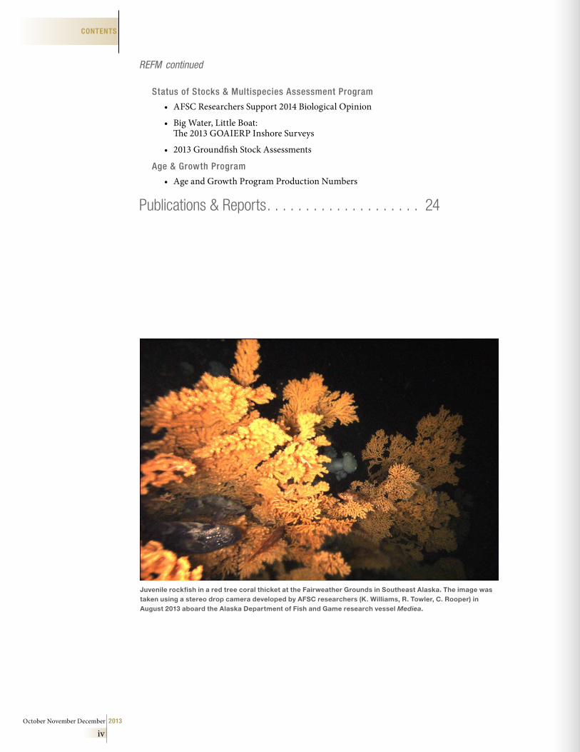
Juvenile rockfish in a red tree coral thicket at the Fairweather Grounds in Southeast Alaska . The image was taken using a stereo drop camera developed by AFSC researchers (K . Williams, R . Towler, C . Rooper) in August 2013 aboard the Alaska Department of Fish and Game research vessel Mediea .
AFSC Quarterly Report
1
AFSCRESEARCH FEATURE
Research to Determine the Distributions of Deep-Sea Corals and Sponges Throughout AlaskaBy Chris Rooper, Mike Sigler, Gerald Hoff, Bob Stone and Mark Zimmermann
The U.S. Exclusive Economic Zone off Alaska covers 3.3 million km2 and contains more than 70% of the U.S. continental shelf. These marine waters support a diverse and abundant collection of fish and invertebrate species, many of which are harvested by the commercial fishing industry. The harvest of these resources consistently puts Alaska at the nation’s top in terms of volume and value of commercial landings, with 5.3 billion pounds and $1.7 billion in 2012. Alaska’s continental shelf also contains significant deposits of oil and precious minerals which support resource extraction activities contributing to the national and state economies. Accordingly Alaska’s marine resources and their associated activities require scientific research to support well-informed management practices in response to the impact of human activities and the effects of global warming.
NavarinCanyon
U.S.-Russia Border
PervenetsCanyon
ZhemchugCanyon
PribilofCanyon
BeringCanyon
Outer shelf Middle shelf
Inner shelf
BeringSea
Gulf ofAlaska
ALEUTIAN ISLANDS
Seattle
Deep-sea coral and sponge ecosys-tems are widespread throughout most of Alaska’s marine waters. Some areas, such as the western Aleutian Islands, may contain the most abundant and diverse cold-water coral and sponge species assemblages in the world. Many different fish and invertebrate species in
Alaska are associated with deep-sea coral and sponge communities. For example, the consistent association of juvenile Pacific ocean perch (Sebastes alutus) with sponges and corals may imply better growth or sur-vival for this species in these habitats.
Challenges facing management of deep coral and sponge ecosystems in Alaska begin with the lack of specific knowledge of where these organisms occur in high abundance and diversity. Because of the size and scope of Alaska’s continental shelf and slope, the vast majority of the area has not been surveyed for the pres-ence of coral and sponge communities. It is difficult to predict the locations and types of human activities that may be threats to the deep-sea coral and sponge ecosystems, because the spatial distribution of these communities in Alaska waters is largely unknown.
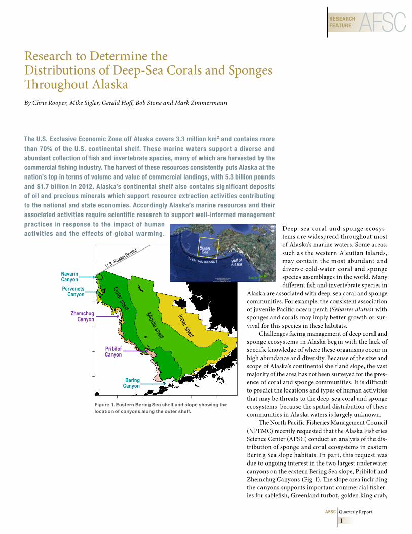
The North Pacific Fisheries Management Council (NPFMC) recently requested that the Alaska Fisheries Science Center (AFSC) conduct an analysis of the dis-tribution of sponge and coral ecosystems in eastern Bering Sea slope habitats. In part, this request was due to ongoing interest in the two largest underwater canyons on the eastern Bering Sea slope, Pribilof and Zhemchug Canyons (Fig. 1). The slope area including the canyons supports important commercial fisher-ies for sablefish, Greenland turbot, golden king crab,
Figure 1 . Eastern Bering Sea shelf and slope showing the location of canyons along the outer shelf .
October November December 2013
2
RESEARCH FEATUREAFSC
Coral Sponge
and walleye pollock (among other species). Some coral and sponge habitat has been reported previously in these two canyons. The question posed by the NPFMC is: Do these canyons constitute unique habitats that should be considered for additional protection from fisheries and other human impacts?
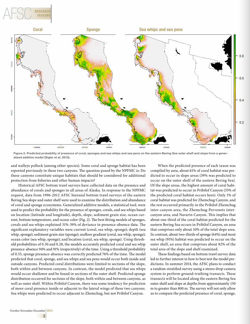
Historical AFSC bottom trawl surveys have collected data on the presence and abundance of corals and sponges in all areas of Alaska. In response to the NPFMC request, data from 1996-2012 AFSC biennial bottom trawl surveys of the eastern Bering Sea slope and outer shelf were used to examine the distribution and abundance of coral and sponge ecosystems. Generalized additive models, a statistical tool, were used to predict the probability for the presence of sponges, corals, and sea whips based on location (latitude and longitude), depth, slope, sediment grain size, ocean cur-rent, bottom temperature, and ocean color (Fig. 2). The best fitting models of sponges, corals and sea whips explained 31%-39% of deviance in presence-absence data. The significant explanatory variables were current (coral, sea whip, sponge); depth (sea whip, sponge); sediment grain size (sponge); seafloor gradient (coral, sea whip, sponge); ocean color (sea whip, sponge); and location (coral, sea whip, sponge). Using thresh-old probabilities of 0.30 and 0.28, the models accurately predicted coral and sea whip presence-absence 94% and 91% (respectively) of the time. Using a threshold probability of 0.53, sponge presence-absence was correctly predicted 76% of the time. The model predicted that coral, sponge, and sea whips and sea pens would occur both inside and outside canyons. Predicted coral distributions were limited to sections of the slope, both within and between canyons. In contrast, the model predicted that sea whips would occur shallower and be found in sections of the outer shelf. Predicted sponge distribution occurred for sections of the slope, both within and between canyons, as well as outer shelf. Within Pribilof Canyon, there was some tendency for prediction of more coral presence inside or adjacent to the lateral wings of these two canyons. Sea whips were predicted to occur adjacent to Zhemchug, but not Pribilof Canyon.
When the predicted presence of each taxon was compiled by area, about 61% of coral habitat was pre-dicted to occur in slope areas (39% was predicted to occur on the outer shelf of the eastern Bering Sea). Of the slope areas, the highest amount of coral habi-tat was predicted to occur in Pribilof Canyon (33% of the predicted coral habitat occurs here). Only 1% of coral habitat was predicted for Zhemchug Canyon, and the rest occurred primarily in the Pribilof-Zhemchug inter-canyon area, the Zhemchug-Pervenets inter-canyon area, and Navarin Canyon. This implies that about one-third of the coral habitat predicted for the eastern Bering Sea occurs in Pribilof Canyon, an area that comprises only about 10% of the total slope area. In contrast, about two-thirds of sponge (64%) and most sea whip (91%) habitat was predicted to occur on the outer shelf, an area that comprises about 82% of the total area of the slope and shelf examined.
These findings based on bottom trawl survey data led to further interest in how to best test the model pre-dictions. In summer 2014, the AFSC plans to conduct a random-stratified survey using a stereo drop camera system to perform ground-truthing transects. These transects will be located along the eastern Bering Sea outer shelf and slope at depths from approximately 150 m to greater than 800 m. The survey will not only allow us to compare the predicted presence of coral, sponge,
Sea whips and sea pens
Figure 2 . Predicted probability of presence of coral, sponges and sea whips and sea pens on the eastern Bering Sea outer shelf and slope from a gener-alized additive model (Sigler et al . 2013) .
AFSC Quarterly Report
3
AFSCRESEARCH FEATURE
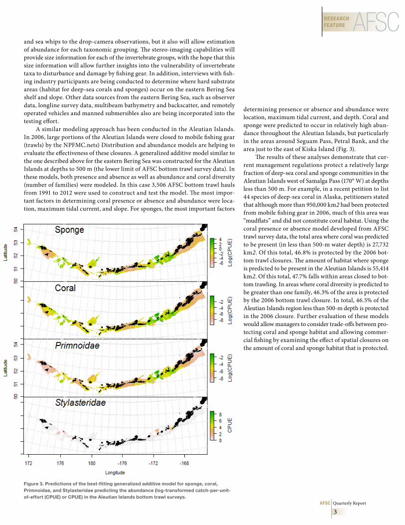
determining presence or absence and abundance were location, maximum tidal current, and depth. Coral and sponge were predicted to occur in relatively high abun-dance throughout the Aleutian Islands, but particularly in the areas around Seguam Pass, Petral Bank, and the area just to the east of Kiska Island (Fig. 3).
The results of these analyses demonstrate that cur-rent management regulations protect a relatively large fraction of deep-sea coral and sponge communities in the Aleutian Islands west of Samalga Pass (170° W) at depths less than 500 m. For example, in a recent petition to list 44 species of deep-sea coral in Alaska, petitioners stated that although more than 950,000 km2 had been protected from mobile fishing gear in 2006, much of this area was “mudflats” and did not constitute coral habitat. Using the coral presence or absence model developed from AFSC trawl survey data, the total area where coral was predicted to be present (in less than 500-m water depth) is 27,732 km2. Of this total, 46.8% is protected by the 2006 bot-tom trawl closures. The amount of habitat where sponge is predicted to be present in the Aleutian Islands is 55,414 km2. Of this total, 47.7% falls within areas closed to bot-tom trawling. In areas where coral diversity is predicted to be greater than one family, 46.3% of the area is protected by the 2006 bottom trawl closure. In total, 46.5% of the Aleutian Islands region less than 500-m depth is protected in the 2006 closure. Further evaluation of these models would allow managers to consider trade-offs between pro-tecting coral and sponge habitat and allowing commer-cial fishing by examining the effect of spatial closures on the amount of coral and sponge habitat that is protected.
and sea whips to the drop-camera observations, but it also will allow estimation of abundance for each taxonomic grouping. The stereo-imaging capabilities will provide size information for each of the invertebrate groups, with the hope that this size information will allow further insights into the vulnerability of invertebrate taxa to disturbance and damage by fishing gear. In addition, interviews with fish-ing industry participants are being conducted to determine where hard substrate areas (habitat for deep-sea corals and sponges) occur on the eastern Bering Sea shelf and slope. Other data sources from the eastern Bering Sea, such as observer data, longline survey data, multibeam bathymetry and backscatter, and remotely operated vehicles and manned submersibles also are being incorporated into the testing effort.
A similar modeling approach has been conducted in the Aleutian Islands. In 2006, large portions of the Aleutian Islands were closed to mobile fishing gear (trawls) by the NPFMC.nets) Distribution and abundance models are helping to evaluate the effectiveness of these closures. A generalized additive model similar to the one described above for the eastern Bering Sea was constructed for the Aleutian Islands at depths to 500 m (the lower limit of AFSC bottom trawl survey data). In these models, both presence and absence as well as abundance and coral diversity (number of families) were modeled. In this case 3,506 AFSC bottom trawl hauls from 1991 to 2012 were used to construct and test the model. The most impor-tant factors in determining coral presence or absence and abundance were loca-tion, maximum tidal current, and slope. For sponges, the most important factors
Figure 3 . Predictions of the best-fitting generalized additive model for sponge, coral, Primnoidae, and Stylasteridae predicting the abundance (log-transformed catch-per-unit-of-effort (CPUE) or CPUE) in the Aleutian Islands bottom trawl surveys .
October November December 2013
4
RESEARCH FEATUREAFSC
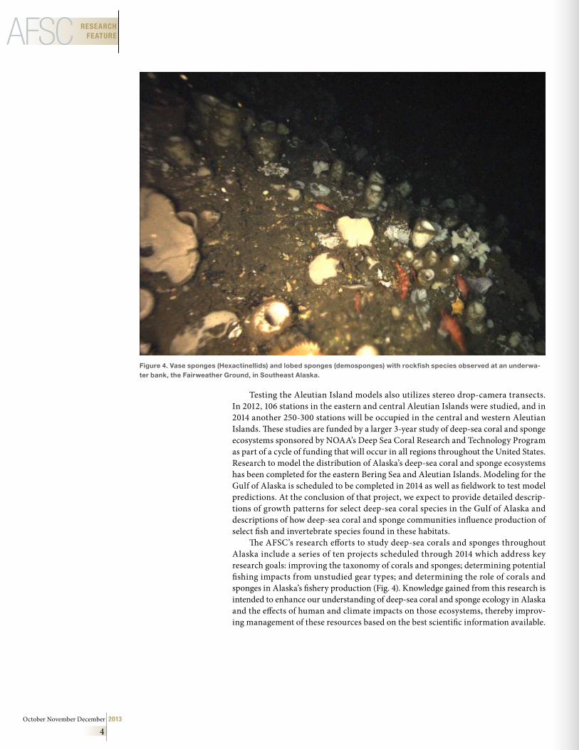
Figure 4 . Vase sponges (Hexactinellids) and lobed sponges (demosponges) with rockfish species observed at an underwa-ter bank, the Fairweather Ground, in Southeast Alaska .
Testing the Aleutian Island models also utilizes stereo drop-camera transects. In 2012, 106 stations in the eastern and central Aleutian Islands were studied, and in 2014 another 250-300 stations will be occupied in the central and western Aleutian Islands. These studies are funded by a larger 3-year study of deep-sea coral and sponge ecosystems sponsored by NOAA’s Deep Sea Coral Research and Technology Program as part of a cycle of funding that will occur in all regions throughout the United States. Research to model the distribution of Alaska’s deep-sea coral and sponge ecosystems has been completed for the eastern Bering Sea and Aleutian Islands. Modeling for the Gulf of Alaska is scheduled to be completed in 2014 as well as fieldwork to test model predictions. At the conclusion of that project, we expect to provide detailed descrip-tions of growth patterns for select deep-sea coral species in the Gulf of Alaska and descriptions of how deep-sea coral and sponge communities influence production of select fish and invertebrate species found in these habitats.
The AFSC’s research efforts to study deep-sea corals and sponges throughout Alaska include a series of ten projects scheduled through 2014 which address key research goals: improving the taxonomy of corals and sponges; determining potential fishing impacts from unstudied gear types; and determining the role of corals and sponges in Alaska’s fishery production (Fig. 4). Knowledge gained from this research is intended to enhance our understanding of deep-sea coral and sponge ecology in Alaska and the effects of human and climate impacts on those ecosystems, thereby improv-ing management of these resources based on the best scientific information available.
AFSC Quarterly Report
5
DIVISION/LABORATORY REPORTSFMA
FMA Observer Program Activities in 2013For the 2013 fishing year, 828 observers were trained, briefed, and equipped for deployment to vessels and processing facilities operating in the Bering Sea and Gulf of Alaska groundfish fisheries. These observers collected data onboard 367 fixed gear and trawl ves-sels and at 14 processing facilities for a total of 43,643 observer days.
New observer candidates are required to complete a 3-week training class with 120 hours of scheduled class time and additional training by FMA staff as nec-essary. The FMA Division conducted training for 186 new observers to deploy in 2013 compared to 168 new observers in 2012.
Returning observers are required to attend an annual 4-day briefing class prior to their first deploy-ment each calendar year. These briefings provide observers with annual updates regarding their respon-sibilities for the current sampling period during the fishing season. Prior to subsequent deployments, all observers must attend a 1-day, 2-day or 4-day brief-ing; the length of the briefing each observer attends is dependent on that individual’s needs. In 2013, FMA staff provided briefings for 281 observers.
After each deployment, observers meet with a FMA staff member for debriefing to review the sam-ple design and finalize the data collected. There were 97 debriefings in Anchorage completed by 3 FMA staff and 572 debriefings in Seattle completed by 15 FMA staff. Many observers deploy multiple times through-out the year and debrief after each contract followed by a briefing for redeployment. Thus, the total number of briefings and debriefings for 2013 do not represent a count of individual observers.
Each year brings some degree of change to observer data collections as part of our efforts to meet the needs of the end data users. In preparation for this year’s fishing season, the 2014 Observer Sampling Manual was updated to reflect changes of how data will be collected on vessels participating in our par-tial coverage program as well as including sampling protocol for new data collection projects. The manual is available online at 2014 Observer Sampling Manual
Submitted by FMA staff
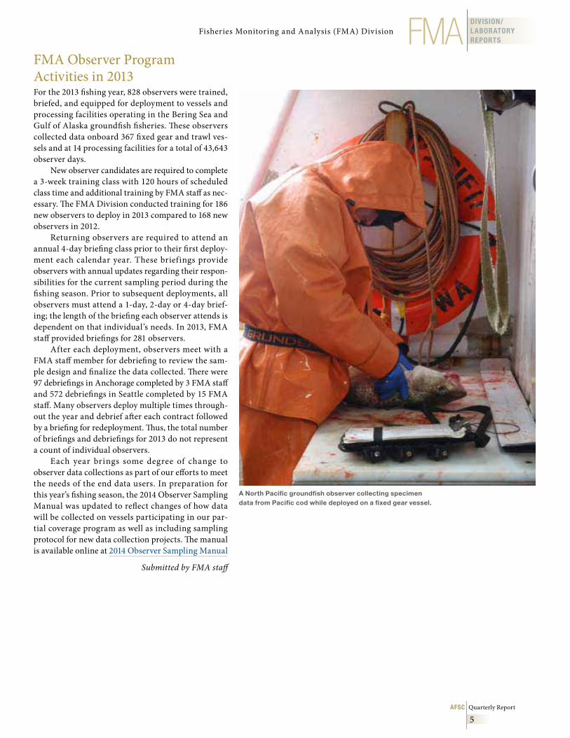
A North Pacific groundfish observer collecting specimen data from Pacific cod while deployed on a fixed gear vessel .
Fisheries Monitoring and Analysis (FMA) Division
October November December 2013
6
DIVISION/LABORATORY
REPORTS NMML National Marine Mammal Laboratory (NMML)
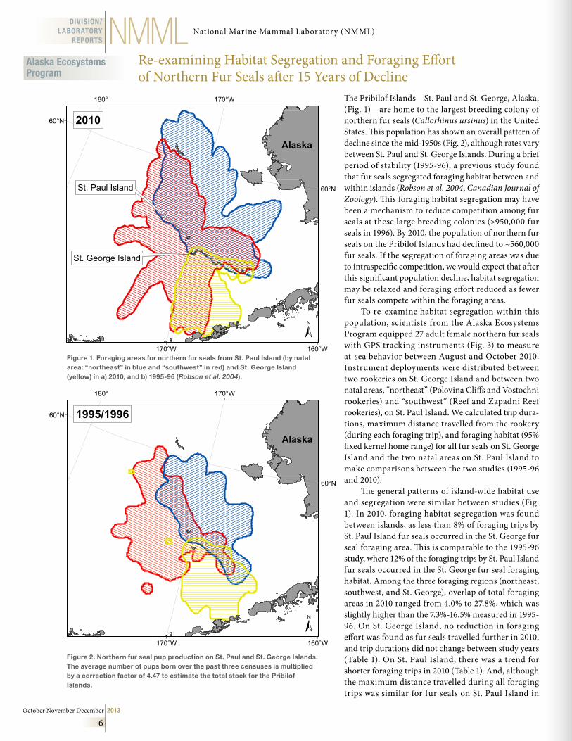
The Pribilof Islands—St. Paul and St. George, Alaska, (Fig. 1)—are home to the largest breeding colony of northern fur seals (Callorhinus ursinus) in the United States. This population has shown an overall pattern of decline since the mid-1950s (Fig. 2), although rates vary between St. Paul and St. George Islands. During a brief period of stability (1995-96), a previous study found that fur seals segregated foraging habitat between and within islands (Robson et al. 2004, Canadian Journal of Zoology). This foraging habitat segregation may have been a mechanism to reduce competition among fur seals at these large breeding colonies (>950,000 fur seals in 1996). By 2010, the population of northern fur seals on the Pribilof Islands had declined to ~560,000 fur seals. If the segregation of foraging areas was due to intraspecific competition, we would expect that after this significant population decline, habitat segregation may be relaxed and foraging effort reduced as fewer fur seals compete within the foraging areas.
To re-examine habitat segregation within this population, scientists from the Alaska Ecosystems Program equipped 27 adult female northern fur seals with GPS tracking instruments (Fig. 3) to measure at-sea behavior between August and October 2010. Instrument deployments were distributed between two rookeries on St. George Island and between two natal areas, “northeast” (Polovina Cliffs and Vostochni rookeries) and “southwest” (Reef and Zapadni Reef rookeries), on St. Paul Island. We calculated trip dura-tions, maximum distance travelled from the rookery (during each foraging trip), and foraging habitat (95% fixed kernel home range) for all fur seals on St. George Island and the two natal areas on St. Paul Island to make comparisons between the two studies (1995-96 and 2010).
The general patterns of island-wide habitat use and segregation were similar between studies (Fig. 1). In 2010, foraging habitat segregation was found between islands, as less than 8% of foraging trips by St. Paul Island fur seals occurred in the St. George fur seal foraging area. This is comparable to the 1995-96 study, where 12% of the foraging trips by St. Paul Island fur seals occurred in the St. George fur seal foraging habitat. Among the three foraging regions (northeast, southwest, and St. George), overlap of total foraging areas in 2010 ranged from 4.0% to 27.8%, which was slightly higher than the 7.3%-16.5% measured in 1995-96. On St. George Island, no reduction in foraging effort was found as fur seals travelled further in 2010, and trip durations did not change between study years (Table 1). On St. Paul Island, there was a trend for shorter foraging trips in 2010 (Table 1). And, although the maximum distance travelled during all foraging trips was similar for fur seals on St. Paul Island in
Re-examining Habitat Segregation and Foraging Effort of Northern Fur Seals after 15 Years of Decline
170°W
170°W180°
160°W
60°N
60°N
±
Alaska
St. Paul Island
St. George Island
2010
170°W
170°W180°
160°W
60°N
60°N
±
Alaska
1995/1996
Figure 1 . Foraging areas for northern fur seals from St . Paul Island (by natal area: “northeast” in blue and “southwest” in red) and St . George Island (yellow) in a) 2010, and b) 1995-96 (Robson et al. 2004) .
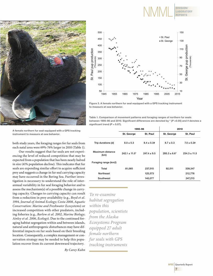
Figure 2 . Northern fur seal pup production on St . Paul and St . George Islands . The average number of pups born over the past three censuses is multiplied by a correction factor of 4 .47 to estimate the total stock for the Pribilof Islands .
Alaska Ecosystems Program
AFSC Quarterly Report
7
DIVISION/LABORATORY REPORTSNMML
both study years, the foraging ranges for fur seals from each natal area were 69%-76% larger in 2010 (Table 1).
Our results suggest that fur seals are not experi-encing the level of reduced competition that may be expected from a population that has been nearly halved in size (41% population decline). This indicates that fur seals are expending similar effort to acquire sufficient prey and suggests a change in fur seal carrying capacity may have occurred in the Bering Sea. Further inves-tigation is necessary to understand the role of inter-annual variability in fur seal foraging behavior and to assess the mechanism(s) of a possible change in carry-ing capacity. Changes to carrying capacity can result from a reduction in prey availability (e.g., Boyd et al. 1994, Journal of Animal Ecology; Costa 2008, Aquatic Conservation: Marine and Freshwater Ecosystems) or increased competition with other predators, includ-ing fisheries (e.g., Barlow et al. 2002, Marine Biology; Ainley et al. 2006, Ecology). Due to the continued for-aging habitat segregation within and between islands, natural and anthropogenic disturbances may have dif-ferential impacts on fur seals based on their breeding location. Consequently, a complex management or con-servation strategy may be needed to help this popu-lation recover from its current downward trajectory.
By Carey Kuhn
10
30
50
70
90
110
130
150
50
100
150
200
250
300
350
400
450
500
1945 1955 1965 1975 1985 1995 2005 2015
St.
Geo
rge
pup
prod
uctio
n(T
hous
ands
)
St.
Pau
l pup
pro
duct
ion
(Tho
usan
ds)
Year
St. PaulSt. George
Figure 3 . A female northern fur seal equipped with a GPS tracking instrument to measure at-sea behavior .
Table 1 . Comparison of movement patterns and foraging ranges of northern fur seals between 1995-96 and 2010 . Significant differences are denoted by * (P <0 .05) and # denotes a significant trend (P = 0 .07) .
1995-96 2010
St . George St . Paul St . George St . Paul
Trip durations (d) 8.0 ± 0.3 8.4 ± 0.3# 8.7 ± 0.3 7.0 ± 0.2#
Maximum distance (km)
242.1 ± 11.0* 247.4 ± 9.5 285.3 ± 6.6* 234.3 ± 11.5
Foraging range (km2)
Total 81,065 237,515 92,511 339,347
Northeast 125,573 212,776
Southwest 140,077 247,213
To re-examine habitat segregation within this population, scientists from the Alaska Ecosystems Program equipped 27 adult female northern fur seals with GPS tracking instruments
A female northern fur seal equipped with a GPS tracking instrument to measure at-sea behavior .
October November December 2013
8
DIVISION/LABORATORY
REPORTS NMML
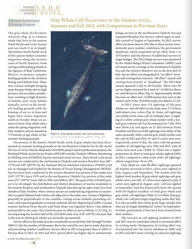
The gray whale (Eschrichtius robustus) (Fig. 4) is a baleen whale that lives in the eastern North Pacific and Arctic Oceans and can reach 15 m in length. The Eastern North Pacific stock of this species makes a seasonal migration along the western coast of North America, from calving and breeding grounds in the lagoons of Baja California, Mexico, to primary summer feeding grounds in the northern Bering and Chukchi Seas. These seas contain multiple foraging areas for gray whales due to high primary and secondary produc-tion, resulting in high densities of benthic prey. Gray whales typically arrive in the north-ern feeding grounds with the breakup of sea ice in June and begin their return migration south in October when sea ice starts to form. Gray whale calves make the spring migration with their mothers and are weaned at 7-9 months of age while on the summer feeding grounds.
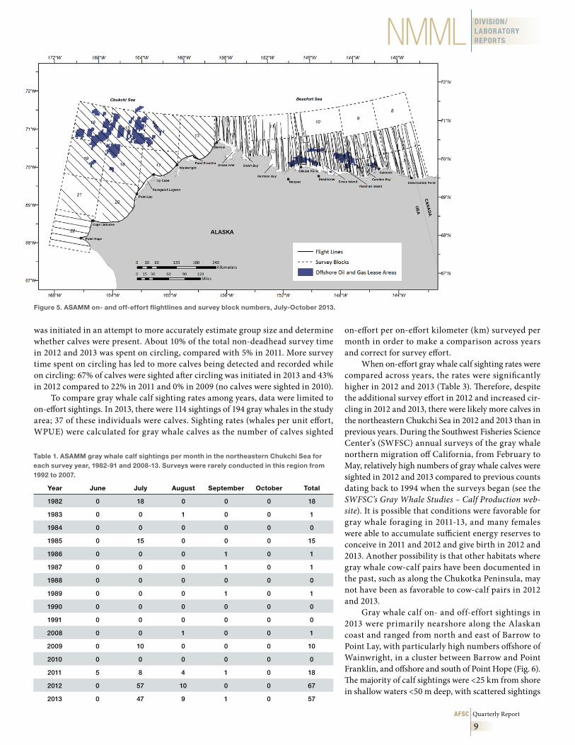
Occurrence of the Eastern North Pacific stock of gray whales has been docu-mented on summer feeding grounds in the northeastern Chukchi Sea by the Aerial Surveys of Arctic Marine Mammals (ASAMM) project and its predecessor projects, the Bowhead Whale Aerial Survey Project (BWASP) and the Chukchi Offshore Monitoring in Drilling Area (COMIDA) marine mammal aerial surveys. These broad-scale aerial surveys are conducted in the northeastern Chukchi and western Beaufort Seas (68°-72°N and 140°-169°W) by the National Marine Mammal Laboratory (NMML) and are co-managed and funded by the Bureau of Ocean Energy Management (BOEM). Surveys have been conducted in the western Beaufort Sea portion of the study area (140°-157°W) since 1979 and in the northeastern Chukchi Sea portion of the study area (157°-169°W) from 1982 to 1991 and 2008 to 2013. The goal of the ASAMM proj-ect is to investigate the distribution and relative abundance of marine mammals in the western Beaufort and northeastern Chukchi Seas during the open-water (ice-free) months of July-October, when various species are undertaking migrations to season-ally occupied habitats both within and adjacent to the study area. Transect flightlines generally lie perpendicular to the coastline, cutting across isobaths, prevailing cur-rents, and expected gradients in marine mammal density. Beginning in 2009, a coastal transect between Point Barrow and Point Hope was regularly flown 1 km offshore and parallel to the coast. This article focuses on effort in survey blocks 12-22 (Fig. 5), encompassing the western half of the ASAMM study area (154°-169°W), because that is the area in which gray whales are normally encountered.
Survey effort in the study area has consistently occurred from July through October 2009-13, but the number of kilometers flown has varied by year due to study objectives and prevailing weather conditions. Survey effort in 2013 was greater than in 2009-11, but less than in 2012. In 2012 and 2013, survey effort was higher due to summertime
beluga surveys in the northeastern Chukchi Sea and expanded Beaufort Sea surveys, which began in mid-July instead of August or September. In 2013, survey effort was lower than in 2012 due to three factors: inter-mittently poor weather conditions; the government shutdown, which suspended survey effort from 1 to 19 October; and the absence of additional surveys to target belugas. The 2012 beluga surveys were sponsored by the Alaska Beluga Whale Committee (ABWC) and increased survey coverage in the northeastern Chukchi Sea and the western Beaufort Sea in the first half of July. Survey effort was designated as “on-effort” (tran-sect and circling from transect), “off-effort” (search and circling from search), or “deadhead.” The 2013 field season spanned 2 July to 28 October. There were 90 survey flights initiated for a total of ~51,000 km flown on- and off-survey effort (Fig. 5). Approximately 40,000 km were on-effort and ~25,000 transect km were in the western part of the ASAMM study area (blocks 12-22).
In 2013, there were 174 sightings of 281 gray whales on- and off-effort in the study area; 57 of these individuals were calves (Fig. 6). Some calf sightings were likely of the same calf on multiple days. A sight-ing of a white-colored gray whale mother with a nor-mal gray-colored calf was documented on 7 July 2013 near Point Lay and again on 21 July between Point Franklin and Barrow; both sightings were likely of the same unusually white-colored gray whale mother and her calf. In 2012 and 2013, 67 and 57 calves were seen, respectively; prior to this, the years with the greatest number of calf sightings were 1982 and 2011, with 18 calves seen each year (Table 2). There was a higher proportion of calves to total gray whales sighted (20%) in 2013, compared to other years with calf sightings, which ranged from 1% to 13%.
Gray whale on- and off-effort sightings spanned all months surveyed in 2013; calves were sighted in July, August, and September. The month with the highest total number of gray whale sightings and gray whale calves was July: 47 calves were sighted in July, 9 calves were sighted in August, and 1 calf was sighted in September. July has historically been the month with the highest numbers of total gray whale and gray whale calf sightings (Table 2); it is likely that gray whale cow-calf pairs begin migrating south after July. It is also possible that calves grow large enough that they are no longer identified as “calves” by September-October, particularly if they have been weaned from their mothers.
The increase in calf sighting numbers in 2012 and 2013 may be somewhat related to increased effort in circling mode. Designation of circling effort was incorporated into the survey database in 2009, and in 2012 and 2013 more circling on cetacean sightings
Figure 4 . Gray whale mother with calf underneath . Photo by Vicki Beaver, 2013 ASAMM survey, NMFS Permit No. 14245.
Cetacean Assessment & Ecology Program
Gray Whale Calf Occurrence in the Alaskan Arctic, Summer and Fall 2013, with Comparisons to Previous Years
AFSC Quarterly Report
9
DIVISION/LABORATORY REPORTSNMML
was initiated in an attempt to more accurately estimate group size and determine whether calves were present. About 10% of the total non-deadhead survey time in 2012 and 2013 was spent on circling, compared with 5% in 2011. More survey time spent on circling has led to more calves being detected and recorded while on circling: 67% of calves were sighted after circling was initiated in 2013 and 43% in 2012 compared to 22% in 2011 and 0% in 2009 (no calves were sighted in 2010).
To compare gray whale calf sighting rates among years, data were limited to on-effort sightings. In 2013, there were 114 sightings of 194 gray whales in the study area; 37 of these individuals were calves. Sighting rates (whales per unit effort, WPUE) were calculated for gray whale calves as the number of calves sighted
Table 1 . ASAMM gray whale calf sightings per month in the northeastern Chukchi Sea for each survey year, 1982-91 and 2008-13 . Surveys were rarely conducted in this region from 1992 to 2007 .
Year June July August September October Total
1982 0 18 0 0 0 18
1983 0 0 1 0 0 1
1984 0 0 0 0 0 0
1985 0 15 0 0 0 15
1986 0 0 0 1 0 1
1987 0 0 0 1 0 1
1988 0 0 0 0 0 0
1989 0 0 0 1 0 1
1990 0 0 0 0 0 0
1991 0 0 0 0 0 0
2008 0 0 1 0 0 1
2009 0 10 0 0 0 10
2010 0 0 0 0 0 0
2011 5 8 4 1 0 18
2012 0 57 10 0 0 67
2013 0 47 9 1 0 57
Figure 5 . ASAMM on- and off-effort flightlines and survey block numbers, July-October 2013 .
on-effort per on-effort kilometer (km) surveyed per month in order to make a comparison across years and correct for survey effort.
When on-effort gray whale calf sighting rates were compared across years, the rates were significantly higher in 2012 and 2013 (Table 3). Therefore, despite the additional survey effort in 2012 and increased cir-cling in 2012 and 2013, there were likely more calves in the northeastern Chukchi Sea in 2012 and 2013 than in previous years. During the Southwest Fisheries Science Center’s (SWFSC) annual surveys of the gray whale northern migration off California, from February to May, relatively high numbers of gray whale calves were sighted in 2012 and 2013 compared to previous counts dating back to 1994 when the surveys began (see the SWFSC’s Gray Whale Studies – Calf Production web-site). It is possible that conditions were favorable for gray whale foraging in 2011-13, and many females were able to accumulate sufficient energy reserves to conceive in 2011 and 2012 and give birth in 2012 and 2013. Another possibility is that other habitats where gray whale cow-calf pairs have been documented in the past, such as along the Chukotka Peninsula, may not have been as favorable to cow-calf pairs in 2012 and 2013.
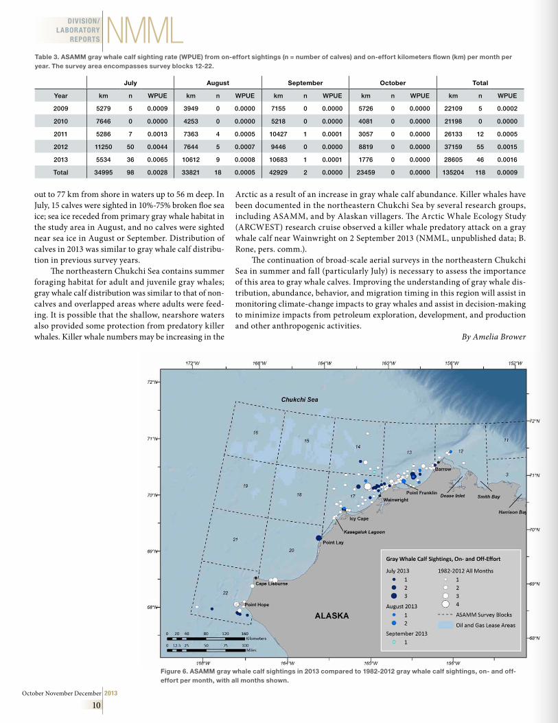
Gray whale calf on- and off-effort sightings in 2013 were primarily nearshore along the Alaskan coast and ranged from north and east of Barrow to Point Lay, with particularly high numbers offshore of Wainwright, in a cluster between Barrow and Point Franklin, and offshore and south of Point Hope (Fig. 6). The majority of calf sightings were <25 km from shore in shallow waters <50 m deep, with scattered sightings
October November December 2013
10
DIVISION/LABORATORY
REPORTS NMML
out to 77 km from shore in waters up to 56 m deep. In July, 15 calves were sighted in 10%-75% broken floe sea ice; sea ice receded from primary gray whale habitat in the study area in August, and no calves were sighted near sea ice in August or September. Distribution of calves in 2013 was similar to gray whale calf distribu-tion in previous survey years.
The northeastern Chukchi Sea contains summer foraging habitat for adult and juvenile gray whales; gray whale calf distribution was similar to that of non-calves and overlapped areas where adults were feed-ing. It is possible that the shallow, nearshore waters also provided some protection from predatory killer whales. Killer whale numbers may be increasing in the
Arctic as a result of an increase in gray whale calf abundance. Killer whales have been documented in the northeastern Chukchi Sea by several research groups, including ASAMM, and by Alaskan villagers. The Arctic Whale Ecology Study (ARCWEST) research cruise observed a killer whale predatory attack on a gray whale calf near Wainwright on 2 September 2013 (NMML, unpublished data; B. Rone, pers. comm.).
The continuation of broad-scale aerial surveys in the northeastern Chukchi Sea in summer and fall (particularly July) is necessary to assess the importance of this area to gray whale calves. Improving the understanding of gray whale dis-tribution, abundance, behavior, and migration timing in this region will assist in monitoring climate-change impacts to gray whales and assist in decision-making to minimize impacts from petroleum exploration, development, and production and other anthropogenic activities.
By Amelia Brower
Table 3 . ASAMM gray whale calf sighting rate (WPUE) from on-effort sightings (n = number of calves) and on-effort kilometers flown (km) per month per year . The survey area encompasses survey blocks 12-22 .
July August September October Total
Year km n WPUE km n WPUE km n WPUE km n WPUE km n WPUE
2009 5279 5 0.0009 3949 0 0.0000 7155 0 0.0000 5726 0 0.0000 22109 5 0.0002
2010 7646 0 0.0000 4253 0 0.0000 5218 0 0.0000 4081 0 0.0000 21198 0 0.0000
2011 5286 7 0.0013 7363 4 0.0005 10427 1 0.0001 3057 0 0.0000 26133 12 0.0005
2012 11250 50 0.0044 7644 5 0.0007 9446 0 0.0000 8819 0 0.0000 37159 55 0.0015
2013 5534 36 0.0065 10612 9 0.0008 10683 1 0.0001 1776 0 0.0000 28605 46 0.0016
Total 34995 98 0.0028 33821 18 0.0005 42929 2 0.0000 23459 0 0.0000 135204 118 0.0009
Figure 6 . ASAMM gray whale calf sightings in 2013 compared to 1982-2012 gray whale calf sightings, on- and off-effort per month, with all months shown .
AFSC Quarterly Report
11
DIVISION/LABORATORY REPORTSNMML
Investigating the Foraging and Diving Behavior of “Transient”-type Killer Whales in the Central and Western AleutiansNMML’s Cetacean Assessment and Ecology Program has a continuing project to study predation on marine mammals by “transient”-type (mammal-eating) killer whales in the Aleutian Islands, initiated in 2001, to investigate the potential role of killer whales in the decline of the western stock of Steller sea lions. Predation on Steller sea lions in the eastern Aleutians has been visually observed to be ~14% of all transient predation events, and stable isotope values of transient killer whales there are consistent with a diet composed of 14% Steller sea lions (Herman et al. 2005, Marine Ecology Progress Series; Krahn et al. 2007, Marine Environmental Research). Acoustic recorders at sea lion rookeries and satellite tagging of killer whales have confirmed foraging movements consistent with some predation on Steller sea lions in the eastern Aleutians. For example, transient killer whales were heard regularly via an acoustic recorder at the Ugamak Island Steller sea lion rookery near Unimak Pass (unpublished data); a kill of a sea lion by a killer whale was observed at that rookery; and satel-lite tag locations of a transient killer whale showed it to be foraging in areas adjacent to that same rookery (J. Durban and Wade, unpublished data).
The focus of current research has shifted to the western and central Aleutian Islands because of the continuing decline or lack of recovery of Steller sea lions in that area. No observations have been made of predation on Steller sea lions in the western and central Aleutians, but observa-tion effort there has been relatively sparse. The only predation events observed during NMML/NMFS surveys in the central and western Aleutians were of a Dall’s porpoise and a Baird’s beaked whale (unpublished data). Additionally, Estes et al. (1998, Science) described predation on sea otters in the central Aleutians.
During NMML surveys, transient killer whales have been regularly seen in two areas in the central and western Aleutian Islands: 1) the Delarof Islands-Tanaga Island area, and 2) Kiska Island and the Rat Islands, with abundance estimated at approximately 90 whales. A popula-tion of killer whales of this size could potentially inhibit the recovery of Steller sea lions in this region if they were a primary prey of transient killer whales there. Killer whales integrate chemical tracers acquired from their prey (e.g., stable isotope ratios of nitrogen and carbon) that reflect both the species consumed and the regions from which the prey were taken (Krahn et al. 2007). Analysis of blubber samples collected from transient killer whales reveals that the nitrogen stable isotope (δ15N) values of transient killer whales in the western Aleutians (Kiska Island and the Rat Islands) are much lower than values of transients in the eastern Aleutians and Bering Sea. However, nitrogen values in the central Aleutians (Delarof Islands-Tanaga Island) show dramatically differ-ent patterns: two of the samples group with the western Aleutian samples, and two of the samples group with the eastern Aleutian samples. The low western and central Aleutian samples have values from 12.5 to 14 δ15N, whereas, the majority of the eastern Aleutian samples have values from 16 to 19.5 δ15N. Given a trophic shift of ~3.8, this means that some transient killer whales in the central and western Aleutians are feeding on prey with an average δ15N value of ~8.7-10.2. This appears to be too low a δ15N value to be primarily from marine mammals, as observed values from marine mammals have all been higher: minke whales (central Aleutians, ~12.3 δ15N), Dall’s porpoise (eastern Aleutians, ~12.6 δ15N), sea otters (central Aleutians, ~13.4 and ~15.3 δ15N), and Steller sea lions (central Aleutians, average value of 15.8 δ15N) (Wade et al. 2006, North Pacific Research Board Final Report; unpublished data). One possible explanation for the low killer whale nitrogen values comes from a single observation of transient killer whales near Kiska Island feeding on squid in 2006 (J. Durban, unpublished data). Some species of squid have δ15N values in the range of ~8.7-10.2, suggesting that predation on squid may explain the low nitrogen values observed in killer whales in the western Aleutians and in some killer whales in the central Aleutians.
On the other hand, two transient killer whales from the central Aleutians had δ15N values over 17 and over 20, which is consistent with a diet composed primarily of Steller sea lions. The stable isotope results there-fore suggest there may be two types of transient killer whales in the central Aleutians, or at least killer whales with two different foraging strategies. Interestingly, recent genetic studies we have conducted (Parsons et al. 2013, Journal of Heredity) have concluded that a population boundary for transient killer whales exists in the central Aleutians, suggesting the possibility of the overlap of two populations there.
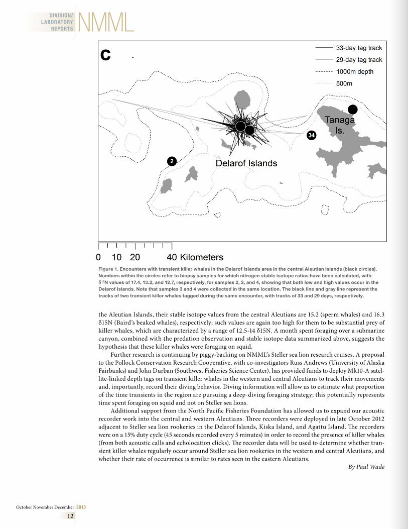
Location-only satellite tags (N=4) have also elucidated two dramatically different foraging strategies, with some killer whales moving ~1,000 nautical miles south of the Aleutians (far outside the range of Steller sea lions) and other killer whales remaining in a single location over deep water at the head of a submarine can-yon for an entire month (Fig. 1), a foraging behavior not previously observed in transient killer whales. While it is possible these killer whales were foraging at the surface on marine mammals the entire time, it seems unlikely. Although we have often seen sperm whales and beaked whales in habitat over submarine canyons in
The focus of current research has shifted to the western and central Aleutian Islands because of the continuing decline or lack of recovery of Steller sea lions in that area.
October November December 2013
12
DIVISION/LABORATORY
REPORTS NMML
the Aleutian Islands, their stable isotope values from the central Aleutians are 15.2 (sperm whales) and 16.3 δ15N (Baird’s beaked whales), respectively; such values are again too high for them to be substantial prey of killer whales, which are characterized by a range of 12.5-14 δ15N. A month spent foraging over a submarine canyon, combined with the predation observation and stable isotope data summarized above, suggests the hypothesis that these killer whales were foraging on squid.
Further research is continuing by piggy-backing on NMML’s Steller sea lion research cruises. A proposal to the Pollock Conservation Research Cooperative, with co-investigators Russ Andrews (University of Alaska Fairbanks) and John Durban (Southwest Fisheries Science Center), has provided funds to deploy Mk10-A satel-lite-linked depth tags on transient killer whales in the western and central Aleutians to track their movements and, importantly, record their diving behavior. Diving information will allow us to estimate what proportion of the time transients in the region are pursuing a deep-diving foraging strategy; this potentially represents time spent foraging on squid and not on Steller sea lions.
Additional support from the North Pacific Fisheries Foundation has allowed us to expand our acoustic recorder work into the central and western Aleutians. Three recorders were deployed in late October 2012 adjacent to Steller sea lion rookeries in the Delarof Islands, Kiska Island, and Agattu Island. The recorders were on a 15% duty cycle (45 seconds recorded every 5 minutes) in order to record the presence of killer whales (from both acoustic calls and echolocation clicks). The recorder data will be used to determine whether tran-sient killer whales regularly occur around Steller sea lion rookeries in the western and central Aleutians, and whether their rate of occurrence is similar to rates seen in the eastern Aleutians.
By Paul Wade
Figure 1 . Encounters with transient killer whales in the Delarof Islands area in the central Aleutian Islands (black circles) . Numbers within the circles refer to biopsy samples for which nitrogen stable isotope ratios have been calculated, with δ15N values of 17 .4, 13 .2, and 12 .7, respectively, for samples 2, 3, and 4, showing that both low and high values occur in the Delarof Islands . Note that samples 3 and 4 were collected in the same location . The black line and gray line represent the tracks of two transient killer whales tagged during the same encounter, with tracks of 33 and 29 days, respectively .
AFSC Quarterly Report
13
DIVISION/LABORATORY REPORTSRACEResource Assessment and Conservation Engineering (RACE) Division
Groundfish Assessment Program
Yes, Virginia, Walleye Pollock is Gadus chalcogrammusThe recent change of the scientific name of Walleye Pollock from Theragra chalcogramma to Gadus chalcogrammus has created some con-sternation among those of us working with this species on nearly a daily basis. The decision to change the generic assignment came about through extensive genetic studies that examined the number of species and evolutionary relationships among the cods (e.g., Coulson et al., 2006; Teletchea et al., 2006; Carr and Marshall, 2008). In all of these studies, Walleye Pollock was definitively placed in an evolutionary lin-eage that included the Pacific, Atlantic, and Greenland Cods (Gadus macrocephalus, G. morhua, and G. ogac). The data also indicated that Theragra is more closely related to G. morhua than the other cod species, rather than outside Gadus in a separate lineage. Morphological studies have been ambiguous, the position of Theragra left unresolved among other gadid genera (Dunn, 1989; Teletchea et al., 2006). Nomenclature should be congruent with our best hypothesis of evolutionary relationships, and to recognize this relationship a nomenclatural decision needed to be made. Authors (Coulson et al., 2006; Carr and Marshall, 2008) chose to include the Gadus and Theragra cod lineages together in the single genus Gadus, rather than remove Gadus morhua from Gadus in order to retain Theragra for Walleye Pollock.
A genus name and species name must agree in gender, according to International Code of Zoological Nomenclature (ICZN, 1999). Thus, when a species is moved to a new genus, an emendation of the species name is often required. Because Gadus is masculine, chalcogramma, the feminine form agree-ing with Theragra, must be changed to chalcogram-mus. Thus, Gadus chalcogrammus is the new name for Walleye Pollock. When citing the author of the name as required in some publication outlets, the correct citation is Gadus chalcogrammus Pallas, 1814 (not Pallas, 1811, as proposed by Carr and Marshall [2008] and Roa-Varón and Orti [2009]). This change has been recognized in the newest edition of the American Fisheries Society Common and Scientific Names of Fishes (2013), the standard followed by the NMFS Scientific Publications Office.
By James W. Orr and Duane E. Stevenson
Literature citedICZN (International Commission on Zoological Nomenclature). 1999. International Code of Zoological Nomenclature, 4th edition. The International Trust for
Zoological Nomenclature, The Natural History Museum, London.
Carr, S. M., and H. Dawn Marshall. 2008. Phylogeographic analysis of complete mtDNA genomes from Walleye Pollock (Gadus chalcogrammus Pallas, 1811) shows an ancient origin of genetic biodiversity. Mitochondrial DNA 19:490-496.
Coulson, M. W., H. D. Marshall, P. Pepin, and S. M. Carr. 2006. Mitochondrial genomics of gadine fishes: implications for taxonomy and biogeographic origins from whole-genome data sets. Genome 49:1115-1130.
Dunn, J. R. 1989. A provisional phylogeny of gadid fishes based on adult and early life-history characters, pp. 209-235. In D. M. Cohen (ed.), Papers on the Systematics of Gadiform Fishes. Natural History Museum of Los Angeles County Science Series 32.
Lawrence M. Page, Héctor Espinosa-Pérez, Lloyd T. Findley, Carter R. Gilbert, Robert N. Lea, Nicholas E. Mandrak, Richard L. Mayden, and Joseph S. Nelson. 2013. Common and Scientific Names of Fishes from the United States, Canada, and Mexico, 7th edition. American Fisheries Society Special Publication 34. 243 p.
Pallas, P. S. 1814. Zoographia Rosso-Asiatica, sistens omnium animalium in extenso Imperio Rossico et adjacentibus maribus observatorum recensionem, domicilia, mores et descriptiones anatomen atque icones plurimorum. 3 vols. [1811–1814]. Petropoli. v. 3: i–vii + 1–428 + index (I–CXXV), Pls. 1, 13, 14, 15, 20 and 21.
Roa-Varón, A., and G. Orti. 2009. Phylogenetic relationships among families of Gadiformes (Teleostei, Paracanthopterygii) based on nuclear and mitochondrial data. Molecular Phylogenetics and Evolution 52:688-704.
Teletchea, F., V. Laudet, and C. Hänni. 2006. Phylogeny of the Gadidae (sensu Svetovidov, 1948) based on their morphology and two mitochondrial genes. Molecular Phylogenetics and Evolution 38:189-199.
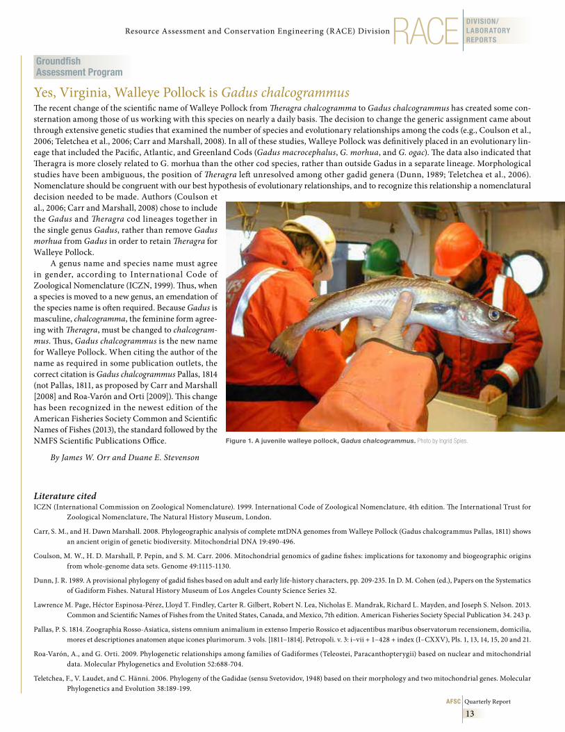
Figure 1 . A juvenile walleye pollock, Gadus chalcogrammus . Photo by Ingrid Spies.
October November December 2013
14
REFMDIVISION/LABORATORY
REPORTS
Resource Ecology & Ecosystem Modeling Program
Fish Stomach Collection and Lab AnalysisDuring the fourth quarter of 2013, Resource Ecology and Ecosystem Modeling (REEM) staff analyzed the contents of 4,853 groundfish stomachs. Laboratory analysis was completed and the resulting data was error-checked and loaded into the AFSC’s Groundfish Food Habits database, resulting in 26,012 added records. The majority of the samples analyzed were walleye pollock from the eastern Bering Sea, but samples from 4 other species in the east-ern Bering Sea and 10 species from the Gulf of Alaska and Aleutian Islands regions were also analyzed.
Other REEM program highlights include devel-opment of a web page called the Stomach Examiner’s Tool (SET), which links a variety of taxonomic data and descriptive pictures compiled and produced by the Food Habits Lab. The web page is designed to improve the abil-ity, accuracy, and speed of prey identification from the stomach content.
Program members also gave a training and infor-mational presentation to fisheries observers, instructing them on the techniques of stomach sample collection, as well as an overview of the REEM program’s use of the resulting data for environmental assessments and eco-system modeling.
Stomach sampling was performed by fisheries observ-ers on 364 walleye pollock, arrowtooth f lounder, and Pacific cod from the eastern Bering Sea and Aleutian Islands regions.
By Troy Buckley, Geoff Lang, Mei-Sun Yang, Richard Hibpshman, Kimberly Sawyer,
Caroline Robinson and Sean Rohan
Ecosystem ModelingThe Bering Sea Integrated Ecosystem Research Program (BSIERP) is part of the Bering Sea Project, a multi-year partnership between the National Science Foundation and the North Pacific Research Board. As the Bering Sea Project wraps up, analysis of the 40- year hindcast for the FEAST model (Forage and Euphausid Abundance in Space and Time) has been ongoing since the conclusion of all simulations last September. Analysis was focused ini-tially on overall regional oceanography and zooplankton dynamics and has now moved on to fish bioenergetics and movement. Results of the hindcast and multi-year simu-lations will be presented at the Bering Sea Open Science Meeting and Association for the Sciences of Limnology and Oceanography (ASLO) Meeting, 23-28 February 2014 in Honolulu, Hawaii. Three papers are being prepared, one detailing the bioenergetics, the second detailing movement and the third one detailing the vertically integrated model from climate input to fishery catches.
By Ivonne Ortiz and Kerim Aydin
Resource Ecology and Fisheries Management (REFM) Division
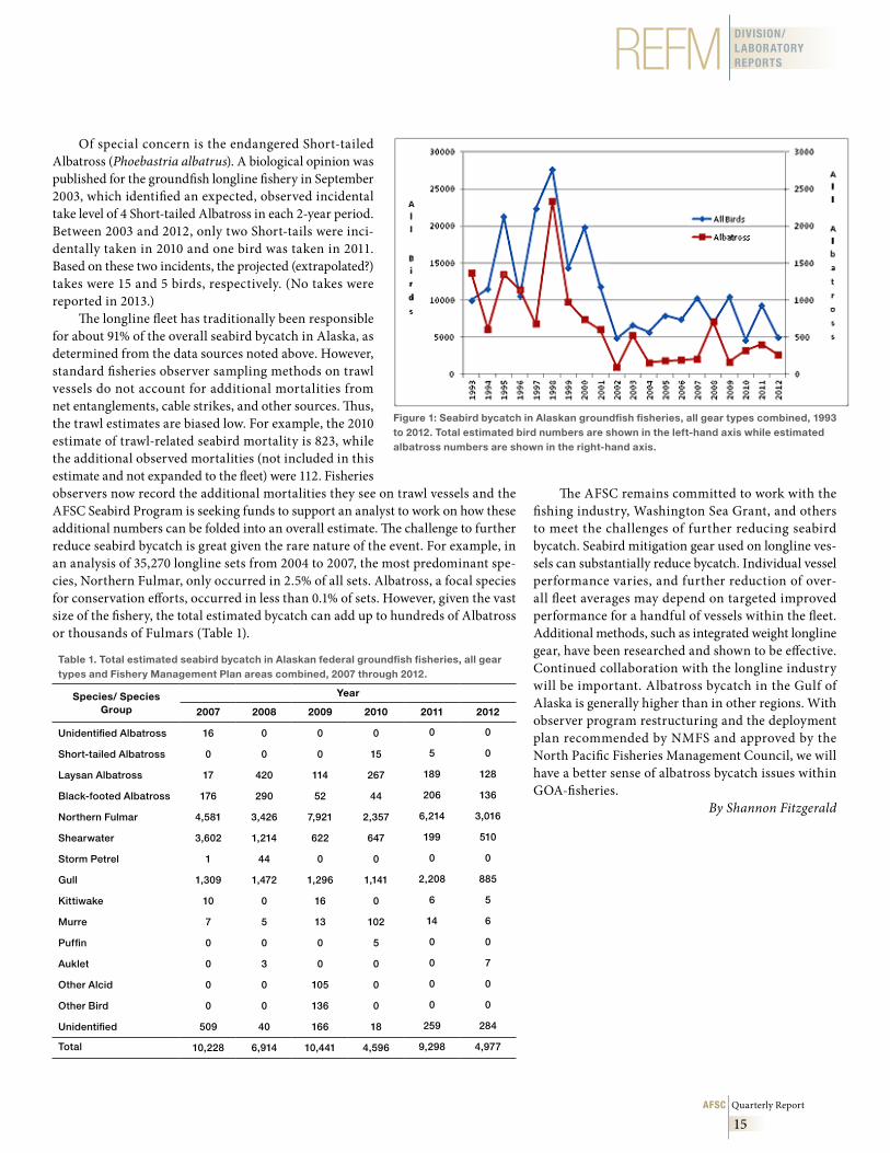
Seabird Bycatch Estimates for Alaskan Groundfish Fisheries, 1993-2012Seabirds are caught as bycatch in Alaskan commercial groundfish fisheries oper-ating in federal waters of the U.S. Exclusive Economic Zone. Fisheries observ-ers record seabird bycatch from their sample and other sources while on board these demersal longline, pot, pelagic trawl, and non-pelagic trawl vessels. The AFSC produces annual estimates of total seabird bycatch from these fisheries each year. Estimates are based on two sources of information: 1) data provided by NMFS-certified fishery observers deployed to vessels and floating or sho-reside processing plants, and 2) industry reports of catch and production. The 2007-12 seabird bycatch estimates presented here (Table 1) are produced from the NMFS Alaska Regional Office Catch Accounting System (CAS).
These estimates update those previously reported from 1993 to 2006. These numbers do not apply to gillnet, seine, troll, or halibut longline fisheries. Data collection on the Pacific halibut longline fishery began in 2013 and will be sum-marized in future documents. Figure 1 provides seabird bycatch in the ground-fish fisheries for 1993 through 2012, using results from two analytical methods employed. The AFSC produced estimates from 1993 through 2006 and the CAS from 2007 through 2012.
The 2012 numbers for the combined groundfish fisheries (Table 1) are 40% below the rolling 5-year average of 8,295 for 2007-11. Albatross bycatch was reduced in 2012 by 27% compared to the previous 5 years, with the greatest decrease in Laysan (Phoebastria immutabilis) versus Black-footed (P. nigripes) Albatross (36% and 11% declines, respectively). Northern fulmar (Fulmaris glacialis) bycatch, down by 39% compared to the 5-year average and 52% from the year before, remained the highest proportion in the catch at 61%. Fulmar bycatch has ranged between 45% and 76% of the total seabird bycatch since 2007. Average annual mortality for fulmars since 2007 has been 4,586. However, when compared to estimates of total population size in Alaska of 1.4 million, this represents an annual 0.33% mortality due to fisheries. There is some concern that the mortality could be colony-specific, possibly leading to local depletions.
The demersal longline fishery in Alaska typically drives the overall esti-mated bycatch numbers and constitutes about 91% of seabird bycatch annually (but see comment regarding trawl estimates below). Bycatch in the longline fish-ery showed a marked decline beginning in 2002 (Fig. 1) due to the deployment of streamer lines as bird deterrents. Since then, annual bycatch has remained below 10,000 birds, dropping as low as 3,704 in 2010. Numbers increased to 8,914 in 2011, the second highest in the streamer line era, but fell back to 4,544 in 2012. The increased numbers in 2011 were due to a doubling of the gull (Larus spp.) numbers (1,084 to 2,206) and a 3-fold increase in fulmars, from 1,782 to 5,848. These species group numbers have decreased in 2012 as well, to 885 and 3,016 respectively. There are many factors that may influence annual variation in bycatch rates, including seabird distribution, population trends, prey supply, and fisheries activities. Work has continued on developing new and refining existing mitigation gear.
Albatross bycatch varied annually. The greatest numbers of albatross were caught in 2008. In 2012, 57.0% of albatross bycatch occurred in the Gulf of Alaska (GOA) (down from 87% in 2011). The GOA typically accounts for 10% to 20% of overall seabird bycatch. Only Laysan Albatross were taken in the Bering Sea-Aleutian Islands (BSAI), and all Black-footed Albatross were taken in the GOA (along with about 14 Laysan). While the estimated bycatch of Black-footed Albatross underwent a 4-fold increase in bycatch (44 to 206) between 2010 and 2011, the 2012 numbers are about 11% under the long-term average of 153 birds per year. Although the Black-footed Albatross is not endangered (like its rela-tive, the Short-tailed Albatross), it was considered for listing as threatened and is currently a Bird of Conservation Concern by the U.S. Fish & Wildlife Service.
AFSC Quarterly Report
15
REFM DIVISION/LABORATORY REPORTS
Of special concern is the endangered Short-tailed Albatross (Phoebastria albatrus). A biological opinion was published for the groundfish longline fishery in September 2003, which identified an expected, observed incidental take level of 4 Short-tailed Albatross in each 2-year period. Between 2003 and 2012, only two Short-tails were inci-dentally taken in 2010 and one bird was taken in 2011. Based on these two incidents, the projected (extrapolated?) takes were 15 and 5 birds, respectively. (No takes were reported in 2013.)
The longline fleet has traditionally been responsible for about 91% of the overall seabird bycatch in Alaska, as determined from the data sources noted above. However, standard fisheries observer sampling methods on trawl vessels do not account for additional mortalities from net entanglements, cable strikes, and other sources. Thus, the trawl estimates are biased low. For example, the 2010 estimate of trawl-related seabird mortality is 823, while the additional observed mortalities (not included in this estimate and not expanded to the fleet) were 112. Fisheries observers now record the additional mortalities they see on trawl vessels and the AFSC Seabird Program is seeking funds to support an analyst to work on how these additional numbers can be folded into an overall estimate. The challenge to further reduce seabird bycatch is great given the rare nature of the event. For example, in an analysis of 35,270 longline sets from 2004 to 2007, the most predominant spe-cies, Northern Fulmar, only occurred in 2.5% of all sets. Albatross, a focal species for conservation efforts, occurred in less than 0.1% of sets. However, given the vast size of the fishery, the total estimated bycatch can add up to hundreds of Albatross or thousands of Fulmars (Table 1).
Table 1 . Total estimated seabird bycatch in Alaskan federal groundfish fisheries, all gear types and Fishery Management Plan areas combined, 2007 through 2012 .
Species/ Species Group
Year
2007 2008 2009 2010 2011 2012
Unidentified Albatross 16 0 0 0 0 0
Short-tailed Albatross 0 0 0 15 5 0
Laysan Albatross 17 420 114 267 189 128
Black-footed Albatross 176 290 52 44 206 136
Northern Fulmar 4,581 3,426 7,921 2,357 6,214 3,016
Shearwater 3,602 1,214 622 647 199 510
Storm Petrel 1 44 0 0 0 0
Gull 1,309 1,472 1,296 1,141 2,208 885
Kittiwake 10 0 16 0 6 5
Murre 7 5 13 102 14 6
Puffin 0 0 0 5 0 0
Auklet 0 3 0 0 0 7
Other Alcid 0 0 105 0 0 0
Other Bird 0 0 136 0 0 0
Unidentified 509 40 166 18 259 284
Total 10,228 6,914 10,441 4,596 9,298 4,977
Figure 1: Seabird bycatch in Alaskan groundfish fisheries, all gear types combined, 1993 to 2012 . Total estimated bird numbers are shown in the left-hand axis while estimated albatross numbers are shown in the right-hand axis .
The AFSC remains committed to work with the fishing industry, Washington Sea Grant, and others to meet the challenges of further reducing seabird bycatch. Seabird mitigation gear used on longline ves-sels can substantially reduce bycatch. Individual vessel performance varies, and further reduction of over-all fleet averages may depend on targeted improved performance for a handful of vessels within the fleet. Additional methods, such as integrated weight longline gear, have been researched and shown to be effective. Continued collaboration with the longline industry will be important. Albatross bycatch in the Gulf of Alaska is generally higher than in other regions. With observer program restructuring and the deployment plan recommended by NMFS and approved by the North Pacific Fisheries Management Council, we will have a better sense of albatross bycatch issues within GOA-fisheries.
By Shannon Fitzgerald
October November December 2013
16
REFMDIVISION/LABORATORY
REPORTS
Economics & Social Sciences Research Program
Bering Sea Tanner Crab Bioeconomic Model to Forecast Effects of Ocean Acidification
A bioeconomic model for the Bering Sea Tanner crab stock was developed to forecast effects of ocean acidification. This model contains separate dynamics for juvenile and adult crabs and is linked to a bioeco-nomic model for Bering Sea snow crab. The model uses estimates of impacts of ocean acidification on juvenile Tanner crab from experiments conducted at the AFSC Kodiak lab. Future impacts of ocean acidification on the growth and survival of juvenile Tanner crab could con-strain the snow crab fishery and cause a wide range of economic impacts. We will link the bioeconomic models for Tanner and snow crab to a regional economic model for Alaska to make projections of these impacts for an ocean acidification scenario.
By Chang Seung, Michael Dalton, and André Punt
Measuring the Economic Contribution of Alaska Head and Gut Catcher-Processors
The Alaska Head and Gut (H&G) catcher-processor fleet is a major player in Bering Sea and Aleutian Island (BSAI) groundfish fisheries and was recently rationalized under Amendment 80 (A80) to the BSAI groundfish fishery man-agement plan. The H&G fleet has demonstrated an interest in quantifying its economic impact within Alaska and on the West Coast and the rest of the United States. In 2006, an industry group commissioned a study that used input-output (IO) analysis to estimate the economic contribution of the H&G sector to Dutch Harbor and the state of Alaska. However, anecdotal evidence on the location of input purchasing, repair and maintenance, hiring, shipping, and vessel ownership suggests that spillover of economic impacts to the west coast (especially Seattle) and other U.S. regions may be significant. Consequently, we developed a multiregional social accounting matrix (MRSAM) model of three U.S. regions (Alaska, the West Coast, and the rest of the United States). We estimated the multiregional contribution of the H&G industry and evaluated multiregional impacts of hypothetical changes in H&G sector production in terms of output, employment, and income. Results of the economic contribu-tion analysis show that the A80 H&G sector’s $281 million of first wholesale revenues produced in 2008 generated approximately $1 billion of total output, and accounted for an estimated 6,800 total jobs in the combined three regions (including the H&G sector’s estimated 2,200 total employees). Results also indi-cate that more than half of the impacts from the H&G fleet on total output and about 80% of the impacts from the fleet on household income accrue outside Alaska, and that the H&G fleet is relatively insensitive to changes in the world prices of its primary products.
By Chang Seung, Michael Dalton, and Edward Waters
Fishery Income Diversification and Risk for Fishermen and Fishing Communities of the U.S. West Coast and AlaskaCatch and price data from many fisheries exhibit high inter-annual variability, leading to variability in the income derived by fishery participants and communities dependent on the fisheries. The economic risk posed by this variability might be mitigated in some cases if individuals and communities participate in several dif-ferent fisheries, particularly if revenues from those fisheries are uncorrelated or vary asynchronously. However, the ability of fishermen to diversify may be limited (or facilitated) by management approaches and regulatory actions.
Continuing the work of Kasperski and Holland (2013), we are in the process of constructing indices of gross income diversification from fisheries at the level of individual vessels and individual fishing communi-ties from 1981 to 2012. Our data set includes over 28,000 vessels with average fishing revenues of more than $5,000 (adjusted to 2005 values) and at least 2 years of documented landings as well as more than 200 fishing communities along the U.S. West Coast and Alaska. The large data set enables us to identify trends in diver-sification and relationships between diversification and variation in revenues despite the relationship being very noisy. We evaluate the relationship between annual variability of fishing revenues and diversification of fishing revenues and find a dome-shaped relationship between diversification and the annual variation in rev-enues for individual vessels, as well as fishing communities. This implies that a small amount of diversification increases income variability, but moderate amounts of diversification can substantially reduce the variability in income that individuals and communities receive from fishing. We also find a steady but moderate reduction in diversification over the last three decades for currently active fishermen, but no clear trend across all fish-ing communities. We expect to post our updated results in both the California Current and Alaska Complex Integrated Ecosystem Assessment web pages (http://www.noaa.gov/iea/) in early 2014.
By Stephen Kasperski
AFSC Quarterly Report
17
REFM DIVISION/LABORATORY REPORTS
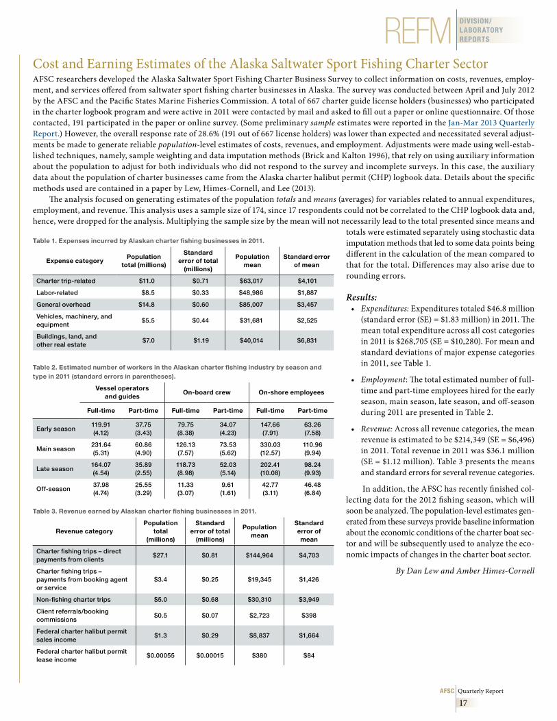
Cost and Earning Estimates of the Alaska Saltwater Sport Fishing Charter SectorAFSC researchers developed the Alaska Saltwater Sport Fishing Charter Business Survey to collect information on costs, revenues, employ-ment, and services offered from saltwater sport fishing charter businesses in Alaska. The survey was conducted between April and July 2012 by the AFSC and the Pacific States Marine Fisheries Commission. A total of 667 charter guide license holders (businesses) who participated in the charter logbook program and were active in 2011 were contacted by mail and asked to fill out a paper or online questionnaire. Of those contacted, 191 participated in the paper or online survey. (Some preliminary sample estimates were reported in the Jan-Mar 2013 Quarterly Report.) However, the overall response rate of 28.6% (191 out of 667 license holders) was lower than expected and necessitated several adjust-ments be made to generate reliable population-level estimates of costs, revenues, and employment. Adjustments were made using well-estab-lished techniques, namely, sample weighting and data imputation methods (Brick and Kalton 1996), that rely on using auxiliary information about the population to adjust for both individuals who did not respond to the survey and incomplete surveys. In this case, the auxiliary data about the population of charter businesses came from the Alaska charter halibut permit (CHP) logbook data. Details about the specific methods used are contained in a paper by Lew, Himes-Cornell, and Lee (2013).
The analysis focused on generating estimates of the population totals and means (averages) for variables related to annual expenditures, employment, and revenue. This analysis uses a sample size of 174, since 17 respondents could not be correlated to the CHP logbook data and, hence, were dropped for the analysis. Multiplying the sample size by the mean will not necessarily lead to the total presented since means and
totals were estimated separately using stochastic data imputation methods that led to some data points being different in the calculation of the mean compared to that for the total. Differences may also arise due to rounding errors.
Results:• Expenditures: Expenditures totaled $46.8 million
(standard error (SE) = $1.83 million) in 2011. The mean total expenditure across all cost categories in 2011 is $268,705 (SE = $10,280). For mean and standard deviations of major expense categories in 2011, see Table 1.
• Employment: The total estimated number of full-time and part-time employees hired for the early season, main season, late season, and off-season during 2011 are presented in Table 2.
• Revenue: Across all revenue categories, the mean revenue is estimated to be $214,349 (SE = $6,496) in 2011. Total revenue in 2011 was $36.1 million (SE = $1.12 million). Table 3 presents the means and standard errors for several revenue categories.
In addition, the AFSC has recently finished col-lecting data for the 2012 fishing season, which will soon be analyzed. The population-level estimates gen-erated from these surveys provide baseline information about the economic conditions of the charter boat sec-tor and will be subsequently used to analyze the eco-nomic impacts of changes in the charter boat sector.
By Dan Lew and Amber Himes-Cornell
Table 1 . Expenses incurred by Alaskan charter fishing businesses in 2011 .
Expense categoryPopulation
total (millions)
Standard error of total
(millions)
Population mean
Standard error of mean
Charter trip-related $11.0 $0.71 $63,017 $4,101
Labor-related $8.5 $0.33 $48,986 $1,887
General overhead $14.8 $0.60 $85,007 $3,457
Vehicles, machinery, and equipment
$5.5 $0.44 $31,681 $2,525
Buildings, land, and other real estate
$7.0 $1.19 $40,014 $6,831
Table 2 . Estimated number of workers in the Alaskan charter fishing industry by season and type in 2011 (standard errors in parentheses) .
Vessel operators and guides
On-board crew On-shore employees
Full-time Part-time Full-time Part-time Full-time Part-time
Early season119.91(4.12)
37.75(3.43)
79.75(8.38)
34.07(4.23)
147.66(7.91)
63.26(7.58)
Main season231.64(5.31)
60.86(4.90)
126.13(7.57)
73.53(5.62)
330.03(12.57)
110.96(9.94)
Late season164.07(4.54)
35.89(2.55)
118.73(8.98)
52.03(5.14)
202.41(10.08)
98.24(9.93)
Off-season37.98(4.74)
25.55(3.29)
11.33(3.07)
9.61(1.61)
42.77(3.11)
46.48(6.84)
Table 3 . Revenue earned by Alaskan charter fishing businesses in 2011 .
Revenue categoryPopulation
total (millions)
Standard error of total
(millions)
Population mean
Standard error of mean
Charter fishing trips – direct payments from clients
$27.1 $0.81 $144,964 $4,703
Charter fishing trips – payments from booking agent or service
$3.4 $0.25 $19,345 $1,426
Non-fishing charter trips $5.0 $0.68 $30,310 $3,949
Client referrals/booking commissions
$0.5 $0.07 $2,723 $398
Federal charter halibut permit sales income
$1.3 $0.29 $8,837 $1,664
Federal charter halibut permit lease income
$0.00055 $0.00015 $380 $84
October November December 2013
18
REFMDIVISION/LABORATORY
REPORTS
Gulf of Alaska Trawl Fishery, Rationalization Sociocultural StudyThe North Pacific Fishery Management Council (NPFMC) is considering the implementation of a new, yet to be defined, bycatch management program (which could include a catch share component) for the Gulf of Alaska trawl fishery. Changes in how fisheries are managed result in changes to the people within the fishery. This research project aims to study the affected individuals both prior to and after the implementation of the rationalization pro-gram. The data collected will provide a baseline descrip-tion of the industry as well as allow for analysis of changes that may face individuals and communities. The measure-ment of these changes will lead to a greater understanding of the social impacts the management measure may have on the individuals and communities affected by fisheries regulations. To achieve these goals, it is critical to collect the necessary data prior to the implementation of the ratio-nalization program so that the effects of the program may be better isolated.
The initial round of survey implementation will occur primarily through in-person surveys and semi-structured to unstructured interviews in spring and summer 2014. Staff from the Economic and Social Sciences Research (ESSR) program have developed the questionnaire and are wait-ing for Office of Management and Budget (OMB) approval. In person interviews will likely take place in Seattle (WA), Newport (OR), Kodiak (AK), Sand Point (AK) and King Cove (AK) (locations may change slightly). Interviewers will discuss the research with study participants, adminis-ter the surveys, be available to answer any questions, code the surveys for anonymity and confidentiality, and collect all the surveys upon completion. In the event individuals are unavailable to meet in person, various options will be avail-able. Hard copy surveys will be provided either in person or via the mail, and electronic versions will be available either for distribution via email or accessible over the internet.
We hope to reach all individuals, partners, and busi-nesses that have any connection to the Gulf of Alaska trawl fishery. Types of respondents expected include fish-ermen, vessel owners, vessel operators, groundfish License Limitation Program license owners/holders, crew aboard groundfish trawl vessels, catcher-processor operations, sho-reside processors, tenders, and other individuals who are stakeholders in the fishery. In addition, the survey/interview pool will include any businesses that are directly tied to the groundfish trawl communities through the supply of com-mercial items to include (but not limited to) net suppliers, fuel suppliers, or equipment suppliers. If you are a Gulf of Alaska trawl groundfish participant interested in partici-pating in the survey, please provide your contact informa-tion to Dr. Amber Himes-Cornell, NOAA, Alaska Fisheries Science Center, 7600 Sand Point Way NE, Seattle, WA 98115 USA and we will make sure you are included in the survey.
By Amber Himes-Cornell and Stephen Kasperski
Advances in the Stock Assessment and Fisheries Evaluation – Economic Status ReportEach year the Economics & Social Sciences Research Program documents and evaluates the economic status of the North Pacific groundfish fisheries. The results of this analysis are compiled into an economic chapter of the Stock Assessment and Fisheries Evaluation (SAFE) Report. The Economic SAFE gives managers and stakeholders recent estimates of economic variables character-izing the fisheries. As the needs of management and stakeholders evolve, so should the Economic SAFE evolve to meet these changing demands.
The 2013 Economic SAFE provides an annual update to the overview, eco-nomic data tables, economic indices, and market profiles. The economic data tables report ex-vessel and wholesale value; production and price; discards and prohibited species catch; and the composition of the fleet. The data are printed in tables that stratify the data along different dimensions. In addition, data are available as Excel files that also provide longer time series of the data when available. Economic indices that evaluate the economic performance through value, price, and quantity, across species, product, and gear types are also presented. Market profiles discuss the markets for selects products of pol-lock, Pacific cod, sablefish, and yellowfin sole and display trends observed in prices, volume, supply, and demand. Finally, new and ongoing research and data collection programs by AFSC social scientists are summarized, and recent scientific publications are listed.
In addition to these annual updates three new sections have been added to the Economic SAFE report that analyze catch share programs, community participation, and the Amendment 80 fleet. Furthermore, an appendix includes some new alternative economic data tables. The following summarizes these additions.
Economic Performance Metrics for North Pacific Groundfish Catch Share Programs: Six of the 15 catch-share programs currently in operation through-out the United States operate in the North Pacific, accounting for approxi-mately 75% of groundfish landings. These programs are the Western Alaska Community Development Quota, Alaska Halibut and Sablefish IFQ, American Fisheries Act Pollock Cooperatives, BSAI Crab Rationalization, Non-Pollock Trawl Catcher/Processor Groundfish Cooperatives, and the Central Gulf of Alaska Rockfish Program. This section presents a set of indicators to assess the economic performance of these programs. The catch and landings metrics are the ACL (annual catch limit) or quota level, whether the ACL or quota was exceeded, aggregate landings, the percent of the quota that was utilized, and whether there is a share cap in place. The effort metrics are the number of active vessels, the number of entities holding share, and the season length. The rev-enue metrics are the aggregate revenue from catch share species, average prices of catch share species, the revenue per active vessel, and the Gini coefficient.
Community Participation in North Pacific Groundfish Fisheries: The breadth of Alaskan communities involved in fishing is significant and is indicative of importance of fishery-related activity to the overall economy and social organization of Alaska. In addition to aggregate information on community demographics, this section discusses the revenues communities have received from fish taxes; how communities relate the development of commercial fish-ing industry; fish landings and processing within communities; and labor par-ticipation in the commercial fishing industry.
AFSC Quarterly Report
19
DIVISION/LABORATORY REPORTS
BSAI Non-pol lock Trawl Catcher-Processor Groundfish Cooperatives (Amendment 80) Program: Summary of Economic Status of the Fishery: This section summarizes the economic data collected in association with the rationalization program for the f leet defined under Amendment 80 of the Fishery Management Plan over the 5-year period follow-ing its implementation in 2008. In general, the data reported include: changes in the physical characteris-tics of the fleet, including productive capacity (freezer and processing line capacity and maximum potential throughput); fuel consumption rates; efficiency and diversification of processing output; investment in ves-sel capital improvements; operational costs incurred for fishing and processing; employment and compen-sation of vessel crews and processing employees.
Additional Economic Data Tables: Alternative meth-ods are used to present data for two sets of tables. The first set of tables present ex-vessel prices and value uti-lizing prices derived from Alaska Department of Fish and Game fish tickets priced by the Alaska Commercial Fisheries Entry Commission. This provides an alter-native source of ex-vessel prices to the Commercial Operator Annual Report purchasing data that has his-torically been used to assemble ex-vessel prices and value. The second set of tables present data on fishing vessels that are clearly not small entities and fishing vessels that may be small entities with entity size deter-mined accounting for vessels’ affiliation with a group (e.g. cooperative). These tables provide an alternative tabulation of vessel counts and average revenues com-pared to what has been used to assemble data on small and large vessels, where small entity status is deter-mined without regard to affiliation. While the alterna-tive methods for both sets of tables may represent an improvement, these changes are still being researched and are therefore included as an appendix.
The Economic SAFE will continue to evolve to meet the needs of management and stakeholders. We plan to improve the structure and format of the doc-ument to make the information and data contained within the report more accessible. Furthermore, we will continue our outreach efforts by attempting to engage users of the Economic SAFE so that we can improve future reports. Readers of this report can con-tribute to our efforts to improve the Economic SAFE by completing the online survey or by contacting [email protected]
By Ben Fissel
Status of Stocks & Multispecies Assessment Program
AFSC Researchers Support 2014 Biological OpinionA hot topic for the National Marine Fisheries Service (NMFS) in Alaska over the past several years has been the ongoing Endangered Species Act Section 7 consul-tation Biological Opinion on the potential effects of the groundfish fisheries on the endangered western stock of Steller sea lions (Eumetopias jubatus). The most recent consultation concerns fishing in the Aleutian Islands, which was restricted after the 2010 Biological Opinion. The NMFS Alaska Regional office prepared a draft environmental impact statement (EIS) in 2013 and is in the process of preparing both the final EIS and a new Biological Opinion on this issue in 2014. Center staff from several divisions are active in research relating to Steller sea lions and have contributed support and assistance in the preparation of both documents during this past year.
Researchers from the AFSC Fisheries Interaction Team (FIT) met with marine mammal researchers and NMFS regional staff several times during 2013 to deter-mine what data sources and research results or analyses could be used to support the 2014 Biological Opinion. The scientists discussed how previous analyses could be improved, and which data were available to describe dynamics in the Aleutian Islands. In particular, researchers looked for ways to use existing data at smaller spatial scales than the entire management region, to determine if correlations occurred between sea lion population trends and groundfish abundance or harvest in smaller areas within the Aleutians.
After careful review and consultation with the AFSC’s RACE (survey) Division, we concluded that groundfish trawl survey data could be summarized at the spatial scale of the survey subareas, but that analysis at any finer spatial scale would not be scientifically defensible. The trawl survey divides the Aleutians into depth inter-vals (0-100m, 100-200m, 200-300m, 300-500m) and into spatial subareas defined by ocean basin and latitude, dividing the three regulatory areas of the Aleutians (statistical reporting areas 541, 542, and 543) into 10 subareas (Fig. 2). Our FIT
researchers assembled a white paper summa-rizing existing trawl survey biomass esti-mates and f isheries observer data by these subareas, and look-ing for any evidence of trends over time (1991 – 2012), indications of seasonal differences in groundfish abundance, or spatial shifts in spe-cies composition of the groundfish most prev-alent in sea lion diets.
Reproductive seasons of groundfish prey species were also summarized into a combined table, as fish prey are often of particularly high nutritional value dur-ing spawning seasons.
The goal of these efforts was to collate and summarize existing data, pub-lications, and recent research to describe the spatial and temporal distribution of groundfish in the Aleutian Islands, so that the authors of the 2014 Biological Opinion would have a clear picture of the Steller sea lion prey resources both inside and outside of areas designated as critical habitat. The resulting white paper and several analyses provided by the National Marine Mammal Lab have been made public on the NMFS Alaska Protected Resource website:
By Elizabeth Conners
REFM
Figure 2 . Management areas (numbered), survey subareas (colored), and critical habitat zones for the eastern Aleutian Islands .
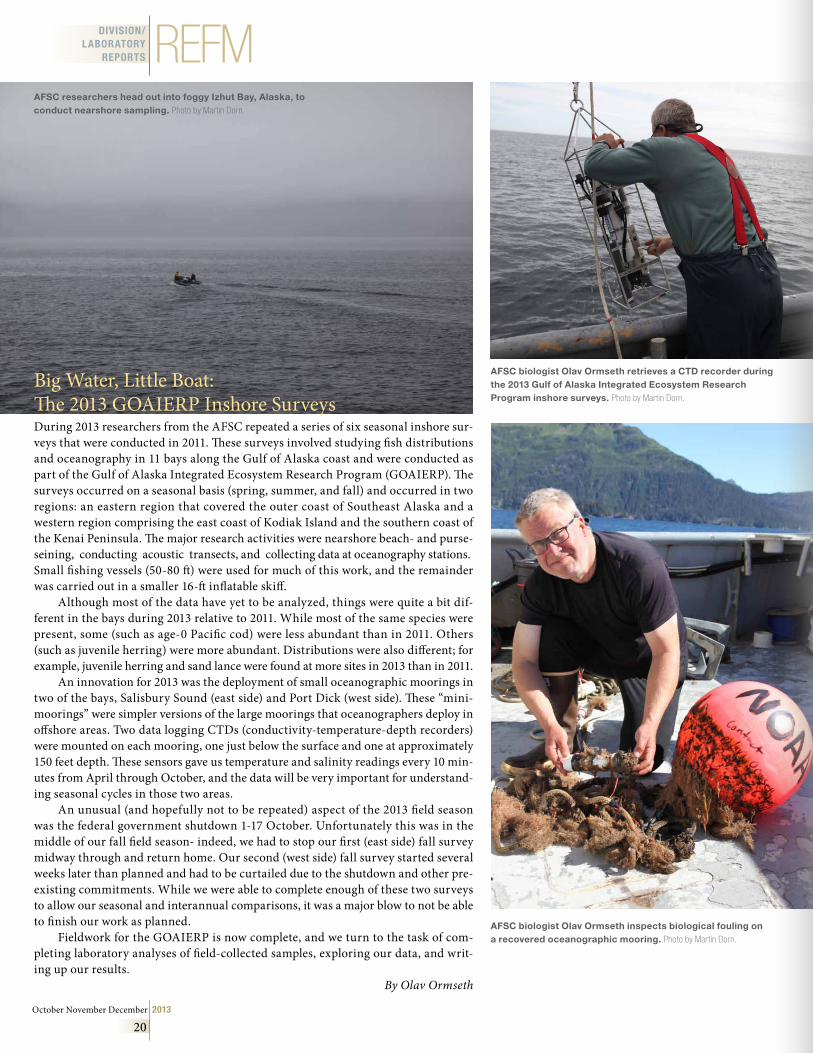
October November December 2013
20
REFMDIVISION/LABORATORY
REPORTS
Big Water, Little Boat: The 2013 GOAIERP Inshore SurveysDuring 2013 researchers from the AFSC repeated a series of six seasonal inshore sur-veys that were conducted in 2011. These surveys involved studying fish distributions and oceanography in 11 bays along the Gulf of Alaska coast and were conducted as part of the Gulf of Alaska Integrated Ecosystem Research Program (GOAIERP). The surveys occurred on a seasonal basis (spring, summer, and fall) and occurred in two regions: an eastern region that covered the outer coast of Southeast Alaska and a western region comprising the east coast of Kodiak Island and the southern coast of the Kenai Peninsula. The major research activities were nearshore beach- and purse-seining, conducting acoustic transects, and collecting data at oceanography stations. Small fishing vessels (50-80 ft) were used for much of this work, and the remainder was carried out in a smaller 16-ft inflatable skiff.
Although most of the data have yet to be analyzed, things were quite a bit dif-ferent in the bays during 2013 relative to 2011. While most of the same species were present, some (such as age-0 Pacific cod) were less abundant than in 2011. Others (such as juvenile herring) were more abundant. Distributions were also different; for example, juvenile herring and sand lance were found at more sites in 2013 than in 2011.
An innovation for 2013 was the deployment of small oceanographic moorings in two of the bays, Salisbury Sound (east side) and Port Dick (west side). These “mini-moorings” were simpler versions of the large moorings that oceanographers deploy in offshore areas. Two data logging CTDs (conductivity-temperature-depth recorders) were mounted on each mooring, one just below the surface and one at approximately 150 feet depth. These sensors gave us temperature and salinity readings every 10 min-utes from April through October, and the data will be very important for understand-ing seasonal cycles in those two areas.
An unusual (and hopefully not to be repeated) aspect of the 2013 field season was the federal government shutdown 1-17 October. Unfortunately this was in the middle of our fall field season- indeed, we had to stop our first (east side) fall survey midway through and return home. Our second (west side) fall survey started several weeks later than planned and had to be curtailed due to the shutdown and other pre-existing commitments. While we were able to complete enough of these two surveys to allow our seasonal and interannual comparisons, it was a major blow to not be able to finish our work as planned.
Fieldwork for the GOAIERP is now complete, and we turn to the task of com-pleting laboratory analyses of field-collected samples, exploring our data, and writ-ing up our results.
By Olav Ormseth
AFSC biologist Olav Ormseth inspects biological fouling on a recovered oceanographic mooring . Photo by Martin Dorn.
AFSC researchers head out into foggy Izhut Bay, Alaska, to conduct nearshore sampling . Photo by Martin Dorn.
AFSC biologist Olav Ormseth retrieves a CTD recorder during the 2013 Gulf of Alaska Integrated Ecosystem Research Program inshore surveys . Photo by Martin Dorn.
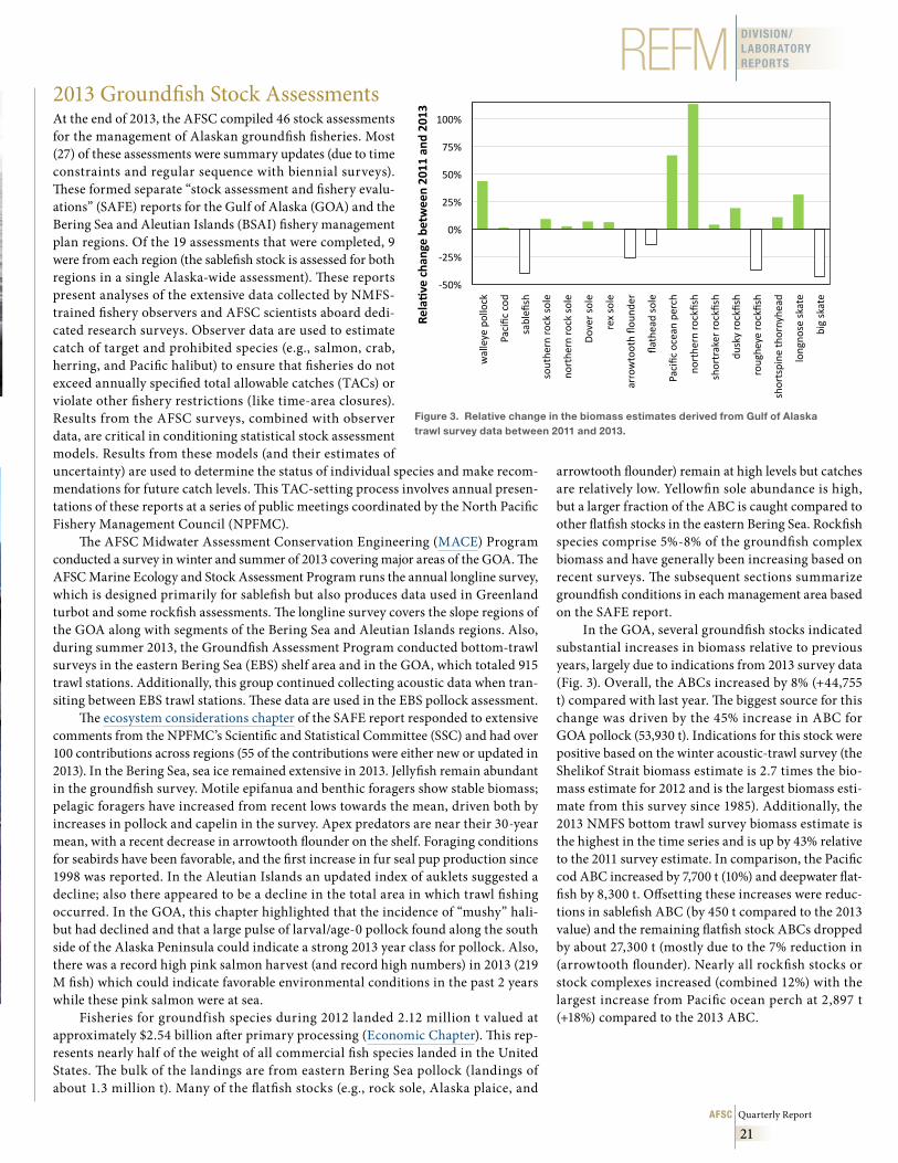
AFSC Quarterly Report
21
REFM DIVISION/LABORATORY REPORTS
2013 Groundfish Stock AssessmentsAt the end of 2013, the AFSC compiled 46 stock assessments for the management of Alaskan groundfish fisheries. Most (27) of these assessments were summary updates (due to time constraints and regular sequence with biennial surveys). These formed separate “stock assessment and fishery evalu-ations” (SAFE) reports for the Gulf of Alaska (GOA) and the Bering Sea and Aleutian Islands (BSAI) fishery management plan regions. Of the 19 assessments that were completed, 9 were from each region (the sablefish stock is assessed for both regions in a single Alaska-wide assessment). These reports present analyses of the extensive data collected by NMFS-trained fishery observers and AFSC scientists aboard dedi-cated research surveys. Observer data are used to estimate catch of target and prohibited species (e.g., salmon, crab, herring, and Pacific halibut) to ensure that fisheries do not exceed annually specified total allowable catches (TACs) or violate other fishery restrictions (like time-area closures). Results from the AFSC surveys, combined with observer data, are critical in conditioning statistical stock assessment models. Results from these models (and their estimates of uncertainty) are used to determine the status of individual species and make recom-mendations for future catch levels. This TAC-setting process involves annual presen-tations of these reports at a series of public meetings coordinated by the North Pacific Fishery Management Council (NPFMC).
The AFSC Midwater Assessment Conservation Engineering (MACE) Program conducted a survey in winter and summer of 2013 covering major areas of the GOA. The AFSC Marine Ecology and Stock Assessment Program runs the annual longline survey, which is designed primarily for sablefish but also produces data used in Greenland turbot and some rockfish assessments. The longline survey covers the slope regions of the GOA along with segments of the Bering Sea and Aleutian Islands regions. Also, during summer 2013, the Groundfish Assessment Program conducted bottom-trawl surveys in the eastern Bering Sea (EBS) shelf area and in the GOA, which totaled 915 trawl stations. Additionally, this group continued collecting acoustic data when tran-siting between EBS trawl stations. These data are used in the EBS pollock assessment.
The ecosystem considerations chapter of the SAFE report responded to extensive comments from the NPFMC’s Scientific and Statistical Committee (SSC) and had over 100 contributions across regions (55 of the contributions were either new or updated in 2013). In the Bering Sea, sea ice remained extensive in 2013. Jellyfish remain abundant in the groundfish survey. Motile epifanua and benthic foragers show stable biomass; pelagic foragers have increased from recent lows towards the mean, driven both by increases in pollock and capelin in the survey. Apex predators are near their 30-year mean, with a recent decrease in arrowtooth flounder on the shelf. Foraging conditions for seabirds have been favorable, and the first increase in fur seal pup production since 1998 was reported. In the Aleutian Islands an updated index of auklets suggested a decline; also there appeared to be a decline in the total area in which trawl fishing occurred. In the GOA, this chapter highlighted that the incidence of “mushy” hali-but had declined and that a large pulse of larval/age-0 pollock found along the south side of the Alaska Peninsula could indicate a strong 2013 year class for pollock. Also, there was a record high pink salmon harvest (and record high numbers) in 2013 (219 M fish) which could indicate favorable environmental conditions in the past 2 years while these pink salmon were at sea.
Fisheries for groundfish species during 2012 landed 2.12 million t valued at approximately $2.54 billion after primary processing (Economic Chapter). This rep-resents nearly half of the weight of all commercial fish species landed in the United States. The bulk of the landings are from eastern Bering Sea pollock (landings of about 1.3 million t). Many of the flatfish stocks (e.g., rock sole, Alaska plaice, and
arrowtooth flounder) remain at high levels but catches are relatively low. Yellowfin sole abundance is high, but a larger fraction of the ABC is caught compared to other flatfish stocks in the eastern Bering Sea. Rockfish species comprise 5%-8% of the groundfish complex biomass and have generally been increasing based on recent surveys. The subsequent sections summarize groundfish conditions in each management area based on the SAFE report.
In the GOA, several groundfish stocks indicated substantial increases in biomass relative to previous years, largely due to indications from 2013 survey data (Fig. 3). Overall, the ABCs increased by 8% (+44,755 t) compared with last year. The biggest source for this change was driven by the 45% increase in ABC for GOA pollock (53,930 t). Indications for this stock were positive based on the winter acoustic-trawl survey (the Shelikof Strait biomass estimate is 2.7 times the bio-mass estimate for 2012 and is the largest biomass esti-mate from this survey since 1985). Additionally, the 2013 NMFS bottom trawl survey biomass estimate is the highest in the time series and is up by 43% relative to the 2011 survey estimate. In comparison, the Pacific cod ABC increased by 7,700 t (10%) and deepwater flat-fish by 8,300 t. Offsetting these increases were reduc-tions in sablefish ABC (by 450 t compared to the 2013 value) and the remaining flatfish stock ABCs dropped by about 27,300 t (mostly due to the 7% reduction in (arrowtooth flounder). Nearly all rockfish stocks or stock complexes increased (combined 12%) with the largest increase from Pacific ocean perch at 2,897 t (+18%) compared to the 2013 ABC.
-‐50%
-‐25%
0%
25%
50%
75%
100%
walleye pollock
Pacific cod
sablefi
sh
southe
rn ro
ck sole
northe
rn ro
ck sole
Dover sole
rex sole
arrowtooth flo
unde
r
flathead sole
Pacific ocean perch
northe
rn ro
ckfish
shortraker ro
ckfish
dusky rockfish
roughe
ye ro
ckfish
shortspine
thornyhe
ad
longno
se skate
big skate
Rela%ve cha
nge be
tween 20
11 and
201
3 Figure 3 . Relative change in the biomass estimates derived from Gulf of Alaska trawl survey data between 2011 and 2013 .
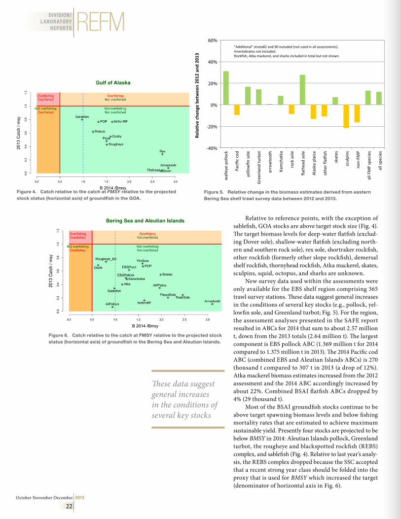
October November December 2013
22
REFMDIVISION/LABORATORY
REPORTS
Relative to reference points, with the exception of sablefish, GOA stocks are above target stock size (Fig. 4). The target biomass levels for deep-water flatfish (exclud-ing Dover sole), shallow-water flatfish (excluding north-ern and southern rock sole), rex sole, shortraker rockfish, other rockfish (formerly other slope rockfish), demersal shelf rockfish, thornyhead rockfish, Atka mackerel, skates, sculpins, squid, octopus, and sharks are unknown.
New survey data used within the assessments were only available for the EBS shelf region comprising 365 trawl survey stations. These data suggest general increases in the conditions of several key stocks (e.g., pollock, yel-lowfin sole, and Greenland turbot; Fig. 5). For the region, the assessment analyses presented in the SAFE report resulted in ABCs for 2014 that sum to about 2.57 million t, down from the 2013 totals (2.64 million t). The largest component is EBS pollock ABC (1.369 million t for 2014 compared to 1.375 million t in 2013). The 2014 Pacific cod ABC (combined EBS and Aleutian Islands ABCs) is 270 thousand t compared to 307 t in 2013 (a drop of 12%). Atka mackerel biomass estimates increased from the 2012 assessment and the 2014 ABC accordingly increased by about 22%. Combined BSAI flatfish ABCs dropped by 4% (29 thousand t).
Most of the BSAI groundfish stocks continue to be above target spawning biomass levels and below fishing mortality rates that are estimated to achieve maximum sustainable yield. Presently four stocks are projected to be below BMSY in 2014: Aleutian Islands pollock, Greenland turbot, the rougheye and blackspotted rockfish (REBS) complex, and sablefish (Fig. 4). Relative to last year’s analy-sis, the REBS complex dropped because the SSC accepted that a recent strong year class should be folded into the proxy that is used for BMSY which increased the target (denominator of horizontal axis in Fig. 6).
"Additional" strata82 and 90 included (not used in all assessments).Invertebrates not included.Rockfish, Atka mackerel, and sharks included in total but not shown.
60%
40%
20%
0%
-20%
-40%
Rela
tive
cha
nge
betw
een
2012
and
201
3
wal
leye
pol
lock
Paci
fic c
od
yello
wfin
sol
e
Gre
enla
nd tu
rbot
arro
wto
oth
Kam
chat
ka
rock
sol
e
flath
ead
sole
Ala
ska
plai
ce
othe
r fla
tfis
h
skat
es
scul
pins
non-
FMP
all F
MP
spec
ies
all s
peci
es
Figure 4 . Catch relative to the catch at FMSY relative to the projected stock status (horizontal axis) of groundfish in the GOA .
Figure 5 . Relative change in the biomass estimates derived from eastern Bering Sea shelf trawl survey data between 2012 and 2013 .
Figure 6 . Catch relative to the catch at FMSY relative to the projected stock status (horizontal axis) of groundfish in the Bering Sea and Aleutian Islands .
These data suggest general increases in the conditions of several key stocks
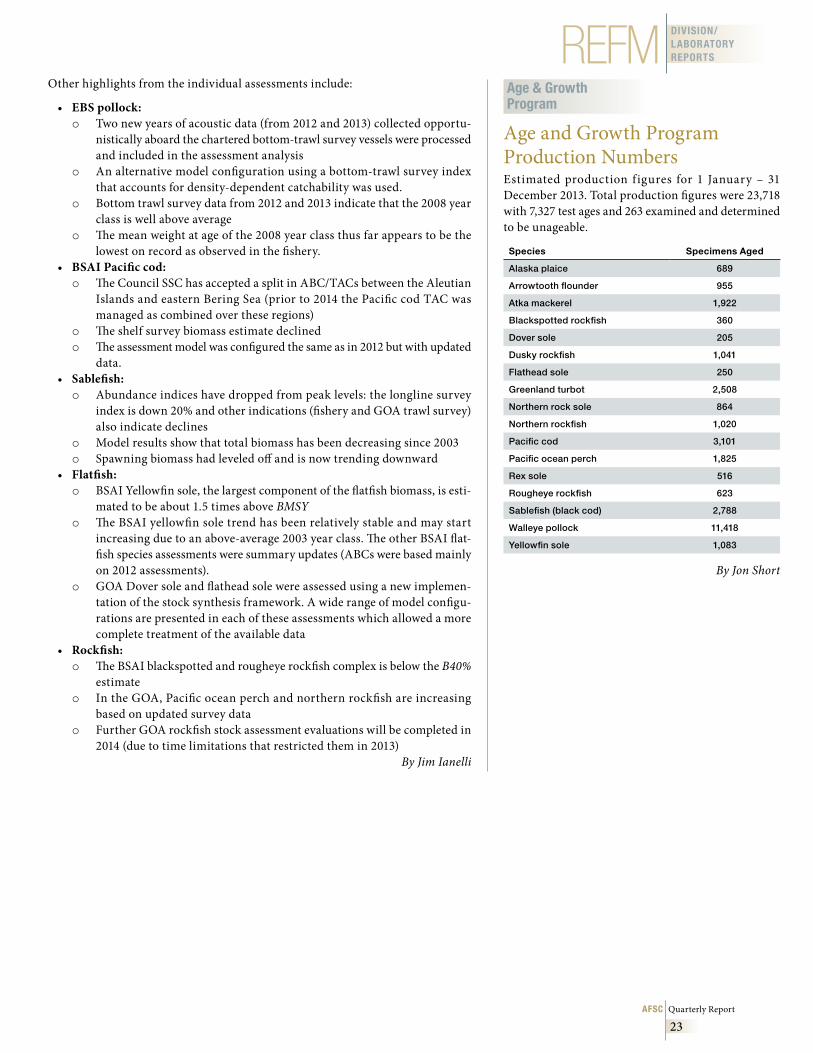
AFSC Quarterly Report
23
REFM DIVISION/LABORATORY REPORTS
Other highlights from the individual assessments include:
• EBS pollock: o Two new years of acoustic data (from 2012 and 2013) collected opportu-
nistically aboard the chartered bottom-trawl survey vessels were processed and included in the assessment analysis
o An alternative model configuration using a bottom-trawl survey index that accounts for density-dependent catchability was used.
o Bottom trawl survey data from 2012 and 2013 indicate that the 2008 year class is well above average
o The mean weight at age of the 2008 year class thus far appears to be the lowest on record as observed in the fishery.
• BSAI Pacific cod:o The Council SSC has accepted a split in ABC/TACs between the Aleutian
Islands and eastern Bering Sea (prior to 2014 the Pacific cod TAC was managed as combined over these regions)
o The shelf survey biomass estimate declined o The assessment model was configured the same as in 2012 but with updated
data. • Sablefish:o Abundance indices have dropped from peak levels: the longline survey
index is down 20% and other indications (fishery and GOA trawl survey) also indicate declines
o Model results show that total biomass has been decreasing since 2003o Spawning biomass had leveled off and is now trending downward
• Flatfish: o BSAI Yellowfin sole, the largest component of the flatfish biomass, is esti-
mated to be about 1.5 times above BMSY o The BSAI yellowfin sole trend has been relatively stable and may start
increasing due to an above-average 2003 year class. The other BSAI flat-fish species assessments were summary updates (ABCs were based mainly on 2012 assessments).
o GOA Dover sole and flathead sole were assessed using a new implemen-tation of the stock synthesis framework. A wide range of model configu-rations are presented in each of these assessments which allowed a more complete treatment of the available data
• Rockfish:o The BSAI blackspotted and rougheye rockfish complex is below the B40%
estimateo In the GOA, Pacific ocean perch and northern rockfish are increasing
based on updated survey datao Further GOA rockfish stock assessment evaluations will be completed in
2014 (due to time limitations that restricted them in 2013)By Jim Ianelli
Age & Growth Program
Age and Growth Program Production NumbersEstimated production figures for 1 January – 31 December 2013. Total production figures were 23,718 with 7,327 test ages and 263 examined and determined to be unageable.
Species Specimens Aged
Alaska plaice 689
Arrowtooth flounder 955
Atka mackerel 1,922
Blackspotted rockfish 360
Dover sole 205
Dusky rockfish 1,041
Flathead sole 250
Greenland turbot 2,508
Northern rock sole 864
Northern rockfish 1,020
Pacific cod 3,101
Pacific ocean perch 1,825
Rex sole 516
Rougheye rockfish 623
Sablefish (black cod) 2,788
Walleye pollock 11,418
Yellowfin sole 1,083
By Jon Short
October November December 2013
24
AFSCBrowman, H .I ., S . Dupont, J . Havenhand, L . Robbins, M . Beman, C . Duarte, M . Fine, J .H . Fosså, J . Hall-Spencer, P . Hallock-Muller, T.P. Hurst, D . Iglesias-Rodriguez, P . Knorr, H . Kurihara, J . Lisle, C . Manno, S . McCoy, F . Melzner, P . Munday, H-O . Pörtner, J . Ries, D . Robert, J . Runge, D . Scott, H .R . Skjoldal, K . Suzuki, F . Thingstad, and T . Wootton .2013. Biological responses to ocean acidif ication, p. 37-54. In AMAP, 2013. AMAP Assessment 2013: Arc-tic Ocean Acidification. Arctic Moni-toring and Assessment Programme (AMAP), Oslo, Norway. viii + 99 p.
Christman, C.L., J .J . Citta, L .T . Quakenbush, J .T . Clarke, B.K. Rone, R.A. Shea, M.C. Ferguson, and M .P . Heide-Jørgensen .2013. Presence and behavior of bowhead whales (Balaena mystice-tus) in the Alaskan Beaufort Sea in July 2011. Polar Biol. 36:1851–1856.
Collier, B .A ., S .L . Farrell, A .M . Long, A .J . Campomizzi, K .B . Hays, J.L. Laake, M .L . Morrison, and R .N . Wilkins . 2013. Modeling spatial ly explicit densities of endangered avian spe-cies in a heterogeneous landscape. Auk 130:666-676.
Conn, P.B., B.T. McClintock, M.F. Cameron, D.S. Johnson, E.E. Moreland, and P.L. Boveng.2013. Accommodating species identification errors in transect sur-veys. Ecology 94:2607-2618.
Cooper, D.W., J.T. Duffy-Anderson, W.T. Stockhausen, and W . Cheng . 2 013 . M o d e l e d c o n n e c t i v i t y between northern rock sole (Lepi-dopsetta polyxystra) spawning and nursery areas in the eastern Bering Sea. J. Sea Res. 84:2-12.
Garland, E.C., J . Gedamke, M .L . Rekdahl, M .J . Noad, C . Garrigue, and N . Gales . 2013. Humpback whale song on the Southern Ocean feeding grounds: Implications for cultural transmis-sion. PLoS One 8(11):e79422.
Hall, A .G ., J .B . McNeill, P.B. Conn, E . Davenport, and A .A . Hohn .2013. Seasonal co-occurrence of sea turtles, bottlenose dolphins, and commercial gill nets in southern Pamlico and northern Core Sounds, and adjacent coastal waters of North Carolina, USA. Endang. Spe-cies Res. 22:235-249.
Hooten, M .B ., E .M . Hanks, D.S. Johnson, and M .W . Alldredge . 2013. Reconciling resource utiliza-tion and resource selection func-tions. J. Anim. Ecol. 82(6):1146-1154.
Johnson, D.S ., M .B . Hooten, and C.E. Kuhn . 2013. Estimating animal resource selection from telemetry data using point process models. J. Anim. Ecol. 82:1155-1164.
Kotwicki, S., and R. Lauth . 2013. Detecting temporal trends and environmentally-driven chang-es in the spatial distribution of bot-tom fishes and crabs on the eastern Bering Sea shelf. Deep-Sea Res. II 94:231-243.
Maxwell, S .M ., E .L . Hazen, S .J . Bograd, B .S . Halpern, G .A . Breed, B . Nickel, N .M . Teutschel, L .B . Crowder, S . Benson, P .H . Dutton, H . Bailey, M .A . Kappes, C.E. Kuhn, M .J Weise, B . Mate, S .A . Shaffer, J .L . Hassrick, R .W . Henry, L . Irvine, B .I . McDonald, P .W . Robinson, B .A . Block, and D .P . Costa . 2013. Cumulative human impacts on marine predators. Nat. Commun. 4:2688.
Parsons, K.M., J.W. Durban, A .M . Burdin, V.N. Burkanov, R .L . Pitman, J . Barlow, L .G . Barrett-Lennard, R .G . Leduc, K .M . Robertson, C .O . Matkin, and P.R. Wade . 2013. Geographic patterns of genet-ic differentiation among killer whales in the nor thern North Pacif ic. J. Heredity 104:737-754.
Pienaar, E .F ., D.K. Lew, and K . Wallmo .2013. Are environmental attitudes influenced by survey context? An investigation of the context depen-dency of the New Ecological Para-digm (NEP) Scale. Soc. Sci. Res. 42:1542-1554.
Pinchuk, A .I ., K .O . Coyle, E.V. Farley, and H .M . Renn . 2013. Emergence of the Arctic The-misto libellula (Amphipoda: Hyperiid-ae) on the southeastern Bering Sea shelf as a result of the recent cool-ing, and its potential impact on the pelagic food web. ICES J. Mar. Sci. 70:1244-1254.
Stevenson, D.E., and C .P . Kenaley, 2013. Revision of the manefish gen-era Caristius and Platyberyx (Tele-ostei: Percomorpha: Caristiidae), with descriptions of five new spe-cies. Copeia 3:415-434.
Wilderbuer, T., W. Stockhausen, and N . Bond . 2013. Updated analysis of flatfish recruitment response to climate vari-ability and ocean conditions in the Eastern Bering Sea. Deep-Sea Res. II 94:157-164.
Wilson, M.T., K.L. Mier, and C.M. Jump. 2013. Effect of region on the food-related benefits to age-0 walleye pollock (Theragra chalcogramma) in association with midwater habitat characteristics in the Gulf of Alaska. ICES J. Mar. Sci. 70:1396–1407.
PUBLICATIONS & REPORTS
Publications and reports for October, November, December 2013. Authors citing affiliation with the AFSC are denoted in boldface.
AFSC Quarterly Report
25
AFSCProcessed Reports
Fergusson, E., J. Orsi, and S . Heinl .2013. Proceedings of the 25th Northeast Pacific Pink and Chum Salmon Workshop 2012. AFSC Pro-cessed Rep. 2013-03, 35 p. Alaska Fish. Sci. Cent., NOAA, Natl. Mar. Fish. Serv., Auke Bay Laborato-ries, 17109 Point Lena Loop Road, Juneau AK 99801.
Laake, J. L.2013. Capture-recapture analysis with hidden Markov models. AFSC Processed Rep. 2013-04, 34 p. Alaska Fish. Sci. Cent., NOAA, Natl. Mar. Fish. Serv., 7600 Sand Point Way NE, Seattle WA 98115.
AFSC Tech. Memo*
Shelden, K.E.W., D.J. Rugh, K.T. Goetz, C.L. Sims, L. Vate Brattstrom, J.A. Mocklin, B.A. Mahoney, B.K. Smith, and R.C. Hobbs . 2013. Aer ia l sur veys of be luga whales, Delphinapterus leucas, in Cook Inlet, Alaska, June 2005 to 2012. U.S. Dep. Commer., NOAA Tech. Memo. NMFS-AFSC-263, 122 p.
Whitehouse, G.A.2013. A pre l iminar y mass-ba l-ance food web model of the east-e r n C h u kc h i S e a . U.S . D e p. Commer., NOA A Tech. Memo. NMFS-AFSC-262, 164 p.
Ferguson, M.C., and J .T . Clarke .2013. Estimates of detection prob-ability for BWASP bowhead whale, gray whale, and beluga sightings collected from Twin Otter and Aero Commander aircraft,1989 to 2007 and 2008 to 2011. U.S. Dep. Com-mer., NOAA Tech. Memo. NMFS-AFSC-261, 52 p.
Breiwick, J.M.2013. North Pacific marine mam-mal bycatch estimation method-ology and results, 2007-2011. U. S. Dep. Commer., NOAA Tech. Memo. NMFS-AFSC-260, 40 p.
PUBLICATIONS& REPORTS
1 The NOAA Technical Memorandum series NMFS AFSC (formerly F/NWC) is a Center publication which has a high level of peer review and editing. The Technical Memorandum series reflects sound professional work and may be cited as publications. Copies may be ordered from the National Technical Information Service, U.S. Department of Commerce, 5285 Port Royal Road, Springfield, VA 22161 or at www.ntis.gov.
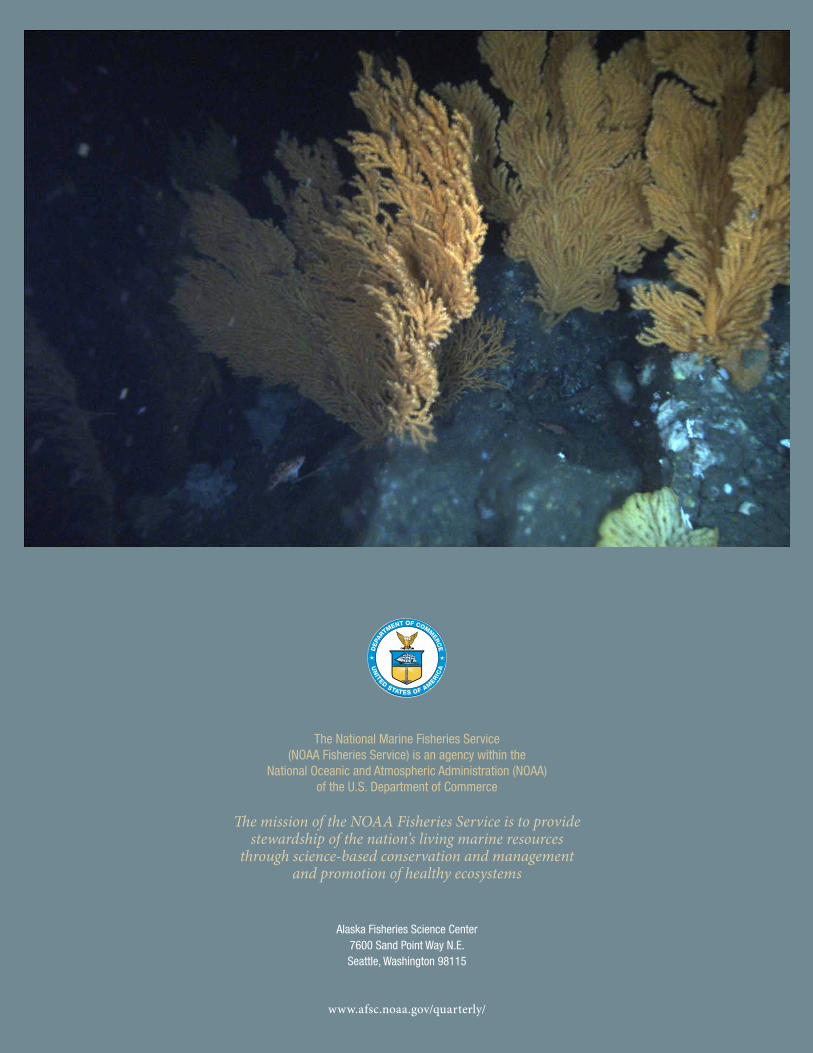
The National Marine Fisheries Service(NOAA Fisheries Service) is an agency within the
National Oceanic and Atmospheric Administration (NOAA) of the U.S. Department of Commerce
The mission of the NOAA Fisheries Service is to provide stewardship of the nation’s living marine resources
through science-based conservation and management and promotion of healthy ecosystems
Alaska Fisheries Science Center 7600 Sand Point Way N.E. Seattle, Washington 98115
www.afsc.noaa.gov/quarterly/


