Embed Size (px)
Citation preview
ISSN (print): 1835-7741 ISSN (electronic): 1925-6329 Library of Congress Control Number: 2008944256 e-mail: [email protected] hard copy: www.lulu.com/asianhp online: www.plateauculture.org/asian-highlands-perspectives Call number: DS1. A4739 Subjects: Uplands-Asia-Periodicals Tibet, Plateau of-Periodicals © 2012. This publication may be reproduced, translated, stored in retrieval systems, and transmitted in any form or by any means, electronic, mechanical, photocopying, recording, or otherwise, except for commercial purposes, in which case, prior written permission from the publisher is required. Citation: Dbang 'dus sgrol ma, Dkon mchog dge legs, Mgon po tshe ring, and Dpal ldan chos dbyings (CK Stuart and G Roche, eds). 2012. Environmental Issues Facing Tibetan Pastoral Communities. Asian Highlands Perspectives 18. Summary: Tibetan communities in Yushu Tibetan Autonomous Prefecture, and G.yon ri Community in Hainan Tibetan Autonomous Prefecture, Qinghai Province, PR China are studied in terms of China's pastoral development policies and their impact on local Tibetans. Cover: Horsewoman near Stag tshang lha mo Monastery (Klu chu County, Gansu Province). Photograph by Jan Reurink, 3 October 2009. http://www.flickr.com/photos/reurinkjan.

•3•
CONTENTS Abbreviations <6> Land and Weight Measures <7> Livestock Measures <7> Transcription Note <7> Acknowledgements <7> Preface William Bleisch (China Exploration and Research
Society) <8> The Ecological Migration Project: The Case of Rtswa
chog, Qinghai Province, China Dbang 'dus sgrol ma (Independent Scholar) <7>
o Figure 1. The Skye dgu resettlement site, Upper Ra shul Township. <13>
o Figure 2. Livestock reduction in Rtswa chog. <24> o Figure 3. Rtswa chog butter production, 2002-2006.
<25> o Figure 4. Livestock per household in Yul gyi nyi ma.
<26> o Figure 5. Comparison of Rtswa chog and Yul gyi nyi
ma livestock populations. <26> o Figure 6. Mammal species richness in Rtswa chog and
Yul gyi nyi ma. <27> o Figure 7. Number of individual plant species at Rtswa
chog and Yul gyi nyi ma. <30> o Figure 8. Density of vegetation on the two sites. <31> o Figure 9. Frequency of grassland site plant species
(%).<33> China's Pastoral Development Policies and Tibetan
Plateau Nomad Communities Dkon mchog dge legs (Independent Scholar) <37>
o Figure 1. Livestock number in Mgo log Tibetan Autonomous Prefecture, 1978-2003. <49>
o Figure 2. Hypothetical fence allocation in Henan Mongolian Autonomous County. <54>
•4•
o Figure 3. Land distribution in Skar mda' and Ko chen APCs. <56>
o Figure 4. Temperature changes outside and inside a shed. <59>
o Figure 5. The impact of sheds on livestock weight. <60>
o Figure 6. The impact of sheds on lamb survival rate. <61>
o Figure 7. Measurement of fencing impact. <62> o Figure 8. Fenced area in Night Star Township, 2001-
2007. <63> o Figure 9. Butter production in Night Star Township,
2002-2007. <64> o Figure 10. Livestock reproduction in Night Star
Township, 2001-2007. <66> o Figure 11. Night Star Township sector income, 2002
vs 2006. <67> o Figure 12. Livestock fluctuation from 1967-1978 in
six counties in Yushu and Mgo log. <68> The Impact of Grassland Privatization on the Grassland
Ecosystem and Livestock Productivity in G.yon ri, Qinghai Province, China Mgon po tshe ring (Beijing University) <73>
o Figure 1. CBM and GHCRS scheduling of seasonal livestock movements, G.yon ri Village. <79>
o Figure 2. Livestock mobility and flexibility in CBGM and GHCRS compared. <82>
o Figure 3. Trends in total population of different livestock species 1986-2007. <84>
o Figure 4. Comparative use of grassland by new families under CBGM and GHCRS. <85>
o Figure 5. Allocation schemes of grassland use under CBGM and GHCRS. <86>
o Figure 6. A public track between two individual households' land holdings in the summer pasture. <87>

•5•
o Figure 7. Major grassland species in G.yon ri Village, their coverage area, and livestock preference. <88>
o Figure 8. Fences used in G.yon ri. <92> o Figure 9. A grassland area used to produce sod bricks
and a sod brick wall/ fence. <93> o Figure 10. Amounts of butter and wool produced
during CBGM and GHCRS. <94> o Figure 11. A stream inside a fenced area in G.yon ri
Village summer pasture. <96> o Figure 12. Total G.yon ri yak population, 1986-2007.
<97> o Figure 13. Stipa krylovii (rtswa 'jam). <101> o Figure 14. Potentilla anserina (gro lung). <102> o Figure 15. Potentilla fruticosa (sben ma). <103> o Figure 16. Rumex spp. (rdum bu kho hog). <104> o Figure 17. Ra gdug. <105> o Figure 18. Leymus spp. ('jag ma). <106> o Figure 19. Achnatherum inebriens (chu ge du ka).
<107> Plateau Pika Control on the Santu Alpine Grassland
Community, Yushu Prefecture, Qinghai Province, China Dpal ldan chos dbyings (Arizona State University) <108>
o Figure 1. Reported predator frequency on sites A and B. <115>
o Figure 2. Reported predator abundance on sites A and B. <116>
o Figure 3. Predatory animal population on sites A and B. <117>
References <125> Non-English Terms <135>

•6•
ABBREVIATIONS
#HH number of households AHBNC Animal Husbandry Bureau of Nangqian APC administrative pastoral community BSN baseline number C Celsius CBGM Community-based Grassland Management E East EMP Ecological Migration Project FA Four Allocations GIS Geographic Information System hm2 = 1 square hectometer (hm2) = 1 hectare (ha) HRS Household Responsibility System LSR lamb survival rate N North NSTG Night Star Township Government OSR overall survival rate PRC People's Republic of China QNXQ Qinghai, Nangqian County Meteorology Bureau RMB Renminbi S South spp./m2 species per square meter SU sheep unit TBF The Bridge Fund TRA Three Rivers Area W West
•7•
LAND AND WEIGHT MEASURES 1 mu = 0.067 hectare 1 ha = 15 mu 1 jin = 0.5 kilograms 1 kg = 2 jin
LIVESTOCK MEASURES 1 sheep = 1 SU 1 goat = 0.8 SU 1 yak = 4 SU 1 horse = 6 SU TRANSCRIPTION NOTE Tibetan and Chinese terms are transcribed in Wylie and pinyin, respectively. All non-English terms are given with appropriate scripts at the end of the book. We used certain terms that we felt our readers would be most familiar with, e.g., 'Qinghai' rather than 'Mtsho sngon' and 'Yushu' rather than 'Yul shul'. ACKNOWLEDGEMENTS The editors and authors thank Timothy Thurston, Rin chen rdo rje and Tshe dbang rdo rje for their assistance.

•8•
PREFACE
William Bleisch (Pad ma rdo rje, China Exploration and Research Society)
The vast grasslands of the Tibetan Plateau have been the basis of one of humankind's most unique and remarkable adaptations – high-altitude nomadic pastoralism. Largely based on the domesticated yak, a suite of technological innovations occurred more than 5,000 years ago, making productive life possible at elevations above the range of agriculture – from 3,500 to 5,000 meters above sea level – opening huge areas to human habitation. Pastoralism has also been the foundation for the rich and diverse culture of Tibetan pastoralists, one of the pillars of Tibetan culture.
Despite a continuous history dating back at least 2,000 years, this valuable heritage is now seriously threatened. There appears to be a consensus that at least 30% of pasturelands on the Tibetan Plateau are seriously degraded. Although the situation may not be as dire as implied by the popular Chinese press, the true figure may be much higher than 30%. The primary data sources for these estimates remain frustratingly elusive and the causes are the subject of vigorous debate, but there is no doubt that pasture degradation has become a serious challenge for Tibetan herders in many regions. The predicted impacts of anthropogenic climate change potentially increase the severity of the situation.
The Chinese government has attempted to address the problem of grassland degradation and improve the lives of Tibetan herders with a series of policies and programs that have changed over time. Some past policies have clearly done more harm than good, and the current suite of policies are not without their critics, who question both the rationale and the effectiveness of implementation. Whatever the intentions were, current government policies have resulted in efforts on the ground that have often proved to be 'complex, impractical and non-participatory'.
What then must be done?
•9•
It has become widely accepted in international development circles that local people have key insights based on indigenous knowledge that can provide valuable guidance to policy-makers. In practice, however, there are still formidable barriers to the participation of local people in policy debates worldwide. China is no exception in this regard. One significant barrier has been the breakdown in communication that is created by language differences – not only the gulf between Mandarin-speaking Chinese officials and local Tibetan herders, whose Mandarin skills are often poor – but also the gulf between experts and implementers created by the heady scientific discourse that frames most of the debate on rangeland policy.
The four young Tibetan scholars whose work is showcased in this volume are part of a small but growing group of Tibetan development professionals who have managed to cross the chasm of communication, and who cross it again and again in the course of their work. Each one of them has a remarkable professional history, rising from a childhood in remote Tibetan pastoral communities, through the educational system in China, to eventually study abroad and complete an advanced degree at some of the world's foremost centers for ecological research, environmental protection, and rural development.
Each of the four authors attempts to take on the full complexity of the situation of rangelands on the Tibetan Plateau, considering not only the rationale of policy, but also providing insights into the actual impacts of government-sponsored programs. Each bases their work on hard data collected in the field and on statistically robust analysis. While not designed to deliver coherent fully-formed programs, the authors also provides their own recommendations for how policies might be adjusted to provide greater benefits and fewer unintended negative consequences. In doing so, the authors take a bold stand in the dangerous middle ground of debate, where they may be open to attack from all sides. Hopefully, readers will take their contributions for what they are meant to be – helpful contributions to an ongoing search for a way to deal with tough problems.
Dbang 'dus sgrol ma provides an introduction to the controversial Ecological Migration Project (EMP) through a case study in Yushu Tibetan Autonomous Prefecture, Qinghai
•10•
Province. The author accepts that grassland degradation on the Tibetan Plateau is a fact, and that the EMP initiative came into being largely as a response to this degradation, with the additional intention of raising the living standards of relocated herders. The study, however, raises serious questions about the actual impacts of EMP in practice. The EMP was first implemented in a small area, creating the opportunity for experimental probing of its results. Perhaps surprisingly, no pre-project baseline information or post-project evaluation has been made available to date to test the effectiveness of EMP in achieving its dual goals. The study attempts to rectify this lacuna, using both direct measurement and interviews of herders to assess impacts on grassland ecology, rangeland production, and herder livelihoods.
Dkon mchog dge legs provides a critical review of the divergent international and Chinese literature on the rationale and impacts of changing rangeland policies for the Tibetan grasslands. Using case studies, he also takes a critical look at pasture privatization and the Four Allocations (FA) policy that were designed to address the problems of rangeland degradation and herder development in Tibetan areas of Qinghai Province. The Four Allocations program was designed to address problems of both pastoral development and grassland degradation, by providing a house, fencing, storage sheds, and livestock sheds to individual herder families. While accepting that pasture degradation has reached a critical stage that needs addressing, the author looks at the unintended consequences of these programs on rangeland condition, herder livelihoods, and social cohesion.
Mgon po tshe ring carried out an in-depth study of the impacts of the Grassland Household Contract Responsibility System (GHCRS) and Four Allocations on the grassland ecosystem and livestock productivity in a pastoral village in Mtsho lho Tibetan Autonomous Prefecture, Qinghai Province. While herders were given responsibility for their own livestock at the end of the collective period, beginning in 1981, grasslands continued to be managed communally after that time. It was not until 1991 that the government divided the grasslands among the herders. Designed by policy makers to reduce climate-driven mortality of livestock, prevent grassland degradation, and improve livestock productivity and thus increase herders' income,

•11•
the GHRCS was a novel arrangement for pastoral herders, who had traditionally herded their livestock together, moving seasonally between common pastures along with other families. The author takes a critical historical look at the actual impacts of this revolution in rangeland management.
Dpal ldan chos dbyings examines the rationale and results of the pika control programs that have been implemented over the past 40 years through a case study in a pastoral community in Yushu Tibetan Autonomous Prefecture. Pikas are small mammals that burrow in grassland soils and consume grass and are widely considered to be a competitor with livestock and a problem for rangelands. It is also widely reported that pika populations have increased in the region since the 1990s, in parallel with the trend of increasing grassland degradation. In response, the government has implemented an aggressive program of pika eradication, using various means, but especially poisoning. As the author points out, the role of pikas in pasture degradation is hotly debated. Pikas have also been called a keystone species of the plateau grassland ecosystem. By comparing two sites, one at which pika poisoning was never carried out, using data from both interviews of local herders and direct observation, the author provides information on the impacts of pika poisoning on grassland ecology, including the unintended side-effects on other wildlife species.
Scholarship on government policy for development of the Tibetan Plateau sometimes appears so polarized that little progress seems possible. Perhaps in no field is this more the case than in pastoral development. Chinese readers are apt to see the crime of splitism lurking in any criticism of government policy in Tibetan areas. Some international critics, on the other hand, have likened China's policies in nomadic pastoral areas of the Tibetan Plateau to the worst abuses of the US policy of strategic hamlets during the war in Vietnam, or the pacification policy of the Burmese military in some minority areas. The essays included here reveal a reality that is clearly more complex – pastoral policy in Tibetan areas is motivated at least partly by pragmatic concern for people who are the unwitting victims of ecological and climatic changes that are beyond their control and who are living largely beyond the reach of modern social services. Subsidies have created real incentives for voluntary resettlement.

•12•
Technological interventions and innovations attempt to address the real concerns expressed by the herders themselves. And yet these interventions have had unintended side effects that may have made conditions worse rather than better.
This volume can be considered a signpost pointing to a way out of the quagmire. By allowing and encouraging local voices to join the policy debate, experts from all backgrounds will be forced to consider practical solutions that may fly in the face of accepted wisdom and past policy. The four essays collected here challenge us to go beyond platitudes and slogans to consider the complex reality of the actual situation on the ground. I daresay that almost everyone will find something contained here that will they will disagree with and perhaps that will challenge their preconceptions. That is as it should be. In the spirit of scholarly debate, it is the beginning of a process of seeking truth from facts in order to solve problems through non-patronizing partnership.
Above all, this volume deserves recognition as a clarion call that Tibetan herders are eager and able to take part in discussions on future policies and programs designed to improve their lives and protect the environment of their homelands. It marks the debut of four authors who are representatives of a new generation of highly trained professionals that can bridge the traditional communication gap between pastoralists and policy makers.
I hope that this volume will serve as a challenge to readers to be as brave as the authors have been in putting aside accepted wisdom or convenient conclusions to confront the complex reality of problems that are affecting the lives of hundreds of thousands of herders and that are challenging the very survival of an ancient, resilient way of life. The potential benefits in terms of making rangeland management more adaptive for improvement in the grassland environment and the pastoral economy are enormous.
•13•
THE ECOLOGICAL MIGRATION PROJECT: THE CASE OF RTSWA CHOG QINGHAI PROVINCE, CHINA
Dbang 'dus sgrol ma (Wendezhuoma 文德卓玛 ) (Independent Scholar)1 ABSTRACT Continuing grassland degradation in China stresses the importance of effective management strategies. This study focuses on the impact of the Ecological Migration Project (EMP), a large-scale grassland recovery strategy, on the Tibetan herding community of Rtswa chog in Upper Ra shul Township, Yushu County, Yushu Tibetan Autonomous Prefecture, Qinghai Province, China. The impact of EMP on the local grassland ecosystem was studied from September to October 2007 by comparing grassland conditions of Rtswa chog to grassland conditions of Yul gyi nyi ma, a nearby, similar herding community where EMP had not been implemented. Species richness and species composition diversity indices, as well as socio-economic indicators of the resettled herding community were investigated, revealing that EMP implementation reduced livestock numbers. However, grassland condition was not improved, nor was biodiversity of the area enriched. Moreover, resettled herders felt disenfranchised and were deprived of a sustainable livelihood under EMP. KEY WORDS Ecological Migration Project (EMP), nomads, Qinghai, pastoralists, Tibetan herders, Yushu
1 I sincerely thank the United Board for Christian Higher Education in Asia for sponsoring my graduate study at Miriam College in Manila, the Republic of the Philippines.
•14•
INTRODUCTION
The Tibetan Plateau is an important but ecologically fragile region encompassing approximately 87% of Qinghai Province's land area (Miller 2006). Addressing rapid grassland degradation requires a management policy that alleviates poverty while restoring the ecosystem. In the past two decades, several grassland management strategies have been implemented, including the Ecological Migration Project (EMP), which began in Qinghai Province in 2003.
There are few reviews of the success of EMP in terms of grassland restoration, such as that by Foggin (2008). Furthermore, EMP's socio-economic impact is poorly understood, as there is a dearth of empirical research measuring the project's ecological impacts on grassland ecosystems. Meanwhile, more EMP implementations are anticipated, thus an early assessment of this on-going project is crucial to better understand its impact. EMP is controversial as evidenced in debates on violations against human rights (Enghebatu 2006) and property rights, degrading living conditions of herders (Meyer 2006), and loss of cultural identity (Miller 2006). Little research has been done on ecological aspects.
This study focused on one EMP site, Rtswa chog, a herding community in Upper Ra shul Township, Yushu County, Yushu Tibetan Autonomous Prefecture, Qinghai Province. The impact of EMP on the grassland ecosystem was assessed by comparing grassland conditions in terms of species richness and species composition diversity indices of Rtswa chog to the nearby, similar community of Yul gyi nyi ma, where EMP had not been implemented.
Ten percent of the population from each study site was randomly selected and interviewed. These interviews provided data on commonly observed birds, mammals, livestock density, and socio-economic aspects of life in the two communities. A quadrat biological sampling method was employed to assess the characteristics of meadow vegetation.
•15•
GRASSLAND AND EMP
Over 40% of China's total land area is grassland that supports a rich diversity of plant and animal life. Pastoralists on the Tibetan Plateau have raised livestock for at least 4,000 years (Barfield 1993, Lattimore 1940). According to Miller (2006), over 260 million hectares of grassland in China are being degraded at the alarming rate of 6,700 square kilometers per year. Wang et al. (2005) reported that grasslands in Dar lag and Rma stod counties in Mgo log Tibetan Autonomous Prefecture are severely degraded. Grassland degradation in Dar lag increased from 8.07 x 10⁴ in 1989 to 20.62×10⁴ hm2 in 1997. According to Meyer (2006) degradation is due to the advocacy of self-sufficiency in 1949, the Great Leap Forward in 1958, and conversion of grassland to cropland during the Cultural Revolution. Miehe (1988) argues that degradation was due to climate change while the Chinese state claims grassland degradation is due to herd mismanagement by pastoralists (Ellis and Swift 1988).
Grassland degradation has had a direct and negative impact on herding communities across the plateau. Herding communities are furthermore directly affected by state-sponsored efforts to alleviate grassland deterioration through resettlement, essentially making herders environmental refugees.
Several solutions have been offered to address grassland degradation and desertification in China. The state's enforcement of the Grassland Household Responsibility System and EMP have been major strategies. Theoretically, such strategies simultaneously allow grassland restoration and improve herders' living conditions. This project has been implemented on a large scale in Qinghai, and has also been conducted in such other herding areas as the Inner Mongolia Autonomous Region.
EMP was first implemented in Qinghai Province in 2003 under the Qinghai Province Three Rivers' Source Natural Reserve Ecological Protection and Construction Blueprint, with the goal of restoring the grassland and improving the living conditions of relocated herders. This direct field experiment on the Tibetan Plateau still lacks empirical pre-project assessment and post

•16•
project evaluation. The outcomes of EMP must be considered as crucial for further implementation of EMP on Tibetan Plateau.
In this context, this study aimed to document EMP in terms of its first major objective: grassland restoration. Specifically, this study attempted to determine the impact of EMP on the grassland ecosystem of the herding community of Rtswa chog by answering the following questions:
Did implementation of EMP reduce the number of livestock
in Rtswa chog? What are the effects of EMP on the grassland ecosystem in
terms of grassland species richness and grassland species composition diversity indices?
What are the socio-economic impacts of EMP on relocated Rtswa chog natives?
CONCEPTUAL FRAMEWORK Livestock are part of the grassland ecosystem, and depend on and nourish the grassland through a symbiotic relationship. For centuries, Tibetans have herded with little damage to the grassland, further suggestive of a mutual, beneficial relationship between livestock and grassland.
The current environmental crisis on the Tibetan Plateau affects herders, whose livelihood depends on grasslands, and also millions of residents at lower elevations in China, Bangladesh, Cambodia, and Thailand, as these populations depend on rivers that originate on the Tibetan Plateau. The current situation of grassland degradation in northern China has strongly influenced the state's perception of grassland conditions and pastoral practices (Goldstein et al. 1990, Miller 2006). Research in certain severely degraded grassland areas became the core of policy-making. Drawing evidence from such research, it was assumed that the culprits were increased livestock numbers in pastoral areas and inadequate management by pastoralists. The state thus implemented EMP to sustain the grassland ecosystem and restore
•17•
the grassland. From the state's perspective, the relationship between livestock and the grassland ecosystem is parasitic, with livestock damaging the grassland.
Livestock represents the herders' only real economic enterprise on the grassland; it is the pillar of their sustenance. Reforms targeting livestock therefore directly affect pastoralists' survival.
EMP was implemented in western China, where 95% of the land is dominated by grass (Yeung and Shen 2004). Moving herders from pastoralist areas and prohibiting herding has been called 'Ecological Migration' by state authorities and aims "to restore ecological balance" as it "shakes-off poverty".2 EMP is expected to restore degraded grasslands by removing herders from the grassland and in so doing, eliminate their livestock.
In assessing the ecological impacts of EMP on grassland conditions, indicators include biodiversity richness and grassland composition diversity indices. Biodiversity richness was determined by the presence of different grass and animal species. The grassland composition diversity indices were measured by dominant grassland species coverage, density, and frequency. The extent to which EMP restores grassland conditions reflects its effectiveness.
RESEARCH SETTING AND TIME Research was conducted in three sites in Yushu County: Rtswa chog Herding Community where EMP was implemented in 2004, Yul gyi nyi ma Herding Community of Lower Ra shul Township where EMP had not been implemented, and Skye dgu Town, where the herders of Rtswa chog were resettled. The main focus of the study was Rtswa chog where thirty households were resettled in Skye dgu Town in 2004.
2 http://www.cafte.gov.cn/english/NEWSROOM/20041110/1256.asp, accessed 21 August 2010.

•18•
Rtswa chog is a herding community located in Yushu County. Yushu Prefecture is one of Qinghai's six ethnic autonomous prefectures and is located in the south of the province.3 The prefecture has six counties, forty-five townships, and 331,733 people, 96% of whom are Tibetan. Han, Hui, Salar, and Mongols make up the remainder.4 The average elevation is 4,500 meters above sea level.
There are three towns and five townships in Yushu County. There were approximately 90,000 people of whom 93% were Tibetan in 2006.5 The area is in the high altitude frigid zone, with significant temperature variation between day and night and relatively little temperature variation in a year. The average annual temperature is around 2.9°C.
Rtswa chog is located at 32°54′ N, 96°29′ E, at 4,221 meters above sea level, in the southwest of Yushu County, seventy-five kilometers from Skye dgu Town, the economic and political center of the prefecture. There are approximately 6,000 people in Upper Ra shul Township of whom the vast majority are Tibetan. Rtswa chog is one of seven administrative herding communities in Upper Ra shul Township.6
Rtswa chog is a herding community of 140 households (800 people). From May to August, herders lived in widely separated tents in their summer camp at high altitudes. From September to April, they lived in their winter camp in adobe houses near one another, creating a sense of community.
3 Yushu, Mgo log, Rma lho, Mtsho byang, and Mtsho lho are all autonomous Tibetan prefectures. Mtsho nub is a Mongolian and Tibetan Autonomous Prefecture. 4 http://www.qh.xinhuanet.com/misc/2008-05/20/content_133133 75. htm, accessed 2 February 2009. 5 http://www.qh.xinhuanet.com/misc/2008-05/20/content_133133 75. htm, accessed 2 February 2009. 6 The other six herding communities are Chu shar, Ri ma, Ma rang, Bsam rnying, Bor rog, and Rdo ra.
•19•
Dairy products (butter, milk, yogurt, dried cheese), meat (beef and mutton), and rtsam pa7 are important foods. The raw material for rtsam pa – barley – is bought from Rdo la, the political and economic center of Upper Ra shul Township, about three hours by motorcycle from Rtswa chog. Barley is roasted and then ground using a water-powered mill. Livestock are butchered every November.
In both Rtswa chog and Yul gyi nyi ma, yaks were the main livestock, providing herders with nearly all basic livelihood needs: milk, butter, cheese, yogurt, and meat for food; and yak hair and skins for clothes and tents. Sheep and goats were less valued because wolves more easily attacked them. Moreover, goats and sheep cannot be herded together with yaks, and thus an additional person was required to herd them. Goats were kept for cashmere, which was collected annually, and provided what was considered a small portion of household income. Horses were a major means of transportation in the past, however, they were expensive and few in number. An increase in the number of motor vehicles in herding areas, particularly motorcycles, further reduced the horse population.
A main source of cash income for local herders is the collection and sale of caterpillar fungus (Ophiocordyceps sinensis), which has a two-month harvest season (May to June). Caterpillar fungus in the area is of poor quality and sparsely distributed. Each local adult caterpillar fungus collector earned an average of 2,000 RMB from this source in 2008. Due to the remoteness of the location, residents have limited trade opportunities.
The local environment is such that agriculture has never been practiced.
No baseline information on grassland conditions prior to implementation of EMP in Rtswa chog exists. Thus, Yul gyi nyi ma was chosen as a study site for comparative purposes. Yul gyi nyi ma is located at 32°46′N, 96°38′E. Rtswa chog and Yul gyi nyi ma have similar physical conditions, though Yul gyi nyi ma is
7 Ground, roasted barley.
•20•
approximately 100 meters lower than Rtswa chog. Both sites have a short growing season and a long winter.
A few leaders of Upper Ra shul Township were taken to sites in Mgo log where EMP had been implemented to visit families in the resettled areas in 2004. According to one leader interviewed in September 2007, living conditions were excellent and the government regularly compensated the resettled herders. In addition, several skills-training projects were conducted for resettled herders. Based on these observations, community leaders agreed to implement EMP in Upper Ra shul Township.
A relocation quota of 200 households was assigned to Upper Ra shul Township. Relocation was voluntary. In early 2004, more than thirty households from Rtswa chog volunteered to be relocated to the southwest part of Skye dgu Town in a valley located at 32 59.6' 96 59.0'E, and at an elevation of 3,990 meters above sea level. The government promised each family a house worth 40,000RMB (5,000USD) and annual compensation of 6,000RMB (750USD). Training programs, subsidies for impoverished families, and the chance to return to the grassland after ten years were also promised.
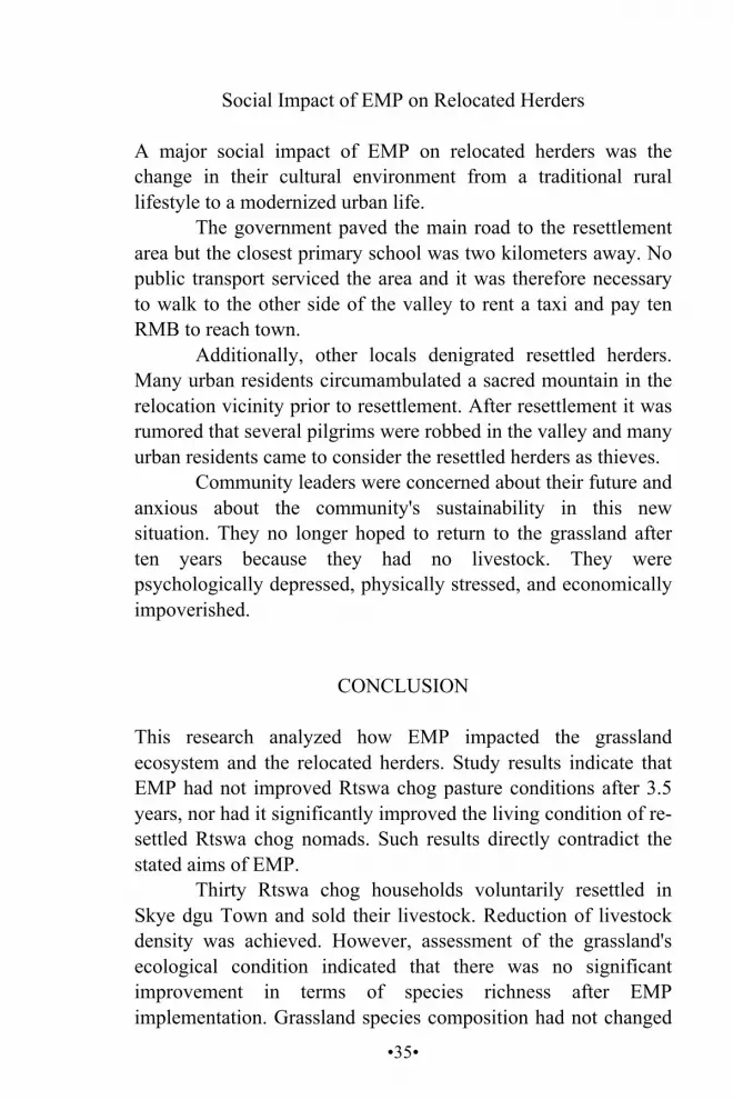
The resettlement area is in a valley south of Skye dgu. Each household was assigned three rooms within a courtyard. The gray houses in the valley are the resettlement area (Figure 1). There were a few small private stores in the resettlement area selling snacks, student supplies, and so on, but no nearby markets, hospitals, or other social amenities. To access such services, the resettled herders needed to go to the other side of the valley, taking about an hour on foot.
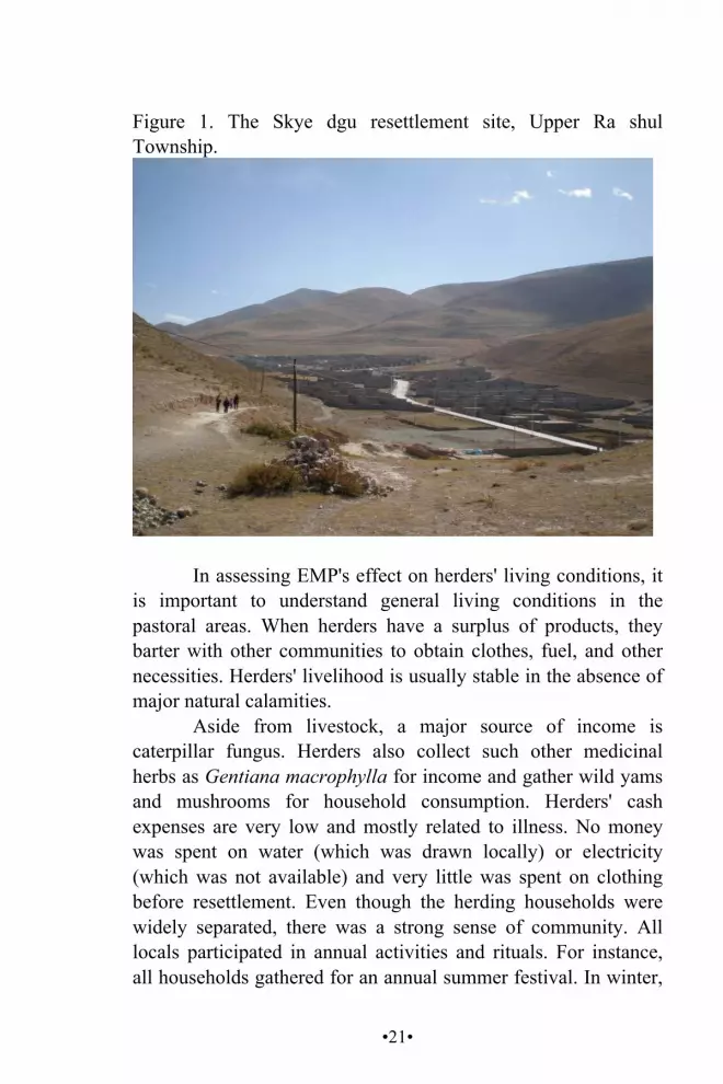
•21•
Figure 1. The Skye dgu resettlement site, Upper Ra shul Township.
In assessing EMP's effect on herders' living conditions, it is important to understand general living conditions in the pastoral areas. When herders have a surplus of products, they barter with other communities to obtain clothes, fuel, and other necessities. Herders' livelihood is usually stable in the absence of major natural calamities.
Aside from livestock, a major source of income is caterpillar fungus. Herders also collect such other medicinal herbs as Gentiana macrophylla for income and gather wild yams and mushrooms for household consumption. Herders' cash expenses are very low and mostly related to illness. No money was spent on water (which was drawn locally) or electricity (which was not available) and very little was spent on clothing before resettlement. Even though the herding households were widely separated, there was a strong sense of community. All locals participated in annual activities and rituals. For instance, all households gathered for an annual summer festival. In winter,

•22•
the community celebrates Lo gsar (Tibetan New Year) together, and families invited each other to their homes.
METHODS
Research Instruments
Three research instruments were employed:
Gathering relevant secondary data for physical attributes from the internet and such institutions that regularly monitor the area as the Upper Ra shul government.
Quadrat biological sampling to determine species richness and composition diversity by systematically sampling and listing species and the number of individuals per selected plot. Sampling was conducted in both Rtswa chog and Yul gyi nyi ma.
Interviews and field observations to estimate faunal diversity. A checklist of birds and mammals was prepared and the respondents were interviewed about species they often observed and the frequency of their observation. There were 140 households in Rtswa chog, 185 in Yul gyi nyi ma, and 200 households in the resettlement area in 2007. A randomly selected 10% sample from the three sites served as respondents.
Data Collection Biological sampling was implemented by randomly designating a 32 × 32 meter grassland plot at each study site. These plots were further divided into sixty-four subplots of 4 × 4 meters. Plots were then numbered and fifteen plots selected at each site using a random sampling method, giving a total of thirty sample plots. Next, fifteen mini-plots of 1 × 1 meter were laid out within each
•23•
subplot. All grass species and the number of individuals per mini-plot were counted and recorded.
This study was conducted from September to October 2007. Snow covered the mountain peaks during the research, and only a few plants were in flower in early September. Most vegetation was dry in late October and most perennial plant species had withered. Some birds were inactive or absent during winter and mammals were hibernating, therefore, lower species diversity was observed.
Indicators and Formulas
Species composition diversity was measured according to three parameters: density, frequency, and dominance. The density and frequency formulas used were as follows (Arances et al. 2004):
Density= number of individuals
area sampled
Frequency = quadrat number where species A occurred
total number of quadrats examined x100%
Dominance = the area covered by the species divided by the total
area sampled
A t-test was applied to compare biodiversity richness and grassland conditions of Rtswa chog and Yul gyi nyi ma. The mean, median, and standard deviation were applied as livestock density indicators.
•24•
RESULTS AND DISCUSSION
The Ecological Impacts of EMS
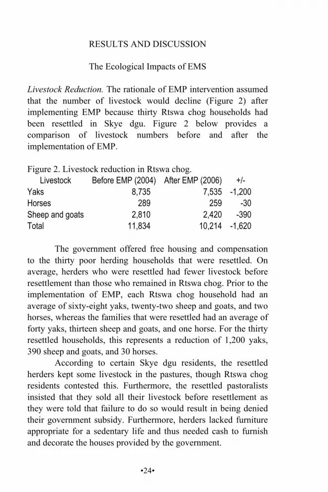
Livestock Reduction. The rationale of EMP intervention assumed that the number of livestock would decline (Figure 2) after implementing EMP because thirty Rtswa chog households had been resettled in Skye dgu. Figure 2 below provides a comparison of livestock numbers before and after the implementation of EMP. Figure 2. Livestock reduction in Rtswa chog.
Livestock Before EMP (2004) After EMP (2006) +/- Yaks 8,735 7,535 -1,200 Horses 289 259 -30 Sheep and goats 2,810 2,420 -390 Total 11,834 10,214 -1,620
The government offered free housing and compensation
to the thirty poor herding households that were resettled. On average, herders who were resettled had fewer livestock before resettlement than those who remained in Rtswa chog. Prior to the implementation of EMP, each Rtswa chog household had an average of sixty-eight yaks, twenty-two sheep and goats, and two horses, whereas the families that were resettled had an average of forty yaks, thirteen sheep and goats, and one horse. For the thirty resettled households, this represents a reduction of 1,200 yaks, 390 sheep and goats, and 30 horses.
According to certain Skye dgu residents, the resettled herders kept some livestock in the pastures, though Rtswa chog residents contested this. Furthermore, the resettled pastoralists insisted that they sold all their livestock before resettlement as they were told that failure to do so would result in being denied their government subsidy. Furthermore, herders lacked furniture appropriate for a sedentary life and thus needed cash to furnish and decorate the houses provided by the government.

•25•
Rtswa chog butter production validates the reduction of livestock (Figure 3). According to the Upper Ra shul Township Government, butter production declined after EMP implementation. It remained constant from 2002 to 2004 but from 2004 to 2005, the first year of EMP implementation, there was a sharp decrease, mirroring a corresponding reduction in livestock number. 8 Moreover, the constant level of butter production beginning in 2005 indicates that no dramatic increase in livestock occurred thereafter.
Figure 3. Rtswa chog butter production, 2002-2006 (Upper Ra shul Government 2007). Ca chog Butter Production
0
1,000
2,000
3,000
4,000
5,000
6,000
2001 2002 2003 2004 2005 2006 2007
Kg
Although a clear trend in reduced livestock numbers is visible, the impact of reduced livestock numbers is unclear. While the government assumes that reduced livestock numbers leads to grassland restoration, herders argued that livestock eat grass and nourish soil with their waste, thus improving pasture growth and preventing invasion of aggressive species that may dominate the grassland. One respondent said that although a non-grazed area may have tall, dense grass, pasture growth the following year would be very poor. In contrast, even though grass 8 The number of yaks only fell by 14%, while the butter production fell by more than 60%, emphasizing the challenges of using, at least in this case, government data.

•26•
may seem short and sparse in grazed areas, grass growth the following year is very good and various plant species grow evenly. This is evident in fenced areas, where herders are prohibited from herding the entire summer season, and where Kobresia spp. and Polygonum viviparum are the dominant species.
In the case of Yul gyi nyi ma (Figure 4), each household had an average of seventy-five yaks, two horses, and seventeen sheep and goats. Yul gyi nyi ma had a total land area of 341.2 square kilometers with 185 households and 17,390 head of livestock. Figure 4. Livestock per household in Yul gyi nyi ma.
Livestock Number Density (head of livestock/ km2) Yaks 75 Horses 2 sheep and goats 17 Total 94 0.02
The number of livestock per household in Yul gyi nyi
ma was assessed and compared with that of Rtswa chog (Figure 5) to determine if the current grassland condition of Yul gyi nyi ma was attributable to its relatively higher stocking rates.
Figure 5. Comparison of Rtswa chog (R) and Yul gyi nyi ma (Y) livestock populations, 1 = Yaks. 2 = Sheep and goats. 3 = Horses. October 2007. Detail 1 2 3
R Y R Y R mean 68.50 74.80 22.00 16.70 2.60 SD 25.00 34.50 27.40 18.30 2.10 total 753.00 1,422.00 244.00 317.00 29.00 N 11.00 19.00 11.00 19.00 11.00 t-test 0.53 0.65 0.08 N: Sample Population R: Rtswa chog Y: Yul gyi nyi ma df=28 a=0.01 t(a)=2.763; t<t(a)

•27•
Figure 5 shows differences in the number of livestock between the two sites. The critical value of t(a) is 2.763, which is higher than the computed values, suggesting there was no significant difference in individual household livestock number between Rtswa chog and Yul gyi nyi ma.
EMP had not been implemented in Yul gyi nyi ma in 2007. Although there was no significant difference in the number of livestock per household between the two sites, there were 110 households in Rtswa chog after EMP, and 185 households in Yul gyi nyi ma. Therefore, the total number of livestock in Yul gyi nyi ma was higher than in Rtswa chog. The findings on species richness and species composition diversity at the two sites therefore reflects the impact of livestock numbers, and thus the implementation of EMP.
Species Richness. There was no significant difference between the two sites in terms of species richness (Figure 6), as indicated in Figure 6. Figure 6. Mammal species richness in Rtswa chog and Yul gyi nyi ma.
Detail Site Rtswa chog Yul gyi nyi ma number of grass species 10 11 number of bird species 3 3 number of mammal species 10 8
The raw data revealed that Rtswa chog had more
mammal species and Yul gyi nyi ma more grass species. Herders reported observing a brown bear and a wild ass in Rtswa chog in 2007. Rtswa chog elders said such wildlife was commonly observed before the 1960s and that poaching accounted for the current absence of wildlife.
The three most commonly observed bird species were Gyps himalayensis (Himalayan Griffon Vulture), Falco cherrug (Saker Falcon), and Gypaetus barbatus (Bearded Vulture),

•28•
indicating an abundance of small mammals in the area, which are also summer food for foxes, wolves, bears, snow leopards, and eagles. Small mammals are generally herbivores that occasionally eat insects.
The two most commonly observed small mammals in both sites were the Plateau Pika (Ochotona curzoniae) and the Himalayan Marmot (Marmota himalayana). The pika's digging of interconnecting burrows is considered a major cause of grassland degradation. Herders explained that pikas do not initiate grassland degradation but do accelerate the process. According to the Yushu Grassland Station, pikas occupy grasslands already in the process of degradation.9
An effort to eliminate pikas was initiated in 2001 in Rtswa chog by spraying a chemical pesticide on the pasture. This aggrevated rather than stopped the infestation. Following the poisoning the population inititally declined over a period of two years, but then recovered and appeared to have become resistant to the pesticide by 2004.
Pikas, marmots, and Woolly Hares (Lepus oiostolus) were observed at greater frequency in Rtswa chog than in Yul gyi nyi ma, indicating that the grassland condition of Rtswa chog was more degraded than in Yul gyi nyi ma. An average of six hares, eighteen pikas, and eleven marmots were observed by the Rtswa chog respondents per day, while an average of four hares, twelve pikas, and eight marmots were observed per day in Yul gyi nyi ma by local residents. According to Breivik (2007), some nomads in Yushu believe religious rituals can control pikas. Certain Rtswa chog nomads considered poisoning pikas to be immoral and a violation of their religious beliefs. Local Rtswa chog residents also viewed it as a risk to humans. Several Rtswa chog residents became sick from eating mushrooms that had been exposed to these poisons. In addition, Smith and Foggin (1999) argued that large-scale killing of pikas may harm the grassland, is a great disturbance to the food chain, and on a larger scale, is an unwanted interruption to the entire grassland ecosystem.
9 Interview with Yushu Grassland Station officers.
•29•
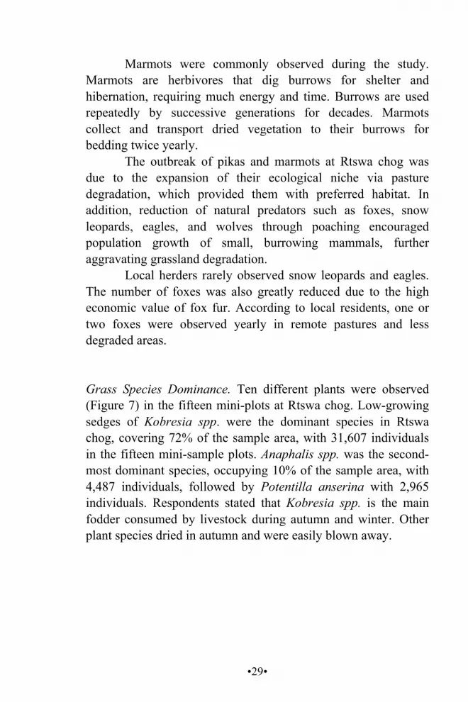
Marmots were commonly observed during the study. Marmots are herbivores that dig burrows for shelter and hibernation, requiring much energy and time. Burrows are used repeatedly by successive generations for decades. Marmots collect and transport dried vegetation to their burrows for bedding twice yearly.
The outbreak of pikas and marmots at Rtswa chog was due to the expansion of their ecological niche via pasture degradation, which provided them with preferred habitat. In addition, reduction of natural predators such as foxes, snow leopards, eagles, and wolves through poaching encouraged population growth of small, burrowing mammals, further aggravating grassland degradation.
Local herders rarely observed snow leopards and eagles. The number of foxes was also greatly reduced due to the high economic value of fox fur. According to local residents, one or two foxes were observed yearly in remote pastures and less degraded areas.
Grass Species Dominance. Ten different plants were observed (Figure 7) in the fifteen mini-plots at Rtswa chog. Low-growing sedges of Kobresia spp. were the dominant species in Rtswa chog, covering 72% of the sample area, with 31,607 individuals in the fifteen mini-sample plots. Anaphalis spp. was the second-most dominant species, occupying 10% of the sample area, with 4,487 individuals, followed by Potentilla anserina with 2,965 individuals. Respondents stated that Kobresia spp. is the main fodder consumed by livestock during autumn and winter. Other plant species dried in autumn and were easily blown away.
•30•
Figure 7. Number of individual plant species at Rtswa chog and Yul gyi nyi ma.
Species Rtswa chog Yul gyi nyi ma Kobresia spp. 31,607 17,557 Anaphalis spp. 4,487 5,153 Potentilla anserina 2,965 2,439 Polygonum viviparum 1,216 1,620 Gentiana autumnalis 983 1,000 Gentiana macrophylla 755 298 Astragalus mollissimus 704 848 Rheum spp. 553 89 skyur ru10 433 563 Sedum rosea 73 0 Geum rossii 0 121 Lamiophlomis rotata 0 5
Eleven grass species were recorded within the fifteen
mini-plots of Yul gyi nyi ma. Like Rtswa chog, Kobresia spp. was the dominant species, occupying 59% of the sample area with 17,557 individuals. Anaphalis spp. was the second dominant species, occupying 17% of the area with 5,153 individuals. Potentilla anserina was the third dominant species in the area with 2,439 individuals.
Vegetation on the two sites was compared. Results indicated that the dominant species in both sites were Kobresia spp. and Anaphalis spp. These findings suggest that the dominant species coverage in Rtswa chog and Yul gyi nyi ma was similar.
Vegetation Density. The general composition of grass species on the two sites was very similar (Figure 8). Kobresia spp. had the highest density in both Rtswa chog and Yul gyi nyi ma and was the main pasture species. Its short-stemmed form explains why it is not blown away by winter winds. Livestock mainly ate Kobresia spp. in winter when other vegetation was unavailable. Anaphalis spp. also had very high density in both areas, and also
10 Skyur ru is a local Tibetan plant name, Latin name unknown.
•31•
served as livestock fodder. Polygonum viviparum has high density but soon dries and blows away after autumn. Figure 8. Density of vegetation on the two sites (spp./ m2).
Names Site Local Name Scientific Name Rtswa
chog Yul gyi nyi
ma rtswa mdong mgo
Kobresia spp. 2,107.0 1,170.0
spar Anaphalis spp. 299.0 343.5 gro ma Potentilla anserina 197.7 162.6 me lo Polygonum viviparum 81.0 108.0 a lpags khra lpags
Gentiana autumnalis 65.5 66.7
sdong bu shu res Gentiana macrophylla 50.3 19.9 khyu lde me tog Astragalus
mollissimus 46.9 56.5
yis mo rna ldeb Rheum spp. 36.9 5.9 skyur ru 28.9 37.5 mgo gzer me tog Sedum rosea 4.8 0.0 ser chen me tog Geum rossii 0.0 8.0 ru rta Lamiophlomis rotata 0.0 0.3
Kobresia spp. had the highest density among vegetative species in Rtswa chog and Anaphalis spp. had the next highest density at 299 individuals per square meter. Anaphalis spp. is a medicinal herb used in moxibustion. Sedum rosea, which is rarely observed in the area, had the lowest density at approximately five individuals per square meter. Rheum spp. and skyur ru also had low densities of 36.9 and 28.9 individuals per square meter, respectively.
According to the Rtswa chog community leader, Gentiana macrophylla was frequently harvested by locals and outsiders a few years ago because of its medicinal and economic value, but this left exposed black sand, which led locals to ban its digging.
In the case of Yul gyi nyi ma, Kobresia spp. also had the highest density with 1,170 individuals per square meter. Similar

•32•
to Rtswa chog, Anaphalis spp. had the second highest density at 343.5 individuals per square meter. Although Lamiophlomis rotata and Geum rossii were observed in Yul gyi nyi ma, they were not widely distributed and had the lowest density in the area. Rheum spp. had a low density of 5.9 individuals per square meter, similar to Gentiana macrophylla. Sedum rosea was not observed in Yul gyi nyi ma.
Locals consider Rheum spp. and Lamiophlomis rotata to be poisonous. Rheum spp. was observed in both Rtswa chog and Yul gyi nyi ma. It has a restricted and clumped distribution pattern; it had a very low density in both areas, particularly in Yul gyi nyi ma. Rheum spp. had a density of thirty-seven individuals per square meter in Rtswa chog compared to six individuals per square meter in Yul gyi nyi ma. This indicated a high degree of grassland degradation in Rtswa chog, as poisonous species are indicators of grassland degradation. In the case of Rtswa chog, clumped Rheum spp. was mainly observed near pika burrows. Lamiophlomis rotata was only observed in Yul gyi nyi ma at the very low density of 0.2 individuals per square meter.
Species Frequency. Kobresia spp. had the highest frequency in both Rtswa chog and Yul gyi nyi ma, occurring in all fifteen mini-sample plots of both Rtswa chog and Yul gyi nyi ma (Figure 8). Potentilla anserina was similar in occurrence to Kobresia spp. in Rtswa chog. Kobresia spp. was the main fodder for livestock, and due to the similar physical attributes of the two sites, the dominant species of the two areas were the same. However, in Yul gyi nyi ma, Potentilla anserina had the second highest frequency. Anaphalis spp. had the second highest frequency of occurrence in Rtswa chog. According to Rtswa chog residents this distribution pattern was due to the low level of the water table, especially at the feet of mountains. Polygonum viviparum and Astragalus mollissimus had the same frequency in both locations.
Polygonum vivipara belongs to the Polygonaceae family and prefers depressed habitats in both sub-alpine and alpine
•33•
zones. Polygonum vivipara is adapted to the short growing seasons, cold temperatures, and strong dry winds that typify alpine environments. It reproduces asexually. Astragalus mollissimus belongs to the legume family and was not abundant at either site.
Skyur ru had the lowest frequency among all species in Rtswa chog and was not commonly observed at either plot. In the case of Yul gyi nyi ma, Lamiophlomis rotata was the least frequently observed plant.
Geum rossii and Lamiophlomis rotata were not observed in the sampled area in Rtswa chog. This, however, does not indicate absence of the two species in the area. Geum rossii is a common meadow species that prefers moist soil. The research time may explain the absence of Geum rossii in sampled plots. Lamiophlomis rotata was likewise not observed in the sampled plots of Rtswa chog and it was not abundant in Yul gyi nyi ma, indicating its sparse distribution. Sedum rosea was not observed in Yul gyi nyi ma, but occurred in small numbers in Rtswa chog. Rheum spp. also had a low frequency of 27% on both sites, mainly due to its clumped distribution. Figure 9. Frequency of grassland site plant species (%).
Species
Site Rtswa chog Yul gyi nyi ma
Kobresia spp. 100 100 Potentilla anserina 80 100 Anaphalis spp. 67 47 Gentiana autumnalis 50 40 Polygonum vivparum 40 40 Astragalus mollissimus 40 60 Rheum spp. 27 60 skyur ru 20 27 Sedum rosea 30 27 Geum rossii None none Lamiophlomis rotata None 53
•34•
There were no significant differences in dominant plant species coverage, density, and frequency between Rtswa chog and Yul gyi nyi ma. The difference in species occurrence and frequency was primarily due to variance in soil type and water availability at the two sites. It was further observed that species such as Geum rossii and Lamiophlomis rotata were not abundant. Poisonous grasses were clumped and infrequent at both sites.
EMP'S SOCIO-ECONOMIC IMPACT
The resettled herders claimed that living conditions were good during the first year after relocation because they had cash from selling livestock. After spending this money, basic subsistence became problematic since they lacked a dependable income source. Most resettled herders relied mainly on caterpillar fungus sales. Some did construction work in summer.
Herders expressed deep frustration with the policy of 'sweeping away illiteracy' implemented in 2007 that aimed to educate every herder under the age of fifty. Because of this compulsory education, locals had no time for other work and families had no income from September to May.
Resettled herders had to purchase most necessities in town. The annual compensation of 6,000 RMB (USD750) was inadequate to support an entire family for a year. Resettled herders rarely found employment in town. In a typical herding family, each person received 0.33 USD per day. This was easily spent on education, health care, and food.
Several skills-training projects were conducted. The first was carpet weaving. A carpet factory was established in the resettlement area but closed after two months. Training projects on motor engine repair and tailoring followed. Skills learned in such programs did not help trainees find jobs because they lacked diplomas and fluency in the Chinese language, and their skills were rudimentary.
•35•
Social Impact of EMP on Relocated Herders A major social impact of EMP on relocated herders was the change in their cultural environment from a traditional rural lifestyle to a modernized urban life.
The government paved the main road to the resettlement area but the closest primary school was two kilometers away. No public transport serviced the area and it was therefore necessary to walk to the other side of the valley to rent a taxi and pay ten RMB to reach town.
Additionally, other locals denigrated resettled herders. Many urban residents circumambulated a sacred mountain in the relocation vicinity prior to resettlement. After resettlement it was rumored that several pilgrims were robbed in the valley and many urban residents came to consider the resettled herders as thieves.
Community leaders were concerned about their future and anxious about the community's sustainability in this new situation. They no longer hoped to return to the grassland after ten years because they had no livestock. They were psychologically depressed, physically stressed, and economically impoverished.
CONCLUSION This research analyzed how EMP impacted the grassland ecosystem and the relocated herders. Study results indicate that EMP had not improved Rtswa chog pasture conditions after 3.5 years, nor had it significantly improved the living condition of re-settled Rtswa chog nomads. Such results directly contradict the stated aims of EMP.
Thirty Rtswa chog households voluntarily resettled in Skye dgu Town and sold their livestock. Reduction of livestock density was achieved. However, assessment of the grassland's ecological condition indicated that there was no significant improvement in terms of species richness after EMP implementation. Grassland species composition had not changed
•36•
significantly three years after EMP implementation. The small ecological differences between the two sites were mainly due to annual precipitation, seasonal livestock grazing patterns, and annual and seasonal factors affecting grass growth. EMP did not significantly influence grassland species richness in Rtswa chog.
No significant difference was observed in terms of species composition diversity indices. Grass species diversity and frequency in Rtswa chog and Yul gyi nyi ma were similar. The main variance in the evenness of species distribution is attributed to differences in water availability and soil profile. EMP had no significant influence on the grassland in terms of species composition diversity indices.
Invasion of poisonous grass species at Rtswa chog was mainly due to the burrowing of pikas, which should be controlled through natural predators to help maintain a healthy, balanced grassland ecosystem.
EMP did not economically benefit locals; poverty alleviation was not realized. The majority of the resettled herders struggled to make a living as they shifted from a subsistence to a consumerist lifeway. The production system of the resettled herders changed from multi-livestock production to no source of production, consequently reducing herders' income. Relocated herders mainly depended on collecting and selling caterpillar fungus for cash income in 2007.
EMP implementation reduced livestock numbers in Rtswa chog, however, grassland condition was not improved, nor was local biodiversity enriched. There was no significant difference in the grassland ecosystem of Rtswa chog before and after EMP, and resettled herders were disenfranchised and deprived of a sustainable livelihood.
•37•
CHINA'S PASTORAL DEVELOPMENT POLICIES AND TIBETAN PLATEAU NOMAD COMMUNITIES
Dkon mchog dge legs (Independent Scholar)11 ABSTRACT China's pastoral policies have reshaped traditional pastoralism by creating permanent dwellings, privatizing rangelands, and investing in fences and sheds. Outcomes of these policies include a decline in social capital as awareness of private ownership increases, more severe environmental degradation as stocking rates increase, and a decrease in young livestock mortality. However, the positive impacts are minimal, due to insufficient investment, inappropriate location of fences, and sheds often being used as human shelters. The side effects of new policies obligate policy makers to reconsider. Traditional pastoral practices are nearly always ignored by policy makers, despite their demonstrated sustainability over centuries. KEY WORDS China's pastoral policy, Qinghai, Tibetan Plateau, yak
11 I thank Dr. Michael Wall for providing the scholarship that allowed me to complete my MA degree at Brandies University; Ms. Monica Garry and The Bridge Fund; Mr. Ravi Lakshmikanthan, Professor Ricardo Godoy, and Professor Kelly Ready at Heller School, Brandeis University, for their advice and suggestions; the Highland Assistance Service Group and Dr. Camille Richard for the use of materials; and Dr. CK Stuart and Dr. Gerald Roche for suggestions, comments, and editing.
•38•
INTRODUCTION Tens of thousands of yaks and sheep were killed in a blizzard in Yushu Tibetan Autonomous Prefecture, Qinghai Province, PR China in 1997. Médecins Sans Frontières (MSF) came to the area to do relief work and hired me. It was then that I began to better understand Tibetan pastoral development issues. This first encounter had a lasting impact on my career.
From 2001-2005, I worked as a program officer for The Bridge Fund (TBF), a Washington D.C.-based NGO, implementing and managing projects in Yushu, where I worked with pastoral specialists Camille Richard and Daniel Miller. I also conducted a pastoral community needs assessment survey and implemented several yak loan programs with my colleagues and local partners. I gradually learned that pastoral development does not simply consist of disaster relief work and poverty alleviation. Policy also plays an essential role in pastoral development programs. Therefore, policy evaluation is of paramount importance to future pastoral development in Tibet. I hypothesized that the causes of contemporary pastoral issues are related to government policy. Consequently, an objective evaluation of China's pastoral policy is highly beneficial to key stakeholders. I hope that this study will be used as a reference by Chinese local governments and NGOs when planning pastoral development programs in Tibetan areas.
BACKGROUND
The Tibetan Plateau is the world's highest and largest plateau with a size of 2.5 million square kilometers. Three out of five major natural pastures in China are on the Tibetan Plateau (Zhongguo caoyuanwang 2006). Tibetan herders are sparsely scattered across the Tibetan Plateau and have, over millennia, developed traditional livestock and pasture management techniques adapted to the highland environment. They are highly sensitive to environmental changes in pastures, thus their grazing
•39•
practices, informed by traditional ecological knowledge, are environmentally sound; time-honored pastoral practices guaranteed sustainable pastures in the past.
In the past half-century, dramatic changes have occurred on the Plateau with socialist collectivization in the 1950s, privatization in the 1980s, sedentarization in the 1990s, and most recently, the policy of herder resettlement in towns. The sedentarization program consists of the division of pasture between households, fencing portions of rangeland, poisoning pikas, and cultivating alien grasses. Pastoral resettlement dramatically shifts traditional pastoralism to a people-centered model.
The Tibetan Plateau environment has been seriously deteriorating in the last decade as a consequence of human behavior and climate change. According to Qinghai xinwen wang (2006), 50-60% of pasture was degraded. The total degraded area of pastureland in TRA12 was 2.4 million hm2 in 1996, which is 17% of total grazable grassland in TRA. Compared to the 1950s, per unit fodder decreased 30-50% and undesirable forbs increased 20-30%. Approximately 1.2 million hm2 is black sand (ibid).
Qinghai's desertified pastures covered 5,970,000 hectares in 1958 and 12,558,001 hectares in 2004. Over forty-six years, 48% of total pasture became desert. Grassland desertification continues at 25,000 hectares a year (Qinghai People's Government 2008).
Pasture degradation in Qinghai has reached a critical level. The desertification and degradation rates have rapidly increased from about 4% in the 1970s and 1980s to 20% in the 1980s and 1990s (Qinghai xinwen wang 2006).
12 The Three Rivers Area is located in the northeastern portion of the Tibetan Plateau where the Rma chu (Yellow), 'Bri chu (Yangtze), and Rdza chu (Mekong) rivers originate, hence the name. Rma chen and Khri 'du counties are both located in the TRA.
•40•
There appears to be a link between the social and environmental changes that have taken place in Qinghai's grasslands in the twentieth century. Government policy collectivized individual herding units into communal farms in the 1950s, resulting in dense livestock populations herded in small areas, which caused a high animal mortality rate and pasture degradation. In the 1950s and 1960s, approximately 6,700 square kilometers of grassland were cultivated in Qinghai Province and then abandoned due to high altitude and lack of water. The negative side effects of cropland conversion have not yet been ameliorated (Kunchok 2000).
The Qinghai Provincial Government is currently attempting to address problems of pastoral development and grassland degredation with the Four Allocations (FA) policy, whereby each household is provided a house, fencing, storage sheds, and livestock sheds. A precondition of FA implementation is the division of pasture into household units. Each household is then required to acquire the four stipulated allocations, based on their newly divided allotment.
This pastoral settlement policy was implemented beginning in the 1990s in southern Qinghai Province and all pastures there are now divided among individual households. By fencing individual allotments, privatization of the rangeland has limited livestock mobility. Grazing activity range has been greatly reduced adjacent to permanent dwellings. While working with TBF, I found that the financial investment imposed by the FA has burdened certain pastoralist households and placed them in debt. The fenced allotments have also blocked natural grazing paths and some households must travel greater distances to reach water and other pasture resources.
Pastoralists are dissatisfied with the distribution of pasture, pasture quality, and increased variation in water access. This inequity in resource distribution has led to increased conflicts between households and communities. According to one township court judge, such conflicts have led to a breakdown of social cohesion including an increase in unhappiness, stress, jealousy, and anger since land distribution took place.
•41•
Limiting grazing space results in inadequate pastoral resource distribution and causes grassland degradation. Lack of resources impacts animal husbandry productivity, leading to income reduction.
RESEARCH QUESTIONS In the context of the above, this research addresses the following questions, using a combination of GIS, regression analysis, and quantitative and qualitative research methods: How do decollectivization and privatization of rangeland
affect Tibetan pastoral communities? How does nomad sedentarization influence rangeland
degradation? How does sedentarization affect animal productivity? How does pasture privatization impact social capital?
LITERATURE REVIEW An evaluation of Chinese government pastoral development policy in nomad communities on the Tibetan Plateau is essential to regional long-term pastoral development sustainability. There are two distinct views on this matter: the Chinese Government view and the international pastoral specialists' view. The disparity between these two viewpoints will become clear below.
Cultural Context The motivations of pasture reform reflect traditional Han Chinese values combined with communist ideology. Williams (2002:61) writes that, "China [is] an agriculture (sic) civilization that conceived of time and space in bounded and discrete increments." Privatization and land allocation are logically deemed to be

•42•
preconditions of sedentary civilization. In other words, "The Marx-Lenin-Mao line of political thought held that natural rangeland has no intrinsic values as a resource because it embodies no labor" (ibid:66). A dominant notion of communism is that the direction of human historical development is from primitive to modern and from backwards to advanced; human history gradually improves as it changes from the most backward and primitive societies (hunting and gathering, mobile pastoralism) to sedentary agriculture, and finally to industrial society. In this context, "even marginal farmland was better than natural pasture" (ibid:66). Changing from nomadic pastoralism to sedentary pastoralism is regarded as a benchmark in the history of civilization (Adelihan Yesihan 2004). According to Miller (nd), the Chinese state thought of the area inhabited by Tibetan pastoralists as 'backward', and wanted to change this, ignoring the value of traditional knowledge and practices. The Chinese government sees traditional pastoralism and nomadic lifestyle as wandering and irrational, requiring rationalization and eradication. As a result, the state maximizes pastoral production by increasing livestock numbers without considering environmental protection or sustainability in its understanding of development.
History of Rangeland Reforms According to Yan et al. (2005:40), the government assumed that pasture privatization and resettlement provide easier access to the market and "better socio-economic services." These assumptions have propelled attempts to reform pastoralism over the last half century. Since the 1950s, the government's approach to pastoralism was to develop it in line with communist ideology. State-owned collective farms were established and consequently, socialist collective farming dominated Tibetan pastoral development until the 1980s (Miller 1999:17).
Collective communes carried out different means to achieve material prosperity. The government attempted to
•43•
provide raw materials demanded by China's economic growth, including maximizing animal product output. Goldstein (1996) argued that the collective commune allowed a 165% increase in livestock after 1952. Consequently, massive pasture degradation occurred due to the artificially increased and maintained stocking levels. However, Goldstein et al. (1990) write that the government has a different view on the cause of pasture degradation, identifying nomads' traditions as the cause of overgrazing and overstocking, and concluded that there is no evidence indicating that traditional pastoral management techniques allow overgrazing or overstocking.
With degradation problems increasingly obvious, the government deemed a new, systematic intervention necessary (ibid). The 'Household Responsibility System' 13 policy was implemented after 1983 and collective communes were dissolved (Miller 1999:17). This system is based on privatization of communal property. However, the definition of privatization employed by the Chinese government is problematic. Chinese Pasture Law, 14 the long-established law governing land ownership, states that all pasture belongs to the state (Qinghaisheng minzhengting 2003). Wu and Richard (1999) claim that rangeland privatization is more like a "long-term leasing system" and does not really privatize the rangeland to individual households (ibid:15). An individual household can use the land by contracting it for fifty years (Richard et al. 2006:84).
An ideally sustainable policy for pastoral development has been sought. Policy has been persistently unstable since the first policy initiatives of the 1950s. Unstable policy and the existing challenges of pastoralism leave space for debate.
13 Baochan daohu. 14 Caoyuanfa.

•44•
Impacts of Decollectivization and Privatization Pastoral development reform aims to decollectivize and privatize traditional pasture and to settle mobile pastoralists. "[This] unfamiliar and disruptive set of land use practice … emerged on the grassland of Inner Mongolia" in the early 1980s (Williams 2002:xi). A decade later, this set of rangeland privatization and sedentarization policy was introduced to the Tibetan Plateau. However, the settlement model in Inner Mongolia was shown to have broken down in the early 1980s because "it was too inconvenient to maintain milk cows while living in the residential area" (ibid:95).
The privatization of pasture and nomad settlement policy in Tibetan pastoral areas leads the government to expect optimal outcome. For example, the Qinghai Government deemed that contemporary pastoral development challenges could be overcome through the FA. A document of the Qinghai Provincial Civil Affairs Bureau states:
The establishment of the FA is based on the household as a unit, and entails constructing a house, fencing the pasture, building sheds for hay storage, as well as livestock sheds. The Qinghai Government has established this disaster-prevention system based on previous snowstorm relief experiences, a consideration of the fragile nature of Tibetan alpine pastoralism, precarious productivity, and synthesis of many years of pastoral development experience. Houses, as part of the 'Four Allocations', can improve the living conditions of pastoralists and increase productivity (trans. Qinghai Provincial Civil Affairs Bureau, 2003, chapter 2). The FA promotes settlement, pasture privatization,
allotment of fencing, construction of houses, and cultivation of fodder. The government claimed implementation of this policy would maximize pastoral production and control pasture deterioration (Miller 1999:403).
•45•
According to official media the FA has had a tremendous impact on pastoral development. An article from Pasture Science, the journal of the Chinese Grass Association, reads:
The results show that the fresh yield was increased by 215 million kilograms. The livestock productive units increased by fifteen million every year, and the stock raising production value, the stock raising income, and the stock raising tax, respectively increased by 138, 176, and 12 million yuan every year (Du et al. 2001). Another general view of settling the herding population
holds that resettlement offers better conditions for education (Yan et al. 2005:42). However, parents in pastoral communities are reluctant to send children to boarding schools that are far from their homes, "Child labor is increased on private land, mainly due to the need to guard herds and boundaries" (ibid:42).
Decollectivization of pastoralism is controversial but might be less so if policy implementation was better. Yan et al. (2005) criticize how careless and uneven privatization has been in creating a ratio of people to livestock. Rangeland size for individual households is based on the number of household members and livestock numbers at the time of privatization. The ratio between the numbers of livestock and livestock quantity varies from county to county. However, the initial privatized rangeland division is fixed, while livestock and human populations change over time. Therefore, the fixed allotment does not match the ever-changing ratio between the number of people and livestock (ibid).
An appropriate division into pasture types is essential. Winter and spring pasture comprised less than 30% of total usable rangeland prior to rangeland allocation in Hongyuan County, Rnga ba Tibetan and Qiang Autonomous Prefecture, Sichuan Province (ibid). Rangeland privatization disrupts the seasonal arrangement of pastures. Certain households require an increase in the portion of winter and spring pastures at least 60% greater than current allocations, in order to have adequate
•46•
supplies of grass during winter and spring. In homogenous topography, rangeland allocation has less impact on grassland use because all households have the same pasture type. Nevertheless, uneven rangeland distribution is inevitable when the policy extends throughout the county and region under a single standard. For example, Yan et al. (2005) state that 70% of allotted land in Hongyuan is marshland and unsuited for winter grazing.
Many traditional summer and autumn pastures became winter or spring pastures around a year after privatization (ibid:40). Such ignorance of traditional pasture structure quickly resulted in negative consequences. In Hongyuan County, households possessing year-round pastures above 3,800 meters must rent lower pastures every year due to extreme cold and snowfall in winter (ibid).
Lack of flexibility in grazing practices has affected the rangeland horizontally and vertically. According to Lernia (2002), "vertical, seasonal-based transhumance" could save pastures from overgrazing by moving sheep and goats up mountains and keeping cattle in lowlands during the dry season. Yeh (2003:506) shares Lernia's perspective:
The vertical (that is, decreased scope of seasonal transhumance patterns) and horizontal fixing-in-place accomplished by modern state territorially has led to the need for more costly movement for these pastoralists. Rangeland privatization in Inner Mongolia resulted in
similar consequences. Williams (1996:128) notes that, "as enclosures expand, grazing pressures and erosion intensify on the public range, while the poorest residents bear the brunt of ecosystem decline."
Traditionally, "livestock grazing on any one pasture was done temporarily so that vegetation could regenerate" (ibid:131). After privatization, intensified overgrazing has occurred on unfenced pasture and "pastoral people have always needed to move their animals regularly in response to the inevitable spatial and temporal patchiness of grassland resources" (ibid:66).
•47•
Salzman (2004:2) claims that mobile pastoralists "actively adapt to their environment, adjusting to its circumstances and manipulating its potentialities." Furthermore, Wu and Richard (2006:7) note that "lack of mobility of the livestock has been identified as a key factor leading to the degradation of rangelands throughout many areas of central Asia" because overgrazing has occurred adjacent to settlements while remote summer pastures have been destocked.
Additionally, Richard et al. (2006) emphasize that nomadic pastoralist settlement has caused erosion and degradation due to a concentration of grazing near riverbanks and settlement houses. As Pirie notes, nomads complain about fenced allotments limiting free grazing. The boundaries between individual allotments "mean possession of land and scope for dispute between neighboring groups" (2005:9).
Rangeland privatization also creates water issues: [W]ater resources on the Tibetan plateau are unevenly distributed due to topography diversity … Five to six households used to share one water source, but that is hardly possible after rangeland privatization (Yan et al. 2005:40).
Richard et al. (2006) write that the privatization of rangeland limited water accessibility for many households by fencing individual allotments, resulting in some households traveling further distances to riparian areas. Fencing also led to erosion along riverbanks by increasing the concentration of livestock at water sources. For example, Yan et al. (2005:40) write, "19,300 people and 1.12 million livestock had drinking water problems in Zoige [Mdzod dge] County, in 2000." Salzman's (2004:1) argument about the nature of mobile pastoralism explains why such issues emerged after policy intervention:
The pastoralists try to identify for their particular environment the optimal combination of locale and timing to maximize benefit for the animal–high quality and quantity of pasture, good water, and favorable temperatures–and minimize detrimental influences-
•48•
extreme temperatures, lack of water or pasture, exposure to disease, and vulnerability to human or animal predators. Miller (1999) argues that current policy is based on
limited knowledge of the nature of nomadic pastoralism, undermines the values of traditional lifestyles, and is based on a tenuous understanding of the reasons for environmental degradation. Fernández (2000:1318) concurs with Miller's understanding of pastoralists' traditional ecological knowledge, stating that pastoralists are "knowledgeable about their environment and capable of regulating resource" allocation. The value of traditional pastoralist knowledge is summarized by Salzman as follows:
[T]he nomadic strategy is one means by which people adapt to thinly spread resources and to the variability of resources in space and over time. It is also a strategy for avoiding other deleterious environmental conditions, such as extreme heat, cold, and disease (2004:39).
Degradation Of the total degraded pasture in the TRA, total pasture yield was reduced 30-50% compared to 1950 (Qinghai xinwen wang 2006). Such poisonous plants as Stellera chamaejasme, Oxytropis ochrocephala, and Achnatherum inebrians have increased 20-30%. Locals believe these poisonous plants harm animals. Furthermore, the speed of degradation has doubled in the upper region of the Rma chu (Yellow River) since 1970 (Qinghai xinwen wang 2006). The medium and severely degraded pasture in the TRA exceeds 10 million hectares of which 4.7 million hectares are 'black sand (Zhongguo caoyuan 2008). The speed of desertification was 3.9% per annum in the 1970s and 1980s and accelerated to 20% in the following decade (Qinghai xinwen wang 2006).

•49•
Although the government has introduced several different pastoral policies, rangeland problems persist. The Qinghai Provincial Bureau of Statistics (2004) reported that the number of livestock in Mgo log Tibetan Autonomous Prefecture was 3,639,800 in 1978, 2,942,000 in 1985, 2,584,200 in 1990, and 2,284,300 in 2003 – a reduction of 37.24% from 1978-2003, as shown in the figure below. Pasture degradation has sometimes forced pastoralists to migrate to neighboring areas to seek better pastures to ensure their continued survival. Consequently, conflicts ensue. Figure 1. Livestock number in Mgo log Tibetan Autonomous Prefecture, 1978-2003 (Xie 2004).
The Revert Pasture to Grassland15 Policy Committee of
Qinghai Province 16 (2004) estimated the rate of rangeland degradation at 2.2% annually since the early 1990s. The total size of the above moderate rangeland degradation in Yushu and Mgo log prefectures is 63.3% of Qinghai's total rangeland. Fodder productivity is 53.2% of that in the 1980s (ibid). The pastoralist 15 Tuimu huancao 16 Qinghaisheng tuimu huancao lingdao xiaozu bangongshi
•50•
sedentarization program and an increase in conflicts have overlapped during the same time period.
Rangeland Conflicts
Grassland conflict now ranks as a secondary problem in the list of social problems in China's pastoral areas. The primary problem is pasture degradation. The government ignores grassland conflict as it strives to address degradation problems. The number of annual grassland conflict cases rose from 784 in 2004, to 2,579 in 2005, a 245% increase in a single year (Nongyebu 2006). The Agriculture Department's report states that pastoralists' awareness of ownership of specific rangelands and inadequate law enforcement are factors responsible for the increasing number of conflicts (ibid). Local governments on both sides of conflict areas prejudicially stand by their own administrative areas (ibid). As a result, grassland conflicts are prolonged and recurrent.
Yan et al. (2005:42) note, "fencing causes conflicts over routes for mobile grazing." Fencing creates no routes or very narrow routes for seasonal livestock migration, therefore moving livestock is challenging. Yeh (2003) has argued for a new perspective on rangeland privatization, based on Richard's critical observation of 'allotment'. Pasture privatization divides land into small pieces and limits flexibility in grazing practices. Unfair rangeland allocations lead to increased violence over distribution among households and villages. Yeh's consultants emphasized that rangeland privatization undermined their sense of solidarity (ibid).
"Historically, grassland in [northeast Tibet] was held as common property" and "[this] greater flexibility in pasture allocation adjustments" kept residents away from inter-household grassland conflicts" (ibid:511-512). "[The] use rights privatization and especially fencing have precipitated new conflicts by increasing inequality of access to pasture and decreasing flexibility" (ibid:512). This contrasts sharply with the time when pastoralists lived and moved together, prior to
•51•
privatization. "[L]iving and moving together provided effective security when people were in groups and helped each other" (Yan et al. 2005).
Yeh (2003:5) contends that privatization of rangeland into small allotments induces conflict at the household, community, and a large range of district levels. She found that household-level conflict was rarely seen prior to the Liberation (ibid).
To understand conflict prior to pastoral reform, we must first understand local social structure and history (Yeh 2003:511):
Although territory in pre-PRC Amdo17 was not conceived of as abstract mapped space, there was a well-developed sense of territorial rights embodied in tsowa18 membership.
Historically, inter-household conflicts within tsowa were uncommon. Reasons for this include greater flexibility in pasture allocation adjustments (ibid).
Grassland conflicts in Tibetan areas include community-level conflict, which is on a larger scale rather than household-level conflict (Yeh 2003). Although rangeland conflict is an historical fact, many conflicts were at the community level. Proliferation of household-level grassland conflicts is recent (ibid). The literature and empirical information suggest that privatization causes increased grassland conflict at the household level. For example, a deadly conflict occurred between bordering pastoral communities in Rma chu and Henan19 counties from 1997-1999, beginning just after the government drew the official pasture border. This conflict killed at least twenty-nine people (Yeh 2003). Rangeland privatization intensifies conflicts between
17 A mdo is the northeast part of the Tibetan Plateau. 18 Tsowa/ Tsho ba = tribe. 19 Henan Mongolian Autonomous County is one of four counties in Rma lho Tibetan Autonomous Prefecture, Qinghai Province. Rma chu is part of Kan lho Tibetan Autonomous Prefecture, Gansu Province.
•52•
communities and creates small-scale conflicts, which were uncommon prior to privatization. The literature shows that conflicts are related to government policy, but we still need to understand how policy creates such conflict.
EVIDENCE AND ANALYSIS
Grassland Conflicts Information on grassland conflicts is sensitive and confidential, and my attempt to collect such data did not go as expected. Furthermore, there is a lack of documentation detailing the precise extent of localized grassland divisions. This is, it turned out, a source of conflict in itself.
Land division is an enormous task. Accurately and rapidly measuring massive land areas and drawing boundaries between households is almost impossible. Local officers undertaking this work are not specialists in land redistribution; they are bureaucrats implementing an assigned task. As a result, rangeland boundaries are poorly defined and people lack documentation to legitimize rangeland privatization – a cause of social unrest (Zhang 2003). Unclear rangeland boundaries and ambiguous rangeland ownership are the foundations of conflict (Yangduo Caidan 2001). Rangeland conflict over grassland has accelerated since privatization took place.
Peace between conflicting parties has been fragile. Local people have the expression, "The more agreements you sign, the more conflicts you have." For example, when parties sign a second agreement on the same conflict area, the first loses its effectiveness as an agreement (Yangduo Caidan 2001).
In addition to the problems of documentation, the uneven distribution of resources may lead to conflicts, as outlined in the following two case studies.
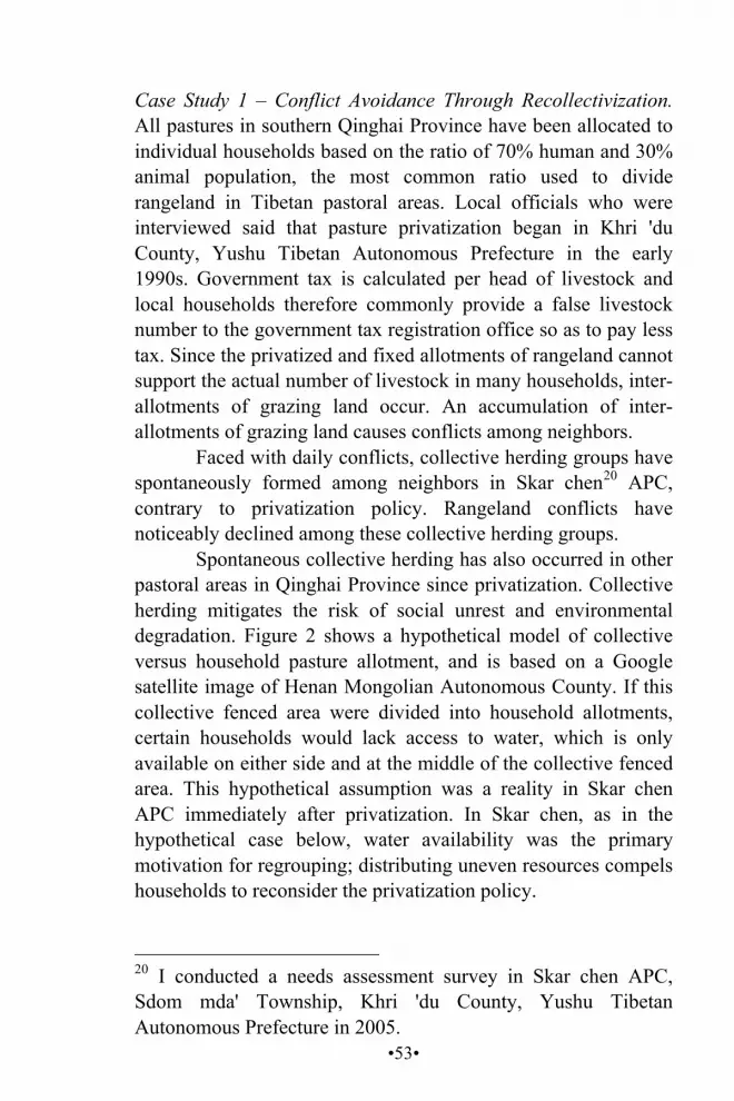
•53•
Case Study 1 – Conflict Avoidance Through Recollectivization. All pastures in southern Qinghai Province have been allocated to individual households based on the ratio of 70% human and 30% animal population, the most common ratio used to divide rangeland in Tibetan pastoral areas. Local officials who were interviewed said that pasture privatization began in Khri 'du County, Yushu Tibetan Autonomous Prefecture in the early 1990s. Government tax is calculated per head of livestock and local households therefore commonly provide a false livestock number to the government tax registration office so as to pay less tax. Since the privatized and fixed allotments of rangeland cannot support the actual number of livestock in many households, inter-allotments of grazing land occur. An accumulation of inter-allotments of grazing land causes conflicts among neighbors.
Faced with daily conflicts, collective herding groups have spontaneously formed among neighbors in Skar chen20 APC, contrary to privatization policy. Rangeland conflicts have noticeably declined among these collective herding groups.
Spontaneous collective herding has also occurred in other pastoral areas in Qinghai Province since privatization. Collective herding mitigates the risk of social unrest and environmental degradation. Figure 2 shows a hypothetical model of collective versus household pasture allotment, and is based on a Google satellite image of Henan Mongolian Autonomous County. If this collective fenced area were divided into household allotments, certain households would lack access to water, which is only available on either side and at the middle of the collective fenced area. This hypothetical assumption was a reality in Skar chen APC immediately after privatization. In Skar chen, as in the hypothetical case below, water availability was the primary motivation for regrouping; distributing uneven resources compels households to reconsider the privatization policy.
20 I conducted a needs assessment survey in Skar chen APC, Sdom mda' Township, Khri 'du County, Yushu Tibetan Autonomous Prefecture in 2005.
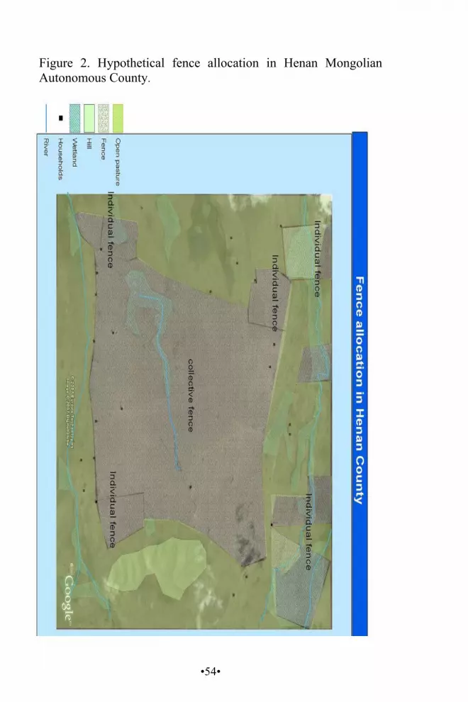
•54•
Figure 2. Hypothetical fence allocation in Henan Mongolian Autonomous County.
•55•
Most households are concentrated along the southern side of the fence, causing overgrazing from herding adjacent to the settlements. The effect of overgrazing can also be seen by examining the distribution of wetlands near the riverbanks. There are abundant wetlands on the northern riverbanks where there are fewer settlements. Wetlands are few near the southern riverbanks. This phenomenon corresponds with the arguments of Richard et al. (2006), Pirie (2005), and Yan et al. (2005), who argue that fencing and privatization lead to erosion along riverbanks by concentrating livestock at water sources. Case Study 2 – Conflict Over Unevenly Distributed Pastoral Resources. Privatization and land division result in an imbalance in resource distribution across topographical variations. In particular, the placement of settlements and land division within variable topography significantly impacts grazing adaptability (Kuhn 2006:26):
Mobility and herd diversity traditionally have been nomads' keys to surviving these conditions by evenly allocating animals to grasslands and taking advantage of local variations in climate and vegetation.
Kuhn's argument may be applied to the Ko chen and Skar mda' case. Traditionally, Ko chen and Skar mda' APCs were a single community, which the government divided into two separate entities in the 1960s. Ko chen has topographically diverse pasture, which Skar mda' lacks. Skar mda' is located on the northern side of an east-west running valley. Slopes in Skar mda' face south. Ko chen occupies half of the southern valley where slopes face north. A more variable range of slope aspects exist, with numerous north-south running tributary valleys.
South-facing slopes receive higher solar radiation in winter, as opposed to north-facing slopes, which are mostly shady and unsuited for grazing during the snowy season, as snow stays longer on these slopes, covering fodder. Moisture on shady

•56•
slopes evaporates slowly; the moisture held by the soil nurtures seeds and seedlings, and these slopes have denser vegetation than sunny slopes. This can be seen from the satellite map in Figure 3. Figure 3. Land distribution in Skar mda' (Karnda) and Ko chen (Kochen) APCs.
•57•
However, Skar mda' APC residents have little choice regarding seasonal pastures. Much Skar mda' territory is located on sunny, south-facing slopes. Vegetation is scarce because snow melts faster on these slopes and soil retains less moisture. Skar mda' APC lacks seasonal pastures, concentrating grazing only on sunny slopes that are becoming increasingly degraded as evident from the satellite images in Figure 3.
Pastures on Ko chen's sunny slopes can rest in summer to allow vegetation to recover, because Ko chen has a diverse choice of pasture. Therefore, sunny slopes are not as degraded as in Skar mda'.
Skar mda' residents face a chronic fodder shortage due to the growing number of livestock, and asked the government to return their pastures from Ko chen, but this has been ignored. Skar mda' livestock occasionally graze in Ko chen territory. In an interview, a Ko chen herder complained about an intrusion from Skar mda'. Arguments have intensified between members of the two communities, who often accuse each other of being the offender.
This artificial land division has led to environmental degradation and a decline in social cohesion. An example of the decline in social capital is explained below. Some parents in Ko chen APC do not send their children to Skar mda' Primary School, regardless of the high quality of the school and the short distance, because of conflicts between the two communities. Many school-age children in Ko chen therefore do not attend school, while others attend school in the distant township town if they have relatives there to care of them.
In the context of a needs assessment in Skar mda', a community brainstorming session was held in 2004 to prioritize local needs, finding that the first priority was to return or share their former pasture with Ko chen. This indicates that land division caused the most significant problem in the community.
Lack of mobility between sunny and shady slopes exacerbates livestock mortality during snowstorms and other bad weather. Pastoralists previously moved freely from shady to sunny slopes to avoid snowstorms, which reduced livestock
•58•
mortality. Such mobility is now impossible. There are no mechanisms under the current policy to readjust pastoral resource management. Before the new policy, herders had more options when they were confronted with such crises as nascent conflict and snowstorms.
Ko chen APC leaders strongly preferred collective herding, saying that it avoided inter-household conflict. All household members in this collective group have equal access to the same common pasture, water resources, and seasonal pastures. For these reasons, collective herding eliminates the basis of inter-household conflicts because such conflict is rare when people graze their livestock on common pasture.
According to interviewees in Ko chen, advantages of the collective herding model include community leaders and experienced senior pastoralists' ability to effectively lead group herding for the entire community's benefit. The efforts of community leaders and experienced herders have an equal effect on all households within the group; they are not confined to individual families. Also, it allows regulations to be applied more easily to collective herding. For example, seasonal pasture movements can be arranged according to a schedule that experienced herders and community leaders can easily monitor and guide.
Conversely, inexperienced herders suffer in completely privatized rangeland. In the absence of mandatory commitment to their pastoral practice, poor management skills create poverty. Also, people who obtained inferior land during the privatization processes lack incentives to invest in the pasture.
Sheds The FA provides a house, fenced pasture of 16.67 hectares, a shed of sixty square meters, and 0.33 hectares of land for growing fodder per household. In the early 1990s, the Qinghai Provincial Government targeted 37,451 households in southern

•59•
Qinghai for the implementation of FA within ten years (Zhang et al. 2005).
As a program component, the shed significantly impacts herders' livelihood by protecting livestock from winter cold. The data below (Figure 4) shows temperature changes inside and outside a shed in various locations over several days.
The average temperature in the shed over twenty-four hours was -6.500C, whereas outside the shed it was -13.500C, a difference of 70C. The temperature changes reduce animal weight loss that usually occurs during cold weather due to burning fat to stay warm.
An evaluation report for Mgo log Prefecture showed that the average weight of sheep kept within a shed decreased by 4.06 kilograms from December-April. In comparison, the weight of sheep lacking access to a shed decreased by 10.58 kilograms over the same time period. The difference in weight loss was 6.52 kilograms per sheep (see Figure 5).
Figure 4. Temperature changes outside and inside a shed (Zhang et al. 2005).
Date Site Days Average Temp in
Shed
Average Outside Temp
Dif
November 1997
Rdza stod
5.0 -6.58 -12.34 5.76
December 1998
Dar lag 10.0 -7.27 -13.26 5.99
January 1999
Rma stod
8.0 -5.66 -14.90 9.24
Average 7.6 -6.50 -13.50 7.00
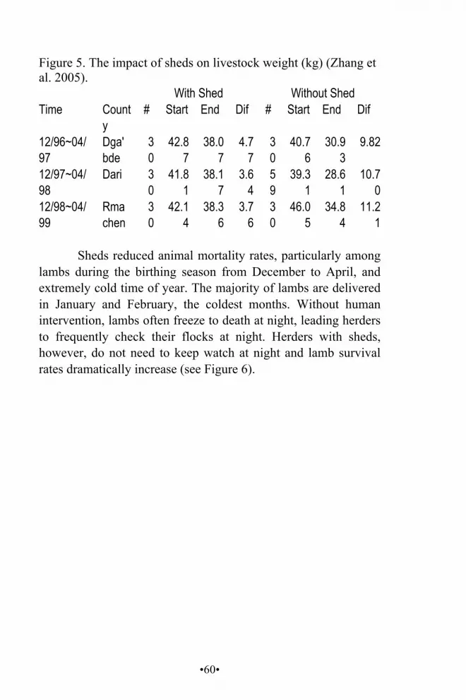
•60•
Figure 5. The impact of sheds on livestock weight (kg) (Zhang et al. 2005). Time
With Shed Without Shed County
# Start End Dif # Start End Dif
12/96~04/97
Dga' bde
30
42.87
38.07
4.77
30
40.76
30.93
9.82
12/97~04/98
Dari 30
41.81
38.17
3.64
59
39.31
28.61
10.70
12/98~04/99
Rma chen
30
42.14
38.36
3.76
30
46.05
34.84
11.21
Sheds reduced animal mortality rates, particularly among
lambs during the birthing season from December to April, and extremely cold time of year. The majority of lambs are delivered in January and February, the coldest months. Without human intervention, lambs often freeze to death at night, leading herders to frequently check their flocks at night. Herders with sheds, however, do not need to keep watch at night and lamb survival rates dramatically increase (see Figure 6).
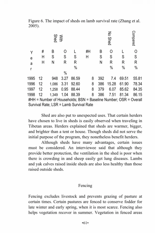
•61•
Figure 6. The impact of sheds on lamb survival rate (Zhang et al. 2005).
Ye a r
W
ith Shed
No Shed
Compared
# HH
B S N
O S R %
L SR %
#HH
BS N
O S R %
L S R%
O S R %
1995 12 948 3.27 86.59 8 392 7.4 69.51 55.81 1996 12 1,086 3.31 92.60 8 386 15.28 61.90 78.34 1997 12 1,258 0.95 88.44 8 379 6.07 85.62 84.35 1998 12 1,349 1.04 88.39 8 386 7.51 81.34 86.15 #HH = Number of Households; BSN = Baseline Number; OSR = Overall Survival Rate; LSR = Lamb Survival Rate
Shed are also put to unexpected uses. That certain herders have chosen to live in sheds is easily observed when traveling in Tibetan areas. Herders explained that sheds are warmer, bigger, and brighter than a tent or house. Though sheds did not serve the initial purpose of the program, they nonetheless benefit herders.
Although sheds have many advantages, certain issues must be considered. An interviewee said that although they provide better protection, the ventilation in the shed is poor when there is crowding in and sheep easily get lung diseases. Lambs and yak calves raised inside sheds are also less healthy than those raised outside sheds.
Fencing
Fencing excludes livestock and prevents grazing of pasture at certain times. Certain pastures are fenced to conserve fodder for late winter and early spring, when it is most scarce. Fencing also helps vegetation recover in summer. Vegetation in fenced areas
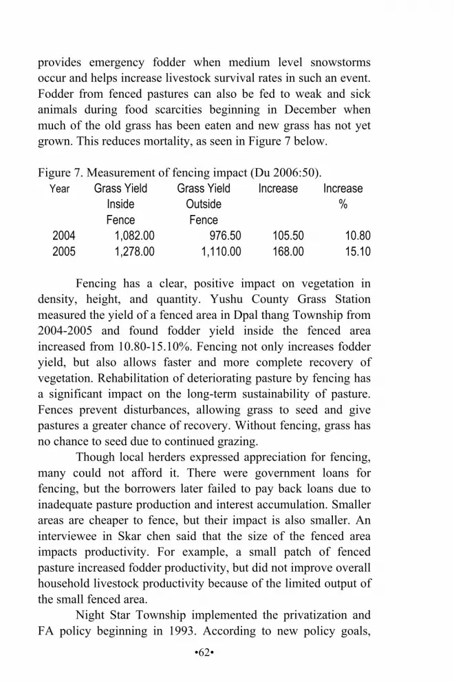
•62•
provides emergency fodder when medium level snowstorms occur and helps increase livestock survival rates in such an event. Fodder from fenced pastures can also be fed to weak and sick animals during food scarcities beginning in December when much of the old grass has been eaten and new grass has not yet grown. This reduces mortality, as seen in Figure 7 below. Figure 7. Measurement of fencing impact (Du 2006:50).
Year Grass Yield Inside Fence
Grass Yield Outside Fence
Increase Increase %
2004 1,082.00 976.50 105.50 10.80 2005 1,278.00 1,110.00 168.00 15.10
Fencing has a clear, positive impact on vegetation in
density, height, and quantity. Yushu County Grass Station measured the yield of a fenced area in Dpal thang Township from 2004-2005 and found fodder yield inside the fenced area increased from 10.80-15.10%. Fencing not only increases fodder yield, but also allows faster and more complete recovery of vegetation. Rehabilitation of deteriorating pasture by fencing has a significant impact on the long-term sustainability of pasture. Fences prevent disturbances, allowing grass to seed and give pastures a greater chance of recovery. Without fencing, grass has no chance to seed due to continued grazing.
Though local herders expressed appreciation for fencing, many could not afford it. There were government loans for fencing, but the borrowers later failed to pay back loans due to inadequate pasture production and interest accumulation. Smaller areas are cheaper to fence, but their impact is also smaller. An interviewee in Skar chen said that the size of the fenced area impacts productivity. For example, a small patch of fenced pasture increased fodder productivity, but did not improve overall household livestock productivity because of the limited output of the small fenced area.
Night Star Township implemented the privatization and FA policy beginning in 1993. According to new policy goals,
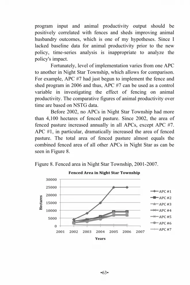
•63•
program input and animal productivity output should be positively correlated with fences and sheds improving animal husbandry outcomes, which is one of my hypotheses. Since I lacked baseline data for animal productivity prior to the new policy, time-series analysis is inappropriate to analyze the policy's impact.
Fortunately, level of implementation varies from one APC to another in Night Star Township, which allows for comparison. For example, APC #7 had just begun to implement the fence and shed program in 2006 and thus, APC #7 can be used as a control variable in investigating the effect of fencing on animal productivity. The comparative figures of animal productivity over time are based on NSTG data.
Before 2002, no APCs in Night Star Township had more than 4,100 hectares of fenced pasture. Since 2002, the area of fenced pasture increased annually in all APCs, except APC #7. APC #1, in particular, dramatically increased the area of fenced pasture. The total area of fenced pasture almost equals the combined fenced area of all other APCs in Night Star as can be seen in Figure 8.
Figure 8. Fenced area in Night Star Township, 2001-2007.
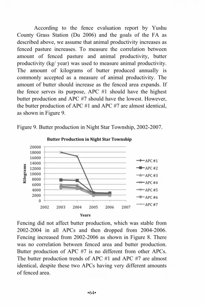
•64•
According to the fence evaluation report by Yushu County Grass Station (Du 2006) and the goals of the FA as described above, we assume that animal productivity increases as fenced pasture increases. To measure the correlation between amount of fenced pasture and animal productivity, butter productivity (kg/ year) was used to measure animal productivity. The amount of kilograms of butter produced annually is commonly accepted as a measure of animal productivity. The amount of butter should increase as the fenced area expands. If the fence serves its purpose, APC #1 should have the highest butter production and APC #7 should have the lowest. However, the butter production of APC #1 and APC #7 are almost identical, as shown in Figure 9.
Figure 9. Butter production in Night Star Township, 2002-2007.
Fencing did not affect butter production, which was stable from 2002-2004 in all APCs and then dropped from 2004-2006. Fencing increased from 2002-2006 as shown in Figure 8. There was no correlation between fenced area and butter production. Butter production of APC #7 is no different from other APCs. The butter production trends of APC #1 and APC #7 are almost identical, despite these two APCs having very different amounts of fenced area.
•65•
However, this evidence does not rule out a correlation between animal productivity and fenced area. Transportation has improved and households may have sold fresh milk and yogurt instead of producing butter.21
Livestock number may be a better way of measuring the effect of fenced area size on animal productivity. Despite government attempts to control the animal population to maintain equilibrium between pasture carrying capacity and animal population, livestock population trends can be used to explain the effect of fenced area size. The reason for this is that the sharp fluctuation of livestock populations may signal fence dysfunction. Historically, sharp fluctuations occurred when there were snowstorms or droughts. Fences supposedly mitigate livestock loss during natural disasters. However, sharp fluctuations in livestock population in all APCs have occurred equally since implementation of FA in 2002. Particularly, APC #7 and APC #1 should be noted, as can be seen in Figure 10, because these two APCs display similar livestock trends despite one having the largest area of fenced land in the township and the other having the least.
21 Motorcycles became increasingly common in many Tibetan herding areas beginning in the 1990s.

•66•
Figure 10. Livestock reproduction in Night Star Township, 2001-2007.
Despite the livestock reduction noted in the figure above, pastoralists' living conditions have improved in recent years. Net incomes of all APCs grew steadily since 2002. Is this the effect of pastoral policy? Is it the consequence of government promoting the commercialization of animal husbandry? These questions may be answered by examining the annual product data of Night Star Township and market prices. The income from butter, cheese, sheep skins, yak skins, and Ophiocordyceps sinensis22 can be multiplied by the market prices of that year to obtain a measure of income. I found that the major portion of locals' income is not from animal husbandry, but from Ophiocordyceps sinensis. The prices of animal products had not changed significantly since 2002. However, the price of
22 Ophiocordyceps sinensis (caterpillar fungus) is a traditional medicine widely used as a tonic and medicine by Chinese for centuries. It is found on the Tibetan Plateau, Bhutan, and northern Nepal.

•67•
Ophiocordyceps sinensis dramatically increased each year. In 2002, income from Ophiocordyceps sinensis sales constituted 41% of Night Star's total income and, by 2006, comprised 92% of total income as shown in figures 11 and 12. This indicates that the growing net income is not attributable to pastoral reform. The booming Ophiocordyceps sinensis economy overshadows traditional pastoral economic issues because people no longer depend solely on livestock. Therefore, pastoral issues became covert, potential problems. Once the economic bubble currently created by the booming Ophiocordyceps sinensis market bursts, pastoral development issues will become critical. Figure 11. Night Star Township sector income, 2002 vs 2006.
According to an interviewee, the expense of fencing is such that only a limited amount is affordable. Insufficient fencing was ineffective in preserving pasture and livestock during the severe snowstorms of 1997.
Fence location is of paramount importance – incorrectly placed fencing wastes resources. I observed almost no difference in pasture quality between the inside and outside of fenced areas in arid areas. Fencing arid pastures is not recommended. However, fencing along riverbanks in wetlands and on non-arid pastures provides good results.
Fences are more effective if households open fenced areas to weaker animals instead of grazing all their livestock there. The
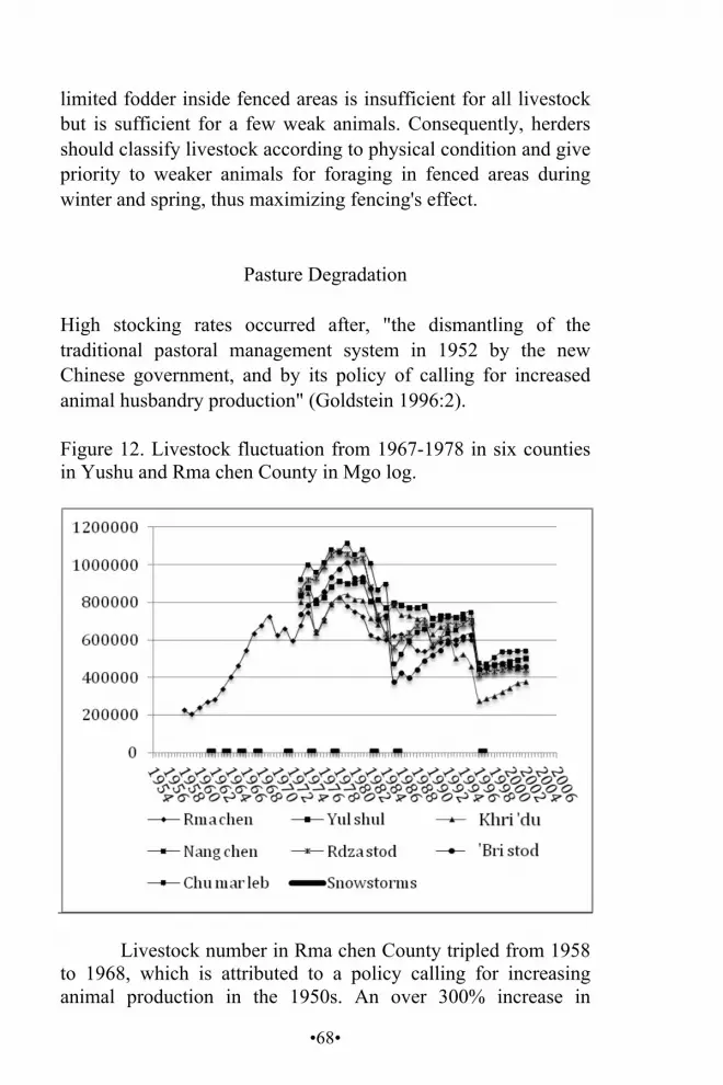
•68•
limited fodder inside fenced areas is insufficient for all livestock but is sufficient for a few weak animals. Consequently, herders should classify livestock according to physical condition and give priority to weaker animals for foraging in fenced areas during winter and spring, thus maximizing fencing's effect.
Pasture Degradation
High stocking rates occurred after, "the dismantling of the traditional pastoral management system in 1952 by the new Chinese government, and by its policy of calling for increased animal husbandry production" (Goldstein 1996:2).
Figure 12. Livestock fluctuation from 1967-1978 in six counties in Yushu and Rma chen County in Mgo log.
Livestock number in Rma chen County tripled from 1958
to 1968, which is attributed to a policy calling for increasing animal production in the 1950s. An over 300% increase in
•69•
grazing population overburdened the grazing carrying capacity. Figure 12 suggests that snowstorms from 1958 to 1968 were accompanied by a sharp increase in livestock population. One explanation is that rangeland that had never before been overgrazed had a substantial livestock carrying capacity until overgrazing gradually led to degradation. Comparatively, Rma chen County in 1968 had three times more livestock than in 1958. Therefore, inadequate forage for livestock during snowstorms likely causes greater animal mortality than when there are more forage resources. An examination of Nori (2004) and Goldstein's (1996) data reveals a relationship between overstocking and losses in snowstorms in southern Qinghai. Increasing livestock number above 600,000 resulted in a drastic drop in livestock number. For example, when the total number of livestock reached 723,935 in 1969, the following year, 98,783 livestock were lost (ibid). "The total number of livestock was actually 5.7% lower than the 1967" (ibid).
Livestock number kept near the equilibrium point until 2007 resulted in maximization of profitability working for long-term sustainability. If livestock number is kept at equilibrium, animal productivity is stable. In this case, the hypothesis that overgrazing causes degradation is somewhat challenged, since degraded rangeland cannot sustain the maximum number of livestock for decades. Rangeland degradation is a great challenge in western China. According to an unnamed government agency's investigation, 50-60% of pasture around the TRA is degraded to some extent (Qinghai xinwen wang 2006). How can degraded rangeland keep livestock numbers at equilibrium? To answer this question, we must obtain data from after 1995. Degradation is a long, slow process; its impact cannot be seen within a short time. However, we lack data about Rma chen County after 1995 and thus must apply data from neighboring counties.
Yushu's six counties share similar climate, policy, geography, and history to Rma chen. Therefore, we can treat Rma chen County as a control variable for the study of pastoral development in Yushu. Data are available from all counties for the period 1973-1995. The livestock trend and effects of snowstorms were comparable within this period. Khri 'du County is geographically close to Rma chen County and the trends in
•70•
these two counties are similar. Rma chen data imply knowable data prior to 1973 in other counties (Figure 12). Therefore, all counties were treated as a single unit of analysis.
From 1972-1991, Khri 'du County's livestock number was kept at an equilibrium point of around 700,000. Each time the livestock number exceeded the equilibrium, a sharp drop was observed the next year. After 1995, the livestock population dropped and never reached the previous equilibrium level again. This phenomenon demonstrates that a certain period of overgrazing leads to long-term degradation.
When plotted, livestock population changes over the last five decades resemble the Kuznets curve, which hypothesizes a relationship between economic development and environmental quality. In this case, increasing animal production seems to lead to an increase in environmental degradation, i.e., long-term overgrazing causes environmental degradation.
Effects of Natural Disaster after Overstocking Major fluctuations in livestock populations imply the occurrence of interventions and disturbances in the past three decades. There were sharp drops in livestock numbers in 1974-1975, 1983-1985, and 1995-1996. Each drop was caused by snowstorms. Ten major snowstorms struck southern Qinghai Province between 1954 and 1985, in 1954, 1956, 1961, 1963, 1965, 1967, 1971, 1974, 1977, 1982, and 1985 (Guoluo Prefecture Government 2008). However, the snowstorms did not affect the increase in livestock population before 1965. Snowstorms began to affect livestock number when livestock raising reached maximum profitability after the 1970s.
Blizzards occurred in 1983, 1985, 1989, 1995, and 1996 (Shi et al. 2001, 50). Blizzards in 1985 and 1995 were the deadliest in recent history and caused a dramatic reduction in livestock numbers, which then gradually rebounded. However, recovery from the most recent blizzards has been minimal and stocking levels have not reached levels prior to each disaster. Overall, the livestock figures have consistently decreased since early 1973.
•71•
CONCLUSIONS AND RECOMMENDATIONS Decollectivization and privatization of Tibetan pastoral rangelands was attempted in order to improve pastoralists' economic conditions. In practice, related policy has been complex, impractical, and non-participatory. The government takes the view that the FA enhances economic growth by moving herders into new, government-built houses. Afterwards, however, these pastoralists lose the traditional form of life they have practiced for millennia. Applying GIS and quantitative and qualitative data research methods to case studies, it can be seen that: Privatization has caused social unrest and conflicts between
neighbors. Some pastoralists formed collective grazing areas to address conflict issues.
Sedentarizing herders increases rangeland degradation and erosion of riparian areas by limiting livestock grazing mobility. Fences mitigate the negative impacts of environmental degradation but sufficient funds are needed for building and maintaining fencing.
The maximization of profitability by overstocking led to a process of depletion of pastoral resources. Profit-oriented equilibrium between the resource and stock rate cannot be sustained over the long term.
Pastoralism has become less significant to pastoralists' livelihood as Ophiocordyceps sinensis has increasingly become the most important source of income, at least in the study area of Night Star Township. This increase in pastoralist income offsets the decline in animal husbandry productivity.
Current policy designed to put people first must be rethought. The quality of implementation of pastoral policy must be improved. Poor documentation and ambiguous boundaries contribute to rangeland conflict. Explicit documentation of rangeland boundaries would reduce rangeland conflicts.

•72•
Meaningful designation of fencing placement is important; fences should be placed in consultation with knowledgeable local stakeholders. My analysis suggests that the result of fencing is positive in the short-run but it must not be permanent; rather, after a certain number of years, fences should be moved to a new area. Large fenced areas have greater impact than a number of small fenced areas. Current fencing loans are a heavy burden for nomads. Some families are deep in debt because they are required to fence. Debt reduction policy is recommended.
This research suggests sedentarizing Tibetan herders is not a realistic solution to poverty alleviation. They cannot adapt to new circumstances and lack job skills leading to even worse poverty.
I conclude that government policy does not meet its objectives, and wastes a great deal of government resources. Policy makers need to objectively evaluate previous policies and be open to accept suggestions and findings from independent experts. The government must particularly listen to the key stakeholders – the pastoralists – who directly experience policy impact and who have an intimate, profound, generationally transmitted knowledge of pastoralism.

•73•
THE IMPACT OF THE GRASSLAND HOUSEHOLD CONTRACT RESPONSBILITY SYSTEM
ON THE GRASSLAND ECOSYSTEM AND LIVESTOCK PRODUCTIVITY IN G.YON RI,
QINGHAI PROVINCE, CHINA Mgon po tshe ring (Beijing University)23 ABSTRACT Chinese policy-makers assumed that grasslands were severely degraded by overstocking and overgrazing under the community-based grassland management system from 1981-1991. The Grassland Household Contract Responsibility System (GHCRS) was then implemented. The ecological impact of the GHCRS with its Four Allocations (FA) program on the grassland ecosystem and livestock productivity in G.yon ri Village, a Tibetan agro-pastoral community in Sum mdo Township, Mang ra County, Mtsho lho Tibetan Autonomous Prefecture, Qinghai Province, PR China was studied. Livestock mobility and flexibility, stock diversity, stocking rate, diversity of grass species, grassland enclosure/ fencing and livestock productivity were considered in analyzing the effects of HRCS. KEY WORDS G.yon ri Village, grassland household contract responsibility system, livestock productivity, Qinghai, Tibetan Plateau
23 I sincerely thank the United Board for Christian Higher Education in Asia for sponsoring my graduate study at Miriam College in Manila, the Republic of the Philippines.
•74•
INTRODUCTION
Interviews with G.yon ri herders suggest that they have experienced a number of policy changes affecting grassland use and livestock distribution since the establishment of 'New China' in 1949, as detailed below:
1958-1981. Livestock and grasslands were managed under
the Commune System,24 during which all property belonged to the state.
1981-1991. The Livestock Household Contract Responsibility System 25 was implemented whereby livestock were distributed among individual households, while grassland was managed by G.yon ri Village, which was also termed Community-based Grassland Management (CBGM).26
1991-present. An extension of the Household Contract Responsibility System (HCRS),27 the Grassland Household Responsibility System (GHCRS) 28 was implemented. Individual households may manage and use their grassland allotment, though the state retains land ownership.
CBGM was implemented in the early 1980s in Tibetan pastoral areas when livestock were divided among individual households while the grassland continued to be managed and used communally. When commune rangelands were distributed in the early 1980s, the general pattern was for pastures to be allocated to administrative or natural villages with collective grazing tenure or kin group tenure (Banks et al. 2003). Mountain ranges and rivers were used to demarcate boundaries of
24 Gongshe zhidu. 25 Xumu chengbao daohu zhidu. 26 Shequ wei jichude caoyuan guanli. 27 Jiating lianchan chengbao zeren zhidu. 28 Caoyuan chengbao daohu.

•75•
community-owned grasslands. In CBGM, pastoralists moved four or five times annually on the communal grassland as determined by local climate and biophysical characteristics of the grasslands.
In the early 1990s, as an extension of the HCRS for agricultural areas in China, the policy of GHCRS was implemented in most Tibetan pastoral communities. This policy was based on the notion that CBGM leads to a 'tragedy of the commons' that facilitates and promotes a dramatic increase in the stocking rate and grassland degradation through overgrazing. Subsequently, the GHCRS was initiated with the allocation of community grassland to individual herding households, with each household assuming responsibility for its own rangeland parcel.
The GHCRS system, also known as the Four Allocation (FA) program, 29 mandated building a house, fencing, and livestock sheds and cultivating non-native grass species. The central government believed implementation of the GHCRS with its FA would encourage more responsible resource management, improve pastoral productivity, prevent further rangeland deterioration, and protect the grassland ecosystem (Goldstein 1996). The GHCRS aimed to prevent grassland degradation by bringing livestock numbers into balance with the carrying capacity of the grassland. Simultaneously, it was thought that such a system would stabilize livestock numbers by avoiding climate driven mortalities, thus increasing livestock productivity and providing a sustainable income for the pastoralists (Goldstein 1996, Miller 2001).
THE PROBLEM Although the GHCRS was implemented with the intention of protecting the grassland ecosystem and improving livestock productivity, certain grassland experts have questioned if sedentizing pastoralists in fenced allotments prevents grassland
29 Sipeitao jianshe.
•76•
degradation (Richard et al. 2006; Miller 2001). Estimates suggest that about 34% of all rangelands in China are moderately to severely degraded, and about 90% are degraded to some degree (Miller 2001). Similarly, Sheehy (2001) writes that about a third of Tibetan Plateau pasture is moderately to severely degraded, questioning its long-term sustainability under contemporary management. Furthermore, interviews and conversations with pastoralists who acted in accordance with the GHCRS of Dge rtse Township, Brag 'go County, Dkar mdze Tibetan Autonomous Prefecture, Sichuan Province, suggest that local herders encounter such problems as insufficient grass, high livestock mortality, and an increase in black sand in grassland areas.
This research seeks to clarify if implementation of GHCRS has improved the grassland ecosystem and livestock productivity in G.yon ri Village. Research was conducted from September to October 2007. More specifically, this research sought to answer these questions:
What are the environmental impacts of the GHCRS on the
grassland ecosystem of G.yon ri Village? What are the impacts of the GHCRS on livestock productivity
improvement? What alternative grassland management techniques might be
adopted to prevent further grassland degradation and lead to sustainable grassland use?
SIGNIFICANCE
Management of rangelands on the Tibetan Plateau has a serious impact on the majority of Tibetans in China. To quote Miller (2004:2):
Of the Tibetan population in China of about 5 million people, almost 2 million are nomads who make their living primarily from animal husbandry. Another 2 and 2.5 million people are agro-pastoralists, who combine both cropping and livestock raising

•77•
for their livelihoods. As such, livestock development and the management of the rangeland resources are fundamental to the future development of the majority of the Tibetan people.
Furthermore, it also impacts people living in lowland China and neighboring countries (Miller 2001) because this region contains the headwaters of the Rma chu (Yellow), Rdza chu (Mekong), and 'Bri chu (Yangzi) rivers. What occurs on the Tibetan Plateau therefore significantly impacts millions of people.
Implemented rangeland management policies and programs on the Tibetan Plateau should be sustainable and address the need to protect the grassland ecosystem while improving livestock productivity. This study's findings might assist environmental managers and planners in implementing further interventions in herding areas to improve existing rangeland management systems. This research also contributes to the literature on Tibetan rangeland management systems and grassland policies for similar future research.
G.YON RI VILLAGE
G.yon ri Village had sixty agro-pastoral households (430 Tibetans) in 2007 and is 3,200 meters above sea level. G.yon ri pastoralists live on alpine grasslands where vegetation is sufficient to support a large number of livestock. Pastoralism is their predominant economic activity; fields occupy a small area of their winter pasture. On average, each family has 0.6 hectares of cultivated land. Major income is earned from selling and exchanging such livestock products as butter, wool, hides, and sheep at the local market in Mang ra County Town with Hui and Han businessmen.
During CBGM from 1981-1991, G.yon ri herders used the grassland communally with three seasonal movements. Their livestock moved vertically, grazing in mountain areas in summer, and then moved back to the foot of the mountains in winter. The spring-autumn pasture was located between the summer and
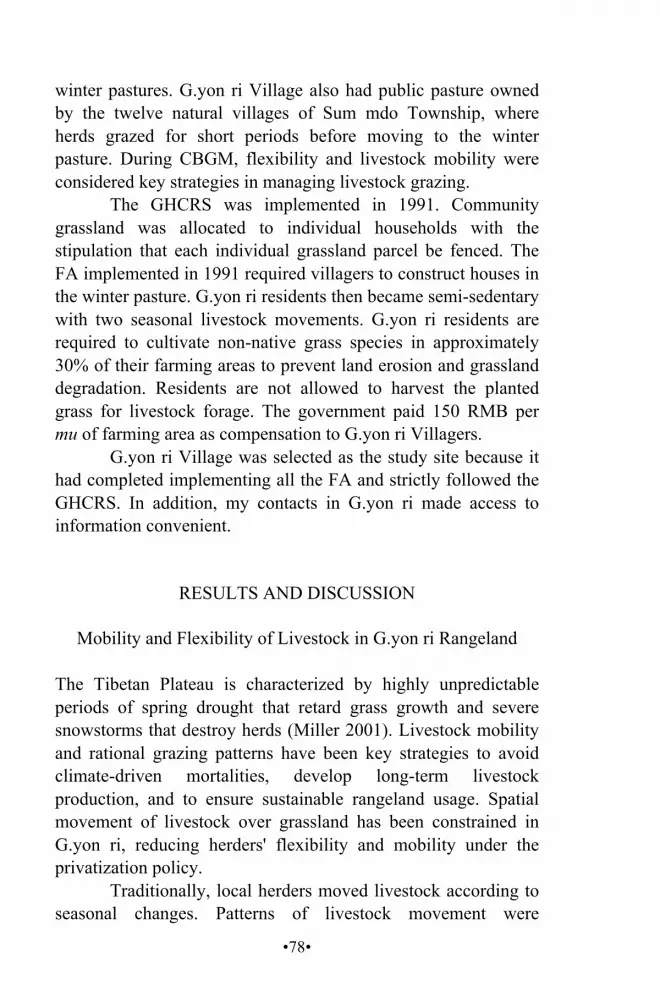
•78•
winter pastures. G.yon ri Village also had public pasture owned by the twelve natural villages of Sum mdo Township, where herds grazed for short periods before moving to the winter pasture. During CBGM, flexibility and livestock mobility were considered key strategies in managing livestock grazing.
The GHCRS was implemented in 1991. Community grassland was allocated to individual households with the stipulation that each individual grassland parcel be fenced. The FA implemented in 1991 required villagers to construct houses in the winter pasture. G.yon ri residents then became semi-sedentary with two seasonal livestock movements. G.yon ri residents are required to cultivate non-native grass species in approximately 30% of their farming areas to prevent land erosion and grassland degradation. Residents are not allowed to harvest the planted grass for livestock forage. The government paid 150 RMB per mu of farming area as compensation to G.yon ri Villagers.
G.yon ri Village was selected as the study site because it had completed implementing all the FA and strictly followed the GHCRS. In addition, my contacts in G.yon ri made access to information convenient.
RESULTS AND DISCUSSION
Mobility and Flexibility of Livestock in G.yon ri Rangeland The Tibetan Plateau is characterized by highly unpredictable periods of spring drought that retard grass growth and severe snowstorms that destroy herds (Miller 2001). Livestock mobility and rational grazing patterns have been key strategies to avoid climate-driven mortalities, develop long-term livestock production, and to ensure sustainable rangeland usage. Spatial movement of livestock over grassland has been constrained in G.yon ri, reducing herders' flexibility and mobility under the privatization policy.
Traditionally, local herders moved livestock according to seasonal changes. Patterns of livestock movement were
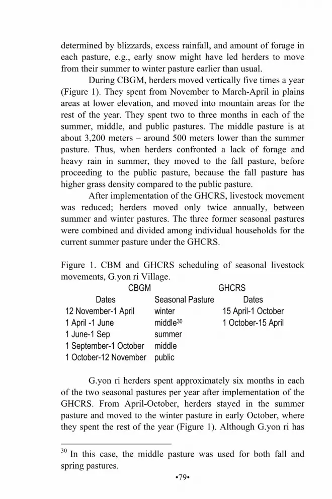
•79•
determined by blizzards, excess rainfall, and amount of forage in each pasture, e.g., early snow might have led herders to move from their summer to winter pasture earlier than usual.
During CBGM, herders moved vertically five times a year (Figure 1). They spent from November to March-April in plains areas at lower elevation, and moved into mountain areas for the rest of the year. They spent two to three months in each of the summer, middle, and public pastures. The middle pasture is at about 3,200 meters – around 500 meters lower than the summer pasture. Thus, when herders confronted a lack of forage and heavy rain in summer, they moved to the fall pasture, before proceeding to the public pasture, because the fall pasture has higher grass density compared to the public pasture.
After implementation of the GHCRS, livestock movement was reduced; herders moved only twice annually, between summer and winter pastures. The three former seasonal pastures were combined and divided among individual households for the current summer pasture under the GHCRS. Figure 1. CBM and GHCRS scheduling of seasonal livestock movements, G.yon ri Village.
CBGM GHCRS Dates Seasonal Pasture Dates
12 November-1 April winter 15 April-1 October 1 April -1 June middle30 1 October-15 April 1 June-1 Sep summer 1 September-1 October middle 1 October-12 November public
G.yon ri herders spent approximately six months in each
of the two seasonal pastures per year after implementation of the GHCRS. From April-October, herders stayed in the summer pasture and moved to the winter pasture in early October, where they spent the rest of the year (Figure 1). Although G.yon ri has
30 In this case, the middle pasture was used for both fall and spring pastures.
•80•
two seasonal pastures, after herding livestock on the summer pasture they moved sheep to the winter pasture, and entrusted their yaks to other villages for a payment of 0.5 RMB per yak per day. This meant each household annually spent about 70 RMB per yak every five months. According to herders, this livestock management scheme is dictated by insufficient forage and grazing areas for both sheep and yaks in their winter pasture. This happened only after implementation of the GHCRS. The herders explained that around 10% of their winter grazing area was used for construction of houses, roads, animal sheds, and planting non-native grass as dictated by the GHCRS. In addition, villagers are not allowed to cut the planted grass or herd livestock inside the planted grass area.
Livestock mobility was reduced to only two seasonal movements, which encouraged high livestock concentration in one area for a longer time, i.e., nearly six months in each pasture. Herders complained of such problems resulting from limited livestock mobility as the limited capacity and time for grass and soil to recover from grazing. The herders commented that a high concentration of livestock and longer stays in one area led to intense competition over desirable forage and consequently, preferred grasses were shorter and less abundant. The herders felt that herding in the same place for nearly six months led to livestock trampling grassland into bare or black sand ground on approximately 5% of their summer pasture.
Reduced spatial livestock mobility was another problem in G.yon ri after implementation of the GHCRS, which resulted in community grassland being divided among individual households and fenced, thus constraining daily grazing on different grassland areas to reduce livestock pressure on different grass species.
G.yon ri's seasonal pastures are located in mountain areas. Herders traditionally utilized various systems to divide daily herding between different locations. According to local elders, a major strategy was to divide the herd according to terrain, e.g., sunny and shady slopes. In winter, snow remained longer on shady slopes, thus herding livestock on sunny slopes was
•81•
preferred because snow melted more quickly there. Meanwhile, evaporation on shady slopes was less, providing vegetation with more moisture, meaning shaded locations had denser vegetation than sunny locations.
After implementation of the GHCRS, certain families were assigned grassland parcels on sunny slopes while others were assigned shady slopes. Herders with sunny slopes thus had land with less dense vegetation, while those with shady slopes had land with snow that melted slowly. In addition, only two moves a year created overgrazing, grassland degradation, and increased livestock mortality during cold and snowy seasons. According to locals, five to six yaks and ten to fifteen sheep per household per year die due to heavy snow. Figure 2 illustrates the comparative systems of livestock mobility and flexibility for the CBGM and GHCRS schemes.

•82•
Figure 2. Livestock mobility and flexibility in CBGM and GHCRS compared.
Figure 2A shows that under the CBGM scheme, local
herders had choices in terms of livestock mobility and flexibility. These choices included seasonal pastures and different areas for daily livestock grazing, including mobility between sunny and shady areas. For instance, on one day, all the herders might have herded their livestock in upper areas of their summer pasture and the next day might have herded in lower areas, allowing grass
•83•
and soil in upper areas to recover. Keppel (2005) observed that high impact of livestock on grassland for short durations is highly beneficial for sustainable growth of grass species because vegetation in the given area receives livestock trampling and disturbance over a short time that facilitates fertilization and seed germination, and when livestock leave the given area for a long period of time, vegetation recovers.
The former summer, middle, and public pastures (Figure 2A) were combined after implementation of the GHCRS in G.yon ri, to create the current summer pasture (see Figure 2B). Individual households were allocated one parcel of grassland in each seasonal pasture. Figure 2B shows that individuals kept their livestock in their assigned parcel, with no daily grazing patterns alternating between sunny and shady slopes. Furthermore, continuous grazing within the individual parcel for nearly six months in each pasture adversely affected the grass and soil. Keppel (2005) reported that plants and soils had no time to recover where there was constant low livestock pressure on the grassland for long periods, resulting in ecosystem damage.
Livestock Species Diversity
Livestock graze selectively on different species of grass, a fact that pastoralists traditionally used in their management strategies. When herded together, different species of livestock more efficiently use rangeland vegetation. As a result, maintaining livestock diversity is a critical issue for uniform grassland utilization, equal growth of all diverse grass species during the growing season, and efficient use of rangeland vegetation. Furthermore, livestock grazing sustains the grassland ecosystem through trampling, fertilization, and uniform grazing. According to local herders, implementation of the GHCRS both directly and indirectly contributed to a reduction of livestock diversity and rapid decline in grass species diversity since 1991.

•84•
Figure 3. Trends in total population of different livestock species 1986-2007, G.yon ri Village.
G.yon ri had yaks, sheep, goats, horses, and donkeys
during the CBGM scheme from 1986-1993. Sheep and yaks comprised the majority of both total and productive stock in the late 1980s. Other livestock were utilized for transportation. Livestock diversity was reduced beginning in 1994, about three years after implementation of the GHCRS.
According to local herders, an important reason for livestock diversity reduction was that after implementation of the GHCRS, people concentrated on raising income-generating livestock – yaks and sheep. Horses, goats, and donkeys produce little in the way of commercial products but were used primarily for transportation. The system of keeping diverse livestock species with subsistence-based livestock productivity to maintain sustainable utilization of the grassland ecosystem shifted to income-centered livestock management focused on maximizing marketable livestock products.
Decrease in livestock diversity is also related to reduction in the size of grazing area. Providing grassland allocations to new households was a critical issue after implementation of the GHCRS. During CBGM, communal livestock grazing was managed collectively, and new families herded livestock with others in the common grassland area. However, after the GHCRS, new families received grassland allocations from their parents' privatized rangeland parcels. According to local

•85•
township records, approximately twenty new households were established from 1994-2007. Figure 4 provides additional information on the relationship between establishing new households and their use of grassland during community-based and privatization management. Figure 4. Comparative use of grassland by new families under CBGM and GHCRS.
Figure 4 shows that when two new households were added to the total village households during the CBGM period, their livestock were herded with other families on the communal grassland with high daily, seasonal, and spatial movements with minimal livestock pressure on the grassland. However, under the GHCRS, the two new households were allocated grassland from their parents' holdings, thus the pressure of the two new families' livestock was solely on their parents' grassland parcel. As a result, the establishment of nuclear families within a household's original grassland allocation resulted in a high livestock population of longer duration in one area. Therefore, many households with married children reduced livestock diversity due to insufficient grazing area.
Local villagers stated that implementation of the GHCRS reduced access to grazing areas, another cause for reduction of livestock diversity. Figure 5 illustrates the total coverage area of
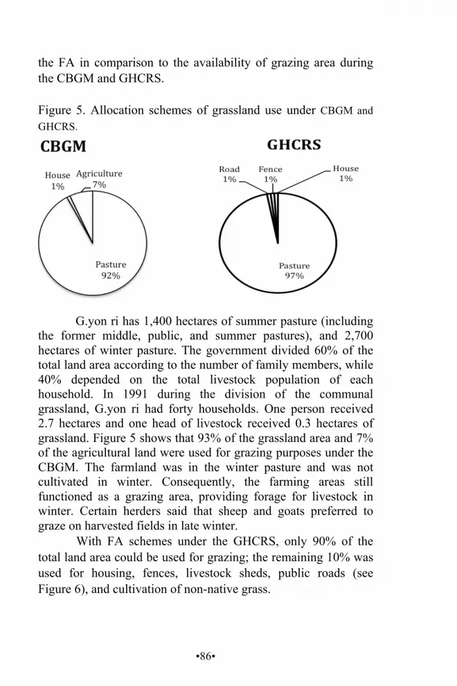
•86•
the FA in comparison to the availability of grazing area during the CBGM and GHCRS.
Figure 5. Allocation schemes of grassland use under CBGM and GHCRS.
G.yon ri has 1,400 hectares of summer pasture (including the former middle, public, and summer pastures), and 2,700 hectares of winter pasture. The government divided 60% of the total land area according to the number of family members, while 40% depended on the total livestock population of each household. In 1991 during the division of the communal grassland, G.yon ri had forty households. One person received 2.7 hectares and one head of livestock received 0.3 hectares of grassland. Figure 5 shows that 93% of the grassland area and 7% of the agricultural land were used for grazing purposes under the CBGM. The farmland was in the winter pasture and was not cultivated in winter. Consequently, the farming areas still functioned as a grazing area, providing forage for livestock in winter. Certain herders said that sheep and goats preferred to graze on harvested fields in late winter.
With FA schemes under the GHCRS, only 90% of the total land area could be used for grazing; the remaining 10% was used for housing, fences, livestock sheds, public roads (see Figure 6), and cultivation of non-native grass.

•87•
Figure 6. A public track between two individual households' allocated land holdings in the G.yon ri summer pasture.
Reduction in livestock diversity led to uneven utilization
of certain vegetation. Sheep and yaks are selective in what they eat, and areas of their desired forage received high grazing pressure, while undesirable forages were untouched. Consequently, growth of undesirable and noxious species increased, while the total diversity of desirable forage grass species was greatly reduced. Local residents estimate that 20% of summer pasture and 30% of winter pasture were covered by such tall plants as Achnatherum inebriens (chu ge du ka) which are poisonous, and not eaten by livestock. Herders pointed out that in recent years they realized that keeping only yaks and sheep within one area for nearly six months encouraged high competition over such desirable forage as Stipa krylovii (rtswa 'jam), leaving other vegetation ungrazed. Desirable forage was overgrazed, leading to black sand patches. Undesirable species likewise started to dominate the grassland ecosystem.
Diversity of Grass Species in G.yon ri Rangeland
Vegetation diversity is critical to sustaining the grassland ecosystem in the face of livestock grazing and human utilization.

•88•
According to Miller (2005), rangelands have been heterogeneous in terms of vegetation species, composition, and productivity, all of which were highly diversified across multiple scales. Grazing helps maintain grass species diversity on the Tibetan Plateau pastures. The privatization policy also aimed to maintain diversified grass species to protect the grassland ecosystem, by bringing livestock population into balance with carrying capacity to prevent grassland degradation through overstocking and overgrazing. Nevertheless, local residents claimed that growth of undesirable vegetation for livestock with few dominant species was common in their pastures and grassland degradation was accelerating. Figure 7. Major grassland species in G.yon ri Village, their coverage area, and livestock preference.
Average Coverage Area
(%)
Livestock Preference Scientific Name Local Name
Summer Pasture Stipa krylovii rtswa 'jam 70 High Potentilla anserina
gro lung 10 Medium
Rumex spp. rdum bu kho hog
8-9 low or never
Potentilla fruticosa
sben ma 10 Never
Winter Pasture Stipa krylovii rtswa 'jam 30 High rab'byungs 35 Medium Leymus spp. 'jag ma 5-10 High ragdug 20 Low Achnatherum inebriens
chu ge du ka 10 Low
Figure 7 indicates that Stipa krylovii and rab 'byungs
covered most winter pastures, accounting for around 65% of total land area. Other major grass species included Achnatherum

•89•
inebriens, ra gdug, and Leymus spp. Stipa krylovii was categorized as a major forage species in the G.yon ri grassland ecosystem and highly preferred by livestock. According to local herders, ra gdug and Achnatherum inebriens became prominent in 2000-2001 and are only eaten by horses and yaks during the growing seasons. Achnatherum inebriens grows in clumps 1-2 meters apart with strongly attached roots, while ra gdug grows individually 2-3 meters apart. Achnatherum inebriens and ra gdug are toxic to livestock, causing intestinal distress. Stipa krylovii and Leymus spp. were highly preferred and effective in maintaining livestock health. However, the density and distribution of these two species decreased three to four years after GHCRS implementation. Herders noted that Stipa krylovii and Leymus spp. covered around 65% of the winter pasture; other dominant species covered 40-45% of the winter pasture in 2007.
Residents explained that due to the absence of yaks and horses in the winter pasture, such tall, robust plants as Achnatherum inebriens and ra gdug have grown while grass species such as Stipa krylovii have limited space and chance to grow and mature. Herders kept only sheep in their winter pasture after the GHCRS, stating that this was because of the lack of winter pasture forage. The sheep grazed often on such short and desirable species as Stipa krylovii, leaving tall grasses such as Achnatherum inebriens ungrazed. These undesirable species continued to grow without being grazed, while desired ones received heavy pressure due to the longer presence of livestock grazing in the same place. In addition, without yaks, horses, donkeys, and goats grazing in the winter pasture, large amounts of vegetation and their fallen leaves remained.
Long (2003) noted that an increase in the accumulation of dead materials reduces forage growth and yield because such materials create shade, and the photosynthetic capacity of other plants is reduced. Further, livestock concentration for longer duration in a single area promoted formation of bare ground. Herders believed that when the ground becomes barren or has very limited vegetation density, the seeds of Achnatherum
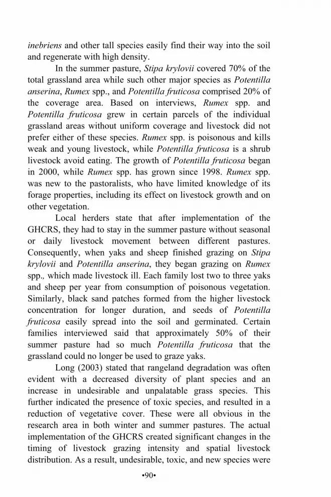
•90•
inebriens and other tall species easily find their way into the soil and regenerate with high density.
In the summer pasture, Stipa krylovii covered 70% of the total grassland area while such other major species as Potentilla anserina, Rumex spp., and Potentilla fruticosa comprised 20% of the coverage area. Based on interviews, Rumex spp. and Potentilla fruticosa grew in certain parcels of the individual grassland areas without uniform coverage and livestock did not prefer either of these species. Rumex spp. is poisonous and kills weak and young livestock, while Potentilla fruticosa is a shrub livestock avoid eating. The growth of Potentilla fruticosa began in 2000, while Rumex spp. has grown since 1998. Rumex spp. was new to the pastoralists, who have limited knowledge of its forage properties, including its effect on livestock growth and on other vegetation.
Local herders state that after implementation of the GHCRS, they had to stay in the summer pasture without seasonal or daily livestock movement between different pastures. Consequently, when yaks and sheep finished grazing on Stipa krylovii and Potentilla anserina, they began grazing on Rumex spp., which made livestock ill. Each family lost two to three yaks and sheep per year from consumption of poisonous vegetation. Similarly, black sand patches formed from the higher livestock concentration for longer duration, and seeds of Potentilla fruticosa easily spread into the soil and germinated. Certain families interviewed said that approximately 50% of their summer pasture had so much Potentilla fruticosa that the grassland could no longer be used to graze yaks.
Long (2003) stated that rangeland degradation was often evident with a decreased diversity of plant species and an increase in undesirable and unpalatable grass species. This further indicated the presence of toxic species, and resulted in a reduction of vegetative cover. These were all obvious in the research area in both winter and summer pastures. The actual implementation of the GHCRS created significant changes in the timing of livestock grazing intensity and spatial livestock distribution. As a result, undesirable, toxic, and new species were

•91•
easily identifiable in both winter and summer pastures. Likewise, only a few species often dominated in the winter pasture.
Grassland Fencing/ Enclosure on the G.yon ri Rangeland The fencing program ignores the fact that herders dwell in highly unpredictable environments where natural disasters are common and devastating to herds. The reality of unpredictable environmental disturbances has led grassland experts to conclude that livestock number is controlled by such climatic factors as snowstorms rather than by limits on the grazing area. After fencing systems were installed in tandem with the privatization policy, this study found that fence construction was central to grazing area degradation.
Based on interviews, all households were expected to have wire fences on their individual grassland parcels. One meter of wire fence cost two RMB and each family spent an average of 30,000 RMB on fencing between 1991 and 1993. After implementation of the GHCRS, individual grassland boundaries became important and fences were needed to delineate the individual land holdings and avoid conflict over boundaries. Fencing all individual grassland parcels with wire fencing was expensive. Consequently, herders used wire-mesh fence, dirt walls, sod walls, and ditches. Figure 8 shows fences that have been built.
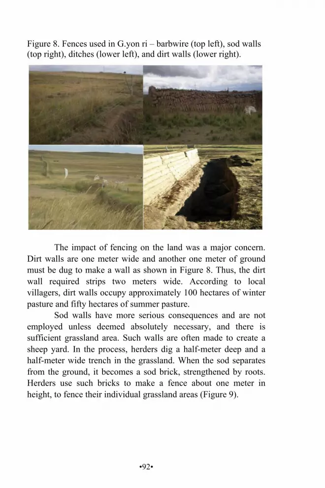
•92•
Figure 8. Fences used in G.yon ri – barbwire (top left), sod walls (top right), ditches (lower left), and dirt walls (lower right).
The impact of fencing on the land was a major concern.
Dirt walls are one meter wide and another one meter of ground must be dug to make a wall as shown in Figure 8. Thus, the dirt wall required strips two meters wide. According to local villagers, dirt walls occupy approximately 100 hectares of winter pasture and fifty hectares of summer pasture.
Sod walls have more serious consequences and are not employed unless deemed absolutely necessary, and there is sufficient grassland area. Such walls are often made to create a sheep yard. In the process, herders dig a half-meter deep and a half-meter wide trench in the grassland. When the sod separates from the ground, it becomes a sod brick, strengthened by roots. Herders use such bricks to make a fence about one meter in height, to fence their individual grassland areas (Figure 9).
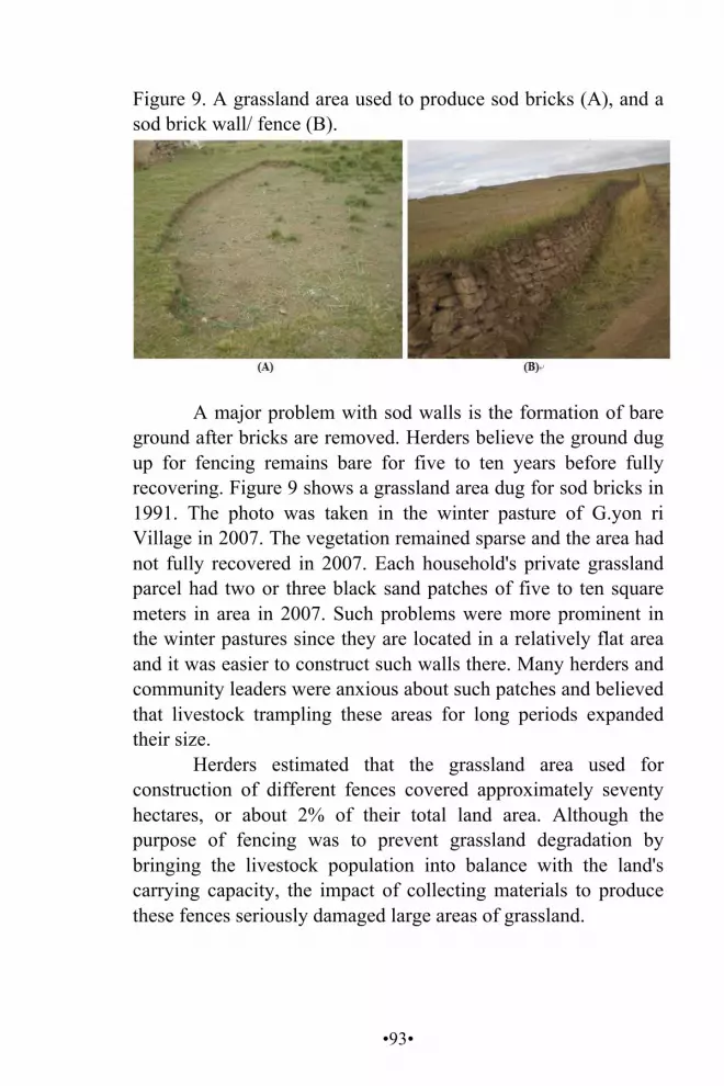
•93•
Figure 9. A grassland area used to produce sod bricks (A), and a sod brick wall/ fence (B).
A major problem with sod walls is the formation of bare
ground after bricks are removed. Herders believe the ground dug up for fencing remains bare for five to ten years before fully recovering. Figure 9 shows a grassland area dug for sod bricks in 1991. The photo was taken in the winter pasture of G.yon ri Village in 2007. The vegetation remained sparse and the area had not fully recovered in 2007. Each household's private grassland parcel had two or three black sand patches of five to ten square meters in area in 2007. Such problems were more prominent in the winter pastures since they are located in a relatively flat area and it was easier to construct such walls there. Many herders and community leaders were anxious about such patches and believed that livestock trampling these areas for long periods expanded their size.
Herders estimated that the grassland area used for construction of different fences covered approximately seventy hectares, or about 2% of their total land area. Although the purpose of fencing was to prevent grassland degradation by bringing the livestock population into balance with the land's carrying capacity, the impact of collecting materials to produce these fences seriously damaged large areas of grassland.

•94•
The GHCRS and Livestock Productivity
Government documents suggest privatization shifts pastoralism from disequilibrium and opportunistic management to a balance between the carrying capacity of the grassland area and livestock number (Goldstein 1996). The government's subsequent implementation of FA under the GHCRS aimed to reduce climate-driven mortality of livestock, prevent grassland degradation, and improve livestock productivity to increase herders' income.
According to locals, butter and wool are major livestock products. Therefore, production data on these commodities were collected. Butter and wool produced per head of livestock during the CBGM and upon implementation of the GHCRS were compared and are presented in Figure 10.
Figure 10. Amounts of butter (kg) and wool (kg) produced per head of livestock during CBGM and GHCRS.
Families
CBGM GHCRS Total
Livestock Total
Product Product
Per Head
Total Livestock
Total Product
Product Per
Head Yaks Butter Butter Yaks Butter Butter Rich 20 70 5.5 40 100 4.5 Medium 14 50 4.7 20 80 4.0 Poor 8 80 5.0 28 150 3.4
Sheep Wool Wool Sheep Wool Wool Rich 250 500 2.0 350 595 1.7 Medium 150 500 3.3 160 450 2.8 Poor 109 216 2.0 240 360 1.5
Figure 10 shows that the average amount of butter and
wool produced per head of livestock declined after implementation of the GHCRS. As shown, a rich family produced an average of 5.5 kilograms of butter from one female yak during CBGM. This fell to 4.5 kilograms after
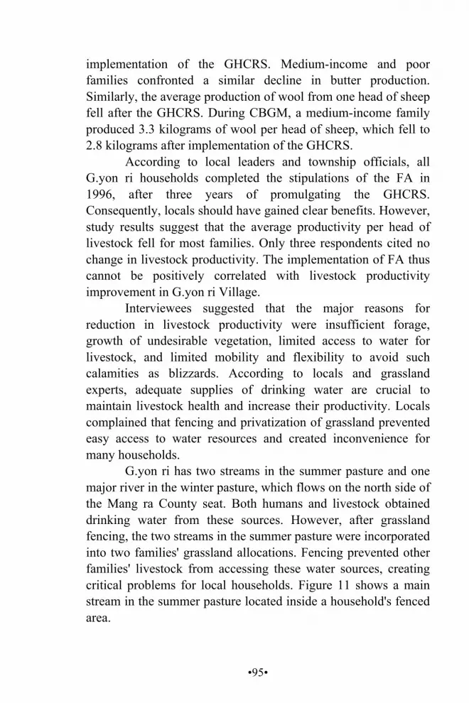
•95•
implementation of the GHCRS. Medium-income and poor families confronted a similar decline in butter production. Similarly, the average production of wool from one head of sheep fell after the GHCRS. During CBGM, a medium-income family produced 3.3 kilograms of wool per head of sheep, which fell to 2.8 kilograms after implementation of the GHCRS.
According to local leaders and township officials, all G.yon ri households completed the stipulations of the FA in 1996, after three years of promulgating the GHCRS. Consequently, locals should have gained clear benefits. However, study results suggest that the average productivity per head of livestock fell for most families. Only three respondents cited no change in livestock productivity. The implementation of FA thus cannot be positively correlated with livestock productivity improvement in G.yon ri Village.
Interviewees suggested that the major reasons for reduction in livestock productivity were insufficient forage, growth of undesirable vegetation, limited access to water for livestock, and limited mobility and flexibility to avoid such calamities as blizzards. According to locals and grassland experts, adequate supplies of drinking water are crucial to maintain livestock health and increase their productivity. Locals complained that fencing and privatization of grassland prevented easy access to water resources and created inconvenience for many households.
G.yon ri has two streams in the summer pasture and one major river in the winter pasture, which flows on the north side of the Mang ra County seat. Both humans and livestock obtained drinking water from these sources. However, after grassland fencing, the two streams in the summer pasture were incorporated into two families' grassland allocations. Fencing prevented other families' livestock from accessing these water sources, creating critical problems for local households. Figure 11 shows a main stream in the summer pasture located inside a household's fenced area.
•96•
Figure 11. A stream inside a fenced area in G.yon ri Village summer pasture.
Locals reported conflict over water access. After fencing,
it was impossible to move livestock to water sources without damaging fences. Consequently, the only source of water available for most families was a spring near a public road two to three kilometers away. Villagers used donkeys and male yaks to fetch water for livestock. During the traditional CBGM scheme, locals reported watering their livestock three times daily, as compared to 2007 when it was difficult to provide livestock with water even once a day.
To further clarify the effects of the GHCRS with FA on livestock productivity, an analysis of village stocking rate in correlation with the implementation of FA under the GHCRS was applied. Yaks and sheep were major sources of livestock products. The implementation of the GHCRS with its FA was meant to protect livestock from climate driven mortality and to stabilize the stocking rate for sustainable and increased productivity and ultimately increase nomads' income by providing extra forage, livestock sheds during cold seasons, and privatization and fencing of grassland to promote more responsible management. Thus, implementation of the FA was expected to be positively correlated with stabilized livestock population with no fluctuations over time.
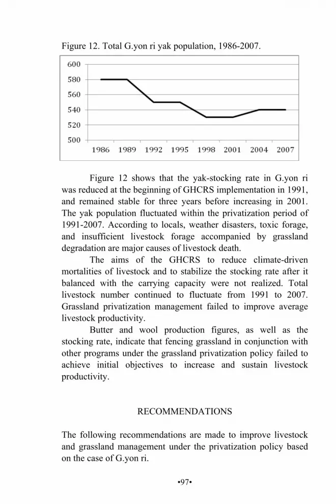
•97•
Figure 12. Total G.yon ri yak population, 1986-2007.
Figure 12 shows that the yak-stocking rate in G.yon ri
was reduced at the beginning of GHCRS implementation in 1991, and remained stable for three years before increasing in 2001. The yak population fluctuated within the privatization period of 1991-2007. According to locals, weather disasters, toxic forage, and insufficient livestock forage accompanied by grassland degradation are major causes of livestock death.
The aims of the GHCRS to reduce climate-driven mortalities of livestock and to stabilize the stocking rate after it balanced with the carrying capacity were not realized. Total livestock number continued to fluctuate from 1991 to 2007. Grassland privatization management failed to improve average livestock productivity.
Butter and wool production figures, as well as the stocking rate, indicate that fencing grassland in conjunction with other programs under the grassland privatization policy failed to achieve initial objectives to increase and sustain livestock productivity.
RECOMMENDATIONS
The following recommendations are made to improve livestock and grassland management under the privatization policy based on the case of G.yon ri.

•98•
Policy Livestock mobility and flexibility were reduced to only two seasonal movements. Daily movements were also reduced within seasonal pastures. These problems have been demonstrated to negatively impact the grassland ecosystem and livestock productivity, and should be addressed by: Dividing the current summer pasture into two seasonal
pastures to increase livestock mobility and flexibility. Sharing individual grazing parcels within each seasonal
pasture among kin groups i.e., five or six families in a collective herding group. This strategy would encourage daily movement of livestock grazing in a wider grassland area so that livestock have more land on which to move.
Pasture GHCRS with its FA did not allow herders to graze their yaks inside the planted-grass areas, thus, total grazing area was reduced. This should be addressed by planting native grass species and forage preferred by livestock, and harvesting them annually to provide livestock forage, especially during inclement weather.
Advocacy The major income source was from livestock products, which led local residents to reserve available grazing areas for yaks and sheep, the major source of their livelihood. However, the study showed a reduction in wool and butter production. Consequently, the herders' desire to increase the stocking rate for the improvement of the total livestock productivity put even greater pressure on the grassland ecosystem. Therefore, access to
•99•
education and vocational skill training are recommended to increase economic opportunities.
G.yon ri herders had a large sheep population, but few skills to utilize wool to produce commercially viable products. Training in using wool to make sweaters and carpets is recommended. Assisting G.yon ri herders to establish small-scale herding cooperatives to conduct small business enterprises is also recommended to provide alternative income sources for herders and offer opportunity to undertake small-scale enterprises. A follow-up study tour and training are suggested for cooperative members to better understand small-scale enterprises.
Extension of the Study
This research focused on the impact of privatization policy on grassland protection and livestock productivity. Achnatherum inebriens and Rumex spp. have toxic effects on livestock, and their coverage was expanding. Future studies could be done on strategies to control these toxic plants.
Certain elders mentioned that in the past, wildlife passed through their winter pastures to the riverbank for water. However, no wildlife had been seen passing near their grassland since the 1970s. They assumed that fences blocked the wild animals. More study is needed on fencing and wildlife interaction.
According to Shikui et al. (2000), shrubs provide protein that improves livestock productivity. However, this study suggests that livestock rarely graze on Potentilla fruticosa (a shrub), which covers much grassland once available for grazing. Further studies might establish what shrubs can be planted as an alternative protein supplement to improve livestock productivity.
•100•
CONCLUSION The first objective of the study was to see if the GHCRS improved the G.yon ri grassland ecosystem. Findings showed a reduction in livestock mobility and flexibility, diversity of grass and livestock species, and the size of grazing areas. It also showed that construction of fences damaged large areas of grassland. In addition, undesirable and toxic species came to dominate the grassland ecosystem. Areas with desirable forage received high concentrations of livestock grazing for long periods. Likewise, bare, black sand patches formed in each individual pasture. The study can only conclude that implementation of the GHCRS did not improve the G.yon ri grassland ecosystem but instead led to negative effects promoting further grassland degradation.
The second objective was to see if the GHCRS improved average livestock productivity. Data showed that average production of butter and wool fell and the yak population fluctuated. The policy aim to reduce climate-driven mortality of livestock was not achieved. This study thus concludes that implementation of the privatization policy did not improve livestock productivity in G.yon ri.
However, the grassland privatization policy has had positive consequences in terms of certain social, economic, and environmental aspects. For instance, dividing the grassland between individual households with fences saved time and labor of child herders who attended school. Otherwise, they spent ten to twelve hours daily herding livestock. Adult herders were able to engage in alternative economic activities. Similarly, individualizing communal grassland provided equal grazing access to poor and rich families. During the study, certain poor families who had few livestock stated that they could rent their extra grassland. In addition, with no seasonal movements and construction of houses in winter pastures, travelling difficulties for old and disabled people were reduced. Further studies are needed for a more holistic view of pastoralism and privatization policies.

•101•
G.YON RI GRASSLAND MAJOR PLANT SPECIES
Figure 13. Stipa krylovii (rtswa 'jam).
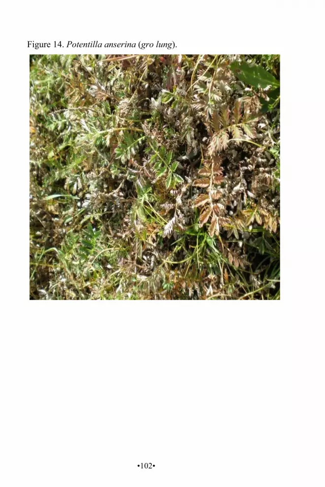
•102•
Figure 14. Potentilla anserina (gro lung).
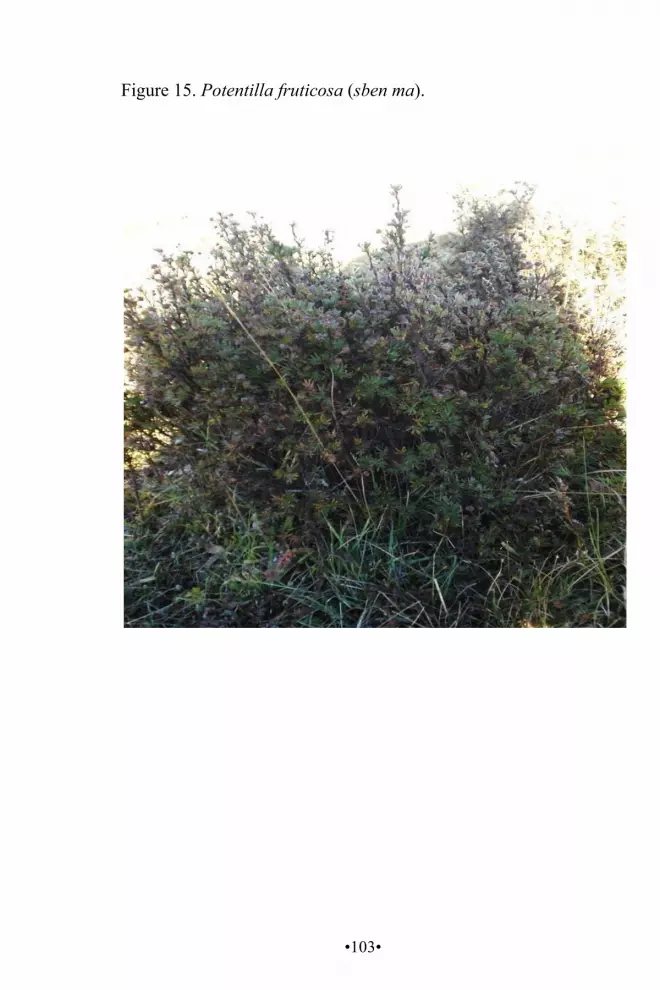
•103•
Figure 15. Potentilla fruticosa (sben ma).
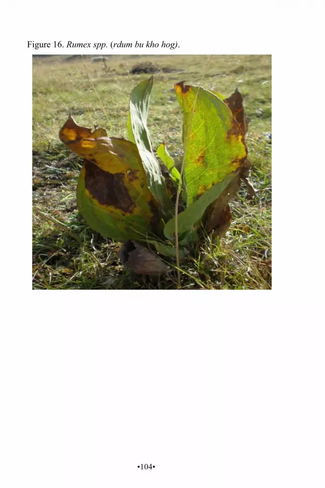
•104•
Figure 16. Rumex spp. (rdum bu kho hog).
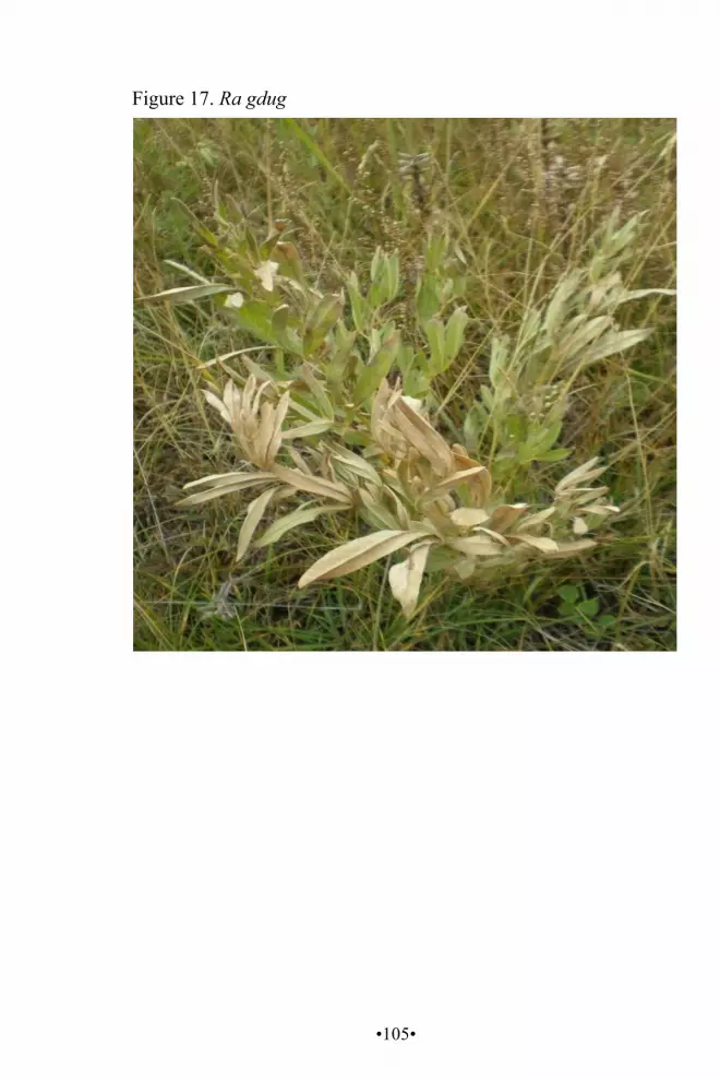
•105•
Figure 17. Ra gdug

•106•
Figure 18. Leymus spp. ('jag ma).

•107•
Figure 19. Achnatherum inebriens (chu ge du ka).

•108•
PLATEAU PIKA CONTROL IN SANTU ALPINE GRASSLAND COMMUNITY, YUSHU PREFECTURE,
QINGHAI PROVINCE, CHINA
Dpal ldan chos dbyings (Arizona State University)31
ABSTRACT Chemical control of the Plateau Pika (Ochotona curzoniae) is practiced on the Tibetan Plateau as the result of policy-makers labeling the species a pest that competes for forage with livestock and accelerates grassland degradation. Conversely, pikas are believed by others to be an ecological keystone species.
Research from September to November 2007 in Santu Pastoral Community, Jiqu Township, Nangqian County, Yushu Tibetan Autonomous Prefecture, Qinghai Province, PR China examined differences in biodiversity of grassland between two selected areas to determine how chemical control impacts vegetation and predator populations, and relationships between pikas, grassland degradation, and livestock grazing.
Results suggest predators rely on pikas for survival and that pikas contribute to degradation of the grassland ecosystem, particularly when population density is high. Sustainable grassland management taking into account livestock grazing sustainability and biodiversity conservation is recommended. Pika control is required and should be based on protection of pika predators. KEY WORDS chemical control, keystone species, pika, Tibetan Plateau
31 I sincerely thank the United Board for Christian Higher Education in Asia for sponsoring my graduate study at Miriam College in Manila, the Republic of the Philippines.
•109•
BACKGROUND Plateau Pika are important food for raptors and mammalian predators. Their burrows are primary homes and nests for a wide variety of birds and lizards. They also help increase vegetative species diversity and variety by creating microhabitat disturbance, and contribute to soil nutrient recycling and enhanced root biomass (Smith and Foggin 1999). With such multiple ecological roles, Plateau Pika are considered a keystone species on the rangeland ecosystem of the Tibetan Plateau (Smith and Foggin 1999).
Raptors that live in or pass through the alpine grassland ecosystem of the Tibetan Plateau include the Steppe Eagle (Aquila nipalensis), Upland Buzzard (Buteo hemilasius), Saker Falcon (Falco cherrug), Goshawk (Accipiter gentilis), Black Kite (Milvus migrans), Little Owl (Athene noctua), and Big Owl (Bubo bubo) (Lai and Smith 2003). These large predatory birds depend on pikas as a food source. Schaller (1998) reported that 90% of pellets under the nest of a Saker Falcon and all pellets beneath the nest of an Upland Buzzard contained pika remains. A similar species, the Daurian Pika (Ochotona dauurica) in Inner Mongolia Autonomous Region, China, also comprises large percentages of the diet of avian predators: Steppe Eagle (62%), Upland Buzzard (17%), Eagle Owl (73%), and Saker Falcon (22%) (Peshkov 1957, 1967).
The pika's role in pasture degradation is much debated. The Chinese government has labeled pikas as pests that contribute to grassland degradation and has launched repeated programs to eliminate the species with poisons. An unfortunate consequence of these campaigns is the death of other species (Smith 1998).
Elimination of pikas would disrupt prey-predator relationships and lead to reduction in predator populations. Furthermore, lessons from such control measures over the past decades suggest poisons are ineffective. A comprehensive approach to improve the overall quality of the grassland ecosystem is an important solution. Ninety to 95% reductions in
•110•
pika populations have been achieved using poisons, resulting in an abrupt reduction in the food supply for many predators for one to two years. However, pikas recovered rapidly over the following breeding seasons (Pech et al. 2007), and caused further damage to the grassland ecosystem. If pika control is required, this study suggests rodenticides are ineffective over the long term.
THE PROBLEM Control attempts were undertaken in many parts of the Plateau because pikas were seen as putatively competing with livestock for forage and were found at high density (Liu et al. 1980; Shen and Chen 1984; Smith et al. 1990). Pikas thrive on degraded grassland ecosystems where there is less and shorter vegetation (Smith et al. 1990). Consequently, the high density of pika populations repeatedly drew the attention of government and subsequent control measures.
STUDY OBJECTIVES This study aims to: characterize pikas as pests or a keystone species on the alpine
grassland ecosystem of Santu Pastoral Community; investigate environmental impacts of chemical control of
pikas on pika predators and other biodiversity components of the alpine grassland ecosystem; and
recommend strategies to sustainably manage pika populations.
•111•
SIGNIFICANCE OF THE STUDY Pikas play an important ecological role as a keystone species (Smith and Foggin 1999, Lai and Smith 2003) and contribute to grassland degradation. Consequently, there is need for continuing research on pikas to suggest or reject initial findings related to management strategies.
RESEARCH SETTING This research was conducted on two different study sites in the pastures of two herding groups within Santu Pastoral Community (Jiqu Township), 150 kilometers from Nangqian County Town, from September to November 2007.
Based on data from the Meteorology Bureau of the local county government and the provincial government, the average elevation of Jiqu Township is 3,500 meters above sea level and is characterized by undulating mountain ranges with consistent intermountain grassland valleys. The major vegetation type is alpine meadow. The continental monsoon climate is dominated by the southeast monsoon and high pressure from Siberia. Temperatures range from -37.1°C to 27.6°C, with the average being -1.7°C (QNXQ). Cold weather lasts five to six months. Summer is short and cool. Other seasons are transitional periods for summer and winter. The average annual precipitation is 426-860 millimeters, 80% of which falls in the short summer. Annual average sunlight is 2,462.7 hours with 60% of total available sunshine (QNXQ).
Research sites A and B are contiguous pastures, share a similar biome typical of alpine grassland biological diversity, and share indistinguishable regional climatic, ecological, and climatic characteristics. The area is dominated by grass species supporting the livelihood of thirty-one households (Site A) and twenty-seven households (Site B). The total community population is approximately 350 people, whose basis for subsistence was 7,000-8,000 head of livestock.
•112•
Control programs were implemented multiple times to eliminate Plateau Pikas on Site A, whereas pika control had never been attempted on Site B. Quantitative data from the two sites were analyzed and compared as indicators of grassland degradation.
RESULTS
Data Analysis of Vegetative Species Sampling Data on grass species density were collected by establishing quadrats at both sites. During sampling, all grass species within each of seventeen plots was counted on both sites and the density of each grass species that were encountered was determined by dividing the total number of each grass species in the seventeen plots by the total sampled area to better understand the grass species' relationship with pikas and the impact of elimination of pikas with chemical control. Local respondents named twenty plant species during interviews on both sites. However, during sampling, only five grass species were common on both sites, out of around fifteen identified grass species. Grass density was higher on Site B than on Site A. The four major grass species were the same for both sites and were regarded as major forage for domestic livestock and wild herbivores. These major species comprise 80-90% of the total coverage of vegetative species within the two study sites. Distribution of other grass species in both sites was random.
Overall density of grass species was much higher on Site B than on Site A. Density of bdag rtswa on Site B was almost twice (A = 71.4: B = 122.2) that of Site A. Density of ljang rtswa was twice (A= 23.6: B = 55.9) as high on Site B than on Site A. Density of khab 'dra rtswa was nearly twice (A = 13.6; B = 23.9) as high on Site B than on Site A.
•113•
Livestock Population on the Two Study Sites Livestock population on both sites was similar. Estimates by local informants were 4,500 sheep, goats, and horses for Site A, and 3,800 for Site B. The number of households on Site A was higher than on Site B. The size of the grazing territory was based on livestock number and human population.
Herders' Views on Pikas and Grassland Degredation Survey interviews were conducted with locals who had observed the grassland ecosystem in their everyday lives for decades. Much of their knowledge about the grassland ecosystem, such as the interdependent relationships inherent to biodiversity, including their livestock, had been passed down from generation to generation through actual practice. Interviewees identified predators and plant species, abundance and frequency of predators, and dominant grass species on both sites. These data were gathered to compare the data collected from sampling.
Thirty informants from both sites were selected to determine vegetative species identification and dominance. The respondents were asked to decide the dominant grass species from the grasses that were identified on both sites. Thirteen species of grasses were identified by interviews on Site A and fourteen species of grasses were identified on Site B. The species of grasses identified were different on sites A and B, as were their frequency.
Informants' opinions varied on other grass species observed in these areas in relation to livestock and such wildlife as plateau pikas. Based on local residents' observation and accumulated knowledge on grassland biodiversity, domestic livestock and pikas consumed the same vegetative species. There were exceptions – livestock grazed certain grass species that pikas did not and vice versa. Both livestock and pikas, however, grazed the dominant grass species, which formed the largest parts of their diet.
Interviews on grassland health and pika population before poisoning were conducted. Local herders' views varied on the
•114•
causes of rangeland degradation and on the time that grassland degradation occurred. Eight out of ten respondents from Site A stated that pikas on the pasture were never an issue until formation of the commune system in the 1960s. The first pika control measure was implemented in the 1970s on Site A after the scientific community declared pikas damaged the pasture. Two other respondents in Site A stressed that pikas were the most serious cause of grassland degradation. However, both respondents (b. 1949, 1946) did not remember specific instances when pikas were directly linked to grassland damage during the commune system period.
All ten respondents on Site A stated that the number of pikas continually increased after formation of the commune system and respondents believed that grassland condition had deteriorated during that time, as seen in a decrease in grass height, decrease of grass coverage, and expansion of bare land. Simultaneously, degradation of the grassland ecosystem was followed by an increase in the pika population with the pika population expanding over huge areas.
Similarly, ten herders from Site B were interviewed and all claimed to have witnessed the emergence and increasing population of pikas within the area in the past two decades. They all considered the pika damaging to the grassland ecosystem in the 1990s, although sparse populations of the species existed earlier. They agreed that pika population density had increased. Many respondents could not attribute the causes of grassland degradation, but claimed the pasture in their area was worsening as evidenced by a decrease of vegetative coverage, emergence of more bare land, and deterioration of livestock health and productivity.
Locals believed that the high pika population density had damaged the grassland by burrowing and digging, which they believed transformed turf into black sand. The locals described the consumption habits of plateau pikas as similar to locals cutting grass for winter fodder, extracting plants from the roots up, and eventually destroying the plant coverage on which domestic livestock grazed. Locals were unconcerned with the viability of grassland for livestock grazing before the 1990s.
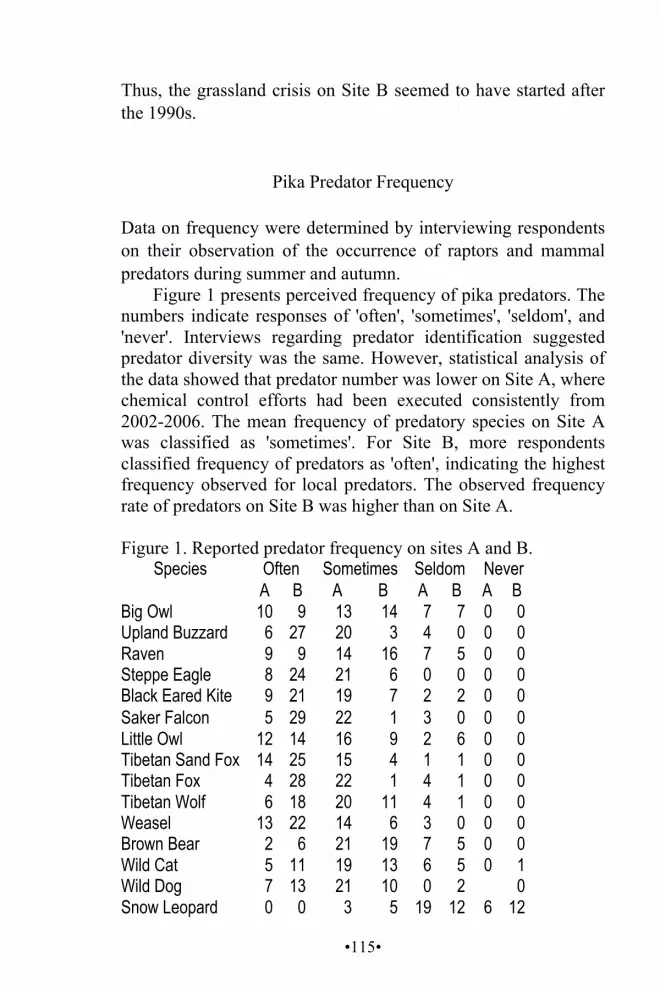
•115•
Thus, the grassland crisis on Site B seemed to have started after the 1990s.
Pika Predator Frequency
Data on frequency were determined by interviewing respondents on their observation of the occurrence of raptors and mammal predators during summer and autumn.
Figure 1 presents perceived frequency of pika predators. The numbers indicate responses of 'often', 'sometimes', 'seldom', and 'never'. Interviews regarding predator identification suggested predator diversity was the same. However, statistical analysis of the data showed that predator number was lower on Site A, where chemical control efforts had been executed consistently from 2002-2006. The mean frequency of predatory species on Site A was classified as 'sometimes'. For Site B, more respondents classified frequency of predators as 'often', indicating the highest frequency observed for local predators. The observed frequency rate of predators on Site B was higher than on Site A.
Figure 1. Reported predator frequency on sites A and B.
Species Often Sometimes Seldom Never A B A B A B A B
Big Owl 10 9 13 14 7 7 0 0 Upland Buzzard 6 27 20 3 4 0 0 0 Raven 9 9 14 16 7 5 0 0 Steppe Eagle 8 24 21 6 0 0 0 0 Black Eared Kite 9 21 19 7 2 2 0 0 Saker Falcon 5 29 22 1 3 0 0 0 Little Owl 12 14 16 9 2 6 0 0 Tibetan Sand Fox 14 25 15 4 1 1 0 0 Tibetan Fox 4 28 22 1 4 1 0 0 Tibetan Wolf 6 18 20 11 4 1 0 0 Weasel 13 22 14 6 3 0 0 0 Brown Bear 2 6 21 19 7 5 0 0 Wild Cat 5 11 19 13 6 5 0 1 Wild Dog 7 13 21 10 0 2 0 Snow Leopard 0 0 3 5 19 12 6 12
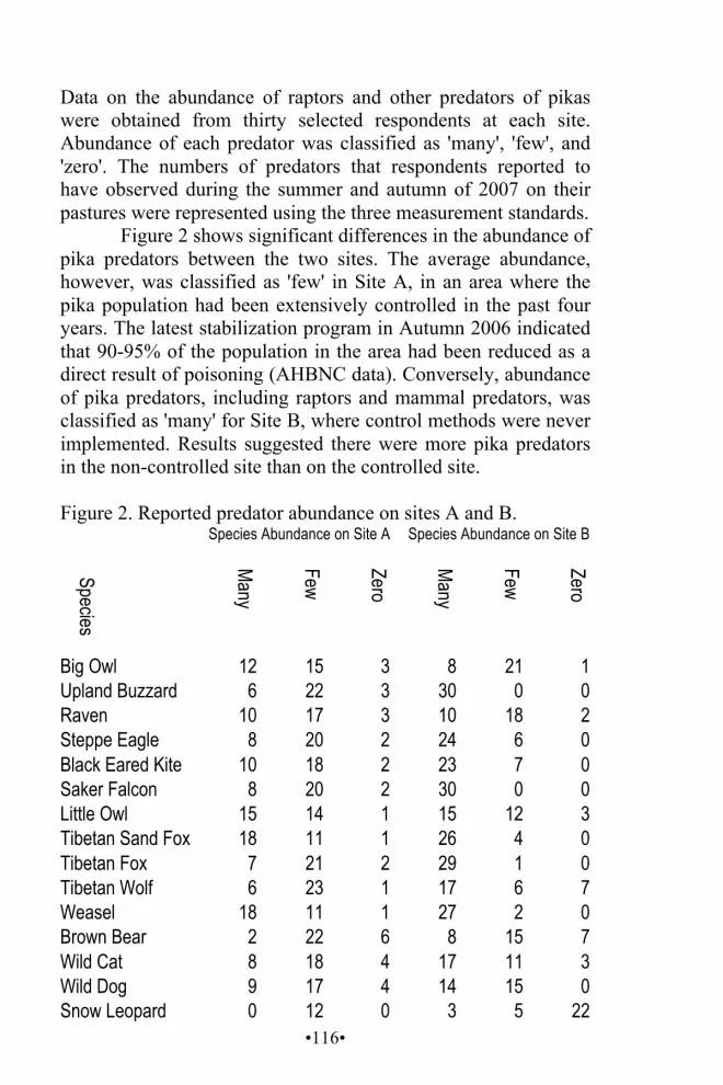
•116•
Data on the abundance of raptors and other predators of pikas were obtained from thirty selected respondents at each site. Abundance of each predator was classified as 'many', 'few', and 'zero'. The numbers of predators that respondents reported to have observed during the summer and autumn of 2007 on their pastures were represented using the three measurement standards.
Figure 2 shows significant differences in the abundance of pika predators between the two sites. The average abundance, however, was classified as 'few' in Site A, in an area where the pika population had been extensively controlled in the past four years. The latest stabilization program in Autumn 2006 indicated that 90-95% of the population in the area had been reduced as a direct result of poisoning (AHBNC data). Conversely, abundance of pika predators, including raptors and mammal predators, was classified as 'many' for Site B, where control methods were never implemented. Results suggested there were more pika predators in the non-controlled site than on the controlled site. Figure 2. Reported predator abundance on sites A and B. Species Abundance on Site A Species Abundance on Site B
Species
Many
Few
Zero
Many
Few
Zero
Big Owl 12 15 3 8 21 1 Upland Buzzard 6 22 3 30 0 0 Raven 10 17 3 10 18 2 Steppe Eagle 8 20 2 24 6 0 Black Eared Kite 10 18 2 23 7 0 Saker Falcon 8 20 2 30 0 0 Little Owl 15 14 1 15 12 3 Tibetan Sand Fox 18 11 1 26 4 0 Tibetan Fox 7 21 2 29 1 0 Tibetan Wolf 6 23 1 17 6 7 Weasel 18 11 1 27 2 0 Brown Bear 2 22 6 8 15 7 Wild Cat 8 18 4 17 11 3 Wild Dog 9 17 4 14 15 0 Snow Leopard 0 12 0 3 5 22

•117•
Sampling of predators related to pikas was done by counting observed predators within three days of transect walks at both sites. All sighted predators were counted and noted as shown in Figure 3 below.
No wolves, brown bears, or snow leopards were observed. Results show a significant difference in the number of predators on the two sites. Local nomads argued that the Upland Buzzard, Tibetan Fox, Saker Falcon, and Weasel (Mustela nivalis) were key predators. This was supported by my data.
Figure 3. Predatory animal population on sites A and B.
Sightings of the five prominent predators were more frequent in the non-controlled area (Site B) than in the controlled area (Site A). There were about three times as many upland buzzards on Site B as on Site A (Site A = 9; site B = 31); two times as many Saker falcons on Site B as on Site A (Site A = 9; Site B = 24); four Tibetan Foxes were observed on Site A while twenty were sighted on site B (Site A = 4; Site B = 26); and three times as many steppe eagles were sighted on Site B as on Site A (A = 5; B = 14). Locals said weasels were a major pika predator, which matched my findings of two weasels on Site A and twelve on Site B (Site A =2; Site B = 12).

•118•
Raptors may be classified into two categories based on prey habits and habitat preference. Nocturnal raptors prey at night and include Big Owl and Little Owl. The others prey during the day. While gathering data, two Big Owl were identified on Site B based on sounds heard twice for two nights. No sound of the same raptor was heard on Site A, although two Big Owl were seen. Likewise, two Little Owl were sighted on Site A, while six of the same species were identified on Site B.
Although Brown Bear (Ursus arctos), Wolves (Canis lupus), and Snow Leopards (Uncia uncia) are considered important pika predators by both local nomads and researchers, none were sighted during sampling. This may be attributed to observations being conducted in late summer; abundance varies significantly with season. These predators were usually seen on high mountains and areas with little human presence.
Raptors were more abundant than mammalian predators on both sites (forty-one raptors and eight mammals on Site A, ninety-six raptors and fifty mammals on Site B). During sampling, interactions between raptors and pikas were higher than between mammal predators and pikas.
Locals report that raptors that prey on pikas also prey on Hume's Groundpecker (Pseudopodoces humilis) and Snowfinch (Montifringilla spp.) that inhabit burrows created by pikas. During sampling, it was observed that small bird species, especially those that sheltered in burrows created by pikas, were more abundant than the pikas themselves. This phenomenon was distinctively apparent on Site B where there were large pika populations. More small birds were sighted on Site B than on Site A.
Pika Burrows The pika population was estimated by counting the number of active burrows within the measured plots on each site. Twenty-one active burrows were observed on Site A, which was considered the average number of active burrows within the three

•119•
hectares of total sampled area. A limited number of pikas were sighted while sampling Site A. Fresh burrows were only observed in the lower areas of the sampling site, characterized by small hills and level areas. Signs of pika presence were infrequently observed on the higher areas of Site A. Collapsed and inactive burrows were observed on Site A, where pika population was high before control. The most recent control measure was in March 2006. Local informants explained that control measures were implemented on an irregular basis.
Pikas abandoned areas where their burrows were so dense that there was no longer adequate burrowing space and moved to areas with sufficient grass and space. The whole survey area had many burrows, causing soil erosion on severely infested areas.
Sampling for active burrows was conducted on both sites to assess the pika population. Active burrows were counted on three hectares of land on Site B and 487 active burrows were found. Almost all had newly dug soil and fresh traces of pika activities. Unlike Site A, no control measures had been implemented on Site B. Based on observations and interpretations by local nomads, pikas increased significantly beginning in the 1990s, and became a major problem in succeeding years. The presence of densely scattered burrows indicated that the pikas were damaging the grassland ecosystem, particularly vegetation, through soil erosion.
Further information on pika population status prior to 2006 was gathered from the Nangqian County Animal Husbandry Bureau, which showed that the total infected area of the grassland ecosystem of Nangqian County was about fifty-nine million hectares, representing 53.19% of usable rangeland. In Santu Pastoral Community, 47% of the rangeland was infested with pikas. According to an investigation by the Qinghai Bureau of Animal Husbandry, there were 1,928 burrows per hectare of land in pika-infested areas of Nangqian County. Site A featured 637 observed burrows. Compared to other infested areas, this indicated reduced population density, attributed to control measures in 2006 aiming to reduce the 637 active burrows to less than eight within one hectare of pasture and to increase grass
•120•
coverage from 25-40%. No previous investigation on pika population density had been done on site B.
DISCUSSION Interviews with local nomads suggested that the frequency and abundance of predators on the two sites were significantly different – there were more predators on site B with a large pika population. The data indicated fewer pika predators on Site A where the pika population density was dramatically reduced in 2006.
According to Site A respondents, the frequency and abundance of predators within the autumn and summer of 2006 had dropped significantly. They claimed that there was more wildlife, particularly raptors, in the previous years when there were more pikas (prior to the most recent pika eradication program in 2006). Meanwhile respondents did not notice any change in the abundance and frequency of predators from 2006-2007. Most respondents cited 'many' to describe the number of predators based on observations during the summer and autumn of 2007, and 'often' on predator frequency. Interview data suggested nearly the opposite for abundance and frequency of raptors on Site A. It is thus likely that control measures aimed at eliminating pikas compromised the ecological niches of non-target species, causing critical disturbance to the prey and predator relationship.
Predators such as the Upland Buzzard, Saker Falcon, Steppe Eagle, Blackeared Kite, Tibetan Fox, and Weasel were considered the most important predators and were rarely sighted on Site A, but were abundant on Site B. It can be assumed that pikas played an irreplaceable role in the food chain. Most predators on the Tibetan Plateau are dependent on pikas as their major food source (Schaller 1998; Smith et al. 1990), especially during winter when most prey hibernate. Pikas were almost the only winter food source for predators (Smith and Foggin 1996).
•121•
Pikas provide an indispensable service maintaining the grassland ecosystem. During the sampling period, some varieties of small birds were sighted in places where pikas existed. According to local nomads, such small birds as Hume's Ground Jay and Snowfinch are interdependent on Plateau Pika for survival on the grassland ecosystem. These birds act as safeguards for the Plateau Pika, signaling when predators approach. This occurred during sampling between weasels and pikas. A flock of small birds circled the weasels while chirping, signaling the pikas of approaching danger. Meanwhile, these birds live in burrows made by pikas, and such activities as food collection occurs in areas around the burrows, which are also bird breeding habitat. Hume's Ground Jay, several species of snowfinch, and native lizards (Phrynocephalus spp., Eremias spp.) breed and nest in pika burrows (Smith and Foggin 1996, 2002). Thus, pikas likely determine the conservation of these species while acting as an important mechanism for the survival of species heavily dependent on them.
Snow leopards, brown bears, and wolves were not sighted while sampling. Local nomads affirmed that pikas are important food for those species, especially in recent years when blue sheep, deer, and gazelles, are greatly reduced in number. Wolves, snow leopards, and brown bears prey on pikas (Smith and Foggin 1996), which can provide a major proportion of their food. The Steppe Eagle, Upland Buzzard, Saker Falcon, Goshawk, Black Kite, and Little Owl (Schaller 1998; Smith and Foggin 2000) remain major pika predators.
Raptors on Site B were more significantly and frequently observed than on Site A during sampling. Statistical data indicates that predator abundance on Site A was strikingly less than on Site B, suggesting a relationship between predator number and pikas. Fewer predators were found where there were fewer pikas.
The important ecological role of pikas in the food chain of the grassland ecosystem is a decisive mechanism for conservation of predators. Pika population density largely determines the abundance of most raptors and mammal predators. Control

•122•
measures designed to eliminate pikas have significant negative impacts on the conservation and survival of predators, small birds, and lizards, causing deterioration of the grassland ecosystem.
According to local herders, pikas eat all varieties of grass species, causing an obvious reduction in grass density within a few years in an area. Data from the Nangqian County Animal Husbandry Bureau suggest that one mature pika consumes about 77.3 grams of forage daily or about 9.5 kilograms of grass during growing season. Consequently, fifty-two pikas consume the same forage per day as one Tibetan Sheep (Ovis aries).
Data shows a large difference in vegetative species density between the two sites. Dominant grass species were denser on Site B where there were many pikas.
Data on grass species density on Site A shows that comparable dominant grass species were fewer than on Site B. Based on secondary data and locals' interpretations, the grassland ecosystem of Site A was severely degraded, the causes of which can be traced most prominently to pika infestation. The primary cause of degradation is most likely livestock overgrazing and such pika activities as burrowing and vegetation consumption (Swift et al. 2005), which were considered to significantly contribute to degradation. However, no concrete data supported these claims. Increases in pika population density should be interpreted as an indicator of grassland degradation rather than simply a cause. The population density of pikas appears to increase following grassland degradation because they are more capable of breeding and surviving on short grass. Local herders observed that pikas were more capable of proliferating on short grass where they easily detect approaching predators, and avoid capture. Tall grass areas are not pika-preferred habitat. A key informant witnessed predation more often in short grass areas than on tall grassy and fenced areas. He said that pikas cannot detect attack from Tibetan Fox in fenced areas because grass blocks their views.
Based on the numbers of sampled active burrows, there were more pikas on Site B than on Site A, though grass was

•123•
denser on Site B than on Site A; specifically dominant grass species were more abundant, which rejects the previous assumption, stating that pikas are a major factor causing grassland degradation. Nevertheless, the time length for pika occupation of each site is not taken into consideration for this justification. Moreover, there were no significant differences in the number of livestock on the two sites. The number of active burrows used as indicators of population density on Site B was thirty times more than on Site A. Likewise, the occurrence duration of pika infestation on Site A began two to three decades earlier than on Site B. The number of fresh pika burrows on Site A before the most recent control program was about twice that of current fresh burrows on Site B. Moreover, the grassland condition of Site B was believed to be worsening in tandem with the increasing pika population in recent years. Thus, pikas were evidentially contributing to grassland degradation when population density reached a significant level, and the time of infestation was significant for a given area.
RECOMMENDATIONS
This study has shown that pikas are ecologically vital species for the conservation of raptors and mammal predators, as well as small bird species and lizards on the Tibetan Plateau. Pikas contribute to improving plant growth. However, pikas negatively affect pasture when population density is high. Thus, utilizing artificial nests to increase raptor numbers is a recommended solution.
CONCLUSION Grassland degradation is an on-going process on the Tibetan Plateau. Overgrazing by livestock is a major factor contributing to this growing problem. Government-led pika-elimination programs using chemical toxins have proven to be unsuccessful
•124•
in reducing the population permanently, while causing significant reduction in raptor and mammalian predators, rendering it a poor management strategy. It is essential to reduce the pika population when it reaches high levels. Local nomads in most heavily infested areas claimed that the pika population increased in the recent past, a symptom of grassland degradation from livestock overgrazing and such factors as climate change.
Livestock overgrazing is a major problem over large areas. Research has determined that the number of livestock on the Tibetan Plateau has more than doubled in the past fifty years, with simultaneous decrease in productivity and livestock weight. Meanwhile, the pika population has increased within the last few decades, in tandem with the on-going process of grassland degradation (Arthur et al 2007).
Prevention of damage is easier than restoration. Significant reduction in livestock grazing pressure is a sustainable management strategy. Meanwhile, pika populations are required for the conservation of raptors, mammal predators, and other interdependent elements of grassland biodiversity. At the same time, pika control is required to allow grassland recovery to a degree that will not promote further pika population increases. Biological control methods should be implemented for more sustainable management of Plateau rangelands.

•125•
REFERENCES
Adelihan Yesihan 阿德力汗 ·叶斯汗. 2004. Cong youmu dao dingju shi youmu minzu chuantong shenghuo fangshi de zhongda biange 从游牧到定居是游牧民族传统生活方式的重大变革 (Going from Nomadism to Fixed Settlement is a Great Change in Nomads' Traditional Lifestyle). Xibei minzu yanjiu 西北民族研究 (Northwest Nationalities Research). http://scholar.ilib.cn/Abstract .aspx?A= xbmzyj20040 4016, accessed 1 November 2006.
Arances J, V Amoroso, W Gruezo, and C Ridsdale. 2004. Development of a Participatory Methodology for Inventory and Assessment of Floral Resources and their Characterization in the Montane Forests of Mt. Malindang. Quezon City: PDM Press.
Arthur, T, R Pech, Jiebu, Zhang Yanming, and Lin Hui. 2007. Grassland Degradation on the Tibetan Plateau: The Role of Small Mammals and Methods of Control. Canberra: Australian Centre for International Agricultural Research. http://aciar.gov.au/system/files/node/6565/TR67+part+1.pdf, accessed 10 Feb-ruary 2011.
Banks, T, C Richard, Li Ping, and Yan Zhaoli. 2003. Community-Based Grassland Management in Western China: Rationale, Pilot Project Experiences, and Policy Implications. Mountain Research and Development 23(2):132-140.
Barfield, T. 1993. The Nomadic Alternative. Englewood Cliffs, New Jersey: Prentice-Hall.
Breivik, I. 2007. The Political Ecology of Grassland Conservation in Qinghai Province, China, Discourse, Policies and the Herders. Master's Thesis, Norwegian University of Life Science, Department of International Environment and Development Studies.
•126•
Chen Jiagui 陈佳贵. 2000. Xibei fazhan baogao 西北发 展报告 (Report on Northwestern Development) http://www.cass.net.cn/zhuanti/y_xibei/fen1_1.htm, accessed 14 April 2009.
Du Tieying 杜铁瑛, Yan Zhenying 严振英, and Qin Hairong 秦海蓉. 2001. Qinghai qingnan muqu 'sipeitao' fangzai jidi jianshe xiaoyi pingjia青海青南牧区'四配套'防灾基地建设效益评价 (Impact Evaluation for Infrastructure Development of 'Four Allocations' in Southern Qinghai Herding Areas) http://www.cnki.com.cn/Article/ CJFDTotalCYKX200101010.htm, accessed 10 August 2010.
Du Yaoting 都耀庭. 2006. Yushu xian caodi ziyuan jiance jieguo fenxi 玉树县草地资源监测结果分析 (Monitoring and Analysis of Rangeland Sources of Yushu County). Yushu 玉树: Yushu xian caoyuanzhan 玉树县草原站 (Yushu County Pasture Station).
Ellis, J and D Swift. 1988. Stability of African Pastoral Ecosystem: Alternative Paradigms and Implications for Development. Journal of Range Management 41:450-458.
Enghebatu, T. 2006. Development for Whom: Ecological Migration and Human Rights. Association for Asian Studies Annual Meeting. http://www.hrichina.org/ public/PDFs/CRF.4.2006/CRF-2006-4_Ecological.pdf, accessed 18 February 2011.
Fernández, M. 2000. The Role of Mongolian Nomadic Pastoralists' Ecological Knowledge in Rangeland Management. Ecological Application 10(5):1318-1326.
Foggin, J. 2008. Depopulating the Tibetan Grasslands: National Policies and Perspectives for the Future of Tibetan Herders in Qinghai Province, China. Mountain Research and Development 28(1):26-31.
Goldstein M, C Beal, and R Cincotta. 1990. Traditional Nomadic Pastoralism and Ecological Conservation on Tibet's Northern Plateau. National Geographic Research 6:139-156.

•127•
Goldstein, M. 1996. Nomads of Golok: A Report.http://www.case .edu/affil/tibet/tibetanNomads/documents/RDPWebsiteReport.DOC, accessed 14 February 2010.
Guoluo Prefecture Government. 2008. Xuezai de tezheng 雪灾的特 征 (The Characteristics of Snow Disasters). http://www.guoluo.gov.cn/html/977/24493.html, accessed 22 February 2011.
Keppel, W. 2005. Animal Impact: How Trampling and Disturbance Benefit Grassland Ecosystems. http://www.managingwholes.com/animal-impact.htm, accessed 18 February 2011.
Kuhn, A. 2002. China's Plan to Reform Herders of Tibet Spurs Culture Clash. Los Angeles Times 08-23-2002 http://www.thefreelibrary.com/Greener+pastures%3f+China%27s+plan+to+%27reform%27+herders+of+Tibet+spurs...-a090715061, accessed 14 February 2010.
Kunchok, T. 2000. Tibetan Bulletin. http://www.tibet.net/tibbul/ 0009/focus2.html,32 accessed 17 November 2006.
Lai, CH and A Smith. 2003. Keystone Status of Plateau Pikas (Ochotona curzoniae): Effect of Control on Biodiversity of Native Birds. Biodiersity and Conservation 12:538-551.
Lattimore, O. 1940. Inner Asian Frontiers of China. The American Journal of Sociology 46:390-393.
Lernia, S. 2002. Dry Climatic Events and Cultural Trajectories: Adjusting Middle Holocene Pastoral Economy of the Libyan Sahara in F Hassan (ed) Droughts, Food and Culture: Ecological Change and Food Security in Africa's Later Prehistory. New York: Kluwer Academic and Plenum Publishers, p225-250.
Liu Jike, Zhang Yunzhan, and Xin Guangwu. 1980. Relationship Between Numbers and Degree of Harmfulness of the Plateau Pika. Acta Zoology Sinica 26:378-385.
32 This website was unavailable 20 February 2010.
•128•
Long Ruijun. 2003. Alpine Rangeland Ecosystems and Their Management in the Qinghai-Tibetan Plateau. http://www.fao.org/docrep/006/AD347E/ad347e0w.htm, accessed 14 February 2010.
Meyer, N. 2006. Desertification and Restoration of Grassland in Inner Mongolia. Journal of Forestry 104(6):328-331.
Miehe, G. 1988. Geological Reconnaissance in the Alpine Belt in Southern Tibet. GeoJournal 17:635-648.
Miller D. 1999. Herders of Forty Centuries: Nomads of Tibetan Rangelands in Western China. V1th International Rangeland Congress Proceedings 1:402-403.
Miller, D. 2001. Looking Back to Move Ahead: Integrating Indigenous Nomadic Knowledge into the Modern Range Profession in China. Society for Range Management's Annual Meeting, Special Session: Rangeland Professionals and Society: Future Directions, 20 February 2001, Kailua-Kona, Hawai'i, http://www.cwru .edu/affil/tibet/booksAndPapers/miller.looking.back.to.move.ahead.pdf, accessed 14 February 2010.
Miller, D. 2004. Organizing Sustainable Development in Tibetan Areas of China. Speech at Congressional Executive Commission on China 19 March 2004. http://www.cecc.gov/pages/roundtables/031904/millerprep.php, accessed 21 August 2010.
Miller, D. 2005. The Tibetan Steppe in J Suttie, S Reynolds, and C Batello (eds) Grasslands of the World. Rome: FAO, p305-342.
Miller, D. 2006. Searching for Grass and Water, Rangeland Ecosystem Sustainability and Herders' Livelihood in Western China. Ambio 13:29-34.
Miller, D. nd. Home on the Range: The Demise of Tibetan Nomadic Pastoralism? http://www.cwru.edu/affil/tibet/ booksAndPapers/papers/miller1.htm?nw_view=1266133308&, accessed 14 February 2010.
•129•
Miller, D, S Craig, and G Rana (eds). 1996. Conservation and Management of Yak Genetic Diversity. Proceedings of a Workshop, 29-31 October 1996, Kathmandu, Nepal. Kathmandu: ICIMOD and FAO.
Nongyebu 农业部 (Agriculture Department). 2006. Caoyuan jianli zhongxin 草原监理中心 (Pastureland Monitoring Center). http://www.grassland.gov.cn/showTip.jsp?tipid =1145428620184, accessed 15 January 2007.
Nori, M. 2004. Hoofs on the Roof: Pastoral Livelihood on Qinghai Tibet Plateau. The Case of Chengdu County in Yul shul Prefecture. http://www.cwru.edu/affil/tibet/ booksAndPapers/ Hoofs_on_the_Roof.pdf, accessed 14 February 2010.
Pech, R, Jiebu, A Arthur, Zhang Yangmin, and Lin Hui. 2007. Population Dynamics and Responses to Management of Plateau Pikas Ochotona curzoniae. Journal of Applied Ecology 44(3):615-624.
Peshkov, B. 1957. Data on Numbers and Diet of Feathered Predators of Southeast Transbaikalia. Irkutsk. Nauchno-Issled. Protivochumnogo Ins. Sib. Dal'nego Vost 16:143-153.
Peshkov, B. 1967. On the Biology of Upland Buzzard. Irkutsk. Nauchno-Issled. Protivochumnogo Ins. Sib. Dal'nego Vost 27:167-174.
Pirie, F. 2005. Feuding, Mediation and the Negotiation of Authority Among the Nomads of Eastern Tibet. Max Planck Institute for Social Anthropology Working Papers No. 72. http://www.cwru.edu/affil/tibet/booksAndPapers /pirie.pdf, accessed 18 February 2011.

•130•
Qinghai People's Government. 2008. Qinghai jubu shahua tudi yi dedao kongzhi zhengti rengcheng mianyan taishi 青海局部沙化土地已得到控制整体仍呈蔓延态势 (Desertification in Qinghai Has Already Been Partially Controlled Though Desertification on the Whole Continues). http://www.gov.cn/gzdt/2008-10/14/ content _1120376.htm, accessed 13 February 2010.
Qinghai xinwen wang 青海新闻网 (Qinghai News Net). 2006. Sanjiangyuan ziran baohuqu zhi shengtai huanjing zhuangkuang 三江源自然保护区之生态环境状况 (The Ecology and Evironment Status of TRA Nature Conservation).http://www.qhnews.com/sjy/system/2006/09/22/000002345.shtml, accessed 26 February 2011.
Qinghaisheng minzhengting 青海省民政厅 (Qinghai Provincial Civil Affairs Bureau). 2003. Caoyuanfa 草原法 The Grassland Law. http://www.qhmz.gov.cn/qinghai_mz/ ZLCX/zrzh_files/zrzh_1002.htm, accessed 13 May 2006.
Qinghaisheng tuimu huancao lingdao xiaozu bangongshi 青海省退牧还草领导小组办公室 (Qinghai Province Small Group Leadership Office Return Grazing-Growing Policy). 2004. Tuimu huancao: xuanchuan ziliao 退牧还草: 宣 传 资 料 (Return Grazing-Growing: Propaganda Materials) vol I.
Richard, C, Yan Zhaoli, and Du Guozhen. 2006. The Paradox of the Individual Household Responsibility System in the Grasslands of the Tibetan Plateau, China. USAID Forest Service Proceeding RMRS 83-91 http://www.treesearch. fs.fed.us /pubs/22871, accessed 13 February 2010.
Salzman, P. 2004. Pastoralists. Jackson, TN: Westview Press. Schaller, G. 1998. Wildlife of the Tibetan Steppe. Chicago:
University of Chicago Press. Sheehy, D. 2001. Rangelands, Land Degradation and Black
Beach: A Review of Research Reports and Discussions in N. van Wageningen and Sa Wenjun (eds). The Living Plateau: Changing Lives of Herders in Qinghai. Kathmandu, Nepal: ICIMOD, p5-9.

•131•
Shen S and Y Chen. 1984. Preliminary Research on Ecology of the Plateau Pica at the Dawa Area, Guoluo, Qinghai Province. Acta Theriol. Sin. 3:181-7.
Shi Fantao 石凡涛, Ma Genglu 马更禄, Jiangcaisongbao 江才松保, Gabao 尕宝, and Gazuo 尕祚. 2001. Zaduoxian fangzai jidi ‘sipeitao’ jianshe xiaoyi diaocha杂多县防灾基地'四配套'建设效益调查 (Investigation on Preventing Natural Disasters by the Four Allocations Policy in Zaduo County). Qinghai caoye 青海草业 (Qinghai Practaculture) 10(2):50.
Shikui, D, L Ruijun, P Xiaopeng, and H Zizhi. 2000. Availability and Utilization of Shrubs as Protein Sources for Yak Grazing on Alpine Meadow on the Qinghai-Tibetan Plateau, PR China. Proceedings of the Third International Congress on Yaks Held at Lhasa, PR China, 4 September 2000.
Smith, A, A Formozov, R Hoffmann, Zheng C, and M Erbajeva. 1990. The Pikas in Rabbits, Hares, and Pikas: Status Survey and Conservation Action Plan J Chapman and J Flux (eds). Gland, Switzerland: IUCN, p14-60.
Smith A and J Foggin. 1996. The Plateau Pika is a Keystone Species for Biodiversity on the Tibetan Plateau in P Schei, Wang Sung, and Xie Yan (eds) Conserving China's Biodiversity (II). Beijing: China Environmental Science Press, p221-221.
Smith, A and M Foggin. 1999. The Plateau Pika is a Keystone Species for Biodiversity on the Tibetan Plateau. Animal Conservation 2:235-240.
Smith A and M Foggin. 2000. The Plateau Pika is a Keystone Species on the Tibetan Plateau in N Wu, D Miller, and Z Lu (eds) Tibet's Biodiversity: Conservation and Management. Beijing: WWF and China Forestry Publishing House.
•132•
Swift, J, S Baas, and Yongong Liu. 2005. Strengthening Capability of Risk Management of the Animal Husbandry Sector and Promoting Sustainable Development in the Grazing Area of Qinghai Province. http://www.fao.org /docrep/009/ag386e/ag386e00.HTM, accessed 23 November 2009.
Swift, J, S Stephan, and Y Liu. 2005. Pastoral Risk Management in Qinghai Province–A Final Report: Strengthening Capability of Risk Management of the Animal Husbandry Sector and Promoting Sustainable Development in the Grazing Area of Qinghai Province. FAO & DAAH, http://www.fao.org/docrep/009/ag386e/ag386e02.htm, accessed 24 February 2010.
Wang Yibo, Wang Genxu, Shen Yongping, and Wang Yanli. 2005. Degradation of the Eco-Environmental System in Alpine Meadow on the Tibetan Plateau. Journal of Glaciology and Geocryology 27(5):63. http://www.gov .cn/gzdt/2008-10/14/content_1120376.htm, accessed 13 February 2010.
Williams, D. 1996. Grassland Enclosure: Catalyst of Land Degradation in Inner Mongolia. Human Organization 55(3):307-313.
Williams, D. 2002. Beyond Great Walls: Environment Identity, and Development on the Chinese Grasslands of Inner Mongolia. Stanford: Stanford University Press.
Wu Ning 吴宁 and C Richard. 1999. The Privatization Process of Rangeland and its Impact on the Pastoral Dynamics in the Hindu-Kush Himalaya: The Case of Western Sichuan, China. Chengdu Institute of Biology, Chinese Academy of Science and International Center for Integrated Mountain Development. http://www.cwru.edu/affil/tibet/ booksAndPapers/Privatization%20Process.htm, accessed 14 May 2006.

•133•
Xie Z. 2004. Zhongguo shengtai cuiruo diqu de shehui jingji fazhan 中国生态脆弱地区的社会经济发展 (Socio-economic Development in China's Ecologically Fragile Areas). http://www.qh.stats.gov.cn/tj/tjfx/FX200488.htm, accessed 10 October 2006.33
Yan Zhaoli, Wu Ning, Yeshi Dorji, and Ru Jia. 2005. A Review of Rangeland Privatization and its Implications in the Tibetan Plateau, China. Nomadic Peoples NS 9 (1&2), 31-51.http://www.case.edu/affil/tibet/tibetanNomads/docu ments/AReviewofRangelandPrivatisation_000.pdf, accessed 18 February 2011.
Yangduocaidan 杨多才旦. 2001. Zangqu caoshan jiufen de chengyin weihai ji duice 藏区草山纠纷的成因, 危害及对策 (The Origin, Harm, and Countermeasures of Disputes Over Grassy Hills in Tibetan Areas). Xizang yanjiu 西藏研究 (Tibet Research) http://d.wanfangdata .com.cn/Periodical_xzyj200102010.aspx, accessed 10 November 2007.
Yeh, E. 2003. Tibetan Range Wars: Spatial Politics and Authority on the Grassland of Amdo. Development and Change 34:499-523.
Yeung, Yueman and Shen Jianfa. 2004. China's Western Development: A Critical Path to National Development. Hong Kong: The Chinese University of Hong Kong Press.
Zhang Huaining 张怀宁, Zheng Shuhui 郑淑惠, Wang Haiying 王海英, and Ma Kefu 马科福. 2005. Qinghaisheng qingnan muqu 'sipeitao' jianshe xiaoyi diaocha 青海省青南牧区'四配套'建设效益调查 (Evaluation Report on the Four Allocations Program in Southern Qinghai Pastoral Area). Sichuan caoyuan 四川草原 (Sichuan Grassland) 113(4):32.
33 Incomplete citation. This website address was unavailable 1 March 2010. The paper's title was approximated in Chinese.
•134•
Zhang Jiancai 张建财. 2003. Guoluozhou caoyuan chengbao diaocha tihui yu sikao 果洛州草原承包调查体会与思考 (Thoughts on the Survey for Pastureland Relocation in Guoluo Prefecture). Qinghai caoye 青海草业 (Qinghai Practaculure) 12(2):35.
Zhongguo caoyuan 中国草原 (China Grassland). 2005. Caoyuan jianli zhongxin 草原监理中心34 (Pastureland Monitoring Center). http://www.grassland.gov.cn/show Tip.jsp?tipid=1145428620184, accessed 15 January 2007.
Zhongguo caoyuan 中国草原 (China Grassland). Sanjiangyuan 7000 duowan mu 'heitan' youwang bian lüzhou 三江源7000多万亩"黑滩"有望变绿洲 (More Than 70 Million mu of Degraded Pasture May Turn Green in the Three Rivers' Source). 2008. http://www.grassland. gov.cn/GrasslandWeb/cyjs/ShowArticle.asp?ArticleID=863, accessed 8 July 2008.
Zhongguo caoyuanwang 中国草原网 35 (China Pasture Net). 2006. http://www.iehang.com/info/shownews.asp?newsid =7125, accessed 11 November, 2006.
Zhongguo caoyuanwang 中国草原网 (China Pasture Net). 2006. http://tiny.cc/oqCBn, accessed 11 November 2006.
Zhongguo caoyuan中国草原 (China Grassland). 2008. http://tiny.cc/iP9Xh, accessed 8 July 2008.
34 Renamed the Grassland Monitoring and Supervision Ministry of Agriculture (Nongyebu caoyuan jianli zhongxin 农业部草原监理中心). 35 Incomplete citation. This website address was unavailable 20 February 2010. Zhongguo caoyuanwang is a general name for the website, not an article's name.

•135•
NON-ENGLISH TERMS
A Aba 阿坝; Rnga ba !་བ།; Aba Tibetan and Qiang Autonomous
Prefecture AHBNC Nangqian xian nong mu ju 囊谦县农牧局, Animal
Husbandry Bureau of Nangqian County a lpags khra lpags ཨ་#གས་$་%གས།; Gentiana autumnalis Amdo; A mdo ཨ༌མདོ། A ra ཨ་ར།; Gaoyuan shutu 高原鼠兔; Ochotonacurzoniae A shog cang shog ཨ་ཤོག་ཅང་ཤོག; Rheum spp.
B Baochan daohu 包产到户; Household Responsbility System bdag rtswa བདག་%།; aihao cao 矮蒿草; Kobresia humilis Bka' rkyud བཀའ་%ད།; Gaju 噶举 Bor rog བོར་རོག; Bu luo 布罗; a herding community in Yushu
County 'Bri chu འ!ི་"།; Changjiang 长江; Yangzi River; Yangtze River 'Bri stod འ"ི་%ོད།; Zhiduo 治多; Trido 'Brug pa འ"ག་པ། Monastery Bsam rnying བསམ་%ིང་།; Shaning 沙宁
C Caoyuan chengbao daohu 草原承包到户 Caoyuanfa 草原法; Pasture Law chu ge du ka !་གེ་!་ཀ།; Achnatherum inebriens Chu mar leb !་མར་ལེབ།; Qümalai 曲玛莱; Chumarleb Chu shar !་ཤར།︽; Quxin 曲新 Commune System; Gongshe zhidu 公社制度
D Dar lag དར་ལག; Dari 达日County, Mgo log Tibetan Autonomous
Prefecture

•136•
Dbang 'dus sgrol ma དབང་འ&ས་(ོལ་མ།; Wendezhuoma文德卓玛 Dge rtse དགེ་%།ེ Township, Dkar mdze Tibetan Autonomous
Prefecture, Sichuan Province Dga' bde དགའ་བདེ།; Gande 甘德 County, Mgo log Tibetan
Autonomous Prefecture Dkar mdzes དཀར་མཛ'ས། Tibetan Autonomous Prefecture, Sichuan
Province Dkon mchog dge legs དཀོན་མཆོག་དགེ་ལེགས། dmar lhab དམར་%བ། Dpal ldan chos dbyings དཔལ་%ན་ཆོས་ད*ིངས།; Badingqiuying
巴丁求英; Palden Choying Dpal thang དཔལ་ཐང་།; Batang 巴唐(乡); Pathang
E Ecological Migration Project; Shengtai yimin gongcheng 生态
移民工程 G
Gannan 甘南 Tibetan Autonomous Prefecture, Gansu Province Gansu 甘肃 Province Gongbuzeren 贡布泽仁 Gongshe zhidu 公社制度; Commune System Grassland Household Contract Responsibility System, Caoyuan
chengbao daohu zhidu 草原承包到户制度 gro ldag rtswa !ོ་$ག་&།; Leguminosae oxytropis gro lung !ོ་$ང་།; Potentilla anserina gro ma !ོ་མ།; Potentilla anserina Gsang stod གསང་%དོ།; Sangduo 桑多; Santu
Guinan xian 贵南县, Mtsho lho Tibetan Autonomous Prefec-ture, Qinghai Province
Guoluo 果洛; Mgo log མགོ་ལོག
'Dzam tang འཛམ་ཐང་།; Rangtang xian 攘塘县; Rangtang County, Aba Tibetan and Qiang Autonomous Prefecture
•137•
G.yon ri གཡོན་རི།; Yuanyi 元义; G.yon ri Village H
Hainan 海南 Tibetan Autnomous Prefecture, Qinghai Province Han 汉 Chinese Henan 河南 Mongolian Autonomous County, Qinghai Pro-
vince Ho nan ཧོ་ནན།; Henan 河南 Mongolian Autonomous County,
Qinghai Province Hongyuan 红原 County; Rka khog !་ཁོག; a county in Aba Tibe-
tan and Qiang Autonomous Prefecture, Sichuan Province huanghuacidou 黄花棘豆 Hui回 nationality
J 'jag ma འཇག་མ།; Leymus spp.
Jiating lianchan chengbao zeren zhidu 家庭联产承包责任制
度; Household Responsibility System; HRS Jiqu Township; Jiqu xiang 吉区乡; Skyid chu zhang !ིད་%་ཞང་།
K Kan lho ཀན་$ོ། Gannan 甘南; Kanlho Tibetan Autonomous Pre-
fecture, Gansu Khab 'dra rtswa ཁབ་འ%་&། Khams ཁམས།; Kang qu 康区; Kham Khri 'du !ི་འ%།; Chengduo 称多; Trindu khul !ལ། zhou 州; prefecture khyu lde me tog !་#ེ་མེ་ཏོག; Astragalus mollissimus Klu chu !་#། County Ko chen ཀོ་ཆེན།; Guoqing 果青; Kochen
L langducao 狼毒草 ldam pu !མ་$། ljang rtswa !ང་$།
•138•
Lo gsar ལོ་གསར།; Tibetan Lunar New Year Lower Rashu; Ra shul smad ma ར་#ལ་%ད་མ།; Xialaxiu 下拉秀
M Mang ra མང་ར།; Guinan 贵南; a county in Hainan Tibetan
Autonomous Prefecture, Qinghai Province Ma rang མ་རང་།; a herding community in Yushu County Mdzod dge མཛ#ད་དག;ེ a county in Aba Tibetan and Qiang
Autonomous Prefecture, Sichuan Province me lo མེ་ལོ།; Polygonum viviparum mgo gzer me tog མགོ་གཟེར་མེ་ཏོག; Sedum rosea Mgo log མགོ་ལོག; Guoluo 果洛 Tibetan Autonomous Prefecture,
Qinghai Province Mgon po tshe ring མགནོ་པོ་ཚ%་རིང་།; Gongbuzeren贡布泽仁 mi dmangs spyi khungs མི་དམངས་!ི་"ངས།; renmin gongshe人民公
社 commune system mi rgan bang ci མི་$ན་བང་ཅི། (local Tibetan name for a grass) Mtsho lho མཚ#་%ོ།; Hainan 海南 Tibetan Autonomous Prefecture,
Qinghai Province Mtsho bod mtho sgang མཚ#་བོད་མཐོ་)ང་།; Qingzang gaoyuan
青藏高原; Qinghai-Tibet Plateau Mtsho byang མཚ#་%ང་།; Haibei 海北Tibetan Autonomous
Prefecture, Qinghai Province Mtsho nub མཚ#་%བ།; Haixi 海西 Mongolian and Tibetan
Autonomouos Prefecture, Qinghai Province Mtsho sngon zhing chen མཚ#་%ོན་ཞིང་ཆེན།; Qinghai sheng 青海省;
Qinghai Province Mtsho sngon zhing chen nang chen rdzong gnam gshis las
khungs མཚ#་%ོན་ཞིང་ཆེན་ནང་ཆེན་-ོང་གནམ་གཤིས་ལས་2ངས།; Qing-hai nangqian xian qixiangju 青海囊谦县气象局 Qinghai, Nangqian County Meteorology Bureau (QNXQ)

•139•
Mtsho sngon zhing chen zhing phyugs las khung མཚ#་%ོན་ཞིང་ཆེན་ཞིང་%གས་ལས་$ང་། Qinghai sheng nongmuting 青海省农牧厅; Qinghai Province Animal Husbandry Bureau
Mtsho sngon མཚ#་%ོན།; Qinghai 青海 mu 亩, a unit of land equaling 0.067 hectares
N Nang chen ནང་ཆེན།; Nangqian 囊谦; Nangchen Nang chen rzdong ནང་ཆེན་&ོང་།; Nangqian xian 囊谦县; Nangqian
County Nongyebu 农业部; Agricultural Department
P Pad ma rdo rje པད་མ་%ོ་'ེ། Palden Choying, Dpal ldan chos dbyings དཔལ་%ན་ཆོས་ད*ིངས།;
Bading Qiuying 巴丁求英 Pasture Law; Caoyuanfa 草原法 Pinyin; Chinese Romanization system officially supported by the
People's Republic of China Q
Qiang 羌, an Ethnic group Qinghai Province 青海省 Qinghai Provincial Animal Husbandry Bureau; Qinghai sheng
xumu ting 青海省畜牧厅 Qinghai sheng san jiang yuan zi ran bao hu qu sheng tai bao hu
he jian she lan tu 青海省三江源自然保护区生态保护和建设蓝图 Qinghai Province Three Rivers Source Natural Reserve Ecological Protection and Construction Blueprint
R ra gdug ར་ག$ག
Ra shul smad ma ར་#ལ་%ད་མ།; Xialaxiu 下拉秀; Lower Rashul
•140•
Ra shul stod ma ར་#ལ་%ོད་མ།; Shanglaxiu 上拉秀; Upper Rashul rab 'byungs རབ་འ%ངས།
Rangtang 攘塘; 'dzam tang འཛམ་ཐང་། Rdo la !ོ་ལ།; the seat of Upper Ra shul Township Rdo ra !ོ་ར།; Duo la 多拉; a herding community in Yushu
County rdum bu kho hog !མ་$་ཁོ་ཧགོ; Rumex spp. Rdza chu !་#།; Lancangjiang 澜 沧 江; Mekong River Rdza stod !་#ོད།; Zaduo 杂多; Dzado rdzong !ོང་།; xian 县; county Ri ma རི་མ།; Rima 日玛 Rin chen rdo rje རིན་ཆེན་'ོ་)ེ། Rma chen !་ཆེན།; Maqing 玛沁; Mountain Range in Qinghai Rma chu !་#།; Maqu 玛曲; County Rma chu !་#།; Huanghe黄河; Yellow River Rma lho !་#ོ།; Huangnan 黄南 Tibetan Autonomous Prefecture,
Qinghai Province Rma stod !་#ོད།; Maduo 玛多 County, Yushu Tibetan
Autonomous Prefecture, Qinghai RMB; Renminbi 人民币 Rme ma !ེ་བ།; Hongyuan 红原; Rnga ba !་བ།; Aba 阿坝 ; Aba Tibetan and Qiang Autonomous
Prefecture rtsam pa !མ་པ།; roasted barley flour rtswa 'bras bu can !་འ$ས་&་ཅན།; douke豆科; Leguminosae Rtswa chog !་ཆོག; Jiaqiao 加巧 ; a Tibetan herding community in
Upper Ra shul Township, Yushu County, Yushu Tibetan Autonomous Prefecture, Qinghai Province
rtswa 'jam !་འཇམ།; Stipa krylovii rtswa kho hro 'dra !་ཁོ་%ོ་འ'། rtswa ljang !་#ང་།; plant species
•141•
rtswa mdong mgo !་མདངོ་མགོ; Kobresia spp. ru rta !་#།; Lamiophlomis rotata
S Salar (Sala 撒拉) Islamic ethnic group Santu; Gsang stod གསང་%ོད།; Sangduo 桑多; a pastoral
community in Jiqu Township, Nangqian County, Yushu Tibetan Autonomous Prefecture, Qinghai Province
Sao mang 扫盲; Sweeping Away Illiteracy sben ma !ེན་མ།; Poentilla fruticosa sde ba !ེ་བ།; mu wei hui 牧委会; herding community Sdom mda' !ོམ་མདའ། Township, Khri 'du County, Yushu Tibetan
Autonomous Prefecture sdong bu shu res !ོང་%་&་རེས།; Gentiana macrophylla ser chen me tog སེར་ཆེན་མེ་ཏོག; Geum rossii sheng tai yi min生态移民; ecological migrant Sheng tai yi min gong cheng 生态移民工程; Ecological
Migration Project Shequ wei jichude caoyuan guanli 社区为基础的草原管理;
Community-based Grassland Management Shor mda' ཤོར་མདའ།; Xiangda 香达; Shornda Sichuan 四川 Province Sipeitao jianshe 四配套建设; Four Allocation Program Skar chen !ར་ཆེན།; Gaqing 尕青(村); Karchen Skar mda' !ར་མདའ།; Ganda 甘达(村); Karnda Skye dgu !ེ་ད#; Jiegu 结古; the seat Yushu Tibetan Autonomous
Prefecture, Qinghai Province Skyid chu zhang !ིད་%་ཞང་།; Jiquxiang 吉区乡; Jichu Township skyur ru !ར་"། (plant name, Latin name unknown) Sngo lhab !ོ་$བ། So le 'dra rtswa སོ་ལེ་འ'་(། spar !ར།; Anaphalis spp.
•142•
Stag tshang lha mo !ག་ཚང་&་མོ། Monastery Sum mdo !མ་མདོ།; Senduo 森多 sweeping away illiteracy; sao mang扫盲
T tsowa; tsho ba ཚ"་བ།; tribe Tuimu huancao 退牧还草; Revert Pasture to Grassland; Ban
Herding to Recover Grassland U
Upper Rashu; Ra shul stod ma ར་#ལ་%ོད་མ།; Shangla xiu 上拉秀 W
Wendezhuoma文德卓玛; Dbang 'dus sgrol ma དབང་འ&ས་()*ོལ་མ། X
Xumu chengbao daohu zhidu 畜牧承包到户制度 ; Livestock Privatization System
Y Yangtze River, Yangzi River, 'Bri chu, Changjiang 长江 Yangzi River; Yangtze River; 'Bri chu, Changjian长江 yis mo rna ldeb skyur ru ཡིས་མོ་'་(ེབ་+ར་-། Rheum spp. Yuanyi cun元义村; Yuanyi Village; G.yon ri Village, Mang ra
County, Mtsho lho Tibetan Autonomous Prefecture, Qinghai Province
Yul gyi nyi ma !ལ་$ི་ཉི་མ།; Yejinima 野吉尼玛; a Tibetan herding community in Upper Ra shul Township, Yushu County, Yushu Tibetan Autonomous Prefecture, Qinghai Province
Yul shul bod rigs rang skyong khul !ལ་$ལ་བོད་རིགས་རང་-ོང་.ལ། Yushu zangzu zizhizhou 玉树藏族自治州; Yushu Tibe-tan Autonomous Prefecture; Yushu 玉树
Yushu 玉树; Yul shul !ལ་$ལ།; Yul shul bod rigs rang sckong khul !ལ་$ལ་བདོ་རིགས་རང་(ོང་*ལ། Yushu zangzu zizhizhou 玉树藏族自治州; Yushu Tibetan Autonomous Prefecture

•143•
Z zhang ཞང་།; xiang 乡; township Zoige; Mdzod ge, Ruo er gai 若尔盖 County, Rnga ba Tibetan
and Qiang Autonomous Prefecture, Qinghai Province.


