Embed Size (px)
Citation preview
Adding Geographic Scopes to Web Resources
Mário J. Silva Bruno Martins Marcirio ChavesAna Paula Afonso
Nuno CardosoDepartamento de Informática
Faculdade de Ciências da Universidade de Lisboa1749-016 Lisboa, Portugal
Abstract
Many Web pages are rich in geographic information and primarily relevant togeographically limited communities. However, existing IR systems only recentlybegan to offer local services and largely ignore geo-spatial information. This pa-per presents our work on automatically identifying the geographical scope of Webdocuments, which provides the means to develop retrieval tools that take the geo-graphical context into consideration. Our approach makes extensive use of an on-tology of geographical concepts, and includes a system architecture for extractinggeographic information from large collections of Web documents. The proposedmethod involves recognising geographical references over the documents and as-signing geographical scopes through a graph ranking algorithm. Initial evaluationresults are encouraging, indicating the viability of this approach.
Keywords: Geographic Information Retrieval, Text and Web Mining
1 Introduction
Over the past decade, search engines evolved from using classic Information Retrieval(IR) models to inferring relevance from the analysis of the Web graph [Arasu et al., 2001].We propose to further improve the quality of search systems, by integrating the geo-graphical knowledge that can be inferred from Web resources. The problem of find-ing automatic ways to attach geographical scopes to these resources is indeed get-ting increasing attention [Naaman et al., 2004, Amitay et al., 2004, Jones et al., 2002,Ding et al., 2000], and IR systems that access resources on the basis of geographiccontext are starting to appear, both in the academic and commercial worlds (i.e. theSPIRIT project [Bucher et al., 2005, Vaid et al., 2005, Jones et al., 2002] or commer-cial systems such asmirago.co.uk , local.yahoo.com andlocal.google.com ).
Unlike the spatial information used in a Geographic Information System (GIS),spatial information obtained from Web documents is often incomplete and fuzzy innature. A GIS user can formulate data retrieval queries specifying complex spatialrestrictions, while a search engine targets a wide variety of users who only providesimple queries. However, these users are also in need of retrieval mechanisms forqueries with geo-spatial relationships. In order to support this, a first step concerns
1
with assigning geographical scopes to Web resources, so that the same resources canlatter be retrieved according to geographical criteria.
In this paper, we describe our research on the identification of geographic scopes forWeb pages, defining scope as the region, if it exists, whose readers find the page morerelevant than average. A geographic scope is specified as a relationship between anentity on the Web domain (a HTML page or a Website) and an entity in the geographicdomain (such as a location or administrative region). The geographic scope of a Webentity has the same footprint as the associated geographic entity.
Once scopes are assigned, search engine queries may specify, explicitly or im-plicitly through context information, that the pages of interest must have a given geo-graphic scope, or that the ranked retrieval process should assign more weight to thosepages whose scope is closer to the searcher’s geographic location. This can be usefulfor many tasks, as some Web resources are relevant primarily to communities within aspecific geographic region. For instance, Web sites containing information on restau-rants or theatres are primarily relevant to those living or visiting the neighbourhood.
Machine learning provides effective techniques for text classification, involving theautomatic generation of classifiers from manually annotated training data [Yang, 1999].However, with very few exceptions, most work in automated classification has ignoredthe presence of hierarchically structured classes and/or features. Typical methods treatthe items to classify as a “bag-of-features,” not taking into consideration the possiblerelationships that may exist among them. Classifying Web pages according to geo-graphical scopes is also much harder than usual categorisation tasks. Much of thecontextual information that could be used to disambiguate the geographical scopes innatural language texts is absent or external to the texts. The amount of training dataper feature is also so low that there are no repeatable phenomena to base probabilisticmethods on. For instance, the frequency of location names is in itself not sufficient fora good classification, as the same location name will usually not be repeated, even ifthe name is important. Because of the large number of classes and the huge numberof relevant features needed to differentiate among them, we are also restricted to us-ing very simple classifiers, both because of computational cost and to prevent complexmodels from overfitting.
We propose a novel approach for assigning geographical scopes to Web pageswhich has two major steps. The first concerns feature extraction, by recognisingand disambiguating geographical references in the text. In the second step, we as-sign geo-scopes to the documents, using a graph-ranking algorithm similar to PageR-ank [Page et al., 1999] to combine and further disambiguate the available features. Acentral component of the whole process is an ontology, used as the source of namesand relationships among geographical concepts.
We are studying the incorporation of geographic searches in the next version oftumba! (www.tumba.pt ), a Web search engine [Silva, 2003], which indexes the sitesof interest to the people related to Portugal [Gomes and Silva, 2005]. The statisticscollected by our system over the past two years motivated this research:
• Geographic information is pervasive on the Web. An analysis of 3,775,611 pagesfound 8,147,120 references to the 308 Portuguese municipalities (administrativedivisions of the territory corresponding to populated sub-regions of the EurostatNUT3 areas), an average of 2.2 references per document [Martins and Silva, 2004b].
• Geographic entities are frequent in user queries. Approximately 4% of the querieslogged bytumba!contain the names of the same 308 municipalities. If we con-sidered names of localities, landmarks or streets, this percentage would increase.
2
It would certainly also increase if our engine considered geographic semanticsand proximity when giving results. Other studies have also shown that geograph-ically related queries represent a significant sub-set of the queries submitted to aglobal Web search engine [Sanderson and Kohler, 2004].
The rest of this paper is organised as follows: Section 2 lists the heuristics thatcan be used in a geographical retrieval system for the Web. Section 3 gives a generaloverview of our system. Section 4 describes how we find geographical references inthe text and how we assign scopes to the documents. Section 5 presents the evalu-ation methodology and some initial experiments with our scope assignment method.Section 6 presents other projects addressing the same or similar problems. Finally,Section 7 presents our conclusions and outlines directions for future work.
2 Heuristics for Geo-Referencing Web Pages
The automated classification of Web pages according to their respective geographicalscopes should consider all the different clues that are available. We can use differ-ent algorithms and techniques, including linguistic and statistical variants of naturallanguage processing [Manning and Schütze, 1999], Web mining and analysis of Webgraphs [Kosala and Blockeel, 2000, Chakrabarti et al., 1999], and Web information ex-traction [Grishman, 1997]. Our approach relies on a set of heuristics derived from ob-servations of how people use geographical references in Web pages. We have threegroups of heuristics, concerning explicit references to geographical concepts in thetext, the specificities of the Web environment, and the usage of geographical refer-ences. They are described in detail in the rest of this Section.
2.1 Textual Information in Web Pages
• If a geographical reference is present in a Web page, the scope of the pageis related to the referenced region.For instance having the sentence “city ofLisbon” in the text of a given Web page indicates that the scope of the page cor-responds to the region of Lisbon. This is the major underlying assumption of oursystem. We assign geographic scopes to Web pages based on the geographicalentities referenced in the pages.
• The more often a term occurs in a document, the more likely it is importantfor that document [Robertson and Jones, 1997]. Having the same geographicentity mentioned several times corresponds to a larger confidence in the doc-ument concerning that scope. For instance, if a document contains the word“Lisbon” twice and the word “Porto” only once, then it is more likely that thescope of the document corresponds to the region of Lisbon.
• Text in a document is not all of the same importance [Cutler and Meng, 1997,Hill, 2000]. HTML defines a set of roles to which fragments of text can be as-signed. Intuitively, terms appearing in different roles have a different importance(i.e. geographic references made in the title should be considered more impor-tant, and therefore weighted accordingly). For instance, if a document containsthe word “Lisbon” in its title and the word “Porto” somewhere else on the pagetext, then it is more likely that the scope of the document corresponds to theregion of Lisbon.
3
2.2 Hyperlinks and the Web Environment
• The geographical scope of a document is related to the location of the Webserver where it resides.Although the location of hosting servers is somewhatunreliable, previous attempts indicate that using it for accessing the geographi-cal scope of Web resources is a promising approach [Buyukokkten et al., 1999,Markowetz et al., 2005], at least when one considers large areas (i.e. countries).Some studies extended this view, using thetraceroute utility to get locationinformation for the Internet nodes connected to the server [Raz, 2004].
• Geographical references extend their influence to more than the documentthey occur on. Some references should spread to a wider extend than the Webpage, in general the whole site. For instance, a common feature of company Websites is acontacts page, which centralises all the possibilities for reaching anorganisation, including postal addresses and telephone numbers. All site pagesshould, in principle, have the same geographical scope as the contacts page.
• Hypertext links and geographical scopes are correlated.This is derived fromthe topic locality assumption [Davison, 2000]. A link from documentA to doc-umentB should mean that documentsA andB are likely to have the same geo-graphical scope, even if both documents are not part of the same Web site. Wecan propagate information from one page to those that are linked to/from it, ina way similar to the work presented in [Marchiori, 1998]. For instance, if sev-eral pages containing the word “Lisbon” link to a target page, then we can statethat the scope of the target document also corresponds to the region of Lisbon,even if it does not contain any geographical terms in its text. The topic localityassumption only considers pages separated by a single link. More recent stud-ies have shown that content relatedness decays with the distance from the startpage [Menczer, 2002]. However, pages in a Web graph “further way” in termsof number of linkage “hops” tend to be less similar to the source document, andthis should also apply to geographical scopes.
• Geographical references in hyperlink anchor text are good indicators of thescope for the target page. Text contained in hypertext anchors often containsgood summaries for the target documents [Amitay, 1999]. This should also applyto geographic terms in link anchors. For instance, if a link to a given page con-tains the word “Lisbon” in its anchor text, then the scope of the target documentshould correspond to the region of Lisbon.
• Some Web pages are more authoritative.PageRank, for instance, measurespage popularity through linkage information [Page et al., 1999]. The authority ofa page is highly correlated with in-link counts [Kleinberg, 1999], and when as-signing scopes, geographic references in pages with more in-links should weightmore in the definition of the scope for the pages linked from them. For instance,if a very popular Web page links to another document with the word “Lisbon” inthe anchor text, then we can state with a high degree of confidence that the scopeof the target document corresponds to the region of Lisbon.
• Linkage information should be explored in an aggregate sense.A link fromone page to another does not in itself provide a good indication that both pagesrefer to the same geographic scope, but, in an aggregate sense, if multiple pagesof a given scope link to another page, that page should also have the same scope.
4
Moreover, links also give good indications on the “area of influence” of a page.Having many links from pages with scopes corresponding to a broad area of acountry is different from having all the links from pages with the scope of a cityin the same area. A similar assumption to this has already been used to find Webpage’s popularity in a certain area [Inoue et al., 2002, Ding et al., 2000].
2.3 Usage of Geographical References
• Each Web page has only one geographical scope.This is similar to the “onesense per discourse” assumption, taken in many recognition and disambiguationsystems [Gale et al., 1992]. It is possible in fact that one page concerns morethan one scope (i.e. a page listing the hotels in a country could be seen as con-taining information about most of the cities in that country). However, with thisassumption, we would use the whole country as the scope of that page.
• If a document references a given location then, to some extent, it shouldalso concern its sub-locations, adjacent locations, and related locations.Thedifferent types of relationships between the geographical references made in thedocuments should be considered in disambiguating the available information.For instance, a page containing the word “Lisbon” should also be related to thea geographical scope corresponding to the “suburbs of Lisbon”.
• Demographics data can be used to disambiguate geographical scopes.Giventwo locations with the same name, the one with higher population is more fre-quently mentioned in Web pages. In the same way, when a geographic name ina text refers to several possible locations, the most likely scope of the page isthe one of the most populated location. For instance, if a page contains the word“Lisbon” then it is more likely that it is referencing the capital of Portugal thananother less populated location also named “Lisbon”.
• In a place name hierarchy, names at higher levels are more likely to be ref-erenced in Web pages and are also more recognisable by users.As a result,hierarchy level information can be used to disambiguate geographical references.For instance, if a page contains the word “Lisbon” then it is more likely that it isreferencing the capital of Portugal than a small village also named “Lisbon” inthe interior of the country.
• Geographical references identified in Web pages are more reliable than in-directly inferred geographical information. Geographic names in a Web pageor manually added meta-data are more important than those propagated throughthe linkage, or from data about the hosting Web site. For instance, if a page con-tains the word “Lisbon” then we can state that the scope of the page correspondsto the region of Lisbon with a higher confidence than if the page merely had anin-link from another page containing the word “Lisbon” in its text.
• Multiple contexts that are in agreement provide increased confidence.Forinstance, if a document explicitly mentions a place name, and the same placename can be associated with the hosting Web site, then it is probable that thepage indeed concerns the scope corresponding to that place name.
5
3 System Overview
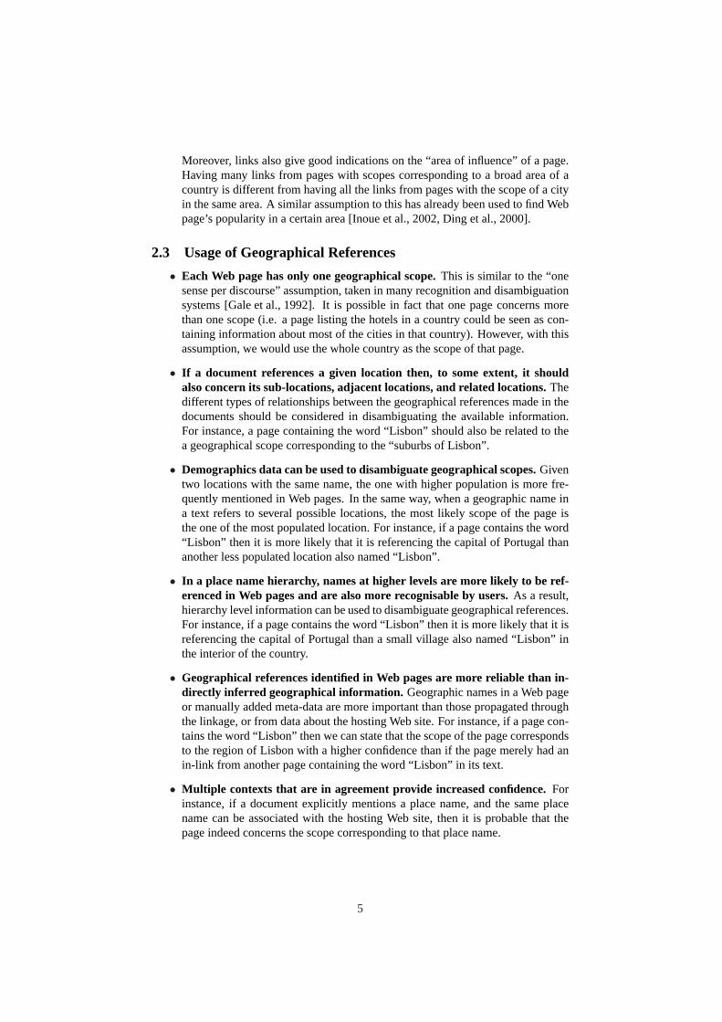
Our framework for mining Web data is shown in Figure 1. Building on the softwarearchitecture of our Web search engine (www.tumba.pt ), the proposed framework relieson meta-data and XML standards, incorporating Semantic Web technologies such asDublin Core and the Resource Description Framework (RDF) [Berners-Lee, 2000].
Figure 1: General Software Framework for Processing Web Resources.
Data is harvested into XMLBase, a Web data management system capable of pro-cessing large collections in parallel. Its components include a crawler, document pro-cessing tools [Martins and Silva, 2005b, Martins and Silva, 2005a], and separate dataand meta-data repositories [Campos, 2003, Gomes et al., 2004]. While “crawling” Webdocuments (HTML, PDF, etc.), low-level data extraction (e.g. text tokens, n-grams,sentences, hypertext links, structural markup, and metatag information), and simplemining tasks (e.g. language identification) are also performed. This is an importantfirst step, as handling Web data usually involves processing badly formatted informa-tion, with markup errors introduced by hand-editing documents or buggy authoringtools. The content of the Web documents is this way digested into RDF representa-tions, which are then stored in the repository. We call thesePurified Web Documents(PWD), to express that Web data, before becoming available for analysis, is cleanedinto a collection of well-formed XML documents, organised under a common schema.
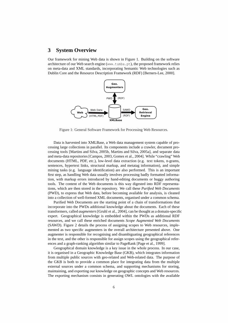
Purified Web Documents are the starting point of a chain of transformations thatincorporate into the PWDs additional knowledge about the documents. Each of thesetransformers, calledaugmenters[Gruhl et al., 2004], can be thought as a domain-specificexpert. Geographical knowledge is embedded within the PWDs as additional RDFresources, and we call these enriched documentsScope Augmented Web Documents(SAWD). Figure 2 details the process of assigning scopes to Web resources, imple-mented as two specific augmenters in the overall architecture presented above. Oneaugmenter is responsible for recognising and disambiguating geographical referencesin the text, and the other is responsible for assign scopes using the geographical refer-ences and a graph-ranking algorithm similar to PageRank [Page et al., 1999].
Geographical domain knowledge is a key issue in the whole process. In our case,it is organised in a Geographic Knowledge Base (GKB), which integrates informationfrom multiple public sources with geo-related and Web-related data. The purpose ofthe GKB is both to provide a common place for integrating data from the multipleexternal sources under a common schema, and supporting mechanisms for storing,maintaining, and exporting our knowledge on geographic concepts and Web resources.The exporting mechanism consists in generating OWL ontologies with the available
6
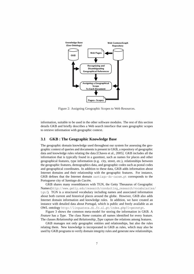
Figure 2: Assigning Geographic Scopes to Web Resources.
information, suitable to be used in the other software modules. The rest of this sectiondetails GKB and briefly describes a Web search interface that uses geographic scopesto retrieve information with geographic context.
3.1 GKB : The Geographic Knowledge Base
The geographic domain knowledge used throughout our system for assessing the geo-graphic context of queries and documents is present in GKB, a repository of geographicdata and knowledge rules relating the data [Chaves et al., 2005]. GKB includes all theinformation that is typically found in a gazetteer, such as names for places and othergeographical features, type information (e.g. city, street, etc.), relationships betweenthe geographic features, demographics data, and geographic codes such as postal codesand geographical coordinates. In addition to these data, GKB adds information aboutInternet domains and their relationship with the geographic features. For instance,GKB defines that the Internet domainsantiago-do-cacem.pt corresponds to thePortuguese city ofSantiago do Cacém.
GKB shares many resemblances with TGN, the Getty Thesaurus of GeographicNames (http://www.getty.edu/research/conducting_research/vocabularies/tgn/ ). TGN is a structured vocabulary including names and associated informationabout both current and historical places around the globe. However, GKB also addsInternet domain information and knowledge rules. In addition, we have created aninstance with detailed data about Portugal, which is public and freely available as anOWL ontologyhttp://linguateca.di.fc.ul.pt/index.php?l=geonetpt .
Figure 3 shows the common meta-model for storing the information in GKB. AFeaturehas aType. The classNamecontains all names identified for every feature.The classesRelationshipandRelationship_Typecapture the relations among features.
GKB manages not only geographic entities and relationships, but also the rulesrelating them. New knowledge is incorporated in GKB as rules, which may also beused by GKB programs to verify domain integrity rules and generate new relationships.
7
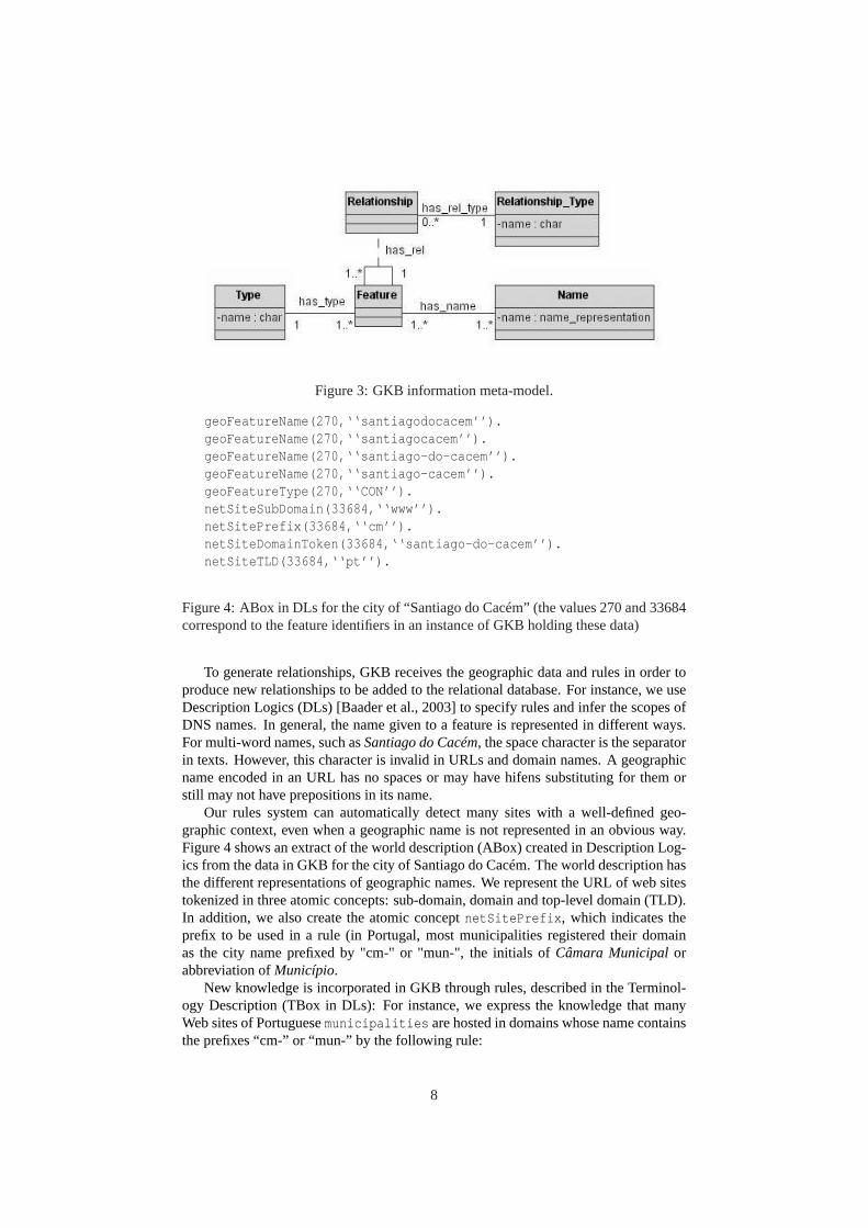
Figure 3: GKB information meta-model.
geoFeatureName(270,‘‘santiagodocacem’’).geoFeatureName(270,‘‘santiagocacem’’).geoFeatureName(270,‘‘santiago-do-cacem’’).geoFeatureName(270,‘‘santiago-cacem’’).geoFeatureType(270,‘‘CON’’).netSiteSubDomain(33684,‘‘www’’).netSitePrefix(33684,‘‘cm’’).netSiteDomainToken(33684,‘‘santiago-do-cacem’’).netSiteTLD(33684,‘‘pt’’).
Figure 4: ABox in DLs for the city of “Santiago do Cacém” (the values 270 and 33684correspond to the feature identifiers in an instance of GKB holding these data)
To generate relationships, GKB receives the geographic data and rules in order toproduce new relationships to be added to the relational database. For instance, we useDescription Logics (DLs) [Baader et al., 2003] to specify rules and infer the scopes ofDNS names. In general, the name given to a feature is represented in different ways.For multi-word names, such asSantiago do Cacém, the space character is the separatorin texts. However, this character is invalid in URLs and domain names. A geographicname encoded in an URL has no spaces or may have hifens substituting for them orstill may not have prepositions in its name.
Our rules system can automatically detect many sites with a well-defined geo-graphic context, even when a geographic name is not represented in an obvious way.Figure 4 shows an extract of the world description (ABox) created in Description Log-ics from the data in GKB for the city of Santiago do Cacém. The world description hasthe different representations of geographic names. We represent the URL of web sitestokenized in three atomic concepts: sub-domain, domain and top-level domain (TLD).In addition, we also create the atomic conceptnetSitePrefix , which indicates theprefix to be used in a rule (in Portugal, most municipalities registered their domainas the city name prefixed by "cm-" or "mun-", the initials ofCâmara Municipalorabbreviation ofMunicípio.
New knowledge is incorporated in GKB through rules, described in the Terminol-ogy Description (TBox in DLs): For instance, we express the knowledge that manyWeb sites of Portuguesemunicipalities are hosted in domains whose name containsthe prefixes “cm-” or “mun-” by the following rule:
8
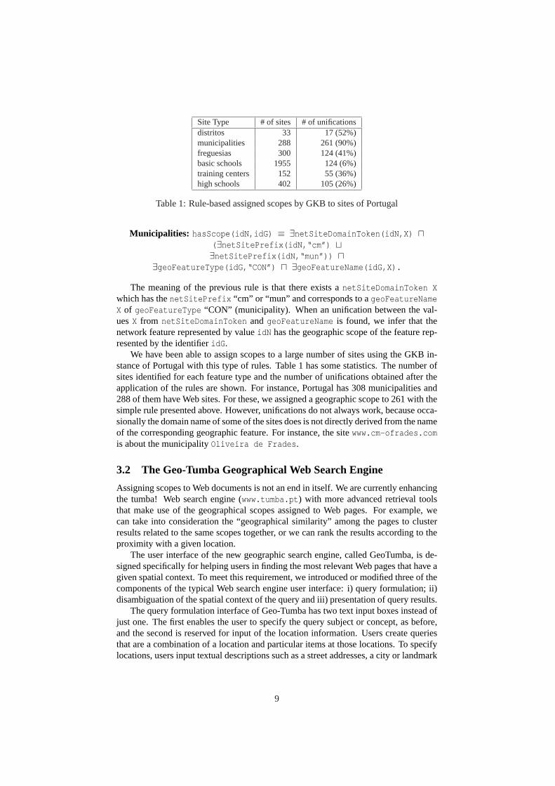
Site Type # of sites # of unificationsdistritos 33 17 (52%)municipalities 288 261 (90%)freguesias 300 124 (41%)basic schools 1955 124 (6%)training centers 152 55 (36%)high schools 402 105 (26%)
Table 1: Rule-based assigned scopes by GKB to sites of Portugal
Municipalities: hasScope(idN,idG) ≡ ∃netSiteDomainToken(idN,X) u( ∃netSitePrefix(idN,“cm”) t∃netSitePrefix(idN,“mun”)) u
∃geoFeatureType(idG,“CON”) u ∃geoFeatureName(idG,X).
The meaning of the previous rule is that there exists anetSiteDomainToken Xwhich has thenetSitePrefix “cm” or “mun” and corresponds to ageoFeatureNameX of geoFeatureType “CON” (municipality). When an unification between the val-uesX from netSiteDomainToken and geoFeatureName is found, we infer that thenetwork feature represented by valueidN has the geographic scope of the feature rep-resented by the identifieridG .
We have been able to assign scopes to a large number of sites using the GKB in-stance of Portugal with this type of rules. Table 1 has some statistics. The number ofsites identified for each feature type and the number of unifications obtained after theapplication of the rules are shown. For instance, Portugal has 308 municipalities and288 of them have Web sites. For these, we assigned a geographic scope to 261 with thesimple rule presented above. However, unifications do not always work, because occa-sionally the domain name of some of the sites does is not directly derived from the nameof the corresponding geographic feature. For instance, the sitewww.cm-ofrades.comis about the municipalityOliveira de Frades .
3.2 The Geo-Tumba Geographical Web Search Engine
Assigning scopes to Web documents is not an end in itself. We are currently enhancingthe tumba! Web search engine (www.tumba.pt ) with more advanced retrieval toolsthat make use of the geographical scopes assigned to Web pages. For example, wecan take into consideration the “geographical similarity” among the pages to clusterresults related to the same scopes together, or we can rank the results according to theproximity with a given location.
The user interface of the new geographic search engine, called GeoTumba, is de-signed specifically for helping users in finding the most relevant Web pages that have agiven spatial context. To meet this requirement, we introduced or modified three of thecomponents of the typical Web search engine user interface: i) query formulation; ii)disambiguation of the spatial context of the query and iii) presentation of query results.
The query formulation interface of Geo-Tumba has two text input boxes instead ofjust one. The first enables the user to specify the query subject or concept, as before,and the second is reserved for input of the location information. Users create queriesthat are a combination of a location and particular items at those locations. To specifylocations, users input textual descriptions such as a street addresses, a city or landmark
9
name, a postal code, or latitude/longitude coordinates. The definition of the querylocation can also be given by clicking on an map.
The location information provided is used to infer the geographical context of thequery. The specification of a geographical context requires the use of spatial relation-ships between the query subject and the query context. In our initial prototype, we onlysupport thein spatial relationship (e.g., restaurants in Lisbon).
In disambiguating the geographical context of the query, the location informationprovided as input is initially checked for syntactical errors using a dictionary-basedspelling checker [Martins and Silva, 2004a]. The dictionary contains the names ofknow locations on the geographic ontology and the corrected options are presentedwhen location terms are not recognised. After this initial correction, we apply a namedentity recognition (NER) procedure to recognise and disambiguate the geographicalname in the query, again using the geographic ontology. If disambiguation is notpossible, the user is prompted to disambiguate the location information provided byselecting one of the known contexts proposed.
Once the geographic scope of the query is resolved, it is submitted to the searchengine and a list of the most relevant pages with scope matching the query is returned.To speed-up searches, we created two indexes: one keeps the pages associated to theircorresponding scope, and the other associates scopes with their list of locations.
4 Assigning Scopes to Web Pages
As previously stated, the scope assignment process has two stages. First, we identifygeographic names in the text of Web pages, weighting them according to occurrencefrequency and HTML heuristics. In the second stage, we assign a final scope to eachWeb page, based on the geographical references found and on their relative weights. Inthe rest of this section, we describe both stages in detail.
4.1 Geographic NE Recognition and Disambiguation
The features for classification are extracted through a named entity recognition (NER)procedure particularly tailored to recognising and disambiguating geographical con-cepts over Web pages. Although NER is a familiar task within the Information Extrac-
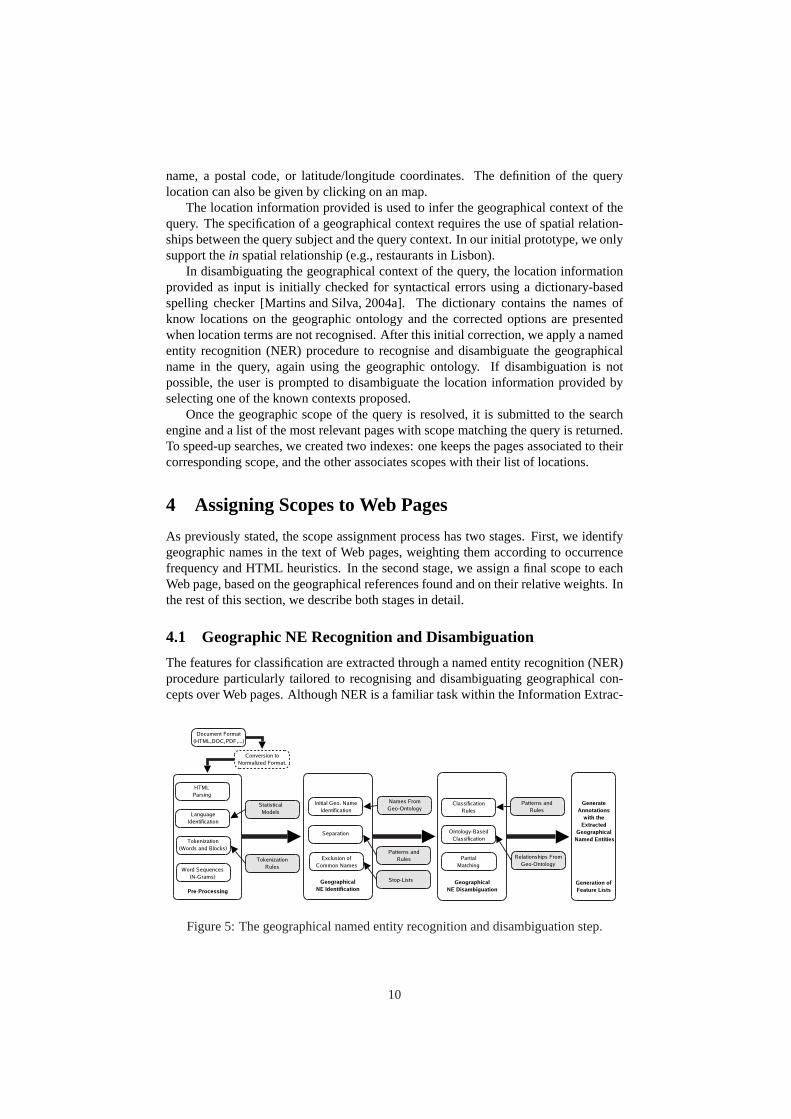
Figure 5: The geographical named entity recognition and disambiguation step.
10
tion community [Sang et al., 2003], our work advances the state of the art, as it presentsa specific adaptation strategy to the domain of multilingual geographical references onthe Web. Besides recognising place names, we try to normalise them in a way thatspecifically describes or even uniquely identifies the place in question, disambiguatingthem with respect to their specific type (e.g. city) and grounding them with features atthe geographical ontology.
For each geographical reference, and besides the corresponding ontology features,we keep its associated occurrence frequency in the text, weighted according to HTMLstructure in a way similar to the scheme proposed in [Robertson et al., 2004]: struc-tured HTML documents are first transformed into unstructured documents where dif-ferent elements (i.e. the title) are repeated several times according to their importance.Hypertext anchors and other available meta-data information is also added to this moreverbose document, which allows an uniform treatment of all geographical references.Although we left linkage out of our experiments, we could also add text from linkingdocuments in the Web graph in this more verbose document. In Section 2 we listedsome heuristics than can be used to account for geographical references from linkedpages in the Web graph.
Figure 5 illustrates the geographical named entity recognition and disambiguationstep, which follows the traditional architecture for NER systems by combining lexi-cal resources with shallow processing operations. We highlighting its main conceptualstages, namely 1) pre-processing, 2) named entity identification, 3) named entity dis-ambiguation, and 4) generation of feature lists.
Pre-processing starts by converting documents from multiple formats into HTML.It then parses documents to extract the textual information, using HTML markup tohelp in weighting text fragments and detecting text boundaries. A language guesser isused to classify the document’s text [Martins and Silva, 2005b], and this informationserves as the starting point for the more advanced processing operations. The identifiedtextual segments are finally split into their constituent wordn-grams, by moving awindow over each text segment and taking all possible consecutive word sequences.
Named entity identification involves the detection of all possiblen-grams that arelikely to belong to a geographical reference. An initial identification applies language-specific patterns, which combine place names and context expressions with and with-out capitalisation (i.e. “city of Lisbon” or ”Lisbon metropolitan area”). A separationsub-stage follows, in whichn-grams that are likely to contain more than one namedentity are detected and attachment problems are resolved. Finally, membership in ex-clusion lists is used to discard very frequent words that despite having a geographicalconnotation, are more frequently used in other contexts.
Named entity identification in itself does not derive the meaning of the expressionsrecognised. For instance, the expression “Campo Grande” refers both to a district inthe city of Lisbon, and to a small town in another completely different region of Por-tugal. The named entity disambiguation stage addresses this issue, aiming to find thecorrect meaning for the expressions recognised. Classification rules use the same ex-pressions that are used to recognise entities to solve simple cases (e.g. in “city of X”,we know X is a city and not some other geographical feature). Ontology based classi-fication uses the feature types and other contiguity measures to guess the correct typefor a given reference (i.e. a one referent per discourse assumption so that place namesthroughout the same paragraph or the same line of an HTML table refer to the sameor to geographically related locations). Finally, we compare slight word variations (i.e.one different character, one extra character or one less character) against referencesalready disambiguated. In the cases not covered by the above heuristics, we keep the
11
association of a reference to the several different possible items at the ontology. Someambiguity problems can therefore persist at the end of the feature extraction phase.
4.2 Scope Assignment : Graph Ranking for Combining Features
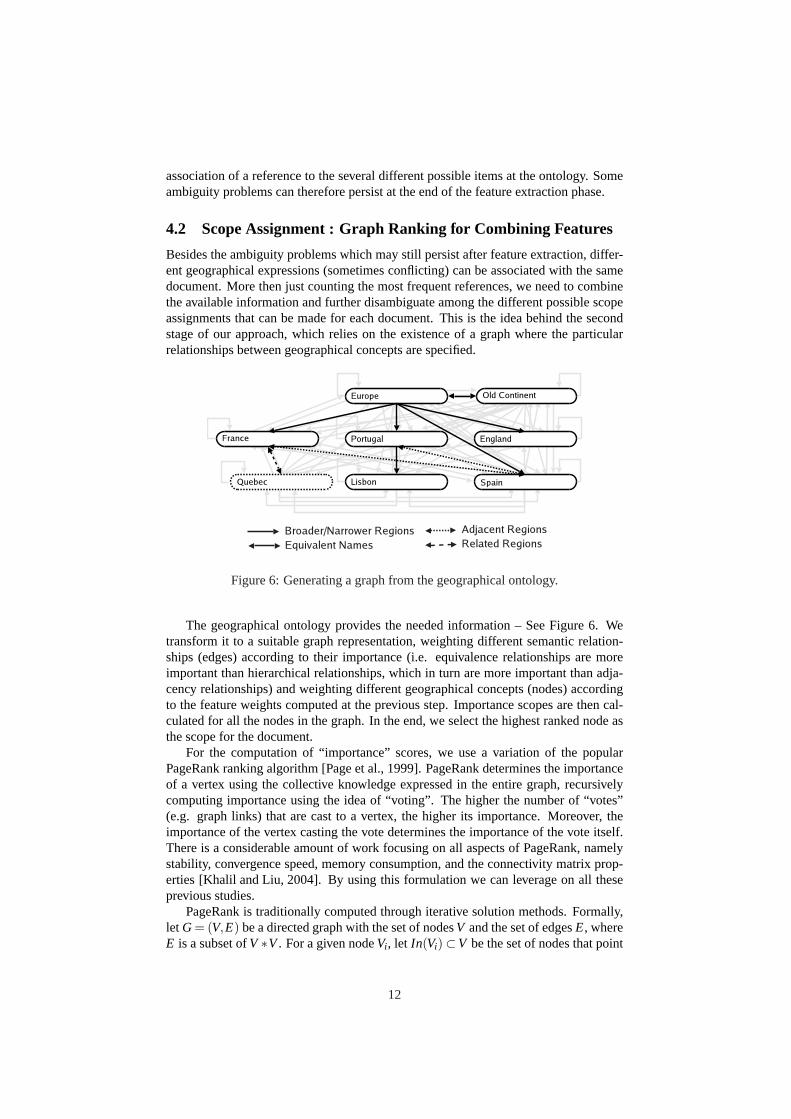
Besides the ambiguity problems which may still persist after feature extraction, differ-ent geographical expressions (sometimes conflicting) can be associated with the samedocument. More then just counting the most frequent references, we need to combinethe available information and further disambiguate among the different possible scopeassignments that can be made for each document. This is the idea behind the secondstage of our approach, which relies on the existence of a graph where the particularrelationships between geographical concepts are specified.
Figure 6: Generating a graph from the geographical ontology.
The geographical ontology provides the needed information – See Figure 6. Wetransform it to a suitable graph representation, weighting different semantic relation-ships (edges) according to their importance (i.e. equivalence relationships are moreimportant than hierarchical relationships, which in turn are more important than adja-cency relationships) and weighting different geographical concepts (nodes) accordingto the feature weights computed at the previous step. Importance scopes are then cal-culated for all the nodes in the graph. In the end, we select the highest ranked node asthe scope for the document.
For the computation of “importance” scores, we use a variation of the popularPageRank ranking algorithm [Page et al., 1999]. PageRank determines the importanceof a vertex using the collective knowledge expressed in the entire graph, recursivelycomputing importance using the idea of “voting”. The higher the number of “votes”(e.g. graph links) that are cast to a vertex, the higher its importance. Moreover, theimportance of the vertex casting the vote determines the importance of the vote itself.There is a considerable amount of work focusing on all aspects of PageRank, namelystability, convergence speed, memory consumption, and the connectivity matrix prop-erties [Khalil and Liu, 2004]. By using this formulation we can leverage on all theseprevious studies.
PageRank is traditionally computed through iterative solution methods. Formally,let G= (V,E) be a directed graph with the set of nodesV and the set of edgesE, whereE is a subset ofV ∗V. For a given nodeVi , let In(Vi)⊂V be the set of nodes that point
12
to it, and letOut(Vi)⊂V be the set of nodes thatVi points to. The valueswi j correspondto weights given to the edges connecting nodesVi andVj , andsi correspond to weightsgiven to each nodeVi (the source strengths). Bellow we show the formula for graph-based ranking that takes into account edge and node weights when computing the scoreassociated with a node in the graph. The ranking score of a nodeVi is defined as:
S(Vi) = (1−d)si +d∗∑Vj εIn(Vi)wi j
∑vkεOut(Vj )w jk
S(Vj)
The parameterd is a damping factor that can be set between0 and1, integratinginto the model the probability of jumping from a given node to another random node inthe graph (e.g. having a document associated with a completely different feature thanthe ones we were able to extracted from it).
The source strengthssi should be positive and satisfy the following condition:
|In(Vi)|= ∑|V|j=1si .
After a score is computed for each feature from the ontology, we select the mostprobable scope for the document, by taking the highest scoring feature or none if allare scored below a given threshold. The general procedure goes as follows:
1. Normalise the ranking scores obtained through the graph ranking algorithm.
2. If there are no features with a weight above the threshold, then no scope is se-lected.
3. From the set of features with the highest weight above the threshold:
(a) If there is only one, return it as the scope for the document.
(b) If there is more than one feature, but one of them corresponds to a generallybroader concept in the ontology, return this broader feature as the scope.
(c) If there is more than one feature, but they all have a common direct broaderfeature in the ontology, select this broader feature as the scope.
(d) If there is more than one feature and no common direct broader concept ex-ists, use demographics data to select the scope corresponding to the highestpopulated geographical region.
5 Evaluation Methodology and Initial Results
The subject of Geo-IR is still at an early stage of development, and limited eval-uation has so far been performed on such systems. Advances in the area requirean evaluation methodology, in order to measure and compare different techniques.A Geo-IR track at CLEF2005 was established as an initial experiment (seehttp://ir.shef.ac.uk/geoclef2005/ ). However, a complete Geo-IR system involvesdifferent components, which interdependently influence one-another and could benefitfrom a separate evaluation.
Disambiguating geographical references in the text and assigning documents witha corresponding geographical scope are two crucial steps in building a geographicalretrieval tool. These two stages can be separately evaluated, and different settings andtechniques could be used on each step. The performance of the extraction also dictates
13
the performance of the scope assignments, giving an additional reason for a separateevaluation of each step.
Our approach interdependently relies on the used ontology, which influences theoutcome of any experiment and should therefore be carefully analysed. Table 2 showssome statistics for two ontologies used in our experiments, namely a global one withnames in different languages, and another specific for the Portuguese territory.
Portuguese ontology Global Multilingual ontology
Ontology Statistic Count Ontology Statistic CountFeatures 418065 Features 12293Geographical Names 418460 Geographical Names 14305Relationships 419072 Relationships 12258Feature types 57 Feature types 7Part-of relations 418340 (99.83%) Part-of relations 12245 (99.89%)Equivalence relations 395 (0.09%) Equivalence relations 1814 (14.80%)Adjacency relations 1132 (0.27%) Adjacency relations 13 (0.10%)NUT1 3 ISO-3166-1 239NUT2 7 ISO-3166-2 3979NUT3 30 Agglomerations 751Districts 18 Places 3968Islands 11 Admin. divisions 3111Municipalities 308 Capital cities 233Civil Parishes 3595 Continents 7Zones 3594 Other 4Localities 44386Street-like 146422Postal codes 219691
Table 2: Statistics for the geographical ontologies.
The effectiveness of the feature extraction step was measured over newswire cor-pora used in previous NER evaluation efforts, and over a smaller collection of hand-annotated Web documents consisting of 20 HTML pages for each of 4 different lan-guages. Table 5 summarises the obtained results, separating the simpler task of recog-nising the boundaries for geographical references in the text (recognition) from thetasks of distinguishing types and assigning the recognised references to the appropriatefeatures at the ontology (disambiguation+grounding).
Recognition Disambiguation + Grounding
Corpus Precision Recall F1 Precision Recall F1
Portuguese text (HAREM) 0.89 0.68 0.77 - - -English text (CoNLL-2003) 0.85 0.79 0.81 - - -Spanish text (CoNLL-2002) 0.83 0.76 0.79 - - -
Portuguese HTML 0.90 0.76 0.82 0.89 0.76 0.81English HTML 0.91 0.75 0.82 0.90 0.73 0.80German HTML 0.79 0.72 0.91 0.77 0.70 0.73Spanish HTML 0.86 0.75 0.80 0.83 0.72 0.77
Table 3: Evaluation results for the feature extraction stage.
14
The disambiguation and grounding tasks could not be evaluated over the newswirecorpora, since they did not have locations tagged with their respective ontology fea-ture. Although the Portuguese ontology included more place names, results in terms ofrecall are inferior to experiments using the smaller global ontology. Although furtherexperiments are needed to confirm this, results indicate that recall does not improveconsiderably with the amount of available place names.
Performance over Web data is comparable to newswire texts, and our results arecomparable to previous proposals. For instance, Nissim et al. experimented an off-the-shelf max-entropy tagger for recognising place names in Scottish historical doc-uments [Nissim et al., 2004]. They achieved similar performances to state-of-the-artNER results (anf -score of 94.25%), but a preliminary experiment in recognizing spe-cific types (i.e. cities) yielded a drop in performance of about 20%. Comparing our re-sults with previous experiments in disambiguating place references – see Table 4 – canbe a problem, as systems vary in the disambiguation performed and on the resourcesused for evaluation. For instance, some systems only classify references according totheir correct type, while others also ground references to coordinates or to a gazetteer.
System Classify Ground Evaluation ResultsInfoXtract [Li et al., 2002] X X 94% accuracy
IDVL [Olligschlaeger and Hauptmann, 1999] X X 75% accuracyWeb-a-Where [Amitay et al., 2004] X X 63-82% accuracy
Smith and Mann [Smith and Mann, 2003] X 22-87% accuracySchilder et al. [Schilder et al., 2004] X X 74% f 1-scoreKIM system [Manov et al., 2003] X 88% f 1-scoreNissim et al. [Nissim et al., 2004] X f 1-score around 75%Leidner et al. [Leidner et al., 2003] X X -
Metacarta [Rauch et al., 2003] X X -
Table 4: Different systems handling geo-references in text.
As for the evaluation of the scope assignment process, the “gold-standard” collec-tion consisted of 1000 pages from the ODP directory, located under theTop:Regionalcategory. The specific branch of this category devoted to Portuguese pages with a co-herent geographic scope was separately tested, together with some pages from Websites for Portuguese municipalities (a total of 500 pages related to the Portuguese ter-ritory). Since the considered scopes are organised hierarchically, we evaluated theclassification approach at different levels of “granularity.” Our assumption was that as-signing pages to a corresponding broader region should in principle be easier than as-signing pages to a narrower area. Table 5 summarises the obtained results, with the lastline showing the accuracy in the case of exact matches with the scope defined for thepages. The two separate columns for each dataset show the results for assigning scopeswith basis on just the most frequently occurring feature (without the graph-based rank-ing algorithm to combine the available information), and with the application of thePageRank algorithm.
The relatively low accuracy confirms the difficulty inherent to the problem at hand.As expected, classification accuracy drops significantly if we consider narrower re-gions. These results can be confronted with those reported in other studies. Jun-yan et al. tried to classify pages according to three layers, namely nation, state andcity. They used a hierarchical thesaurus of place names, achieving a bestf -scoreof 86% [Ding et al., 2000]. Yamada et al. proposed a scheme to identify the geo-
15
Multilingual Ontology Portuguese OntologyODP Top:Regional ODP Top:Regional:Europe:Portugal
Measured Accuracy Measured AccuracyGranularity Most. Frequent Ranking Granularity Most. Frequent Ranking
Continent 91% 92% NUT 1 84% 86%Country 76% 85% NUT 2 58% 65%
NUT 3 44% 59%Municipalities 28% 31%
Exact Matches 67% 72% Exact Matches 34% 53%
Table 5: Experimental results in different test scenarios.
graphical region mentioned in a Web page through a minimum bounding rectangle,reporting an accuracy of 88% [Yamada et al., 2002]. Amitay et al. presented an ap-proach for finding the geographical focus of Web pages when several place namesare mentioned in the text, using the immediate parent in a hierarchically structuredgazetteer [Amitay et al., 2004]. ODP data was used for evaluation and the correct con-tinent, country, city or exact scope were guessed respectively 96%, 93%, 32% and 38%of the times.
6 Related Work
The WebFountain project is an example of a computer cluster designed to analyzemassive amounts of textual information, enabling the discovery of trends, patterns andrelationships [Gruhl et al., 2004, Dill et al., 2003]. The architecture integrates applica-tions that focus on specific tasks, using multi-disciplinary text mining approaches toextract data from Web resources. The Web data management architecture used in thiswork shares many ideas with WebFountain.
The SPIRIT project aims to develop a search engine aware of geographical termi-nology, using a geographical ontology [Fu et al., 2005, Jones et al., 2002]. Our frame-work differs on the emphasis put on geographic named entity recognition, the use of agraph ranking method for assigning a single scope to each document, the extensive useof names instead of coordinate information, and the availability of ontologies associat-ing entities to geographic scopes.
Markowetz et al. describe an initial implementation of a geographical Web searchengine for Germany [Markowetz et al., 2005]. Their system performs extraction of ge-ographical features from Web documents, which are then mapped to coordinates andaggregated across link and site structure. The authors build on many previously pro-posed concepts and ideas. Examples are the work of Gravano and Shivakumar whichintroduced the notion of geo-scopes [Buyukokkten et al., 1999, Ding et al., 2000], orthe Web-a-Where project which addresses geo-coding of Web documents for the entireglobe [Amitay et al., 2004]. No empirical results are given, and again our frameworkdiffers on the use of a graph ranking method for assigning a single scope to each doc-ument, and on the extensive use of place names instead of spatial coordinates.
The NetGeo project also concerned geographic locations in the context of the In-ternet, collating information from multiple sources in order to assign the most probablelongitude/latitude pair, together with the specificity and reliability of the location of IPaddresses [Moore et al., 2000]. There is a correlation between the location of the server
16
hosting a Web page and its scope. However, this is not the case in many situations. Forinstance, many Portuguese Websites are hosted in servers from U.S. providers or con-centrated in locations with good network connectivity. Local sites from small popu-lated cities are seldom hosted in that city. Another previous study successfully used thetraceroute utility, to get location information for the Internet nodes connected to aWeb server [Raz, 2004]. However, these projects aimed at finding coarse geographicalscopes (such as states or countries), whereas our scopes are of a finer level of detail.
Previous studies have demonstrated that recognising geographical place names intext (usually calledgeo-parsing) is a crucial precondition for geo-referencing Web doc-uments [Densham and Reid, 2003]. In language processing, the task of extracting anddistinguishing different types of entities in text (i.e. names of people or organisations,dates and times, events, geographic features or even “non entities”) is referred to asNamed Entity Recognition (NER) [Sang et al., 2003, Palmer and Day, 1997]. The de-gree to which gazetteers help in identifying named entities seems to vary. For instance,Malouf found that gazetteers did not improve performance [Malouf, 2002], whereasothers have gained significant improvements using gazetteers and simple “triggering”patterns [Carreras et al., 2002]. Mikheev et al. showed that a NER system couldperform well even without gazetteers for most entity classes, although not for placenames [Mikheev et al., 1999]. The same study by Mikheev et al. also showed that sim-ple list lookup performs reasonably well for locations [Mikheev et al., 1999]. Ambi-guity is the main problem associated with geographical references in text. The CoNLLshared task on named entity recognition concluded that ambiguity in geographical ref-erences is bi-directional, as the same name can be used for more than one location(referent ambiguity), and the same location can have more than one name (referenceambiguity) [Sang et al., 2003]. The former has another twist: the same name can beused for locations as well as for other class of entities, like persons or company names(referent class ambiguity).
More recently, the Workshop on the Analysis of Geographic References, held inconjunction with the 2003 NAACL-HLT conference, focused on topics concerning therecognition, disambiguation, normalisation, storage, and display of geographic refer-ences [Kornai and Sundheim, 2003]. The concerned problems are more complex thanthe simple recognition of place names in text, as NER in itself does not derive themeaning of the expressions recognised. To be useful, NER systems focusing on geo-graphical concepts should handle the complex issues related to how people use geo-graphical references. Place names lack precision in their meaning, and often vary withtime, from person to person, and with the context in which they are used. Many timesplace names are simply temporary conventions, and people’s vernacular geography ifalso often vague, as they may also be interested in the vicinity of a place without know-ing its exact name. Not only spelling variations are common on geographical names,but also the places those names reference change in shape and size.
The GIPSY system for automatic geo-referencing of text uses a disambiguationmethod that incrementally constructs a polytope via merging flat polygons, in sucha way that a third dimension is introduced for the intersecting area (polygon stack-ing). The authors report some initial experiments, but no exact evaluation figures aregiven [Woodruff and Plaunt, 1994]. Smith and Crane proposed an interesting reso-lution method, based on computing a centroid for all possible referents and discard-ing points that are more than two times the standard deviation away from the cen-troid [Smith and Crane, 2001]. They reportf -scores between 0.81 and 0.96, but foundthat the centroid-based method lacks robustness. More recently, Yamada et al. pro-posed a scheme to identify the geographical region mentioned in a Web page through
17
a minimum bounding rectangle, reporting an accuracy of 88% [Yamada et al., 2002].Our work differs from these three previous proposals for disambiguating and combin-ing geographical references in the sense that instead of using coordinates, it relies onsemantic relationships between geographical concepts as provided by an ontology. Theapproach that is closest to ours is perhaps the work in the Web-a-Where project, whichuses a hierarchical gazetteer [Amitay et al., 2004]
7 Conclusions
We presented our approach for automatically identifying geographic scopes in Webpages. A shared knowledge base is used to augment RDF-based descriptions of crawledWeb pages with geographic meta-data. This work is part of a larger project which alsoinvolves the creation innovative IR algorithms in our Web search engine, using thenotion of “geographical relatedness.”
The assignment of geographical scopes to Web resources is made in two stages.In the first, geographical references occurring over the texts are recognised and dis-ambiguated. In the second stage, a scope is assigned to the documents, combiningthe available information through a graph-ranking algorithm. A geographical ontologyprovides the names and the relationships between geographical concepts.
Both steps of the scope assignment process reflect a set of heuristics related to thedifferent ways in which people place geographical context information on Web docu-ments. Since many parameters are combined, a very important step concerns tuningthe weights associated with the several parameters. For now, we are relaying on em-pirical tests and on published results from other experiments in the area of informationretrieval. In the future, we plan on evaluating our approach using a systematic methodto tune these parameters. Additional evaluation studies are in fact currently being per-formed (i.e. participation at GeoCLEF 2005), and there are also many ideas for futureenhancements and for retrieval functionalities making use of geographical scopes.
8 Acknowledgements
Diana Santos, the coordinator of Linguateca, is a consultant to our project in languagetechnology. Special thanks also to our colleagues and members of the tumba! develop-ment team Daniel Gomes, Nuno Seco, Leonardo Andrade and Sérgio Freitas, for theircomments on early drafts of this paper.
This research was partially supported by the FCCN-Fundação para a ComputaçãoCientífica Nacional, and FCT-Fundação para a Ciência e Tecnologia, under projectgrants POSI/SRI/40193/2001 (XMLBase) and POSI/SRI/47071/2002 (GREASE).
References
[Amitay, 1999] Amitay, E. (1999).Words on the Web - Computer Mediated Commu-nication, chapter Anchors in context : A corpus analysis of web pages authoringconventions. Intellect Books.
[Amitay et al., 2004]Amitay, E., Har’El, N., Sivan, R., and Soffer, A. (2004). Web-a-where: geotagging Web content. InProceedings of SIGIR-04, the 27th Conferenceon Research and Development in Information Retrieval. ACM Press.
18
[Arasu et al., 2001]Arasu, A., Cho, J., Garcia-Molina, H., Paepcke, A., and Ragha-van, S. (2001). Searching the Web.ACM Transactions on Internet Technology,1(1).
[Baader et al., 2003]Baader, F., Calvanese, D., Nardi, D., McGuinness, D., andPatel-Schneider, P., editors (2003).The Description Logic Handbook: The-ory,Implementation and Applications. Cambridge University Press.
[Berners-Lee, 2000]Berners-Lee, T. (2000).Weaving the Web: The Original Designand Ultimate Destiny of the World Wide Web by its Inventor. Harper Business.
[Bucher et al., 2005]Bucher, B., Clough, P., Joho, H., Purves, R., and Syed, A. K.(2005). Geographic ir systems : Requirements and evaluation. InProceedings ofICC-05, the 12th International Cartographic Conference.
[Buyukokkten et al., 1999]Buyukokkten, O., Cho, J., Garcia-Molina, H., Gravano, L.,and Shivakumar, N. (1999). Exploiting geographical location information of Webpages. InProceedings of WebDB-99, the 1999 ACM SIGMOD Workshop on the Weband Databases.
[Campos, 2003]Campos, J. P. (2003). Versus: A Web data repository with time sup-port. DI/FCUL TR 03–08, Department of Informatics, University of Lisbon. Mas-ters thesis.
[Carreras et al., 2002]Carreras, X., Marques, L., and Padro, L. (2002). Named entityextraction using AdaBoost. InProceedings of CoNLL-2002, the 6th Conference onNatural Language Learning.
[Chakrabarti et al., 1999]Chakrabarti, S., Dom, B. E., Kumar, S. R., Raghavan, P.,Rajagopalan, S., Tomkins, A., Gibson, D., and Kleinberg, J. (1999). Mining theWeb’s link structure.Computer, 32(8).
[Chaves et al., 2005]Chaves, M., Silva, M. J., and Martins, B. (2005). A geographicknowledge base for semantic Web applications. InProceedings of SBBD-05, the20th Brazilian Symposium on Databases.
[Cutler and Meng, 1997]Cutler, Y. S. M. and Meng, W. (1997). Using the structureof HTML documents to improve retrieval. InProceedings of USITS-97, the 1stUSENIX Symposium on Internet Technologies and Systems.
[Davison, 2000]Davison, B. D. (2000). Topical locality in the Web. InProceedingsof SIGIR-00, the 23rd Conference on Research and Development in InformationRetrieval.
[Densham and Reid, 2003]Densham, I. and Reid, J. (2003). A geo-coding ser-vice encompassing a geo-parsing tool and integrated digital gazetteer service. InProceedings of the Workshop on The Analysis of Geographic References held atHTL/NAACL 2003.
[Dill et al., 2003] Dill, S., Eiron, N., Gibson, D., Gruhl, D., Guha, R., Jhingran, A.,Kanungo, T., Rajagopalan, S., Tomkins, A., Tomlin, J. A., and Zien, J. Y. (2003).SemTag and Seeker: Bootstrapping the semantic Web via automated semantic an-notation. InProceedings of WWW-2003, the 12th World Wide Web Conference.
19
[Ding et al., 2000]Ding, J., Gravano, L., and Shivakumar, N. (2000). Computing ge-ographical scopes of Web resources. InProceedings of VLDB-00, the 26th Confer-ence on Very Large Data Bases. Morgan Kaufmann Publishers Inc.
[Fu et al., 2005]Fu, G., Jones, C. B., and Abdelmoty, A. I. (2005). Building a ge-ographical ontology for intelligent spatial search on the web. InProceedings ofDBA-2005, the 2005 IASTED International Conference on Databases and Applica-tions.
[Gale et al., 1992]Gale, W., Church, K., and Yarowsky, D. (1992). One sense per dis-course. InProceedings of the 4th DARPA Speech and Natural Language Workshop.
[Gomes et al., 2004]Gomes, D., Santos, A. L., and Silva, M. J. (2004). Webstore: Amanager for incremental storage of contents. DI/FCUL TR 04–15, Department ofInformatics, University of Lisbon.
[Gomes and Silva, 2005]Gomes, D. and Silva, M. J. (2005). Characterizing a nationalcommunity web.ACM Transactions on Internet Technology, 5(3).
[Grishman, 1997]Grishman, R. (1997). Information extraction: Techniques and chal-lenges. In Pazienza, M. T., editor,Lecture Notes In Artificial Intelligence, volume1299. Springer-Verlag.
[Gruhl et al., 2004]Gruhl, D., Chavet, L., Gibson, D., Meyer, J., Pattanayak, P.,Tomkins, A., and Zien, J. (2004). How to build a WebFountain: An architecturefor very large-scale text analytics.IBM Systems Journal - Utility Computing, 43(1).
[Hill, 2000] Hill, C. (2000). Information space based on HTML structure. In Voorhees,E. M. and Harman, D. K., editors,Proceedings of TREC-9, the 9th Text REtrievalConference. Department of Commerce of National Institute of Standards and Tech-nology.
[Inoue et al., 2002]Inoue, Y., Lee, R., Takakura, H., and Kambayashi, Y. (2002). Weblocality based ranking utilizing location names and link structure. InProceedingsof W2GIS-2002, The Second International Workshop on Web and Wireless Geo-graphical Information Systems, in conjunction with WISE-2002 3rd InternationalConference on Web Information Systems Engineering.
[Jones et al., 2002]Jones, C. B., Purves, R., Ruas, A., Sanderson, M., Sester, M., vanKreveld, M., and Weibel, R. (2002). Spatial information retrieval and geographicalontologies: An overview of the SPIRIT project. InProceedings of SIGIR-02, the25th Annual International ACM SIGIR Conference on Research and Developmentin Information Retrieval. ACM Press.
[Khalil and Liu, 2004] Khalil, A. and Liu, Y. (2004). Experiments with PageRankcomputation. Technical Report 603, Computer Science department at Indiana Uni-versity.
[Kleinberg, 1999]Kleinberg, J. M. (1999). Authoritative sources in a hyperlinkedenvironment.Journal of the ACM, 46(5).
[Kornai and Sundheim, 2003]Kornai, A. and Sundheim, B., editors (2003).Workshopon the Analysis of Geographic References. (held in conjunction with NAACL-HLT2003).
20
[Kosala and Blockeel, 2000]Kosala, R. and Blockeel, H. (2000). Web mining re-search: A survey.SIGKDD Explorations: Newsletter of the ACM Special InterestGroup (SIG) on Knowledge Discovery and Data Mining, 2.
[Leidner et al., 2003]Leidner, J. L., Sinclair, G., and Webber, B. (2003). Groundingspatial named entities for information extraction and question answering. InPro-ceedings of the HTL/NAACL Workshop on The Analysis of Geographic References,Edmonton, Alberta, Canada.
[Li et al., 2002] Li, H., Srihari, K. R., Niu, C., and Li, W. (2002). Location normaliza-tion for information extraction. InProceedings of COLING-02, the 19th Conferenceon Computational Linguistics.
[Malouf, 2002] Malouf, R. (2002). Markov models for language-independent namedentity recognition. InProceedings of CoNLL-2002, the 6th Conference on NaturalLanguage Learning.
[Manning and Schütze, 1999]Manning, C. D. and Schütze, H. (1999).Foundationsof Statistical Natural Language Processing. The MIT Press, Cambridge, Mas-sachusetts.
[Manov et al., 2003]Manov, D., Kiryakov, A., Popov, B., Bontcheva, K., Maynard,D., and Cunningham, H. (2003). Experiments with geographic knowledge for infor-mation extraction. InProceedings Workshop on Analysis of Geographic References.
[Marchiori, 1998] Marchiori, M. (1998). The limits of Web metadata, and beyond. InProceedings of WWW-98, the 7th International World Wide Web Conference.
[Markowetz et al., 2005]Markowetz, A., Chen, Y.-Y., Suel, T., Long, X., and Seeger,B. (2005). Design and implementation of a geographic search engine. TechnicalReport TR-CIS-2005-03, Department of Computer and Information Science of thePolytechnic University of Brooklyn.
[Martins and Silva, 2004a]Martins, B. and Silva, M. J. (2004a). Spelling correctionfor search engine queries. InProceedings of EsTAL-04, España for Natural Lan-guage Processing.
[Martins and Silva, 2004b]Martins, B. and Silva, M. J. (2004b). A statistical study ofthe WPT-03 corpus. DI/FCUL TR 04–04, Department of Informatics, University ofLisbon.
[Martins and Silva, 2005a]Martins, B. and Silva, M. J. (2005a). Language identifi-cation in Web pages. InProceedings of ACM-SAC-DE-05, Document EngineeringTrack of the 20th Symposium on Applied Computing.
[Martins and Silva, 2005b]Martins, B. and Silva, M. J. (2005b). WebCAT: A Webcontent analysis tool for ir applications. InProceedings of WI-2005, The 2005IEEE/WIC/ACM International Conference on Web Intelligence.
[Menczer, 2002]Menczer, F. (2002). Lexical and semantic clustering by Web links.Journal of the American Society for Information Science and Technology. Forth-coming.
21
[Mikheev et al., 1999]Mikheev, A., Moens, M., and Grover, C. (1999). Named entityrecognition without gazetteers. InProceedings of EACL-99, the 9th Conference ofthe European Chapter of the Association for Computational Linguistics.
[Moore et al., 2000]Moore, D., Periakaruppan, R., and Donohoe, J. (2000). Wherein the world is netgeo.caida.org? InProceedings of INET-2000, the 10th AnnualInternet Society Conference.
[Naaman et al., 2004]Naaman, M., Song, Y. J., Paepcke, A., and Garcia-Molina, H.(2004). Automatic organization for digital photographs with geographic coordi-nates. InProceedings of JCDL-04, the 4th ACM/IEEE-CS Joint Conference onDigital Libraries.
[Nissim et al., 2004]Nissim, M., Matheson, C., and Reid, J. (2004). Recognising ge-ographical entities in scottish historical documents. InProceedings of the Workshopon Geographic Information Retrieval at SIGIR 2004.
[Olligschlaeger and Hauptmann, 1999]Olligschlaeger, A. M. and Hauptmann, A. G.(1999). Multimodal information systems and GIS: The informedia digital videolibrary. In Proceedings of the 1999 ESRI User Conference.
[Page et al., 1999]Page, L., Brin, S., Motwani, R., and Winograd, T. (1999). Thepagerank citation ranking: Bringing order to the Web. Technical Report SIDL-WP-1999-0120, Stanford Digital Library. Working Paper.
[Palmer and Day, 1997]Palmer, D. D. and Day, D. S. (1997). A statistical profile ofthe named entity task. InProceedings of ANLP-97, the 5th conference on AppliedNatural Language Processing. Morgan Kaufmann Publishers Inc.
[Rauch et al., 2003]Rauch, E., Bukatin, M., and Baker, K. (2003). A confidence-based framework for disambiguating geographic terms. InProceedings of theHTL/NAACL Workshop on The Analysis of Geographic References.
[Raz, 2004]Raz, U. (2004). Finding a host’s geographical location. Retrieved on 30thAugust 2004 from the World Wide Web:http://www.private.org.il/IP2geo.html .
[Robertson et al., 2004]Robertson, S., Zaragoza, H., and Taylor, M. (2004). SimpleBM25 extension to multiple weighted fields. InProceedings of CIKM-04, the 13thConference on Information and Knowledge Management.
[Robertson and Jones, 1997]Robertson, S. E. and Jones, K. S. (1997). Simple provenapproaches to text retrieval. Technical Report TR356, Cambridge University Com-puter Laboratory.
[Sanderson and Kohler, 2004]Sanderson, M. and Kohler, J. (2004). Analyzing geo-graphic queries. InProceedings of SIGIR-GIR-2004, the Workshop on Geograph-ical IR held at the 27th Conference on Research and Development in InformationRetrieval.
[Sang et al., 2003]Sang, T. K., F., E., and De Meulder, F. (2003). Introduction tothe CoNLL-2003 shared task: Language-independent named entity recognition. InDaelemans, W. and Osborne, M., editors,Proceedings of CoNLL-2003, the 7th Con-ference on Natural Language Learning. Edmonton, Canada.
22
[Schilder et al., 2004]Schilder, F., Versley, Y., and Habel, C. (2004). Extracting spatialinformation: grounding, classifying and linking spatial expressions. InProceedingsof the Workshop on Geographic Information Retrieval at SIGIR 2004.
[Silva, 2003] Silva, M. J. (2003). The case for a portuguese Web search engine. InPro-ceedings of ICWI-2003, the 2003 IADIS International Conference WWW/Internet.
[Smith and Crane, 2001]Smith, D. A. and Crane, G. (2001). Disambiguating geo-graphic names in a historical digital library. InECDL ’01: Proceedings of the 5thEuropean Conference on Research and Advanced Technology for Digital Libraries,London, UK. Springer-Verlag.
[Smith and Mann, 2003]Smith, D. A. and Mann, G. S. (2003). Bootstrapping to-ponym classifiers. InProceedings of the HTL/NAACL Workshop on The Analysis ofGeographic References.
[Vaid et al., 2005]Vaid, S., Jones, C. B., Joho, H., and Sanderson, M. (2005). Spatio-textual indexing for geographical search on the web. InProceedings of SSTD-05,the 9th Symposium on Spatial and Temporal Databases.
[Woodruff and Plaunt, 1994]Woodruff, A. and Plaunt, C. (1994). GIPSY: Automatedgeographic indexing of text documents.Journal of the American Society of Infor-mation Science, 45(9).
[Yamada et al., 2002]Yamada, N., Lee, R., Kambayashi, Y., and Takakura, H. (2002).Classification of web pages with geographic scope and level of details for mobilecache management. InProceedings of W2GIS-02, the 2nd Workshop on Web andWireless Geographical Information Systems.
[Yang, 1999] Yang, Y. (1999). An evaluation of statistical approaches to text catego-rization. Information Retrieval, 1(1–2).
23