Embed Size (px)
Citation preview
PROPOSED KAPPA OMEGA 2ND 765KV ESKOM POWERLINES
WESTERN CAPE
Heritage Impact Assessment component: Built Environment, Spatial History and Cultural Landscape
SCOPING AND ASSESSMENT REPORT
NOVEMBER 2014
HERITAGE WESTERN CAPE CASE NO: 121004JL09E
Prepared For
Nzumbululo Heritage Solutions South Africa
4 Berger Road, Vorna Valley, Midrand 1686, South Africa Tel: +27 11 021 4937, +27 15 291 3661
SALLY TITLESTAD
HERITAGE CONSULTANTS IN ASSOCIATION
Mobile: 071 1090 900 Tel: +27 21 683 7085 Fax: 086 511 0389 Mobile: 072 212 8246 Tel 021 686 8124 Email: [email protected] Web: www.bridgetodonoghue.com Email: [email protected] 4 OAKDALE ROAD NEWLANDS 7708 CAPE TOWN SOUTH AFRICA 22 BIRKETT ROAD RONDEBOSCH 7700 CAPE TOWN SOUTH
AFRICA
ESKOM PROPOSED 765KV POWERLINES KAPPA OMEGA SPECIALIST ASSESSMENT OF SPATIAL HISTORY, CULTURAL LANDSCAPE AND BUILT ENVIRONMENT
___________________________________________________________________________________________________
BRIDGET O’DONOGHUE & SALLY TITLESTAD HERITAGE CONSULTANTS IN ASSOCIATION
ii
TABLE OF CONTENTS
EXECUTIVE SUMMARY VI GLOSSARY AND DEFINITIONS VII SECTION 1 INTRODUCTION 1
1.1 INTRODUCTION 1 1.2 LEGAL REQUIREMENTS 1 1.3 TERMS OF REFERENCE 2 1.4 PROPOSED POWERLINES AND ASSOCIATED INFRASTRUCTURE 2 1.5 BUILT ENVIRONMENT AND CULTURAL LANDSCAPE SCOPE OF WORK 3 1.6 APPROACH TO THE SPECIALIST STUDY 4 1.7 STUDY METHODOLOGY 5 1.8 ASSUMPTIONS AND LIMITATIONS 9
1.8.1 Assumptions 9 1.8.2 Limitations 9
1.9 SPECIALIST TEAM AND DETAILS 10 1.10 DECLARATION OF INDEPENDENCE 11 1.11 REPORT STRUCTURE 11
SECTION 2 PROJECT DESCRIPTION 12
2.1 INTRODUCTION 12 2.2 ALTERNATIVE ROUTES OPTIONS 13 2.3 PYLON TOWERS 14
SECTION 3 REGION AND SITES DESCRIPTION 16
3.1 INTRODUCTION 16 3.2 HISTORICAL OVERVIEW 16 3.3 CULTURAL LANDSCAPE 19
3.3.1 The Term ‘Cultural Landscape’ 19 3.3.2 Cultural Landscapes Occurring along Powerline Route Alternatives 20 3.3.2.3 The Swartland 23
3.4 BUILT ENVIRONMENT 26
SECTION 4 HERITAGE LEGISLATION & ASSESSMENT CRITERIA 27
4.1 INTRODUCTION 27 4.2 ADMINISTRATIVE CONTEXT AND STATUTORY FRAMEWORK 27
4.2.1 Overview 27 4.2.2 National Heritage Resources Act No. 25 of 1999 (NHRA) 27 4.2.3 Existing Heritage Studies 28
4.3 HERITAGE ASSESSMENT CRITERIA 29 4.3.1 Definition of Cultural Significance and Criteria for the Assessment of Cultural Significance 29 4.3.2 Contextual/Experiential Significance 30
ESKOM PROPOSED 765KV POWERLINES KAPPA OMEGA SPECIALIST ASSESSMENT OF SPATIAL HISTORY, CULTURAL LANDSCAPE AND BUILT ENVIRONMENT
___________________________________________________________________________________________________
BRIDGET O’DONOGHUE & SALLY TITLESTAD HERITAGE CONSULTANTS IN ASSOCIATION
iii
4.3.3 Assessments of Impacts 31
4.4 HERITAGE DESIGN INDICATORS 32 4.4.1 Scoping Phase Guidelines 32 4.4.3 Assessment Phase Local Scale Heritage Design Indicators 34 4.4.4 Assessment Phase Micro Scale Heritage Design Indicators 36
4.5 IMAGES AND DEPICTIONS OF ROUTE ALTERNATIVES 37
SECTION 5 IDENTIFIED HERITAGE RESOURCES & STATEMENTS OF HERITAGE SIGNIFICANCE 57
5.1 INTRODUCTION 57 5.2 ROUTE OPTION 1 57
SECTION 6 IMPACT ASSESSMENT 71
6.1 INTRODUCTION 71 6.2 SCOPING PHASE ASSESSMENT 71 6.3 ASSESSMENT PHASE 71 6.4 ZONES AND ROUTE OPTIONS 72 Table 6.1 Impact Assessment Route Option 1 Zone 1 73 Table 6.2 Impact Assessment Route Option 1 Zone 2 74 Table 6.3 Impact Assessment Route Option 1 Zone 3 85 Table 6.4 Impact Assessment Route Option 1A Zone 3 97 Table 6.5 Impact Assessment Route Option 2 Zone 3 98 Table 6.6 Impact Assessment Route Option 1b Zone 3 106 6.5 SUMMARY OF IMPACT ASSESSMENT 106
SECTION 7 RECOMMENDATIONS 109 SECTION 8 BIBLIOGRAPHY OF SOURCES 110 ANNEXURE 1: RECORDS OF DECISION APPLICABLE TO THE STUDY 115 ANNEXURE 2.1: BRIEF HISTORICAL TIMELINE FOR THE WARM AND KOUE BOKKEVELD AND TULBAGH VALLEY 119 ANNEXURE 2.2: BRIEF HISTORICAL TIMELINE FOR THE SWARTLAND 126
ANNEXURE 3: MAPS 139
ESKOM PROPOSED 765KV POWERLINES KAPPA OMEGA SPECIALIST ASSESSMENT OF SPATIAL HISTORY, CULTURAL LANDSCAPE AND BUILT ENVIRONMENT
___________________________________________________________________________________________________
BRIDGET O’DONOGHUE & SALLY TITLESTAD HERITAGE CONSULTANTS IN ASSOCIATION
iv
TABLE OF FIGURES:
Figure 1: Location of proposed new 765kV transmission line within South Africa, powerline corridors located within red circle (Metro GIS, 2013) 12
Figure 2: Kappa Gamma 2nd 765kV powerlines, Metro GIS 2013 13
Figure 3: Pylons for 765kV powerlines (ESKOM Line Engineering services, ESKOM 400kV and 765kV Tower Guide May 2013) 14
Figure 4: Existing powerlines immediately south of Gamma substation, iillustrating the difference in height between 400kV self supporting suspension pylons and the 765kV Guyed-V suspension pylons (765kV powerline right), BOD/ST 2013 15
Figure 5: Diagram showing three cultural landscape zones. For the purpose of historical depiction, the Mountainous region and the entrance into the Ceres Karoo are dealt with jointly (adapted from MetroGIS, 2013) 16
Figure 6: Diagram showing cultural landscape zones in relation to the proposed powerline routes (MetroGIS, 2013) 21
Figure 7: Ceres Valley from Gydo Pass (photograph Judelle Drake) 22
Figure 8: Agricultural patterning of the Swartland and the visual connections between settlements nestled into the foothills of mountains (photograph Kay McCormick, 2014) 23
Figure 9: Cultural landscape elements and context of heritage resources in the context of alternate route Options 1,2 and 3, with emphasis on the route options being considered at impact assessment phase. (adapted from Metro GIS) 25
Figure 10: Images from Kappa Substation to Karoopoort 37
Figure 11: Landscape and approach to the R46 scenic routes from the R355 38
Figure 12: Images Karoopoort Outspan to Ceres including Hottentotskloof and Theronsberg Passes, scenic routes 38
Figure 13: Images Ceres Valley Context 39
Figure 14: Images Wolseley Context 40
Figure 15: Images of Elandsberg Farms and Landscape Context 41
Figure 16: Images of Riebeek Kasteel and Landscape Context 45
Figure 17: Images Saron Mission Settlement and Landscape Context 46
Figure 18: Images Riebeek Valley 47
Figure 19: Images Porterville and Landscape Context 48
Figure 20: Images Proposed Route 3 between Porterville and Piketberg 49
ESKOM PROPOSED 765KV POWERLINES KAPPA OMEGA SPECIALIST ASSESSMENT OF SPATIAL HISTORY, CULTURAL LANDSCAPE AND BUILT ENVIRONMENT
___________________________________________________________________________________________________
BRIDGET O’DONOGHUE & SALLY TITLESTAD HERITAGE CONSULTANTS IN ASSOCIATION
v
Figure 21: IMAGES SWARTLAND PORTERVILLE, PIKETBERG AND KORINGBERG CONTEXT 49
Figure 22: Images Piketberg 50
Figure 23: Images Koringberg 51
Figure 24: Images R45 Roadway 52
Figure 25: Images Approach Darling 53
Figure 26: Images Philadelphia & Context 53
Figure 27: Images Kalkbaskraal 54
Figure 28: Images Abbotsdale 55
Figure 29: Images Klipheuwel 56
Figure 30: Kappa Omega 2nd 765kV powerlines corridors options 1, 1a, 1b (red, orange and yellow lines), Option 2 (blue line, depicted as blue and pink where it coincides with proposals from Option 1), Option 3, 3a, 3b, 3c [purple line with colour variants on the west], Metro GIS 2013 57
Figure 31: Diagram of Cultural Landscape Elements and Informants (adapted from MetroGIS) 71
Figure 32: Kappa Omega Assessment Zones 72
Figure 33 (right): portion of map 29 showing the point at which route option 2 assessment begins in relation to contextual topography (MetroGIS2013) 98
Figure 34: Diagram depicting portion of route option 2 which coincides with route 1a, studied at impact assessment phase. 106
Figure 35: Connection between recomended routes that will require specific and close attention to avoid negative impacts on Heritage Reources 108
EXECUTIVE SUMMARY
This assessment constitutes specialist input on spatial history, cultural landscape and the built environment towards the Heritage Impact Assessment component of and EIA conducted in line with the requirements of the National Environmental Management Act (Act 107/1998).
The proposal is for a second 765kV powerline between Koruson (Kappa) substation near Ceres to Sterekus (Omega) substation near Koeberg in Cape Town. Three alternative powerline routes (with variations along their length) identified by ESKOM all start at Kappa and end at Omega. An alternative travels via Aurora substation. This specialist assessment identifies, assesses and maps the heritage resources within the three identified alternative 4km powerline corridors. It also provides heritage design indicators for development and assesses the potential impacts of the proposed powerlines on the identified heritage resources within the corridors. It assesses the impacts of the proposals on spatial history, cultural landscape and the built environment. The recommendations of the assessment are that the heritage indicators are adopted, and that Option Route 1, 1a and 2, south of Riebeek Kasteel and the R46 Scenic Route, as the preferred route due to the lower impact on settlements and landscapes is endorsed, with the adoption of mitigation measures contained in the Tables 6.1- 6.6.
GLOSSARY AND DEFINITIONS
The approach to the definitions and application of the HIA is extracted from the National Heritage Resources Act, no 25 of 1999 and the ICOMOS Australian Burra Charter, revised in 1999. Adaptation The process of adaptation introduces a sufficient degree of flexibility to the treatment of a place or resource to enable change to be managed and still fulfil conservation objectives (Kerr, Baumann). Such change should be appropriate and should not affect the cultural significance of a structure or site. Associations Associations mean the special connections that exist between people and a place. Significant associations between people and a place should be respected, retained and not obscured. Opportunities for the interpretation, commemoration and celebration of these associations should be investigated and implemented. Archaeological resources Material remains resulting from human activities which are older than 100 years including artefacts, human and hominid remains and artificial features and structures which are in a state of disuse. They may also include rock art, marine shipwrecks and structures associated with military history (NHR Act). Authenticity That which is genuine or original and not in an altered or modified state. Authenticity may reside in the fabric itself with its evidence of workmanship and age, or in the design and layout of a place or in the integrity of traditions. It may reside in use, customs, appropriate technology and ownership associated most closely with the heritage resource (Kerr, modified). Compatible use Compatible use means a use that respects the cultural significance of a place. Such a use must have minimal or no impact on cultural significance. Context The area around a place or heritage resource, which may include the visual catchment (Burra). (May also refer to how a resource is “read” and understood, and as a result may refer to the histories and societal values associated with it.) Conservation Conservation means all the processes of looking after a place so as to retain its cultural significance. Contextual value The cumulative value associated with an object or place when read as part of a whole. (MA). Cultural landscape A physical area with natural features and elements modified due to human activity and resulting in patterns of evidence layered over time in the landscape, which give a place its distinctive spatial, historical, aesthetic, symbolic and memorable character (Lennon, Australia- modified).
ESKOM PROPOSED 765KV POWERLINES KAPPA OMEGA SPECIALIST ASSESSMENT OF SPATIAL HISTORY, CULTURAL LANDSCAPE AND BUILT ENVIRONMENT
___________________________________________________________________________________________________
BRIDGET O’DONOGHUE & SALLY TITLESTAD HERITAGE CONSULTANTS IN ASSOCIATION
viii
Cultural significance Cultural significance means aesthetic, historical, scientific, social or spiritual value for past, present or future generations. Cultural significance is embodied in the place itself, its fabric, setting, use, associations, meanings, records, related places and related objects. Places may have a range of values for different individuals or groups. The cultural significance of a place and other issues affecting its future are best understood by collecting and analysing the required information before making decisions. Conservation (of heritage resources) The processes necessary for managing heritage resources so as to retain their cultural significance. These may include protection, maintenance, preservation and sustainable use of resources and adaptive re-use. Conservation requires the retention of an appropriate visual setting and other relationships that contribute to the cultural significance of the place. New construction, demolition, intrusions or other changes which would adversely affect the setting or its relationships are not appropriate. Cultural heritage What society inherits and attaches sufficient value to, to nurture for future generations, while at the same time recognizing the value of the past. Development Physical intervention, excavation or action other than those caused by natural forces, which may change the nature or appearance of a place. Those may include construction, alteration, demolition, removal or change of use of a place or structure at a place, the removal or destruction of trees or changes to the natural topography of the land (NHR Act). Heritage Indicators Using a combination of topography, settlement patterns and the heritage significance of cultural landscapes and built structures, a series of constraints and opportunities for appropriate new development are generated. These are used as the basis for assessing impacts of a proposal. Heritage resources Places or objects of cultural significance. (NHR Act) Heritage area Designated area of special architectural historic, social, symbolic, aesthetic/scenic character which are protected by legislative mechanisms either at a provincial or local level. Heritage management The sensitive and sustainable management of heritage resources and the application of the relevant laws within the context of development and community values (MA). Heritage Impact Assessment (HIA) A requirement of the National Heritage Resources Act (Section 38) whereby development of a certain magnitude and character require the assessment of the impact of the development on the heritage resources on the site. Intrinsic value A heritage resource that has value in its own right, either for reasons of aesthetic, architectural and scientific excellence, or the stories and persons associated with the resource.
ESKOM PROPOSED 765KV POWERLINES KAPPA OMEGA SPECIALIST ASSESSMENT OF SPATIAL HISTORY, CULTURAL LANDSCAPE AND BUILT ENVIRONMENT
___________________________________________________________________________________________________
BRIDGET O’DONOGHUE & SALLY TITLESTAD HERITAGE CONSULTANTS IN ASSOCIATION
ix
Interpretation Interpretation means all the ways of presenting the cultural significance of a place. Intangible heritage Non-material heritage or non-material culture including traditions, oral history, ritual, ceremonies, language, popular memory and indigenous knowledge systems (NHR Act). Object Any movable property of cultural significance, which may be protected in terms of the NHR Act. Place A site area or region, a building or structure, a group of buildings, an open space, including a public square, street or park, and the immediate surroundings of a place (NHR Act). Place means site, area, land, landscape, building or other work, group of buildings or other works, and may include components, contents, spaces and views (Burra Charter). The physical location of a place is part of its cultural significance. A building, work or other component of a place should remain in its historical location. Relocation is generally unacceptable unless this is the sole practical means of ensuring its survival. Meanings denote what a place signifies, indicates, evokes or expresses. Related place means a place that contributes to the cultural significance of another place. Preservation Preservation is appropriate where the existing fabric or its condition constitutes evidence of cultural significance, or where insufficient evidence is available to allow other conservation processes to be carried out. Significant meanings Significant meanings including spiritual values, of a place should be respected. Opportunities for the continuation or revival of these meanings should be investigated and implemented. Setting Setting means the area around a place, which may include the visual catchment.
ESKOM PROPOSED 765KV POWERLINES KAPPA OMEGA SPECIALIST ASSESSMENT OF SPATIAL HISTORY, CULTURAL LANDSCAPE AND BUILT ENVIRONMENT
___________________________________________________________________________________________________
BRIDGET O’DONOGHUE & SALLY TITLESTAD HERITAGE CONSULTANTS IN ASSOCIATION
1
SECTION 1 INTRODUCTION
1.1 INTRODUCTION
Nzumbululo Sustainable Energy and Environmental Solutions, on contract to ESKOM Holdings Soc Limited, appointed heritage consultants Sally Titlestad and Bridget O’Donoghue in association, for the specialist assessment of the spatial history, cultural landscape and built environment component of the Heritage Impact Assessment (HIA) (Scoping and assessment phases) for the proposed Kappa Omega 2nd 765kV powerlines. This specialist assessment identifies, assesses and maps the heritage resources within the three identified alternative 4km powerline corridors. It also provides heritage design indicators for development and assesses the potential impacts of the proposed powerlines on the identified heritage resources within the corridors. This specialist assessment does not assess impacts of the substations themselves, which are part of separate proposals.
1.2 LEGAL REQUIREMENTS
This is a specialist report component of a Heritage Impact Assessment (HIA) being conducted within an Environmental Impact Assessment (EIA). The HIA and EIA are undertaken by Nzumbululo in compliance with the National Environmental Management Act, Act 107/1998 (NEMA), and Environmental Impact Assessment (EIA) regulations No 543 of 2010. The National Department of Environmental Affairs (DEA) is the decision-making authority for the EIA. The Western Cape Provincial Government (WCPG) Department of Environmental Affairs and Development Planning (DEA&DP) will comment on the EIA to DEA. (NEAS reference: DEA/EIA/0001267/2012 and DEA Reference 14/12/16/3/3/2/353). Integration of the specialist studies into a Heritage Impact Assessment in terms of Section 38(8) of the National Heritage Resources Act, (Act 25/1999) (NHRA) is undertaken by Nzumbululo Heritage Solutions. Heritage Western Cape (HWC) will be the commenting authority on the HIA to DEA&DP and DEA on resources situated in the Western Cape. In terms of the NHR Act Section 38 (1) a Notification for Intent to Develop (NID) was submitted to HWC by Nzumbululo in 2012. The NID identified the alternative powerline corridors and the proposed scale of the pylons. The HWC Decision, dated 17 October 2012 on the NID was: “Since there is reason to believe that heritage resources will be impacted upon, HWC requires an HIA in terms of S. 38(3) (Act 25 of 1999) assessing the impacts to all identified heritage resources within a 10km corridor around the proposed line, including but not limited to mountainscapes, natural and cultural landscapes, declared natural areas and conservancies, agricultural sites, scenic routes, archaeological and paleontological resources. The 4 proposed alternative lines must each be assessed for their relative impact to heritage resources. The outcome of the Public Participation Process must be included in the HIA” .
ESKOM PROPOSED 765KV POWERLINES KAPPA OMEGA SPECIALIST ASSESSMENT OF SPATIAL HISTORY, CULTURAL LANDSCAPE AND BUILT ENVIRONMENT
___________________________________________________________________________________________________
BRIDGET O’DONOGHUE & SALLY TITLESTAD HERITAGE CONSULTANTS IN ASSOCIATION
2
As ESKOM was dissatisfied with the HWC decision that assessment should be conducted across 10km corridors for each alternative corridor, ESKOM officials and Nzumbululo legal representatives discussed the HWC decision at the HWC IACOM meeting on 13 January 2013. HWC adjusted their decision and the final comment on the NID was dated 27 February 2013: “Heritage Western Cape agreed that the request to reduce the study corridors from 10km to 4km is accepted but reserves the right to require wider corridors in particular areas if necessary on basis of information coming from the EIA process”
(refer Annexure 1: HWC Decision 12 October 2012 and Final Comment 13 February 2013).
1.3 TERMS OF REFERENCE
The broad terms of reference for this study are an assessment of the impacts of the proposed transmission lines on the historical built environment and cultural landscape in terms of Section 38(8) of the NHRA. The minimum requirements for HIA’s are set out in section 38 (3) of the NHRA. These are:
The identification and mapping of heritage resources. Assessment of the significance of heritage resources in terms of the criteria set down by the
Act (refer section 4 and methodology and limitations for detailed application). Assessment of the impacts of the proposals on resources identified, and evaluation of
impact relative to the sustainable social and economic benefits to be derived from the development.
If heritage resources will be adversely impacted, the consideration of alternatives. Recommendations for mitigation of adverse impacts where these are identified. As requested by HWC in initial consultation, an evaluation from the specialists on the
benefits or otherwise of introducing new infrastructural corridors as opposed to the cumulative impacts of a second 765kV line in the already approved first corridor.
1.4 PROPOSED POWERLINES AND ASSOCIATED INFRASTRUCTURE
A second ESKOM 765kV transmission powerline is proposed in the Western Cape, from the Koruson (Kappa) substation near Ceres to Sterekus (Omega) substation near Koeberg in Cape Town. The project motivation is incremental growth in electricity demand in the Western Cape and the limitation of the existing substructure to meet this demand. The provision of additional power to the Western Cape is considered important to meet projected demand and to improve the stability and reliability of the power supply. The project includes the upgrade of the existing Omega substation in order to accommodate the 765kV transmission line as a separate proposal from the lines themselves. Auxiliary infrastructure includes feeder bays and service roads. All proposed route alternatives are located within the Western Cape Province of the Republic of South Africa. Due to their linear nature and length, each of the proposed route alternatives traverses a number of Local Municipal level administrative areas located within District Municipalities.
ESKOM PROPOSED 765KV POWERLINES KAPPA OMEGA SPECIALIST ASSESSMENT OF SPATIAL HISTORY, CULTURAL LANDSCAPE AND BUILT ENVIRONMENT
___________________________________________________________________________________________________
BRIDGET O’DONOGHUE & SALLY TITLESTAD HERITAGE CONSULTANTS IN ASSOCIATION
3
The three alternative powerline routes identified by ESKOM for assessment all start at Kappa substation and end at Omega substation. The Kappa - Omega 765kV section averages approximately 415km in length but the different routes have markedly different lengths. The sites proposed for these developments vary in cultural landscape character, spatial history, and to some degree their built environment structures vary: route options traverse mountainous areas, scenic routes, settlements, agricultural lands, nature reserves, and identified sites of heritage significance. A detailed description of the route alignments for each alternative is provided in Section 2.
1.5 BUILT ENVIRONMENT AND CULTURAL LANDSCAPE SCOPE OF WORK
Based on the terms of reference for the study, the scope of work entails the provision of specialist heritage services to the HIA Phase 1 and 2 (Scoping and Assessment Phases) required in terms of section 38 of the NHRA. This specialist assessment is submitted to Nzumbululo for integration with other Heritage Impact Assessment specialists’ reports into a submission to the Impact Assessment Committee (IACOM) of the Provincial Heritage Authority, Heritage Western Cape (HWC) for comment.
The aim of the Scoping Phase was to assess the affected areas within a 4km corridor of eight possible proposed route sections for potential negative impacts. The Scoping Phase identified the routes with the least negative impact on identified significant heritage resources, and excluded the proposed northern route as a possibility. This provided the HIA team with three possible alternatives and factors to study further for impact, and the EIA team with clear information about which routes will have the lowest impact from a heritage (built environment, spatial history and cultural landscape) perspective.
The HIA scoping phase specialist assessment achieved the following scope of work:
Consultation with heritage authorities has taken place to ensure that all required directives are being followed at the outset of the project.
Research into the history of the settlements, context and specific heritage resources: Collection and review of project information and previous studies conducted within the area of the proposed routes. This has been analysed and mapped to establish the density and significance of the heritage resources and issues along the proposed routes in relation to patterns of human occupation and land use over time;
Site visits of all alternative routes. Project initiation meetings with Nzumbululo and an integration workshop with all
project specialists at Scoping Phase completion. Identification and mapping of all significant heritage resources on the sites within
the 4 km corridors that could be affected by these development proposals. Assessment of the significance of the identified heritage resources in terms of the
NHRA criteria at settlement level (villages and towns). Identification of relevant heritage design indicators.
ESKOM PROPOSED 765KV POWERLINES KAPPA OMEGA SPECIALIST ASSESSMENT OF SPATIAL HISTORY, CULTURAL LANDSCAPE AND BUILT ENVIRONMENT
___________________________________________________________________________________________________
BRIDGET O’DONOGHUE & SALLY TITLESTAD HERITAGE CONSULTANTS IN ASSOCIATION
4
As requested by HWC, an evaluation from the specialists on the benefits or otherwise of introducing new infrastructural corridors as opposed to the cumulative impacts of a second 765kV line in the already approved first corridor.
Exclusion of route option 2 and 3 between Kappa and their exit into the Berg River Valley (pristine wilderness and the degrees of impact), coupled with serious concerns about their direct crossing of the valley and the open agricultural plain surrounding Piketberg (a recommended Provincially significant landscape1).
Identification of issues and concerns for further study on the preferred routes (Option 1, 1a and 1b).
All Public Participation Processes (PPP) are undertaken within the EIA. No separate consultation with local conservation civics has been undertaken by the built environment and cultural landscape specialists. The visual impact assessment (VIA) has been undertaken as a specialist study and the integration of this information into the EIA is undertaken by Nzumbululo. The HIA cultural landscape and built environment Assessment phase study achieved the following scope of work:
Detailed study of the preferred route and its possible alternatives (options 1, 1a, and 1b), while mapping existing and possible heritage resources for all eight proposed routes.
Assessment of the impacts of the proposals on cultural landscape and built environment resources identified, and evaluation of impact relative to the sustainable social and economic benefits to be derived from the development.
Where heritage resources will be adversely impacted, the consideration of alternatives, and additional site visits where applicable .
Identification of heritage sensitive and no-go areas, and where these are identified recommendations for use of alternate routes.
Recommendations for mitigation of adverse impacts where these are identified on sensitive sections of routes.
As requested by HWC, an evaluation from the specialists on the benefits or otherwise of introducing new infrastructural corridors as opposed to the cumulative impacts of a second 765kV line in the already approved first corridor are assessed at site scale.
The preparation of integrated HIA and EIA reports will be undertaken by the Principal Investigator, Nzumbululo. The report will integrate the heritage specialists’ findings and comment on the potential heritage issues associated with each route and identify potentially suitable powerline routes that can be taken forward and assessed during the walk down and construction phases should the proposal be approved by the relevant authorities.
1.6 APPROACH TO THE SPECIALIST STUDY
The proposed approach to this specialist study is based and guided by the following reports, legislation and guidelines:
NHRA.
1 Winter & Oberholzer, 2013.
ESKOM PROPOSED 765KV POWERLINES KAPPA OMEGA SPECIALIST ASSESSMENT OF SPATIAL HISTORY, CULTURAL LANDSCAPE AND BUILT ENVIRONMENT
___________________________________________________________________________________________________
BRIDGET O’DONOGHUE & SALLY TITLESTAD HERITAGE CONSULTANTS IN ASSOCIATION
5
Guidelines for Involving Heritage Specialists in EIA processes: Edition 1 CSIR report No. ENV-S-C 2005 053 RSA, Provincial Government of the Western Cape, Department of Environmental Affairs and Planning, Cape Town (DEA&DP). These guidelines are based on accepted international best practice guidelines.
Heritage Western Cape Guidelines for Heritage Grading. International Council on Monuments and Sites (ICOMOS) Burra Charter (1999).
The specific approach to the assessment is defined by the linear nature of the proposed development and the complexity of heritage factors across the areas covered by the proposals. In this regard linear infrastructure projects, such as powerlines, create unique challenges due to the linear extent of the impact and the large areas whose heritage resources are potentially impacted by the proposed new infrastructure.
This specialist input will form part of an integrated HIA-EIA process for the implementation of the National Environment Management Act and its guidelines through the DEA&DP and the implementation of the NHRA through Heritage Western Cape (responsible for the management of heritage resources in the Western Cape).
The proposed Kappa - Omega powerlines assessment is approached from a macro, regional and micro scale. Consultation with the relevant heritage authority, Heritage Western Cape (HWC) early in the assessment process has ensured that full compliance with their requirements is met.
While the assessment cannot guarantee the successful outcome of the proposed project, the Heritage Assessment Practitioners believe that the integration and the area specific approach present a manner of assessing the degree of impact weighed against the degrees of heritage significance of sites.
1.7 STUDY METHODOLOGY
The methodology implemented in this assessment included the following:
Route alternatives: ESKOM Transmission determined route alternatives before the beginning of the project, based on existing ESKOM lines and servitudes, feedback from the first 765kV line application and the need to extend electrical power supply to the Western Cape. Specialists were not involved in route selection.
Study corridors: The study corridors for the EIA are a 1km buffer zone either side of the proposed route/s. As outlined above, the study corridors for the heritage specialists’ inputs were determined through a process of negotiation between ESKOM Transmission and HWC, for a 4km corridor, with the proposed route marking the central line of that corridor, has been used as definition and assessment. Should the position of the line be moved within the study corridor, it is possible that structures and settlements that have not been assessed may be impacted. For this reason, assessment tables include position of the resource in the corridor, and where known resources of significance close to the edge of the corridor, this has been noted.
Collection of baseline information: Previous studies, most importantly those included in the application for the first 765kV line have been consulted. Baumann and Winter’s scoping report and Jacobs phase 2 assessment have been extensively studied, and the methodology and conceptual frameworks of this report incorporate the guidelines set down in those
ESKOM PROPOSED 765KV POWERLINES KAPPA OMEGA SPECIALIST ASSESSMENT OF SPATIAL HISTORY, CULTURAL LANDSCAPE AND BUILT ENVIRONMENT
___________________________________________________________________________________________________
BRIDGET O’DONOGHUE & SALLY TITLESTAD HERITAGE CONSULTANTS IN ASSOCIATION
6
studies. Applications submitted to HWC and SAHRA prior to July 2013 that are recorded and publicly accessible and that fall within the corridors of this study have been consulted, and their findings incorporated into the baseline of this report where appropriate.
Historical Overview: Baseline information gathered was combined with historical cartography and published secondary sources, mapped and timelines for the areas created. Themes and patterns relating to historical settlement and periods of change were noted and used to define the assessments of heritage significance and cultural landscape.
Fieldwork: Baseline historical information and mapping provided the basis for fieldwork sessions. An initial five-day field trip covering the entire length of all route alternatives between Gamma and Omega was in undertaken in May 2013 but was limited to those sites accessible by motor vehicle from regional routes. Follow up site visits were made to three sections of line during the process of impact assessment. Not all sites have been physically visited, and in many cases the markers of structures over 60 years have been sufficient from previous projects and mapping assessments to ensure confidence of significance and impact. Further series of fieldwork will be required following the selection of the preferred route and prior to composite team site visits (walk down). This will ensure integration of visual assessment with heritage assessment and will assist with determination of appropriate mitigation.
Establishing Heritage Indicators: Guiding principles relating to the appropriate location of large transmission lines within cultural landscapes of significance and in close proximity to built environments of heritage significance were established by a combination of the above. During the Assessment Phase these were developed into indicators at sub-regional, local and micro (site specific) levels (refer section 4). These informants provided the analytical framework for the assessment process.
Assessment of Impacts, scale of impacts, adverse sections of routes and mitigation
measures: Impacts of the proposals on cultural landscapes, settlements and on individual resources have been undertaken in terms of the analytical framework established by Heritage Indicators. Assessment tables identify, describe, assess impacts and their scale, and provide mitigation measures and/or directives for implementation on the preferred route and its linked alternatives.
Specialist assessment Mapping conventions and Map book: The Gamma-Kappa and Kappa-Omega considerations were made as part of an iterative assessment process. They are separated in report form, as they constitute two separate projects. An A3 Map book provides a continuous mapped assessment of built environment and cultural landscape considerations across both projects (refer Annexure 3). Maps included with this Annexure are the Gamma-Kappa-Omega sections of the route options. Mapping of the proposed lines and the associated or affected heritage resources is required by section 38 of the NHRA.
The process of mapping and depiction has been continuous throughout the project as follows:
o Kmz or Google earth compatible files depicting the proposed alternatives were received from ESKOM at the beginning of the study phase. These were transmitted into a Geographical Information Systems (GIS) format and embedded onto 1:50 000 topo-cadastral maps of the entire study area. The topo-cadastral base provides important additional detail including farm names.
o Adjustment of the corridors from 2km to 4km was implemented.
ESKOM PROPOSED 765KV POWERLINES KAPPA OMEGA SPECIALIST ASSESSMENT OF SPATIAL HISTORY, CULTURAL LANDSCAPE AND BUILT ENVIRONMENT
___________________________________________________________________________________________________
BRIDGET O’DONOGHUE & SALLY TITLESTAD HERITAGE CONSULTANTS IN ASSOCIATION
7
o In order to achieve as accurate a depiction as possible of buildings over 60 years the oldest 1:50 000 topo-cadastral maps of the extended area were used. For parts of the affected area, topo-cadastral maps were first drawn fairly recently. In such cases the oldest and closest to 1953 was used, with the date of the map being noted in the naming of places.
o Existing covered structures and nodes within the corridors were located and place marked on Google Earth. This was done by cross-referencing Google Earth imagery with recent edition 1: 50 000 topo-cadastral maps.
o Identification of existing covered structures/ nodes within identified subject areas on Google Earth, and assigning a place mark to each. This was done by examining the most recent Google Earth satellite imagery, cross-referenced with recent edition 1: 50 000 topo-cadastral maps for each of the relevant search areas;
o Demarcation of urban search exclusion zones. Urban edges were drawn in on the basis of the plans/ SDPs for the relevant towns in the SDFs for the relevant areas. Note that the relevant SDFs are all approved/adopted documents, certain of which included in the Land use Planning Ordinance no. 15 of 1985 (LUPO). The relevant SDFs were also used as the basis for drawing in scenic routes;
o The 2012-2017 Swartland SDF Heritage Plan for Riebeek Kasteel was used as the basis for defining the Riebeek Kasteel urban heritage area. The demarcated area indicates the outer extent of the area containing identified heritage resources (i.e. not all structures within this area are of heritage significance);
o Identification of potential heritage significance of identified existing structures/ nodes, by comparing each place mark against historical 1: 50 000 topo-cadastral maps. Use was made of the nearest historical record to 1953 (not necessarily the oldest). Structures that do not appear on historic maps were screened out (“recent”). For those which do appear, the name and number of structures mapped at the time, as well as the mapping date, were recorded (in the label) - e.g. Vrede (69T – 3) = Farm Vrede (1969 topo-cadastral – 3 structures on 1969 map);
o In tandem with the previous step, historic and recent 1: 50 000 topo-cadastral maps for the relevant areas were checked for markers indicating cemeteries, graves, blockhouses and other monuments, and such information recorded. A number of graves indicated on historic maps are no longer indicated on recent maps. In a number of instances, Google Earth imagery indicates still clearly discernible (farm) cemetery footprints, while in others the exact location is no longer describable.
o Provincial Heritage Sites were included from the currently accepted list2 provided by Heritage Western Cape.
o The draft Provincial Development Framework was consulted and recommended sites, landscapes and scenic routes that were graded in the draft document were included.
2 An undated document entitled ‘National Monuments Council, Western Cape Regional Office Administration of Conservation Register of Specific Cases (e.g. 9/2 files)’ was confirmed by pers. Comm. Christina Jikela, 17.2.2014 to constitute the current list, which is ‘up for review’.
ESKOM PROPOSED 765KV POWERLINES KAPPA OMEGA SPECIALIST ASSESSMENT OF SPATIAL HISTORY, CULTURAL LANDSCAPE AND BUILT ENVIRONMENT
___________________________________________________________________________________________________
BRIDGET O’DONOGHUE & SALLY TITLESTAD HERITAGE CONSULTANTS IN ASSOCIATION
8
Exclusions:
Structures inside currently demarcated urban edges were excluded as settlements were assessed and graded. Uncovered structures, e.g. kraals, weirs, dams were not marked nor counted, but have been noted in assessment. Historic and modern ruins have not been marked unless they are provincial heritage sites, as they form part of the archaeological assessment. San rock art/ Bushman painting sites have not been shown, to protect the sites.
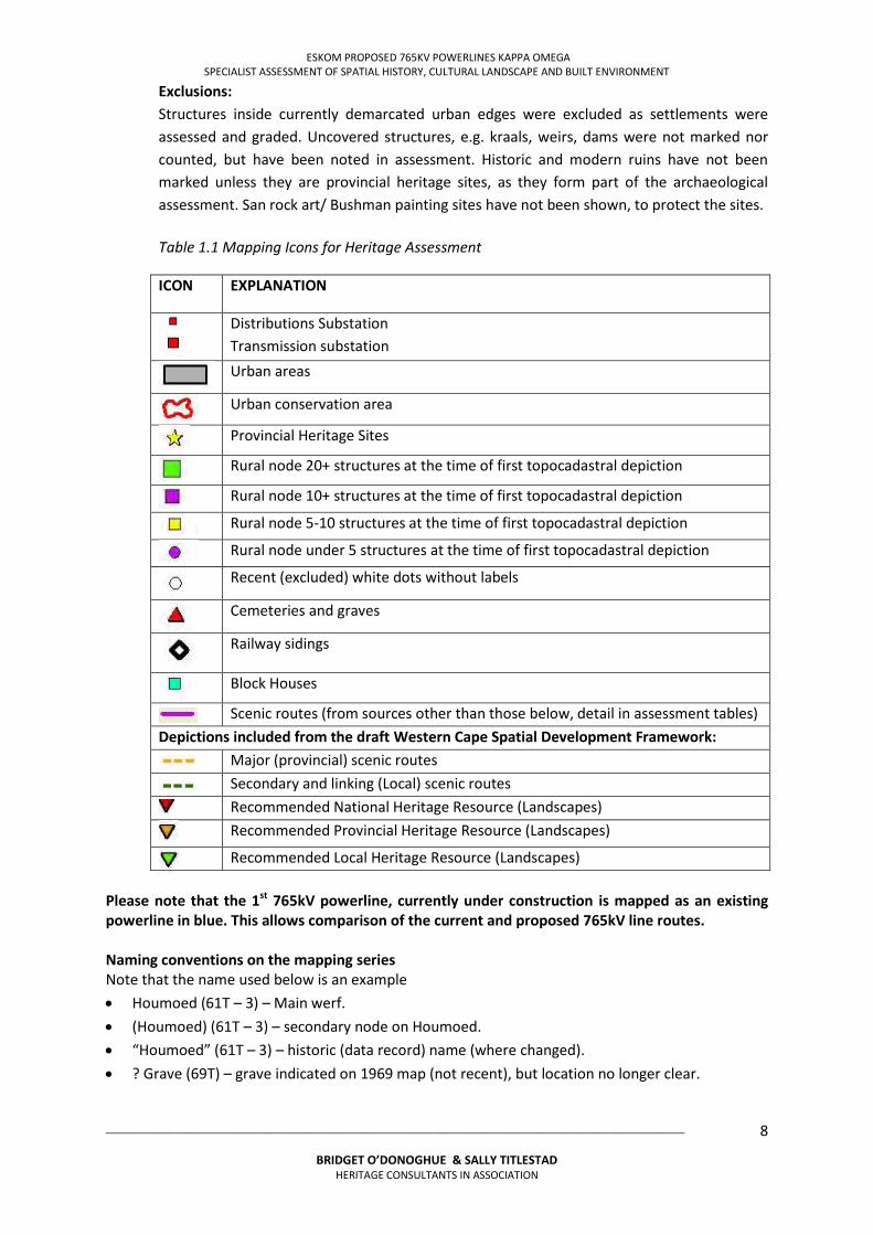
Table 1.1 Mapping Icons for Heritage Assessment
ICON EXPLANATION
Distributions Substation Transmission substation
Urban areas
Urban conservation area
Provincial Heritage Sites
Rural node 20+ structures at the time of first topocadastral depiction
Rural node 10+ structures at the time of first topocadastral depiction
Rural node 5-10 structures at the time of first topocadastral depiction
Rural node under 5 structures at the time of first topocadastral depiction
Recent (excluded) white dots without labels
Cemeteries and graves
Railway sidings
Block Houses
Scenic routes (from sources other than those below, detail in assessment tables) Depictions included from the draft Western Cape Spatial Development Framework:
Major (provincial) scenic routes
Secondary and linking (Local) scenic routes
Recommended National Heritage Resource (Landscapes)
Recommended Provincial Heritage Resource (Landscapes)
Recommended Local Heritage Resource (Landscapes) Please note that the 1st 765kV powerline, currently under construction is mapped as an existing powerline in blue. This allows comparison of the current and proposed 765kV line routes. Naming conventions on the mapping series Note that the name used below is an example
Houmoed (61T – 3) – Main werf. (Houmoed) (61T – 3) – secondary node on Houmoed. “Houmoed” (61T – 3) – historic (data record) name (where changed). ? Grave (69T) – grave indicated on 1969 map (not recent), but location no longer clear.

ESKOM PROPOSED 765KV POWERLINES KAPPA OMEGA SPECIALIST ASSESSMENT OF SPATIAL HISTORY, CULTURAL LANDSCAPE AND BUILT ENVIRONMENT
___________________________________________________________________________________________________
BRIDGET O’DONOGHUE & SALLY TITLESTAD HERITAGE CONSULTANTS IN ASSOCIATION
9
MAPPING LIMITATIONS The 1: 50 000 data record does not precisely match the 1953 search date. The record for the
area covers the period 1941 to 1987, with the bulk of records dating to the 1960’s. Urban areas and areas of dense settlement are generally covered by maps from the 1940’s, the 1950’s, the 1960’s, or a combination thereof.
Historic structure counts indicate the number of structures at a location at the time of the record only. Historic footprints have not been matched up with current ones. Existing structures may therefore not necessarily indicate historic ones.
No information is provided with regard to current sizes of nodes. Primary, secondary and unused structures are not differentiated,
Visual impacts have not been depicted in the mapping exercise as the VIA forms part of a separate study within the EIA.
The status of Provincial Heritage sites remains unclear as the undated record of the National Monuments Council has not been reviewed to date.
1.8 ASSUMPTIONS AND LIMITATIONS
1.8.1 Assumptions
The following items are assumed:
The data on the proposed project provided by Nzumbululo Heritage Solutions is accurate and up to date at the time of finalising the report.
The proposed transmission line routes identified by ESKOM are technically feasible. The technical data provided by ESKOM is accurate and sufficient for the assessment of the
proposed routes.
1.8.2 Limitations
The specialist assessments of the HIA have faced the following limitations:
All corridors were selected by ESKOM prior to the initiation of the HIA. The exact measurement of the servitude required for construction and maintenance may
vary depending on which pylons are implemented in different places. Measurements cited in this report have been provided by ESKOM and the PI team.
The assessment of cultural landscape cannot be determined in absolute terms. Meetings of the specialists have only occurred twice during the study period, resulting in
minimal cross reference of specialist inputs. Visual impact assessment and public participation are separate specialist studies and have
not been available to the built environment and cultural landscape specialists.
The specialist assessments and report have produced the following limitations:
This assessment does not consider the ancillary project infrastructure required for construction and maintenance (such as access roads, borrow pits, soil dumps, construction worker housing, etc.), nor does it take into account possible impacts of the expansion of existing substations to accommodate the new transmission lines. Expansion of the substations form separate studies. It is envisaged that ancillary infrastructure will be
ESKOM PROPOSED 765KV POWERLINES KAPPA OMEGA SPECIALIST ASSESSMENT OF SPATIAL HISTORY, CULTURAL LANDSCAPE AND BUILT ENVIRONMENT
___________________________________________________________________________________________________
BRIDGET O’DONOGHUE & SALLY TITLESTAD HERITAGE CONSULTANTS IN ASSOCIATION
10
considered once a preferred route has been selected and design and implementation of the project continue.
Applications for projects working on alternative sources of power generation have not been mapped in this assessment. This assessment is aware of a number of wind and solar energy proposals in the Western Cape, but has not assessed the need for transmission lines from those proposals.
Age of buildings older than 60 years cannot be precisely established from topocadastral maps, and are therefore estimates given the data available.
SAHRA and Heritage Western Cape have a memorandum of agreement in place regarding Grade I (National) and II (provincial) heritage sites. It is not clear at the present time which of these sites have been declared and which are ‘regarded’ as sites in the cited category but have not yet been declared.
Public participation and visual assessment has not been integrated at the level of this specialist report as it falls within the scope of work of the Principal Investigator.
Assessments of archaeological and paleontological resources (and impacts thereon) have been undertaken as separate specialist studies, and are not depicted within this report. Integration of archaeological and paleontological impacts with the spatial history, cultural landscape and built environment assessments is therefore not part of this specialist study, and will be addressed by Nazumbululo at the HIA level.
The processes and outcomes of the VIA and public participation will be integrated into the HIA by the Principal Investigator, and have not been accessible to the built environment specialists.
1.9 SPECIALIST TEAM AND DETAILS
The Built environment specialist team consists of Bridget O’Donoghue and Sally Titlestad. Bridget O’Donoghue (B Arch, UCT; M Phil (Environmental Science), (UCT) has extensive heritage experience in public organisations and the private sector. As a registered Architect and accredited Professional Heritage Practitioner, Bridget has the qualifications and the skills to conduct complex heritage impact assessments that deal with the built environmental and cultural landscape issues. During her position within the City of Cape Town, Bridget managed development in sensitive heritage and natural areas in the urban and rural landscape. She has an extremely good practicing understanding and knowledge of national, provincial, and local legislation applicable to development. As a private consultant since 2007, Bridget has completed numerous heritage assessments, audits, and surveys for public and private clients. Work for public clients has included a Heritage Impact assessment for Green Market Square, Bo Kaap Quarries, Relocation of the Cenotaph and Adderley Street IRT Bus Station, and surveys of Sculptures, Monuments, and Memorials within the CCT on public land, heritage surveys and reviews of heritage area boundaries.
Sally Titlestad (B Soc Sci (Social Work)(Hons), UCT; BA (Psych) (Hons), UWC; MPhil Arch (UCT) is a senior independent specialist spatial historian and heritage management consultant on complex projects. She has been part of the PI team for the Department of Public Works (Groote Schuur Presidential Estate) Integrated Conservation and Management Plan, has prepared and presented expert evidence to the Land Claims Court and is the Principal Heritage Consultant to the Lutheran Church in Cape Town. Sally is an accredited Professional Heritage Practitioner.
ESKOM PROPOSED 765KV POWERLINES KAPPA OMEGA SPECIALIST ASSESSMENT OF SPATIAL HISTORY, CULTURAL LANDSCAPE AND BUILT ENVIRONMENT
___________________________________________________________________________________________________
BRIDGET O’DONOGHUE & SALLY TITLESTAD HERITAGE CONSULTANTS IN ASSOCIATION
11
1.10 DECLARATION OF INDEPENDENCE
This is to confirm that Sally Titlestad and Bridget O’Donoghue are responsible for undertaking the above specialist studies and are independent and have no vested or financial interest in the proposed development on the alternative routes being either approved or rejected by the relevant authorities.
1.11 REPORT STRUCTURE
The report is divided into 8 Sections, namely: Section 1: Introduction: Presents the site description, terms of reference and report structure.
Section 2: Project Description: includes the powerline routes and infrastructure description.
Section 3: Regions and Sites Description: Includes the historical background and physical description of the sites and the context.
Section 4: Heritage Legislation and assessment criteria: outlines legislation applied in the assessment, defines cultural landscapes, identifies sensitivities, and provides Heritage Indicators for the proposed project at regional, local and at site specific scales.
Section 5: Identified heritage resources and statements of cultural significance/s: Provides a brief definition of settlements and collections of resources, identifying features of heritage significance and providing a recommended grade for settlements and landscape features of significance.
Section 6: Assessment of impacts measures the scale, permanence and degree of impact, recommending mitigation where appropriate
Section 7: Recommendations: Presents the cultural landscape and built environment recommendations for the preferred route
Section 8: Bibliography
ESKOM PROPOSED 765KV POWERLINES KAPPA OMEGA SPECIALIST ASSESSMENT OF SPATIAL HISTORY, CULTURAL LANDSCAPE AND BUILT ENVIRONMENT
___________________________________________________________________________________________________
BRIDGET O’DONOGHUE & SALLY TITLESTAD HERITAGE CONSULTANTS IN ASSOCIATION
12
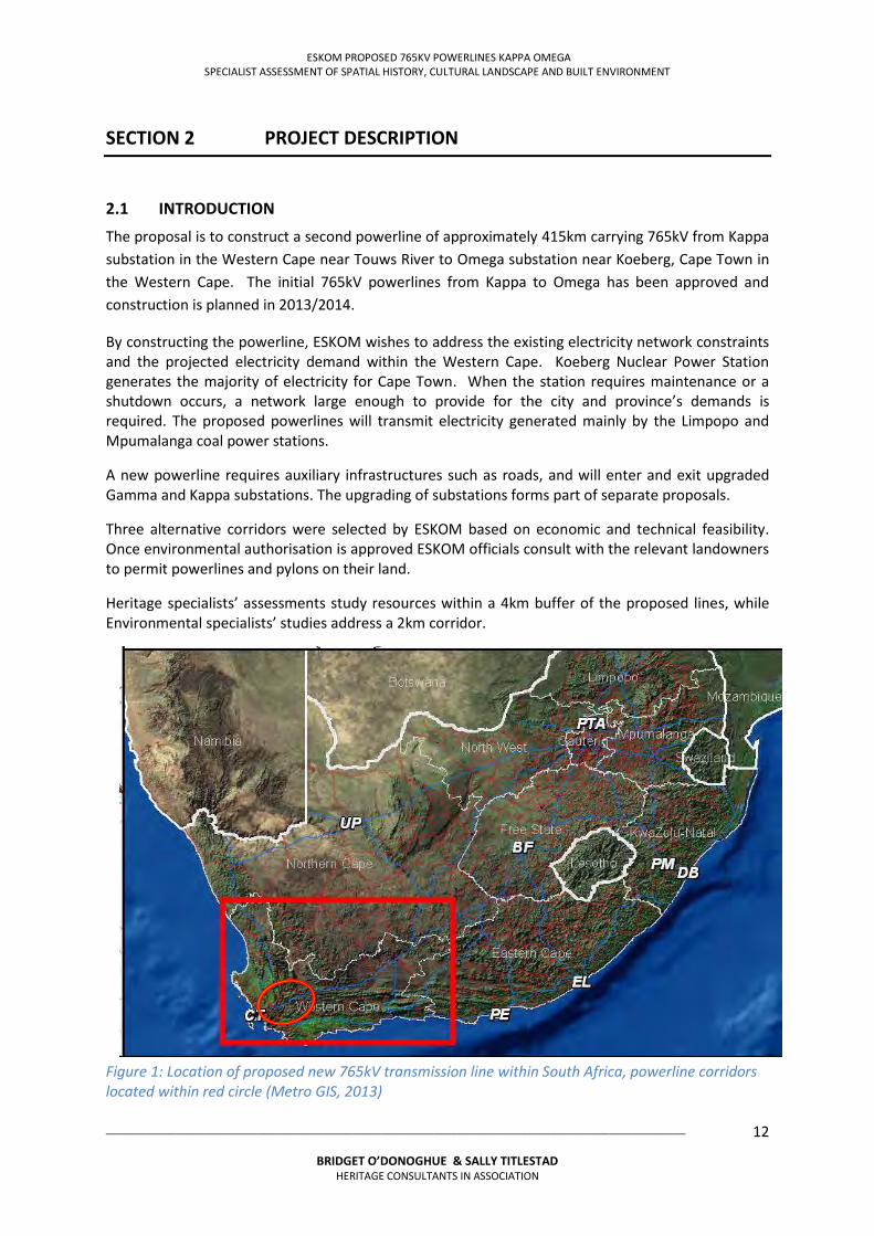
SECTION 2 PROJECT DESCRIPTION
2.1 INTRODUCTION
The proposal is to construct a second powerline of approximately 415km carrying 765kV from Kappa substation in the Western Cape near Touws River to Omega substation near Koeberg, Cape Town in the Western Cape. The initial 765kV powerlines from Kappa to Omega has been approved and construction is planned in 2013/2014.
By constructing the powerline, ESKOM wishes to address the existing electricity network constraints and the projected electricity demand within the Western Cape. Koeberg Nuclear Power Station generates the majority of electricity for Cape Town. When the station requires maintenance or a shutdown occurs, a network large enough to provide for the city and province’s demands is required. The proposed powerlines will transmit electricity generated mainly by the Limpopo and Mpumalanga coal power stations.
A new powerline requires auxiliary infrastructures such as roads, and will enter and exit upgraded Gamma and Kappa substations. The upgrading of substations forms part of separate proposals.
Three alternative corridors were selected by ESKOM based on economic and technical feasibility. Once environmental authorisation is approved ESKOM officials consult with the relevant landowners to permit powerlines and pylons on their land.
Heritage specialists’ assessments study resources within a 4km buffer of the proposed lines, while Environmental specialists’ studies address a 2km corridor.
Figure 1: Location of proposed new 765kV transmission line within South Africa, powerline corridors located within red circle (Metro GIS, 2013)
ESKOM PROPOSED 765KV POWERLINES KAPPA OMEGA SPECIALIST ASSESSMENT OF SPATIAL HISTORY, CULTURAL LANDSCAPE AND BUILT ENVIRONMENT
___________________________________________________________________________________________________
BRIDGET O’DONOGHUE & SALLY TITLESTAD HERITAGE CONSULTANTS IN ASSOCIATION
13
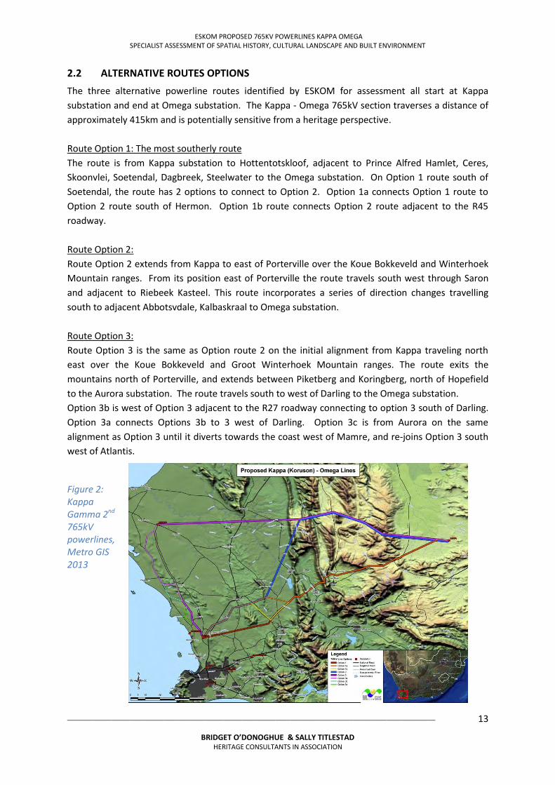
2.2 ALTERNATIVE ROUTES OPTIONS
The three alternative powerline routes identified by ESKOM for assessment all start at Kappa substation and end at Omega substation. The Kappa - Omega 765kV section traverses a distance of approximately 415km and is potentially sensitive from a heritage perspective. Route Option 1: The most southerly route The route is from Kappa substation to Hottentotskloof, adjacent to Prince Alfred Hamlet, Ceres, Skoonvlei, Soetendal, Dagbreek, Steelwater to the Omega substation. On Option 1 route south of Soetendal, the route has 2 options to connect to Option 2. Option 1a connects Option 1 route to Option 2 route south of Hermon. Option 1b route connects Option 2 route adjacent to the R45 roadway. Route Option 2: Route Option 2 extends from Kappa to east of Porterville over the Koue Bokkeveld and Winterhoek Mountain ranges. From its position east of Porterville the route travels south west through Saron and adjacent to Riebeek Kasteel. This route incorporates a series of direction changes travelling south to adjacent Abbotsvdale, Kalbaskraal to Omega substation. Route Option 3: Route Option 3 is the same as Option route 2 on the initial alignment from Kappa traveling north east over the Koue Bokkeveld and Groot Winterhoek Mountain ranges. The route exits the mountains north of Porterville, and extends between Piketberg and Koringberg, north of Hopefield to the Aurora substation. The route travels south to west of Darling to the Omega substation. Option 3b is west of Option 3 adjacent to the R27 roadway connecting to option 3 south of Darling. Option 3a connects Options 3b to 3 west of Darling. Option 3c is from Aurora on the same alignment as Option 3 until it diverts towards the coast west of Mamre, and re-joins Option 3 south west of Atlantis.
Figure 2: Kappa Gamma 2nd 765kV powerlines, Metro GIS 2013
ESKOM PROPOSED 765KV POWERLINES KAPPA OMEGA SPECIALIST ASSESSMENT OF SPATIAL HISTORY, CULTURAL LANDSCAPE AND BUILT ENVIRONMENT
___________________________________________________________________________________________________
BRIDGET O’DONOGHUE & SALLY TITLESTAD HERITAGE CONSULTANTS IN ASSOCIATION
14
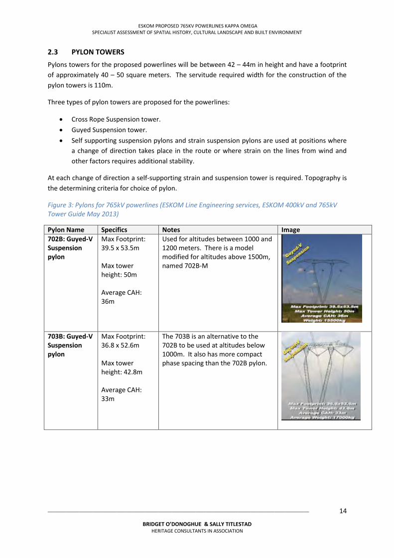
2.3 PYLON TOWERS
Pylons towers for the proposed powerlines will be between 42 – 44m in height and have a footprint of approximately 40 – 50 square meters. The servitude required width for the construction of the pylon towers is 110m.
Three types of pylon towers are proposed for the powerlines:
Cross Rope Suspension tower. Guyed Suspension tower. Self supporting suspension pylons and strain suspension pylons are used at positions where
a change of direction takes place in the route or where strain on the lines from wind and other factors requires additional stability.
At each change of direction a self-supporting strain and suspension tower is required. Topography is the determining criteria for choice of pylon.
Figure 3: Pylons for 765kV powerlines (ESKOM Line Engineering services, ESKOM 400kV and 765kV Tower Guide May 2013)
Pylon Name Specifics Notes Image 702B: Guyed-V Suspension pylon
Max Footprint: 39.5 x 53.5m Max tower height: 50m Average CAH: 36m
Used for altitudes between 1000 and 1200 meters. There is a model modified for altitudes above 1500m, named 702B-M
703B: Guyed-V Suspension pylon
Max Footprint: 36.8 x 52.6m Max tower height: 42.8m Average CAH: 33m
The 703B is an alternative to the 702B to be used at altitudes below 1000m. It also has more compact phase spacing than the 702B pylon.
ESKOM PROPOSED 765KV POWERLINES KAPPA OMEGA SPECIALIST ASSESSMENT OF SPATIAL HISTORY, CULTURAL LANDSCAPE AND BUILT ENVIRONMENT
___________________________________________________________________________________________________
BRIDGET O’DONOGHUE & SALLY TITLESTAD HERITAGE CONSULTANTS IN ASSOCIATION
15
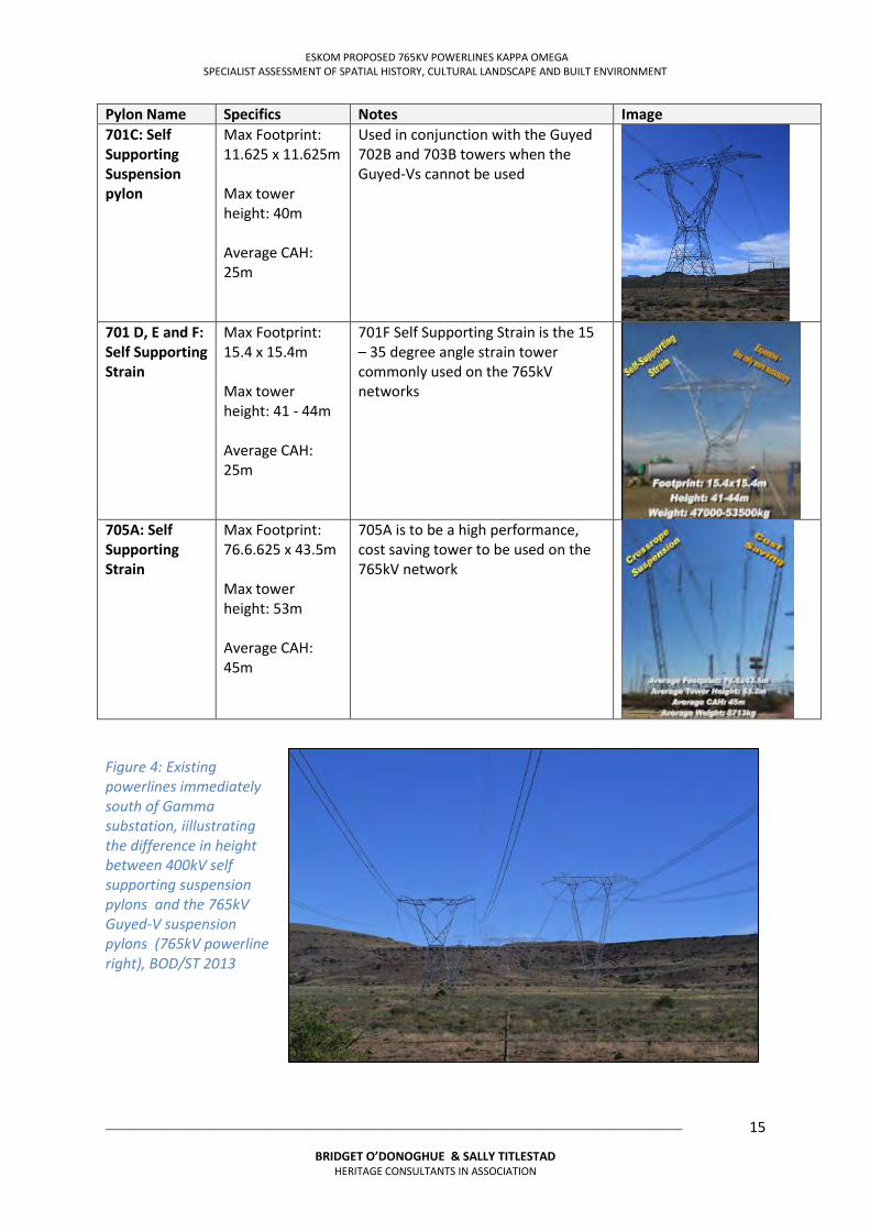
Pylon Name Specifics Notes Image 701C: Self Supporting Suspension pylon
Max Footprint: 11.625 x 11.625m Max tower height: 40m Average CAH: 25m
Used in conjunction with the Guyed 702B and 703B towers when the Guyed-Vs cannot be used
701 D, E and F: Self Supporting Strain
Max Footprint: 15.4 x 15.4m Max tower height: 41 - 44m Average CAH: 25m
701F Self Supporting Strain is the 15 – 35 degree angle strain tower commonly used on the 765kV networks
705A: Self Supporting Strain
Max Footprint: 76.6.625 x 43.5m Max tower height: 53m Average CAH: 45m
705A is to be a high performance, cost saving tower to be used on the 765kV network
Figure 4: Existing powerlines immediately south of Gamma substation, iillustrating the difference in height between 400kV self supporting suspension pylons and the 765kV Guyed-V suspension pylons (765kV powerline right), BOD/ST 2013
ESKOM PROPOSED 765KV POWERLINES KAPPA OMEGA SPECIALIST ASSESSMENT OF SPATIAL HISTORY, CULTURAL LANDSCAPE AND BUILT ENVIRONMENT
___________________________________________________________________________________________________
BRIDGET O’DONOGHUE & SALLY TITLESTAD HERITAGE CONSULTANTS IN ASSOCIATION
16
SECTION 3 REGION AND SITES DESCRIPTION
3.1 INTRODUCTION
The 3 alternative routes transverse regions with a few cultural landscapes, historic settlements and built environment structures. Scenic routes are located along the route, and parts of all three alternatives are scenic and have iconic characteristics.
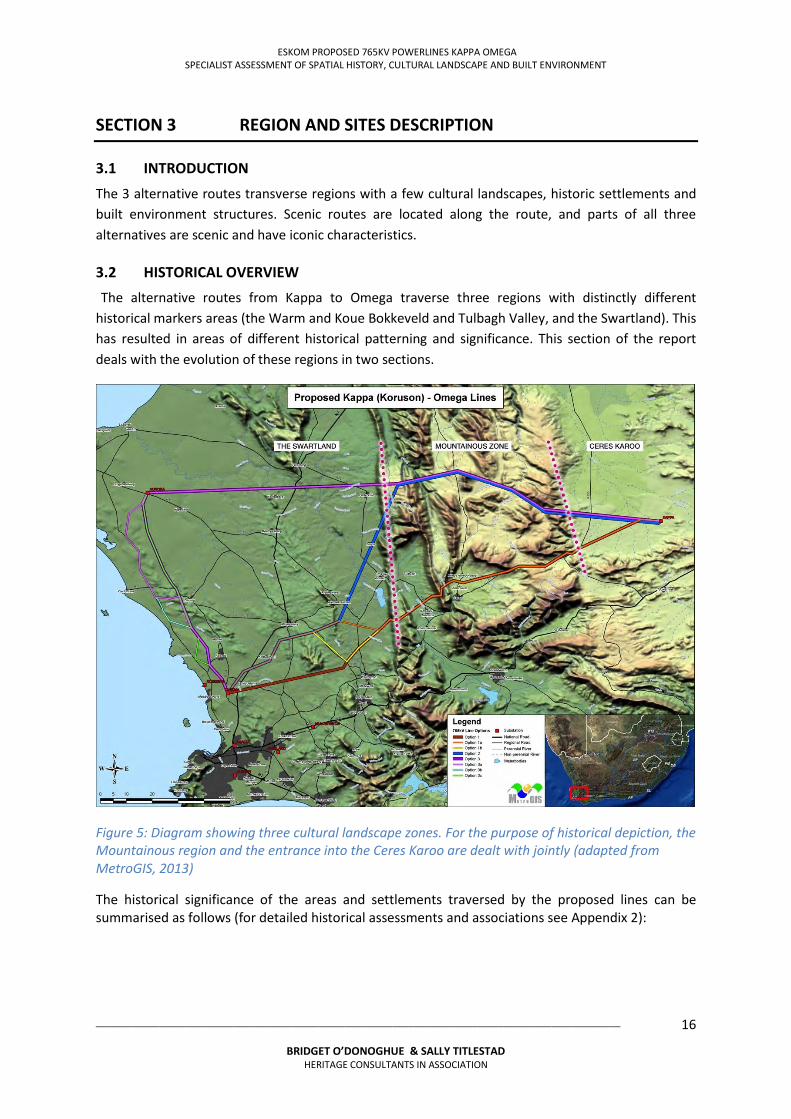
3.2 HISTORICAL OVERVIEW
The alternative routes from Kappa to Omega traverse three regions with distinctly different historical markers areas (the Warm and Koue Bokkeveld and Tulbagh Valley, and the Swartland). This has resulted in areas of different historical patterning and significance. This section of the report deals with the evolution of these regions in two sections.
Figure 5: Diagram showing three cultural landscape zones. For the purpose of historical depiction, the Mountainous region and the entrance into the Ceres Karoo are dealt with jointly (adapted from MetroGIS, 2013)
The historical significance of the areas and settlements traversed by the proposed lines can be summarised as follows (for detailed historical assessments and associations see Appendix 2):
ESKOM PROPOSED 765KV POWERLINES KAPPA OMEGA SPECIALIST ASSESSMENT OF SPATIAL HISTORY, CULTURAL LANDSCAPE AND BUILT ENVIRONMENT
___________________________________________________________________________________________________
BRIDGET O’DONOGHUE & SALLY TITLESTAD HERITAGE CONSULTANTS IN ASSOCIATION
17
3.2.1 The Bokkeveld and Tulbagh Valley3
Pre Colonial Settlement, the area served as a hunting area for the San, and later as seasonal grazing grounds for the Khoekoen populations that migrated south and entered the Western Cape region. A number of rock art sites in the region depict early rock art, but also show contact period depictions. Farm and place name along the routes are associated with the use of this region by Khoe and San inhabitants;
During the Dutch Colonial period, this area was first permanently settled as part of the ‘loan farm’ system of land occupation and cadastral control. Several early mountain passes existed between the Swartland and the Tulbagh Valley, originally named “Roodezand”. The first of these was created by the need of the colonists to locate the indigenous people in order to approach them for the purchase of livestock. Recorded expeditions into this area took place as early as 1658. These routes quickly became formalised and the VOC formalised an access route to the Valley. This route and its toll house have been recently located. In 1699 the valley was opened to farming and thereafter became known as the ‘Land van Waveren’. Two ‘buiteposte’ were established to monitor movement of the Khoesan and tighten border controls;
Resistance to the VOC and settler occupation began almost immediately, and the area was characterised by rising stock theft and an increase in military patrols and commandos. By 1740 the KhoeSan had been subdued or driven out of the area. A Church was established in 1743, which became the centre of a new town, Tulbagh. A road linking Waveren and the warm Bokkeveld was established in 1765 and the Karroopoort outspan provided a stopping place en route to and from the hinterland;
The town of Tulbagh was laid out in the late 18th century, and contains 100 provincial heritage sites (PHS). The establishment of towns and agricultural production in surrounding valleys was facilitated by mid to late 19th century road building traditions of using convict labour to establish significant roads and mountain passes, e.g. the Michells’, Theronsberg, Tulbagh and Karoopoort road and passes were developed within this system. The linked valleys (Tulbagh, Ceres) continued to expand incorporating Prince Alfred Hamlet and Wolseley. The region remains characterised by productive agricultural farmland, largely related to the production and processing of deciduous fruit. Rail links to the region allowed easier fruit transportation and later export, and served as a rail link to the expanding diamond fields and later gold reefs;
During the South African war, blockhouses were established at bridges on this important rail link. During the First World War the introduction of refrigeration facilitated intensification of fruit production and transportation;
From 1948 the introduction of a battery of apartheid legislation entrenched already existing segregation policies and created separate township communities on the outskirts of existing settlements;
Capital investments on farms, the widespread use of mechanisation, the entrenchment of selective access to land based opportunity and the government subsidisation of farming development have solidified the historical Warm Bokkeveld and Tulbagh valley region as a central producer of fruit, fruit products and wine.
3 Refer Appendix 2 for detailed histroical outline
ESKOM PROPOSED 765KV POWERLINES KAPPA OMEGA SPECIALIST ASSESSMENT OF SPATIAL HISTORY, CULTURAL LANDSCAPE AND BUILT ENVIRONMENT
___________________________________________________________________________________________________
BRIDGET O’DONOGHUE & SALLY TITLESTAD HERITAGE CONSULTANTS IN ASSOCIATION
18
3.2.2 The Swartland4
Pre Colonial Settlement, the area served as a hunting area for the San. The numerous and widespread rock art sites in surrounding shelters of the mountain ranges attest to regular use of the area by the San. Khoekhoen sites of pastoral activity are not easily found in the region, perhaps because of the almost uniform agricultural cultivation of low-lying lands;
Following Dutch East India Company (VOC) settlement at the Cape and expansion of the settlement frontier, the region quickly became a site of conflict between indigenous people and trekboers. In the mid to late 1600s cattle and sheep acquired from the Khoekhoen in Namaqualand and the Roodezand area were driven to Cape Town by the meat pachters (butchers). The area used for driving livestock later became a farm called ‘deurgang’, stretching from Salt River to the east of Riebeek Kasteel;
Trekboers and settlers with licences to sell meat later used loan farms in the area to graze livestock, establishing homesteads in a few well watered areas. The VOC also established four outposts in the area to monitor and control movement of indigenous people across the area, v.i.z. Groene Kloof, Riebeek Kasteel, Sonquas drift and Vogel Vallei. Some remaining Khoe chiefs grazed their cattle close to the outpostsfor protection from the KhoeSan who raided their stock in retaliation for the loss of land. The role of the outposts changed as trade became more open and interaction with the settlers began a process of absorption of Khoe, and they later became farms and villages;
The region was established as an agricultural area in fairly close proximity to Cape Town, and by the early 18th century farmers were settling and creating homesteads in the region. From 1714 crops were allowed to be produced and the farming of wine, wheat, oats and barley became increasingly common. The agricultural expansion across the region was fairly swift. By 1740 the KhoeSan had been subdued or driven out of the region, and its expansion as a region of agricultural production had been established;
In the mid 18th century, two Churches were established, and the growth of settlements around these Churches began;
Along the coastal plain, small fishing villages were established and trade with passing ships continued;
In the early 19th century a mission settlement was established at Groenkloof (later called Mamre), which later expanded to include Louwplaas and a Khoekhoe reserve. The settlement included agricultural allotments on either side of the Louwskloof river;
Difficulty in labour and power relations was illustrated by a rebellion of 340 slaves in the early 19th century. The rebellion was quelled and five of the ring leaders executed. Introduction of the Caledon code (1809) revised labour relations by requiring contracts between owners and labourers, but also introduced the first ‘pass laws’ in the region. This entrenched the power and authority of farmers;
Under British rule, revision of the cadastral system (1813) facilitated the need to keep farms profitable. This caused the expansion of some farms and the withdrawal of some farmers to the northern border lands. The introduction and increase in demand for wool led to widespread production of sheep, which was accompanied by more intense production of
4 Refer Appendix 2 for detailed historical timelines
ESKOM PROPOSED 765KV POWERLINES KAPPA OMEGA SPECIALIST ASSESSMENT OF SPATIAL HISTORY, CULTURAL LANDSCAPE AND BUILT ENVIRONMENT
___________________________________________________________________________________________________
BRIDGET O’DONOGHUE & SALLY TITLESTAD HERITAGE CONSULTANTS IN ASSOCIATION
19
wheat. The region became characterised by fine grained but intensive agricultural production;
The development of towns began in the 1820s with the layout of Malmesbury and later, Wellington;
The emancipation of slaves in 1834, with a four period of apprenticeship, was paralleled by the expansion of Mamre and the establishment of a second mission station (Saron) in 1846. These communities provided labour to neighbouring farms as well as providing labourers with a semblance of independence from farmers. The reduction in permanent work force that accompanied emancipation soon led to the use of seasonal labour on farms, and the mission stations were a reliable source of seasonal labour;
Church towns began to develop across the region, and examples of these are Darling (1853), Riebeek West (1855), Philadelphia (1858), and Porterville (1863);
The introduction of a rail link to Malmesbury in 1877 and its later extension to Porterville (1905), with a small gauge line between Kalbaskraal and Darling, facilitated the growth of small settlements at rail junctions as well as allowing the expansion and intensification of agricultural production by making the transportation of goods easier. Block houses were built along these lines to protect bridges during the South African War (the Anglo-Boer War). Some commando action during the war was experienced at Darling and at Kalbaskraal;
The introduction, in 1889 of the use of convict labour on farms was expanded in the 1930s and from 1947 prison farms were created, at least one of which lies against the foothills North of Saron;
From 1948 the introduction of a battery of apartheid legislation entrenched already existing segregation policies and created separate township communities on the outskirts of existing settlements;
Capital investments on farms, the widespread use of mechanisation, the entrenchment of selective access to land based opportunity and the government subsidisation of farming development have solidified the historical Swartland region as a central producer of wheat and wine in the Western Cape;
Post 1994, housing has been expanded and some communities have actively addressed the challenges of democratisation. The expansion of housing settlements and the introduction of farm workers rights have recently renewed tensions that have historically been markers of the use of the area for agricultural production.
3.3 CULTURAL LANDSCAPE
3.3.1 The Term ‘Cultural Landscape’
Cultural landscapes provide the meaningful context for a range of heritage resources that take a variety of forms and constitute heritage resources in their own right. Following the well-established guidelines set by the first 765kV linear assessments, the following cultural landscape understandings and assessment criteria have been utilised5:
5 Baumann and Winter, 2009:14-16
ESKOM PROPOSED 765KV POWERLINES KAPPA OMEGA SPECIALIST ASSESSMENT OF SPATIAL HISTORY, CULTURAL LANDSCAPE AND BUILT ENVIRONMENT
___________________________________________________________________________________________________
BRIDGET O’DONOGHUE & SALLY TITLESTAD HERITAGE CONSULTANTS IN ASSOCIATION
20
“It could be regarded as the tapestry within which all other heritage resources are embedded and which gives them their sense of place and meaning. The concept of cultural landscape gives spatial and temporal expression to the processes and products of interaction of people with the environment. It may thus be conceived of as a particular configuration of topography, vegetation cover, land use and settlement pattern that establishes some coherence of natural and cultural processes”6.
UNESCO identifies three broad categories of cultural landscape7
Designed landscapes are clearly defined and created intentionally by people. These include gardens and parklands, most commonly constructed for aesthetic purposes;
Organically evolved landscapes result from an initial social, economic, administrative and/or religious imperative and develop their form by a combination of these and in response to the natural environment. These landscapes reflect evolutionary processes in their form and in component features. They can be divided into relic landscapes (no longer used) and continuing landscapes, where the organic nature of their form continues to evolve through active contemporary use including the traditional associations;
Associated cultural landscapes are those that have powerful religious, artistic or cultural associations that may not be evidenced in historical fabric;
Natural Landscapes: Distinctive vivid landscapes have qualities that set them apart from their surroundings, a dramatic visual quality which is legible and easily understood. These landscapes do not necessarily appear to have been subject to human intervention;
Representative landscapes are particularly representative of the region of which they form a part; they reveal a combination of characteristics and qualities that may be regarded as reflecting the quintessential character of the region;
In order for landscapes to have significance they should be intact and authentic and relatively undisturbed by visual intrusions.
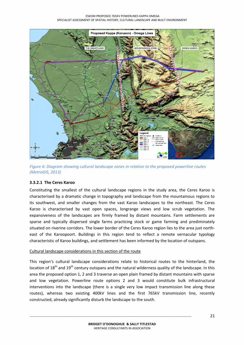
3.3.2 Cultural Landscapes Occurring along Powerline Route Alternatives
Characterisation of landscapes is a fluid and dynamic process. There are no hard edges to the types of landscapes encountered along the route options. The transitions between landscape typologies are zones where there is a blending of typology, but sections of the routes have fairly distinctive general characteristics, differentiated in part by changing morphology. The proposed powerlines corridors traverse three morphological zones: Ceres Karoo, Mountainous region and the Swartland.
In the Scoping Phase, cultural landscapes were differentiated and assessed at sub-regional scale. Scoping Phase recommended the exclusion of the northern parts of route options 2 and 3, leaving route option 1 and the southern part of route option 2 below the Kasteelberg as the preferred routes for detailed assessment (Refer Section 6). The descriptions below provide cultural landscape typologies and an overview of considerations, with detail for the assessment phase of the study.
6 Baumann and Winter, 2009:14 7 adapted from Baumann and Winter, 2009
ESKOM PROPOSED 765KV POWERLINES KAPPA OMEGA SPECIALIST ASSESSMENT OF SPATIAL HISTORY, CULTURAL LANDSCAPE AND BUILT ENVIRONMENT
___________________________________________________________________________________________________
BRIDGET O’DONOGHUE & SALLY TITLESTAD HERITAGE CONSULTANTS IN ASSOCIATION
21
Figure 6: Diagram showing cultural landscape zones in relation to the proposed powerline routes (MetroGIS, 2013)
3.3.2.1 The Ceres Karoo
Constituting the smallest of the cultural landscape regions in the study area, the Ceres Karoo is characterised by a dramatic change in topography and landscape from the mountainous regions to its southwest, and smaller changes from the vast Karoo landscapes to the northeast. The Ceres Karoo is characterised by vast open spaces, longrange views and low scrub vegetation. The expansiveness of the landscapes are firmly framed by distant mountains. Farm settlements are sparse and typically dispersed single farms practicing stock or game farming and prediminately situated on riverine corridors. The lower border of the Ceres Karoo region lies to the area just north-east of the Karoopoort. Buildings in this region tend to reflect a remote vernacular typology characteristic of Karoo buildings, and settlement has been informed by the location of outspans.
Cultural landscape considerations in this section of the route
This region’s cultural landscape considerations relate to historical routes to the hinterland, the location of 18th and 19th century outspans and the natural wilderness quality of the landscape. In this area the proposed option 1, 2 and 3 traverse an open plain framed by distant mountains with sparse and low vegetation. Powerline route options 2 and 3 would constitute bulk infrastructural interventions into the landscape (there is a single very low impact transmission line along these routes), whereas two existing 400kV lines and the first 765kV transmission line, recently constructed, already significantly disturb the landscape to the south.
ESKOM PROPOSED 765KV POWERLINES KAPPA OMEGA SPECIALIST ASSESSMENT OF SPATIAL HISTORY, CULTURAL LANDSCAPE AND BUILT ENVIRONMENT
___________________________________________________________________________________________________
BRIDGET O’DONOGHUE & SALLY TITLESTAD HERITAGE CONSULTANTS IN ASSOCIATION
22
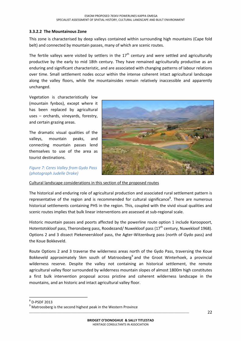
3.3.2.2 The Mountainous Zone
This zone is characterised by deep valleys contained within surrounding high mountains (Cape fold belt) and connected by mountain passes, many of which are scenic routes.
The fertile valleys were visited by settlers in the 17th century and were settled and agriculturally productive by the early to mid 18th century. They have remained agriculturally productive as an enduring and significant characteristic, and are associated with changing patterns of labour relations over time. Small settlement nodes occur within the intense coherent intact agricultural landscape along the valley floors, while the mountainsides remain relatively inaccessible and apparently unchanged.
Vegetation is characteristically low (mountain fynbos), except where it has been replaced by agricultural uses – orchards, vineyards, forestry, and certain grazing areas.
The dramatic visual qualities of the valleys, mountain peaks, and connecting mountain passes lend themselves to use of the area as tourist destinations.
Figure 7: Ceres Valley from Gydo Pass (photograph Judelle Drake)
Cultural landscape considerations in this section of the proposed routes
The historical and enduring role of agricultural production and associated rural settlement pattern is representative of the region and is recommended for cultural significance8. There are numerous historical settlements containing PHS in the region. This, coupled with the vivid visual qualities and scenic routes implies that bulk linear interventions are assessed at sub-regional scale.
Historic mountain passes and poorts affected by the powerline route option 1 include Karoopoort, Hotentotskloof pass, Theronsberg pass, Roodezand/ Nuwekloof pass (17th century, Nuwekloof 1968). Options 2 and 3 dissect Piekeneerskloof pass, the Agter-Witzenburg pass (north of Gydo pass) and the Koue Bokkeveld.
Route Options 2 and 3 traverse the wilderness areas north of the Gydo Pass, traversing the Koue Bokkeveld approximately 5km south of Matroosberg9 and the Groot Winterhoek, a provincial wilderness reserve. Despite the valley not containing an historical settlement, the remote agricultural valley floor surrounded by wilderness mountain slopes of almost 1800m high constitutes a first bulk intervention proposal across pristine and coherent wilderness landscape in the mountains, and an historic and intact agricultural valley floor.
8 D-PSDF 2013 9 Matroosberg is the second highest peak in the Western Province
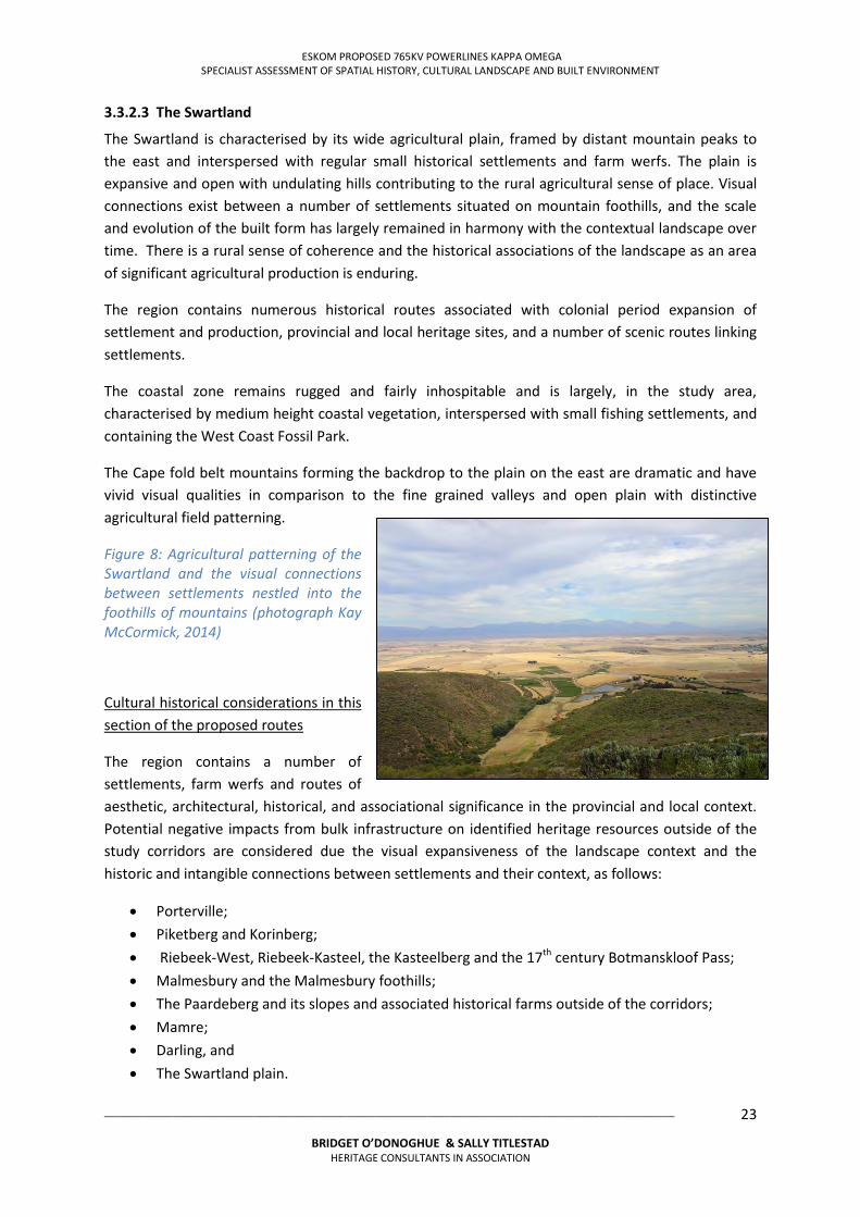
ESKOM PROPOSED 765KV POWERLINES KAPPA OMEGA SPECIALIST ASSESSMENT OF SPATIAL HISTORY, CULTURAL LANDSCAPE AND BUILT ENVIRONMENT
___________________________________________________________________________________________________
BRIDGET O’DONOGHUE & SALLY TITLESTAD HERITAGE CONSULTANTS IN ASSOCIATION
23
3.3.2.3 The Swartland
The Swartland is characterised by its wide agricultural plain, framed by distant mountain peaks to the east and interspersed with regular small historical settlements and farm werfs. The plain is expansive and open with undulating hills contributing to the rural agricultural sense of place. Visual connections exist between a number of settlements situated on mountain foothills, and the scale and evolution of the built form has largely remained in harmony with the contextual landscape over time. There is a rural sense of coherence and the historical associations of the landscape as an area of significant agricultural production is enduring.
The region contains numerous historical routes associated with colonial period expansion of settlement and production, provincial and local heritage sites, and a number of scenic routes linking settlements.
The coastal zone remains rugged and fairly inhospitable and is largely, in the study area, characterised by medium height coastal vegetation, interspersed with small fishing settlements, and containing the West Coast Fossil Park.
The Cape fold belt mountains forming the backdrop to the plain on the east are dramatic and have vivid visual qualities in comparison to the fine grained valleys and open plain with distinctive agricultural field patterning.
Figure 8: Agricultural patterning of the Swartland and the visual connections between settlements nestled into the foothills of mountains (photograph Kay McCormick, 2014)
Cultural historical considerations in this section of the proposed routes
The region contains a number of settlements, farm werfs and routes of aesthetic, architectural, historical, and associational significance in the provincial and local context. Potential negative impacts from bulk infrastructure on identified heritage resources outside of the study corridors are considered due the visual expansiveness of the landscape context and the historic and intangible connections between settlements and their context, as follows:
Porterville; Piketberg and Korinberg; Riebeek-West, Riebeek-Kasteel, the Kasteelberg and the 17th century Botmanskloof Pass; Malmesbury and the Malmesbury foothills; The Paardeberg and its slopes and associated historical farms outside of the corridors; Mamre; Darling, and The Swartland plain.
ESKOM PROPOSED 765KV POWERLINES KAPPA OMEGA SPECIALIST ASSESSMENT OF SPATIAL HISTORY, CULTURAL LANDSCAPE AND BUILT ENVIRONMENT
___________________________________________________________________________________________________
BRIDGET O’DONOGHUE & SALLY TITLESTAD HERITAGE CONSULTANTS IN ASSOCIATION
24
The detailed impact assessment phase has concentrated on the natural and cultural landscapes within the study corridor of Option 1, 1a and 1b and Route option 2 in the area between the southeast of the Kasteelberg and Omega substation.
Summary:
The majority of landscapes in the assessed area between Kappa and Omega fall within the range of organically evolved landscapes. The following sub-categories for these landscapes are used to further depict the heritage resources potentially affected by the lines10:
Historical townscape; Historical farm werf; Scenic landscapes; Productive agricultural landscapes, which occur in valleys and on open plains within the
study corridors; Organically developed low density productive agricultural landscapes; Remote arid landscapes; Relic landscapes; Pristine natural landscapes or Wilderness mountainscapes.
10 Adapted from Baumann and Winter, 2009:15
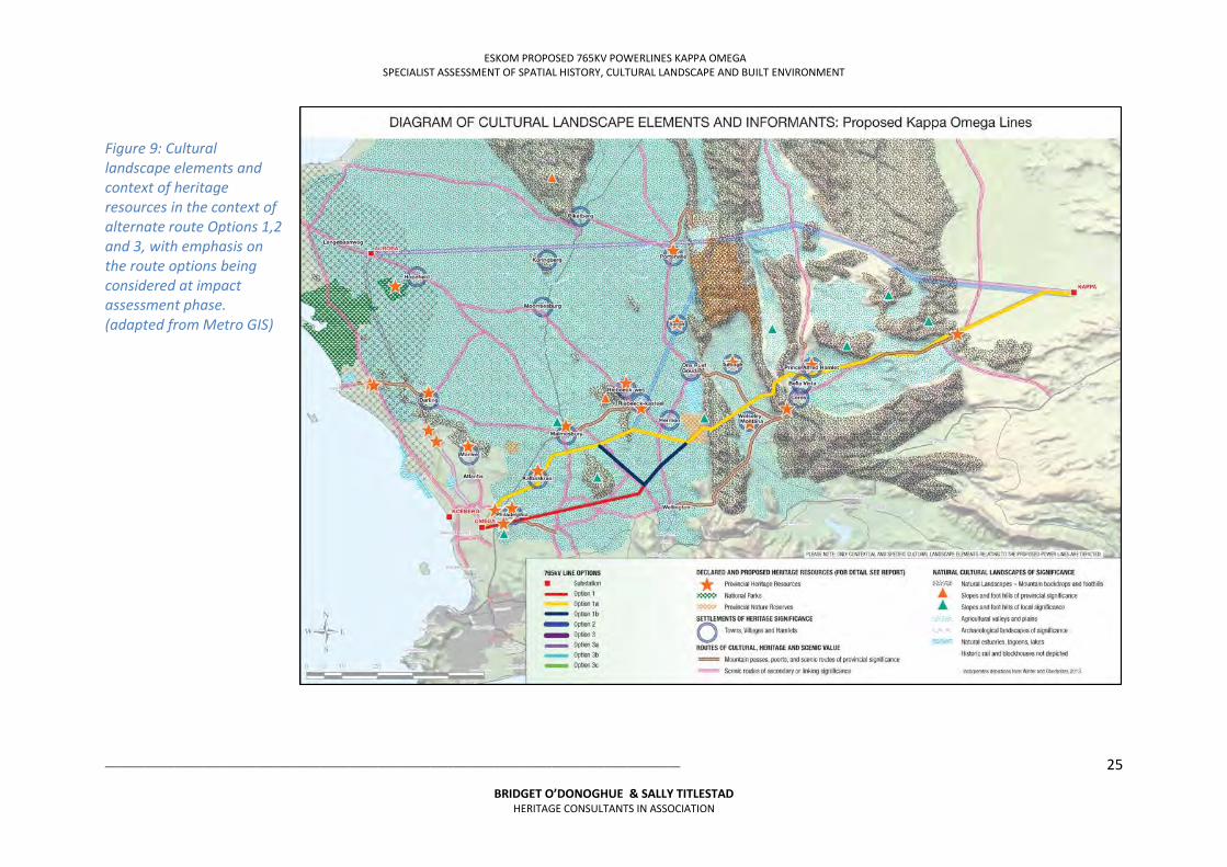
ESKOM PROPOSED 765KV POWERLINES KAPPA OMEGA SPECIALIST ASSESSMENT OF SPATIAL HISTORY, CULTURAL LANDSCAPE AND BUILT ENVIRONMENT
___________________________________________________________________________________________________
BRIDGET O’DONOGHUE & SALLY TITLESTAD HERITAGE CONSULTANTS IN ASSOCIATION
25
Figure 9: Cultural landscape elements and context of heritage resources in the context of alternate route Options 1,2 and 3, with emphasis on the route options being considered at impact assessment phase. (adapted from Metro GIS)
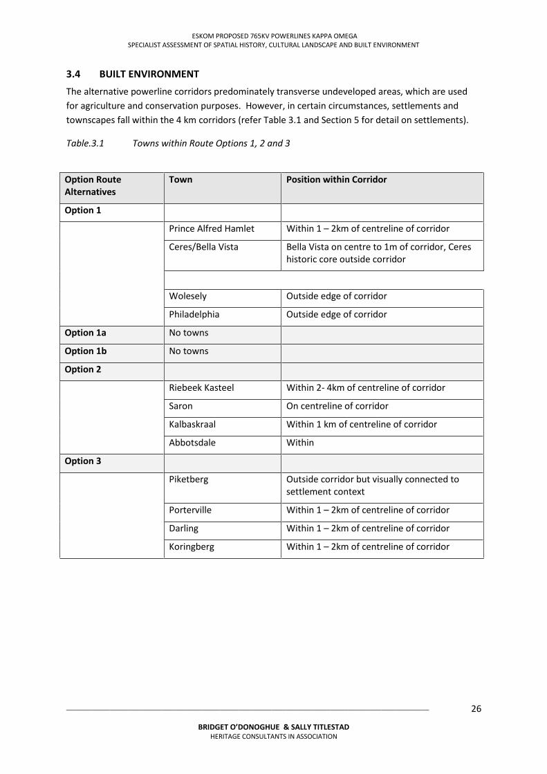
ESKOM PROPOSED 765KV POWERLINES KAPPA OMEGA SPECIALIST ASSESSMENT OF SPATIAL HISTORY, CULTURAL LANDSCAPE AND BUILT ENVIRONMENT
___________________________________________________________________________________________________
BRIDGET O’DONOGHUE & SALLY TITLESTAD HERITAGE CONSULTANTS IN ASSOCIATION
26
3.4 BUILT ENVIRONMENT
The alternative powerline corridors predominately transverse undeveloped areas, which are used for agriculture and conservation purposes. However, in certain circumstances, settlements and townscapes fall within the 4 km corridors (refer Table 3.1 and Section 5 for detail on settlements).
Table.3.1 Towns within Route Options 1, 2 and 3
Option Route Alternatives
Town Position within Corridor
Option 1
Prince Alfred Hamlet Within 1 – 2km of centreline of corridor
Ceres/Bella Vista Bella Vista on centre to 1m of corridor, Ceres historic core outside corridor
Wolesely Outside edge of corridor
Philadelphia Outside edge of corridor
Option 1a No towns
Option 1b No towns
Option 2
Riebeek Kasteel Within 2- 4km of centreline of corridor
Saron On centreline of corridor
Kalbaskraal Within 1 km of centreline of corridor
Abbotsdale Within
Option 3
Piketberg Outside corridor but visually connected to settlement context
Porterville Within 1 – 2km of centreline of corridor
Darling Within 1 – 2km of centreline of corridor
Koringberg Within 1 – 2km of centreline of corridor
ESKOM PROPOSED 765KV POWERLINES KAPPA OMEGA SPECIALIST ASSESSMENT OF SPATIAL HISTORY, CULTURAL LANDSCAPE AND BUILT ENVIRONMENT
___________________________________________________________________________________________________
BRIDGET O’DONOGHUE & SALLY TITLESTAD HERITAGE CONSULTANTS IN ASSOCIATION
27
SECTION 4 HERITAGE LEGISLATION & ASSESSMENT CRITERIA
4.1 INTRODUCTION
Section 4 provides an overview of the administration context of the sites and the applicable statutory framework. The historical development for the settlement is provided in addition to descriptions of the individual sites and their context, current structures, landscape features and land uses.
4.2 ADMINISTRATIVE CONTEXT AND STATUTORY FRAMEWORK
4.2.1 Overview
The corridors are located within multiple districts including Cape Winelands District Municipality, West Coast District Municipality and the Cape Metropolitan Area (City of Cape Town). Municipal areas traversed include Cape Winelands with Breede River, Witzenebrg Drakenstein, West Coast District Municipality with Swartland, Saldahna Bay and Berg River municipalities and the City of Cape Town as the Metro.
For the purposes of this study, the following relevant South African and city policy and planning documents were reviewed:
National Heritage Resources Act No. 25 of 1999 (NHR Act); Municipal Zoning Policies, Frameworks and Regulations; Municipal planning strategy and reports;
4.2.2 National Heritage Resources Act No. 25 of 1999 (NHRA)
The NHR Act serves as the controlling legal framework for heritage conservation in South Africa. The Act lays down general principles for governing heritage resources management throughout the republic and provides for the identification, assessment and management of the heritage resources of the country. The Act only applied to “those heritage resources of South Africa, which are of cultural significance or other special value for the community and for future generations”. A heritage resource is described as “any place or object of cultural significance” (NHR Act, Section 26 [xvi]). Heritage resources significant enough to be considered part of the national ‘estate’, may include inter alia (Section 3[2]):
o Places, buildings, structures and equipment of cultural significance; o Places to which oral traditions are attached or which are associated with living heritage; o Historical settlements and townscapes; o Landscapes and natural features of cultural significance; o Geological sites of scientific or cultural importance; o Archaeological sites and objects; o Graves and burial grounds; o Sites of significance relating to the history of slavery in South Africa; o Moveable objects including military objects, fine art, books records, documents,
archaeological and paleontological objects and materials.
ESKOM PROPOSED 765KV POWERLINES KAPPA OMEGA SPECIALIST ASSESSMENT OF SPATIAL HISTORY, CULTURAL LANDSCAPE AND BUILT ENVIRONMENT
___________________________________________________________________________________________________
BRIDGET O’DONOGHUE & SALLY TITLESTAD HERITAGE CONSULTANTS IN ASSOCIATION
28
Cultural heritage significance means aesthetic, historical, scientific, architectural, scientific, spiritual, technological or social value or significance. The process of deciding why a place is of heritage significance is called heritage assessment. The NHR Act requires the heritage significance of any site or object be assessed so as to ensure the appropriate level of management of the country’s heritage resources. The South African Heritage Resources Authority (SAHRA) has in terms of Section 7 (1) of the NHR Act, published regulations providing for grading systems and heritage resources assessment criteria (Government Gazette No. 24893. Government Notice No. 694 dated 30 May 2003). This criteria is to be applied in assessment the significance of heritage resources for Grade 1, 2 and 3 heritage resources (refer to Annexure 4: Cultural Significance Assessment Criteria). A culturally significant resource or site is considered part of the national estate if it has cultural significance or any other specials value because of – Its importance in the community, or pattern of South Africa’s history; Its possession of uncommon, rare or endangered aspects of South Africa’s natural or cultural
history; Its potential to yield information that will contribute to an understanding of South Africa natural
or cultural heritage; Its importance in demonstrating the principal characteristics of a particular class of South
Africa’s natural or cultural places or objects; Its importance in exhibiting particular aesthetic characteristics valued by a community or
cultural group; Its importance in demonstrating a high degree of creative or technical achievement at a
particular period; Its strong association with a particular community or cultural group for social, cultural or
spiritual reasons; Its strong and special association with the life or work of a person, group or organisation of
importance in the history of south Africa; Sites of significance in relations to the history of slavery (Section 3[3] NHR Act). The Act provides formal protections for national and provincial heritage sites in addition to the protection of heritage resources that have not been formally protected. Section 34 requires that “no person may alter of demolish any structure or part of a structure which is older than 60 years without a permit issued by the relevant provincial heritage authority”. Section 38 is intended to ensure that heritage resources that have not been formally identified and protected are not unknowingly damaged or destroyed during development or administration change to site/s.
4.2.3 Existing Heritage Studies
The HIA Phases 1 and 2 for the initial 756kV powerlines corridor from Kappa to Omega substations provided baselines for the degree of required assessment for the current study. In addition, site and
ESKOM PROPOSED 765KV POWERLINES KAPPA OMEGA SPECIALIST ASSESSMENT OF SPATIAL HISTORY, CULTURAL LANDSCAPE AND BUILT ENVIRONMENT
___________________________________________________________________________________________________
BRIDGET O’DONOGHUE & SALLY TITLESTAD HERITAGE CONSULTANTS IN ASSOCIATION
29
settlement heritage studies have provided information on the various cultural significances of affected areas within the study corridors11.
4.3 HERITAGE ASSESSMENT CRITERIA
4.3.1 Definition of Cultural Significance and Criteria for the Assessment of Cultural Significance
Cultural significance is defined as “historical, architectural, aesthetic, environmental, social or technological/scientific value or significance” (NHRA 25 of 1999).
The NHRA lists broad criteria for the assessment of cultural significance. This is based on the following:
Importance in the community or pattern in South African history; Possession of uncommon, rare or endangered aspects of South African's natural or cultural
heritage; Potential to yield information that will contribute to an understanding of South Africa's
natural and cultural heritage; Importance in exhibiting particular aesthetic characteristics valued by a community or
cultural group; Importance in demonstrating a high degree of creative of technical achievement during a
particular period; Strong or special association with a particular community of cultural group for social, cultural
or spiritual reasons; Strong or special association with the life of work of a person, group or organisation of
importance in the history of South Africa.
Such criteria can be categorised, in terms of the NHRA, as follows:
Historical:
Associated with an historic person or group Associated with a historic event, use or activity Is representative of a historical period
Architectural:
Significant to architectural or design history Important example of a building type Possesses special features, fine details or workmanship Work of a major architect
Environmental:
Contributes to the character of an area Part of an important group of heritage resources or features Landmark quality Important for reasons of natural environmental considerations
11 Refer Bibliography for list of sources
ESKOM PROPOSED 765KV POWERLINES KAPPA OMEGA SPECIALIST ASSESSMENT OF SPATIAL HISTORY, CULTURAL LANDSCAPE AND BUILT ENVIRONMENT
___________________________________________________________________________________________________
BRIDGET O’DONOGHUE & SALLY TITLESTAD HERITAGE CONSULTANTS IN ASSOCIATION
30
Social:
Associated with economic social and religious activity Significant in terms of social memory Associated with living heritage and cultural traditions
Technical/Scientific:
Important to industrial technological or engineering development Important to archaeology, palaeontology, geology and botany.
The following additional criteria are used in understanding cultural landscapes and the cultural significance of a place in terms of its physical evidence and contextual qualities12: Intrinsic Significance: Ability for physical or material evidence to demonstrate a past design style period technique, philosophy or belief. The degree of heritage significance is determined by:
Age Scarcity value Intactness (presence of original features) Representational value (outstanding, important or typical value) Evidence of historical layering
Associational Significance: Associational links with past events, activities, persons or social groupings for which there may not be physical evidence. Degree of Significance is determined by:
The significance of past events Intimacy of the association Duration of the association Evocative quality of a place and its stetting relative to the period of association
4.3.2 Contextual/Experiential Significance
Qualities that give a place historical character, a sense of continuity with the past, a sense of orientation, and structure within the landscape. It encompasses the physical properties (scale, form edges, alignments, views spaces, orientation) of a place and it's setting. Degree of significance is determined by:
Level of coherence or unity Level of intactness Level of interpretive qualities Level of continuity or historical layering Level of vividness Relationship with its setting Evocative versus disruptive qualities of contrasting elements. The NHRA grades sites according to their national (Grade 1) provincial (grade 2) or local
(grade 3) significance. 12 Kerr 2000, used by Bauman and Winter 2003
ESKOM PROPOSED 765KV POWERLINES KAPPA OMEGA SPECIALIST ASSESSMENT OF SPATIAL HISTORY, CULTURAL LANDSCAPE AND BUILT ENVIRONMENT
___________________________________________________________________________________________________
BRIDGET O’DONOGHUE & SALLY TITLESTAD HERITAGE CONSULTANTS IN ASSOCIATION
31
4.3.3 Assessments of Impacts
Criteria for the assessment of heritage impacts has been based on those contained in the EIA regulations, as follows:
Nature of the impact in terms of: Physical and material impacts Visual spatial qualities Associational impacts
Extent of the impact in terms of: Regional/townscape scale Local scale Farm/site scale Individual element scale
Duration of the impact may be: Permanent Long term Medium term Short term Temporary
Magnitude of the impact may be: High involving severe alteration or damage. Substantial mitigation required; Medium involving significant alteration or change. Significant mitigation required; Low involving minimal alteration or change. Minimal mitigation required; Very low and within the capacity of the site to absorb.
Status of impact in terms of cost benefit analysis
The NHRA requires that impacts on heritage resources are also to be assessed in the light of the proposal to the resource to provide social and economic benefit to the community and economy at large (either positive, negative, neutral). The levels of significance in terms of the potential impacts to the heritage resource can be summarized in levels of significance (No, low, moderate, high significance) and the No development option.
ESKOM PROPOSED 765KV POWERLINES KAPPA OMEGA SPECIALIST ASSESSMENT OF SPATIAL HISTORY, CULTURAL LANDSCAPE AND BUILT ENVIRONMENT
___________________________________________________________________________________________________
BRIDGET O’DONOGHUE & SALLY TITLESTAD HERITAGE CONSULTANTS IN ASSOCIATION
32
4.4 HERITAGE DESIGN INDICATORS
Heritage indicators and their appliaction to the assessment were identified to assess the impact of the 2nd 765kV powerline option corridors on the identified cultural landscapes and built environment. These were developed at regional, sub regional, local and micro (site specific) scales.
4.4.1 Scoping Phase Guidelines
Preliminary guideline principles for powerline construction were developed by the authors in the Scoping Phase and informed the heritage design indicators. These guidelines were based primarily on the assessment of the impacts of existing powerlines of varying voltage capacities on sites.
Powerlines have less impact on identified heritage resources if situated in the following situations:
Mountain foothills; Rugged mountainous terrain; Disturbed land e.g. agricultural lands; Within a concentrated corridor; A distance of approximately 500 – 1km from an established transport route; On the edge of a valley i.e. not bisecting a valley.
Powerlines have more impact on identified heritage resources if situated in the following situations:
Road intersections; Smooth mountainous terrain; Unblemished terrain/landscapes; Variety of powerlines infrastructure within a context; Level topography i.e. less backdrop; In close proximity to established routes, especially scenic routes; Bisecting a valley; Interrupting coherent patterns, such as agricultural lands and settlement patterns.
Sensitivities
• Coherent natural and cultural landscapes, for example Karoo National Park, Karoo mountainscapes and agricultural landscapes;
• Settlements within powerline corridors, for example Merweville and Beaufort West;
• ‘Pristine’ landscapes, for example sections of the Karoo;
• Cumulative impact verses. establishing new corridors;
• Iconic scenic routes, for example N! roadway sections in context of the Three Sisters;
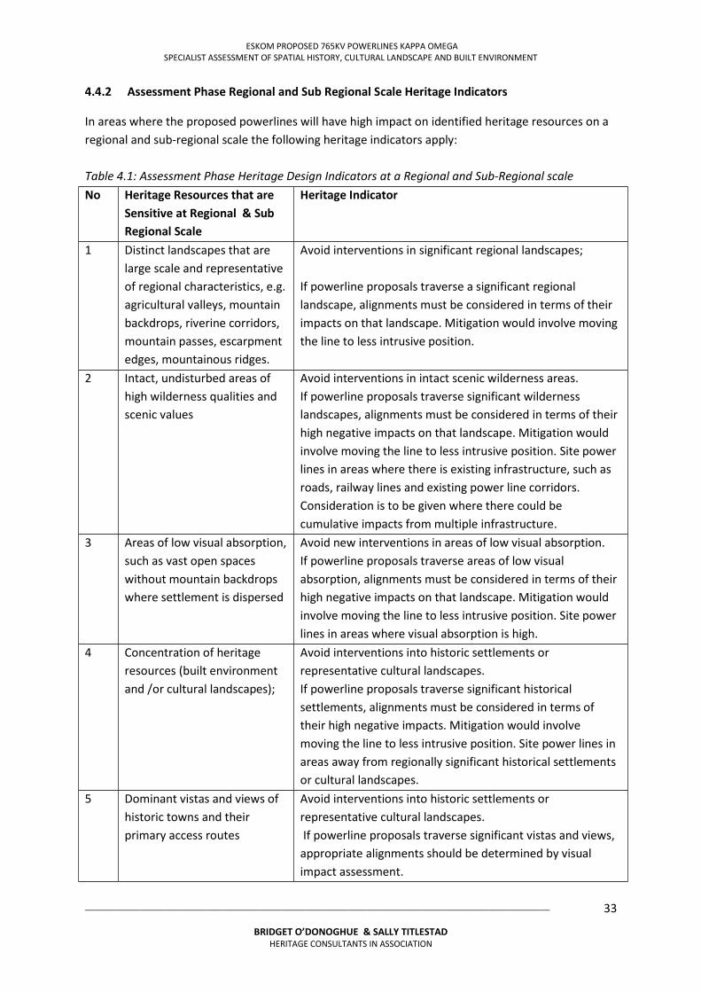
ESKOM PROPOSED 765KV POWERLINES KAPPA OMEGA SPECIALIST ASSESSMENT OF SPATIAL HISTORY, CULTURAL LANDSCAPE AND BUILT ENVIRONMENT
___________________________________________________________________________________________________
BRIDGET O’DONOGHUE & SALLY TITLESTAD HERITAGE CONSULTANTS IN ASSOCIATION
33
4.4.2 Assessment Phase Regional and Sub Regional Scale Heritage Indicators
In areas where the proposed powerlines will have high impact on identified heritage resources on a regional and sub-regional scale the following heritage indicators apply: Table 4.1: Assessment Phase Heritage Design Indicators at a Regional and Sub-Regional scale No Heritage Resources that are
Sensitive at Regional & Sub
Regional Scale
Heritage Indicator
1 Distinct landscapes that are large scale and representative of regional characteristics, e.g. agricultural valleys, mountain backdrops, riverine corridors, mountain passes, escarpment edges, mountainous ridges.
Avoid interventions in significant regional landscapes; If powerline proposals traverse a significant regional landscape, alignments must be considered in terms of their impacts on that landscape. Mitigation would involve moving the line to less intrusive position.
2 Intact, undisturbed areas of high wilderness qualities and scenic values
Avoid interventions in intact scenic wilderness areas. If powerline proposals traverse significant wilderness landscapes, alignments must be considered in terms of their high negative impacts on that landscape. Mitigation would involve moving the line to less intrusive position. Site power lines in areas where there is existing infrastructure, such as roads, railway lines and existing power line corridors. Consideration is to be given where there could be cumulative impacts from multiple infrastructure.
3 Areas of low visual absorption, such as vast open spaces without mountain backdrops where settlement is dispersed
Avoid new interventions in areas of low visual absorption. If powerline proposals traverse areas of low visual absorption, alignments must be considered in terms of their high negative impacts on that landscape. Mitigation would involve moving the line to less intrusive position. Site power lines in areas where visual absorption is high.
4 Concentration of heritage resources (built environment and /or cultural landscapes);
Avoid interventions into historic settlements or representative cultural landscapes. If powerline proposals traverse significant historical settlements, alignments must be considered in terms of their high negative impacts. Mitigation would involve moving the line to less intrusive position. Site power lines in areas away from regionally significant historical settlements or cultural landscapes.
5 Dominant vistas and views of historic towns and their primary access routes
Avoid interventions into historic settlements or representative cultural landscapes. If powerline proposals traverse significant vistas and views, appropriate alignments should be determined by visual impact assessment.
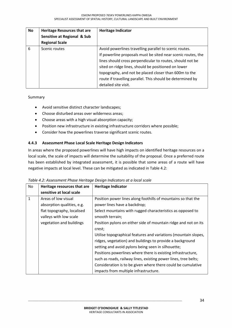
ESKOM PROPOSED 765KV POWERLINES KAPPA OMEGA SPECIALIST ASSESSMENT OF SPATIAL HISTORY, CULTURAL LANDSCAPE AND BUILT ENVIRONMENT
___________________________________________________________________________________________________
BRIDGET O’DONOGHUE & SALLY TITLESTAD HERITAGE CONSULTANTS IN ASSOCIATION
34
No Heritage Resources that are
Sensitive at Regional & Sub
Regional Scale
Heritage Indicator
6 Scenic routes Avoid powerlines travelling parallel to scenic routes. If powerline proposals must be sited near scenic routes, the lines should cross perpendicular to routes, should not be sited on ridge lines, should be positioned on lower topography, and not be placed closer than 600m to the route if travelling parallel. This should be determined by detailed site visit.
Summary
Avoid sensitive distinct character landscapes; Choose disturbed areas over wilderness areas; Choose areas with a high visual absorption capacity; Position new infrastructure in existing infrastructure corridors where possible; Consider how the powerlines traverse significant scenic routes.
4.4.3 Assessment Phase Local Scale Heritage Design Indicators
In areas where the proposed powerlines will have high impacts on identified heritage resources on a local scale, the scale of impacts will determine the suitability of the proposal. Once a preferred route has been established by integrated assessment, it is possible that some areas of a route will have negative impacts at local level. These can be mitigated as indicated in Table 4.2: Table 4.2: Assessment Phase Heritage Design Indicators at a local scale No Heritage resources that are
sensitive at local scale Heritage Indicator
1 Areas of low visual absorption qualities, e.g. flat topography, localised valleys with low scale vegetation and buildings
Position power lines along foothills of mountains so that the power lines have a backdrop; Select mountains with rugged characteristics as opposed to smooth terrain; Position pylons on either side of mountain ridge and not on its crest; Utilise topographical features and variations (mountain slopes, ridges, vegetation) and buildings to provide a background setting and avoid pylons being seen in silhouette; Positions powerlines where there is existing infrastructure, such as roads, railway lines, existing power lines, tree belts; Consideration is to be given where there could be cumulative impacts from multiple infrastructure.
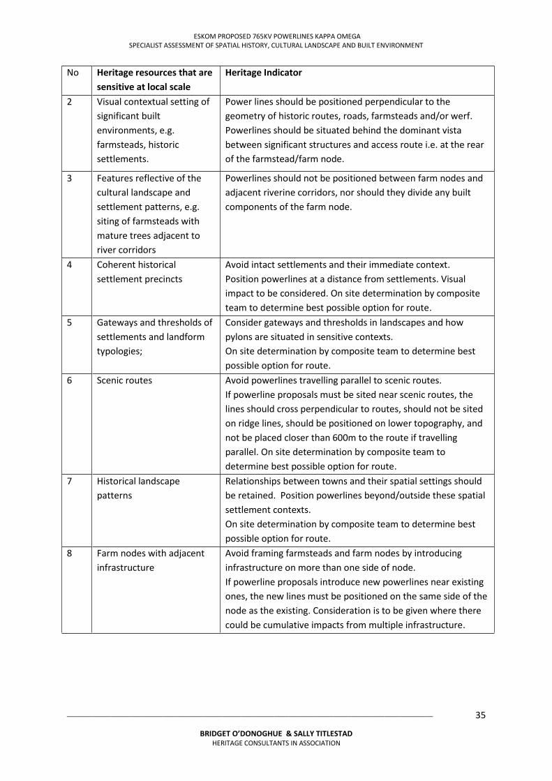
ESKOM PROPOSED 765KV POWERLINES KAPPA OMEGA SPECIALIST ASSESSMENT OF SPATIAL HISTORY, CULTURAL LANDSCAPE AND BUILT ENVIRONMENT
___________________________________________________________________________________________________
BRIDGET O’DONOGHUE & SALLY TITLESTAD HERITAGE CONSULTANTS IN ASSOCIATION
35
No Heritage resources that are
sensitive at local scale Heritage Indicator
2 Visual contextual setting of significant built environments, e.g. farmsteads, historic settlements.
Power lines should be positioned perpendicular to the geometry of historic routes, roads, farmsteads and/or werf. Powerlines should be situated behind the dominant vista between significant structures and access route i.e. at the rear of the farmstead/farm node.
3 Features reflective of the cultural landscape and settlement patterns, e.g. siting of farmsteads with mature trees adjacent to river corridors
Powerlines should not be positioned between farm nodes and adjacent riverine corridors, nor should they divide any built components of the farm node.
4 Coherent historical settlement precincts
Avoid intact settlements and their immediate context. Position powerlines at a distance from settlements. Visual impact to be considered. On site determination by composite team to determine best possible option for route.
5 Gateways and thresholds of settlements and landform typologies;
Consider gateways and thresholds in landscapes and how pylons are situated in sensitive contexts. On site determination by composite team to determine best possible option for route.
6 Scenic routes Avoid powerlines travelling parallel to scenic routes. If powerline proposals must be sited near scenic routes, the lines should cross perpendicular to routes, should not be sited on ridge lines, should be positioned on lower topography, and not be placed closer than 600m to the route if travelling parallel. On site determination by composite team to determine best possible option for route.
7 Historical landscape patterns
Relationships between towns and their spatial settings should be retained. Position powerlines beyond/outside these spatial settlement contexts. On site determination by composite team to determine best possible option for route.
8 Farm nodes with adjacent infrastructure
Avoid framing farmsteads and farm nodes by introducing infrastructure on more than one side of node. If powerline proposals introduce new powerlines near existing ones, the new lines must be positioned on the same side of the node as the existing. Consideration is to be given where there could be cumulative impacts from multiple infrastructure.
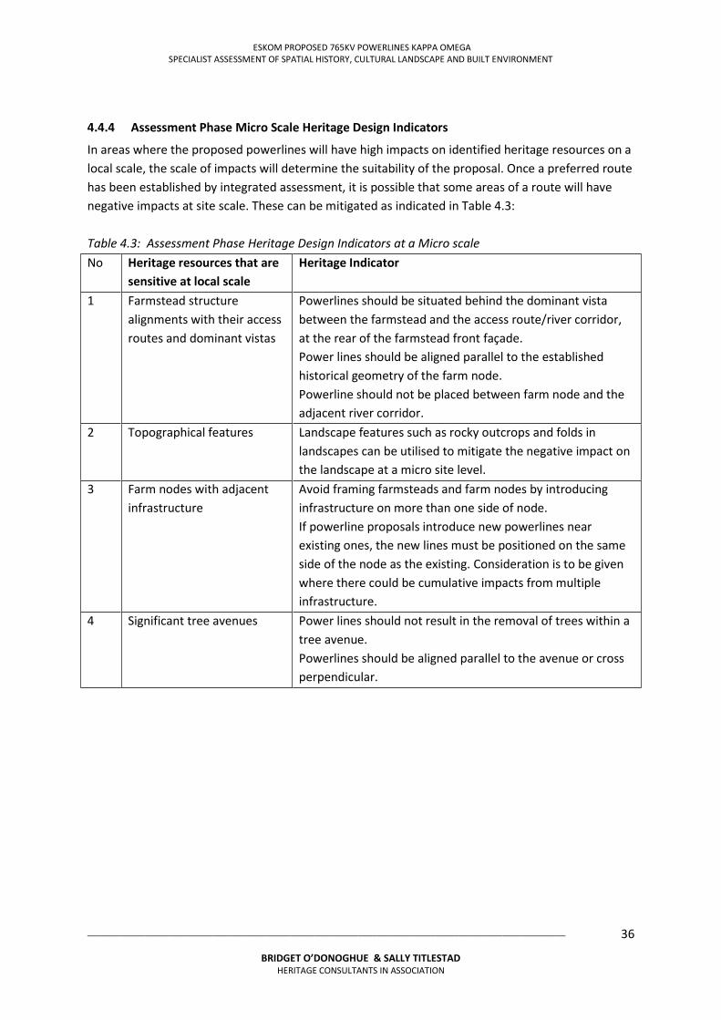
ESKOM PROPOSED 765KV POWERLINES KAPPA OMEGA SPECIALIST ASSESSMENT OF SPATIAL HISTORY, CULTURAL LANDSCAPE AND BUILT ENVIRONMENT
___________________________________________________________________________________________________
BRIDGET O’DONOGHUE & SALLY TITLESTAD HERITAGE CONSULTANTS IN ASSOCIATION
36
4.4.4 Assessment Phase Micro Scale Heritage Design Indicators
In areas where the proposed powerlines will have high impacts on identified heritage resources on a local scale, the scale of impacts will determine the suitability of the proposal. Once a preferred route has been established by integrated assessment, it is possible that some areas of a route will have negative impacts at site scale. These can be mitigated as indicated in Table 4.3: Table 4.3: Assessment Phase Heritage Design Indicators at a Micro scale No Heritage resources that are
sensitive at local scale Heritage Indicator
1 Farmstead structure alignments with their access routes and dominant vistas
Powerlines should be situated behind the dominant vista between the farmstead and the access route/river corridor, at the rear of the farmstead front façade. Power lines should be aligned parallel to the established historical geometry of the farm node. Powerline should not be placed between farm node and the adjacent river corridor.
2 Topographical features Landscape features such as rocky outcrops and folds in landscapes can be utilised to mitigate the negative impact on the landscape at a micro site level.
3 Farm nodes with adjacent infrastructure
Avoid framing farmsteads and farm nodes by introducing infrastructure on more than one side of node. If powerline proposals introduce new powerlines near existing ones, the new lines must be positioned on the same side of the node as the existing. Consideration is to be given where there could be cumulative impacts from multiple infrastructure.
4 Significant tree avenues
Power lines should not result in the removal of trees within a tree avenue. Powerlines should be aligned parallel to the avenue or cross perpendicular.
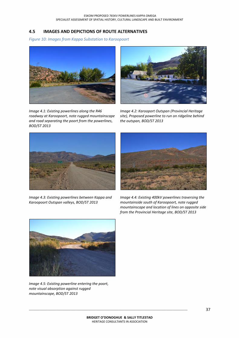
ESKOM PROPOSED 765KV POWERLINES KAPPA OMEGA SPECIALIST ASSESSMENT OF SPATIAL HISTORY, CULTURAL LANDSCAPE AND BUILT ENVIRONMENT
___________________________________________________________________________________________________
BRIDGET O’DONOGHUE & SALLY TITLESTAD HERITAGE CONSULTANTS IN ASSOCIATION
37
4.5 IMAGES AND DEPICTIONS OF ROUTE ALTERNATIVES
Figure 10: Images from Kappa Substation to Karoopoort
Image 4.1: Existing powerlines along the R46 roadway at Karoopoort, note rugged mountainscape and road separating the poort from the powerlines, BOD/ST 2013
Image 4.2: Karooport Outspan (Provincial Heritage site), Proposed powerline to run on ridgeline behind the outspan, BOD/ST 2013
Image 4.3: Existing powerlines between Kappa and Karoopoort Outspan valleys, BOD/ST 2013
Image 4.4: Existing 400kV powerlines traversing the mountainside south of Karoopoort, note rugged mountainscape and location of lines on opposite side from the Provincial Heritage site, BOD/ST 2013
Image 4.5: Existing powerline entering the poort, note visual absorption against rugged mountainscape, BOD/ST 2013
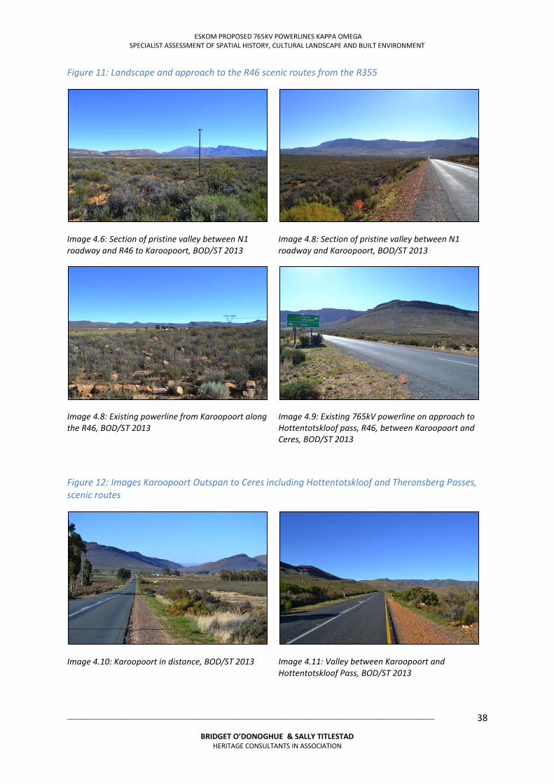
ESKOM PROPOSED 765KV POWERLINES KAPPA OMEGA SPECIALIST ASSESSMENT OF SPATIAL HISTORY, CULTURAL LANDSCAPE AND BUILT ENVIRONMENT
___________________________________________________________________________________________________
BRIDGET O’DONOGHUE & SALLY TITLESTAD HERITAGE CONSULTANTS IN ASSOCIATION
38
Figure 11: Landscape and approach to the R46 scenic routes from the R355
Image 4.6: Section of pristine valley between N1 roadway and R46 to Karoopoort, BOD/ST 2013
Image 4.8: Section of pristine valley between N1 roadway and Karoopoort, BOD/ST 2013
Image 4.8: Existing powerline from Karoopoort along the R46, BOD/ST 2013
Image 4.9: Existing 765kV powerline on approach to Hottentotskloof pass, R46, between Karoopoort and Ceres, BOD/ST 2013
Figure 12: Images Karoopoort Outspan to Ceres including Hottentotskloof and Theronsberg Passes, scenic routes
Image 4.10: Karoopoort in distance, BOD/ST 2013
Image 4.11: Valley between Karoopoort and Hottentotskloof Pass, BOD/ST 2013
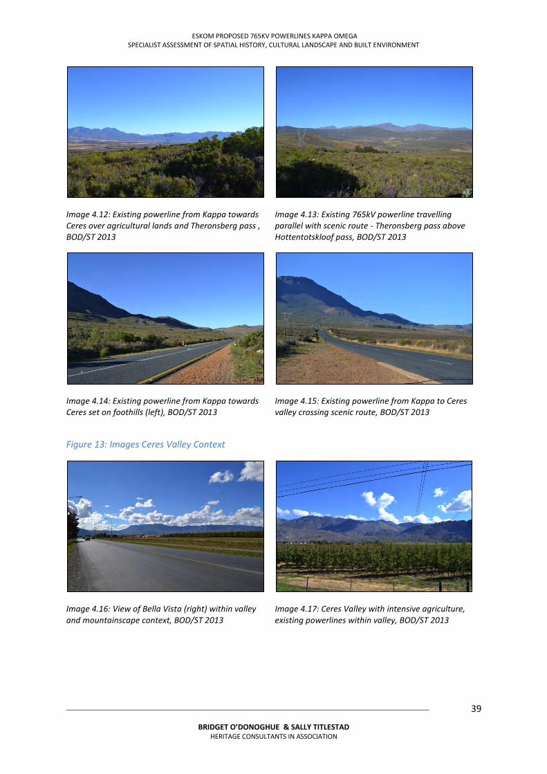
ESKOM PROPOSED 765KV POWERLINES KAPPA OMEGA SPECIALIST ASSESSMENT OF SPATIAL HISTORY, CULTURAL LANDSCAPE AND BUILT ENVIRONMENT
___________________________________________________________________________________________________
BRIDGET O’DONOGHUE & SALLY TITLESTAD HERITAGE CONSULTANTS IN ASSOCIATION
39
Image 4.12: Existing powerline from Kappa towards Ceres over agricultural lands and Theronsberg pass , BOD/ST 2013
Image 4.13: Existing 765kV powerline travelling parallel with scenic route - Theronsberg pass above Hottentotskloof pass, BOD/ST 2013
Image 4.14: Existing powerline from Kappa towards Ceres set on foothills (left), BOD/ST 2013
Image 4.15: Existing powerline from Kappa to Ceres valley crossing scenic route, BOD/ST 2013
Figure 13: Images Ceres Valley Context
Image 4.16: View of Bella Vista (right) within valley and mountainscape context, BOD/ST 2013
Image 4.17: Ceres Valley with intensive agriculture, existing powerlines within valley, BOD/ST 2013
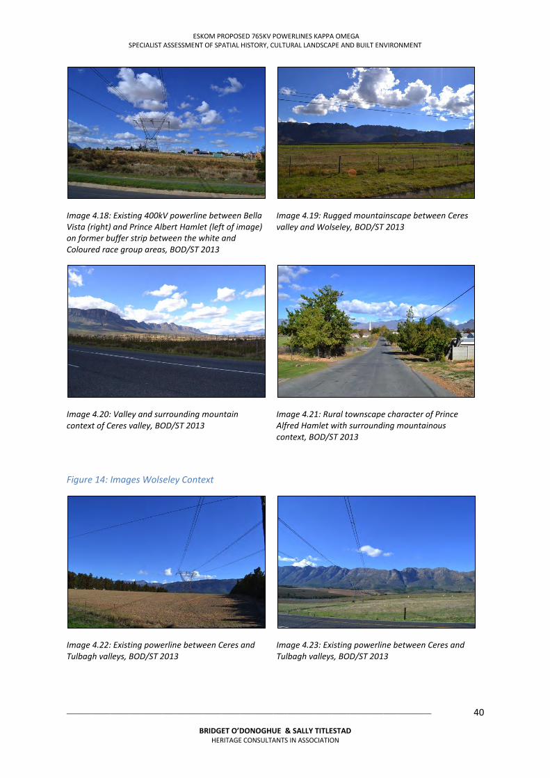
ESKOM PROPOSED 765KV POWERLINES KAPPA OMEGA SPECIALIST ASSESSMENT OF SPATIAL HISTORY, CULTURAL LANDSCAPE AND BUILT ENVIRONMENT
___________________________________________________________________________________________________
BRIDGET O’DONOGHUE & SALLY TITLESTAD HERITAGE CONSULTANTS IN ASSOCIATION
40
Image 4.18: Existing 400kV powerline between Bella Vista (right) and Prince Albert Hamlet (left of image) on former buffer strip between the white and Coloured race group areas, BOD/ST 2013
Image 4.19: Rugged mountainscape between Ceres valley and Wolseley, BOD/ST 2013
Image 4.20: Valley and surrounding mountain context of Ceres valley, BOD/ST 2013
Image 4.21: Rural townscape character of Prince Alfred Hamlet with surrounding mountainous context, BOD/ST 2013
Figure 14: Images Wolseley Context
Image 4.22: Existing powerline between Ceres and Tulbagh valleys, BOD/ST 2013
Image 4.23: Existing powerline between Ceres and Tulbagh valleys, BOD/ST 2013
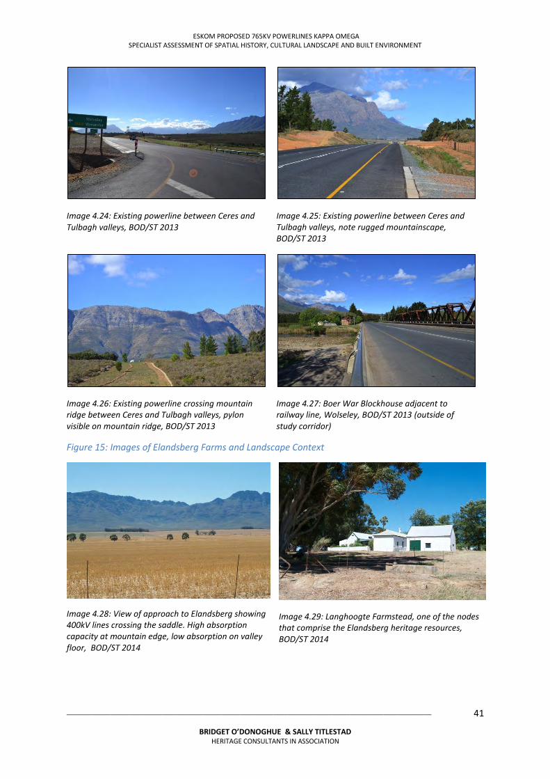
ESKOM PROPOSED 765KV POWERLINES KAPPA OMEGA SPECIALIST ASSESSMENT OF SPATIAL HISTORY, CULTURAL LANDSCAPE AND BUILT ENVIRONMENT
___________________________________________________________________________________________________
BRIDGET O’DONOGHUE & SALLY TITLESTAD HERITAGE CONSULTANTS IN ASSOCIATION
41
Image 4.24: Existing powerline between Ceres and Tulbagh valleys, BOD/ST 2013
Image 4.25: Existing powerline between Ceres and Tulbagh valleys, note rugged mountainscape, BOD/ST 2013
Image 4.26: Existing powerline crossing mountain ridge between Ceres and Tulbagh valleys, pylon visible on mountain ridge, BOD/ST 2013
Image 4.27: Boer War Blockhouse adjacent to railway line, Wolseley, BOD/ST 2013 (outside of study corridor)
Figure 15: Images of Elandsberg Farms and Landscape Context
Image 4.28: View of approach to Elandsberg showing 400kV lines crossing the saddle. High absorption capacity at mountain edge, low absorption on valley floor, BOD/ST 2014
Image 4.29: Langhoogte Farmstead, one of the nodes that comprise the Elandsberg heritage resources, BOD/ST 2014
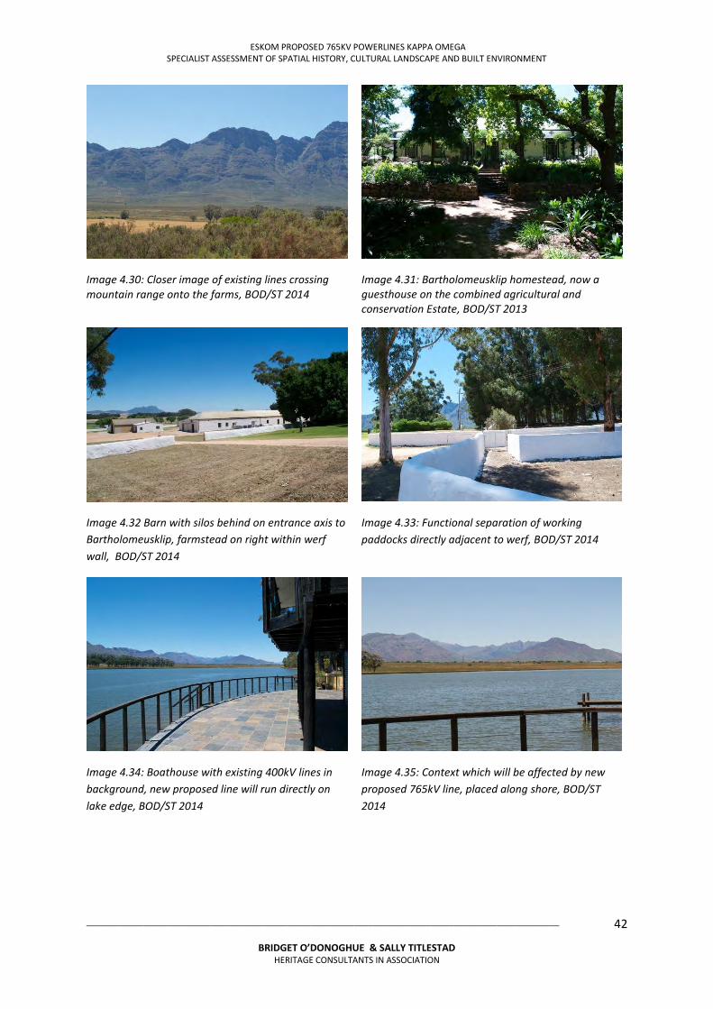
ESKOM PROPOSED 765KV POWERLINES KAPPA OMEGA SPECIALIST ASSESSMENT OF SPATIAL HISTORY, CULTURAL LANDSCAPE AND BUILT ENVIRONMENT
___________________________________________________________________________________________________
BRIDGET O’DONOGHUE & SALLY TITLESTAD HERITAGE CONSULTANTS IN ASSOCIATION
42
Image 4.30: Closer image of existing lines crossing mountain range onto the farms, BOD/ST 2014
Image 4.31: Bartholomeusklip homestead, now a guesthouse on the combined agricultural and conservation Estate, BOD/ST 2013
Image 4.32 Barn with silos behind on entrance axis to Bartholomeusklip, farmstead on right within werf wall, BOD/ST 2014
Image 4.33: Functional separation of working paddocks directly adjacent to werf, BOD/ST 2014
Image 4.34: Boathouse with existing 400kV lines in background, new proposed line will run directly on lake edge, BOD/ST 2014
Image 4.35: Context which will be affected by new proposed 765kV line, placed along shore, BOD/ST 2014
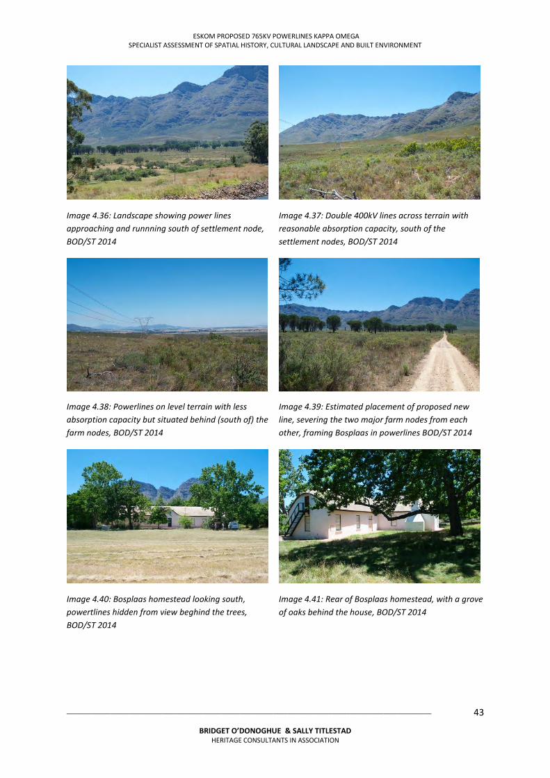
ESKOM PROPOSED 765KV POWERLINES KAPPA OMEGA SPECIALIST ASSESSMENT OF SPATIAL HISTORY, CULTURAL LANDSCAPE AND BUILT ENVIRONMENT
___________________________________________________________________________________________________
BRIDGET O’DONOGHUE & SALLY TITLESTAD HERITAGE CONSULTANTS IN ASSOCIATION
43
Image 4.36: Landscape showing power lines approaching and runnning south of settlement node, BOD/ST 2014
Image 4.37: Double 400kV lines across terrain with reasonable absorption capacity, south of the settlement nodes, BOD/ST 2014
Image 4.38: Powerlines on level terrain with less absorption capacity but situated behind (south of) the farm nodes, BOD/ST 2014
Image 4.39: Estimated placement of proposed new line, severing the two major farm nodes from each other, framing Bosplaas in powerlines BOD/ST 2014
Image 4.40: Bosplaas homestead looking south, powertlines hidden from view beghind the trees, BOD/ST 2014
Image 4.41: Rear of Bosplaas homestead, with a grove of oaks behind the house, BOD/ST 2014
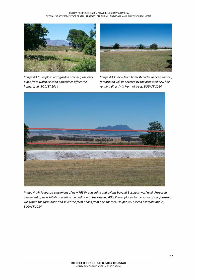
ESKOM PROPOSED 765KV POWERLINES KAPPA OMEGA SPECIALIST ASSESSMENT OF SPATIAL HISTORY, CULTURAL LANDSCAPE AND BUILT ENVIRONMENT
___________________________________________________________________________________________________
BRIDGET O’DONOGHUE & SALLY TITLESTAD HERITAGE CONSULTANTS IN ASSOCIATION
44
Image 4.42: Bosplaas rear garden precinct, the only place from which existing powerlines affect the homestead, BOD/ST 2014
Image 4.43: View from homestead to Riebeek Kasteel, foreground will be severed by the proposed new line running directly in front of trees, BOD/ST 2014
Image 4.44: Proposed placement of new 765kV powerline and pylons beyond Bosplaas werf wall. Proposed placement of new 765kV powerline, in addition to the existing 400kV lines placed to the south of the farmstead will frame the farm node and sever the farm nodes from one another. Height will exceed estimate above, BOD/ST 2014
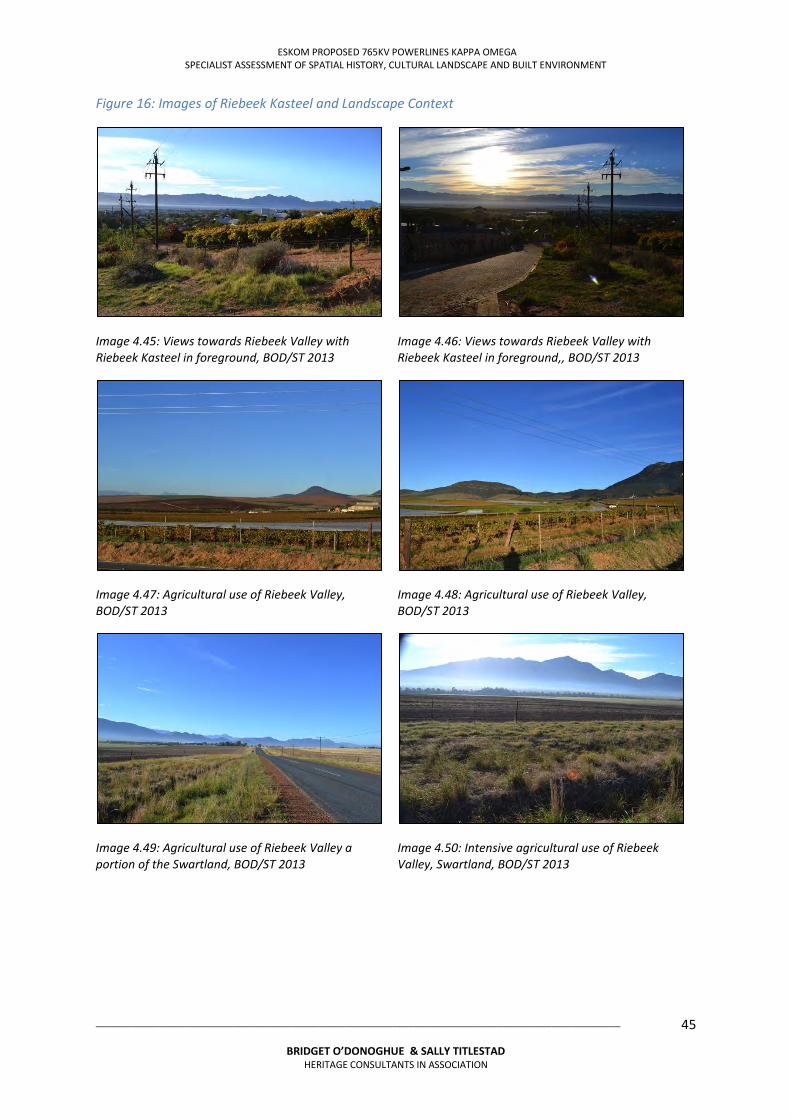
ESKOM PROPOSED 765KV POWERLINES KAPPA OMEGA SPECIALIST ASSESSMENT OF SPATIAL HISTORY, CULTURAL LANDSCAPE AND BUILT ENVIRONMENT
___________________________________________________________________________________________________
BRIDGET O’DONOGHUE & SALLY TITLESTAD HERITAGE CONSULTANTS IN ASSOCIATION
45
Figure 16: Images of Riebeek Kasteel and Landscape Context
Image 4.45: Views towards Riebeek Valley with Riebeek Kasteel in foreground, BOD/ST 2013
Image 4.46: Views towards Riebeek Valley with Riebeek Kasteel in foreground,, BOD/ST 2013
Image 4.47: Agricultural use of Riebeek Valley, BOD/ST 2013
Image 4.48: Agricultural use of Riebeek Valley, BOD/ST 2013
Image 4.49: Agricultural use of Riebeek Valley a portion of the Swartland, BOD/ST 2013
Image 4.50: Intensive agricultural use of Riebeek Valley, Swartland, BOD/ST 2013
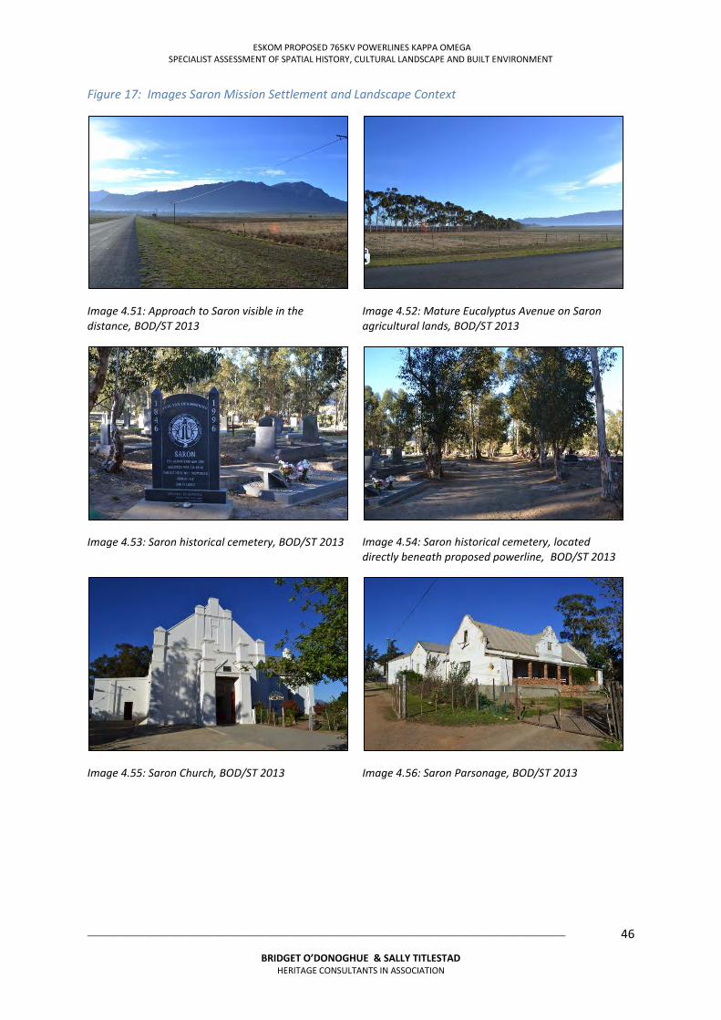
ESKOM PROPOSED 765KV POWERLINES KAPPA OMEGA SPECIALIST ASSESSMENT OF SPATIAL HISTORY, CULTURAL LANDSCAPE AND BUILT ENVIRONMENT
___________________________________________________________________________________________________
BRIDGET O’DONOGHUE & SALLY TITLESTAD HERITAGE CONSULTANTS IN ASSOCIATION
46
Figure 17: Images Saron Mission Settlement and Landscape Context
Image 4.51: Approach to Saron visible in the distance, BOD/ST 2013
Image 4.52: Mature Eucalyptus Avenue on Saron agricultural lands, BOD/ST 2013
Image 4.53: Saron historical cemetery, BOD/ST 2013
Image 4.54: Saron historical cemetery, located directly beneath proposed powerline, BOD/ST 2013
Image 4.55: Saron Church, BOD/ST 2013
Image 4.56: Saron Parsonage, BOD/ST 2013
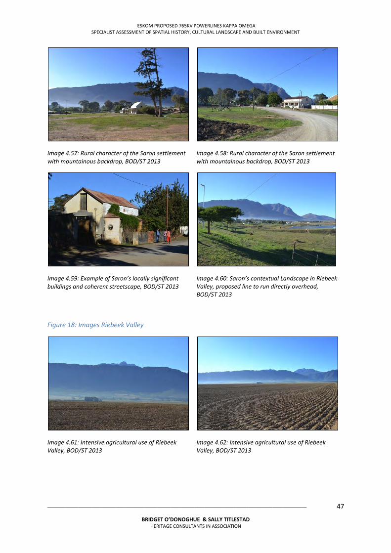
ESKOM PROPOSED 765KV POWERLINES KAPPA OMEGA SPECIALIST ASSESSMENT OF SPATIAL HISTORY, CULTURAL LANDSCAPE AND BUILT ENVIRONMENT
___________________________________________________________________________________________________
BRIDGET O’DONOGHUE & SALLY TITLESTAD HERITAGE CONSULTANTS IN ASSOCIATION
47
Image 4.57: Rural character of the Saron settlement with mountainous backdrop, BOD/ST 2013
Image 4.58: Rural character of the Saron settlement with mountainous backdrop, BOD/ST 2013
Image 4.59: Example of Saron’s locally significant buildings and coherent streetscape, BOD/ST 2013
Image 4.60: Saron’s contextual Landscape in Riebeek Valley, proposed line to run directly overhead, BOD/ST 2013
Figure 18: Images Riebeek Valley
Image 4.61: Intensive agricultural use of Riebeek Valley, BOD/ST 2013
Image 4.62: Intensive agricultural use of Riebeek Valley, BOD/ST 2013
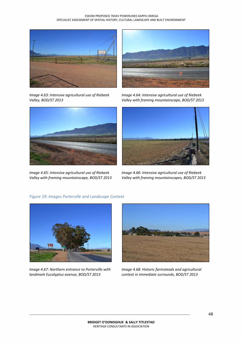
ESKOM PROPOSED 765KV POWERLINES KAPPA OMEGA SPECIALIST ASSESSMENT OF SPATIAL HISTORY, CULTURAL LANDSCAPE AND BUILT ENVIRONMENT
___________________________________________________________________________________________________
BRIDGET O’DONOGHUE & SALLY TITLESTAD HERITAGE CONSULTANTS IN ASSOCIATION
48
Image 4.63: Intensive agricultural use of Riebeek Valley, BOD/ST 2013
Image 4.64: Intensive agricultural use of Riebeek Valley with framing mountainscape, BOD/ST 2013
Image 4.65: Intensive agricultural use of Riebeek Valley with framing mountainscape, BOD/ST 2013
Image 4.66: Intensive agricultural use of Riebeek Valley with framing mountainscapes, BOD/ST 2013
Figure 19: Images Porterville and Landscape Context
Image 4.67: Northern entrance to Porterville with landmark Eucalyptus avenue, BOD/ST 2013
Image 4.68: Historic farmsteads and agricultural context in immediate surrounds, BOD/ST 2013
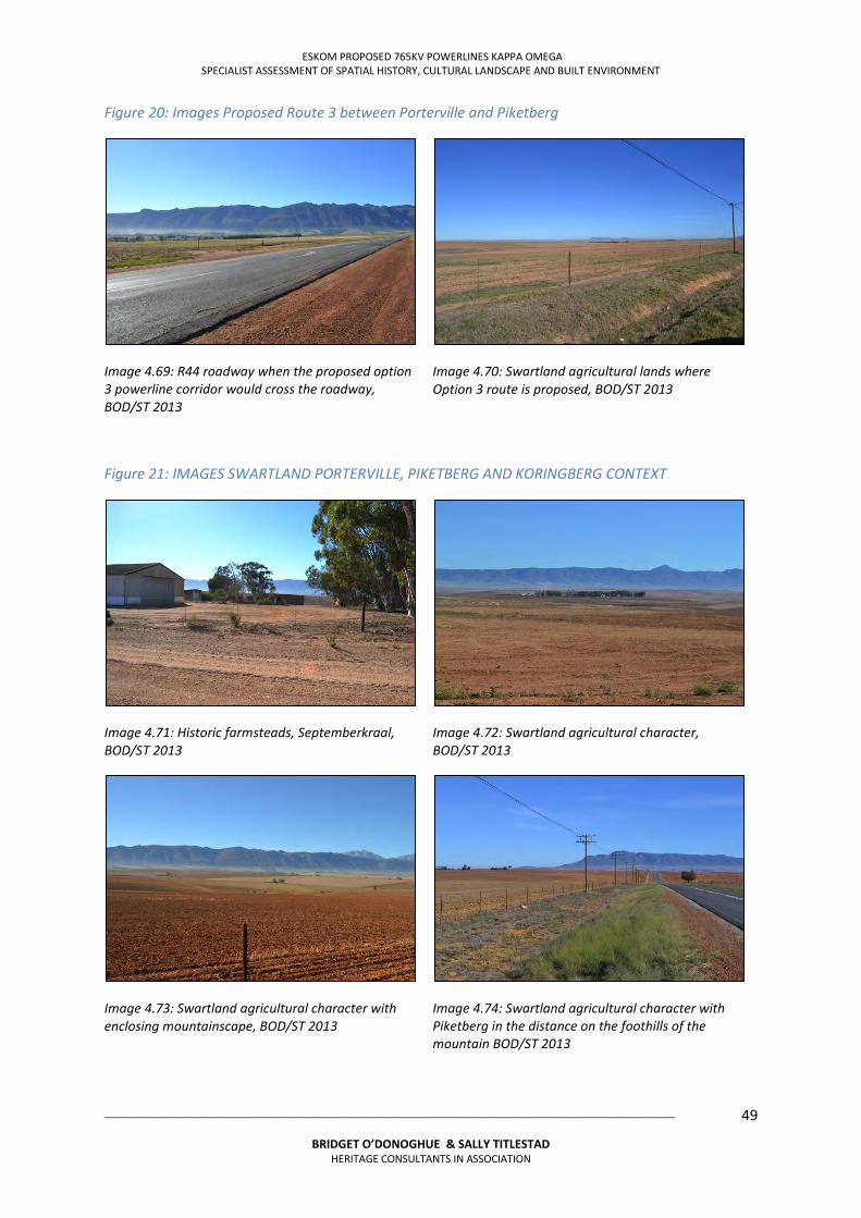
ESKOM PROPOSED 765KV POWERLINES KAPPA OMEGA SPECIALIST ASSESSMENT OF SPATIAL HISTORY, CULTURAL LANDSCAPE AND BUILT ENVIRONMENT
___________________________________________________________________________________________________
BRIDGET O’DONOGHUE & SALLY TITLESTAD HERITAGE CONSULTANTS IN ASSOCIATION
49
Figure 20: Images Proposed Route 3 between Porterville and Piketberg
Image 4.69: R44 roadway when the proposed option 3 powerline corridor would cross the roadway, BOD/ST 2013
Image 4.70: Swartland agricultural lands where Option 3 route is proposed, BOD/ST 2013
Figure 21: IMAGES SWARTLAND PORTERVILLE, PIKETBERG AND KORINGBERG CONTEXT
Image 4.71: Historic farmsteads, Septemberkraal, BOD/ST 2013
Image 4.72: Swartland agricultural character, BOD/ST 2013
Image 4.73: Swartland agricultural character with enclosing mountainscape, BOD/ST 2013
Image 4.74: Swartland agricultural character with Piketberg in the distance on the foothills of the mountain BOD/ST 2013
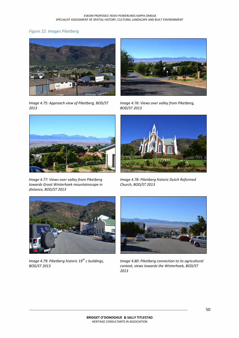
ESKOM PROPOSED 765KV POWERLINES KAPPA OMEGA SPECIALIST ASSESSMENT OF SPATIAL HISTORY, CULTURAL LANDSCAPE AND BUILT ENVIRONMENT
___________________________________________________________________________________________________
BRIDGET O’DONOGHUE & SALLY TITLESTAD HERITAGE CONSULTANTS IN ASSOCIATION
50
Figure 22: Images Piketberg
Image 4.75: Approach view of Piketberg, BOD/ST 2013
Image 4.76: Views over valley from Piketberg, BOD/ST 2013
Image 4.77: Views over valley from Piketberg towards Groot Winterhoek mountainscape in distance, BOD/ST 2013
Image 4.78: Piketberg historic Dutch Reformed Church, BOD/ST 2013
Image 4.79: Piketberg historic 19th c buildings, BOD/ST 2013
Image 4.80: Piketberg connection to its agricultural context, views towards the Winterhoek, BOD/ST 2013
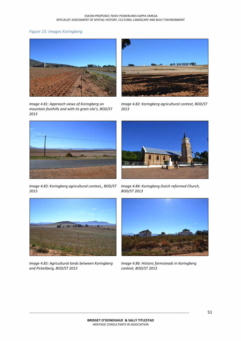
ESKOM PROPOSED 765KV POWERLINES KAPPA OMEGA SPECIALIST ASSESSMENT OF SPATIAL HISTORY, CULTURAL LANDSCAPE AND BUILT ENVIRONMENT
___________________________________________________________________________________________________
BRIDGET O’DONOGHUE & SALLY TITLESTAD HERITAGE CONSULTANTS IN ASSOCIATION
51
Figure 23: Images Koringberg
Image 4.81: Approach views of Koringberg on mountain foothills and with its grain silo’s, BOD/ST 2013
Image 4.82: Koringberg agricultural context, BOD/ST 2013
Image 4.83: Koringberg agricultural context,, BOD/ST 2013
Image 4.84: Koringberg Dutch reformed Church, BOD/ST 2013
Image 4.85: Agricultural lands between Koringberg and Picketberg, BOD/ST 2013
Image 4.86: Historic farmsteads in Koringberg context, BOD/ST 2013
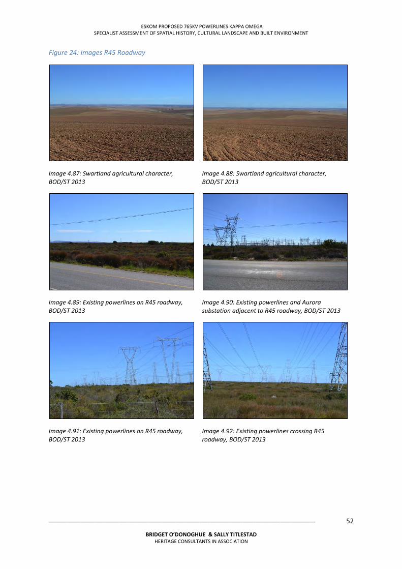
ESKOM PROPOSED 765KV POWERLINES KAPPA OMEGA SPECIALIST ASSESSMENT OF SPATIAL HISTORY, CULTURAL LANDSCAPE AND BUILT ENVIRONMENT
___________________________________________________________________________________________________
BRIDGET O’DONOGHUE & SALLY TITLESTAD HERITAGE CONSULTANTS IN ASSOCIATION
52
Figure 24: Images R45 Roadway
Image 4.87: Swartland agricultural character, BOD/ST 2013
Image 4.88: Swartland agricultural character, BOD/ST 2013
Image 4.89: Existing powerlines on R45 roadway, BOD/ST 2013
Image 4.90: Existing powerlines and Aurora substation adjacent to R45 roadway, BOD/ST 2013
Image 4.91: Existing powerlines on R45 roadway, BOD/ST 2013
Image 4.92: Existing powerlines crossing R45 roadway, BOD/ST 2013
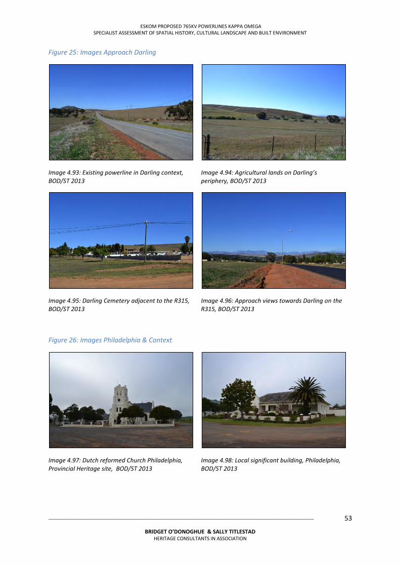
ESKOM PROPOSED 765KV POWERLINES KAPPA OMEGA SPECIALIST ASSESSMENT OF SPATIAL HISTORY, CULTURAL LANDSCAPE AND BUILT ENVIRONMENT
___________________________________________________________________________________________________
BRIDGET O’DONOGHUE & SALLY TITLESTAD HERITAGE CONSULTANTS IN ASSOCIATION
53
Figure 25: Images Approach Darling
Image 4.93: Existing powerline in Darling context, BOD/ST 2013
Image 4.94: Agricultural lands on Darling’s periphery, BOD/ST 2013
Image 4.95: Darling Cemetery adjacent to the R315, BOD/ST 2013
Image 4.96: Approach views towards Darling on the R315, BOD/ST 2013
Figure 26: Images Philadelphia & Context
Image 4.97: Dutch reformed Church Philadelphia, Provincial Heritage site, BOD/ST 2013
Image 4.98: Local significant building, Philadelphia, BOD/ST 2013
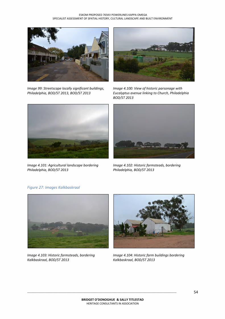
ESKOM PROPOSED 765KV POWERLINES KAPPA OMEGA SPECIALIST ASSESSMENT OF SPATIAL HISTORY, CULTURAL LANDSCAPE AND BUILT ENVIRONMENT
___________________________________________________________________________________________________
BRIDGET O’DONOGHUE & SALLY TITLESTAD HERITAGE CONSULTANTS IN ASSOCIATION
54
Image 99: Streetscape locally significant buildings, Philadelphia, BOD/ST 2013, BOD/ST 2013
Image 4.100: View of historic parsonage with Eucalyptus avenue linking to Church, Philadelphia BOD/ST 2013
Image 4.101: Agricultural landscape bordering Philadelphia, BOD/ST 2013
Image 4.102: Historic farmsteads, bordering Philadelphia, BOD/ST 2013
Figure 27: Images Kalkbaskraal
Image 4.103: Historic farmsteads, bordering Kalkbaskraal, BOD/ST 2013
Image 4.104: Historic farm buildings bordering Kalkbaskraal, BOD/ST 2013
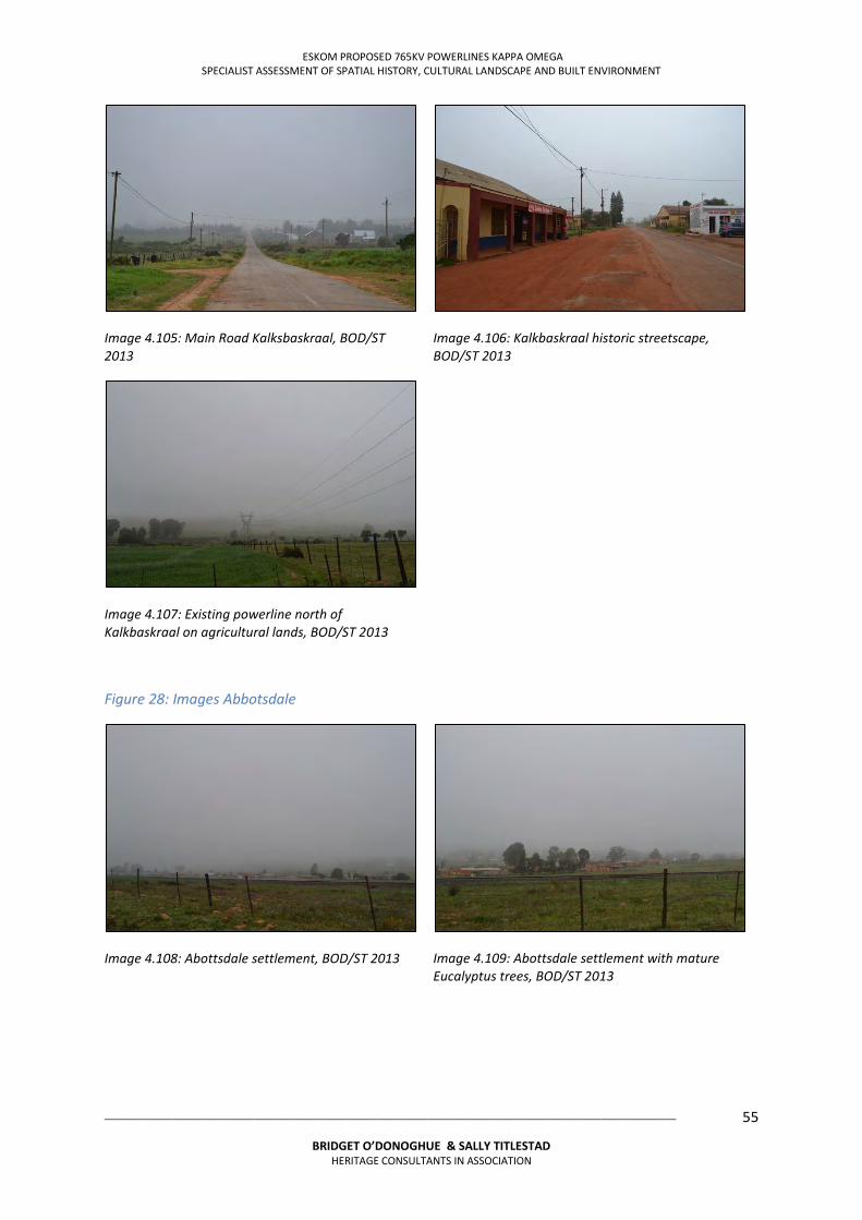
ESKOM PROPOSED 765KV POWERLINES KAPPA OMEGA SPECIALIST ASSESSMENT OF SPATIAL HISTORY, CULTURAL LANDSCAPE AND BUILT ENVIRONMENT
___________________________________________________________________________________________________
BRIDGET O’DONOGHUE & SALLY TITLESTAD HERITAGE CONSULTANTS IN ASSOCIATION
55
Image 4.105: Main Road Kalksbaskraal, BOD/ST 2013
Image 4.106: Kalkbaskraal historic streetscape, BOD/ST 2013
Image 4.107: Existing powerline north of Kalkbaskraal on agricultural lands, BOD/ST 2013
Figure 28: Images Abbotsdale
Image 4.108: Abottsdale settlement, BOD/ST 2013
Image 4.109: Abottsdale settlement with mature Eucalyptus trees, BOD/ST 2013
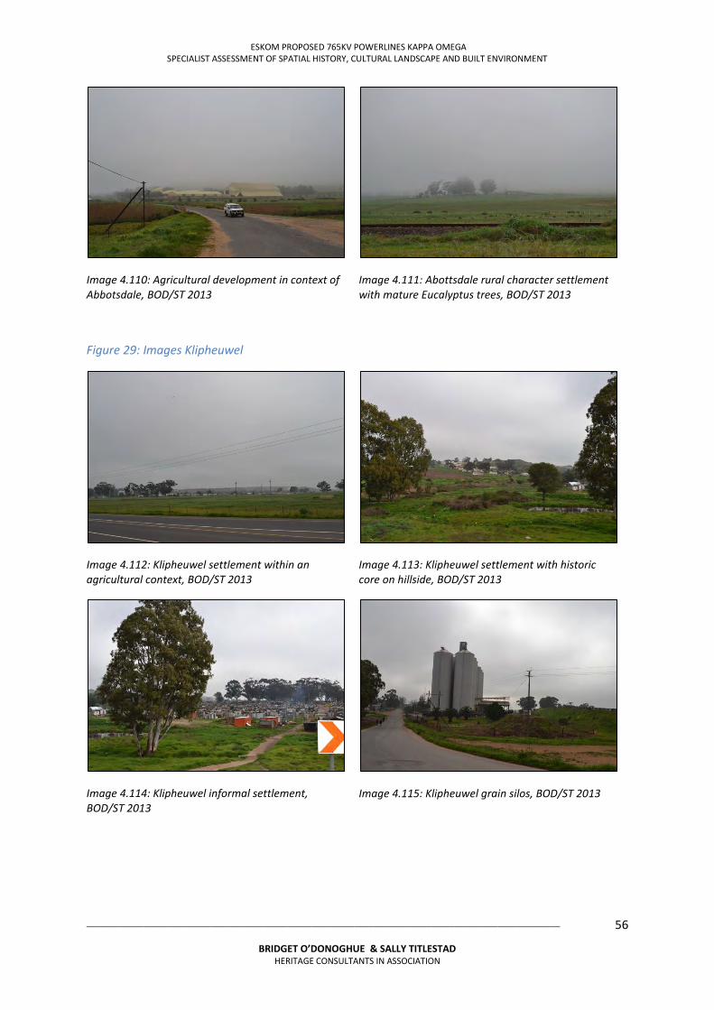
ESKOM PROPOSED 765KV POWERLINES KAPPA OMEGA SPECIALIST ASSESSMENT OF SPATIAL HISTORY, CULTURAL LANDSCAPE AND BUILT ENVIRONMENT
___________________________________________________________________________________________________
BRIDGET O’DONOGHUE & SALLY TITLESTAD HERITAGE CONSULTANTS IN ASSOCIATION
56
Image 4.110: Agricultural development in context of Abbotsdale, BOD/ST 2013
Image 4.111: Abottsdale rural character settlement with mature Eucalyptus trees, BOD/ST 2013
Figure 29: Images Klipheuwel
Image 4.112: Klipheuwel settlement within an agricultural context, BOD/ST 2013
Image 4.113: Klipheuwel settlement with historic core on hillside, BOD/ST 2013
Image 4.114: Klipheuwel informal settlement, BOD/ST 2013
Image 4.115: Klipheuwel grain silos, BOD/ST 2013
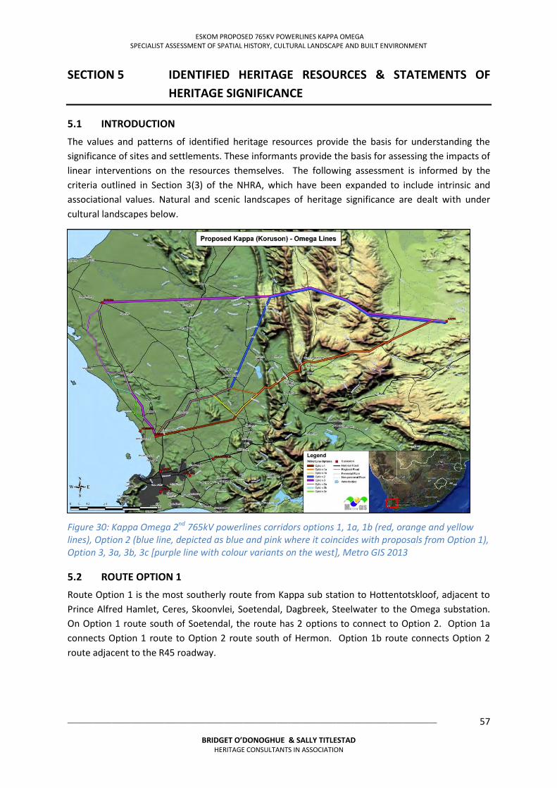
ESKOM PROPOSED 765KV POWERLINES KAPPA OMEGA SPECIALIST ASSESSMENT OF SPATIAL HISTORY, CULTURAL LANDSCAPE AND BUILT ENVIRONMENT
___________________________________________________________________________________________________
BRIDGET O’DONOGHUE & SALLY TITLESTAD HERITAGE CONSULTANTS IN ASSOCIATION
57
SECTION 5 IDENTIFIED HERITAGE RESOURCES & STATEMENTS OF
HERITAGE SIGNIFICANCE
5.1 INTRODUCTION
The values and patterns of identified heritage resources provide the basis for understanding the significance of sites and settlements. These informants provide the basis for assessing the impacts of linear interventions on the resources themselves. The following assessment is informed by the criteria outlined in Section 3(3) of the NHRA, which have been expanded to include intrinsic and associational values. Natural and scenic landscapes of heritage significance are dealt with under cultural landscapes below.
Figure 30: Kappa Omega 2nd 765kV powerlines corridors options 1, 1a, 1b (red, orange and yellow lines), Option 2 (blue line, depicted as blue and pink where it coincides with proposals from Option 1), Option 3, 3a, 3b, 3c [purple line with colour variants on the west], Metro GIS 2013
5.2 ROUTE OPTION 1
Route Option 1 is the most southerly route from Kappa sub station to Hottentotskloof, adjacent to Prince Alfred Hamlet, Ceres, Skoonvlei, Soetendal, Dagbreek, Steelwater to the Omega substation. On Option 1 route south of Soetendal, the route has 2 options to connect to Option 2. Option 1a connects Option 1 route to Option 2 route south of Hermon. Option 1b route connects Option 2 route adjacent to the R45 roadway.
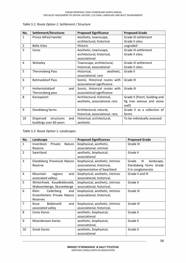
ESKOM PROPOSED 765KV POWERLINES KAPPA OMEGA SPECIALIST ASSESSMENT OF SPATIAL HISTORY, CULTURAL LANDSCAPE AND BUILT ENVIRONMENT
___________________________________________________________________________________________________
BRIDGET O’DONOGHUE & SALLY TITLESTAD HERITAGE CONSULTANTS IN ASSOCIATION
58
Table 5.1: Route Option 1: Settlement / Structure No. Settlement/Structures Proposed Significance Proposed Grade 1 Prince Alfred Hamlet Aesthetic, townscape,
architectural, historical Grade III settlement Grade II sites:
2 Bella Vista Historic ungraded 3 Ceres Aesthetic, townscape,
architectural, historical, associational
Grade III settlement Grade II sites:
4 Wolseley Townscape, architectural, historical, associational
Grade III settlement Grade II sites:
5 Theronsberg Pass Historical, aesthetic, associational, rare
Grade II
6 Botmaskloof Pass Scenic, Historical routes with associational significance
Grade III
7 Hottentotskloof and Theronsberg pass
Scenic, Historical routes with associational significance
Grade III
8 Karoopoort Architectural, historical, aesthetic, associational, rare
Grade II (Poort, building and fig tree avenue and stone wall)
9 Elandsberg farms Architectural, natural, historical, associational, rare,
Grade II as a collection of farms
10 Dispersed structures and buildings over 60 years
Historical, architectural, aesthetic
To be individually assessed
Table 5.2: Route Option 1: Landscapes No. Landscape Proposed Significances Proposed Grade 1 Inverdoon Private Nature
Reserve biophysical, aesthetic, associational, intrinsic
Grade III
2 Swartland aesthetic, biophysical, associational
Grade II
3 Elandsberg Provincial Nature Reserve
biophysical, aesthetic, intrinsic associational, historical, representative of Swartland
Grade III landscape, Elandsberg farms Grade II in conglomerate
4 Mountain regions and associated valleys
biophysical, aesthetic, intrinsic associational, historical,
Grade II and III
5 Winterhoek, KoueBokkeveld, Waboomberge, Skurweberge
biophysical, aesthetic, intrinsic associational, historical,
Grade II
6 Klein Cederberg and Groenfontein Private Nature Reserves
biophysical, aesthetic, intrinsic associational, historical,
Grade III
7 Koue Bokkeveld and associated valley
biophysical, aesthetic, intrinsic associational, historical,
Grade III
8 Ceres Karoo aesthetic, biophysical, associational
Grade II
9 Moordenaars Karoo aesthetic, biophysical, associational,
Grade II
10 Great Karoo aesthetic, biophysical, associational
Grade II
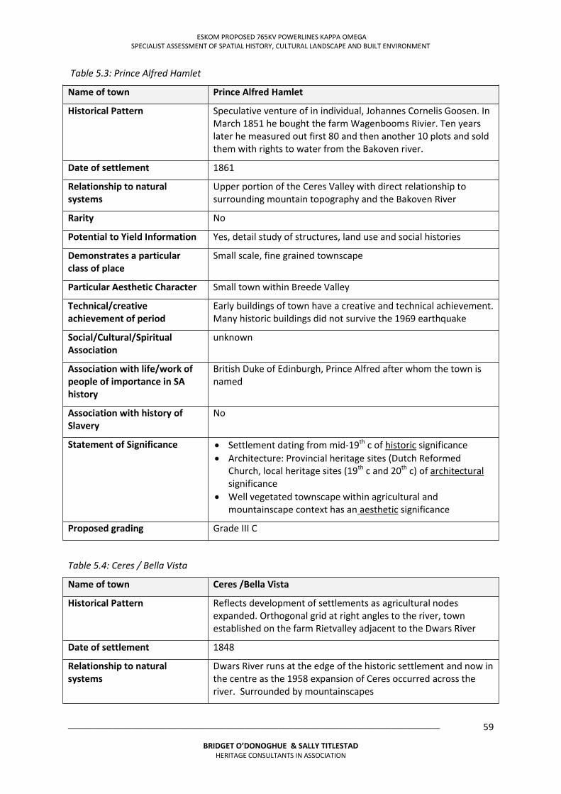
ESKOM PROPOSED 765KV POWERLINES KAPPA OMEGA SPECIALIST ASSESSMENT OF SPATIAL HISTORY, CULTURAL LANDSCAPE AND BUILT ENVIRONMENT
___________________________________________________________________________________________________
BRIDGET O’DONOGHUE & SALLY TITLESTAD HERITAGE CONSULTANTS IN ASSOCIATION
59
Table 5.3: Prince Alfred Hamlet
Name of town Prince Alfred Hamlet
Historical Pattern Speculative venture of in individual, Johannes Cornelis Goosen. In March 1851 he bought the farm Wagenbooms Rivier. Ten years later he measured out first 80 and then another 10 plots and sold them with rights to water from the Bakoven river.
Date of settlement 1861
Relationship to natural systems
Upper portion of the Ceres Valley with direct relationship to surrounding mountain topography and the Bakoven River
Rarity No
Potential to Yield Information Yes, detail study of structures, land use and social histories
Demonstrates a particular class of place
Small scale, fine grained townscape
Particular Aesthetic Character Small town within Breede Valley
Technical/creative achievement of period
Early buildings of town have a creative and technical achievement. Many historic buildings did not survive the 1969 earthquake
Social/Cultural/Spiritual Association
unknown
Association with life/work of people of importance in SA history
British Duke of Edinburgh, Prince Alfred after whom the town is named
Association with history of Slavery
No
Statement of Significance Settlement dating from mid-19th c of historic significance Architecture: Provincial heritage sites (Dutch Reformed
Church, local heritage sites (19th c and 20th c) of architectural significance
Well vegetated townscape within agricultural and mountainscape context has an aesthetic significance
Proposed grading Grade III C
Table 5.4: Ceres / Bella Vista
Name of town Ceres /Bella Vista
Historical Pattern Reflects development of settlements as agricultural nodes expanded. Orthogonal grid at right angles to the river, town established on the farm Rietvalley adjacent to the Dwars River
Date of settlement 1848
Relationship to natural systems
Dwars River runs at the edge of the historic settlement and now in the centre as the 1958 expansion of Ceres occurred across the river. Surrounded by mountainscapes
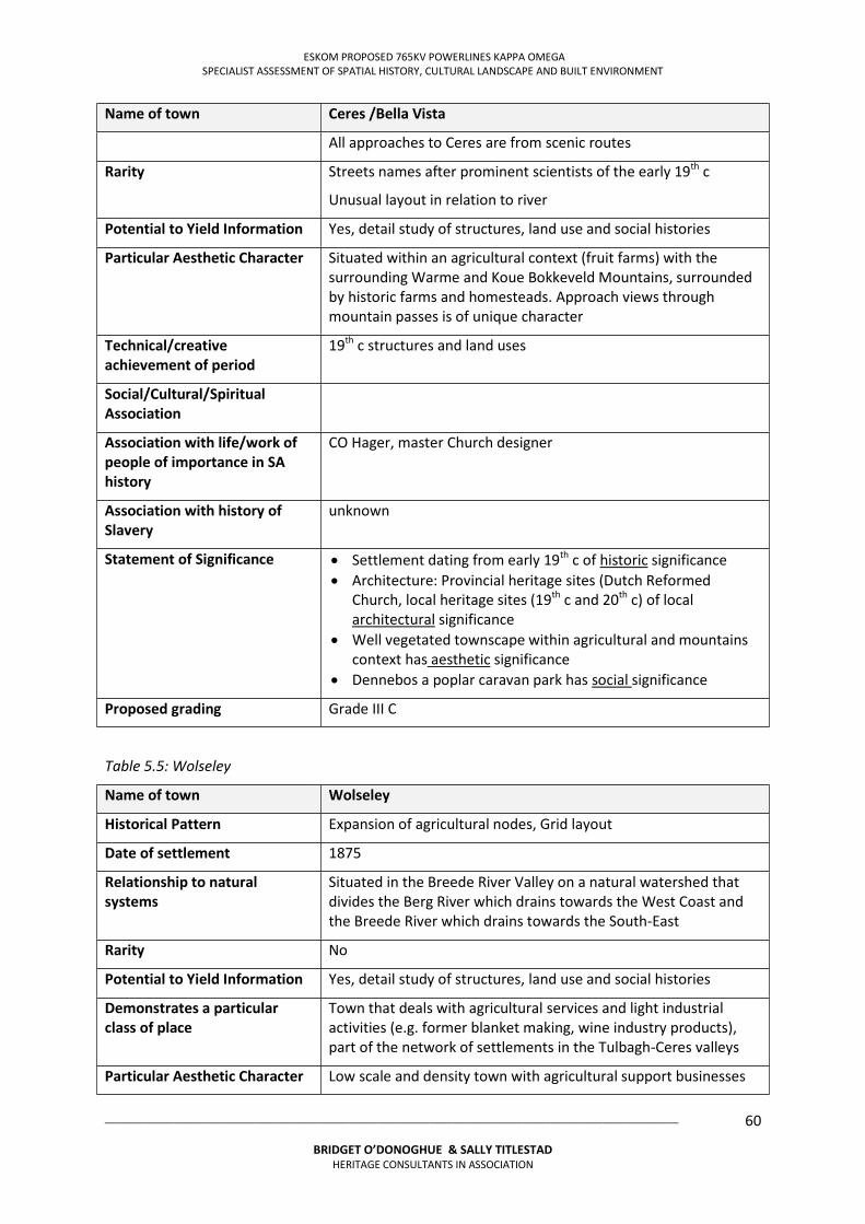
ESKOM PROPOSED 765KV POWERLINES KAPPA OMEGA SPECIALIST ASSESSMENT OF SPATIAL HISTORY, CULTURAL LANDSCAPE AND BUILT ENVIRONMENT
___________________________________________________________________________________________________
BRIDGET O’DONOGHUE & SALLY TITLESTAD HERITAGE CONSULTANTS IN ASSOCIATION
60
Name of town Ceres /Bella Vista
All approaches to Ceres are from scenic routes
Rarity Streets names after prominent scientists of the early 19th c
Unusual layout in relation to river
Potential to Yield Information Yes, detail study of structures, land use and social histories
Particular Aesthetic Character Situated within an agricultural context (fruit farms) with the surrounding Warme and Koue Bokkeveld Mountains, surrounded by historic farms and homesteads. Approach views through mountain passes is of unique character
Technical/creative achievement of period
19th c structures and land uses
Social/Cultural/Spiritual Association
Association with life/work of people of importance in SA history
CO Hager, master Church designer
Association with history of Slavery
unknown
Statement of Significance Settlement dating from early 19th c of historic significance Architecture: Provincial heritage sites (Dutch Reformed
Church, local heritage sites (19th c and 20th c) of local architectural significance
Well vegetated townscape within agricultural and mountains context has aesthetic significance
Dennebos a poplar caravan park has social significance
Proposed grading Grade III C
Table 5.5: Wolseley
Name of town Wolseley
Historical Pattern Expansion of agricultural nodes, Grid layout
Date of settlement 1875
Relationship to natural systems
Situated in the Breede River Valley on a natural watershed that divides the Berg River which drains towards the West Coast and the Breede River which drains towards the South-East
Rarity No
Potential to Yield Information Yes, detail study of structures, land use and social histories
Demonstrates a particular class of place
Town that deals with agricultural services and light industrial activities (e.g. former blanket making, wine industry products), part of the network of settlements in the Tulbagh-Ceres valleys
Particular Aesthetic Character Low scale and density town with agricultural support businesses
ESKOM PROPOSED 765KV POWERLINES KAPPA OMEGA SPECIALIST ASSESSMENT OF SPATIAL HISTORY, CULTURAL LANDSCAPE AND BUILT ENVIRONMENT
___________________________________________________________________________________________________
BRIDGET O’DONOGHUE & SALLY TITLESTAD HERITAGE CONSULTANTS IN ASSOCIATION
61
Name of town Wolseley
Technical/creative achievement of period
Blockhouses constructed by the British military to protect bridges over rail links during Anglo-Boer war
Social/Cultural/Spiritual Association
Anglo-Boer War
Association with life/work of people of importance in SA history
Town named Wolseley after Sir Garnet Wolseley, the British governor of Natal
Association with history of Slavery
No
Statement of Significance Architectural and Historical: Two blockhouses dating from the Anglo-Boer War (1901) that can be seen along the railway line to the South of the town.
Proposed grading Ungraded
Table 5.6: Philadelphia
Name of town Philadelphia
Historical Pattern Church town, on former farm Dassenvalley farm, layout a rectangular grid
Date of settlement 1858
Relationship to natural systems
Situated on a river
Rarity Rarity relates to the Church town of a small size
Potential to Yield Information Yes, detail study of structures, land use and social histories
Demonstrates a particular class of place
Aesthetic of historical townscape with central Church complex and later expansion of residential areas
Particular Aesthetic Character Village of rural character (dirt roads and Eucalyptus trees) situated within the Swartland agricultural context, associated link to Church Parsonage: Kerkplaas (Church farm) ‘Dasvlei’
Technical/creative achievement of period
Yes, Church settlement and associated village
Social/Cultural/Spiritual Association
Dutch Reformed Church
Association with life/work of people of importance in SA history
D R Minister JJ Beck who withheld permission to start the parish
Association with history of Slavery
No
Statement of Significance Settlement dating from early 19th c of historic significance; successful appeal by local farmers and villages to the Synod to establish a new parish after permission as upheld
ESKOM PROPOSED 765KV POWERLINES KAPPA OMEGA SPECIALIST ASSESSMENT OF SPATIAL HISTORY, CULTURAL LANDSCAPE AND BUILT ENVIRONMENT
___________________________________________________________________________________________________
BRIDGET O’DONOGHUE & SALLY TITLESTAD HERITAGE CONSULTANTS IN ASSOCIATION
62
Name of town Philadelphia
Architecture: Provincial heritage sites (Dutch Reformed Church, local heritage sites (19th c and 20th c) of local architectural significance
Original layout, mature trees, rural context and Church precinct has aesthetic significance
Proposed grading Grade III B
5.3 ROUTE OPTION 2
Route Option 2 is from Kappa to east of Portville over the Koue Bokkeveld and Winterhoek Mountain ranges. From position east of Porterville the route travels south west to Saron and adjacent to Riebeek Kasteel. It changes a series of directions travelling south to adjacent Abbotsdale, Kalbaskraal to Omega substation.
Table 5.7: Route Option 2: Settlement / Structure
No. Settlement Proposed Significance Proposed Grade
1 Saron Aesthetic, townscape, architectural, historical, associational
Grade III settlement
Grade II sites:
2 Riebeek Kasteel Aesthetic, townscape, architectural, historical,
Grade III settlement
Grade II sites:
3 Kalbaskraal Historical Grade III
4 Dispersed structures and buildings over 60 years
Historical, architectural, aesthetic
Grade III
Table 5.8: Route Option 2: Landscapes
No. Landscape Proposed Significance Proposed Grade
1 Inverdoon Private Nature Reserve
biophysical, aesthetic, associational,
Grade III
1 Koue Bokkeveld Mountain range
biophysical, aesthetic, Grade II
2 Valley between Koue Bokkeveld Winterhoek Mountain ranges
biophysical, aesthetic, historic Grade II
3 Winterhoek Mountain range biophysical, aesthetic, Grade II
4 Visgat Natural Heritage Site biophysical, aesthetic, historical, Grade III
5 Riebeek valley biophysical, aesthetic, associational, historical,
Grade III
ESKOM PROPOSED 765KV POWERLINES KAPPA OMEGA SPECIALIST ASSESSMENT OF SPATIAL HISTORY, CULTURAL LANDSCAPE AND BUILT ENVIRONMENT
___________________________________________________________________________________________________
BRIDGET O’DONOGHUE & SALLY TITLESTAD HERITAGE CONSULTANTS IN ASSOCIATION
63
Table 5.9: Riebeek Kasteel
Name of town Riebeek Kasteel
Historical Pattern VOC outpost and later a Church town, On the road between Malmesbury to Hermon, site of VOC outpost established to monitor movement of the KhoeSan
Surveyor RJ Moll established a rectangular street grid of 1.3 x 0.7m below Main road
Date of settlement Pre 1840, Parish established 1868
Relationship to natural systems
Situated on lower slopes of Kasteelberg with streams giving water to settlement
Rarity Indirect relationship to early 19th century slave rebellion
Potential to yield Information Yes, detail study of structures, land use and social histories
Demonstrates a particular class of place
Yes, small Church town within agricultural Swartland landscape
Particular aesthetic character Settlement within an agricultural and natural context of high aesthetic significance; surrounding historic farms of Cloovenburg and Allesveloren; views from settlement towards agricultural valley, mountainscapes and visual links with other settlements in the valley
Technical/creative achievement of period
Early 19th c significant structures
Social/Cultural/Spiritual Association
DR Church
Association with life/work of people of importance in SA history
Jan Smuts, born on Ongegund farm (in context)
DF Malan, born on farm Allesveloren
Association with history of Slavery
Indirect relationship with slavery and the quelling of the early 19th century slave rebellion in the region
Statement of Significance Settlement dating from early 19th c of historic significance Architecture: Provincial heritage sites (former Dutch Reformed
Church, local heritage sites (19th c and 20th c) of local architectural significance
Surrounding agricultural landscape: Farms de Hoop, and historic structures and landscape features of aesthetic significance
Proposed grading Grade IIIB
ESKOM PROPOSED 765KV POWERLINES KAPPA OMEGA SPECIALIST ASSESSMENT OF SPATIAL HISTORY, CULTURAL LANDSCAPE AND BUILT ENVIRONMENT
___________________________________________________________________________________________________
BRIDGET O’DONOGHUE & SALLY TITLESTAD HERITAGE CONSULTANTS IN ASSOCIATION
64
Table 5.10: Saron
Name of town Saron
Historical Pattern Rhenish Mission Station, on farm De Leeuwenklip, now run by DR Mission Church
Date of settlement 1846
Relationship to natural systems
Foothills of the Groot Winterhoek mountains
Rarity Rare, established for the resettlement of freed slaves, unusually intact and authentic, its placement of level ground is unusual
Potential to Yield Information A single recent architectural stud has revealed the heritage values inherent in the settlement. The social history of the community and its relationships to other mission settlements should be researched
Demonstrates a particular class of place
Yes, mission village, unrecognised heritage values
Particular Aesthetic Character Yes, 19th c mission village
Technical/creative achievement of period
Yes, especially the civic buildings such as the Mission Church, graveyard, Parsonage and Mission store
Social/Cultural/Spiritual Association
Yes, with Rhenish and DR Churches
Association with life/work of people of importance in SA history
Emancipated Slaves and their descendants
Rev. JH Kulpmann, founded the mission station
Association with history of Slavery
Yes
Statement of Significance Settlement dating from early 19th c of historic significance; Successful appeal by local farmers and villages to the Synod to
establish a new parish after permission as upheld Architecture: Provincial heritage sites (Dutch Reformed Church
and graveyard, local heritage sites (19th c and 20th c) of local architectural significance
Original layout, mature trees, rural context and Church precinct has aesthetic significance
Remaining intact layout of houses with productive gardens behind them
Proposed grading III A
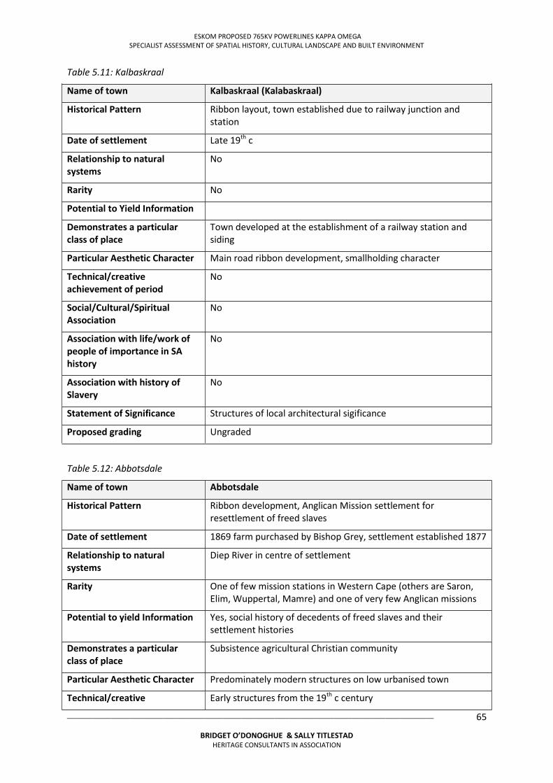
ESKOM PROPOSED 765KV POWERLINES KAPPA OMEGA SPECIALIST ASSESSMENT OF SPATIAL HISTORY, CULTURAL LANDSCAPE AND BUILT ENVIRONMENT
___________________________________________________________________________________________________
BRIDGET O’DONOGHUE & SALLY TITLESTAD HERITAGE CONSULTANTS IN ASSOCIATION
65
Table 5.11: Kalbaskraal
Name of town Kalbaskraal (Kalabaskraal)
Historical Pattern Ribbon layout, town established due to railway junction and station
Date of settlement Late 19th c
Relationship to natural systems
No
Rarity No
Potential to Yield Information
Demonstrates a particular class of place
Town developed at the establishment of a railway station and siding
Particular Aesthetic Character Main road ribbon development, smallholding character
Technical/creative achievement of period
No
Social/Cultural/Spiritual Association
No
Association with life/work of people of importance in SA history
No
Association with history of Slavery
No
Statement of Significance Structures of local architectural sigificance
Proposed grading Ungraded
Table 5.12: Abbotsdale
Name of town Abbotsdale
Historical Pattern Ribbon development, Anglican Mission settlement for resettlement of freed slaves
Date of settlement 1869 farm purchased by Bishop Grey, settlement established 1877
Relationship to natural systems
Diep River in centre of settlement
Rarity One of few mission stations in Western Cape (others are Saron, Elim, Wuppertal, Mamre) and one of very few Anglican missions
Potential to yield Information Yes, social history of decedents of freed slaves and their settlement histories
Demonstrates a particular class of place
Subsistence agricultural Christian community
Particular Aesthetic Character Predominately modern structures on low urbanised town
Technical/creative Early structures from the 19th c century
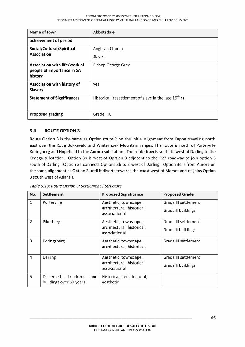
ESKOM PROPOSED 765KV POWERLINES KAPPA OMEGA SPECIALIST ASSESSMENT OF SPATIAL HISTORY, CULTURAL LANDSCAPE AND BUILT ENVIRONMENT
___________________________________________________________________________________________________
BRIDGET O’DONOGHUE & SALLY TITLESTAD HERITAGE CONSULTANTS IN ASSOCIATION
66
Name of town Abbotsdale
achievement of period
Social/Cultural/Spiritual Association
Anglican Church
Slaves
Association with life/work of people of importance in SA history
Bishop George Grey
Association with history of Slavery
yes
Statement of Significances Historical (resettlement of slave in the late 19th c)
Proposed grading Grade IIIC
5.4 ROUTE OPTION 3
Route Option 3 is the same as Option route 2 on the initial alignment from Kappa traveling north east over the Koue Bokkeveld and Winterhoek Mountain ranges. The route is north of Porterville Koringberg and Hopefield to the Aurora substation. The route travels south to west of Darling to the Omega substation. Option 3b is west of Oprtion 3 adjacent to the R27 roadway to join option 3 south of Darling. Option 3a connects Options 3b to 3 west of Darling. Option 3c is from Aurora on the same alignment as Option 3 until it diverts towards the coast west of Mamre and re-joins Option 3 south west of Atlantis.
Table 5.13: Route Option 3: Settlement / Structure
No. Settlement Proposed Significance Proposed Grade
1 Porterville Aesthetic, townscape, architectural, historical, associational
Grade III settlement
Grade II buildings
2 Piketberg Aesthetic, townscape, architectural, historical, associational
Grade III settlement
Grade II buildings
3 Koringsberg Aesthetic, townscape, architectural, historical,
Grade III settlement
4 Darling Aesthetic, townscape, architectural, historical, associational
Grade III settlement
Grade II buildings
5 Dispersed structures and buildings over 60 years
Historical, architectural, aesthetic
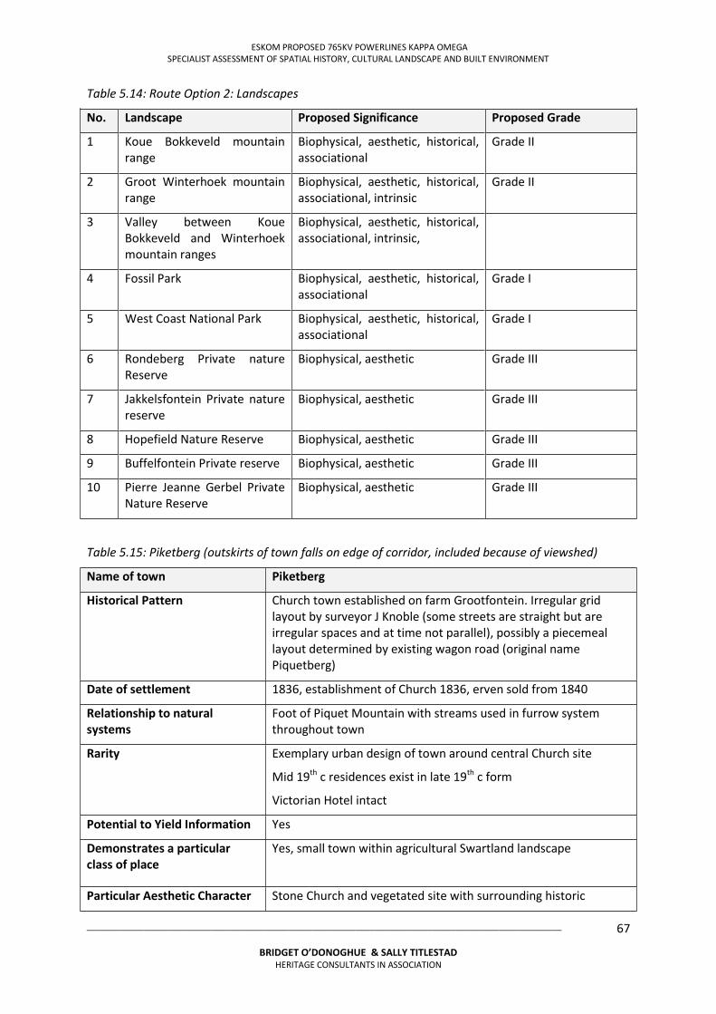
ESKOM PROPOSED 765KV POWERLINES KAPPA OMEGA SPECIALIST ASSESSMENT OF SPATIAL HISTORY, CULTURAL LANDSCAPE AND BUILT ENVIRONMENT
___________________________________________________________________________________________________
BRIDGET O’DONOGHUE & SALLY TITLESTAD HERITAGE CONSULTANTS IN ASSOCIATION
67
Table 5.14: Route Option 2: Landscapes
No. Landscape Proposed Significance Proposed Grade
1 Koue Bokkeveld mountain range
Biophysical, aesthetic, historical, associational
Grade II
2 Groot Winterhoek mountain range
Biophysical, aesthetic, historical, associational, intrinsic
Grade II
3 Valley between Koue Bokkeveld and Winterhoek mountain ranges
Biophysical, aesthetic, historical, associational, intrinsic,
4 Fossil Park Biophysical, aesthetic, historical, associational
Grade I
5 West Coast National Park Biophysical, aesthetic, historical, associational
Grade I
6 Rondeberg Private nature Reserve
Biophysical, aesthetic Grade III
7 Jakkelsfontein Private nature reserve
Biophysical, aesthetic Grade III
8 Hopefield Nature Reserve Biophysical, aesthetic Grade III
9 Buffelfontein Private reserve Biophysical, aesthetic Grade III
10 Pierre Jeanne Gerbel Private Nature Reserve
Biophysical, aesthetic Grade III
Table 5.15: Piketberg (outskirts of town falls on edge of corridor, included because of viewshed)
Name of town Piketberg
Historical Pattern Church town established on farm Grootfontein. Irregular grid layout by surveyor J Knoble (some streets are straight but are irregular spaces and at time not parallel), possibly a piecemeal layout determined by existing wagon road (original name Piquetberg)
Date of settlement 1836, establishment of Church 1836, erven sold from 1840
Relationship to natural systems
Foot of Piquet Mountain with streams used in furrow system throughout town
Rarity Exemplary urban design of town around central Church site
Mid 19th c residences exist in late 19th c form
Victorian Hotel intact
Potential to Yield Information Yes
Demonstrates a particular class of place
Yes, small town within agricultural Swartland landscape
Particular Aesthetic Character Stone Church and vegetated site with surrounding historic
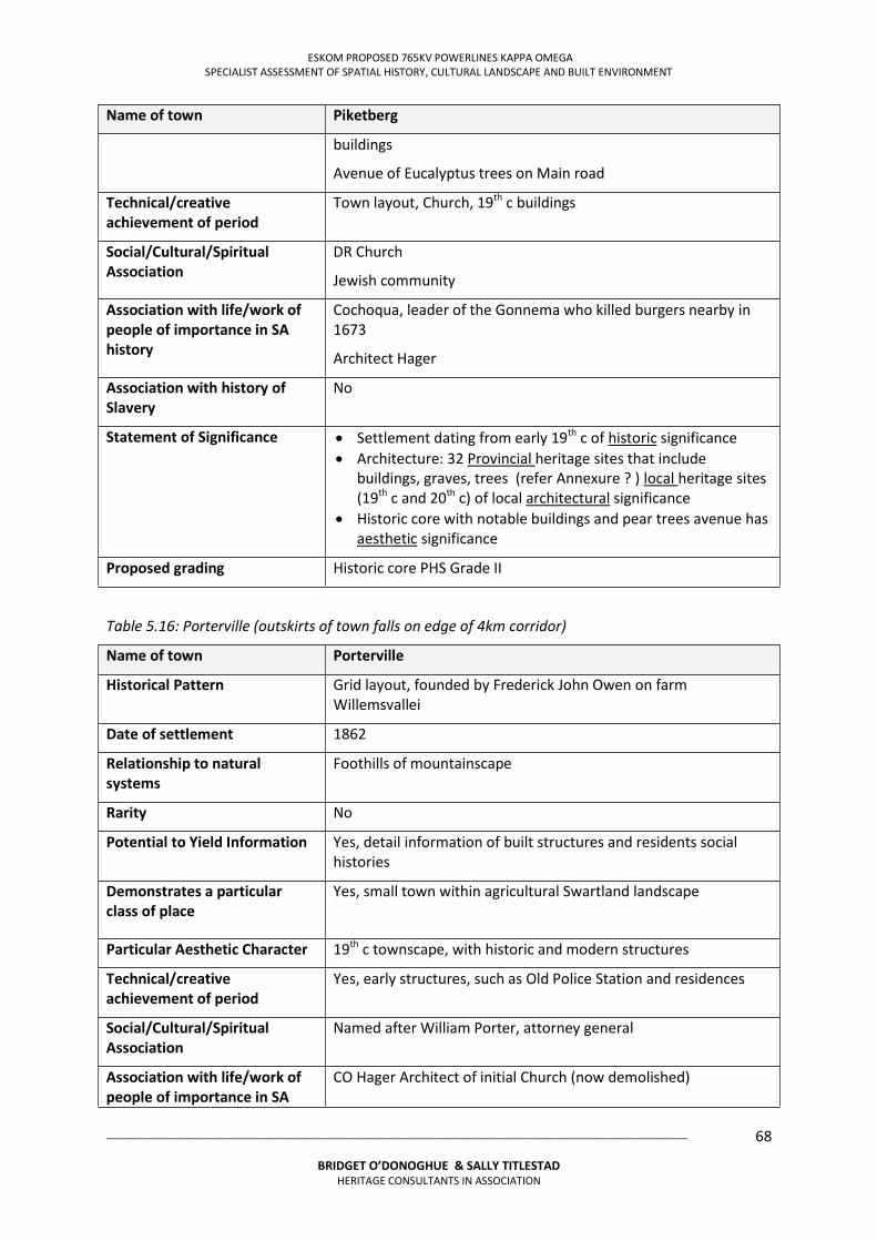
ESKOM PROPOSED 765KV POWERLINES KAPPA OMEGA SPECIALIST ASSESSMENT OF SPATIAL HISTORY, CULTURAL LANDSCAPE AND BUILT ENVIRONMENT
___________________________________________________________________________________________________
BRIDGET O’DONOGHUE & SALLY TITLESTAD HERITAGE CONSULTANTS IN ASSOCIATION
68
Name of town Piketberg
buildings
Avenue of Eucalyptus trees on Main road
Technical/creative achievement of period
Town layout, Church, 19th c buildings
Social/Cultural/Spiritual Association
DR Church
Jewish community
Association with life/work of people of importance in SA history
Cochoqua, leader of the Gonnema who killed burgers nearby in 1673
Architect Hager
Association with history of Slavery
No
Statement of Significance Settlement dating from early 19th c of historic significance Architecture: 32 Provincial heritage sites that include
buildings, graves, trees (refer Annexure ? ) local heritage sites (19th c and 20th c) of local architectural significance
Historic core with notable buildings and pear trees avenue has aesthetic significance
Proposed grading Historic core PHS Grade II
Table 5.16: Porterville (outskirts of town falls on edge of 4km corridor)
Name of town Porterville
Historical Pattern Grid layout, founded by Frederick John Owen on farm Willemsvallei
Date of settlement 1862
Relationship to natural systems
Foothills of mountainscape
Rarity No
Potential to Yield Information Yes, detail information of built structures and residents social histories
Demonstrates a particular class of place
Yes, small town within agricultural Swartland landscape
Particular Aesthetic Character 19th c townscape, with historic and modern structures
Technical/creative achievement of period
Yes, early structures, such as Old Police Station and residences
Social/Cultural/Spiritual Association
Named after William Porter, attorney general
Association with life/work of people of importance in SA
CO Hager Architect of initial Church (now demolished)
ESKOM PROPOSED 765KV POWERLINES KAPPA OMEGA SPECIALIST ASSESSMENT OF SPATIAL HISTORY, CULTURAL LANDSCAPE AND BUILT ENVIRONMENT
___________________________________________________________________________________________________
BRIDGET O’DONOGHUE & SALLY TITLESTAD HERITAGE CONSULTANTS IN ASSOCIATION
69
Name of town Porterville
history
Association with history of Slavery
No
Statement of Significance Settlement dating from early 19th c of historic significance Architecture: 32 Provincial heritage sites that include
buildings, graves, trees local heritage sites (19th c and 20th c) of local architectural significance
Historic core with notable buildings and pear trees avenue has aesthetic significance
Proposed grading III C
Table 5.17: Koringberg and surrounding farms
Name of town Koringberg
Historical Pattern Church town established at a railway siding
Date of settlement
Relationship to natural systems
Rarity Very small settlement driven by rail link, surrounding farms of significant historical buildings and include graveyards
Potential to Yield Information Yes, detail study of structures, land use and social histories
Demonstrates a particular class of place
Yes, small town of rural character within agricultural Swartland landscape
Particular Aesthetic Character Rural character within a Swartland agricultural context
Technical/creative achievement of period
Early land uses and 19th c structures
Social/Cultural/Spiritual Association
Church, links to community and surrounding parishes not yet established
Association with life/work of people of importance in SA history
unknown
Association with history of Slavery
Statement of Significance Rural character of town of aesthetic significance
Proposed grading of settlement
Grade III C
ESKOM PROPOSED 765KV POWERLINES KAPPA OMEGA SPECIALIST ASSESSMENT OF SPATIAL HISTORY, CULTURAL LANDSCAPE AND BUILT ENVIRONMENT
___________________________________________________________________________________________________
BRIDGET O’DONOGHUE & SALLY TITLESTAD HERITAGE CONSULTANTS IN ASSOCIATION
70
Table 5.18: Darling
Name of town Darling
Historical Pattern Church town, established on part of the farm Langfontein. Almost square historic settlement. Rectangular grid of elongated blocks with a wider strip in the centre to accommodate the river. 20th c expansions to the north east (Nuwedorp) created grid of smaller erven resulting in smaller houses and higher density.
Date of settlement 1853, named after the acting Governor of the Cape, Sir Charles Henry Darling
Relationship to natural systems
River in the centre of the historic settlement
Rarity Unusual grid layout of river in centre (similar to Ceres with its expansion to both sides of river)
Potential to Yield Information Yes, detail study of structures, land use and social histories
Demonstrates a particular class of place
Yes, small town of rural character within agricultural Swartland landscape
Particular Aesthetic Character Rural character within a Swartland agricultural context, nearby farm Oudepost
Technical/creative achievement of period
Early land uses and 19th c structures
Social/Cultural/Spiritual Association
DR Church
Association with life/work of people of importance in SA history
Named after acting Governor of the Cape, Sir Charles Henry Darling
Entertainer Pieter Dirk Uys lives in Darling
Association with history of Slavery
Statement of Significance Settlement dating from early 19th c of historic significance Architecture: Provincial heritage sites, local heritage sites (19th
c and 20th c) of local architectural significance Rural character of town of aesthetic significance
Proposed grading of settlement
Grade III B
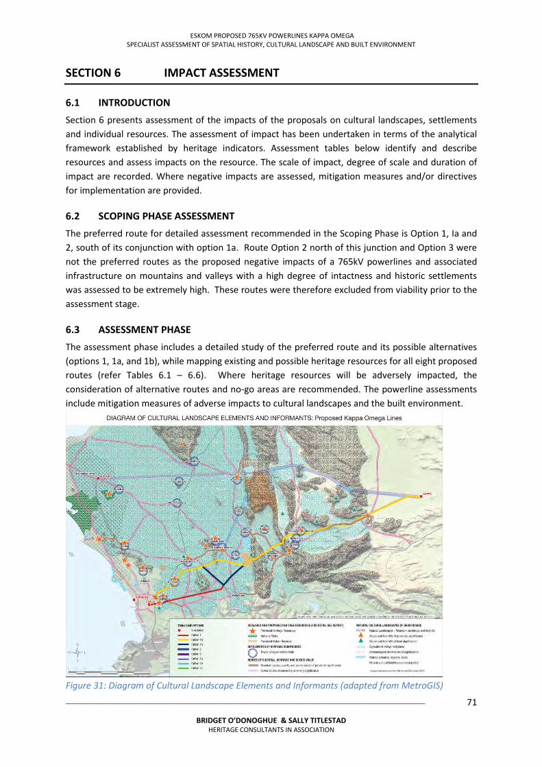
ESKOM PROPOSED 765KV POWERLINES KAPPA OMEGA SPECIALIST ASSESSMENT OF SPATIAL HISTORY, CULTURAL LANDSCAPE AND BUILT ENVIRONMENT
___________________________________________________________________________________________________
BRIDGET O’DONOGHUE & SALLY TITLESTAD HERITAGE CONSULTANTS IN ASSOCIATION
71
SECTION 6 IMPACT ASSESSMENT
6.1 INTRODUCTION
Section 6 presents assessment of the impacts of the proposals on cultural landscapes, settlements and individual resources. The assessment of impact has been undertaken in terms of the analytical framework established by heritage indicators. Assessment tables below identify and describe resources and assess impacts on the resource. The scale of impact, degree of scale and duration of impact are recorded. Where negative impacts are assessed, mitigation measures and/or directives for implementation are provided.
6.2 SCOPING PHASE ASSESSMENT
The preferred route for detailed assessment recommended in the Scoping Phase is Option 1, Ia and 2, south of its conjunction with option 1a. Route Option 2 north of this junction and Option 3 were not the preferred routes as the proposed negative impacts of a 765kV powerlines and associated infrastructure on mountains and valleys with a high degree of intactness and historic settlements was assessed to be extremely high. These routes were therefore excluded from viability prior to the assessment stage.
6.3 ASSESSMENT PHASE
The assessment phase includes a detailed study of the preferred route and its possible alternatives (options 1, 1a, and 1b), while mapping existing and possible heritage resources for all eight proposed routes (refer Tables 6.1 – 6.6). Where heritage resources will be adversely impacted, the consideration of alternative routes and no-go areas are recommended. The powerline assessments include mitigation measures of adverse impacts to cultural landscapes and the built environment.
Figure 31: Diagram of Cultural Landscape Elements and Informants (adapted from MetroGIS)
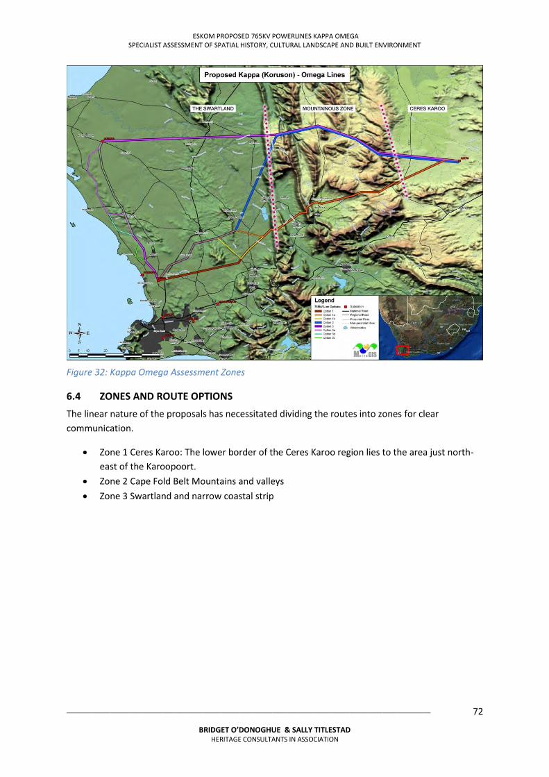
ESKOM PROPOSED 765KV POWERLINES KAPPA OMEGA SPECIALIST ASSESSMENT OF SPATIAL HISTORY, CULTURAL LANDSCAPE AND BUILT ENVIRONMENT
___________________________________________________________________________________________________
BRIDGET O’DONOGHUE & SALLY TITLESTAD HERITAGE CONSULTANTS IN ASSOCIATION
72
Figure 32: Kappa Omega Assessment Zones
6.4 ZONES AND ROUTE OPTIONS
The linear nature of the proposals has necessitated dividing the routes into zones for clear communication.
Zone 1 Ceres Karoo: The lower border of the Ceres Karoo region lies to the area just north-east of the Karoopoort.
Zone 2 Cape Fold Belt Mountains and valleys Zone 3 Swartland and narrow coastal strip
ESKOM PROPOSED 765KV POWERLINES KAPPA OMEGA SPECIALIST ASSESSMENT OF SPATIAL HISTORY, CULTURAL LANDSCAPE AND BUILT ENVIRONMENT
___________________________________________________________________________________________________
BRIDGET O’DONOGHUE & SALLY TITLESTAD HERITAGE CONSULTANTS IN ASSOCIATION
73
Table 6.1 Impact Assessment Route Option 1 Zone 1 No. KAPPA OMEGA 2ND 765KV POWER LINE ROUTE OPTION 1 ZONE 1: BUILT ENVIRONMENT AND CULTURAL LANDSCAPE RESOURCES Heritage Resources Landscape Typology Description
Position in corridor
Impact assessment13
Mitigation of assessed negative impacts
Confidence of assessment Image if applicable
F 1/1/1 Ref map 8
Platfontein Farm Productive agricultural node within remote arid landscape
Small farm complex on riverine tributaries, dam, kraals and irrigated fields, large trees, on stream tributaries structures <5, (1970T-2)
Mid corridor 500m north of farm node 450m from existing 400kV power line and 1st 765kV power line, Situated 1.4km from Kappa substation, bisected by roadway to Kappa substation Already highly impacted further high impact
Local Cumulative medium negative impact Permanent
No mitigation required Medium High
F 2/1/1 ref Map 8
Die Brak Farm Farm node within remote arid landscape
Small farm node on riverine corridor, structures <5 (1970T-3)
Mid corridor 1.6km south of node 400kV line 1.6km south of node
Sub regional Cumulative Medium negative impact
No mitigation required Medium High
F 3/1/1 Ref map 8
Kolkiesrivier Farm Productive agricultural node within remote arid landscape
Small farm node situated on edge of riverine corridor with 3 structures kraals, reservoir (1969T-3)
Mid corridor 170m north west of farm node, 290m north of existing 400kV power line and 990m north of 1st 765kV & 400kV power line
Local Cumulative medium negative impact Cumulative High negative if power line situated north of 440kV line Permanent
Position power line south of existing 400kV powerline within corridor to prevent framing farm node with powerlines
Medium High
F 3/1/1 Ref map 7
Tweerivier Farm Productive agricultural node within remote arid landscape
Small farm adjacent to R356 on edge of riverine corridor, kraals, large dam Structures <5 (1969T-3)
Mid corridor 420m south node, 1.3km north of 400kV power line, situated on edge of Inverdoorn private nature reserve
Local Cumulative medium negative impact Cumulative high negative impact if line situated north of 400kV line Permanent
Position power line south of existing 400kV powerline within corridor
Medium High
NR 1/1/1 Map 7 & 8
Inverdoorn Private Nature Reserve
Ceres Karoo 10 000 hectare reserve with 1200 animals, largest number of animals of all the private reserves in the Cape
Mid corridor traverses nature reserve
Local High impact Sub regional Cumulative medium negative impact Cumulative high negative impact if line situated north of 400kV line Permanent
Position power line south of existing 400kV powerline within corridor
Medium High
13 Impact Assessment: Scale (regional, sub regional, local) Measurement (High, Medium, Local) (Positive, Neutral, Negative) Duration of Impact (Permanent, Semi permanent, temporary)
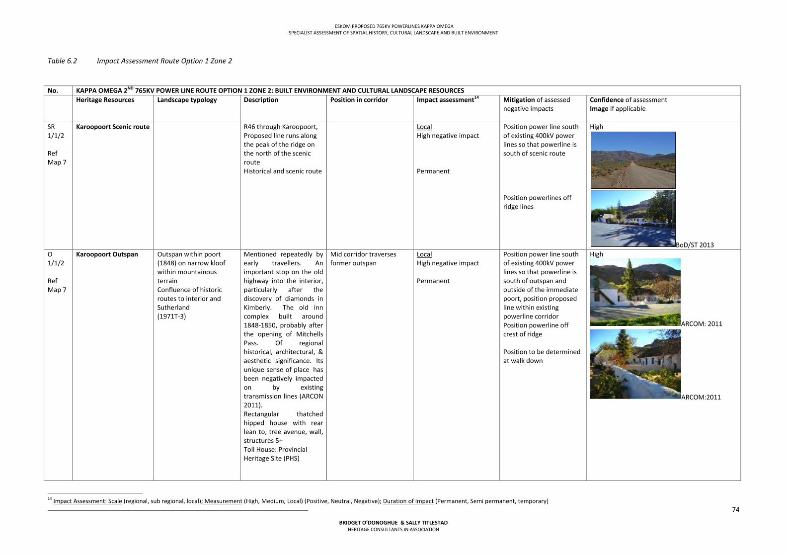
ESKOM PROPOSED 765KV POWERLINES KAPPA OMEGA SPECIALIST ASSESSMENT OF SPATIAL HISTORY, CULTURAL LANDSCAPE AND BUILT ENVIRONMENT
___________________________________________________________________________________________________
BRIDGET O’DONOGHUE & SALLY TITLESTAD HERITAGE CONSULTANTS IN ASSOCIATION
74
Table 6.2 Impact Assessment Route Option 1 Zone 2
No. KAPPA OMEGA 2ND 765KV POWER LINE ROUTE OPTION 1 ZONE 2: BUILT ENVIRONMENT AND CULTURAL LANDSCAPE RESOURCES Heritage Resources Landscape typology Description Position in corridor
Impact assessment14
Mitigation of assessed negative impacts
Confidence of assessment Image if applicable
SR 1/1/2 Ref Map 7
Karoopoort Scenic route R46 through Karoopoort, Proposed line runs along the peak of the ridge on the north of the scenic route Historical and scenic route
Local High negative impact Permanent
Position power line south of existing 400kV power lines so that powerline is south of scenic route Position powerlines off ridge lines
High
BoD/ST 2013 O 1/1/2 Ref Map 7
Karoopoort Outspan
Outspan within poort (1848) on narrow kloof within mountainous terrain Confluence of historic routes to interior and Sutherland (1971T-3)
Mentioned repeatedly by early travellers. An important stop on the old highway into the interior, particularly after the discovery of diamonds in Kimberly. The old inn complex built around 1848-1850, probably after the opening of Mitchells Pass. Of regional historical, architectural, & aesthetic significance. Its unique sense of placehas been negatively impacted on by existing transmission lines (ARCON 2011). Rectangular thatched hipped house with rear lean to, tree avenue, wall, structures 5+ Toll House: Provincial Heritage Site (PHS)
Mid corridor traverses former outspan
Local High negative impact Permanent
Position power line south of existing 400kV power lines so that powerline is south of outspan and outside of the immediate poort, position proposed line within existing powerline corridor Position powerline off crest of ridge Position to be determined at walk down
High
ARCOM: 2011
ARCOM:2011
14 Impact Assessment: Scale (regional, sub regional, local); Measurement (High, Medium, Local) (Positive, Neutral, Negative); Duration of Impact (Permanent, Semi permanent, temporary)
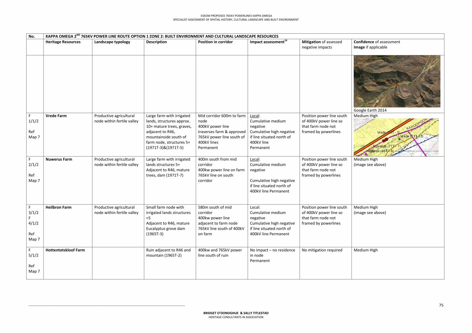
ESKOM PROPOSED 765KV POWERLINES KAPPA OMEGA SPECIALIST ASSESSMENT OF SPATIAL HISTORY, CULTURAL LANDSCAPE AND BUILT ENVIRONMENT
___________________________________________________________________________________________________
BRIDGET O’DONOGHUE & SALLY TITLESTAD HERITAGE CONSULTANTS IN ASSOCIATION
75
No. KAPPA OMEGA 2ND 765KV POWER LINE ROUTE OPTION 1 ZONE 2: BUILT ENVIRONMENT AND CULTURAL LANDSCAPE RESOURCES Heritage Resources Landscape typology Description Position in corridor
Impact assessment14
Mitigation of assessed negative impacts
Confidence of assessment Image if applicable
Google Earth 2014
F 1/1/2 Ref Map 7
Vrede Farm Productive agricultural node within fertile valley
Large farm with irrigated lands, structures approx. 10+ mature trees, graves, adjacent to R46, mountainside south of farm node, structures 5+ (1971T-3)&(1971T-5)
Mid corridor 600m to farm node 400kV power line traverses farm & approved 765kV power line south of 400kV lines Permanent
Local: Cumulative medium negative Cumulative high negative if line situated north of 400kV line Permanent
Position power line south of 400kV power line so that farm node not framed by powerlines
Medium High
F 2/1/2 Ref Map 7
Nuwerus Farm Productive agricultural node within fertile valley
Large farm with irrigated lands structures 5+ Adjacent to R46, mature trees, dam (1971T-7)
400m south from mid corridor 400kw power line on farm 765kV line on south corridor
Local: Cumulative medium negative Cumulative high negative if line situated north of 400kV line Permanent
Position power line south of 400kV power line so that farm node not framed by powerlines
Medium High (image see above)
F 3/1/2 F 4/1/2 Ref Map 7
Heilbron Farm Productive agricultural node within fertile valley
Small farm node with irrigated lands structures <5 Adjacent to R46, mature Eucalyptus grove dam (1965T-3)
580m south of mid corridor 400kw power line adjacent to farm node 765kV line south of 400kV on farm
Local: Cumulative medium negative Cumulative high negative if line situated north of 400kV line Permanent
Position power line south of 400kV power line so that farm node not framed by powerlines
Medium High (image see above)
F 5/1/2 Ref Map 7
Hottentotskloof Farm Ruin adjacent to R46 and mountain (1965T-2)
400kw and 765kV power line south of ruin
No impact – no residence in node Permanent
No mitigation required Medium High
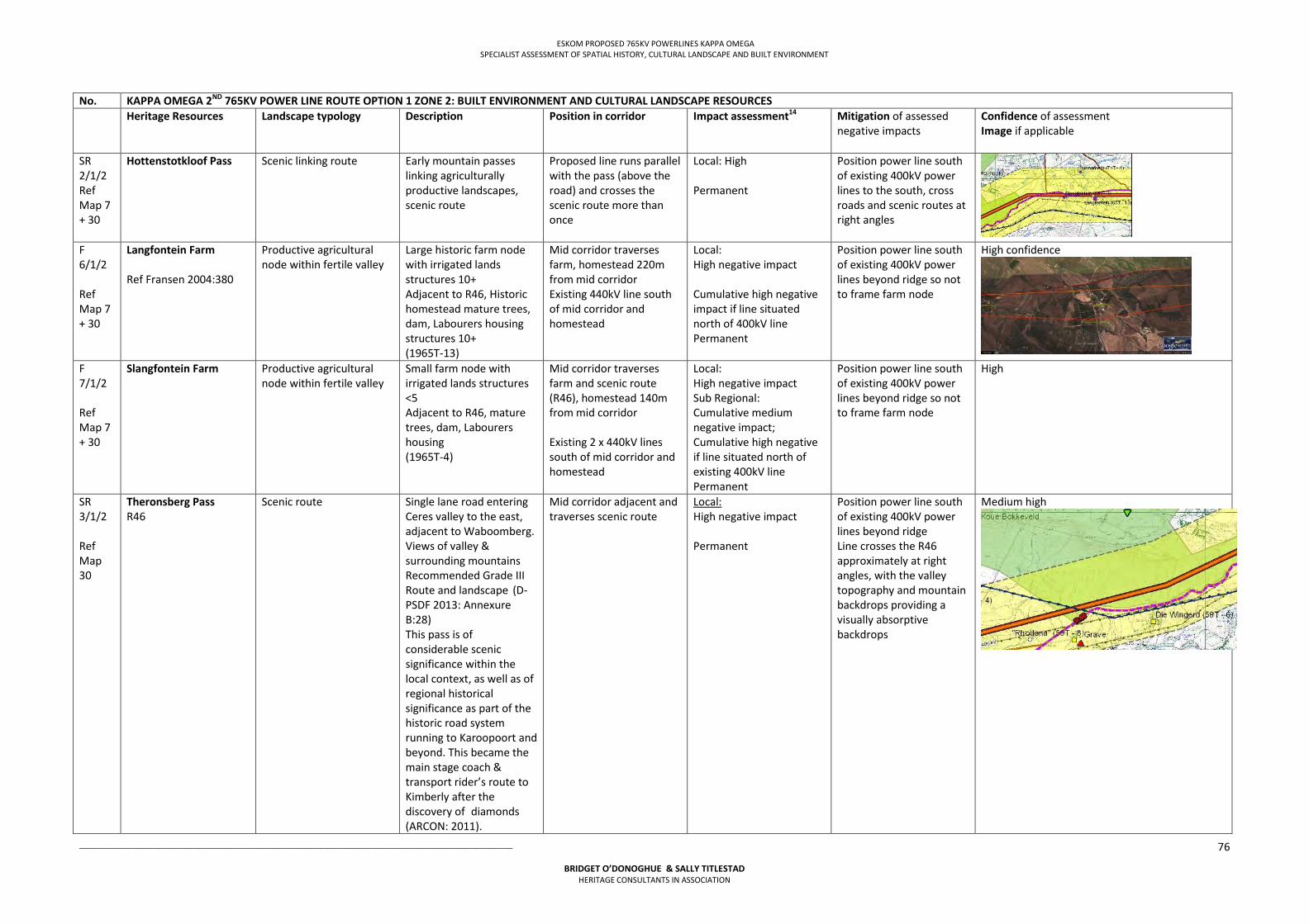
ESKOM PROPOSED 765KV POWERLINES KAPPA OMEGA SPECIALIST ASSESSMENT OF SPATIAL HISTORY, CULTURAL LANDSCAPE AND BUILT ENVIRONMENT
___________________________________________________________________________________________________
BRIDGET O’DONOGHUE & SALLY TITLESTAD HERITAGE CONSULTANTS IN ASSOCIATION
76
No. KAPPA OMEGA 2ND 765KV POWER LINE ROUTE OPTION 1 ZONE 2: BUILT ENVIRONMENT AND CULTURAL LANDSCAPE RESOURCES Heritage Resources Landscape typology Description Position in corridor
Impact assessment14
Mitigation of assessed negative impacts
Confidence of assessment Image if applicable
SR 2/1/2 Ref Map 7 + 30
Hottenstotkloof Pass
Scenic linking route Early mountain passes linking agriculturally productive landscapes, scenic route
Proposed line runs parallel with the pass (above the road) and crosses the scenic route more than once
Local: High Permanent
Position power line south of existing 400kV power lines to the south, cross roads and scenic routes at right angles
F 6/1/2 Ref Map 7 + 30
Langfontein Farm Ref Fransen 2004:380
Productive agricultural node within fertile valley
Large historic farm node with irrigated lands structures 10+ Adjacent to R46, Historic homestead mature trees, dam, Labourers housing structures 10+ (1965T-13)
Mid corridor traverses farm, homestead 220m from mid corridor Existing 440kV line south of mid corridor and homestead
Local: High negative impact Cumulative high negative impact if line situated north of 400kV line Permanent
Position power line south of existing 400kV power lines beyond ridge so not to frame farm node
High confidence
F 7/1/2 Ref Map 7 + 30
Slangfontein Farm Productive agricultural node within fertile valley
Small farm node with irrigated lands structures <5 Adjacent to R46, mature trees, dam, Labourers housing (1965T-4)
Mid corridor traverses farm and scenic route (R46), homestead 140m from mid corridor Existing 2 x 440kV lines south of mid corridor and homestead
Local: High negative impact Sub Regional: Cumulative medium negative impact; Cumulative high negative if line situated north of existing 400kV line Permanent
Position power line south of existing 400kV power lines beyond ridge so not to frame farm node
High
SR 3/1/2 Ref Map 30
Theronsberg Pass R46
Scenic route Single lane road entering Ceres valley to the east, adjacent to Waboomberg. Views of valley & surrounding mountains Recommended Grade III Route and landscape (D-PSDF 2013: Annexure B:28) This pass is of considerable scenic significance within the local context, as well as of regional historical significance as part of the historic road system running to Karoopoort and beyond. This became the main stage coach & transport rider’s route to Kimberly after the discovery ofdiamonds (ARCON: 2011).
Mid corridor adjacent and traverses scenic route
Local: High negative impact Permanent
Position power line south of existing 400kV power lines beyond ridge Line crosses the R46 approximately at right angles, with the valley topography and mountain backdrops providing a visually absorptive backdrops
Medium high
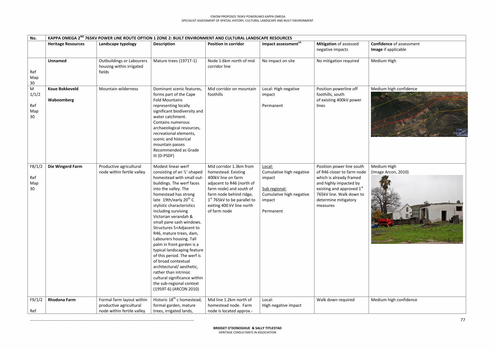
ESKOM PROPOSED 765KV POWERLINES KAPPA OMEGA SPECIALIST ASSESSMENT OF SPATIAL HISTORY, CULTURAL LANDSCAPE AND BUILT ENVIRONMENT
___________________________________________________________________________________________________
BRIDGET O’DONOGHUE & SALLY TITLESTAD HERITAGE CONSULTANTS IN ASSOCIATION
77
No. KAPPA OMEGA 2ND 765KV POWER LINE ROUTE OPTION 1 ZONE 2: BUILT ENVIRONMENT AND CULTURAL LANDSCAPE RESOURCES Heritage Resources Landscape typology Description Position in corridor
Impact assessment14
Mitigation of assessed negative impacts
Confidence of assessment Image if applicable
Ref Map 30
Unnamed Outbuildings or Labourers housing within irrigated fields
Mature trees (1971T-1) Node 1.6km north of mid corridor line
No impact on site No mitigation required Medium High
M 1/1/2 Ref Map 30
Koue Bokkeveld Waboomberg
Mountain wilderness Dominant scenic features, forms part of the Cape Fold Mountains representing locally significant biodiversity and water catchment. Contains numerous archaeological resources, recreational elements, scenic and historical mountain passes Recommended as Grade III (D-PSDF)
Mid corridor on mountain foothills
Local: High negative impact Permanent
Position powerline off foothills, south of existing 400kV power lines
Medium high confidence
F8/1/2 Ref Map 30
Die Wingerd Farm Productive agricultural node within fertile valley
Modest linear werf consisting of an ‘L’-shaped homestead with small out- buildings. The werf faces into the valley. The homestead has strong late19th/early 20th C stylistic characteristics including surviving Victorian verandah & small pane sash windows. Structures 5+Adjacent to R46, mature trees, dam, Labourers housing. Tall palm in front garden is a typical landscaping feature of this period. The werf is of broad contextual architectural/ aesthetic, rather than intrinsic cultural significance within the sub-regional context (1959T-6) (ARCON 2010)
Mid corridor 1.3km from homestead. Existing 400kV line on farm adjacent to R46 (north of farm node) and south of farm node behind ridge, 1st 765kV to be parallel to exiting 400 kV line north of farm node
Local: Cumulative high negative impact Sub regional: Cumulative high negative impact Permanent
Position power line south of R46 closer to farm node which is already framed and highly impacted by existing and approved 1st 765kV line. Walk down to determine mitigatory measures
Medium High (Image Arcon, 2010)
F9/1/2 Ref
Rhodona Farm Formal farm layout within productive agricultural node within fertile valley
Historic 18th c homestead, formal garden, mature trees, irrigated lands,
Mid line 1.2km north of homestead node. Farm node is located approx.-
Local: High negative impact
Walk down required Medium high confidence
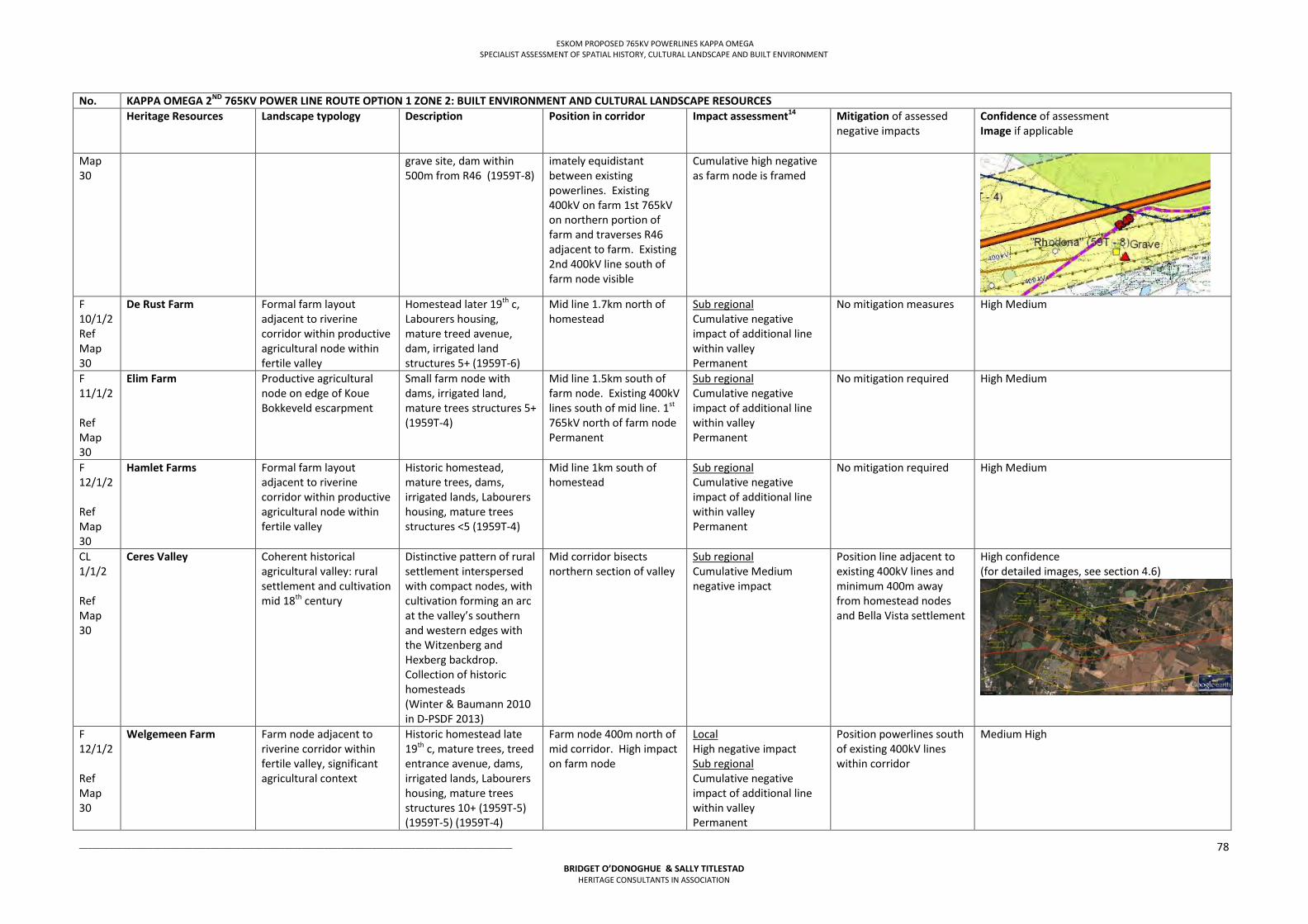
ESKOM PROPOSED 765KV POWERLINES KAPPA OMEGA SPECIALIST ASSESSMENT OF SPATIAL HISTORY, CULTURAL LANDSCAPE AND BUILT ENVIRONMENT
___________________________________________________________________________________________________
BRIDGET O’DONOGHUE & SALLY TITLESTAD HERITAGE CONSULTANTS IN ASSOCIATION
78
No. KAPPA OMEGA 2ND 765KV POWER LINE ROUTE OPTION 1 ZONE 2: BUILT ENVIRONMENT AND CULTURAL LANDSCAPE RESOURCES Heritage Resources Landscape typology Description Position in corridor
Impact assessment14
Mitigation of assessed negative impacts
Confidence of assessment Image if applicable
Map 30
grave site, dam within 500m from R46 (1959T-8)
imately equidistant between existing powerlines. Existing 400kV on farm 1st 765kV on northern portion of farm and traverses R46 adjacent to farm. Existing 2nd 400kV line south of farm node visible
Cumulative high negative as farm node is framed
F 10/1/2 Ref Map 30
De Rust Farm Formal farm layout adjacent to riverine corridor within productive agricultural node within fertile valley
Homestead later 19th c, Labourers housing, mature treed avenue, dam, irrigated land structures 5+ (1959T-6)
Mid line 1.7km north of homestead
Sub regional Cumulative negative impact of additional line within valley Permanent
No mitigation measures High Medium
F 11/1/2 Ref Map 30
Elim Farm Productive agricultural node on edge of Koue Bokkeveld escarpment
Small farm node with dams, irrigated land, mature trees structures 5+ (1959T-4)
Mid line 1.5km south of farm node. Existing 400kV lines south of mid line. 1st 765kV north of farm node Permanent
Sub regional Cumulative negative impact of additional line within valley Permanent
No mitigation required High Medium
F 12/1/2 Ref Map 30
Hamlet Farms Formal farm layout adjacent to riverine corridor within productive agricultural node within fertile valley
Historic homestead, mature trees, dams, irrigated lands, Labourers housing, mature trees structures <5 (1959T-4)
Mid line 1km south of homestead
Sub regional Cumulative negative impact of additional line within valley Permanent
No mitigation required High Medium
CL 1/1/2 Ref Map 30
Ceres Valley Coherent historical agricultural valley: rural settlement and cultivation mid 18th century
Distinctive pattern of rural settlement interspersed with compact nodes, with cultivation forming an arc at the valley’s southern and western edges with the Witzenberg and Hexberg backdrop. Collection of historic homesteads (Winter & Baumann 2010 in D-PSDF 2013)
Mid corridor bisects northern section of valley
Sub regional Cumulative Medium negative impact
Position line adjacent to existing 400kV lines and minimum 400m away from homestead nodes and Bella Vista settlement
High confidence (for detailed images, see section 4.6)
F 12/1/2 Ref Map 30
Welgemeen Farm Farm node adjacent to riverine corridor within fertile valley, significant agricultural context
Historic homestead late 19th c, mature trees, treed entrance avenue, dams, irrigated lands, Labourers housing, mature trees structures 10+ (1959T-5) (1959T-5) (1959T-4)
Farm node 400m north of mid corridor. High impact on farm node
Local High negative impact Sub regional Cumulative negative impact of additional line within valley Permanent
Position powerlines south of existing 400kV lines within corridor
Medium High
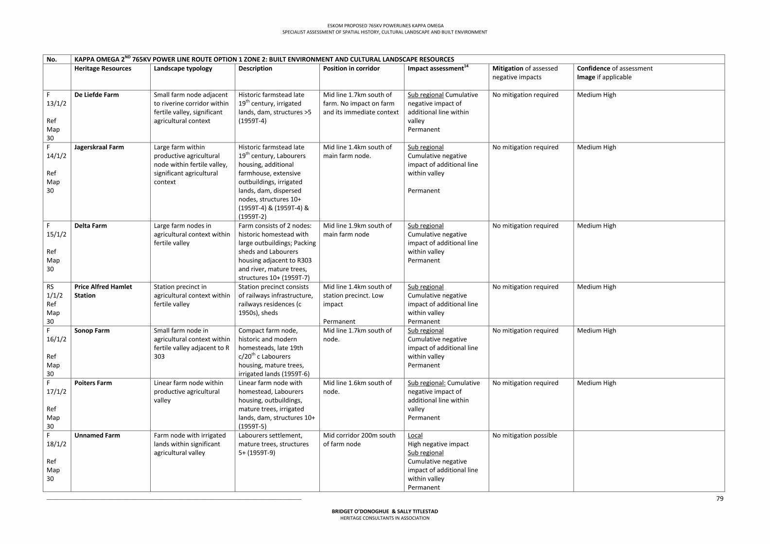
ESKOM PROPOSED 765KV POWERLINES KAPPA OMEGA SPECIALIST ASSESSMENT OF SPATIAL HISTORY, CULTURAL LANDSCAPE AND BUILT ENVIRONMENT
___________________________________________________________________________________________________
BRIDGET O’DONOGHUE & SALLY TITLESTAD HERITAGE CONSULTANTS IN ASSOCIATION
79
No. KAPPA OMEGA 2ND 765KV POWER LINE ROUTE OPTION 1 ZONE 2: BUILT ENVIRONMENT AND CULTURAL LANDSCAPE RESOURCES Heritage Resources Landscape typology Description Position in corridor
Impact assessment14
Mitigation of assessed negative impacts
Confidence of assessment Image if applicable
F 13/1/2 Ref Map 30
De Liefde Farm Small farm node adjacent to riverine corridor within fertile valley, significant agricultural context
Historic farmstead late 19th century, irrigated lands, dam, structures >5 (1959T-4)
Mid line 1.7km south of farm. No impact on farm and its immediate context
Sub regional Cumulative negative impact of additional line within valley Permanent
No mitigation required Medium High
F 14/1/2 Ref Map 30
Jagerskraal Farm Large farm within productive agricultural node within fertile valley, significant agricultural context
Historic farmstead late 19th century, Labourers housing, additional farmhouse, extensive outbuildings, irrigated lands, dam, dispersed nodes, structures 10+ (1959T-4) & (1959T-4) & (1959T-2)
Mid line 1.4km south of main farm node.
Sub regional Cumulative negative impact of additional line within valley Permanent
No mitigation required Medium High
F 15/1/2 Ref Map 30
Delta Farm Large farm nodes in agricultural context within fertile valley
Farm consists of 2 nodes: historic homestead with large outbuildings; Packing sheds and Labourers housing adjacent to R303 and river, mature trees, structures 10+ (1959T-7)
Mid line 1.9km south of main farm node
Sub regional Cumulative negative impact of additional line within valley Permanent
No mitigation required Medium High
RS 1/1/2 Ref Map 30
Price Alfred Hamlet Station
Station precinct in agricultural context within fertile valley
Station precinct consists of railways infrastructure, railways residences (c 1950s), sheds
Mid line 1.4km south of station precinct. Low impact Permanent
Sub regional Cumulative negative impact of additional line within valley Permanent
No mitigation required Medium High
F 16/1/2 Ref Map 30
Sonop Farm Small farm node in agricultural context within fertile valley adjacent to R 303
Compact farm node, historic and modern homesteads, late 19th c/20th c Labourers housing, mature trees, irrigated lands (1959T-6)
Mid line 1.7km south of node.
Sub regional Cumulative negative impact of additional line within valley Permanent
No mitigation required Medium High
F 17/1/2 Ref Map 30
Poiters Farm Linear farm node within productive agricultural valley
Linear farm node with homestead, Labourers housing, outbuildings, mature trees, irrigated lands, dam, structures 10+ (1959T-5)
Mid line 1.6km south of node.
Sub regional: Cumulative negative impact of additional line within valley Permanent
No mitigation required Medium High
F 18/1/2 Ref Map 30
Unnamed Farm Farm node with irrigated lands within significant agricultural valley
Labourers settlement, mature trees, structures 5+ (1959T-9)
Mid corridor 200m south of farm node
Local High negative impact Sub regional Cumulative negative impact of additional line within valley Permanent
No mitigation possible
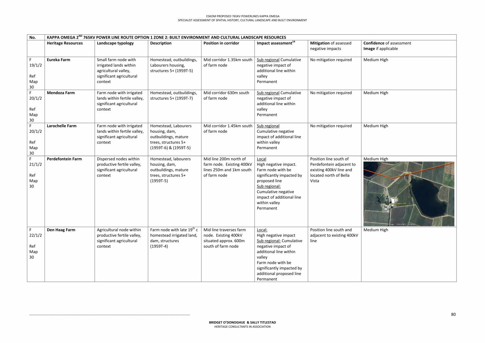
ESKOM PROPOSED 765KV POWERLINES KAPPA OMEGA SPECIALIST ASSESSMENT OF SPATIAL HISTORY, CULTURAL LANDSCAPE AND BUILT ENVIRONMENT
___________________________________________________________________________________________________
BRIDGET O’DONOGHUE & SALLY TITLESTAD HERITAGE CONSULTANTS IN ASSOCIATION
80
No. KAPPA OMEGA 2ND 765KV POWER LINE ROUTE OPTION 1 ZONE 2: BUILT ENVIRONMENT AND CULTURAL LANDSCAPE RESOURCES Heritage Resources Landscape typology Description Position in corridor
Impact assessment14
Mitigation of assessed negative impacts
Confidence of assessment Image if applicable
F 19/1/2 Ref Map 30
Eureka Farm Small farm node with irrigated lands within agricultural valley, significant agricultural context
Homestead, outbuildings, Labourers housing, structures 5+ (1959T-5)
Mid corridor 1.35km south of farm node
Sub regional Cumulative negative impact of additional line within valley Permanent
No mitigation required Medium High
F 20/1/2 Ref Map 30
Mendoza Farm Farm node with irrigated lands within fertile valley, significant agricultural context
Homestead, outbuildings, structures 5+ (1959T-7)
Mid corridor 630m south of farm node
Sub regional Cumulative negative impact of additional line within valley Permanent
No mitigation required Medium High
F 20/1/2 Ref Map 30
Larochelle Farm Farm node with irrigated lands within fertile valley, significant agricultural context
Homestead, Labourers housing, dam, outbuildings, mature trees, structures 5+ (1959T-6) & (1959T-5)
Mid corridor 1.45km south of farm node
Sub regional Cumulative negative impact of additional line within valley Permanent
No mitigation required Medium High
F 21/1/2 Ref Map 30
Perdefontein Farm Dispersed nodes within productive fertile valley, significant agricultural context
Homestead, labourers housing, dam, outbuildings, mature trees, structures 5+ (1959T-5)
Mid line 200m north of farm node. Existing 400kV lines 250m and 1km south of farm node
Local High negative impact. Farm node with be significantly impacted by proposed line Sub regional: Cumulative negative impact of additional line within valley Permanent
Position line south of Perdefontein adjacent to existing 400kV line and located north of Bella Vista
Medium High
F 22/1/2 Ref Map 30
Den Haag Farm Agricultural node within productive fertile valley, significant agricultural context
Farm node with late 19th c homestead irrigated land, dam, structures (1959T-4)
Mid line traverses farm node. Existing 400kV situated approx. 600m south of farm node
Local: High negative impact Sub regional: Cumulative negative impact of additional line within valley Farm node with be significantly impacted by additional proposed line Permanent
Position line south and adjacent to existing 400kV line
Medium High
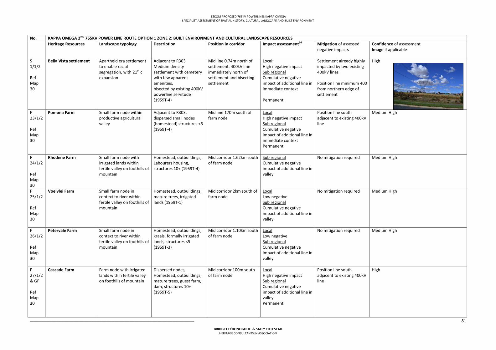
ESKOM PROPOSED 765KV POWERLINES KAPPA OMEGA SPECIALIST ASSESSMENT OF SPATIAL HISTORY, CULTURAL LANDSCAPE AND BUILT ENVIRONMENT
___________________________________________________________________________________________________
BRIDGET O’DONOGHUE & SALLY TITLESTAD HERITAGE CONSULTANTS IN ASSOCIATION
81
No. KAPPA OMEGA 2ND 765KV POWER LINE ROUTE OPTION 1 ZONE 2: BUILT ENVIRONMENT AND CULTURAL LANDSCAPE RESOURCES Heritage Resources Landscape typology Description Position in corridor
Impact assessment14
Mitigation of assessed negative impacts
Confidence of assessment Image if applicable
S 1/1/2 Ref Map 30
Bella Vista settlement Apartheid era settlement to enable racial segregation, with 21st c expansion
Adjacent to R303 Medium density settlement with cemetery with few apparent amenities, bisected by existing 400kV powerline servitude (1959T-4)
Mid line 0.74m north of settlement. 400kV line immediately north of settlement and bisecting settlement
Local: High negative impact Sub regional Cumulative negative impact of additional line in immediate context Permanent
Settlement already highly impacted by two existing 400kV lines Position line minimum 400 from northern edge of settlement
High
F 23/1/2 Ref Map 30
Pomona Farm Small farm node within productive agricultural valley
Adjacent to R303, dispersed small nodes (homestead) structures <5 (1959T-4)
Mid line 170m south of farm node
Local High negative impact Sub regional Cumulative negative impact of additional line in immediate context Permanent
Position line south adjacent to existing 400kV line
Medium High
F 24/1/2 Ref Map 30
Rhodene Farm Small farm node with irrigated lands within fertile valley on foothills of mountain
Homestead, outbuildings, Labourers housing, structures 10+ (1959T-4)
Mid corridor 1.62km south of farm node
Sub regional Cumulative negative impact of additional line in valley
No mitigation required Medium High
F 25/1/2 Ref Map 30
Voelvlei Farm Small farm node in context to river within fertile valley on foothills of mountain
Homestead, outbuildings, mature trees, irrigated lands (1959T-1)
Mid corridor 2km south of farm node
Local Low negative Sub regional Cumulative negative impact of additional line in valley
No mitigation required Medium High
F 26/1/2 Ref Map 30
Petervale Farm Small farm node in context to river within fertile valley on foothills of mountain
Homestead, outbuildings, kraals, formally irrigated lands, structures <5 (1959T-3)
Mid corridor 1.10km south of farm node
Local Low negative Sub regional Cumulative negative impact of additional line in valley
No mitigation required Medium High
F 27/1/2 & GF Ref Map 30
Cascade Farm Farm node with irrigated lands within fertile valley on foothills of mountain
Dispersed nodes, Homestead, outbuildings, mature trees, guest farm, dam, structures 10+ (1959T-5)
Mid corridor 100m south of farm node
Local High negative impact Sub regional Cumulative negative impact of additional line in valley Permanent
Position line south adjacent to existing 400kV line
High
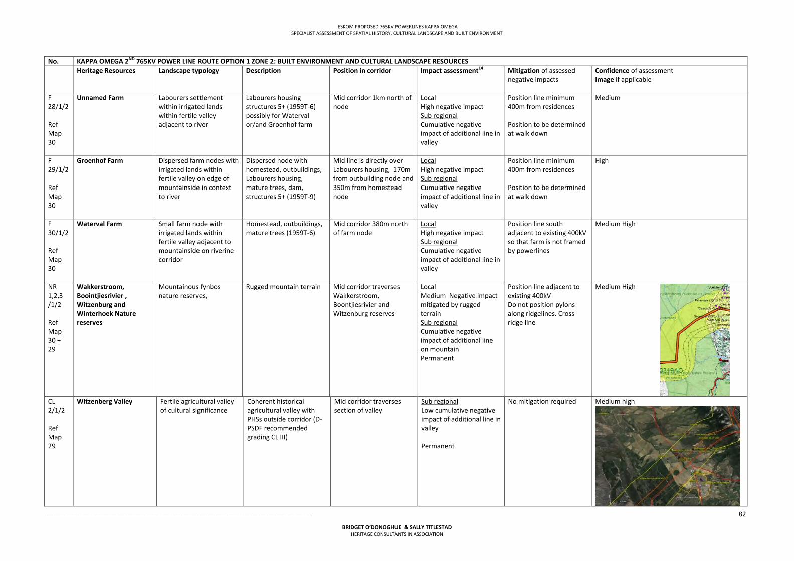
ESKOM PROPOSED 765KV POWERLINES KAPPA OMEGA SPECIALIST ASSESSMENT OF SPATIAL HISTORY, CULTURAL LANDSCAPE AND BUILT ENVIRONMENT
___________________________________________________________________________________________________
BRIDGET O’DONOGHUE & SALLY TITLESTAD HERITAGE CONSULTANTS IN ASSOCIATION
82
No. KAPPA OMEGA 2ND 765KV POWER LINE ROUTE OPTION 1 ZONE 2: BUILT ENVIRONMENT AND CULTURAL LANDSCAPE RESOURCES Heritage Resources Landscape typology Description Position in corridor
Impact assessment14
Mitigation of assessed negative impacts
Confidence of assessment Image if applicable
F 28/1/2 Ref Map 30
Unnamed Farm Labourers settlement within irrigated lands within fertile valley adjacent to river
Labourers housing structures 5+ (1959T-6) possibly for Waterval or/and Groenhof farm
Mid corridor 1km north of node
Local High negative impact Sub regional Cumulative negative impact of additional line in valley
Position line minimum 400m from residences Position to be determined at walk down
Medium
F 29/1/2 Ref Map 30
Groenhof Farm Dispersed farm nodes with irrigated lands within fertile valley on edge of mountainside in context to river
Dispersed node with homestead, outbuildings, Labourers housing, mature trees, dam, structures 5+ (1959T-9)
Mid line is directly over Labourers housing, 170m from outbuilding node and 350m from homestead node
Local High negative impact Sub regional Cumulative negative impact of additional line in valley
Position line minimum 400m from residences Position to be determined at walk down
High
F 30/1/2 Ref Map 30
Waterval Farm Small farm node with irrigated lands within fertile valley adjacent to mountainside on riverine corridor
Homestead, outbuildings, mature trees (1959T-6)
Mid corridor 380m north of farm node
Local High negative impact Sub regional Cumulative negative impact of additional line in valley
Position line south adjacent to existing 400kV so that farm is not framed by powerlines
Medium High
NR 1,2,3 /1/2 Ref Map 30 + 29
Wakkerstroom, Boointjiesrivier , Witzenburg and Winterhoek Nature reserves
Mountainous fynbos nature reserves,
Rugged mountain terrain Mid corridor traverses Wakkerstroom, Boontjiesrivier and Witzenburg reserves
Local Medium Negative impact mitigated by rugged terrain Sub regional Cumulative negative impact of additional line on mountain Permanent
Position line adjacent to existing 400kV Do not position pylons along ridgelines. Cross ridge line
Medium High
CL 2/1/2 Ref Map 29
Witzenberg Valley Fertile agricultural valley of cultural significance
Coherent historical agricultural valley with PHSs outside corridor (D-PSDF recommended grading CL III)
Mid corridor traverses section of valley
Sub regional Low cumulative negative impact of additional line in valley Permanent
No mitigation required Medium high
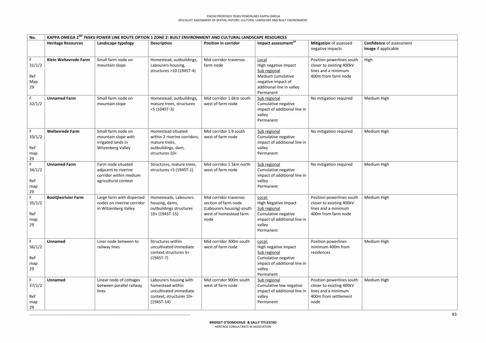
ESKOM PROPOSED 765KV POWERLINES KAPPA OMEGA SPECIALIST ASSESSMENT OF SPATIAL HISTORY, CULTURAL LANDSCAPE AND BUILT ENVIRONMENT
___________________________________________________________________________________________________
BRIDGET O’DONOGHUE & SALLY TITLESTAD HERITAGE CONSULTANTS IN ASSOCIATION
83
No. KAPPA OMEGA 2ND 765KV POWER LINE ROUTE OPTION 1 ZONE 2: BUILT ENVIRONMENT AND CULTURAL LANDSCAPE RESOURCES Heritage Resources Landscape typology Description Position in corridor
Impact assessment14
Mitigation of assessed negative impacts
Confidence of assessment Image if applicable
F 31/1/2 Ref Map 29
Klein Weltevrede Farm Small farm node on mountain slope
Homestead, outbuildings, Labourers housing, structures >10 (1945T-4)
Mid corridor traverses farm node
Local High negative impact Sub regional Medium cumulative negative impact of additional line in valley Permanent
Position powerlines south closer to existing 400kV lines and a minimum 400m from farm node
High
F 32/1/2
Unnamed Farm Small farm node on mountain slope
Homestead, outbuildings, mature trees, structures <5 (1045T-3)
Mid corridor 1.6km south west of farm node
Sub regional Cumulative negative impact of additional line in valley Permanent
No mitigation required Medium High
F 33/1/2 Ref map 29
Weltevrede Farm Small farm node on mountain slope with irrigated lands in Witzenberg Valley
Homestead situated within 2 riverine corridors, mature trees, outbuildings, dam, structures 10+
Mid corridor 1.9 south west of farm node
Sub regional Cumulative negative impact of additional line in valley Permanent
No mitigation required Medium High
F 34/1/2 Ref map 29
Unnamed Farm Farm node situated adjacent to riverine corridor within medium agricultural context
Structures, mature trees, structures <5 (1945T-1)
Mid corridor 1.5km north west of farm node
Sub regional Cumulative negative impact of additional line in valley Permanent
No mitigation required Medium High
F 35/1/2 Ref map 29
Booitjiesrivier Farm Large farm with dispersed nodes on riverine corridor in Witzenberg Valley
Homesteads, Labourers housing, dams, outbuildings structures 10+ (1945T-15)
Mid corridor traverses section of farm node (Labourers housing) south west of homestead farm node
Local: High Negative impact Sub regional Cumulative negative impact of additional line in valley Permanent
Position powerlines south closer to existing 400kV lines and a minimum 400m from farm node
Medium High
F 36/1/2 Ref map 29
Unnamed Liner node between to railway lines
Structures within uncultivated immediate context structures 5+ (1945T-7)
Mid corridor 300m south west of farm node
Local: High negative impact Sub regional Cumulative negative impact of additional line in valley Permanent
Position powerlines minimum 400m from residences
Medium High
F 37/1/2 Ref map 29
Unnamed Linear node of cottages between parallel railway lines
Labourers housing with homestead within uncultivated immediate context, structures 10+ (1945T-14)
Mid corridor 900m south west of farm node
Sub regional Cumulative low negative impact of additional line in valley Permanent
Position powerlines south closer to existing 400kV lines and a minimum 400m from settlement node
Medium High
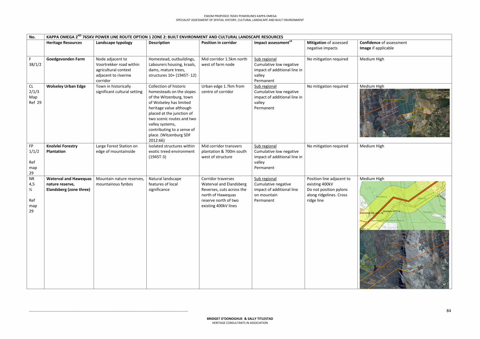
ESKOM PROPOSED 765KV POWERLINES KAPPA OMEGA SPECIALIST ASSESSMENT OF SPATIAL HISTORY, CULTURAL LANDSCAPE AND BUILT ENVIRONMENT
___________________________________________________________________________________________________
BRIDGET O’DONOGHUE & SALLY TITLESTAD HERITAGE CONSULTANTS IN ASSOCIATION
84
No. KAPPA OMEGA 2ND 765KV POWER LINE ROUTE OPTION 1 ZONE 2: BUILT ENVIRONMENT AND CULTURAL LANDSCAPE RESOURCES Heritage Resources Landscape typology Description Position in corridor
Impact assessment14
Mitigation of assessed negative impacts
Confidence of assessment Image if applicable
F 38/1/2
Goedgevonden Farm Node adjacent to Voortrekker road within agricultural context adjacent to riverine corridor
Homestead, outbuildings, Labourers housing, kraals, dams, mature trees, structures 10+ (1945T- 12)
Mid corridor 1.5km north west of farm node
Sub regional Cumulative low negative impact of additional line in valley Permanent
No mitigation required Medium High
CL 2/1/3 Map Ref 29
Wolseley Urban Edge Town in historically significant cultural setting
Collection of historic homesteads on the slopes of the Witzenburg, town of Wolseley has limited heritage value although placed at the junction of two scenic routes and two valley systems, contributing to a sense of place. (Witzenburg SDF 2012:66)
Urban edge 1.7km from centre of corridor
Sub regional Cumulative low negative impact of additional line in valley Permanent
No mitigation required Medium High
FP 1/1/2 Ref map 29
Knolvlei Forestry Plantation
Large Forest Station on edge of mountainside
Isolated structures within exotic treed environment (1945T-3)
Mid corridor transvers plantation & 700m south west of structure
Sub regional Cumulative low negative impact of additional line in valley Permanent
No mitigation required Medium High
NR 4,5 ½ Ref map 29
Waterval and Hawequas nature reserve, Elandsberg (zone three)
Mountain nature reserves, mountainous fynbos
Natural landscape features of local significance
Corridor traverses Waterval and Elandsberg Reverses, cuts across the north of Hawequas reserve north of two existing 400kV lines
Sub regional Cumulative negative impact of additional line on mountain Permanent
Position line adjacent to existing 400kV Do not position pylons along ridgelines. Cross ridge line
Medium High
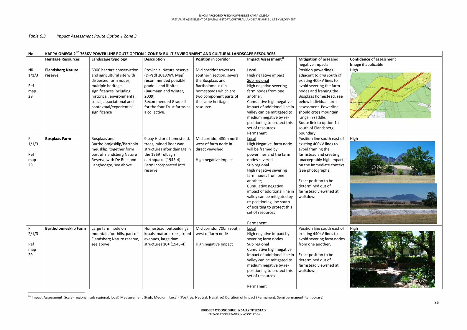
ESKOM PROPOSED 765KV POWERLINES KAPPA OMEGA SPECIALIST ASSESSMENT OF SPATIAL HISTORY, CULTURAL LANDSCAPE AND BUILT ENVIRONMENT
___________________________________________________________________________________________________
BRIDGET O’DONOGHUE & SALLY TITLESTAD HERITAGE CONSULTANTS IN ASSOCIATION
85
Table 6.3 Impact Assessment Route Option 1 Zone 3
No. KAPPA OMEGA 2ND 765KV POWER LINE ROUTE OPTION 1 ZONE 3: BUILT ENVIRONMENT AND CULTURAL LANDSCAPE RESOURCES Heritage Resources Landscape typology Description Position in corridor Impact Assessment15
Mitigation of assessed negative impacts
Confidence of assessment Image if applicable
NR 1/1/3 Ref map 29
Elandsberg Nature reserve
6000 hectare conservation and agricultural site with dispersed farm nodes, multiple heritage significances including historical, environmental, social, associational and contextual/experiential significance
Provincial Nature reserve
(D-Psdf 2013:WC Map), recommended possible grade II and III sites (Baumann and Winter, 2009). Recommended Grade II for the four Trust farms as a collective.
Mid corridor traverses southern section, severs the Bosplaas and Bartholomeusklip homesteads which are two component parts of the same heritage resource
Local High negative impact Sub regional High negative severing farm nodes from one another; Cumulative high negative impact of additional line in valley can be mitigated to medium negative by re-positioning to protect this set of resources Permanent
Position powerlines adjacent to and south of existing 400kV lines to avoid severing the farm nodes and framing the Bosplaas homestead, see below individual farm assessment. Powerline should cross mountain range in saddle. Route link to option 1a south of Elandsberg boundary
High
F 1/1/3 Ref map 29
Bosplaas Farm Bosplaas and Bartholomjesklip/Bartholomeusklip, together form part of Elandsberg Nature Reserve with De Rust and Langhoogte, see above
9 bay Historic homestead, trees, ruined Boer war structures after damage in the 1969 Tulbagh earthquake (1945-4) Farm incorporated into reserve
Mid corridor 480m north west of farm node in direct viewshed High negative impact
Local High Negative, farm node will be framed by powerlines and the farm nodes severed Sub regional High negative severing farm nodes from one another; Cumulative negative impact of additional line in valley can be mitigated by re-positioning line south of exisiting to protect this set of resources Permanent
Position line south east of existing 400kV lines to avoid framing the farmstead and creating unacceptably high impacts on the immediate context (see photographs), Exact position to be determined out of farmstead viewshed at walkdown
High
F 2/1/3 Ref map 29
Bartholomiesklip Farm Large farm node on mountain foothills, part of Elandsberg Nature reserve, see above
Homestead, outbuildings, kraals, mature trees, treed avenues, large dam, structures 10+ (1945-4)
Mid corridor 700m south west of farm node High negative Impact
Local High negative impact by severing farm nodes Sub regional Cumulative high negative impact of additional line in valley can be mitigated to medium negative by re-positioning to protect this set of resources Permanent
Position line south east of existing 440kV lines to avoid severing farm nodes from one another, Exact position to be determined out of farmstead viewshed at walkdown
High
15 Impact Assessment: Scale (regional, sub regional, local) Measurement (High, Medium, Local) (Positive, Neutral, Negative) Duration of Impact (Permanent, Semi permanent, temporary)
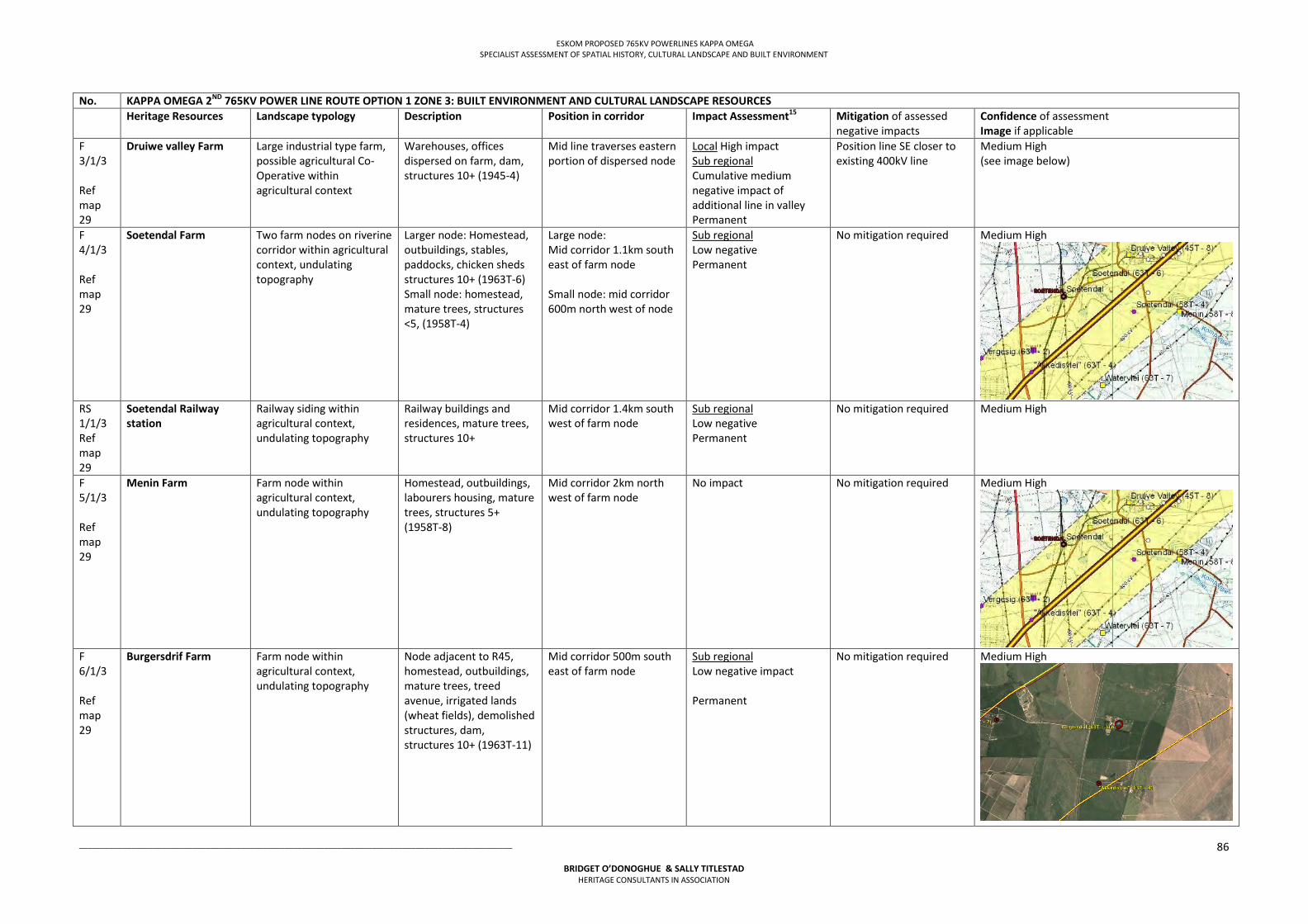
ESKOM PROPOSED 765KV POWERLINES KAPPA OMEGA SPECIALIST ASSESSMENT OF SPATIAL HISTORY, CULTURAL LANDSCAPE AND BUILT ENVIRONMENT
___________________________________________________________________________________________________
BRIDGET O’DONOGHUE & SALLY TITLESTAD HERITAGE CONSULTANTS IN ASSOCIATION
86
No. KAPPA OMEGA 2ND 765KV POWER LINE ROUTE OPTION 1 ZONE 3: BUILT ENVIRONMENT AND CULTURAL LANDSCAPE RESOURCES Heritage Resources Landscape typology Description Position in corridor Impact Assessment15
Mitigation of assessed negative impacts
Confidence of assessment Image if applicable
F 3/1/3 Ref map 29
Druiwe valley Farm Large industrial type farm, possible agricultural Co-Operative within agricultural context
Warehouses, offices dispersed on farm, dam, structures 10+ (1945-4)
Mid line traverses eastern portion of dispersed node
Local High impact Sub regional Cumulative medium negative impact of additional line in valley Permanent
Position line SE closer to existing 400kV line
Medium High (see image below)
F 4/1/3 Ref map 29
Soetendal Farm Two farm nodes on riverine corridor within agricultural context, undulating topography
Larger node: Homestead, outbuildings, stables, paddocks, chicken sheds structures 10+ (1963T-6) Small node: homestead, mature trees, structures <5, (1958T-4)
Large node: Mid corridor 1.1km south east of farm node Small node: mid corridor 600m north west of node
Sub regional Low negative Permanent
No mitigation required Medium High
RS 1/1/3 Ref map 29
Soetendal Railway station
Railway siding within agricultural context, undulating topography
Railway buildings and residences, mature trees, structures 10+
Mid corridor 1.4km south west of farm node
Sub regional Low negative Permanent
No mitigation required Medium High
F 5/1/3 Ref map 29
Menin Farm Farm node within agricultural context, undulating topography
Homestead, outbuildings, labourers housing, mature trees, structures 5+ (1958T-8)
Mid corridor 2km north west of farm node
No impact
No mitigation required Medium High
F 6/1/3 Ref map 29
Burgersdrif Farm Farm node within agricultural context, undulating topography
Node adjacent to R45, homestead, outbuildings, mature trees, treed avenue, irrigated lands (wheat fields), demolished structures, dam, structures 10+ (1963T-11)
Mid corridor 500m south east of farm node
Sub regional Low negative impact Permanent
No mitigation required Medium High
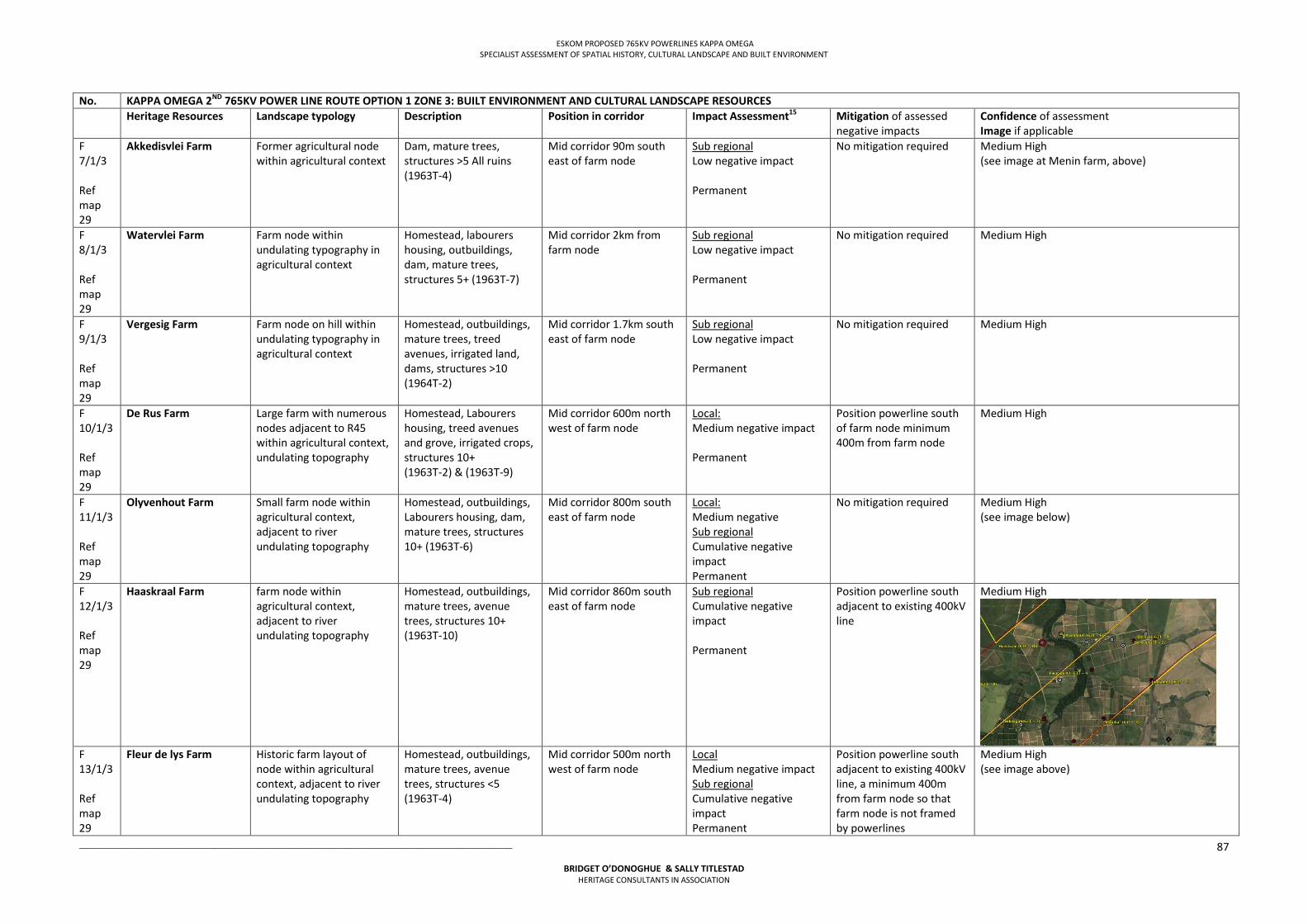
ESKOM PROPOSED 765KV POWERLINES KAPPA OMEGA SPECIALIST ASSESSMENT OF SPATIAL HISTORY, CULTURAL LANDSCAPE AND BUILT ENVIRONMENT
___________________________________________________________________________________________________
BRIDGET O’DONOGHUE & SALLY TITLESTAD HERITAGE CONSULTANTS IN ASSOCIATION
87
No. KAPPA OMEGA 2ND 765KV POWER LINE ROUTE OPTION 1 ZONE 3: BUILT ENVIRONMENT AND CULTURAL LANDSCAPE RESOURCES Heritage Resources Landscape typology Description Position in corridor Impact Assessment15
Mitigation of assessed negative impacts
Confidence of assessment Image if applicable
F 7/1/3 Ref map 29
Akkedisvlei Farm Former agricultural node within agricultural context
Dam, mature trees, structures >5 All ruins (1963T-4)
Mid corridor 90m south east of farm node
Sub regional Low negative impact Permanent
No mitigation required Medium High (see image at Menin farm, above)
F 8/1/3 Ref map 29
Watervlei Farm Farm node within undulating typography in agricultural context
Homestead, labourers housing, outbuildings, dam, mature trees, structures 5+ (1963T-7)
Mid corridor 2km from farm node
Sub regional Low negative impact Permanent
No mitigation required Medium High
F 9/1/3 Ref map 29
Vergesig Farm Farm node on hill within undulating typography in agricultural context
Homestead, outbuildings, mature trees, treed avenues, irrigated land, dams, structures >10 (1964T-2)
Mid corridor 1.7km south east of farm node
Sub regional Low negative impact Permanent
No mitigation required Medium High
F 10/1/3 Ref map 29
De Rus Farm Large farm with numerous nodes adjacent to R45 within agricultural context, undulating topography
Homestead, Labourers housing, treed avenues and grove, irrigated crops, structures 10+ (1963T-2) & (1963T-9)
Mid corridor 600m north west of farm node
Local: Medium negative impact Permanent
Position powerline south of farm node minimum 400m from farm node
Medium High
F 11/1/3 Ref map 29
Olyvenhout Farm Small farm node within agricultural context, adjacent to river undulating topography
Homestead, outbuildings, Labourers housing, dam, mature trees, structures 10+ (1963T-6)
Mid corridor 800m south east of farm node
Local: Medium negative Sub regional Cumulative negative impact Permanent
No mitigation required Medium High (see image below)
F 12/1/3 Ref map 29
Haaskraal Farm farm node within agricultural context, adjacent to river undulating topography
Homestead, outbuildings, mature trees, avenue trees, structures 10+ (1963T-10)
Mid corridor 860m south east of farm node
Sub regional Cumulative negative impact Permanent
Position powerline south adjacent to existing 400kV line
Medium High
F 13/1/3 Ref map 29
Fleur de lys Farm Historic farm layout of node within agricultural context, adjacent to river undulating topography
Homestead, outbuildings, mature trees, avenue trees, structures <5 (1963T-4)
Mid corridor 500m north west of farm node
Local Medium negative impact Sub regional Cumulative negative impact Permanent
Position powerline south adjacent to existing 400kV line, a minimum 400m from farm node so that farm node is not framed by powerlines
Medium High (see image above)
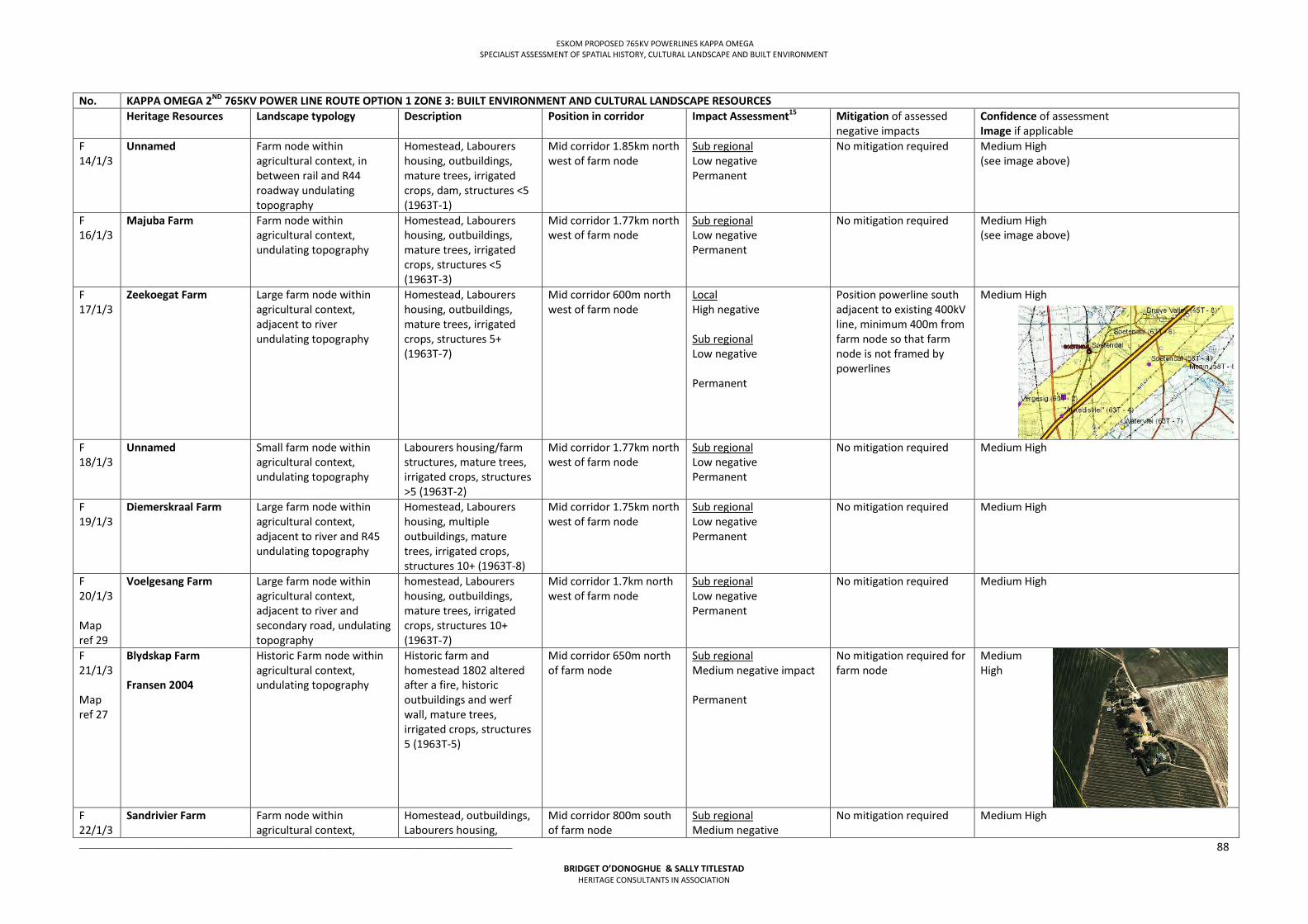
ESKOM PROPOSED 765KV POWERLINES KAPPA OMEGA SPECIALIST ASSESSMENT OF SPATIAL HISTORY, CULTURAL LANDSCAPE AND BUILT ENVIRONMENT
___________________________________________________________________________________________________
BRIDGET O’DONOGHUE & SALLY TITLESTAD HERITAGE CONSULTANTS IN ASSOCIATION
88
No. KAPPA OMEGA 2ND 765KV POWER LINE ROUTE OPTION 1 ZONE 3: BUILT ENVIRONMENT AND CULTURAL LANDSCAPE RESOURCES Heritage Resources Landscape typology Description Position in corridor Impact Assessment15
Mitigation of assessed negative impacts
Confidence of assessment Image if applicable
F 14/1/3
Unnamed Farm node within agricultural context, in between rail and R44 roadway undulating topography
Homestead, Labourers housing, outbuildings, mature trees, irrigated crops, dam, structures <5 (1963T-1)
Mid corridor 1.85km north west of farm node
Sub regional Low negative Permanent
No mitigation required Medium High (see image above)
F 16/1/3
Majuba Farm Farm node within agricultural context, undulating topography
Homestead, Labourers housing, outbuildings, mature trees, irrigated crops, structures <5 (1963T-3)
Mid corridor 1.77km north west of farm node
Sub regional Low negative Permanent
No mitigation required Medium High (see image above)
F 17/1/3
Zeekoegat Farm Large farm node within agricultural context, adjacent to river undulating topography
Homestead, Labourers housing, outbuildings, mature trees, irrigated crops, structures 5+ (1963T-7)
Mid corridor 600m north west of farm node
Local High negative Sub regional Low negative Permanent
Position powerline south adjacent to existing 400kV line, minimum 400m from farm node so that farm node is not framed by powerlines
Medium High
F 18/1/3
Unnamed Small farm node within agricultural context, undulating topography
Labourers housing/farm structures, mature trees, irrigated crops, structures >5 (1963T-2)
Mid corridor 1.77km north west of farm node
Sub regional Low negative Permanent
No mitigation required Medium High
F 19/1/3
Diemerskraal Farm Large farm node within agricultural context, adjacent to river and R45 undulating topography
Homestead, Labourers housing, multiple outbuildings, mature trees, irrigated crops, structures 10+ (1963T-8)
Mid corridor 1.75km north west of farm node
Sub regional Low negative Permanent
No mitigation required Medium High
F 20/1/3 Map ref 29
Voelgesang Farm Large farm node within agricultural context, adjacent to river and secondary road, undulating topography
homestead, Labourers housing, outbuildings, mature trees, irrigated crops, structures 10+ (1963T-7)
Mid corridor 1.7km north west of farm node
Sub regional Low negative Permanent
No mitigation required Medium High
F 21/1/3 Map ref 27
Blydskap Farm Fransen 2004
Historic Farm node within agricultural context, undulating topography
Historic farm and homestead 1802 altered after a fire, historic outbuildings and werf wall, mature trees, irrigated crops, structures 5 (1963T-5)
Mid corridor 650m north of farm node
Sub regional Medium negative impact Permanent
No mitigation required for farm node
Medium High
F 22/1/3
Sandrivier Farm Farm node within agricultural context,
Homestead, outbuildings, Labourers housing,
Mid corridor 800m south of farm node
Sub regional Medium negative
No mitigation required Medium High
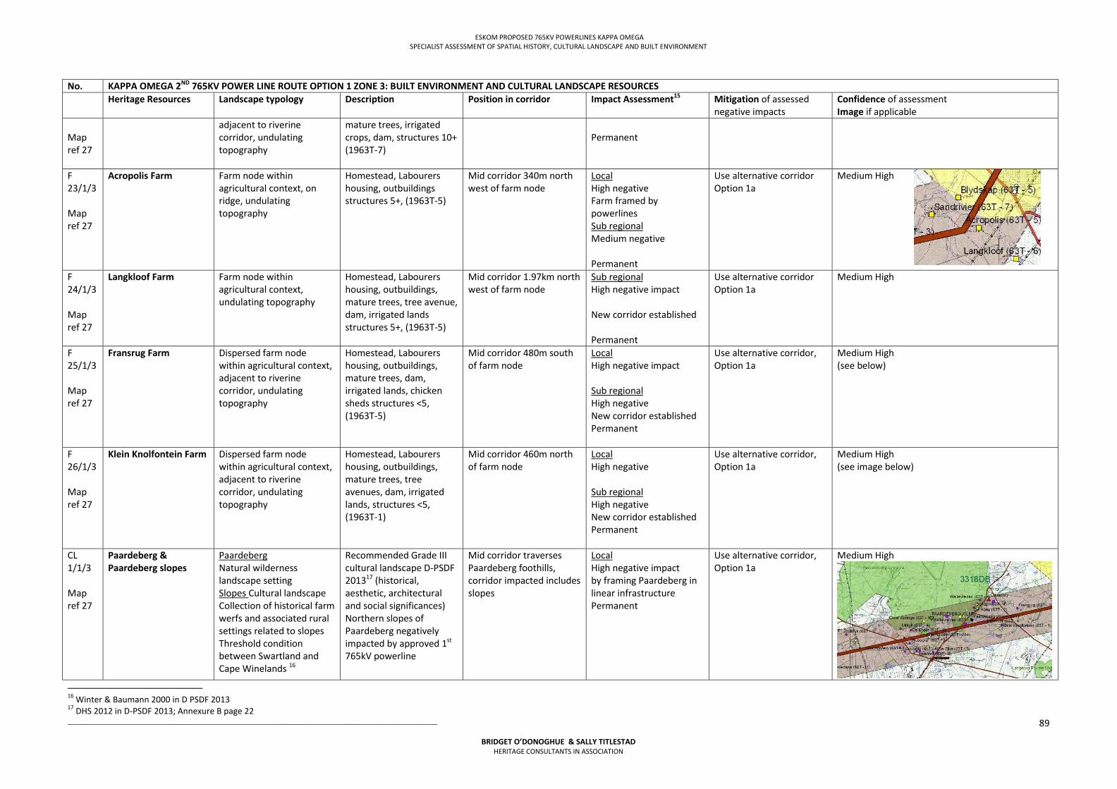
ESKOM PROPOSED 765KV POWERLINES KAPPA OMEGA SPECIALIST ASSESSMENT OF SPATIAL HISTORY, CULTURAL LANDSCAPE AND BUILT ENVIRONMENT
___________________________________________________________________________________________________
BRIDGET O’DONOGHUE & SALLY TITLESTAD HERITAGE CONSULTANTS IN ASSOCIATION
89
No. KAPPA OMEGA 2ND 765KV POWER LINE ROUTE OPTION 1 ZONE 3: BUILT ENVIRONMENT AND CULTURAL LANDSCAPE RESOURCES Heritage Resources Landscape typology Description Position in corridor Impact Assessment15
Mitigation of assessed negative impacts
Confidence of assessment Image if applicable
Map ref 27
adjacent to riverine corridor, undulating topography
mature trees, irrigated crops, dam, structures 10+ (1963T-7)
Permanent
F 23/1/3 Map ref 27
Acropolis Farm Farm node within agricultural context, on ridge, undulating topography
Homestead, Labourers housing, outbuildings structures 5+, (1963T-5)
Mid corridor 340m north west of farm node
Local High negative Farm framed by powerlines Sub regional Medium negative Permanent
Use alternative corridor Option 1a
Medium High
F 24/1/3 Map ref 27
Langkloof Farm Farm node within agricultural context, undulating topography
Homestead, Labourers housing, outbuildings, mature trees, tree avenue, dam, irrigated lands structures 5+, (1963T-5)
Mid corridor 1.97km north west of farm node
Sub regional High negative impact New corridor established Permanent
Use alternative corridor Option 1a
Medium High
F 25/1/3 Map ref 27
Fransrug Farm Dispersed farm node within agricultural context, adjacent to riverine corridor, undulating topography
Homestead, Labourers housing, outbuildings, mature trees, dam, irrigated lands, chicken sheds structures <5, (1963T-5)
Mid corridor 480m south of farm node
Local High negative impact Sub regional High negative New corridor established Permanent
Use alternative corridor, Option 1a
Medium High (see below)
F 26/1/3 Map ref 27
Klein Knolfontein Farm Dispersed farm node within agricultural context, adjacent to riverine corridor, undulating topography
Homestead, Labourers housing, outbuildings, mature trees, tree avenues, dam, irrigated lands, structures <5, (1963T-1)
Mid corridor 460m north of farm node
Local High negative Sub regional High negative New corridor established Permanent
Use alternative corridor, Option 1a
Medium High (see image below)
CL 1/1/3 Map ref 27
Paardeberg & Paardeberg slopes
Paardeberg Natural wilderness landscape setting Slopes Cultural landscape Collection of historical farm werfs and associated rural settings related to slopes Threshold condition between Swartland and Cape Winelands 16
Recommended Grade III cultural landscape D-PSDF 201317 (historical, aesthetic, architectural and social significances) Northern slopes of Paardeberg negatively impacted by approved 1st 765kV powerline
Mid corridor traverses Paardeberg foothills, corridor impacted includes slopes
Local High negative impact by framing Paardeberg in linear infrastructure Permanent
Use alternative corridor, Option 1a
Medium High
16 Winter & Baumann 2000 in D PSDF 2013 17 DHS 2012 in D-PSDF 2013; Annexure B page 22
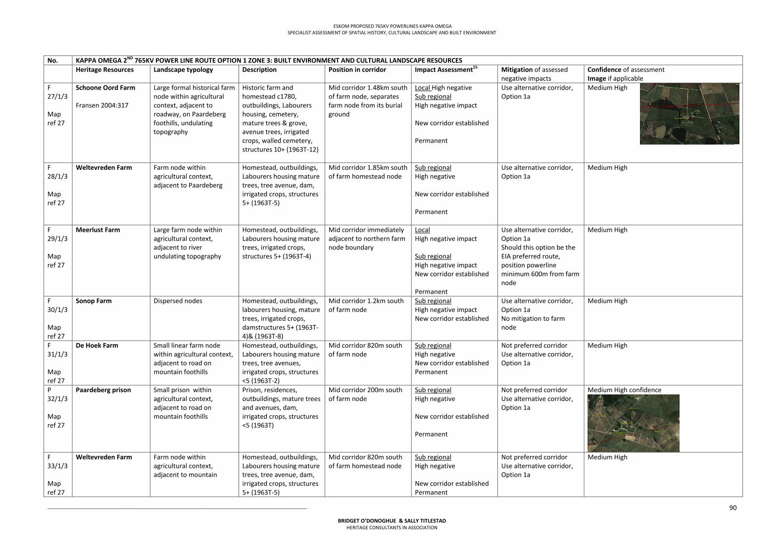
ESKOM PROPOSED 765KV POWERLINES KAPPA OMEGA SPECIALIST ASSESSMENT OF SPATIAL HISTORY, CULTURAL LANDSCAPE AND BUILT ENVIRONMENT
___________________________________________________________________________________________________
BRIDGET O’DONOGHUE & SALLY TITLESTAD HERITAGE CONSULTANTS IN ASSOCIATION
90
No. KAPPA OMEGA 2ND 765KV POWER LINE ROUTE OPTION 1 ZONE 3: BUILT ENVIRONMENT AND CULTURAL LANDSCAPE RESOURCES Heritage Resources Landscape typology Description Position in corridor Impact Assessment15
Mitigation of assessed negative impacts
Confidence of assessment Image if applicable
F 27/1/3 Map ref 27
Schoone Oord Farm Fransen 2004:317
Large formal historical farm node within agricultural context, adjacent to roadway, on Paardeberg foothills, undulating topography
Historic farm and homestead c1780, outbuildings, Labourers housing, cemetery, mature trees & grove, avenue trees, irrigated crops, walled cemetery, structures 10+ (1963T-12)
Mid corridor 1.48km south of farm node, separates farm node from its burial ground
Local High negative Sub regional High negative impact New corridor established Permanent
Use alternative corridor, Option 1a
Medium High
F 28/1/3 Map ref 27
Weltevreden Farm Farm node within agricultural context, adjacent to Paardeberg
Homestead, outbuildings, Labourers housing mature trees, tree avenue, dam, irrigated crops, structures 5+ (1963T-5)
Mid corridor 1.85km south of farm homestead node
Sub regional High negative New corridor established Permanent
Use alternative corridor, Option 1a
Medium High
F 29/1/3 Map ref 27
Meerlust Farm Large farm node within agricultural context, adjacent to river undulating topography
Homestead, outbuildings, Labourers housing mature trees, irrigated crops, structures 5+ (1963T-4)
Mid corridor immediately adjacent to northern farm node boundary
Local High negative impact Sub regional High negative impact New corridor established Permanent
Use alternative corridor, Option 1a Should this option be the EIA preferred route, position powerline minimum 600m from farm node
Medium High
F 30/1/3 Map ref 27
Sonop Farm Dispersed nodes Homestead, outbuildings, labourers housing, mature trees, irrigated crops, damstructures 5+ (1963T-4)& (1963T-8)
Mid corridor 1.2km south of farm node
Sub regional High negative impact New corridor established
Use alternative corridor, Option 1a No mitigation to farm node
Medium High
F 31/1/3 Map ref 27
De Hoek Farm Small linear farm node within agricultural context, adjacent to road on mountain foothills
Homestead, outbuildings, Labourers housing mature trees, tree avenues, irrigated crops, structures <5 (1963T-2)
Mid corridor 820m south of farm node
Sub regional High negative New corridor established Permanent
Not preferred corridor Use alternative corridor, Option 1a
Medium High
P 32/1/3 Map ref 27
Paardeberg prison Small prison within agricultural context, adjacent to road on mountain foothills
Prison, residences, outbuildings, mature trees and avenues, dam, irrigated crops, structures <5 (1963T)
Mid corridor 200m south of farm node
Sub regional High negative New corridor established Permanent
Not preferred corridor Use alternative corridor, Option 1a
Medium High confidence
F 33/1/3 Map ref 27
Weltevreden Farm Farm node within agricultural context, adjacent to mountain
Homestead, outbuildings, Labourers housing mature trees, tree avenue, dam, irrigated crops, structures 5+ (1963T-5)
Mid corridor 820m south of farm homestead node
Sub regional High negative New corridor established Permanent
Not preferred corridor Use alternative corridor, Option 1a
Medium High
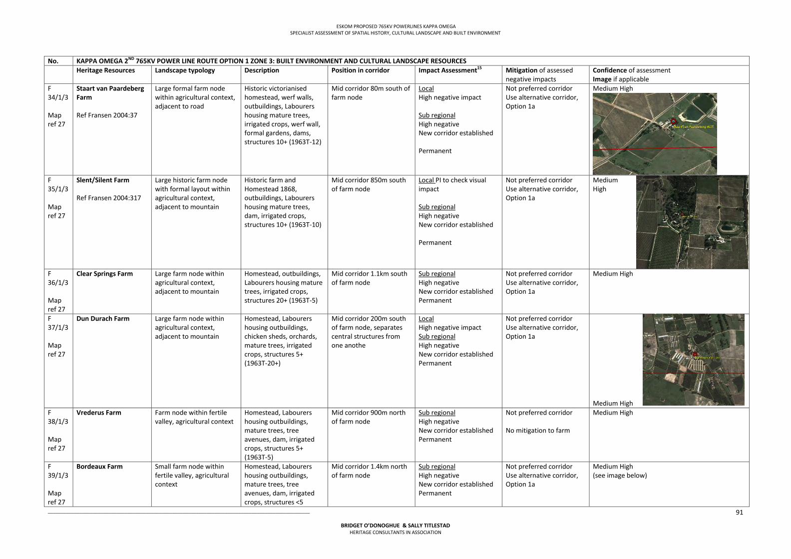
ESKOM PROPOSED 765KV POWERLINES KAPPA OMEGA SPECIALIST ASSESSMENT OF SPATIAL HISTORY, CULTURAL LANDSCAPE AND BUILT ENVIRONMENT
___________________________________________________________________________________________________
BRIDGET O’DONOGHUE & SALLY TITLESTAD HERITAGE CONSULTANTS IN ASSOCIATION
91
No. KAPPA OMEGA 2ND 765KV POWER LINE ROUTE OPTION 1 ZONE 3: BUILT ENVIRONMENT AND CULTURAL LANDSCAPE RESOURCES Heritage Resources Landscape typology Description Position in corridor Impact Assessment15
Mitigation of assessed negative impacts
Confidence of assessment Image if applicable
F 34/1/3 Map ref 27
Staart van Paardeberg Farm Ref Fransen 2004:37
Large formal farm node within agricultural context, adjacent to road
Historic victorianised homestead, werf walls, outbuildings, Labourers housing mature trees, irrigated crops, werf wall, formal gardens, dams, structures 10+ (1963T-12)
Mid corridor 80m south of farm node
Local High negative impact Sub regional High negative New corridor established Permanent
Not preferred corridor Use alternative corridor, Option 1a
Medium High
F 35/1/3 Map ref 27
Slent/Silent Farm Ref Fransen 2004:317
Large historic farm node with formal layout within agricultural context, adjacent to mountain
Historic farm and Homestead 1868, outbuildings, Labourers housing mature trees, dam, irrigated crops, structures 10+ (1963T-10)
Mid corridor 850m south of farm node
Local PI to check visual impact Sub regional High negative New corridor established Permanent
Not preferred corridor Use alternative corridor, Option 1a
Medium High
F 36/1/3 Map ref 27
Clear Springs Farm
Large farm node within agricultural context, adjacent to mountain
Homestead, outbuildings, Labourers housing mature trees, irrigated crops, structures 20+ (1963T-5)
Mid corridor 1.1km south of farm node
Sub regional High negative New corridor established Permanent
Not preferred corridor Use alternative corridor, Option 1a
Medium High
F 37/1/3 Map ref 27
Dun Durach Farm Large farm node within agricultural context, adjacent to mountain
Homestead, Labourers housing outbuildings, chicken sheds, orchards, mature trees, irrigated crops, structures 5+ (1963T-20+)
Mid corridor 200m south of farm node, separates central structures from one anothe
Local High negative impact Sub regional High negative New corridor established Permanent
Not preferred corridor Use alternative corridor, Option 1a
Medium High F 38/1/3 Map ref 27
Vrederus Farm Farm node within fertile valley, agricultural context
Homestead, Labourers housing outbuildings, mature trees, tree avenues, dam, irrigated crops, structures 5+ (1963T-5)
Mid corridor 900m north of farm node
Sub regional High negative New corridor established Permanent
Not preferred corridor No mitigation to farm
Medium High
F 39/1/3 Map ref 27
Bordeaux Farm Small farm node within fertile valley, agricultural context
Homestead, Labourers housing outbuildings, mature trees, tree avenues, dam, irrigated crops, structures <5
Mid corridor 1.4km north of farm node
Sub regional High negative New corridor established Permanent
Not preferred corridor Use alternative corridor, Option 1a
Medium High (see image below)
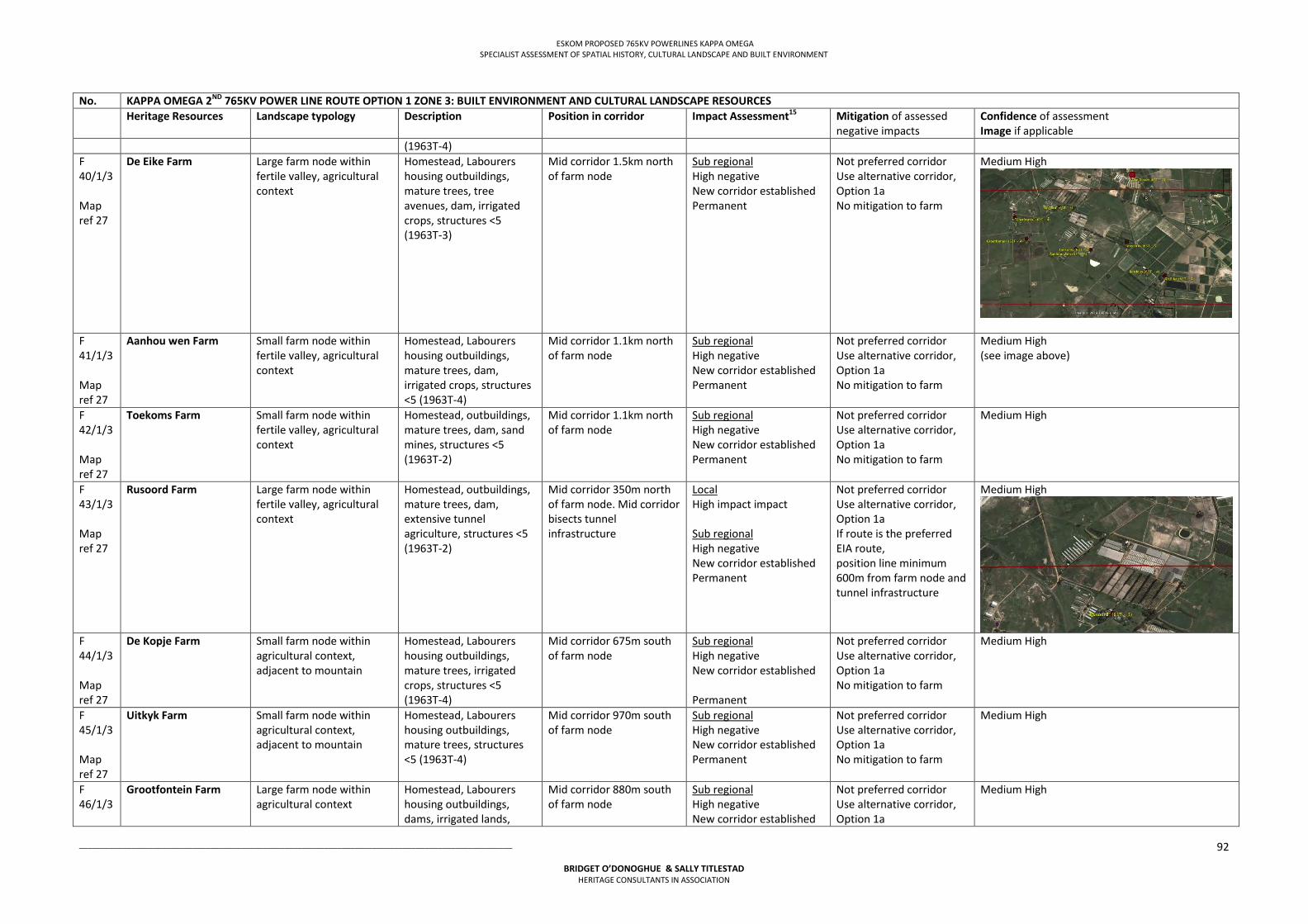
ESKOM PROPOSED 765KV POWERLINES KAPPA OMEGA SPECIALIST ASSESSMENT OF SPATIAL HISTORY, CULTURAL LANDSCAPE AND BUILT ENVIRONMENT
___________________________________________________________________________________________________
BRIDGET O’DONOGHUE & SALLY TITLESTAD HERITAGE CONSULTANTS IN ASSOCIATION
92
No. KAPPA OMEGA 2ND 765KV POWER LINE ROUTE OPTION 1 ZONE 3: BUILT ENVIRONMENT AND CULTURAL LANDSCAPE RESOURCES Heritage Resources Landscape typology Description Position in corridor Impact Assessment15
Mitigation of assessed negative impacts
Confidence of assessment Image if applicable
(1963T-4) F 40/1/3 Map ref 27
De Eike Farm Large farm node within fertile valley, agricultural context
Homestead, Labourers housing outbuildings, mature trees, tree avenues, dam, irrigated crops, structures <5 (1963T-3)
Mid corridor 1.5km north of farm node
Sub regional High negative New corridor established Permanent
Not preferred corridor Use alternative corridor, Option 1a No mitigation to farm
Medium High
F 41/1/3 Map ref 27
Aanhou wen Farm Small farm node within fertile valley, agricultural context
Homestead, Labourers housing outbuildings, mature trees, dam, irrigated crops, structures <5 (1963T-4)
Mid corridor 1.1km north of farm node
Sub regional High negative New corridor established Permanent
Not preferred corridor Use alternative corridor, Option 1a No mitigation to farm
Medium High (see image above)
F 42/1/3 Map ref 27
Toekoms Farm Small farm node within fertile valley, agricultural context
Homestead, outbuildings, mature trees, dam, sand mines, structures <5 (1963T-2)
Mid corridor 1.1km north of farm node
Sub regional High negative New corridor established Permanent
Not preferred corridor Use alternative corridor, Option 1a No mitigation to farm
Medium High
F 43/1/3 Map ref 27
Rusoord Farm Large farm node within fertile valley, agricultural context
Homestead, outbuildings, mature trees, dam, extensive tunnel agriculture, structures <5 (1963T-2)
Mid corridor 350m north of farm node. Mid corridor bisects tunnel infrastructure
Local High impact impact Sub regional High negative New corridor established Permanent
Not preferred corridor Use alternative corridor, Option 1a If route is the preferred EIA route, position line minimum 600m from farm node and tunnel infrastructure
Medium High
F 44/1/3 Map ref 27
De Kopje Farm Small farm node within agricultural context, adjacent to mountain
Homestead, Labourers housing outbuildings, mature trees, irrigated crops, structures <5 (1963T-4)
Mid corridor 675m south of farm node
Sub regional High negative New corridor established Permanent
Not preferred corridor Use alternative corridor, Option 1a No mitigation to farm
Medium High
F 45/1/3 Map ref 27
Uitkyk Farm Small farm node within agricultural context, adjacent to mountain
Homestead, Labourers housing outbuildings, mature trees, structures <5 (1963T-4)
Mid corridor 970m south of farm node
Sub regional High negative New corridor established Permanent
Not preferred corridor Use alternative corridor, Option 1a No mitigation to farm
Medium High
F 46/1/3
Grootfontein Farm Large farm node within agricultural context
Homestead, Labourers housing outbuildings, dams, irrigated lands,
Mid corridor 880m south of farm node
Sub regional High negative New corridor established
Not preferred corridor Use alternative corridor, Option 1a
Medium High
ESKOM PROPOSED 765KV POWERLINES KAPPA OMEGA SPECIALIST ASSESSMENT OF SPATIAL HISTORY, CULTURAL LANDSCAPE AND BUILT ENVIRONMENT
___________________________________________________________________________________________________
BRIDGET O’DONOGHUE & SALLY TITLESTAD HERITAGE CONSULTANTS IN ASSOCIATION
93
No. KAPPA OMEGA 2ND 765KV POWER LINE ROUTE OPTION 1 ZONE 3: BUILT ENVIRONMENT AND CULTURAL LANDSCAPE RESOURCES Heritage Resources Landscape typology Description Position in corridor Impact Assessment15
Mitigation of assessed negative impacts
Confidence of assessment Image if applicable
Map ref 27
livestock, mature trees, structures <5 (1963T-4)
Permanent No mitigation to farm
F 47/1/3 Map ref 27
Grafwater Farm Small farm node within agricultural context, adjacent to mountain
Homestead, Labourers housing outbuildings, mature trees, structures <5 (1963T-4)
Mid corridor 350 north west of farm node
Local High Negative Sub regional High negative New corridor established Permanent
Not preferred corridor Use alternative corridor, Option 1a If route is the preferred EIA route, position powerline minimum 600m from farm node
Medium High
F 48/1/3 Map ref 27
Uitkyk Farm Ref Fransen 2004:318
Small farm node within agricultural context, undulating topography
Altered homestead c 1787, Labourers housing outbuildings, mature trees, irrigated crops, structures <5 (1963T-3)
Mid corridor 1.4km south of farm node
Sub regional High negative New corridor established Permanent
Position powerlines minimum 400m from farm node
Medium High
F 49/1/3 Map ref 27
Houmoed Farm Farm node within agricultural context, adjacent to R304 road, undulating topography
Homestead, Labourers housing outbuildings, mature trees, dam, irrigated crops, livestock, structures <5 (1966T-3)
Mid corridor 1.9 south of farm node
Sub regional High negative New corridor established Permanent
Not preferred corridor Use alternative corridor, Option 1a No mitigation to farm required
Medium High
F 50/1/3 Map ref 27
Wolvedans Farm Formal farm node within agricultural context, undulating topography
Homestead, Labourers housing outbuildings, mature trees, tered avenue, dam, irrigated crops, livestock, structures 10+ (1966T-11)
Mid corridor 1.1km north of homestead node
Sub regional High negative New corridor established Permanent
Not preferred corridor Use alternative corridor, Option 1a
Medium High
F 51/1/3 Map ref 27
Klein Wolwedans Historic farm node within agricultural context, adjacent to R304 road, undulating topography
Homestead, Labourers housing outbuildings, mature trees, tree avenue, irrigated crops, structures <5 (1966T-3)
Mid corridor 430m north of farm node and 190m north of labourers housing
Local High negative Sub regional High negative New corridor established Permanent
Not preferred corridor Use alternative corridor, Option 1a If route is the preferred EIA route, position powerline minimum 600m from farm node
Medium High F 52/1/3 Map ref 27
Elandsvlei Small farm node within agricultural context, adjacent to dam undulating topography
Homestead, Labourers housing outbuildings, semi demolished structure, mature trees, dam, irrigated crops, structures <5 (1966T-1)
Mid corridor 0.9km south of farm node
Sub regional High negative New corridor established Permanent
Not preferred corridor Use alternative corridor, Option 1a
Medium High
ESKOM PROPOSED 765KV POWERLINES KAPPA OMEGA SPECIALIST ASSESSMENT OF SPATIAL HISTORY, CULTURAL LANDSCAPE AND BUILT ENVIRONMENT
___________________________________________________________________________________________________
BRIDGET O’DONOGHUE & SALLY TITLESTAD HERITAGE CONSULTANTS IN ASSOCIATION
94
No. KAPPA OMEGA 2ND 765KV POWER LINE ROUTE OPTION 1 ZONE 3: BUILT ENVIRONMENT AND CULTURAL LANDSCAPE RESOURCES Heritage Resources Landscape typology Description Position in corridor Impact Assessment15
Mitigation of assessed negative impacts
Confidence of assessment Image if applicable
F 53/1/3 Map ref 27
Unnamed Small farm node within agricultural context, adjacent to dam, undulating topography
Building/s, mature trees, dam, irrigated crops, structures <5 (1966T-2)
Mid corridor 0.9km south east of farm node
Sub regional High negative New corridor Permanent
Not preferred corridor Use alternative corridor, Option 1a
Medium High
F 54/1/3 Map ref 27
Bottelfontein Small farm node within agricultural context, adjacent to railway, undulating topography
Homestead, Labourers housing outbuildings, mature trees, irrigated crops, structures <5 (1966T-4)
Mid corridor traverses centre of farm node
Sub regional High negative New corridor established Permanent
Not preferred corridor Use alternative corridor, Option 1a If route is the preferred EIA route, position powerline minimum 600m from farm node
Medium High
F 55/1/3 Map ref 27
Vrede Small farm node within agricultural context, adjacent to railway, undulating topography
Homestead, Labourers housing outbuildings, mature trees, irrigated crops, chicken sheds, structures <5 (1966T-2)
Mid corridor 250m north of farm node
Local High negative Sub regional High negative New corridor established Permanent
Not preferred corridor Use alternative corridor, Option 1a If route is the preferred EIA route, position powerline minimum 600m from farm node
Medium High
F 56/1/3 Map ref 27
Bonnie Doon Farm node within agricultural context, undulating topography
Homestead, Labourers housing outbuildings, mature trees, irrigated crops, structures 5+ (1966T-6)
Mid corridor 160m south of farm node
Local High negative Sub regional High negative New corridor Permanent
Not preferred corridor Use alternative corridor, Option 1a If route is the preferred EIA route, position powerline minimum 600m from farm node
Medium High
F 57/1/3 Map ref 27
Magrug Small farm node within agricultural context, adjacent to river undulating topography
Cottages outbuildings, mature trees, irrigated crops, possible vacated buildings structures <5 (1966T-5)
Mid corridor 810m south of farm node
Sub regional High negative New corridor established Permanent
Not preferred corridor Use alternative corridor, Option 1a No mitigation to farm node required
Medium High
F 58/1/3 Map ref 27
Remhoogte Large farm node within agricultural context, adjacent to river undulating topography
Homestead, Labourers housing outbuildings, mature trees, irrigated crops, structures <5 (1966T-4)
Mid corridor 1.7km south east of farm node
Sub regional High negative New corridor established Permanent
Not prefered corridor Use alternative corridor, Option 1a No mitigation to farm node required
Medium High
ESKOM PROPOSED 765KV POWERLINES KAPPA OMEGA SPECIALIST ASSESSMENT OF SPATIAL HISTORY, CULTURAL LANDSCAPE AND BUILT ENVIRONMENT
___________________________________________________________________________________________________
BRIDGET O’DONOGHUE & SALLY TITLESTAD HERITAGE CONSULTANTS IN ASSOCIATION
95
No. KAPPA OMEGA 2ND 765KV POWER LINE ROUTE OPTION 1 ZONE 3: BUILT ENVIRONMENT AND CULTURAL LANDSCAPE RESOURCES Heritage Resources Landscape typology Description Position in corridor Impact Assessment15
Mitigation of assessed negative impacts
Confidence of assessment Image if applicable
F 59/1/3 Map ref 27
Middelpost Historic farm node within agricultural context, undulating topography
Historic homestead, Labourers housing outbuildings, dam, mature trees, tree avenues, irrigated crops, structures <5 (1966T-2)
Mid corridor 140m north of farm node
Sub regional High negative New corridor established Permanent
Not preferred corridor Use alternative corridor, Option 1a If route is the preferred EIA route, position powerline minimum 600m from farm node
Medium High
F 60/1/3 Map ref 27
Goedontmoeting Farm Large historic farm node within agricultural context, adjacent to river, bisected by Philadelphia road, undulating topography
Historic Homestead & outbuildings, Labourers housing mature trees, livestock, irrigated crops, structures 20+ (1966T-17)
Mid corridor 420m north of farm node
Local: High negative impact Sub regional High negative New corridor established Permanent
Not preferred corridor, use alternative corridor, Option 1a If route is the preferred EIA route, position power line minimum 600m from farm node and off ridgeline
Medium High
F 61/1/3 Map ref 27
Van Schoorsdrif Farm Former farm building within agricultural context, adjacent to road, undulating topography
Mature trees, irrigated crops, no structures <5 (1966T-1)
Mid corridor 560m south of farm node
No Impact, farm node vacated
No mitigation required Medium High
F 62/1/3 Map ref 27
Dasvlei Farm Historic farm node within agricultural context, adjacent to Philadelphia road, undulating topography
Historic homestead, Labourers housing outbuildings, mature trees, tree avenues, irrigated crops, structures <5 (1966T-4)
Mid corridor 539m south of farm node
Local High negative Sub regional High negative New corridor established Permanent
Position powerlines minimum 400m from farm node
Medium High
ESKOM PROPOSED 765KV POWERLINES KAPPA OMEGA SPECIALIST ASSESSMENT OF SPATIAL HISTORY, CULTURAL LANDSCAPE AND BUILT ENVIRONMENT
___________________________________________________________________________________________________
BRIDGET O’DONOGHUE & SALLY TITLESTAD HERITAGE CONSULTANTS IN ASSOCIATION
96
No. KAPPA OMEGA 2ND 765KV POWER LINE ROUTE OPTION 1 ZONE 3: BUILT ENVIRONMENT AND CULTURAL LANDSCAPE RESOURCES Heritage Resources Landscape typology Description Position in corridor Impact Assessment15
Mitigation of assessed negative impacts
Confidence of assessment Image if applicable
F 63/1/3 Map ref 27
Klein Dasvlei Farm Large farm node within agricultural context, adjacent to river undulating topography
Homestead, Labourers housing outbuildings, mature trees, irrigated crops, livestock, structures <5 (1966T-4)
Mid corridor traverses farm node
Local High negative Sub regional High negative New corridor Permanent
Not preferred corridor, use alternative corridor, Option 1a If route is the preferred EIA route, position power line minimum 600m from farm node and off ridgeline to the north
Medium High
F 64/1/3 Map ref 27
Steelwater Farm Small farm node within agricultural context, adjacent to Old Malmesbury road, undulating topography
Cottages, mature trees, demolished structures, vacant structures <5 (1966T-1)
Mid corridor 1.4km north of farm node
Sub regional High negative New corridor established Permanent
Not preferred corridor Use alternative corridor, Option 1a No mitigation to farm node required
Medium High
S 1/1/3
Philadelphia Church town 1864. Smallest laid out Church town in the Cape; agricultural context, adjacent to Philadelphia road, undulating topography
Provincial Heritage Sites, cemetery, Grade III heritage resources
Mid corridor 1.8km south of town’s modern residential area
Sub regional High negative New corridor established Permanent
Not preferred corridor Use alternative corridor, Option 1a No mitigation to settlement node required
High
F 65/1/3
Uitkyk Farm Farm node within agricultural context, undulating topography
Homestead, Labourers housing outbuildings, mature trees, tree avenues, irrigated crops, dam, structures 5+ (1965T-2)
Mid corridor 360m north of farm node
Local High negative impact Sub regional High negative New corridor Permanent
Not preferred corridor Use alternative corridor, Option 1a If route is the preferred EIA route, position powerline minumum 600m from farm node
Medium High
F 66/1/3
De Hoop Farm Ref Fransen 2004:318
Small farm node within agricultural context, undulating topography
Asymmetrical T shaped Homestead c 1833 victoriansied, Labourers housing outbuildings, dam, mature trees, irrigated crops, structures <5 (1966T-3)
Mid corridor 1.4km north of farm node
Sub regional High negative New corridor Permanent
Not prefered corridor Use alternative corridor, Option 1a No mitigation to farm node required
Medium High
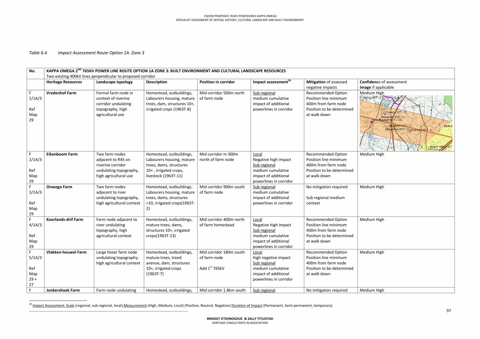
ESKOM PROPOSED 765KV POWERLINES KAPPA OMEGA SPECIALIST ASSESSMENT OF SPATIAL HISTORY, CULTURAL LANDSCAPE AND BUILT ENVIRONMENT
___________________________________________________________________________________________________
BRIDGET O’DONOGHUE & SALLY TITLESTAD HERITAGE CONSULTANTS IN ASSOCIATION
97
Table 6.4 Impact Assessment Route Option 1A Zone 3
No. KAPPA OMEGA 2ND 765KV POWER LINE ROUTE OPTION 1A ZONE 3: BUILT ENVIRONMENT AND CULTURAL LANDSCAPE RESOURCES Two existing 400kV lines perpendicular to proposed corridor
Heritage Resources Landscape typology Description Position in corridor Impact assessment18
Mitigation of assessed negative impacts
Confidence of assessment Image if applicable
F 1/1A/3 Ref Map 29
Vredenhof Farm Formal farm node in context of riverine corridor undulating topography, high agricultural use
Homestead, outbuildings, Labourers housing, mature trees, dam, structures 10+, irrigated crops (1963T-8)
Mid corridor 500m north of farm node
Sub regional medium cumulative impact of additional powerlines in corridor
Recommended Option Position line minimum 400m from farm node Position to be determined at walk down
Medium High
F 2/1A/3 Ref Map 29
Eikenboom Farm Two farm nodes adjacent to R45 on riverine corridor undulating topography, high agricultural use
Homestead, outbuildings, Labourers housing, mature trees, dams, structures 10+ , irrigated crops, livestock (1963T-11)
Mid corridor m 300m north of farm node
Local Negative high impact Sub regional medium cumulative impact of additional powerlines in corridor
Recommended Option Position line minimum 400m from farm node Position to be determined at walk down
Medium High
F 3/1A/3 Ref Map 29
Onwego Farm Two farm nodes adjacent to river undulating topography, high agricultural context
Homestead, outbuildings, Labourers housing, mature trees, dams, structures >10, irrigated crops(1963T-2)
Mid corridor 900m south of farm node
Sub regional medium cumulative impact of additional powerlines in corridor
No mitigation required Sub regional medium context
Medium High
F 4/1A/3 Ref Map 29
Koorlands-drif Farm Farm node adjacent to river undulating topography, high agricultural context
Homestead, outbuildings, mature trees, dams, structures 10+, irrigated crops(1963T-13)
Mid corridor 400m north of farm homestead
Local Negative high impact Sub regional medium cumulative impact of additional powerlines in corridor
Recommended Option Position line minimum 400m from farm node Position to be determined at walk down
Medium High
F 5/1A/3 Ref Map 29 + 27
Vlakken-heuwel Farm
Large linear farm node undulating topography, high agricultural context
Homestead, outbuildings, mature trees, treed avenue, dam, structures 10+, irrigated crops (1963T-7)
Mid corridor 180m south of farm node Add 1st 765kV
Local high negative impact Sub regional medium cumulative impact of additional powerlines in corridor
Recommended Option Position line minimum 400m from farm node Position to be determined at walk down
Medium High
F Jonkershoek Farm Farm node undulating Homestead, outbuildings, Mid corridor 1.8km south Sub regional No mitigation required Medium High
18 Impact Assessment: Scale (regional, sub regional, local) Measurement (High, Medium, Local) (Positive, Neutral, Negative) Duration of Impact (Permanent, Semi permanent, temporary)
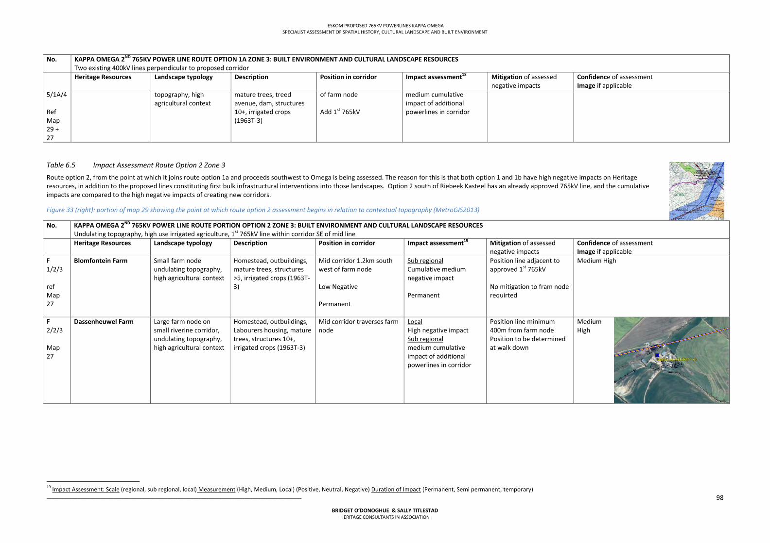
ESKOM PROPOSED 765KV POWERLINES KAPPA OMEGA SPECIALIST ASSESSMENT OF SPATIAL HISTORY, CULTURAL LANDSCAPE AND BUILT ENVIRONMENT
___________________________________________________________________________________________________
BRIDGET O’DONOGHUE & SALLY TITLESTAD HERITAGE CONSULTANTS IN ASSOCIATION
98
No. KAPPA OMEGA 2ND 765KV POWER LINE ROUTE OPTION 1A ZONE 3: BUILT ENVIRONMENT AND CULTURAL LANDSCAPE RESOURCES Two existing 400kV lines perpendicular to proposed corridor
Heritage Resources Landscape typology Description Position in corridor Impact assessment18
Mitigation of assessed negative impacts
Confidence of assessment Image if applicable
5/1A/4 Ref Map 29 + 27
topography, high agricultural context
mature trees, treed avenue, dam, structures 10+, irrigated crops (1963T-3)
of farm node Add 1st 765kV
medium cumulative impact of additional powerlines in corridor
Table 6.5 Impact Assessment Route Option 2 Zone 3 Route option 2, from the point at which it joins route option 1a and proceeds southwest to Omega is being assessed. The reason for this is that both option 1 and 1b have high negative impacts on Heritage resources, in addition to the proposed lines constituting first bulk infrastructural interventions into those landscapes. Option 2 south of Riebeek Kasteel has an already approved 765kV line, and the cumulative impacts are compared to the high negative impacts of creating new corridors.
Figure 33 (right): portion of map 29 showing the point at which route option 2 assessment begins in relation to contextual topography (MetroGIS2013)
No. KAPPA OMEGA 2ND 765KV POWER LINE ROUTE PORTION OPTION 2 ZONE 3: BUILT ENVIRONMENT AND CULTURAL LANDSCAPE RESOURCES Undulating topography, high use irrigated agriculture, 1st 765kV line within corridor SE of mid line
Heritage Resources Landscape typology Description Position in corridor Impact assessment19 Mitigation of assessed negative impacts
Confidence of assessment Image if applicable
F 1/2/3 ref Map 27
Blomfontein Farm Small farm node undulating topography, high agricultural context
Homestead, outbuildings, mature trees, structures >5, irrigated crops (1963T-3)
Mid corridor 1.2km south west of farm node Low Negative Permanent
Sub regional Cumulative medium negative impact Permanent
Position line adjacent to approved 1st 765kV No mitigation to fram node requirted
Medium High
F 2/2/3 Map 27
Dassenheuwel Farm Large farm node on small riverine corridor, undulating topography, high agricultural context
Homestead, outbuildings, Labourers housing, mature trees, structures 10+, irrigated crops (1963T-3)
Mid corridor traverses farm node
Local High negative impact Sub regional medium cumulative impact of additional powerlines in corridor
Position line minimum 400m from farm node Position to be determined at walk down
Medium High
19 Impact Assessment: Scale (regional, sub regional, local) Measurement (High, Medium, Local) (Positive, Neutral, Negative) Duration of Impact (Permanent, Semi permanent, temporary)
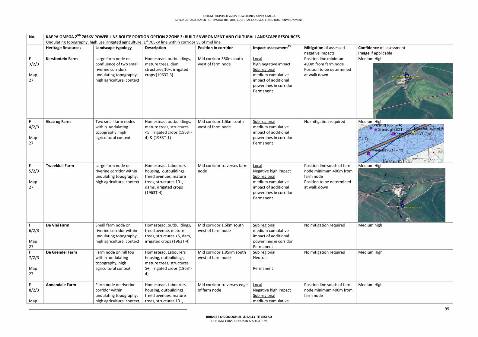
ESKOM PROPOSED 765KV POWERLINES KAPPA OMEGA SPECIALIST ASSESSMENT OF SPATIAL HISTORY, CULTURAL LANDSCAPE AND BUILT ENVIRONMENT
___________________________________________________________________________________________________
BRIDGET O’DONOGHUE & SALLY TITLESTAD HERITAGE CONSULTANTS IN ASSOCIATION
99
No. KAPPA OMEGA 2ND 765KV POWER LINE ROUTE PORTION OPTION 2 ZONE 3: BUILT ENVIRONMENT AND CULTURAL LANDSCAPE RESOURCES Undulating topography, high use irrigated agriculture, 1st 765kV line within corridor SE of mid line
Heritage Resources Landscape typology Description Position in corridor Impact assessment19 Mitigation of assessed negative impacts
Confidence of assessment Image if applicable
F 3/2/3 Map 27
Kersfontein Farm Large farm node on confluence of two small riverine corridors, undulating topography, high agricultural context
Homestead, outbuildings, mature trees, dam structures 10+, irrigated crops (1963T-3)
Mid corridor 350m south west of farm node
Local high negative impact Sub regional medium cumulative impact of additional powerlines in corridor Permanent
Position line minimum 400m from farm node Position to be determined at walk down
Medium High
F 4/2/3 Map 27
Grasrug Farm
Two small farm nodes within undulating topography, high agricultural context
Homestead, outbuildings, mature trees, structures <5, irrigated crops (1963T-4) & (1963T-1)
Mid corridor 1.5km south west of farm node
Sub regional medium cumulative impact of additional powerlines in corridor Permanent
No mitigation required Medium High
F 5/2/3 Map 27
Tweekluil Farm Large farm node on riverine corridor within undulating topography, high agricultural context
Homestead, Labourers housing, outbuildings, treed avenues, mature trees, structures 10+, dams, irrigated crops (1963T-4)
Mid corridor traverses farm node
Local Negative high impact Sub regional medium cumulative impact of additional powerlines in corridor Permanent
Position line south of farm node minimum 400m from farm node Position to be determined at walk down
Medium High
F 6/2/3 Map 27
De Vlei Farm
Small farm node on riverine corridor within undulating topography, high agricultural context
Homestead, outbuildings, treed avenue, mature trees, structures >5, dam, irrigated crops (1963T-4)
Mid corridor 1.5km south west of farm node
Sub regional medium cumulative impact of additional powerlines in corridor Permanent
No mitigation required Medium high
F 7/2/3 Map 27
De Grendel Farm Farm node on hill top within undulating topography, high agricultural context
Homestead, Labourers housing, outbuildings, mature trees, structures 5+, irrigated crops (1963T-4)
Mid corridor 1.95km south west of farm node
Sub regional Neutral Permanent
No mitigation required Medium High
F 8/2/3 Map
Annandale Farm Farm node on riverine corridor within undulating topography, high agricultural context
Homestead, Labourers housing, outbuildings, treed avenues, mature trees, structures 10+,
Mid corridor traverses edge of farm node
Local Negative high impact Sub regional medium cumulative
Position line south of farm node minimum 400m from farm node
Medium High
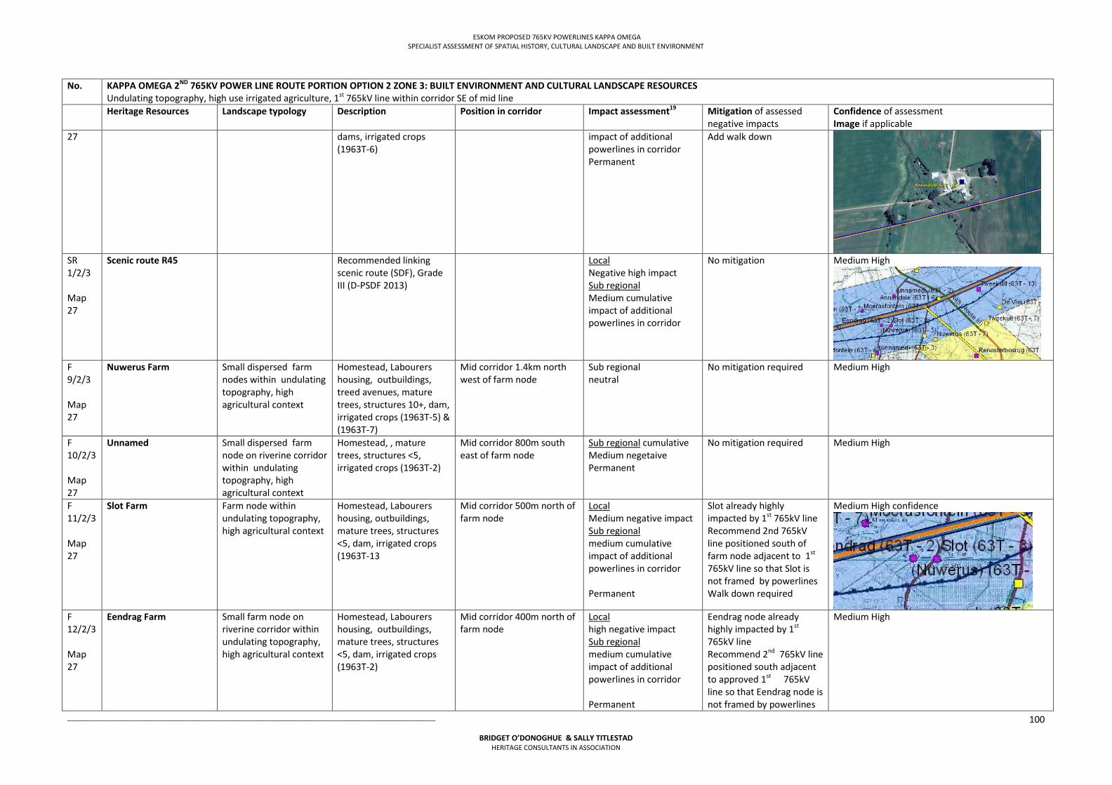
ESKOM PROPOSED 765KV POWERLINES KAPPA OMEGA SPECIALIST ASSESSMENT OF SPATIAL HISTORY, CULTURAL LANDSCAPE AND BUILT ENVIRONMENT
___________________________________________________________________________________________________
BRIDGET O’DONOGHUE & SALLY TITLESTAD HERITAGE CONSULTANTS IN ASSOCIATION
100
No. KAPPA OMEGA 2ND 765KV POWER LINE ROUTE PORTION OPTION 2 ZONE 3: BUILT ENVIRONMENT AND CULTURAL LANDSCAPE RESOURCES Undulating topography, high use irrigated agriculture, 1st 765kV line within corridor SE of mid line
Heritage Resources Landscape typology Description Position in corridor Impact assessment19 Mitigation of assessed negative impacts
Confidence of assessment Image if applicable
27 dams, irrigated crops (1963T-6)
impact of additional powerlines in corridor Permanent
Add walk down
SR 1/2/3 Map 27
Scenic route R45 Recommended linking scenic route (SDF), Grade III (D-PSDF 2013)
Local Negative high impact Sub regional Medium cumulative impact of additional powerlines in corridor
No mitigation Medium High
F 9/2/3 Map 27
Nuwerus Farm Small dispersed farm nodes within undulating topography, high agricultural context
Homestead, Labourers housing, outbuildings, treed avenues, mature trees, structures 10+, dam, irrigated crops (1963T-5) & (1963T-7)
Mid corridor 1.4km north west of farm node
Sub regional neutral
No mitigation required Medium High
F 10/2/3 Map 27
Unnamed Small dispersed farm node on riverine corridor within undulating topography, high agricultural context
Homestead, , mature trees, structures <5, irrigated crops (1963T-2)
Mid corridor 800m south east of farm node
Sub regional cumulative Medium negetaive Permanent
No mitigation required Medium High
F 11/2/3 Map 27
Slot Farm Farm node within undulating topography, high agricultural context
Homestead, Labourers housing, outbuildings, mature trees, structures <5, dam, irrigated crops (1963T-13
Mid corridor 500m north of farm node
Local Medium negative impact Sub regional medium cumulative impact of additional powerlines in corridor Permanent
Slot already highly impacted by 1st 765kV line Recommend 2nd 765kV line positioned south of farm node adjacent to 1st
765kV line so that Slot is not framed by powerlines Walk down required
Medium High confidence
F 12/2/3 Map 27
Eendrag Farm Small farm node on riverine corridor within undulating topography, high agricultural context
Homestead, Labourers housing, outbuildings, mature trees, structures <5, dam, irrigated crops (1963T-2)
Mid corridor 400m north of farm node
Local high negative impact Sub regional medium cumulative impact of additional powerlines in corridor Permanent
Eendrag node already highly impacted by 1st 765kV line Recommend 2nd 765kV line positioned south adjacent to approved 1st 765kV line so that Eendrag node is not framed by powerlines
Medium High
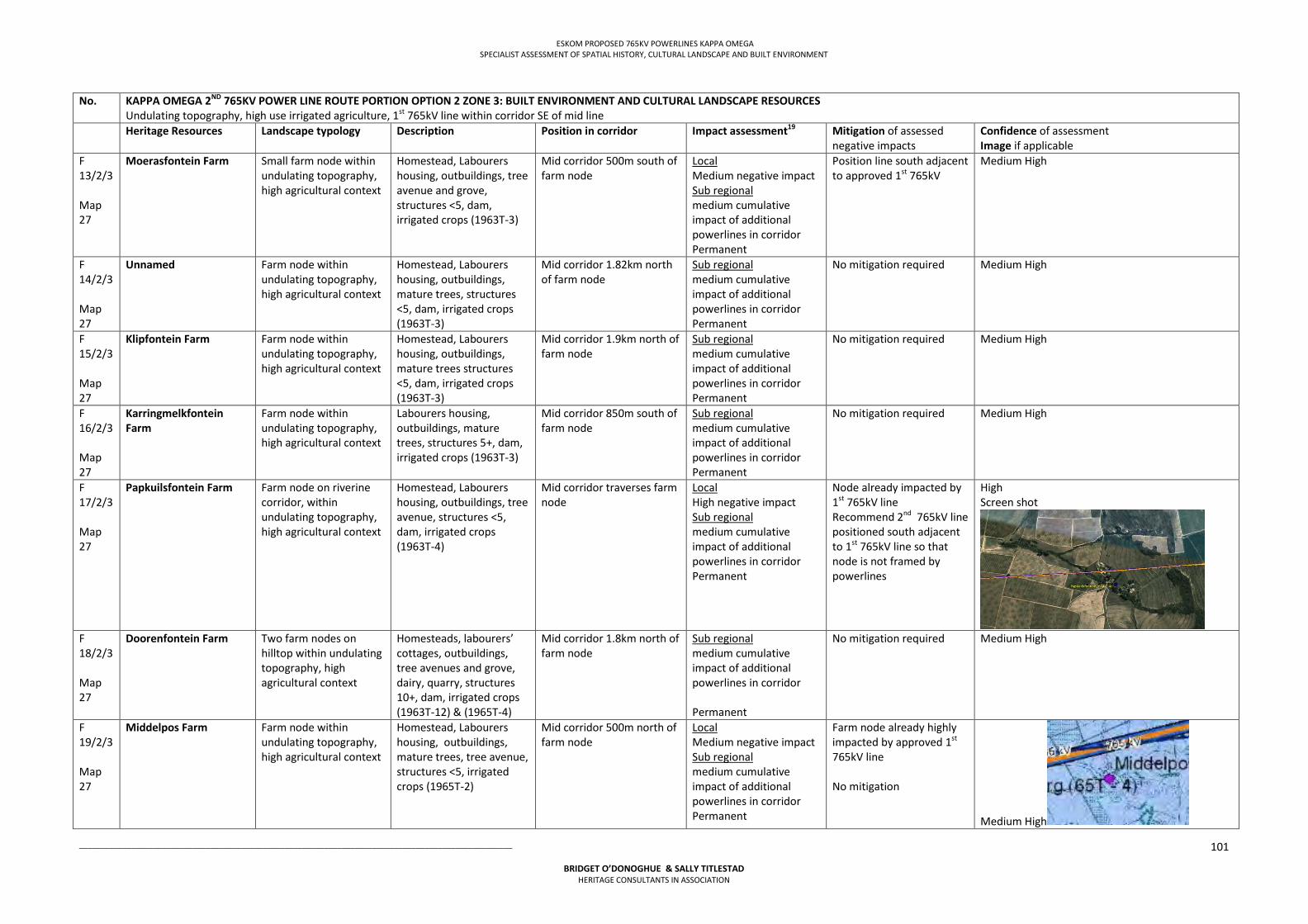
ESKOM PROPOSED 765KV POWERLINES KAPPA OMEGA SPECIALIST ASSESSMENT OF SPATIAL HISTORY, CULTURAL LANDSCAPE AND BUILT ENVIRONMENT
___________________________________________________________________________________________________
BRIDGET O’DONOGHUE & SALLY TITLESTAD HERITAGE CONSULTANTS IN ASSOCIATION
101
No. KAPPA OMEGA 2ND 765KV POWER LINE ROUTE PORTION OPTION 2 ZONE 3: BUILT ENVIRONMENT AND CULTURAL LANDSCAPE RESOURCES Undulating topography, high use irrigated agriculture, 1st 765kV line within corridor SE of mid line
Heritage Resources Landscape typology Description Position in corridor Impact assessment19 Mitigation of assessed negative impacts
Confidence of assessment Image if applicable
F 13/2/3 Map 27
Moerasfontein Farm Small farm node within undulating topography, high agricultural context
Homestead, Labourers housing, outbuildings, tree avenue and grove, structures <5, dam, irrigated crops (1963T-3)
Mid corridor 500m south of farm node
Local Medium negative impact Sub regional medium cumulative impact of additional powerlines in corridor Permanent
Position line south adjacent to approved 1st 765kV
Medium High
F 14/2/3 Map 27
Unnamed Farm node within undulating topography, high agricultural context
Homestead, Labourers housing, outbuildings, mature trees, structures <5, dam, irrigated crops (1963T-3)
Mid corridor 1.82km north of farm node
Sub regional medium cumulative impact of additional powerlines in corridor Permanent
No mitigation required Medium High
F 15/2/3 Map 27
Klipfontein Farm Farm node within undulating topography, high agricultural context
Homestead, Labourers housing, outbuildings, mature trees structures <5, dam, irrigated crops (1963T-3)
Mid corridor 1.9km north of farm node
Sub regional medium cumulative impact of additional powerlines in corridor Permanent
No mitigation required Medium High
F 16/2/3 Map 27
Karringmelkfontein Farm
Farm node within undulating topography, high agricultural context
Labourers housing, outbuildings, mature trees, structures 5+, dam, irrigated crops (1963T-3)
Mid corridor 850m south of farm node
Sub regional medium cumulative impact of additional powerlines in corridor Permanent
No mitigation required Medium High
F 17/2/3 Map 27
Papkuilsfontein Farm Farm node on riverine corridor, within undulating topography, high agricultural context
Homestead, Labourers housing, outbuildings, tree avenue, structures <5, dam, irrigated crops (1963T-4)
Mid corridor traverses farm node
Local High negative impact Sub regional medium cumulative impact of additional powerlines in corridor Permanent
Node already impacted by 1st 765kV line Recommend 2nd 765kV line positioned south adjacent to 1st 765kV line so that node is not framed by powerlines
High Screen shot
F 18/2/3 Map 27
Doorenfontein Farm Two farm nodes on hilltop within undulating topography, high agricultural context
Homesteads, labourers’ cottages, outbuildings, tree avenues and grove, dairy, quarry, structures 10+, dam, irrigated crops (1963T-12) & (1965T-4)
Mid corridor 1.8km north of farm node
Sub regional medium cumulative impact of additional powerlines in corridor Permanent
No mitigation required Medium High
F 19/2/3 Map 27
Middelpos Farm Farm node within undulating topography, high agricultural context
Homestead, Labourers housing, outbuildings, mature trees, tree avenue, structures <5, irrigated crops (1965T-2)
Mid corridor 500m north of farm node
Local Medium negative impact Sub regional medium cumulative impact of additional powerlines in corridor Permanent
Farm node already highly impacted by approved 1st 765kV line No mitigation
Medium High
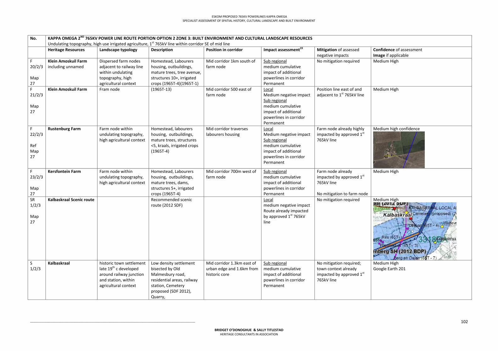
ESKOM PROPOSED 765KV POWERLINES KAPPA OMEGA SPECIALIST ASSESSMENT OF SPATIAL HISTORY, CULTURAL LANDSCAPE AND BUILT ENVIRONMENT
___________________________________________________________________________________________________
BRIDGET O’DONOGHUE & SALLY TITLESTAD HERITAGE CONSULTANTS IN ASSOCIATION
102
No. KAPPA OMEGA 2ND 765KV POWER LINE ROUTE PORTION OPTION 2 ZONE 3: BUILT ENVIRONMENT AND CULTURAL LANDSCAPE RESOURCES Undulating topography, high use irrigated agriculture, 1st 765kV line within corridor SE of mid line
Heritage Resources Landscape typology Description Position in corridor Impact assessment19 Mitigation of assessed negative impacts
Confidence of assessment Image if applicable
F 20/2/3 Map 27
Klein Amoskuil Farm including unnamed
Dispersed farm nodes adjacent to railway line within undulating topography, high agricultural context
Homestead, Labourers housing, outbuildings, mature trees, tree avenue, structures 10+, irrigated crops (1965T-4)(1965T-1)
Mid corridor 1km south of farm node
Sub regional medium cumulative impact of additional powerlines in corridor Permanent
No mitigation required Medium High
F 21/2/3 Map 27
Klein Amoskuil Farm Fram node (1965T-13) Mid corridor 500 east of farm node
Local Medium negative impact Sub regional medium cumulative impact of additional powerlines in corridor Permanent
Position line east of and adjacent to 1st 765kV line
Medium High
F 22/2/3 Ref Map 27
Rustenburg Farm Farm node within undulating topography, high agricultural context
Homestead, labourers housing, outbuildings, mature trees, structures <5, kraals, irrigated crops (1965T-4)
Mid corridor traverses labourers housing
Local Medium negative impact Sub regional medium cumulative impact of additional powerlines in corridor Permanent
Farm node already highly impacted by approved 1st 765kV line
Medium high confidence
F 23/2/3 Map 27
Kersfontein Farm Farm node within undulating topography, high agricultural context
Homestead, Labourers housing, outbuildings, mature trees, dams, structures 5+, irrigated crops (1965T-4)
Mid corridor 700m west of farm node
Sub regional medium cumulative impact of additional powerlines in corridor Permanent
Farm node already impacted by approved 1st 765kV line No mitigation to farm node
Medium High
SR 1/2/3 Map 27
Kalbaskraal Scenic route Recommended scenic route (2012 SDF)
Local medium negative impact Route already impacted by approved 1st 765kV line
No mitigation required Medium High
S 1/2/3
Kalbaskraal
historic town settlement late 19th c developed around railway junction and station, within agricultural context
Low density settlement bisected by Old Malmesbury road, residential areas, railway station, Cemetery proposed (SDF 2012), Quarry,
Mid corridor 1.3km east of urban edge and 1.6km from historic core
Sub regional medium cumulative impact of additional powerlines in corridor Permanent
No mitigation required; town context already impacted by approved 1st 765kV line
Medium High Google Earth 201
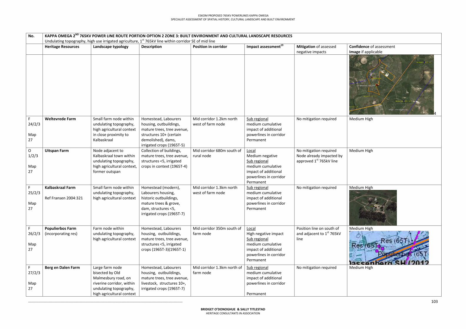
ESKOM PROPOSED 765KV POWERLINES KAPPA OMEGA SPECIALIST ASSESSMENT OF SPATIAL HISTORY, CULTURAL LANDSCAPE AND BUILT ENVIRONMENT
___________________________________________________________________________________________________
BRIDGET O’DONOGHUE & SALLY TITLESTAD HERITAGE CONSULTANTS IN ASSOCIATION
103
No. KAPPA OMEGA 2ND 765KV POWER LINE ROUTE PORTION OPTION 2 ZONE 3: BUILT ENVIRONMENT AND CULTURAL LANDSCAPE RESOURCES Undulating topography, high use irrigated agriculture, 1st 765kV line within corridor SE of mid line
Heritage Resources Landscape typology Description Position in corridor Impact assessment19 Mitigation of assessed negative impacts
Confidence of assessment Image if applicable
4 F 24/2/3 Map 27
Weltevrede Farm Small farm node within undulating topography, high agricultural context in close proximity to Kalbaskraal
Homestead, Labourers housing, outbuildings, mature trees, tree avenue, structures 10+ (certain demolished), dams, irrigated crops (1965T-5)
Mid corridor 1.2km north west of farm node
Sub regional medium cumulative impact of additional powerlines in corridor Permanent
No mitigation required Medium High
O 1/2/3 Map 27
Uitspan Farm Node adjacent to Kalbaskraal town within undulating topography, high agricultural context, former outspan
Collection of buildings, mature trees, tree avenue, structures <5, irrigated crops in context (1965T-4)
Mid corridor 680m south of rural node
Local Medium negative Sub regional medium cumulative impact of additional powerlines in corridor Permanent
No mitigation required Node already impacted by approved 1st 765kV line
Medium High
F 25/2/3 Map 27
Kalbaskraal Farm Ref Fransen 2004:321
Small farm node within undulating topography, high agricultural context
Homestead (modern), Labourers housing, historic outbuildings, mature trees & grove, dam, structures <5, irrigated crops (1965T-7)
Mid corridor 1.3km north west of farm node
Sub regional medium cumulative impact of additional powerlines in corridor Permanent
No mitigation required Medium High
F 26/2/3 Map 27
Populierbos Farm (incorporating res)
Farm node within undulating topography, high agricultural context
Homestead, Labourers housing, outbuildings, mature trees, tree avenue, structures <5, irrigated crops (1965T-3)(1965T-1)
Mid corridor 350m south of farm node
Local High negative impact Sub regional medium cumulative impact of additional powerlines in corridor Permanent
Position line on south of and adjacent to 1st 765kV line
Medium High
F 27/2/3 Map 27
Berg en Dalen Farm Large farm node bisected by Old Malmesbury road, on riverine corridor, within undulating topography, high agricultural context
Homestead, Labourers housing, outbuildings, mature trees, tree avenue, livestock, structures 10+, irrigated crops (1965T-7)
Mid corridor 1.3km north of farm node
Sub regional medium cumulative impact of additional powerlines in corridor Permanent
No mitigation required Medium High
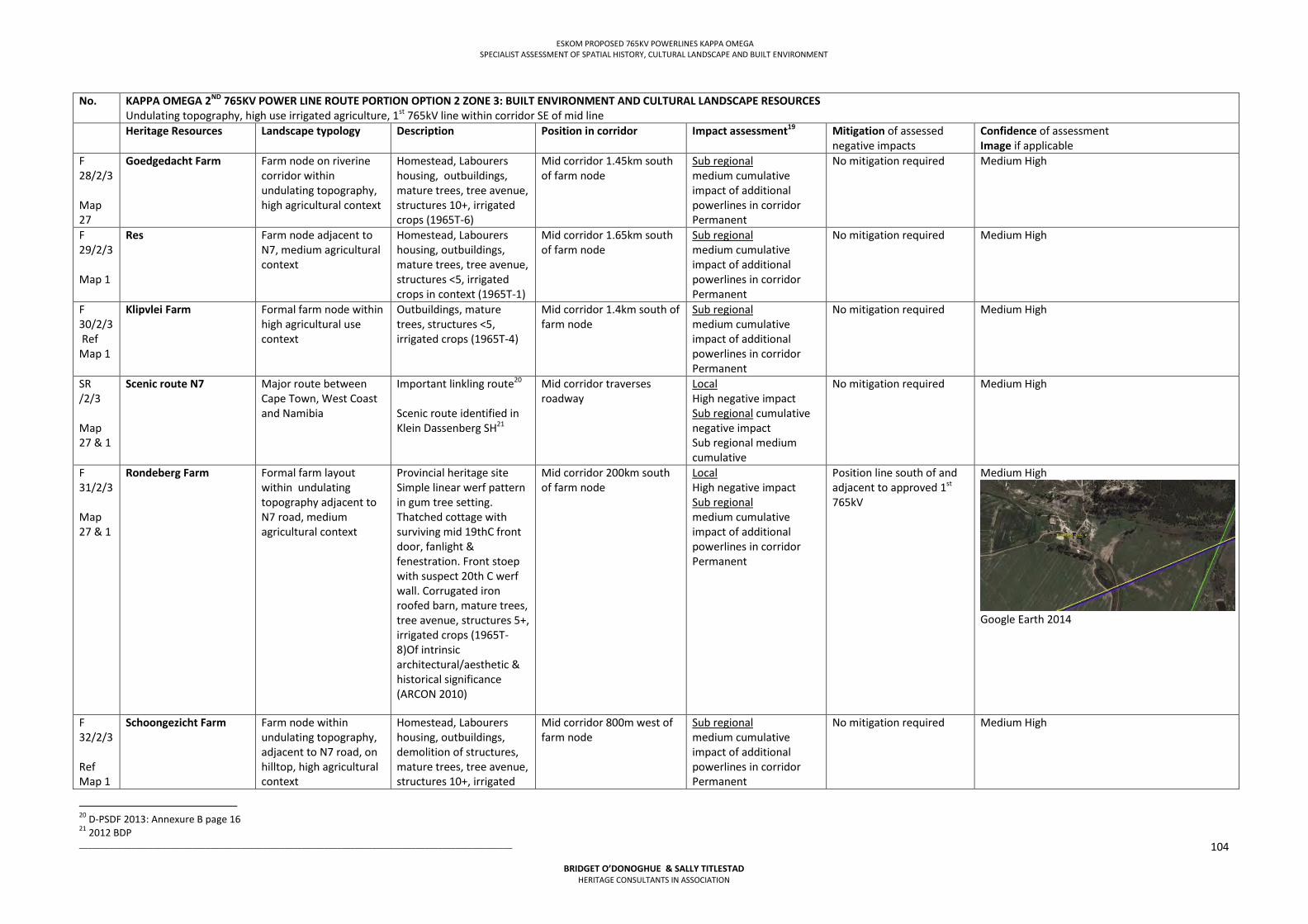
ESKOM PROPOSED 765KV POWERLINES KAPPA OMEGA SPECIALIST ASSESSMENT OF SPATIAL HISTORY, CULTURAL LANDSCAPE AND BUILT ENVIRONMENT
___________________________________________________________________________________________________
BRIDGET O’DONOGHUE & SALLY TITLESTAD HERITAGE CONSULTANTS IN ASSOCIATION
104
No. KAPPA OMEGA 2ND 765KV POWER LINE ROUTE PORTION OPTION 2 ZONE 3: BUILT ENVIRONMENT AND CULTURAL LANDSCAPE RESOURCES Undulating topography, high use irrigated agriculture, 1st 765kV line within corridor SE of mid line
Heritage Resources Landscape typology Description Position in corridor Impact assessment19 Mitigation of assessed negative impacts
Confidence of assessment Image if applicable
F 28/2/3 Map 27
Goedgedacht Farm Farm node on riverine corridor within undulating topography, high agricultural context
Homestead, Labourers housing, outbuildings, mature trees, tree avenue, structures 10+, irrigated crops (1965T-6)
Mid corridor 1.45km south of farm node
Sub regional medium cumulative impact of additional powerlines in corridor Permanent
No mitigation required Medium High
F 29/2/3 Map 1
Res
Farm node adjacent to N7, medium agricultural context
Homestead, Labourers housing, outbuildings, mature trees, tree avenue, structures <5, irrigated crops in context (1965T-1)
Mid corridor 1.65km south of farm node
Sub regional medium cumulative impact of additional powerlines in corridor Permanent
No mitigation required Medium High
F 30/2/3 Ref Map 1
Klipvlei Farm
Formal farm node within high agricultural use context
Outbuildings, mature trees, structures <5, irrigated crops (1965T-4)
Mid corridor 1.4km south of farm node
Sub regional medium cumulative impact of additional powerlines in corridor Permanent
No mitigation required Medium High
SR /2/3 Map 27 & 1
Scenic route N7
Major route between Cape Town, West Coast and Namibia
Important linkling route20 Scenic route identified in Klein Dassenberg SH21
Mid corridor traverses roadway
Local High negative impact Sub regional cumulative negative impact Sub regional medium cumulative
No mitigation required Medium High
F 31/2/3 Map 27 & 1
Rondeberg Farm
Formal farm layout within undulating topography adjacent to N7 road, medium agricultural context
Provincial heritage site Simple linear werf pattern in gum tree setting. Thatched cottage with surviving mid 19thC front door, fanlight & fenestration. Front stoep with suspect 20th C werf wall. Corrugated iron roofed barn, mature trees, tree avenue, structures 5+, irrigated crops (1965T-8)Of intrinsic architectural/aesthetic & historical significance (ARCON 2010)
Mid corridor 200km south of farm node
Local High negative impact Sub regional medium cumulative impact of additional powerlines in corridor Permanent
Position line south of and adjacent to approved 1st 765kV
Medium High
Google Earth 2014
F 32/2/3 Ref Map 1
Schoongezicht Farm
Farm node within undulating topography, adjacent to N7 road, on hilltop, high agricultural context
Homestead, Labourers housing, outbuildings, demolition of structures, mature trees, tree avenue, structures 10+, irrigated
Mid corridor 800m west of farm node
Sub regional medium cumulative impact of additional powerlines in corridor Permanent
No mitigation required Medium High
20 D-PSDF 2013: Annexure B page 16 21 2012 BDP
ESKOM PROPOSED 765KV POWERLINES KAPPA OMEGA SPECIALIST ASSESSMENT OF SPATIAL HISTORY, CULTURAL LANDSCAPE AND BUILT ENVIRONMENT
___________________________________________________________________________________________________
BRIDGET O’DONOGHUE & SALLY TITLESTAD HERITAGE CONSULTANTS IN ASSOCIATION
105
No. KAPPA OMEGA 2ND 765KV POWER LINE ROUTE PORTION OPTION 2 ZONE 3: BUILT ENVIRONMENT AND CULTURAL LANDSCAPE RESOURCES Undulating topography, high use irrigated agriculture, 1st 765kV line within corridor SE of mid line
Heritage Resources Landscape typology Description Position in corridor Impact assessment19 Mitigation of assessed negative impacts
Confidence of assessment Image if applicable
crops, horses, (1965T-5) Will be impacted by 1st 765kV Permanent
F 33/2/3 Ref Map 1
Tierhoogte Farm
Large farm formal node adjacent to N7 Roadway within undulating topography, high agricultural context
Labourers housing, outbuildings, mature trees, tree avenues (entry + roadway), dam, structures 10+, irrigated crops (1965T-6)
Mid corridor 1.9km west of farm node
Sub regional medium cumulative impact of additional powerlines in corridor Permanent
No mitigation required Medium High
F 34/2/3 Ref Map 1
Boterberg Farm
Farm node adjacent to N7 roadway on Philadelphia road, within undulating topography, high agricultural context, 1.5km to Philadelphia
Homestead, Labourers housing, outbuildings, graves, mature trees, tree avenue, kraals, dam, structures <5, irrigated crops in context (1965T-4)
Mid corridor 1.6km north west of farm node
Sub regional medium cumulative impact of additional powerlines in corridor Permanent
No mitigation required Medium High
F 35/2/3 Ref Map 1
Botterberg General area PHS list from HWC – general area listed without boundaries, map or status
Unknown Medium High
F 36/2/3 Ref Map 1
Klipvlei Farm Check repeat
Farm node adjacent to N7 road, on coastal plain, medium agricultural context, petrol station between node and road
Labourers housing, outbuildings, mature trees, structures <5, irrigated crops in context (1965T-5)
Mid corridor 1.2km north west of farm node
Sub regional medium cumulative impact of additional powerlines in corridor Permanent
No mitigation required Medium High
F 37/2/3 Ref Map 1
Unnamed Farm node on riverine corridor, medium agricultural context
Homestead, Labourers housing, outbuildings, mature tree grove, structures <5, irrigated crops in context (1965T-4)
Mid corridor 600m south east of farm node
Local medium cumulative impact Sub regional medium impact medium Permanent
Already impacted by approved 1st 765kV line
Medium High
F 38/2/3 Ref Map 1
Mesech Farm Add both distances
Farm node adjacent to N7 roadway, within undulating topography, high agricultural context, on minor riverine corridor
Homestead, Labourers housing, outbuildings, mature tree grove, structures <5, irrigated crops in context (1965T-4)
Option 2 Mid corridor 1.5km north west of farm node Option 1 mid corridor 1.4km from farm node
Sub regional medium cumulative impact of additional powerlines in corridor Permanent
No mitigation required Medium High
F 39/2/3 Ref Map 1
Die Anker Farm Large farm node adjacent to R304 roadway, within undulating topography, medium agricultural context
Homestead, Labourers housing, outbuildings, livestock, mature tree grove, structures 10+, (1965T-4)
Mid corridor 900m south east of farm node
Sub regional medium cumulative impact of additional powerlines in corridor Permanent
No mitigation required Medium High
F 40/2/3
Witdam Farm Farm node adjacent to R304 roadway, within undulating topography,
Homestead, Labourers housing, outbuildings, mature trees, structures
Mid corridor 600m north west of farm node Omega substation 1km south west
Local Cumulative high impacted
Already impacted by approved 1st 765kV line
Medium High
ESKOM PROPOSED 765KV POWERLINES KAPPA OMEGA SPECIALIST ASSESSMENT OF SPATIAL HISTORY, CULTURAL LANDSCAPE AND BUILT ENVIRONMENT
___________________________________________________________________________________________________
BRIDGET O’DONOGHUE & SALLY TITLESTAD HERITAGE CONSULTANTS IN ASSOCIATION
106
No. KAPPA OMEGA 2ND 765KV POWER LINE ROUTE PORTION OPTION 2 ZONE 3: BUILT ENVIRONMENT AND CULTURAL LANDSCAPE RESOURCES Undulating topography, high use irrigated agriculture, 1st 765kV line within corridor SE of mid line
Heritage Resources Landscape typology Description Position in corridor Impact assessment19 Mitigation of assessed negative impacts
Confidence of assessment Image if applicable
medium agricultural context
10+, (1965T-4 (1965T-9) of farm node Sub regional medium cumulative impact of additional powerlines in corridor Permanent
Table 6.6 Impact Assessment Route Option 1b Zone 3 No KAPPA OMEGA 2ND 765KV POWER LINE ROUTE PORTION OPTION 1B ZONE 3: BUILT ENVIRONMENT AND CULTURAL LANDSCAPE RESOURCES
Undulating topography, high use irrigated agriculture, no large infrastructure within corridor Heritage Resources Landscape typology Description (farm name
and descript. Position in corridor)
Position in corridor
Impact assessment22
Mitigation of assessed negative impacts
Confidence of assessment Image if appliacable
CL 1/1/3 Map ref 27
Paardeberg & Paardeberg slopes
Paardeberg Natural wilderness landscape setting Slopes Cultural landscape Collection of historical farm werfs and associated rural settings related to slopes Threshold condition between Swartland and Cape Winelands 23
Recommended Grade III cultural landscape D-PSDF 201324 (historical, aesthetic, architectural and social significances) Northern slopes of Paardeberg negatively impacted by approved 1st 765kV powerline
1km from Paardeberg foothills, corridor impacted includes slopes
Local High negative impact by framing Paardeberg in linear infrastructure Permanent
Use alternative corridor, Option 1a
Medium High
F 1/1B/3 Ref Map 27
Ongegund Farm Farm node within undulating topography, high agricultural context, on ridge
Homestead, labourers housing, outbuildings, mature trees, structures <5, irrigated crops in context (1965T-4)
Mid corridor 1.02km west of farm node Permanent
Sub regional high negative impact establishment of new corridor
Corridor not recommended. Use alternative corridor, Option 1a If route is the preferred EIA route, position powerline minimum 600m from farm node
High
F 2/1B/3 Ref Map 27
Diemerskraal Farm Farm node within undulating topography, high agricultural context, adjacent to river
Homestead, labourers housing, outbuildings, mature trees, structures 5+, irrigated crops in context (1965T-8)
Option 1B Mid corridor 250m south west of farm node Option 1 mid corridor south east 1.75km Permanent
Sub regional high negative impact establishment of new corridor
Corridor not recommended. Use alternative corridor, Option 1a If route is the preferred EIA route, position powerline minimum 600m from farm
High
22 Impact Assessment : Scale (regional, sub regional, local) Measurement (High, Medium, Local) (Positive, Neutral, Negative) Duration of Impact (Permanent, Semi permanent, temporary) 23 Winter & Baumann 2000 in D PSDF 2013 24 DHS 2012 in D-PSDF 2013; Annexure B page 22
ESKOM PROPOSED 765KV POWERLINES KAPPA OMEGA SPECIALIST ASSESSMENT OF SPATIAL HISTORY, CULTURAL LANDSCAPE AND BUILT ENVIRONMENT
___________________________________________________________________________________________________
BRIDGET O’DONOGHUE & SALLY TITLESTAD HERITAGE CONSULTANTS IN ASSOCIATION
107
No KAPPA OMEGA 2ND 765KV POWER LINE ROUTE PORTION OPTION 1B ZONE 3: BUILT ENVIRONMENT AND CULTURAL LANDSCAPE RESOURCES Undulating topography, high use irrigated agriculture, no large infrastructure within corridor
node F 3/1B/3 Ref Map 27
Welgegund Farm Small farm node within undulating topography, adjacent to riverine corridor, high agricultural context
Homestead, labourers housing, outbuildings, mature trees, structures 5+, irrigated crops in context (1965T-4)
Mid corridor 980m west of farm node Permanent
Sub regional high negative impact: establishment of new corridor
Corridor not recommended. Use alternative corridor, Option 1a
High
F 4/1B/3 Ref Map 27
Botriviervlei Farm
Farm node within undulating topography, high agricultural context, adjacent to river and road (R45)
Homestead, labourers housing, outbuildings, mature trees, tree avenue structures 5+, irrigated crops in context (1965T-8)
Mid corridor 800m north east of farm node Permanent
Sub regional High negative impact establishment of new corridor
Corridor not recommended. Use alternative corridor, Option 1a
High
F 5/1B/3 Ref Map 27
Soutpan Farm Farm node within undulating topography, high agricultural context, on riverine corridor
Homestead, labourers housing, outbuildings, mature trees, structures <5, irrigated crops in context (1965T-3)
Mid corridor 760m south west of farm node Permanent
Sub regional High negative impact: establishment of new corridor
Corridor not recommended. Use alternative corridor, Option 1a If route is the preferred EIA route, position powerline minimum 600m from farm node
High
F 6/1B/3 Ref Map 27
Gras en Dalen Farm Small liner farm node within undulating topography, high agricultural context
Homestead, outbuildings, mature trees, structures <5, irrigated crops in context (1965T-4)
Mid corridor 870m north east of farm node 1.9km Permanent
Sub regional High negative impact: establishment of new corridor
Corridor not recommended. Use alternative corridor, Option 1a If route is the preferred EIA route, position powerline minimum 600m from farm node
High
F 7/1B/3 Ref Map 27
La Rhine Farm Large farm with two nodes within undulating topography, high agricultural context, adjacent to river
Homestead, labourers housing, outbuildings, mature trees, structures 10+, irrigated crops in context (1963T-7) & (1963T-9)
Mid corridor 1.6km north east of farm node Permanent
Sub regional High negative impact: establishment of new corridor
Corridor not recommended. Use alternative corridor, Option 1a If route is the preferred EIA route, position powerline minimum 600m from farm node
High
F 8/1B/3 Ref Map 27
Goetverwagting Farm Farm nodes within undulating topography, high agricultural context, adjacent to river
Homestead, labourers housing, outbuildings, mature trees, structures <5, irrigated crops in context (1965T-4)
Mid corridor 1.9km north east of farm node Permanent
Sub regional High negative impact: establishment of new corridor
Corridor not recommended. Use alternative corridor, Option 1a If route is the preferred EIA route, position powerline minimum 600m from farm node
High
ESKOM PROPOSED 765KV POWERLINES KAPPA OMEGA SPECIALIST ASSESSMENT OF SPATIAL HISTORY, CULTURAL LANDSCAPE AND BUILT ENVIRONMENT
___________________________________________________________________________________________________
BRIDGET O’DONOGHUE & SALLY TITLESTAD HERITAGE CONSULTANTS IN ASSOCIATION
108
No KAPPA OMEGA 2ND 765KV POWER LINE ROUTE PORTION OPTION 1B ZONE 3: BUILT ENVIRONMENT AND CULTURAL LANDSCAPE RESOURCES Undulating topography, high use irrigated agriculture, no large infrastructure within corridor
F 9/1B/3 Ref Map 27
Boesmansrivier Farm Large farm node within undulating topography, high agricultural context, on ridge
Homestead, labourers housing, outbuildings, mature trees, structures 10+, livestock, irrigated crops in context (1963T-17)
Mid corridor immediately adjacent to labourers housing Permanent
Local High negative Impact Sub regional High negative impact: establishment of new corridor
Corridor not recomended. Use alternative corridor, Option 1a If route is the preferred EIA route, position powerline minumum 600m from farm node
High
F 10/1B/3 Ref Map 27
Kanolfontein Farm Small farm node within undulating topography, high agricultural context, adjacent to river
Residence, outbuilding, mature trees, dams, structures <5, irrigated crops in context (1963T-3)
Mid corridor 870m north east of farm node Permanent
Sub regional High negative impact: establishment of new corridor
Corridor not recommended. Use alternative corridor, Option 1a If route is the preferred EIA route, position powerline minimum 600m from farm node
High
F 11/1B/3 Ref Map 27
Rhenosterbosrug Farm Farm node within undulating topography, high agricultural context, adjacent to river
Homestead, labourers housing, outbuildings, mature trees, dams, livestock, structures 10+, irrigated crops in context (1963T-10)
Mid corridor traverses farm node Permanent
Local High negative impact Sub regional High negative impact: establishment of new corridor
Corridor not recommended. Use alternative corridor, Option 1a If route is the preferred EIA route, position powerline minimum 600m from farm node
High
F 12/1B/3 Ref Map 27
Twee Kuil Farm Farm node within undulating topography, high agricultural context
Homestead, labourers housing, outbuildings, mature trees, structures 5+, dam, irrigated crops in context (1963T-7)
Mid corridor 1.35km south west of farm node Permanent
Sub regional High negative impact: establishment of new corridor
Corridor not recommended. Use alternative corridor, Option 1a If route is the preferred EIA route, position powerline minimum 600m from farm node
High
F 13/1B/3 Ref Map 27
Welgelegen Farm Farm node within undulating topography, high agricultural context
Homestead, labourers housing, outbuildings, mature trees, structures <5, dam, irrigated crops in context (1963T-7)
Mid corridor 1.85km north east of farm node Permanent
Sub regional High negative impact: establishment of new corridor
Corridor not recommended. Use alternative corridor, Option 1a If route is the preferred EIA route, position powerline minimum 600m from farm node
F 14/1B/3 Ref
Ribbokam Farm Farm with two nodes within undulating topography, high agricultural context
Homestead, labourers housing, outbuildings, mature trees, structures 5+, irrigated crops in
Mid corridor 1.5km north east of farm node Permanent
Sub regional High negative impact: establishment of new corridor
Corridor not recommended. Use alternative corridor, Option 1a
High
ESKOM PROPOSED 765KV POWERLINES KAPPA OMEGA SPECIALIST ASSESSMENT OF SPATIAL HISTORY, CULTURAL LANDSCAPE AND BUILT ENVIRONMENT
___________________________________________________________________________________________________
BRIDGET O’DONOGHUE & SALLY TITLESTAD HERITAGE CONSULTANTS IN ASSOCIATION
109
No KAPPA OMEGA 2ND 765KV POWER LINE ROUTE PORTION OPTION 1B ZONE 3: BUILT ENVIRONMENT AND CULTURAL LANDSCAPE RESOURCES Undulating topography, high use irrigated agriculture, no large infrastructure within corridor
Map 27 context (1963T-7) If route is the preferred EIA route, position powerline minimum 600m from farm node
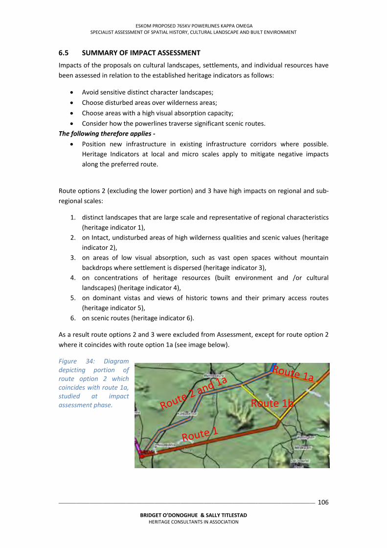
ESKOM PROPOSED 765KV POWERLINES KAPPA OMEGA SPECIALIST ASSESSMENT OF SPATIAL HISTORY, CULTURAL LANDSCAPE AND BUILT ENVIRONMENT
___________________________________________________________________________________________________
BRIDGET O’DONOGHUE & SALLY TITLESTAD HERITAGE CONSULTANTS IN ASSOCIATION
106
6.5 SUMMARY OF IMPACT ASSESSMENT
Impacts of the proposals on cultural landscapes, settlements, and individual resources have been assessed in relation to the established heritage indicators as follows:
Avoid sensitive distinct character landscapes; Choose disturbed areas over wilderness areas; Choose areas with a high visual absorption capacity; Consider how the powerlines traverse significant scenic routes.
The following therefore applies - Position new infrastructure in existing infrastructure corridors where possible.
Heritage Indicators at local and micro scales apply to mitigate negative impacts along the preferred route.
Route options 2 (excluding the lower portion) and 3 have high impacts on regional and sub-regional scales:
1. distinct landscapes that are large scale and representative of regional characteristics (heritage indicator 1),
2. on Intact, undisturbed areas of high wilderness qualities and scenic values (heritage indicator 2),
3. on areas of low visual absorption, such as vast open spaces without mountain backdrops where settlement is dispersed (heritage indicator 3),
4. on concentrations of heritage resources (built environment and /or cultural landscapes) (heritage indicator 4),
5. on dominant vistas and views of historic towns and their primary access routes (heritage indicator 5),
6. on scenic routes (heritage indicator 6).
As a result route options 2 and 3 were excluded from Assessment, except for route option 2 where it coincides with route option 1a (see image below).
Figure 34: Diagram depicting portion of route option 2 which coincides with route 1a, studied at impact assessment phase.
Route 1b
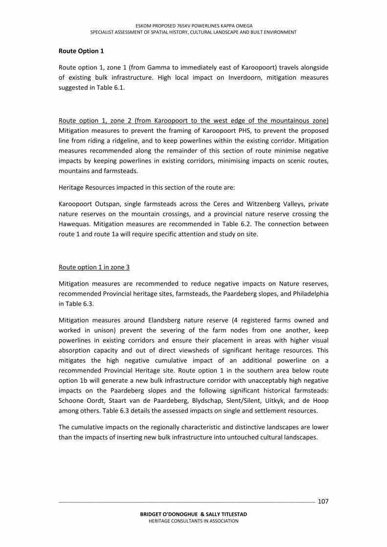
ESKOM PROPOSED 765KV POWERLINES KAPPA OMEGA SPECIALIST ASSESSMENT OF SPATIAL HISTORY, CULTURAL LANDSCAPE AND BUILT ENVIRONMENT
___________________________________________________________________________________________________
BRIDGET O’DONOGHUE & SALLY TITLESTAD HERITAGE CONSULTANTS IN ASSOCIATION
107
Route Option 1
Route option 1, zone 1 (from Gamma to immediately east of Karoopoort) travels alongside of existing bulk infrastructure. High local impact on Inverdoorn, mitigation measures suggested in Table 6.1.
Route option 1, zone 2 (from Karoopoort to the west edge of the mountainous zone) Mitigation measures to prevent the framing of Karoopoort PHS, to prevent the proposed line from riding a ridgeline, and to keep powerlines within the existing corridor. Mitigation measures recommended along the remainder of this section of route minimise negative impacts by keeping powerlines in existing corridors, minimising impacts on scenic routes, mountains and farmsteads.
Heritage Resources impacted in this section of the route are:
Karoopoort Outspan, single farmsteads across the Ceres and Witzenberg Valleys, private nature reserves on the mountain crossings, and a provincial nature reserve crossing the Hawequas. Mitigation measures are recommended in Table 6.2. The connection between route 1 and route 1a will require specific attention and study on site.
Route option 1 in zone 3
Mitigation measures are recommended to reduce negative impacts on Nature reserves, recommended Provincial heritage sites, farmsteads, the Paardeberg slopes, and Philadelphia in Table 6.3.
Mitigation measures around Elandsberg nature reserve (4 registered farms owned and worked in unison) prevent the severing of the farm nodes from one another, keep powerlines in existing corridors and ensure their placement in areas with higher visual absorption capacity and out of direct viewsheds of significant heritage resources. This mitigates the high negative cumulative impact of an additional powerline on a recommended Provincial Heritage site. Route option 1 in the southern area below route option 1b will generate a new bulk infrastructure corridor with unacceptably high negative impacts on the Paardeberg slopes and the following significant historical farmsteads: Schoone Oordt, Staart van de Paardeberg, Blydschap, Slent/Silent, Uitkyk, and de Hoop among others. Table 6.3 details the assessed impacts on single and settlement resources.
The cumulative impacts on the regionally characteristic and distinctive landscapes are lower than the impacts of inserting new bulk infrastructure into untouched cultural landscapes.
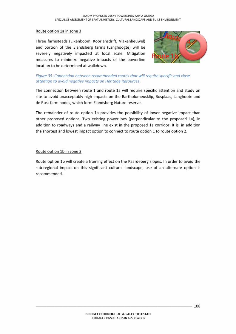
ESKOM PROPOSED 765KV POWERLINES KAPPA OMEGA SPECIALIST ASSESSMENT OF SPATIAL HISTORY, CULTURAL LANDSCAPE AND BUILT ENVIRONMENT
___________________________________________________________________________________________________
BRIDGET O’DONOGHUE & SALLY TITLESTAD HERITAGE CONSULTANTS IN ASSOCIATION
108
Route option 1a in zone 3
Three farmsteads (Eikenboom, Koorlansdrift, Vlakenheuwel) and portion of the Elandsberg farms (Langhoogte) will be severely negatively impacted at local scale. Mitigation measures to minimize negative impacts of the powerline location to be determined at walkdown.
Figure 35: Connection between recommended routes that will require specific and close attention to avoid negative impacts on Heritage Resources
The connection between route 1 and route 1a will require specific attention and study on site to avoid unacceptably high impacts on the Bartholomeusklip, Bosplaas, Langhoote and de Rust farm nodes, which form Elandsberg Nature reserve.
The remainder of route option 1a provides the possibility of lower negative impact than other proposed options. Two existing powerlines (perpendicular to the proposed 1a), in addition to roadways and a railway line exist in the proposed 1a corridor. It is, in addition the shortest and lowest impact option to connect to route option 1 to route option 2.
Route option 1b in zone 3
Route option 1b will create a framing effect on the Paardeberg slopes. In order to avoid the sub-regional impact on this significant cultural landscape, use of an alternate option is recommended.
Route 1b
ESKOM PROPOSED 765KV POWERLINES KAPPA OMEGA SPECIALIST ASSESSMENT OF SPATIAL HISTORY, CULTURAL LANDSCAPE AND BUILT ENVIRONMENT
___________________________________________________________________________________________________
BRIDGET O’DONOGHUE & SALLY TITLESTAD HERITAGE CONSULTANTS IN ASSOCIATION
109
SECTION 7 RECOMMENDATIONS
The specialist spatial history, cultural landscape and built environment assessments of the proposed 2nd 765kV power lines form kappa to Omega sub stations recommend:
1. Adoption of the report’s heritage indicators in the assessment of the proposed 2nd 765kV power lines;
2. Option Route 2 (north and east route option 1a) assessed as undesirable due to the unacceptably high negative impacts on heritage resources and cultural landscapes, including on iconic landscapes, by the establishment of a new powerline corridor;
3. Option Route 3 assessed as undesirable due to the unacceptably high negative impacts on heritage resources and cultural landscapes, including on iconic landscapes by the establishment of a new powerline corridor.
4. Acceptance of Option Route 1, 1a and 2, south of Riebeek Kasteel and the R46 Scenic Route, as the preferred route due to the lower impact on settlements and landscapes. The presence of existing 400kV and approved first 765kV power lines have already impacted the landscape and farm settlements along the greater distance of route option 1.
5. Adoptions of mitigation measures for options 1, 1a and 2 where it intersects with option 1a, contained in the Tables 6.1- 6.6.
ESKOM PROPOSED 765KV POWERLINES KAPPA OMEGA SPECIALIST ASSESSMENT OF SPATIAL HISTORY, CULTURAL LANDSCAPE AND BUILT ENVIRONMENT
___________________________________________________________________________________________________
BRIDGET O’DONOGHUE & SALLY TITLESTAD HERITAGE CONSULTANTS IN ASSOCIATION
110
SECTION 8 BIBLIOGRAPHY OF SOURCES
Adhikari M. (2010). The Anatomy of a South African Genocide. Cape Town: UCT Press.
ARCON Architects and Heritage Consultants (2011). Kappa Omega Transmission Line Heritage Impact Assessment Phase 2 Prepared for Professional Grave SolutionsOn behalf of the Nature Conservation Corporation For ESKOM Transmission
Athiros, G. (nd) Route 27 West Coast South Africa: The Hildebrand Monument: Anglo-Boer War 1899-1902. Accessed on 27 May 2013 at: http://www.route27sa.com/hildebrand.html
Baumann, N & Winter, S. in association with Clift, H. 2009. Heritage Scoping Study of Proposed Gamma-Omega Transmission Power line; Specialist Built Environment and Landscape Study. Unpublished report for Cape Archaeological Survey on behalf of ESKOM Transmission.
Bulpin, T.V. (1980). Discovering Southern Africa (2nd edition). TV Bulpin Publishers: Cape Town.
Burman, J. (1984). Early Railways at the Cape. Cape Town: Human & Rousseau.
Clift, H. (2008). Appendix accessed on 10 May 2013 at:
http://www.eskom.co.za/content/APPENDIX%205%20Historical%20chronology%20HC%20Corrections~1.pdf
Cross, C. and Hornby, D. (2002). Obstacles to Women’s Land Access in South Africa. A Research Report for the Promoting Women’s Access to Land Programme. Accessed on 20 June 2013 at: http://www.info.gov.za/otherdocs/2002/landgender.pdf
Darling, Western Cape (nd). Accesses on 22 May 2013 at: http://en.wikipedia.org/wiki/Darling,_Western_Cape
Du Plessis, K. and Cowling, V. (2006). West Coast: Cederberg to the Sea. Cape Town: Struik.
Elphick, R. and Giliomee, H. editors (1989). The Shaping of South African Society 1652-1840. (2nd ed) Cape Town: Maskew Miller Longman.
Elphick, R. and Malherbe, C. (1989). The Khoisan to 1828. In The Shaping of South African Society 1652-1840. (2nd ed) Cape Town: Maskew Miller Longman.
Fransen, H. (2004). The Old Buildings of the Cape. Johannesburg: Jonathan Ball.
Fransen, H. (2006). Old Towns and Villages in the Cape. Johannesburg: Jonathan Ball.
Freund, W.B. (1989). The Cape under transitional governments, 1795-1814. In: Elphick, R. and Giliomee, H. editors (1989). The Shaping of South African Society 1652-1840. (2nd ed) Cape Town: Maskew Miller Longman.
Google Maps. (2013). Accessed on 13 June 2013 at:
Heritage Western Cape, A Short Guide to Grading Version 5, 2007
ICOMOS, Charter for the Conservation of Historic Towns and Urban Areas (Washington Charter 1987)
ICOMOS, Guidance on Heritage Impact Assessments for Cultural World Heritage Properties Draft May 2010
Inskeep, R.R. (1978). The Peopling of Southern Africa. Cape Town: David Philip.
James, W.G. and Simons, M. editors (1989). The Angry Divide. Cape Town: David Philip.
Inskeep, R.R. (1978). The Peopling of Southern Africa. Cape Town: David Philip.
Malmesbury Tourism Bureau (nd). Malmesbury Historic Route. Accessed on 22 May 2013 at: http://www.malmesburytourism.co.za/malmesbury-history.htm
ESKOM PROPOSED 765KV POWERLINES KAPPA OMEGA SPECIALIST ASSESSMENT OF SPATIAL HISTORY, CULTURAL LANDSCAPE AND BUILT ENVIRONMENT
___________________________________________________________________________________________________
BRIDGET O’DONOGHUE & SALLY TITLESTAD HERITAGE CONSULTANTS IN ASSOCIATION
111
Mangin, G. and Lloyd, S. (1998). The Special Signal Services (Sss): We scanned the seas and skies in the Second World War. Military History Journal Vol 11 No 2 - December 1998.
Marquis-Kyle, P and Walker, M: Australia ICOMOS: The Illustrated Burra Charter: making good decisions about the care of important places, Australia ICOMOS 1992
Mossop, E.E. (1927). Old Cape Highways. Cape Town: Maskew Miller.
Mostert, L. (2011). History Textbook Workbook Grade 10 NCAPS. Cape Town: Allcopy Publishers. Accessed on 20 June 2013 at: intranet.parklands.co.za/?dl_id=2
National Heritage Resources Act, No 25 of 1999
Orton, J. (2004). Heritage Scoping Study of the Farm Groot Oliphantskop (Farm 81) for the Proposed Omega Substation, Western Cape. Prepared for Eyethu Engineers. South Africa. Archaeology, Contracts Office, University of Cape Town.
Orton, J. (2010) Heritage Impact Assessment for the Proposed Zen Wind Energy Facility, Tulbagh Magisterial District, Western Cape. Prepared for Savannah Environmental. South Africa. Archaeology, Contracts Office, University of Cape Town.
Orton, J. (2010). Heritage Impact Assessment for the Proposed Expansion of the N7 between the Melkbos and Atlantis Junctions, Malmesbury Magisterial District, Western Cape. Prepared for CCA Environmental. South Africa. Archaeology, Contracts Office, University of Cape Town
Parkington, J. et al (2008). Karoo Rock Engravings: Marking Places in the Landscape. Clanwilliam: Living Landscape Project.
Peires, J.B. (1989). The British and the Cape, 1814-1834 in Elphick, R. and Giliomee, H. editors (1989). The Shaping of South African Society 1652-1840. (2nd ed) Cape Town: Maskew Miller Longman.
Penn, N. (1989). Labour, land and livestock in the Western Cape during the eighteenth century: the Khoisan and the colonists. In James, W.G. and Simons, M. editors (1989). The Angry Divide. Cape Town: David Philip
Penn, N. (2005) The Forgotten Frontier. Cape Town: Double Storey Books.
Pinnock, D. (1989). Ideology and Urban Planning: Blueprints of a Garrison City. In James, W.G. and Simons, M. editors (1989). The Angry Divide. Cape Town: David Philip.
Porterville, Western Cape (nd1). Accessed on 22 May 2013 at: http://en.wikipedia.org/wiki/Porterville,_Western_Cape
Randle, T. (2005). Brief historical timeline for the Dwars River Valley for the last 2000 years. A report produced for the Boschendal Estates Heritage Impact Assessment.
Robert Jacob Gordon (nd). Accessed on 13 June 2013 at: http://en.wikipedia.org/wiki/Robert_Jacob_Gordon
Sleigh, D. (2004). Die Buiteposte: VOC-Buiteposte onder kaapse bestuur 1652-1795. Pretoria: Protea Boekhuis.
Smidt, I. (2013). Saron: Valued heritage: final draft of MPhil in Conservation of the Built Environment, UCT.
Western Cape Provincial Heritage Sites (Previously National Monuments) (nd). Accessed on 8 May 2013 at: http://www.westerncape.gov.za/other/2010/11/provincial_heritage_sites_2002_09_19_-_old_national_monuments.pdf
Whitehead, M. (2010). Passes and Poorts: Getaway’s Top 30 Scenic Mountain Routes in the Western Cape. Johannusburg: Jacana Media.
Wilson, F. (1975). Farming, 1866-1966. In The Oxford History of South Africa Vol. II. South Africa 1870-1966. Oxford: Oxford University Press.
ESKOM PROPOSED 765KV POWERLINES KAPPA OMEGA SPECIALIST ASSESSMENT OF SPATIAL HISTORY, CULTURAL LANDSCAPE AND BUILT ENVIRONMENT
___________________________________________________________________________________________________
BRIDGET O’DONOGHUE & SALLY TITLESTAD HERITAGE CONSULTANTS IN ASSOCIATION
112
Wilson, M. and Thompson, L. editors (1975). The Oxford History of South Africa Vol. II. South Africa 1870-1960. Oxford: Oxford University Press.
Winter, S., & Oberholzer, B., in Association with Setplan. May 2013. Heritage and Scenic Resources: Inventory and Policy Framework: A Study Prepared for the Western Cape Provincial Spatial Development Framework. Published on the DEA&DP website, with associated inventory and maps.
Worden, N. and Crais, C. (1994). Breaking the Chains: Slavery and its Legacy in the Nineteenth-Century Cape Colony. Johannesburg: Witwatersrand University Press.
LIST OF MAPPING SOURCES
Historic 1: 50 000 Topo-Cadastral Maps
Chief Director Surveys and Mapping (1987). 3319AB Gydo Pass. First Edition.
Chief Director Surveys and Mapping (1980). 3318AB Hopefield. Third Edition.
Chief Director Surveys and Mapping (1971). 3319AA Groot Winterhoek. First Edition.
Chief Director Surveys and Mapping (1971). 3319BA Baviaanshoek. First Edition.
Chief Director Surveys and Mapping (1969). 3319BB Inverdoorn. First Edition.
Chief Director Surveys and Mapping (1966). 3317BB& 3318AA Saldanha. Second Edition.
Chief Director Surveys and Mapping (1965). 3218CD Bergrivier. First Edition.
Chief Director Surveys and Mapping (1965). 3219CD De Meul. First Edition.
Chief Director Surveys and Mapping (1965). 3318AB Yzerfontein. Second Edition.
Chief Director Surveys and Mapping (1965). 3318DA Philadelpihia. Second Edition.
Chief Director Surveys and Mapping (1965). 3319BC De Doorns. First Edition.
Chief Director Surveys and Mapping (1963). 3219CC Keerom. First Edition
Chief Director Surveys and Mapping (1963). 3318BB Porterville. Second Edition.
Chief Director Surveys and Mapping (1963). 3318BD Riebeek-Kasteel. Second Edition.
Chief Director Surveys and Mapping (1963). 3318DB Paarl. Second Edition.
Chief Director Surveys and Mapping (1961). 3218DC Moravia. First Edition.
Chief Director Surveys and Mapping (1961). 3218DD Piketberg. First Edition.
Chief Director Surveys and Mapping (1959). 3319AD Ceres. First Edition.
Chief Director Surveys and Mapping (1958). 3319CA Bains Kloof First Edition.
Chief Director Surveys and Mapping (1949). 3319AC Tulbagh. First Edition.
Chief Director Surveys and Mapping (1943). 3318 AB Yzerfontein. First Edition.
Chief Director Surveys and Mapping (1943). 3318AD Darling. First Edition.
Chief Director Surveys and Mapping (1943). 3318BA. Moorreesburg. First Edition.
Chief Director Surveys and Mapping (1941). 3318CB Mamre. First Edition.
ESKOM PROPOSED 765KV POWERLINES KAPPA OMEGA SPECIALIST ASSESSMENT OF SPATIAL HISTORY, CULTURAL LANDSCAPE AND BUILT ENVIRONMENT
___________________________________________________________________________________________________
BRIDGET O’DONOGHUE & SALLY TITLESTAD HERITAGE CONSULTANTS IN ASSOCIATION
113
Recent Edition 1: 50 000 Topo-Cadastral Maps
Chief Director Surveys and Mapping (2010). 3318AB Yzerfontein. Fifth Edition.
Chief Director Surveys and Mapping (2003). 3218CD Bergrivier. Third Edition.
Chief Director Surveys and Mapping (2003). 3218DC Moravia. Third Edition.
Chief Director Surveys and Mapping (2003). 3218DD. Piketberg. Third Edition.
Chief Director Surveys and Mapping (2003). 3219CC Keerom. First Edition
Chief Director Surveys and Mapping (2003). 3219CD De Meul. Third Edition
Chief Director Surveys and Mapping (2000). 3318AB Hopefield. Fourth Edition.
Chief Director Surveys and Mapping (2000). 3318BA Moorreesburg. Fourth Edition.
Chief Director Surveys and Mapping (2000). 3318 BB Porterville. Fourth Edition.
Chief Director Surveys and Mapping (2000). 3318 BD Riebeek-Kasteel. Fifth Edition.
Chief Director Surveys and Mapping (2000). 3318 CB Mamre. Fifth Edition.
Chief Director Surveys and Mapping (2000). 3318 DA Philadelpihia. Fifth Edition.
Chief Director Surveys and Mapping (1999). 3318AD Darling. Fourth Edition.
Chief Director Surveys and Mapping (1998). 3317BB& 3318AA Saldanha. Fourth Edition.
Chief Director Surveys and Mapping (1997). 3319AA Groot Winterhoek. Second Edition.
Chief Director Surveys and Mapping (1997). 3319AB Gydo Pass. Second Edition.
Chief Director Surveys and Mapping (1997). 3319AC Tulbagh. Third Edition.
Chief Director Surveys and Mapping (1997). 3319AD Ceres. Third Edition.
Chief Director Surveys and Mapping (1997). 3319BA Baviaanshoek. Second Edition.
Chief Director Surveys and Mapping (1997). 3319BB Inverdoorn. Third Edition.
Chief Director Surveys and Mapping (1997). 3319BC De Doorns. Third Edition.
Chief Director Surveys and Mapping (1997). 3319CA Bains Kloof. Third Edition.
POLICY DOCUMENTS
City of Cape Town (2012). City of Cape Town Spatial Development Framework – Statutory Report:
o Map 5.8: Cultural landscapes, scenic drives and world heritage areas.
City of Cape Town (2012). Blauwberg District Plan: Technical Report – Final (adopted):
o Figure 5-4: Blaauwberg Cultural and Recreational Zone.
o Figure 6.10: Blaauwberg Sub-district 6: Atlantis and surrounds.
City of Cape Town (2012). Northern District Plan: Technical Report – Final (adopted):
o Figure 6: Northern Cultural and Recreational Zone.
o Figure 17: Northern Sub-distinct 4.
ESKOM PROPOSED 765KV POWERLINES KAPPA OMEGA SPECIALIST ASSESSMENT OF SPATIAL HISTORY, CULTURAL LANDSCAPE AND BUILT ENVIRONMENT
___________________________________________________________________________________________________
BRIDGET O’DONOGHUE & SALLY TITLESTAD HERITAGE CONSULTANTS IN ASSOCIATION
114
City of Cape Town (2008). Draft Urban Edge Plan: Atlantis, Mamre, Philadelphia and Klipheuwel.
Drakenstein Local Municipality (2010). Witzenberg Spatial Development Framework 2012-2017 – Final (adopted):
o Figure 31.a. Drakenstein Cultural landscapes.
o Figure 39.a.5 (Saron urban edge).
Swartland Local Municipality (2012). Swartland 2012-2017 Spatial Development Framework – Final (adopted):
o Abbotsdale Spatial Proposals (plan);
o Darling Spatial Proposals (plan);
o Kalbaskraal Spatial Proposals (plan);
o Riebeek-Kasteel Heritage& Conservation (plan);
o Riebeek-Kasteel Spatial Proposals (plan).
Provincial Spatial Development Framework (Draft May 2013): Heritage and Scenic Resources: Inventory and Policy Framework for the Western Cape.
o Appendix A;
o Appendix B (22.7);
o Cape Metro Heritage and scenic reources;
o West Coast Heritage and Scenic resources map;
o Western Cape Heritage and Scenic resources map;
o Winelands Heritage and Scenic resources.
Witzenberg Local Municipality (2012). Witzenberg Spatial Development Framework 2012-2017 – Final (adopted):
o Map 25 (Witzenberg Cultural and Sensitive landscapes);
o Plan C.6 4-2 (Bella Vista urban edge);
o Plan C.6 4-5 (Wolseley Vista urban edge).
INTERNET
Google Earth 2013.
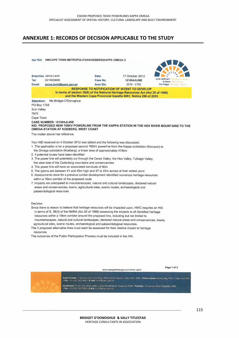
ESKOM PROPOSED 765KV POWERLINES KAPPA OMEGA SPECIALIST ASSESSMENT OF SPATIAL HISTORY, CULTURAL LANDSCAPE AND BUILT ENVIRONMENT
___________________________________________________________________________________________________
BRIDGET O’DONOGHUE & SALLY TITLESTAD HERITAGE CONSULTANTS IN ASSOCIATION
115
ANNEXURE 1: RECORDS OF DECISION APPLICABLE TO THE STUDY
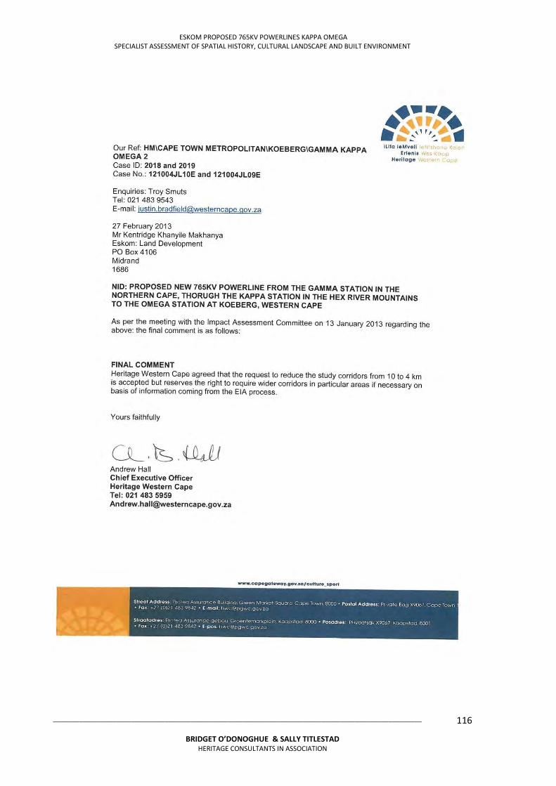
ESKOM PROPOSED 765KV POWERLINES KAPPA OMEGA SPECIALIST ASSESSMENT OF SPATIAL HISTORY, CULTURAL LANDSCAPE AND BUILT ENVIRONMENT
___________________________________________________________________________________________________
BRIDGET O’DONOGHUE & SALLY TITLESTAD HERITAGE CONSULTANTS IN ASSOCIATION
116
ESKOM PROPOSED 765KV POWERLINES KAPPA OMEGA SPECIALIST ASSESSMENT OF SPATIAL HISTORY, CULTURAL LANDSCAPE AND BUILT ENVIRONMENT
___________________________________________________________________________________________________
BRIDGET O’DONOGHUE & SALLY TITLESTAD HERITAGE CONSULTANTS IN ASSOCIATION
117
ESKOM PROPOSED 765KV POWERLINES KAPPA OMEGA SPECIALIST ASSESSMENT OF SPATIAL HISTORY, CULTURAL LANDSCAPE AND BUILT ENVIRONMENT
___________________________________________________________________________________________________
BRIDGET O’DONOGHUE & SALLY TITLESTAD HERITAGE CONSULTANTS IN ASSOCIATION
118
Gamma Kappa 2
Our Ref: 9/2/100/001, 9/2/091/0004
Enquiries: Kathryn Smuts Date: Wednesday October 17, 2012 Tel: 021 462 4502 Email: [email protected] Page No: 2 CaseID: 615
_________________________________________________________________________________
Palaeontologist is needed to indicate that this is unnecessary. If the area is deemed sensitive, a full Phase 1 Palaeontological Impact Assessment will be required and if necessary a Phase 2 rescue operation might be necessary. (See www.palaeontologicalsociety.co.za for a list of accredited Palaeontologists).
Any other heritage resources that may be impacted such as built structures over 60 years old, sites of cultural significance associated with oral histories, burial grounds and graves, graves of victims of conflict, and cultural landscapes or viewscapes must also be assessed.
Should you have any further queries, please contact the designated official using the case number quoted above in the case header.
Yours faithfully
________________________________________ Kathryn Smuts Heritage Officer: Archaeology South African Heritage Resources Agency
________________________________________ Colette Scheermeyer SAHRA Head Archaeologist South African Heritage Resources Agency
ADMIN:
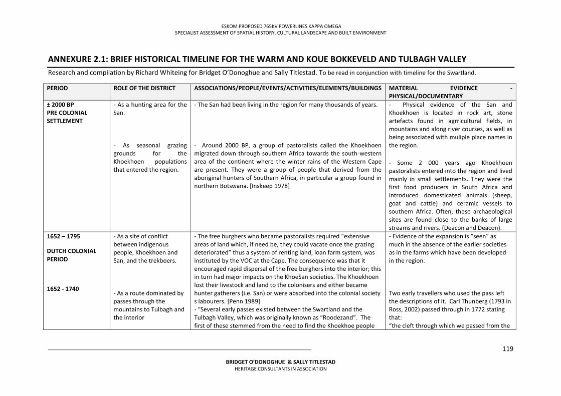
ESKOM PROPOSED 765KV POWERLINES KAPPA OMEGA SPECIALIST ASSESSMENT OF SPATIAL HISTORY, CULTURAL LANDSCAPE AND BUILT ENVIRONMENT
___________________________________________________________________________________________________
BRIDGET O’DONOGHUE & SALLY TITLESTAD HERITAGE CONSULTANTS IN ASSOCIATION
119
ANNEXURE 2.1: BRIEF HISTORICAL TIMELINE FOR THE WARM AND KOUE BOKKEVELD AND TULBAGH VALLEY Research and compilation by Richard Whiteing for Bridget O’Donoghue and Sally Titlestad. To be read in conjunction with timeline for the Swartland.
PERIOD ROLE OF THE DISTRICT ASSOCIATIONS/PEOPLE/EVENTS/ACTIVITIES/ELEMENTS/BUILDINGS MATERIAL EVIDENCE - PHYSICAL/DOCUMENTARY
± 2000 BP PRE COLONIAL SETTLEMENT
- As a hunting area for the San. - As seasonal grazing grounds for the Khoekhoen populations that entered the region.
- The San had been living in the region for many thousands of years. - Around 2000 BP, a group of pastoralists called the Khoekhoen migrated down through southern Africa towards the south-western area of the continent where the winter rains of the Western Cape are present. They were a group of people that derived from the aboriginal hunters of Southern Africa, in particular a group found in northern Botswana. [Inskeep 1978]
- Physical evidence of the San and Khoekhoen is located in rock art, stone artefacts found in agrricultural fields, in mountains and along river courses, as well as being associated with muliple place names in the region.
- Some 2 000 years ago Khoekhoen pastoralists entered into the region and lived mainly in small settlements. They were the first food producers in South Africa and introduced domesticated animals (sheep, goat and cattle) and ceramic vessels to southern Africa. Often, these archaeological sites are found close to the banks of large streams and rivers. (Deacon and Deacon).
1652 – 1795
DUTCH COLONIAL PERIOD
1652 - 1740
- As a site of conflict between indigenous people, Khoekhoen and San, and the trekboers. - As a route dominated by passes through the mountains to Tulbagh and the interior
- The free burghers who became pastoralists required “extensive areas of land which, if need be, they could vacate once the grazing deteriorated” thus a system of renting land, loan farm system, was instituted by the VOC at the Cape. The consequence was that it encouraged rapid dispersal of the free burghers into the interior; this in turn had major impacts on the KhoeSan societies. The Khoekhoen lost their livestock and land to the colonisers and either became hunter gatherers (i.e. San) or were absorbed into the colonial society s labourers. [Penn 1989] - “Several early passes existed between the Swartland and the Tulbagh Valley, which was originally known as “Roodezand”. The first of these stemmed from the need to find the Khoekhoe people
- Evidence of the expansion is “seen” as much in the absence of the earlier societies as in the farms which have been developed in the region. Two early travellers who used the pass left the descriptions of it. Carl Thunberg (1793 in Ross, 2002) passed through in 1772 stating that: “the cleft through which we passed from the
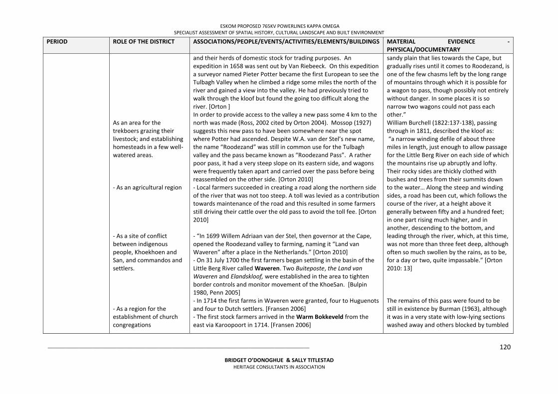
ESKOM PROPOSED 765KV POWERLINES KAPPA OMEGA SPECIALIST ASSESSMENT OF SPATIAL HISTORY, CULTURAL LANDSCAPE AND BUILT ENVIRONMENT
___________________________________________________________________________________________________
BRIDGET O’DONOGHUE & SALLY TITLESTAD HERITAGE CONSULTANTS IN ASSOCIATION
120
PERIOD ROLE OF THE DISTRICT ASSOCIATIONS/PEOPLE/EVENTS/ACTIVITIES/ELEMENTS/BUILDINGS MATERIAL EVIDENCE - PHYSICAL/DOCUMENTARY
As an area for the trekboers grazing their livestock; and establishing homesteads in a few well-watered areas. - As an agricultural region - As a site of conflict between indigenous people, Khoekhoen and San, and commandos and settlers. - As a region for the establishment of church congregations
and their herds of domestic stock for trading purposes. An expedition in 1658 was sent out by Van Riebeeck. On this expedition a surveyor named Pieter Potter became the first European to see the Tulbagh Valley when he climbed a ridge some miles the north of the river and gained a view into the valley. He had previously tried to walk through the kloof but found the going too difficult along the river. [Orton ] In order to provide access to the valley a new pass some 4 km to the north was made (Ross, 2002 cited by Orton 2004). Mossop (1927) suggests this new pass to have been somewhere near the spot where Potter had ascended. Despite W.A. van der Stel’s new name, the name “Roodezand” was still in common use for the Tulbagh valley and the pass became known as “Roodezand Pass”. A rather poor pass, it had a very steep slope on its eastern side, and wagons were frequently taken apart and carried over the pass before being reassembled on the other side. [Orton 2010] - Local farmers succeeded in creating a road along the northern side of the river that was not too steep. A toll was levied as a contribution towards maintenance of the road and this resulted in some farmers still driving their cattle over the old pass to avoid the toll fee. [Orton 2010] - “In 1699 Willem Adriaan van der Stel, then governor at the Cape, opened the Roodezand valley to farming, naming it “Land van Waveren” after a place in the Netherlands.” [Orton 2010] - On 31 July 1700 the first farmers began settling in the basin of the Little Berg River called Waveren. Two Buiteposte, the Land van Waveren and Elandskloof, were established in the area to tighten border controls and monitor movement of the KhoeSan. [Bulpin 1980, Penn 2005] - In 1714 the first farms in Waveren were granted, four to Huguenots and four to Dutch settlers. [Fransen 2006] - The first stock farmers arrived in the Warm Bokkeveld from the east via Karoopoort in 1714. [Fransen 2006]
sandy plain that lies towards the Cape, but gradually rises until it comes to Roodezand, is one of the few chasms left by the long range of mountains through which it is possible for a wagon to pass, though possibly not entirely without danger. In some places it is so narrow two wagons could not pass each other.” William Burchell (1822:137-138), passing through in 1811, described the kloof as: “a narrow winding defile of about three miles in length, just enough to allow passage for the Little Berg River on each side of which the mountains rise up abruptly and lofty. Their rocky sides are thickly clothed with bushes and trees from their summits down to the water… Along the steep and winding sides, a road has been cut, which follows the course of the river, at a height above it generally between fifty and a hundred feet; in one part rising much higher, and in another, descending to the bottom, and leading through the river, which, at this time, was not more than three feet deep, although often so much swollen by the rains, as to be, for a day or two, quite impassable.” [Orton 2010: 13] The remains of this pass were found to be still in existence by Burman (1963), although it was in a very state with low-lying sections washed away and others blocked by tumbled
ESKOM PROPOSED 765KV POWERLINES KAPPA OMEGA SPECIALIST ASSESSMENT OF SPATIAL HISTORY, CULTURAL LANDSCAPE AND BUILT ENVIRONMENT
___________________________________________________________________________________________________
BRIDGET O’DONOGHUE & SALLY TITLESTAD HERITAGE CONSULTANTS IN ASSOCIATION
121
PERIOD ROLE OF THE DISTRICT ASSOCIATIONS/PEOPLE/EVENTS/ACTIVITIES/ELEMENTS/BUILDINGS MATERIAL EVIDENCE - PHYSICAL/DOCUMENTARY
1740 - 1795
- As a route to the hinterland
- In 1715, San resisters, possibly the Ubiqua from the mountains in the Waveren district, repeatedly stole cattle and sheep from colonial farmers. The VOC established an additional military post in the district at Witsenberg. The settlers formed a commando and pursued one of the groups but were unsuccesfull and only retrieved one cow. The raiders had made off with 32 cows and 700 sheep. [Penn 2005] - By 1740 the KhoeSan had been subdued or driven out of the Western Cape region, and Trekboers entered the Hantam, Roggeveld, Bokkeveld and Tankwa districts. [Penn 2005] - A VOC commissioner, Baron van Imhoff, visited the rural districts of the Cape in 1743 and recommended improvements. Two more churches were established, one in Waveren, called the Roodezand congregation, which was to become the centre of the new town of Tulbagh [Fransen 20006] - In 1765 a farmer, Mostert, constructed a road through the pass linking Waveren with the Warm Bokkeveld however there were regular washaways as the road crossed the river frequently. [Whitehead 2010] - Karoopoort provided a route to the Karoo once Mostert’s Pass was opened.
rocks. He also notes the scars of “remskoene” to be present in places on this pass. [Orton 2010]. The Nuwekloof pass was opened in it place in 1968. Some of the farmhouses have been declared provincial heritage sites including Schoonderzicht, Mont Pellier, Wolwefontein homestead, Schalkenbosch and Klipfontein. [Western Cape nd] The church, completed in 1748, still stands today having undergone few alterations. [Fransen 2006] The church designed by Louis Thibault has been described as a severe example of Cape Dutch architecture, and is now a museum. It is also a declared provincial heritage site. [Bulpin 1980] Theronsberg and Hottentotskloof passes lead east into the hinterland. The pass through Karoopoort remains in existence.
1795 -1806 INTERREGNUM
- The village of Tulbagh was laid out in 1795, named after Ryk Tulbagh, a former and reportedly one of the Cape’s best governors. A drostdy building, hald an hour’s walk from the village, was built on the farm, Rietvlei, and in 1804 a magistrate was appointed. Tulbagh later lost its role as a district centre when Worcester was favoured. [Bulpin 1980]
The Drostdy as well as close to 100 other buildings in Tulbagh have been listed as provincial heritage sites. [Western Cape nd]
ESKOM PROPOSED 765KV POWERLINES KAPPA OMEGA SPECIALIST ASSESSMENT OF SPATIAL HISTORY, CULTURAL LANDSCAPE AND BUILT ENVIRONMENT
___________________________________________________________________________________________________
BRIDGET O’DONOGHUE & SALLY TITLESTAD HERITAGE CONSULTANTS IN ASSOCIATION
122
PERIOD ROLE OF THE DISTRICT ASSOCIATIONS/PEOPLE/EVENTS/ACTIVITIES/ELEMENTS/BUILDINGS MATERIAL EVIDENCE - PHYSICAL/DOCUMENTARY
1806 - 1910
BRITISH OCCUPATION OF THE CAPE
1806 - 1867
(to the discovery of diamonds)
- As a region of agriculture - As a place for mission stations - As a transit route to the Karoo and the diamond fields - As an agricultural centre
- In 1813 a proclamation to end the loan farm system was issued and the Quitrent system was introduced. Farmers then made use of ‘request farms’ in order to reduce their costs. [Freund 1989, Peires 1989] - The Cape Government set up the Cape Land Board in1828; the Board was tasked with recording farm boundaries accurately [Peires 1989] - Steinthal was established in 1843 by the Rhenish Mission Society on the farm Witzenberg in the Tulbagh valley. - In the 1840s, John Montagu, the Cape’s colonial secretary, began the first major road building programme in the Cape, utilising convict labour to reduce costs. He was ably assisted by Major Charles Michell and the road builder, Andrew Geddes Bain. Among their first projects were the construction of a route from Cape Town to the Karoo. Key passes that were constructed included Tulbagh Pass, Michell’s Pass to the Warm Bokkeveld, and the Theronsberg and Karoopoort passes to the Tankwa and Great Karoo. [Bulpin 1980] - “Karoopoort was one of the routes that people used in travelling from the Cape to the Karoo and, during the 1870s and early 1880’s it became well used as a result of the discovery of diamonds near Kimberley. Its importance faded from 1885 when the railhead first reached Kimberley.” [Orton 2004: 13] - Karoopoort is a pass 4km long, winding alongside the Doring River between the ranges of the Witteberg Mountains. It leads to the Bokkeveld Karoo, the beginning of the Great Karoo. [Bulpin 1980] - There was an oustspan beneath Klein Hangklip on the eastern side of the Doring Valley. For travellers from the hinterland, it was a welcome relief after journeying across the hot and arid Bokkeveld Karoo. [Bulpin 1980] - In 1848 Michell’s Pass was completed and the route to Cape Town was significantly shortened. [Whitehead 2010] - This development led to the development of the new village of
The site of the church and school at Steinthal have been declared a provincial heritage site. [Western Cape nd] “The Swartruggens Mountains, to the north of Karoopoort, contain many painted images that almost certainly date to the late 1800s when the Karoopoort route was in heavy use (Hall & Mazel 2006) and a few other painted sites probably dating to the same period also occur in other localities nearby (S. Hall, pers. comm. 2008)”. [Cited in Orton 2004] The paintings include horse-drawn vehicles closely resembling a design called the Spring Wagon which was built in Paarl and Wellington in the 1870s. [Hall and Mazel 2005] Little has changed in this landscape since the 1800s and the roads are still gravel. [Orton 2004]
ESKOM PROPOSED 765KV POWERLINES KAPPA OMEGA SPECIALIST ASSESSMENT OF SPATIAL HISTORY, CULTURAL LANDSCAPE AND BUILT ENVIRONMENT
___________________________________________________________________________________________________
BRIDGET O’DONOGHUE & SALLY TITLESTAD HERITAGE CONSULTANTS IN ASSOCIATION
123
PERIOD ROLE OF THE DISTRICT ASSOCIATIONS/PEOPLE/EVENTS/ACTIVITIES/ELEMENTS/BUILDINGS MATERIAL EVIDENCE - PHYSICAL/DOCUMENTARY
Ceres, named after Ceres in Scotland. The farm Rietvallei on the Dwars River was purchased in 1848 and the first erven sold in 1849. A Dutch Reformed Congregation was established in 1855. Water was channelled to the town from the Skurwe mountains as the Dwars River was insufficient. A bridge over the Dwars River was built by Thomas Bains, son of Andrew Geddes Bains, to link the two halves of the developing town. [Fransen 2006] - In 1864 Ceres was declared a municipality. Ceres flourished with the increased traffic to the diamond fields and the railway link at Ceres Road, built in 1875. It became an agricultural centre known for its apples, cherries and fruit juice. [Fransen 2006, Bulpin 1980] - Prince Alfred Hamlet, named after Queen Victoria’s 2nd son who visited the Cape in 1860, was established by proclamation on 8 December 1864. It was laid out on the farm Wagensboomrivier which was owned by JG Goosen and situated close to the foot of the Gydo Pass. [Bulpin 1980]
Karoopoort and its buildings have been declared a provincial heritage site. [Heritage [Western Cape] The pass is still in use although on a different alignment. Parts of the buttressing of the early pass built by convict labour are still visible. [Bulpin 1980] Ceres is not rich in heritage buildings and only one building has been declared a provincial heritage site. However the region is rich in “fine old homesteads”. [Western Cape nd, Fransen 2006]
1868 - 1910
(to the Union of South Africa)
- As a transit route for a railway line linking Cape Town and Kimberley; and later also the Reef. - As a site of conflict
- On 3 October 1893 Wolseley, named after Sir Garnet Wolseley, a British general who had served at the Cape, was established as a town. A railway siding, named Ceres Road, had been built on the site in 187 . Furrows were constructed alongside the town’s streets to allow water to flow through the town. [Bulpin 1980] - During the Anglo-Boer War blockhouses were constructed to protect bridges along the railway line, including in the Tulbagh District.
Two blockhouses from the Anglo-Boer War stand guard as the tarred road from Wolseley passes over the river. These are declared provincial heritage sites. [Western Cape nd]
ESKOM PROPOSED 765KV POWERLINES KAPPA OMEGA SPECIALIST ASSESSMENT OF SPATIAL HISTORY, CULTURAL LANDSCAPE AND BUILT ENVIRONMENT
___________________________________________________________________________________________________
BRIDGET O’DONOGHUE & SALLY TITLESTAD HERITAGE CONSULTANTS IN ASSOCIATION
124
PERIOD ROLE OF THE DISTRICT ASSOCIATIONS/PEOPLE/EVENTS/ACTIVITIES/ELEMENTS/BUILDINGS MATERIAL EVIDENCE - PHYSICAL/DOCUMENTARY
1910-1948
UNION OF SOUTH AFRICA
- As a centre for packing and despatching fruit
- In 1912 a branch line from Wolseley reached Ceres via Michell’s Pass. [Bulpin 1980] - The possibility of exporting fruit and other perishable produce was enabled by the development of refrigeration during WWI. [Wilson 1975] - The railway was further extended to Prince Alfred Hamlet in 1929 which became a terminus resulting in the town becoming an important centre for the despatch of fruit to Cape Town and beyond. [Bulpin 1980]
1948- present day
FROM APARTHEID TO DEMOCRATIC FREEDOM
- As a fruit and wine producing region
- Well known farms in the Tulbagh region, some nestling close to the Winterhoek, include Theuniskraal, known for its dry white wines; Remhoogte, a fruit producer; Montpellier and Tweede Jonge Gezellen, also known for their wines; and Roodezand, known for its prunes, peaches and grapes. [Bulpin 1980]
REFERENCES Adhikari M. (2010). The Anatomy of a South African Genocide. Cape Town: UCT Press.
Bulpin, T.V. (1980). Discovering Southern Africa (2nd edition). TV Bulpin Publishers: Cape Town.
Elphick, R. and Giliomee, H. editors (1989). The Shaping of South African Society 1652-1840. (2nd ed) Cape Town: Maskew Miller Longman.
Fransen, H. (2006). Old Towns and Villages in the Cape. Johannesburg: Jonathan Ball.
Freund, W.B. (1989). The Cape under transitional governments, 1795-1814. In: Elphick, R. and Giliomee, H. editors (1989). The Shaping of South African Society 1652-1840. (2nd ed) Cape Town: Maskew Miller Longman.
James, W.G. and Simons, M. editors (1989). The Angry Divide. Cape Town: David Philip.
Inskeep, R.R. (1978). The Peopling of Southern Africa. Cape Town: David Philip.
ESKOM PROPOSED 765KV POWERLINES KAPPA OMEGA SPECIALIST ASSESSMENT OF SPATIAL HISTORY, CULTURAL LANDSCAPE AND BUILT ENVIRONMENT
___________________________________________________________________________________________________
BRIDGET O’DONOGHUE & SALLY TITLESTAD HERITAGE CONSULTANTS IN ASSOCIATION
125
Mossop, E.E. (1927). Old Cape Highways. Cape Town: Maskew Miller.
Orton, J. (2004). Heritage Scoping Study of the Farm Groot Oliphantskop (Farm 81) for the Proposed Omega Substation, Western Cape. Prepared for Eyethu Engineers. South Africa. Archaeology, Contracts Office, University of Cape Town.
Orton, J. (2010) Heritage Impact Assessment for the Proposed Zen Wind Energy Facility, Tulbagh Magisterial District, Western Cape. Prepared for Savannah Environmental. South Africa. Archaeology, Contracts Office, University of Cape Town.
Peires, J.B. (1989). The British and the Cape, 1814-1834 in Elphick, R. and Giliomee, H. editors (1989). The Shaping of South African Society 1652-1840. (2nd ed) Cape Town: Maskew Miller Longman.
Penn, N. (1989). Labour, land and livestock in the Western Cape during the eighteenth century: the Khoisan and the colonists. In James, W.G. and Simons, M. editors (1989). The Angry Divide. Cape Town: David Philip
Penn, N. (2005) The Forgotten Frontier. Cape Town: Double Storey Books.
Western Cape Provincial Heritage Sites (Previously National Monuments) (nd). Accessed on 8 May 2013 at:
http://www.westerncape.gov.za/other/2010/11/provincial_heritage_sites_2002_09_19_-_old_national_monuments.pdf
Whitehead, M. (2010). Passes and Poorts: Getaway’s Top 30 Scenic Mountain Routes in the Western Cape. Johannusburg: Jacana Media.
Wilson, F. (1975). Farming, 1866-1966. In The Oxford History of South Africa Vol. II. South Africa 1870-1966. Oxford: Oxford University Press.
Wilson, M. and Thompson, L. editors (1975). The Oxford History of South Africa Vol. II. South Africa 1870-1960. Oxford: Oxford University Press.
ESKOM PROPOSED 765KV POWERLINES KAPPA OMEGA SPECIALIST ASSESSMENT OF SPATIAL HISTORY, CULTURAL LANDSCAPE AND BUILT ENVIRONMENT
___________________________________________________________________________________________________
BRIDGET O’DONOGHUE & SALLY TITLESTAD HERITAGE CONSULTANTS IN ASSOCIATION
126
ANNEXURE 2.2: BRIEF HISTORICAL TIMELINE FOR THE SWARTLAND Research and compilation by Richard Whiteing for Bridget O’Donoghue and Sally Titlestad. To be read in conjunction with timeline for the Warm Bokkeveld and Tulbagh
PERIOD
ROLE OF THE SWARTLAND REGION
ASSOCIATIONS/PEOPLE/EVENTS/ACTIVITIES/ELEMENTS/BUILDINGS
MATERIAL EVIDENCE - PHYSICAL/DOCUMENTARY
± 2 000 BP
PRE COLONIAL
SETTLEMENT
- As a hunting area for the San.
- As seasonal grazing grounds for the Khoekhoen populations that entered the region.
- The San had been living in the region for many thousands of years. - Around this time, a group of pastoralists called the Khoekhoen migrated down through southern Africa towards the south-western area of the continent where the winter rains of the Western Cape are present. They were a group of people that derived from the aboriginal hunters of Southern Africa, in particular a group found in northern Botswana. [Inskeep 1978]
- From the 1590s the Khoekhoen along the coast began trading with passing ships requiring fresh meat and water. In return for their livestock, the Khoekhoen received iron, copper and tobacco. In later years the Dutch stopped trading iron as they saw that this improved the weaponry of the Khoekhoen who made spear- and arrow-points from the metal. [Elphick & Malherbe 1989]
Physical evidence of the San inhabitants living in the Swartland region during the last 2 thousand years is found in the various rock art sites situated in shelters of the mountain ranges within and surrounding the area.
It is difficult to find physical evidence of Khoekhoe kraals and settlements in the Swartland. “The great mobility resulting from a pastoral mode of subsistence, the destructive action of hooves of the moving herds, as well as the fact that the majority of potential sites are now ploughed lands, have all contributed to the lack of suitable archaeological sites.” [Clift 1995: 4 cited in Randle 2005] The movement of these fairly large groups of people and their flocks of sheep and cattle created broad trails where once only narrow paths existed. It has been suggested that these stock trails became the basis of the Dutch East India Company (VOC) trading routes. [Ross 2002: 71 cited in Randle 2005]
The Khoekhoe groups were entering
environments that were already inhabited by San hunters. “Any introduction of exotic herds is bound to have put pressure on the
ESKOM PROPOSED 765KV POWERLINES KAPPA OMEGA SPECIALIST ASSESSMENT OF SPATIAL HISTORY, CULTURAL LANDSCAPE AND BUILT ENVIRONMENT
___________________________________________________________________________________________________
BRIDGET O’DONOGHUE & SALLY TITLESTAD HERITAGE CONSULTANTS IN ASSOCIATION
127
PERIOD
ROLE OF THE SWARTLAND REGION
ASSOCIATIONS/PEOPLE/EVENTS/ACTIVITIES/ELEMENTS/BUILDINGS
MATERIAL EVIDENCE - PHYSICAL/DOCUMENTARY
San’s resources, such as grazing for wild game. The incoming herdsmen would have changed the social life and environment of the local hunting population” [Boonzaier et al 1996: 27 cited in Randle 2005].
1652 – 1795
DUTCH COLONIAL PERIOD
1652 - 1740
- As a site of conflict between indigenous people, Khoekhoen and San, and the trekboers. - As a transit route to the northern hinterland
- The free burghers who became pastoralists required “extensive areas of land which, if need be, they could vacate once the grazing deteriorated” thus a system of renting land, loan farm system, was instituted by the VOC at the Cape. The consequence was that it encouraged rapid dispersal of the free burghers into the interior; this in turn had major impacts on the KhoeSan societies. The Khoekhoen lost their livestock and land to the colonisers and either became hunter gatherers (i.e. San) or were absorbed into the colonial society as labourers. [Penn 1989] - During the 2nd Khoe-Dutch War, 1673-77, the first official commando was organised to defeat the Cochoqa whose range covered much of the Swartland and whose centre of transhumance was probably in the vicinity of Mamre. The action resulted in the seizing of 1 765 head of cattle and nearly 5 000 sheep. The Cochoqa led by Gonnema disintegrated as a group. The remaining groups were at the mercy of the Dutch and hostile KhoeSan. [Penn 2005] - During the mid- and late-1600s, exploration and trading groups travelled through the Swartland to the area of the Oliphants River and Namaqualand as well as to the Roodezand area. Cattle and sheep were acquired from the Khoekhoen through trade by VOC butchers and were driven through the Swartland to Cape Town. Later a ‘farm’ called Deurgang was allocated for the purpose of driving livestock to Cape Town, stretching from Salt River to the east
Evidence of the expansion is “seen” as much in the absence of the earlier societies as in the farms which have been developed in the region. Maps in Mossop’s book provide evidence for the early routes through the region. [Mossop 1927] ‘The 1890 Cape Survey shows this thoroughfare running all the way from the
ESKOM PROPOSED 765KV POWERLINES KAPPA OMEGA SPECIALIST ASSESSMENT OF SPATIAL HISTORY, CULTURAL LANDSCAPE AND BUILT ENVIRONMENT
___________________________________________________________________________________________________
BRIDGET O’DONOGHUE & SALLY TITLESTAD HERITAGE CONSULTANTS IN ASSOCIATION
128
PERIOD
ROLE OF THE SWARTLAND REGION
ASSOCIATIONS/PEOPLE/EVENTS/ACTIVITIES/ELEMENTS/BUILDINGS
MATERIAL EVIDENCE - PHYSICAL/DOCUMENTARY
1740 - 1795
- As an area for the trekboers grazing their livestock; and establishing homesteads in a few well-watered areas.
- As an agricultural region - As a place for churches - As a region for agricultural developments
of Riebeek Kasteel. [Mossop 1927, Orton 2010] - At the time of the 3rd frontier in the early 1700s, there were 4 VOC buiteposte in the Swartland: Groene Kloof, Riebeek-Kasteel, Sonquas Drift and Vogel Vallei. Their purpose was to build up the stock of sheep and cattle for the VOC to trade with ships, as well as to tighten the border and monitor the movements of the KhoeSan. Some of the remaining Khoe captains grazed their stock close to the buiteposte for protection against KhoeSan who raided their livestock in retaliation to their loss of land. As trade with Khoe herders was opened up to settlers, the role of the buiteposte diminished and they became farms or villages. [Penn 2005] - Early farms in the Riebeek Valley and environs date from 1704 including Ongegund (later named Boplaas), Allesverloren and Kloovenburg. From 1714 farmers were allowed to grow crops on leased lands and over time the following were introduced: vines, oats, barley and wheat. [Du Toit and Cowling 2006] - The smallpox epidemic of 1713 decimated the Khoe population of the Western Cape, thereby ending a long process of the breakdown of the Khoe as a society in the region. The change in the land policy with the introduction of loan farms in 1714 is possibly directly linked to the final decimation of Khoekhoen in the region. [Elphick & Malherbe 1989, Penn 2005] - The Swartland, named after the “renosterbossies” found in the area and not the colour of the soil, became a fairly intensive agricultural area from the early 18th century. - By 1740 the KhoeSan had been subdued or driven out of the Western Cape region, and Trekboers entered the Hantam, Roggeveld, Bokkeveld and Tankwa districts. Many of the defeated KhoeSan became herders or servants for the new farmers, including
region of present day Salt River (where the Salt River Outspan was located) northwards past several outspans (including Baas Ariesfontein Outspan) to eventually leave the map to the east of Riebeek Kasteel. On this survey map it is labelled “Thoroughfare for Butcher‟s cattle 50 roods wide”.’ [Orton 2010] Map of Buiteposte van die derde grens, 1703-
1706 in Sleigh [Sleigh 2004] Some of the farmhouses in the Malmesbury
District have been declared provincial heritage sites including Ongegund, De Groote Post and Klawervallei. [Western Cape nd]
ESKOM PROPOSED 765KV POWERLINES KAPPA OMEGA SPECIALIST ASSESSMENT OF SPATIAL HISTORY, CULTURAL LANDSCAPE AND BUILT ENVIRONMENT
___________________________________________________________________________________________________
BRIDGET O’DONOGHUE & SALLY TITLESTAD HERITAGE CONSULTANTS IN ASSOCIATION
129
PERIOD
ROLE OF THE SWARTLAND REGION
ASSOCIATIONS/PEOPLE/EVENTS/ACTIVITIES/ELEMENTS/BUILDINGS
MATERIAL EVIDENCE - PHYSICAL/DOCUMENTARY
those captured in raids. [Penn 2005] - A VOC commissioner, Baron van Imhoff, visited the rural districts of the Cape in 1743 and recommended improvements. Two more churches were established, one in present-day Malmesbury. [Fransen 2006] - Robert Gordon is credited with introducing merino sheep to the Cape in 1789. [Robert Jacob Gordon ND]
In 1775 the Inboekseling system of
indenturing indigenous people was legalised.
The farm of the widow Van der Westhuyzen,
Welvergenoegd, on the Diep River was acquired for the new congregation in Malmesbury. The congregation has retained its original name of Swartland despite the town being named Malmesbury. [Fransen 2006]
1795 -1806 INTERREGNUM
1806 - 1910
BRITISH OCCUPATION OF THE CAPE
1806 - 1867
(to the discovery of diamonds)
- As a place of mission stations
- As a region for slave
- In 1807 the mission station of Groene Kloof, renamed Mamre in 1854, was established by two Moravian missionaries on the invitation of the Earl of Caledon after the perceived success of Genadendal. The mission station was developed on 3 farms, Groene Kloof [also called De Kleine Post], Louwsplaas, a Khoekhoe reserve, and Cruijwagenskraal. [Fransen 2006] The layout of the village included agricultural allotments on either side of the Louwskloof River with houses facing the river. [Fransen 2006]. - In 1808 a slave rebellion began on the farm Vogelgezang, just north
The original farmhouse, dating back to the 1760s, and the water mill are provincial heritage sites. Much of the historic ambience of the village has been lost to the modernisation of the houses in recent years. Photographs of the 1960s show 360 thatched and whitewashed houses. [Fransen 2006, Western Cape nd]
Regulations regarding church membership, conversion to Christianity and importance of the family resulted in homogeneous
ESKOM PROPOSED 765KV POWERLINES KAPPA OMEGA SPECIALIST ASSESSMENT OF SPATIAL HISTORY, CULTURAL LANDSCAPE AND BUILT ENVIRONMENT
___________________________________________________________________________________________________
BRIDGET O’DONOGHUE & SALLY TITLESTAD HERITAGE CONSULTANTS IN ASSOCIATION
130
PERIOD
ROLE OF THE SWARTLAND REGION
ASSOCIATIONS/PEOPLE/EVENTS/ACTIVITIES/ELEMENTS/BUILDINGS
MATERIAL EVIDENCE - PHYSICAL/DOCUMENTARY
rebellion - As a region of revised labour relations
- As a region of agriculture - As a region for the development of church towns
- As a place for further
of Malmesbury. It was instigated by Louis of Mauritius who lived and worked in Cape Town. The slaves went from farm to farm ransacking the properties on their route however none of the farmers were killed. Some 340 slaves, mostly men, participated in the unsuccessful rebellion. In the ensuing retribution, five of the ringleaders were executed. [Mostert 2011] - The Caledon Code requiring labour contracts between employers and workers was introduced in 1809. The code introduced the first pass laws in that indigenous people tied by contract were required to have signed permission when leaving farms they worked on. It also legalised the ‘apprenticeship’ or indentured labour of Khoekhoen between the ages of 8 and 18. Despite some protection for indigenous workers, the code entrenched the power of the farmers. [Penn 2005] - In 1813 a proclamation to end the loan farm system was issued and the Quitrent system was introduced. Farmers were compelled to look at the output of the land. However some farmers then made use of ‘request farms’ in order to reduce their costs, while others moved to away to border lands with their stock. [Freund 1989, Peires 1989, Wilson 1969] - In response to an increase in international prices, wool farming production increased and greater numbers of merino sheep acquired. [Wilson 1969] - The Cape Government set up the Cape Land Board in 1828; the Board was tasked with recording farm boundaries accurately [Peires 1989] - In 1827 the town of Malmesbury was proclaimed and 16 erven were offered for sale the following year. In 1829 the town was named after the Earl of Malmesbury, a relative of Sir Lowry Cole,
communities in the mission stations. A silver beaker that had belonged to the farmer Petrus Gerhardus Louw, where the revolt had begun, is said to have been used by the initiators of the rebellion. The story about the beaker is part of the family’s oral tradition and the beaker has been donated to Iziko Museums. [Iziko Museum press release reproduced in Mostert 2011] Revised legislation in the form of the Masters
and Servants Act of 1856 entrenched control of the movement of people of colour and made it a crime to be unemployed.
A number of the early houses still exist
ESKOM PROPOSED 765KV POWERLINES KAPPA OMEGA SPECIALIST ASSESSMENT OF SPATIAL HISTORY, CULTURAL LANDSCAPE AND BUILT ENVIRONMENT
___________________________________________________________________________________________________
BRIDGET O’DONOGHUE & SALLY TITLESTAD HERITAGE CONSULTANTS IN ASSOCIATION
131
PERIOD
ROLE OF THE SWARTLAND REGION
ASSOCIATIONS/PEOPLE/EVENTS/ACTIVITIES/ELEMENTS/BUILDINGS
MATERIAL EVIDENCE - PHYSICAL/DOCUMENTARY
changes to labour relations - As a place for mission stations
governor of the Cape at the time. A plan for the town was developed by J Knobel, and 24 houses are shown in a plan of 1840; but growth was rapid and the town had a population of more than 1 000 by 1865. [Fransen 2006] - After some difficulties, the new congregation of Wellington came into being and the farm of Champagne was purchased in 1838. RL Aling surveyed the area and laid out 30 erven which were soon sold. An earlier wagon route became the main street, and the church was erected on a very prominent site on a T-junction. On 4 November 1863 the railway reached the town and it became the 1st rail terminus in the hinterland until the line was extended to Kimberley. [Fransen 2006] - Slaves in the Cape were declared freed on 1 December 1834 however a 4-year ‘apprenticeship’ indentured them to their ex-owners until 1838. Thereafter a number of slaves sought a safe haven on mission stations in the region including Groenekloof (Mamre) and later on Saron. Due to insufficient land, the mission stations became reservoirs of seasonal labour for neighouring farms. An unintended consequence of the freeing of slaves was the reduction of the permanent work force and the introduction of seasonal labour on a grand scale on wheat and wine farms. [Worden and Crais - Saron was started when the 2 300ha farm, De Leeuwensklip, was bought in 1846 by Johannes Kulpmann of the Rhenisch Missionary Society in order to establish a mission station to serve the freed slaves and indigenous inhabitants in the area. By 1848 there were 120 families living on the mission. The farm comprised a house (c1775), ‘werf wall’, water mill, smithy and wine cellar. The mission was sited at the existing farm complex and the farm buildings were incorporated into the mission complex. The farm house became the pastorie, and a church was built adjacent to it after the RMS took control of the mission station in 1852. Additions were made to the church in 1897 and 1949. [Western Cape 2003, Smidt 2013]
however many have lost their gables and thatched roofs were exchanged for tin, possibly due to severe storms in 1895 and 1912. Photographs of some of these houses and other historic buildings appear in Fransen and the Malmesbury Tourism Bureau online publication, Malmesbury Historic Route. [Fransen 2006, Malmesbury Tourism Bureau nd]
The original opstal of Champagne, a T-
shaped homestead, is still standing and a number of other houses as well as educational institutional buildings are listed provincial heritage sites. [Fransen 2006, Western Cape nd]
The site of the church at Saron is a declared
provincial heritage site. The church itself has been much altered since 1853 and the village has lost much of its character as a mission station. Smidt has identified over 40 historic buildings in the town. [Western Cape nd, Fransen 2006, Smidt 2013]
ESKOM PROPOSED 765KV POWERLINES KAPPA OMEGA SPECIALIST ASSESSMENT OF SPATIAL HISTORY, CULTURAL LANDSCAPE AND BUILT ENVIRONMENT
___________________________________________________________________________________________________
BRIDGET O’DONOGHUE & SALLY TITLESTAD HERITAGE CONSULTANTS IN ASSOCIATION
132
PERIOD
ROLE OF THE SWARTLAND REGION
ASSOCIATIONS/PEOPLE/EVENTS/ACTIVITIES/ELEMENTS/BUILDINGS
MATERIAL EVIDENCE - PHYSICAL/DOCUMENTARY
- As a region for the development of church towns
- In 1853 the town of Darling was founded on the farm, Langfontein. It was named after Sir Charles Darling, Lt Governor of the Cape. The town was laid out in elongated blocks and built up close to the small river that runs through the town. [Fransen 2006] - Riebeek West, named after the adjacent Kasteelberg, was first established in 1855 on part of the farm Allesverloren and requested to be a kerkdorp. This request was opposed and it was only in 1858 that a Dutch Reformed parish was formed. The town is sited on the slopes of Kasteelberg and 5 streams run through it. [Fransen 2006] - The farming community of Koeberg acquired part of the farm Dassenvallei and started to build a church in 1858, gaining permission from the moederkerk in Durbanville later after initial opposition. The town, given the name Philadelphia, is arguably the smallest formally established kerkdorp, with only 12 buildings at the end of the 19th century. A small township developed across the spruit, most likely due to apartheid legislation. [Fransen 2006] - Riebeek Kasteel became a separate parish in 1863 however the town was founded earlier than this on the farm De Hoop. The town was developed on a grid pattern flanked by the main road with the church facing the village from the opposite side of the road. [Fransen 2006] - In 1863 the town of Porterville was laid out on the farm Pomona, previously called Willem’s Vallei. It was named after Porter, attorney general of the Cape Colony from 1839 to 1866. It became a municipality in 1901. The surrounding area is known for its yellow disas and hang gliding. [Porterville, Western Cape nd]
There are numerous older buildings but few of architectural interest. The original church burnt down in 1957 and a modern structure erected in its place. The pastorie and the old mission church built in 1927 are however of architectural interest. Aerial photographs provide evidence of the lay out of the town. [Fransen 2006]
The church has an unusual design as it is
pedimented and classicist rather than Gothic. There are a number of well-preserved mid-Victorian houses behind the church. A photograph of the church provides evidence. [Fransen 2006]
Aerial photograph available in Fransen.
[Fransen 2006] An early map of Malmesbury c1840 has two
roads marking the direction of of Riebeek’s Kasteel, suggesting that the town began long before it gained its kerkdorp status. The map as well as photographs of the town are reproduced in Fransen. [Fransen 2006]
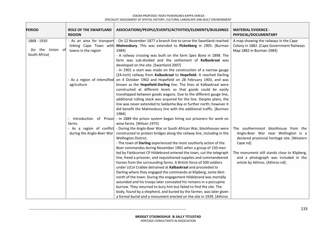
ESKOM PROPOSED 765KV POWERLINES KAPPA OMEGA SPECIALIST ASSESSMENT OF SPATIAL HISTORY, CULTURAL LANDSCAPE AND BUILT ENVIRONMENT
___________________________________________________________________________________________________
BRIDGET O’DONOGHUE & SALLY TITLESTAD HERITAGE CONSULTANTS IN ASSOCIATION
133
PERIOD
ROLE OF THE SWARTLAND REGION
ASSOCIATIONS/PEOPLE/EVENTS/ACTIVITIES/ELEMENTS/BUILDINGS
MATERIAL EVIDENCE - PHYSICAL/DOCUMENTARY
1868 - 1910
(to the Union of South Africa)
- As an area for transport linking Cape Town with towns in the region
- As a region of intensified agriculture
- Introduction of Prison farms - As a region of conflict during the Anglo-Boer War
- On 12 November 1877 a branch line to serve the Swartland reached Malmesbury. This was extended to Picketberg in 1905. [Burman 1984] - A railway crossing was built on the farm Spes Bona in 1898. The farm was sub-divided and the settlement of Kalbaskraal was developed on the site. [Swartland 2007] - In 1901 a start was made on the construction of a narrow gauge [24-inch] railway from Kalbaskraal to Hopefield. It reached Darling on 4 October 1902 and Hopefield on 28 February 1903, and was known as the Hopefield-Darling line. The lines at Kalbaskraal were constructed at different levels so that goods could be easily transhipped between goods wagons. Due to the different gauge line, additional rolling stock was acquired for the line. Despite plans, the line was never extended to Saldanha Bay or further north; however it did benefit the Malmesbury line with the additional traffic. [Burman 1984] - In 1889 the prison system began hiring out prisoners for work on wine farms. [Wilson 1975] - During the Anglo-Boer War or South African War, blockhouses were constructed to protect bridges along the railway line, including in the Wellington District. - The town of Darling experienced the most southerly action of the Boer commandos during November 1901 when a group of 150 men led by Fieldcornet CP Hildebrand entered the town, cut the telegraph line, freed a prisoner, and requisitioned supplies and commandeered horses from the surrounding farms. A British force of 500 soldiers under LtCol Crabbe detrained at Kalbaskraal and proceeded to Darling where they engaged the commando at Klipberg, some 6km north of the town. During the engagement Hildebrand was mortally wounded and his troops later concealed his remains in a porcupine burrow. They returned to bury him but failed to find the site. The body, found by a shepherd, and buried by the farmer, was later given a formal burial and a monument erected on the site in 1939. [Athiros
A map showing the railways in the Cape Colony in 1882. [Cape Government Railways Map 1882 in Burman 1984] The southernmost blockhouse from the
Anglo-Boer War near Wellington is a declared provincial heritage site. [Western Cape nd]
The monument still stands close to Klipberg,
and a photograph was included in the article by Athiros. [Athiros nd].
ESKOM PROPOSED 765KV POWERLINES KAPPA OMEGA SPECIALIST ASSESSMENT OF SPATIAL HISTORY, CULTURAL LANDSCAPE AND BUILT ENVIRONMENT
___________________________________________________________________________________________________
BRIDGET O’DONOGHUE & SALLY TITLESTAD HERITAGE CONSULTANTS IN ASSOCIATION
134
PERIOD
ROLE OF THE SWARTLAND REGION
ASSOCIATIONS/PEOPLE/EVENTS/ACTIVITIES/ELEMENTS/BUILDINGS
MATERIAL EVIDENCE - PHYSICAL/DOCUMENTARY
nd]
1910-1948
UNION OF SOUTH AFRICA
- As a region of intensive agriculture
- As a site for aircraft bases and radar facilties during WWII
- The possibility of exporting eggs, meat, fruit and other perishable produce was enabled by the development of refrigeration during WWI. [Wilson, 1975] - During the 1930s there was an increase of 66% in wheat production due to the introduction of tariffs to prevent cheaper imports and government intervention to reduce price fluctuations of agricultural products which had been problematic for farmers. This led to the uneconomic expansion of wheat, wine, milk and butter production to the detriment of the ecology in marginal areas. [Wilson 1975] - In 1937 the prison labour system expanded, and from 1947 prison farms were built. The costs were borne by the farmers but the prisons were run by the prison services. By 1966 there were 13 gaols providing farm labour in the Western Cape. [Wilson 1975] - During WWII 6 additional airfields were developed in response to the U-Boat attacks in 1942; one of these airfields was situated at Darling and Lockheed Ventura aircraft of 23 Squadron were based here, followed by 27 Squadron. In 1943 29 Operational Training Unit was relocated from Nigel. Training included launching of torpedoes. A steel hangar and lecture rooms were erected in 1944. A crew of six died when their aircraft crashed into the hill of Dassenberg in 1948. [Darling, Western Cape nd] - Another aspect of defence was the introduction of radar facilties. A transportable radar unit was placed at Somersveld north-west of Darling. The readings were taken only on aircraft, using two tall 30m masts right out in the flat veld. This radar set was designed for accurately plotting high-flying aircraft, presumably in anticipation of
ESKOM PROPOSED 765KV POWERLINES KAPPA OMEGA SPECIALIST ASSESSMENT OF SPATIAL HISTORY, CULTURAL LANDSCAPE AND BUILT ENVIRONMENT
___________________________________________________________________________________________________
BRIDGET O’DONOGHUE & SALLY TITLESTAD HERITAGE CONSULTANTS IN ASSOCIATION
135
PERIOD
ROLE OF THE SWARTLAND REGION
ASSOCIATIONS/PEOPLE/EVENTS/ACTIVITIES/ELEMENTS/BUILDINGS
MATERIAL EVIDENCE - PHYSICAL/DOCUMENTARY
bombers from an enemy aircraft carrier on their way to attack Cape Town. The operators spent most of the time plotting friendly SAAF and RAF aircraft from a big air force training camp not far away. The radar operators were young women from the Special Signals Service. [Mangin and Lloyd 1998]
1948- present day
FROM APARTHEID TO DEMOCRATIC FREEDOM
- As a region of segregated towns
- As a wheat and wine producing region
- As a place for the development of democracy - As a site for new housing
- In 1948 the newly elected National Party government formalises segregation under its apartheid policy.
- The Population Registration Act of 1950 required every South African to register and was classified according to their ‘racial’ characteristics. Linked to this act, the Group Areas Act of 1950 divided towns into residential and business for different groups classified by apartheid legislation, resulting in complete segregation of people of colour as thousands of people were forcibly removed from their homes. New ‘townships’ were developed for the different ‘race’ groups.
- Capital investment on farms increased after WWII with the construction of dams and contour banks, the closing of dongas and other improvements. This was made possible through the availability of credit, tax concessions and the rapid increase in land values. [Wilson 1975]
- Mechanisation with the purchasing of tractors and harvesters increased exponentially in the 1940s and 50s. The wealth generated saw the construction of large brick houses, tennis courts and the introduction of electricity on farms. The role of government subsidies also assisted this process with R13.2 million paid to wheat farmers by 1967. [Wilson 1975]
- During 1990-91 the “1913 and 1936 Land Acts, Group Areas Act, Population Registration Act, and separate Amenities Act repealed; political organizations unbanned; state of emergency revoked; amid widespread violence, delegates from 18 parties start formal negotiations.” [Thompson 1995: xix in Randle 2005]
- After 1994 new legislation introduced free RDP (Reconstruction and
The houses constructed in the new
townships are very similar in design and can be seen throughout the region. These townships are often far removed from town centres and are separated by geographic or other ‘barriers’, for example in Malmesbury the areas developed for people of colour are to the west of the N7. [Pinnock 1989; Google Maps 2013]
ESKOM PROPOSED 765KV POWERLINES KAPPA OMEGA SPECIALIST ASSESSMENT OF SPATIAL HISTORY, CULTURAL LANDSCAPE AND BUILT ENVIRONMENT
___________________________________________________________________________________________________
BRIDGET O’DONOGHUE & SALLY TITLESTAD HERITAGE CONSULTANTS IN ASSOCIATION
136
PERIOD
ROLE OF THE SWARTLAND REGION
ASSOCIATIONS/PEOPLE/EVENTS/ACTIVITIES/ELEMENTS/BUILDINGS
MATERIAL EVIDENCE - PHYSICAL/DOCUMENTARY
projects - As a region of new agricultural opportunities
- As a region of contested rights to residency on farms and changes in labour relations
Development Programme) houses for people below with low incomes.
- Since 1990 olive production has expanded in the Swartland and prizes won for excellence of the olive oil produced. The historic farm of Kloovenburg in the Riebeek Valley won an international prize in 2005 after only 4 years of production. Riebeek Kasteel hosts an annual olive festival. [Du Toit and Cowling 2006]
- The Land Reform (Labour Tenants) Act of 1995 and the Extension of Security of Tenure Act of 1997 have attempted to strengthen the occupation and use rights of farm dwellers, including rights against evictions from the land. A consequence has been the casualisation of farm labour by farmers to limit the number of farm workers with rights to residence on the farms. [Cross and Hornby 2002]
The newly developed areas can be easily identified due to the new house designs which are generally square in shape as compared to the oblong semi-detached houses of the 1960-80 period. [Google Maps 2013]
REFERENCES
Adhikari M. (2010). The Anatomy of a South African Genocide. Cape Town: UCT Press.
Athiros, G. (nd) Route 27 West Coast South Africa: The Hildebrand Monument: Anglo-Boer War 1899-1902. Accessed on 27 May 2013 at: http://www.route27sa.com/hildebrand.html
Bulpin, T.V. (1980). Discovering Southern Africa (2nd edition). TV Bulpin Publishers: Cape Town.
Burman, J. (1984). Early Railways at the Cape. Cape Town: Human & Rousseau.
Clift, H. (2008). Appendix accessed on 10 May 2013 at:
http://www.eskom.co.za/content/APPENDIX%205%20Historical%20chronology%20HC%20Corrections~1.pdf
Cross, C. and Hornby, D. (2002). Obstacles to Women’s Land Access in South Africa. A Research Report for the Promoting Women’s Access to Land Programme. Accessed on 20 June 2013 at:
http://www.info.gov.za/otherdocs/2002/landgender.pdf
Darling, Western Cape (nd). Accesses on 22 May 2013 at:
ESKOM PROPOSED 765KV POWERLINES KAPPA OMEGA SPECIALIST ASSESSMENT OF SPATIAL HISTORY, CULTURAL LANDSCAPE AND BUILT ENVIRONMENT
___________________________________________________________________________________________________
BRIDGET O’DONOGHUE & SALLY TITLESTAD HERITAGE CONSULTANTS IN ASSOCIATION
137
http://en.wikipedia.org/wiki/Darling,_Western_Cape
Du Plessis, K. and Cowling, V. (2006). West Coast: Cederberg to the Sea. Cape Town: Struik.
Elphick, R. and Giliomee, H. editors (1989). The Shaping of South African Society 1652-1840. (2nd ed) Cape Town: Maskew Miller Longman.
Elphick, R. and Malherbe, C. (1989). The Khoisan to 1828. In The Shaping of South African Society 1652-1840. (2nd ed) Cape Town: Maskew Miller Longman.
Fransen, H. (2006). Old Towns and Villages in the Cape. Johannesburg: Jonathan Ball.
Freund, W.B. (1989). The Cape under transitional governments, 1795-1814. In: Elphick, R. and Giliomee, H. editors (1989). The Shaping of South African Society 1652-1840. (2nd ed) Cape Town: Maskew Miller Longman.
Google Maps. (2013). Accessed on 13 June 2013 at:
Inskeep, R.R. (1978). The Peopling of Southern Africa. Cape Town: David Philip.
James, W.G. and Simons, M. editors (1989). The Angry Divide. Cape Town: David Philip
Malmesbury Tourism Bureau (nd). Malmesbury Historic Route. Accessed on 22 May 2013 at:
http://www.malmesburytourism.co.za/malmesbury-history.htm
Mangin, G. and Lloyd, S. (1998). The Special Signal Services (Sss): We scanned the seas and skies in the Second World War. Military History Journal Vol 11 No 2 - December 1998.
Mossop, E.E. (1927). Old Cape Highways. Cape Town: Maskew Miller.
Mostert, L. (2011). History Textbook Workbook Grade 10 NCAPS. Cape Town: Allcopy Publishers. Accessed on 20 June 2013 at: intranet.parklands.co.za/?dl_id=2 Orton, J. (2010). Heritage Impact Assessment for the Proposed Expansion of the N7 between the Melkbos and Atlantis Junctions, Malmesbury Magisterial District, Western Cape. Prepared for CCA Environmental. South Africa. Archaeology, Contracts Office, University of Cape Town. Peires, J.B. (1989). The British and the Cape, 1814-1834 in Elphick, R. and Giliomee, H. editors (1989). The Shaping of South African Society 1652-1840. (2nd ed) Cape Town: Maskew Miller Longman.
Penn, N. (1989). Labour, land and livestock in the Western Cape during the eighteenth century: the Khoisan and the colonists. In James, W.G. and Simons, M. editors (1989). The Angry Divide. Cape Town: David Philip.
ESKOM PROPOSED 765KV POWERLINES KAPPA OMEGA SPECIALIST ASSESSMENT OF SPATIAL HISTORY, CULTURAL LANDSCAPE AND BUILT ENVIRONMENT
___________________________________________________________________________________________________
BRIDGET O’DONOGHUE & SALLY TITLESTAD HERITAGE CONSULTANTS IN ASSOCIATION
138
Penn, N. (2005) The Forgotten Frontier. Cape Town: Double Storey Books.
Pinnock, D. (1989). Ideology and Urban Planning: Blueprints of a Garrison City. In James, W.G. and Simons, M. editors (1989). The Angry Divide. Cape Town: David Philip.
Porterville, Western Cape (nd1). Accessed on 22 May 2013 at: http://en.wikipedia.org/wiki/Porterville,_Western_Cape
Porterville, Western Cape (nd2). Accessed on 22 May 2013 at: http://www.swartlandwineroute.co.za/message-manager.htm
Randle, T. (2005). Brief historical timeline for the Dwars River Valley for the last 2000 years. A report produced for the Boschendal Estates Heritage Impact Assessment.
Robert Jacob Gordon (nd). Accessed on 13 June 2013 at: http://en.wikipedia.org/wiki/Robert_Jacob_Gordon
Sleigh, D. (2004). Die Buiteposte: VOC-Buiteposte onder kaapse bestuur 1652-1795. Pretoria: Protea Boekhuis.
Smidt, I. (2013). Saron: Valued heritage: final draft of MPhil in Conservation of the Built Environment, UCT. Western Cape Provincial Heritage Sites (Previously National Monuments) (nd). Accessed on 8 May 2013 at:
http://www.westerncape.gov.za/other/2010/11/provincial_heritage_sites_2002_09_19_-_old_national_monuments.pdf
Wilson, F. (1975). Farming, 1866-1966. In The Oxford History of South Africa Vol. II. South Africa 1870-1966. Oxford: Oxford University Press.
Wilson, M. and Thompson, L. editors (1975). The Oxford History of South Africa Vol. II. South Africa 1870-1960. Oxford: Oxford University Press.
Worden, N. and Crais, C. (1994). Breaking the Chains: Slavery and its Legacy in the Nineteenth-Century Cape Colony. Johannesburg: Witwatersrand University Press.
ESKOM PROPOSED 765KV POWERLINES KAPPA OMEGA SPECIALIST ASSESSMENT OF SPATIAL HISTORY, CULTURAL LANDSCAPE AND BUILT ENVIRONMENT
___________________________________________________________________________________________________
BRIDGET O’DONOGHUE & SALLY TITLESTAD HERITAGE CONSULTANTS IN ASSOCIATION
139
ANNEXURE 3: MAP BOOK
THE PROPOSED KAPPA OMEGA 2ND 765KV TRANSMISSION POWERLINE AND SUBSTATIONS UPGRADE, WESTERN CAPE
(NEAS REFERENCE: DEA/EIA/0001266/2012 DEA REFERENCE: 14/12/16/3/3/2/352)
VISUAL IMPACT ASSESSMENT
PREPARED FOR:
NZUMBULULO HERITAGE SOLUTIONS CONTACT PERSON: KELEBOGILE MOGAJANE
CONTACT NO.: 011 021 4937
E-MAIL: [email protected]
ON BEHALF OF:
ESKOM (Pty) Ltd Megawatt Park Maxwell Drive
Sunninghill Sandton
PREPARED BY:
AXIS LANDSCAPE ARCHITECTS (CC)
226 Odendaal Street Meyerspark
Pretoria 0184
March 2013
AXIS REF:KAP2012
Copyright Warning- Copyright in all text and other matter, including the manner of presentation, is the exclusive property of the author. It
is a criminal offence to reproduce and/or use, without written consent, any matter, technical procedure and/or technique contained in this document. Criminal and civil proceedings will be taken as a matter of strict routine
against any person and/or institution infringing the copyright of the author and/or proprietors.
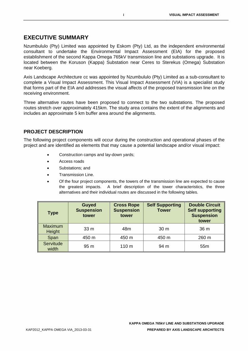
i VISUAL IMPACT ASSESSMENT
KAPPA OMEGA 765kV LINE AND SUBSTATIONS UPGRADE
KAP2012_KAPPA OMEGA VIA_2013-03-31 PREPARED BY AXIS LANDSCAPE ARCHITECTS
EXECUTIVE SUMMARY Nzumbululo (Pty) Limited was appointed by Eskom (Pty) Ltd, as the independent environmental consultant to undertake the Environmental Impact Assessment (EIA) for the proposed establishment of the second Kappa Omega 765kV transmission line and substations upgrade. It is located between the Koruson (Kappa) Substation near Ceres to Sterekus (Omega) Substation near Koeberg.
Axis Landscape Architecture cc was appointed by Nzumbululo (Pty) Limited as a sub-consultant to complete a Visual Impact Assessment. This Visual Impact Assessment (VIA) is a specialist study that forms part of the EIA and addresses the visual affects of the proposed transmission line on the receiving environment.
Three alternative routes have been proposed to connect to the two substations. The proposed routes stretch over approximately 415km. The study area contains the extent of the alignments and includes an approximate 5 km buffer area around the alignments.
PROJECT DESCRIPTION The following project components will occur during the construction and operational phases of the project and are identified as elements that may cause a potential landscape and/or visual impact:
• Construction camps and lay-down yards; • Access roads • Substations; and • Transmission Line. • Of the four project components, the towers of the transmission line are expected to cause
the greatest impacts. A brief description of the tower characteristics, the three alternatives and their individual routes are discussed in the following tables.
Type Guyed
Suspension tower
Cross Rope Suspension
tower
Self Supporting Tower
Double Circuit Self supporting
Suspension tower
Maximum Height 33 m 48m 30 m 36 m
Span 450 m 450 m 450 m 260 m Servitude
width 95 m 110 m 94 m 55m
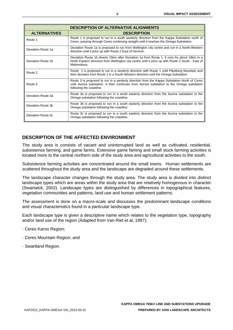
ii VISUAL IMPACT ASSESSMENT
KAPPA OMEGA 765kV LINE AND SUBSTATIONS UPGRADE
KAP2012_KAPPA OMEGA VIA_2013-03-31 PREPARED BY AXIS LANDSCAPE ARCHITECTS
DESCRIPTION OF ALTERNATIVE ALIGNMENTS ALTERNATIVES DESCRIPTION
Route 1 Route 1 is proposed to run in a south westerly direction from the Kappa Substation north of Ceres, passing through Ceres continuing straight until it reaches the Omega Substation.
Deviation Route 1a Deviation Route 1a is proposed to run from Wellington city centre and run in a North-Western direction until it joins up with Route 2 East of Hermon.
Deviation Route 1b Deviation Route 1b diverts 15km after Deviation 1a from Route 1. It runs for about 18km in a North Eastern direction from Wellington city centre until it joins up with Route 2 South - East of Malmesbury.
Route 2 Route 2 is proposed to run in a westerly direction with Route 1 until Piketberg Mountain and then deviates from Route 1 in a South-Western direction until the Omega Substation
Route 3 Route 3 is proposed to run in a westerly direction from the Kappa Substation North of Ceres until Aurora substation. It then continues from Aurora substation to the Omega substation following the coastline.
Deviation Route 3a Route 3a is proposed to run in a south easterly direction from the Aurora substation to the Omega substation following the coastline.
Deviation Route 3b Route 3b is proposed to run in a south easterly direction from the Aurora substation to the Omega substation following the coastline.
Deviation Route 3c Route 3c is proposed to run in a south easterly direction from the Aurora substation to the Omega substation following the coastline.
DESCRIPTION OF THE AFFECTED ENVIRONMENT The study area is consists of vacant and uninterrupted land as well as cultivated, residential, subsistence farming, and game farms. Extensive game faming and small stock farming activities is located more to the central northern side of the study area and agricultural activities to the south.
Subsistence farming activities are concentrated around the small towns. Human settlements are scattered throughout the study area and the landscape are degraded around these settlements.
The landscape character changes through the study area. The study area is divided into distinct landscape types which are areas within the study area that are relatively homogenous in character (Swanwick, 2002). Landscape types are distinguished by differences in topographical features, vegetation communities and patterns, land use and human settlement patterns.
The assessment is done on a macro-scale and discusses the predominant landscape conditions and visual characteristics found in a particular landscape type.
Each landscape type is given a descriptive name which relates to the vegetation type, topography and/or land use of the region (Adapted from Van Riet et al, 1997);
· Ceres Karoo Region;
· Ceres Mountain Region; and
· Swartland Region.
iii VISUAL IMPACT ASSESSMENT
KAPPA OMEGA 765kV LINE AND SUBSTATIONS UPGRADE
KAP2012_KAPPA OMEGA VIA_2013-03-31 PREPARED BY AXIS LANDSCAPE ARCHITECTS
FINDINGS AND RECOMMENDATIONS LANDSCAPE CHARACTER SENSITIVITY The sensitivity of the landscape character is an indication of “…the degree to which a particular landscape can accommodate change from a particular development, without detrimental effects on its character” (GLVIA, 2002).
The majority of the study area is considered to have a moderate landscape character sensitivity due to the undulating topography and relative undeveloped condition of the landscape, the generally high visual quality and the related tourism value that is placed on the visual resource. Moderate terrain variability mainly occurs through the study area where a moderately low VAC can be expected. Generally the vegetation cover is shrubland and scattered trees which will provide very little visual screening for the proposed transmission line.
The landscape character is considered moderately susceptible to change, whether it is a low intensity change over an extensive area or an acute change over a limited area. Generally, the vegetation occurring in the study area is rigid and recovers very slowly from surface disturbances.
SIGNIFICANCE OF LANDSCAPE IMPACTS Landscape impacts are alterations to the fabric, character, visual quality and/or visual value which will either positively or negatively affect the landscape character. During the construction and operational phases, the project components are expected to impact on the landscape character of the landscape types it traverses.
The following table provides a summary of the anticipated landscape impacts that may occur as a result of the construction of the transmission line.
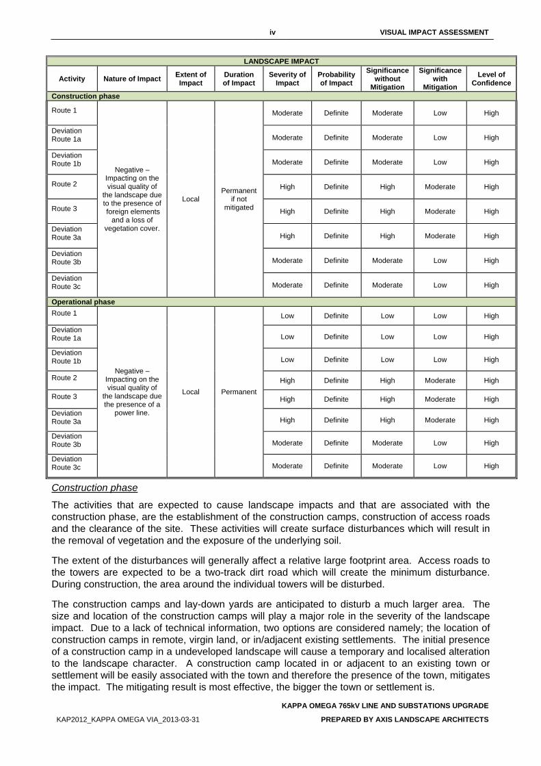
iv VISUAL IMPACT ASSESSMENT
KAPPA OMEGA 765kV LINE AND SUBSTATIONS UPGRADE
KAP2012_KAPPA OMEGA VIA_2013-03-31 PREPARED BY AXIS LANDSCAPE ARCHITECTS
LANDSCAPE IMPACT
Activity Nature of Impact Extent of Impact
Duration of Impact
Severity of Impact
Probability of Impact
Significance without
Mitigation
Significance with
Mitigation Level of
Confidence
Construction phase
Route 1
Negative – Impacting on the visual quality of
the landscape due to the presence of foreign elements
and a loss of vegetation cover.
Local Permanent
if not mitigated
Moderate Definite Moderate Low High
Deviation Route 1a Moderate Definite Moderate Low High
Deviation Route 1b Moderate Definite Moderate Low High
Route 2 High Definite High Moderate High
Route 3 High Definite High Moderate High
Deviation Route 3a High Definite High Moderate High
Deviation Route 3b Moderate Definite Moderate Low High
Deviation Route 3c Moderate Definite Moderate Low High
Operational phase Route 1
Negative – Impacting on the visual quality of
the landscape due the presence of a
power line.
Local Permanent
Low Definite Low Low High
Deviation Route 1a Low Definite Low Low High
Deviation Route 1b Low Definite Low Low High
Route 2 High Definite High Moderate High
Route 3 High Definite High Moderate High
Deviation Route 3a High Definite High Moderate High
Deviation Route 3b Moderate Definite Moderate Low High
Deviation Route 3c Moderate Definite Moderate Low High
Construction phase
The activities that are expected to cause landscape impacts and that are associated with the construction phase, are the establishment of the construction camps, construction of access roads and the clearance of the site. These activities will create surface disturbances which will result in the removal of vegetation and the exposure of the underlying soil.
The extent of the disturbances will generally affect a relative large footprint area. Access roads to the towers are expected to be a two-track dirt road which will create the minimum disturbance. During construction, the area around the individual towers will be disturbed.
The construction camps and lay-down yards are anticipated to disturb a much larger area. The size and location of the construction camps will play a major role in the severity of the landscape impact. Due to a lack of technical information, two options are considered namely; the location of construction camps in remote, virgin land, or in/adjacent existing settlements. The initial presence of a construction camp in a undeveloped landscape will cause a temporary and localised alteration to the landscape character. A construction camp located in or adjacent to an existing town or settlement will be easily associated with the town and therefore the presence of the town, mitigates the impact. The mitigating result is most effective, the bigger the town or settlement is.
v VISUAL IMPACT ASSESSMENT
KAPPA OMEGA 765kV LINE AND SUBSTATIONS UPGRADE
KAP2012_KAPPA OMEGA VIA_2013-03-31 PREPARED BY AXIS LANDSCAPE ARCHITECTS
Servitudes will generally be cleared of higher growing and dense vegetation to reduce biomass that may cause a fire hazard if ignited. The complete removal of high growing vegetation and scrubs will result in disturbed areas of exposed soil and difference in texture.
The exposed soil and change in texture will contrast severely with the intact vegetation around the disturbance footprint and servitudes.
Considering the moderately low VAC throughout most of the study area, the undisturbed condition of parts of the landscape and the recovery rate of the endemic vegetation, the severity of landscape impact during the construction stage is expected to be moderate for Route 1, Deviation Route 1a and 1b and high for all the other alternatives. The impact will extend over the entire length of the different alignments and may vary in degrees of severity along the linear length as it transects landscape types of varying VAC. Surface disturbances are also minimised through, for example, utilising existing roads.
Operational phase
Surface disturbances created during construction may remain for an extended period during the operational phase. These are seen as residual affects carried forward from the construction phase and can be completely or substantially mitigated if treated appropriately during the construction phase.
An additional impact will be caused as a result of the presence of the completed transmission line, i.e. that of the evenly spaced towers of the lines, buildings and structures. The industrial character and the near monumental vertical scale of the towers will contrast with the diverse landscape character that prevails through most of the study area.
VIEWER SENSITIVITY Within the receiving environment, specific viewers (visual receptors) experience different views of the visual resource and value it differently. They will be affected because of alterations to their views due to the proposed project. The visual receptors are grouped according to their similarities. The visual receptors included in this study are:
• Residents; • Tourists; and • Motorists.
To determine visual receptor sensitivity a, commonly used rating system is utilised. This is a generic classification of visual receptors and enables the visual impact specialist to establish a logical and consistent visual receptor sensitivity rating for viewers who are involved in different activities without engaging in extensive public surveys. The sensitivity of the identified visual receptors is discussed in Section 5.2.1.
SIGNIFICANCE OF VISUAL IMPACTS Empirical research indicates that the visibility of a transmission tower, and hence the severity of visual impact, decreases as the distance between the observer and the tower increases. The landscape type, through which the transmission line crosses, can mitigate the severity of visual impact through topographical or vegetative screening. Bishop et al (1988) noticed that in some cases the tower may dominate the view for example, silhouetted against the skyline, or in some cases be absorbed in the landscape. A complex landscape setting with a diverse land cover and topographical variation has the ability to decrease the severity of visual impact more than a mundane landscape (Bishop et al, 1985).
The following tables summarise the visual impacts on residents, tourists and motorists.
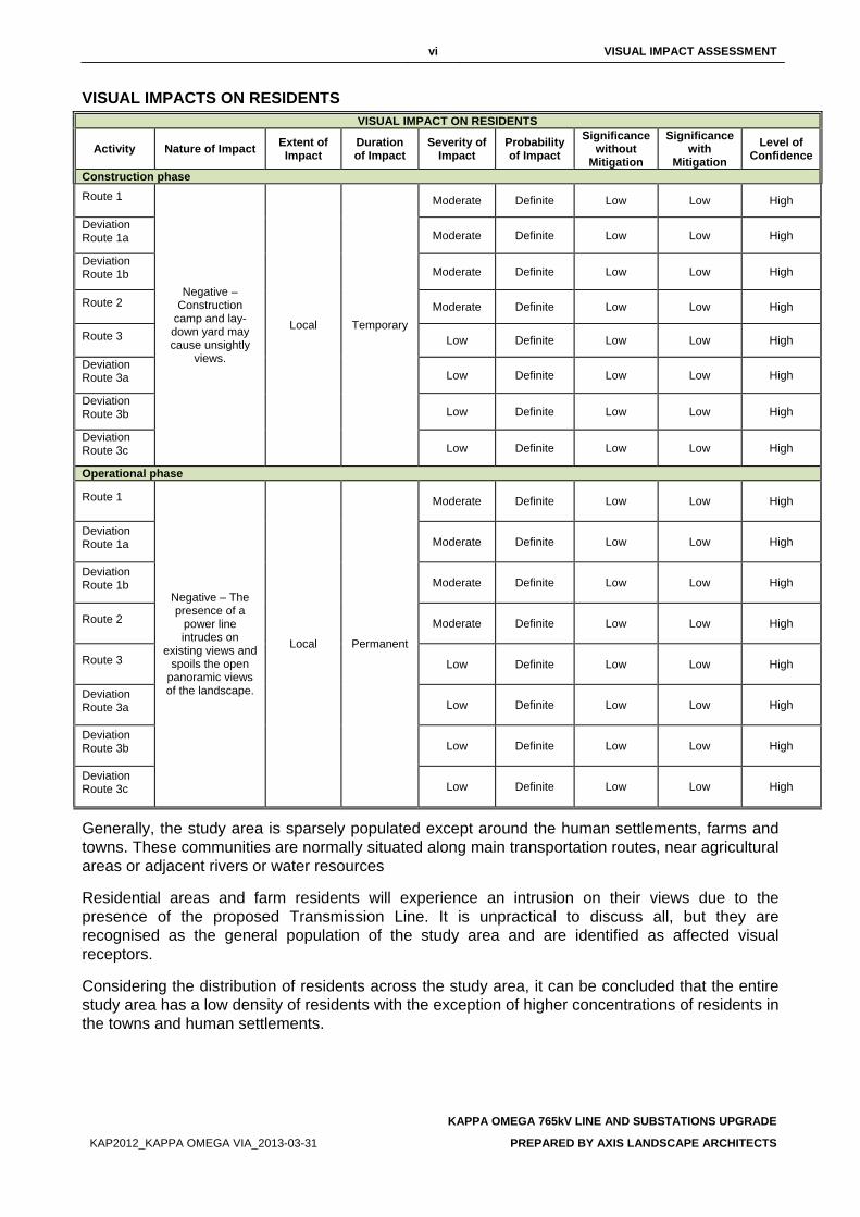
vi VISUAL IMPACT ASSESSMENT
KAPPA OMEGA 765kV LINE AND SUBSTATIONS UPGRADE
KAP2012_KAPPA OMEGA VIA_2013-03-31 PREPARED BY AXIS LANDSCAPE ARCHITECTS
VISUAL IMPACTS ON RESIDENTS VISUAL IMPACT ON RESIDENTS
Activity Nature of Impact Extent of Impact
Duration of Impact
Severity of Impact
Probability of Impact
Significance without
Mitigation
Significance with
Mitigation Level of
Confidence
Construction phase Route 1
Negative – Construction
camp and lay-down yard may cause unsightly
views.
Local Temporary
Moderate Definite Low Low High
Deviation Route 1a Moderate Definite Low Low High
Deviation Route 1b Moderate Definite Low Low High
Route 2 Moderate Definite Low Low High
Route 3 Low Definite Low Low High
Deviation Route 3a Low Definite Low Low High
Deviation Route 3b Low Definite Low Low High
Deviation Route 3c Low Definite Low Low High
Operational phase
Route 1
Negative – The presence of a
power line intrudes on
existing views and spoils the open
panoramic views of the landscape.
Local Permanent
Moderate Definite Low Low High
Deviation Route 1a Moderate Definite Low Low High
Deviation Route 1b Moderate Definite Low Low High
Route 2 Moderate Definite Low Low High
Route 3 Low Definite Low Low High
Deviation Route 3a Low Definite Low Low High
Deviation Route 3b Low Definite Low Low High
Deviation Route 3c Low Definite Low Low High
Generally, the study area is sparsely populated except around the human settlements, farms and towns. These communities are normally situated along main transportation routes, near agricultural areas or adjacent rivers or water resources
Residential areas and farm residents will experience an intrusion on their views due to the presence of the proposed Transmission Line. It is unpractical to discuss all, but they are recognised as the general population of the study area and are identified as affected visual receptors.
Considering the distribution of residents across the study area, it can be concluded that the entire study area has a low density of residents with the exception of higher concentrations of residents in the towns and human settlements.
vii VISUAL IMPACT ASSESSMENT
KAPPA OMEGA 765kV LINE AND SUBSTATIONS UPGRADE
KAP2012_KAPPA OMEGA VIA_2013-03-31 PREPARED BY AXIS LANDSCAPE ARCHITECTS
Construction phase
During the construction phase, unsightly views may be created by the presence of construction camps and the lay-down yards. The duration of the potential visual impact will be temporary which will result in an anticipated moderately low significance of visual impact for all the alternatives. The visual exposure to the construction activity will initially be limited and only local residents will experience views of the site preparation activity. As the structures increase in scale and height, the ZVI increases, resulting in a greater number of affected viewers and a subsequent increase in visual exposure.
The cleared sites, construction camps and material lay-down yard will appear unsightly and out of character. Large scale construction elements such as cranes, will be highly visible and increase awareness of the construction activity over a considerable area. The visual intrusion caused during the construction stage will be moderate, but will be temporary in nature.
Operational phase
The residents of the residential areas and farming communities next to the power lines may experience a moderate degree of visual intrusion due to their proximity to all the Alternatives.
The presence of a transmission line in the visual field of the residents in this part of the study area will spoil the uncluttered panoramic views they currently experience. The silhouette of a transmission line on the horizon will be visible from a great distance and thus increase the ZVI considerably, potentially impacting on more residents.
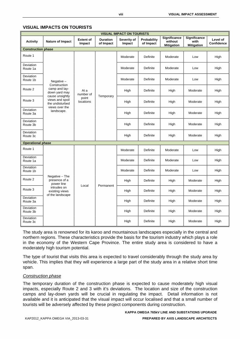
viii VISUAL IMPACT ASSESSMENT
KAPPA OMEGA 765kV LINE AND SUBSTATIONS UPGRADE
KAP2012_KAPPA OMEGA VIA_2013-03-31 PREPARED BY AXIS LANDSCAPE ARCHITECTS
VISUAL IMPACTS ON TOURISTS VISUAL IMPACT ON TOURISTS
Activity Nature of Impact Extent of Impact
Duration of Impact
Severity of Impact
Probability of Impact
Significance without
Mitigation
Significance with
Mitigation Level of
Confidence
Construction phase
Route 1
Negative – Construction
camp and lay-down yard may cause unsightly views and spoil the undisturbed views over the
landscape.
At a number of
point locations
Temporary
Moderate Definite Moderate Low High
Deviation Route 1a Moderate Definite Moderate Low High
Deviation Route 1b Moderate Definite Moderate Low High
Route 2 High Definite High Moderate High
Route 3 High Definite High Moderate High
Deviation Route 3a High Definite High Moderate High
Deviation Route 3b High Definite High Moderate High
Deviation Route 3c High Definite High Moderate High
Operational phase
Route 1
Negative – The presence of a
power line intrudes on
existing views of the landscape
Local Permanent
Moderate Definite Moderate Low High
Deviation Route 1a Moderate Definite Moderate Low High
Deviation Route 1b Moderate Definite Moderate Low High
Route 2 High Definite High Moderate High
Route 3 High Definite High Moderate High
Deviation Route 3a High Definite High Moderate High
Deviation Route 3b High Definite High Moderate High
Deviation Route 3c High Definite High Moderate High
The study area is renowned for its karoo and mountainous landscapes especially in the central and northern regions. These characteristics provide the basis for the tourism industry which plays a role in the economy of the Western Cape Province. The entire study area is considered to have a moderately high tourism potential.
The type of tourist that visits this area is expected to travel considerably through the study area by vehicle. This implies that they will experience a large part of the study area in a relative short time span.
Construction phase
The temporary duration of the construction phase is expected to cause moderately high visual impacts, especially Route 2 and 3 with it’s deviations. The location and size of the construction camps and lay-down yards will be crucial in regulating the impact. Detail information is not available and it is anticipated that the visual impact will occur localised and that a small number of tourists will be adversely affected by these project components during construction.
ix VISUAL IMPACT ASSESSMENT
KAPPA OMEGA 765kV LINE AND SUBSTATIONS UPGRADE
KAP2012_KAPPA OMEGA VIA_2013-03-31 PREPARED BY AXIS LANDSCAPE ARCHITECTS
Their exposure to possible unsightly views of the construction camps and the associated activity will however be minimal and localised.
The potential visual impact on tourists during the construction phase of the proposed project can be mitigated with relative ease except for Route 2 and 3 with its deviations. The greatest factor to consider is the location of the construction camps from potential views that may be experienced from scenic routes or tourist hotspots.
Operational phase
Considering the extent of the proposed alternatives, a number of tourists will be affected during their visit to the study area. Although it is difficult to pinpoint particular locations in the study area that are of specific tourist value, since the entire study area bares some value, the most obvious concentration of tourists can be expected in the northern central part of the study area. For these tourists, Route 2 and 3 with its deviations will create alterations to their views. The presence of a transmission line in this undeveloped landscape will spoil the views that are experiencing. It can be concluded that Route 2 and 3 with its deviations will cause a high visual intrusion in the views expected by tourists travelling through the study are.
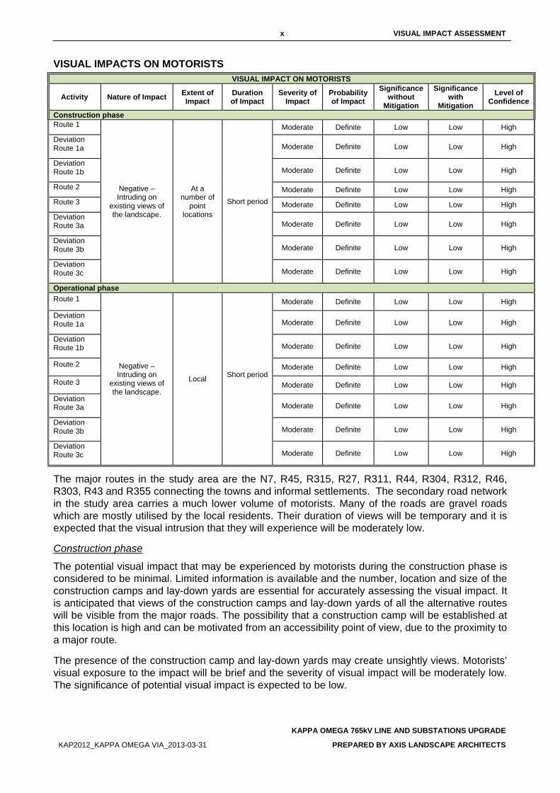
x VISUAL IMPACT ASSESSMENT
KAPPA OMEGA 765kV LINE AND SUBSTATIONS UPGRADE
KAP2012_KAPPA OMEGA VIA_2013-03-31 PREPARED BY AXIS LANDSCAPE ARCHITECTS
VISUAL IMPACTS ON MOTORISTS VISUAL IMPACT ON MOTORISTS
Activity Nature of Impact Extent of Impact
Duration of Impact
Severity of Impact
Probability of Impact
Significance without
Mitigation
Significance with
Mitigation Level of
Confidence
Construction phase Route 1
Negative – Intruding on
existing views of the landscape.
At a number of
point locations
Short period
Moderate Definite Low Low High Deviation Route 1a Moderate Definite Low Low High
Deviation Route 1b Moderate Definite Low Low High
Route 2 Moderate Definite Low Low High Route 3 Moderate Definite Low Low High Deviation Route 3a Moderate Definite Low Low High
Deviation Route 3b Moderate Definite Low Low High
Deviation Route 3c Moderate Definite Low Low High
Operational phase Route 1
Negative – Intruding on
existing views of the landscape.
Local Short period
Moderate Definite Low Low High
Deviation Route 1a Moderate Definite Low Low High
Deviation Route 1b Moderate Definite Low Low High
Route 2 Moderate Definite Low Low High
Route 3 Moderate Definite Low Low High
Deviation Route 3a Moderate Definite Low Low High
Deviation Route 3b Moderate Definite Low Low High
Deviation Route 3c Moderate Definite Low Low High
The major routes in the study area are the N7, R45, R315, R27, R311, R44, R304, R312, R46, R303, R43 and R355 connecting the towns and informal settlements. The secondary road network in the study area carries a much lower volume of motorists. Many of the roads are gravel roads which are mostly utilised by the local residents. Their duration of views will be temporary and it is expected that the visual intrusion that they will experience will be moderately low.
Construction phase
The potential visual impact that may be experienced by motorists during the construction phase is considered to be minimal. Limited information is available and the number, location and size of the construction camps and lay-down yards are essential for accurately assessing the visual impact. It is anticipated that views of the construction camps and lay-down yards of all the alternative routes will be visible from the major roads. The possibility that a construction camp will be established at this location is high and can be motivated from an accessibility point of view, due to the proximity to a major route.
The presence of the construction camp and lay-down yards may create unsightly views. Motorists’ visual exposure to the impact will be brief and the severity of visual impact will be moderately low. The significance of potential visual impact is expected to be low.
xi VISUAL IMPACT ASSESSMENT
KAPPA OMEGA 765kV LINE AND SUBSTATIONS UPGRADE
KAP2012_KAPPA OMEGA VIA_2013-03-31 PREPARED BY AXIS LANDSCAPE ARCHITECTS
Operational phase
The N7, R27, R47, R44 and R46 are the most prominent, carrying the highest volume of traffic. Route 3 with its deviations will be the most visible from the R27. The severity and significance of visual impact for all the proposed routes on motorists will be moderate.
RECOMMENDED MITIGATION MEASURES In most cases, the landscape and visual impacts occurring during the construction phase can be mitigated relatively effectively. Rehabilitation of the disturbed areas will prevent the exposure of soil, which may cause a reduction in the visual quality of the study area. Sensitive positioning of the construction camps and lay-down yards should take advantage of the natural screening capacity of the study area by locating the camps outside of the views of sensitive visual receptors.
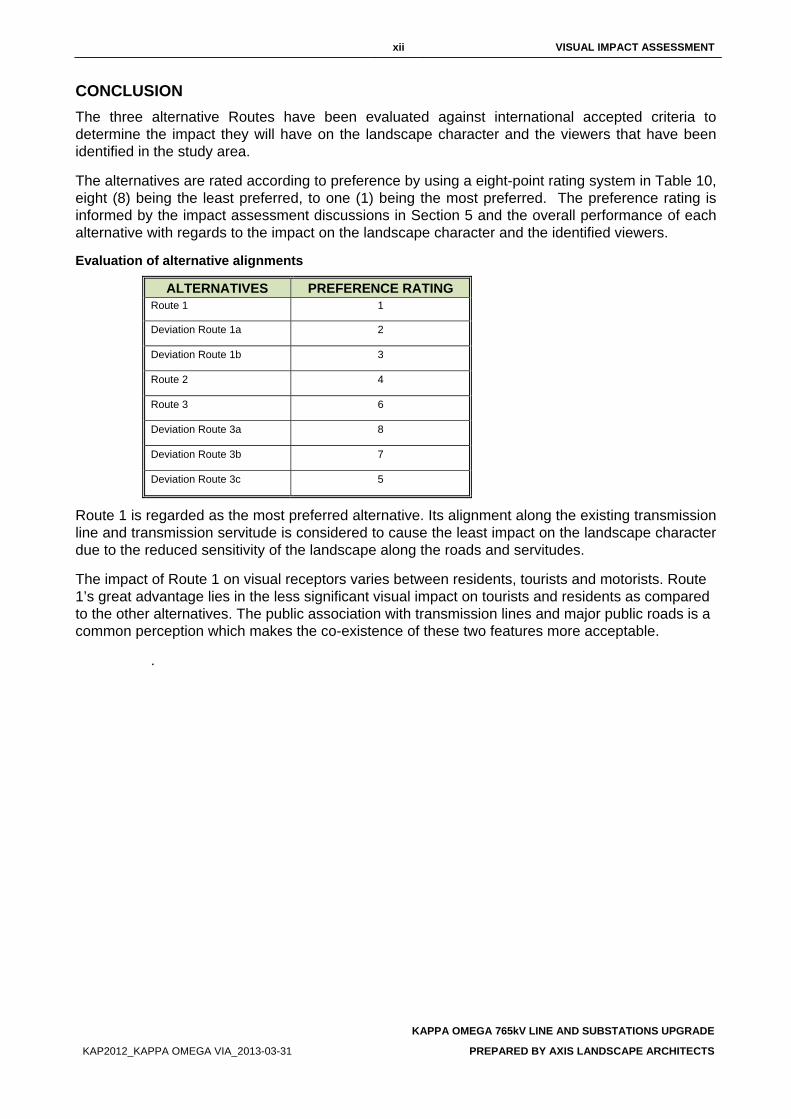
xii VISUAL IMPACT ASSESSMENT
KAPPA OMEGA 765kV LINE AND SUBSTATIONS UPGRADE
KAP2012_KAPPA OMEGA VIA_2013-03-31 PREPARED BY AXIS LANDSCAPE ARCHITECTS
CONCLUSION The three alternative Routes have been evaluated against international accepted criteria to determine the impact they will have on the landscape character and the viewers that have been identified in the study area.
The alternatives are rated according to preference by using a eight-point rating system in Table 10, eight (8) being the least preferred, to one (1) being the most preferred. The preference rating is informed by the impact assessment discussions in Section 5 and the overall performance of each alternative with regards to the impact on the landscape character and the identified viewers.
Evaluation of alternative alignments
ALTERNATIVES PREFERENCE RATING Route 1 1
Deviation Route 1a 2
Deviation Route 1b 3
Route 2 4
Route 3 6
Deviation Route 3a 8
Deviation Route 3b 7
Deviation Route 3c 5
Route 1 is regarded as the most preferred alternative. Its alignment along the existing transmission line and transmission servitude is considered to cause the least impact on the landscape character due to the reduced sensitivity of the landscape along the roads and servitudes.
The impact of Route 1 on visual receptors varies between residents, tourists and motorists. Route 1’s great advantage lies in the less significant visual impact on tourists and residents as compared to the other alternatives. The public association with transmission lines and major public roads is a common perception which makes the co-existence of these two features more acceptable.
.
xiii VISUAL IMPACT ASSESSMENT
KAPPA OMEGA 765kV LINE AND SUBSTATIONS UPGRADE
KAP2012_KAPPA OMEGA VIA_2013-03-31 PREPARED BY AXIS LANDSCAPE ARCHITECTS
TABLES OF CONTENTS Page
EXECUTIVE SUMMARY ................................................................................................................... i PROJECT DESCRIPTION ............................................................................................................. i DESCRIPTION OF THE AFFECTED ENVIRONMENT ................................................................ ii
FINDINGS AND RECOMMENDATIONS ........................................................................................ iii LANDSCAPE CHARACTER SENSITIVITY ................................................................................. iii SIGNIFICANCE OF LANDSCAPE IMPACTS ............................................................................. iii VIEWER SENSITIVITY .................................................................................................................. v SIGNIFICANCE OF VISUAL IMPACTS ........................................................................................ v
VISUAL IMPACTS ON RESIDENTS ................................................................................................................... vi VISUAL IMPACTS ON TOURISTS .................................................................................................................... viii VISUAL IMPACTS ON MOTORISTS ................................................................................................................... x
RECOMMENDED MITIGATION MEASURES ............................................................................. xi CONCLUSION ............................................................................................................................. xii
TABLES OF CONTENTS .............................................................................................................. xiii LIST OF FIGURES ......................................................................................................................... xv LIST OF TABLES ........................................................................................................................... xv LIST OF ABBREVIATIONS .......................................................................................................... xvi 1. INTRODUCTION ..................................................................................................................... 1
1.1. BACKGROUND AND BRIEF .............................................................................................. 1 1.2. STUDY AREA ...................................................................................................................... 1
2. STUDY APPROACH .............................................................................................................. 3 2.1. INFORMATION BASE ......................................................................................................... 3 2.2. ASSUMPTIONS AND LIMITATIONS .................................................................................. 3 2.3. LEVEL OF CONFIDENCE ................................................................................................... 3 2.4. METHOD ............................................................................................................................. 3
3. PROJECT DESCRIPTION ...................................................................................................... 4 3.1. OVERVIEW OF DEVELOPMENT ....................................................................................... 4 3.2. ALTERNATIVE ALIGNMENTS ........................................................................................... 4 3.3. PROJECT COMPONENTS AND ACTIVITIES .................................................................... 4
3.3.1. SUBSTATIONS ........................................................................................................................................ 4 3.3.2. CONSTRUCTION CAMPS AND LAY-DOWN YARDS ...................................................................... 5 3.3.3. ACCESS ROADS ..................................................................................................................................... 5 3.3.4. TRANSMISSION LINE ............................................................................................................................ 5
3.4. VISUAL CHARACTERISTICS OF PROJECT COMPONENTS .......................................... 6 4. DESCRIPTION OF THE AFFECTED ENVIRONMENT ........................................................ 10
4.1. VISUAL RESOURCE ........................................................................................................ 10 4.1.1. LANDSCAPE CHARACTER ................................................................................................................ 10 4.1.2. VISUAL CHARACTER .......................................................................................................................... 14
xiv VISUAL IMPACT ASSESSMENT
KAPPA OMEGA 765kV LINE AND SUBSTATIONS UPGRADE
KAP2012_KAPPA OMEGA VIA_2013-03-31 PREPARED BY AXIS LANDSCAPE ARCHITECTS
4.1.2.1 Visual Quality ...................................................................................................................................... 14 4.1.2.2 Visual absorption capacity ................................................................................................................ 14
5. IMPACT ASSESSMENT ....................................................................................................... 35 5.1. SIGNIFICANCE OF LANDSCAPE IMPACT ..................................................................... 35
5.1.1. LANDSCAPE CHARACTER SENSITIVITY ....................................................................................... 35 5.1.2. SEVERITY OF POTENTIAL LANDSCAPE IMPACTS ..................................................................... 37
5.2. SIGNIFICANCE OF VISUAL IMPACTS ............................................................................ 39 5.2.1. VIEWER SENSITIVITY ......................................................................................................................... 39
5.2.1.1 Residents ............................................................................................................................................. 39 5.2.1.2 Tourists ................................................................................................................................................ 39 5.2.1.3 Motorists .............................................................................................................................................. 39
5.2.2. SEVERITY OF POTENTIAL VISUAL IMPACTS ............................................................................... 40 5.2.2.1 Potential visual impacts on residents .............................................................................................. 41 5.2.2.2 Potential visual impacts on tourists ................................................................................................. 43 5.2.2.3 Potential visual impacts on motorists .............................................................................................. 45
6. RECOMMENDED MITIGATION MEASURES ...................................................................... 47 6.1. GENERAL ......................................................................................................................... 47 6.2. ACCESS ROUTES ............................................................................................................ 47 6.3. TRANSMISSION TOWERS ............................................................................................... 47 6.4. CLEARED SERVITUDES .................................................................................................. 48 6.5. CONSTRUCTION CAMPS AND LAY DOWN YARDS ..................................................... 48
7. CONCLUSION ...................................................................................................................... 49 APPENDIX 1 ................................................................................................................................... 50 LEVEL OF CONFIDENCE .............................................................................................................. 59 VISUAL RECEPTOR SENSITIVITY ............................................................................................... 60 REFERENCES ............................................................................................................................... 61
xv VISUAL IMPACT ASSESSMENT
KAPPA OMEGA 765kV LINE AND SUBSTATIONS UPGRADE
KAP2012_KAPPA OMEGA VIA_2013-03-31 PREPARED BY AXIS LANDSCAPE ARCHITECS
LIST OF FIGURES Figure 1: Locality Plan ....................................................................................................................................... 2 Figure 2: Example of a construction camp ........................................................................................................ 7 Figure 3: Typical construction equipment .......................................................................................................... 8 Figure 4: Tower Types ....................................................................................................................................... 9 Figure 5: Landscape types .............................................................................................................................. 12 Figure 6: Landscape types .............................................................................................................................. 13 Figure 7: Landscape character of study area .................................................................................................. 16 Figure 8: Landscape character of study area .................................................................................................. 17 Figure 9: Landscape character of study area .................................................................................................. 18 Figure 10: Landscape character of study area ................................................................................................ 19 Figure 9: Photo Reference Map ...................................................................................................................... 20 Figure 12: Photo plate 1 .................................................................................................................................. 21 Figure 13: Photo plate 2 .................................................................................................................................. 22 Figure 14: Photo plate 3 .................................................................................................................................. 23 Figure 15: Photo plate 4 .................................................................................................................................. 24 Figure 16: Photo plate 5 .................................................................................................................................. 25 Figure 17: Photo plate 6 .................................................................................................................................. 26 Figure 18: Photo plate 7 .................................................................................................................................. 27 Figure 19: Photo plate 8 .................................................................................................................................. 28 Figure 20: Photo plate 9 .................................................................................................................................. 29 Figure 21: Photo plate 10 ................................................................................................................................ 30 Figure 22: Photo plate 11 ................................................................................................................................ 31 Figure 23: Photo plate 12 ................................................................................................................................ 32 Figure 24: Photo plate 13 ................................................................................................................................ 33 Figure 25: Photo plate 14 ................................................................................................................................ 34 Figure 26: Alternative 1.................................................................................................................................... 51 Figure 27: Alternative 1A ................................................................................................................................. 52 Figure 28: Alternative 1B ................................................................................................................................. 53 Figure 29: Alternative 3 A ................................................................................................................................ 54 Figure 30: Alternative 3 B ................................................................................................................................ 55 Figure 31: Alternative 3 C ................................................................................................................................ 56
LIST OF TABLES Table 1: Description of alternative alignments .................................................................................................. 4 Table 2: Types and typical characteristics of proposed towers ......................................................................... 5 Table 3: Criteria of Visual Quality (FHWA, 1981) ............................................................................................ 14 Table 4: Visual Quality of the regional landscape ........................................................................................... 14 Table 5: Regional Visual Absorption Capacity evaluation ............................................................................... 15 Table 6: Significance of impacts ...................................................................................................................... 35 Table 7: Landscape character sensitivity rating (Adapted from GOSW, 2006) ............................................... 35 Table 8: Landscape character sensitivity ........................................................................................................ 36 Table 9: Landscape impact – Altering the landscape character ..................................................................... 37 Table 10: Evaluation of alternative alignments ................................................................................................ 49 Table 11: Confidence level chart and description ........................................................................................... 59 Table 12: Visual receptor sensitivity ................................................................................................................ 60

xvi VISUAL IMPACT ASSESSMENT
KAPPA OMEGA 765kV LINE AND SUBSTATIONS UPGRADE
KAP2012_KAPPA OMEGA VIA_2013-03-31 PREPARED BY AXIS LANDSCAPE ARCHITECTS
LIST OF ABBREVIATIONS EIA Environmental Impact Assessment.
FHWA Federal Highway Administration of the United States Department of Transportation. The publishers of the guide “Visual Impact Assessment for High Projects” 1981.
LCA Landscape Character Assessment.
LT Landscape Type
VAC Visual Absorption Capacity
VIA Visual Impact Assessment.
ULI Urban Land Institute
ZVI Zone of Visual Influence.
1 VISUAL IMPACT ASSESSMENT
KAPPA OMEGA 765kV LINE AND SUBSTATIONS UPGRADE
KAP2012_KAPPA OMEGA VIA_2013-03-31 PREPARED BY AXIS LANDSCAPE ARCHITECTS
1. INTRODUCTION Nzumbululo (Pty) Limited was appointed by Eskom (Pty) Ltd, as the independent environmental consultant to undertake the Environmental Impact Assessment (EIA) for the proposed establishment of the second Kappa Omega 765kV transmission line and substations upgrade. It is located between the Koruson (Kappa) Substation near Ceres to Sterekus (Omega) Substation near Koeberg.
Axis Landscape Architecture cc was appointed by Nzumbululo (Pty) Limited as a sub-consultant to complete a Visual Impact Assessment. This Visual Impact Assessment (VIA) is a specialist study that forms part of the EIA and addresses the visual affects of the proposed transmission line on the receiving environment.
Three alternative routes have been proposed to connect to the two substations. The proposed routes stretch over approximately 415km. The study area contains the extent of the alignments and includes an approximate 5 km buffer area around the alignments.
1.1. BACKGROUND AND BRIEF This VIA will conform to the requirements of a level three assessment which requires the realisation of the following objectives (Adapted from Oberholzer (2005)):
• Determination of the extent of the study area; • Description of the proposed project and the receiving environment; • Identification and description of the landscape character of the study area; • Identification of the elements of particular visual value and -quality that could be affected
by the proposed project; • Identification of landscape- and visual receptors in the study area that will be affected by
the proposed project and assess their sensitivity; • Indication of potential landscape- and visual impacts; • Assessment of the significance of the landscape- and visual impacts; • Recommendations of mitigation measures to reduce and/or alleviate the potential
adverse landscape- and visual impacts.
1.2. STUDY AREA The study area includes the entire area covered by the alternative routes. The study area stretches from the Koruson (Kappa) Substation north of Ceres to Sterekus (Omega) Substation near Koeberg in Western Cape Province (Figure 1).
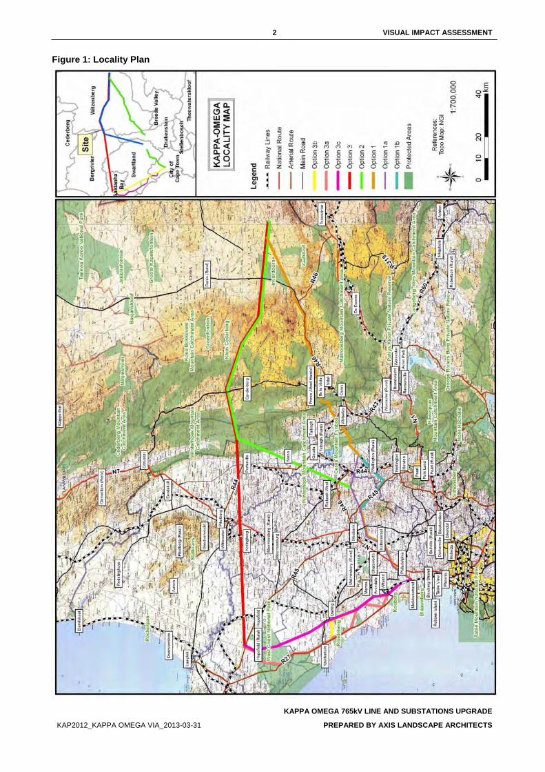
2 VISUAL IMPACT ASSESSMENT
KAPPA OMEGA 765kV LINE AND SUBSTATIONS UPGRADE
KAP2012_KAPPA OMEGA VIA_2013-03-31 PREPARED BY AXIS LANDSCAPE ARCHITECTS
Figure 1: Locality Plan
3 VISUAL IMPACT ASSESSMENT
KAPPA OMEGA 765kV LINE AND SUBSTATIONS UPGRADE
KAP2012_KAPPA OMEGA VIA_2013-03-31 PREPARED BY AXIS LANDSCAPE ARCHITECTS
2. STUDY APPROACH 2.1. INFORMATION BASE
This assessment was based on information from the following sources:
• Topographical maps and GIS generated data were sourced from the Surveyor General, Surveys and Mapping in Mowbray, Cape Town and ECOGIS (2013) respectively;
• Observations made and photographs taken during site visits; • Technical information received from Eskom Transmission; • Professional judgement based on experience gained from similar projects; and • Literature research on similar projects.
2.2. ASSUMPTIONS AND LIMITATIONS This assessment was undertaken during the conceptual stage of the project and is based on information available at the time.
• An exact commencement date for the construction phase is unknown. Construction is expected to commence as soon as approval is received from the relevant authorities;
• The exact location, size of construction camps and material lay-down yards are not yet specified at this stage of the project. It is anticipated that construction camps will be set up on farms at central locations next to the preferred alignment. The construction camps will consist of temporary structures such as tents or temporary buildings. Ablution facilities will also be associated with a construction camp and are expected to be portable toilets and temporary shower facilities;
2.3. LEVEL OF CONFIDENCE The level of confidence assigned to the findings of this assessment is based on:
• The level of information available and/or understanding of the study area (rated 2); and • The information available and/or knowledge and experience of the project (rated 3).
This visual impact assessment is rated with a general confidence level of 6. This rating indicates that the author’s general confidence in the accuracy of the findings is high (Table 11). Where the confidence level of specific findings is not regarded as high, it is noted in the last column of each impact assessment table.
2.4. METHOD A broad overview of the approach and methodology used in this assessment is provided below:
• The extent of the study area is determined and indicated in Figure1; • The site is visited to establish a photographic record of the site, views and areas of
particular visual quality and or -value; • The project components and activities are described and assessed as potential elements
of visual and landscape impacts; • The receiving environment is described in terms of its prevailing landscape- and visual
character; • Landscape- and visual receptors that may be affected by the proposed project are
identified and described; • The sensitivity of the landscape- and visual receptors is assessed; • The severity of the landscape- and visual impacts is determined; • The significance of the visual and landscape impacts is assessed;
4 VISUAL IMPACT ASSESSMENT
KAPPA OMEGA 765kV LINE AND SUBSTATIONS UPGRADE
KAP2012_KAPPA OMEGA VIA_2013-03-31 PREPARED BY AXIS LANDSCAPE ARCHITECTS
• Mitigation measures are proposed to reduce adverse impacts; and • The findings of the study are documented in this Visual Impact Assessment.
3. PROJECT DESCRIPTION 3.1. OVERVIEW OF DEVELOPMENT
The project involves the construction of a 765kV transmission line from the Kappa Substation to the Omega Substation as well as the upgrade of the two substations. The servitude required for the development along the route is 80m wide and approximately 415km in length between the origin and the end of the line.
3.2. ALTERNATIVE ALIGNMENTS Table 1: Description of alternative alignments
ALTERNATIVES DESCRIPTION (Refer to Figure 1)
Route 1 Route 1 is proposed to run in a south westerly direction from the Kappa Substation north of Ceres, passing through Ceres continuing straight until it reaches the Omega Substation.
Deviation Route 1a Deviation Route 1a is proposed to run from Wellington city centre and run in a North-Western direction until it joins up with Route 2 East of Hermon.
Deviation Route 1b Deviation Route 1b diverts 15km after Deviation 1a from Route 1. It runs for about 18km in a North Eastern direction from Wellington city centre until it joins up with Route 2 South - East of Malmesbury.
Route 2 Route 2 is proposed to run in a westerly direction with Route 1 until Piketberg Mountain and then deviates from Route 1 in a South-Western direction until the Omega Substation
Route 3 Route 3 is proposed to run in a westerly direction from the Kappa Substation North of Ceres until Aurora substation. It then continues from Aurora substation to the Omega substation following the coastline.
Deviation Route 3a Route 3a is proposed to run in a south easterly direction from the Aurora substation to the Omega substation following the coastline.
Deviation Route 3b Route 3b is proposed to run in a south easterly direction from the Aurora substation to the Omega substation following the coastline.
Deviation Route 3c Route 3c is proposed to run in a south easterly direction from the Aurora substation to the Omega substation following the coastline.
3.3. PROJECT COMPONENTS AND ACTIVITIES Each project component and activity will affect the receiving environment differently and is therefore discussed separately. The following project components will occur during the construction and operational phases of the project and are identified as elements that may cause a potential landscape and/or visual impact:
3.3.1. SUBSTATIONS The two existing Substations, Kappa and Omega will be upgraded to accommodate the new 765kV Line. Each substation site will require a 765kV feeder bay, 400MVAr line reactors and extend the existing bus bar if necessary.
A level or stepped platform will be created with a buffer zone inside the fence. On the outskirts of this area will be several terminal gantries which are the termination points for the lines entering or leaving the substation. These structures will be approximately 45 meters tall.
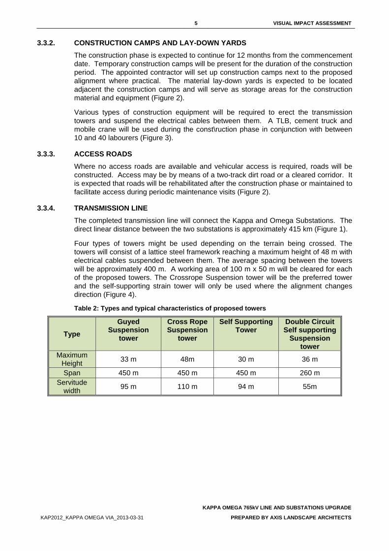
5 VISUAL IMPACT ASSESSMENT
KAPPA OMEGA 765kV LINE AND SUBSTATIONS UPGRADE
KAP2012_KAPPA OMEGA VIA_2013-03-31 PREPARED BY AXIS LANDSCAPE ARCHITECTS
3.3.2. CONSTRUCTION CAMPS AND LAY-DOWN YARDS The construction phase is expected to continue for 12 months from the commencement date. Temporary construction camps will be present for the duration of the construction period. The appointed contractor will set up construction camps next to the proposed alignment where practical. The material lay-down yards is expected to be located adjacent the construction camps and will serve as storage areas for the construction material and equipment (Figure 2).
Various types of construction equipment will be required to erect the transmission towers and suspend the electrical cables between them. A TLB, cement truck and mobile crane will be used during the const\ruction phase in conjunction with between 10 and 40 labourers (Figure 3).
3.3.3. ACCESS ROADS Where no access roads are available and vehicular access is required, roads will be constructed. Access may be by means of a two-track dirt road or a cleared corridor. It is expected that roads will be rehabilitated after the construction phase or maintained to facilitate access during periodic maintenance visits (Figure 2).
3.3.4. TRANSMISSION LINE The completed transmission line will connect the Kappa and Omega Substations. The direct linear distance between the two substations is approximately 415 km (Figure 1).
Four types of towers might be used depending on the terrain being crossed. The towers will consist of a lattice steel framework reaching a maximum height of 48 m with electrical cables suspended between them. The average spacing between the towers will be approximately 400 m. A working area of 100 m x 50 m will be cleared for each of the proposed towers. The Crossrope Suspension tower will be the preferred tower and the self-supporting strain tower will only be used where the alignment changes direction (Figure 4).
Table 2: Types and typical characteristics of proposed towers
Type Guyed
Suspension tower
Cross Rope Suspension
tower
Self Supporting Tower
Double Circuit Self supporting
Suspension tower
Maximum Height 33 m 48m 30 m 36 m
Span 450 m 450 m 450 m 260 m Servitude
width 95 m 110 m 94 m 55m
6 VISUAL IMPACT ASSESSMENT
KAPPA OMEGA 765kV LINE AND SUBSTATIONS UPGRADE
KAP2012_KAPPA OMEGA VIA_2013-03-31 PREPARED BY AXIS LANDSCAPE ARCHITECTS
3.4. VISUAL CHARACTERISTICS OF PROJECT COMPONENTS Visual character is based on human perception and the observer’s response to the relationships between and composition of the visible project components. The transmission line, i.e. the towers and the cables suspended between each tower, is the most visible and permanent project component and is discussed in this section.
The towers have an industrial character enforced by the double steel pole and the electrical cables between the towers. It has a near monumental scale if compared to the predominantly rural and agricultural landscape. The entire transmission line will be perceived as a rhythmic arrangement of vertical towers forming a linear element through the landscape. The electrical cables emphasise the linear character of the transmission line but are easily absorbed in the background when viewed from distances greater than 10 km.
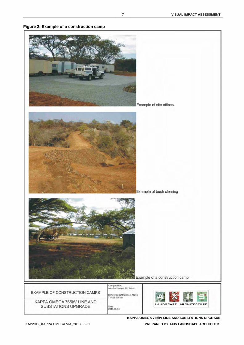
7 VISUAL IMPACT ASSESSMENT
KAPPA OMEGA 765kV LINE AND SUBSTATIONS UPGRADE
KAP2012_KAPPA OMEGA VIA_2013-03-31 PREPARED BY AXIS LANDSCAPE ARCHITECTS
Figure 2: Example of a construction camp
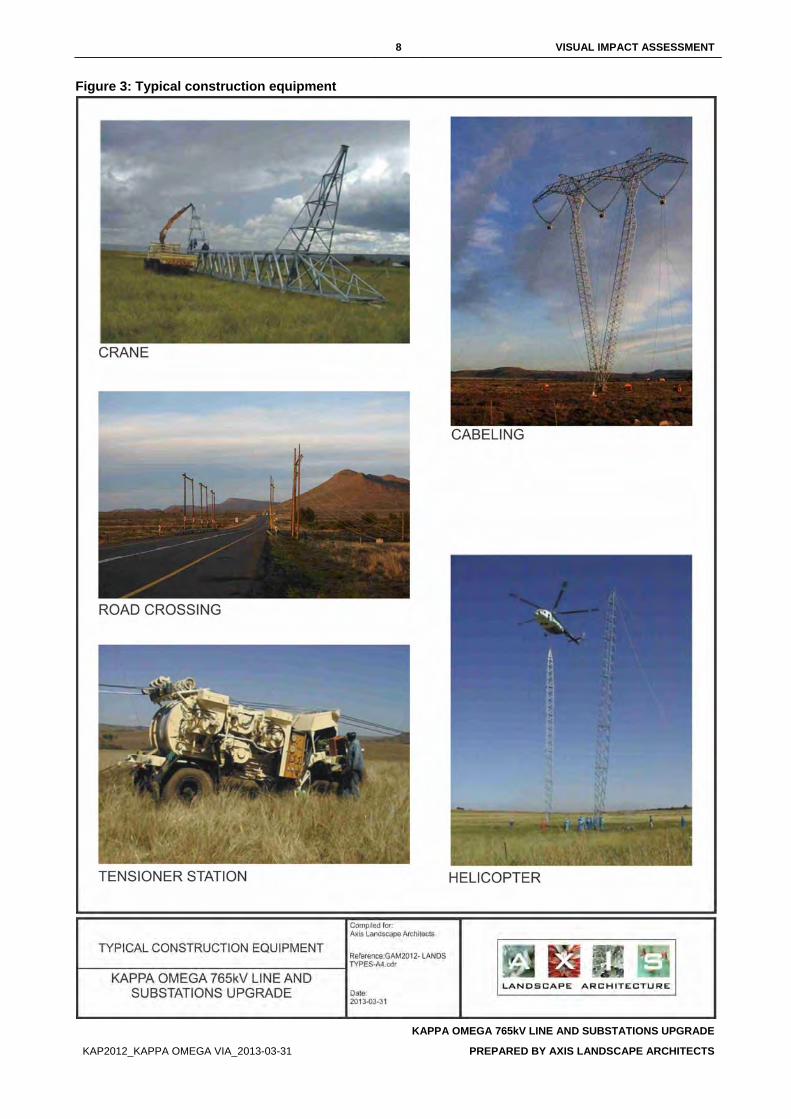
8 VISUAL IMPACT ASSESSMENT
KAPPA OMEGA 765kV LINE AND SUBSTATIONS UPGRADE
KAP2012_KAPPA OMEGA VIA_2013-03-31 PREPARED BY AXIS LANDSCAPE ARCHITECTS
Figure 3: Typical construction equipment
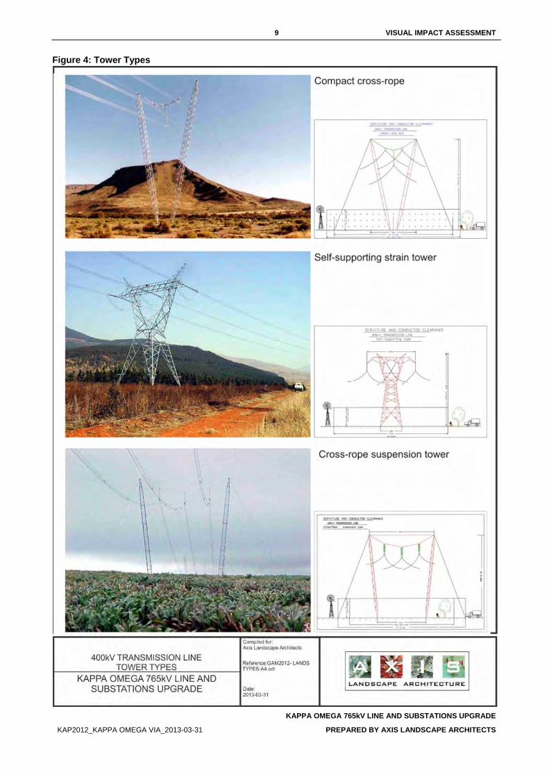
9 VISUAL IMPACT ASSESSMENT
KAPPA OMEGA 765kV LINE AND SUBSTATIONS UPGRADE
KAP2012_KAPPA OMEGA VIA_2013-03-31 PREPARED BY AXIS LANDSCAPE ARCHITECTS
Figure 4: Tower Types
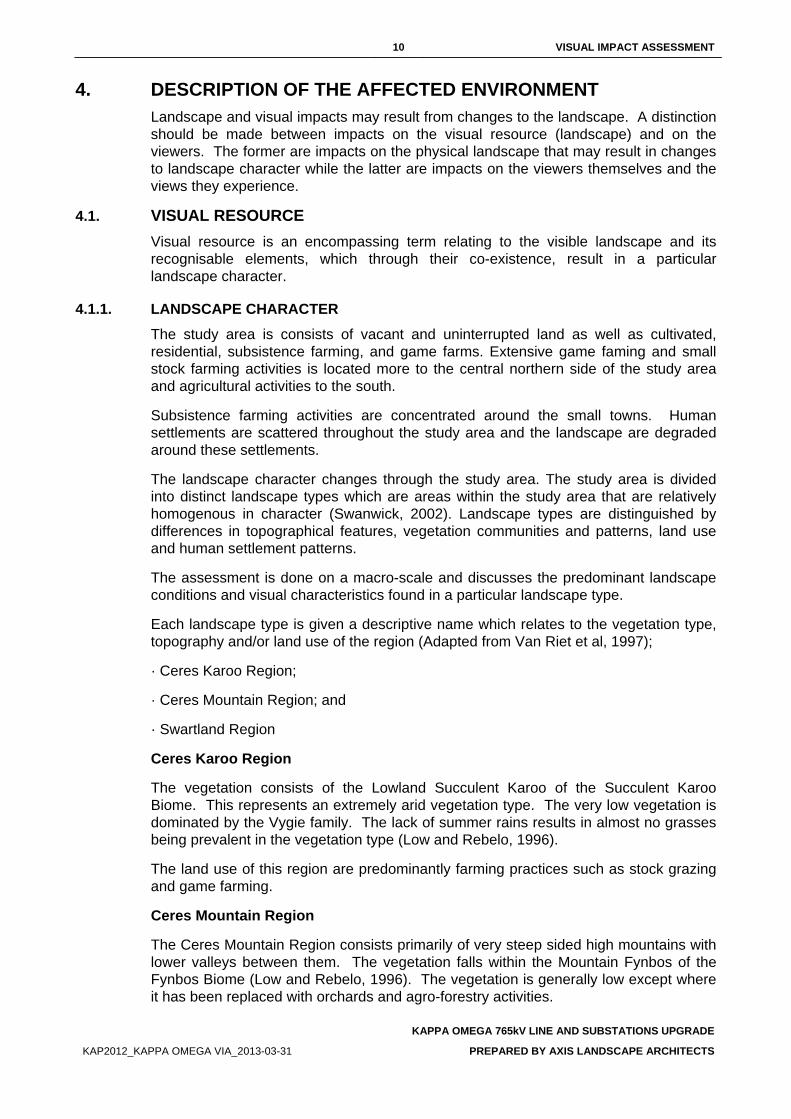
10 VISUAL IMPACT ASSESSMENT
KAPPA OMEGA 765kV LINE AND SUBSTATIONS UPGRADE
KAP2012_KAPPA OMEGA VIA_2013-03-31 PREPARED BY AXIS LANDSCAPE ARCHITECTS
4. DESCRIPTION OF THE AFFECTED ENVIRONMENT Landscape and visual impacts may result from changes to the landscape. A distinction should be made between impacts on the visual resource (landscape) and on the viewers. The former are impacts on the physical landscape that may result in changes to landscape character while the latter are impacts on the viewers themselves and the views they experience.
4.1. VISUAL RESOURCE Visual resource is an encompassing term relating to the visible landscape and its recognisable elements, which through their co-existence, result in a particular landscape character.
4.1.1. LANDSCAPE CHARACTER The study area is consists of vacant and uninterrupted land as well as cultivated, residential, subsistence farming, and game farms. Extensive game faming and small stock farming activities is located more to the central northern side of the study area and agricultural activities to the south.
Subsistence farming activities are concentrated around the small towns. Human settlements are scattered throughout the study area and the landscape are degraded around these settlements.
The landscape character changes through the study area. The study area is divided into distinct landscape types which are areas within the study area that are relatively homogenous in character (Swanwick, 2002). Landscape types are distinguished by differences in topographical features, vegetation communities and patterns, land use and human settlement patterns.
The assessment is done on a macro-scale and discusses the predominant landscape conditions and visual characteristics found in a particular landscape type.
Each landscape type is given a descriptive name which relates to the vegetation type, topography and/or land use of the region (Adapted from Van Riet et al, 1997);
· Ceres Karoo Region;
· Ceres Mountain Region; and
· Swartland Region
Ceres Karoo Region
The vegetation consists of the Lowland Succulent Karoo of the Succulent Karoo Biome. This represents an extremely arid vegetation type. The very low vegetation is dominated by the Vygie family. The lack of summer rains results in almost no grasses being prevalent in the vegetation type (Low and Rebelo, 1996).
The land use of this region are predominantly farming practices such as stock grazing and game farming.
Ceres Mountain Region
The Ceres Mountain Region consists primarily of very steep sided high mountains with lower valleys between them. The vegetation falls within the Mountain Fynbos of the Fynbos Biome (Low and Rebelo, 1996). The vegetation is generally low except where it has been replaced with orchards and agro-forestry activities.
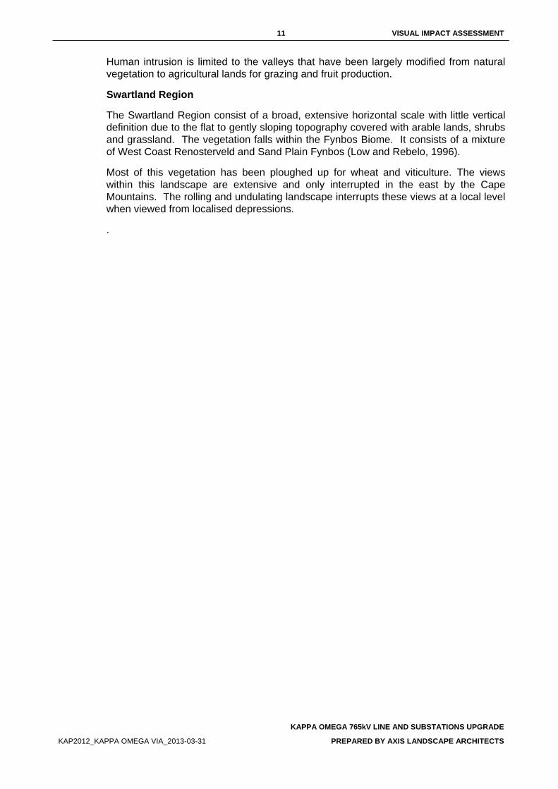
11 VISUAL IMPACT ASSESSMENT
KAPPA OMEGA 765kV LINE AND SUBSTATIONS UPGRADE
KAP2012_KAPPA OMEGA VIA_2013-03-31 PREPARED BY AXIS LANDSCAPE ARCHITECTS
Human intrusion is limited to the valleys that have been largely modified from natural vegetation to agricultural lands for grazing and fruit production.
Swartland Region
The Swartland Region consist of a broad, extensive horizontal scale with little vertical definition due to the flat to gently sloping topography covered with arable lands, shrubs and grassland. The vegetation falls within the Fynbos Biome. It consists of a mixture of West Coast Renosterveld and Sand Plain Fynbos (Low and Rebelo, 1996).
Most of this vegetation has been ploughed up for wheat and viticulture. The views within this landscape are extensive and only interrupted in the east by the Cape Mountains. The rolling and undulating landscape interrupts these views at a local level when viewed from localised depressions.
.
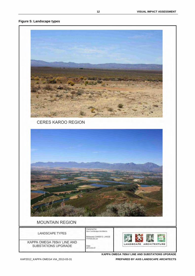
12 VISUAL IMPACT ASSESSMENT
KAPPA OMEGA 765kV LINE AND SUBSTATIONS UPGRADE
KAP2012_KAPPA OMEGA VIA_2013-03-31 PREPARED BY AXIS LANDSCAPE ARCHITECTS
Figure 5: Landscape types
13 VISUAL IMPACT ASSESSMENT
KAPPA OMEGA 765kV LINE AND SUBSTATIONS UPGRADE
KAP2012_KAPPA OMEGA VIA_2013-03-31 PREPARED BY AXIS LANDSCAPE ARCHITECTS
Figure 6: Landscape types
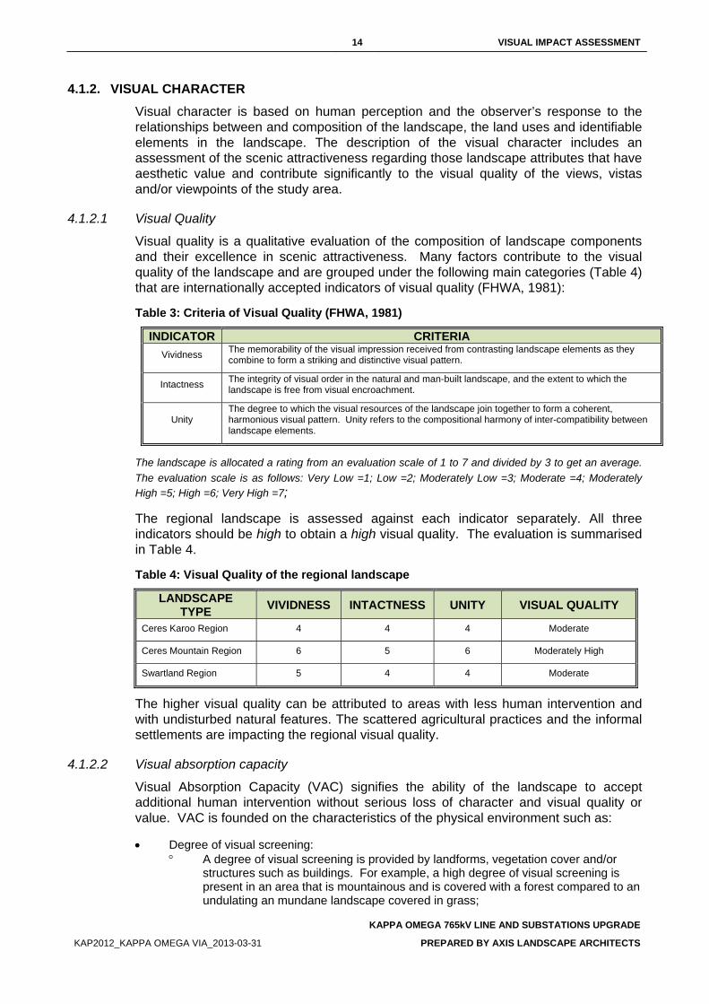
14 VISUAL IMPACT ASSESSMENT
KAPPA OMEGA 765kV LINE AND SUBSTATIONS UPGRADE
KAP2012_KAPPA OMEGA VIA_2013-03-31 PREPARED BY AXIS LANDSCAPE ARCHITECTS
4.1.2. VISUAL CHARACTER Visual character is based on human perception and the observer’s response to the relationships between and composition of the landscape, the land uses and identifiable elements in the landscape. The description of the visual character includes an assessment of the scenic attractiveness regarding those landscape attributes that have aesthetic value and contribute significantly to the visual quality of the views, vistas and/or viewpoints of the study area.
4.1.2.1 Visual Quality
Visual quality is a qualitative evaluation of the composition of landscape components and their excellence in scenic attractiveness. Many factors contribute to the visual quality of the landscape and are grouped under the following main categories (Table 4) that are internationally accepted indicators of visual quality (FHWA, 1981):
Table 3: Criteria of Visual Quality (FHWA, 1981)
INDICATOR CRITERIA Vividness The memorability of the visual impression received from contrasting landscape elements as they
combine to form a striking and distinctive visual pattern.
Intactness The integrity of visual order in the natural and man-built landscape, and the extent to which the landscape is free from visual encroachment.
Unity The degree to which the visual resources of the landscape join together to form a coherent, harmonious visual pattern. Unity refers to the compositional harmony of inter-compatibility between landscape elements.
The landscape is allocated a rating from an evaluation scale of 1 to 7 and divided by 3 to get an average. The evaluation scale is as follows: Very Low =1; Low =2; Moderately Low =3; Moderate =4; Moderately High =5; High =6; Very High =7;
The regional landscape is assessed against each indicator separately. All three indicators should be high to obtain a high visual quality. The evaluation is summarised in Table 4.
Table 4: Visual Quality of the regional landscape
LANDSCAPE TYPE VIVIDNESS INTACTNESS UNITY VISUAL QUALITY
Ceres Karoo Region 4 4 4 Moderate
Ceres Mountain Region 6 5 6 Moderately High
Swartland Region 5 4 4 Moderate
The higher visual quality can be attributed to areas with less human intervention and with undisturbed natural features. The scattered agricultural practices and the informal settlements are impacting the regional visual quality.
4.1.2.2 Visual absorption capacity
Visual Absorption Capacity (VAC) signifies the ability of the landscape to accept additional human intervention without serious loss of character and visual quality or value. VAC is founded on the characteristics of the physical environment such as:
• Degree of visual screening: ° A degree of visual screening is provided by landforms, vegetation cover and/or
structures such as buildings. For example, a high degree of visual screening is present in an area that is mountainous and is covered with a forest compared to an undulating an mundane landscape covered in grass;
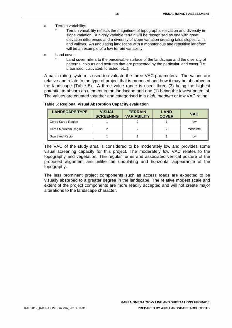
15 VISUAL IMPACT ASSESSMENT
KAPPA OMEGA 765kV LINE AND SUBSTATIONS UPGRADE
KAP2012_KAPPA OMEGA VIA_2013-03-31 PREPARED BY AXIS LANDSCAPE ARCHITECTS
• Terrain variability: ° Terrain variability reflects the magnitude of topographic elevation and diversity in
slope variation. A highly variable terrain will be recognised as one with great elevation differences and a diversity of slope variation creating talus slopes, cliffs and valleys. An undulating landscape with a monotonous and repetitive landform will be an example of a low terrain variability;
• Land cover: ° Land cover refers to the perceivable surface of the landscape and the diversity of
patterns, colours and textures that are presented by the particular land cover (i.e. urbanised, cultivated, forested, etc.);
A basic rating system is used to evaluate the three VAC parameters. The values are relative and relate to the type of project that is proposed and how it may be absorbed in the landscape (Table 5). A three value range is used; three (3) being the highest potential to absorb an element in the landscape and one (1) being the lowest potential. The values are counted together and categorised in a high, medium or low VAC rating.
Table 5: Regional Visual Absorption Capacity evaluation
LANDSCAPE TYPE VISUAL SCREENING
TERRAIN VARIABILITY
LAND COVER VAC
Ceres Karoo Region 1 2 1 low
Ceres Mountain Region 2 2 2 moderate
Swartland Region 1 1 1 low
The VAC of the study area is considered to be moderately low and provides some visual screening capacity for this project. The moderately low VAC relates to the topography and vegetation. The regular forms and associated vertical posture of the proposed alignment are unlike the undulating and horizontal appearance of the topography.
The less prominent project components such as access roads are expected to be visually absorbed to a greater degree in the landscape. The relative modest scale and extent of the project components are more readily accepted and will not create major alterations to the landscape character.
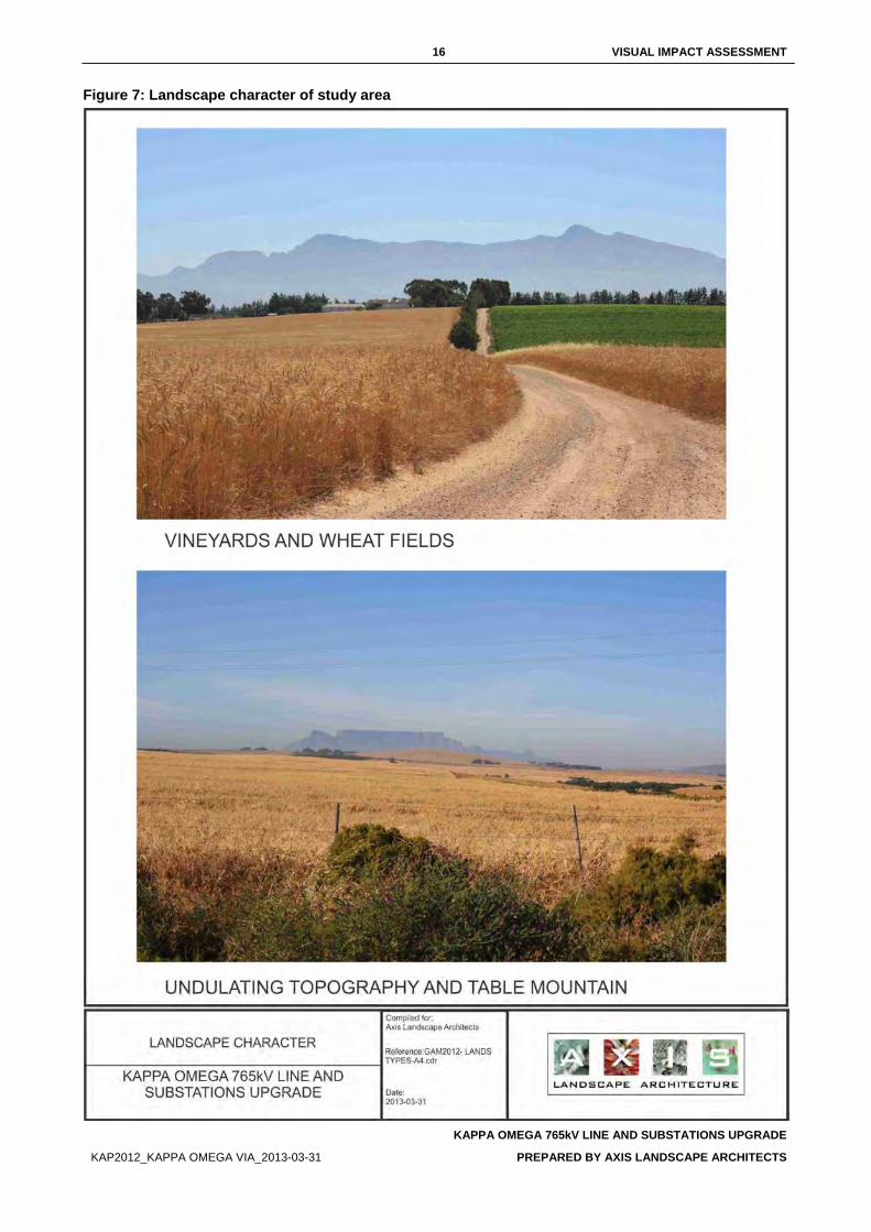
16 VISUAL IMPACT ASSESSMENT
KAPPA OMEGA 765kV LINE AND SUBSTATIONS UPGRADE
KAP2012_KAPPA OMEGA VIA_2013-03-31 PREPARED BY AXIS LANDSCAPE ARCHITECTS
Figure 7: Landscape character of study area
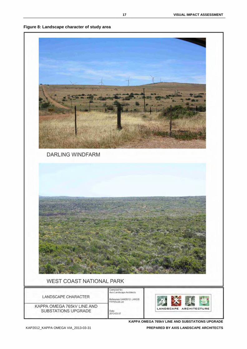
17 VISUAL IMPACT ASSESSMENT
KAPPA OMEGA 765kV LINE AND SUBSTATIONS UPGRADE
KAP2012_KAPPA OMEGA VIA_2013-03-31 PREPARED BY AXIS LANDSCAPE ARCHITECTS
Figure 8: Landscape character of study area
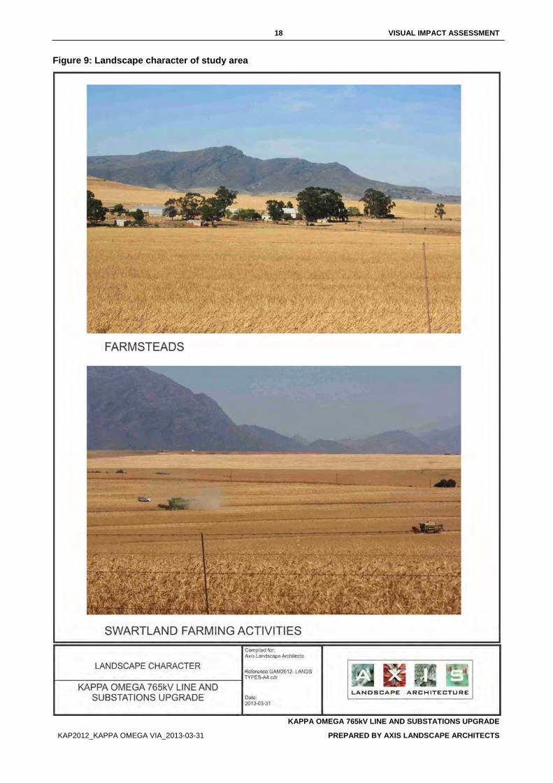
18 VISUAL IMPACT ASSESSMENT
KAPPA OMEGA 765kV LINE AND SUBSTATIONS UPGRADE
KAP2012_KAPPA OMEGA VIA_2013-03-31 PREPARED BY AXIS LANDSCAPE ARCHITECTS
Figure 9: Landscape character of study area
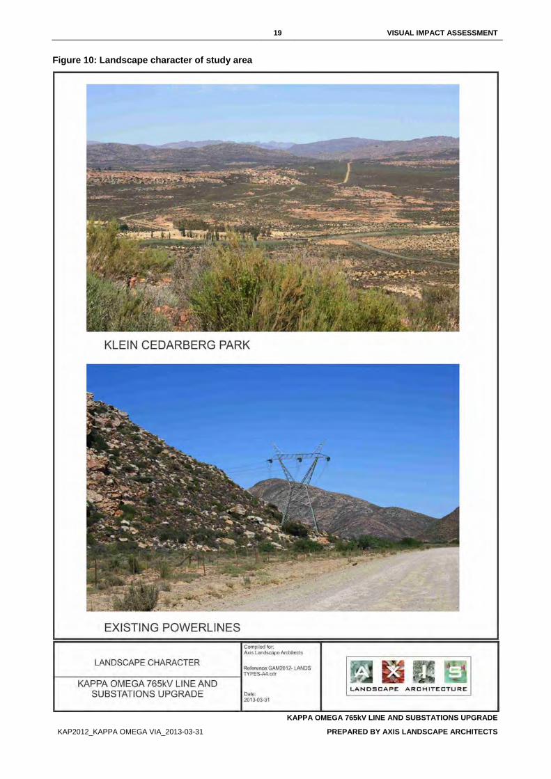
19 VISUAL IMPACT ASSESSMENT
KAPPA OMEGA 765kV LINE AND SUBSTATIONS UPGRADE
KAP2012_KAPPA OMEGA VIA_2013-03-31 PREPARED BY AXIS LANDSCAPE ARCHITECTS
Figure 10: Landscape character of study area
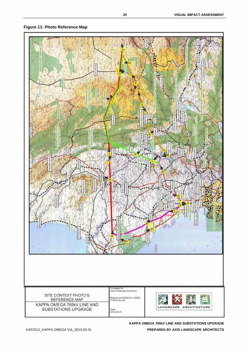
20 VISUAL IMPACT ASSESSMENT
KAPPA OMEGA 765kV LINE AND SUBSTATIONS UPGRADE
KAP2012_KAPPA OMEGA VIA_2013-03-31 PREPARED BY AXIS LANDSCAPE ARCHITECTS
Figure 11: Photo Reference Map
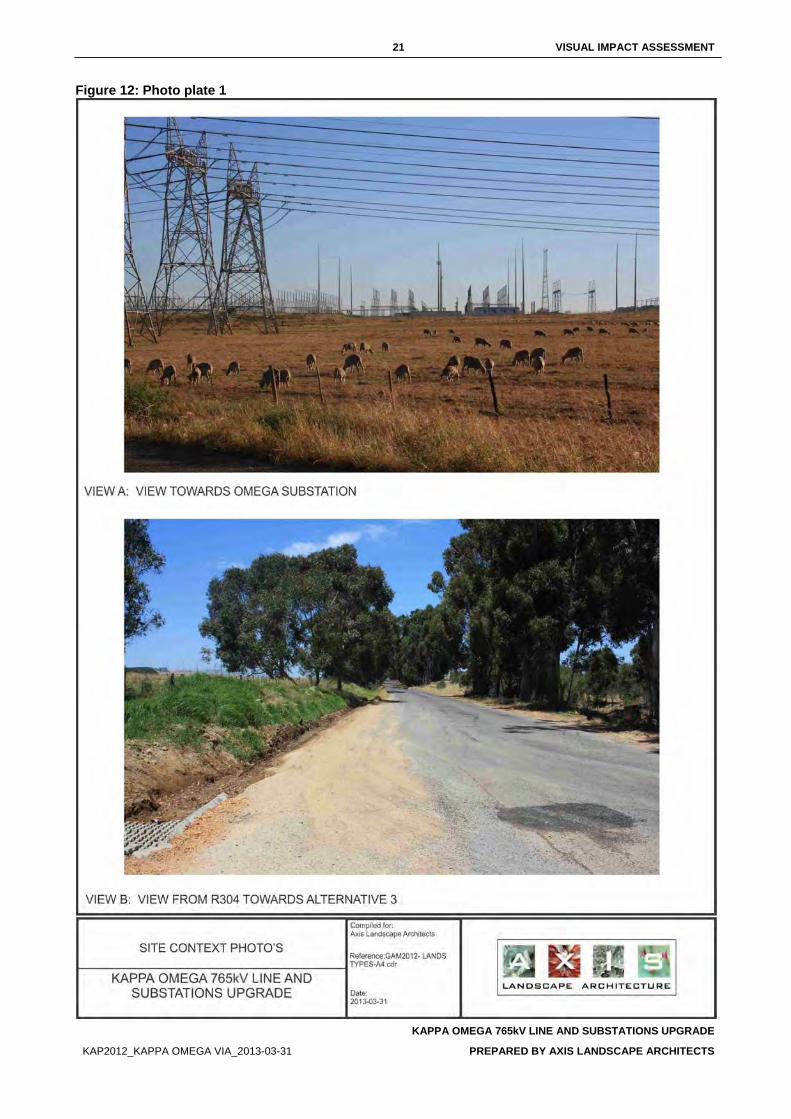
21 VISUAL IMPACT ASSESSMENT
KAPPA OMEGA 765kV LINE AND SUBSTATIONS UPGRADE
KAP2012_KAPPA OMEGA VIA_2013-03-31 PREPARED BY AXIS LANDSCAPE ARCHITECTS
Figure 12: Photo plate 1
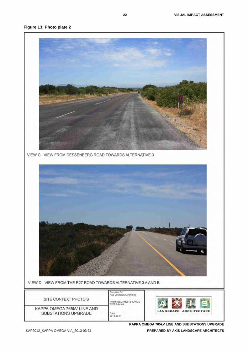
22 VISUAL IMPACT ASSESSMENT
KAPPA OMEGA 765kV LINE AND SUBSTATIONS UPGRADE
KAP2012_KAPPA OMEGA VIA_2013-03-31 PREPARED BY AXIS LANDSCAPE ARCHITECTS
Figure 13: Photo plate 2
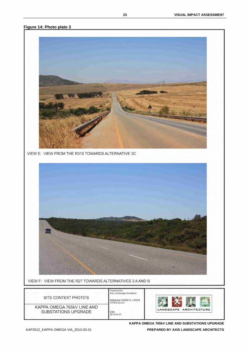
23 VISUAL IMPACT ASSESSMENT
KAPPA OMEGA 765kV LINE AND SUBSTATIONS UPGRADE
KAP2012_KAPPA OMEGA VIA_2013-03-31 PREPARED BY AXIS LANDSCAPE ARCHITECTS
Figure 14: Photo plate 3
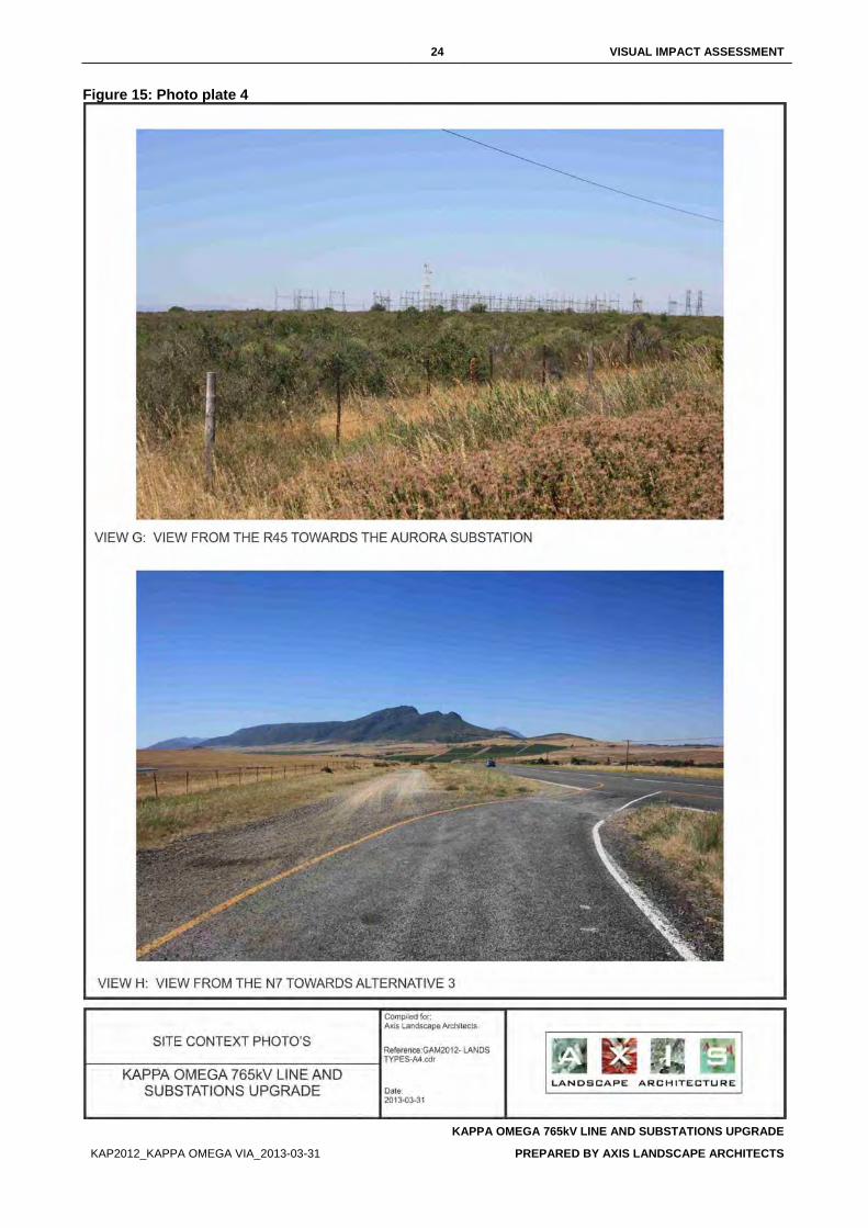
24 VISUAL IMPACT ASSESSMENT
KAPPA OMEGA 765kV LINE AND SUBSTATIONS UPGRADE
KAP2012_KAPPA OMEGA VIA_2013-03-31 PREPARED BY AXIS LANDSCAPE ARCHITECTS
Figure 15: Photo plate 4
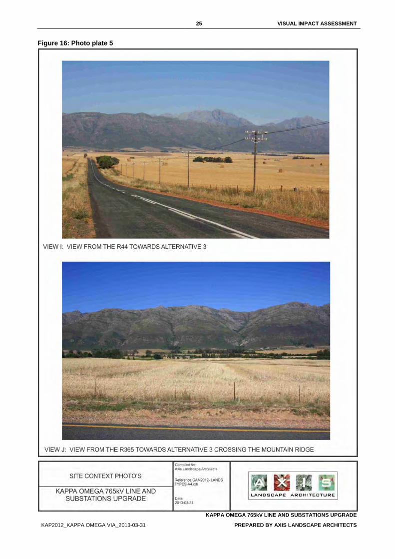
25 VISUAL IMPACT ASSESSMENT
KAPPA OMEGA 765kV LINE AND SUBSTATIONS UPGRADE
KAP2012_KAPPA OMEGA VIA_2013-03-31 PREPARED BY AXIS LANDSCAPE ARCHITECTS
Figure 16: Photo plate 5
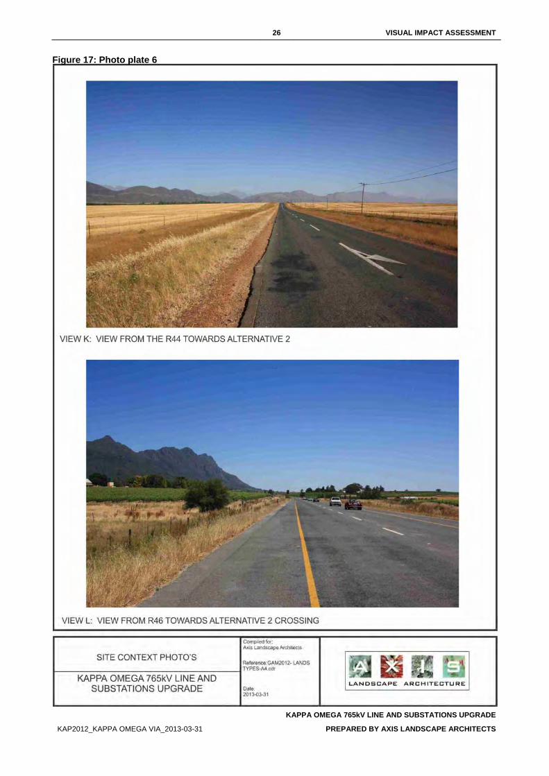
26 VISUAL IMPACT ASSESSMENT
KAPPA OMEGA 765kV LINE AND SUBSTATIONS UPGRADE
KAP2012_KAPPA OMEGA VIA_2013-03-31 PREPARED BY AXIS LANDSCAPE ARCHITECTS
Figure 17: Photo plate 6
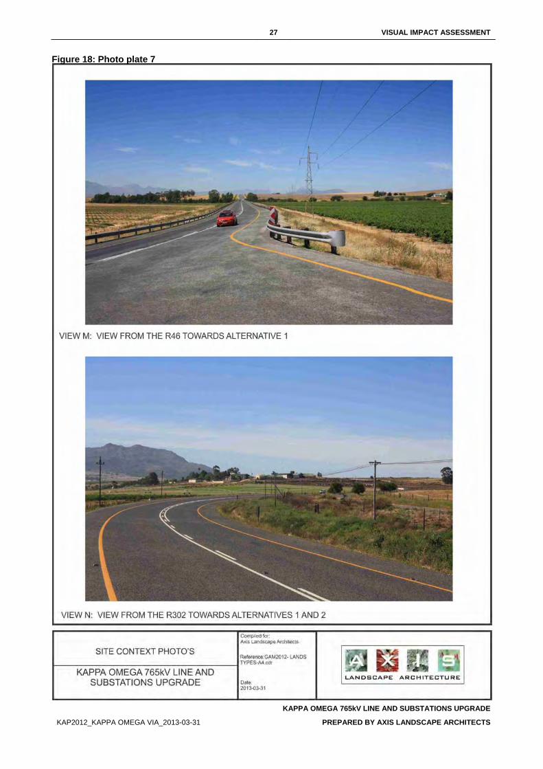
27 VISUAL IMPACT ASSESSMENT
KAPPA OMEGA 765kV LINE AND SUBSTATIONS UPGRADE
KAP2012_KAPPA OMEGA VIA_2013-03-31 PREPARED BY AXIS LANDSCAPE ARCHITECTS
Figure 18: Photo plate 7
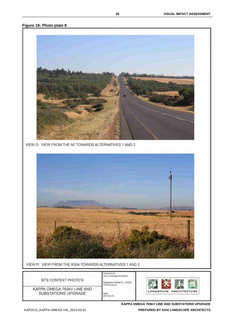
28 VISUAL IMPACT ASSESSMENT
KAPPA OMEGA 765kV LINE AND SUBSTATIONS UPGRADE
KAP2012_KAPPA OMEGA VIA_2013-03-31 PREPARED BY AXIS LANDSCAPE ARCHITECTS
Figure 19: Photo plate 8
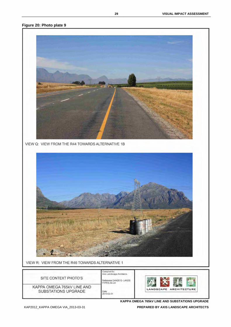
29 VISUAL IMPACT ASSESSMENT
KAPPA OMEGA 765kV LINE AND SUBSTATIONS UPGRADE
KAP2012_KAPPA OMEGA VIA_2013-03-31 PREPARED BY AXIS LANDSCAPE ARCHITECTS
Figure 20: Photo plate 9
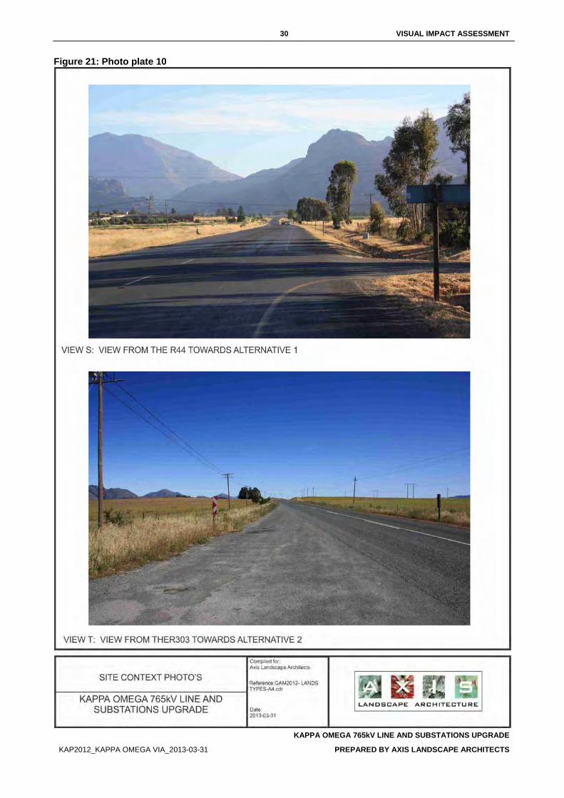
30 VISUAL IMPACT ASSESSMENT
KAPPA OMEGA 765kV LINE AND SUBSTATIONS UPGRADE
KAP2012_KAPPA OMEGA VIA_2013-03-31 PREPARED BY AXIS LANDSCAPE ARCHITECTS
Figure 21: Photo plate 10
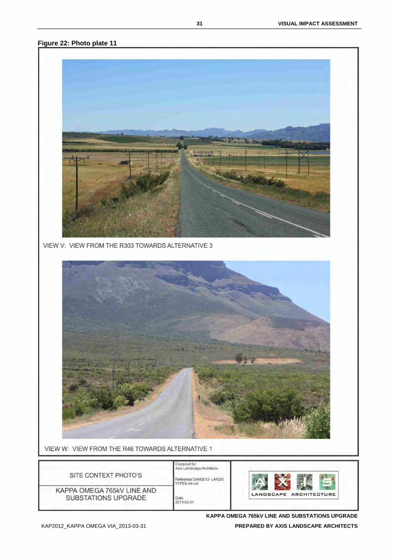
31 VISUAL IMPACT ASSESSMENT
KAPPA OMEGA 765kV LINE AND SUBSTATIONS UPGRADE
KAP2012_KAPPA OMEGA VIA_2013-03-31 PREPARED BY AXIS LANDSCAPE ARCHITECTS
Figure 22: Photo plate 11
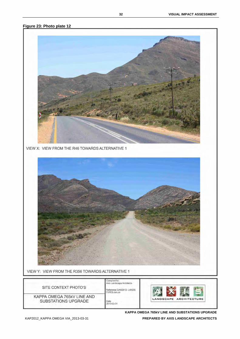
32 VISUAL IMPACT ASSESSMENT
KAPPA OMEGA 765kV LINE AND SUBSTATIONS UPGRADE
KAP2012_KAPPA OMEGA VIA_2013-03-31 PREPARED BY AXIS LANDSCAPE ARCHITECTS
Figure 23: Photo plate 12
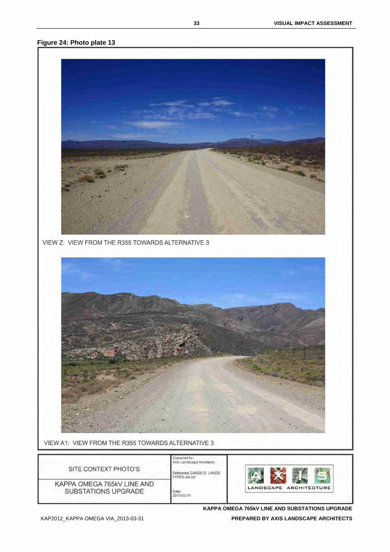
33 VISUAL IMPACT ASSESSMENT
KAPPA OMEGA 765kV LINE AND SUBSTATIONS UPGRADE
KAP2012_KAPPA OMEGA VIA_2013-03-31 PREPARED BY AXIS LANDSCAPE ARCHITECTS
Figure 24: Photo plate 13
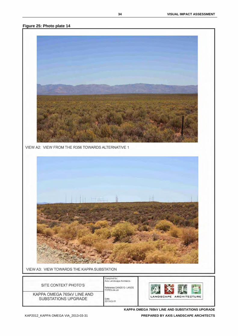
34 VISUAL IMPACT ASSESSMENT
KAPPA OMEGA 765kV LINE AND SUBSTATIONS UPGRADE
KAP2012_KAPPA OMEGA VIA_2013-03-31 PREPARED BY AXIS LANDSCAPE ARCHITECTS
Figure 25: Photo plate 14
35 VISUAL IMPACT ASSESSMENT
KAPPA OMEGA 765kV LINE AND SUBSTATIONS UPGRADE
KAP2012_KAPPA OMEGA VIA_2013-03-31 PREPARED BY AXIS LANDSCAPE ARCHITECTS
5. IMPACT ASSESSMENT The significance of impacts is a comparative function relating to the severity of the identified impacts on the respective receptors. The significance of an impact is considered high should a highly sensitive receptor be exposed to a highly severe impact (Table 6).
Table 6: Significance of impacts
RECEPTOR SENSITIVITY
IMPACT SEVERITY LOW MEDIUM HIGH
LOW No significance Low Low
MEDIUM Low Medium Medium
HIGH Low Medium High
5.1. SIGNIFICANCE OF LANDSCAPE IMPACT
5.1.1. LANDSCAPE CHARACTER SENSITIVITY The sensitivity of the landscape character is an indication of “…the degree to which a particular landscape can accommodate change from a particular development, without detrimental effects on its character” (GLVIA, 2002). A landscape with a high sensitivity would be one that is greatly valued for its aesthetic attractiveness and/or have ecological, cultural or social importance through which it contributes to the inherent character of the visual resource.
The assessment of the landscape is substantiated through professional judgement and informed reasoning which is based on the landscape character assessment in Section 4. A landscape sensitivity rating was adapted from GOSW (2006) (Table 7) and applied in the classification of the study area into different sensitivity zones.
Table 7: Landscape character sensitivity rating (Adapted from GOSW, 2006)
DESCRIPTION
Low sensitivity
These landscapes are likely to:
° Have distinct and well-defined landforms; ° Have a strong sense of enclosure; ° Provide a high degree of screening; ° Have been affected by extensive development or man-made features; ° Have reduced tranquillity; ° Are likely to have little inter-visibility with adjacent landscapes; and ° Exhibit no or a low density of sensitive landscape features that bare visual value.
Moderately sensitivity
These landscapes are likely to:
° Have a moderately elevated topography with reasonably distinct landforms that provides some sense of enclosure;
° Have been affected by several man-made features; ° Have limited inter-visibility with adjacent landscapes; and ° Exhibit a moderate density of sensitive landscape features that bare visual value.
Highly sensitivity
These landscapes are likely to:
° Consist mainly of undulating plains and poorly defined landforms; ° Be open or exposed with a remote character and an absence of man-made
features; ° Are often highly visible from adjacent landscapes; and ° Exhibit a high density of sensitive landscape features that bare visual value.
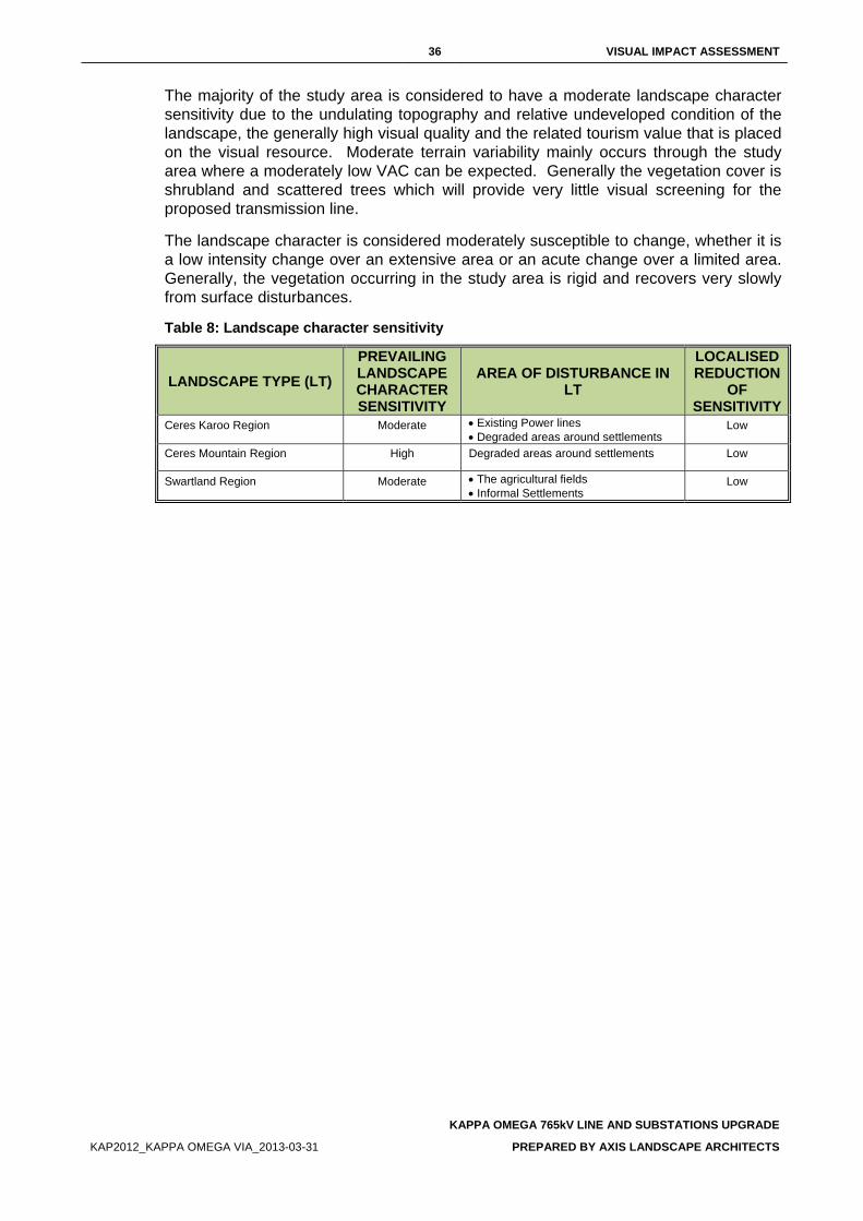
36 VISUAL IMPACT ASSESSMENT
KAPPA OMEGA 765kV LINE AND SUBSTATIONS UPGRADE
KAP2012_KAPPA OMEGA VIA_2013-03-31 PREPARED BY AXIS LANDSCAPE ARCHITECTS
The majority of the study area is considered to have a moderate landscape character sensitivity due to the undulating topography and relative undeveloped condition of the landscape, the generally high visual quality and the related tourism value that is placed on the visual resource. Moderate terrain variability mainly occurs through the study area where a moderately low VAC can be expected. Generally the vegetation cover is shrubland and scattered trees which will provide very little visual screening for the proposed transmission line.
The landscape character is considered moderately susceptible to change, whether it is a low intensity change over an extensive area or an acute change over a limited area. Generally, the vegetation occurring in the study area is rigid and recovers very slowly from surface disturbances.
Table 8: Landscape character sensitivity
LANDSCAPE TYPE (LT) PREVAILING LANDSCAPE CHARACTER SENSITIVITY
AREA OF DISTURBANCE IN LT
LOCALISED REDUCTION
OF SENSITIVITY
Ceres Karoo Region Moderate • Existing Power lines • Degraded areas around settlements
Low
Ceres Mountain Region High Degraded areas around settlements Low
Swartland Region Moderate • The agricultural fields • Informal Settlements
Low
37 VISUAL IMPACT ASSESSMENT
KAPPA OMEGA 765kV LINE AND SUBSTATIONS UPGRADE
KAP2012_KAPPA OMEGA VIA_2013-03-31 PREPARED BY AXIS LANDSCAPE ARCHITECTS
5.1.2. SEVERITY OF POTENTIAL LANDSCAPE IMPACTS Landscape impacts are alterations to the fabric, character, visual quality and/or visual value which will either positively or negatively affect the landscape character. During the construction and operational phases, the project components are expected to impact on the landscape character of the landscape types. The magnitude/severity of this intrusion is measured against the scale of the project, the permanence of the intrusion and the loss in visual quality, -value and/or VAC.
Table 9: Landscape impact – Altering the landscape character
Activity Nature of Impact
Extent of
Impact Duration of
Impact Severity of
Impact Probability of Impact
Significance without
Mitigation
Significance with
Mitigation Level of
Confidence
Construction phase
Route 1
Negative – Impacting on
the visual quality of the
landscape due to the
presence of foreign
elements and a loss of
vegetation cover.
Local Permanent if not mitigated
Moderate Definite Moderate Low High
Deviation Route 1a Moderate Definite Moderate Low High
Deviation Route 1b Moderate Definite Moderate Low High
Route 2 High Definite High Moderate High
Route 3 High Definite High Moderate High
Deviation Route 3a High Definite High Moderate High
Deviation Route 3b Moderate Definite Moderate Low High
Deviation Route 3c Moderate Definite Moderate Low High
Operational phase
Route 1
Negative – Impacting on
the visual quality of the
landscape due the presence of a power
line.
Local Permanent
Low Definite Low Low High
Deviation Route 1a Low Definite Low Low High
Deviation Route 1b Low Definite Low Low High
Route 2 High Definite High Moderate High
Route 3 High Definite High Moderate High
Deviation Route 3a High Definite High Moderate High
Deviation Route 3b Moderate Definite Moderate Low High
Deviation Route 3c Moderate Definite Moderate Low High
Construction phase
The activities that are expected to cause landscape impacts and that are associated with the construction phase, are the establishment of the construction camps, construction of access roads and the clearance of the site. These activities will create surface disturbances which will result in the removal of vegetation and the exposure of the underlying soil.
The extent of the disturbances will generally affect a relative large footprint area. Access roads to the towers are expected to be a two-track dirt road which will create
38 VISUAL IMPACT ASSESSMENT
KAPPA OMEGA 765kV LINE AND SUBSTATIONS UPGRADE
KAP2012_KAPPA OMEGA VIA_2013-03-31 PREPARED BY AXIS LANDSCAPE ARCHITECTS
the minimum disturbance. During construction, the area around the individual towers will be disturbed.
The construction camps and lay-down yards are anticipated to disturb a much larger area. The size and location of the construction camps will play a major role in the severity of the landscape impact. Due to a lack of technical information, two options are considered namely; the location of construction camps in remote, virgin land, or in/adjacent existing settlements. The initial presence of a construction camp in a undeveloped landscape will cause a temporary and localised alteration to the landscape character. A construction camp located in or adjacent to an existing town or settlement will be easily associated with the town and therefore the presence of the town, mitigates the impact. The mitigating result is most effective, the bigger the town or settlement is.
Servitudes will generally be cleared of higher growing and dense vegetation to reduce biomass that may cause a fire hazard if ignited. The complete removal of high growing vegetation and scrubs will result in disturbed areas of exposed soil and difference in texture.
The exposed soil and change in texture will contrast severely with the intact vegetation around the disturbance footprint and servitudes.
Considering the moderately low VAC throughout most of the study area, the undisturbed condition of parts of the landscape and the recovery rate of the endemic vegetation, the severity of landscape impact during the construction stage is expected to be moderate for Route 1, Deviation Route 1a and 1b and high for all the other alternatives. The impact will extend over the entire length of the different alignments and may vary in degrees of severity along the linear length as it transects landscape types of varying VAC. Surface disturbances are also minimised through, for example, utilising existing roads.
Operational phase
Surface disturbances created during construction may remain for an extended period during the operational phase. These are seen as residual affects carried forward from the construction phase and can be completely or substantially mitigated if treated appropriately during the construction phase.
An additional impact will be caused as a result of the presence of the completed transmission line, i.e. that of the evenly spaced towers of the lines, buildings and structures. The industrial character and the near monumental vertical scale of the towers will contrast with the diverse landscape character that prevails through most of the study area.
39 VISUAL IMPACT ASSESSMENT
KAPPA OMEGA 765kV LINE AND SUBSTATIONS UPGRADE
KAP2012_KAPPA OMEGA VIA_2013-03-31 PREPARED BY AXIS LANDSCAPE ARCHITECTS
5.2. SIGNIFICANCE OF VISUAL IMPACTS
5.2.1. VIEWER SENSITIVITY Within the receiving environment, specific viewers (visual receptors) experience different views of the visual resource and value it differently. They will be affected because of alterations to their views due to the proposed project. The visual receptors are grouped according to their similarities. The visual receptors included in this study are:
• Residents; • Tourists; and • Motorists.
To determine visual receptor sensitivity a commonly used rating system is utilised. This is a generic classification of visual receptors and enables the visual impact specialist to establish a logical and consistent visual receptor sensitivity rating for viewers who are involved in different activities without engaging in extensive public surveys.
5.2.1.1 Residents
Residents of the affected environment are classified as visual receptors of high sensitivity owing to their sustained visual exposure to the proposed development as well as their attentive interest towards their living environment.
5.2.1.2 Tourists
Tourists are regarded as visual receptors of exceptional high sensitivity. Their attention is focused towards the landscape which they essentially utilise for enjoyment purposes and appreciation of the quality of the landscape.
5.2.1.3 Motorists
Motorists are generally classified as visual receptors of low sensitivity due to their momentary view and experience of the proposed development. As a motorist’s speed increases, the sharpness of lateral vision declines and the motorist tends to focus on the line of travel (USDOT, 1981). This adds weight to the assumption that under normal conditions, motorists will show low levels of sensitivity as their attention is focused on the road and their exposure to roadside objects is brief.
Motorists on the scenic routes in the study area will present a higher sensitivity. Their reason for being in the landscape is similar to that of the tourists and they will therefore be categorised as part of the tourist viewer group.
40 VISUAL IMPACT ASSESSMENT
KAPPA OMEGA 765kV LINE AND SUBSTATIONS UPGRADE
KAP2012_KAPPA OMEGA VIA_2013-03-31 PREPARED BY AXIS LANDSCAPE ARCHITECTS
5.2.2. SEVERITY OF POTENTIAL VISUAL IMPACTS Severity of visual impact refers to the magnitude of change to specific visual receptor’s views and/or experience of the landscape. Severity of visual impact is influenced by the following factors:
• The viewer’s exposure to the project: ° Distance of observers from the proposed project; ° The visibility of the proposed project (ZVI); ° Number of affected viewers; and ° Duration of views to development experienced by affected viewers.
• Degree of visual intrusion created by the project.
Empirical research indicates that the visibility of a transmission tower and hence the severity of visual impact, decreases as the distance between the observer and the tower increases. The landscape type, through which the transmission line crosses, can mitigate the severity of visual impact through topographical or vegetative screening. Bishop et al (1988) noticed that in some cases the tower may dominate the view for example, silhouetted against the skyline, or in some cases be absorbed in the landscape. A complex landscape setting with a diverse land cover and topographical variation has the ability to decrease the severity of visual impact more than a mundane landscape (Bishop et al, 1985).
The Zone of Visual Influence (ZVI) is determined through a Geographical Information System (GIS). The result reflects a shaded pattern which identifies the areas that are expected to experience views of the proposed alignments. The ZVI is limited to 5 km from the proposed locations.
A visibility analysis has been completed for each of the three alternative alignments and deviation routes (APPENDIX 1). According to Bishop et al (1988), visual receptors within 1 km from the alignment are most likely to experience the highest degree of visual intrusion, hence contributing to the severity of the visual impact. This is considered as the zone of highest visibility after which the degree of visual intrusion decreases rapidly at distances further away.
In order to assess the extent and degree of visibility in the visual envelope, a Geographical Information System (GIS) was utilised. A visibility analysis was performed which provides the following information (Figure 26 - Figure 31).
• The areas within the visual envelope that may experience views of the proposed project; and
• The degree of visibility in terms of the percentage of the proposed project that will be visible from a specific location.
The GIS performs an analysis for a series of elevated observer points which represents the height of the entire power line in a digital elevation model (DEM). This results in a visibility map with the degree of visibility illustrated by a colour.
The visibility analyses consider worst-case scenarios, using line-of-sight, based on topography alone. The screening capability of vegetation is not captured in the base model of the DEM and is therefore not considered in these results.
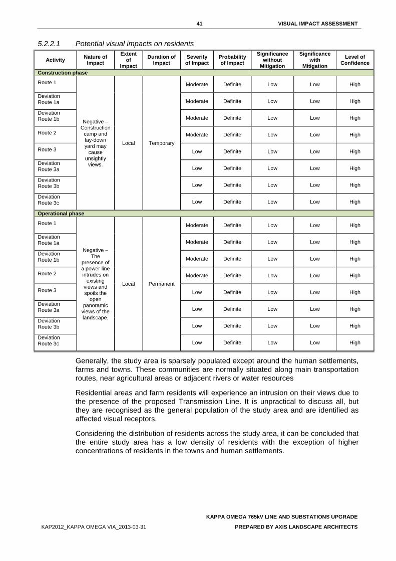
41 VISUAL IMPACT ASSESSMENT
KAPPA OMEGA 765kV LINE AND SUBSTATIONS UPGRADE
KAP2012_KAPPA OMEGA VIA_2013-03-31 PREPARED BY AXIS LANDSCAPE ARCHITECTS
5.2.2.1 Potential visual impacts on residents
Activity Nature of Impact
Extent of
Impact Duration of
Impact Severity
of Impact Probability of Impact
Significance without
Mitigation
Significance with
Mitigation Level of
Confidence
Construction phase
Route 1
Negative – Construction
camp and lay-down yard may
cause unsightly
views.
Local Temporary
Moderate Definite Low Low High
Deviation Route 1a Moderate Definite Low Low High
Deviation Route 1b Moderate Definite Low Low High
Route 2 Moderate Definite Low Low High
Route 3 Low Definite Low Low High
Deviation Route 3a Low Definite Low Low High
Deviation Route 3b Low Definite Low Low High
Deviation Route 3c Low Definite Low Low High
Operational phase
Route 1
Negative – The
presence of a power line intrudes on
existing views and spoils the
open panoramic
views of the landscape.
Local Permanent
Moderate Definite Low Low High
Deviation Route 1a Moderate Definite Low Low High
Deviation Route 1b Moderate Definite Low Low High
Route 2 Moderate Definite Low Low High
Route 3 Low Definite Low Low High
Deviation Route 3a Low Definite Low Low High
Deviation Route 3b Low Definite Low Low High
Deviation Route 3c Low Definite Low Low High
Generally, the study area is sparsely populated except around the human settlements, farms and towns. These communities are normally situated along main transportation routes, near agricultural areas or adjacent rivers or water resources
Residential areas and farm residents will experience an intrusion on their views due to the presence of the proposed Transmission Line. It is unpractical to discuss all, but they are recognised as the general population of the study area and are identified as affected visual receptors.
Considering the distribution of residents across the study area, it can be concluded that the entire study area has a low density of residents with the exception of higher concentrations of residents in the towns and human settlements.
42 VISUAL IMPACT ASSESSMENT
KAPPA OMEGA 765kV LINE AND SUBSTATIONS UPGRADE
KAP2012_KAPPA OMEGA VIA_2013-03-31 PREPARED BY AXIS LANDSCAPE ARCHITECTS
Construction phase
During the construction phase, unsightly views may be created by the presence of construction camps and the lay-down yards. The duration of the potential visual impact will be temporary which will result in an anticipated moderately low significance of visual impact for all the alternatives. The visual exposure to the construction activity will initially be limited and only local residents will experience views of the site preparation activity. As the structures increase in scale and height, the ZVI increases, resulting in a greater number of affected viewers and a subsequent increase in visual exposure.
The cleared sites, construction camps and material lay-down yard will appear unsightly and out of character. Large scale construction elements such as cranes, will be highly visible and increase awareness of the construction activity over a considerable area. The visual intrusion caused during the construction stage will be moderate, but will be temporary in nature.
Operational phase
The residents of the residential areas and farming communities next to the power lines may experience a moderate degree of visual intrusion due to their proximity to all the Alternatives.
The presence of a transmission line in the visual field of the residents in this part of the study area will spoil the uncluttered panoramic views they currently experience. The silhouette of a transmission line on the horizon will be visible from a great distance and thus increase the ZVI considerably, potentially impacting on more residents.
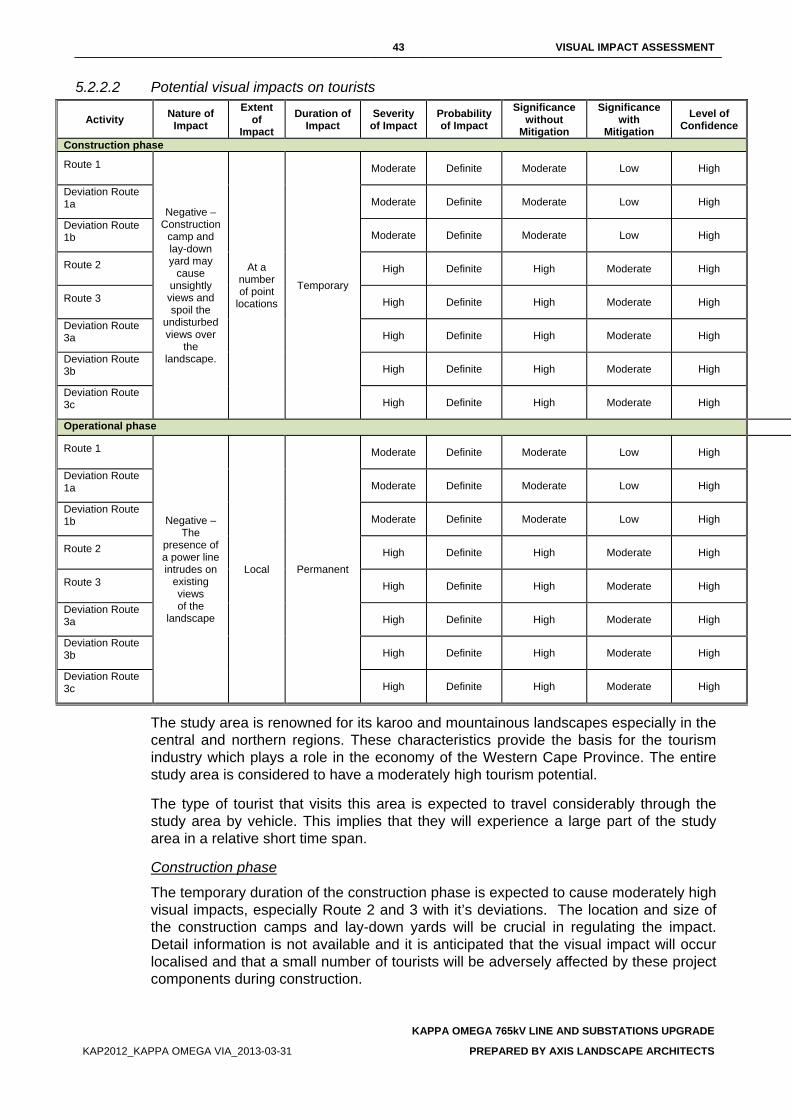
43 VISUAL IMPACT ASSESSMENT
KAPPA OMEGA 765kV LINE AND SUBSTATIONS UPGRADE
KAP2012_KAPPA OMEGA VIA_2013-03-31 PREPARED BY AXIS LANDSCAPE ARCHITECTS
5.2.2.2 Potential visual impacts on tourists
Activity Nature of Impact
Extent of
Impact Duration of
Impact Severity
of Impact Probability of Impact
Significance without
Mitigation
Significance with
Mitigation Level of
Confidence
Construction phase
Route 1
Negative – Construction
camp and lay-down yard may
cause unsightly views and spoil the
undisturbed views over
the landscape.
At a number of point
locations
Temporary
Moderate Definite Moderate Low High
Deviation Route 1a Moderate Definite Moderate Low High
Deviation Route 1b Moderate Definite Moderate Low High
Route 2 High Definite High Moderate High
Route 3 High Definite High Moderate High
Deviation Route 3a High Definite High Moderate High
Deviation Route 3b High Definite High Moderate High
Deviation Route 3c High Definite High Moderate High
Operational phase Route 1
Negative – The
presence of a power line intrudes on
existing views of the
landscape
Local Permanent
Moderate Definite Moderate Low High
Deviation Route 1a Moderate Definite Moderate Low High
Deviation Route 1b Moderate Definite Moderate Low High
Route 2 High Definite High Moderate High
Route 3 High Definite High Moderate High
Deviation Route 3a High Definite High Moderate High
Deviation Route 3b High Definite High Moderate High
Deviation Route 3c High Definite High Moderate High
The study area is renowned for its karoo and mountainous landscapes especially in the central and northern regions. These characteristics provide the basis for the tourism industry which plays a role in the economy of the Western Cape Province. The entire study area is considered to have a moderately high tourism potential.
The type of tourist that visits this area is expected to travel considerably through the study area by vehicle. This implies that they will experience a large part of the study area in a relative short time span.
Construction phase
The temporary duration of the construction phase is expected to cause moderately high visual impacts, especially Route 2 and 3 with it’s deviations. The location and size of the construction camps and lay-down yards will be crucial in regulating the impact. Detail information is not available and it is anticipated that the visual impact will occur localised and that a small number of tourists will be adversely affected by these project components during construction.
44 VISUAL IMPACT ASSESSMENT
KAPPA OMEGA 765kV LINE AND SUBSTATIONS UPGRADE
KAP2012_KAPPA OMEGA VIA_2013-03-31 PREPARED BY AXIS LANDSCAPE ARCHITECTS
Their exposure to possible unsightly views of the construction camps and the associated activity will however be minimal and localised.
The potential visual impact on tourists during the construction phase of the proposed project can be mitigated with relative ease except for Route 2 and 3 with its deviations. The greatest factor to consider is the location of the construction camps from potential views that may be experienced from scenic routes or tourist hotspots.
Operational phase
Considering the extent of the proposed alternatives, a number of tourists will be affected during their visit to the study area. Although it is difficult to pinpoint particular locations in the study area that are of specific tourist value, since the entire study area bares some value, the most obvious concentration of tourists can be expected in the northern central part of the study area. For these tourists, Route 2 and 3 with its deviations will create alterations to their views. The presence of a transmission line in this undeveloped landscape will spoil the views that are experiencing. It can be concluded that Route 2 and 3 with its deviations will cause a high visual intrusion in the views expected by tourists travelling through the study area.
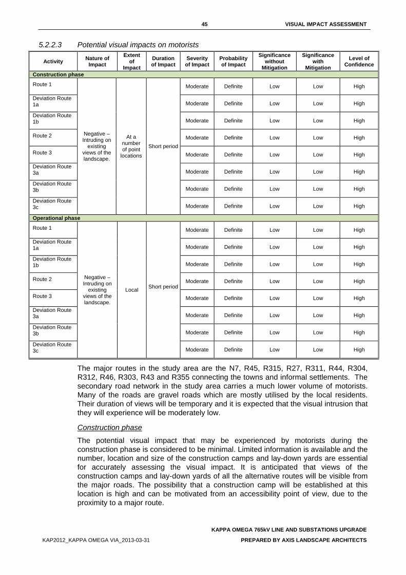
45 VISUAL IMPACT ASSESSMENT
KAPPA OMEGA 765kV LINE AND SUBSTATIONS UPGRADE
KAP2012_KAPPA OMEGA VIA_2013-03-31 PREPARED BY AXIS LANDSCAPE ARCHITECTS
5.2.2.3 Potential visual impacts on motorists
Activity Nature of Impact
Extent of
Impact Duration of Impact
Severity of Impact
Probability of Impact
Significance without
Mitigation
Significance with
Mitigation Level of
Confidence
Construction phase
Route 1
Negative – Intruding on
existing views of the landscape.
At a number of point
locations
Short period
Moderate Definite Low Low High
Deviation Route 1a Moderate Definite Low Low High
Deviation Route 1b Moderate Definite Low Low High
Route 2 Moderate Definite Low Low High
Route 3 Moderate Definite Low Low High
Deviation Route 3a Moderate Definite Low Low High
Deviation Route 3b Moderate Definite Low Low High
Deviation Route 3c Moderate Definite Low Low High
Operational phase
Route 1
Negative – Intruding on
existing views of the landscape.
Local Short period
Moderate Definite Low Low High
Deviation Route 1a Moderate Definite Low Low High
Deviation Route 1b Moderate Definite Low Low High
Route 2 Moderate Definite Low Low High
Route 3 Moderate Definite Low Low High
Deviation Route 3a Moderate Definite Low Low High
Deviation Route 3b Moderate Definite Low Low High
Deviation Route 3c Moderate Definite Low Low High
The major routes in the study area are the N7, R45, R315, R27, R311, R44, R304, R312, R46, R303, R43 and R355 connecting the towns and informal settlements. The secondary road network in the study area carries a much lower volume of motorists. Many of the roads are gravel roads which are mostly utilised by the local residents. Their duration of views will be temporary and it is expected that the visual intrusion that they will experience will be moderately low.
Construction phase
The potential visual impact that may be experienced by motorists during the construction phase is considered to be minimal. Limited information is available and the number, location and size of the construction camps and lay-down yards are essential for accurately assessing the visual impact. It is anticipated that views of the construction camps and lay-down yards of all the alternative routes will be visible from the major roads. The possibility that a construction camp will be established at this location is high and can be motivated from an accessibility point of view, due to the proximity to a major route.
46 VISUAL IMPACT ASSESSMENT
KAPPA OMEGA 765kV LINE AND SUBSTATIONS UPGRADE
KAP2012_KAPPA OMEGA VIA_2013-03-31 PREPARED BY AXIS LANDSCAPE ARCHITECTS
The presence of the construction camp and lay-down yards may create unsightly views. Motorists’ visual exposure to the impact will be brief and the severity of visual impact will be moderately low. The significance of potential visual impact is expected to be low.
Operational phase
The N7, R27, R47, R44 and R46 are the most prominent, carrying the highest volume of traffic. Route 3 with its deviations will be the most visible from the R27. The severity and significance of visual impact for all the proposed routes on motorists will be moderate.
47 VISUAL IMPACT ASSESSMENT
KAPPA OMEGA 765kV LINE AND SUBSTATIONS UPGRADE
KAP2012_KAPPA OMEGA VIA_2013-03-31 PREPARED BY AXIS LANDSCAPE ARCHITECTS
6. RECOMMENDED MITIGATION MEASURES The aim of mitigation is to reduce or alleviate the intrusive contrast between the proposed project components and activities, and the receiving landscape to a point where it is acceptable to visual and landscape receptors.
6.1. GENERAL • Proceed with construction of the substation during the off peak tourism season; • Where areas are going to be disturbed through the destruction of vegetation, for example
the establishment of the construction camp, the vegetation occurring in the area to be disturbed must be salvaged and kept in a controlled environment such as a nursery, for future re-planting in the disturbed areas as a measure of rehabilitation;
6.2. ACCESS ROUTES • Make use of existing access roads where possible; • Where new access roads are required, the disturbance area should be kept as small as
possible. A two-track dirt road will be the most preferred option; • Locate access routes so as to limit modification to the topography and to avoid the
removal of established vegetation; • Avoid crossing over or through ridges, rivers, pans or any natural features that have
visual value. This also includes centres of floral endemism and areas where vegetation is not resilient and takes extended periods to recover;
• Maintain no or minimum cleared road verges; • Access routes should be located on the perimeter of disturbed areas such as
cultivated/fallow lands as not to fragment intact vegetated areas; and • If it is necessary to clear vegetation for a road, avoid doing so in a continuous straight
line. Alternatively, curve the road in order to reduce the visible extent of the cleared corridor.
6.3. TRANSMISSION TOWERS • Avoid crossing over or through ridges, rivers, pans or any natural features that have
visual value. This also includes centres of floral endemism and areas where vegetation is not resilient and takes extended periods to recover;
• The preferred type of tower is the compact cross-rope or the cross-rope suspension tower. These two tower types are the most visually permeable and create an extremely low degree of visual obstruction;
• Avoid changing the alignment’s direction too often in order to minimise the use of the self-supporting strain tower. This tower type is the most visually intrusive as the steel lattice structure is more dense than the other two tower types, hence creating more visual obstruction;
• Plan the route so that the route crosses existing main routes as close to 90° as possible as this will reduce the time that the line is in the viewshed of the passing motorist / viewer;
• Where practically possible, provide a minimum of 1 km buffer area between the transmission line and sensitive visual receptors; and
• Rehabilitate disturbed areas around pylons as soon as practically possible after construction. This should be done to restrict extended periods of exposed soil.
• Align the route along the footslopes of hills, mountains and ridges. This is to maximise the backdrop screening effect of the topography that will reduce presenting the Transmission line in silhouette.
• Plan the route so that the route crosses existing main routes as close to 90° as possible as this will reduce the time that the line is in the viewshed of the passing motorist / viewer.
48 VISUAL IMPACT ASSESSMENT
KAPPA OMEGA 765kV LINE AND SUBSTATIONS UPGRADE
KAP2012_KAPPA OMEGA VIA_2013-03-31 PREPARED BY AXIS LANDSCAPE ARCHITECTS
• Align the route through areas of existing visual clutter and disturbance such as alongside
railway lines, existing Transmission lines, roads and other visible infrastructure, rather than through pristine or undisturbed areas where possible. However, the cumulative effect of adding to the visual clutter prior to the final placement should be evaluated
• Avoid areas where the current land uses, such as game farm, lodges, etc. often rely on the absence of human visual intrusion.
• The galvanising of the pylon should be allowed to weather to a matt grey finish rather than be painted silver, as is often the case. This allows the structures to blend in with the existing environmental colours more readily than the silver that is highly reflective especially early morning and late afternoon. Should it be necessary to paint, it is recommended that a neutral matt finish be used.
6.4. CLEARED SERVITUDES • Locate the alignment and the associated cleared servitude so as to avoid the removal of
established vegetation; and • Avoid a continuous linear path of cleared vegetation that would strongly contrast with the
surrounding landscape character. Feather the edges of the cleared corridor to avoid a clearly defined line through the landscape.
6.5. CONSTRUCTION CAMPS AND LAY DOWN YARDS • If practically possible, locate construction camps in areas that are already disturbed or
where it isn’t necessary to remove established vegetation like for example, naturally bare areas;
• Utilise existing screening features such as dense vegetation stands or topographical features to place the construction camps and lay-down yards out of the view of sensitivity visual receptors;
• Keep the construction sites and camps neat, clean and organised in order to portray a tidy appearance; and
• Screen the construction camp and lay-down yards by enclosing the entire area with a dark green or black shade cloth of no less than 2 m height.
49 VISUAL IMPACT ASSESSMENT
KAPPA OMEGA 765kV LINE AND SUBSTATIONS UPGRADE
KAP2012_KAPPA OMEGA VIA_2013-03-31 PREPARED BY AXIS LANDSCAPE ARCHITECTS
7. CONCLUSION The three alternative Routes have been evaluated against international accepted criteria to determine the impact they will have on the landscape character and the viewers that have been identified in the study area.
The alternatives are rated according to preference by using a eight-point rating system in Table 10, eight (8) being the least preferred, to one (1) being the most preferred. The preference rating is informed by the impact assessment discussions in Section 5 and the overall performance of each alternative with regards to the impact on the landscape character and the identified viewers.
Table 10: Evaluation of alternative alignments
ALTERNATIVES PREFERENCE RATING Route 1 1
Deviation Route 1a 2
Deviation Route 1b 3
Route 2 4
Route 3 6
Deviation Route 3a 8
Deviation Route 3b 7
Deviation Route 3c 5
Route 1 is regarded as the most preferred alternative. Its alignment along the existing transmission line and transmission servitude is considered to cause the least impact on the landscape character due to the reduced sensitivity of the landscape along the roads and servitudes..
The impact of Route 1 on visual receptors varies between residents, tourists and motorists. Route 1’s great advantage lies in the less significant visual impact on tourists and residents as compared to the other alternatives. The public association with transmission lines and major public roads is a common perception which makes the co-existence of these two features more acceptable.
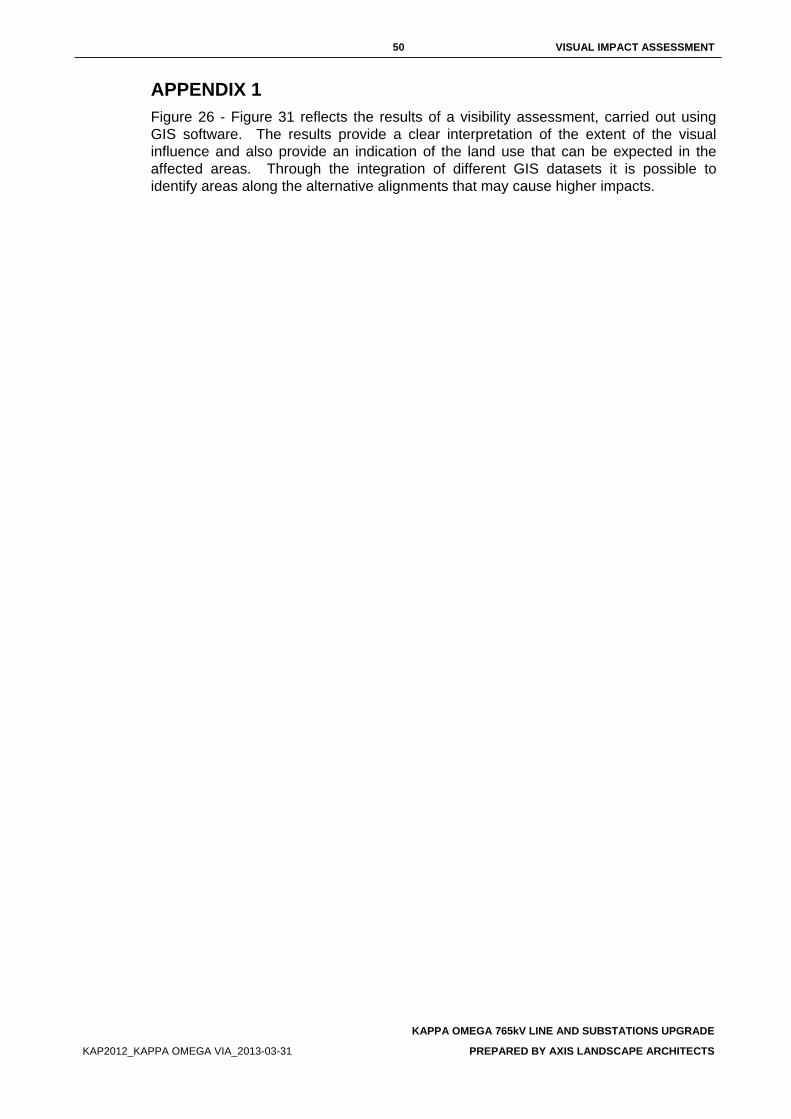
50 VISUAL IMPACT ASSESSMENT
KAPPA OMEGA 765kV LINE AND SUBSTATIONS UPGRADE
KAP2012_KAPPA OMEGA VIA_2013-03-31 PREPARED BY AXIS LANDSCAPE ARCHITECTS
APPENDIX 1 Figure 26 - Figure 31 reflects the results of a visibility assessment, carried out using GIS software. The results provide a clear interpretation of the extent of the visual influence and also provide an indication of the land use that can be expected in the affected areas. Through the integration of different GIS datasets it is possible to identify areas along the alternative alignments that may cause higher impacts.
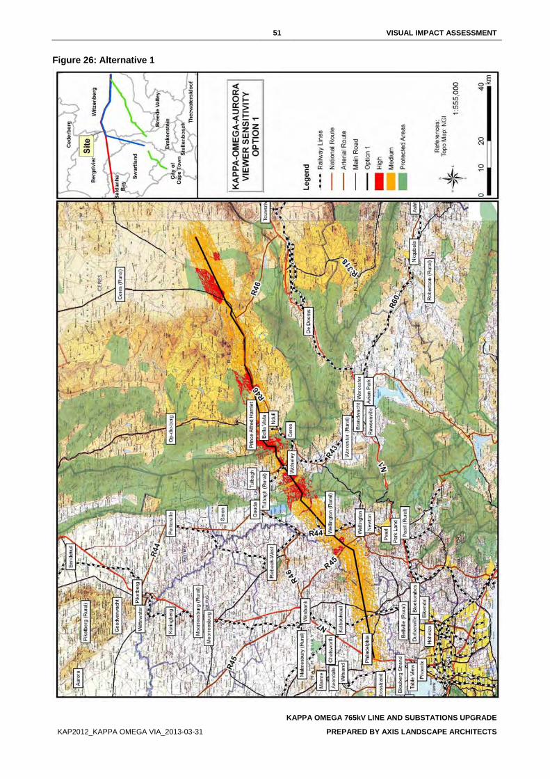
51 VISUAL IMPACT ASSESSMENT
KAPPA OMEGA 765kV LINE AND SUBSTATIONS UPGRADE
KAP2012_KAPPA OMEGA VIA_2013-03-31 PREPARED BY AXIS LANDSCAPE ARCHITECTS
Figure 26: Alternative 1
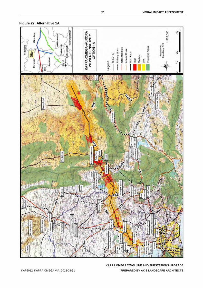
52 VISUAL IMPACT ASSESSMENT
KAPPA OMEGA 765kV LINE AND SUBSTATIONS UPGRADE
KAP2012_KAPPA OMEGA VIA_2013-03-31 PREPARED BY AXIS LANDSCAPE ARCHITECTS
Figure 27: Alternative 1A
53 VISUAL IMPACT ASSESSMENT
KAPPA OMEGA 765kV LINE AND SUBSTATIONS UPGRADE
KAP2012_KAPPA OMEGA VIA_2013-03-31 PREPARED BY AXIS LANDSCAPE ARCHITECTS
Figure 28: Alternative 1B
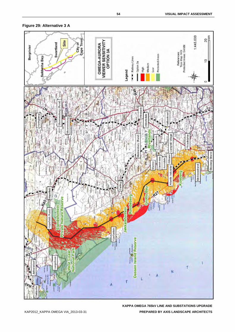
54 VISUAL IMPACT ASSESSMENT
KAPPA OMEGA 765kV LINE AND SUBSTATIONS UPGRADE
KAP2012_KAPPA OMEGA VIA_2013-03-31 PREPARED BY AXIS LANDSCAPE ARCHITECTS
Figure 29: Alternative 3 A
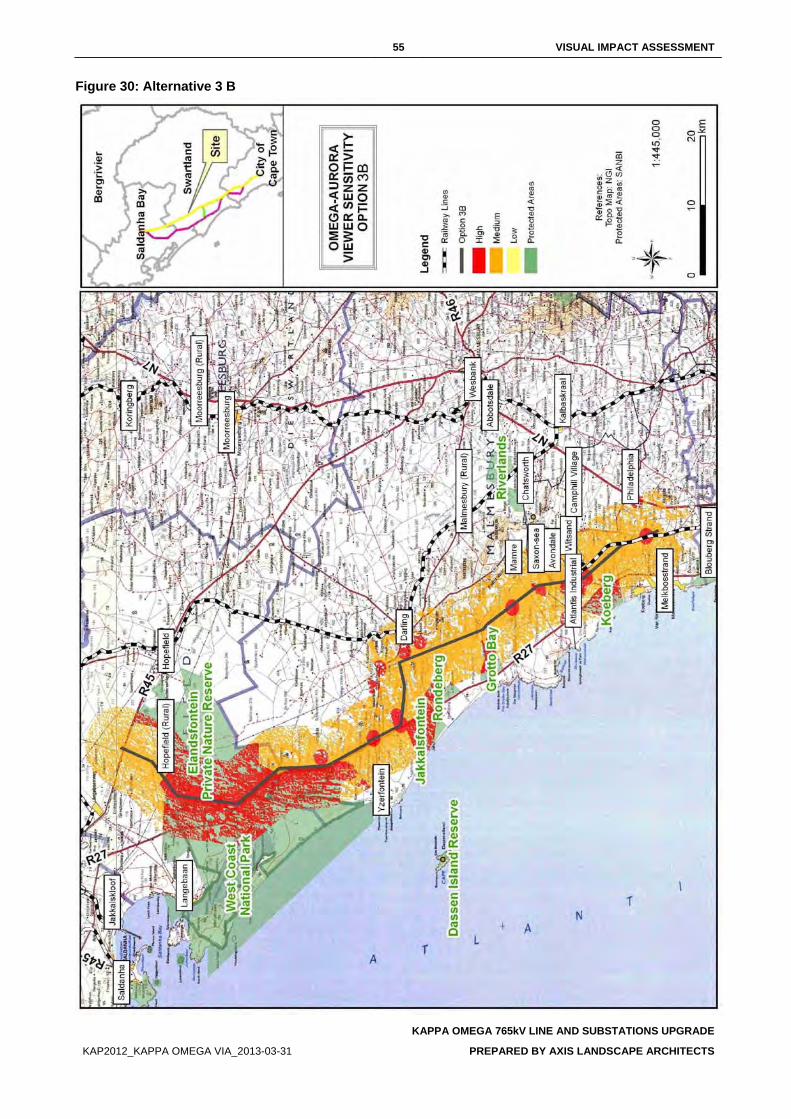
55 VISUAL IMPACT ASSESSMENT
KAPPA OMEGA 765kV LINE AND SUBSTATIONS UPGRADE
KAP2012_KAPPA OMEGA VIA_2013-03-31 PREPARED BY AXIS LANDSCAPE ARCHITECTS
Figure 30: Alternative 3 B
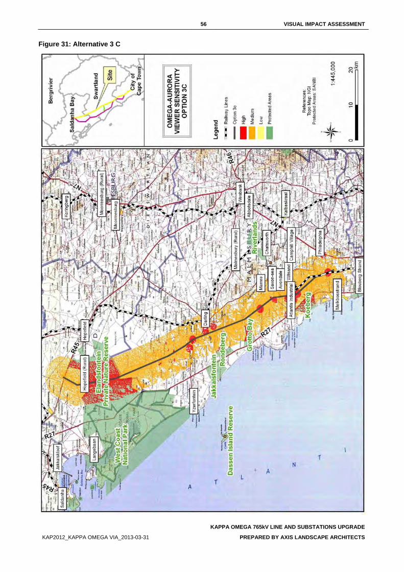
56 VISUAL IMPACT ASSESSMENT
KAPPA OMEGA 765kV LINE AND SUBSTATIONS UPGRADE
KAP2012_KAPPA OMEGA VIA_2013-03-31 PREPARED BY AXIS LANDSCAPE ARCHITECTS
Figure 31: Alternative 3 C
57 VISUAL IMPACT ASSESSMENT
KAPPA OMEGA 765kV LINE AND SUBSTATIONS UPGRADE
KAP2012_KAPPA OMEGA VIA_2013-03-31 PREPARED BY AXIS LANDSCAPE ARCHITECTS
GLOSSARY OF TERMS
Aesthetics The science or philosophy concerned with the quality of sensory experience. (ULI, 1980)
Horizon contour A line that encircles a development site and that follows ridgelines where the sky forms the backdrop and no landform is visible as a background. This is essentially the skyline that when followed through the full 360-degree arc as viewed from a representative point on the site defines the visual envelope of the development. This defines the boundary outside which the development would not be visible.
Landscape characterisation/ character
This covers the gathering of information during the desktop study and field survey work relating to the existing elements, features, and extent of the landscape (character). It includes the analysis and evaluation of the above and the supporting illustration and documentary evidence.
Landscape condition
Refers to the state of the landscape of the area making up the site and that of the study area in general. Factors affecting the condition of the landscape can include the level maintenance and management of individual landscape elements such as buildings, woodlands etc and the degree of disturbance of landscape elements by non-characteristics elements such as invasive tree species in a grassland or car wrecks in a field.
Landscape impact Changes to the physical landscape resulting from the development that include; the removal of existing landscape elements and features, the addition of new elements associated with the development and altering of existing landscape elements or features in such as way as to have a detrimental affect on the value of the landscape.
Landscape unit A landscape unit can be interpreted as an “outdoor room” which are enclosed by clearly defined landforms or vegetation. Views within a landscape unit are contained and face inward.
Sense of place That distinctive quality that makes a particular place memorable to the visitor, which can be interpreted in terms of the visual character of the landscape. A more emotive sense of place is that of local identity and attachment for a place “which begins as undifferentiated space [and] becomes place as we get to know it better and endow it with value” (Tuan 1977)1.
Viewer exposure The extent to which viewers are exposed to views of the landscape in which the proposed development will be located. Viewer exposure considers the visibility of the site, the viewing conditions, the viewing distance, the number of viewers affected, the activity of the viewers (tourists or workers) and the duration of the views.
Viewer sensitivity The assessment of the receptivity of viewer groups to the visible landscape elements and visual character and their perception of visual quality and value. The sensitivity of viewer groups depends on their activity and awareness within the affected landscape, their preferences, preconceptions and their opinions.
Visual absorption capacity (VAC)
The inherent ability of a landscape to accept change or modification to the landscape character and/or visual character without diminishment of the visual quality or value, or the loss of visual amenity. A high VAC rating implies a high ability to absorb visual impacts while a low VAC implies a low ability to absorb or conceal visual impacts.
1 Cited in Climate Change and Our 'Sense of Place', http://www.ucsusa.org/greatlakes/glimpactplace.html
58 VISUAL IMPACT ASSESSMENT
KAPPA OMEGA 765kV LINE AND SUBSTATIONS UPGRADE
KAP2012_KAPPA OMEGA VIA_2013-03-31 PREPARED BY AXIS LANDSCAPE ARCHITECTS
Visual amenity The notable features such as hills or mountains or distinctive vegetation cover such as forests and fields of colour that can be identified in the landscape and described. Also included are recognised views and viewpoints, vistas, areas of scenic beauty and areas that are protected in part for their visual value.
Visual character This addresses the viewer response to the landscape elements and the relationship between these elements that can be interpreted in terms of aesthetic characteristics such as pattern, scale, diversity, continuity and dominance.
Visual contour The outer perimeter of the visual envelope determined from the site of the development. The two dimensional representation on plan of the horizon contour.
Visual contrast The degree to which the physical characteristics of the proposed development differ from that of the landscape elements and the visual character. The characteristics affected typically include:
• Volumetric aspects such as size, form, outline and perceived density;
• Characteristics associated with balance and proportion such scale, diversity, dominance, continuity;
• Surface characteristics such as colour, texture, reflectivity; and • Luminescence or lighting.
Visual envelope The approximate extent within which the development can be seen. The extent is often limited to a distance from the development within which views of the development are expected to be of concern.
Visual impact Changes to the visual character of available views resulting from the development that include: obstruction of existing views; removal of screening elements thereby exposing viewers to unsightly views; the introduction of new elements into the view shed experienced by visual receptors and intrusion of foreign elements into the view shed of landscape features thereby detracting from the visual amenity of the area.
Visual impact assessment
A specialist study to determine the visual effects of a proposed development on the surrounding environment. The primary goal of this specialist study is to identify potential risk sources resulting from the project that may impact on the visual environment of the study area, and to assess their significance. These impacts include landscape impacts and visual impacts.
Visual quality An assessment of the aesthetic excellence of the visual resources of an area. This should not be confused with the value of these resources where an area of low visual quality may still be accorded a high value. Typical indicators used to assess visual quality are vividness, intactness and unity. For more descriptive assessments of visual quality attributes such as variety, coherence, uniqueness, harmony, and pattern can be referred to.
Visual receptors Includes viewer groups such as the local community, residents, workers, the broader public and visitors to the area, as well as public or community areas from which the development is visible. The existing visual amenity enjoyed by the viewers can be considered a visual receptor such that changes to the visual amenity would affect the viewers.
Zone of visual influence
The extent of the area from which the most elevated structures of the proposed development could be seen and may be considered to be of interest (see visual envelope).
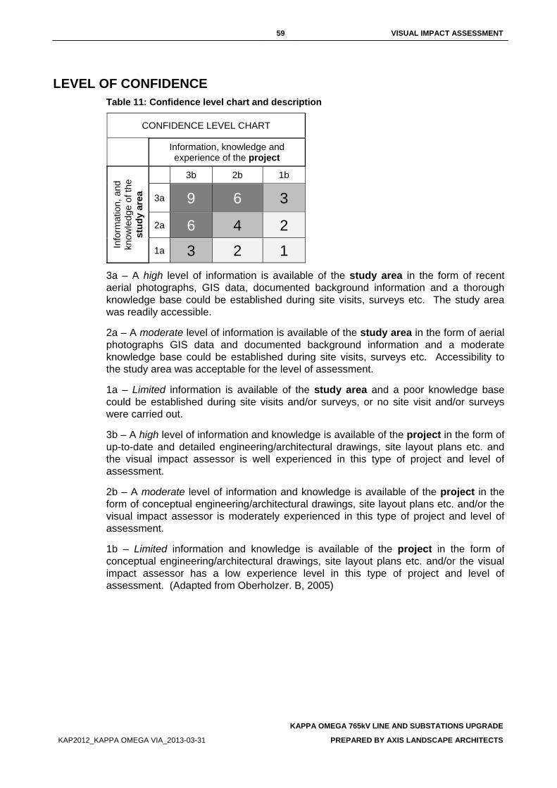
59 VISUAL IMPACT ASSESSMENT
KAPPA OMEGA 765kV LINE AND SUBSTATIONS UPGRADE
KAP2012_KAPPA OMEGA VIA_2013-03-31 PREPARED BY AXIS LANDSCAPE ARCHITECTS
LEVEL OF CONFIDENCE Table 11: Confidence level chart and description
CONFIDENCE LEVEL CHART
Information, knowledge and experience of the project
Info
rmat
ion,
and
kn
owle
dge
of th
e st
udy
area
3b 2b 1b
3a 9 6 3
2a 6 4 2 1a 3 2 1
3a – A high level of information is available of the study area in the form of recent aerial photographs, GIS data, documented background information and a thorough knowledge base could be established during site visits, surveys etc. The study area was readily accessible.
2a – A moderate level of information is available of the study area in the form of aerial photographs GIS data and documented background information and a moderate knowledge base could be established during site visits, surveys etc. Accessibility to the study area was acceptable for the level of assessment.
1a – Limited information is available of the study area and a poor knowledge base could be established during site visits and/or surveys, or no site visit and/or surveys were carried out.
3b – A high level of information and knowledge is available of the project in the form of up-to-date and detailed engineering/architectural drawings, site layout plans etc. and the visual impact assessor is well experienced in this type of project and level of assessment.
2b – A moderate level of information and knowledge is available of the project in the form of conceptual engineering/architectural drawings, site layout plans etc. and/or the visual impact assessor is moderately experienced in this type of project and level of assessment.
1b – Limited information and knowledge is available of the project in the form of conceptual engineering/architectural drawings, site layout plans etc. and/or the visual impact assessor has a low experience level in this type of project and level of assessment. (Adapted from Oberholzer. B, 2005)
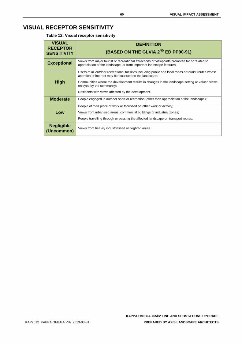
60 VISUAL IMPACT ASSESSMENT
KAPPA OMEGA 765kV LINE AND SUBSTATIONS UPGRADE
KAP2012_KAPPA OMEGA VIA_2013-03-31 PREPARED BY AXIS LANDSCAPE ARCHITECTS
VISUAL RECEPTOR SENSITIVITY Table 12: Visual receptor sensitivity
VISUAL RECEPTOR
SENSITIVITY
DEFINITION (BASED ON THE GLVIA 2ND ED PP90-91)
Exceptional Views from major tourist or recreational attractions or viewpoints promoted for or related to appreciation of the landscape, or from important landscape features.
High
Users of all outdoor recreational facilities including public and local roads or tourist routes whose attention or interest may be focussed on the landscape;
Communities where the development results in changes in the landscape setting or valued views enjoyed by the community;
Residents with views affected by the development.
Moderate People engaged in outdoor sport or recreation (other than appreciation of the landscape);
Low People at their place of work or focussed on other work or activity;
Views from urbanised areas, commercial buildings or industrial zones;
People travelling through or passing the affected landscape on transport routes.
Negligible (Uncommon) Views from heavily industrialised or blighted areas
61 VISUAL IMPACT ASSESSMENT
KAPPA OMEGA 765kV LINE AND SUBSTATIONS UPGRADE
KAP2012_KAPPA OMEGA VIA_2013-03-31 PREPARED BY AXIS LANDSCAPE ARCHITECTS
REFERENCES
BLM (Bureau of Land Management). (1986). Handbook H-8431-1, Visual Resource Contrast Rating. U.S. Department of the Interior BLM. http://www.blm.gov/nstc/VRM/vrmsys.html
Government Office of the South West - England (2006). Using landscape sensitivity for renewable energy. REvision 2010 – Empowering the region [Online]. http://www.oursouthwest.com/revision2010/lca_methodology_windbiomass.doc [Accessed 8 November 2006]
Landscape Institute and the Institute of Environmental Assessment and Management. (2002). Guidelines for Landscape and Visual Impact Assessment (GLVIA). Second Edition, E & FN Spon Press.
M. Hill, J. Briggs, P. Minto, D. Bagnall, K. Foley, A.Williams. (March 2001). Guide to Best Practice in Seascape Assessment. Maritime (Ireland / Wales) INTERREG Programme- Building Bridges.
Oberholzer, B. (2005). Guideline for involving visual and aesthetic specialists in EIA processes: Edition 1. CSIR Report No ENV-S-C 2005 053 R. Republic of South Africa, Provincial Government of the Western Cape, Department of Environmental Affairs and Development Planning, Cape Town.
Swanwick, C. Department of Landscape, University of Sheffield and Land Use Consultants. (2002). Landscape Character Assessment:: Guidance for England and Scotland. The Countryside Agency / Scottish Natural Heritage.
Van Riet, W., Claassens, P., Van Rensburg, J., Van Viegen, T., Du Plessis, L. 1997. Environmental Potential Atlas for South Africa. The Department of Environmental Affairs and Tourism in conjunction with The Geographic Information Systems Laboratory CC and the University of Pretoria. J.L. van Schaik.
Van Rooyen, M.W. 2002. Management of the old field vegetation in the Namaqua National Park, South Africa: conflicting demands of conservation and tourism. Published paper from The Geographical Journal, Vol. 168, No.3, September 2002, pp. 211-223.
U.S.D.O.T., Federal Highway Administration, Office of Environmental Policy. (March 1981). Visual Impact Assessment for Highway Projects. U. S. Department of Transportation Washington D. C.
Urban Land Institute, 1980. Visual Resource Management 0510-1: Environmental Comment (May 1980). Washington D.C.
No. Issue Raised by Response
79. Dear Shawn, Please find attached hereto the comments we have prepared on behalf of our client. The comments relate to the DEIR (dated May 2014) prepared by Nzumbululo Sustainable, Energy and Environmental Solutions for the proposed Kappa Omega 2nd 765kV power line. We also attach two independent reviews (marked Annexure A and Annexure B) of the heritage impact assessment and the visual impact assessment, respectively. These reviews form part of our client’s comments and should be expressly incorporated as such. I shall be most grateful if you will acknowledge receipt hereof. Kind regards, Richard Summers BSocSci LLB LLM (Environmental Law) smith • ndlovu • summers attorneys See FEIR appendices submitted for letter and appendic A and B.
Richard Summers BSocSci LLB LLM (Environmental Law) smith • ndlovu • summers attorneys, acting for Elandsberg Farms Stewardship Project, comment by e-mailed letter, independent visual impact assessment and heritage reviews, 11 August 2014.
Dear Richard, Thank you for your e-mail and submission on the Eskom 2nd 765kV transmission line DEIR. I hereby acknowledge receiving your comments and the two independent reviews conducted by your specialist team. I will keep you informed about the submission of the FSR and the availability of the FSR once it has been completed. Sincerely, Shawn Johnston
80. 29. Whilst the Guideline for Involving Heritage Specialists quoted above identifies heritage indicators and constraints as key criteria for the selection of alternatives, the Built Environment, Spatial History and Cultural Landscape Report (“Cultural Landscape Report”) notes that: “ESKOM Transmission determined route alternatives before the beginning of the project, based on existing ESKOM lines and servitudes,
Richard Summers BSocSci LLB LLM (Environmental Law) smith • ndlovu • summers attorneys, acting for Elandsberg Farms Stewardship Project, comment by e-mailed letter, independent visual impact assessment and heritage reviews, 11 August 2014.
Acknowledged. This is stated as a limitation of the ‘Cultural Landscape report’, and was raised in initial meetings with the EAP. BoD and ST, November 2014.
No. Issue Raised by Response
feedback from the first 765kV line application and the need to extend electrical power supply to the Western Cape. Specialists were not involved in route selection.”33 [Own underlining].
81. 30. As a result of Eskom’s predetermined alternative routes, the study area itself was geographically limited. Specialists were limited to study corridors of 1 kilometre on either side of the proposed routes.34 At the outset, therefore, studies undertaken by the specialists did not inform the route selection. The effect of this is that the route selection has not been informed by an assessment of information on the anticipated impacts of the proposed power line. The assessment of alternatives does not therefore respond to specialist input generated through the EIA process which would enable an appropriate response to particular environmental constraints or the significance of impacts.
Richard Summers BSocSci LLB LLM (Environmental Law) smith • ndlovu • summers attorneys, acting for Elandsberg Farms Stewardship Project, comment by e-mailed letter, independent visual impact assessment and heritage reviews, 11 August 2014.
Heritage specialist studies were conducted as directed by HWC on 2km study corridors either side of the proposed lines. The remainder of the comment is acknowledged. BoD and ST, November 2014.
82. CUMULATIVE IMPACTS 48. Regulation 31(2)(l) of the EIA Regulations requires that environmental impact assessment reports must include an assessment of each identified potentially significant impact including, inter alia, a description and assessment cumulative impacts.
Richard Summers BSocSci LLB LLM (Environmental Law) smith • ndlovu • summers attorneys, acting for Elandsberg Farms Stewardship Project, comment by e-mailed letter, independent visual impact assessment and heritage reviews, 11 August 2014.
The “Cultural Landscape Report” has assessed but not described every cumulative impact where it occurs at local scale. BoD and ST, November 2014.
83. 60.3. With regard to the potential impact on the Elandsberg Nature Reserve the assessment of cumulative visual impacts is a critical enquiry that must be undertaken, particularly given the impact of the proposed power lines on the sense of place and the aesthetic qualities of this
Richard Summers BSocSci LLB LLM (Environmental Law) smith • ndlovu • summers attorneys, acting for Elandsberg Farms Stewardship Project, comment by e-mailed letter,
Acknowledged, refer to revised Cultural Landscape Report, November 2014, BoD and ST, November 2014.
No. Issue Raised by Response
predominantly rural and wilderness landscape. Without a detailed cumulative visual impact assessment, it is not possible to draw any defensible conclusions regarding visual impacts.
independent visual impact assessment and heritage reviews, 11 August 2014.
84. 60.5. The cumulative heritage impacts associated with the project. The primary basis for assessing Alternative Route 1 as the preferred route in the draft Heritage Impact Assessment Report (“draft HIA Report”)60 and the Cultural Landscape Report is the presence of an existing 400kV transmission line and an approved 765kV transmission line which already impacts landscapes and settlements along the greater distance of Alternative Route 1. For the reasons set out elsewhere in these comments the level of analysis in the DEIR and specialist reports does not substantiate the selection of Alternative Route 1 based on a credible analysis of heritage related impacts in the various heritage studies.
Richard Summers BSocSci LLB LLM (Environmental Law) smith • ndlovu • summers attorneys, acting for Elandsberg Farms Stewardship Project, comment by e-mailed letter, independent visual impact assessment and heritage reviews, 11 August 2014.
The ‘Cultural Landscape Report’ recommendation of the preferred route Option 1 and 1a is based on the combination of developed heritage indicators and the assessment of negative impacts on heritage resources on regional, sub regional and local scales. This report also does not limit the recommended option to route 1, based on the above, BoD and ST, November 2014.
85. 95.3. The combination of both cultural and natural heritage makes the Elandsberg Nature Reserve a property of considerable heritage significance.
Richard Summers BSocSci LLB LLM (Environmental Law) smith • ndlovu • summers attorneys, acting for Elandsberg Farms Stewardship Project, comment by e-mailed letter, independent visual impact assessment and heritage reviews, 11 August 2014.
Acknowledged, BoD and ST November 2014.
86. 95.4. The Bosplaas and Bartholomeus Klip homesteads situated on the Elandsberg Nature Reserve are considered to be excellent examples of an early Swartland (Bosplaas) and Victorian homestead (Bartholomeus Klip). The additional
Richard Summers BSocSci LLB LLM (Environmental Law) smith • ndlovu • summers attorneys, acting for Elandsberg Farms Stewardship Project,
The site is assessed as rare and representative, not ‘very rare’. In 2006 the Drakenstein Heritage survey (Baumann and Winter) assessed Bartholomeusklip as a Grade IIIa, and Bosplaas as a Grade 2 (Baumann and Winter, 2009, p80).
No. Issue Raised by Response
survival of the old landscape context makes the property a very rare part of the cultural landscape.
comment by e-mailed letter, independent visual impact assessment and heritage reviews, 11 August 2014.
In Baumann and Winter, 2009, Bartholomeusklip is recommended as a Grade IIIa (p80), and Bosplaas as a Grade 2 (p80), referencing the Drakenstein Heritage survey of 2006. They recommended the cultural and natural landscapes as Grade 2 (p80). Winter and Oberholzer (2012), in the Draft Provincial Spatial Development Framework (DPSDF) report recommend the Elandsberg Landscape as a local (grade III) heritage resource on the mapping appendices, but do not refer to or evaluate the Elandsberg or its component parts (Bosplaas, Bartholomeusklip, Langhoogte and de Rust) within the report or inventory. The closest citing of Elandsberg in the Provincial framework (which specifically identifies heritage resources significant at Provincial level) is a reference to Voelvlei Dam (under water landscapes). Winter and Oberholzer cite over 40 urban and rural sites that were previous National Monuments, and they cite five new declared Provincial Heritage sites (draft PSDF, Appendix A, p8). The report does not cite recommended Provincial Heritage sites. HWC provided a list of Provincial sites and these resources were not listed. As far as we are aware the site has not ever been proposed to HWC as a Provincial site. Winter and Oberholzer (2012) recommended the Elandsberg landscape as a Grade III, locally significant landscape, a clear review of the 2006 and 2009 recommendations. The impacts on Bosplaas and Bartholomeusklip in the 2009 specialist assessment of the initial 765kV line were reported a ‘medium to high heritage hotspot’ (Baumann and Winter, 2009, p 129) While we were aware of the recommendations of the 2006 and
No. Issue Raised by Response
2009 studies, the fact that this cultural and natural landscape was not proposed by the same practitioner in 2013 as a Provincial landscape of significance, in addition to the fact that it has not in 9 years following the initial recommendations been nominated as such, indicated that the review assessed this as a locally rather than provincially significant resource. Given this confusion, which was brought to our attention by the 2014 ‘review report’ commissioned by the owner of the land, a site visit was conducted and the report has been revised and recommends the Elandsberg farms (Bartholomeusklip, Bosplaas, Langhoogte and de Rust) as Grade II sites as a collection (as Bosplaas is a reconstructed farmstead, it is not individually assessed by the current authors as an individual Grade II site). Assessments and recommendations for the proposed line in relation to these sites have been further clarified. BoD and ST, November 2014.
87. 96. The review also identifies the following critical concerns with the heritage impact assessment undertaken to date as part of the EIA process: 96.1. The landscape assessment undertaken in the Cultural Landscape Report is coarse grained and inconsistent in terms of its scale of analysis.
Richard Summers BSocSci LLB LLM (Environmental Law) smith • ndlovu • summers attorneys, acting for Elandsberg Farms Stewardship Project, comment by e-mailed letter, independent visual impact assessment and heritage reviews, 11 August 2014.
The Cultural Landscape assessment methodology incorporated numerous site visits at landscape, settlement and individual site scales. The assessment is detailed and cannot be considered course grained. It is acknowledged that not all farmsteads were visited across the route options. The use of previous reports, historical data and GIS data rendered the assessment consistent. BoD and ST, November 2014.
88. 96.2. The natural and cultural landscape associated with the Elandsberg Nature Reserve and Alternative Route 1 is ungraded in the Cultural Landscape Report.
Richard Summers BSocSci LLB LLM (Environmental Law) smith • ndlovu • summers attorneys, acting for Elandsberg Farms Stewardship Project, comment by e-mailed letter, independent visual impact assessment and heritage
Acknowledged, this has been revised following a detailed site visit. BoD and ST, November 2014.
No. Issue Raised by Response
reviews, 11 August 2014.
89. 96.3. There has been no recognition of the specific heritage issues and concerns which were raised with respect to potential impacts on the Elandsberg Nature Reserve and its suggested Grade 2 status in the Built Environment and Landscape Report prepared by Winter and Baumann (dated March 2009) for the Kappa Omega 1st 765kV power line.
Richard Summers BSocSci LLB LLM (Environmental Law) smith • ndlovu • summers attorneys, acting for Elandsberg Farms Stewardship Project, comment by e-mailed letter, independent visual impact assessment and heritage reviews, 11 August 2014.
See above comprehensive response number 209. BoD and ST, November 2014.
90. 96.4. With regard to the Kappa Omega 1st 765kV power line, the southern route alternative was proposed to follow the alignment of an existing 400kV power line through the Elandsberg Nature Reserve. The Winter and Baumann Report (2009) identified the cumulative impacts of this alignment as highly problematic from a heritage perspective. Contrary to this recommendation, the Cultural Landscape Report for the proposed Kappa-Omega 2nd 765kV power line concludes that the heritage impacts associated with Alternative Route 1 through the Elandsberg Nature Reserve can be mitigated by its realignment close to the existing 400kV power lines. No reasons are provided in the Cultural Landscape Report to justify its variance with the findings of the Winter and Baumann Report.
Richard Summers BSocSci LLB LLM (Environmental Law) smith • ndlovu • summers attorneys, acting for Elandsberg Farms Stewardship Project, comment by e-mailed letter, independent visual impact assessment and heritage reviews, 11 August 2014.
This site was identified as a “medium to high level heritage hotspot’ and not a no-go zone in the 2009 report. Impacts on Bartholomeusklip were cited as low, and on Bosplaas as medium to high (not high). We are in agreement that the impacts of the proposed new line are “High” and that the line should not be built in its proposed position in relation to these resources, as stated in the mitigation measures of the report reviewed by the Summers’ specialists. It should be noted that the review conducted was on a draft ‘Cultural Landscape report’ and not the final ‘Cultural Landscape report’ dated April 2014. However, in the summary of assessment, it is stated that this route is preferable to others, where multiple resources would be negatively impacted on a sub regional as opposed to local scale. This has been clarified and the recommendations clearly made in the revision of the report. BoD and ST, 2014.
91. 96.5. There is an over-reliance in the draft HIA Report and Cultural Landscape Report on mitigation measures being resolved once the preferred alternative route is determined. For the reasons stated elsewhere in these comments, the reliance upon mitigation
Richard Summers BSocSci LLB LLM (Environmental Law) smith • ndlovu • summers attorneys, acting for Elandsberg Farms Stewardship Project, comment by e-mailed letter,
Acknowledge that we were appointed to assess alternative routes, and where impacts are high to propose mitigation. In cases where multiple resources would be significantly negatively impacted, the proposed mitigation was to use an alternate route. BoD and ST, November 2014.
No. Issue Raised by Response
measures as a means of addressing each potentially significant impact undermines one of the primary purposes of the EIA process, which is to ensure that significant adverse impacts are avoided.
independent visual impact assessment and heritage reviews, 11 August 2014.
92. 96.6. The integration of visual and heritage specialist studies from a cultural landscape perspective has been inadequate. This is acknowledged in the Cultural Landscape Report which notes that “meetings of the specialists have only occurred twice during the study period, resulting in minimal cross reference of specialist inputs”75 and “visual impact assessment and public participation are separate specialist studies and have not been available to the built environment and cultural landscape specialists”.76 In order to adequately determine visual impacts on landscapes and settlements of heritage value, the visual and heritage specialist studies should have been appropriately integrated during the scoping and impact assessment phases.
Richard Summers BSocSci LLB LLM (Environmental Law) smith • ndlovu • summers attorneys, acting for Elandsberg Farms Stewardship Project, comment by e-mailed letter, independent visual impact assessment and heritage reviews, 11 August 2014.
Acknowledged. This was stated in the limitations of the report. BoD and ST, 2014.
93. 97. There is insufficient information in the DEIR and the specialist reports to be able to support the contention that placing new large scale power line infrastructure within the existing corridors impacted by existing power line infrastructure is defensible from a heritage perspective. The specialist reports have failed to test this contention across various scales of analysis, which would be required before any defensible conclusions can be made from a heritage perspective.
Richard Summers BSocSci LLB LLM (Environmental Law) smith • ndlovu • summers attorneys, acting for Elandsberg Farms Stewardship Project, comment by e-mailed letter, independent visual impact assessment and heritage reviews, 11 August 2014.
Specialists were not able to make these integrations as the visual analysis was conducted parallel to EIA processes and not to specialist HIA studies. BoD and ST, November 2014.
94. 98. The review commissioned by our client also Richard Summers BSocSci LLB The ‘Cultural Landscape’ specialist assessment of the preferred
No. Issue Raised by Response
confirms that insufficient consideration has been given to the cumulative impacts of introducing a second 765kV power line within significant natural and cultural landscapes associated with Alternative Route 1. Given the heritage significance of our client’s property, it could be argued that the combined cumulative impacts of an additional 765kV power line through our client’s property, the greater Tulbagh Valley and other significant local landscapes associated with Alternative Route 1 outweigh (in terms of significant adverse heritage impacts) the equivalent impacts associated with Alternative Routes 2 and 3. However, there is insufficient information in the draft HIA Report and the Cultural Landscape Report to enable an appropriate interrogation of this.
LLM (Environmental Law) smith • ndlovu • summers attorneys, acting for Elandsberg Farms Stewardship Project, comment by e-mailed letter, independent visual impact assessment and heritage reviews, 11 August 2014.
alternative routes have taken cumulative impacts into account and have weighed them against cutting new infrastructure corridors through pristine landscapes. BoD and ST, November 2014.
95. 100. The failure to appropriately assess site specific heritage impacts renders the assessment deficient. The deficiencies in the assessment of heritage-related impacts effectively means that the requirements of section 38 of the National Heritage Resources Act have not been complied with in connection with the minimum requirements for the assessment of heritage impacts.
Richard Summers BSocSci LLB LLM (Environmental Law) smith • ndlovu • summers attorneys, acting for Elandsberg Farms Stewardship Project, comment by e-mailed letter, independent visual impact assessment and heritage reviews, 11 August 2014.
Impacts were assessed at site levels, and recommendations to deal with possible negative site specific impacts have been undertaken for every identified site over 60 years old. BoD and ST, November 2014.
96. CONCLUSIONS 111. The DEIR is materially deficient in several respects, and most notably in connection with the failure to identify, consider, evaluate and/or assess potentially significant site- specific impacts (including cumulative impacts) associated with the proposed power line.
Richard Summers BSocSci LLB LLM (Environmental Law) smith • ndlovu • summers attorneys, acting for Elandsberg Farms Stewardship Project, comment by e-mailed letter, independent visual impact assessment and heritage
Site specific impacts will be considered in the site specific EMP.

No. Issue Raised by Response
reviews, 11 August 2014.
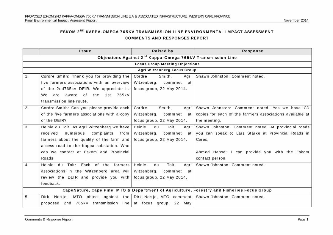
PROPOSED ESKOM 2ND KAPPA-OMEGA 765KV TRANSMISSION LINE EIA & ASSOCIATED INFRASTRUCTURE, WESTERN CAPE PROVINCE Final Environmental Impact Assessent Report November 2014
Comments & Response Report Page 1
ESKOM 2ND KAPPA-OMEGA 765KV TRANSMISSION LINE ENVIRONMENTAL IMPACT ASSESSMENT COMMENTS AND RESPONSES REPORT
Issue Raised by Response
Objections Against 2nd Kappa-Omega 765kV Transmission Line Focus Group Meeting Objections
Agri Witzenberg Focus Group
1. Cordre Smith: Thank you for providing the five farmers associations with an overview of the 2nd765kv DEIR. We appreciate it. We are aware of the 1st 765kV transmission line route.
Cordre Smith, Agri Witzenberg, commnet at focus group, 22 May 2014.
Shawn Johnston: Comment noted.
2. Cordre Smith: Can you please provide each of the five farmers associations with a copy of the DEIR?
Cordre Smith, Agri Witzenberg, commnet at focus group, 22 May 2014.
Shawn Johnston: Comment noted. Yes we have CD copies for each of the farmers associations available at the meeting.
3. Heinie du Toit. As Agri Witzenberg we have received numerous complaints from farmers about the quality of the farm and access road to the Kappa substation. Who can we contact at Eskom and Provincial Roads
Heinie du Toit, Agri Witzenberg, commnet at focus group, 22 May 2014.
Shawn Johnston: Comment noted. At provincial roads you can speak to Lars Starke at Provincial Roads in Ceres. Ahmed Hansa: I can provide you with the Eskom contact person.
4. Heinie du Toit: Each of the farmers associations in the Witzenberg area will review the DEIR and provide you with feedback.
Heinie du Toit, Agri Witzenberg, commnet at focus group, 22 May 2014.
Shawn Johnston: Comment noted.
CapeNature, Cape Pine, MTO & Department of Agriculture, Forestry and Fisheries Focus Group 5. Dirk Nortje: MTO object against the
proposed 2nd 765kV transmission line Dirk Nortje, MTO, comment at focus group, 22 May
Shawn Johnston: Comment noted.
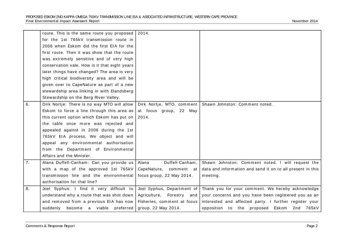
PROPOSED ESKOM 2ND KAPPA-OMEGA 765KV TRANSMISSION LINE EIA & ASSOCIATED INFRASTRUCTURE, WESTERN CAPE PROVINCE Final Environmental Impact Assessent Report November 2014
Comments & Response Report Page 2
route. This is the same route you proposed for the 1st 765kV transmission route in 2006 when Eskom did the first EIA for the first route. Then it was show that the route was extremely sensitive and of very high conservation vale. How is it that eight years later things have changed? The area is very high critical biodiversity area and will be given over to CapeNature as part of a new stewardship area linking in with Elandsberg Stewardship on the Berg River Valley.
2014.
6. Dirk Nortje: There is no way MTO will allow Eskom to force a line through this area as this current option which Eskom has put on the table once more was rejected and appealed against in 2006 during the 1st 765kV EIA process. We object and will appeal any environmental authorisation from the Department of Environmental Affairs and the Minister.
Dirk Nortje, MTO, comment at focus group, 22 May 2014.
Shawn Johnston: Comment noted.
7. Alana Duffell-Canham: Can you provide us with a map of the approved 1st 765kV transmission line and the environmental authorisation for that line?
Alana Duffell-Canham, CapeNature, comment at focus group, 22 May 2014.
Shawn Johnston: Comment noted. I will request the data and information and send it on to all present in this meeting.
8. Joel Syphus: I find it very difficult to understand why a route that was shot down and removed from a previous EIA has now suddenly become a viable preferred
Joel Syphus, Department of Agriculture, Forestry and Fisheries, comment at focus group, 22 May 2014.
Thank you for your comment. We hereby acknowledge your concerns and you have been registered you as an interested and affected party. I further register your opposition to the proposed Eskom 2nd 765kV
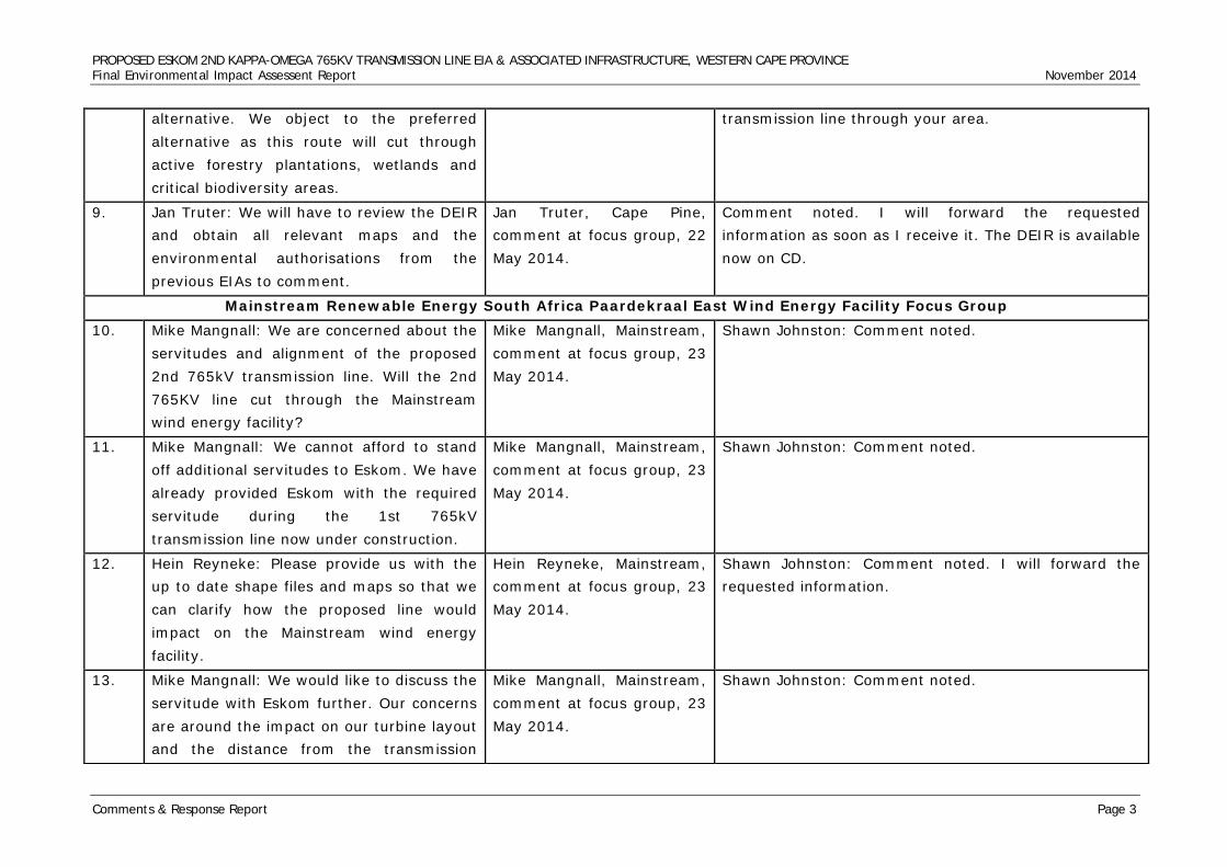
PROPOSED ESKOM 2ND KAPPA-OMEGA 765KV TRANSMISSION LINE EIA & ASSOCIATED INFRASTRUCTURE, WESTERN CAPE PROVINCE Final Environmental Impact Assessent Report November 2014
Comments & Response Report Page 3
alternative. We object to the preferred alternative as this route will cut through active forestry plantations, wetlands and critical biodiversity areas.
transmission line through your area.
9. Jan Truter: We will have to review the DEIR and obtain all relevant maps and the environmental authorisations from the previous EIAs to comment.
Jan Truter, Cape Pine, comment at focus group, 22 May 2014.
Comment noted. I will forward the requested information as soon as I receive it. The DEIR is available now on CD.
Mainstream Renewable Energy South Africa Paardekraal East Wind Energy Facility Focus Group 10. Mike Mangnall: We are concerned about the
servitudes and alignment of the proposed 2nd 765kV transmission line. Will the 2nd 765KV line cut through the Mainstream wind energy facility?
Mike Mangnall, Mainstream, comment at focus group, 23 May 2014.
Shawn Johnston: Comment noted.
11. Mike Mangnall: We cannot afford to stand off additional servitudes to Eskom. We have already provided Eskom with the required servitude during the 1st 765kV transmission line now under construction.
Mike Mangnall, Mainstream, comment at focus group, 23 May 2014.
Shawn Johnston: Comment noted.
12. Hein Reyneke: Please provide us with the up to date shape files and maps so that we can clarify how the proposed line would impact on the Mainstream wind energy facility.
Hein Reyneke, Mainstream, comment at focus group, 23 May 2014.
Shawn Johnston: Comment noted. I will forward the requested information.
13. Mike Mangnall: We would like to discuss the servitude with Eskom further. Our concerns are around the impact on our turbine layout and the distance from the transmission
Mike Mangnall, Mainstream, comment at focus group, 23 May 2014.
Shawn Johnston: Comment noted.

PROPOSED ESKOM 2ND KAPPA-OMEGA 765KV TRANSMISSION LINE EIA & ASSOCIATED INFRASTRUCTURE, WESTERN CAPE PROVINCE Final Environmental Impact Assessent Report November 2014
Comments & Response Report Page 4
lines. We would be keen to have follow-up sessions with the Eskom planning team.
Elandsberg Farms Stewardship Project Focus Group 14. Mike Gregor: Elandsberg is a conservation
area linked to the CapeNature Stewardship Programme. The area is a registered stewardship area and a critical biodiversity area (CBA).
Mike Gregor, Elandsberg Stewardship Project, comment at focus group, 12 June 2014.
Shawn Johnston: Comment noted.
15. Mike Gregor: In 2006 Eskom wanted to bring the 1st 765kV transmission line through here and all of the landowners objected against the 1st 765kV transmission coming through the area. We have proof of all the meetings we attended. In the end the alternative was removed. All of the EIA studies highlighted the areas as an extremely sensitive area with critical species. How can Eskom now come back in 2014 and state the a route that was rejected in the 1st 765kV EIA is now a preferred alternative.
Mike Gregor, Elandsberg Stewardship Project, comment at focus group, 12 June 2014.
Shawn Johnston: Comment noted.
16. Mike Gregor: We object against the proposed 2nd 765kV transmission line alternative. This alternative should never been considered as an alternative as it was rejected by specialist and the community in 2006 during the 1st 765kV EIA.
Mike Gregor, Elandsberg Stewardship Project, comment at focus group, 12 June 2014.
Shawn Johnston: Comment noted.
17. Mike Gregor: I would like to inform Eskom Mike Gregor, Elandsberg Thank you for your comment. We hereby acknowledge
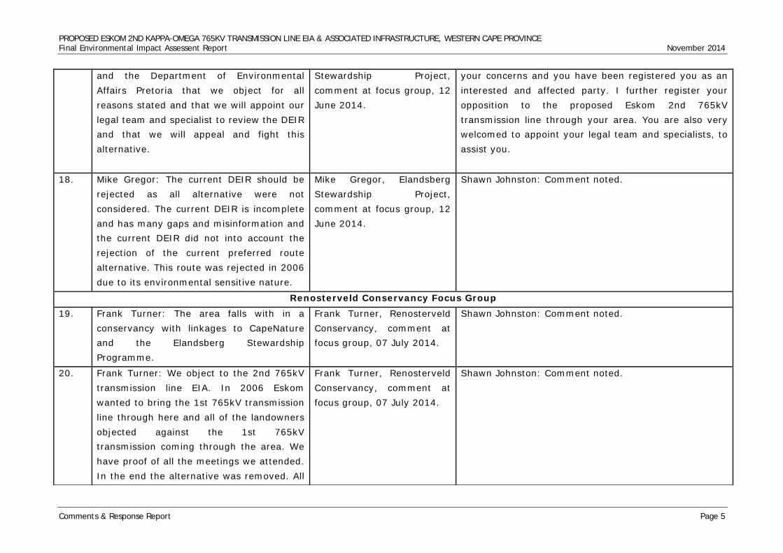
PROPOSED ESKOM 2ND KAPPA-OMEGA 765KV TRANSMISSION LINE EIA & ASSOCIATED INFRASTRUCTURE, WESTERN CAPE PROVINCE Final Environmental Impact Assessent Report November 2014
Comments & Response Report Page 5
and the Department of Environmental Affairs Pretoria that we object for all reasons stated and that we will appoint our legal team and specialist to review the DEIR and that we will appeal and fight this alternative.
Stewardship Project, comment at focus group, 12 June 2014.
your concerns and you have been registered you as an interested and affected party. I further register your opposition to the proposed Eskom 2nd 765kV transmission line through your area. You are also very welcomed to appoint your legal team and specialists, to assist you.
18. Mike Gregor: The current DEIR should be rejected as all alternative were not considered. The current DEIR is incomplete and has many gaps and misinformation and the current DEIR did not into account the rejection of the current preferred route alternative. This route was rejected in 2006 due to its environmental sensitive nature.
Mike Gregor, Elandsberg Stewardship Project, comment at focus group, 12 June 2014.
Shawn Johnston: Comment noted.
Renosterveld Conservancy Focus Group 19. Frank Turner: The area falls with in a
conservancy with linkages to CapeNature and the Elandsberg Stewardship Programme.
Frank Turner, Renosterveld Conservancy, comment at focus group, 07 July 2014.
Shawn Johnston: Comment noted.
20. Frank Turner: We object to the 2nd 765kV transmission line EIA. In 2006 Eskom wanted to bring the 1st 765kV transmission line through here and all of the landowners objected against the 1st 765kV transmission coming through the area. We have proof of all the meetings we attended. In the end the alternative was removed. All
Frank Turner, Renosterveld Conservancy, comment at focus group, 07 July 2014.
Shawn Johnston: Comment noted.
PROPOSED ESKOM 2ND KAPPA-OMEGA 765KV TRANSMISSION LINE EIA & ASSOCIATED INFRASTRUCTURE, WESTERN CAPE PROVINCE Final Environmental Impact Assessent Report November 2014
Comments & Response Report Page 6
of the EIA studies highlighted the areas as an extremely sensitive area with critical species. How can Eskom now come back in 2014 and state a route that was rejected in the 1st 765kV EIA is now a preferred alternative.
21. Frank Turner: We object against the proposed 2nd 765kV transmission line alternative.
Frank Turner, Renosterveld Conservancy, comment at focus group, 07 July 2014.
Thank you for your comment. We hereby acknowledge your concerns and you have been registered you as an interested and affected party. I further register your opposition to the proposed Eskom 2nd 765kV transmission line through your area.
22. Frank Turner: I would like to inform Eskom and the Department of Environmental Affairs Pretoria that we object and that we will appeal any positive environmental authorisation.
Frank Turner, Renosterveld Conservancy, comment at focus group, 07 July 2014.
Thank you for your comment. We hereby acknowledge your concerns and you have been registered you as an interested and affected party. I further register your opposition to the proposed Eskom 2nd 765kV transmission line through your area.
23. Frank Turner: We will provide you with our comments on the matter.
Frank Turner, Renosterveld Conservancy, comment at focus group, 07 July 2014.
Shawn Johnston: Comment noted.
Hermon Farmers Association Focus Group 24. Deon Steyn: The Hermon Farmers
Association hereby objects against the construction of the proposed Eskom 2nd 765kV transmission over the Elandsberg and Bontebok Ridge Farms.
Deon Steyn, Chairperson Hermon Farmers Association, comment at focus group, 21 July 2014.
Thank you for your comment. We hereby acknowledge your concerns and you have been registered you as an interested and affected party.
25. Deon Steyn: Is Eskom aware of the national key point on this proposed route. The route will cut through the DENEL
Deon Steyn, Chairperson Hermon Farmers Association, comment at
Shawn Johnston: Comment noted.
PROPOSED ESKOM 2ND KAPPA-OMEGA 765KV TRANSMISSION LINE EIA & ASSOCIATED INFRASTRUCTURE, WESTERN CAPE PROVINCE Final Environmental Impact Assessent Report November 2014
Comments & Response Report Page 7
ammunitions factory. This area is regarded as a national key point.
focus group, 21 July 2014.
26. Deon Steyn: It seems Eskom want to bully a route through the area. An alternative that was rejected in 2006 during the 1st 765kV EIA. Why is the Department of Environmental Affairs in Pretoria allowing this to happen? A route that was declared null and void in a previous EIA should not be considered again in the future.
Deon Steyn, Chairperson Hermon Farmers Association, comment at focus group, 21 July 2014.
Shawn Johnston: Comment noted.
27. Lauire Terblanche: The proposed line will change our sense of place, the cultural landscape and impact on the critical biodiversity of the area.
Laurie Terblance, Hermon Farmers Association, comment at focus group, 21 July 2014.
Shawn Johnston: Comment noted.
28. Lauire Terblanche: As members of the Hermon Farmers Association we object against the proposed Eskom 2nd 765kV transmission line and will submit our reasons once we have reviewed the DEIR.
Laurie Terblanche, Hermon Farmers Association, comment at focus group, 21 July 2014.
Thank you for your comment. We will await for your reasons.
Draft Environmental Impact Assessment Report Objections CapeNature Concervation Objections
29. Dear Shawn, Please will you pass on the attached comments to Nzumbulelo Heritage solutions. Please note that whilst some examples of errors and omissions have been provided in
Alana Duffell-Canham, CapeNature Scientific Services, Jonkerskoek, comment by e-mailed letter, 11 July 2014.
Dear Alana, Thank you for your e-mails and comments on the Eskom Gamma-Kappa and Kappa-Omega DEIR. I hereby acknowledge receiving both e-mails and attached comment letters.
PROPOSED ESKOM 2ND KAPPA-OMEGA 765KV TRANSMISSION LINE EIA & ASSOCIATED INFRASTRUCTURE, WESTERN CAPE PROVINCE Final Environmental Impact Assessent Report November 2014
Comments & Response Report Page 8
our comments, we cannot provide a comprehensive list of all the factual, grammatical and other errors evident throughout the report. Suffice it to say that the report needs a significant amount of review and editing by the consultants. Kind regards, Alana
Sincerely, Shawn Johnston
30. CapeNature would like to thank you for the opportunity to comment on this proposed activity and wish to make the following comments: Overview: 1. The information provided regarding the description of the study area is generalised and contains numerous errors. For example the vegetation types listed on page 37 of the main report are not correct – please refer to the CAPE fine-scale vegetation maps as well as the South African vegetation maps for the correct names of the vegetation types found within the study area. These include but are not limited to several types of sandstone Fynbos, alluvium Fynbos, sand Fynbos granite Renosterveld, shale Renosterveld, Flats Strandveld, Granite Strandveld, Dune
Alana Duffell-Canham, CapeNature Scientific Services, Jonkerskoek, comment by e-mailed letter, 11 July 2014.
Thank you for your comment. With regards to your comment on our vegetation types being incorrect. We appointed a specialist, in which their report was attached as an appendix. As we are not ecological specialists, we made our point generic, however also stipulated that you will need to refer to the specialist report attached. We wouldn’t have appointe a specialist, had we believed that we were ecological specialists.
PROPOSED ESKOM 2ND KAPPA-OMEGA 765KV TRANSMISSION LINE EIA & ASSOCIATED INFRASTRUCTURE, WESTERN CAPE PROVINCE Final Environmental Impact Assessent Report November 2014
Comments & Response Report Page 9
Strandveld, Tanqua karoo, riverine vegetation etc. Incorrect names/spellings of vegetation types are also found later in the report such as “Bre Shale Renosterveld” (p 76).
31. 2. The report does not provide a description of how the three route alternatives to be investigated were decided upon. Furthermore, the report does not provide a step by step explanation of how route alternative 1 was decided upon as the preferred alternative. A table should be provided clearly outlining the pros, cons and fatal flaws for each route alternative. In addition, no explanation has been provided as to why a corridor following the same alignment as the corridor approved for the first 765kV line is not being considered.
Alana Duffell-Canham, CapeNature Scientific Services, Jonkerskoek, comment by e-mailed letter, 11 July 2014.
Eskom selects lines that are technically and environmentally viable on their side, however they appoint environmental specialists to also look at the environmental impacts of their selected alternatives. Within the report, we had a table from page 168 to 171. This table includes all the recommendations from the specialists assessments. This however is not the final decision, as it still needs to be reviewed by the Department of Environemtal Affairs.
32. 3. The main report also only provides a very general discussion of impacts. The information provided is insufficient to draw any conclusions regarding the significance of site specific impacts of the preferred route and of the other route alternatives. This basically results in the Environmental Impact Report (EIR) being no more informative than the Scoping Report. The Scoping Report should have provided
Alana Duffell-Canham, CapeNature Scientific Services, Jonkerskoek, comment by e-mailed letter, 11 July 2014.
This can only be done once the final alignments have been selected and tower positions have been finalized. Site specific impacts will be considered during the walk down and incoperated in the site specific EMP. It is not the objective of this report to attempt to demarcate all sections of power line for all the alternative corridors that would need to be mitigated. This can only be done once the final alignments have
PROPOSED ESKOM 2ND KAPPA-OMEGA 765KV TRANSMISSION LINE EIA & ASSOCIATED INFRASTRUCTURE, WESTERN CAPE PROVINCE Final Environmental Impact Assessent Report November 2014
Comments & Response Report Page 10
sufficient information to determine the preferred corridor. The EIA phase of the project should have investigated the preferred corridor in detail. CapeNature notes that it is the applicant’s intention to conduct a walk-down and to conduct negotiations with the landowners regarding the final positions of the pylons and access roads only after environmental authorisation has been received. However, the footprint of the roads and pylons is significant and it is necessary to assess these impacts at a much finer-scale than what has currently been done. Our previous comments specifically requested that the entire development footprint including access routes, stockpiling areas, parking and turning areas be assessed. Decision-makers need to be aware of site-specific issues regardless of the length of powerline being assessed.
been selected and tower positions have been finalized. Site specific impacts will be considered during the walk down
33. 4. Some of the recommendations made on p173 of the report are confusing and questionable. For example recommendation number 6 states that the line should be patrolled annually and areas where collisions have occurred then be marked
Alana Duffell-Canham, CapeNature Scientific Services, Jonkerskoek, comment by e-mailed letter, 11 July 2014.
The assessment approach was aimed at identification and prioritisation of portions along the various alternatives that are considered most likely to be able to sustain the most diverse and sensitive faunal and floral populations and where more care would be required in the planning, construction and operational phases of the
PROPOSED ESKOM 2ND KAPPA-OMEGA 765KV TRANSMISSION LINE EIA & ASSOCIATED INFRASTRUCTURE, WESTERN CAPE PROVINCE Final Environmental Impact Assessent Report November 2014
Comments & Response Report Page 11
reactively. Note that bird carcasses which may be present as a result of collisions and electrocutions quickly decompose or are scavenged and disappear within days, how will collision sites be determined if the line is not patrolled for months at a time? With regard to point 9 “avoid sensitive habitats”, the level of detail and the scale of maps provided for the sensitivity assessment is not adequate to accurately determine all areas of high sensitivity. Sensitive areas must be groundtruthed and mapped in detail.
project. It has been made clear in the reports developed that as part of the planning phase of the development a walk down be undertaken of all areas considered of higher ecological importance identified within the baseline 2report for the selected route within the selected corridor. By so doing areas of least concern can be identified for the construction of support structures.
34. 5. There is a general lack of discussion regarding cumulative impacts of additional powerlines through the landscape and at particular sensitive sites. See comments under Site Specific Considerations below for further discussion in this regard.
Alana Duffell-Canham, CapeNature Scientific Services, Jonkerskoek, comment by e-mailed letter, 11 July 2014.
This can only be done once the final alignments have been selected and tower positions have been finalized. Site specific impacts will be considered during the walk down and incoperated in the site specific EMP.
35. 6. The maps provided in the report are at a broad scale, several with too many labels to see the route indicated below. Some of the maps indicating specific features are not linked to specific text in the report nor do they provide any explanation of the importance or relevance of the features in terms of how they influenced the selection of the route alternatives For example, the
Alana Duffell-Canham, CapeNature Scientific Services, Jonkerskoek, comment by e-mailed letter, 11 July 2014.
We included a soft copy, along with the hard copy so that you can be able to zoom in and out. The maps give a brief overlaying of the flora sites. Its not meant to be specific. Such maps, are included in specialist studies.
PROPOSED ESKOM 2ND KAPPA-OMEGA 765KV TRANSMISSION LINE EIA & ASSOCIATED INFRASTRUCTURE, WESTERN CAPE PROVINCE Final Environmental Impact Assessent Report November 2014
Comments & Response Report Page 12
“Flora Sites Map” shows “key vegetation community”, “special habitat location” and “spring flowers” but no explanation is provided is provided as to the importance of these sites. Spring flower sites may be important for tourism but not necessarily for conservation of species of conservation concern, although the areas indicated could be important for more than one reason. Contour and river maps are also not useful at the scale provided as specific landscape features and sizes of features cannot be identified. The Natural features map also requires more explanation in the report, what is the importance of these features and how did they impact on the powerline route selection, why are the “Natural features” as indicated in the title and map legend also “Scenic Landscape Features” as indicated by the labels on the map? Spelling and typos of maps also need to be checked and corrected e.g. “Contous Map” should be Contours Map.
36. 7. A concerning omission in that the main report does not provide maps indicating Critical Biodiversity Areas (CBAs), aquatic CBAs or Freshwater Ecosystem Priority Areas (FEPAs). CBAs, FEPAs and protected
Alana Duffell-Canham, CapeNature Scientific Services, Jonkerskoek, comment by e-mailed letter, 11 July 2014.
Thank you for your comment. Appendixes are part of the report, so we believe that the specialst studies are part of the main report.
PROPOSED ESKOM 2ND KAPPA-OMEGA 765KV TRANSMISSION LINE EIA & ASSOCIATED INFRASTRUCTURE, WESTERN CAPE PROVINCE Final Environmental Impact Assessent Report November 2014
Comments & Response Report Page 13
areas are key biodiversity informants that should be used to inform site/route selection. Although some of the specialist reports contain maps indicating these features, the main report should also contain these maps and reference to their importance.
37. 8. Another important map that should be provided is one indicating Important Bird Areas (IBAs).
Alana Duffell-Canham, CapeNature Scientific Services, Jonkerskoek, comment by e-mailed letter, 11 July 2014.
Comment noted.
38. 9. In future, please provide the correct shapefiles digitally early on in the process so we can overlay these onto our information. The correct shapefiles were only received fairly late in the commenting period.
Alana Duffell-Canham, CapeNature Scientific Services, Jonkerskoek, comment by e-mailed letter, 11 July 2014.
39. Ecology Specialist Study: 10. The ecology study is largely desk-top based with minimal ground-truthing conducted. Whilst CapeNature understands that the specialists had time and budgetary constraints, we remain of the opinion that more groundtruthing should have been done especially within CBAs. A large part of the routes is transformed thus not requiring detailed groundtruthing hence the
Alana Duffell-Canham, CapeNature Scientific Services, Jonkerskoek, comment by e-mailed letter, 11 July 2014.
Thank you for your comment. All available and regionally known faunal and floral reference databases were considered or assessed in order to assure that the assessments take as many of the potential species as well as important habitats into consideration as possible given the extent of the various alternatives. However, consideration should be given to extreme
PROPOSED ESKOM 2ND KAPPA-OMEGA 765KV TRANSMISSION LINE EIA & ASSOCIATED INFRASTRUCTURE, WESTERN CAPE PROVINCE Final Environmental Impact Assessent Report November 2014
Comments & Response Report Page 14
consultants should have focused their resources on the natural areas. Remnants of intact Critically Endangered and Endangered vegetation should be mapped and avoided in planning the powerline routes. Using information for plants and fauna at a quarter degree scale has only limited usefulness and species lists are certainly not comprehensive and we question the use of this as a key informant for determining route sensitivity. The ecology study is sufficient to indicate that possibly route alternative 1 will have less impact than the other route alternatives but there is insufficient information regarding site specific impacts and mitigation measures to determine if this route is acceptable in terms of impacts on biodiversity or whether additional route alternatives (other than those alternatives already provided) should be sought and investigated.
extent each of the proposed alternatives cover that resulted in the likelihood of all documented species as well as a vast variety of different habitats being present along portions of the routes. It should also be noted that the study was aimed at assessing 2km wide corridor alternatives and as such detailed assessments are not practicable at this stage of the investigations. The assessment approach was aimed at identification and prioritisation of portions along the various alternatives that are considered most likely to be able to sustain the most diverse and sensitive faunal and floral populations and where more care would be required in the planning, construction and operational phases of the project. It has been made clear in the reports developed that as part of the planning phase of the development a walk down be undertaken of all areas considered of higher ecological importance identified within the baseline 2report for the selected route within the selected corridor. By so doing areas of least concern can be identified for the construction of support structures. It should further be noted that where portions of routes were identified that where considered ‘no go’ areas, it has been highlighted in the report and where possible alternative alignment has been proposed or recommended. The client has been provided with the GIS files
PROPOSED ESKOM 2ND KAPPA-OMEGA 765KV TRANSMISSION LINE EIA & ASSOCIATED INFRASTRUCTURE, WESTERN CAPE PROVINCE Final Environmental Impact Assessent Report November 2014
Comments & Response Report Page 15
indicating areas considered to be of very high and high sensitivity identified using all desktop information available with special mention of fine scale plans as well as site visits. It is the opinion of the specialists that alternative route alignment be considered around these areas and that CBAs be avoided as far as possible regardless of what faunal or floral species are found within them. By so doing the site specific impacts associated with be developed for areas where re-alignment is not an option, however this would require detailed site assessments of all these areas; possibly as a ‘second phase’ assessment that can inform the EIA prior to final submission or prior to finalisation of the EMP for the project. This will allow for the furtherdevelopment of site specific construction and operational mitigation measures. It should be noted that the assessment was based on a worst case scenario and are therefore considered indicative of the significance of impact that could result due to vegetation clearing and construction related activities within each sensitivity class.
40. 11.The ecology study gives some consideration to general mitigation of construction related impacts but does not adequately consider impacts that may occur during the operational phase of the
Alana Duffell-Canham, CapeNature Scientific Services, Jonkerskoek, comment by e-mailed letter, 11 July 2014.
It has been made clear in the reports developed that as part of the planning phase of the development a walk down be undertaken of all areas considered of higher ecological importance identified within the baseline 2report for the selected route within the selected
PROPOSED ESKOM 2ND KAPPA-OMEGA 765KV TRANSMISSION LINE EIA & ASSOCIATED INFRASTRUCTURE, WESTERN CAPE PROVINCE Final Environmental Impact Assessent Report November 2014
Comments & Response Report Page 16
powerline. Brushcutting under powerlines in many instances occurs too frequently and the vegetation is cut too low resulting in severe loss of species over time. Some areas of natural vegetation require burning within a certain time period which ideally needs to be planned for. However, fires are not permitted under the powerlines which also results in loss of species. In addition areas that are not burnt for a very long time sometimes experience wild fires which burn out of control resulting in significant damage to property and loss of biodiversity.
corridor.
41. Avifaunal Specialist Study: 12. Impacts on birds are of high concern for any large powerline project. However, there is sufficient information and research to indicate that if the lines are aggregated, they will be more visible and birds will be able to more easily navigate around the powerlines which suggests that the preferred alignment should closely follow the first 765kV line route. The findings of the avifaunal specialist support this. However, the cumulative loss of habitat resulting from having more than one powerline in close proximity should also be taken into account.
Alana Duffell-Canham, CapeNature Scientific Services, Jonkerskoek, comment by e-mailed letter, 11 July 2014.
Thank you for your comment and information provided.
PROPOSED ESKOM 2ND KAPPA-OMEGA 765KV TRANSMISSION LINE EIA & ASSOCIATED INFRASTRUCTURE, WESTERN CAPE PROVINCE Final Environmental Impact Assessent Report November 2014
Comments & Response Report Page 17
42. Wetland and River Assessment: 13. A broad status quo investigation of the significant wetland clusters has been provided. Ground-truthing was also very limited for this study and no maps indicating specific areas of concern have been provided and there is no indication of the feasibility of avoiding certain wetland areas which has been provided as a recommendation in the main report. Other mitigation measures provided with regard to impacts on wetlands are also generic and do not highlight site specific issues and implications for planning.
Alana Duffell-Canham, CapeNature Scientific Services, Jonkerskoek, comment by e-mailed letter, 11 July 2014.
Site specfic impacts will be considered during work down surveys for the selcted route. The proposed powerline corridor is 2km which means the technical team has enough room to avoid or minimise any impacts. We are further confident that our team used appropriate methodology to assess the alternatives of the entire development. Specific impacts will be covered when the final route selection is concluded.
43. Tourism Impact Assessment: 14.This study was of potential interest to CapeNature as the powerlines could have a potential impact on our protected areas, especially visual impacts as well as impacts on biodiversity. Unfortunately, this report provided as Appendix 12 is completely illegible as the words in each paragraph are joined.
Alana Duffell-Canham, CapeNature Scientific Services, Jonkerskoek, comment by e-mailed letter, 11 July 2014.
Thank you for your comment. All issues with paragraphs, has been fixed. The TIAS does not identify permanent negative or prohibitive barrier to the developing the proposed powerline in any of the alternative servitudes. As such, this study supports the preferred route subject to it being the most suitable from other impact and technical recommendations.
44. Environmental Management Plan: 15. The EMP needs to be updated to include inter alia a map clearly indicating areas of high sensitivity/no-go areas, more information regarding site rehabilitation
Alana Duffell-Canham, CapeNature Scientific Services, Jonkerskoek, comment by e-mailed letter, 11 July 2014.
This can only be done once the final alignments have been selected and tower positions have been finalized. Site specific impacts will be considered during the walk down and incoperated in the site specific EMP.
PROPOSED ESKOM 2ND KAPPA-OMEGA 765KV TRANSMISSION LINE EIA & ASSOCIATED INFRASTRUCTURE, WESTERN CAPE PROVINCE Final Environmental Impact Assessent Report November 2014
Comments & Response Report Page 18
after construction as well as operational management measures for on-going alien clearing and fire management. 16. Note that should certain plant species need to be removed or translocated this may require a permit from CapeNature. As the exact footprint of the infrastructure is unknown and has therefore not been assessed in detail at this stage it is unknown whether any of the relevant species will be affected. This may cause delays later on.
45. Site Specific Considerations: Note that this is not a comprehensive list of sites of concern and inputs regarding sensitive areas and desired management objectives from landowners and other interested and affected parties must also be taken into consideration: 17.Route Alternative 1 crosses several protected areas including Elandsberg Nature Reserve, Waterval Nature Reserve and Hawequa State Forest. Elandsberg Nature Reserve and the property to the south which is known as Kranskop support two Critically Endangered vegetation types, namely Swartland Alluvium Fynbos and Swartland Shale Renosterveld. These
Alana Duffell-Canham, CapeNature Scientific Services, Jonkerskoek, comment by e-mailed letter, 11 July 2014.
Thank you for your comment. When Eskom is doing the final EMP they will have to take note of the nature Reserves in detail. And put forward site specific mitigations forward.
PROPOSED ESKOM 2ND KAPPA-OMEGA 765KV TRANSMISSION LINE EIA & ASSOCIATED INFRASTRUCTURE, WESTERN CAPE PROVINCE Final Environmental Impact Assessent Report November 2014
Comments & Response Report Page 19
properties have been determined as Critical Biodiversity Areas (CBAs) and contain several Ecological Support Areas (ESAs) as well.
46. 18. Elandsberg Nature Reserve contains many threatened and endemic plant species. It also supports the Critically Endangered geometric tortoise, which is now the third most endangered tortoise in the world and has been listed by the IUCN as one of the top 100 most threatened species on earth.
Alana Duffell-Canham, CapeNature Scientific Services, Jonkerskoek, comment by e-mailed letter, 11 July 2014.
Comment has been noted.
47. 19. Cumulative impacts of a third powerline within the Elandsberg Nature Reserve and surrounding properties must be considered. Two 400kV powerlines already traverse the Nature Reserve and construction of a third larger powerline will cause additional habitat loss and disturbance. As discussed in point 11 above, fire plays an important role in ensuring survival of certain plant species. Past experience has shown that it has been impossible to implement block burns underneath powerlines due to the perceived impact it would have in terms of interrupted service. The addition of a third powerline will increase the area that will not be able to be included in a planned burning
Alana Duffell-Canham, CapeNature Scientific Services, Jonkerskoek, comment by e-mailed letter, 11 July 2014.
Thank you for your comment, and please be adviced that your comment has been noted.
PROPOSED ESKOM 2ND KAPPA-OMEGA 765KV TRANSMISSION LINE EIA & ASSOCIATED INFRASTRUCTURE, WESTERN CAPE PROVINCE Final Environmental Impact Assessent Report November 2014
Comments & Response Report Page 20
regime. CapeNature strongly suggests that an alternative route that avoids Elandsberg be investigated.
48. 20. From the information provided it is not clear whether the preferred powerline route will be going through the area known as Suurvlak. If the proposed powerline needs to be moved to allow for sufficient distance between it and the existing 400kV line, the powerline may intercept the Suurvlak. The Suurvlak area contains many wetland and seepage areas and is considered sensitive for this reason. More groundtruthing of this area is required pre-authorisation. Information regarding this site can also be obtained from Working for Wetlands.
Alana Duffell-Canham, CapeNature Scientific Services, Jonkerskoek, comment by e-mailed letter, 11 July 2014.
Please refer to the maps provided for further details about the powerline route. We are confident that our wetland specialists put your observation into considerations. Certainly the powerline will not be allowed to impact on such significant wetlands. As environmentalists we are equal concerned about protecting the environment.
49. 21. Route alternatives 2 and 3 also cut through several areas of high conservation importance including the Groot Winterhoek. Not only is a most of this area a nature reserve but there are also important ecological corridors to consider. This area is considered a no-go area from a biodiversity perspective and a deviation around this area will have to be considered.
Alana Duffell-Canham, CapeNature Scientific Services, Jonkerskoek, comment by e-mailed letter, 11 July 2014.
Thank you for your comment. It should be noted that where portions of routes were identified that where considered ‘no go’ areas, it has been highlighted in the report and where possible alternative alignment has been proposed or recommended.
50. 22. The route alternatives which run in a north-south direction down the West Coast are also not preferred from a biodiversity
Alana Duffell-Canham, CapeNature Scientific Services, Jonkerskoek,
Thank you for your comment and it has been noted. The assessment approach was aimed at identification and prioritisation of portions along the various
PROPOSED ESKOM 2ND KAPPA-OMEGA 765KV TRANSMISSION LINE EIA & ASSOCIATED INFRASTRUCTURE, WESTERN CAPE PROVINCE Final Environmental Impact Assessent Report November 2014
Comments & Response Report Page 21
perspective as they will affect the West Coast National Park, the Dassenberg Coastal Catchment Partnership (DCCP) and possibly several stewardship sites. Note that the DCCP corridor has not been taken into consideration in any of the studies.
comment by e-mailed letter, 11 July 2014.
alternatives that are considered most likely to be able to sustain the most diverse and sensitive faunal and floral populations and where more care would be required in the planning, construction and operational phases of the project. It has been made clear in the reports developed that as part of the planning phase of the development a walk down be undertaken of all areas considered of higher ecological importance identified within the baseline 2report for the selected route within the selected corridor. By so doing areas of least concern can be identified for the construction of support structures.
51. Conclusion: 23. Despite specialist studies been undertaken during the EIA phase of this project, very little groundtruthing or detailed investigation of site specific impacts has been done. Whilst CapeNature understands that perhaps there were time and budget constraints, there should still have been a greater focus on areas of high sensitivity and efforts to precisely map these as no-go areas and determine if they can be avoided or whether completely new corridors need to be investigated.
Alana Duffell-Canham, CapeNature Scientific Services, Jonkerskoek, comment by e-mailed letter, 11 July 2014.
Site specific mitigation measures can be developed for areas where re-alignment is not an option, however this would require detailed site assessments of all these areas; possibly as a ‘second phase’ assessment that can inform the Eskom prior to construction or prior to finalisation of the EMP for the project. This will allow for the further development of site specific construction and operational mitigation measures. - It should be noted that the assessment was based on a worst case scenario and are therefore considered indicative of the significance of impact that could result due to vegetation clearing and construction related activities within each sensitivity class.
52. Objection: 24. Whilst the information provided does
Alana Duffell-Canham, CapeNature Scientific
Objection noted. Site specific mitigation measures can be developed for
PROPOSED ESKOM 2ND KAPPA-OMEGA 765KV TRANSMISSION LINE EIA & ASSOCIATED INFRASTRUCTURE, WESTERN CAPE PROVINCE Final Environmental Impact Assessent Report November 2014
Comments & Response Report Page 22
indicate that powerline route alternative 1 may have fewer impacts than the other route alternatives, there is too little information to determine if these impacts can be avoided or adequately mitigated as the EIR places too much reliance on post-authorisation measures such as walk downs of the preferred route at which stage issues, which should have been discovered and dealt with during the EIA, could be discovered and cause major delays to the project. Alternatively these issues could be overlooked as authorisation will have already been obtained. Issues and requirements identified by commenting authorities and I&APs during the Scoping phase have been largely skimmed over in the Draft EIR. CapeNature therefore objects to this application and is of the opinion that a decision to authorise this application should not be made based on the inadequate, incorrect (and in places illegible) report and appendices provided.
Services, Jonkerskoek, comment by e-mailed letter, 11 July 2014.
areas where re-alignment is not an option, however this would require detailed site assessments of all these areas; possibly as a ‘second phase’ assessment that can inform the Eskom prior to constructionor or prior to finalisation of the EMP for the project. This will allow for the further development of site specific construction and operational mitigation measures.
53. CapeNature reserves the right to revise initial comments and request further information based on any additional information that may be received.
Alana Duffell-Canham, CapeNature Scientific Services, Jonkerskoek, comment by e-mailed letter, 11 July 2014.
Thank you and noted.
PROPOSED ESKOM 2ND KAPPA-OMEGA 765KV TRANSMISSION LINE EIA & ASSOCIATED INFRASTRUCTURE, WESTERN CAPE PROVINCE Final Environmental Impact Assessent Report November 2014
Comments & Response Report Page 23
City of Cape Town Objections PROPOSED KAPPA OMEGA 2ND 765Kv
POWERLINE AND SUBSTATIONS UPGRADE IN WESTERN CAPE – DRAFT ENVIRONMENTAL IMPACT REPORT [NEAS Ref: DEA/EIA/0001266/2012] [DEA Ref: 14/12/16/3/3/2/352] The abovementioned draft Environmental Impact Report (Draft EIR), dated May 2014, submitted under the Nzumbululo Heritage Solutions’ coverletter, dated 31 May 2014, refer. Eskom proposes a new transmission line to bring power generated elsewhere into the Western Cape, in order to supply increasing electricity demands in the Cape Town area. The proposed new transmission line will link the Kappa substation near Ceres to the Omega substation near Koeberg (approximately 415km long). It appears that three (3) main routes alternatives are proposed with secondary deviation options being considered for main Routes 1 and 3. As was mentioned during the draft scoping stage of this project the City of Cape Town
Morne Theron, Senior Environmental Practioner and Pat Titmuss Regional Manager: Enviornmental and Heritage Management: District B & C, City of Cape Town, comment by e-mailed letter, 11 August 2014.
Thank you for your comment.
PROPOSED ESKOM 2ND KAPPA-OMEGA 765KV TRANSMISSION LINE EIA & ASSOCIATED INFRASTRUCTURE, WESTERN CAPE PROVINCE Final Environmental Impact Assessent Report November 2014
Comments & Response Report Page 24
technical comment is limited to the 2nd Kappa Omega 765kV line only as it traverses the City’s municipal jurisdiction.
54. Public Participation Process 1. Appendix 2 of the draft EIR includes the Competent Authority’s approval, dated 18/08/2013, of the final scooping report and proposed plan of study. The EAP was reminded to comply with the requirements of regulations 56 and 57 in regards to the allowance of a commenting period for interested and affected parties on all reports submitted. Notwithstanding the above the City of Cape Town was not informed of the availability of the final Scoping Report or afforded an opportunity to comment thereon as required in terms of regulation 56(6). 2. Subsequent to the notification from Nzumbululo Heritage Solutions, dated 31 May 2014, the City of Cape Town received the attached letter, dated 2 June 2014, from Sustainable Futures (as Process Facilitator) entitled: Update on Eskom’s 2nd 765kV Transmission Line. According to the
Morne Theron, Senior Environmental Practioner and Pat Titmuss Regional Manager: Enviornmental and Heritage Management: District B & C, City of Cape Town, comment by e-mailed letter, 11 August 2014.
1. The Draft scoping report, which was sent to you, allowed you to comment on any issues you had. All the issues and concerns, which you raised where acknowledged in the Final Scoping report which was submitted to the Department. 2. All alternatives, were assessed. The specialists, then recommended which alternative would be less harmful to the environment. The assessment approach was aimed at identification and prioritisation of portions along the various alternatives that are considered most likely to be able to sustain the most diverse environment and where more care would be required in the planning, construction and operational phases of the project. It has been made clear in the reports developed that as part of the planning phase of the development a walk down be undertaken of all areas considered of higher ecological importance identified within the baseline report for the selected route within the selected corridor. By so doing areas of least concern can be identified for the construction of support structures. The final decision, as to which route is appropriate, will be made by the
PROPOSED ESKOM 2ND KAPPA-OMEGA 765KV TRANSMISSION LINE EIA & ASSOCIATED INFRASTRUCTURE, WESTERN CAPE PROVINCE Final Environmental Impact Assessent Report November 2014
Comments & Response Report Page 25
said Sustainable Futures update letter all the Alternatives Route Options except Alternative 1 have been discarded and that only Alternative 1 is to be taken forward for assessment. It is highly unusual to only have 1 option to consider during the draft EIR stage of an EIA process. The said update is furthermore problematic in that it indicates a ‘pre-emptive’ discarding of all the alternatives (except for Alternative 1) even before the final PPP for the draft EIR process has been concluded. There appears to be contradictory information being communicated to I&APs between the EAP and the Process Facilitator. It is cautioned that this uncertainty might be grounds for rendering the PPP flawed.
Department of Environmental Affairs.
55. Public Participation Process 1. Appendix 2 of the draft EIR includes the Competent Authority’s approval, dated 18/08/2013, of the final scooping report and proposed plan of study. The EAP was reminded to comply with the requirements of regulations 56 and 57 in regards to the
Morne Theron, Senior Environmental Practioner and Pat Titmuss Regional Manager: Enviornmental and Heritage Management: District B & C, City of Cape Town, comment by e-mailed
Comment noted. Nzumbululo Heritage Solutions as the environmental impact assessment practitioner interacted directly with the commenting authorities and the public participation team with the broader intereated and affected parties.
PROPOSED ESKOM 2ND KAPPA-OMEGA 765KV TRANSMISSION LINE EIA & ASSOCIATED INFRASTRUCTURE, WESTERN CAPE PROVINCE Final Environmental Impact Assessent Report November 2014
Comments & Response Report Page 26
allowance of a commenting period for interested and affected parties on all reports submitted. Notwithstanding the above the City of Cape Town was not informed of the availability of the final Scoping Report or afforded an opportunity to comment thereon as required in terms of regulation 56(6).
letter, 11 August 2014.
56. 2. Subsequent to the notification from Nzumbululo Heritage Solutions, dated 31 May 2014, the City of Cape Town received the attached letter, dated 2 June 2014, from Sustainable Futures (as Process Facilitator) entitled: Update on Eskom’s 2nd 765kV Transmission Line. According to the said Sustainable Futures update letter all the Alternatives Route Options except Alternative 1 have been discarded and that only Alternative 1 is to be taken forward for assessment. It is highly unusual to only have 1 option to consider during the draft EIR stage of an EIA process. The said update is furthermore problematic in that it indicates a ‘pre-emptive’ discarding of all the alternatives (except for Alternative 1) even before the final PPP for the draft EIR process has been concluded. There appears
Morne Theron, Senior Environmental Practioner and Pat Titmuss Regional Manager: Enviornmental and Heritage Management: District B & C, City of Cape Town, comment by e-mailed letter, 11 August 2014.
Comment noted. An instruction was given by Nzumbululo Heritage Solutions to the public participation team to inform all interested and affected parties of the current status of the environmental impact assessment and what alternatives are the preferred alternative being taken forward in the draft environmental impact report in cooperation of specialist studies which was released for public comment. This letter was submitted as an update during the comments period of the draft environmental impact report and provided details of what alternatives where disgarded by specialist and the environmental impact assessment practitioner and referred to the availability of the draft environmental impact assessment report and the public participation process.
PROPOSED ESKOM 2ND KAPPA-OMEGA 765KV TRANSMISSION LINE EIA & ASSOCIATED INFRASTRUCTURE, WESTERN CAPE PROVINCE Final Environmental Impact Assessent Report November 2014
Comments & Response Report Page 27
to be contradictory information being communicated to I&APs between the EAP and the Process Facilitator. It is cautioned that this uncertainty might be grounds for rendering the PPP flawed. Notwithstanding the contradictory notifications mentioned in point 2 above, the following comment is made on the written text of the draft Environmental Impact Assessment Report (Draft EIR) and the draft EMPr pertaining to all 3 route alternatives including their respective deviation options (1a, 1b, 3a, 3b and 3c):
57. Draft Environmental Impact Assessment Report 1. It was indicted during the draft scoping stage that “Section 5 Statutory requirements should list applicable local municipal spatial development frameworks and assess the compatibility of the proposed powerlines to the strategies, and / or guidelines of the said spatial development frameworks. In this regard source the approved City of Cape Town Spatial Development Framework (2012), as well as the Blaauwberg and Northern District Plans (2012) from the City of Cape Town website
Morne Theron, Senior Environmental Practioner and Pat Titmuss Regional Manager: Enviornmental and Heritage Management: District B & C, City of Cape Town, comment by e-mailed letter, 11 August 2014.
Thank you for your comment and it has been noted.
PROPOSED ESKOM 2ND KAPPA-OMEGA 765KV TRANSMISSION LINE EIA & ASSOCIATED INFRASTRUCTURE, WESTERN CAPE PROVINCE Final Environmental Impact Assessent Report November 2014
Comments & Response Report Page 28
(www.capetown.gov.za/environment)”; And “Be advised that the proposed Routes 1 and 2 appears to traverse cultural and recreational resource zones, notably the Koeberg Farms Cultural Landscape and the Swartland Farms Cultural Landscape, as identified in both the Blaauwberg and Northern District Plans (2012). Sections of Route 3 traverse the Blaauwberg District’s Archaeological zone which included areas of high potential archaeological and paleontological value. The routes’ impact in the aforementioned zones and their management priorities should be unpacked.”
58. Notwithstanding the above, the draft EIR completely ignored the aforementioned. Spatial Development Framework and Environmental Management Framework relevance to this project are, amongst other, the following: 1.1 In terms of Policy Statement 6 of the CTSDF the City of Cape Town will proactively support initiatives aimed at
Morne Theron, Senior Environmental Practioner and Pat Titmuss Regional Manager: Enviornmental and Heritage Management: District B & C, City of Cape Town, comment by e-mailed letter, 11 August 2014.
Thank you for your comment, please note the the study did not ignore any frameworks of the municipalities. Everyframework and city by laws were take into consideration.Hence all the municipalities along the powerline were contacted to assist and were invited to comment where possible.
PROPOSED ESKOM 2ND KAPPA-OMEGA 765KV TRANSMISSION LINE EIA & ASSOCIATED INFRASTRUCTURE, WESTERN CAPE PROVINCE Final Environmental Impact Assessent Report November 2014
Comments & Response Report Page 29
enhancing the economic competitiveness of the city region by engaging with, amongst other, parastatals such as Eskom on issues of cross border significance including coordinating economic infrastructure; protecting regional assets (e.g. agricultural land, cultural landscapes, and biodiversity areas); and lobbying National Government on regional issues, including infrastructural investment.
59. As such the principle of establishing a 2nd 765kV powerline in order to accommodate the region’s future energy demand is in accordance with the CTSDF. However, the proposed location of the 2nd 765kV powerline is problematic as will be elaborated below. 1.2 A number of the route alternatives, including the proposed preferred alternative 1, of the 2nd 765kV powerline appear to be inconsistent with the approved City of Cape Town: Spatial Development Framework (CTSDF) as well as the Northern District Plan and Environmental Management Framework (EMF) for the following reasons: • In terms of Policy Statement 25 of
Morne Theron, Senior Environmental Practioner and Pat Titmuss Regional Manager: Enviornmental and Heritage Management: District B & C, City of Cape Town, comment by e-mailed letter, 11 August 2014.
All available and regionally known faunal and floral reference databases were considered or assessed in order to assure that the assessments take as many of the potential species as well as important habitats into consideration as possible given the extent of the various alternatives. However, consideration should be given to extreme extent each of the proposed alternatives cover that resulted in the likelihood of all documented species as well as a vast variety of different habitats being present along portions of the routes. It should also be noted that the study was aimed at assessing 2km wide corridor alternatives and as such detailed assessments are not practicable at this stage of the investigations because you will be studying a wider corider. Hence the walk downs will be done to assist further where the pylons will be place and where the developer should avoid. The assessment approach was aimed at identification
PROPOSED ESKOM 2ND KAPPA-OMEGA 765KV TRANSMISSION LINE EIA & ASSOCIATED INFRASTRUCTURE, WESTERN CAPE PROVINCE Final Environmental Impact Assessent Report November 2014
Comments & Response Report Page 30
the CTSDF all levels of government should increase efforts to protect and enhance biodiversity networks. In terms of Policy Guideline P25.1 the impact of proposed powerlines (i.e. development) on critical biodiversity areas must be carefully assessed, and decisions related to the city’s biodiversity network must be based, amongst other, on the most up-to-date mapping of the city’s biodiversity network. In this regard, and as further elaborated in paragraph 6 below, the environmental practitioner does not refer to the fine scale systematic biodiversity plan (Biodiversity Network) for the City of Cape Town, which prioritizes areas for conservation. • Alternative 1 aligns point-to-point cross-country over the R304 which is an identified scenic route according to the CTSDF and EMF. In terms of Policy Statement 48 of the CTSDF land uses and interventions (e.g. power lines) along identified scenic route, and in places of scenic and visual quality, must be carefully managed. The scenic route land use management guidelines include the following:
and prioritisation of portions along the various alternatives that are considered most likely to be able to sustain the most diverse and sensitive faunal and floral populations and where more care would be required in the planning, construction and operational phases of the project. It has been made clear in the reports developed that as part of the planning phase of the development a walk down be undertaken of all areas considered of higher ecological importance identified within the baseline 2report for the selected route within the selected corridor. By so doing areas of least concern can be identified for the construction of support structures. It should further be noted that where portions of routes were identified that where considered ‘no go’ areas, it has been highlighted in the report and where possible alternative alignment has been proposed or recommended.
PROPOSED ESKOM 2ND KAPPA-OMEGA 765KV TRANSMISSION LINE EIA & ASSOCIATED INFRASTRUCTURE, WESTERN CAPE PROVINCE Final Environmental Impact Assessent Report November 2014
Comments & Response Report Page 31
o “All future buildings, roads and infrastructure, including power lines, alongside designated scenic routes, or that can be seen from scenic routes, should be positioned and designated according to relevant guidelines” o “Pipelines, transmission lines and telecommunication masts should be aligned with existing and proposed transport (road and/or rail) corridors, rather than along point-to-point cross-country routes (provided that this does not affect cultural and scenic landscapes)” • In terms of the section 5.2.3 of the Northern District Plan and EMF the preferred Alternative 1 is located within the Philadelphia and surround Koeberg/Swartland Farms cultural and heritage area. Within this zone inappropriate utilities such as pylons and overhead cables are listed as ‘kinds of developments, land uses or activities that would be undesirable’.
60. Conversely it is worthy to note that the alignment of the approved 1st 765kV power line is compatible with the above spatial
Morne Theron, Senior Environmental Practioner and Pat Titmuss Regional
Thank you for your comment.
PROPOSED ESKOM 2ND KAPPA-OMEGA 765KV TRANSMISSION LINE EIA & ASSOCIATED INFRASTRUCTURE, WESTERN CAPE PROVINCE Final Environmental Impact Assessent Report November 2014
Comments & Response Report Page 32
development framework and district plan. As such the alignment of the 2nd 765Kv power line adjacent to the 1st 765kV power line once it traverse through the City of Cape Town’s jurisdiction would be more consistent with the approved CTSDF and EMF. In other words the positioning of the 2nd 765Kv power line within the City of Cape Town’s jurisdiction would thus be more consistent with the approved CTSDF and EMF policy statements, guidelines and management priorities from a purely spatial planning perspective if aligned along route Alternative 2 where the route intersects with Alternative 1 route deviation Option 1a and 1b.
Manager: Enviornmental and Heritage Management: District B & C, City of Cape Town, comment by e-mailed letter, 11 August 2014.
61. 2. The draft EIR does not include the approved Plan of Study (PoS) and/or the terms of reference that the specialists were supposed to follow in compiling their respective studies. The aforementioned, and the fact that the final scoping report with POS was never circulated, renders if difficult to ascertain what the specialists based their recommendations on or how they assessed the various route alternatives.
Morne Theron, Senior Environmental Practioner and Pat Titmuss Regional Manager: Enviornmental and Heritage Management: District B & C, City of Cape Town, comment by e-mailed letter, 11 August 2014.
Thank you for your comment. The specialists terms of reference, where included as table 8 in DEIR.
PROPOSED ESKOM 2ND KAPPA-OMEGA 765KV TRANSMISSION LINE EIA & ASSOCIATED INFRASTRUCTURE, WESTERN CAPE PROVINCE Final Environmental Impact Assessent Report November 2014
Comments & Response Report Page 33
62. 3. Three (3) alternatives (Option 1, 2 and 3) with a number of route diversions (i.e. Routes options 1a, 1b and 3a, 3b and 3c) are listed by the EAP. This effectively means a total of 8 route variations, yet the EAP appears to completely ignore the route diversions in the final recommendation.
Morne Theron, Senior Environmental Practioner and Pat Titmuss Regional Manager: Enviornmental and Heritage Management: District B & C, City of Cape Town, comment by e-mailed letter, 11 August 2014.
Thank you for your comment. There are only 3 alternatives. These include alternative 1,2 and 3. 1a and 1b for example, are just diversions, but are still part of alternative 1. We cannot call 1a an alternative on its own, as its just a small portion of alternative 1. Had we put 1a,1b,2a,2b,3a or 3b as different alternatives, then only that smal portion would be the line which needs to be constructed by Eskom and that is not what we are trying to achieve.
63. 4. The draft EIR lists some rating matrix for each potential impact, however the EAP fails to represent the various route alternatives in a coherent table against the said rating matrixes in a matter that clearly compare the cumulative impact of the 8 route diversions. As such the conclusion by the EAP indicating the preferred alternative as Option 1 is questionable.
Morne Theron, Senior Environmental Practioner and Pat Titmuss Regional Manager: Enviornmental and Heritage Management: District B & C, City of Cape Town, comment by e-mailed letter, 11 August 2014.
A rating matrix has been included in the final report. All our conclusions, where mostly based on the findings of the specialist.
64. 5. It is of grave concern that the table entitled ‘Summary of findings regarding route alternatives in the study area’ (Section 16: General conclusion, page 168 – 171 of the draft EIR) incorrectly list the preferred alternative under a number of the specialist studies. In a number of cases the EAP merely refers to Alternative 1, yet the route diversions 1a and 1b that the specialists often assessed as preferred
Morne Theron, Senior Environmental Practioner and Pat Titmuss Regional Manager: Enviornmental and Heritage Management: District B & C, City of Cape Town, comment by e-mailed letter, 11 August 2014.
Thank you for your comment. Comment noted and it shall be addressed.
PROPOSED ESKOM 2ND KAPPA-OMEGA 765KV TRANSMISSION LINE EIA & ASSOCIATED INFRASTRUCTURE, WESTERN CAPE PROVINCE Final Environmental Impact Assessent Report November 2014
Comments & Response Report Page 34
alternatives are discarded by the EAP without any reason being provided. The incorrectly listed preferred alternatives are, notably the following: Avifauna (the specialist listed Alternative 1b, yet the EAP listed Alternative 1); Fauna and Flora (the specialist listed alternative 1 and 3 not just Alternative 1); Heritage (the specialist listed a combination of Alternative 1, 1a and 2, yet the EAP merely highlighted Alternative 1); Wetlands (the specialist actually concluded that “all proposed development routes crosses significant surface water resources and that no preferred alternative is provided in this report” yet the EAP listed Alternative 1 at the preferred alternative); Visual Impact (the visual specialist Axis Landscaping Architect’s map’s Option 1 on page 2 of the specialist report, differs from the EAP’s map’s Option/Alternative 1 in Appendix 1 of the draft EIR!)
PROPOSED ESKOM 2ND KAPPA-OMEGA 765KV TRANSMISSION LINE EIA & ASSOCIATED INFRASTRUCTURE, WESTERN CAPE PROVINCE Final Environmental Impact Assessent Report November 2014
Comments & Response Report Page 35
Effectively the Visual specialist Option 1 is identical to the EAP (and other specialists) Alternative 1 with a diversion along route 1a in order to run along the existing approved 1st 765kV line. Yet the EAP merely listed his Alternative 1 (without the diversion along route 1a in order to run along the existing approved 1st 765kV line). This effectively means that the EAP is suggesting a completely different (and visually detrimental) southern alignment into the Omega/Sterrekus Substation)
65. 6. It is furthermore puzzling why a number of specialist studies was conducted and included as Appendices to the draft EIR, yet the findings of the said specialists were not included in (Section 16: General conclusion, page 168 – 171 of the draft EIR)? It was indicted during the draft scoping stage that “the consultant seems to be unaware of the biodiversity planning initiatives for the Western Cape as the Cape Fine-Scale Biodiversity Plans are not mentioned, nor are the Succulent Karoo Ecosystem Plan or the fine-scale biodiversity plan for the City of Cape Town area (i.e. the Biodiversity Network) mentioned. These plans represent the
Morne Theron, Senior Environmental Practioner and Pat Titmuss Regional Manager: Enviornmental and Heritage Management: District B & C, City of Cape Town, comment by e-mailed letter, 11 August 2014.
Thank you for your comment. Within the General Conclusion , we included comments from the specialists as well as the preferred alternative of the specialist. We also stated that the comparative assessment of specialist findings had highlighted alternative 1 as preferred over 2 and 3.
PROPOSED ESKOM 2ND KAPPA-OMEGA 765KV TRANSMISSION LINE EIA & ASSOCIATED INFRASTRUCTURE, WESTERN CAPE PROVINCE Final Environmental Impact Assessent Report November 2014
Comments & Response Report Page 36
Critical Biodiversity Areas and Ecological Support Areas that are the minimum required to meet national biodiversity conservation targets and to maintain biodiversity long-term. It is essential that these tools are used to devise potential alternative routes that avoid such areas. Information can be downloaded from the SANBI BGIS website, and for the latest City information from the City of Cape Town website (www.capetown.gov.za/environment) or by contacting the City of Cape Town: Biodiversity Management Branch directly.”
66. The draft EIR still fails to adequately address the aforementioned. The consultant does not refer to the fine scale systematic biodiversity plan (Biodiversity Network) for the City of Cape Town, which prioritizes areas for conservation. These fine-scale, systematic conservation plans (Cape fine-scale plans for neighbouring municipalities) are important as they represent Critical Biodiversity Areas (CBAs) and Ecological Support Areas (ESAs) that are the minimum required to meet national biodiversity conservation targets and to maintain biodiversity long-term. This should
Morne Theron, Senior Environmental Practioner and Pat Titmuss Regional Manager: Enviornmental and Heritage Management: District B & C, City of Cape Town, comment by e-mailed letter, 11 August 2014.
Thank you for your comment. All the specialist reports, give a greater explanation of all the issues raised. All available and regionally known faunal and floral reference databases were considered or assessed in order to assure that the assessments take as many of the potential species as well as important habitats into consideration as possible given the extent of the various alternatives. However, consideration should be given to extreme extent each of the proposed alternatives cover that resulted in the likelihood of all documented species as well as a vast variety of different habitats being present along portions of the routes. It should also be noted that the study was aimed at assessing 2km wide corridor
PROPOSED ESKOM 2ND KAPPA-OMEGA 765KV TRANSMISSION LINE EIA & ASSOCIATED INFRASTRUCTURE, WESTERN CAPE PROVINCE Final Environmental Impact Assessent Report November 2014
Comments & Response Report Page 37
be addressed in the FEIR and any portions of the proposed transmission lines that traverse CBAs or ESAs highlighted in the report.
alternatives and as such detailed assessments are not practicable at this stage of the investigations. The assessment approach was aimed at identification and prioritisation of portions along the various alternatives that are considered most likely to be able to sustain the most diverse and sensitive faunal and floral populations and where more care would be required in the planning, construction and operational phases of the project. It has been made clear in the reports developed that as part of the planning phase of the development a walk down be undertaken of all areas considered of higher ecological importance identified within the baseline 2report for the selected route within the selected corridor. By so doing areas of least concern can be identified for the construction of support structures. It should further be noted that where portions of routes were identified that where considered ‘no go’ areas, it has been highlighted in the report and where possible alternative alignment has been proposed or recommended. CBA maps, have been included in the final report.
67. Concerns and mistakes pointed out from the Draft Scoping Report have not been addressed or corrected and should be amended in the FEIR (please refer to the City comment on the draft scoping report dated 7 May 2013). Examples include: Page 32 – ‘Apparently there is 31% increase of
Morne Theron, Senior Environmental Practioner and Pat Titmuss Regional Manager: Enviornmental and Heritage Management: District B & C, City of Cape Town, comment by e-mailed
Thank you for your comment and comment has been noted.
PROPOSED ESKOM 2ND KAPPA-OMEGA 765KV TRANSMISSION LINE EIA & ASSOCIATED INFRASTRUCTURE, WESTERN CAPE PROVINCE Final Environmental Impact Assessent Report November 2014
Comments & Response Report Page 38
threatened species in the Protea family…’ [Refrain from speculative statements, i.e. apparently, and rather state factual information. Again proper referencing is warranted in this regard. Page 71, Specialist studies - The identification of “endangered” species, should be “threatened” species or “species of conservation concern”. It is not clear what is meant by “recommendations for clearing of plants”? Brushcutting and mowing of CFR ecosystems eliminates many species and is not supported.
letter, 11 August 2014.
68. Maps are not sufficiently detailed and are difficult to interrogate. Either shape files should be provided to the major commenting authorities or else fine-scale maps (to enable a zoom function to a minimum of 1:10,000) provided that overlays the proposed transmission line route alternatives with the most detailed Critical Biodiversity Area plans covering all municipalities (e.g. Biodiversity Network and Cape Fine-scale Plans) to indicate the proposed routes and extent of construction on biodiversity areas. The Protected Areas map (pg. 82, fig. 10) for the city area is outdated and the consultant should contact
Morne Theron, Senior Environmental Practioner and Pat Titmuss Regional Manager: Enviornmental and Heritage Management: District B & C, City of Cape Town, comment by e-mailed letter, 11 August 2014.
Thank you for your comment. The eletronic maps can be zoomed to a bigger number required. After communication with the City of capetown the Protected Areas map has been updated. Thank you very much for your assistance
PROPOSED ESKOM 2ND KAPPA-OMEGA 765KV TRANSMISSION LINE EIA & ASSOCIATED INFRASTRUCTURE, WESTERN CAPE PROVINCE Final Environmental Impact Assessent Report November 2014
Comments & Response Report Page 39
the City of Cape Town, Environmental Resource Management Department, for the most recent information.
69. [Note: The map pages contained in the Built, Spatial History and Cultural Landscape study as compiled by Bridget O’Donoghue/Sally Titlestad heritage consultants were much more detailed and thus user friendly than those contained in the main report of the draft EIR]
Morne Theron, Senior Environmental Practioner and Pat Titmuss Regional Manager: Enviornmental and Heritage Management: District B & C, City of Cape Town, comment by e-mailed letter, 11 August 2014.
Thank you for your comment. We have included the maps you require, under appendix 1. However, we would like to believe that, if those maps are included in the specialist report then they are part of our report. All the appendices included , are part of the report. This includes, all the specialist reports attached.
70. 7. The Floral and Faunal Assessment indicated areas (within the City of Cape Town boundaries) demarcated as CBAs as well as other areas with intact vegetation within threatened ecosystems located along the west coast. It is agreed with the specialist that successful search and rescue and translocation of floral species from these areas would be very difficult. The specialist recommended that by re-routing options and alternatives to more disturbed areas inland, or follows the existing transmission line corridor, coastal floral habitat, CBAs and threatened ecosystems could be avoided. Option 1 and option 3 are consequently regarded by the specialist as the most
Morne Theron, Senior Environmental Practioner and Pat Titmuss Regional Manager: Enviornmental and Heritage Management: District B & C, City of Cape Town, comment by e-mailed letter, 11 August 2014.
Thank you for your comment and it has been noted. All available and regionally known faunal and floral reference databases were considered or assessed in order to assure that the assessments take as many of the potential species as well as important habitats into consideration as possible given the extent of the various alternatives.
PROPOSED ESKOM 2ND KAPPA-OMEGA 765KV TRANSMISSION LINE EIA & ASSOCIATED INFRASTRUCTURE, WESTERN CAPE PROVINCE Final Environmental Impact Assessent Report November 2014
Comments & Response Report Page 40
ecologically viable options that are expected to have the least impact of the options considered. The City of Cape Town is of the opinion that other route deviation options should be proposed that do not traverse CBAs and ESAs in this international biodiversity hotspot. Thus even for route option 1 there are sections traversing CBAs and ESAs that could be modified by deviations to have a lower biodiversity impact.
71. 8. City of Cape Town: Biodiversity Network: When assessing the different route options, it is clear that all options will traverse Critical Biodiversity Areas (CBAs) (see Figure 1 below). Of these it seems options 1, 1a and 1b will traverse the fewest CBAs (see Figure 2 below). This coincides with the Wetland/River, Bird and Bat assessments which have option 1 as their preferred alternative. Unfortunately power line infrastructure is not compatible with conserving biodiversity in fynbos biome ecosystems. This is because these ecosystems require periodic summer fires to maintain biodiversity.
Morne Theron, Senior Environmental Practioner and Pat Titmuss Regional Manager: Enviornmental and Heritage Management: District B & C, City of Cape Town, comment by e-mailed letter, 11 August 2014.
Thank you for your comment.
PROPOSED ESKOM 2ND KAPPA-OMEGA 765KV TRANSMISSION LINE EIA & ASSOCIATED INFRASTRUCTURE, WESTERN CAPE PROVINCE Final Environmental Impact Assessent Report November 2014
Comments & Response Report Page 41
Without fire, fynbos and renosterveld biodiversity will be lost over time. To date there has been very little success by Eskom in applying appropriate ecological management in the fynbos biome. Vegetation continues to be mowed, brush cut and even ploughed under power lines in order to prevent fires, destroying much critical biodiversity. To this extent be advised that an approved Sivest Environmental Final BAR, dated March 2013 (DEA Reference: 12/12/20/2011) pertaining to the establishment of the 132kV Koeberg-Dassenberg powerline contained a Vegetation Management Plan, dd February 2013, that was specifically developed for that route and included in the EMPr to ensure minimal long term operational management impact of the indigenous vegetation underneath the power line. A similar Vegetation Management Plan should be compiled for this powerline, failure upon which, all power lines and their structures must be located off natural vegetation areas. Furthermore, routes need to be assessed in
PROPOSED ESKOM 2ND KAPPA-OMEGA 765KV TRANSMISSION LINE EIA & ASSOCIATED INFRASTRUCTURE, WESTERN CAPE PROVINCE Final Environmental Impact Assessent Report November 2014
Comments & Response Report Page 42
relation to wetland features (including seasonal wetlands) which also form part of the Biodiversity Network. From the documentation perused if would appear that the wetland features were not assessed by the consultants. See referred map in attached letter.
72. 9. It is reiterated that, based on the lack of detailed specialist investigation, it is problematic to support any of the proposed alternatives from a biodiversity resource and conservation perspective, as they all traverse CBAs and/or ESAs. It is imperative that the consultants carefully examine the fine-scale, systematic biodiversity plans that are available and consider alternative routes that avoid all threatened and fire-prone vegetation remnants (fynbos and renosterveld) and wetlands in this international biodiversity hotspot. In addition, this basic assessment report must be accompanied by more detailed maps or the provision of shapefiles to allow commenting authorities to properly interrogate the various alternatives that are proposed in relation to the various environmental features.
Morne Theron, Senior Environmental Practioner and Pat Titmuss Regional Manager: Enviornmental and Heritage Management: District B & C, City of Cape Town, comment by e-mailed letter, 11 August 2014.
All available and regionally known faunal and floral reference databases were considered or assessed in order to assure that the assessments take as many of the potential species as well as important habitats into consideration as possible given the extent of the various alternatives. However, consideration should be given to extreme extent each of the proposed alternatives cover that resulted in the likelihood of all documented species as well as a vast variety of different habitats being present along portions of the routes. It should also be noted that the study was aimed at assessing 2km wide corridor alternatives and as such detailed assessments are not practicable at this stage of the investigations. The assessment approach was aimed at identification and prioritisation of portions along the various alternatives that are considered most likely to be able to sustain the most diverse and sensitive faunal and floral populations and where more care would be required in the planning, construction and operational phases of the project. It has been made clear in the reports developed
PROPOSED ESKOM 2ND KAPPA-OMEGA 765KV TRANSMISSION LINE EIA & ASSOCIATED INFRASTRUCTURE, WESTERN CAPE PROVINCE Final Environmental Impact Assessent Report November 2014
Comments & Response Report Page 43
Any residual negative impact on biodiversity from any route option should be mitigated and this mitigation proposed by the consultants and written into the environmental authorization as conditions of approval once the final route has been selected. Such mitigation could include biodiversity offsetting, strict local management plans to ensure maintenance of biodiversity below power lines (e.g. no mowing but periodic, managed, summer fires on natural vegetation remnants), structures incorporated into design to deter birds and bats that are prone to collisions etc.
that as part of the planning phase of the development a walk down be undertaken of all areas considered of higher ecological importance identified within the baseline 2report for the selected route within the selected corridor. By so doing areas of least concern can be identified for the construction of support structures. It should further be noted that where portions of routes were identified that where considered ‘no go’ areas, it has been highlighted in the report and where possible alternative alignment has been proposed or recommended.
73. 10. It was indicted during the draft scoping stage that the potential impact of the proposed routes on existing urban development, as well as future township development currently being considered within the City of Cape Town jurisdiction, must be assessed. Notable the current Urban Edge amendment application for the proposed Wescape development between the R304 (Atlantis road) and M10 (Melkbosstrand road) is of relevance in this regard. This has still not been addressed.
Morne Theron, Senior Environmental Practioner and Pat Titmuss Regional Manager: Enviornmental and Heritage Management: District B & C, City of Cape Town, comment by e-mailed letter, 11 August 2014.
We acknowledge your contribution in this regard, the authrisation process will consider such impacts especially when the final route is selected. The impact of the selected route will then be weighed against city of Cape Town spatiall development plans. We are also confident that electricity suppy is a priority to the city and will certaily alighn its development with proposed powerline development.
74. 11. The draft EIR failed to identify the Morne Theron, Senior Generallly powerline developments are compartable with
PROPOSED ESKOM 2ND KAPPA-OMEGA 765KV TRANSMISSION LINE EIA & ASSOCIATED INFRASTRUCTURE, WESTERN CAPE PROVINCE Final Environmental Impact Assessent Report November 2014
Comments & Response Report Page 44
recently approved City of Cape Town: Regional Landfill Site that was approved on Cape Farm Bottelfontein. Utilizing Map Page 1 and 27 of the Built, Spatial History and Cultural Landscape study as compiled by Bridget O’Donoghue/Sally Titlestad heritage consultants the approximate position of the new City of Cape Town: Regional Landfill Site in relation to the proposed route Alternative 1 and Alternative 2 (Note: Alternative 2 co-align with route deviation option 1a and 1b which runs through the City of Cape Town’s jurisdiction) could be mapped on Map 1 and Map 2 below. When considering the physical beacons in Map 2 (e.g. the raiwayl line), it would appear that the preferred Alternative 1 (Option 1) falls within the 7,5km buffer of the City of Cape Town: Regional Landfill Site. The positioning of the power line along route Alternative 2 (i.e. the servitude corridor illustrated in blue that intersects with route deviation Option 1a and 1b) is not problematic as it is removed from the landfill site. However, the preferred
Environmental Practioner and Pat Titmuss Regional Manager: Enviornmental and Heritage Management: District B & C, City of Cape Town, comment by e-mailed letter, 11 August 2014.
urban infrastructure developments such as landfills. Eskom technical team will consider the best compartable option between the proposed powerline and landfill site. Note that this is usually done when the final route selection is concluded.Site specfic impacts will be considered during walk down surveys for the selcted route. The proposed powerline corridor is 2km which means the technical team has enough room to avoid or minimise the impact by placing towers further away from the main activity area of the landfill site.and please note the studies you are reffering they were given a go ago ahead to study 4 km while the rest of the EIA team were given 2 km to assess in such cases the corridor will be able to avoid any feature and be able to put mitigation measures. Further more, Eskom has protocols which they follow in terms land fills in relation to the powerlines. Which means they will certainly adhre to the impacts cause by the landfill site and powerlines built next to landfills
PROPOSED ESKOM 2ND KAPPA-OMEGA 765KV TRANSMISSION LINE EIA & ASSOCIATED INFRASTRUCTURE, WESTERN CAPE PROVINCE Final Environmental Impact Assessent Report November 2014
Comments & Response Report Page 45
Alternative 1 (Option 1) should be carefully considered and further investigation may be required to assess the compatibility with the landfill activities since it falls within the 7.5 km radius (Refer to the Map 1 below). In addition, depending on the height limitations of the servitude corridor, the impact of the landfill site will have to be assessed. The current assessment has not taken into account the establishment of the regional landfill site and the specialists need to apply their minds to this in order to ensure an inclusive assessment has been conducted. In this regard the following must be considered: • Eskom should be concerned about potential windblown litter (e.g. plastic) blowing onto the power lines; • The proposed Eskom servitudes might result in undue height limitations for vehicles and mechanical equipment such as the crane offloading from the rail which could restrict the optimal airspace utilization of this strategic City landfill facility. The City of Cape Town: Solid Waste
PROPOSED ESKOM 2ND KAPPA-OMEGA 765KV TRANSMISSION LINE EIA & ASSOCIATED INFRASTRUCTURE, WESTERN CAPE PROVINCE Final Environmental Impact Assessent Report November 2014
Comments & Response Report Page 46
Disposal Branch therefore also requested that Eskom provides adequate clearance for future rail sidings and access roads build for the regional site in the event of preferred Alternative 1 still being pursued. Planning of such access routes should be done at this stage to obviate future problems and ensure mitigatory measures are included in their environmental management programmes. It is recommended that the project considers the compatibility of landfill activities with that of the alternatives provided. See attached maps 1 and 2: Location of the City of Cape Town: Regional Landfill Site in relation to 765kV route alternatives in letter submitted.
75. Draft EMPr The following amendments to the draft EMPr are required: 1. Section 2.5.2 must indicate to whom the monthly progress and compliance reports are to be sent; 2. Section 4.1 refers to an Appendix C
Morne Theron, Senior Environmental Practioner and Pat Titmuss Regional Manager: Enviornmental and Heritage Management: District B & C, City of Cape Town, comment by e-mailed letter, 11 August 2014.
Thank you for your comments.
PROPOSED ESKOM 2ND KAPPA-OMEGA 765KV TRANSMISSION LINE EIA & ASSOCIATED INFRASTRUCTURE, WESTERN CAPE PROVINCE Final Environmental Impact Assessent Report November 2014
Comments & Response Report Page 47
which is not attached as indicated; 3. Section 4.3.1.1 refers to an Appendix 4 which is not attached; 4. Section 5.1 refers to “mitigation provisions specific to the site in section 4.2 below” – This should read section 5.2 below; 5. Section 5.1.2 To include bins must have closed lids that are scavenger proof and to prohibit wind-blown pollution; 6. Section 5.1.2 To indicate that waste must be separated into waste streams and that recycling is to be encouraged; 7. Section 5.1.2 Toilet facilities to be discussed under separate heading; 8. Section 5.2.1 Refers to penalties being imposed – No penalty clause is included in the EMP – please ensure a separate penalty clause indicating penalties and fines and to how the payment thereof will be required; 9. Section 5.2.2 Point 2 Refers to site establishment not taking place within 30m, this should be 32m as per NEMA regulations; 10. Section 5.2.3 Sections are duplicated but not the information – please ensure each section for example “Batching
PROPOSED ESKOM 2ND KAPPA-OMEGA 765KV TRANSMISSION LINE EIA & ASSOCIATED INFRASTRUCTURE, WESTERN CAPE PROVINCE Final Environmental Impact Assessent Report November 2014
Comments & Response Report Page 48
Plants” include all necessary information under one heading; 11. Section 6 Refers to areas already disturbed – this is questioned as evidence is not provided and some areas may not have been disturbed; 12. The whole document has numerous spelling, grammar and editing mistakes. Spacing is incorrect which leads to difficulty in reading the document; 13. Please note the EMP is a legally binding working document and must provide for amendments as is needed.
76. Recommendation In light of the numerous mistakes in the report and the PPP inconsistencies the opinion is held that it might be warranted to re-issue a revised draft EIR that sufficiently address all the above mentioned issues.
Morne Theron, Senior Environmental Practioner and Pat Titmuss Regional Manager: Enviornmental and Heritage Management: District B & C, City of Cape Town, comment by e-mailed letter, 11 August 2014.
We cannot resubmit the Draft EIR. We will ensure that all issues raised in the draft EIR, are adhered to in the Final EIR. DEA will be looking at every comment, and all issues raised by interested and affected parties. Us not rectifying these mistakes, would lead to our report not being accepted as comments from interested and affected partiies is very relevant.
77. All of the comments, conditions and concerns raised in this letter must be addressed in the revised draft EIR or Final EIR (as may be applicable) and submitted to this office in the form of 1 hard copy and 1 electronic CD version.
Morne Theron, Senior Environmental Practioner and Pat Titmuss Regional Manager: Enviornmental and Heritage Management: District B & C, City of Cape Town, comment by e-mailed
Comment noted
PROPOSED ESKOM 2ND KAPPA-OMEGA 765KV TRANSMISSION LINE EIA & ASSOCIATED INFRASTRUCTURE, WESTERN CAPE PROVINCE Final Environmental Impact Assessent Report November 2014
Comments & Response Report Page 49
letter, 11 August 2014.
Elandsberg Farms Stewardship Project & Smith Ndlovu and Summers Attorneys Objections 78. We already have 2 x 400kV lines which run
through a highly threatened funbos area (2% left). We do noy believe it is in our interest to have a third much bigger one. Wehave briefed Richard Summers in this matter.
Mike Gregor, Elandsberg Farms Stewardship Project, comment by reply form, 13 June 2014.
Thank you for your comment. We hereby acknowledge your concerns and you have been registered you as an interested and affected party. I further register your opposition to the proposed Eskom 2nd 765kV transmission line through your area.
79. Dear Shawn, Please find attached hereto the comments we have prepared on behalf of our client. The comments relate to the DEIR (dated May 2014) prepared by Nzumbululo Sustainable, Energy and Environmental Solutions for the proposed Kappa Omega 2nd 765kV power line. We also attach two independent reviews (marked Annexure A and Annexure B) of the heritage impact assessment and the visual impact assessment, respectively. These reviews form part of our client’s comments and should be expressly incorporated as such. I shall be most grateful if you will acknowledge receipt hereof. Kind regards,
Richard Summers BSocSci LLB LLM (Environmental Law) smith • ndlovu • summers attorneys, acting for Elandsberg Farms Stewardship Project, comment by e-mailed letter, independent visual impact assessment and heritage reviews, 11 August 2014.
Dear Richard, Thank you for your e-mail and submission on the Eskom 2nd 765kV transmission line DEIR. I hereby acknowledge receiving your comments and the two independent reviews conducted by your specialist team. I will keep you informed about the submission of the FSR and the availability of the FSR once it has been completed. Sincerely, Shawn Johnston
PROPOSED ESKOM 2ND KAPPA-OMEGA 765KV TRANSMISSION LINE EIA & ASSOCIATED INFRASTRUCTURE, WESTERN CAPE PROVINCE Final Environmental Impact Assessent Report November 2014
Comments & Response Report Page 50
Richard Summers BSocSci LLB LLM (Environmental Law) smith • ndlovu • summers attorneys See FEIR appendices submitted for letter and appendic A and B.
80. RE: PROPOSED KAPPA OMEGA 2ND 765kV POWER LINE – COMMENTS ON THE DRAFT ENVIRONMENTAL IMPACT ASSESSMENT REPORT DATED MAY 2014 DEA REF: 14/12/16/3/3/2/352 1. We act for Elandsberg Farms (Pty) Ltd and Rapula Farming (Pty) Ltd.
Richard Summers BSocSci LLB LLM (Environmental Law) smith • ndlovu • summers attorneys, acting for Elandsberg Farms Stewardship Project, comment by e-mailed letter, independent visual impact assessment and heritage reviews, 11 August 2014.
Thank you for your comment.
81. 2. This letter contains comments, on behalf of our client, on the Draft Environmental Impact Report (referred to as the “DEIR” in this document) dated May 2014 prepared by Nzumbululo Sustainable, Energy and Environmental Solutions for the proposed Kappa Omega 2nd 765kV power line.
Richard Summers BSocSci LLB LLM (Environmental Law) smith • ndlovu • summers attorneys, acting for Elandsberg Farms Stewardship Project, comment by e-mailed letter, independent visual impact assessment and heritage reviews, 11 August 2014.
Thank you for your comment.
PROPOSED ESKOM 2ND KAPPA-OMEGA 765KV TRANSMISSION LINE EIA & ASSOCIATED INFRASTRUCTURE, WESTERN CAPE PROVINCE Final Environmental Impact Assessent Report November 2014
Comments & Response Report Page 51
82. 3. Elandsberg Farms (Pty) Ltd and Rapula Farming (Pty) Ltd are the registered owners of the landholdings comprising Elandsberg Farms1 and Elandsberg Farms (Pty) Ltd is the registered owner of the landholdings comprising the Elandsberg Nature Reserve2 (located near Hermon and in the vicinity of the preferred alternative route (Alternative Route 1) for the proposed power line). As such, our client is interested in and affected by the proposed power line.
Richard Summers BSocSci LLB LLM (Environmental Law) smith • ndlovu • summers attorneys, acting for Elandsberg Farms Stewardship Project, comment by e-mailed letter, independent visual impact assessment and heritage reviews, 11 August 2014.
Thank you for your comment.
83. 4. The purpose of this letter is to iterate our client’s concerns with the EIA process and the level of assessment undertaken and reflected in the DEIR. In particular, and for the reasons set out in detail in these comments, we are instructed to record our client’s opposition to the proposed power line based on the significant adverse impact the power line will have on our client’s property.
Richard Summers BSocSci LLB LLM (Environmental Law) smith • ndlovu • summers attorneys, acting for Elandsberg Farms Stewardship Project, comment by e-mailed letter, independent visual impact assessment and heritage reviews, 11 August 2014.
Thank you for your comment.
84. KEY AREAS OF CONCERN IN CONNECTION WITH THE EIA PROCESS 5. For the reasons set out in this letter, the DEIR has failed to appropriately consider,
Richard Summers BSocSci LLB LLM (Environmental Law) smith • ndlovu • summers attorneys, acting for
Thank you for your comment. Please be aware of the fact that our team used appropriate methodology to assess the alternatives of the entire development. Specific impacts will be covered when the final route selection is concluded.
PROPOSED ESKOM 2ND KAPPA-OMEGA 765KV TRANSMISSION LINE EIA & ASSOCIATED INFRASTRUCTURE, WESTERN CAPE PROVINCE Final Environmental Impact Assessent Report November 2014
Comments & Response Report Page 52
investigate and assess all the potential consequences for or impacts on the environment associated with the proposed power line. This includes the following:
Elandsberg Farms Stewardship Project, comment by e-mailed letter, independent visual impact assessment and heritage reviews, 11 August 2014.
85. 5.1. The failure to describe appropriately all components of the project and associated infrastructure (this refers to the auxiliary and ancillary developments such as access roads, construction and storage camps, etc. mentioned in the DEIR);
Richard Summers BSocSci LLB LLM (Environmental Law) smith • ndlovu • summers attorneys, acting for Elandsberg Farms Stewardship Project, comment by e-mailed letter, independent visual impact assessment and heritage reviews, 11 August 2014.
Thank you for your comment. All these issues, have been addressed in the DEIR. However, as mentioned in the DEIR these access road will be determined once we get approval from the Departmetn of Environmental Affairs. The information about the access points and exact route for the access roads will be negotiated and finalised with landowners after completion and approval of the EIA study. At the same time, the construction company has not been appointed as yet. So we are not sure, whether they will have construction camps on site.
86. 5.2. The failure to assess the impacts associated with the auxiliary and ancillary developments associated with the project;
Richard Summers BSocSci LLB LLM (Environmental Law) smith • ndlovu • summers attorneys, acting for Elandsberg Farms Stewardship Project, comment by e-mailed letter, independent visual impact
Thank you for your comment. All these issues, have been addressed in the DEIR. However, as mentioned in the DEIR these access road will be determined once we get an approval from the Departmetn of Environmental Affairs. The information about the access points and exact route for the access roads will be negotiated and finalised with landowners after completion and approval of the EIA study. We did however make recommendations, on the maintenance so as to avoid
PROPOSED ESKOM 2ND KAPPA-OMEGA 765KV TRANSMISSION LINE EIA & ASSOCIATED INFRASTRUCTURE, WESTERN CAPE PROVINCE Final Environmental Impact Assessent Report November 2014
Comments & Response Report Page 53
assessment and heritage reviews, 11 August 2014.
environmental impacts. The site specific EMP, will also have mitigation measures. At the same time, the construction company has not been appointed as yet. So we are not sure, whether they will have construction camps on site.
87. 5.3. the failure to adequately identify and assess alternatives;
Richard Summers BSocSci LLB LLM (Environmental Law) smith • ndlovu • summers attorneys, acting for Elandsberg Farms Stewardship Project, comment by e-mailed letter, independent visual impact assessment and heritage reviews, 11 August 2014.
Please note that the EAP and specialists are expected to provide an independent assessment of the project area and we are confident that they are qualified and experienced to conduct a report and studies for linear developments like powerlines. We are further confident that our team used appropriate methodology to assess the alternatives of the entire development. Specific impacts will be covered when the final route selection is concluded. As in the response above, over use of absolute comments is not appreciated by the entire team.
88. 5.4. the failure to adequately address the issue of need and desirability;
Richard Summers BSocSci LLB LLM (Environmental Law) smith • ndlovu • summers attorneys, acting for Elandsberg Farms Stewardship Project, comment by e-mailed letter, independent visual impact assessment and heritage reviews, 11 August 2014.
Thank you for your comment, the need and desirability was clearly described on the motivation of the project. Therefore I still refer you to the same motivation from ESKOM. Eskom Transmission are to honor its mandate and commitment to meet the increasing needs of the end users, it has to establish and expand its infrastructure of Transmission power lines and Substations on an ongoing basis. Due to substantial annual load growth, load shifts and step loads, it has become necessary to reinforce the existing electrical infrastructure.
PROPOSED ESKOM 2ND KAPPA-OMEGA 765KV TRANSMISSION LINE EIA & ASSOCIATED INFRASTRUCTURE, WESTERN CAPE PROVINCE Final Environmental Impact Assessent Report November 2014
Comments & Response Report Page 54
89. 5.5. the failure to assess the impacts on heritage resources and, in particular, impacts on the natural and cultural landscape (and the associated adverse impact on the visual and aesthetic qualities of our client’s property);
Richard Summers BSocSci LLB LLM (Environmental Law) smith • ndlovu • summers attorneys, acting for Elandsberg Farms Stewardship Project, comment by e-mailed letter, independent visual impact assessment and heritage reviews, 11 August 2014.
May you please specify the particular impacts you are referring to. Note that the consultation and review process is meant to ensure that significant heritage resources are protected. It is not a platform to insult each other. Over use of absolute comments such as ‘failure’ is in itself failure to respect effort, qualifications and experience of dedicated heritage professionals.
90. 5.6. the failure to adequately assess the visual impacts of the project and the effects of change on the landscape in terms of the heritage significance or sense of place of our client’s property;
Richard Summers BSocSci LLB LLM (Environmental Law) smith • ndlovu • summers attorneys, acting for Elandsberg Farms Stewardship Project, comment by e-mailed letter, independent visual impact assessment and heritage reviews, 11 August 2014.
Please note that specialist studies are expected to provide an independent assessment of the project area and we are confident that the specialist is qualified and experienced to conduct visual impact studies for linear developments like powerlines. We are further confident that our specialist used appropriate methodology to assess the visual impact of the entire development. Specific impacts will be covered when the final route selection is concluded. As in the response above, over use of absolute comments is not appreciated by the entire team. The consultation and review process is meant to ensure that significant heritage resources are protected during any development. Your comments are expected to aid the process not to undermine and distort the process. The process is not a platform to trade insults. We respect your professional credibility and as a senior citizen we expect you to respect fellow
PROPOSED ESKOM 2ND KAPPA-OMEGA 765KV TRANSMISSION LINE EIA & ASSOCIATED INFRASTRUCTURE, WESTERN CAPE PROVINCE Final Environmental Impact Assessent Report November 2014
Comments & Response Report Page 55
professionals.
91. 5.7. the failure to consider and assess appropriately all potential adverse impacts on biodiversity;
Richard Summers BSocSci LLB LLM (Environmental Law) smith • ndlovu • summers attorneys, acting for Elandsberg Farms Stewardship Project, comment by e-mailed letter, independent visual impact assessment and heritage reviews, 11 August 2014.
All available and regionally known faunal and floral reference databases were considered or assessed in order to assure that the assessments take as many of the potential species as well as important habitats into consideration as possible given the extent of the various alternatives.
92. 5.8. the failure to appropriately assess the risks of fire and fire management issues associated with the proposed power line;
Richard Summers BSocSci LLB LLM (Environmental Law) smith • ndlovu • summers attorneys, acting for Elandsberg Farms Stewardship Project, comment by e-mailed letter, independent visual impact assessment and heritage reviews, 11 August 2014.
Thank you for your comment. Your comment has been noted
93. 5.9. the failure to appropriately assess the risks of electromagnetic fields (EMF) and electromagnetic interference (EMI) associated with the proposed power line;
Richard Summers BSocSci LLB LLM (Environmental Law) smith • ndlovu • summers attorneys, acting for
A report on EMF and EMI, was attached as an appendix and on the report it included the EMF and EMI associated with powerline.. As for electromegnatic interference, despite extensive research including the WORLD HEALTH Organisation ( WHO), to date there is
PROPOSED ESKOM 2ND KAPPA-OMEGA 765KV TRANSMISSION LINE EIA & ASSOCIATED INFRASTRUCTURE, WESTERN CAPE PROVINCE Final Environmental Impact Assessent Report November 2014
Comments & Response Report Page 56
Elandsberg Farms Stewardship Project, comment by e-mailed letter, independent visual impact assessment and heritage reviews, 11 August 2014.
no evidence to conclude that exposure to low level electromagnetic fields is harmful to human health
94. 5.10. the failure to assess the potential for audible noise associated with the power lines and the potential for such audible noise to give rise to a nuisance;
Richard Summers BSocSci LLB LLM (Environmental Law) smith • ndlovu • summers attorneys, acting for Elandsberg Farms Stewardship Project, comment by e-mailed letter, independent visual impact assessment and heritage reviews, 11 August 2014.
Thank you for your comment. Please be aware of the fact that,its not the first time that Eskom is doing a project of such kind. We have addressed all noise impacts, through out the DEIR. We even included mitigation measures..
95. 5.11. the failure to appropriately consider and assess the cumulative impacts of this project;
Richard Summers BSocSci LLB LLM (Environmental Law) smith • ndlovu • summers attorneys, acting for Elandsberg Farms Stewardship Project, comment by e-mailed letter, independent visual impact assessment and heritage reviews, 11 August 2014.
Please note that the EAP and specialists are expected to provide an independent assessment of the project area and we are confident that they are qualified and experienced to conduct a report and studies for linear developments like powerlines. We are further confident that our team used appropriate methodology to assess the alternatives of the entire development. Specific impacts will be covered when the final route selection is concluded. As in the response above, over use of absolute comments is not appreciated by the entire team.
PROPOSED ESKOM 2ND KAPPA-OMEGA 765KV TRANSMISSION LINE EIA & ASSOCIATED INFRASTRUCTURE, WESTERN CAPE PROVINCE Final Environmental Impact Assessent Report November 2014
Comments & Response Report Page 57
96. 5.12. the failure to assess each identified potentially significant impact in a manner that enables an appropriate consideration of the nature, extent, and duration of the impact and the degree to which the impact can be mitigated effectively; and
Richard Summers BSocSci LLB LLM (Environmental Law) smith • ndlovu • summers attorneys, acting for Elandsberg Farms Stewardship Project, comment by e-mailed letter, independent visual impact assessment and heritage reviews, 11 August 2014.
Please note that the EAP and specialists are expected to provide an independent assessment of the project area and we are confident that they are qualified and experienced to conduct a report and studies for linear developments like powerlines. We are further confident that our team used appropriate methodology to assess the alternatives of the entire development. Specific impacts will be covered when the final route selection is concluded. As in the response above, over use of absolute comments is not appreciated by the entire team.
97. 5.13. the failure to provide an accurate and succinct comparative assessment of both the positive and negative implications of the preferred route for the power line and the alternative routes identified as part of the EIA process.
Richard Summers BSocSci LLB LLM (Environmental Law) smith • ndlovu • summers attorneys, acting for Elandsberg Farms Stewardship Project, comment by e-mailed letter, independent visual impact assessment and heritage reviews, 11 August 2014.
Please note that the EAP and specialists are expected to provide an independent assessment of the project area and we are confident that they are qualified and experienced to conduct a report and studies for linear developments like powerlines. We are further confident that our team used appropriate methodology to assess the alternatives of the entire development. Specific impacts will be covered when the final route selection is concluded. As in the response above, over use of absolute comments is not appreciated by the entire team.
98. These concerns are motivated in more detail in the body of this letter. For the reasons set out herein, the DEIR does not satisfy the statutorily prescribed content requirement for environmental impact assessment reports prepared in terms of
Richard Summers BSocSci LLB LLM (Environmental Law) smith • ndlovu • summers attorneys, acting for Elandsberg Farms
Thank you for your comment. Please highligh the numerous critical aspects for further consideration by our team
PROPOSED ESKOM 2ND KAPPA-OMEGA 765KV TRANSMISSION LINE EIA & ASSOCIATED INFRASTRUCTURE, WESTERN CAPE PROVINCE Final Environmental Impact Assessent Report November 2014
Comments & Response Report Page 58
the NEMA EIA Regulations.3 The statement in the DEIR that an “in-depth Environmental Impact Assessment has been undertaken to provide the environmental authorities with sufficient information for the purpose of making an informed decision”4 is disputed. A perusal of the comments set out herein, as well as the comments submitted by other I&APs in connection with this project, clearly reveal that there is insufficient information regarding numerous critical aspects of the EIA process in order to enable defensible decision-making in terms of section 24 of NEMA. For this reason alone, the DEIR should be rejected.
Stewardship Project, comment by e-mailed letter, independent visual impact assessment and heritage reviews, 11 August 2014.
99. DESCRIPTION AND ASSESSMENT OF ALL COMPONENTS OF THE PROJECT 7. Section 2 of the National Environmental Management Act5 (“NEMA”) contains principles which apply to the actions and decisions of all organs of state which may significantly affect the environment,6 which actions and decisions include any decision to grant or refuse an application for environmental authorisation exercised in terms of section 24 of NEMA. Section
Richard Summers BSocSci LLB LLM (Environmental Law) smith • ndlovu • summers attorneys, acting for Elandsberg Farms Stewardship Project, comment by e-mailed letter, independent visual impact assessment and heritage reviews, 11 August 2014.
Thank you for the clarification.
PROPOSED ESKOM 2ND KAPPA-OMEGA 765KV TRANSMISSION LINE EIA & ASSOCIATED INFRASTRUCTURE, WESTERN CAPE PROVINCE Final Environmental Impact Assessent Report November 2014
Comments & Response Report Page 59
2(4)(b) of NEMA provides the following: “Environmental management must be integrated, acknowledging that all elements of the environment are linked and interrelated, and it must take into account the effects of decisions on all aspects of the environment and all people in the environment by pursuing the selection of the best practicable environmental option.” [Own underlining].
100. 8. Section 23 of NEMA promotes the application of appropriate environmental management tools in order to ensure the integrated environmental management of activities. The general objective of integrated environmental management is to, inter alia: “(b) identify, predict and evaluate the actual and potential impact on the environment, socio- economic conditions and cultural heritage, the risks and consequences and alternatives and options for mitigation of activities, with a view to minimising negative impacts, maximising benefits, and promoting compliance with the principles of environmental management set out in section 2; [and]
Richard Summers BSocSci LLB LLM (Environmental Law) smith • ndlovu • summers attorneys, acting for Elandsberg Farms Stewardship Project, comment by e-mailed letter, independent visual impact assessment and heritage reviews, 11 August 2014.
Comment noted, thank you.
PROPOSED ESKOM 2ND KAPPA-OMEGA 765KV TRANSMISSION LINE EIA & ASSOCIATED INFRASTRUCTURE, WESTERN CAPE PROVINCE Final Environmental Impact Assessent Report November 2014
Comments & Response Report Page 60
(c) ensure that the effects of activities on the environment receive adequate consideration before actions are taken in connection with them...”7 [Own emphasis].
101. 9. In order to give effect to the general objectives of integrated environmental management set out in sections 2 and 23 of NEMA, section 24 of NEMA requires that the potential consequences for or impacts on the environment of listed activities must be considered, investigated, assessed and reported on to the competent authority before environmental authorisation can be issued and the activity can commence.
Richard Summers BSocSci LLB LLM (Environmental Law) smith • ndlovu • summers attorneys, acting for Elandsberg Farms Stewardship Project, comment by e-mailed letter, independent visual impact assessment and heritage reviews, 11 August 2014.
Comment noted thank you.
102. 10. Against the backdrop of the applicable legislative context for EIA processes undertaken in terms of NEMA, there are several potentially significant consequences for and impacts on the environment that have not been dealt with in the DEIR. The reason for this is that there are several critical components of the project which have not been assessed now (as part of the current EIA process) but are rather being left for investigation and assessment at some later (unidentified) stage. The DEIR
Richard Summers BSocSci LLB LLM (Environmental Law) smith • ndlovu • summers attorneys, acting for Elandsberg Farms Stewardship Project, comment by e-mailed letter, independent visual impact assessment and heritage reviews, 11 August 2014.
Thank you for your comment. Site specific impacts will be considered during the walk down. It is not the objective of this report to attempt to demarcate all sections of power line for all the alternative corridors that would need to be mitigated. This can only be done once the final alignments have been selected and tower positions have been finalized.
PROPOSED ESKOM 2ND KAPPA-OMEGA 765KV TRANSMISSION LINE EIA & ASSOCIATED INFRASTRUCTURE, WESTERN CAPE PROVINCE Final Environmental Impact Assessent Report November 2014
Comments & Response Report Page 61
makes it clear that several critical aspects of the project will only be evaluated and assessed “after completion and approval of the EIA study”.8
103. 11. In particular, the DEIR identifies that the following critical components of the project are to be considered and finalised at a later stage and only after environmental authorisation is obtained: 11.1. the final position of pylons;9
Richard Summers BSocSci LLB LLM (Environmental Law) smith • ndlovu • summers attorneys, acting for Elandsberg Farms Stewardship Project, comment by e-mailed letter, independent visual impact assessment and heritage reviews, 11 August 2014.
Once the alternative has been accepted by the Department. A site specific EMP will be done, which will assist us in determining where a pylon will be placed so as to avoid impact on the Environment.
104. 11.2. the access points and routes for the access roads;10
Richard Summers BSocSci LLB LLM (Environmental Law) smith • ndlovu • summers attorneys, acting for Elandsberg Farms Stewardship Project, comment by e-mailed letter, independent visual impact assessment and heritage reviews, 11 August 2014.
Noted, however we are still trying to determine which route is feasible. The Department, still has to approve one alternative from the 3.
105. 11.3. the number and location of construction camps;11 and
Richard Summers BSocSci LLB LLM (Environmental
We do not know whether the construction company, will have construction camps or how will be on site. The
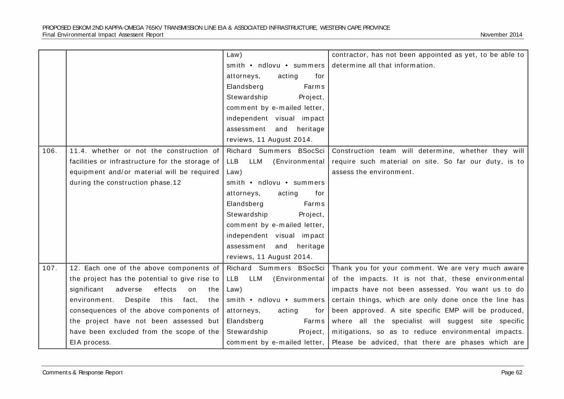
PROPOSED ESKOM 2ND KAPPA-OMEGA 765KV TRANSMISSION LINE EIA & ASSOCIATED INFRASTRUCTURE, WESTERN CAPE PROVINCE Final Environmental Impact Assessent Report November 2014
Comments & Response Report Page 62
Law) smith • ndlovu • summers attorneys, acting for Elandsberg Farms Stewardship Project, comment by e-mailed letter, independent visual impact assessment and heritage reviews, 11 August 2014.
contractor, has not been appointed as yet, to be able to determine all that information.
106. 11.4. whether or not the construction of facilities or infrastructure for the storage of equipment and/or material will be required during the construction phase.12
Richard Summers BSocSci LLB LLM (Environmental Law) smith • ndlovu • summers attorneys, acting for Elandsberg Farms Stewardship Project, comment by e-mailed letter, independent visual impact assessment and heritage reviews, 11 August 2014.
Construction team will determine, whether they will require such material on site. So far our duty, is to assess the environment.
107. 12. Each one of the above components of the project has the potential to give rise to significant adverse effects on the environment. Despite this fact, the consequences of the above components of the project have not been assessed but have been excluded from the scope of the EIA process.
Richard Summers BSocSci LLB LLM (Environmental Law) smith • ndlovu • summers attorneys, acting for Elandsberg Farms Stewardship Project, comment by e-mailed letter,
Thank you for your comment. We are very much aware of the impacts. It is not that, these environmental impacts have not been assessed. You want us to do certain things, which are only done once the line has been approved. A site specific EMP will be produced, where all the specialist will suggest site specific mitigations, so as to reduce environmental impacts. Please be adviced, that there are phases which are
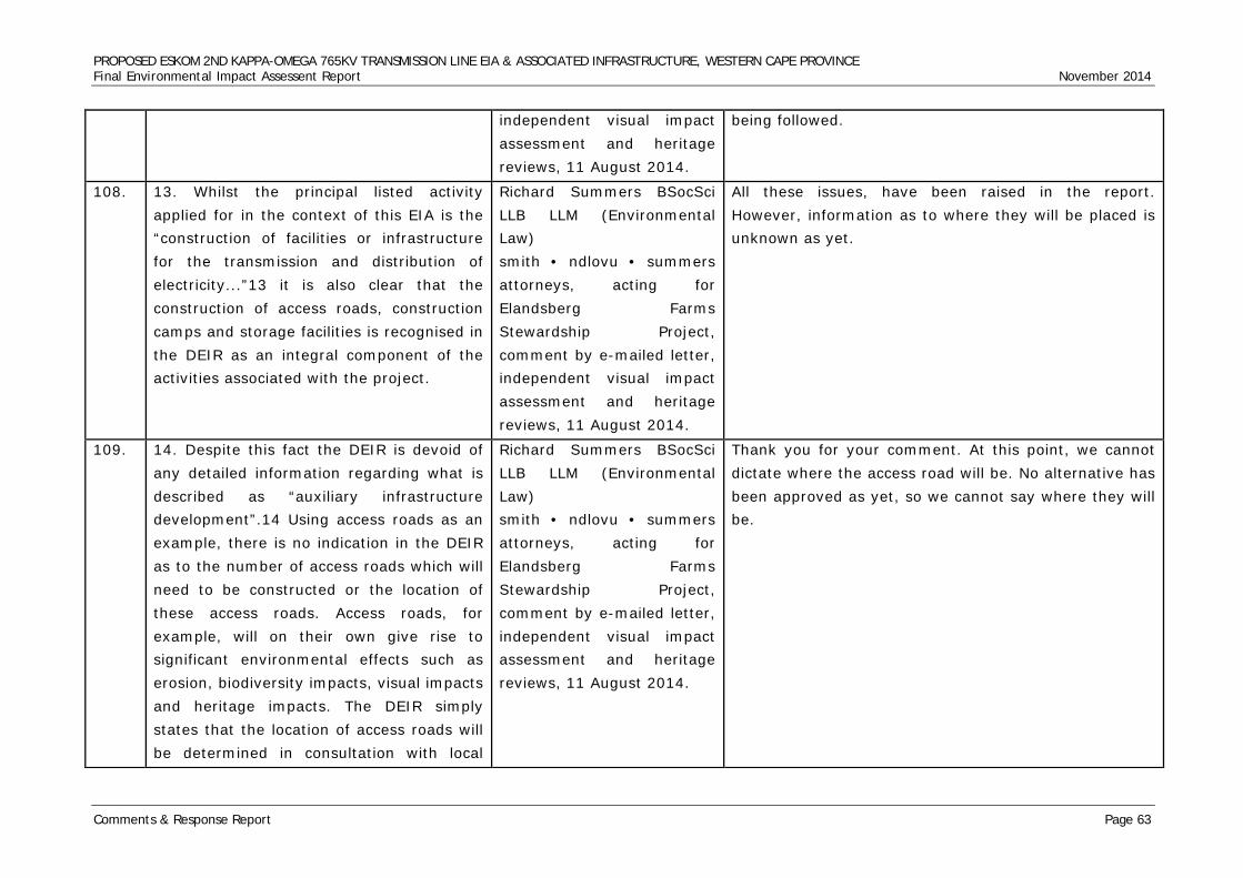
PROPOSED ESKOM 2ND KAPPA-OMEGA 765KV TRANSMISSION LINE EIA & ASSOCIATED INFRASTRUCTURE, WESTERN CAPE PROVINCE Final Environmental Impact Assessent Report November 2014
Comments & Response Report Page 63
independent visual impact assessment and heritage reviews, 11 August 2014.
being followed.
108. 13. Whilst the principal listed activity applied for in the context of this EIA is the “construction of facilities or infrastructure for the transmission and distribution of electricity...”13 it is also clear that the construction of access roads, construction camps and storage facilities is recognised in the DEIR as an integral component of the activities associated with the project.
Richard Summers BSocSci LLB LLM (Environmental Law) smith • ndlovu • summers attorneys, acting for Elandsberg Farms Stewardship Project, comment by e-mailed letter, independent visual impact assessment and heritage reviews, 11 August 2014.
All these issues, have been raised in the report. However, information as to where they will be placed is unknown as yet.
109. 14. Despite this fact the DEIR is devoid of any detailed information regarding what is described as “auxiliary infrastructure development”.14 Using access roads as an example, there is no indication in the DEIR as to the number of access roads which will need to be constructed or the location of these access roads. Access roads, for example, will on their own give rise to significant environmental effects such as erosion, biodiversity impacts, visual impacts and heritage impacts. The DEIR simply states that the location of access roads will be determined in consultation with local
Richard Summers BSocSci LLB LLM (Environmental Law) smith • ndlovu • summers attorneys, acting for Elandsberg Farms Stewardship Project, comment by e-mailed letter, independent visual impact assessment and heritage reviews, 11 August 2014.
Thank you for your comment. At this point, we cannot dictate where the access road will be. No alternative has been approved as yet, so we cannot say where they will be.
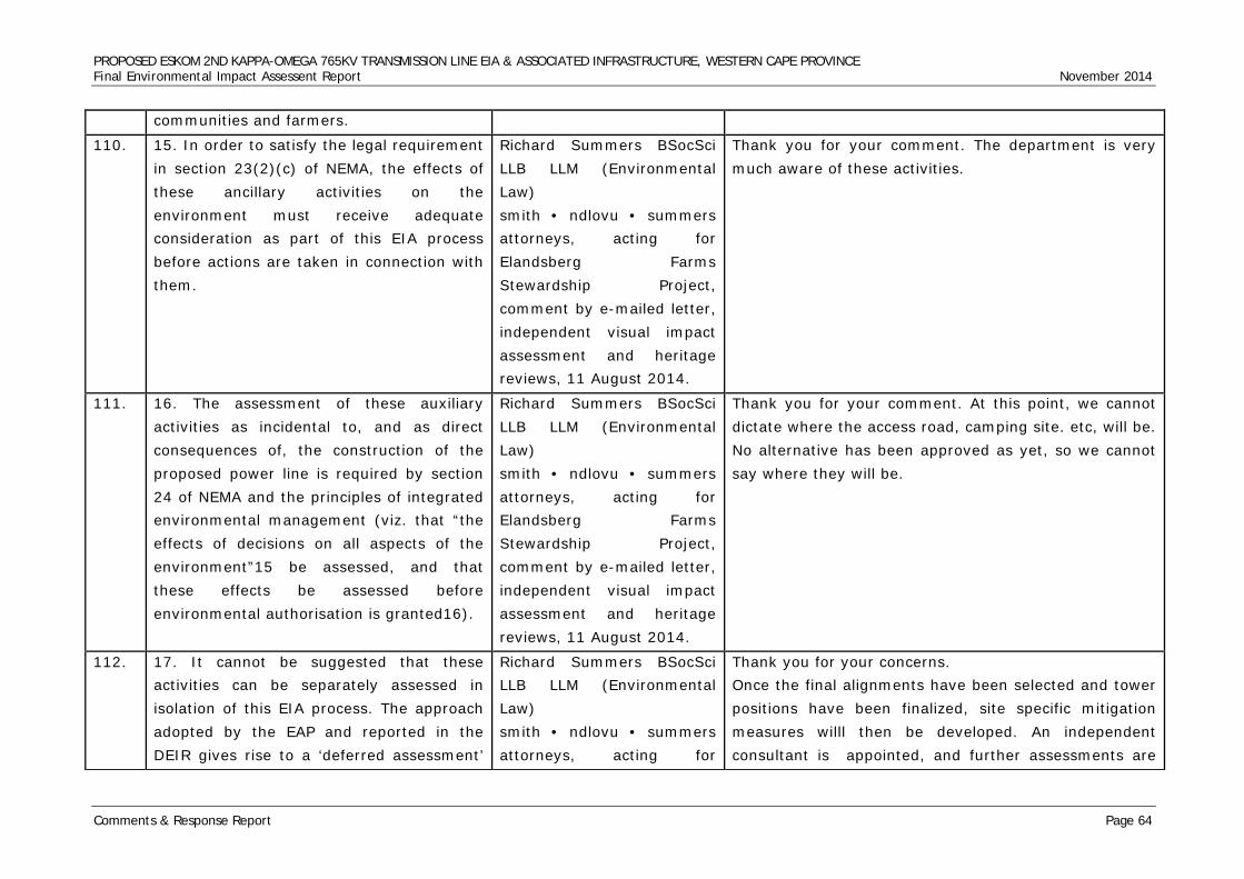
PROPOSED ESKOM 2ND KAPPA-OMEGA 765KV TRANSMISSION LINE EIA & ASSOCIATED INFRASTRUCTURE, WESTERN CAPE PROVINCE Final Environmental Impact Assessent Report November 2014
Comments & Response Report Page 64
communities and farmers.
110. 15. In order to satisfy the legal requirement in section 23(2)(c) of NEMA, the effects of these ancillary activities on the environment must receive adequate consideration as part of this EIA process before actions are taken in connection with them.
Richard Summers BSocSci LLB LLM (Environmental Law) smith • ndlovu • summers attorneys, acting for Elandsberg Farms Stewardship Project, comment by e-mailed letter, independent visual impact assessment and heritage reviews, 11 August 2014.
Thank you for your comment. The department is very much aware of these activities.
111. 16. The assessment of these auxiliary activities as incidental to, and as direct consequences of, the construction of the proposed power line is required by section 24 of NEMA and the principles of integrated environmental management (viz. that “the effects of decisions on all aspects of the environment”15 be assessed, and that these effects be assessed before environmental authorisation is granted16).
Richard Summers BSocSci LLB LLM (Environmental Law) smith • ndlovu • summers attorneys, acting for Elandsberg Farms Stewardship Project, comment by e-mailed letter, independent visual impact assessment and heritage reviews, 11 August 2014.
Thank you for your comment. At this point, we cannot dictate where the access road, camping site. etc, will be. No alternative has been approved as yet, so we cannot say where they will be.
112. 17. It cannot be suggested that these activities can be separately assessed in isolation of this EIA process. The approach adopted by the EAP and reported in the DEIR gives rise to a ‘deferred assessment’
Richard Summers BSocSci LLB LLM (Environmental Law) smith • ndlovu • summers attorneys, acting for
Thank you for your concerns. Once the final alignments have been selected and tower positions have been finalized, site specific mitigation measures willl then be developed. An independent consultant is appointed, and further assessments are
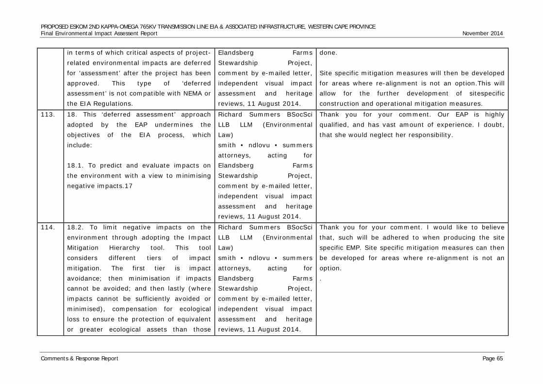
PROPOSED ESKOM 2ND KAPPA-OMEGA 765KV TRANSMISSION LINE EIA & ASSOCIATED INFRASTRUCTURE, WESTERN CAPE PROVINCE Final Environmental Impact Assessent Report November 2014
Comments & Response Report Page 65
in terms of which critical aspects of project-related environmental impacts are deferred for ‘assessment’ after the project has been approved. This type of ‘deferred assessment’ is not compatible with NEMA or the EIA Regulations.
Elandsberg Farms Stewardship Project, comment by e-mailed letter, independent visual impact assessment and heritage reviews, 11 August 2014.
done. Site specific mitigation measures will then be developed for areas where re-alignment is not an option.This will allow for the further development of sitespecific construction and operational mitigation measures.
113. 18. This ‘deferred assessment’ approach adopted by the EAP undermines the objectives of the EIA process, which include: 18.1. To predict and evaluate impacts on the environment with a view to minimising negative impacts.17
Richard Summers BSocSci LLB LLM (Environmental Law) smith • ndlovu • summers attorneys, acting for Elandsberg Farms Stewardship Project, comment by e-mailed letter, independent visual impact assessment and heritage reviews, 11 August 2014.
Thank you for your comment. Our EAP is highly qualified, and has vast amount of experience. I doubt, that she would neglect her responsibility.
114. 18.2. To limit negative impacts on the environment through adopting the Impact Mitigation Hierarchy tool. This tool considers different tiers of impact mitigation. The first tier is impact avoidance; then minimisation if impacts cannot be avoided; and then lastly (where impacts cannot be sufficiently avoided or minimised), compensation for ecological loss to ensure the protection of equivalent or greater ecological assets than those
Richard Summers BSocSci LLB LLM (Environmental Law) smith • ndlovu • summers attorneys, acting for Elandsberg Farms Stewardship Project, comment by e-mailed letter, independent visual impact assessment and heritage reviews, 11 August 2014.
Thank you for your comment. I would like to believe that, such will be adhered to when producing the site specific EMP. Site specific mitigation measures can then be developed for areas where re-alignment is not an option. .
PROPOSED ESKOM 2ND KAPPA-OMEGA 765KV TRANSMISSION LINE EIA & ASSOCIATED INFRASTRUCTURE, WESTERN CAPE PROVINCE Final Environmental Impact Assessent Report November 2014
Comments & Response Report Page 66
lost.18
115. 18.3. To ensure adequate public participation in all aspects of decisions that may affect the environment.19
Richard Summers BSocSci LLB LLM (Environmental Law) smith • ndlovu • summers attorneys, acting for Elandsberg Farms Stewardship Project, comment by e-mailed letter, independent visual impact assessment and heritage reviews, 11 August 2014.
Adequate public participation, was undertaken by the EAP and the TEAM. Several meetings where held with farmers associations, departments and different community members. Their concerns, have acknowledged and incoperated within this issues and response report. Some of the issues, regarding the first 765kv line have been reported to Eskom. We made sure that public issues, are taken serioulsy.
116. 18.4. To select the option that will provide the most benefit and cause the least damage to the environment in the short and long term.20
Richard Summers BSocSci LLB LLM (Environmental Law) smith • ndlovu • summers attorneys, acting for Elandsberg Farms Stewardship Project, comment by e-mailed letter, independent visual impact assessment and heritage reviews, 11 August 2014.
Thank you for your comment.
117. 19. Without describing and assessing the impacts associated with these ancillary activities the DEIR fails to predict or evaluate the impacts that such activities will have on the receiving environment.
Richard Summers BSocSci LLB LLM (Environmental Law) smith • ndlovu • summers attorneys, acting for
Thank you for your comment. At this point, we cannot dictate where the access road,construction camps will be. No alternative has been approved as yet, so we cannot say where they will be. Public concerns are adhered to, even during construction and that is why
PROPOSED ESKOM 2ND KAPPA-OMEGA 765KV TRANSMISSION LINE EIA & ASSOCIATED INFRASTRUCTURE, WESTERN CAPE PROVINCE Final Environmental Impact Assessent Report November 2014
Comments & Response Report Page 67
Accordingly, the practical effect of this ‘deferred assessment’ is that negative impacts cannot be avoided and effective public participation on these issues is prevented. Accordingly, the best practicable environmental option cannot be achieved through such an approach in terms of which impacts are considered only after the project has been authorised.
Elandsberg Farms Stewardship Project, comment by e-mailed letter, independent visual impact assessment and heritage reviews, 11 August 2014.
Eskom appoints an ECO and CLO who will be there to ensure that the people are protected during construction.
118. 20. It is imperative that a proper assessment of the impact of ancillary activities associated with the power line be assessed as part of this EIA process and before the competent authority renders a decision in connection with the application. This must include the assessment of all impacts associated with the siting and location of pylons, access roads, construction camps and storage facilities. The assessment must be predicated upon the requisite level of information regarding the auxiliary infrastructure development. It is also imperative that I&APs be afforded an opportunity, through the EIA public participation process, to comment on the applicant’s assessment of all such project-related impacts.
Richard Summers BSocSci LLB LLM (Environmental Law) smith • ndlovu • summers attorneys, acting for Elandsberg Farms Stewardship Project, comment by e-mailed letter, independent visual impact assessment and heritage reviews, 11 August 2014.
Thank you for your concerns. Once the final alignments have been selected and tower positions have been finalized, site specific mitigation measures willl then be developed. An independent consultant is appointed, and further assessments are done. Site specific mitigation measures will then be developed for areas where re-alignment is not an option.This will allow for the further development of sitespecific construction and operational mitigation measures.
119. ALTERNATIVES Richard Summers BSocSci Thank you for your comment.
PROPOSED ESKOM 2ND KAPPA-OMEGA 765KV TRANSMISSION LINE EIA & ASSOCIATED INFRASTRUCTURE, WESTERN CAPE PROVINCE Final Environmental Impact Assessent Report November 2014
Comments & Response Report Page 68
21. The EIA Regulations provide that alternatives to the proposed activity, including the advantages and disadvantages that the proposed activity or alternatives may have on the environment and the community affected by the activity, must be considered and assessed as part of the assessment phase of the EIA process which culminates in the production of such information in an environmental impact report such as the DEIR.21
LLB LLM (Environmental Law) smith • ndlovu • summers attorneys, acting for Elandsberg Farms Stewardship Project, comment by e-mailed letter, independent visual impact assessment and heritage reviews, 11 August 2014.
120. 22. The approach to the identification and assessment of alternatives in this project was constrained at the outset, as the applicant itself pre-determined the alternative routes.22 It is clear from the specialist reports that the specialists (and the EAP) were not involved in the route selection process or the identification of appropriate development alternatives.23 In the result the EIA process has been constrained. The statement in the DEIR that “this study includes describing the project, determining the project alternatives, environmental management plan for the proposed project attached in this Report”24 is, therefore, not correct.
Richard Summers BSocSci LLB LLM (Environmental Law) smith • ndlovu • summers attorneys, acting for Elandsberg Farms Stewardship Project, comment by e-mailed letter, independent visual impact assessment and heritage reviews, 11 August 2014.
Thank you for your comment. Eskom’s mandate remains to provide electricity in an efficient and sustainable manner, including the generation, transmission and distribution of electricity, the latter including wholesale and retail sales. Eskom is a critical and strategic contributor to the South African government’s goal of ensuring security of electricity supply in the country as well as economic growth and prosperity
121. 23. The DEIR records that all routes were Richard Summers BSocSci Thank you for your comment. We are not disputing the
PROPOSED ESKOM 2ND KAPPA-OMEGA 765KV TRANSMISSION LINE EIA & ASSOCIATED INFRASTRUCTURE, WESTERN CAPE PROVINCE Final Environmental Impact Assessent Report November 2014
Comments & Response Report Page 69
studied thoroughly by scientists in the EIA process, leading to the selection of Alternative Route 1 as the preferred route.25 This statement is also not correct. Eskom determined the alternative routes before the EIA process commenced and the EAP and specialists were constrained to a consideration of these pre-determined alternative routes only.26
LLB LLM (Environmental Law) smith • ndlovu • summers attorneys, acting for Elandsberg Farms Stewardship Project, comment by e-mailed letter, independent visual impact assessment and heritage reviews, 11 August 2014.
fact that Eskom chose alternatives 1, 2, and 3 with deviations. However, when the specialists did their assessments they also came up with the different conclusion. That does not necessarily mean, they were forced to go for that prefered alternative. Had it not been, the better route then I doubt the specialists would have recommended that alternative. We strongly believe that our specialists, are highly qualified and would never put their jobs at risks.hence they are contracted to be independent and study the routes independently and please note that they were on site looking for differenrent aspects there was no at time when ESKOM told them which route they should choose between the 3 routes and the deviaitions. Eskom takes into consideration the techical issues costs and also the connections of these substations and powerlines all these are Eskom responsbility to connect these substations and it will not be technical, or environmental viable to take the longest route to connects the substation
122. 24. The competent authority is required, where appropriate, to consider “any reasonable and feasible alternatives to the activity which is the subject of the application and any feasible and reasonable modifications or changes to the activity that may minimise harm to the environment”.27 Internationally-recognised best practice for
Richard Summers BSocSci LLB LLM (Environmental Law) smith • ndlovu • summers attorneys, acting for Elandsberg Farms Stewardship Project, comment by e-mailed letter,
Thank you for your comment. We appointed specialists, inorder to determine a more feasible alternative. Physical changes( re-alignment) of pylons, will be conducted during the compilation of the site specific EMP.
PROPOSED ESKOM 2ND KAPPA-OMEGA 765KV TRANSMISSION LINE EIA & ASSOCIATED INFRASTRUCTURE, WESTERN CAPE PROVINCE Final Environmental Impact Assessent Report November 2014
Comments & Response Report Page 70
avoiding or reducing the environmental impacts of power lines recognises that alternative routes must be determined with reference to the EIA process. In this sense, the EIA process is rendered ineffective if the role of the EIA process is limited to simply identifying the impacts associated with a pre-determined alternative. The reason being that this flawed methodology precludes the EIA process from being able to respond to significant adverse environmental impacts.
independent visual impact assessment and heritage reviews, 11 August 2014.
123. 25. The effect of the applicant pre-determining the alternative routes has been to constrain the ability of the specialists to respond to negative impacts identified along the route corridors. As such, specialists were not in a position to suggest modifications or changes to the route to avoid significant adverse environmental impacts.
Richard Summers BSocSci LLB LLM (Environmental Law) smith • ndlovu • summers attorneys, acting for Elandsberg Farms Stewardship Project, comment by e-mailed letter, independent visual impact assessment and heritage reviews, 11 August 2014.
Thank you for your comment. Before Eskom appointed the independent consultants, they had their own team of specialists evaluating the alternatives. Including high qualified engineers and environmentalist to assess the routes whether they are viable or note, and further more the 765kv have been constructed in the country and all the impacts are known.
124. 26. The Department of Environmental Affairs and Development Planning (“DEA&DP”) have published a number of EIA guidelines which are useful in explaining the general legislative intent
Richard Summers BSocSci LLB LLM (Environmental Law) smith • ndlovu • summers attorneys, acting for
Thank you. I would like to believe, that we aware of these guidelines and hence we where appointed to do this assessment.
PROPOSED ESKOM 2ND KAPPA-OMEGA 765KV TRANSMISSION LINE EIA & ASSOCIATED INFRASTRUCTURE, WESTERN CAPE PROVINCE Final Environmental Impact Assessent Report November 2014
Comments & Response Report Page 71
behind legal requirements under the EIA Regulations. It is clear from the DEA&DP Guideline on Alternatives that the EIA process itself can confirm an important role in the identification of alternatives. The reason for this is that it is the assessment of potential impacts and the gathering of information during the assessment phase which should inform the alternative options. The following is quoted from the Guideline on Alternatives in support of this assertion: “Every EIA process must therefore identify and investigate alternatives, with feasible and reasonable alternatives to be comparatively assessed.”28 [Own underlining]. “The identification of alternatives should be broad, objectively done and well documented.”29 [Own underlining]. “The “feasibility” and “reasonability” of and the need for alternatives must be determined by considering, inter alia, (a) the general purpose and requirements of the activity, (b) need and desirability, (c) opportunity costs, (d) the need to avoid
Elandsberg Farms Stewardship Project, comment by e-mailed letter, independent visual impact assessment and heritage reviews, 11 August 2014.
PROPOSED ESKOM 2ND KAPPA-OMEGA 765KV TRANSMISSION LINE EIA & ASSOCIATED INFRASTRUCTURE, WESTERN CAPE PROVINCE Final Environmental Impact Assessent Report November 2014
Comments & Response Report Page 72
negative impacts altogether, (e) the need to minimise unavoidable negative impacts, (f) the need to maximise benefits, and (g) the need for equitable distributional consequences.”30 [Own underlining].
125. 27. With regard to the minimum requirements for heritage impact assessment, section 38(2)(f) of the National Heritage Resources Act 31 (“NHRA”) states the following: “The responsible heritage resources authority must specify the information to be provided in a report required in terms of subsection (2)(a): Provided that the following must be included: ... (f) if heritage resources will be adversely affected by the proposed development, the consideration of alternatives...” [Own emphasis].
Richard Summers BSocSci LLB LLM (Environmental Law) smith • ndlovu • summers attorneys, acting for Elandsberg Farms Stewardship Project, comment by e-mailed letter, independent visual impact assessment and heritage reviews, 11 August 2014.
We are confident that our heritage specialists adhered to minimum requirements of both SAHRA and Heritage Western Cape. The heritage team has vast experience in Heritage Impact Assessments. This paragraph makes reference to minimum requirements of the HIA and cites Section 38(2)(f) of the NHRA (Act 25 of 1999). This is not correct because the cited section addresses directive to responsible heritage authority to respond within 14 days to issued notifications for proposed development. Section 38(2) does not have subsection (f) as stated in the Summers’ paragraph 27. Nonetheless, the HIA exercise we have conducted thus far fully satisfied Section 38(2) of the NHRA 25 of 1999. Notice of Intend to Develop and the Need and Desirability (NID) Applications were submitted to both the South African Heritage Resources Agency (SAHRA) and Heritage Western Cape (HWC) (HWC Case 12004JL09E). Both these heritage compliancy authorities issued their responses and directives that Phase 1 HIA study was necessary, hence the HIA exercise we conducted. HWC issued their directive and specified the nature of the heritage assessment deemed
PROPOSED ESKOM 2ND KAPPA-OMEGA 765KV TRANSMISSION LINE EIA & ASSOCIATED INFRASTRUCTURE, WESTERN CAPE PROVINCE Final Environmental Impact Assessent Report November 2014
Comments & Response Report Page 73
necessary for the nature of the proposed powerline development. We have followed and fulfilled these directives to later. We have fully complied with Section 38(2)(a) by submitting the relevant applications, notifications and NID. Beyond that, in line with Section 38(3), we have engaged and met with HWC officials to discuss their specifications for the HIA study with regards to the proposed powerline routes and associated alternatives (as specified in Sec. 38(3)(f), as well as the extent of the proposed powerline servitudes to be covered in the HIA study.
126. 28. The DEA&DP Guideline for Involving Heritage Specialists in EIA Processes, dated June 2005, provides the following with regard to “Clarifying Appropriate Development Alternatives”: “Alternatives considered in the EIA process can include location and/or routing alternatives, layout alternatives, process and/or design alternatives, scheduling alternatives or input alternatives. Any development proposal may include a range of possible alternatives from some or all of these various categories of alternatives. The “no- go” alternative in EIA provides a
Richard Summers BSocSci LLB LLM (Environmental Law) smith • ndlovu • summers attorneys, acting for Elandsberg Farms Stewardship Project, comment by e-mailed letter, independent visual impact assessment and heritage reviews, 11 August 2014.
Please note that selection of routes is not determined by heritage studies. Selection of routes is a technical exercise that is determined by factors such as demand for electricity and existence of infrastructure such as substations and power stations. Eskom has the mandate to transmit and distribute electricity to where it is required. There are responsible for designing Transmission network. Heritage specialists, SAHRA and Heritage Western Cape were involved in the scoping phase and subsequent EIA Process. As far as we are concerned all heritage aspects were adequately covered. Summers, et. al. paragraph 28 addresses the role of heritage specialists in EIA specifically with reference to selecting alternatives. The information provided is
PROPOSED ESKOM 2ND KAPPA-OMEGA 765KV TRANSMISSION LINE EIA & ASSOCIATED INFRASTRUCTURE, WESTERN CAPE PROVINCE Final Environmental Impact Assessent Report November 2014
Comments & Response Report Page 74
benchmark against which to evaluate potential impacts of the proposed project alternatives. The heritage specialist should be involved in the selection of appropriate development alternatives, which clearly respond to significance of heritage impacts. Alternatives are best considered in the pre-application and early stages of the EIA, where the proposal has greater flexibility and opportunities to avoid or prevent significance impacts are more easily achievable.”32 [Own underlining].
correct. However, it is our considered interpretation that the guidelines Summers, et. al. refers to were not necessarily referring to heritage sub-discipline specialists’ studies. We are the responsible Principle Investigator (PI) for the HIA Phase 1 Report. In conducting this study, we commissioned additional input from independent heritage sub-discipline specialists such as built environment, cultural and spatial history, archaeology, palaeontology and physical cultural properties risk managers. As Principle Investigator, we are competent to engage with both the developer and the compliance authorities regarding the proposed development, its location and alternatives to be considered in the Phase 1 HIA as stipulated in both the NHRA, Act 25 of 1999 Section 38 and the SAHRA and HWC HIA Guidelines. It is correct that Eskom SOC proposed a specific development in a specific geographic area where the proposed transmission lines should connect fixed pre-existing points. The proposed powerline has to T-off from existing and fixed Kappa Sub Station location and traverse through section of the Western Cape to another existing and fixed Omega Sub Station location. Whichever route the proposed powerline follows, it has to link these fixed points and logic framework dictates that the study area has to be defined around these fixed points and the powerline may only be considered within
PROPOSED ESKOM 2ND KAPPA-OMEGA 765KV TRANSMISSION LINE EIA & ASSOCIATED INFRASTRUCTURE, WESTERN CAPE PROVINCE Final Environmental Impact Assessent Report November 2014
Comments & Response Report Page 75
a viable corridor between the said fixed points. Once the developer’s planners, engineers and the EAP and GIS specialists proposed potential servitude routes within study area, we did not find any reason to primarily dismiss the proposed alternatives nor did we think it necessary to propose additional alternatives for HIA study before considering the proposed alternatives on the table. As such, we had the relevant notifications and applications submitted to the heritage compliance authorities. HWC issued their directives on the routes and alternatives. We analysed their directives and made further submissions and engaged the authority until three (3) proposed alternatives and their extent were defined for the HIA study. Based on this information, we then commissioned heritage sub-discipline specialists to assess the defined route servitudes. Summers, et. al. will be correct in pointing out that the Built Environment, Spatial History and Cultural Landscape specialists did not participate in selecting proposed routes. Our interpretation of this responsibility is that we are the primary HIA Study PI; we took that responsibility because we have the relevant heritage and management qualifications, experience and professional standing in heritage resources management to undertake the task and we did. After all, we extensively engaged with relevant heritage authority on the finalisation of the study servitudes. There is no logic in the notion that limited participation of a sub-discipline
PROPOSED ESKOM 2ND KAPPA-OMEGA 765KV TRANSMISSION LINE EIA & ASSOCIATED INFRASTRUCTURE, WESTERN CAPE PROVINCE Final Environmental Impact Assessent Report November 2014
Comments & Response Report Page 76
specialists would invalidate the alternative selection exercise.
127. 29. Whilst the Guideline for Involving Heritage Specialists quoted above identifies heritage indicators and constraints as key criteria for the selection of alternatives, the Built Environment, Spatial History and Cultural Landscape Report (“Cultural Landscape Report”) notes that: “ESKOM Transmission determined route alternatives before the beginning of the project, based on existing ESKOM lines and servitudes, feedback from the first 765kV line application and the need to extend electrical power supply to the Western Cape. Specialists were not involved in route selection.”33 [Own underlining].
Richard Summers BSocSci LLB LLM (Environmental Law) smith • ndlovu • summers attorneys, acting for Elandsberg Farms Stewardship Project, comment by e-mailed letter, independent visual impact assessment and heritage reviews, 11 August 2014.
The purpose of the scoping phase of the EIA process covers your concerns. Scoping phase is the ideal way of involving specialist in accordance with the legislation, if there are serious heritage concerns in the route selection specialists can discard sensitive routes or recommend further studies.
128. 30. As a result of Eskom’s predetermined alternative routes, the study area itself was geographically limited. Specialists were limited to study corridors of 1 kilometre on either side of the proposed routes.34 At the outset, therefore, studies undertaken by the specialists did not inform the route selection. The effect of this is that the route selection has not been informed by an assessment of information on the
Richard Summers BSocSci LLB LLM (Environmental Law) smith • ndlovu • summers attorneys, acting for Elandsberg Farms Stewardship Project, comment by e-mailed letter, independent visual impact assessment and heritage
It is unfortunate that your comment is based on lack of information about the EIA process and our engagements with the relevant authorities. Before the proposed powerline development is subjected to EIA studies Eskom conducts feasiblity studies which are key in route selections as well technical considerations. The proposed corridors are 2km wide for all the specialist studies and 4km for heritage studies. I believe any corridor wider than 4km for a powerline development will be urealistic. Powerline construction is determined by many factors ie
PROPOSED ESKOM 2ND KAPPA-OMEGA 765KV TRANSMISSION LINE EIA & ASSOCIATED INFRASTRUCTURE, WESTERN CAPE PROVINCE Final Environmental Impact Assessent Report November 2014
Comments & Response Report Page 77
anticipated impacts of the proposed power line. The assessment of alternatives does not therefore respond to specialist input generated through the EIA process which would enable an appropriate response to particular environmental constraints or the significance of impacts.
reviews, 11 August 2014.
technical considerations, environmental issues, funding and demand. Also note that there were three alternatives for the proposed powerline development and I am confident that you are aware of the advantages of having more than 3 alternatives for a single development.
129. 31. It is also clear from the DEIR that the exclusion of certain project alternatives by the EAP has more to do with the cost sensitivity of the applicant than valid environmental considerations. For example, the alternative of situating the proposed power line underground is noted in the DEIR but immediately dismissed for the following reason: “[T]he preference with overhead lines is mainly on the grounds of costs and intrusive nature”.35
Richard Summers BSocSci LLB LLM (Environmental Law) smith • ndlovu • summers attorneys, acting for Elandsberg Farms Stewardship Project, comment by e-mailed letter, independent visual impact assessment and heritage reviews, 11 August 2014.
Thank you for your comment. Are you aware of the environmental implications of having a 765 kv powerline underground. When burying cables, the soil must be exchanged. Furthermore, not only do the cable routes need to be kept free from deeply rooted plants, they may not be built on for any other purpose. In addition, underground cables radiate heat. This has an effect on soil humidity, which, for example, can lead to drainage or drying out of marshes. The laying of underground cable also requires the construction of cable jointing structures every 500 to 700 meters, as well as compensation facilities along the cable route. As a result, existing biotopes are permanently cut up. As long-term experience with underground 22-kV cable is lacking, the effects on the soil of decomposition of the plastic cable sheathing remain unknown.
130. 32. It is also clear that key to the selection of Alternative Route 1 as the preferred route was influenced by it being the “most direct” route between the Kappa and
Richard Summers BSocSci LLB LLM (Environmental Law) smith • ndlovu • summers
Eskom’s purpose is to provide sustainable electricity solutions to grow the economy and improve the quality of life of the people in South Africa and the region. Their mandate remains to provide electricity n
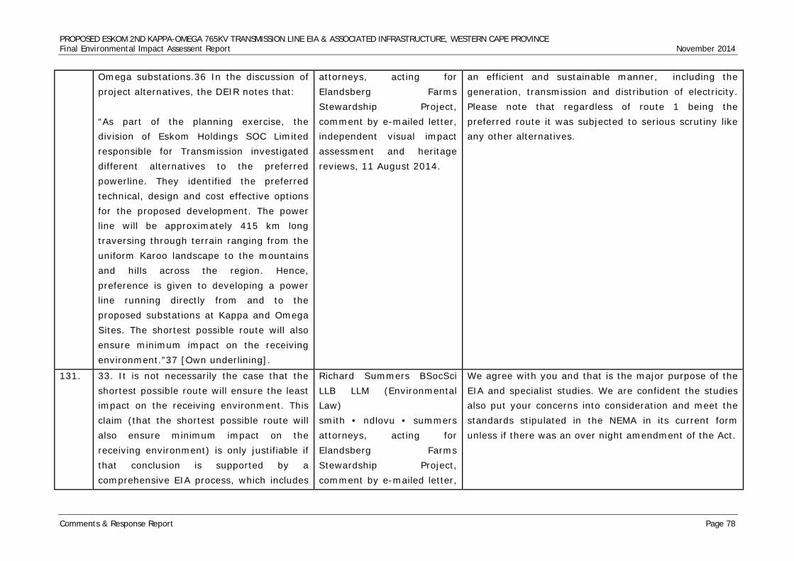
PROPOSED ESKOM 2ND KAPPA-OMEGA 765KV TRANSMISSION LINE EIA & ASSOCIATED INFRASTRUCTURE, WESTERN CAPE PROVINCE Final Environmental Impact Assessent Report November 2014
Comments & Response Report Page 78
Omega substations.36 In the discussion of project alternatives, the DEIR notes that: “As part of the planning exercise, the division of Eskom Holdings SOC Limited responsible for Transmission investigated different alternatives to the preferred powerline. They identified the preferred technical, design and cost effective options for the proposed development. The power line will be approximately 415 km long traversing through terrain ranging from the uniform Karoo landscape to the mountains and hills across the region. Hence, preference is given to developing a power line running directly from and to the proposed substations at Kappa and Omega Sites. The shortest possible route will also ensure minimum impact on the receiving environment.”37 [Own underlining].
attorneys, acting for Elandsberg Farms Stewardship Project, comment by e-mailed letter, independent visual impact assessment and heritage reviews, 11 August 2014.
an efficient and sustainable manner, including the generation, transmission and distribution of electricity. Please note that regardless of route 1 being the preferred route it was subjected to serious scrutiny like any other alternatives.
131. 33. It is not necessarily the case that the shortest possible route will ensure the least impact on the receiving environment. This claim (that the shortest possible route will also ensure minimum impact on the receiving environment) is only justifiable if that conclusion is supported by a comprehensive EIA process, which includes
Richard Summers BSocSci LLB LLM (Environmental Law) smith • ndlovu • summers attorneys, acting for Elandsberg Farms Stewardship Project, comment by e-mailed letter,
We agree with you and that is the major purpose of the EIA and specialist studies. We are confident the studies also put your concerns into consideration and meet the standards stipulated in the NEMA in its current form unless if there was an over night amendment of the Act.
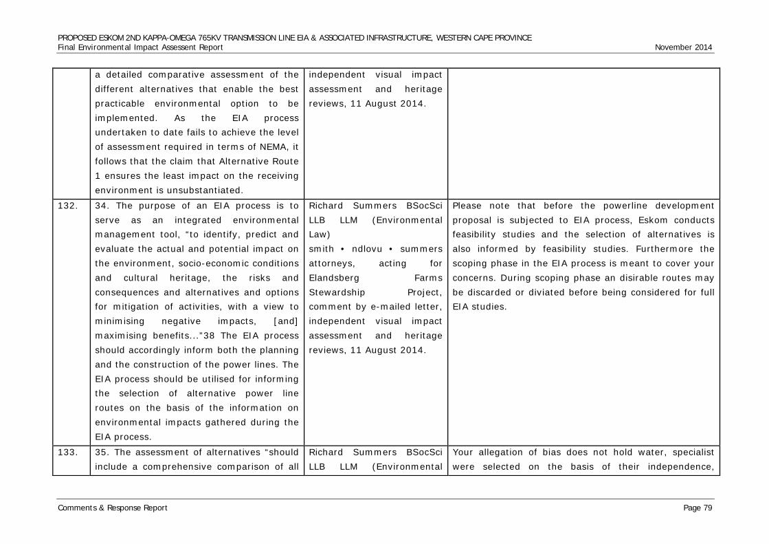
PROPOSED ESKOM 2ND KAPPA-OMEGA 765KV TRANSMISSION LINE EIA & ASSOCIATED INFRASTRUCTURE, WESTERN CAPE PROVINCE Final Environmental Impact Assessent Report November 2014
Comments & Response Report Page 79
a detailed comparative assessment of the different alternatives that enable the best practicable environmental option to be implemented. As the EIA process undertaken to date fails to achieve the level of assessment required in terms of NEMA, it follows that the claim that Alternative Route 1 ensures the least impact on the receiving environment is unsubstantiated.
independent visual impact assessment and heritage reviews, 11 August 2014.
132. 34. The purpose of an EIA process is to serve as an integrated environmental management tool, “to identify, predict and evaluate the actual and potential impact on the environment, socio-economic conditions and cultural heritage, the risks and consequences and alternatives and options for mitigation of activities, with a view to minimising negative impacts, [and] maximising benefits...”38 The EIA process should accordingly inform both the planning and the construction of the power lines. The EIA process should be utilised for informing the selection of alternative power line routes on the basis of the information on environmental impacts gathered during the EIA process.
Richard Summers BSocSci LLB LLM (Environmental Law) smith • ndlovu • summers attorneys, acting for Elandsberg Farms Stewardship Project, comment by e-mailed letter, independent visual impact assessment and heritage reviews, 11 August 2014.
Please note that before the powerline development proposal is subjected to EIA process, Eskom conducts feasibility studies and the selection of alternatives is also informed by feasibility studies. Furthermore the scoping phase in the EIA process is meant to cover your concerns. During scoping phase an disirable routes may be discarded or diviated before being considered for full EIA studies.
133. 35. The assessment of alternatives “should include a comprehensive comparison of all
Richard Summers BSocSci LLB LLM (Environmental
Your allegation of bias does not hold water, specialist were selected on the basis of their independence,
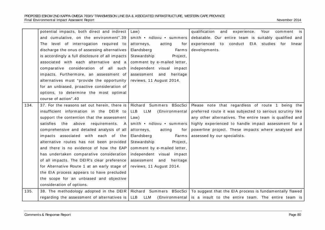
PROPOSED ESKOM 2ND KAPPA-OMEGA 765KV TRANSMISSION LINE EIA & ASSOCIATED INFRASTRUCTURE, WESTERN CAPE PROVINCE Final Environmental Impact Assessent Report November 2014
Comments & Response Report Page 80
potential impacts, both direct and indirect and cumulative, on the environment”.39 The level of interrogation required to discharge the onus of assessing alternatives is accordingly a full disclosure of all impacts associated with each alternative and a comparative consideration of all such impacts. Furthermore, an assessment of alternatives must “provide the opportunity for an unbiased, proactive consideration of options, to determine the most optimal course of action”.40
Law) smith • ndlovu • summers attorneys, acting for Elandsberg Farms Stewardship Project, comment by e-mailed letter, independent visual impact assessment and heritage reviews, 11 August 2014.
qualification and experience. Your comment is debatable. Our entire team is suitably qualified and experienced to conduct EIA studies for linear developments.
134. 37. For the reasons set out herein, there is insufficient information in the DEIR to support the contention that the assessment satisfies the above requirements. A comprehensive and detailed analysis of all impacts associated with each of the alternative routes has not been provided and there is no evidence of how the EAP has undertaken comparative consideration of all impacts. The DEIR’s clear preference for Alternative Route 1 at an early stage of the EIA process appears to have precluded the scope for an unbiased and objective consideration of options.
Richard Summers BSocSci LLB LLM (Environmental Law) smith • ndlovu • summers attorneys, acting for Elandsberg Farms Stewardship Project, comment by e-mailed letter, independent visual impact assessment and heritage reviews, 11 August 2014.
Please note that regardless of route 1 being the preferred route it was subjected to serious scrutiny like any other alternatives. The entire team is qualified and highly experienced to handle impact assessment for a powerline project. These impacts where analysed and assessed by our specialists.
135. 38. The methodology adopted in the DEIR regarding the assessment of alternatives is
Richard Summers BSocSci LLB LLM (Environmental
To suggest that the EIA process is fundamentally flawed is a insult to the entire team. The entire team is
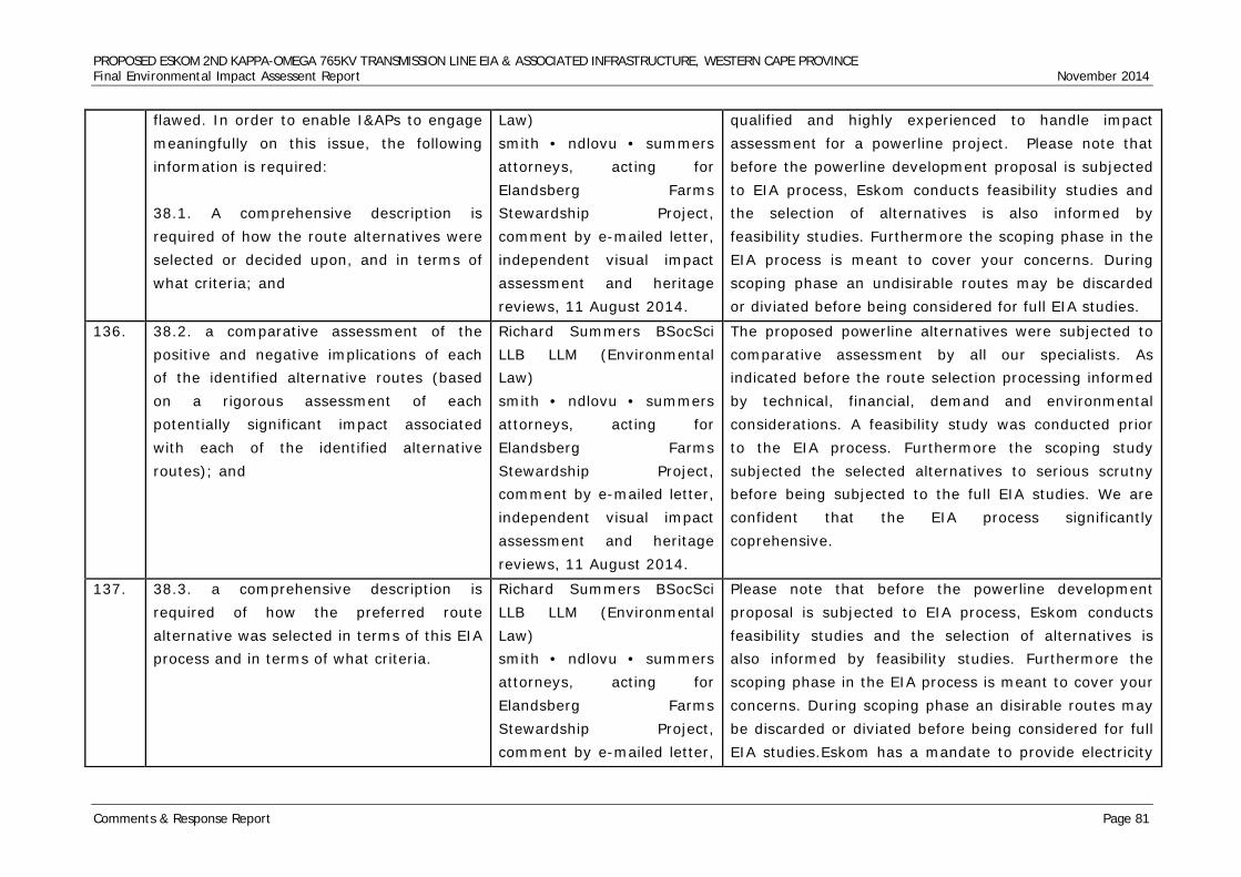
PROPOSED ESKOM 2ND KAPPA-OMEGA 765KV TRANSMISSION LINE EIA & ASSOCIATED INFRASTRUCTURE, WESTERN CAPE PROVINCE Final Environmental Impact Assessent Report November 2014
Comments & Response Report Page 81
flawed. In order to enable I&APs to engage meaningfully on this issue, the following information is required: 38.1. A comprehensive description is required of how the route alternatives were selected or decided upon, and in terms of what criteria; and
Law) smith • ndlovu • summers attorneys, acting for Elandsberg Farms Stewardship Project, comment by e-mailed letter, independent visual impact assessment and heritage reviews, 11 August 2014.
qualified and highly experienced to handle impact assessment for a powerline project. Please note that before the powerline development proposal is subjected to EIA process, Eskom conducts feasibility studies and the selection of alternatives is also informed by feasibility studies. Furthermore the scoping phase in the EIA process is meant to cover your concerns. During scoping phase an undisirable routes may be discarded or diviated before being considered for full EIA studies.
136. 38.2. a comparative assessment of the positive and negative implications of each of the identified alternative routes (based on a rigorous assessment of each potentially significant impact associated with each of the identified alternative routes); and
Richard Summers BSocSci LLB LLM (Environmental Law) smith • ndlovu • summers attorneys, acting for Elandsberg Farms Stewardship Project, comment by e-mailed letter, independent visual impact assessment and heritage reviews, 11 August 2014.
The proposed powerline alternatives were subjected to comparative assessment by all our specialists. As indicated before the route selection processing informed by technical, financial, demand and environmental considerations. A feasibility study was conducted prior to the EIA process. Furthermore the scoping study subjected the selected alternatives to serious scrutny before being subjected to the full EIA studies. We are confident that the EIA process significantly coprehensive.
137. 38.3. a comprehensive description is required of how the preferred route alternative was selected in terms of this EIA process and in terms of what criteria.
Richard Summers BSocSci LLB LLM (Environmental Law) smith • ndlovu • summers attorneys, acting for Elandsberg Farms Stewardship Project, comment by e-mailed letter,
Please note that before the powerline development proposal is subjected to EIA process, Eskom conducts feasibility studies and the selection of alternatives is also informed by feasibility studies. Furthermore the scoping phase in the EIA process is meant to cover your concerns. During scoping phase an disirable routes may be discarded or diviated before being considered for full EIA studies.Eskom has a mandate to provide electricity
PROPOSED ESKOM 2ND KAPPA-OMEGA 765KV TRANSMISSION LINE EIA & ASSOCIATED INFRASTRUCTURE, WESTERN CAPE PROVINCE Final Environmental Impact Assessent Report November 2014
Comments & Response Report Page 82
independent visual impact assessment and heritage reviews, 11 August 2014.
for the nation. They know which area is in need of electricity.
138. NEED AND DESIRABILITY 39. The DEIR fails to adequately address the issue of need and desirability and any statements made therein are limited to a consideration of the need for additional transmission capacity in the Western Cape.
Richard Summers BSocSci LLB LLM (Environmental Law) smith • ndlovu • summers attorneys, acting for Elandsberg Farms Stewardship Project, comment by e-mailed letter, independent visual impact assessment and heritage reviews, 11 August 2014.
Thank you for your comment. The need and desirability was clearly addressesd on the project motivation.
139. 40. Based on Eskom’s mandate, the inquiry undertaken by the EAP is limited to recognising “the identified need for the proposed development to proceed” and the fact that “although there could be negative impacts associated with the proposed development, there are several possible and effective mitigating measures that could be implemented to minimise or eliminate negative impacts”.41
Richard Summers BSocSci LLB LLM (Environmental Law) smith • ndlovu • summers attorneys, acting for Elandsberg Farms Stewardship Project, comment by e-mailed letter, independent visual impact assessment and heritage reviews, 11 August 2014.
Thank you for your comment. These site specific mitigation measures, will be included in the site specific EMP.
140. 41. Need and desirability, as a concept required to be considered in terms of the
Richard Summers BSocSci LLB LLM (Environmental
Thank you for your comment. Before Eskom even appoints independent consultants they already know the
PROPOSED ESKOM 2ND KAPPA-OMEGA 765KV TRANSMISSION LINE EIA & ASSOCIATED INFRASTRUCTURE, WESTERN CAPE PROVINCE Final Environmental Impact Assessent Report November 2014
Comments & Response Report Page 83
EIA Regulations, requires something more than a limited consideration of the positive outcomes of a proposed activity, coupled with an attempt at mitigating adverse environmental effects (which the current EIA process is limited to). Rather the enquiry into need and desirability requires a holistic and integrated consideration of the positive and negative environmental effects of the proposed development. A balancing exercise is required to weigh up the relative pros and cons of the proposed development. This exercise requires the accurate prediction, evaluation and assessment of all environmental, economic and social consequences of the 765kV power line.
Law) smith • ndlovu • summers attorneys, acting for Elandsberg Farms Stewardship Project, comment by e-mailed letter, independent visual impact assessment and heritage reviews, 11 August 2014.
need for that line. Meaning, they do feasability studies.We as consultants don’t sit down and make up the need for the powerline.It might seem generic to you, but please be aware of the fact that Eskom undergoes several processes prior to involving anyone else. We as independent consultants and specialists, then do further studies. These studies(reports) submitted, respond to all the issues that you have.
141. 42. As indicated above, the DEIR has only motivated for the need for the proposed power line from the general perspective of the country’s energy requirements 42 . A comprehensive integration of all relevant environmental considerations into the strategic socio-economic context is absent from the DEIR. In other words, the DEIR fails to include a consideration of both the identified positive socio-economic benefits and the environmental “trade-offs” or
Richard Summers BSocSci LLB LLM (Environmental Law) smith • ndlovu • summers attorneys, acting for Elandsberg Farms Stewardship Project, comment by e-mailed letter, independent visual impact assessment and heritage reviews, 11 August 2014.
Thank you for your comment. Before Eskom even appoints independent consultants they already know the need for that line. Meaning, they do feasability studies.We as consultants don’t sit down and make up the need for the powerline.It might seem generic to you, but please be aware of the fact that Eskom undergoes several processes prior to involving anyone else. We as independent consultants and specialists, then do further studies. These studies(reports) submitted, respond to all the issues that you have.
PROPOSED ESKOM 2ND KAPPA-OMEGA 765KV TRANSMISSION LINE EIA & ASSOCIATED INFRASTRUCTURE, WESTERN CAPE PROVINCE Final Environmental Impact Assessent Report November 2014
Comments & Response Report Page 84
adverse effects associated with the benefits of meeting energy requirements through the implementation of this project. In the EIA context the country’s energy requirements cannot be considered in isolation of and without due regard to the environmental costs associated with this project.
142. 43. According to the DEA&DP Guideline on Need and Desirability43, the competent authority, when considering an application for environmental authorisation, must: “...have regard to a number of specific relevant considerations, including specifically having to consider “the need and desirability of the activity”. The EIA Regulations specify that the basic assessment report, scoping report and environmental impact report must provide a description of the need and desirability of the proposed activity and identified potential alternatives to the proposed activity. It requires that both need and desirability must be considered by the developer, his/her independent environmental assessment practitioner (EAP), the specialists, and the competent authority. Interested and affected parties
Richard Summers BSocSci LLB LLM (Environmental Law) smith • ndlovu • summers attorneys, acting for Elandsberg Farms Stewardship Project, comment by e-mailed letter, independent visual impact assessment and heritage reviews, 11 August 2014.
Thank you for your comment. Before Eskom even appoints independent consultants they already know the need for that line. We as consultants don’t sit down and make up the need for the powerline.It might seem generic to you, but please be aware of the fact that Eskom undergoes several processes prior to involving anyone else. We as independent consultants and specialists, then do further studies.
PROPOSED ESKOM 2ND KAPPA-OMEGA 765KV TRANSMISSION LINE EIA & ASSOCIATED INFRASTRUCTURE, WESTERN CAPE PROVINCE Final Environmental Impact Assessent Report November 2014
Comments & Response Report Page 85
must also be afforded an opportunity to make representation in terms of their views in terms of the need and desirability considerations.”44 [Own underlining]. .... “During the actual assessment stages of an EIA process the need and desirability must be specifically assessed and evaluated, including specialist input/studies as required.”45 [Own underlining].
143. 44. Additionally, the draft National Need and Desirability Guideline published by the Minister of Environmental Affairs in the Government Gazette on 5 October 2012 46 explains the concept of “need and desirability” in the following terms: “With regard to having to consider need and desirability, the definition of “evaluation” must also be noted. NEMA defines “evaluation” as “the process of ascertaining the relative importance or significance of information, in the light of people’s values, preferences and judgments, in order to make a decision”. When receiving an application for identified developmental need, the competent authority should evaluate such an
Richard Summers BSocSci LLB LLM (Environmental Law) smith • ndlovu • summers attorneys, acting for Elandsberg Farms Stewardship Project, comment by e-mailed letter, independent visual impact assessment and heritage reviews, 11 August 2014.
Thank you for your comment. Before Eskom even appoints independent consultants they already know the need for that line. We as consultants don’t sit down and make up the need for the powerline.It might seem generic to you, but please be aware of the fact that Eskom undergoes several processes prior to involving anyone else. We as independent consultants and specialists, then do further studies.
PROPOSED ESKOM 2ND KAPPA-OMEGA 765KV TRANSMISSION LINE EIA & ASSOCIATED INFRASTRUCTURE, WESTERN CAPE PROVINCE Final Environmental Impact Assessent Report November 2014
Comments & Response Report Page 86
application in order to determine the desirability of the receiving environment considering its sensitivity. It is, therefore, extremely important that the applicant’s motivation covers all aspects, especially those which may be queried by other departments relevant to the application type.” 47 [Own underlining].
144. 45. The DEIR is ominously silent on the enquiry into the need and desirability of the project. There is therefore no indication of how the enquiry into need and desirability has been undertaken, if at all. The only logical conclusion is that this issue – which is a key requirement of the EIA Regulations – has not been addressed in the DEIR. The result is that there is insufficient information for interested and affected parties to comment on how this key requirement of the EIA Regulations has been addressed.
Richard Summers BSocSci LLB LLM (Environmental Law) smith • ndlovu • summers attorneys, acting for Elandsberg Farms Stewardship Project, comment by e-mailed letter, independent visual impact assessment and heritage reviews, 11 August 2014.
Thank you for your comment. Before Eskom even appoints independent consultants they already know the need for that line. We as consultants don’t sit down and make up the need for the powerline.It might seem generic to you, but please be aware of the fact that Eskom undergoes several processes prior to involving anyone else. We as independent consultants and specialists, then do further studies.
145. 46. The DEIR must first meet the legal requirement of specifically considering need and desirability in evaluating each impact, both negative and positive, in terms of each of the aspects of the environment.48 The current draft released for public comment fails to achieve this.
Richard Summers BSocSci LLB LLM (Environmental Law) smith • ndlovu • summers attorneys, acting for Elandsberg Farms Stewardship Project,
Thank you for your comment. Before Eskom even appoints independent consultants they already know the need for that line. We as consultants don’t sit down and make up the need for the powerline.It might seem generic to you, but please be aware of the fact that Eskom undergoes several processes prior to involving anyone else. We as independent consultants and
PROPOSED ESKOM 2ND KAPPA-OMEGA 765KV TRANSMISSION LINE EIA & ASSOCIATED INFRASTRUCTURE, WESTERN CAPE PROVINCE Final Environmental Impact Assessent Report November 2014
Comments & Response Report Page 87
comment by e-mailed letter, independent visual impact assessment and heritage reviews, 11 August 2014.
specialists, then do further studies. Once again, the entire team is qualified and highly experienced to handle impact assessment for a powerline project. Please note that before the powerline development proposal is subjected to EIA process, Eskom conducts feasibility studies and the selection of alternatives is also informed by feasibility studies. Furthermore the scoping phase in the EIA process is meant to cover your concerns. During scoping phase an disirable routes may be discarded or diviated before being considered for full EIA studies.
146. 47. While addressing the country’s need for energy resources is an issue of strategic importance, that need cannot by itself be decisive of the need and desirability of the proposed power line without regard to the associated impacts on the receiving environment. The DEIR has not motivated that the benefits associated with the project, and the public good to be achieved by the proposed power line outweigh the negative impacts of the proposed power line on the environment and the affected community. Based on the numerous deficiencies in the assessment and evaluation of each project- related impact, the DEIR does not enable the “evaluation” of need and desirability. On this basis alone the DEIR should be rejected by the
Richard Summers BSocSci LLB LLM (Environmental Law) smith • ndlovu • summers attorneys, acting for Elandsberg Farms Stewardship Project, comment by e-mailed letter, independent visual impact assessment and heritage reviews, 11 August 2014.
Thank you for your comment. Before Eskom even appoints independent consultants they already know the need for that line. We as consultants don’t sit down and make up the need for the powerline.It might seem generic to you, but please be aware of the fact that Eskom undergoes several processes prior to involving anyone else. We as independent consultants and specialists, then do further studies. Once again, the entire team is qualified and highly experienced to handle impact assessment for a powerline project. Please note that before the powerline development proposal is subjected to EIA process, Eskom conducts feasibility studies and the selection of alternatives is also informed by feasibility studies. Furthermore the scoping phase in the EIA process is meant to cover your concerns. During scoping phase an disirable routes may be discarded or diviated before being considered for full EIA studies.
PROPOSED ESKOM 2ND KAPPA-OMEGA 765KV TRANSMISSION LINE EIA & ASSOCIATED INFRASTRUCTURE, WESTERN CAPE PROVINCE Final Environmental Impact Assessent Report November 2014
Comments & Response Report Page 88
competent authority.
147. CUMULATIVE IMPACTS 48. Regulation 31(2)(l) of the EIA Regulations requires that environmental impact assessment reports must include an assessment of each identified potentially significant impact including, inter alia, a description and assessment cumulative impacts.
Richard Summers BSocSci LLB LLM (Environmental Law) smith • ndlovu • summers attorneys, acting for Elandsberg Farms Stewardship Project, comment by e-mailed letter, independent visual impact assessment and heritage reviews, 11 August 2014.
We acknowledge your contribution and we believe that our specialists fulfilled the requirements of section 31 (2) (1) of the EIA process. South Africa has probably the highest number of powerline networks in Africa thus our specialist have vast experience in powerline developments. Generally powerline development impacts have been well documented and releatively easy to predict as well as to mitigate.
148. 49. The EIA Regulations define the term “cumulative impact” as follows: “the impact of an activity that in itself may not be significant, but may become significant when added to the existing and potential impacts eventuating from similar or diverse activities or undertakings in the area.” 49 [Own underlining].
Richard Summers BSocSci LLB LLM (Environmental Law) smith • ndlovu • summers attorneys, acting for Elandsberg Farms Stewardship Project, comment by e-mailed letter, independent visual impact assessment and heritage reviews, 11 August 2014.
Thank you for making that observation, we are very aware of that and the essence of the EIA process is to capture direct and indirect impacts as well as considering the cumulative impacts of the proposed development. Powerline development is not a new and unique development that may warrant panic by members of the public.
149. 50. In order to satisfy the applicable legal requirement in the EIA Regulations, the DEIR is required to assess the impacts of the proposed power line in combination with the impacts eventuating from existing
Richard Summers BSocSci LLB LLM (Environmental Law) smith • ndlovu • summers attorneys, acting for
Please note that specialist are guided by different legislations and guidelines which are applicable to their fields of study. For example in Archaeology construction a powerline close to another powerline is considered to be ideal than going to virgin servitude. Furthermore
PROPOSED ESKOM 2ND KAPPA-OMEGA 765KV TRANSMISSION LINE EIA & ASSOCIATED INFRASTRUCTURE, WESTERN CAPE PROVINCE Final Environmental Impact Assessent Report November 2014
Comments & Response Report Page 89
similar or diverse activities or developments in the area. The need for this is attributable to the “realisation that the process of evaluating the negative environmental impacts of individual developments, which may be unobjectionable in themselves, do not adequately take into account the accumulative nature of some effects”.50 As illustrated in these comments, the DEIR has singularly failed to address the requirement to assess cumulative impacts in any meaningful manner.
Elandsberg Farms Stewardship Project, comment by e-mailed letter, independent visual impact assessment and heritage reviews, 11 August 2014.
constructing a powerline across known sites provides the opportunity to avoid them. I would like to assure you that our specialist did consider cummulative impacts in their various fields. Site specific and comprehensive studies will be done once the final route is selected.
150. 51. A cumulative impact assessment in the context of this project should therefore entail an assessment of existing impacts to the receiving environment from existing activities or development and an assessment of the cumulative impacts to be occasioned by the proposed power line. The DEIR has failed to undertake this level of assessment.
Richard Summers BSocSci LLB LLM (Environmental Law) smith • ndlovu • summers attorneys, acting for Elandsberg Farms Stewardship Project, comment by e-mailed letter, independent visual impact assessment and heritage reviews, 11 August 2014.
Please refer to response above(150).
151. 52. In particular, a cumulative impact assessment would need to assess whether the cumulative impacts associated with the project are acceptable, or whether the cumulative impacts result in too great an
Richard Summers BSocSci LLB LLM (Environmental Law) smith • ndlovu • summers attorneys, acting for
We are quite aware of your observation but depending on the field of study it is better to disturb an already disturbed landscape than disturbing a virgin landscape. (Please refer to response 150)
PROPOSED ESKOM 2ND KAPPA-OMEGA 765KV TRANSMISSION LINE EIA & ASSOCIATED INFRASTRUCTURE, WESTERN CAPE PROVINCE Final Environmental Impact Assessent Report November 2014
Comments & Response Report Page 90
impact on the receiving environment. The need for an assessment of cumulative impacts is particularly necessary in the present project which entails the construction of a 765kV power line in close proximity to existing infrastructure including, for example, existing 400kV power lines.
Elandsberg Farms Stewardship Project, comment by e-mailed letter, independent visual impact assessment and heritage reviews, 11 August 2014.
152. 53. The DEIR reveals that the impacts of the proposed power line have not been assessed cumulatively with the existing impacts associated with existing power lines and other (similar or diverse) infrastructure and development along the proposed alternative routes.
Richard Summers BSocSci LLB LLM (Environmental Law) smith • ndlovu • summers attorneys, acting for Elandsberg Farms Stewardship Project, comment by e-mailed letter, independent visual impact assessment and heritage reviews, 11 August 2014.
Please refer to response 150
153. 54. Whilst the DEIR considers pre-determined alternative routes with the (intended) overall aim of identifying which route will result in the least risk to the receiving environment, missing from this enquiry is an indication and assessment of the impacts on the receiving environment eventuating from existing similar or diverse activities along the proposed routes.
Richard Summers BSocSci LLB LLM (Environmental Law) smith • ndlovu • summers attorneys, acting for Elandsberg Farms Stewardship Project, comment by e-mailed letter, independent visual impact
You mentioned this over and over again and we do not understand if you are only emphasising the point. We are aware of your concerns and as indicated earlier cumulative impacts and their implications depends on the field of study. Our role in the process is to assess the impacts based on specialist inputs.
PROPOSED ESKOM 2ND KAPPA-OMEGA 765KV TRANSMISSION LINE EIA & ASSOCIATED INFRASTRUCTURE, WESTERN CAPE PROVINCE Final Environmental Impact Assessent Report November 2014
Comments & Response Report Page 91
Similarly absent from the analysis is the assessment of the cumulative impacts for each resource within the study area.
assessment and heritage reviews, 11 August 2014.
154. 55. In terms of section 1 of NEMA, the “best practicable environmental option” is defined as “the option that provides the most benefit or causes the least damage to the environment as a whole, at a cost acceptable to society, in the long term as well as in the short term.” It is widely recognised that the cumulative nature of impacts may result in a particularly significant adverse impact on the environment as a whole, resulting in a cost which is not acceptable to society.
Richard Summers BSocSci LLB LLM (Environmental Law) smith • ndlovu • summers attorneys, acting for Elandsberg Farms Stewardship Project, comment by e-mailed letter, independent visual impact assessment and heritage reviews, 11 August 2014.
We are aware of your concerns and as indicated earlier cumulative impacts and their implications depends on the field of study. Our role in the process is to assess the impacts based on specialist inputs.
155. 56. For this reason, and in order to determine whether the EIA process is indeed capable of advocating the best practicable environmental option it is critical that the DEIR: 56.1. Must describe past, present and reasonably foreseeable “similar or diverse activities or undertakings” in the study area for the power line;
Richard Summers BSocSci LLB LLM (Environmental Law) smith • ndlovu • summers attorneys, acting for Elandsberg Farms Stewardship Project, comment by e-mailed letter, independent visual impact assessment and heritage reviews, 11 August 2014.
Our specialists reports bears testimony to your concerns. studies conducted identified previously identified impacts and operational impacts which will best be dealt with by the operational management plan. Please familiarise with Eskom powerline construction processes before making conclusions. Our studies meet intenational standards including World bank guidelines since most powerline projects are funded by the World Bank.
156. 56.2. must identify, evaluate and assess the extent to which those similar or diverse
Richard Summers BSocSci LLB LLM (Environmental
Certainly all experienced and qualified practitioners are aware of the terms of reference for the proposed
PROPOSED ESKOM 2ND KAPPA-OMEGA 765KV TRANSMISSION LINE EIA & ASSOCIATED INFRASTRUCTURE, WESTERN CAPE PROVINCE Final Environmental Impact Assessent Report November 2014
Comments & Response Report Page 92
activities or undertakings in the study area have the potential to have a substantial detrimental impact which the proposed power line would contribute to; and
Law) smith • ndlovu • summers attorneys, acting for Elandsberg Farms Stewardship Project, comment by e-mailed letter, independent visual impact assessment and heritage reviews, 11 August 2014.
powerline development. Please note that powerline development is not a unique development. Our specialist have been conducting similar studies on developments which are now operational.
157. 56.3. must evaluate the potential for the proposed power line to have a substantial contribution to cumulative impacts on the environment with the potential to significantly affect the environment based on the significance of such impacts.
Richard Summers BSocSci LLB LLM (Environmental Law) smith • ndlovu • summers attorneys, acting for Elandsberg Farms Stewardship Project, comment by e-mailed letter, independent visual impact assessment and heritage reviews, 11 August 2014.
Certainly all experienced and qualified practitioners are aware of the terms of reference for the proposed powerline development. Please note that powerline development is not a unique development. Our specialist have been conducting similar studies on developments which are now operational
158. 57. Despite the legal requirement to assess cumulative impacts, there is little evidence that this issue has been dealt with in the required manner. The assessment tables in relation to visual impacts51 and agricultural impacts52 in the DEIR include only a superficial reference to cumulative impacts. Beyond inserting the word “cumulative” into
Richard Summers BSocSci LLB LLM (Environmental Law) smith • ndlovu • summers attorneys, acting for Elandsberg Farms Stewardship Project, comment by e-mailed letter,
Certainly all experienced and qualified practitioners are aware of the terms of reference for the proposed powerline development. Please note that powerline development is not a unique development. Our specialist have been conducting similar studies on developments which are now operational
PROPOSED ESKOM 2ND KAPPA-OMEGA 765KV TRANSMISSION LINE EIA & ASSOCIATED INFRASTRUCTURE, WESTERN CAPE PROVINCE Final Environmental Impact Assessent Report November 2014
Comments & Response Report Page 93
the text of the table, there is no indication of how cumulative impacts, as defined in terms of NEMA and the EIA Regulations, formed part of the assessment by the EAP or how cumulative impacts were appropriately considered as an integral aspect of the evaluation of alternatives, if at all.
independent visual impact assessment and heritage reviews, 11 August 2014.
159. 58. The manner in which cumulative impacts are addressed is not only superficial but also largely generic. There are no site specific considerations which would indicate where cumulative impacts might differ, depending on the particular receiving environment along the length of the alternative routes or the particular significance of a resource in a particular part of the study area. With linear developments of this nature it cannot be correct to suggest – as the DEIR does - that the nature, extent and duration of cumulative impacts are the same across the entire site or study area. It is clear that a more credible and comprehensive site specific analysis is required before the DEIR will be able to satisfy the content requirements of the EIA Regulations.
Richard Summers BSocSci LLB LLM (Environmental Law) smith • ndlovu • summers attorneys, acting for Elandsberg Farms Stewardship Project, comment by e-mailed letter, independent visual impact assessment and heritage reviews, 11 August 2014.
As indicated earlier on site specific impacts will be considered after the final route selection is concluded. The selected route will be subjected to walk down surveys which will deal with site specific impacts including tower to tower impacts. Please note that construction phase management plan will also take into consideration site specific impacts, there after an operational phase management plan will consider the impacts of the proposed powerline after construction including impacts of routine mantainace work and repairs.
160. 59. In support of the concern that the issue Richard Summers BSocSci Please note that our specialist are independent and their
PROPOSED ESKOM 2ND KAPPA-OMEGA 765KV TRANSMISSION LINE EIA & ASSOCIATED INFRASTRUCTURE, WESTERN CAPE PROVINCE Final Environmental Impact Assessent Report November 2014
Comments & Response Report Page 94
of cumulative impacts has not been considered appropriately, we highlight the following unsubstantiated assumptions and/or conclusions in the DEIR relating to cumulative impacts: 59.1. In its consideration of alternative routes, the DEIR makes the assumption that Alternative Route 1 is preferable because “not only is it the most direct, but it also parallels existing infrastructure along most of its length from Wellington northwards to Kappa”.53 The argument appears to be that because Alternative Route 1 runs parallel to existing power line infrastructure that the cumulative impact of the proposed power line on the receiving environment will be less than if the power line is not constructed alongside existing infrastructure. This argument (which presupposes only positive cumulative impacts) cannot be sustained without a comprehensive and objective assessment of the cumulative impact of the proposed power line when considered against the existing impacts associated with existing infrastructure.
LLB LLM (Environmental Law) smith • ndlovu • summers attorneys, acting for Elandsberg Farms Stewardship Project, comment by e-mailed letter, independent visual impact assessment and heritage reviews, 11 August 2014.
fields are different. You are generalizing specialist studies and yet they are not only guided by NEMA, they also guided by their own legislations and guidelines including ethical considerations in their various fields. A situation that may be an advantage to a palaeontologist may be a disadvantage to the other but our role is to weigh the options.
161. 59.2. In relation to visual impacts, it is Richard Summers BSocSci Specialist are independent and their fields are different.
PROPOSED ESKOM 2ND KAPPA-OMEGA 765KV TRANSMISSION LINE EIA & ASSOCIATED INFRASTRUCTURE, WESTERN CAPE PROVINCE Final Environmental Impact Assessent Report November 2014
Comments & Response Report Page 95
noted merely that the “cumulative” visual impact is “[n]ot significant, because the area is impacted by several other developments”.54 It is precisely because of the fact that the area is already impacted by other (similar or diverse) activities or developments that a cumulative impact assessment is critical. As shown in these comments, the Visual Impact Assessment (“VIA”) Report fails to assess cumulative visual impacts, which is a material deficiency in a project of this nature, particularly where the preferred alternative is recommended along an existing power line route.
LLB LLM (Environmental Law) smith • ndlovu • summers attorneys, acting for Elandsberg Farms Stewardship Project, comment by e-mailed letter, independent visual impact assessment and heritage reviews, 11 August 2014.
You are generalizing specialist studies and yet they are not only guided by NEMA, they also guided by their own legislations and guidelines including ethical considerations in their various fields. A situation that may be an advantage to a palaeontologist may be a disadvantage to the other but our role is to weigh the options.
162. 59.3. The fact that the area is already impacted by “several other developments” is meaningless unless the cumulative impacts have been considered and assessed (and the findings justify the conclusion). In the present case, the DEIR fails to assess the cumulative impact of this proposed 765kV power line when considered against the existing impact associated with existing power lines, and other infrastructure or developments which give rise to the same or similar impacts.
Richard Summers BSocSci LLB LLM (Environmental Law) smith • ndlovu • summers attorneys, acting for Elandsberg Farms Stewardship Project, comment by e-mailed letter, independent visual impact assessment and heritage reviews, 11 August 2014.
specialist are independent and their fields are different. You are generalizing specialist studies and yet they are not only guided by NEMA, they also guided by their own legislations and guidelines including ethical considerations in their various fields. A situation that may be an advantage to a palaeontologist may be a disadvantage to the other but our role is to weigh the options.
163. 59.4. In relation to the impact of the Richard Summers BSocSci Please note that mitigation also includes impact
PROPOSED ESKOM 2ND KAPPA-OMEGA 765KV TRANSMISSION LINE EIA & ASSOCIATED INFRASTRUCTURE, WESTERN CAPE PROVINCE Final Environmental Impact Assessent Report November 2014
Comments & Response Report Page 96
proposed power line on wetlands and rivers, the DEIR claims that mitigation measures can negate cumulative impacts.55 For the reasons indicated elsewhere in these comments, the primary focus of the DEIR appears to be on mitigation, not impact avoidance. Mitigation cannot be the primary basis of impact assessment as this undermines the objectives of the Impact Mitigation Hierarchy tool. Cumulative impacts must first be critically assessed and a consideration of impact avoidance should precede an assessment of impact mitigation.56 The cumulative impact of the proposed power line, and existing infrastructure with similar impacts, on wetlands and rivers must be specifically assessed. This has not been done.
LLB LLM (Environmental Law) smith • ndlovu • summers attorneys, acting for Elandsberg Farms Stewardship Project, comment by e-mailed letter, independent visual impact assessment and heritage reviews, 11 August 2014.
avoidance. For further explanation refer to responses above.
164. 59.5. With regards to the socio-economic impacts of the proposed power line, it is noted in the DEIR that farmers are investigating methods of cost saving which will impact labour. According to the DEIR, this will have a “cumulative effect on labour/employment”.57 How this relates to the cumulative impacts of the proposed power line on socio-economic conditions is
Richard Summers BSocSci LLB LLM (Environmental Law) smith • ndlovu • summers attorneys, acting for Elandsberg Farms Stewardship Project, comment by e-mailed letter, independent visual impact
The issue of cummulative impacts has been said over and over again.The specialist understood the terms of reference of his work and further assessment may be beyond his scope of work. Eskom is also guided by labour laws of the republic.
PROPOSED ESKOM 2ND KAPPA-OMEGA 765KV TRANSMISSION LINE EIA & ASSOCIATED INFRASTRUCTURE, WESTERN CAPE PROVINCE Final Environmental Impact Assessent Report November 2014
Comments & Response Report Page 97
not clear at all from the DEIR. assessment and heritage reviews, 11 August 2014.
165. 60. The DEIR must be supplemented by a credible and comprehensive assessment of cumulative impacts. Based on our understanding of the likely and anticipated risks associated with the project, this should include, as a bare minimum, the following: 60.1. The cumulative fire risk associated with the proposed construction of this 765kV power line parallel to existing transmission power lines.
Richard Summers BSocSci LLB LLM (Environmental Law) smith • ndlovu • summers attorneys, acting for Elandsberg Farms Stewardship Project, comment by e-mailed letter, independent visual impact assessment and heritage reviews, 11 August 2014.
Your concern is a technical matter which Eskom is aware of.
166. 60.2. The cumulative visual impacts associated with the project which must take into account the cumulative visual impacts on the receiving landscape across the study area. In this regard the VIA Report recommends that “the cumulative effect of adding to the visual clutter prior to the final placement should be evaluated”.58 The VIA Report is insufficient in that the assessment is done “on a macro-scale”59 without any detailed cumulative assessment of site specific visual impacts or how the cumulative visual impact might impact on a particular resource within the study area.
Richard Summers BSocSci LLB LLM (Environmental Law) smith • ndlovu • summers attorneys, acting for Elandsberg Farms Stewardship Project, comment by e-mailed letter, independent visual impact assessment and heritage reviews, 11 August 2014.
Please note that our specialist are independent and their fields are different. You are generalizing specialist studies and yet they are not only guided by NEMA, they also guided by their own legislations and guidelines including ethical considerations in their various fields. A situation that may be an advantage to a palaeontologist may be a disadvantage to the other but our role is to weigh the options.
PROPOSED ESKOM 2ND KAPPA-OMEGA 765KV TRANSMISSION LINE EIA & ASSOCIATED INFRASTRUCTURE, WESTERN CAPE PROVINCE Final Environmental Impact Assessent Report November 2014
Comments & Response Report Page 98
167. 60.3. With regard to the potential impact on the Elandsberg Nature Reserve the assessment of cumulative visual impacts is a critical enquiry that must be undertaken, particularly given the impact of the proposed power lines on the sense of place and the aesthetic qualities of this predominantly rural and wilderness landscape. Without a detailed cumulative visual impact assessment, it is not possible to draw any defensible conclusions regarding visual impacts.
Richard Summers BSocSci LLB LLM (Environmental Law) smith • ndlovu • summers attorneys, acting for Elandsberg Farms Stewardship Project, comment by e-mailed letter, independent visual impact assessment and heritage reviews, 11 August 2014.
Please note that our specialist are independent and their fields are different. You are generalizing specialist studies and yet they are not only guided by NEMA, they also guided by their own legislations and guidelines including ethical considerations in their various fields. A situation that may be an advantage to a palaeontologist may be a disadvantage to the other but our role is to weigh the options.
168. 60.4. The cumulative biodiversity-related impacts on the Elandsberg Nature Reserve and surrounding properties must be considered comprehensively in terms of additional habitat loss and disturbance. This has not been done.
Richard Summers BSocSci LLB LLM (Environmental Law) smith • ndlovu • summers attorneys, acting for Elandsberg Farms Stewardship Project, comment by e-mailed letter, independent visual impact assessment and heritage reviews, 11 August 2014.
Please note that our specialist are independent and their fields are different. You are generalizing specialist studies and yet they are not only guided by NEMA, they also guided by their own legislations and guidelines including ethical considerations in their various fields. A situation that may be an advantage to a palaeontologist may be a disadvantage to the other but our role is to weigh the options.
169. 60.5. The cumulative heritage impacts associated with the project. The primary basis for assessing Alternative Route 1 as the preferred route in the draft Heritage Impact Assessment Report (“draft HIA
Richard Summers BSocSci LLB LLM (Environmental Law) smith • ndlovu • summers attorneys, acting for
Note that you do not dismiss somebodies work without providing an alternative or a standard. We are confident that our specialist studies met rquirements as set out in section 36 and 38 of the NHRA and also SAHRA and Heritage Western Cape guidelines.
PROPOSED ESKOM 2ND KAPPA-OMEGA 765KV TRANSMISSION LINE EIA & ASSOCIATED INFRASTRUCTURE, WESTERN CAPE PROVINCE Final Environmental Impact Assessent Report November 2014
Comments & Response Report Page 99
Report”)60 and the Cultural Landscape Report is the presence of an existing 400kV transmission line and an approved 765kV transmission line which already impacts landscapes and settlements along the greater distance of Alternative Route 1. For the reasons set out elsewhere in these comments the level of analysis in the DEIR and specialist reports does not substantiate the selection of Alternative Route 1 based on a credible analysis of heritage related impacts in the various heritage studies.
Elandsberg Farms Stewardship Project, comment by e-mailed letter, independent visual impact assessment and heritage reviews, 11 August 2014.
170. 60.6. The cumulative impacts of the proposed power line on birds and bats must be assessed in greater detail. The specialist Bird Impact Assessment61 and Desktop Bat Assessment62 reports do not consider the alternative routes in detail and they do not evidence the fact that the cumulative impacts associated with the proposed power line have been assessed. The reports are more focused on recommending generic mitigation measures (which could apply equally to all alternative routes) rather than on a detailed assessment of impacts (including cumulative impacts).
Richard Summers BSocSci LLB LLM (Environmental Law) smith • ndlovu • summers attorneys, acting for Elandsberg Farms Stewardship Project, comment by e-mailed letter, independent visual impact assessment and heritage reviews, 11 August 2014.
Please note that our specialist are independent and their fields are different. You are generalizing specialist studies and yet they are not only guided by NEMA, they also guided by their own legislations and guidelines including ethical considerations in their various fields. A situation that may be an advantage to a palaeontologist may be a disadvantage to the other but our role is to weigh the options.
171. 61. The approach reflected in the DEIR to the assessment of cumulative impacts is
Richard Summers BSocSci LLB LLM (Environmental
To suggest that the EIA process is fundamentally flawed is a insult to the entire team. The entire team is
PROPOSED ESKOM 2ND KAPPA-OMEGA 765KV TRANSMISSION LINE EIA & ASSOCIATED INFRASTRUCTURE, WESTERN CAPE PROVINCE Final Environmental Impact Assessent Report November 2014
Comments & Response Report Page 100
flawed. The methodology adopted in the EIA process to date undermines the purpose of the EIA process, which is to evaluate the impacts of an activity before it is authorised and implemented. The approach to the assessment of cumulative impacts also undermines the objectives of the Impact Mitigation Hierarchy tool, which requires that an assessment of impact avoidance must precede an assessment of impact mitigation. One cannot defensibly engage in the issue of impact mitigation when the impact assessment is deficient in several material respects – as it is in this case.
Law) smith • ndlovu • summers attorneys, acting for Elandsberg Farms Stewardship Project, comment by e-mailed letter, independent visual impact assessment and heritage reviews, 11 August 2014.
qualified and highly experienced to handle impact assessment for a powerline project. As indicated earlier on site specific impacts will be considered after the final route selection is concluded. The selected route will be subjected to walk down surveys which will deal with site specific impacts including tower to tower impacts. Please note that construction phase management plan will also take into consideration site specific impacts, there after an operational phase management plan will consider the impacts of the proposed powerline after construction including impacts of routine mantainace work and repairs.
172. 62. Given the significant gaps in the assessment of cumulative impacts and the unsubstantiated assumptions and/or conclusions regarding cumulative impacts contained in the DEIR, there is simply not sufficient information regarding the assessment of cumulative impacts associated with the proposed development. The DEIR fails to satisfy the content requirements of the EIA Regulations in this regard.
Richard Summers BSocSci LLB LLM (Environmental Law) smith • ndlovu • summers attorneys, acting for Elandsberg Farms Stewardship Project, comment by e-mailed letter, independent visual impact assessment and heritage reviews, 11 August 2014.
The entire team is qualified and highly experienced to handle impact assessment for a powerline project. As indicated earlier on site specific impacts will be considered after the final route selection is concluded. The selected route will be subjected to walk down surveys which will deal with site specific impacts including tower to tower impacts. Please note that construction phase management plan will also take into consideration site specific impacts, there after an operational phase management plan will consider the impacts of the proposed powerline after construction including impacts of routine mantainace work and repairs.
PROPOSED ESKOM 2ND KAPPA-OMEGA 765KV TRANSMISSION LINE EIA & ASSOCIATED INFRASTRUCTURE, WESTERN CAPE PROVINCE Final Environmental Impact Assessent Report November 2014
Comments & Response Report Page 101
173. FIRE RISK 63. A significant impact which has not been assessed adequately in the DEIR is the fire risk that transmission power lines pose to the surrounding environment. International studies confirm that fires are a very real risk associated with transmission power lines and that the placement of power lines in close proximity to one another increases that fire risk.
Richard Summers BSocSci LLB LLM (Environmental Law) smith • ndlovu • summers attorneys, acting for Elandsberg Farms Stewardship Project, comment by e-mailed letter, independent visual impact assessment and heritage reviews, 11 August 2014.
Thank you for your comment.
174. 64. The DEIR recognises the potential risk of fire which can be caused by, among others, electrical flashovers.63 Whilst the DEIR proposes certain mitigation measures in this regard, it does not adequately assess the fire risk or the impact of potential fires on the receiving environment in areas of particular concern. The mitigation measures contemplated are generic and it is not clear how site specific considerations have informed the assessment of the significance of fire-related impacts.
Richard Summers BSocSci LLB LLM (Environmental Law) smith • ndlovu • summers attorneys, acting for Elandsberg Farms Stewardship Project, comment by e-mailed letter, independent visual impact assessment and heritage reviews, 11 August 2014.
Thank you for your comment. Site specific mitigation measures, will be included in the site specific EMP.
175. 65. The entire study corridor must be subjected to a rigorous assessment of the fire hazards associated with the project. This must include an assessment of the potential for the project to contribute to a
Richard Summers BSocSci LLB LLM (Environmental Law) smith • ndlovu • summers attorneys, acting for
Thank you for your comment. Noted.
PROPOSED ESKOM 2ND KAPPA-OMEGA 765KV TRANSMISSION LINE EIA & ASSOCIATED INFRASTRUCTURE, WESTERN CAPE PROVINCE Final Environmental Impact Assessent Report November 2014
Comments & Response Report Page 102
significant cumulative fire hazard in areas of particular concern.
Elandsberg Farms Stewardship Project, comment by e-mailed letter, independent visual impact assessment and heritage reviews, 11 August 2014.
176. 66. With regard to mitigation measures, the DEIR stipulates that vegetation under the power lines should be cleared so as to reduce the risk of fire (with uncertainty as to what degree of vegetation should remain so as to prevent soil erosion).64 Appropriate methods of vegetation clearance underneath power lines to mitigate the fire risk should be assessed in the context of areas of particular concern. Vegetation removal methods below power lines include chemical, manual, mechanical and fire methods, though the latter is recommended only at appropriate locations and under strictly controlled conditions (and is accordingly seldom undertaken near power lines).65 The appropriate method depends on the circumstances and the various methods should have therefore been assessed in the DEIR to enable our client to assess whether the proposed measures are compatible with the
Richard Summers BSocSci LLB LLM (Environmental Law) smith • ndlovu • summers attorneys, acting for Elandsberg Farms Stewardship Project, comment by e-mailed letter, independent visual impact assessment and heritage reviews, 11 August 2014.
Thank you for your comment. Eskom has been constructing powerlines for decades and are very much aware of such dangers. The construction team,that Eskom will appoint will have their own ECO who will ensuring that such impacts are avoided by all means. I would also like to believe, that Eskom would not appoint people who are not qualified. The details which you require, will be included in the site specific EMP.
PROPOSED ESKOM 2ND KAPPA-OMEGA 765KV TRANSMISSION LINE EIA & ASSOCIATED INFRASTRUCTURE, WESTERN CAPE PROVINCE Final Environmental Impact Assessent Report November 2014
Comments & Response Report Page 103
management regime of the Elandsberg Nature Reserve. The clearing of vegetation under the power lines is highly problematic
177. 67. As noted in the DEIR, it is also imperative that Eskom clarify responsibilities for fire management in the power line servitude area.66 The responsibilities of land owners must be clearly identified and understood. The burdening of land owners with fire prevention concerns should be seen as a negative impact on the land owning community. Any such burdening with responsibilities should be clearly identified and assessed in the EIA process.
Richard Summers BSocSci LLB LLM (Environmental Law) smith • ndlovu • summers attorneys, acting for Elandsberg Farms Stewardship Project, comment by e-mailed letter, independent visual impact assessment and heritage reviews, 11 August 2014.
Thank you for your comment. Eskom has been constructing powerlines for decades and are very much aware of such dangers. The construction team,that Eskom will appoint will have their own ECO who will ensuring that such impacts are avoided by all means. I would also like to believe, that Eskom would not appoint people who are not qualified. The details which you require, will be included in the site specific EMP.
178. 68. The DEIR also fails to recognise that controlled burning fire plays an important role in ensuring the survival of certain plant species. Experience has shown that it has been impossible to implement effectively block burns underneath power lines. The construction of an additional power line will increase the area that will not be able to be included in a planned burning regime, with potentially significant adverse impacts for biodiversity management on the Elandsberg Nature Reserve. This impact has not been assessed.
Richard Summers BSocSci LLB LLM (Environmental Law) smith • ndlovu • summers attorneys, acting for Elandsberg Farms Stewardship Project, comment by e-mailed letter, independent visual impact assessment and heritage reviews, 11 August 2014.
Thank you for your comment. Eskom has been constructing powerlines for decades and are very much aware of such dangers. The construction team,that Eskom will appoint will have their own ECO who will ensuring that such impacts are avoided by all means. I would also like to believe, that Eskom would not appoint people who are not qualified. The details which you require, will be included in the site specific EMP.
PROPOSED ESKOM 2ND KAPPA-OMEGA 765KV TRANSMISSION LINE EIA & ASSOCIATED INFRASTRUCTURE, WESTERN CAPE PROVINCE Final Environmental Impact Assessent Report November 2014
Comments & Response Report Page 104
179. 69. Of particular concern to our client is the extent to which fire-related impacts have been considered with regard to the Elandsberg Nature Reserve. Our client has direct experience of a previous fire having been caused by an Eskom contractor carrying out the clearing work under the pylons of the existing 400kV power line. Veldfires are frequent in the area and it is widely recognised that veldfires in this area are notoriously difficult to control. Our client’s property is particularly vulnerable due to prevailing wind patterns, which often mean that veldfires along the mountains burn downwards towards Elandsberg, due to the mountain topography which causes a downdraft.
Richard Summers BSocSci LLB LLM (Environmental Law) smith • ndlovu • summers attorneys, acting for Elandsberg Farms Stewardship Project, comment by e-mailed letter, independent visual impact assessment and heritage reviews, 11 August 2014.
Thank you for your comment. Noted.
180. 70. The fire risk associated with this project must be comprehensively assessed, along with the other fire-related issues raised above. There is also no evidence to suggest that the DEIR has considered the impacts of fire on Eskom infrastructure and the potential for fire to cause trips and/or outages, which are widely recognized as a serious threat to the operational stability of the transmission line network.
Richard Summers BSocSci LLB LLM (Environmental Law) smith • ndlovu • summers attorneys, acting for Elandsberg Farms Stewardship Project, comment by e-mailed letter, independent visual impact assessment and heritage reviews, 11 August 2014.
Thank you for your comment. Noted.
PROPOSED ESKOM 2ND KAPPA-OMEGA 765KV TRANSMISSION LINE EIA & ASSOCIATED INFRASTRUCTURE, WESTERN CAPE PROVINCE Final Environmental Impact Assessent Report November 2014
Comments & Response Report Page 105
181. ELECTRIC AND MAGNETIC FIELD RADIATION 71. There is significant general public concern around the health risks associated with transmission power lines and the exposure of the surrounding community to electric and magnetic field (EMF) radiation. There is likewise significant general public concern that EMF radiation has a negative impact on fauna and flora in the vicinity of transmission power lines. These issues and concerns have not been addressed adequately in the DEIR.
Richard Summers BSocSci LLB LLM (Environmental Law) smith • ndlovu • summers attorneys, acting for Elandsberg Farms Stewardship Project, comment by e-mailed letter, independent visual impact assessment and heritage reviews, 11 August 2014.
Thank you for your concern. We have attached an EMF report as Appendix 5. This report, clearly stipulates the use of electromagneic shieling to reduce the impacts.
182. 72. Although the DEIR acknowledges the threat of EMF radiation to human health, fauna and flora, the DEIR attempts to address this concern with reference to a study commissioned by the applicant in 2006 and conducted by Empetus Close Corporation (“the Empetus Report”). According to the DEIR, the Empetus Report: “...highlights that all household appliances and other electrical equipment generate electrical and magnetic fields (EMF). Therefore people are generally exposed to varying levels of EMF in their daily lives at work and at home. EMF is always created,
Richard Summers BSocSci LLB LLM (Environmental Law) smith • ndlovu • summers attorneys, acting for Elandsberg Farms Stewardship Project, comment by e-mailed letter, independent visual impact assessment and heritage reviews, 11 August 2014.
A report was attached as an appendix, which had answers to all your concerns. You have stated that, the report was outdated. May you please assist us with the latest, which speaks something totally different from what was attached in the report. Despite extensive research, to date there is no evidence to conclude that exposure to low level electromagnetic fields is harmful to human health. Please refer to EMF Project- World Health Oraganization site on : http://www.who.int/peh-emf/en/
PROPOSED ESKOM 2ND KAPPA-OMEGA 765KV TRANSMISSION LINE EIA & ASSOCIATED INFRASTRUCTURE, WESTERN CAPE PROVINCE Final Environmental Impact Assessent Report November 2014
Comments & Response Report Page 106
in varying levels, with the generation of electricity and the frequency of the electrical power system. Overhead powerlines generate electric and magnetic fields but not any different from what people are already exposed to from other sources in their daily lives.”67
183. 73. The Empetus Report is an eight year-old study and is out of date. Scientific research in relation to EMF radiation from power lines is ongoing. The EAP’s interrogation of this issue should therefore be informed by the most recent studies which take into account best available science.
Richard Summers BSocSci LLB LLM (Environmental Law) smith • ndlovu • summers attorneys, acting for Elandsberg Farms Stewardship Project, comment by e-mailed letter, independent visual impact assessment and heritage reviews, 11 August 2014.
A report was attached as an appendix, which had answers to all your concerns. You have stated that, the report was outdated. May you please assist us with the latest, which speaks something totally different from what was attached in the report. Despite extensive research, to date there is no evidence to conclude that exposure to low level electromagnetic fields is harmful to human health. Please refer to EMF Project- World Health Oraganization site on : http://www.who.int/peh-emf/en/
184. 74. With regard to the argument that people are already exposed to EMF radiation in their daily lives, there is no evidence that an assessment of the levels of EMF radiation to which people are ordinarily exposed to has been undertaken, or the extent to which power lines give rise to additional exposure and the extent to which that results in a significant impact. The methodology reflected in the DEIR is
Richard Summers BSocSci LLB LLM (Environmental Law) smith • ndlovu • summers attorneys, acting for Elandsberg Farms Stewardship Project, comment by e-mailed letter, independent visual impact assessment and heritage
A report was attached as an appendix, which had answers to all your concerns. You have stated that, the report was outdated. May you please assist us with the latest, which speaks something totally different from what was attached in the report. Despite extensive research, to date there is no evidence to conclude that exposure to low level electromagnetic fields is harmful to human health. Please refer to EMF Project- World Health Oraganization
PROPOSED ESKOM 2ND KAPPA-OMEGA 765KV TRANSMISSION LINE EIA & ASSOCIATED INFRASTRUCTURE, WESTERN CAPE PROVINCE Final Environmental Impact Assessent Report November 2014
Comments & Response Report Page 107
flawed. reviews, 11 August 2014. site on : http://www.who.int/peh-emf/en/
185. 75. There is no basis to conclude that the EMF radiation generated by power lines is “not any different from what people are already exposed to”. There has been no assessment of exposure rates. There has also been no assessment of the potential cumulative impacts that the proposed 765kV power line will have on the receiving environment when considered against the existing power lines in the study area which already give rise to EMF radiation.
Richard Summers BSocSci LLB LLM (Environmental Law) smith • ndlovu • summers attorneys, acting for Elandsberg Farms Stewardship Project, comment by e-mailed letter, independent visual impact assessment and heritage reviews, 11 August 2014.
A report was attached as an appendix, which had answers to all your concerns. You have stated that, the report was outdated. May you please assist us with the latest, which speaks something totally different from what was attached in the report. Despite extensive research, to date there is no evidence to conclude that exposure to low level electromagnetic fields is harmful to human health. Please refer to EMF Project- World Health Oraganization site on : http://www.who.int/peh-emf/en/
186. 76. With reference again to the Empetus Report, it is noted in the DEIR that: “no evidence of a causal relationship between magnetic field exposure and childhood leukemia or breast cancer has been found and no dose-response relationship has been shown to exist between EMF exposure and biological effects”; and “according to findings of studies on the effects of electric and magnetic fields on plants with levels typical of a powerline environment, complying with the requirements for proper servitude
Richard Summers BSocSci LLB LLM (Environmental Law) smith • ndlovu • summers attorneys, acting for Elandsberg Farms Stewardship Project, comment by e-mailed letter, independent visual impact assessment and heritage reviews, 11 August 2014.
A report was attached as an appendix, which had answers to all your concerns. You have stated that, the report was outdated. May you please assist us with the latest, which speaks something totally different from what was attached in the report. Despite extensive research, to date there is no evidence to conclude that exposure to low level electromagnetic fields is harmful to human health. Please refer to EMF Project- World Health Oraganization site on : http://www.who.int/peh-emf/en/
PROPOSED ESKOM 2ND KAPPA-OMEGA 765KV TRANSMISSION LINE EIA & ASSOCIATED INFRASTRUCTURE, WESTERN CAPE PROVINCE Final Environmental Impact Assessent Report November 2014
Comments & Response Report Page 108
management as prescribed by electric utility, are unlikely to affect plants in terms of growth, germination and crop production”.68
187. 77. The conclusions drawn from the Empetus Report on the impacts of EMF radiation on human health and fauna and flora are not conclusive. International studies on the effects of EMF radiation are contradictory in their conclusions and generally acknowledge that research in this field of study is on-going. As indicated above, any interrogation of this issue in the context of the EIA process must be based on best available science.
Richard Summers BSocSci LLB LLM (Environmental Law) smith • ndlovu • summers attorneys, acting for Elandsberg Farms Stewardship Project, comment by e-mailed letter, independent visual impact assessment and heritage reviews, 11 August 2014.
Despite the feeling of some people that more research needs to be done, scientific knowledge in this area is now more extensive than for most chemicals. Based on a recent in-depth review of the scientific literature, the WHO concluded that current evidence does not confirm the existence of any health consequences from exposure to low level electromagnetic fields. Please refer to EMF Project- World Health Oraganization site on : http://www.who.int/peh-emf/en/
188. 78. What is clear, and which is acknowledged in the DEIR, is that there is general public concern on the issue of EMF radiation and public fear in respect of the health and environmental risks associated therewith.
Richard Summers BSocSci LLB LLM (Environmental Law) smith • ndlovu • summers attorneys, acting for Elandsberg Farms Stewardship Project, comment by e-mailed letter, independent visual impact assessment and heritage reviews, 11 August 2014.
Despite the feeling of some people that more research needs to be done, scientific knowledge in this area is now more extensive than for most chemicals. Based on a recent in-depth review of the scientific literature, the WHO concluded that current evidence does not confirm the existence of any health consequences from exposure to low level electromagnetic fields.
189. 79. The lack of conclusive evidence relied on in the DEIR, coupled with public concern
Richard Summers BSocSci LLB LLM (Environmental
Thank you for your comment. We did mention EMF and EMI from page 52 to 53. We also attached a report as
PROPOSED ESKOM 2ND KAPPA-OMEGA 765KV TRANSMISSION LINE EIA & ASSOCIATED INFRASTRUCTURE, WESTERN CAPE PROVINCE Final Environmental Impact Assessent Report November 2014
Comments & Response Report Page 109
and the risk of negative impacts on human health and the receiving environment, justifies a precautionary approach to this issue.
Law) smith • ndlovu • summers attorneys, acting for Elandsberg Farms Stewardship Project, comment by e-mailed letter, independent visual impact assessment and heritage reviews, 11 August 2014.
appendix 5.
190. 80. There is insufficient information in the DEIR to satisfy the national environmental management principles contained in section 2 of NEMA. We refer specifically to the precautionary principle which requires that “a risk-averse and cautious approach is applied, which takes into account the limits of current knowledge about the consequences of decisions and actions”.69
Richard Summers BSocSci LLB LLM (Environmental Law) smith • ndlovu • summers attorneys, acting for Elandsberg Farms Stewardship Project, comment by e-mailed letter, independent visual impact assessment and heritage reviews, 11 August 2014.
Thank you for your comment.
191. 81. Even if the DEIR seeks to rely on the argument that the science is inconclusive in respect of harm to human health and the environment caused by EMF radiation, this does not mean that there is no risk of harm from EMF radiation. Relying on the argument that the scientific literature does not establish harm is not the same as
Richard Summers BSocSci LLB LLM (Environmental Law) smith • ndlovu • summers attorneys, acting for Elandsberg Farms Stewardship Project, comment by e-mailed letter,
A report was attached as an appendix, which had answers to all your concerns. You have stated that, the report was outdated. May you please assist us with the latest, which speaks something totally different from what was attached in the report. Despite extensive research, to date there is no evidence to conclude that exposure to low level electromagnetic fields is harmful to human health.
PROPOSED ESKOM 2ND KAPPA-OMEGA 765KV TRANSMISSION LINE EIA & ASSOCIATED INFRASTRUCTURE, WESTERN CAPE PROVINCE Final Environmental Impact Assessent Report November 2014
Comments & Response Report Page 110
saying that there is no risk associated with EMF radiation. The DEIR has failed to show that there is no such risk. The precautionary principle applies in the face of this uncertainty and a risk-averse and cautious approach is required.
independent visual impact assessment and heritage reviews, 11 August 2014.
Please refer to EMP Project- World Health Oraganization site on : http://www.who.int/peh-emf/en/
192. ELECTROMAGNETIC INTERFERENCE 82. The fact that high voltage transmission lines such as the proposed 765kV power lines can produce corona and induced electromagnetic fields which produce electromagnetic interference (EMI) is not recognised in the DEIR as a potentially significant impact. It is also widely recognised that EMI can potentially affect the functioning of electronic and telecommunications equipment.
Richard Summers BSocSci LLB LLM (Environmental Law) smith • ndlovu • summers attorneys, acting for Elandsberg Farms Stewardship Project, comment by e-mailed letter, independent visual impact assessment and heritage reviews, 11 August 2014.
Thank you fr your comment. We did mention EMF and EMI from page 52 to 53. We also attached a report as appendix 5.
193. 83. This potential impact is not considered at all in the DEIR. The only indication that this concern has been considered is the reference to the unsubstantiated statement that “Minimal radio / television interference anticipated”.70 The potential for EMI to interfere or interrupt electronic equipment and telecommunications on our client’s property is required to be considered as the construction of additional high voltage
Richard Summers BSocSci LLB LLM (Environmental Law) smith • ndlovu • summers attorneys, acting for Elandsberg Farms Stewardship Project, comment by e-mailed letter, independent visual impact assessment and heritage
A report was attached as an appendix, which had answers to all your concerns. You have stated that, the report was outdated. May you please assist us with the latest, which speaks something totally different from what was attached in the report. Despite extensive research, to date there is no evidence to conclude that exposure to low level electromagnetic fields is harmful to human health. Please refer to EMP Project- World Health Oraganization
PROPOSED ESKOM 2ND KAPPA-OMEGA 765KV TRANSMISSION LINE EIA & ASSOCIATED INFRASTRUCTURE, WESTERN CAPE PROVINCE Final Environmental Impact Assessent Report November 2014
Comments & Response Report Page 111
transmission lines will inevitably give rise to EMI.
reviews, 11 August 2014. site on : http://www.who.int/peh-emf/en/
194. IMPACT ON BIODIVERSITY 84. The Elandsberg Nature Reserve supports two critically endangered vegetation types, namely Swartland Alluvium Fynbos and Swartland Shale Renosterveld. The area is critically important from a biodiversity perspective and has been proclaimed as a provincial nature reserve (proclamation number 15/2008, Western Cape) under the National Environmental Management: Protected Areas Act.71
Richard Summers BSocSci LLB LLM (Environmental Law) smith • ndlovu • summers attorneys, acting for Elandsberg Farms Stewardship Project, comment by e-mailed letter, independent visual impact assessment and heritage reviews, 11 August 2014.
Thank you for the information.
195. 85. The Elandsberg Nature Reserve has also been determined as a Critical Biodiversity Area (CBA) and contains several Ecological Support Areas (ESAs). This factor should serve as a critical biodiversity indicator and informant in EIA processes such as this. However, based on the absence of a detailed interrogation of the relevance of this factor in the assessment process, it is not possible to ascertain to what extent the CBA status of the Elandsberg Nature Reserve has informed the EIA process.
Richard Summers BSocSci LLB LLM (Environmental Law) smith • ndlovu • summers attorneys, acting for Elandsberg Farms Stewardship Project, comment by e-mailed letter, independent visual impact assessment and heritage reviews, 11 August 2014.
All available and regionally known faunal and floral reference databases were considered or assessed in order to assure that the assessments take as many of the potential species as well as important habitats into consideration as possible given the extent of the various alternatives. However, consideration should be given to extreme extent each of the proposed alternatives cover that resulted in the likelihood of all documented species as well as a vast variety of different habitats being present along portions of the routes. It should also be noted that the study was aimed at assessing 2km wide corridor alternatives and as such detailed assessments are not
PROPOSED ESKOM 2ND KAPPA-OMEGA 765KV TRANSMISSION LINE EIA & ASSOCIATED INFRASTRUCTURE, WESTERN CAPE PROVINCE Final Environmental Impact Assessent Report November 2014
Comments & Response Report Page 112
practicable at this stage of the investigations. The assessment approach was aimed at identification and prioritisation of portions along the various alternatives that are considered most likely to be able to sustain the most diverse and sensitive faunal and floral populations and where more care would be required in the planning, construction and operational phases of the project. It has been made clear in the reports developed that as part of the planning phase of the development a walk down be undertaken of all areas considered of higher ecological importance identified within the baseline report for the selected route within the selected corridor. By so doing areas of least concern can be identified for the construction of support structures. It should further be noted that where portions of routes were identified that where considered ‘no go’ areas, it has been highlighted in the report and where possible alternative alignment has been proposed or recommended. The client has been provided with the GIS files indicating areas considered to be of very high and high sensitivity identified using all desktop information available with special mention of fine scale plans as well as site visits. It is the opinion of the specialists that alternative route alignment be considered around these areas and that CBAs be avoided as far as possible
PROPOSED ESKOM 2ND KAPPA-OMEGA 765KV TRANSMISSION LINE EIA & ASSOCIATED INFRASTRUCTURE, WESTERN CAPE PROVINCE Final Environmental Impact Assessent Report November 2014
Comments & Response Report Page 113
regardless of what faunal or floral species are found within them. By so doing the sitespecific impacts associated with these areas will most likely be avoided. Site specific mitigation measures can then be developed for areas where re-alignment is not an option, however this would require detailed site assessments of all these areas; possibly as a ‘second phase’ assessment that can inform the EIA prior to final submission or prior to finalisation of the EMP for the project. This will allow for the further development of sitespecific construction and operational mitigation measures. It should be noted that the assessment was based on a worst case scenario and are therefore considered indicative of the significance of impact that could result due to vegetation clearing and construction related activities within each sensitivity class.
196. 86. The conservation areas comprising the Elandsberg Nature Reserve have been recognised as a critically important site for the conservation of west coast lowland renosterveld.72 The total number of indigenous plant species recorded on the site is in excess of eight hundred, with approximately thirty of these being listed as threatened species. The Elandsberg Nature Reserve also supports the critically
Richard Summers BSocSci LLB LLM (Environmental Law) smith • ndlovu • summers attorneys, acting for Elandsberg Farms Stewardship Project, comment by e-mailed letter, independent visual impact assessment and heritage
Thank you for your comment.
PROPOSED ESKOM 2ND KAPPA-OMEGA 765KV TRANSMISSION LINE EIA & ASSOCIATED INFRASTRUCTURE, WESTERN CAPE PROVINCE Final Environmental Impact Assessent Report November 2014
Comments & Response Report Page 114
endangered geometric tortoise, which is the third most endangered tortoise in the world and has been listed by the IUCN as one of the top 100 most threatened species on earth. There is however no indication of how the biodiversity significance of the Elandsberg Nature Reserve has informed the EIA process, if at all.
reviews, 11 August 2014.
197. 87. The impacts of the proposed power line on biodiversity are of particular concern to our client, given the high biodiversity value of the Elandsberg Nature Reserve. The construction of the 765kV power line on our client’s property will inevitably result in vegetation and habitation loss, and the presence of the power line will pose a fire risk to the biodiversity supported by our client’s property. The terrain surrounding our client’s property is mountainous and veld fires are notoriously difficult to control given the topography of the area. This increased risk posed by fire and the vegetation and habitation loss associated with the construction could have a devastating effect on the fauna and flora supported by our client’s property. This proposal threatens the very integrity of our client’s protected area management
Richard Summers BSocSci LLB LLM (Environmental Law) smith • ndlovu • summers attorneys, acting for Elandsberg Farms Stewardship Project, comment by e-mailed letter, independent visual impact assessment and heritage reviews, 11 August 2014.
Thank you for your comment.
PROPOSED ESKOM 2ND KAPPA-OMEGA 765KV TRANSMISSION LINE EIA & ASSOCIATED INFRASTRUCTURE, WESTERN CAPE PROVINCE Final Environmental Impact Assessent Report November 2014
Comments & Response Report Page 115
program.
198. 88. The impacts on biodiversity of ancillary infrastructure such as roads and construction camps on biodiversity are also of particular concern. As discussed above, site specific impacts associated with ancillary infrastructure have not been assessed at all in the DEIR. The potential negative impact that such infrastructure could have on the rich biodiversity value of our client’s property must be assessed in the DEIR. This will require the full extent of the proposed development footprint to be assessed now as part of this process in order to appreciate and understand the nature and extent of all biodiversity related impacts.
Richard Summers BSocSci LLB LLM (Environmental Law) smith • ndlovu • summers attorneys, acting for Elandsberg Farms Stewardship Project, comment by e-mailed letter, independent visual impact assessment and heritage reviews, 11 August 2014.
All available and regionally known faunal and floral reference databases were considered or assessed in order to assure that the assessments take as many of the potential species as well as important habitats into consideration as possible given the extent of the various alternatives. However, consideration should be given to extreme extent each of the proposed alternatives cover that resulted in the likelihood of all documented species as well as a vast variety of different habitats being present along portions of the routes. It should also be noted that the study was aimed at assessing 2km wide corridor alternatives and as such detailed assessments are not practicable at this stage of the investigations. The assessment approach was aimed at identification and prioritisation of portions along the various alternatives that are considered most likely to be able to sustain the most diverse and sensitive faunal and floral populations and where more care would be required in the planning, construction and operational phases of the project. It has been made clear in the reports developed that as part of the planning phase of the development a walk down be undertaken of all areas considered of higher ecological importance identified within the baseline report for the selected route within the selected corridor. By so doing areas of least concern can be identified for the construction of support structures. It should further be noted that where portions of routes
PROPOSED ESKOM 2ND KAPPA-OMEGA 765KV TRANSMISSION LINE EIA & ASSOCIATED INFRASTRUCTURE, WESTERN CAPE PROVINCE Final Environmental Impact Assessent Report November 2014
Comments & Response Report Page 116
were identified that where considered ‘no go’ areas, it has been highlighted in the report and where possible alternative alignment has been proposed or recommended. The client has been provided with the GIS files indicating areas considered to be of very high and high sensitivity identified using all desktop information available with special mention of fine scale plans as well as site visits. It is the opinion of the specialists that alternative route alignment be considered around these areas and that CBAs be avoided as far as possible regardless of what faunal or floral species are found within them. By so doing the sitespecific impacts associated with these areas will most likely be avoided. Site specific mitigation measures can then be developed for areas where re-alignment is not an option, however this would require detailed site assessments of all these areas; possibly as a ‘second phase’ assessment that can inform the EIA prior to final submission or prior to finalisation of the EMP for the project. This will allow for the further development of sitespecific construction and operational mitigation measures. It should be noted that the assessment was based on a worst case scenario and are therefore considered indicative of the significance of impact that could result
PROPOSED ESKOM 2ND KAPPA-OMEGA 765KV TRANSMISSION LINE EIA & ASSOCIATED INFRASTRUCTURE, WESTERN CAPE PROVINCE Final Environmental Impact Assessent Report November 2014
Comments & Response Report Page 117
due to vegetation clearing and construction related activities within each sensitivity class.
199. 89. The DEIR, read with the Terrestrial Ecological Assessment Report,73 provides insufficient detailed information on the investigation of site specific impacts on biodiversity. The Terrestrial Ecological Assessment Report is largely a desktop study with minimal ground-truthing conducted. The maps provided are not of a sufficient scale to accurately determine areas of high biodiversity sensitivity.
Richard Summers BSocSci LLB LLM (Environmental Law) smith • ndlovu • summers attorneys, acting for Elandsberg Farms Stewardship Project, comment by e-mailed letter, independent visual impact assessment and heritage reviews, 11 August 2014.
It should also be noted that the study was aimed at assessing 2km wide corridor alternatives and as such detailed assessments are not practicable at this stage of the investigations. The assessment approach was aimed at identification and prioritisation of portions along the various alternatives that are considered most likely to be able to sustain the most diverse and sensitive faunal and floral populations and where more care would be required in the planning, construction and operational phases of the project. It has been made clear in the reports developed that as part of the planning phase of the development a walk down be undertaken of all areas considered of higher ecological importance identified within the baseline report for the selected route within the selected corridor. By so doing areas of least concern can be identified for the construction of support structures. It should further be noted that where portions of routes were identified that where considered ‘no go’ areas, it has been highlighted in the report and where possible alternative alignment has been proposed or recommended. It is the opinion of the specialists that alternative route alignment be considered around these areas and that CBAs be avoided as far as possible regardless of what
PROPOSED ESKOM 2ND KAPPA-OMEGA 765KV TRANSMISSION LINE EIA & ASSOCIATED INFRASTRUCTURE, WESTERN CAPE PROVINCE Final Environmental Impact Assessent Report November 2014
Comments & Response Report Page 118
faunal or floral species are found within them. By so doing the sitespecific impacts associated with these areas will most likely be avoided. Site specific mitigation measures can then be developed for areas where re-alignment is not an option, however this would require detailed site assessments of all these areas; possibly as a ‘second phase’ assessment that can inform the EIA prior to final submission or prior to finalisation of the EMP for the project. This will allow for the further development of sitespecific construction and operational mitigation measures.
200. 90. Some consideration is given in the DEIR and Terrestrial Ecological Assessment Report to the general mitigation of impacts on biodiversity. For the reasons stated above, the DEIR’s focus on generic mitigation measures without a proper evaluation of the site specific impacts of the power line on biodiversity is not in accordance with the Impact Mitigation Hierarchy tool or the objectives of an EIA process.
Richard Summers BSocSci LLB LLM (Environmental Law) smith • ndlovu • summers attorneys, acting for Elandsberg Farms Stewardship Project, comment by e-mailed letter, independent visual impact assessment and heritage reviews, 11 August 2014.
Site specific mitigation measures can then be developed for areas where re-alignment is not an option, however this would require detailed site assessments of all these areas; possibly as a ‘second phase’ assessment that can inform the EIA prior to final submission or prior to finalisation of the EMP for the project. This will allow for the further development of sitespecific construction and operational mitigation measures.
201. 91. The mitigation measures are mostly of generic application and there is no indication as to how the biodiversity impact on the Elandsberg Nature Reserve has been quantified or assessed. In order to ensure that biodiversity-related impacts are
Richard Summers BSocSci LLB LLM (Environmental Law) smith • ndlovu • summers attorneys, acting for Elandsberg Farms
Site specific mitigation measures can then be developed for areas where re-alignment is not an option, however this would require detailed site assessments of all these areas; possibly as a ‘second phase’ assessment that can inform the EIA prior to final submission or prior to finalisation of the EMP for the project. This will allow for
PROPOSED ESKOM 2ND KAPPA-OMEGA 765KV TRANSMISSION LINE EIA & ASSOCIATED INFRASTRUCTURE, WESTERN CAPE PROVINCE Final Environmental Impact Assessent Report November 2014
Comments & Response Report Page 119
addressed in the EIA process in a manner that will satisfy the requirements in NEMA, it is clear that the mapping and ground-truthing of sensitive areas will be required. This process must inform how the impact on biodiversity is evaluated and assessed.
Stewardship Project, comment by e-mailed letter, independent visual impact assessment and heritage reviews, 11 August 2014.
the further development of sitespecific construction and operational mitigation measures.
202. 92. It is accordingly not clear whether the biodiversity significance of our client’s property has been considered at all in the assessment of Alternative Route 1 or the selection thereof as the preferred alternative route.
Richard Summers BSocSci LLB LLM (Environmental Law) smith • ndlovu • summers attorneys, acting for Elandsberg Farms Stewardship Project, comment by e-mailed letter, independent visual impact assessment and heritage reviews, 11 August 2014.
Thank you for your comment.
203. 93. The cumulative impact on biodiversity of another power line (in addition to the two existing 400kV power lines) traversing our client’s property has also not been considered and assessed. As indicated above, the DEIR must address the cumulative impact of the proposed power line on biodiversity.
Richard Summers BSocSci LLB LLM (Environmental Law) smith • ndlovu • summers attorneys, acting for Elandsberg Farms Stewardship Project, comment by e-mailed letter, independent visual impact assessment and heritage reviews, 11 August 2014.
Site specific mitigation measures can then be developed for areas where re-alignment is not an option, however this would require detailed site assessments of all these areas; possibly as a ‘second phase’ assessment that can inform the EIA prior to final submission or prior to finalisation of the EMP for the project. This will allow for the further development of sitespecific construction and operational mitigation measures.
PROPOSED ESKOM 2ND KAPPA-OMEGA 765KV TRANSMISSION LINE EIA & ASSOCIATED INFRASTRUCTURE, WESTERN CAPE PROVINCE Final Environmental Impact Assessent Report November 2014
Comments & Response Report Page 120
204. 94. Based on the failure to undertake an appropriate interrogation of biodiversity-related impacts through ground-truthing and a site specific analysis of areas which are considered as particularly sensitive from a biodiversity perspective, there is simply insufficient information to enable the assessment of the environmental effects of the proposed power line on biodiversity.
Richard Summers BSocSci LLB LLM (Environmental Law) smith • ndlovu • summers attorneys, acting for Elandsberg Farms Stewardship Project, comment by e-mailed letter, independent visual impact assessment and heritage reviews, 11 August 2014.
All available and regionally known faunal and floral reference databases were considered or assessed in order to assure that the assessments take as many of the potential species as well as important habitats into consideration as possible given the extent of the various alternatives. However, consideration should be given to extreme extent each of the proposed alternatives cover that resulted in the likelihood of all documented species as well as a vast variety of different habitats being present along portions of the routes. It should also be noted that the study was aimed at assessing 2km wide corridor alternatives and as such detailed assessments are not practicable at this stage of the investigations. The assessment approach was aimed at identification and prioritisation of portions along the various alternatives that are considered most likely to be able to sustain the most diverse and sensitive faunal and floral populations and where more care would be required in the planning, construction and operational phases of the project. It has been made clear in the reports developed that as part of the planning phase of the development a walk down be undertaken of all areas considered of higher ecological importance identified within the baseline report for the selected route within the selected corridor. By so doing areas of least concern can be identified for the construction of support structures. It
PROPOSED ESKOM 2ND KAPPA-OMEGA 765KV TRANSMISSION LINE EIA & ASSOCIATED INFRASTRUCTURE, WESTERN CAPE PROVINCE Final Environmental Impact Assessent Report November 2014
Comments & Response Report Page 121
should further be noted that where portions of routes were identified that where considered ‘no go’ areas, it has been highlighted in the report and where possible alternative alignment has been proposed or recommended. The client has been provided with the GIS files indicating areas considered to be of very high and high sensitivity identified using all desktop information available with special mention of fine scale plans as well as site visits. It is the opinion of the specialists that alternative route alignment be considered around these areas and that CBAs be avoided as far as possible regardless of what faunal or floral species are found within them. By so doing the sitespecific impacts associated with these areas will most likely be avoided. Site specific mitigation measures can then be developed for areas where re-alignment is not an option, however this would require detailed site assessments of all these areas; possibly as a ‘second phase’ assessment that can inform the EIA prior to final submission or prior to finalisation of the EMP for the project. This will allow for the further development of sitespecific construction and operational mitigation measures. It should be noted that the assessment was based on a worst case scenario and are therefore considered
PROPOSED ESKOM 2ND KAPPA-OMEGA 765KV TRANSMISSION LINE EIA & ASSOCIATED INFRASTRUCTURE, WESTERN CAPE PROVINCE Final Environmental Impact Assessent Report November 2014
Comments & Response Report Page 122
indicative of the significance of impact that could result due to vegetation clearing and construction related activities within each sensitivity class.
205. HERITAGE 95. An independent review of the draft HIA Report and the Cultural Landscape Report was undertaken on behalf of our client by Mr. Ashley Lillie and Ms. Sarah Winter. This review is attached as Annexure “A” hereto.74 This review has confirmed the heritage significance of our client’s property in the following terms: 95.1. The natural and cultural landscape associated with the Elandsberg Nature Reserve has outstanding heritage significance and is worthy of Grade 2 heritage status. The property is also a designated Natural Heritage Site (No. 81).
Richard Summers BSocSci LLB LLM (Environmental Law) smith • ndlovu • summers attorneys, acting for Elandsberg Farms Stewardship Project, comment by e-mailed letter, independent visual impact assessment and heritage reviews, 11 August 2014.
We greatly appreciate your input, your contribution is noted if the site in question is designated as a natural heritage site (no. 80) Both the Environmental and Heritage legislation provide for protection of such sites and there are appropriate measures to deal; with heritage located in the context of infrastructure development. Even World Heritage Sites are adequately covered in the same way. From a heritage perspective we do not see any reason for ringing alarm bells because the law is clear about impacts associated with development. Nowhere in our HIA or specialists reports in the significance of Elandsberg Nature Reserve and associated heritage resources questioned. This property and associated heritage resources enjoy specific and general protection from the NHRA Sections 34 and 35. Both the Environmental and Heritage legislation provide for protection of such sites and there are appropriate measures to deal with heritage located in the context of infrastructure development. Our report covered this principle and we are confident that the assessment made acknowledges this legal requirement. The observation that the heritage resources in Elandsberg Nature Reserve maybe worthy Grade 2 heritage status as recommended in Winter and
PROPOSED ESKOM 2ND KAPPA-OMEGA 765KV TRANSMISSION LINE EIA & ASSOCIATED INFRASTRUCTURE, WESTERN CAPE PROVINCE Final Environmental Impact Assessent Report November 2014
Comments & Response Report Page 123
Baumman (2009) HIA Report cited by Lillie and Winter (2014) review remains a recommendation that was based on an HIA study. In order to go beyond an HIA recommendation, the classified sites would require further assessment as stipulated in Sections 7 and 8 of the NHRA (25 of 1999). These sections forms the basis for Heritage Assessment Criteria and Grading. The Winter and Baumann (2009) conclusions regarding Grade 2 status did not lead to these sites being included in the national or provincial heritage registers. However, this does not mean the sites are not protected. As heighted, they fall under the general protection category. From a heritage perspective we do not see any reason for ringing alarm bells because the law is clear about impacts associated with proposed development especially given the fact that the heritage resources in question already enjoy general protection and the HIA study was conducted conscious of these factors.
206. 95.2. The Elandsberg Nature Reserve is recognised as a site of very high conservation importance containing very scarce fauna and flora.
Richard Summers BSocSci LLB LLM (Environmental Law) smith • ndlovu • summers attorneys, acting for Elandsberg Farms Stewardship Project, comment by e-mailed letter, independent visual impact
We acknowledge your input and we are confident our heritage specialists covered your concerns adequately. We acknowledge Summers, et. al.’s observations and we are confident our heritage study process and specialists covered the concerns and the compliance authorities are yet to make their own determination. Be that as it may, we are confident that the heritage compliance authorities have the knowledge,
PROPOSED ESKOM 2ND KAPPA-OMEGA 765KV TRANSMISSION LINE EIA & ASSOCIATED INFRASTRUCTURE, WESTERN CAPE PROVINCE Final Environmental Impact Assessent Report November 2014
Comments & Response Report Page 124
assessment and heritage reviews, 11 August 2014.
understanding and capacity to make responsible decisions regarding management of any heritage resources in the project area.
207. 95.3. The combination of both cultural and natural heritage makes the Elandsberg Nature Reserve a property of considerable heritage significance.
Richard Summers BSocSci LLB LLM (Environmental Law) smith • ndlovu • summers attorneys, acting for Elandsberg Farms Stewardship Project, comment by e-mailed letter, independent visual impact assessment and heritage reviews, 11 August 2014.
We have no doubt that Elandsberg is significant and we are confident that our specialists have the necessary expertise and experience to assess heritage significance of any given site in the Republic. We have no doubt that Elandsberg reserve is significant. After all the said sites already enjoy adequate protection within the heritage management frameworks.
208. 95.4. The Bosplaas and Bartholomeus Klip homesteads situated on the Elandsberg Nature Reserve are considered to be excellent examples of an early Swartland (Bosplaas) and Victorian homestead (Bartholomeus Klip). The additional survival of the old landscape context makes the property a very rare part of the cultural landscape.
Richard Summers BSocSci LLB LLM (Environmental Law) smith • ndlovu • summers attorneys, acting for Elandsberg Farms Stewardship Project, comment by e-mailed letter, independent visual impact assessment and heritage reviews, 11 August 2014.
The Environmental and Heritage legislation (NHRA) provides for the adequate protection of significant sites in the context of development. Our specialist’s assessments are governed by the law and guidelines as well as expert opinion. SAHRA and Heritage Western Cape have provided guidelines for conducting Heritage Impact Assessment. The Heritage legislation (NHRA, Act 25 0f 1999) provides for the adequate protection of significant sites in the context of development. The very law and guidelines as well as expert opinion govern our specialist’s assessments. However, it is our considered heritage opinion that there is no basis for describing or
PROPOSED ESKOM 2ND KAPPA-OMEGA 765KV TRANSMISSION LINE EIA & ASSOCIATED INFRASTRUCTURE, WESTERN CAPE PROVINCE Final Environmental Impact Assessent Report November 2014
Comments & Response Report Page 125
classifying Bosplaas and Bartholomeus Klip as the last of the “excellent examples” of any category of heritage resources without applying both the NHRA Sections 7 and 38 Assessment processes. It is our understanding that Winter and Baumman (2009) study which Summers, et. al. (2014) relied on in making this classification, was a NHRA Section 38 assessment study and not take into account Section 7 assessment. Our HIA and auxiliary heritage studies could not be influenced by another separate and independent HIA study in order to classify sites to national register grades without the correct management processes being applied. Such required management processes are not the scope of our HIA exercise.
209. 96. The review also identifies the following critical concerns with the heritage impact assessment undertaken to date as part of the EIA process: 96.1. The landscape assessment undertaken in the Cultural Landscape Report is coarse grained and inconsistent in terms of its scale of analysis.
Richard Summers BSocSci LLB LLM (Environmental Law) smith • ndlovu • summers attorneys, acting for Elandsberg Farms Stewardship Project, comment by e-mailed letter, independent visual impact assessment and heritage reviews, 11 August 2014.
Our specialists were appointed based on their expertise and experience in Heritage Impact Assessments. We have confidence in our specialists; we strongly believe their various methods and approaches are adequate to fulfil their mandates. The proposed development is not unique in any way and it is not the first development of its kind in the republic and the Western Cape in particular. The cultural landscape specialists were appointed based on their expertise and experience in Heritage Impact Assessments. As such, their chosen method of assessment may not be primarily dismissed on the basis that a reviewer does not agree with their approach. We
PROPOSED ESKOM 2ND KAPPA-OMEGA 765KV TRANSMISSION LINE EIA & ASSOCIATED INFRASTRUCTURE, WESTERN CAPE PROVINCE Final Environmental Impact Assessent Report November 2014
Comments & Response Report Page 126
are of the opinion that there are various methods and approaches, including those used in the HIA studies in question that are adequate to fulfil the Phase 1 HIA mandates. The proposed development is not unique in any methodological way and it is not the first development of its kind in the republic and the Western Cape in particular. As such, these best practice methods and approaches that our HIA team relied on.
210. 96.2. The natural and cultural landscape associated with the Elandsberg Nature Reserve and Alternative Route 1 is ungraded in the Cultural Landscape Report.
Richard Summers BSocSci LLB LLM (Environmental Law) smith • ndlovu • summers attorneys, acting for Elandsberg Farms Stewardship Project, comment by e-mailed letter, independent visual impact assessment and heritage reviews, 11 August 2014.
Thank for your observation, your input has been noted. However you must appreciate that the proposed development covers over 300km in length. As such specialist sample their studies, if your site was missed in the sample it does not invalidate the general observation and hence the recommendations for walk down surveys and heritage monitoring during construction phase. Summers, et. al.’s observation has been noted. However, it should be emphasised that the proposed development is linear covering more than 300km in length. As such, consistent with any study, in Phase 1 HIA specialists may sample their studies, and may not necessarily report on 100% ground coverage. The observation that Elandsberg Nature Reserve was not graded in the Cultural Landscape sub-specialist report does not invalidate the observations, conclusions reached and recommendations in the overall HIA report. After all, this nature reserve has been flagged for its significance and heritage management measures were
PROPOSED ESKOM 2ND KAPPA-OMEGA 765KV TRANSMISSION LINE EIA & ASSOCIATED INFRASTRUCTURE, WESTERN CAPE PROVINCE Final Environmental Impact Assessent Report November 2014
Comments & Response Report Page 127
proposed in relation to protecting the heritage resources in development context.
211. 96.3. There has been no recognition of the specific heritage issues and concerns which were raised with respect to potential impacts on the Elandsberg Nature Reserve and its suggested Grade 2 status in the Built Environment and Landscape Report prepared by Winter and Baumann (dated March 2009) for the Kappa Omega 1st 765kV power line.
Richard Summers BSocSci LLB LLM (Environmental Law) smith • ndlovu • summers attorneys, acting for Elandsberg Farms Stewardship Project, comment by e-mailed letter, independent visual impact assessment and heritage reviews, 11 August 2014.
The heritage report acknowledges existence of significant sites throughout the landscape. While we appreciate the significance of the site we must also draw your attention to the fact that the law allows you to nominate a site for heritage grading. Our understanding is that the site is not yet graded. Much as we acknowledge its significance, your reference is not binding, expert opinion may differ, and the fact that we differ does not make your opinion better. The HIA and associated specialists reports acknowledge existence of significant sites throughout the project receiving landscape. However, should Summers et. al. seek to have the sites in Elandsberg Nature Reserve treated as fully protected Grade 2 resources, then they should take that proposal through to the relevant heritage authority by applying NHRA Sections 7 and 8. Our HIA scope did not seek to grade site into the heritage register but rather to classify them for purposes of assessing potential impacts and management recommendations and responses in the context of proposed development. The fact that we may differ with Winter and Baumann’s (2009) opinion does not make Summers, et. al.’s opinion better especially given the observation that the latter based their argument on limited heritage
PROPOSED ESKOM 2ND KAPPA-OMEGA 765KV TRANSMISSION LINE EIA & ASSOCIATED INFRASTRUCTURE, WESTERN CAPE PROVINCE Final Environmental Impact Assessent Report November 2014
Comments & Response Report Page 128
assessment category to reach their conclusion. It is our opinion that adequate protection or management measures are already taking shape starting with the phase 1 study until the final HMP and CEMP subject to the project receiving necessary approvals to proceed as may be determined by the environmental and heritage compliance authorities.
212. 96.4. With regard to the Kappa Omega 1st 765kV power line, the southern route alternative was proposed to follow the alignment of an existing 400kV power line through the Elandsberg Nature Reserve. The Winter and Baumann Report (2009) identified the cumulative impacts of this alignment as highly problematic from a heritage perspective. Contrary to this recommendation, the Cultural Landscape Report for the proposed Kappa-Omega 2nd 765kV power line concludes that the heritage impacts associated with Alternative Route 1 through the Elandsberg Nature Reserve can be mitigated by its realignment close to the existing 400kV power lines. No reasons are provided in the Cultural Landscape Report to justify its variance with the findings of the Winter and Baumann Report.
Richard Summers BSocSci LLB LLM (Environmental Law) smith • ndlovu • summers attorneys, acting for Elandsberg Farms Stewardship Project, comment by e-mailed letter, independent visual impact assessment and heritage reviews, 11 August 2014.
Although literature review is a component of the Impact Assessment process, expert opinion presented in the literature and previous reports does not bind specialist to align with previous observation. The report you are making reference to is not a benchmark and worse still is not published. It does not deserve the authority you are attaching to it. We strongly feel there is no basis for making a bible for conducting HIA in the project area. Although literature review is a component of the Impact Assessment process, however, the Winter and Baumman (2009) report referred to in Summers, et. al. comment is not a benchmark for Phase 1 HIA studies in the project area. While the study may be relevant, in our opinion there is no ground for over-emphasising the opinions expressed in that report. Be that as it may our HIA report is independent and not bound to explain variance with another independent opinion. We strongly feel there is no basis for making Winter and Baumman (2009) report a bible for conducting HIA in the project area nor do we consider it benchmark for best practice
PROPOSED ESKOM 2ND KAPPA-OMEGA 765KV TRANSMISSION LINE EIA & ASSOCIATED INFRASTRUCTURE, WESTERN CAPE PROVINCE Final Environmental Impact Assessent Report November 2014
Comments & Response Report Page 129
in HIA. As such our HIA team need not justify or explain similarity of difference of opinion expressed in their reports with reference to the Winter and Baumann (2009) report as suggested by Summers, et. al.
213. 96.5. There is an over-reliance in the draft HIA Report and Cultural Landscape Report on mitigation measures being resolved once the preferred alternative route is determined. For the reasons stated elsewhere in these comments, the reliance upon mitigation measures as a means of addressing each potentially significant impact undermines one of the primary purposes of the EIA process, which is to ensure that significant adverse impacts are avoided.
Richard Summers BSocSci LLB LLM (Environmental Law) smith • ndlovu • summers attorneys, acting for Elandsberg Farms Stewardship Project, comment by e-mailed letter, independent visual impact assessment and heritage reviews, 11 August 2014.
Please note that the proposed development is a linear development and the corridor is 2km wide, there is enough room to avoid significant sites by diverting within the 2km corridor. The NHRA allows for mitigatory measures to minimise or to avoid any significant sites on the direct path of the proposed development. Our specialists are aware of the provisions. The environmental and heritage legislation that govern our specialists studies does not advocate for freezing the landscape, they allow for sustainable development to take place while ensuring that significant heritage resources are protected. Your concerns are covered by the legislation and we have confidence in the Environmental Authorisation process. Furthermore the Environmental Authorisation process provides for walk down surveys and heritage monitoring during developments. We strongly feel that your fears are baseless, all your concerns are covered by the law unless if you do not have confidence in the entire system. We are at Phase 1 of HIA process and our recommendation for further Phase 2 studies to be conducted is based on our opinion that it would be
PROPOSED ESKOM 2ND KAPPA-OMEGA 765KV TRANSMISSION LINE EIA & ASSOCIATED INFRASTRUCTURE, WESTERN CAPE PROVINCE Final Environmental Impact Assessent Report November 2014
Comments & Response Report Page 130
feasible to select a specific route from the three alternatives studied. Should the compliance authorities approve the recommended route, we are of the opinion that further HIA study phases will be necessary to further guide the compliance process noting that the objective of an HIA is not to simply assess whether the development may or may not proceed. Far from being over-reliant on Phase 2 HIA processes, our report is consistent with the compliance authorities guidelines of conducting Phase 1 HIA and best practice principles of heritage management in development contexts. Furthermore, we took into consideration NHRA (Act 25 of 1999) Section 38(4)(f) and (g). Planning for mitigation where impact is anticipated should the development proceed is an acceptable best-practice procedure. Recommending preferred route walk-down or Phase 2 studies is a perfectly normal and acceptable foundation for further heritage mitigation or management tool. Summers, et. al.’s comments that mitigation have been applied as a means of addressing each potentially significant impact is incorrect. The HIA Report upheld the principle that ideally, in situ protection of heritage resource in the project-receiving environment is primary. However, our study is relative to the broad socio-economic benefits to be derived from the proposed development. Should the proposed development be approved to proceed in any of the
PROPOSED ESKOM 2ND KAPPA-OMEGA 765KV TRANSMISSION LINE EIA & ASSOCIATED INFRASTRUCTURE, WESTERN CAPE PROVINCE Final Environmental Impact Assessent Report November 2014
Comments & Response Report Page 131
alternative routes, we recommended that Phase 2 HIA studies would be necessary. For example, in acknowledging the existence of heritage resources in the project receiving area, the worse case scenario would be that avoidance of heritage resource would not be possible. In such a scenario, the HIA report proposed several applicable management and mitigation measures. This can hardly be considered as being counter to the EIA process that seeks to ensure that adverse impacts are avoided as suggested in Summers, et. al.’s comments. In fact, this is in line with HIA guidelines and the NHRA Section 38 (3)(g). In deciding our recommendations, we took into consideration several factors among them the fact that the proposed development is a linear with three alternatives proposed each with a 2km-wide servitude. The final direct footprint of the powerline would be within a 55m wide servitude. Should any of the proposed servitudes be approved in their current or amended form, there would be room to avoid any physical cultural properties by diverting the tower positions within the 2km-wide corridor of the final alternative. The NHRA allows for mitigatory measures to minimise or to avoid any significant sites on the direct path of the proposed development. Furthermore the Environmental Authorisation process provides for walk down surveys and heritage monitoring during
PROPOSED ESKOM 2ND KAPPA-OMEGA 765KV TRANSMISSION LINE EIA & ASSOCIATED INFRASTRUCTURE, WESTERN CAPE PROVINCE Final Environmental Impact Assessent Report November 2014
Comments & Response Report Page 132
developments. Contrary to comment that the HIA is going counter to the principles of EIA, it is our considered opinion that our HIA report fully addresses both potential impacts and possible responses.
214. 96.6. The integration of visual and heritage specialist studies from a cultural landscape perspective has been inadequate. This is acknowledged in the Cultural Landscape Report which notes that “meetings of the specialists have only occurred twice during the study period, resulting in minimal cross reference of specialist inputs”75 and “visual impact assessment and public participation are separate specialist studies and have not been available to the built environment and cultural landscape specialists”.76 In order to adequately determine visual impacts on landscapes and settlements of heritage value, the visual and heritage specialist studies should have been appropriately integrated during the scoping and impact assessment phases.
Richard Summers BSocSci LLB LLM (Environmental Law) smith • ndlovu • summers attorneys, acting for Elandsberg Farms Stewardship Project, comment by e-mailed letter, independent visual impact assessment and heritage reviews, 11 August 2014.
Please note that the specialist studies are mutually exclusive to allow specialists to exercise their independence. Your allegations in this regard are not valid. Specialist attended integration meetings where each specialist presented their findings to the study team before finalizing their reports. Apart from integration meetings, technology such as drop box allows us to share large volumes of data without necessarily meeting face to face. Specialist reports and project progress reports were posted on our website for the public to view. We are confident that the number of integration meetings and facilities we provided to share information are adequate for impact studies. It should be noted that the specialist studies are mutually exclusive to allow specialists to exercise their independence. The project EAP or HIA PI convenes Specialist workshops or summits or integration meetings as a project management exercise to keep each team member abreast with progress and key issues. We do not agree with Summers, et. al.’s suggestion that the HIA and Visual Impact Assessment reports should have been integrated in the way they propose. Instead, as the HIA principles, we evaluated all specialists’ reports applicable to the HIA and applied the data from these
PROPOSED ESKOM 2ND KAPPA-OMEGA 765KV TRANSMISSION LINE EIA & ASSOCIATED INFRASTRUCTURE, WESTERN CAPE PROVINCE Final Environmental Impact Assessent Report November 2014
Comments & Response Report Page 133
studies to compile the HIA report. We evaluated both the VIA and the Cultural Landscape Reports and applied the findings from these studies in compiling the HIA Report. We are confident that our HIA report addressed findings of all auxiliary studies and there is no justification for Summers, et. al.’s to use the comments from the Cultural Landscape report as a reflection of the entire HIA Study. The Cultural Landscape specialist was commissioned to conduct and independent study and so was the VIA specialist. The observation that these tow specialists’ reports are not integrated does not invalidates the HIA report because the HIA report is based on all other specialists’ inputs. For the record, apart from integration meetings, multi media platforms and technology such as drop box allowed us to share large volumes of data with all specialists during the EIA and HIA studies without frequent face to face. Specialist reports and project progress reports are posted on our website for the public or any member of the team to view. We are confident that the number of integration meetings and facilities we provided to share information are adequate for impact studies.
215. 96.7. The draft HIA Report does not meet the requirements of section 38(3)(e) of the NHRA as it does not include the outcomes of the public consultation processes
Richard Summers BSocSci LLB LLM (Environmental Law) smith • ndlovu • summers
Let me emphasise that our specialist have the necessary experience and expertise to conduct impact studies. As far as we are concerned requirements of section (3) (e) were covered adequately. Heritage specialists
PROPOSED ESKOM 2ND KAPPA-OMEGA 765KV TRANSMISSION LINE EIA & ASSOCIATED INFRASTRUCTURE, WESTERN CAPE PROVINCE Final Environmental Impact Assessent Report November 2014
Comments & Response Report Page 134
undertaken during the scoping phase. There is no evidence to suggest that there has been any engagement with registered conservation bodies during the heritage assessment process. Evidently this has not occurred.
attorneys, acting for Elandsberg Farms Stewardship Project, comment by e-mailed letter, independent visual impact assessment and heritage reviews, 11 August 2014.
participated in public consultation meetings and also exchanged information during the studies. It is unfortunate that throughout the entire process we engaged the relevant authorities as required by the law. Please note that Heritage Western Cape and SAHRA were engaged in accordance with the law. Furthermore any other stakeholders were engaged as part of the public consultation process. The HIA process forms part of the EIA process, As such conservation bodies were also notified as part of the EIA process. If any were missed the EIR process provides room for public engagements. The EIA and HIA studies must not be viewed in isolation. It is not clear how Summers, et. al. concluded that the HIA report does not meet the requirements of NHRA Section 38(3)(e). The HIA study is part of the EIA exercise for proposed development. A detailed I&APs, community and stakeholder consultation process has been conducted through specialised Public Participation Process (PPP). The HIA report clearly refers to this PPP exercise and any issue on heritage raised from this process has been addressed accordingly. This approach of having a specialist independently coordinate the stakeholder consultations is not arbitrary but well considered and is very effective. More important, the process meets the requirements of the NHRA Section 38(3)(e). However, this should be considered in context of NHRA Section 38(8) that acknowledge that provisions
PROPOSED ESKOM 2ND KAPPA-OMEGA 765KV TRANSMISSION LINE EIA & ASSOCIATED INFRASTRUCTURE, WESTERN CAPE PROVINCE Final Environmental Impact Assessent Report November 2014
Comments & Response Report Page 135
of the environmental management guidelines are primary subject to the authorities ensuring that heritage resources are adequately addressed in the EIA exercise. There nothing to suggest that parallel stakeholder engagement process should be conducted. In our opinion, the stakeholder and public consultations being conducted for the broader EIA project by an independent coordinator with participation of HIA PI is detailed and encompassing enough for both EIA and HIA processes. Nothing in this exercise excludes or prohibits any part to participate or comment or raise specific heritage issue. Ironically, Summers, et.al. comments were directed through the very same PPP process that they are criticising as not having been done.
216. 97. There is insufficient information in the DEIR and the specialist reports to be able to support the contention that placing new large scale power line infrastructure within the existing corridors impacted by existing power line infrastructure is defensible from a heritage perspective. The specialist reports have failed to test this contention across various scales of analysis, which would be required before any defensible conclusions can be made from a heritage perspective.
Richard Summers BSocSci LLB LLM (Environmental Law) smith • ndlovu • summers attorneys, acting for Elandsberg Farms Stewardship Project, comment by e-mailed letter, independent visual impact assessment and heritage reviews, 11 August 2014.
First and foremost powerline development is not unique, powerlines have been built all over and generic impacts of powerline development are well documented. Environmental Impact studies remember are not academic endeavours. The selection of routes is determined by Eskom‘s strategic planning and demand. We are confident that our specialists are capable and they fulfilled their requirements of the relevant legislation that govern their work. First and foremost the proposed powerline development is not unique nor is it the first of its kind for the developer. Powerlines have been built and generic impacts of powerline development are well documented.
PROPOSED ESKOM 2ND KAPPA-OMEGA 765KV TRANSMISSION LINE EIA & ASSOCIATED INFRASTRUCTURE, WESTERN CAPE PROVINCE Final Environmental Impact Assessent Report November 2014
Comments & Response Report Page 136
Impact studies are not academic endeavours but rather applied studies. The HIA study was not designed to test particular contentions but rather to assess the potential impact of the proposed development. Heritage resources and development are not necessarily incompatible to a point that we should be obliged to depart from a of point testing contentions even those that have no basis. The proposed alternative routes have been selected taking into consideration a basket of factors, which suggest that the alternatives are viable. The environmental and heritage compliance authorities that approved the study applications also concur that the alternatives gives were viable enough to warrant the study to proceed. That means the HIA study had to assess impact within each potential route in context of the fact that each route is considered viable. For example, assuming that the proposed development is approved to proceed within a servitude that is in the proximity of a listed Grade 2 colonial period historic building, there is nothing from heritage management perspective that suggested that such a move would result in automatic destruction of the said Grade 2 Property. The logic framework of heritage management would dictate that such a decision would be made in context of applicable heritage management tools. As highlighted before, the proposed development is not unique nor is it a pilot exercise. We have several similar developments in comparable environments that we can learn from. Even at World
PROPOSED ESKOM 2ND KAPPA-OMEGA 765KV TRANSMISSION LINE EIA & ASSOCIATED INFRASTRUCTURE, WESTERN CAPE PROVINCE Final Environmental Impact Assessent Report November 2014
Comments & Response Report Page 137
Heritage Sites Level, several WHS listed properties are managed and remain protected with development context in and around these properties.
217. 98. The review commissioned by our client also confirms that insufficient consideration has been given to the cumulative impacts of introducing a second 765kV power line within significant natural and cultural landscapes associated with Alternative Route 1. Given the heritage significance of our client’s property, it could be argued that the combined cumulative impacts of an additional 765kV power line through our client’s property, the greater Tulbagh Valley and other significant local landscapes associated with Alternative Route 1 outweigh (in terms of significant adverse heritage impacts) the equivalent impacts associated with Alternative Routes 2 and 3. However, there is insufficient information in the draft HIA Report and the Cultural Landscape Report to enable an appropriate interrogation of this.
Richard Summers BSocSci LLB LLM (Environmental Law) smith • ndlovu • summers attorneys, acting for Elandsberg Farms Stewardship Project, comment by e-mailed letter, independent visual impact assessment and heritage reviews, 11 August 2014.
We are aware those significant natural and cultural heritage sites occur along the proposed powerline route. As you are aware heritage resources are graded according to significance. The NHRA allows individuals to nominate sites for grading if they so wish. The studies adequately considered the potential of encountering significant resources. Furthermore the NHRA provides for measures to avoid or to minimise impact of development to significant heritage sites. Summers, et. al. makes an important observation regarding cumulative impacts. However, we would like to state that we have a different opinion to the reviewers’ conclusion. Our reference to cumulative impacts cannot be dismissed off hand as being insufficient. Applying Rapid Cumulative Impact Assessment (RCIA) is an acceptable approach at this stage of the HIA study. Typically an RCIA involves only a desk review of available information, including existing HIA, EIA & SIAs; strategic, regional, and/or heritage resource planning documents; and reports from the scientific community, and other interested actors. We have a different understanding of cumulative impacts assessment processes that should be followed in any development including the proposed Kappa-
PROPOSED ESKOM 2ND KAPPA-OMEGA 765KV TRANSMISSION LINE EIA & ASSOCIATED INFRASTRUCTURE, WESTERN CAPE PROVINCE Final Environmental Impact Assessent Report November 2014
Comments & Response Report Page 138
Omega Powerline development. We are in agreement with the observation that the proposed development will raise cumulative impacts and the HIA report pointed out this factor. However, we do not believe cumulative impacts can be adequately assessed in isolation or specifically to a category of valuable environmental and social component. While both the environmental and heritage management regulations provide for inclusion of cumulative impacts, there is not baseline in heritage framework to suggest that our reference to cumulative impacts in the HIA report were insufficient. Literature review confirms that there is significant debate and disagreement among academics, developers, practitioners, and civil society organizations about whether cumulative impact assessment should be an integral component of environmental and social impact assessment (E/SIA) or a separate stand-alone process. However, we are clear that CIA is evolving and there is no single accepted state of global practice and as such, we limited our present input to RCIA. However, in the HIA being part of the EIA process, we acknowledged that contemporary good practice requires that, at a minimum, project sponsors assess during the E/SIA process whether their development may contribute to cumulative impacts on valued
PROPOSED ESKOM 2ND KAPPA-OMEGA 765KV TRANSMISSION LINE EIA & ASSOCIATED INFRASTRUCTURE, WESTERN CAPE PROVINCE Final Environmental Impact Assessent Report November 2014
Comments & Response Report Page 139
environmental and social components and/ or may be at risk from cumulative effects on resources they depend on. And our HIA study has fulfilled this position by including the data from the RCIA. We are of the opinion that full cumulative impact assessment processes involve continuous engagement with compliance agencies, affected communities, developers, and other stakeholders. We subscribe to the position of international organisations, such as the IMF and IFC, that in practice, effective design and implementation of complete cumulative assessment processes is often beyond the technical and financial capacity of a single developer. Cumulative Impact assessment (CIA) thus transcends the responsibility of a single project developer. In the context of HIA study under discussion, we acknowledge cumulative impacts are ever present but they may not be assessed in discipline isolation as implied by the review. There is no prohibitive factor for cumulative impacts to be identified and acknowledged in the ESIA process. The project’s EMP and HMP can cover the measures proposed for managing the incremental contribution of a given project. This is often the case when dealing with well-studied airsheds, watersheds, seascapes, and landscapes, or with widely recognized global issues such as climate change. For instance, methods for assessing
PROPOSED ESKOM 2ND KAPPA-OMEGA 765KV TRANSMISSION LINE EIA & ASSOCIATED INFRASTRUCTURE, WESTERN CAPE PROVINCE Final Environmental Impact Assessent Report November 2014
Comments & Response Report Page 140
the incremental contribution to fabric of a graded heritage property degradation from the electricity transmission infrastructure operation may be well established in the heritage management community and are typically an integral component of a good HMP process. Similarly, the determination of visual intrusion of landscapes and their management within the heritage visual aesthetic context are well-recognized national or global practices. Neither of these cases would require a separate Heritage Cumulative Impact Assessment process; the inclusion of standard heritage mitigation, site protection and control measures as an integral component of HMP would typically suffice. Obliviously we went with this approach in our HIA study.
218. 99. For the reasons set out above, the heritage impact assessment undertaken as part of the EIA process is fundamentally flawed. There is insufficient information to enable a considered understanding of all heritage impacts or how the proposed power line will affect sites of particular heritage significance. The Elandsberg Nature Reserve is of considerable heritage significance, and it forms part of an important cultural landscape that is not adequately described or assessed in the draft HIA Report or the Cultural Landscape Report.
Richard Summers BSocSci LLB LLM (Environmental Law) smith • ndlovu • summers attorneys, acting for Elandsberg Farms Stewardship Project, comment by e-mailed letter, independent visual impact assessment and heritage reviews, 11 August 2014.
To suggest that the EIA process is fundamentally flawed is a insult to the entire team. The entire team is qualified and highly experienced to handle impact assessment for a powerline project. While we appreciate that Elandsberg Nature Reserve has significant heritage resources, your comment is not clear. Please note that the proposed corridor for heritage studies is 4km wide. As far as we are concerned the corridor is wide enough to avoid any significant heritage resources. Which type of heritage resources are you concerned with? As far as we are concerned if the heritage resources in the nature reserve are known, we are confident that it will be easy for the development to avoid them by shifting pole positions within the 4km corridor. If the final route is
PROPOSED ESKOM 2ND KAPPA-OMEGA 765KV TRANSMISSION LINE EIA & ASSOCIATED INFRASTRUCTURE, WESTERN CAPE PROVINCE Final Environmental Impact Assessent Report November 2014
Comments & Response Report Page 141
selected it still going to be subjected to a walk down survey by specialists. If heritage resources are encountered specialist will design mitigation measures that may include deviations or shifting of pole positions where necessary. In the context of a development site specific HIA, the objective is not necessarily to test the universal value of heritage resources that may be in the project area, but rather to identify the sites and assess the potential impact the proposed development may trigger on the sites. In fact, the true outstanding value of any given heritage resources may not be fully investigated or measured in the context of a Phase 1 HIA scope of study. We are confident that the impact assessment we applied fulfils the objectives of the EIA process. Potential development related Impacts on heritage in the project area were well established. Therefore, we do not agree with Summers, et. al.’s conclusion that the HIA undertaken is “fundamentally flawed”. It is our considered position that describing our study and the supporting sub-disciple reports as flawed border on emotive reviewing which is not based on factual evaluation of the actual reports, methodologies applied and conclusions drawn in the Phase 1 HIA Report. The referenced nature reserve already enjoys accorded protection and no amount of repeated descriptions or overemphasis is necessary. Were the proposed
PROPOSED ESKOM 2ND KAPPA-OMEGA 765KV TRANSMISSION LINE EIA & ASSOCIATED INFRASTRUCTURE, WESTERN CAPE PROVINCE Final Environmental Impact Assessent Report November 2014
Comments & Response Report Page 142
development be approved to proceed in the vicinity of significant heritage properties in Elandsberg Nature Reserve, it does not follow that the heritage properties will automatically be destroyed as a result. As highlighted already, as heritage management professionals, we do not see heritage resources and socio-economic development as mutually exclusive. Take example of UNESCO World Heritage Site listing as the ultimate high-ranking classification of heritage resources. Even such sites are managed from the same principle of socio-economic balance and sustainable management. We are duty bound by best practices to evaluate any potential impact of development on heritage resources relative to the sustainable and social and economic benefits to be derived from the development, (NHAR 25 1999 Sec. 38 (3)(e). The HIA report is detailed adequately to inform the responsible authorities and the stakeholders to allow for relevant judgements on the balance between the potential impacts of the proposed development. We do not see HIA objectives as being to seek freezing the “cultural landscape” given the very fact that any cultural landscape is an ever-changing and organically evolving responsive to current and future needs and cultural resources management. There is nothing in these principles that suggest our Phase 1 HIA is flawed
PROPOSED ESKOM 2ND KAPPA-OMEGA 765KV TRANSMISSION LINE EIA & ASSOCIATED INFRASTRUCTURE, WESTERN CAPE PROVINCE Final Environmental Impact Assessent Report November 2014
Comments & Response Report Page 143
fundamentally or otherwise. We take exceptions to such commentary. To the contrary, we have upheld the fundamental principles of Phase 1 HIA and heritage management in line with applicable legislations, management guidelines and international best practices.
219. 100. The failure to appropriately assess site specific heritage impacts renders the assessment deficient. The deficiencies in the assessment of heritage-related impacts effectively means that the requirements of section 38 of the National Heritage Resources Act have not been complied with in connection with the minimum requirements for the assessment of heritage impacts.
Richard Summers BSocSci LLB LLM (Environmental Law) smith • ndlovu • summers attorneys, acting for Elandsberg Farms Stewardship Project, comment by e-mailed letter, independent visual impact assessment and heritage reviews, 11 August 2014.
Your comment is baseless, our heritage studies fulfill the requirements of section 38 of the NHRA as well SAHRA and Heritage Western Cape guidelines. If we are referring to the same heritage legislation your comment does not hold water. You must learn to appreciate other people’s effort and complement where necessary. Negativity does not solve problems, you are welcome to make positive inputs to the exercise. Our HIA assessment did not fail to assess site-specific impacts as suggested in Summers, et. al.’s comments. Once again, we note that Summers, et. al. opted to completely disregard, either deliberately or by design, all the methods, principle, results and recommendations provided into the Phase 1 HIA report and associated specialists studies reports. The HIA study report fulfils both the NHRA and the EIA requirements and it may not be reduced to descriptive terms such as “fundamentally flawed”, “Failure to appropriately…”, “deficient” etc. without any form of quantification of the so called flaws or deficiencies. Ironically, we observe that Summers, et. al. comments use the same emotive language on other independent
PROPOSED ESKOM 2ND KAPPA-OMEGA 765KV TRANSMISSION LINE EIA & ASSOCIATED INFRASTRUCTURE, WESTERN CAPE PROVINCE Final Environmental Impact Assessent Report November 2014
Comments & Response Report Page 144
specialist report comments. For example, paragraph 99 is replicated as paragraph 104 with minor changes when referring to the HIA and VIA reports. The object and objectivity of the comments become questionable if all comments only seek to denigrate the studies conducted. At most, Summers, et. al. comments does not help us to improve the process being undertaken.
220. 101. Related to this issue is the impact on sense of place. The experiential qualities of heritage sites is fundamental to their significance and nature. Given the manner in which the proposed power line dissects our client’s property it follows that the impact of this on a site specific scale must be considered. This will need to be assessed both in terms of the heritage assessment (in terms of the impact of the project of the qualities and significance of the heritage resource) and from a visual impact perspective. The DEIR has failed to evaluate, consider and asses this potentially significant impact.
Richard Summers BSocSci LLB LLM (Environmental Law) smith • ndlovu • summers attorneys, acting for Elandsberg Farms Stewardship Project, comment by e-mailed letter, independent visual impact assessment and heritage reviews, 11 August 2014.
Please note that no corridor has been approved so far. The EIA process provides for walk down surveys once the final route selection is approved. In the same vein our specialist recommended walk down surveys for the proposed project. As such recommended walk down surveys will cover your concerns. As far as we are concerned the Visual specialist is qualified and used appropriate methodology to assess the visual impact of the proposed powerline. May you provide us with potential significant impact you are referring to. The Phase 1 HIA report addressed the potential impact on sense of place on the three alternatives. Sense of place is a subjective intangible value and so are the experiential qualities. Having said that, we are confident that the specialist VIA study adequately addressed this issue as well. The HIA report also applied the findings of the VIA. The Phase 1 HIA adequately addressed this intangible resources impact and there was no failure as suggested in Summers, et. al comments.
PROPOSED ESKOM 2ND KAPPA-OMEGA 765KV TRANSMISSION LINE EIA & ASSOCIATED INFRASTRUCTURE, WESTERN CAPE PROVINCE Final Environmental Impact Assessent Report November 2014
Comments & Response Report Page 145
221. VISUAL IMPACTS 102. An independent review of the VIA Report was undertaken on behalf of our client by Messrs. Bernard Oberholzer and Quinton Lawson. This review is attached as Annexure “B” hereto and should be considered as forming part of these comments.
Richard Summers BSocSci LLB LLM (Environmental Law) smith • ndlovu • summers attorneys, acting for Elandsberg Farms Stewardship Project, comment by e-mailed letter, independent visual impact assessment and heritage reviews, 11 August 2014.
222. 103. By way of summary, the Oberholzer and Lawson review identifies the following concerns with the visual impact assessment undertaken as part of the EIA process: 103.1. The VIA Report is unacceptably brief, with the study being divided into three broad landscape types (Ceres Karoo, Ceres Mountain and Swartland) with a minimal description of each study area.
Richard Summers BSocSci LLB LLM (Environmental Law) smith • ndlovu • summers attorneys, acting for Elandsberg Farms Stewardship Project, comment by e-mailed letter, independent visual impact assessment and heritage reviews, 11 August 2014.
There is no regulation of how long should the Visual report be.. Hence the specilaist is highly qiualified and has conducted a lot visual studies in the country as a whole.
223. 103.2. The VIA Report fails to identify local landscapes within the three broad study areas and fails to identify important scenic resources, landscape features, scenic routes, wine routes, areas of a wilderness or rural character, and areas of
Richard Summers BSocSci LLB LLM (Environmental Law) smith • ndlovu • summers attorneys, acting for Elandsberg Farms
The specialist did assess all the areas and the final walkdown will further specify the scenic routes and many others
PROPOSED ESKOM 2ND KAPPA-OMEGA 765KV TRANSMISSION LINE EIA & ASSOCIATED INFRASTRUCTURE, WESTERN CAPE PROVINCE Final Environmental Impact Assessent Report November 2014
Comments & Response Report Page 146
conservation value or tourism importance. Stewardship Project, comment by e-mailed letter, independent visual impact assessment and heritage reviews, 11 August 2014.
224. 103.3. There has been no attempt in the VIA Report to rate visual resources in terms of their uniqueness, scarcity, vulnerability, or in relation to their natural or cultural landscape value.
Richard Summers BSocSci LLB LLM (Environmental Law) smith • ndlovu • summers attorneys, acting for Elandsberg Farms Stewardship Project, comment by e-mailed letter, independent visual impact assessment and heritage reviews, 11 August 2014.
The visual report did rate the resources, please recheck the report carefully.
225. 103.4. The study methodology in the VIA Report is flawed because of the lack of visual criteria used, such as visual integrity, visual compatibility, visual sensitivity, and sensitive receptors.
Richard Summers BSocSci LLB LLM (Environmental Law) smith • ndlovu • summers attorneys, acting for Elandsberg Farms Stewardship Project, comment by e-mailed letter, independent visual impact assessment and heritage reviews, 11 August 2014.
Comment noted.
226. 103.5. The manner in which recommended Richard Summers BSocSci Site specific mitigation measures can then be developed
PROPOSED ESKOM 2ND KAPPA-OMEGA 765KV TRANSMISSION LINE EIA & ASSOCIATED INFRASTRUCTURE, WESTERN CAPE PROVINCE Final Environmental Impact Assessent Report November 2014
Comments & Response Report Page 147
mitigation measures are dealt with in the VIA Report is superficial. The assessment is of such a generic level that the mitigation measures could equally apply to any similar development across the country. In other words, the mitigation measures are devoid of any context relating to this project or its impact on the receiving environment and areas which are particularly sensitive to visual impacts.
LLB LLM (Environmental Law) smith • ndlovu • summers attorneys, acting for Elandsberg Farms Stewardship Project, comment by e-mailed letter, independent visual impact assessment and heritage reviews, 11 August 2014.
for areas where re-alignment is not an option, however this would require detailed site assessments of all these areas; possibly as a ‘second phase’ assessment that can inform the EIA prior to final submission or prior to finalisation of the EMP for the project. This will allow for the further development of site specific construction and operational mitigation measures.
227. 103.6. No monitoring programmes, or input into the Environmental Management Plans, are included in the VIA Report. Monitoring programmes are considered essential to ensuring compliance with recommended mitigation measures.
Richard Summers BSocSci LLB LLM (Environmental Law) smith • ndlovu • summers attorneys, acting for Elandsberg Farms Stewardship Project, comment by e-mailed letter, independent visual impact assessment and heritage reviews, 11 August 2014.
Site specific mitigation measures can then be developed for areas where re-alignment is not an option, however this would require detailed site assessments of all these areas; possibly as a ‘second phase’ assessment that can inform the EIA prior to final submission or prior to finalisation of the EMP for the project. This will allow for the further development of site specific construction and operational mitigation measures.
228. 103.7. The maps included in the VIA Report are so reduced that legibility is a problem. The maps are broad and general and accordingly have little use at a local scale.
Richard Summers BSocSci LLB LLM (Environmental Law) smith • ndlovu • summers attorneys, acting for Elandsberg Farms Stewardship Project,
Comment noted.
PROPOSED ESKOM 2ND KAPPA-OMEGA 765KV TRANSMISSION LINE EIA & ASSOCIATED INFRASTRUCTURE, WESTERN CAPE PROVINCE Final Environmental Impact Assessent Report November 2014
Comments & Response Report Page 148
comment by e-mailed letter, independent visual impact assessment and heritage reviews, 11 August 2014.
229. 103.8. The visual impacts associated with construction camps, access roads and ancillary project developments has not been assessed.
Richard Summers BSocSci LLB LLM (Environmental Law) smith • ndlovu • summers attorneys, acting for Elandsberg Farms Stewardship Project, comment by e-mailed letter, independent visual impact assessment and heritage reviews, 11 August 2014.
At this moment in time there is no specifi EMP which means where these developments will be is unknown but on the report those ancilliry services were discussed and mitigation measure were put forward.
230. 103.9. No 3D or visual simulations, such as montages, of the proposed power line are given in the VIA Report.
Richard Summers BSocSci LLB LLM (Environmental Law) smith • ndlovu • summers attorneys, acting for Elandsberg Farms Stewardship Project, comment by e-mailed letter, independent visual impact assessment and heritage reviews, 11 August 2014.
The montages or visual simulations were provided on the appendix of maps for the whole study.
231. 104. For the reasons set out above, the visual impact assessment undertaken as
Richard Summers BSocSci LLB LLM (Environmental
It is not the objective of this report to attempt to demarcate all sections of power line for all the
PROPOSED ESKOM 2ND KAPPA-OMEGA 765KV TRANSMISSION LINE EIA & ASSOCIATED INFRASTRUCTURE, WESTERN CAPE PROVINCE Final Environmental Impact Assessent Report November 2014
Comments & Response Report Page 149
part of the EIA process is fundamentally flawed. Accordingly, the VIA Report does not assist in assessing the visual impact of the proposed power line. There is therefore insufficient information to enable a considered understanding of all visual impacts or how the proposed power line will affect particular resources. As such, it is not possible at present – and based on the limited nature and scope of the studies undertaken to date – for our client to engage meaningfully on the manner in which the project will impact on the heritage significance and experiential qualities of our client’s property.
Law) smith • ndlovu • summers attorneys, acting for Elandsberg Farms Stewardship Project, comment by e-mailed letter, independent visual impact assessment and heritage reviews, 11 August 2014.
alternative corridors that would need to be mitigated. This can only be done once the final alignments have been selected and tower positions have been finalized. Site specific impacts will be considered during the walk down.
232. 105. A far more comprehensive treatment of the potential visual issues, visual impacts associated with our client’s properties, and impacts on sense of place is required.
Richard Summers BSocSci LLB LLM (Environmental Law) smith • ndlovu • summers attorneys, acting for Elandsberg Farms Stewardship Project, comment by e-mailed letter, independent visual impact assessment and heritage reviews, 11 August 2014.
The specific EMP will address your clients properties, the walkdown will cover your client and will be contacted when the department authorises the preffered route.
233. NOISE-RELATED IMPACTS
Richard Summers BSocSci LLB LLM (Environmental
Thank you for your comment.
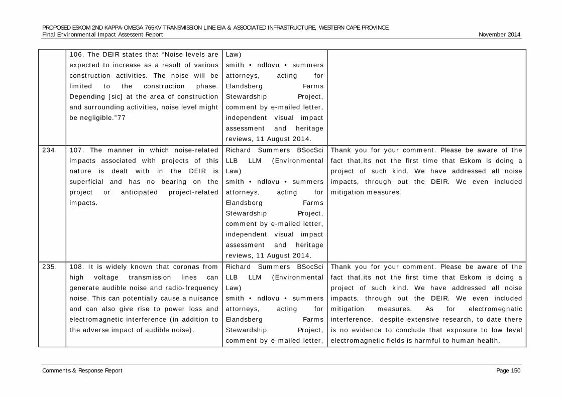
PROPOSED ESKOM 2ND KAPPA-OMEGA 765KV TRANSMISSION LINE EIA & ASSOCIATED INFRASTRUCTURE, WESTERN CAPE PROVINCE Final Environmental Impact Assessent Report November 2014
Comments & Response Report Page 150
106. The DEIR states that “Noise levels are expected to increase as a result of various construction activities. The noise will be limited to the construction phase. Depending [sic] at the area of construction and surrounding activities, noise level might be negligible.”77
Law) smith • ndlovu • summers attorneys, acting for Elandsberg Farms Stewardship Project, comment by e-mailed letter, independent visual impact assessment and heritage reviews, 11 August 2014.
234. 107. The manner in which noise-related impacts associated with projects of this nature is dealt with in the DEIR is superficial and has no bearing on the project or anticipated project-related impacts.
Richard Summers BSocSci LLB LLM (Environmental Law) smith • ndlovu • summers attorneys, acting for Elandsberg Farms Stewardship Project, comment by e-mailed letter, independent visual impact assessment and heritage reviews, 11 August 2014.
Thank you for your comment. Please be aware of the fact that,its not the first time that Eskom is doing a project of such kind. We have addressed all noise impacts, through out the DEIR. We even included mitigation measures.
235. 108. It is widely known that coronas from high voltage transmission lines can generate audible noise and radio-frequency noise. This can potentially cause a nuisance and can also give rise to power loss and electromagnetic interference (in addition to the adverse impact of audible noise).
Richard Summers BSocSci LLB LLM (Environmental Law) smith • ndlovu • summers attorneys, acting for Elandsberg Farms Stewardship Project, comment by e-mailed letter,
Thank you for your comment. Please be aware of the fact that,its not the first time that Eskom is doing a project of such kind. We have addressed all noise impacts, through out the DEIR. We even included mitigation measures. As for electromegnatic interference, despite extensive research, to date there is no evidence to conclude that exposure to low level electromagnetic fields is harmful to human health.
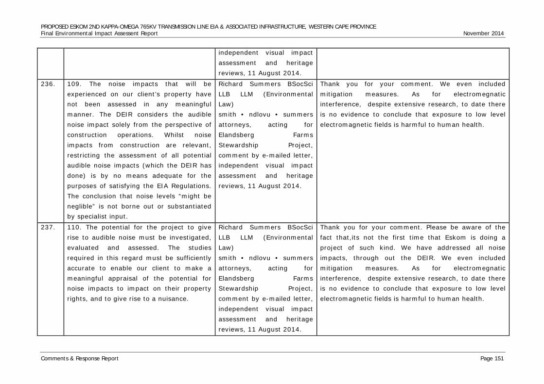
PROPOSED ESKOM 2ND KAPPA-OMEGA 765KV TRANSMISSION LINE EIA & ASSOCIATED INFRASTRUCTURE, WESTERN CAPE PROVINCE Final Environmental Impact Assessent Report November 2014
Comments & Response Report Page 151
independent visual impact assessment and heritage reviews, 11 August 2014.
236. 109. The noise impacts that will be experienced on our client’s property have not been assessed in any meaningful manner. The DEIR considers the audible noise impact solely from the perspective of construction operations. Whilst noise impacts from construction are relevant, restricting the assessment of all potential audible noise impacts (which the DEIR has done) is by no means adequate for the purposes of satisfying the EIA Regulations. The conclusion that noise levels “might be neglible” is not borne out or substantiated by specialist input.
Richard Summers BSocSci LLB LLM (Environmental Law) smith • ndlovu • summers attorneys, acting for Elandsberg Farms Stewardship Project, comment by e-mailed letter, independent visual impact assessment and heritage reviews, 11 August 2014.
Thank you for your comment. We even included mitigation measures. As for electromegnatic interference, despite extensive research, to date there is no evidence to conclude that exposure to low level electromagnetic fields is harmful to human health.
237. 110. The potential for the project to give rise to audible noise must be investigated, evaluated and assessed. The studies required in this regard must be sufficiently accurate to enable our client to make a meaningful appraisal of the potential for noise impacts to impact on their property rights, and to give rise to a nuisance.
Richard Summers BSocSci LLB LLM (Environmental Law) smith • ndlovu • summers attorneys, acting for Elandsberg Farms Stewardship Project, comment by e-mailed letter, independent visual impact assessment and heritage reviews, 11 August 2014.
Thank you for your comment. Please be aware of the fact that,its not the first time that Eskom is doing a project of such kind. We have addressed all noise impacts, through out the DEIR. We even included mitigation measures. As for electromegnatic interference, despite extensive research, to date there is no evidence to conclude that exposure to low level electromagnetic fields is harmful to human health.
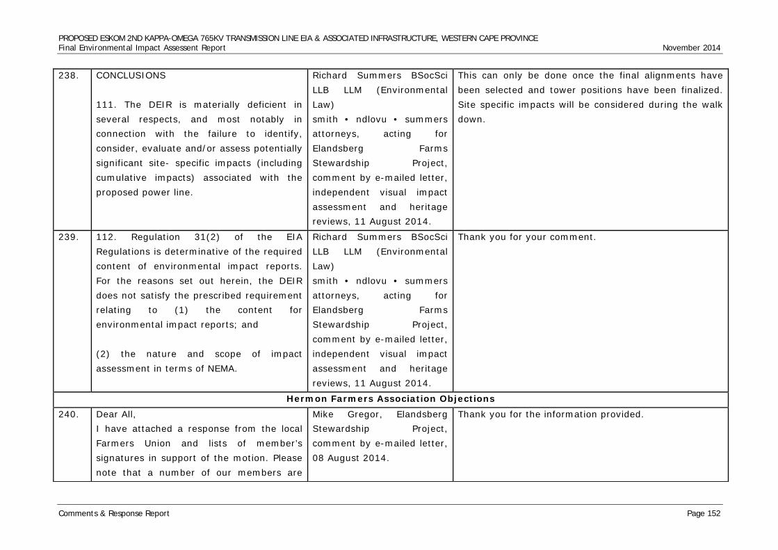
PROPOSED ESKOM 2ND KAPPA-OMEGA 765KV TRANSMISSION LINE EIA & ASSOCIATED INFRASTRUCTURE, WESTERN CAPE PROVINCE Final Environmental Impact Assessent Report November 2014
Comments & Response Report Page 152
238. CONCLUSIONS 111. The DEIR is materially deficient in several respects, and most notably in connection with the failure to identify, consider, evaluate and/or assess potentially significant site- specific impacts (including cumulative impacts) associated with the proposed power line.
Richard Summers BSocSci LLB LLM (Environmental Law) smith • ndlovu • summers attorneys, acting for Elandsberg Farms Stewardship Project, comment by e-mailed letter, independent visual impact assessment and heritage reviews, 11 August 2014.
This can only be done once the final alignments have been selected and tower positions have been finalized. Site specific impacts will be considered during the walk down.
239. 112. Regulation 31(2) of the EIA Regulations is determinative of the required content of environmental impact reports. For the reasons set out herein, the DEIR does not satisfy the prescribed requirement relating to (1) the content for environmental impact reports; and (2) the nature and scope of impact assessment in terms of NEMA.
Richard Summers BSocSci LLB LLM (Environmental Law) smith • ndlovu • summers attorneys, acting for Elandsberg Farms Stewardship Project, comment by e-mailed letter, independent visual impact assessment and heritage reviews, 11 August 2014.
Thank you for your comment.
Hermon Farmers Association Objections 240. Dear All,
I have attached a response from the local Farmers Union and lists of member’s signatures in support of the motion. Please note that a number of our members are
Mike Gregor, Elandsberg Stewardship Project, comment by e-mailed letter, 08 August 2014.
Thank you for the information provided.
PROPOSED ESKOM 2ND KAPPA-OMEGA 765KV TRANSMISSION LINE EIA & ASSOCIATED INFRASTRUCTURE, WESTERN CAPE PROVINCE Final Environmental Impact Assessent Report November 2014
Comments & Response Report Page 153
away hunting at the moment. Regards, Mike Gregor.
241. Objection: second 765kV Power line Transmission Line Kappa-Omega (DEA ref 14/12/16/3/3/2/352). After discussion with Mr. Shawn Johnston, environmental officer for Sustainable FuturesZA and the proposed project, we were informed that option 2 and 3 of this transmission line proposal was rejected and tah the newly preferred route would be via Wolsely, Elandsberg, DENEL towards Omega substation.
Deon Steyn, Chairperson, Hermon Farmers Association, comment by e-mailed letter, 08 August 2014.
Objection noted.
242. The Hermon Farmers Association strongly object to the building of newly proposed transmission line, crossing our valley at Elandsberg near Hermon towards the Omega substation.
Deon Steyn, Chairperson, Hermon Farmers Association, comment by e-mailed letter, 08 August 2014.
Objection noted
243. The building of this power line will visually destry the natural sense of place of our valley and environment and any further erectionof lines will have a negative socio economic impact on all people living in this area.
Deon Steyn, Chairperson, Hermon Farmers Association, comment by e-mailed letter, 08 August 2014.
Comment noted.
244. The line will further have a negative impact on farming activities in our area as aeroplanes are used to spray our crops. The lines make it increasingly difficult and dangerous for all parties concerned.
Deon Steyn, Chairperson, Hermon Farmers Association, comment by e-mailed letter, 08 August 2014.
Comment noted.
PROPOSED ESKOM 2ND KAPPA-OMEGA 765KV TRANSMISSION LINE EIA & ASSOCIATED INFRASTRUCTURE, WESTERN CAPE PROVINCE Final Environmental Impact Assessent Report November 2014
Comments & Response Report Page 154
As there are already existing power lines in our area and along the suggested route, the impact of new lines are not mitigated as you would suggest, but it actually has a negative cumulative effect and it is destroying our sense of place.
Deon Steyn, Chairperson, Hermon Farmers Association, comment by e-mailed letter, 08 August 2014.
Thank you for your comment
245. There is also sensitive Renosterveld in close proximity, which are very rare in the rest of the world, and damaging this would be catastrophic.
Deon Steyn, Chairperson, Hermon Farmers Association, comment by e-mailed letter, 08 August 2014.
Thank you for your comment.
246. We would also like to stress that this particular route was considered by Eskom in 2006 and rejected for valid reasons. We do not see why this line wil now fulfill the criteria.
Deon Steyn, Chairperson, Hermon Farmers Association, comment by e-mailed letter, 08 August 2014.
Thank you for your comment.
247. Attached please find the names and farms of farmers belonging to our Association who strongly object to this new proposed line and who wants to be registered as interested and affected parties.
Deon Steyn, Chairperson, Hermon Farmers Association, comment by e-mailed letter, 08 August 2014.
Thank you for your assistance, with the names. We will be registering them as interested and affected parties.
Tomi’s Abbotoir’s Objections 248. I am a landowner near Hermon and believe
that aesthetics and sense of place, as well as land value will be negatively affecetd by option 2 line. I am also concerned about visual impact on Hermon and adjacent towns, Riebeeck Kasteel and Riebeeck West
Laurie Terblance, Operational Manager, Toni’s Abbotoir, comment by reply form, 14 July 2014
Dear Laurie, Thank you for your e-mail. I hereby acknowledge your e-mails and you have been registered you as an interested and affected party. I further register your opposition to the proposed Eskom 2nd 765kV transmission line through your area and your points
PROPOSED ESKOM 2ND KAPPA-OMEGA 765KV TRANSMISSION LINE EIA & ASSOCIATED INFRASTRUCTURE, WESTERN CAPE PROVINCE Final Environmental Impact Assessent Report November 2014
Comments & Response Report Page 155
and effects of power lines regarding health issues, Cancer!
listed in the comments form received. Laurie, I look forward to any additional comments from yourself and any other interested and affected parties. Sincerely, Shawn Johnston
249. Hi Shawn, As stated in our previous correspondence from Michelle we still want to be registered as an affected and interest party as we are a member of the Hermon Boerevereniging, also have land in Hermon and we are concerned on the impact of the environment between Tomis, Hermon and Wellington, especially as far as visual impact is concerned. We are further concerned that none of the public participation documents were available at Riebeeck Kasteel Library on request and we want to have access to these documents for feedback purposes. We therefore still request to be registered as an affected party as our request was sent within the prescribed period Best regards, Laurie Terblanche Tomis Trust Trustee
Laurie Terblance, Operational Manager, Toni’s Abbotoir, comment by reply form, 18 July 2014
Hi Laurie, I can come and see you on Monday, 21July 2014 at 11am to clarify the route. Find attached the Google Earth kmz files for the Gamma-Kappa and Kappa-Omega routes. Sincerely, Shawn Johnston
Renosterveld Conservancy Objections 250. Morning Shawn,
Herewith our proposed letter. See what you Frank Turner, Chairpsron, Renosterveld Conservancy,
I hereby acknowledge receing you comment. Thank you.
PROPOSED ESKOM 2ND KAPPA-OMEGA 765KV TRANSMISSION LINE EIA & ASSOCIATED INFRASTRUCTURE, WESTERN CAPE PROVINCE Final Environmental Impact Assessent Report November 2014
Comments & Response Report Page 156
think and get back to us by 5 pm please. Regards, Frank
comment by e-mail, 14 July 2014.
251. We as the Renosterveld Conservancy in partnership with CapeNature, the Wellington Landbou Vereniging, the Wellington Tourism Association and all the members of the Renosterveld Conservancy OBJECT TO AND WILL APPEAL the construction of the above mention line through our conservation area in the strongest possible manner!
Frank Turner, Chairpsron, Renosterveld Conservancy, comment by e-mail, 14 July 2014.
Objection noted.
252. The route through our conservancy and the greater Wellington area was proposed and rejected in 2006 due to the sensitivity of the area. We therefore find it totally unacceptable that the same route be reconsidered once it has already been rejected.
Frank Turner, Chairpsron, Renosterveld Conservancy, comment by e-mail, 14 July 2014.
Kentridge Makhanya: The decision was taken by the Minister of Environmental Affairs to dismiss the appeals against the 1st 765kV line. The 1st 765kV line is currently under construction. However during the EMP and the servitude acquisition phase mitigation measures will be put in place to minimise potential impacts.
253. There are already two power lines going through Elandsberg Private Nature Reserve and the ammunition factory, Rheinmetaal/Denel which is a National Key Point. ONE MORE POWERLINE IS JUST TOO MUCH.
Frank Turner, Chairpsron, Renosterveld Conservancy, comment by e-mail, 14 July 2014.
Thank you for your comment. We hereby acknowledge your concerns and you have been registered you as an interested and affected party. I further register your opposition to the proposed Eskom 2nd 765kV transmission line through your area.
254. The Renosterveld Conservancy was established in 2002 and covers an area of approx.24,000 hectares with 13 members.
Frank Turner, Chairpsron, Renosterveld Conservancy, comment by e-mail, 14 July
Thank you for the information.
PROPOSED ESKOM 2ND KAPPA-OMEGA 765KV TRANSMISSION LINE EIA & ASSOCIATED INFRASTRUCTURE, WESTERN CAPE PROVINCE Final Environmental Impact Assessent Report November 2014
Comments & Response Report Page 157
The aim of the Conservancy is to protect the critically endangered and highly sensitive Renosterveld. This area has the largest piece of Renosterveld intact, of which there is only 4% left in the world, as recognized by Kirstenbosch Botanical Gardens, it is a HOT SPOT for endemic species.
2014.
255. The Conservancy has an active relationship with Cape Nature and Department of Landcare, in the clearing of aliens such as black wattle, Port Jackson, hakea, blue gums etc. Millions of rand have been invested by the State and landowners. Three of the farms have signed and committed their land in perpetuity to the stewardship program with Cape Nature. This is a unique public/private partnership aimed at restoring, maintaining and protecting critically endangered fauna and flora.
Frank Turner, Chairpsron, Renosterveld Conservancy, comment by e-mail, 14 July 2014.
Thank you for your comment. Site specific mitigation measures can be developed for areas where re-alignment is not an option, this would require detailed site assessments of all these areas; possibly as a ‘second phase’ assessment that can inform the EIA prior to final submission or prior to finalisation of the EMP for the project. This will allow for the further development of site specific construction and operational mitigation measures.
256. Members are concerned about the degrading of fauna and flora during the possible construction of the line and vehicles used in the process. The unsightly vista will adversely affect the natural beauty and uniqueness of this unspoiled natural wonder.
Frank Turner, Chairpsron, Renosterveld Conservancy, comment by e-mail, 14 July 2014.
Comment has been noted. Please be adviced, that intense mitigation measures, will be included in the site specific EMP to ensure that the such beauty is preserved.
PROPOSED ESKOM 2ND KAPPA-OMEGA 765KV TRANSMISSION LINE EIA & ASSOCIATED INFRASTRUCTURE, WESTERN CAPE PROVINCE Final Environmental Impact Assessent Report November 2014
Comments & Response Report Page 158
The critically endangered geometric tortoise, our flagship species, is particularly vulnerable to any disturbances. Other concerns are fires, during construction and unrestricted access to nature reserves.
Frank Turner, Chairpsron, Renosterveld Conservancy, comment by e-mail, 14 July 2014.
Thank you for your comment, and it has been noted. Environmental Impacts of power lines are assessed and quantified inside the EIR report. In most instances mitigation measures are also recommended. Detailed mitigation measures will be provided inside the site specific EMP. A CLO and Environmental Control Officer will be appointed by Eskom, who will take measures to controlling construction related matters and to ensure that no unauthorised access is allowed in the nature reserve.
257. The birdlife is already under threat and the shrinking and disturbance of the natural habitat, which we as a conservancy have pledged to protect, will be seriously affected. We have not only created a conservancy for the present day but also for the future generations. We are a success and would like the impact study to take cognizance thereof.
Frank Turner, Chairpsron, Renosterveld Conservancy, comment by e-mail, 14 July 2014.
Thank you for your comment, and it has been noted.
258. As the Conservancy chairman, I speak on behalf of my members who are in agreement with the details of this letter. We understand the necessity of the construction of the line and do realize that it is of national importance - but where?!? If I take your map and take the green line 7
Frank Turner, Chairpsron, Renosterveld Conservancy, comment by e-mail, 14 July 2014.
Thank you for your comment and it has been noted.
PROPOSED ESKOM 2ND KAPPA-OMEGA 765KV TRANSMISSION LINE EIA & ASSOCIATED INFRASTRUCTURE, WESTERN CAPE PROVINCE Final Environmental Impact Assessent Report November 2014
Comments & Response Report Page 159
8 9 10 11 12 it would bypass our conservancy. The route would travel through areas of wheat lands north of Gouda, down past Riebeeck Kasteel on the east side to join up with your Grid at 13. Ideally this would be our choice!
259. You ask in your questionnaire what the impact would be and I can honestly say it would be No 5 – EXTREME and forever, 25 years plus, if the line came through on existing routes or further south. Our conservancy stretches from Voelvlei dam in the north to Bainskloof in the south. One cannot object to the construction of the power line as I have already said – it is of national interest. But, one could spend the extra funds now on a slightly longer route and save the conservancy for posterity.
Frank Turner, Chairpsron, Renosterveld Conservancy, comment by e-mail, 14 July 2014.
Thank you for your comment.
260. I would like to meet with the relevant officials, be they Eskom or Nzumbululo on site to discuss the situation further.
Frank Turner, Chairpsron, Renosterveld Conservancy, comment by e-mail, 14 July 2014.
Thank you for your comment. We will make arrangements, to meet up with you.
Department of Agriculture, Forestry and Fisheries Objections 261. Dear Shawn,
Attached please find DAFF's input. Regards, Susan PS: I am in field and therefore cannot sign,
Susan Steyn, Department of Agriculture, Forestry and Fisheries, comment by e-mail, 18 July 2014.
I hereby acknowledge receiving your submission. Comment noted.
PROPOSED ESKOM 2ND KAPPA-OMEGA 765KV TRANSMISSION LINE EIA & ASSOCIATED INFRASTRUCTURE, WESTERN CAPE PROVINCE Final Environmental Impact Assessent Report November 2014
Comments & Response Report Page 160
if this is a problem please advise and I can forward a signed letter on Monday when I am back in office.
262. RE: Proposed Eskom Transmission Power Lines from the Kappa Substation near Ceres to the Omega Substation near Koeberg, DEA Reference 14/12/16/3/3/2/352. The Department of Agriculture Forestry and Fisheries (DAFF) would like to thank you for the opportunity to review and comment on the above application.
Susan Steyn, Department of Agriculture, Forestry and Fisheries, comment by e-mail, 18 July 2014.
Thank you for your comment.
263. DAFF has studied the supporting documents for the abovementioned and the following points related to DAFF’s mandate include: According to the information provide: (1) the proposed transmission line will cross productive State Forest Land at Wolseley (2) trees cannot exist under transmission lines therefore a total loss of 40 ha is implied with this application and a loss of 60 ha already happened due to the existing line (3) the Cabinet agreed to the continuation of Forestry in Wolseley in 2008 which with an additional loss of 40 ha could become
Susan Steyn, Department of Agriculture, Forestry and Fisheries, comment by e-mail, 18 July 2014.
Comments noted.
PROPOSED ESKOM 2ND KAPPA-OMEGA 765KV TRANSMISSION LINE EIA & ASSOCIATED INFRASTRUCTURE, WESTERN CAPE PROVINCE Final Environmental Impact Assessent Report November 2014
Comments & Response Report Page 161
unviable DAFF reserves the right to revise initial comment and request further information based on any additional information that may be received. Yours faithfully, Susan Steyn
Cape Pine Objections 264. Cape Pine own and operates Kluitjieskraal
state forest. Need to determine impact on forestry with Department of Agriculture, Forestry and Fisheries.
Jan Truter, Cape Pine, comment by reply form, 21 March 2014.
Comment noted.
Ivan Harris Objection 265. Objection towards power line. The previous
line was rejected in 2006. I belong to the Conservancy. Property is part of it. Already existing line. Do not need another line.
Ivan Harris, Palmiet Valley & Wellington Farmers Association, comment by reply form, 29 Jul 2014.
Thank you for your comment. We hereby acknowledge your concerns and you have been registered you as an interested and affected party. I further register your opposition to the proposed Eskom 2nd 765kV transmission line through your area
Douglas Henry Objection 266. My wife and I retired to Riebeek West on
Feb 1st 2013, and 1 of the main attractions is the view of the valley, towards the mountains. Pyllons would severly impact on this view
Douglas Henry, Resident Riebeeck West, comment by reply form, 02 July 2014.
Thank you for your comment. We hereby acknowledge your concerns and you have been registered you as an interested and affected party. I further register your opposition to the proposed Eskom 2nd 765kV transmission line through your area
Mainstream Renewable Power South Africa - Paardekraal East Wind Energy Facility (at Kappa Substation) Objections 267. Dear Shawn,
Attached please find our comments Mike Mangnall, Mainstream Renewable Power South
Dear Mike, Thank you for your comments. I will add it to the FEIR
PROPOSED ESKOM 2ND KAPPA-OMEGA 765KV TRANSMISSION LINE EIA & ASSOCIATED INFRASTRUCTURE, WESTERN CAPE PROVINCE Final Environmental Impact Assessent Report November 2014
Comments & Response Report Page 162
regarding Eskom’s proposed second 765kV powerline through the Kappa area, Western Cape. Regards, Mike Mangnall.
Africa, comment by e-mailed letter, 07 August 2014.
comments and response report. Sincerely, Shawn Johnston
268. Comment on the Draft EIR for Eskom’s proposed 2nd 765kV powerline (Gamma to Omega): Potential impact on Mainstream’s renewable energy projects. Thank you for the opportunity to comment on the Draft EIR for the above-mentioned proposed project.
Mike Mangnall, Mainstream Renewable Power South Africa, comment by e-mailed letter, 07 August 2014.
Thank you for your comments.
269. Further to our previous emailed correspondence as well as our meeting of 23 May 2014, based on the Google kmz file sent on 21 July 2014, it is evident that the preferred route for the proposed powerline corridor aligns adjacent to the existing 765kV line – see light blue and green lines on attached map. We have therefore assumed that the previously indicated routes (Alt 1, 2 and 3 lines in attached map) are no longer EIA alternatives.
Mike Mangnall, Mainstream Renewable Power South Africa, comment by e-mailed letter, 07 August 2014.
Thank you for your comments.
270. The preferred alignment routes through our Perdekraal East wind farm site, for which we already have secured EIA and land use planning approvals and intend bidding it into the DoE’s REIPPPP. More-specifically it crosses Farm 245 (Lower Stinkfontein) on
Mike Mangnall, Mainstream Renewable Power South Africa, comment by e-mailed letter, 07 August 2014.
Kentridge Makhanya: The current corridors are 2km wide. This is for the simple reason that it will allow us to avoid planned developments, sensitive environmental receptors, etc. In certain areas we might have to expand the size of the corridor as a mitigation measure. Eskom’s land acquisition team will engage with you
PROPOSED ESKOM 2ND KAPPA-OMEGA 765KV TRANSMISSION LINE EIA & ASSOCIATED INFRASTRUCTURE, WESTERN CAPE PROVINCE Final Environmental Impact Assessent Report November 2014
Comments & Response Report Page 163
which we have a legal land contract in place with the landowner. In terms of this agreement, we have exclusive rights over the land and third party requests for development therefore first require our written consent.
during servitude acquisition.
271. Our main concern with the preferred alignment is the potential negative impact that the additional servitude area would have on our Perdekraal East turbine layout. Our layout is at an advanced stage of development and any land lost to accommodate the second 765kV line will result in a reduction in turbine numbers and wind farm capacity. However, if a compromise could be reached with Eskom regarding their turbine setback requirements from transmission lines then the impact could possibly be ameliorated.
Mike Mangnall, Mainstream Renewable Power South Africa, comment by e-mailed letter, 07 August 2014.
Kentridge Makhanya: Comment noted. Response provided under point 275.
272. It is therefore essential that Eskom urgently clarify their position in this regard. If no compromise can be reached, then we will have no choice but to take the necessary steps to protect our assets if required in future.
Mike Mangnall, Mainstream Renewable Power South Africa, comment by e-mailed letter, 07 August 2014.
Kentridge Makhanya: The current corridors are 2km wide. This is for the simple reason that it will allow us to avoid planned developments, sensitive environmental receptors, etc. In certain areas we might have to expand the size of the corridor as a mitigation measure. Eskom’s land acquisition team will engage with you during servitude acquisition.
273. The preferred alignment is unlikely to have any impacts on the other properties we
Mike Mangnall, Mainstream Renewable Power South
Thank you for your comment. Eskom will be getting back to you.
PROPOSED ESKOM 2ND KAPPA-OMEGA 765KV TRANSMISSION LINE EIA & ASSOCIATED INFRASTRUCTURE, WESTERN CAPE PROVINCE Final Environmental Impact Assessent Report November 2014
Comments & Response Report Page 164
currently are leasing around the Kappa substation, as indicated on the attached map.
Africa, comment by e-mailed letter, 07 August 2014.
274. We look forward to hearing back from Eskom in this regard. Please do not hesitate to contact the undersigned should you have any queries.
Mike Mangnall, Mainstream Renewable Power South Africa, comment by e-mailed letter, 07 August 2014.
Thank you for your comment.
Genesis Eco-Energy Paardekraal West Wind Energy Facility (at Kappa Substation) Objections 275. Hi Shawn, Please send me link to or
information re the EIA process for the 765kV Line you working on. We would like to register as an affected party on behalf of the Perdekraal West Wind Farm on Lower Stinkfonterin & Rietpoort Farms near Kappa. Thanx Ralph Damonse Head: Project Development Genesis Eco-Energy (Pty) Ltd
Ralph Damonse, Head Project Development Genesis Eco-Energy, comment by e-mail, 29 July 2014.
Dear Ralph, Thank you for the chat. Please note I have registered Genesis Eco-Energy as a I&AP on the Eskom Kappa-Omega EIA. I will send the CD with the Kappa-Omega DEIR to your post box. Find attached the link where you can access the DEIR: http://www.nzumbululo.com Find attached the kmz Google Earth file of the combined route, Gamma-Kappa and Kappa-Omega. Sincerely, Shawn Johnston
276. Paardekraal West wind energy facility on Lower Stinkfontein and Rietpport Frams Ceres Karoo. We object against the 2nd 765kV line crossing the Paardekraal West wind farm.
Ralph Damonse, Head Project Development Genesis Eco-Energy, comment by e-mail, 29 July 2014.
Thank you for your comment, and it has been noted.
Department of Environmental Affairs and Development Planning Western Cape Comments
PROPOSED ESKOM 2ND KAPPA-OMEGA 765KV TRANSMISSION LINE EIA & ASSOCIATED INFRASTRUCTURE, WESTERN CAPE PROVINCE Final Environmental Impact Assessent Report November 2014
Comments & Response Report Page 165
277. The following comments are relevant, which will form part of the Department’s final response: 2.1. An integrated waste management approach must be used that is based on waste minimisation and must incorporate avoidance, reduction, recycling, re-use and disposal where appropriate.
Loretta Osborne, Department of Environmental Affairs and Development Planning Western Cape, Directorate Land Management: Region 1, comment by e-mail, 22 August 2014.
Thank you for your comment, and it has been noted.
278. 2.2 Any solid waste from the proposed development must be disposed of at an appropriately licensed waste disposal facility.
Loretta Osborne, Department of Environmental Affairs and Development Planning Western Cape, Directorate Land Management: Region 1, comment by e-mail, 22 August 2014.
Thank you for your comment, and it has been noted.
279. 2.3 No surface or groundwater must be polluted due to any activity on the site.
Loretta Osborne, Department of Environmental Affairs and Development Planning Western Cape, Directorate Land Management: Region 1, comment by e-mail, 22 August 2014.
Thank you for your comment, and it has been noted.
280. 2.4 Should any archaeological artefacts be exposed during excavation, the construction in the vicinity of the finding
Loretta Osborne, Department of Environmental Affairs and
Thank you for your comment
PROPOSED ESKOM 2ND KAPPA-OMEGA 765KV TRANSMISSION LINE EIA & ASSOCIATED INFRASTRUCTURE, WESTERN CAPE PROVINCE Final Environmental Impact Assessent Report November 2014
Comments & Response Report Page 166
must be stopped. Under no circumstances shall any artefacts be destroyed. Such an archaeological site must be marked and fenced off, and South African Heritage Resource Agency must be contacted within 48 hours.
Development Planning Western Cape, Directorate Land Management: Region 1, comment by e-mail, 22 August 2014.
281. 2.5 Comments received during the Public Participation Process from the Interested and Affected Parties and the relevant authorities and a Comments and Response Report that adequately addresses any highlighted issues must be included in the final EIA Report.
Loretta Osborne, Department of Environmental Affairs and Development Planning Western Cape, Directorate Land Management: Region 1, comment by e-mail, 22 August 2014.
Thank you for your comment.
282. 2.6 Please ensure that all relevant recommendations and mitigation measures stipulated in the specialist reports are included in the draft Environmental Management Programme to be submitted with the final EIA Report.
Loretta Osborne, Department of Environmental Affairs and Development Planning Western Cape, Directorate Land Management: Region 1, comment by e-mail, 22 August 2014.
Thank you for your comment. As our EMP is generic, and specialists have adviced that a site specific EMP (walk down) be done, wouldn’t it be advisable that those mitigation measures be included in that EMP as it will be usd by the ECO during monitoring of the site.
283. 2.7 All original signed declarations are to be included with the final EIA Report submitted to the competent authority for decision-making.
Loretta Osborne, Department of Environmental Affairs and Development Planning Western Cape, Directorate Land Management: Region
Thank you for your comment. We will include them.
PROPOSED ESKOM 2ND KAPPA-OMEGA 765KV TRANSMISSION LINE EIA & ASSOCIATED INFRASTRUCTURE, WESTERN CAPE PROVINCE Final Environmental Impact Assessent Report November 2014
Comments & Response Report Page 167
1, comment by e-mail, 22 August 2014.
284. 2.8 The recommendations and mitigation measures stipulated in the specialist reports must be implemented and complied with.
Loretta Osborne, Department of Environmental Affairs and Development Planning Western Cape, Directorate Land Management: Region 1, comment by e-mail, 22 August 2014.
Thank you for your comment.
285. 2.9 The reports refers to sensitive vegetation, however Activity 12 of Government Notice No. R. 546 was not applied for.
Loretta Osborne, Department of Environmental Affairs and Development Planning Western Cape, Directorate Land Management: Region 1, comment by e-mail, 22 August 2014.
Thank you for your comment. We will be sure, to add this activity.
286. 2.10 Furthermore, the development also crosses water courses, but Activities 11 and 18 of Government Notice No. R. 544 and Activity 16 of Government Notice R. 546 were not applied for.
Loretta Osborne, Department of Environmental Affairs and Development Planning Western Cape, Directorate Land Management: Region 1, comment by e-mail, 22 August 2014.
Thank you for your comment. We will be sure, to add these activities.
287. 2.11 The reports refer to the proposed Kappa Omega 2nd 765kV powerline
Loretta Osborne, Department of
Comment noted.
PROPOSED ESKOM 2ND KAPPA-OMEGA 765KV TRANSMISSION LINE EIA & ASSOCIATED INFRASTRUCTURE, WESTERN CAPE PROVINCE Final Environmental Impact Assessent Report November 2014
Comments & Response Report Page 168
approximately 415km and substations upgrade and the proposed Gamma Kappa 2nd 765kV powerline approximately 370km and substations upgrade. The lengths should rather be distinguished/ differentiated.
Environmental Affairs and Development Planning Western Cape, Directorate Land Management: Region 1, comment by e-mail, 22 August 2014.
288. 2.12 The route descriptions is also unclear. Detailed route descriptions must be provided.
Loretta Osborne, Department of Environmental Affairs and Development Planning Western Cape, Directorate Land Management: Region 1, comment by e-mail, 22 August 2014.
Comment noted.
289. 2.13 The reports also refer to only one rating matrix. No distinction between impact ratings for individual routes were considered. A comparative assessment of the positive and negative implications of the proposed activity and identified alternatives must be considered.
Loretta Osborne, Department of Environmental Affairs and Development Planning Western Cape, Directorate Land Management: Region 1, comment by e-mail, 22 August 2014.
Thank you for your comment.
290. 2.14 The Botanical assessment does not address the need for fire for management of indigenous vegetation. Similarly, the EMP only includes Fire Prevention and does not include the managing of vegetation and fire during the operational phase.
Loretta Osborne, Department of Environmental Affairs and Development Planning Western Cape, Directorate Land Management: Region
Thank you for your comment.
PROPOSED ESKOM 2ND KAPPA-OMEGA 765KV TRANSMISSION LINE EIA & ASSOCIATED INFRASTRUCTURE, WESTERN CAPE PROVINCE Final Environmental Impact Assessent Report November 2014
Comments & Response Report Page 169
1, comment by e-mail, 22 August 2014.
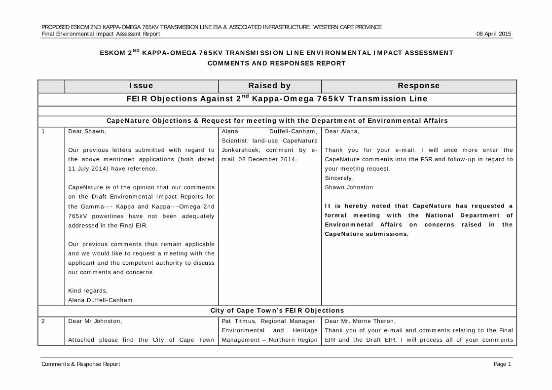
PROPOSED ESKOM 2ND KAPPA-OMEGA 765KV TRANSMISSION LINE EIA & ASSOCIATED INFRASTRUCTURE, WESTERN CAPE PROVINCE Final Environmental Impact Assessent Report 08 April 2015
Comments & Response Report Page 1
ESKOM 2ND KAPPA-OMEGA 765KV TRANSMISSION LINE ENVIRONMENTAL IMPACT ASSESSMENT COMMENTS AND RESPONSES REPORT
Issue Raised by Response
FEIR Objections Against 2nd Kappa-Omega 765kV Transmission Line
CapeNature Objections & Request for meeting with the Department of Environmental Affairs 1 Dear Shawn,
Our previous letters submitted with regard to the above mentioned applications (both dated 11 July 2014) have reference. CapeNature is of the opinion that our comments on the Draft Environmental Impact Reports for
the Gamma--‐ Kappa and Kappa--‐Omega 2nd 765kV powerlines have not been adequately addressed in the Final EIR. Our previous comments thus remain applicable and we would like to request a meeting with the applicant and the competent authority to discuss our comments and concerns. Kind regards, Alana Duffell-Canham
Alana Duffell-Canham, Scientist: land-use, CapeNature Jonkershoek, comment by e-mail, 08 December 2014.
Dear Alana, Thank you for your e-mail. I will once more enter the CapeNature comments into the FSR and follow-up in regard to your meeting request. Sincerely, Shawn Johnston It is hereby noted that CapeNature has requested a formal meeting with the National Department of Environmnetal Affairs on concerns raised in the CapeNature submissions.
City of Cape Town’s FEIR Objections 2 Dear Mr Johnston,
Attached please find the City of Cape Town
Pat Titmus, Regional Manager: Environmental and Heritage Management – Northern Region
Dear Mr. Morne Theron, Thank you of your e-mail and comments relating to the Final EIR and the Draft EIR. I will process all of your comments
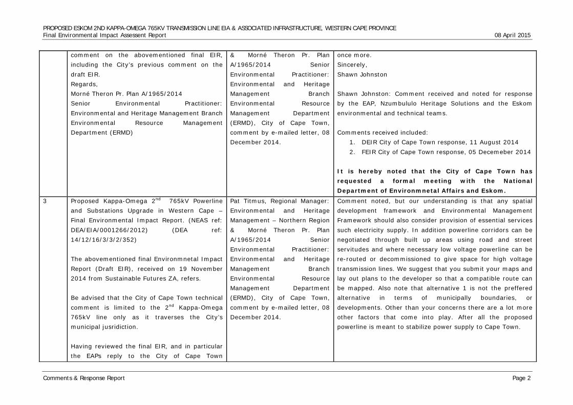
PROPOSED ESKOM 2ND KAPPA-OMEGA 765KV TRANSMISSION LINE EIA & ASSOCIATED INFRASTRUCTURE, WESTERN CAPE PROVINCE Final Environmental Impact Assessent Report 08 April 2015
Comments & Response Report Page 2
comment on the abovementioned final EIR, including the City’s previous comment on the draft EIR. Regards, Morné Theron Pr. Plan A/1965/2014 Senior Environmental Practitioner: Environmental and Heritage Management Branch Environmental Resource Management Department (ERMD)
& Morné Theron Pr. Plan A/1965/2014 Senior Environmental Practitioner: Environmental and Heritage Management Branch Environmental Resource Management Department (ERMD), City of Cape Town, comment by e-mailed letter, 08 December 2014.
once more. Sincerely, Shawn Johnston Shawn Johnston: Comment received and noted for response by the EAP, Nzumbululo Heritage Solutions and the Eskom environmental and technical teams. Comments received included:
1. DEIR City of Cape Town response, 11 August 2014 2. FEIR City of Cape Town response, 05 Decemeber 2014
It is hereby noted that the City of Cape Town has requested a formal meeting with the National Department of Environmnetal Affairs and Eskom.
3 Proposed Kappa-Omega 2nd 765kV Powerline and Substations Upgrade in Western Cape – Final Environmental Impact Report. (NEAS ref: DEA/EIA/0001266/2012) (DEA ref: 14/12/16/3/3/2/352) The abovementioned final Environmnetal Impact Report (Draft EIR), received on 19 November 2014 from Sustainable Futures ZA, refers. Be advised that the City of Cape Town technical comment is limited to the 2nd Kappa-Omega 765kV line only as it traverses the City’s municipal jusridiction. Having reviewed the final EIR, and in particular the EAPs reply to the City of Cape Town
Pat Titmus, Regional Manager: Environmental and Heritage Management – Northern Region & Morné Theron Pr. Plan A/1965/2014 Senior Environmental Practitioner: Environmental and Heritage Management Branch Environmental Resource Management Department (ERMD), City of Cape Town, comment by e-mailed letter, 08 December 2014.
Comment noted, but our understanding is that any spatial development framework and Environmental Management Framework should also consider provision of essential services such electricity supply. In addition powerline corridors can be negotiated through built up areas using road and street servitudes and where necessary low voltage powerline can be re-routed or decommissioned to give space for high voltage transmission lines. We suggest that you submit your maps and lay out plans to the developer so that a compatible route can be mapped. Also note that alternative 1 is not the preffered alternative in terms of municipally boundaries, or developments. Other than your concerns there are a lot more other factors that come into play. After all the proposed powerline is meant to stabilize power supply to Cape Town.
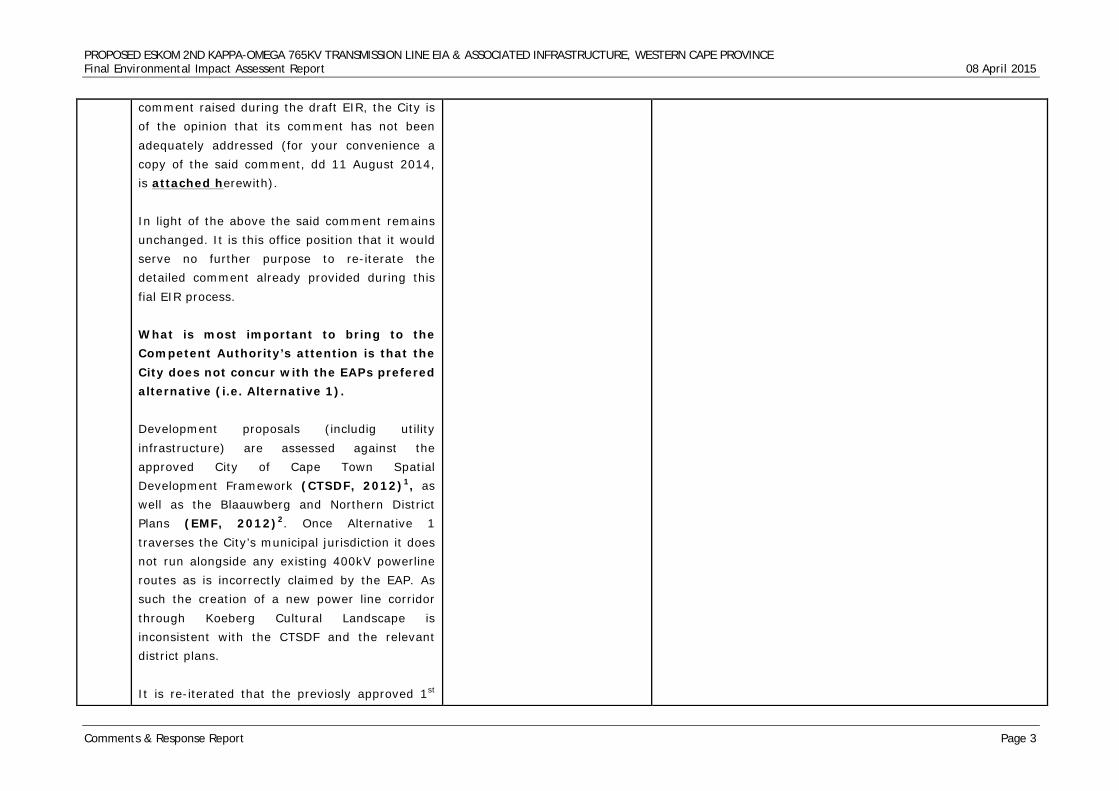
PROPOSED ESKOM 2ND KAPPA-OMEGA 765KV TRANSMISSION LINE EIA & ASSOCIATED INFRASTRUCTURE, WESTERN CAPE PROVINCE Final Environmental Impact Assessent Report 08 April 2015
Comments & Response Report Page 3
comment raised during the draft EIR, the City is of the opinion that its comment has not been adequately addressed (for your convenience a copy of the said comment, dd 11 August 2014, is attached herewith). In light of the above the said comment remains unchanged. It is this office position that it would serve no further purpose to re-iterate the detailed comment already provided during this fial EIR process. What is most important to bring to the Competent Authority’s attention is that the City does not concur with the EAPs prefered alternative (i.e. Alternative 1). Development proposals (includig utility infrastructure) are assessed against the approved City of Cape Town Spatial Development Framework (CTSDF, 2012)1, as well as the Blaauwberg and Northern District Plans (EMF, 2012)2. Once Alternative 1 traverses the City’s municipal jurisdiction it does not run alongside any existing 400kV powerline routes as is incorrectly claimed by the EAP. As such the creation of a new power line corridor through Koeberg Cultural Landscape is inconsistent with the CTSDF and the relevant district plans. It is re-iterated that the previosly approved 1st
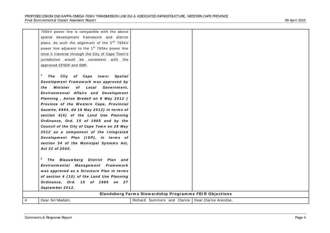
PROPOSED ESKOM 2ND KAPPA-OMEGA 765KV TRANSMISSION LINE EIA & ASSOCIATED INFRASTRUCTURE, WESTERN CAPE PROVINCE Final Environmental Impact Assessent Report 08 April 2015
Comments & Response Report Page 4
765kV power line is compatible with the above spatial development framework and district plans. As such the alignment of the 2nd 765kV power line adjacent to the 1st 765kv power line once it traverse through the City of Cape Town’s jurisdiction would be consistent with the approved CFSDF and EMF. 1 The City of Cape town: Spatial Development Framework was approved by the Minister of Local Government, Environmental Affairs and Development Planning , Anton Bredell on 8 May 2012 ( Province of the Western Cape, Provincial Gazette, 6994, dd 18 May 2012) in terms of section 4(6) of the Land Use Planning Ordinance, Ord. 15 of 1985 and by the Council of the City of Cape Town on 28 May 2012 as a component of the Integrated Development Plan (IDP), in terms of section 34 of the Municipal Systems Act, Act 32 of 2000. 2 The Blaauwberg District Plan and Environmental Management Framework was approved as a Structure Plan in terms of section 4 (10) of the Land Use Planning Ordinance, Ord. 15 of 1985 on 27 September 2012.
Elandsberg Farms Stewardship Programme FEIR Objections 4 Dear Sir/Madam, Richard Summers and Clarice Dear Clarice Arendse,
PROPOSED ESKOM 2ND KAPPA-OMEGA 765KV TRANSMISSION LINE EIA & ASSOCIATED INFRASTRUCTURE, WESTERN CAPE PROVINCE Final Environmental Impact Assessent Report 08 April 2015
Comments & Response Report Page 5
We act for Elandsberg Farms (Pty) Ltd and Rapula Farming (Pty) Ltd.
2. Please find attached hereto copies of the following: 2.1. Our client’s comments on the Final Environmental Impact Assessment Report; 2.2. Annexure A; and 2.3. Annexure B. 3. Kindly acknowledge receipt hereof. Kind regards, Clarice Arendse LLB LLM (Environmental Law) smith • ndlovu • summers attorneys
Arendse, smith • ndlovu • summers attorneys, comment by e-mailed letter, 08 December 2014.
Thank you for your e-mail and comments submitted on behalf of Elandsberg Farms (PTY) Ltd and Rapula Farming (PTY) Ltd. I hereby acknowledge your e-mail and attached correspondence. Sincerely, Shawn Johnston
5 Dear Sir/Madam 8 December 2014 Our ref: RWS/cr/P17-002 Your ref: HESSA REF NO: 2012_JHB.HESSA_ENV.PRO_0006 RE: PROPOSED KAPPA OMEGA 2ND 765kV POWER LINE – COMMENTS ON THE FINAL ENVIRONMENTAL IMPACT ASSESSMENT REPORT DATED NOVEMBER 2014 DEA REF: 14/12/16/3/3/2/352 1. We act for Elandsberg Farms (Pty) Ltd and Rapula Farming (Pty) Ltd. 2. This letter contains comments, on behalf of our clients, on the Final Environmental Impact
Richard Summers and Clarice Arendse, smith • ndlovu • summers attorneys, comment by e-mailed letter, 08 December 2014.
Acknowledged. Please understand that, in most of our comments we repeatedly explained to Richard Summers, that to suggest that the EIA process is fundamentally flawed is a insult to the entire team. The entire team is qualified and highly experienced to handle impact assessment for a powerline project. We further explained that, it is not a platform to insul t and undermine each other’s opinion and integrity. Over use of absolute comments such as ‘failure’ is in itself failure to respect effort, qualifications and experience of dedicated specialists. Your comments are expected to aid the process not to undermine and distort the process. The process is not a platform to trade insults. We respect your professional credibility and differences in opinion should not warrant such
PROPOSED ESKOM 2ND KAPPA-OMEGA 765KV TRANSMISSION LINE EIA & ASSOCIATED INFRASTRUCTURE, WESTERN CAPE PROVINCE Final Environmental Impact Assessent Report 08 April 2015
Comments & Response Report Page 6
Report (referred to as the “FEIR” in this document) dated November 2014 prepared by Nzumbululo Sustainable, Energy and Environmental Solutions for the proposed Kappa Omega 2nd 765kV power line. 3. Elandsberg Farms (Pty) Ltd and Rapula Farming (Pty) Ltd are the registered owners of the landholdings comprising Elandsberg Farms1 and Elandsberg Farms (Pty) Ltd is the registered owner of the landholdings comprising the Elandsberg Nature Reserve2 (located near Hermon and in the vicinity of the preferred alternative route (Alternative Route 1) for the proposed power line). 4. The purpose of this letter is to formally communicate the concern that none of our clients’ concerns with the environmental impact assessment (“EIA”) process have been addressed. In connection with the draft environmental impact report (“DEIR”), we aised several concerns which were motivated in detail in our letter of comments dated 11 August 2014 (a copy of which is attached for ease of reference marked A). 5. In November 2014, the FEIR was released for public comment. It is apparent from the FEIR that the Environmental Assessment Practitioner (“EAP”) has doggedly persisted with the nature and scope of studies undertaken to date and has
absolute rejection of the entire team’s work. See our previous comments.
PROPOSED ESKOM 2ND KAPPA-OMEGA 765KV TRANSMISSION LINE EIA & ASSOCIATED INFRASTRUCTURE, WESTERN CAPE PROVINCE Final Environmental Impact Assessent Report 08 April 2015
Comments & Response Report Page 7
made no meaningful attempt to engage with issues raised by members of the public. 6. Issues raised in connection with the DEIR have been ‘addressed’ in the Comments and Response Report prepared by the EAP and released with the FEIR in November 2014. At best, the issues raised have been ‘addressed’ in the most superficial manner. It cannot be said that the EAP has responded in a meaningful manner to issues raised as legitimate concerns in the EIA process. The concerns raised do not appear to have resulted in the concerns being addressed through evaluation, consideration or assessment. Rather the concerns raised, have been dismissed by the EAP, in a highly unprofessional manner. 7. We do not feel that it will be constructive (in this set of submissions) to engage with the highly inappropriate manner in which the EAP has responded to several of the issues raised.3 In order to ensure that our clients exercise their rights and participate throughout the public participation process, we have set out several comments in connection with biodiversity and heritage related impacts. The purpose of this letter is therefore not to repeat all the concerns raised in connection with the DEIR. As those issues have not been addressed satisfactorily, the concerns raised in our letter of 11 August 2014 should be read together with this letter. To
PROPOSED ESKOM 2ND KAPPA-OMEGA 765KV TRANSMISSION LINE EIA & ASSOCIATED INFRASTRUCTURE, WESTERN CAPE PROVINCE Final Environmental Impact Assessent Report 08 April 2015
Comments & Response Report Page 8
the extent that the EAP’s approach in responding to issues raised with the DEIR evidences non-compliance with Regulation 17 of the EIA Regulations4, a separate submission will be made to the Department of Environmental Affairs (“DEA”) regarding evidence of non-compliance with the EIA Regulations. 8. We reiterate that none of our clients’ concerns have been addressed through substantive evaluation and assessment or with reference to accepted EIA methodology and practice. The fact that our clients have not elected to reiterate the concerns (all of which were substantiated in detail in our letter dated 11 August 2014) should not be seen as a concession that the issues have been dealt with satisfactorily.
6 Process 9. Concerns with the manner in which impact assessment has effectively been deferred to the post-authorisation stage formed a key component of the comments we submitted in connection with the DEIR.
Richard Summers and Clarice Arendse, smith • ndlovu • summers attorneys, comment by e-mailed letter, 08 December 2014.
We are to post Authorisation because thus where further studies will be done.
7 10. The EAP continues to rely on the post-approval process as a basis for assessing some of the site specific impacts occasioned by this project. We reiterate our opinion that the process is unlawful and the failure to assess impacts now constitutes a fatal procedural flaw in the undertaking of the EIA.
Richard Summers and Clarice Arendse, smith • ndlovu • summers attorneys, comment by e-mailed letter, 08 December 2014.
Point of correction, site specific impacts will be conducted upon approval from DEA, when the specialists conduct their walk down
8 11. Several other process-related flaws continue Richard Summers and Clarice We disagree with Summers et al on this matter; several
PROPOSED ESKOM 2ND KAPPA-OMEGA 765KV TRANSMISSION LINE EIA & ASSOCIATED INFRASTRUCTURE, WESTERN CAPE PROVINCE Final Environmental Impact Assessent Report 08 April 2015
Comments & Response Report Page 9
to undermine the efficacy of the EIA process. These include the following: 11.1. There is no evidence that Heritage Western Cape (“HWC”) has commented on or endorsed the heritage impact and as reported on in the DEIR. In the absence of the formal endorsement by HWC of the heritage studies undertaken to date, it is submitted that the release of the FEIR for public comment was premature. 11.2. There is no evidence that heritage conservation bodies registered with HWC have commented on either the DEIR or the heritage impact assessment (“HIA”). 11.3. One of the authors for the Built Environment, Spatial History and Cultural Landscape specialist report5 (Ms S Titlestad) stated in a public forum (before the Impact Assessment Committee of HWC) that the authors of the Built Environment Report had not had any input into the response to heritage-related issues contained in the Comments and Response Report. 11.4. Ms S Titlestad further undertook a site inspection of the Elandsberg Nature Reserve after the FEIR was released for public comment. If that site visit results in the production of a final Built Environment Report, when will I&APs be afforded an opportunity to comment on that report?
Arendse, smith • ndlovu • summers attorneys, comment by e-mailed letter, 08 December 2014.
heritage foundations registered with Heritage were consulted. In addition all interested and affected parties were afforded the opportunity to engage with the Environmental authorisation process through our independent public participation specialist. Some of the heritage foundations’ inputs are included in this very list (see attached list). We also disagree with item 11.3, in the best our knowledge we sent responses and issues to our specialist and also attended meetings with them. In addition we interacted with our specialists and the public through our website (www.nzumbululo.com) and multimedia communication means. It is also the responsibility of our Principal Investigator to deal with responses and issues, where necessary as in the case of Ms S. Titlestad, the relevant specialist would be requested to respond via the EAP and to the Principal Investigator. We appreciate that there are various ways of coordinating impact studies by a team of specialists and ours was best suitable for our circumstances. Please note that public participation process which Summers et al are responding to continued concurrently with Ms S. Titlestad‘s site inspection. If any issues arose during that time, the door was very open and hence your issues and responses.
9 BIODIVERSITY 12. The FEIR states the following:
Richard Summers and Clarice Arendse, smith • ndlovu •
All available and regionally known faunal and floral reference databases were considered or assessed in order to assure that
PROPOSED ESKOM 2ND KAPPA-OMEGA 765KV TRANSMISSION LINE EIA & ASSOCIATED INFRASTRUCTURE, WESTERN CAPE PROVINCE Final Environmental Impact Assessent Report 08 April 2015
Comments & Response Report Page 10
“However, with adequate planning of the corridor in order to avoid areas of increased sensitivity, impact on floral habitat can be significantly reduced.”
summers attorneys, comment by e-mailed letter, 08 December 2014.
the assessments take as many of the potential species as well as important habitats into consideration as possible given the extent of the various alternatives. However, consideration should be given to extreme extent each of the proposed alternatives cover that resulted in the likelihood of all documented species as well as a vast variety of different habitats being present along portions of the routes. It should also be noted that the study was aimed at assessing 2km wide corridor alternatives and as such detailed assessments are not practicable at this stage of the investigations. The assessment approach was aimed at identification and prioritisation of portions along the various alternatives that are considered most likely to be able to sustain the most diverse and sensitive faunal and floral populations and where more care would be required in the planning, construction and operational phases of the project. It has been made clear in the reports developed that as part of the planning phase of the development a walk down be undertaken of all areas considered of higher ecological importance identified within the baseline report for the selected route within the selected corridor. By so doing areas of least concern can be identified for the construction of support structures. It should further be noted that where portions of routes were identified that where considered ‘no go’ areas, it has been highlighted in the report and where possible alternative alignment has been proposed or recommended. The client has been provided with the GIS files indicating areas considered to be of very high and high sensitivity identified using all desktop information available with special mention of fine scale plans as well as site visits. It is the opinion of the
PROPOSED ESKOM 2ND KAPPA-OMEGA 765KV TRANSMISSION LINE EIA & ASSOCIATED INFRASTRUCTURE, WESTERN CAPE PROVINCE Final Environmental Impact Assessent Report 08 April 2015
Comments & Response Report Page 11
specialists that alternative route alignment be considered around these areas and that CBAs be avoided as far as possible regardless of what faunal or floral species are found within them. By so doing the sitespecific impacts associated with these areas will most likely be avoided. Site specific mitigation measures can then be developed for areas where re-alignment is not an option, however this would require detailed site assessments of all these areas; possibly as a ‘second phase’ assessment that can inform the EIA prior to final submission or prior to finalisation of the EMP for the project. This will allow for the further development of sitespecific construction and operational mitigation measures. It should be noted that the assessment was based on a worst case scenario and are therefore considered indicative of the significance of impact that could result due to vegetation clearing and construction related activities within each sensitivity class.
10 13. This has clearly not happened in the case of Alternative Route 1 (which impacts significantly on Elandsberg) and thus one must assume that the botanical impacts will not be significantly reduced, in which case the impact will be high-negative, instead of medium – low. The EAP is making the very significant, yet incorrect assumption, that adequate planning of the corridor has taken place and that key sensitive areas have thus been avoided.
Richard Summers and Clarice Arendse, smith • ndlovu • summers attorneys, comment by e-mailed letter, 08 December 2014.
All available and regionally known faunal and floral reference databases were considered or assessed in order to assure that the assessments take as many of the potential species as well as important habitats into consideration as possible given the extent of the various alternatives. However, consideration should be given to extreme extent each of the proposed alternatives cover that resulted in the likelihood of all documented species as well as a vast variety of different habitats being present along portions of the routes. It should also be noted that the study was aimed at assessing 2km wide corridor alternatives and as such detailed assessments are not practicable at
PROPOSED ESKOM 2ND KAPPA-OMEGA 765KV TRANSMISSION LINE EIA & ASSOCIATED INFRASTRUCTURE, WESTERN CAPE PROVINCE Final Environmental Impact Assessent Report 08 April 2015
Comments & Response Report Page 12
this stage of the investigations. The assessment approach was aimed at identification and prioritisation of portions along the various alternatives that are considered most likely to be able to sustain the most diverse and sensitive faunal and floral populations and where more care would be required in the planning, construction and operational phases of the project. It has been made clear in the reports developed that as part of the planning phase of the development a walk down be undertaken of all areas considered of higher ecological importance identified within the baseline report for the selected route within the selected corridor. By so doing areas of least concern can be identified for the construction of support structures. It should further be noted that where portions of routes were identified that where considered ‘no go’ areas, it has been highlighted in the report and where possible alternative alignment has been proposed or recommended. The client has been provided with the GIS files indicating areas considered to be of very high and high sensitivity identified using all desktop information available with special mention of fine scale plans as well as site visits. It is the opinion of the specialists that alternative route alignment be considered around these areas and that CBAs be avoided as far as possible regardless of what faunal or floral species are found within them. By so doing the sitespecific impacts associated with these areas will most likely be avoided. Site specific mitigation measures can then be developed for areas where re-alignment is not an option, however this would require detailed site assessments of all these areas; possibly as a ‘second phase’ assessment that can inform the EIA prior to final submission or prior to finalisation
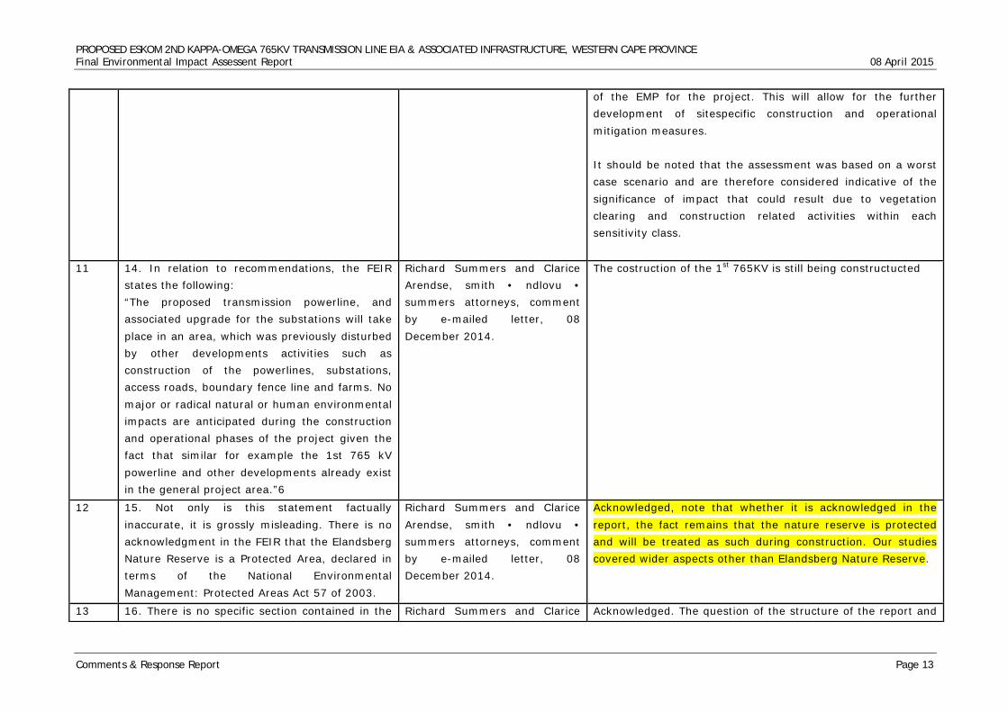
PROPOSED ESKOM 2ND KAPPA-OMEGA 765KV TRANSMISSION LINE EIA & ASSOCIATED INFRASTRUCTURE, WESTERN CAPE PROVINCE Final Environmental Impact Assessent Report 08 April 2015
Comments & Response Report Page 13
of the EMP for the project. This will allow for the further development of sitespecific construction and operational mitigation measures. It should be noted that the assessment was based on a worst case scenario and are therefore considered indicative of the significance of impact that could result due to vegetation clearing and construction related activities within each sensitivity class.
11 14. In relation to recommendations, the FEIR states the following: “The proposed transmission powerline, and associated upgrade for the substations will take place in an area, which was previously disturbed by other developments activities such as construction of the powerlines, substations, access roads, boundary fence line and farms. No major or radical natural or human environmental impacts are anticipated during the construction and operational phases of the project given the fact that similar for example the 1st 765 kV powerline and other developments already exist in the general project area.”6
Richard Summers and Clarice Arendse, smith • ndlovu • summers attorneys, comment by e-mailed letter, 08 December 2014.
The costruction of the 1st 765KV is still being constructucted
12 15. Not only is this statement factually inaccurate, it is grossly misleading. There is no acknowledgment in the FEIR that the Elandsberg Nature Reserve is a Protected Area, declared in terms of the National Environmental Management: Protected Areas Act 57 of 2003.
Richard Summers and Clarice Arendse, smith • ndlovu • summers attorneys, comment by e-mailed letter, 08 December 2014.
Acknowledged, note that whether it is acknowledged in the report, the fact remains that the nature reserve is protected and will be treated as such during construction. Our studies covered wider aspects other than Elandsberg Nature Reserve.
13 16. There is no specific section contained in the Richard Summers and Clarice Acknowledged. The question of the structure of the report and
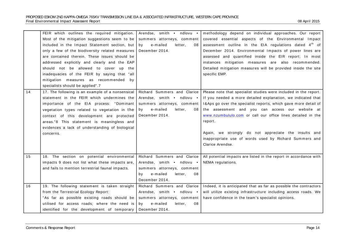
PROPOSED ESKOM 2ND KAPPA-OMEGA 765KV TRANSMISSION LINE EIA & ASSOCIATED INFRASTRUCTURE, WESTERN CAPE PROVINCE Final Environmental Impact Assessent Report 08 April 2015
Comments & Response Report Page 14
FEIR which outlines the required mitigation. Most of the mitigation suggestions seem to be included in the Impact Statement section, but only a few of the biodiversity related measures are contained therein. These issues should be addressed explicitly and clearly and the EAP should not be allowed to cover up the inadequacies of the FEIR by saying that “all mitigation measures as recommended by specialists should be applied”.7
Arendse, smith • ndlovu • summers attorneys, comment by e-mailed letter, 08 December 2014.
methodology depend on individual approaches. Our report covered essential aspects of the Environmental Impact assessment outline in the EIA regulations dated 4th of December 2014. Environmental Impacts of power lines are assessed and quantified inside the EIR report. In most instances mitigation measures are also recommended. Detailed mitigation measures will be provided inside the site specific EMP.
14 17. The following is an example of a nonsensical statement in the FEIR which undermines the importance of the EIA process: “Dominant
vegetation types related to vegetation in the context of this development are protected areas.”8 This statement is meaningless and evidences a lack of understanding of biological concerns.
Richard Summers and Clarice Arendse, smith • ndlovu • summers attorneys, comment by e-mailed letter, 08 December 2014.
Please note that specialist studies were included in the report. If you needed a more detailed explanation, we indicated that I&Aps go over the specialist reports, which gave more detail of the assessment and you can access our website at www.nzumbululo.com or call our office lines detailed in the report. Again, we strongly do not appreciate the insults and inappropriate use of words used by Richard Summers and Clarice Arendse.
15 18. The section on potential environmental impacts 9 does not list what these impacts are, and fails to mention terrestrial faunal impacts.
Richard Summers and Clarice Arendse, smith • ndlovu • summers attorneys, comment by e-mailed letter, 08 December 2014.
All potential impacts are listed in the report in accordance with NEMA regulations.
16 19. The following statement is taken straight from the Terrestrial Ecology Report: “As far as possible existing roads should be utilised for access roads; where the need is identified for the development of temporary
Richard Summers and Clarice Arendse, smith • ndlovu • summers attorneys, comment by e-mailed letter, 08 December 2014.
Indeed, it is anticipated that as far as possible the contractors will utilize existing infrastructure including access roads. We have confidence in the team’s specialist opinions.
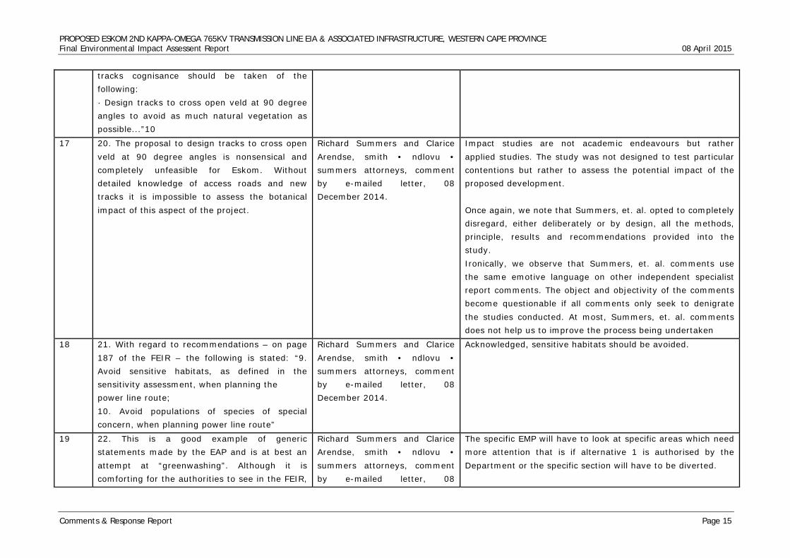
PROPOSED ESKOM 2ND KAPPA-OMEGA 765KV TRANSMISSION LINE EIA & ASSOCIATED INFRASTRUCTURE, WESTERN CAPE PROVINCE Final Environmental Impact Assessent Report 08 April 2015
Comments & Response Report Page 15
tracks cognisance should be taken of the following: · Design tracks to cross open veld at 90 degree angles to avoid as much natural vegetation as possible...”10
17 20. The proposal to design tracks to cross open veld at 90 degree angles is nonsensical and completely unfeasible for Eskom. Without detailed knowledge of access roads and new tracks it is impossible to assess the botanical impact of this aspect of the project.
Richard Summers and Clarice Arendse, smith • ndlovu • summers attorneys, comment by e-mailed letter, 08 December 2014.
Impact studies are not academic endeavours but rather applied studies. The study was not designed to test particular contentions but rather to assess the potential impact of the proposed development. Once again, we note that Summers, et. al. opted to completely disregard, either deliberately or by design, all the methods, principle, results and recommendations provided into the study. Ironically, we observe that Summers, et. al. comments use the same emotive language on other independent specialist report comments. The object and objectivity of the comments become questionable if all comments only seek to denigrate the studies conducted. At most, Summers, et. al. comments does not help us to improve the process being undertaken
18 21. With regard to recommendations – on page 187 of the FEIR – the following is stated: “9. Avoid sensitive habitats, as defined in the sensitivity assessment, when planning the power line route; 10. Avoid populations of species of special concern, when planning power line route”
Richard Summers and Clarice Arendse, smith • ndlovu • summers attorneys, comment by e-mailed letter, 08 December 2014.
Acknowledged, sensitive habitats should be avoided.
19 22. This is a good example of generic statements made by the EAP and is at best an attempt at “greenwashing”. Although it is comforting for the authorities to see in the FEIR,
Richard Summers and Clarice Arendse, smith • ndlovu • summers attorneys, comment by e-mailed letter, 08
The specific EMP will have to look at specific areas which need more attention that is if alternative 1 is authorised by the Department or the specific section will have to be diverted.
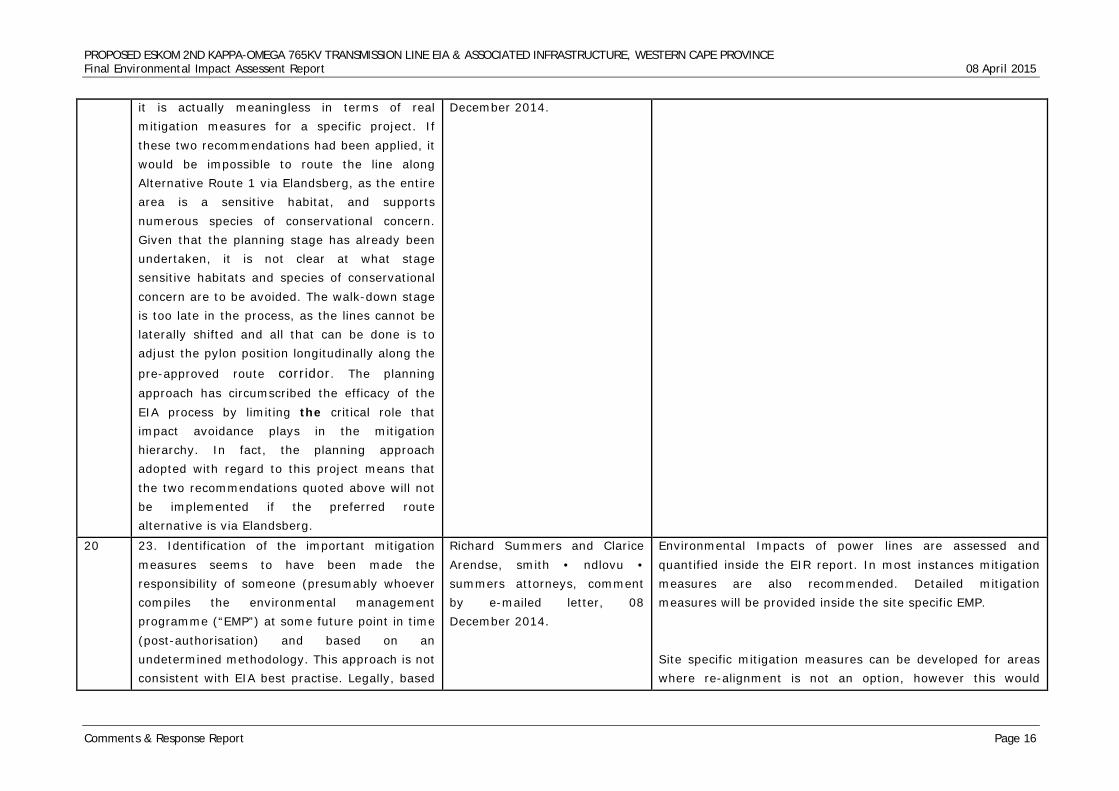
PROPOSED ESKOM 2ND KAPPA-OMEGA 765KV TRANSMISSION LINE EIA & ASSOCIATED INFRASTRUCTURE, WESTERN CAPE PROVINCE Final Environmental Impact Assessent Report 08 April 2015
Comments & Response Report Page 16
it is actually meaningless in terms of real mitigation measures for a specific project. If these two recommendations had been applied, it would be impossible to route the line along Alternative Route 1 via Elandsberg, as the entire area is a sensitive habitat, and supports numerous species of conservational concern. Given that the planning stage has already been undertaken, it is not clear at what stage sensitive habitats and species of conservational concern are to be avoided. The walk-down stage is too late in the process, as the lines cannot be laterally shifted and all that can be done is to adjust the pylon position longitudinally along the
pre-approved route corridor. The planning approach has circumscribed the efficacy of the EIA process by limiting the critical role that impact avoidance plays in the mitigation hierarchy. In fact, the planning approach adopted with regard to this project means that the two recommendations quoted above will not be implemented if the preferred route alternative is via Elandsberg.
December 2014.
20 23. Identification of the important mitigation measures seems to have been made the responsibility of someone (presumably whoever compiles the environmental management programme (“EMP”) at some future point in time (post-authorisation) and based on an undetermined methodology. This approach is not consistent with EIA best practise. Legally, based
Richard Summers and Clarice Arendse, smith • ndlovu • summers attorneys, comment by e-mailed letter, 08 December 2014.
Environmental Impacts of power lines are assessed and quantified inside the EIR report. In most instances mitigation measures are also recommended. Detailed mitigation measures will be provided inside the site specific EMP. Site specific mitigation measures can be developed for areas where re-alignment is not an option, however this would
PROPOSED ESKOM 2ND KAPPA-OMEGA 765KV TRANSMISSION LINE EIA & ASSOCIATED INFRASTRUCTURE, WESTERN CAPE PROVINCE Final Environmental Impact Assessent Report 08 April 2015
Comments & Response Report Page 17
on a proper consideration of the National Environmental Management Act 107 of 1998 (“NEMA”) and the EIA Regulations, the EIA process (and the environmental impact reports in particular) are supposed to include and collate all necessary information that must be incorporated into the EMP. This has not been the case here.
require detailed site assessments of all these areas; possibly as a ‘second phase’ assessment that can inform the Eskom prior to constructionor or prior to finalisation of the EMP for the project. This will allow for the further development of site specific construction and operational mitigation measures
21 24. The methodology of the Terrestrial Ecology Report is inconsistent. If the consultants had flagged Elandsberg as an area of “exceptional significance” (which they should have done, according to their own criteria) then they would not have been able to recommend Alternative Route 1 as a preferred route.
Richard Summers and Clarice Arendse, smith • ndlovu • summers attorneys, comment by e-mailed letter, 08 December 2014.
We acknowledge your contribution and we believe that our specialists fulfilled the requirements of section 31 (2) (1) of the EIA process. South Africa has probably the highest number of powerline networks in Africa thus our specialist have vast experience in powerline developments. Generally powerline development impacts have been well documented and releatively easy to predict as well as to mitigate.
22 25. The EAP reflects a poor understanding of the EIA process. The report which has been submitted to the DEA is the FEIR. This is the final opportunity for impact assessment and public participation in the EIA process. It is not clear what the EAP is suggesting by way of site specific mitigation measures that “can be developed” in the future for certain areas. It is also not clear what is being contemplated by the reference to “detailed site assessments” or “a ‘second phase’ assessment that can inform the EIA prior to final submission or prior to finalisation of the EMP.” The EAP ignores the fact that there is no opportunity for further assessment at some undetermined future stage. The whole purpose of an EIA is to evaluate, assess and consider project-related impacts
Richard Summers and Clarice Arendse, smith • ndlovu • summers attorneys, comment by e-mailed letter, 08 December 2014.
Once again, to suggest that the EAP process has a poor understanding is an insult to the entire team. The entire team is qualified and highly experienced to handle impact assessment for a powerline project. While we appreciateyour comments, and ensure that they are adhered to, we don’t appreciate any insults. Powerline development is not unique, powerlines have been
built all over and generic impacts of powerline development
are well documented. Environmental Impact studies remember
are not academic endeavours. The selection of routes is
determined by Eskom‘s strategic planning and demand. We
are confident that our specialists are capable and they fulfilled
their requirements of the relevant legislation that govern their
work.
PROPOSED ESKOM 2ND KAPPA-OMEGA 765KV TRANSMISSION LINE EIA & ASSOCIATED INFRASTRUCTURE, WESTERN CAPE PROVINCE Final Environmental Impact Assessent Report 08 April 2015
Comments & Response Report Page 18
before a project is authorised.
23 26. The EAP has failed completely to respond to the concerns raised regarding how the biodiversity impact on the Elandsberg Nature Reserve has been quantified or assessed. It is plainly apparent that this impact has not been assessed in the manner required by NEMA. On this basis the FEIR should be rejected by DEA.
Richard Summers and Clarice Arendse, smith • ndlovu • summers attorneys, comment by e-mailed letter, 08 December 2014.
All available and regionally known faunal and floral reference databases were considered or assessed in order to assure that the assessments take as many of the potential species as well as important habitats into consideration as possible given the extent of the various alternatives. However, consideration should be given to extreme extent each of the proposed alternatives cover that resulted in the likelihood of all documented species as well as a vast variety of different habitats being present along portions of the routes. It should also be noted that the study was aimed at assessing 2km wide corridor alternatives and as such detailed assessments are not practicable at this stage of the investigations. The assessment approach was aimed at identification and prioritisation of portions along the various alternatives that are considered most likely to be able to sustain the most diverse and sensitive faunal and floral populations and where more care would be required in the planning, construction and operational phases of the project. It has been made clear in the reports developed that as part of the planning phase of the development a walk down be undertaken of all areas considered of higher ecological importance identified within the baseline report for the selected route within the selected corridor. By so doing areas of least concern can be identified for the construction of support structures. It should further be noted that where portions of routes were identified that where considered ‘no go’ areas, it has been highlighted in the report and where possible alternative alignment has been proposed or recommended. The client has been provided with the GIS files indicating areas
PROPOSED ESKOM 2ND KAPPA-OMEGA 765KV TRANSMISSION LINE EIA & ASSOCIATED INFRASTRUCTURE, WESTERN CAPE PROVINCE Final Environmental Impact Assessent Report 08 April 2015
Comments & Response Report Page 19
considered to be of very high and high sensitivity identified using all desktop information available with special mention of fine scale plans as well as site visits. It is the opinion of the specialists that alternative route alignment be considered around these areas and that CBAs be avoided as far as possible regardless of what faunal or floral species are found within them. By so doing the sitespecific impacts associated with these areas will most likely be avoided. Site specific mitigation measures can then be developed for areas where re-alignment is not an option, however this would require detailed site assessments of all these areas; possibly as a ‘second phase’ assessment that can inform the EIA prior to final submission or prior to finalisation of the EMP for the project. This will allow for the further development of sitespecific construction and operational mitigation measures. It should be noted that the assessment was based on a worst case scenario and are therefore considered indicative of the significance of impact that could result due to vegetation clearing and construction related activities within each sensitivity class.
24 7. The Terrestrial Ecology Report states the following: “Development of a transmission line within or near a nature reserve can result not only in direct impact on vegetation due to clearing, but can also decrease the ‘sense of place’ of the area, consequently resulting in loss of ecotourism on which the nature reserves depend. It is therefore strongly recommended
Richard Summers and Clarice Arendse, smith • ndlovu • summers attorneys, comment by e-mailed letter, 08 December 2014.
Very true all routes areas which can not be mittigated and are very sensitive will need to be re routed.
PROPOSED ESKOM 2ND KAPPA-OMEGA 765KV TRANSMISSION LINE EIA & ASSOCIATED INFRASTRUCTURE, WESTERN CAPE PROVINCE Final Environmental Impact Assessent Report 08 April 2015
Comments & Response Report Page 20
that the options that would pass through nature reserves or in close proximity to nature reserves, if chosen, be re-routed to more disturbed areas inland of where the options are presently proposed.”11
25 28. This finding and recommendation in the Terrestrial Ecology Report clearly ignores the fact that the Elandsberg Nature Reserve (approximately 3192ha in size) is a legally protected nature reserve in terms of the National Environmental Management: Protected Areas Act 57 of 2003. Information regarding this protected status is freely available. The Elandsberg Nature Reserve should have been identified as an area through which the proposed power lines should not traverse, and Alternative Route 1 should accordingly not have been approved.
Richard Summers and Clarice Arendse, smith • ndlovu • summers attorneys, comment by e-mailed letter, 08 December 2014.
Route 1 is not yet approved but it is preferred and I strongly believe thet the the powerline will not take the whole 3192 ha in size
26 29. The Terrestrial Ecology Report further failed to mention the key reference to lowland conservation priorities – the so called Jarman Report (Jarman 1986, Conservation Priorities in Lowland Regions of the Fynbos Biome, South African National Scientific Programmes Report 87, the Counsel for Scientific and Industrial Research, Pretoria). The Jarman report ranks Elandsberg (which it even then recognised as conserved) as the second most important site in the entire West Coast Renosterveld Region.12
Richard Summers and Clarice Arendse, smith • ndlovu • summers attorneys, comment by e-mailed letter, 08 December 2014.
The specilaist is free to use any reference they wish to use, they are not titled to use one which is widely known.it depends on the specialist descretion
27 30. In addition, the Terrestrial Ecology Report states:
Richard Summers and Clarice Arendse, smith • ndlovu •
Comment noted, we acknowledge the specialists ‘s opinion in this matter.
PROPOSED ESKOM 2ND KAPPA-OMEGA 765KV TRANSMISSION LINE EIA & ASSOCIATED INFRASTRUCTURE, WESTERN CAPE PROVINCE Final Environmental Impact Assessent Report 08 April 2015
Comments & Response Report Page 21
“During the field assessment isolated Renosterveld and woody alien vegetation stands were encountered where vegetation has been cleared in servitudes as mitigation to possible fire damage. These were considered isolated instances and therefore clearing of vegetation within servitudes was not taken into consideration during the impact assessment.”13
summers attorneys, comment by e-mailed letter, 08 December 2014.
28 31. Whether this critically sensitive vegetation type (renosterveld) is isolated or not, the fact is that vegetation clearing has been undertaken in various parts of the existing servitude, and would thus be likely to occur in parts of the new servitude. The failure to assess the impact of this is a significant omission, especially in light of the following statement contained in the same paragraph: “However, it should be noted that vegetation clearing and subsequent change of the natural fire regimes within the servitudes will result in transformation of vegetation communities and would result in a much higher impact rating than what was calculated in the impact assessment below.”14
Richard Summers and Clarice Arendse, smith • ndlovu • summers attorneys, comment by e-mailed letter, 08 December 2014.
Acknowledged. We stand by our specialist opinion because it is an objective assessment of the situation on the ground. Also note that site specific impacts and mitigation measures and will still be dealt with in detail after authorisation. If the project gets authorised.
29 32. The Terrestrial Ecology Report continues by stating: “All SCC (Species of Conservational Concern) and plants considered to be of medicinal value should be marked during the walk down of the preferred corridor, prior to commencement of construction activities. Marking of SCC should be undertaken by a suitably qualified and appropriately experienced Botanist;
Richard Summers and Clarice Arendse, smith • ndlovu • summers attorneys, comment by e-mailed letter, 08 December 2014.
Acknowledged. Please note that specialists recommend the best options for minimising damages to the environment. They could be several ways of dealing with the challenge but certainly one has to weigh options and the decision is informed by experience and expertise. This is not the first powerline Eskom is proposing to build.
PROPOSED ESKOM 2ND KAPPA-OMEGA 765KV TRANSMISSION LINE EIA & ASSOCIATED INFRASTRUCTURE, WESTERN CAPE PROVINCE Final Environmental Impact Assessent Report 08 April 2015
Comments & Response Report Page 22
· Relevant permits should be obtained for rescue and relocation of any SCC identified; · All SCC individuals encountered during the walk down or construction phase of the development should be rescued and relocated to the nearest similar habitat to that from which it was taken, by a suitably qualified specialist”.15
30 33. Rescue and relocation is not supported by CapeNature as an acceptable mitigation measure for many species for various reasons, including the low likelihood of success for many taxa, the need to conserve habitat rather than just species, and importantly because translocating species involves disturbance of the receiving site. Unless a similar, but previously disturbed, receiving site can be located (which is in need of rehabilitation) then translocating specimens may in fact increase overall disturbance.
Richard Summers and Clarice Arendse, smith • ndlovu • summers attorneys, comment by e-mailed letter, 08 December 2014.
Acknowledged. In our view rescue and relocation is deemed as the most feasible option given that it is not only terrestrial issues that are considered for final recommendations. All specialists inputs are weighed equally. Please note that should balance the benefits of the projects with protection of the environment for sustainable development. While we acknowledged CapeNature’s opinion we strongly support the Rescue and relocation method as the best suitable method for our circumstances.
31 34. The recommendation that species of conservational concern encountered during the walk-down should be rescued and relocated is simply not feasible or advisable. As many as 40% of the species of conservational concern en route will be shrubs with very low translocation potential. Accordingly, rescue and relocation cannot be used as a mitigation measure for loss of species of conservational concern. It is submitted that there will be loss of species of conservational concern in footprint areas, and also in the road access areas. This appears to have been completely ignored in the Terrestrial Ecology Report.
Richard Summers and Clarice Arendse, smith • ndlovu • summers attorneys, comment by e-mailed letter, 08 December 2014.
Acknowledged. As indicated above, rescue and relocation has been carefully selected as the most feasible option given that all specialist inputs were equally considered. The Terrestrial and Ecology study should not be treated in isolation. It is part and parcel of the whole package of specialist studies that should zero on one alternative route for approval by DEA. In our view the entire report cannot rejected on the basis of a very small section of the route.
PROPOSED ESKOM 2ND KAPPA-OMEGA 765KV TRANSMISSION LINE EIA & ASSOCIATED INFRASTRUCTURE, WESTERN CAPE PROVINCE Final Environmental Impact Assessent Report 08 April 2015
Comments & Response Report Page 23
32 35. Eskom has not provided information to specialists on where the road access points will be. Road access can often have a bigger botanical impact than the actual pylon footprints, as the cumulative road footprint in
any one section is much greater than the pylon footprint. The inability to assess the botanical impact of road access is accordingly a significant shortcoming.
Richard Summers and Clarice Arendse, smith • ndlovu • summers attorneys, comment by e-mailed letter, 08 December 2014.
Acknowledged. Please note that the proposed line is proposed in developed areas with farm roads, rural and existing regional road infrastructure which will be utilized during construction. Also note that in the majority of cases the proposed powerline route runs along 1st 765kv and 400kv poweline with existing access road. Based on our experience, contractors often use existing structures for their camp sites. In addition as indicated earlier on site specific impacts will be considered after the final route selection is concluded. The selected route will be subjected to walk down surveys which will deal with site specific impacts including tower to tower impacts. Please note that construction phase management plan will also take into consideration site specific impacts, there after an operational phase management plan will consider the impacts of the proposed powerline after construction including impacts of routine mantainace work and repairs.
33 36. The Terrestrial Ecology Report provides that: “Care should be taken if chemical methods (herbicides) are to be utilised for both vegetation clearing prior to construction as well as alien vegetation removal post construction. Spill or indiscriminate use of herbicides could result in the loss of indigenous floral individuals or habitat;”16
Richard Summers and Clarice Arendse, smith • ndlovu • summers attorneys, comment by e-mailed letter, 08 December 2014.
Acknowledged. Note that this recommendation is tentative; it will depend on which method the contactors will use for vegetation clearance. Your suggestion will be incorporated in the final EMP
34 37. It is submitted that herbicides should not be used at all, nor should they be necessary anywhere in the study area. In particular, herbicides should not be used in any medium, high or very high sensitivity areas, as collateral damage and loss of potential species of conservational concern is very high with herbicide usage. If any herbicide are to be used,
Richard Summers and Clarice Arendse, smith • ndlovu • summers attorneys, comment by e-mailed letter, 08 December 2014.
Comment noted. Your input will be included in the final management plan (EMP)
PROPOSED ESKOM 2ND KAPPA-OMEGA 765KV TRANSMISSION LINE EIA & ASSOCIATED INFRASTRUCTURE, WESTERN CAPE PROVINCE Final Environmental Impact Assessent Report 08 April 2015
Comments & Response Report Page 24
they should be hand painted on cut stems of species that re-sprout, and should not be permitted to be sprayed.
35 38. The Terrestrial Ecology Report recommends that “all areas surrounding construction activity footprints should be kept off-limits to construction vehicles and personnel.”17 This mitigation measure lacks specificity and is accordingly impossible to enforce. It is unclear what areas constitute the construction activity footprints. This mitigation measure should have provided, for example, that approved development footprints be demarcated prior to construction.
Richard Summers and Clarice Arendse, smith • ndlovu • summers attorneys, comment by e-mailed letter, 08 December 2014.
It should be noted that the assessment was based on a worst
case scenario and are therefore considered indicative of the
significance of impact that could result due to vegetation
clearing and construction related activities within each
sensitivity class. It has been made clear in the reports
developed that as part of the planning phase of the
development a walk down be undertaken of all areas
considered of higher ecological importance identified
within the baseline 2report for the selected route within
the selected corridor. By so doing areas of least concern
can be identified for the construction of support
structures.
It should further be noted that where portions of routes
were identified that where considered ‘no go’ areas, it
has been highlighted in the report and where possible
alternative alignment has been proposed or
recommended.
36 39. In respect of specific eradication for alien and weed species, the report recommends: · “Care should be taken with the choice of herbicide to ensure that no additional impact and loss of indigenous plant species occurs due
Richard Summers and Clarice Arendse, smith • ndlovu • summers attorneys, comment by e-mailed letter, 08 December 2014.
Comment noted. Your suggestions will be included in the construction Environmental Management Plan (EMP)
PROPOSED ESKOM 2ND KAPPA-OMEGA 765KV TRANSMISSION LINE EIA & ASSOCIATED INFRASTRUCTURE, WESTERN CAPE PROVINCE Final Environmental Impact Assessent Report 08 April 2015
Comments & Response Report Page 25
to the herbicide used; · Footprint areas should be kept as small as possible when removing alien plant species; and · No vehicles should be allowed to indiscriminately drive through open veld during the eradication of alien and weed species.”18
37 40. As noted above, no herbicide should be permitted in medium, high or very high sensitivity areas, not even for alien vegetation control, except where the alien invasive vegetation requires herbicide to prevent re-sprouting from cut stems. In this specific case, it would be recommended that herbicide be hand painted (as opposed to being sprayed) onto cut stems within 5 minutes of felling, and that the herbicide be mixed with a suitable dye so that treated stems are easily identifiable.
Richard Summers and Clarice Arendse, smith • ndlovu • summers attorneys, comment by e-mailed letter, 08 December 2014.
Your inputs are appreciated and will be included in the final EMP as noted above.
38 41. The Terrestrial Ecology Report stipulates that: “All soils compacted as a result of construction activities falling outside of the servitude and construction footprint areas should be ripped and profiled. Special attention should be paid to alien and invasive control within these areas”.19
Richard Summers and Clarice Arendse, smith • ndlovu • summers attorneys, comment by e-mailed letter, 08 December 2014.
Comment noted. Your contribution will be implemented particularly in the EMP..
39 42. This statement is incorrect. No ripping or profiling should take place in any areas of natural vegetation, particularly not in any areas of medium, high or very high sensitivity, as it will significantly increase the disturbance levels and alien invasion potential.
Richard Summers and Clarice Arendse, smith • ndlovu • summers attorneys, comment by e-mailed letter, 08 December 2014.
Comment noted however our recommendation was based on the worst case of compaction where ripping might be appropriate as part of the rehabilitation process.
40 43. No mention is made in the Terrestrial Richard Summers and Clarice Please note that specialist studies are expected to provide an
PROPOSED ESKOM 2ND KAPPA-OMEGA 765KV TRANSMISSION LINE EIA & ASSOCIATED INFRASTRUCTURE, WESTERN CAPE PROVINCE Final Environmental Impact Assessent Report 08 April 2015
Comments & Response Report Page 26
Ecology Report of certain key references, including: 43.1. Von Hase, A., M. Rouget, K. Maze, and N. Helme. 2003. A fine-scale conservation plan for Cape Lowlands Renosterveld: Technical report. CCU Report # 2/03, Botanical Society of South Africa, Kirstenbosch. This report highlights Elandsberg as a priority area for Renosterveld conservation in the Swartland. 43.2. Helme, N. 2008. Botanical Scoping Assessment: New transmission lines from Bantamsklip to Bacchus, Kappa and Muldersvlei, and extension of Bacchus Substation, Western Cape. Report for Eskom and Arcus Gibb (SA). Nick Helme Botanical Surveys, Scarborough. This report also highlights Elandsberg as a priority area for Renosterveld conservation in the Swartland, and highlights it as an area of very high ecological sensitivity that should be avoided by new power lines. 43.3. Elandsberg Nature Reserve is indicated as a Focus Area in the map of the National Protected Area Expansion Strategy (2008).
Arendse, smith • ndlovu • summers attorneys, comment by e-mailed letter, 08 December 2014.
independent assessment of the project area and we are confident that the specialist is qualified and experienced to conduct visual impact studies for linear developments like powerlines. Literature review is an important component in any study, how selection of the literature depends on the specialist’s own knowledge and expertise. We are further confident that our specialist used appropriate methodology to assess the visual impact of the entire development. Specific impacts will be covered when the final route selection is concluded. As in the response above, over use of absolute comments is not appreciated by the entire team. The consultation and review process is meant to ensure that significant heritage resources are protected during any development.
41 44. The section on the No-Go alternative20 in the Terrestrial Ecology Report is a cursory analysis. Notably, no mention is made of formal conservation areas and the fact that the ecological condition of these areas is stable or improving. It is for this reason that the No-Go scenario in these areas is positive from an ecological perspective, versus negative for all development alternatives.
Richard Summers and Clarice Arendse, smith • ndlovu • summers attorneys, comment by e-mailed letter, 08 December 2014.
Comment noted but you issues revolve around differences in expert opinions and approaches.
PROPOSED ESKOM 2ND KAPPA-OMEGA 765KV TRANSMISSION LINE EIA & ASSOCIATED INFRASTRUCTURE, WESTERN CAPE PROVINCE Final Environmental Impact Assessent Report 08 April 2015
Comments & Response Report Page 27
42 45. There is only a brief discussion of cumulative impacts21 which is cursory and inadequate. No mention is made of the impacts of servitude brushcutting (which may be strongly negative); access roads (which may also be negative); or the cumulative impact of Eskom power lines and servitude management in general. The brushcut servitude on Elandsberg alone impacts on 18 hectares of vegetation (this is clearly visible on Google Earth imagery dated 14 October 2014), which is far from insignificant in a Critically Endangered vegetation type, especially when it is known to support numerous species of conservational concern. The proposed power line will cross many kilometres of intact vegetation, and thus servitude brushcutting could have significant cumulative negative impacts when added to the other brushcutting undertaken in existing Eskom servitudes in the region. The acknowledgement that “by adding an additional servitude the loss of Renosterveld would be significant within the area”22 suggests that the authors are aware of the negative impact of brushcutting, but do not address the impacts adequately or comprehensively throughout the entire route
Richard Summers and Clarice Arendse, smith • ndlovu • summers attorneys, comment by e-mailed letter, 08 December 2014.
Please note those specialists are guided by different legislations and guidelines which are applicable to their fields of study. For example in Archaeology construction a powerline close to another powerline is considered to be ideal than going to virgin servitude. Furthermore constructing a powerline across known sites provides the opportunity to avoid them. I would like to assure you that our specialist did consider cummulative impacts in their various fields. Site specific and comprehensive studies will be done once the final route is selected. As indicated earlier on site specific impacts will be considered after the final route selection is concluded. The selected route will be subjected to walk down surveys which will deal with site specific impacts including tower to tower impacts. Please note that construction phase management plan will also take into consideration site specific impacts, there after an operational phase management plan will consider the impacts of the proposed powerline after construction including impacts of routine mantainace work and repairs.
43 46. The frequency of brushcutting in the servitude that crosses Fynbos vegetation of this type is critical. If undertaken frequently, or if the site is burnt in the intervening period, it may lead to local extinction of some of the slower growing and slower maturing species, notably
Richard Summers and Clarice Arendse, smith • ndlovu • summers attorneys, comment by e-mailed letter, 08 December 2014.
Comment noted. The Terrestrial and Ecology report is based on the study of the site of interest and expert opinions. Differences in approaches and expert opinions should not be undermined. Although we appreciate your opinion it is should not be treated as binding.
PROPOSED ESKOM 2ND KAPPA-OMEGA 765KV TRANSMISSION LINE EIA & ASSOCIATED INFRASTRUCTURE, WESTERN CAPE PROVINCE Final Environmental Impact Assessent Report 08 April 2015
Comments & Response Report Page 28
certain succulents and shrubs, some of which may be species of conservational concern. Frequent brushcutting in Fynbos systems can severely alter vegetation structure, rapidly changing it to a grassland that is in fact more fire prone than the original vegetation (although this is in fact noted in page 111 of the FEIR, the potential impact thereof is not accurately assessed in either the FEIR or the Terrestrial Ecology Report).
44 47. The section on the No-Go alternative20 in the Terrestrial Ecology Report is a cursory analysis. Notably, no mention is made of formal conservation areas and the fact that the ecological condition of these areas is stable or improving. It is for this reason that the No-Go scenario in these areas is positive from an ecological perspective, versus negative for all development alternatives. There is only a brief discussion of cumulative impacts 21 which is cursory and inadequate. No mention is made of the impacts of servitude brushcutting (which may be strongly negative); access roads (which may also be negative); or the cumulative impact of Eskom power lines and servitude management in general. The brushcut servitude on Elandsberg alone impacts on 18 hectares of vegetation (this is clearly visible on Google Earth imagery dated 14 October 2014), which is far from insignificant in a Critically Endangered vegetation type, especially when it is known to support numerous species of
Richard Summers and Clarice Arendse, smith • ndlovu • summers attorneys, comment by e-mailed letter, 08 December 2014.
Your detailed comments are note, however as mentioned above your issues revolve around differences in approach and expert opinion. It is unfortunate that your opinions are based on subjective and biased analysis of the impacts where as our study is objective and independent of any personal or external influence or interest.
PROPOSED ESKOM 2ND KAPPA-OMEGA 765KV TRANSMISSION LINE EIA & ASSOCIATED INFRASTRUCTURE, WESTERN CAPE PROVINCE Final Environmental Impact Assessent Report 08 April 2015
Comments & Response Report Page 29
conservational concern. The proposed power line will cross many kilometres of intact vegetation, and thus servitude brushcutting could have significant cumulative negative impacts when added to the other brushcutting undertaken in existing Eskom servitudes in the region. The acknowledgement that “by adding an additional servitude the loss of Renosterveld would be significant within the area”22 suggests that the authors are aware of the negative impact of brushcutting, but do not address the impacts adequately or comprehensively throughout the entire route. The frequency of brushcutting in the servitude that crosses Fynbos vegetation of this type is critical. If undertaken frequently, or if the site is burnt in the intervening period, it may lead to local extinction of some of the slower growing and slower maturing species, notably certain succulents and shrubs, some of which may be species of conservational concern. Frequent brushcutting in Fynbos systems can severely alter vegetation structure, rapidly changing it to a grassland that is in fact more fire prone than the original vegetation (although this is in fact noted in page 111 of the FEIR, the potential impact thereof is not accurately assessed in either the FEIR or the Terrestrial Ecology Report). The mitigation measures proposed in the Terrestrial Ecology Report will not significantly reduce the cumulative impacts of the project, as
PROPOSED ESKOM 2ND KAPPA-OMEGA 765KV TRANSMISSION LINE EIA & ASSOCIATED INFRASTRUCTURE, WESTERN CAPE PROVINCE Final Environmental Impact Assessent Report 08 April 2015
Comments & Response Report Page 30
the pylons and access roads will still be built in various ecologically sensitive areas, and the servitudes are very likely to be brushcut as, when and where Eskom desires. It is also submitted that Eskom has had a bad and well documented history of servitude mismanagement (most notably at the Plattekloof Natural Heritage site in the City of Cape Town,
as well as in the Breede River valley near Robertson where Succulent Karoo vegetation (which was not capable of holding a fire) was brushcut).
45 48. With regard to areas of exceptional significance 23, it is questionable how the Terrestrial Ecology Report’s analysis determined that only three areas were of exceptional biodiversity significance, when the criteria were that “these areas coincide with areas indicated to be either natural vegetation and CBAs (Fine Scale Plans) or critically endangered ecosystems (Threatened Ecosystem Status).” Elandsberg fits all these criteria, yet it was excluded. The failure by the specialists to incorporate Elandsberg in their findings stems from the fact that they did not refer at all to the Cape Lowlands Renosterveld study (von Hase et al 2004), which is the recognised Fine Scale Plan for that specific area.
Richard Summers and Clarice Arendse, smith • ndlovu • summers attorneys, comment by e-mailed letter, 08 December 2014.
Comment noted, but as indicated above we realize your lack of appreciation of our methods and approaches in impact studies.
46 49. Further, mitigation requirements are not dealt with explicitly in the Terrestrial Ecology Report. This is a particularly serious oversight,
Richard Summers and Clarice Arendse, smith • ndlovu • summers attorneys, comment
Please note that the studies were conducted by qualified and experienced specialist whom we do not doubt the credibility of their work. In our view it is the responsibility of compliance
PROPOSED ESKOM 2ND KAPPA-OMEGA 765KV TRANSMISSION LINE EIA & ASSOCIATED INFRASTRUCTURE, WESTERN CAPE PROVINCE Final Environmental Impact Assessent Report 08 April 2015
Comments & Response Report Page 31
as mitigation is one of the most important sections of an impact assessment and without a credible implementation of the mitigation hierarchy the results of the EIA are not credible. The fact that mitigation requirements are not contained in the Terrestrial Ecology Report invalidates the impact assessment, which refers to the impacts “after mitigation”.
by e-mailed letter, 08 December 2014.
agencies to make the final decision on our studies.
47 HERITAGE 50. Several critical concerns were raised in our letter dated 11 August 2014 with the level of heritage impact assessment. These concerns were captured in an independent review of the draft HIA Report and the Built Environment Report which was undertaken by Mr. Ashley Lillie and Ms. Sarah Winter.
Richard Summers and Clarice Arendse, smith • ndlovu • summers attorneys, comment by e-mailed letter, 08 December 2014.
Thank you for raising issues relating to the heritage value of the Elandsberg Farms. Your concerns have been noted and dealt with adequately; refer to revised Cultural Landscape Report, November 2014, BoD and ST, November 2014. ith adequately.
48 51. Our previous set of comments highlighted the fact that the Elandsberg Nature Reserve is a property of considerable heritage significance and that there were several flaws in the heritage impact assessment methodology, which had compromised the assessment of heritage impacts. The heritage-related concerns were substantiated by the independent expert opinion of Ashley Lillie and Sarah Winter.
Richard Summers and Clarice Arendse, smith • ndlovu • summers attorneys, comment by e-mailed letter, 08 December 2014.
No doubt that every landscape in one way or another is a cultural landscape. We have no doubt that Elandsberg Reserve is significant. In addition the sites in question are already protected by the NHRA and NEMA and the HIA study was conducted conscious of these factors. Our heritage studies were not limited to one locality and one type of heritage; we looked beyond historical and colonial heritage of the landscape.
49 52. It appears that we are unable to engage meaningfully with the EAP on this particular – critically important – aspect of the impact assessment process. The reason for this is the high-handed and dismissive approach the EAP has adopted in connection with the heritage-
Richard Summers and Clarice Arendse, smith • ndlovu • summers attorneys, comment by e-mailed letter, 08 December 2014.
Indeed we do not see the logic of panicking over a process that is legislated and whose results are yet to be assessed and adjudicated by the relevant competent authorities. Please note that our responses were triggered by comments that seek to undermine our credibility. Reading from the tone of comments and issues, we are of the view that you are simply lobbying
PROPOSED ESKOM 2ND KAPPA-OMEGA 765KV TRANSMISSION LINE EIA & ASSOCIATED INFRASTRUCTURE, WESTERN CAPE PROVINCE Final Environmental Impact Assessent Report 08 April 2015
Comments & Response Report Page 32
related issues identified in connection with the DEIR. In illustration of this point the Comments and Response Report24 indicates as follows: 52.1. “From a heritage perspective we do not see any reason for ringing alarm bells because the law is clear about impacts associated with development.” 52.2. “This property and associated heritage resources enjoys specific and general protection from the NHRA Sections 34 and 35.” 52.3. “... we are confident our heritage specialists covered your concerns adequately.”
against the whole process with little or no intention to contribute productively to the EIA process. Your clients were accorded the opportunity to raise their concerns in accordance with the NEMA regulations and section 38 of the NHRA.
50 53. In order to determine definitively whether or not the EAP can defensibly claim to have covered heritage-related concerns adequately our clients have again commissioned Ashley Lillie and Sarah Winter to review the FEIR and the HIA. That review is attached hereto marked B in a letter dated 8 December 2014 which confirms that the concerns regarding the heritage assessment methodology, cumulative impacts and the nature and scope of heritage impact assessment have not been addressed in the final HIA and specialist report.
Richard Summers and Clarice Arendse, smith • ndlovu • summers attorneys, comment by e-mailed letter, 08 December 2014.
Your concerns are noted however we still insist that our various methods and approaches are adequate to fulfil the Phase 1 mandates. Please note that issues of methodology and approaches are contested, our methods and approaches of assessment may not be primarily dismissed on the basis that a reviewer does not agree with our approach. Whether the review is repeated over and over again as long as it is the same reviewer being engaged we start questioning the credibility of the process.
51 54. On this basis the claim in the Comments and Response Report that requirements of section 38(3) of the National Heritage Resources Act 25 of 1999 have been addressed is disputed. We have been instructed to raise these concerns directly with the relevant heritage resources authority in the Western Cape (HWC) due to the fact that the adequacy of heritage impact
Richard Summers and Clarice Arendse, smith • ndlovu • summers attorneys, comment by e-mailed letter, 08 December 2014.
Your recurrent issues are acknowledged but we still stick to our point that our HIA report fulfils requirements of section 38(3) and international best practice. It is within your constitutional rights to raise your concerns with compliance agencies but we strongly feel that your issues would be best dealt with by the relevant specialists conducting the studies. The role of Heritage Western Cape is to comment on a finished product.
PROPOSED ESKOM 2ND KAPPA-OMEGA 765KV TRANSMISSION LINE EIA & ASSOCIATED INFRASTRUCTURE, WESTERN CAPE PROVINCE Final Environmental Impact Assessent Report 08 April 2015
Comments & Response Report Page 33
assessment is central to our clients’ concerns and is likely to be the subject of an ongoing dispute if this issue is not addressed appropriately and responsibly through the NEMA EIA process.
52 VISUAL IMPACTS 55. An independent review of the Visual Impact Assessment (“VIA”) Report was undertaken on behalf of our clients by Messrs. Bernard Oberholzer and Quinton Lawson and which formed part of our clients’ comments on the DEIR.
Richard Summers and Clarice Arendse, smith • ndlovu • summers attorneys, comment by e-mailed letter, 08 December 2014.
Your intervention is commended as long as it is intended to bring value to the EIA process.
53 56. The review by Messrs. Oberholzer and Lawson indicated that the level of detailed visual impact assessment was inadequate for a project of this nature and did not enable an appropriate consideration of visual impacts. It is simply inadequate for the concern raised to be disposed of with glib references to the fact that “the specialist is highly qualified and has conducted a lot of visual studies in the country as a whole”.25 It was also not acceptable for the EAP to retort that the “specialist did assess all the areas and the final walkdown will further specify the scenic routes and many others”.26 Responses such as those quoted in the aforementioned text are meaningless and do not take the matter further. Our clients went to the trouble of commissioning independent expert opinion on the basis that they felt the treatment of visual impacts was not adequate. The type of flippant response to these issues is
Richard Summers and Clarice Arendse, smith • ndlovu • summers attorneys, comment by e-mailed letter, 08 December 2014.
Your comments are noted. Please refer to attached response from Gerhard Griesel dated 20 October 2014. In our opinion experience and expertise are key in impact studies hence our confidence in the specialist. Note that our Heritage Principal Investigator reviewed the specialists’ reports.
PROPOSED ESKOM 2ND KAPPA-OMEGA 765KV TRANSMISSION LINE EIA & ASSOCIATED INFRASTRUCTURE, WESTERN CAPE PROVINCE Final Environmental Impact Assessent Report 08 April 2015
Comments & Response Report Page 34
unacceptable. In the circumstances, we have no alternative but to request DEA to reject the visual impact study and the FEIR in the manner contemplated in Regulation 34 of the EIA Regulations. Alternatively, and as a bare minimum DEA is requested to inform the applicant that both the visual impact report and the FEIR have been referred for specialist review in terms of section 24I of NEMA.
54 57. For the reasons set out above, the visual impact assessment undertaken as part of the EIA process is fundamentally flawed. Accordingly, the VIA Report does not assist in assessing the visual impact of the proposed power line. There is therefore insufficient information to enable a considered understanding of all visual impacts or how the proposed power line will affect particular resources. It is not possible for our clients to engage meaningfully on the manner in which the project will impact on the heritage significance and experiential qualities of our clients’ property.
Richard Summers and Clarice Arendse, smith • ndlovu • summers attorneys, comment by e-mailed letter, 08 December 2014.
Please refer to response letter from Gerhard Griesel dated 20 October 2014.
55 DESCRIPTION AND ASSESSMENT OF ALL COMPONENTS OF THE PROJECT 58. We reiterate that there are several potentially significant consequences for and impacts on the environment that have not been dealt with in the EIA process and which the EAP seems to suggest will be investigated / assessed at some later (unidentified) stage. The Comments and Response Report confirms our concern that several critical aspects of the
Richard Summers and Clarice Arendse, smith • ndlovu • summers attorneys, comment by e-mailed letter, 08 December 2014.
Your comments are not, however in our opinion we realize the misconception of post approval measure to protect the environment. Our methodologies and approaches are guided by NEMA regulation and the NHRA and we strongly believe that we are operating within the confines of the laws of this land.
PROPOSED ESKOM 2ND KAPPA-OMEGA 765KV TRANSMISSION LINE EIA & ASSOCIATED INFRASTRUCTURE, WESTERN CAPE PROVINCE Final Environmental Impact Assessent Report 08 April 2015
Comments & Response Report Page 35
project will only be evaluated and assessed after completion and approval of the EIA process.
56 59. In order to satisfy the legal requirements in NEMA, all potential impacts on the environment must receive adequate consideration as part of the EIA process before actions are taken in connection with them.
Richard Summers and Clarice Arendse, smith • ndlovu • summers attorneys, comment by e-mailed letter, 08 December 2014.
Acknowledged, we confirm that all impacts were adequately dealt with in our report. In addition site specific impacts will be further dealt with during walk down surveys.
57 60. The approach adopted in connection with this project gives rise to a ‘deferred assessment’ in terms of which critical aspects of project-related environmental impacts are deferred for ‘assessment’ after the project has been approved. This type of ‘deferred assessment’ is not compatible with NEMA or the EIA Regulations for the reasons set out in detail in our letter dated 11 August 2014.
Richard Summers and Clarice Arendse, smith • ndlovu • summers attorneys, comment by e-mailed letter, 08 December 2014.
Comment noted, but it seems you have a different understanding of the authorisation process. Our assessment goes beyond just authorisations.
58 61. It is also not possible for our clients to engage with potential impacts (for example visual impacts and impacts on biodiversity) without a detailed understanding of the type of power line structures that will be used. The severity of the impact may vary greatly depending on the type of structures. The FEIR is devoid of the requisite detail as it simply confirms that: “Various tower structures on which powerlines will be suspended are being considered for use during the construction in different sections of the line subject to landscape, engineering and biophysical environment of the receiving areas”.27
Richard Summers and Clarice Arendse, smith • ndlovu • summers attorneys, comment by e-mailed letter, 08 December 2014.
See letter from Gerhard Griesel dated 20 October 2015.
PROPOSED ESKOM 2ND KAPPA-OMEGA 765KV TRANSMISSION LINE EIA & ASSOCIATED INFRASTRUCTURE, WESTERN CAPE PROVINCE Final Environmental Impact Assessent Report 08 April 2015
Comments & Response Report Page 36
59 ALTERNATIVES 62. For the reasons outlined in our comments dated 11 August 204, we reiterate that the approach to the identification and assessment of alternatives in this project was constrained at the outset, as the applicant pre-determined the alternative routes.28 It is clear from the specialist reports that the specialists (and the EAP) were not involved in the route selection process or the identification of appropriate development alternatives.29 In the result the EIA process has been constrained as it is not possible to fully implement the mitigation hierarchy if the alternatives are pre-determined and not influenced by specialist input.
Richard Summers and Clarice Arendse, smith • ndlovu • summers attorneys, comment by e-mailed letter, 08 December 2014.
Your comments are noted. It is correct that Eskom SOC proposed a specific development in a specific geographic area where the proposed lines should connect fixed pre-existing substations. The proposed powerline has to T-off from fixed Kappa Sub Station and traverse through sections of the Western Cape to another existing and fixed Omega Station location. Whichever way or approach, logic framework dictates that the study area has to be defined around these fixed points and the powerline may only be considered within a viable corridor between the fixed points (See our earlier response to issues
60 63. The FEIR and specialist studies illustrate that Eskom pre-determined the alternative routes before the EIA process commenced and the EAP and specialists were constrained to a consideration of these pre-determined alternative routes only.30
Richard Summers and Clarice Arendse, smith • ndlovu • summers attorneys, comment by e-mailed letter, 08 December 2014.
See response 59 above.
61 64. Published guidelines (referred to in our letter dated 11 August 2014) recognise that alternatives must be identified with reference to the EIA process. In this sense, the EIA process is rendered ineffective if the role of the EIA process is limited to identifying the impacts associated with pre-determined alternatives.
Richard Summers and Clarice Arendse, smith • ndlovu • summers attorneys, comment by e-mailed letter, 08 December 2014.
See response for 59
62 65. As the specialist studies did not inform the route selection, the effect of this is that the route selection has not been informed by an
Richard Summers and Clarice Arendse, smith • ndlovu • summers attorneys, comment
See response for 59
PROPOSED ESKOM 2ND KAPPA-OMEGA 765KV TRANSMISSION LINE EIA & ASSOCIATED INFRASTRUCTURE, WESTERN CAPE PROVINCE Final Environmental Impact Assessent Report 08 April 2015
Comments & Response Report Page 37
evaluation and assessment of information on the anticipated impacts of the proposed power line. The EAP has failed to demonstrate that the assessment of alternatives has responded to specialist input generated through the EIA process.
by e-mailed letter, 08 December 2014.
63 NEED AND DESIRABILITY 66. The enquiry into need and desirability in terms of the EIA Regulations, requires a holistic and integrated consideration of the positive and negative environmental effects of the proposed development. This exercise requires the accurate prediction, evaluation and assessment of all environmental, economic and social impacts.
Richard Summers and Clarice Arendse, smith • ndlovu • summers attorneys, comment by e-mailed letter, 08 December 2014.
NEED and DESIRABILY have been adequately dealt with in accordance with NEMA regulation. I our view differences in opinion and approach do not make our findings invalid. There is no one answer to such studies, we are not dealing with figures and numbers, it is a matter of facts and opinions, of course backed by expertise and experience.
64 67. Based on the deficiencies in the assessment and evaluation of each project-related impact, the FEIR does not enable the “evaluation” of need and desirability contemplated in applicable guidelines. The EAP’s response to issues raised during the public participation process illustrates that the EAP has scant regard for the relative importance or significance of information, in the light of people’s values, preferences and judgments, and the importance of that in order to enable informed decision-making in the EIA process.
Richard Summers and Clarice Arendse, smith • ndlovu • summers attorneys, comment by e-mailed letter, 08 December 2014.
Acknowledged. Please understand that our role is protect the Environment.Please understand, that we also work as independent consultants Before Eskom even appoints independent consultants they already know the need for that line. We as consultants don’t sit down and make up the need for the powerline.It might seem generic to you, but please be aware of the fact that Eskom undergoes several processes prior to involving anyone else. We as independent consultants and specialists, then do further studies.
65 CUMULATIVE IMPACTS 68. In our letter dated 11 August 2014, we identified several concerns regarding the fact that cumulative impacts were not appropriately
Richard Summers and Clarice Arendse, smith • ndlovu • summers attorneys, comment by e-mailed letter, 08
We insist that the issue relating to cumulative impacts has been dealt with adequately in our previous response. The ‘Cultural Landscape Report’ recommendation of the preferred route Option 1 and 1a is based on the combination of
PROPOSED ESKOM 2ND KAPPA-OMEGA 765KV TRANSMISSION LINE EIA & ASSOCIATED INFRASTRUCTURE, WESTERN CAPE PROVINCE Final Environmental Impact Assessent Report 08 April 2015
Comments & Response Report Page 38
considered. These concerns have not been dealt with in a meaningful manner through properly considered evaluation and assessment. Given the EAP’s approach in responding to these concerns in the Comments and Response Report, it would appear pointless to repeat our detailed submissions regarding cumulative impacts save to state that: 68.1. The additional review by Ashley Lillie and Sarah Winter dated 8 December 2014 (attached hereto) confirms that the cumulative heritage impacts have not been assessed. 68.2. Our clients have engaged Nick Helme who has also confirmed that the cumulative botanical impact has not been assessed thoroughly.31
31 Our clients were unable to obtain a formal written submission from Nick Helme in connection with the botanical impact assessment due to the relatively short timeframe for commenting on the FEIR. Our clients will endeavour to obtain a formal response from Mr. Helme which then can be submitted to DEA in supplementation of these comments in the FEIR given the central relevance of the need for our clients to obtain specialist inputs in connection with key areas on the basis that the EAP has simply failed to engage the substance of the concerns raised.
December 2014. developed heritage indicators and the assessment of negative impacts on heritage resources on regional, sub regional and local scales. This report also does not limit the recommended option to route 1, based on the above, BoD and ST, November 2014.
66 9. We reiterate that there are significant gaps in the assessment of cumulative impacts and the EIA is based on several unsubstantiated
Richard Summers and Clarice Arendse, smith • ndlovu • summers attorneys, comment
See attached (previous) comments on the matter.
PROPOSED ESKOM 2ND KAPPA-OMEGA 765KV TRANSMISSION LINE EIA & ASSOCIATED INFRASTRUCTURE, WESTERN CAPE PROVINCE Final Environmental Impact Assessent Report 08 April 2015
Comments & Response Report Page 39
assumptions and / or conclusions regarding cumulative impacts.
by e-mailed letter, 08 December 2014.
67 70. There is simply not sufficient information regarding the assessment of cumulative impacts associated with the proposed development. The FEIR fails to satisfy the content requirements of the EIA Regulations in this regard.
Richard Summers and Clarice Arendse, smith • ndlovu • summers attorneys, comment by e-mailed letter, 08 December 2014.
Please note those specialists are guided by different legislations and guidelines which are applicable to their fields of study. For example in Archaeology construction a powerline close to another powerline is considered to be ideal than going to virgin servitude. Furthermore constructing a powerline across known sites provides the opportunity to avoid them. I would like to assure you that our specialist did consider cummulative impacts in their various fields. Site specific and comprehensive studies will be done once the final route is selected. Thank you for making that observation, we are very aware of that and the essence of the EIA process is to capture direct and indirect impacts as well as considering the cumulative impacts of the proposed development. Powerline development is not a new and unique development that may warrant panic by members of the public.
68 ELECTRIC AND MAGNETIC FIELD RADIATION 71. The purpose of raising several concerns with Electric and Magnetic Field (“EMF”) radiation and Electromagnetic Interference (“EMI”), is to illustrate that there is general public concern on the issue of EMF radiation and public fear in respect of the health and environmental risks.
Richard Summers and Clarice Arendse, smith • ndlovu • summers attorneys, comment by e-mailed letter, 08 December 2014.
Thank you for your concern. We have attached an EMF report as Appendix 5. This report, clearly stipulates the use of electromagneic shieling to reduce the impacts. A report was attached as an appendix, which had answers to all your concerns. You have stated that, the report was outdated. May you please assist us with the latest, which speaks something totally different from what was attached in the report. Despite extensive research, to date there is no evidence to conclude that exposure to low level electromagnetic fields is
PROPOSED ESKOM 2ND KAPPA-OMEGA 765KV TRANSMISSION LINE EIA & ASSOCIATED INFRASTRUCTURE, WESTERN CAPE PROVINCE Final Environmental Impact Assessent Report 08 April 2015
Comments & Response Report Page 40
harmful to human health. Please refer to EMF Project- World Health Oraganization site on : http://www.who.int/peh-emf/en/
69 72. There is no basis to conclude that the EMF radiation generated by power lines is no different from the background levels that people are already exposed to. There has been no assessment of the relevant exposure rates. There has also been no assessment of the potential cumulative health impacts when considered against the existing power lines in the study area. The potential for EMI to interfere or interrupt electronic equipment and telecommunications on our clients’ property is required to be considered as the construction of additional high voltage transmission lines will inevitably give rise to EMI.
Richard Summers and Clarice Arendse, smith • ndlovu • summers attorneys, comment by e-mailed letter, 08 December 2014.
Thank you for your concern. We have attached an EMF report as Appendix 5. This report, clearly stipulates the use of electromagneic shieling to reduce the impacts. A report was attached as an appendix, which had answers to all your concerns. You have stated that, the report was outdated. May you please assist us with the latest, which speaks something totally different from what was attached in the report. Despite extensive research, to date there is no evidence to conclude that exposure to low level electromagnetic fields is harmful to human health. Please refer to EMF Project- World Health Oraganization site on : http://www.who.int/peh-emf/en/
70 73. The lack of conclusive evidence relied on in the EIA process, coupled with public concern and the risk of negative impacts on human health and the receiving environment, justifies a precautionary approach to this issue. The Comments and Response Report reveals that the EAP’s approach is to defend the basis upon which the conclusions in the DEIR were reached. The reference to “extensive research” is not supported by the almost exclusive reliance on the Empetus Report which is a 2006 study.
Richard Summers and Clarice Arendse, smith • ndlovu • summers attorneys, comment by e-mailed letter, 08 December 2014.
Thank you for your comment. We strongly believe that all Environmental impacts were indicated in the report. The entire team is qualified and highly experienced to handle impact assessment for a powerline project.
PROPOSED ESKOM 2ND KAPPA-OMEGA 765KV TRANSMISSION LINE EIA & ASSOCIATED INFRASTRUCTURE, WESTERN CAPE PROVINCE Final Environmental Impact Assessent Report 08 April 2015
Comments & Response Report Page 41
71 74. We are of the opinion that this issue has not been fairly and transparently evaluated with reference to best available science. The inherent risk associated with relying on the FEIR as a basis for informed decision-making is that this runs counter to the risk- averse and cautious approach which DEA is mandated to apply in terms of section 2 of NEMA.
Richard Summers and Clarice Arendse, smith • ndlovu • summers attorneys, comment by e-mailed letter, 08 December 2014.
Comment noted, but we acknowledge that powerlines are not new inventions and their potential harm has been assessed elsewhere. The fact that powerlines of that nature are still being constructed does not make the proposed 765 KV unique.
72 NOISE-RELATED IMPACTS 75. The noise impacts that will be experienced on our clients’ property have not been assessed in any meaningful manner. The potential for the project to give rise to audible noise must be investigated, evaluated and assessed. The studies required in this regard must be sufficiently accurate to enable our clients to make a meaningful appraisal of the potential for noise impacts to impact on their property rights, and to give rise to a nuisance. It was precisely because of the generic and vague manner in which this impact was addressed in the DEIR that we raised several noise-related concerns. Our clients wish to understand the potential for the power lines to give rise to audible noise on their properties. It is highly inappropriate for the EAP to respond to this concern with the glib remark that “its not the first time that Eskom is doing a project of such kind”32 or that “we even included mitigation measures”.33 This superficial approach to site specific impacts leaves our clients with no understanding of how this potentially severe impact will interfere with their
Richard Summers and Clarice Arendse, smith • ndlovu • summers attorneys, comment by e-mailed letter, 08 December 2014.
Specific impacts will be dealt with once the final route selection and authorisation is concluded. Note that the route covers more than 2km and noise levels will vary depending on the distance from the activity areas and the duration of the activities. All your concerns will be best dealt with in our construction EMP.
PROPOSED ESKOM 2ND KAPPA-OMEGA 765KV TRANSMISSION LINE EIA & ASSOCIATED INFRASTRUCTURE, WESTERN CAPE PROVINCE Final Environmental Impact Assessent Report 08 April 2015
Comments & Response Report Page 42
use and enjoyment of their properties or detract from the qualities of the area.
73 CONCLUSIONS 76. As a result of the failure to engage with the issues raised in regard to the DEIR, we are of the opinion that the FEIR is materially deficient in several respects. The most serious flaw relates to the failure to identify, consider, evaluate and / or assess potentially significant site-specific impacts (including cumulative impacts) associated with the proposed power line. This has been substantiated (twice now) by external expert opinion with regard to heritage-related impacts.
Richard Summers and Clarice Arendse, smith • ndlovu • summers attorneys, comment by e-mailed letter, 08 December 2014.
Noted, but your comments are expected to aid the process not to undermine and distort the process. The process is not a platform to trade insults. We respect your professional credibility and as a senior citizen we expect you to respect fellow professionals. It is not a platform to insult each other. Over use of absolute comments such as ‘failure’ is in itself failure to respect effort, qualifications and experience of dedicated specialists. The entire team is qualified and highly experienced to handle impact assessment for a powerline project. As indicated earlier on site specific impacts will be considered after the final route selection is concluded. The selected route will be subjected to walk down surveys which will deal with site specific impacts including tower to tower impacts. Please note that construction phase management plan will also take into consideration site specific impacts, there after an operational phase management plan will consider the impacts of the proposed powerline after construction including impacts of routine mantainace work and repairs.
74 77. The FEIR does not satisfy the prescribed requirement Regulation 31(2) of the EIA Regulations relating to (1) the content for environmental impact reports; and (2) the nature and scope of impact assessment in terms of NEMA. There is insufficient information relating to key aspects of the project and the impacts associated with the project (many of which the EAP suggests will be dealt with as part of a site walk-down in the post-authorisation
Richard Summers and Clarice Arendse, smith • ndlovu • summers attorneys, comment by e-mailed letter, 08 December 2014.
We disagree with you on this matter. The entire team is qualified and highly experienced to handle impact assessment for a mere powerline project. Powerline development is not unique, powerlines have been built all over and generic impacts of powerline development are well documented elsewhere. In addition Eskom is experienced in building and managing powerlines. Environmental Impact studies remember are not academic endeavours. The selection of routes is determined by Eskom‘s strategic planning and demand. We are confident that our specialists are capable and
PROPOSED ESKOM 2ND KAPPA-OMEGA 765KV TRANSMISSION LINE EIA & ASSOCIATED INFRASTRUCTURE, WESTERN CAPE PROVINCE Final Environmental Impact Assessent Report 08 April 2015
Comments & Response Report Page 43
stage). This approach to the identification and assessment of project impacts is not lawful. The nature of the information made available is of a generic nature and in many instances is pitched at a scale of analysis which precludes a meaningful understanding of site-specific impacts. The FEIR does not form a sound basis for informed decision-making and the report should be rejected by the DEA.
they fulfilled their requirements of the relevant legislation that govern their work. Site specific mitigation measures can then be developed for areas where re-alignment is not an option, however this would require detailed site assessments of all these areas; possibly as a ‘second phase’ assessment that can inform the EIA prior to final submission or prior to finalisation of the EMP for the project. This will allow for the further development of sitespecific construction and operational mitigation measures.
Mainstream Energy Perdekraal East Wind Energy Facility Objections 75 RE: Comment on Final EIR for the proposed
Kappa Omega 2nd 765kV powerline approximately 415km and substations upgrade in Western Cape. NEAS Reference: DEA/EIA/0001266/2012, DEA REFERENCE: 14/12/16/3/3/2/352 Dear Hellen & Shawn, Thank you for the opportunity to comment on the final EIA report for the above mentioned project. Further to our previous emailed correspondence as well as our meeting on 23 May 2014, based on the Google kmz file sent on 21 July 2014, and a letter sent as a comment to the Draft EIR on the 6th August 2014 we would like to submit this I&AP letter as a comment to the final EIR. As detailed in our letter submitted as a comment
Raymond Takuba & Mike Mangnall, Senior Project Manager: Perdekraal East Wind Farm, comment by e-mailed letter, 08 December 2014.
Dear Raymond, & Mike, Thank you for your e-mail and comments received. I hereby acknowledge receiving your correspondence. Sincerely, Shawn Johnston
PROPOSED ESKOM 2ND KAPPA-OMEGA 765KV TRANSMISSION LINE EIA & ASSOCIATED INFRASTRUCTURE, WESTERN CAPE PROVINCE Final Environmental Impact Assessent Report 08 April 2015
Comments & Response Report Page 44
for the Draft EIR commenting period, we would again like to highlight that the preferred alignment (Gamma – Kappa section) routes through our Perdekraal East wind farm site. As such, we kindly ask for a specific response to the issues raised in the previous letter. We look forward to hearing back from you in this regard. Please do not hesitate to contact the undersigned should you have any queries. Yours sincerely, Mike Mangnall Senior Project Manager: Perdekraal East Wind Farm
Vleesbank Concerns 76 I currently have numerous Eskom high tention
power lines over my farms and would like to be kept informed.
Christoffel Lombard, Lombard Trust, Farms Vleesbank, Soetendal and Dreyersvlei, comment by reply form 18 November 2014.
Your comment has been noted. We will keep you informed about this proposed development. For further information visit www.nzumbululo.com website
Tulbagh Valley Heritage Foundation Hello and thanks for the email, receipt of which I
can confirm. We will discuss this at our December meeting and revert back to you soonest. Regards Jayson
Jayson, Tulbagh Heritage Founation, 24 November 2014.
Shawn Johnston: The Tulbagh Heritage Foundation’s comment was noted. Dear Jayson, Thank you for your e-mail. If you require clarity, please feel free to call me directly. All objections and comments can be sent to me as well. Sincerely,
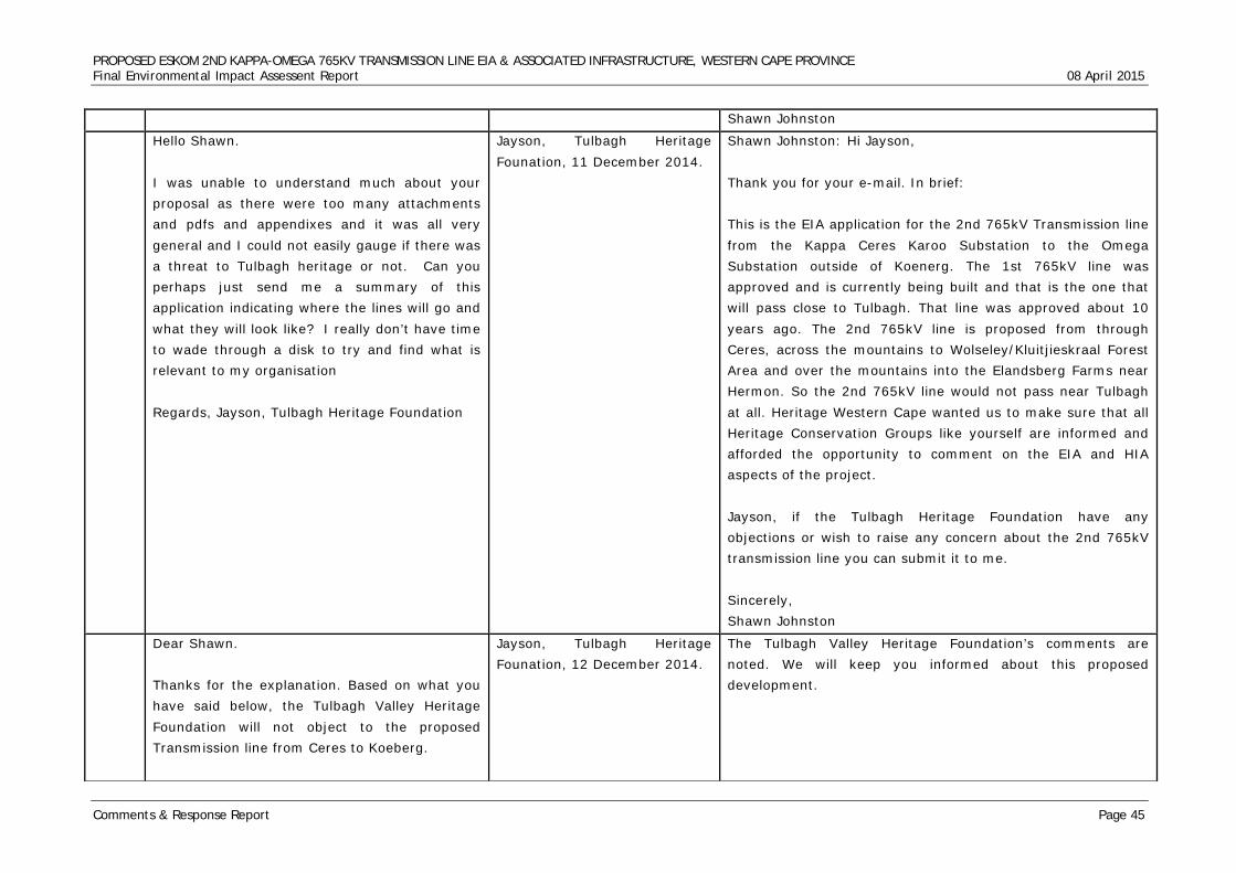
PROPOSED ESKOM 2ND KAPPA-OMEGA 765KV TRANSMISSION LINE EIA & ASSOCIATED INFRASTRUCTURE, WESTERN CAPE PROVINCE Final Environmental Impact Assessent Report 08 April 2015
Comments & Response Report Page 45
Shawn Johnston
Hello Shawn. I was unable to understand much about your proposal as there were too many attachments and pdfs and appendixes and it was all very general and I could not easily gauge if there was a threat to Tulbagh heritage or not. Can you perhaps just send me a summary of this application indicating where the lines will go and what they will look like? I really don’t have time to wade through a disk to try and find what is relevant to my organisation Regards, Jayson, Tulbagh Heritage Foundation
Jayson, Tulbagh Heritage Founation, 11 December 2014.
Shawn Johnston: Hi Jayson, Thank you for your e-mail. In brief: This is the EIA application for the 2nd 765kV Transmission line from the Kappa Ceres Karoo Substation to the Omega Substation outside of Koenerg. The 1st 765kV line was approved and is currently being built and that is the one that will pass close to Tulbagh. That line was approved about 10 years ago. The 2nd 765kV line is proposed from through Ceres, across the mountains to Wolseley/Kluitjieskraal Forest Area and over the mountains into the Elandsberg Farms near Hermon. So the 2nd 765kV line would not pass near Tulbagh at all. Heritage Western Cape wanted us to make sure that all Heritage Conservation Groups like yourself are informed and afforded the opportunity to comment on the EIA and HIA aspects of the project. Jayson, if the Tulbagh Heritage Foundation have any objections or wish to raise any concern about the 2nd 765kV transmission line you can submit it to me. Sincerely, Shawn Johnston
Dear Shawn. Thanks for the explanation. Based on what you have said below, the Tulbagh Valley Heritage Foundation will not object to the proposed Transmission line from Ceres to Koeberg.
Jayson, Tulbagh Heritage Founation, 12 December 2014.
The Tulbagh Valley Heritage Foundation’s comments are noted. We will keep you informed about this proposed development.
PROPOSED ESKOM 2ND KAPPA-OMEGA 765KV TRANSMISSION LINE EIA & ASSOCIATED INFRASTRUCTURE, WESTERN CAPE PROVINCE Final Environmental Impact Assessent Report 08 April 2015
Comments & Response Report Page 46
Kind regards, Jayson