Embed Size (px)
Citation preview
4.1 Development of SQL
4.2 Core SQL Queries
4.3 Spatial Queries and Core SQL
4.4 Spatial Extension of the
Relational Algebra
4.5 Spatial Extensions of SQL
4.6 Evaluation of Spatial Queries
4.7 Summary
Spatial Databases and GIS – Karl Neumann, Sarah Tauscher– Ifis – TU Braunschweig 321
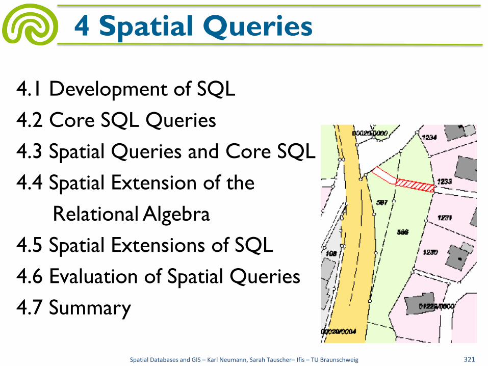
4 Spatial Queries

• Spatial queries are a special class of queries
which are supported by spatial database systems
• Queries are different from queries formulated in
"core SQL", offering the use of
– Geometric data types (point, line, polygon)
– Geometric operations (intersection, length, area)
– Geometric predicates (overlaps, meets, equals)
Spatial Databases and GIS – Karl Neumann, Sarah Tauscher– Ifis – TU Braunschweig 322
4 Spatial Queries
SQL geometric
ADTs
spatial query
language

• 1970
– E. F. Codd: A Relational Model of Data for Large Shared Data Banks. Comm. ACM 13(6): 377-387
• Since 1982
– SQL/DS, Oracle, DB2
– Criticism: lack of orthogonality
– Criticism: lack of functionality
• 1986
– ANSI SQL
– Relations, attributes, views
– SELECT ... FROM ... WHERE ...
Spatial Databases and GIS – Karl Neumann, Sarah Tauscher– Ifis – TU Braunschweig 323
4.1 Development of SQL

• 1987
– SQL86 (ISO/IEC
9075:1986)
• 1989
– SQL89 (SQL1)
• ≈ SQL86 + restricted
referential integrity
• 1992
– SQL92 (SQL2)
– Entry Level
• ≈ SQL89 + CHECK
(attribute)
– Intermediate Level
• ⊇ Entry Level + domains,
CHECK (relation), CASE,
CAST, JOIN, EXCEPT,
INTERSECT
– Full Level
• ⊇ Intermediate Level +
assertions, nested select,
nested from
Spatial Databases and GIS – Karl Neumann, Sarah Tauscher– Ifis – TU Braunschweig 324
4.1 Development of SQL

• 1999/2000
– SQL:1999 (SQL3)
– ≈ SQL92 + object-orientation, recursive queries, triggers,
OLAP, user defined types
– Computational complete, object-oriented database
programming language, descriptive and procedural
– Core (approx. 180 features)
• ≈ SQL92 Entry Level + parts of Intermediate and Full Level
– 9 Packages (approx. 240 features)
• enhanced datetime, enhanced integrity, OLAP, PSM, CLI, basic
object support, enhanced object support, trigger, SQL/MM
Spatial Databases and GIS – Karl Neumann, Sarah Tauscher– Ifis – TU Braunschweig 325
4.1 Development of SQL
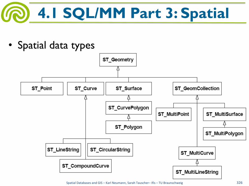
• Spatial data types
Spatial Databases and GIS – Karl Neumann, Sarah Tauscher– Ifis – TU Braunschweig 326
4.1 SQL/MM Part 3: Spatial

• Spatial data types
– ST_Geometry: base type, subtypes are 2D-SDTS
– ST_Point: point with two coordinates
– ST_Curve: line, series of points, including interpolated or
closed
– ST_LineString: subtype of ST_Curve, linear interpolation
– ST_CircularString: subtype of ST_Curve, interpolation by
circular arcs
– ST_Surface: area
– ST_Polygon: instantiable subtype of ST_Surface with linear
rings
Spatial Databases and GIS – Karl Neumann, Sarah Tauscher– Ifis – TU Braunschweig 327
4.1 SQL/MM Part 3: Spatial

• Some methods
– ST_Length() returns double, length of a curve
– ST_IsClosed() returns integer, closed curve?
– ST_CurveToLine() returns ST_LineString, provides line-approximation of a curve
– ST_PointN() returns ST_Point, provides nth point of a LineString
– ST_Area returns double, provides area of surface
– ST_Perimeter returns double, provides perimeter
– ST_Centroid returns ST_Point, provides centroid
– ST_ExteriorRing returns ST_Curve, provides outer boundary
Spatial Databases and GIS – Karl Neumann, Sarah Tauscher– Ifis – TU Braunschweig 328
4.1 SQL/MM Part 3: Spatial
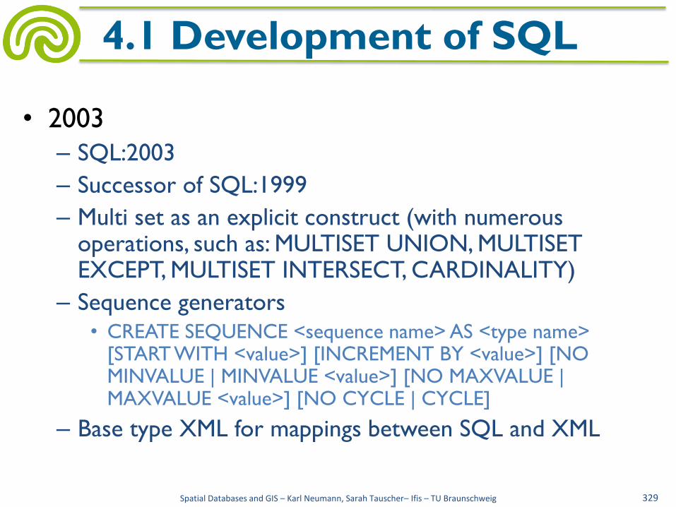
• 2003
– SQL:2003
– Successor of SQL:1999
– Multi set as an explicit construct (with numerous operations, such as: MULTISET UNION, MULTISET EXCEPT, MULTISET INTERSECT, CARDINALITY)
– Sequence generators
• CREATE SEQUENCE <sequence name> AS <type name> [START WITH <value>] [INCREMENT BY <value>] [NO MINVALUE | MINVALUE <value>] [NO MAXVALUE | MAXVALUE <value>] [NO CYCLE | CYCLE]
– Base type XML for mappings between SQL and XML
Spatial Databases and GIS – Karl Neumann, Sarah Tauscher– Ifis – TU Braunschweig 329
4.1 Development of SQL
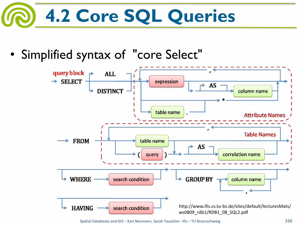
• Simplified syntax of "core Select"
Spatial Databases and GIS – Karl Neumann, Sarah Tauscher– Ifis – TU Braunschweig 330
4.2 Core SQL Queries
http://www.ifis.cs.tu-bs.de/sites/default/lecturesMats/ ws0809_rdb1/RDB1_08_SQL2.pdf

• Query 1:
Personnel number, name, amount of remaining leave plus annual leave for all employees, in descending order of amount of vacation days and for the same sum in ascending order by name
Employees (persNo, name, ..., remainingLeave, annualLeave)
Result (persNo, name, expr.)
Spatial Databases and GIS – Karl Neumann, Sarah Tauscher– Ifis – TU Braunschweig 331
4.2 Core SQL Queries
↓
SELECT persNo, name, remainingLeave+annualLeave FROM Employees WHERE remainingLeave IS NOT NULL AND annualLeave IS NOT NULL ORDER BY 3 DESC, name ASC;

• Query 2:
Prerequisites of the course "Programming in Java"
Course (courseNo, title, ...)
Prerequisite (courseNo. prerequisiteNo)
↓
Result(title)
Spatial Databases and GIS – Karl Neumann, Sarah Tauscher– Ifis – TU Braunschweig 332
4.2 Core SQL Queries
SELECT c2.title FROM Course c1, Course c2, Prerequisite WHERE c1.title= ’Programming in Java’ AND c1.courseNo = Prerequisite.courseNo AND Prerequisite.prerequisiteNo = c2.courseNo;

• Query 3: Pairs of employees (personnel number, name), who participate in exactly
the same courses
Employees (persNo, name, ...) Participants (courseNo, persNo)
↓
Result (persNo1, name1, persNo2, name2)
Question of equality of sets:
What personnel numbers occur in "Participants" with the same set of course numbers?
Sets A and B are equal:
∀ a ∈ A: a ∈ B ∧ ∀ b ∈ B: b ∈ A
Spatial Databases and GIS – Karl Neumann, Sarah Tauscher– Ifis – TU Braunschweig 333
4.2 Core SQL Queries
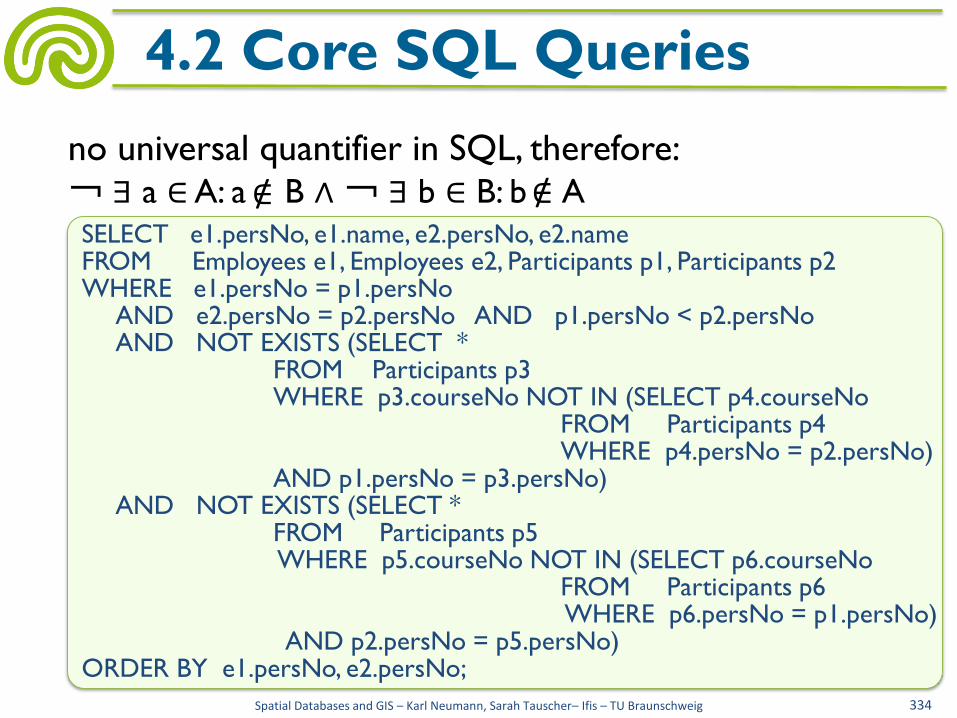
no universal quantifier in SQL, therefore:
¬ ∃ a ∈ A: a B ∧ ¬ ∃ b ∈ B: b A
Spatial Databases and GIS – Karl Neumann, Sarah Tauscher– Ifis – TU Braunschweig 334
4.2 Core SQL Queries
∈ / ∈ / SELECT e1.persNo, e1.name, e2.persNo, e2.name FROM Employees e1, Employees e2, Participants p1, Participants p2 WHERE e1.persNo = p1.persNo AND e2.persNo = p2.persNo AND p1.persNo < p2.persNo AND NOT EXISTS (SELECT * FROM Participants p3 WHERE p3.courseNo NOT IN (SELECT p4.courseNo FROM Participants p4 WHERE p4.persNo = p2.persNo) AND p1.persNo = p3.persNo) AND NOT EXISTS (SELECT * FROM Participants p5 WHERE p5.courseNo NOT IN (SELECT p6.courseNo FROM Participants p6 WHERE p6.persNo = p1.persNo) AND p2.persNo = p5.persNo) ORDER BY e1.persNo, e2.persNo;

• Query 4: Generate a list of potential reviewers for a submitted
paper (id = 42). Potential reviewers are only those persons, who are not a coauthor of the respective paper. The potential reviewers should be ordered ascending by the number of the contributions, they already had reviewed.
Person (email, ...)
Review (reviewer, contribution, ...)
Authors (contribution, author)
↓
Result (email, expr.)
Spatial Databases and GIS – Karl Neumann, Sarah Tauscher– Ifis – TU Braunschweig 335
4.2 Core SQL Queries

Spatial Databases and GIS – Karl Neumann, Sarah Tauscher– Ifis – TU Braunschweig 336
4.2 Core SQL Queries
SELECT * FROM ((SELECT email, 0 FROM Person WHERE email NOT IN (SELECT reviewer FROM Review) AND email NOT IN (SELECT author FROM Authors WHERE contribution = 42)) UNION (SELECT reviewer, COUNT(*) FROM Review WHERE reviewer NOT IN (SELECT author FROM Authors WHERE contribution = 42) GROUP BY reviewer)) AS Result ORDER BY 2;
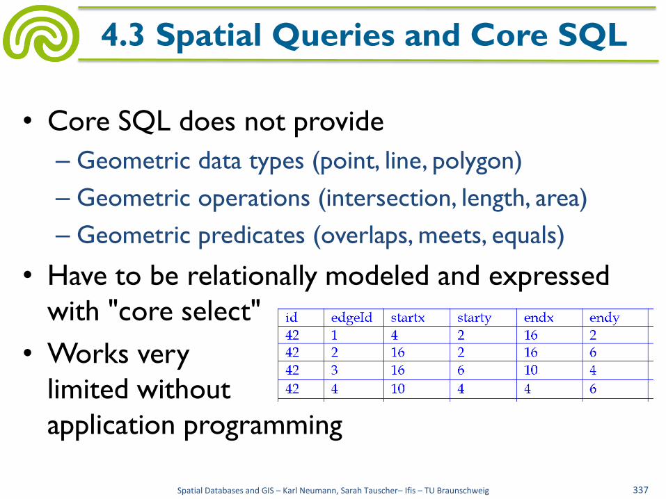
• Core SQL does not provide
– Geometric data types (point, line, polygon)
– Geometric operations (intersection, length, area)
– Geometric predicates (overlaps, meets, equals)
• Have to be relationally modeled and expressed
with "core select"
• Works very
limited without
application programming
Spatial Databases and GIS – Karl Neumann, Sarah Tauscher– Ifis – TU Braunschweig 337
4.3 Spatial Queries and Core SQL
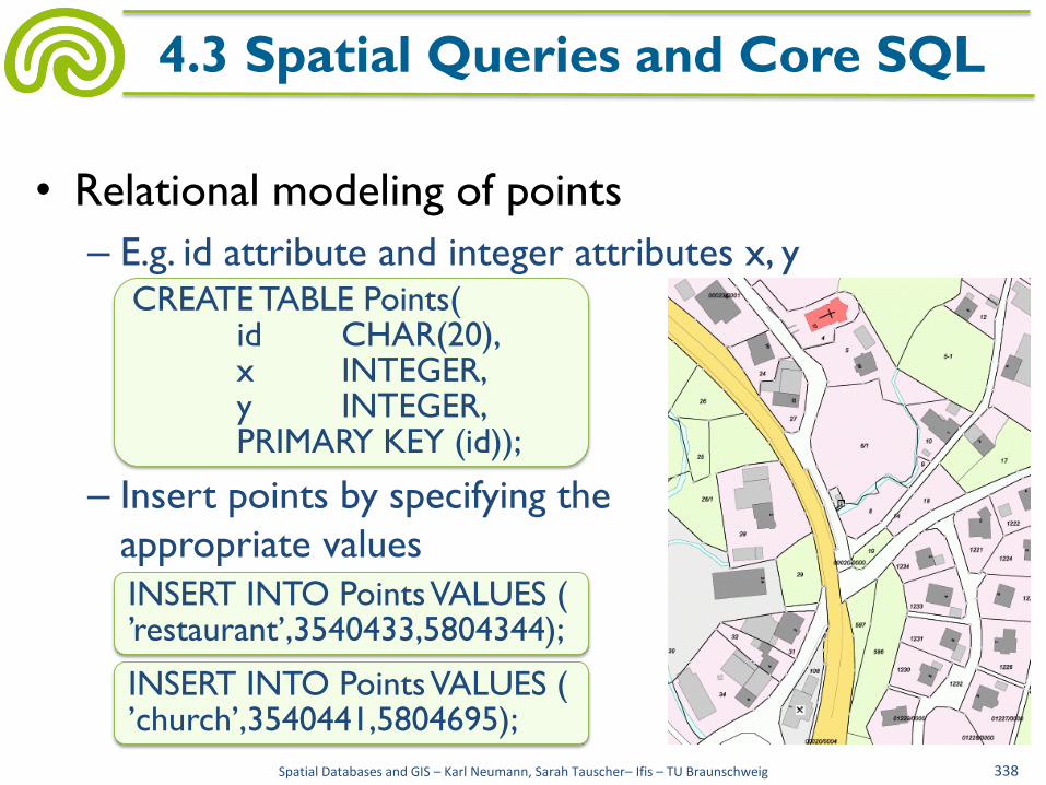
• Relational modeling of points
– E.g. id attribute and integer attributes x, y
– Insert points by specifying the
appropriate values
Spatial Databases and GIS – Karl Neumann, Sarah Tauscher– Ifis – TU Braunschweig 338
4.3 Spatial Queries and Core SQL
INSERT INTO Points VALUES ( ’church’,3540441,5804695);
INSERT INTO Points VALUES ( ’restaurant’,3540433,5804344);
CREATE TABLE Points( id CHAR(20), x INTEGER, y INTEGER, PRIMARY KEY (id));
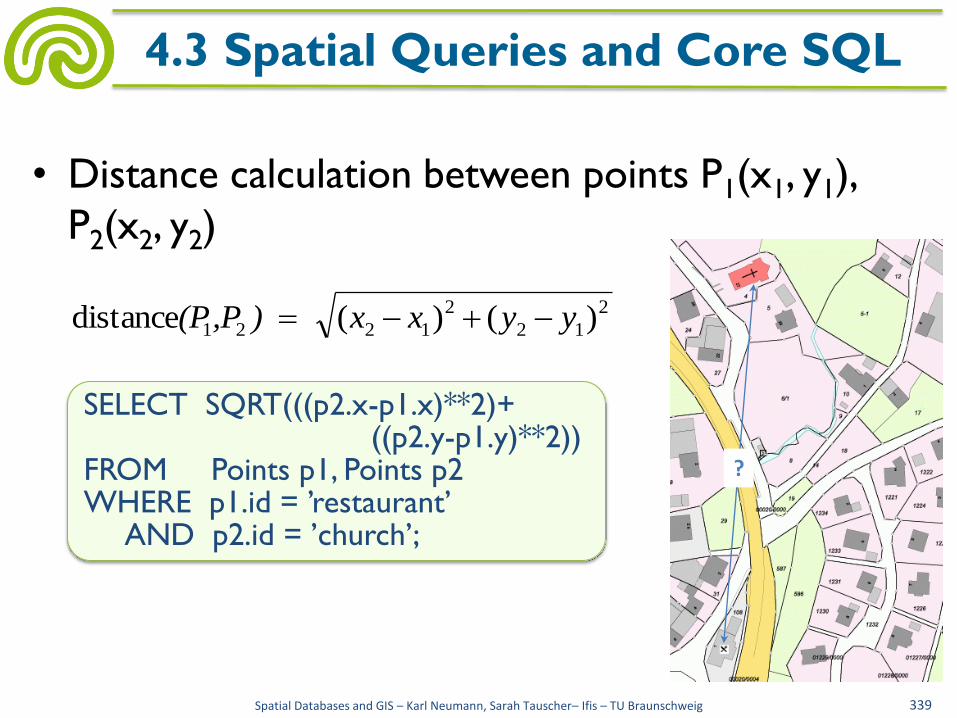
• Distance calculation between points P1(x1, y1),
P2(x2, y2)
Spatial Databases and GIS – Karl Neumann, Sarah Tauscher– Ifis – TU Braunschweig 339
4.3 Spatial Queries and Core SQL
?
2
12
2
1221 )()(distance yyxx ) ,P(P
SELECT SQRT(((p2.x-p1.x)**2)+ ((p2.y-p1.y)**2)) FROM Points p1, Points p2 WHERE p1.id = ’restaurant’ AND p2.id = ’church’;
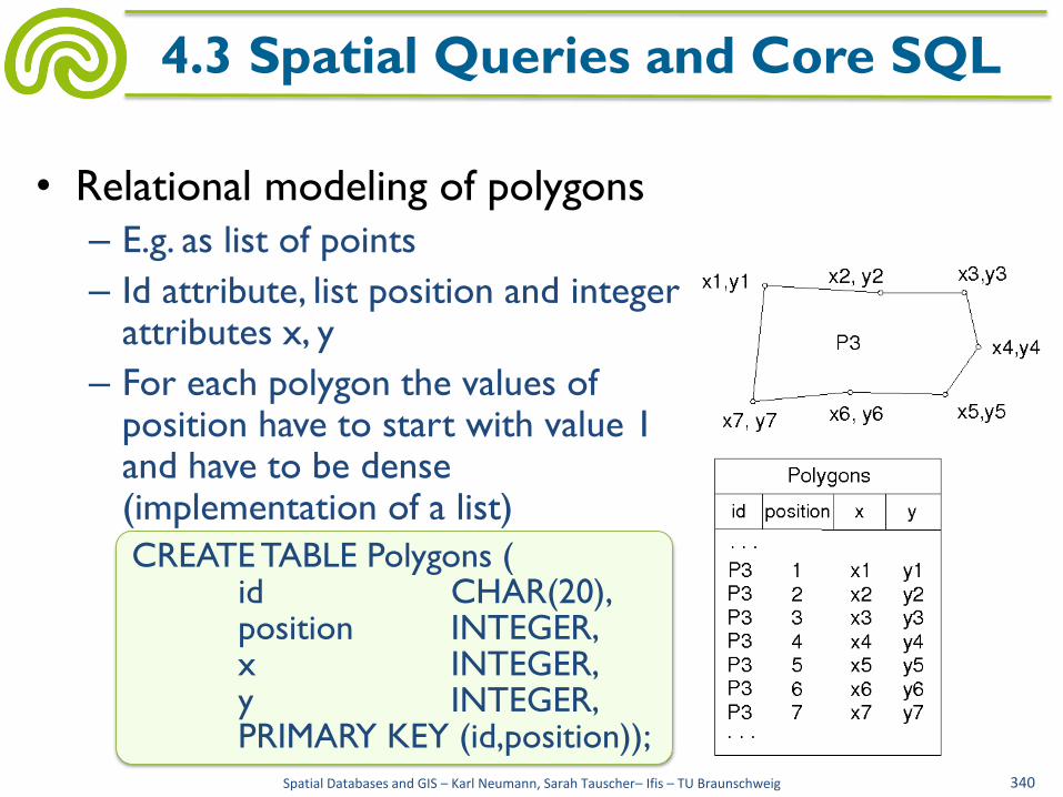
• Relational modeling of polygons
– E.g. as list of points
– Id attribute, list position and integer attributes x, y
– For each polygon the values of position have to start with value 1 and have to be dense (implementation of a list)
Spatial Databases and GIS – Karl Neumann, Sarah Tauscher– Ifis – TU Braunschweig 340
4.3 Spatial Queries and Core SQL
CREATE TABLE Polygons ( id CHAR(20), position INTEGER, x INTEGER, y INTEGER, PRIMARY KEY (id,position));
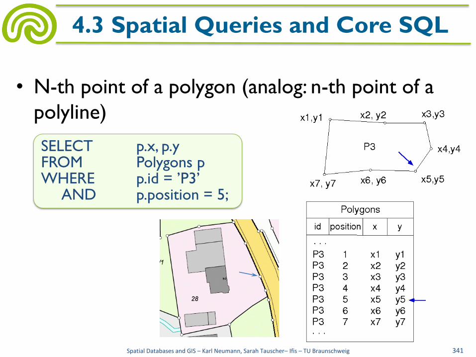
• N-th point of a polygon (analog: n-th point of a
polyline)
Spatial Databases and GIS – Karl Neumann, Sarah Tauscher– Ifis – TU Braunschweig 341
4.3 Spatial Queries and Core SQL
SELECT p.x, p.y FROM Polygons p WHERE p.id = ’P3’ AND p.position = 5;

• Smallest rectangle, oriented to the x- and y-axes,
that completely encloses the polygon (bounding
box); more precisely: the lower left, upper right
point of the bounding box
Spatial Databases and GIS – Karl Neumann, Sarah Tauscher– Ifis – TU Braunschweig 342
4.3 Spatial Queries and Core SQL
SELECT min(p.x), min(p.y), max(p.x), max(p.y) FROM Polygons p WHERE p.id = ’P3’
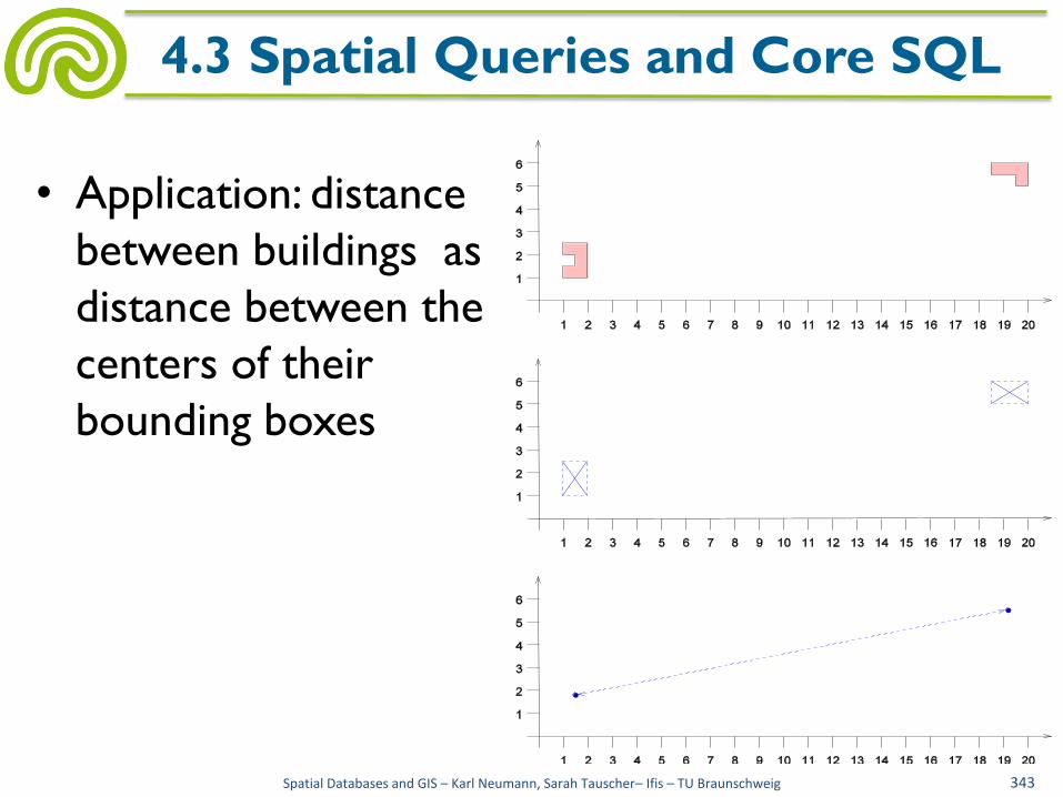
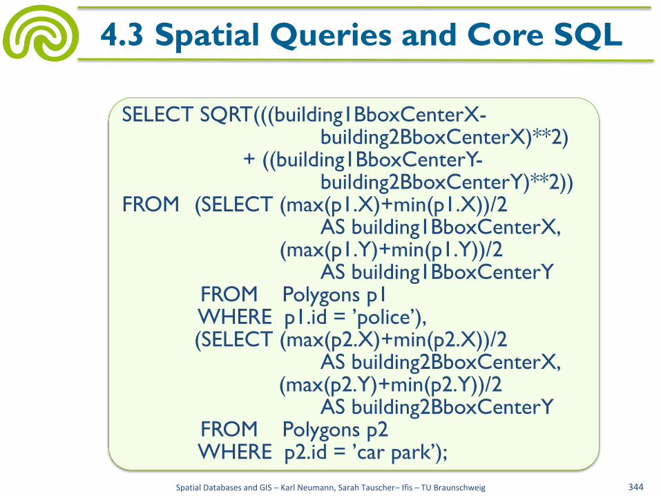
• Application: distance
between buildings as
distance between the
centers of their
bounding boxes
Spatial Databases and GIS – Karl Neumann, Sarah Tauscher– Ifis – TU Braunschweig 343
4.3 Spatial Queries and Core SQL
Spatial Databases and GIS – Karl Neumann, Sarah Tauscher– Ifis – TU Braunschweig 344
4.3 Spatial Queries and Core SQL
SELECT SQRT(((building1BboxCenterX- building2BboxCenterX)**2) + ((building1BboxCenterY- building2BboxCenterY)**2)) FROM (SELECT (max(p1.X)+min(p1.X))/2 AS building1BboxCenterX, (max(p1.Y)+min(p1.Y))/2 AS building1BboxCenterY FROM Polygons p1 WHERE p1.id = ’police’), (SELECT (max(p2.X)+min(p2.X))/2 AS building2BboxCenterX, (max(p2.Y)+min(p2.Y))/2 AS building2BboxCenterY FROM Polygons p2 WHERE p2.id = ’car park’);
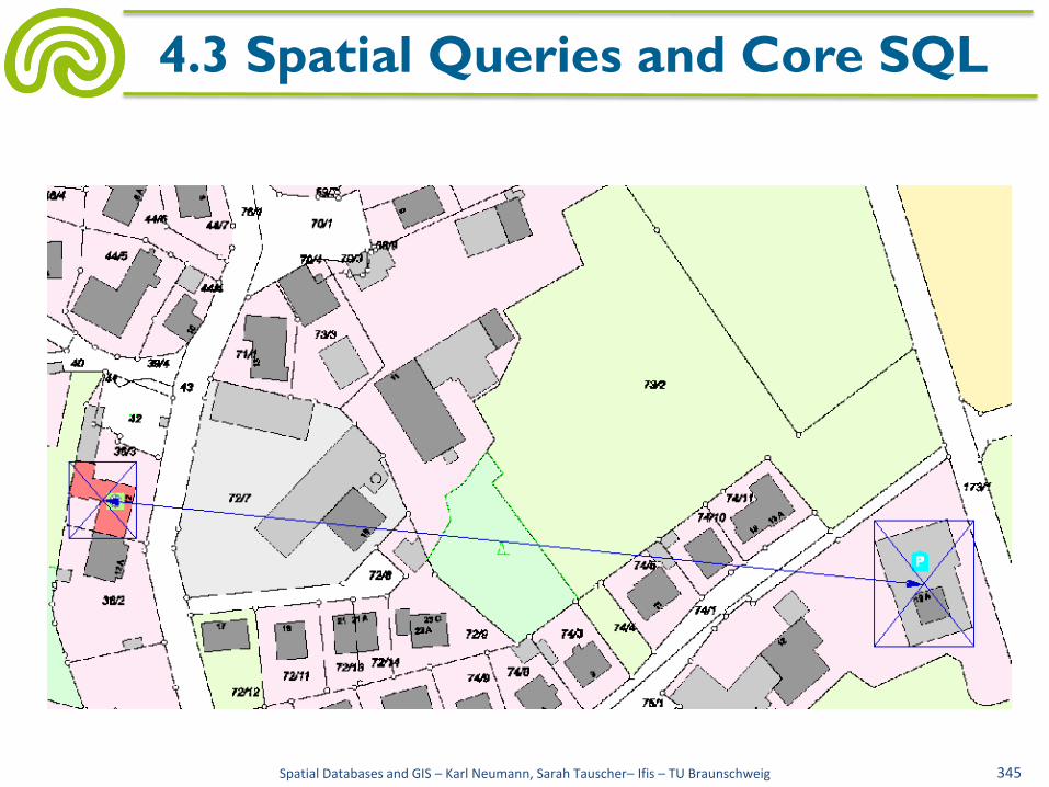
Spatial Databases and GIS – Karl Neumann, Sarah Tauscher– Ifis – TU Braunschweig 345
4.3 Spatial Queries and Core SQL

• Perimeter of polygons
Pseudocode solution in embedded SQL
Spatial Databases and GIS – Karl Neumann, Sarah Tauscher– Ifis – TU Braunschweig 346
4.3 Spatial Queries and Core SQL
2
1
2
1
2
2
1
2
1 )()()()( nn
n
i
iiii yyxxyyxx
INT position, X1, Y1, Xi, Yi, XiMinus1, YiMinus1; REAL perimeter := 0.0; BOOL furtherPoints := TRUE; EXEC SQL DECLARE point CURSOR FOR SELECT position, x, y FROM Polygons WHERE id = ’P3’ ORDER BY position;

Spatial Databases and GIS – Karl Neumann, Sarah Tauscher– Ifis – TU Braunschweig 347
4.3 Spatial Queries and Core SQL
EXEC SQL OPEN point; EXEC SQL FETCH point INTO :position, :X1, :Y1; XiMinus1 := X1; YiMinus1 := Y1; WHILE furtherPoints DO BEGIN EXEC SQL FETCH point INTO :position, :Xi, :Yi; perimeter := perimeter + SQRT((Xi-XiMinus1)^2+(Yi-YiMinus1)^2); XiMinus1 := Xi; YiMinus1 := Yi; IF SQLCODE = 100 THEN furtherPoints := FALSE FI END; perimeter := perimeter + SQRT((X1-XiMinus1)^2+(Y1-YiMinus1)^2); PRINT perimeter; EXEC SQL CLOSE point;

• Complexity of queries depends on the chosen
spatial data model
• Common data models to represent polygons in
relational databases:
– Topological models (cf. section 2.4)
• Spaghetti model: polygon as list of points
• Edge list: polygon as set of edges (unordered)
• Winged Edge: polygon as set of edges (ordered)
Spatial Databases and GIS – Karl Neumann, Sarah Tauscher– Ifis – TU Braunschweig 348
4.3 Perimeter of Polygons

• Spaghetti model, one polygon
Spatial Databases and GIS – Karl Neumann, Sarah Tauscher– Ifis – TU Braunschweig 349
4.3 Perimeter of Polygons
SELECT uid, pm1 + (SQRT(((p.x – pn.x)**2) +((p.y – pn.y)**2))) AS perimeter FROM polygons p, polygons pn, (SELECT p1.id AS uid, SUM(SQRT(((p2.x – p1.x)**2) +((p2.y – p1.y)**2))) AS pm1 FROM Polygons p1, Polygons p2 WHERE p1.id = p2.id AND p1.position = p2.position-1 AND p1.id = ‘P3’)) WHERE p.id = pn.id AND p.id = uid AND p.position = 1 AND pn.position = (SELECT max(m.position) FROM Polygons m WHERE m.id = pn.id)
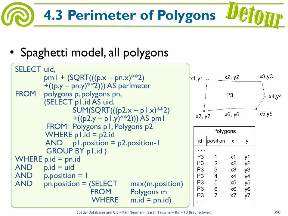
• Spaghetti model, all polygons
Spatial Databases and GIS – Karl Neumann, Sarah Tauscher– Ifis – TU Braunschweig 350
4.3 Perimeter of Polygons
polygons p, polygons pn,
SELECT uid, pm1 + (SQRT(((p.x – pn.x)**2) +((p.y – pn.y)**2))) AS perimeter FROM polygons p, polygons pn, (SELECT p1.id AS uid, SUM(SQRT(((p2.x – p1.x)**2) +((p2.y – p1.y)**2))) AS pm1 FROM Polygons p1, Polygons p2 WHERE p1.id = p2.id AND p1.position = p2.position-1 GROUP BY p1.id ) WHERE p.id = pn.id AND p.id = uid AND p.position = 1 AND pn.position = (SELECT max(m.position) FROM Polygons m WHERE m.id = pn.id)

• Edge list, one polygon
Spatial Databases and GIS – Karl Neumann, Sarah Tauscher– Ifis – TU Braunschweig 351
4.3 Perimeter of Polygons
id start node end node right face left face
E1 V1 V2 P3
E2 V2 V3 P3
E3 V3 V4 P3
E4 V4 V5 P3
E5 V5 V6 P3
E6 V6 V7 P3
E7 V7 V1 P3
V1 V2 V3
V4
V5 V6 V7
Edge id x y
V1 x1 y1
V2 x2 y2
V3 x3 y3
V4 x4 y4
V5 x5 y5
V6 x6 y6
V7 x7 y7
Node
SELECT SUM(SQRT(((end.x – start.x)**2) +((end.y – start.y)**2))) AS perimeter FROM Edge e, Node start, Node end WHERE e.startnode = start.id AND e.endnode = end.id AND (e.rightface = ‘P3‘ OR e.leftface = ‘P3‘)
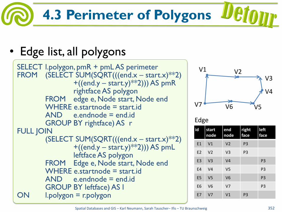
• Edge list, all polygons
Spatial Databases and GIS – Karl Neumann, Sarah Tauscher– Ifis – TU Braunschweig 352
4.3 Perimeter of Polygons
V1 V2 V3
V4
V5 V6 V7
id start node
end node
right face
left face
E1 V1 V2 P3
E2 V2 V3 P3
E3 V3 V4 P3
E4 V4 V5 P3
E5 V5 V6 P3
E6 V6 V7 P3
E7 V7 V1 P3
Edge
SELECT l.polygon, pmR + pmL AS perimeter FROM (SELECT SUM(SQRT(((end.x – start.x)**2) +((end.y – start.y)**2))) AS pmR rightface AS polygon FROM edge e, Node start, Node end WHERE e.startnode = start.id AND e.endnode = end.id GROUP BY rightface) AS r FULL JOIN (SELECT SUM(SQRT(((end.x – start.x)**2) +((end.y – start.y)**2))) AS pmL leftface AS polygon FROM Edge e, Node start, Node end WHERE e.startnode = start.id AND e.endnode = end.id GROUP BY leftface) AS l ON l.polygon = r.polygon
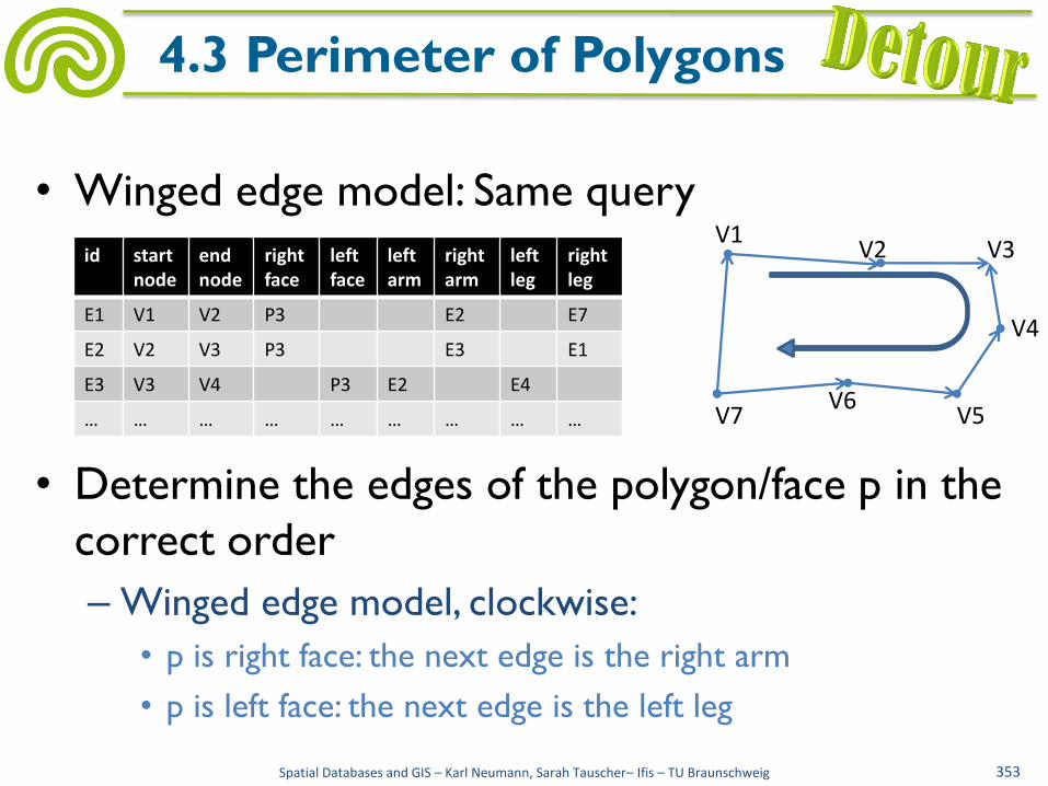
• Winged edge model: Same query
• Determine the edges of the polygon/face p in the
correct order
– Winged edge model, clockwise:
• p is right face: the next edge is the right arm
• p is left face: the next edge is the left leg
Spatial Databases and GIS – Karl Neumann, Sarah Tauscher– Ifis – TU Braunschweig 353
4.3 Perimeter of Polygons
id start node
end node
right face
left face
left arm
right arm
left leg
right leg
E1 V1 V2 P3 E2 E7
E2 V2 V3 P3 E3 E1
E3 V3 V4 P3 E2 E4
… … … … … … … … …
V1 V2 V3
V4
V5 V6
V7
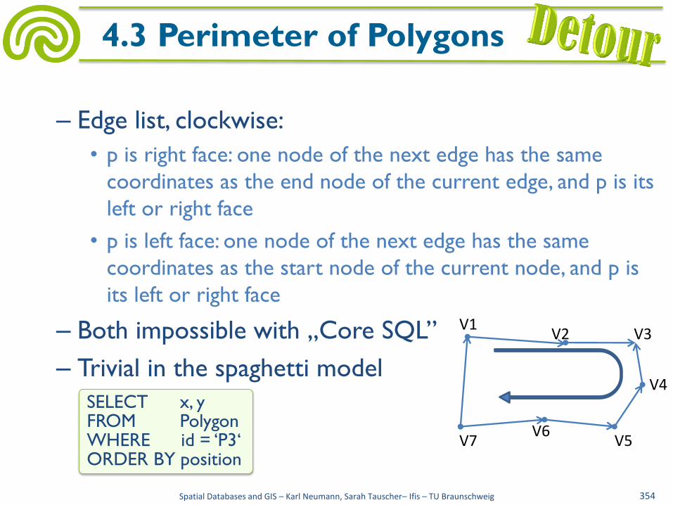
– Edge list, clockwise:
• p is right face: one node of the next edge has the same
coordinates as the end node of the current edge, and p is its
left or right face
• p is left face: one node of the next edge has the same
coordinates as the start node of the current node, and p is
its left or right face
– Both impossible with „Core SQL”
– Trivial in the spaghetti model
Spatial Databases and GIS – Karl Neumann, Sarah Tauscher– Ifis – TU Braunschweig 354
4.3 Perimeter of Polygons
V1 V2 V3
V4
V5 V6
V7
SELECT x, y FROM Polygon WHERE id = ‘P3‘ ORDER BY position
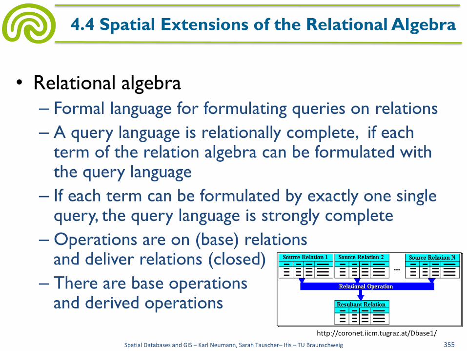
• Relational algebra
– Formal language for formulating queries on relations
– A query language is relationally complete, if each term of the relation algebra can be formulated with the query language
– If each term can be formulated by exactly one single query, the query language is strongly complete
– Operations are on (base) relations and deliver relations (closed)
– There are base operations and derived operations
Spatial Databases and GIS – Karl Neumann, Sarah Tauscher– Ifis – TU Braunschweig 355
4.4 Spatial Extensions of the Relational Algebra
http://coronet.iicm.tugraz.at/Dbase1/

• Base operations
– Projection πA1,A2,...,Ak(R)
πpersNo,name(Employees)
– Selection σϕ(R) σremainingLeave>10(Employees)
– Cross product R × S Course × Prerequisite
– Union R ∪ S πemail(Person) ∪ πemail(Institute)
– Difference R \ S πpersNo(Employees)\πpersNo(Participants)
– Rename δA←B(R) δname←surname(Employees)
Spatial Databases and GIS – Karl Neumann, Sarah Tauscher– Ifis – TU Braunschweig 356
4.4 Spatial Extensions of the Relational Algebra

• Derived operations
– Intersection R ∩ S = R \ (R \ S)
πreviewer(Review) ∩ πauthor(Authors)
– Join R ⋈θ S = σθ(R × S)
Review ⋈reviewer≠author Authors
– Natural join R ⋈ S = πA1,...,Ak,C1,...,Cm,B1,...,Bn
(σR.C1=S.C1∧...∧R.Cm=S.Cm(R × S))
Course ⋈ Prerequisite
Spatial Databases and GIS – Karl Neumann, Sarah Tauscher– Ifis – TU Braunschweig 357
4.4 Spatial Extensions of the Relational Algebra

• Example (Query 2): Prerequisites of the course "Programming in Java"
Course (courseNo, title, ...)
Prerequisite (courseNo, prerequisiteNo)
↓
Result (title)
(1) πtitle2(σtitle1=′Programming in Java′ (σcourseNo1=courseNo3
(σcourseNo2=prerequisiteNo (Course × Course × Prerequisite))))
(2) πtitle(σcourseNo=prerequisiteNo(Course× πprerequisiteNo (σcourseNo1=courseNo2
(Prerequisite× πcourseNo(σtitle=′Programming in Java′(Course))))))
Spatial Databases and GIS – Karl Neumann, Sarah Tauscher– Ifis – TU Braunschweig 358
4.4 Spatial Extensions of the Relational Algebra

• Solution 2 as operator tree
Spatial Databases and GIS – Karl Neumann, Sarah Tauscher– Ifis – TU Braunschweig 359
4.4 Spatial Extensions of the Relational Algebra

• As data types of the attributes the “usual data types” are presupposed implicitly
– Integer
– Decimal
– String
with the usual operators such as +,−, ∗, / and predicates as <,=,>, ≠
• Operators and predicates can only be used in the qualification formulas of the selection, e.g.: σremainingLeave>10(Employees)
σremainingLeave<0.2∗annualLeave(Employees)
Spatial Databases and GIS – Karl Neumann, Sarah Tauscher– Ifis – TU Braunschweig 360
4.4 Spatial Extensions of the Relational Algebra
• Query results are always tuples of attribute values which are unchanged (no compositions of values by operators)
• For example, query 1' can not be formulated: Personnel number, name, amount of remaining leave plus
annual leave for all employees
Employees (persNo, name, ..., remainingLeave, annualLeave)
↓
Result (persNo, name, expr.)
πpersNo,name,remainingLeave+annualLeave (Employees)
Spatial Databases and GIS – Karl Neumann, Sarah Tauscher– Ifis – TU Braunschweig 361
4.4 Spatial Extensions of the Relational Algebra

• Extensions typically on the level of data types
• Thus, introducing new sorts, operators, predicates
(e.g., analogous to SQL/MM Part 3: Spatial)
– Point, LineString, Polygon
– Length, Area, Perimeter,
Centroid
– Equals, Disjoint,
Intersects, Overlaps,
Touches, Contains
Spatial Databases and GIS – Karl Neumann, Sarah Tauscher– Ifis – TU Braunschweig 362
4.4 Spatial Extensions of the Relational Algebra
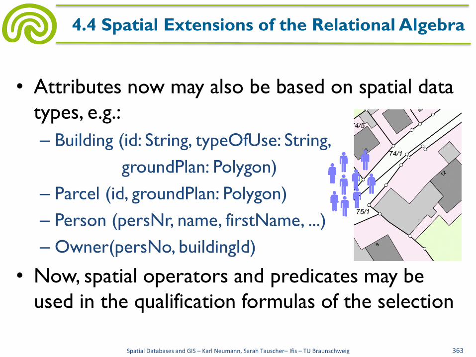
• Attributes now may also be based on spatial data
types, e.g.:
– Building (id: String, typeOfUse: String,
groundPlan: Polygon)
– Parcel (id, groundPlan: Polygon)
– Person (persNr, name, firstName, ...)
– Owner(persNo, buildingId)
• Now, spatial operators and predicates may be
used in the qualification formulas of the selection
Spatial Databases and GIS – Karl Neumann, Sarah Tauscher– Ifis – TU Braunschweig 363
4.4 Spatial Extensions of the Relational Algebra

• Query 5:
Ids of all buildings on the parcel with id "1222"
Building(id: String, typeOfUse: String, groundPlan: Polygon)
Parcel (id, groundPlan: Polygon)
πid2(σContains(groundPlan1,groundPlan2)
(σid1=′1222′(Parcel × Building)))
Spatial Databases and GIS – Karl Neumann, Sarah Tauscher– Ifis – TU Braunschweig 364
4.4 Spatial Extensions of the Relational Algebra

• Query 6:
Ids of churches which are located no more than 2 km
from a car park
Building(id: String, typeOfUse: String, groundPlan: Polygon)
πid1(σDistance(Centroid(groundPlan1),
Centroid(groundPlan2))<2000
(σtypeOfUse1=′church′∧typeOfUse2=′car park′
(Building × Building)))
Spatial Databases and GIS – Karl Neumann, Sarah Tauscher– Ifis – TU Braunschweig 365
4.4 Spatial Extensions of the Relational Algebra
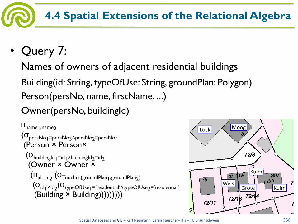
• Query 7:
Names of owners of adjacent residential buildings
Building(id: String, typeOfUse: String, groundPlan: Polygon)
Person(persNo, name, firstName, ...)
Owner(persNo, buildingId)
πname1,name2
(σpersNo1=persNo3∧persNo2=persNo4
(Person × Person×
(σbuildingId1=id1∧buildingId2=id2
(Owner × Owner ×
(πid1,id2 (σTouches(groundPlan1,groundPlan2)
(σid1<id2(σtypeOfUse1=′residential′∧typeOfUse2=′residential′
(Building × Building)))))))))
Spatial Databases and GIS – Karl Neumann, Sarah Tauscher– Ifis – TU Braunschweig 366
4.4 Spatial Extensions of the Relational Algebra
Lock Moog
Grote Weis
Kulm
Kulm

• Query 5’:
Areas of all buildings on the parcel with id "1222"
Building(id: String, typeOfUse: String, groundPlan: Polygon)
Parcel (id, groundPlan: Polygon)
πArea(groundPlan2)(σContains(groundPlan1,groundPlan2)
(σid1=′1222′(Parcel × Building)))
• As in the "classical" relational algebra no
operators are allowed in the projection list
Spatial Databases and GIS – Karl Neumann, Sarah Tauscher– Ifis – TU Braunschweig 367
4.4 Spatial Extensions of the Relational Algebra

• Extensions on the level of data types (again)
• Thus, new sorts, operators, predicates
• Typically orientation at standard
• SQL/MM Part 3: Spatial, e.g.:
– Point, LineString, Polygon
– Length, Area, Perimeter, Centroid
– Equals, Disjoint, Intersects, Overlaps, Touches,
Contains
• Relations now may have spatial attributes
Spatial Databases and GIS – Karl Neumann, Sarah Tauscher– Ifis – TU Braunschweig 368
4.5 Spatial Extensions of SQL

• Use of spatial data types in the same way as the
"usual" data types in CREATE TABLE statement,
e.g.:
Spatial Databases and GIS – Karl Neumann, Sarah Tauscher– Ifis – TU Braunschweig 369
4.5 Spatial Extensions of SQL
CREATE TABLE Parcel (id CHAR(25), groundPlan Polygon, PRIMARY KEY(id));
INSERT INTO Building VALUES ( ’G4211’,’police’,(12125,1333,13430, 1560,13260,2497,14111,2695,14111, 2638,16040,3092,15303,6468,13345, 5958,13771,3943,12948,3773,12948, 3887,11671,3631));
CREATE TABLE Building (id CHAR(25), typeOfUse CHAR(25), groundPlan Polygon, PRIMARY KEY(id));

• Spatial operators and predicates now may occur
in SELECT statements, at the same places where
the "usual" operators and predicates are allowed
Spatial Databases and GIS – Karl Neumann, Sarah Tauscher– Ifis – TU Braunschweig 370
4.5 Spatial Extensions of SQL

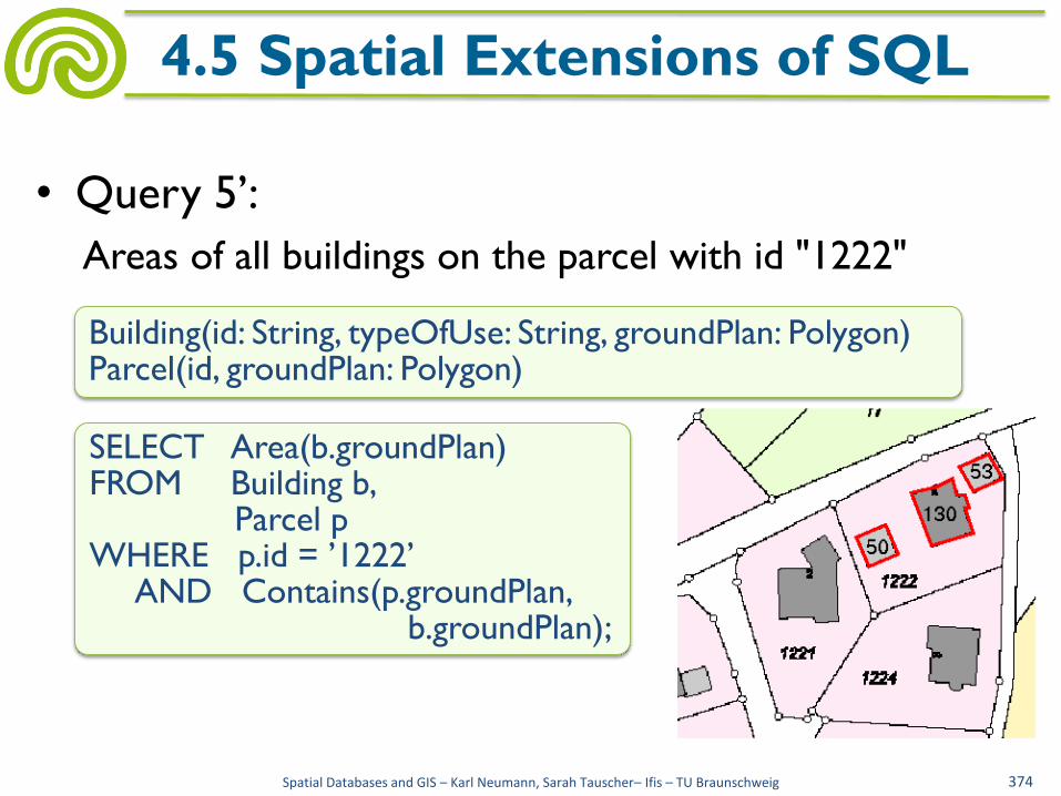
• Query 5:
Ids of all buildings on the parcel with id "1222"
Spatial Databases and GIS – Karl Neumann, Sarah Tauscher– Ifis – TU Braunschweig 371
4.5 Spatial Extensions of SQL
SELECT b.id FROM Building b, Parcel p WHERE p.id = ’1222’ AND Contains(p.groundPlan,b.groundPlan);
Building(id: String, typeOfUse: String, groundPlan: Polygon) Parcel(id, groundPlan: Polygon)

• Query 6:
Ids of churches which are located no more than 2 km
from a car park
Spatial Databases and GIS – Karl Neumann, Sarah Tauscher– Ifis – TU Braunschweig 372
4.5 Spatial Extensions of SQL
SELECT b1.id FROM Building b1, Building b2 WHERE b1.typeOfUse = ’church’ AND b2.typeOfUse = ’car park’ AND Distance(Centroid(b1.groundplan), Centroid(b2.groundPlan)) < 2000;
Building(id: String, typeOfUse: String, groundPlan: Polygon)
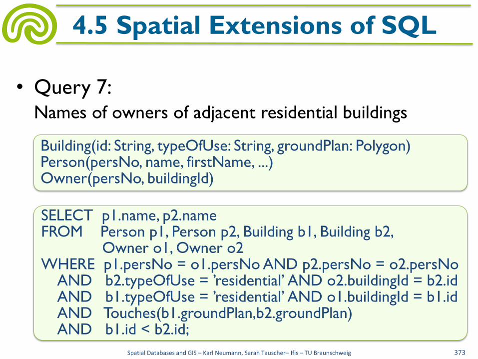
• Query 7: Names of owners of adjacent residential buildings
Spatial Databases and GIS – Karl Neumann, Sarah Tauscher– Ifis – TU Braunschweig 373
4.5 Spatial Extensions of SQL
SELECT p1.name, p2.name FROM Person p1, Person p2, Building b1, Building b2, Owner o1, Owner o2 WHERE p1.persNo = o1.persNo AND p2.persNo = o2.persNo AND b2.typeOfUse = ’residential’ AND o2.buildingId = b2.id AND b1.typeOfUse = ’residential’ AND o1.buildingId = b1.id AND Touches(b1.groundPlan,b2.groundPlan) AND b1.id < b2.id;
Building(id: String, typeOfUse: String, groundPlan: Polygon) Person(persNo, name, firstName, ...) Owner(persNo, buildingId)
• Query 5’:
Areas of all buildings on the parcel with id "1222"
Spatial Databases and GIS – Karl Neumann, Sarah Tauscher– Ifis – TU Braunschweig 374
4.5 Spatial Extensions of SQL
SELECT Area(b.groundPlan) FROM Building b, Parcel p WHERE p.id = ’1222’ AND Contains(p.groundPlan, b.groundPlan);
Building(id: String, typeOfUse: String, groundPlan: Polygon) Parcel(id, groundPlan: Polygon)
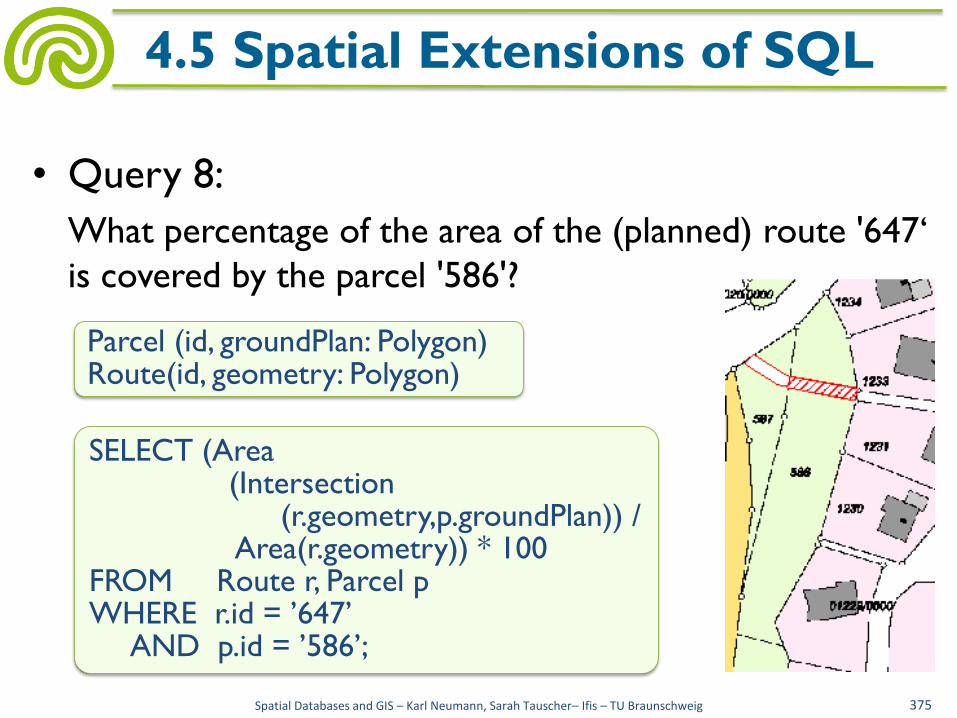
• Query 8:
What percentage of the area of the (planned) route '647‘
is covered by the parcel '586'?
Spatial Databases and GIS – Karl Neumann, Sarah Tauscher– Ifis – TU Braunschweig 375
4.5 Spatial Extensions of SQL
SELECT (Area (Intersection (r.geometry,p.groundPlan)) / Area(r.geometry)) * 100 FROM Route r, Parcel p WHERE r.id = ’647’ AND p.id = ’586’;
Parcel (id, groundPlan: Polygon) Route(id, geometry: Polygon)
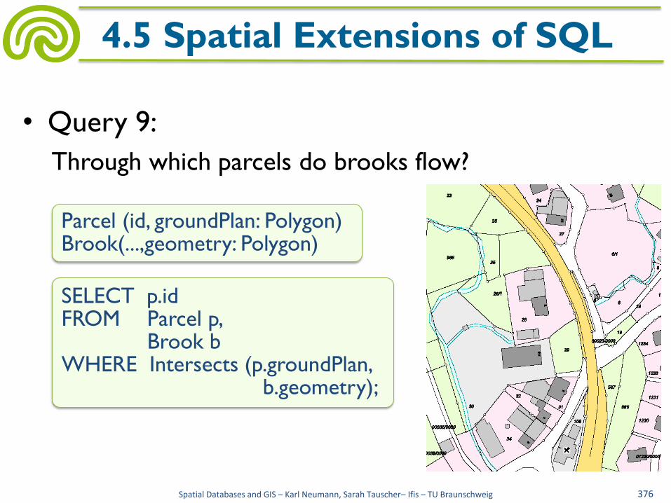
• Query 9:
Through which parcels do brooks flow?
Spatial Databases and GIS – Karl Neumann, Sarah Tauscher– Ifis – TU Braunschweig 376
4.5 Spatial Extensions of SQL
SELECT p.id FROM Parcel p, Brook b WHERE Intersects (p.groundPlan, b.geometry);
Parcel (id, groundPlan: Polygon) Brook(...,geometry: Polygon)

• Typical spatial SQL extensions are provided by
– Oracle Spatial
– Postgres
• Oracle Spatial
– Extension of the Oracle Database System
– A (very special) geometric data type:
CREATE TYPE sdo_geometry AS OBJECT (
SDO_GTYPE NUMBER,
SDO_SRID NUMBER,
SDO_POINT SDO_POINT_TYPE,
SDO_ELEM_INFO MDSYS.SDO_ELEM_INFO_ARRAY,
SDO_ORDINATES MDSYS.SDO_ORDINATE_ARRAY);
Spatial Databases and GIS – Karl Neumann, Sarah Tauscher– Ifis – TU Braunschweig 377
4.5 Spatial Extensions of SQL

• By SDO_GTYPE the geometry type is coded
– 0 UNKNOWN_GEOMETRY
– 1 POINT
– 2 LINESTRING
– 3 POLYGON
– 4 Collection
– 5 MULTIPOINT
– 6 MULTILINESTRING
– 7 MULTIPOLYGON
Spatial Databases and GIS – Karl Neumann, Sarah Tauscher– Ifis – TU Braunschweig 378
4.5 Spatial Extensions of SQL
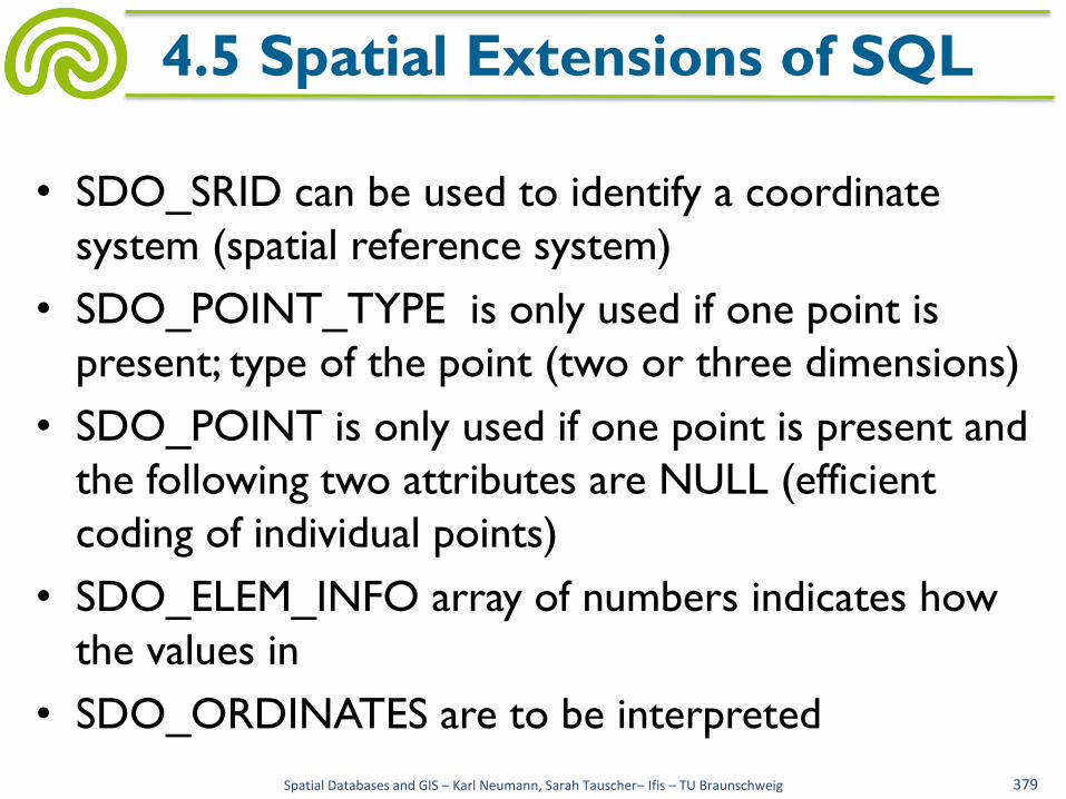
• SDO_SRID can be used to identify a coordinate
system (spatial reference system)
• SDO_POINT_TYPE is only used if one point is
present; type of the point (two or three dimensions)
• SDO_POINT is only used if one point is present and
the following two attributes are NULL (efficient
coding of individual points)
• SDO_ELEM_INFO array of numbers indicates how
the values in
• SDO_ORDINATES are to be interpreted
Spatial Databases and GIS – Karl Neumann, Sarah Tauscher– Ifis – TU Braunschweig 379
4.5 Spatial Extensions of SQL

• Example: relation for buildings
Spatial Databases and GIS – Karl Neumann, Sarah Tauscher– Ifis – TU Braunschweig 380
4.5 Spatial Extensions of SQL
INSERT INTO Building VALUES (’G4211’,’police’, SDO_GEOMETRY(SDO_GTYPE = 2003, SDO_SRID = NULL, SDO_POINT = NULL, SDO_ELEM_INFO = (1,1003,1), SDO_ORDINATES = (12125,1333,13430,1560, 13260,2497,14111,2695,14111,2638, 16040, 3092,15303,6468,13345,5958, 13771,3943, 12948,3773,12948,3887,11671,3631)));
CREATE TABLE Building (id CHAR(25), typeOfUse CHAR(25), groundPlan SDO_GEOMETRY, PRIMARY KEY(id));

• Polygon with hole
– Distinction between inner
and outer polygon rings
– Connection of points as
straight line or circular arc
Spatial Databases and GIS – Karl Neumann, Sarah Tauscher– Ifis – TU Braunschweig 381
4.5 SDO_Geometry
SDO_GEOMETRY
( 2003,
NULL,
NULL,
SDO_ELEM_INFO_ARRAY(1,1003,1, 19,2003,1),
SDO_ORDINATE_ARRAY(2,4, 4,3, 10,3, 13,5, 13,9, 11,13, 5,13, 2,11,
2,4, 7,5, 7,10, 10,10, 10,5, 7,5) )
http://download.oracle.com/docs/ ...5/sdo_objrelschema.htm
2-dimensional polygon
outer polygon ring straight line
offset

• Polygon with hole
– Distinction between inner
and outer polygon rings
– Connection of points as
straight line or circular arc
Spatial Databases and GIS – Karl Neumann, Sarah Tauscher– Ifis – TU Braunschweig 381
4.5 SDO_Geometry
SDO_GEOMETRY
( 2003,
NULL,
NULL,
SDO_ELEM_INFO_ARRAY(1,1003,1, 19,2003,1),
SDO_ORDINATE_ARRAY(2,4, 4,3, 10,3, 13,5, 13,9, 11,13, 5,13, 2,11,
2,4, 7,5, 7,10, 10,10, 10,5, 7,5) )
http://download.oracle.com/docs/ ...5/sdo_objrelschema.htm
2-dimensional polygon inner polygon ring
straight line offset
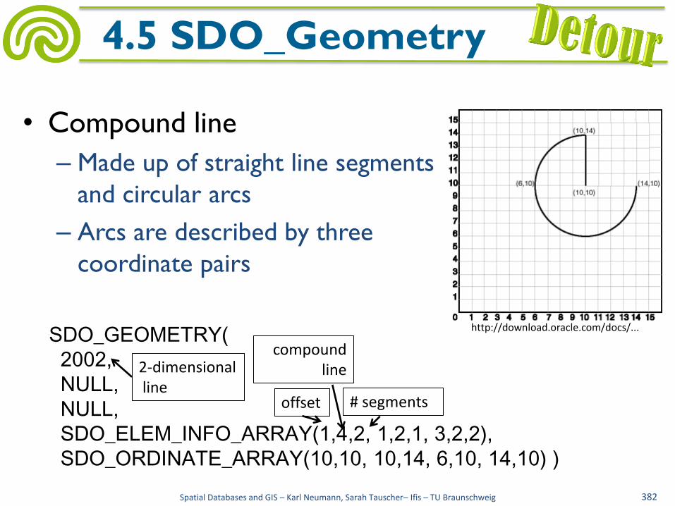
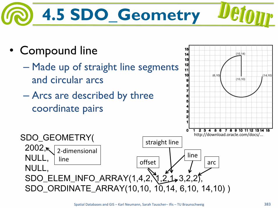
• Compound line
– Made up of straight line segments
and circular arcs
– Arcs are described by three
coordinate pairs
SDO_GEOMETRY(
2002,
NULL,
NULL,
SDO_ELEM_INFO_ARRAY(1,4,2, 1,2,1, 3,2,2),
SDO_ORDINATE_ARRAY(10,10, 10,14, 6,10, 14,10) )
Spatial Databases and GIS – Karl Neumann, Sarah Tauscher– Ifis – TU Braunschweig 382
4.5 SDO_Geometry
offset
2-dimensional line
compound line
# segments
http://download.oracle.com/docs/...
• Compound line
– Made up of straight line segments
and circular arcs
– Arcs are described by three
coordinate pairs
SDO_GEOMETRY(
2002,
NULL,
NULL,
SDO_ELEM_INFO_ARRAY(1,4,2, 1,2,1, 3,2,2),
SDO_ORDINATE_ARRAY(10,10, 10,14, 6,10, 14,10) )
offset
Spatial Databases and GIS – Karl Neumann, Sarah Tauscher– Ifis – TU Braunschweig 383
4.5 SDO_Geometry
arc
straight line
2-dimensional line
line
http://download.oracle.com/docs/...

• Collection
– Contains an arbitrary number of
geometries of different types
Spatial Databases and GIS – Karl Neumann, Sarah Tauscher– Ifis – TU Braunschweig 384
4.5 SDO_Geometry
SDO_GEOMETRY (
2004,
NULL,
NULL,
SDO_ELEM_INFO_ARRAY (1,1,1, 3,2,1, 7,1003,1),
SDO_ORDINATE_ARRAY (12,14, 2,3, 10,7, 5,8, 9,8, 10,13, 5,13, 5,8))
point line polygon

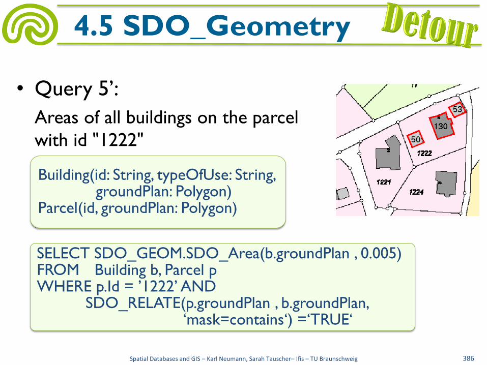
• Query 5’:
Areas of all buildings on the parcel
with id "1222"
Spatial Databases and GIS – Karl Neumann, Sarah Tauscher– Ifis – TU Braunschweig 385
4.5 SDO_Geometry
SELECT SDO_GEOM.SDO_Area(b.groundPlan, 0.005) FROM Building b, Parcel p WHERE p.Id = ’1222’ AND SDO_CONTAINS(p.groundPlan, b.groundPlan) =‘TRUE‘
Building(id: String, typeOfUse: String, groundPlan: Polygon) Parcel(id, groundPlan: Polygon)
• Query 5’:
Areas of all buildings on the parcel
with id "1222"
Spatial Databases and GIS – Karl Neumann, Sarah Tauscher– Ifis – TU Braunschweig 386
4.5 SDO_Geometry
SELECT SDO_GEOM.SDO_Area(b.groundPlan , 0.005) FROM Building b, Parcel p WHERE p.Id = ’1222’ AND SDO_RELATE(p.groundPlan , b.groundPlan, ‘mask=contains‘) =‘TRUE‘
Building(id: String, typeOfUse: String, groundPlan: Polygon) Parcel(id, groundPlan: Polygon)
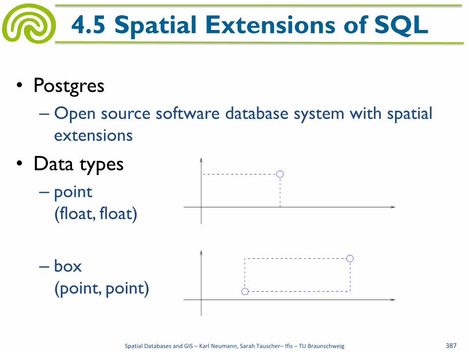
• Postgres
– Open source software database system with spatial
extensions
• Data types
– point
(float, float)
– box
(point, point)
Spatial Databases and GIS – Karl Neumann, Sarah Tauscher– Ifis – TU Braunschweig 387
4.5 Spatial Extensions of SQL

– lseg
(point, point)
– path
(point1, point2, ..., pointn)
2≤n
– polygon
(point1, point2, ..., pointn)
3≤n
Spatial Databases and GIS – Karl Neumann, Sarah Tauscher– Ifis – TU Braunschweig 388
4.5 Spatial Extensions of SQL
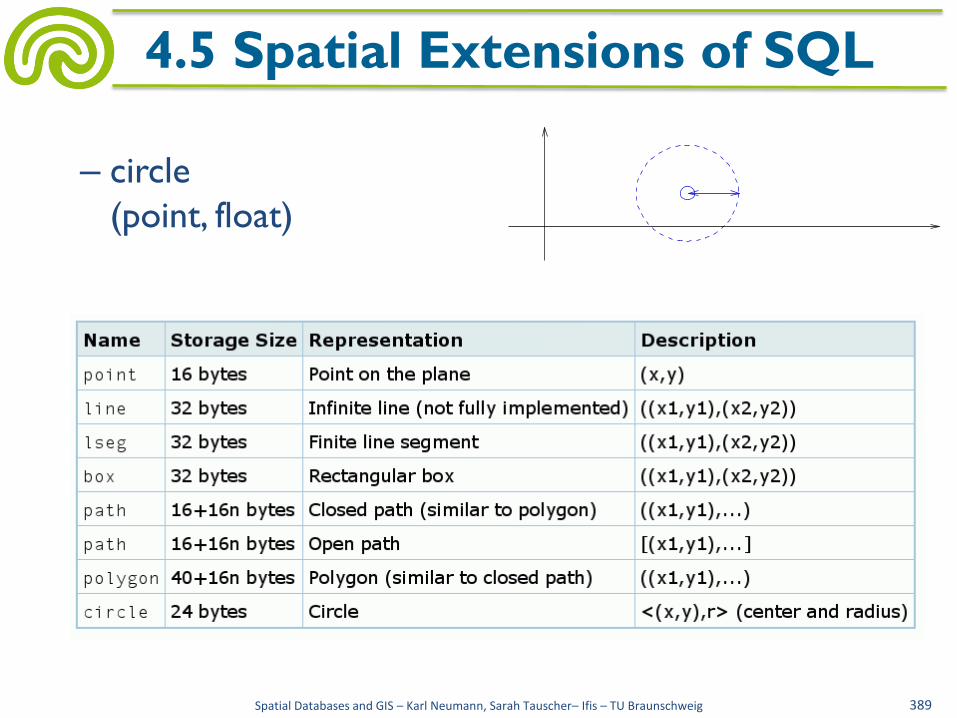
– circle
(point, float)
Spatial Databases and GIS – Karl Neumann, Sarah Tauscher– Ifis – TU Braunschweig 389
4.5 Spatial Extensions of SQL

• Predicates
– =, <> point×point, lseg×lseg, ..., circle×circle
– Intersects spatial_type×spatial_type
– Inside point × {box, polygon, circle} box × {box, polygon, circle} lseg × {box, polygon, circle} path × {box, polygon, circle} polygon × {box, polygon, circle} circle × {box, polygon, circle}
Spatial Databases and GIS – Karl Neumann, Sarah Tauscher– Ifis – TU Braunschweig 390
4.5 Spatial Extensions of SQL
http://www.ludwigshafen.de/

• Functions
– Area {box, circle, polygon} → float
– Length {lseg, path} → float
– Perimeter {box, circle, polygon} → float
– Distance point×point → float
– Point_x, Point_y point → float
– Box_ll, Box_ur box → point
– Bbox
{box, lseg, line, path, polygon, circle} → box
Spatial Databases and GIS – Karl Neumann, Sarah Tauscher– Ifis – TU Braunschweig 391
4.5 Spatial Extensions of SQL

• Example: relation for buildings
Spatial Databases and GIS – Karl Neumann, Sarah Tauscher– Ifis – TU Braunschweig 392
4.5 Spatial Extensions of SQL
INSERT INTO Building VALUES ( ’G4211’,’police’, ((12125,1333),(13430,1560),(13260,2497), (14111,2695),(14111,2638),(16040,3092), (15303,6468),(13345,5958),(13771,3943), (12948,3773),(12948,3887),(11671,3631)) ’);
CREATE TABLE Building (id CHAR(25), typeOfUse CHAR(25), groundPlan Polygon(50), PRIMARY KEY(id));

• Query 5’:
Areas of all buildings on the parcel with id "1222"
Spatial Databases and GIS – Karl Neumann, Sarah Tauscher– Ifis – TU Braunschweig 393
4.5 Spatial Extensions of SQL
SELECT Area(b.groundPlan) FROM Building b, Parcel p WHERE p.id = ’1222’ AND inside(b.groundPlan,p.groundPlan);
Building(id: String, typeOfUse: String, groundPlan: Polygon) Parcel (id, groundPlan: Polygon)
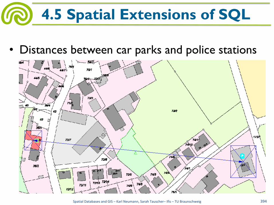
• Distances between car parks and police stations
Spatial Databases and GIS – Karl Neumann, Sarah Tauscher– Ifis – TU Braunschweig 394
4.5 Spatial Extensions of SQL

Spatial Databases and GIS – Karl Neumann, Sarah Tauscher– Ifis – TU Braunschweig 395
4.5 Spatial Extensions of SQL
SELECT b1.id, b2.id, Distance ( point ( (Point_X (box_ll (bbox (b1.groundPlan))) + Point_X (box_ur (bbox (b1. groundPlan)))) / 2, (Point_Y (box_ll (bbox (b1. groundPlan))) + Point_Y (box_ur (bbox (b1. groundPlan)))) / 2), point ( (Point_X (box_ll (bbox (b2. groundPlan))) + Point_X (box_ur (bbox (b2. groundPlan)))) / 2, (Point_Y (box_ll (bbox (b2. groundPlan))) + Point_Y (box_ur (bbox (b2. groundPlan)))) / 2)) FROM Building b1, Building b2 WHERE b1.typeOfUse = ’car park’ AND b2.typeOfUse = ’police’ ORDER BY 1, 3;

• Spatial queries are frequently classified by
– Point query given: object o with point geometry find: { oi | contains(oi.geometry, o.geometry)}
– Window query given: object o with rectangle geometry find: { oi | intersects(oi.geometry, o.geometry)}
– Region query given: object o with polygon geometry find: { oi | intersects(oi.geometry, o.geometry)}
Spatial Databases and GIS – Karl Neumann, Sarah Tauscher– Ifis – TU Braunschweig 396
4.6 Evaluation of Spatial Queries
http://www.wwa-ke.bayern.de/
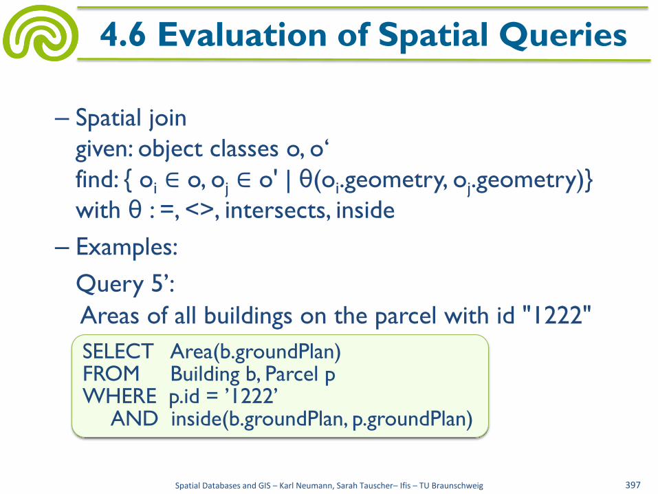
– Spatial join
given: object classes o, o‘
find: { oi ∈ o, oj ∈ o' | θ(oi.geometry, oj.geometry)}
with θ : =, <>, intersects, inside
– Examples:
Query 5’:
Areas of all buildings on the parcel with id "1222"
Spatial Databases and GIS – Karl Neumann, Sarah Tauscher– Ifis – TU Braunschweig 397
4.6 Evaluation of Spatial Queries
SELECT Area(b.groundPlan) FROM Building b, Parcel p WHERE p.id = ’1222’ AND inside(b.groundPlan, p.groundPlan)

• Query 9:
Through which parcels do brooks flow?
Spatial Databases and GIS – Karl Neumann, Sarah Tauscher– Ifis – TU Braunschweig 398
4.6 Evaluation of Spatial Queries
SELECT p.id FROM Parcel p, Brook b WHERE Intersects (p.groundPlan, b.geometry);
Parcel(id, groundPlan: Polygon) Brook(...,geometry: Polygon)
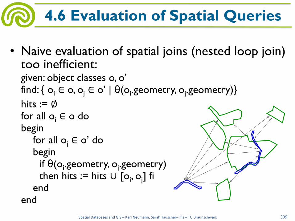
• Naive evaluation of spatial joins (nested loop join) too inefficient:
given: object classes o, o’ find: { oi ∈ o, oj ∈ o’ | θ(oi.geometry, oj.geometry)}
hits := ∅ for all oi ∈ o do begin for all oj ∈ o’ do begin if θ(oi.geometry, oj.geometry) then hits := hits ∪ [oi, oj] fi end end
Spatial Databases and GIS – Karl Neumann, Sarah Tauscher– Ifis – TU Braunschweig 399
4.6 Evaluation of Spatial Queries

• Evaluating query 9 (through which parcels do
brooks flow?) with e.g. 5.000 polygons of parcels
and 40 polygons of brooks results in 200.000
intersection operations, e.g.:
Spatial Databases and GIS – Karl Neumann, Sarah Tauscher– Ifis – TU Braunschweig 400
4.6 Evaluation of Spatial Queries
intersects((7200,2430,7245,2430,7200,2565,7245,2700,7290,2790,7335, 2880,7470,3105,7560,3240,7515,3375,7470,3600,7425,3780,7335,3870, 7245,3870,7110,3780,6975,3870,6930,3960,6840,4005,6750,4095,6570, 4230,6480,4230,6480,4185,6705,4050,6840,3915,7020,3780,7110,3735, 7245,3780,7335,3780,7425,3645,7470,3375,7515,3195,7335,2970,7200, 2745,7155,2520,7200,2385,7245,2385,7200,2430),(6975,2565,7065,2835,7245,2835,7875,2790,8190,2970,8010,3195,7650,3555,7470,3510,7470, 3690,7290,3825,7020,3825,6750,4050,6570,4095,6480,3915,6345,3960, 6210,3600,6165,3420,6165,3240,6210,3015,6300,2655,6345,2610,6840, 2610,6975,2565))

• Therefore evaluation of spatial queries in 2 steps
– Filter step
• Determination of possible hits by evaluation on spatial
approximation (lower costs)
– Refinement step
• Evaluation on accurate geometry only for objects of the
filter step
Spatial Databases and GIS – Karl Neumann, Sarah Tauscher– Ifis – TU Braunschweig 401
4.6 Evaluation of Spatial Queries
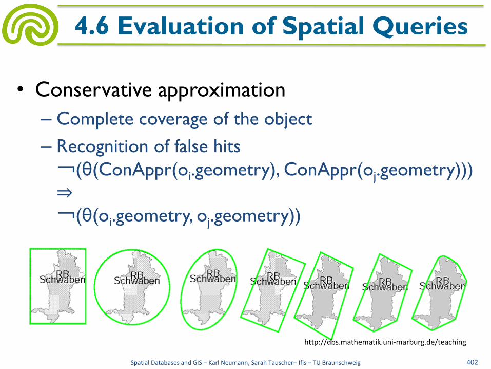
• Conservative approximation
– Complete coverage of the object
– Recognition of false hits
¬(θ(ConAppr(oi.geometry), ConAppr(oj.geometry)))
⇒
¬(θ(oi.geometry, oj.geometry))
Spatial Databases and GIS – Karl Neumann, Sarah Tauscher– Ifis – TU Braunschweig 402
4.6 Evaluation of Spatial Queries
http://dbs.mathematik.uni-marburg.de/teaching

• Progressive approximation
– Completely covered by the object
– Recognition of hits
θ(ProgAppr(oi.geometry), ProgAppr(oj.geometry))
⇒
θ(oi.geometry, oj.geometry)
– Complex
computation
Spatial Databases and GIS – Karl Neumann, Sarah Tauscher– Ifis – TU Braunschweig 403
4.6 Evaluation of Spatial Queries
http://dbs.mathematik.uni-marburg.de/teaching

• In practice usually
conservative
approximation by
minimum bounding
(paraxial) rectangle
(MBR, bounding box)
Spatial Databases and GIS – Karl Neumann, Sarah Tauscher– Ifis – TU Braunschweig 404
4.6 Evaluation of Spatial Queries
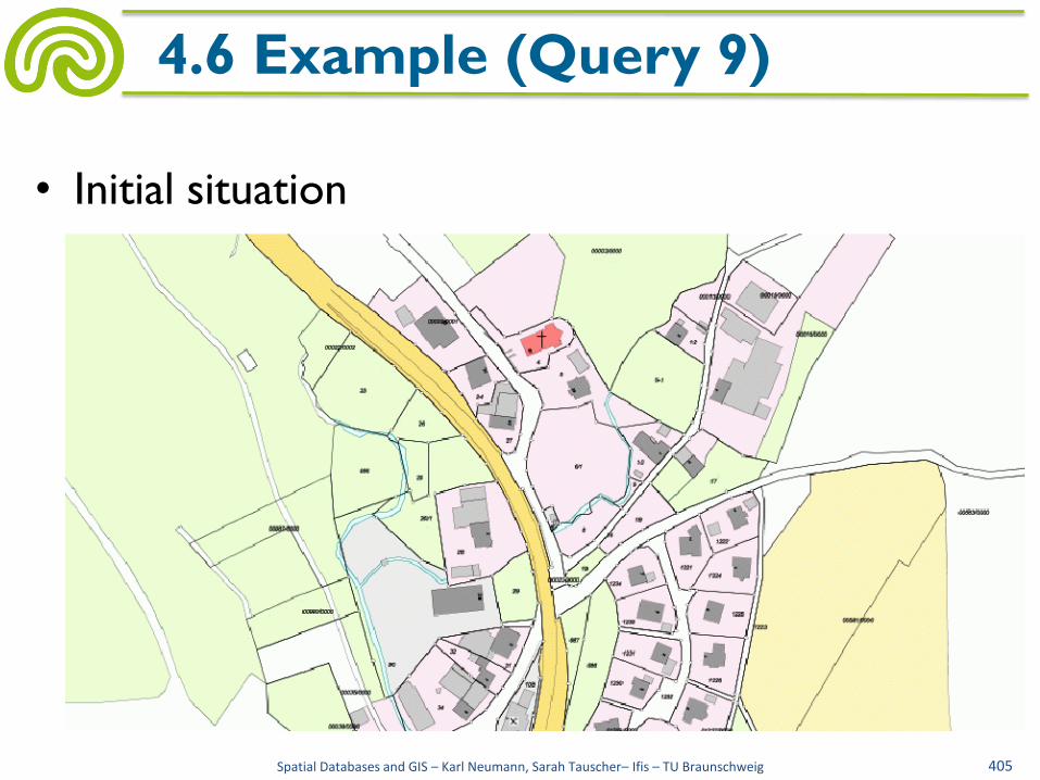
• Initial situation
Spatial Databases and GIS – Karl Neumann, Sarah Tauscher– Ifis – TU Braunschweig 405
4.6 Example (Query 9)
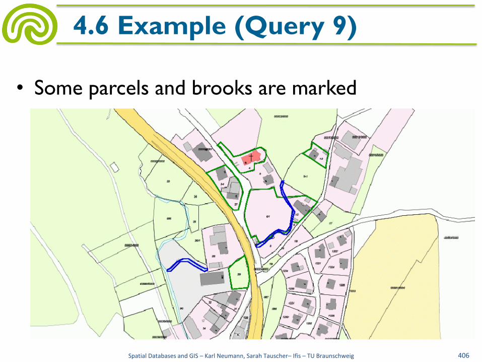
• Some parcels and brooks are marked
Spatial Databases and GIS – Karl Neumann, Sarah Tauscher– Ifis – TU Braunschweig 406
4.6 Example (Query 9)

• MBRs of parcels and brooks
Spatial Databases and GIS – Karl Neumann, Sarah Tauscher– Ifis – TU Braunschweig 407
4.6 Example (Query 9)
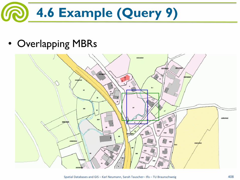
• Overlapping MBRs
Spatial Databases and GIS – Karl Neumann, Sarah Tauscher– Ifis – TU Braunschweig 408
4.6 Example (Query 9)
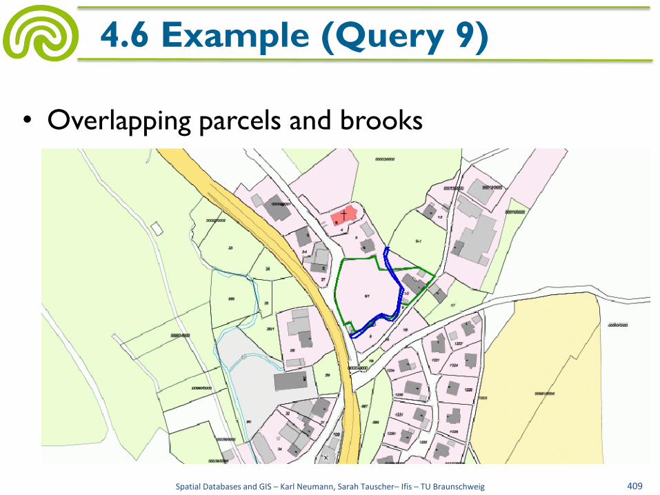
• Overlapping parcels and brooks
Spatial Databases and GIS – Karl Neumann, Sarah Tauscher– Ifis – TU Braunschweig 409
4.6 Example (Query 9)

• Evaluation of spatial joins with MBRs (somewhat) more efficient:
hits := ∅
for all oi ∈ o do
begin
for all oj ∈ o’ do
begin
if θ(MBR(oi.geometry), MBR(oj.geometry))
then if θ(oi.geometry, oj.geometry)
then hits := hits ∪ [oi, oj]
fi
fi
end
end
Spatial Databases and GIS – Karl Neumann, Sarah Tauscher– Ifis – TU Braunschweig 410
4.6 Evaluation of Spatial Queries

• There are still |oi|· |oj| comparisons needed (e.g. 200.000 comparisons between 5.000 MBRs of parcels and 40 MBRs of brooks)
• For a more efficient evaluation of spatial queries spatial indexes are needed
Spatial Databases and GIS – Karl Neumann, Sarah Tauscher– Ifis – TU Braunschweig 411
4.6 Evaluation of Spatial Queries
http://www.geoinformation.net/
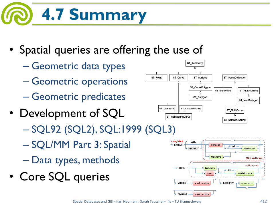
• Spatial queries are offering the use of
– Geometric data types
– Geometric operations
– Geometric predicates
• Development of SQL
– SQL92 (SQL2), SQL:1999 (SQL3)
– SQL/MM Part 3: Spatial
– Data types, methods
• Core SQL queries
Spatial Databases and GIS – Karl Neumann, Sarah Tauscher– Ifis – TU Braunschweig 412
4.7 Summary

• Spatial queries and core SQL
– Relational modeling of points
– Distance calculation between points
– Relational modeling of polygons
– N-th point of a polygon
– Bounding box
– Perimeter of polygons
– Perimeter of polygons, direct
Spatial Databases and GIS – Karl Neumann, Sarah Tauscher– Ifis – TU Braunschweig 413
4.7 Summary
V1 V2 V3
V4
V5 V6 V7

• Spatial extensions of the relational algebra
– Base operations, derived operations
– Extensions by new sorts, operators, predicates
– Some queries
• Spatial extensions of SQL
– Some queries
– Oracle Spatial
– SDO_Geometry
– Postgres
Spatial Databases and GIS – Karl Neumann, Sarah Tauscher– Ifis – TU Braunschweig 414
4.7 Summary

• Evaluation of spatial queries
– Point query
– Window query
– Region query
– Spatial join
– Evaluation of spatial queries in 2 steps
– Conservative approximation
– Progressive approximation
Spatial Databases and GIS – Karl Neumann, Sarah Tauscher– Ifis – TU Braunschweig 415
4.7 Summary
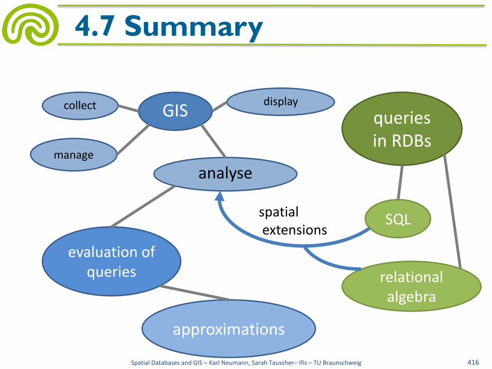
Spatial Databases and GIS – Karl Neumann, Sarah Tauscher– Ifis – TU Braunschweig 416
4.7 Summary
GIS
SQL
evaluation of queries
approximations
collect
manage
analyse
display
spatial extensions
relational algebra
queries in RDBs


