Embed Size (px)
Citation preview
Universidade de ÉvoraCIDEHUS - Centro Interdisciplinar de História, Culturas e Sociedades
ricercheseries maior 1

Universidade de ÉvoraCIDEHUS - Centro Interdisciplinar de História, Culturas e Sociedades
Changing LandscapesThe impact of Roman towns in the Western MediterraneanProceedings of the International Colloquium, Castelo de Vide - Marvão 15th-17th May 2008
edited byCristina Corsi and Frank Vermeulen
With contribution of:
Universidade de Évora - CIDEHUS
FCT
Universiteit Gent
Università degli Studi di CassinoDipartimento di Filologia e Storia
© 2010 Ante Quem soc. coop.
Ante Quem soc. coop.Via San Petronio Vecchio 6, 40125 Bologna, Italy - tel. / fax +39 051 4211109www.antequem.it
redazione e impaginazione: Enrico Gallì, Cristina Servadei
ISBN 978-88-7849-055-0
SUMMARY
ForewordJoão José dos Santos Sentieiro 7
PrefácioMafalda Soares da Cunha, Filipe Themudo Barata 9
IntroductionCristina Corsi, Frank Vermeulen 11
Town and country in the early Roman West – a perspectiveMartin Millett 17
Iberia and Italia: Issues and challenges in the comparative study of Roman urbanismSimon Keay 27
La “romanisation” des campagnes sardes: un bilan des recherches récentesCinzia Vismara 47
The role of Roman towns in the Romanization process in Corsica. The case-study of MarianaCristina Corsi, Caterina Paola Venditti 69
Romanisation et dynamiques territoriales en Gaule centrale. Le cas de la cité des Arvernes (IIe s. av. J.-C.–IIe s. ap. J.-C.)Frédéric Trément 85
Implantation romaine et développement du territoire dans la colonie de BéziersMonique Clavel-Lévêque 105
Histoire d’une conquête. Dynamiques sociales et intentions programmatiques dans l’architecture et l’urbanisme de la Cisalpine occidentale et de la Gaule Narbonnaise en époque républicaine avancéeElisa Panero 117
L’occupation romaine de la Cerdagne: transformations d’un paysage pyrénéen pendant l’antiquitéOriol Olesti i Vila, Oriol Mercadal i Fernandez 129
Asentamientos rurales y estructuración de la Layetania interior (Barcelona): romanización e impacto de los programas de organización territorialMarta Flórez Santasusanna, Josep M. Palet Martínez 141
Modelación y conceptualización del paisaje romano en el ager Tarraconensis: Tarraco y la centuriación del territorioJosep M. Palet Martínez, José I. Fiz Fernández, Hèctor A. Orengo Romeu 167
The impact of the organization of territory in a provincial capital: The colony of Tarraco and the ager TarraconensisRamon Járrega Domínguez 185
5
Changing Landscapes. The impact of Roman towns in the Western Mediterranean
6
The ager Tarraconensis project (right side of river Francolí) (PAT): The application of geophysical survey to identify rural Roman settlement typologiesMarta Prevosti, Kristian Strutt, Cèsar Carreras 205
Mudanças da paisagem cultural na baía de Algeciras (Cádis, Espanha). Paisagem e território de CarteiaLourdes Roldán, Juan Blánquez, Dario Bernal, José Juan Díaz 217
An approach to landscape changes in the Bay of Gibraltar through the cartographyHelena Jiménez Vialás 237
Urban forms and social space of Italica in Roman Imperial timesMargherita Carucci 253
The Romanization process of an agrarian landscape: La Serena regionVictorino Mayoral Herrera, Rebeca Cazorla Martín, Sebastián Celestino Pérez 263
Bracara Augusta and the changing rural landscapeManuela Reis Martins, Helena Paula Abreu de Carvalho
281
Variação e constância na ocupação de Conimbriga e do seu territórioVirgílio Hipólito Correia, Adriaan De Man 299
From cityscape to landscape in Roman Lusitania: the municipium of AmmaiaFrank Vermeulen, Devi Taelman 311
Mesas do Castelinho (Almodôvar): A case of a failed Roman town in southern LusitaniaCarlos Fabião, Amílcar Guerra 325
Changement et continuité: la romanisation à Chãos Salgados, Santiago do Cacém – Mirobriga? – (Portugal)José Carlos Quaresma 347
Ab Oppido ad Urbem: Algarve’s urban landscape variations throughout the Roman ageJoão Pedro Bernardes 357
El sustrato libiopúnico y el proceso de transformación del paisaje extraurbano en el África RomanaFernando Prados Martínez 369
Romanization and definition of commercial areas in Africa Proconsularis: The examples of Leptis Magna and ThuggaLilia Palmieri 385
List of Authors 393
INTRODUCTION
The impact of Bracara Augusta in the development of the surrounding area can only be assessed andunderstood by the archaeological studies undertaken in the Braga region within the last 30 years. Whatwe understand today from these studies differs from previous analyses generated by the traditional histo-riography, which considers the northwestern region of the Iberian Peninsula as not deeply influenced byRoman culture, either in the development of the urban centres or in the integration of indigenous people.
The newly available data sheds new light on Bracara Augusta both as an urban centre and as the mainagent of development of its surrounding region. This new interpretation represents three decades of urbanarchaeology practice within the city of Braga (Martins, 2004; Morais, 2005). The new data concerned withthe pre-Roman occupation of the region, as well as with the Roman exploitation and organization of theterritory, is the result of archaeological studies included in several research projects focused on the evolu-tion of the settlement and landscape between the first millennium BC and Late Antiquity (Martins 1990;Fontes, 1991-1992; Martins, 1995; Carvalho, 2000; Fontes, 2005; Martins, 2005). In this sense, the exca-vations undertaken in Braga since 1976, together with the recurrent surveys in the surrounding area, offera key resource to study and understand the impact of the Roman city on the landscape changes.
This paper aims to give notice of this newly available data and the subsequent new knowledge regar-ding the development of Bracara Augusta and the organization of its hinterland.
BEFORE BRACARA AUGUSTA. PRE-ROMAN SETTLEMENT
The pre-Roman settlement of the Braga region was characterized by hill-forts, as happened in thewider northwestern Iberia. These residential units can be seen as the result of a complex historical deve-lopment process that occurred throughout the first millennium BC (Silva, 1986; Martins, 1990;Alarcão, 1992; Martins, 1996b). Emerging in the Late Bronze Age they were originally located around
BRACARA AUGUSTA AND THE CHANGING RURAL LANDSCAPE
Manuela Reis Martins, Helena Paula Abreu de Carvalho
ABSTRACT: This paper focuses on the foundation and development of Bracara Augusta and also on the relationship of thetown with the surrounding countryside. Using data provided by urban rescue excavations carried out over the last 30 yearsin Braga, we will consider the planning and layout of the Roman town, the main features of its public and domestic archi-tecture and the importance of Bracara Augusta as an administrative, and economic centre. Archaeological research into thesurrounding countryside, concerning both the pre-Roman and the Roman occupations, shows a strong impact of BracaraAugusta on the evolution of indigenous communities, on the economic and social organization of the area and on the crea-tion of a new rural landscape. This impact is mainly linked with the construction of the road network, with the rapid spreadof villas and vici and land centuriation. Bracara Augusta as a central focus of regional development contributed to the pro-motion and integration of indigenous populations through the creation of a rural landowning elite and a landscape of pri-vate properties and open settlements, co-existing with some Romanized hill-forts.
KEYWORDS: Bracara Augusta, Romanization, Rural Landscape.
281

the borders of the river valleys. Gradually they occupied all the preeminent reliefs, and started sprea-ding to the small hills scattered in the valley lowlands (Martins, 1996b; Almeida, 2003).
This settlement pattern is the highlight of a long-term socio-economic process linked to the appro-priation and intensive exploitation of land, a fact that gave origin to the necessity of establishing terri-torial boundaries between communities, requiring a rigorous definition of resource areas. Those boun-daries must have been reflected in the self-image of the communities and in territorial entities linkedto socio-economic and symbolic spaces. The visibility of the hill forts, with its expression in the con-struction of fortifications, remained a fundamental element in the structuring of those boundaries aswell as in the organization of the landscape (Martins, 1996b).
The Braga region shows visible signs of change, especially towards the end of the first millenniumBC, associated with general economic growth. This is linked with the agricultural development asso-ciated with the foundation of new hill-forts in valley lowlands. This trend is linked to a process of eco-nomic intensification bound up with the exploitation of cereals and the innovation and specialization ofhandicrafts, as well as a widespread use of metal (Silva, 1986; Martins, 1990; Martins, Lemos & PérezLosada, 2005). This process brought together a surplus production which seems to have favoured awider interaction between hill-forts and also an increase in social complexity with differentiation of thestatus of communities and persons. This economic growth (Martins, 1990; Ead., 1996b) is clearly visi-ble in the archaeological record from the second century BC onwards, being represented in the con-struction of complex defensive systems in some hill-forts or in the substantial reorganization of others,including the introduction of streets and residential quarters (Silva, 1986).
The archaeological remains from this period reveal clear distinctions between hill-forts in terms ofsize and socio-economic control, well understood by the existence of wide settlements (oppida) (GonzálezRuibal, 2006-2007), which would have represented central places within the communities that domi-nated a network of smaller hill forts with different but complementary functions (Martins, 1990; Silva,1995; Alarcão, 1999a; Silva, 1999).
The changing patterns mentioned above suggest that an evolution from segmentary societies to hie-rarchical ones took place in a particular northwestern area, corresponding to the Portuguese province ofEntre-Douro-e-Minho, the occidental territories of Trás-os-Montes (Lemos, 1993; Martins, Lemos &Pérez Losada, 2005) and also southern Galicia.
It may not be possible yet to understand fully the opportunities offered by the Braga region, but itis believed that the early connection with the southern areas of the Iberian Peninsula would have invol-ved profound socio-cultural and economic changes within the indigenous communities, which favouredan inevitable rupture from the traditional autarchy of the indigenous northwestern societies (SastrePrats, 2001; Ead. 2004). These events contributed to the emergence of hierarchical communities whichwould be better adapted to a stronger interaction with the Romanized areas of Iberia. On the otherhand, it is believed that the military campaigns of Decimus Iunius Brutus in the northern border regionof the Douro river, in 138-136 BC, would have contributed to accelerating the process of reorganizationof the indigenous hill-forts. This included abandoning some of them, and the subsequent concentrationof the population within the settlements that offered the best geo-strategic conditions. These sites deve-loped in a proto-urban scheme acting as central places. Paradigmatic examples of these oppida areSanfins, Briteiros, S. Julião, Carmona and Santa Luzia, among others (Silva, 1986; Martins, 1990).
The military confrontation between the Bracari and the Roman army, as documented in the writtensources (Alarcão, 1988), might have conditioned a wider integration of the communities located in dif-ferent hill-forts, which could have developed new forms of regional alliance and solidarity, giving riseto wider socio-political units. At this point, growing contacts with the southern Romanized regionswere established, attested by the presence of exogenous products and by the development of some con-struction techniques and wider skills which confirm the peculiarities of the meridional and westernregion of northwestern Iberia (Silva, 1986). These particular circumstances would have affected the con-text of relationships established between the Romans and the indigenous élites of the Braga region andcertainly favoured their integration as well as their role within the foundation of Bracara Augusta(Martins, Lemos & Pérez Losada, 2005).
Changing Landscapes. The impact of Roman towns in the Western Mediterranean
282

FOUNDATION AND DEVELOPMENT OF BRACARA AUGUSTA
After the end of the Cantabric wars, Augustus was in charge of developing the integration strategy ofboth the territory and population of northwestern Iberia. The chosen model, already implemented in otherregions of the Empire, was essentially administrative and had as its main agents the indigenous élites them-selves, to whom special prerogatives were given. This model was based upon the construction of a complexroad network, which sustained Roman power over the area and helped to develop the Augustan town foun-dations that were intended to be centres of administrative power, Roman culture and ideology (Fig. 1).
THE FOUNDATION
Bracara Augusta was the only urban centrecreated by Augustus within the current terri-tory of Portugal, located north of the DouroRiver. The exact date of the town’s foundationis still unknown, although some scholars sug-gest a date around 16-15 BC for the consecra-tion of all three Augustan towns in thenorthwest (Rodríguez Colmenero, 1996a).
We know that Bracara Augusta was createdex nihilo within an area surrounded by hill-forts,some of which could have been true oppidawhile others, smaller and likely subsidiary tothem, might have been abandoned after thetown’s foundation (Martins, 1990). The choiceof the place to settle the town seems to be rela-ted both to the peculiar topographic conditionsof the area and to its relative importance withinthe pre-Roman land occupation. In fact, the town was founded at a strategic and central point in theterritory between the Douro and Minho rivers (Lemos, 1999), within the area controlled by the Bracaribetween the Cávado and Ave rivers. It appears as an epicentre of natural crossroads, assuring the neces-sary communications with the other northwestern urban centres but also with the south and theMediterranean ports (Martins, 1990; Martins, Lemos & Pérez Losada, 2005; Morais, 2005).
The site of the town was already an important economic centre in pre-Roman times. In fact, it wassituated at the heart of a very developed region which had fertile soil and plenty of water. These resour-ces were the key for the intensification of agriculture, witnessed around the first century BC within boththe middle Cávado River area (Martins, 1990) and the Ave valley (Silva, 1986). Although the site ofBracara does not offer the necessary topographic conditions for the establishment of a hill-fort, due toits low altitude (188 m), considering the surrounding area (300 m), it possessed key attractive featuresfor the indigenous populations of the region that must have used it with different functions.
One of the first authors to refer to the geostrategic importance of the location of Bracara Augusta,which might have justified its choice as the place for the new Augustan foundation, was Alain Tranoy(1981, p. 194). Tranoy believes the location was a marketplace and/or a meeting point of the indige-nous population in pre-Roman times. The centrality of the site was naturally apt to become a politi-cally strategic crossroads, a sporadic or regular marketplace and also a location for the celebration ofcults and rituals. With regards to the site as a place of worship, it seems reasonable to suggest the exi-stence of cults linked with fertility since it was surrounded by water courses that came from the sur-rounding hills. In fact, a pre-Roman sanctuary dedicated to Nabia, an indigenous goddess linked withthe worship of waters, fertility and nature, must have existed on the site of the Idol’s Fountain (Lemos,2002a; Elena, Mar & Martins, 2008). Emphasizing the abundance and importance of water as a worship
Manuela Reis Martins, Helena Paula Abreu de Carvalho
283
1. Bracara Augusta location
motif at the site, a relatively small indigenous baths building was discovered in the north-west part ofthe city (Lemos et alii, 2003).
The available archaeological data suggests a civilian origin for the town as opposed to the other twoAugustan northwestern towns, which were the legacy of previous military camps (Rodríguez Colmenero& Covadonga Carreño, 1999; Sevillano Fuertes & Vidal Encinas, 2002). Bracara Augusta was founded asan administrative centre to underline Roman power over the region, relocate the native populations andpromote their economic, social and political integration, a process also enabled by the particularities ofthe pre-Roman settlement of the region. Being one of the main administrative capitals of northwesternIberia, the town controlled a wide territory, encompassing the conventus iuridicus, which contained seve-ral civitates.
The foundation of Bracara Augusta was linked with an ideological and religious context attested bythe epigraphic references to the emperor and his relatives. It seems to be also closely related to thelegacy of Paulus Fabius Maximus, who can be considered as the town’s patron, referred to on a statuepedestal dedicated to Augustus by the bracaraugustani (Le Roux, 1975; Tranoy, 1981). The epigraphiccollection dating to the foundation era suggests a general acceptance by the indigenous élites both ofthe imperial cult and of the emperor’s policy, witnessed in the dedications to Caius and Lucius (CIL,II, 2422) and Agrippa Postumus (Le Roux, 1975). The unquestionable ideological and religiousimportance that preceded the town’s foundation was also enhanced by the juridical, religious and eco-nomic functions the town acquired as a conventus iuridicus capital as it organized the imperial cult(Tranoy, 1980; Id., 1981).
The important urban administrative functions over a wide region must have been followed by a notless important economic activity, as the town acted as the main production and distribution centre ofthe region’s resources (Morais, 2005). In fact, Bracara Augusta seems to have kept the central position italready had in pre-Roman times, justified by its strategic location (Martins, 1990; Lemos, 1999). Theprecocious economic activity of the town is well documented in an inscription, dated to the year 42 AD,dedicated to C. Caetronius Miccio by the Roman citizens who were trading in the area (Alföldy, 1966).This activity is also corroborated by archaeological finds that document a wide flow of imported pro-ducts in the pre-Flavian period (Morais, 1997-1998; Id., 2005).
SETTLEMENT
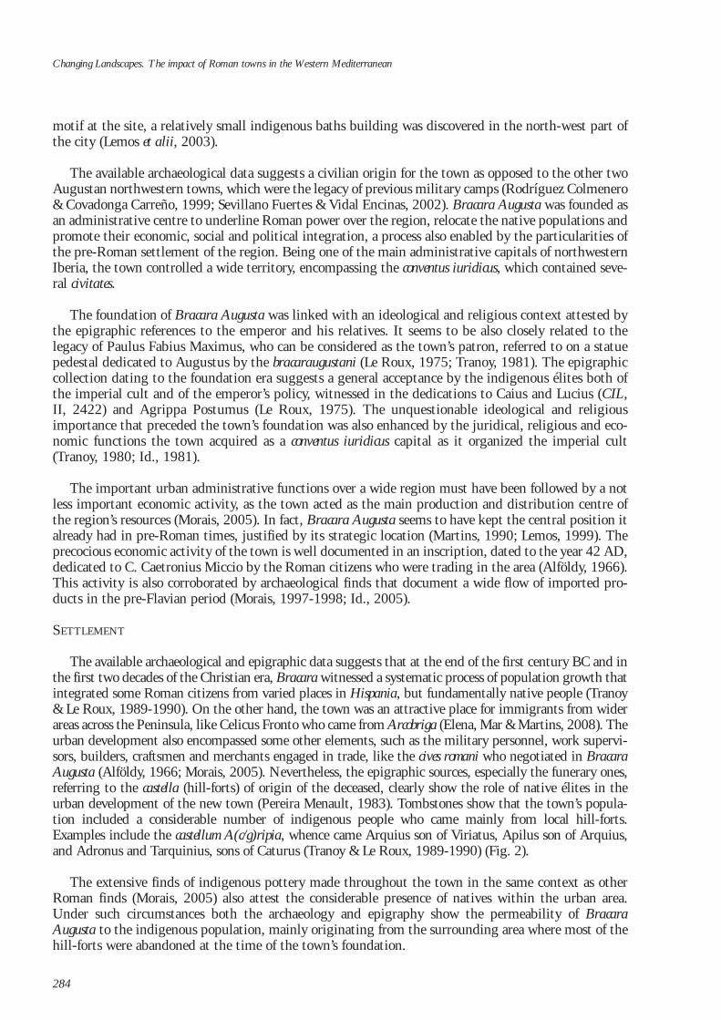
The available archaeological and epigraphic data suggests that at the end of the first century BC and inthe first two decades of the Christian era, Bracara witnessed a systematic process of population growth thatintegrated some Roman citizens from varied places in Hispania, but fundamentally native people (Tranoy& Le Roux, 1989-1990). On the other hand, the town was an attractive place for immigrants from widerareas across the Peninsula, like Celicus Fronto who came from Arcobriga (Elena, Mar & Martins, 2008). Theurban development also encompassed some other elements, such as the military personnel, work supervi-sors, builders, craftsmen and merchants engaged in trade, like the cives romani who negotiated in BracaraAugusta (Alföldy, 1966; Morais, 2005). Nevertheless, the epigraphic sources, especially the funerary ones,referring to the castella (hill-forts) of origin of the deceased, clearly show the role of native élites in theurban development of the new town (Pereira Menault, 1983). Tombstones show that the town’s popula-tion included a considerable number of indigenous people who came mainly from local hill-forts.Examples include the castellum A(c/g)ripia, whence came Arquius son of Viriatus, Apilus son of Arquius,and Adronus and Tarquinius, sons of Caturus (Tranoy & Le Roux, 1989-1990) (Fig. 2).
The extensive finds of indigenous pottery made throughout the town in the same context as otherRoman finds (Morais, 2005) also attest the considerable presence of natives within the urban area.Under such circumstances both the archaeology and epigraphy show the permeability of BracaraAugusta to the indigenous population, mainly originating from the surrounding area where most of thehill-forts were abandoned at the time of the town’s foundation.
Changing Landscapes. The impact of Roman towns in the Western Mediterranean
284
We know from epigraphic evidence that some natives obtained Roman citizen-ship, since they were enrolled in the Quirina voting tribe, for instance, T. CaeliusFlaccus, Q. Pontius Severus, who was flamen in Tarraco, or L. Terentius Rufus whofought against the Dacians in the reign of the Emperor Trajan (Tranoy, 1981). Onthe other hand, we also know that some natives were priests of the imperial cult,like Camalus, the son of Melgecus, Lucrecia Fida and Pro Nigrina who performed ahigher religious role in Tarraco (Tranoy, 1981).
URBAN LAYOUT
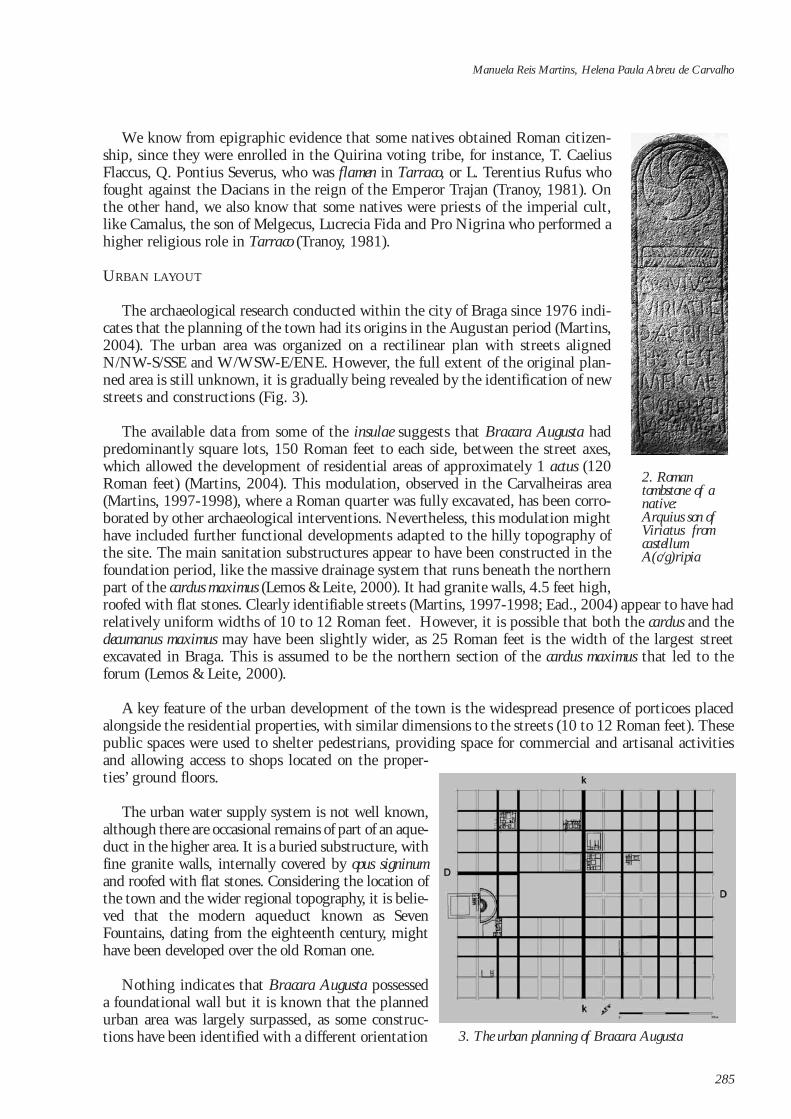
The archaeological research conducted within the city of Braga since 1976 indi-cates that the planning of the town had its origins in the Augustan period (Martins,2004). The urban area was organized on a rectilinear plan with streets alignedN/NW-S/SSE and W/WSW-E/ENE. However, the full extent of the original plan-ned area is still unknown, it is gradually being revealed by the identification of newstreets and constructions (Fig. 3).
The available data from some of the insulae suggests that Bracara Augusta hadpredominantly square lots, 150 Roman feet to each side, between the street axes,which allowed the development of residential areas of approximately 1 actus (120Roman feet) (Martins, 2004). This modulation, observed in the Carvalheiras area(Martins, 1997-1998), where a Roman quarter was fully excavated, has been corro-borated by other archaeological interventions. Nevertheless, this modulation mighthave included further functional developments adapted to the hilly topography ofthe site. The main sanitation substructures appear to have been constructed in thefoundation period, like the massive drainage system that runs beneath the northernpart of the cardus maximus (Lemos & Leite, 2000). It had granite walls, 4.5 feet high,roofed with flat stones. Clearly identifiable streets (Martins, 1997-1998; Ead., 2004) appear to have hadrelatively uniform widths of 10 to 12 Roman feet. However, it is possible that both the cardus and thedecumanus maximus may have been slightly wider, as 25 Roman feet is the width of the largest streetexcavated in Braga. This is assumed to be the northern section of the cardus maximus that led to theforum (Lemos & Leite, 2000).
A key feature of the urban development of the town is the widespread presence of porticoes placedalongside the residential properties, with similar dimensions to the streets (10 to 12 Roman feet). Thesepublic spaces were used to shelter pedestrians, providing space for commercial and artisanal activitiesand allowing access to shops located on the proper-ties’ ground floors.
The urban water supply system is not well known,although there are occasional remains of part of an aque-duct in the higher area. It is a buried substructure, withfine granite walls, internally covered by opus signinumand roofed with flat stones. Considering the location ofthe town and the wider regional topography, it is belie-ved that the modern aqueduct known as SevenFountains, dating from the eighteenth century, mighthave been developed over the old Roman one.
Nothing indicates that Bracara Augusta possesseda foundational wall but it is known that the plannedurban area was largely surpassed, as some construc-tions have been identified with a different orientation
Manuela Reis Martins, Helena Paula Abreu de Carvalho
285
2. Roman tombstone of anative: Arquius son ofViriatus fromcastellum A(c/g)ripia
3. The urban planning of Bracara Augusta
from the normal orthogonal layout (Martins, 2004). This can be seen in the public building locatedbeneath the cathedral, placed on the edge of the town (Gaspar, 1986; Fontes, Lemos & Cruz, 1997-1998) with a north–south orientation. On the other hand, the suburban area was provided with severalbuildings, mainly an amphitheatre (Morais, 2001) and sanctuaries like the Idol’s Fountain, located atthe western exit (Lemos, 2002a). This provides the best example of a pre-Roman locus sacer shaped bythe regular Roman architectural patterns of the era of the town’s foundation (Elena, Mar & Martins,2008). Although no classical temple has been found, it is believed that there was a fanum in the subur-ban area, as a cylindrical altar inscribed with the word “SACRVM” has been uncovered (Carvalho et alii,2006). The suburban areas also included craft constructions as well as cemeteries that run alongside themain roads exiting the town (Martins & Delgado, 1989-1990; Lemos, 2003).
The administrative and religious forum was situated in the highest part of the town. This locationis interpreted both from the wider layout of the forma urbis and by a written reference in Braunio’s map,dating from the sixteenth century, indicating the “forum Romanorum” to be located near the S. Sebastiãochapel (Martins, 2004). Nevertheless, both the dimensions and features of this important civic spacestill need to be brought to light.
PUBLIC ARCHITECTURE
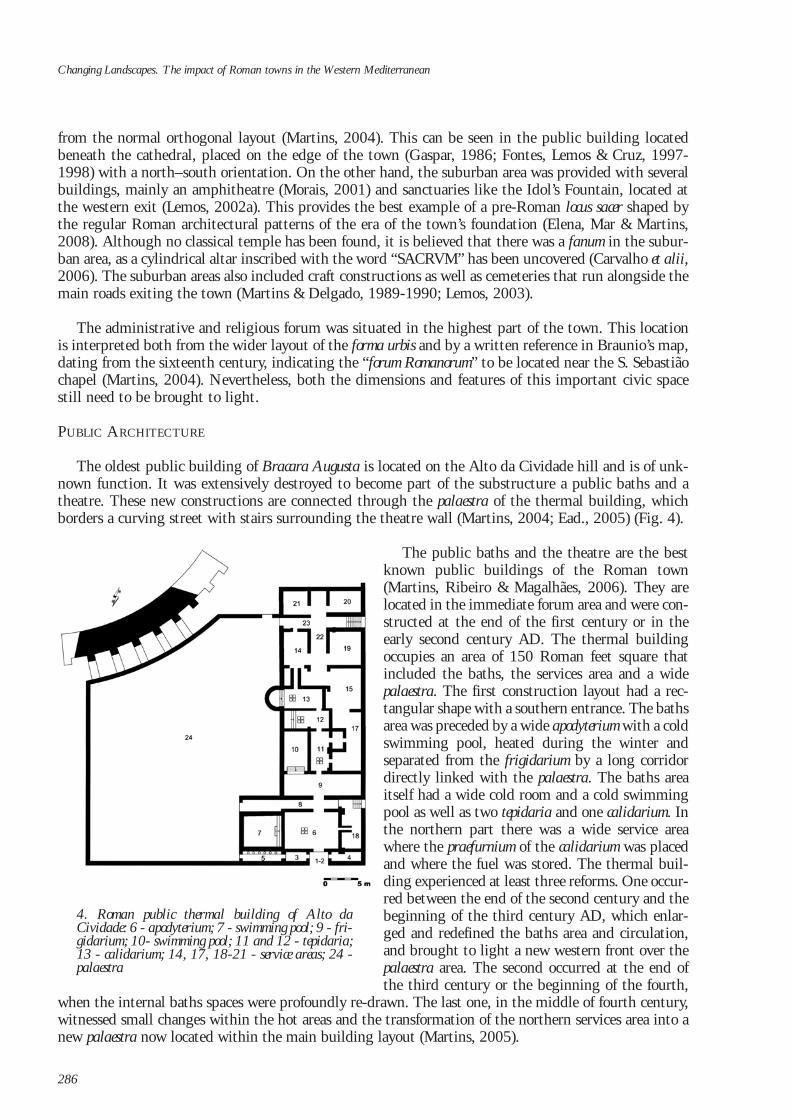
The oldest public building of Bracara Augusta is located on the Alto da Cividade hill and is of unk-nown function. It was extensively destroyed to become part of the substructure a public baths and atheatre. These new constructions are connected through the palaestra of the thermal building, whichborders a curving street with stairs surrounding the theatre wall (Martins, 2004; Ead., 2005) (Fig. 4).
The public baths and the theatre are the bestknown public buildings of the Roman town(Martins, Ribeiro & Magalhães, 2006). They arelocated in the immediate forum area and were con-structed at the end of the first century or in theearly second century AD. The thermal buildingoccupies an area of 150 Roman feet square thatincluded the baths, the services area and a widepalaestra. The first construction layout had a rec-tangular shape with a southern entrance. The bathsarea was preceded by a wide apodyterium with a coldswimming pool, heated during the winter andseparated from the frigidarium by a long corridordirectly linked with the palaestra. The baths areaitself had a wide cold room and a cold swimmingpool as well as two tepidaria and one calidarium. Inthe northern part there was a wide service areawhere the praefurnium of the calidarium was placedand where the fuel was stored. The thermal buil-ding experienced at least three reforms. One occur-red between the end of the second century and thebeginning of the third century AD, which enlar-ged and redefined the baths area and circulation,and brought to light a new western front over thepalaestra area. The second occurred at the end ofthe third century or the beginning of the fourth,
when the internal baths spaces were profoundly re-drawn. The last one, in the middle of fourth century,witnessed small changes within the hot areas and the transformation of the northern services area into anew palaestra now located within the main building layout (Martins, 2005).
Changing Landscapes. The impact of Roman towns in the Western Mediterranean
286
4. Roman public thermal building of Alto daCividade: 6 - apodyterium; 7 - swimming pool; 9 - fri-gidarium; 10- swimming pool; 11 and 12 - tepidaria;13 - calidarium; 14, 17, 18-21 - service areas; 24 -palaestra
The nearby theatre, still under study, is a building with a diameter of around 68.6 metres. Its wallis about 4 metres in width, which allows the assumption that the building had a porticus in summa caveaaround 3 metres (10 Roman feet) in width. The cavea was around 13.2 metres (44 Roman feet) high andwas partially settled on the hill slope. Only half of the ima cavea is excavated. A praecintio separated thelatter from the orchaestra where the presence of three large steps indicates the existence of a poedria.Between the orchaestra and the scaena body, an aditus 2.4 metres in width was found, which allowed élitespectators access to the orchaestra seats. The visible elements allow the assumption that the pulpitum hada height of around 1.4 metres (5 Roman feet), and a width of 6.7 metres (23 Roman feet) and was limi-ted by the scaenae frons structure and by the proscaenium wall with rectangular exedrae. The available datasuggests that the theatre was functional until the beginnings of the fourth century AD.
The construction of prestigious buildings in Bracara Augusta also includes an amphitheatre, whichis today completely buried and partially destroyed. Its existence is known through literary referencesfrom the seventeenth and eighteenth centuries that located the building within the parish of S. Pedrode Maximinos in the place of the old church. We know that up to middle of the nineteenth centurysome remains of the building were still visible, hence the exact location of the amphitheatre can be esti-mated from the analysis of aerial photographs. These reveal the existence of a wide buried structure onthe axis of S. Sebastião street, which runs alongside the western part of the Roman decumanus maximus(Morais, 2001).
Considering that the Flavian and Antonine periods seem to represent the height of the town’s aspi-rations, it is possible to suggest that both the amphitheatre and the theatre had the same chronology,being aesthetically linked and shaped by the topography. Both buildings provided the city with a pre-stigious architecture, giving the urban élite the opportunity to reinforce their personal power and revea-ling their fidelity to imperial policy. In fact, these otium buildings were key places for the ideologicalexpressions of Roman public life, as were the ludi gladiatorii and the ludi scaenici.
The end of the third century AD and the beginning of the fourth was a time of great construction,as most of the existing buildings underwent restructuring works, probably related to the promotion ofthe city to capital of the new province of Galaecia in the time of Diocletian (Tranoy, 1981). Nevertheless,the biggest investment of the period was the construction of a powerful fortification, in line with theHispanic legion style, also found in other western Roman provinces such as in Gallia, Germania andBritania. This allows the assumption that this equipment was the consequence of a wider political plandetermined by Rome for the defence of the Empire (Fernández Ochoa, 1999; Lemos et alii, 2003). Theconstruction of the wall completely changed the layout of the High Empire town. The wall was ellip-tical in form, leaving outside some buildings that nevertheless remained occupied. The city becomes aclosed place, accessed only through its gates, inside which the layout becomes rather compacted. Slowlysome of the streets disappeared, as well as the classical porticoes, and the spaces were completely inte-grated within the new constructions. At the beginning of the fourth century AD the first Paleo-Christian church was built, of which the remains were found under the cathedral. This religious buil-ding had a rectangular shape with three aisles (Fontes, Lemos & Cruz, 1997-1998) and a porticus on theeast side.
PRIVATE ARCHITECTURE
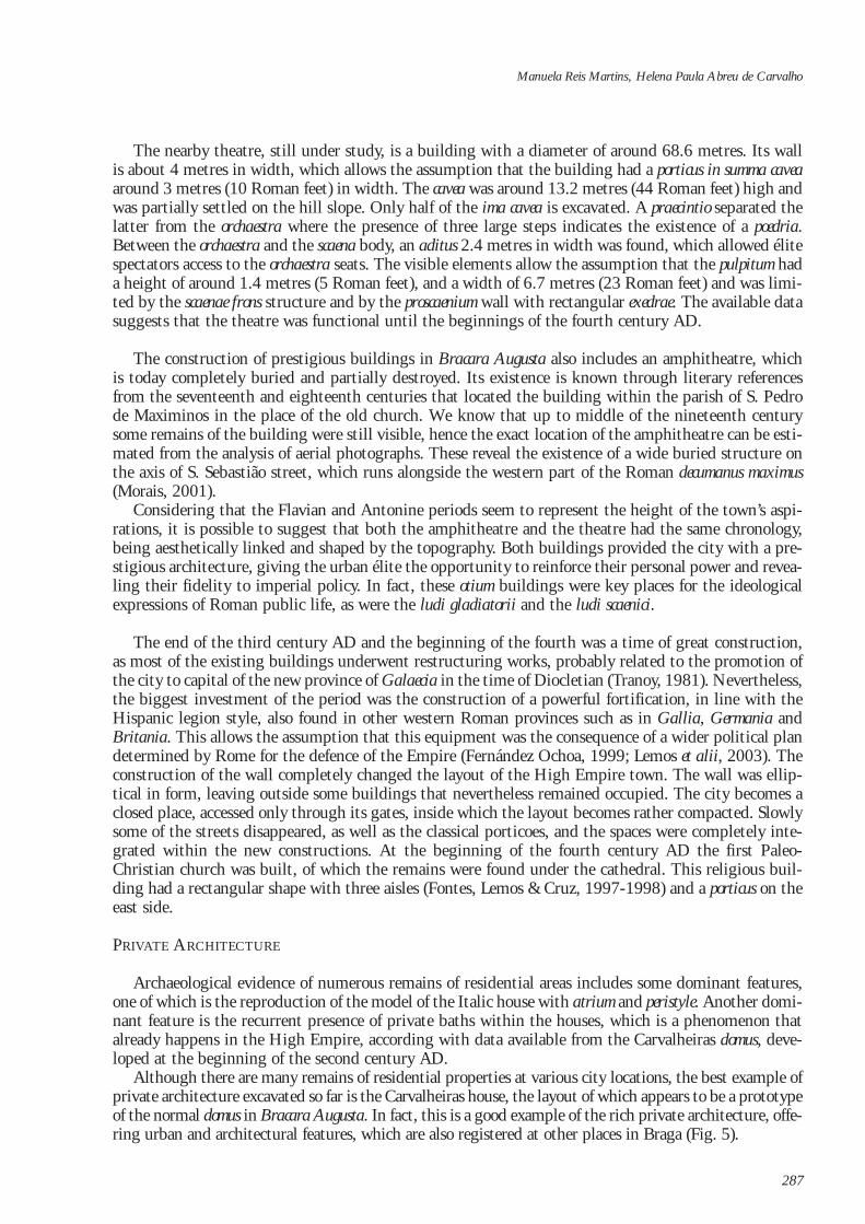
Archaeological evidence of numerous remains of residential areas includes some dominant features,one of which is the reproduction of the model of the Italic house with atrium and peristyle. Another domi-nant feature is the recurrent presence of private baths within the houses, which is a phenomenon thatalready happens in the High Empire, according with data available from the Carvalheiras domus, deve-loped at the beginning of the second century AD.
Although there are many remains of residential properties at various city locations, the best example ofprivate architecture excavated so far is the Carvalheiras house, the layout of which appears to be a prototypeof the normal domus in Bracara Augusta. In fact, this is a good example of the rich private architecture, offe-ring urban and architectural features, which are also registered at other places in Braga (Fig. 5).
Manuela Reis Martins, Helena Paula Abreu de Carvalho
287
The Carvalheiras domus is located relati-vely close to the forum area. It was built inthe Flavian period and underwent its firstreform in the first half of the second cen-tury AD with the construction of a bal-neum occupying a substantial part of theresidence. The initial architectonic projectdeveloped a wide residence occupying anarea of 1156 m2 (110 x 120 Roman feet).It is an elegant house with a square shapethat can be divided into two main func-tional but distinct areas marked by a diffe-rence of 3 m in height between thenorthern platform (lower) and thesouthern (higher). This discrepancy wasaddressed by the construction of an inte-rior wall that runs half the width house.Both platforms define different functionalspaces although they are linked by innerstaircases. The Carvalheiras house had twomain entrances: one to the south withdirect access to the atrium and surroun-ding rooms, mainly a tablinum and a oecus;the other on the northern side that led to
the peristyle and to other nearby rooms. Bordering Carvalheiras domus and running alongside the southernand western streets we find porticoes 10 Roman feet in width that provided access to the shops in thehouse façades.
The restructuring of the Carvalheiras domus in the first half of the second century AD shows theinstallation of a baths area in the northwestern part of the building with an area of around 190 m2 inclu-ding a group of cold and hot rooms. It was mainly a compact block of four spaces (apodyterium, frigida-rium, tepidarium and calidarium) which follows the normal circuit plan for baths. An important reformof the domus space took place at the end of the third century or the beginning of the fourth, when thenorthern sector was changed into a public space that included the balneum and some new tabernae. Thesouthern part of the house seems to have kept its private residential function. Further reforms of thespace occurred in the middle of the fourth century, and everything indicates that it was occupied throu-ghout the fifth and sixth centuries, although the exact features of the place during this period remainas yet unknown.
The pavements and the internal decoration of the houses depended on the taste and wealth of theirresidents, and several types of materials and finishing techniques were in use. Unfortunately the natureof the local soils does not help with the conservation of the classic opus tesselatum which are believed tohave decorated the corridors and the interior rooms as well as the swimming pools. We know, however,that this type of opus was widely used in the Bracara Augusta domus, as it has been identified mainly withinthe current historic city centre, where medieval and modern constructions overlie the Roman houses. Thesame is true of the mural paintings, remains of which have been found in several excavations.
ECONOMIC ACTIVITY AND INTERACTION WITH THE SURROUNDING AREA
Bracara Augusta can be placed on the same level as any other administrative capital of the Romanworld due to its orthogonal structure and prestigious public buildings, in particular the leisure spaceswhich are good representations of the Roman culture of otium and key features of public life and urbanprestige (Martins, 2004).
Changing Landscapes. The impact of Roman towns in the Western Mediterranean
288
5. The domus of Carvalheiras (Phase I): A - atrium; B - perystile
The city was equally an important commercial place, which is well attested by the epigraphy andwider archaeological finds. Its economic role was already well established in the Claudian period, whenthe Roman citizens in the city paid tribute to Caius Caetronius Miccio (Alföldy, 1966). At the sametime the town was a privileged market, epigraphically documented in an inscription dedicated to theGenius Macelli (Martins, 2004). However, it is mainly through archaeological finds that we can under-stand what goods were available in the city. Among them we know some food products transported inamphorae, as well as the pottery, glass and other luxury objects imported from other Roman provinces.The presence of these finds allows the reconstruction of certain trade routes that linked Bracara Augustato the wider Empire (Morais, 1998; Id., 2005; Id., 2007), mainly through the Atlantic sea route. Theamphorae reveal precious information about their chronology, production centers and distribution rou-tes, giving us relevant data about the eating habits and economy of the town (Morais, 1997-1998a; Id.,1998; Id., 2005). Through the routes of amphorae imports came also pottery, like the mortars made inItaly, and Baetica and fine wares produced both in Italy and in other provincial centers.
Sigillata is largely present in the town, being represented by Italic wares and south Gallia (LaGraufesenque) productions which were very successful in Bracara Augusta in the reigns of Claudius andNero. Nevertheless, the most represented type of sigillata was that produced in the Rioja region.Sigillata from Africa Proconsularis (Carthage, El Djem and Raqqada) is also present in the town (Morais,2006b), as well as ceramic products from Focida that appeared at the end of the fourth century AD, sur-viving to the middle of the eighth century AD. Pottery with the same chronology produced in Cyprushas a residual presence (Delgado, 1988). Glass products were also imported, showing the relationshipsof the town with different production centres in Renania, Italy, Cyprus and Alexandria (Cruz, 2001).The importation of pottery, glass and other fine products testifies that the town benefited from an orga-nized and active trade that unified the different producing centres of the Empire (Morais, 2004).
Bracara Augusta was also an important production centre with several workshops of the fabri invol-ved in different handicraft activities. The strategic position of the town as a regional market favored theestablishment of craftsmen, the diffusion of products and the acquisition of raw materials. Clay andwood were extracted in the town’s hinterland, while metals and glass could be acquired in ingot formto be worked in specialized workshops.
Archaeological data and laboratory analysis attest the importance of pottery production in BracaraAugusta, using clays from the Prado/Ucha region, which could also have been a production centre forclay building materials (Gomes, 2001; Morais, 2004; Id., 2005). Pottery workshops have a tendency tooccupy the suburban areas, but we know that some of them operated inside the town, due to the iden-tification of finds associated with pottery production (Morais, 2005). Beyond common wares used foreating, cooking, storage, carrying and washing, Bracara Augusta manufactured a special type of fine pot-tery, named “bracarense” (Leite, 1997), which imitated the shapes of Hispanic sigillata and those of“paredes finas” produced in the Emerita Augusta region. Other handicraft productions are present in thetown, namely those related to glass (Cruz, 2001), fine metals (Martins, 1988; Morais, 2005) and iron,as well as cloth manufacture.
As a privileged market, Bracara Augusta redistributed imported goods to its hinterland using theroad network (Lemos, 2002b) and the secondary markets established in the vici that supplied ruralpopulations. Bracara Augusta was a consumer centre but it was also the main place of redistribution ofimported goods from the different provinces of the Empire, mainly fine pottery, glasses, sumptuousobjects and currency.
The town’s hinterland was organized with villae and vici connected through the main and secondaryroad networks, which made possible both the diffusion of imported products and the supply of theurban centre with food and the necessary raw materials. In fact, Bracara Augusta was closely linked withits territory, which was under the direct influence of the town, contributing to the changing of previoussettlement patterns and the building of a new rural landscape.
Manuela Reis Martins, Helena Paula Abreu de Carvalho
289
BRACARA AUGUSTA AND THE RURAL LANDSCAPE
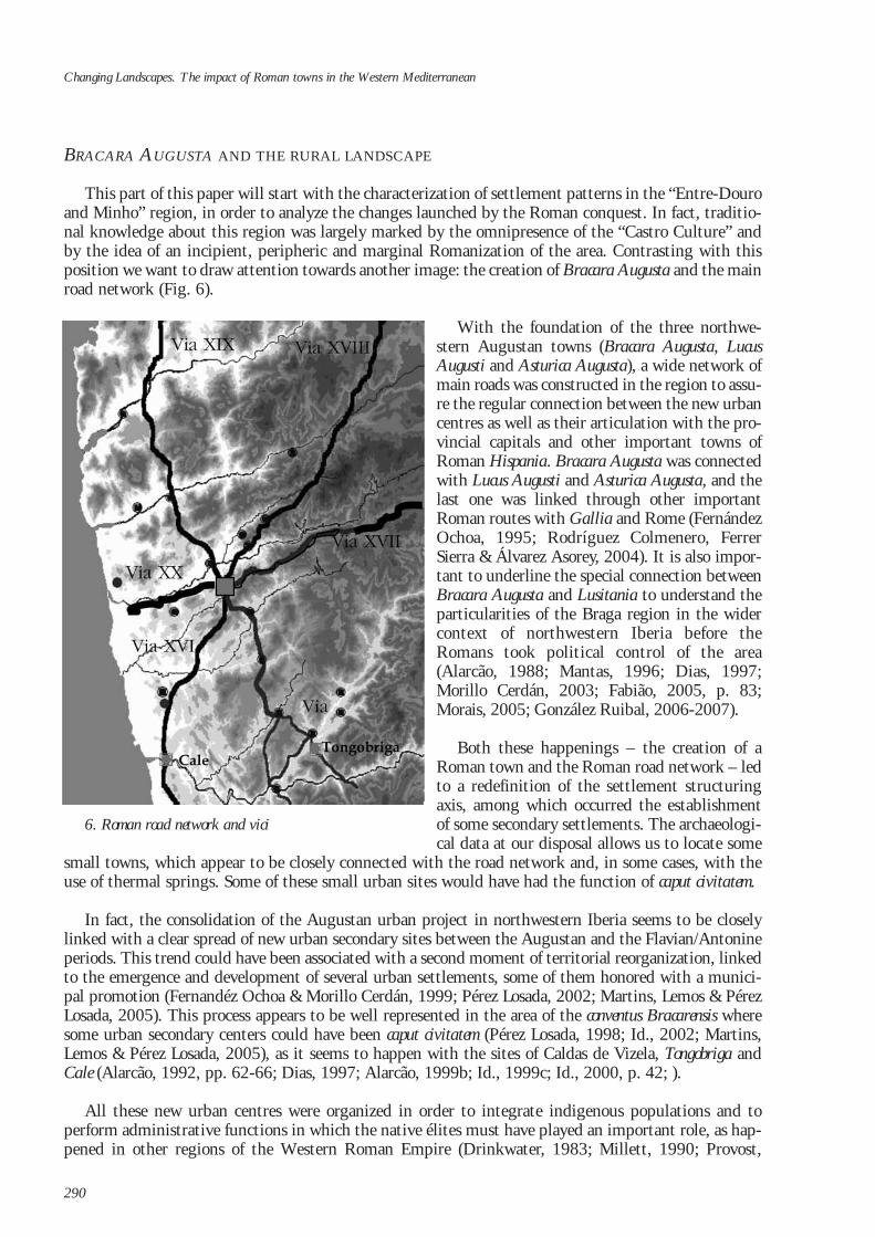
This part of this paper will start with the characterization of settlement patterns in the “Entre-Douroand Minho” region, in order to analyze the changes launched by the Roman conquest. In fact, traditio-nal knowledge about this region was largely marked by the omnipresence of the “Castro Culture” andby the idea of an incipient, peripheric and marginal Romanization of the area. Contrasting with thisposition we want to draw attention towards another image: the creation of Bracara Augusta and the mainroad network (Fig. 6).
With the foundation of the three northwe-stern Augustan towns (Bracara Augusta, LucusAugusti and Asturica Augusta), a wide network ofmain roads was constructed in the region to assu-re the regular connection between the new urbancentres as well as their articulation with the pro-vincial capitals and other important towns ofRoman Hispania. Bracara Augusta was connectedwith Lucus Augusti and Asturica Augusta, and thelast one was linked through other importantRoman routes with Gallia and Rome (FernándezOchoa, 1995; Rodríguez Colmenero, FerrerSierra & Álvarez Asorey, 2004). It is also impor-tant to underline the special connection betweenBracara Augusta and Lusitania to understand theparticularities of the Braga region in the widercontext of northwestern Iberia before theRomans took political control of the area(Alarcão, 1988; Mantas, 1996; Dias, 1997;Morillo Cerdán, 2003; Fabião, 2005, p. 83;Morais, 2005; González Ruibal, 2006-2007).
Both these happenings – the creation of aRoman town and the Roman road network – ledto a redefinition of the settlement structuringaxis, among which occurred the establishmentof some secondary settlements. The archaeologi-cal data at our disposal allows us to locate some
small towns, which appear to be closely connected with the road network and, in some cases, with theuse of thermal springs. Some of these small urban sites would have had the function of caput civitatem.
In fact, the consolidation of the Augustan urban project in northwestern Iberia seems to be closelylinked with a clear spread of new urban secondary sites between the Augustan and the Flavian/Antonineperiods. This trend could have been associated with a second moment of territorial reorganization, linkedto the emergence and development of several urban settlements, some of them honored with a munici-pal promotion (Fernandéz Ochoa & Morillo Cerdán, 1999; Pérez Losada, 2002; Martins, Lemos & PérezLosada, 2005). This process appears to be well represented in the area of the conventus Bracarensis wheresome urban secondary centers could have been caput civitatem (Pérez Losada, 1998; Id., 2002; Martins,Lemos & Pérez Losada, 2005), as it seems to happen with the sites of Caldas de Vizela, Tongobriga andCale (Alarcão, 1992, pp. 62-66; Dias, 1997; Alarcão, 1999b; Id., 1999c; Id., 2000, p. 42; ).
All these new urban centres were organized in order to integrate indigenous populations and toperform administrative functions in which the native élites must have played an important role, as hap-pened in other regions of the Western Roman Empire (Drinkwater, 1983; Millett, 1990; Provost,
Changing Landscapes. The impact of Roman towns in the Western Mediterranean
290
6. Roman road network and vici
1993). The archaeological identification of all the civitates and their territorial boundaries is not yet sol-ved by research. Nevertheless, the set of sites identified as vici shows its relevance within the Romansettlement network, as they created new central places that help us to understand the landscape reorga-nization in the region under analysis. Plural functionality seems to be the dominant characteristic ofthose secondary urban sites, with a high variability in extent and morphology (Pérez Losada, 1998; Id.,2002; Tarpin, 2002), which has also been recognized by the archaeological research in Gallia andBritannia (Pérez Losada, 2002).
Among the very considerable archaeological data indicating Roman sites or Roman traces, we wouldlike to emphasize the presence of the Roman villae. The attraction of Bracara Augusta itself is a veryimportant one. In addition, the Roman roads and the valleys were the most essential entities for theattraction of rural occupation linked with the introduction of Roman villae (Alarcão, 1998; Martins,1990; Ead., 1995). On the other hand, the survival of some Iron Age hill-forts which have a Romanoccupation seems to be connected with the control of the territory with its road network.
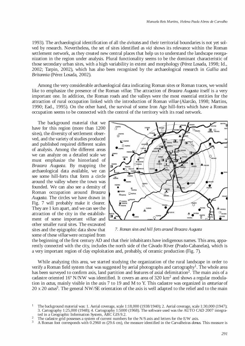
The background material that wehave for this region (more than 1200sites), the diversity of settlement obser-ved, and the variety of studies producedand published required different scalesof analysis. Among the different areaswe can analyze on a detailed scale wemust emphasize the hinterland ofBracara Augusta. By mapping thearchaeological data available, we cansee some hill-forts that form a circlearound the valley where the town wasfounded. We can also see a density ofRoman occupation around BracaraAugusta. The circles we have drawn inFig. 7 will probably make it clearer.They are 1 km apart, and we can see theattraction of the city in the establish-ment of some important villae andother smaller rural sites. The excavatedsites and the epigraphic data show thatsome of these villae were occupied fromthe beginning of the first century AD and that their inhabitants have indigenous names. This area, appa-rently connected with the city, includes the north side of the Cávado River (Prado-Cabanelas), which isa very important region of clay exploitation and, probably, of ceramic production (Fig. 7).
While analyzing this area, we started studying the organization of the rural landscape in order toverify a Roman field system that was suggested by aerial photographs and cartography1. The whole areahas been surveyed to confirm axis, land partition and features of axial delimitation2. The main axis of acadastre oriented 16º N/NW was identified. It covers an area of 320 km2 and shows a regular modula-tion in actus, mainly visible in the axis 7 to 19 and M to Y. This cadastre was organized in centuriae of20 x 20 actus3. The general NW/SE orientation of the axis is well adapted to the relief and to the main
Manuela Reis Martins, Helena Paula Abreu de Carvalho
1 The background material was: 1. Aerial coverage, scale 1:18,000 (1938/1940); 2. Aerial coverage, scale 1:30,000 (1947);3. Cartography 1:25,000 (1948); 4. Cartography 1:5000 (1968). The software used was the AUTO CAD 2007 integra-ted in a Geographic Information System, ARC GIS 9.2.
2 The cadastre grid possesses a system of current numbers for the N/S axis and letters for the E/W axis. 3 A Roman foot corresponds with 0.2960 m (29.6 cm), the measure identified in the Carvalheiras domus. This measure is
291
7. Roman sites and hill forts around Bracara Augusta
hydrographic network of the region. The orientation of the axis, the modulation in actus and its articu-lation with the town planning and with the road network suggest the Roman origin of this cadastre,which is also confirmed by the survey of the region.
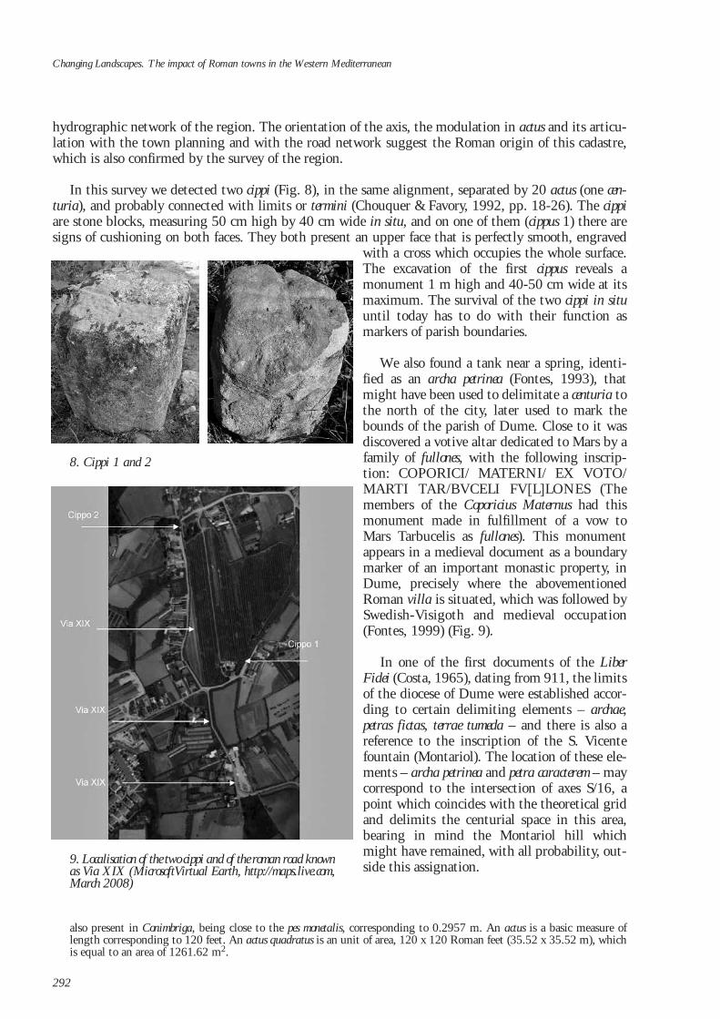
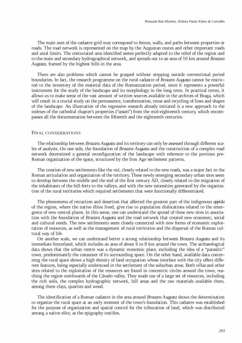
In this survey we detected two cippi (Fig. 8), in the same alignment, separated by 20 actus (one cen-turia), and probably connected with limits or termini (Chouquer & Favory, 1992, pp. 18-26). The cippiare stone blocks, measuring 50 cm high by 40 cm wide in situ, and on one of them (cippus 1) there aresigns of cushioning on both faces. They both present an upper face that is perfectly smooth, engraved
with a cross which occupies the whole surface.The excavation of the first cippus reveals amonument 1 m high and 40-50 cm wide at itsmaximum. The survival of the two cippi in situuntil today has to do with their function asmarkers of parish boundaries.
We also found a tank near a spring, identi-fied as an archa petrinea (Fontes, 1993), thatmight have been used to delimitate a centuria tothe north of the city, later used to mark thebounds of the parish of Dume. Close to it wasdiscovered a votive altar dedicated to Mars by afamily of fullones, with the following inscrip-tion: COPORICI/ MATERNI/ EX VOTO/MARTI TAR/BVCELI FV[L]LONES (Themembers of the Coporicius Maternus had thismonument made in fulfillment of a vow toMars Tarbucelis as fullones). This monumentappears in a medieval document as a boundarymarker of an important monastic property, inDume, precisely where the abovementionedRoman villa is situated, which was followed bySwedish-Visigoth and medieval occupation(Fontes, 1999) (Fig. 9).
In one of the first documents of the LiberFidei (Costa, 1965), dating from 911, the limitsof the diocese of Dume were established accor-ding to certain delimiting elements – archae,petras fictas, terrae tumeda – and there is also areference to the inscription of the S. Vicentefountain (Montariol). The location of these ele-ments – archa petrinea and petra caracterem – maycorrespond to the intersection of axes S/16, apoint which coincides with the theoretical gridand delimits the centurial space in this area,bearing in mind the Montariol hill whichmight have remained, with all probability, out-side this assignation.
Changing Landscapes. The impact of Roman towns in the Western Mediterranean
292
8. Cippi 1 and 2
9. Localisation of the two cippi and of the roman road knownas Via XIX (MicrosoftVirtual Earth, http://maps.live.com,March 2008)
also present in Conimbriga, being close to the pes monetalis, corresponding to 0.2957 m. An actus is a basic measure oflength corresponding to 120 feet. An actus quadratus is an unit of area, 120 x 120 Roman feet (35.52 x 35.52 m), whichis equal to an area of 1261.62 m2.
The main axes of the cadastre grid may correspond to fences, walls, and paths between properties orroads. The road network is represented on the map by the Augustan routes and other important roadsand axial limits. The centuriated area identified seems perfectly adapted to the relief of the region andto the main and secondary hydrographical network, and spreads out to an area of 10 km around BracaraAugusta, framed by the highest hills in the area.
There are also problems which cannot be grasped without stepping outside conventional periodboundaries. In fact, the research programme on the rural cadastre of Bracara Augusta cannot be restric-ted to the inventory of the material data of the Romanization period, since it represents a powerfulinstrument for the study of the landscape and its morphology in the long term. In practical terms, itallows us to make sense of the vast amount of written sources available in the archives of Braga, whichwill result in a crucial study on the permanence, transformation, reuse and recycling of lines and shapesof the landscape. An illustration of the regressive research already initiated is a new approach to theindexes of the cathedral chapter’s properties (“casais”) from the mid-eighteenth century, which encom-passes all the documentation between the fifteenth and the eighteenth centuries.
FINAL CONSIDERATIONS
The relationship between Bracara Augusta and its territory can only be assessed through different sca-les of analysis. On one side, the foundation of Bracara Augusta and the construction of a complex roadnetwork determined a general reconfiguration of the landscape with reference to the previous pre-Roman organization of the space, structured by the Iron Age settlement patterns.
The creation of new settlements like the vici, closely related to the new roads, was a major fact in theRoman articulation and organization of the territory. These newly emerging secondary urban sites seemto develop between the middle and the end of the first century AD, closely related to the migration ofthe inhabitants of the hill-forts to the valleys, and with the new necessities generated by the organiza-tion of the rural territories which required settlements that were functionally differentiated.
The phenomena of retraction and desertion that affected the greatest part of the indigenous oppidaof the region, where the native élites lived, give rise to population dislocations related to the emer-gence of new central places. In this sense, one can understand the spread of these new sites in associa-tion with the foundation of Bracara Augusta and the road network that created new economic, socialand cultural needs. The new settlements seem closely connected with new forms of economic exploi-tation of resources, as well as the management of rural territories and the dispersal of the Roman cul-tural way of life.
On another scale, we can understand better a strong relationship between Bracara Augusta and itsimmediate hinterland, which includes an area of about 6 to 8 km around the town. The archaeologicaldata shows that the urban centre was a dynamic economic place, excluding the idea of a “parasitic”town, predominantly the consumer of its surrounding space. On the other hand, available data concer-ning the rural space shows a high density of land occupation whose interface with the city offers diffe-rent features, being especially understood in the settlement of the suburban areas. Both villae and othersites related to the exploitation of the resources are found in concentric circles around the town, rea-ching the region northwards of the Cávado valley. They made use of a large set of resources, includingthe rich soils, the complex hydrographic network, hill areas and the raw materials available there,among them clays, quarries and wood.
The identification of a Roman cadastre in the area around Bracara Augusta shows the determinationto organize the rural space at an early moment of the town’s foundation. This cadastre was establishedfor the purpose of organization and spatial control for the tributation of land, which was distributedamong a native elite, as the epigraphy testifies.
Manuela Reis Martins, Helena Paula Abreu de Carvalho
293
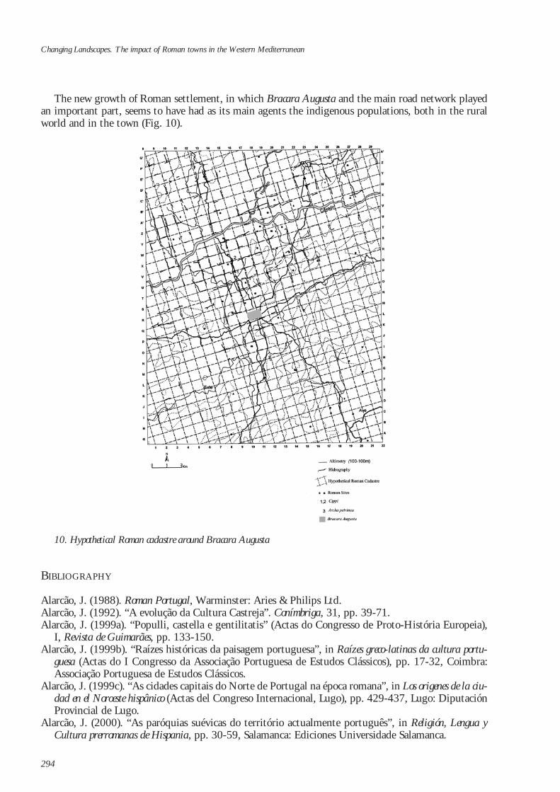
The new growth of Roman settlement, in which Bracara Augusta and the main road network playedan important part, seems to have had as its main agents the indigenous populations, both in the ruralworld and in the town (Fig. 10).
BIBLIOGRAPHY
Alarcão, J. (1988). Roman Portugal, Warminster: Aries & Philips Ltd.Alarcão, J. (1992). “A evolução da Cultura Castreja”. Conímbriga, 31, pp. 39-71.Alarcão, J. (1999a). “Populli, castella e gentilitatis” (Actas do Congresso de Proto-História Europeia),
I, Revista de Guimarães, pp. 133-150.Alarcão, J. (1999b). “Raízes históricas da paisagem portuguesa”, in Raízes greco-latinas da cultura portu-
guesa (Actas do I Congresso da Associação Portuguesa de Estudos Clássicos), pp. 17-32, Coimbra:Associação Portuguesa de Estudos Clássicos.
Alarcão, J. (1999c). “As cidades capitais do Norte de Portugal na época romana”, in Los origenes de la ciu-dad en el Noroeste hispânico (Actas del Congreso Internacional, Lugo), pp. 429-437, Lugo: DiputaciónProvincial de Lugo.
Alarcão, J. (2000). “As paróquias suévicas do território actualmente português”, in Religión, Lengua yCultura prerromanas de Hispania, pp. 30-59, Salamanca: Ediciones Universidade Salamanca.
Changing Landscapes. The impact of Roman towns in the Western Mediterranean
294
10. Hypothetical Roman cadastre around Bracara Augusta
Alarcão, J. (2003). “A organização social dos povos do Noroeste e norte da Península”. Conímbriga, 42,pp. 5-115.
Alföldy, G. (1966). “Um ‘cursus’ senatorial de Bracara Augusta”. Revista de Guimarães, 76, 1-2, pp. 363-372.
Almeida, C.A.B. (2003). Povoamento romano do litoral minhoto entre Cávado e Minho, Dissertação deDoutoramento em Pré-História e Arqueologia, Edição do Autor.
Carvalho, H. (1998) “Pedestal ao Génio encontrado em Vilela, Amares (Conventus Bracaraugustanus)”.Ficheiro Epigráfico, 57, n. 262.
Carvalho, H. (2000). “Parcelamento rural de Bracara Augusta: questões metodológicas”, in Actas do IIICongresso Peninsular de Arqueologia. VI. Arqueologia da Antiguidade na Península Ibérica, pp. 143-146,Porto: Adecap.
Carvalho, H. (2008). “Organisation cadastrale autour de Bracara Augusta, Braga (Portugal)”. Dialoguesd’Histoire Ancienne, 34/1, pp. 155-160.
Carvalho, H., de Encarnação, J., Martins, M. & Cunha, A. (2006). “Altar romano encontrado em Braga”.Forum, 40, pp. 31-42.
Centeno, R. (1987). Circulação monetária no Noroeste de Hispânia até 192, Porto: Sociedade Portuguesa deNumismática.
Chouquer, G. & Favory, F. (1992). Les arpenteurs romains. Théorie et pratique, Paris: Errance.Chouquer, G. (2000). L’étude des paysages. Essais sur leurs formes et leur histoire, Paris: ErranceClavel-Levêque, M. (Éd.) (1983). Cadastres et espaces rurales. Approches et réalités antiques (Actes de la table
ronde de Besançon, mai 1980), Paris: CNRS.Clavel-Levêque, M. (1992). “Centuriation, géométrie et harmonie. Le cas du Biterrois”, in J.Y.
Guillaumin (Éd.), Mathématiques dans l`Antiquité, pp. 161-184, Saint-Étienne: Publ. Univ. de Saint-Étienne.
Clavel-Levêque, M., Jouffroy, I. & Vignot, A. (1994). De la terre au ciel. Paysages et cadastres antiques,Besançon: Annales Littéraires.
Clavel-Levêque, M. & Vignot, A. (1998). Atlas historique des cadastres d`Europe, Luxembourg: OPOCE.Costa, A.J. (1965-1990). Liber Fidei Sanctae Bracarensis Ecclesiae, Braga: Junta Distrital de Braga.Cruz, M. (2001). Vidros romanos de Bracara August, Dissertação de Mestrado, Braga, Universidade do
Minho: policopiada.Delgado, M. (1988). “Contribuição para o estudo das cerâmicas romanas tardias do Médio Oriente
encontradas em Portugal”. Cadernos de Arqueologia, II s., 5, pp. 35-49.Delgado, M. (1993-1994). “Notícia sobre cerâmicas de engobe vermelho não vitrificável encontradas em
Braga”. Cadernos de Arqueologia, II s., 10-11, pp. 113-149.Dias, L.A. (1997). Tongobriga, Lisboa: Instituto Português do Património ArquitectónicoDrinkwater, J.F. (1983). Roman Gaul. The Three Provinces, 58 BC- 260 AD, London: Council for British
Archaeology. Elena, G.A., Mar, R. & Martins, M. (2008). A Fonte do Ídolo: análise, interpretação e reconstituição do san-
tuário, Bracara Augusta. Escavações Arqueológicas, 4, Braga: UAUM/NARQ.Encarnação, J. De (1985). “O culto ao Génio no Noroeste Peninsular”. Cadernos de Arqueologia, II s., 2,
pp. 41-49.Fabião, C. (2005). “Caminhos do Atlântico Romano: evidências e perplexidades”, in C. Fernández
Ochoa & García Díaz, P. (Eds.), III Coloquio Internacional de Arqueología en Gijón, Unidad y diversidaden el Arco Atlântico en época romana, pp. 83-86, BAR International Series, 1371, Gijon: Archaeopress.
Favory, F., Chouquer, G. & Clavel-Levêque, M. (1982). “Cadastres, occupation du sol et paysages agrai-res antiques”. Annales. Économies, Societés, Civilisations, 37 (5), pp. 847-882.
Favory, F. & Van der Leeuw, S. (1998). “Archaeomedes, la dynamique spatio-temporelle de l’habitatantique dans la vallée du Rhône: bilan et perspectives”. Revue Archéologique de Narbonnaise, 31, pp.257-298.
Fernández Ochoa, C. (1995). “Astures y Roma: la configuración del territorio”, in Astures. Pueblos y cul-turas en la frontera del Imperio Roman, pp. 99-111, Gijón: Associacíon Astures.
Fernández Ochoa, C. & Morillo Cerdán, A. (1999). La tierra de los astures. Nuevas perspectivas sobre laimplantación romana en la antigua Asturia, Gijón: Ed. Trea, S.L.
Manuela Reis Martins, Helena Paula Abreu de Carvalho
295
Fontes, L.F.O. (1990). “Escavações arqueológicas na antiga igreja de Dume”, in Actas do CongressoInternacional sobre o IX centenário da dedicação da Sé de Braga, I, pp. 147-169, Braga: UniversidadeCatólica Portuguesa, Faculdade de Teologia.
Fontes, L.F.O. (1991-1992). “Salvamento Arqueológico de Dume (Braga). Resultados das Campanhasde 1989-1990 e 1991-1992”. Cadernos de Arqueologia, II s., 8-9, pp. 199-230.
Fontes, L.F.O. (1992). “O Norte de Portugal no Período Suevo-Visigótico. Elementos para o seu estu-do”, in Actas XXXIX. Corso di Cultura sull’Arte Ravennate e Bizantina (Ravenna, 6-12 Aprile 1992),pp. 217-248.
Fontes, L.F.O. (1993). “Inventário de Sítios Arqueológicos de Concelho de Braga”. Mínia, III s., 1.1, pp.31-88.
Fontes, L.F.O. (2005). São Martinho de Tibães: um sítio onde se fez um mosteiro. Ensaio em arqueologia da pai-sagem e da arquitectura, Lisboa: IPPAR.
Fontes, L.F.O. (2006). A Basílica Sueva de Dume e o Túmulo dito de São Martinho, Braga: NARQ.Fontes, L.F.O. (2009). “O Período Suévico e Visigótico e o Papel da Igreja na Organização do Território”,
in P. Pereira (Ed.), Minho. Traços de Identidade, pp. 272-295, Braga: Conselho Cultural daUniversidade do Minho.
Fontes, L.F., Lemos, F.S. & Cruz, M. (1997-1998). “Mais Velho que a Sé de Braga. Intervenção arqueoló-gica na catedral bracarense: noticia preliminar”. Cadernos de Arqueologia, II s., 14/15, pp. 137-164.
Gaspar, A. (1986). “Escavações arqueológicas na Rua de N. Sra. do Leite, em Braga”. Cadernos deArqueologia, II s., 2, pp. 51-125.
Gaspar, A. (2000). Contribuição para o estudo das cerâmicas cinzentas dos séculos V-VI d.C. de Braga,Dissertação de Mestrado, Braga, Universidade do Minho: policopiada.
Gomes, A.M.M. (2000). Cerâmicas pintadas de época romana: tecnologia, morfologia e cronologia, Dissertaçãode Mestrado, Braga, Universidade do Minho: policopiada.
González Ruibal, A. (2006-2007). “Arqueología del Primer Milenio en el Noroeste de la PenínsulaIbérica”, Brigantium, 18-19, I-II.
Le Roux, P. (1975). “Aux Origines de Braga (Bracara Augusta)”. Bracara Augusta, pp. 155-157. Leite, F.S. (1997). Contribuição para a localização do centro de produção da cerâmica “dita” Bracarense,
Dissertação de Mestrado, policopiada, Braga, Universidade do Minho.Lemos, F.S. (1993). Povoamento romano de Trás-os-Montes Oriental, Dissertação de Doutoramento polico-
piada, Braga, Universidade do Minho. Lemos, F.S. (1999). “O contexto geográfico da fundação de Bracara Augusta”. Forum, 25, pp. 81-94.Lemos, F.S. (2002a). “A Fonte do Ídolo – História do Monumento e Contexto Arqueológico”. Mínia, III
s., 10, pp. 5-26.Lemos, F.S. (2002b). “Bracara Augusta – A Grande Plataforma viária do Noroeste Peninsular”. Forum,
31, pp. 95-127.Lemos, F.S. (2003). “Bracara Augusta – periferia imediata”. Forum, 33, pp. 11-25.Lemos, F.S. (2004). “O poder romano e a reorganização territorial do Noroeste Peninsular: observações
pontuais”, in O passado em cena: narrativas e fragmentos. Miscelânea ofericida a Joge de Alarcão, pp. 225-246, Coimbra-Porto: FCT-CEAUCP.
Lemos, F.S. & Baptista, A. (1995-1996). “Estudo de um troço da via XVIII”. Cadernos de Arqueologia, IIs., 12-13, pp. 113-133.
Lemos, F.S., Leite, J.M.F., Bettencourt, A.M.S. & Azevedo, M. (2003). “O balneário pré-romano deBraga”. Al madan, 12, pp. 43-46.
Mantas, V.G. (1996). A rede viária da Faixa Atlântica entre Lisboa e Braga, Dissertação de Doutoramentopolicopiado, Coimbra, Faculdade de Letras da Universidade de Coimbra.
Martins, M. (1988). “Moldes de sítulas com decoração geométrica”. Cadernos de Arqueologia, II s., 5, pp.23-29, Braga.
Martins, M. (1990). “O povoamento proto-histórico e a romanização da bacia do curso médio do Cávado”.Cadernos de Arqueologia, Monografias 5, Braga: Unidade de Arqueologia da Universidade do Minho.
Martins, M. (1995). “A ocupação romana da região de Braga: balanço e perspectivas de investigação”, inActas do Congresso Histórico Comemorativo dos 150 anos do Nascimento de Alberto Sampaio, pp. 73-114,Guimarães: Câmara Municipal de Guimarães.
Changing Landscapes. The impact of Roman towns in the Western Mediterranean
296
Martins, M. (1996). “A cidade como elemento romanizador: o exemplo de Bracara Augusta”, in S.Reboreda Morillo & P. López Barja (Eds), A Cidade e o Mundo: Romanización e Cambio Social, pp. 181-201, Xinzo de Limia: Concello de Xinzo de Limia.
Martins, M. (2000). Bracara Augusta cidade romana, Braga: Unidade de Arqueologia da Universidade doMinho.
Martins, M. (2004). “Urbanismo e Arquitectura em Bracara Augusta. Balanço dos contributos daArqueologia Urbana”, in Simulacra Romae. Roma y las Capitales Provinciales del Occidente Europeo.Estudios Arqueológicos, pp.149-173, Tarragona: Edicions El Médol.
Martins, M. (2005). “As termas romanas do Alto da Cividade. Um exemplo de arquitectura pública emBracara Augusta”, in M. Martins (Ed.), Bracara Augusta, Escavações Arqueológicas, 1, Braga:UAUM/NARQ.
Martins, M. (2006). “Bracara Augusta: a Roman town in Atlantic area”, in L. Abal Casal, S. Keay & S.Ramallo Asensio (Eds.), Early Roman Towns in Hispania Tarraconensis, pp. 213-222, Journal of RomanArchaeology, Supplementary Series, 62, Portsmouth, Rhode Island.
Martins, M. (2009). “A romanização”, in Pereira, P. (Ed.), Minho. Traços de Identidade, pp. 216-269,Braga: Universidade do Minho.
Martins, M. & Delgado, M. (1989-1990a). “História e Arqueologia de uma cidade em devir: BracaraAugusta”. Cadernos de Arqueologia, II s., 6-7, pp. 11-38.
Martins, M. & Delgado, M. (1989-1990b). “As necrópoles de Bracara Augusta. Os dados arqueológicos”.Cadernos de Arqueologia, II s., 6-7, pp. 41-186.
Martins, M., Lemos, F.S. & Pérez Losada, F. (2005). “O povoamento romano no território dos galaicosbracarenses”, in Actas do Colóquio Internacional Unidad y Diversidad en el Arco Atlantico, BARInternational Series, 1371, pp. 279-296, Gijón: Archaeopress.
Martins, M., Ribeiro, R. & Magalhães, F. (2006). “A arqueologia em Braga e a descoberta do teatroromano de Bracara Augusta”. Forum, 40, pp. 9-30.
Morais, R. (1997-1998a). “Importações de cerâmicas finas em Bracara Augusta: da fundação até à épocaflávia”. Cadernos de Arqueologia, II s., 14-15, pp. 47-136.
Morais, R. (1997-1998b). “Sobre a hegemonia do vinho e a escassez do azeite no noroeste peninsular nosinícios da romanização”. Cadernos de Arqueologia, II s., 14-15, pp. 175-182.
Morais, R. (1998). “As ânforas da zona das Carvalheiras. Contribuição para o estudo das ânforas roma-nas de Bracara Augusta”. Cadernos de Arqueologia, Monografias, 8, Braga: UAUM.
Morais, R. (2001). “Breve ensaio sobre o anfiteatro de Bracara Augusta”. Forum, 30, pp. 55-76.Morais, R. (2004). “O comércio e a rede de transportes de Bracara Augusta no contexto do NW
Peninsular (Elementos para o seu estudo)”, in Ier Simposi Patrimoni i Turisme Cultural. Arqueologia vivade les ciutats de l’Antiguitat, pp. 41-76, Guissona: Institut d’Estudis Catalanes i Patronatd’Arqueología de Guissona.
Morais, R. (2005). “Autarcia e Comércio em Bracara Augusta. Contributo para o estudo económico da cida-de no período Alto-Imperial”, in Bracara Augusta, Escavações Arqueológicas, 2, Braga: UAUM/NARQ.
Morais, R. (2006a). “Consumo de preparados piscícolas em Bracara Augusta durante a época romana”,in Simpósio Internacional Produção e Comércio de Preparados Piscícolas durante a Proto-História e a épocaRomana no Ocidente da Península Ibérica, Homenagem a Françoise Mayet (Setúbal, 7-9 Maio 2004),Setúbal Arqueológica, 13, pp. 295-312, Setúbal.
Morais, R. (2006b). “A Época Romana”, in I. Silva & C. Mineiro (Eds.), Museu D. Diogo de Sousa-Roteiro,Lisboa: IPM.
Morais, R. (2007). “A via atlântica e o contributo de Gádir nas campanhas romanas na fachada Noroesteda Península”. Humanitas, 59, pp. 99-132.
Morais, R. & Pinto, I.V. (2006). “Complemento de comércio das ânforas: cerâmica comum bética no territó-rio português”, in Congresso Internacional CETARIAE 2005. Salsas y Salazones de pescado en occidente durantela Antiguedad (Cádiz, 7-9 Noviembre de 2005), pp. 235-253, BAR International Series, 30, Oxford.
Millett, M. (1990). The Romanization of Britain. An essay in archaeological interpretation, Cambridge:Cambridge University Press.
Naveiro López, J. (1986) “El comercio marítimo en el N.O. durante época romana, a través de las ánfo-ras”. Revista de Arqueología, 57, pp. 40-45.
Manuela Reis Martins, Helena Paula Abreu de Carvalho
297
Naveiro López, J. (1991). El comercio antiguo en el NW Peninsular, A Coruña: Museu Arqueolóxico.Pereira Menault, G. (1983). “Los castella y las comunidades de Gallaecia”. II Seminario de Arqueologia del
Noroeste, pp. 169-192, Madrid: Zugarto Ediciones, S.A.Pérez Losada, F. (1998). “Cidades e aldeias na Galiza romana. Uma proposta de classificação hierárqui-
ca do habitat galaico-romano”. O Arqueólogo Português, IV s., 16, pp. 157-174. Pérez Losada, F. (2002). “Entre a cidade e a aldea. Estudio arqueohistórico dos ‘aglomerados secundá-
rios’ romanos en Galicia”, in Brigantium, 13.Provost, M. (1993). “Le val de Loire dans l’Antiquité”, in Gallia, suppl. 52, Paris. Rodríguez Colmenero, A. (1996). “Integración administrativa del Noroeste peninsular en las estructu-
ras romanas”, in A. Rodríguez Colmenero (Ed.), Lucus Augusti I. El amanecer de una ciudad, pp. 265-299, A Coruña.
Rodríguez Colmenero, A. & Covadonga Carreño, M. (1999). “Lucus Augusti. Capital romana del fini-sterre hispânico”, in Actas da Mesa Redonda, Emergência e Desenvolvimento das cidades romanas no norte daPenínsula Ibérica, pp.115-132, Porto: Escola Profissional de Arqueologia/IPAR.
Rodríguez Colmenero, A., Ferrer Sierra, S. & Álvarez Asorey, R.D. (2004). Miliarios e outras inscriciónsviarias romanas do Noroeste Hispânico (Conventos Bracarense, Lucense e Asturicense), Calaeciae et AsturiaeItinera Romana, Santiago de Compostela: Consello de Cultura Galega.
Sastre Prats, I. (2001). Las formaciones sociales rurales de la Asturia romana, Madrid: Ediciones Clásicas.Sastre Prats, I. (2004). “La epigrafia de Las Médulas. Escritura y sociedad”, in Cuadernos de la Fundación
las Médulas, 4, Las Médulas: Instituto de Historia, CSIC.Sevillano Fuertes, A. & Vidal Encinas, J.M. (2002). Urbs Magnífica. Una aproximación a la Arqueología de
Asturica Augusta (Astorga, León), Museo Romano (Guía-Catálogo), Astorga: Ayuntamiento de Astorga.Silva da, A.C.F. (1986). A cultura Castreja no Noroeste de Portugal, Paços de Ferreira: Museu arqueológico
da Citânia de Sanfins.Silva da, A. C. F. (1995). “A evolução do habitat castrejo e o processo de proto-urbanização no noroeste
de Portugal durante o I milénio a.C.”. Revista da Faculdade de Letras, II s., 12, pp. 505-546.Silva da, A.C.F. (1999). “A ocupação do território do Noroeste Peninsular aquando da chegada dos roma-
nos”, in Emergência e Desenvolvimento das cidades romanas no Norte da Península Ibérica (Actas da MesaRedonda), pp. 39-52, Porto: Escola Profissional de Arqueologia/IPPAR.
Tarpin, M. (2002). “Vici et pagi dans l’occident roman”, Collection de l’École française de Rome, 299,Rome.
Tranoy, A. (1980). “Religion et Societé à Bracara Augusta (Braga), au Haut Empire romain”, in ISeminário de Arqueologia do NO Peninsular, 3, pp. 67-83, Guimarães: S.M.S.
Tranoy, A. (1981). La Galice romaine. Recherches sur le Nord Ouest de la Péninsule Ibérique dans l’Antiquité,Paris: Diffusion du Boccard.
Tranoy, A. (1989-1990). “As necrópoles romanas de Bracara Augusta – Les inscriptions funéraires”.Cadernos de Arqueologia, II s., 6-7, pp. 183-230.
Zabaleta Estévez, M. del Mar (1999). “Breve síntese sobre o estudo das moedas de Bracara Augusta”.Forum, 26, pp. 80-85.
Zabaleta Estévez, M. del Mar (2000). “Hallazgos Numismáticos de los comienzos de Bracara Augusta”,in Actas do III Congresso de Arqueologia Peninsular, VI, pp. 395-399, Porto: Adecap.
Changing Landscapes. The impact of Roman towns in the Western Mediterranean
298


![[Augusta, GA] Daily Constitutionalist, September](https://img.dokumen.tips/doc/110x75/6332df3eb0ddec4616074f2c/augusta-ga-daily-constitutionalist-september.jpg)


