Embed Size (px)
Citation preview
I,
....... -. <'
. ..,,' ;·'.;
',__,'
e.· .. ··.· .. ·~ ~ '
·(),'
---"\(
/}'
· . ..,'
"'--:_:
--'";
·'
,., '
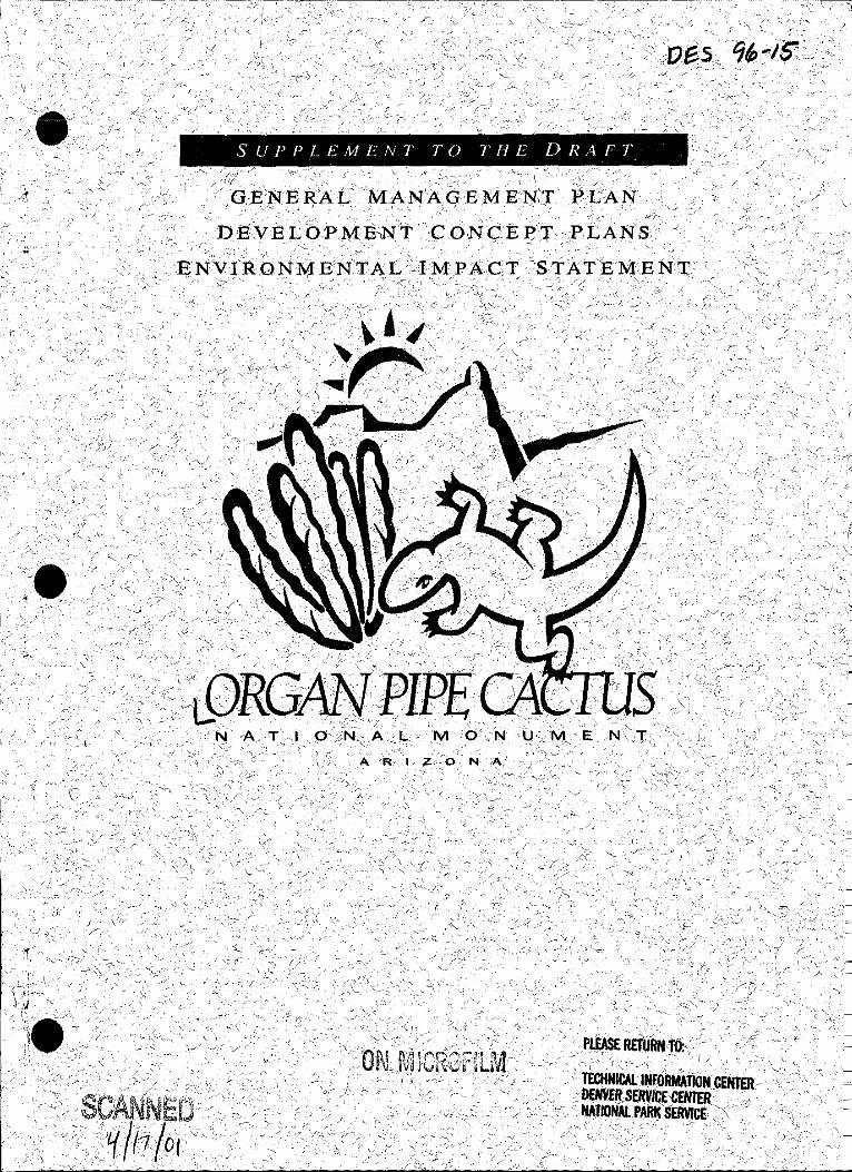
SUPPLEMENT TO THE DRAFT
I '" / --, .' ,/
"' · GrE,NE·····:RAC:.M.ANAGE.ME.N~'T
- ' i ·~· \_,-
. "-'' (
_;.,/
),
''-~;<:~-":'.·'
', .,, ,,_. ,)::- /
::J
·'<,,! ' .. ~L()RG~,·~PIPE~, . , '.N ·A. T .I 0 ;.;N. A<L ]VI d •.. N U·.,'1\1 E
;,/
J I.~
-"< C'"
'-~ ('
'- • ·!
~- ,_
)'
N .:A,,'' •· -,,,;
c~ ."
Of\LM !G~GfJtfyt ;~ ~ •;'
J
i c•
,/,-
':~
P~E RETuRNtO: ; '("cl'- ' -.:.~--- . , , -_, .,_ ' ' '
• TECHNICALINFOilMATION CENTER ~NVEft.SERVICECEN1ER . ,..
1 ljAJIONALPARK SERVICE .'\
-!:_,.'
-·-, c· ., ''i'
\ ~) 0
•
United States Department of the Interior
NATIONAL PARK SERVICE Organ Pipe Cactus National Monument
Route I, Box 100 Ajo, Arizona 85321
PLEASE NOTE THE FOLLOWING CORRECTION:
REVIEW COMMENTS MUST BE POSTMARKED NO LATER THAN JUNE 12TH. THE CLOSING DATE FOR PUBLIC COMMENTS THAT APPEARS IN THE SUPPLEMENT IS INCORRECT .
1•
.e
IN REPLY REFER TO:
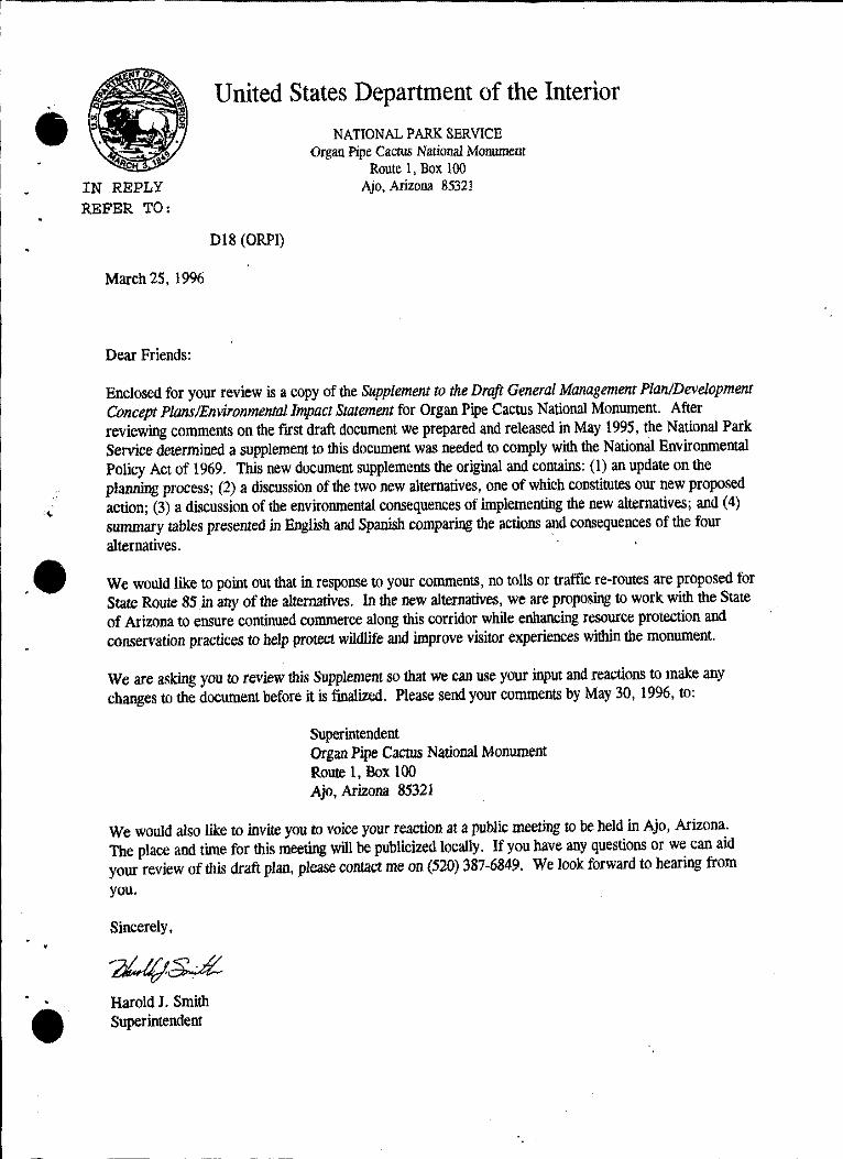
March 25, 1996
Dear Friends:
United States Department of the Interior
018 (ORPI)
NATIONAL PARK SERVICE Organ Pipe Cacrus National Momunent
Route 1, Box 100 Ajo, Arizona 85321
Enclosed for your review is a copy of the Supplement to the Draft General Management Plan/Development Concept Plans/Environmental Impact Statement for Organ Pipe Cactus National Monument. After reviewing comments on the first draft document we prepared and released in May 1995, the National Park Service determined a supplement to this document was needed to comply with the National Environmental Policy Act of 1969. This new document supplements the original and contains: (I) an update on the planning process; (2) a discussion of the two new alternatives, one of which constitutes our new proposed action; (3) a discussion of the environmental consequences of implementing the new alternatives; and (4) summary tables presented in English and Spanish comparing the actions and consequences of the four alternatives. ·
We would like to point out that in response to your comments, no tolls or traffic re-routes are proposed for State Route 85 in any of the alternatives. In the new alternatives, we are proposing to work with the State of Arizona to ensure continued commerce along this corridor while enhancing resource protection and conservation practices to help protect wildlife and improve visitor experiences within the monument.
We are asking you to review this Supplement so th.at we can use your input and reactions to make any changes to the document before it is finalized. Please send your comments by May 30, 1996, to:
Superintendent Organ Pipe Cactus National Monument Route 1, Box 100 Ajo, Arizona 85321
We would also like to invite you to voice your reaction at a public meeting to be held in Ajo, Arizona. The place and time for this meeting will be publicized locally. If you have any questions or we can aid your review of this draft plan, please contact me on (520) 387-6849. We look forward to hearing frorn you.
Sincerely,
Harold J. Smith Superintendent
--
IN REPLY REFER TO:
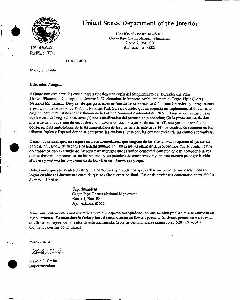
Marzo 25, 1996
Estimados Amigos:
------ ---------
United States Department of the Interior
Dl8 (ORPI)
NATIONAL PARK SERVICE Organ Pipe Cactus National Monument
Route 1, Box 100 Ajo,Arizona 85321
Adjunto con esta carta les envio, paras revision una copia del Supplemento de! Borrador de! Plan General/Planes de! Concepto de Desarrollo/Declaracion de lmpacto Ambiental para el Organ Pipie Cactus National Monument. Despues de que pasaramos revista de los comentarios de! primer borrador que preparamos y presentamos en mayo de 1995, el National Park Service decidio que se requeria un suplemento al documento original para cumplir con la legislacion de la Politica Nacion al Ambiental de 1969. El nuevo documento es un suplemento del original e incluye: (l) una actualizacion de! proceso de planaecion; (2) la presentacion de dos altemativas nuevas, una de las cuales constituye una nueva propuesta de accion; (3) una presentacion de las consecuencias arnbientales de la instnnnentacion de las nuevas alremlltivas; y (4) los cuadros de resumen en los idiomas Ingles y Espanol donde se comparan las acciones junto con las consecuencias de las cuatro altemativas.
Deseamos senalar que, en respuestas a sus comentarios, que ninguna de las alternativas proponen ni garitas de paeje ni un carnbio de la carretera Estatal numero 85. En la nueva altemath•a, proponemos que se continue una colarobacion con el Estado de Arizona para aserugar que el trafico comercial continue en este corredor a la vez que se fomenta la proteccion de las recursos y las practicas de conservasion y, en esta manera proteger la vida silvestre y mejorar las experiencias de los visitantes dentro del parque.
Solicitamos que revise ulsted este Suplemento para que podamos aprovechar sus comentarios y reacciones y lograr cambios al documento antes de que se edite su version final Favor de enviar sus comentario antes del 30 de mayo, l 996 a:
Superintendent Organ Pipe Cactus National Monument Route 1, Box I 00 Ajo, Arizona 85321
Asimismo, extendemos una invitacion para que esprese sus opiniones en una reunion publica que se convoca en Ajao, Arizona. Se anunciara la fecha y hora de esta reunion en forma oportuna. Si tienen preguntas o podernor auxilar en su repaso de borrador de este documento, favor de communicarse conmigo al (520) 387-6849. Contamos con sus comentarios.
Atentamente,
Harold J. Smith Superintendent
-•
SUPPLEMENT to the DRAFf General Management Plan Development Concept Plans
Environmental Impact Statement
ORGAN PIPE CACTUS NATIONAL MONUMENT PIMA COUNTY, ARIZONA
This Supplement to the Draft General Management Plan/Development Concept Plan/Environmental Impact Statement presents two additional alternatives for future management of the monument, one of which constitutes the National Park Services' (NPS) new proposed draft general management plan. This document supplements the Draft.General Management Plan/Development Concept Plan/Environmental Impact Statement (Draft G/\l!PIDCP/ElS) prepared by the NPS and released in May 1995. The new alternatives were formulated in response to public comments generated by the Draft G.MP!DCP!EJS, and are titled: New Ideas Alternative and New Proposed Action Alternative. Also in response to comments, no tolls, traffic reroutes, or changes to speed limits are proposed for State Route 85 (SR 85) in any of the alternatives, while the proposed agreement between the Tohono O'odham Nation and the NPS is now proposed in all of the alternatives.
As with the f'rrst two alternatives, the new alternatives wmk to ensure the legislative mandates and purpose of the monument are fulfilled. The New Ideas Alternative proposes to carry out principals of the Man and the Bioshpere (MAB) program, adopt a regional perspective, maximize wilderness values and experiences, and enhance resource protection. Actions proposed in this alternative include:
• working with the State of Arizona Department of Transportation (ADOT) to ensure continued travel and cmumerce along the portion of SR 85 within the monument, while enhancing resource protection by exploring mitigation strategies, such as installing bridges and pullouts, to reduce wildlife mortality and improve the visitor experience • reducing the amount of existing fucilities inside the monument by concentrating facilities at or outside monument boundaries in the Ajo, Luke>'ille, and Why areas • re-aligning the trail network in the Quitobaquito Springs area • more strictly managing visitor use, such as using permits to manage visitors at Quitobaquito Springs and Alamo Canyon Wash • establishing partnerships with other agencies, public, or private interests, to share facilities, staff, and costs • proposing the greatest potential increase in wilderness in comparison to the other alternatives • seeking redesignation of the monument to Organ Pipe Cactus National Park
The New Proposed Action Alternative constitutes the NP S's proposed action. The concept combines elements from the other alternatives: within the region, to carry out principles of the MAB program by adopting a regional perspective to improve visitor services and conserve resources, and within the monument, to improve management capabilities to enhance visitor opportunities and protect resources and wilderness values, Actions proposed in this alternative generally reflect those presented in other alternatives and include:
• working with ADOT, as in the New Ideas Alternative, to ensure continued travel and commerce while enhancing conservation practices along the SR 85 corridor in the monument; re-aligning the trail network in the Quitobaquito Springs area; establishing partnerships with others to share facilities, staff, and costs within the Why and Lukeville areas; and proposing an increase in wilderness, but to a lesser degree than in the New Ideas Alternative · • seeking redesignation of the monument, as in the Former Preferred Future Alternative, to Sonoran Desert National Park and retaining existing facilities in the Twin Peaks area • seeking to be more cost-effective than the other alternatives, by relocating and developing partnerships for some facilities in Lukeville, proposing different uses for some existing facilities in the Twin Peaks area, and adding fewer new facilities.
Tue review period for this document ends on May 30, 1996, All comments must be received by that time and should be addressed to:
Superintendent, Organ Pipe Cactus National Monument Route 1, Box 100, Ajo, Arizona, 85321
United States Department of the Interior National Park Service, Denver Service Center
_e
. e
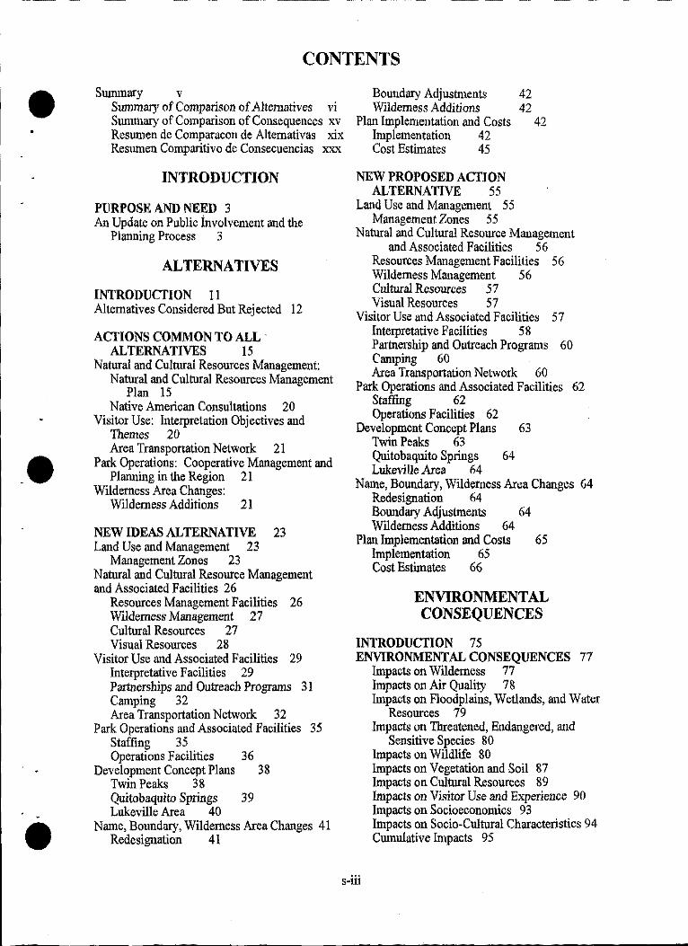
CONTENTS
Summary v Summary of Comparison of Alternatives vi Summary of Comparison of Consequences xv Resumen de Comparacon de Altemativas xix Resumen Comparitivo de Consecuencias xxx
INTRODUCTION
PURPOSE AND NEED 3 An Update on Public involvement and the
Planning Process 3
ALTERNATIVES
INTRODUCTION 11 Alternatives Considered But Rejected 12
ACTIONS COMMON TO ALL · ALTERNATIVES 15
Natural and Cultural Resources Management: Natural and Cultural Resources Management
Plan 15 Native American Consultations 20
Visitor Use: Interpretation Objectives and Themes 20 Area Transportation Network 21
Park Operations: Cooperative Management and Planning in the Region 21
Wilderness Area Changes: Wilderness Additions 21
NEW IDEAS ALTERNATIVE 23 Land Use and Management 23
Management Zones 23 Natural and Cultural Resource Management and Associated Facilities 26
Resources Management Facilities 26 Wilderness Management 27 Cultural Resources 27 Visual Resources 28
Visitor Use and Associated Facilities 29 Interpretative Facilities 29 Partnerships and Outreach Programs 31 Camping 32 Area Transportation Network 32
Park Operations and Associated Facilities 35 Staffing 35 Operations Facilities 3 6
Development Concept Plans 38 Twin Peaks 3 8 Quitobaquito Springs 39 Lukeville Area 40
Name, Boundary, Wilderness Area Changes 41 Redesignation 41
Boundary Adjustments Wilderness Additions
Plan Implementation and Costs Implementation 42 Cost Estimates 45
NEW PROPOSED ACTION ALTERNATIVE 55
Land Use and Management 55 ManagementZones 55
42 42
42
Natural and Cultural Resource Management and Associated Facilities 56
Resources Management Facilities 56 Wilderness Management 56 Cultural Resources 5 7 Visual Resources 5 7
Visitor Use and Associated Facilities 57 Interpretative Facilities 58 Partnership and Outreach Programs 60 Camping 60 Area Transportation Network 60
Park Operations and Associated Facilities 62 Staffing 62 Operations Facilities 62
Development Concept Plans 63 Twin Peaks 63 Quitobaquito Springs 64 Lukeville Area 64
Name, Boundary, Wilderness Area Changes 64 Redesignation 64 Boundary Adjustments 64 Wilderness Additions 64
Plan Implementation and Costs 65 Implementation 65 Cost Estimates 66
ENVIRONMENTAL CONSEQUENCES
INTRODUCTION 75 ENVIRONMENTAL CONSEQUENCES 77
Impacts on Wilderness 77 Impacts on Air Quality 78 Impacts on Floodplains, Wetlands, and Water
Resources 79 Impacts on Threatened, Endangered, and
Sensitive Species 80 Impacts on Wildlife 80 Impacts on Vegetation and Soil 87 Impacts on Cultural Resources 8 9 Impacts on Visitor Use and Experience 90 Impacts on Socioeconomics 93 Impacts on Socio-Cultural Characteristics 94 Cumulative Impacts 95
s-iii
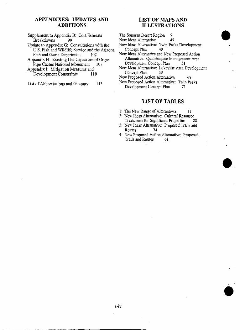
APPENDIXES: UPDATES AND ADDITIONS
Supplement to Appendix B: Cost Estimate Breakdowns 99
Update to Appendix G: Consultations with the U.S. Fish and Wildlife Service and the Arizona Fish and Game Department 102
Appendix H: Existing Use Capacities of Organ Pipe Cactus National Monument 107
Appendix I: Mitigation Measures and Development Constraints 110
List of Abbreviations and Glossary 113
LIST OF MAPS AND ILLUSTRATIONS
The Sonoran Desert Region 7 New Ideas Alternative 47 New Ideas Alternative: Twin Peaks Development
Concept Plan 49 New Ideas Alternative and New Proposed Action
Alternative: Quitobaquito Management Area Development Concept Plan 51
New Ideas Alternative: Lukeville Area Development Concept Plan 53
New Proposed Action Alternative 69 New Proposed Action Alternative: Twin Peaks
Development Concept Plan 71
LIST OF TABLES
1: The New Range of Alternatives 11 2: New Ideas Alternative: Cultural Resource
Treannents for Significant Properties 28 3: New Ideas Alternative: Proposed Trails and
Routes 34 4: New Proposed Action Alternative: Proposed
Trails and Routes 61
s-iv
e.
•
••
•
SUMMARY
This Supplement to the Draft General Management Plan/Development Concept Plan/Environmental Impact Statement presents two additional alternatives for future management of the monument, one of which constitutes the National Park Service's (NPS) new proposed draft general management plan. This document supplements the Draft General Management Plan/Development Concept Plan/Environmental Impact Statement (Draft G!vfPIDCP/EIS) prepared by the NPS and released in May 1995. The new alternatives were formulated in response to public comments generated by the Draft GA1P!DCPIEIS, and are titled: New Ideas Alternative and New Proposed Action Alternative. As with the first two alternatives, the new alternatives work to ensure the legislative mandates and purpose of the monument are fulfilled
The following summary tables replace those in the Draft GJMP IDCP /EIS as they compare the actions and consequences of the four alternatives: the two original alternatives and the two new alternatives contained in this Supplement. The summaries are presented in table format to assist the reader in comparing the alternatives and is the part of the document that is presented in two languages: English and Spanish. For more complete information on a given topic, the reader should consult the corresponding section in the Drajl GA1P/DCP!EIS or in this Supplement.
Portions of the tables are either shaded or un-shaded. Shaded boxes represent portions of the original two alternatives that remain as presented in the Draft GJMP IDCP !EIS; the intent of these sections remains the same, however, some parts were re-worded to help clarify them. For example in this Supplement, the Existing Conditions and Former Preferred Future Alternatives have been renamed and, in the tables, are presented in a reverse order from the original. These changes were made to aid the reader in understanding and comparing the full range of alternatives and consequently, some of the descriptions needed to be re-worded to respond to these changes. Un-shaded boxes represent new information or parts of the original alternatives that have been substantively changed. Where changes have been made, the reasons are noted .
s-v
ALTERNATIVES-.
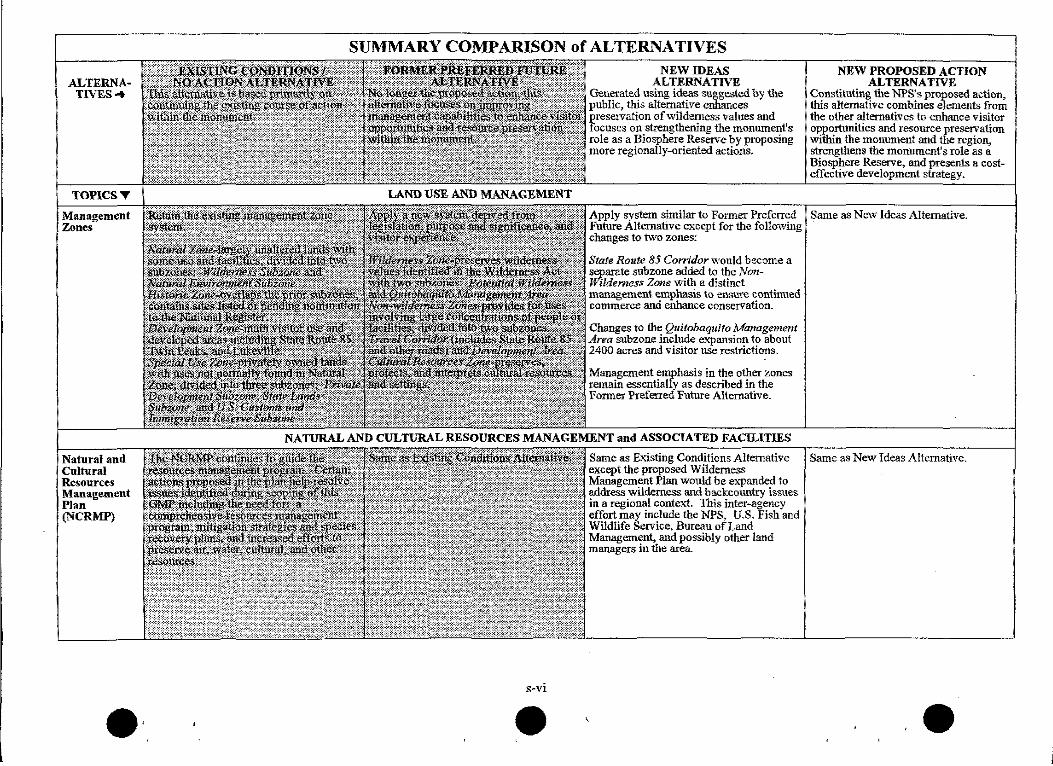
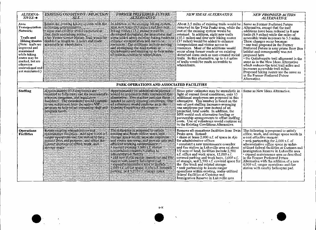
TOPICST
Management Zones
Natural and Cultural Resources Management Plan (NCRMP)
•·
SUMMARY COMPARISON of ALTERNATIVES NEW IDEAS
ALTERNATIVE Generated using ideas suggested by fue public, this alternative enhances preservation of wilderness values and focuses on strengthening the monument's role as a Biosphere Reserve by proposing more regionally-oriented actions.
NEW PROPOSED ACTION ALTERNATIVE
Constituting fue NPS's proposed action, this alternative combines elements from the other alternatives to enhance visitor opportunities and resource presetVation \Vithin the monun1ent and the region, strengthens the monument's role as a Biosphere Reserve, and presents a costeffective development strategy.
Apply system similar to Former Preferred Same as New Ideas Alternative. Future Alternative except for the following changes to two zones;
State Route 85 Cotridor would become a separate subzone added to the NonfYildemess Zone \vith a distinct management emphasis to ensure continued commerce and enhance conservation.
Changes to the Quitobaquito Manage1'nent Area subzone include expansion to about 2400 acres and visitor use restrictions.
Management emphasis in the other zones remain essentially as described in the Fonner Preferred Future Alternative.
NATURAL AND CULTURAL RESOURCES MANAGEMENT and ASSOCIATED FACILITIES ~~~~~~~~~~~~~~~~~~~~~~~~~~~~---!
Same as Existing Conditions Alternative Same as New Ideas Alternative. except the proposed Wilderness Management Plan would be expanded to address wilderness and backcountry issues in a regional contel\'t. This inter-agency effort may include the NPS, U.S. Fish and Wildlife Service, Bureau of Land Management, and possibly other land managers in the area.
• •
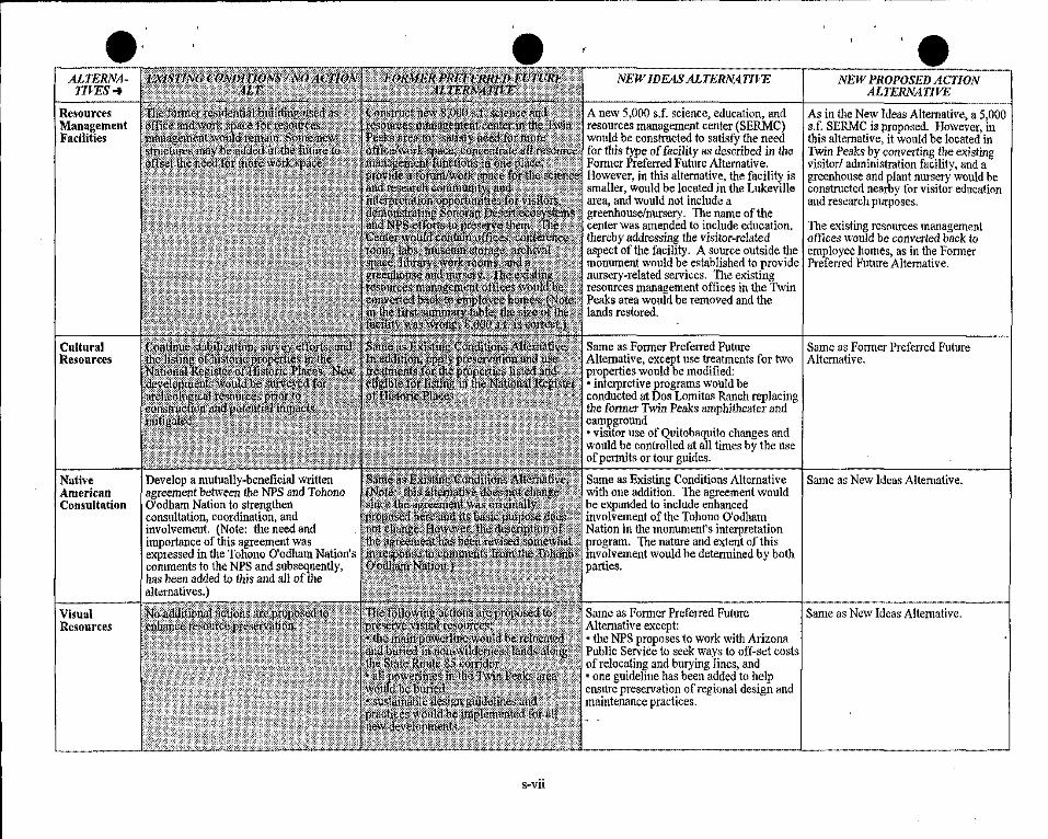
ALTERNATIVES ..
Resources Management Facilities
Cultural Resources
Native American Consultation
I------·-Visual Resources
Develop a mutually-beneficial written agreement between the NPS and Tol10no O'odham Nation to strengthen consultation; coordination, and involvement. (Note: the need and importance of this agreement was expressed in the Tohono O'odham Nation's comments to the NPS and subsequently, has been added to this and all of the alternatives.)
NEW IDEAS ALTERNATIVE
A new 5,000 s.f. science, education, and resources management center (SERMC) would be constructed to satisfy the need for this type of facility as described in the Former Preferred Future Alternative. However, in this alternative, the facility is smaller, would be located in the Lukeville area, and would not include a greenhouse/nursery. 1he name of the center was amended to include education. thereby addressing the visitor-related aspect of the facility. A source outside the monument would be established to provide nursery~related services. 111e existing resources management offices in the Twin Peaks area would be removed and the lands restored.
Same as Former Preferred Future Alternative, except use treatments for two properties would be modified: • interpretive programs would be conducted at Dos Lomitas Ranch replacing the former Twin Peaks amphitheater and caml?ground •visitor use of Quitobaquito changes and would be controlled at all times by the use of permits or tour guides.
NEW PROPOSED ACTION ALTERNATIVE
As in the New Ideas Alternative, a 5,000 s.f. SERMC is proposed. However, in this alternative, it would be located in Twin Peaks by con»erting the existing visitor/ administration facility, and a greenhouse and plant nursery would be constructed nearby for visitor education and research purposes.
The existing resources management offices would be con»erte<l back to employee homes, as in the Former Preferred Future Alternative.
Same as Former Preferred Future Alternative.
Same as Existing Conditions Alternative Same as New Ideas Alternative. with one addition. The agreement would be expanded to include enhanced involvement of the Tohono O'odham Nation in the monument's interpretation program. The nature and extent of this mvolvement would be determined by both parties.
Same as Former Preferred Future Same as New Ideas Alternative. Alternative except: • tl1e NPS proposes to work with Arizona Public ServiCe to seek ways to off-set costs of relocating and burying lines, and • one guideline has been added to help ensure preservation of regional design and maintenance practices.
ALTERNATIVES ...
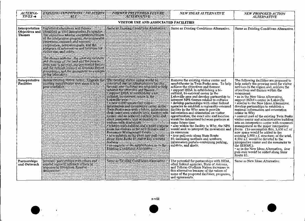
Interpretation Objectives and Themes
Interyretative Facilities
Partnerships and Outreach
•·
NEW IDEAS ALTERNATIVE
VISITOR USE AND ASSOCIATED FACILITIES
s-viii
•
Same as Existing Conditions Alternative.
Remove the existing visitor center and amphitheater in Twin Peaks area. To help achieve the objectives and themes: • support ISDA in establishing a tricultural, tri-national center in the Lukeville area and develop partnership to interpret NPS themes related to cultures • develop partnerships with other f~eral agencies to establish a regionally-oriented facility in the Why area to provide information and orientation on visitor opportunities; the exact size and location would be determined between partners at some future time •also within the facility in Why, the NPS \vould seek to interpret the monument and its resources •four pull-outs along State Route 85-including northern and southern infonnation portals-containing parking, exhibits, and shade.
The potential for partnerships \\1th ISDA, other federal agencies, State of Arizona, and Tohono 0 1odham Nation incre&.--es in this alternative because of the nature of some of the proposed facilities, programs, and agreements.
NEW PROPOSED ACTION ALTER¥ATIVE
Same as Existing Conditions Alternative.
The following facilities are proposed to help satisfy the growing need for visitor services in the region an~ achieve the objectives and themes Vlithin the monument • as in the New Ideas Alternative, support ISDA1s center in LukeviUe • similar to the New Ideas Alternative. develop partnerships to establish a regional information and orientation center in Why • convert part of the existing Twin Peaks visitor center and administrative building into an interpretive center \vith resources management as the major interpretive focus. (To accomplish this, 3,600 s.f. of new space \Vould be added to the existing 5,900 s.f. strncture; of the total, 4,500 s.f. would be devoted to the intetpretive center and the remainder to theSERMC). • as in the New Ideas Alternative, four pull-outs would be added along State Route 85.
Same as Ne\v Ideas Alternative.
•
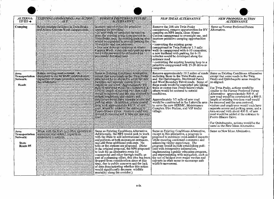
ALTERNATIVES-+
Camping
Area Transportation Network:
Roads
Area Transportation Netivork:
State Route 85
•
Same as Existing Conditions Alternative. Additionally, the NPS would seek to work with the State to add informational signs and pullouts at both monument entrances, and add three additional pull-outs. No tolls or fee stations are proposed. (Note: in the original proposal, the NPS proposed to look for an alternative route for commercial and other through-traffic as part of a planning effort; this idea has been dropped from consideration since at this time, due to public concerns and the lack of data demonstrating whether this action would significantly decrease wildlife mortality along the corridor.)
s-ix
NEW IDEAS ALTERNATIVE
Remove the 208 site T"'in Peaks campground .. remove opportunities for RV camping on NPS lands, close Alamo Canyon campground to overnight use, and increase primitive camping opporhmities by: • converting the existing group campground in Twin Peaks to 1.5 mile walk-in campground with 6-10 campsites; a new !railhead with parking for 6-10 vehicles would be developed along the entrance road • converting the existing housing loop to a primitive campground with 15-20 drive-in campsites
Remove approxim:itely 19.5 miles of roads including those in the T~in Peaks area, and the Quitobaquito, Northwest Patrol and West Boundary Patrol roads. Some of these roads would be converted into hiking trails or routes (see Trails below} while others would be restored to natural conditions.
Approximately l 12 mile of new road would be constructed in the Lukeville area to serve the new SERMC, Maintenance Complex /Fire Station, and VIP trailer village.
NEW PROPOSED ACTION ALTERNATIVE
Same as Former Preferred Future Alternative.
Same as Existing Conditions Alternative except that some roads in the T\vin Peaks and Quitobaquito areas \Vould be re-aligned.
For T~i.n Peaks, actions would be similar to the Fonner Preferred Future Alternative: approximately 800 ft. of new road would be constructed; a 800 ft length of existing two-lane road Would be removed and the area restored; visitors and employees would each have separate access and parking areas; and a turn-around with about 400 ft. of new road would be added at the entrance to Puerto Blanco Drive.
For Quitobaquito, actions would be the same as the Ne1v Ideas Alternative.
Same as Existing Conditions Alternative, Same as New Ideas Alternative. except in this alternative, a program is proposed to minimize road-related impacts while ensuring continued commerce and enhancing visitor experience. The program would include establishing pull-outs with interpretive information, implementing a public education program, and experimenting with mitigation, such as the use of bridges over major \Vashes and culverts in other areas to encourage safe wildlife movement.
ALTERNATIVES ..
Area Transportation Network:.
Trails and Hiking Routes
(Note: trails are improved and maintained while hiking routes may be marked, but are othenvise undeveloped and not maintained.)
Staffing
Operations Facilities
NEW IDEAS ALTERNATIVE
About 2.5 miles of existing trails would be removed in the Twin Peaks area~ "vhile the rest of the existing system \Vould be retained. In addition, eight new trails (IO.I miles) and four new hil<ing routes (37 miles) would be added to enhance interpretation and visitor access to resources. Most of the additions would occur along former roads or on existing disturbed areas such as user-created social trails. In this alternative, up to 6.4 miles of trails would be made accessible to wheelchairs.
PARK OPERATIONS AND ASSOCIATED FACILITIES
s-x
•
Since prior estimates may be unrealistic in light of current fiscal conditions, only 15 additional employees are proposed in this alternative. This number is based on the rate of past staffing increases-averaging one employee rer year-instead of on projected, tota needs. In addition, the NPS would seek alternative funding or partnership arrangements to offset staffing costs. Use of volunteers would continue as in the Existing Conditions Alternative.
Remove all operations facilities from Twin Peaks area. Instead: • share or lease 2,000 s.f. of space in Ajo for administrative offices • construct a new maintenance complex and .fire station in Lukeville area an about 1/2 acre ofland; facilities include 2,500 s.f. office and work space, 12,000 s.f. covered parking and work bays, 5,000 s.f. of storage, and 2~500 s.f. covered space for the fire truck and related storage. • seek partnership to locate ranger operations within existing, under-utilized federal facilities at Customs and Immigration Reserve in Lukeville area
NEW PROPOSED ACTION ALTERlVATIVE
Same as Former Preferred Future Alternative, except that the trail additions have been reduced to 8 new trails (8. 9 miles) while the miles of accessible trails increases to 5.5 1niles. These changes occur because: • one trail proposed in the Fonner Preferred Future is near prime Rosy Boa habitat and consequently was not proposed here • the Quitobaquito trail alignment is the same as in the New Ideas Alternative which reduces the total trail miJes and increases accessible trail miles. Proposed hiking routes are the same as in the Fonner Preferred Future Alternative.
Same as New Ideas Alternative.
The following is proposed to satisfy office, work, and storage space needs in a cost effective manner: •seek partnership for 2,000 s.f. of administrative otTice space in underutilized federal facilities at Customs and Immigration Reserve in LukeviUe area • expand maintenance area as described in the Fonner Preferred Future Alternatb:1e with the addition of a new 4,000 s.f. ranger operations and fire station with nearby helicopter pad.
•
ALTERNATIVES ..
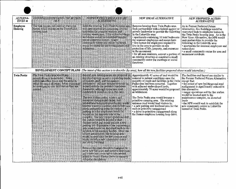
Employee Housing
Twin Peaks
' e NEW IDEAS ALTERNATIVE
Remove housing from T\vin Peaks area. Seek partnerships with a federal agency or private landowner to provide the following in the Lukeville area: • apartments containing IO total bedrooms for seasonal employees and researchers • five homes for employees required to live in the area to provide on-site protection of life, property, and resources m the monument • for all area residents, convert a portion of an existing structme or construct a small community center for meetings or social functions.
NEW PROPOSED ACTION ALTERNATIVE
As in Former Preferred Futme Alternative, five buildings would be converted back to employee homes in the Twin Peaks housing area. As in the New Ideas Alternative, the NPS would seek partnerships to provide the following in the Lukeville area: • apartments for seasonal employees and researchers • a small community center for area and monument residents.
DEVELOPMENT CONCEPT PLANS (The intent of this section is to describe (by area), how all the new facilities proposed above would interrelate.)
Approximately 43. acres of land would be The facilities and layout are similar to restored to natural conditions once the the Fonner Preferred Future Alternative m~jority of roads and facilities in the Twin except that: Peaks area had been removed. Together • the extent of new buildings and road with adjacent undeveloped lands, realignment is significantly reduced in approximately 70 acres would be proposed this alternative as wilderness, • ranger operations and the fire station
would be located next to the 'The Twin Peaks area would become a maintenance complex, on disturbed primitive camping area. The existing lands entrance road would lead visitors to: •the NPS would seek to establish the • a new parking and !railhead area for the new community center in Lukeville walk-in primitive campground instead of Twin Peaks. • a drive-in primitive campground along the former employee housing loop drive.
s-xi
ALTERNATIVES ..
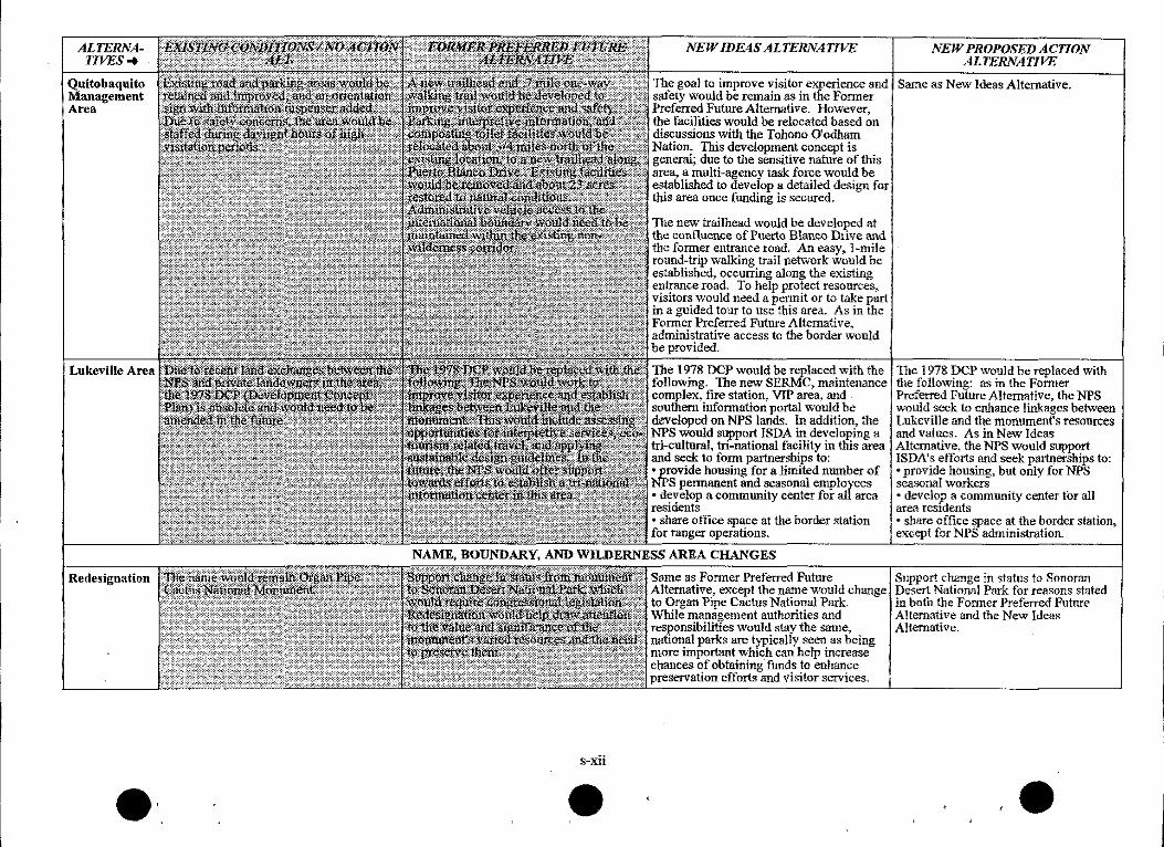
Quitobaquito 1\-fanagement Area
Lukeville Area
Redesignation
NEW IDE4S ALTERNATIVE l\'EW PROPOSED ACTION ALTERNATIVE
The goal to improve visitor experience and Same as New Ideas Alternative. safety would be remain as in the Former Preferred Future Alternative. However, the facilities would be relocated based on discussions litith the Tohono 0 1odham Nation. This development concept is general; due to the sensitive nature of this area, a multi-agency task force v.rould be e,-tablished to develop a detailed design for this area once funding is secured.
The new !railhead would be developed at the confluence of Puerto Blanco Drive and the former entrance road. An easy, ]-mile ronnd-trip walking trail network would be established, occurring along the existing entrance road. To help protect resources, visitors would need a permit or to take part in a guided tour to use this area. As in the Former Preferred Future Alternative, administrative access to the border would be provided.
The 1978 DCP would be replaced with the following. The new SER1\1C~ maintenance complex~ fire station, VIP area, and southern information portal would be developed on NPS lands. In addition, the NPS would support ISDA in developing a tri-cultural, tri-national facility in this area and seek to form partnerships to: •provide housing for a limited number of NPS permanent and seasonal employees • develop a community center for all area residents • share office space at the border station for ranger operations.
NAME, BOUNDARY, AND WIWERNESS AREA CHANGES
The 1978 DCP would be replaced with the following: as in the Former Preferred Future Alternative, the NPS would seek to enhance linkages between Lukeville and the monument's resources and values. As in New Ideas Alternative, the NPS would support ISDA's efforts and seek partnerships to: •provide housing, but only for 1'.'PS seasonal workers • develop a community center for an area residents • share office ~ace at the border station, exc-epl for NPS administration.
~~~~~~~~~~~~~~~~~~~~~~~~~~~~~
Srune as Former Preferred Future Alternative7 except the name '\vould change to Organ Pipe Cactus National Park. While management authorities and res.ponsibilities would stay the same~ national parks are typically seen as being more important \Vhich can help increase chances of obtaining funds to enhance preservation efforts and visitor services.
Support change in status to Sonoran Desert National Park for reasons stated in both the Fonner Preferred Future Alternative and the New Ideas Alternative.
ALTERNATIVES-t
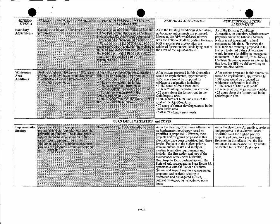
Boundary Adjustments
Wilderness Area Additions
Implementation Strategy
NEW IDEAS ALTERNATIVE
As in the Existing Conditions Alternative, no boundary adjustments are proposed, However, the NPS would seek to work with the Tohono O'odham Nation to ensure NPS mandates for preservation are achieved for monument lands lying east of the crest of the Ajo Mountains.
After actions proposed in this alternative would be implemented, approximately 3,650 acres would be proposed for wilderness designation including: • 1,280 acres of State trust lands • 206 acres along the powerline corridor • 23 acres along the former road in the Quitobaquito area. • 1502.6 acres ofNPS lands east of the crest of the Ajo M01mtains • 70 acres of former developed areas in the Twin Peaks area • 570 acres along former roads
PLAN IMPLEMENTATION and COSTS
s-xiii
As in the Existing Conditions Alternative, an implementation strategy based on priorities is proposed. llowever, most projects and programs proposed in this alternative hiive been prioritized into three levels. Projects in the highest priority involve human health and safety or meeting legislative requirements and include: the fire station and part of the maintenance complex in Lukeville, Quitobaquito DCP, partnership with the State of Arizona regarding State Route 85, agreements with the Tohono O'odham Nation, and several resource management programs and projects relating to threatened and endangered species, cultural resources, and abandoned mine lands, ·
NEW PROPOSED ACTION ALTERNATIVE
As in the Existing Conditions Alternative, no boundary adjustments are proposed since the Tohono O'odham Nation is not interested in a land exchange at this time. However, the NPS feels the exchange proposed in the Former Preferred Future Alternative would improve its ability to manage the monument. fn the future, if the Tohono O'odham Nation expresses an interest in this idea, the NPS would be willing to enter into discussions.
After actions proposed in this alternative would be implemented, approximately 1509 acres would be proposed for wilderness designation including: • 1,280 acres of State held lands • 206 acres along the powerline corridor • 23 acres along the former road in the Quitobaquito area
As in the New Ideas Alternative, projects and programs in this alternative are prioritized and the highest priority projects and programs are the same, However, in this alternative, the fire station and maintenance facility would be located in the Twin Peaks area.
ALTERNATIVES-#
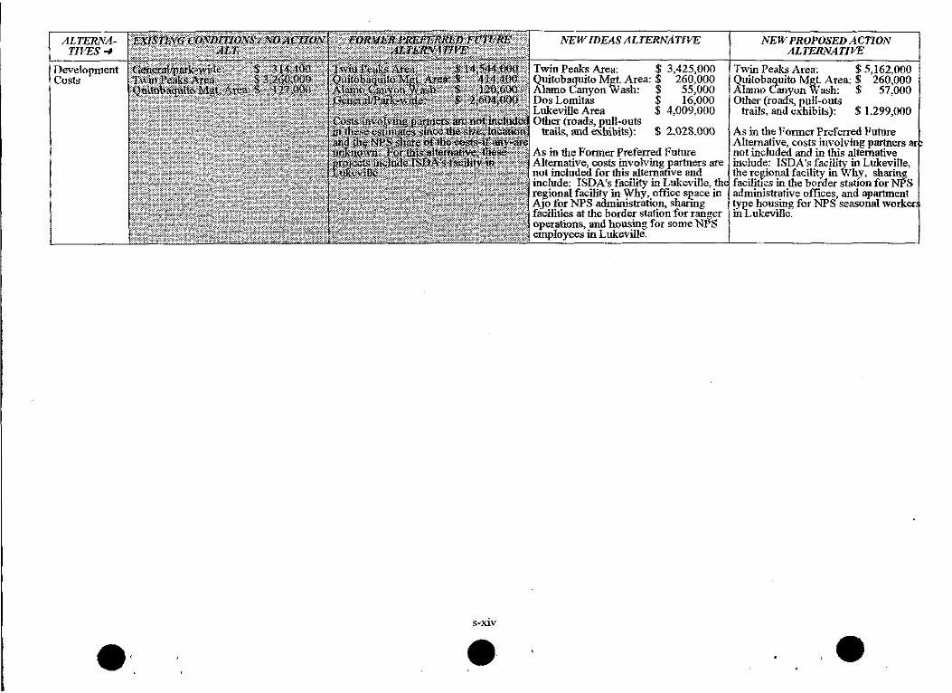
Development Costs
g ... xiv
e
NEW IDEAS ALTERNATIVE
T"in Peaks Area: $ 3,425,000 Quitobaquito Mg!. Area: $ 260,000 Alamo Canyon Wash: $ 55,000 Dos Lomitas $ 16,000 Lukeville Area $ 4,009,000 Othet (roads, 1mll-outs
trails, l!Ild exhibits): $ 2,028,000
As in the Former Prefetred Future Alternative, costs involving partners are not included for this altemattve and include: ISDA's facility in Lukeville, th
al facility in Why, office space in for NPS ailministration, sharing 'ties at the bordet station for ranger
operations, and housing for some NPS employees in Lukeville.
NEW PROPOSED ACTION ALTERNATIVE
Twin Peaks Area: $ 5,162,000 Quitobaquito Mgt Area: $ 260,000 Alamo Canyon Wash: $ 57,000 Other (roads, l'Ull-outs
trails, and exhibits): $ 1,299,000
As in the Former Preferred Future Alternative, costs involving partners ar not included and in this alternative include: ISDA's facility in Lukeville, the te(\iona\ facility in Why, sharing facili!Ies in the border station for NPS administrative offices, and apartment type honsing for NPS seasonal worker ii1Lukeville.
e
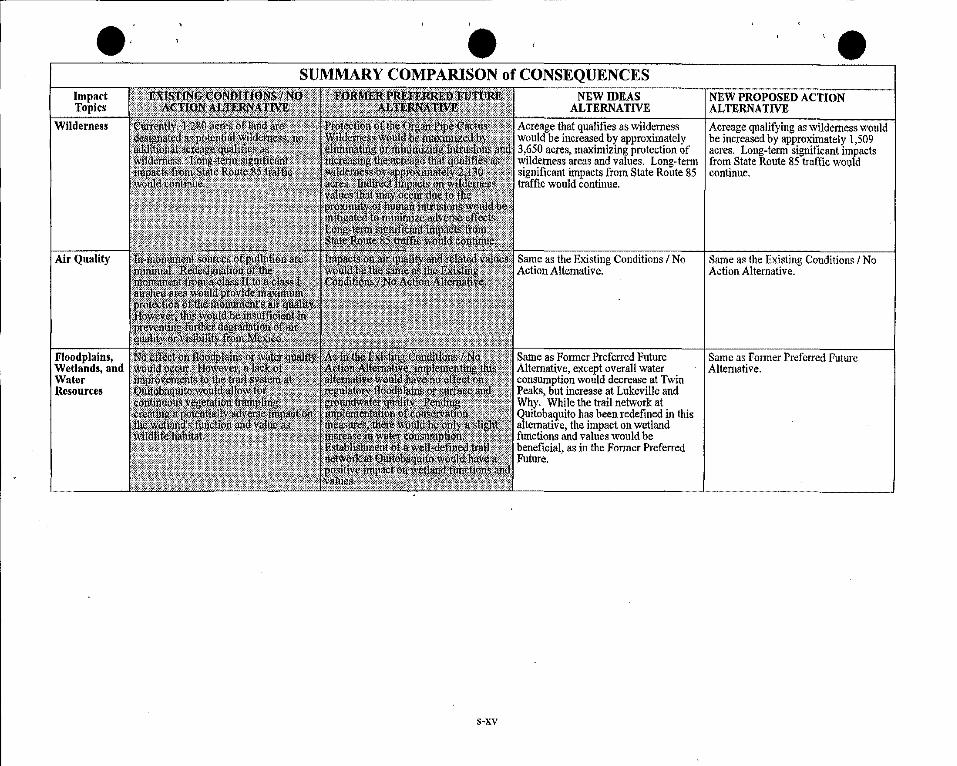
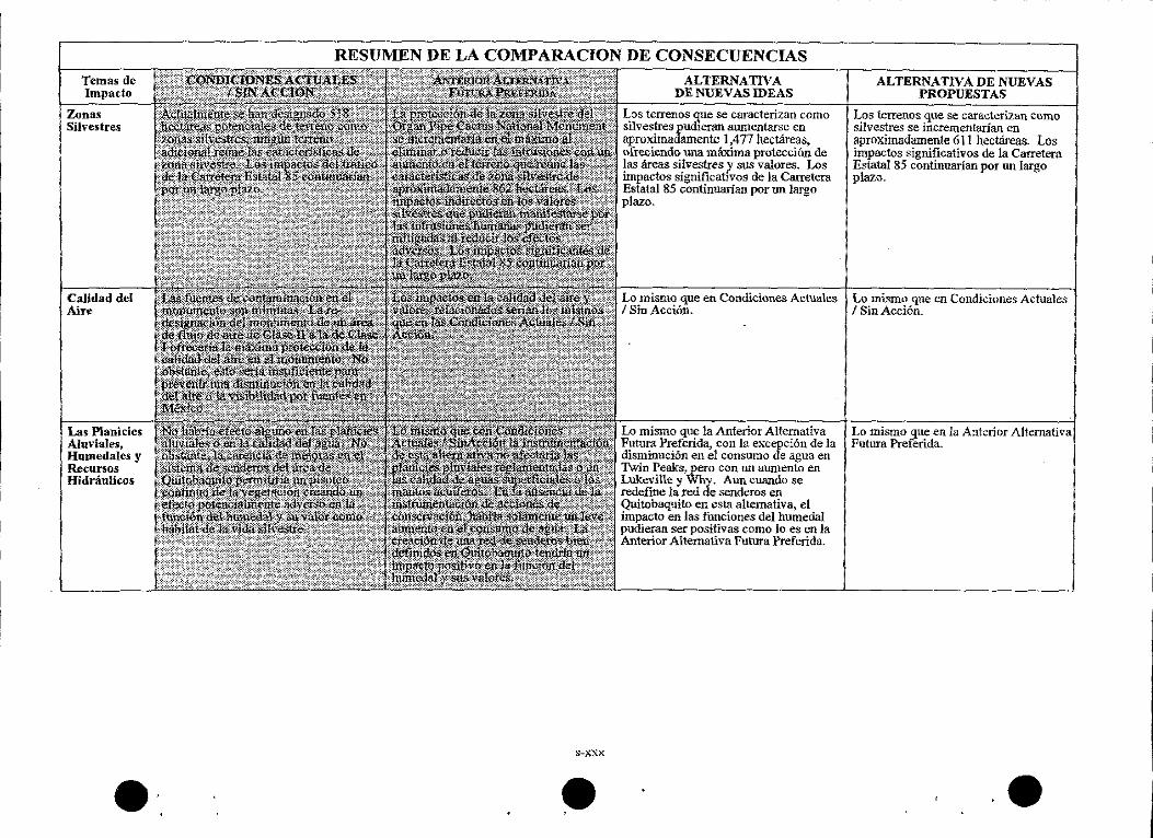
Impact Topics
Wilderness
Air Quality
Floodplains, Wetlands, and Water Resources
' e SUMMARY COMPARISON of CONSEQUENCES
s~xv
~~~~N=E=Wcc=ID~E~A-S~~~--,~N~E~W~P~R-O_P_O_S_E_D_A_C_T_lO-N~~~~
ALTERNATIVE ALTERNATIVE Acreage that qualifies as wilderness Acreage qualifying as wilderness would would be increased by approximately be increased by approximately 1,509 3,650 acres, maximizing protection of acres. Long-tenn significant impacts wilderness areas and values. Long-tenn from State Route 85 traffic would significant impacts from State Route 85 continue. · traffic would continue.
Sarne as the Existing Conditions I No Action Alternative.
Same as Fonner Preferred Future Alternative, except overall water consumption would decrease at Twin Peaks, but increase at Lukeville and Why. While the trail network at Quitobaquito has been redefined in this alternative, the impact on wetland functions and values would be beneficial, as in the Former Preferred Future.
Same as the Existing Conditions I No Action Alternative.
Same as Former Preferred Future Alternative.
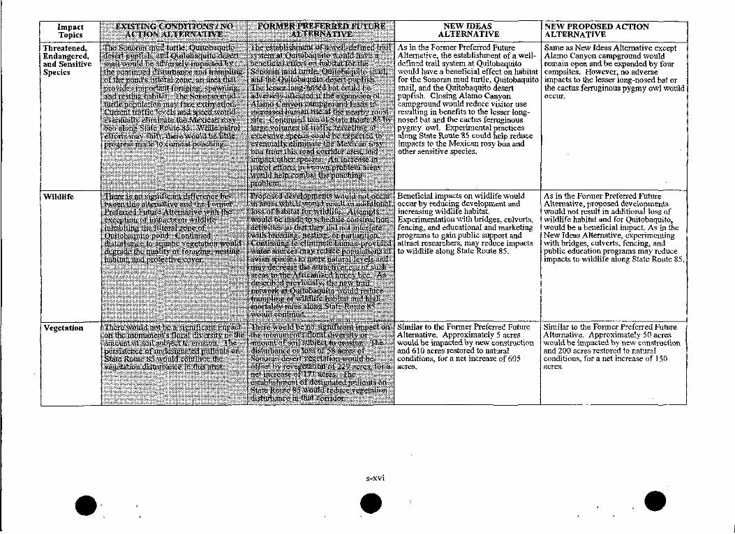
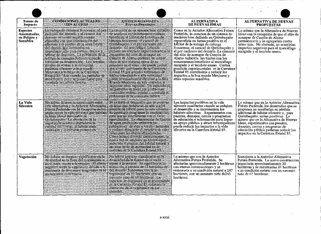
Impact Topics
Threatened, Endangered, and Sensitive Species
Wildlife
Vegetation
• , s-xvi
•
NEW IDEAS ALTERNATIVE
As in the Former Preferred Future Alternative, the establishment of a welldefined trail system at Quitobaquito would have a beneficial effect on habitat for the Sonoran mud turtle, Quitobaquito snail, and the Quitobaquito desert pupfish. Closing Alamo Canyon campground would reduce visitor use resulting in benefits to the lesser longnosed bat and the cactus fenuginous pygmy owl, Experimental practices along State Route 85 could help reduce impacts to the Mexican rosy boa and other sensitive species.
Beneficial impacts on '\vildlife would occur by reducing development and increasing wildlife habitat. Experimentation '\vith bridges, culverts, fencing, and educational and marketing programs to gain public support and attract research~ may reduce impacts to wildlife along State Route 85,
Similar to the Former Preferred Future Alternative. Approximately 5 acres would be impacted by new construction and 610 acres restored to natural conditions, for a net increase of 605 acres.
NEW PROPOSED ACTION ALTERNATIVE
Same as New Ideas Alternative except Alamo Canyon campground would remain open and be expanded by four campsites. Ho\vever, no adverse impacts to the lesser long-nosed bat or the cactus ferruginous pygmy owl would occur.
As in the Fonner Preterred Future Alternative, proposed developments \Vould not result in additional loss of wildlife habitat and for Quitobaquito, would be a beneficial impact. As in the New Ideas Alternative, experimenting with bridges, culverts~ fencing~ and public education programs may reduce impacts to wildlife along State Route 85,
Similar to the Former Preferred Future Alternative. Approximately 50 acres would be impacted by new construction. and 200 acres restored to natural conditions~ for a net increase of 150 acres.
•
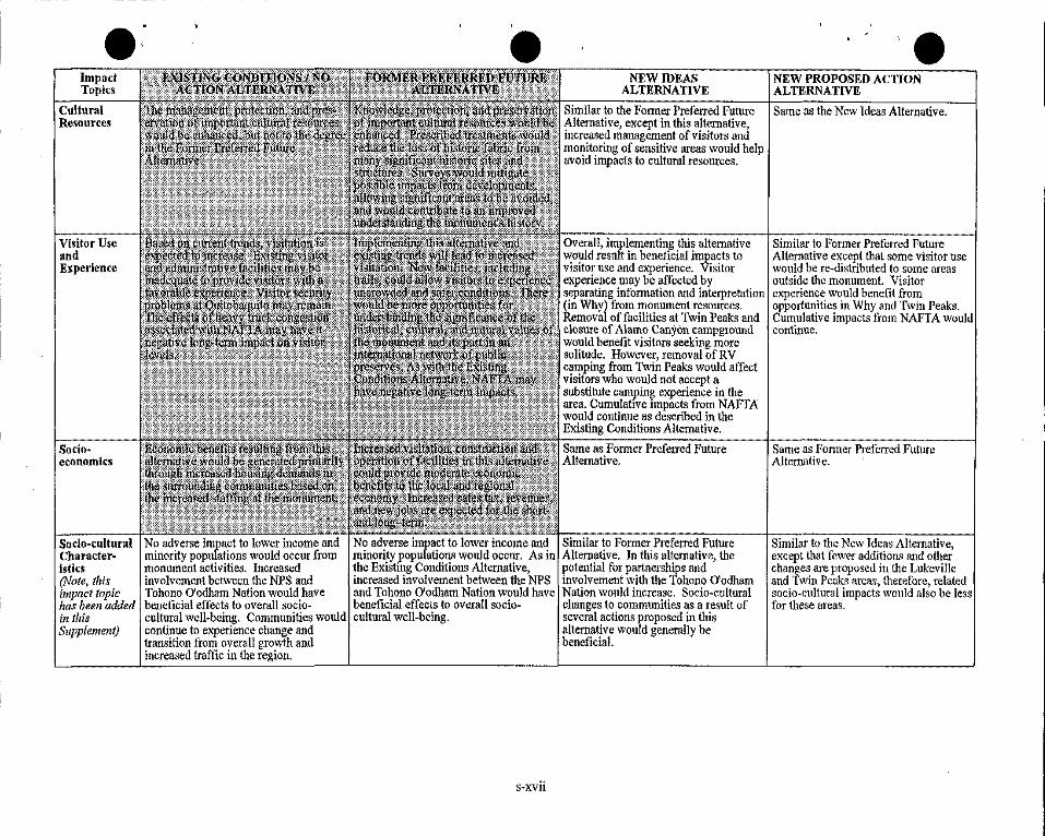
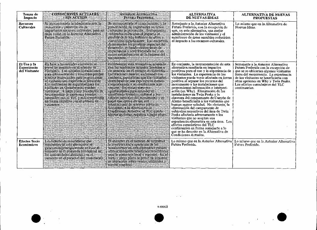
Impact Topics
Cultural Resources
Visitor Use and Experience
Socio· economics
Socio-cultural Characteristics (Note, this impact topic has been added in this Supplement)
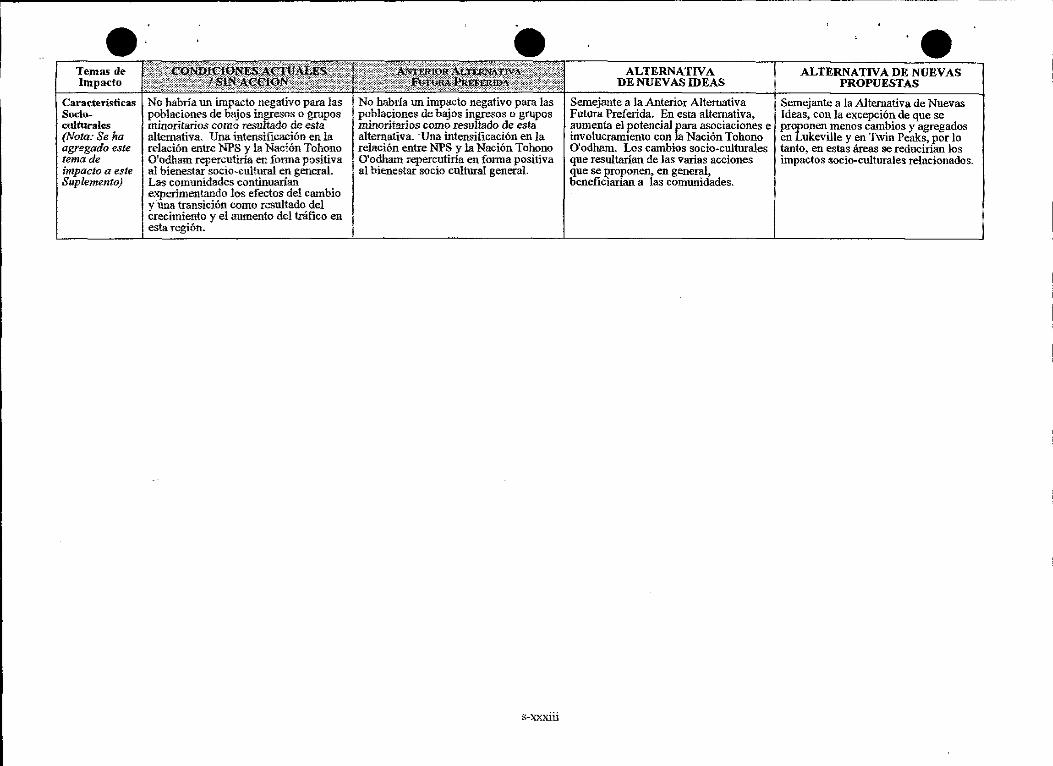
No adverse impact to lower income and minority populations would occur from monument activities. Increased involvement between the NPS and Tohono O'odham Nation would have beneficial effects to overall sociocultural well-being. Communities would continue to experience change and transition from overall growth and increased traffic in the region.
' e NEW IDEAS
ALTERNATIVE
Similar to the Former Preferred Future Alternative, except in this alternative, increased management of visitors and monitoring of sensitive areas would help avoid impacts to cultural resources.
Overall, implementing this alternative would result in beneficial impacts to visitor use and experience. Visitor experience may be affected by separating information and inteipretation (in Why) from monument resources. Removal of facilities at Twin Peaks and closure of Alamo Canyon campground would benefit visitors seeking more solitude. However, removal of RV camping from Twin Peaks would affect visitors who would not accept a substitute carnpin~ experience in the area. Cumulattve impacts from NAFTA would continue as described in the Existing Conditions Alternative.
Same as Former Preferred Future Alternative.
No adverse impact to lower income and Similar to Former Preferred Future minority populations would occur. As in Alternative. In this alternative, the the Existing Conditions Alternative, potential for partnerships and increased involvement between the NPS involvement with the Tohono O'odham and Tohono O'odham Nation would have Nation would increase. Socio-cultural beneficial effects to overall socio- changes to communities as a result of cultural well-being. several actions proposed in this
alternative would generally be beneficial.
s~xvii
NEW PROPOSED ACTION ALTERNATIVE
Same as the New Ideas Alternative,
Similar to Former Preferred Future Alternative except that some visitor use would be re-distributed to some areas outside the monument Visitor experience would benefit from opportunities in Why and Twin Peaks. Cumulative impacts from NAFTA would continue.
Same as Former Preferred Future Alternative.
Similar to the New Ideas Alternative, except that fewer additions and other changes are proposed in the Lukeville and Twin Peaks areas, therefore, related socio-cultural impacts would also be Jess for these areas.
Impact Topics
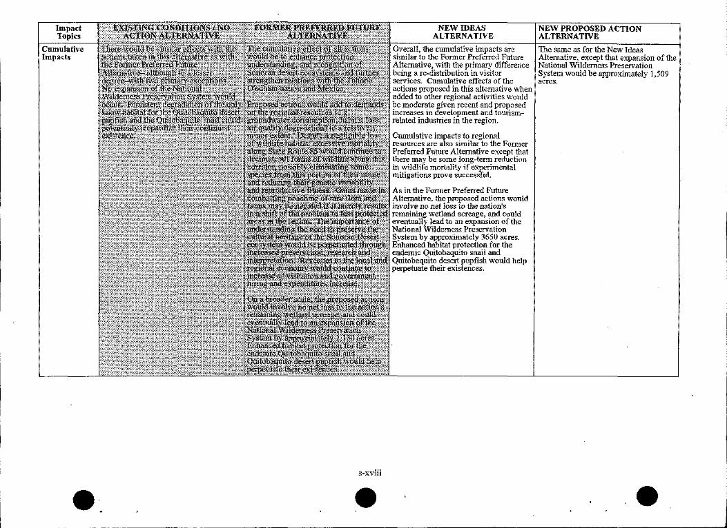
Cumulative Impacts
s-xviii
NEW IDEAS ALTERNATNE
Overal1, the cumulative impacts are similar to the Fonner Preferred Future Alternative, with the primary difference being a re-distribution in visitor services. Cumulative effects of the actions proposed in this alternative \Vhen added to other regional activities would be moderate given recent and proposed increases in development and tourismrelated industries in the region.
Cumulative impacts to regional resources are also similar to the Former Preferred Future Alternative except that there may be some 1ong-tenn reduction in wildlife mortality if experimental mitigations prove successful.
As in the Fonner Preferred Future Alternative, the proposed actions would involve no net Joss to the nation's remaining v;retland acreage, and could eventually lead to an expansion of the National Wilderness Preservation System by approximately 3650 acres. Enhanced habitat protection for the endemic Quitobaquito snail and Quitobaquito desert pupfish would help perpetuate their existences,
NEW PROPOSED ACTION ALTERNATIVE
The same as for the New Ideas Alternative, except that expansion of the National Vv~iiderness Preservation System would be approximately 1,509 acres.
ALTERNA· TIVAS ...
TEMAST
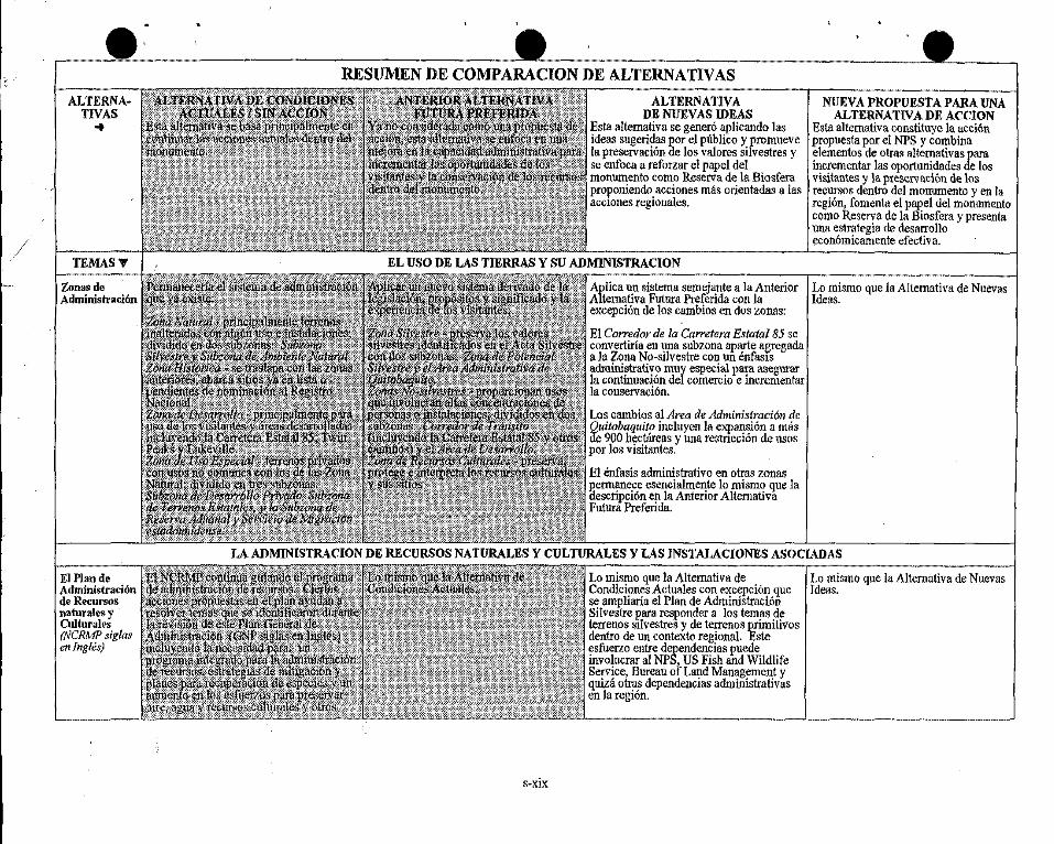
Zonas de AdministraclOn
El Plan de Administraci6n de Recursos natura\es y Cultural es (NCRMP siglas en Ingles)
RESUMEN DE COMP ARA CI ON DE ALTERNATIV AS
ALTERNATIVA DE NUEVAS IDEAS
Esta alternativa se gener6 aplicando las ideas sugeridas por el pliblico y promueve la preservaci6n de los valores silvestres y se enfoca a reforzar el papel de! monumento como Reserva de la Biosfera proponiendo acciones mas orientadas a las acc1ones regionales.
NUEVAPROPUESTAPARA UNA ALTERNATJV A DE ACCION
Esta altemativa constituye la acci6n propuesta por el NPS y combina elementos de otras altemativas para incrementar las oportunidades de los visi\antes y la preservaci6n de los recursos dentro de! monumento y en la region, fomenta el papel de! monumento como Reserva de la Biosfera y presenta una estrategia de desarrollo econ6micamente efectiva.
Aplica IUl sistema semejante a la Anterior Lo mismo que la Altemativa de Nuevas Altemativa Futura Preferida con la Ideas. excepci6n de las cambios en dos zonas:
El Corredor de la Carretera Estatal 85 se convertiria en una subzona aparte agregada a la Zona No-silvestre con IUl enfas1s adminislrativo muy especial para asegurar la continuaci6n del comercio e incrementar la conservaci6n.
Los cambios al Area de Administraci6n de Ouitobaquito incluyen la expansion a nliis ife 900 hec!Areas y una restncci6n de usos por los visitantes.
El emasis administrativo en olras zonas P.ermanece esencialmente lo mismo que la oescripci6n en la Anterior Altemativa Futura Preferida.
LA ADMINISTRACION DE RECURSOS NATURALES Y CULTURALES Y LAS INSTALACIONES ASOCIADAS
Lo mismo que la Altemativa de Lo mismo que la Alternativa de Nuevas Condiciones Actuales con excepci6n que Ideas. se ampliaria el Plan de Administraci6n Silvestre para responder a las temas de terrenos s!lvestres y de terrenos primitives dentro de IUl contexto regional. Este esfuerzo entre dependencias puede involucrar al NPS, US Fish and Wildlife Service, Bureau of Land Management y qniza otras dependencias administrativas en la regi6n.
s-xix
ALTER.¥A-11VAS ..
Instalaciones para AdmlnlstraclOn deRecursos
Recursos Culturales
Consulta con los Indfgena;; Nativos
Desarrollar un convenio escrito de beneficio mutuo entre NPS y la Nacion Tohono O'odham para reforzar la consulta 1 coordinaci6n e involucramiento de estos. (Nota: en los comentarios de la Nacion O'odham al NPS se subray6 la necesidad y la importancia de este convenio y, subsecuentementet se ha agregado a esta y a todas Alternativas.)
•·. s-xx
•
ALTERNAITVA DE NUEVAS IDEAS
Se construiria un nuevo Centro de Administraci6n de Recursos~ Ciencia y Educaci6n (SERMC slglas en Ingles) de 465 metros cuadrados para responder a las necesidades para este tipo de instalaciOn de acuerdo con la descripci6n en la Anterior Aiternativa Futura Preferida. No obstante1 en esta alternativa. la instalaci6n seria mas pequeila y se ubicarfa en Lukeville, sin 1ncluir el invernadero ni el vivero. Se cambi6 el nombre deJ centro para que incluyera la educaci6n, respondiendo asf al uso de 1a instalaci6n por Jos visitantes. Se estableceria una insta1aci6n fuera de1 monumento para prestar servicios de vivero. Se eliminari'.an las oficinas de administracion de recursos que ya existen en le c.lrea· de Twin Peaks y se resta:uraria e1 terreno.
Lo mismo que la Anterior Alternativa Futura Preferida~ con la excepc16n de la modificaciOn del trato de dos propiedades: • los programas interpretativos se instrumentarian en el Rancho Dos Lomitas en sustituci6n det anterior anfiteatro en Twin Peaks y el sitio de a cam par • tos cambios en el uso de Quitobaquito por visitantes, controlado por permisos o empleando gulas.
Lo mismo que la Alternativa de Condiciones Actuates. Se ampliaria el convenio para incrementar el involucramiento de la Naci6n Tohono O'odham en el programa de interpretaciOn del monumento. La forma y la amplitud de este involucramiento seria determinado por ambas partes.
NUEVA PROPUESTA PARA UNA ALTERNA11VA DEACCION
Al igual con la Alternativa de Nuevas Ideas, se propane un SERMC de 465 metros cuadrados. No obstante, en esta aJternativa se le ubicaria en Twin Peaks, convirtiendo la instalaci6n actual de visitantes y administraci6n y, ademas, se construirfa un invernadero y vivero cercanos para la educaci6n de los visitantes y para investigaci6n. Las oficinas actuales de administraci6n de recursos revertiri.an a residencjas para los empleados tal como en la Anterior Alternativa Futura Preferida.
Anterior Afternativa Futura Preferida.
Lo mismo que la Alternativa de Nuevas Ideas.
•
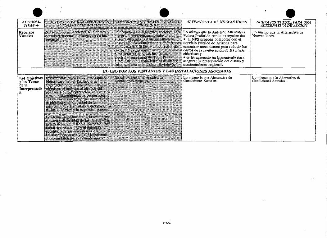
ALTERNATIVAS ...
Recursos Visuales
U.s Objetivos ylos Temas de la Interpretaci6 n
e e ALTERNATIVA DE NUEVAS IDEAS NUEVA PROPUESTA PARA UNA
ALTERNATIVA DE ACCION
Lo mismo que la Anterior Alternativa Lo mismo que la Alternativa de Futura Preferida con la excepci6n de: Nuevas Ideas. • el NPS propone colaborar con el Servicio Pllbltco de Arizona para encontrar mecanismos para reducir los costos de la re-ubicaci6n de Jas lineas el€ctricas y • se ha agregado un lineamiento para asegurar la preservaci6n del disefiu y mantenimiento regional.
EL USO POR WS VISITANTES Y LAS INSTALACIONES ASOCIADAS
s-xxi
Lo mismo Ia que Alternativa de Condiciones Actuales.
Lo mismo que la Alternativa de Condiciones Actuales.
ALTERNATIVAS ...
Instalaciones para la lnterpretaciOn
Asociaciones y E:xtensionllmo
Sitios de Acampar
• s-xxii
•
ALTERNATIVA DE NUEVAS IDEAS
Eliminar el centro de visitantes y el anfiteatro en el 3.rea de Twin Peaks. Para lograr este objetivo v los temas: • apoyar la Alianza ·en la creacion de un centro tri-cuitural y tri-nacional en el area de Lukevilie y crear una relaci6n co1aborativa para interpretar los temas del NPS en relac16n a los aspectos culturales • desarrollar la colaboraci6n con otras ~endencias federa]es para establecer una instalaci6n regionahnente enfocada en Why para proporcionar informaci6n y orientaci6n en relaci6n a las oporlun1dades para los visitantes; el tamafio y la ubicaci6n se detenninaria en consulta con los socios en el proyecto en el futuro. • asimismo, dentro de 1as insta1aciones en Why el NPS procuraria interpretar el monumento v SU."'.: recursos • cuatro sitiOs en et acotamiento de 1a Carretera Estatal 85 inc1uyendo casetas de infonnaci6n en ]oS extremos norte y sur con estacionamientos, exhibiciones y sombra.
E1 potencial de una asociaci6n con la Ahanza, otras dependencias federales, e1 Estado de Arizona y 1a Naci6n Tohono 0 1odham aumenta en esta altemativa en relaci6n al caracter de 1as instaJaciones que se proponen, Jos programas y los convenios.
Eliminar Jos 208 sitios de acampar en Twin Peaks_,. asi como eliminar los estacionam1entos J?aTa los Vehiculos Recreativos (RV siglas en Ingles) en los terrenos de1 NPS~ clausurar el campamento de pernocta en Canyon de A1amo e incrementar las oportunidades de acampar en 1os sitios primttivos por medio de; • convertir el actual siho de acampar en Twin Peaks en un senderc de dos kil6metros y medio para llegar a pie a 6 o 10 sitios de acampar; se desarrollaria un nuevo sitio para iniciar el paseo con estacionam1ento para entre 6 y 10 vebiculos en el camino de entrada • convertir el camino circular de acceso a las residencias a un campamento primitivo con 15 a 20 sitios de acampar.
NUEVA PROPUESTA PARA UNA ALTERNATIVA DEACCION
Se proponen las siguientes instalaciones para satisfacer el aumento en la demanda <:le servicios para los visit.antes en la regi6n y_ 1ograr los objetivos y los temas dentro del monumento: • lo mismo que en Altemativa de Nuevas Ideas, apoyar el Centro que propone Ia Atianza en Lukeville • en forma semejante a las Alternativas de Nuevas Ideas, desarroUar asociaciones para establecer un centro de infonnac:i6n y orientaci6n regional en Why • convertir una parte del actual centro de visitantes y ad:Iri1nistraci6n en Twin Peaks en un centro interpretativo enfocado principalmente en la administraci6n Ge recursos. (Para 6.to se agregaria una nueva instalaci6n de 350 metros cuadrados a los 550 metros cuadrados en la estructura que ya existe; de estos un total de 418 metros cuadrados se dedicarian al centro interpretativo y el resto al SERMC). • 1o mismo queen ]a Altemativa de Nuevas Ideas se crearian tres sitios en el acotamiento del la Carretera Estatal 85.
Lo mismo que Ias Alternativas de Nuevas Ideas.
Lo mismo ~e la Anterior Altemativa Futura Preferida.
•
r------------------------------------------------------------
ALTERNATIVAS ..
Red de Transporte del Area:
Caminos
Red de Transporte del Area:
Carretera Estatal 85
Lo mismo que con la Altemativa de Condiciones Actuales. Adicionalmente, el NPS procuraria colaborar con el estado para agregar rotulaci6n informativa y aescansos en el acotamientoceerca de las dos entradas al monumento, ai!adiendo tres descansos en el acotamiento. No se proponcn casetas de peaje. (Nata: en la propuesta origin!tl, NPS prop'.'so buscar una rota altemativa para el trafico comercial y otro para el trafico general coma parte de! esfuerzo de planeaci6n. Se ha descartado esta ideadebido a una gran preocupaci6n por parte de! publico, asi como la falta de informaci6n que demostrara que la propuesta reduciria significativarnente la mortandad de la fauna silvestre en este corredor.)
s-xxiii
ALTERNATIVA DE NUEVAS IDEAS
Se eliminarian aproximadamente 3 l kil6metros de caminos incluyendo los de! area de Twin Peaks y los caminos de patmlla de Quitobaquito, Noroeste y la Frontera Occidental. Se convertirian algunos de estos caminos en senderos o rotas para peatones (ver la secci6n de Senderos mas adelante) mientras otros serian restaurados a sus coudiciones natural es.
Se construiria aproximadarnente 3/4 de kil6metro de nuevo camino en el area de Lukeville r.ara servir las necesidades del SERMC, el complejo de mantenimiento y cuartel de bomberos y la aldea de casas de remolque VIP.
Lo mismo que la Altemativa de Condiciones Actuales~ con excepci6n de que en esta alternativa, se propone un program• para reducir los tmpactos relacionados con la carretera a la vez que se asegura la continuidad del comerc.io e incrementa la experiencia de Ios visitantes. El progran1a incluiria la creacion de descansos con informaci6n intetpretativa, instrumentaci6n de un programa de educaci6n publica y la experimentaci6n con la mitigaci6n de los impactos por medio de la constrocc\6n de pt1entes •[I !as arroyos y otros mecarusmos para prop1c1ar el movimiento de la vida silvestre en fonna mas segura.
NUEVA PROPUESTA PARA UNA ALTERNATIVA DE ACCION
Lo mismo que en la Altemativa de Condiciones Actuales con la excepci6n de que se ajustarian los trayectos de algunos caminos en el area de Twin Peaks y Quitobaquito.
Las acciones para Twin Peaks serian semejantes a la Anterior Alternativa Futora Preferida: se construirian aproximadamente 250 metros de nuevo camino; se eliminarJan 250 metros del camino de dos carriles ya en existencia y se restaoraria el area; los visitantes y empleados cada uno tendrian acceso por separado a las areas de estacionamiento; se agregaria un retomo con 120 metros de cam1no nuevo en la entrada de Puerto Blanco Drive. Para Quitobaquito, las acciones serian semejantes a 1as Alternativas de Nuevas Ideas.
Lo mismo que las Altemativas de Nuevas Ideas.
ALTERNATIVAS-t
Senderos y Rutas Para Peatones (Nota: Se mejoranyse mantienen los senderos. las rotas para peat ones pueden estar seiiala!1os pero no me1orados ni mantenidos.)
Person.a)
•
ALTERNATJVA DE NUEVAS IDEAS
Se eliminarian mas de 3 ki16metros y medio en el area de Twin Peaks a la vez que se mantendria el resto del sistema. Adem<is, se agregarian ocho senderos nuevos ~5 kil6metros) y cuatro rutas nuevas 60 kil6metros) para incrementar la interpre ci6n y el acceso de ]os visitantes a los recursos. La mayoria de lo que se agr~a seria en sitios de caminos antenores o en areas va afectadas, tales como los nombrados
4
senderos sociales. En esta alternativa se modificarian 9 kil6metros de senderos para acomodar sillas de ruedas.
NUEVA PROPUEST..4 PARA UNA ALTER.NAT/VA DE ACCION
Lo mismo gue la Anterior Alternativa Futura Preferidal con excepcibn de que se han reducido os senderos que se aiiaden a 8 nuevos (12 kilo metros) a Ia vez que los senderos accesibles aumentan en casi nueve kil6metros. Estos cambios ocurren porque: • uno de los senderos que se propusieron en la Anterior Alternattva Futnra Preferida se encuentra muy cercana al habitat de l~ boa rosada y por consecuencta no se propuso en este plan • el ajuste en el sendero de Quitobaquito es el mismo que se habia propuesto en las Alternativas de Nuevas Iaeas reduciendo el kilometraje total de senderos e incrementa el niimero de kil6metros de senderos accesibles. Las rutas que se proponen son los mismos queen la Anterior Alternativa Futura Preferida.
LA OPERACION DEL PARQUE E INSTALACIONES ASOCIADAS ~~~~~~~~~~~~~~-..,~~~~~~~~~~~~~--j
Ya que los estimados del pasado pueden Lo mismo que las Alternativas de resultar .incorrectos en vista de la actual Nuevas Ideas. situaci6n fiscal esta a1temativa propone solamente 1 S empleados adicionales. Esta cifra se basa en la tasa de aumento de empleados en los iiUimos ailos, este ha sidO de un empleado por afio, en vez de proyecciones de las necesidades reales. Ademas, el NPS buscaria subvenciones o asociaciones para mitigar los costos del ~ersonaL El uso de vo1untarios continuara de acuerdo con la Alternativa de Condiciones Actuates.
s-xxiv
• •
ALTERNA-11VAS ..
lnstalaciones para Operaciones
Residencias Para Empleados
S•XXV
ALTERNATIVA DE NUEVAS IDEAS
Eliminar todas las instalaciones para operaciones de! area de Twin Peaks. En SU lugar: • compartir o arrendar 185 metros cuadraaos en Ajo para oficinas administrativas • Construir un complejo de mantenimiento y cuartel de bomberos en Lukeville en una parcela de 2,000 metros cuadrados; las mstalaciones incluyen: 232 metros cuadrados para oficina y area de trabajo, 1,115 metros cuadrados para estacionamiento y areas de trabajo, 464 metros cuadrados de alrnacenam1ento y 232 metros cnadrados de cobertura para el cami6n de bomberos y almacenarniento relacionado. • buscar una relaci6n colaborativa para ubicar las operaciones de guardabosques dentro de instalaciones federates de poco uso en la Reserva de Aduana y Migraci6n en Lukeville.
Elirninar las residencias de! area de Twin Peaks. Buscar la colaboraci6n con una dependencia federal o un particular ['.lara proporcionar lo siguiente en el area ae Lul(eville: • apartamentos con un total de I 0 recamaras para trabajadores temporales e investigadores • cit}co res\d~ciasfar" empleados que requ1eren v1v1r en e s1tio para proporcionar seguridad para vidas, propiedad y los recurses de! monurnento • para uso de todos los residentes de! area, modificar una parte de la estructura que ya existe o construir un pequeilo centro comunitario para reuniones o funciones sociales.
NUEVA PROPUESTA PARA UNA ALTERNATIVA DE ACCION
Se propone lo siguiente para res110nder a las necesidades de oficina, trabaio y almacenamiento econ6micamente eficiente: • buscar una relaci6n colaborativa para obtener 185 metros cuadrados para una oficina adrninistrativa en instalaciones federa!es sub-utilizadas de la Reserva de Aduana y Mi~raci6n en Lukeville • amp liar el area de rnantenirniento de acueri:io con la descripci6n en la Anterior Alternativa Futura Preferida agregando 371 metros cuadrados para las operaciones de los guardaparques y el cuartel de bomberos y un aterrizaje para helic6pteros aledafio.
Al igual queen la Anterior Alternativa Futura Preferida, se rnodificarian cinco edificios para residencias de empleados en el firea de Twin Peaks. Lo 1n1smo que en las Alternativas de Nuevas Ideas el NPS buscaria la colaboraci6n para suministrar lo siguiente en el area de Lukeville: • apartamentos para trabajadores temporales e investigadores • un pequefio centro comunitario para los residentes de! y de! area.
ALTERNATJVAS ...
Twin Peaks
• s-xxvi
•
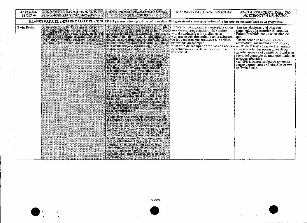
ALTERNATIVA DE NUEVAS IDEAS
El <irea de Tv.'in Peaks se convertiria en un Area de acampar primitivo. El camino actual conduciria a los visitantes a: • un nuevo estacionarniento en la cabecera de los senderos que conducen a los sitios primitivos de acampar • un sitio de acampar primitivo con acceso de vehiculos cerca del anterior camino residenciaL
NUEVA PROPUESTA PARA UNA ALTERNATIVA DE ACCION
Las instalaciones y el plan son semejantes a la Anterior Altemativa Futura Pref erida con la excepci6n de que: • hasta donde se reducen, en esta altemativa, Ios nuevos edificios y el ajuste en la trayectoria de los caminos • se ubicarlan las operaciones de los guardaparques y el cuartel de bomberos cerca del complejo de mantenimiento, en terrenos afectados •el NPS buscaria establecer un nuevo centro comunitario en Lukeville en vez de Twin Peaks.
•
• ALTERNA-171'ltS-+
El Area de AdministraciOn de Quitobaquito
EI Area de Lukeville
s-xxvii
ALTERNA TJVA DE NUEVAS IDEAS
Se mantendria la meta de mejorar Ia experiencia y Ia s~uridad de Ios visitantes como en la Anterior Afternativa Futura Preferida. No obstante, se re-ubicarian las instalaciones en base a un difilogo con ~resentantes de la Naci6n 0 1odham. ESte concepto de desarrollo es general; la delicada naturaleza de esta area requiere un grupo de trabajo con representantes de vanas d~ndenc1as para desarro1lar lll1 disefio del area una vez que se obtiene el presupuesto para el plan.
Se crearia una nueva cabecera de sendero en el en:tronque de Puerto Blanco Drive v el anterior camino de entrada. Se ' estahleceria una red de senderos de kiLOmetro y medio~ ida y vuel~ en el sitio del actual camino de entrada. Para auxiliar en ]a protecci6n de los recursos se requerinl que los visitantes obtengan un J?ermiso o participen en una gira guiada del area. Lo mismo queen la Anterior Altemativa Futnra Preferida, se mantendria el acceso administrativo a la zona fronteriza.
Se sustituiria al PCD de 1978 con los siguientes e]ementos: Se desarrollarian el nuevo SERMC, el complejo de mantenimiento y cuarteI de bomberos, el area VIP y el centro de infonnaci6n surefio en terrenos de! NPS. Ademas, el NPS apoyaria a la Alianza en el desarrollo de 1ll1 centro tri-cultural, tri-nacional en esta zona y buscarla fonnar re1aciones colaborativas para: • yroporcionar alojamiento para un numero limitado de empleados temporales y pennanentes de! NPS • Desarrollar un centro comunitario para todos los residentes del Area • compartir oficinas en la frontera para la operac16n de los guardaparques.
• NUEVAPROPUESTA PARA UNA ALTERNATIVA DE ACCION
Lo mismo que en las Alternativas de Nuevas Ideas.
Se sustituiria al PCD de J 978 con ios siguientes elementos: al igual de la Anterior AJternativa Futura Preferida, el NPS buscaria incrementar los enlaces entre Lukeville y los recursos y valores de! monumento. Al ignal que en Alternativa de Nuevas Ideas NPS apoyaria los esfuerzos de la Alianza y buscaria asociaciones J?ara: • proporcionar alojannento, pero solarnente para empleados 1emporales de!NPS • desarroHar un centro comunitario para todos los residentes de! area • compartir e~acio de oficina en la frontera, con la excepci6n de la administraci6n del NPS.
ALTERNATIVAS-t
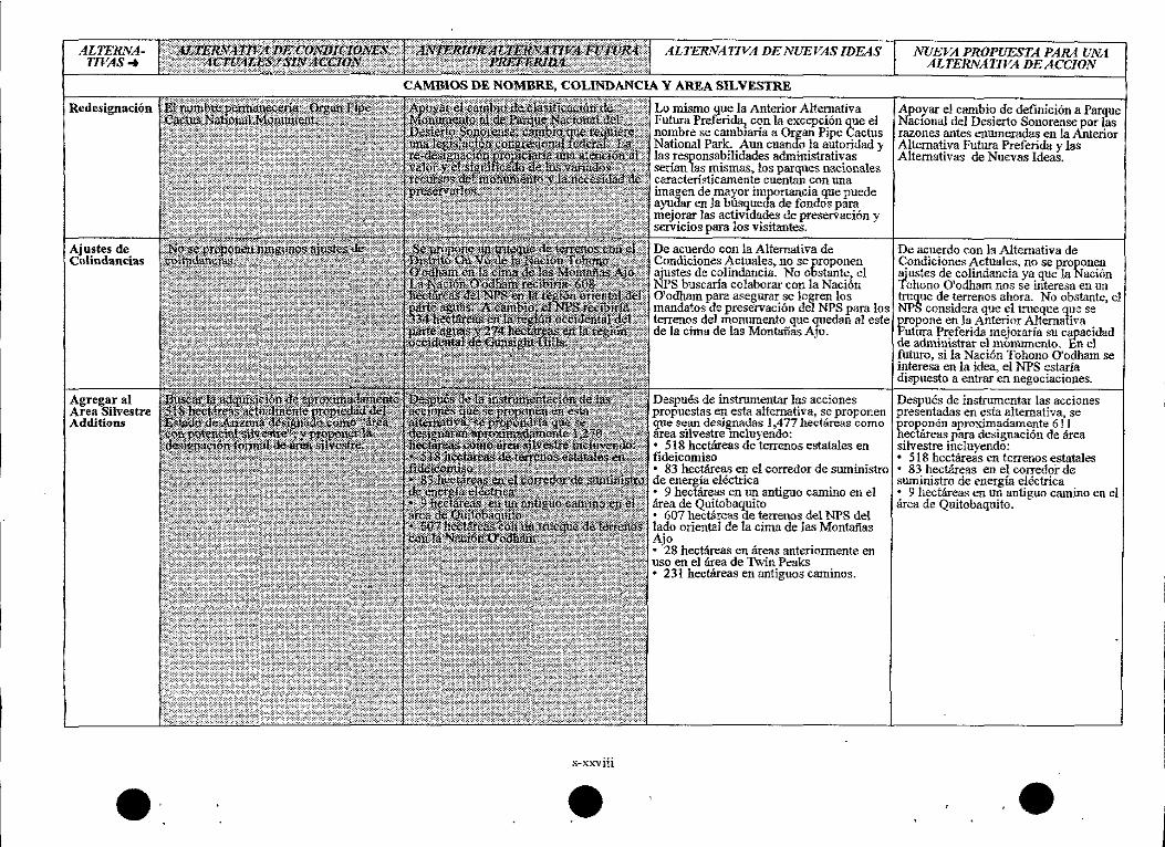
Redesignaci6n
Ajustes de Colindant:ias
Agregaral Area Silvestre Additions
•
ALTERNA TIVA DE NUEVAS IDEAS
CAMBIOS DE NOMBRE, COLINDANCIA Y AREA SILVESTRE
s-xxviii
•
Lo mismo que Ja Anterior Alternativa Futura Preferida? con la excepci6n que el nombre se camb1aria a Organ Pipe Cactus National Park. Aun cuando la autoridad y las responsabilidades administrativas serian las mismas, los parq_ues nacionales caracteristicamente cuentan con una imagen de mayor importancia que puede ayudar en la btisqueda de fondOs para mejorar las activ1dades de preservaci6n y servicios para 1os visitantes.
De acuerdo con la Alternativa de Condiciones Actuates~ no se proponen ajustes de co]indancia. No obstante, el NPS buscaria colaborar con la Naci6n 0 1odham para asegurar se logren los mandatos de preservaci6n del NPS para los terrenos del monumento que quedaii al este de la cima de las Montaiias AJo.
Despues de instrumentar las acciones propuestas en esta alternativa, se proponen gue sean designadas 1,477 hect8reas como area silvestre mcluvendo: • 518 hectareas de "'terrenos estatales en fideicomiso • 83 hectareas en el corredor de suministro de energia electrica • 9 beet.areas en un antiguo camino en el area de Quitobaquito • 607 hec!Areas de terrenos de! NPS de! !ado oriental de la cima de las Montaiias Ajo • 28 hectareas en areas anterionnente en USO en el area de Twin Peaks • 231 hectareas en antiguos c-aminos.
NUEVA PROPUESTA PARA UNA ALTERNATIVA DEACCION
Apoyar e1 cambio de definici6n a Pargue NRcronaJ del Desierto Sonorense por las razones antes enumeradas en la Anterior Alternativa Futura Preferida y las Alternativas de Nuevas Ideas.
De acuerdo con la Altemativa de Condiciones Actuates~ no se proponen ajustes de colindancia va que ]a NaciOn 'fohono O'odham nos Se interesa en un ~que de terrenos ahora. No obstante, e1 NPS considera que el trueque que se propone en la Anterior Altemativa Futura Preferida mejoraria su capacidad de administrar el monumento. En el futuro, si la Naci6n Tohono O'odham se interesa en la idea, el NPS estaria dispuesto a entrar en negociaciones.
Despues de instrumentar las acciones presentadas en esta altemativa, se pro~nen aproximadamente 611 hectcireas para designaci6n de area silvestre incluyendo: • 518 hectareas en terrenos estata1es • 83 hectareas en el corredoi- de suministro de energia el&trica • 9 hectilreas en un antiguo camino en el area de Quitobaquito.
•
.----------------------------------------------
• ALTERNATIVAS-+
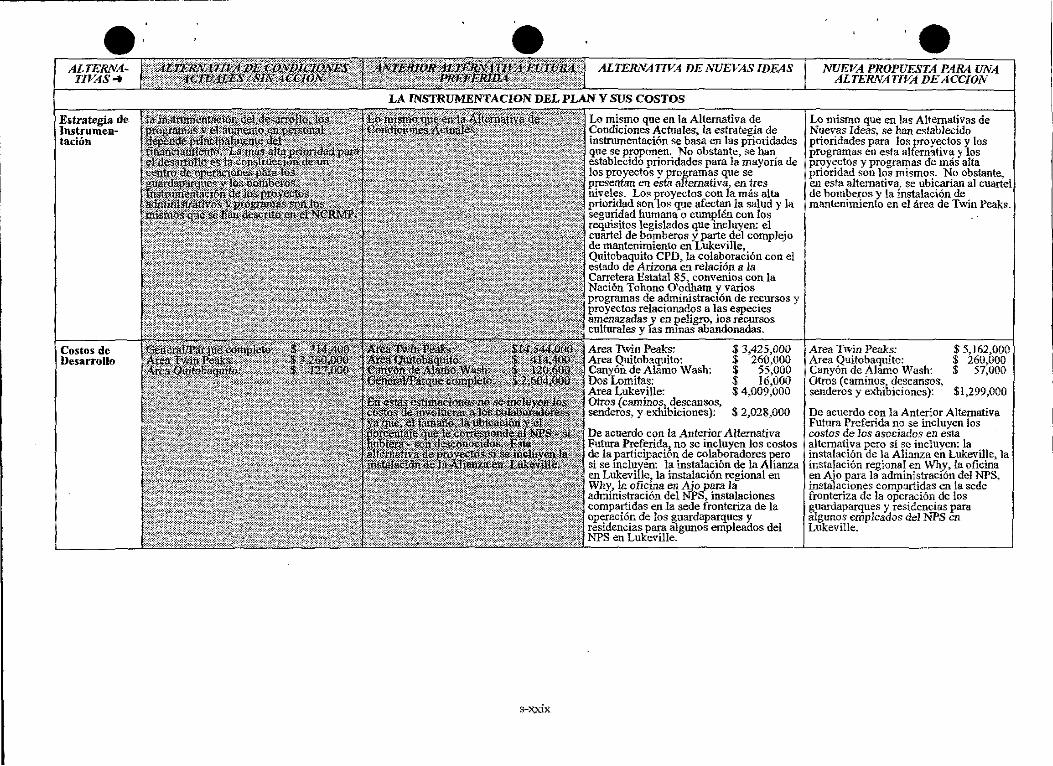
E.trategia de lnstrumentaciOn
Costas de Desarrollo
• ALTERNATIVA DE NUEVAS IDEAS
LA lNSTRUMENTACION DEL PLAN Y SUS COSTOS
s-:x;xix
Lo mismo que en la Alternativa de Coruliciones Actuates, la estrategia de instrumentaci6n se basa en las prioridades que se prcponen. No obstante, se han establecido prioridades para la mayoria de los proyectos y programas que se presentan en est.a alternativ~ en ires niveles. Los proyectos con la mas alta prioridad son los que afec!an la salud y la seguridad humana o Cll1llJ?len con los requisitos legislados que mcluyen: el cuartel de bomberos y_ parte de! complejo de mantenimiento en LUkeville, Quitobaquito CPD, Ia colaboraci6n con el estado de Arizona en re1aci6n a la Carretera Estatal 85, convenios con la Nacion Tohono 0 1odham y varios programas de administrac16n de recursos y proyectos relacionados a las especies amenazadas y en peligro, Jos recursos culturales y fas m1nas abandonadas.
Area Twin Peaks: Area Quitobaquito: Canyon de Alamo Wash: Dos Lomitas: Area Lukeville: Olros (carnino;;, descansos, senderos, y exhibiciones ):
$ 3,425,000 $ 260,000 $ 55,000 $ 16,000 $ 4,009,000
$ 2,028,000
De acuerdo con la Anterior Alternativa Futura Preferida~ no se incluyen los costos de la participaci6n de colaboradores pero si se mcluyen: la instalaci6n de la Alianza en Lukeville~ la instalaci6n regional en Why, la oficina en Aio para la administraci6n del NPS-~ instalaciones compartidas en la sede fronteriza de la operaci6n de los guardaparques }'. residencias para algunos empleados del NPS en Luk:eville.
• !VVEVA PR.OPUESTA PARA UNA ALTERNATIVA DE ACCION
Lo mismo que en las Alternativas de Nuevas Ideas, se han estab1ecido prioridades para los proy~tos y los programas en esta alternativa y los proyectos y programas de mas alta prioridad son los mismos. No obstante, en esta alternativa, se ubicarian al cuartel de bomberos y la instalaci6n de mantenimiento en el iirea de Twin Peaks.
Area Twin Peaks: Area Quitobaquito: Canyon de Alamo Wash: Otros (caminos, descansos, senderos y exhibiciones ):
$ 5,162,000 $ 260,000 $ 57,000
$1,299,000
De acuerdo con la Anterior Altemativa Futura Preferida no se incluyen Jos costos de las asociados en esta a)ternativa pero si se incluyen: la instalaci6n de la Alianza en Lukeville> la instalaci6n regional en \Vhy~ la oficina en Ajo para la administraci6n de) NPS, jnst.aJac1ones compartidas en ia sede fronteriza de la operaci6n de los guardaparques y residencias para algunos empleados de! l'<'PS en Lukeville.
Temas de Impacto
Zonas Silvestres
Calidad del Aire
Las Planicies Alul·iales, Humedales y Recunos HidniuUcos
•
RESUMEN DE LA COMPARACION DE CONSECUENCIAS
s-xxx
•
ALTERNATIVA DE NUEV AS IDEAS
Los terrenos que se caracterizan como silvestres pudieran aumentarse en aproximadamente 1,477 hectareas, ofreciendo una maxima protecci6n de las 8.reas silvestres "! SUS valores. Los impactos significabvos de la Carretera Estatal 85 continuarian por un largo plazo.
Lo mismo que en Condiciones Actua\es I Sin Acci6n.
Lo mismo que la Anterior Alternativa Futura Preferida~ con la excepci6n de la disminuci6n en el consumo de agua en Twin Peaks~ pero con un aun1ento en Lukeville y Why. Aun cuando se redefine la red de senderos en Quitobaquito en esta altemativa, el impacto en las funciones del humedal pudieran ser positivas como lo es en la Anterior Altemativa Futura Preferida.
ALTERNATIVA DE NUEVAS PROPUESTAS
Los terrenos que se caracterizan como sHvestres se incrementarian en aproximadamente 611 hectareas. Los Jmpactos significativos de la Carretera Estatal 85 continuarian por un largo plazo.
Lo mismo que en Condiciones Actuales I Sin AcciOn.
Lo mismo que en la Anterior Alternativa Futura Preferida.
••
Temas de Imp a eta
Especies Amenazadasl en Peligro y Sensibles
La Vida Silvestre
VegetaciOn
s-xxxi
ALTERNATIVA DE NUEV AS IDEAS
Como en la Anterior Alternativa Futura Preferida, la creacion de un sistema de senderos bien definido en Quitobaquito repercutiria en forma positiva en el habitat de la tortuga de cienaga Sonorense, el caracoI de Quitobaquito y el fez cachorro del desierto. La clausura de sitio de acampar de Cany6n de Alamo reduciria las visitas con los consecuentes beneficios al murcieiago narigudo y el tecolote enano. Ciertas practicAs experimentales en ]a Carretera Estatal 85 contribuiria a reducir los impactos a la boa rosada Mexicana y otras especies sensibles.
Los impactos positivos en la vida silvestre resultarian cuando se redujera el desarrollo y se incrementen los habitats silvestres. Experimentos con puentes, drenajes, cercos y programas de educaci6n e informaci6n para lograr un apoyo piiblico y atraer investigadores puede reducir los impactos a Ia vida silvestre en la Carretera Estala! 85.
Lo mismo que con la Anterior Altemativa Futura Preferida. Se afectarian aproximadamente 2 hectareas con nuevas construcciones y se restauraria a su condici6n natural a 24 7 hectareast con un aumento neto de245 hectareas.
ALTERNATIV A DE NUEVAS PROPUESTAS
Lo mismo que la Altemativa de Nuevas Ideas con la excepci6n de que el sitio de acampar de Canyon de Alamo permaneceria y se agregarian cuatro sitios mas. No obstante, no ocurririan impactos negativos para el rnurcielago narigudo y el tecolote enano.
Lo mismo que en la Anterior Alternativa Futura. Preferida, los desarro1los que se proponen no resultarian en perdida adicional de habitat silvestre y. para Quitobaquito, serian positivos. Lo mismo queen )a Altemativa de Nuevas Ideas, experimentos con puentes, drenajes, cercos y programas de educaci6n pUblica pudieran reducir los impactos en la Carretera Estatal 85.
Semejante a Ia Anterior Aitemativa Futura Preferida. La nueva construcci6n impactaria aproximadamente 20 hectareas y se restaurarian 8 l hectareas a su condici6n natural con un aumento neto de 61 hect<ireas.
Temas de Impacto
Recursos Culturales
El Uso y la Experiencia del Visitante
Efectos Socio EconOmicos
• s-xxxii
•
ALTERNATIVA DENUEVASIDEAS
Semejante a la Anterior Alternativa Futura Preferida, con la excepci6n de que, en esta alternativ~ una mejor administraci6n de los visitantes y el monitoreo de areas sensibles reducirian el impacto a Ios recurses cu1turales.
En conjwito, la instrumentaci6n de esta alternativa resultaria en impactos positivos para el uso y la experiencia de los visitantes. La experienc1a de los visitantes puede verse afectada en forma positiva al separar Ios recursos del monmnento y las instalaciones que proporcionan informaciOn e interpretaci6n {en Why). Eliminaci6n de las instalaciones en Twin Peaks y la clausura del campamento de Cany6n de Alamo beneficiaria a los visitantes que buscan mayor soledad. No obstante, la eliminaci6n del campamento de . vehiculos recreativos del area de Twin Peaks afectaria adversamente a los visitantes que no aceptan una experiencia altemativa en esta area. Los efectos cumulativos del TLC continuarian en form.a semejante a lo que se ha descrito en la A1temativa de Condiciones Actuales.
ALTERNATIV A DE NUEVAS PROPUESTAS
Lo mismo queen la Alternativa de Nuevas Ideas.
Semejante a la Anterior Altemativa Putura Preferida con la excepci6n de que se re-ubicruian alglUlos visitantes fuera del monumento. La experiencia de los visitantes se beneficiaria con otras opciones en Why y T\'\rin Peaks. Los efectos cumulativos def TLC continuarian.
Lo mismo queen la Anterior Altemativa Lo misrno queen Ia Anterior Alternativa Futura Preferida. Futura Preferida.
•
• Temas de Impacto
Caracteristicas Socio.-cultural es (Nota: Se ha agregado este teniade impacto a este Suplemento)
No habria un impacto negativo para las poblaciones de bajos ingresos o grupos minoritarios coma resultado de est.a altemativa. Una intensif1caci6n en la relaci6n entre NPS y la Naci6n Tohono O'Qdham repercutirla en fonna positiva al bienestar socio-cultural en general. Las comunidades continuarian experimentando los efectos del cambio y una transici6n como resultado del crecimiento y el aumento del trafico en esta regi6n.
No habria un impacto negativo para las poblaciones de bajos ingresos o grupos minoritarios como resultado de esta altemativa. -una intensificaci6n en la relaci6n entre NPS y la Naci6n Tohono O'odham repercutiria en forma positiva al bienestar socio cultmal general.
ALTERNATIVA DENUEVASIDEAS
Semejante a la Anterior Alternativa Futura Preferida. En esta altemativa, aumenta el potencial para asoc.iac.iones e involucram1ento con la Naci6n Tohono O' odham. Los cambios socio-culturales que resultarian de las varias acciones que se proponen~ en general, beneficiarian a las comunidades.
•• ALTERNATIVADENUEVAS
PROPUESTAS
Semejante a la Alternativa de Nuevas Ideas, con la excepci6n de que se proponen menos cambios v agregados en Lukeville y en Twin Peaks, por lo tanto, en estas Areas se reducirian los impactos socio-culturales relacionados.
Temas de Impacto
Impactos Cumulativos
• s-xxxiv
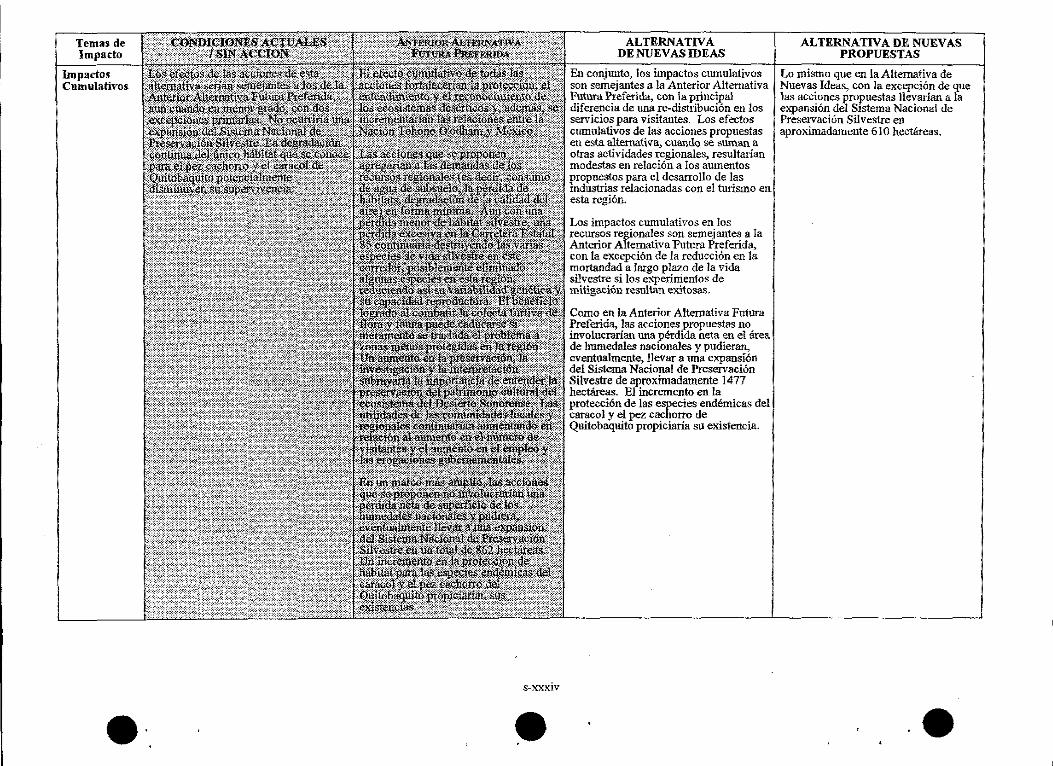
ALTERNATIVA DENUEVASIDEAS
En conjunto~ los impactos ctunu1ativos son semejantes a la Anterior Alternativa Futura Preferida, con la principal diferencia de una re-distribuci6n en los servicios para visitantes. Los efectos cumulativos de las acciones propuestas en esta alternativa, cuanOO se suman a otras actividades regionales, resultarian modest.as en relaciOn a los aumentos propuestos para el desarrollo de las Industrias relacionadas con el turismo en est.a regi6n.
Los impactos cumulativos en los recursos regionales son semejantes a Ia Anterior Alternativa Futura Preferida, con la excepci6n de la reducci6n en la mortandad a largo plazo de la vida silvestre si los experimentos de mitiga.cIDn resultan exitosas.
Como en la Anterior Altemativa Futura Preferida, las acciones _f!ropuestas no involucrarian una pet:dida neta en el area de hmnedales nac1onales y pudieran, eventualmente, Uevar a una expansf6n del Sistema Nacional de Preservaci6n Silvestre de aproximadamente 1477 hectareas. El incremento en la protecci6n de las especies endemicas del caracol y el pez cachorro de Quitobaquito propiciaria su existencia.
ALTERNATIVA DE NUEVAS PROPUESTAS
Lo mismo queen la Alternativa de Nuevas Ideas, con la excepci6n de que las acciones pr~ues1as Jlevarian a la expansion del Sistema Nacional de PreservaciOn Silvestre en aproximadamente 610 hectareas.
••
INTRODUCTION TO THE SUPPLEMENT
Introduction
PURPOSE AND NEED
The purpose of this Supplement is to present two new alternatives resulting from comments and concerns raised by the public and other agencies during review of the Draft GMP/DCP/EIS released in May, 1995. Comments leading to development of this Supplement involved:
• actions affecting use of State Route 85 (SR 85) • the number of alternatives presented • new ideas about cooperation between the NPS and others, and about development both within the monument and outside monument boundaries •requests for more involvement by the Tohono O'odham Nation • costs associated with implementing the alternatives • mitigation of impacts on natural resources, especially threatened and endangered species
After reviewing these and all other comments, the National Park Service (NPS) determined a supplement to the Draft GMP!DCP!ElS was needed. This document is intended to be just that-a supplement to the original document-as it provides additional information. The document you are reading is formally titled Supplement To The Draft GMP/DCP/ElS. To help avoid confusion between the documents, the original draft document will be referred to as the Draft GMPIDCPIEJS while this document will be referred to as the Supplement.
This Supplement contains: • an update on the planning process and public involvement including further description of some of the reasons for preparation of this Supplement and what steps to expect in the future •a discussion of the two new alternatives, one of which constitutes the National Park Service's new proposed action • a discussion of the enviromnental consequences of implementing the new alternatives • summary tables comparing the actions and consequences of the four alternatives
In the interest of avoiding duplication, information contained in the Draft GMPIDCP/EJS is incorporated here by reference and not repeated in this Supplement. The Natural and Cultural Resources Management Plan is summarized and also incorporated by reference and not duplicated in this document.
AN UPDATE ON PUBLIC INVOLVEMENT AND THE PLANNING PROCESS
In May ofl 995, the Draft GMPIDCPIEJSwas released for public review and comment. The NPS mailed or handed out more than 400 copies of the plan to interested people. Mailings contained a letter asking for comments on the draft plan, and invited citizens to participate in upcoming public meetings. The general nature of the meetings, comments, and what to expect next in the planning process are described below.
Public Meetings and Native American Consultations. The Draft GMP/DCP!ElS was presented at public meetings in Sonoyta, Sonora, Mexico, and in Aja, Phoenix, and Tucson, Arizona on May 8, 9, 10, and 11, 1995, respectively. In addition, meetings were held on June 8 and 9 with the Tohono O'odham Nation, including representatives from the Ria C'ed O'odham, at the Gu Vo and Hickiwan Districts and at the Legislative Council in Sells. The Intemational Sonoran Desert Alliance (ISDA) invited the NPS to make a short presentation on the plan which occurred during the May 1995 meeting of that organization. Briefings were also held with the Cabeza Prieta National Wildlife Refuge and with staff representatives of Senator John Kyl's and Congressman Ed Pastor's offices before the July 10 deadline.
Since that time, the NPS has held additional meetings to gather input into the development of the new alternatives. A public meeting was held in Ajo on October 25, 1995. In addition, on November 7 and
S-3
Introduction
21, 1995, the NPS consulted with the Tohono O'odham Nation at a Legislative Council meeting in Sells, and at a meeting held at Quitobaquito. At the legislative council meeting, discussion centered around access to sacred lands, and information used by the NPS regarding Tohono O'odham history and culture. The Quitobaquito meeting included a presentation and discussion about issues and proposals for the Quitobaquito Management Area.
Public Comments. In addition to the comments received at the public meetings, the NPS has received approximately 55 responses from other agencies, various organizations, and private citizens. A brief summary follows of some of the substantive comments that are addressed in the Supplement. Substantive comments relating to the Affected Environments section of the Draft GMPIDCP /EIS deal primarily with the need for factual corrections and will be addressed in the Final GMP/DCP/EIS.
Many comments were made in response to the impact of SR 85 on monument resources and the visitor experience. Concern was raised over any possibility of a toll being established on this road, and the negative impacts of traffic on rare, threatened, and endangered species.
Neither alternative in the Draft GMPIDCPIEIS proposes realignment of SR 85 or the establishment of a toll road. However, the Former Preferred Future Alternative does propose a future planning effort to find solutions to problems associated with the increasing impact of the volume and speed of traffic on wildlife and human safety.
The public presented some new ideas that may help alleviate some of the impacts of the traffic and the road on the monument. These ideas have been explored and are included in the new alternatives presented in this Supplement.
Some agencies and organizations felt that the range of alternatives presented in the Draft GMP/DCPIKIS did not consider the full range of possibilities regarding: facility development, both within the monument and outside monument boundaries, the potential for partnerships and other involvement with neighbors, managing visitor use in sensitive areas, and dispersing visitation across other areas. As with changes to SR 85, these ideas have been explored in the new alternatives in the Supplement.
Other concerns raised involved the need to include more specific procedures to mitigate impacts on air, water, plants, animals, soil, and the land and people inside and outside the monument. In response, the Environmental Consequences section of this Supplement has been improved and contains additional information including a new impact topic titled socio-cultural impacts. Also, a draft biological assessment is being prepared in consultation with the U.S. Fish and Wildlife Service (FWS), to analyze the impacts of the New Proposed Action on threatened and endangered species and to address mitigation procedures. A copy of the draft biological assessment can be acquired by contacting the monument and will be included in the Final GMP/DCP/EIS.
There were also questions regarding the costs of development. A discussion has been added in the Implementation and Costs section in this Supplement in an attempt to better define what is included in conceptual cost estimates.
Finally, it was felt that the NPS should further consult with the Tohono O'odham Nation and the public during the planning process. Consequently, the NPS held the meetings with the Tohono O'odham Nation and with the public as described previously. The NPS intends to continue communications with the Tohono O'odham Nation at both formal and informal levels to begin work on the proposed agreement and discuss topics of concern.
A variety of other comments and concerns were raised. Some of these are discussed in the Alternatives Considered but Rejected section in this Supplement. The remaining comments will be addressed within the final document to be prepared after public review of the Supplement. The process for developing A the final document is outlined below. •
S-4
-•
Introduction
The Planning Process: What's Next? After the Supplement is released to the public, a minimum 60-day review and comment period will occur, and \\~thin that period, one public meeting and at least one meeting with the Tohono O'odham Nation will be held. Also, the NPS is consulting with the FWS and preparing a biological assessment to help meet federal responsibilities under Section 7 of the Endangered Species Act (1973)_ Substantive comments received during the comment period would be reviewed and resolved in the Final GMP/DCP/EIS_ The Final GMP/DCP/EIS will consist of one document combining the Draft Glv!PIDCP/E!Swith the Supplement, any changes resulting from the public comment period for the Supplement, and the biological assessment along with a letter confirming successful completion of the Section 7 process. This final document would be distributed to the public and other agencies_ A Record of Decision, which is the final approval needed allowing the NPS to implement the plan, would not be signed for at least 30 days after the notice of availability of the final document appears in the Federal Register.
Once a plan of action is approved, when and how the actions and services described in the final plan would be implemented depends on the NPS programming and budgeting process as well as the NPS planning, design, and construction process_ The rate of implementation is directly tied to congressional funding levels--e_g., modest funding over the life of the general management plan means modest growth. Once funding is secured, development of new facilities would take three or more years from design through construction.
S-5
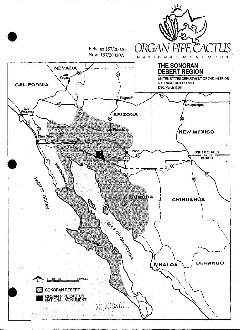
''\NEVADA ' Las 15
'\Vegas
CALIFORNIA ''\ r...J '\ I
\)
~ OE20-40C::==::!:"i100MILES
Ii SONORAN DESERT
• ORGAN PIPE CACTUS NATIONAL MONUMENT
------- -----
Pub!. as 157/20020 Now 157/20020A NATIONAL MONUMENT
THESONORAN DESERT REGION
I
UNITED STATES DEPARTMENT OF THE INTERIOR NATIONAL PARK SERVI.CE DSC/March 1996/!
NEW MEXICO
\ I
I I
,J I
\ I
I r-' \
I
\ ~---/ \
" \ "- r-• , __ ,,_, ~
\
(DURANGO l-" I
\
1..-, \
\
\ \
\ \
SUPPLEMENT TO
THE ALTERNATIVES
.e
INTRODUCTION
Two additional alternatives have been added to the two originally presented in the Draft GNJPIDCPIEIS and are described in this Supplement. The new alternatives are titled: New Ideas Alternative and New Proposed Action Alternative. As with the first two alternatives, the new alternatives fulfill the purpose and significance of the park, address issues raised, and achieve the desired futures statements all of which can be found in the Draft G!v!P!DCPIEIS, pages 9-13. These alternatives also help the NPS carry out the mandates of the 1916 Organic Act "to conserve the scenery and the natural and historic objects and wild life therein and to provide for the enjoyment of the same in such a manner and by such means as will leave them unimpaired for the enjoyment of future generations."
To aid the reader, the organization oftli.e alternatives is the same in both documents. Discussion of the two original alternatives-Alternative 1: The Preferred Future and Alternative 2: A Continuation of F.xistlng Conditions-remain essentially as described in the Draft GMPIDCPIEIS except for two important changes presented in this Supplement. First, along SR 85, there are no tolls, fee collection stations, traffic re-routes, orreduction of the current speed limit proposed within the monument in any of the alternatives. This change is further discussed in the Alternatives Considered but Rejected section of this Supplement. Secondly, the original alternatives have been re-named to help the reader identify the new range of alternatives. A chart follows showing the names of the original alternatives, the names of the new range of alternatives, a general defmition of the concept of each alternative, and in which document the descriptions of each alternative can be found.
TbllThN Ra a e . e ew ngeo fAlt ti erna ves
Original Names Names of the New General Concept Location of of Alternatives Range of Alternatives Alternative .
Description8
Alternative 2: Exis~ Conditions I Constitutes the NPS no action Draft Continuation of No Action Alternative alternative. Tiris alternative is based GMPIDCPIEIS; Existing Conditions
primarily on continuing the existing course of action and is required to be analyzed by NEPA.
pages47-59
Alternative I: Former Preferred No l~er the proposed action, this Draft The Preferred Future Alternative altemative focuses on improving GMPIDCP/EIS; Future management caeabilities to enhance pages 17-46
visitor OP.Portunities and resource preservation within the monument.
New Ideas Alternative Using ideas from the public, the concept S[kplement; see for this new alternative is to strengthen A ternative.s the monument's role as a Biosphere section Reserve by adopting a more regional ~oacb, enhance preservation of
erness values by removing and relocating many facilities, and enhance resource protection by more strictly managing visitor use.
New Proposed Action This alternative constitutes the NPS s'1f!lement; see Alternative ~posed action. CombinintY, features A tematives
m the other alternatives, e resulting section concept is to carry out principals of the MAB pr?~ by adop~tl a regio!lal perspective to unprove visitor services and conserve resources, and \\<·ithin the monument, improve management capabilities to enhance visitor ~ortunities and protect resources and
demess values.
S-11
Following this introduction are two discussions titled Alternatives Considered but Rejected and Actions Common to All Alternatives. The first section discusses those new actions proposed during the public A comment period that the NPS has rejected from further consideration and would replace the similar W discussion in the Draft GMPIDCP/FJS. The second section has been added to aid review of this Supplement by describing those actions that are common to all four alternatives.
English and Spanish versions of summary tables comparing the actions and consequences of all four alternatives can be found in the Summary section of this Supplement. This new summary, replaces the Summary found in the Draft GMP/DCPIFJS, pages v-xxii.
ALTERNATIVES CONSIDERED BUT REJECTED
The NPS analyzed all of the new ideas or alternatives that resulted from comments on the Draft GMPIDCP/EJS. Based on this analysis, some of the new ideas were incorporated into the new alternatives. A few ideas were rejected because they have been determined to be infeasible or beyond the scope of this project. These ideas are described below and the reason for the rejection of each is discussed.
The following discussion is intended to replace the similar section found on pages 17-18 in the Draft GMP!DCPIEJS. Some ideas originally rejected by the NPS, are now being considered in the new alternatives.
Re-route commercial thru-traffic outside of the monument. As stated in the public meeting held in Ajo on October 25, 1995, the NPS is not proposing in any of the alternatives to re-route traffic, A establish a toll road, or construct a fee-collection station at the entrance within the monument along SR •. 85. As discussed on page 18 of the Draft GMPIDCPIFJS, the NPS considered searching for an alternative route and port of entry for commercial and other through-traffic as part of a planing effort to include all interested parties. And, if a solution could be found, the NPS was interested in moving the entrance station at Twin Peaks to the road at the monument's entrances. Since at this time, none of the nearby land owners or managers want the traffic or related economic and environmental impacts, these proposals have been dropped from consideration. In the new alternatives, the NPS presents a proposal to work with the State of Arizona Department of Transportation (ADOT) to ensure continued travel and commerce along this road corridor, while at the same time improving resource conservation measures and the visitor experience.
The Former Preferred Future Alternative in the GMP/DCP/EIS also proposed to work with the State to see if the speed limit could be reduced by I 0 mph. This proposal was dropped from consideration at this time due to public concerns on the possible impact of this action on the economy, the lack of data showing whether a I 0 mph reduction in speed limit would result in a significant reduction in wildlife mortality, and comments from ADOT stating they have no intention ofreducing the speed limit along SR 85. However, the NPS would continue working with the State of Arizona Highway Patrol towards having the majority of vehicles travelling through the monument maintain the legal speed limit.
Expand the Tohono O'odham Nation to include the Monument. An idea to relinquish monument lands to the Tohono O'odham Nation was considered and rejected as being beyond the scope of this project. The Presidential Proclamation establishing Organ Pipe Cactus National Monument also directs the Secretary of the Interior, and consequently the NPS, to manage these lands in accordance with the 1916 Organic Act, as described above in the introduction to the new range of alternatives. Therefore, A the NPS is not able to relinquish the inherent federal responsibilities and authority to manage these W
S-12

.e
Alternatives
lands unless directed otherwise by the President or Congress of the United States. In response to this idea, the NPS has included other measures in the two new alternatives to further strengthen relations with the Tohono O'odham Nation and to help insure protection and preservation of sacred or traditionally-used areas contained within the boundaries of the monument.
Monument Expansion. As described in the Draft GMP IDCP/EJS, page 17, a proposal emerged early in the planning process to expand the monument to include the Cabeza Prieta National Wildlife Refuge. The NPS decided that this idea was not necessary since the monument and refuge are both being managed for wilderness values. However, a proposal to develop an inter-agency wilderness management plan has been added to the following alternatives and would include BLM lands as well as the refuge. The intent of this proposal is to help protect resources, ecosystems, and wilderness values that are presently bisected along the straight line boundaries that separate these management areas.
Ask Mexico to move Highway 2 farther south of its existing location. Moving Highway 2 as a means to improve the wilderness experience, enhance resource protection, and increase safety at Quitobaquito is beyond the scope of this project and impractical to pursue. Instead, alternative solutions such as increasing patrols, using permits, and establishing guided tours are explored in the new alternatives. The NPS feels these strategies are more feasible for Quitobaquito especially since the highway is in Mexico, and outweigh the impacts of attempting to relocate the highway. They will work as solutions to other concerns at Quitobaquito as well.
Re-establish historic Tohono O'odham communities at Quitobaquito. This action does not appear to be viable for a variety of reasons: there is no electricity or potable water at the site, human habitation in the area would pose a significant adverse impact to threatened and endangered species and wildlife use of the area, and this type of development is clearly inconsistent with the Wilderness Act which applies to a majority of the Quitobaquito area. Increasing the interpretation of the historic use of this area is addressed in the new alternatives.
Divert Central Arizona Project water to Quitobaquito to help recharge the aquifer. Accelerated groundwater pumping for agriculture in the Sonoyta Valley has been identified as one of the greatest threats to the monument's water resources. NPS staff received a suggestion to resolve this threat by diverting water from the Central Arizona Project to recharge the aquifer. The NPS determined this to be impractical due to the significant costs and environmental impacts involved.
The General Management Plan should serve as a primary vehicle for the Threatened and Endangered Species Recovery Plan. A suggestion for the general management plan to also serve the role of a Threatened and Endangered Species Recovery Plan was rejected as being beyond the scope and intent of the General Management Plan. A General Management Plan is intended to direct future management, not serve as the vehicle for detailed implementation plans such as a recovery plan. The General Management Plan can, however, identify the need for development of such a recovery plan. A discussion of the proposed Threatened and Endangered Species program, including development of a species recovery plan, can be found in a following discussion under Resources Management in the Actions Common to All Alternatives section.
S-13

Alternatives
e.
S-14
. e
ACTIONS COMMON TO ALL ALTERNATIVES
The following actions are common to all four alternatives, \Vhere applicable, the discussions replace those by the same title in the original two alternatives in the Draft GMP/DCPIEIS. All of the actions, including those common to all alternatives, are presented in comparison tables in the Summary section.
The common actions are described under the following topic headings: Natural and Cultural Resource Management, Visitor Use, Park Operations, and Wilderness Area Changes.
NATURAL AND CULTURAL RESOURCE MANAGEMENT: Natural and Cultural Resource Management Plan
As stated in both alternatives of the Draft GMP/DCPIEIS, the NPS uses Natural and Cultural Resources Management Plans-typically updated annually-to propose more detailed resource management strategies that would help achieve the basic goals presented in approved general management plans. Organ Pipe Cactus National Monument's Natural and Cultural Resource Management Plan (NCRMP) identifies management strategies, programs, projects, and priorities that help deal v.ith the issues and ideas identified during development ofthis draft general management plan relating to:
• protection of threatened, endangered, and rare species and communities • air and water quality management • evaluation of visitor use impacts and limits • monitoring of ecosystem health • impacts and hazards of abandoned mine lands • control of trespass livestock • revegetation of impacted sites • impacts from activities and land uses occuring outside monument boundaries
Consequently, the NCRMP would serve as the principal guide to management of the monument's resources in each of the four alternatives .
In the Draft GMP/DCPIEIS, only some of:t:he proposed actions contained in the NCRMP-a lengthy and detailed document-were described. In response to public comments, the entire resources management program as presented in the NCRMP is summarized below. However, some additional actions have been proposed to supplement the program outlined in the NCRMP. Please refer to the Resources Management section of the alternatives for a discussion of any proposed additions.
The discussion is summarized by topic headings corresponding to those found in the NCRMP and include: program goals, vegetation management, wildlife management, natural resources inventorying and monitoring, water resources, threatened, endangered and sensitive species, air resources, archeology, historic resources, natural and cultural research management and planning, information/data management, integrated pest management, wildland fire, wilderness management, abandoned mine lands, aircraft management, Man and the Biosphere program, museum/archives/library, and other.
Program goals. The goals for resources management in the monument are to: • develop a comprehensive and integrated natural and cultural resources management program that deals with the interactions among geological, hydrological, air, biological, historical and archeological components • be pro-active in addressing the need for baseline data • effectively deal with both internal and external threats and issues relating to ecosystems, biodiversity, ecological inventory and monitoring, threatened and endangered species management, vegetatioµ and wildlife management, integrated pest management, air quality and degradation of cultural, natural, and wilderness resource values
Vegetation Management. The current emphasis of the monument's vegetation program on research, control of nonnative vegetation, and revegetation of disturbed areas would continue. Additional staff and funding is needed to continue carrying out these programs. A permanent staff coordinator would
S-15
Alternatives
be established to ensure the programs are carried out including revegetation of disturbed sites, nonnative species control, sensitive species monitoring and general vegetation community research. A A vegetation management plan would be prepared and incorporated into the NCRMP. The plan would W address vegetation management issues and guide implementation of programs such as revegetation and plant community restoration in natural areas, landscaping in development areas, sensitive plant species management, nonnative plant species control, hazardous tree management, preserving plant species of historical significance, and outlining the role of interpretation in vegetation management programs. An assessment of the overall effectiveness of the monument's revegetation program is proposed to fully evaluate past revegetation projects, establish standard operation procedures for propagation and monitoring, and develop guidelines to direct future revegetation activities. In addition, an expanded program to monitor and mitigate the impacts of woodcutting would be developed and implemented.
Wildlife Management. A Wildlife Management Plan would be developed to guide wildlife management at the monument and a pennanent coordinator position would be established to manage and implement the wildlife management program. Research, control of nonnative animals, and ecological inventorying and monitoring would continue and be expanded as described here and in following sections on threatened, endangered, and sensitive species, integrated pest management, and natural resource inventorying and monitoring. Programs would be established to evaluate the status of and develop a monitoring plan for bighorn sheep ( Ovis canadensis), javelina (Dicotyles tajacu ), mountain lion (Felis concolor), and mule deer (Odocoileus hemionus).
Natural Resources Inventorying and Monitoring. In response to legal mandates that require the NPS to protect and therefore be responsible for knowing the condition of the resources they are charged in managing, an international panel of scientists and managers met to plan the development of a progran1 . to both assess and monitor ecosystem conditions at the monument. As a result of the Ecological Monitoring Program (EMP) (previously referred to as the Sensitive Ecosystems Program), the monument has the framework for one of the most extensive and effective ecological research and inventorying and monitoring programs in the NPS. To date, progress has been made in such areas as A land use trends and community pattemh s surrounding the monument, thrspecial status birds, mammals, and W. plants, ecology of invertebrates, amp ibians and reptiles, alien plant eats, climatological monitoring, recovery of monument ecosystems since termination of cattle grazing, and vegetation structure and diversity in natural communities.
This program would continue as it provides a comprehensive and effective means for evaluating and managing natural resources. While most of the initial research phase is ending there is still a lack of basic data in some areas including soils, surficial geology, hydrology, and an update of the monument's flora. This data would be collected and the next steps in the program-integration and synthesis of research results-would be initiated. Some of the initial actions proposed to carry ont this next step include:
• establishing a permanent coordinator and a science advisory committee to steer and guide the program • mapping monitoring study sites and establishing monitoring protocols for various plants and animal species, microphytic crusts, climate, and land use trends • preparing a natural resources monitoring handbook and video • replacing and supplementing climate monitoring equipment • developing and implementing a database management system to manage, analyze, interpret, and archive collected data • publishing and distributing final natural resources inventory and assessment reporrs to identified universities, researchers, and other sources
Water Resources. Preservation of most natural and cultural resources is dependent on maintenance of relatively undisturbed surface, gronndwater, and subsnrface water resources. To combat threats to these resources, the current water resources program in the park would continue and be expanded. The current inventory of water resources provides little information about water quality or trends so a longterm monitoring program would be initiated to supplement the existing program. Both internal and external impacts on water resources in the monument are currently being studied and would continue.
S-16
.e
Alternatives
Groundwater resources, surface water, land use, trends in water use, land subsidence, and characteristics of regional aquifers and the Rio Sonoyta watershed would be studied as they may have a direct impact on monumem resources.
Significant progress has been made recently in researching the effects from outside agricultural land use on water resources in the park. Study plots would be established to help evaluate the effects of water drawdown from agricultural uses. The geo-hydrology of Quitobaquito Springs would be determined to help evaluate the impacts of groundwater depletion occurring in this area. A program would also be developed to collect data on the quantity and quality of ground and surface water entering the park along the northernmost boundaries.
Within monument boundaries, a water conservation plan would be developed and implemented to ensure the NPS uses water in the most efficient manner. The water-related resource attributes of the monument have not been fully assessed, so an inventory would be conducted by an interdisciplinary team. Results of this inventory would be used to provide a database from which to make informed managemem decisions and to protect water rights. A program is also proposed to control accelerated erosion that has been documented at Dos I..omitas and Armenta Ranches. The erosion deepens the arroyos which in tum causes road maintenance problems in these area. Threats posed by abandoned mine tailings would be evaluated and any necessary remedial actions would be identified.
Threatened, Endangered, and Sensitive Species. An extensive threatened, endangered, and sensitive species plan specific to the monument would be developed to more effectively guide management, research, monitoring, and if needed, recovery of these species. In total, there are approximately 50 animal and plant species of special concern found with the monument. Research, monitoring, and management of all federally liSted species would continue to be coordinated with the U.S. Fish and Wildlife Service (FWS) and the Arizona Game and Fish Department. The FWS currently is the lead agency responsible for the management and recovery of the Sonoran pronghorn in the area, including Organ Pipe Cactus National Monument. The NPS involvement in this program would continue and be expanded as needed.
Current monitoring programs would be expanded for the Quitobaquito desert pupfish (Cyprinodon macularius eremus), cactus ferruginous pygmy owl, lesser long-nosed bat (Leptonycteris curasoae), desert tortoise (Gopherus agassizii), organ pipe cactus (Stenocereus thurben), acuna cactus (Echinomastus erectrocentrus var. acunensis), senita cactus (Lophocereus schottil), and elephant trees (Bursera microphylla) to ensure protection, wise management, and recovery of these species. Since water is critical in determining flora and fauna distributions in desert ecosystems, a study on the biological-hydrologic relationships of the Rio Sonoyta area is needed and would aid in protecting the endangered pupfish and riparian vegetation communities.
A study would be developed to determine the extent of the poaching problem in the monument. Interviews with knowledgeable professionals in the area, including local courts, Pima County sheriff, Tohono O'odham Tribal Police, Arizona Department of Agriculture, monument staff, other federal agencies, and others would be conducted to help determine the extent of the problem and develop solutions. Methods for controlling and preventing poaching would be proposed and evaluated in the study and effective means would be implemented. ·
Air Resources. Air quality is related to visitor experience, the health of plants, wildlife and humans. Ensuring high air quality carries out several mandates under the Clean Air Act, the Wilderness Act, and the Bioshpere Reserve status of the monument. To protect air resources in the park, the NPS would recommend to the Arizona Department of Environmental Quality that the park be reclassified from a class II to a class I airshed as identified in the Clean Air Act of 1977. Having a class I designation would offer the highest level of protection for the monument's air quality related values such as visibility. The potential for increased visibility impairment and air quality impacts are very likely given the growth in population and industry occurring adjacent to the monument, on both sides of the border. The redesignation process must be conducted by the state, have concurrence from the federal land managing agency-the NPS in this case- and include public hearings on the matter.
S-17

Alternatives
Programs would be developed to monitor ambient air quality and visibility in the monument. Establishing this baseline data will document the extent and severity of trends, monitor changes, and provide a defense for reducing current or potential air pollutant impacts on resources and visitor experience.
Archeology. This topic section is much broader than the title indicates as it describes the proposed management program for all cultural resources-archeological, historic, and ethnographic. A cultural resource staff specialist position is needed to ensure an effective and comprehensive program of cultural resource inventory, management, protection, and interpretation is carried out within the monument. This person would also assist with the consultations with Native Americans which are of increasing importance in resource management.
The highest priority would continue to be developing an adequate inventory and database on the cultural resources in the monument. Towards this end, the following is proposed:
•an archeological sampling survey, assessment, and survey report with a focus on high-use areas and eroded features, and including curation and special studies of artifacts collected during the surveys • a cultural history and a study to locate, identify, and record cultural resources in the Quitobaquito area • a GIS (geographic information systems) model to predict the locations of archeological sites • archival research related to previous surveys and research, analysis of artifacts collected during previous surveys, and reanalysis of collections in light of current data •an overview, assessment, inventory, and oral histories on ethnographic resources, ethnobiology, ethnobotany, ethnoarcheology, and the history of use and development of the monument • a long-term program to record rock art with assistance from the American Rock Art Recording Association • an overview and synthesis of the archeological and historic resources of the monument • an integrated data base and map of cultural and natural resources, including large, dispersed sites
Based on findings from the various surveys, nominations for listing on the National Register of Historic Places would be prepared for archeological sites and districts potentially eligible for listing. A protection program would be instituted and would include the use of volunteers to establish a site steward program through the Arizona State Historic Preservation Office. A site preservation guide would also be prepared. Important and lrrepJaceable prehistoric sites are subject to damage from natural processes, pests, and vandalism and theft. Interpretation, training, and awareness of archeological and ethnographic resources for the public and for park staff would be expanded and would become an integral part of monument operations.
Historic Resources. Evaluation of historic properties and sites for eligibility of listing on the National Register of Historic Places would continue. In addition, the treatment and use plan presented in the final approved general management plan would be used to develop a more detailed preservation plan, guidelines for general housekeeping, integrated pest management, and annual and cyclic maintenance, and monitoring protocols of historic structures and sites.
Natural and Cultural Resources and Research Management and Planning. The division of natural and cultural resources management would be broadened and expanded to address the full range of resource issues facing the monument. Components of the program would include all topics addressed in the NCRMP and summarized here. The research program would be expanded and would include an interpretive function involving traditional visitor programs and outreach efforts.
e.
Information/Data Management. As the body of research has continned to grow, so has the need for a system of analyzing and synthesizing resulting information to keep it useable both now and in the future. Current efforts would be expanded toward developing and managing a resource information program. The program would integrate and implement a geographic information system (GIS), airborne video monitoring, automated quad indexing, global positioning system data, and a A computerized bibliographic system. An administrative history would also be prepared to document the W
S-18

.e
. .
Alternutives
development and status of resources management and research programs within the monument.
Integrated Pest Management. An integrated pest management plan (!PM) would be developed to provide a comprehensive and unified approach to addressing related issues and managing pest species using IPM techniques. The monument would continue efforts to monitor and control Africanized honey bees. In addition, a monitoring and control program would be established to analyze impacts generated by trespassing livestock.
Wildland Fire. Information about fire history and ecology is lacking to truly comprehend the role of fire in the desert ecosystem. A fire history would be prepared to direct future management activities in the monument. Additionally. a comprehensive fire management program and plan would be developed to manage wildfires and prescribed fires.
Wilderness Management. A wilderness management plan would be prepared to promote and protect wilderness values and experiences, and to guide research, search and rescue, maintenance, and other management projects and activities that occur within designated wilderness. Development of this plan would include conducting a study on visitor distribution, use, and related impacts. Results would be used to establish use capacities, as required by law, that work to protect resources and provide quality wilderness experiences. Cave and trail management plans would also be developed as very little has been done to document the extent of either of these elements in the Organ Pipe Cactus Wilderness.
Abandoned Mine Lands. A study of wildlife use of abandoned mines would be conducted to determine the impacts on or value to wildlife. Due to the potential hazard to visitors and wildlife, the yearly monitoring and maintenance program of the safety features established for all of the 92 hazardous mines and wells within the monument, would continue. The safety program would be improved in two ways. First, some mine and well sites would be closed to use, documented, and the area restored. Not all mine and well sites in the monument would be closed since some of them comprise significant cultural or natural resources. Where possible, closing sites would reduce the work and therefore costs of annually inspecting and repairing the safety features at each site. Secondly, an education program would be developed to make the hazard of abandoned mines and wells known to visitors and staff.
Aircraft Overflight Management. The existing draft aircraft monitoring and management program would be implemented. The program involves monitoring overflights, assessing the impacts of overflights on monument resources and the visitor experience, and working with the military to reduce these impacts.
Man and the Biosphere Program. The NPS would continue work to implement the Man and the Biosphere Program (MAB). The program is regional in focus and cooperative in nature involving the Sonoran Desert, the monument, MAB program specialists, and others. throughout the region. The final approved general management plan will serve as the MAB plan for the monument. Work to be carried out includes fully defining the geographic area of the Sonoran Desert Biosphere Region, identifying resource issues of regional concern, and developing a consultative framework to promote discussion and cooperation among groups and individuals.
Museum/Library/Archives. A curatorial position would be established to manage the monument's existing library and museum. Currently, this work is performed by a biologist. Hiring a specialist in this area would allow the monument to standardize management of the library and museum and make more efficient use of the biologist. The curator would also oversee three projects including: development of a collections management plan, which is needed to guide the preservation and protection of museum specimens, completion, systematization, and maintenance of a historic photograph collection, and maintenance of the automated national catalog system.
Other. Three other resource projects do not fit in the previous topics and subsequently, are described here. User capacities and maintenance standards for non-wilderness areas, including the scenic loop drives, would be developed to ensure resource protection and quality visitor experiences. As visitation continues to increase, so do impacts from poaching, vandalism, and other illegal activities, and
S-19
Altematives
intensive maintenance needed to keep the roads passable. The standards will help manage and control these impacts.
A borrow material and spoil area plan would be developed as required by Special Directive 91-6. The plan would establish legitimate sources for borrow extraction and spoil disposal to ensure natural and cultural resources are protected at all locations prior to implementing borrow extraction or spoil deposition.
An integrated and comprehensive management plan for the Quitobaquito Resource Management Area would be developed based on the final approved general management plan. This plan would serve to integrate the variety of natural and cultural resource management activities, and to provide in-depth information on the status of rare species and cultural resources in this area.
Native American Consultations
As in the Former Preferred Future Alternative, an agreement between the NPS and the Tohono O' odham Nation would be developed that would serve to strengthen the ongoing effort of consultation and coordination between them, and to more directly involve the Tohono O'odham on various matters. However, two changes have been made. First, the idea was not presented as part of the Existing Conditions Alternative. Since the Tohono O'odham Nation expressed their interest in and irnportanee of an agreement regardless of the course of action taken by the NPS, the agreement is proposed under all the alternatives, including the Existing Conditions Alternative. Secondly, in the Former Preferred Future Alternative, the NPS proposed the written agreement in the form of a memorandum of trnderstanding. The form of the agreement is changed based on comments by the Tohono 0' odham Nation. The NPS is willing to help prepare and enter into the most appropriate type of interagency agreement that would be worked out and would be acceptable to both parties.
The agreement could cover a variety of topics, or both parties may agree to develop several agreements. Some issues that may be discussed include:
• establishment of institutionalized mechanisms for regular consultation • incorporation of Tohono O' odham and Hia-Ced individuals into park programs • identification and study of sacred sites and traditional-use areas on NPS lands for better protection and visitor avoidance • sharing of O' odham traditional, indigenous knowledge for NPS use in managing natural and cultural resources • establishment of procedures for sharing of NPS fmdings from scientific research projects •appropriate means of interpreting Tohono O'odham history, culture, and language to visitors •creation of an avenue of input from the Tohono O'odham Nation on trail or other facility locatio11~
VISITOR USE:
Interpretative Objectives and Themes
An Interpretive Prospectus was prepared partly in respo11~e to the need for a fresh look at the messages being delivered to the park visitors and partly in response to this planning effort which began in 1988. The interpretive objectives and interpretive themes identified in the Interpretive Prospecms and presented on pages 27-29 of the Draft GMPIDCP/EIS, are common to all alternatives. The reason that they are common to all is that the new objective and themes presented in the Interpretive Prospectus were broadened to address the monument's special designations as Wilderness and as a Biosphere Reserve. The monument needs to interpret not only the character and intportance of its resources and resources management programs, but also its wilderness values, diverse cultural heritage, and role in an international network of protected samples of the world's major ecosystem types.
S-20
•
•
Alternatives
Area Transportation Network
State Route 85. As described in the Alternatives Considered but Rejected section, in all the alternatives, no tolls, entrance stations, traffic re-routes, or reduction to the existing speed limit are proposed. In the Former Preferred Future Alternative, the NPS proposed some of these items such as reducing the speed limit from 55 to 45 miles per hour, looking for an alternative port-of-entry as part of a planning effort to determine if some of the traffic could be re-routed elsewhere, and establishing an entrance station at monument boundaries. These ideas were dropped from consideration since at this time, none of the nearby land owners or managers want the traffic or related economic and environmental impacts, the lack of data showing whether a 10 mph reduction in speed limit would result in a significant reduction in wildlife mortality, comments from ADOT stating they have no intention of reducing the speed limit along SR 85, due to public concerns on the possible impact of these actions on the economy. The NPS was only interested in entrance stations at the monument's boundaries ifa solution to re-route some of the.traffic could be found.
Instead, the NPS proposes actions in each of the new alternatives that work to ensure continued travel and commerce while improving conservation measures to protect resources and enhance the visitor experience along the segment of SR 85 within the monument.
PARK OPERATIONS: Cooperative Management and Planning in the Region
As described on page 34 of the Draft GMP!DCP/EIS, the NPS would continue efforts to expand dialogues and recognition of the Sonoran Desert Biosphere Region including further implementation of the Man and the Biosphere Program and continued participation in the International Sonoran Desert Alliance (ISDA). The monument would also increase communication efforts to further strengthen its working relationship with other federal, state, and local agencies and groups, the general public, the Tohono O'odham Nation, and Mexico.
Recently, there have been discussions in the region about establishing a larger, international Biosphere Reserve that might include Organ Pipe Cactus National Monument, other federal lands in the area, and the Biosphere Reserves in Mexico. The NPS would support this idea and work with others to determine its feasibility and possible implementation.
WILDERNESS AREA CHANGES: Wilderness Additions
As in the Existing Conditions and Former Preferred Future Alternatives, the two areas totalling l ,280 acres are currently held in State trust and would be proposed for wilderness designation in all alternatives. One parcel lies near Bates Well, the other near Dos Lomitas and both are depicted on all maps showing alternatives. These areas are already designated as "potential wilderness" in the wilderness legislation.
In some of the alternatives, other areas are also proposed for wilderness designation as described under the Wilderness Additions section of those alternatives .
S-21
Alternatives
S-22
--
. .
I
L
THE NEW IDEAS ALTERNATIVE
This new alternative was formulated using ideas generated by the public for management actions resulting from review of the Draft GMP!DCPIEIS, and is therefore titled the New Ideas Alternative. The planning team listed each new action that was suggested, prepared analysis to determine those the NPS deemed reasonable (refer to the Alternatives Considered But Rejected section of the Supplement, for ideas that were rejected), and then further developed these ideas into this new alternative.
The concept of this new alternative is to carry out the principles of the Man and the Biosphere program while ensuring the legislative mandates and purpose of the monument are fulfilled. The NPS proposes to accomplish this by:
• working with ADOT to ensure continued travel and conunerce along the portion of SR 85 within the monument, while enhancing resource protection by exploring mitigation strategies, such as installing bridges and pullouts, to reduce wildlife mortality and improve the visitor experience • reducing the amount of existing facilities inside the monument by concentrating facilities at or outside monument boundaries iu the Ajo, Lukevi!le, and Why areas • re-aligning the trail network in the Quitobaquito Springs area • more strictly managing visitor use, such as using permits to manage visitors at Quitobaquito Springs and Alamo Canyon Wash • establishing partnerships with other agencies, public, or private interests, to share facilities, staff, and costs
A description and map of the New Ideas Alternative follows at the end of the discussion of this alternative.
LAND USE AND MANAGEMENT
The 1978 General Authorities Act, Public Law 95-625, requires the identification and management commitment to establish visitor carrying capacities on all lands of the NPS. Carrying capacity refers to the type and level of visitor use an area can accommodate while sustaining desired resource and social conditions that are based on the monument's purpose and significance.
In this alternative, changes are proposed for some of the monument's current visitor use capacities in both the wilderness and non-wilderness areas of the monument and are described by zone in the following Management Zone section. The existing capacities primarily focus on overnight use and are presented in Appendix of this Supplement. All of the carrying capacities are based on available data on resource and social conditions in the monument, and therefore, tend to be general. In the future, a wilderness management plan would be prepared to refine the existing system by establishing both day and night visitor-use capacities for wilderness areas. The proposed plan would also propose additional management actions for areas that exceed recommended capacity and need to be brought into standard.
Management Zones
Management zones for this alternative are similar to those described in the Former Preferred Future Alternative of the Draft GMPIDCPIFJS, pages 19-22. However, several modifications have been made to the document including the addition of a new Non-Wilderness subzone titled State Route 85 Corridor, added discussion for several zones to help clarify the management intent, and a change in visitor use and size of the Quitobaquito Management Area. Also, the total acreage in some of the zones changes in response to actions proposed in this alternative. The modified management zones are described below and illustrated by the New Ideas Alternative map located at the end of the discussion of this alternative.
Wilderness Zone - The management emphasis in this zone would ensure consistency with the legislative mandate of the Wilderness Act All lands in this zone would remain undeveloped, retaining the primeval character and influence for which they were designated. As stated in the legislation:
S-23
Alternatives
• lands would be preserved in their natural condition.s affected primarily by the forces of nature • outstanding opportunities for solitude and primitive unconfined recreation would be provided A • ecological, geological, and cultural features of scientific, educational, scenic, or historic value • would be preserved
Only those facilities that are the minimum necessary for the health and safety of wilderness travelers or for the protection of wilderness resources would be provided. Approximately 312,600 acres-about 95% of the monument-are currently designated wilderness.
The following two subzones were created to focus on unique situations that occur within the wilderness zone. Other subzones may be added as part of the proposed wilderness management plan that is called for in the Natural and Cultural Resources Management Plan.
S-24
Potential Wilderness Subzone - Lands designated potential wilderness lands would be managed in a manner consistent with the wilderness zone even though, at this time, these lands contain elements inconsistent with wilderness values. Several actions proposed by this plan would add approximately 2372 acres to lands eligible for designation. This figure includes the 1240 acres that are currently designated as potential wilderness additions and described previously in the Actions Common To All Alternatives section. The rest of the lands are described under the Name, Boundaries, and Wilderness Area Changes section of this alternative.
Quitobaquito Management Area Subzone - Management emphasis for this area would involve:
• maintaining the ecosystem and preserving the critical habitat for the endangered desert pupfish using only those manipulations essential to the continued health and functioning of the system • preserving the cultural resources •providing for safe public access and enjoyment of cultural and natural values within the context of the above items • complying with federal laws
Several actions are proposed in this alternative work toward achieving these goals. The NPS would request that the Tohono O'odham Nation participate in further development and execution of goals and objectives for this area. The exact nature of this participation could be developed as part of the written agreement sought between the Tohono O'odham Nation and the NPS.
The boundaries of the Quitobaquito Management Area would be expanded to include more of the ecosystem, enhancing protection of the sensitive and significant resources. As a preliminary estimate, the boundaries would be extended to include approximately 2400 acres to incorporate the extent of the Quitobaquito Springs watershed that occurs in the United States. Most of this area is currently designated wilderness or potential wilderness and is accounted for in each zone listed above. In the future, this boundary could be amended as the result of discussions with the Tohono O'odham Nation regarding cultural considerations.
To further enhance resource protection, visitor use of the area would be controlled at all times; during the day, visitors would need a permit or would need to participate on a guided tour of the area, and overnight use of the area would continue to be prohibited, as it is now. Initially, the limit of day-users would be based on management's ability to offer guided tours and enforce the permit system. The NPS would attempt to use volunteers to help provide sufficient service. In the future, the wilderness management plan would establish standards for this area which could increase or reduce the initial limits.
Alternatives
Non-Wilderness Zone - The management emphasis of non-wilderness lands was detennined in the plan leading to the establishment of the Organ Pipe Cactus Wilderness in 1978, Management emphasis for these lands would be to provide for the major roads as well as existing and future parking areas, pullouts, public-use structures, management structures, and other areas needed for various nonwilderness uses involving concentrations of people, Lands in this zone totals approximately 15, 718 acres and would be managed under the following subzones,
State Route 85 Corridor Subzone - Approximately 22 miles of SR 85 lie within the monument ADOT maintains the road under a perpetual easement that applies to an area extending 33 feet from each side of the road centerline, As required by NPS Management Policies, this area has been zoned as part of this alternative since it occurs within the legislated boundaries of the monument The State Route 85 Corridor Subzone section was added to this alternative to recognize the distinction of this road from other roads that are managed and maintained solely by the NPS, This sub-zone applies to all non-wilderness lands along SR 85, including the road, for a total of approximately 1600 acres,
Under the mandates in the mission of the National Park Service and the Wilderness Act, the NPS must work to protect resources and wilderness values, and provide for the enjoyment of present and future generations within the monument Therefore, the NPS would maintain the area outside the easement in a natural and essentially unmodified condition to help preserve adjacent wilderness values, Since the road corridor and related traffic affect the resources and visitor experience in the monument, the NPS proposes to work with ADOT to ensure continued travel and commerce within the easement while improving resource protection, reducing the impact of the traffic on wildlife, increasing safety for humans, minimizing fire hazards, and improving the visitor's experience of the monument while travelling along the road corridor, The NPS would seek to develop an agreement or partnership with ADOT and possibly others, such as the National Biological Service personnel at the University of Arizona, involved in the management or interested in the future of this road, Together, this group would help develop a program to:
•research the extent of traffic impacts on wildlife, vegetation, cultural resources, human safety, and the visitor experience, and research possible solutions to the impacts • explore and implement measures and technologies that ultimately would reduce impacts on monument resources while accommodating traffic; research findings would be used to help detennine viable and effective measures which could be innovative or involve traditional practices such as constructing bridges over major washes, installing culverts, and establishing programs involving vegetation clearing • establish an education and infonnation program to gain public support and attract researchers, scientists, and planners from a variety of disciplines to study, develop, and apply effective measures
Results from this program could ultimately help the NPS protect some resources while improving conditions for travellers on the road, More far-reaching effects could also occur as resulting infonnation and innovations are applied in the Sonoran Desert region and elsewhere,
Travel Corridor Subzone - These lands would be managed primarily as travel corridors providing visitor and management access-both physical and scenic-to the designated wilderness, These corridors include 150 feet or more on each side of the road centerline for a total of approximately 12,324 acres of non-wilderness land along Aja Mountain Drive (Rt 011), Puerto Blanco Drive (Rt 012), Senita Basin Rd, (Rt 202), Bates Well Rd, (Rt 405), North Patrol Rd, (Rt 406), El Camino de Dos Republicas (Rt 201), and several administrative access roads such as those along the international boundary, The total of this sub zone is lower than in the Former Preferred Future Alternative because several roads are proposed to be removed or converted into trails in this alternative,
S-25
Alternatives
Although these travel corridors are in non-wilderness, the noise and dust of vehicles on these roads can impact the visitor experience on adjoining lands in the Wilderness Zone, and the A high concentration of plants that align these roads can lead to a high fire hazard. As described W in the previous Resources Management portion of the Actions Common to All Alternatives section, the impact of these roads on desert vegetation would be studied and recommendations proposed for road alignment, maintenance, and carrying capacity.
Development Area Subzone - Management emphasis for this area would focus on the facilities needed by visitors and management. This zone applies to non-wilderness areas where concentrations of facilities or use substantially alters the natural environment and includes federal and privately owned lands. In this alternative, the acreage of this zone is lower than in the Former Preferred Future Alternative totalling approximately 1794 acres concentrated around Lukeville and in one small area within Twin Peaks. Of this total, approximately 73 acres are privately owned in the Lnkeville area, approximately eight acres are part of the U.S. Customs and Immigration Reserve, and the remainder are managed by the NPS.
Cultural Resources Overlay Zone - Lands in this overlay zone would be managed to emphasize the preservation, protection, and interpretation of archeological, ethnographic, and historic resources and their settings. All of these resources occur in other zones and would be managed consistently with both zone definitions. For example, where these resources occur in wilderness, they would be managed in a manner consistent with the Wilderness Act. Resources in this zone include the eight properties currently listed in the National Register of Historic Places, one property formally determined eligible for listing, and other culturally significant resources that would receive general visitation. The total acres oflands in this zone are reflected in the Wilderness and Non-Wilderness Zone totals.
It is important to note that this zone does not include all significant cultural resources in the monument. Sensitive sites or features that cannot withstand use would not be included in the zone and consequently, are not shown on the map of this alternative; these important resources would still be protected under federal law and NPS management policies.
This zone may include some traditional-use sites of the Hia-Ced O'odham and Tohono O'odham. Consultation with the Tohono O'odham Nation would occur regarding the significance and treatment of these areas, possible evaluation and nomination to the National Register of Historic Places, and, if appropriate, strategies for accommodating visitors.
NATURAL AND CULTURAL RESOURCE MANAGEMENT AND ASSOCIATED FACILITIES
This alternative proposes the following actions related to natural and cultural resources management in addition to those described in the Actions Common To All Alternatives section in this Supplement.
Resources Management Facilities
As in the Former Preferred Future Alternative, a new facility is proposed to satisfy the specific requirements and functions of the Resources Management Division and its expanding research and resources management program. However, in this alternative, the facility is smaller, would be located in the Lnkeville area, would not include a greenhouse and nursery, and would have a slightly different name. A description of the new facility follows.
A new science, education, and resources management center (SERMC) would be built and would serve to:
S-26
• concentrate natural and cultural resources management and staff together with some of the interpretation staff at one new location in the Lukeville area • provide a forum and working space for the science, education, and research community a associated with both the natural and cultural components of the Sonoran Desert ecosystem and W the monument's resources management activities that work to preserve them
.e
Alternatives
• provide educational programs related to the monument's resources and resources management program (accordingly, education was added to the name of the facility)
The NPS feels that it is essential for this facility to be located near the resources being studied, managed, and preserved. Since in this alternative most facilities would be removed from the Twin Peaks area, the proposed location is at the southern entrance to the monument in the Lukeville area, within the non-wilderness zone. This location was selected in part due to its proximity to the resource and utilities.
Today, the monument does not have adequate space for employees or the work they perfonn. With the exception of the division chief, all resource management personnel currently share office space in two small, former residences in the Twin Peaks employee housing complex. Because these structures were originally built for another purpose and had to be creatively adapted for their new role, they do not meet the division's essential needs for office, meeting, storage, and laboratory space. Under this alternative, the houses that now provide resource management work space would be demolished and the area restored to natural conditions.
Because of the nature and location of this facility, the NPS would be willing to enter into a partnership with other agencies or private interests to construct this facility. If a partnership can be established, the size of this facility may need to be increased to satisfy the partner's needs. As an initial estimate, the SERMC would need to be approximately 5,000 s.f. in size to accommodate the following functions:
• offices for natural and cultural resource management and interpretation staff • a large conference room • various labs •rest rooms and a shower • kitchen and eating area • museum storage and archival space •a library • various work rooms, including a dark room • space for circulation, janitorial and mechanical/electrical equipment
The conceptual location and layout of these facilities are shown in the Lukeville Area Development Concept Plan (DCP) presented later in this alternative.
Wi.lderness Management
As described in the Actions Common to All Alternatives section, the NPS intends to prepare a wilderness management plan for the Organ Pipe Cactus Wilderness. To be more regional, cooperative, and cost-effective, this planning effort would be prepared as an inter-agency plan that addresses the full extent of designated wilderness and adjacent backcountry in the area. This effort would help protect wilderness resources and ecosystems especially since the existing straight line boundaries of these areas cross hydrographic features, wildlife corridors, and other systems. The NPS would seek to participate or initiate this planning effort and would include other agencies of the Department of Interior, especially the U.S. Fish and Wildlife Service who are the managers of the adjoining Cabeza Prieta National Wildlife Refuge, and the Bureau of Land Management who are the managers ofland immediately north of the monument. As federal resources become increasingly limited, discussions among these agencies about the possibility of developing joint plans, and possibly sharing staff or space, have started to occur. Others that may also be involved as direct participants or contributors to the plan would include the Bureau oflndian Affairs, the Tohono O'odham Nation, the International Sonoran Desert Alliance, the U.S. Air Force, and managers of the Biosphere Reserves in Mexico.
Cultural Resources
In addition to actions described previously in Actions Common To All Alternatives, this alternative proposes changes in the visitor use of Dos Lomitas Ranch and Quitobaquito Springs. The following table has been prepared listing only the new proposed use for Dos Lomitas Ranch and Quitobaquito
S-27
Alternatives
Springs-Dos Lomitas Ranch is listed and Quitobaquito Springs is eligible for listing on the National Register of Historic Places. Uses of all other National Register properties-both listed and eligible for A listing-remain the same as proposed in the Former Preferred Future Alternative in the Draft • GMP!DCP/EIS, and consequently, are not included in the following table. The preservation treatment for all properties remains as described in the Former Preferred Future Alternative, page 25 of the Draft GMP!DCPIEIS. Consequently, preservation treatments are not shown in the following table.
Table 2. New Ideas Alternative: Cultural Resource Treatmeuts for Signlf!ca nt Properties Properties Proposed u,.
National Register Properties (listed and eligible for listing)
DosLomitas Interpretive ~rograrns would be held at this site to replace the Ranch fonner function of the Twin Peaks amphitheater; improvements
would include a campfire area with benches for presenting the pro$faln•, and signs at this site and along the dirt entrance road for mterpretation and education about protecting resources.
Quitobaquito Springs
Use by pennit or tour only; interpretive site on newly designed trail system; signs for interpretation and education about protecting resources.
In addition to the treatments prescribed, protection of all cultural resources would be enhanced through a variety of techniques. Where possible, increased patrols and the use of various innovative security technologies would be employed. In addition to Quitobaquito Springs, permits or interpretive guides would be used at Alamo Canyon Wash. When the Twin Peaks amphitheater is removed, outdoor talks would be held in the Dos Lomitas Ranch area due to its proximity to the privately-owned campground and lodging in the Lukeville area. Visitor use would increase during the day and night at this area which could help increase protection of the resources; people would be present for longer periods reducing opportunities for vandals.
As described previously under the Resources Management portion of the Actions Common to All Alternatives section, the monument would also seek to establish an active unit of the Arizona Site Steward Program. This state-operated program encourages citizens to acquire the necessary training and then volunteer to inspect, evaluate, and monitor significant cultural resources on a regular basis. Establishing this program in the monument would increase protection of historic properties, such as Bates-Well Ranch, and to other places with a concentration of cultural resources, increase baseline data available on these resources and places, and could increase preservation efforts and treatments.
Visual Resources
Underground Powerlines. In keeping with the concept of this alternative, the following actions are proposed to enhance preservation of wilderness values:
• all of the powerlines would be removed from the Twin Peaks area once the facilities are removed • approximately 22 miles of existing above-ground powerlines located west of SR 85 would eventually be relocated to and buried within disturbed areas in the Non-Wilderness Zone, State Route 85 Corridor Subzone. • the existing service road that runs along the length of the powerline would be removed and approximately 206 acres oflands restored to natural conditions
While this proposal is the same as in the Former Preferred Future Alternative, the following strategy has been added to help off-set the costs of these actions, especially relocating and burying the line lying west of SR 85. The NPS would seek and pursue opportunities to implement these actions only as they can be achieved in a cost-effective manner and to minimize costs, if any, to tax and rate payers.
S-28
e.
' .
--
The Arizona Public Service company (APS) maintains the powerlines under a Special Use Permit with the NPS. According to conversations with the APS, burying lines can lead to reduced maintenance costs and these savings can be passed on to consumers_ Due to recent improvements to conduit, underground power lines generally require less maintenance than above ground power-lines which are susceptible to wind, lightning, wildlife, and other damage. Currently, the above-ground lines located west of SR 85 are difficult to reach, increasing maintenance efforts and costs. Relocating the line alongside SR 85 would make it faster and easier to access.
Also, the APS expressed an interest in working with the NPS to further off-set costs of the project by using volunteer labor, donations, or other means. At present, the APS is beginning to explore an idea that would allow some communities in Mexico to purchase power from APS. To accomplish this, they would need to increase the voltage size of the powerline and are considering various locations for this new line. A mutually agreed upon location may serve the interests of the NPS and APS, limiting costs to consumers. Depending on the location of this new line, further environmental analysis would need to be conducted in accordance with NEPA
Sustainable Design Guidelines. The following guideline would be added to the seven sustainable design guidelines described on page 26 in the Draft GMPIDCP!EIS. Tue intent of the new guideline-number 8 below-is to ensure preservation of the cultural influence on design and maintenance practices in the region.
8_ To the extent practicable, utilize current or past cultural practices and design elements in the development and maintenance of new facilities or maintenance practices. This would help the NPS ensure that historical, regionally used practices and design elements of Sonoran Desert cultures are reflected in future development and maintenance activities.
VISITOR USE AND ASSOCIATED FACILITIES
Interpretative Facilities
Several new facilities and programs are proposed in order to meet the interpretation objectives and present the themes and stories identified as important to understanding the monument's purpose and significance. The objectives and themes remain as described in the Draft GMPIDCPIEIS. pages 27-29. Tue basis for the proposed facilities is on the visitor needs and use patterns identified by the 1989 Visitor Survey. The proposed facility and program developments are discussed below and include a information, orientation, and interpretive center, primitive camping, new wayside exhibits, including two that serve as gateways of information to the monument experience, and some roads and trails. In addition, several existing facilities and programs have been eliminated to protect sensitive resources, reduce staffing and maintenance costs, or enhance the wilderness experience of this area. As described below, they include camping areas, the campground amphitheater, roads, and trails.
In keeping with the concept of this alternative, most of the major visitor facilities would be removed from the Twin Peaks area and would be relocated to one of the gateways, near the north or south entrances to the monument. This concept is further illustrated in the Development Concept Section of this alternative.
Multi-Agency Information, Orientation, and Interpretive Center. Consistent with the concept of this alternative, the existing visitor center would be removed from the Twin Peaks area. Yet, the need for a visitor center remains. The 1989 Visitor Survey indicates that 95% of monument visitors use the existing center, and over 70% of monument visitors are over 60 years in age_ Also, the NPS expects that the need for visitor-oriented facilities will increase with the increase in visitation. At present, the monument experiences an average visitor increase of7% annually.
To accommodate these needs, the NPS would seek partnerships with other federal agencies to establish a new facility in the Why area that would serve two purposes: provide information on and orientation to recreational opportunities in the Sonoran Desert region, and to interpret resources within the monument. Tue location of Why was proposed because of its proximity to the various federal lands
S-29
Alternatives
and because of the amount of visitors and travelers passing through this junction. Within this facility, visitors might find information and enjoy exhibits that tell important stories of the area with a focus on A area resources and federal efforts to preserve and protect these resources. Possible partners would W include other Department of the Interior agencies including the Bureau of Land Management (BLM), U.S. Fish and Wildlife Service, and the Bureau of Indian Affairs, although ultimately others may also be involved. The resulting partnerships could help reduce federal costs, avoid a duplication of services, and serve many visitors to the area.
The size of the facility would be determined based on the needs of each partner. As an initial estimate, approximately 5,000 s.f. would serve inter-agency functions which might include:
• lobby with information desk and orientation media • sales area for publications and related material • interpretive exhibit area • small, multi-use theater • public and employee rest rooms • employee offices, work space, and break area • storage space for sale items, janitorial supplies • space for circulation and mechanical/electrical equipment
The location of the facility would also be determined among the partners. At this time, some land is available for purchase in the Why area, however, congressional legislation would be required if the NPS would seek to purchase lands outside the monument boundaries. A second option would be to work with the BLM to build this facility on federally owned lands. The U.S. Border Patrol currently leases land from the BLM for a facility in the Why area and a similar arrangement may be possible for the information, orientation, and interpretive center.
Tri-Cultural, Tri-National Center. The International Sonoran Desert Alliance is currently promoting development of a tri-national, tri-cultural center in the Sonoran Desert region. The U.S., Tohono A O'odham Nation, and Mexico would all be involved in this facility. At this time, the ultimate size, W. function, or location of this facility has not been finalized. However, Lukeville looks to be one of the most promising locations, especially due to its proximity to Mexico to help facilitate Mexican involvement with this center.
The NPS would support the idea of this facility, and depending on its location, may become a partner in this effort. If a partnership were possible, the NPS would be interested in helping to develop exhibits and programs that would help tell the monument's stories or interpret themes that deal with the different cultures of the region. While many of the interpretive themes have a cultural component, the second theme is most specific to cultures, including societies, groups, or peoples, and follows below.
II. Cultures have successfully lived and thrived in the desert environment from prehistoric times to the present. Like the abU11dant and diverse natural resources, the cultural history of the monument is rich in diversity.
Organ Pipe Cactus NM is an area of confluence of three prehistoric peoples. Peoples from prehistoric to recent times have found similar and yet different ways of living with the desert.
The desert environment shaped the experience of all peoples who have occupied the monument. Yet at the same time, these peoples shaped the land in ways that met their needs.
If constructed in Lukeville, approximately 1,000 s.f. of office, exhibit and display, and storage space could be used by the NPS. If this facility is not built or ISDA is not interested in a partnership, the NPS would seek to provide this information within the science, education, and resources management center A in the Lukeville area, the information, orientation and interpretive center in Why, or through signs and W wayside exhibits within the monument.
S-30
Alternatives
Information Portals a11d Wayside Exhibits. Infonnation portals would be established near the north and south entrances to the monuments as depicted on the New Ideas Alternative and Lukeville Area Development Concept Plan drawings. These gateways would be developed on the side of SR 85 that visitors enter the monument: on the east side of the road for visitors travelling north from the Lukeville port-of-entry and on the west side of the road for visitors travelling south from Why. Currently, there is little sense of arrival at either entrance, and many visitors do not realize they are in a national park area where special regulations and considerations are in force. To improve the sense of arrival and interpretive profile .at these areas, pullouts with parking for approximately 15-20 vehicles would be developed with multiple wayside exhibit panels. Together with entrance signs, enhanced to be more visually striking, these information portals would serve as gateways to the monument, providing a welcome to visitors, orienting them to the monument with a map and other information, introducing them to the Sonoran Desert, and letting them know that certain regulations are in force to protect the park. The addition of picnic tables, simple shade structures, and at the northern portal, a short trail, are proposed to accommodate visitor needs.
Two smaller pullouts, accomodating from 5-10 vehicles each, with wayside exhibits are proposed along SR 85 and are also proposed in the Former Preferred Future Alternative. Shown on the New Ideas Alternative map, the first area is located between mileposts 70 and 71, and the second between mileposts 73 and 74. Several smaller wayside exhibits are also proposed and would be located at various outdoor locations throughout the monument to interpret specific features or to provide information about trails. These wayside exhibits would be restricted to non-wilderness areas along roads or at trailheads in non-wilderness areas where they can be used by substantial numbers of people. Key areas identified for new wayside exhibits include Ajo Mountain and Puerto Blanco scenic drives, Quitobaquito Springs, Dos Lomitas Ranch, Gachado Line Camp, Golden Bell Mine, and Bonita Well.
V\i'hile most of the portals and exhibits would occur on currently disturbed lands, further environmental analysis is needed to ensure compliance with NEPA and other federal laws . . e Partnerships and Outreach Programs
As in the Former Preferred Future Alternative, partnerships and outreach efforts would be elqlanded. Additionally, in this alternative, the NPS proposes to work with ISDA and others to develop and promote a tri-national, tri-cultural facility as described above. This facility would include an educational component in which the NPS would hope to participate.
The Tohono O'odham Nation's involvement in the interpretive program would be expanded in this alternative. A partnership between the NPS and the Tohono O'odham Nation would be established to determine the specific nature of this involvement. Cooperation would enhance the monument's interpretive programs and could include some or all of the following:
•Members of the Tohono O'odham Nation could become part of the NPS staff to jointly direct aspects of the interpretive program and provide interpretive services in the monument. • The demonstration and sales of traditional arts and crafts could be incorporated into the visitor center in cooperation with the Southwestern Parks and Monuments Association. • Events similar to the popular O'odham Days held eaeh spring could be extended or expanded to include other times of the year. • The Tohono O'odham Nation may provide and/or conduct some interpretative programs for their cnlturally important places.
It is important to note that funding sources for programs or positions could occur in a variety of ways to be worked out in the future between the two parties. Some suggestions might include NPS funding, Tohono O'odham funding, joint funding arrangements, donations, volunteer efforts, or grant applications.
S-31
Alternatives
Camping
The main campground and amphitheater at Twin Peaks would be closed, and approximately 30 acres restored to natural conditions and proposed for wilderness designation. The NPS would encourage and support private efforts and other agencies to meet visitor demand for this type of campground facility in Lukeville and areas outside the monument.
Based on the visitor's increasing desire for a primitive-style camping experience with little development and no electricity, this type of camping would be expanded in the monument and is more compatible with the adjacent wilderness. The existing employee housing area would be removed and replaced with a drive-in primitive style campground. Approximately 15-20 drive-in, primitive sites would be developed on the leveled areas remaining once the homes are removed. The Twin Peaks water tank would be retained to continue provision of water and rest room facilities.
The Twin Peaks area is a spectacular setting for camping. The experience of the campground, including restrictions, would be similar to that provided currently at the Alamo Canyon Wash campground: permits would be required, motor homes and RV trailers would be prohibited, and the maximum capacity would be four people per site.
Visitors seeking a more remote primitive camping experience would be able to use a second primitive campground in the Twin Peaks area. The existing group campground would be retained and rehabilitated into a walk-in primitive camping area with approximately 6· 10 sites. The road leading to the existing Twin Peaks group campground would be converted into an approximately 1.5 mile walking trail. The existing group rest room facilities in the area would be retained and water would continue to be provided.
The Alamo Canyon Campground would be closed to overnight use to help protect the natural and cultural resources in this area. Visitors could drive-in and use the area during the day by permit or on a A gbuided dtourd. A
1 puldlout and par
1 k!D:g area fwfiould be established at the entrance to the road which would •.
e gate an c ose to genera v1s1tor tra 1c.
Area Transportation Network
Actions are proposed that would change the current network of roads, including SR 85, and trails in the park. The additions and changes are described below.
Roads. In this alternative, the use of approximately 44.5 miles ofroads would change in response to the concept and other actions, such as the shift in facility locations: approximately 19.5 miles of road would be eliminated and restored to natural conditions and approximately 25 miles ofroad would become trails, as described below.
Existing roads that would be eliminated include: •the unpaved and currently unmaintained 9.6 mile Northwest Patrol Rd. (Rt. 038) •the unpaved and currently unmaintained 5.3 mile West Boundary Patrol Rd. (Rt. 039) •approximately 4.5 miles ofroads in the Twin Peaks area-including the paved 3.91 mile Campground Rd. (Rt. 200), unpaved .4 mile Service Rd. North (Rt. 048), and the unpaved .42 mile Old Utility Spur and L.P. Gas Tank Spur (Rts. 045 and 046)-as shown and discussed further in the Twin Peaks Development Concept Plan section of this alternative.
The roads that would be converted to trails are described in the following discussion on trails. One of these roads-the unpaved 9.35 mile North Patrol Rd. (Rt. 406)-affects use of other roads in the monument and is further described here. This road connects SR 85 with the Bates Well Rd (Rt. 405); the Bates Well Rd. in tl1e monument is actually a part of a longer road originating as the Darby Well Rd. in Ajo, through BLM land, into the monument, and on to the Cabeza Prieta National Wildlife Refuge. By converting the North Patrol Rd. to a trail in this alternative, visitors and NPS would need to A drive to Ajo to access the Bates Well Rd. There is the possibility that the three agencies-NPS, BLM, •
S-32
--
Alternatives
and FWS-could enter in a partnership arrangement to patrol these areas as discussed later under staffing.
Road Use and Maintenance. As stated in the Actions Common to All Alternatives, Natural and Cultural Resources Management Plan section, user capacity of the roads accommodating vehicular access into the wilderness would be detennined as part of the wilderness management plan to be developed in the future. These roads would include Ajo Mountain Dr. (Rt. 011 ), Puerto Blanco Dr. (Rt. 012), Senita Basin Rd. (Rt. 202), and El Camino de Dos Republicas (Rt. 201). Also, the NPS would work with the FWS and BLM to detennine capacities for Bates Well Rd. (Rt. 405) as the route begins in Ajo, travels over BLM lands through the monument, and into the Cabeza Prieta National Wildlife Refuge. Until capacities can be detennined, all of these roads would be maintained in a manner that helps to preserve wilderness values to the greatest extent possible.
In general, the elimination of almost 44 .5 miles of road would result in a reduction of maintenance. Improvements to the remaining 85 miles of paved and graded roads maintained by the NPS are sometimes required in order to keep these roads passable and to help reduce impacts caused by vehicles. Most of the existing roads in the monument were not designed but were bulldozed into the desert. Consequently, these roads suffer from improper drainage and aligmnent, and many are located in or across major washes. Although dry during much of the year, even minor water flows in these drainages create washouts resulting in heavy repair and maintenance. Generally, improvements would include minor reroutes or realigmnents. Specific road improvements are not described here because it is not known when and where these improvements are needed. When they are needed, the improvements would be made so as not to affect designated wilderness areas and would comply with NEPA, the National Historic Preservation Act, and all other pertinent legislation.
State Route 85, The approximately 22 miles of SR 85 within the boundaries of the monument would continue to serve as a through-route. As stated previously, the NPS proposes to work with ADOT, which is responsible for maintaining the road, to ensure continued travel and commerce, improve the visitor experience, and apply conservation practices to protect resources along the road corridor within the monument. Some actions may involve:
• development of information portals at the north and south entrances to the monument to increase the visibility of the monument's presence to travelers and allow for a place to stop, rest, and obtain information on the use and the importance of these federally protected lands • development of two wayside pullouts, in addition to the informational portals, along the road allowing visitors and travelers a place to stop safely, rest, and learn about the monument and its resources •bridge construction over major washes, installing culverts, or other measures to mitigate road-related impacts on wildlife
Trails. (In the following discussion, "trails" refer to improved and maintained areas for walking, while "hiking routes" may be marked, but are otherwise undeveloped, un-maintained, and would tend to be more challenging to use than trails.)
Approximately 2.5 miles of trails would be removed and the lands restored while the rest of the existing trail network-totalling approximately 10. l miles-would be retained. Removal of some trails is in response to the removal of some facilities that are proposed in this alternative. These trails occur within the Twin Peaks area and include:
• the . l mile round-trip Visitor Center Nature Trail •the I mile round-trip Twin Peaks Campground Perimeter Trail • the 1.3 mile one-way Palo Verde Trail
In addition, eight new trails and four new hiking routes totalling 37 miles would be added to enhance interpretation of and visitor access to resources, and help accommodate the desire for new trails as identified in the 1989 Visitor Survey. The criteria used to determine appropriate trail additions remains as described on page 32 of the Former Preferred Future Alternative_ Consequently, many of the new trails and routes proposed in this alternative are the same as those described in the Former Preferred
S-33
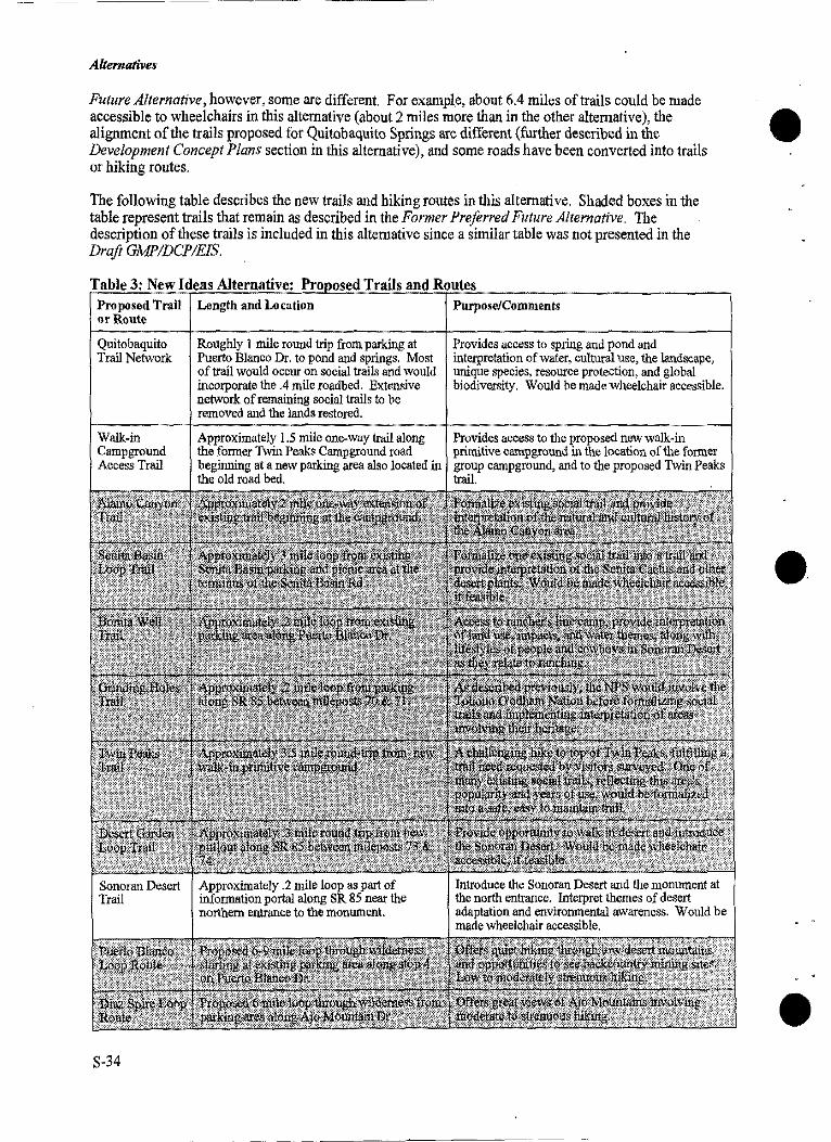
Alternatives
Future Alternative, however, some are different. For example, about 6.4 miles of trails could be made accessible to wheelchairs in this alternative (about 2 miles more than in the other alternative), the alignment of the trails proposed for Quitobaquito Springs are different (further described in the Development Concept Plans section in this alternative), and some roads have been converted into trails or hiking routes.
The following table describes the new trails and hiking routes in this alternative. Shaded boxes in the table represent trails that remain as described in the Former Preferred Future Alternative. The description of these trails is included in this alternative since a similar table was not presented in the Draft GMP!DCP!EIS.
Table 3: New Ideas Alternative: Pro osed Trails and Routes Proposed Trail or Route
Quitobaquito Trail Network
Walk-in Campground Access Trail
S-34
Length and Location
Roughly 1 mile round trip from parking at Puerto Blanco Dr. to pond and springs. Most of trail would occur on social trails and would incorporate the .4 mile roadbed. Extensive network of remaining social trails to be removed and the lands restored.
Approximately 1.5 mile one-way trail along the fonner Twin Peaks Campground road beginning at a new parking area also located in the old road bed.
Purpose/Comments
Provides access to spring and pond and interpretation of water, cultural use, the landscape, unique species, resource protection, and global biodiversity. Would be made wheelchair accessible.
Provides access to the proposed new walk-in primitive campground in the location of the former group campground, and to the proposed Twin Peaks trail.
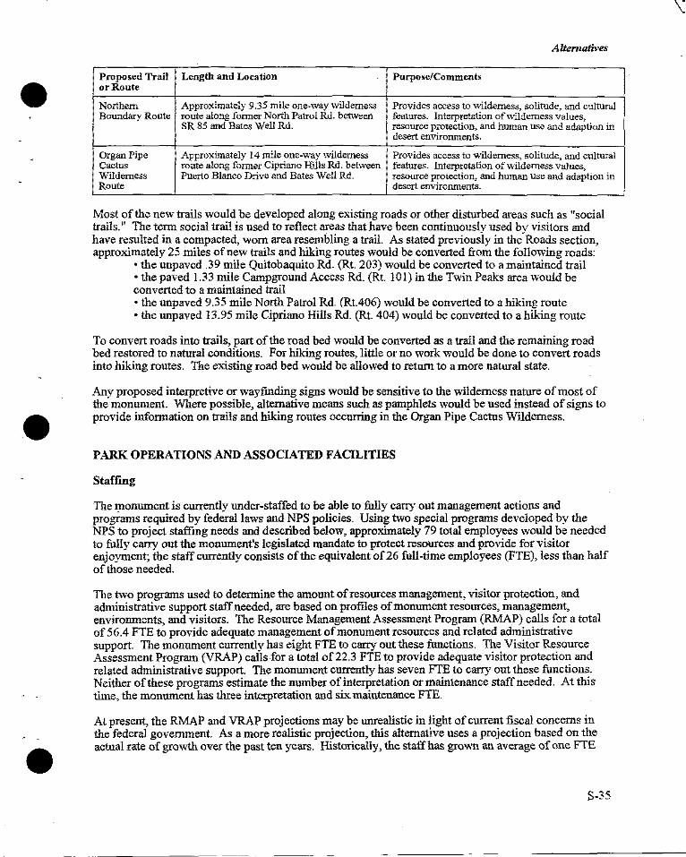
Alternatives
Proposed Trail Length and Location Purpose/Comments or Route
Northern Approximately 9.35 mile one-way wilderness Provides access to \irilderness, solitude, and cultural Boundary Route route along former North Patrol Rd. between features. Interpretation of\"\'ilderness values,
SR 85 and Bates Well Rd. resource protection, and human use and adaption in desert environments.
Organ Pipe Approximately 14 mile one-way wilderness Provides access to wilderness, solitude, and cultural Cactus route along former Cipriano Hills Rd. between features. Interpretation of\\'ildemess values~ Vllldemess Puerto Blanco Drive and Bates Well Rd. resource protection~ and human use and adaption in Route desert environments.
Most of the new trails would be developed along existing roads or other disturbed areas such as "social trails." The tenn social trail is used to reflect areas that have been continuously used bv visitors and have resulted in a compacted, worn area resembling a trail. As stated previously in the' Roads section, approximately 25 miles of new trails and hiking routes would be converted from the following roads:
• the unpaved .39 mile Quitobaquito Rd. (Rt. 203) would be converted to a maintained trail •the paved 1.33 mile Campground Access Rd. (Rt. IOI) in the Twin Peaks area would be converted to a maintained trail •the unpaved 9.35 mile North Patrol Rd. (Rt.406) would be converted to a hiking route • the unpaved 13.95 mile Cipriano Hills Rd. (Rt. 404) would be converted to a hiking route
To convert roads into trails, part of the road bed would be converted as a trail and the remaining road bed restored to natural conditions. For hiking routes, little or no wmk would be done to convert roads into hiking routes. The existing road bed would be allowed to return to a more natural state.
Any proposed interpretive or wayfmding signs would be sensitive to the wilderness nature of most of the monument. Where possible, alternative means such as pamphlets would be used instead of signs to provide information on trails and hiking routes occurring in the Organ Pipe Cactus Wilderness.
PARK OPERATIONS AND ASSOCIATED FACILITIES
Staffing
The monument is currently under-staffed to be able to fully carry out management actions and programs required by federal laws and NPS policies. Using two special programs developed by the NPS to project staffing needs and described below, approximately 79 total employees would be needed to fully carry out the monument's legislated mandate to protect resources and provide for visitor enjoyment; the staff currently consists of the equivalent of 26 full-time employees (FTE), less than half of those needed.
The two programs used to detennine the amount of resources management, visitor protection, and administrative support staff needed, are based on profiles of monument resources, management, enviromnents, and visitors. The Resource Management Assessment Program (RMAP) calls for a total of 56.4 FTE to provide adequate management of monument resources and related administrative support. The monument currently has eight FTE to carry out these functions. The Visitor Resource Assessment Program (VRAP) calls for a total of 22.3 FTE to provide adequate visitor protection and related administrative support. The monument currently has seven FTE to carry out these functions. Neither of these programs estimate the number of interpretation or maintenance staff needed. At this time, the momnnent has three interpretation and six maintenance FTE.
At present, the RMAP and VRAP projections may be unrealistic in light of current fiscal concerns in the federal government. As a more realistic projection, this alternative uses a projection based on the actual rate of growth over the past ten years. Historically, the staff has grown an average of one FTE
S-35
-~
. -- ----------
Alt.ernatives
per year. Therefore, over the next 15 years-the estimated life of this plan-the monument would seek A to gain approximately 15 FTE at a minimum. •
The following chart shows a distribution of the additional FTE for each division. Since these numbers reflect a reduction over the number ofFTE estimated in the Former Preferred Future Alternative, the distribution reflects current priorities in the monument and may need to be adjusted in the future to correspond with issues as they arise.
Division Maintenance Natural and Cultural Resources Management Interpretation Visitor Protection Administration
Eull Time Equivalents 4.5
4.5 2.5 2.5 1.0
Under this alternative, some changes in assignments of existing and proposed staff would need to occur. Protection work would change in this alternative since some of the roads would be closed or converted into trails. Since certain areas could not be reached by vehicle, more backcountry patrols by foot, horse, or airplane would need to be performed to protect visitors and resources.
Protection and maintenance of cultural properties would also be affected. Some cultural resource properties that lie a short distance from roads to be closed under this alternative, would be more difficult for staff to access. Use of these areas may be expected to decrease since they cannot be readily accessed by vehicle. A variety of tools would be used to increase protection and allow for the maintenance of these properties in their wilderness setting. Some of these tools may include increasing the use of infra-red satellite alarm systems and airplane or helicopter patrols.
Operations Facilities
Consistent with the concept of this alternative, all operational facilities would be removed from the Twin Peaks area including:
• administration/visitor center building • maintenance complex • employee housing • ranger operations building • two buildings that function as the resource centers • the VIP trailer village
Consequently, roads and trails in the area would also be removed as discussed in the Area Transportation Network section of this alternative. An approximate total of 43 acres within Twin Peaks would be restored to natural conditions and together with currently undeveloped lands, approximately 70 acres would be proposed for wilderness designation.
Many of these facilities are essential to the continued operation and maintenance of the monument and must be adjacent to the physical resources. These facilities include the maintenance complex, fire station, ranger operations, and a limited amount of employee housing as described below and depicted in the Lukeville Area DCP section of this alternative. Some functions, such as administrative offices, do not need to be directly adjacent to the monument's physical resources and would be relocated outside the monument. Consequently, the administrative facility would be located in Ajo, under this alternative.
The new locations would:
S-36
• occur in previously disturbed or developed areas as much as possible • maximize wilderness and resource values by minimizing future development and increasing the size of wilderness within the monument
Alternatives
• where feasible, establish partnerships or share facilities • separate employee and visitor use areas
Maintenance Complex and Fire Station. Jn this alternative, the fire station would be designed as part of the maintenance complex. The proposed maintenance complex and fire station would be located near Lukeville, would require approximately 1/2 acre ofland and would contain the following:
• a security system for the entire facility • about 2,500 s.f. of office and work space for carpentry, supply storage, plumbing shop, and a small paint shop • about 12,000 s.f. of covered parking for vehicle and equipment storage and bays for welding, washing, and automobile and heavy equipment repair • about 4,000 s.f of covered storage space for materials • about 1,000 s.f. of 5 foot high concrete silos for materials storage • loading ramps • about 2,500 s.f. of covered space for the fire truck and related equipment storage
To help offset costs, the NPS would attempt to re-use or recycle materials from the existing facility in the Twin Peaks area. In addition, the NPS proposes to enter into discussions with the other federal agencies in the Lukeville area to share facilities, staff, and storage needs. Based on these discussions, the NPS may need to increase the size of this complex to accommodate any added functions.
Employee and VIP Housing. The NPS would seek partnership ventures to establish housing in the Lukeville area for employees with required housing and for the monument's seasonal work force. Land, power, water, restrooms, and showers would continue to be provided for Volunteers-in-Parks (VIPs) with their own recreational vehicles (RV), however, the facility would be relocated to the southern entrance of the monument near the maintenance facility, as shown on the Lukeville Area DCP. Any additional housing needs would be secured by employees on a free market basis in surrounding communities.
The NPS would intend to develop a mutually beneficial partnership with one of the other federal agencies and/or a private owner in Lukeville to provide the housing. Required housing is assigned to those employees the NPS needs immediately available to provide on-site protection of life, property, and resources in the monument. At this time, the NPS has detennined that a minimwn of 5 single family homes would be needed for those employees with required housing. Because affordable, seasonal or short-term housing is difficult to find during the winter season, apartments or efficiencies containing approximately 10 total bedrooms, would be sought to help accommodate most of the monument's seasonal workers. At least one of these units would be reserved for use by visiting researchers or scientists.
All NPS housing, whether owned or leased by the NPS, would need to meet federal standards and would need to be affordable for employees. Two housing areas currently exist in the Lukeville area: one constructed and maintained by GSA on the U.S. Customs and Immigration Reserve, and the other owned and maintained by a private land-owner. The NPS is not interested in utilizing the existing federal housing area due to the noise and congestion generated by the adjacent port of entry facility. If a mutually satisfactory arrangement cannot be reached with either the federal agency or private owner, the NPS would seek to construct these homes on federally owned lands in the vicinity of the maintenance facility complex.
The NPS would also seek to establish a community center for all area residents. An existing building in the Lukeville area may serve as the facility, such as one of the currently un-used homes in the existing housing area on the U.S. Customs and Immigration Reserve, or a new building may be constructed. While the NPS would help initiate and participate in this effort, the functions and size of the facility would need to be determined among all community participants.
Ranger Operations. The NPS would seek to locate its law enforcement functions to the Customs and Immigrations Reserve located within the boundaries of the monument. The NPS would work to
S-37
Altematives
establish a partnership and agreements with the U.S. Customs Service, Immigration and Naturalization, and the Government Services Administration to share the existing under-utilized facilities at the border A station and within the housing compound. The NPS would seek space for: •
•first aid • law enforcement and fitness training • office and work space • helicopter landings
Administration. Administrative functions would be moved from the existing facility in Twin Peaks to a building in Ajo. Approximately 2,000 s.f. of space is needed to accommodate the following functions: ·
• offices for the superintendent and three other employees • one large conference/meeting room • supply and equipment storage •a restroom • a foyer or lobby suitable for greeting visitors and providing information
The NPS would seek to share space with another federal agency, or lease office space if it is available. According to local sources, leasing rates in Ajo range from .35 cents to $2.00 per s.f. If shared or leased space is not available, the NPS would explore the possibility of purchasing land and constructing needed office space. Congressional legislation would be needed to allow the NPS to purchase any lands outside monument boundaries.
DEVELOPMENT CONCEPT PLANS
The DCPs are intended to depict the basic concepts for development in the Twin Peaks, Quitobaquito Springs, and Lukeville areas-in other words, the inter-relationship of the various visitor, operational, A ~~l~~sportahtion ele
0mentsfun. Thd. ere'.ore, onlyd~erydgen1eral locatidons!
1fund cdti~ns, andd sizes of P.roposed •.
iac1 1t1es are s own. nee mg 1s secure ior eve opment, etai e es1gn an construction drawings would be developed for each facility or area, and further enviromnental analysis performed in compliance with NEPA.
Twin Peaks
As described in previous sections, most of the facilities currently residing in Twin Peaks would be removed. Approximately 43 acres ofland would be restored to natural conditions once the majority of roads, trails, and buildings in the Twin Peaks area would be removed or relocated. Subsequently, approximately 70 acres ofland currently designated as non-wildemess-including the restored lands together with adjoining undeveloped lands-would become potential wilderness additions.
The Twin Peaks area would be converted into a primitive camping area with some opportunities for picnicking and hiking as shown on the Twin Peaks Development Concept Plan map. A portion of the existing paved entrance road would remain leading visitors to a new parking and trailhead area for the walk-in primitive campground, or to the former housing loop drive which would be converted to a drive-in primitive campground. The new trailhead would consist of a 10 vehicle parking area that would be constructed on disturbed land at the existing intersection of the entrance road and the road leading to the main campground. An approximately 1.5 mile trail would lead from the trailhead and parking area to a walk-in primitive camping area located on the site of the e:1.isting group camping facility. The drive-in primitive campground would contain a restroom and a day-use parking are for 6-10 vehicles. A new 3.5 mile round-trip trail would lead from this campground to the top of Twin Peaks. The existing water tank, sewage system, and unpaved roads leading to them, would be retained to provide water and sewer to the rest rooms in this area.
S-38
Alternatives
Quitobaquito Springs
The concept for development at Quitobaquito Springs-to improve safety, visitor experience, and resource protection-remains very close to that described in the Former Preferred Future Alternative, page 36. However in this alternative, protection of the varied, sensitive resources in the Quitobaquito Springs area would be accomplished differently: visitors would be allowed access into this area via permits or on interpretive tours of the area. At first, the amount of use allowed would be based on the NPS ability to manage the permit and tour programs. In the future, day-use standards and user capacities would be established for this area as part of a wilderness management plan.
While the concept was similar, a new layout for the parking, trail, and other facilities is proposed in this alternative as shown on the Quitobaquito DCP and described below. The description and illustration of the new layout is very general in nature and has primarily resulted from concerns raised by the Tohono O'odham Nation and its Districts. Once funding is secured, a multi-agency task force would be established to develop a detailed design for this area. The design would include locating the exact locations of the elements, development of detailed design drawings, and finalizing how interpretive stories would be shared with visitors. At a minimum, this group would need to include representatives of the Tohono O'odham Nation, the U.S. Fish and Wildlife Service, the State Historic Preservation Office, and the National Park Service. Group representatives could also be from various disciplines including archeology, anthropology, history, landscape architecture, maintenance, wildlife biology, and others. This group would also help develop detailed mitigation strategies and would contribute to the effort to prepare all documents to ensure compliance with NEPA, the National Historic Preservation Act, and all other applicable federal laws and regulations.
In this alternative, the parking lot would be placed in a currently disturbed area at the existing intersection of Puerto Blanco Drive and the Quitobaquito road. An orientation sign, interpretive information, a composting or vault type toilet, and picnic tables shaded by a simple ramada would be provided near the parking area. Moving the parking area and other facilities to a safer location would help decrease the incidence of vehicle break-ins and theft. NPS law enforcement records indicate 16 burglary or larceny incidents occurring in the Quitobaquito parking lot from 1990-1995. The new location is sheltered by hills in the area, unlike the existing location. However, the new location would be immediately visible to rangers and visitors driving by on the Puerto Blanco Drive, which would help to increase safety. The current location of the parking lot is not visible from Puerto Blanco Drive.
A well-defined trail network would also be established along existing roads and disturbed areas. This relatively easy, approximately I mile round-trip walking loop would be made accessible to visitors with disabilities. The new trail would begin at the parking area and travel along what is now the road. About 112 mile down the trail, a new trail segment would be added following the contours of the land and leading to the Quitobaquito Springs. The trail would direct people from the spring and on to the historic pond. A small portion of the trail network would be established in the vicinity of the pond to offer views of the water and vegetation, and to offer good birding opportunities. From the pond, the trail would loop back along the former parking lot and road, back to the start of the trail.
The new trail system would help protect resources and improve the area's value as wildlife habitat by reducing the amount of vegetation trampling, erosion, and human use of sensitive areas, such as the edge of the pond, that is presently occurring. Over time, visitors have established a vast, well-worn matrix of trails in the area. Once the new trail network is in place, the numerous social trails remaining would be restored to natural conditions.
While walking along the trails, visitors would have the opportunity to learn about the cultural use of the area and its natural resource significance. As described under the previous partnerships section, the Tohono O'odham would be significantly involved with the interpretation of this unique area.
Administrative vehicle access to the international border would need to be maintained along the 60-foot wide reserve. A new section of road would be constructed that would connect Puerto Blanco Drive with the existing border patrol road. Due to the sensitive nature of this area, the exact location of
S-39
Alternatives
this road section would be detennined in the field as part of the next phase of the development plan for the Quitobaquito area. At present, patrols along the border go from the present location of the A Quitobaquito parking lot, on to ao administrative road leading to the border patrol roadway. The • existing border patrol road is about 250 feet from the Quitobaquito pond. Pennission for use of this road could be graoted by the Superintendent to visitors with special needs, on a case-by-case basis.
During public review of the Draft GMPIDCPIEJS, a new idea was proposed involving development by Mexico of a pullout along Highway 2 aod a pedestriao border crossing from Mexico into the Quitobaquito area. Quitobaquito is historically significaot to Mexico as well as the U.S. At various times in history, this oasis in the desert has been owned by both countries and was ao important stopping point along the historic Camino de! Diablo established as a route between Mexico aod California connecting present-day Sonoyta and other parts of Mexico with the monument and the Cabeza Prieta National Wildlife Refuge. If citizens of Mexico decide to further develop the idea of this pedestrian crossing, the NPS would be willing to enter into discussions with Mexico and other U.S. agencies to detennine its feasibility. As with the access on the U.S. side, all access would be limited based on the carrying capacity of the area aod would be closely monitored aod controlled at all times.
Lukeville Area
Private enterprise in Lukeville, as well as in Ajo and Why, would continue to provide esscntial services to visitors and travelers. When the wilderness boundaries were detennined, areas aronnd Lukeville aod Twin Peaks were retained as non-wilderness to allow for the expaosion or development of visitor and NPS administrative facilities. Consequently, in this alternative, the Lukeville area would become the location of several NPS facilities. The Lukeville Area DCP drawing depicts the location of the various facilities that have been added or relocated to this place from other areas in the monument.
A new, approximately 1/2 mile long road would be constructed on NPS owned lands aod would lead to a parking area for tlie new science, education, and resources management center. The road would A continue from this facility to the new maintenaoce complex and fire station aod on to the RV area for •· NPS volunteers. A security system would be added to all facilities constructed in this area.
The southern infonnation portal would be developed along the eastern side of SR 85, north of privately-owned developments in Lukeville. A pullout with parking for 15-20 vehicles, shade, infonnation, and ao enhaoced cntraoce sign would welcome and help orient visitors to the monument while offering a place to rest.
As discussed previously in this alternative, the NPS would seek a partnership to provide additional facilities in the Lukeville area, possibly on privately-owned laods or lands managed by aoother federal agcncy. While the location aod size of these facilities are unknown, they would include:
• 3-5 homes for employees with required housing and apartments containing 10 total bedrooms for NPS seasonals or researchers •office and work space for ranger operations, most likely within currently under-utilized facilities at the border station • a new community center for all area residents
If a mutually satisfactory arrangement cannot be reached with either aoother federal agency or a private land-owner, the NPS would seek to develop these facilities on NPS-o'il'lled laods in the vicinity of the maintenaoce facility.
S-40
--
Alternatives
NAME, BOUNDARY, AND WILDERNESS AREA CHANGES
Redesignation
As with the Former Preferred Future Alternative, the NPS would support proposing legislation to change its designation to National Park status, however, the new proposed name is different. In this alternative the new proposed name would be Organ Pipe Cactus National Park.
NPS management responsibilities and authorities are generally the same whether an area is designated a National Park or National Monument. In fact, all units of the National Park Service are required to adhere to federal laws, follow NPS management policies and guidelines, and carry out the mission of the NPS as established in the 1916 Organic Act, "to conserve the scenery and the natural and historic objects and the wild life therein and to provide for the enjoyment of the same in such manner and by such means as will leave them wiimpaired for the enjoyment of future generations."
The differences between monument and park designation, are in some ways subtle, but are important in terms of status, especially when it comes to competing for ever-dwindling rederal dollars. The basic distinction between the designations is that National Monuments are created by a signature of the President of the United States, typically by way of a Presidential Proclamation, while National Parks are created by an Act of Congress. Many of this nation's National Monuments were created to protect a single feature, a unique occurrence of a natural phenomenon, or a specific area of historical or cultural importance, and were named accordingly, such as: Organ Pipe Cactus National Monument, Natural Bridges National Monument, or Montezuma's Castle National Monument. In recent years, the larger National Monuments responsible for protecting a variety of significant resources have been redesignated through Acts of Congress into National Parks including: Death Valley National Park, Joshua Tree National Park, and Saguaro National Park.
Even though monuments and parks are governed by the same rules, National Parks are often considered to be more important. Recent evidence of this was on Congress's list of units of the National Park system that were being considered for possible closure; because of their status, no National Parks were on the list, while National Monuments were, including Organ Pipe Cactus National Monument.
The following factors contribute to Organ Pipe Cactus National Monument's distinction and importance in this country and subsequently, provide some of the rationale for its redesignation. Some of these facts reiterate portions of the significance statements found in the Draft GIVIP IDCP /EIS, on page 9. They are repeated here since they link to the reasoning behind proposed redesignation.
•At 330,689 acres, it is the largest National Monument of the National Parks system in the lower 48 states. • While there are other units of the National Park system in the Sonoran Desert, none of them so clearly exemplifies the unique features and biological diversity that defme the Sonoran Desert ecosystem. •It is a place where three cultures intersect and is significant archeologically, geographically, and internationally for the cultural resources which can be fowid reflecting long, widespread, and diverse occupations by Native Americans, Mexican, and Anglo groups. •The monument borders the Tohono O'odham Nation, whose heritage and creation beliefs are linked integrally to the monument, and borders Mexico where communication and economic ties with the U.S. are increasing and resulting in a new openness. • The monument provides habitat for a highly diverse flora and fawia, including 27 rare, endangered, and threatened wildlife species. • Within its boundaries are expansive vistas of Sonoran Desert landscapes with dramatic mountains and valleys, eroding bajadas and alluvial fans, and magnificent specimens of columnar cacti, all of which are easily enjoyed by all people whether in a vehicle or on foot.
For all these reasons, National Park status is sought.
S-41
Alternatives
Boundary Adjustments
No adjustment to the current boundary is proposed in this alternative. However, the NPS would seek to work with the Tohono O'odham Nation to ensure that NPS mandates for preservation are achieved for the monument lands lying east of the crest of the Ajo Range. This item would be covered under the agreement to be developed between the Tohono O'odham Nation and the NPS, as discussed previously in the Actions Common to All Alternatives, Native American Consultations section.
Wilderness Additions
In addition to the State Trust lands described in the Actions Common to All Alternatives, the following areas may be eligible for wilderness designation. When implemented, several actions proposed in this alternative would remove incompatible elements from these lands which would allow the lands to be eligible for wilderness designation. Once conditions are met, a legislative proposal would be prepared to propose their addition.
1. Approximately 206 acres ofland where the above-ground powerlines are currently located west of SR 85. The old lines and poles would be removed and the powerline road restored to natural conditions. These lands could then qualify to be added into the wilderness boundaries.
2. Approximately 23 acres of the Quitobaquito area would be suitable for wildemess designation once the existing parking lot and road are restored to natural conditions.
3. In the Twin Peaks area, approximately 70 acres of!and, currently designated as nonwilderness, would be suitable for wilderness designation once facilities on about 43 acres of land are removed and the area restored. The remaining 27 acres are adjacent to the area that would be restored and are currently undeveloped.
4. Approximately 570 acres of roads and adjacent non-wilderness lands would be suitable for e. wilderness designation once the roads would be removed or be converted into hiking trails. Trails are considered appropriate facilities in wilderness areas.
5. The 1502.6 acres ofland occurring on the eastern divide of the Ajo Mountains. These lands were not included in the original wilderness designation due to the existence of special-use permits for grazing. These permits have expired and have not been re-established.
PLAN IMPLEMENTATION AND COSTS
Implementation
The intent of a general management plan (GMP) is to provide comprehensive, general guidance for managing a unit of the NPS over a 15-20 year time span. The ability and rate of which the NPS is able to implement the actions in a GMP is variable and is based on numerous factors, many of which are not controlled by the NPS. Some NPS managed areas are able to fully implement approved GMPs within this time frame, while for other areas it takes much longer.
Funding is the ultimate determinant of the time frame in which proposed developments, programs, and staffing additions would be implemented. Because oflimited federal resources, the NPS together with other federal agencies, is seeking partnerships to develop cost-effective solutions for carrying out their legislated responsibilities. Partnerships, donations, and volunteer work can offset implementation costs. In these cases, the costs described would be the financial value or cost-saving to the NPS.
Priorities. A prioritization or phasing strategy is proposed to direct implementation actions in this A alternative. Priorities for staffing are not included in this discussion since they are discussed below in -the Staffing Cost section. The following strategy may be amended by the monument as needed to
S-42
I I
I
I
•
-·
•
Alternatives
ensure effective management of the resources, visitors, and employees. The NPS would comply with all laws and regulations, including NEPA, the National Historic Preservation Act, and the Endangered Species Act, before implementing these actions.
When priorities are set at either park or national levels of the NPS, projects related to health and safety issues receive the hlghest priority rankings. Projects dealing "~th legislative requirements such as the protection of or recovery of threatened and endangered species, protection of significant cultural resources, and Native American consultations, also rank high. Likewise, the projects in this alternative related to health and safety or legislative requirements are proposed as the highest priority and include implementation of the following: (these highest priority projects are not presented in any specific order)
•the fire station as part of the new maintenance complex proposed in the Lukeville area; for security reasons, part of this maintenance complex would need to be constructed at the same time · •the DCP for Quitobaquito Management Area which relates to safety, threatened and endangered species, and cultural resource concerns • a partnership with ADOT to develop and implement the program proposed for SR 85 to improve visitor safety and help protect and recover threatened and endangered species affected by the road and related traffic •the one or more agreements to be developed between the NPS and the Tohono O'odham Nation • inventorying, monitoring, and mitigation programs and actions to protect and recover threatened and endangered species including control of nonnative vegetation and animals • studies and programs that help mitigate impacts on occurring from outside the monument on threatened and endangered species including expansion of the water resources management · program • safety programs for abandoned mine lands • inventory, evaluation, and monitoring programs to protect cultural resources including their nomination to the National Register of Historic Places
Second level priorities involve provision of essential services and NPS functions that are not a level one priority, or, are the second phase of a high priority project. In this alternative, many second priority projects are those that would need to be accomplished before facility removal, restoration, and new development in the Twin Peaks area could be accomplished. Second level priority projects include implementation of:
•the rest of the programs and projects identified in the Natural and Cultural Resources Management Plan; due to financial considerations, many of these would be phased over time • the rest of the maintenance complex and other new facilities in the Lukeville area • partnerships that work toward: development of the visitor center in Why, use of existing office and work space for NPS ranger operations in Lukeville, initiation of the joint effort to prepare a wilderness and backcountry management plan, establishing employee housing in Lukeville • finding office space for NPS administrations in the Ajo area • working with APS to detennine strategies to relocate and bury powerlines • developments at Dos Lomitas Ranch for conducting interpretive programs •road removal, road conversion to trails, other new trails, and restoration of area social trails all of which \v<mld most likely need to be phased over time • redesignation which would require congressional legislation
All other projects and programs proposed in this alternative are third level priority projects and may encompass the second or third phase of projects initiated at higher priority levels. These include implementing:
• facility removal, restoration, and development of the campgrounds and trails in the Twin Peaks area • the proposed additions to wilderness which would require congressional legislation
S-43
Alternatives
Cost Estimates
Cost Estimates for New Developments. Costs of development are one-time costs to the government. The NPS recognizes that development costs for the federal government tend to be higher than those for private citizens, and subsequently, has prepared the following discussion regarding escalated costs. In light of recent fiscal concerns in the federal government, the NPS would seek all means to offset the estimated costs which might include the use of partnerships, volunteers, donations, or any other available means. For the purpose of this planning effort, the total costs the government may expect to incur to implement these developments are listed below the discussion of escalated costs. If costs are successfully offset or reduced, these estimates instead would represent tlte value or cost savings to the government.
Escalated Costs. This discussion has been prepared due to the number of concerns raised regarding costs and in an attempt to explain why costs to the govennnent seem to escalate over those for private citizens. The Estimating Section of the NPS's Denver Service Center has developed what is referred to as "Class C" costs that are used to estimate total development costs of projects. Over time, the actual costs of projects-from planning, design, to construction-have been tracked and compiled into the "Class C Estimated Guide" which is routinely used in estimates for planning purposes.
Why do these costs appear so high? The costs are comprised of the following five factors, which when totalled, equal the costs reflected in this document.
1. Class "C" unit prices. These prices, also known as net construction costs, are generally higher than the normal market price due to actual increases elq>erienced in federal government bids due to requirements related to fair labor laws, purchasing, ensured safety, bonding, and additional paperwork. In addition, these costs are meant to be valid for at least a few years after a plan is finalized.
2. Design and construction document preparation. This is a standard expense of25% of the e. net construction cost. DCPs presented in General Management Plans are not sufficiently detailed to actually build or prepare anything. Design construction drawings and documents are required in the construction process and to bid the work. Small, relatively simple projects may sometimes dispense with this requirement.
3. Increase for project remoteness. Many project locations in the NPS are very remote compared to those that occur within reasonable distance of communities and suppliers. Remote areas require increase costs for transporting materials and equipment further distances and sometimes, by less cost effective means. Labor costs also rise at remote area because lengthy daily travel mnst be compensated, or per diem paid when daily commutes are too lengthy. Jn the case of the monument, a remoteness factor was not applied to the net construction cost estimate.
4. Increase for unlisted technical tests and studies. This increase is one of the greatest llllknowns for the NPS, but if not calculated into the initial cost estimate, has been known to lead to significant funding shortages. Often in the early planning portion of projects, there is not enough time and money to reveal unexpected subsurface or historical site conditions. Because of the high chance of uncovering archeological resources at the monument, a factor of I 0% has been applied to the net construction costs to cover the need for these types of tests.
5. Increase for overhead. This is the standard cost for contract administration and construction supervision. All NPS projects are subject to this factor of 31 % and there is no flexibility in this amount.
As an example, assume the net construction cost of a small, 2 stall rest room that meets all federal requirements of accessibility and safety, is estimated at $50,000. As stated previously, this initial estimate would be higher than for a private citizen because of compliance with fair labor laws,
S-44
--
L_ __ _
Alternatives
purchasing, ensured safety, bonding, and additional paperwork. By applying the previous formula (net costs + 25% document prep. + l 0% studies/tests + 31 % overhead), the estimated total cost of this fictitious project would equal the following:
$50,000 + $12,500 + $5,000 + $15,500 = $83,000
The NPS is required to estimate the total amount of costs the federal government can expect to incur on projects, and consequently these totals comprise the cost estimates in the alternatives.
Total Costs. The total development cost is expected to be approximately$ 9,793,000 for this alternative and is broken down below by area. More detailed figures can be found in Appendix B of this Supplement. (The figures from the Appendix were rounded up to the nearest thousand.)
Twin Peaks: Quitobaquito: Alamo Canyon: Dos Lomitas: Lukeville Area: Other Roads, Pullouts,
Trails, and Exhibits:
$ 3,425,000 $ 260,000 $ 55,000 $ 16:000 $ 4,009,000
$ 2,028,000
The cost for projects involving partners or those located outside monument boundaries are not included in these estimates. At this time, the proposals are preliminary and the make-up of the partnerships, and the size, location, and the NPS share of facility costs-if any-are unknown. Examples of NPS costs in established partnership efforts vary widely: from the NPS paying for construction to having a facility donated at no cost to the NPS, from using NPS paid staff, to using another agencies' paid staff, to using volunteers at no cost to the federal government. Because of these unknown variables, the NPS has not attempted at this time to predict the costs of these projects to the federal government. The NPS would seek public involvement on the partnerships, locations, and size of the facilities in compliance with NEPA, and would be able to begin to predict and present any costs at that time.
The projects that are discussed in this alternative but are not included in the cost estimates include: the inter-agency information, orientation, and interpretive center in Why, ISDA's possible tri-cultural, trinational center, sharing facilities in the border station for NPS ranger operations, seeking office space in Ajo for NPS administrative pUipOses, establishing a small facility for community meetings and social functions in the Lukeville area, and seeking homes for some NPS employees also in the Lukeville area.
Cost Estimates of Adding Staff. Increases in funding and therefore staffing, are difficult to predict. To gain the entire 15 FTEs-at the average rate of one per year-the NPS would eventually incur a total cost of roughly $850,000. As described previously, in this alternative there is a significant chance oflowering the cost and number of additional FTE through partnerships and other ventures in this alternative. For example, jointly paid or volunteer employees could be used to staff the information, orientation, and interpretive center in Why.
As an initial estimate, if three positions can be funded through other sources over the life of the plan, the NPS would save roughly $170,000 of salary plus the amount to cover the need for additional vehicles, supplies, materials, travel, and training.
S-45
--1
! I
Alternatives
S-46
e.
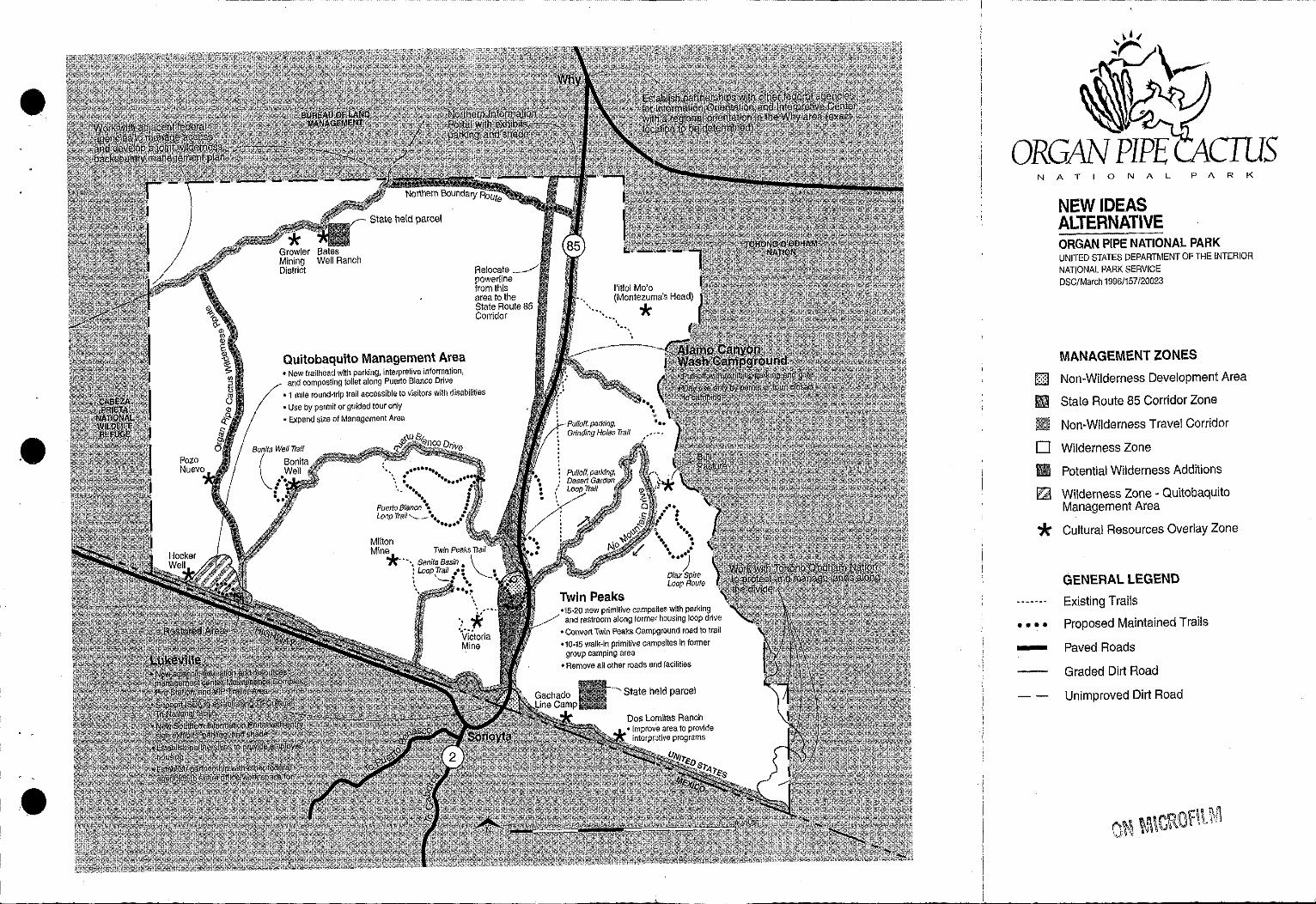
.e
State held parcel
Quitobaquito Management Area •New traflhead with parking, interpretive information,
and composting toilet along Puerto Blanco Drive
Relocate powerline from this area to the State Route 85 Corridor
• 1 mile round-trip trail accessible to visitors with disabilities
• Use by permit or guided tour only • Expand size of Management Area
··. ... . .. ,_ .. ... Puerto 8/anco *'• Loop Trail........__.•.. .•
•••••• Milton Mine* Twin Peaks Trail
• --. Senita. Basin • \ : Loop Trail .• • "-_ • ~ '-._• ... .. . . . . .. .....
': it .. \iictoria Mine
•15·20 now primitive campsites with parking and restroom along former housing toop drive
•Convert Twtn Peal<s Campground road to trail •10-15 walk-in primitive campsites In former
group camping area • Remove all other roads and facilities
State held parcel
Dos Lomltas Ranch
N A T 0 N A L
NEW IDEAS ALTERNATIVE
P A R K
ORGAN PIPE NATIONAL PARK UNITED STATES DEPARTMENT OF THE INTERIOR NATIONAL PARK SERVICE DSC/March 1996/157/20023
MANAGEMENT ZONES
Non-Wilderness Development Area
State Route 85 Corridor Zone
Non-Wilderness Travel Corridor
D Wilderness Zone
Ill Potential Wilderness Additions
~ Wilderness Zone • Quitobaquito Management Area
* Cultural Resources Overlay Zone
GENERAL LEGEND
Existing Trails
• • • • Proposed Maintained Trails
- Paved Roads
Graded Dirt Road
Unimproved Dirt Road
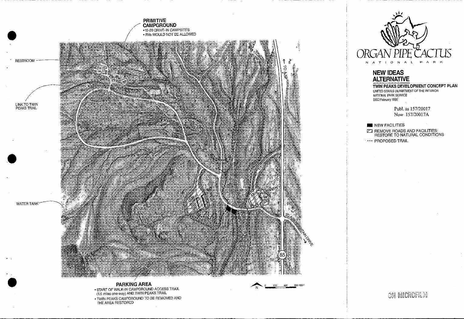
RESTROOM ----
LINK TO TWIN PEAKS TRAIL
--WATER TANK
PRIMITIVE CAMPGROUND •15-20 DRIVE-IN CAMPSITES • RVs WOULD NOT BE ALLOWED
PARKING AREA •START OF WALK-IN CAMPGROUND ACCESS TRAIL
(1.5 miles one-way) AND TWIN PEAKS TRAIL •TWIN PEAKS CAMPGROUND TO BE REMOVED AND
THE AREA RESTORED
~ 0 200 400 600 FEET
- - ··----------·--·~------
NATIONAL PARK
NEW IDEAS ALTERNATIVE TWIN PEAKS DEVELOPMENT CONCEPT PLAN UNITED STATES DEPARTMENT OF THE INTERIOR NATIONAL PARK SERVICE DSC/Febru~ry 1996'
Pub!. as 157/20017 Now 157/20017A
• NEW FACILITIES 12'.:J REMOVE ROADS AND FACILITIES:
RESTORE TO NATURAL CONDITIONS
• • • PROPOSED TRAIL
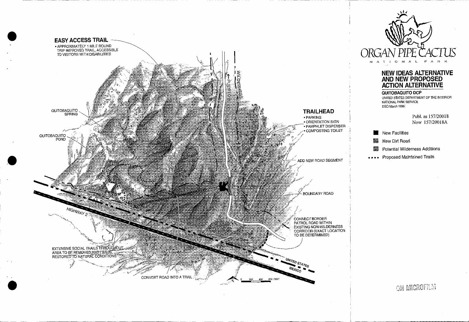
.e
EASY ACCESS TRAIL~ •APPROXIMATELY 1 MILE ROUND
TRIP IMPROVED TRAIL, ACCESSIBLE ID VISITORS WITH DISABILITIES
QUITOBAQUITO SPRING
"' ,'
TRAIL HEAD •PARKING •ORIENTATION SIGN •PAMPHLET DISPENSER
/'COMPOSTING TOILET
ADD NEW ROAD SEGMENT
CONNECT BORDER PATROL ROAD WITHIN EXISTING NON-WILDERNESS CORRIDOR (EXACT LOCATION TO BE DETERMINED)
I L
NATIONAL PARK
NEW IDEAS ALTERNATIVE AND NEW PROPOSED ACTION ALTERNATIVE QUITOBAQUITO DCP UNITED STATES DEPARTMENT OF THE INTERIOR NATIONAL PARK SERVICE DSC/March 1996!
• New Facilities
II New Dirt Road
Pub!. as 157/20018 Now 157/20018A
II Potential Wilderness Additions
• • • • Proposed Maintained Trails
1 '; .1 !,..1';'J
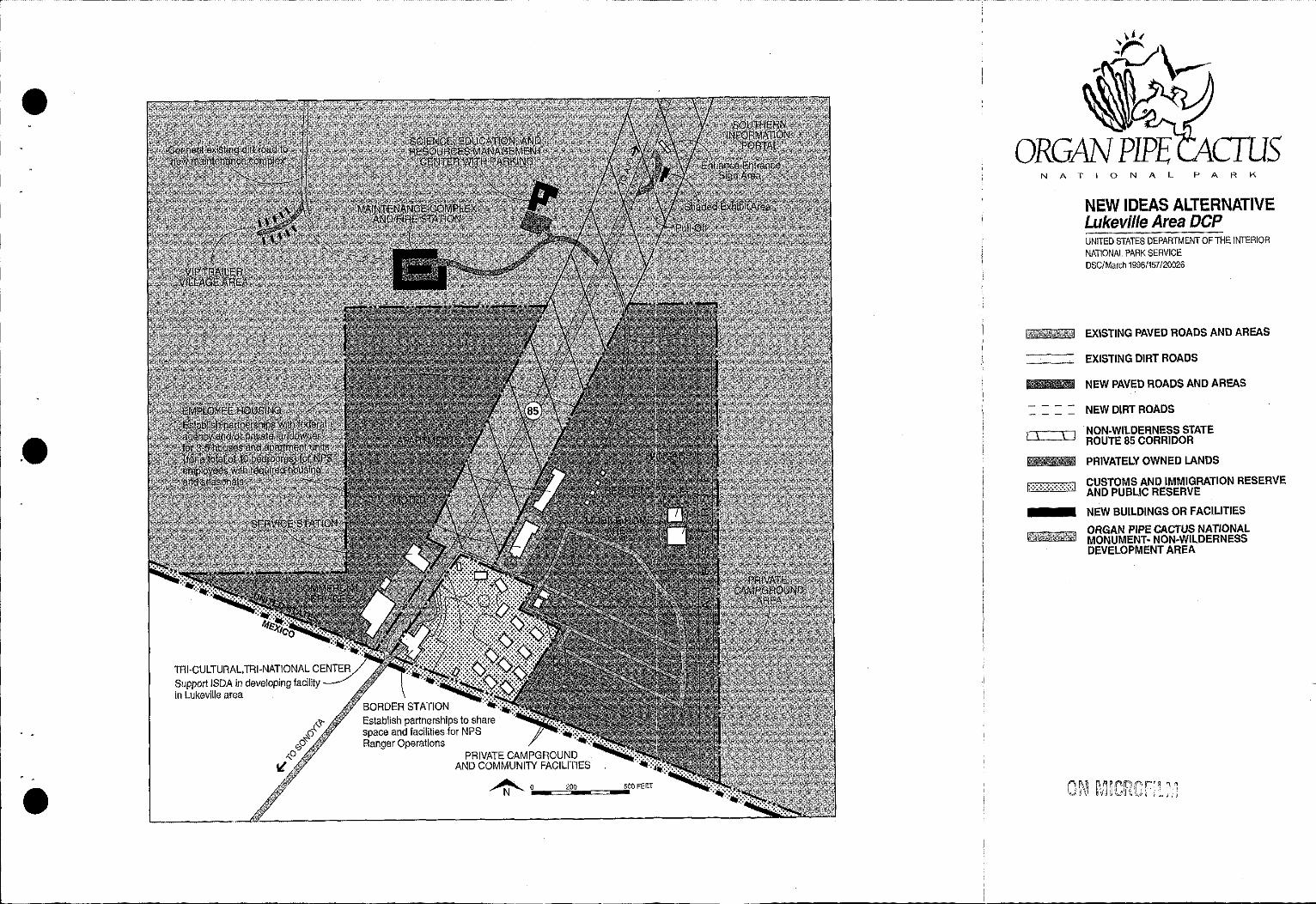
~ --·------------·----·----·-
.e
TRl·CULTURAL,TRl-NATIONAL CENTER Support ISDA in developing facility in Lukeville area
PRIVATE CAMPGROUND AND COMMUNITY FACILITIES
~o 200 500 FEET
NATIONAL PARK
NEW IDEAS ALTERNATIVE Lukevi/le Area DCP UNITED STATES DEPARTMENT OF THE INTERIOR NATIONAL PARK SERVICE DSC/March 1996/157/20026
EXISTING PAVED ROADS AND AREAS
EXISTING DIRT ROADS
NEW PAVED ROADS AND AREAS
NEW DIRT ROADS
NON-WILDERNESS STATE ROUTE 85 CORRIDOR
PRIVATELY OWNED LANDS
CUSTOMS AND IMMIGRATION RESERVE AND PUBLIC RESERVE
NEW BUILDINGS OR FACILITIES
ORGAN PIPE CACTUS NATIONAL MONUMENT· NON-WILDERNESS DEVELOPMENT AREA
• THE NEW PROPOSED ACTION AL TERNA. TIVE
This alternative constitutes the NPS's new proposed action. Parts of the concepts and actions from the other three alternatives have been combined into this alternative. The resulting concept is two-fold: within the region, carry out principles of the MAB program by adopting a regional perspective to improve visitor services and conserve resources; and within the monument, improve management capabilities to enhance visitor opportunities and protect resources and wilderness values. To accomplish this, the NPS proposes to:
• working with ADOT, as in the New Ideas Alternative, to ensure continued travel and commerce while enhancing conservation practices along the SR 85 corridor in the monument; re-aligning the trail network in the Quitobaquito Springs area; establishing partnerships with others to share facilities, staff, and costs within the Why and Lukeville areas; and proposing an increase in wilderness, but to a lesser degree than in the New Ideas Alternative • seeking redesignation of the monument, as in the Former Preferred Future Alternative, to Sonoran Desert National Park and retaining existing facilities in the Twin Peaks area • seeking to be more cost-effective than the other alternatives, by relocating and developing partnerships for some facilities in Lukeville, proposing different uses for some existing facilities in the Twin Peaks area, and adding fewer new facilities.
Much of the following description of the New Proposed Action Alternative refers to previous discussions in other alternatives. A brief summarv of most actions is made so the full effect of the alternative can be understood without necessarily.referring to other sections. In addition, the Summary Comparison of Alternatives found at the beginning of this Supplement allows for a full comparison of all the actions in all the alternatives. A map of the New Proposed Action Alternative follows at the end of the discussion of this alternative.
While most of the actions come from other alternatives, one new action is proposed in this alternative. In response to public concerns and reactions at the most recent public meetings, a new approach to development is proposed and described in this alternative in an attempt to lower costs to the NPS. This new approach attempts to efficiently use existing facilities while reducing the amount of new construction over that proposed in other alternatives. Specific facilities are discussed under the following sections: Resources Management, Visitor Use and Associated Facilities, and Park Operations and Associated Facilities. In addition, the layout and inter-relationships of the facilities within the Twin Peaks, Quitobaqulto Springs, and Lukeville areas are described in the Development Concept Plan section.
LAND USE AND MANAGEMENT
The management zone scheme for this alternative is the same as for the New Ideas Alternative except for visitor use of Quitobaquito and the total acreage of each zone. For example, fewer acres of Potential Wilderness Subzone are proposed by this alternative than in the New Ideas Alternative. This reduction is due to the fact that several miles of roads proposed to be converted into wilderness in the New Ideas Alternative would be retained as roads in this alternative, and consequently, would not meet requirements for potential wilderness designation.
A list of the zones and subzones follows with the changes in this alternative that apply to Quitobaquito and total acreage. Refer to the Land Use and Management section of the New Ideas Alternative for a full definition of each zone. The management zones are illustrated on the map of the New Proposed Action Alternative at the end of the discussion of this alternative.
Management Zones
Wilderness Zone- The management intent is to ensure consistency with the legislative mandate of the Wilderness Act. Approximately 312,600 acres are currently designated v.ildemess.
S-55
Altl!rnatives
Potential Wilderness Subzone - Approximately 3410 acres would be eligible for wilderness designation, the same as in the Former Preferred Future Alternative. In the meantime, these lands would be managed consistently with the wilderness zone.
Quitobaquito Management Area Subzone -As in the New Ideas Alternative, the boundaries of this subzone would be expanded to incorporate the Quitobaquito Springs watershed-approximately 2400 acres of either designated or potential wilderness-in order to include more of the ecosystem and enhance resource protection. However, in this alternative, visitor use restrictions are not proposed at this time. In the future, a carrying capacity study would be detennined and if needed, appropriate restrictions would be proposed and analyzed in compliance with NEPA.
Non-Wilderness Zone - The intent of this zone is to provide for the major roads, parking areas, pullouts, public-use and management structures, and other areas needed to accommodate concentrations of people. The total acres for this zone-18,090 acres-is the same as in the Former Preferred Future Alternative. However, in this alternative the lands are divided into the following three subzones.
State Route 85 Corridor Subzone -As with the New Ideas Alternative, this subzones applies to approximately 1600 acres, including the road. As in the New Ideas Alternative, the NPS would maintain the area outside the easement in a natural aud essentially unmodified condition to help preserve adjacent wilderness values. Additionally, the NPS proposes to work with ADOT to ensure continuued travel aod commerce within the easement while improving resource protection, reducing the impact of the traffic on wildlife, increasing safety for humans, minimizing fire hazards, and improving the visitor's experience of the monument while travelling along the road corridor.
Travel Corridor Subzone - Managed primarily to provide visitors and management both -. physical and scenic access to the designated wilderness, these areas include 150 feet from each W side of the road centerline for a total of approximately 14,626 acres-the same as in the Former Preferred Future Alternative-along the following roads: Ajo Mountain Drive (Rt. 011), Puerto Blanco Drive (012), Senita Basin Rd. (Rt. 202), Bates Well Rd. (Rt. 405), North Patrol Rd. (Rt. 406), El Camino de Dos Republicas (Rt. 20 I), Cipriano Hills Rd., and several roads in the Twin Peaks area.
Development Area Subzone - This subzone applies to concentrations of visitor and management oriented facilities within the Twin Peaks and Lukeville areas and totals approximately 1864 acres. (In the Former Preferred Future Alternative, SR 85 was included in this zone.)
Cultural Resources Overlay Zone - Lands in this zone would emphasize preservation, protection, and interpretation of visited cultural resources and their settings. As an overlay zone, these areas occur within the other zones and subzones, and are the same in all alternatives.
NATURAL AND CULTURAL RESOURCE MANAGEMENT & ASSOCIATED FACILITIES
This alternative proposes the following actions related to natural and cultural resources management in addition to those described in the Actions Common to All Alternatives section in this Supplement.
Resources Management Facilities
As in the New Ideas Alternative, a science, education, and resources management center (SERMC) would be established to satisfy the expanding research, resources management, aud related educational programs. However, in this alternative, this facility would be retrofitted within an existing structure instead of being in a new facility as in the New Ideas Alternative. (Refer to the discussion of goals,
S-56
. '
Alterntitives
justification, functions, and space needs for this facility ir1 the New Ideas Alternative, since they are also the same in this alternative.)
As in the New Ideas Alternative, approximately 5,000 s.f. are needed to house the facility and it needs to be located near the resources being studied, managed, and preserved. To accomplish this, this alternative proposes using part of 5,900 s.f. visitor center and administrative facility in the Twin Peaks area could be converted for use as the SERMC. Using the existing facility is a cost effective use of this space since the functions and needs of the SERMC could readily be accommodated within the existing facility. For example, the existing room where a slide show is presented to visitors does not function well as a theater yet would be ideal as a large conference room, one of the functions needed in the new SERMC. Aninterpretive center is also proposed as part of this new facility, and together with the SERMC, would require that an addition be built onto the existing facility as described further in the Interpretive Facilities and Twin Peaks Development Concept Plan sections of this alternative.
Wilderness Management
As in the New Ideas Alternative, the NPS proposes to facilitate preparation of an inter-agency Wilderness and backcountry management plan for the Organ Pipe Cactus Wilderness, BLM backcountry, and the FWS managed Cabeza Prieta National Wildlife Refuge. Other agencies and groups may also be involved. The extent and nature of this plan would be developed with the agencies involved.
Cultural Resources
Proposed preservation and use treatments for culturally significant properties remain as described in the Former Preferred Future Alternative in the Draft GMP/DCP/E!S, pages 24-25.
Visual Resources
Powerlines and Sustainable Guidelines.· As with both the New Ideas and Former Preferred Future Alternatives, the NPS would seek to bury powerlines within the Twin Peaks area and eventually relocate and bury the powerlines that currently lie west of SR 85 to non-wilderness lands within the SR 85 corridor. This project is proposed to maximize the wilderness in and scenic values of the monument. The NPS would seek and pursue opportunites to implement these actions only as they can be achieved in a cost-effective manner and to minimize costs, if any, to tax and rate payers as discussed in the New Ideas Alternative.
The proposed sustainable design guidelines presented in the Former Preferred Future would apply to this alternative and would include the additional guideline proposed in the New Ideas Alternatives. These guidelines would serve to minimize the impact of new developments on the landscape and on natural systems by maintaining biological diversity and environmental integrity, contributing to the health of the air, water, and soils, reflecting regional goals and conditions, and reducing the impact of human use.
VISITOR USE AND ASSOCIATED FACILITIES
Some new and some improved facilities and programs are proposed in order to meet the interpretation objectives, to present the themes and stories important to understanding the monument's purpose and significance, and to achieve the concept of this alternative. The interpretive objectives and theme outline can be found in the Draft GMP!DCP!EIS, pages 27-29. They are used to help determine the amount of and type of facilities and interpretive programs that are needed to interpret the resources and stories of the monument to the visitors and residents in the area on both sides of the international boundary.
S-57
Alternatives
Interpretive Facilities
To satisfy the continued and growing need of visitors and other users of this part of the Sonoran Desert, several facilities are discussed but only one would be developed solely by the NPS while the others would be developed by others with the NPS as a potential partner. These facilities include: a multiagency information and orientation center in the Why area, ISDA's tri-cultural tri-national center in the Lukeville area, and an interpretive center as part of the science, education, and resources management center in the Twin Peaks area of the monument.
The existing visitor center in the Twin Peaks area is too small and outdated, and focuses primarily on the monument. Instead cif continuing to accommodate visitor needs only within the monument, the NPS proposes to work with others to encourage development of visitor-oriented facilities within the region, each wiih a distinct non-competing purpose and function. These facilities would help to:
• reach the greatest number of visitors to the monument as well as this area of the Sonoran Desert • increase the type of information that could be provided as well as the potential for partnerships that ultimately could result in cost savings to the NPS • focus on the different but equally important aspects of the various stories, resources, and management issues of the Sonoran Desert
A discussion of the purpose and function of each facility follows.
Multi-agency Information and Orientation Center. To help accommodate visitor infonnation and orientation needs in the region, the NPS proposes to assist in the establishment of a new multi-agency information and orientation center in the Why area by developing partnerships with other federal agencies and/or private interests. Described in the New Ideas Alternative, the idea of this type of facility has been gaining support and subsequently is also proposed as part of this alternative. Why was selected as a location because it serves as a critical junction for people travelling between Mexico A and the U.S. and because of its proximity to the various federal lands. W The purpose and preliminary size estimate of the new facility has been changed from that proposed in the New Ideas Alternative. In this alternative, the facility would focus on providing information and orientation on use offederally protected lands in the area, including the monument, and visitor opportunities in the Sonoran Desert region. (In the New Ideas Alternative, the facility would also serve as an interpretive center for the monument, however in this alternative, the interpretive center is proposed in another location and is described below.) The size of the facility would be determined based on the needs of each partner. As an initial estimate, approximately 2,500 s . .f. would be needed to contain the following inter-agency functions:
• lobby with infonnation desk, orientation media, and to provide various permits • sales area for publications and related material • interpretive exhibit area • public and employee rest rooms • employee offices, work space, and outdoor break area •storage space for sale items, janitorial supplies • space for circulation and mechanical/electrical equipment
As stated in the New Ideas Alternative, some land is available for purchase in the Why area although congressional legislation would be required if the NPS sought to purchase any lands outside the monument boundaries. A second option would be to work with the BLM to build this facility on federally owned lands. The U.S. Border Patrol currently leases land from the BLM for a facility in the Why area and a similar arrangement may be possible for this facility.
If this facility is not built, the NPS would seek partnerships to provide this information within the interpretive center in the Twin Peaks area, described below, or through signs and wayside exhibits throughout the region and the monument.
S-58
Alternatives
ISDA 's Tri-Cultural, Tri-National Center. As in the New Ideas Alternative, the NPS supports development of this center in the Lukeville area, and would be interested in a possible partnership. The NPS would not want to duplicate information and services provided through ISDA and this facility, and instead would be interested in complementing the function of this facility. !fa partnership were possible, the NPS would be interested in helping to develop exhibits and programs that would carry out the monument's interpretive themes relating to cultures. If this facility is not built or ISDA is not interested in a partnership, the NPS would seek to provide this information within the interpretive center in the Twin Peaks area, described below, or through signs and wayside exhibits in the monument.
SERMC Interpretive Center. An approximately 4,500 s.f. interpretive center linked to the new science, education, and resources management center (SERMC) is proposed in this alternative. A 3,600 s.f addition would be added to the existing visitor center and administrative building in the Twin Peaks area. The existing building together with the addition would be converted into the interpretive center, and the rest into the SERMC.
The size of the interpretive center is reduced from the previous estimates for a new visitor center in the Former Preferred Future Alternative for several reasons. Combining the visitor center with the SERMC would allow sharing of space and eliminate duplication of some functions. For example, interpretive and resources management employees could share one conference room, restrooms, break area, and janitorial storage and utilities areas; if two building were constructed these functions would need to be duplicated. Another reason the proposed facility is smaller is that some of the functions of the existing visitor center could be handled at the two previously discussed visitor facilities, allowing tbe interpretive center in the monument to focus on interpreting resources and resources management activities. As evidenced in the interpretive themes, resource issues, resources management, and resource protection are key aspects of the interpretive stories and themes of Organ Pipe Cactus National Monument. These themes deal with the riclmess and diversity ofresources, environmental factors, responsible management, and the fact that the monument serves as a unique living laboratory. In addition, the public has become increasingly aware and interested in the environmental and social issues facing the NPS. Therefore, the proposed interpretive center would work to connect the monument's research, science, and education program with the visitors.
While the interpretive center and SERMC would need to work together, employee work space and visitor use areas would be separated as shown and described in the Development Concept Plan section. The functions in the new interpretive center would include:
• lobby with information desk and orientation media (this lobby could also serve as reception area for the SERMC) • sales area for publications and related material • storage space for sale items • interpretive exhibit area •multi-use theater • public restrooms with exterior access •employee offices and work space (which would be part of the SERMC)
The interpretive center would also include an outdoor public use space. Presently during O'odham Days, more than 2,000 people can congregate around the visitor center area, yet there is no place designed to accommodate this number of people or to allow for other outdoor related uses. The proposed outdoor space would be designed for multiple-uses so that the space could function for smaller interpretive programs and be easily expanded for large events, like O'odham Days. To achieve this, a core area and overflow space would be developed. The core space would be designed as a shaded plaza with outdoor exhibits and would serve as the starting point for tours of the SERMC nursery and greenhouse and would alleviate overcrowding in the interpretive center. An interpretive trail would begin at this plaza as discussed later in the Area Transportation Network section.
The overflow area would be simply designed to accommodate crowds and temporary structures such as booths, stages, or exhibits, yet would appear generally undeveloped when not in use. For example the
S-59
Alternatives
entire area might not need to be paved: in some places the ground is hard and level enough to acconunodate a variety of functions, or soil stabilizers could be used. Both the core and overflow areas A would be landscaped with native vegetation and would include electricity, lighting, seating, shade, and W water.
Information Portals and Wayside Exhibits. lnfonnation portals at the north and south entrances of the monument, two other pullouts, and other exhibits would be established as proposed in the New Ideas Alternative. The portals would be visually striking, serve as gateways to the monument, provide a welcoming and rest area for visitors, orient visitors to monument resources, and let them know that certain regulations are in force to protect the park. To help interpret specific features or resources, two smaller pullouts with wayside exhibits are proposed between mileposts 70-71 and mileposts 73-7 4. Several other wayside exhibits are proposed at key areas throughout the monument as described in the New Ideas Alternative. While most of these developments would occur on currently disturbed lands, further environmental analysis would be prepared before construction of the facilities to ensnre compliance with NEPA and other federal laws.
Partnerships and Outreach Programs
As in the Former Preferred Future and New Ideas Alternatives, partnerships and outreach efforts would be expanded to include working with ISDA to develop and promote a tri-national, tri-cultural facility and significantly increase the Tohono O'odham Nation's involvement in interpretation of the monument.
Camping
To help satisfy visitors' increasing demand for a primitive-style camping experience with little development, a walk-in camping area would be established in the Twin Peaks area near the existing group camping area as described in the Former Preferred Future Alternative. Approximately 20 primitive campsites would be developed and the parking area expanded for 20 vehicles, with one restroom.
The Alamo Canyon campground would be expanded as described in the Former Preferred Future Alternative, to include four additional sites and a delineated parking area to help manage day-use. Before this expansion would occur, resource studies would be perfonned on the sensitive cultural and natural resources in this area and the results used to detennine overnight use capacity of this area. Based on the results, the location and densities of campsites may change, and if necessary, use restrictions may be imposed to protect resources.
Area Transportation Network
Roads. The road network would remain as described in the Existing Conditions Alternative with the following exceptions. Some roads in the Twin Peaks and Quitobaquito areas would be re-aligned to serve proposed facilities and changes in use, and user capacities of the roads accommodating vehicular access into the wilderness would be detennined as described in the Natural and Cultural Resources Management Plan section of the Actions Common to All Alternatives.
In the Twin Peaks area: approximately 800 feet ofnew, two-lane paved road would be constructed, 800 feet of two-lane paved road would be removed, visitors and employees would each have separate access and parking areas, and a new turn-around with about 400 feet of new dirt road would be added at the entrance to Puerto Blanco Drive.
As in the New Ideas Alternative, the approximately .4 mile long Quitobaquito entrance road would be converted into a trail and the remaining road bed would be removed and restored to natural conditions.
Trails. The existing network of trails would be retained and in addition, eight new trails and two new e hiking routes totalling about 22 miles would be added to enhance interpretation of and visitor access to
S-60
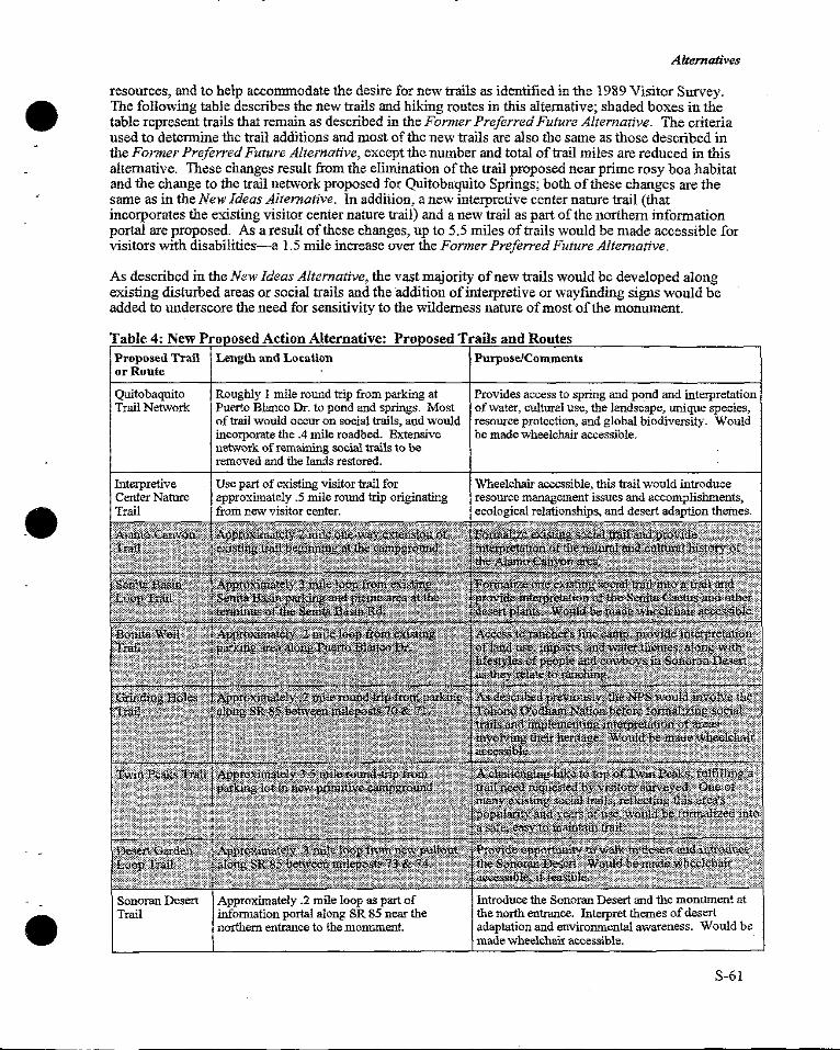
Alternatives
resources, and to help accommodate 1he desire for new trails as identified in 1he 1989 Visitor Survey. The following table describes the new trails and hiking routes in this alternative; shaded boxes in the table represent trails that remain as described in the Former Preferred Future Alternative. The criteria used to determine the trail additions and most of the new trails are also the same as those described in the Former Preferred Future Alternative, except the number and total of trail miles are reduced in this alternative. These changes result from the elimination of the trail proposed near prime rosy boa habitat and the change to the trail network proposed for Quitobaquito Springs; both of these changes are the same as in the New Ideas Alternative. In addition, a new interpretive center nature trail (that incorporates the existing visitor center nature trail) and a new trail as part of the northern information portal are proposed. As a result of these changes, up to 5.5 miles of trails would be made accessible for visitors with disabilities-a 1.5 mile increase over the Former Preferred Future Alternative.
As described in the New Ideas Alternative, the vast majority of new trails would be developed along existing disturbed areas or social trails and the addition of interpretive or wayfinding signs would be added to underscore the need for sensitivity to the wilderness nature of most of the monument.
Table 4: New Pro osed Action Alternative: Pro osed Trails and Routes Proposed Trail or Route
Quitobaquito Trail Network
Interpretive Center Nature Trail
Sonoran Desert Trail
Length and Lo<ation
Roughly I mile round trip from parking at Puerto Blanco Dr. to pond and springs. Most of trail would occur on social trails, and would incorporare the .4 mile roadbed. Extensive network of remaining social trails to be removed and the lands restored.
Use part of existing visitor trail for approximately .5 mile round trip originating from new visitor center.
Approximately .2 mile loop as part of information portal along SR 85 near the northern entrance to the monument.
Purpose/Comments
Provides access to spring and pond and interpretation of water, cultural use, the landscape, unique species, resource protection, and global biodiversity. Would be made wheelchair accessible.
Wheelchair accessible, this trail would introduce resource management issues and accomplishments, ecological relationships, and desert adaption themes.
Introduce the Sonoran Desert and the monument at the north entrance. Interpret themes of desert adaptation and environmental awareness. Would be made wheelchair accessible.
S-61
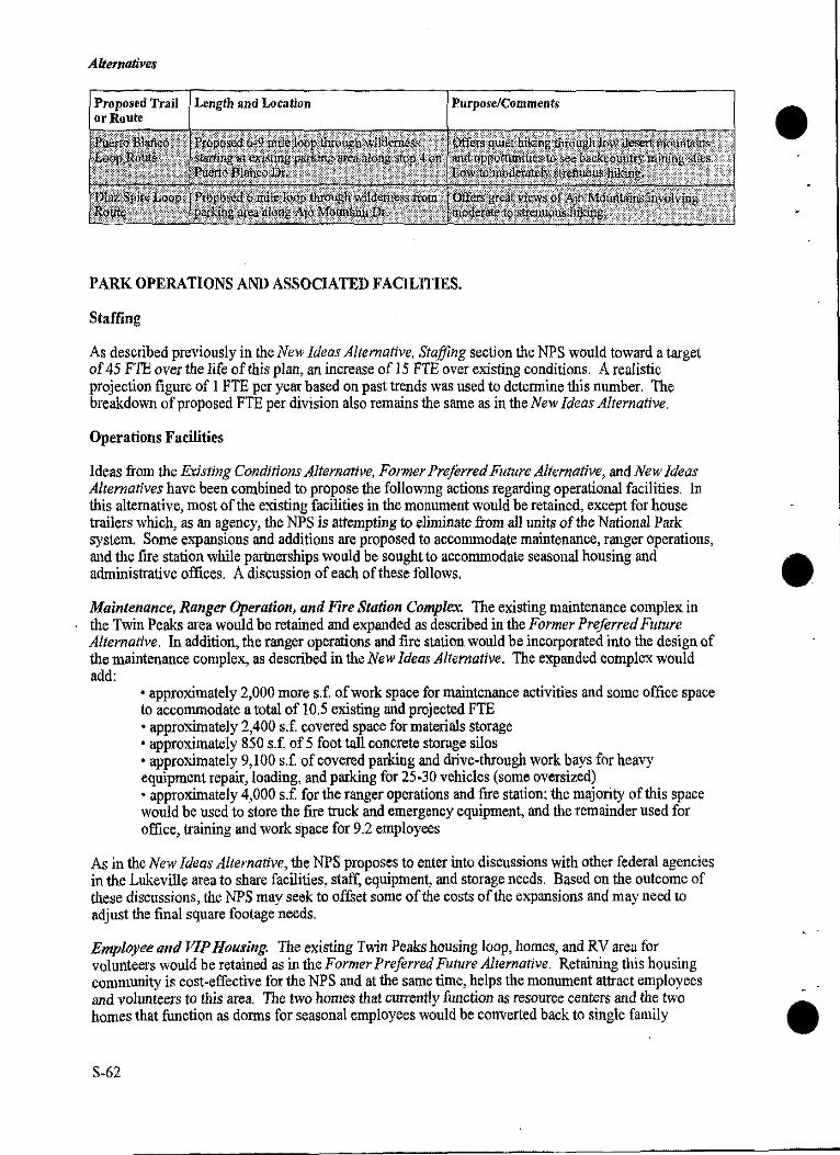
Alternatives
Length and Location Purpose/Comments
PARK OPERATIONS AND ASSOCIATED FACILITIES.
Staffing
As described previously in the New Ideas Alternative, Staffing section the NPS would toward a target of 45 FTE over the life of this plan, an increase of 15 FTE over existing conditions. A realistic projection figure of I FTE per year based on past trends was used to determine this number. The breakdown of proposed FTE per division also remains the same as in the New Ideas Alternative.
Operations Facilities
Ideas from the Existing Conditions Alternative, Former Preferred Future Alternative, and New Ideas Alternatives have been combined to propose the following actions regarding operational facilities. In this alternative, most of the existing facilities in the monument would be retained, except for house trailers which, as an agency, the NPS is attempting to eliminate from all units of the National Park system. Some eiqiansions and additions are proposed to accommodate maintenance, ranger operations, and the fire station while partnerships would be sought to accommodate seasonal housing and administrative offices. A discussion of each of these follows.
Maintenance, Ranger Operation, and Fire Station Complex. The existing maintenance complex in the Twin Peaks area would be retained and expanded as described in the Former Preferred Future Alternative. In addition, the ranger operations and fire station would be incorporated into the design of the maintenance complex, as described in the New Ideas Alternative. The expanded complex would add:
• approximately 2,000 more s.f. of work space for maintenance activities and some office space to accommodate a total of 10.5 existing and projected FTE • approximately 2,400 s.f. covered space for materials storage • approximately 850 s.f. of 5 foot tall concrete storage silos • approximately 9,100 s.f. of covered parking and drive-through work bays for heavy equipment repair, loading, and parking for 25-30 vehicles (some oversized) • approximately 4,000 s.f for the ranger operations and fire station; the majority of this space would be used to store the fire truck and emergency equipment, and the remainder used for office, training and work space for 9.2 employees
As in the New Ideas Alternative, the NPS proposes to enter into discussions with other federal agencies in the Lukeville area to share facilities, staff, equipment, and storage needs. Based on the outcome of these discussions, the NPS may seek to offset some of the costs of the expansions and may need to adjust the final square footage needs.
Employee and VIP Hou.ving. The existing Twin Peaks housing loop, homes, and RV area for volunteers would be retained as in the Former Preferred Future Alternative. Retaining this housing community is cost-effective for the NPS and at the same time, helps the monument attract employees and volunteers to this area. The two homes that currently function as resource centers and the two homes that function as dorms for seasonal employees would be converted back to single faniily
S-62
Alternatives
residences. This work would primarily be cosmetic as no major construction would be needed. No new employee housing would be constructed in this area.
Since affordable, short-term housing is difficult to find in the area during the busy winter season, the NPS would seek partnership ventures to establish apartments or efficiencies for seasonal employees and visiting scientists and researchers in the Lukeville area, as in the New Ideas Alternative. The NPS estimates that approximately I 0 total bedrooms are needed which could be in apartments or efficiencies. All NPS housing, whether owned or leased by the NPS, would need to meet federal standards and would need to be affordable for employees. As stated previously, the NPS is not interested in utilizing the existing housing area within the U.S. Customs and Immigration due to the noise and congestion generated by the adjacent port of entry. If a mutually satisfactory arrangement cannot be reached with either the federal agency or private owners, the NPS would seek to construct these units on federally owned lands in the Lukeville vicinity.
As in the New Ideas Alternative, the NPS would help initiate and participate in establishing a community center in the Lukeville area for all area residents-those living in Lukeville and Twin Peaks. The function and size of the facility would be determined with community participants and could be located in an existing building, or a new one.
Administration. Approximately 2,000 s.f. of total office space would be needed to accommodate a total of four administrative FTEs, including the Superintendent. In this alternative, the NPS would work to establish an agreement with the Government Services Administration, U.S. Customs and Immigration, and Immigration and Naturalization to utilize and share office space in the border station. The facilities are currently under-utilized and would help off-set the monument's need for office and work space.
DEVELOPMENT CONCEPT PLANS
As stated previously, the DCPs are intended to depict the basic concept for development in the Twin Peaks, Quitobaquito Springs, and Lukeville areas-in other words, the inter-relationship of the various visitor, operational, and transportation elements. Therefore, only very general locations, functions, and sizes of proposed facilities are shown. Once funding is secured for development, detailed design and construction drawings with further environmental analysis in compliance with NEPA and other federal legislation would be developed for each facility or area.
Sustainable design guidelines would be utilized for all proposed developments to ensure: • facilities are visually compatible and sensitive to the Sonoran Desert environment • water conservation and sustainable technologies are utilized • buildings are located for energy efficiency in the hot, arid climate, and are not located in floodplains of major washes • alternative energy and waste disposal measures are considered
Twin Peaks
The development concept plan for the Twin Peaks area is shown on the corresponding map. In many ways, it is similar to that proposed in the Former Preferred Future Alternative, except for the reduced size and change oflocation of some of the facilities.
The science, education, and resources management center, greenhouse, and nursery would be located next to the interpretive center and joined by an outdoor plaza and nature trail. To help separate visitors and employees, a visitor parking and picnic area would be located on one side of the facility, and an employee parking area on the opposite side.
S-63
Alternatives
Expansion of the maintenance facility would occur on distur]led lands as described in the Former Preferred Future Alternative. However, in this alternative, the ranger operations and fire station would A be located next to the maintenance facility, with a nearby area for helicopter landings. W Other changes to the Former Preferred Future Alternative DCP concern the housing loop area. Several facilities are not proposed by this alternative including the community center and seasonal housing which are instead, proposed in the Lukeville area, and the satellite dish and utility building which have been omitted.
As in the Former Preferred Future Alternative, some of the roads would be realigned and a new turnaround for Puerto Blanco Drive added. These additions would be made to serve the new facilities, improve vehicular circulation in the area, and separate employee and visitor use areas. Approximately 800 feet of new paved two-lane road would be constructed along the visitor's entrance to the Twin Peaks area and 800 feet of existing two-lane road would be removed. Approximately 400 feet of new dirt road would be added at the entrance to Puerto Blanco Drive as the new tum-around.
Quitobaquito Springs
The proposed development concept plan for the Quitobaquito Springs area is the same as in the New Ideas Alternative. Please refer to the drawing and discussion in the DCP section of the New Ideas Alternative.
Lukeville Area
While several actions are proposed for the Lukeville area, the sizes or specific locations of the facilities are not known at this time. Actions proposed in this alternative that could occur in Lukeville are described on the New Proposed Action Alternative map and include: housing for NPS seasonals and visiting researchers totalling about 10 bedrooms, use of office and work space for NPS administration A within the existing border station, ISDA's Tri-National, Tri-Cultural Center, and a community center • for all area residents in Lukeville and Twin Peaks. Most of these actions are similar to some of the actions proposed in the New Ideas Alternative, however, less development is proposed in this alternative.
NAME, BOUNDARY, AND WILDERNESS AREA CHANGES
Redesignation
For all the reasons described in the New Ideas Alternative, National Park status would be sought. However, in this alternative, the proposed name would be Sonoran Desert National Park since this name better exemplifies the significant resources contained within its boundaries.
Boundary Adjustments
The NPS feels that the land exchange proposed in the Former Preferred Future Alternative would enhance management of these lands for both the NPS and the Tohono O'odham Nation. However, the NPS will not seek to implement this exchange unless both parties are willing. At this time, the Tohono O'odham Nation does not appear to be interested in the proposal so the NPS will respect this decision and consequently, has not depicted this action on the map of the New Proposed Action Alternative. If in the future the Tohono O'odham Nation becomes interested in pursuing this or a similar idea, the NPS would be willing to enter into negotiations at that time.
Wilderness Additions
In addition to the state trust lands described in the Actions Common to All Alternatives, the following areas may be eligible for wilderness designation and are the same as in the Former Preferred Future
S-64
Alternatives
Alternative with one exception. The acres involving the proposed land exchange with the Tohono O'odham Nation are not proposed in this alternative. Once conditions are met, a legislative proposal would be prepared to propose the addition of approximately l 509 acres.
l. Approximately 206 acres of!and where the above-ground powerlines are currently located west of SR 85. The old lines and poles would be removed and the powerline road restored to natural conditions. These lands could then qualify to be added into the wilderness boundaries.
2. Once the existing parking lot and road are restored to natural conditions, approximately 23 acres of the Quitobaquito area would be suitable for wilderness designation.
3. In the Twin Peaks area, approximately 70 acres ofland, currently designated as nonwildemess, would be suitable for wilderness designation once facilities on about 43 acres of land are removed and the area restored. The remaining 27 acres are adjacent to the area that would be restored and are currently undeveloped.
PLAN IMPLEMENTATION A.l'ID COSTS
Implementation
As described previously, the intent of a GMP is to provide comprehensive, general guidance for managing a unit of the NPS over a 15-20 year time span. The ability and rate of which the NPS is able to implement the actions in a GMP is variable and is based on numerous factors, many of which are not controlled by the NPS. Some NPS managed areas are able to fully implement approved GMPs within this time frame, while for other areas, it takes much longer.
Funding is the ultimate determinant of the time frame in which proposed developments, programs, and staffing additions would be implemented. Because oflimited federal resources, the NPS, together with other federal agencies, is seeking partnerships to develop cost-effective solutions for carrying out legislated responsibilities. Partnerships, donations, and volunteer work can offset implementation costs and would be sought wherever possible.
Priorities. A prioritization or phasing strategy has been developed to implement actions in this alternative as described in the New Ideas Alternative. Likev.ise, priorities may be amended in the future, and those for staffing are included in the following Staffing Cost section.
The same categories used in the New Ideas Alternative have been used for the prioritization of the actions in this alternative. The projects in this alternative related to health and safety or legislative requirements, such as threatened and endangered species, significant cultural resources, and Native American consultation, are proposed as the highest priority and include implementation of: (these projects are not in any specific order of priority)
• the fire station as part of the expanded maintenance complex proposed in the Twin Peaks area •the DCP for the Quitobaquito Management Area which relates to safety, threatened and endangered species, and cultural resource concerns • a partnership with ADOT to develop and implement the program proposed for SR 85 in order to improve visitor safety and to help protect and recover threatened and endangered species affected by the road and related traffic • the one or more agreements to be developed between the NPS and the Tohono O'odham Nation •the inventory, monitoring, and mitigation programs and actions to protect and recover threatened and endangered species including control of nonnative vegetation and animals • studies and programs that help mitigate impacts occurring from outside the monument on threatened and endangered species including expansion of the water resources management program • safety programs for abandoned mine lands
S-65
Alternatives
• inventory, evaluation, and monitoring programs established to protect cultural resources including their nomination to the National Register of Historic Places
Second level priorities involve provision of essential services and NPS functions that are not a level one priority, or, are the second phase of a high priority project, and in this alternative include implementation of:
• the rest of the programs and projects identified in the Natural and Cultural Resources Management Plan; due to financial considerations, many of these would be phased overtime. •expansion of the maintenance complex in the Twin Peaks area • partnerships that work toward: development of the visitor center in Why, use of existing office and work space for NPS administration in Lukeville, initiation of the joint effort to prepare a wilderness and backcountry management plan, and the establishnient of housing for NPS seasonals in Lukeville • plans developed with APS to detennine strategies to relocate and bury powerlines •related road work and conversion of the existing visitor/administrative facility in Twin Peaks to the science, education, and resources management center, greenhouse, nursery, and interpretive center • new trails and restoration of social trails which most likely would be phased over time • redesignation which would require congressional legislation
All other projects and programs proposed in this alternative are third level priority projects and may encompass the second or third phase of projects initiated at higher priority levels. These include the implementation of:
• conversion of houses currently used as office space and dorms, back to employee homes; this could not be accomplished until the new SERMC, ranger operations, and seasonal apartments have been completed • the proposed additions to wilderness which would require congressional legislation
Cost Estimates
Cost Estimates for New Development. The following costs of development are one-time costs to the government. The NPS recognizes that development costs for the federal government tend to be higher than those for private citizens, and subsequently, has prepared a discussion in the Cost Estimates section of the New Ideas Alternative regarding escalated casts. This discussion also applies to the estimated costs for this alternative.
For the purpose of this planning effort, the total costs the government may expect to incur to implement these developments are listed below. If costs are successfully offset or reduced, these estimates instead would represent the value or cost savings to the government.
The total development cost is expected to be approximately $ 6, 778,000 for this alternative and is broken down below by area. More detailed figures can be found in Appendix B of this Supplement. (The figures from the Appendix were rounded up to the nearest thousand.)
Twin Peaks: Quitobaquito: Alamo Canyon: Other Roads, Pullouts,
Trails, and Exhibits:
$ 5,162,000 $ 260,000 $ 57,000
$ 1,299,000
The cost for projects involving partners or those located outside monument boundaries are not included in these estimates. At this time, the proposals are preliminary and the make-up of the partnerships, and the size, location, and the NPS share of facility costs-if any-are unknown. Examples ofNPS costs in established partnership efforts vary widely: from the NPS paying for construction to having a facility donated at no cost to the NPS, from using NPS paid staff, to using another agencies paid staff, A to using volunteers at no cost to the federal government. Because of these unknown variables, the NPS •
S-66
Alternatives
has not attempted at this time to predict the costs of these projects to the federal government. The NPS would seek public involvement on the partnerships, locations, and size of the facilities in compliance with NEPA, and would be able to begin to predict and present any costs at that time.
The projects that are discussed in this alternative but are not inluded in the cost estimates include: the inter-agency information and orientation center in Why, ISDA's possible tri-cultural, tri-national center, sharing facilities in the border station for NPS administration, establishing a small facility for community meetings and social fucntions in the Lukeville area, and seeking apartment type housing for NPS seasonal employees also in the Lukeville area.
Cost Estimates of Adding Staff.
Increases in funding and therefore staffing, are difficult to predict. As described in the New Ideas Alternative, the rate of past staffing increases for the monument was used to predict a realistic increase for this alternative: at one FTE per year this equates to a total of 15 FTE. To gain the entire 15 FTEs-at the average rate of one per year-the NPS would eventually incur a total cost of roughly $850,000.
As in the New Ideas Alternative, the cost and number of additional FTE could be reduced through partnerships and other ventures due to the increased potential for establishing inter-agency partnerships.
S-67
Alternatives
S-68
State held parcel
Quitobaquito Management Area • New trai!head with parking, interpretive information,
and composting toilet along Puerto Blanco Drive
Relocate powerllne from this area to the State Route 85 Corridor
• 1 mile round-trip trail accessible to visitors with disabiHties • Expand size of Management Area
' ~., . " . ' .. ~~ ..
••• Puerlo Blanco \ LoopTraif'-......---••. .•
•••••• • Milton Mine Twin Peaks *'" San/ta Basin ~ ~ Loop Trail •: •
: '--··\ •. ~ .. . ···~.
·: *"'•• \iiCtorla Mine
l'ltlol Mo'o (Montez.umas Head)
.,~
Southern Information Portal with exhibits, parking, and shade
N A T 0 N A L P A R K
NEW PROPOSED ACTION ALTERNATIVE SONORAN DESERT NATIONAL PARK UNITED STATES DEPARTMENT OF THE INTERIOR NATIONAL PARK SERVICE DSC/March 199Ei
Pub!. as 157/20014 Now 157/20014A
MANAGEMENT ZONES
t]l Non-Wilderness Development Area
Ill State Route 85 Corridor Zone
Non-Wilderness Travel Corridor
0 Wilderness Zone
II Potential Wilderness Additions
l:!'2 Wilderness Zone • Quitobaquito Management Area
* Cultural Resources Overlay Zone
GENERAL LEGEND
Existing Trails .
• • • • Proposed Maintained Trails
- Paved Roads
State held parcel Graded Dirt Road
Unimproved Dirt Road
--- --·------------------ ------
EMPLOYEE -HOUSING AREA •MAINTAIN CURRENT
NUMBER OF HOUSING UNITS
.e
VIP TRAILER VILLAGE •MAINTAIN CURRENT
CAPACITY
HELICOPTER PAD
RANGER OPERATIONS AND FIRE STATION
EXISTING DUPLEX CONVERT FROM EXISTING USE BACK TO SINGLE FAMILY RESIDENCES
MAINTENANCE COMPLEX •EXPANDED WORK/SHOP
SPACE, COVERED STORAGE AND PARKING
•ADD WASH BAYS, CONCRETE SILOS, AND LOADING RAMPS
FORMER CORRAL AREA ~ 0 200 400 600 FEET
NEW TURN-AROUND
MULTI-USE OVERFLOW SPACE
GREENHOUSE AND NURSERY AREA
EXISTING EMPLOYEE PARKING
SCIENCE, EDUCATION, AND ·• RESOURCES MANAGEMENT CENTER • CONVERT EXISTING
ADMINISTRATION/ VISITOR FACILITY
VISITOR CENTER 1
•ADDITION WITH RESTROOM
MUL Tl-USE OUTDOOR : PLAZA-CORE AREA .
VISITOR PARKING
NATIONAL PARK
NEW PROPOSED ACTION ALTERNATIVE TWIN PEAKS DEVELOPMENT CONCEPT PLAN UNITED STATES DEPARTMENT OF THE INTERIOR NATIONAL PARK SERVICE DSC/March 1996)
Pub!. as 157/20016 Now 157/20016A
D EXISTING BUILDINGS AND FACILITIES • NEW BUILDINGS AND STRUCTURES 11111 NEW ROADS, PAVED AREAS, AND
OTHER FACILITIES ~ REMOVE ROADS: RESTORE TO
NATURAL CONDITIONS --- EXISTING TRAIL
--
~
.....
~~ , ..
-------------- ---
SUPPLEMENT TO
ENVIRONMENTAL CONSEQUENCES
INTRODUCTION
triAs required by the National Environmental Policy Act (NEPA) of 1969 , the potential consequences of implementing the new alternatives were analyzed. The following discussion of consequences addresses both adverse and beneficial impacts on the human environment that are expected to occur if actions related to the two new alternatives are implemented. Most of the actions contained in the two new alternatives have been discussed previously in the Draft GMPIDCPIEIS. Therefore, the following analysis will focus on those actions that are unique to the alternatives presented in this document. Impacts associated with actions already described in the Draft GMPIDCPIE/Swill be incorporated by reference.
A chart summarizing the environmental consequences is located in the summary section, following the summary of alternatives. The chart contains a comparison of the two new alternatives. Analysis of the no action alternative and Former Preferred Future Alternative can be reviewed in the Draft GMPIDCPIEIS. .
The programmatic nature of many actions proposed in general management plans makes it difficult to quantify their environmental impacts; consequently, more detailed site-specific planning and analysis would be required before implementing some actions contained in this document. More specific mitigations for implementing the New Proposed Action Alternative are presented in Appendix I. In addition, other more detailed efforts may involve preparing project-specific environmental assessments, obtaining additional clearances and permits from regulatory agencies, or developing further mitigation strategies.
Impact Topics
Impact topics were developed to aIIow comparison of the environmental consequences, or impacts, of each alternative. The same impact topics that were used for analyzing alternatives in the Draft GIY1P!DCPIE!S have been nsed to analyze the two new alternatives in this Supplement. These topics include: wilderness; air quality; floodplains, wetlands, and water resources; threatened, endangered, and sensitive species; wildlife; vegetation and soil; cultural resources; visitor use and experience; socioeconomics; and cumulative impacts. A definition of each topic can be found on pages l 05-106 of the Draft GMPIDCPIEIS, as well as a list of those topics dismissed from further consideration. One new impact topic was analyzed in this Supplement: impacts to socio-cultural characteristics. This new impact topic was developed in part, to address Executive Order 12898, "Federal Actions to Address Environmental Justice in Minority Populations and Low-Income Populations'', issued by President Clinton on February II, 1994. The definition of this impact topic is provided under that topic heading.
S-75
Environmental Consequences
S-76
•
•
ENVIRONMENTAL CONSEQUENCES
IMPACTS ON WILDERNESS
New Ideas Alternative
Proposed actions would increase protection of wilderness resources and values, and are consistent with both the Wilderness Act and NPS management policies. Actions directly affecting wilderness are similar to the Former Preferred Future Alternative with three exceptions:
• the proposed wilderness and backcountry management plan would be prepared as an interagency effort with the U.S. Fish and Wildlife Service (FWS) and Bureau of Land Management (BLM) • fewer acres would be committed to development within the Twin Peaks area in the monument • 3650 acres would be proposed for wilderness designation, including 70 acres of former developed lands in the Twin Peaks area and 570 acres along former road corridors
An indirect effect of this new alternative, which is common to all alternatives, is that user capacities would be established for roads that provide access into wilderness.
Wilderness values would be enhanced under the New Ideas Alternative by the removal of nearly all of the existing development in the Twin Peaks area, the reduction of the number of roads providing vehicular access into wilderness areas, and the relocation and burying of the powerlines. By maintaining only those facilities or roads that are either resource dependent, essential for efficient monument operations, or offer a unique experience (e.g., primitive camping opportunities), the monument would become more compatible with wilderness values.
Anticipated impacts to wilderness resulting from actions contained in the New Ideas Alternative are essentially the same as described in the Former Preferred Future Alternative. There would be no direct adverse effect on wilderness since all proposed development would occur outside wilderness boundaries. Although most maintained trails and unimproved hiking routes would occur either in designated or proposed wilderness, their presence and use is considered acceptable and appropriate in wilderness areas.
Other beneficial impacts on wilderness would result from an increase in the amount of acreage eligible for wilderness designation. Under this alternative, the size of the Organ Pipe Cactus Wilderness could potentially increase by 3650 acres, compared to 3,410 acres under the Former Preferred Future Alternative. Once designated, these lands would receive permanent protection under the Wilderness Act.
Development and implementation of an inter-agency wilderness management plan also would have beneficial effects on designated and proposed wilderness areas as well as those areas managed to maintain wilderness values. Coordination and joint planning with the FWS and BLM would promote more efficient management of adjoining wilderness areas and address issues of common concern. This planning effort would seek collaborative approaches, ensure a spectrum of visitor opportunities, and facilitate information sharing among agencies to better protect wilderness resources.
Establishing user capacities ofbackcountry roads would help ensure that adjacent wilderness areas are protected to the greatest extent possible. Determining these capacities as proposed in the Natural and Cultural Resources Management Plan, would have a beneficial effect by limiting intrusions on the solitude and visual quality of adj a cent wilderness.
The approximately 22 miles of SR 85 within the monument would continue to serve as a through route; however, .the NPS proposes to continue to work with ADOT to develop ways to mitigate impacts from existing use. No reduced speed limits, tolls, or traffic re-routes are planned. The impact to wilderness values from noise and visual intrusions resulting from the anticipated increase in non-monument traffic would continue to be adverse, long-term and significant.
S-77
Environmental Consequences
Conclusion. Actions described in the New Ideas Alternative would, for the most part, continue to enhance wilderness values. Under this alternative, an additional 3,650 acres of the monument A would be proposed as wilderness. Removal of facilities and roads, development of an inter- W agency wilderness management plan, and the establishment of user capacities for roads leading into wilderness would have long-term beneficial effects on wilderness areas and values. Coordination with ADOT to seek ways to minimize impacts of continued use and conditions along SR 85 would facilitate protection of monument resources. However, the indirect impact of traffic on the solitude and visual quality of adjacent wilderness would continue to be adverse, long-term, and significant.
New Proposed Action Alternative
Impacts to wilderness would be essentially the same as the New Ideas Alternative except that fewer acres would be restored to natural conditions and proposed for wilderness designation. Under this alternative, 1,509 acres would be proposed as wilderness, compared to 3,650 acres under the New Ideas Alternative. The difference in acreage is due to three factors:
• 70 acres in the Twin Peaks area would remain developed •none of the monument's backcountry roads would be restored or converted to trails under this alternative •the 1502.6 acres of the monument that which lie of the crest of the Ajo range would not be proposed for addition into wilderness, however, the NPS would work with the Tohono O'odham Nation to ensure that management of these lands is compatible with wilderness values
All other actions and resulting impacts would be the same as those described for the New Ideas Alternative.
Conclusion. Actions described in the New Proposed Action Alternative would, for the most part, A enhance wilderness values and attributes as described under the New Ideas Alternative. The • continued use of all backcountry roads as well as existing facilities in the Twin Peaks area would make these areas ineligible for wilderness designation (as proposed under the New Ideas Alternative); however, this would not be an adverse impact to the wilderness character of the monument as a whole. As with the New Ideas Alternative, inter-agency development of a wilderness management plan and establishing user capacities for backcountry roads providing access to wilderness would have long-term beneficial impacts to wilderness areas and values. Impacts on adjacent wilderness resulting from traffic on SR 85 would continue to be adverse, long-term and significant, although the NPS would work with ADOT on these issues.
IMPACTS ON AIR QUALITY
New Ideas Alternative
There would be no change to the actions to protect air quality from those described under the Former Preferred Future Alternative. The NPS would continue to seek redesignation of the monument from a class II to a class I airshed which would have a long-term beneficial effect on air quality. However, despite the more stringent air quality standards associated with a class I designation, it cannot prevent further visibility impairment or air quality degradation from pollutants that originate outside the U.S.
Actions described in the New Ideas Alternative involving gro1md disturbance and construction would have a temporary and insignificant impact on air quality. Although there would be little dust associated with new construction due to the lack of proposed development in the Twin Peaks area, dust would be generated during building demolition. Jn either case, impacts would be minor and short-term. To further reduce dust levels and minimize soil erosion around construction sites, bare soil would be A dampened with water and disturbed areas would be revegetated with native plants. W
S-78
-·----~------
Environmental Consequences
Conversion of roads to trails along with elimination of some roads entirely would decrease the amount of dust produced by vehicles in remote sections of the monument. This conversion would also reduce the amount of road surface subject to wind erosion. Establishing user capacities for selected roads within the monument may affect vehicle volumes and therefore have a related benefit on air quality. However, in both instances the localized nature of impacts is expected to be minor in the context of overall air quality within the monument. Although use of the SR 85 corridor is expected to increase over time and would continue to have localized, adverse impacts on air quality, this would not affect the redesignation of the monument from a class II to a class I airshed.
Conclusion. Overall impacts to air quality would be the same as described for the Former Preferred Future Alternative, the primary benefit being redesignation of the monument from a class II to a class I airshed. This action would have a long-term, beneficial effect on monument air quality. Airborne pollutants generated by construction-related activities and vehicle use of monument roads would have short-term and localized impacts, but would be minor in the context of the monument's overall air quality.
New Proposed Action Alternative
Impacts on the monument's air quality would be the same as described under the New Ideas Alternative.
Conclusion. Redesignation of the monument's airshed to class I would have a long-term, beneficial effect on monument air quality. Although vehicle use and construction-related activities would result in short-term and localized increases in airborne pollutants, these impacts would be minor in relation to overall monument air quality.
IMPACTS ON FLOODPLAINS, WETLANDS, AND WATER RESOURCES
New Ideas Alternative
Impacts to floodplains, wetlands, and water resources would be similar to those described under the Former Preferred Future Alternative. All proposed actions would occur outside regulatory floodplains. Proposed development in the Lukeville and Why areas would require careful planning and further environmental analysis to prevent adverse impacts on floodplains, wetlands, and water resources.
Although there may be a slight alteration of drainage patterns around new development or areas where facilities have been removed, site grading and the installation of culverts would help minimize the disruption of surface and subsurface water flows. Removal of facilities in the Twin Peaks area would have the added benefit of eliminating existing impervious surfaces and restoring soil conditions. Impacts on surface or groundwater quality also would be avoided by ensuring that runoff and sediments from construction sites do not enter washes and other bodies of water. Runoff would be controlled in compliance with federal and state regulations.
In the Quitobaquito area, facilities would be relocated, resulting in similar long-term beneficial impacts on wetland functions and values as those described for the Former Preferred Future Alternative. The exact location of proposed trails and facilities would require further site planning and may determine the need for additional environmental compliance. A properly designed and maintained trail network would decrease, if not eliminate, vegetation trampling, soil erosion, and turbidity along the edges of the pond, springs, and channel. Such actions would enhance habitat values of the pond's littoral (shallow water) zone, producing a beneficial effect on the many species of wildlife that forage, nest, or seek protective cover in this area.
To further ensure that visitor use does not result in adverse impacts on sensitive resources in the Quitobaquito area, visitors would be required to ei1her obtain a permit or visit the area as part of a
S-79
Environmental Consequences
guided tour. The NPS would also monitor the effects of visitor use to determine appropriate user capacities that promote resource protection, including wetland functions and values. To assess the impact of groundwater depletion on monument resources, including sensitive species at Quitobaquito, the NPS would continue to collect groundwater data both within the monument and on adjacent lands in the U.S. and Mexico, as well as work with Mexican resource specialists on this issue.
Although the construction of additional housing and facilities in the Lukeville and Why areas could be expected to increase water consumption over existing levels, this increase is not expected to be statistically significant. Similarly, the lack of new construction and removal of some facilities from the Twin Peaks area would cause a corresponding decrease in water consumption within this area of the monument; however, the NPS would still develop and implement a water conservation plan.
Conclusion. Actions contained in this alternative would not have an adverse effect on regulatory floodplains or surface and groundwater quality. Wetland functions and values would be enhanced in the Quitobaquito area through establishment of a well-designed and maintained trail network, restrictions on visitor access, and development of an appropriate user capacity for the area. A lack of new construction and removal of some facilities from the Twin Peaks area would cause a decrease in water consumption at this location. Conversely, new construction would result in an increase in water consumption in the Lukeville area. To assess the impact of groundwater depletion on monument resources, the NPS would continue to collect groundwater data both within the monument and on adjacent lands, as well as work with Mexican resource specialists on this issue.
New Proposed Action Alternative
Although in this alternative more development would occur within the Twin.Peaks area, impacts on floodplains, wetlands, and water resources would essentially be the same as those described under the New Ideas Alternative. However, rather than a decrease in water consumption over existing levels, use A could be expected to increase since several offices would be reconverted into four employee W residences, allowing more people to reside within the Twin Peaks area, and development of the new interpretive center would attract more visitors. Following implementation of conservation measures, there would be only a slight to moderate increase in water consumption over existing levels.
Conclusion. Proposed actions would have no adverse impact on regulatory floodplains or surface and groundwater quality, and would result in only a slight to moderate increase in water consumption over existing levels. Prior to constructing any facilities outside the monument, additional environmental analysis would be performed to ensure protection of water resources. Visitor use restrictions and improvements to the trail system at Quitobaquito would enhance the wetland's value as wildlife habitat by limiting human intrusions and the disturbance of sensitive resources. The NPS would also continue to collect groundwater data to assess the impact of groundwater depletion on monument resources.
IMPACTS ON THREATENED, ENDANGERED AND SENSITIVE SPECIES
In response to comments on the Draft GMP!DCPIEIS, the following discussion is presented in greater detail in this Supplement. Section 7 of the Endangered Species Act (1973) prohibits federal agencies such as the NPS from implementing any action that is likely to jeopardize the continued existence of a federally listed (i.e. endangered, threatened) species. Furthermore, the Act requires that the NPS consult with the FWS on any action it authorizes, funds, or executes that could potentially affect a protected species or its designated critical habitat. To help meet its responsibilities under the Act, the NPS is currently consulting with the FWS as well as preparing a biological assessment that analyzes potential effects of the GMP on federally listed, proposed, and candidate species. This document will appear as an Appendix in the final GMP /DCP /EIS along with a letter from the FWS confirming successful completion of the Section 7 process.
S-80
Environmental Consequences
Of the endangered, proposed endangered, and candidate species identified by the FWS (Appendix G of the Supplement), as well as the plant and wildlife species of special concern (Appendices C and D of the Draft GMPIDCP/EIS, pages 148-151), only the Sonoran pronghorn, Mexican rosy boa, lesser long· nosed bat, cactus ferruginous pygmy owl, Quitobaquito desert pupfish, Quitobaquito snail, and Sonoran mud turtle may be affected by proposed actions. Specific actions, mitigation measures, and their effects on listed species are outlined below for each alternative discussed in this Supplement.
New Ideas Alternative
Sonoran Pronghorn .. Organ Pipe Cactus National Monument is within the historic range of the Sonoran pronghorn. Prior to a recent verified sighting of two pronghorns just west of SR 85 neat the Alamo Canyon road in mid-August 1995 (Organ Pipe Cactus NM, unpublished data), the last verified observation of a pronghorn near this highway was a carcass found on Aja Mountain Drive in 1972. There is an unconfirmed report of four Sonoran pronghorn crossing SR 85 in August 1993, approximately 1.5 km north of the monument visitor center. Although observations along SR 85 have been limited in recent decades, pronghorns were supposedly not uncommon along the highway. Longtime Ajo residents reported seeing more Sonoran pronghorn along the highway neat Ajo and south in the Valley of the Ajo in previous decades (FWS 1994).
Observations of pronghorn movements suggest that traffic along SR 85 acts as a barrier to pronghorns, restricting their movements to areas west of the highway. Not only is the highway a deterrent to expanding pronghorn populations, but the resulting modified behavior patterns may lead to a reduction in genetic exchange, reduced viability, and the ability to adapt to environmental change.
To reduce wildlife mortality and habitat fragmentation along SR-85, the NPS would work with state and federal agencies to develop a research program examining the effectiveness of various traditional and innovative measures aimed at reducing wildlife mortality and facilitating safe passage aeross the roadway. Some of the traditional methods to be examined include bridge construction and placement of oversized culverts beneath the roadway; vegetation removal along road shoulders; and educating motorists about wildlife use of the road corridor through various interpretive media, including road signs and wayside exhibits. Because fenced highways have been shown to fragment pronghorn habitat and isolate herds (Ockenfels et al. 1996), the NPS does not support their use to keep animals off SR 85 or to guide them into culverts
Since the effectiveness of techniques varies, the NPS would not rely on any one method exclusively. Measures proven to be effective would be applied on a limited basis and further environmental analysis completed before expanding their use on a broader scale. In the meantime, the NPS would continue working with the ADOT towards enforcing the existing speed limit within the monument.
Vegetation removal along road shoulders would cause further habitat losses and may increase the barrier that SR 85 presents to pronghorn. Although bridge construction and culvert placement would focus on areas of known wildlife use, such as xeroriparian corridors (i.e., washes), some pronghorn may have difficulty locating or may simply refuse to enter culverts. Moreover, any gains experienced by ensuring safe passage across the highway could be offset by a potential increase in predator-related mortality. Such structures could serve as a predator trap, allowing mountain lions and coyotes to successfully ambush pronghorn at culvert openings. Because pronghorn, like other animals, are not restricted to xeroriparian habitats, increased efforts to educate motorists and enforce the existing speed limit may have the most impact on reducing the potential for vehicle-related mortality.
Despite such mitigation measures, pronghorn may still avoid using the SR 85 corridor due to the disturbance associated with the heavy volume of traffic travelling at high speeds. Elevated heart rates have been correlated with auditory or visual disturbance among pronghorn (Thompson et al. 1968, Cherkovich and Tatoyan 1973, Moen et al. 1978 [cited in FWS 1994]. Hughes and Smith (1990) reported flight distances of 400-500 meters in response to an approaching vehicle. They also reported that though the impaets of military aircraft overflights on the Sonoran pronghorn are unknown, in one
S-81
Environmental Consequences
instance, low-level flights over three pronghorns caused them to move about I 00 meters from their original location.
Key components of the recently revised draft recovery plan for the Sonoran pronghorn include monitoring the present U.S. population, assisting with monitoring in Mexico, protecting and managing known habitat, and continuing research efforts to provide a better understanding of the subspecies (FWS, 1994 ). The NPS will assist in Sonoran pronghorn recovery by continuing to serve as a member of the interagency Core Working Group. As called for in the Natural and Cultural Resources Management Plan, the NPS will implement activities outlined in the recovery plan, under the lead of the FWS, including development of a monitoring program.
Mexican Rosy Boa. As described previously under the Former Preferred Future Alternative, the Mexican rosy boa has experienced a human-induced population decline within the monument and has been adversely impacted by highway mortality along SR 85. However, unlike the Farmer Preferred Future Alternative, the NPS is no longer proposing a pullout and trail at Eagle's Pass (mile 66.0), a rocky outcrop that represents one of the few areas of potential rosy boa habitat along the road corridor.
As described for Sonoran pronghorn, in this alternative the NPS proposes to work with state and federal agencies to develop a research program that examines the effectiveness of various mitigation strategies at reducing wildlife mortality. Of the traditional mitigation techniques mentioned, those actions aimed at modifying the motorist's behavior (e.g., speed limit enforcement, use of signs and other interpretive media) offer the greatest potential for reducing rosy boa mortality along the road corridor. At 55 mph, motorists would have more time to react, and consequently avoid hitting snakes in the roadway than they would if travelling at higher speeds.
The effect that vegetation removal would have on this snake is unknown. However, due to its small home range size, even relatively minor habitat losses could result in adverse impacts such as a localized decline in prey species.
Installing culverts along the length of the roadway might be successful in reducing vehicle-related mortality by keeping snakes off the pavement. However, without some type of strnctural barrier, such as a low fence, to guide snakes into culverts, the effectiveness of this techniques is uncertain (and could further inhibit pronghorn movements). The small home range size of snakes necessitates that culverts be placed less than 0.25 mile apart to prevent the disruption of gene flow within populations. This would require more than 90 culverts to be located beneath the 22-mile stretch of highway within the monument. Consequently, not only is the effectiveness and practicality of such measures of concern, but they may also enhance the efficacy of predators-and possibly poachers-as they await prey along the fenceline and culvert openings. Such losses could eventually eliminate t11e rosy boa from all areas bordering SR 85. In contrast, the Jaw speeds and infrequent traffic volume e"''Perienced on dirt roads throughout the monument appears to have an insignificant effect on this species.
Lesser Lo11g-11osed Bat. The lesser-long nosed bat is a seasonal resident in the monument, visiting between April and September. In 1989, the largest known maternity colony in the U.S., consisting of approximately 20,000 bats was discovered roosting in an abandoned mine adit near Alamo Canyon. Through coordination with the FWS, the NPS has instituted an annual monitoring program to obtain data on the colony including its size, productivity, diet, and habitat requirements.
As outlined in the draft recovery plan for this species (FWS 1994), recovery actions should stress protection of known roosts, determination of foraging and mating behavior, population monitoring, and public education. The NPS is assisting in recovery efforts through ongoing monitoring of the roost, protecting all potential roost sites and food plants within the monument, and educating visitors about the ecological importance of bats.
Lesser long-nosed bat colonies appear to be sensitive to human disturbance. Such disturbance could have potentially adverse effects on the species' survival if it resulted in abandonment of a major roost or a decline in juvenile survivorship or recruitment. The proximity of the maternity roost to Alamo
S-82
- .
Environmental Consequences
Canyon Campground, coupled with the fact that features such as mine adits are attractive destinations for hikers, increases the potential for human-induced disturbance at the roost site. However, previous indications are that little, if any visitation presently occurs at the site, particularlv at the time of vear when bats are roosting. - ·
Under this alternative, there would be little opportunity for potential disturbance to the roost site since visitor access at Alamo Canyon would be closely controlled through permit or direct supervision (e.g., guided hikes). The Alamo Canyon campground would also be closed. Furthermore, the remote location and nondescript nature of the adit would discourage all but the most ardent hikers; accessing the site from the campground requires a l .5-mile hike cross-country, across rugged terrain.
Although the entrance to the adit is currently fenced with barbed wire and signed to prohibit entry, a more permanent closure is proposed to minimize potential disturbance on the maternity colony of lesser long-nosed bats. A "bat friendly" grate would be placed at each opening of the adit that would allow bats unimpeded access to the mine's interior, while prohibiting human entry. It would also reduce mortality attributed to predators such as common barn-owls which can now enter through the existing barbed wire fence. Although similar barbed wire fences appear on other mine openings throughout the monument, more permanent closures could be constructed for those adits determined to be significant bat roosting sites. Consequently, other bat species could benefit from such mitigative measures.
Cactus Ferruginous fygmy Owl. The cactus ferruginous pygmy owl is an permanent but uncommon resident that occurs in washes, canyons, and saguaro stands; it typically nests in riparian areas during June and July. The last recorded observation of this owl within the monument was in 1993 in Growler Canyon, approximately l mile from Bates Well (Organ Pipe Cactus NM, unpublished data). The cause forthe cactus ferruginous pygmy owl's decline at Organ Pipe Cactus NM and throughout the northern part of its range is unknown. However, the ongoing destruction of riparian habitat across the region may partially explain the reasons for the decline ..
Critical habitat designation for the cactus ferruginous pygmy owl has been proposed from the well in Alamo Canyon (Tl6S, R4W, unsurveyed Section 6) downstream to the point where Growler Wash intersects the Bates Well Road. The boundaries encompass the current active channel, in addition to secondary, side, and overflow channels extending up to 100 meters laterally of the 100-year floodplain. Although this owl has not been observed in the vicinity of the Alamo Canyon campground for nearly 10 years, the nearby wash has been proposed as critical habitat since it possesses suitable habitat characteristics and has the potential to support nesting owls. Restricting visitor access in the Alamo Canyon area, as proposed under this alternative, may have a long-term beneficial effect on the species by minimizing the potential for human disturbance to this fairly shy owl or its critical habitat by minimizing the potential for human disturbance or habitat degradation.
To aid in the management of the cactus ferruginous pygmy owl, the NPS would expand its monitoring program as well as collect data on the demographics, behavior, and habitat requirements of this species. Such information would help the NPS provide more effective protection for this rare owl.
Quitobaquito Desert PupflSh, Quitobaquito Snail, and Sonoran Mud Turtle. Impacts associated with development of a well-designed and maintained trail system at Quitobaquito would be the same as those described under the Former Preferred Future Alternative. Establishment of a trail system would have a long-term beneficial effect on habitat for the Sonoran mud turtle, Quitobaquito snail, and Quitobaquito desert pupfish. By encouraging visitors to remain on established trails, there would be a reduction to and possibly an elimination of vegetation trampling along the pond's littoral zone. This highly productive zone, dominated by stands of bulrush and submerged aquatic vegetation, is rich in invertebrates and provides protective cover, along with important foraging, spawning, and resting areas for the above-mentioned species.
To further minimize the potential for adverse impacts on sensitive species and their critical habitat, visitor use would be closely regulated via restrictions to visitor access and development of an
S-83
Environmental Consequences
appropriate visitor canying capacity for the area. Although these species would still be vulnerable to stochastic (chance) events (e.g., environmental perturbations, decliue iu habitat quality), the risk from A anthropogenic (human caused) impacts (e.g., water pollution, introduction of nonnative fish) would be W reduced.
The NPS would continue to aid pupfish recovery efforts by implementing actions contained in the desert pupfish recovery plan (FWS 1993). Some of the specific actions to be accomplished include an expansion of the current monitoring program to assess population status, detect trends, and evaluate the success of pup fish recovery. The NPS would continue to conduct habitat assessments and population estimates under site-specific protocols mutually established by the NPS and FWS, and assist with the collection oflife history foformation to help determine factors affecting population persistence. In addition, the NPS would further its efforts to educate the public about the plight of the Quitobaquito desert pupfish through a variety of interpretive media. The NPS would work closely with the FWS on the above actions.
Conclusion. Of the threatened, endangered, and sensitive species identified within the monument, only the Sonoran pronghorn, Mexican rosy boa, lesser long-nosed bat, cactus ferruginous pygmy owl, Quitobaquito desert pupfish, Quitobaquito snail, and Sonoran mud turtle may be affected by proposed actions. ·Mitigation measures, including experimentation with traditional and innovative techniques, as well as continuation of efforts to work with fish and wildlife agencies would seek to minimize long-term adverse impacts to these species.
New Proposed Action Alternative
Impacts on the Sonoran pronghorn, Mexican rosy boa, lesser long-nosed bat, Quitobaquito desert pupfish, Quitobaquito snail, and Sonoran mud turtle would be the same as those described under the new ideas alternative. With the exception of the cactus ferruginous pygmy owl, there would be no effect 011 any other species of concern.
The only difference between the two alternatives involves proposals for the Alamo Canyon area. Under this alternative, the NPS would adopt actions proposed in the Former Preferred Future Alternative to eiqland the existing campground by four sites and delineate a day-use parking area within the existing roadbed.
Although no restrictions would be placed on visitor use of the Alamo Canyon area, this is unlikely to have an adverse effect on either the lesser long-nosed bat or cactus ferruginous pygmy owl. It is particularly unlikely that increasing the capacity of the Alamo Canyon campground would have an effect on the lesser long-nosed bat for the following reasons:
•visitation to the monument and use of Alamo Canyon is relatively low during the time of year that bats are roosting • grates would be placed at each opening of the adit to allow bats unimpeded access to the mine's interior, while prohibiting human entry • the remote location and nondescript nature of the adit would discourage all but the most determined hikers from visiting the roost site.
Although day use is typically limited to hikes along the wash, which is within designated critical habitat for the cactus ferruginous pygmy owl, this type of visitor use is generally infrequent, occurs at low levels, and is confined to the existirig trail. Likewise, the current low-levels of overnight use seem to have no adverse affect on this species. However, the impact that doubling the size of the campground would have is unknown. Since campground expansion could result in the presence of twice as many campers in the area at dawn and dusk, periods when this owl is actively foraging, the potential for human disturbance would be greater than under existing conditions.
The lack of this owl's confinned presence in the Alamo Canyon area, coupled with the low potential for human disturbance is not expected to have an adverse affect on the species or its critical habitat. To ensure that management actions do not result in adverse effects on the cactus ferruginous pygmy owl,
S-84
. .
-.
Environmental Consequences
the NPS would expand its monitoring program as well as .collect data on the demographics, behavior, and habitat requirements of this species prior to campground expansion. Gaining a better understanding of the species' tolerance of humans would not only aid the NPS in providing more effective protection for this rare owl, but it would also help determine the appropriateness of campground expansion, as well as the location and density of proposed campsites.
As in the New Ideas Alternative, appropriate user capacities would be determined and established for the Quitobaquito area. Although in this alternative, no initial restrictions would be placed on visitor use of the Quitobaquito area, this is not expected to have an adverse effect on the Quitobaquito desert pupfish, Quitobaquito snail, or Sonoran mud turtle.
Conclusion. Impacts on the Sonoran pronghorn, Mexican rosy boa, lesser long-nosed bat, Quitobaquito desert pupfish, Quitobaquito snail, and Sonoran mud turtle would be the same as those described under the New Ideas Alternative. Although differences exist in proposed actions for the Alamo Canyon area, these differences are not expected to have an adverse effect on either the lesser long-nosed bat or cactus ferruginous pygmy owl. Similarly, no adverse effects are anticipated for the Quitobaquito desert pupfish, Quitobaquito snail, or Sonoran mud turtle despite an initial lack of visitor use restrictions in the Quitobaquito area.
IMPACTS ON WILDLIFE
New Ideas Alternative
Actions contained in the New Ideas Alternative would have a beneficial effect on wildlife and its habitat by limiting the potential for human disturbance and habitat degradation. This would be accomplished by committing fewer acres to development within the monument, restricting visitor use in sensitive areas such as Quitobaquito and Alamo Canyon, establishing carrying capacities for wilderness areas and backcountry roads, and developing a research program examining the effectiveness of various mitigation strategies at reducing wildlife mortality and facilitating safe passage across SR 85.
New construction would result in the disturbance or loss of approximately 5 acres of desert scrub vegetation. The irretrievable commitment of this acreage to development precludes its use as wildlife habitat. Approximately 610 acres would be revegetated and restored to natural conditions following removal of some facilities in the Twin Peaks area and closure of several backcountry roads. Although vegetation and habitat values would return to these areas with time, conditions of restored sites may differ from those that existed prior to development,.
As described in the Former Preferred Future Alternative, construction-related disturbance (e.g., noise, increased human presence) would impact wildlife in the vicinity of these sites. Although most animals could be expected to temporarily avoid these areas during construction, some small mammals and birds may be permanently displaced due to a loss of nest sites and forage species. However, such actions are not expected to adversely affect monument fauna since new construction would involve an expansion of existing development and would occur on small sites surrounded by larger areas of undisturbed habitat
Despite an anticipated increase in visitation, visitor use is not expected to cause adverse impacts on wildlife or its habitat Based on current patterns of visitor use (NPS 1990), most use would continue to be concentrated in interpretive centers or other areas of existing development, areas that wildlife typically avoid. As previously mentioned in the Former Preferred Future Alternative, by chauueling use along a system of well-maintained trails at Quitobaquito (nearly half of which would incorporate existing social trails or the roadbed), habitat values of the pond's littoral zone would be enhanced. A reduction in vegetation trampling, particularly along the pond's northern edge, would be especially beneficial to those species that forage, nest, or seek protective cover in the emergent vegetation. Wildlife that would benefit most from such actions include numerous species of birds and
S-85
Environmental Consequences
invertebrates, as well as rare and sensitive species such as the Quitobaquito desert pupfish, Sonoran mud turtle, and Quitobaquito snail. Since vegetation·free areas, which do not restrict access or visibility, would still persist along the edge of the pond, a reduction in vegetation trampling is not expected to adversely affect the pond's use as a water source particularly for large mammals.
Due to the discontinuous nature of desert scrub vegetation, new trail construction would involve minimal vegetation removal causing minor losses of wildlife forage and habitat. Moreover, the infrequent and low·level use ofbackcountry trails, coupled with the establishment of user capacities for wilderness areas, is expected to result in transitory and minor impacts on wildlife behavior and habitat use. To ensure protection of critical wildlife habitat and activity centers from human disturbance, park managers would implement seasonal or short-tenn closures whenever necessary.
As described previously in the Impacts on Threatened, Endangered and Sensitive Species section, experimentation with mitigation techniques such as bridge and culvert installation, vegetation removal along road shoulders, education of motorists, and speed limit enforcement could be expected to reduce vehicle-related mortality along SR 85. However, the effectiveness of some techniques, such as the use of low structural barriers to guide animals into culverts, may be outweighed by the increased efficiency of both predators and poachers as they await animals along the fence line and at culvert openings. The monument's herpetofauna (e.g., snakes, lizards) would be especially vulnerable in such situations.
In other instances, wildlife may simply refuse to enter culverts, adding to further habitat fragmentation and the potential for decreased genetic exchange within populations. Although the presence of bridges and culverts in areas of known wildlife use, such as xeroriparian corridors, would help reduce the lethal effects of the highway, it would not totally eliminate the problem since many animals would still attempt to cross the road. Consequently, highway mortality would continue to have the potential to eliminate some species from this portion of their range as well as reduce fauna! diversity, genetic variability, and population levels within the monument.
Since it is unknown what effect even relatively minor habitat losses would have on monument fauna, particularly those species with a small home range, vegetation clearing would be tried on a limited basis before expanding its use along the entire road corridor. Given the potential drawbacks of the above techniques, increased efforts aimed at educating motorists and enforcing the existing speed limit may have the greatest impact on reducing vehicle-related mortality. To ensure that mitigation measures do not result in adverse impacts on monument fauna, methods would be applied on a limited basis and their effectiveness evaluated before expanding their use on a broader scale.
Conclusion. Actions contained in the New Ideas Alternative would have a beneficial effect on wildlife and its habitat by limiting the potential for human disturbance and habitat degradation. This would be accomplished by committing fewer acres to development within the monument, restricting visitor use in sensitive areas, establishing carrying capacities for wilderness areas and backcountry roads, and developing a research program examining the effectiveness of various mitigation strategies at reducing wildlife mortality and facilitating safe passage across SR 85. Although mitigation techniques such as bridges, oversized culverts, and vegetation clearing might reduce the lethal effects of SR 85, in some instances the effectiveness of such measures may be outweighed by increased levels of predation and poaching, further habitat fragmentation, and decreased genetic exchange within populations. To minimize the potential for adverse impacts on monument fauna, mitigation measures would be applied on a limited basis and their effectiveness evaluated before expanding their use on a larger scale.
New Proposed Action Alternative
Impacts on monument wildlife would be similar to those described for the New Ideas Alternative. However, under the New Proposed Action Alternative, approximately 50 acres of wildlife habitat would be lost to development. To help compensate for lost habitat values, 200 acres would be revegetated and restored to natural conditions following construction. Although some small mammals and birds may be pennanently displaced due to habitat loss, new construction is not expected to have significant
S-86
. .
•
-.
Environmental Consequences
adverse or long-term impacts on local populations since it generally represents an expansion of existing development, invohdng small sites surrounded by larger areas of undisturbed habitat. Experimentation with mitigation techniques such as bridge and culvert installation, vegetation removal along road shoulders, education of motorists, and enforcement of the speed limit could be expected to reduce vehicle-related mortality along SR 85. However, in some cases such measures could have negative consequences on monument fauna as previously described under the New Ideas Alternative. To avoid the potential for adverse impacts, methods would be applied on a limited basis and fully evaluated before incorporating their use along the entire road corridor.
Conclusion. Impacts.would be similar to those described for the New Ideas Alternative except that less acreage, particularly in the Twin Peaks area, would be available for wildlife habitat. Impacts of this alternative on wildlife are not expected to be significant.
IMPACTS ON VEGETATION AND SOIL
New Ideas Alternative
Impacts on vegetation and soils would be very similar to those described for the Former Preferred Future Alternative, with the greatest difference being the amount of acreage committed to development, particularly in the Twin Peaks area. Proposed actions would disturb or remove soil and native vegetation from approximately 5 acres, virtually all of it representative of the mixed Sonoran desertscrub plant community. Consequently, vegetation losses would not have a significant impact on the monument's floral diversity. Although revegetation and landscaping would restore vegetation to disturbed sites and help recreate species diversity and plant density, it may take decades to replicate the community structure and ecological processes found on undisturbed sites. Following new construction or removal of facilities, approximately 610 acres of monument land would be restored to natural conditions .
New construction and the relocation of some NPS functions to the Lukeville and Whv areas would involve some additional ground disturbance. Some of the facilities may be located in existing structures or on previously disturbed sites. Further environmental analysis would be required before construction could occur to ensure that appropriate measures are taken to protect native vegetation and soils.
Development of a new trailhead and parking area along Puerto Blanco Drive would not result in new ground disturbance or vegetation removal since the parking area would be located within an existing disturbed site, at the confluence of Puerto Blanco Drive and the Quitobaqnito road. Most of the proposed trail network would occupy previously disturbed areas including the existing roadbed and some social trails. Of the approximately I mile of trails to be built, roughly 0.5 mile would involve new construction, eliminating approximately 0.25 acre of riparian vegetation along a 3-foot wide swath.
The removal and subsequent revegetation or conversion to trails of approximately 19 .5 miles of roads would restore desert flora to approximately 570 acres. In addition, native vegetation would be restored to nearly 43 acres in the Twin Peaks area, following the removal of buildings, campground, roads, and trails. Restoring vegetation to former roadbeds would have a beneficial effect on area soils by decreasing the amount of soil subject to erosion.
The discontinuous nature of the vegetation would allow the eight new trails and four new hiking routes totalling approximately 37 miles, to be routed with minimal impact on large plants (e.g., shrubs, trees, columnar cacti). Vegetation and soil losses would be further minimized by channeling use along wellmaintained trails and incorporating existing social trails into the trail network wherever possible. Before new trail construction could occur on previously undisturbed sites, additional environmental analysis would be needed to more fully assess the impacts on soils and vegetation.
S-87
Environmental Consequences
As in the Former Preferred Future Alternative, an additional.206 acres along SR 85 would be restored to natural conditions following burial of the overhead powerline and revegetation of the administrative A road. Construction of information portals at the north and south entrances to the monument as well as W two new pullouts along the road corridor would result in less than two acres of new disturbance since most of these sites are located in previously disturbed areas. The lack of additional designated pullout along SR 85 may continue to encourage visitors to park along the road shoulder, and sometimes beyond, resulting in soil compaction, vegetation trampling and removal, and subsequent soil erosion.
The NPS will strive to maintain the native flora of monument areas, manipulating vegetation only where necessary to achieve management objectives (NPS, 1988). To date, the monument's vegetation program has emphasized research, control of nonnative species, and rehabilitation of previously disturbed sites.
Although the exact location of building footprints would be determined at the comprehensive design stage, whenever possible buildings would be located on previously disturbed sites to reduce the amount of new ground disturbance. Besides the direct loss of soil and vegetation resulting from construction activities, indirect impacts may also occur to these resources outside the building footprints. Such impacts include minor alteration of drainage patterns due to site grading, and soil compaction and vegetation removal caused by foot traffic around buildings. This may lead to decreased soil permeability and moisture retention, creating additional surface runoff and soil erosion. To mitigate these effects, culverts and drainage systems would be used to divert runoff, and hardening techniques may be employed to reduce soil impacts caused by trampling.
To mitigate construction-related impacts on the monument's flora, areas near developed sites would be · revegetated and restored to natural conditions. Disturbed sites would be revegetated with native plant materials salvaged from areas impacted by construction. To guide restoration efforts, the NPS would develop a site-specific revegetation plan to outline procedures for collecting· and propagating native species, salvaging topsoil, site grading and soil preparation, erosion control, re-establishment of native vegetation, and post-construction monitoring. The use of native vegetation for landscaping around developed areas would provide an attractive setting and help screen the built environment from visitor use areas.
Conclusion. Approximately five acres would be impacted by new construction as the NPS fully implements actions contained in this alternative. To help offset the amount of acreage lost to construction, 610 acres would be restored to natural conditions. None of the proposed actions would affect floral diversity or result in long-term adverse impacts on monument soils or vegetation.
New Proposed Action Alternative
Proposed actions would result in similar impacts on monument soils and native vegetation as previously described under the New Ideas Alternative. However, in this alternative:
• fewer acres would be restored in the Twin Peaks area due to the retention of existing structures and construction of several new facilities •no changes are proposed to the existing network ofbackcountry roads • fewer new trails and hiking routes (totalling approximately 13.5 miles) would be constructed • the Alamo Canyon campground would be expanded
Under this alternative, an additional 50 acres of monument land would be committed to development. Vegetation losses would be partially mitigated by the revegetation of approximately 200 acres following new construction.
As previously described in the Former Preferred Future Alternative, expansion of the Alamo Canyon campground would remove less than two acres of desertscrub vegetation, primarily triangle-leaf bursage and creosote. Wherever possible, campsites would be situated to avoid the removal of large
S-88
••
• f
- -- --~-----1 Environmental Consequences I
trees, shrubs, and colunmar cacti. The proposed parking area would not involve new ground disturbance or vegetation removal since it would be located entirely within the existing roadbed.
Other mitigation measures described under the New Ideas Alternative would be the same for the new proposed action.
Conclusion. Impacts on monument soils and native vegetation would be similar to those described under the New Ideas Alternative, although more acreage would be committed to development (approximately 50 acres) and fewer acres would be restored to natural conditions (approximately 200 acres).
IMPACTS ON CULTURAL RESOURCES
New Ideas Alternative
Prehistoric, Historic, and Ethnographic Resources. Impacts would be similar to those described under the Former Preferred Future Alternative, with the exception of impacts to four of the nine monument properties listed in the National Register of Historic Places, or eligible for listing. These changes are related to shifts in visitor access and use. For two of the sites, Bates Well Ranch and Growler Mine/Mining District, the access changes since visitors would need to drive to the Ajo area .. the start of the Bates-Well road, to access these sites by vehicle. Visitation would be expected to go down, which would reduce impacts to cultural resources. Current ranger resource-protection patrols may also be more difficult, however protection could be maintained with other means such as remote electronic sensing technologies.
For the other two properties, Quitobaquito Springs and Dos Lomitas Ranch, visitor use would change. For Quitobaquito, visitor use under the New Ideas Alternative would be more controlled, limited to permits or to guided tours. This would have an overall beneficial impact on cultural resources in this area. Interpretive programs planned under this alternative for Dos Lomitas Ranch would increase use which may curtail vandalism and other untoward encounters with cultural resources.
NPS would continue to support the goal of an activated Arizona Site Steward Program to aid in the protection and monitoring of cultural resources within the monument. This would have a beneficial impact to these resources. The New Ideas Alternative also emphasizes more cooperative partnerships sought with such neighbors and regional organizations as the Tohono O'odham Nation and the International Sonoran Desert Alliance. This would have an increased beneficial impact to cultural resources over that described under the Former Preferred Future Alternative.
Archeological Resources. Impacts to archeological resources would be similar to those in the Former Preferred Future Alternative, except that overall effects would be less due to a removal of current facilities from the Twin Peaks development area. Additional archeological surveys would be required in the Lukeville area prior to construction of new facilities, such as the science and resources management center, maintenance facility, employee housing, community center, and for 112 mile of new road, but it is anticipated that no resources would be affected due to the previous disturbance that has occurred at the proposed sites. Archeological surveys would also be required prior to selection of a site for a visitor center in Why, as well as prior to the design and construction of two informational portals and two pullouts along SR 85, and 400 feet ofnew road along the Puerto Blanco Drive to accommodate a new parking area. As in the Former Preferred Future Alternative, proposed new trails would also be surveyed for archeological resources prior to their establishment.
In all cases, if previously unknown archeological resources are discovered during these surveys, facilities will be designed or relocated to avoid impacts to the sites. If it became infeasible to do so, mitigative measures would be developed in consultation with the Arizona state historic preservation officer, the Advisory Council on Historic Preservation, and, if appropriate, the Tohono O'odham Nation and the Hia-Ced O'odham.
S-89
I
Environmental Consequences
Conclusion. Impacts from actions proposed under the New Ideas Alternative would have overall beneficial impacts to cultural resources from tbose described under the Former Preferred A Future Alternative. The primary benefits would be in tbose areas where visitation would be W more closely controlled and monitored to avoid adverse impacts to resources. No adverse impacts are expected to archeological resources; however, before any ground disturbance occurs, surveys would be conducted. Increased partnerships witb otber federal agencies, the Tohono O'odham Nation, and otber entities would result in increased awareness and protection of cultural resources.
New Proposed Action Alternative
Prehistoric, Historic, and Ethnographic Resources. The actions and therefore, tbe environmental consequences of tbe New Proposed Action Alternative are tbe same as in the Former Preferred Future Alternative. Opportunities for partnerships with other entities under this alternative would help ensure protection of cultural resources.
Archeological Resources. Impacts to archeological resources would be similar to those in tbe New Ideas Alternative except that less overall acreage would be affected in tbe Twin Peaks area from facilities removal. Additional archeological surveys would be required in tbe Twin Peaks development area for the construction new facilities such as expansion of the maintenance complex with ranger operations and fire station, and the addition of an interpretive center, outdoor plaza, greenhouse and plant nursery near the existing visitor center/administrative facility. As in tbe New Ideas Alternative, archeological surveys would be required in the Lukeville area prior to tbe addition of new facilities such as apartments for employee housing, and a community center, but it is anticipated tbat no resources would be affected due to tbe previous disturbance tbat has occurred at the proposed sites. Archeological surveys would also be required prior to selection of a site for a visitor center in Why, as well as prior to the design and construction of 800 feet of new road along the Puerto Blanco Drive to accommodate a new parking area.
As in the Former Preferred Future Alternative, proposed new trails would also be surveyed for archeological resources prior to their establishment. In all cases, if previously unknown archeological resources are discovered during tbese surveys, facilities will be relocated or designed to avoid impacts to the sites. If it became infeasible to do so, mitigation measures would be developed in consultation witb the Arizona state historic preservation officer, the Advisory Council on Historic Preservation, and, if appropriate, the Tohono O'odham and Hia-Ced O'odham nations.
Conclusion. The New Proposed Action Alternative would have similar impacts to those described in the New Ideas Alternative relative to tbe protection and monitoring of cultural resources. Increased partnership with entities and agencies having mutual interest in cultural resource protection would benefit from tbese resources. No adverse impacts are anticipated from actions proposed in this alternative.
IMPACTS ON VISITOR USE AND EXPERIENCE
New Ideas Alternative
Visitor Use. Overall visitor use would be dispersed due to tbe removal of facilities such as the Twin Peaks visitor center and campground. Visitation at a regional infonnation and orientation center in the Why area could be comparable or higher tban at the present visitor center at Twin Peaks if through • · traffic travelling between Arizona and Mexico is captured at the Why junction.
Visitation to Quitobaquito would likely decrease due to proposed actions such as use limits and tour scheduling. These proposals may have adverse impacts as some visitors may find it inconvenient and A restrictive to follow a guided tour through Quitobaquito. This impact is expected to be minor but long- W term.
S-90
• •
Environmental Consequences
As in the Former Preferred Future Alternative, redesignation from National Monument to National Park may result in a sudden surge in visitor numbers. Eliminating RV camping opportunities at the Twin Peaks campground may have little effect on overall regional visitation and would likely cause visitors to find alternative campsites on adjacent public lands or in private campgrounds. In 1995, average user nights per month during peak season at Twin Peaks campground was approximately 10,000 persons (333 persons per day), with an average of250 persons per month (8 persons per day) camping in Alamo Canyon. Consequently, eliminating RV camping at Twin Peaks may impact adjacent public land managers who might be faced with accommodating these displaced monument campers, as well as their own increasing overnight visitor population. This action would also result in modest long-term economic benefits to private campground owners.
Visitor Experience. Impacts to visitor experience would be both adverse and beneficial as a result of removal of facilities and infrastructure from the monument. For some visitors, the wilderness experience would be enhanced by the removal of facilities, restoration of disturbed lands, and the increase in the amount of wilderness. Because of these actions, more opportunities would be available for activities such as primitive c~mping and hiking, giving the visitor a greater opportunity to explore the Sonoran Desert wilderness. In addition, adding up to 38 miles of new trails, some converted from roads, may offer an increased sense of solitude to a hiker's experience. However, the removal of some facilities, such as the Twin Peaks campground and roads would adversely affect some visitors who currently eajoy these areas. This would be a moderate adverse impact on the overall visitor experience over the long-term.
A visitor center in ·why would also have beneficial impacts on visitor experience. Visitors would be given the opportunity to learn about the monument and other public lands before deciding to visit the resource. Visitors may also find it more convenient to gather information about public lands such as camping, hiking, and sightseeing opportunities at one central location without driving to the monument or other lands. Partnering with agencies such as the BLM, FWS, or the Tohono O'odharn Nation would offer the visitor a regional perspective on public lands in Western Pima County, and a perspective of the historical and cultural significance of these lands as seen by others. All of these effects would benefit the visitor experience over the long-term.
Separation of the visitor center from the monument would also have some adverse impacts on visitor experience. The 1989 Visitqr Use Study indicates that nearly 95% of visitors use the existing visitor center, and over 80% find it very useful. Why is approximately 5 miles from the northern boundary of the monument and 25 miles from the Twin Peaks area. The distance between a visitor center in Why and the resource may detract from the visitor's ability to relate to resources and attractions within the monument that are inteipreted at the visitor center. This would be a moderate adverse impact to the overall visitor experience over the long-term.
Enhanced site design and ranger presence at Quitobaquito would impact the visitor experience under this alternative. Relocating the parking lot to a topographically enclosed area, along with supervised tours, would give visitors an increased sense of security. Additionally, Tohono O'odham involvement in the interpretation of the area may enhance the visitor experience by adding an interpretive dimension not currently offered to the visitor. The proposed paved trail to Quitobaquito Springs would allow easier access for visitors with disabilities over the trails proposed in the Former Preferred Future Alternative. Overall, these impacts would benefit the visitor experience at Quitobaquito.
The visitor's camping experience would be impacted in several ways under this alternative. Actions such as eliminating RV camping would impact campers who would not accept a substitute camping experience since the monument offers a unique type of RV camping opportunity in regards to activities, scenic quality, solitude, and permitted length of stay.
While the Alamo Canyon Campground would be closed, the proposed primitive campgrounds in the former housing area and group campground in Twin Peaks would accommodate more visitors seeking a primitive camping experience than currently exists. These campgrounds would also offer a more primitive and solitary experience than tent camping at the existing Twin Peaks RV campground.
S-91
Environmental Consequences
However, while the new campgrounds would offer a similar type of primitive camping experience, the presence of more tent campsites would offer less solitude than what currently exists at Alamo Canyon Campground.
Conclusion. Impacts from actions contained in this alternative would generally be beneficial to visitor experience. Removal of some facilities and services at Twin Peaks would offer visitors who travel there more solitude and primitive camping experiences. However, relying on an orientation center at Why instead of at Twin Peaks would provide greater distance between interpretive information and the resources in the monument. Removal of most camping at Twin Peaks, especially for those utilizing RV units, would have an adverse impact on those seeking this experience at this site. However, other camping opportunities are available on surrounding public and private lands; therefore, this is not considered to be a major impact. Visitor experience would be improved at Quitobaquito since visitation would be by permit thereby reducing overcrowding and resource damage, although some may feel inconvenienced by the permit system. Closing of the Alamo Canyon campground would also allow for visitors to experience this area in its more natural state.
New Proposed Action Alternative
Visitor Use. The impacts to visitor use would essentially be the same as in the Former Preferred Future Alternative. For the Twin Peaks area, the primary differences affecting visitor use are:
• a facility is proposed in Why (as in the New Ideas Alternative) which in this alternative would focus on providing regional information and orientation • an interpretive center would be incorporated into and focus on the science, education, and resources management facility, and would replace the existing visitor center at Twin Peaks • the Twin Peaks Campground would be retained and primitive camping opportunities increased in the group campground area
As a result of these actions, visitation would be higher at Twin Peaks than that occurring in the New Ideas Alternative.
This alternative would also result in increased visitor use at Alamo Canyon campground than would occur in the New Ideas Alternative. The campground is proposed to remain open and have an additional four drive-in campsites. Impacts on visitor use in the Quitobaquito Springs area would be the same as the New Ideas Alternative.
Visitor Experience. This alternative strives to provide more of a balance between visitor facilities occurring in the region and in the monument than the New Ideas Alternative or in the Former Preferred Future Alternative. As in the New Ideas Alternative, the new proposed action would allow visitors to learn about the region at the information and orientation center in Why. Additionally, visitors would have the opportunity to learn specifically about the NPS mission and resources management in an interpretive center to be included as part of the science, education, and resources management facility at Twin Peaks.
As with other alternatives, a change from National Monument to National Park would likely result in some increase in visitation. However, the information and orientation center in Why is likely to redistribute visitors between Why, the monument, and other public lands and facilities in the area, potentially alleviating crowded conditions in some areas duting the peak season.
Within the monument, the possibility of crowded conditions duting some peak visitation times would be more likely in this alternative than the New Ideas Alternative, largely due to the lower number of trails proposed and the retention of more on-site visitor facilities and RV camping. Impacts from crowding in these areas would be moderate <luting peak visitation times, but minor at other times.
Conclusion. Impacts to visitor use and experience from actions contained in the new proposed action
S-92
alternative would be similar to the Former Preferred Future Alternative with the greatest difference being redistribution of some use to areas outside the monument, as in the New Ideas
••
••
l
Environmental Consequences
Alternative. Within the monument, interpretation would center on the monument's purpose and allow for interactions with the science, education, and resources management facility. Visitors would still have the opportunity to learn more about the region's resources at the multi-agency facility proposed at Why. Camping opportunities would increase at Twin Peaks and Alamo Canyon as also proposed under the Former Preferred Future Alternative. This would have overall benefits to those seeking a primitive camping experience within the monument. Impacts to Quitobaquito relative to visitor experience and use would be similar to the New Ideas Alternative.
IMPACTS ON SOCIOECONOMICS
New Ideas Alternative
This alternative would result in overall economic benefits to local and regional economies. The communities of Why and Ajo could experience short and long-term benefits from construction and operation of a regional information/orientation center in Why. Direct and indirect short-term impacts include construction-related sales and tax revenues, employment, food and lodging. Long-term impacts include tourist-related expenditures from items such as gas, food, and lodging. Expenditures above current levels are difficult to predict since visitors and employees currently patronize local businesses in Ajo and Why, however, Why would likely experience the largest revenue increase. Housing demands for monument employees in Ajo and Why would increase slightly from the present levels, resulting in a modest increase in sales and tax revenues.
In the Lukeville area, construction and operation of the science, education, and resource management center (SERMC), maintenance complex, ranger operations, the fire station, employee housing, and the VIP RV area would have direct and indirect beneficial impacts to the local and regional economy. The economies of Lukeville and Sonoyta, Mexico would experience moderate beneficial economic impacts resulting from an increased demand for services from NPS employees and researchers working and living in the Lukeville area. If the International Sonoran Desert Alliance (ISDA) finds it feasible to locate their tri-national, tri-cultural facility in Lukeville, then visitor use from this facility would provide additional economic benefits to this area.
Local economies would directly benefit from a predicted increase in RV camping demands resulting from the elimination of208 RV spaces from the Twin Peaks Campground. Locating administrative facilities in Ajo would likely result in a modest increase in sales and tax revenues resulting from operation of such facilities. This facility would be located in vacant office space and would have negligible impacts to the local community. If the NPS is able to share office space with other land management agencies in this facility, the community as well as visitors could benefit from a centralized administrative office for federal lands in Western Pima County. Some benefits include visitor convenience for collecting information about various public lands, better communication between land agencies, and more coordinated regional land management strategies.
Location of monument related facilities and services in these local communities would place additional demand on public services such as water, fire protection, law enforcement and housing. Existing services are considered adequate to handle increased needs for public services and the revenues generated by monument related facilities in these communities would offset impacts. Therefore, impacts to public services would be minor.
Conclusion. Impacts to socioeconomic conditions from actions contained in this alternative would not be major. Lukeville and Why would experience overall economic benefits from the location of facilities and services in these communities. Public services are generally adequate to accommodate increased demands from population growth associated with location of facilities in these areas. Revenues would offset costs of any needed expansion of public services.
S-93
Environmental Consequences
New Proposed Action Alternative
Actions contained in this alternative would impact socioeconomic conditions, but not to the extent of the New Ideas Alternative. The difference in the New Proposed Action Alternative is that several facilities would be retained or constructed in Twin Peaks, not Lukeville as proposed in the New Ideas Alternative. As in the New Ideas Alternative, the NPS would seek to establish seasonal apartments, a community center, and use a portion of the Customs and Immigration Reserve facility for NPS administration functions. Therefore, overall impacts to Lukeville under the new proposed action alternative would be beneficial to the local economy, and not be significantly different than those actions proposed under the New Ideas Alternative.
Socioeconomic impacts to the community of Why would essentially be the same as the New Ideas Alternative. Also, impacts to public services provided in Why and Lukeville, would be similar to the New Ideas Alternative.
Conclusion. Impacts would be similar to the New Ideas Alternative. A regionally-focused orientation center would still provide economic benefits to Why while Lukeville would benefit from location of seasonal housing for the NPS, a connnunity center, shared use of office space for NPS administration at the border station, and the International Sonoran Desert Alliance facility. The impacts ofretaining and expanding existing facilities in the Twin Peaks area would have minor socioeconomic impacts to Lukeville and other communities in the region.
IMPACTS ON SOCIO-CULTURAL CHARACTERISTICS
Executive Order 12898, "Federal Actions to Address Environmental Justice in Minority Populations and Low-Income Populations", was issued by President Clinton on February 11, 1994. In accordance with this law, this Supplement includes an analysis of potential impacts on minority and low-income populations residing in the United States, which may result from implementation of this plan. For the purposes of this plan, the definition of"socio-cultural" impacts include economics as well as social well-being of residents, including NPS employees and the Tohono O'odham Nation, and potential effects on the character of a community.
New Ideas Alternative
Impacts to low income and minority populations in the region would generally be beneficial. Increased visitation and available services would bring new dollars and job opportunities into the area economy. Increased involvement and partnerships between the Tohono O'odham Nation and the NPS would have beneficial effects to overall socio-cultural well-being. The Tohono O'odham Nation's heritage and relationship with lands in the monument and region would be shared through their involvement in the
· tri-cultural, tri-national center, the regional information and orientation center, and the NPS interpretive program. The written agreements can be used to strengthen and further develop the NPS's relationship with the Tohono O'odham Nation over time and to ensure Tohono O'odham representation on issues affecting the interpretation and preservation of their culture within the monument.
Construction and operation of a regional information and orientation center would have a moderate impact on the character of Why. Why's estimated current population is approximately 300 permanent residents and a total ofup to 2,000 residents in the winter season. Population growth is restricted somewhat by the lack of available private land in the area. Small population and restricted growth opportunities contribute to the community's sense of solitude. While economic benefits would occur " • from the construction of the facility, additional traffic and related commercial development would tend to decrease the community solitude.
The proposed information and orientation facility, along with the possible partnering of other land agencies to share space and information about their respective public lands would increase the identity A of Why as an important gateway to surrounding recreational lands. If participation of the nearby W
S-94
••
Environmental Consequences
Tohono O'odham Nation in this facility occurs, it could help to establish Why as a focal point for information about the cultural and historical significance of surrounding lands.
ISDA's tri-national, tri-cultural center together with the science, education, and resources management center, maintenance complex, employee housing, ranger operations and fire station, and community center would impact the character of the Lukeville area. The extent of the impacts would depend on the scale and location of the facilities, and what partners were involved. Establishing the tri-cultural , trinational center in Lukeville would provide a permanent location for ISDA and give Mexican, Tohono O'odham, and American people a location to promote the significance of the natural, cultural, and historic resources of the region. Possible adverse socio-cultural impacts would be increased traffic and a change to the "small town" character with the addition of facilities and associated commercial development. A community center to be utilized by all residents of Lukeville, including monument employees, would have beneficial impacts to residents seeking a focal point for social activities. While overall changes in socio-cultural conditions in Lukeville would occur over time under this alternative, these changes are not anticipated to have major adverse impacts to the community.
Conclusion. Impacts to low income and minority populations in the region would generally be beneficial. Increased visitation and available services would bring new dollars and job opportunities into the area· economy. Increased involvement and partnerships between the NPS and the Tohono O'odham Nation would have beneficial effects to overall socio-cultural wellbeing. Impacts to socio-cultural characteristics of nearby communities would be moderate. The location of a regionally-focused orientation center at Why would have the most pronollllced effects as traffic and visitation would increase. Lukeville would experience similar changes, but not to the degree Why would. No adverse impact to low income or minority populations would occur.
New Proposed Action
Impacts to the socio-cultural environment would be similar to the New Ideas Alternative. The primary difference is that a different level of development would occur in the Lukeville area. The ISDA facility and some housing, the community center, and locating some NPS administrative functions would be pursued in Lukeville, however, other facilities and services would be located in Twin Peaks. These shifts in focus and function are not anticipated to have measurable differences to the socioeconomic character of Lukeville than those described under the New Ideas Alternative. Impacts to socio-cultural conditions of the Tohono O'odham Nation and Why would be the same as under the New Ideas Alternative.
Conclusion. The impacts to socio-cultural conditions from actions contained in this alternative would be very similar to the New Ideas Alternative. The primary difference is that fewer facilities are proposed for Lukeville, and consequently would not necessarily generate the same effects to the character of this area as under the New Ideas Alternative. Visitation through these areas are generally expected to increase through time and overall socio-cultural impacts would be felt regardless ofNPS actions proposed in this alternative. As in the New Ideas Alternative, no adverse impact to low income or minority populations would occur.
CUMULATIVE IMPACTS
New Ideas Alternative
Overall, the cumulative impacts for the New Ideas Alternative are similar to the Former Preferred Future Alternative-to enhance protection, understanding, and recognition of Sonoran desert ecosystems and further strengthen relations with the Tohono O'odham Nation and Mexico-with the primary difference being a redistribution in visitor services. Cumulative effects of the actions proposed in this alternative when added to other regional activities would be moderate given recent and proposed increases in development and tourism-related industries in Puerto Penasco, Mexico, elsewhere in the
S-95
Environmental Consequences
region, and in response to NAFTA and improvements to the border patrol station in Lukeville. Cooperative management efforts such as development of a regional wilderness management plan, as A well as involvement in an inter-agency visitor center and ISDA's tri-cultural, tri-national center would • facilitate information exchange and collaborative approaches to ensure resource protection on adjacent lands.
Cumulative impacts to natural resources are also similar to the Former Preferred Future Alternative except that there may be a long-term reduction in wildlife mortality if experimental mitigation techniques along SR 85 prove successful. On a broader scale, proposed actions would have an insignificant affect on regional air quality, involve no net loss to the nation's remaining wetland acreage, and could eventually lead to an expansion of the National Wilderness Preservation System by approximately 3,650 acres. They would also aid recovery efforts for rare and sensitive species such as the Quitobaquito desert pupfish, lesser long-nosed bat, and Sonoran pronghorn. The loss of an additional 5 acres of desert scrub habitat would be insignificant when compared to the overall size of the monument and losses occurring throughout the region.
Conclusion. Cumulative impacts for the New Ideas Alternative are similar to the Former Preferred Future Alternative with the primary difference being a redistribution in visitor services, the amount of acreage eligible for wilderness designation, and a potential long-term reduction in wildlife mortality along SR 85.
New Proposed Action Alternative
Cumulative impacts would be the same as for the New Ideas Alternative, except that proposed actions could eventually lead to an expansion of the National Wilderness Preservation System by 1,509 acres.
Conclusion, The only difference between the cumulative effects for the New Proposed Action
S-96
Alternative and the New Ideas Alternative is in the amount of acreage that would be added to the National Wilderness Preservation System.
' .

I
SUPPLEMENT TO
APPENDIXES AND BIBLIOGRAPHY
- ··-------------------~--~----
. .
Appendixes: Updates and Revisions
SUPPLEMENT TO APPENDIX B: COST ESTIMATE BREAKDOWNS
A discussion titled Escalated Costs has been prepared due to the number of concerns raised regarding costs and in an attempt to explain why costs to the government seem to escalate over those for private citizens. This discussion can be found in the Cost Estimate section in the New Ideas Alternative.
The following cost estimates were prepared using the Estimating Section of the NPS's Denver Service Center "Class C" costs that are used to estimate total development costs of projects in the general planning stage. Over time, the actual costs of projects-from planning, design, to construction-have been tracked and compiled into the "Class C Estimating Guide" which is routinely used in estimates for planning purposes.
A breakdown of the estimated costs of the two alternatives presented in this Supplement are contained on the following pages. The costs are broken down into four columns: cost item, gross construction costs, advance planning cost, and total costs. A definition of what is generally contained in each column follows.
Cost Item. This column lists and describes the items that costs were estimated for. The items are presented by area.
Gross Construction Costs. This column lists the estimated gross cost of each item. The gross cost is the total of net construction costs and an increase for overhead as defined below.
Net construction costs are based on Class "C" unit prices. These prices are generally higher than the normal market price due to actual increases experienced in federal government bids due to requirements related to fair labor laws, purchasing, ensured safety, bonding, and additional paperwork. In addition, these costs are meant to be valid for at least a few years after a plan is finalized. Since Organ Pipe Cactus National Monument is only considered somewhat remote, most of the increase in net construction costs involve an increase for unlisted technical tests and studies. This increase is one of the greatest unknowns for the NPS, but if not calculated into the initial cost estimate, has been known to lead to significant funding shortages. Often in the early planning portion of projects, there is not enough time and money to reveal unexpected subsurface or historical site conditions. Because of the high chance of uncovering archeological resources at the monument, a factor of 10% has been applied to the net construction costs to cover the need for these types of tests.
Increase for averhead This is the standard cost for contract administration and construction supervision. All NPS projects are subject to this factor of 31 % and there is no flexibility in this amount.
Advance Planning Cost. This column includes the cost of design and construction document preparation, the next stage after the GMP is approved. This is a standard expense of25% of the net construction cost (not the gross construction costs). DCPs presented in General Management Plans are not sufficiently detailed to actually build or prepare anything. Design construction drawings and documents are required in the construction process and to bid the work. Small, relatively simple projects may sometimes dispense with this requirement.
Total Costs. This last column totals the gross construction cost and advance planning cost columns .
S-99
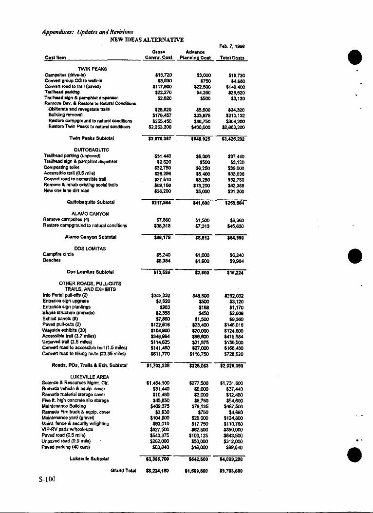
Appendixes: Updates and Rll1'isions NEW IDEAS ALTERNATIVE
Feb. 7, 1996 Gro•• Advance e Co!I tt•m ConS'tr. Cost Planning Cost Total Costs
TWIN PEAKS C.mpslt .. (drivo-ln) $15,nO $3,000 $18,720 Convert group ca to walk..fn $3,930 $750 $4,680 Conwrt rood to trail (paYOd) $117,900 $2.UOO $140,400 T,.llhead parf<lng $22,270 $4,250 $26,520 Tntllhead sign & pamphlet dlspat>Mf $2,620 $500 $3,120 R•move Dev. & Restore to Natural Conditions
Obliterate and revegetate trails $28,820 $5,500 $34,320 Building rem"""I $176,457 $33,675 $210,132 Restore campground to natural conditions $255,450 $48,750 $304,200 Restore Twin Peaks to natural conditions $2,253,200 $430,000 $2,683,200
Twin Peaks Subtotal $2,876,367 $548,925 $3,426,292
QUITOBAQUITO Trallhead parf<lng (unpaved) $31,440 $6,000 $37,440 Trailhead sign & pamphlet dlspen .. r $2,620 $500 $3,120 Composting toilet $32,750 $6,250 $39,000 -ible trail (0.5 mile) $28,296 $5,400 $33,696 Convert rood to ....,..Ible trail $27,510 $5,250 $32,780 Remove & rehab existing social trails $69,168 $13,200 $82,368 New one tane dirt mad $26,200 $5,000 $31,200
Qultobaqulto Subtotal $217,98' $41,600 $269,684
ALAMO CANYON Remove campsites (4) $7,860 $1,500 $9,380 Restore campground to natural conditions $38,318 $7,313 $45,630
Alamo Canyon Subtotal $46,178 $8,813 $54,990
DOS LOMITA$ Campfire circle $5,240 $1,000 $6,240 Ben<hes $8,384 $1,600 $9,984
Dos Lomltas Subtotal $13,624 $2,600 $16,224
OTHER ROADS, PULL-OUTS TRAILS, AND EXHIBITS
Info Portal pulk>ft\; (2) $245,232 $48,800 $292,032 Entrance sign upgrade $2,620 $500 $3,120 Entrance $ign plantings $983 $188 $1.170 Shade sllucture (ramada) $2,3S8 $450 $2,808 Eldlibtt panels (8) $7,860 $1,500 $9,380 Paved pull-outs (2) $122,616 $23,400 $146,016 Wayside exhibits (20) $104,800 $20,000 $124,800 Accessible trail (3.7 miles) $348,9&4 $66,600 $415,584 UnpaYOd trail (2.5 miles) $114,625 $21,875 $136,500 Convert road lo a""95Sible trail (1.5 miles) $141,.480 $27,000 $168,.480 Convert road to hiking route (23.:35 miles) $611,770 $116,750 $n8,520
Roads, POs, Trails & Exh. Subtotal $1,703,328 $326,063 $2,028,390
LUKEVILLE AREA Science & Resources Mgmt. ctr. $1,454,100 $277,500 $1,731,600 Ramada vehicle & equip. cover $31,440 $6,000 $37,440 Ramada material storage cover $10,.480 $2,000 $12,.480 F'IYO ft. high concrete silo st ... ge $45,850 $8,750 $54,600 Maintenance Building $409,375 $78,125 $487,500 Ramada Fire truck & equip. cover $3,930 $750 $4,680 Maintenance yard (graveQ $104,800 $20,000 $124,800 Maint. Ienco & securily w/lighting $93,010 $17,750 $110,760 VIP-RV pads Wihook-ups $327,500 $62,500 $390,000 PaYOd road (0.5 mile) $540,375 $103,125 $643,500 Unpaved road (0.5 mile) $262,000 $50,000 $312,000 .. Paved parf<lng (40 cars) $83,840 $16,000 $99,840 e Luk•ville Subtotal $3,366,700 $642,600 $4,009,200
Grand Total $8,224,180 $1,ISU,600 $9,793,680
S-100
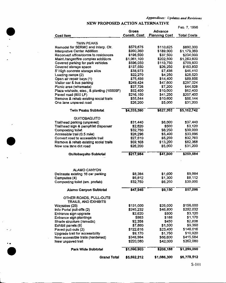
Appendixes: Updates and Revisions
NEW PROPOSED ACTION ALTERNATIVE
e Feb. 7, 1996 Gross Advance
Cost Item Cons tr. Cost Planning Cost Total Costs
TWIN PEAKS Remodel for SERMC and lnterp. Ctr. $579,675 $110,625 $690,300 Interpretive Center Addition $990,360 $189,000 $1,179,360 Reconvert office/dorms to residences $196,500 $37,500 $234,000 Maint.frangerlfire complex additions $1,061, 100 $202,500 $1,263,600 Covered parking for park vehicles $596,050 $113,750 $709,800 Covered storage space $137,550 $26,250 $163,800 5' High concrete storage silos $38,973 $7,438 $46,410 Loading ramps (2) $22,270 $4,250 $26,520 Open air repair bays (1) $75,456 $14,400 $89,856 Visitor car & bus parking $249,424 $47,600 $297,024 Picnic area (w/ramada) $37,728 $7,200 $44,928 Plaza w/shade, elec., & planting (1000SF) $52,400 $10,000 $62,400 Paved road (800 LF) $216,150 $41,250 $257,400 Remove & rehab existing social trails $55,544 $10,600 $66,144 One lane unpaved road $26,200 $5,000 $31,200
Twin Peaks Subtotal $4,335,380 $827,363 $5,162,742
QUITOBAQUITO Trailhead parking (unpaved) $31,440 $6,000 $37,440 Trailhead sign & pamphlet dispenser $2,620 $500 $3,120 Composting toilet $32,750 $6,250 $39,000 Accessible trail (0.5 mile) $28,296 $5,400 $33,696 Convert road to accessible trail $27,510 $5,250 $32,760 Remove & rehab existing social traits $69,168 $13,200 $82,368 New one lane dirt road $26,200 $5,000 $31,200
auitobaqulto Subtotal $217,984 $41,600 $259,584
ALAMO CANYON Delineate existing 16 car parking $8,384 $1,600 $9,984 Campsites (4) $6,812 $1,300 $8,112 Composting toilet (sm. prefab) $32,750 $6,250 $39,000
Alamo Canyon Subtotal $47,946 $9,150 $57,096
OTHER ROADS, PULL-OUTS TRAILS, AND EXHIBITS
Waysides (20} $131,000 $25,000 $156,000 Info Portal pull-offs (2) $245,232 $46,800 $292,032 Entrance sign upgrade $2,620 $500 $3,120 Entrance sign plantings $983 $188 $1, 170 Shade structure (ramada) $2,358 $450 $2,808 Exhibit panels (8) $7,860 $1,500 $9,360
' J Paved pull-outs (2) $122,616 $23,400 $146,016 Upgrade trail for accessibility $9,170 $1,750 $10,920 New accessible trails (hardened) $348,984 $66,600 $415,584 ... New unpaved trail $220,080 $42,000 $262,080
e Park Wide Subtotal $1,090,903 $208,188 $1,299,090
Grand Total $5,692,212 $1,086,300 sa.ns,512
S-101
L
Appendixes: Updates and Revisions
UPDATE TO APPENDIX G: CONSULTATIONS WITH THE U.S. FISH AND WILDLIFE SERVICE e
AND THE ARIZONA FISH AND GAME DEPARTMENT
At present, the NPS is consulting with the FWS and preparing a biological assessment to help meet federal responsibilities under Section 7 of the Endangered Species Act (1973). Section 7 of the Endangered Species Act (1973) prohibits federal agencies such as the NPS from implementing any action that is likely to jeopardize the continued existence of a federally listed (i.e. endangered, threatened) species. Furthermore, the Act requires that the NPS consult with the FWS on any action it authorizes, funds, or execntes that could potentially affect a protected species or its designated critical habitat. To help meet its responsibilities under the Act, the NPS is currently consulting with the FWS as well as preparing a biological assessment that analyzes potential effects of the GMP on federally listed, proposed, and candidate species. This document will appear as an Appendix in the final GMP/DCP/EIS along with a letter from the FWS confirming successful completion of the Section 7 process.
The following letters are more recent versions ofletters presented in the Draft GMP/DCP/EIS and consequently, are presented here.
S-102
I ~
••
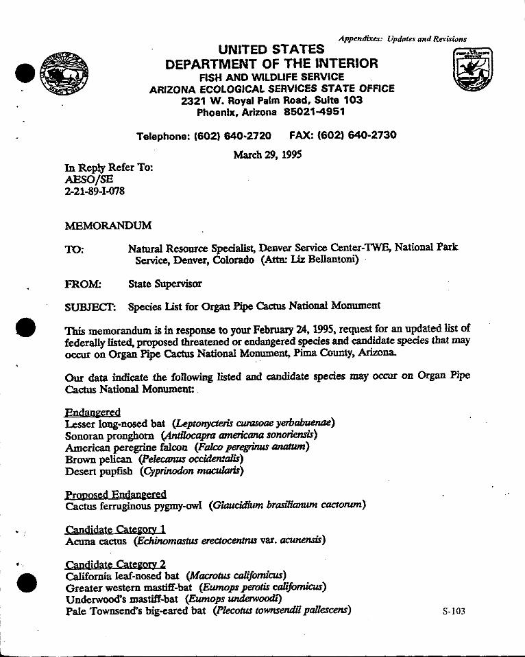
• !
•
I I
L
---- -- -- ---- -- ------------
Appendixes: Updates and Revisions
· UNITED STATES !11 DEPARTMENT OF THE INTERIOR
FISH AND WILDLIFE SERVICE _ ARIZONA ECOLOGICAL SERVICES STATE OFFICE -
2321 W. Royal Palm Road, Suite 103 Phoenix, Arizona 85021-4951
Telephone: (602) 640·2720 FAX: {602) 640-2730
In Reply Refer To: AP,SO/SE 2-21-89-1-078
MEMORANDUM
March 29, 1995
TO: Natural Resource Specialist, Denver Service Center-TWE, National Park Service, Denver, Colorado (Attn: Liz Bellantoni) ·
FROM: State Supervisor
SUBJECT: Species List for Organ Pipe Cactus National Monument
This memorandum is in response to your Febru:uy 24, 1995, request for an updated list of federally listed, proposed threatened or endangered species and candidate species that may occur on Organ Pipe Cactus National MOllument, Pima County, Arizona.
Our data indicate the following listed and candidate species may occur on Organ Pipe Cactus National Monument:
Endauered Lesser long-nosed bat (Leptonycteris curasoae yerbabuenae) Sonoran pronghorn (Antilocapra americana sonoriensis) American peregrine falcon (Falco peregrimu anatwn) Brown pelican (Pelecanus occidenlalis) Desert pupfish (Cyprinodon macularis)
Proposed Endan&ered Cactus ferruginous pygmy-owl ( Glaucidium brasilianwn cactonun)
Omdidate Cate&ory 1 Acuna cactus (Echinomastus erectocentrus var. acwien.sis)
Qmdidate CatetmJY 2 California leaf-nosed bat (Macrotus calijomicus} Greater western mastiff-bat (Eumops perotis californicus) Underwood's mastiff-bat (Eumops underwoodi) Pale Townsend's big-eared bat (Plecotus townsendii pallescens) S-103
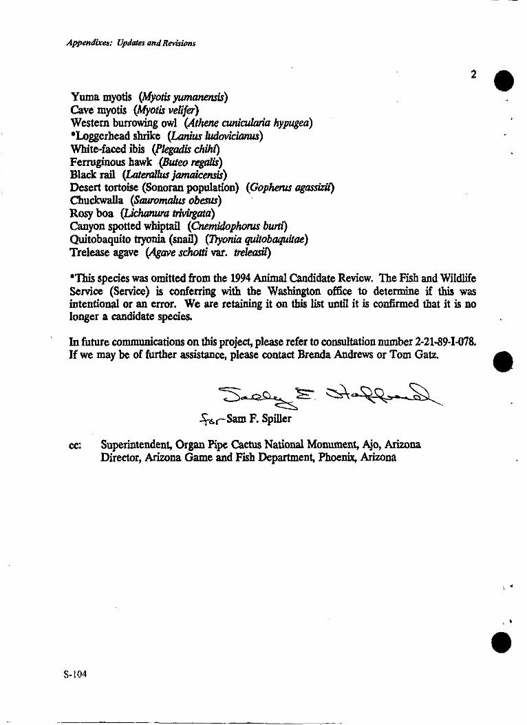
Appendixes: Updates and Revisions
Yuma myotis (Myotis yumanensis) Cave myotis (Myotis velifer) Western burrowing owl (Athene cunicularia hypugea) •Loggerhead shrike (Lanius ludovicianus) White-faced ibis (Pkgadis chilu} Ferruginous hawk (Buteo regalis) Black rail (LateralJus jamalcensis) Desert tortoise (Sonoran population) (GophetUS agassizh} Chuckwalla (Sauromalus obesus) Rosy boa (Lichanura tri:virgata) Canyon spotted whiptail (Cnemidophorus bum} Quitobaquito tryonia (snail) (Tryonia quitobaJIUitae) Trelease agave (Agave schotti var. treleash)
2
*This species was omitted from the 1994 Animal Candidate Review. The Fish and Wildlife Service (Service) is conferring with the Washington office to determine if this was intentional or an error. We are retaining it on this list until it is confirmed that it is no longer a candidate species.
In future communications on this project, please refer to consultation number 2-21-89-1-078. H we may be of further assistance, please contact Brenda Andrews or Tom Gatz.
"S~~ ~ .. ~~- ~ ~.s.rSam F. Spiller
cc: Superintendent, Organ Pipe Cactus National Monument, Ajo, Arizona Director, Arizona Game and Fish Department, Phoenix, Arizona
S-104
\ ..
' '
Appendixes: Updates and Revisions
TIIESTATE
G,,.,,..... Fife SJZDlaatoa
~ ow,.... EliubetbT. Woodis,,._,,
Altlwr Porter. Pboc:oix Nonie Jobasoa. Snowft.lkc
GAME & FISH DEPARTMENT Mi"""":i!'::!!'h.~ 2221 West Greenway Road, Phoenix, Arizona 85023-4399 (602) 942-3000
February 24, 1995
Ms. Liz Bellantoni National Parks Service, Denver Service Center-TWE Box 25287 Denver, Colorado 80225
Din<w Duane L. Shmufc-
IJqHllY Dir«tt:W 'lboaw w. Spalding
Re: Special Status Species; Organ Pipe Cactus National Monument, Arizona
Dear Ms. Bellantoni:
The Arizona Game and Fish Department {Department) has received your request of February 24, 1994, regarding special status species for above-referenced area and the following information is provided.
The Department's Heritage Data Management System has been accessed and current records show that the special status species on the attached list have been documented as occurring in Organ Pipe Cactus National Monument.
Thank you for the opportunity to provide this information. If you have any questions, please contact me at (602) 789-3600.
Sincerely,
~~ Nan~y o'Tu'on Project Evaluation Specialist Habitat Branch
NLO:no
• J Enclosure
AGFD# 02-24-95(03)
S-105
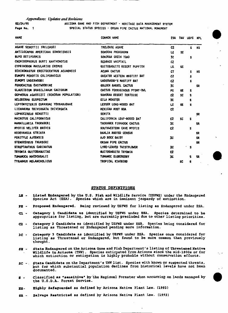
Appendixes: Updates and Revisions 02/24195 ARIZONA GAME AND FISH DEPARTMENT • HERITAGE DATA MANAGEMENT SYSTEM Page No. SPECIAL STATUS $PECIES · ORGAN PIPE CACTUS NATIONAL MONUMENT
NAME COMMON NAME ESA TNW USFS NPL
AGAVE SCHOTT!! TRELEASEI TRELEASE AGAVE C2 s KS ANTILOCAFRA AMERICANA SONORIENSIS SONORAN PRONGHORN LE SE 8UFO RETIFORMIS SONORAN GREEN TOAD 3C s CNE!41DOPHORUS BURT! XANTKONOTUS REOSACK WKIPTAIL C2 CYPRINOOON MACULARIUS EREllUS QUIT08AQU!TO OESERT PUPFISK LE se ECHINOMASTUS ERECTOCENTRUS ACUNENSIS ACUNA CACTUS Ct s HS EUMOPS PEROTIS CALIFORNICUS GREATER 11£STERN MASTIFF SAT C2 s NOS UNDERWOCIO I UNDERllOCl> 1S MASTIFF SAT C2 s FEROCACTUS EASTWOOD IAE GOLDEN BARREL CACTUS 3C SR Gl.AUCIDIUM BllASILIANIJH CACTORUM CACTU$ FERRUGINOUS PYGMY·Olll. PE SE s GOPKERUS AGASS!Zll (SONOllAN POPULATION) SONORAN DESERT TOllTOISE C2 SC s HELODERMA SUSPECTUll GI LA MOH STER lC s LEPTONYCTERIS CURASOAE YERBABUEHAE LESSER LOHG•HOSEO BAT LE SE s LICHANU!V. TRIVIRGATA TRIVIRGATA MEXICAN ROSY ~ C2 LOPHOCEREUS SCHOTT!! SEN I TA ~R MACROTUS CALIFORNICUS CALlfORHlA LEAF·NOSED SAT C2 SC s MA!VllLLARIA THORNBERI THORNBER flSHKOOI( CACTUS 3C SR llYOTIS VELIFER BREVIS SOUTKllESTERH CAVE MYOTIS C2 s NEOEVANSIA STRIATA DAHLIA ROOTED CEREUS SR PERITYLE AJOfHSIS AJO lOCl( DAISY 3C SR STENOCEREUS THURBER! ORGAN PIPE CACTUS SR STREPTANTHUS CARINATUS LYRE·LEAVEO Tl/ISTFLOWER 3C s TRYOlllA QUITOBAQUITAE QUITOBAQUITO TRYCllllA C2 TUMAMCICA MACDOUGALi! TIJMAMQC GLOSEBWY 3C s Sil
TYRAllNUS MELAllCHOl.ICUS TROPICAL KINGBIRD SC s
STA'l'tJS PEPIN?TION$
Lil • Lbted bdangered by the tJ.S. Fish and liildlife Service (tJSFli'S) under the Endangered Species Act (ESA) • Species which are in imminent jeopardy of extinction.
PB - Proposed lll1danger•d. Being reviewed by USFllS for listing as Endangered under ESA.
Cl. - C&tegory 1 c::..nclid&ta as identified by tJSl!'WS under ESA. Species d&termined to be appropriate for listing, but are currently precluded due to othex- liseing priorities.
c::i. - Category 2 Candidate as identified by O'SFWS under ESA. Species being considered for listing as Threatened or Endangered pending more information.
3C: • Category 3 Candidate as identified by O'SFWS under ESA. Species once considered for listing as Threatened or Endangered, but found to be more common than previously thought.
SB • State Endangered on the Arill!ona Game and Fish Department• s listing of Threatened Native Wildlife in Arizona (TNll) • Species extirpated from Arizona since the mid•lSOOs or for which extinction or extirpation is highly probable without conservation efforts.
sc •. state c~didate on the Department's TNW list. Species with known or suspected threats, but for which substantial population declines from historical levels have not been documented.
s - Classified as •eendtiva• by ·i:he Regional Forester when occuuing on lands managed by the tJ.S.O.A. Forest service.
as- ai~hly Saf•guarded as defined by Ari:ona Native Plant Law. (1993)
SR • salvage Re•tricted as defined by Arizona Native Plant Law. (1993)
e
...
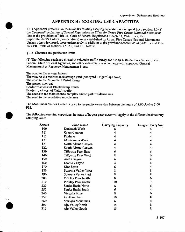
~ .. .J
',
e
Appendixes: Updates and Revisions
APPENDIX H: EXISTING USE CAPACITIES
This Appendix presents the Monument's existing carrying capacities as excerpted from section J .5 of the Compendium Listing o/Special Regulations in Effect for Organ Pipe Cactus National Monument. Under the provision of Title 36, Code of Federal Regulations, Chapter l, Parts l - 7, the Superintendent's Orders (compendium) were established for Organ Pipe Cactus National Monument. Unless otherwise noted, these orders apply in addition to the provisions contained in parts l - 7 of Title 36 CFR. Parts of sections l.5, 2.2, and 2.10 follow.
§ 1.5 Closures and public use limits.
(1) The following roads are closed to vehicular traffic except for use by National Park Service, other Federal, State or Local Agencies, and other individuals in accordance with approved General Management or Resource Management Plans:
The road to the sewage lagoon The road to the maintenance storage yard (boneyard - Tiger Cage Area) The road to the Monument Pistol Range The power line road · Border road east of Blankenship Ranch Border road west of Quitobaquito The roads to the maintenance complex and to park residence area The road to the vegetative recycle area
The Monument Visitor Center is open to the public every day between the hours of8:00 AM to 5:00 PM.
The following carrying capacities, in terms of largest party sizes will apply to the different backcountry camping zones.
Zone# Zone Name Carrying Capacity Largest Party Size 100 Kuakatch Wash 8 6 111 Grass Canyon 4 4 112 Pitahaya 4 4 113 Montezuma Wash 4 4 121 North Alamo Canyon 4 4 122 South Alamo Canyon · 4 4 130 Tillotson Peak East 6 6 140 Tillotson Peak West 8 6 150 Arch Canyon 6 4 160 Diablo Canyon 4 4 170 Diaz Spire 6 4 180 Sonoyta Valley West 8 8 190 Sonoyta Valley East 8 8 200 Pinkley Peak North 8 6 210 Pinkley Peak South IO 7 220 Senita Basin North 8 6 230 Senita Basin South 6 4 240 Victoria Mine 8 6 250 La Abra Plain 1.0 8 260 Sonoyta Mountains 6 4 300 Ajo Valley North 15 8 310 Ajo Valley South 15 8
S-107
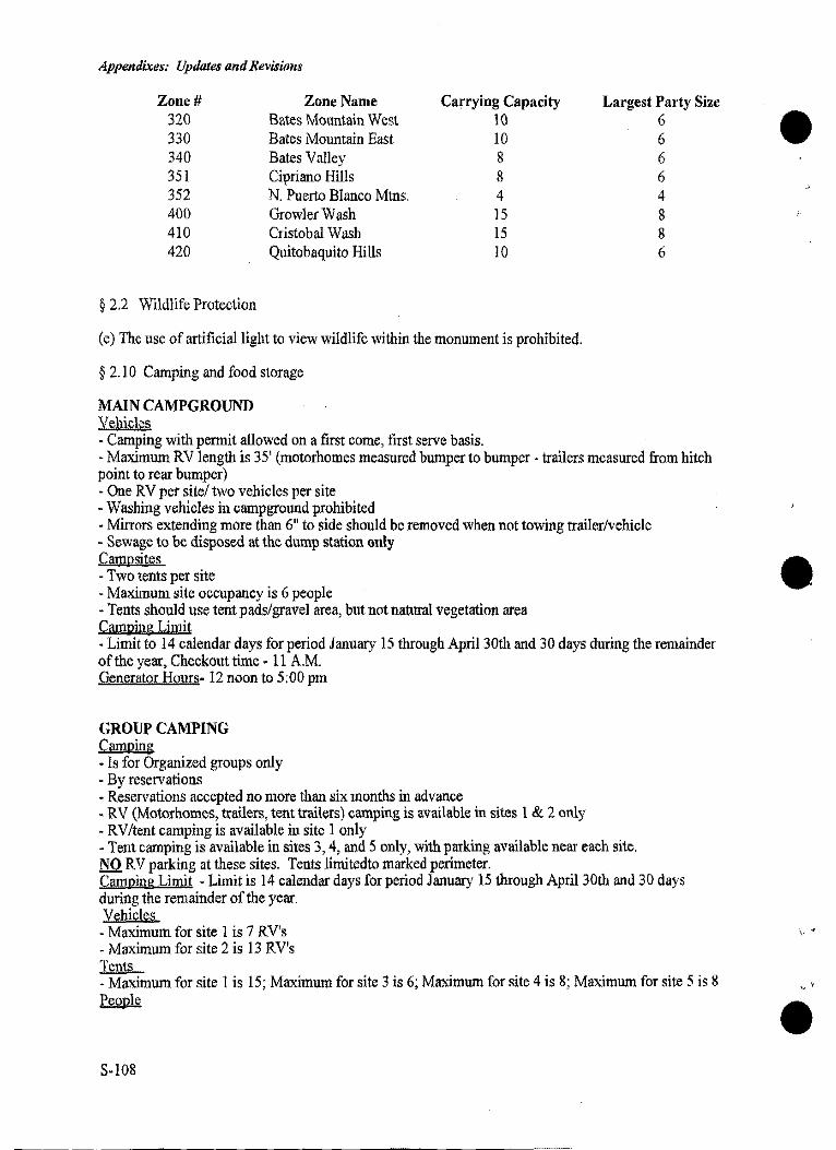
Appendixes: Updates and Revisions
Zone# 320 330 340 351 352 400 410 420
§ 2.2 Wildlife Protection
Zone Name Bates Mountain West Bates Mountain East Bates Valley Cipriano Hills N. Puerto Blanco Mtns. Growler Wash Cristobal Wasb Quitobaquito Hills
Carrying Capacity 10 10 8 8 4 15 15 IO
(e) The use of artificial light to view wildlife within the monument is prohibited.
§ 2.10 Camping and food storage
MAIN CAMPGROUND Vehicles - Camping with permit allowed on a first come, first serve basis.
Largest Party Size 6 6 6 6 4 8 8 6
- Maximum RV length is 35' (motorhomes measured bumper to bumper - trailers measured from hitch point to rear bumper) - One RV per site/ two vehicles per site - Washing vehicles in campground prohibited - Mirrors extending more than 6" to side should be removed when not towing trailer/vehicle - Sewage to be disposed at the dump station only Campsites - Two tents per site - Maximum site occupancy is 6 people - Tents should use tent pads/gravel area, but not natural vegetation area Camping Limit - Limit to 14 calendar days for period January 15 through April 30th and 30 days during the remainder of the year, Checkout time· 11 A.M. Generator Hours- 12 noon to 5:00 pm
GROUP CAMPING Camping - Is for Organized groups only - By reservations - Reservations accepted no more than six months in advance - RV (Motorhomes, trailers, tent trailers) camping is available in sites 1 & 2 only - RV/tent camping is available in site I only -Tent camping is available in sites 3, 4, and 5 only, with parking available near each site. lS.Q RV parking at these sites. Tents Jimitedto marked perimeter. Camping Limit - Limit is 14 calendar days for period January 15 through April 30th and 30 days during the remainder of the year. Vehicles - Maximum for site l is 7 RV's - Maximum for site 2 is 13 RV's Tents - Maximum for site l is 15; Maximum for site 3 is 6; Maximum for site 4 is 8; Maximum for site 5 is 8 People
S-108
\, ...
'"
, v
Appendixes: Updates and R.evisions
- Maximum for site l is 4 5; Maximum for site 2 is 40; Maximum for site 3 is 18; Maximum for site 4 is 24; Maximum for site 5 is 24 Maximum Vehicle Length - 35 foot for motorhomes measured bumper to bumper. Trailers are measured from hitch point to rear bumper. Detachable Mirrors which extend 6" beyond vehicle side fender line are to be removed when not towing a second vehicle or trailer. Generator Hours - 12 noon to 5:00 P.M.
ALAMO PRIMITIVE CAMPGROUND
Vehicles - Camping with a backcountry permit (obtained from the Visitor Center only, on a :first come, first serve basis). - Motor homes and RV trailers are prohibited. - Parking is limited to space provided at each site. - Parking for day use/backcountry use should use the south side of parking lot, near the pit toilet. - Permit should be placed on dashboard of vehicle, so the number can be read through windshield. - Umegistered vehicles are subject to citation/towing, at the owners expense.
Campsites Are for Primitive Camping only. - Maximum capacity if four people per site. - Maximum capacity is twenty people per night, for the entire campground. - Camping is limited to seven (7) calendar days, with a break of not less than 30 calendar days before a new permit can be issued. - Check out time is 11 A.M. - Entrance permit required. - Wood fires are not permitted.
BACKCOUNTRY CAMPING - Backcountry camping permit required for overnight stays. Acquire permit at Visitor Center, first come, :first serve. Permits should be placed on dash of vehicles, so the number on the back can be read through the windshield. Camping - Is limited to fourteen (14) days in any 90 day period. - No more than two (2) consecutive nights may be spent at the same campsite. - Within one half mile of any road, historic site, orwater source is prohibited. - Leave a clean campsite; carry out all trash. - Sanitation, bury human waste, using a "cat hole";a six inch deep hole, covered after use. Parking - Back-packers should park in the pull-out or parking area specified on their backcountry permit.
S-109
Appendixes: Updates and Revisions
APPENDIX I: MITIGATION MEASURES AND DEVELOPMENT CONSTRAINTS
Mitigation measures and development constraints are specific actions that when implemented, minimize, avoid, or eliminate impacts on resources that would be affected by proposed actions. The following resource protection strategies would be implemented for the NPS's proposed action. Where applicable, more specific mitigation measures are outlined in the summary of the Natural and Cultural Resources Management Plan in the Actions Common to All Alternatives section, or the Environmental Consequences section under the appropriate impact topic.
The NPS would fully comply with all applicable laws, regulations, and policies governing resource protection including the National Environmental Policy Act, Endangered Species Act, Clean Water Act, Clean Air Act, Executive Orders 11988 (Floodplain Management) and 11990 (Protection of Wetlands), National Historic Preservation Act, and agency specific guidelines. In instances where resource conditions may have changed over time or more detailed site design is required, the NPS would ensure that the necessary level of environmental compliance has been completed prior to implementing any proposed actions.
Wilderness
In compliance with the Wilderness Act's mandate that wilderness be undeveloped, retain its primeval character and influence, and be devoid of permanent improvements or human habitation, all proposed development, with the exception of trails, would be located outside designated wilderness. Although most of the new maintained trails and unimproved hiking routes would occur either in designated or proposed wilderness, their presence and use is considered acceptable and appropriate in wilderness areas. Managers would also use the "mininmm tools" (i.e., the least heavy-handed approach) necessary for resource management, trail maintenance, or cultural resources preservation in order to achieve wilderness management objectives.
Air Quality
Disturbed areas would be revegetated with native plants to stabilize soils, decreasing the amount of dust subject to wind erosion. Whenever possible, bare soil would be dampened with water to further reduce dust around construction sites.
The NPS would implement a comprehensive air quality monitoring program to ensure maximum protection of the monument's air quality-related values, and to verify that federal pollution control standards are not being exceeded. The program would entail inventory and monitoring of air qualityrelated values (including visibility), evaluating air pollution impacts, and collecting baseline and trend data on pollutants such as ozone and sulfur dioxide.
Floodplains, Wetlands, and Water Resources
Floodplains and wetlands would be avoided to the greatest extent possible when selecting sites appropriate for development or visitor use. In accordance with NPS guidelines governing floodplain management and wetlands protection (45 FR 35916 and 47 FR 36718), actions would be taken to enhance and restore floodplain and wetland values, to avoid modification or development in floodplains and wetlands when practicable alternatives exist, and to mitigate adverse impacts if a floodplain or wetland would be occupied or modified.
A Clean Water Act, Section 404 permit would be obtained for the discharge of dredged or fill material into waters of the United States. A Section 401 Water Quality Certification would be acquired in conjunction with the 404 permit.
S-110
"'
''
Appendixes: Updates and Revisions
A Clean Water Act, Section 402, National Pollutant Discharge Elimination System permit would be obtained for all ground disturbing activities that exceed five acres in impact.
The NPS would comply with numeric water quality standards for fecal coliform and radiochemicals listed in the Arizona Administrative Code (AAC) R-18-11-109. G.
Best management practices (BMPs) would be implemented during and after all construction phases to protect watershed condition and riparian areas, to maintain adequate vegetative cover, and to minimize the discharge of sediment, petroleum, nutrients, bacteria and other pollutants to the watershed or water courses. All discharges would meet applicable water quality standards.
A monitoring program would be implemented to evaluate the effectiveness of BMPs in protecting watershed condition and water resources.
Sanitary waste facilities provided during construction phases would be planned and developed in such a manner to ensure protection of both surface and groundwater resources.
An Aquifer Protection Permit would be obtained from the Arizona Department of Environmental Quality (ADEQ) in instances where new facility construction would dispose pollutants to the land surface, the underlying soil, or to groundwater, or where there is a reasonable probability that pollutants would reach groundwater.
Public or semi-public water supply systems would be developed to comply with the Arizona Administrative Code (AAC) R-18-4-201 et seq., Public and Semipublic Water Supply Systems rules.
If any gasoline lines or underground storage tanks containing petroleum products are moved, the lines would be tested and recertified by ADEQ before being used.
Any new or modified water and/or wastewater facility must be designed to protect public health and the environment through a construction approval program that ensures that proposed plans and specifications for construction comply with ADEQ sanitation rules, engineering guidelines and policies.
Vegetation and Soil
To minimize unnecessary ground disturbance and vegetation impacts resulting from construction, equipment and materials would be stockpiled on previously developed sites or within construction footprints. Construction limits would be identified in construction documents and specifications, and fenced or signed in the field to further protect vegetation and environmentally sensitive areas from disturbance. A construction supervisor would monitor ground and vegetation disturbance to ensure that they are restricted to the minimum area necessary.
To minimize soil erosion and vegetation impacts caused by visitor use or construction-related activities, disturbed areas would be revegetated and restored to natural conditions. These sites would be revegetated with native plant materials (e.g., seeds, transplanted vegetation) salvaged from areas impacted by construction. To gnide restoration efforts, the NPS would outline procedures for collecting and propagating native species, salvaging topsoil, site grading and soil preparation, erosion control, vegetation re-establishment, and post-construction monitoring. Whenever possible, vegetation would be used to screen the built enviromnent from visitor use areas.
Projects would be scheduled so that clearing and grading is done during times of minimum erosion potential. Erosion control techniques would be used to prevent sediment transport from construction sites. Topsoil stockpiles would be covered or stabilized, and hay bales and drift fences (or similar structures) would be used as wind barriers. For trail and campsite improvements, design criteria would incorporate soil compaction techniques and prevent sediment transport due to pedestrian traffic, water,
S-111
Appendixes: Updates and Revisions
and wind erosion. Consideration also would be given to the type and location of pennanent erosion and sediment controls such as energy dissipators, velocity controls, and vegetation buffer strips.
Locations requiring excessive cut and fill would be avoided, as would steep slopes, sites that drain directly into sensitive water bodies, and areas subject to subsidence, landslides, rock outcroppings, and highly erodible soils.
Wildlife
A Wildlife Management Plan would be developed to guide wildlife management at the monument. Monitoring programs also would be expanded to include desert bighom,javelina, mountain lion, and mule deer.
To reduce wildlife mortality along SR SS, the NPS would work with the Arizona Department of Transportation to (I) establish a research program to seek design solutions such as bridge construction and the placement of oversized culverts beneath the roadway to facilitate safe passage, and (2) educate motorists about wildlife use of the road corridor via signs and various interpretive media.
To ensure protection of critical wildlife habitat and activity centers from human disturbance, park managers would implement seasonal or short-tenn closures whenever necessary.
Threatened, Endangered, and Sensitive Species
To reduce the potential for adverse effects on endangered, threatened, or sensitive plants or animals, qualified park personnel would survey development sites prior to construction. If a species of concern is found to be inhabiting a site, the NPS would consult with the FWS to detennine appropriate mitigation measures to avoid adverse impacts.
To minimize the potential for disturbance to the maternity colony of lesser long-nosed bats, a "batfriendly" grate would be placed at each opening of the adit to allow bats unimpeded access to the mine's interior, while prohibiting human entry.
A study would be developed to detennine the extent of the poaching problem in the monument. Methods for preventing poaching would be evaluated and those detennined to be effective would be implemented.
An extensive threatened, endangered, and sensitive species plan specific to the monument would be developed to more effectively guide management and recovery of these species. Current monitoring programs also would be expanded for the Quitobaquito desert pupfish, cactus ferruginous pygmy owl, lesser long-nosed bat, desert tortoise, elephant tree, organ pipe cactus, acuna cactus, and senita cactus.
Cultural Resources
Archeologicval surveys would be done prior to any developement. If previously unknown cultural resources are discovered, facilities will be re-designed or relocated to avoid impacts to the sites. If avoidance is infeasible, mitigation will be sought in consultation with the Asrizona state historic preservation officer, the Advisory Council on Historic Preservation, and if appropriate, the Tohono O'odham Nationa and the Hia-Ced O'odbam.
To further protect cultural resources from theft and vandalism, where possible, increased patrols and the use of various innovative security teclmologies would be employed. The monument would also seek to establish an active unit of the Arizona Site Steward Program. This state-operated program encourages citizens to acquire the necessary training and then volunteer to inspect, evaluate, and monitor significant cultural resources on a regular basis.
S-112
', '
I V
\-,,«
Appendixes: Updates and Revisions
GLOSSARY AND ABBREVIATIONS
AAC. Arizona Administrative Code.
ADEQ. Arizona Department ofEnviromnental Quality.
ADOT. Arizona Department of Transportation.
affected environment. Existing biological, physical, geographical, social, cultural, and economic conditions of an area that are subject to change, both directly and indirectly as a result of a proposed hnman action.
APS. Arizona Public Service company.
BL1'L Bureau of Land Management, a federal agency in the Department of the Interior.
DCP. Development Concept Plan. The document prepared to guide the new uses proposed for a specific site in a park.
ecology. The study of the interrelationships between organisms and their physical enviromnents.
ecosystem. A community of living organisms interacting with one another and with their physical enviromnent, such as a forest, pond, or estuary.
EIS. Environmental Impact Statement. The National Environmental Policy Act of 1969 requires that an environmental impact statement be prepared to evaluate the potential environmental effects of major federal actions. This document identifies and analyzes activities that might affect the human and natural environment.
EMP. Ecological Monitoring Program
EPA. Environmental Protection Agency. The agency of the United States Government that approves E!Ss; it is independent of any other federal department or agency.
ethnographic resource. A feature or geographic area of traditional and continuing significance to a contemporary people.
ethnography. The description and study of a people's culture using the methods of cultural anthropology.
ethnobistory. The study of the past ways of life and culture of a people using the methods of cultural anthropology and history.
extirpate. A wildlife species no longer present in an area because of local extinction.
extirpation. The term nsed when the whole population of a particular animal or plant species is wiped out locally or dies and becomes extinct, often because of environmental neglect or mismanagement.
floodplain. Land adjacent to a river that periodically floods.
FWS. Fish and Wildlife Service, a federal agency in the Department of the Interior.
GIS. Geographic Information System. A computerized mapping database that stores, retrieves, and manipulates spatial data.
GMP. General Manangement Plan. The document prepared to guide the overall operations of a park for the next 15 years or so, including visitor use and resource protection and preservation.
indigenous. Peoples, animals, or plants native to a particular area or environment.
inholding. Parcel oflaod surrounded by property owned by another.
!PM Integrated Pest Management.
S-113
Appendixes: Updates and Revirions
ISDA. International Sonoran Desert Alliance. A non-profit organization that promotes the proteetion and preservation of 1he Sonoran Desert on bo1h sides of 1he United States-Mexico border.
juvenile. An animal in 1he process of maturing and growing into adul1hood.
littoral zone. Jmportaot wildlife foraging, spawning, and resting area near a pond's edge, aod in 1he monument, dominated by stands of bulrush and submerged aquatic vegetation.
maximum probable flood. The most severe and extensive flood considered reasonably possible to occur at a site as a result of existing hydrologic, topographic, and metereologic conditions.
mitigation. Activities 1hat will avoid or reduce 1he severity of an adverse environmental impact or eliminate it altogether.
NEPA. The National Environmental Policy Act ofl 969. A federal law 1hat requires 1he consideration and aoalysis of environmental effects of a proposed federal action, no action, and 1he full range of reasonable alternatives.
NPS. National Park Seivice. A federal agency in 1he Department of1he Interior.
riparian. Vegetation adapted to moist growing conditions and occasional flooding occurring along watercourses.
RMAP. Resource management assessment program. used to estimate the number of employees needed to carry out resource management in 1mits of the National Park system.
SERMC. Science, education, and resources management center. A term used to describe a new facility containing the functions listed in 1he 1he title and proposed under certain alternatives.
SRMC. Science and resources maoagement center. A term used to describe a new facility containing 1he functions listed in the the title and proposed under certain alternatives.
self-sustaining. Capable of maintaining oneself or itself independently.
species. A group ofindividualplaots or animals (including snbspecies and popnlations) that share common characteristics and interbreed.
stochastic events. Randomly occuring events, for example, decline in habitat quality or flooding.
traditional cultural property. An ethnographic resource recognized as especially important to a contemporary people's heritage by being listed in the National Register of Historic Places. Some Native Americans object to tbis National Register tenn.
VRAP, Visitor resource assessment program.nsed to estimate the number of employees needed to protect visitors in units of the National Park system.
watershed. The area drained by a river system.
wetland. A low· lying area supporting vegetation adapted to periodic saturation or floodwater conditions, such as a swamp or marsh.
xeroriparlan. Desert vegetation dependent on floodwater conditions occurring along intermittent watercourses, such as dry washes and arroyos.
S-114
J •
Appendixes: Updates and Reviswns
•
,,
'f' I.'
S-115
Appendixes: Updates and Revisions
•
}. 'I
S-116


