Embed Size (px)
Citation preview

Seeing
CITIES
A R T 1 0 0
U n d e r s t a n d i n g V i s u a l C u l t u r e

agenda 3.21.15
what do people want...from cities?
Abraham Maslow's "Hierarchy of Needs"
early cities: characteristic features of cities
an early example of "urban planning"
modern discipline of urban planning
what principles should guide our planning?

Abraham MASLOW
US psychologist
"A Theory of Human Motivation"
(1943)


first key feature: site
Q: what makes one site better than another?


is Beijing an exception?


Grand Canal
• artificial waterway running from Beijing in the north to
Zhejiang province in the south.
• built in sections beginning in the 5th century BC; unified
and extended during the Sui (7th century AD). Largest civil
engineering project prior to the Industrial Revolution.
• transport of grain, rice, and other raw materials;
communication across large distances
• by the 13th century it consisted of more than 1,200 miles
linked waterways, connecting five of China’s main river
basins.


Traditional ways of life are still present on the canal, but many areas have opted
instead for to retool for the tourist trade.

After restoration, Zhouzhuang now draws more than 2.5 million sightseers a year.


what else do you need?
food supply (imported from agricultural areas)
water supply (often transported through aqueducts from
distant areas)
place of protection (often walled)

city characteristics
• physical geography—the shape of the earth, the location
of rivers, coasts and navigable harbors, will dictate the
placement of cities
• size/density of population
• structure of society
• artisans, craftsman, builders (making useful things)
• people who buy, sell, trade, and finance (merchants and
bankers)
• record-keeping and communication
• public buildings and spaces (for civic and religious
spaces)

social structures tend to grow "deep" or "tall" over time


teacher
student student student student student student

These are oil paintings from the 1830s
made by US artist George Catlin during
one of his Western trips.


mounds at Cahokia, IL
physical evidence of prior civilization

physical evidence of previous
society
St. Louis was called “Mound City” in the 19th century, but
almost all mounds were gone by turn of 20th century.
There is only one mound left, and a road called “Mound
St.”
Cahokia also was partially destroyed, but with 4,000 acres
still remaining, it is largest archaeological site in the US.

who were the people who built this massive earthen structure?
what was their civilization like?

Cahokia facts
located in fertile bottomland around Mississippi River
largest structure is 16 acres at the base—larger footprint
than the Pyramid of Khufu—and 10 stories high
constructed from 22 million cubic feet of earth (deposited
by the basketful by a huge workforce)
plaza oriented to cardinal directions

large outlying agricultural areas and suburbs
1050-1150 population and building boom in “downtown”
Cahokia, approx. 20,000 inhabitants (larger than London
at the time)
stockade fence 2 miles in circumference surrounding the
complex; from tree ring dating we know when this was
built and it corresponds to a time of food scarcity.

“The idea that American Indians could have built
something resembling a city was so foreign to European
settlers, that when they encountered the mounds of
Cahokia—the largest of which is a ten-story earthen
colossus composed of more than 22 million cubic feet of
soil—they commonly thought they must have been the
work of a foreign civilization: Phoenicians or Vikings or
perhaps a lost tribe of Israel.”
—Glenn Hodges, “America’s Forgotten
City” (National Geographic, January 2011)

Monk’s Mound, Cahokia, IL

Burial Excavation showing position of bodies, Cahokia, IL

what is beneath the ground?
hundreds of thousands of objects, suggesting the presence of a large agricultural society
many are functional like farming implements
but there are also musical instruments, games, and sculptures, suggesting a high level of social organization/stratification

Nursing Mother
ceramic figure/bottle
c. 1100

“Birger Figurine”
c. 1100
carved from bauxite

aerial view, Monk’s Mound, Cahokia, IL

reconstruction of what Cahokia might have looked like

artist’s rendering of the Grand Plaza at Cahokia with surrounding housing

artist’s rendering of family housing in Cahokia

Urban planning An essentially modern
discipline.
Considering various
needs and activities and
organizing them into
thoughtful, pleasing
shape.
• services
• circulation
• structures
• open space
The application of design
principles to the city space.

Central Park, Frederick Law OLMSTED and Calvert VAUX, 1858, completed 1873

aerial photograph, Manhattan, NYC

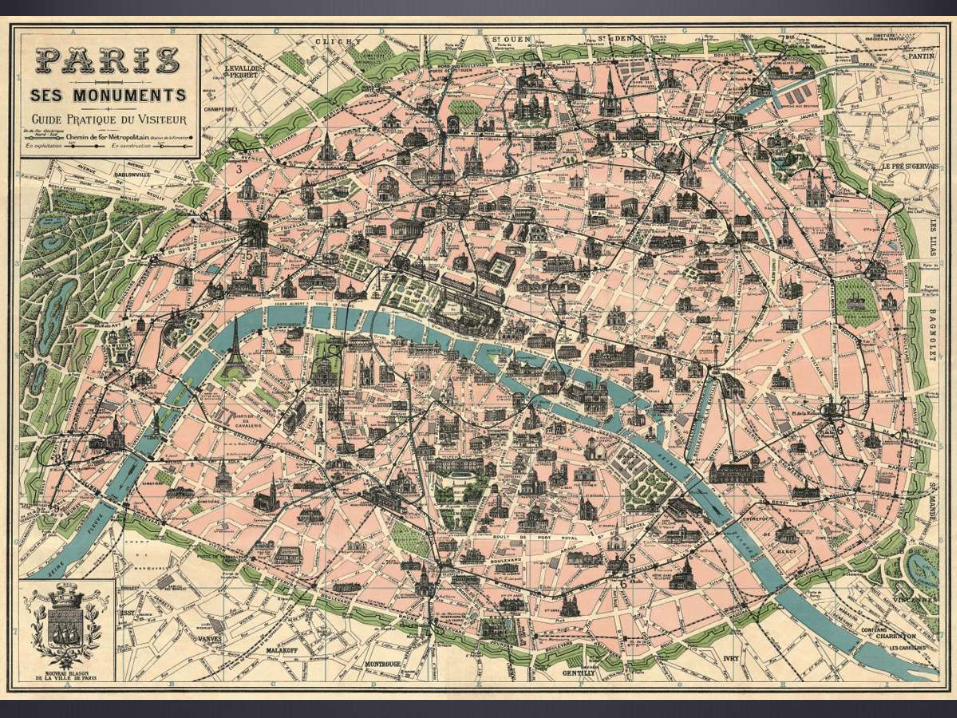
Paris,
before
urban
planning
Charles MARVILLE,
Rue Maître Albert,
Paris, 1852

Charles Marville,
Passage du Dragon,
Paris, 1858

Under Napoleon III
• Haussmann undertook what many consider the first modern
urban works project, demolishing many existing neighborhoods
to make way for grand boulevards and parks.
• He installed a sewer system.
• Gas lighting was placed in major public places.
• He hired photographers to document the medieval streets he
was plowing under.

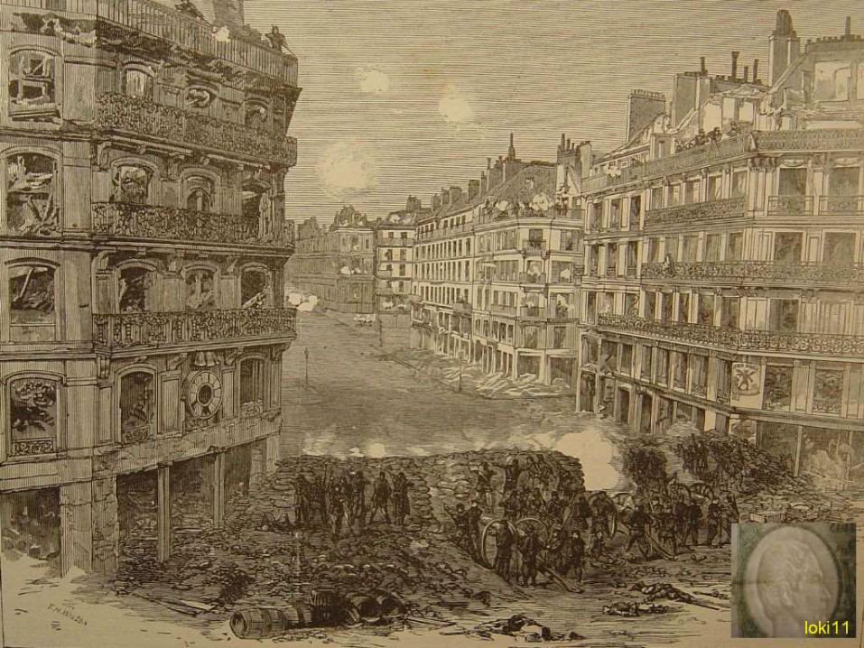
Unidentified photographer
[Barricade on Rue de la Roquette, Paris]
18 March 1871, Cabinet card

Unidentified photographer
[Barricades during the Paris Commune]
1871 © Det Kongelige Bibliotek


Maximilien LUCE, A Street in Paris, May 1871, 1903-6, Musée d’Orsay
oil on canvas, w2250 x h1510 cm, © RMN (Musée d'Orsay) / Hervé Lewandowski


Gustave CAILLEBOTTE, Boulevard Haussmann in the Snow, 1881


Camille PISSARRO, Boulevard Montmartre, 1897, 29.1 × 36.5 in

Camille Pissarro, Avenue de L’Opera, 1898

Gustave CAILLEBOTTE, Traffic Island in the Boulevard Haussmann


Charles Garnier, Paris Opera, built from 1860 to 1875

Marville, L’Avenue de l’Opera

razing the Butte des Moulins during c
onstruction of the Paris Opera house

grand cultural institutions,
then and now

Urban planning, NY style
“I’d like to see the planner who can remove
a ghetto without displacing some people,
just like I’d like to see the chef who can
make an omelette without breaking some
eggs.”
—Robert Moses, New York City planner
and nemesis of Jane Jacobs

“creative destruction”Joseph Schumpeter
Capitalism, Socialism and Democracy (1942)

Robert
Moses,
with the
map of
the Five
Boroughs
of New York
City
behind him

Robert Moses
NYC Parks Commissioner
built parkways, beaches and bridges in and around New
York in the 1930s, using New Deal funds
postwar period, attention turned to expressways

“When I first looked at this
project, I thought, "How the hell
are we going to get across
here?" It was probably one of
the most challenging highway
projects that had been
constructed, or even
conceived, up until that time. I
dare say that only a man like
Mr. Moses would have the
audacity to believe that one
could push (the expressway)
from one end of the Bronx to
the other.“
—Ernest Clark, design team
The "Cross Bronx"
Expressway

Moses vs. Jacobs


The Cross-Bronx Expressway, today


The Death and Life of
Great American Cities
(1961)Has become a touchstone for planners and architects associated
with the New Urbanism.

Jacobs, p. 8
“Specifically, in the case of planning for cities, it is clear
that a large number of good and earnest people do care
deeply about building and renewing. Despite some
corruption, and considerable greed for the other man's
vineyard, the intentions going into the messes we make
are, on the whole, exemplary.”

Jacobs, p. 8
“Planners, architects of city design, and those they have led along with them in their beliefs are not consciously disdainful of the importance of knowing how things work. On the contrary, they have gone to great pains to learn what the saints and sages of modern orthodox planning have said about how cities ought to work and what ought to be good for people and businesses in them. They take this with such devotion that when contradictory reality intrudes, threatening to shatter their dearly won learning, they must shrug reality aside.”

Her proposal:
Let’s study healthy streets and blocks and
develop a set of principles they share in
common.
We can use those principles to guide ne w
development.

http://inframanage.com/urbanization-1950-2050-economist-magazine-interactive-
timeline-infrastructure-management-perspective/

Kilwa, city of the Zanj people (now Tanzania)