Embed Size (px)
Citation preview

Fabricating the Delta 2
WAX LAKE DELTA [ ] Fabricating the Delta
LSU ARCH 4993

WAX LAKE DELTA [ ] Fabricating the Delta
LSU ARCH 4993

Fabricating the Delta 6
The challenge of sustaining the ecological, settlement, and economic framework of the coast is one of the Gulf South’s most pressing issues. The mission of the LSU Coastal Sustainability Studio is to address this challenge.
The Coastal Sustainability Studio (CSS) is a trans-disciplinary program of the College of Art & Design, College of Engineering, and the School of the Coast & Environment. At CSS, scientists, engineers, and designers come together to intensively study and respond to issues of settlement, coastal restoration, flood protection, and the economy. CSS brings together disciplines that normally work separately to respond to critical coastal issues in a comprehensive way.
The CSS approach centers on supporting resilient human communities in the dynamic Gulf of Mexico environment. These communities face tremendous challenges, many of which are not being solved because the various disciplines alone cannot cope with the complexity and enormity of the problems. CSS was created as a trans-disciplinary institute for this reason and works to envision and design sustainable systems that reduce vulnerability to increased storm strength, coastal hazards, habitat degradation, and global environmental change.
The LSU Coastal Sustainability Studio provided financial, planning, and institutional support for the course. CSS works to envision and design sustainable systems that reduce vulnerability to increased storm strength, coastal hazards, habitat degradation, and global environmental change. The results of this design experimentation provide a sound basis for major policy decisions for adaptation through more sustainable land-use planning protection, and education
Studio collaborations with Dr. Robert Twilley, executive director of the Louisiana Sea Grant Program.
Work complied by Kelli Cunningham, LSU Architecture + Landscape Architecture Graduate Student. Kayla Bosarge LSU Architecture Graduate Student and Jennifer Trippett. Photos by Shelby Doyle, Jennifer Trippett, Ana Orosco, and the students of ARCH 4993.
Top Right, CSS Work Pinned up, CSS
Bottom Right, Mudscapes, CSS entry and finalist in the 2014 ONE Prize.
Coastal Sustainability Studio

Fabricating the Delta 8
Canadian Pavilion, Venice Biennale, 2014 (Dezeen)
Landscape Relationships Exhibit, LSU 2015, Kelli Cunningham, Landon Pugh, Karl Schmidt
ARCH 4993 StudentsAlexis Malone Andrea HendricksonKarl SchmidtKathleen AutilioKayla BosargeCody DragoKelli CunninghamJames BabinEthan JordanLandon PughSara LoquistJennifer PriceCole RhodesReagan RisponeTravis DickersonYao Lui
This course explores digital modeling and fabrication as means for producing dynamic and interactive models of Louisiana’s riparian and deltaic environments. These models will frame and question our understanding the urban and architectural future of the Gulf Coast. This work will serve as research and prototyping for a permanent exhibition space for the Coastal Protection and Restoration Authority’s Expanded Small Scale Physical Model, a flagship project of the Baton Rouge Water Campus.
Beginning with research and imagery produced by the Coastal Sustainability Studio Visualization Team students will construct prototypes of exhibition content using the LSU Design School woodshop as well as available digital fabrication technologies including CNC Routing, CNC Milling, 3D Printing, and Laser Cutting. This will be supplemented the integration of interactive sensing technology, primarily Arduino, and projections. Work will be done iteratively, individually and in small groups. Projects are grouped into the following categories:
1. Land / Water Interfaces2. Sediment / Dredging3. The Levee / Urban Space4. Diversions / Spillways5. Building / Ground Interfaces
Course Description
Shelby Elizabeth Doyle is a Visiting Assistant Professor at Louisiana State University School of Architecture and a Research Fellow at the LSU Coastal Sustainability Studio. Her research examines architecture’s potential agency and disciplinary relevance to the urban future of the Gulf South. This research began a 2011-2012 Fulbright Research Fellow based in Phnom Penh, Cambodia entitled City of Water: Architecture, Infrastructure, and the Floods of Phnom Penh and can be found at cityofwater.wordpress.com. She holds a Bachelor of Science in Architecture from the University of Virginia and Master of Architecture degree from the Harvard Graduate School of Design.
Instructor

Fabricating the Delta 10
Coastal Restoration and Protection Authority
The CPRA is established as the single state entity with authority to articulate a clear statement of priorities and to focus development and implementation efforts to achieve comprehensive coastal protection for Louisiana.
The Coastal Protection and Restoration Authority’s mandate is to develop, implement, and enforce a comprehensive coastal protection and restoration Master Plan.
For the first time in Louisiana’s history, this single state authority is integrating coastal restoration and hurricane protection by marshaling the expertise and resources of the Department of Natural Resources, the Department of Transportation and Development and other state agencies, to speak with one clear voice for the future of Louisiana’s coast.
Working with federal, state and local political subdivisions, including levee districts, the CPRA is working to establish a safe and sustainable coast that will protect our communities, the nation’s critical energy infrastructure and our bountiful natural resources for generations to come.
Top Right, CPRA Work within the Wetlands, Marsh Planting
Bottom Right, Coastline restoration
Bottom Far Right, Collecting water samples

Fabricating the Delta 12
TABLE OF CONTENTS
ASSIGNMENT 1 14Image to Surface to Model
ASSIGNMENT 2 18Image To Surface To Print
ASSIGNMENT 3 24Projection+Laser Cut Model
ASSIGNMENT 4 28laser cut + void + resin + projection
ASSIGNMENT 5 32CNC milling + water + projection
ASSIGNMENT 6 36Test Projections On Different Materials
Group 01 Delta Over Time 40How to represent changing bathymetry / topography over time?
Group 02 Deltaic Scale 44Prompt: How to represent the scale of a site this large and flat?
Group 03 Sediment Deposition 48How to represent natural systems impact on deltaic system?
Group 04 Deltaic Disturbances 52How to represent disturbances in the deltaic system?
Group 05 Land and Water 56How to represent where land and water ends?
Exhibits 60Work by LSU landscape architecture and architecture students

Fabricating the Delta 14
The Hurricane Katrina disaster of August 2005 highlighted a problem recognized for decades: the Mississippi River Delta (MRD) is sinking, resulting in extensive loss of wetlands and increasing the exposure of urban and industrial infrastructure to coastal storms [Fischetti 2001; NRC 2005]. By far the largest contributing factor to wetlands loss has been the construction of flood control levees along the lower Mississippi River, that has cutting off the river from its surrounding delta plain, thus converting the river into a pipeline that shunts water and sediment to the Gulf of Mexico and starves the wetlands of sediment [Day et al. 2005]. The land-loss problem will be exacerbated further with eustatic sea level rise [Blum & Roberts 2009], which is a problem facing deltas and depositional coastlines the world over [Syvitski et al. 2009; Vörösmarty et al. 2009]. The urgent need for large- scale wetland restoration through the diversion of Mississippi River water and sediments has been recognized throughout the restoration community [Day et al. 2003; Mitsch & Day 2006; Mitsch et al. 2005, CPRA 2007]. This management strategy uses diversion control structures from the Mississippi River to deliver freshwater and sediments to declining wetland areas (e.g., Barataria Bay and Breton Sound) [[Delaune et al. 2008; Day et al. 2005, 2007; Keddy et al. 2007; Lane et al. 2006]. These early diversions were not designed to capture sediment from the river and cannot be expected to build significant land, but they do restore seasonal freshwater pulses to the estuary. Large-scale river diversions that can deliver coarse sediment are needed to build wetlands. This concept has been modeled and projects 1,000 km2 of new wetlands can be built with the Mississippi River within a century [Kim et al. 2009]. One of the major challenges facing large-scale delta restoration is confidence that the trajectory of delta growth and decay of these new subdeltas will build land and promote wetland ecology as predicted in mathematical and physical models. The Wax Lake Delta (WLD) is living proof that land building in the face of sea level rise and subsidence is possible, as long as a substantial sediment supply is available in a shallow depositional region. Thus, the WLD is both an inspiring analog for engineered diversions of the Mississippi River, and an ideal natural laboratory to understand the ecogeomorphic evolution of growing delta lobes. Delta restoration requires calibrated predictive models for design and scenario analysis that are grounded in comprehensive field-based data sets. There is no facility anywhere in the world that can provide such data sets. The DELTA LAB research observatory at WLD provides critical data to the worldwide research community focusing on evolution and restoration of prograding delta environments. The delta is developing in shallow bayhead near the
Far Left, Wax Lake Delta Vegetated horizon
Left, Wax Lake Delta Marsh Vegetation
WAX LAKE DELTA

Fabricating the Delta 16
with lease agreement by the Louisiana Department of Wildlife and Fisheries.The accuracy of land building models is completely dependent upon the breadth and accuracy of the field data available development and verification. While more detailed numerical models are currently being developed to investigate the physical controls over fine scale channel structure [Edmonds & Slingerland 2010] the data sets need to validate them are not currently available. The ecological, nutrient biogeochemical, and storm surge reduction attributes of delta models are also still being developed and are limited by a lack of large spatial and temporal data sets. These types of models are critical to predicting the benefits that large-scale coastal and ecological restoration projects can provide society and when developed will be an integral part of the restoration management practice in Louisiana as well as other deltas around the world. Deltas exemplify the strong coupling across disciplinary boundaries that we recognize as characteristic of Earth-surface dynamics [Committee on Challenges and Opportunities in Earth Surface Processes 2010]. We stress also that engineering is, in effect, folded into the entire effort as the basic-science research increasingly strives to produce engineering-style predictions of the outcomes of specific designs and actions. Finally, the problem of predicting delta evolution and dynamics is as scientifically rich as it is socially important. Given that hundreds of millions of people worldwide live or depend on low-lying depositional coasts, human impacts dominate coastal dynamics (e.g. by modifying channel patterns, building levees, and manipulating water flow); social factors and social sciences need to be included in the entire framework for delta management and restoration [Syvitski et al. 2009].
The missing centerpiece in the grand scientific challenge of delta prediction and restoration is a densely instrumented delta observatory to provide the comprehensive data sets needed to stimulate the whole enterprise. The challenge is to develop a research environment that captures key pulsed events (e.g. fronts, floods, tropical storms) that drive the physical, ecological, and geochemical patterns that determine delta evolution. Our main goal is to develop the instrumentation necessary to capture such pulsed events in the Wax Lake DELTA LAB observatory. The instruments we developed at WLD is not a single device but the instrumented delta itself: a dense, self-activating instrument network designed to capture the full range of relevant physical-geochemical-ecological linkages associated with such events. The DELTA LAB described in this proposal represents a critical investment in the development of a field-based research environment in the emerging discipline of ‘coastal and ecological engineering’.
Dr. Robert TwilleyProfessor, Department of Oceanography and Coastal Science Executive Director, Louisiana Sea Grant College Program
Dr. Chris PaolaNational Center for Earth Surface Dynamics, University of Minnesota
headlands of oldest lobe of the Mississippi River, the Maringouin-Teche. Currently the WLD receives approximately 30-40% of the total water and sediment discharge of the Atchafalaya River, which is equivalent to 10-12% of Mississippi River discharge [McManus 2002; Roberts et al. 2003]. Long-term subaerial land growth of the WLD is 1.0 - 2.0 km2 yr-1 [Roberts et al. 1997], and the delta front expands at a rate of +/- 0.3 km yr-1 [Parker & Sequierios 2006]. Sediment transport in the WLD is influenced by seasonal water exchange from river flooding, tidal exchange, cold fronts, and tropical storms. Winter-spring cold fronts control the inshore to offshore exchange of water and sediments as river discharge is increasing [Mossa & Roberts 1990]. As river discharge decreases and winds relax during summer, micro-tides transport sediment-laden river water to vegetated wetlands. The lowest water discharge occurs during the fall, when tropical storms periodically move water inshore [Walker 2001]. Interacting with these geophysical forces is the seasonal growth and mortality of wetland plants that affect sediment retention in the wetlands [Holm & Sasser 2001]. The delta islands are colonized by woody, shrub/scrub and herbaceous fresh marsh species that exhibit zonation along the natural elevation gradient (Visser 1998) these same patterns have also been documented in the Atchafalaya Delta (Johnson et al 1985, Schaffer et al. 1992).The delta is under state ownership managed as a Wildlife Management Area
Above. Wax Lake Delta marsh vegetation, Shelby Doyle.

Fabricating the Delta 18
Above. Collection of class lasercut topography modelsAbove Right. Example of projection onto lasercut model, Kelli CunninghamRight. Detail of lasercut model produced by Yao LuiBelow. Group setup of lasercut topography modelsBelow Right. Lasercut model produced by Kelli Cunningham
ASSIGNMENT 1
The first step in converting the digital image into a physical model was to redefine the various color coordinates into a grey-scale variant. Adjustments were made to reflect the low points as black and the high points as white. An attempt to convert the image into a 3d Rhino model resulted in a severely jagged topography. The image was blurred which allowed for a smoothing out of the terrain. Once the surface was created, a base was made to allow for the process of laser cutting a physical model. Contours were created and the individual pieces were layered out in accordance with the laser bed requirements. Assembly of the individual pieces was performed and then the model was lightly sanded to accentuate the areas of the terrain that were most prominent.
Pictured above is a paperboard lasercut model of the Wax Lake Delta that demonstrates the unique topography of the landscape, emphasizing the relationship between land and water. This model was created by Karl Schmidt.
Image to Surface to Model
Fabricating the Delta 20
Above. Initial digital maps of land/water condition at Wax Lake DeltaLeft and Below. Rhino 3D heightened surface digital models, Landon PughBottom Right. Lasercut model by Alexis MaloneBelow Left. Detail of lasercut model, Ethan Jordan Bottom Left. Texture comparison, lasercut models
Facing Page. Grid of Lasercut models laid out to form the topography of Wax Lake Delta, Entire Class
Individual lasercut models of Wax Lake Delta topography and bathymetry

Fabricating the Delta 22
Left. Model grid of Wax Lake DeltaBelow Left. Detail of 3D-printed model produced by Jennifer PriceBelow Right. Detail of 3D-printed model produced by Reagan Rispone.Bottom Left. 3D-printed model by Karl Schmidt
ASSIGNMENT 2
Beginning with the contour lines achieved from the previous assignment, a smaller scale 3d rhino model was created. In order to line up the model with the adjacent models in the delta, a comparitive study was performed to allow a continuous surface from each piece. Once the 3d digital model was complete, the file was saved and taken to be processed along with other models. After the 3d printing was complete, post processing required a salt water solution be sprayed onto the model to harden the piece. Imagery was collected and combined for the applicable wax lake delta region and projected onto the completed 3d printed models.
Depicted above is a collection of all of the 3D-printed topographic models produced by the class, arranged in a grid to represent the Wax Lake Delta Region. The models are overlaid with digital projections of additional information related to the land/water condition of the Delta.
Image To Surface To Print

Fabricating the Delta 24
Individual 3D-printed models of Wax Lake Delta topography and bathymetry, perspective viewIndividual 3D-printed models of Wax Lake Delta topography and bathymetry

Fabricating the Delta 26
Left. Full grid of class 3D-printed topobathy modelsBelow. Full grid of models with projection of additional data
Facing Page:Top Right. Detail of 3D-pinted model, Kayla BosargeTop Left. Perspective view of model gridMiddle Right. Projection on model, Sara LoquistBottom Left. Projection on model, Kayla BosargeBottom Right. Projection on model, Sara Loquist

Fabricating the Delta 28
Left. Projection on lasercul model, Yao LuiRight. Lasercut model detail, Ryan ZerangueBelow Left. Projection stand demonstration, Cole RhodesBottom. Projection on lasercut model, Cole Rhodes
ASSIGNMENT 3
Taking the laser cut assembled terrain model, studies were conducted to determine the most effective way to display data onto the model using a video projection system. Due to the exaggerated z axis of the physical model, projecting onto the side provided the most efficient method for delivering information. Measurements were made to ascertain the correct distance from the model. A base and stand were designed and built to hold the projector and model at the predetermined spacing. Trials were conducted in order to properly display all data and applicable information onto the model.
Foam-board projection stand mock-up, Landon Pugh
Projection+Laser Cut Model

Fabricating the Delta 30
Left. Projector stand construction process, Cole RhodesBelow Right. Projection stand demonstration, Reagan RisponeBottom. Lasercut projection stand mock up, Ethan Jordan
Above. Projector stand, Kayla BosargeAbove Right. 4 projector side projection, Kelli Cunningham Right. Projector stand, Yao LuiFar Right. Projector stand, Kayla BosargeBelow Left. Projector stand demonstration, Yao LuiBottom Right. Projection on lasercut model, Karl Schmidt

Fabricating the Delta 32
Left. Lasercut acrylic model of Wax Lake Delta, process model, Jennifer PriceBelow Left. Lasercut acrylic topobathy model, Karl SchmidtBelow Right. Lasercut acrylic model with resin, Kelli CunninghamBottom Right. Lasercut acrylic model, process, Reagan Rispone
ASSIGNMENT 4
In opposition to the previous assignments which used the land as the basis for the physical models, this project made use of the water. Using a previous assignments terrain model, a model of the water was created then placed within a box. Contours were created and the project was laser cut and assembled loosely. A frame was constructed out of foam insulation to hold the laser cut pieces together to allow for resin to be poured into the created void. During this process, the resin was not properly contained within the model causing leakage. After the resin hardened, the model was lightly sanded to remove excess resin. Using the previous assignments projection stand, the acrylic/resin model was projected on.
Acrylic lasercut topobathy model filled with resin. Yao Lui
laser cut + void + resin + projection

Fabricating the Delta 34
Left. Projection on finished acrylic model, with resin, Landon PughBelow Left. Projection through acrylic model with resin, Yao LuiBelow Right. Projection on final acrylic lasercut model with resin, Sara LoquistBottom Left. Projection of Wax Lake Delta Map onto acrylic lasercut model, Cole Rhodes
Above. Poured resin in mould, Kelli CunninghamRight. Assembled acrylic lasercut model, Travis DickersonBelow Left. Resin preparation, Alexis MaloneBottom Right. Poured resin in acrylic model, Reagan Rispone

Fabricating the Delta 36
Top Left. Topography model filled with waterTop Right. CNC-milled foam in the form of Wax Lake Delta TopographyAbove Right. Projection onto foam topography model filled with waterLeft. Foam coated with spray paint for waterproofing
ASSIGNMENT 5
This project was performed in collaboration with three additional model pieces. Using acquired bathymetry, a rhino model was created of the four areas of the wax lake delta. The depth of the bathymetry was exaggerated to allow for maximum depth possible for the size of the modeling material. A surface was created from the contour lines, then a box was created beneath the surface to the dimensions of the material being used. The file was processed and encoded into the CNC milling machine. Once the model was milled, the excess material was trimmed away and the milled area of the model was lightly cleaned. Using non-acrylic spray paint, the model was coated white then filled with water to simulate the condition of the delta. An image was created projecting contour lines onto the model emphasizing the depth of the area.
Projection of bathymetry contour lines onto CNC-milled foam model filled with water. Jennifer Price.
CNC milling + water + projection

Fabricating the Delta 38
Above. CNC-milled foam model waterproofed with spraypaint, Travis DickersonRight. Contour model projection used on foam model, Yao LuiFar Right. Projection on water in CNC-milled model, Alexis MaloneBottom Left. CNC-milled foam model, Kala Bosarge, Kelli Cunningham, Landon PughBottom Right. Projection of topography lines onto CNC-milled model
Left. Rhino digital 3D-model of Wax Lake Delta topography, Yao LuiFar Left. Rhino digital 3D-model, Travis DickersonBelow Left. CNC-milling processBelow Right. CNC-milling processBottom. CNC-milling process

Fabricating the Delta 40
Right. Projection on Corks, Jennifer PriceBelow Left. Projection of black and white control image, Ethan JordanBottom Left 1. Projection on tarp, Reagan RisponeBottom Left 2. Projection on strips of paper, Travis DickersonBottom Right. Projection on Hydrocal, Ethan Jordan
ASSIGNMENT 6
This assignment tested the success and failures of a projecting the original topography models on a range of different materials. Tests included textures of different scales, colors, and materials, and the projections used included a series of architectural drawings, diagrams, maps, and art as well as the topography map. A black and white image and a color image were used for comparison.
With each test of the topography model projection on different surfaces, we examined color, lines, and text. The purpose of this study was to see which materials act as a visually readable base for a projection to cast on. Examples are shown here.
Projection of topography map on pinecones, Jennifer Price
Test Projections On Different Materials

Fabricating the Delta 42
Top. Projection on brick, Kayla BosargeTop Right. Projection on nails, Jennifer PriceAbove. Projection on fabric, Sara LoquistRight. Projection on thermoplastic pellets, Karl Schmidt
Top Left 1. Projection on styrofoam place, Kayla BosargeTop Left 2. Projection on CDs, Cole RhodesTop Right. Projection on seeds, Reagan RisponeAbove Left 1+2. Projections on fabric, Sara LoquistBelow Right. Projection on bamboo reeds, Jennifer PriceBottom Left. Projection on grass, Yao Lui

Fabricating the Delta 44
Above. Steel armature detailLeft. Wooden siding detailBelow Left. Full-sized entire kiosk, final designBelow Right. Detail of suspended wooden beads representing change in topography and bathymetry levels
The installation shows topographic and bathymetric changes in Wax Lake Delta between 1941 and 2012. While topography and bathymetry datasets are represented as continuous, this data is extrapolated from collections of point data; in addition, a continuous method of representation is not well attuned to the characteristics of deltaic environments. As such, topography [ air / land ] and bathymetry [ land / water ] are shown via a point cloud representing the changes in elevation and depth at the intersection of a nominal grid and the Wax Lake Delta. In addition to the altered means of representation, the use of a point cloud also imbues an ephemerality and the suggestion of continual movement and change.
Project team :Kelli Cunningham M.Arch/MLA 2016Landon Pugh M.Arch 2015Karl lane Schmidt M.Arch/MLA 2016
Group 01 Delta Over TimeHow to represent changing bathymetry / topography over time?

Fabricating the Delta 46
Above. Concept image“Kinetic Sculpture BMW”by Joachim SauterLeft. Study model of bathymetry changeFar Left. Interior of lower kiosk box, suspension detailsBelow. Change over time logo and description
Top. Interior motors run by arduino technology inside of the kiosk to change the bead elevationAbove Left. Detail, interactive panel (ipad) on kiosk tabletopAbove Right. Armature construction detailLeft. Final full-sized kiosk with open side
Facing Page:Bottom Left. Final kiosk design wooden surface detail

Fabricating the Delta 48
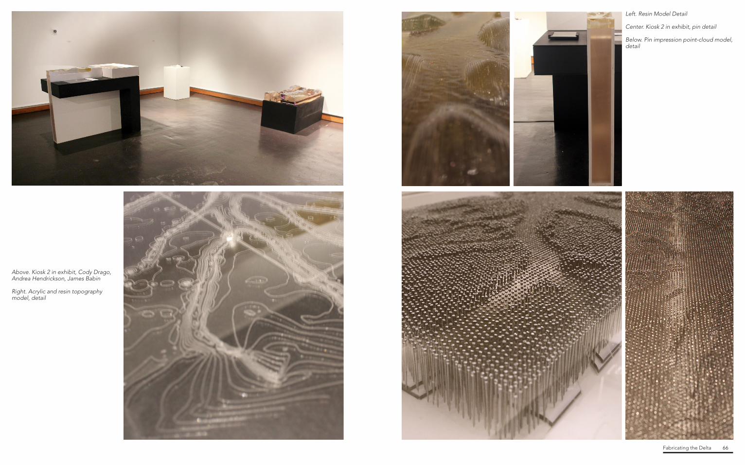
Above. Kiosk surface with interactive and informational elementsAbove Right. Acrylic engraved map projection surfaceBelow. Detail of final pin impression point cloud modelBottom Right. Full-size built final kiosk design
The most difficult part of fabricating the Wax Lake delta was how to represent a landscape so vast and flat in a way that is both informative and experiential. Early investigations proved that an exaggerated Z axis section model was necessary to provide an accurate yet skewed informative model. Along with the section model, another aspect of the kiosk should show the experiential aspect of the delta - the emergence of the landscape. The final decision was made to create a pin impression point cloud model that not only shows the emergence of landscape but also begins to represent this idea of “wetland.” The design of the kiosk was discovered around the desire for a 360 degree viewing angle. Much like exhibits in museums that occupy the center of a space, the kiosk contains information that engages the viewer from all four angles. The exhibit is compositionally structured to read as two major intersecting forms. The pieces that are white and acrylic create the structure for the two models, while the black members display the text and other information. Originally, a projection containing an animation and information was to be displayed onto the section model originating inside one of the black arms of the kiosk and reflecting off of a mirror in order to gain the required depth for a wide projection. This later changed to the projector shining from below the section model.
Project team :James Babin B. Arch 2017Cody Drago B. Arch 2015Andrea Hendrickson B. Arch 2017
Group 02 Deltaic ScalePrompt: How to represent the scale of a site this large and flat?

Fabricating the Delta 50
Using bathemtry and topographical data, the section model was created with an exaggerated Z axis of x500. At a scale of 1” = 875’-0”, the model covers 21,000 feet longitudinally and 5,250 feet transversely. Investigations in this exaggerated section reveals the location of the delta’s deepest channels and largest land growth areas. The highest landmass proves to be about 5 feet above sea level at its peak, which would be represented at only .0057” high if the model were scaled accurately. The deepest channel, located at the Northernmost part of the delta, is 9 feel below sea level.
The model is created using bathemetry data provided by the LSU Coastal Sustainability Studio. A section of the main channel of the Wax Lake Delta is surfaced and then exaggerated. Once exaggerated, the model is scaled down and then contoured 96 times at 1/16”, then laser cut into acrylic. When the acrylic model is assembled, it is sealed and then casted with colored resin to represent water. A projection is later added that provides an animation of section cuts running across the model that guides the viewer’s eye along the changing elevations.
Above. Detail of pin impression point cloud modelAbove Center. Rhino, vertically exaggerated surface modelAbove Right. Pouring resin into acrylic modelRight. Digital rendering of final kiosk design
Left. Acrylic lasercut topobathy model in processBelow. Entire point cloud model in action

Fabricating the Delta 52
Top Left. Support construction detailTop Right. Final basswood and acrylic model filled with sand to represent sediment flowAbove Left. Sand falling through delta model Right. Final full-sized kiosk
Unlike most of Coastal Louisiana, which is suffering from subsidence and wetland loss, the Wax Lake Delta is building wetlands. This kiosk intends to highlight the process of prograde through demonstrating the deposition and accumulation of sediment. It will also examine the intersection of man-made intervention with natural development and explore the potentiality of the sediment deposition process in rebuilding Louisiana’s disappearing coastlne.
The Sediment Deposition kiosk was inspired by this simple use of materials. We decided to expose the structure, and did not attempt to hide connections, fasteners, and armatures. The technology is also visible, usually behind plexiglass, so that the viewer can see the inner workings; arduino, chords, plugs, and all.
The kiosk consists of three main materials: wood, metal, and plexiglass. The structure can also be disassembled by removing bolts and screws, nails and glue were used sparingly. This makes the kiosk easily moveable or stored when not on display.
Project team :Ethan Jordan M. Arch 2016Yao Liu MLA 2015Cole Rhodes B. Arch 2015Ryan Zerangue B. Arch 2015
Group 03 Sediment DepositionHow to represent natural systems impact on deltaic system?

Fabricating the Delta 54
We moved away from a digital interactive display towards a physical representation. The Wax Lake Delta topobathy model was enclosed and filled with sand to represent sediment. The model was allowed to rotate so gravity would cause the sand to fall over the bathymetry surface, representing sediment flow. To demonstrate the prograde process, certain sections of the model would trap the sand, allowing it to build up, while some sand would travel beyond the delta model, representing the sediment which deposited into the Gulf of Mexico. In addition, the topobathy model could rotate 360 degrees so that the sand could reset itself. The rotation was to be controlled by arduino motors, and the speed of rotation would be based on the actual flow of water through Wax Lake Delta.
The sediment model was based on bathymetry of the Wax Lake Delta provided by the USGS. The total model size is 16” x 24”, and consists of 220 section cuts, with over 400 pieces in total.
The individual section cuts were numbered, laser cut on plexiglass, then glued together with clear silicon. The model was then partially filled with sand, capped and sealed.
The design was inspired by an hourglass. However, the sand, representing sediment would build up in certain areas while pass through others unobstructed.
Top. Lasercut process imageAbove Left. Rhino digital image of sediment modelAbove Center. Kiosk leg brace construction detailAbove Right. Construction detail, housing for power stripLeft. Rotating panel study model
Facing Page:Left. Final full-sized kiosk design in perspectiveTop Right. Final kiosk front elevation

Fabricating the Delta 56
Above Left. Information projection onto modelTop Right. Final full-sized kiosk with interactive panelAbove Right. Detail of interactive map showing oil spill scenariosLeft. Digital projection detail of bathymetry, oil wells, platforms, and pipelines, on milled model
Accidental and inevitable coastal disturbances effect deltaic systems, producing calamitous aftermaths that challenge the sluggish growth of the Louisiana Coast. These disturbances are distinguished through manmade disturbances and nature disturbances. In the context of our site, the Wax Lake Delta, manmade disturbances are shown through pollution in the form of oil spills due to the amount of oil wells within our site parameters. The primary concern of oil meeting land is soil degradation, which “is defined as a change in the soil health status resulting in a diminished capacity of the ecosystem to provide goods and services for its beneficiaries.” Although the Louisiana coast is currently at a fragile state, many ecosystems heavily rely on the land. In the presence of oil contamination on land, the toxins saturate the ground, preventing water from being absorbed. Due to the lack of water, this action inhibits the plants from being nourished. Because all of these ecosystems are interrelated, when one is in danger, a spiraling trickledown effect arises.
Project team:Travis Dickerson M. Arch 2016Sara Loquist M. Arch 2016Alexis Malone M. Arch 2016
Group 04 Deltaic DisturbancesHow to represent disturbances in the deltaic system?

Fabricating the Delta 58
Left. MDF CNC-milled model of Wax Lake DeltaBelow Left. Final kioskBelow Right 1. Process image, drilling hopes into interactive map for lightsBelow Right 2. Process image, interactive map lightsBelow Right 3. Process image, testing kiosk
Using animated projections, we show two of the possible oil spills scenarios near Wax Lake Delta, referencing data from the 2010 BP oil spill. One scenario takes place in the later part of the summer where Wax Lake Delta is more prone to an oil spill reaching its parameters due to the tide. The second scenario takes place during the winter months where the tides will direct the spill westward, not affecting Wax Lake Delta.
Oil spill summer projection August 15 to September 19
Oil spill winter projection January 8 to February 12

Fabricating the Delta 60
Above. Projection on final Wax Lake Delta model showing difference between land and waterRight. Plaster cast model of the Delta topographyFar Right. Projection studiesFacing Page. Cardboard Wax Lake Delta topographic model
This particular kiosk is aimed at developing an understanding of the difference between land and water and its relationship with the Wax Lake Delta. The kiosk includes a projector, projected image, hydrocal model, section model, water, a water-pump operated by Arduino, and an iPad. It was developed over several months and its process and the final kiosk are presented in this portfolio. Project team:Kathleen Autilio M. Arch 2016Kayla Bosarge M. Arch 2016Jennifer Price M. Arch 2016Reagan Rispone M. Arch 2016
Group 05 Land and WaterHow to represent where land and water ends?

Fabricating the Delta 62
Right. Final KioskBelow 1. Final Wax Lake Delta physical model, covered in plasticBelow 2. Construction detail of interactive panel (ipad) and buttonBelow 3. Projection on final model in kiosk
A series of images were used to create a video projection showing different elevations and its relationship with water.

Fabricating the Delta 64
Facing Page. Rope, Walk, Breathe, Mixed Media, 2014, by Sheryl Fishel Right. Kiosk 1, Kelli Cunningham, Landon Pugh, Karl SchmidtAbove. Topography beads detailsBottom. Kiosk in Exhibition
This exhibition is collection of models, sculptures, installations, drawings, and projections of landscapes created by current and former students of the LSU Robert Reich School of Landscape Architecture and the LSU School of Architecture, curated by Associate Professor Cathy Marshall.
Landscape Relationships was on display in the LSU Foster Gallery, January 30–February 27, 2015.
Participating artists include:
Kathleen AutilioJames BabinKayla BorsageElizabeth L. BoudreauxJazmin Rosario CastilloRy’yan Michael ClarkKelli CunninghamCody Lee DavidTravis DickersonErin DibosCody DragoSheryl L. FishelMarianne Zenobia GarciaWesley K. GentryMax Sebastian GuzzettaAndrea HendricksonJustine HolzmanGarrett L. JenkinsEthan JordanXinyue LingYao LiuYifu LiuYinan LiuSara LoquistAlexis MaloneEthan Joseph NicosiaWilliam Breen ParkerRuoyi PengJennifer PriceSkipper PughMatthew J. RelyeaCole RhodesReagan RisponeJames Maxwell SandlinKarl SchmidtXiwei ShenYimeng WangMichael A. WebbSarah ZelenakRyan Zeringue
Landscape RelationshipsWork by LSU landscape architecture and architecture students
Fabricating the Delta 66
Left. Resin Model Detail
Center. Kiosk 2 in exhibit, pin detail
Below. Pin impression point-cloud model, detail
Above. Kiosk 2 in exhibit, Cody Drago, Andrea Hendrickson, James Babin
Right. Acrylic and resin topography model, detail

Fabricating the Delta 68
Top ,Fabricating the Delta Art and Design Atrium Exhibit, Shelby Doyle
Bottom, Group 1 Surface, Fabricating the Delta Art and Design Atrium Exhibit, Shelby Doyle
Fabricating the Delta was a Fall 2014 graduate level Architecture and Landscape Architecture research seminar at the Louisiana State University (LSU) College of Art + Design (CoAD) and was taught in collaboration with the LSU Coastal Sustainability Studio, and the Coastal Protection and Restoration Authority (CPRA), a Louisiana government agency. This partnership bridged research, practice, and pedagogy through funded applied design research.
Resulting coursework informed the ongoing Design Development Phase of the fifteen thousand square foot CPRA River Model Center, a CSS designed project and a flagship building on the Baton Rouge Water Campus (BRWC) that houses a ten thousand square foot physical model of the Lower Mississippi River Basin engineered to test sediment flows, distribution, and land building.Context
The Louisiana Coast is disappearing at a rate of 16.57 square miles a year, equal to the loss of a football field of coast every hour. This loss reflects the aggregate consequences of the anthropocene sooner and faster than possibly anywhere in the United States. Consequently, the present conditions of the Louisiana Coast represent several possible scenarios for the future of the nation’s coasts and provide a real-life context for examining the tools, methods, and practices that will be required to cope with those consequences. Fabricating the Delta produced explanatory interactive models of the Wax Lake Delta, a unique area of active (wet)land building. In 1942 the US Army Corps of Engineers constructed a river diversion to protect Morgan City from the Atchafalaya River. Simultaneously, the diversion directed water and sediment to the Wax Lake resulting in measurable (wet)land building during the last 70 years. The Wax Lake Delta provides valuable insight into the ecological processes of coastal restoration. Course
Fabricating the Delta introduced digital fabrication as an act of making, analyzing, and positioning design in relation to coastal restoration. The course introduced concepts of bathymetry, topography, and projection through an introduction to laser cutting*, 3D-printing*, CNC milling, casting, and drawing production. The final project was a full-scale kiosk that presents the relationships between physical models, static images, text, projected images, maps and animations, interactive screen content. Each group was provided with a fixed material and fabrication budget, an iPad tablet, a pico-projector, and a specific question regarding the process of (wet)land building in the Wax Lake Delta:
How to represent bathymetry / topography over time? *How to represent the scale of a site this large and flat? *How to represent natural systems impact on a deltaic system?How to represent disturbances in the deltaic system?How to represent a changing land / water gradient?
* Included in exhibit
Atrium Wall ExhibitArt and Design Commons, Louisiana State University