Embed Size (px)
Citation preview

NORTHWEST MULTIMODAL TRANSIT CORRIDOR
IQC Progress Update 4 August 2015
!(1
!(1
!(1
#*6
!(3
!(2
")5
#*7
"4)
F0 10.5
Miles
Lake
He
fne
r P
ark
way
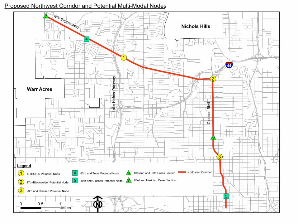
Proposed Northwest Corridor and Potential Multi-Modal Nodes
Legend
!(1 INTEGRIS Potential Node
!(2 47th-Blackwelder Potential Node
!(3 23rd and Classen Potential Node
"4) 63rd and Tulsa Potential Node
")5 10th and Classen Potential Node
#*6 Classen and 30th Cross Section
#*7 63rd and Meridian Cross Section
Northwest Corridor
§̈¦44
Cla
ssen
Blv
d
NW Expressway
Warr Acres
Nichols Hills

IQC Progress Update
• Priority Multimodal Nodes – 23rd and Classen – Blackwelder and Northwest Expressway – Independence and Northwest Expressway

IQC Progress Update
• Existing Conditions Analysis • Multimodal Area Improvements • Road Design Concepts – Alternative 1: Basic – Alternative 2: Robust

23rd and Classen
Uptown

Significant Origins
• Historic Neighborhoods • Classen Tower

Significant Destinations
• Oklahoma City University • Uptown • Asian District • American Fidelity Property

Existing Conditions

Street Section

Bus Stop Classen at 23rd
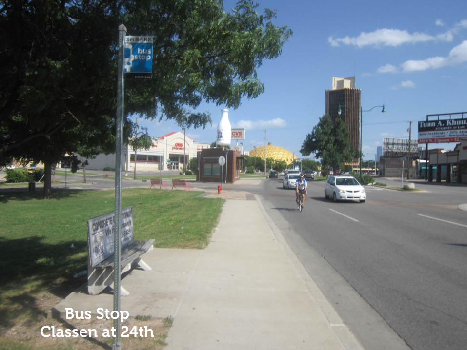
Bus Stop Classen at 24th

Narrow Sidewalk Classen at 23rd

Pedestrian Improvements 24th and Classen

"W
Source: Esri, DigitalGlobe, GeoEye, Earthstar Geographics, CNES/Airbus DS, USDA, USGS, AEX,Getmapping, Aerogrid, IGN, IGP, swisstopo, and the GIS User Community
F0 0.15 0.3 0.45 0.60.075
Miles1 Mile
0.5 Miles
Cla
ssen
Blv
d
NW 16th St
NW 23rd St
NW 13th StW
este
rn A
ve
NW 10th St
Penn
sylv
ania
Ave
23rd Street Potential Stop Area: Existing Sidewalk Grid

"W
#
#
#
#
#
F0 0.15 0.3 0.45 0.60.075
Miles
1 Mile
0.5 Miles
Cla
ssen
Blv
d
23rd St and Classen Blvd Potential Multi-Modal Node: Existing Transit Connections
Legend
Memorial Rd Route
N Portland Route
23rd Street Crosstown Route
"W 23rd and Classen Potential Node
Asian
District
Gold Dome
Fairlawn Cemetery
Classen Tower
NW 23rd St
Wes
tern
Ave
NW 10th St
Oklahoma City
University
m
mm m
m m

"W
#
#
#
#
#
F0 0.15 0.3 0.45 0.60.075
Miles
1 Mile
0.5 Miles
Cla
ssen
Blv
d
23rd St and Classen Blvd Potential Multi-Modal Node: Jobs + Population Per Acre Density
Jobs + Population
0 - 5 per acre
6 - 10 per acre
11 - 15 per acre
16 - 30 per acre
31 - 50 per acre
Over 50 per acre
Asian
District
Gold Dome
Fairlawn Cemetery
Classen Tower
NW 23rd St
Weste
rn A
ve
NW 10th St
Oklahoma City
University
!(
!(
!(!( !( !(
!( !(!(
!(!(
!(
!( !(!(
!(
!(
!(
!(!(!(!( !( !( !( !(!(!(!(!(!(!(!(!(!(!(!( !( !( !(!(!(
!( !( !(
!(!( !(
!( !(
!(
!(!( !(
!(!(
!( !( !(
!(
!(
!(
Source: Esri, DigitalGlobe, GeoEye, Earthstar Geographics, CNES/Airbus DS, USDA, USGS, AEX,Getmapping, Aerogrid, IGN, IGP, swisstopo, and the GIS User Community
F0 0.15 0.3 0.45 0.60.075
Miles1 Mile
0.5 Miles
Cla
ssen
Blv
d
NW 16th St
NW 23rd St
NW 13th StW
este
rn A
ve
NW 10th St
Penn
sylv
ania
Ave
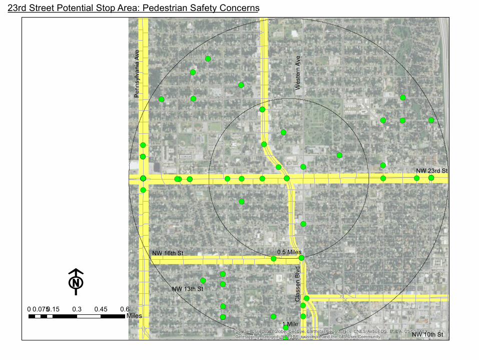
23rd Street Potential Stop Area: Pedestrian Safety Concerns

!(!( !(!(
!(
!(
!( !(
!(
!( !(!(
!(!( !(!(!( !(!(!(!(!( !(!( !( !(!(
!(!( !(
!( !(!(
!(!( !(
!(
!(!(
Source: Esri, DigitalGlobe, GeoEye, Earthstar Geographics, CNES/Airbus DS, USDA, USGS, AEX,Getmapping, Aerogrid, IGN, IGP, swisstopo, and the GIS User Community
F0 0.15 0.3 0.45 0.60.075
Miles1 Mile
0.5 Miles
Cla
ssen
Blv
d
NW 16th St
NW 23rd St
NW 13th StW
este
rn A
ve
NW 10th St
Penn
sylv
ania
Ave
23rd Street Potential Stop Area: Bicycle Safety Concerns

#
#
#
#
#
!( !(
!(
!( !(
!(
!(
!(
!(!(
!(
!(
!(
!(
!(
!(
!(
!( !(!(!( !(!(!(!(!( !(!( !( !(
!(
!( !(
!( !(
!(
!( !(
!(
!(
!(
!(
!(
!( !(!(!( !(
!(
!(
!(
!( !( !(
!(
!(
!( !( !(
!( !(
!(
!(!(
!( !(!(
!(
!(!(!( !( !( !(!(!(!(!(!(!(!(!(!( !( !(!(!(
!( !(
!( !(
!( !(
!(
!(!(
!(!(
!(
!(
!(
F0 0.15 0.3 0.45 0.60.075
Miles
1 Mile
0.5 Miles
Cla
ssen
Blv
d
NW 10th St
23rd St and Classen Blvd Potential Multi-Modal Node: Existing Walk Shed and Bike Shed
NW 23rd St
Legend!( Less Severe Pedestrian Collisions
!( Severe Pedestrian Collisions
!( Less Severe Bicycle Collisions
!( Severe Bicycle Collisions
Existing Walk Shed
Existing Bike Shed
NW 36th St
Weste
rn A
ve
Oklahoma City
University
Classen
Tower
Gold Dome
Asian District
Fairlawn Cemetery

23rd & ClassenMultimodal Area Improvements
Sidewalk - OK Repair
Priority Sidewalk Upgrade Existing Marked Crossing
Proposed Marked Crossing
Existing Bus Stop
Proposed Bus StopTransit-Oriented Area
Oklahoma CityUniversity
Uptown
Paseo
Plaza District
FairlawnCemetery

#
#
#
#
#
!( !(
!(
!( !(
!(
!(
!(
!(!(
!(
!(
!(
!(
!(
!(
!(
!( !(!(!( !(!(!(!(!( !(!( !( !(
!(
!( !(
!( !(
!(
!( !(
!(
!(
!(
!(
!(
!( !(!(!( !(
!(
!(
!(
!( !( !(
!(
!(
!( !( !(
!( !(
!(
!(!(
!( !(!(
!(
!(!(!( !( !( !(!(!(!(!(!(!(!(!(!( !( !(!(!(
!( !(
!( !(
!( !(
!(
!(!(
!(!(
!(
!(
!(
F0 0.15 0.3 0.45 0.60.075
Miles
1 Mile
0.5 Miles
Cla
ssen
Blv
d
NW 10th St
23rd St and Classen Blvd Potential Multi-Modal Node: Existing Walk Shed and Bike Shed
NW 23rd St
Legend!( Less Severe Pedestrian Collisions
!( Severe Pedestrian Collisions
!( Less Severe Bicycle Collisions
!( Severe Bicycle Collisions
Existing Walk Shed
Existing Bike Shed
NW 36th St
Weste
rn A
ve
Oklahoma City
University
Classen
Tower
Gold Dome
Asian District
Fairlawn Cemetery

23rd and Classen - Existing

23rd and Classen Alternative 1 – Basic Enhanced crosswalk visibility with median refuges on Classen Upgraded transit shelters Curb extension for additional space, northwest corner

23rd and Classen Alternative 1 – Basic
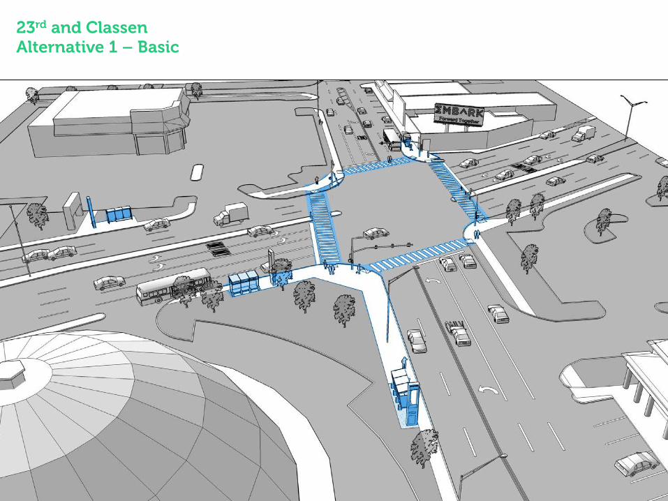
23rd and Classen Alternative 1 – Basic

23rd and Classen Alternative 2 – Robust Dedicated bus/right turn lanes Expanded sidewalk on northwest corner Transit plaza and enhanced transit shelters

23rd and Classen Alternative 2 – Robust
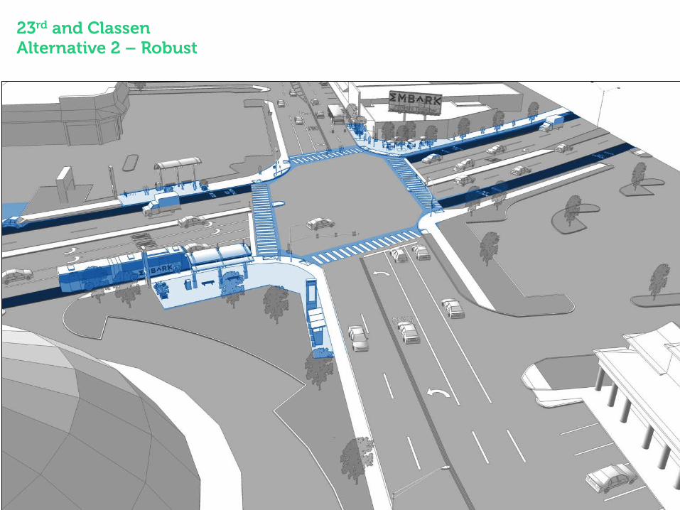
23rd and Classen Alternative 2 – Robust

Blackwelder and NW Expressway
Belle Isle
Significant Origins
• Residential Neighborhoods

Significant Destinations
• Office Towers • Belle Isle • Penn Square Mall • Western Avenue District

Existing Conditions

Street Section
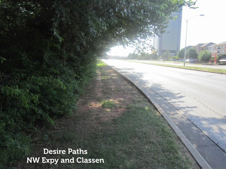
Desire Paths NW Expy and Classen

Cyclist NW Expy and Blackwelder

Unimproved Intersection NW Expy and Blackwelder
"W
Source: Esri, DigitalGlobe, GeoEye, Earthstar Geographics, CNES/Airbus DS, USDA, USGS, AEX,Getmapping, Aerogrid, IGN, IGP, swisstopo, and the GIS User Community
F0 0.15 0.3 0.45 0.60.075
Miles1 Mile
0.5 Miles
Cla
ssen
Blv
d
NW 50th St
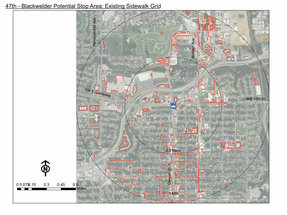
47th - Blackwelder Potential Stop Area: Existing Sidewalk Grid
Wes
tern
Ave
NW ExpresswayPe
nnsy
lvan
ia A
ve
"W
#
#
#
#
#
F0 0.15 0.3 0.45 0.60.075
Miles
1 Mile
0.5 Miles
Cla
ssen
Blv
d
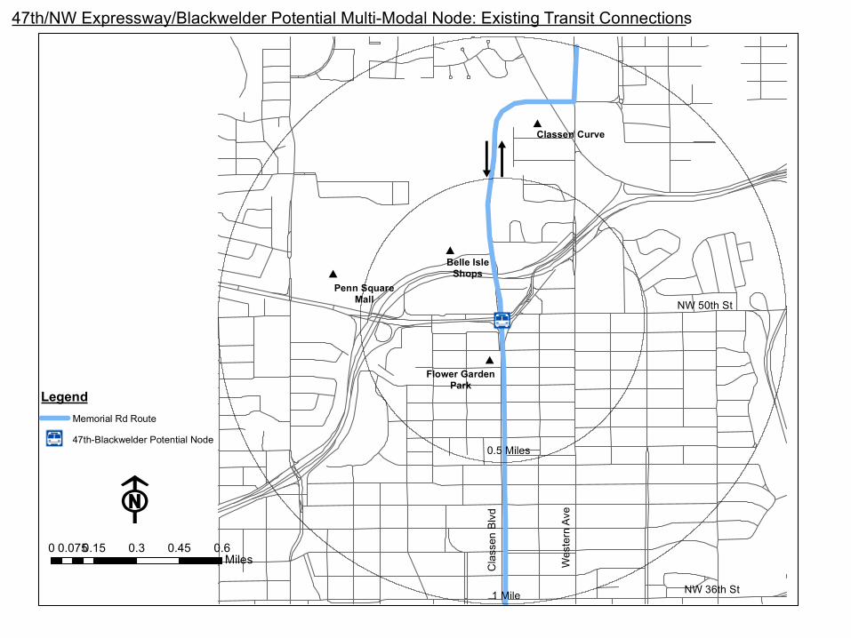
47th/NW Expressway/Blackwelder Potential Multi-Modal Node: Existing Transit Connections
LegendMemorial Rd Route
"W 47th-Blackwelder Potential Node
Belle IsleShops
Classen Curve
Flower GardenPark
NW 50th St
Wes
tern
Ave
NW 36th St
Penn SquareMall
m
m

"W
#
#
#
#
F0 0.15 0.3 0.45 0.60.075
Miles
1 Mile
0.5 Miles
Cla
ssen
Blv
d
47th/NW Expressway/Blackwelder Potential Multi-Modal Node: Jobs + Population Per Acre Density
NW Expressway
Jobs + Population0 - 5 per acre
6 - 10 per acre
11 - 15 per acre
16 - 30 per acre
31 - 50 per acre
Over 50 per acre
Belle IsleShops
Flower GardenPark
Classen Curve
Penn SquareMall
NW 50th St
Weste
rn A
ve
§̈¦44
NW 36th St

!(
!(
!(
!(!(!(!(
!( !(!(!(!(!( !(
!(!(!(
!(!(
!(!(
!(
!( !(!( !( !(
!(
!(
!(
!(
Source: Esri, DigitalGlobe, GeoEye, Earthstar Geographics, CNES/Airbus DS, USDA, USGS, AEX,Getmapping, Aerogrid, IGN, IGP, swisstopo, and the GIS User Community
F0 0.15 0.3 0.45 0.60.075
Miles1 Mile
0.5 Miles
Cla
ssen
Blv
d
NW 50th St
47th - Blackwelder Potential Stop Area: Pedestrian Safety Concerns
Wes
tern
Ave
NW ExpresswayPe
nnsy
lvan
ia A
ve
!(
!(
!(!(
!(!(
!(
!(!(!(
!( !( !(!(
Source: Esri, DigitalGlobe, GeoEye, Earthstar Geographics, CNES/Airbus DS, USDA, USGS, AEX,Getmapping, Aerogrid, IGN, IGP, swisstopo, and the GIS User Community
F0 0.15 0.3 0.45 0.60.075
Miles1 Mile
0.5 Miles
Cla
ssen
Blv
d
NW 50th St
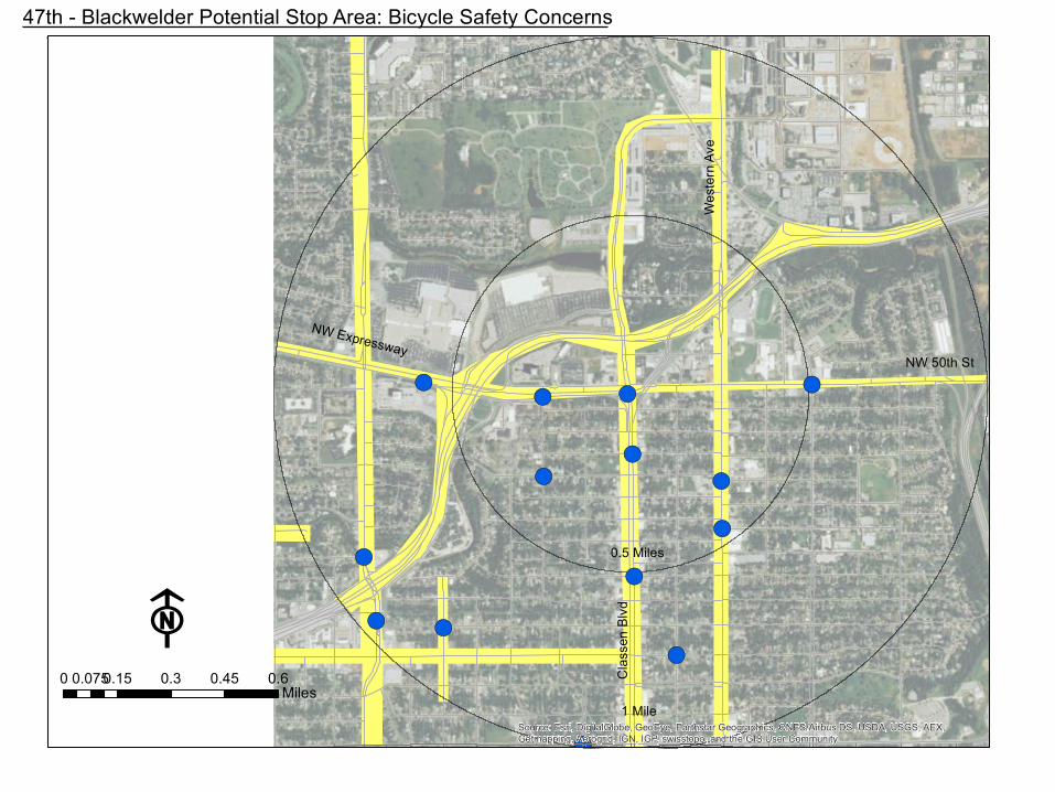
47th - Blackwelder Potential Stop Area: Bicycle Safety Concerns
Wes
tern
Ave
NW Expressway

!(
!(
!(
!(
!(!(
!(
!(
!(
!(
!(
!(!(!(
!(
!(
!(
!(
!(
!(
!(
!(
!(!(!(!( !(!(
!(!(!(
!(
!(
!(
!(!(
!(
!( !(!( !( !(
!(
!(
!(
#
#
#
#
F0 0.15 0.3 0.45 0.60.075
Miles
1 Mile
0.5 Miles
Cla
ssen
Blv
d
NW 36th St
47th/NW Expressway/Blackwelder Potential Multi-Modal Node: Existing Walk Shed and Bike Shed
Legend!( Less Severe Pedestrian Collisions
!( Severe Pedestrian Collisions
!( Less Severe Bicycle Collisions
!( Severe Bicycle Collisions
Existing Walk Shed
Existing Bike Shed
Wes
tern
Ave
Penn SquareMall
Belle Isle Shops
Flower Garden Park
Classen Curve
NW Expressway
§̈¦44

Classen & NW ExpresswayMultimodal Area Improvements
Existing Sidewalks/Trails
Proposed Sidewalks/Trails
Existing Marked Crossing
Proposed Marked Crossing
Existing Bus Stop
Proposed Bus Stop
Penn Square MallBelle Isle
WesternAvenueDistrict
"W
#
#
#
#
#
F0 0.15 0.3 0.45 0.60.075
Miles
1 Mile
0.5 Miles
Cla
ssen
Blv
d
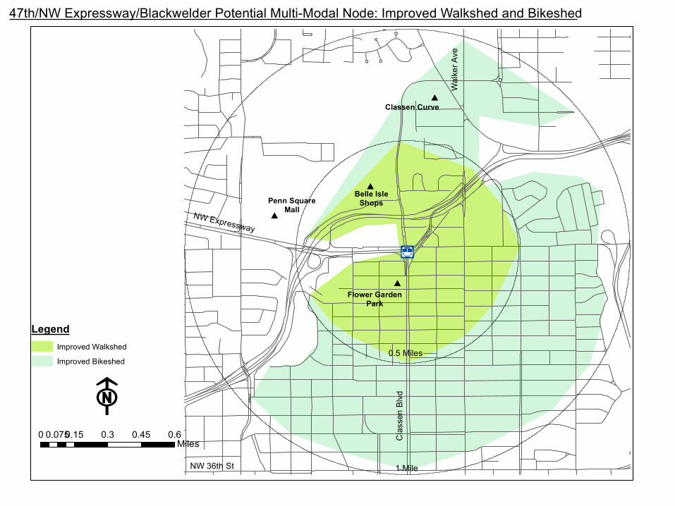
47th/NW Expressway/Blackwelder Potential Multi-Modal Node: Improved Walkshed and Bikeshed
NW Expressway
LegendImproved Walkshed
Improved Bikeshed
Penn SquareMall
Belle IsleShops
Wal
ker A
ve
Classen Curve
Flower GardenPark
NW 36th St
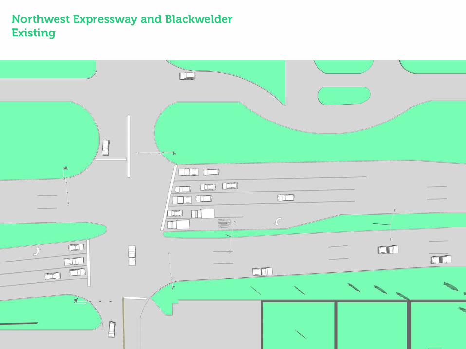
Northwest Expressway and Blackwelder Existing

Northwest Expressway and Blackwelder Alternative 1 – Basic Enhanced crosswalk, bus bays, and shelters

Northwest Expressway and Blackwelder Alternative 1 – Basic

Northwest Expressway and Blackwelder Alternative 1 – Basic

Northwest Expressway and Blackwelder Alternative 2 – Robust Two-stage crosswalk, enhanced transit shelters with amenities

Northwest Expressway and Blackwelder Alternative 2 – Robust

Northwest Expressway and Blackwelder Alternative 2 – Robust

Independence and NW Expressway
INTEGRIS

Significant Origins
• Warwick Apartments • Midtown Apartments Tower • Founders Tower • Tower Hotel (Formerly Marriott)

Significant Destinations
• INTEGRIS • Office Complexes • Retail
Existing Conditions

Street Section

Unimproved Intersection NW Expy and
Independence

Unimproved Intersection NW Expy and Independence

No Sidewalks Independence

Sidewalks Independence
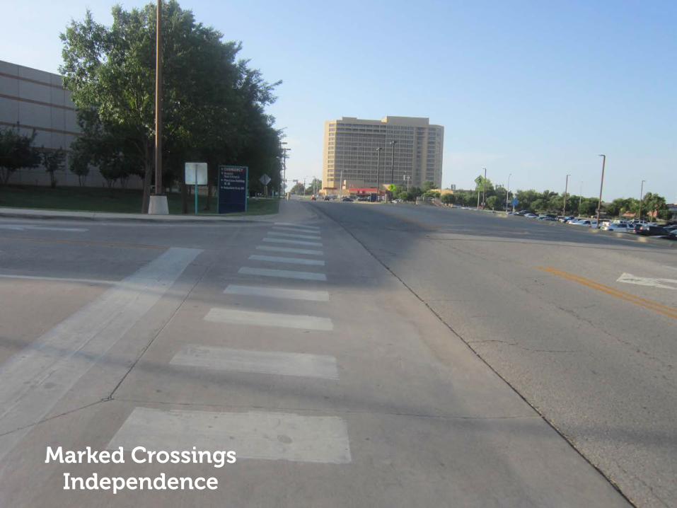
Marked Crossings Independence

56th Bridge over I-44 Not Accessible

Æa
Source: Esri, DigitalGlobe, GeoEye, Earthstar Geographics, CNES/Airbus DS, USDA, USGS, AEX,
Getmapping, Aerogrid, IGN, IGP, swisstopo, and the GIS User Community
F0 0.15 0.3 0.45 0.60.075
Miles
1 Mile
0.5 MilesLake
He
fne
r P
ark
way
Inde
pen
de
nce
Ave
NW 50th St
Port
land
Ave
INTEGRIS Potential Stop Area: Existing Sidewalk Grid
May A
ve

Æa#
#
#
#
F0 0.15 0.3 0.45 0.60.075
Miles
1 Mile
0.5 Miles
Lake
He
fne
r P
ark
way
NW Expressway and Independence (INTEGRIS) Potential Multi-Modal Node: Existing Transit Connections
LegendN Portland Route
N Penn/NW 63rd Route
N May Route
Æa INTEGRIS Potential Node
FoundersTower
INTEGRISHospital
NW 63rd St
Inde
pen
de
nce
Ave
NW 50th St
DeaconessHospital
mm
Oklahoma CityGolf and Country Club
NW Expressway
mm
m
m
m
m m
m
m
m
m m

Æa#
#
#
#
F0 0.15 0.3 0.45 0.60.075
Miles
1 Mile
0.5 MilesLa
ke H
efne
r Par
kway
NW Expressway and Independence (INTEGRIS) Potential Multi-Modal Node: Jobs + Population Per Acre Density
NW Expressway
Jobs + Population0 - 5 per acre
6 - 10 per acre
11 - 15 per acre
16 - 30 per acre
31 - 50 per acre
Over 50 per acre
DeaconessHospital
FoundersTower
Inde
pend
ence
Ave
Oklahoma CityGolf and Country Club
INTEGRISHospital
NW 50th St
NW 63rd St

!(!(
!( !(!(!(!(
!(!(
!(!(
!(!(
!(!(!(
!(
!( !(!(!( !(!(!(
!(
!(
!( !(!(!( !(!(!(
!(
!(
Source: Esri, DigitalGlobe, GeoEye, Earthstar Geographics, CNES/Airbus DS, USDA, USGS, AEX,
Getmapping, Aerogrid, IGN, IGP, swisstopo, and the GIS User Community
F0 0.15 0.3 0.45 0.60.075
Miles
1 Mile
0.5 MilesLake
He
fne
r P
ark
way
Inde
pen
de
nce
Ave
NW 50th St
Port
land
Ave
INTEGRIS Potential Stop Area: Pedestrian Safety Concerns
May A
ve

!(
!(
!(
!(
!(
!(
!(
!(
!(
!(
!(
!(
!(
Source: Esri, DigitalGlobe, GeoEye, Earthstar Geographics, CNES/Airbus DS, USDA, USGS, AEX,
Getmapping, Aerogrid, IGN, IGP, swisstopo, and the GIS User Community
F0 0.15 0.3 0.45 0.60.075
Miles
1 Mile
0.5 MilesLake
He
fne
r P
ark
way
Inde
pen
de
nce
Ave
NW 50th St
Port
land
Ave
INTEGRIS Potential Stop Area: Bicycle Safety Concerns
May A
ve

Æa
!(!(
!(
!(
!(
!(
!(
!(!(!(
!( !(!(!(!(
!(
!(
!(
!(
!(
!(!( !(!(
!(
!(
!( !(!(!( !(!(!(
!(
!(
!(
!(
!(
!(
!(
!(
!(!( !(
!(
!(
#
#
#
#
F0 0.15 0.3 0.45 0.60.075
Miles
1 Mile
0.5 MilesLa
ke H
efne
r Par
kway
NW 50th St
INTEGRIS Potential Multi-Modal Node: Existing Walk Shed and Bike Shed
Legend!( Less Severe Bike Collisions
!( Severe Bike Collisions
!( Less Severe Pedestrian Collisions
!( Severe Pedestrian Collisions
Existing Walk Shed
Existing Bike Shed
Inde
pend
ence
Ave
DeaconessHospital
INTEGRISHospital
FoundersTower
Oklahoma CityGolf and Country Club
NW Expressway §̈¦44
Portl
and
Ave
NW 63rd St

Independence & NW ExpresswayMultimodal Area Improvements
Existing Sidewalks/Trails
Proposed Sidewalks/Trails
Existing Marked Crossing
Proposed Marked Crossing
Existing Bus Stop
Proposed Bus Stop

Æa#
#
#
#
F0 0.15 0.3 0.45 0.60.075
Miles
1 Mile
0.5 Miles
Lake
He
fne
r P
ark
way
NW Expressway and Independence (INTEGRIS) Potential Multi-Modal Node: Improved Walkshed and Bikeshed
NW Expressway
LegendImproved Walkshed
Improved Bikeshed
INTEGRISHospital
Founders Tower
Oklahoma CityGolf and Country Club
DeaconessHospital
NW 50th St
Inde
pen
de
nce
Ave
NW 63rd St

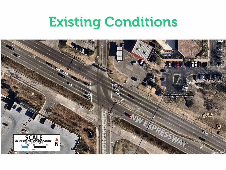
NW Expressway & Independence Existing Conditions Complex intersection No pedestrian crossings

NW Expressway & Independence Alternative 1 – Basic Two-stage crosswalk with offset Improved transit shelters Queue jump for inbound transit

NW Expressway & Independence Alternative 1 – Basic

NW Expressway & Independence Alternative 1 – Basic

NW Expressway & Independence Alternative 2 – Robust Transit shelters with amenities Turnout bays for transit stops Raised crosswalk on access road Relocated Route 8 transit shelter
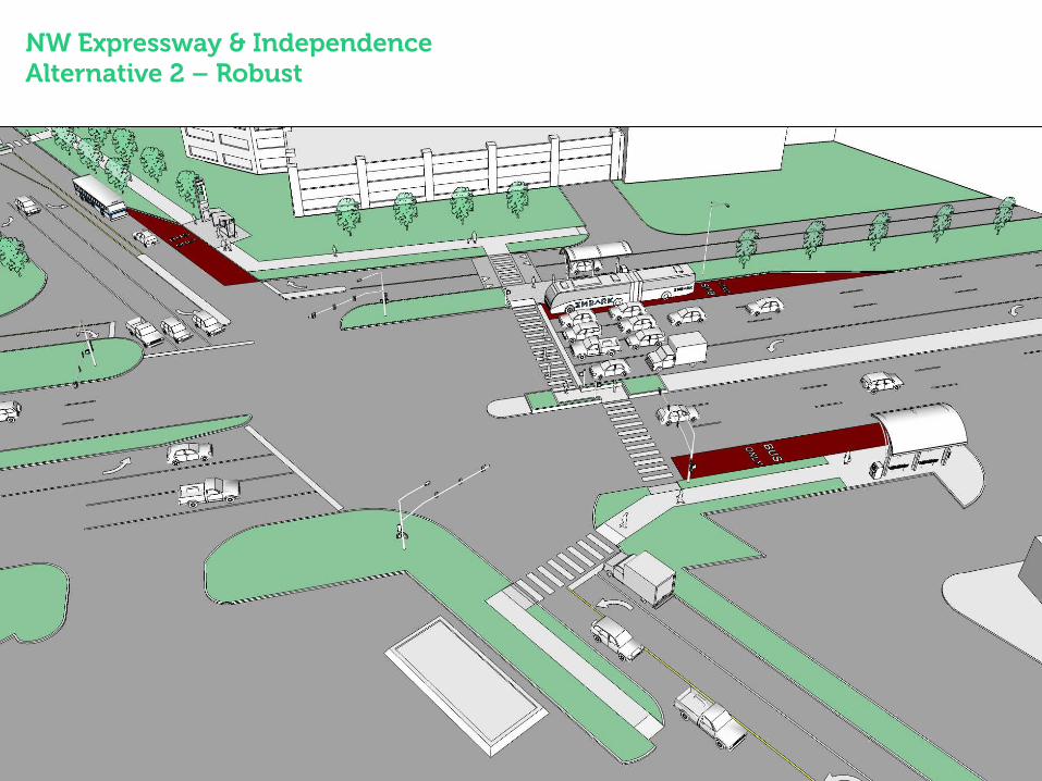
NW Expressway & Independence Alternative 2 – Robust

NW Expressway & Independence Alternative 2 – Robust

NW Expressway & Independence Alternative 2b – Bridge Exploring the idea of a pedestrian overpass Significant constraints


Each location has its own types of challenges and
opportunities.

NEXT STEP:
4 Additional Locations
Meridian
Tulsa/63rd
30th
10th