Embed Size (px)
Citation preview
See the energy at TGS.com
© 2016 TGS-NOPEC Geophysical Company ASA. All rights reserved.
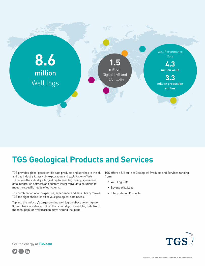
TGS Geological Products and ServicesTGS provides global geoscientific data products and services to the oil and gas industry to assist in exploration and exploitation efforts. TGS offers the industry’s largest digital well log library, specialized data integration services and custom interpretive data solutions to meet the specific needs of our clients.
The combination of our expertise, experience, and data library makes TGS the right choice for all of your geological data needs.
Tap into the industry’s largest online well log database covering over 30 countries worldwide. TGS collects and digitizes well log data from the most popular hydrocarbon plays around the globe.
TGS offers a full suite of Geological Products and Services ranging from:
� Well Log Data
� Beyond Well Logs
� Interpretation Products
8.6 million
Well logs
1.5 million
Digital LAS and LAS+ wells
Well Performance Data
4.3 million wells
3.3
million production entities

See the energy at TGS.com
Well Log DataR360R360 seamlessly assimilates TGS data libraries with your existing technologies, giving you ready access to TGS Well Logs, Directional Surveys, Well Performance Data, Permits, Validated Well Headers, and Interpretation Products.
With R360, see the data you have already licensed, as well as other data that’s available. Receive notifications when there are updates to your licensed data. Access is constant. No more FTP files to manage or need to reorder data already purchased. Use R360 your way – through your desktop, laptop, tablet, or other mobile device.
Oyster Plus and LongbowTGS’s Oyster Plus plan provides unlimited access to the entire US smartRaster library, along with US Well Performance and Permit data in the Longbow desktop search and visualization application tool.
Use Longbow and Well Performance data to refine your data selection. The Well Performance database contains current and historic monthly production volumes and also provides 60 different statistical cumulative summaries that provide additional insight into the performance capability of each well. Move your well selection from Longbow directly to R360 to access log data.
Raster Well Log ImagesOver 9 million log images with more than 6.9 million depth calibrated smartRASTER®. SmartRASTERS are digitally calibrated for depth in a .SIF file with 200 top mnemonics by API.
LAS and LAS+Coverage for more than 3.1 million wells with over 1.5 million available LAS for immediate delivery. 12,000-14,000 LAS are added to the multi-client database each month.
TGS LAS contain a full suite of curves, when available – Resistivity, Neutron Density, Sonic, and Shard (Gamma, Spontaneous Potential, and Caliper) Curves. Data is processed through rigorous QA and QC standards to ensure quality and reliability.
TGS value added LAS+ data contains more than 78,000 workstation ready wells. Processing is performed to industry standards for clean-up, validation, calibrations, merging of runs, and standard mnemonics down to 17 curves. Ready for cross-section, formation analysis and petrophysical analysis over prospect focused regional study areas.
Process Compare LAS LAS Plus
LAS Version 2.0 2.0
HeaderInfo
Wire-line logging–All Standard curves
LWD–Only in the absence of WL standard curves
QualityControl vs Raster vs geological QC
DLIS, LIS,Tab and LAS Evaluation ●
Depth Shift ●
Calculated curves ●
Casing Shoe clean up ●
SP baseline ●
Tool pull QC ●
Reading Logging Remarks ●
Compose like Curve class for max coverage ●
Normalized Units ●
Normalized Depth Step ●
Normalized Mnemonics ●

See the energy at TGS.com
Beyond Well LogsMUD DataMud LAS is available in color and includes rate of penetration and total and individual gas curves. Digitized lithology and cutting remarks are available as an optional add-on.
Edited Sonics Sonic and density well log data are vital for geophysicists, petrophysicists, engineers and geologists in the search and evaluation of economic oil and gas reserves. In many cases, however, the data are missing or need editing due to environmental effects such as sonic cycle skipping or density rugose hole and washout effects. TGS Edited Sonic Logs correct these effects.
Check Shot SurveysCheck-Shot surveys give an immediate confirmation of where you are in both time and depth, regardless of wellbore geometry, so you can quickly make informed drilling decisions.
Validated Well HeaderThe Validated Well Header is the ultimate in quality control, to which all TGS data types are tied, ensuring optimal well system accuracy. The validation process uses all available documentation to determine drilling events, providing the wellbore profiles of all surrounding wells so you can avoid them, reducing risk and preventing multi-million dollar mistakes. The TGS Validated Well Header also provides ortho-rectified surface well locations, accurate bottom hole locations calculated from directional surveys, and verified ground elevations using Digital Elevation Models.
Directional Surveys (DS+)See the most accurate spatial representation of well path from surface to total depth with our thoroughly researched, reprocessed, and standardized datasets. DS+ is the new standard of quality for ‘user-ready’ directional survey data and well path control, essential data for interpreters in oil and gas, going beyond the simple capture of measured depth, azimuth and inclination.

See the energy at TGS.com
© 2016 TGS-NOPEC Geophysical Company ASA. All rights reserved.
GEONEWS
GEONEWS is a new, geospatially located and tagged database of current oil and gas news specifically tailored for professionals, analysts and investors in the Oil and Gas Exploration, Midstream and Downstream industries. With GEONEWS users are able to easily stay up to date with the latest breaking news and developments related to companies, drilling activity, plays, land transactions, lease sales, pipelines, facilities, regional news and regulations.
Field and Pool GIS Data
The TGS Field and Pool Data is a nationwide GIS multi-client database containing every producing oil and gas field, pool, and formation in the United States.
Visualize the geographic extent of fields and pools, analyze spatial patterns in oil and gas discoveries, size, and production, quantify spatial variations in pools by stratigraphic unit, and integrate with other regional geographic information in a GIS.
Why TGSExperienceTGS Geological Products and Services has a wide range of experience both in areas worked and in technical studies. This experience can be brought to bear on any project to ensure there is an optimum result. It also means that new ideas can be used in different areas to create new plays and prospects, thereby enhancing the prospectivity of an area.
Project Management and Quality ControlTGS employs an experienced project manager to plan and manage all projects. This ensures that projects deliver on time and to the right specification. There is a built in quality control process to ensure that the project is delivered to a high quality first time.
SkillsTGS has a wide range of skills available to deploy on any exploration project. This enables the right skills to be deployed at the right time to minimise the risk of failure or a poor quality product.
Multi-clientTGS delivers most of its products as multi-client interpretations. This means that project sponsors can have an input into the scope and deliverables of the study and can get access to the report sooner than their competitors. Moreover, all companies benefit from the reduced cost of the project in comparison to proprietary or internal studies.
US Tel: +1 713 860 2100Email: [email protected]
For more information, contact TGS at: