Embed Size (px)
Citation preview

READING LIST:USING A RETROSPECTIVE APPROACH TO MINE THE
LITERATURE FOR GIS AND GISCIENCE NUGGETS
Prepared for the Applied Research Seminar 2016 Esri Federal User Conference
February 24-26, Washington, DC
Mining U.S. Federal Agency Materials for GIS and GIScience Nuggets
Dr. Barry Wellar Program Director, GIS Retrospective Project
Principal, Wellar Consulting Inc. Professor Emeritus, University of Ottawa
August 31, 2015

Mining U.S. Federal Agency Materials for GIS Nuggets
2 | Seminar Reading List
1. Background to the Seminar Reading List
Details about GIS retrospective program objectives have been presented previously in several documents. However, it is possible that not all readers have accessed these materials. As a result, to assist in putting everyone reading this document on the same page, I open the Background section with a brief summary statement about GIS retrospective program objectives, and include links to several pertinent reports for those who want to learn about the derivation of the objectives and related matters.
The following remarks appear sufficient to achieve a common understanding of the objectives of the GIS retrospective program.
First, and consistent with a primary axiom of methodologically designed inquiries, the GIS retrospective research project is organized around a question:
How can looking back at what has been done, or not been done in the field of geographic information systems (GIS), contribute insights into why and how the field of GIS could and should evolve in the coming years?
With that question providing an overall sense of purpose, the reading list prepared for the 2016 seminar is another step in the process of elaborating what we can learn from the past, and how we can learn from the past, to inform the futures of three core, related missions:
1. Designing, developing, and implementing geographic information systems (GIS) technology;
2. Defining and elaborating the research methods, techniques, and operations of geographic information science (GIScience); and
3. Using geographic information systems technology and/or geographic information science in government, academia, business, the media, and other organizations, as well as by individuals, community associations, and other interests.
Information about the derivation and discussion of the objectives of the GIS retrospective program is presented in a number of publications, which can be accessed via the following links:
http://wellar.ca/wellarconsulting/AutoCarto_Six_Retrospective.pdf; http://wellar.ca/wellarconsulting/IJAGR_AC_SixRetroReviewAndImplicationsPaper.pdf; http://wellar.ca/wellarconsulting/COLLOQUIUM_PROCEEDINGS.pdf; http://wellar.ca/wellarconsulting/COLLOQUIUM_SLIDE_PRESENTATIONS.pdf; http://wellar.ca/wellarconsulting/Summary_GIS_Retrospective_Research_Colloquium_FINAL.pdf; and, https://www.esri.com/esri-news/arcnews/summer15articles/ colloquium-urges-gis-specialists-to-look-to-the-past-to-inform-the-future.

Mining U.S. Federal Agency Materials for GIS Nuggets
3 | Seminar Reading List
The decision to include a reading list in seminar materials follows comments and suggestions arising from the Colloquium on Using the Retrospective Approach to Mine for GIS Nuggets, which was held at Esri in Redlands, February 13-14, 2015.
In brief, the idea of using the retrospective approach to mine the literature for GIS nuggets was seen to introduce research design issues that are a major departure from prior experience for many in the GIS and GIScience community. It was recommended that I provide a selected body of publications to assist seminar attendees and other interested parties better understand the seminar objectives and presentations, and more comfortably participate in Q&A sessions and post-seminar discussions.
Based on prior reading list projects, I believe that for a new or significantly different research activity such as this one on using the retrospective approach to mine for GIS nuggets, it is advisable to begin at an indicative level, with emphasis on being broadly illustrative rather than deeply comprehensive. Moreover, it is advisable to limit entries to those which could be deemed original, fundamental, or basic building blocks. Additional readings can be added as time and resources permit, or circumstances dictate.
For the purposes of this seminar, four bodies of pertinent readings are identified.
First and foremost are the papers prepared for AutoCarto Six Retrospective (section A), which set out many of the concepts, ideas, needs, challenges and opportunities, as well as principles and practices that underlie the evolution of GIS technology and GIScience methodology.
The second body of publications is the papers and slide presentations prepared for the Colloquium on Using the Retrospective Approach to Mine for GIS Nuggets (section B1 and section B2, respectively), and the third body (section C) consists of the articles about GIS retrospective project activities published in the International Journal of Geospatial Research (IJAGR).
These materials are what might be termed “required reading” .for the seminar. I do not believe that they are sufficient for a number of attendees, but I do regard them as necessary in order to more fully benefit from seminar presentations and the discussions.
Finally, a preliminary list of publications (section D) from various academic, government, professional organization, and other sources has been compiled to supplement the AutoCarto Six Retrospective papers, and the colloquium productions. It is anticipated that more references will be identified in the coming months, and the current reading list dated July 31, 2015 will be amended accordingly.
Again, the intention is to suggest readings which could be instructive for a wide range of attendees, and our approach at this stage in view of resource constraints, as well as uncertainty about the backgrounds of seminar attendees, is to be indicative and illustrative rather than comprehensive and directive.
Mining U.S. Federal Agency Materials for GIS Nuggets
4 | Seminar Reading List
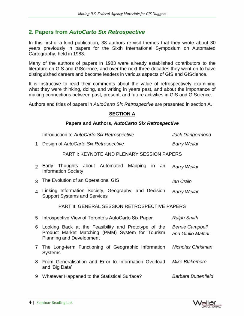
2. Papers from AutoCarto Six Retrospective
In this first-of-a kind publication, 38 authors re-visit themes that they wrote about 30 years previously in papers for the Sixth International Symposium on Automated Cartography, held in 1983.
Many of the authors of papers in 1983 were already established contributors to the literature on GIS and GIScience, and over the next three decades they went on to have distinguished careers and become leaders in various aspects of GIS and GIScience.
It is instructive to read their comments about the value of retrospectively examining what they were thinking, doing, and writing in years past, and about the importance of making connections between past, present, and future activities in GIS and GIScience.
Authors and titles of papers in AutoCarto Six Retrospective are presented in section A.
SECTION A
Papers and Authors, AutoCarto Six Retrospective
Introduction to AutoCarto Six Retrospective Jack Dangermond
1 Design of AutoCarto Six Retrospective Barry Wellar
PART I: KEYNOTE AND PLENARY SESSION PAPERS
2 Early Thoughts about Automated Mapping in an Information Society
Barry Wellar
3 The Evolution of an Operational GIS Ian Crain
4 Linking Information Society, Geography, and Decision Support Systems and Services
Barry Wellar
PART II: GENERAL SESSION RETROSPECTIVE PAPERS
5 Introspective View of Toronto’s AutoCarto Six Paper Ralph Smith
6 Looking Back at the Feasibility and Prototype of the Product Market Matching (PMM) System for Tourism Planning and Development
Bernie Campbell
and Giulio Maffini
7 The Long-term Functioning of Geographic Information Systems
Nicholas Chrisman
8 From Generalisation and Error to Information Overload and ‘Big Data’
Mike Blakemore
9 Whatever Happened to the Statistical Surface? Barbara Buttenfield

Mining U.S. Federal Agency Materials for GIS Nuggets
5 | Seminar Reading List
10 Exploratory Steps towards the Contemporary World of Geographic Information and Unexpected Consequences
David Rhind
11 Design of Maps for Telidon: Interactive Design of Maps Revisited
Fraser Taylor
12 MIGS: From Cartographic Revolution to Evolution Steve Prashker
PART III: SPECIAL SESSION RETROSPECTIVE PAPERS
13 L’évolution de la cartographie thématique sur micro-ordinateur
Jean-Paul Donnay
14 LACAD: Looking Back and Looking Forward at Simulating and Visualising the Real World
Bob Itami and
Randy Gimblett
15 Adaptive Grids Then and Now Randolph Franklin
16 Fractals in Context: Fractal Enhancement for Thematic Display of Topologically Stored Data
Marc Armstrong
and Lewis Hopkins
17 Soil and Agricultural Land Maps, from Mapping to GIS Jean-Philippe
Grelot
18 Fractals 30 Years After: A Retrospective of “Measuring the Fractal Dimensions of Surfaces”
Mark Shelberg,
Nina Lam, and
Harold Moellering
19 The Photogrammetric Generation of Topographic Information: A Brief History
Dierk Hobbie
20 The Map Overlay and Statistical System (MOSS) – A Historical Perspective
Carl Reed
21 Automated Cartographic-Quality Map Feature Labeling John Ahn and
Herbert Freeman
22 Technology, Information, Communications and Instant Maps
Chris Kissling
23 Early Electronic Atlases - Synergy between the Classical and Modern Cartography and GeoVisualization
Eva Siekierska
24 Moonshot – USGS and Census Build TIGER Steve Guptill
25 Reflections on Data Transfer Between Software Environments and the Challenges of GIS Teaching in a Post-Secondary Institution
Robert Maher and
David Colville

Mining U.S. Federal Agency Materials for GIS Nuggets
6 | Seminar Reading List
26 A Retrospective on Designing Interactive Spatial Systems Based on Real and Virtual Maps
Harold Moellering
27 Big Data: How Geo-information Helped Shape the Future of Data Engineering
Robert Jeansoulin
28 Human Factors in the Design of Real-Time Cartographic Displays – A Battle Lost?
Michael Dobson
29 The Class of 1980s: Contributions to Local Government GIS Implementation and Management Methods
Rebecca Somers
30 On the Transfer of Remote Sensing Classifications into Polygon Geocoded Data Bases in Canada
David Goodenough
and Gordon
Plunkett
Papers in AutoCarto Six Retrospective can be viewed at: http://wellar.ca/wellarconsulting/AutoCarto_Six_Retrospective.pdf
3. Papers and Slide Presentations from the Colloquium on Using the Retrospective Approach to Mine for GIS Nuggets
These materials provide a context for the seminar, define what is meant by “nuggets”, elaborate what is meant by “the literature”, and discuss such critical topics as retrospective research methodology, the rationale for and value of engaging in retrospective research, and the value of retrospective research as a means of obtaining additional returns on such initiatives as:
Investments in acquiring, processing, disseminating, and applying geospatial data, information, and knowledge;
Investments in GIS technology;
Investments in the application of GIS technology, and
Investments in the development and application of GIScience methodology (research methods, techniques, and operations).
The authors and titles of colloquium papers and slide presentations are listed in sections B1 and B2, respectively.
SECTION B1
Papers and Authors, Research Colloquium on Using the Retrospective Approach to Mine for GIS Nuggets
1 Developing a Compendium of Ideas on Using the Retrospective Approach to Mine for GIS Nuggets: Initial Considerations
Barry Wellar
2 Abuse v. Care of Land, Water, and Air, 1990-2015: The Doomsday Map and Stewardship Map Concepts as Compelling Arguments to
Barry Wellar

Mining U.S. Federal Agency Materials for GIS Nuggets
7 | Seminar Reading List
Retrospectively Mine the Popular Literature for GIS Nuggets
3 Searching for GIS Nuggets: Mining Annual Reports by Canada's Commissioner of Environment and Sustainable Development
Barry Wellar
4 Mining for GIS Nuggets in Reports by Ontario's Commissioner of Environment
Barry Wellar
5 Mining Open Data in Search of GIS Nuggets
Gordon Plunkett
6 Revisiting Classical Land Classification, Assessment, and Management Literature to Inform GIS Research
Mike DeMers
Research colloquium papers may be viewed at: http://wellar.ca/wellarconsulting/COLLOQUIUM_PROCEEDINGS.pdf
SECTION B2
Slide Presentations and Authors, Research Colloquium on Using the Retrospective Approach to Mine for GIS Nuggets
1 Fundamentals of Mining for GIS Nuggets: Introductory Remarks
Barry Wellar
2 Developing a Compendium of Ideas on Using the Retrospective Approach to Mine for GIS Nuggets: Initial Design and Module Considerations
Barry Wellar
3 Developing a Compendium of Ideas on Using the Retrospective Approach to Mine for GIS Nuggets: Populating the Questions Module
Barry Wellar
4 Looking Back, Looking Ahead: Industry Thoughts for the GIS Retro Colloquium
Jack Dangermond
5 Mining Open Data in Search of GIS Nuggets
Gordon Plunkett
6 Abuse v. Care of Land, Water, and Air, 1990-2015: The Doomsday Map and Stewardship Map Concepts as Compelling Arguments to Retrospectively Mine the Popular Literature for GIS Nuggets
Barry Wellar
7 The Role of Federal Agencies in Directing the Research Agenda: Is this a Case of the Cart Before the Horse? A TIGER Case Study
Tim Trainor
8
Searching for GIS Nuggets: Mining Annual Reports by Canada's Commissioner of Environment and Sustainable Development
Barry Wellar

Mining U.S. Federal Agency Materials for GIS Nuggets
8 | Seminar Reading List
9 Preserving Institutional Memory: Capturing Knowledge Key to GIScience
Stephen Guptill
10 Mining for GIS Nuggets in Reports by Ontario's Commissioner of Environment
Barry Wellar
11 Extracting Nuggets – Data Quality and Metadata
Nick Chrisman
12 Revisiting Classical Land Classification, Assessment, and Management Literature to Inform GIS Research
Mike Demers
13 Integrated Land Evaluation – Story of a Track Not Taken
Nick Chrisman
Research colloquium presentations may be viewed at: http://wellar.ca/wellarconsulting/COLLOQUIUM_SLIDE_PRESENTATIONS.pdf
4. GIS Retrospective Articles in the International Journal of Applied Geospatial Research
At this time of writing (July, 2015), the International Journal of Applied Geospatial Research has published two retrospective articles, and a third article has been accepted for publication in the first issue of 2016. Details are presented in section C.
SECTION C
Articles about GIS Retrospective Project Activities Published in the International Journal of Geospatial Research (IJAGR)
1. Wellar, B. 2014. Using the retrospective approach to commemorate AutoCarto Six. International Journal of Applied Geospatial Research (IJAGR). D. Albert, Editor. 5(1), 93-99.
2. Wellar, B. 2015. Review and implications of the AutoCarto Six retrospective project. International Journal of Applied Geospatial Research (IJAGR). D. Albert, Editor. 6(3), July-September, 73-90.
3. Wellar, B. 2016. (Forthcoming) Developing a compendium of ideas on using the retrospective approach to mine for GIS nuggets: Initial considerations. International Journal of Applied Geospatial Research. (IJAGR). D. Albert, Editor. 7(1) Jan-Mar.
Examination of these materials may be instructive for those wishing to know more about why and how the retrospective approach was used to re-visit papers in the proceedings of the AutoCarto Six Symposium, and to then move from that base into a Colloquium on Using the Retrospective Approach to Mine for GIS Nuggets.

Mining U.S. Federal Agency Materials for GIS Nuggets
9 | Seminar Reading List
5. Results from Surveys and Literature Searches
In view of the modest scale of the seminar project, the survey and literature search activity is prudently of an indicative nature. The three elements of the survey and literature search activity are outlined as follows.
First, to the extent that time and resources allow, individuals and federal agencies recognized for their contributions to GIS and/or GIScience are asked to suggest published materials of a general nature (e.g., bibliographies, conference proceedings) which are likely sources of GIS and/or GIScience nuggets.
Second, to the extent that time and resources allow, individuals and federal agencies recognized for their contributions to GIS and/or GIScience are asked to suggest published materials which address matters of current or (potentially) future interest, and which are likely sources of GIS and/or GIScience nuggets.
And, third, to the extent that time and resources allow, literature searches are undertaken using keywords from AutoCarto Six Retrospective papers, from the colloquium papers and slide presentations, and from publications which I believe provide critical insights into connecting the past, present, and future states of GIS technology, GIScience methodology, and the uses of GIS and GIScience methodology. Publications will be added to section D until the end of December, 2015.
As readers may recall, the past-present-future connection was elaborated by the late Prof. William L. Garrison in discussions about designing the colloquium. His advice is even more pertinent for this seminar, as we think about mining materials which document 50 years and more of investments by federal agencies in GIS technology, GIScience methods, techniques, and operations, and the uses of geospatial data, geospatial information, and geospatial knowledge for legislative, policy, program, and operational purposes.
Further, while our interest is not limited to digital productions, emphasis for the seminar is on these more readily accessible publications. To the extent that assistance and resources allow, significant publications which are currently available only in paper format will be scanned and links provided for easy electronic access.
Before presenting the items obtained via surveys and literature searches, it is appropriate to outline the design of this part of the reading list.
There are various ways to organize the materials in this section, but for the purposes of the seminar I believe it advisable to list the publications in chronological order for several reasons. They are outlined as follows.
First, documenting the times and sequences of ideas, developments, and events is critical to understanding the unfolding of causal relationships during the evolution of GIS technology, GIScience methodology, and the uses of GIS technology and GIScience methodology. This is a difficult task, however, because we are dealing with a diverse body of subject matter that has a publishing history of 50 or so years, and by no means

Mining U.S. Federal Agency Materials for GIS Nuggets
10 | Seminar Reading List
is the publishing record a precise match for the actual creation, discovery, etc., of ideas, or the unfolding of developments and events.
That said, this is a very modest project, and under the circumstances a time-ordered list is a reasonable and relatively effective means to track publication topics and authors, and to contemplate past-present-future connections.
Second, carefully examining previous thinking and doing in GIS and GIScience, and the uses of GIS technology and GIScience, could yield findings (a.k.a. nuggets) which significantly contribute to present and future thoughts and deeds in GIS, in GIScience, and the uses of GIS and GIScience in government, academia, business, etc.
Readers who have examined the published record as part of the background work for dissertations, theses, project proposals, creation of legislation, development of policies, public hearings, etc., are already aware from direct experience that the retrospective approach is a matter of record.
However, as a general rule that work was done on an individual or small-group basis, and what we have in mind for the seminar is very different. That is, we are engaged in a much broader enterprise, in that the retrospective research is undertaken at an agency level, and could entail hundreds if not thousands of personnel. Further, an even wider level of engagement is anticipated through in-person and virtual participation in the seminar event, and as a result of subsequent discussions.
The chronological approach promotes staying on course regardless of the number of participants, but keeping track of who said or did what over time becomes increasingly important as more players become involved in mining for GIS nuggets. From the standpoint of both effectiveness and efficiency, therefore, the value of the time factor cannot be over-emphasized.
Third, although the evolution of GIS and GIScience has a relatively short span of 50 or so years, there have been a number of fundamental changes in GIS technology; in GIS education, training, research, applications, management, etc.; as well as in attitudes and actions in support of increased adoption of GIS in government, in business, and in academic institutions from elementary schools through to colleges and universities. This topic is discussed in detail in The Emergence of Geographic Information Systems as a Core Public Policy Research Tool: Comments on the Paradigm Shift, which was prepared as background material for the seminar.
Fundamental changes, a.k.a. revolutionary changes, are significant phenomena. It therefore makes eminent good sense to be aware of such changes, and to mine them for all they are worth as potential sources of GIS nuggets in any of the ways mentioned above.
A number of entries in section D temporally track fundamental changes in GIS technology, GIScience methodology, and their uses, and the references in those documents suggest additional readings. Of particular significance are benchmarking documents.

Mining U.S. Federal Agency Materials for GIS Nuggets
11 | Seminar Reading List
Finally, it was frequently noted during the AutoCarto Six Retrospective project, and the colloquium project, that unfounded claims are often made about new or different ideas, relationships, hypotheses, evidence, etc.
As pointed out in a number of communications, one seeming cause of the unfounded claims was and is a failure to do proper literature searches of both digital and paper productions.
This reading list is neither designed nor intended to address the failed literature search issue from a methods perspective, but it does provide readers a number of reasons to have due regard for both paper and digital productions when retrospectively mining the literature for GIS nuggets.
That is, references in section D go back to the early days of GIS and GIScience formation and evolution, and these references contain hundreds of additional references, all of which were initially paper productions.
Or, to re-phrase for the purpose of emphasis, published works intended for general consumption up until the 1980s were in paper format, and paper was the format of choice for many productions well into the1990s. Accordingly, there is an abundance of entries in section D which take readers back to the time when much of the original thinking about GIS and GIScience was expressed and communicated via paper.
The chronological listing of publications in section D may therefore serve a double purpose:
a. Drive home the requirement of beginning at the beginning when conducting literature searches in order to achieve a robust retrospective research design; and,
b. Ensure that mining for nuggets gets beyond derivative literature to the original literature on GIS technology, GIScience methodology, and the uses of GIS and GIScience.
SECTION D
Publications Resulting from Solicitations, Surveys, and Literature Searches
Ackerman, E. 1958. Geography as a Fundamental Research Discipline. Chicago: The University of Chicago. Anderson, J. 1961. Toward more effective methods of obtaining land use data in geographic research. The Professional Geographer. XIII (6), 1-4.
Ackoff, R. 1967. Scientific Methods Optimizing Applied Research Decisions. London: John Wiley and Sons, Inc.
Hemmens, G. 1968. Survey of planning agency experience with urban development models, data processing and computers. Urban Development Models. ed. G.

Mining U.S. Federal Agency Materials for GIS Nuggets
12 | Seminar Reading List
Hemmens. Washington: Highway Research Board-National Academy of Sciences. 219-230.
Steger, W. and Lakshmanan, T.R. 1968. Plan evaluation methodologies: Some aspects of decision requirements and analytical response. Urban Development Models. ed. G. Hemmens. Washington: Highway Research Board. 33-76.
U.S. Department of Housing and Urban Development, 1969. Request for Proposals No. H-2-70 for Municipal Information Systems. Washington, DC: Department of Housing and Urban Development, Contracts and Agreements Division.
Horwood, E. and H. Calkins, 1970. Perspectives on where we have been in urban/region information systems. Papers of the Eighth Annual Conference of the Urban and Regional Information Systems Association. 25-34. https://library.esri.com/docs/138854.pdf Aangeenbrug, R. 1971. An essay on the minimum requirements of a geographic information system. Geocoding-71. Papers from the Working Session on Geographic Base File Developments. ed. D. Cooke... Chicago, IL: Urban and Regional Information Systems Association and Urban Data Processing, Inc., 67-71.
Wellar, B. 1971. Evaluation of selected major information system research and development projects: Implications for the Wichita Falls, Texas municipal information system (MIS). The Wichita Falls Consortium Phase I Report, Integrated Municipal Information Systems Project. Section II, 18-138. Contract No. H-1217-Municipal Information Systems, Federal Urban Information Systems Inter-Agency Committee, U.S. Department of Housing and Urban Development. Springfield, VA: National Technical Information Service, Operations Division, U.S. Department of Commerce, NTIS No. PB-206 789-18.
Wellar, B. 1971. Monitoring change in urban housing and its environment. Papers, American Society of Photogrammetry. Washington DC: American Society of Photogrammetry. 174-203.
Wellar, B. and T. Graff. 1971. Geographic Aspects of Information Systems; Introduction and Selected Bibliography. Exchange Bibliography 239. Monticello, IL: Council of Planning Librarians. https://archive.org/details/geographicaspect239well
Tomlinson, R. 1972. Geographical Data Handling. Washington: National Technical Information Service.
Wellar, B. ed. 1972. Perspectives on Geographic Aspects of Information Systems. Lawrence, KS: Institute for Social and Environmental Studies, University of Kansas. http://www.wellar.ca/wellarconsulting/PerspectivesOnGeographicAspectsOfInformationSystems1972.pdf
Wellar, B. and T. Graff. 1972. Bibliography on Urban and Regional Information Systems: Focus on Geographic Perspectives. Exchange Bibliography 316/317.

Mining U.S. Federal Agency Materials for GIS Nuggets
13 | Seminar Reading List
Monticello, IL: Council of Planning Librarians. http://www.wellar.ca/wellarconsulting/BibloigraphyOnUrbanAndRegionalInformationSystems1972.pdf
Janza, F. ed. 1975. Manual of Remote Sensing. Vol. I – Theory, Instruments, and Techniques. Falls Church, VA: American Society of Photogrammetry.
Bowden, L. and E. Pruitt. eds. 1975. Manual of Remote Sensing. Vol. II. – Interpretation and Applications. Falls Church, VA: American Society of Photogrammetry.
Matthews, J. and K. Kraemer. 1975. Ten Years of URISA Proceedings: Indexes and Abstracts. Washington, D.C. Urban and Regional Information Systems Association.
Horwood, E. 1977. Perspectives on URISA’s origin and on the emergence of a theory of urban and regional information systems. Information System Inputs to Policies, Plans, and Programs, Papers of the 15th Annual Conference of the Urban and Regional Information Systems Association , ed. B. Wellar. Vol. 1, Invited Papers. 2-19, https://library.esri.com/docs/139550.pdf
Kevany, M. 1977. Review: 15 Years of URISA geoprocessing. URISA Annual Conference Proceedings ed. B. Wellar. Vol. II. 126-134. https://library.esri.com/docs/139581.pdf
Werner, R. 1977. Fifteen years of geoprocessing in education. URISA Annual Conference Proceedings ed. B. Wellar. Vol. II. 135-149. http://urisa.library.esri.com/cgi-bin/koha/opac-detail.pl?biblionumber=146446&query_desc=au%2Cwrdl%3A%20wellar
Wellar, B. 1977. Evolution of information systems as essential infrastructure in urban and regional governments. Papers from the 15th Annual Conference of the Urban and Regional Information Systems Association. ed. B. Wellar. Chicago: Municipal Finance Officers Association. 1, 20-28. https://library.esri.com/docs/139551.pdf
Gschwind, R., R. Allen and W. Huxhold, 1982. Creating magic - an evaluation in retrospect of the Milwaukee automated geographic information and cartographic system. URISA Annual Conference Proceedings. 282-302. http://urisa.library.esri.com/cgi-bin/koha/opac-detail.pl?biblionumber=145815&query_desc=kw%2Cwrdl%3A%20retrospective Wellar, B. ed. 1983. Automated Cartography: International Perspectives on Achievements and Challenges. Proceedings of the Sixth International Symposium on Automated Cartography Vols. I and II. Ottawa: Auto-Carto Six Conference Committee, Carleton University and University of Ottawa. http://wellar.ca/wellarconsulting/AutoCarto_Six_Retrospective.pdf
Kevany, M. 1985. Assessment of automated mapping and geographic information systems in local governments in the U.S.A. Comparative International Assessment of

Mining U.S. Federal Agency Materials for GIS Nuggets
14 | Seminar Reading List
Information Systems and Services in Local Governments. ed. B. Wellar. URISA Conference Proceedings. McLean, VA: Urban and Regional Information Systems Association. Vol. III, 82.88. https://library.esri.com/docs/139667.pdf
Wellar, B. 1989. Emerging trends in structuring and directing GIS research. Challenge for the 1990s: Geographic Information Systems. Ottawa: Canadian Institute for Surveying and Mapping. 601-609.
Wellar, B. 1989. In truth, what do we know about GIS? Proceedings of the 1989 URISA Conference. II, 1-8. http://urisa.library.esri.com/cgi-bin/koha/opac-detail.pl?biblionumber=90819&query_desc=kw%2Cwrdl%3A%20Wellar Wellar, B.1989. The changing nature and role of the “geo-factor” and “GIS” in public policy formation. Proceedings of SaskGIS ’89. Regina, SK: Central Survey and Mapping Agency, Province of Saskatchewan. 83-94.
Ontario Ministry of Natural Resources. 1990. Geographic Information Systems Seminar: The Coming of a New Decade -- What Have We Learned from the 80’s? Toronto: Ontario Ministry of Natural Resources and Canadian Institute of Surveying and Mapping. http://www.wellar.ca/wellarconsulting/GISSeminarTheComingOfANewDecade-WhatHaveWeLearnedFromThe80s1990.pdf
Wellar, B. 1990. Science, applications, coherence and GIS; Seizing the moment. GIS/LIS Proceedings. Vol.2. 854-871.
Wellar, B., D. Parr, and R. Somers. eds. 1990. Introduction to Geographic Information Systems. Washington, DC: Urban and Regional Information Systems Association.
Wellar, B. 1991. Standards and IS/GIS, 1971-1991: Is the relationship getting better, or just older? URISA Annual Conference Proceedings. Vol. 5. http://urisa.library.esri.com/cgi-bin/koha/opac-detail.pl?biblionumber=133317&query_desc=au%2Cwrdl%3A%20wellar
Goodchild, M. 1992. Geographical information science. International Journal of Geographical Information Systems. Vol. 6, No. 2. 87-104.
Smith, R. & Wellar, B.1992. A progress report on public policy objectives achieved through IS/GIS/LIS. IS/GIS/LIS and Public Policies, Plans and Programs: Thirty Years in Perspective. Eds. Wellar, B., and Parr. Papers from the Annual Conference of the Urban and Regional Information Systems Association. V, 117-144. https://library.esri.com/docs/3571.pdf
Wellar, B. and D. Parr. eds. 1992. IS/GIS/LIS in Public Policies, Plans and Programs: Thirty Years in Perspective. Washington, D.C.: Urban and Regional Information Systems Association. https://library.esri.com/docs/1986.pdf

Mining U.S. Federal Agency Materials for GIS Nuggets
15 | Seminar Reading List
Craig, W., S. McCrary, and B. Wellar, 1993. URISA ’92 and the research agenda: What we know and what we need to know. Journal of the Urban and Regional Information Systems Association. 5(1):105-115. http://www.urisa.org/clientuploads/directory/Documents/Journal/vol5no1.pdf
Wellar, B. 1993. Benchmarking IS/GIS/LIS progress: The contributions of “Perspectives '92". Journal of the Urban and Regional Information Systems Association. Vol. 5, No. 1. 84-91. URL
Wellar, B. and P. Wilson. 1993. Contributions of GIS concepts and capabilities to scientific inquiry: Initial findings. GIS/LIS Proceedings. Vol.2. 753-767.
Wellar, B., N. Cameron and M. Sawada.1994. Progress in building linkages between GIS and methods and techniques of scientific inquiry. Computers, Environment and Urban Systems Vol. 18, No. 2, 67-80.
Wellar, B. and P. Wilson, 1994. GIS in social science research and action initiatives: An hypothesis-based progress report. GIS/LIS Proceedings, 803- 817.
Wellar, B. and P. Wilson. 1995. Impact of GIS on spatial theorizing: A status and progress report. GIS/LIS Proceedings, Vol. 2, 1026-1036.
Wellar, B. 1998. Use of “change detection” as a functionality criterion for evaluating the contribution of geomatics to decision processes. Geomatica. 52(4), 462-467.
Mark, D. 2000. Geographic information science: Critical issues in an emerging cross-disciplinary research domain. URISA Journal, Vol. 12, No. 1, 43-54. https://library.esri.com/docs/7709.pdf
Axelsson, A-L. 2001. Forest Landscape Change in Boreal Sweden 1850–2000 – A Multiscale Approach. Doctoral dissertation. ISSN 1401-6230, ISBN 91-576-6067-0. Umea, Sweden, Department of Forest Vegetation Ecology, Swedish University of Agricultural Sciences (SLU). http://pub.epsilon.slu.se/468/1/silvestria183.pdf
Brody, J. et al, 2002. Using GIS and historical records to reconstruct residential exposure to large-scale pesticide application. Journal of Exposure Analysis and Environmental Epidemiology. 12, 64–80. http://www.nature.com/jes/journal/v12/n1/full/7500205a.html
Wellar, B. 2002. Forty years of vision: Measuring URISA’s contribution to IS/GIS/LIS progress. URISA 2002 Proceedings. Chicago: Urban and Regional Information Systems Association, CD-Rom publication. https://library.esri.com/docs/23887.pdf
Harries, R. 2003. Modelling and predicting recorded property crime trends in England and Wales -- retrospective. International Journal of Forecasting 19, 557–566. http://www.forecastingprinciples.com/files/pdf/Harries_Modelling.pdf

Mining U.S. Federal Agency Materials for GIS Nuggets
16 | Seminar Reading List
Schmiegelow, F. and S. Cumming. 2004. The Remote Areas Project: A Retrospective Study of Avian Indicators of Forest Change. Edmonton: University of Alberta, Sustainable Forest Management Network. www.era.library.ualberta.ca/public/.../PR_200304schmiegelowfdire6.pdf Boschetti, L. et al. 2006. A sampling method for the retrospective validation of global burned area products. IEEE Transactions on Geoscience and Remote Sensing. 44(7): 1765-1773. http://ba1.geog.umd.edu/Papers/Boschetti_et_al_TGRS_GBAVal.pdf Clougherty, J., Levy, J.; Ryan, P. Wright, R. 2006. GIS-based retrospective assessment of traffic-related air pollution exposures, and social-environmental influences on childhood asthma. Epidemiology: ISEE/ISEA 2006 Conference Abstracts Supplement: Session Abstracts 17(6), S111
McKinnon, A. and Y. Ge. . 2006. The potential for reducing empty running by trucks: a retrospective analysis. International Journal of Physical Distribution & Logistics Management. 36(5), 301-410. Johnson, I. 2008. Mapping the fourth dimension: A ten year retrospective. Archeologiae Calcolatori. 19, 31-43. http://soi.cnr.it/archcalc/indice/PDF19/3_Johnson.pdf Wellar, B. 2010. Significant advances in applied geography from combining curiosity-driven and client-driven research methodologies. International Journal of Applied Geospatial Research (IJAGR). Vol.1, Issue 1, 1-25.
Davis, B., Miller, C., and Parks, S. 2011. Retrospective Fire Modeling: Quantifying the Impacts of Fire Suppression. Diane Publishing Co. www.books.google.ca/books?isbn=143793904X
Kracalik, I., Lukhnova, L., Aikimbayev, A., Pazilov, Y., Temiralyeva, G., and Blackburn, J. 2011. Incorporating retrospective clustering into a prospective cusum methodology for anthrax: Evaluating the effects of disease expectation. Spatial and Spatio-temporal Epidemiology. 2(1), 11-21. http://www.sciencedirect.com/science/article/pii/S1877584510000304
Brundu, D., et al. 2012. Cystic echinococcosis in slaughtered cattle in Sardinia: a retrospective epidemiological study and spatial analysis. Geospatial Health. 6(2). 285-291. http://www.geospatialhealth.unina.it/articles/v6i2/gh-v6i2-15-brundu.pdf
Wellar, B. 2012. Introduction to foundations of urban and regional information systems and geographic information systems and science. Foundations of Urban and Regional Information Systems and Geographic Information Systems and Science. ed. B. Wellar. Urban and Regional Information Systems Association. 1-14. http://www.urisa.org/foundations

Mining U.S. Federal Agency Materials for GIS Nuggets
17 | Seminar Reading List
Wellar, B. 2012. Five major, early contributors to the foundations of information systems education, training, research, and applications. Foundations of Urban and Regional Information Systems and Geographic Information Systems and Science. ed. B. Wellar. Urban and Regional Information Systems Association. 52- 62. http://www.urisa.org/foundations
Kevany, M. 2012. More early contributors to the launch of the urban information field. Foundations of Urban and Regional Information Systems and Geographic Information Systems and Science. ed. B. Wellar. Urban and Regional Information Systems Association. 63-75. http://www.urisa.org/foundations
Wellar, B. 2012. URISA Proceedings, 1968-1978: A defining contribution to urban and regional information systems and geographic information systems and science. Foundations of Urban and Regional Information Systems and Geographic Information Systems and Science. ed. B. Wellar. Urban and Regional Information Systems Association. 80-113. http://www.urisa.org/foundationsExpanding the
Wellar, B. 2012. Connecting research methodology and the reality-data-information-knowledge transform process. Foundations of Urban and Regional Information Systems and Geographic Information Systems and Science. ed. B. Wellar. Urban and Regional Information Systems Association. 223-235. http://www.urisa.org/foundations
Wellar, B. 2012. IS/GIS/LIS and public policies, plans, and programs: Thirty years in perspective – recalling a major benchmarking project. Foundations of Urban and Regional Information Systems and Geographic Information Systems and Science. ed. B. Wellar. Urban and Regional Information Systems Association. 115-123. http://www.urisa.org/foundations Van Demark, P. 2012. Special interest groups (SIGs). Foundations of Urban and Regional Information Systems and Geographic Information Systems and Science. ed. B. Wellar. Urban and Regional Information Systems Association. 126-132. http://www.urisa.org/foundations Wellar, B. 2012. Workshops and workbooks: Leading the way in education and training based on research and applications support. Foundations of Urban and Regional Information Systems and Geographic Information Systems and Science. ed. B. Wellar. Urban and Regional Information Systems Association. 133-153. http://www.urisa.org/foundations Hunter, G. and D. Haley. 2012. The URISA exemplary systems in government (ESIG) awards: Recognizing information systems delivering value. Foundations of Urban and Regional Information Systems and Geographic Information Systems and Science ed. B. Wellar. Urban and Regional Information Systems Association. 154-174. http://www.urisa.org/foundations
Mining U.S. Federal Agency Materials for GIS Nuggets
18 | Seminar Reading List
Craig, W. 2012. A research agenda focused on institutional issues. Foundations of Urban and Regional Information Systems and Geographic Information Systems and Science ed. B. Wellar. Urban and Regional Information Systems Association. 175-187. http://www.urisa.org/foundations
Croswell, P. 2012. GIS management: Major initiatives and lessons learned. Foundations of Urban and Regional Information Systems and Geographic Information Systems and Science ed. B. Wellar. Urban and Regional Information Systems Association. 201-220. http://www.urisa.org/foundations
Wellar, B. 2012. Connecting research methodology and the reality-data-information-knowledge transform process. Foundations of Urban and Regional Information Systems and Geographic Information Systems and Science ed. B. Wellar. Urban and Regional Information Systems Association. 223-235. http://www.urisa.org/foundations
Wells, M. Street addressing: From admatch to a national standard. Foundations of Urban and Regional Information Systems and Geographic Information Systems and Science. ed. B. Wellar. Urban and Regional Information Systems Association. 253-261. http://www.urisa.org/foundations
Dangermond, J. 2012. GIS and the city 2.0. Foundations of Urban and Regional Information Systems and Geographic Information Systems and Science. ed. B. Wellar. Urban and Regional Information Systems Association. 270-273. http://www.urisa.org/foundations
Wellar, B. 2012. Building on Foundations and expanding the GISP field of work and play. The GISP Professional. May-June. 9-11. https://asoft4198.accrisoft.com/urisa/clientuploads/directory/Documents/The%20GIS%20Professional/2012/mayjune2012.pdf
Battelle. 2013. Bradford and Susquehanna County, Pennsylvania Retrospective Case Study Characterization Report. .Technical Memo 4: Battelle Contract No. CON00011206., Submitted to: American Petroleum Institute (API) and America’s Natural Gas Alliance (ANGA). Columbus, OH: Battelle. www.anga.us/.../13%20Feb%2022%20FinalBradSusqReport_clean%2021.pdf
Ryngnga, P. 2013. Analysing urban land use change in gis environment. International Journal of Scientific Research and Management (IJSRM). 2(4), 738-741. http://ijsrm.in/v2-i4/6%20ijsrm.pdf Wellar, B. 2013. AutoCarto Six Retrospective. www.wellar.ca/wellarconsulting/ and www.mapcontext.com/autocarto/proceedings/TOC.html

Mining U.S. Federal Agency Materials for GIS Nuggets
19 | Seminar Reading List
City of New York. 2014. Section 3.12, Hurricane Sandy retrospective analysis. 2014 New York City Hazard Mitigation Plan. New York: New York City Office of Emergency Management (OEM) and the Department of City Planning (DCP). 201-212. http://www.nyc.gov/html/oem/downloads/pdf/hazard_mitigation/plan_update_2014/3.12_sandy_retro_final.pdf
Garcia-Ayllon, S. 2014. Retrospective analysis of urban development in the Spanish Mediterranean coast. Urban Regeneration and Sustainability. eds. Zubir, S. and Brebbia, C. Southampton, U.K.: WIT Press. 291-302. Szűcs, L. 2014. Understanding landscape changes and cultural ecosystem services in a retro(per)spective. Proceedings of Digital Landscape Architecture. eds. Wissen Hayek, U., Fricker, P. and Buhmann, E. ETH Zurich. © Herbert Wichmann Verlag, VDE VERLAG GMBH, Berlin/Offenbach. 352-361. http://dla2014.ethz.ch/talk_pdfs/DLA_2014_8_Szucs.pdf
6. Next Steps
The reading list will be updated prior to the seminar as called for by circumstances, and as time and resources allow.