Embed Size (px)
Citation preview

1
LIST OF CONTENTS Page .
Introduction 3
Location and Access 3
Previous Work 4
Previous Work by the Geological Survey 4
Geophysics 5
Mineral Occurrences 6
C-75 Area Geology 7-8
Area structures 8
Rock Sample Geochemistry 9
Conclusions 9
Recommendations 9
References 19

2
List of Figures
Page
Figure 1. Location Map 10
Figure 2. Gold Geochemistry Summary map 11
Figure 3 Mineral Occurrence Summary Map. 12
Figure 4. Geological Summary Map 13
Figure 5. Geological Summary Map 14
Figure 6. Geological Summary Map. 15
Figure 7. Geological Summary Map Error! Bookmark not defined.
Figure 8. Aeromagnetic Map 17
Figure 9. Topographic Map 18
3
Introduction
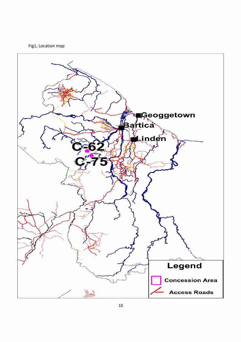
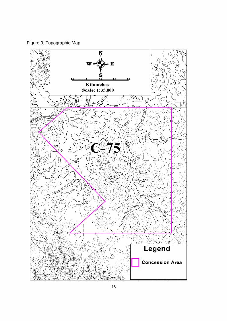
The Prospecting Licence (C-75) located in the Potaro Mining District No. 2 as shown on
Terra Surveys Topographic Map 43NW, as shown in fig 9 and enclosing an area of
approximately 11980 acres of the Itawa River. The potential of the area for gold
diamond and is good.
The Kuribrong area where this concession is located have been subject to an
abundance of activity from small scale artisan prospecting up to large scale multi-phase
exploration programs initiated by Guyana Geology and Mines Commision.The entire
concession encompasses Itwaw River.
Several areas within the concession have been mined for gold and diamonds in the past
by pork Knockers, starting 1898. The geology of the area consists of Lower Proterozoic
Mazaruni Supergroup (greenstone belts) consisting of meta-sediments and meta-
volcanic rocks, intruded by Younger Granites. Unconformably overlying these rocks is
the Roraima Formation, a generally flat lying series of conglomerates, sandstones,
shales and with minor interbedded volcanics. All of these rocks (greenstones, granites,
and post-orogenic sedimentary series), are intruded by doleritic and gabbroic dikes and
sills (the Younger Basic Intrusive Suite).

4
Location and Access
The Prospecting license C-75 is located in the Potaro Mining District, approximately 180 km
SW of Georgetown, and comprises the catchments of the Itawa River,as shown in fig 1
Access to the Concession is either from Georgetown to Bartica via speed boat on the
Essequibo River, or by road from Georgetown to Linden (81 km) to the Sherima Ferry
crossing (55 km). From Bartica, the Issano Road leads to the Sherima Ferry Crossing (41
km) and then to Mile 72 (92 km). There is also a small dirt road that by-passes the crossing
and connects the Issano Road below the crossing. Continuing on the Issano Road from
Mile 72 to Apanachi (46 km), leads to an old trail that was rehabilitated for truck and 4-wheel
drive access to Powis Landing (19km).From Powis Landing on Kuribrong River,the
concession can be access by boat,see fig 1. Almost all basic supplies, such as fuel and food
can be obtained in Bartica.
Previous Work
The whole of the Potaro Mining district, going back to the early parts of last century, have
been subject to an abundance of activity from small scale artisan prospecting up to large
scale multi-phase exploration programs initiated by GGMC in the 1990s
The area has a long history of localized, small-scale gold production, as far back as in
the 1930s and 1940s. The surrounding region of the Itawa River-Kuribrong River is
acknowledged for its gold and diamond production, whether it is from river dredging,
land dredging or land excavation. Historically and currently there has been an
abundance of small to medium scale gold and diamond operations. Gibbs (1971)
reported that gold mining activity was intense during the period 1898-1940.

5
Previous Work by the Geological Survey
Work began in the area with river traverses in 1875 (Gibbs, 1975). Throughout the late
1920’s and 1930’s numerous investigations were made by Connolly, Bracewell, Grantham
and Williams (Connolly and Bracewell 1928; Bracewell, 1944). These studies focused on
surficial deposits and prospecting for alluvial deposits of gold and diamonds, but their maps
also showed significant bedrock classification, and were the first to record the stratification
that has remained in use today. Reports detailed geographic relationship of bedrock
lithology to topography, surficial deposits and alluvial mineralisation. On a more regional
scale, Bateson, J.H., and Allderidge, M.G (1961) reported on the geology of the area
bounded by the Mazaruni, Kaburi, Waiamu, Hubana, and Kuribrong Rivers. They described
the major rock types and concluded with a stratigraphy unchanged from that discerned by
previous workers in the 1920’s. However, they provided further interpretation on the source
of gold mineralisation in the area and suggested that quartz veining accompanying intrusion
of granites (and diorites?) concentrated gold in bedrock.
Geophysics
The area is covered by a summary aeromagnetic data survey in digital form from the British
Geological Survey, and paper 1:200,000 scale aeromagnetic contour maps are available.
The simplest level of interpretation was used – studying visual patterns, correlating belts of
highs and lows and superimposing existing geological, topographic and aeromagnetic
maps, as well as previous interpretation maps by earlier workers.
6
The aeromagnetic data shows distinct areas with magnetic highs, or abrupt magnetic
gradients. Meta-basic rocks are often magnetic in hand-specimen, but also form distinct
topographic highs, see fig 8. Known areas of meta-basic rocks match well with the disturbed
/ magnetic high areas, though this may be partly due to ground effects.
The Younger basic rocks surprisingly do not form distinct magnetic anomalies, though basic
rocks are normally magnetic, and known basic dykes form distinct topographic features.
Even reversed magnetised bodies are expected to reveal high gradients at the edges.
Known areas of Younger Granites correlate with magnetically quiet like Itawa River the
concession area.
Mineral occurrences
Gold
Just outside the south –western portion of the concession contain known alluvial
mineralisation, gold anomaly and diamond occurrences, as shown in fig 3. Data is derived
from a combination of the USGS MRDS (Mineral Resources Database System), GGMC
maps and reports and fieldwork. The location of known mineral occurrences is shown in
Figure 3. Digital data is divided into 2 files. The Guyana Mineralisation File is based on the
original USGS MRDS, with improved co-ordinates and updated information, and new
mineral occurrences about which more than minimal information is known. The alluvial
Minerals file is used for additional alluvial mineral occurrences derived from spots marked on
historical GGMC maps, or abandoned dredge sites seen in the field for which additional
information is not available. In the Kuribrong- Itawa area 14 gold mineral occurrences from
the Guyana Mineralisation file occur. A few of these are currently being mined on a small
scale by “land dredges”.
Several areas in creeks headwaters may be related to primary mineralisation or gold derived
from white sand basal gravels of which Itawa is one such river. Geology consists of high
laterite capped hills of basic volcanics and meta-volcanics. Rocks are reported to contain
small quartz stringers and threads; larger veins were not seenn.

7
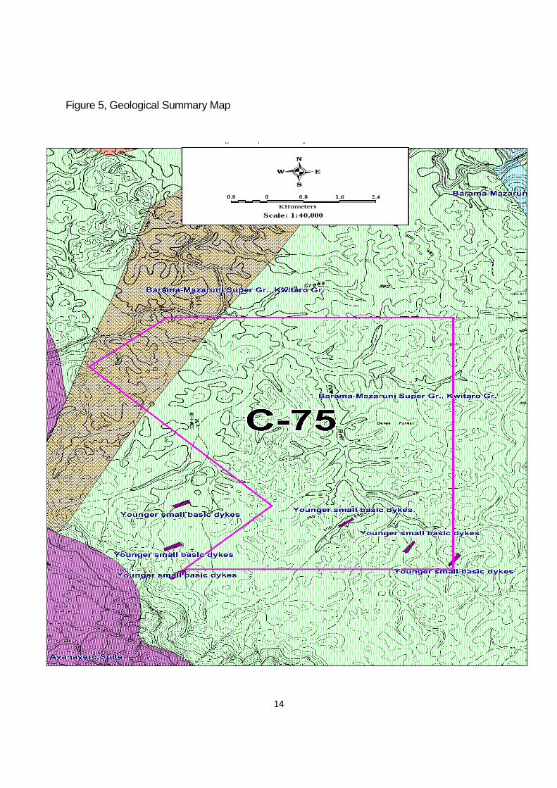
C-62 Area Geology
The geology of the area consists of Lower Proterozoic Mazaruni Supergroup, intruded by
Younger Granites.Generally. the geology of this area is very similar to that seen in other
parts of the greenstone belts of Guyana, with the oldest rocks consisting of the Lower
Proterozoic Mazaruni Supergroup, intruded by Younger Granites. In the western part of the
area, these rocks are uncomformably overlain by Roraima Formation, a generally flat lying,
post-orogenic series of conglomerates, sandstones, shales and volcanics. All these units
are intruded by Younger Basic Rocks,as shown in fig 4-7.
Laterite
Cappings of dolerite ridges and basic rock ridges are often laterite. Laterite occurs as
the open textured, massive, and honeycomb variety as well as the fine-grained,
compact and banded variety. Laterites can also concentrate gold.
Meta-volcanics.
Meta-volcanic rocks in the area have a varied composition, though most samples examined
petrologically were acid meta-volcanics. Bracewell (1944) reported that the rocks exist in a
belt that strikes NW across the Kuribrong area extending from the Hubana River mouth to
Embiparu Falls (about 5 km downstream in the Kuribrong River). This same belt appears on
the Gibbs et. al., (1971) maps. Gibbs (1975) noted pillowed exposures and water-lain tuffs
that supported a submarine origin for the volcanic rocks, as well as siliceous volcanics and
associated agglomerates that were probably once centres of volcanic eruption.
Meta-sediments
Bracewell (1944) described white sericite schists and green chlorite schists in the area
and suggested that these rocks were probably metamorphosed argillaceous
sedimentary beds. Gibbs (1975) described the series as grey graded greywackes and
shales, with ferruginous cherts

8
Younger Basic Intrusives
These rocks consist of small dolerite dikes of fine to medium grain size. However, the
outcrops appear to belong to two major strike directions: north-south and east-west,
and these rocks are younger than the Mazaruni Volcanics and also have been noted to
cut intrusive granites.
White Sand Formation
The geology of the area is covered by a series of unconsolidated sands, gravels and
silts. This material consists of white, fairly sorted sands and sandstones with local
intercalations of gravel and silts.
Area structures
Existing structures mapped from earlier workers (mainly Gibbs, et. al., 1971 and 1972) were
modified using stereoscopic examination of air photos, aeromagnetic and JERS data and
field data to identify the structures shown in fig 4 and 5. Where all different data types
coincide, the probability that the structure is significant is higher. A similar process was used
to define major lithological boundaries.
Faults mapped by earlier workers in this area were derived from air photo interpretation and
field mapping. Air photo interpretation suggests that many linear features can be traced
between photographs over long distances. At least some of these must be faults with
significant movement, and others are first and second order fracture systems related to
primary movement.

9
Rock Sample Geochemistry
The rock sample data helps to interpret geochemical patterns in stream sediment data
that are related to source rock geology. Generally elements of commercial value such
as gold were low in rock samples assayed; this is partly as mineralised rocks are likely
to be weathered, and not easily sampled. Samples of laterite in the concession showed
moderately low values of 21 ppb Au,as shown in fig 7.
Comments & Conclusions
In this concession area there is a possibility of a significant mineralised zone which appears
to be related to the contact of meta-volcanics and basic rocks. Based on the body of data in
this concession, further exploration activity is needed in order to develop the property into a
large scale mine. Mapping suggested that at least some of the gold was derived from
superficial white sand cover.
Further sampling of the main mineralized zones is required to better understand the
mineralization. Detailed soil sampling and geological mapping in the PL would help define
the style and source of the mineralization. Also it will help to accurately define the grade and
type of mineralization, however from the sampling and study undertaken recently it can be
suggested that gold mineralization is hosted in quartz veins and quartz rich lodes, while the
source of the diamond is unkown.
10
Fig1, Location map

11
Figure 2, Gold Geochemistry Summary map

12
Figure 3, Mineral Occurrence Summary Map.

13
Figure 4, Geological Summary map
14
Figure 5, Geological Summary Map

15
Figure 6, Geological Summary Map

16
Figure 7, Geological Summary Map

17
Figure 8, Aeromagnetic map
18
Figure 9, Topographic Map

19
REFERENCES :
Cole, E.C., Heesterman, L.J.L. & Kemp, A.W. 2003. Kuribrong Project. A summary of geochemistry, geology and structure.Guyana Geology and Mines Commission, Geoservices Division Technical Report GS1/2003.
Gibbs, A.K. 1973. Notes to Accompany the Economic Geology map of the Potaro-Mazaruni District, Guyana.
Bateson, J.H., and Allderige, M.G., 1958, Geology of the area bounded by the Mazaruni, Kaburi, Kuribrong and Waiamu Rivers, GGMC unpublished report, maps P5/F2/8 and P5/F2/10, 17p.
Alexander, JGW, 1973, Prelim evaluation of auriferous quartz veins at Honey Camp
Guyana Geology and Mines Commission unpublished report, 16p.
Barron, C.N., 1964, Potaro-Kuribrong Expedition, in Appendix 1, Annual report of the
geological survey department of British Guiana, p. 32-33.
Carter, J.W., and Hewins, R.H.,1963, Preliminary report on the geology of the Eldorado Mine: GGMC unpublished report, 20p.