Embed Size (px)
Citation preview

Presented By:HITESH KUMAWAT
E.I.C 4th year

Emergency service for subscriber safety. Location sensitive billing. Cellular Fraud detection. Intelligent transport system services. Efficient and effective network performanceand management.


Whole service area is divided into several coverage areas known as a “cell”. Each area has a separate base station(BS).
Every BS is provided with a frequency of range 450 to 900 Mhz.
The MTSO controls the BSS so that the subscriber can continue his call without interruption.
Tracking the location within the boundary of a cell in a telecommunication network is known as “location based services”.

A geolocation service provider provides location information and location aware sevices to subscribers. The service provider will contact the location control center about the coordinates of the mobile system (MS). The location control center will gather information required to compute the MS’s location.
GEOLOCATION SYSTEM ARCHITECTURE [K0S00]

1.HANDSET BASED MOBILE POSITIONING AND TRACKING 1.1 GLOBAL POSITIONING SYSTEM (GPS)
2. DIRECTION BASED GEOLOCATION2.1 ANGLE OF ARRIVAL METHOD
3. DISTANCE BASED POSITIONING3.1 TIME OF ARRIVAL(TOA)3.2 TIME DIFFERENCE OF ARRIVAL(TDOA)
4. LOCATION TRACKING CURVE METHOD

To locate the mobile telephone by itself, the mobile telephone is provided with a GPS receiver to calculate its location.
There should be an unobstructed line of sight to four or more GPS satellites.
GPS satellites broadcast signals from space, which each GPS receiver uses to calculate its three-dimensional location (latitude, longitude, and altitude) plus the current time
GPS receivers are used in mobile phones, vehicles, marine navigation devices and military applications.

The navigational signals transmitted by GPS satellites encode a variety of information including satellite positions, the state of the internal clocks, and the health of the network. Message is send at a rate of 50 bits per second.
The first part of the message encodes the week number and the time within the week, as well as the data about the health of the satellite. The second part of the message, the ephemeris, provides the precise orbit for the satellite. The last part of the message, the almanac, contains coarse orbit and status information for all satellites in the network as well as data related to error correction.
These signals are transmitted on two separate carrier frequencies 1.57542 GHz (L1 signal) and 1.2276 GHz (L2 signal),that are common to all satellites in the network.
The satellite network uses a CDMA spread-spectrum technique where the low-bitrate message data is encoded with a high-rate pseudorandom(PRN) sequence that is different for each satellite.

Since all of the satellite signals are modulated onto the same L1 carrier frequency, there is a need to separate the signals after demodulation. Demodulating and Decoding of GPS Satellite Signals takes place using the Gold codes.
This is done by assigning each satellite a unique binary sequence known as a Gold code. The signals are decoded, after demodulation, using addition of the Gold codes corresponding to the satellites monitored by the receiver.

Using messages received from a minimum of four visible satellites, a GPS receiver is able to determine the times sent and then the satellite positions.
The x, y, and z components of position, and the time sent, are designated as where the subscript i is the satellite number and has the value 1, 2, 3, or 4.
The GPS receiver can compute the transit time of the message as (tr-ti) .The distance traveled or pseudorange, can be computed as (tr-ti)*c .
A satellite's position and pseudorange define a sphere, centered on the satellite with radius equal to the pseudorange.
The position of the receiver is somewhere on the surface of this sphere.
Thus with four satellites, the indicated position of the GPS receiver is at or near the intersection of the surfaces of four spheres.


This method calculates the angle of arrival of signal receiving at the BS.
When a mobile user switches the system ON it receives the signal from different base stations, may be 3 or 4 or more. The angle of arrival method requires two or more base station for the determination.
It measures the direction of signal falling on the base station and measures the angle of incidence with respect to a normal and determines the position of the system.
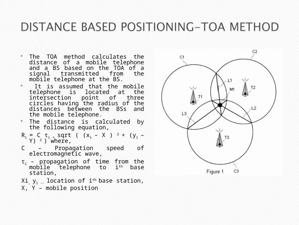
The TOA method calculates the distance of a mobile telephone and a BS based on the TOA of a signal transmitted from the mobile telephone at the BS.
It is assumed that the mobile telephone is located at the intersection point of three circles having the radius of the distances between the BSs and the mobile telephone.
The distance is calculated by the following equation,
Ri = C τi = sqrt ( (xi – X ) 2 + (yi – Y) 2 ) where,
C – Propagation speed of electromagnetic wave,
τi – propagation of time from the mobile telephone to ith base station,
Xi, yi -- location of ith base station, X, Y – mobile position


The location data processor draws two circles C1 and C2 with their respective centers set at BSs T1 and T2 based on the TOAs of a signal transmitted from the corresponding mobile telephone M1 or M2 to the two BSs T1 and T2 located near the mobile telephone M1 or M2. The two circles C1 and C2 define a common chord L1.
Therefore, we use location tracking curves TR1 and TR2 connecting the same two intersection points P1 and P2 of the two circles C1 and C2, instead of the common chord L1.
The two curves TR1 and TR2 have their middle points intersecting the line ST, which connects the positions of the two BSs T1 and T2 and the parts of two circles C1 and C2 drawn to connect the two intersection points P1 and P2.
This method prevents the location error caused by the multi-path fading or the NLOS path characteristics.

When curves are selected for all selected BS pairs, the location data processor obtains the intersection points among the selected curves.
As the selected curves do not intersect at one point due to the multi-path fading or the NLOS effects, the midpoint of these intersection points is determined as the location of the mobile telephone.
The location data processor represents the intersection points in the latitude and the longitude coordinates and transmits the position coordinates to the network and the mobile telephone.
Our proposal is advantageous in that the location of a mobile telephone can be accurately tracked even in the multi-path fading and the NLOS environment, by using more accurate tracking curves connecting the intersection points among circles.
We have described about accurate positioning of mobile telephones, which can be used for several applications.
The important considerations to be undertaken while selecting a location based technology are location accuracy, implementation cost, reliability, increasing functionality.
