Embed Size (px)
Citation preview

Project Overview
Coastal Fars Gas Fields
• 3 CPTDC Land Rigs, 2 Year
•Technical Base @ Tehran
• Operational Base @ Lamerd
5 producers
30 producers + 1 workover
10 producers+ 1 workover

Project Coordination
NIOC-PEDECGas Fields Development Plan
KEPSProject Management
ServicesRBT
CONSORTIUMCPTS
CPTDCMJF/BMC
Drilling and all relatedServices
3Rigs

GAS FIELD DEVELOPMENT PLANPROJECT MANAGEMENT SERVICES
PROVIDED BY KEPS/RBT:• GEOLOGY• DRILLING• LOGISTICS• INFORMATION TECHNOLOGY
Project Overview

Geology
Surface outcrop map and reservoir structural map supplied by PEDEC (NIOC)
Cross-sections produced by KEPS/RBT Geologist’s
Stratigraphic columns produced using cross-sections and offset data.
- 13 0 0 m .
- 14 0 0 m .
-1 5 0 0 m .
-1 6 0 0 m .
- 17 0 0m .
-1 8 00 m .
- 1 90 0m . - 2 0 0 0 m .
-1 7 0 0 m .
- 1 6 0 0 m .
- 1 5 0 0 m .
- 1 0 0 0 m .
- 1 5 0 0 m .
-2 0 0 0 m .
-1 50 0 m .
- 1 5 00 m .
- 2 0 00 m .
- 1 5 0 0 m .
- 2 00 0 m .
- 2 0 0 0 m .
- 1 2 9 0m .
TB K - W 1 4 0 N
G L E = 11 2 0
2 ,285, 000
2, 290, 000
615 ,0 00
2, 295, 00 0
2, 275, 000
6 20,0 00
2, 270, 000
630 ,00 0
2,2 65,0 00
2,300 ,000 2,305, 000
2, 310, 000
2 ,315, 000
2, 320 ,00 0
2 ,3 25,0 00
2, 330, 0002,33 5,00 0
62 5,0 00
610 ,00 060 5,00 0
600 ,00 0590 ,00 0
CH AH M U BA R A K
GAV BA ND I
T B K- 1
TBK-1
DATA

ALL DEPTHS MEASURED FROM RTE
DRAWING NOT TO SCALE
GROUND LEVEL AT 1114m ABOVE SEA LEVEL
30in CASING AT 184m36in HOLE TO 187m(TOP OF ASMARI FORMATION)
9.625in CASING AT 2450m12.25in HOLE TO 2455m(DASHTAK FORMATION,ABOVE BLUE ZONE)
20in CASING AT 890m26in HOLE TO 893m(BASE OF ILAM / TOP OF LAFFAN FORMATION)13.375in CASING AT 1035m17.5in HOLE TO 1040m(TOP OF DARIYAN FORMATION)
7in LINER AT 2700m8.5in HOLE TO 2705m(TOP OF KANGANFORMATION)
5in LINER AT 3185m6in HOLE TO 3185m(NAR MEMBER)
CEMENTING OF CASING STRINGSWILL BE VIA CONVENTIONAL ANDTOP-UP METHODS
TOP OF 7in LINERAT 2330m
TOP OF 5in LINERAT 2580m
TD AT 3185m
Drilling
Problematic shale
Salt water flow zone
Loss zone
Based on the stratigraphic column andoffset data a preliminary well design
is produced.
Peer review conducted to analyse and refine the design.
Well hazard assessment conducted with the aim of identifying all
potential hazards and establishing control/mitigating measures.
Well design finalised and Drilling Programs produced.
Performance monitoring KPI’s established.
PLA
NN
ING
PLA
NN
ING

OPE
RA
TIO
NS
OPE
RA
TIO
NS
Drilling
CO
MPL
ETED
WEL
LC
OM
PLET
ED W
ELL
SUB SURFACE SAFETY VALVE
7in TUBING
4.5in TUBINGCROSSOVER
7in PACKER
SLIDING SLEEVE
LANDING NIPPLE
RE-ENTRY GUIDE
GAS
TUBINGHANGER• Wells will be drilled in accordance with the
Drilling Programs. Modifications to well designs and procedures can only be made with the approval of the Drilling Manager.
• Drilling performance will be closely monitored at the rigsite and in Tehran.
• Regular discussions between the rig and Tehran will aim at optimising operations and maintaining a high safety standard.
• Data will be transmitted from the rigsite to Tehran on electronic format. Other packages will be used to monitor performance and assist in planning future wells.
• Upon completion of the drilling phase the well will be tested and completed as per the Completion Program.

CLO
SE-O
UT
CLO
SE-O
UT
Review meeting conducted to capture “learnings” from the well for application
to subsequent wells.
Planned KPI’s compared to actual KPI’s for assessment
of performance.
Well Completion Report produced detailing all aspects
of operations to assist in planning future wells
Drilling
WEL
L ST
YLES
WEL
L ST
YLES
VERTICAL DIRECTIONAL

Logistics
The Procurement Departments main tasks are as follows:
1. Check the quality and specification of material and equipment on behalf of PEDEC.2. Check the status and condition of access roads and operational sites.3. Co-ordinate the movement of personnel between the various sites.4. Inspect the disposal of waste material as per the HSE guidelines of the project.

Logistics
+/-1200km
LAMERD
LOCATION MAP

Logistics
Office
Bedrooms
Shelter for heavy trucks
Cement Barite&Bento Mud materials
Bits
Testing
Store Store Store Store Store Store
Tools Repair shop
Area for rig equipment
Dining room
Cement silo area
Racks for different sizes DP,DC,Casing & TBG
Power generator
X-Trees
LAMERD BASE

•Support the communication systems for the drilling operation•Manage technical databases and reporting systems for client and management•Build flexible systems and networks that can quickly grow or be re-configurated•Ensure complete system and data security at all times
Technical Computing Environment
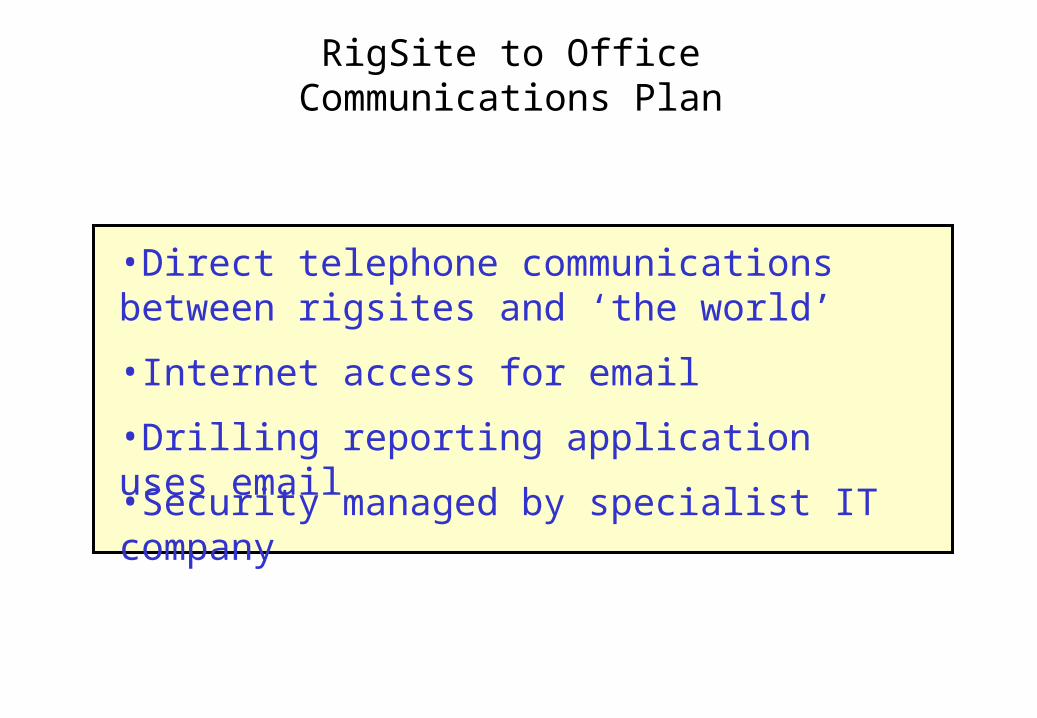
RigSite to OfficeCommunications Plan
•Direct telephone communications between rigsites and ‘the world’
•Internet access for email
•Security managed by specialist IT company
•Drilling reporting application uses email

Wide Area Network (Tehran)
•Master database and web server is housed at ISP’s office
•Database is replicated in PEDEC and KEPS offices•Archived Data stored at PEDEC office
•Latest reports available to client and partners on the web
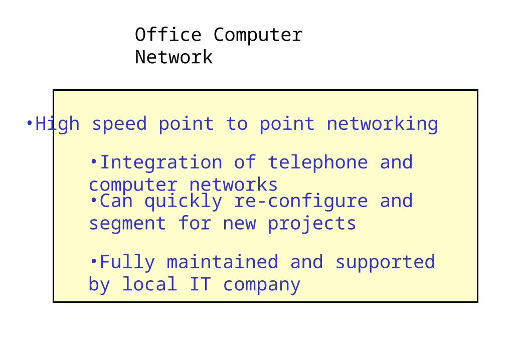
Office Computer Network
•High speed point to point networking
•Integration of telephone and computer networks
•Can quickly re-configure and segment for new projects
•Fully maintained and supported by local IT company

Web-Based Reporting System
•Provides client and partners with immediate access to latest project results
•Password-controlled access for security
•Locally sourced skills and resources