Embed Size (px)
Citation preview
Introduction UTool Conclusions
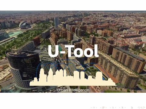
U-Tool: A Urban-Toolkit for enhancing city mapsthrough citizens’ activity
E. del Val J. Palanca M. RebolloUniversitat Politècnica de València
PAAMS 2016
@mrebollo UPVU-Tool: A Urban-Toolkit for enhancing city maps through citizens’ activity
Introduction UTool Conclusions
Introduction
Study of dynamic in citiesAvailability of real-time information for decision-making processesregarding with the uses of the city
citizens as soft-sensorsgeolocated resourcesactivity in social networks publicly available
@mrebollo UPVU-Tool: A Urban-Toolkit for enhancing city maps through citizens’ activity
Introduction UTool Conclusions
Limitations of current apps
Twitter analytics: private information for the usersSocialBro et al.: apps to measure the impact of hashtags oruser influenceGeofeedia / WeLink: geolocated activity in an area, butoff-lineFlocker: real-time analysis, without geolocation
@mrebollo UPVU-Tool: A Urban-Toolkit for enhancing city maps through citizens’ activity
Introduction UTool Conclusions
Our purpose
extraction of geolocated activity in Twitteranalysis as an spatial networkreal-timeintuitive, without experience in complex network analysisvalid at professional level (urban planing) and personal(citizens, tourists)
@mrebollo UPVU-Tool: A Urban-Toolkit for enhancing city maps through citizens’ activity
Introduction UTool Conclusions
What can it do?
event detectionmobility pattersvisitor attendancepredict activityfind best position for urban facilitiesmeasure accesibility
@mrebollo UPVU-Tool: A Urban-Toolkit for enhancing city maps through citizens’ activity
Introduction UTool Conclusions
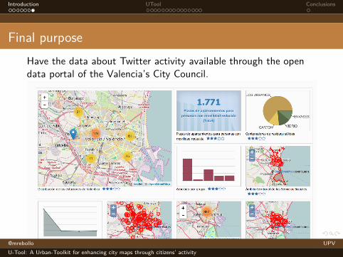
Final purposeHave the data about Twitter activity available through the opendata portal of the Valencia’s City Council.
@mrebollo UPVU-Tool: A Urban-Toolkit for enhancing city maps through citizens’ activity
Introduction UTool Conclusions
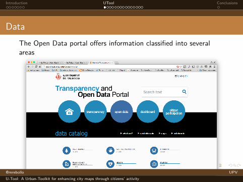
DataThe Open Data portal offers information classified into severalareas
@mrebollo UPVU-Tool: A Urban-Toolkit for enhancing city maps through citizens’ activity
Introduction UTool Conclusions
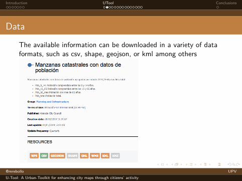
Data
The available information can be downloaded in a variety of dataformats, such as csv, shape, geojson, or kml among others
@mrebollo UPVU-Tool: A Urban-Toolkit for enhancing city maps through citizens’ activity
Introduction UTool Conclusions
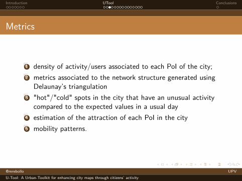
Metrics
1 density of activity/users associated to each PoI of the city;2 metrics associated to the network structure generated using
Delaunay’s triangulation3 "hot"/"cold" spots in the city that have an unusual activity
compared to the expected values in a usual day4 estimation of the attraction of each PoI in the city5 mobility patterns.
@mrebollo UPVU-Tool: A Urban-Toolkit for enhancing city maps through citizens’ activity
Introduction UTool Conclusions
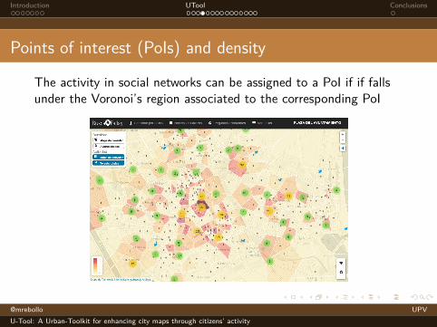
Points of interest (PoIs) and density
The activity in social networks can be assigned to a PoI if if fallsunder the Voronoi’s region associated to the corresponding PoI
@mrebollo UPVU-Tool: A Urban-Toolkit for enhancing city maps through citizens’ activity
Introduction UTool Conclusions
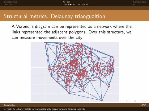
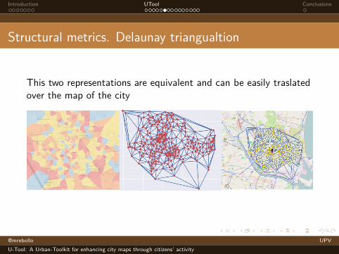
Structural metrics. Delaunay triangualtionA Voronoi’s diagram can be represented as a network where thelinks represented the adjacent polygons. Over this structure, wecan measure movements over the city
@mrebollo UPVU-Tool: A Urban-Toolkit for enhancing city maps through citizens’ activity
Introduction UTool Conclusions
Structural metrics. Delaunay triangualtion
This two representations are equivalent and can be easily traslatedover the map of the city
@mrebollo UPVU-Tool: A Urban-Toolkit for enhancing city maps through citizens’ activity
Introduction UTool Conclusions
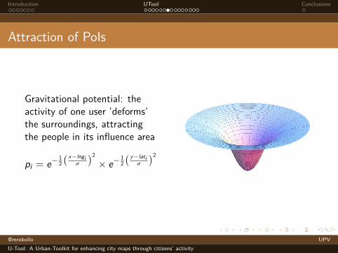
Attraction of PoIs
Gravitational potential: theactivity of one user ’deforms’the surroundings, attractingthe people in its influence area
pi = e− 12
( x−lngiσ
)2
× e− 12
( y−latiσ
)2
@mrebollo UPVU-Tool: A Urban-Toolkit for enhancing city maps through citizens’ activity
Introduction UTool Conclusions
Attraction of PoIs
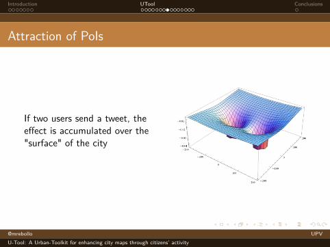
If two users send a tweet, theeffect is accumulated over the"surface" of the city
@mrebollo UPVU-Tool: A Urban-Toolkit for enhancing city maps through citizens’ activity
Introduction UTool Conclusions
Attraction of PoIs
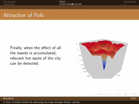
Finally, when the effect of allthe tweets is accumulated,relevant hot spots of the citycan be detected.
@mrebollo UPVU-Tool: A Urban-Toolkit for enhancing city maps through citizens’ activity
Introduction UTool Conclusions
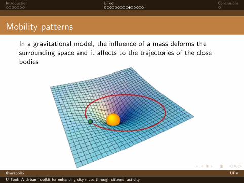
Mobility patternsIn a gravitational model, the influence of a mass deforms thesurrounding space and it affects to the trajectories of the closebodies
@mrebollo UPVU-Tool: A Urban-Toolkit for enhancing city maps through citizens’ activity
Introduction UTool Conclusions
Mobility patterns
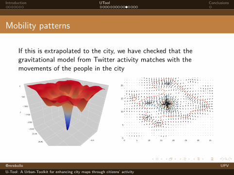
If this is extrapolated to the city, we have checked that thegravitational model from Twitter activity matches with themovements of the people in the city
@mrebollo UPVU-Tool: A Urban-Toolkit for enhancing city maps through citizens’ activity
Introduction UTool Conclusions
U-Tool
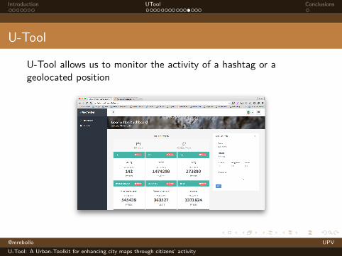
U-Tool allows us to monitor the activity of a hashtag or ageolocated position
@mrebollo UPVU-Tool: A Urban-Toolkit for enhancing city maps through citizens’ activity
Introduction UTool Conclusions
U-Tool
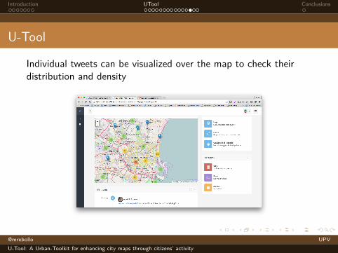
Individual tweets can be visualized over the map to check theirdistribution and density
@mrebollo UPVU-Tool: A Urban-Toolkit for enhancing city maps through citizens’ activity
Introduction UTool Conclusions
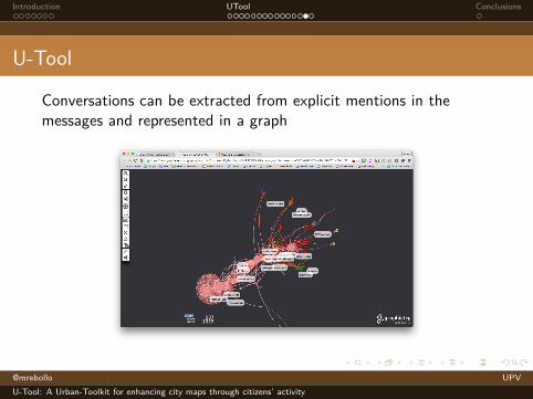
U-Tool
Conversations can be extracted from explicit mentions in themessages and represented in a graph
@mrebollo UPVU-Tool: A Urban-Toolkit for enhancing city maps through citizens’ activity
Introduction UTool Conclusions
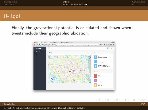
U-Tool
Finally, the gravitational potential is calculated and shown whentweets include their geographic ubication.
@mrebollo UPVU-Tool: A Urban-Toolkit for enhancing city maps through citizens’ activity
Introduction UTool Conclusions
Conclusions
Conclusionsanalytical tool for the activity of citiescombines geo-located activity from SS NN and open datarepositoriesspacial model and complex network analysis in real-timedecision making assistance
Next stepsgravity map will be available in the opendata portal of theValencia’s City Hallopen the U-Tool dashboard to the public
@mrebollo UPVU-Tool: A Urban-Toolkit for enhancing city maps through citizens’ activity