Embed Size (px)
Citation preview
Opportunities in Remote Sensing
D2AE–TIMarch 2011
2D2AE-TI
Table of Contents
Executive Summary
Scope and Methodology Scope of Research Research Methodology
Research Overview Research Snapshot Key Findings
Technology Snapshot and Trends
Technology Capability Technology Snapshot SWOT Analysis Applications
Technology Maturity Technology Readiness Levels
3D2AE-TI
Table of Contents (Contd..)
Key Stakeholder Analysis and Technology Benchmarking
Stakeholder Analysis Drivers and Challenges Stakeholder Management Process Analytical Hierarchy Process Technology Roadmap Technology Management Strategies
Key Patents
Contact Details
Decision Support Tables
About Frost & Sullivan
4D2AE-TI
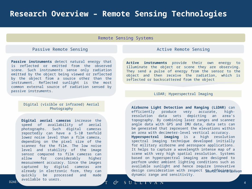
Research Overview – Remote Sensing Technologies
Remote Sensing Systems
Passive Remote Sensing
Passive instruments detect natural energy that is reflected or emitted from the observed scene. Such instruments sense only radiation emitted by the object being viewed or reflected by the object from a source other than the instrument. Reflected sunlight is the most common external source of radiation sensed by passive instruments.
Active Remote Sensing
Active instruments provide their own energy to illuminate the object or scene they are observing. They send a pulse of energy from the sensor to the object and then receive the radiation, which is reflected or backscattered from the object
Digital (visible or infrared) Aerial Photography
LiDAR; Hyperspectral Imaging
Digital aerial cameras increase the speed of availability of aerial photographs. Such digital cameras reportedly can have a 5-10 tenfold lower noise level than a film camera, depending on the pixel size of the scanner for the film. The low noise level and stability of the image sensor compared to film cameras can allow for considerably higher measurement accuracy. Since the images captured by digital cameras are already in electronic form, they can quickly be processed and made available to users.
Airborne Light Detection and Ranging (LiDAR) can efficiently produce very accurate, high-resolution data sets depicting an area's topography. By combining laser ranges and scanner angle data with GPS and IMU data, data sets can be generated that represent the elevations within an area with decimeter-level vertical accuracy. Hyperspectral imaging is a high resolution spectral imaging technique developed initially for military airborne and aerospace applications. It helps to capture a wavelength intense map of a scene with very high spatial resolution. Systems based on hyperspectral imaging are designed to perform under ambient lighting conditions such as available sunlight and hence require innovative design consideration with respect to efficiency, dynamic range and sensitivity.
Source: Frost & Sullivan
5D2AE-TI
Research Overview -- Key FindingsD
rivers
Dri
vers
Restr
ain
tsR
estr
ain
ts
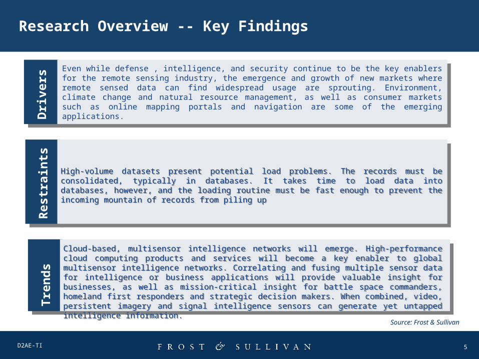
Even while defense , intelligence, and security continue to be the key enablers for the remote sensing industry, the emergence and growth of new markets where remote sensed data can find widespread usage are sprouting. Environment, climate change and natural resource management, as well as consumer markets such as online mapping portals and navigation are some of the emerging applications.
Even while defense , intelligence, and security continue to be the key enablers for the remote sensing industry, the emergence and growth of new markets where remote sensed data can find widespread usage are sprouting. Environment, climate change and natural resource management, as well as consumer markets such as online mapping portals and navigation are some of the emerging applications.
High-volume datasets present potential load problems. The records must be consolidated, typically in databases. It takes time to load data into databases, however, and the loading routine must be fast enough to prevent the incoming mountain of records from piling up
High-volume datasets present potential load problems. The records must be consolidated, typically in databases. It takes time to load data into databases, however, and the loading routine must be fast enough to prevent the incoming mountain of records from piling up
Tre
nd
sTre
nd
s
Cloud-based, multisensor intelligence networks will emerge. High-performance cloud computing products and services will become a key enabler to global multisensor intelligence networks. Correlating and fusing multiple sensor data for intelligence or business applications will provide valuable insight for businesses, as well as mission-critical insight for battle space commanders, homeland first responders and strategic decision makers. When combined, video, persistent imagery and signal intelligence sensors can generate yet untapped intelligence information.
Cloud-based, multisensor intelligence networks will emerge. High-performance cloud computing products and services will become a key enabler to global multisensor intelligence networks. Correlating and fusing multiple sensor data for intelligence or business applications will provide valuable insight for businesses, as well as mission-critical insight for battle space commanders, homeland first responders and strategic decision makers. When combined, video, persistent imagery and signal intelligence sensors can generate yet untapped intelligence information.
Source: Frost & Sullivan
6D2AE-TI
Key Applications of Remotely Sensed Data
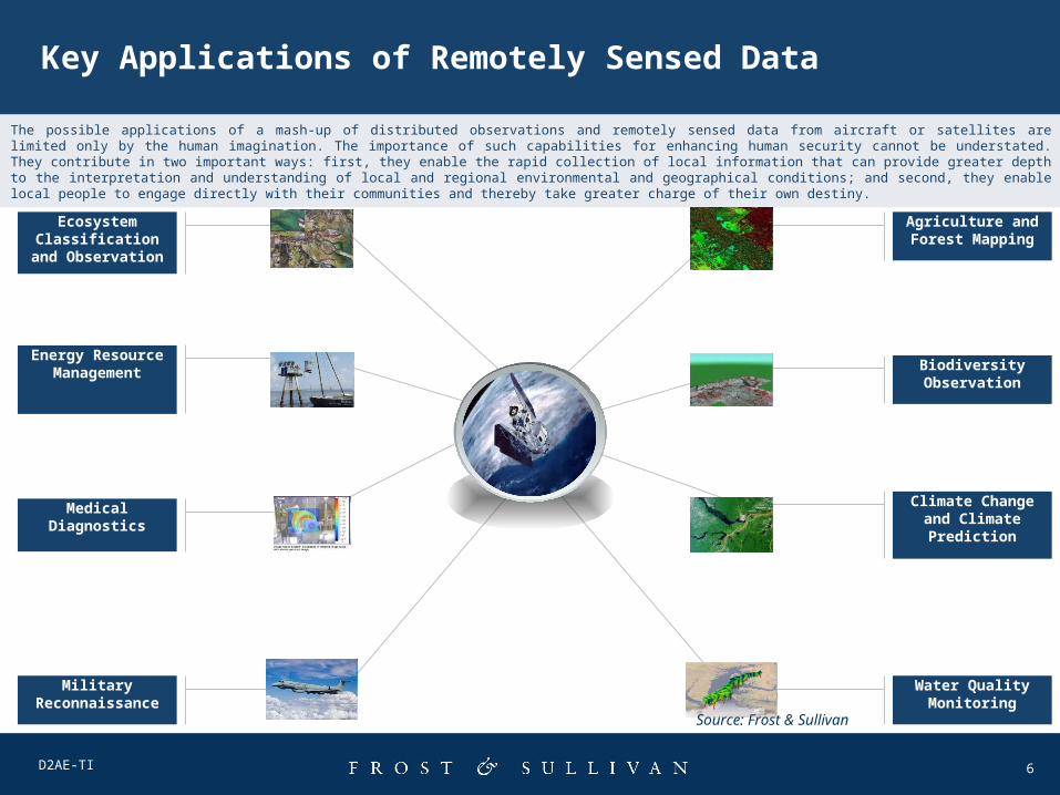
Agriculture and Forest Mapping
Biodiversity Observation
Climate Change and Climate Prediction
Water Quality Monitoring
Ecosystem Classification
and Observation
Energy Resource
Management
Medical Diagnostics
Military Reconnaissance
The possible applications of a mash-up of distributed observations and remotely sensed data from aircraft or satellites are limited only by the human imagination. The importance of such capabilities for enhancing human security cannot be understated. They contribute in two important ways: first, they enable the rapid collection of local information that can provide greater depth to the interpretation and understanding of local and regional environmental and geographical conditions; and second, they enable local people to engage directly with their communities and thereby take greater charge of their own destiny.
Source: Frost & Sullivan
7D2AE-TI
Technology Maturity
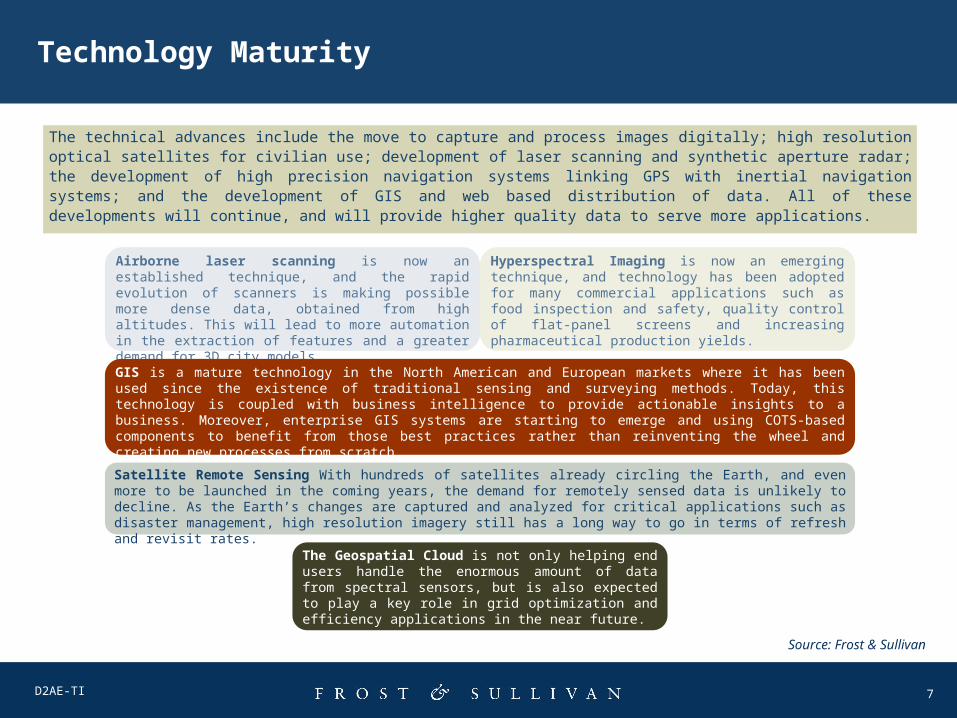
The technical advances include the move to capture and process images digitally; high resolution optical satellites for civilian use; development of laser scanning and synthetic aperture radar; the development of high precision navigation systems linking GPS with inertial navigation systems; and the development of GIS and web based distribution of data. All of these developments will continue, and will provide higher quality data to serve more applications.
Airborne laser scanning is now an established technique, and the rapid evolution of scanners is making possible more dense data, obtained from high altitudes. This will lead to more automation in the extraction of features and a greater demand for 3D city models
Hyperspectral Imaging is now an emerging technique, and technology has been adopted for many commercial applications such as food inspection and safety, quality control of flat-panel screens and increasing pharmaceutical production yields.
Satellite Remote Sensing With hundreds of satellites already circling the Earth, and even more to be launched in the coming years, the demand for remotely sensed data is unlikely to decline. As the Earth’s changes are captured and analyzed for critical applications such as disaster management, high resolution imagery still has a long way to go in terms of refresh and revisit rates.
GIS is a mature technology in the North American and European markets where it has been used since the existence of traditional sensing and surveying methods. Today, this technology is coupled with business intelligence to provide actionable insights to a business. Moreover, enterprise GIS systems are starting to emerge and using COTS-based components to benefit from those best practices rather than reinventing the wheel and creating new processes from scratch.
The Geospatial Cloud is not only helping end users handle the enormous amount of data from spectral sensors, but is also expected to play a key role in grid optimization and efficiency applications in the near future.
Source: Frost & Sullivan
8D2AE-TI
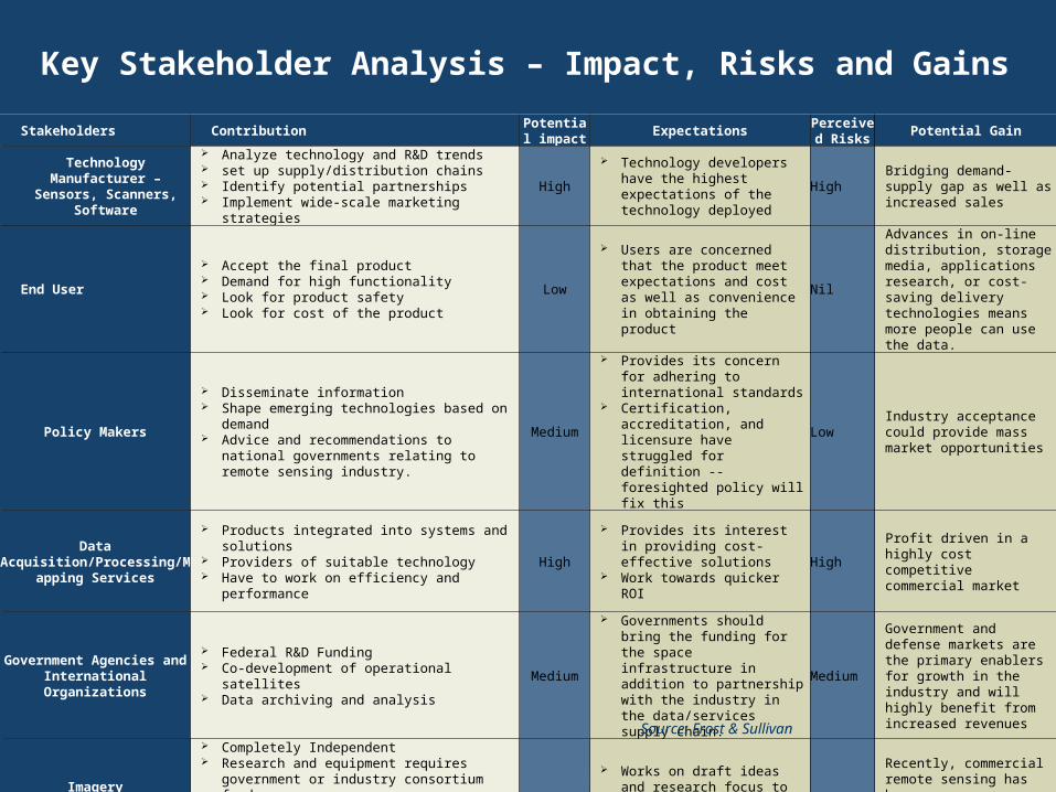
Stakeholders ContributionPotential impact
ExpectationsPerceived Risks
Potential Gain
Technology Manufacturer –
Sensors, Scanners, Software
Analyze technology and R&D trends set up supply/distribution chains Identify potential partnerships Implement wide-scale marketing strategies
High
Technology developers have the highest expectations of the technology deployed
HighBridging demand-supply gap as well as increased sales
End User
Accept the final product Demand for high functionality Look for product safety Look for cost of the product
Low
Users are concerned that the product meet expectations and cost as well as convenience in obtaining the product
Nil
Advances in on-line distribution, storage media, applications research, or cost-saving delivery technologies means more people can use the data.
Policy Makers
Disseminate information Shape emerging technologies based on
demand Advice and recommendations to national
governments relating to remote sensing industry.
Medium
Provides its concern for adhering to international standards
Certification, accreditation, and licensure have struggled for definition -- foresighted policy will fix this
LowIndustry acceptance could provide mass market opportunities
Data Acquisition/Processing/M
apping Services
Products integrated into systems and solutions
Providers of suitable technology Have to work on efficiency and performance
High
Provides its interest in providing cost-effective solutions
Work towards quicker ROI
HighProfit driven in a highly cost competitive commercial market
Government Agencies and International
Organizations
Federal R&D Funding Co-development of operational satellites Data archiving and analysis
Medium
Governments should bring the funding for the space infrastructure in addition to partnership with the industry in the data/services supply chain.
Medium
Government and defense markets are the primary enablers for growth in the industry and will highly benefit from increased revenues
Imagery Providers/Satellite
Operators
Completely Independent Research and equipment requires
government or industry consortium funds Concentrates on effectiveness of technology Fine tuning of currently adopted
technologies and innovation
Low Works on draft ideas and
research focus to analyze commercialization potential
Low
Recently, commercial remote sensing has beendriven by growth in the consumer demand for space imagery.
Key Stakeholder Analysis – Impact, Risks and Gains
Source: Frost & Sullivan
9D2AE-TI
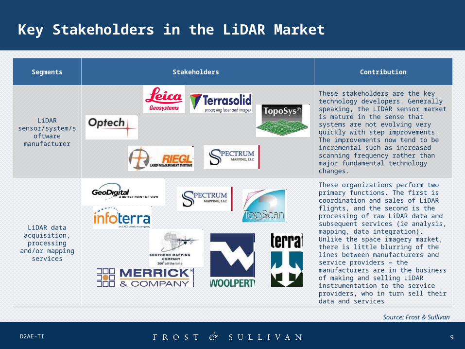
Key Stakeholders in the LiDAR Market
Segments Stakeholders Contribution
LiDAR sensor/system/sof
tware manufacturer
These stakeholders are the key technology developers. Generally speaking, the LIDAR sensor market is mature in the sense that systems are not evolving very quickly with step improvements. The improvements now tend to be incremental such as increased scanning frequency rather than major fundamental technology changes.
LiDAR data acquisition,
processing and/or mapping services
These organizations perform two primary functions. The first is coordination and sales of LiDAR flights, and the second is the processing of raw LiDAR data and subsequent services (ie analysis, mapping, data integration). Unlike the space imagery market, there is little blurring of the lines between manufacturers and service providers – the manufacturers are in the business of making and selling LiDAR instrumentation to the service providers, who in turn sell their data and services
Source: Frost & Sullivan
10D2AE-TI
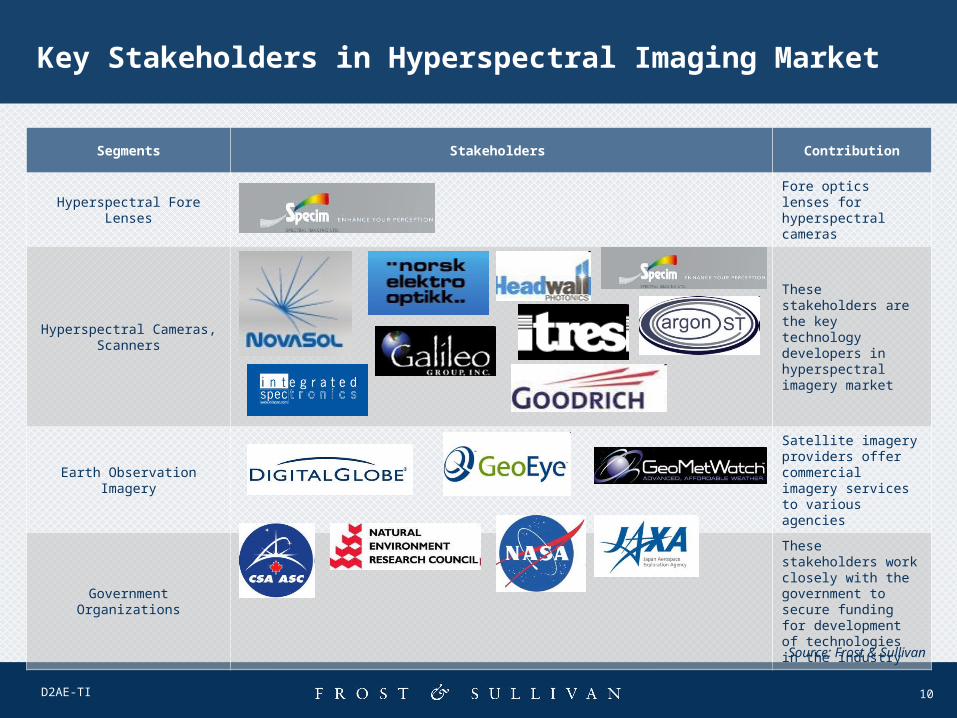
Key Stakeholders in Hyperspectral Imaging Market
Segments Stakeholders Contribution
Hyperspectral Fore LensesFore optics lenses for hyperspectral cameras
Hyperspectral Cameras, Scanners
These stakeholders are the key technology developers in hyperspectral imagery market
Earth Observation Imagery
Satellite imagery providers offer commercial imagery services to various agencies
Government Organizations
These stakeholders work closely with the government to secure funding for development of technologies in the industry
Source: Frost & Sullivan
11D2AE-TI
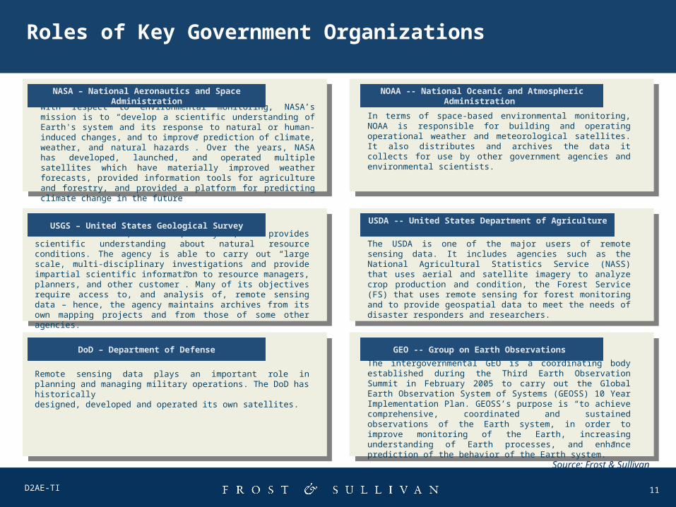
With respect to environmental monitoring, NASA’s mission is to “develop a scientific understanding of Earth's system and its response to natural or human-induced changes, and to improve prediction of climate, weather, and natural hazards”. Over the years, NASA has developed, launched, and operated multiple satellites which have materially improved weather forecasts, provided information tools for agriculture and forestry, and provided a platform for predicting climate change in the future
NASA – National Aeronautics and Space Administration
NOAA -- National Oceanic and Atmospheric Administration
In terms of space-based environmental monitoring, NOAA is responsible for building and operating operational weather and meteorological satellites. It also distributes and archives the data it collects for use by other government agencies and environmental scientists.
Roles of Key Government Organizations
The USGS collects, monitors, analyzes, and provides scientific understanding about natural resource conditions. The agency is able to carry out “large scale, multi-disciplinary investigations and provide impartial scientific information to resource managers, planners, and other customer”. Many of its objectives require access to, and analysis of, remote sensing data – hence, the agency maintains archives from its own mapping projects and from those of some other agencies.
USGS – United States Geological SurveyUSDA -- United States Department of Agriculture
The USDA is one of the major users of remote sensing data. It includes agencies such as the National Agricultural Statistics Service (NASS) that uses aerial and satellite imagery to analyze crop production and condition, the Forest Service (FS) that uses remote sensing for forest monitoring and to provide geospatial data to meet the needs of disaster responders and researchers.
Remote sensing data plays an important role in planning and managing military operations. The DoD has historicallydesigned, developed and operated its own satellites.
DoD – Department of Defense GEO -- Group on Earth Observations
The intergovernmental GEO is a coordinating body established during the Third Earth Observation Summit in February 2005 to carry out the Global Earth Observation System of Systems (GEOSS) 10 Year Implementation Plan. GEOSS’s purpose is “to achieve comprehensive, coordinated and sustained observations of the Earth system, in order to improve monitoring of the Earth, increasing understanding of Earth processes, and enhance prediction of the behavior of the Earth system.”
Source: Frost & Sullivan


![[REMOTE SENSING] 3-PM Remote Sensing](https://img.dokumen.tips/doc/110x75/61f2bbb282fa78206228d9e2/remote-sensing-3-pm-remote-sensing.jpg)


