Embed Size (px)
Citation preview

Long-Term Stewardship Site Highlights
Kansas City PlantMajor Activities - groundwater and surface water monitoring; institutional controls for soilcontaminationSite Size - 56.4 hectares (141 acres)Start-End Years - 2005/in perpetuity Estimated Average Annual Cost FY 2005-2006 - $1,334,000
Latty Avenue Propertiesunknown
St. Louis Airport Siteunknown
St. Louis Airport Site Vicinity Propertiesunknown
St. Louis Downtown Siteunknown
Weldon Spring Site Remedial Action ProjectMajor Activities - surface water and groundwater monitoring; disposal cell maintenanceand monitoring; institutional controlsSite Size - 91.4 hectares (226 acres)Start-End Years - 2003/in perpetuityEstimated Average Annual Cost FY 2003-2006 - $1,006,000
Westlake Disposal SiteSite Size - 81 hectares (200 acres)
Kansas City Plant Weldon Spring Site
Missouri
Westlake Disposal Site
St. Louis Airport SiteVicinity Properties
St. Louis Airport Site
St. Louis Downtown Site
Latty Avenue Properties


Table of Contents
1Missouri
Table of Contents
Kansas City Plant . . . . . . . . . . . . . . . . . . . . . . . . . . . . . . . . . . . . . . . . . . . . . . . . . . . . . . . . . . . . . . . . . . . . . . . . 3
Latty Avenue Properties . . . . . . . . . . . . . . . . . . . . . . . . . . . . . . . . . . . . . . . . . . . . . . . . . . . . . . . . . . . . . . . . . 11
St. Louis Airport Site . . . . . . . . . . . . . . . . . . . . . . . . . . . . . . . . . . . . . . . . . . . . . . . . . . . . . . . . . . . . . . . . . . . . 13
St. Louis Airport Site Vicinity Properties . . . . . . . . . . . . . . . . . . . . . . . . . . . . . . . . . . . . . . . . . . . . . . . . . . . . 15
St. Louis Downtown Site . . . . . . . . . . . . . . . . . . . . . . . . . . . . . . . . . . . . . . . . . . . . . . . . . . . . . . . . . . . . . . . . . 17
Weldon Spring Site . . . . . . . . . . . . . . . . . . . . . . . . . . . . . . . . . . . . . . . . . . . . . . . . . . . . . . . . . . . . . . . . . . . . . 19
Westlake Disposal Site . . . . . . . . . . . . . . . . . . . . . . . . . . . . . . . . . . . . . . . . . . . . . . . . . . . . . . . . . . . . . . . . . . 29

National Defense Authorization Act (NDAA) Long-Term Stewardship Report
2Missouri

Kansas City Plant
3Missouri
LONG-TERM STEWARDSHIP HIGHLIGHTS
Major Long-Term Stewardship Activities -groundwater and surface water monitoring;institutional controls for soil contaminationTotal Site Area - 56.4 hectares (141 acres)Estimated Volume of Residual Contaminants -unknownLong-Term Stewardship Start-End Years - 2005-inperpetuityAverage Annual Long-Term Stewardship Cost FY2005-2006 - $1,334,000Landlord - U.S. Department of Energy, Office ofDefense Programs
KANSAS CITY PLANT
1.0 SITE SUMMARY
1.1 Site Description and Mission
The Kansas City Plant is the U.S. Department ofEnergy’s (DOE) main component fabrication plant,supporting multiple missions (defense, environmental,and others). The plant is part of the Bannister FederalComplex, a 120-hectare (300-acre) site approximately19 kilometers (12 miles) south of downtown KansasCity, Missouri. DOE occupies about 56 hectares (141acres) of this complex. The complex is zoned by localgovernment for heavy industry. The surrounding areaconsists of single- and multiple-family residences,commercial establishments, industrial districts, andpublic-use lands.
The Kansas City Plant was built by the U.S. Navyduring World War II to assemble engines for Navyfighter planes. Pratt-Whitney operated the plant from early 1943 until 1945. In 1947, Westinghouse beganleasing the facility to the Fairfax Storage Company, which used part of the building as a warehouse for tires, rawrubber, sugar and lumber. Two years later in 1949, the Atomic Energy Commission (later known as the U.S.Department of Energy) asked the Bendix Corporation to take over part of the facility and begin buildingcomponents for nuclear weapons. In 1993, DOE officially designated the Kansas City Plant as the consolidatedsite for all nonnuclear components for nuclear weapons. The plant, now under operation by Honeywell FederalManufacturing & Technologies (FM&T), currently manufactures and procures electrical, electromechanical,mechanical, and plastic components.
1.2 Site Cleanup and Accomplishments
Various spills and leaks from previous productionactivities have contaminated the soil, groundwater, andsurface water at the Kansas City Plant. Because the siteproduced only nonnuclear components for nuclearweapons, no radioactive contamination is present at thesite.
The soil is contaminated with polychlorinated biphenyls(PCBs), volatile organics, and petroleum hydrocarbons.The volatile organic contamination covers much of thesite, while the polychlorinated biphenyl contaminationis most highly concentrated near the solid-wastemanagement units. The petroleum hydrocarboncontamination occurs at various locations throughoutthe site. The soil contamination represented a surfacearea of approximately 70,000 square meters (84,000square yards, or 17 acres) of subsurface soil.
SITE ACCOMPLISHMENTS
• 42 of 43 release sites have been stabilized; and theResource Conservation and Recovery Act(RCRA) Facility Investigation for the 43rd site(95th Terrace Site) is under Missouri Departmentof Natural Resources review
ANTICIPATED ACCOMPLISHMENTS BY 2006
• Complete the Corrective Measures Study todetermine which cleanup method to use for the95th Terrace Site
• Compete the Corrective Measures ImplementationDesign, which specifies construction details forcleanup of the 95th Terrace Site
• Continue groundwater treatment and monitoringactivities, including well monitoring andmaintenance, preparing regulatory reports, andground water interceptor well design

National Defense Authorization Act (NDAA) Long-Term Stewardship Report
4Missouri
Kansas City Plant
Surface remediation, including soil removal, has been ongoing under a Consent Order Agreement with the U.S.Environmental Protection Agency (EPA) since 1990 and is expected to be completed by fiscal year (FY) 2004.The Consent Order Agreement was transferred from EPA to the Missouri Department of Natural Resources asa post-closure permit in 1999.
The volume of residual soil contamination is unknown. DOE expects that institutional controls will be theselected remedy in areas where soil contamination poses a minimal risk. No additional capping of contaminatedsoil areas is planned, as the majority of contamination is located underneath the facility. Two former waste watertreatment lagoons have caps, requiring monitoring and maintenance.
Approximately 24 hectares (58 acres) of groundwater is contaminated with volatile organics and petroleumhydrocarbons. Engineered controls are used to prevent further contamination of the groundwater. DOE willcontinue to extract and treat groundwater contaminated with trichloroethylene (TCE) and its degradationproducts, 1,2-dichloroethylene (1,2 DCE), and vinyl chloride until maximum concentration limits (MCLs) areno longer exceeded. However, currently, there is no known, viable, cost-effective treatment method that willremove volatile organics to MCLs for the contamination under the buildings (in a tight silty clay soil).Technologies will continue to be evaluated for applicability to volatile organic contamination. The groundwatercontamination by petroleum hydrocarbons, which are dense non-aqueous phase liquids (DNAPLs), is beingcleaned up primarily through the use of innovative technologies.

Kansas City Plant
5Missouri
Final cleanup levels for groundwater have not yet been determined. DOE plans to continue groundwatertreatment and monitoring until it can be demonstrated in three consecutive years that MCLs are not exceeded oruntil the regulators agree to an alternative. Approximately 80 million liters (21 million gallons) of groundwaterper year are treated. With current technologies and cleanup standards, groundwater treatment could continue forhundreds of years in order to achieve maximum contaminant levels. There is currently no designated use for thecontaminated aquifer and none is predicted, as the city uses surface water sources for its drinking supply. Currentgroundwater treatment is limiting discharge of contaminants to the surrounding surface water.
Contamination also spilled into the storm drains affecting the Indian Creek and Blue River surface water andsediments. The surface water concentrations have typically been in the parts-per-billion range, when detected.Sediment concentrations on areas of the site have been around two parts per million. The State of Missouri hasrecently notified DOE that the discharge limit will be lowered to 0.5 parts per billion in the near future, possiblyresulting in future remediation work. The contamination consists of PCBs spilled into a storm drain and residualcontamination in the storm sewer. Water collected in one exterior sump onsite is treated for PCBs prior to beingdischarged to the sanitary sewer system. Several projects to reduce the concentrations were completed in the last15 years, including lining of laterals and excavations at different areas of the site. These projects include thefollowing:
Date Project
1984 Six manholes modified to decrease amount of PCBs entering storm sewer.
1985 K lateral lined with Insituform.
1987 PCB-containing heat transfer oil and PCB-contaminated piping were removed from the two heat transfersystems, one of which was responsible for the 95th Terrace spills.
1988 Four additional laterals were lined with Insituform; a corrugated metal pipe, which was coated with aPCB-containing material, was removed from part of the 002 system. Also in 1988, 1600 tons of 002Raceway PCB-contaminated materials (soil, sediments, and concrete) were removed. This material hadbecome contaminated as a result of a 1972 spill. Clean fill was used to return the area to grade, and areplacement concrete raceway from the outfall to Indian Creek was constructed.
1993 24,700 metric tons (27,210 tons) of PCB-contaminated material (up to 9,000 mg/kg) were removed foroffsite disposal. PCBs at this location were primarily the result of the 1969 spill at the old 002 Outfall. Clean fill was used to restore the area to grade.
2.0 SITE-WIDE LONG-TERM STEWARDSHIP
2.1 Long-Term Stewardship Activities
Because contamination remains in place, DOE must conduct long-term surveillance and monitoring. DOE’sOffice of Defense Programs (DP) will be responsible for institutional controls, continued groundwaterremediation, and monitoring. DOE will conduct routine sampling and maintain institutional and proceduralcontrols, including excavation restrictions, in order to protect workers from inadvertent exposure in areas whereresidual contamination is present. Corrective Action reports, completed as part of the Consent Order, are keptin a library in the Environmental Compliance Department onsite. Documents are also distributed to the DOEKansas City Area Office, EPA Region 7, and the Missouri Department of Natural Resources.
Currently, the site has institutional controls that include both procedural and proprietary controls. Proceduralcontrols include: Hazardous Waste Operations and Emergency Response (HAZWOPER) determination,

National Defense Authorization Act (NDAA) Long-Term Stewardship Report
6Missouri
Kansas City Soil Contamination
preliminary hazard analysis, construction waste assessment, design review, construction safety plan, and anexcavation permit. Proprietary controls include: land use restrictions and conditions, a land use restrictionnotice, a notice to potential transferees, a plan for continuation of institutional controls, and compliance withregulatory requirements. The engineered controls, in place at the site, include a groundwater pump and treatsystem and an iron wall to contain contaminated groundwater and prevent it from reaching Blue River and IndianCreek. Designs are underway to improve the efficiency and effectiveness of the engineered controls to providecontainment and treatment of contaminated groundwater.
2.2 Specific Long-Term Stewardship Activities
Soil
DOE will conduct routine sampling of the soil and maintain institutional and procedural controls, includingexcavation restrictions, to protect workers from inadvertent exposure in areas where residual contamination ispresent. Major areas of soil contamination lie near or under the Main Manufacturing Building, with additionalareas of soil contamination located to the east and northeast of the main building. The exact volume of soilsubject to long-term stewardship requirements is not known.
Groundwater
Due to the presence of DNAPLs, the site expects that groundwater monitoring will be needed indefinitely. Atthe present remediation rate, additional treatment may be necessary to restore the alluvial aquifer. Currently,188 wells are in place to monitor groundwater. Monitoring wells and groundwater treatment equipment willrequire surveillance and maintenance throughout this treatment period.

Kansas City Plant
7Missouri
Kansas City Groundwater and Surface Water Contamination
Surface Water/Sediment
Due to the presence of PCBs in Indian Creek, DOE periodically monitors for PCBs. As previously mentioned,several projects have addressed PCB concentrations (see previous page). Also, future activities will beinfluenced by possible changes to the discharge limits for PCB contamination set by the State of Missouri.
2.3 Regulatory Regime
The Missouri Department of Natural Resources has authority over the Post Closure Permit and is the regulatorylead over all environmental restoration for the Kansas City Plant. Long-term stewardship activities at the KansasCity Plant are governed by several regulations, including the Atomic Energy Act of 1954, as amended; EPAgroundwater protection standards in 40 Code of Federal Regulations; and the National Environmental PolicyAct of 1969, the Resource Conservation and Recovery Act, and the Comprehensive Environmental Response,Compensation, and Liability Act.

National Defense Authorization Act (NDAA) Long-Term Stewardship Report
8Missouri
2.4 Assumptions and Uncertainties
DOE assumes that the designated groundwater cleanup levels will be met. If they cannot be met, it may bepossible to apply for alternative cleanup levels (ACLs) because of “technical impracticability,” but this will needto be demonstrated. Although the cost estimates assume no additional remediation, the Resource Conservationand Recovery Act Post Closure Permit, issued by the Missouri Department of Natural Resources, requiresperiodic review of new technologies. If a new technology is determined feasible for this site, implementationwould be required, which would possibly require increased funding.
3.0 ESTIMATED LONG-TERM STEWARDSHIP COSTS
Estimated costs for long-term stewardship activities for the Kansas City Plant are identified in the table below.Costs are based on monitoring, sampling of the groundwater, and well maintenance. Of the cost totals shownin the cost table, approximately 55% is for groundwater monitoring, 18% for groundwater treatment, and 27%for program management. As stated in Section 2.4, possible future groundwater remediation costs have not beenfactored into cost estimates as a contingency.
Site Long-Term Stewardship Costs (Constant Year 2000 Dollars)
Year(s) Amount Year(s) Amount Year(s) Amount
FY 2000 $0 FY 2008 $1,166,000 FY 2036-2040 $6,676,000
FY 2001 $0 FY 2009 $1,506,000 FY 2041-2045 $6,689,000
FY 2002 $0 FY 2010 $1,167,000 FY 2046-2050 $6,345,000
FY 2003 $0 FY 2011-2015 $6,691,000 FY 2051-2055 $6,679,000
FY 2004 $0 FY 2016-2020 $6,343,000 FY 2056-2060 $6,691,000
FY 2005 $1,164,000 FY 2021-2025 $6,677,000 FY 2061-2065 $6,345,000
FY 2006 $1,504,000 FY 2026-2030 $6,690,000 FY 2066-2070 $6,677,000
FY 2007 $1,165,000 FY 2031-2035 $6,345,000
4.0 FUTURE USES
DOE’s Office of Defense Programs (DP) has an ongoing mission and will use facilities and land for office space,warehousing, and light manufacturing. DP is expected to be the lead secretarial office and intends to use the sitefor the foreseeable future. In the event of a landowner change, a Notice to Potential Transferees will be issued,a plan for Continuation of Institutional Controls will be developed, and compliance with the ComprehensiveEnvironmental Response, Compensation, and Liability Act (CERCLA) Section 120(h) will be achieved.

Kansas City Plant
9Missouri
For more information about the Kansas City Plant, please contact:
Tanya Snyder, Public Affairs Officer Phil Keary, Environmental Restoration Manager2000 East 95th Street Office of Technical ManagementP.O. Box 419159 US Department of Energy, Kansas City Area OfficeKansas City, MO 64141-6159 P.O. Box 410202Phone: 816-997-5937 Kansas City, MO 64141-0202or visit the Internet website at http://www.os.kcp.com Phone: 816-997-7288

National Defense Authorization Act (NDAA) Long-Term Stewardship Report
10Missouri

Latty Avenue Properties
1 The Latty Avenue Properties Site comprise one of the 21 Formerly Utilized Sites Remedial Action Program(FUSRAP) sites where cleanup responsibility was transferred to the U.S. Army Corps of Engineers (Corps) in accordance withthe Energy and Water Development Appropriations Act for FY 1998. At these 21 sites, the Corps is responsible for remediationand DOE is responsible for long-term stewardship activities, if any are deemed necessary. The cleanup decisions for these sitesare not yet final and, therefore, the extent of long-term stewardship required for these sites, if any, is not yet known.
11Missouri
LATTY AVENUE PROPERTIES 1
SITE SUMMARY
The Latty Avenue Properties are located in an area approximately one kilometer (0.6 mile) north of the St. LouisAirport in the towns of Hazelwood and Berkeley, Missouri. The Latty Avenue Properties include: (1) theHazelwood Interim Storage Site, which was used for interim storage of materials removed from St. Louis vicinityproperties; (2) the Futura Coatings Site, which was a Futura Coatings, Inc.-leased property used formanufacturing plastic coatings; and (3) several vicinity properties on Latty Avenue.
During the 1940s and 1950s, the Mallinckrodt Chemical Company conducted uranium milling and refiningoperations under contracts with the Manhattan Engineer District and the Atomic Energy Commission(predecessor agencies to the U.S. Department of Energy) at the nearby St. Louis Downtown Site in Missouri.During the same period, Mallinckrodt transported process residues to the St. Louis Airport Site for storage. Theprocess residues at the St. Louis Airport Site were sold to a commercial firm in the late 1960s, and the residueswere transported to a property at 9200 Latty Avenue for storage and processing. This material was subsequentlysold to the Cotter Corporation and shipped toits facilities in Cañon City, Colorado. By theearly 1970s, the material had been removedfrom the Latty Avenue site, and the CotterCorporation’s Nuclear RegulatoryCommission (NRC) license was terminated.However, soil analyses conducted by theNRC in 1976, and subsequent radiologicalassessments by others, indicated that therewere residual uranium and thoriumconcentrations above criteria for unrestrictedland use.
In 1983, Congress authorized the cleanup ofthe Latty Avenue Properties as a reasearchand development contamination projectunder the Formerly Utilized Sites RemedialAction Program (FUSRAP).
Current radiological contamination presentno significant health risks to workers or thepublic under the current site-use and land-useconditions. The Corps’ remedial action forthis site is not yet complete and, therefore,the extent of long-term stewardship required,if any, is not yet known.
Latty Avenue Properties

National Defense Authorization Act (NDAA) Long-Term Stewardship Report
12Missouri
For additional information about the Latty Avenue Properties, please contact:
FUSRAP Project Office St. Louis DistrictU.S. Army Corps of Engineers8945 Latty AvenueBerkeley, MO 63134Phone:314-260-3905or visit the Internet website at: http://www.mvs.usace.army.mil/engr/fusrap/home2.htm

St. Louis Airport Site
1 The St. Louis Airport Site is one of the 21 Formerly Utilized Sites Remedial Action Program (FUSRAP) sites wherecleanup responsibility was transferred to the U.S. Army Corps of Engineers (Corps) in accordance with the Energy and WaterDevelopment Appropriations Act for FY 1998. At these 21 sites, the Corps is responsible for remediation and DOE isresponsible for long-term stewardship activities, if any are deemed necessary. The cleanup decisions for these sites are not yetfinal and, therefore, the extent of long-term stewardship required for these sites, if any, is not yet known.
13Missouri
ST. LOUIS AIRPORT SITE 1
SITE SUMMARY
The St. Louis Airport Site is adjacent to the northern boundary of the Lambert-St. Louis International AirportAuthority in St. Louis County, Missouri. The site is approximately 25 kilometers (15 miles) northwest ofdowntown St. Louis. The site was used primarily to store process residues from the former MallinckrodtChemical Company plants in downtown St. Louis, currently known as the St. Louis Downtown Site.
The Manhattan Engineer District (MED), an early predecessor agency of the U.S. Department of Energy (DOE),acquired the St. Louis Airport Site in 1946. The site was operated by the Manhattan Engineer District and theAtomic Energy Commission (the successor agency to the MED and a predecessor agency of DOE) from 1946to 1953 to store residues from the milling and refining of high-grade uranium ore conducted at the St. LouisDowntown Site. During the late 1960s, thestored process residues were sold andremoved from the site. Also, in the late1960s, title to the property was transferred tothe Lambert-St. Louis Airport Authority.Ownership of the site was assumed by thecity of St. Louis in the 1970s, with theLambert-St. Louis Airport Authority beingresponsible for access to and maintenance ofthe site.
In the Energy and Water DevelopmentAppropriations Act for Fiscal Year 1985,Congress directed DOE to reacquire the sitefor use as a disposal facility for contaminatedmaterials and wastes from the Latty AvenueProperties Site in Hazelwood, Missouri, aswell as the St. Louis Airport Site VicinityProperties. However, absent an agreementand important decisions regarding finalcleanup of the principal St. Louis sites, workwas initiated to clean up designated vicinityproperties and haul road contamination. Aninterim storage site on Latty Avenue inHazelwood is being used to storeradioactively contaminated soil from vicinityproperties and haul roads.
Contaminants of concern from storage activities at the St. Louis Airport Site are uranium, thorium, metals, andorganics.
St. Louis Airport Site

National Defense Authorization Act (NDAA) Long-Term Stewardship Report
14Missouri
The Corps’ remedial action for this site is not yet complete and, therefore, the extent of long-term stewardshiprequired, if any, is not yet known.
For additional information about the St. Louis Airport Site, please contact:
FUSRAP Project Office St. Louis DistrictU.S. Army Corps of Engineers8945 Latty AvenueBerkeley, MO 63134Phone:314-260-3905or visit the Internet website at: http://www.mvs.usace.army.mil/engr/fusrap/home2.htm

St. Louis Airport Site Vicinity Properties
1 The St. Louis Airport Site Vicinity Properties comprise one of the 21 Formerly Utilized Sites Remedial ActionProgram (FUSRAP) sites where cleanup responsibility was transferred to the U.S. Army Corps of Engineers (Corps) inaccordance with the Energy and Water Development Appropriations Act for FY 1998. At these 21 sites, the Corps is responsiblefor remediation and DOE is responsible for long-term stewardship activities, if any are deemed necessary. The cleanup decisionsfor these sites are not yet final and, therefore, the extent of long-term stewardship required for these sites, if any, is not yetknown.
15Missouri
ST. LOUIS AIRPORT SITE VICINITY PROPERTIES1
SITE SUMMARY
The St. Louis Airport Site Vicinity Propertiesare located in the towns of Hazelwood andBerkeley, Missouri, approximately 25kilometers (15 miles) northwest of downtownSt. Louis. The properties are associated withboth the St. Louis Airport Site and the LattyAvenue Properties.
The Manhattan Engineer District (MED), anearly predecessor agency of the U.S.Department of Energy (DOE), acquired theSt. Louis Airport Site in 1946. The site wasoperated by the Manhattan Engineer Districtand the Atomic Energy Commission (thesuccessor agency to the MED and apredecessor agency of DOE) from 1946 to1953 to store residues from uraniumprocessing operations, primarily from theformer Mallinckrodt Chemical CompanyPlants in St. Louis, at a location currentlyreferred to as the St. Louis Downtown Site.
By the late 1960s, most of the residues weresold to Continental Mining and MillingCompany and removed from the St. LouisAirport Site to their property on LattyAvenue, which is part of the Latty Avenue Vicinity Properties.
As a consequence of moving these residues from the St. Louis Airport Site to Latty Avenue, several vicinityproperties and locations (right-of-ways) along the haul roads were contaminated with the radioactive constituentsof the residues. Also, over time, natural migration by water and wind resulted in the transport of radioactivecontamination to several properties contiguous to the St. Louis Airport Site and along Coldwater Creek.Radioactive contaminants have been removed from most of the properties and place in temporary storage at theHazelwood Interim Storage Site.
The Corps’ remedial action for the St. Louis Airport Vicinity Properties Site is not yet complete and, therefore,the extent of long-term stewardship required, if any, is not yet known.
St. Louis Airport Site Vicinity Properties

National Defense Authorization Act (NDAA) Long-Term Stewardship Report
16Missouri
For additional information about the St. Louis Airport Site Vicinity Properties, please contact:
FUSRAP Project Office St. Louis DistrictU.S. Army Corps of Engineers8945 Latty AvenueBerkeley, MO 63134Phone:314-260-3905or visit the Internet website at: http://www.mvs.usace.army.mil/engr/fusrap/home2.htm

St. Louis Downtown Site
1 The St. Louis Downtown Site is one of the 21 Formerly Utilized Sites Remedial Action Program (FUSRAP) siteswhere cleanup responsibility was transferred to the U.S. Army Corps of Engineers (Corps) in accordance with the Energy andWater Development Appropriations Act for FY 1998. At these 21 sites, the Corps is responsible for remediation and DOE isresponsible for long-term stewardship activities, if any are deemed necessary. The cleanup decisions for these sites are not yetfinal and, therefore, the extent of long-term stewardship required for these sites, if any, is not yet known.
17Missouri
ST. LOUIS DOWNTOWN SITE 1
SITE SUMMARY
The St. Louis Downtown Site is located in an industrial area on the eastern border of St. Louis, about 60 meters(200 feet) west of the Mississippi River. The St. Louis Downtown Site is an operating industrial facility ownedby Mallinckrodt, Inc
From the 1940s to 1950s, Mallinckrodt Chemical Company conducted a variety of uranium processing andrecovery operations at the site in support of the national defense program. During closeout of operations in thelate 1950s, government-owned buildings were either dismantled or transferred to Mallinckrodt as part of asettlement agreement.
Contamination at the St. Louis Downtown Siteoriginated from industrial-scale milling to recoveruranium from high-grade uranium ore, among otherprocessing activities (e.g., extraction and concentrationof thorium-230 from pitchblende raffinate). Theprimary contaminants of concern at the site includeuranium, thorium, and radium. Based on chemicalcharacterization data, several metals (antimony, arsenic,beryllium, lead, nickel, and thallium) are also present atconcentrations above background levels. The St. LouisDowntown Site was designated for cleanup by the U.S.Department of Energy (DOE) under the FormerlyUtilized Sites Remedial Action Program (FUSRAP) in1984. The final decision on a remedy for all St. Louissites has not been made. However, cleanup activitieshave been conducted in support of building constructionand renovation operations by Mallinckrodt. Residualradioactive materials that were accumulated were placein interim storage on the site.
The potential for contaminant transport is limited.Impervious materials (e.g., buildings) cover most of thecontaminated soils.
The Corps’ remedial action for the site is not yet complete and, therefore, the extent of long-term stewardshiprequired, if any, is not yet known.
St. Louis Downtown Site

National Defense Authorization Act (NDAA) Long-Term Stewardship Report
18Missouri
For additional information about the St. Louis Downtown Site, please contact:
FUSRAP Project Office St. Louis DistrictU.S. Army Corps of Engineers8945 Latty AvenueBerkeley, MO 63134Phone:314-260-3905or visit the Internet website at: http://www.mvs.usace.army.mil/engr/fusrap/home2.htm

Weldon Spring Site
19Missouri
LONG-TERM STEWARDSHIP HIGHLIGHTS
Major Long-Term Stewardship Activities - surfacewater and groundwater monitoring; disposal cellmaintenance and monitoring; institutional controls;inspectionsTotal Site Area - 91.4 hectares (226 acres) Estimated Volume of Residual Contaminants -engineered unit 1.13 million cubic meters (1.48 millioncubic yards); groundwater 85,000 cubic meters(110,000 cubic yards)Long-Term Stewardship Start-End Years - 2003-inperpetuityPortions in Long-Term Stewardship as of 2006 - 2Average Annual Long-Term Stewardship Cost FY2003-2006 - $1,006,000Landlord - U.S. Department of Energy, GrandJunction Office (beginning in 2003)
WELDON SPRING SITE
1.0 SITE SUMMARY
1.1 Site Description and Mission
The Weldon Spring Site is located in southern St.Charles County, Missouri, approximately 48.2kilometers (30 miles) west of St. Louis along MissouriState Route 94. The site consists of two main areas, theWeldon Spring Chemical Plant and the Weldon SpringQuarry.
The Weldon Spring Chemical Plant Site is an 87.8-hectare (217-acre) area initially used by the U.S. Armyduring the 1940s to produce the explosivestrinitrotoluene (TNT) and dinitrotoluene (DNT), andlater by the U.S. Atomic Energy Commission (AEC) [apredecessor agency to the U.S. Department of Energy(DOE)]to process uranium and thorium oreconcentrates. Site features included 40 buildings, fourraffinate pits, two ponds, and two former dump areas.The plant was operated by Mallinckrodt ChemicalCompany from 1957 until it was shut down in 1966.
The Weldon Spring Site Quarry is a 3.6-hectare (nine-acre) limestone quarry located 6.5 kilometers (four miles)southwest of the chemical plant area. Historically, the site was used to dispose of manufacturing wastes andcontaminated process residues from TNT and DNT production at the chemical plant, as well as radiologicallycontaminated wastes generated from processing uranium and thorium ores. Building rubble also was disposedof at the quarry after decommissioning of the explosives production facilities at the chemical plant site. Thequarry is surrounded by the Weldon Spring Conservation Area. The Katy Trail State Park (Katy Trail) passesjust south of the quarry. The St. Charles County well field is located southeast of the quarry between the FemmeOsage Slough and the Missouri River. Groundwater for the quarry area lies between the quarry proper and theSt. Charles County well field.
The Weldon Spring Remedial Action Project began in 1985. DOE is the current owner of the site and isresponsible for conducting all site activities. Remediation of vicinity properties has been completed, andremediation of the quarry site and the chemical plant site is expected to be completed by 2002, after which theonly ongoing mission at the Weldon Spring Site will be performing long-term stewardship activities. Long-termstewardship activities will be the responsibility of DOE.
1.2 Site Cleanup and Accomplishments
The sources of contamination at the Weldon Spring Site were the wastes and residues generated by explosivesproduction and uranium and thorium processing operations. Completed remedial activities include the removalof 110,000 cubic meters (144,000 cubic yards) of bulk waste from the quarry site, removal and treatment ofcontaminated water from the quarry, power washing and sealing rock fractures, and removal of residualradioactive materials from 17 vicinity properties. The vicinity properties, with the exception of the SoutheastDrainage and the Frog Pond Outlet, were remediated to standards that are appropriate for unrestricted use and

National Defense Authorization Act (NDAA) Long-Term Stewardship Report
20Missouri
Weldon Spring Site
do not require long-term stewardship activities. The Southeast Drainage area was excavated to removecontaminated soil and sediment from 55 locations along the length of the drainage to levels considered protectiveunder a “modified residential/child recreational” scenario. Soils exceeding the uranium cleanup criteria remainbeneath the Frog Pond Outlet area. A risk assessment incorporating both recreational and industrial workerscenarios determined that potential risk levels fell within the acceptable range set by the EnvironmentalProtection Agency.
Reclamation of the chemical plant site included: the demolition of all site buildings; excavation of contaminatedsoil from former onsite disposal areas and building locations; dredging raffinate pit sludge and subsequenttreatment by chemical stabilization and solidification; and dredging sediment from ponds and some vicinityproperties. Wastes were disposed of in a 17-hectare (42-acre) disposal cell, which was constructed with a doubleliner and leachate collection system and a multi-layered cap to minimize radon emissions and prevent infiltrationof water and intrusion by plants and animals. Approximately 1,132,000 cubic meters (1,480,000 cubic yards)of radioactive and chemical wastes, contaminated soils, sediment, and debris were disposed of in the WeldonSpring Site disposal cell. DOE anticipates the disposal cell will be completed and capped in 2002.
Contaminated groundwater remains beneath the chemical plant area of the site, primarily in the western andsouthwestern portions of the site. Contaminants to the southwest include trichloroethene (TCE), uranium, nitrateand nitroaromatic compounds (2,4-DNT; 2,6-DNT; 2,4,6-TNT and 2,6-DNT). Groundwater in the westernportion of the site contains nitrate; 2,4-DNT and 2,6-DNT. Nitroaromatic contamination is also present to alesser extent on the eastern portion of the site, east of the chemical plant in one offsite well (uranium) as wellas in two small, noncontiguous areas to the northeast (nitrate; 2,6-DNT; 2,4,6-TNT and 1,3,5-DNB).

Weldon Spring Site
21Missouri
LONG-TERM STEWARDSHIP GOALS
Maintain restrictions on groundwater use, land use,and site access; and monitor groundwater and surfacewater for continued protection of human health andthe environment.
STAKEHOLDER INVOLVEMENT
Public involvement with the Weldon Spring Site isconducted in accordance with the requirements of theComprehensive Environmental Compensation,Response, and Liability Act (CERCLA) and DOE andEPA public involvement guidelines. The WeldonSpring Citizens Commission was established inJanuary 1995 to serve as a monitoring committee andcommunications link between DOE and St. CharlesCounty citizens and elected county officials.
Burgermeister Spring is routinely monitored for uranium and nitrate, while two springs located within theSoutheast Drainage area are currently monitored for uranium and nitroaromatic compounds.
2.0 SITE-WIDE LONG-TERM STEWARDSHIP
2.1 Site-Wide Long-Term Stewardship Activities
Because of the contamination resulting from pastoperations, long-term stewardship activities will berequired at the Weldon Spring Site. These activities willinclude maintaining restrictions on groundwater use,land use, and site access, and monitoring groundwaterand surface water. Long-term stewardship activities alsowill include monitoring and maintaining the disposal celland operating the disposal cell leachate collectionsystem.
All records related to implementation of the long-term monitoring and maintenance plan for the Weldon SpringSite will be maintained in permanent site files in accordance with archival procedures set forth in Federalproperty management regulations. An annual report will be developed to summarize, describe, and evaluate allmonitoring and maintenance actions conducted at the Weldon Spring Site, including annual site inspections,groundwater and surface water monitoring, any corrective actions, and any other activities conducted inconjunction with the long-term operations, surveillance, and maintenance of the site. The annual reports will beincluded in permanent files stored onsite, and will be available for review by affected regulatory agencies andother stakeholders. Public or small group meetings may be held following distribution of the annual reports,based on level of interest.
Institutional Controls
Institutional controls for the quarry site includerestrictions on groundwater use, as well as restrictionson land use in the vicinity of the quarry site torecreational uses. Institutional controls at the chemicalplant site include access restrictions to the leachatesump system and land use restrictions outside of theperimeter road. The chemical plant area outside of theperimeter road remains under DOE control and is beingrevegetated with native grasses and plant species. Post-closure land use restrictions for the chemical plant arerequired to preserve the final grading patterns of thesite, which provide erosion control and prevent anydrainage back towards the disposal cell. Institutional controls are also required to protect and maintain accessto monitoring wells. Institutional controls are necessary in the vicinity of the quarry site to prevent groundwateruse that would be inconsistent with recreational use, contribute to groundwater contaminant migration, or restrictmunicipal access to groundwater for domestic usage. For the Southeast Drainage, the existing easementagreement with the Missouri Department of Conservation will be modified to impose restrictions on future landuse in order to ensure that no private development occurs within the drainage proper.
Some surface water monitoring sites and monitoring wells used for groundwater monitoring are not located on

National Defense Authorization Act (NDAA) Long-Term Stewardship Report
22Missouri
DOE-controlled land, but are located on either the adjacent U.S. Army Weldon Spring Training Area or theMissouri Department of Conservation property. Access agreements are in place between DOE, the U.S. Army,and the Missouri Department of Conservation regarding access to these wells and will be maintained, as required,based on long-term monitoring needs.
2.2 Regulatory Regime
Long-term stewardship activities at the Weldon Spring Site will begin in 2003. A Memorandum ofUnderstanding between DOE and the U.S. Army resulted in transfer of the ownership of the Weldon Spring Siteto DOE in 1985. The quarry site was placed on the U.S. Environmental Protection Agency’s (EPA’s) NationalPriorities List in 1987, and the remainder of the site was placed on the National Priorities List in 1989.Remediation of the quarry site was completed in 1996, in accordance with the Record of Decision for theManagement of Bulk Wastes at the Weldon Spring Quarry, and the Record of Decision for Remedial Action forthe Quarry Residuals Operable Unit under the Comprehensive Environmental Response, Compensation, andLiability Act (CERCLA) under the supervision of EPA and the State of Missouri. Remediation of the chemicalplant site is being conducted in accordance with the 1993 Chemical Plant Record of Decision and Record ofDecision for the Chemical Plant Groundwater Operable Unit (anticipated to be issued in 2000) under CERCLA.Requirements for surveillance and maintenance of the engineered disposal cell, long-term monitoring ofgroundwater and surface water, and maintenance of institutional controls at the quarry and chemical plant sitesare established in these Records of Decision (RODs).
Section 120 of CERCLA requires the negotiation of a legally binding Federal Facilities Agreement betweenagencies (i.e., DOE and EPA). This agreement establishes timetables, procedures, and documentation for theremedial action. Under the CERCLA process, a ROD formally documents the selection of a preferred remedialalternative. The ROD is a legally enforceable document that ensures all components of the remedial action areimplemented. Once issued, the ROD is incorporated into the Federal Facilities Agreement; therefore, anyphysical or institutional controls specified in the ROD will be enforceable through the Federal FacilitiesAgreement.
Three RODs have been signed for both the chemical plant area and quarry area. The Quarry Residuals OperableUnit (OU) ROD and the Chemical Plant OU ROD specify long-term monitoring activities as a portion of theselected remedy. The ROD for the quarry also discusses implementation of institutional controls as a componentof the cleanup action. The ROD for the chemical plant states that any institutional controls pertinent to the futureuse of the property, such as restrictions on the use of land or groundwater, will be deferred until the final remedyfor groundwater is determined.
In addition to CERCLA, long-term stewardship activities at the Weldon Spring Site will be governed by severalregulations, including the Atomic Energy Act of 1954, as amended; EPA groundwater protection standards,including Subparts B and C of the Code of Federal Regulations; and cooperative agreements with the U.S. Army,EPA, and the State of Missouri.
2.3 Assumptions and Uncertainties
Assumptions for the Weldon Spring Site are generally that the final site remediation and long-term stewardshipactivities will be conducted in accordance with the CERCLA RODs for the quarry and chemical plant sites.Uncertainties are addressed through contingency plans developed for the site. These plans address such issuesas disposal cell cover settlement, biointrusion, surface erosion, changes in leachate flow rates, and potentialmigration of contaminants in the vicinity of the St. Charles County wellfield.

Weldon Spring Site
23Missouri
2.4 Estimated Site-Wide Long-Term Stewardship Costs
Long-term stewardship cost estimates for the Weldon Spring Site, identified in the table below, were based ona detailed long-term surveillance and maintenance cost estimate developed by the Weldon Spring RemedialAction Project. These estimates and were reviewed by DOE’s Grand Junction Office.
Site Long-Term Stewardship Costs (Constant Year 2000 Dollars)
Year(s) Amount Year(s) Amount Year(s) Amount
FY 2000 $0 FY 2008 $1,005,589 FY 2036-2040 $5,027,945
FY 2001 $0 FY 2009 $1,005,589 FY 2041-2045 $5,027,945
FY 2002 $0 FY 2010 $1,005,589 FY 2046-2050 $5,027,945
FY 2003 $1,005,589 FY 2011-2015 $5,027,945 FY 2051-2055 $5,027,945
FY 2004 $1,005,589 FY 2016-2020 $5,027,945 FY 2056-2060 $5,027,945
FY 2005 $1,005,589 FY 2021-2025 $5,027,945 FY 2061-2065 $5,027,945
FY 2006 $1,005,589 FY 2026-2030 $5,027,945 FY 2066-2070 $5,027,945
FY 2007 $1,005,589 FY 2031-2035 $5,027,945
3.0 PORTION OVERVIEW
The Weldon Spring Site’s long-term stewardship activities will be performed at two portions of the site: thechemical plant site portion and the quarry groundwater portion. For the purposes of this report, a “portion” isa geographically contiguous and distinct area (which may involve residually contaminated facilities, engineeredunits, soil, groundwater, an/or surface water/sediment) for which cleanup, disposal, or stabilization will havebeen completed and long-term stewardship activities will be required as of 2006. These areas were reported asseparate portions because they are 6.5 kilometers (four miles) apart, and because of their varying contaminationand cleanup requirements. DOE conducted the active cleanup of these areas as separate operable units.
Long-Term Stewardship Information
Portion Long-Term Stewardship Start Year
Long-Term Stewardship End Year
Chemical Plant 2003 In perpetuity
Quarry Groundwater 2003 In perpetuity
3.1 Weldon Spring Chemical Plant Site Portion
The Weldon Spring Chemical Plant site portion consists of 87.8 hectares (217 acres) and operated as the WeldonSpring Uranium Feed Materials Plant until 1966. The plant converted uranium concentrates to uraniumtetrafluoride and uranium metal. Thorium, also a radioactive metal, was processed at the plant. Residues fromthe processing operations were disposed in four large open raffinate pits that consisted of four settling basinscovering 10.5 hectares (26 acres). The pits were radiologically contaminated with uranium and thorium residues,and chemical contaminants, including nitrate, fluoride, polychlorinated biphenyls (PCBs), and heavy metals. The

National Defense Authorization Act (NDAA) Long-Term Stewardship Report
24Missouri
WELDON SPRING CHEMICAL PLANT SITEHIGHLIGHTS
Major Long-Term Stewardship Activities - siteinspections; groundwater monitoring; institutionalcontrolsPortion Size - 87.8 hectares (217 acres)Estimated Volume of Residual Contaminants -engineered units 1.13 million cubic meters (1.48million cubic yards); groundwater unknown Long-Term Stewardship Start-End Years - 2003-inperpetuityAverage Annual Long-Term Stewardship Cost FY2003-2006 - $671,000
site also had two ponds: Ash Pond and Frog Pond.During plant operations from 1957 to 1966, the plant,buildings, equipment, soil surface, sewer system, anddrainage into the Missouri River became contaminatedwith uranium and thorium and their decay products.The buildings were contaminated with asbestos, hazardouschemical substances, uranium, and thorium. After sitereclamation activities, the groundwater and engineereddisposal cell will require long-term stewardshipactivities.
Long-term stewardship activities for the chemical plantsite portion will include leachate management, siteinspections, groundwater monitoring, lab analyses,record-keeping, and report preparation in accordancewith the CERCLA RODs for both the chemical plant site and associated groundwater area. After remediationis complete, the final chemical plant site area will consist of the disposal cell, a leachate sump located to the northof the cell, and the perimeter access road. The land outside the perimeter road will remain under DOE controland will be revegetated with native grasses and plant species. At some point in the future, portions of thisproperty may be permitted for use by other agencies, provided this use is consistent with land use restrictions andrequirements.
Two buildings will remain at the chemical plant – the main administration building and the access controlbuilding. The administration building will be leased to Francis Howell School District for expansion of theiradministrative offices. Building maintenance and utilities upkeep will be the responsibilities of the schooldistrict. The access control building will house the Weldon Spring Site Interpretive Center. With the exceptionof the leachate sump, there will be no access restrictions around the disposal cell.
3.1.1 Groundwater
Contaminated groundwater, approximately 14 hectares (35 acres), remains beneath the chemical plant area ofthe site, primarily in the western and southwestern portions of the site. The chemical plant area is located on theMissouri-Mississippi River surface drainage divide. The northern and western portions of the site drain totributaries flowing into the Mississippi River, while the southern portion of the site generally flows to thesoutheast drainage area tributary, which flows to the Missouri River. A similar groundwater divide transects thesouthern portion of the site, with groundwater from the southern portion of the site flowing towards theMississippi River, and groundwater from the north and western portions flowing towards the Missouri. TheBurgermeister Spring provides a localized point of emergence for groundwater flowing from the western andnorthern portions of the site.
The disposal cell groundwater monitoring system consists of five monitoring wells (four downgradient and oneupgradient of the Burgermeister Spring). The system is designed to provide long-term monitoring of the disposalcell in compliance with the Resource Conservation and Recovery Act (RCRA) groundwater monitoring standarddetailed in Title 40 of the Code of Federal Regulations, Part 264, Subpart F, and State regulation 10 CSR 25-7.264(2)(F). The system monitors groundwater quality in the shallow aquifer.
Standard operating procedures will be developed for monitoring well installation and development, watersampling, sample preservation and transport, field procedures, and chain of custody. All aspects of groundwatermonitoring will be conducted in accordance with these procedures. The standard operating procedures are based

Weldon Spring Site
25Missouri
Weldon Spring Chemical Plant
on industry standards, “best management” practices, and EPA guidance.
Details regarding implementation of the long-term monitoring program for groundwater at the chemical plantsite will be developed once the groundwater ROD is finalized.
Groundwater Long-Term Stewardship Activities
Long-term stewardship activities for the disposal cell groundwater monitoring system include contaminantdetection monitoring, which will be conducted on a semi-annual basis for all compliance wells and BurgermeisterSpring. DOE anticipates that if contaminant concentrations decrease over time and the disposal cell performancemeasures remain stable for a period of 30 years, the compliance monitoring program may be discontinued. Iftrends indicate an upward movement in contaminant concentrations, necessitating corrective actions for the cell,the program may be extended past the 30-year period, based upon discussion between DOE and the EPA. Longterm stewardship activities for the site groundwater portion will be developed once the groundwater ROD isfinalized.
3.1.2 Engineered Units
The disposal cell is the only remaining facility on the chemical plant portion that contains contaminated materialsand requires long-term stewardship activities. The cell encompasses 17 hectares (42 acres). The cell wasconstructed with a double liner, a leachate collection system, and a multi-layered cap to minimize radon

National Defense Authorization Act (NDAA) Long-Term Stewardship Report
26Missouri
QUARRY GROUNDWATER HIGHLIGHTS
Major Long-Term Stewardship Activities - inspections;groundwater monitoring; institutional controlsPortion Size - 3.6 hectares (9 acres)Estimated Volume of Residual Contaminants -groundwater 85,000 cubic meters (110,000 cubicyards)Long-Term Stewardship Start-End Years - 2003-inperpetuityAverage Annual Long-Term Stewardship Cost FY2003-2006 - $334,000
emissions and prevent infiltration of water and intrusion by plants and animals. Approximately 1.13 millioncubic meters (1.48 million cubic yards) of radioactive and chemical waste, and contaminated soil, sediment anddebris are disposed of in the Weldon Spring Site disposal cell. DOE anticipates that the disposal cell will becompleted and capped in 2002.
Engineered Unit Long-Term Stewardship Activities
Visual inspections of the disposal cell will be conducted on an annual basis. The inspection results will berecorded in the site maintenance log. Photographs will be taken, as necessary, to document changing siteconditions. Annual inspections will continue for the first five years following closure of the disposal cell. If nochanges are evident after this five-year time frame, inspections may be decreased as deemed appropriate.
3.1.3 Estimated Long-Term Stewardship Costs for Chemical Plant (Disposal Cell and SiteGroundwater)
Long-Term Stewardship Costs (Constant Year 2000 Dollars)
FY 2000 -FY 2010
FY 2011 -FY 2020
FY 2021 -FY 2030
FY 2031 -FY 2040
FY 2041 -FY 2050
FY 2051 -FY 2060
FY 2061 -FY 2070
EstimatedTotal
$5,370,656 $6,713,320 $6,713,320 $6,713,320 $6,713,320 $6,713,320 $6,713,320 $45,650,576
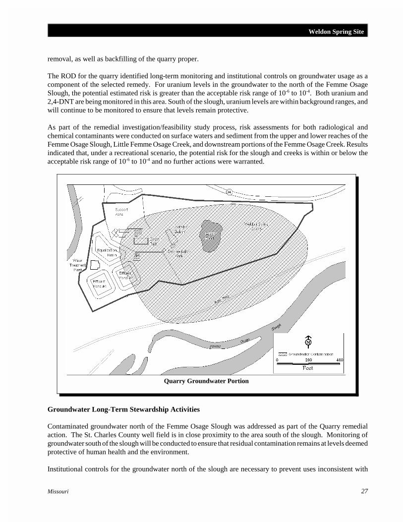
3.2 Quarry Groundwater Portion
The Weldon Spring Site quarry is a 3.6-hectare (nine-acre) limestone quarry located 6.5 kilometers (fourmiles) southwest of the chemical plant area. This sitewas historically used for disposal of manufacturingwaste created during the ordnance works activities,contaminated process residue and building rubble fromthe decommissioning of the ordnance works, andradiologically contaminated wastes from the chemicalplant area processing activities. No direct surface waterrunoff enters or exits the quarry due to the topographyof the area. Prior to remediation, a small (0.08-hectare/0.2-acre) pond within the quarry proper acted asa sump to accumulate both direct rainfall andgroundwater. Groundwater in the area is located within both alluvial and bedrock aquifer systems, and flowstowards the Missouri River.
3.2.1 Groundwater
Approximately 110,000 cubic meters (144,000 cubic yards) of soil and waste material were removed from thequarry and transported to the chemical plant area as part of the remedial action stipulated in the CERCLA RODfor the management of the bulk wastes at the Weldon Spring Site quarry. Bulk waste removal was completedin October 1995. These wastes were staged in the Temporary Storage Area and were subsequently placed in thedisposal cell in 1999. Rock fractures were power washed and sealed, to the extent practicable, to assist inremoving residual contamination. Contaminated water contained in the quarry pond was also removed and treatedthrough the quarry site water treatment plant. Quarry restoration is scheduled for completion in 2001.Restoration activities include demolition of the water treatment plant and other facilities used during bulk waste
Weldon Spring Site
27Missouri
Quarry Groundwater Portion
removal, as well as backfilling of the quarry proper.
The ROD for the quarry identified long-term monitoring and institutional controls on groundwater usage as acomponent of the selected remedy. For uranium levels in the groundwater to the north of the Femme OsageSlough, the potential estimated risk is greater than the acceptable risk range of 10-6 to 10-4. Both uranium and2,4-DNT are being monitored in this area. South of the slough, uranium levels are within background ranges, andwill continue to be monitored to ensure that levels remain protective.
As part of the remedial investigation/feasibility study process, risk assessments for both radiological andchemical contaminants were conducted on surface waters and sediment from the upper and lower reaches of theFemme Osage Slough, Little Femme Osage Creek, and downstream portions of the Femme Osage Creek. Resultsindicated that, under a recreational scenario, the potential risk for the slough and creeks is within or below theacceptable risk range of 10-6 to 10-4 and no further actions were warranted.
Groundwater Long-Term Stewardship Activities
Contaminated groundwater north of the Femme Osage Slough was addressed as part of the Quarry remedialaction. The St. Charles County well field is in close proximity to the area south of the slough. Monitoring ofgroundwater south of the slough will be conducted to ensure that residual contamination remains at levels deemedprotective of human health and the environment.
Institutional controls for the groundwater north of the slough are necessary to prevent uses inconsistent with

National Defense Authorization Act (NDAA) Long-Term Stewardship Report
28Missouri
recreational uses, or that would adversely affect contaminant migration. DOE, the Missouri Department ofConservation, and the Missouri Department of Natural Resources will establish a deed restriction that outlinesthe terms of an agreement to limit access to groundwater north of the slough for irrigation, consumption, or useas a surface water source. The terms of the agreement will be reviewed as part of each DOE five-year reviewcycle under CERCLA.
Once the long-term groundwater monitoring program is established for this operable unit, long-term stewardshipactivities will be defined, as appropriate. DOE will be responsible for groundwater monitoring activities. Accessagreements are in place between the Missouri Department of Conservation and DOE to allow long-term accessto the quarry monitoring well network.
3.2.2 Estimated Long-Term Stewardship Costs for Quarry Groundwater
Long-Term Stewardship Costs (Constant Year 2000 Dollars)
FY 2000 -FY 2010
FY 2011 -FY 2020
FY 2021 -FY 2030
FY 2031 -FY 2040
FY 2041 -FY 2050
FY 2051 -FY 2060
FY 2061 -FY 2070
EstimatedTotal
$2,674,056 $3,342,570 $3,342,570 $3,342,570 $3,342,570 $3,342,570 $3,342,570 $22,729,476
4.0 FUTURE USES
A 17-hectare (42-acre) disposal cell will remain onsite in the chemical plant area. The disposal cell is accessibleto the public and there are no access restrictions, except for the leachate sump. The chemical plant site area thatis not occupied by the disposal cell, or otherwise required to be retained by DOE to perform long-termstewardship activities, will be released, as appropriate, subject to future land use restrictions. Currently, DOEanticipates that future land use of the chemical plant site outside of the perimeter road will include a combinationof open space, recreational, and controlled access areas. DOE anticipates that the quarry site could be releasedto a Federal or state agency for recreational use. Final decisions concerning the future uses of the Weldon SpringSite will be based on the CERCLA five-year review process and the long-term monitoring requirements forgroundwater at the site.
For additional information about the Weldon Spring Site, please contact:
Thomas Pauling, Environmental EngineerU.S. Department of Energy, Weldon Spring Site Remedial Action Project7295 Highway 94 SouthSt. Charles, MO, 63304Phone: 636-441-8978or visit the Internet website at http://www.em.doe.gov/wssrap

Westlake Disposal Site
1This report is developed in response to a Congressional request in the Fiscal Year (FY) 2000 NationalDefense Authorization Act (NDAA). As requested by the Act, this report addresses current and anticipated long-term stewardship activities at each site or portion of a site by the end of calendar year 2006 (“Conference Report onS.1059, National Defense Authorization Act for Fiscal Year 2000,” Congressional Record, August 5, 1999).
Based on current planning, the U.S. Department of Energy is not expected to be responsible for the long-termstewardship activities at the Westlake Disposal Site. However, since DOE sent waste to the disposal site and DOEwas identified as a potentially responsible party, a description of the site and possible long-term stewardshipresponsibilities are included. (See Section 2.1.2 of Volume I).
29Missouri
SITE HIGHLIGHTS
Total Site Area - 81 hectares (200 acres)Reason Not Subject to NDAA Requirements - DOE isnot expected to be responsible for long-termstewardship at the site
WESTLAKE DISPOSAL SITE1
1.0 SITE SUMMARY
1.1 Site Description and Mission
The Westlake Disposal Site is located near the city ofSt. Louis, Missouri, along the floodplain of theMissouri River and adjacent to agricultural land. The81-hectare (200-acre) site has been used since 1962 fordisposing of municipal refuse, industrial solid andliquid wastes, and construction demolition debris.
From 1939 to 1985, limestone was quarried on the site.Beginning in 1962, portions of the property were used for disposing of solid and liquid industrial wastes,municipal refuse, and construction debris. In 1973, Cotter Corporation disposed of over 47,000 tons of uraniumore processing residues mixed with soil in two areas covering a total of 6 hectares (16 acres) of the site.
1.2 Site Cleanup and Accomplishments
Due to these past disposal practices, radioactive contaminants (e.g., uranium) have been found in the soil and ingroundwater beneath the site. Potential contaminant pathways exist for people who come into direct contact withor ingest contaminated groundwater or soil.
In 1976, the Missouri Department of Natural Resources (MDNR) closed the unregulated landfill. Since that time,MDNR had issued several permits for various portions of the 200-acre site. In 1990, an operating sanitarylandfill had a permitted area of 52 acres (21 hectares), and an operating demolition landfill had a permitted areaof 22 acres (9 hectares).
After listing the site on U.S. Environmental Protection Agency’s (EPA) National Priorities List, the EPAcompleted a preliminary study and determined that no immediate actions were necessary at the Westlake DisposalSite while site studies were underway. A radiological survey conducted for the Nuclear Regulatory Commission(NRC) in 1981 and 1982 documented radioactive wastes on site. Property adjacent to the landfill wasinvestigated in 1990, which identified radiological contamination that migrated from the landfill. Results indicatethat large volumes of uranium ore residues, probably originating from the Hazelwood, Missouri, Latty Avenuesite (DOE-leased property), have been buried at the Westlake Disposal Site. Two areas of contamination,covering more than 6 hectares (15 acres) and located at depths of up to 6 meters (20 feet) below the presentsurface, have been identified. There is no indication that significant quantities of contaminants are moving offsite

Westlake Disposal SiteNational Defense Authorization Act (NDAA) Long-Term Stewardship Report
30Missouri
Westlake Disposal Site
at this time. However, in 1990, anestimated 60 people obtained drinking waterfrom private wells within three miles of thesite.
Studies are still being conducted to explorethe nature and extent of contamination. Theinformation will be used to identify the bestcleanup strategy for the radiologiccontaminants at the site and for the chemicalcontamination from the landfill.
2.0 EXPECTED FUTURE USES AND SITE
RESPONSIBILITY
The Westlake Disposal Site is beingaddressed through Federal and potentiallyresponsible parties' actions. It is possiblethat a portion of the radioactive wastedisposed in the Westlake landfill was fromthe Latty Avenue Properties, a 4.6-hectare(11.6-acre), DOE-leased property used forinterim storage of materials removed fromvicinity properties. However, DOE’sresponsibility for both remediation andlong-term stewardship activities as well asfinancial commitments have yet to bedetermined.
For additional information about the Westlake Disposal Site, please contact:
the Environmental Protection Agency’s Internet website athttp://www.epa.gov/region07/programs/spfd/nplfacts/westlake_landfill.pdf