Embed Size (px)
Citation preview

1
NOTE 1 on SKETCHES K and K No. 2
for LT. WM. P. McARTHUR’S PRELIMINARY SURVEY
of the MOUTH of the COLUMBIA RIVER (1850)
Sketch K and Sketch K. No. 2 Image Courtesy the Huntington Library
Lt. William P. McArthur, U.S.N. was in command of the U.S.C.S. hydrographic party, under the direction of Superintendent A.D. Bache, surveying the Pacific Coast of North America during the years 1849-1851. The images above show two surveying sketches that were prepared during the course of that survey, as preliminary work for a navigational chart of the bar and mouth of the Columbia River, which chart was published by the U.S. government in 1851. The two “sketches” are in fact complete engravings, with full typography, printed together on a single sheet. “Sketch K” itself, dated 1850, has no notes or attributions of authorship, to any of the members of the hydrographic party. “Sketch K No. 2,” dated 1851, is credited in printed text accompanying the drawing, to A.M. Harrison, Sub Assistant, U.S.C.S.

2
They appear to be the only sketches extant, originating from the USCS survey of the mouth of the Columbia river – although the Naval Archives have not been examined for this article. I have been able to identify only one copy of Sketch K No. 2, held at the Huntington Library in San Marino, California. Sketch K.(No. 1) is at the Huntington as well, where it is on a single sheet with Sketch K No. 2; however, Sketch K. (No. 1) is also accessible in electronic image format, from the NOAA Historical Charts website http://historicalcharts.noaa.gov/historicals/search -- where it is mysteriously identified as Navigational Chart Showing the Shoal of Cape May Lighthouse, and given a publication date of “0” – since it was never published. The completed chart, Mouth of the Columbia River (1851) is also at the NOAA site:
Chart of the Mouth of the Columbia River , USCS (1851). Image Courtesy the Huntington Library
The image appearing above, however, is from a copy of the published chart at the Huntington Library. Close-ups of the chart , used in this article, are from a copy in the Greg Walter Collection, Cave Junction, Oregon.
The completed Chart of the Mouth of the Columbia River was published by the USCS in 1851, and provided nautical data of the mouth and bar of the River, including soundings in fathoms, and bearings to facilitate navigation for approximately 12 miles of the river channel, up to about Tongue Point on the Oregon side, and Gray’s Bay on the (now) Washington side. A detailed set of sailing directions apparently compiled by Lt. McArthur, appears at the foot of the chart.

3
NOTE 1: A LOOK @ SKETCH K No. 2
Sketch K No. 2
“Sketch K No. 2 CAPE HANCOCK (OR DISAPPOINTMENT) OREGON” is the title of the second of the two survey drawings, which I want to consider first. The “sketch” drawing is an extremely detailed topographical rendering of Cape Disappointment up to McKenzie’s Head (labeled) to the northwest, and to Pacific City (Ilwaco) on Baker’s Bay, to the north-east. But “Sketch K No. 2” is ndot just a sketch: it has been fully engraved, and the engraving is densely hachured, highly detailed, so that even individual trees appear rendered on the mountains. Credit for the piece is referenced in the captions “Survey by A.M. Harrison Sub Asst. U.S.C.S.” To the lower left of the Cape, at the foot of the sketch, is a “key” note, to wit: “a. Proposed site of Light House.” --- However, despite the obvious label, amidst the overabundance of topographical rendering there is no letter “a.” anywhere on Sketch K No. 2, to show where such a proposed lighthouse was to be built:

4
Portion -- Chart of the Mouth of the Columbia River, USCS (1851) Image Courtesy Greg Walter Collection
All of the engraved detail of Sketch K No. 2 were transferred to the lithograph of the finished U.S.C.S. Chart of the Mouth of the Columbia River -- including the lack of a site for the proposed lighthouse. In the finished map, the label for MacKenzie’s Head on the Pacific ocean, has also been omitted; while the hook of the Cape has been provided with the label “Cape Bluff” – a name which makes perfect sense, but for which there is no precedent, and no legacy in the navigational guides.1
This omission of the proposed lighthouse location looks at first like a mere engraver’s oversight, but this could not be the case, because the site for the lighthouse was carefully indicated on the beautiful navigational profile of the same finished chart, as was MacKenzie’s Head., and at the U S Coast Survey, a chart like this would pass through considerable careful review. It would be next to impossible for the engraver – and his superiors -- not to cross-check his work on different views of the same landscape, published on the same sheet, as the engraving progressed. Wouldn’t it?
Although it appears in McArthur’s Sailing Directions on this chart, it is completely unknown otherwise. See Appendix A.
Image Courtesy Greg Walter Collection
Note also, that the Cape in the navigational profile is now “Cape Hancock” exclusively: no longer is this otherwise unfamiliar name, just a nickname for “Cape Disappointment,” as it is in the cadastral airborne view. Maybe it was an engraver’s error after all; and the chart a … comedy of errors? What a landscape; and what a cloudscape!! (See page 2). 1 See, e.g., Imray, Sailing Directions for Western North America; Findlay, Directory of Navigation, pp. 359-367 (1850).
5
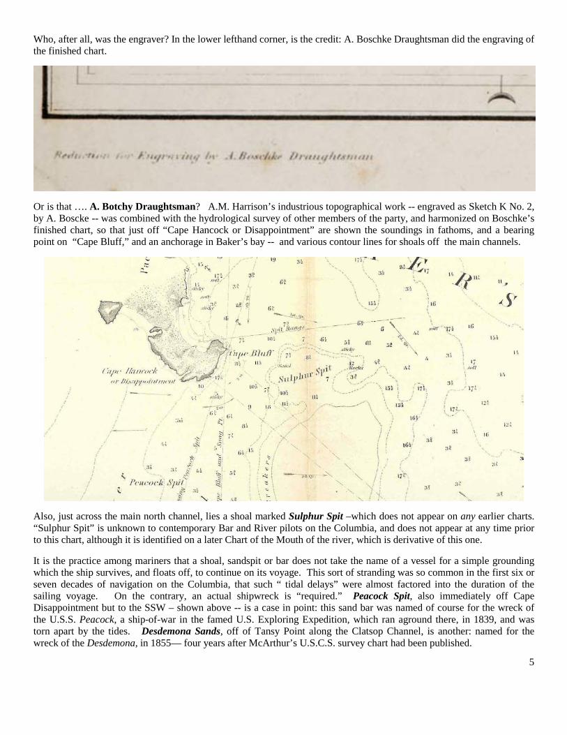
Who, after all, was the engraver? In the lower lefthand corner, is the credit: A. Boschke Draughtsman did the engraving of the finished chart.
Or is that …. A. Botchy Draughtsman? A.M. Harrison’s industrious topographical work -- engraved as Sketch K No. 2, by A. Boscke -- was combined with the hydrological survey of other members of the party, and harmonized on Boschke’s finished chart, so that just off “Cape Hancock or Disappointment” are shown the soundings in fathoms, and a bearing point on “Cape Bluff,” and an anchorage in Baker’s bay -- and various contour lines for shoals off the main channels.
Also, just across the main north channel, lies a shoal marked Sulphur Spit –which does not appear on any earlier charts. “Sulphur Spit” is unknown to contemporary Bar and River pilots on the Columbia, and does not appear at any time prior to this chart, although it is identified on a later Chart of the Mouth of the river, which is derivative of this one.
It is the practice among mariners that a shoal, sandspit or bar does not take the name of a vessel for a simple grounding which the ship survives, and floats off, to continue on its voyage. This sort of stranding was so common in the first six or seven decades of navigation on the Columbia, that such “ tidal delays” were almost factored into the duration of the sailing voyage. On the contrary, an actual shipwreck is “required.” Peacock Spit, also immediately off Cape Disappointment but to the SSW – shown above -- is a case in point: this sand bar was named of course for the wreck of the U.S.S. Peacock, a ship-of-war in the famed U.S. Exploring Expedition, which ran aground there, in 1839, and was torn apart by the tides. Desdemona Sands, off of Tansy Point along the Clatsop Channel, is another: named for the wreck of the Desdemona, in 1855— four years after McArthur’s U.S.C.S. survey chart had been published.
6
So it goes.
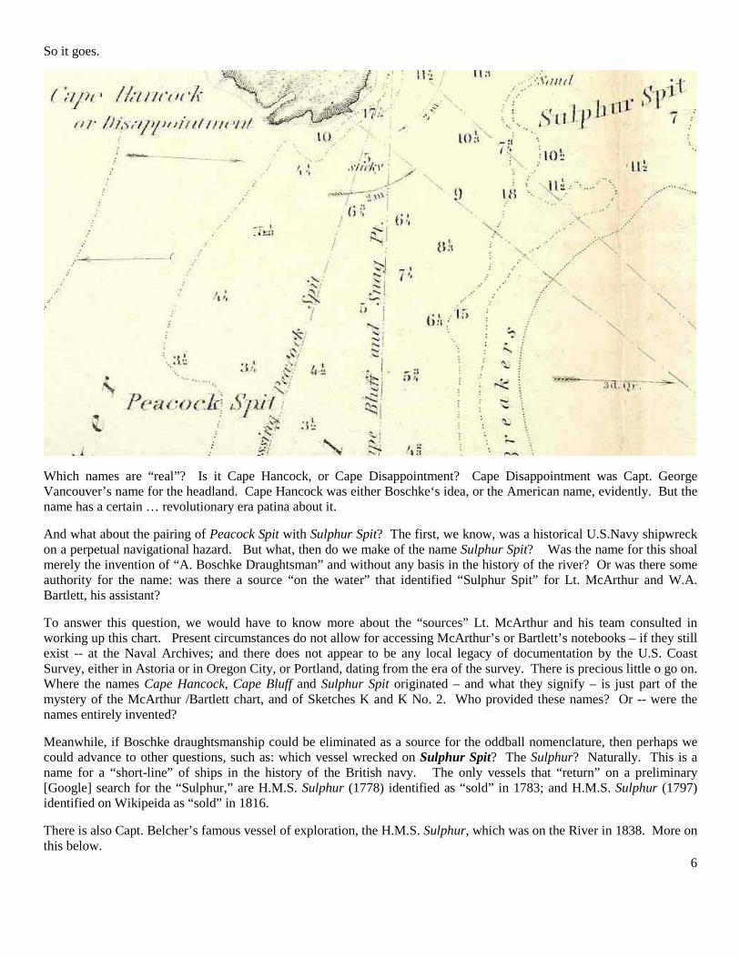
Which names are “real”? Is it Cape Hancock, or Cape Disappointment? Cape Disappointment was Capt. George Vancouver’s name for the headland. Cape Hancock was either Boschke‘s idea, or the American name, evidently. But the name has a certain … revolutionary era patina about it.
And what about the pairing of Peacock Spit with Sulphur Spit? The first, we know, was a historical U.S.Navy shipwreck on a perpetual navigational hazard. But what, then do we make of the name Sulphur Spit? Was the name for this shoal merely the invention of “A. Boschke Draughtsman” and without any basis in the history of the river? Or was there some authority for the name: was there a source “on the water” that identified “Sulphur Spit” for Lt. McArthur and W.A. Bartlett, his assistant?
To answer this question, we would have to know more about the “sources” Lt. McArthur and his team consulted in working up this chart. Present circumstances do not allow for accessing McArthur’s or Bartlett’s notebooks – if they still exist -- at the Naval Archives; and there does not appear to be any local legacy of documentation by the U.S. Coast Survey, either in Astoria or in Oregon City, or Portland, dating from the era of the survey. There is precious little o go on. Where the names Cape Hancock, Cape Bluff and Sulphur Spit originated – and what they signify – is just part of the mystery of the McArthur /Bartlett chart, and of Sketches K and K No. 2. Who provided these names? Or -- were the names entirely invented?
Meanwhile, if Boschke draughtsmanship could be eliminated as a source for the oddball nomenclature, then perhaps we could advance to other questions, such as: which vessel wrecked on Sulphur Spit? The Sulphur? Naturally. This is a name for a “short-line” of ships in the history of the British navy. The only vessels that “return” on a preliminary [Google] search for the “Sulphur,” are H.M.S. Sulphur (1778) identified as “sold” in 1783; and H.M.S. Sulphur (1797) identified on Wikipeida as “sold” in 1816.
There is also Capt. Belcher’s famous vessel of exploration, the H.M.S. Sulphur, which was on the River in 1838. More on this below.

7
The AMAZING CAPT. WHITE and the DISCOVERY of the SOUTH CHANNEL
Capt. Charles White and the Schooner Mary Taylor. One possible way of identifying the origin of these names, and learning more about the McArthur /Bartlett chart, is to look more closely into the mechanics of the survey of the Columbia itself. During the survey of the river, McArthur’s associate, Lt. Washington A. Bartlett, was on the river at least once in a schooner called the Mary Taylor.2 The Mary Taylor was 60 feet long, 17 feet beam, and had been constructed in New London Connecticut, in 1848.3
Although the Mary Taylor can be associated with other early bar pilots, including John G. Hustler,
Lt. Bartlett reported “I crossed the bar, (south channel,) in the pilot boat Mary Taylor. During the “heaviest bar” that occurred within the above named period, beating out with the wind ahead.”
4
Some time in 1849 Captain White and his son, Cornelius, bought the schooner Mary Taylor and put her on the bar as pilot-boat, with himself and J.G. Hustler as pilots. She was really the first craft acting as pilot-boat on the bar worthy of the name and position. Both White and Hustler hailed from New York.
and Job Hatfield, who certainly had formed a company with Charles White, Bartlett also noted, “The principal pilot of the bar is Captain White, late pilot of New York harbor; he is very intelligent and competent to his duties, and no accident has occurred at the mouth of the Columbia since September, 1849, when he commenced his duties as a pilot.” Bartlett’s statements as to Capt. Charles White, are confirmed by P.W. Gillette, in an article in the Pacific Monthly, for June, 1901:
5
Contrary both to Bartlett’s and Gillette’s dating, Lewis & Dryden’s Marine History of the Pacific Northwest, gives the date of Capt. White’s arrival as December 25, 1849. The Christmas Day arrival also matches the date given in Fred Lockley’s papers
6 In close confirmation, Capt. White is listed in the Marine Intelligence column of the Oregon Spectator for February 7, 1850, as reaching the Columbia River, as captain of the schooner, Mary Taylor (arriving in ballast, from San Francisco), on January 2, 1850. Meanwhile, also, in that same February 7, 1850, issue of the Spectator, the editor gives the Captain a familiar nod, in terms which corroborate Lt. Bartlett’s evaluation of him as principal pilot on the Bar.
2 Report of Lt. Washington Bartlett to A.D. Bache, No. 10., in Bache, Notices of the Western Coast of the United States, pp 29-30 (1851). 3 Lewis & Dryden, Marine History of the Pacific Northwest, p. 25 (1895) [Google Book] 4 Capt. Hustler of the Mary Taylor, worked as a bar pilot for about a year, before signing on as an employee of Capt. George Flavel (see below). 5 P.W. Gillette, “Early Pilotage on the Columbia River,” The Pacific Monthly, Vol. 6 No. 1, pp. 3-7 (June, 1901) [Google Book] 6 Oregon Historical Society Research Library, MS 2168. “After a brief stay in California with John [sic] White and other old New York pilots, purchased the Schooner Mary Taylor, and sailed for Astoria. Arriving in Astoria Dec. 25, 1849.”

8
Strangely enough, however, Capt. White is not listed among the Columbia River Bar Pilots, in any of the “conventional” historical lists I have located: that is, he is not properly included in Fred Lockley’s list of Bar Pilots (OHS MSs 2168), although a “John White” is briefly referenced (see note 6 above); and he is not on the lists found in the Clatsop County Historical Society files, although his son Capt. Cornelius White, is named there as an employee of Capt. Hustler. Nevertheless, he was credited in the press of the day, with historic – even epic – contributions to navigation of the bar.
The press clipping above, from the February 7, 1850 Oregon Spectator, was only the beginning of an extraordinary run of coverage for Capt. White, in the newspaper’s pages during the year 1850: in the weeks and months that followed, report followed report, occasionally in the form of testimonials, often from the pen of correspondents arriving at Astoria, or from captains of vessels piloted in or out by Capt. White and his associates on the Mary Taylor.
Initially, however, the Board of Commissioners on Pilots and Pilotage immediately swung into action – now that Capt. White was on the river…..
The Pilotage Commission had been established by the Oregon Territorial Legislature in 1846, but was very nearly inactive during the intervening four years. In April, 1847 it had appointed one pilot, Selah C. Reeves, whose tenure ended a year later, when he wrecked the vessel Vancouver on Chinook Sands.
There were also a few river pilots working for the Hudson Bay Company – there was the notoriously tipsy Mr. Lattie; and there was the free-lancer, James Sauls, the black cook who had deserted from the U.S.S. Peacock: Sauls had volunteered to bring the U.S.S. Shark, Capt. Howison, upriver to Vancouver in 1846 – and then had almost immediately grounded her. But that’s another story . . . .
Now, however, there was Charles White. As seen in the report published at left, on February 6, 1850 – about six weeks after Capt. White’s Christmas Day arrival on the Columbia -- at their meeting, the Pilotage Commission, including Governor Joseph Lane and Capts. Couch and Crosby, as its first item of business, voted to grant Capt. White the first branch license for pilotage at the mouth of the Columbia – and his associates Job Hatfield and ___ Long were close seconds, approved as Capt. White’s deputies. The story was in the Spectator the next day:
Oregon Spectator, Feb. 7, 1850 _:_

9
Within the month, favorable reports on the initiatives of Capt. White were accumulating. Under a lead-in titled THE SOUTH PASSAGE”-- the column below, from the March 7, 1850 Spectator, reported that Capt. White himself was sounding the south channel, with the intention of laying buoys and piloting vessels in that way, rather than bringing them in by the north channel off Cape Disappointment:
Oregon Spectator, Mar 7, 1850
Note that no mention is made of the U.S. Coast Survey, then on the River conducting this very project …
Then again two weeks later, the Spectator published excerpts of a letter from Capt. Nathaniel Crosby – recall, a member of the Pilotage Commission -- extolling Capt. White as pilot, with a special dig directed at the U. S. Coast Survey: “Captain White has one and is doing more for the mouth of the Columbia than all the surveying and exploring expeditions that ever came out here.”
Crosby goes on to note that White’s costs are very high – and enjoins his readers to “Do all you can to encourage their remaining here …”
Oregon Spectator, Mar 21, 1850 4:4.
Note here, Crosby’s final paragraph:
“We lay three days at Anchor at Tanzy Point, Clatsop, with a heavy gale from S. W. to W. by N. and find it an excellent harbor, good holding ground and true tides – far superior to Bakers [Bay – the anchorage off the north channel].
We will come back to Tansy Point, in discussing Sketch K (No. 1).

10
The Governor Gets Involved -- Again : It seemed like only months ago – in February -- that Governor Lane had voted to authorize Capt. White’s branch license for the Bar. But within two months, Governor Lane’s office was hosting a meeting to address a crisis in the new era of bar pilotage: financing. With Captain White’s costs outstripping his revenues, the Territorial Government was faced with a frontier administrative crisis: the possible departure of Capt. White from pilot work at the Bar. A public meeting was held in the Governor’s offices in Oregon City in late April, 1850:
And note, that this time, Lt. McArthur himself testified on behalf of Captain White, and joined the major governing figures of the Oregon Territory, in this brainstorming session, to work out an arrangement by which Capt. White could be induced to stay on . . . .
Lt. Wm. P. McArthur, here misidentified as holding the rank of Captain, not only had gone out with White in the Mary Taylor a time or two, as mentioned above, but he evidently knew the man – or at the very least, his work – sufficiently well, to prize his contributions, and to testify for him at this early meeting in Oregon City – which was anywhere from four to eight days by sail upriver(s), from Astoria, where Mac Arthur’s work with the Coast Survey was ongoing.
And while in Oregon City for this meeting on pilotage issues, McArthur also penned a letter to the editor of the Spectator, further praising Capt. White, and going so far as to attribute to him, not just some soundings and channel marking, but the very discovery of the South Channel itself:
Oregon Spectator, 12 December 1850, 1:

11
Lt. McArthur’s letter singled out Capt. Charles White for virtually revolutionizing bar navigation by his discovery of the South Channel. This letter was picked up widely – as had certainly been the officer’s object in composing it – and was published in such commercial gazettes as Hunt’s Merchant’s Magazine, as part of federal efforts to restore the reputation of the Columbia river bar, as a readily navigable commercial channel:
Another letter by Lt. McArthur was published along with it: this one was directed to Gen. John Adair, Collector of Customs at the Astoria Custom House, located a mile upriver from Astoria “proper”. This letter too pays special acknowledgements to Capt. White, for his critical discovery of the South Channel as a harbinger of a new era of safe navigation of the Columbia Bar:

12
Of course, it was bull-puckey: the south channel had been known of for at least a decade before Capt. White got anywhere near the Columbia River. It was extensively sounded in 1841 by Capt. Knox of the Flying Fish, shortly after the U.S.S. Peacock had been wracked on the spits off Cape Disappointment. What was Lt. McArthur up to?
Meanwhile, however, although his legacy on paper was secure, Capt. White’s navigational revolution was already unwinding – due to the very financial constraints that Mac Arthur and Governor Lane had sought to address. In fact, the very next month, on June 27, 1850, the Spectator ran a story, informing its readers that the Mary Taylor was losing money for its owners, and that Capt. White was quitting. And finally on November 4, 1851, a notice appeared that Capt. White was leaving Astoria for San Francisco and the gold fields.
But that’s another story . . .
An era had ended. Capt. White, with the help of Capts. Long and Hatfield, had ushered in an era of completely reliable and maritime traffic over the Columbia Bar. Not only by consumate seamanship, but by totally dedicating his energies to the development of the South Channel – that is, by completing soundings there, and laying bouys -- crossing the bar had become virtually routine.
But for all his nautical skill and maritime prowess, Capt. White had did not also have the businessman’s acumen, or the tradesman’s moxy, that were necessary to convert bar pilotage from a taciturn art, into a commercially viable trade that could serve the public for generations. Another man was already on the scene when White moved south for the gold fields -- would shortly arrive on the scene. That was Captain George Flavel, who was on the river in the John Petty, before White arrived.
Panegyric poetry!! All that remained was for some poet to wax rhapsodical about this extraordinary sailor – and, so it was: Capt. White’s skill, his notable contributions to navigations at the mouth of the Columbia, and his seamanship, so impressed at least one passenger , that he was inspired to unusual new heights of versification. Thus, the figure of Capt. White, and his little schooner, the Mary Taylor were immortalized in verse: Theodore Eckerson’s Address to the Bar at the Mouth of the Columbia River – a poem published in the Oregon Spectator -- twice invoked the name of White, (only using it for an end-rhyme once! ) – emphasizing his navigational acumen at Cape Disappointment
Oregon Spectator, December 12, 1850 1:1

13
LT. WM. P. McArthur, CAPT. WHITE and the CHART of the COLUMBIA
What we know is new -- but we still do not know much about the mysterious Capt. Charles White, who altered the course of navigational history at the Columbia River bar. We know he was a New York pilot at one time, but we do not know his age, or his prior experience – for instance, as a sailor or officer in the War of 1812, which, after all, did have a Pacific theatre, and naval operations on the Columbia River: most notably, the H.M.S. Raccoon’s capture of Astoria in 1813.
We do know that Lt. McArthur, commanding officer of the U.S. Coast Survey at Mouth of the Columbia, knew Capt. White well enough. McArthur had not only navigating the bar, with Capt. White acting as pilot of the Mary Taylor; but had –evidently – become very familiar with Capt. White, man to man, and, as one sea-captain to another. McArthur had observed White’s sounding and marking of the south channel, conversed with him about the shoals and other navigational hazards of the bar, and – for a certainty – had used White’s experience in composing the U.S.C.S. Chart of the Mouth of the Columbia (1851). Likewise, McArthur had almost certainly taken from White – although not necessarily White alone – the specific instructions for navigation that appear on that chart, as McArthur’s Sailing Directions. See, Appendix A. And recall, Lt. McArthur had also travelled from Astoria, where he was commissioned to survey, and sailed upriver, beyond the Columbia river, to Oregon City on the Willamette – thus exceeding his commission – in order to testify for Capt. White at the Pilotage Commission meeting in late April, 1850. That trip would have required at least a week of time, taken from the U.S.C.S. official business. In all likelihood, two weeks away from the coastline would be required.
The point is, that the channels and hazards identified during the U.S. Coast Survey at the Mouth of the Columbia, and compiled onto the 1851 chart, had the best “sourcing” possible: they lay in the indisputable expertise of Capt. White, and in his close personal acquaintance and professional camaraderie, with Lt. McArthur, commanding officer of the U.S.C.S. ion the pacific coast. That being the case, then, Sulphur Spit represents – or represented – nothing less than a serious navigational hazard both to Capt. White, and his associates Capts. Hatfield and Long, as well as Capt. Hustler, Capt. Flavel, and others. Sulphur Spit remained a dangerous navigational hazard for Capt. White, because he knew from experience, of a dangerous shoal there: immediately off Cape Disappointment; and he knew some seafaring authority, or from some earlier voyage, that the shoal had – in historical fact – caused the shipwreck of a vessel in the British line – H.M.S. Sulphur. That is how and why the shoal was identified on McArthur’s chart, and referenced in the Sailing Directions. See Appendix A.
That is my proposal. There are precious few discussions of how maritime navigational hazards were named during this period . One such, however, by J.S. Bacon, appears in the pages of Balllou’s Monthly Magazine, for 1871, under the title “Shipwreck of the Carrier Pigeon: a California Sketch,” (Vol. 33, p. 444) [Google Book] and although it deals strictly with the situation in California during this period, it is still relevant. Here is some of that discussion:
It is a time-honored custom among mariners, to affix to rocks, shoals and quicksands the names of the unfortunate vessels whose stranded keels firs made known their existence, and which too often proved their final restring-place. This is more particularly noted on the California coast. For centuries comparatively unknown to navigation, it is now being thoroughly explored, and hidden dangers brought to light.
Blossom Rock, in San Francisco bay, gave the deathblow to the good old whaleship Blossom. Southampton Shoals once seriously interfered with the progress of the U.S. storeship Southampton. Anita Rock gave ample employment at the pumps to the crew of the Bark Anita, till she could reach a secure anchorage. Tonquin Shoal ended the days of the good ship Tonquin, lumber laden, and just reaching port from a long Cape Horn voyage. Noonday Rock, off the Bar of San Francisco, checked the mad career of the gallant ship Noonday, plunging onward in the gale, eager to enter the harbor before dark, and consigned ship and cargo to a watery grave. Duxbury reef was first ploughed up by the keel of the old Duxbury, homeward bound; and Tennessee Cove once witnessed the landing of the Pilgrims; California Pilgrims, voyaging to the golden land, on board the steamship Tennessee; which mistaking the entrance to the harbor in a fog, went ashore with all her live freight on board, fortunately resulting in no loss of life.”
As I said, that is the situation in California. On the Columbia, with the sands of the shoals shifting dramatically from year to year, and the depth of the channel fluctuating with sedimentation, it may be a different story. For instance, the H.M.S. Raccoon, Capt. Black, on entry to the river in 1813, smashed onto the sands of the channel, and stranded – until she broke

14
free – leaving her forward keel in the bed of the river. That stately keel, which washed ashore in the 1970’s, is now on display at the Columbia River Maritime Museum. But, although the H.M.S. Raccoon left its name on Raccoon Straits and Raccoon Cove, off Angel/Ayala Island, where it was repaired in San Francisco Bay later that year, nevertheless there is no Raccoon Spit on any Columbia river charts, and never was. Other early vessels as well, such as the H.M.S. Chatham, would have similar entries in their logbooks – there would be hundreds, even thousands of such entries. But on the Columbia, such strandings were so common, they would hardly earn a memorial in the local sailing lore – and would not be commemorated – they were not commemorated -- in the navigational terminology.
Capt. Beechey, and then his successor in the Sulphur explorations, Capt Belcher, brought their two surveying vessels, H.M.S. Sulphur and H.M.S Starling, to the river twice during the course of the ‘Round the World Cruise, 1837-39 -- which included survey work for a chart of the mouth of the Columbia. Capt. Belcher, last in command, did not, however, shipwreck on the sands, but did -- ostensibly -- run aground while sounding the Columbia bar. Lewis & Dryden’s Marine History of the Pacific Northwest, (p. 14) [Google Book] reports:
In 1839 the Sulphur, in command of Capt. Edward Belcher, with her consort, the schooner Starling, Captain Kellett, entered the Columbia River and made extensive soundings and surveys on the bar, the larger vessel grounding and narrowly escaping destruction on what was afterward known as Peacock Spit. Other vessels in 1838 were the Hudson's Bay bark Vancouver, Captain Duncan, the brig Thomas Perkins ….
However, on the McArthur/Bartlett chart, A. Boschke, perhaps following Capt. White, separates Peacock Spit from Sulphur Spit, and in fact designates the North Channel running right between them. Meanwhile, for the inner spit to take the name Sulphur Spit, for a temporary grounding, that the vessel sailed away from, would “violate” the routine practice on the Columb ia, that seems to reserve such new nomenclature, for strandings that end in total shipwreck. Even Capt. Belcher’s logbook confirms the transitory character of the “danger” to the Sulphur:
“Just at our last tack, which would have taken us safely to our anchorage, the ship tailed, and the flood forced her instantly on the bank…” Later, freed by the tide, she “anchored in security until the morning, when we weighed and ran up to our berth in Baker’s bay. Not so the Starling; in weighing (in ten fathoms) she tailed, and instantly lost her rudder.” Longstaff & Lamb, “The Royal Navy on the Northwest Coast, 1813-1850, Part I,” British Columbia Historical Quarterly, Vol IX, p. 13. (1945)[Available online]
On the scale of strandings on the Columbia bar, this was a virtual non-event. It does not even qualify as an “owie.” The royal vessel, H.M.S. Sulphur (III), was totally unharmed. Meanwhile, her companion vessel, H.M.S. Starling was slightly damaged, in the loss of her rudder. So if anything, we should expect -- perhaps at the most-- to find a Starling Spit, where the Starling‘s rudder was torn off. The idea that Capt. White pointed out Sulphur Spit for Lt. McArthur, and connected it with for Capt. Belcher’s uneventful delay, is preposterous.
It is conceivable, that Capt. White -- and Lt. McArthur -- could have known of the brief stranding of the Sulphur however; although it was not referenced in published accounts of the Sulphur voyage. Capt. Belcher on the Sulphur, had encountered Comm. Wilkes on the U.S.S. Peacock, while refitting in Hawaii in 1840: Belcher was fresh from reconnoitering the Columbia, and Wilkes, with the Ex. Ex., was heading that way. Capt. Belcher, indeed, provided Comm. Wilkes with ….. sailing directions for entering the mouth of the Columbia, which Wilkes relied on entirely – to the total destruction of his ship the Peacock, and to the great injury of the objectives of the Exploring Expedition.
Wilkes mentions this in his Narrative of the United States Exploring Expedition, published in 1842, and certainly McArthur and White had probably read that narrative before they reached the river in 1849. If McArthur or White had encountered Wilkes, in New York or Washington D.C., during the 1840’s, and enquired about Belcher’s sailing directions, and their consequence for the wreck of the U.S.S. Peacock, it is conceivable that the 1839 stranding of the Sulphur might have come up, as part of a professional conversation. The question is, would either of the men have placed the stranding of the Capt. Belcher’s Sulphur on the chart, in a context comparable to the wreck of the Peacock?
If not, that leaves two other short-lived, eight-gun vessels, each christened H.M.S. Sulphur, from which to choose. Was it the first H.M.S. Sulphur (1778) or the second H.M.S. Sulphur (1797) that ran aground and was broken up on the shoal that bears it’s name?

15
APPENDIX A
SAILING DIRECTIONS from the CHART of the MOUTH of the COLUMBIA RIVER (1851)
These Sailing Directions printed at the foot of the McArthur/Bartlett Chart of the Mouth of the Columbia (1851) differ materially from those printed in book form, which can be searched online.
© 2011 ROCH STEINBACH ©