Embed Size (px)
Citation preview

SELMA
WEST END
BASIC WITZ
UNIONTOWN
PLUNKETTVILLE
SEARS HILL
SUNNYSIDE
NEWTOWN
Staunton Neighborhoods
HSF Brown Bag 2015-2016

Staunton Neighborhoods: a Town within a Townwhere are they, what anchors them, how can we support their presence into the future
Exploring ways to re-emphasize existing neighborhoods and
support their growth as thriving districts within the City.

Built within the ridge and valley topography typical of the Shenandoah
Valley, the City of Staunton has been shaped over time by land form,
availability of natural resources, economic demands, and social dynamics.

The geographic growth of the City is expressed in cycles of annexation,
beginning in the 1700’s, continuing on through the 1800’s, into 1905, 1935,
1948, 1956, with the most recent,
large expansion to the City limits occurring in 1986.

These annexations included the absorption of previously independent
communities including ca. 1930’s Plunkettville to the west of central
Staunton and the post-Civil War historic African American community of
Uniontown to the east; both annexed in 1948.
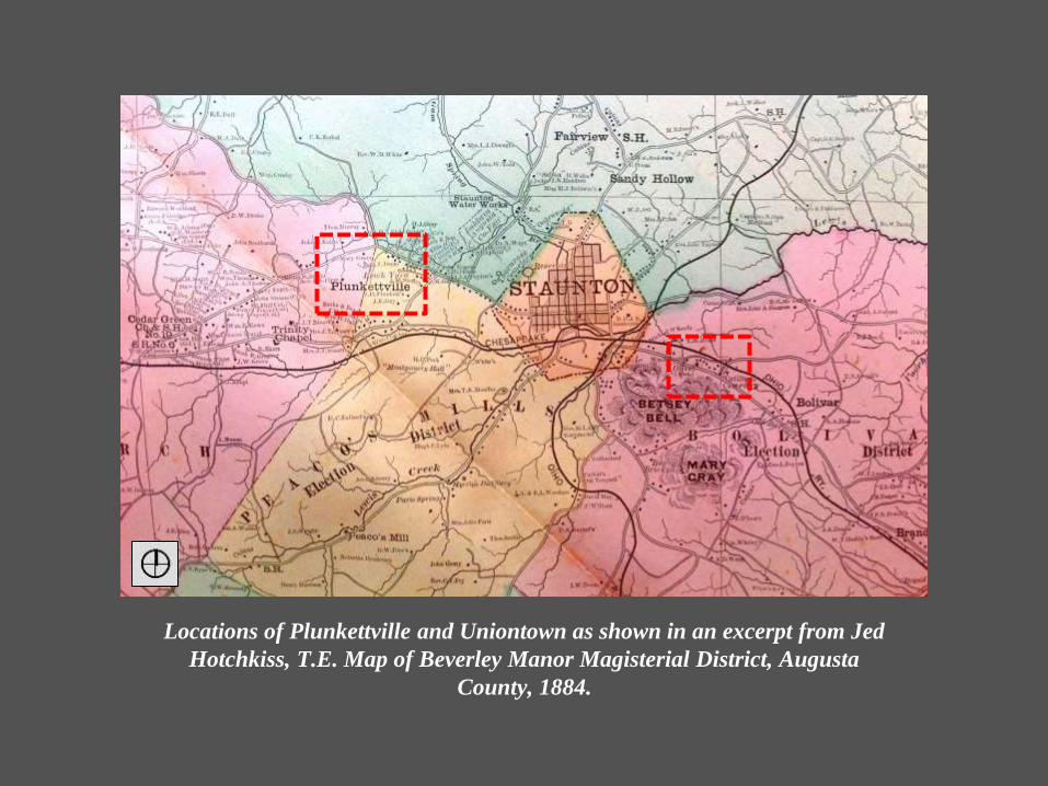
Locations of Plunkettville and Uniontown as shown in an excerpt from Jed
Hotchkiss, T.E. Map of Beverley Manor Magisterial District, Augusta
County, 1884.

Heavily influencing Staunton’s evolution was the establishment of a new zoning
ordinance in the 1960’s, resulting in broadening codification of land use districts.
Staunton’s new land use policies, like many zoning ordinances and land use districts of
that time period, were designed and configured primarily to support the car oriented
development of subdivisions and strip malls - whether or not the existing conditions
reflected that type of neighborhood patterning.

Plunkettville
The location of Plunkettville within the context of Staunton’s current zoning districts and
neighborhood patterning visible in Staunton aerial view.

Buildings forming the commercial center of Plunkettville
and houses typical of the adjacent neighborhood.

Uniontown
The location of Uniontown within the context of Staunton’s current zoning districts and
neighborhood patterning still visible in Staunton aerial view.

Existing buildings in Uniontown. Uniontown is included in the
Virginia Foundation for the Humanities
African American Historic Sites Data Base .

Existing Supports: Entrance Corridor Overlay District, protecting character


Exceptions to off-street parking requirements for existing commercial buildings on space
restricted or steep parcels City wide; exceptions for the required placement of a new
residence on a small (don’t meet minimum area and/or width requirements) lot to reflect
near-by conditions.
Existing Supports: ordinances encouraging the use of existing
residences and commercial buildings

Existing Supports: zoning encouraging the continued use of residences as residences

Staunton’s Neighborhoods: a town within a town: exploring ways to re-emphasize existing neighborhoods and
support their growth as thriving districts within the City.

SELMA
WEST END
BASIC WITZ
UNIONTOWN
PLUNKETTVILLE
SEARS HILL
SUNNYSIDE
NEWTOWN
Staunton Neighborhoods
HSF Brown Bag 2015-2016


![Staunton Spectator (Staunton, Va.) 1870-05-03 [p ] · H. M. bell, Staunton. ECHOLS, BELL _fc CATLETT, ATTORNEYS AT LAW, Staunton, Va., Will practice in the State and Federal Courts](https://img.dokumen.tips/doc/110x75/5f0ffbdf7e708231d446dccb/staunton-spectator-staunton-va-1870-05-03-p-h-m-bell-staunton-echols.jpg)

![Staunton Spectator (Staunton, Va.) 1887-06-08 [p ]chroniclingamerica.loc.gov/lccn/sn84024718/1887-06-08/ed-1/seq-1.pdf · Staunton Spectator RICHARD MLA.TTZY, Editor and Proprietor,](https://img.dokumen.tips/doc/110x75/5e80ed5f7ca30c081d7c2789/staunton-spectator-staunton-va-1887-06-08-p-staunton-spectator-richard-mlattzy.jpg)

![Staunton Spectator (Staunton, Va.) 1869-09-07 [p ] · Staunton Spectator Volume XLVI. ... Staunton, Virginia, Will practice in all the Courts of Augusta and Alleghany, and in the](https://img.dokumen.tips/doc/110x75/5e8836fa4304ac5ade5cf79c/staunton-spectator-staunton-va-1869-09-07-p-staunton-spectator-volume-xlvi.jpg)