Embed Size (px)
Citation preview
Report Cross border workshop Southwest Baltic
2 of 30
Author: Thea Ohlander Arfwidsson, Annie Bengtsson,
Shahin Madjidian, Andrea Öström
Date: 2016-02-15
Report number: --
Key words: MSP, Maritime Spatial Planning, Cross border, Workshop,
Baltic Sea, Stakeholder participation, Baltic SCOPE
Lead partner : Swedish Agency for Marine and Water Management
www.havochvatten.se/en
3 of 30
About this document
A report from the Cross border workshop Southwest Baltic for
maritime spatial planning
This report presents the findings and outcomes of the Cross border workshop
with institutional stakeholders to the Southwest Baltic. The workshop constituted
a possibility for representatives from the sectors Energy, Fishing, Nature and
Environment and Shipping, to exchange input and knowledge on the process of
marine spatial planning. The workshop was held in Malmö, Sweden, in
January 2016.
The target groups of this report are stakeholders to maritime spatial planning in
the Baltic Sea such as: planners, representatives from the sectors Energy,
Fishing, Nature and Shipping as well as other representatives from countries
around the Baltic Sea
About Baltic SCOPE
Baltic SCOPE is a collaboration between the maritime spatial planning authorities
in six countries and pan-Baltic organizations to find planning solutions to trans-
boundary issues. We strive to achieve coherence and cross-border solutions in
Baltic maritime spatial plans and improve the planning processes. Our two-year
collaboration is co-funded by European Commission.
www.balticscope.eu
4 of 30
Summary
The Cross border workshop with institutional stakeholders to the Southwest Baltic
constituted a possibility for representatives from the sectors Energy, Fishing, Nature
and Environment and Shipping, to exchange input and knowledge on the process of
MSP. All sector groups reached similar conclusions regarding the need for more
cooperation, sharing of information and data, and the need for group discussions.
The form for these group discussions was not identified, since meetings with many
stakeholders can be very resource consuming, but on the other hand it can be
difficult to cover all aspects in a smaller focus group.
All sectors was interested in the possibilities of co-existence as a way to handle
conflicts of interest, a possible key to a way forward, implementing mitigation issues
instead of prohibiting activities. Baltic Scope can be a good platform to address the
issues of potential synergies between sectors in the Baltic sea.
A healthy environment is required for a sustainable South West Baltic. Here the
aggregation of data across borders is important since nature does not apply to
national borders. However strategic planning always includes uncertainty and lack of
data should not stop the planning process.
Conclusions
Transboundary Marine Spatial Planning is more complex than anticipated
There is a lack of a common understanding of what is needed for coherent
planning
There is a lack of harmonization between different EU directives
There is a difference in the national legal systems, and, what legal role the
MSP plays in every country.
There are unsettled border issues
5 of 30
A strategic approach is difficult to comprehend and sector actors are not used
to think in a holistic perspective
Planners do not have the mandate to solve all issues
Recommendations
There is a need for:
Common capacity building and creation of awareness
Close cooperation between planning authorities
Political involvement on a pan-Baltic level for MSP
A permanent platform with resources and mandate to cover the issue, not
depending on a project
Common criteria or recommendations in a number of issues, such as
o safety distances to OQFs
o what to include in the SEA
o how to coordinate with MFWD etc
For recommendations from each sector, please see the notes from the respective
thematic meetings.
6 of 30
Day one
Plenary
The Cross border workshop with institutional stakeholders from the Southwest Baltic
was opened on the 27th of January 2016. Axel Wenblad (chairman of the board of
WWF Sweden) was moderating the event, and opened up with the importance of the
long term perspective, the transboundary issues and the challenges of four different
legal systems meeting with different perspectives on Maritime Spacial Planning.
Marie Columbier from DG Mare presented the Directive on Maritime Spacial Planning
from July 2014, and its aim to reduce conflicts and cumulative impacts on the
environment. The directive also seeks to reduce coordination costs for public
authorities and improve certainty to private businesses and investments. During 2016
all member states should transpose the Directive it into their national plans, and by
2021 plans for all waters should be finalized. The plans should be reviewed every ten
year. The underlying principle for the MSP as well as cross border cooperation is an
ecosystem based approach.
To set the scene the Baltic Scope Project Manager Ingela Isaksson presented the
project, and each of the participating countries presented their current activities on
MSP:
Poland has already implemented the directive for MSP in Polish law, and the
responsibility is shared by three organizations, covering three different
geographical areas. The MSPs in Poland will be legally binding, but so far no
MSPs are officially adopted in Poland yet.
Germany has different MSPs for different areas and the responsibility is
shared by four planning agencies – the Länder are responsible for their
respective territorial seas and the BSH is in charge of the EEZ. Germany has
MSPs in force, on both Länder and Federal level, and are hence limited in
flexibility regarding the development of MSPs.
7 of 30
Denmark is starting up their MSP planning process in autumn 2016 and it will
involve cooperation between ministries, municipalities, regional authorities,
neighboring countries and the public. Denmark will have one single plan for
the North Sea and the Baltic sea area. The MSP will be finalized in 2021 and
the Danish Maritime Authority is going to be responsible for the plan,that will
be legally binding.
Sweden will have three MSPs; the Gulf of Bothnia, the Baltic sea and
Skagerrak-Kattegat. The planning will take place 2016-2019 and the MSPs
will be guiding documents only. At this stage Sweden has a status report and
a guidance document on MSP. The guidance document presents the goals
for planning as well as the regional differences between the areas, the
Swedish MSP area boarders 9 countries (plus Åland), covers 65
municipalities and 14 regions.
Tomas Andersson from SwAM presented some of the challenges of transboundary
MSP, such as that processes and negotiations are slow and agreements are usually
voluntary. One always has to remember that participants are sovereign nations and
have domestic targets, goals, priorities and interests. The different countries are at
different temporal levels in the MSP process, which can make coordination difficult.
To approach these challenges there is a need for an exchange of planning
information, and to reach agreements on certain topics. Workshop participants were
encouraged to focus on the issues of what they need from each other to be able to
be successful in making the MSPs.
Inspirational speaker Mattias Rust from WWF raised the issue of the primary goal of
the MSP:s – is it economic growth or environmental health? Increased activities in
the Baltic means increased pressure on the environment and fish populations.
However, investing in the marine environment is not a cost, but a necessity to ensure
steady production in the future. He also emphasized the importance of asking the
8 of 30
right questions in this MSP process, such as “Is it possible to talk about growth in the
fisheries sector when fish populations are declining?”. Growth is a direction and
sustainability is a boundary within which we can grow, here MSP can be a tool for
sustainability.
Before the thematic meetings there was a brief introduction to the topics. Thereafter
Tomas Andersson presented the geographical areas of special interests (see Annex 3).
Thematic meetings
On the thematic meetings, participant was to discuss the following issues:
1. Are the topic papers giving a correct picture of the current status? (Topic
papers gives a background description of each theme, describes existing
conflicts and prospects in the Baltic Sea area.)
2. What are the needs in terms of space and location of areas (surface, water
pillar, bottom, on banks)?
3. What are the development plans for your sector in 2035 and 2050?
4. What are the main conflicts and synergies with other interests and how could
those be handled?
5. What recommendation is the group giving the planners for their work with
focus on transboundary aspects?
The discussions from each of the four thematic meetings: Energy, Fishing, Nature and Environment and Shipping, is presented below. The participants of each thematic meeting is listed in Annex 2.
Energy
In the Energy-sector there are two aspects to consider – the coordination of planning
of offshore wind farms (OWFs) used by several countries and a joint planning for
energy transport corridors.
For OWFs the requirements are Good natural conditions (seabed, sea depth, wind
conditions), good infrastructure conditions (distance to coast, distance from shipping
9 of 30
routes, large areas) and environmental conditions (minimum impact on protected
areas).
The requirements for power cables are related to acceptable routes regarding
shipping/extraction sites.
Are the topic papers giving a correct picture of the current status?
Overall, the group agreed that the topic paper gave a correct picture of the current
status, even if the paper was considered somewhat fragmented.
Some issues was raised on incorrect details on energy production, and the need for
a map of built and planned OWFs and pipelines, so that the planners can see where
there are interests to construct OWFs and place pipelines in the future. The group
also pointed out the need for better correlations to the ESPOO process, and more
substance on international consultation and transboundary cooperation and how that
process can be designed.
What are the development plans for your sector in 2035 and 2050?
The facilitators decided to combine this question with the third question.
What are the needs in terms of space and location of areas (surface, water pillar,
bottom, on banks)?
The needs are very difficult to predict due to politics at national levels, costs, and
other factors. The group recognizes a need for more information, data and further
cooperation for better understanding before this question can be adequately
answered. A new workshop where different scenarios would be discussed could be
needed.
Different energy needs in the future will result in different scenarios, for example the
need for physical space could be lower than today due to technological progress
such as increased capacity of single turbines, floating OWFs or other. Nevertheless
10 of 30
energy should be included early on when allotting physical space to different sectors,
to find good areas for all sectors in a balanced way.
The need for safety zones around OWFs in EEZs was highlighted and also the need
to find a common framework on how and where to locate OWFs. Areas for mixed use
also need to be found, where for example pipelines can be allowed through OWFs.
Environmental issues can also form a common ground with OWFs as ships cannot
come near.
To ensure a successful planning process, data and information sharing is important,
and processes should be set up to develop this type of cooperation. The following
questions should be used in the process: need to take scenarios/assumptions into
consideration, national zoning requirements, expected generating capacity per km2
in the future, energy priority versus other sectors, OWF effect of oil prices.
What are the main conflicts and synergies with other interests and how could those be
handled?
The group agreed that the main conflicts with energy are the following:
Nature and conservation, Natura2000
Shipping
Fishing
Also, military objects are difficult to plan for, as military areas can be secret and thus
not shown on maps.
The group agreed that synergies can be found in the following areas:
Environmental benefits
o E.g., creation of artificial reefs and promoting marine biodiversity.
OWFs could lead to innovative fishing techniques when no trawling is
allowed, and possibly aquaculture sites.
Grid connectivity between two or more countries
o possible by-products of having OWFs in the same area.
11 of 30
What recommendation is the group giving the planners for their work with focus on
transboundary aspects?
There were both divergent perspectives and common interests in the group, but the
recommendations from the group to the planners for their work with focus on
transboundary aspects were the following:
Agree on how to collect and share data, especially with regards to MSPs.
Create international working groups of planners regarding conflict areas.
Consider the correlation to the ESPOO process and use the experience from
it.
Co-location – finding sites for multiple uses and sectors.
Evaluate projects across borders to achieve consistency.
Fishing
A common understanding in the group is that it is hard to involve the fishermen in the
MSP dialogue.
The Common Fisheries Policy (CFP) gives a framework of what should happen, with
quotas and harbour landing numbers regulated and foreseen on a short and long
term. Missing in the CFP however is the spatial aspect, where fishing activities will
occur etc. The MSP is a framework for discussion with other sectors, and how
fisheries is going to interact with them.
Are the topic papers giving a correct picture of the current status?
Overall the group agrees that the topic paper gives a correct picture of the current
status, however it would be good if it goes more into detail regarding the possible
conflicts and synergies with other sectors.
It was also suggested to include an overview of CFP and MSP in relation to each
other, what they regulate and what is not included.
12 of 30
The areas identified in the following question are some of the question marks for the
future that will be important to address in the topic paper.
What are the development plans for your sector in 2035 and 2050?
The areas identified was the following:
Sustainability as a goal
Protected areas (Nature 2000)
Coexistence
Commercial/recreational
Important fish habitats
Selectivity
Knowledge and data as a basis for plans
Market
Large scale – Ports– Small scale
There has been a reduction in fish stocks the last 40 years according to the previous
WWF presentation and the question was raised that maybe instead of talking about
growth in fisheries sector, we should be talking about a decline argued the
representative from Nordregio. However, a representative from DK argued, that in
the Baltic the fish stocks have grown, and we can talk about growth because the
fishing industry can use better selective tools and thus earn more money and be
more sustainable in their methods at the same time.
The needs for harbours change depending on how the fisheries change. And is it
possible to expect a future emergence of combined recreational and commercial
fisheries. Some say yes on a small scale, some say that is not economically viable.
13 of 30
What are the needs in terms of space and location of areas (surface, water pillar,
bottom, on banks)?
The group agreed on using habitats, ports and fishing grounds as a base, but there
are complexities in transferring data and evidence into marine plan format.
There are also difficulties in fencing in fishing interests, but if we don’t try to, fishing
might not be represented at all. There is a lack of information on small scale fisheries
and fish habitats, fishing grounds are traditionally part of expert knowledge, and also,
fishing grounds change, so data changes. The topic paper for example, shows a
historic picture, not current or future.
There was a discussion on what to include in the MSP process, is it every country´s
responsibility to accommodate not only their own fisheries interests but also interests
from other countries fisheries? Aggregated data will show a larger economic interest,
but then we are back in the difficulties of getting data. To get updated data,
stakeholders have to be included. Data and sharing of data can be sensitive, and
there is a lack of data from small vessels in all countries.
There are limitations with spatial designations, and it is important to look at
cumulative effects of spatial claims from other activities on fisheries.
A difficulty to engage fishery sector in the MSP process is recognized, and to create
a common picture of important fish habitats a forum should be identified where there
can be an exchange of information on fish habitat. The Baltic Scope project should
highlight what are the important questions and deliver recommendations, not
answers to all questions.
What are the main potential spatial conflicts and synergies with other interest and how
could those be handled?
14 of 30
The group agrees with the list in the topic paper. However, a further specification is
needed on which types of fisheries have what kind of interactions with other sectors.
In some cases there are existing guidance, such as the fisheries regulation
in Natura 2000, in others it needs to be developed. Also a full picture of potential
synergies and conflicts needs to be developed, some cases can be both!
Focus should be on spatial issues.
What recommendation is the group giving the planners for their work with focus on
transboundary aspects?
Develop aggregated maps for shared fishing interests in the whole region, as an outcome of Baltic Scope
o Further exchange and cooperation is required to agree on methodology for this
o We could draw on experience from e.g. ICES o Should highlight limitations as well as economic and social /cultural
values
National political decision whether to display shared transboundary fisheries interest, and how (different levels of cooperation)
o Informal exchange of data and designations o Standardize methodology for representing fisheries interest o Use aggregated data in MSP, not just national interest
Arguments for using aggregate data
o Logical conclusion of the CFP, although not specified o Aggregates value of sector interest, improving incentive for protecting
fisheries interest in MSP
Further exchange of experience between countries is required on how to represent fisheries interest in the MSP process
o Stakeholder processes o Modelling method o Evidence base
Develop a more detailed description of interactions with other sectors

15 of 30
Add in topic paper: make clear CFP and MSP – different regulations and interactions
Use BSAC as regional stakeholder forum for fisheries in MSP.
Nature and environment
The session started up with a brief presentation of the objectives and geographical
scope.
The objectives are to:
Identify the distribution of investments having significant impact on the marine
environment, and also identify new areas.
Verify what sort of prohibitions and orders there are in place related to nature
conservation, per country.
Comparison of Environmental impact assessment (EIA) and Strategic
environmental assessment (SEA) public participation procedures, in countries.
The geographical areas are:
Odra bank
Adlergrund.
Öresund.
German- Danish border
Kriegers flak.
Southern Middle bank.
The geographical areas are further presented in Annex 3.
Are the topic papers giving a correct picture of the current status?
The group concluded that the paper gives a good overview of the status of the nature
and environment, but there is room for improvement.
The Topic paper should add the following:
Clearer structure, conclusions and recommendations
Broaden the scope to environmental management - Marine protected areas
(MPA) development, MSFD-descriptors.
16 of 30
Guidance on how the nature and environment should be considered in MSP and
the issues which can be addressed in the MSP-process.
Some more specific aspects that should be considered in the paper are:
Some directives are missing, such as MSFD
Some activities should be further elaborated on such as noise pollution and the
problems with shipping (invasive species, pollution, ammunition, dumping, and
sea bottom impact).
Include description of corridors for migrating birds and other fauna
The problems with alien species should be included
Tables should be reformulated and add an analysis of the influence of the
activities in the areas.
The Natura 2000 area maps need to be updated, for example the pressure
descriptions are missing in the table for SE.
The group also expressed that the paper should focus not only on protected areas,
but also on other areas that are important form a nature protection perspectiv. It was
also pointed out that the aspects of synergies and co-existence are missing.
Furthermore, the descriptions could present a more forward vision.
What are the development plans for your sector in 2035 and 2050?
The approach to this issue was to consider cross border, important environmental
issues and new issues that will influence MSP.
In Sweden there are plans to expand and improve nature protection, and there is an
ongoing discussion on what to protect and what not to protect. A green infrastructure
approach is being developed, looking for co-existence with others It is not only
considering what can co-exist but also when. Sweden also focus on connectivity,
enhancing the knowledge in this area, carrying out studies, with the aim to create
networks that are functional and connected. Results of this may be that Swedish
protected areas should be in other countries as well! There will also be a stronger
regulation on migration corridors.
In Denmark there is a proposal on marine protected areas and perhaps also Natura
2000 areas.
In Germany there are regulations or stipulations for protected areas, Natura 2000,
and currently management plans are being worked out for these areas. There is no
room to expand marine nature protection in Germany, since 50 percent of the marine
17 of 30
areas are located in economic zone. Other aspects are being dealt with instead.
There is a discussion on measures related to MSFD, how they can be used as a tool
for example to integrate migration corridors into MSP.
In Poland, there are no plans to expand the marine nature protection, as for now.
What are the needs in terms of space and location of areas (surface, water pillar,
bottom, on banks)?
This issue was not discussed in the Nature group due to lack of time.
What are the main conflicts and synergies with other interest and how could those be
handled?
The area of Middle bank was discussed as an example. Would it be acceptable to
construct OWF in this areas, if avoiding piling (since the noise from piling is a special
threat to the population of harbour porpoise). The German representatives gave a
picture of the nature protection needs of the areas, but also that there is too little
information to draw any conclusions.
The positive and negative aspects of mussels on OWF was discussed. OWF as a
base for mussels is positive for fish and also for birds. , argued the representative of
the Swedish Environmental Protection Agency. The German representative meant
that there are also negative impacts since over production of mussels lead to
overfertilization and dead sea bottoms.
Another possible solution was introduced - could there be a trade-off between Middle
bank and Krigers flak? Krigers flak is location for intensive bird migration between
Sweden and Denmark, for which OWF would be a problem, according to the German
representatives.
Overall conclusions from this discussions was that there are big challenges with co-
existence, for example OWF in relation to birds, harbour porpoise, mussels. There is
still a need for more information on possible impacts. But still, some conclusions
have to be taken, because MSP will happen. We have to accept that we will never
have perfect information, but use the best available information and prioritize.
Finally, one way forward could be to install cross border task forces, on important
cross border areas, as part of the MSP process. The concrete experience of the
German-Polish working group could be used as a model.
What recommendation is the group giving the planners for their work with focus on
transboundary aspects?
18 of 30
There is a need for more and stronger co-operation on all levels related to
MSP. MSP cooperation needs to have status of a continuous task, not a
project, and resources should be allocated.
The group recommended that bilateral/multilateral work groups should be
established, and that these should be based on formal agreements between
countries. There is a German-Polish example, which could be used as a
model. Preferably there should be scientific advisory boards linked to these
work groups. Possibly a think tank could be useful, compiling and
demonstrating good examples and good practices of MSP.
There is a need to improve the exchange of information on MSP-issues within
Helcom, for example between the Helcom Vasab MSP-work group and other
thematic Helcom work groups (Helcom Fish, Helcom Maritime)
A common policy framework should be developed. This could take form in
initiating and developing common policy level agreements on environmental
related aspects, such as renewable energy.
Increased knowledge and data sharing was also strongly recommended.
There is need for more knowledge about the systems and how they link and
interact on different levels and from different angels: the planning system and
the MSP-system, the planning process and various projects, Strategic
environmental assessment (SEA) and Environmental impact assessment
(EIA). Furthermore, there is need to collect more environmental data, new
information on for example migration routes, and develop ways to exchange
this data and information (possibly via Helcom/Vasab).
Other recommendations were to develop a joint project on monitoring and to
develop sensitivity maps on for example oil spills.
Shipping
In the shipping group, not many representatives from the Shipping industry was
represented but a number of MSP experts. However, there was a constructive
discussion, and exchange of knowledge between the participating countries.
Are the topic papers giving a correct picture of the current status?
Overall the content is good, but there is a link missing between the conclusion and
recommendations and the content in the topic paper. In the next version it can be
better explained.
19 of 30
The topic paper reads that shipping should be the priority sector, but from a planners’
perspective all uses should have equal rights in the beginning of planning. Poland on
the other hands argues that shipping should have priority, since the shortest way at
sea generates less pollutions.
In the Central Baltic case there is plenty of space compared to the South West case.
It is a challenge to coordinate traffic in a better way. Well placed TSS or
recommended routes would be helpful, but it is not easy. A suggestion is to keep
corridors sensibly wide & define the largest possible routes. It is important to consider
current state of port strategies in the different countries, but port activities are also
highly dependent on the companies deciding to use or not to use it. The
representative from the Swedish Maritime Administration argues not to make much
restriction in advance. Also in Latvia they do not want to make reservations
beforehand, if a suggestion comes they want to be open for discussion, and do not
want to draw the red lines on the map.
What are the development plans for your sector in 2035 and 2050?
Shipping is expected to increase globally with 400% in 50 years. Not possible says
Polish representative, rather 50% in 50 years. Swedish representative argues that it
is probably better to plan for an increase, since for example Sweden has a goal to
move transport from land to sea. Another probable development is that vessels are
getting bigger, hence fewer are needed to ship larger amounts of cargo.
Another possible development in shipping is that ships are steered by robots and
remotely controlled from land. Automation could demand automatic traffic ways,
potentially leaving space for other uses of the sea, or it is not needed since the
steering will be overlooked in detail from land by a rested pilot.
What are the needs in terms of space and location of areas (surface, water pillar,
bottom, on banks)?
How to represent the interests of the maritime sector? A suggestion that in the
“defined area” for shipping they have the right to be, but other areas they have to
share with others.
20 of 30
The national approaches to buffer zones differ. The safety zones around structures in
line with UNCLOS (500m), but other buffer zones differ & so does the designation. In
Latvia main shipping roads are 6NM broad and in Estonia they have 4 NM ship
zones, but roads for smaller vessels are 2 NM broad. Latvia informs that other
sectors are not happy about it so it will be discussed later this year.
In Germany routs including buffer was 7, and smaller routs was 2 NM each side of
the road. The separation on the TSS is 2,7 NM. Ships can go everywhere, but they
have defined main routes. In the Polish plans there will be TSS on the map, and they
will try to show recommended/preferred routs, and round these routs plan for a buffer
zone. Sweden has developed “safe routs”, one of which is a deep water rout.
So, it looks like there will be routs reserved for shipping. It would in the Baltic Scope
be interesting to see how they match when crossing borders, and if they are in the
same width. Other issues to be taken into account are areas for slowing down,
turning, anchoring, and the issues of designating areas to OWF.
Emerging routes should be discussed among BSR partners, and if possible consider
national interests of other countries in national plans. In Baltic Scope we have the
possibility to exchange knowledge & set learning processes for partners in motion.
What are the main conflicts and synergies with other interest and how could those be
handled?
The topic paper dealt mainly with energy, but other sectors is also relevant such as
environment, and intense traffic & fisheries. Some in the group saw a potential
conflict with fisheries, but other meant that they can coexist.
The Polish representative meant that ships should stay away from rest places WHAT
DOES IT MEAN? at sea (which often easy to solve since these are too shallow for
ships. The moderator raised the issue on trawling; it is banned in Öresund, are there
more places where it should be banned for safety reasons for shipping? The trawl
takes up a lot of space. The representative from the Swedish Maritime Administration
means that they can coexist in the same area and that there are very few accidents.
21 of 30
Regarding energy and OWFs, collisions can be avoided with buffer zones. Can we
mainstream the size of these zones? IALA is developing guidelines for buffer zones
for overseas wind farms, the main reason is that the windfarms can produce
shadows for radio signals from the GMDSS (global maritime distress and safety
system). At this moment France wants a buffer zone of 10 NM from the coast, but it
will probably end up with an agreement on a recommendation on 2-3 NM of safety
distance.
What recommendation is the group giving the planners for their work with focus on
transboundary aspects?
Modification of Recommendations:
1. In the Topic paper, the text on re-routing requires a reformulation so that it
opens up a possibility to reroute the navigational routes, possibly ”avoid as far
as possible”, Might need consultation among all countries before altering.
Denmark wants to point out that they do not want to reroute anything.
2. Merge the recommendations on rerouting in the Topic paper to one
New recommendations:
1) For planners in Baltic Scope: look into planning of other colleagues & exchange
knowledge and strive for alignment in the representation of the routes
2) Concerning the state of shipping in 2035: impossible to know / predict the
development of size of ships; thus the spatial requirements will not be lower or at
least the same.
3) Possible recommendation on fishing and shipping; not recommended to fish in
areas with intense shipping? Group did not agree fully on this.
4) Add actors of the shipping industry to this discussion, when ready.
5) Examples of how other countries handle the shipping sector?
BalticScope is laying the seeds for the development of a trans-Baltic ”Spatial Vision”
22 of 30
Day two
The second day of the workshop was initiated with a recap of the outcomes and
recommendations from the discussions of day one. The different sector perspectives
was presented and discussed in the plenary. Issues raised and questions asked are
presented below for each sector together with the discussion and outcomes of the
round table cross sectoral discussions.
Round table cross sectoral discussions
After the presentations, each of the sector groups had the possibility to discuss
internally what the others sectors had presented. Those cross sectorial discussions
focused on how the recommendation from the other sectors matched the ones in the
group, and how it is possible to cooperate over sector borders as well as over county
borders. The issues to be discussed were:
What is the impact on your sector/theme, from what you heard
from the other groups?
How should that impact be addressed?
The discussions and outcomes of these round tables cross sectorial discussions are
presented below.
Energy
During the presentation of the outcomes from the Energy group, a number of
questions was raised and discussed:
1. What existing working groups in the energy sector can be used, instead of
creating new ones?
-An interest group for wind farm companies in Denmark, and TTOs and
groups on the international level.
2. In what ways does nature represent both conflicts and synergies?
-For example artificial reefs or aquaculture at OWFs. It might be possible to
expand N 2000 sites while leaving some space for OWFs, or making it
23 of 30
mandatory to make a contribution towards Natura 2000 if someone wants to
build an OWF. OWFs also leads to reduced shipping activity in the area,
hence the marine environment becomes less disturbed. One possible step is
to start looking at how OWFs are designed and how other sectors can be
interwoven into that design in order to create possibilities for co-existence and
multiple use sites.
3. What can be done about the data discrepancy?
- Create a common marine database. However, the interpretation of data is
different, so a common understanding is also needed for the basis for MSPs.
A further comment on that was that different sets of data are needed when
planning strategically and actually building an OWF.
What is the impact of your sector, based on what you’ve heard from the other
groups?
There is an energy group working with transboundary issues in Sweden,
Svensk Vind, the group wonders whether there are corresponding
organizations in the other Baltic Scope countries?
Science and scientists should be involved in the MSP process, because a lot
of plans and decisions are based on their findings.
Shipping sees themselves as the priority, but the issue of coexistence is very
important.
How should we address this, what is the way forward?
The existing working groups within the energy sector could be combined with
the recommendations from the other sectors (such as think tank idea from
“Nature group”)
Who should be included in this group?
o Only planners?
o This workshop with many stakeholders is interesting and important,
but too many actors also makes the planning process inefficient.
24 of 30
o Including stakeholders can however be valuable for both project
promotors and planners.
The groups should include the entire Baltic, but with specific geographical
focus areas below the overall area group.
These expert groups could be used by planners and practitioners throughout
the processes, when needed.
Possible challenges are identified, such as the fact that meetings usually
cover more than one area or sector, and that is is probably not possible to
collect all these people many times throughout the year.
The group is unanimous that MSP cooperation should not only be a project, but
should be a continuous task.
Fishing
The presentation from the Fishing group, trigged a number of questions:
1. How do fisheries cooperate with the Nature/Environment group?
-HELCOM has a group for coastal fisheries. Unclear however if commercial
species are addressed there.
2. Is there a conflict between fishing and shipping?
- No, it can be combined, but if shipping or fishing is very intense there is a
conflict.
3. How do fisheries look in the future?
-Statistics shows that in the Baltic stocks have increased. Important to work
with fisheries management and smart fishing methods. ICES
recommendations have been followed since 2008/09, leading to an
improvement in fish stocks. It is also about food security.
4. How should planners handle important areas for fish where fisheries don’t
take place outside N2000-areas, such as spawning grounds etc.
This question remains unanswered for now, it is one important thing to deal
with in the future, to look for ways to define it. Possible collaboration with
25 of 30
Nature and environment group on this issue, perhaps modelling scenarios
could be one measure to deal with it.
5. Small-scale fisheries are part of the cultural landscape and should be handled
completely different, how should planners consider that?
- ICES could be used much better and much more, they have the resources
and the competence. A suggestion is that DG Mare could give ICES the
funding and task of compiling data for the MSP process, since DG Mare is
handling both MSP and fisheries. This is already considered on a national
level. Possibly easier to reach the sector through ICEs than Helcom.
What is the impact of your sector, based on what you’ve heard from the other
groups?
Fish habitats are difficult to define and designate (eg moving sandbeds in
Poland) but there are some which are more static
There is not a conflict between shipping and fisheries, more with fishing and
OWFs which is a fixed, permanent introduction in the oceans so co-existence
must be taken into account when planning for an OWF.
Finding ways for fisheries to coexist with other activities.
o Search for compromises in N2000 zones and criteria for co-existence:
small-scale fishery with certain gear, minimize impact on seabed and
important habitats.
o The EU Commission has made a statement that fisheries and N2000
does not exclude each other. E.g Denmark restricts fishing activities in
certain vulnerable parts of the N2000-area. Fishery is starting to be a
part of ecosystems in policy documents.
Interaction between environment and fisheries is needed. Regulation in
N2000 and looking at bycatch issues- ned discussion for coexistence
How to solve data provision to MSP? Issues in all sectors and between
sectors.
26 of 30
How to think about strategic planning information that can be included in
planning - it’s not all about the map
How should we address this, what is the way forward?
Use Helcom state, ICEs and Vasab to develop information on important fish
habitats to feed into MSP
A synthesis paper or report on coexistence between activities and synergies
between sectors is needed.
Discussion between industry groups on how to design activities to enable
coexistence
Guidelines on design to enable coexistence to developers and in planning
Need strategy for how MSP data requirements can be drawn from existing
data exchange forums and frameworks
The vision and goals for fishing is found in the CFP, the MSP process should
be more on how to collaborate
Clarify and educate on what the non- mapping based part of planning is and
how we can use that to show fisheries interests
A strategy or proposal is needed for how exchange of data is going to occur. All
groups have touched upon it, so it is an important issue to look into.
Nature and Environment
During the presentation of the Nature and environment group, the following questions
were raised:
1. Looking at climate predictions, change of salinity etc, have you thought about
how this affects nature and environment (and fisheries)?
27 of 30
-SMHI and WSP have made simulations of scenarios and analyzing the
impact, then looking at each sector what activities need to be taken. This
could possibly be addressed more in this project.
2. Why is the nature group so focused on wind parks? Birds and fish are dying
due to shipping and intense fishing.
-Due to lack of time, that OWF is a big issue in the Middle bank, and due to
the group trying to focus on positive synergies.
The Nature and environment group did not discuss the predefined questions but
rather organized the discussion around the other sectors involved:
SHIPPING: Suggestion that areas indicated by IMO to be avoided from shipping and
other sectors (”No go” areas) should be promoted as mandatory. This could be done
by developing a common proposal to influence IMO to close these areas, via
Helcom, on a case by case basis.
FISHERY: Related to Fishery, the proposal was that areas for fishery should be
made priority (areas for spawning grounds, look at the whole sea area to point out
the areas for fisheries and closed areas for fish). This should be addressed via an
organization to investigate and collaborate on this task with for example Helcom Fish,
Helcom state and conservation or Helcom Vasab.
The issue of data sharing, data monitoring, data aggregation is common for all
groups. Can the Nature and environment group support Fishery with data on
habitats? In that case, who should pay? There is also a need for aggregated data
between countries (e.g. on migration of birds) and between sectors. Is it possible to
include data collection in the national surveys and compile in a data base? Or can it
be done through using the scientific advisory groups linked to multi/bilateral work
groups?
Another common issue was the co-operation between working groups for planners in
the different sectors, cross border. A possible solution is to follow the example of the
28 of 30
German-Polish working group for MSP where ministries and institutions take part in
the working group. A political leadership would be necessary.
Shipping
The following questions came up during the Shipping presentation:
1. The shipping group recommended that rerouting should be avoided, but what
are the options, asked the Nature group?
-Options are to avoid or soften the routes, but to re-route will be too difficult.
2. Does ”shipping” include fishery and other traffic, for example service traffic to
OWF?
-Shipping mainly deals with the large ships, but in the future it will be
necessary have more organized shipping routes even for other traffic.
The Shipping group did not discuss the predefined questions but rather organized the
discussion around the other sectors involved:
ENERGY: It is a good idea with expert groups regarding conflict areas, shipping
should be involved. Before inviting the industry, the state representatives/ authorities
should discuss among themselves. The authorities should be involved, and be
informed by their respective sectors.
Poland would like to know what distance to windfarm is safe for small fishing boats.
Will windfarms be open as they are today even in the future? The issue of OWTs is
complicated, Estonia have national plans for windfarms, but it affects regional plans
in Latvia for the small fisheries. OWTs are not planned in routes because they know
they will not stand a chance against shipping. The ferries/cruisers cross the big
routes and do not go where the large cargo vessels go.
FISHERIES: What is the safety like concerning recreational vessels, small fishing
boats, and OWTs? Windfarms are open during good conditions and during the day.
Maybe routes could be planned for small fisheries.
29 of 30
NATURE: Nature presented possible conflicts/problems with regards to the aspect of
noise. But is it better to gather the traffic in routes, or is it better to spread out the
traffic, and hence the noise, so that it does not disturb the fish so much? If data exists
it would be an important background for IMO/shipping to work from, it needs to be
scientifically based in order for shipping industry to be able to address them.
The Shipping group also wants to stress the importance of the previously mentioned
multilateral working groups for exchange of knowledge and cooperation between
sectors.
Summing up and conclusions
All groups had similar conclusions regarding the need for more cooperation, sharing
of information and data, and the need for group discussions. However the form for
these group discussions was not identified, a meeting with a lot of stakeholders can
be to resource consuming, but it can also be hard to cover all aspects in a smaller
focus group.
The possibilities of co-existence is a way to handle conflicts of interests that all
sectors was interested in. It can be key to a way forward, implementing mitigation
issues instead of prohibiting activities. BalticScope can be a good platform to address
the issue of potential synergies between sectors in the Baltic Sea.
A healthy environment is required, not only for a sustainable fishing sector but for a
sustainable South West Baltic. Here the aggregation of data across borders is
important since nature does not apply to national borders
A reflection from Tomas Andersson (SwAM) was the importance to remember that
planning has to be made on best available information. Strategic planning always
includes uncertainty, but if the doors are keep relatively open, you can correct
mistakes along the way. Revising plans is part of the process, and we should not be
stopped by lack of data.
The two very interesting days were summed up by moderator Axel Wenblad saying
that it is rewarding to hear that all sectors are interested in more cooperation and
sharing of information. We are at an early stage in cross border cooperation for
MSPs in the South West Baltic, but this workshop has been an important part of the
process, engaging stakeholders, discussing important issues and sharing knowledge.
Annex 1. Programme
Programme
Cross border workshop with institutional stakeholders Southwest Baltic
27-28 January 2016, Malmö
27 January
9:30-10:00 Registration and Coffee
10:00-12:30 Plenary session
Who / High level?
10:00-10:20
Welcome and introduction to the day Moderator Axel Wenblad
EU directive, Marie Colombier DG Mare
10:20-11:20
Setting the scene
Presentation of Baltic Scope Project, Ingela Isaksson Project leader
MSP in Poland, Marta Konik
MSP in Germany, Annika Koch
MSP in Denmark, Ellen Hjort Petersen
MSP In Sweden, Susanne Gustafsson
Planning in a Transboundary perspective, Tomas Andersson
11:20-11:30 Leg Stretch
11:30:-12:00 Drivers for development – long time perspective
What can the future bring? Mattias Rust WWF
12:00-13:00 Lunch
13:00-13:50 Introduction to thematic topics
Energy (DE), Annika Koch
Fishing (SE), Ulrika Gunnartz
Shipping (SE), Linus Hammar
Nature and environment (PL), Magdalena Wesolowska
Geographical areas of interest (SE), Tomas Andersson
13:50-14:00 Introduction to the workshops
What are the tasks in the group work?
14:00-17:00 Thematic / Parallel workshops
14:00-17:00
Including Coffee brake at 14:30
Thematic meeting, Parallel workshops
Moderators:
Energy, Nico Nolte,
Nature /environment, Jacek Zaucha,
Shipping, Linus Hammar
Fishing, Anita Tullrot
17:00-18:00 Mingle
Time for preparation for the report
19:00-21:00 Joint Dinner
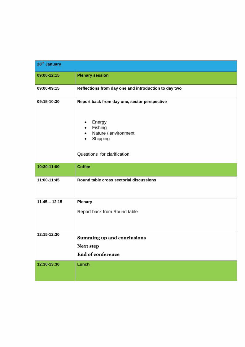
28th
January
09:00-12:15 Plenary session
09:00-09:15 Reflections from day one and introduction to day two
09:15-10:30
Report back from day one, sector perspective
Energy
Fishing
Nature / environment
Shipping
Questions for clarification
10:30-11:00 Coffee
11:00-11:45 Round table cross sectorial discussions
11.45 – 12.15 Plenary
Report back from Round table
12:15-12:30 Summing up and conclusions
Next step
End of conference
12:30-13:30 Lunch
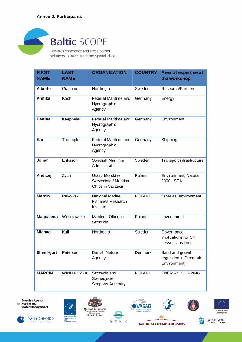
Annex 2. Participants
FIRST
NAME
LAST
NAME
ORGANIZATION COUNTRY Area of expertise at
the workshop
Alberto Giacometti Nordregio Sweden Research/Partners
Annika Koch Federal Maritime and
Hydrographic
Agency
Germany Energy
Bettina Kaeppeler Federal Maritime and
Hydrographic
Agency
Germany Environment
Kai Truempler Federal Maritime and
Hydrographic
Agency
Germany Shipping
Johan Eriksson Swedish Maritime
Administration
Sweden Transport infrastructure
Andrzej Zych Urząd Morski w
Szczecinie / Maritime
Office in Szczecin
Poland Environment, Natura
2000 , SEA
Marcin Rakowski National Marine
Fisheries Research
Institute
POLAND fisheries, environment
Magdalena Wesolowska Maritime Office in
Szczecin
Poland environment
Michael Kull Nordregio Sweden Governance
implications for C4
Lessons Learned
Ellen Hjort Petersen Danish Nature
Agency
Denmark Sand and gravel
regulation in Denmark /
Environment)
MARCIN WINIARCZYK Szczecin and
Swinoujscie
Seaports Authority
POLAND ENERGY, SHIPPING,
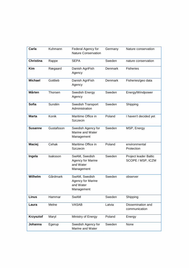
Carla Kuhmann Federal Agency for
Nature Conservation
Germany Nature conservation
Christina Rappe SEPA Sweden nature conservation
Kim Rægaard Danish AgriFish
Agency
Denmark Fisheries
Michael Gottlieb Danish AgriFish
Agency
Denmark Fisheries/geo data
Mårten Thorsen Swedish Energy
Agency
Sweden Energy/Windpower
Sofia Sundén Swedish Transport
Administration
Sweden Shipping
Marta Konik Maritime Office in
Szczecin
Poland I haven't decided yet
Susanne Gustafsson Swedish Agency for
Marine and Water
Management
Sweden MSP, Energy
Maciej Cehak Maritime Office in
Szczecin
Poland environmental
Protection
Ingela Isaksson SwAM, Swedish
Agency for Marine
and Water
Management
Sweden Project leader Baltic
SCOPE / MSP, ICZM
Wilhelm Gårdmark SwAM, Swedish
Agency for Marine
and Water
Management
Sweden observer
Linus Hammar SwAM Sweden Shipping
Laura Melne VASAB Latvia Dissemination and
communication
Krzysztof Maryl Ministry of Energy Poland Energy
Johanna Egerup Swedish Agency for
Marine and Water
Sweden None
Management
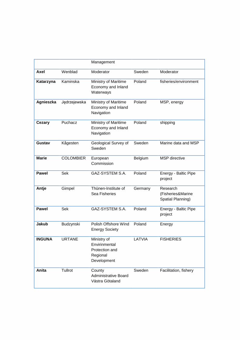
Axel Wenblad Moderator Sweden Moderator
Katarzyna Kaminska Ministry of Maritime
Economy and Inland
Waterways
Poland fisheries/environment
Agnieszka Jędrzejewska Ministry of Maritime
Economy and Inland
Navigation
Poland MSP, energy
Cezary Puchacz Ministry of Maritime
Economy and Inland
Navigation
Poland shipping
Gustav Kågesten Geological Survey of
Sweden
Sweden Marine data and MSP
Marie COLOMBIER European
Commission
Belgium MSP directive
Pawel Sek GAZ-SYSTEM S.A. Poland Energy - Baltic Pipe
project
Antje Gimpel Thünen-Institute of
Sea Fisheries
Germany Research
(Fisheries&Marine
Spatial Planning)
Pawel Sek GAZ-SYSTEM S.A. Poland Energy - Baltic Pipe
project
Jakub Budzynski Polish Offshore Wind
Energy Society
Poland Energy
INGUNA URTANE Ministry of
Envirinmental
Protection and
Regional
Development
LATVIA FISHERIES
Anita Tullrot County
Administrative Board
Västra Götaland
Sweden Facilitation, fishery
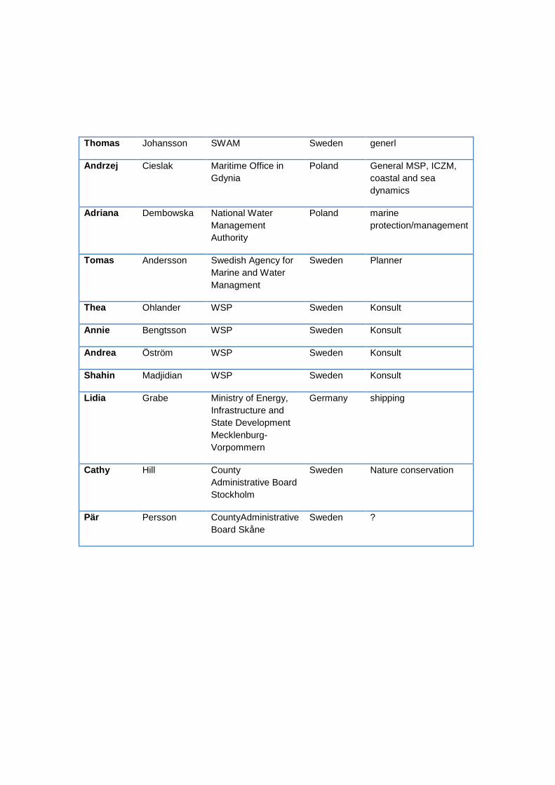
Thomas Johansson SWAM Sweden generl
Andrzej Cieslak Maritime Office in
Gdynia
Poland General MSP, ICZM,
coastal and sea
dynamics
Adriana Dembowska National Water
Management
Authority
Poland marine
protection/management
Tomas Andersson Swedish Agency for
Marine and Water
Managment
Sweden Planner
Thea Ohlander WSP Sweden Konsult
Annie Bengtsson WSP Sweden Konsult
Andrea Öström WSP Sweden Konsult
Shahin Madjidian WSP Sweden Konsult
Lidia Grabe Ministry of Energy,
Infrastructure and
State Development
Mecklenburg-
Vorpommern
Germany shipping
Cathy Hill County
Administrative Board
Stockholm
Sweden Nature conservation
Pär Persson CountyAdministrative
Board Skåne
Sweden ?
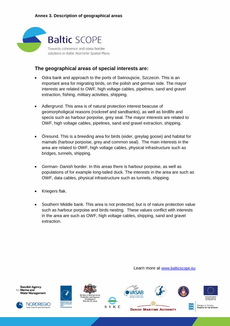
Annex 3. Description of geographical areas
The geographical areas of special interests are:
Odra bank and approach to the ports of Swinoujscie, Szczecin. This is an
important area for migrating birds, on the polish and german side. The mayor
interests are related to OWF, high voltage cables, pipelines, sand and gravel
extraction, fishing, military activities, shipping.
Adlergrund. This area is of natural protection interest beacuse of
geomorpholigical reasons (rockreef and sandbanks), as well as birdlife and
specis such as harbour porpoise, grey seal. The mayor interests are related to
OWF, high voltage cables, pipelines, sand and gravel extraction, shipping.
Öresund. This is a breeding area for birds (eider, greylag goose) and habitat for
mamals (harbour porpoise, grey and common seal). The main interests in the
area are related to OWF, high voltage cables, physical infrastructure such as
bridges, tunnels, shipping.
German- Danish border. In this areas there is harbour porpoise, as well as
populations of for example long-tailed duck. The interests in the area are such as
OWF, data cables, physical infrastructure such as tunnels, shipping.
Kriegers flak.
Southern Middle bank. This area is not protected, but is of nature protection value
such as harbour porpoise and birds nesting. These values conflict with interests
in the area are such as OWF, high voltage cables, shipping, sand and gravel
extraction.
Learn more at www.balticscope.eu