Embed Size (px)
Citation preview

Activities in SWC since last time
• Bi/Tri lateral meetings
PL-SE, PL-DE, DE-DK-SE
Detailed discussions on conflicts, synergies, potential solutions. Using the same method.
• Started the discussion about solutions and results of the project, reporting
• Developed a proposal for safety distances between shipping lanes and fixed objects

Cont….
• Initiated the process for settling border issues
• Harmonization of the topic paper for fishery between
the two cases
• Discussed about developing a joint Green map,
possibly making a joint map with CBC?
• Participated in CBC stakeholder workshop in
Jurmala

SWB Planners meeting
• Discussion on what we mean by recommendations – There are different levels, some are case-specific, others theme-specific.
– Geographical cases are interesting to ourselves (planners group Baltic Scope)
– Divide into categories: planning-, policy-, recommendations from the project... (pyramid)
– Point our target group for each recommendation, to ensure correct level of detail etc.
– Policy recommendations should be adopted by the whole Baltic Scope project
TO DO
• Start working with the report (draft table of content)– Discussions about the structure
– Tomas and Alberto, deadline mid August
– A shorter PPT-version is very useful
• Conclusions and recommendations from Topics and bi-lateral meetings, with
target groups. (Also including a list of unsolved issues if applicable)– Topic leaders, deadline August 1st
– Nordregio will extract case conclusions and recommendations
• Draft will be sent out to planners 1 week before autumn meeting
(September?)– Tomas and Alberto
• Fill in the ecosystem approach checklists
– Send to Jan SC. Deadline before meeting in September
Policy-------
Planning-------------
Lessons learned = foundation

Bi/Tri lateral meetings
• Full day meetings
• Used same method
• Excel matrix to fill out
• Questioners to fill out

Bi lateral meetings
Conclusions/
recommendations
The process
• Bi-lateral meetings has been a good
- Focusing the discussions on problem and
potential solutions
• Recommend the partners to have continues
bilateral meeting to follow up through out the
planning process


Results/ Recomendations
Kriegers flak (DK, DE, SE)
Kriegers flak is already allocated to OWF
• Plan for possibilities to interconnect the national
power grids
• Illustrate possible gates for potential connections
• On giving permits – investigate all three countries
requirements for constructions
• The three countries should harmonize the safety
distances to shipping
• Potential need for adjustment of shipping (ferry) line
between Trelleborg and Travemünde if DK builds

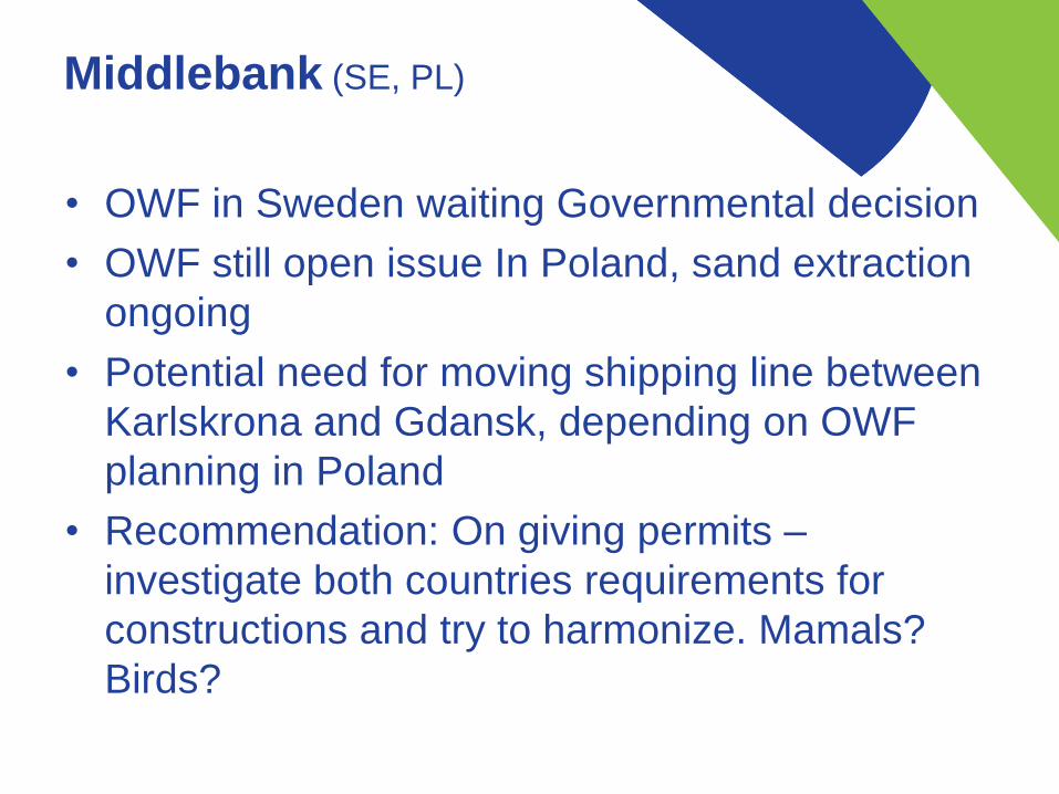
Middlebank (SE, PL)
• OWF in Sweden waiting Governmental decision
• OWF still open issue In Poland, sand extraction
ongoing
• Potential need for moving shipping line between
Karlskrona and Gdansk, depending on OWF
planning in Poland
• Recommendation: On giving permits –
investigate both countries requirements for
constructions and try to harmonize. Mamals?
Birds?

Pomeranian Bay (Odra Bank
& Harbour Approach) (DE, PL)

“Grey Zone”
• Maritime Office in Szczecin has approach
relevant Polish ministry
• Poland has approach Denmark, on civil servants
level, to bring the issue to relevant authority and
level.
• DMA has notified the ministry about the Polish
initiative.

Recommandations, shipping
• The future planning must respect UNCLOS regulation including the strait regime in the Sound and the approaches to the Great Belt
• It is important to ensure that safety at sea and navigation requirements are adequately addressed during preparation and planning.
• Early relavant stakeholder and expert involvement between sectors and between maritime administrations in neighbouring countries are necessary to avoid conflicts and to obtain transboundary coherence in plans. Cross-border working groups could be established to resolve issues (SWC+CBC Jurmala/Malmö)
• It is recommended not to make rerouting in and/or adjacent to existing IMO recognized Traffic Separation Schemes (TSSs), two way routes, recommended routes, DW-routes and of major traffic flow etc.
• Depending on the scale of potential rerouting in and/or adjacent to existing ship routes, Traffic Separation Schemes (TSSs), two way routes, recommended route etc. shipping consequence analyses must be carried out. These analyses must be in accordance with international recognised risk assessment methods, e.g. the IALA risk management toolbox or the IMO adopted Formal Safety Assessment methodology (FSA).
• Potential changes of international main routes (Deep water route T, transit traffic flow in connection with TSSs through the area) are necessary to carry out through IMO.
- Governments intending to establish a new routeing system, or amend an existing one, must submit proposed routing measures to IMO's Sub-Committee on Navigation, Communication and Search and Rescue (NCSR), which will then evaluate the proposal and make a recommendation regarding its adoption. The recommendation is then passed to the MSC for adoption.2
- Marine spatial plans may not necessarily conform with IMO regulations but governments should work for alignment over time.
• - It is recommended to establish a safety distance between offshore installations and fairways, routes, TSSs etc. The minimum distance between wind

Shipping con.
• turbines and routes used for shipping is defined individually from case to
case under consideration of traffic requirements and further framework
conditions. The standard value is 2 nm plus a eventual safety zone of 500 m
• When designating Spatial needs for shipping future Development of traffic
must be taken into account including density and ships sizes.
• -Consideration must be paid to avoid conflicts between commercial vessels
and leisure boating when for instance planning large areas for wind farms.
• It is recommended that Wind turbines are designed and constructed so
called “collision-friendly“.
• Data on shipping can but not only be based on AIS-data or WMS for fishing.
Data on other ‘smaller’ vessels traffic must be taken into account in ships
analyses and effective knowledge and data sharing methods must be
developed.

Energy- Challenges
• Complexity, lack of harmonization between different EU
directives and lack of common understanding what is needed
for coherent planning as well as unsettled border issues
makes transnational MSP difficult
• Sector stakeholders are not used to think holistic
• Differences in national legal systems (and legal role of MSP
authorities), stage of MSP
• Cross-border (coherent) MSPs are not available yet, but
projects are under development and need decisions/permits
in the near future
Energy-
Recommendations
• Secure political involvement on a pan-Baltic level for MSP
• Establish close cooperation of planning authorities and set up
a permanent platform for transboundary MSP (independent
from projects)
– Respect/Consider existing/approved infrastructure of neighbouring
countries
– Discuss jointly general projected/planned infrastructure to fit into future
cross-border plans and make respective provisions in MSP
– Discuss plans/projects with transnational impact in an early phase in
particular in the case of , before making final decisions on location,
routing etc. (e.g. Baltic Pipe)

Energy-
Recommendations
• Develop jointly cross-border corridors and gates for linear
infrastructure in MSP (power lines, data cables, pipelines)
- width according to capacity needed and applicable technical
requirements (to be agreed on?), considering conflicting interests,
including space/capacity for future infrastructure, with definition of type
of infrastructure allowed within the corridor
• Develop and decide on common criteria in MSP for
– safety distances between shipping routes and OWF (e.g. proposal of
DMA)
– strategic environmental assessments (SEA)
Guidelines needed for solving sectoral conflicts and respective decisions to
be taken on exceptions from agreed general rules, as well as potential
mitigation measures (e.g. in case of routing of cables in Natura 2000 areas,
cables crossing major shipping routes etc.)

Fishing- Maps and data of
fisheries in SW countries
• Denmark: VMS tracks of trawling and passive gearvessels 2011-2014. Cover areas outside EEZ butnot the eastern parts of SW case area
• Germany: Areas of interest within EEZ. No info on fishing acitivites. Recent info shows low fishingacitivity without any clear transboundary patternsdue to a fleet with small vessels.
• Poland: Catch data from 2012 including species and gear types. Cover areas outside EEZ but not the western part of SW case area
• Sweden: Map of landing weights for cod 2008-2012. Includes activities as well as important areasoutside Swedens EEZ
Planner recommendation: MSP should show areas of national interest for fisheries in other countries EEZ.

Adler bank: Important fishing
ground for Poland in Danish waters
- Question: What is the management ’s view on passive gear in future fisheries in the
countries?
- Planning recommendation: Secure acess to Adlers bank from landing places of
Kolobrzeg and Swinoujsce (e.g design of future OWF area at Odra Bank)

Middlebank: Important fishing
ground (SWE, PL and CB case)
- Planning recommendation: Future OWF areas on the bank should be designated in
order to promote shipping to go north of the bank
- A problem? Fishieries and Shipping are identified as co-existence but is it stilll with
future traffic volumes as well as from a habitat perspecitive?

Environment Key issue /
challenges
• When the administrative borders run through the
ecologically valuable areas it should be the subject of
deeper reflection of neighbouring countries as it is rarely
so that at the same time it is the ecosystem border.
• specific points (issues) critical for ecosystem proper
functioning and conditioning its spatial connectivity (i.a.
blue corridors) – these should be identified and should
be the object of joint protection of neighbouring
countries.
• Not only natural environment values count by also its
transborder connectivity.

Environment- MSP
authorities/teams should
• have the understanding and current knowledge not only on
spatial range of protected areas but also on the objects of
protection, defined influences, existing prohibitions and
injunctions determining human use of the sea area.
• have the understanding and current knowledge on the
protected areas (objects of protection, defined influences,
prohibitions and injunctions) designated in the border area of
neighbouring countries so that they could avoid location of the
investments/uses having negative influence at these valuable
areas - continuous access to comprehensive and reliable
data/ information / knowledge /expertise.
• have the deepened knowledge on EIA procedures in
neighbouring countries.

Environment- crossborder
protected & valuable areas
Neighbouring countries should cooperate in the process of
their management. Different levels of coop. may exist:
•information about the intention to establish new protected area;
•information about the management/protection plans elaboration;
•consultation of the solutions which may influence the human
use of the sea areas of neighbouring countries;
•joint development of such solutions being later transferred to
national managements/protection plans;
•joint elaboration/agreement of the basis of monitoring of sea
use having potential negative influence on protection objects and
connectivity.

Environment - Needs
• there should be support given to joint, transboudary
research on
– sensitivity / risk analyses regarding i.e. oil spill, noise needed to
support MSP process as well as for
– monitoring / research programs to gather information on objects
of protection which are not well enough recognized like e.g.
harbour porpoise
– conditions for successful co-existance (e.g. OWF – fish
resources, harbour porpoise).
These recommendations should be given to programs
financing Baltic research (BONUS), VASAB?

• the neighbouring countries should avoid planning such human uses which may negatively influence the cohesion and connectivity of crossborderprotected/valuable areas
• strenghening the relationship / regular cooperation with international decision organs on different levels like Helcom (regional sea level), IMO (global level) to find solutions to the problems connected to the environment revealed in the course of MSP process
• regular multilateral groups based on formal agreements to discuss transboundary issues in order to develop common approach / solutions
• common approach to protection measures and objects of protection and based on it setting criteria for other activities (prohibitions, limitations, possible co-existance, synergies);
Needs, cont.

Report from SWC,
proposed
Format
• Short with concrete recommendations, bullet
format
Target group
• Baltic scope partners
• Planners in our countries (our self)
• Ministries
• Helcom/Vasab

Results on different levels
• Policy results?
• Planning oriented?
• Thematic?

• Proposed structure of case study report. List of
content