Embed Size (px)
Citation preview

Dr. Danika van Proosdij & Greg Baker
Department of Geography, Saint Mary’s University
Coastal Vulnerability Assessment
1
Rationale
2
Coastal zones are dynamic – leads to conflict between natural variability & economic, social & cultural activities
Anse Source D’Argent, La Digue Petit Sable, Mauritius

Rationale
3
Adaptive capacity of coastal communities directly linked to availability of physical space, shore zone stability & knowledge
Lack of consistent polices often leads to the systematic use of hard engineering structures without consideration for either coastal dynamics or socioeconomic factors
Point d’Ensy Road to Grand Sable, Mauritius
Coastal Vulnerability
4 Photo: Sam Page, 2012
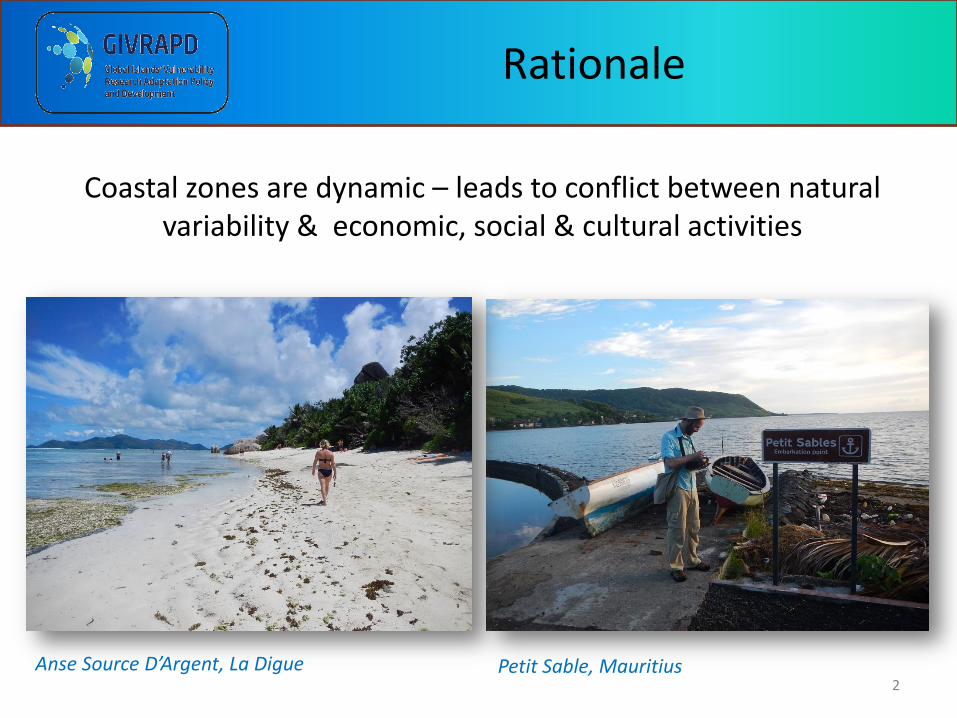
Exposure Condition • fetch • dominant wind/wave direction • shoreline orientation • tidal state
Biophysical State • geomorphology • built features • erodibility • slope • elevation
Resilience Condition • eco-morphological resilience capacity • sediment budget • relaxation time
Adaptive Capacity • political • financial • cultural/social
Adaptation Response/ Adjustments • hold the line (shore protection) • retreat (incl. set backs) • abandon
Understanding the complexities of current and future coastal exposure-sensitivities and adaptive strategies is one of the central themes of the ParCA & GIVRAPD projects.

Research Approach
GOAL: Assess and compare coastal vulnerability (exposure – sensitivity) to current and future coastal erosion and storm surge and associated adaptive capacity within the ParCA and GIVRAPD study areas in Canada, the Caribbean and Indian Ocean.
Field Characterization & Assessment
Modelling & Visualization within GIS

Research Approach: Field
6
Anse Royale
• Line segmentation @ changes in backshore, foreshore and nearshore
• Notable point features (e.g. groyne, fishing access, drain, pier)
• Geotagged enabled camera
Trimble Yuma Field Tablet
Blue Bay
7
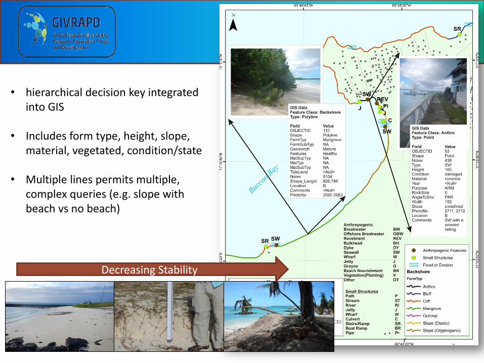
• hierarchical decision key integrated into GIS
• Includes form type, height, slope,
material, vegetated, condition/state • Multiple lines permits multiple,
complex queries (e.g. slope with beach vs no beach)
Decreasing Stability

Research Approach: Field
8
• Modified Emery Board method
• Beach width, slope, wave E proxy • Profiles perpendicular to coast
Research Approach: GIS
9
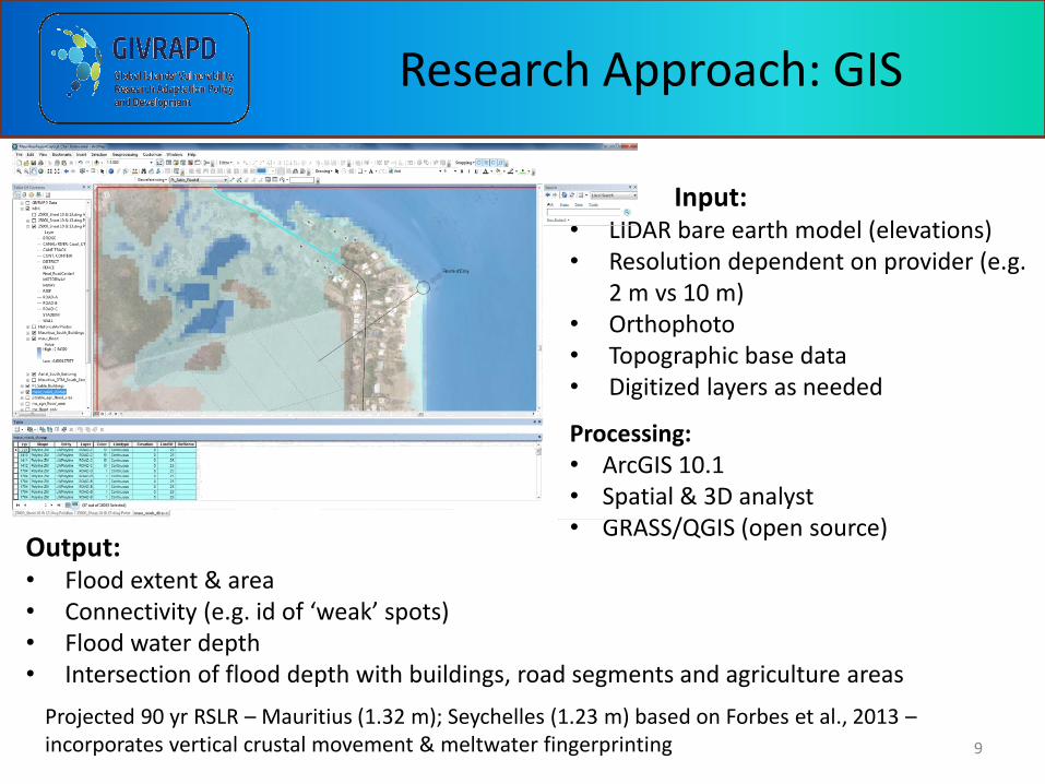
Input: • LIDAR bare earth model (elevations) • Resolution dependent on provider (e.g.
2 m vs 10 m) • Orthophoto • Topographic base data • Digitized layers as needed
Processing: • ArcGIS 10.1 • Spatial & 3D analyst • GRASS/QGIS (open source)
Projected 90 yr RSLR – Mauritius (1.32 m); Seychelles (1.23 m) based on Forbes et al., 2013 – incorporates vertical crustal movement & meltwater fingerprinting
Output: • Flood extent & area • Connectivity (e.g. id of ‘weak’ spots) • Flood water depth • Intersection of flood depth with buildings, road segments and agriculture areas

Field Assessment Example: Grand
& Petit Sable, Mauritius
10
• 82% foreshore coarse sand, low gradient, stabilized, evidenced by significant wrack material & garbage
• Shore protection only in backshore (55%), min engineering (except park), opportunistic use of materials – all evidence of disrepair or failure
• Query level of understanding of mangrove planting as useful – evidence of use of cut wood for field stakes

Flood Analysis: Anse Royale, Seychelles
11
• Projected 90 yr RSLR = 1.23 m • 152 buildings flooded • 1.16 km road • 16.13 Ha agricultural land flooded behind Anse
Royale • Primary conduit under Bazaar bridge & wetland

PARCA: Negril characterization & assessment post Sandy
12
Antropogenic Feature
!> Culvert
Artifical Reef
Breakwater
Gate
Groyne
Road
Run-off Trench
Sill
Wall
Wharf
Tourist Amenity
¼= ATM
J Airport
"# Bank
"ñ Fire Station
I8 Fuel
ÆP Hospital
ÆI Park
"î Place of Worship
ca Police
Ó" Post Office
_ Resort
"n School
Backshore Form Type
anthro
cliff
outcrop
platform
slope
waterbody
wetland
Backshore Conditions
high stabilized
not stabilized
partially stabilized
unconsolidated over solid

Physical Vulnerability Analysis
13 Analysis conducted by S. Letourneau

Challenges: Accommodation Space
14
Example: Anse Source D’Argent
Key tourist destination, widely advertised , iconic beach – min area to ‘roll back’
Challenges: Accommodation Space
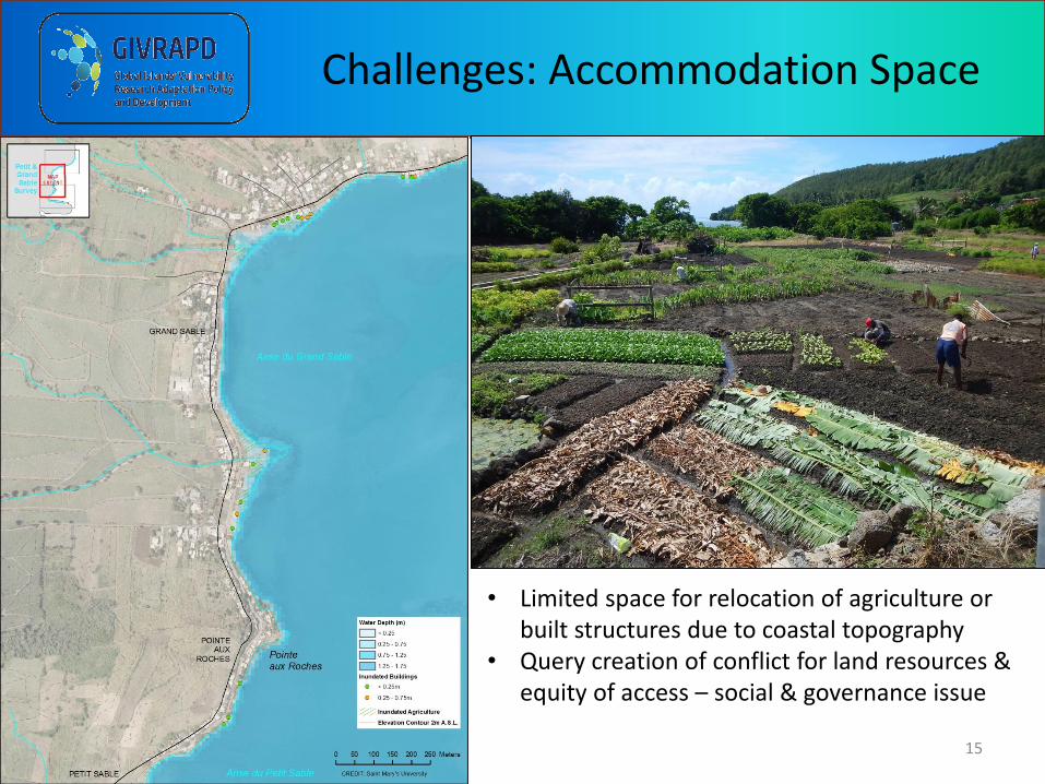
15
• Limited space for relocation of agriculture or built structures due to coastal topography
• Query creation of conflict for land resources & equity of access – social & governance issue

Adaptation vs Maladaptation
16
Key to adaptation is choosing a solution that does not create additional problems (e.g. undermining structure or neighbouring structures or interrupting supply of sediment) Does not need to be costly, just designed with coastal process in mind & not all techniques are appropriate in all areas Encourage use of soft/living or hybrid shoreline where appropriate however will require a longer time to realize benefits compared with ‘immediate’ result of rock armouring

Innovations & Opportunities
17
Natural planting of hybrid options
Restrict or modify development to permit migration of coastal landforms & coastal processes Use future predicted HWL rather than exisiting
Education, training, outreach & community engagement
Beach nourishment appropriate if sand sustainably obtained Requires consideration of longshore transport

Recommendations
18
• Maps provide basis for dialogue & community decision making - protect/accommodate/retreat – ID priorities & options
• Critical to consider planning at littoral cell level (e.g.
coastal component of sediment transport – see Cuzes-Duvat and Robert (2001) for maps) to avoid maladaptation choices (e.g. groyne which cuts of sediment supply)
• Increase education & outreach on cost - effective design of coastal protection structures – including outreach to agricultural & fishing communities
• Integrate local knowledge and experience
where possible – share experiences between island communities
Acknowledgements
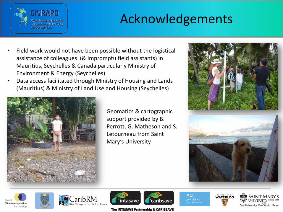
• Field work would not have been possible without the logistical assistance of colleagues (& impromptu field assistants) in Mauritius, Seychelles & Canada particularly Ministry of Environment & Energy (Seychelles)
• Data access facilitated through Ministry of Housing and Lands (Mauritius) & Ministry of Land Use and Housing (Seychelles)
Geomatics & cartographic support provided by B. Perrott, G. Matheson and S. Letourneau from Saint Mary’s University
19