Embed Size (px)
Citation preview

Going for GOLD Adventures in Open Linked
Geospatial Metadata
James Reid,Geoservices, EDINAUniversity of Edinburgh

EDINA National Data Centreour mission...
to enhance the productivity of research, learning and teaching in UK higher and further education
Networked access to a range of online resources for all UK FE and HE (including OS/BGS/Seazone and Landmark Historic data)
Institutional subscription services at subsidised rates or at no charge. For use by staff and students in learning, teaching and research
Focus is on service but also undertake R&D (projects services)
Employs about 80 staff (30 in geo), in two locations (Edinburgh & Warrington)
Who?

What?
In a nutshell...
Exploring the creation of Linked Data versions of geospatial metadata via alternative mechanisms …
GOLD – GOgeo as Linked Data www.gogeo.ac.uk

Why?
Discovery.ac.uk
Linked Data is the new black
Conventional metadata publishing not 'open' enough

More on the Why?
Search engines are poorly optimised to index Deep Web databases. Applications are increasingly becoming Linked Data friendly.
The evolution of metadata vocabularies towards RDF based models.

More on the What?
2 approaches:
1. Metadata crosswalking. Use a Dublin Core crosswalk to implement uniform mappings from geographic metadata schemas to the RDF data model by:
i. Applying a metadata crosswalk from the original metadata schema (ISO) to the Dublin Core vocabulary.
ii. Adding additional metadata such as provenance of the record, original information model or crosswalk identification.
iii. Apply the profile for expressing as RDF the metadata terms.
2. An alternative approach was to publish direct from the relational data store underpinning the metadata resource , direct to RDF. An extension to this approach was to produce the RDF direct from the UML itself

Metadata crosswalkingUsed here to mean a transformation that is done on a particular document (in this case a catalogue record) rather than at the level of a database or collection of such documents. The approach turns on a 'harvesting' mechanism similar to that used more generally across the European spatial data infrastructure and elsewhere e.g. JRC harvest of UK metadata.
procedure Harvest(source, start) [CSW/WAF]for xml in source modified since start do
rdf Transform(xml) ← [XSLT]Store(rdf ) [4store]
end forend procedure
Harvest – a specialised CSW client was written (in Go)
A quadstore RDF database (4Store) was used to store the transformed records

Metadata crosswalking
Crosswalk mapping of ISO1939 elements to common RDF vocabularies.
Some simplification required - in many cases it makes sense to produce more than one RDF statement e.g. temporal extent where the expression of a time interval in RDF can be quite verbose, and vice-versa where it takes many elements in ISO19139 to express a geographical bounding box but because we opted for the simpler representation, the RDF requires only three.
Some anomalies in some elements e.g. to distinguishbetween various types of dates, (publication or modification date), it appears that thecontrolled vocabulary and localisation support in many catalogues is incomplete for this purpose.

Database and UML to RDF Approaches
D2R is a toolset for publishing relational databases on the Semantic Web. It enables RDF and HTML browsers to navigate the content of the database, and allows applications to query the database using a formal query language - SPARQL (SPARQL Protocol and RDF Query Language).
In this approach, queries are expressed in the SPARQL query language (whether expressly composed or implied by the act of fetching or dereferencing a resource identifier) and are transformed to more traditional SQL queries that are then executed against the underlying database.
The major aspect for consideration here is the mapping between the database schema and the RDF constructs expected in the outputs. These mappings can become quite onerous to hand-craft and we developed an approach to making this less tedious by extending the capabilities of a visual UML tool (Enterprise Architect)

Database and UML to RDF Approaches
Two main difficulties encountered with this approach.
1. Fragility and relative instability of local database schemas.
2. Lack of schema documentation making the process of refining the mappingconfiguration for the D2R server non-trivial if the schema is at all complicated or subject to frequent changes.
The relative merits of which approach to use – crosswalking or derivation directfrom a database, are ultimately bound to issues of available infrastructure, skillsets, data currency.
Side-by-side comparison of Crosswalk and D2R based approaches

Some Points to Consider - URIs
Implicitly these suggests:
- URIs can be clearly and unambiguously defined and assigned to identify particular resources.
- URIs are stable and persist.
Context - Cabinet Office paper, “Designing URI Sets for the UK Public Sector”, endeavoured to address this issue but it's adoption and adaptation to location (geospatial) information in “Designing URI Sets for Location” highlighted an issue of political sensitivity – specifically the fact that in its original presentation the guidance neglected to allow for nationally determined and nationally specific URI schemes.
The guidance is being recast to allow for Scottish, Welsh and Northern Irish URI naming schemes to be adopted if required by the devolved administrations.
Scottish Government are discussing adopting a http://{resource}.data.scotland.gov.uk pattern where {resource} maps to the United Nations Classification of Functions of Government (COFOG) headings, using a cofog01, cofog02 approach rather than the descriptive label e.g. "general public services", "defence", etc.
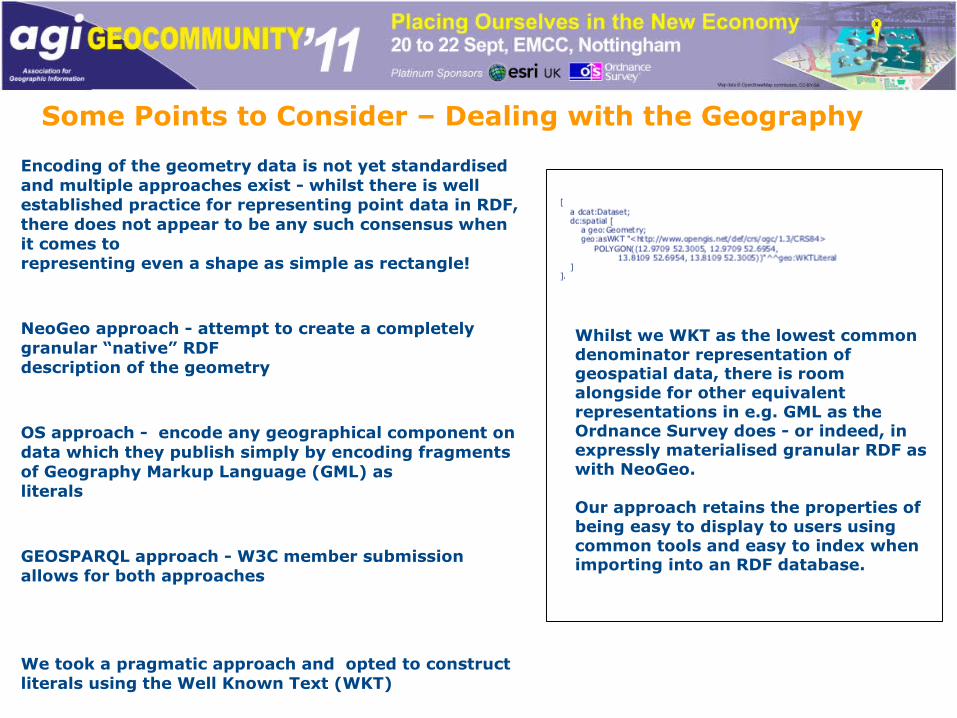
Some Points to Consider – Dealing with the Geography
Encoding of the geometry data is not yet standardised and multiple approaches exist - whilst there is well established practice for representing point data in RDF, there does not appear to be any such consensus when it comes torepresenting even a shape as simple as rectangle!
NeoGeo approach - attempt to create a completely granular “native” RDFdescription of the geometry
OS approach - encode any geographical component ondata which they publish simply by encoding fragments of Geography Markup Language (GML) asliterals
GEOSPARQL approach - W3C member submission allows for both approaches
We took a pragmatic approach and opted to construct literals using the Well Known Text (WKT)
Whilst we WKT as the lowest common denominator representation of geospatial data, there is room alongside for other equivalent representations in e.g. GML as the Ordnance Survey does - or indeed, in expressly materialised granular RDF as with NeoGeo.
Our approach retains the properties of being easy to display to users using common tools and easy to index when importing into an RDF database.

Conclusions
We have established a basic workflow and infrastructure which support CSW harvesting (from any CSW) and automated Linked Data publication of that geospatial metadata by adopting well known and frequently used vocabularies e.g. FOAF, Dcat.
An open question remains as to whether or not Linked Data is the panacea to resource discovery and reuse that its proponents assert.
A significant issue to overcome is to establish core, common vocabularies – particularly in respect to alternate and competing approaches to the representation of geometry information.