Embed Size (px)
DESCRIPTION
The excavation of the site at Clash comprised a truncated Bronze Age house dating to the Late Bronze Age. The structure was defined by a double ring of post-holes, the inner ring was concentric with the outer ring, but neither ring was complete. The internal diameter of the complete structure was 6.2 m. The entrance to the house faced east-northeast and measured 1.2 m in width. A small pit and four stake-holes were located centrally in the structure.
Citation preview
Issue 11 [ISSN 2009-2237]
Archaeological Excavation Report
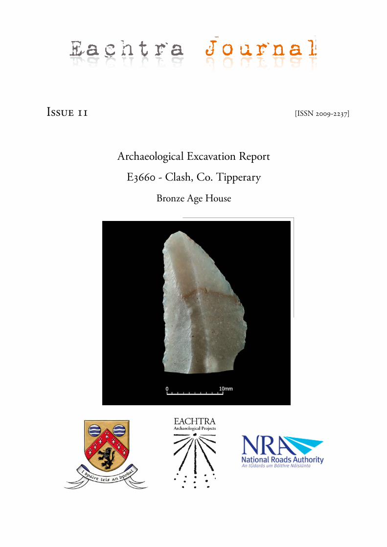
E3660 - Clash, Co. Tipperary
Bronze Age House
Eachtra Journal

July 2011
Archaeological Excavation Report
Co. Tipperary
Laois County Council and National Roads Authority
John Tierney
Clash
EACHTRAArchaeological Projects
E no
:
:
Project:
Client:
E3660
John TierneyExcavation Director
Written by:
Bronze Age House
N7 Castletown to Nenagh (Contract 1)

CORKThe Forge, Innishannon, Co. Cork
tel: 021 4701616 | web: www.eachtra.ie | email: [email protected]
GALWAY Unit 10, Kilkerrin Park, Liosbain Industrial Estate, Galway
tel: 091 763673 | web: www.eachtra.ie | email: [email protected]
Archaeological Excavation Report
ClashCo. Tipperary
Excavation Director
John Tierney
Written By
John Tierney
EACHTRAArchaeological Projects
© 2011 The Forge, Innishannon, Co Cork
Set in 12pt Garamond
Printed in Ireland
i
Table of ContentsSummary����������������������������������������������������������������������������������������������������������������������������������������������������������������iii
Acknowledgements��������������������������������������������������������������������������������������������������������������������������������������� iv
1 Scopeoftheproject�������������������������������������������������������������������������������������������������������������� 1
2 Routelocation��������������������������������������������������������������������������������������������������������������������������� 1
3 Receivingenvironment��������������������������������������������������������������������������������������������������������� 3
4 Archaeologicalandhistoricalbackground��������������������������������������������������������������������� 4Mesolithic�(c��8000�to�4000�BC)����������������������������������������������������������������������������������������������������������������� 4
Neolithic�(c��4000�to�2000�BC)�������������������������������������������������������������������������������������������������������������������� 4
Bronze�Age�(c��2000�to�600BC)������������������������������������������������������������������������������������������������������������������ 4
Iron�Age�(c��500�BC�to�AD�500)������������������������������������������������������������������������������������������������������������������ 6
Early�medieval�period�(c��AD�400�to�1100)������������������������������������������������������������������������������������������ 6
High�and�later�medieval�periods�(c��AD�1100�to�1650)����������������������������������������������������������������� 6
Post-medieval�period�(c��1650�to�the�present)���������������������������������������������������������������������������������� 7
5 SiteLocationandTopography�������������������������������������������������������������������������������������������� 7
6 Excavationmethodology������������������������������������������������������������������������������������������������������ 9
7 Excavationresults�������������������������������������������������������������������������������������������������������������������� 9
8 Discussion�������������������������������������������������������������������������������������������������������������������������������� 21
9 References��������������������������������������������������������������������������������������������������������������������������������22
Appendix1 Stratigraphicreport�������������������������������������������������������������������������������������������23
Appendix2 SiteMatrix������������������������������������������������������������������������������������������������������������� 39
Appendix3 Groupandsubgroups��������������������������������������������������������������������������������������40
Appendix4 Plantremains������������������������������������������������������������������������������������������������������46
Appendix5 Lithicsreport��������������������������������������������������������������������������������������������������������49
ii
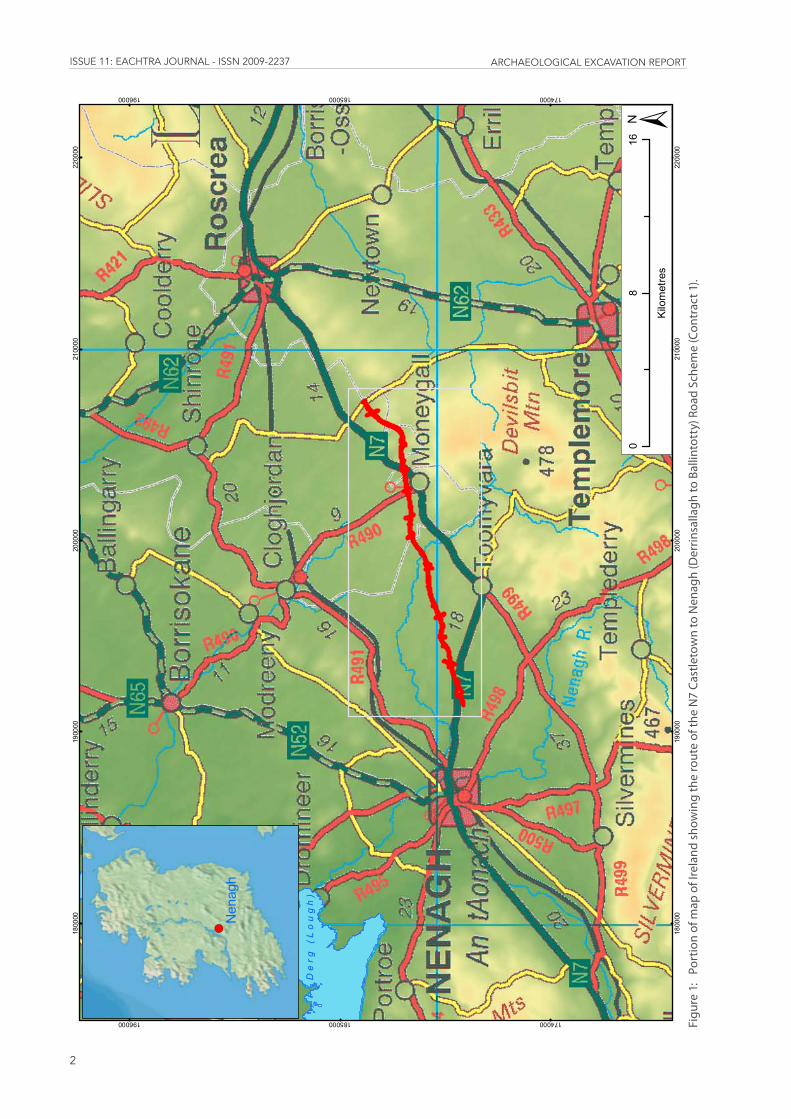
List of FiguresFigure1: PortionofmapofIrelandshowingtherouteoftheN7CastletowntoNenagh(Derrin-
sallaghtoBallintotty)RoadScheme(Contract1)�������������������������������������������������������������������������� 2
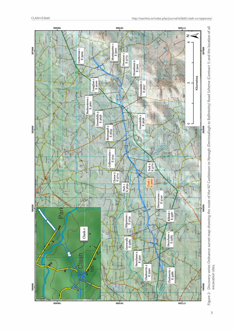
Figure2: DiscoveryseriesOrdnancesurvetmapshowingtherouteoftheN7CastletowntoNenagh(DerrinsallaghtoBallintotty)RoadScheme(Contract1)andthelocationofallexcavationsites������������������������������������������������������������������������������������������������������������������������������������������ 5
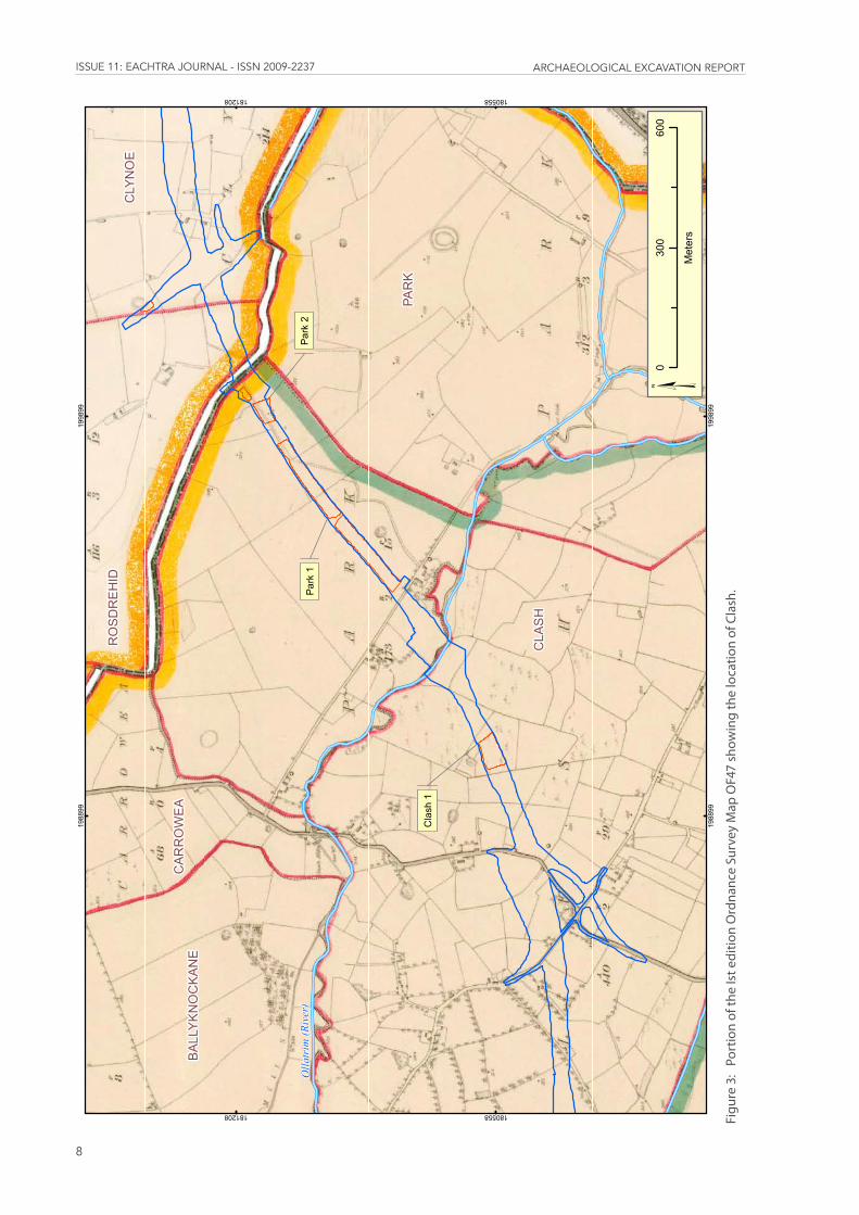
Figure3: PortionoftheIsteditionOrdnanceSurveyMapOF47showingthelocationofClash���� 8
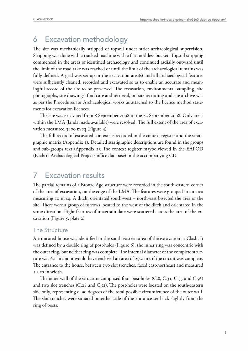
Figure4: LocationandextentofClashE3660ontheN7CastletowntoNenagh�������������������������������10
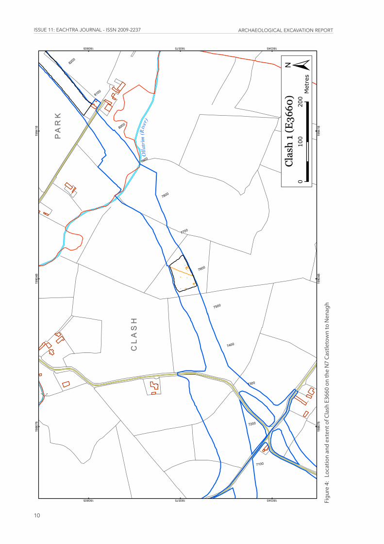
Figure5: Post-excavationplanofClashE3660������������������������������������������������������������������������������������������������ 11
Figure6: Post-excavationplanoftheBronzeAgehouseatClash����������������������������������������������������������� 14
Figure7: SectionsofC�33,C�36,C�31,C�3andC�52���������������������������������������������������������������������������������������� 15
List of PlatesPlate1: AerialviewofClash,notetheOllatrimRiverinthemiddlegroundandtheexcavation
atParkE3659inthebackground���������������������������������������������������������������������������������������������������������� 7
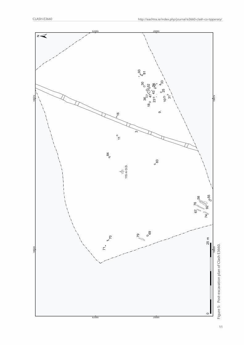
Plate2: ViewofareaofexcavationatClashfromwest,notetheareaoftheBronzeAgehouseonthesouthernedgeoftheareaofexcavation������������������������������������������������������������������������� 12
Plate3: Post-excavationofpost-holeC�8������������������������������������������������������������������������������������������������������� 13
Plate4: Post-excavationofpost-holeC�18������������������������������������������������������������������������������������������������������ 13
Plate5: Mid-excavationofpitC�36������������������������������������������������������������������������������������������������������������������� 17
Plate6: Mid-excavationofpitC�10�������������������������������������������������������������������������������������������������������������������� 17
Plate7: Mid-excavationofpitC�23��������������������������������������������������������������������������������������������������������������������18
Plate8: ViewofflintbladeE3660:1:1�����������������������������������������������������������������������������������������������������������������20
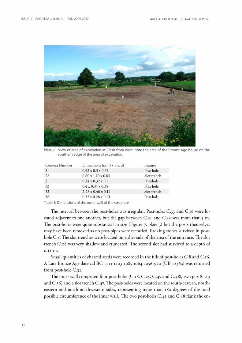
List of TablesTable1:Dimensionsoftheouterwallofthestructure�������������������������������������������������������������������������������������� 12
Table2:Dimensionsoftheinnerwallofthestructure��������������������������������������������������������������������������������������16
Table3:Dimensionsofthefeaturesintheinteriorofthestructure�������������������������������������������������������������16
Table4:Dimensionsoffeaturesinproximitytothestructure������������������������������������������������������������������������16
Table5:Dimensionsofnon-archaeologicalfeatures����������������������������������������������������������������������������������������� 19
Table6:Radiocarbondates������������������������������������������������������������������������������������������������������������������������������������������ 19
Clash-E3660
iii
http://eachtra.ie/index.php/journal/e3660-clash-co-tipperary/
SummaryThe excavation of the site at Clash comprised a truncated Bronze Age house dating to the Late Bronze Age. The structure was defined by a double ring of post-holes, the inner ring was concentric with the outer ring, but neither ring was complete. The internal diameter of the complete structure was 6.2 m. The entrance to the house faced east-northeast and measured 1.2 m in width. A small pit and four stake-holes were located centrally in the structure.
Road project name N7 Castletown to Nenagh Site name ClashE no. E3660Site director John TierneyTownland ClashParish BallymackeyCounty TipperaryBarony Upper OrmondOS Map Sheet No. TN22National Grid Reference 199051 180559

issUE 11: EaChtra JoUrnal - issn 2009-2237 arChaEologiCal ExCavation rEport
iv
AcknowledgementsThe project was commissioned by Laois County Council and was funded by the Na-tional Roads Authority under the National Development Plan (2000-2006). The project archaeologist was Niall Roycroft. Kildare County Council supervised the archaeological contract with RE staff of Pat Dowling and Colum Fagan. Kildare County Council Sen-ior Executive Engineer was Joseph Kelly and Kildare County Council Senior Engineer was John Coppinger. The senior archaeologist was John Tierney and the post-excavation manager was Jacinta Kiely. Illustrations are by Maurizio Toscano, photographs by John Sunderland and Eagle Photography and aerial photography by StudioLab. Specialist anal-ysis was carried out by Mary Dillon and Penny Johnston and the 14 Chrono Centre at Queen’s University Belfast.
Clash-E3660
1
http://eachtra.ie/index.php/journal/e3660-clash-co-tipperary/
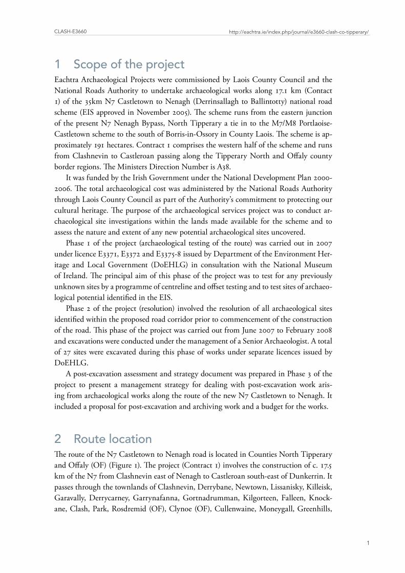
1 Scope of the project Eachtra Archaeological Projects were commissioned by Laois County Council and the National Roads Authority to undertake archaeological works along 17.1 km (Contact 1) of the 35km N7 Castletown to Nenagh (Derrinsallagh to Ballintotty) national road scheme (EIS approved in November 2005). The scheme runs from the eastern junction of the present N7 Nenagh Bypass, North Tipperary a tie in to the M7/M8 Portlaoise-Castletown scheme to the south of Borris-in-Ossory in County Laois. The scheme is ap-proximately 191 hectares. Contract 1 comprises the western half of the scheme and runs from Clashnevin to Castleroan passing along the Tipperary North and Offaly county border regions. The Ministers Direction Number is A38.
It was funded by the Irish Government under the National Development Plan 2000-2006. The total archaeological cost was administered by the National Roads Authority through Laois County Council as part of the Authority’s commitment to protecting our cultural heritage. The purpose of the archaeological services project was to conduct ar-chaeological site investigations within the lands made available for the scheme and to assess the nature and extent of any new potential archaeological sites uncovered.
Phase 1 of the project (archaeological testing of the route) was carried out in 2007 under licence E3371, E3372 and E3375-8 issued by Department of the Environment Her-itage and Local Government (DoEHLG) in consultation with the National Museum of Ireland. The principal aim of this phase of the project was to test for any previously unknown sites by a programme of centreline and offset testing and to test sites of archaeo-logical potential identified in the EIS.
Phase 2 of the project (resolution) involved the resolution of all archaeological sites identified within the proposed road corridor prior to commencement of the construction of the road. This phase of the project was carried out from June 2007 to February 2008 and excavations were conducted under the management of a Senior Archaeologist. A total of 27 sites were excavated during this phase of works under separate licences issued by DoEHLG.
A post-excavation assessment and strategy document was prepared in Phase 3 of the project to present a management strategy for dealing with post-excavation work aris-ing from archaeological works along the route of the new N7 Castletown to Nenagh. It included a proposal for post-excavation and archiving work and a budget for the works.
2 Route locationThe route of the N7 Castletown to Nenagh road is located in Counties North Tipperary and Offaly (OF) (Figure 1). The project (Contract 1) involves the construction of c. 17.5 km of the N7 from Clashnevin east of Nenagh to Castleroan south-east of Dunkerrin. It passes through the townlands of Clashnevin, Derrybane, Newtown, Lissanisky, Killeisk, Garavally, Derrycarney, Garrynafanna, Gortnadrumman, Kilgorteen, Falleen, Knock-ane, Clash, Park, Rosdremid (OF), Clynoe (OF), Cullenwaine, Moneygall, Greenhills,
De
rg (
Lo
ug
h)
180000
180000
190000
190000
200000
200000
210000
210000
220000
220000
174000
174000
185000
185000
196000
196000
!(Nenagh
±0
816
Kilometres
issUE 11: EaChtra JoUrnal - issn 2009-2237 arChaEologiCal ExCavation rEport
2
Figu
re1
:Po
rtio
nof
map
ofI
rela
nds
how
ing
the
rout
eof
the
N7
Cast
leto
wn
toN
enag
h(D
errin
salla
ghto
Bal
linto
tty)
Roa
dSc
hem
e(C
ontr
act1
)�

Clash-E3660
3
http://eachtra.ie/index.php/journal/e3660-clash-co-tipperary/
Drumbaun, Busherstown (OF), Drumroe (OF), Moatquarter, Loughan (OF) and Cas-tleroan (OF). The townlands are located in the parishes of Ballymackey, Cullenwaine, Castletownely, Rathnaveoge, Finglas and Dunkerrin and the baronies of Upper Ormond, Ikerrin and Clonisk,
The route begins at the eastern end of the Nenagh bypass at Clashnevin c. 5 km east of Nenagh and continues eastward on the northern side of the existing N7 in Co. Tip-perary. It crosses a number of third class roads to the north of Toomyvara and 0.7 km east of Clash crossroads crosses the Ollatrim River. It extends into County Offaly directly east of Park. From here it crosses the R490 0.6 km north of Moneygall. It extends back in County Tipperary and through the demesne of Greenhills before crossing the existing N7 at the junction of Greenhills and Drumbaun townlands. It crosses back into County Offaly and climbs east into Busherstown and Drumroe. It crosses the Keeloge Stream into Moatquarter in County Tipperary and extends northeast back into County Offaly through the townlands of Loughan and Castleroan 1.4 km southwest of Dunkerrin.
3 Receiving environmentNorth Tipperary is bounded on the west by the River Shannon and Lough Derg with the Silvermines, to the south, and small hills extending towards Devilsbit and Borrisnoe Mountains to the east. The mountains are composed largely of Silurian strata and Old Red Sandstone. Copper, silver and lead deposits have been mined in the Silvermines. The geology of the lowlands consists of Carboniferous limestone covered by glacial drift in addition to tracts of raised bog.
The western portion of the study area is drained by the Ollatrim River which flows westwards into the River Ballintotty which in turns drains into the River Nenagh. The eastern portion is drained by the Keeloge Stream and other small water sources. These rise in the foothills of the Silvermine Mountains and flow north. The Keeloge drains into the Little Brosna River c. 1 km south of Shinrone, Co Offaly. The Brosna turns north and drains into the Shannon south of Banagher.
The largest population centre in the area is Nenagh. The smaller population centres, are Toomyvara, Moneygall and Dunkerrin.
The soils on the route are characterised by 80% grey brown podzolics, 10% gleys, 5% brown earths and 5% basis peat. They are derived from glacial till of predominantly Car-boniferous limestone composition. These soils occur in Tipperary and Offaly and have a wide use range being suitable for both tillage and pasture (Gardiner and Radford 1980, 97-99). Land use along the route was a mix of grassland devoted to intensive dairying and cattle-rearing and tillage.
issUE 11: EaChtra JoUrnal - issn 2009-2237 arChaEologiCal ExCavation rEport
4
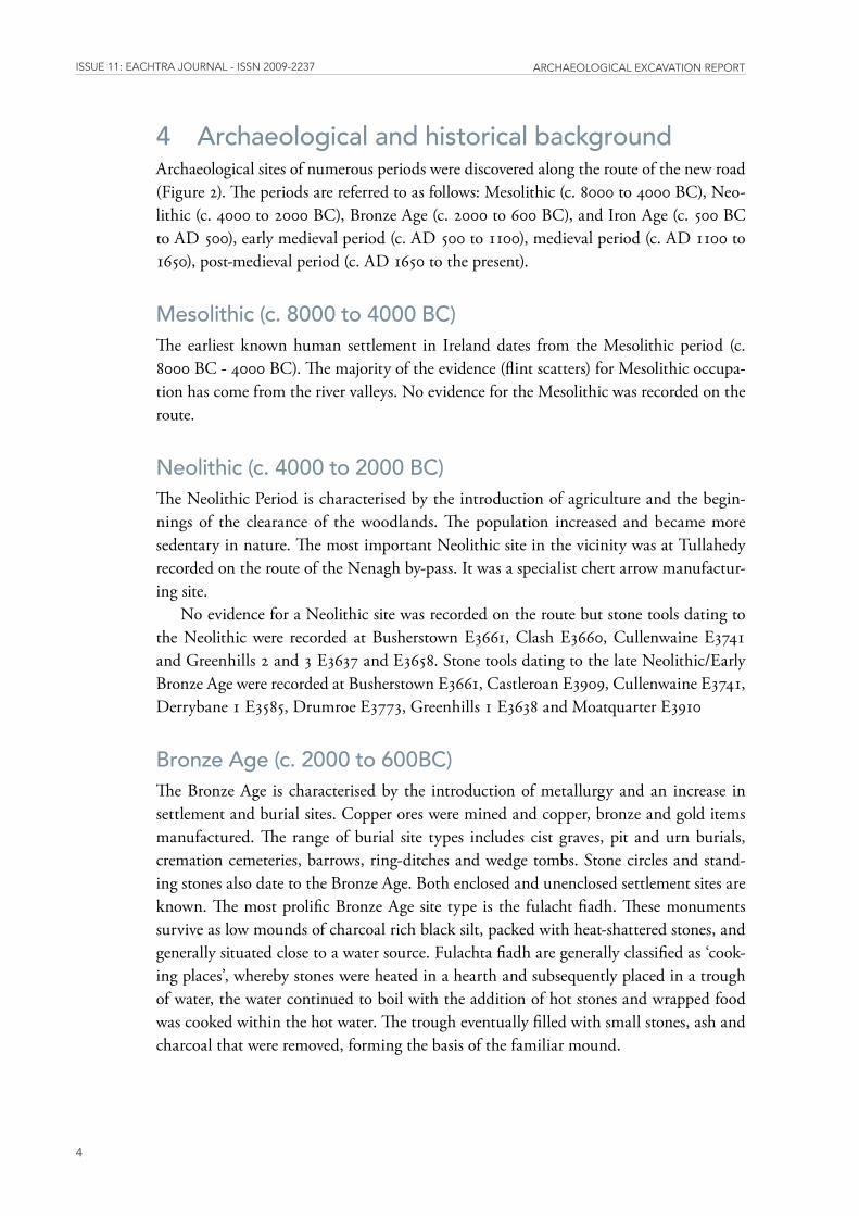
4 Archaeological and historical backgroundArchaeological sites of numerous periods were discovered along the route of the new road (Figure 2). The periods are referred to as follows: Mesolithic (c. 8000 to 4000 BC), Neo-lithic (c. 4000 to 2000 BC), Bronze Age (c. 2000 to 600 BC), and Iron Age (c. 500 BC to AD 500), early medieval period (c. AD 500 to 1100), medieval period (c. AD 1100 to 1650), post-medieval period (c. AD 1650 to the present).
Mesolithic (c. 8000 to 4000 BC)The earliest known human settlement in Ireland dates from the Mesolithic period (c. 8000 BC - 4000 BC). The majority of the evidence (flint scatters) for Mesolithic occupa-tion has come from the river valleys. No evidence for the Mesolithic was recorded on the route.
Neolithic (c. 4000 to 2000 BC)The Neolithic Period is characterised by the introduction of agriculture and the begin-nings of the clearance of the woodlands. The population increased and became more sedentary in nature. The most important Neolithic site in the vicinity was at Tullahedy recorded on the route of the Nenagh by-pass. It was a specialist chert arrow manufactur-ing site.
No evidence for a Neolithic site was recorded on the route but stone tools dating to the Neolithic were recorded at Busherstown E3661, Clash E3660, Cullenwaine E3741 and Greenhills 2 and 3 E3637 and E3658. Stone tools dating to the late Neolithic/Early Bronze Age were recorded at Busherstown E3661, Castleroan E3909, Cullenwaine E3741, Derrybane 1 E3585, Drumroe E3773, Greenhills 1 E3638 and Moatquarter E3910
Bronze Age (c. 2000 to 600BC)The Bronze Age is characterised by the introduction of metallurgy and an increase in settlement and burial sites. Copper ores were mined and copper, bronze and gold items manufactured. The range of burial site types includes cist graves, pit and urn burials, cremation cemeteries, barrows, ring-ditches and wedge tombs. Stone circles and stand-ing stones also date to the Bronze Age. Both enclosed and unenclosed settlement sites are known. The most prolific Bronze Age site type is the fulacht fiadh. These monuments survive as low mounds of charcoal rich black silt, packed with heat-shattered stones, and generally situated close to a water source. Fulachta fiadh are generally classified as ‘cook-ing places’, whereby stones were heated in a hearth and subsequently placed in a trough of water, the water continued to boil with the addition of hot stones and wrapped food was cooked within the hot water. The trough eventually filled with small stones, ash and charcoal that were removed, forming the basis of the familiar mound.
Cla
shn
evin
1E
358
6C
lash
nev
in 1
E 3
586
Cla
shn
evin
2E
359
0C
lash
nev
in 2
E 3
590
Der
ryba
ne
1E
358
5D
erry
ban
e 1
E 3
585
Der
ryba
ne
2E
359
1D
erry
ban
e 2
E 3
591
Kil
leis
k 1
E 3
587
Kil
leis
k 1
E 3
587
Gar
rava
llyE
358
9G
arra
vally
E 3
589
Der
ryca
rney
1E
374
0D
erry
carn
ey 1
E 3
740
Kil
gort
een
1E
373
9K
ilgo
rtee
n 1
E 3
739
Cla
sh 1
E 3
660
Cla
sh 1
E 3
660
Par
k 1
E 3
659
Par
k 1
E 3
659
Par
k 2
E 3
772
Par
k 2
E 3
772
Cly
noe
2E
377
4C
lyn
oe 2
E 3
774
Cu
lleen
wai
ne
1E
374
1C
ulle
enw
ain
e 1
E 3
741
Mon
eyga
ll 2
E 3
635
Mon
eyga
ll 2
E 3
635
Gre
enh
ills
1E
363
8G
reen
hill
s 1
E 3
638
Gre
enh
ills
2E
363
7G
reen
hill
s 2
E 3
637
Gre
enh
ills
3E
365
8G
reen
hill
s 3
E 3
658
Dru
mba
un
2E
391
2D
rum
bau
n 2
E 3
912
Bus
her
stow
n 1
E 3
661
Bus
her
stow
n 1
E 3
661
Dru
mro
e 1
E 3
773
Dru
mro
e 1
E 3
773
Moa
tqu
arte
r 1
E 3
910
Moa
tqu
arte
r 1
E 3
910
Lou
ghan
1E
40
00
Lou
ghan
1E
40
00
Cas
tler
oan
1E
390
9C
astl
eroa
n 1
E 3
909
190400
190400
196200
196200
202000
202000
207800
207800
177200
177200
181800
181800
186400
186400
±
Cla
sh 1
Cla
sh 1
03
6
Kilometres
Clash-E3660
5
http://eachtra.ie/index.php/journal/e3660-clash-co-tipperary/
Figu
re2
:D
isco
very
ser
ies
Ord
nanc
esu
rvet
map
sho
win
gth
ero
ute
ofth
eN
7Ca
stle
tow
nto
Nen
agh
(Der
rinsa
llagh
toB
allin
tott
y)R
oad
Sche
me
(Con
trac
t1)a
ndth
elo
catio
nof
all
exca
vatio
nsi
tes�
issUE 11: EaChtra JoUrnal - issn 2009-2237 arChaEologiCal ExCavation rEport
6
Two new fulachta fiadh or burnt mounds were recorded at Clashnevin 1 E3586, Cullenwaine E3741 and six at three separate locations in Greenhills, E3638, E3637 and E3658. Evidence of nine roundhouses or partial round structures were recorded; two at Castleroan E3909, Derrybane 2 E3591 and Drumbaun 2 E3912 and one at Clash E3660, Drumroe E3773 and Moatquarter E3910.
Iron Age (c. 500 BC to AD 500)Upto recently there was little evidence of a significant Iron Age presence in Munster. Settlement sites are few and far between as well as being difficult to identify (Woodman, 2000) while the material culture of this period is limited. Linear earthworks, believed to have marked tribal boundaries, and hillforts are two of the most visible monuments of the period. Ten percent of sites excavated on NRA road schemes in recent years have produced Iron Age dates. The dates have led to the identification of 30 new Iron Age sites in Munster from road schemes in counties Cork, Limerick and Tipperary (McLaughlin 2008, 51). These include a ditched enclosure in Ballywilliam and a wooden trackway in Annaholty Bog excavated on the route of the N7 Nenagh-Limerick (Taylor 2008, 54).
Early medieval period (c. AD 400 to 1100)The early medieval period is characterised by the arrival of Christianity to Ireland. The characteristic monument type of the period is the ringfort. Ringforts are the most nu-merous archaeological monument found in Ireland, with estimates of between 30,000 and 50,000 illustrated on the first edition of the Ordnance Survey 6” maps of the 1840’s (Barry 1987). As a result of continued research, the construction of these monuments has a narrow date range during the early medieval period between the 7th and 9th centuries AD. Although there are some very elaborate examples of ringforts, they often take the form of a simple earth or stone enclosure functioning as settlements for all classes of secu-lar society (Stout 1997).
North Tipperary is rich in early ecclesiastical sites and the remains of these religious centres are at the core of some of the towns and villages. Roscrea, for example, was chosen by St Cronan as a location for his monastery in the seventh century as it was located at the crossroads on the Slighe Dála, an important roadway in early medieval times (NIAH 2006, 4-8).
A possible early medieval enclosure and associated road way was recorded at Killeisk E3587. A denuded ringfort (OF046-013) was excavated at Clynoe 2 E3774.
High and later medieval periods (c. AD 1100 to 1650)This period is characterized by the arrival of the Anglo-Normans and the building of tow-er houses. The Anglo-Normans obtained charters in the thirteenth century for the towns of Nenagh, Roscrea, Thurles and Templemore and established markets. Nenagh grew rapidly in the aftermath of the granting of the lands of Munster to Theobald fitzWalter in
Clash-E3660
7
http://eachtra.ie/index.php/journal/e3660-clash-co-tipperary/
1185 (ibid. 8). Moated sites represent the remains of isolated, semi-defended homesteads in rural areas. They were build mainly in the late thirteenth and early fourteenth cen-turies in counties, such as Wexford, Kilkenny, Tipperary, mid-Cork and Limerick, that were colonised by English settlers (O’Conor 1998, 58). The Archaeological Inventory for North Tipperary lists 39 moated sites (2002, 298).
A newly recorded moated site was excavated at Busherstown E3661.
Post-medieval period (c. 1650 to the present).The post-medieval period is characterised by mills, limekilns, workhouses, country hous-es and associated demesnes, vernacular buildings and field systems (Figure 3). A small demesne associated with a county house was recorded at Greenhills.
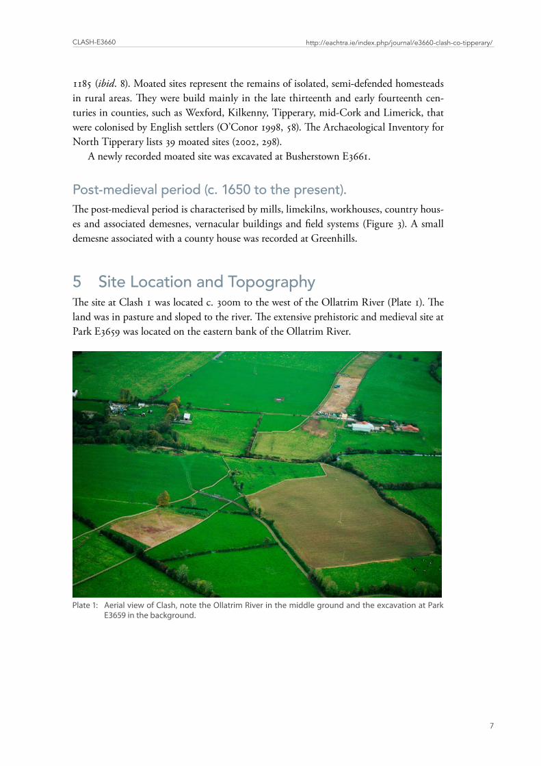
5 Site Location and TopographyThe site at Clash 1 was located c. 300m to the west of the Ollatrim River (Plate 1). The land was in pasture and sloped to the river. The extensive prehistoric and medieval site at Park E3659 was located on the eastern bank of the Ollatrim River.
Plate1: AerialviewofClash,notetheOllatrimRiverinthemiddlegroundandtheexcavationatParkE3659inthebackground�
PAR
K
CLA
SH
CLY
NO
ER
OS
DR
EH
ID
BA
LLY
KN
OC
KA
NE
CA
RR
OW
EA
Olla
trim
(Riv
er)
1988
99
1988
99
1998
99
1998
99
180558
180558
181208
181208
Park
2Pa
rk 1
Cla
sh 1
030
060
0
Met
ers
¥
issUE 11: EaChtra JoUrnal - issn 2009-2237 arChaEologiCal ExCavation rEport
8
Figu
re3
:Po
rtio
nof
the
Iste
ditio
nO
rdna
nce
Surv
eyM
apO
F47
show
ing
the
loca
tion
ofC
lash
�
Clash-E3660
9
http://eachtra.ie/index.php/journal/e3660-clash-co-tipperary/
6 Excavation methodologyThe site was mechanically stripped of topsoil under strict archaeological supervision. Stripping was done with a tracked machine with a flat toothless bucket. Topsoil stripping commenced in the areas of identified archaeology and continued radially outward until the limit of the road take was reached or until the limit of the archaeological remains was fully defined. A grid was set up in the excavation area(s) and all archaeological features were sufficiently cleaned, recorded and excavated so as to enable an accurate and mean-ingful record of the site to be preserved. The excavation, environmental sampling, site photographs, site drawings, find care and retrieval, on-site recording and site archive was as per the Procedures for Archaeological works as attached to the licence method state-ments for excavation licences.
The site was excavated from 8 September 2008 to the 22 September 2008. Only areas within the LMA (lands made available) were resolved. The full extent of the area of exca-vation measured 3400 m sq (Figure 4).
The full record of excavated contexts is recorded in the context register and the strati-graphic matrix (Appendix 1). Detailed stratigraphic descriptions are found in the groups and sub-groups text (Appendix 2). The context register maybe viewed in the EAPOD (Eachtra Archaeological Projects office database) in the accompanying CD.
7 Excavation resultsThe partial remains of a Bronze Age structure were recorded in the south-eastern corner of the area of excavation, on the edge of the LMA. The features were grouped in an area measuring 10 m sq. A ditch, orientated south-west – north-east bisected the area of the site. There were a group of furrows located to the west of the ditch and orientated in the same direction. Eight features of uncertain date were scattered across the area of the ex-cavation (Figure 5, plate 2).
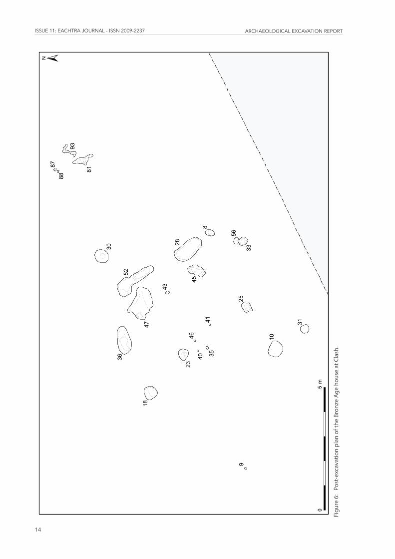
The Structure A truncated house was identified in the south-eastern area of the excavation at Clash. It was defined by a double ring of post-holes (Figure 6), the inner ring was concentric with the outer ring, but neither ring was complete. The internal diameter of the complete struc-ture was 6.1 m and it would have enclosed an area of 29.2 m2 if the circuit was complete. The entrance to the house, between two slot trenches, faced east-northeast and measured 1.2 m in width.
The outer wall of the structure comprised four post-holes (C.8, C.31, C.33 and C.56) and two slot trenches (C.28 and C.52). The post-holes were located on the south-eastern side only, representing c. 90 degrees of the total possible circumference of the outer wall. The slot trenches were situated on either side of the entrance set back slightly from the ring of posts.
8200
8100
8000
7900
7800
7700
7600
7500
7400
7300
7200
7100
CLASH
CLASH
PARK
PARK
Olla
trim
(Riv
er)
198678
198678
199048
199048
199418
199418
180345
180345
180575
180575
180805
180805
±0
100
200Metres
Cla
sh 1
(E
366
0)
Cla
sh 1
(E
366
0)
issUE 11: EaChtra JoUrnal - issn 2009-2237 arChaEologiCal ExCavation rEport
10
Figu
re4
:Lo
catio
nan
dex
tent
ofC
lash
E36
60o
nth
eN
7Ca
stle
tow
nto
Nen
agh
3
5876
92
79
74
5247
67
28
55
81
7084
10
93
69
30
18
83
11
25
23
31
33
16
71
9
43
36
1990
20
1990
20
1990
74
1990
74
180557
180557
180579
180579
±
)O11
5 m
O.D
.
025
m
Clash-E3660
11
http://eachtra.ie/index.php/journal/e3660-clash-co-tipperary/
Figu
re5
:Po
st-e
xcav
atio
npl
ano
fCla
shE
3660
�
issUE 11: EaChtra JoUrnal - issn 2009-2237 arChaEologiCal ExCavation rEport
12
Context Number Dimensions (m) (l x w x d) Feature8 0.42 x 0.3 x 0.35 Post-hole28 0.60 x 1.10 x 0.03 Slot trench31 0.34 x 0.32 x 0.8 Post-hole33 0.4 x 0.35 x 0.38 Post-hole52 2.23 x 0.40 x 0.11 Slot trench56 0.32 x 0.28 x 0.21 Post-hole
Table1:Dimensionsoftheouterwallofthestructure
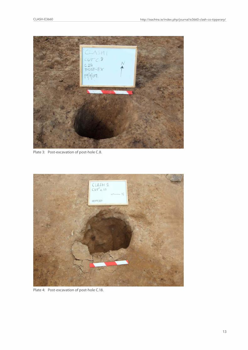
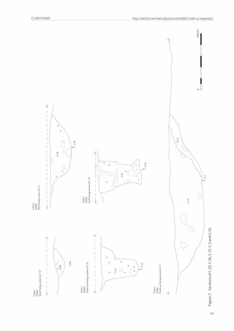
The interval between the post-holes was irregular. Post-holes C.33 and C.56 were lo-cated adjacent to one another, but the gap between C.31 and C.33 was more that 4 m. The post-holes were quite substantial in size (Figure 7, plate 3) but the posts themselves may have been removed as no post-pipes were recorded. Packing stones survived in post-hole C.8. The slot trenches were located on either side of the area of the entrance. The slot trench C.28 was very shallow and truncated. The second slot had survived to a depth of 0.11 m.
Small quantities of charred seeds were recorded in the fills of post-holes C.8 and C.56. A Late Bronze Age date cal BC 1111-1103 1085-1064 1056-920 (UB 12360) was returned from post-hole C.31.
The inner wall comprised four post-holes (C.18, C.25, C.45 and C.48), two pits (C.10 and C.36) and a slot trench C.47. The post-holes were located on the south-eastern, north-eastern and north-northwestern sides, representing more than 180 degrees of the total possible circumference of the inner wall. The two post-holes C.45 and C.48 flank the en-
Plate2: ViewofareaofexcavationatClashfromwest,notetheareaoftheBronzeAgehouseonthesouthernedgeoftheareaofexcavation�
Clash-E3660
13
http://eachtra.ie/index.php/journal/e3660-clash-co-tipperary/
Plate3: Post-excavationofpost-holeC�8�
Plate4: Post-excavationofpost-holeC�18�
52
47
28
36
81
8
10
93
45
30
18
25
23
31
33
569
43
35
87
4046
41
88±
05m
issUE 11: EaChtra JoUrnal - issn 2009-2237 arChaEologiCal ExCavation rEport
14
Figu
re6
:Po
st-e
xcav
atio
npl
ano
fthe
Bro
nze
Age
hou
sea
tCla
sh�
C.3
Cla
sh 1
E366
0N
orth
eas
t fac
ing
sect
ion
of C
.3
##
#
#
##
## C
.33
Cla
sh 1
E366
0So
uth
wes
t fac
ing
sect
ion
of C
.33
Cla
sh 1
E366
0W
est f
acin
g se
ctio
n of
C.3
#
##
#
C.3
6
C.3
8
C.3
1
#
#
#
Cla
sh 1
E366
0So
uth
faci
ng se
ctio
n of
C.3
1
# C.59
C.52
Cla
sh 1
E366
0So
uth
faci
ng se
ctio
n of
C.5
2
C.1
2
C.1
3
C.4
3
C.3
2
050
0 m
m
Clash-E3660
15
http://eachtra.ie/index.php/journal/e3660-clash-co-tipperary/
Figu
re7
:Se
ctio
nso
fC�3
3,C
�36,
C�3
1,C
�3a
ndC
�52�
issUE 11: EaChtra JoUrnal - issn 2009-2237 arChaEologiCal ExCavation rEport
16
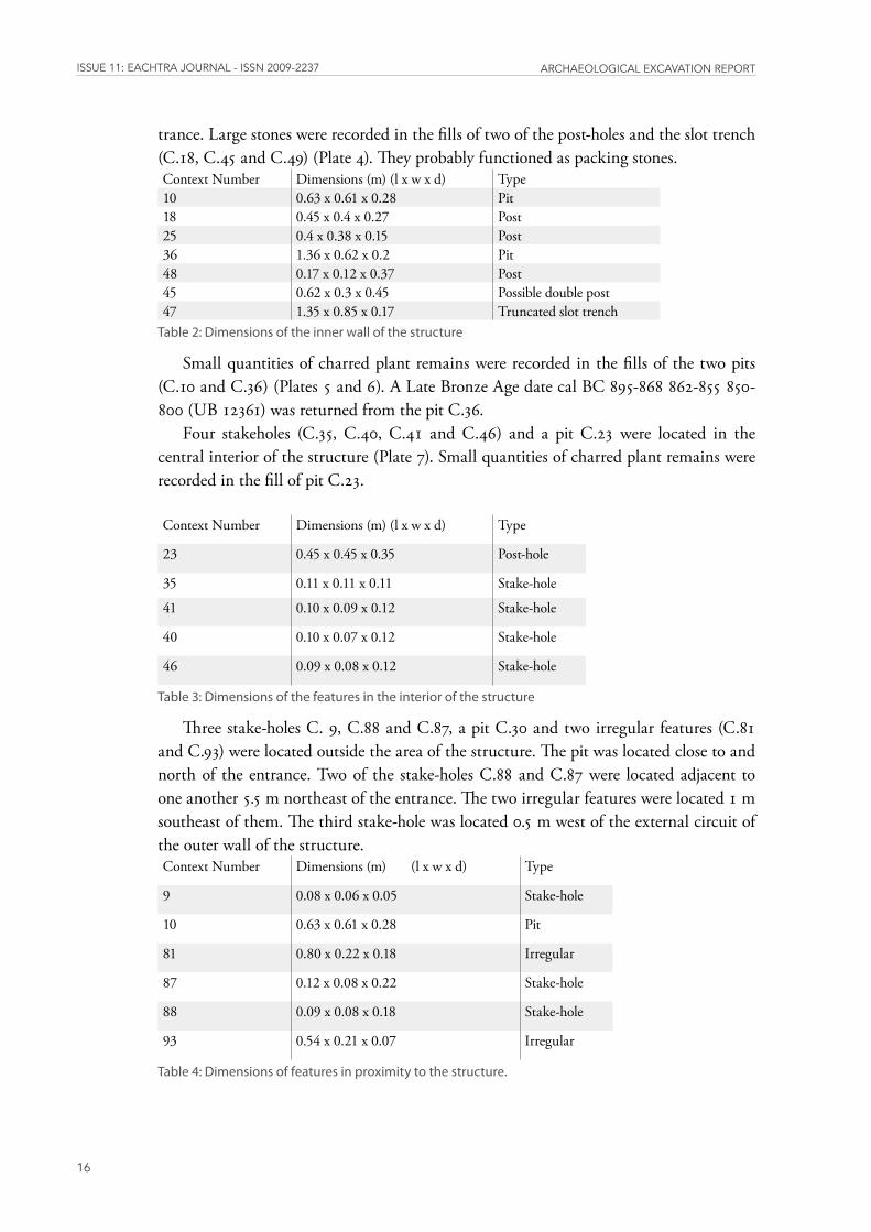
trance. Large stones were recorded in the fills of two of the post-holes and the slot trench (C.18, C.45 and C.49) (Plate 4). They probably functioned as packing stones. Context Number Dimensions (m) (l x w x d) Type10 0.63 x 0.61 x 0.28 Pit18 0.45 x 0.4 x 0.27 Post25 0.4 x 0.38 x 0.15 Post36 1.36 x 0.62 x 0.2 Pit48 0.17 x 0.12 x 0.37 Post45 0.62 x 0.3 x 0.45 Possible double post47 1.35 x 0.85 x 0.17 Truncated slot trench
Table2:Dimensionsoftheinnerwallofthestructure
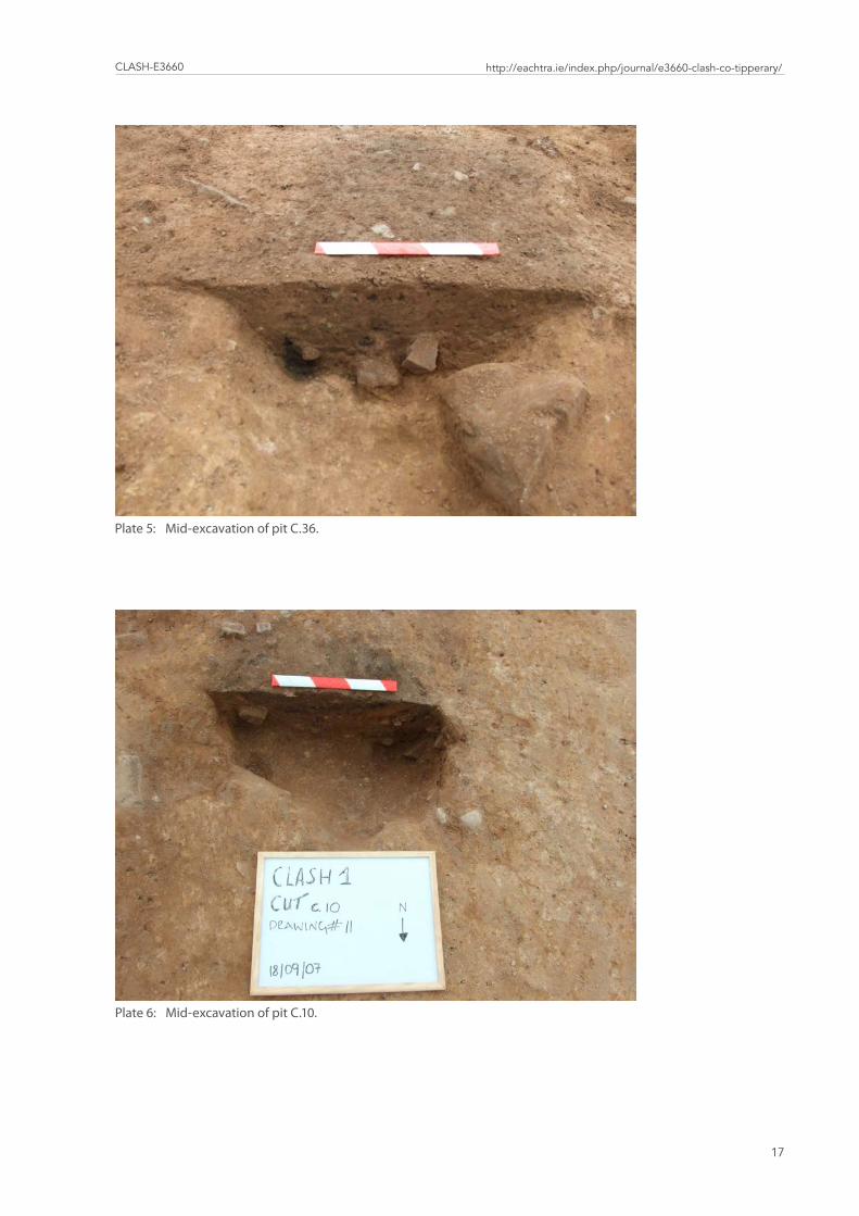
Small quantities of charred plant remains were recorded in the fills of the two pits (C.10 and C.36) (Plates 5 and 6). A Late Bronze Age date cal BC 895-868 862-855 850-800 (UB 12361) was returned from the pit C.36.
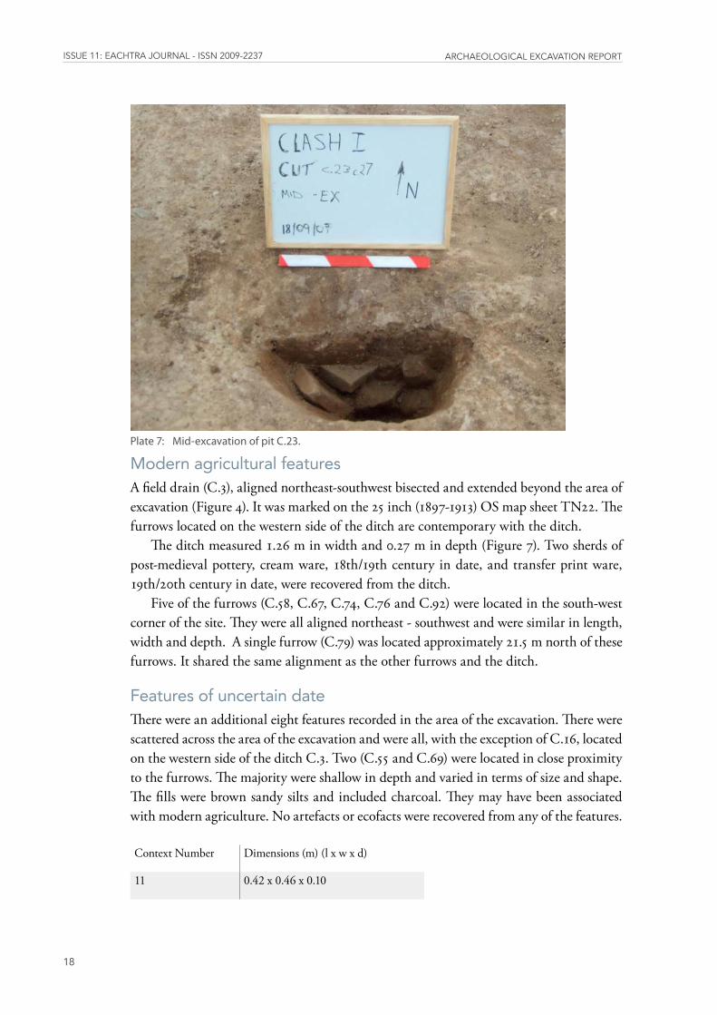
Four stakeholes (C.35, C.40, C.41 and C.46) and a pit C.23 were located in the central interior of the structure (Plate 7). Small quantities of charred plant remains were recorded in the fill of pit C.23.
Context Number Dimensions (m) (l x w x d) Type
23 0.45 x 0.45 x 0.35 Post-hole
35 0.11 x 0.11 x 0.11 Stake-hole
41 0.10 x 0.09 x 0.12 Stake-hole
40 0.10 x 0.07 x 0.12 Stake-hole
46 0.09 x 0.08 x 0.12 Stake-hole
Table3:Dimensionsofthefeaturesintheinteriorofthestructure
Three stake-holes C. 9, C.88 and C.87, a pit C.30 and two irregular features (C.81 and C.93) were located outside the area of the structure. The pit was located close to and north of the entrance. Two of the stake-holes C.88 and C.87 were located adjacent to one another 5.5 m northeast of the entrance. The two irregular features were located 1 m southeast of them. The third stake-hole was located 0.5 m west of the external circuit of the outer wall of the structure.Context Number Dimensions (m) (l x w x d) Type
9 0.08 x 0.06 x 0.05 Stake-hole
10 0.63 x 0.61 x 0.28 Pit
81 0.80 x 0.22 x 0.18 Irregular
87 0.12 x 0.08 x 0.22 Stake-hole
88 0.09 x 0.08 x 0.18 Stake-hole
93 0.54 x 0.21 x 0.07 Irregular
Table4:Dimensionsoffeaturesinproximitytothestructure�
Clash-E3660
17
http://eachtra.ie/index.php/journal/e3660-clash-co-tipperary/
Plate5: Mid-excavationofpitC�36�
Plate6: Mid-excavationofpitC�10�
issUE 11: EaChtra JoUrnal - issn 2009-2237 arChaEologiCal ExCavation rEport
18
Modern agricultural featuresA field drain (C.3), aligned northeast-southwest bisected and extended beyond the area of excavation (Figure 4). It was marked on the 25 inch (1897-1913) OS map sheet TN22. The furrows located on the western side of the ditch are contemporary with the ditch.
The ditch measured 1.26 m in width and 0.27 m in depth (Figure 7). Two sherds of post-medieval pottery, cream ware, 18th/19th century in date, and transfer print ware, 19th/20th century in date, were recovered from the ditch.
Five of the furrows (C.58, C.67, C.74, C.76 and C.92) were located in the south-west corner of the site. They were all aligned northeast - southwest and were similar in length, width and depth. A single furrow (C.79) was located approximately 21.5 m north of these furrows. It shared the same alignment as the other furrows and the ditch.
Features of uncertain dateThere were an additional eight features recorded in the area of the excavation. There were scattered across the area of the excavation and were all, with the exception of C.16, located on the western side of the ditch C.3. Two (C.55 and C.69) were located in close proximity to the furrows. The majority were shallow in depth and varied in terms of size and shape. The fills were brown sandy silts and included charcoal. They may have been associated with modern agriculture. No artefacts or ecofacts were recovered from any of the features.
Context Number Dimensions (m) (l x w x d)
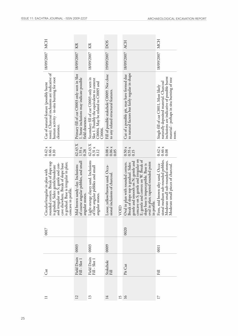
11 0.42 x 0.46 x 0.10
Plate7: Mid-excavationofpitC�23�
Clash-E3660
19
http://eachtra.ie/index.php/journal/e3660-clash-co-tipperary/
16 0.50 x 0.55 x 0.15
55 1.10 x 0.46 x 0.08
69 0.58 x 0.45 x 0.15
70 0.37 x 0.3 x 0.15
71 0.24 x 0.21 x 0.09
83 0.55 x 0.21 x 0.09
84 0.57 x 0.56 x 0.25
Table5:Dimensionsofnon-archaeologicalfeatures
Plant remainsThe plant remains were examined by Penny Johnston (Appendix 3). Seeds were recorded in five samples from three pits (C.36, C.23 and C.10) and two post-holes (C.8 and C.56). In all cases the quantities of plant remains recovered were small, with just 15 grains of ce-reals found in total from the site. Where identifiable, the cereals were barley and it is likely that these were brought to site as foodstuffs. Other seeds included wild plants such as Black bindweed (from the dock family) and flax. Both of these plant remains could have been collected either as food or as accidental inclusions gathered with the crop plants.
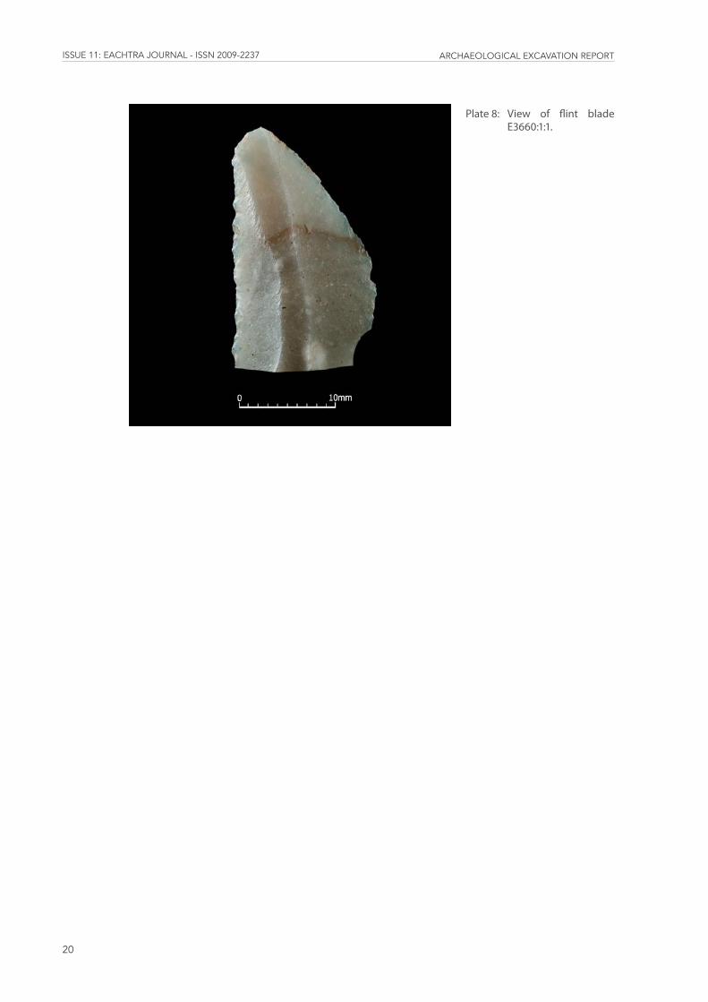
LithicsThe lithics were examined by Farina Sternke (Appendix 4). A single flint blade (E3660:1:1) was recovered from the topsoil in the area of the Bronze Age house (Plate 8). It dates to the first half of the Neolithic.
Charcoal The charcoal was examined by Mary Dillon in advance of radiocarbon dating.
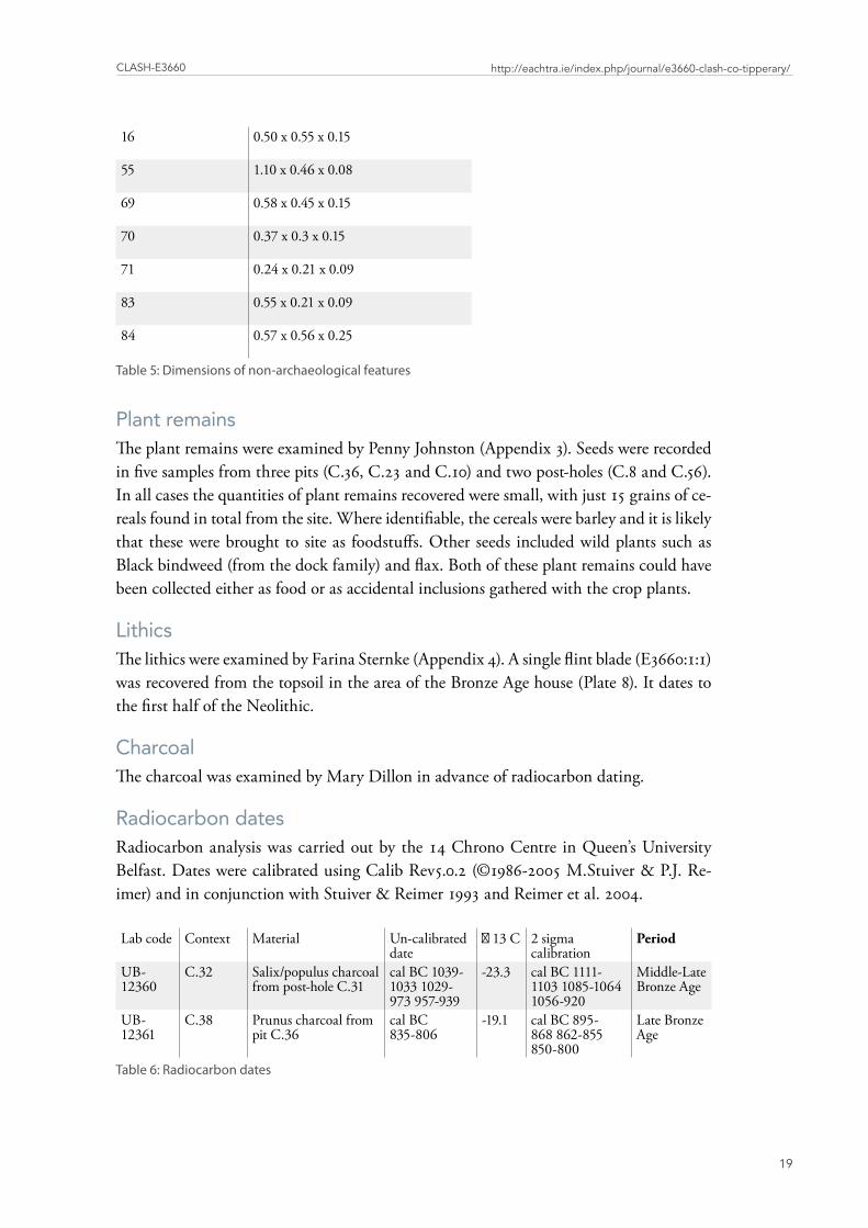
Radiocarbon datesRadiocarbon analysis was carried out by the 14 Chrono Centre in Queen’s University Belfast. Dates were calibrated using Calib Rev5.0.2 (©1986-2005 M.Stuiver & P.J. Re-imer) and in conjunction with Stuiver & Reimer 1993 and Reimer et al. 2004.
Lab code Context Material Un-calibrated date
δ 13 C 2 sigma calibration
Period
UB-12360
C.32 Salix/populus charcoal from post-hole C.31
cal BC 1039-1033 1029-973 957-939
-23.3 cal BC 1111-1103 1085-1064 1056-920
Middle-Late Bronze Age
UB-12361
C.38 Prunus charcoal from pit C.36
cal BC 835-806
-19.1 cal BC 895-868 862-855 850-800
Late Bronze Age
Table6:Radiocarbondates
issUE 11: EaChtra JoUrnal - issn 2009-2237 arChaEologiCal ExCavation rEport
20
Plate8: View of flint bladeE3660:1:1�
Clash-E3660
21
http://eachtra.ie/index.php/journal/e3660-clash-co-tipperary/
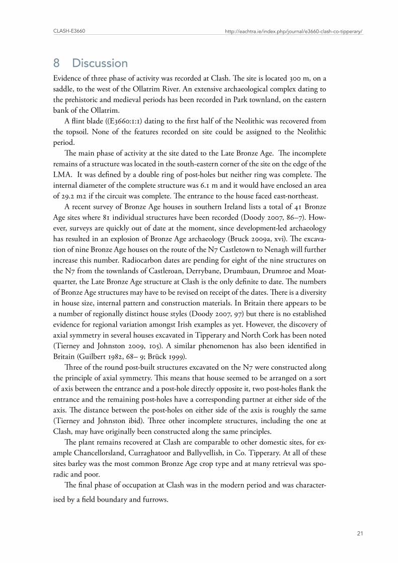
8 DiscussionEvidence of three phase of activity was recorded at Clash. The site is located 300 m, on a saddle, to the west of the Ollatrim River. An extensive archaeological complex dating to the prehistoric and medieval periods has been recorded in Park townland, on the eastern bank of the Ollatrim.
A flint blade ((E3660:1:1) dating to the first half of the Neolithic was recovered from the topsoil. None of the features recorded on site could be assigned to the Neolithic period.
The main phase of activity at the site dated to the Late Bronze Age. The incomplete remains of a structure was located in the south-eastern corner of the site on the edge of the LMA. It was defined by a double ring of post-holes but neither ring was complete. The internal diameter of the complete structure was 6.1 m and it would have enclosed an area of 29.2 m2 if the circuit was complete. The entrance to the house faced east-northeast.
A recent survey of Bronze Age houses in southern Ireland lists a total of 41 Bronze Age sites where 81 individual structures have been recorded (Doody 2007, 86–7). How-ever, surveys are quickly out of date at the moment, since development-led archaeology has resulted in an explosion of Bronze Age archaeology (Bruck 2009a, xvi). The excava-tion of nine Bronze Age houses on the route of the N7 Castletown to Nenagh will further increase this number. Radiocarbon dates are pending for eight of the nine structures on the N7 from the townlands of Castleroan, Derrybane, Drumbaun, Drumroe and Moat-quarter, the Late Bronze Age structure at Clash is the only definite to date. The numbers of Bronze Age structures may have to be revised on receipt of the dates. There is a diversity in house size, internal pattern and construction materials. In Britain there appears to be a number of regionally distinct house styles (Doody 2007, 97) but there is no established evidence for regional variation amongst Irish examples as yet. However, the discovery of axial symmetry in several houses excavated in Tipperary and North Cork has been noted (Tierney and Johnston 2009, 105). A similar phenomenon has also been identified in Britain (Guilbert 1982, 68– 9; Brück 1999).
Three of the round post-built structures excavated on the N7 were constructed along the principle of axial symmetry. This means that house seemed to be arranged on a sort of axis between the entrance and a post-hole directly opposite it, two post-holes flank the entrance and the remaining post-holes have a corresponding partner at either side of the axis. The distance between the post-holes on either side of the axis is roughly the same (Tierney and Johnston ibid). Three other incomplete structures, including the one at Clash, may have originally been constructed along the same principles.
The plant remains recovered at Clash are comparable to other domestic sites, for ex-ample Chancellorsland, Curraghatoor and Ballyvellish, in Co. Tipperary. At all of these sites barley was the most common Bronze Age crop type and at many retrieval was spo-radic and poor.
The final phase of occupation at Clash was in the modern period and was character-
ised by a field boundary and furrows.
issUE 11: EaChtra JoUrnal - issn 2009-2237 arChaEologiCal ExCavation rEport
22
9 ReferencesBruck, J. (2009a) Overview of findings, pp. xvi – xviii in McQuade, M., Molloy, B.
and Moriarty, C. In the Shadow of the Galtees. Archaeological excavations along the route of the N8 Cashel to Mitchelstown Road Scheme. Dublin, National Roads Authority.
Doody, M. (2007) Excavations at Curraghatoor, Co. Tipperary, University College Cork.
Farrelly, J., and O’Brien, C. (2002) Archaeological Inventory of County Tipperary Vol. 1 - North Tipperary, The Stationery Office Dublin.
Gardiner, M.J. and Radford,T. (1980) Soil Assocaitions of Ireland and Their Land Use Potential. Dublin, An Foras Talúntais.
Guilbery, G. (1982) ‘Post-ring symmetry in roundhouses at Moel y Gaer and some other sites in prehistoric Britain’, in P J Drury (ed), Structural Recognition: approaches to the interpretation of excavated remains of buildings, 67 – 86. British Archaeological Reports 110.
McLaughlin, M. and Conran, S. (2008) ‘The emerging Iron Age of South Munster’ in Seanda, Issue 3, 51-53. Dublin.
National Inventory of Architectural Heritage (2006) An Introduction to the Architec-tural Heritage of North Tipperary. Government of Ireland.
O’Conor, K.D. (1998) The Archaeology of Medieval Rural Settlement in Ireland, Discov-ery Programme Monographs No 3, Discovery Programme/Royal Irish Academy Dublin.
Reimer, P.J., Baillie, M.G.L., Bard, E., Bayliss, A., Beck, J.W., Bertrand, C., Blackwell, P.G., Buck, C.E., Burr, G., Cutler, K.B., Damon, P.E., Edwards, R.L., Fairbanks, R.G., Friedrich, M., Guilderson, T.P., Hughen, K.A., Kromer, B., McCormac, F.G., Manning, S., Bronk Ramsey, C., Reimer, R.W., Remmele, S., Southon, J.R., Stuiver, M., Talamo, S., Taylor, F.W., van der Plicht, J. and Weyhenmeyer, C.E. (2004) ‘IntCal04 Terrestrial Radiocarbon Age Calibration, 0–26 Cal Kyr BP’, Radiocarbon 46, 1029-1058.
Stuiver, M., and Reimer, P.J. (1993) ‘Extended (super 14) C data base and revised CALIB 3.0 (super 14) C age calibration program’, Radiocarbon 35, 215-230.
Stout, M. (1997) The Irish Ringfort. Dublin, Four Courts Press.Taylor, K. (2008) ‘At home and on the road: two Iron Age sites in County Tipperary’
in Seanda, Issue 3, 54-55. Dublin.Woodman, P.C. (2000) ‘Hammers and Shoeboxes: New Agendas for Prehistory’., pp.
1 -10 in Desmond, A., Johnson, G., McCarthy, M., Sheehan, J. and Shee Twohig, E. New Agendas in Irish Prehistory. Papers in commemoration of Liz Anderson. Bray, Wordwell.
issUE 11: EaChtra JoUrnal - issn 2009-2237 arChaEologiCal ExCavation rEport
23
N7
Cas
tle-
tow
n N
enag
h C
lash
1
E366
0
Con
text
#C
onte
xt
Type
Fill
ofFi
lled
with
Sh
ort D
escr
iptio
nD
imen
-sio
ns (m
) (l
x w
x
d)
Inte
rpre
tatio
nD
ate
Initi
als
1To
psoi
l
Fi
rm, l
ight
gre
yish
bro
wn
sand
y sil
t. M
oder
ate m
ediu
m a
nd c
oars
e sub
-an
gula
r peb
bles
.
? X ?
X
0.2
Thi
s con
text
repr
esen
ts th
e top
soil
cove
r-in
g th
e are
a of e
xcav
atio
n. P
ost-M
edie
val
potte
ry sh
erds
wer
e rec
over
ed fr
om th
is de
-po
sit, i
ndic
atin
g a r
ecen
t dat
e of f
orm
atio
n.
14/0
9/20
07N
G
2N
atur
al
Subs
oil
Stiff
, lig
ht y
ello
wish
ora
nge s
ilty
clay
. M
oder
ate c
oars
e sub
-roun
ded
peb-
bles
. Mod
erat
e sm
all a
nd o
ccas
iona
l m
ediu
m su
b-ro
unde
d sto
nes.
T
his d
epos
it re
pres
ents
natu
rally
occ
ur-
ring
subs
oil a
cros
s are
a of e
xcav
atio
n. S
ite
strip
ped
to th
is le
vel.
Col
our a
nd c
ompo
si-tio
n ch
ange
s slig
htly
acr
oss s
ite. C
onte
xt
num
ber r
epre
sent
s the
who
le su
rfac
e of
subs
oil.
14/0
9/20
07N
G
3Fi
eld D
rain
C
ut
0004
, 00
05,
0006
, 00
07,
0012
, 00
13
Line
ar in
pla
n. B
reak
of s
lope
at to
p an
d ba
se is
shar
p on
NW
and
SE.
Si
des g
entle
to st
eep
in g
radi
ent a
nd
conc
aen
to sm
ooth
in sh
ape,
Base
is
linea
r in
plan
; con
cave
pro
file
62.4
3 x
1.26
x
0.27
Cut
of l
inea
r fea
ture
, mos
t pro
babl
y a f
ield
dr
ain.
Sto
nes w
ithin
fill
sugg
est b
ackf
ill-
ing
for c
leara
nce o
r dra
inag
e. T
his c
onte
xt
repr
esen
ts th
e am
alga
mte
d da
ta fr
om
seve
n se
ctio
ns th
roug
h th
e fiel
d dr
ain,
all
info
rmat
ion
is av
erag
ed to
inclu
de in
stra
t in
dex
- orig
inal
dat
a can
still
be f
ound
on
cont
ext s
heet
s
17/0
9/20
07N
G
4Fi
eld D
rain
Fi
ll00
03
Firm
, mid
yel
low
ish b
row
n sa
nd
silt.
Mod
erat
e med
ium
and
coa
rse
sub-
angu
lar a
nd su
b-ro
unde
d pe
b-bl
es. M
oder
ate s
mal
l and
occ
asio
nal
med
ium
and
larg
e sub
-ang
ular
and
su
b-ro
unde
d sto
nes.
Occ
asio
nal
smal
l pie
ces o
f cha
rcoa
l.
62.4
3 x
1.29
x
0.25
Fill
of li
near
feat
ure (
field
dra
in).
Pres
ence
of
cha
rcoa
l sug
gest
s hum
an a
ctiv
ity in
the
area
. Sto
nes m
ay h
ave b
een
depo
sited
by
delib
erat
e bac
kfill
ing
for f
ield
clear
ance
or
drai
nage
. Thi
s con
text
repr
esen
ts th
e am
al-
gam
ted
data
from
seve
n se
ctio
ns th
roug
h th
e fiel
d dr
ain,
all
info
rmat
ion
is av
erag
ed
to in
clude
in st
rat i
ndex
- or
igin
al d
ata c
an
still
be f
ound
on
cont
ext s
heet
s.
17/0
9/20
07N
G
App
endi
x 1
Stra
tigra
phic
rep
ort
issUE 11: EaChtra JoUrnal - issn 2009-2237 arChaEologiCal ExCavation rEport
24
5Fi
eld D
rain
Fi
ll - S
lot 2
0003
H
ard,
indu
rate
d, m
id o
rang
ish
brow
n sa
ndy
clay
. Occ
asio
nal m
edi-
um su
b-ro
unde
d pe
bble
s. O
ccas
iona
l sm
all a
ngul
ar st
ones
.
62.4
3 X
1.
14 x
0.
33
Fill
of c
ut C
0003
onl
y se
en in
Slo
t 2,
seco
ndar
y fil
l of f
ield
drai
n. R
elat
ed to
co
ntex
t C00
04
17/0
6/20
07AC
H,
MC
H
6Fi
eld D
rain
Fi
ll - S
lot 2
0003
In
dura
ted,
dar
k re
ddish
bro
wn
sand
y sil
t. M
oder
ate m
ediu
m a
ngul
ar p
eb-
bles
. Mod
erat
e sm
all a
ngul
ar st
ones
.
62.4
3 X
0.
48 x
0.
22
Fill
of c
ut C
0003
onl
y se
en in
Slo
t 2, p
ri-m
ary
fill o
f fiel
d dr
ain.
17
/06/
2007
ACH
, M
CH
7Fi
eld D
rain
Fi
ll - S
lot 4
0003
Fi
rm, m
id y
ello
wish
bro
wn
sand
y sil
t. O
ccas
iona
l fin
e and
med
ium
, an
d m
oder
ate c
oars
e sub
-ang
ular
an
d su
b-ro
unde
d pe
bble
s. O
ccas
ion-
al sm
all a
nd m
ediu
m su
b-an
gula
r an
d su
b-ro
unde
d sto
nes.
62.4
3 x
1.0
x 0.
15
Prim
ary
fill o
f cut
C00
03 o
nly
seen
in S
lot
4. C
onte
xt w
as p
roba
bly
form
ed b
y al
luvi
al
actio
n. S
tone
inclu
sions
may
indi
cate
pos
-sib
le fie
ld c
leara
nce.
18/0
9/20
07R
K
8Po
stho
le C
ut
0024
Sub-
circ
ular
in p
lan
with
roun
ded
corn
ers.
Brea
k of
slop
e top
is
grad
ual.
Side
s: ste
ep a
nd ir
regu
lar
on E
; ver
tical
and
smoo
th el
sew
here
. Br
eak
of sl
ope b
ase i
s gra
dual
. Bas
e is
sub-
circ
ular
in p
lan;
con
cave
in
prof
ile.
0.42
x
0.30
x
0.35
Cut
of p
ossib
le sto
ne-p
acke
d po
stho
le. P
ost
pipe
not
visi
ble -
pos
t pro
babl
y re
mov
ed. I
n clo
se p
roxi
mity
, and
sim
ilar t
o cu
t C00
33.
20/0
9/20
07D
K
9St
akeh
ole
Cut
00
14O
val i
n pl
an w
ith ro
unde
d co
rner
s. Br
eak
of sl
ope t
op is
shar
p. S
ides
: ste
ep a
nd sm
ooth
on
N; v
ertic
al el
se-
whe
re. B
reak
of s
lope
bas
e is g
radu
al
on S
; sha
rp el
sew
here
. Bas
e is o
val i
n pl
an; p
oint
ed in
pro
file.
0.08
x
0.06
x
0.05
Cut
of p
ossib
le sta
keho
le, b
ut n
ot c
lose
to
any
rela
ted
struc
tura
l fea
ture
s. 19
/09/
2007
DO
S
10Pi
t Cut
00
22,
0021
Sub-
circ
ular
in p
lan
with
roun
ded
corn
ers.
Brea
k of
slop
e top
is sh
arp
to g
radu
al o
n N
; sha
rp el
sew
here
. Si
des:
mod
erat
e and
irre
gula
r on
N; v
ertic
al a
nd c
onca
ve o
n S
and
W; s
teep
and
smoo
th o
n E.
Bre
ak
of sl
ope b
ase i
s gra
dual
on
N; s
harp
el
sew
here
. Bas
e is s
ub-c
ircul
ar in
pl
an; f
lat i
n pr
ofile
.
0.63
x
0.61
x
0.28
Cut
of a
sub-
circ
ular
pit.
Reg
ular
shap
e an
d ste
ep si
des i
ndic
ate t
hat t
his p
it w
as
inte
ntio
nally
dug
. May
be r
elat
ed to
nea
rby
cut C
0023
.
19/0
9/20
07RW
issUE 11: EaChtra JoUrnal - issn 2009-2237 arChaEologiCal ExCavation rEport
25
11C
ut
0017
Circ
ular
/irre
gula
r in
plan
with
ro
unde
d co
rner
s. Br
eak
of sl
ope t
op
is gr
adua
l. Si
des:
gent
le/m
oder
ate
and
irreg
ular
on
S; g
entle
and
con
-ca
ve el
sew
here
. Bre
ak o
f slo
pe b
ase
is gr
adua
l. Ba
se is
irre
gula
r in
plan
; co
ncav
e in
prof
ile.
0.42
x
0.46
x
0.10
Cut
of n
atur
al fe
atur
e (po
ssib
ly b
urnt
ro
ots).
Cha
rcoa
l inc
lusio
ns a
re in
dica
tive o
f hu
man
act
ivity
- in
-situ
bur
ning
for r
oot
clear
ance
.
18/0
9/20
07M
CH
12Fi
eld D
rain
Fi
ll - S
lot 1
0003
M
id b
row
n sa
ndy
clay
. Inc
lusio
ns
of c
oars
e ang
ular
peb
bles
, and
smal
l an
gula
r sto
nes.
62.4
3 X
1.
55 x
0.
28
Prim
ary
fill o
f cut
C00
03 o
nly
seen
in S
lot
1. S
tone
inclu
sions
may
indi
cate
pos
sible
field
clea
ranc
e.
18/0
9/20
07K
R
13Fi
eld D
rain
Fi
ll - S
lot 1
0003
Li
ght o
rang
e cla
yey
sand
. Inc
lusio
ns
of fi
ne a
ngul
ar p
ebbl
es a
nd sm
all
angu
lar s
tone
s.
62.4
3 X
0.
31 x
0.
12
Seco
ndar
y fil
l of c
ut C
0003
onl
y se
en in
Sl
ot 1
. Pos
sibly
the e
quiv
alen
t to
cont
ext
C00
04. M
ay b
e rel
ated
to C
0005
and
C
0006
.
18/0
9/20
07K
R
14St
akeh
ole
Fill
0009
Lo
ose,
yello
w/b
row
n sa
nd. O
cca-
siona
l inc
lusio
ns o
f cha
rcoa
l. 0.
08 x
0.
06 x
0.
05
Fill
of p
ossib
le sta
keho
le C
0009
. Not
clo
se
to a
ny re
late
d str
uctu
ral f
eatu
res.
19/0
9/20
07D
OS
15
VO
ID
16
Pit C
ut
0020
Ova
l in
plan
with
roun
ded
corn
ers.
Brea
k of
slop
e top
is g
radu
al. S
ides
: ge
ntle
and
smoo
th o
n N
; gen
tle a
nd
conc
ave o
n S;
gen
tle a
nd ir
regu
lar o
n E;
gen
tle a
nd c
onve
x on
W. B
reak
of
slope
bas
e is i
mpe
rcep
tible.
Bas
e is
oval
in p
lan;
tape
red
roun
ded
poin
t in
pro
file.
0.50
x
0.55
x
0.15
Cut
of a
pos
sible
pit,
may
hav
e for
med
due
to
nat
ural
fact
ors b
ut fa
irly
regu
lar i
n sh
ape
18/0
9/20
07AC
H
17Fi
ll00
11
Firm
, mid
bro
wn
silty
sand
. Occ
a-sio
nal m
ediu
m su
b-ro
unde
d pe
bble
s. M
oder
ate s
mal
l sub
-roun
ded
stone
s. M
oder
ate s
mal
l pie
ces o
f cha
rcoa
l.
0.42
x
0.46
x
0.08
Sing
le fil
l of c
ut C
0011
, Mos
t lik
ely
natu
rally
dep
osite
d m
ater
ial.
Cha
rcoa
l in
clusio
ns a
re in
dica
tive o
f pos
sible
burn
t m
ater
ial -
per
haps
in si
tu b
urni
ng o
f tre
e ro
ots.
18/0
9/20
07M
CH
issUE 11: EaChtra JoUrnal - issn 2009-2237 arChaEologiCal ExCavation rEport
26
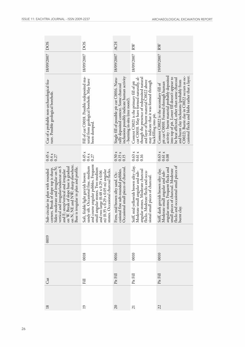
18C
ut
0019
Sub-
circ
ular
in p
lan
with
roun
ded
corn
ers.
Brea
k of
slop
e top
is sh
arp.
Si
des:
mod
erat
e and
irre
gula
r on
N;
vert
ical
and
irre
gula
r/und
ercu
t on
S an
d E;
stee
p/ve
rtic
al a
nd ir
regu
lar
on W
. Bre
ak o
f slo
pe b
ase i
s gra
dual
on
N, N
E an
d N
W; s
harp
else
whe
re.
Base
is ir
regu
lar i
n pl
an a
nd p
rofil
e.
0.45
x
0.4
x 0.
27
Cut
of a
pro
babl
e non
-arc
haeo
logi
cal f
ea-
ture
. Pos
sible
geol
ogic
al b
oreh
ole.
18
/09/
2007
DO
S
19Fi
ll00
18
Soft,
fria
ble l
ight
gre
yish
bro
wn
sand
y sil
t. O
ccas
iona
l fin
e, m
ediu
m
and
coar
se a
ngul
ar p
ebbl
es. F
requ
ent
smal
l ang
ular
ston
es. T
wo
med
ium
an
d tw
o la
rge (
0.48
x 0
.29
x 0.
06
m) (
0.35
x 0
.29
x 0.
05 m
) ang
ular
sto
nes.
Occ
asio
nal c
harc
oal f
lecks
.
0.45
x
0.4
x 0.
27
Fill
of c
ut C
0018
. Pos
sible
rede
posit
ed m
a-te
rial f
rom
geo
logi
cal b
oreh
ole.
May
hav
e be
en d
umpe
d.
18/0
9/20
07D
OS
20Pi
t Fill
0016
Fi
rm, m
id b
row
n sil
ty sa
nd. O
c-ca
siona
l fin
e sub
-roun
ded
pebb
les.
Occ
asio
nal s
mal
l pie
ces o
f cha
rcoa
l.
0.50
x
0.15
x
0.15
Sing
le fil
l of p
ossib
le pi
t cut
C00
16. N
atu-
rally
dep
osite
d co
ntex
t. So
me c
harc
oal
inclu
sions
pos
sibly
indi
cate
hum
an a
ctiv
ity
- bur
ning
in-si
tu (t
ree r
oots?
).
18/0
9/20
07AC
H
21Pi
t Fill
0010
St
iff, m
id y
ello
wish
bro
wn
silty
cla
y. M
oder
ate s
mal
l ang
ular
and
sub-
angu
lar s
tone
s. M
oder
ate c
harc
oal
fleck
s. M
oder
ate f
lecks
and
occ
a-sio
nal s
mal
l pie
ces o
f cha
rcoa
l.
0.63
x
0.61
x
0.16
Con
text
C00
21 is
the p
rimar
y fil
l of p
it cu
t C00
10. M
ay h
ave f
orm
ed n
atur
ally,
al-
thou
gh th
e pre
senc
e of r
edep
osite
d na
tura
l an
d la
yer o
f bur
nt m
ater
ial C
0022
abo
ve
may
indi
cate
that
it w
as fo
rmed
thro
ugh
back
fillin
g in
to p
it.
18/0
9/20
07RW
22Pi
t Fill
0010
St
iff, d
ark
grey
ish b
row
n sil
ty c
lay.
Mod
erat
e sm
all a
ngul
ar a
nd su
b-an
gula
r sto
nes.
Freq
uent
flec
ks a
nd
smal
l pie
ces o
f cha
rcoa
l. M
oder
ate
fleck
s and
occ
asio
nal s
mal
l pie
ces o
f bu
rnt c
lay.
0.63
x
0.61
x
0.08
Con
text
C00
22 is
the s
econ
dary
fill
of
pit c
ut C
0010
. For
med
thro
ugh
hum
an
activ
ity -
burn
t mat
eria
l pro
babl
y de
posit
ed
into
top
of p
it. L
ower
fill
does
n’t a
ppea
r to
be h
eat a
ffect
ed, o
ther
than
som
e cha
rcoa
l an
d bu
rnt c
lay
inclu
sions
(pro
babl
y fro
m
C00
22).
Burn
t cla
y in
C00
22 o
ccur
s as o
c-ca
siona
l flec
ks a
nd b
lobs
rath
er th
at a
laye
r.
19/0
9/20
07RW
issUE 11: EaChtra JoUrnal - issn 2009-2237 arChaEologiCal ExCavation rEport
27
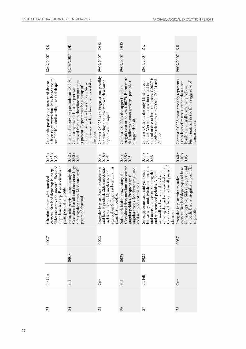
23Pi
t Cut
00
27C
ircul
ar in
pla
n w
ith ro
unde
d co
rner
s. Br
eak
of sl
ope t
op is
shar
p.
Side
s are
stee
p an
d sm
ooth
. Bre
ak o
f slo
pe b
ase i
s sha
rp. B
ase i
s circ
ular
in
plan
; poi
nted
in p
rofil
e.
0.45
x
0.45
x
0.35
Cut
of p
it, p
ossib
ly n
ot b
otto
med
due
to
diff
icul
ty o
f exc
avat
ion.
May
be r
elat
ed to
cu
t C00
10 -
simila
r fill
s, siz
e and
shap
e.
18/0
9/20
07R
K
24Fi
ll00
08
Firm
, mid
gre
yish
bro
wn
sand
y sil
t. O
ccas
iona
l sm
all a
nd m
oder
ate l
arge
su
b-an
gula
r sto
nes.
Mod
erat
e sm
all
piec
es o
f cha
rcoa
l.
0.42
x
0.30
x
0.35
Sing
le fil
l of p
ossib
le po
stho
le cu
t C00
08.
Con
text
repr
esen
ts fil
l afte
r pos
t was
re
mov
ed fr
om c
ut, t
here
fore
no
post
pipe
is
pres
ent.
Dep
osit
may
be a
dum
p of
m
ater
ial u
sed
to le
vel o
ut th
e cut
. Sto
ne
inclu
sions
may
hav
e bee
n us
ed to
stab
ilise
th
e pos
t.
20/0
9/20
07D
K
25C
ut
0026
Irre
gula
r in
plan
. Bre
ak o
f slo
pe to
p an
d ba
se is
gra
dual
. Sid
es: m
oder
ate
and
irreg
ular
on
N; m
oder
ate a
nd
stepp
ed o
n S.
Bas
e is s
ub-c
ircul
ar in
pl
an; f
lat i
n pr
ofile
.
0.4
x 0.
38 x
0.
15
Con
text
C00
25 is
an
irreg
ular
cut
, pos
sibly
re
pres
entin
g a h
ollo
w in
to w
hich
a bu
rnt
depo
sit w
as d
umpe
d.
19/0
9/20
07D
OS
26Fi
ll00
25
Soft,
dar
k bl
uish
bro
wn
stony
silt.
O
ccas
iona
l fin
e, m
ediu
m a
nd c
oars
e an
gula
r peb
bles
. Fre
quen
t sm
all
angu
lar s
tone
s. M
oder
ate s
mal
l and
m
ediu
m p
iece
s of c
harc
oal.
0.4
x 0.
38 x
0.
15
Con
text
C00
26 is
the u
pper
fill
of a
n irr
egul
ar c
ut o
r hol
low
C00
25. B
urnt
mat
e-ria
l ind
icat
es h
uman
act
ivity
- po
ssib
ly a
du
mpe
d de
posit
.
19/0
9/20
07D
OS
27Pi
t Fill
0023
St
rong
ly c
emen
ted,
mid
yel
low
ish
brow
n sil
ty sa
nd. M
oder
ate m
ediu
m
and
occa
siona
l coa
rse s
ub-a
ngul
ar
and
sub-
roun
ded
pebb
les.
Mod
er-
ate s
mal
l and
occ
asio
nal m
ediu
m
sub-
angu
lar a
nd su
b-ro
unde
d sto
nes.
Occ
asio
nal f
lecks
and
smal
l pie
ces o
f ch
arco
al.
0.45
x
0.45
x
0.38
Con
text
C00
27 is
the o
nly
fill o
f pit
cut
C00
23. M
etho
d of
dep
ositi
on c
ould
be
natu
ral o
r due
to h
uman
fact
ors.
C00
27 is
po
ssib
ly re
late
d to
cut
C00
10, C
0021
and
C
0022
.
18/0
9/20
07R
K
28C
ut
0037
Irre
gula
r in
plan
with
roun
ded
corn
ers.
Brea
k of
slop
e top
and
bas
e is
impe
rcep
tible.
Sid
es a
re g
entle
and
sm
ooth
. Bas
e is i
rreg
ular
in p
lan;
flat
in
pro
file.
0.60
x
1.10
x
0.03
Con
text
C00
28 m
ost p
roba
bly
repr
esen
ts
a thi
n la
yer o
f mat
eria
l rat
her t
han
a cut
. Po
ssib
ly a
natu
rally
occ
urrin
g ho
llow.
Bu
rnt m
ater
ial i
n th
e fill
is su
gges
tive o
f hu
man
act
ivity
.
19/0
9/20
07K
R
issUE 11: EaChtra JoUrnal - issn 2009-2237 arChaEologiCal ExCavation rEport
28
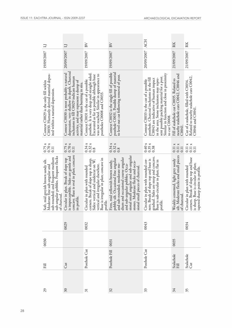
29Fi
ll00
30
Soft,
mid
gre
yish
bro
wn
sand
y sil
t. M
oder
ate f
ine s
ub-a
ngul
ar a
nd
sub-
roun
ded;
and
freq
uent
med
ium
su
b-an
gula
r peb
bles
. Fre
quen
t flec
ks
of c
harc
oal.
0.75
x
0.70
x
0.11
Con
text
C00
29 is
the o
nly
fill w
ithin
C
0030
. Hum
anly
der
ived
mat
eria
l dep
os-
ited
with
in a
natu
ral d
epre
ssio
n.
19/0
9/20
07LJ
30C
ut
0029
Circ
ular
in p
lan.
Bre
ak o
f slo
pe to
p is
impe
rcep
tible.
Sid
es a
re g
entle
and
co
ncav
e. Ba
se is
ova
l in
plan
; con
cave
in
pro
file.
0.75
x
0.70
x
0.11
Con
text
C00
30 is
mos
t pro
babl
y a n
atur
al
depr
essio
n, v
ery
shal
low
in d
epth
. Cha
rcoa
l in
clusio
ns in
fill
C00
29 in
dica
te h
uman
ac
tivity
, and
may
repr
esen
t a d
ump
of
mat
eria
l rat
her t
han
burn
ing
in si
tu.
20/0
9/20
07LJ
31Po
stho
le C
ut
0032
Circ
ular
in p
lan
with
roun
ded
corn
ers.
Brea
k of
slop
e top
is sh
arp.
Si
des:
vert
ical
and
und
ercu
t on
W;
vert
ical
and
irre
gula
r else
whe
re.
Base
is ir
regu
lar i
n pl
an; c
onca
ve in
pr
ofile
.
0.34
x
0.32
x
0.8
Con
text
C00
31 is
the c
ut o
f a p
ossib
le po
stho
le. It
is v
ery
deep
and
stra
ight
side
d.
Exca
vate
d as
far a
s pos
sible
alth
ough
bas
e w
as n
ot re
ache
d. S
imila
r in
appe
aran
ce to
po
stho
les C
0008
and
C00
33.
19/0
9/20
07BV
32Po
stho
le Fi
ll00
31
Firm
, mid
yel
low
ish b
row
n sa
ndy,
pebb
ly si
lt. O
ccas
iona
l fin
e ang
ular
an
d su
b-ro
unde
d; m
oder
ate m
e-di
um a
nd o
ccas
iona
l coa
rse a
ngul
ar
and
sub-
angu
lar p
ebbl
es. O
cca-
siona
l sm
all a
ngul
ar a
nd su
b-an
gula
r sto
nes.
Mod
erat
e flec
ks a
nd o
cca-
siona
l sm
all p
iece
s of c
harc
oal.
0.34
x
0.32
x
0.8
Con
text
C00
32 is
the s
ingl
e fill
of p
ossib
le po
stho
le C
0031
. Pos
sible
dum
p of
mat
eria
l to
leve
l out
cut
follo
win
g re
mov
al o
f pos
t.
19/0
9/20
07BV
33Po
stho
le C
ut
0043
Circ
ular
in p
lan
with
roun
ded
cor-
ners
. Bre
ak o
f slo
pe to
p an
d ba
se is
gr
adua
l. Si
des a
re st
eep
and
conc
ave.
Ba
se is
sub-
circ
ular
in p
lan;
flat
in
prof
ile.
0.40
x
0.35
x
0.38
Con
text
C00
33 is
the c
ut o
f a p
ossib
le po
stho
le. C
harc
oal i
nclu
sions
in th
e fill
C
0043
are
indi
cativ
e of h
uman
impa
ct
in th
e are
a. S
tone
inclu
sions
may
repr
e-se
nt p
ossib
le pa
ckin
g m
ater
ial f
or a
post.
Si
mila
r in
func
tion
and
close
in p
roxi
mity
to
cut
C00
08.
20/0
9/20
07AC
H
34St
akeh
ole
Fill
0035
W
eakl
y ce
men
ted,
ligh
t gre
y sa
ndy
silt.
Mod
erat
e flec
ks a
nd sm
all p
iece
s of
cha
rcoa
l.
0.11
x
0.11
x
0.11
Fill
of st
akeh
ole c
ut C
0035
. Rel
ated
to
near
by st
akeh
ole c
uts C
0042
, C00
46 a
nd
C00
41.
21/0
9/20
07R
K
35St
akeh
ole
Cut
00
34C
ircul
ar in
pla
n w
ith ro
unde
d co
rner
s. Br
eak
of sl
ope t
op a
nd b
ase
is sh
arp.
Bas
e is c
ircul
ar in
pla
n;
tape
red
shar
p po
int i
n pr
ofile
.
0.11
x
0.11
x
0.11
Cut
of a
stak
ehol
e, fil
led w
ith C
0034
. R
elat
ed to
nea
rby
stake
hole
cuts
C00
42,
C00
46 a
nd C
0041
.
21/0
9/20
07R
K
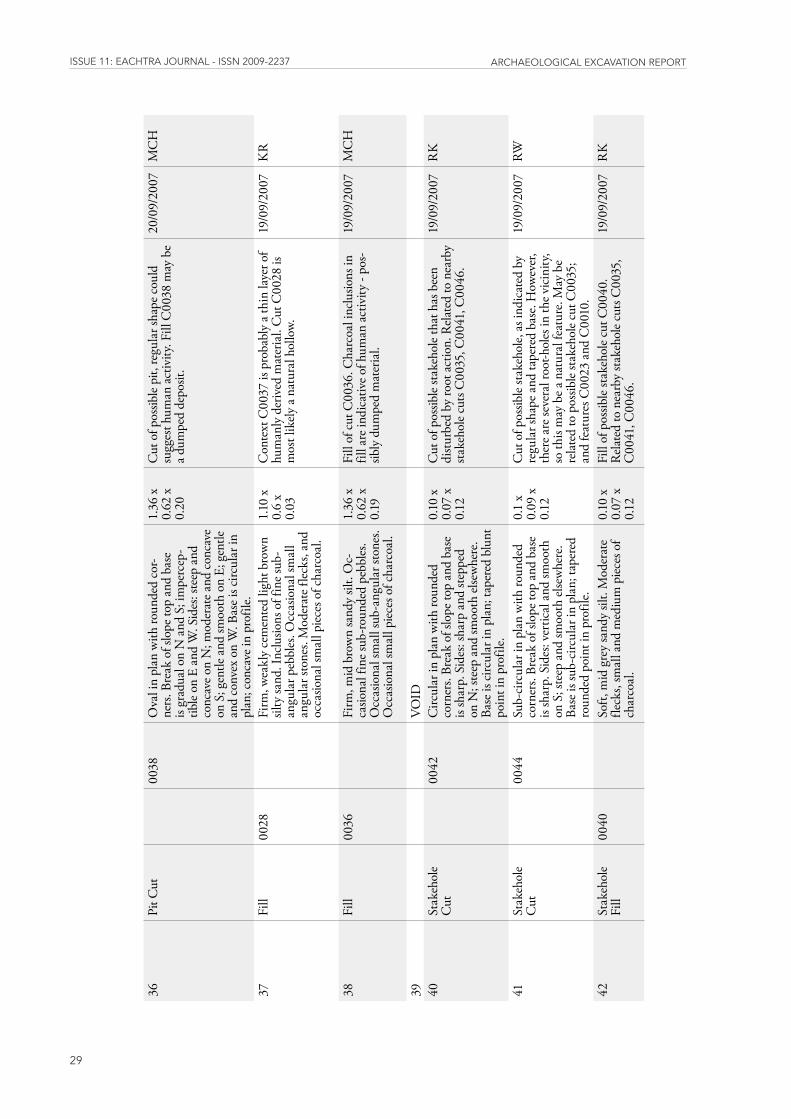
issUE 11: EaChtra JoUrnal - issn 2009-2237 arChaEologiCal ExCavation rEport
29
36Pi
t Cut
00
38O
val i
n pl
an w
ith ro
unde
d co
r-ne
rs. B
reak
of s
lope
top
and
base
is
grad
ual o
n N
and
S; i
mpe
rcep
-tib
le on
E a
nd W
. Sid
es: s
teep
and
co
ncav
e on
N; m
oder
ate a
nd c
onca
ve
on S
; gen
tle a
nd sm
ooth
on
E; g
entle
an
d co
nvex
on
W. B
ase i
s circ
ular
in
plan
; con
cave
in p
rofil
e.
1.36
x
0.62
x
0.20
Cut
of p
ossib
le pi
t, re
gula
r sha
pe c
ould
su
gges
t hum
an a
ctiv
ity. F
ill C
0038
may
be
a dum
ped
depo
sit.
20/0
9/20
07M
CH
37Fi
ll00
28
Firm
, wea
kly
cem
ente
d lig
ht b
row
n sil
ty sa
nd. I
nclu
sions
of f
ine s
ub-
angu
lar p
ebbl
es. O
ccas
iona
l sm
all
angu
lar s
tone
s. M
oder
ate f
lecks
, and
oc
casio
nal s
mal
l pie
ces o
f cha
rcoa
l.
1.10
x
0.6
x 0.
03
Con
text
C00
37 is
pro
babl
y a t
hin
laye
r of
hum
anly
der
ived
mat
eria
l. C
ut C
0028
is
mos
t lik
ely a
natu
ral h
ollo
w.
19/0
9/20
07K
R
38Fi
ll00
36
Firm
, mid
bro
wn
sand
y sil
t. O
c-ca
siona
l fin
e sub
-roun
ded
pebb
les.
Occ
asio
nal s
mal
l sub
-ang
ular
ston
es.
Occ
asio
nal s
mal
l pie
ces o
f cha
rcoa
l.
1.36
x
0.62
x
0.19
Fill
of c
ut C
0036
. Cha
rcoa
l inc
lusio
ns in
fil
l are
indi
cativ
e of h
uman
act
ivity
- po
s-sib
ly d
umpe
d m
ater
ial.
19/0
9/20
07M
CH
39
VO
ID
40
Stak
ehol
e C
ut
0042
Circ
ular
in p
lan
with
roun
ded
corn
ers.
Brea
k of
slop
e top
and
bas
e is
shar
p. S
ides
: sha
rp a
nd st
eppe
d on
N; s
teep
and
smoo
th el
sew
here
. Ba
se is
circ
ular
in p
lan;
tape
red
blun
t po
int i
n pr
ofile
.
0.10
x
0.07
x
0.12
Cut
of p
ossib
le sta
keho
le th
at h
as b
een
dist
urbe
d by
root
act
ion.
Rel
ated
to n
earb
y sta
keho
le cu
ts C
0035
, C00
41, C
0046
.
19/0
9/20
07R
K
41St
akeh
ole
Cut
00
44Su
b-ci
rcul
ar in
pla
n w
ith ro
unde
d co
rner
s. Br
eak
of sl
ope t
op a
nd b
ase
is sh
arp.
Sid
es: v
ertic
al a
nd sm
ooth
on
S; s
teep
and
smoo
th el
sew
here
. Ba
se is
sub-
circ
ular
in p
lan;
tape
red
roun
ded
poin
t in
prof
ile.
0.1
x 0.
09 x
0.
12
Cut
of p
ossib
le sta
keho
le, a
s ind
icat
ed b
y re
gula
r sha
pe a
nd ta
pere
d ba
se. H
owev
er,
ther
e are
seve
ral r
oot-h
oles
in th
e vic
inity
, so
this
may
be a
nat
ural
feat
ure.
May
be
rela
ted
to p
ossib
le sta
keho
le cu
t C00
35;
and
feat
ures
C00
23 a
nd C
0010
.
19/0
9/20
07RW
42St
akeh
ole
Fill
0040
So
ft, m
id g
rey
sand
y sil
t. M
oder
ate
fleck
s, sm
all a
nd m
ediu
m p
iece
s of
char
coal
.
0.10
x
0.07
x
0.12
Fill
of p
ossib
le sta
keho
le cu
t C00
40.
Rel
ated
to n
earb
y sta
keho
le cu
ts C
0035
, C
0041
, C00
46.
19/0
9/20
07R
K
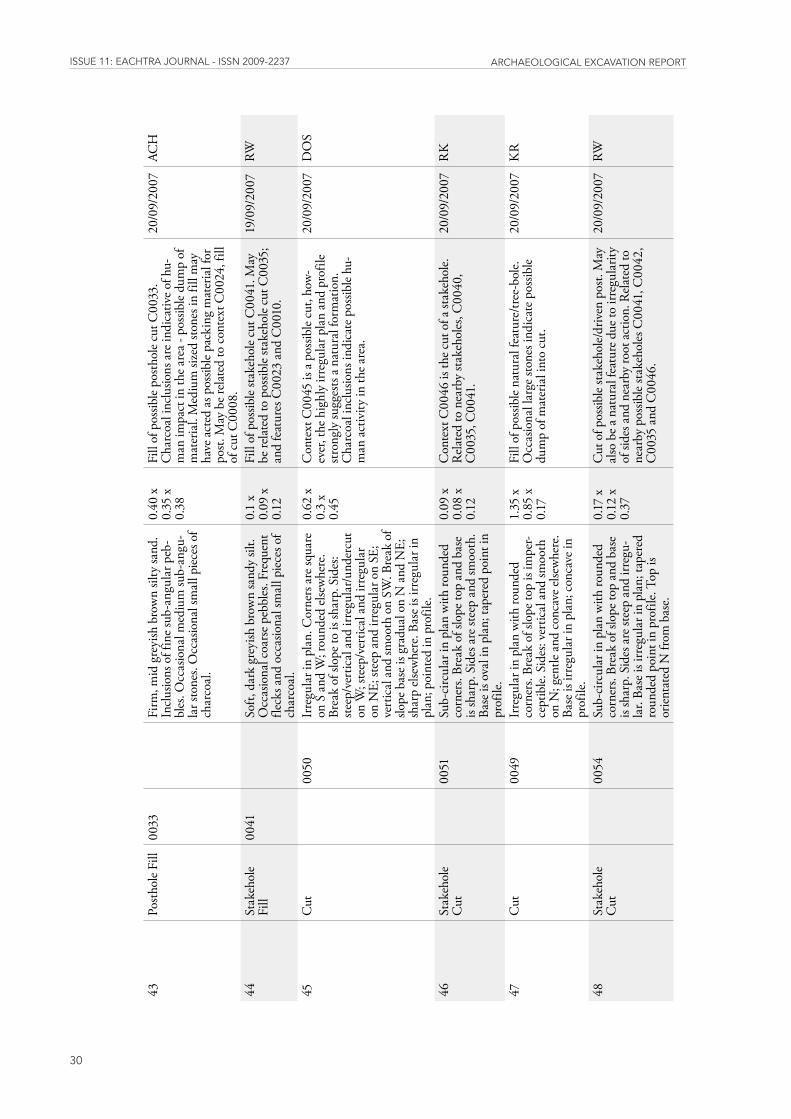
issUE 11: EaChtra JoUrnal - issn 2009-2237 arChaEologiCal ExCavation rEport
30
43Po
stho
le Fi
ll00
33
Firm
, mid
gre
yish
bro
wn
silty
sand
. In
clusio
ns o
f fin
e sub
-ang
ular
peb
-bl
es. O
ccas
iona
l med
ium
sub-
angu
-la
r sto
nes.
Occ
asio
nal s
mal
l pie
ces o
f ch
arco
al.
0.40
x
0.35
x
0.38
Fill
of p
ossib
le po
stho
le cu
t C00
33.
Cha
rcoa
l inc
lusio
ns a
re in
dica
tive o
f hu-
man
impa
ct in
the a
rea -
pos
sible
dum
p of
m
ater
ial.
Med
ium
size
d sto
nes i
n fil
l may
ha
ve a
cted
as p
ossib
le pa
ckin
g m
ater
ial f
or
post.
May
be r
elat
ed to
con
text
C00
24, f
ill
of c
ut C
0008
.
20/0
9/20
07AC
H
44St
akeh
ole
Fill
0041
So
ft, d
ark
grey
ish b
row
n sa
ndy
silt.
Occ
asio
nal c
oars
e peb
bles
. Fre
quen
t fle
cks a
nd o
ccas
iona
l sm
all p
iece
s of
char
coal
.
0.1
x 0.
09 x
0.
12
Fill
of p
ossib
le sta
keho
le cu
t C00
41. M
ay
be re
late
d to
pos
sible
stake
hole
cut C
0035
; an
d fe
atur
es C
0023
and
C00
10.
19/0
9/20
07RW
45C
ut
0050
Irre
gula
r in
plan
. Cor
ners
are
squa
re
on S
and
W; r
ound
ed el
sew
here
. Br
eak
of sl
ope t
o is
shar
p. S
ides
: ste
ep/v
ertic
al a
nd ir
regu
lar/u
nder
cut
on W
; ste
ep/v
ertic
al a
nd ir
regu
lar
on N
E; st
eep
and
irreg
ular
on
SE;
vert
ical
and
smoo
th o
n SW
. Bre
ak o
f slo
pe b
ase i
s gra
dual
on
N a
nd N
E;
shar
p el
sew
here
. Bas
e is i
rreg
ular
in
plan
; poi
nted
in p
rofil
e.
0.62
x
0.3
x 0.
45
Con
text
C00
45 is
a po
ssib
le cu
t, ho
w-ev
er, t
he h
ighl
y irr
egul
ar p
lan
and
prof
ile
stron
gly
sugg
ests
a nat
ural
form
atio
n.
Cha
rcoa
l inc
lusio
ns in
dica
te p
ossib
le hu
-m
an a
ctiv
ity in
the a
rea.
20/0
9/20
07D
OS
46St
akeh
ole
Cut
00
51Su
b-ci
rcul
ar in
pla
n w
ith ro
unde
d co
rner
s. Br
eak
of sl
ope t
op a
nd b
ase
is sh
arp.
Sid
es a
re st
eep
and
smoo
th.
Base
is o
val i
n pl
an; t
aper
ed p
oint
in
prof
ile.
0.09
x
0.08
x
0.12
Con
text
C00
46 is
the c
ut o
f a st
akeh
ole.
R
elat
ed to
nea
rby
stake
hole
s, C
0040
, C
0035
, C00
41.
20/0
9/20
07R
K
47C
ut
0049
Irre
gula
r in
plan
with
roun
ded
corn
ers.
Brea
k of
slop
e top
is im
per-
cept
ible.
Sid
es: v
ertic
al a
nd sm
ooth
on
N; g
entle
and
con
cave
else
whe
re.
Base
is ir
regu
lar i
n pl
an; c
onca
ve in
pr
ofile
.
1.35
x
0.85
x
0.17
Fill
of p
ossib
le na
tura
l fea
ture
/tree
-bol
e.
Occ
asio
nal l
arge
ston
es in
dica
te p
ossib
le du
mp
of m
ater
ial i
nto
cut.
20/0
9/20
07K
R
48St
akeh
ole
Cut
00
54Su
b-ci
rcul
ar in
pla
n w
ith ro
unde
d co
rner
s. Br
eak
of sl
ope t
op a
nd b
ase
is sh
arp.
Sid
es a
re st
eep
and
irreg
u-la
r. Ba
se is
irre
gula
r in
plan
; tap
ered
ro
unde
d po
int i
n pr
ofile
. Top
is
orien
tate
d N
from
bas
e.
0.17
x
0.12
x
0.37
Cut
of p
ossib
le sta
keho
le/dr
iven
pos
t. M
ay
also
be a
nat
ural
feat
ure d
ue to
irre
gula
rity
of si
des a
nd n
earb
y ro
ot a
ctio
n. R
elat
ed to
ne
arby
pos
sible
stake
hole
s C00
41, C
0042
, C
0035
and
C00
46.
20/0
9/20
07RW
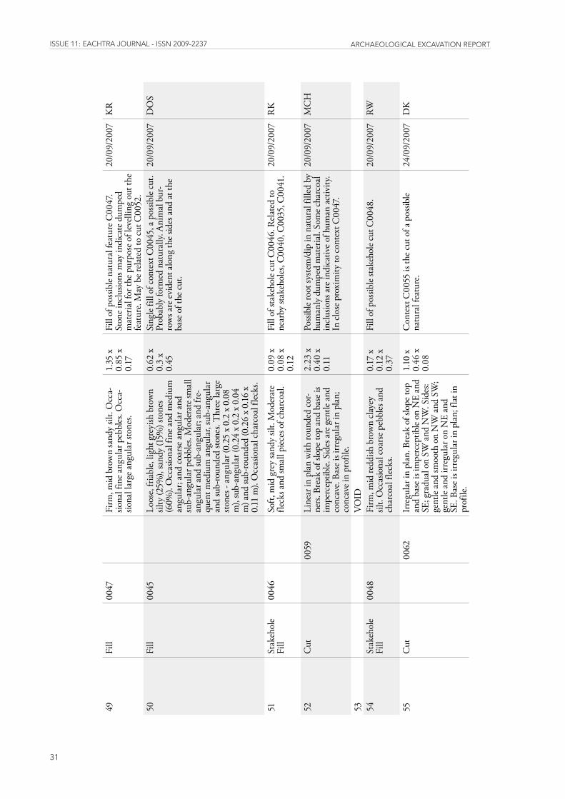
issUE 11: EaChtra JoUrnal - issn 2009-2237 arChaEologiCal ExCavation rEport
31
49Fi
ll00
47
Firm
, mid
bro
wn
sand
y sil
t. O
cca-
siona
l fin
e ang
ular
peb
bles
. Occ
a-sio
nal l
arge
ang
ular
ston
es.
1.35
x
0.85
x
0.17
Fill
of p
ossib
le na
tura
l fea
ture
C00
47.
Ston
e inc
lusio
ns m
ay in
dica
te d
umpe
d m
ater
ial f
or th
e pur
pose
of l
evel
ling
out t
he
feat
ure.
May
be r
elat
ed to
cut
C00
52.
20/0
9/20
07K
R
50Fi
ll00
45
Loos
e, fri
able,
ligh
t gre
yish
bro
wn
silty
(25%
), sa
ndy
(15%
) sto
nes
(60%
). O
ccas
iona
l fin
e and
med
ium
an
gula
r; an
d co
arse
ang
ular
and
su
b-an
gula
r peb
bles
. Mod
erat
e sm
all
angu
lar a
nd su
b-an
gula
r; an
d fre
-qu
ent m
ediu
m a
ngul
ar, s
ub-a
ngul
ar
and
sub-
roun
ded
stone
s. T
hree
larg
e sto
nes -
ang
ular
(0.2
5 x
0.2
x 0.
08
m),
sub-
angu
lar (
0.24
x 0
.2 x
0.0
4 m
) and
sub-
roun
ded
(0.2
6 x
0.16
x
0.11
m).
Occ
asio
nal c
harc
oal f
lecks
.
0.62
x
0.3
x 0.
45
Sing
le fil
l of c
onte
xt C
0045
, a p
ossib
le cu
t. Pr
obab
ly fo
rmed
nat
ural
ly. A
nim
al b
ur-
row
s are
evi
dent
alo
ng th
e sid
es a
nd at
the
base
of t
he c
ut.
20/0
9/20
07D
OS
51St
akeh
ole
Fill
0046
So
ft, m
id g
rey
sand
y sil
t. M
oder
ate
fleck
s and
smal
l pie
ces o
f cha
rcoa
l. 0.
09 x
0.
08 x
0.
12
Fill
of st
akeh
ole c
ut C
0046
. Rel
ated
to
near
by st
akeh
oles
, C00
40, C
0035
, C00
41.
20/0
9/20
07R
K
52C
ut
0059
Line
ar in
pla
n w
ith ro
unde
d co
r-ne
rs. B
reak
of s
lope
top
and
base
is
impe
rcep
tible.
Sid
es a
re g
entle
and
co
ncav
e. Ba
se is
irre
gula
r in
plan
; co
ncav
e in
prof
ile.
2.23
x
0.40
x
0.11
Poss
ible
root
syste
m/d
ip in
nat
ural
fille
d by
hu
man
ly d
umpe
d m
ater
ial.
Som
e cha
rcoa
l in
clusio
ns a
re in
dica
tive o
f hum
an a
ctiv
ity.
In c
lose
pro
xim
ity to
con
text
C00
47.
20/0
9/20
07M
CH
53
VO
ID
54
Stak
ehol
e Fi
ll 00
48
Firm
, mid
redd
ish b
row
n cl
ayey
sil
t. O
ccas
iona
l coa
rse p
ebbl
es a
nd
char
coal
flec
ks.
0.17
x
0.12
x
0.37
Fill
of p
ossib
le sta
keho
le cu
t C00
48.
20/0
9/20
07RW
55C
ut
0062
Irre
gula
r in
plan
. Bre
ak o
f slo
pe to
p an
d ba
se is
impe
rcep
tible
on N
E an
d SE
; gra
dual
on
SW a
nd N
W. S
ides
: ge
ntle
and
smoo
th o
n N
W a
nd S
W;
gent
le an
d irr
egul
ar o
n N
E an
d SE
. Bas
e is i
rreg
ular
in p
lan;
flat
in
prof
ile.
1.10
x
0.46
x
0.08
Con
text
C00
55 is
the c
ut o
f a p
ossib
le na
tura
l fea
ture
. 24
/09/
2007
DK

issUE 11: EaChtra JoUrnal - issn 2009-2237 arChaEologiCal ExCavation rEport
32
56Po
stho
le C
ut
0061
Circ
ular
in p
lan
with
roun
ded
cor-
ners
. Bre
ak o
f slo
pe to
p an
d ba
se is
gr
adua
l. Si
des:
vert
ical
and
con
cave
on
SE;
ver
tical
and
smoo
th el
se-
whe
re. B
ase i
s circ
ular
in p
lan;
flat
in
pro
file.
0.32
x
0.28
x
0.31
Cut
of p
ossib
le po
stho
le. M
ay b
e rel
ated
to
post
hole
cuts
C00
33 a
nd C
0008
in c
lose
pr
oxim
ity.
21/0
9/20
07AC
H
57Fu
rrow
Fill
0058
So
ft, m
id b
row
n sa
ndy
silt.
Mod
er-
ate f
ine a
nd o
ccas
iona
l med
ium
sub-
angu
lar a
nd su
b-ro
unde
d pe
bble
s. Fr
eque
nt c
oars
e sub
-ang
ular
peb
bles
. M
oder
ate s
mal
l sub
-ang
ular
and
su
b-ro
unde
d sto
nes.
4.40
x
0.70
x
0.15
Fill
of a
furr
ow, c
ut C
0058
. Nat
ural
ly o
c-cu
rrin
g de
posit
ed m
ater
ial.
Rel
ated
to fi
lls
of o
ther
furr
ows i
n th
e are
a - C
0078
and
C
0077
.
21/0
9/20
07LJ
58Fu
rrow
Cut
00
57Li
near
in p
lan.
Cor
ners
are
squa
re
on N
E an
d N
W; r
ound
ed o
n SE
and
SW
. Bre
ak o
f slo
pe to
p an
d ba
se is
gr
adua
l. Si
des a
re g
entle
and
smoo
th.
Base
is li
near
in p
lan;
con
cave
in
prof
ile.
4.40
x
0.70
x
0.15
Cut
of a
furr
ow. O
ne o
f thr
ee li
nes o
f fur
-ro
ws a
ll pa
ralle
l to
one a
noth
er. R
elat
ed to
ot
her f
urro
ws,
C00
67, C
0074
and
C00
76.
21/0
9/20
07LJ
59Fi
ll00
52
Firm
, dar
k br
own
sand
y sil
t. O
cca-
siona
l med
ium
sub-
roun
ded
pebb
les.
Occ
asio
nal s
mal
l sub
-ang
ular
ston
es.
Occ
asio
nal s
mal
l pie
ces o
f cha
rcoa
l.
2.23
x
0.40
x
0.09
Fill
of c
ut C
0052
, a p
ossib
le na
tura
l fea
-tu
re. F
ill m
ay re
pres
ent a
dum
p of
mat
eria
l w
ithin
cut
. Cha
rcoa
l inc
lusio
ns a
re in
dica
-tiv
e of h
uman
influ
ence
. May
be r
elat
ed to
cu
t C00
47, w
hich
is in
clo
se p
roxi
mity
.
20/0
9/20
07M
CH
60
VO
ID
61
Post
hole
Fill
0056
Fi
rm, i
ndur
ated
, mid
bro
wn
silty
sa
nd. O
ccas
iona
l fin
e sub
-roun
ded
pebb
les.
Occ
asio
nal m
ediu
m su
b-an
gula
r sto
nes.
Occ
asio
nal s
mal
l pi
eces
of c
harc
oal.
0.32
x
0.28
x
0.31
Onl
y fil
l of p
ossib
le po
stho
le cu
t C00
56.
May
repr
esen
t a d
ump
of m
ater
ial i
nto
cut.
Ston
e inc
lusio
ns m
ay b
e rem
nant
s of
dist
urbe
d pa
ckin
g m
ater
ial.
Cha
rcoa
l is
indi
cativ
e of h
uman
inte
rfere
nce i
n th
e ar
ea. R
elat
ed to
nea
rby
post
hole
s C00
33
and
C00
08.
21/0
9/20
07AC
H
62Fi
ll00
55
Loos
e, m
id b
row
n sil
ty sa
nd. M
oder
-at
e sm
all a
nd m
ediu
m su
b-an
gula
r sto
nes.
1.10
x
0.46
x
0.08
Onl
y fil
l of c
ut C
0055
, a p
ossib
le na
tura
l fe
atur
e. Ve
ry sh
allo
w. M
ost l
ikely
dep
osite
d na
tura
lly -
poss
ibly
was
hed
in d
own
slope
.
24/0
9/20
07D
K
63
VO
ID
64
V
OID
65
VO
ID
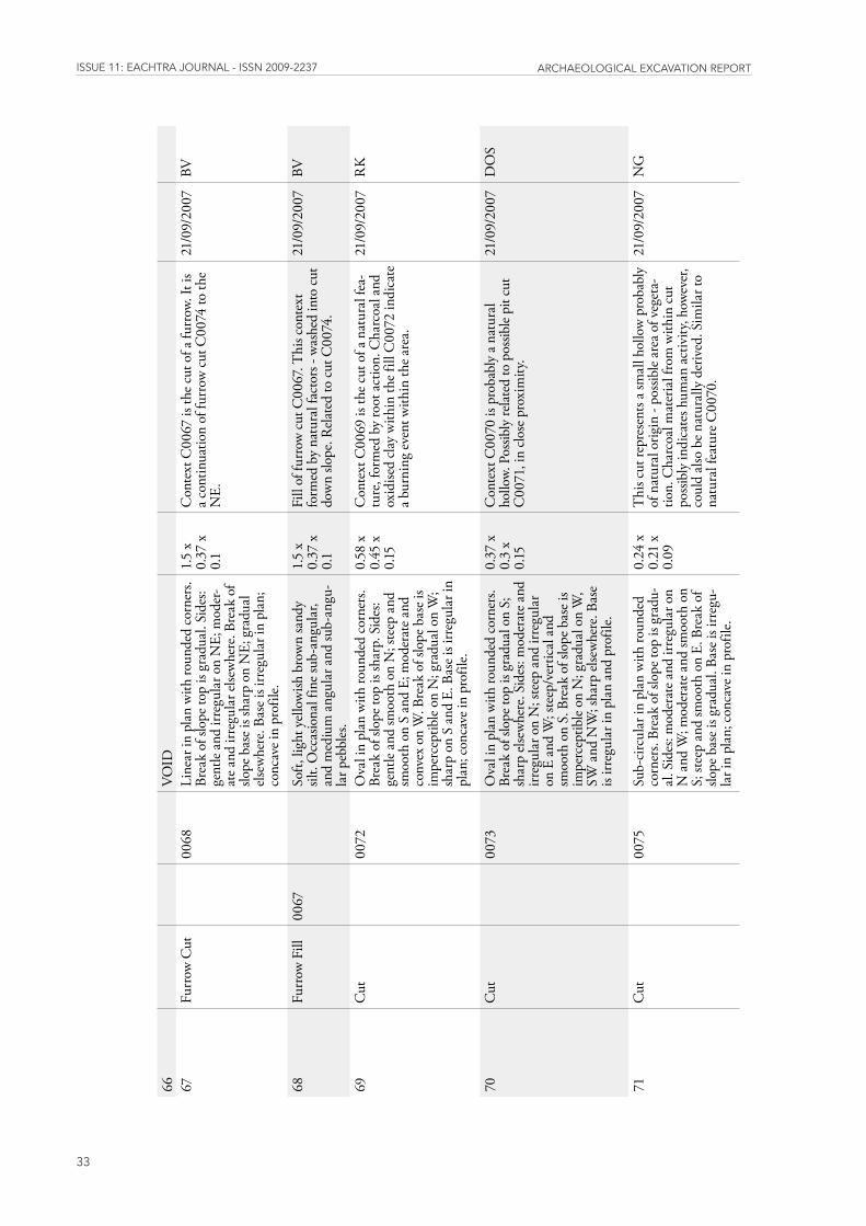
issUE 11: EaChtra JoUrnal - issn 2009-2237 arChaEologiCal ExCavation rEport
33
66
VO
ID
67
Furr
ow C
ut
0068
Line
ar in
pla
n w
ith ro
unde
d co
rner
s. Br
eak
of sl
ope t
op is
gra
dual
. Sid
es:
gent
le an
d irr
egul
ar o
n N
E; m
oder
-at
e and
irre
gula
r else
whe
re. B
reak
of
slope
bas
e is s
harp
on
NE;
gra
dual
el
sew
here
. Bas
e is i
rreg
ular
in p
lan;
co
ncav
e in
prof
ile.
1.5
x 0.
37 x
0.
1
Con
text
C00
67 is
the c
ut o
f a fu
rrow
. It i
s a c
ontin
uatio
n of
furr
ow c
ut C
0074
to th
e N
E.
21/0
9/20
07BV
68Fu
rrow
Fill
0067
So
ft, li
ght y
ello
wish
bro
wn
sand
y sil
t. O
ccas
iona
l fin
e sub
-ang
ular
, an
d m
ediu
m a
ngul
ar a
nd su
b-an
gu-
lar p
ebbl
es.
1.5
x 0.
37 x
0.
1
Fill
of fu
rrow
cut
C00
67. T
his c
onte
xt
form
ed b
y na
tura
l fac
tors
- w
ashe
d in
to c
ut
dow
n slo
pe. R
elat
ed to
cut
C00
74.
21/0
9/20
07BV
69C
ut
0072
Ova
l in
plan
with
roun
ded
corn
ers.
Brea
k of
slop
e top
is sh
arp.
Sid
es:
gent
le an
d sm
ooth
on
N; s
teep
and
sm
ooth
on
S an
d E;
mod
erat
e and
co
nvex
on
W. B
reak
of s
lope
bas
e is
impe
rcep
tible
on N
; gra
dual
on
W;
shar
p on
S a
nd E
. Bas
e is i
rreg
ular
in
plan
; con
cave
in p
rofil
e.
0.58
x
0.45
x
0.15
Con
text
C00
69 is
the c
ut o
f a n
atur
al fe
a-tu
re, f
orm
ed b
y ro
ot a
ctio
n. C
harc
oal a
nd
oxid
ised
clay
with
in th
e fill
C00
72 in
dica
te
a bur
ning
eve
nt w
ithin
the a
rea.
21/0
9/20
07R
K
70C
ut
0073
Ova
l in
plan
with
roun
ded
corn
ers.
Brea
k of
slop
e top
is g
radu
al o
n S;
sh
arp
else
whe
re. S
ides
: mod
erat
e and
irr
egul
ar o
n N
; ste
ep a
nd ir
regu
lar
on E
and
W; s
teep
/ver
tical
and
sm
ooth
on
S. B
reak
of s
lope
bas
e is
impe
rcep
tible
on N
; gra
dual
on
W,
SW a
nd N
W; s
harp
else
whe
re. B
ase
is irr
egul
ar in
pla
n an
d pr
ofile
.
0.37
x
0.3
x 0.
15
Con
text
C00
70 is
pro
babl
y a n
atur
al
hollo
w. P
ossib
ly re
late
d to
pos
sible
pit c
ut
C00
71, i
n clo
se p
roxi
mity
.
21/0
9/20
07D
OS
71C
ut
0075
Sub-
circ
ular
in p
lan
with
roun
ded
corn
ers.
Brea
k of
slop
e top
is g
radu
-al
. Sid
es: m
oder
ate a
nd ir
regu
lar o
n N
and
W; m
oder
ate a
nd sm
ooth
on
S; st
eep
and
smoo
th o
n E.
Bre
ak o
f slo
pe b
ase i
s gra
dual
. Bas
e is i
rreg
u-la
r in
plan
; con
cave
in p
rofil
e.
0.24
x
0.21
x
0.09
Thi
s cut
repr
esen
ts a s
mal
l hol
low
pro
babl
y of
nat
ural
orig
in -
poss
ible
area
of v
eget
a-tio
n. C
harc
oal m
ater
ial f
rom
with
in c
ut
poss
ibly
indi
cate
s hum
an a
ctiv
ity, h
owev
er,
coul
d al
so b
e nat
ural
ly d
eriv
ed. S
imila
r to
natu
ral f
eatu
re C
0070
.
21/0
9/20
07N
G
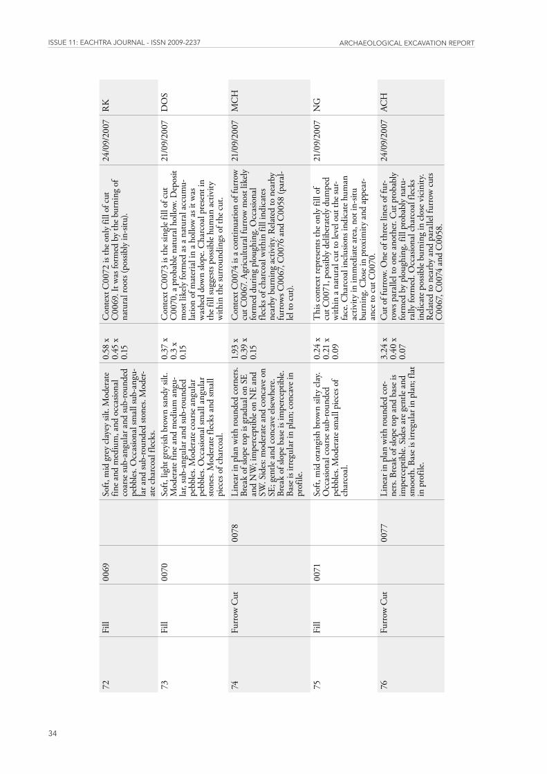
issUE 11: EaChtra JoUrnal - issn 2009-2237 arChaEologiCal ExCavation rEport
34
72Fi
ll00
69
Soft,
mid
gre
y cl
ayey
silt.
Mod
erat
e fin
e and
med
ium
, and
occ
asio
nal
coar
se su
b-an
gula
r and
sub-
roun
ded
pebb
les.
Occ
asio
nal s
mal
l sub
-ang
u-la
r and
sub-
roun
ded
stone
s. M
oder
-at
e cha
rcoa
l flec
ks.
0.58
x
0.45
x
0.15
Con
text
C00
72 is
the o
nly
fill o
f cut
C
0069
. It w
as fo
rmed
by
the b
urni
ng o
f na
tura
l roo
ts (p
ossib
ly in
-situ
).
24/0
9/20
07R
K
73Fi
ll00
70
Soft,
ligh
t gre
yish
bro
wn
sand
y sil
t. M
oder
ate f
ine a
nd m
ediu
m a
ngu-
lar,
sub-
angu
lar a
nd su
b-ro
unde
d pe
bble
s. M
oder
ate c
oars
e ang
ular
pe
bble
s. O
ccas
iona
l sm
all a
ngul
ar
stone
s. M
oder
ate f
lecks
and
smal
l pi
eces
of c
harc
oal.
0.37
x
0.3
x 0.
15
Con
text
C00
73 is
the s
ingl
e fill
of c
ut
C00
70, a
pro
babl
e nat
ural
hol
low.
Dep
osit
mos
t lik
ely fo
rmed
as a
nat
ural
acc
umu-
latio
n of
mat
eria
l in
a hol
low
as i
t was
w
ashe
d do
wn
slope
. Cha
rcoa
l pre
sent
in
the f
ill su
gges
ts po
ssib
le hu
man
act
ivity
w
ithin
the s
urro
undi
ngs o
f the
cut
.
21/0
9/20
07D
OS
74Fu
rrow
Cut
00
78Li
near
in p
lan
with
roun
ded
corn
ers.
Brea
k of
slop
e top
is g
radu
al o
n SE
an
d N
W; i
mpe
rcep
tible
on N
E an
d SW
. Sid
es: m
oder
ate a
nd c
onca
ve o
n SE
; gen
tle a
nd c
onca
ve el
sew
here
. Br
eak
of sl
ope b
ase i
s im
perc
eptib
le.
Base
is ir
regu
lar i
n pl
an; c
onca
ve in
pr
ofile
.
1.93
x
0.39
x
0.15
Con
text
C00
74 is
a co
ntin
uatio
n of
furr
ow
cut C
0067
. Agr
icul
tura
l fur
row
mos
t lik
ely
form
ed d
urin
g pl
ough
ing.
Occ
asio
nal
fleck
s of c
harc
oal w
ithin
fill
indi
cate
s ne
arby
bur
ning
act
ivity
. Rel
ated
to n
earb
y fu
rrow
s C00
67, C
0076
and
C00
58 (p
aral
-lel
to c
ut).
21/0
9/20
07M
CH
75Fi
ll00
71
Soft,
mid
ora
ngish
bro
wn
silty
cla
y. O
ccas
iona
l coa
rse s
ub-ro
unde
d pe
bble
s. M
oder
ate s
mal
l pie
ces o
f ch
arco
al.
0.24
x
0.21
x
0.09
Thi
s con
text
repr
esen
ts th
e onl
y fil
l of
cut C
0071
, pos
sibly
del
iber
ately
dum
ped
with
in a
natu
ral c
ut to
leve
l out
the s
ur-
face
. Cha
rcoa
l inc
lusio
ns in
dica
te h
uman
ac
tivity
in im
med
iate
are
a, n
ot in
-situ
bu
rnin
g. C
lose
in p
roxi
mity
and
app
ear-
ance
to c
ut C
0070
.
21/0
9/20
07N
G
76Fu
rrow
Cut
00
77Li
near
in p
lan
with
roun
ded
cor-
ners
. Bre
ak o
f slo
pe to
p an
d ba
se is
im
perc
eptib
le. S
ides
are
gen
tle a
nd
smoo
th. B
ase i
s irr
egul
ar in
pla
n; fl
at
in p
rofil
e.
3.24
x
0.40
x
0.07
Cut
of f
urro
w. O
ne o
f thr
ee li
nes o
f fur
-ro
ws p
aral
lel to
one
ano
ther
. Cut
pro
babl
y fo
rmed
by
plou
ghin
g, fi
ll pr
obab
ly n
atu-
rally
form
ed. O
ccas
iona
l cha
rcoa
l flec
ks
indi
cate
pos
sible
burn
ing
in c
lose
vic
inity
. R
elat
ed to
nea
rby
and
para
llel f
urro
w c
uts
C00
67, C
0074
and
C00
58.
24/0
9/20
07AC
H
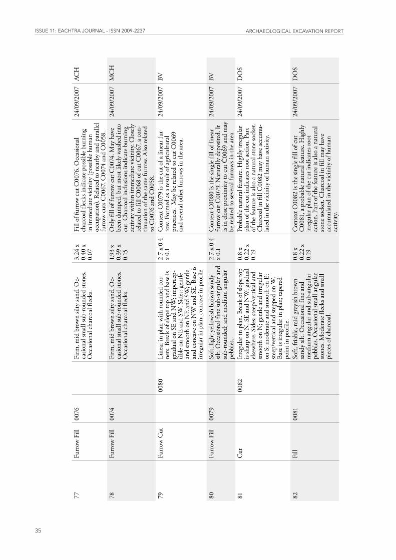
issUE 11: EaChtra JoUrnal - issn 2009-2237 arChaEologiCal ExCavation rEport
35
77Fu
rrow
Fill
0076
Fi
rm, m
id b
row
n sil
ty sa
nd. O
c-ca
siona
l sm
all s
ub-ro
unde
d sto
nes.
Occ
asio
nal c
harc
oal f
lecks
.
3.24
x
0.40
x
0.07
Fill
of fu
rrow
cut
C00
76. O
ccas
iona
l ch
arco
al fl
ecks
indi
cate
pos
sible
burn
ing
in im
med
iate
vic
inity
(pos
sible
hum
an
occu
patio
n). R
elat
ed to
nea
rby
and
para
llel
furr
ow c
uts C
0067
, C00
74 a
nd C
0058
.
24/0
9/20
07AC
H
78Fu
rrow
Fill
0074
Fi
rm, m
id b
row
n sil
ty sa
nd. O
c-ca
siona
l sm
all s
ub-ro
unde
d sto
nes.
Occ
asio
nal c
harc
oal f
lecks
.
1.93
x
0.39
x
0.15
Onl
y fil
l of f
urro
w c
ut C
0074
. May
hav
e be
en d
umpe
d, b
ut m
ost l
ikely
was
hed
into
cu
t. C
harc
oal i
nclu
sions
indi
cate
bur
ning
ac
tivity
with
in im
med
iate
vic
inity
. Clo
sely
re
late
d to
fill
C00
68 o
f cut
C00
67, a
con
-tin
uatio
n of
the s
ame f
urro
w. A
lso re
late
d to
C00
76 a
nd C
0058
.
24/0
9/20
07M
CH
79Fu
rrow
Cut
00
80Li
near
in p
lan
with
roun
ded
cor-
ners
. Bre
ak o
f slo
pe to
p an
d ba
se is
gr
adua
l on
SE a
nd N
W; i
mpe
rcep
-tib
le on
NE
and
SW. S
ides
: gen
tle
and
smoo
th o
n N
E an
d SW
; gen
tle
and
conc
ave o
n N
W a
nd S
E. B
ase i
s irr
egul
ar in
pla
n; c
onca
ve in
pro
file.
2.7
x 0.
4 x
0.1
Con
text
C00
79 is
the c
ut o
f a li
near
fur-
row.
For
med
as a
resu
lt of
agr
icul
tura
l pr
actic
es.
May
be r
elat
ed to
cut
C00
69
and
seve
ral o
ther
furr
ows i
n th
e are
a.
24/0
9/20
07BV
80Fu
rrow
Fill
0079
So
ft, li
ght y
ello
wish
bro
wn
sand
y sil
t. O
ccas
iona
l fin
e sub
-ang
ular
and
su
b-ro
unde
d; a
nd m
ediu
m a
ngul
ar
pebb
les.
2.7
x 0.
4 x
0.1
Con
text
C00
80 is
the s
ingl
e fill
of l
inea
r fu
rrow
cut
C00
79. N
atur
ally
dep
osite
d. It
is
in c
lose
pro
xim
ity to
cut
C00
69 a
nd m
ay
be re
late
d to
seve
ral f
urro
ws i
n th
e are
a.
24/0
9/20
07BV
81C
ut
0082
Irre
gula
r in
plan
. Bre
ak o
f slo
pe to
p is
shar
p on
N, S
E an
d N
W; g
radu
al
else
whe
re. S
ides
: ste
ep/v
ertic
al a
nd
smoo
th o
n N
; gen
tle a
nd ir
regu
lar
on S
; mod
erat
e and
smoo
th o
n E;
ste
ep/v
ertic
al a
nd st
eppe
d on
W.
Base
is ir
regu
lar i
n pl
an; t
aper
ed
poin
t in
prof
ile.
0.8
x 0.
22 x
0.
19
Prob
able
natu
ral f
eatu
re. H
ighl
y irr
egul
ar
plan
of t
he c
ut in
dica
tes r
oot a
ctio
n. P
art
of th
e fea
ture
is a
lso a
natu
ral s
tone
sock
et.
Cha
rcoa
l in
fill C
0082
may
hav
e acc
umu-
late
d in
the v
icin
ity o
f hum
an a
ctiv
ity.
24/0
9/20
07D
OS
82Fi
ll00
81
Soft,
fria
ble,
mid
gre
yish
bro
wn
sand
y sil
t. O
ccas
iona
l fin
e and
m
ediu
m a
ngul
ar a
nd su
b-an
gula
r pe
bble
s. O
ccas
iona
l sm
all a
ngul
ar
stone
s. M
oder
ate f
lecks
and
smal
l pi
eces
of c
harc
oal.
0.8
x 0.
22 x
0.
19
Con
text
C00
82 is
the s
ingl
e fill
of c
ut
C00
81, a
pro
babl
e nat
ural
feat
ure.
Hig
hly
irreg
ular
pla
n of
the c
ut in
dica
tes r
oot
actio
n. P
art o
f the
feat
ure i
s also
a na
tura
l sto
ne so
cket
. Cha
rcoa
l in
fill m
ay h
ave
accu
mul
ated
in th
e vic
inity
of h
uman
ac
tivity
.
24/0
9/20
07D
OS
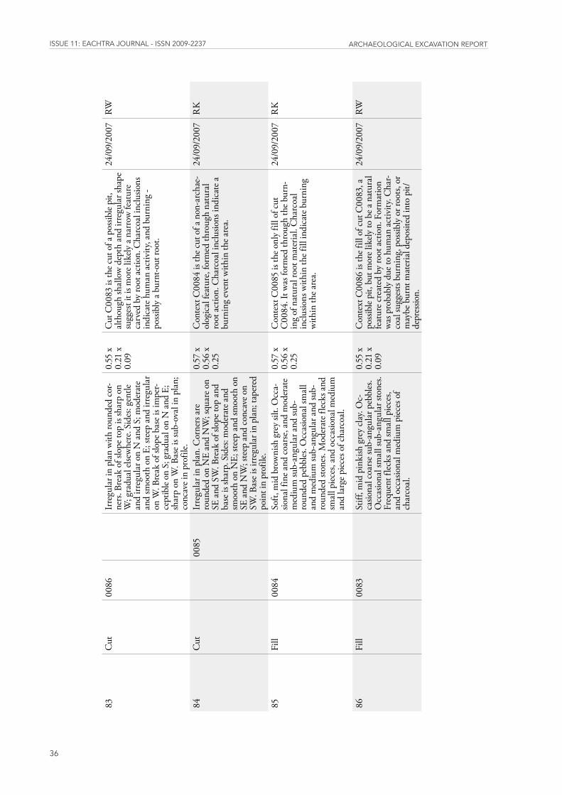
issUE 11: EaChtra JoUrnal - issn 2009-2237 arChaEologiCal ExCavation rEport
36
83C
ut00
86
Irre
gula
r in
plan
with
roun
ded
cor-
ners
. Bre
ak o
f slo
pe to
p is
shar
p on
W
; gra
dual
else
whe
re. S
ides
: gen
tle
and
irreg
ular
on
N a
nd S
; mod
erat
e an
d sm
ooth
on
E; st
eep
and
irreg
ular
on
W. B
reak
of s
lope
bas
e is i
mpe
r-ce
ptib
le on
S; g
radu
al o
n N
and
E;
shar
p on
W. B
ase i
s sub
-ova
l in
plan
; co
ncav
e in
prof
ile.
0.55
x
0.21
x
0.09
Cut
C00
83 is
the c
ut o
f a p
ossib
le pi
t, al
thou
gh sh
allo
w d
epth
and
irre
gula
r sha
pe
sugg
est i
t is m
ore l
ikely
a na
rrow
feat
ure
carv
ed b
y ro
ot a
ctio
n. C
harc
oal i
nclu
sions
in
dica
te h
uman
act
ivity
, and
bur
ning
- po
ssib
ly a
burn
t-out
root
.
24/0
9/20
07RW
84C
ut
0085
Irre
gula
r in
plan
. Cor
ners
are
ro
unde
d on
NE
and
NW
; squ
are o
n SE
and
SW
. Bre
ak o
f slo
pe to
p an
d ba
se is
shar
p. S
ides
: mod
erat
e and
sm
ooth
on
NE;
stee
p an
d sm
ooth
on
SE a
nd N
W; s
teep
and
con
cave
on
SW. B
ase i
s irr
egul
ar in
pla
n; ta
pere
d po
int i
n pr
ofile
.
0.57
x
0.56
x
0.25
Con
text
C00
84 is
the c
ut o
f a n
on-a
rcha
e-ol
ogic
al fe
atur
e, fo
rmed
thro
ugh
natu
ral
root
act
ion.
Cha
rcoa
l inc
lusio
ns in
dica
te a
bu
rnin
g ev
ent w
ithin
the a
rea.
24/0
9/20
07R
K
85Fi
ll00
84
Soft,
mid
bro
wni
sh g
rey
silt.
Occ
a-sio
nal f
ine a
nd c
oars
e, an
d m
oder
ate
med
ium
sub-
angu
lar a
nd su
b-ro
unde
d pe
bble
s. O
ccas
iona
l sm
all
and
med
ium
sub-
angu
lar a
nd su
b-ro
unde
d sto
nes.
Mod
erat
e flec
ks a
nd
smal
l pie
ces,
and
occa
siona
l med
ium
an
d la
rge p
iece
s of c
harc
oal.
0.57
x
0.56
x
0.25
Con
text
C00
85 is
the o
nly
fill o
f cut
C
0084
. It w
as fo
rmed
thro
ugh
the b
urn-
ing
of n
atur
al ro
ot m
ater
ial.
Cha
rcoa
l in
clusio
ns w
ithin
the f
ill in
dica
te b
urni
ng
with
in th
e are
a.
24/0
9/20
07R
K
86Fi
ll00
83
Stiff
, mid
pin
kish
gre
y cl
ay. O
c-ca
siona
l coa
rse s
ub-a
ngul
ar p
ebbl
es.
Occ
asio
nal s
mal
l sub
-ang
ular
ston
es.
Freq
uent
flec
ks a
nd sm
all p
iece
s, an
d oc
casio
nal m
ediu
m p
iece
s of
char
coal
.
0.55
x
0.21
x
0.09
Con
text
C00
86 is
the f
ill o
f cut
C00
83, a
po
ssib
le pi
t, bu
t mor
e lik
ely to
be a
nat
ural
fe
atur
e cre
ated
by
root
act
ion.
For
mat
ion
was
pro
babl
y du
e to
hum
an a
ctiv
ity. C
har-
coal
sugg
ests
burn
ing,
pos
sibly
or r
oots
, or
may
be b
urnt
mat
eria
l dep
osite
d in
to p
it/de
pres
sion.
24/0
9/20
07RW
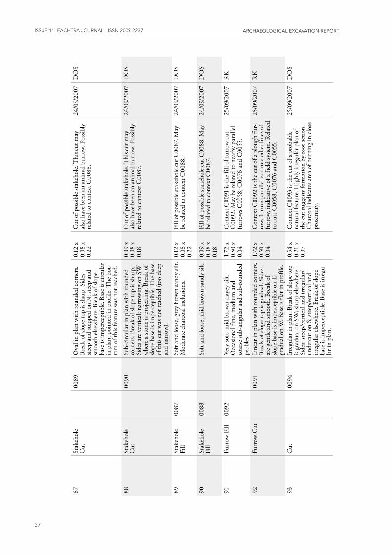
issUE 11: EaChtra JoUrnal - issn 2009-2237 arChaEologiCal ExCavation rEport
37
87St
akeh
ole
Cut
00
89O
val i
n pl
an w
ith ro
unde
d co
rner
s. Br
eak
of sl
ope t
op is
shar
p. S
ides
: ste
ep a
nd st
eppe
d on
N; s
teep
and
sm
ooth
else
whe
re. B
reak
of s
lope
ba
se is
impe
rcep
tible.
Bas
e is c
ircul
ar
in p
lan;
poi
nted
in p
rofil
e. T
he b
ot-
tom
of t
his f
eatu
re w
as n
ot re
ache
d.
0.12
x
0.08
x
0.22
Cut
of p
ossib
le sta
keho
le. T
his c
ut m
ay
also
hav
e bee
n an
ani
mal
bur
row.
Pos
sibly
re
late
d to
con
text
C00
88.
24/0
9/20
07D
OS
88St
akeh
ole
Cut
00
90Su
b-ci
rcul
ar in
pla
n w
ith ro
unde
d co
rner
s. Br
eak
of sl
ope t
op is
shar
p.
Side
s are
ver
tical
; nar
row
ing
on S
W
whe
re a
stone
is p
rojec
ting.
Bre
ak o
f slo
pe b
ase i
s im
perc
eptib
le. T
he b
ase
of th
is cu
t was
not
reac
hed
(too
deep
an
d na
rrow
).
0.09
x
0.08
x
0.18
Cut
of p
ossib
le sta
keho
le. T
his c
ut m
ay
also
hav
e bee
n an
ani
mal
bur
row.
Pos
sibly
re
late
d to
con
text
C00
87.
24/0
9/20
07D
OS
89St
akeh
ole
Fill
0087
So
ft an
d lo
ose,
grey
bro
wn
sand
y sil
t. M
oder
ate c
harc
oal i
nclu
sions
. 0.
12 x
0.
08 x
0.
22
Fill
of p
ossib
le sta
keho
le cu
t C00
87. M
ay
be re
late
d to
con
text
C00
88.
24/0
9/20
07D
OS
90St
akeh
ole
Fill
0088
So
ft an
d lo
ose,
mid
bro
wn
sand
y sil
t. 0.
09 x
0.
08 x
0.
18
Fill
of p
ossib
le sta
keho
le cu
t C00
88. M
ay
be re
late
d to
con
text
C00
87.
24/0
9/20
07D
OS
91Fu
rrow
Fill
0092
Ve
ry so
ft, m
id b
row
n cl
ayey
silt.
O
ccas
iona
l fin
e, m
ediu
m a
nd
coar
se su
b-an
gula
r and
sub-
roun
ded
pebb
les.
1.72
x
0.50
x
0.04
Con
text
C00
91 is
the f
ill o
f fur
row
cut
C
0092
. May
be r
elat
ed to
nea
rby
para
llel
furr
ows C
0058
, C00
76 a
nd C
0055
.
25/0
9/20
07R
K
92Fu
rrow
Cut
00
91Li
near
in p
lan
with
roun
ded
corn
ers.
Brea
k of
slop
e top
is g
radu
al. S
ides
ar
e gen
tle a
nd sm
ooth
. Bre
ak o
f slo
pe b
ase i
s im
perc
eptib
le on
E;
grad
ual o
n W
. Bas
e is f
lat i
n pr
ofile
.
1.72
x
0.50
x
0.04
Con
text
C00
92 is
the c
ut o
f a p
loug
h fu
r-ro
w. It
runs
par
allel
to th
ree o
ther
line
s of
furr
ow, i
ndic
ativ
e of a
field
syste
m. R
elat
ed
to c
uts C
0058
, C00
76 a
nd C
0055
.
25/0
9/20
07R
K
93C
ut
0094
Irre
gula
r in
plan
. Bre
ak o
f slo
pe to
p is
grad
ual o
n SW
; sha
rp el
sew
here
. Si
des:
steep
/ver
tical
and
irre
gula
r/un
derc
ut o
n S;
stee
p/ve
rtic
al a
nd
irreg
ular
else
whe
re. B
reak
of s
lope
ba
se is
impe
rcep
tible.
Bas
e is i
rreg
u-la
r in
plan
.
0.54
x
0.21
x
0.07
Con
text
C00
93 is
the c
ut o
f a p
roba
ble
natu
ral f
eatu
re. H
ighl
y irr
egul
ar p
lan
of
the c
ut su
gges
ts fo
rmat
ion
by ro
ot a
ctio
n.
Cha
rcoa
l ind
icat
es a
rea o
f bur
ning
in c
lose
pr
oxim
ity.
25/0
9/20
07D
OS
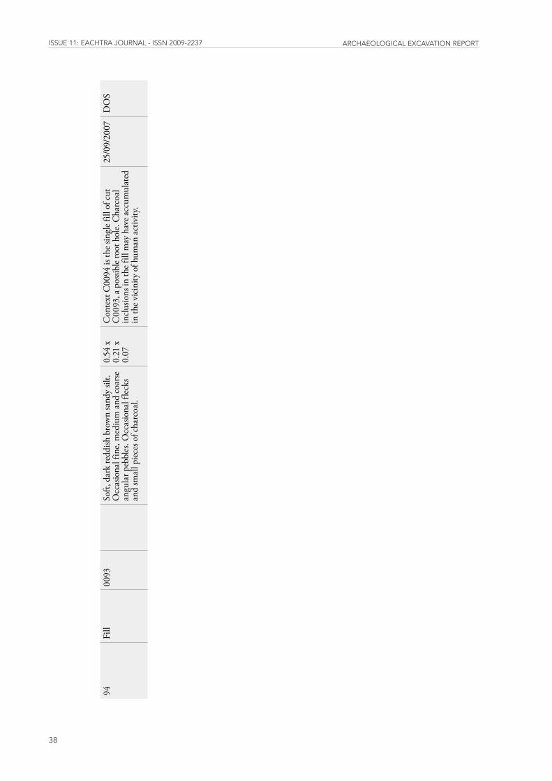
issUE 11: EaChtra JoUrnal - issn 2009-2237 arChaEologiCal ExCavation rEport
38
94Fi
ll00
93
Soft,
dar
k re
ddish
bro
wn
sand
y sil
t. O
ccas
iona
l fin
e, m
ediu
m a
nd c
oars
e an
gula
r peb
bles
. Occ
asio
nal f
lecks
an
d sm
all p
iece
s of c
harc
oal.
0.54
x
0.21
x
0.07
Con
text
C00
94 is
the s
ingl
e fill
of c
ut
C00
93, a
pos
sible
root
hol
e. C
harc
oal
inclu
sions
in th
e fill
may
hav
e acc
umul
ated
in
the v
icin
ity o
f hum
an a
ctiv
ity.
25/0
9/20
07D
OS

Appendix 2 Site Matrix
Clash-E3660
39
http://eachtra.ie/index.php/journal/e3660-clash-co-tipperary/
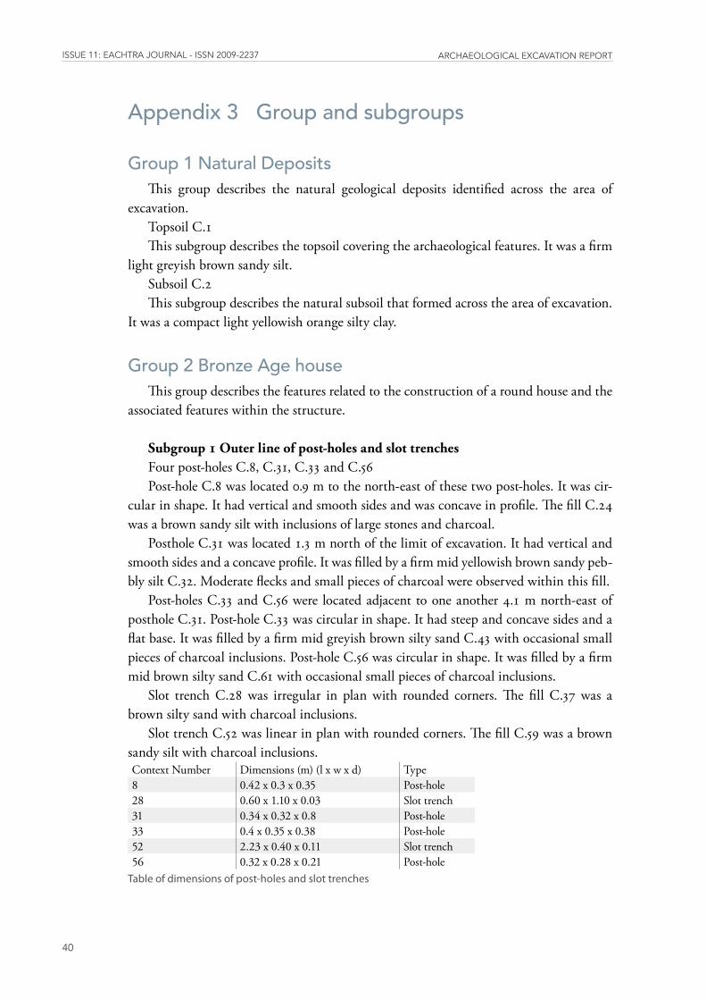
issUE 11: EaChtra JoUrnal - issn 2009-2237 arChaEologiCal ExCavation rEport
40
Appendix 3 Group and subgroups
Group 1 Natural DepositsThis group describes the natural geological deposits identified across the area of
excavation.Topsoil C.1 This subgroup describes the topsoil covering the archaeological features. It was a firm
light greyish brown sandy silt. Subsoil C.2This subgroup describes the natural subsoil that formed across the area of excavation.
It was a compact light yellowish orange silty clay.
Group 2 Bronze Age houseThis group describes the features related to the construction of a round house and the
associated features within the structure.
Subgroup 1 Outer line of post-holes and slot trenches Four post-holes C.8, C.31, C.33 and C.56Post-hole C.8 was located 0.9 m to the north-east of these two post-holes. It was cir-
cular in shape. It had vertical and smooth sides and was concave in profile. The fill C.24 was a brown sandy silt with inclusions of large stones and charcoal.
Posthole C.31 was located 1.3 m north of the limit of excavation. It had vertical and smooth sides and a concave profile. It was filled by a firm mid yellowish brown sandy peb-bly silt C.32. Moderate flecks and small pieces of charcoal were observed within this fill.
Post-holes C.33 and C.56 were located adjacent to one another 4.1 m north-east of posthole C.31. Post-hole C.33 was circular in shape. It had steep and concave sides and a flat base. It was filled by a firm mid greyish brown silty sand C.43 with occasional small pieces of charcoal inclusions. Post-hole C.56 was circular in shape. It was filled by a firm mid brown silty sand C.61 with occasional small pieces of charcoal inclusions.
Slot trench C.28 was irregular in plan with rounded corners. The fill C.37 was a brown silty sand with charcoal inclusions.
Slot trench C.52 was linear in plan with rounded corners. The fill C.59 was a brown sandy silt with charcoal inclusions.Context Number Dimensions (m) (l x w x d) Type8 0.42 x 0.3 x 0.35 Post-hole28 0.60 x 1.10 x 0.03 Slot trench31 0.34 x 0.32 x 0.8 Post-hole33 0.4 x 0.35 x 0.38 Post-hole52 2.23 x 0.40 x 0.11 Slot trench56 0.32 x 0.28 x 0.21 Post-hole
Tableofdimensionsofpost-holesandslottrenches
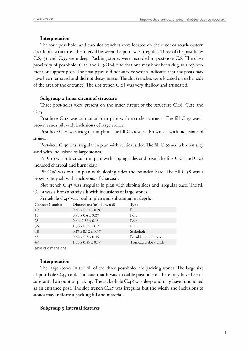
Clash-E3660
41
http://eachtra.ie/index.php/journal/e3660-clash-co-tipperary/
InterpretationThe four post-holes and two slot trenches were located on the outer or south-eastern
circuit of a structure. The interval between the posts was irregular. Three of the post-holes C.8, 31 and C.33 were deep. Packing stones were recorded in post-hole C.8. The close proximity of post-holes C.33 and C.56 indicate that one may have been dug as a replace-ment or support post. The post-pipes did not survive which indicates that the posts may have been removed and did not decay insitu. The slot trenches were located on either side of the area of the entrance. The slot trench C.28 was very shallow and truncated.
Subgroup 2 Inner circuit of structure Three post-holes were present on the inner circuit of the structure C.18, C.25 and
C.45.Post-hole C.18 was sub-circular in plan with rounded corners. The fill C.19 was a
brown sandy silt with inclusions of large stones. Post-hole C.25 was irregular in plan. The fill C.26 was a brown silt with inclusions of
stones. Post-hole C.45 was irregular in plan with vertical sides. The fill C.50 was a brown silty
sand with inclusions of large stones.Pit C10 was sub-circular in plan with sloping sides and base. The fills C.21 and C.22
included charcoal and burnt clay. Pit C.36 was oval in plan with sloping sides and rounded base. The fill C.38 was a
brown sandy silt with inclusions of charcoal.Slot trench C.47 was irregular in plan with sloping sides and irregular base. The fill
C. 49 was a brown sandy silt with inclusions of large stones.Stakehole C.48 was oval in plan and substantial in depth.
Context Number Dimensions (m) (l x w x d) Type10 0.63 x 0.61 x 0.28 Pit18 0.45 x 0.4 x 0.27 Post25 0.4 x 0.38 x 0.15 Post36 1.36 x 0.62 x 0.2 Pit48 0.17 x 0.12 x 0.37 Stakehole45 0.62 x 0.3 x 0.45 Possible double post47 1.35 x 0.85 x 0.17 Truncated slot trench
Tableofdimensions
InterpretationThe large stones in the fill of the three post-holes are packing stones. The large size
of post-hole C.45 could indicate that it was a double post-hole or there may have been a substantial amount of packing. The stake-hole C.48 was deep and may have functioned as an entrance post. The slot trench C.47 was irregular but the width and inclusions of stones may indicate a packing fill and material.
Subgroup 3 Internal features
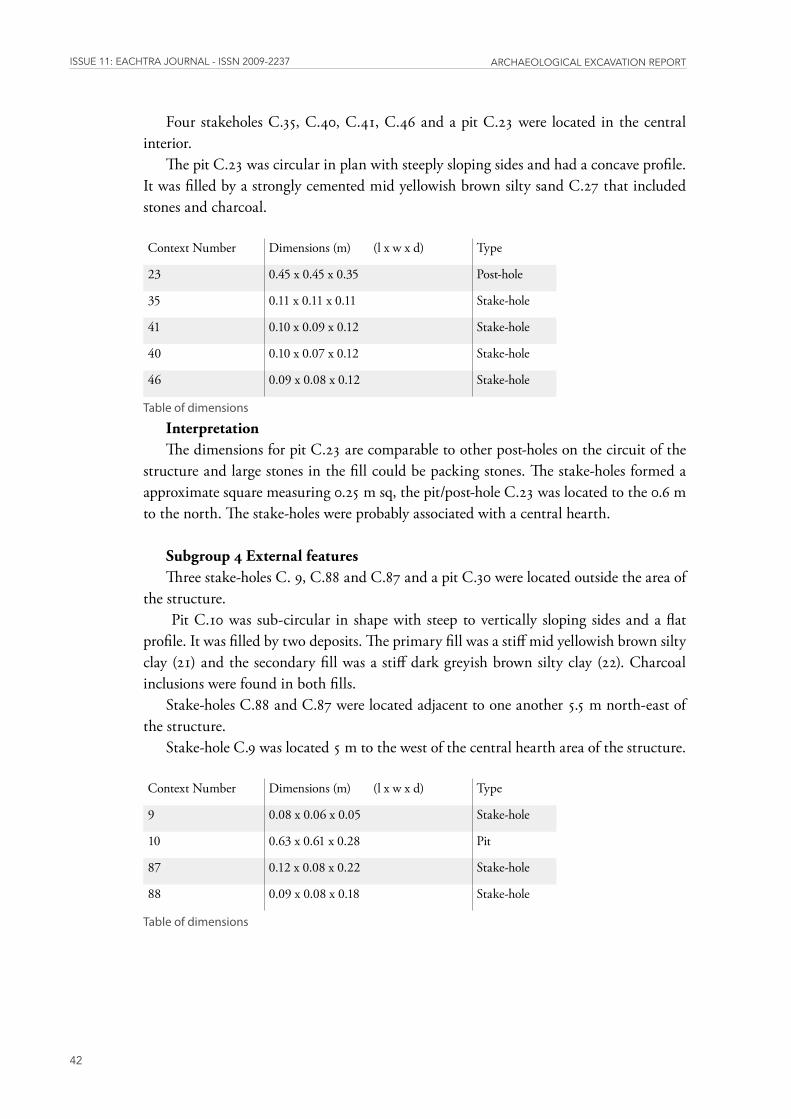
issUE 11: EaChtra JoUrnal - issn 2009-2237 arChaEologiCal ExCavation rEport
42
Four stakeholes C.35, C.40, C.41, C.46 and a pit C.23 were located in the central interior.
The pit C.23 was circular in plan with steeply sloping sides and had a concave profile. It was filled by a strongly cemented mid yellowish brown silty sand C.27 that included stones and charcoal.
Context Number Dimensions (m) (l x w x d) Type
23 0.45 x 0.45 x 0.35 Post-hole
35 0.11 x 0.11 x 0.11 Stake-hole
41 0.10 x 0.09 x 0.12 Stake-hole
40 0.10 x 0.07 x 0.12 Stake-hole
46 0.09 x 0.08 x 0.12 Stake-hole
Tableofdimensions
InterpretationThe dimensions for pit C.23 are comparable to other post-holes on the circuit of the
structure and large stones in the fill could be packing stones. The stake-holes formed a approximate square measuring 0.25 m sq, the pit/post-hole C.23 was located to the 0.6 m to the north. The stake-holes were probably associated with a central hearth.
Subgroup 4 External featuresThree stake-holes C. 9, C.88 and C.87 and a pit C.30 were located outside the area of
the structure. Pit C.10 was sub-circular in shape with steep to vertically sloping sides and a flat
profile. It was filled by two deposits. The primary fill was a stiff mid yellowish brown silty clay (21) and the secondary fill was a stiff dark greyish brown silty clay (22). Charcoal inclusions were found in both fills.
Stake-holes C.88 and C.87 were located adjacent to one another 5.5 m north-east of the structure.
Stake-hole C.9 was located 5 m to the west of the central hearth area of the structure.
Context Number Dimensions (m) (l x w x d) Type
9 0.08 x 0.06 x 0.05 Stake-hole
10 0.63 x 0.61 x 0.28 Pit
87 0.12 x 0.08 x 0.22 Stake-hole
88 0.09 x 0.08 x 0.18 Stake-hole
Tableofdimensions
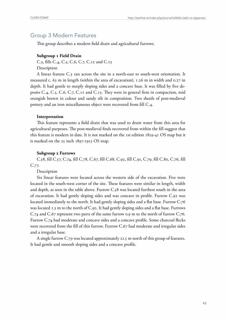
Clash-E3660
43
http://eachtra.ie/index.php/journal/e3660-clash-co-tipperary/
Group 3 Modern Features This group describes a modern field drain and agricultural furrows.
Subgroup 1 Field Drain C.3, fills C.4, C.5, C.6, C.7, C.12 and C.13Description A linear feature C.3 ran across the site in a north-east to south-west orientation. It
measured c. 63 m in length (within the area of excavation), 1.26 m in width and 0.27 in depth. It had gentle to steeply sloping sides and a concave base. It was filled by five de-posits C.4, C.5, C.6, C.7, C.12 and C.13. They were in general firm in compaction, mid orangish brown in colour and sandy silt in composition. Two sherds of post-medieval pottery and an iron miscellaneous object were recovered from fill C.4.
InterpretationThis feature represents a field drain that was used to drain water from this area for
agricultural purposes. The post-medieval finds recovered from within the fill suggest that this feature is modern in date. It is not marked on the 1st edition 1829-41 OS map but it is marked on the 25 inch 1897-1913 OS map.
Subgroup 2 Furrows C.58, fill C.57, C.74, fill C.78, C.67, fill C.68, C.92, fill C.91, C.79, fill C.80, C.76, fill
C.77.Description Six linear features were located across the western side of the excavation. Five were
located in the south-west corner of the site. These features were similar in length, width and depth, as seen in the table above. Furrow C.58 was located furthest south in the area of excavation. It had gently sloping sides and was concave in profile. Furrow C.92 was located immediately to the north. It had gently sloping sides and a flat base. Furrow C.76 was located 1.3 m to the north of C.92. It had gently sloping sides and a flat base. Furrows C.74 and C.67 represent two parts of the same furrow 0.9 m to the north of furrow C.76. Furrow C.74 had moderate and concave sides and a concave profile. Some charcoal flecks were recovered from the fill of this furrow. Furrow C.67 had moderate and irregular sides and a irregular base.
A single furrow C.79 was located approximately 21.5 m north of this group of features. It had gentle and smooth sloping sides and a concave profile.
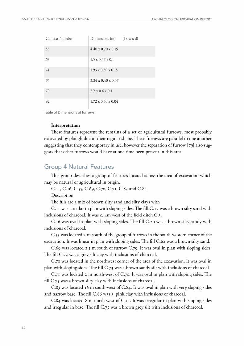
issUE 11: EaChtra JoUrnal - issn 2009-2237 arChaEologiCal ExCavation rEport
44
Context Number Dimensions (m) (l x w x d)
58 4.40 x 0.70 x 0.15
67 1.5 x 0.37 x 0.1
74 1.93 x 0.39 x 0.15
76 3.24 x 0.40 x 0.07
79 2.7 x 0.4 x 0.1
92 1.72 x 0.50 x 0.04
TableofDimensionsoffurrows�
InterpretationThese features represent the remains of a set of agricultural furrows, most probably
excavated by plough due to their regular shape. These furrows are parallel to one another suggesting that they contemporary in use, however the separation of furrow [79] also sug-gests that other furrows would have at one time been present in this area.
Group 4 Natural FeaturesThis group describes a group of features located across the area of excavation which
may be natural or agricultural in origin. C.11, C.16, C.55, C.69, C.70, C.71, C.83 and C.84Description The fills are a mix of brown silty sand and silty clays with C.11 was circular in plan with sloping sides. The fill C.17 was a brown silty sand with
inclusions of charcoal. It was c. 4m west of the field ditch C.3.C.16 was oval in plan with sloping sides. The fill C.20 was a brown silty sandy with
inclusions of charcoal. C.55 was located 2 m south of the group of furrows in the south-western corner of the
excavation. It was linear in plan with sloping sides. The fill C.62 was a brown silty sand. C.69 was located 2.5 m south of furrow C.79. It was oval in plan with sloping sides.
The fill C.72 was a grey silt clay with inclusions of charcoal. C.70 was located in the northwest corner of the area of the excavation. It was oval in
plan with sloping sides. The fill C.73 was a brown sandy silt with inclusions of charcoal. C.71 was located 2 m north-west of C.70. It was oval in plan with sloping sides. The
fill C.75 was a brown silty clay with inclusions of charcoal. C.83 was located 16 m south-west of C.84. It was oval in plan with very sloping sides
and narrow base. The fill C.86 was a pink clay with inclusions of charcoal.C.84 was located 8 m north-west of C.11. It was irregular in plan with sloping sides
and irregular in base. The fill C.75 was a brown grey silt with inclusions of charcoal.
Clash-E3660
45
http://eachtra.ie/index.php/journal/e3660-clash-co-tipperary/
Context Number Dimensions (m) (l x w x d)
11 0.42 x 0.46 x 0.10
16 0.50 x 0.55 x 0.15
55 1.10 x 0.46 x 0.08
69 0.58 x 0.45 x 0.15
70 0.37 x 0.3 x 0.15
71 0.24 x 0.21 x 0.09
83 0.55 x 0.21 x 0.09
84 0.57 x 0.56 x 0.25
TableofDimensions
InterpretationThe irregularity, lack of depth within the features and the scatter nature of them
across the area of the excavation suggests that they are natural. The similar but sterile fills within some of these features suggest a natural origin, while the charcoal inclusions in some of the fills could be agricultural in origin.
issUE 11: EaChtra JoUrnal - issn 2009-2237 arChaEologiCal ExCavation rEport
46
Appendix 4 Plant remains By Penny Johnston
IntroductionThis report details the results of plant remains analysis on material retrieved from
Clash, Co. Tipperary. The site comprised a group of post-holes, stake-holes and pits that possibly represented a truncated prehistoric structure. Radiocarbon dates indicate a Late Bronze Age period of occupation.
MethodologyThe samples were collected on site as bulk soil and were processed using machine-
assisted floatation (following guidelines in Pearsall 2000). The floating material (or ‘flot’) from each sample was collected in a stack of geological sieves (the smallest mesh size was 250mm). When all the carbonised material was collected the flot was then air-dried in paper-lined drying trays prior to storage in airtight plastic bags. A total of 16 samples were sieved from this site, but 6 did not contain any charred plant remains and therefore these did not produce flots (listed in Table 1 at the end of this report).
The remaining 10 samples were scanned under low-powered magnification. The re-sults of preliminary scanning were presented in an assessment report (Johnston 2009) and the assessment table is reproduced as Table 2 at the end of this report.
Samples were selected for further analysis on the basis of the preliminary assessment. This selection was limited to samples that contained plant material Plant remains were extracted from the flots and the material was identified under low-powered magnification (x 10 to x 40) using a binocular microscope. The results of identification are presented in Table 3 at the end of this report. Nomenclature and taxonomic order follow Stace (1997). Use of scientific names is restricted to the tables at the end of the report in order to facili-tate easy reading of this text.
ResultsA total of 10 samples were scanned. Assessment revealed that only 50% of these con-
tained seeds (5 samples). In all cases the quantities of plant remains recovered were small, with just 15 grains of cereals found in total from the site. Where identifiable, the cereals were barley and it is likely that these were brought to site as foodstuffs. Preservation oc-curred when the plant remains were subsequently accidentally charred during domestic activity at the site. Other seeds included wild plants such as Black bindweed (from the dock family) and flax. Both of these plant remains could have been collected either as food or as accidental inclusions gathered with the crop plants.

Clash-E3660
47
http://eachtra.ie/index.php/journal/e3660-clash-co-tipperary/
All of the plant remains were found in association with three pits (C.36, C.23 and C.10) and two post-holes (C.8 and C.56) within an area of features that has been inter-preted as a possible truncated structure. Radiocarbon dates from these features indicate a period of occupation that is dated to the Late Bronze Age.
Barley is often the dominant cereal type in Irish sites dating to the Bronze Age (Monk
1985/86, 32). Sites in Co. Tipperary where archaeobotanical analysis has been carried out bear this finding out, for example, at the Middle Bronze Age settlement site at Site A in Chancellorsland (McClatchie 2008), and at the Late Bronze Age settlement sites at Curraghatoor (Monk 1987a, 30 – 31 and McClatchie 2007, 64 ) and Ballyveelish Monk 1987b 40 – 42). At all of these sites barley was the most common Bronze Age crop type. At many of these sites retrieval was also sporadic and poor. The plant remains assemblage from Clash is therefore reasonably typical when compared to other domestic sites that have been excavated in Co. Tipperary.
References
McClatchie, M. 2008 Plant remains from Site A, pp. 473 – 478 in Doody, M. The Ballyhoura Hills Project. Dublin. Discovery Programme Monograph No. 7.
McClatchie, M. 2007 Plant remains, pp. 62 – 67 in Doody, M. Excavations at Curraghatoor, Co. Tipperary. Cork, UCC Department of Archaeology Archaeological Monograph.
Monk, M. 1987a Appendix I: the charred plant remains, pp. 40 – 42 in Doody, M. ‘Late Bronze Age huts at Curraghatoor, Co. Tipperary’. In Cleary, R.M. Hurley, M.F. and Twohig E.A. (eds.) Archaeological Excavations on the Cork-Dublin Gas Pipeline (1981-82). Cork, Department of Archaeology.
Monk, M. 1987b Appendix V: the charred plant remains from Ballyveelish, pp. 30 – 31 in Doody, M. ‘Late Bronze Age settlement, Ballyveelish 2, Co. Tipperary’. In Cleary, R.M. Hurley, M.F. and Twohig E.A. (eds.) Archaeological Excavations on the Cork-Dublin Gas Pipeline (1981-82). Cork, Department of Archaeology.
Monk, M. 1985/86. ‘Evidence from macroscopic plant remains for crop husbandry in prehistoric and early historic Ireland: A review’, Journal of Irish Archaeology 3, 31 – 36.
Pearsall, D. 2000 Paleoethnobotany: a Handbook of Procedures. New York, Academic Press.
Stace, C.A. 1997 (second edition) New Flora in the British Isles, Cambridge. Cam-bridge University Press.
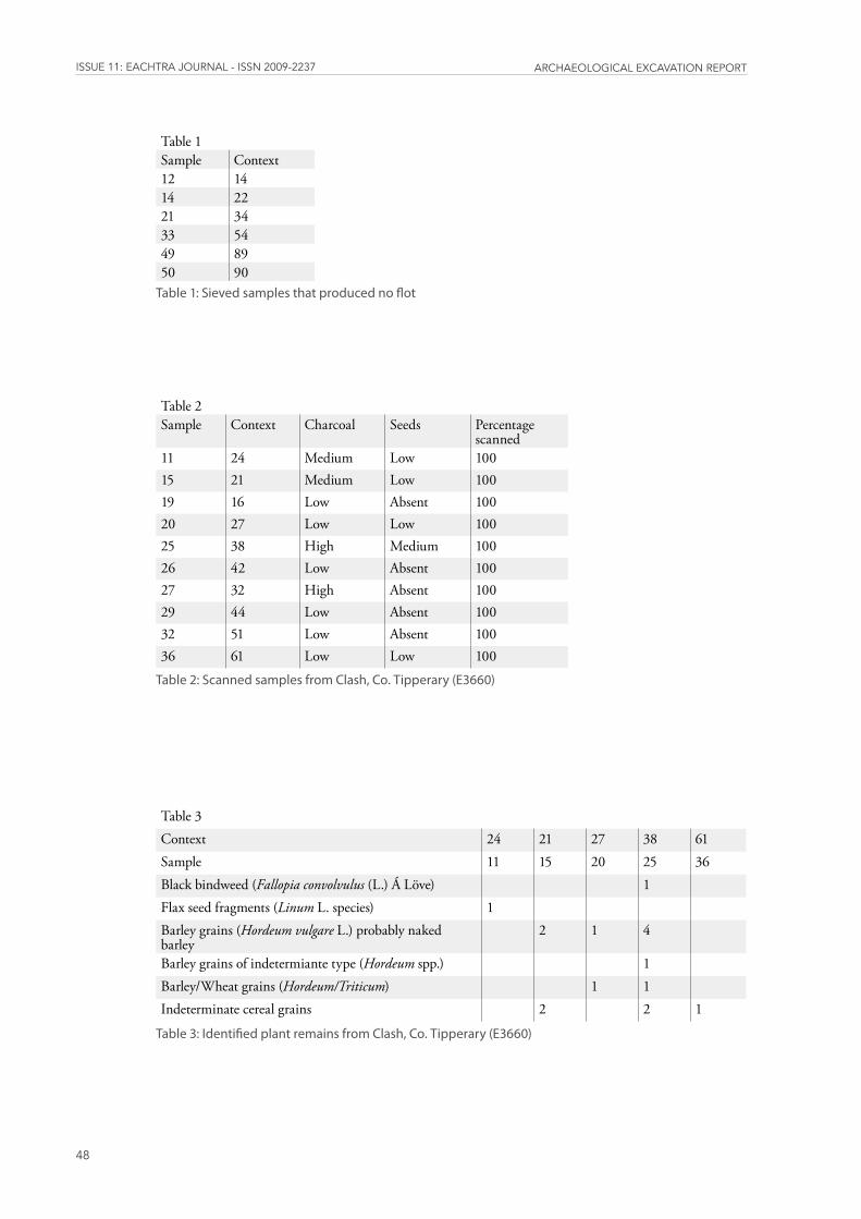
issUE 11: EaChtra JoUrnal - issn 2009-2237 arChaEologiCal ExCavation rEport
48
Table 1Sample Context12 1414 2221 3433 5449 8950 90
Table1:Sievedsamplesthatproducednoflot
Table 2Sample Context Charcoal Seeds Percentage
scanned11 24 Medium Low 10015 21 Medium Low 10019 16 Low Absent 10020 27 Low Low 10025 38 High Medium 10026 42 Low Absent 10027 32 High Absent 10029 44 Low Absent 10032 51 Low Absent 10036 61 Low Low 100
Table2:ScannedsamplesfromClash,Co�Tipperary(E3660)
Table 3Context 24 21 27 38 61Sample 11 15 20 25 36Black bindweed (Fallopia convolvulus (L.) Á Löve) 1 Flax seed fragments (Linum L. species) 1 Barley grains (Hordeum vulgare L.) probably naked barley
2 1 4
Barley grains of indetermiante type (Hordeum spp.) 1 Barley/Wheat grains (Hordeum/Triticum) 1 1 Indeterminate cereal grains 2 2 1
Table3:IdentifiedplantremainsfromClash,Co�Tipperary(E3660)
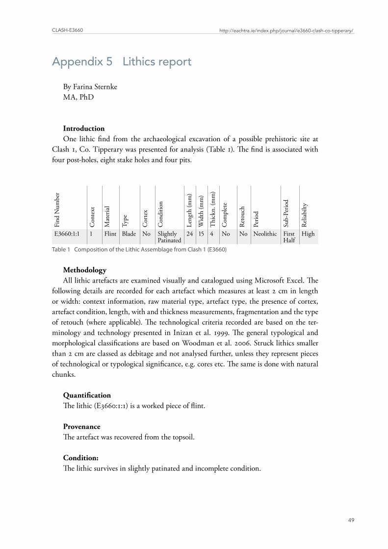
Clash-E3660
49
http://eachtra.ie/index.php/journal/e3660-clash-co-tipperary/
Appendix 5 Lithics report
By Farina SternkeMA, PhD
IntroductionOne lithic find from the archaeological excavation of a possible prehistoric site at
Clash 1, Co. Tipperary was presented for analysis (Table 1). The find is associated with four post-holes, eight stake holes and four pits.
Find
Num
ber
Con
text
Mat
eria
l
Type
Cor
tex
Con
ditio
n
Leng
th (m
m)
Wid
th (m
m)
Thi
ckn.
(mm
)
Com
plet
e
Ret
ouch
Perio
d
Sub-
Perio
d
Rel
iabi
lty
E3660:1:1 1 Flint Blade No Slightly Patinated
24 15 4 No No Neolithic First Half
High
Table1CompositionoftheLithicAssemblagefromClash1(E3660)
MethodologyAll lithic artefacts are examined visually and catalogued using Microsoft Excel. The
following details are recorded for each artefact which measures at least 2 cm in length or width: context information, raw material type, artefact type, the presence of cortex, artefact condition, length, with and thickness measurements, fragmentation and the type of retouch (where applicable). The technological criteria recorded are based on the ter-minology and technology presented in Inizan et al. 1999. The general typological and morphological classifications are based on Woodman et al. 2006. Struck lithics smaller than 2 cm are classed as debitage and not analysed further, unless they represent pieces of technological or typological significance, e.g. cores etc. The same is done with natural chunks.
QuantificationThe lithic (E3660:1:1) is a worked piece of flint.
ProvenanceThe artefact was recovered from the topsoil.
Condition:The lithic survives in slightly patinated and incomplete condition.
issUE 11: EaChtra JoUrnal - issn 2009-2237 arChaEologiCal ExCavation rEport
50
Technology/Morphology: The artefact is a blade which was produced on a single-platform core. It is missing its
proximal end and measures 24 mm long, 15 mm wide and 4 mm thick.
Dating:The artefact appears to date to the first half (Early to Middle) of the Neolithic period.
ConservationLithics do not require specific conservation, but should be stored in a dry, stable envi-
ronment. Preferably, each lithic should be bagged separately and contact with other lith-ics should be avoided, so as to prevent damage and breakage, in particular edge damage which could later be misinterpreted as retouch. Larger and heavier items are best kept in individual boxes to avoid crushing of smaller assemblage pieces.
SummaryThe lithic find from the archaeological excavation at Clash 1, Co. Tipperary is a flint
blade which appears to date to the first half of the Neolithic period.
This site makes a minor contribution to the evidence for prehistoric settlement and land use in Co. Tipperary.
Bibliography
Inizan, M.-L., M. Reduron-Ballinger, H. Roche and J. Tixier 1999. Technology and Terminology of Knapped Stone 5. CREP, Nanterre.
Woodman, P. C., Finlay, N. and E. Anderson, 2006. The Archaeology of a Collection: The Keiller-Knowles Collection of the National Museum of Ireland. National Museum of Ireland Monograph Series 2. Wordwell, Bray.


![Eachtra Journaleachtra.ie/new_site/wp-content/uploads/2011/07/... · Issue 11 [ISSN 2009-2237] Archaeological Excavation Report E3585 - Derrybane 1, Co. Tipperary Multi peroid site](https://img.dokumen.tips/doc/110x75/60fce45c06a92b7b2306e9b1/eachtra-issue-11-issn-2009-2237-archaeological-excavation-report-e3585-derrybane.jpg)