226 Tiie U$pv Coat
XX.- The Upper Coal .Measures West of the Alleghanp Mountains.
BY JNO. J. STEVFJYSON,PH.D.
Read December 16,1872.
WHILE connected with the Geological Survey. of Ohio, I: was employed in investigating the Upper Coals as displayed in the First Geological District of the state. The relations of the coal beds to each other, and the marked ohangee in the intervening strata, seemed to be at variance with some accepted opinions and induced me to make diligent compari- son of the Ohio coals with those of Pennsylvania and West Virginia. The results of this examination appear, to me, of sufticient importance to warrant publication in advance of the Ohio Report. This I am permitted to do by the courtesy of Prof. Newberry, chief geologist of Ohio.
The observations recorded in this paper cover only that portion of the field xiorth of the Baltimore and Ohio railroad in West Virginia and Ohio.
LIMITS OF THE: UPPER COALS.
The autcrop of the Pittsburg cod, the base of tha Upper Coal Measures, beginning ati the Baltimore and Ohio rail- road in West Virginia runs northward, rudely parallel to Laurel Hill, through Marion and MonongaJia counties, W. Vai, and E’ayetta and Westmoreland, Penn., thence westwardly, though Westmoreland and Alleghany into Han- cockl W. Va. CrossiDg the Ohio just above Steubenville it passes through Jefferson, Harrison and Belmont into Guernsey where it reaches the Baltimore and Ohio railroad at SalesviUe, thirty-seven miles west from the Ohio rivar. That this is by no means the original extent is evident from several facts. In Pennsylvania, the Frostburg and Broad Top basins lying to the east of the main outcrop have been
West of $he AZZeglTian y Mountains. 5327
proved to contain the upper coals, anit some of our leading geologists profess to find equivalents of the same beds in tbe anthracite region. 'in Ohio, west of the line of outcrop, isolated patohes areA found iu the synclinal paasing through Guernsey county, ten to fifteen miles away. At New Con- cord, Muskingum Co,, Ohio, twenty-three miles west from Salesville, there is a thin coal resting on a heavy buff colored fossiliferous limestone and occupying both sides of the syn- clinal trough, of which the bottom is at that village, About fifty feet below it is a hard limestone, bluish-gray in color and fossilil'erous, known in the Ohio section as the Crinoidal Limestone, a persistent stratum traceable in to Pennsylvania and Westi Virginia.
Alang the western outcrop of the Pittsburg coal the Ci.inoida1 Limestone is found at a distance, varyiug little from one hundred and fifty feet, below the coal, and the interval is occupied by variegated shales and shaly sand- stones, with no coal or even bituminous shale. From four to ten feet below the coal there is a tough limestone, varying in color, four to six feet thick and more or less fossiliferous, f t mould seem then from the accompanying rocks that the New Concord coal is the western prolongation of the Pith- burg. It is true that the interval between it and the Cyrhoidal Limestone is at that place very much less than at Salesville, twenty-three miles east, but even this is an additional proof of identity, for this interval increases eastward. Three miles northwest from New Concord it is barely thirty-five feet ; at Concord it is fifty ; at Salesville it is one hundred and fifty; while in the Monongahela Valley it is two hun- dred and fifty.
The C'lrinoidal Limestone has been traced to within three miles of the Muskingum river on the west and thence round to the borders of Tuscarawas and Stark, on the northwest and into Columbiana and Mahoning on the north, So constant and regular is it in its relations to the Pittsburg coal, that we may regard its distriblxtion as an indication of
228 Tlte Uper Coal Measures
40'
1'
70'
1'
35'
14' 100'
44'
2&'
36'
70'
4'
35
fr' 30'
& 20'
10'
the original extent of that bed, Accepting this then as a basis for the calculation we conclude that that coal once reached as far west as Sonora on the Central Ohio railroad, seventy-one mite5 west from Wheeling, and to a point north- ward not less than fifty miles from that city, a tortuous boundary 'line connecting the two points.
1. Sandstone, 7'
2. CoaZ,Waynesbnrg, 3'
3. Shale, 33'
5. Sandstone, 3'
6. Limestone and Shale, 95'
7. Shale, 3'
8. Coat, 18'
10. Coal, 1'
12. Sandstone, 8'
13. CoaZ,Sewickly, 18'
14. Limestone, 24'
15. Coal, Bedstone, 1'
16. Limestone, 20'
4. Limestone, 15'
9. Shale, 6'
ll. Clay, 6.'
17. Shale, 6'
18. Coal, Pittsburg, 8'
RELATIONS OF THE SEVERAL COAL BEDS IN OHIO, PENNSYLVANIA AND WEST VIRGINIA.
1, Deb~ia, 160'
2. C o a l m , 1%
3. Sandstone, 70'
4. Coa2xn, l$'
5. ShaleandSandstone, 40'
6. Coalxl, 2'
7. Sandstone With thin Limestoue, loo'
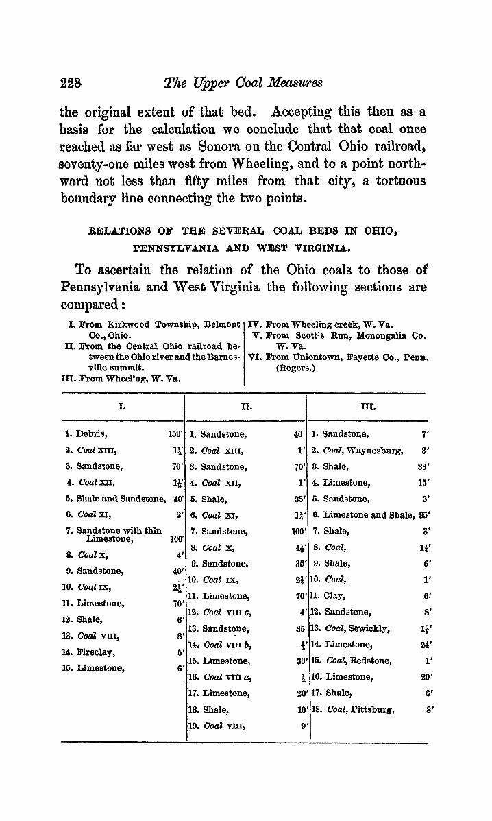
To ascertain the relation of the Ohio coals to those of Pennsylvania and West Virginia thq followiiig sections are compared :
1. Sandstone,
2. Coal ~ m ,
3. Sandstone, 4. Coal XU,
ti. Shale, 6. Coal XI,
7. Sandstone,
I. From Kirkwood Township, Belmont Co., Ohio.
II. From the Central Ohio railroad be- tween the Ohio river and the Barnes- ville summit.
IX. from Wheeling, W. Va.
IV. From Wheeling creek, W. Va. V. From Scott's Run, Monongdia Co.
TI. From Uniontown, Fayette Co., Penn. W. Va.
(Rogers.)
11. I .I. m. I
a. C O ~ Z X ,
9. Sandstone. 10.
11.
1%
13.
Con2 IxI
Limestone, Shale, Coat vm.
8. Coal X,
9. Sandstone, 40'
10. Coal TX, 11. Limestone,
2i' 70' - -
12. Coat vmc, 13. Sandstone,
6'
8' 14, Coal vm b,
16. Limestone, 16, Coal Vm a,
14. Fireclay, 5'
16. Limestone, 6'
17. Limestone, 18. Shale, 19. Coal my
91
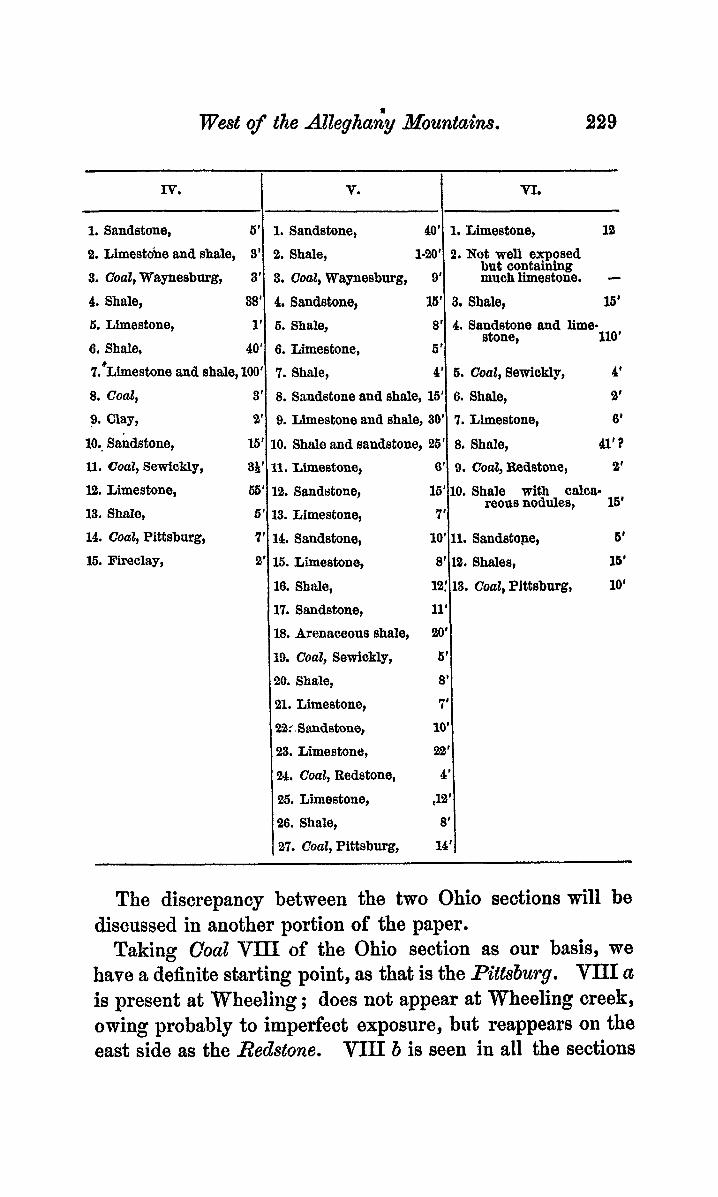
We& of the AZZegha& Mountains. 229
1. Sandstone, 6'
2. Limestobe and shale, 3'
3. Coal, Waynesbnrg, 3'
4. Shale, 38'
Iv. I V. 1 VI.
1. Sandstone, 40' 1, Limestone, ia 2. Shale, 1-20' 2. Not well exposed 3. Coal, Waynesbnrg, 9' much limestone. - 4, Sandstone, 16' 3. Shale, 16'
but containing
1'
40'
6, Limestone, 6. Shale,
6. Shale, 6. Limestone,
8'
5'
4. Sandstone and lime- stone, 110'
?,*Limestone and shale, 100'
10.. Sandstone, 15'
8. Coal, 3'
9. Clay, 2'
11. Coat, Sewickly, 38'
12. Limestone, 13. Shale,
7. Shale, 4' 6. Coal, Semickly, 4'
8. Sandstone and shale, 16' 6. Shale, 2'
9. Limestone and shale, 30' 7. Liestone, 6'
10. Shale and sandstone, 26' 8. Shale, 41'3 11. Limestone, 6' 9. Coat, Bedstone, 2'
65' 12. Sandstone, 6' 13. Limestone, I 16'
7' 10' 8'
l2!
10. Shale with CalCa= reous nodules, 16'
11. Sandstone, 6'
12. Shales, 16'
13. Coal, Pittsburg, 10'
14. Coal, Pittsburg, 7' 16. Fireclay, 2'
1'1 8'
14. Sandstone, 15. Limestone, 16. Shale, 17. Sandstone, 18. Arenaceons shale, 19. Coal, Sewickly,
21. Limestone, !22.2i.Snndstone, 23. Limestone, W . Coal, Redstone, 25. Limestone, 26. Shale, 27. CoaZ, Pittsburg,
20. Shale,
7' 10'
22' 4'
J2' 8'
14'
The discrepancy between the two Ohio sections will be discussed in another portion of the paper.
Taking Coal VIII of the Ohio section as our basis, we have a definite starting point, as that is the Pittsburg. VIII a is present at Wheeling; does not appear at Wheeling creek, owing probably to imperfect exposure, but reappears on the east side as the Redstone. V I I I b is seen in all the sections
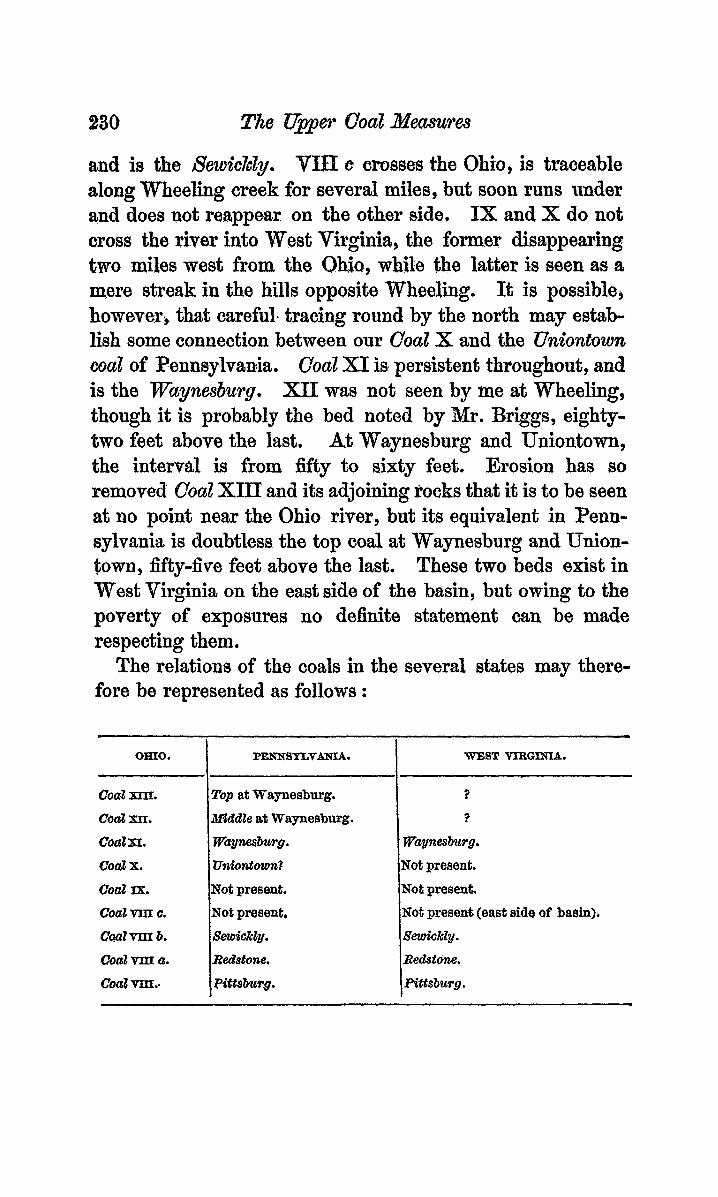
230 The Upper Coal Xeasures
OHIO.
CoaZ XIIT.
Cod w. CoaZxr.
coal x. coal zx, CoaZ vm c.
cw2m 6, Coa2 vm a.
CoaZ vm..
and is the 8ewic7cZy. T3.U c crosses the Ohio, is traceable dong Wheeling creek for several miles, but soon runs under and does not reappear on the other side, IX and X do not cross the river into West Virginia, the former disappearing two miJes west from the Ohio, while the latter i s seen as a mere streak in the hills opposite Wheeling. It is possible, however., that; careful. tracing round by the norrth may estab- lish some connection between our Caal X and the Uniontown coal of Penmylvania. Coal XI is persistent thpoughsut, and is the Wayrzesburg. xu[ was not seen by me at Wheeling, though it is probably the bed noted by Mr. Briggs, eighty= two feet above the last. At Waynesburg and Uniontown, the interval is from fifty to Eiixty feet. Erosion has so removed Coal XIII and its adjoining rocks that it is to be seen at no point near the Ohio river, but its equivalent in Penn- sylvania is doubtless the top coal at Waynesburg and Union- town, fifty-five feet above the last. These two beds exist in West Virginia on the east side of the basin, but owing to the poverty of exposures no definite statement can be made respecting them.
The relations of the coals in the several states may there- fore be represented as folIows :
PENNSYLVANSA. WEST VIRGJXIA.
Top at Waynesburg. ?
X&&k at Waynesburg. ?
WaynesBurg. . Wagnesbzwg.
U&mtozon? Not present. Not present. Not. present. Not present. Not presene (east side of basin). Setpick&. SetaickZy.
Redstone. Redstone.
FdttsbuTg . Pittsburg.

We& of the Alleghatzy &!buntaim. 231
DESCRIF!PION OF THE! BEDSr
Coals XII and XIII of the Ohio section are well at faw localities and are of economical importance nowhere. The former is enormously developed in the hills opposite Wheel- ing, where it is a dry coal, six feet thick, but heavily charged with pyrites.
The Waynesbzcrg (XI) is commonly known in western Belmont Co., Ohio, as the “jumping six-foot seam” owing to its shdden variations in thickness. In Harrison and Jef- ferson oounties, it is worthless, ’never more than two feet thick, and is seen only near the tops of the highest hills. In western Belmont it is not worked and varies from six inches to nearly six feet in thickness. This change is seen in a cut we& from Barnesville; at one end of which it; ia;J barely six inches while at the other it shows the following section :
Coal, 1 ft. ; shale, 4 in. ; coal, 4 in. ; shale, 4 in. ; coal, 4 in. ; shale, 2 ft. ; coat, 1 ft. Total, 5 ft. 4 in.
Seven miles east from Barnesville it is seen in a cut, about one foot thick and parted in the middle by a thin layer of limestone. Near St. Clairsville, in the same county, it is rudely worked and shows three feet of very impure coal, resting almost immediately upon ft foot of limestone. Near Bridgeport, opposite Wheeling, it is three feet six inches thick, roofed by six inches of impure black band which is overlaid by two feet of alternating bands of bituminous and ordinary shale. Here the limestone is eighteen inches below the coal. On 8 run four miles west from Belleair and just south of the railroad, it soddenly thickens out and &becomes a con- fused mass of coal and shale nut less than fiifteen feet thick; and -totally worthless.
Pollowed into West Virginia it is seen on the top of Wheeling Hill, just back of the city. On’ Wheeling week it is worked at> Roney’s Point, ten miles from the city, and proves to be a very good coal varying from two feet four
232 me Upper Coat Measures
inches to three feet thick. It is seen somewhat thicker on the south fork of the creek, Om the eastern side of the basin it is seen at several points along Scott’s and Robinson’s Runs, in Monongalia Co., W. Va., as well as in Greene c0.9 Penn. Its greatest development is seen on Scott’s Run, where its changes are almost as interesting 88 in Belmont Co. Ohio. TWO miles and a half up the run several openings are seen which give tho following section :
Coal, 1 ft. 9 in. ; Bituminous shale, 8 in. Coal, 4 ft. 8 in4 Two miles farther up the run the shale has disappeared,
.and at an opening near Cassville, the bed shows full nine feet of coal. One mile beyond, the following section was obtained :
Blue clay, 6 in. ; slaty coal, 1 ft. 3 in. ; clay, with many impressions of plants, 3 to 6 in.; c o d , 2 in.; day, 2 in.; coal, 74 in. ; clay, 1 ft. 1 in. ; coal, seen, 4 ft. 2 in.
This opening is likely to prove of considerable interest as the fossils are very numerous and well preserved, while the horizon at which they occur is more than one hundred feet higher than any other yet discovered in the northern portion of the trough. On Robinson’s Run the bed shows a tendency to develop in the same manner as follows :
Bituminous shale, with thin laminm of coal, 2 ft. ; c o d , 1 ft. 6 in. ; clay, 7 in. ; coal, 4 ft. 8 in.
Towards the south it rapidly diminishes in thickness and apparentIy thins out.
I n Pennsylvania the bed is usually double, but is nowhere SO greatly developed as on Scott’s Run. Near Waynesburg it shows coal, 1 ft. 8 in. ; clay, 1 ft. 2 in. ; coal, 3 ft. 2 in. Near Carmichaeltown, Greene Co., it shows coal, 3 ft. ; clay, 3 in. ; coal, 3 ft. The clay is so,rnetimes replaced by black slate with innumerable thin laminae of coal (Rogers). Near Brownsville it is five feet thick and single.
I n West Virgi’nin the coal from this bed is dry, almost open-burning, gives a strong fire and is highly valued for domestic purposes. It contains n large proportion of pyrites,
West of the Alleghany Miuntuhas. 233
sufficient probably to render it unfit for general use. In Pennsylvania its quality is inferior to that of coal from the Pz’ttsburg, mhilo in Ohio, it is, for the most part, utterly worthless.
Coal X of the Ohio section is traceable through Belmont, Harrison and Jefferson counties, Ohio. It is u8ually a double bed and in some localities is still further divided. At the most westerly opening seen, iu Warren Township, Belmont Co., it shows : slaty coal, 1 ft 6 in.
At Badgersburg in the adjoining township it diaplays the double character more clearly as follows :
Laminated shale, 4 ft. ; cod, slaty, 1 ft. 7 in. ; shale and clay,, 1 ft. 8 in. j c o d , 5 ft. j fireclay, 1 ft.
Here the coal is of good quality and compares favorably with that obtained from the Pittsburg, but the bed is much cut up by ccclay-vein~” and “horse-backs” both from above and from below, difficulties which Beem to beset it generally. In Union township the bed is seen triple in Section 25 as folJows :
Coal, 1 ft. ; clay, 1 ft. 3 in. ; coal, 4 ft. 6 in. ; shale, 1 ft. ; C Q U Z , slaty, 1 ft. ; fireclay, 1 ft. 3 in.
Kear the village of Flushing it is worked at many openings. While varying little in thickness it is exceedingly uncertain in quality ; some banks yielding coal well fitted for black- smiths’ use, while that from others iu the immediate neigh- borhood is hardly fit for the coarsest of domestic purposes, The general section there is
Coal, 1 ft. 2 in. ; shale and clay, 1 ft. 4 in. ; c o d , 3 ft. to 4 ft.
As this bed is followed ea8twnrd toward the Ohio river it is seen to lose its thickness gradually, soon becoming of no ecouomical importance and finally thinning out near the river. I n Harrison Co., it is frequently seen at the road- sides ; but few openings are found owing to the ready accessi- bility and better quality of the Pittsburg. Near New Athens the following section was obtained :
Coal, good, 3 ft.
234 The Upper Caul Neusures
Shale, 6 ft. ; coal, 1-0 in. ; fireclay, It0 in. ; shale, 1 ft. 8 int ; coal, 4 ff. 8 in. ; shale, 3 ft. j coaZ, 4 in, ; shah, 3 ft.
Near Gadiz the same section is repeated. In Jefferson CO., the coal is frequently seen at the roadside but is SO
degraded as to be worthless. It is little more than a, bitumi- nms shale, two to three feet thick. It may be the coal at Knoxville one hundred feet above V3m, but is there not more than eighteen inches.
Coal IX likewise thins out before reaching the Ohio. It is seen at numerous localities in Belmont, Harrison and Jef- feraon counties, at varying distttnce above the Rttslmrg and is usually about two feet six inches thick, divided midway by a thin clay parting. It is very persistent, rests directly on limestone and being of no economical value, is interesting ohiefly because of its relations to the P.ittsbu.l.g, which will be considered farther on. It is thickest in its southeastern prolongation and thins out toward the borders o€ the basin, W. andN.
Coal V I I I c is known locally in Ohio as the Glenco Cod, having been worked somewhat extensively at the station of that name, on the Central Ohio railroad, where it is nearly four feet, Along the railroad it retains its size to Belleair, but from that point northward it diminishes rapidly, becom- ing three feet along Wheeling creek and only fifteen inches at-MaEtinsville, five miles north from Belleair. In West Vir- ginia, from Benwood to Wheeling it shows some singular variations. Back of the furnace at Benwood it is eighteen incbesI; at the stone quarry, a short distance north, it is six inches, with one foot of cod five feet above it; at the lime- stone quarry near South Wheeling, it is eight inches and the upper bed concealed; while at Wheehg it is one foot with fourteen inches of coal six &et above it. Followed up the north fork of Wheeling creek it becomes more important and i s mine.d near Triadelphia, where it shows about three feet of very fair cannel. The double character displayed dong the Ohio, on the Virgiuia side, is occasionally ex-
West of the REleghany ..&!bunt&& 235
hibited in Belmont Go., but never to any very marked degree.
The SewickZy (VIII b) is confined, in Ohio, to the neigh- borhood of Wheeling. It may be seen on the National Boad, five miles west from the river and near Glenco on the Cen- tral Ohio railroad. At Bellenir it is only six inches thick and at Bridgeport barely one foot. At Benwood, on the Virginia side, it shows :
Coat, 124 in.; clay, 49 in.; coal, 86 in.; slaty coal, 5 in. Total, 2 ft. 64 in.
From this point to Wheeling it runs about two feet, but at Wheeling it is much degraded and shows bituminous shale, 8 in. ; clay, 4 in. ; coat, 8 in. On Wheeling Creek, it shows f t very complex division.
Coal, 1 in.; shale, 1 ft. 3 in.; c o d , 1. ft8 1 in.; clay, 3 in. ; c o d , 10 in.
It disappears under Wheeling creek about five miles east from Wheeling. It. reappears on Scott’s Bun, in Monon- b walizt Co., greatly increased in thickness and much changed in character. Where first seen above the run, it is five feet ei& inches thick ; a short distance beyond, it is five feet and on the bank of the Mouongahela river it is a ix feet. At all of these opeuings it is divided about midway by a layer of camel from .two to six inches thiok. On Robinson’s Run it is four feet six inches, with a day parting midway and the canriel layer only one foot from the bottom. At its eastern outcrop near Laurel Hill it is only one foot thick, having been torn away during the deposition of its overlying sand- stone. It can be traced southwwd to the Baltimore and Ohio railroad but does not retain its thickness. The coal from this bed in West Virginia on the east side o f the basin is of remarkably good quality, containing only 8 minute proportion of pyrites and showing little tendency to cake upon the fire.
In Pennsylvania, this bed is persistent within certain limits, and varies from two to fim feet in thickness.
W
236 The Upper Coal Rleusures
The Redstone (VIII a) , like the preceding, is seen in Ohio, oiily near Wheeliog. At Belleair it is six inches thick im- bedded in one foot of black shale and enclosed by the lime- stone. At the limestone quarry near Bexiwood, W. Va., it is barely one foot thick, a confused mass of shale and coal. At Wheeling it has the same character. On Scott’s and Robinson’s Runs, in Monongalia Co., it is from three to four feet thick, and yields a coking coal of very superior quatity. Iu Peniisylvania it is a variable conl, ranging from eighteen inches to four feet in thickness.
The Pitisburg (VIII) is well exposed in Belmont, Guern- aey, Harrison and Jefferson counties, Ohio, as well as in Ohio, Brooke, Marion, and 3lonongalia counties, West Virginia. Its most westerly exposure, aside from isolated patches, is at Salesville, on the Central Ohio railroad, thirty-seven miles west from Wheeling, and its most northerly exposure, at KnovvilIe, Jefferson Co., about the same distauce north from Wheeling. Wherever accompanied by its normal roof, shale, succeeded by limestone, it is a double bed, consistiug of two or even more divisions of conl separated by shale OF clay.
I u Guernsey and Western Belmont, where the overlying limestoile shale has been removed to be replaced by sand- stone, this bed has suffered the loss of its upper layers, and for the most part is single-bedded, varying from four to five feet in thickness with the sandstone resting directly upon it, or at most, separated by only a few inches of shale. In some localities the eroding curreii t excavated deep trenches in the coal itself. These, haviug been filled up with sand, now appear as huge sandstone “horsebacks” from five to sixty feet wide. The change in the accompanying rocks is shown iu the following sections. No. I is from Barnesville, Belmopt Co. No. 11 is from Sewellsville in the same coiinty and north from Barnes-
No. f I l is from Moorbeld, Harrison CO., and north from Bamesville.
No. V is from Egypt, Belmont Co., a short distance east from SeweUs-
ville.
No. ZV is from near Deersville, ( c &C c i c c ( 6 ( 6
ville.
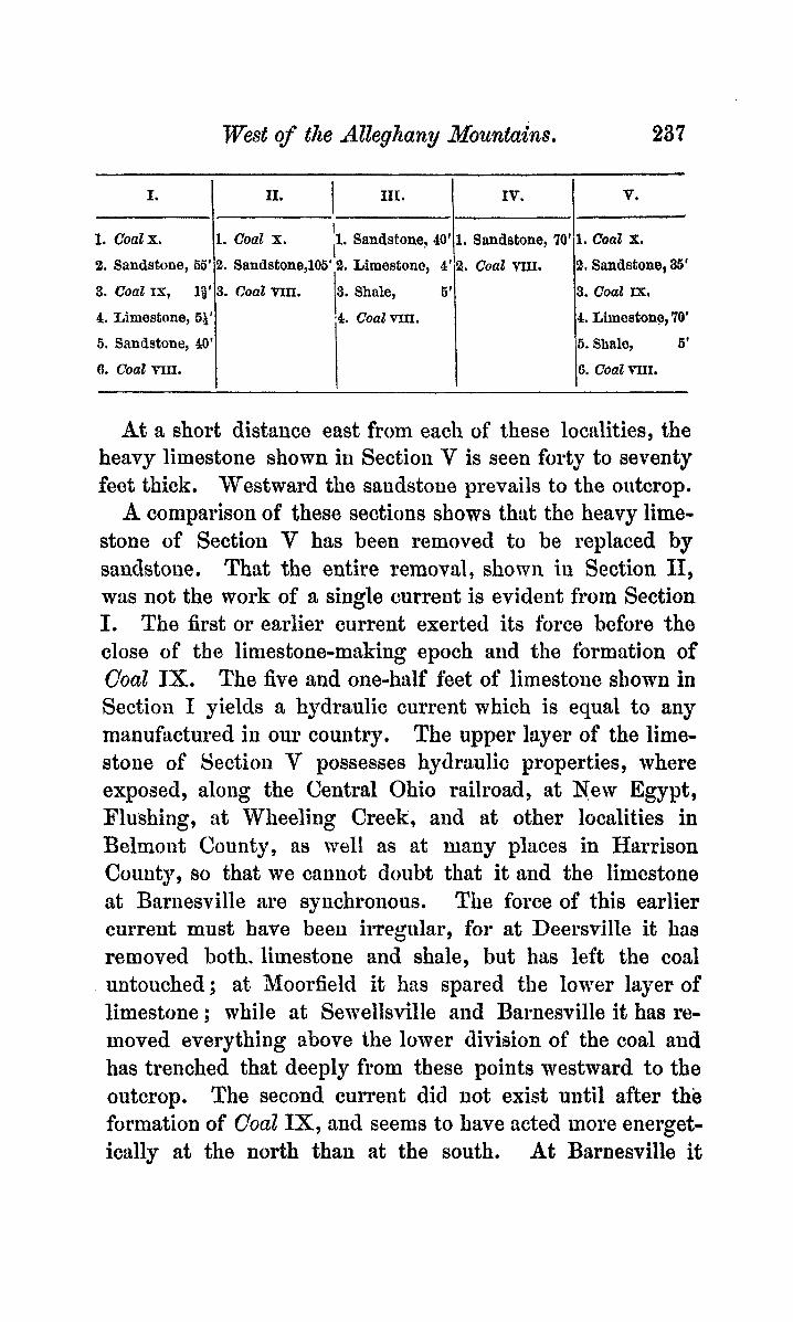
West of the Alleghany Mountains. 237
11. I 111.
1. Sandstone, 40' I i
I. Coal x . 8. Sandstone,l05' 2. Limestone, 4'
3. Coal trlII. 3. Shale, 6'
-4. C o a t n x . I
I.
1. CoaZx. 2. Sandstone, 66
3. Coal IX, 18
4. Limestone, 6$ 6. Sandstone, 40 6. Coal nII.
IV. V.
1. Sandstone, 70' 1, CoaZ X.
2. Coal vm. 9. Sandstone, 36'
3. Coal fx.
4. Limestone, 70'
6. Shale, 6'
6. C o a l m .
At a short distance east from each of these locdities, the heavy limestone shown in Section V is seen forty to seventy feet thick. Westward the sandstone prevails to the outcrop.
A comparison of these sections shows that the heavy lime- stone of Section V has been removed to be replaced by sanclstoiie. That the entire removal, shown iu Section 11, was not the work of a single current is evident from Section I. The first or earlier current exerted its force before the close of the lirnestone-making epoch and the formation of Coal IX. The five and one-half feet of limestolio shown in Section I yields a hydraulic current which is equal to any manufactured in our country. The upper layer of the lime- stone of Section V possesses hydraulic properties, where exposed, along the Central Ohio railroad, at New Egypt, Flushing, at Wheeling Creek, and at other localities in Belmont County, as well as at many places in Harrison County, so that we cannot doubt that it and the limcstone at Bariiesville are synchronous. The force of this earlier current must have beeu irregular, for at Deersville it has removed both. limestone and shale, but has left the coal untouched; at Moorfield it has spared the lower layer of limestone ; while at Semellsville a i d Barnesville it has re- moved everything above the lower division of the coal and has trenched that deeply from these points westward to the outcrop. The second current did Dot exist until after the formation of Coal 3cx, and seems to have acted more energet- ically at the north than at the south. At Barnesville it
238 me Uppeg* Coal N e a s u m
spared not only the limestone but also the coal, whereas northward both were removed. The eastern boundary of these currents is very tortuous, but has a rudely northeast and southwest direction. They must have their origin in similar causes, as their courses coincide.
As already stated, the P.ittsburg, mherq accompanied by its normal: roof, is a double coal. The roof-coal, or upper division, is subject to much variation. The partings in the lower division are very persistent. About one foot from the top is a band of pyrites, one to two inches thick; near the middle is a clay parting,,about one inch, and three to eight inches below this a second clay parting resembling -the firsf; below this a thin band of pyrites is frequently found, but it is not persistent. The middle bench, between the clay partings, is ordinarily very pure, and well adapted to smiths’ use.
I n Millwood and Londonderry townships, Guernsey Co., Ohio, the coal is single-bedded, with a sandstone roof, and varies little from four feet in thickness. In Warren and Kirkwood townships, Belmont Co. , wherever roofed by ssnd- stone, it is single-bedded and badly cut out. I n Oxford township, Guernsey Co, , the roof-coal is occasiona-lly seen one foot thick and separated by shale from the lower divi- sion.
Near Deersville, in Harrison Co. , the coal is opened and gives the follo-ing section :-
Coal, 10 in. ; clay, 10 in. ; coat, 4 ft. The intimate structure of the lower division, as shown in
an opening here, is peculiar in the thicknes9 of the middle bench 2
Coal, 1 Et. 6 in, ; pyrites band, 14 in. ; C Q ~ , 2 in. ; clay parting, $* in. ; c o d , 1 ft. 3 in. ; clay parting, 1 in. ;. coat, 10 in. ; total, 4 ft. 1 in.
I n the neighborhood of these sections the coal is soft, not good for hard firing, but is quite pure and shows fern streaks or nodules of pyrites. Pollowed eastward the ooal thickens,
West of the Alleghany 1Mountains. 230
becomes harder and less pure. Cadiz it shows :
in. ; c o d , 5 ft. 6 in.
shaft of the coal worlrs :--
About a mile west from
Bituminous shale, 4 ft. ; c o d , 1 ft. 3 in. ; clay, I ft. 2
At Ctdiz the following section is said to exist in the
CoaE, 2 ft. ; limestone, 5 ft. ; clay, 2 ft. ; coal, 5 ft. It is impossible to verify this report, given by the fore-
mail, :ts the shaft is boarded up. If it be a true section it is exceedingly anomalous, for no such successiou is to be seen in the neighborhood, and there are good exposures near by.
Through this district the coal seems to be exceedingly pure, no pyrites are visible except in the two bands, uud blacksmiths pronounce the coal admirably fitted for their use. Yet analysis shows that it coiitaius upwtirds of two per cent. of sulphur in its best part. That this is distributed throughout the cod as pyrites and not as :iu organic com- pound is evident from the fact thttt more than one-half re- mains after coking, forming almost t.wo per cent. of the coke. At the most northerly exposure of the bed near Jefferson, the intimate structure of the whole bed is as f'ollotva :-
Coal, 1 ft. 6 in. ; clay, 1 ft. 6 in. ; coal, 1 ft, 9 in, ; clay parting, 4 in. ; coal, 6 in. ; clay parting, 4 in. ; coal, 1 ft. 2 in. ; clay parting, 5 in. ; coal, 1 ft. 2 in. ; total of lower division, 4 ft. 8 in.
The upper pyrites band is uot persistent at this opening, and where seen is one-fifth of an iiich thick. The lower band was not observed. Near Ihnover, at the northwestern exposure of the bed, the clay between the coals has almost disappeared, aud we find
Boof-coal, 1 ft. 6 in.; clay parting, 5 in.; coal, 3 ft. 11 in.
The roof-coal is slaty and easily recognized as separate from the main cod below. In Jcfferson Co., this bed lies for the most part high up in the hills, and there are few ex- JANUARY, 1873. 17 ANEX. LYO, NAT. HIBT., VOL. X
240 The Up2er Coal Jleeasures
tensive openings. Near Unionport, on the Panhandle road , at the northern outcrop, several banks have been opened, but none of them show the roof-coal. The roof is shale suoceeded by sandstone, and the coal is 4 ft. 2 in. to 4 ft. 9 in. thick, with the following structure.
Coal, 1 ft. 2 in. ; clay, Q in. ; coal, 6 in. ; clay + in. ; coat, 9+ in. ; clay, + in. ; coal, 1 in, ; clay, + in ; coal, 2 ft.
The pyrites bands are not persistent here but streaks and nodules are quite numerous. At another opening about half a mile from these, the roof-coal is still absent, the roof being shale, six feet thick, succeeded by sandstone. Following the road from Unionport to York several openings are seen, at one of which the following section was obtained :
Coal, 1 ft. 6 in. ; clay, 10 in. ; c o d , 5 ft. to 5 ft. 6 in. The roof-coal throughout this district seldom exceeds ten
inches and the lowe: coal is much injured by pyrites both in nodules and streaks. I n the neighborhood of Mt. Pleasant the roof-coal varies from one to three feet, and on Rush Run it is said to be five feet at one opening, though only three feet were exposed at the time of my visit.
In Belmont Co., at Hendrysburg, just east of the sand- stone deposit the coal shows :
CoaZ, 10 in. ; clay, 4 in, ; shale with thin laminae of coaZ, 1 ft. ; c o d , 4 ft. 8 in. On Jug Run, a tributary of Wheel- ing creek, the roof-coal is divided, a condition rarely seen in Ohio, except along Wheeling creek, where it is quite common. The section is
CoaZ, 6 in. ; clay, 8 in. ; coal, 10-15 in. ; clay 10-15 in. ; coal, 5 ft.
In Colerain township, on Hughes’ Run, the lower division becomes 5 ft. 8 in.
On Barr’s Run, the subdivision of the roof-coal is extraor- dinary, as follows :
O‘oal, 3 in. ; black shale, 4 in. j coal, 1s in. ; shale & in. ; cod, 10 in. ; shale, 1 in. ; c o d , 16 in. ; shale 5 in. ; coal 14 in. ; with the lower division 4 ft. 10 in. seen.
West of the Alleghany Xozcntains, 241
In Pease township, on Wheeling creek, the whole bed is greatly expanded. At one opening we find
Cod, 1 ft. 6 in. ; shale 8 in.; c o d , 10 to 18 in. ; clay, 8 in.; c o d , 5 ft, 2 in. to 6 ft. In one or* two neighboring openings the lower coal becomes seven feet. Here the coal is of excellent quality for fuel, though containing too much sulphur to be of value in the manufacture of iron or gas. The intimate struottzre of the lower bed is shown here to be
Coal, 2 ft. 5 in.; pnrting,.l in.; c o d , 3 in,; parting; 1 in. ; coaZ, 3 ft. to 3 ft. 6 in.
The upper pyrites band is seen persistently at from twelve to fourteen inches from {he top, and the clay partings are full of pyrites. Nodules occur occasionally, but are small and easily separated. Along the Ohio rive2 the roof-coal again becomes single, while the lower coal retains its thiok- ness. Two o r three miles above Martinsvillo we find coal, 2 ff. ; clay, 6 in. to 2 ft. ; coal, 4 ft. 9 in. to 6 ft.
Here the roof-coal has not been mined. It is usually left with the clay parting to make a firm roof. The clay is much slickensided, rendering it liable to fall after removal of the coal below.
Crossing the river into West Virginia we find this coal ex- tensively worked from Benwood opposite Eelleair to twelve miles north from Wlise2icg, a8 well as on both branches of Wheeling creek. As might hardly be expected it shows little variation in character and the following is a represen- tative section :
Coal, 1 ft. 3 in. to 1 ft. 8 in. ; clay, 1 ft. ; coal, 5 to 6 ft. Rarely a thin shale is found dividing the roof-cod. East-
ward the bed disappears about five miles from Wheeling, and at the same distance southward it passes under the BaL timore and Ohio railroad, the dip being southeast. Follow- ing the railroad we see the coal again at Fairmont, about eighty miles S. S. E. from Wheeling, dipping sharply to the northwest. Here it is single-bedded, about nine feet thick, and roofed by a heavy felspathic sandstone which is coarse
242 The Upper Coal Nensures
pained and contains numerous coaly spots, evidently eroded coal. The coal fmrn this locality is coked and tests have been made at Wheeling to determine its value in irommakiug. It proves to be too impure for use even when mixed with thrice its bulk of Connellsville coke. It is, however, much more compact than that coke, and if it could be cleaned by washing would undoubtedly be employed in preference. Along the base of Laurel Hill (Chestnut Hill, of Pennsyl- vitnizt Reports), from Fsirmont to the junction of Chest and &f onongahela rivers we find the coal always single-bedded and roofed by this coarse sandstone, though occasionally separated from it by a few illdies of shale. The roof is very irregular a d gives evidence that the eroding current which removed the .upper beds, tore out much of the lower cod, which, indeed, near Morgmtown is sometimes reduced to six feet, though seldom less than eight.
Crossing the Monongahela we fifinct a number of openings on Scott’s Run, which give the following geiieral section :
Coal, 3 in. ; shale, 1 ft. 9 in. ; coal, 1 ft. 3 i n ; Ehule, 1 ft. 5 i n , ; coa2, 10 ft,
On Courtney’s Run, onemile below Scott’s Run, we get Coal, slaty, 1 ft. 9 in. ; shale, 3 ft. 5 in.; cqnl, 48 in.;
shale, 1 ft. 10 in. ; coal, 1 ft. 4 in. ; shale, 10 iu. ; coed, 8 ft. 8 in.
Ou Robinson’s Run, one mile farther down, we find Mccty coal, 2 ft.; black shale, 3 ft. 6 in.; bituminous
slate, 10 in. ; c o d , 1 ft. 3 in. ; bituminous shale, 1 ft. ; coaZ, 8 ft., exposed.
Here, within a distance of six miles, the bed is seen- first single-bedded, next, on Scott’s Run the roof-coal is present and double, on Courtney’s, a third hyer is added to the roof, while on Robinson’s, the two layers seen on Scott’s lie together, though they -are clearly distinct.
In Pennsylvania, the character of this bed varies in the different basim, and is found ouly south of the Ohio and Conemaugh rivers. In the first basin south of those rivers
Wmt of the Alleghany iWountains. 243
it is about nine feet thiuk mid single; in the second eight and one-half, and single ; while in the third it is double with the lower division averagiug between nine and ten feet, and the upper varyiug from two to five and one-half.
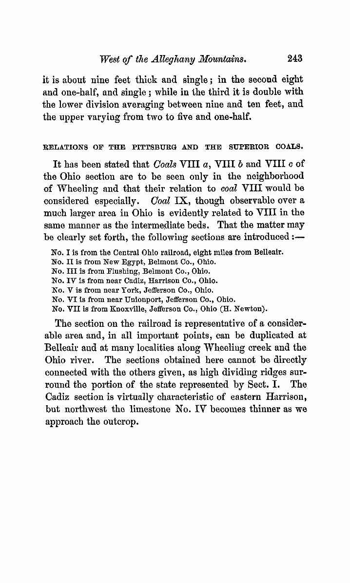
RELATIONS OF THE PITTSBURG AND THE SUPERIOR COALS.
It has beeu stated that CYoaZs VIII a, VIII b and VIII c of the Ohio section are to be seen only in the neighborhood of Wheeling and that their relation to coal VIII would be considered especially, Coal IX, though observahlo over a much larger area in Ohio is evidently related to VIII in the same manner as the intermediate beds. That the matter may be clearly set forth, the following sectioiis are introduced :-
No. I is from the Central Ohio railroad, eight milea from Belleair. No. I1 is from New Egypt, Belmont Co., Ohio. No. I11 is from Flushing, Belmont Co., Ohio. No. IV is from near Cad& Harrison Co., Ohio. KO. V is from near Tork, Jefferson Co., Ohio. No. VI is from near Unionport, Jefferson Co., Ohio. No. VII is from Knoxvllle, Jefferson Co., Ohio (H. Newton).
The section on the railroad is representative of ft consider- able area and, in a11 important points, can be duplicated at Belleair and at many localities along W h e e h g creek and the Ohio river. The sectioiis obtained here cannot be directly connected with the others given, as high dividing ridges sur- round the portion of the state represented by Sect. I. The Cadiz section is virtually characteristic of eastern Hrtrrisoii, but northwest the limestone No. IV becomes thinner as we approach the outcrop.
244 The Upper Coal Measu~es
Iv.
1. Coals , - 2. Sandstone, 75'
3. Coal=, 2'
4. Limestone, 20'
6. Shales, 4'
6. Coatvm, 8'
V-
VI.
1. Coalx, ?
2. Sandstone, 85'
3. Coalvm, 6'
VII.
I.
1. CoaZx; - 2. Sandstone, 35' 3. Coal=, 2h'
4. Limestone, 70'
6. CoaZVIII c, 4'
7. Coal q b , 1:' 8. Limestone, 20' 9. C o a l m a , 15'
10. Limestone, 20' 11. Shale, 6'
12. CoaZvm, 8'
6. Sandstone, 18'
n.
1. Coal X, - 2. Sandstone, 35'
3. Coal IX, 24'
4. Limestone, 70'
5. Shales, 5'
6. Coalvm, 7'
IXX. 1. Coalx, - 2. Sandstone, 60'
3. Coal=, - 4. Limestone, 88'
5. Shales, 4
6. Coal=, 6
. - 1. Coalx, 3'
2. Sandstone, 85'
Should one follow Wheeling creek, Ohio, from its mouth to where it becomes Patterson's creek, he will find VIII c in its banks, as well as in those of its tributaries. Along the bottoms of Patterson's creek, which flows northeast, he mill see it worked by stripping. But before reaching Union township the creek bed is some distance above it. Crossicg the dividing ridge and descending into the valley of Spen- cer's creek, he will find Section If, six miles west ,of the locality where he last saw vIl[I c. If, however, instead of following Patterson's creek, he take the branch flowing from the northwest, he will lose sight of VnI c near Uniontown, and six miles further he will obtain Section ID[. The result is similar in other directions. l n each of these sections a cod is seen one hundred feet, more or less, below Coal X. In No. I it is VIII c, in the others it is VIII. The accuracy of this identification has been questioned, so that the grounds on which it is made should be stated distinctly.
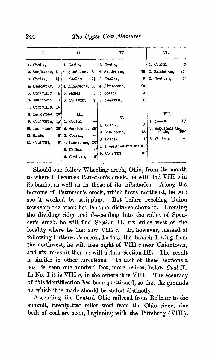
Ascending the Central Ohio railroad from Belleair to the summit, twenty-two miles west from the Ohio river, nine beds of coal are seen, beginning with the Pittsburg (VIU).
1. Coalx, la ' 2. Sandstone and
shale, 100'
3. CoaZIx, 1;'
4. Limestone and shale 7' 5. C o a l v m , 6;'
3. C o a l v m -
West of the Alleghany Mountains, 245
ASCENDING.
1. C'oaz Xm.
2. Shales and sandstone, 70
3. C O U l X r I .
4. Shaly sandstone, 40'
6. CoalXI.
6:Sandstone and shales, 98'
7. CoaZx. 8. Sandstone, 36'
9. Coal=.
10. Limestone, 70'
11. Coalvur c. 12. Sandstone, 18-35'
13. Coal FI~I b.
14. Limestone, 20'
16. COdVMa.
16. Limestone, 20-25'
17. Shales, 5-10 ' 18. CoaZim,
19. Fireclay and shales with thin limestone. 10'
2Q. Sandstone, 90'
Descending from the summit to Quaker City, thirty-five miles west from the river, only six can be seen, and at Quaker City the crinoidd limestone occurs. The relation of the sections is as follows :-
A
DESCENDINQ.
1. Coa2xm. 2. Shale and Sandstone, 70'
3. C O U l ~ .
4. Shale and Sandstone, 30'
5. Coal X I .
6 . Sandstones with thin limestones and shales, 100'
7. Coalx. 8 . Sandstone, 60'
10. Limestone, 5&'
11. Sandstone, 45'
12. Cool vm. 13. Fireclay, 6'
14. Limestone, Y'
9. Coal Ix.
15. Sandstones and variegated shales, 260'
16. Cdnoidal Limestone.
It is evident from these sections, that east and west of the summit the strata are identical to No. 10 ot each, including, as was previously shown, No. 11 of the second; and it is equally evident that No. 12 of the second cannot be No. 11 of the first, but that it must be Coal VIIT or the Pittsbut*g. The internal anatomy of the bed shows this, for even along the Central Ohio railroad, where the upper division has been re- moved, we find the characteristic pyrites band and the clay partings. But in order to remove all possible doubt, the
246 The Upper Coal Xeaswes
Coal vT-l[I of the second section was carefully traced with its crinoidal limestone along its western and northern outcrop, from Salesville, iu Guernsey Co. to the Ohio river at Stew benville. From Steubenville it was easily followed clown the river to Belleair, where it was found to be identical with Coal VIII of the first section. It is clear, then, that the coals betmeen VIII: and IX have disappeared somewhere within the dividing ridges of Belmont Co. One would expect to find the successive disappearauces along the Ohio, but the aoals become very thin above Belleair and the superficial deposits are so thick that accurate tracing is impossible.
It is well to note that wherever VIII c occurs, it has the same relative position to Coal X that Coal VIII holds west and north of the dividing ridges in Belmont Co., the interval in each case being about one huiidred feet.
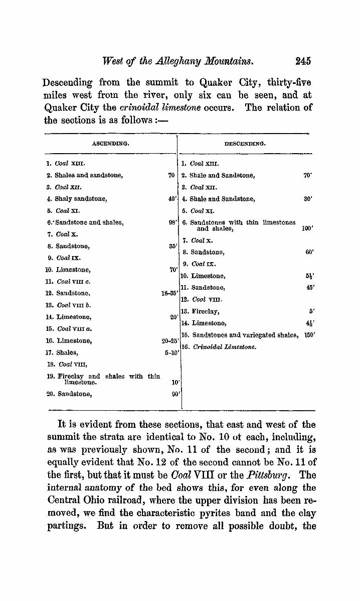
The gradual disappearance of the limestone below Cod IX and the merging of that coal into Coal VIII are more easily traced. In Section I on the Central Ohio railroad the linie- stone is seventy feet ; at Btuuesville the interval, including the shales and upper layers of Coal VIII, is only forty-five feet; at New Egypt, considerably east of Barnosville, it is seventy feet; at Flushing, north from Egypt, it is thirty- eight ; at Cztdiz, northeast from Flushing, it is oidy twenty feet, and diminishes rapidly to the northwest, beiiig only five feet at Hsnover ; at York it is seven feet, including the shales, overlying VIII ; while at Unionport a i d Kuoxville the limestone does not exist and Coal IX itself has disap- peared. From a careful study of these facts I am led to be- lieve that here we have a series of bifurcations of CoaZ VIU almost as extensive ard interesting as those said to occur in the .li!&aminoth hed ofthe anthracite region. It is worthy of note in this coiinection that the distance between Coals VIII and X gradually diminishes mrthwtl'd, from one hundred and five feet on the Ceritral Ohio railroad to eighty-five feet at Unionport, and the interval between X and XI diminishes in the same direction from one hundred feet on the railroad
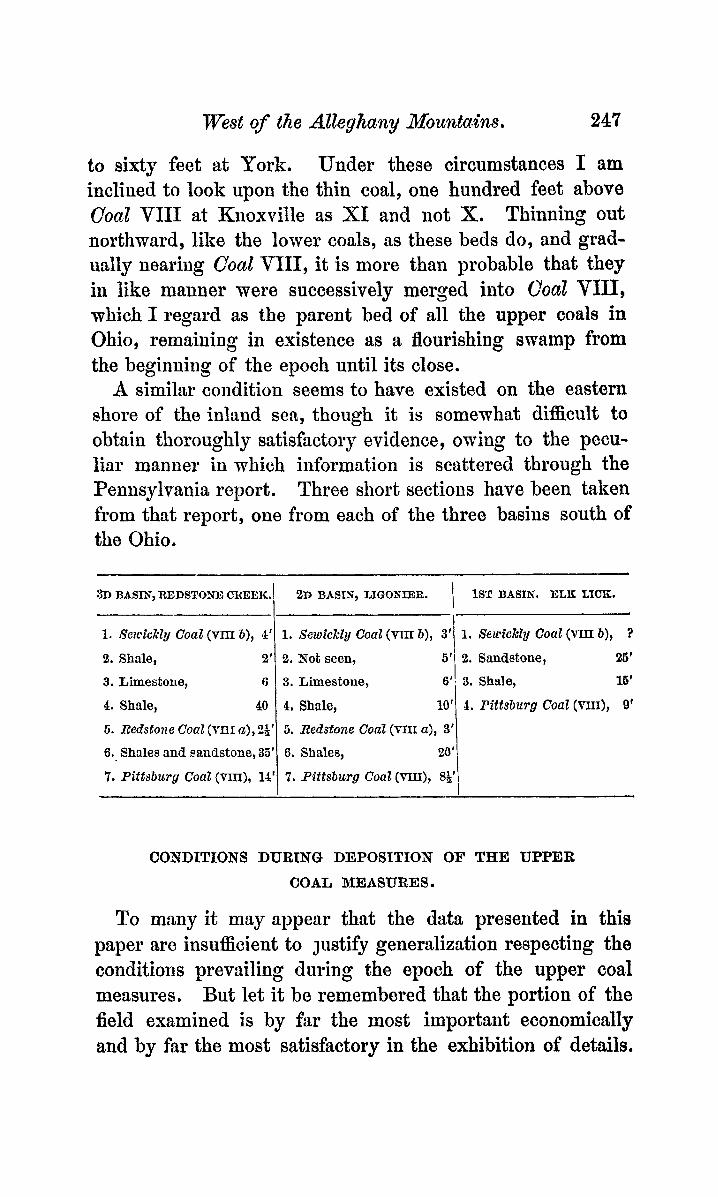
West of the Alleghany Mounta.ins.
1. "YezcicllZg Coal (vm b), 4'
2. Shale, 2'
3. Limestone, 6
4. Shale, 40
5. Redstone CoaZ (mf a), 24'
6. Shales and sandstone, 35'
7. Pittsburg Coat (VIXI), 14'
247
1. SewicMg Coal (VIII b), 3' 1. Seu*ickly Coal ( ~ m b) , ?
26' 2. Xot seen, 3. Limestone, 6'; 3. Shale, 16'
4, Shale, 10' 4. Pittsburg Coal (nn), 9'
5. Redstone Coal (ITXI a,), 3'
6. Shales,
7. Pittsburg CoaZ (mz), S:',
I 6'' 2. Sandatone,
to sixty feet at York. Under these circumstances I rim inclined to look upon the thin coal, one hundred feet above ConZ VIII at Knoxville as XI and not X. Thinning out northward, like the lower coals, as these beds do, and grad- ually nearing Coat VIII, it is more than probable that they in like manner were successively merged into CYoaZ VIII, which I regard as the parent bed of all the upper coals in Ohio, remaining in existence as a flourishing swamp from the beginning of the epoch until its close.
A similar condition seems to have existed on the eastern shore of the inland sea, though it is somewhat difficult to obtain thoroughly satisfactory evidence, owing to the pecu- liar manner in which iiiformation is scattered through the Pennsylvania report. Three short sections have been taken from that report, one from each of the three basins south of the Ohio.
CONDITIONS DURING DEPOSITION OF THE UPPER
COAL M3ASURES.
To many it may appear that the data presented in this paper are insufficient to justify generalization respecting the conditions prevailing during the epoch of the upper coal measures. But let it be remembered that the portion of the field examined is by far the most important economicalIy and by far the most satisfactory in the exhibition of details,
248 The Upper Coal Measures
1. Waynesburg Coab ( X I ) , 3
2. Shale, 33
3. Limestone, 16
4. ,Sandstone, 3'
6. Limestone, 6'
6. Shale, 5'
7. Limestone, 2'
8: Shale, 2'
9, Limestone and Shale, 11'
10. Shale, 6'
11. Limestone, 44'
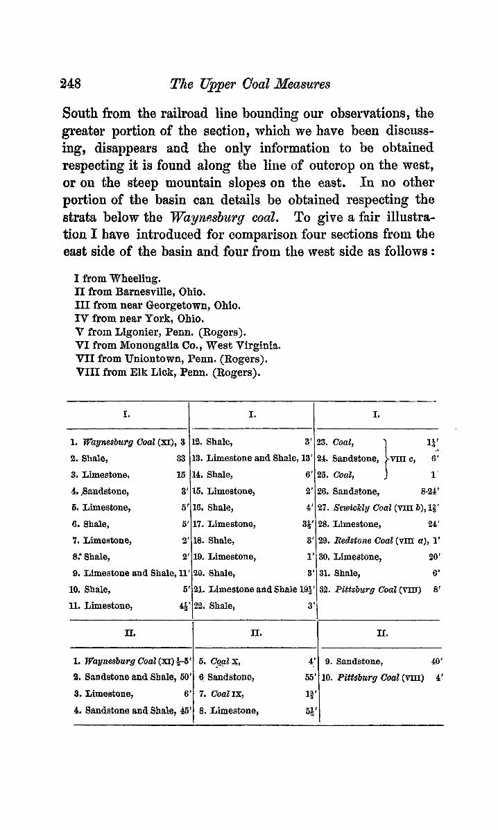
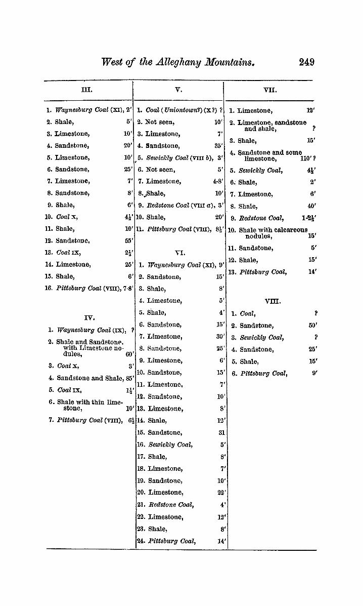
South from the railroad line bounding our observatiom, the greater portion of the section, which we have been discuss- ing, disappears and, the only information to be obtained respecting it is found along the line of outcrop on the west, or on the steep mountain slopes on the east. I n no other portion of the basin can details be obtained respecting the strata below the Waynesburg coal. To give a fair illustra- tion I have introduced for comparison four sections from the east side of the basin and four from the west side its follows :
1% Shale, 3'
13. Limestone and Shale, 13'
14. Shale, 6'
15. Limestone, 2
16. Shale, 4
17. Limestone, 35
18. Shale, 3
19. Limestone, 1
20. Shale, 3
21. Limestone and Shale 191: 22. Shale, 3
I from Wheeling. I1 from Barnesville, Ohio. 111 from near Georgetown, Ohio. IV from near Pork, Ohio. V from Ligonier, Penn. (Rogers). VI from Monongalia Co., West Virginia. VfI from Uniontown, Penn. (Rogers). VIII from Elk Lick, Penn. (Rogers).
1. Wagnesburg Cod (XI) +5'
21. Sandstone and Shale, 60'
3. Limeatone, 6'
4. Sandstone and Shale, 45'
I. I I.
6. Cqat x, 4' 9. Sandstone, 40'
6- Sandstone, 65' 10. Pittsburg Coal (vm) 4'
7 . CoaZIx, 13'
8. Limestone, 64'
I
IT, I II.
I.
23. Coat, 13 ' 24. Sandstone, vm c, 6'
26. Coal, i r 26. Sandstone, 8-24'
27. SewickZy Coal (vm b), 12' 28. Limestone, 21'
29. Redstone Coal (vm a), 1'
30. Limeatone, 20'
31. Shale, 6'
,352. Pittsburg CoaE (m) 8' 1
I II. I
West of the Alleghany Mountah 249
m.
1. FVuynesbztrg Coal (XI), 2'
V. n1. r
1. Coal ( Uniontown?) (x?) ? 1. Limestone, 12' 2. Shale, 5'
3. Limestone, 10'
4. Sandstone, 20'
5. Limestone, 10'
2. Not seen, 10'
3. Limestone, 7'
4. Sandstone, 36'
2. Limestone, sandstone
3. Shale, 16'
and shale, ?
4. Sandstone and some ,5. S~WMZY Coal (VIII b), 3'1 limestone, 110' ?
6. Sandstone, 25'
7. Limestone, 7'
8. Sandstone, 8'
10. Coalx, 44' 9. Shale, 6'
11. Shale, 10'
6. Not seen, 6'
7. Limestone, 4-8'
8.j3hale, 10'
10. Shale, 20'
9. Redstone Coal (m a), 3'
11. Pittsburg Coal (nu), Si'
6 . Sewickly Coal, 4k' 6: Shale, 2'
7. Limestone, 6'
8. Shale, 40'
9. Redstone Coal, la&'
16' 10. Shale with oalcareous
16. Pittsburg Coat (Vm), 7-8'
IV.
nodules , 11. Sandstone,
VI . 12. Sandstone,
13. Coal=,
3. Shale, 8'
4. Limestone, 6' VIII. 5. Shale, 4' 1. Cod,
14, Limestone, 25'
15. Shale, 6'
1. ipaynesburg CoaZ (IX), ?
2. Shale and Sandstone, with Limestone no- dules, 60'
3. Coalx, 3'
12. Shale,
13. Pittsburg Coal, 1. Vaynesburg Coal (XI), 9'
2. Sandstone, 15'
6.
7.
8.
9.
4. sanastone and Shale, 85' 6. Coal=, 1x1
6. Shale with thin lime- a
10. Sandstone, 35'
11. Limestone, 7' 12. Sandstone, 10'
Sandstone, 15'
Limestone, 30'
Sm&toue, 25'
Limestone, 6'
stone, 10'113. Limestone, 8'1 7 . Pittsburg Coat (VIII), 14. Shale,
15. Sandstone,
16. Xm'ckly Coal,
17. Shale,
18. Limestone,
19. Sandstone,
20. Limestone,
21. Redstone Coal,
22. Limestone,
23. Shale,
24. Pittsburg Coal,
12'
31
5'
8'
7'
10'
2r2'
4'
12'
8'
14'
2. Sandstone,
3. Sewickly Coal,
4. Sandstone,
5. Shale,
6. Pittsburg Coal,
6'
16'
14'
?
60'
?
26'
16'
9'
I I

250 The Upper Coal &Ieasures
The relative geographical positions of these localities, as we11 ag those of some others already referred to, are shown in the following diagram.
A similar swies of sections of the Barren measures shows that the strata of that group diminish in thickness east and west of the central portion of the basin. There can be no doubt, therefore, that at the beginning of the Barren epoch, the Alleghany basin had already its present shape and was bounded on the west by t.he slopes of the Cincinnati axis, on the east by the slopes of a similar axis. The events of the succeeding epoch seein to show that the Cincinnati axis had attained its highest elevation before the deposition of the upper coal measures began. At the close of the Barren epoch, the northern portion of the basin was a half-filled valley such as is now presented by the bed of the Qhio river, below Smith’s Ferry
A comparison of the upper coal measure sections given above, shows that as we leave the middle of the basin we find the limestones diminishing in every direction. In the portion below Cod X, these limestones, followed west and north do not give place to off-shore deposits, but simply disappear and permit the coal-beds to approach each other ; whereas, eastward, they interlock with sandstones and shales, before
Wegt of the Alleghnny 3lozcntains. 251
disappoariug, which in their turn thin out as do the lime- stoiies on the west side of the basin. This is evidciice of clear, quiet waters on the west, while rivers or shore cur- rents carried iu their freight of sand :tiid mud from the east slid northeast.
After the form:ttion of CoaZ X, which, w has been stated, may have been synchronous with the Uniontown of Pennsyl- vania, the conditions were more nearly alike throughout the basin uutil the formation of the TTuynesbzwg, though at the east and west, :iltern:ttioas of liuiestone aiicl sandstcke during the greater portiou of the iuterval give evidence of neighbor- iiig shores. The limestone is still greatest in the ceiitrtll portibiis, but is easily traceable in strata or nodules as far west as Bnrneavillc, north as Unionport, and east as Elk Lick creek, d l on the line of fiunl outcrop.
Oil the west side of the bash, we find the Redstone, Se- wickly, VIZI c and IX successively merged iuto the Pittsburg. Qn the eubt side we find the Redstong disappearing and the Semickly brought nearer to the Pittsburg by so much as the Redstoiie was ciisjtrtnt from it, while the interval between the Yewickly a i d the Uniontown (X ?) is reduced at the most easterly exposure to barely one-third of what it is nearer the central portion, ou the Jlononguheln. We have tbus evidence of ti series of gradual subsidences, separated by iiitervals of repose, during each of which a lid of coal was formed over all or :I part of the basin. These subsi- dences could not have beeti p:iroxysmal, for we find that as the shore-line sank, the great Pittsburg marsh crept up the shore, coutiiiuslly from the beginning of the epoch until long after the formation of Coal IX, perhaps until the very close of the epoch. Thus it is that, although giving origin to so many subordinate seams, the great coal bed dirniiiishes in thickness when followed west from the Ohio, or east from the immediate valley of the Monoiigaliela,
It is highly probable that the Pittsburg was begun on the east and advanced westmardly . We have ample evidence in
252 Lingual Dentition of Gmotis.
the sandstone and shale, which at the east separate it from its limestone, th& a delta was there forming and pushing out to the west, so that on the east the conditions requisite for the formation of coal would first exist. On the east side of the basin me find nine to ten feet in the lower division of the bed, while on th6 west side we find on1l))i’five to six feet.
I am led, then, to the following conclusions : 1. The Great Bituminous Trough, west of the Alleghnnies,
does not owe its basin shape primarily to the Appalachian Revolution
2. The coal measures of this basin were not united to those of Indiana and Illinois at any time posterior to the lower coal measure epoch, and probably were always distinct.
3. The upper cod measures originally exteuded as fhr west as the Muskingum River, in Ohio.
4. Throughout the upper cod measure epoch the general condition mas one of subsidence intarrupted by longer or shorter intervals of repose. During subsidence the Pitts- burg marsh crept up the shore, and at each of the longer intervals of repose pushed out seaward upon the advancing land, thus giving rise to the successive coal-beds of the upper coal measures.
5. The P’ittsbt~rg marsh had its origin at the east.
XXI. - On the Lingual Deittition of Chot is .
BY THOS. BLAND L~D IT. G. BIFNET.
Read January 6,1873.
THE genus Gaotis was described by Shuttleworth,* founded on a curious mollusk from Porto Rico. The lingual denti- tion was said to be nearly the same as in VitrZ12a and Zonites, the teeth arranged in oblique rows, centrals ohtuse,ly tri-
*‘*Lamina lingualie fere ut in Pitrina et Zonites constituta videtur, papills nempe numerosa in seriebus utrinque obliqnis ordinattta sunt : papilla centrali obtuse tri dentata; mediis vix B centraIi diversis; lateralibus autem subulato-productis, arcuatis basi? bifurcatis. An maxilla adsit h3eret.” ‘‘E formatione lingua animal videtnr sine dubio carnivorum.” Shuttleworth, Bern X t . 1854, p. 34.
Recommended