2nd Deep-Water Circulation Congress, 10-12 Sept. 2014, Ghent, Belgium
[15]
The Pianosa Contourite Depositional System (Corsica Trough, North Tyrrhenian Sea): stratigraphic evolution and possible role in slope instability
Elda Miramontes1, Antonio Cattaneo1,2, Gwenael Jouet1, Sebastien Garziglia1, Estelle Thereau1, Arnaud Gaillot1, Angelique Roubi1 and Mickael Rovere1
1 IFREMER, Géosciences Marines, Centre de Brest, BP70, 29280 Plouzané, France. [email protected] 2 Joint affiliation: CNR-ISMAR, v. Gobetti 101,40129 Bologna, Italy
Abstract: The Pianosa Contourite Depositional System (Corsica Trough, North Tyrrhenian Sea) results from the interaction of the Levantine Intermediate Water (LIW) with the Pianosa Ridge. Seismic reflection data and Calypso piston cores show cyclicity in drift morphology and migration, as well as in the lithology, that might be linked to sea-level changes. Major erosional seismic discontinuities in the contourite drifts correspond to coarser sediment and seem to influence the location of slide planes. Key words: contourite drifts, submarine landslides, Levantine Intermediate Water, Tyrrhenian Sea
INTRODUCTION
The Levantine Intermediate Water (LIW) is formed in the eastern Mediterranean and enters in the Tyrrhenian through the Sicily Channel, being found in between 200 and 600-1000m in the Corsica Trough (Artale and Gasparini, 1990). The Corsica Trough, located between Corsica and the Tuscan shelf, connects the Tyrrhenian and Ligurian Seas through the Strait of Corsica with a maximum depth of 900m. The western part of the basin presents a gentle slope (2 to 3°) and is dominated by the turbidity channel-lobe systems of the Golo basin. Our study area is located in Pianosa Ridge, a tectonic structure with a steeper slope (3.5 to 7.5°) characterized by submarine landslides and contourites that limits the basin to the east. The Corsica Trough becomes shallower and narrower to the north. Therefore, bottom currents accelerate, especially in the eastern slope due to Coriolis effect, forming the depositional and erosional features of the Pianosa Contourite Depositional System. In the southern part of the study area mass transport deposits are larger and more abundant. Submarine landslides in the Pianosa Ridge do not correspond to a unique event, but are recurrent in time (Cattaneo et al., 2014).
DATA AND RESULTS
Multibeam bathymetry, High-Resolution-72 traces
(50-250Hz), Chirp (1800-5300Hz) seismic reflection profiles and Calypso piston cores were collected during cruises PRISME2 and PRISME3 in 2013. Gamma density, P-wave velocity and magnetic susceptibility of whole sections were measured with a Geotek Multi-Sensor Core logger (MSCL). X-ray fluorescence (XRF) was measured on split cores using an Avaatech XRF core scanner to obtain the bulk sediment semi-quantitative geochemistry.
The Pianosa Contourite Depositional System
extends from the Capraia Sill (43°-00'N) to the southern part of the Pianosa Ridge (42°-18'N) (Roveri, 2002). A small longitudinal mounded drift (2.3km wide) near
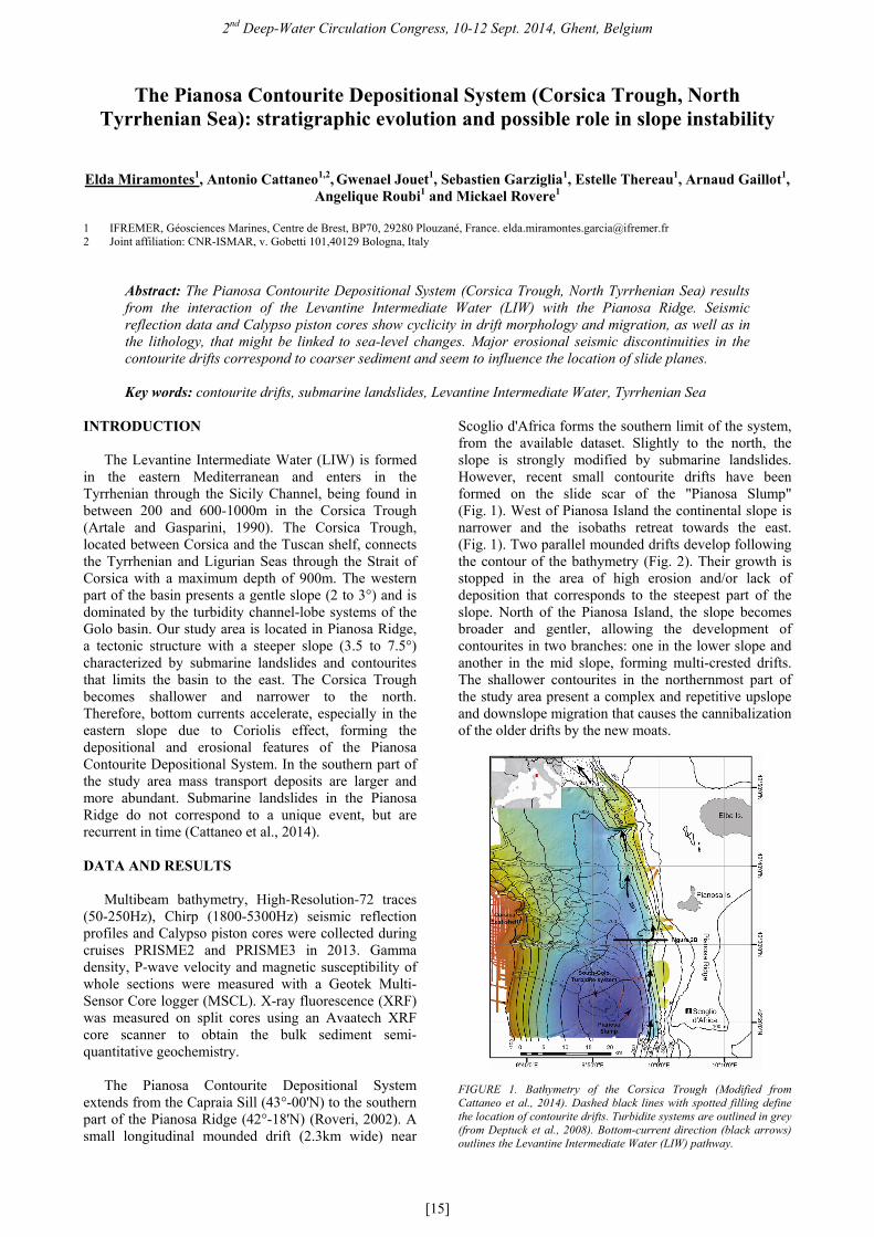
Scoglio d'Africa forms the southern limit of the system, from the available dataset. Slightly to the north, the slope is strongly modified by submarine landslides. However, recent small contourite drifts have been formed on the slide scar of the "Pianosa Slump" (Fig. 1). West of Pianosa Island the continental slope is narrower and the isobaths retreat towards the east. (Fig. 1). Two parallel mounded drifts develop following the contour of the bathymetry (Fig. 2). Their growth is stopped in the area of high erosion and/or lack of deposition that corresponds to the steepest part of the slope. North of the Pianosa Island, the slope becomes broader and gentler, allowing the development of contourites in two branches: one in the lower slope and another in the mid slope, forming multi-crested drifts. The shallower contourites in the northernmost part of the study area present a complex and repetitive upslope and downslope migration that causes the cannibalization of the older drifts by the new moats.
FIGURE 1. Bathymetry of the Corsica Trough (Modified from Cattaneo et al., 2014). Dashed black lines with spotted filling define the location of contourite drifts. Turbidite systems are outlined in grey (from Deptuck et al., 2008). Bottom-current direction (black arrows) outlines the Levantine Intermediate Water (LIW) pathway.
2nd Deep-Water Circulation Congress, 10-12 Sept. 2014, Ghent, Belgium
[16]
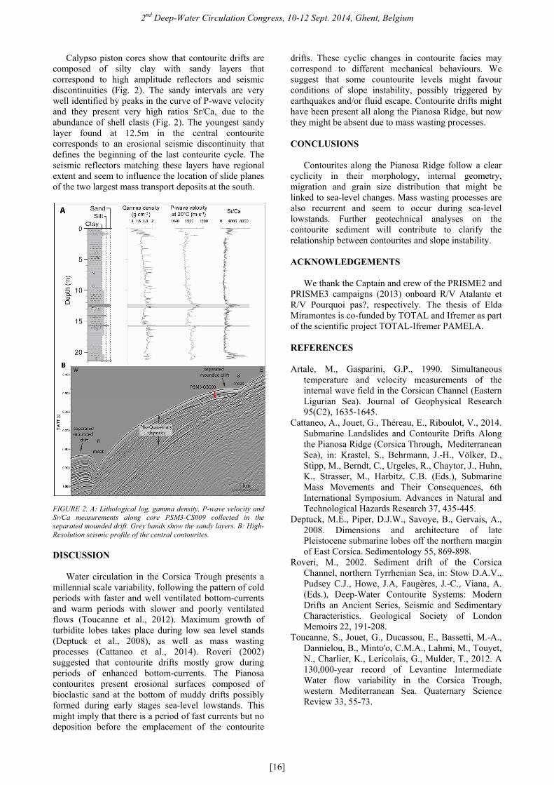
Calypso piston cores show that contourite drifts are composed of silty clay with sandy layers that correspond to high amplitude reflectors and seismic discontinuities (Fig. 2). The sandy intervals are very well identified by peaks in the curve of P-wave velocity and they present very high ratios Sr/Ca, due to the abundance of shell clasts (Fig. 2). The youngest sandy layer found at 12.5m in the central contourite corresponds to an erosional seismic discontinuity that defines the beginning of the last contourite cycle. The seismic reflectors matching these layers have regional extent and seem to influence the location of slide planes of the two largest mass transport deposits at the south.
FIGURE 2. A: Lithological log, gamma density, P-wave velocity and Sr/Ca measurements along core PSM3-CS009 collected in the separated mounded drift. Grey bands show the sandy layers. B: High-Resolution seismic profile of the central contourites.
DISCUSSION
Water circulation in the Corsica Trough presents a millennial scale variability, following the pattern of cold periods with faster and well ventilated bottom-currents and warm periods with slower and poorly ventilated flows (Toucanne et al., 2012). Maximum growth of turbidite lobes takes place during low sea level stands (Deptuck et al., 2008), as well as mass wasting processes (Cattaneo et al., 2014). Roveri (2002) suggested that contourite drifts mostly grow during periods of enhanced bottom-currents. The Pianosa contourites present erosional surfaces composed of bioclastic sand at the bottom of muddy drifts possibly formed during early stages sea-level lowstands. This might imply that there is a period of fast currents but no deposition before the emplacement of the contourite
drifts. These cyclic changes in contourite facies may correspond to different mechanical behaviours. We suggest that some countourite levels might favour conditions of slope instability, possibly triggered by earthquakes and/or fluid escape. Contourite drifts might have been present all along the Pianosa Ridge, but now they might be absent due to mass wasting processes. CONCLUSIONS
Contourites along the Pianosa Ridge follow a clear
cyclicity in their morphology, internal geometry, migration and grain size distribution that might be linked to sea-level changes. Mass wasting processes are also recurrent and seem to occur during sea-level lowstands. Further geotechnical analyses on the contourite sediment will contribute to clarify the relationship between contourites and slope instability.
ACKNOWLEDGEMENTS
We thank the Captain and crew of the PRISME2 and PRISME3 campaigns (2013) onboard R/V Atalante et R/V Pourquoi pas?, respectively. The thesis of Elda Miramontes is co-funded by TOTAL and Ifremer as part of the scientific project TOTAL-Ifremer PAMELA.
REFERENCES
Artale, M., Gasparini, G.P., 1990. Simultaneous
temperature and velocity measurements of the internal wave field in the Corsican Channel (Eastern Ligurian Sea). Journal of Geophysical Research 95(C2), 1635-1645.
Cattaneo, A., Jouet, G., Théreau, E., Riboulot, V., 2014. Submarine Landslides and Contourite Drifts Along the Pianosa Ridge (Corsica Through, Mediterranean Sea), in: Krastel, S., Behrmann, J.-H., Völker, D., Stipp, M., Berndt, C., Urgeles, R., Chaytor, J., Huhn, K., Strasser, M., Harbitz, C.B. (Eds.), Submarine Mass Movements and Their Consequences, 6th International Symposium. Advances in Natural and Technological Hazards Research 37, 435-445.
Deptuck, M.E., Piper, D.J.W., Savoye, B., Gervais, A., 2008. Dimensions and architecture of late Pleistocene submarine lobes off the northern margin of East Corsica. Sedimentology 55, 869-898.
Roveri, M., 2002. Sediment drift of the Corsica Channel, northern Tyrrhenian Sea, in: Stow D.A.V., Pudsey C.J., Howe, J.A, Faugères, J.-C., Viana, A. (Eds.), Deep-Water Contourite Systems: Modern Drifts an Ancient Series, Seismic and Sedimentary Characteristics. Geological Society of London Memoirs 22, 191-208.
Toucanne, S., Jouet, G., Ducassou, E., Bassetti, M.-A., Dannielou, B., Minto'o, C.M.A., Lahmi, M., Touyet, N., Charlier, K., Lericolais, G., Mulder, T., 2012. A 130,000-year record of Levantine Intermediate Water flow variability in the Corsica Trough, western Mediterranean Sea. Quaternary Science Review 33, 55-73.
Recommended