The Météo-France NWP system: description, recent changes and plans
François Bouttier, updated Apr 2010
Contents
1. Formulation......................................................................................................................................11.a. System overview and characteristics........................................................................................11.b. Dynamics..................................................................................................................................31.c. ARPEGE/ALADIN physics......................................................................................................41.d. AROME physics.......................................................................................................................61.e. Data Assimilation......................................................................................................................71.f. Ensemble forecasting & ensemble assimilation........................................................................9
2. Operational system.........................................................................................................................103. Recent and planned changes to production NWP system..............................................................12
3.a. Aug 2007, cy32T0 upgrade.....................................................................................................123.b. Feb 2008, cy32T2 upgrade.....................................................................................................123.c. June 2008 cy33T0 upgrade of ARPEGE/ALADIN................................................................123.d. Dec 2008 operational implementation of AROME................................................................133.e. Feb 2009 cy33T1 upgrade of ARPEGE/ALADIN.................................................................133.f. Main planned changes for early 2010.....................................................................................13
4. Verification procedures..................................................................................................................155. Cooperations...................................................................................................................................15
1. Formulation
1.a. System overview
The atmospheric models used in Météo-France for NWP and climate modelling are all derived from the IFS/ARPEGE software. Different formulations are used in each configuration as a compromise between computational cost, meteorological performance and the timing of new scientific developments.
The resolutions and grids used by the different configurations are listed in the following table. When a significant change is imminent or recent, it is mentioned in italics.
ARPEGE-France system:
horizontal grid: global with Schmidt projection, spectral T798L70c2.4 (i.e. resolution from 10.5km over France to 60km over the South Pacific), 1600x800 grid.
vertical grid & timestep: Arp L70 dt=600s
forecasts: to about 4 days, 4 times per day.
data assimilation: 6-hourly 4D-Var with T323 increments i.e. 60km
ARPEGE ensemble forecast system:
horizontal grid: global Schmidt T358c2.4 (i.e. 23km to 134km), 720x360 grid. (will be T538 after Dec 10 with resolution 15km over W Europe)
vertical grid & timestep: Arp L65, same timestep as ARPEGE-France.
forecasts: 35 members, twice per day: 72h range from 06UTC analysis, 108h range from 18UTC analysis
1
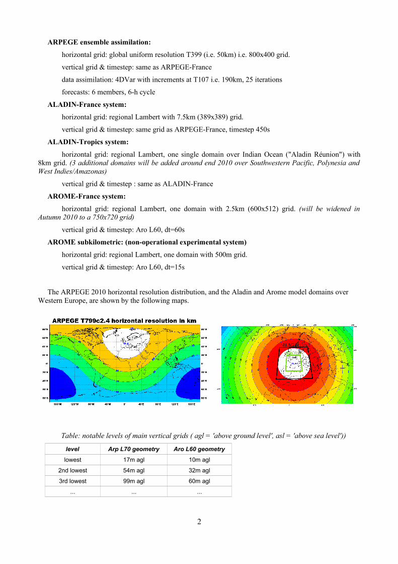
ARPEGE ensemble assimilation:
horizontal grid: global uniform resolution T399 (i.e. 50km) i.e. 800x400 grid.
vertical grid & timestep: same as ARPEGE-France
data assimilation: 4DVar with increments at T107 i.e. 190km, 25 iterations
forecasts: 6 members, 6-h cycle
ALADIN-France system:
horizontal grid: regional Lambert with 7.5km (389x389) grid.
vertical grid & timestep: same grid as ARPEGE-France, timestep 450s
ALADIN-Tropics system:
horizontal grid: regional Lambert, one single domain over Indian Ocean ("Aladin Réunion") with 8km grid. (3 additional domains will be added around end 2010 over Southwestern Pacific, Polynesia and West Indies/Amazonas)
vertical grid & timestep : same as ALADIN-France
AROME-France system:
horizontal grid: regional Lambert, one domain with 2.5km (600x512) grid. (will be widened in Autumn 2010 to a 750x720 grid)
vertical grid & timestep: Aro L60, dt=60s
AROME subkilometric: (non-operational experimental system)
horizontal grid: regional Lambert, one domain with 500m grid.
vertical grid & timestep: Aro L60, dt=15s
The ARPEGE 2010 horizontal resolution distribution, and the Aladin and Arome model domains over Western Europe, are shown by the following maps.
Table: notable levels of main vertical grids ( agl = 'above ground level', asl = 'above sea level'))
level Arp L70 geometry Aro L60 geometry
lowest 17m agl 10m agl
2nd lowest 54m agl 32m agl
3rd lowest 99m agl 60m agl
... ... ...
2

3rd highest 50Pa (52km asl) 1400Pa (29km asl)
2nd highest 30Pa (57km asl) 510Pa (36km asl)
highest 10Pa (65km asl) 60Pa (52km asl)
The implied tropospheric vertical resolutions over low terrain are represented in the following figures, at two different zoom levels. A comparison with the current ECMWF IFS resolution is included.
The following figures show the successive AROME model domains (the colours represent model orography) The lower resolution ALADIN-France domain is approximately twice as large. Left: Arome domain in 2009 and early 2010. Right: Arome domain planned for mid 2010.
References:
Bouttier, F. and collaborators, 2010 : the 2010 upgrades of the Météo-France NWP system. WMO CAS/JSC WGNE Blue Book, Edited by J. Côté.
1.b. Discretization & dynamics
The atmospheric models rely on a spectral discretisation in the horizontal, and a mass-based grid in the vertical, which is terrain-following near the surface and evolving to constant pressure at model top.
In the horizontal all model variables are held at the same points and the spectral technique is used to
3

compute exact derivatives. The global models use a triangular spectral truncation of spherical harmonics (i.e. Legendre functions times Fourier transforms), and a reduced Gaussian collocation grid. All models use a quasi-linear collocation, so that there is virtually no spectral aliasing. The ARPEGE model uses a stretched Schmidt conformal mapping with maximum resolution over France, minimum resolution in the South Pacific, and a smooth variable horizontal resolution inbetween. The ALADIN and AROME regional models use a Lambert conformal projection with a bi-Fourier spectral representation and elliptical truncation. Periodicity of the bi-Fourier representation on a two-dimensional torus is achieved via a numerical extension zone. All models except the stretched ARPEGE have quasi-uniform resolution over the whole extension domain. The spatial distribution of the ARPEGE resolution is shown in the following figure (the colours indicate the horizontal resolution of the collocation grid). Reference:
Courtier, P. and J.-F. Geleyn, 1988: A global numerical weather prediction model with variable resolution: application to the shallow-water equations. Quart. Jour. Roy. Meteor. Soc., 114, 1321-1346.
Yessad, K. and P. Bénard, 1996 : Introduction of a local mapping factor in the spectral part of the Meteo-France global variable mesh numerical weather forecast model. Quart. Jour. Roy. Meteor. Soc., 122, pp. 1701-1719.
In the vertical all model variables are held at the same levels except vertical velocity which is staggered. The geometry of the vertical discretisation is summarized below for the highest and lowest levels in a standard atmosphere (over orography the lower levels are stretched to remain at a quasi constant height above ground, the stretching reduces to nil above 100hPa where the levels are pure pressure-levels). These are 'full' model levels, i.e. the ones that hold the prognostic variables.
ARPEGE and ALADIN use the hydrostatic primitive equations form of the adiabatic equations, with a thin layer approximation of the atmosphere. The dynamical prognostic variables are surface pressure, temperature, concentration of water vapour, and horizontal wind. Other advected 3D fields include cloud and precipitating water species, which are only loosely coupled to the dynamics through changes in density and specific heat of the moist air particles. Turbulent kinetic energy is also a 3D advected variable. Advection is computed using a semi-Lagrangian scheme. Advection and physics tendencies are computed on a physical collocation grid: a Gaussian reduced grid of the Earth surface with variable-mesh Schmidt conformal mapping in ARPEGE, a regular x-y grid on a conformal Lambert projection in ALADIN and AROME. The remaining computations (horizontal derivatives, horizontal numerical diffusion, dry dynamical computations and timestepping) are performed in spectral space, which is defined on the model's horizontal surfaces: using spherical harmonics (i.e. Legendre polynomials) in ARPEGE, using 2D fast Fourier transforms in ALADIN and AROME. The 2D fast Fourier transforms involve a biperiodization of the horizontal fields in the x and y directions, the biperiodization is done using a thin numerical grid extension zone on the sides of the ALADIN and AROME domains. The biperiodization is only a numerical device to facilitate spectral computations, its impact on the physical gridpoint values is negligible.
The spectral timestepping uses a spectral semi-implicit solver of the linearized dynamical equations, whereby the fast waves are treated implicitly, so that the timestep of the model discretisation is limited by accuracy, rather than stability, constraints. Horizontal wind is represented by vorticy and divergence. In ARPEGE and ALADIN, the dynamical equations are the hydrostatic primitive equations (HPE) system on a mass-based vertical coordinate, vertical wind is diagnosed through mass conservation and hydrostatic balance constraints. In AROME, the dynamical equations are compressible non-hydrostatic equations on a hydrostatic pressure vertical coordinate, vertical wind is represented as a vertical divergence with suitable boundary conditions, the relative departure of pressure from hydrostatic pressure is a prognostic variable . Apart from the horizontal geometry and the presence of a lateral boundary condition (for coupling to a larger-scale model), the ARPEGE and ALADIN dynamical formulations are identical. They are themselves quasi identical to the IFS formulation of ECMWF, and strictly identical to the ARPEGE Climate model. With the exception of the non-hydrostatic parts of the dynamics, the AROME dynamical formulation is the same as IFS, ARPEGE, and ALADIN, and most of the software is identical. References:
P. Benard, J. Vivoda, J Masek. P. Smolikova, K. Yessad, C. Smith, R. Brozkova and J.-F. Geleyn., 2009: Dynamical kernel of the Aladin-NH spectral limited-area model: revised formulation and sensitivity experiments. Accepted for publication in Q. J. R. Meteorol. Soc. in Sept 2009.
Bubnová, R., G. Hello, P. Bénard and J.-F. Geleyn, 1995 : Integration of the fully elastic equations cast
4
in the hydrostatic pressure terrain-following coordinate in the framework of the ARPEGE/ALADIN NWP system, Mon. Wea. Rev., 123, 515-535.
1.c. ARPEGE/ALADIN physics
The ARPEGE, ALADIN and AROME physics are currently restricted to representing physical interactions inside each model column. Chemical and aerosol fields are prescribed i.e. they are not interactive, except in an experimental chemistry version of AROME.
The ARPEGE and ALADIN-France physics comprise the following parametrization schemes. A general review of recent changes is provided in:
Bouteloup, Y., E. Bazile, F. Bouyssel and P. Marquet, 2009: Evolution of the physical parametrisations of ARPEGE and ALADIN-MF. Aladin Newsletter 35, pp.48-58, available from http://www.cnrm.meteo.fr/ aladin/newsletters/newsletters.html
Lopez microphysics: a prognostic cloud condensation and precipitation scheme, that accounts for 3D advection of condensed water fields, ice phase, and cloud cover representation. The sedimentation (i.e. fallout of precipitation) part of the scheme uses an original statistical algorithm in order to save CPU without compromising physical accuracy. References:
Bouteloup, Y., F. Bouyssel and P. Marquet, 2006: Improvements of Lopez's prognostic large scale cloud and precipitation scheme. ALADIN newsletter 28, available from http://www.cnrm.meteo.fr/ aladin/newsletters/newsletters.html
Geleyn, J.-F., B. Catry, Y. Bouteloup and R. Brožková, 2008 : A statistical approach for sedimentation inside a micro-physical precipitation scheme, Tellus A, Volume 60 Issue 4, pp 649-662
Lopez, P., 2002: Implementation and validation of a new prognostic large-scale cloud and precipitation scheme for climate and data-assimilation purposes. Q. J. R. Meteorol. Soc., 128, 229-257.
Xu, K.M. and D. Randall, 1996: A semi-empirical cloudiness parameterisation for use in climate models. J. Atmos. Sci., 53, 3084-3102.
RRTM/FM radiation: an adaptation of an older version of the ECMWF IFS radiation scheme, with two-stream representation of radiative transfer in several IR, and six visible bands, and cloud/radiation interaction. The computation of transmissivities is updated every 3 hours. Monthly climatologies are used for ozone (function of latitude and pressure) and aerosols. References:
Fortuin, J.P.F. and Langematz, U. (1994): An update on the global ozone climatology and on concurrent ozone and temperature trends. Proceedings SPIE. Atmos. Sensing and Modeling, 2311, 207-216.
Mlawer, E. J., Taubman, S. J., Brown, P. D., Iacono, M. J. and Clough, S. A. (1997). Radiative transfer for inhomogeneous atmospheres: RRTM, a validated correlated-k model for the longwave. J. Geophys. Res., 102D, 16663–16682.
Morcrette, J.-J. (1991). Radiation and cloud radiative properties in the ECMWF operational weather forecast model. J. Geophys. Res., 96D, 9121–9132.
Geleyn/Bougeault ACCVIMP convection: a parametrisation of the effects of subgrid, deep precipitating convective clouds, based on a idealised representation of updraughts and downdraughts inside each model column, simple microphysics, closure hypotheses and cloud cover assumptions. Reference:
Bougeault, P., 1985: A simple parameterization of the large-scale effects of cumulus convection. Mon. Wea. rev., 113, 2108-2121.
CBR/KFB turbulence: Vertical mixing scheme based on a prognostic turbulence scheme derived from the Cuxart-Bougeault-Redelsperger proposal, with the Bougeault-Lacarrère mixing length formulation (modified in order to account for shallow and deep convection turbulence effects). It is coupled to a Kain-Fristch-Bechtold non-precipitating shallow convection scheme that accounts for moist mixing by subgrid clouds such as cumuli and stratocumuli (top PBL entrainment scheme); subgrid shallow convection is a source of turbulence. Specific subgrid orographic drag scheme, using envelope orography. References:
5

Bougeault, P. and P. Lacarrère, 1989 : Parameterization of orography-induced turbulence in a meso-beta scale model, Mon. Wea. Rev.,117,1870-1888.
Cuxart, J., Ph. Bougeault, and J.L. Redelsperger, 2000: A turbulence scheme allowing for mesoscale and large eddy simulations. Q. J. R. Meteorol. Soc., 126, 1-30.
Bechtold, P., E. Bazile, F. Guichard, P. Mascart and E. Richard, 2001 : A mass flux convection scheme for regional and global models. Quart. Jour. Roy. Meteor. Soc., 127, pp. 869-886.
Grenier, H. and C. S. Bretherton, 2001: A moist PBL parameterization for large-scale models and its application to subtropical cloud-topped marine boundary layers. Mon. Wea. Rev., 129, 357-377.
Catry, B., J.-F. Geleyn, F. Bouyssel, J. Cedilnik, R. Brožková, M. Derkova and R. Mladek, 2008: A new sub-grid scale lift formulation in a mountain drag parameterisation scheme , Meteorologische Zeitschrift, Vol 17, N.2, pp. 193-208(16)
Empirical wind drag scheme and sponge near the model top.
Prognostic land surface scheme derived from ISBA on land surfaces (i.e. bare soil + vegetation fraction), and a prescribed SST/ice field with Charnock parametrisation of mixing coefficients over sea, plus a simple snow-on-ground scheme. Prognostic surface fields include: soil liquid water and ice content on two levels, snow depth and albedo. The vertical mixing is implicitly coupled with the surface flux computation inside each timestep. The fluxes over sea are computed using the ECUME empirical formulae. References:
Belamari S., Caniaux G., and Tcham M., 2005: Optimisation of the one year POMME experiment bulk fluxes data set using a one dimensional approach together with genetic algorithms (poster). EGU Meeting, Vienne, 25-29 April, 2005.
Giard, D., and E. Bazile, 2000: Implementation of a new assimilation scheme for soil and surface variables in a global NWP model. Mon. Wea. Rev., 128, 997-1015.
Noilhan, J. and S. Planton, 1989 : A simple parameterization of land surface processes for meteorological models, Mon. Wea. Rev., 117, 536-549
Noilhan, J. and J.-F. Mahfouf, 1996: The ISBA land surface parameterization scheme. Global and Plan. Change, 13, 145-159.
Surface physiographies are prescribed using global databases (GTOPT030 and Henderson-Sellers). Soil moisture and temperature are assimilated using a 6-hourly optimal interpolation to compensate for errors in observed SYNOP 2m temperature and humidities. Ice caps and SST are reinterpolated from NESDIS (SSMI-based) gridded products.
1.d. AROME physics
The AROME physics are almost entirely distinct from the ARPEGE/ALADIN parametrizations, and strictly identical to the corresponding schemes in the Méso-NH model. A general documentation of the AROME system is provided in http://www.cnrm.meteo.fr/arome/
ICE3 cloud microphysics and precipitation scheme with 6 prognostic 3D fields (cloud water and ice, precipitating rain, snow and graupel, cloud fraction), using a conservative instantaneous adjustment scheme, and a statistical scheme to compute the sedimentation. References:
Geleyn, J.-F., B. Catry, Y. Bouteloup and R. Brožková, 2008 : A statistical approach for sedimentation inside a micro-physical precipitation scheme, Tellus A, Volume 60 Issue 4, pp 649-662
Pinty, J.P. & P. Jabouille, 1998 : A mixed-phased cloud parameterization for use in a mesoscale non-hydrostatic model: simulations of a squall line and of orographic precipitation. Preprints of Conf. On Cloud Physics, Everett, WA, Amer. Meteor. Soc., 217-220.
Vertical mixing scheme based on a prognostic turbulence scheme derived from the Cuxart-Bougeault-Redelsperger proposal, with the Bougeault-Lacarrère mixing length formulation. "EDKF" shallow subgrid (i.e. cumulus) convection scheme using an adaptation of the Kain-Fritsch scheme with a mass-flux closure approach.
6

Cuxart, J., Ph. Bougeault, and J.L. Redelsperger, 2000: A turbulence scheme allowing for mesoscale and large eddy simulations. Q. J. R. Meteorol. Soc., 126, 1-30.
RRTM/FM radiation scheme: the same as in ARPEGE/ALADIN-France, the transmissivities are updated every hour. References:
Mlawer, E. J., Taubman, S. J., Brown, P. D., Iacono, M. J. and Clough, S. A. (1997). Radiative transfer for inhomogeneous atmospheres: RRTM, a validated correlated-k model for the longwave. J. Geophys. Res., 102D, 16663–16682.
Morcrette, J.-J. (1991). Radiation and cloud radiative properties in the ECMWF operational weather forecast model. J. Geophys. Res., 96D, 9121–9132.
SURFEX surface scheme with a tiling approach and explicit coupling with the vertical diffusion. Four tiles are allowed in each model gridbox: nature, town, sea, lake. Sea/Lakes may be frozen, Nature/Town may be covered with snow (prognostic multilayer snow scheme). The nature tile may be an aggregation of several nature types and is based on the ISBA formulation (bare soil + vegetation fractions, several ground layers). The town tile is based on the TEB (Town Energy Budget) scheme. The sea tile is a simple prescribed SST, which is currently being upgraded to a 1D prognostic model of the ocean mixing layer. The lake tile is being upgraded to the FLAKE prognostic scheme. The low-level diagnostics and flux computation over land are calculated using a high-vertical-resolution, subgrid 1D column model on each model grid box ('Canopy' model). The fluxes over sea are computed using the Ecume empirical formulae. References:
Masson, V., 2000 : A physically-based scheme for the urban energy budget in atmospheric models. Bound. Layer Meteor, 1994, 357-397.
Masson, V. and Y. Seity : Including atmospheric layers in vegetation and urban surface schemes, submitted in 2007 to Journal of Applied Meteorology and Climatology.
Noilhan, J. and S. Planton, 1989 : A simple parameterization of land surface processes for meteorological models, Mon. Wea. Rev., 117, 536-549
Noilhan, J. and J.-F. Mahfouf, 1996: The ISBA land surface parameterization scheme. Global and Plan. Change, 13, 145-159.
ECOCLIMAP surface physiographies: prescribed using a global 1km database, with a 250m refinements over Europe with the CORINE database. Prognostic surface characteristics from Eumetsat's Land SAF are being implemented, as well as a variational assimilation of soil moisture and temperature. Reference:
Champeaux, J.L., V. Masson and R. Chauvin, 2005 : Ecoclimap : A global database of land surface parameters at 1 km resolution. Meteorological Applications, 12 (1), p 29-32.
RACM/ORILAM interactive chemistry and dust/aerosol features are available for testing in AROME, but are not active by default in NWP applications.
1.e. Data Assimilation
The ARPEGE, ALADIN and AROME data assimilation software are very similar, and they are derived from the formulation of ECMWF's IFS 4D-Var.
The ARPEGE data assimilation algorithm is a sequential, 6-hourly incremental 4D-Var technique whereby uniform-resolution global corrections of wind, temperature, humidity and surface pressure are analysed using background fields (provided by the previous variable-resolution ARPEGE forecast), observations (listed below), and a digital filter weak variational constraint to control spurious fast tendencies. Each ARPEGE 4D-Var analysis run comprises two inner-loop incremental minimizations, the final one is at T224 resolution (with the same vertical grid as the forecast model); these minimizations deliver a uniform-resolution T224 increment that is added to the higher-resolution stretched ARPEGE background in order to produce a high-resolution stretched analysis. References:
Courtier, P., E. Andersson, W. Heckley, J. Pailleux, D. Vasiljevic, M. Hamrud, A. Hollingsworth, F. Rabier and M. Fischer, 1998 : The ECMWF implementation of three-dimensional variational assimilation
7

(3D-Var). I : formulation. Quart. Jour. Roy. Meteor. Soc., 124, pp. 1783-1808.
Courtier P., J-N. Thépaut and A. Hollingsworth, 1994 : A stategy for operational implementation of 4 D-VAR using an incremental approach. Quart. Jour. Roy. Meteor. Soc. 120, 1367-1387.
Derber J. and F. Bouttier : A reformulation of the background error covariance in the RCMWF global data assimilation system. Tellus, 40A, 1-25. .
Gauthier, P. and J.N. Thépaut, 2001 : Impact of the digital filter as a weak constraint in the pre-operational 4D-Var assimilation system of Météo-France. Mon. Wea. Rev., 129, pp. 2089-2102.
Mahfouf, J.F. and F. Rabier, 2000 : The ECMWF operational implementation of four dimensional variational assimilation. Part. II : experimental results with improved physics. Quart. Jour. Roy. Meteor. Soc., 126, pp. 1171-1190.
Rabier F., C. Faccani, N. Fourrié, F. Karbou, P. Moll, J-F. Lafore, M. Nuret, F. Hdidou & O. Bock : The impact of the AMMA radiosonde data on the French global assimilation and forecast system, Weather and Forecasting, submitted in 2008.
The ARPEGE inner loops use the dynamics of the dry linearized ARPEGE model (in the vicinity of the background forecast), with a minimal set of physics (vertical diffusion, mostly).
The ARPEGE data assimilation uses the following data sources, which are all subjected to various quality control checks (selection of stations, levels and channels; flow-dependent background departure check; redundancy check; horizontal and vertical thinning of data denser than the model grid; variational buddy-check quality control; etc.) and variational bias correction:
● land surface stations: Synop, Metar, French automatic Radome stations. The parametre selection is detailed in a table below.
● surface sea stations: drifting and moored buoys, Ship reports. Surface pressure and wind are used.
● aircraft data: Airep, Amdar and Acars reports i.e. cruise level and ascent/descent mesaurements of temperature and wind.
● in-situ sounding data: Temp and Pilot ballon reports, dropsondes. Temperature, wind and humidity are used.
● European wind profiler radar data.
● GPS data: land-based zenith total delays are used, which mainly affect tropospheric humidity, and space-based descending radio occultations from the COSMIC, CHAMP, GRACE, Metop/GRAS (when available) instruments.
● geostationary satellite data: atmospheric motion wind vectors derived from the Meteosat, GOES, and MTSAT satellites. Clear-Sky radiances from Meteosat.
● polar-orbiting infrared data: cloud-free HIRS (NOAA series satellites), IASI (Metop satellite) and AIRS (Aqua satellite) radiometre channels, sensitive to temperature and humidity. Some cloud-affected channels are also used.
● polar-orbiting microwave data: cloud-free AMSU (NOAA series satellites) , MHS (MetOp satellite), SSMI (DMSP series satellites) radiometre channels, sensitive to temperature and humidity. Some channels sensitive to low levels are used thanks to a parametrization of land surface microwave emissivitiy.
● polar-orbiting scatterometre data: ambiguous sea-surface wind retrievals from the Quikscat satellite, Metop/ASCAT and ERS2/AMI.
With a few exceptions, observed data is taken from WMO's Global Telecommunications System in BUFR format. Fixed stations are used at up to hourly frequency. References:
Auligné, T., 2007 : An objective approach to modelling biases in satellite radiances : application to AIRS
8

and AMSU-A. Q. J. R. Meteorol. Soc. 133 p. 1789–1801 (2007)
Chapnik, B., G. Desroziers, F. Rabier and O. Talagrand, 2006 : Diagnosis and tuning of observational error in a quasi-operational data assimilation setting. Quart. Jour. Roy. Meteor. Soc., 132, pp.543-565.
Karbou, F., E. Gérard, and F. Rabier, 2006 : Microwave Land Emissivity and Skin Temperature For AMSU-A & -B Assimilation Over Land. Quart. Jour. Roy. Meteor. Soc., 132, pp.2333-2355.
Karbou F., E. Gérard, F. Rabier : Global 4D-Var assimilation and forecast experiments using land surface emissivities from AMSU-A & AMSU-B observations. PartI : Impact on sounding channels. Weather and Forecasting, submitted in 2009
Poli, P., P. Moll, D. Puech, F. Rabier, and S. B. Healy, 2007 : Quality control, error analysis, and impact assessment of FORMOSAT-3/COSMIC in numerical weather prediction. Terrestrial, Atmospheric and Oceanic Sciences
Poli P., S.B. Healy, F. Rabier, and J. Pailleux : Preliminary Assessment of the Scalability of GPS Radio Occultations Impact in Numerical Weather Prediction. Geophysical Research Letters, in press.
Rabier F., P. Poli, V. Guidard, N. Fourrié, E. Gérard, F. Karbou, P. Moll and C. Payan : Current developments on global satellite data assimilation at Météo-France. WMO CAS/JSC WGNE Blue Book, 2008. Edited by J. Côté
The ALADIN 3D-Var data assimilation is identical to ARPEGE, except for the limited area geometry, the use of 6-hourly 3D-Var instead of 4D-Var, the use of land surface stations (see the table below), and the use of Meteosat cloud-free radiances and GPS ground station delays, mainly sensitive to tropospheric humidity. References:
Berre, L., 2000 : Estimation of synoptic and mesoscale forecast error covariances in a limited area model. Mon. Wea. Rev., 128, pp. 644-667.
Fischer C., T. Montmerle, L. Berre, L. Auger and S.E. Stefanescu, 2006 : An overview of the variational assimilation in the ALADIN/FRANCE NWP system. Quart. Jour. Roy. Meteor. Soc.,613, pp. 3477-3492.
Guidard V., C. Fischer, M. Nuret and A. Dziedzic, 2006 : Evaluation of the ALADIN 3D-Var with observations of the MAP campaign. Meteorol. Atmos. Phys., 92, pp.161-173.
Montmerle, T., F. Rabier and C. Fischer, 2006 : Respective impact of polar orbiting and geostationary satellite observations in the Aladin/France NWP system. Quart. Jour. Roy. Meteor. Soc., 133, pp 655-671.
Yan X., V. Ducrocq, P. Poli, G. Jaubert, A. Walpersdorf, 2008 : Mesoscale GPS Zenith Delay assimilation during a Mediterranean heavy precipitation event, Advances in Geosciences, 17, 71-77.
The AROME 3D-Var data assimilation is identical to the ALADIN 3D-Var, except for the use of much sharper structure functions, a shorter 3-hourly assimilation cycle, and the use of French radar Doppler wind components (assimilation of humidity retrievals from 3D radar reflectivities is planned). A general documentation of the AROME system is provided in http://www.cnrm.meteo.fr/arome/
References:
Brousseau, P. and Y. Seity, 2006 : A first prototype for the AROME data assimilation scheme, in Aladin newsletter N30. http://www.cnrm.meteo.fr/aladin/newsletters/newsletters.html
Ducrocq, V., D. Ricard, J.P. Lafore and F. Orain, 2002 : Storm-scale numericalrainfall prediction for five precipirating events over France: On the importance of the initial humidity field, Weather and Forecasting, 17, 1236-1256
Montmerle, T. and C. Faccani, 2009 : Mesoscale assimilation of radial velocities from Doppler radar in a pre-operational framework. Mon. Wea. Rev., in press.
Wattrelot E., O. Caumont, S. Pradier-Vabre, M. Jurasek and G. Haase, 2008: 1D+3DVar assimilation of
9
radar reflectivities in the pre-operational AROME model at Météo-France. ERAD 2008 - 5th European Conference on Radar in Meteorology and Hydrology
The background error covariance model in ARPEGE 4D-Var, ALADIN & AROME 3D-Var is based on the spectral vorticity-based multivariate formulation of Derber and Bouttier, with time-independent correlations derived from offline ensembles of the same models, and time-dependent variances derived from the ARPEGE ensemble of assimilations.
Low-level in situ observation usage: all models use soil temperature & moisture inferred through linear regression from T2m, HU2m reports. In the atmospheric analysis, frequently reporting stations are used every 1h, 6h and 3h in ARPEGE, ALADIN and AROME, respectively. When used, T2m is corrected for orography mismatch using a climatological lapse rate, or rejected if the mismatch is greater than 200m. The static data selection is as follows; it is combined with a monthly station-dependent selection list, and real-time quality checks:
ARPEGE ALADIN AROME
pressure used used used
V10m over sea only used used
T2m not used daytime only daytime only
HU2m not used daytime only daytime only
1.f. Ensemble forecasting & ensemble assimilation
The Météo-France ensemble forecasting system (PEARP) is entirely based on ARPEGE, with nearly the same model configuration as the ARPEGE-France deterministic data assimilation and forecast suite. The main difference is the ARPEGE model resolution (PEARP uses T358C2.4L55, i.e. slightly coarser resolution than the deterministic run). One unperturbed plus ten perturbed ARPEGE forecasts run every day at 108h range, which make up an 11-member ensemble with the unperturbed, deterministic ARPEGE 18UTC run. The ensemble perturbations are created as follows:
● the initial perturbations of the ensemble are a combination of singular vectors and evolved perturbations of the previous PEARP run (10 perturbations from 24h earlier)
● a flow-dependent background error estimate is used in the computation of singular vectors
● the singular vectors are a combination of targeted singular vectors over Europe-NorthAtlantic (16 vectors at resolution T95L55), the Northern, Southern Hemispheres and the Tropics (10,20 and 10 vectors, respectively, at T44L55 resolution).
The singular vectors are computed using a Lanczos algorithm on a dry linearized version of ARPEGE, in the vicinity of a 36-h ARPEGE forecast. PEARP can be regarded as both a global ensemble system, and a regional one optimised for Western Europe, with a resolution similar to foreign limited-area ensembles. Reference:
Molteni, F. R. Buizza, T. Palmer and T. Petroliagis, 1996: the ECMWF ensemble prediction system: methodology and validation. Q. J. R. Meteorol. Soc., 122, 73-119.
An assimilation ensemble system (not yet coupled with the PEARP system) runs in real time since early 2008. It contains 6 instances of the ARPEGE assimilation perturbed by adding random noise to observations, with a few differences from the main, unperturbed ARPEGE system: cheaper algorithm (3DVar-FGAT instead of 4DVar), lower, uniform horizontal resolution (T359c1 instead of T538c2.4). As of mid-2008, only the background vorticity variances predicted by this ensemble are used. They are fed into the 4DVar background error model, which gives flow-dependent weight to observations, and into the initial perturbation generation for the PEARP ensemble forecasting system. Reference:
Belo Pereira, M. and L. Berre, 2006 : The use of an ensemble approach to study the background error covariance in a global NWP model. Mon.Wea.Rev., 134, pp.2466-2489.
Berre, L., 2000 : Estimation of synoptic and mesoscale forecast error covariances in a limited area
10
model. Mon. Wea. Rev., 128, pp. 644-667.
Raynaud L., L. Berre et G. Desroziers, 2008 : Spatial averaging of ensemble-based background error variances. Q. J. R. Meteorol. Soc., 134, 1003-1014.
Pannekoucke O., L. Berre and G. Desroziers, 2008 : Background error correlation length-scale estimates and their sampling statistics. Quart. Jour. Roy. Meteor. Soc. 134 : 497-508
2. Operational systemThe NWP system is organized around the production of analyses at 00, 06, 12 and 18UTC, and the
ensuing forecasts; the tasks are run nearly identically every 6 hours.
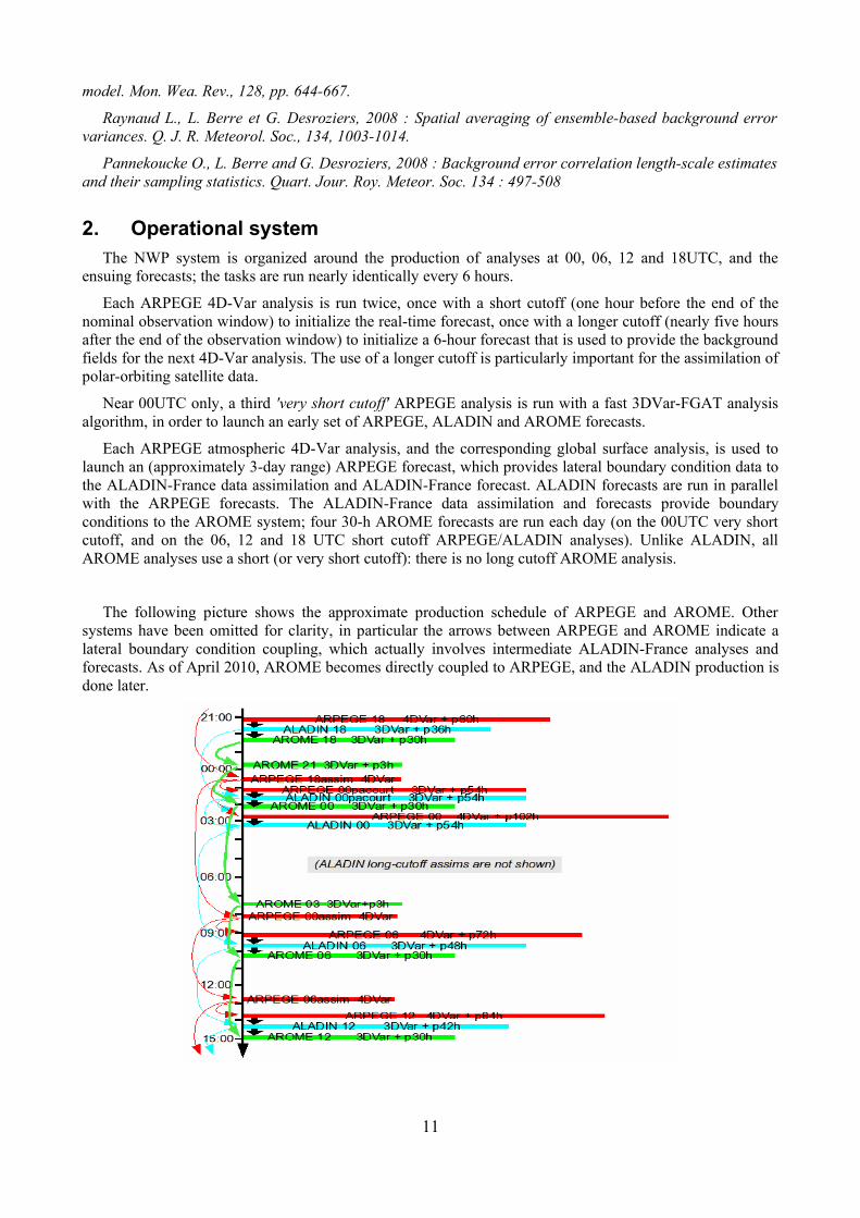
Each ARPEGE 4D-Var analysis is run twice, once with a short cutoff (one hour before the end of the nominal observation window) to initialize the real-time forecast, once with a longer cutoff (nearly five hours after the end of the observation window) to initialize a 6-hour forecast that is used to provide the background fields for the next 4D-Var analysis. The use of a longer cutoff is particularly important for the assimilation of polar-orbiting satellite data.
Near 00UTC only, a third 'very short cutoff' ARPEGE analysis is run with a fast 3DVar-FGAT analysis algorithm, in order to launch an early set of ARPEGE, ALADIN and AROME forecasts.
Each ARPEGE atmospheric 4D-Var analysis, and the corresponding global surface analysis, is used to launch an (approximately 3-day range) ARPEGE forecast, which provides lateral boundary condition data to the ALADIN-France data assimilation and ALADIN-France forecast. ALADIN forecasts are run in parallel with the ARPEGE forecasts. The ALADIN-France data assimilation and forecasts provide boundary conditions to the AROME system; four 30-h AROME forecasts are run each day (on the 00UTC very short cutoff, and on the 06, 12 and 18 UTC short cutoff ARPEGE/ALADIN analyses). Unlike ALADIN, all AROME analyses use a short (or very short cutoff): there is no long cutoff AROME analysis.
The following picture shows the approximate production schedule of ARPEGE and AROME. Other systems have been omitted for clarity, in particular the arrows between ARPEGE and AROME indicate a lateral boundary condition coupling, which actually involves intermediate ALADIN-France analyses and forecasts. As of April 2010, AROME becomes directly coupled to ARPEGE, and the ALADIN production is done later.
11

The PEARP ARPEGE ensemble prediction system is run twice a day, shortly after the 06UTC and 18UTC deterministic forecasts. Since October 2007, PEARP is sent to the ECMWF TIGGE database at 1.5 degree global resolution.
A uniform-resolution ARPEGE model called "ARPEGE Tropics", is run twice a day in support of tropical hurricane forecast offices. The forecasts are initialised from the ARPEGE-France analysis, and are issued twice a day, for the 00 and 12UTC analyses, shortly after the ARPEGE-France and ALADIN forecasts. The ARPEGE-Tropics system is being phased out.
A specific ALADIN 3DVar data assimilation and forecasting suite is also run on the Southwest Indian Ocean, it is called "ALADIN Réunion", with 8km horizontal resolution. The corresponding domain is depicted in the following picture. The ALADIN Réunion assimilation uses cyclone pseudo-observations (as wind pseudo-reports). Reference:
Montroty, R., F. Rabier, S. Westrelin, G. Faure and N. Viltard, 2008 : Impact of wind bogus and cloud and rain affected SSM/I data on tropical cyclones analyses and forecasts. Quart. Jour. Roy. Meteor. Soc. 134.1673-1699
In 2010/2011, Aladin-Réunion will be complemented by 3 similar applications using 3D-Var data assimilation on other French oversea territories,:
● West Indies/Guyana
● Polynesia
● New Caledonia
3. Recent and planned changes to production NWP systemOlder changes:
Feb 2007, cy31T1 upgrade: improvement of soil freezing in analysis, and other technical changes. Implementation of ALADIN 3DVar assimilation over the SW Indian Ocean.
May 2007, cy31T1 upgrade: Switchover of the whole production to the new NEC SX8 supercomputer platform, with no meteorological impact.
3.a. Aug 2007, cy32T0 upgrade
assimilation of GPS radio-occultation (COSMIC, CHAMP, GRACE), assimilation of MetOp satellite data (AMSU-A, MHS, monitoring of ASCAT, HIRS), assimilation of ERS2 AMI scatterometre, increase of GPS ZTD use
change in IR radiance cloud detection; withdrawal of some AMSU-A NOAA16 channels
use 1/12degree NESDIS product in SST analysis
correction of evaporation of precipitation (reduces spurious low-level divergence)
12

in ALADIN-France only: assimilation of 10m wind observations
in ALADIN-Reunion only: multivariate background balance constraint in background error covariance model (non-linear with omega equation)
The impact is a general, significant improvement of most forecast scores on all domains, particularly in the lower stratosphere and the Southern Hemisphere. The impact is small over North America and Europe. In ALADIN, the short-range low-level wind forecasts are improved.
3.b. Feb 2008, cy32T2 upgrade
increase of horizontal and vertical resolutions in ARPEGE/ALADIN: the vertical resolution in both models is increased from 46 to 60 levels, with the extra resolution concentrated near the tropopause; the ARPEGE model resolution is increased from T358 to T538 ; the ARPEGE 4DVar horizontal resolution of increments is increased from T159 to T224.
vertical discretisation based on vertical finite elements
variational bias correction scheme for satellite radiances
assimilation of Metop ASCAT, revision of the bias correction for Quikscat and ERS2 data, monitoring of IASI
new (pdf-based) precipitation sedimentation algorithm
ALADIN-specific modifications: AIRS radiances, incremental digital filter initialisation, reduction of obs weight in 3DVar
PEARP: increase in vertical resolution, use evolved perturbations from previous run, flow-dependent background error in singular vector computation, add targeted singular vectors over Northern, Southern Hemispheres and Tropics, which enforces an acceptable dispersion over the whole globe. Dissemination to TIGGE.
Tropical system: global ARPEGE-Tropics model (at uniform resolution) is now initialised from the ARPEGE-France analysis, there is no longer an ARPEGE-Tropics 4DVar assimilation. Extension of the ALADIN-Réunion model domain, which is coupled to ARPEGE-France instead of ARPEGE-Tropics.
3.c. June 2008 cy33T0 upgrade of ARPEGE/ALADIN
assimilation of more satellites radiances: Metop/IASI (50 channels) and Metop/HIRS radiances; more Aqua/AIRS channels in the troposphere; DMSP-F14/SSMI microwaves; Meteosat-9/SEVIRI clear-sky water vapour radiances in ARPEGE (SEVIRI raw radiances are already used in ALADIN);
assimilation of surface-sensitive microwave channels over land using a new representation of land surface emissivities (for AMSU-A, AMSU-B, MHS from NOAA and Metop satellites)
assimilation of more tropospheric GPS radio-occultations and more aircraft reports
4D-Var background error variances are flow-dependent and derived from the ensemble data assimilation system (6 ARPEGE 3DVar-FGAT assimilations at T358L60c1 resolution with perturbed observations)
blacklist night time T2m and HU2m observations
physics: improve the low-level vertical diffusion in stable conditions, the subgrid orographic drag parametrisation, and snowmelt in the precipitation scheme.
ALADIN only: timestep changed to 450s, postprocessing change over lakes, variational bias correction for Meteosat/SEVIRI radiances.
ARPEGE Tropics only: upgrade resolution to T539L55 i.e. 37km uniform horizontal resolution, and retire ARPEGE-Tropics assimilation (forecasts are now initialized from the variable resolution ARPEGE 4DVar assimilation)
13

3.d. Dec 2008 operational implementation of AROME
The initial version of the AROME system (2.5km model over France with 3D-Var data assimilation) has been declared operational on 18 Dec 2008.
3.e. Feb 2009 cy33T1 upgrade of ARPEGE/ALADIN
new vertical diffusion / boundary layer scheme in ARPEGE/ALADIN: CBR prognostic 1D turbulent kinetic energy coupled with Kain-Fritsch-Bechtold (KFB) shallow convection scheme (through a dedicated thermal production term, and convection-sensitive turbulent length scale
damping of deep convection scheme in order to avoid double-counting with KFB scheme
radiation parametrisation: increase number of solar spectral bands from 2 to 6; use new ozone climatology following Fortuin and Langematz(1994)
new 'ECUME' sea surface flux parametrisation in ARPEGE/ALADIN
retuning of numerical horizontal diffusion
assimilate more IASI channels, particularly over land and sea ice
debiasing of scatterometre winds
assimilate cloudy AIRS radiances using CO2-slicing technique to derive cloud parameters
assimilate EARS Modis wind data
implementation of own surface assimilation (SST/ice and soil variables) in ALADIN
the PEARP ensemble prediction scheme, the ensemble data assimilation, and all French ALADIN models inherit from the above changes.
3.f. Apr 2010 cy35t2 upgrade of ARPEGE/ALADIN/AROME
The whole NWP suite has been migrated to a new supercomputer platform (NEC SX9) and a new production/database management software in summer 2009.
The AROME-2.5km regional prediction system over mainland France has been modified as follows:
increase of the number of vertical levels from 41 to 60 levels, the corresponding enhancement of vertical resolution is mainly located in the lower troposphere
activation of an absorbing upper boundary condition with relaxation of the large-scales to the NWP boundary condition model
change of the boundary condition model from the regional ALADIN-France to the global ARPEGE system, with hourly updated lateral and upper boundary conditions
update of the background error covariance model used by the AROME 3DVar data assimilation, use of flow-dependent background error variances provided by the ARPEGE ensemble assimilation system
assimilation of AIRS, IASI and SSM/I radiances; implementation of a variational bias correction scheme for the assimilation of SEVIRI radiances; radiances are used with an increased density
assimilation of radar reflectivities through Bayesian retrievals of vertical humidity profiles
upgrades to the EDKF shallow convection scheme, implementation of fog sedimentation, improvement of the gust diagnostic computation.
The ARPEGE global prediction system has been modified as follows:
increase of the model horizontal resolution from T538 to T798 stretched spectral truncation i.e. from 15 to 10.5km resolution over Western Europe (and to 60km over the South Pacific), timestep 900s
14

increase of the model vertical resolution from 60 to 70 levels, most of the enhancement is located in the lower troposphere
increase of the 4DVar assimilation increment resolution from T224 to T323 i.e. from 90 to 60km
increase of the density of assimilated satellite radiances to 125km, activation of extra radiance data in the 4DVar data assimilation: AMSU-B channel 5 over land (see contribution by F. Karbou et al elsewhere in this volume), IASI water vapour channels, and the NOAA19 satellite. Assimilation of MODIS clear-sky water vapour winds
increased dependency of the ARPEGE 4DVar assimilation on the ensemble assimilation system, which provides flow-dependent background error variances for all mass and wind control variables.
improvement of the turbulent kinetic energy scheme and of the 4DVar simplified physics, improvement of the gust diagnostic computation.
The ALADIN regional systems have inherited from the ARPEGE modifications, the ALADIN horizontal resolution is now 7.5km over France and 8km over the SW Indian Ocean. The ARPEGE ensemble prediction system (PEARP) has been upgraded in December 2009:
increase of the number of members from 11 to 35
increase of the vertical resolution from 55 to 65 levels
initial perturbations are derived from the ARPEGE ensemble assimilation, on top of the previously used singular vectors.
model error is represented in the forecasts using varying physical parametrization setups.
more frequent ensemble forecasts (from the 06 and 18UTC analyses; previously, PEARP was only run from the 18UTC analysis)
The ARPEGE ensemble assimilation system, which now runs 6 members at T399 uniform resolution (i.e. 50km) has been upgraded to use 4DVar (3DVar was previously used) with 190-km increments. (described elsewhere in this volume)
The combined impact of the above changes is beneficial in terms of most forecast scores at large and regional scale. They have received favourable subjective evaluations both in routine forecasts and in severe weather events such as the Xynthia storm that hit Southwestern Europe on 27/28 February 2010. The corresponding software developments have been included into the IFS/ARPEGE software that is used by ECMWF and the ALADIN and HIRLAM consortia.
3.g. Future planned changes
● upgrade of ARPEGE '3MT' subgrid deep convection scheme. References:
Gérard, L., 2007: An integrated package for subgrid convection, clouds and precipitation compatible with the meso-gamma scales , Q.J.R.Meteorol.Soc., Volume 133, Issue 624, pp 711-730
Piriou, J-M, J.-L. Redelsperger, J.-F. Geleyn, J.-P. Lafore and F. Guichard : An approach for convective parameterization with memory, in separating microphysics and transport in grid-scale equations. J. Atmos. Sci., 64, n.11, p. 4127-4139.
● new SURFEX data assimilation, use OSTIA data for the SST analysis
● assimilate GPS radio-occultations from MetOp/GRAS
● enhanced resolution for the PEARP ensemble system
● extended domain for the AROME system
In the AROME system:
15

● assimilate cloudy IR radiances. Reference: Dahoui, M., L. Lavanant, F. Rabier and T. Auligné, 2005 : Use of MODIS imager to help dealing with AIRS cloudy radiances. Quart. Jour. Roy. Meteor. Soc., 131, pp. 2559-2579.
● improvements to AROME cloud and precipitation physics
● variational coupling to the large-scale data assimilation. Reference: Guidard V. and C. Fischer, 2008 : Introduction of a constraint to the larger scales of a global analysis in a LAM data assimilation system, submitted to Quart. Jour. Roy. Meteor. Soc..
4. Verification proceduresARPEGE forecast errors are assessed with respect to ARPEGE analyses, ECMWF analyses, TEMP and
SYNOP observations. They are compared with other models using standardized WMO scores.
ALADIN forecast errors are assessed with respect to ALADIN analyses, TEMP and SYNOP observations. AROME forecast errors are assessed with respect to TEMP and Radome observations, plus Quantitative Precipitation Forecasts with respect to 24-h daily accumulations, and comparison between satellite images and RTTOV-simulated radiances. Real-time intercomparisons with other models are limited (e.g. HIRLAM mast measurements, MAP D-PHASE FDP field experiment).
5. CooperationsThe R&D in numerical weather prediction (NWP) is carried out in connection with many cooperation
networks. The most active ones lately have been:
the IFS/ARPEGE software cooperation with ECMWF, see http://www.ecmwf.int/
the ALADIN consortium with several services of Europe and North Africa, see http:// www.cnrm.meteo.fr/aladin/
the HIRLAM consortium with several other European meteorological services see http://hirlam.org/
the Méso-NH mesoscale modelling group, see http://mesonh.aero.obs-mip.fr/mesonh/
the SRNWP European coordination body (funded by EUMETNET), see http://srnwp.cscs.ch/ and http://www.eumetnet.eu.org/
------------
16
Recommended