Spatial Data Infrastructures in Germany: State of play 2007
Country repor t on SDI e laborated in the context of a s tudy commiss ioned by the EC (EUROSTAT) in the f ramework of the INSPIRE in i t ia t ive
(Under Framework Contract REGIO/G4-2002-02-Lot 2) February 2008
SPATIAL APPLICATIONS DIVISION K.U.LEUVEN RESEARCH & DEVELOPMENT Celestijnenlaan 200 E, BE-3001 LEUVEN TEL.: 32 16 32 97 32 FAX: 32 16 32 97 24 URL: http://www.sadl.kuleuven.be
Report meta-information
Title Spatial Data Infrastructures in Germany: State of Play 2007
Creator Marco Fritz (SADL) & Peter Beusen(ICRI)
Date Issued 2002-11-05
Subject INSPIRE State of Play
Publisher K. U. Leuven (SADL + ICRI) + Margaret Hall consultant (HALL)
Description The report describes the status of the SDI in Germany with regard to the 5 components as described in the GSDI Cookbook and adding the environmental component to it
Contributor Dietmar Grünreich (BKG), Markus Meinert (BMI), Jens Riecken (NRW), Michael Bilo (BfN), Fred Kruse (PortalU), Hartmut Streuff (BMU), Jürgen Walther (BKG), Sabine Afflerbach (BKG), Martin Lenk (BKG)
Format MS Word 97/2000
Audience INSPIRE stakeholders
Identifier rcr07DEv111
Language EN
Coverage Snapshot at 2006-12-31
Version number
Date Modified by Comments
1.0 – 4.0 2002-11-05 Marco Fritz (SADL) a Peter Beusen (ICRI)
First to fourth versions
5.0 2002-12-20 Jos Van Orshoven (SADL)
Harmonization with 31 other country reports
5.1 2003-04-14 Pier-Giorgio Zaccheddu (DE)
Review of chapters 1 and 2 of the text
5.2 2003-04-15 Jörn Sievers (DE) Review of chapters 1 and 2 of the text 5.3.0 2003-04-16 Pier-Giorgio Zaccheddu
(DE) Review of chapters 1 and 2 of the text
5.3.1 2003-04-17 Jörn Sievers (DE) Review of chapters 1 and 2 of the text 5.3.2 2003-04-22 Dietmar Grünreich (DE) Review of chapters 1 and 2 of the text 5.4 2003-04-23 Jörn Sievers (DE) Review of chapters 1 and 2 of the text 5.5 2003-04-25 Jens Riecken (DE) Review the third chapter of the text on
the SDI of NRW 6.0 2003-08-11 Danny Vandenbroucke
(SADL) Adding Abbreviations and Acronyms, executive summary, finalise and review the text
7.0 2004-06-28 Jörn Sievers, Pier-Giorgio Zaccheddu and Sabine Malcher (DE)
Review of Executive Summary and Chapters 1 and 2
7.1 2004-07-02 Jens Riecken (DE) Review of the status of the regional SDI
Version number
Date Modified by Comments
of NRW 7.2 2004-07-16 Michael Bilo Review of the environmental part of the
state of play report 7.3 2004-07-25 Danny Vandenbroucke Consolidation state of play spring 2004 8.0 2004-07-28 Katleen Janssen (ICRI) General review, correction and update of
legal framework 9.0 2005-03-23 Jens Riecken (NRW) Review of the status of the regional SDI
of NRW 9.1 2005-05-23 Michael Bilo (MoE) Review of the status from the
Environmental point of view 9.2 2005-05-23 Thomas Vögele (UDK) Modifications regarding activities of
UDK 9.3 2005-06-29 Martin Lenk (IMAGI),
Jörn Sievers (DE) Review of the status regarding the overall NSDI and reference data
9.4 2005-08-03 Danny Vandenbroucke Overall review and modifications update 2005.
9.5 2005-08-04 Katleen Janssen (ICRI) General review, corrections and update of the legal framework
9.6 2005-09-23 Danny Vandenbroucke Final report based on minor remarks from Commission
10.0 2006-12-22 Katleen Janssen (ICRI) General review, corrections and update of the legal framework
10.1 2006-12-30 Danny Vandenbroucke Overall review and modifications update 2006 based on input/meeting IMAGI
11.0 2008-02-29
D. Grünreich (DE) Martin Lenk (DE) Sabine Afflerbach (DE) Jens Riecken (DE) Fred Kruse (DE) H. Streuff (DE) M. Bilo (DE)
Overall review and modifications update 2007
11.1 2008-03-29 Katleen Janssen and Danny Vandenbroucke
Review, highlighting changes, final modifications
11.2 2008-08-04 Danny Vandenbroucke Adding data sets and services overview
EC-INSPIRE: Spatial Data Infrastructures in Europe: State of play Autumn 2007 Germany
K. U. Leuven (SADL-ICRI) – REGIO/G4-2002-02-Lot2 4
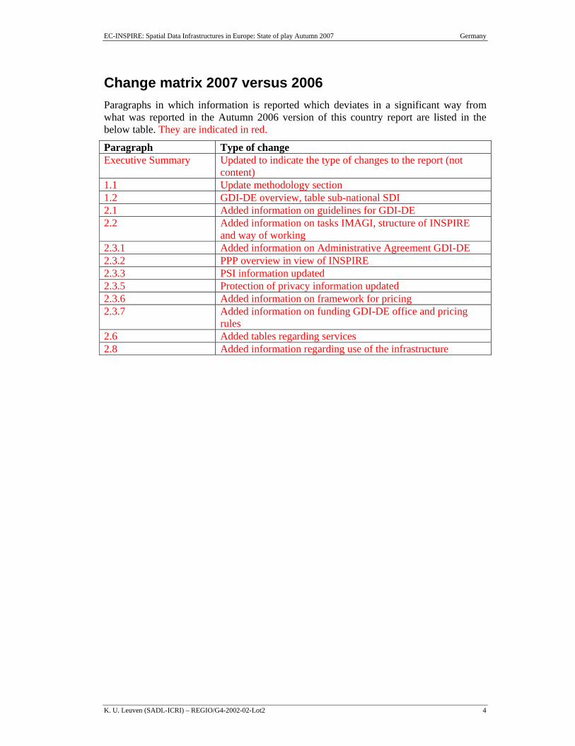
Change matrix 2007 versus 2006 Paragraphs in which information is reported which deviates in a significant way from what was reported in the Autumn 2006 version of this country report are listed in the below table. They are indicated in red.
Paragraph Type of change Executive Summary Updated to indicate the type of changes to the report (not
content) 1.1 Update methodology section 1.2 GDI-DE overview, table sub-national SDI 2.1 Added information on guidelines for GDI-DE 2.2 Added information on tasks IMAGI, structure of INSPIRE
and way of working 2.3.1 Added information on Administrative Agreement GDI-DE 2.3.2 PPP overview in view of INSPIRE 2.3.3 PSI information updated 2.3.5 Protection of privacy information updated 2.3.6 Added information on framework for pricing 2.3.7 Added information on funding GDI-DE office and pricing
rules 2.6 Added tables regarding services 2.8 Added information regarding use of the infrastructure
EC-INSPIRE: Spatial Data Infrastructures in Europe: State of play Autumn 2007 Germany
K. U. Leuven (SADL-ICRI) – REGIO/G4-2002-02-Lot2 5
Executive Summary This report is summarizing the review of SDI in Germany, and reflects the degree to which the SDI situation in Germany is similar to the ideas set out in the INSPIRE position papers1 and in the more recent INSPIRE scoping documents.
The structure of government in Germany has three distinct levels of public authority: local, regional and national, all of which are generators and holders of public information. This structure has an influence on the development of the German SDI.
In 2008 the national SDI in Germany (GDI-DE) is a public infrastructure being coordinated by a common steering committee (LG GDI-DE) comprising members from the federal government, the federal states and the communal head associations. The organisation structure of GDI-DE is completed by the GIW-Kommission (Commission for Geo-Information Business), which can be seen as consulting body inside the development of SDI in Germany.
Surveying and mapping administration is a task of the 16 federal states (States). Each of the federal states is responsible for its own topographic and cadastral service, environmental and statistical data collection, and in general for data policies. There is an authorisation by agreements between the Federal Administration and the federal states on the production of topographic reference data (including maps). All scales larger than 1:200,000 are done by the federal states, while the equal and smaller scales are compiled by BKG (Bundesamt für Kartographie und Geodäsie), the Federal Agency for Cartography and Geodesy.
The AdV (Arbeitsgemeinschaft der Vermessungsverwaltungen der Länder der Bundesrepublik Deutschland – http://www.adv-online.de) provides common documentation of the reference data available as well as a pricing and data collection policy. A metadata information system (http://www.atkis.de/metainfo; http://www.geodatenzentrum.de) informs users about the availability and quality of topographic reference data. ATKIS® (Authoritative Topographic-Cartographic Information System) as a central service of the German national survey is a major common project by the 16 federal state surveying authorities and the BKG. The product line comprises digital landscape models (DLM), including digital terrain models (DGM), and the digital topographic map series 1:25,000 to 1:1,000,000.
Some federal states of the Federal Republic of Germany have already implemented or are in the process of implementing geoportals featuring a wide range of commonly used services. The forthcoming GeoPortal.Bund (http://www.geoportal.bund.de) will be functioning as a central point of entry for GI in Germany, provided by the German Federal administration. It will be linked to the geoportals of the federal states, as well as to thematic databases and services. It shall also provide facilities for publishing data and metadata. With regard to the planned EU (INSPIRE)-geoportal the GeoPortal.Bund will be able to form a node with this.
In 2004, the Geodatenkatalog as a part of GeoPortal.Bund was established as an online metainformation broker and central entrance point to the metadata catalogues of the
1 INSPIRE position papers, final versions: RDM, ETC, DPLI, ASF, IST, IAS (latest version).
EC-INSPIRE: Spatial Data Infrastructures in Europe: State of play Autumn 2007 Germany
K. U. Leuven (SADL-ICRI) – REGIO/G4-2002-02-Lot2 6
emerging German NSDI. As an interdisciplinary search engine on distributed metadata Geodatenkatalog can be the main interface for the enquiry of core thematic metadata in Germany. Geodatenkatalog has also access to all UDK catalogues (Environmental Data Catalogues) in Germany via PortalU® catalogue interface (http://www.portalU.de).
In 2007, the report has been completely reviewed by Germany: some of the old / historical material has been eliminated or at least simplified to bring it more in line with the expected INSPIRE reporting.
EC-INSPIRE: Spatial Data Infrastructures in Europe: State of play Autumn 2007 Germany
K. U. Leuven (SADL-ICRI) – REGIO/G4-2002-02-Lot2 7
Table of Contents CHANGE MATRIX 2007 VERSUS 2006..................................................................................................... 4
EXECUTIVE SUMMARY ............................................................................................................................. 5
TABLE OF CONTENTS ................................................................................................................................ 7
ABBREVIATIONS AND ACRONYMS ....................................................................................................... 8
1 GENERAL INFORMATION................................................................................................. 10 1.1 METHOD........................................................................................................................................ 10 1.2 OVERVIEW OF SELECTED SDI-INITIATIVES................................................................................... 10
2 DETAILS OF THE GERMAN NSDI: GDI-DE®................................................................. 14 2.1 GENERAL INFORMATION............................................................................................................... 14 2.2 COMPONENT 1: COORDINATION AND ORGANIZATIONAL ISSUES .................................................. 14 2.3 COMPONENT 2: LEGAL FRAMEWORK AND FUNDING .................................................................... 21 2.4 COMPONENT 3: DATA FOR THEMES OF THE INSPIRE ANNEXES .................................................. 24 2.5 COMPONENT 4: METADATA.......................................................................................................... 31 2.6 COMPONENT 5: NETWORK SERVICES ........................................................................................... 32 2.7 COMPONENT 6: THEMATIC ENVIRONMENTAL DATA..................................................................... 42 2.8 USE AND EFFICIENCY OF SDI ........................................................................................................ 44
3 ANNEXES................................................................................................................................. 45 3.1 LIST OF SDI ADDRESSES / CONTACTS FOR GERMANY .................................................................. 45 3.2 LIST OF REFERENCES FOR GERMANY............................................................................................ 47
EC-INSPIRE: Spatial Data Infrastructures in Europe: State of play Autumn 2007 Germany
K. U. Leuven (SADL-ICRI) – REGIO/G4-2002-02-Lot2 8
Abbreviations and acronyms AdV Working Committee of the Surveying Authorities of the States AGeoBW Amt für Geoinformationswesen der Bundeswehr ALB Automated Real Estate Book ALK Automated Real Estate Map ALKIS Authoritative Real Estate Cadastral Information System ATKIS Authoritative Topographic-Cartographic Information System AUC Atmospheric User Centre BfN Federal Agency for Nature Conservation BKG Federal Agency for Cartography and Geodesy BMU Federal Ministry for the Environment, Nature Conservation and Nuclear
Safety CRS Coordinate Reference System DDGI German Umbrella Organisation for GI DFD German Remote Sensing Data Centre DGK German Geodetic Commission DGM Digital Terrain Model DLM Digital Landscape Model DLR German Aerospace Centre DOM Digital Surface Model DTK Digital Topographic Map DUDEN German language dictionary EOWEB Earth Observation WEB EUROGI European Umbrella Organisation for Geographical Information FIR Further Investigation Required GDI-DE National Spatial Data Infrastructure for Germany GeoZG German Law for Geo Data Access (Draft) GI Geographical Information GIS Geographical Information System GIW-Komm. Commission for Geo Business GKSt. Office of the Steering Committee of the National Spatial Data
Infrastructure for Germany GPS Global Positioning System IFG German Law for free access to public information IMAGI Inter-Ministerial Committee for Geo Information INSPIRE Infrastructure for Spatial Information in Europe ISO International Organization for Standardization ITF INSPIRE Task Force IWG German law for reuse of public sector information LG GDI-DE Steering Committee of the National Spatial Data Infrastructure for
Germany
EC-INSPIRE: Spatial Data Infrastructures in Europe: State of play Autumn 2007 Germany
K. U. Leuven (SADL-ICRI) – REGIO/G4-2002-02-Lot2 9
MoE Ministry of Environment NIA No Information Available NGDB National geodatabase NRW North Rhine Westphalia NSDI National Spatial Data Infrastructures OGC Open Geospatial Consortium PortalU® German Environmental Information Portal PPP Public-private partnerships PSI Policy and legislation on access to public sector information SDI Spatial Data Infrastructures SOA Service Orientated Architecture UBA Federal Environmental Agency UDK Environmental Data Catalogue (Metadata model of PortalU®) UIG German Environmental Information Law UrhG German Copyright Act (Urheberrechtgesetz) WMS Web Mapping Service
EC-INSPIRE: Spatial Data Infrastructures in Europe: State of play Autumn 2007 Germany
K. U. Leuven (SADL-ICRI) – REGIO/G4-2002-02-Lot2 10
1 GENERAL INFORMATION
1.1 Method This report is summarizing the review of SDI in Germany, and reflects the degree to which the SDI situation in Germany is similar to the ideas set out in the INSPIRE position papers2 and in the more recent INSPIRE scoping documents.
The report is based on the analysis of various documents, project references and web sites readily accessible in English and German. Comments from a number of German SDI-experts have been integrated in the 2003 as well as in the 2004 versions. The update 2005 is based on input from the German experts from the BKG, IMAGI, NRW and MoE. Modifications were integrated and reviewed and completed with additional information. The update 2006 is based on input provided by Martin Lenk (IMAGI), information obtained during a meeting of the INSPIRE Task Force in Frankfurt (August 2006) and from several presentation at the EC GI&GIS workshop in Innsbruck (June 20063). In 2007, German authorities responsible for INSPIRE reviewed the whole report and reformulated/restructured according the last developments. In July 2008 templates with information on services were received which were integrated in this country report, but which were not used for the assessment at the European level (see summary report). The answers on data sharing which were received at the same time were not integrated anymore.
1.2 Overview of selected SDI-initiatives The structure of government in Germany has three distinct levels of public authority: local, regional and national, all of which are generators and holders of public information. This structure has an influence on the development of the German SDI.
In 2008 the national SDI in Germany (GDI-DE) is a public infrastructure being coordinated by a common steering committee (LG GDI-DE) comprising members from the federal government, the federal states and the communal head associations. Each federal state member represents and coordinates the public services, agencies etc. of his/her federal state, e. g. the mapping and cadastre administration, the geological agency, the environmental agency etc. The chair of LG GDI-DE changes every two years. So a wide approval by SDI stakeholders inside the public administration is guaranteed (see also chapter 2.2).
The organisation structure of GDI-DE is completed by the GIW-Kommission (Commission for Geo-Information Business), which can be seen as consulting body inside the development of SDI in Germany. The GIW-Kommission is a body chaired by the Federal Ministry of Economies and Technology. It contains mainly members from national lobby organisation. A main task of the GIW-Kommission is the removal of obstacles against an easy use of geo-data sets provided by public authorities. Obstacles
2 INSPIRE position papers, final versions: RDM, ETC, DPLI, ASF, IST, IAS (latest version). 3 It might be useful to mention that the situation in 2008 changed because of the institutional establishment of (GDI-DE) SDI Germany. Therefore the content of the document after the update 2008 is quite different compared to versions before.
EC-INSPIRE: Spatial Data Infrastructures in Europe: State of play Autumn 2007 Germany
K. U. Leuven (SADL-ICRI) – REGIO/G4-2002-02-Lot2 11
are heterogeneous licensing, rather high pricing or insufficient quality and access- and using-restrictions by data protection laws.
The coordination offices of LG GDI-DE and GIW-Kommission are cooperating in various projects.
Surveying and mapping administration is a task of the 16 federal states. Each of the federal states is responsible for its own topographic and cadastral service, environmental and statistical data collection, and in general for data policies. Traditionally data collection is largely decentralised and carried out mostly on the regional and local level, which means that the processing and maintenance of data is mostly tailored to local and regional requirements, which leads to a built-in incompatibility. The different federal states have issued laws (e.g. "Surveying and Cadastral Acts") that regulate the work, which the regional and local authorities are carrying out.
The surveying and mapping administrations of the 16 federal states are responsible for creating and maintaining the reference data describing real estate and the landscape. Whereas the mapping agencies of the federal states are responsible for providing large and medium scale reference data, the cadastre offices have to perform the tasks of the real estate cadastre and to support the work of the mapping agencies.
The responsible ministries and directors are collaborating in the Working Committee of the Surveying Authorities of the federal states of the Federal Republic of Germany (AdV – Arbeitsgemeinschaft der Vermessungsverwaltungen der Länder der Bundesrepublik Deutschland – http://www.adv-online.de). To the AdV belong the Federal Ministry of the Interior, and of Transport, Building and Housing and the Head of the "AGeoBW" (Amt für Geoinformationswesen der Bundeswehr). Permanent guests of AdV are the German Geodetic Commission (DGK), representing the universities, education and research in geodesy and geo information, and the "Bund/Länder Working Committee for Rural Development (ArgeLandentwicklung)", responsible for land consolidation and rural development in Germany.
There is an authorisation by agreements between the Federal Administration and the federal states on the production of topographic reference data (including maps). All scales larger than 1:200,000 are done by the federal states, while the equal and smaller scales are compiled by BKG (Bundesamt für Kartographie und Geodäsie), the Federal Agency for Cartography and Geodesy. The BKG supports as a competence centre for geodesy and geo information the administrations of the Federation and the federal states. It advises the Federal Government in all questions related to geodesy and geo information and it safeguards the relevant German interests at the European and international level. BKG contributes significantly to the establishment and the deployment of the German spatial data infrastructure (GDI-DE®).
The AdV provides common documentation of the reference data available as well as a pricing and data collection policy. A metadata information system (http://www.atkis.de/metainfo; http://www.geodatenzentrum.de) informs users about the availability and quality of topographic reference data. ATKIS® (Authoritative Topographic-Cartographic Information System) as a central service of the German national survey is a major common project by the 16 federal state surveying authorities and the BKG. The product line comprises digital landscape models (DLM), including
EC-INSPIRE: Spatial Data Infrastructures in Europe: State of play Autumn 2007 Germany
K. U. Leuven (SADL-ICRI) – REGIO/G4-2002-02-Lot2 12
digital terrain models (DGM), and the digital topographic map series 1:25,000 to 1:1,000,000.
The Deutscher Dachverband für Geoinformation (DDGI – German Umbrella Organisation for GI) is an important GI-lobbying body. The DDGI (http://www.ddgi.de) is the forum bringing together institutional players and data providers from across the country, with members from the private sector and academia. DDGI promotes interdisciplinary German interests in the private GI sector, stimulates the construction and the application of GI on national and international level. It aims at optimizing the economical use by quality and contents' standardization and at improving the availability and usability of geo data. It is an interdisciplinary, non-profit and neutral organization. Through its initiatives it promotes synergy across the main stakeholders at federal and federal state level, and linkages to the European dimension via EUROGI.
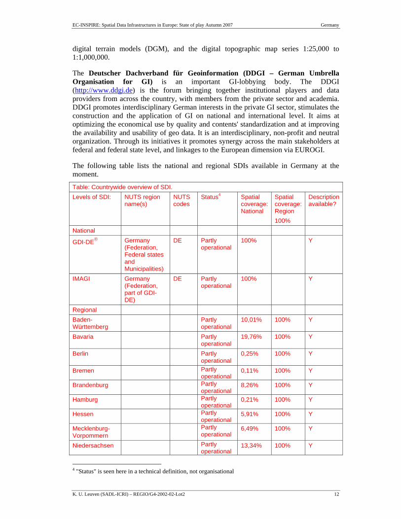
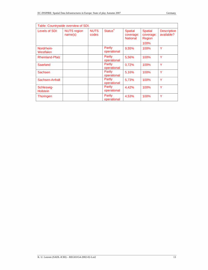
The following table lists the national and regional SDIs available in Germany at the moment.
Table: Countrywide overview of SDI. Levels of SDI: NUTS region
name(s) NUTS codes
Status4 Spatial coverage: National
Spatial coverage: Region 100%
Description available?
National
GDI-DE® Germany (Federation, Federal states and Municipalities)
DE Partly operational
100% Y
IMAGI Germany (Federation, part of GDI-DE)
DE Partly operational
100% Y
Regional Baden-Württemberg
Partly operational
10,01% 100% Y
Bavaria Partly operational
19,76% 100% Y
Berlin Partly operational
0,25% 100% Y
Bremen Partly operational
0,11% 100% Y
Brandenburg Partly operational
8,26% 100% Y
Hamburg Partly operational
0,21% 100% Y
Hessen Partly operational
5,91% 100% Y
Mecklenburg-Vorpommern
Partly operational
6,49% 100% Y
Niedersachsen Partly operational
13,34% 100% Y
4 "Status" is seen here in a technical definition, not organisational
EC-INSPIRE: Spatial Data Infrastructures in Europe: State of play Autumn 2007 Germany
K. U. Leuven (SADL-ICRI) – REGIO/G4-2002-02-Lot2 13
Table: Countrywide overview of SDI. Levels of SDI: NUTS region
name(s) NUTS codes
Status4 Spatial coverage: National
Spatial coverage: Region 100%
Description available?
Nordrhein-Westfalen
Partly operational
9,55% 100% Y
Rheinland-Pfalz Partly operational
5,56% 100% Y
Saarland Partly operational
0,72% 100% Y
Sachsen Partly operational
5,16% 100% Y
Sachsen-Anhalt Partly operational
5,73% 100% Y
Schleswig-Holstein
Partly operational
4,42% 100% Y
Thüringen Partly operational
4,53% 100% Y
EC-INSPIRE: Spatial Data Infrastructures in Europe: State of play Autumn 2007 Germany
K. U. Leuven (SADL-ICRI) – REGIO/G4-2002-02-Lot2 14
2 Details of the German NSDI: GDI-DE®
2.1 General Information For the information and scientific society as well as monitory of the environmental changes and security, up-to-date geo information, which is available all over the country, is crucial for the further development. The German Federal Government launched activities for the provision of a spatial data infrastructure in collaboration with the federal states, universities and industry. The explicit aim is to increase cooperation between data producers and data users and to provide up to date geo data in a most common available way.
Through the joint setup of the Spatial Data Infrastructure for Germany [German designation: GDI-DE®] by the Federal Government, the federal states and communes/municipalities, the potential of geo information is strengthened, primarily with regard to political, administrative, and economic decision-making processes. The GDI-DE® creates the prerequisites for obtaining, evaluating and applying geo information on the basis of a National Geo Database (NGDB = reference data and thematic data and metadata) with the aid of a geo information network of services and standards. This can be guaranteed by means of transparent and open data retention as well as the construction of a user-friendly geo data portal on the Internet.
In 2007 the guideline for the implementation of GDI-DE was published: GDI-DE Architecture V 1.0. The document is available for the public (www.gdi-de.org). It describes goals, preconditions, technical issues and a roadmap (masterplan) for establishing the GDI-DE. It is seen as the common guideline for all public institutions dealing and using geo information. Technically it follows the architecture of SOA (Service Orientated Architecture) and describes in details the most necessary components like Discovery-, View- and Download-Services. A geo data portal is seen as a fundamental component of the GDI-DE® and will function as one point of entry for Germany and international users providing a large variety of services. GDI-DE® will be linked to the services and geoportals of public institutions of the Federation, federal states and the municipalities. To create a powerful architecture it is necessary to implement a defined and controlled topology of service points. With regard to the planned EU (INSPIRE)-geoportal the GDI-DE will be able to create a powerful node of it.
One step forward to provide the expanding geo data market with topographic reference data was the establishment of a Geo Data Centre (founded already in 1996) within the BKG. With the GeoPortal.Bund® it will be possible to obtain, evaluate and apply geo information, including thematic data, which will be interoperable with the geobasic/reference data.
2.2 Component 1: Coordination and organizational issues Coordination activities are deemed crucial in a federal system as Germany. Recently the major initiatives of Federation and Federal states have been established the political profile of a national SDI (Geodaten-Infrastruktur Deutschland – GDI-DE®), including the development of a framework for coordination.
EC-INSPIRE: Spatial Data Infrastructures in Europe: State of play Autumn 2007 Germany
K. U. Leuven (SADL-ICRI) – REGIO/G4-2002-02-Lot2 15
The institutional setup of GDI-DE began first with the establishment of the "Interministerieller Ausschuss für Geoinformationswesen" (IMAGI – Inter-Ministerial Committee for Geo-information) by the Federal Government in 1998 as an improvement on coordination in the field of GI. The secretariat was transferred to the Bundesamt für Kartographie und Geodäsie (BKG – Federal Agency for Cartography and Geodesy). The members of IMAGI (www.imagi.de) thus are all federal ministries and IMAGI has to organize effective data collection and exchange among them on a federal level. The AdV attends the IMAGI sessions as a permanent guest.
The Federal Government addressed the following tasks to the IMAGI:
- Conception for an effective data management for spatial data on federal level
- Development and operating of a metainformationsystem as part of a geoportal of the Federation
- Optimizing the technical and organizational responsibilities for geo data management
- Consulting for harmonizing and optimizing administrative requirements for delivery of geo data
- Awareness rising for the use of Geo information
- International representation of Germany in the field of Geo information
Further political support came at the start of 2001 when the German Parliament, Bundestag, passed a resolution to rapidly implement the German SDI and promote the interdepartmental use of GI in the public sector. In April 2003 the German Parliament (Bundestag) debated the achievements and shortcomings, and asked the Federal Government to increase the efforts devoted to the establishment of the GDI-DE® underlining the need for coordination of the GDI-DE® activities at Federal level. In compliance with the resolution of the German Parliament, the Chiefs of the Federal and Federal states Chancelleries adopted a resolution dealing with the set-up of the GDI-DE® in November 2003. The organisational structure for the set-up of the GDI-DE® has been approved and established in 2004 (Figure 1).
EC-INSPIRE: Spatial Data Infrastructures in Europe: State of play Autumn 2007 Germany
K. U. Leuven (SADL-ICRI) – REGIO/G4-2002-02-Lot2 16
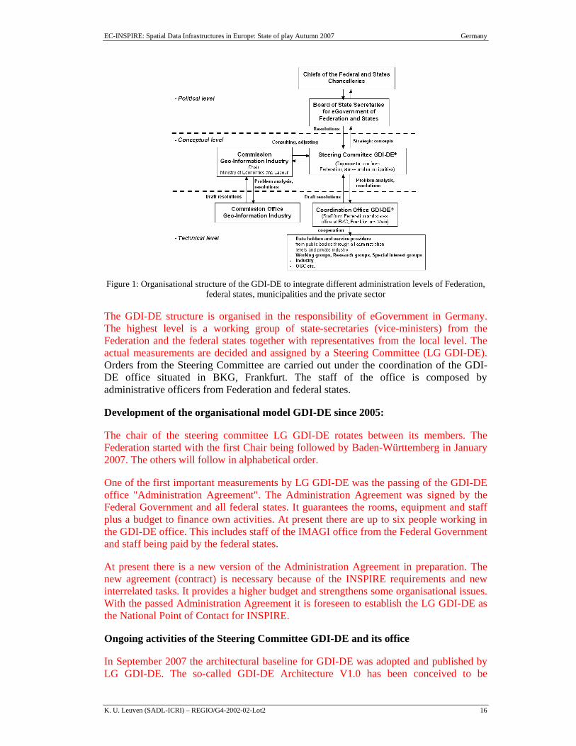
Figure 1: Organisational structure of the GDI-DE to integrate different administration levels of Federation,
federal states, municipalities and the private sector
The GDI-DE structure is organised in the responsibility of eGovernment in Germany. The highest level is a working group of state-secretaries (vice-ministers) from the Federation and the federal states together with representatives from the local level. The actual measurements are decided and assigned by a Steering Committee (LG GDI-DE). Orders from the Steering Committee are carried out under the coordination of the GDI-DE office situated in BKG, Frankfurt. The staff of the office is composed by administrative officers from Federation and federal states.
Development of the organisational model GDI-DE since 2005:
The chair of the steering committee LG GDI-DE rotates between its members. The Federation started with the first Chair being followed by Baden-Württemberg in January 2007. The others will follow in alphabetical order.
One of the first important measurements by LG GDI-DE was the passing of the GDI-DE office "Administration Agreement". The Administration Agreement was signed by the Federal Government and all federal states. It guarantees the rooms, equipment and staff plus a budget to finance own activities. At present there are up to six people working in the GDI-DE office. This includes staff of the IMAGI office from the Federal Government and staff being paid by the federal states.
At present there is a new version of the Administration Agreement in preparation. The new agreement (contract) is necessary because of the INSPIRE requirements and new interrelated tasks. It provides a higher budget and strengthens some organisational issues. With the passed Administration Agreement it is foreseen to establish the LG GDI-DE as the National Point of Contact for INSPIRE.
Ongoing activities of the Steering Committee GDI-DE and its office
In September 2007 the architectural baseline for GDI-DE was adopted and published by LG GDI-DE. The so-called GDI-DE Architecture V1.0 has been conceived to be
EC-INSPIRE: Spatial Data Infrastructures in Europe: State of play Autumn 2007 Germany
K. U. Leuven (SADL-ICRI) – REGIO/G4-2002-02-Lot2 17
technically open and defines the most important rules to be applied in order to ensure the interoperability of GDI-DE's constituent components. It is based on an analysis of national SDI initiatives and INSPIRE. Technically it references ISO and OGC specifications.
The GDI-DE architecture lists and evaluates implementation specifications, which are relevant to modern geo information (particularly those laid down by ISO and OGC) considering legal frameworks and eGovernment requirements. The specifications were categorized according to their level of maturity into three groups of varying levels of obligation:
• GDI-DE Essential
• GDI-DE Optional
• GDI-DE Future
It also contains the GDI-DE Implementation Plan, which is based on the technical concepts of the GDI-DE architecture and determines activity fields, procedures and instruments, which shall be implemented on all operational levels of GDI-DE. The main tasks are:
GDI-DE Operating Model: To cope with organizational challenges a detailed cross-administrative operating model will be established. The operating model will cover already existing and future business cases and will focus on those administrative issues which are crucial for realizing vertical integration of service offers.
GDI-DE Specification Program: The specification program supports the maintenance of the technical architecture GDI-DE. Future requirements either from the ongoing INSPIRE process or from sub-national SDIs will be carefully integrated without affecting recent implementations.
Metadata Management: To improve the network of Germany's major catalogue services and the management of its metadata a pilot project has been initiated: Geodatenkatalog-DE. Within this project the network of Germany's major catalogue services shall be improved. The aim is to link distributed catalogue services – e.g. hosted on the federal or municipality level – in a way that distributed metadata can be quickly accessed from a single entry point. In particular interoperability and performance issues are subject of this project and different methods like harvesting, caching or cascading will be evaluated.
Vertical Integration: Consistent License management is an important component for cooperative data and service sharing. In addition to this, efficient data and service sharing also requires distinct keywords and related descriptions. With a GDI-DE pilot project called "Registry-DE" it is planned to setup a central registry service to manage and provide consistent SDI-information (e.g. parameters of coordinate systems, units of measure, definition of terms etc).
Spatial Data Offerings: To increase the number and quality of spatial data offerings it is planned to provide recommendations concerning the identification of key datasets in
EC-INSPIRE: Spatial Data Infrastructures in Europe: State of play Autumn 2007 Germany
K. U. Leuven (SADL-ICRI) – REGIO/G4-2002-02-Lot2 18
public administration in Germany. The recommendation could define key datasets by the following indicators:
• The dataset is required by public administrations to provide services according to their legal mandate.
• The dataset is of interest for a modern administration. • The dataset is of general economic interest. • The dataset is of research interest.
Spatial datasets, which meet at least one of these requirements, form the so-called Germany's National Geodatabase (NGDB). GDI-DE Impulse Program: The Impulse Program is a promotion for GDI-DE. Public or private organizations that support GDI-DE by implementing GDI-DE compliant services or by other supporting efforts can register their contribution and sign the "Charter of GDI-DE Contributors". These partners will be promotionally effectively listed on the GDI-DE website. A key instrument to coordinate the GDI-DE structure is the adjustment of GDI-DE issues in working groups. Working groups are usually formed by delegates from the public sector in cooperation with private companies. They are coordinated by the GDI-DE Office. Currently there are three active working groups:
• GDI-DE WG Architecture: The architecture working group compiled and maintains the Technical Architecture GDI-DE. Also the definition of the GDI-DE Operating Model is assigned to this group.
• GDI-DE WG Services: The services working group is analysing SDI- specification and develops national profiles if necessary
• GDI-DE WG Metadata: The working group for metadata management is run by metadata providers of the public administration as well as metadata specialists from software companies. The coordination of distributed catalogue-networks and the use of metadata standards in GDI-DE are addressed by this working group.
Another key instrument for the implementation of GDI-DE is the set up of pilot projects. Besides the already mentioned projects "Registry GDI-DE" and "Geodatenkatalog-DE" there is another important pilot project "Protected Area Sites". In this project distributed map services across several administrative areas and levels of detail have been connected to produce a joint map of protected areas over Germany. All contributing geo-resources remain distributed, but on request it is possible to compose a joint harmonised map. In a first phase the system had been exemplarily implemented by a selected number of partners in Germany (Final report available for Download in German language: http://www.gdi-de.org/de/download/GDI_DE_Schutzgebiete_V1.0.pdf). Now, in a second phase the aim is to realize a Germany-wide implementation and to transfer the results to a broad community until spring 2008.

EC-INSPIRE: Spatial Data Infrastructures in Europe: State of play Autumn 2007 Germany
K. U. Leuven (SADL-ICRI) – REGIO/G4-2002-02-Lot2 19
To co-ordinate the national activities in the framework of INSPIRE especially on a thematic level a German INSPIRE Task Force (ITF) was explicitly established, combining the political coordination of the INSPIRE-legislation and the expert knowledge of existing national structures. The ITF, chaired by the Federal Ministry for the Environment, Nature Conservation and Nuclear Safety (BMU) as the responsible authority for the INSPIRE legislation on national level, comprises representatives from the LG GDI-DE, the BKG, the BfN and several Expert Working Groups, the representative of the Bundesrat (2nd chamber) for INSPIRE and a representative of the Federal Ministry of the Interior. The German drafting team experts are regularly invited to attend the ITF-meetings. The main objective of the ITF is to coordinate the INSPIRE legislation process with the establishment of the GDI-DE and to provide a national forum accompanying the development of the INSPIRE implementing rules.
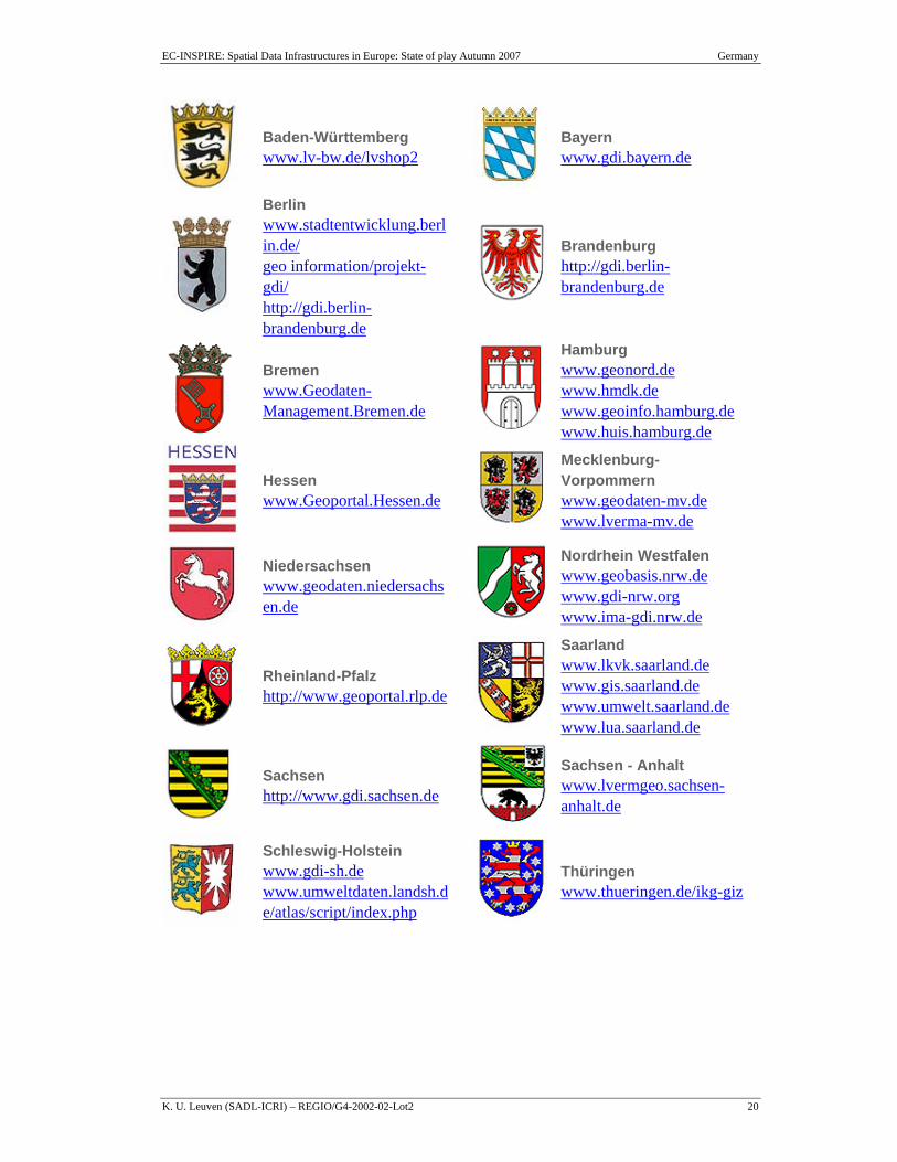
Major initiatives at the level of the Federal States Parallel to the GDI-DE development, which is a coordinated development of the federation and the federal states with representation of the local level (municipalities), SDI developments have taken place in the federal states starting in the late 90th. These developments are now strongly related to the SDI developments of the GDI-DE.
Further information of the developments at the level of the Federal states is available in the internet:
Figure 2: Cascading Webmapping Services for national wide harmonised Visualisation of Protected Areas in Germany (GDI-DE pilot project)
EC-INSPIRE: Spatial Data Infrastructures in Europe: State of play Autumn 2007 Germany
K. U. Leuven (SADL-ICRI) – REGIO/G4-2002-02-Lot2 20
Baden-Württemberg www.lv-bw.de/lvshop2
Bayern www.gdi.bayern.de
Berlin www.stadtentwicklung.berlin.de/ geo information/projekt-gdi/ http://gdi.berlin-brandenburg.de
Brandenburg http://gdi.berlin-brandenburg.de
Bremen www.Geodaten-Management.Bremen.de
Hamburg www.geonord.de
www.hmdk.de
www.geoinfo.hamburg.de
www.huis.hamburg.de
Hessen www.Geoportal.Hessen.de
Mecklenburg-Vorpommern www.geodaten-mv.de
www.lverma-mv.de
Niedersachsen www.geodaten.niedersachsen.de
Nordrhein Westfalen www.geobasis.nrw.de
www.gdi-nrw.org
www.ima-gdi.nrw.de
Rheinland-Pfalz http://www.geoportal.rlp.de
Saarland www.lkvk.saarland.de
www.gis.saarland.de
www.umwelt.saarland.de
www.lua.saarland.de
Sachsen http://www.gdi.sachsen.de
Sachsen - Anhalt www.lvermgeo.sachsen-anhalt.de
Schleswig-Holstein www.gdi-sh.de
www.umweltdaten.landsh.de/atlas/script/index.php
Thüringen www.thueringen.de/ikg-giz
EC-INSPIRE: Spatial Data Infrastructures in Europe: State of play Autumn 2007 Germany
K. U. Leuven (SADL-ICRI) – REGIO/G4-2002-02-Lot2 21
2.3 Component 2: Legal framework and funding
2.3.1 Legal framework
The Federation is recently preparing a law to guarantee access to Federal geo data sets in the sense of INSPIRE (Geodatenzugangsgesetz – GeoZG). The law (draft version) itself doesn't regulate GDI-DE organization, but it refers and builds up on the existence of a structure like the national GDI-DE (Steering Committee and Office). The adaptation of the law is expected for 2008, which means that the Federation will achieve the INSPIRE requirement for the member states to implement national laws by 15th May 2009.
The GeoZG will only be in force for Federal Institutions. The federal states are developing their own laws themselves, using the GeoZG like a guidance document. In order to coordinate and to harmonize the distinct developments on Federation and Federal level both levels agreed upon a close cooperation in a working group on GeoZG. The outcome of the legal SDI development is recently not completely clear yet, but it can be expected that the Federation and the Federal states will pass widely harmonized legal regulations.
At present there is a new version of the Administration Agreement of the GDI-DE in preparation (see 2.2). The new agreement (contract) will extend budget and human resources of the GDI office and guarantee its existence in the long run.
2.3.2 Public-private partnerships (PPP's)
Within the context of INSPIRE implementation the German SDI (GDI-DE) will be opened for third parties: As long as they accept the underlying principles of GDI-DE and the regulations of GeoZG third parties may contribute their geo data and metadata using the geoportal of GDI-DE. They just have to ensure the compliance with the technical rules defined by the GeoZG, the INSPIRE implementing rules and the GDI-DE Architecture.
In that respect the work of the INSPIRE Task Force (ITF, see 2.2 p.19) can be seen as an example of a PPP. Representatives of the government, scientific institutions and enterprises cooperate to coordinate the outcome of European and national legislation with the technical development within GDI-DE. Establishment of GDI-DE itself is done with major participation of the "Commission of Geo-Information Industry" on the conceptual level (see Figure 1, p. 16).
2.3.3 Policy and legislation on access to public sector information (PSI)
The Federation implemented the European Directive 2003/98/EG on PSI into national law in 2006 by adopting the "Informationsweiterverwendungsgesetz" (IWG – reuse of public sector information). The IWG regulates the Federal as well as the Federal state and Municipal administrative level. Furthermore the Federation in 2006 adopted the "Informationsfreiheitsgesetz" (IFG – free access to public information)" enabling the access to administrative information.
EC-INSPIRE: Spatial Data Infrastructures in Europe: State of play Autumn 2007 Germany
K. U. Leuven (SADL-ICRI) – REGIO/G4-2002-02-Lot2 22
Recently, ‘freedom of information laws’ have been adopted at the regional level by some of the Länder. In Brandenburg the right to freedom of information was explicitly laid down in legislation (constitution) in 1998. It relates to the right of all citizens to access public records held by state authorities, districts and cities, unless public or private interests prevail. Berlin, Schleswig-Holstein, North Rhine-Westphalia, Mecklenburg-Vorpommern, Hamburg, Bremen, and Saarland have also recently adopted freedom of information laws. Other federal states are still preparing their FOI laws.
Directive 2003/4 on access to environmental information has been implemented by the German Environmental Information Law (Umweltinformationsgesetz - UIG), which passed the German Parliament on 22nd of December 2004. UIG defines the facilities which are affected, describes the access to environmental as well as rejection of access, active dissemination of environmental information and fees. It has entered into force on 14 February 2005. The main instrument to support access to environmental information is the German Environmental Information Portal, PortalU®
The Federation is recently preparing a law to guarantee access to Federal geo data sets in the sense of INSPIRE (Geodatenzugangsgesetz – GeoZG). The law (draft version) itself doesn't regulate GDI-DE organization, but it refers and builds up on the existence of a structure like the national GDI-DE (Steering Committee and Office). The adaptation of the law is expected for 2008, which means that the Federation will achieve the INSPIRE requirement for the member states to implement national laws by 15th May 2009.
The GeoZG will only be in force for Federal Institutions. The federal states are developing their own laws themselves, using the GeoZG like a guidance document. In order to coordinate and to harmonize the distinct developments on Federation and Federal level both levels agreed upon a close cooperation in a working group on GeoZG. The outcome of the legal SDI development is recently not completely clear yet, but it can be expected that the Federation and the Federal states will pass widely harmonized legal regulations.
2.3.4 Legal protection of GI by intellectual property rights
In Germany the national legislator is competent to issue copyright regulation and other intellectual property laws. The federal states are not allowed to issue state laws that contradict national laws.
The German Copyright Act (Urheberrechtgesetz – UrhG) explicitly states that works of literature, science or art have to be original to enjoy copyright protection. Since products of geographical information are functional, their level of originality tends to be rather low. Works with a low level of originality such as geographic maps, tables and so on enjoy copyright protection if some creativity has come into play, for instance in the generalisation process that is inherent in map production, or in the selection and arrangement of data. However, if the level of originality is low, protection granted is similarly low.
Photographic works that are original are covered by common copyright. The German Copyright Act however has a special clause that gives the creator of a non-original photograph a right to resist duplication (art. 72 UrhG). The Directives 96/9/EC on the legal protection of databases and 91/250/EC on the legal protection of computer programs have been fully integrated in German Copyright Act.
EC-INSPIRE: Spatial Data Infrastructures in Europe: State of play Autumn 2007 Germany
K. U. Leuven (SADL-ICRI) – REGIO/G4-2002-02-Lot2 23
According to article 5 of the Copyright Act, government information is not subject to copyright. One category encompasses laws, decrees and so on (article 5(1)), whereas another category deals with official works published in the official interest for public information (article 5(2)). Interpretation of this last article is however very strict since – according to the Supreme Court – it only applies to information that is meant to be made generally available and copied.
The different federal states laws that regulate the work of the surveying and mapping authorities contain clauses that regulate the use of information collected or produced by them.
The 2001 Directive on copyright in the information society was transposed by the Gesetz zur Regelung des Urheberrechts in der Informationsgesellschaft of 10 September 2003.
2.3.5 Restricted access to GI further to the legal protection of privacy
Protection of privacy has a long tradition in Germany and is considered tantamount to a human right. Hence privacy and personal data laws in Germany are generally very restrictive. Spatial datasets that contain information on individuals are in principle subject to the German laws on the protection of privacy. To ensure protection of privacy when implementing the INSPIRE-Directive, the Federal commissioner for data protection was involved when drafting GeoZG.
The Federal Data Protection Act of 20 December 1990 (Bundesdatenschutzgesetz) – as already amended by the law of 14 September 1994 – was later amended by the Federal Data Protection Act of 18 May 2001. This latest act implements Directive 95/46/EC and came into force on 23 May 2001. The Federal Data Protection Act applies to the federal public sector and the private sector. All federal states (except Sachsen and Bremen) adopted new Data Protection Laws to implement the EU Directive. These acts apply to the public sector of the respective federal states.
A particularity of German data protection law lies in the fact that in addition to the above Federal Data Protection Act there are numerous sector-specific provisions. All these rules are granting the data subject a variety of possibilities aiming at the respect of his individual data protection rights. The use of (public) geodata is also restricted by the cadastral laws at the federal state level.
Directive 2002/58 on privacy and electronic communication has been transposed in German law.
2.3.6 Licensing framework
Each German authority or agency currently defines its own data policy on a case-by-case basis under the direction of the appropriate Minister. The GDI-DE Steering Committee, GIW-Commission, IMAGI, DDGI and AdV are all – directly or indirectly – working towards the development of a harmonised and simplified licensing framework for GI.
A framework to get comparable prices for geo data was adopted by IMAGI in 2006 (see 2.3.7). One of the tasks of AdV is also to deliberate on the costs. These bodies thus have a mission in developing a pricing policy for GI.
EC-INSPIRE: Spatial Data Infrastructures in Europe: State of play Autumn 2007 Germany
K. U. Leuven (SADL-ICRI) – REGIO/G4-2002-02-Lot2 24
A good example for simplifying licensing processes is the contract between the Federal states and the Federal Ministry for Interior to provide reference datasets from the federal states to the Federal Administration. It regulates an annual all-inclusive payment from federation to the federal states, which enables the BKG to provide all topographic data sets and services to Federal Agencies for free.
2.3.7 Funding model for SDI and pricing policy
Funding model
Funding the public SDI coordination differs between the Federal states themselves and in comparison to the Federation. Most organisation and funding models are based on the existence of managing SDI Offices being situated inside mapping agencies.
The GDI-DE Office at the BKG in Frankfurt is funded through an "Administration Agreement" (see 2.2).
Pricing Policy
In Germany users of public geo data have to pay for most of the spatial data. Official core data (reference and thematic data) that are supplied by the surveying, mapping, cadastral and other departmental administrations are made available at the costs of economic value and dissemination. Variations do exist in the pricing policies of the different public authorities.
The costs for reference data are determined by the AdV. Responsibility for data policies and pricing guidelines rests with the federal states. There is a clear understanding among them that the GDI-DE® is a public infrastructure and that policies for access to the core data should hence be developed consistent with this vision.
In 2006 the IMAGI adopted a common "template of terms of use for delivery and service of Geo information from the Federal administration". The IMAGI approved the use of the template inside all affected Federal institutions. The document provides 3 categories for pricing rules:
(1) a certain set of general free information for non-commercial use will be distributed via the web,
(2) standard products will be available to the user at fixed reasonable prices and
(3) special services – if requested by the user – will be charged according to full cost recovery.
2.4 Component 3: Data for themes of the INSPIRE annexes Since 2005 the AG IMAGI, the expert group of the IMAGI has been developing an explicit definition for the National Geo Database (NGDB). The NGDB includes all relevant public geo datasets for legal tasks as well as for the support of good governance and also considers the demand of Sciences and German Economy. Furthermore, the AG IMAGI is developing a list of available geo products, which are seen as a part of the NGDB. The result of this activity is available in GeoPortal.Bund since 2007
EC-INSPIRE: Spatial Data Infrastructures in Europe: State of play Autumn 2007 Germany
K. U. Leuven (SADL-ICRI) – REGIO/G4-2002-02-Lot2 25
(http://geoportal.bkg.bund.de/). The concept of the NGDB is also described in the GDI-DE architecture V1.0.
2.4.1 Scale and resolution: European, National, Regional, Local, Other
Reference and core thematic data are produced at all these scale levels.
2.4.2 Data by resolution or scale range for the INSPIRE themes
As a first challenge the EU-member states have to deal with the themes of annex I and II inside the INSPIRE Directive. Data content and quality here fore are not exactly described yet. This will be a task of the implementing rules (data specifications). Most of the existing German reference data sets seem to fulfil the demands of annex I and II as follows:
Authoritative Topographic-Cartographic Information System (ATKIS):
The product line ATKIS® (Authoritative Topographic-Cartographic Information System) includes digital landscape models, digital topographic maps and digital terrain models. All products listed here are stored and – if possible – harmonised centrally at the Geo Data Centre of the Federal Agency of Cartography and Geodesy.
Digital Landscape Models (DLM)
The DLMs describe the topographic features of the landscape and the relief of the earth's surface in vector format.
The databases contain the following six themes: settlements, transport, vegetation, hydrography, relief and other areas (e.g. islands, national parks, etc.). Each theme contains one or more data layers. The following landscape models are available:
Basic-DLM (compiled from the scale range 1:5.000 – 1:25.000, horizontal accuracy ± 3 m)
DLM 50 (partly ready, in responsibility of the federal states)
DLM 250 (resolution 1:250.000, ± 125 m)
DLM 1000 (content of 1:500.000, ± 250 – 500 m)
With the help of appropriate GIS-software, the DLM can be visualized as simple map graphics.
Digital Topographic Maps (DTK)
The digital topographic maps (DTK) will be derived directly from the DLM at scales
1:10 000 (DTK10)
1:25 000 (DTK25)
EC-INSPIRE: Spatial Data Infrastructures in Europe: State of play Autumn 2007 Germany
K. U. Leuven (SADL-ICRI) – REGIO/G4-2002-02-Lot2 26
1:50 000 (DTK50)
1:100 000 (DTK100)
1:250 000 (DTK250) and
1:1 000 000 (DTK1000)
The production of DTK has started. During the construction phase the customers are provided with preliminary versions (DTK-V) that are obtained by scanning of conventional topographic maps at scales
1:25 000 (DTK25-V)
1:50 000 (DTK50-V)
1:100 000 (DTK100-V)
1:200 000 (DTK200-V)
1:500 000 (DTK500-V) and
1:1 000 000 (DTK1000-V)
Digital Terrain Model (DGM)
For the uniform description of the relief of the area of the Federal Republic of Germany in raster format – by a point set that is geo-referenced in position and height and that is arranged in a regular grid – the following Digital Terrain Models (DGM) of various quality degrees (high but also varying accuracies) are built up within the framework of the ATKIS Project by the German national survey administration:
DGM2 (partly available) (grid width 2-5 m, height ± 0,2 m)
DGM5 (partly available) (grid width 10-20 m, height ± 0,5–1 m)
DGM-D (grid width 25 m and 50 m, height ± 1-5 m)
DGM250 (grid width 200 m, height ± 20 m)
DGM1000 (grid width 1000 m, height ± 50-100 m)
Quasigeoid of the Federal Republic of Germany – SatNivGeoid
For the territory of the Federal Republic of Germany a combined satellite-geodetic gravimetric levelling quasigeoid (SatNivGeoid) was derived that allows the conversion of ellipsoidal GPS heights in ETRS89 with reference to the reference ellipsoid GRS80 and levelling heights in the DHHN92 (NHN) with an accuracy of 1 cm in the plain, 2-3 cm in the highlands and 3-5 cm in the high mountains. The grid width in each model is 1'x 1,5' in geographical coordinates. The geoid can be delivered either for the whole territory of the Federal Republic of Germany or in four parts.
Digital surface models (DOM) are not yet provided.
EC-INSPIRE: Spatial Data Infrastructures in Europe: State of play Autumn 2007 Germany
K. U. Leuven (SADL-ICRI) – REGIO/G4-2002-02-Lot2 27
For further information please refer to
http://www.geodatenzentrum.de/geodaten/gdz_rahmen.gdz_div?gdz_spr=deu&gdz_akt_zeile=2&gdz_anz_zeile=3&gdz_user_id=0
Real Estate Cadastre – towards ALKIS®
The real estate cadastre is a description of the ownership of land with geographic reference, in the public interest, neutral to the parties concerned, comprehensive, up to date and reliable. The task of the surveying, mapping, and cadastral authorities of the federal states of Germany is to provide reference data for spatial information (Geobasis Data) for the use of official, industrial and private users. The demand for this data to be provided in digital format continues to increase and has been met at a very early stage by the authorities, which up to now record and provide the data of the real estate cadastre in the ALK (Automated Real Estate Map) and ALB (Automated Real Estate Register) and the topographic data in the ATKIS (Authoritative Topographic Cartographic Information System) in a digital, standardized manner across the whole of Germany. Most Federal States are governed by a cabinet ruling that ALK and ATKIS data shall be used as a basis for other technical information systems (FIS). The concepts according to which ALB, ALK and ATKIS were founded originated in the 1970s and 1980s.
Information system in the Real Estate Cadastre – Current situation (2008):
In the early 1980th the ALB (Automated Real Estate Register) was introduced in the German cadastre. The ALB dataset includes information about the parcels (key numbers, location, area, history, cultivation, etc.), plot of land (key numbers from land register, type of property), stand of parcel (proprietor/owner).
Parallel to the ALB the ALK (Automated Real Estate Map) was introduced to map the cadastral situation. The ALK dataset includes cadastral boundaries, land parcels, nature of use, buildings, special topography, name of streets and districts, house number, etc. ALK is based on a feature model. Therefore different features are allocated to different layers (parcel layer, building layer, etc.).
Information system in the Real Estate Cadastre – perspective (2009+):
In the near future ALKIS® (Authoritative Real Estate Cadastre Information System) will replace the existing solutions by integrating ALK and ALB and the coordinate register in a common model. ALKIS will reduce the duplication (redundancy) in collection and processing. ALKIS is based on the geographical information standards of ISO and OGC. The ALKIS core database is the database provided by all surveying authorities of the federal states of the Federal Republic of Germany in ALKIS for all users throughout the country.
Geo information of official surveying and mapping also includes information on the control stations. Because these originally belong neither to ALK nor to ATKIS, they are now modelled in their own information system called Authoritative Geodetic Control Station Information System (AFIS) with a separate feature catalogue. The AdV projects AFIS, ALKIS and ATKIS with their nationally standardised features are described in a common form under the heading Documentation for Modelling Geo information of Official Surveying and Mapping. They are associated with each other in a
EC-INSPIRE: Spatial Data Infrastructures in Europe: State of play Autumn 2007 Germany
K. U. Leuven (SADL-ICRI) – REGIO/G4-2002-02-Lot2 28
common reference model as a common application schema for AFIS, ALKIS and ATKIS. In the future the systems AFIS®, ALKIS® and ATKIS® (AAA application schema) will guarantee a standardized and to large extent redundancy-free object view (further information: http://www.adv-online.de).
Core thematic data on the national level exist partly in several federal agencies. Following an agreement of public authorities on Federal and Federal state level, the Federal Agency for Nature Conservation (Bundesamt für Naturschutz – BfN) holds surveying maps of sites for nature protection (Nature Protection Sites, Landscape Protection Sites, Biosphere Reserves, Nature Parks, National Parks). Due to weak commitments in the agreement, the underlying database of geographic information is not sufficient for further analysis.
2.4.3 Geodetic reference systems and projections
In 1991 the AdV (Working Committee of the Surveying Authorities of the States of the Federal Republic of Germany) decided to introduce the future-oriented datum ETRS89 instead of the previous Gauß-Krüger system based on DHDN datum. In 1995 the AdV confirmed this decision and determined the Universal Transverse Mercator projection (UTM) as the projection system for the ETRS89 datum.
The specification based on a uniform reference and projection system for Europe followed the intention to transfer spatial reference data geometrically correct in common unique system. However, the practical transfer of geo data sets to ETRS89 with UTM was done only partly by public and private administrations. Therefore transformation services are still necessary for the combination of geo data in different Coordinate Reference Systems (CRS).
In the western part of Germany all federal states are using the same CRS based on the datum German Main Triangle Network (Deutsches Hauptdreiecksnetz, DHDN) with Gauß-Krüger projection (DE_DHDN / GK_3).
There is a need for appropriate transformation parameter sets to transform from DE_DHDN / GK_3 to geodetic datum ETRS89 with UTM projection DE_ETRS89 / UTM. There are common agreements about these sets for the whole country. They were published in 2001 to transform in several quality levels:
• for an accuracy of the coordinates of about 3 m and
• for the Northern, Central and Southern part of the covered country area with an accuracy lower than one meter.
In the eastern part of Germany there are several official projection systems in use:
• Federal state Sachsen-Anhalt use the DE_42/83 / GK_3 as basis for surveying activities, topographic and base mapping, cadastral purposes
• Mecklenburg-Vorpommern and Brandenburg use DE_ETRS89 / UTM as agreed on as the official German geodetic reference and projection system by the AdV in 1995.
EC-INSPIRE: Spatial Data Infrastructures in Europe: State of play Autumn 2007 Germany
K. U. Leuven (SADL-ICRI) – REGIO/G4-2002-02-Lot2 29
• Sachsen and Thüringen have the DE_PD/83 / GK_3 resp. DE_RD/83 / GK_3 which are concrete realisations of DE_DHDN / GK_3 and conform to it in the meter level.
For all these coordinate systems the descriptions and the parameters for transformation into ETRS89 are available in the Information System for European Coordinate Reference Systems CRS-EU http://crs.bkg.bund.de/crs-eu/. For some of the CRS an online transformation service is available at the Geodatenzentrum of BKG http://www.geodatenzentrum.de.
With AdV decision of 1993 the German Main Height Network (Deutsches Haupthöhennetz, DHHN92) is introduced as the official height reference system for Germany. For the DHHN92 normal heights about normal height zero (NHN) will derived. The NHN level is identically with 1 cm with respect to the Normaal Amsterdams Peil.
The level and scale for the gravity measurements in Germany is determined by German Gravity Basic Network (Deutsches Schweregrundnetz 1994, DSGN94), which was validated by absolute gravity measurements.
2.4.4 Quality of the data
Quality of the data is dependent on the data used from the National Geo database (NGDB). It will be concretised when the INSPIRE Implementation Rules for the Annex themes are ready.
2.4.5 Interoperability
Interoperability is dependent on the data used from the National Geo database (NGDB). It will be concretised when the INSPIRE Implementation Rules for the Annex themes are ready.
2.4.6 Language and culture
The language used at present is German.
2.4.7 Data Content
Data content is in conjunction with the chosen product of the National Geo Database and is subject to the responsibility of the respective ministry.
2.4.8 Geographical names
Geographical names are written in German according to the DUDEN language dictionary.
Spelling rules are documented in "Toponymic guidelines" (see also http://www.stagn.de/Portals/0/020809 TOPGUIDE ZWEISPR MIT ABB.pdf).
EC-INSPIRE: Spatial Data Infrastructures in Europe: State of play Autumn 2007 Germany
K. U. Leuven (SADL-ICRI) – REGIO/G4-2002-02-Lot2 30
The geographical names included in the ATKIS work (as attributes of the features) refer, depending on the scale, in particular to the following groups of topographical features: populated places, mountains, mountain ranges, rivers, lakes, seas, bays, islands, vegetation, landscapes and special points of interest.
Furthermore, the BKG maintains two stand-alone databases of geographical names. These databases contain names of the municipalities, villages and parts of municipalities, landscapes, mountains, islands, rivers, canals, lakes, seas and others. The database GN250 follows the scale 1:250.000 and contains about 61.000 entries. The database GN1000 follows the scale 1:1.000.000 and contains about 13.000 entries.
The Federal Agency for Cartography and Geodesy (BKG) is owner, creator, administrator and distributor of these datasets. BKG is aiming at connecting the stand-alone geographical names databases with ATKIS.
2.4.9 Character sets
Since 2007 the UNICODE UTF-8 is used as character set.
EC-INSPIRE: Spatial Data Infrastructures in Europe: State of play Autumn 2007 Germany
K. U. Leuven (SADL-ICRI) – REGIO/G4-2002-02-Lot2 31
2.5 Component 4: Metadata
2.5.1 Availability
Consistent metadata are produced for a significant part of the reference and core thematic data. With more and more geo-services becoming available, production of service metadata has started.
2.5.2 Metadata catalogues availability + standard
In 2004, the Geodatenkatalog as a part of GeoPortal.Bund was established as an online metainformation broker and central entrance point to the metadata catalogues of the emerging German NSDI. As an interdisciplinary search engine on distributed metadata Geodatenkatalog can be the main interface for the enquiry of core thematic metadata in Germany. At the present time there are fourteen distributed metadata information systems with about 35000 datasets connected to Geodatenkatalog. They describe geodata regarding biota and environment, basic data, air, water, statistics, infrastructure, geology, farming (to be continued). Geodatenkatalog has access to all UDK catalogues in Germany via PortalU® catalogue interface.
The catalogue of data sources integrated in PortalU® is based on the UDK metadata model that was developed for the environmental ministries and agencies (on the federal and federal state level) in Germany and Austria. In Germany, the UDK catalogues maintained by federal and federal state environmental authorities can be accessed through the central internet portal (http://www.portalu.de).
The UDK metadata model complies with generic international standards (e.g. Dublin Core) and has, within the last 10 years, evolved into a de facto-standard for referencing environmental information. In 2004, the UDK metadata model was modified to be compatible with the ISO19115/19119 standards. Since then, it is used to reference core thematic data (i.e. environmental data), basic geospatial data (in some federal states), and geo-services in a fully ISO compatible format.
Both Geodatenkatalog and PortalU® implement a catalogue interface that complies with the "OpenGIS® Catalogue Services Specification 2.0 - ISO19115/ISO19119 Application Profile for CSW 2.0" and since April 2008 with the "OpenGIS® Catalogue Services Specification 2.0.2 - ISO Metadata Application Profile".
2.5.3 Dublin core metadata standards for GI-discovery
NIA
2.5.4 Metadata implementation
NIA
EC-INSPIRE: Spatial Data Infrastructures in Europe: State of play Autumn 2007 Germany
K. U. Leuven (SADL-ICRI) – REGIO/G4-2002-02-Lot2 32
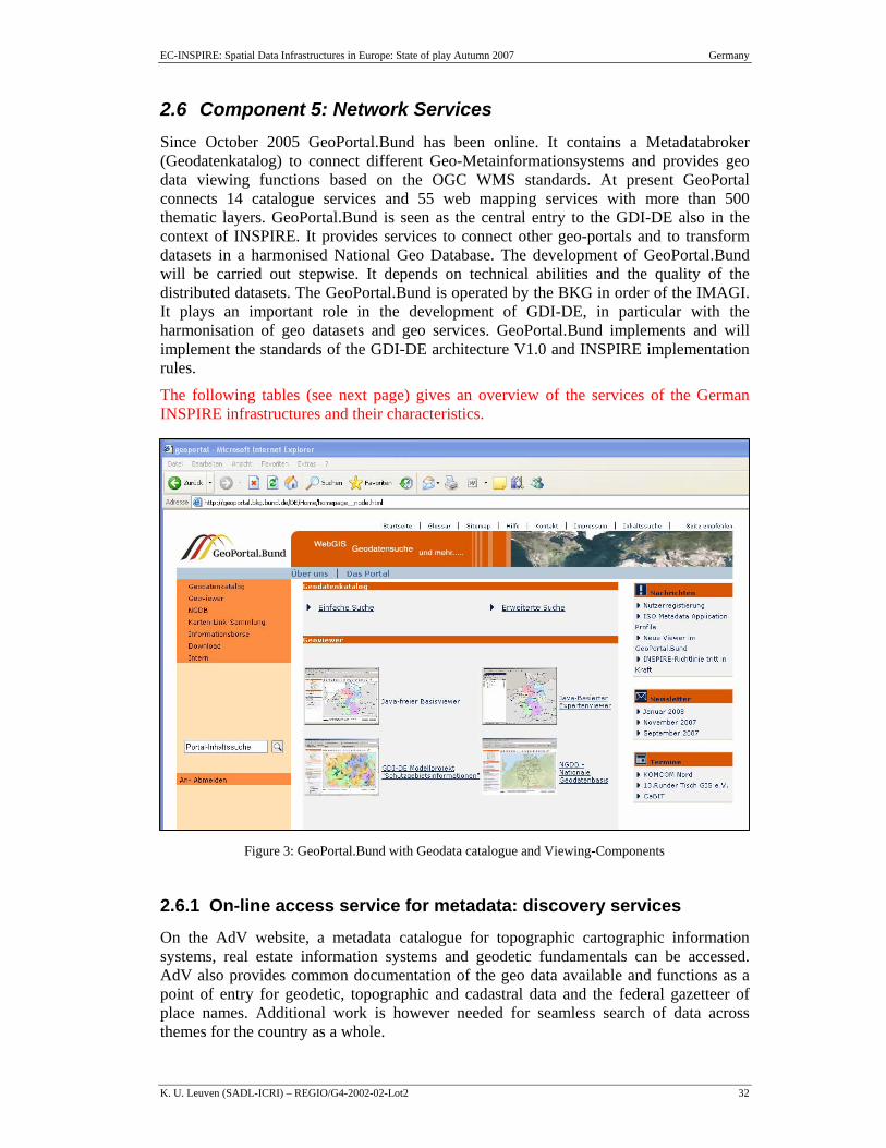
2.6 Component 5: Network Services Since October 2005 GeoPortal.Bund has been online. It contains a Metadatabroker (Geodatenkatalog) to connect different Geo-Metainformationsystems and provides geo data viewing functions based on the OGC WMS standards. At present GeoPortal connects 14 catalogue services and 55 web mapping services with more than 500 thematic layers. GeoPortal.Bund is seen as the central entry to the GDI-DE also in the context of INSPIRE. It provides services to connect other geo-portals and to transform datasets in a harmonised National Geo Database. The development of GeoPortal.Bund will be carried out stepwise. It depends on technical abilities and the quality of the distributed datasets. The GeoPortal.Bund is operated by the BKG in order of the IMAGI. It plays an important role in the development of GDI-DE, in particular with the harmonisation of geo datasets and geo services. GeoPortal.Bund implements and will implement the standards of the GDI-DE architecture V1.0 and INSPIRE implementation rules.
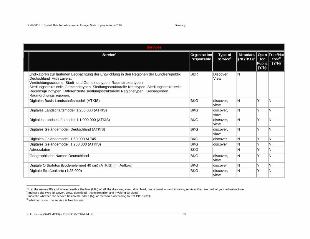
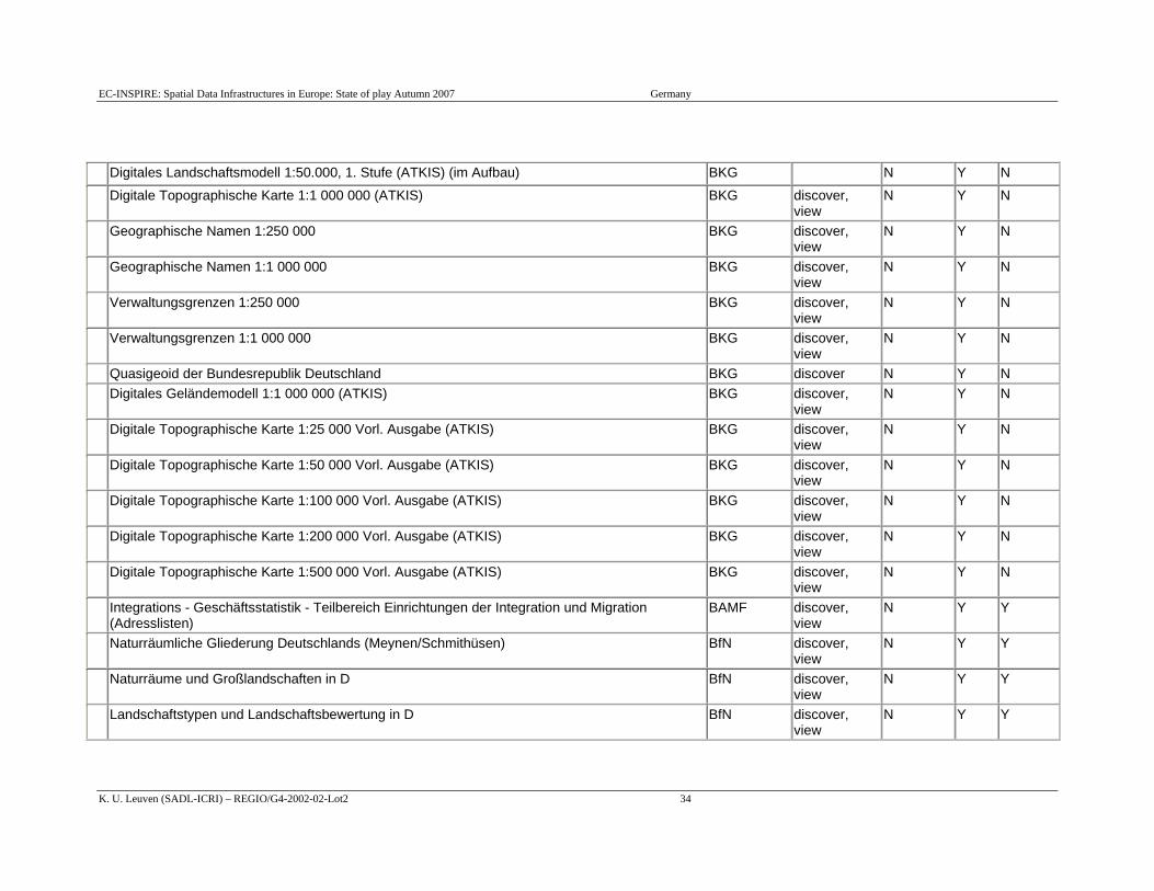
The following tables (see next page) gives an overview of the services of the German INSPIRE infrastructures and their characteristics.
2.6.1 On-line access service for metadata: discovery services
On the AdV website, a metadata catalogue for topographic cartographic information systems, real estate information systems and geodetic fundamentals can be accessed. AdV also provides common documentation of the geo data available and functions as a point of entry for geodetic, topographic and cadastral data and the federal gazetteer of place names. Additional work is however needed for seamless search of data across themes for the country as a whole.
Figure 3: GeoPortal.Bund with Geodata catalogue and Viewing-Components
EC-INSPIRE: Spatial Data Infrastructures in Europe: State of play Autumn 2007 Germany
K. U. Leuven (SADL-ICRI) – REGIO/G4-2002-02-Lot2 33
Services
Service5 Organisation responsible
Type of service6
Metadata (N/Y/ISO)7
Open for
Public (Y/N)
Free/Not free8 (Y/N)
„Indikatoren zur laufenen Beobachtung der Entwicklung in den Regionen der Bundesrepublik Deutschland“ with Layers: Verdichtungsraeume, Stadt- und Gemeindetypen, Raumstrukturtypen, Siedlungsstrukturelle Gemeindetypen, Siedlungsstrukturelle Kreistypen, Siedlungsstrukturelle Regionsgrundtypen, Differenzierte siedlungsstrukturelle Regionstypen, Kreisregionen, Raumordnungsregionen,
BBR Discover View
N
Digitales Basis-Landschaftsmodell (ATKIS) BKG discover, view
N Y N
Digitales Landschaftsmodell 1:250 000 (ATKIS) BKG discover, view
N Y N
Digitales Landschaftsmodell 1:1 000 000 (ATKIS) BKG discover, view
N Y N
Digitales Geländemodell Deutschland (ATKIS) BKG discover, view
N Y N
Digitales Geländemodell 1:50 000 M 745 BKG discover N Y N Digitales Geländemodell 1:250 000 (ATKIS) BKG discover N Y N Adressdaten BKG N Y N Geographische Namen Deutschland BKG discover,
view N Y N
Digitale Orthofotos (Bodenelement 40 cm) (ATKIS) (im Aufbau) BKG discover N Y N Digitale Straßenkarte (1:25.000) BKG discover,
view N Y N
5 List the names/IDs and where possible the link (URL) of all the discover, view, download, transformation and invoking services that are part of your infrastructure 6 Indicate the type (discover, view, download, transformation and invoking services) 7 Indicate whether the service has no metadata (N), or metadata according to ISO 19119 (ISO). 8 Whether or not the service is free for use.
EC-INSPIRE: Spatial Data Infrastructures in Europe: State of play Autumn 2007 Germany
K. U. Leuven (SADL-ICRI) – REGIO/G4-2002-02-Lot2 34
Digitales Landschaftsmodell 1:50.000, 1. Stufe (ATKIS) (im Aufbau) BKG N Y N Digitale Topographische Karte 1:1 000 000 (ATKIS) BKG discover,
view N Y N
Geographische Namen 1:250 000 BKG discover, view
N Y N
Geographische Namen 1:1 000 000 BKG discover, view
N Y N
Verwaltungsgrenzen 1:250 000 BKG discover, view
N Y N
Verwaltungsgrenzen 1:1 000 000 BKG discover, view
N Y N
Quasigeoid der Bundesrepublik Deutschland BKG discover N Y N Digitales Geländemodell 1:1 000 000 (ATKIS) BKG discover,
view N Y N
Digitale Topographische Karte 1:25 000 Vorl. Ausgabe (ATKIS) BKG discover, view
N Y N
Digitale Topographische Karte 1:50 000 Vorl. Ausgabe (ATKIS) BKG discover, view
N Y N
Digitale Topographische Karte 1:100 000 Vorl. Ausgabe (ATKIS) BKG discover, view
N Y N
Digitale Topographische Karte 1:200 000 Vorl. Ausgabe (ATKIS) BKG discover, view
N Y N
Digitale Topographische Karte 1:500 000 Vorl. Ausgabe (ATKIS) BKG discover, view
N Y N
Integrations - Geschäftsstatistik - Teilbereich Einrichtungen der Integration und Migration (Adresslisten)
BAMF discover, view
N Y Y
Naturräumliche Gliederung Deutschlands (Meynen/Schmithüsen) BfN discover, view
N Y Y
Naturräume und Großlandschaften in D BfN discover, view
N Y Y
Landschaftstypen und Landschaftsbewertung in D BfN discover, view
N Y Y
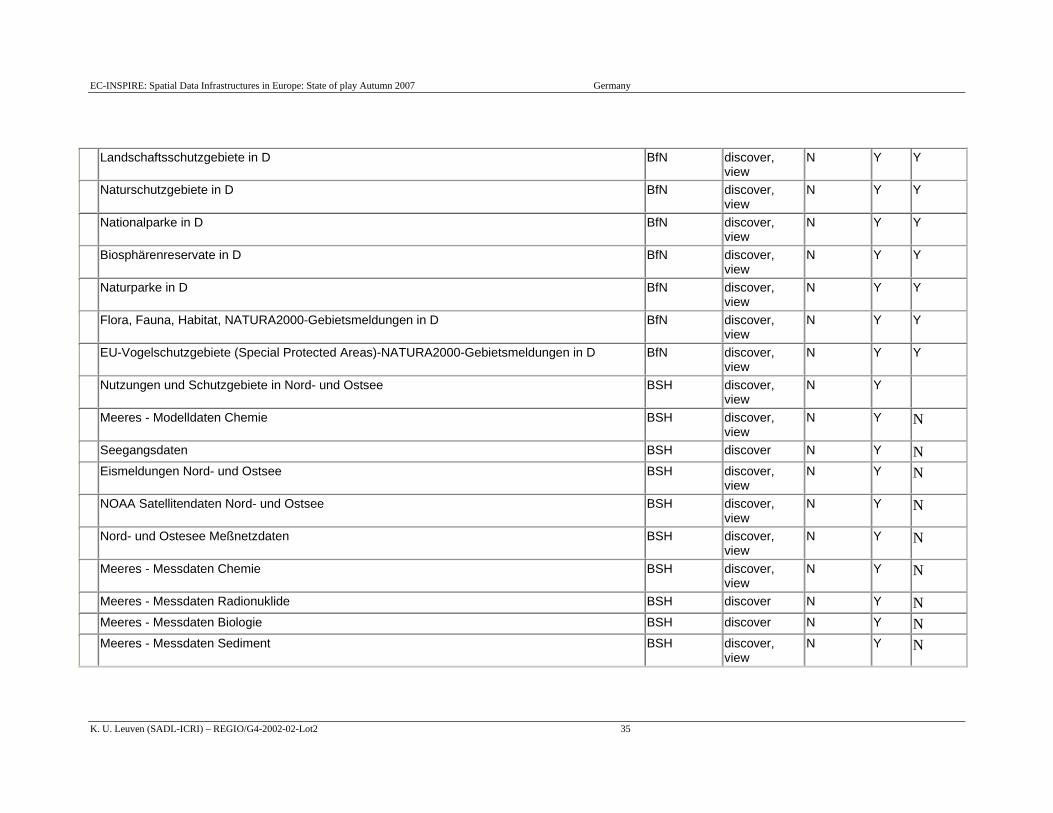
EC-INSPIRE: Spatial Data Infrastructures in Europe: State of play Autumn 2007 Germany
K. U. Leuven (SADL-ICRI) – REGIO/G4-2002-02-Lot2 35
Landschaftsschutzgebiete in D BfN discover, view
N Y Y
Naturschutzgebiete in D BfN discover, view
N Y Y
Nationalparke in D BfN discover, view
N Y Y
Biosphärenreservate in D BfN discover, view
N Y Y
Naturparke in D BfN discover, view
N Y Y
Flora, Fauna, Habitat, NATURA2000-Gebietsmeldungen in D BfN discover, view
N Y Y
EU-Vogelschutzgebiete (Special Protected Areas)-NATURA2000-Gebietsmeldungen in D BfN discover, view
N Y Y
Nutzungen und Schutzgebiete in Nord- und Ostsee BSH discover, view
N Y
Meeres - Modelldaten Chemie BSH discover, view
N Y N
Seegangsdaten BSH discover N Y N Eismeldungen Nord- und Ostsee BSH discover,
view N Y N
NOAA Satellitendaten Nord- und Ostsee BSH discover, view
N Y N
Nord- und Ostesee Meßnetzdaten BSH discover, view
N Y N
Meeres - Messdaten Chemie BSH discover, view
N Y N
Meeres - Messdaten Radionuklide BSH discover N Y N Meeres - Messdaten Biologie BSH discover N Y N Meeres - Messdaten Sediment BSH discover,
view N Y N

EC-INSPIRE: Spatial Data Infrastructures in Europe: State of play Autumn 2007 Germany
K. U. Leuven (SADL-ICRI) – REGIO/G4-2002-02-Lot2 36
Meeres - Modelldaten Physik BSH discover, view
N Y N
Unterwasserhindernisse BSH discover, view
N Y N
nationale See- und Verwaltungsgrenzen BSH discover, view
N Y N
Elektronische Seekarten BSH discover, view
N Y N
Seekartendaten - Vektor BSH discover N Y N Seekartendaten - Raster BSH discover N Y N Meeres - Messdaten Physik BSH discover,
view N Y N
Zentrale Zwischenlager BfS discover, view
N Y Y
Standort-Zwischenlager BfS discover, view
N Y Y
Endlager für radioaktive Abfälle Morsleben BfS discover, view
N Y Y
Bergwerk zur Erkundung des Salzstocks Gorleben BfS discover, view
N Y Y
Endlagerprojekt Schachtanlage Konrad BfS discover, view
N Y Y
Bodenübersichtskarte der Bundesrepublik Deutschland 1:1000000 BGR discover, view
N Y Y
Bodenübersichtskarte der Bundesrepublik Deutschland 1:2000000 BGR discover, view
N Y Y
Bodenübersichtskarte der Bundesrepublik Deutschland 1:5000000 BGR discover, view
N Y Y
Geomorphographische Übersichtskarte der Bundesrepublik Deutschland 1:1000000 BGR discover, view
N Y Y
Hydrogeologische Übersichtskarte der Bundesrepublik Deutschland 1:200000 BGR discover, view
N Y Y
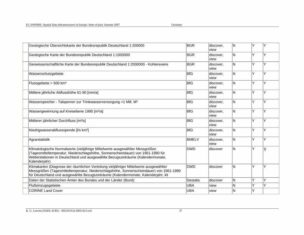
EC-INSPIRE: Spatial Data Infrastructures in Europe: State of play Autumn 2007 Germany
K. U. Leuven (SADL-ICRI) – REGIO/G4-2002-02-Lot2 37
Geologische Übersichtskarte der Bundesrepublik Deutschland 1:200000 BGR discover, view
N Y Y
Geologische Karte der Bundesrepublik Deutschland 1:1000000 BGR discover, view
N Y Y
Geowissenschaftliche Karte der Bundesrepublik Deutschland 1:2000000 - Kohlereviere BGR discover, view
N Y Y
Wasserschutzgebiete BfG discover, view
N Y Y
Flussgebiete > 500 km² BfG discover, view
N Y Y
Mittlere jährliche Abflusshöhe 61-90 [mm/a] BfG discover, view
N Y Y
Wasserspeicher - Talsperren zur Trinkwasserversorgung >1 Mill. M³ BfG discover, view
N Y Y
Wassergewinnung auf Kreisebene 1995 [m³/a] BfG discover, view
N Y Y
Mittlerer jährlicher Durchfluss [m³/s] BfG discover, view
N Y Y
Niedrigwasserabflussspende [l/s km²] BfG discover, view
N Y Y
Agrarstatistik BMELV discover, view
N Y Y
Klimatologische Normalwerte (vieljährige Mittelwerte ausgewählter Messgrößen (Tagesmitteltemperatur, Niederschlagshöhe, Sonnenscheindauer) von 1961-1990 für Wetterstationen in Deutschland und ausgewählte Bezugszeiträume (Kalendermonate, Kalenderjahr)
DWD discover N Y Y
Klimakarten (Diagnose der räumlichen Verteilung vieljähriger Mittelwerte ausgewählter Messgrößen (Tagesmitteltemperatur, Niederschlagshöhe, Sonnenscheindauer) von 1961-1990 für Deutschland und ausgewählte Bezugszeiträume (Kalendermonate, Kalenderjahr, kli
DWD discover N Y Y
Daten der Statistischen Ämter des Bundes und der Länder (Bund) Destatis discover N Y Y Flußeinzugsgebiete UBA view N Y Y CORINE Land Cover UBA view N Y
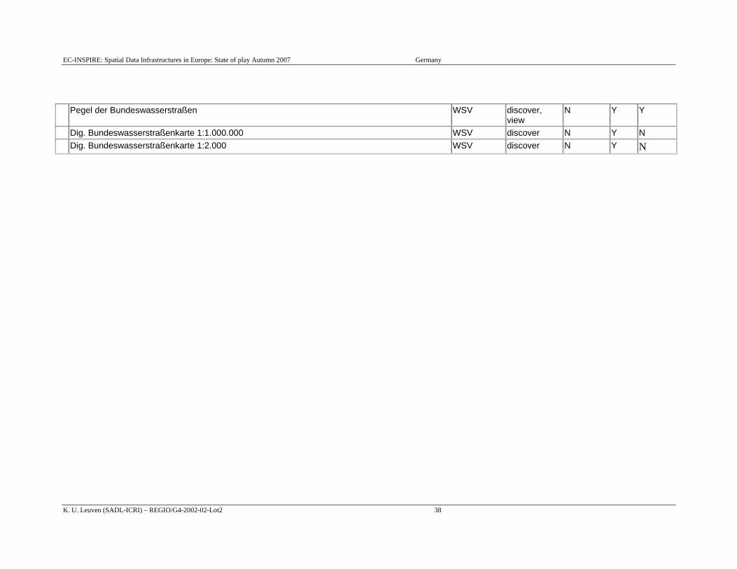
EC-INSPIRE: Spatial Data Infrastructures in Europe: State of play Autumn 2007 Germany
K. U. Leuven (SADL-ICRI) – REGIO/G4-2002-02-Lot2 38
Pegel der Bundeswasserstraßen WSV discover, view
N Y Y
Dig. Bundeswasserstraßenkarte 1:1.000.000 WSV discover N Y N Dig. Bundeswasserstraßenkarte 1:2.000 WSV discover N Y N
EC-INSPIRE: Spatial Data Infrastructures in Europe: State of play Autumn 2007 Germany
K. U. Leuven (SADL-ICRI) – REGIO/G4-2002-02-Lot2 39
The online metadata information system Geodatenkatalog has been set up by BKG to provide an internet application with web-based query tools for accessing federal information on geodata (topographic reference data as well as thematic data). Geodatenkatalog® greatly facilitates access to and use of the databases (maintained decentralized). It is a platform-independent search system and incorporates all specialist metadata information systems of the federal authorities. Geodatenkatalog® is a service available to authorities (federal administrations as well as for the federal states and communes), industry and the general public via Internet. It provides users with metadata from fourteen distributed systems and a wide thematic range.
It is an integral part of the federal geoportal [German designation: GeoPortal.Bund], which provides users with different services and information. The Geodatenkatalog and the GeoPortal.Bund are based on the ISO family of standards – especially on the ISO 19115, 19119, 19139 and OGC "ISO 19115/ISO19119 Application Profile for CSW 2.0" and "OpenGIS® Catalogue Services Specification 2.0.2 - ISO Metadata Application Profile" standards.
Some Federal states of the Federal Republic of Germany have already implemented or are in the process of implementing geoportals featuring a wide range of commonly used services. The forthcoming GeoPortal.Bund can be considered as the main component of the National Spatial Data Infrastructure (GDI-DE) and will be functioning as a central point of entry for GI in Germany, provided by the German Federal administration. It will be linked to the geoportals of the federal states, as well as to specific sector databases and services. It shall also provide facilities for publishing data and metadata.
With regard to the planned EU (INSPIRE)-geoportal the GeoPortal.Bund will be able to form a node with this.
In this sense the model project named "Geodatenkatalog-DE" regards and implements the requirements of INSPIRE (i.e. implementing rules on metadata and network services (discovery services)). The data of the federal states and the federation will be focused in a consistent way and topology to one central point for the delivery to the INSPIRE Portal.
For quality management reasons a conformance test was developed in the model project. This test is based on the OGC team engine and it is planned to put it to OGC. It proves if a catalogue service is alive, if the namespaces, the SOAP header are o.k., 19139 schemata and multilinguality.
For more information see "Survey for the impact assessment of the INSPIRE EU Geo-portal".
The environmental administrations in Germany agreed on the metadata model UDK, which distinguishes classes as
Data collection/Database
Service/Application/Information system
Document/Report/Literature
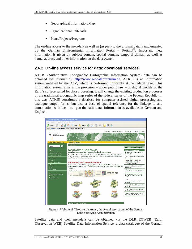
EC-INSPIRE: Spatial Data Infrastructures in Europe: State of play Autumn 2007 Germany
K. U. Leuven (SADL-ICRI) – REGIO/G4-2002-02-Lot2 40
Geographical information/Map
Organizational unit/Task
Plans/Projects/Programs
The on-line access to the metadata as well as (in part) to the original data is implemented by the German Environmental Information Portal – PortalU®. Important meta information is given by subject domain, spatial domain, temporal domain as well as name, address and other information on the data owner.
2.6.2 On-line access service for data: download services
ATKIS (Authoritative Topographic Cartographic Information System) data can be obtained via Internet by http://www.geodatenzentrum.de. ATKIS is an information system initiated by the AdV, which is performed uniformly at the federal level. This information system aims at the provision – under public law – of digital models of the Earth's surface suited for data processing. It will change the existing production processes of the traditional topographic map series of the federal states of the Federal Republic. In this way ATKIS constitutes a database for computer-assisted digital processing and analogue output forms, but also a base of spatial reference for the linkage to and combination with technical geo-thematic data. Information is available in German and English.
Satellite data and their metadata can be obtained via the DLR EOWEB (Earth Observation WEB) Satellite Data Information Service, a data catalogue of the German
Figure 4: Website of "Geodatenzentrum", the central service unit of the German Land Surveying Administration
EC-INSPIRE: Spatial Data Infrastructures in Europe: State of play Autumn 2007 Germany
K. U. Leuven (SADL-ICRI) – REGIO/G4-2002-02-Lot2 41
Remote Sensing Data Centre (DFD). Thematic maps are also available. Links are provided to further map catalogue access services like: AUC (Atmospheric User Centre), World Data Centre (for atmospheric data, CEOS data catalogue/archive, Einet (data catalogue of EURIMAGE, Sirius (data catalogue SPOT Image), GLOBE (Global Elevation model of USGS), Aviso (Oceanographic data).
The on-line access for core thematic data of environmental administrations is realized by the German Environmental Information Portal PortalU® (www.portalu.de). PortalU® brings together a wide range of distributed information from a multitude of public organisations in Germany, such as environmental authorities, agencies and ministries at federation and federal state level.
PortalU® currently provides environmental information of nearly 200 suppliers from governmental authorities and other public institutions at federation and federal state level. This offer encompasses over 1,000,000 web pages and numerous databases such as the Environmental Specimen Bank of the Federal Environmental Agency (UBA) or the Documentation Data Base for Nature and Landscape of the Federal Agency for Nature Conservation (BfN).
The German environmental metadata model (UDK) is fully integrated in PortalU®. Thus PortalU® provides both direct accesses to environmental data and environmental metadata through one interface.
2.6.3 Inter-linkages of on-line access services for metadata and data
See 2.5.2 Metadata catalogues availability + standard
2.6.4 OpenSource software and access services
The underlying modular software of the German Environmental Information Portal PortalU® InGrid® is based on standard OpenSource technologies, which were adapted to the needs of PortalU®. To store configuration information and local metadata, InGrid® relies on MySQL as RDBMS. The InGrid® search engine is based on Nutch and Lucene, and the built-in GIS utility applies the UMN Mapserver. As map viewer the OpenSource software mapbender is used and the portal surface is realised by jetspeed.
2.6.5 Availability of viewing services
See 2.5.2 Metadata catalogues availability + standard
2.6.6 Availability of catalogue services to regulate access
NIA
2.6.7 Availability of catalogue services that perform payment operations
NIA
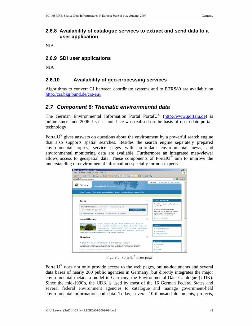
EC-INSPIRE: Spatial Data Infrastructures in Europe: State of play Autumn 2007 Germany
K. U. Leuven (SADL-ICRI) – REGIO/G4-2002-02-Lot2 42
2.6.8 Availability of catalogue services to extract and send data to a user application
NIA
2.6.9 SDI user applications
NIA
2.6.10 Availability of geo-processing services
Algorithms to convert GI between coordinate systems and to ETRS89 are available on http://crs.bkg.bund.de/crs-eu/.
2.7 Component 6: Thematic environmental data The German Environmental Information Portal PortalU® (http://www.portalu.de) is online since June 2006. Its user-interface was realised on the basis of up-to-date portal-technology.
PortalU® gives answers on questions about the environment by a powerful search engine that also supports spatial searches. Besides the search engine separately prepared environmental topics, service pages with up-to-date environmental news, and environmental monitoring data are available. Furthermore an integrated map-viewer allows access to geospatial data. These components of PortalU® aim to improve the understanding of environmental information especially for non-experts.
Figure 5: PortalU® main page
PortalU® does not only provide access to the web pages, online-documents and several data bases of nearly 200 public agencies in Germany, but directly integrates the major environmental metadata model in Germany, the Environmental Data Catalogue (UDK). Since the mid-1990's, the UDK is used by most of the 16 German Federal States and several federal environment agencies to catalogue and manage government-held environmental information and data. Today, several 10-thousand documents, projects,
EC-INSPIRE: Spatial Data Infrastructures in Europe: State of play Autumn 2007 Germany
K. U. Leuven (SADL-ICRI) – REGIO/G4-2002-02-Lot2 43
digital maps, geoservices, and other environmentally relevant information items are referenced by the UDK.
Most of this information and data has a relation to geographic space. A considerable part of it can even be classified as "geospatial". Therefore PortalU® plays an important role as a catalogue of environmental geospatial data within the national SDI, i.e. the GDI-DE, and the NGDB.
The PortalU® metadata module is ISO-conform and compatible with the metadata formats used by the GDI-DE and INSPIRE. The metadata are made accessible through a standardized catalogue-interface based on the same OGC specifications that are applied by the GDI-DE. Thus an effective communication of PortalU® with the metadata component of the GDI-DE is warranted. PortalU® is linked to the GeoPortal.bund (http://geoportal.bkg.bund.de/) as catalogue for environmental geospatial data.
2.7.1 Application of the legal framework and funding principles to thematic environmental data
In the context of the agreement of environmental authorities on federal and federal state level mentioned in chapter 2.7.3 the following funding principle was founded: 450 t€/a were spent for running PortalU®, paid half by federal level, half by federal state level. For further developments of the common system 300 t€/a are planned. 75 % of that amount is paid by the federal level, 25 % by federal state level.
2.7.2 Application of metadata issues to thematic environmental data
Based on the law on free access to environmental data information, a memorandum of understanding between the ministries of environment of the Federal Government and the federal states was signed in January 1996 for maintaining and developing the German Environmental Data Catalogue (Umweltdatenkatalog), UDK. Since then several 10-thousand documents, projects, digital maps, geoservices, and other environmentally relevant information items are referenced by the UDK.
After an update of the memorandum in 2003 the UDK-metadata model was fully integrated in PortalU®. Other kinds of metadata systems can be connected to PortalU® by a CSW interface.
2.7.3 Application of access services to thematic environmental data
The UDK metadata model allows specifying URLs that link directly to thematic data or accordant services (e.g. web-mapping-services). A web mapping services (WMS) referenced by UDK metadata is integrated in PortalU®. The WMS enables the user to visualize geospatial data. Thus multiple geospatial data sets (e.g. digital maps) from different sources can be visualized in PortalU®.
2.7.4 Application of standards issues to thematic environmental data
One of the GDI-DE pilot projects pertains to environmental spatial designations. See chapter 2.2, p. 18 and 2.7.
EC-INSPIRE: Spatial Data Infrastructures in Europe: State of play Autumn 2007 Germany
K. U. Leuven (SADL-ICRI) – REGIO/G4-2002-02-Lot2 44
2.7.5 Application of update procedures issues to thematic environmental data
FIR
2.8 Use and efficiency of SDI The duplication of functionality and data production is identified as key problem for the efficiency of geo data management. The creation of a nationwide SDI should also minimize inconveniences and restraints of data availability, access, exchange and compatibility. Decentralized data acquisition and management without binding (inter)national standards, insufficient and inhomogeneous documentation, inconsistent licensing and pricing policy of public data providers, lack of awareness of the potential use and infrastructural requests of geodata management and the lack of a generally accepted representation body for German GI issues are named as further obstacles to an efficient geodata management. IMAGI aims to tackle these problems within "sustainable and efficient" development and implementation of the GDI-DE® project, priority within the responsibilities of the federal government.
Examples on the use of the infrastructure:
A good example is the federal geodata portal “GeoPortal.Bund” (http://www.geoportal.bund.de), which is used as a common access point to services of Federation and States (currently ~130.000 page loads per week). It provides user access to a large variety of geodata and services: search for data, visualisation of spatial data, etc.
Another good example is the pilot project protected area sites, which is registered as a reference material for INSPIRE Implementing Rules.
The project is carried out by the environmental administrations in Germany (Federal and 6 state administrations) in cooperation with the SDI-Office (GKSt. GDI-DE). The aim of the project is harmonising cascading Webservices from distributed environmental agencies in Germany including the presentation of the result in GeoPortal.Bund (www.geoportal.bund.de). The WMS providers already agreed on a common framework, which was considered for the configuration for the services. The framework includes a common object catalogue, common attributes, signatures and other agreements.
The service protected area sites is frequently used by visitors of the website for visualisation. At the present the service will be technically prepared for using it in other information systems, e.g. an information system for surface mining.
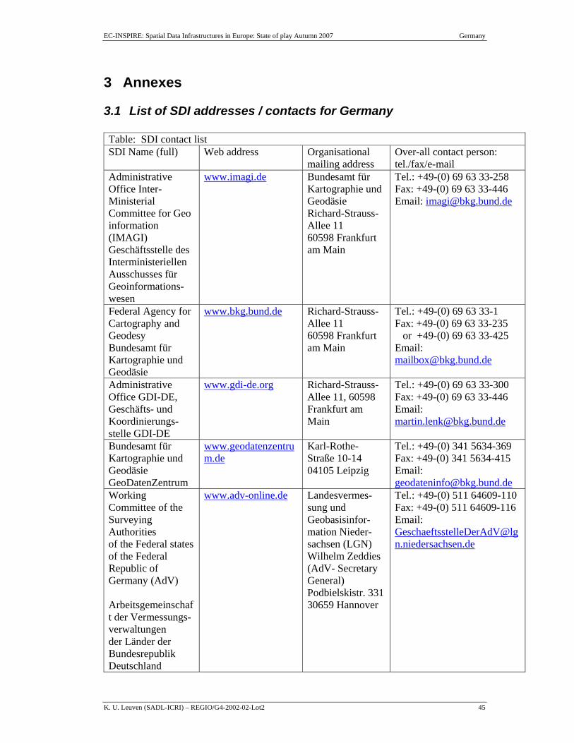
EC-INSPIRE: Spatial Data Infrastructures in Europe: State of play Autumn 2007 Germany
K. U. Leuven (SADL-ICRI) – REGIO/G4-2002-02-Lot2 45
3 Annexes
3.1 List of SDI addresses / contacts for Germany Table: SDI contact list SDI Name (full) Web address Organisational
mailing address Over-all contact person: tel./fax/e-mail
Administrative Office Inter-Ministerial Committee for Geo information (IMAGI) Geschäftsstelle des Interministeriellen Ausschusses für Geoinformations-wesen
www.imagi.de Bundesamt für Kartographie und Geodäsie Richard-Strauss-Allee 11 60598 Frankfurt am Main
Tel.: +49-(0) 69 63 33-258 Fax: +49-(0) 69 63 33-446 Email: [email protected]
Federal Agency for Cartography and Geodesy Bundesamt für Kartographie und Geodäsie
www.bkg.bund.de
Richard-Strauss-Allee 11 60598 Frankfurt am Main
Tel.: +49-(0) 69 63 33-1 Fax: +49-(0) 69 63 33-235 or +49-(0) 69 63 33-425 Email: [email protected]
Administrative Office GDI-DE, Geschäfts- und Koordinierungs-stelle GDI-DE
www.gdi-de.org Richard-Strauss-Allee 11, 60598 Frankfurt am Main
Tel.: +49-(0) 69 63 33-300 Fax: +49-(0) 69 63 33-446 Email: [email protected]
Bundesamt für Kartographie und Geodäsie GeoDatenZentrum
www.geodatenzentrum.de
Karl-Rothe-Straße 10-14 04105 Leipzig
Tel.: +49-(0) 341 5634-369 Fax: +49-(0) 341 5634-415 Email: [email protected]
Working Committee of the Surveying Authorities of the Federal states of the Federal Republic of Germany (AdV) Arbeitsgemeinschaft der Vermessungs-verwaltungen der Länder der Bundesrepublik Deutschland
www.adv-online.de
Landesvermes-sung und Geobasisinfor-mation Nieder-sachsen (LGN) Wilhelm Zeddies (AdV- Secretary General) Podbielskistr. 331 30659 Hannover
Tel.: +49-(0) 511 64609-110 Fax: +49-(0) 511 64609-116 Email: [email protected]
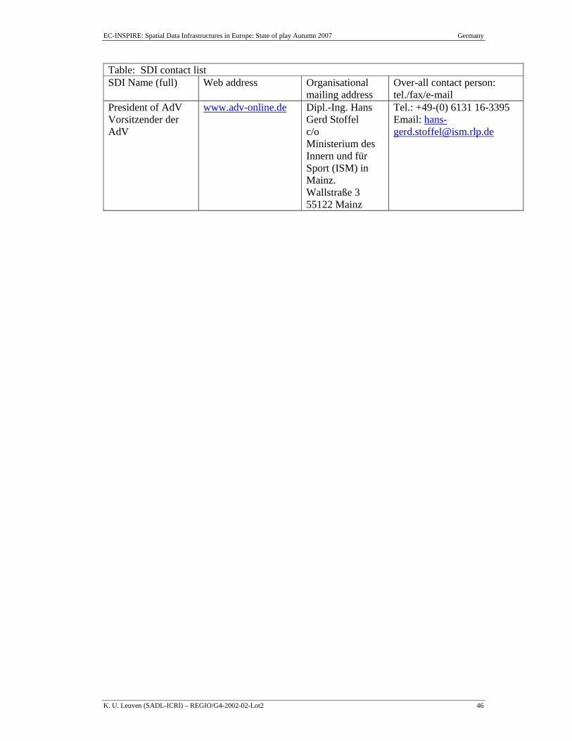
EC-INSPIRE: Spatial Data Infrastructures in Europe: State of play Autumn 2007 Germany
K. U. Leuven (SADL-ICRI) – REGIO/G4-2002-02-Lot2 46
Table: SDI contact list SDI Name (full) Web address Organisational
mailing address Over-all contact person: tel./fax/e-mail
President of AdV Vorsitzender der AdV
www.adv-online.de Dipl.-Ing. Hans Gerd Stoffel c/o Ministerium des Innern und für Sport (ISM) in Mainz. Wallstraße 3 55122 Mainz
Tel.: +49-(0) 6131 16-3395 Email: [email protected]
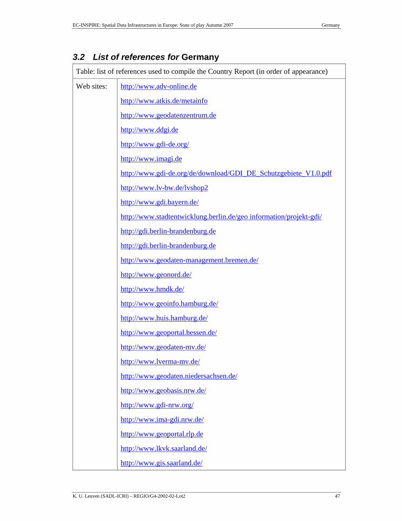
EC-INSPIRE: Spatial Data Infrastructures in Europe: State of play Autumn 2007 Germany
K. U. Leuven (SADL-ICRI) – REGIO/G4-2002-02-Lot2 47
3.2 List of references for Germany Table: list of references used to compile the Country Report (in order of appearance)
Web sites: http://www.adv-online.de
http://www.atkis.de/metainfo
http://www.geodatenzentrum.de
http://www.ddgi.de
http://www.gdi-de.org/
http://www.imagi.de
http://www.gdi-de.org/de/download/GDI_DE_Schutzgebiete_V1.0.pdf
http://www.lv-bw.de/lvshop2
http://www.gdi.bayern.de/
http://www.stadtentwicklung.berlin.de/geo information/projekt-gdi/
http://gdi.berlin-brandenburg.de
http://gdi.berlin-brandenburg.de
http://www.geodaten-management.bremen.de/
http://www.geonord.de/
http://www.hmdk.de/
http://www.geoinfo.hamburg.de/
http://www.huis.hamburg.de/
http://www.geoportal.hessen.de/
http://www.geodaten-mv.de/
http://www.lverma-mv.de/
http://www.geodaten.niedersachsen.de/
http://www.geobasis.nrw.de/
http://www.gdi-nrw.org/
http://www.ima-gdi.nrw.de/
http://www.geoportal.rlp.de
http://www.lkvk.saarland.de/
http://www.gis.saarland.de/
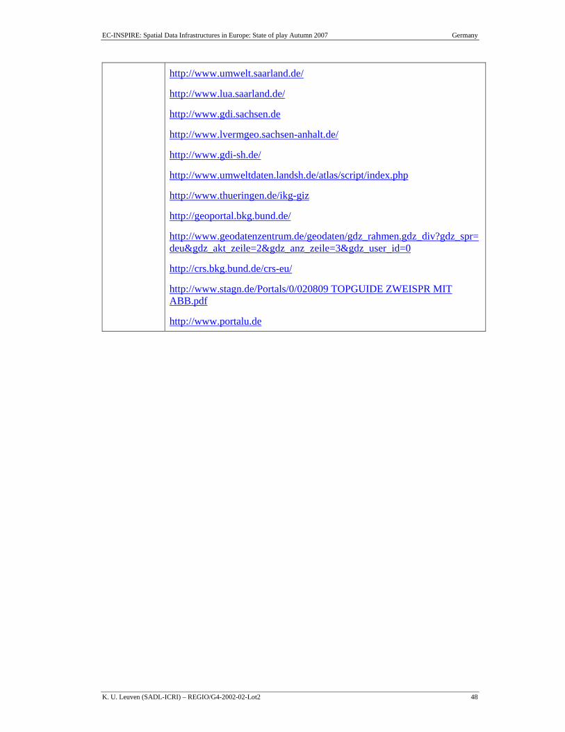
EC-INSPIRE: Spatial Data Infrastructures in Europe: State of play Autumn 2007 Germany
K. U. Leuven (SADL-ICRI) – REGIO/G4-2002-02-Lot2 48
http://www.umwelt.saarland.de/
http://www.lua.saarland.de/
http://www.gdi.sachsen.de
http://www.lvermgeo.sachsen-anhalt.de/
http://www.gdi-sh.de/
http://www.umweltdaten.landsh.de/atlas/script/index.php
http://www.thueringen.de/ikg-giz
http://geoportal.bkg.bund.de/
http://www.geodatenzentrum.de/geodaten/gdz_rahmen.gdz_div?gdz_spr=deu&gdz_akt_zeile=2&gdz_anz_zeile=3&gdz_user_id=0
http://crs.bkg.bund.de/crs-eu/
http://www.stagn.de/Portals/0/020809 TOPGUIDE ZWEISPR MIT ABB.pdf
http://www.portalu.de
Recommended