Rahan Tully
Water Framework Directive
Groundwater Monitoring Programme
Site Information
Tully comprises 2 adjacent boreholes in a pump house; referred to as the Tully wells which in conjunction with the Agall / Hollims Hill sources
collectively supply the Rahan Scheme. The Tully boreholes abstract 432 m³/day.
ImagePath1: Rahan
Tully\IE_SH_G_19_011_a_Sampl
ingTap.jpg
August 2011
Offaly
Final Borehole Depth (m): ---
Site Use: Drinking Water (PWS)
RBD: Shannon IRBD
Northing: 226609
County: Offaly
EU Reporting Code: IE_SH_G_232_19_011
GWB Name: Tullamore
GWB Code: IE_SH_G_232
Drinking Water Code: 2500PUB1016
Site Name: Rahan Tully
Water Quality Monitoring Network:
Hydrometric Area: 25
Ownership: Offaly County Council
Site Comments:
The Tully boreholes contribute to the Rahan Scheme. They are adjacent to each other in a pump house.
SITE INFORMATION
Screen Interval (m bgl): ---
Potential Yield (m³/day): ---
Top of Casing (m agl): ---
Abstraction Rate (m³/d): 432 Ground Elevation (m OD): 63
Upper Casing Diameter (mm):
450
Upper Casing Bottom Depth (m bgl) :
---
Monitoring Point Type: BH
Specific Capacity (m³/d/m):
35Comments on Monitoring
Site:
Both boreholes are vulnerable from surface contamination.
WELL INFORMATION
Total Drilled Depth (m bgl): 60 and 91 (Tully BH's) Depth to Bedrock (m bgl): 4
Lower Casing Diameter (mm):
---
Lower Casing Bottom Depth (m bgl):
---
Static Water Level (m bgl): 7-9
SITE DIRECTIONS
Location and Access Information:
---
Additional Comments: ---
Townland: AGHALUSKY
Water Level Monitoring Network:
Easting: 227435
Open Hole Interval (m bgl): ---
Level Flow
Surveillance Operational (Point) Operational (Diffuse)
Borehole Log Available:
NN
N N Y
---
Scheme Name: Rahan WSSNumber of Abstraction Points in the Scheme:
5
Scheme Summary:There are two boreholes at Tully. The two Tully boreholes in conjunction with the Agall Spring and two boreholes for Hollimhill collectively supply the Rahan Scheme.
Source Report Available
Y
Source Report Info:GSI report prepared for Tully boreholes and separately for Agall and Hollimshill.
Screen Type (PVC,Steel,other):
--- Screen Slot Size (mm): ---
Grout Type (cement,bentonite):
--- Grouted above (m bgl): --- Grout Volume Injected (m³):
---
Gravel Pack Interval (m bgl):
--- Gravel Pack Volume (m³): ---
Page 2 of 5
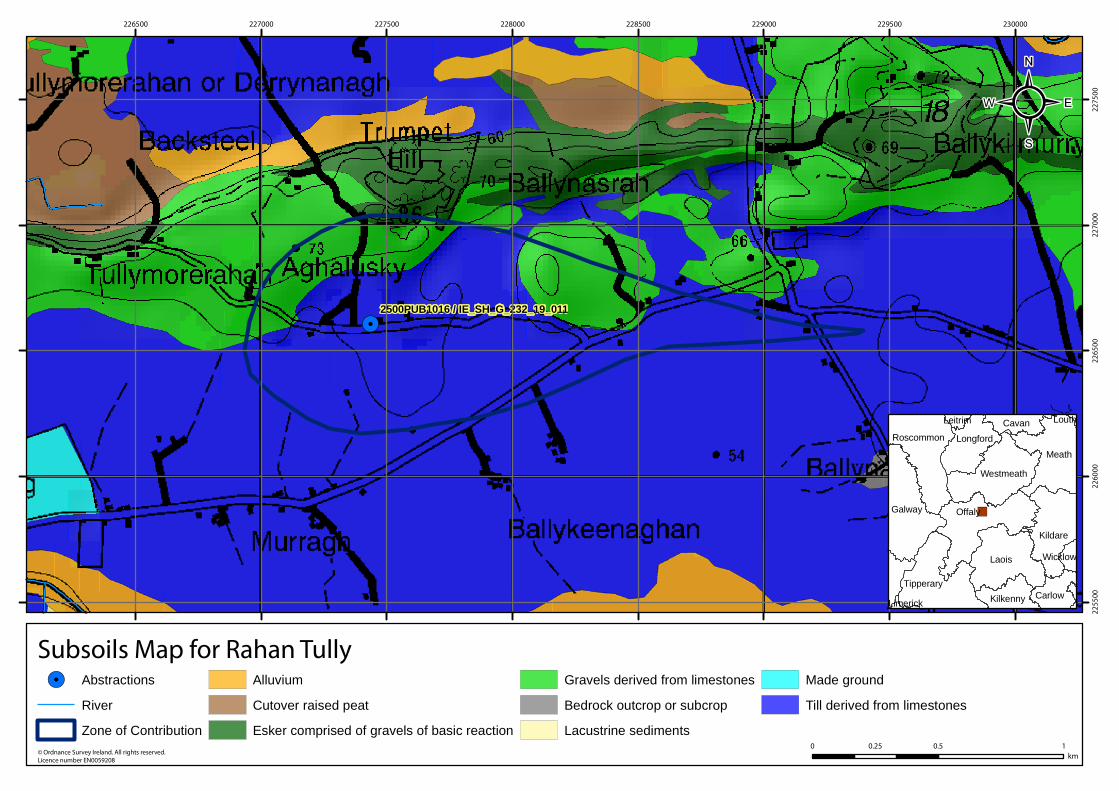
Subsoil: Tills (diamictons) (TLs)
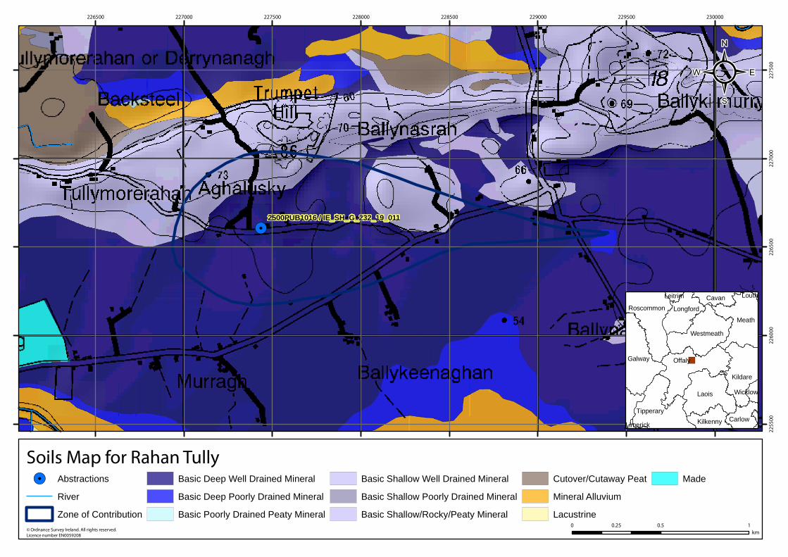
Soil: Deep well drained mineral (BminDW)
ZOC Delineation Comments:
ZOC delineated by the GSI. Both Inner and Outer Source Protection Areas were defined. Available from the groundwater section at GSI.
HYDROGEOLOGY
GEOLOGY
Bedrock: Dinantian Pure Bedded Limestones
Subsoil Permeability:
Moderate
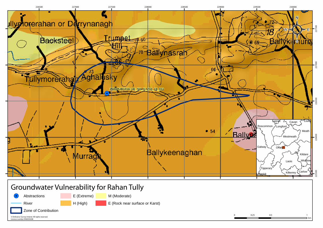
HYDROGEOLOGYVulnerability at Monitoring
site:
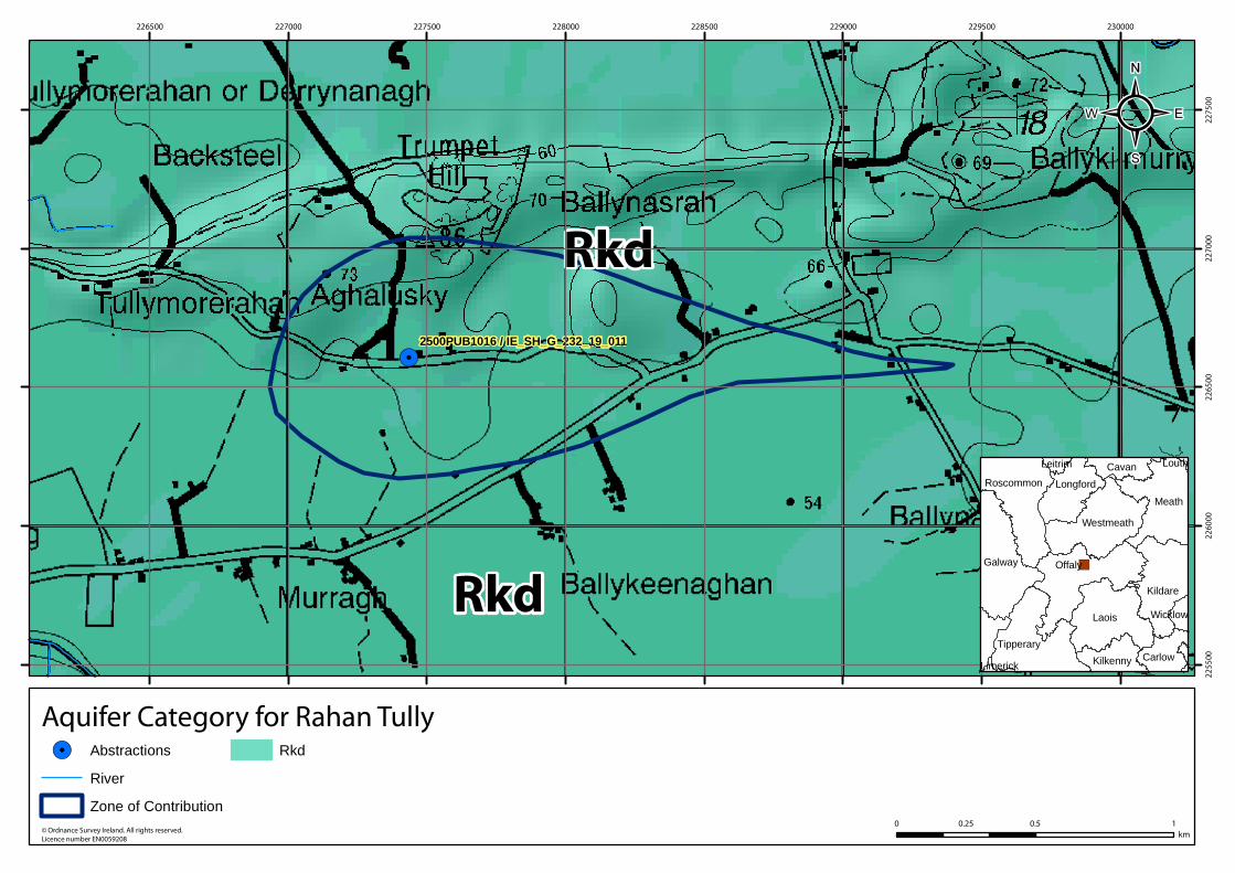
HighAquifer
Category: Rkd Flow Regime: Karstified
ZONE OF CONTRIBUTION
Estimated ZOC Size
(km²):
1.15
Recharge Est (mm/yr):
280
HYDROCHEMISTRY
Additional Water
Chemistry Information:
During the monitoring period: The average nitrate concentration was 20 mg/l NO3 and the maximum nitrate concentration was 33 mg/l NO3. The average ammonium concentration was 0.012 mg/l N and the maximum ammonium concentration was 0.076 mg/l N. The average molybdate reductive phosphorus (MRP) concentration was 0.006 mg/l P and the maximum MRP concentration was 0.024 mg/l P. The average chloride concentration was 20.2 mg/l Cl and the maximum chloride concentration was 26 mg/l Cl.
ZOC Delineated By: GSI
Recharge Estimate(mm/yr):
Average:
323Alkalinity (mg/l HCO3):
Range:
220-410
Average:
397Hardness (mg/l
CaCO3):
Range:
306-739
Average:
710Conductivity (uS/cm):
Range:
303-1140
From:
1996
Monitoring Record Period:
To:
2010
RISK ASSESSMENT
Risk Category: At risk, high confidence
Typical Contaminants: ---
GWB Status: Good
Pressure (e.g., Nitrates, Phosphates, Abstractions): ---
Extreme (X)
0
Groundwater Vulnerability within
ZOC (% area):
Extreme (E)
0
High
100
Moderate
0
Low
0
Unclassified
0
Extreme:
0.00
Impact Potential within ZOC (% area):
High:
0.00
Moderate:
100.00
Low:
0.00
Negligible:
0.00
Hydrochemical Signature: Ca-HCO3
High to Low
0
OTHER INFORMATION
---
Page 3 of 5
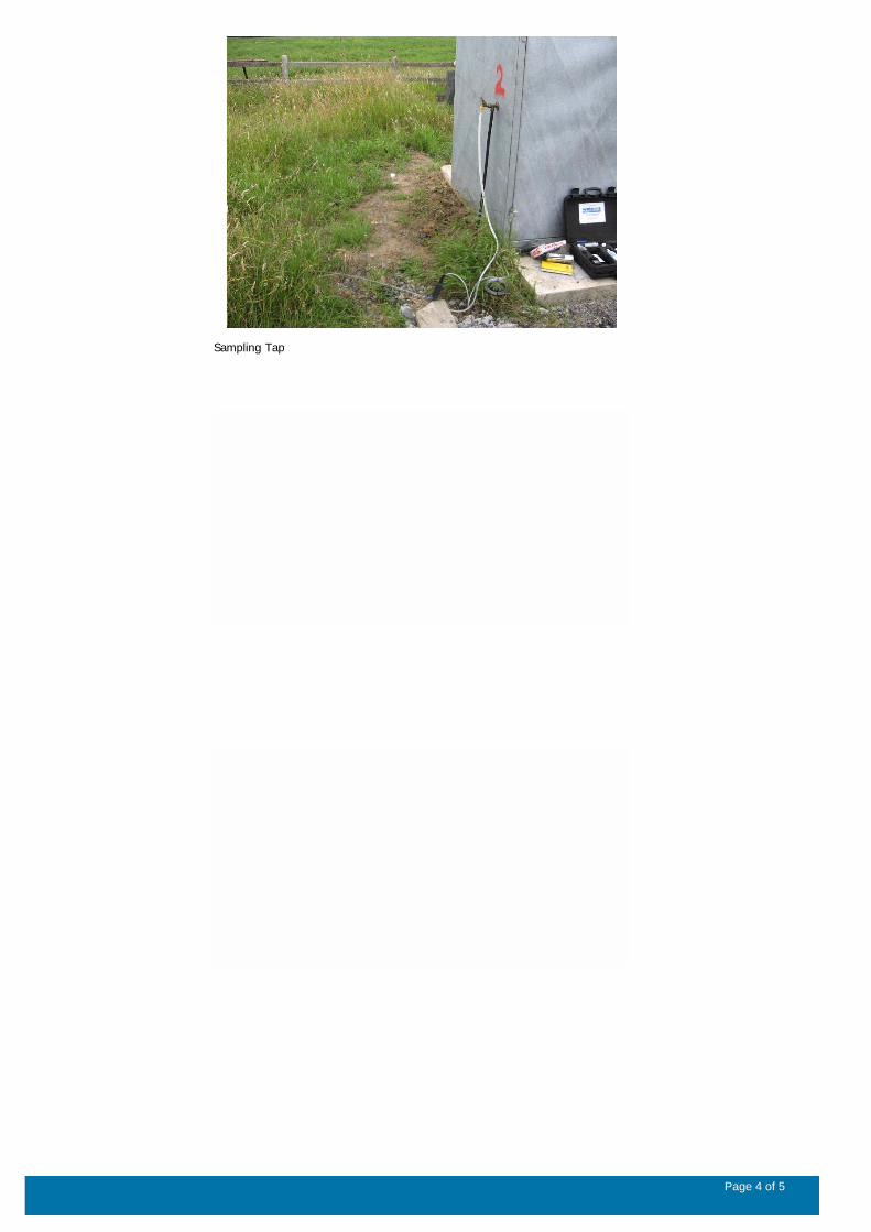
Sampling Tap
Page 4 of 5
Data Summary Sheet - July 2011
Disclaimer: The data in this document are based on the best available information and understanding at time of writing. Neither
the Environmental Protection Agency, nor the individual bodies supplying data for this document and accompanying maps will
be responsible for any loss or damage from the use or interpretation of these data.
Rock Unit Geology Map: GSI, 2009
Aquifer Type Map: GSI, 2009
Groundwater Vulnerability Map: GSI, 2009
Soils & Subsoils Type: Teagasc, 2007
Recharge Map: GSI, 2009
Impact Potential Map: EPA, 2009
Risk Assessment Map: EPA WFD Risk Assessment, 2006
Groundwater Body Status: EPA WFD Status Assessment, 2008
Water Quality Data: EPA WFD Monitoring, 2008
Groundwater Threshold Values
Groundwater threshold values for selected parameters:
Nitrate - General Chemical Test/ Drinking Water Test (37.5 mg/I N03)
Ammonium - Drinking Water Test (0.175 mg/I N) / Surface Water Test (0.065 mg/l N)
Molybdate Reactive Phosphorus (MRP) - Surface Water Test (0.035 mg/I P)
Chloride -Saline/Intrusive Test (24 mg/I) / Drinking Water Test (175 mg/I Cl)
Electrical Conductivity -Saline/Intrusive Test (800 µS/cm) / Drinking Water Test (1,875 µS/cm)
Further information on groundwater threshold values is contained in the Groundwater Regulations (S.I. No.9 of 2010).
General Downgradient Distances
General Downgradient Distances (XL) applied to boreholes sourced in bedrock aquifers are constrained to estimate approximate
limits based on data at the GSl. ln some cases they may be higher or lower depending on local conditions.
It is assumed that groundwater downgradient of a spring cannot flow back up to the spring, however a precautionary 30m buffer
is generally applied which allows for instances where pumping under dry weather periods may induce a drawdown or where the
ground may be sloping toward the spring from the downgradient side.
Rk, Rkd, Lk 225 m
Lm 150 m
Ll, PI 60 m
Prepared by GSI Date:
Prepared by Date:
Prepared by Date:
Prepared by Date:
Prepared by Tobin (CK) Date: Apr 2011
Version 0:
Version 1:
Version 2:
Version 3:
Version 4:
Page 5 of 5
!.2500PUB1016 / IE_SH_G_232_19_011
226500 227000 227500 228000 228500 229000 229500 230000
225500
226000
226500
227000
227500
© Ordnance Survey Ireland. All rights reserved.
Licence number EN0059208
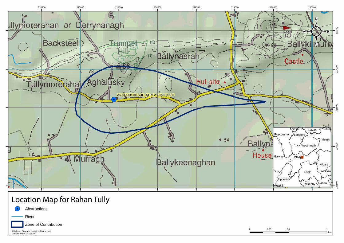
Location Map for Rahan Tully
0 0.5 10.25
km
!. Abstractions
River
Zone of Contribution
²
�)Offaly
Laois
Meath
Galway
Kildare
Tipperary
Westmeath
Roscommon Longford
CarlowKilkenny
Cavan
Wicklow
Leitrim
Limerick
Louth
!.
Rkd
Rkd
2500PUB1016 / IE_SH_G_232_19_011
226500 227000 227500 228000 228500 229000 229500 230000
225500
226000
226500
227000
227500
© Ordnance Survey Ireland. All rights reserved.
Licence number EN0059208
Aquifer Category for Rahan Tully
0 0.5 10.25
km
!. Abstractions
River
Zone of Contribution
Rkd
²
�)Offaly
Laois
Meath
Galway
Kildare
Tipperary
Westmeath
Roscommon Longford
CarlowKilkenny
Cavan
Wicklow
Leitrim
Limerick
Louth

!.2500PUB1016 / IE_SH_G_232_19_011
226500 227000 227500 228000 228500 229000 229500 230000
225500
226000
226500
227000
227500
© Ordnance Survey Ireland. All rights reserved.
Licence number EN0059208
Bedrock Map for Rahan Tully
0 0.5 10.25
km
!. Abstractions
River
Zone of Contribution
Dinantian Pure Bedded Limestones
²
�)Offaly
Laois
Meath
Galway
Kildare
Tipperary
Westmeath
Roscommon Longford
CarlowKilkenny
Cavan
Wicklow
Leitrim
Limerick
Louth
!.2500PUB1016 / IE_SH_G_232_19_011
226500 227000 227500 228000 228500 229000 229500 230000
225500
226000
226500
227000
227500
© Ordnance Survey Ireland. All rights reserved.
Licence number EN0059208
Groundwater Vulnerability for Rahan Tully
0 0.5 10.25
km
!. Abstractions
River
Zone of Contribution
E (Extreme)
H (High)
M (Moderate)
E (Rock near surface or Karst)
²
�)Offaly
Laois
Meath
Galway
Kildare
Tipperary
Westmeath
Roscommon Longford
CarlowKilkenny
Cavan
Wicklow
Leitrim
Limerick
Louth
!.2500PUB1016 / IE_SH_G_232_19_011
226500 227000 227500 228000 228500 229000 229500 230000
225500
226000
226500
227000
227500
© Ordnance Survey Ireland. All rights reserved.
Licence number EN0059208
Subsoils Map for Rahan Tully
0 0.5 10.25
km
!. Abstractions
River
Zone of Contribution
Alluvium
Cutover raised peat
Esker comprised of gravels of basic reaction
Gravels derived from limestones
Bedrock outcrop or subcrop
Lacustrine sediments
Made ground
Till derived from limestones
²
�)Offaly
Laois
Meath
Galway
Kildare
Tipperary
Westmeath
Roscommon Longford
CarlowKilkenny
Cavan
Wicklow
Leitrim
Limerick
Louth
!.2500PUB1016 / IE_SH_G_232_19_011
226500 227000 227500 228000 228500 229000 229500 230000
225500
226000
226500
227000
227500
© Ordnance Survey Ireland. All rights reserved.
Licence number EN0059208
Soils Map for Rahan Tully
0 0.5 10.25
km
!. Abstractions
River
Zone of Contribution
Basic Deep Well Drained Mineral
Basic Deep Poorly Drained Mineral
Basic Poorly Drained Peaty Mineral
Basic Shallow Well Drained Mineral
Basic Shallow Poorly Drained Mineral
Basic Shallow/Rocky/Peaty Mineral
Cutover/Cutaway Peat
Mineral Alluvium
Lacustrine
Made
²
�)Offaly
Laois
Meath
Galway
Kildare
Tipperary
Westmeath
Roscommon Longford
CarlowKilkenny
Cavan
Wicklow
Leitrim
Limerick
Louth
Recommended