October Storm Flows
City of Worcester DPW & Parks Department, Sewer Operations
Division January 26,2006
Today's Discussion
• We are going to talk about Worcester Sewer System, and how it is interconnected to our local waterways.
• We will review some of the cities large scale Flood Control systems
• What DPW does to control street and limit flooding
• We will talk about the heavy October Rains and some of Worcesters geographic characteristics
• What effect did the storm have on Worcester
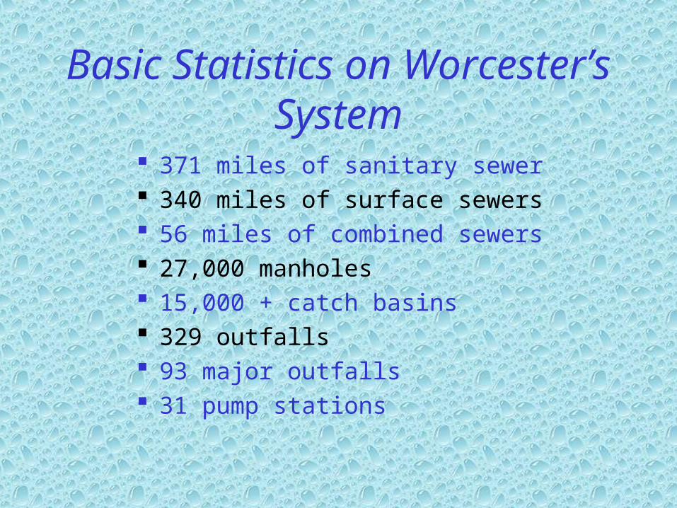
Basic Statistics on Worcester’s System
371 miles of sanitary sewer 340 miles of surface sewers 56 miles of combined sewers 27,000 manholes 15,000 + catch basins 329 outfalls 93 major outfalls 31 pump stations

Interceptor Sewers
City of Worcester
-Topographic Layout of the City
-Interceptor Sewers Shown In Red
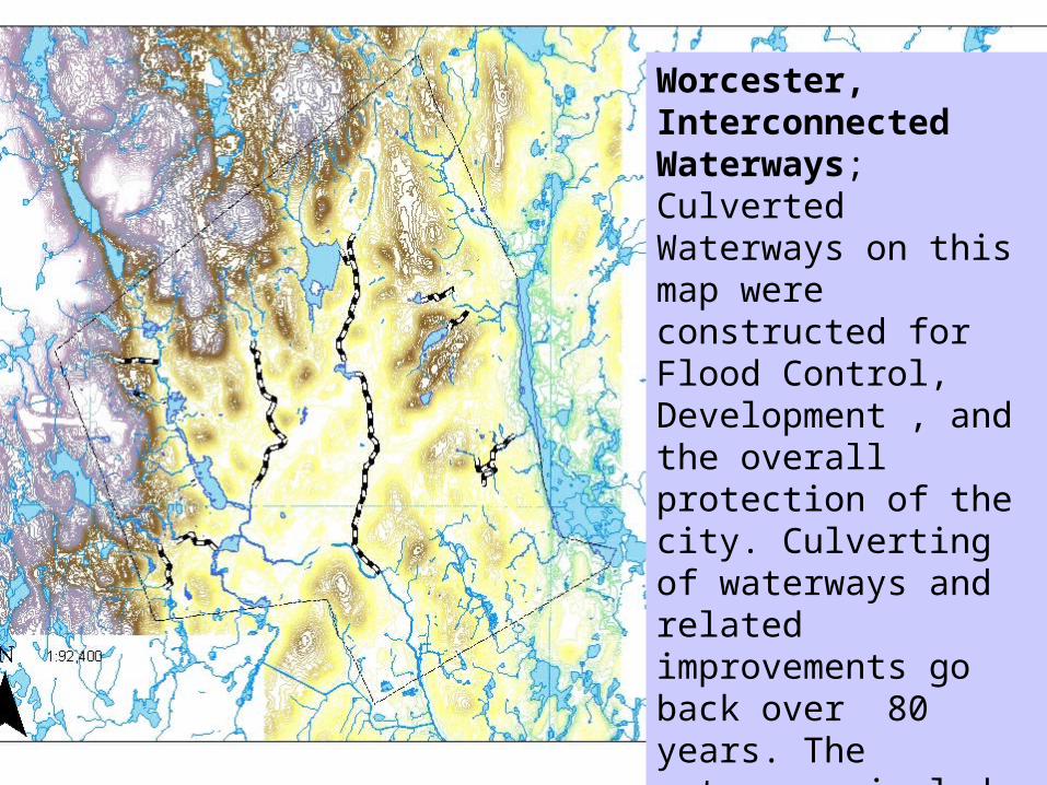
Worcester, Interconnected Waterways; Culverted Waterways on this map were constructed for Flood Control, Development , and the overall protection of the city. Culverting of waterways and related improvements go back over 80 years. The waterways include; Beaver Brook, Mill Brook Fitzgerald Brook and Kettle Brook Tributaries.
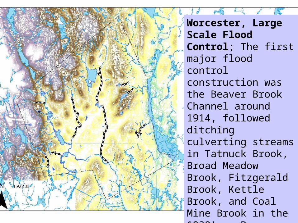
Worcester, Large Scale Flood Control; The first major flood control construction was the Beaver Brook Channel around 1914, followed ditching culverting streams in Tatnuck Brook, Broad Meadow Brook, Fitzgerald Brook, Kettle Brook, and Coal Mine Brook in the 1930’s . Beaver Brook was also culverted extensively through the 1940’s.

Combined Sewer Area
City of Worcester
-Topographic Layout of the City
-Combined Sewer Area Shaded
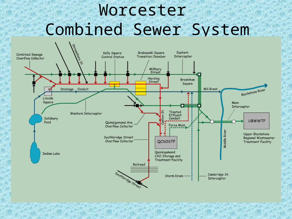
Worcester Combined Sewer System
Major Flood Control Projects
• The Worcester Diversion,1955 effectively shuts off Kettle Brook form entering the city through a 16 foot diameter tunnel that runs under Pakachoag Hill in Auburn Massachusetts.
• The Chandler Hill Flood Control Project, 1955, which takes flows from East Park and includes a 96 inch pipe which runs down most of Shrewsbury Street to carry flood waters.
Major Flood Control Projects (continued)
• Through the mid to late sixties three ponds were eliminated in the West Boylston Street, Gold Star Blvd. Area. Twin Box Culverts eleven by seven feet were installed to carry flows from the Weasel Brook area and Indian Lake to Salisbury Pond.
• Around this time the Ararat Brook Flood Control project was also complete north of Indian Lake
Major Flood Control Projects (continued)
• Through the seventies and eighties storm flows were removed from the old Mill Brook Conduit, which is basically the covered over Blackstone Canal, by constructing a series of large concrete culverts that take flows from Salisbury Pond to the Blackstone River. There are now two underground rivers running through the center of the city, one for storm flows and one combined sewer flows.
Major Flood Control Projects (continued)
• There are many more major drainage programs that have been completed to mitigate localized flooding. Most recently the Mill Brook sewer was extended to outfall further down stream to reduce flooding in the Green Island Area.
Storm Drain System Maintenance
• We clean all city catch basins over a two year period, but if a basin is not working we will make every effort to get that basin to work.
• We clean flush and TV inspect many portions of the stormwater system daily.
• We sweep streets to keep sand, leaves and debris from blocking city storm drains.
Storm Drain System Maintenance (continued)
• The Storm drainage systems in the city are monitored in dry and wet weather hoping to find problems before they happen.
• We have over 50 choke points or stream crossings that we check bi-monthly in dry and wet weather in hopes of limiting the chances of flooding.

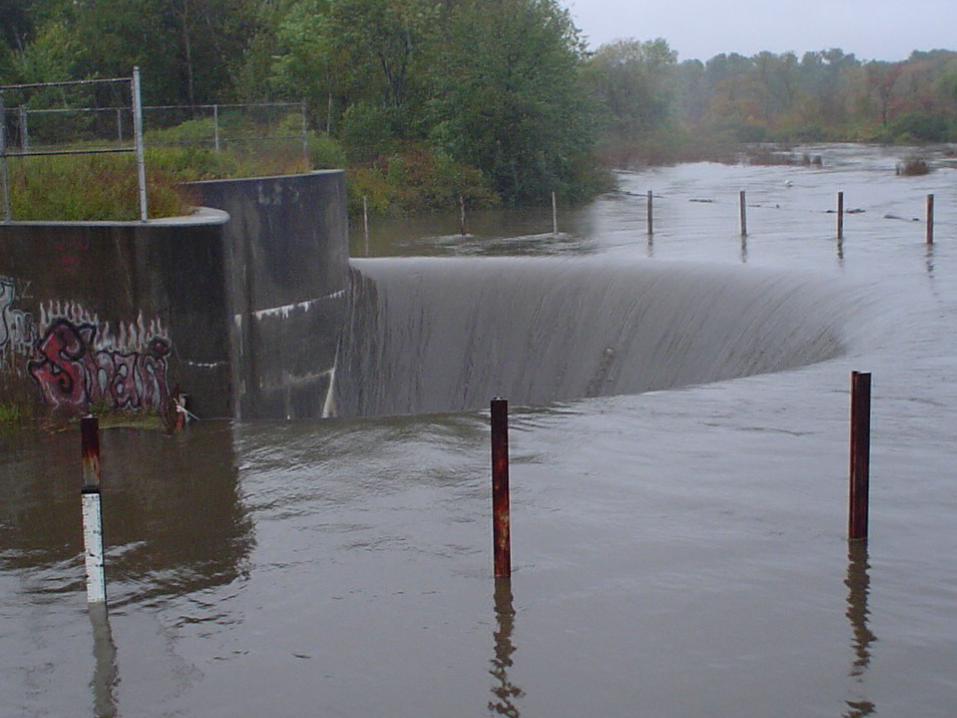
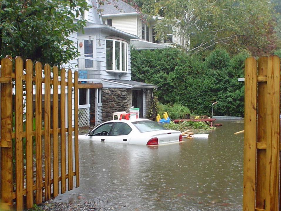
The October Storm
October Storm Flows
0
2
4
6
8
10
12
14
0 2 4 6 8 10 12 14 16 18
Days
Inc
he
s o
f R
ain
daily
total
Nine days of rain

The October Storm
October Storm Flows
0
2
4
6
8
10
12
14
0 2 4 6 8 10 12 14 16 18
Days
Inc
he
s o
f R
ain
daily
total
Over 12 inches of rain

DPW Received Over 200 Complaints
• 17 % were street flooding
• 11 % were blown off or missing man hole covers
• 36 % were sewer backing up into house
• 36 % were water backing up into cellar
We estimate there were many more problem areas that simply were not reported.

Inflow & Infiltration II
• The nine days of rain coupled with the heavy rain, of October 15,2005 caused extreme snow melt like conditions in the sanitary sewer system. High ground water conditions surcharged the soil and consequentially the sewer system. The rain and ground water conditions filled the sewer system with excess ground water, just like a leaky basement.
Inflow & Infiltration II (continued)
• The excess storm flow that entered the sanitary sewer system, blew off manhole covers, backed up into peoples homes, caused sanitary sewer overflows (SSOs), and Pump Stations to by-pass.
Where are we headed
• Continuing the I/I program development and implementation.
• Development of the cities backflow prevention program.
• Continue the cities storm drain system maintenance

Questions
Recommended