EURAINSAT – LOOKING INTO THE FUTURE
OF SATELLITE RAINFALL ESTIMATIONS
V. Levizzani1#, P. Bauer2, A. Buzzi1, S. Davolio1, D. E. Hinsman3, C. Kidd4, F. S. Marzano5, F. Meneguzzo6, A. Mugnai7, J. P. V. Poiares Baptista8, F. Porcù9, F. Prodi1,9, .J. F. W. Purdom10, D. Rosenfeld11, J. Schmetz12,
E. A. Smith13, F. Tampieri1, F. J. Turk14, G. A. Vicente13,15 1ISAO-CNR, Bologna, Italy, 2ECMWF, Reading, UK, 3WMO, Geneva, Switzerland, 4Univ. Birmingham, UK,
5Univ. L’Aquila, Italy, 6LaMMA, Firenze, Italy, 7IFA-CNR, Roma, Italy, 8ESA-ESTEC, Nordwijk, The Netherlands, 9Univ. Ferrara, Italy, 10NOAA-NESDIS, Camp Springs, MD, 11Hebrew Univ. of Jerusalem, Israel,
12EUMETSAT, Darmstadt, Germany, 13NASA-GSFC, Greenbelt, MD, 14NRL, Monterey, CA, 15QSS Group, Inc, Seabrook, MD
ABSTRACT EURAINSAT is a shared-cost project co-funded by the Research DG of the European Commission within the RTD activities of a generic nature of the Environment and Sustainable Development sub-programme (5th Framework Programme). Its key objective is the development of algorithms for rapidly-updated satellite rainfall estimations at the geostationary scale with METEOSAT Second Generation (MSG) Spinning Enhanced Visible and InfraRed Imager (SEVIRI) in mind. The new SEVIRI channels in the visible (VIS) and infrared (IR) portion of the spectrum will gain better insights into the microphysical and dynamic structure of precipitating clouds allowing for a more precise identification of precipitation levels. The method(s) will work as follows: 1) Microphysical characterization of precipitating clouds with VIS/IR sensors; 2) Creation of microphysical and radiative databases on cloud systems using cloud model outputs and aircraft penetrations; 3) Tuning of microwave (MW) algorithms on the different cloud systems (convective, stratiform,...); 4) Combination of data from the different algorithms and application to a rapid update cycle that makes use of the different sensors at the geostationary scale. The project is fostering international research on satellite rainfall estimations building a bridge between Europe and the US for present and future missions. 1. INTRODUCTION The latest generation sensors on board the Geostationary Operational Environmental Satellites (GOES) (Menzel and Purdom, 1994) and the upcoming METEOSAT Second Generation (MSG) Spinning Enhanced Visible and Infrared Imager (SEVIRI) (Schmetz et al., 1998) significantly enhance the ability of sensing cloud microstructure and precipitation forming processes (Levizzani et al., 2000) from a geostationary platform. A potential exists for improved instantaneous rainfall measurements from space by combining infrared (IR) and visible (VIS) observations with passive microwave (MW) measurements. IR and VIS satellite rainfall estimates have long since been available and suffered from the difficulty in associating cloud top features to precipitation at ground level. IR methods were used for climate purposes or combined with radar measurements for nowcasting (e.g. recent examples by Amorati et al., 2000; Porcù et al., 1999; Vicente et al., 1998) and multispectral approaches start to become operational (e.g. Ba and Gruber, 2001).
#Corresponding author address: V. Levizzani, ISAO-CNR, via Gobetti 101, I-40129 Bologna, Italy, e-mail: [email protected]. Project’s web server: http://www.isao.bo.cnr.it/~eurainsat/
Physically-based passive MW methods were developed mainly using data from the Special Sensor Microwave/Imager (SSM/I) and are based on several different physical principles (see for example Smith et al., 1998; Wilheit et al., 1994). Limitations of MW algorithms include the relatively large footprint and the low earth orbits not suitable for most of the operational strategies. Combined use of MW and IR data for rainfall estimations was already recognized some time ago (Vicente and Anderson, 1993). Adler et al. (1993) used SSM/I radiometric data for monthly average rainfall estimations over wide areas and global products such as those of the Global Precipitation Climatology Project (GPCP) were conceived (for recent advances see Huffman et al., 2001). However, the need for hourly and instantaneous combined estimations was clearly recognized (e.g. Vicente, 1994; Vicente and Anderson, 1994; Levizzani et al., 1996). Several methods exist (Sorooshian et al., 2000; Todd et al., 2001; Turk et al., 1999) that make use of IR and MW at various degrees of complexity and targeting different rainfall regimes. Some of these are running operationally, granting that their validation requires additional work in the years to come. In particular, global rapid-update estimates with near real-time adjustment of the thermal IR co-localized with MW-based rainrates are operationally very promising (Turk et al., 1999). The algorithms for the Tropical Rainfall Measuring Mission (TRMM) Precipitation Radar (PR) require a special mention given the novelty and potential of the active instruments for future missions: an example is the TRMM algorithm 2A-25 (Iguchi et al., 2000). Combined MW and rain radar algorithms are relatively new and were developed for the TRMM Microwave Imager (TMI) and the PR (e.g. TRMM algorithm 2B-31, Haddad et al., 1997). Finally, rainfall and humidity assimilation, and microphysical parameterizations for Local Area Models (LAM) and General Circulation Models (GCM) open up the road to very effective operational meteorological applications that incorporate the verification of model output (Turk et al., 1997). 2. EURAINSAT: THE PROJECT EURAINSAT is a project partially funded by the European Commission with the aim of developing new satellite rainfall estimation methods at the geostationary scale for an operational use in short and very short range weather monitoring and forecasting. It will exploit the new channels in the VIS, near IR and IR of the MSG SEVIRI that will be launched in middle 2002. The project started in January 2001 and will last until December 2003. The consortium has two objectives in mind: 1) contribute to improving the knowledge of clouds and precipitation formation processes using meteorological satellite sensors, and 2) make available new precipitation products for weather analysis and forecasting. SEVIRI will in fact provide better multispectral measurements for the identification of the physical processes of cloud formation and evolution. The 15 min image repetition time is also more compatible with the time responses of cloud systems. The following key geographic areas and major meteorological events were adopted: � Flood-producing episodes (e.g. Northwestern and Southern Italy); � Several cases involving the presence/absence of ice, polluted air masses and maritime conditions; � Influence of orography, e.g. the Alps during the Mesoscale Alpine Programme (MAP) Special
Observing Period (SOP) (Bougeault et al., 2001); � Sustained light rain and “insignificant” rain cases (very difficult to detect from satellite) in UK and
Northern Europe; � Tropical and sub-tropical cases over Africa, where the Niger catchment was selected given the relatively
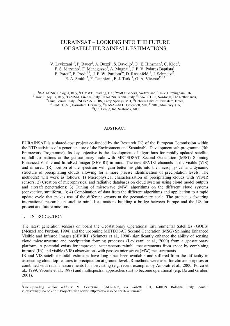
regular ground raingage network (Fig. 1); � A climatological window over Europe (30-60 N, 15 W-20 E) (Fig. 1). The project has gathered together a substantial part of the satellite rainfall community and in this sense has already reached an important milestone. The team actively participates into the development of scenarios and
concept for the future Global Precipitation Measurement (GPM) Mission and the International Precipitation Working Group of the Coordination Group for Meteorological Satellites (CGMS). More information on EURAINSAT and its findings can be gained at the web site http://www.isao.bo.cnr.it/~eurainsat/. 3. MICROPHYSICAL CHARACTERIZATION OF CLOUD PROCESSES A method was developed by Rosenfeld and Lensky (1998) to infer precipitation-forming processes in clouds based on multispectral satellite data. The method was originally based on the Advanced High Resolution Radiometer (AVHRR) imagery on polar orbiting satellites (Lensky and Rosenfeld, 1997). The forthcoming MSG SEVIRI is expected to enhance the capabilities of extracting cloud physical properties (Watts et al., 1998) more relevant for cloud genesis and evolution and not anymore limited by the insufficient number of passages. The effective radius (re) of the particles and cloud optical thickness are extracted and used for radiative transfer calculations that define the cloud type and improve its characterization. Precipitation forming processes are inferred using also data from the AVHRR, the TRMM VIS and IR Sensor (VIRS) and the MODerate-resolution Imaging Spectroradiometer (MODIS) on board NASA’s Terra spacecraft. Microphysically “maritime” clouds grow in relatively clean air with small cloud condensation nuclei (CCN) and low droplet concentrations, which produce very efficient coalescence and warm rain processes. “Continental” clouds normally grow, on the contrary, in polluted air masses having large CCN and high droplet concentrations, i.e. the coalescence is relatively inefficient. The better knowledge of cloud microstructure and precipitation forming processes will facilitate the development of a new generation of improved passive MW rainfall algorithms. The importance of the cloud characterization method has recently been demonstrated by observing the effects of forest fire (Rosenfeld, 1999), urban pollution (Rosenfeld, 2000) and desert dust aerosols (Rosenfeld et al., 2001) in inhibiting precipitation formation processes. One more promising line of action is the potential use of lightning detection for discriminating between convective and stratiform regimes while estimating precipitation. Data from ground-based lightning detection networks and satellite sensors like the TRMM Lightning Imaging Sensor (LIS) are applied to IR rainfall estimations (Grecu and Anagnostou, 2000) and show considerable potential for rapid update applications within EURAINSAT (Solomon et al., 2001). Lightning detection represents a fast-response fundamental parameter for discriminating active convection and some quantitative relationships have been demonstrated between lightning discharges and other measurables of rainfall (Petersen and Rutledge, 1998).
Figure 1. Left: EURAINSAT climatological window over Europe (30 – 60 N; 15 W – 20 E). Timeframe spans the 1998-2000 period. Right: Tropical and sub-tropical window over Africa (3 – 23 N; 0 – 16 E). It includes the river Niger catchment, which is one of the best instrumented areas of the whole continent.
4. RAINFALL ESTIMATION METHODS 4.1 IR methods IR-based rainfall estimation methods have been the first to be applied to a wide variety of scales and phenomena. With the advent of MW sensors they were more and more confined to large scale and climate applications. At the instantaneous time scale IR methods are being integrated by ancillary information, such as data from radar, other VIS, IR and NIR channels, lightning detection, model output and other meteorological parameters.
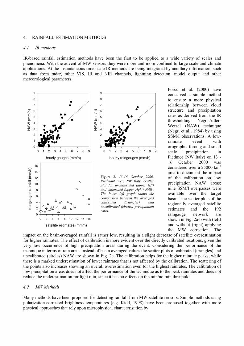
Porcù et al. (2000) have conceived a simple method
ifvtuttlr 4 Mpp
9 9
to ensure a more physical relationship between cloud structure and precipitation rates as derived from the IR thresholding Negri-Adler-Wetzel (NAW) technique (Negri et al., 1984) by using SSM/I observations. A low-rainrate event with orographic forcing and small scale precipitation in Piedmot (NW Italy) on 13 -16 October 2000 was considered over a 25000 km2
area to document the impact of the calibration on low precipitation NAW areas; nine SSM/I overpasses were available over the target basin. The scatter plots of the regionally averaged satellite estimates and the 192 raingauge network are shown in Fig. 2a-b with (left) and without (right) applying the MW correction. The
mpact on the basin-averaged rainfall is rather low, resulting in a slight decrease of satellite overestimation or higher rainrates. The effect of calibration is more evident over the directly calibrated locations, given the ery low occurrence of high precipitation areas during the event. Considering the performance of the echnique in terms of rain areas instead of basin averaged values the scatter plots of calibrated (triangles) and ncalibrated (circles) NAW are shown in Fig. 2c. The calibration helps for the higher rainrate peaks, while here is a marked underestimation of lower rainrates that is not affected by the calibration. The scattering of he points also increases showing an overall overestimation even for the highest rainrates. The calibration of ow precipitation areas does not affect the performance of the technique as to the peak rainrates and does not educe the underestimation for light rain, since it has no effects on the rain/no rain threshold.
.2 MW Methods
any methods have been proposed for detecting rainfall from MW satellite sensors. Simple methods using olarization-corrected brightness temperatures (e.g. Kidd, 1998) have been proposed together with more hysical approaches that rely upon microphysical characterization by
hourly gauges (mm/h)
0 1 2 3 4 5 6 7 8 9
NAW
(mm
/h)
0
1
2
3
4
5
6
7
8
hourly raingauges (mm/h)
0 1 2 3 4 5 6 7 8 9
NAW
(mm
/h)
0
1
2
3
4
5
6
7
8
satellite estimates (mm/h)
0 2 4 6 8 10 12 14 16
rain
gaug
es ra
infa
ll (m
m/h
)
0
2
4
6
8
10
12
14
16 Figure 2. 13-16 October 2000,Piedmont area, NW Italy. Scatterplot for uncalibrated (upper left)and calibrated (upper right) NAW.The lower left graph shows thecomparison between the averagedcalibrated (triangles) anduncalibrated (circles) precipitationrates.
� stratifying clouds into different microphysical types and examining how much of the variability in the bias of MW rainfall estimation is explained by the microphysical characterization;
� developing a library of passive MW signatures from different cloud types, and � using a microphysical cloud classification for improving cloud radiative transfer modeling based on
statistical multivariate generators of cloud genera. The scheme of Mugnai et al. (1993) and Smith et al. (1992) is a good example of such methods, especially in the very complex environment of severe storm microphysics. Cloud modeling and MW radiative transfer has been recently applied to stratiform rainfall by Bauer et al. (2000). Panegrossi et al. (1998) have shown the importance of testing the physical initialization and the consistency between model and measurement manifolds. Research trends concentrate on improving the interpretation of active and passive MW measurements through better modeling of cloud processes such as the melting layer (Bauer, 2001a; Olson et al., 2001a, b). The TRMM satellite has set path to new algorithms that still mostly work over oceans (e.g. Bauer, 2001b; Bauer et al, 2001), but new developments are at hand over land (Grecu and Anagnostou, 2001). Polarization and texture information from passive radiometers together with PR data complete the scenario of new methods (Olson et al., 2001c). Fundamental ancillary data are finally provided by means of active and passive MW radiometry for cloud liquid water (LWC) profiling: measurements from ground based MW radiometers combine with reflectivity (Z) profiles from cloud radars and cloud model statistics to lower the errors in LWC measurements by as much as 10 – 20 % (Löhnert et al., 2001). 4.3 Combined Multispectral and MW Methods Cloud microphysical information, when combined with MW measurements, can lead to improvements in satellite-based rainfall measurements, especially from clouds in the extra tropics and over land (e.g. Bauer et al., 1998). EURAINSAT concentrates on exploiting SEVIRI data in the VIS, near IR and water vapor (WV) for cloud characterization and screening within a rapid cycle of rainfall estimation based on SSM/I, TMI and geostationary IR data. Data from MODIS serve the purpose of simulating data from MSG SEVIRI during the pre-launch phase. Moreover, the project shares in the cloud-related work from the MODIS team (King et al. 1997). Two are the main research lines: � Develop new MSG-MW rainfall algorithms incorporating the observed cloud microstructure and
precipitation forming processes. State of the art cloud (Khain et al., 2000) and radiative transfer modeling will be instrumental to detailed cloud and rainfall type discrimination.
� Introduce such methods into rapid update rainfall cycles for near real time rainfall estimations over oceans and land with the widest possible area coverage. Mid-latitude Europe, the Mediterranean basin, North Africa, the Middle East and equatorial and tropical African regions are the main targets for operational and climatological applications. Applications to the Mediterranean have been reported by Meneguzzo et al. (1998).
5. APPLICATIONS Applications embrace, among others, water availability, global change studies, nowcasting, hydrogeological disaster management, agriculture and famine reduction, and monitoring of remote areas. Let us examine only two of them, that is assimilation for numerical weather predictions (NWP) and satellite telecommunications 5.1 Rainfall assimilation for NWP Data assimilation procedures that improve cloud and humidity characterization in current analysis schemes for LAMs are at hand. Most important are the sensitivity to the orography and the modeling of moist processes. The model BOLAM (Buzzi et al., 1998) is used in the project to conduct rainfall assimilation
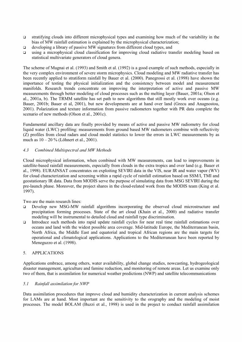
experiments that quantify the impact of satellite data onto the forecasting chain (a tuning run is shown in Fig. 3). The nudging technique of Falcovich et al. (2000) is adopted. The humidity in the lower troposphere is proportional to the rainrate difference qnew (z) = q(z) + c(z) τ [ q(z) - q*(z) ] q*(z) = qsat(z) ± ε where c(z) = vertical modulation different in case of
� large scale precipitation � convective precipitation � large scale + convective precipitation
τ = ∆t ⋅ tanh (∆Prec); ε = over (under) saturation. Work will focus on: � Tuning of ε (different value in all the
above cases) � c(z) dependent from orography height
(more accurate definition of vertical profile over orography)
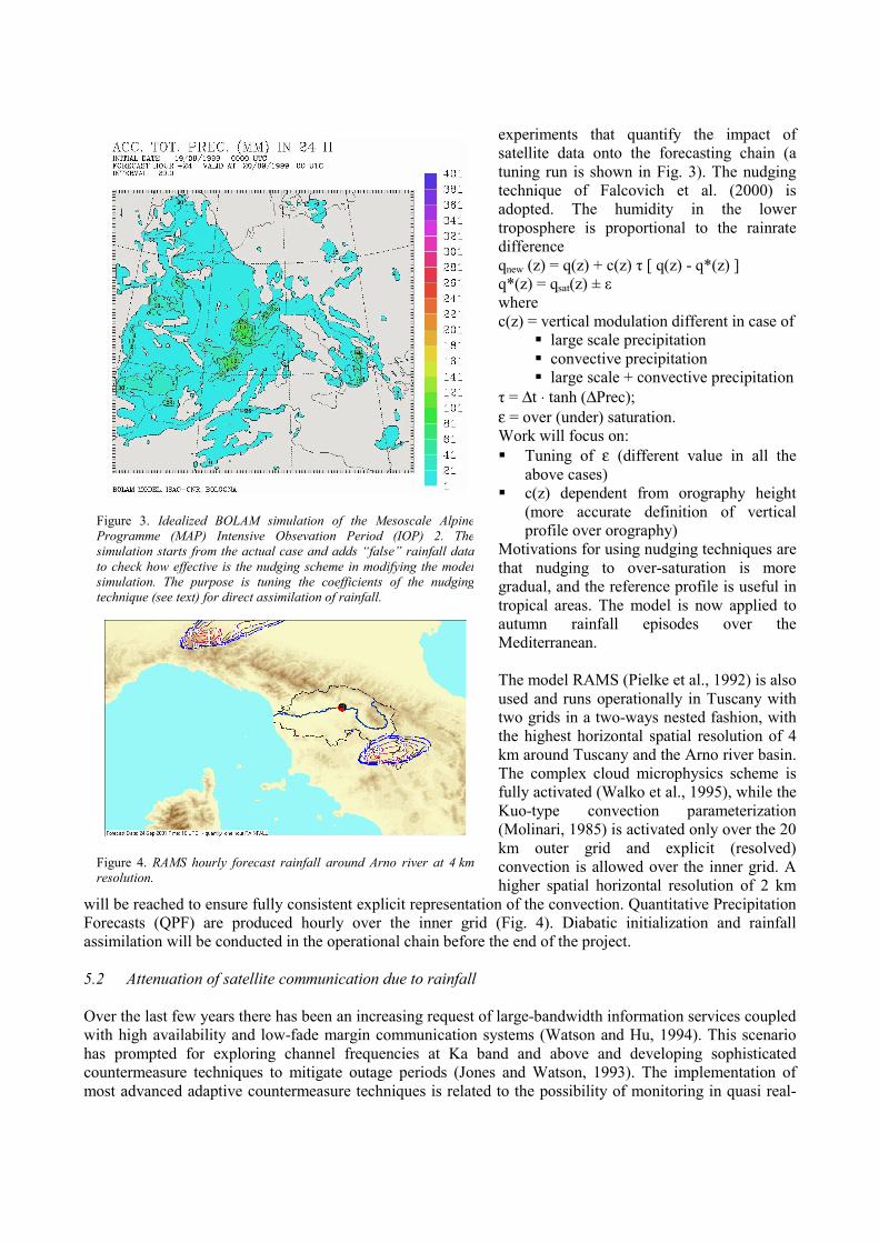
Motivations for using nudging techniques are that nudging to over-saturation is more gradual, and the reference profile is useful in tropical areas. The model is now applied to autumn rainfall episodes over the Mediterranean. The model RAMS (Pielke et al., 1992) is also used and runs operationally in Tuscany with two grids in a two-ways nested fashion, with the highest horizontal spatial resolution of 4 km around Tuscany and the Arno river basin. The complex cloud microphysics scheme is fully activated (Walko et al., 1995), while the Kuo-type convection parameterization (Molinari, 1985) is activated only over the 20 km outer grid and explicit (resolved) convection is allowed over the inner grid. A higher spatial horizontal resolution of 2 km
wiFoas 5. Ovwihacom
Figure 3. Idealized BOLAM simulation of the Mesoscale AlpineProgramme (MAP) Intensive Obsevation Period (IOP) 2. Thesimulation starts from the actual case and adds “false” rainfall datato check how effective is the nudging scheme in modifying the modelsimulation. The purpose is tuning the coefficients of the nudgingtechnique (see text) for direct assimilation of rainfall.
Figure 4. RAMS hourly forecast rainfall around Arno river at 4 kmresolution.
ll be reached to ensure fully consistent explicit representation of the convection. Quantitative Precipitation recasts (QPF) are produced hourly over the inner grid (Fig. 4). Diabatic initialization and rainfall similation will be conducted in the operational chain before the end of the project.
2 Attenuation of satellite communication due to rainfall
er the last few years there has been an increasing request of large-bandwidth information services coupled th high availability and low-fade margin communication systems (Watson and Hu, 1994). This scenario s prompted for exploring channel frequencies at Ka band and above and developing sophisticated untermeasure techniques to mitigate outage periods (Jones and Watson, 1993). The implementation of ost advanced adaptive countermeasure techniques is related to the possibility of monitoring in quasi real-
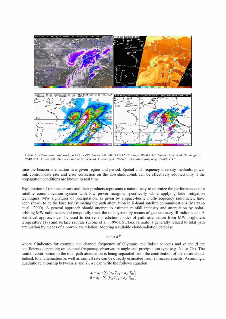
time the beacon attenuation in a given region and period. Spatial and frequency diversity methods, power link control, data rate and error correction on the downlink/uplink can be effectively adopted only if the propagation conditions are known in real time. Exploitation of remote sensors and their products represents a natural way to optimize the performances of a satellite communication system with low power margins, specifically while applying fade mitigation techniques. MW signatures of precipitation, as given by a space-borne multi-frequency radiometer, have been shown to be the base for estimating the path attenuation in K-band satellite communications (Marzano et al., 2000). A general approach should attempt to estimate rainfall intensity and attenuation by polar-orbiting MW radiometers and temporally track the rain system by means of geostationary IR radiometers. A statistical approach can be used to derive a prediction model of path attenuation from MW brightness temperature (TB) and surface rainrate (Crone et al., 1996). Surface rainrate is generally related to total path attenuation by means of a power-law relation, adopting a suitable cloud-radiation database
Af = α R β
where f indicates for example the channel frequency of Olympus and Italsat beacons and α and β are coefficients depending on channel frequency, observation angle and precipitation type (e.g. Ns or Cb). The rainfall contribution to the total path attenuation is being separated from the contribution of the entire cloud. Indeed, total attenuation as well as rainfall rate can be directly estimated from TB measurements. Assuming a quadratic relationship between Af and TB we can write the follows equation
Af = a0 + ∑f (a1f TBfp + a2f TBf2)
R = b0 + ∑f (b1f TBfp + b2f TBfp2)
Figure 5. Attenuation case study, 6 Oct., 1998. Upper left: METEOSAT IR image, 0600 UTC. Upper right: 85-GHz image at0540 UTC. Lower left: 24-h accumulated rain (mm). Lower right: 20-GHz attenuation (dB) map at 0600 UTC.
The coefficient set is different for over-land and over-ocean estimates. Since the land surface model does not include polarization, the average between the two orthogonally-polarized TB’s is used for all four SSM/I frequencies over land. Over the ocean all 7 polarized channels are employed. An example is given in Fig. 5. ACKNOWLEDGMENTS EURAINSAT is a shared-cost project (contract EVG1-2000-00030) co-funded by the Research DG of the European Commission within the RTD activities of a generic nature of the Environment and Sustainable Development sub-programme (5th Framework Programme). ESA and EUMETSAT deserve special mention for the steering role of the MSG Research Announcement of Opportunity that first formed the team under Project 152 “Use of the MSG SEVIRI channels in a combined SSM/I, TRMM and geostationary IR method for rapid updates of rainfall”. The authors finally acknowledge their mother institutions/companies that strongly supported the formation of the project’s science team. REFERENCES Adler, R. F., A. J. Negri, P. R. Keehn, and I. M. Hakkarinen, 1993: Estimation of monthly rainfall over Japan and
surrounding waters from a combination of low-orbit microwave and geosynchronous IR data. J. Appl. Meteorol., 32, 335-356.
Amorati, R., P. P. Alberoni, V. Levizzani, and S. Nanni, 2000: IR-based satellite and radar rainfall estimates of convective storms over northern Italy. Meteor. Appl., 7, 1-18.
Ba, M. B., and A. Gruber, 2001: GOES multispectral rainfall algorithm (GMSRA). J. Appl. Meteorol., 40, 1500-1514. Bauer, P., 2001a: Microwave radiative transfer imulation in clouds: Including a melting layer in cloud model bulky
hydrometeor distributions. Atmos. Res., 157, 9-30. —————, 2001b: Over-ocean rainfall retrieval from multisensor data of the Tropical Rainfall Measuring Mission.
Part I: Design and evaluation of inversion databases. J. Atmos. Oceanic Technol., 18, 1315-1330. —————, L. Schanz, R. Bennartz, and P. Schlüssel, 1998: Outlook for combined TMI-VIRS algorithms for TRMM:
lessons learned from the PIP and AIP projects. J. Atmos. Sci., 55, 1714-1729. —————, A. Khain, A. Pokrovsky, R. Meneghini, C. Kummerow, F. S. Marzano, and J. P. V. Poiares Baptista,
2000: Combined cloud–microwave radiative transfer modeling of stratiform rainfall. J. Atmos. Sci., 57, 1082-1104. —————, P. Amayenc, C. Kummerow, and E. A. Smith, 2001: Over-ocean rainfall retrieval from multisensor data
of the Tropical Rainfall Measuring Mission. Part II: Algorithm implementation. J. Atmos. Oceanic Technol., in press.
Bougeault, P., P. Binder, A. Buzzi, R. Dirks, R. Houze, J. Kuettner, R. B. Smith, R. Steinacker, and H. Volkert, 2001: The MAP Special Observing Period. Bull. Amer. Meteor. Soc., 82, 433-462.
Buzzi, A., N. Tartaglione, and P. Malguzzi, 1998: Numerical simulations of the 1994 Piedmont flood: role of orography and moist processes. Mon. Wea. Rev., 126, 2369-2383.
Crone, L. J., L. M. McMillin, and D. S. Crosby, 1996: Constrained regression in satellite meteorology. J. Appl. Meteor., 35, 2023-2039.
Falcovich, A., E. Kalnay, S. Lord, and M. B. Matur, 2000: A new method of observed rainfall assimilation in forecast models. J. Appl. Meteor., 39, 1282-1298.
Grecu, M., and E. N. Anagnostou, 2000: Assessment of the use of lightning information in satellite infrared rainfall estimations. J. Hydrometeor., 1, 211-221.
—————, and —————, 2001: Overland precipitation estimation from TRMM passive microwave observations. J. Appl. Meteorol., 40, 1367-1380.
Haddad, Z., E. A. Smith, C. Kummerow, T. Iguchi, M. Farrar, S. Darden, M. Alves, and W. Olson, 1997: The TRMM ‘Day-1’ radar/radiometer combined rain-profile algorithm. J. Meteor. Soc. Japan, 75, 799-808.
Huffman, G. J., R. F. Adler, M. M. Morrissey, D. T. Bolvin, S. Curtis, R. Joyce, B. McGavock, and J. Susskind, 2001: Global precipitation at one-degree daily resolution from multisatellite observations. J. Hydrometeorol., 2, 36-50.
Iguchi, T., T. Kozu, R. Meneghini, J. Awaka, and K. Okamoto, 2000: Rain-profiling algorithm for the TRMM precipitation radar. J. Appl. Meteorol., 39, 2038-2052.
Jones, S. M. R., and P. A. Watson, 1993: Attenuation and countermeasures in millimeter-wave point-to-multipoint networks. Radio Sci., 28, 1057-1069.
Khain, A., M. Ovtchinnikov, M. Pinsky, A. Pokrovsky, and H. Krugliak, 2000: Notes on the state-of-the-art numerical modeling of cloud microphysics. Atmos. Res., 55, 159-224.
Kidd, C., 1998: On rainfall retrieval using polarization-corrected temperatures. Int. J. Remote Sensing, 19, 981-996. King, M. D., S.-C. Tsay, S. E. Platnick, M. Wang, and K.-N. Liou, 1997: Cloud retrieval algorithms for MODIS: optical
thickness, effective particle radius, and thermodynamic phase. MODIS Algorithm Theoretical Basis Doc., ATBD-MOD-05 and MOD-06, 79 pp.
Lensky, I. M., and D. Rosenfeld, 1997: Estimation of precipitation area and rain intensity based on the microphysical properties retrieved from NOAA AVHRR data. J. Appl. Meteorol., 36, 234-242.
Levizzani, V., F. Porcù, F. S. Marzano, A. Mugnai, E. A. Smith, and F. Prodi, 1996: Investigating a SSM/I microwave algorithm to calibrate METEOSAT infrared instantaneous rainrate estimates. Meteorol. Appl., 3, 5-17.
—————, P. P. Alberoni, P. Bauer, L. Bottai, A. Buzzi, E. Cattani, M. Cervino, P. Ciotti, M. J. Costa, S. Dietrich, B. Gozzini, A. Khain, C. Kidd, F. S. Marzano, F. Meneguzzo, S. Migliorini, A. Mugnai, F. Porcù, F. Prodi, R. Rizzi, D. Rosenfeld, L. Schanz, E. A. Smith, F. Tampieri, F. Torricella, F. J. Turk, G. A. Vicente, and G. Zipoli, 2000: Use of the MSG SEVIRI channels in a combined SSM/I, TRMM and geostationary IR method for rapid updates of rainfall. Proc. 1st MSG-RAO Workshop, ESA SP-452, 63-66.
—————, J. Schmetz, H. J. Lutz, J. Kerkmann, P. P. Alberoni, and M. Cervino, 2001: Precipitation estimations from geostationary orbit and prospects for METEOSAT Second Generation. Meteorol. Appl., 8, 23-41.
Löhnert, U., S. Crewell, C. Simmer, and A. Macke, 2001: Profiling cloud liquid water by combining active and passive microwave measurements with cloud model statistics. J. Atmos. Oceanic Technol., 18, 1354-1366.
Marzano, F. S., J. F. Turk, P. Ciotti, S. Di Michele, and N. Pierdicca, 2000: Combined use of spaceborne polar-orbiting microwave and geo-stationary infrared radiometers for estimating rainfall attenuation along earth-satellite links. Proc. 1st Int. Workshop on Radiowave Propagation Modelling for SatCom Services at Ku-band and above, ESA WPP-146, 189-196.
Meneguzzo, F., S. Migliorini, G. A. Vicente, L. Bottai, B. Gozzini, and G. Zipoli, 1998: Satellite rainfall estimates in real time in the Mediterranean countries. Verifications in Tuscany. Proc. ICAM-98, 25th Int. Conf. Alpine Meteor., Turin, 14-19 Jul, 2-7.
Menzel, W. P., and J. F. W. Purdom, 1994: Introducing GOES-I: the first of new generation of Geostationary Operational Environmental Satellites. Bull. Am. Meteor. Soc., 75, 757-781.
Molinari, J., 1985: A general form of Kuo's cumulus parameterization. Mon. Wea. Rev., 113, 1411-1416. Mugnai, A., E. A. Smith, and G. J. Tripoli, 1993: Foundations for statistical-physical precipitation retrieval from
passive microwave satellite measurements. Part II: Emission-source and generalized weighting-function properties of a time-dependent cloud-radiation model. J. Appl. Meteorol., 32, 17-39.
Negri, A. J., R. F. Adler, and P. J. Wetzel, 1984: Rain estimation from satellite: An examination of the Griffith-Woodley technique. J. Climate Appl. Meteorol., 23, 102-116.
Olson, W. S., P. Bauer, N. E. Viltard, D. E. Johnson, W.-K. Tao, R. Meneghini, and L. Liao, 2001a: A melting-layer model for passive/active microwave remote sensing applications. Part I: Model formulation and comparison with observations. J. Appl. Meteorol., 40, 1145-1163.
—————, —————, C. D. Kummerow, Y. Hong, and W.-K. Tao, 2001b: A melting-layer model for passive/active microwave remote sensing applications. Part II: Simulation of TRMM observations. J. Appl. Meteorol., 40, 1164-1179.
—————, Y. Hong, C. D. Kummerow, and F. J. Turk, 2001c: A texture-polarization method for estimating convective-stratiform precipitation area coverage from passive microwave radiometer data. J. Appl. Meteorol., 40, 1577-1591.
Panegrossi, G., S. Dietrich, F. S. Marzano, A. Mugnai, E. A. Smith, X. Xiang, G. J. Tripoli, P. K. Wang, and J. P. V. Poiares Baptista, 1998: Use of cloud model microphysics for passive microwave-based precipitation retrieval: significance of consistency between model and measurement manifolds. J. Atmos. Sci., 55, 1644-1672.
Petersen, W. A., and S. A. Rutledge, 1998: On the relationship between cloud-to-ground lightning and convective rainfall. J. Geophys. Res., 103, 14025-14040.
Pielke, R. A., W. R. Cotton, R. L. Walko, C. J. Tremback, W. A. Lyons, L. D. Grasso, M. E. Nicholls, M. D. Moran, D. A. Wesley, T. J. Lee, and J. H. Copeland, 1992: A comprehensive meteorological modeling system – RAMS. Meteorol. Atmos. Phys., 49, 69-91.
Porcù, F., M. Borga, and F. Prodi, 1999: Rainfall estimation by combining radar and infrared satellite data for nowcasting purposes. Meteorol. Appl., 6, 289-300.
—————, F. Prodi, S. Dietrich, A. Mugnai, and R. Bechini, 2000: Multisensor estimation of severe rainfall events. Proc. The 2000 EUMETSAT Meteorological Satellite Data Users' Conf., EUM P 29, EUMETSAT, 371-378.
Rosenfeld, D., 1999: TRMM observed first direct evidence of smoke from forest fires inhibiting rainfall. Geophys. Res. Lett., 26 (20), 3105-3108.
—————, 2000: Suppression of rain and snow by urban and industrial air pollution. Science, 287, 1793-1796. —————, and I. M. Lensky, 1998: Satellite-based insights into precipitation formation processes in continental and
maritime convective clouds. Bull. Am. Meteor. Soc., 79, 2457-2476. —————, Y. Rudich, and R. Lahav, 2001: Desert dust suppressing precipitation: a possible desertification feedback
loop. PNAS, 98, 5975-5980. Schmetz, J., H. Woick, S. A. Tjemkes,, and M. Rattenborg, 1998: From METEOSAT to METEOSAT Second
Generation (MSG). Prepr. 9th Conf. Satellite Meteorol. Oceanography, AMS, 335-338 Smith, E. A., A. Mugnai, H. J. Cooper, G. J. Tripoli, and X. Xiang, 1992: Foundations for statistical-physical
precipitation retrieval from passive microwave satellite measurements. Part I: Brightness-temperature properties of a time-dependent cloud-radiation model. J. Appl. Meteorol., 31, 506-531.
—————, J. E. Lamm, R. F. Adler, J. Alishouse, K. Aonashi, E. C. Barrett, P. Bauer, W. Berg, A. Chang, R. Ferraro, J. Ferriday, S. Goodman, N. Grody, C. Kidd, D. R. Kniveton, C. Kummerow, G. Liu, F. S. Marzano, A. Mugnai, W. Olson, G. Petty, A. Shibata, R. Spencer, F. Wentz, T. Wilheit, and E. Zipser, 1998: Results of the WetNet PIP-2 project. J. Atmos. Sci., 55, 1483-1536.
Solomon, R., M. B. Baker, S. Dietrich, C. Adamo, and A. Mugnai, 2001: Rainfall monitoring at geostationary scale: Potential of lightning data in a rapid update approach. Proc. The 2001 EUMETSAT Meteorological Data Users’ Conf., Antalya, this issue.
Sorooshian, S., K.-L. Hsu, X. Gao, H. V. Gupta, B. Imam, and D. Braithwaite, 2000: Evaluation of PERSIANN system satellite–based estimates of tropical rainfall. Bull. Am. Meteor. Soc., 81, 2035–2046.
Todd, M. C., C. Kidd, D. Kniveton, and T. J. Bellerby, 2001: A combined satellite infrared and passive microwave technique for estimation of small-scale rainfall. J. Atmos. Oceanic Technol., 18, 742-755.
Turk, F. J., G. D. Rohaly, and P. Arkin, 1997: Utilization of satellite-derived tropical rainfall for analysis and assimilation into a numerical weather prediction model. Prepr. 22nd Conf. Hurricanes and Tropical Meteor., AMS, 310-311.
—————, G. D. Rohaly, J. Hawkins, E. A. Smith, F. S. Marzano, A. Mugnai, and V. Levizzani, 1999: Meteorological applications of precipitation estimation from combined SSM/I, TRMM and infrared geostationary satellite data. In Microwave Radiometry and Remote Sensing of the Earth’s Surface and Atmosphere, P. Pampaloni and S. Paloscia Eds., VSP Int. Sci. Publ., 353-363.
Vicente, G. A., 1994: Hourly retrieval of precipitation rate from the combination of passive microwave and infrared satellite radiometric measurements. Ph.D. Thesis. Dept. of Atmospheric and Oceanic Sciences, Univ. of Wisconsin - Madison, WI, USA, 127 pp.
—————, and J. R. Anderson, 1993: Retrieval of rainfall rates from the combination of passive microwave radiometric measurements and infrared measurements. Prepr. 20th Conf. Hurricane and Tropical Meteorol., AMS, 151-154.
—————, and —————, 1994: A new rain retrieval technique that combines geosynchronous IR and MW polar orbit data for hourly rainfall estimates. Case Study: Kwajalein and TOGA-COARE. Prepr. 7th Conf. Satellite Meteorology and Oceanography, AMS, 34-37.
—————, R. A. Scofield, and W. P. Menzel, 1998: The operational GOES infrared rainfall estimation technique. Bull. Am. Meteor. Soc., 79, 1883-1898.
Walko, R. L., W. R. Cotton, M. P. Meyers, and J. Y. Harrington, 1995: New RAMS cloud microphysics parameterization. Part I: The single-moment scheme. Atmos. Res., 38, 29–62.
Watson, P. A., and Y. F. Hu, 1994: Prediction of attenuation on satellite-earth links for systems operating with low fade margins. IEE Proc. - Microw. Antennas Propagat., 141, 467-472.
Watts, P. D., C. T. Mutlow, A. J. Baran, and A. M. Zavody, 1998: Study on cloud properties derived from Meteosat Second Generation observations. Final Rep. EUMETSAT ITT No. 97/181, 344 pp.
Wilheit, T. T., R. F. Adler, S. Avery, E. Barrett, P. Bauer, W. Berg, A. Chang, J. Ferriday, N. Grody, S. Goodman, C. Kidd, D. Kniveton, C. Kummerow, A. Mugnai, W. Olson, G. Petty, A. Shibata, E. A. Smith, and R. Spencer, 1994: Algorithms for the retrieval of rainfall from passive microwave measurements. Remote Sens. Rev., 11, 163-194.
Recommended